SOCIAL STUDIES Grade 7 Student Textbook Author and Editor: Mekuriya Feleke (BA) Wondu Teklemedhin (BA) Evaluators: Tamirat Fite Yirgalem Mihrate Zelalem Alagaw Federal Democratic Republic of Ethiopia Ministry of Education

Welcome message from author
This document is posted to help you gain knowledge. Please leave a comment to let me know what you think about it! Share it to your friends and learn new things together.
Transcript
SOCIAL STUDIES
Grade 7
Student Textbook
Author and Editor:
Mekuriya Feleke (BA)
Wondu Teklemedhin (BA)
Evaluators:
Tamirat Fite
Yirgalem Mihrate
Zelalem Alagaw
Federal Democratic Republic of Ethiopia
Ministry of Education
Acknowledgements
The redesign, printing and distribution of this student textbook has been funded through the General Education Quality
Improvement Project (GEQIP), which aims to improve the quality of education for Grades 1–12 students in government
schools throughout Ethiopia.
The Federal Democratic Republic of Ethiopia received funding for GEQIP through credit/financing from the International
Development Associations (IDA), the Fast Track Initiative Catalytic Fund (FTI CF) and other development partners – Finland,
Italian Development Cooperation, the Netherlands and UK aid from the Department for International Development (DFID).
The Ministry of Education wishes to thank the many individuals, groups and other bodies involved – directly and indirectly – in
publishing the textbook and accompanying teacher guide.
Every effort has been made to trace the copyright holders of the images and we apologise in advance for any unintentional
omission. We would be pleased to insert the appropriate acknowledgement in any subsequent edition of this publication.
© Federal Democratic Republic of Ethiopia, Ministry of Education
First edition, 2003(E.C.)
Developed, printed and distributed for the Federal Democratic Republic of Ethiopia, Ministry of Education by:
Al Ghurair Printing and Publishing House CO. (LLC)
PO Box 5613
Dubai
U.A.E.
In collaboration with
Kuraz International Publisher P.L.C
P.O. Box 100767
Addis Ababa
Ethiopia
ISBN 978-99944-2-078-0
All rights reserved. No part of this publication may be reproduced, stored in a retrieval system or transmitted in any form or by
any means (including electronic, mechanical, photocopying, recording or otherwise) either prior written permission of the
copyright owner or a licence permitting restricted copying in Ethiopia by the Federal Democratic Republic of Ethiopia, Federal
Negarit Gazeta ,Proclamation No. 410/2004 Copyright and Neighbouring Rights Protection Proclamation, 10th year, No. 55,
Addis Ababa, 19 July 2004.
Disclaimer
Every effort has been made to trace the copyright owners of material used in this document. We apologise in advance for any
unintentional omissions. We would be pleased to insert the appropriate acknowledgement in any future edition.
Page
UNIT 1:
1.1 The People, Location, Size and Shape of Africa ............................................... 2
1.2 Latitudes and Longitudes ....................................................................... 7
1.3 Super Language Families of the Peoples of Africa and their Distribution ............... 12
1.4 Ancient Civilization in Africa (Egypt and Carthage) ........................................ 15 1.5. Pre-Colonial States (Zimbabwe, Mali, Funj) ................................................. 20 1.6. Long Distance Trade as a Factor Connecting Peoples in Ethiopia ........................ 23
1.7. Population Distribution and Settlement ....................................................... 27
Unit Summary ................................................................................. 42
Glossary ................................................................................................................................. 43
Review Questions .............................................................................. 44
Check List ...................................................................................... 45
UNIT 2:
2.1. Finding and Using Information from A Map ................................................. 48
2.2. Layers of the Earth ....... .................................................................... 57
2.3. Types and Formation of Rocks ................................................................ 60
Unit Summary ................................................................................. 66
Glossary ................................................................................................................................. 67
Review Questions .............................................................................. 68
Check List ....................................................................................... 70
UNIT 3:
3.1. Natural Vegetation and Wild Animals ........................................................ 72 3.2. Water, Soil and Air ........................................................................... 83 3.3. Intervention Measures to Conserve Natural Resources .................................... 88
Unit Summary ................................................................................. 93
Glossary ................................................................................................................................. 94
Review Questions .............................................................................. 95
Check List ...................................................................................... 97
UNIT 4:
4.1. Population Related Issues ...................................................................... 99 4.2. Issues of Rights and Safety ................................................................ 108
4.3. Programmes for Partnership ................................................................. 118
Unit Summary ................................................................................ 127
Glossary ............................................................................................................................... 128
Review Questions ............................................................................ 129
Check List .................................................................................... 131

Take Good Care of This Textbook
This textbook is the property of your school.
Take good care not to damage or lose it.
Here are 10 ideas to help take care of the book:
1. Cover the book with protective material, such as plastic, old newspapers or magazines.
2. Always keep the book in a clean dry place.
3. Be sure your hands are clean when you use the book.
4. Do not write on the cover or inside pages.
5. Use a piece of paper or cardboard as a bookmark.
6. Never tear or cut out any pictures or pages.
7. Repair any torn pages with paste or tape.
8. Pack the book carefully when you place it in your school bag.
9. Handle the book with care when passing it to another person.
10. When using a new book for the first time, lay it on its back. Open only a few pages at a
time. Press lightly along the bound edge as you turn the pages. This will keep the cover in
good condition.

1
Unit Outcomes
After studying this unit, you will be able to:
���� Explain the size, shape, location, and the Super Language Families
of Africa.
���� Recognize the major ancient civilizations and pre-colonial states of
Africa.
���� Discuss factors that affect distribution, settlement and livelihood
in Africa.
UNIT
1
LIVING IN AFRICA
2
1 Living in Africa
Key terms
���� Absolute location ���� Massive continent
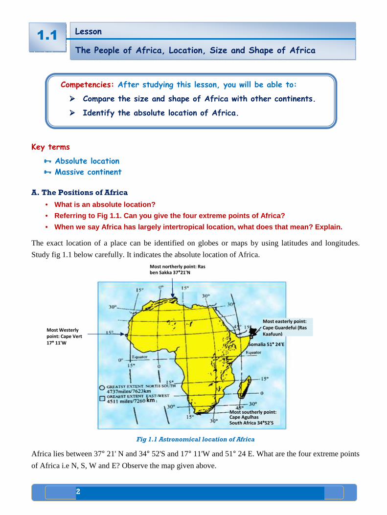
A. The Positions of Africa
• What is an absolute location?
• Referring to Fig 1.1. Can you give the four extreme points of Africa?
• When we say Africa has largely intertropical locati on, what does that mean? Explain.
The exact location of a place can be identified on globes or maps by using latitudes and longitudes.
Study fig 1.1 below carefully. It indicates the absolute location of Africa.
Fig 1.1 Astronomical location of Africa
Africa lies between 37° 21' N and 34° 52'S and 17° 11'W and 51° 24 E. What are the four extreme points
of Africa i.e N, S, W and E? Observe the map given above.
Lesson
The People of Africa, Location, Size and Shape of Africa
1.1
Competencies: After studying this lesson, you will be able to:
���� Compare the size and shape of Africa with other continents.
���� Identify the absolute location of Africa.
Somalia 51°°°° 24'E
Most easterly point:
Cape Guardefui (Ras
Kaafuun) Most Westerly
point: Cape Vert
17°°°° 11'W
Most northerly point: Ras
ben Sakka 37°°°°21'N
Most southerly point: Cape Agulhas South Africa 34°°°°52'S
km
3
1 Living in Africa
����
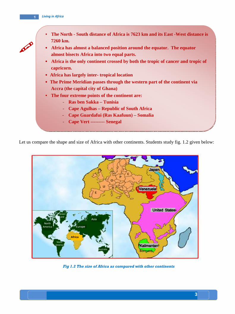
Let us compare the shape and size of Africa with other continents. Students study fig. 1.2 given below:
Fig 1.2 The size of Africa as compared with other continents
• The North - South distance of Africa is 7623 km and its East -West distance is 7260 km.
•••• Africa has almost a balanced position around the equator. The equator almost bisects Africa into two equal parts.
•••• Africa is the only continent crossed by both the tropic of cancer and tropic of capricorn.
•••• Africa has largely inter- tropical location
•••• The Prime Meridian passes through the western part of the continent via Accra (the capital city of Ghana)
• The four extreme points of the continent are: - Ras ben Sakka – Tunisia - Cape Agulhas – Republic of South Africa - Cape Guardafui (Ras Kaafuun) – Somalia - Cape Vert --------- Senegal
Africa
Europe
Asia
Australia
South
America
North
America
Green
Land
JapanJapanJapanJapan
VenezuelaVenezuelaVenezuelaVenezuela
United StatesUnited StatesUnited StatesUnited States
KalimantanKalimantanKalimantanKalimantan
4
1 Living in Africa
Africa has a compact shape. It has remarkably regular coastal lines. Such coastlines afford very few
harbours. The only indentations are Gulf of Guinea and the Gulf of Sidra. Try to locate these areas on
the map of Africa.
As it is indicated in Fig. 1.2 Asia is bigger than Africa. Therefore, Africa is the 2nd largest continent. It
has a total area of about 30,331,606 km2. This accounts for about 20.2 percent of the earth’s land
surface. Of course 75 percent of Africa’s area lies within the tropics. On the other hand, over 25 percent
of Africa’s land is covered by the Sahara desert.
���� The table below shows the size of major continents. Study it carefully
Table 1.1 Areal sizes of Major continents
Continent Approximate
area in Km2
percent of world
share
Asia 44, 810,880 29.9
Africa 30, 331,606 20.2
North America 24, 367,875 16.3
South America 17, 831,606 11.9
Antarctica 14,002,590 9.4
Europe 9, 935,233 6.6
Australia 8, 289,000 5.7
World total 149, 568,790 100
Africa is as large as the combined land area of U.S.A, Europe and China.
Africa’s land surface, approximately two third, lies north of the Equator.
Case Study Case Study Case Study Case Study
Comparison of two capitals: Accra and KampalaComparison of two capitals: Accra and KampalaComparison of two capitals: Accra and KampalaComparison of two capitals: Accra and Kampala
Accra Accra is the capital and the largest city in Ghana (Western Africa) with the population
of the city proper estimated at 3,963,264 as of 201 1. Accra also doubles as the capital
of Grea ter Accra region and of the Accra Metropolitan dist rict with which it is
coterminous (sharing a border). Accra is also the a nchor of a substantially l arger
metropolitan area called the Greater Accra Metropol itan area and includes eight
districts.

5
1 Living in Africa
Accra is the administrative, communications, and ec onomic center of the country. Originally built around a port, Accra stretches alo ng the A tlantic coast and north into the interior. Serving as the nation’s capital, then the Gold C oast, form 1877 its architecture ranges from large and elegant nineteen th ce ntury colonial buildings to skyscrapers and parliament blocks made of concre te, glass and steel in the 1970s. Reflecting its transition form a 19 th century suburb Victorian burg (old fashioned) to the modern metropolis it is today.
Spreading along the Atlantic coast, the city is wel l endowed with luxury as well as great value hotels, excelle nt restaurants and night clubs. A range of absorbin g museums and fine public monu ments, modern business and commercial areas, as well as busy markets and tree lined residential sub urbs, is ready to be explored. Since the early 1990s a number of new buildin gs have been built, including the multi- storey Novotel hotel which is French owned. There i s also an Impassive National theatre that was built with help from the Chinese.
The center of Accra contains the main banks, the la rge department stores, and a whole area known as the Ministries, where the gover nmental administration is concentrated. Economic activities in Accra are: fin ancial, agriculture, fishing, and manufacturing processed food, lumber and plywood, t extiles, clothing and chemicals.
Kampala Kampala is the largest city and capital of Uganda ( Eastern Africa). The city is divided into five boroughs that oversee local plann ing: Kampala Center, Kawempa Division, Makindye Division, Nakawa Division and Lu baga Division. Mutesa I, the Kabaka (king) of Buganda, had chosen the area that was to become Kampala as one of his favorite hunting grounds. The area was m ade up of hills and wetlands. It was an ideal breeding ground for various game, part icularly a species of antelope.
The city grew as the capit al of Buganda Kindgom, from which several buildings survive, including the Dasubi Tombs (built in 1881) , the Buganda parliament, the Buganda Court of Justice and the Naggalabi Budo cor onation site. Severely damaged in the Uganda-Tanzania war, the city has si nce then been rebuilt with constructions of new buildings including hotels, ba nks, shopping malls , educational institutions, hospitals and improvement of war torn buildings and infrastructure. Traditionally, Kampala was a city o f seven hills, but over ti me it hascome to have a lot more.
Kampala is situated at an altitude of 1,190 meters (3,904 feet). The national census in 2002 estimated the population of the city at 1,1 89,142. The Uganda Bureau of Statistics estimated the population of Kampala at 1 ,420,000 in 2008. Kampala
6
1 Living in Africa
Lesson Lesson Lesson Lesson ReviewReviewReviewReview
Activity 1.1 A A. Questions based on facts:
• What is the difference between an absolute and relative location of a place? • Give the absolute location of Africa. • Mention the four extreme points of the continent of Africa. • Which extension of the African land mass (N-S or E-W) is the longest? What is its
distance in km?
• How do we explain the compactness of a continent? • Give the name of the most northerly and the most southerly points of Africa and
indicate the latitudinal difference between them.
• Which part of Africa is wider? The northern or the southern?
B. Group discussion:
• Discuss the advantages and disadvantages of having large size of continent like that of Africa.
• In groups, discuss the advantages and disadvantages of compact shape.
C. Individual work:
• Draw a political map of Africa and label the countries with their respective capital cities. Then present it to your class mates for further comment. Finally let your teacher add if something is missing.
1.1
features a tropical wet and dry climate. However, d ue to the city’s higher altitude, average temperatures are noticeably cooler than wha t is typically seen in other cities with this type of climate. Kampala seldom gets hot during the course of the year, it s warmest month being January. Kampala’s weather feat ures two distinct seasons. There is a lengthy rainy season from August through December and another shorter rainy season that begins in February and lasts thro ugh June. The heaviest amount of precipitation at an average of around 175 mm of rai n.
Summary Although the two cities are long built cities, they are situated at the two extreme corners of the continent, i.e, Accra in western Afr ica and Kampa la in Eastern Africa. Accra is a port city while Kampala is the capital city of landlocked country ( Uganda). Furthermore, Accra stretches along the Atlantic coa st and north into the interior, occupying the coastal lowland, while Kampala is sai d to b e the city of several hills. Its altitude is about 1,190 meters (3,904 feet). Kampala features a tropical we t and dry climate. However, due to the city’s higher altitude, average temperat ures are cooler than cities of the same climate.
The population of Accra is estimated at 3,963,264 a s of 2011, while the population of Kampala had been estimated by Uganda Bureaus of sta tistics at 1,420,000 in 2008.

7
1 Living in Africa
Key terms
���� Low latitudes
���� Middle latitudes
���� High latitudes
���� Longitudes
���� Meridians
���� Solstice
���� Parallels
A. Latitudes and parallels
• What is the difference between a meridian and a pa rallel?
• What does high latitude and low latitude refer to?
• How do you explain the relationship between latitu de and climate?
• Latitudes: are angular distances measured north and south of the equator in degrees. To measure
latitude, equal distances from equator are marked off by parallels which are imaginary circles that
go around the earth parallel to the equator. Like the equator, parallels run in an East- West direction.
In addition, parallels are closer and smaller at North or South Pole.
• Parallels: are imaginary lines drawn on globes or maps joining all points with the same latitude in
degrees north and south of the equator. Since the equator is the origin of latitude, it is numbered 00.
Places north of the equator have north latitude; places south of the equator have south latitude. The
north and south poles are the most distant points from the equator; that is the North Pole’s latitude is
900 N and the South Pole’s latitude is 900 S. The location of a place relative to the equator
determines the amount of sunlight it receives. Fig 1.3, shows five important latitudes. These lines
are used as benchmarks for telling the amount of sunlight reaching various parts of the surface of
the earth.
Next, you will learn more about the latitudes indicated in fig 1.3. They are as follows: 1. The low latitudes or tropics: The equator receives more direct sunlight than any place on earth.
Areas near the equator are usually hot all year round. Both the tropic of Cancer (231/2° N) and tropic
of Capricorn (231/2°S) receive vertical sunrays. This happens on solstices. The belt between the two
lines of latitudes or parallels is called the low latitude or tropics.
Lesson
Latitudes and Longitudes 1.2
Competency: After studying this Lesson, you will be able to:
���� Explain the terms latitude and longitude in relation to
parallels and meridians.

8
1 Living in Africa
2. Middle latitudes or temperate regions: They are found between the Tropic of Cancer
(231/2°N) and the Arctic Circle (661/20N) in the north and the Tropic of Capricorn (231/2° S) and the
Antarctic Circle (661/20 S) in the south. (231/2° - 661/2°N and S)
3. High latitudes and the Arctic and Antarctic circles: (661/20N or S). Both have at least one
day of complete sunlight and darkness each year. This occurs on solstices. Beyond the Arctic circle and the Antarctic circle are the high latitudes or polar regions. These areas receive little heat from the sun and, therefore, they are cold. Each year both North and South Poles have six months of daylight and six months of darkness.
Fig 1.3 The Tropics, the Middle Latitudes and the High Latitudes
B. Longitudes and Meridians
• How do you explain the relationship between longitu des and time?
• Which longitude is the most important longitude?
Middle latitudes
High latitudes
90 0 S
66 1/2
0 S
231/2 °°°°S
0°°°°
231/2°°°° N
66 1/2
0 N
High Latitudes
Middle latitudes
Low latitudes
North Pole
South Pole
Arctic circleArctic circleArctic circleArctic circle
Tropic of cancer Tropic of cancer Tropic of cancer Tropic of cancer
Equator Equator Equator Equator
Tropic of Capricorn Tropic of Capricorn Tropic of Capricorn Tropic of Capricorn
AAAAntntntntarctic circlearctic circlearctic circlearctic circle
90 0 N

9
1 Living in Africa
• Longitudes: are angular distances
measured to the east and west of the
prime meridians in degrees
• Meridians: are imaginary lines drawn on
globes or maps joining all points with the
same longitude in degrees. All meridians
extend from the North Pole to the South
Pole and each meridian is, therefore, a
semi circle covering half of the earth’s
circumference. Distance between
meridians is known as Longitude.
The Prime Meridian or 0 ° longitude
There is “natural” midpoint like the equator from which longitude can be measured, but most countries have agreed to use the meridian that runs from the North Pole to the South Pole through the royal observatory at Greenwich. This meridian is called Prime Meridian.
All other meridians are labeled in degrees East or West of the prime meridian. The earth being a circle,
it is divided into 360° of longitude. The half of the earth that lies east of the Prime Meridian has east
longitude up to 180° (half of 360°); the half that lies west of Prime Meridian has west longitude up to
180°.
C. Travelling in Time
• What is the difference between local time and stan dard time?
• Why do we say a place east of the international da te time is earlier than a place west of the international date time?
���� Local Mean TimeLocal Mean TimeLocal Mean TimeLocal Mean Time
Time varies with longitude. The earth rotates on its axis from west to east. This motion of the earth determines the length of a day. All places on the face of the earth see the sun apparently rising in the East and setting in the West. Each day, in its path the sun moves across the sky at its zenith. This happens at noon time. All places located along a given meridian see the sun equally. They have also similar noon time. But the time East or West of this line will see the sun differently. Due to longitudinal variation in time, places observe varied Local Mean Time( L.M.T). For example, the earth completes one rotation or 360° in 24 hours. That means every 15° equals one hour and four minutes for a degree.
90°°°°N
North Pole
231/2 °°°°N
0°°°°
231/2
0 S
Fig 1.4 Prime meridian
66 ½ 0 S
661/2 °°°°N
90°°°°S
South Pole
Arctic circle
Tropic of cancer
Equator
Tropic of Capricorn
Antarctic circle
Prim
e m
erid
ian
(0 °° °°)
North latitude
South latitude

10
1 Living in Africa
Places East of the meridional position in relation to the sun will be ahead of places to the west. Therefore, the L.M.T for the East is always ahead. For example, you can find L.M.T. in New York when it is noon in London.
Fig 1.5 Longitude and Time
����
Once the time difference between two points is known, it is possible to calculate their longitudinal location. For example, if L.M.T. is 41/2 hour ahead of Greenwich as reported by radio officer on a ship, what will be its longitudinal location? To calculate this, you can proceed as follows:
����
Difference in longitude between New York and London: London 0°°°° New York 74°°°°W Longitudinal difference 0 + 74 = 74
• Difference in time: - 74 ÷÷÷÷ 15 = 4 hours, 56 minutes. Is L.M.T in New York behind or ahead of
London? The direction is west, therefore, L.M.T is behind. When it is noon at London, its L.M.T is 7:04 a.m at New York.
• Difference in time is 4 hours
• Difference in longitude is: 4 ×××× 15°°°° = 67 degrees
• Therefore, the longitudinal position of the ship is 67° 30' East.
Saturday/Sunday Sunday/Monday
Midnight
180°°°°
Prime
Meridian
Noon
Sunday
2 a.m. 150°°°°W
4 a.m. 120°°°°W
6 a.m. 90°°°°W
8 a.m. 60°°°°W
10 a.m. 30°°°°W
30°°°°E 2 p.m.
60°°°°E 4 p.m.
90°°°°E 6 p.m.
120°°°°E 8 p.m.
150°°°°E 10 p.m.
NROTATION
West to East

11
1 Living in Africa
Lesson Lesson Lesson Lesson
ReviewReviewReviewReview
Activity 1.2 A
A. Questions based on facts:
• Which longitude is known as the prime meridian?
• What do we mean by the apparent movement of the sun? • Is the time in Delhi (India) ahead or behind than the time in paris(France)?
• Explain the following abbreviations A.M, P.M, L.M.T, G.M.T.
B. Group work:
Do in two groups. Let the first group make a short study as to why time is ahead when
one goes from west to east. Let the second group make a short study as to why
temperature is decreasing when moving from the low latitude to the high latitude. Let
the representatives of each group present the results of their studies to their
classmates and invite them for further discussion.
C. Things to do:
• The news is broadcasted by the B.B.C at 7 p.m G.M.T 1. At what time is it heard in Addis Ababa,400 E? 2. At Singapore 105°E?
1.2

12
1 Living in Africa
Key terms
���� Khoisan ���� super Language families
���� Major Language Families Major Language Families Major Language Families Major Language Families Spoken in Africa Spoken in Africa Spoken in Africa Spoken in Africa
• Do all the peoples of Africa speak one language?
• List major language families spoken in Africa.
Niger – Congo
• Bantu family
• Kordofanian family
• Mande
• Dogon
Afro -Asiatic
• Semetic
• Cushitic
• Berber
• Chadic
• Omotic
Nilo -Saharan
• Kanuri
• Songhay
• Nubian
• Nilotic family
- Luo
- Dinka
- Masai
Khoisan
• Khoe
• Tuu
• Kxa
The languages spoken by the peoples of Africa are classified into four super-language families. They
are:
• Niger–Congo: It has between 300 and 400 million speakers. The Niger-Congo super–family
speakers are found in western, central, eastern and southern Africa. This language family occupies the
largest part of Africa.
•••• Afro–Asiatic: super family speakers are found in northern, central, northeastern and the Horn of
Africa. It is the second largest super language family. It has between 200 and 300 million speakers.
Competency: After studying this lesson, you will be able to:
���� Name super language families in Africa.
Lesson
Super Language Families of the Peoples of Africa and their
Distribution
1.3

13
1 Living in Africa
•••• Nilo Saharan: It is divided into seven subgroups. Chari-Nile, Songhay, Saharan, Meban, Koman and
Fur. Chari-Nile and Koman are spoken in parts of Ethiopia and the Horn. It has about 30 million
speakers.
•••• The Khoisan super-family speakers occupy a few areas of southern Africa. This language super
family has the smallest number of speakers. It has about 300,000 speakers.
Case Study
comparative case study of speakers from two major l anguage groups.
Speakers from Two Major Language Groups Speakers from Two Major Language Groups Speakers from Two Major Language Groups Speakers from Two Major Language Groups
The Niger-Congo Language family is the largest grou p in Africa (and probably in the
world) interms of the number of languages. A major branch of the Niger- Congo
Language is the Bantu family, which covers a greate r geographic area than the rest
of the famil y put together. Most of the ethnic groups living in Central and Southern
Africa today are Bantu speakers. In fact, more than 200 million people in the region
speak one of the many Bantu languages.
Afro-Asiatic Languages are spoken across North Africa, the Horn of Africa and the
Middle East. There are approximately 375 Afro – Asiatic languages spoken by 300
million people. The main sub-families of Afro-A siatic are the Semitic Languages, the
Cushitic Languages, Berber and the Chadic Languages . The Afro-A siatic language
family is believed to have originated in East Afric a, though its most famous sub -
branch, the Semitic Languages (including Arabic, Am haric and Hebrew among
others), seems to have developed in the Arabian pen insula . The Semitic Languages
are the only branch of the Afro- Asiatic family of languages that is spoken outside of
Africa.

14
1 Living in Africa
Fig. 1.6 Language Super-Families
Lesson Lesson Lesson Lesson ReviewReviewReviewReview
Activity 1.3 A A. Fact based questions:
1. Answer the following questions
• What are the major language classification of the peoples of Africa?
• Which of the four Super-Families of languages are spoken in Ethiopia
and the Horn?
• How many super language families are there in Africa?
• Which language Super-Family has the largest number of speakers?
• Which language Super-Family has the smallest number of speakers?
1.3
Afro-Asiatic
Nilo-Saharan
Niger –Congo
Khoisan
Austronesia

15
1 Living in Africa
Key terms
���� Craftsman ���� Temple
���� Mummification ���� Tomb
���� Ancient Civilization of EgyptAncient Civilization of EgyptAncient Civilization of EgyptAncient Civilization of Egypt
• Most ancient civilizations began in river valleys. Do you agree or disagree? Discuss.
• Have you ever seen the picture of a pyramid? Sketch it on the exercise book.
The civilization of Ancient Egypt began about 3000 BC in the Nile River valley. During this time, most
people lived in and around the Nile valley.
Lesson
Ancient Civilization in Africa (Egypt and Carthage)
1.4
Competencies: After studying this lesson, you will be able to:
���� Indicate the location of Egypt and Carthage as one of the centers
of ancient civilizations in Africa.
���� Explain the significance of the ancient civilizations of Egypt and
Carthage.

16
1 Living in Africa
]
Fig.1.7 Nile valley settlement
���� Social Classes in Ancient EgyptSocial Classes in Ancient EgyptSocial Classes in Ancient EgyptSocial Classes in Ancient Egypt In ancient Egypt, there were three social classes. These include:
• The Upper Class: consisted of kings, rich land owners, priests and government officials.
• The Middle Class: was made up of merchants, craftsmen and other skilled workers.
• The Lower Class: consisted of poor farmers. They lived in small mud huts.
���� Agriculture Agriculture Agriculture Agriculture
Ancient Egypt was a hot country with almost no rain fall. But farmers grew crops most of the year by irrigating their land. They built canals to take water from the Nile to their fields. Farmers used wooden ploughs pulled by oxen to prepare the fields for planting.
Wheat and barley were the main crops of ancient Egypt. Other crops included lettuce, beans, onions,
figs, dates, grapes, melons and cucumbers. Parts of the date of grape crops were crushed to make wine.
Shwa
Bahanya
Farafra
Dakhla Kharga
Abydos
Asyut
Luxer
Coptos
Amarna
Thebes
Aswan
Abu Simbel
Giza
Faiyum
Sais
Heliopolis
Tanis
Mendes
Rosetta Alexandria

17
1 Living in Africa
The Egyptians raised dairy and beef cattle, goats, ducks, geese and donkeys. Some people kept bees for
honey.
���� TradeTradeTradeTrade
Ancient Egyptian traders sailed to lands bordering Aegean, Mediterranean and Red Seas. They acquired
silver, iron, horses and cedar logs from Syria, Lebanon and other areas of Southwestern Asia. They got
ivory, leopard skins, copper, cattle and spices from Nubia, a country south of Egypt. For these goods, the
Egyptians bartered gold, other minerals, wheat, barley and papyrus sheets.
����
���� The PyramidsThe PyramidsThe PyramidsThe Pyramids
Egyptian farmers were also involved in the construction of temples, palaces and tombs. The large tombs
built for the Pharaohs were called Pyramids. (See fig 1.8).
Fig. 1.8 Pyramids
���� Beliefs Beliefs Beliefs Beliefs Ancient Egyptians believed in life after death. They preserved the body of the dead. The process of
preserving the dead body is called Mummification .
���� Egyptian WritingsEgyptian WritingsEgyptian WritingsEgyptian Writings
A system of writing called hieroglyphics was developed by Ancient Egyptians. Hieroglyphics was a
pictorial form of writing. First Egyptians wrote by carving hieroglyphics on stone or wood. Later on,
they used papyrus. In fact, the English word paper comes from the word papyrus.
Ancient Egyptian rulers were known as Pharaohs.

18
1 Living in Africa
���� Contribution Made in ScienceContribution Made in ScienceContribution Made in ScienceContribution Made in Science
Ancient Egyptians contributed a lot for the advancement of mathematics, astronomy and medicine. They
produced a calendar with 365 days. Ancient Egyptians also made important medical discoveries.
���� The Ancient Civilization of CarthageThe Ancient Civilization of CarthageThe Ancient Civilization of CarthageThe Ancient Civilization of Carthage
• Where was Carthage found?
Carthage was one of the greatest cities of ancient times. It was a rich trading center. Carthage was
located on the coast of North Africa near the present day Tunis (capital city of Tunisia).
Carthage was founded by the Phoenician people at about 814 BC. It was surrounded by a wall. Probably it was the first city-state to control an empire. The Empire of Carthage ruled parts of North Africa, southern Spain and the islands of Corsica, Sardinia and Sicily in the Mediterranean Sea.
The Phoenicians developed their alphabet which consisted of 22 symbols. The Greek alphabet developed from that of the Phoenicians. The Roman and all Western alphabets have been taken from the Greeks. The Carthaginians built broad cargo ships and also long, narrow warships. They engraved metals such as gold and silver. They carved objects from ivory. They also knew how to weave woolen and linen.
Carthage fought three wars with the Roman Empire over Sicily. The wars, took place from 264 BC to 146 BC. The wars were called the Punic Wars. But in the third war, Carthage was finally destroyed and it became part of the Roman Empire.
Case Study
Comparison between Egypt and CarthageComparison between Egypt and CarthageComparison between Egypt and CarthageComparison between Egypt and Carthage
Ancient Egypt was the birthplace of one of the worl d’s first civilizations. This advanced culture arose about 5000 years ago in the Nile Rive r valley in northeastern Africa. It continued for over 2000 years and so became one of the longest lasting civiliza tions in history.
The ancient Egyptians made outstanding contribution s to the development of civilization. They created the world’s first nation al government, basic forms of arithmetic, and a 365-day calendar. They invented a form of picture writing called hieroglyphics. They also invented papyrus, a paper like writing material made from
the stems of papyrus plants. Ancient Egyptians deve loped a belief in life after death. They built great cities in which many skilled archi tect, doctors, engineers, pa inters and sculptors worked. They also built the pyramids as t ombs for their rulers. They serve as spectacular reminders of the glory of ancient Egypt .
Carthage was one of the greatest cities of ancient time . It stood on a peninsula in North Africa, near the present city of Tunis, Tunisia. It was founded by the Phoenicians around 814 BC. It grew quickly because of its locat ion on a peninsula and its two excellent harbours. But archeologists who excavated the ruins of Carthage have found no remains earlier than about 750 B.C.

19
1 Living in Africa
Lesson Lesson Lesson Lesson ReviewReviewReviewReview
Activity 1.4 A A. Questions based on facts:
• Explain the time and place of the beginning of ancient Egyptian civilization.
• Why did the ancient Egyptians construct pyramids? • What are hieroglyphics?
• What is papyrus?
• Who were the founders of Carthage?
B. Things to do:
• Draw an outline map of Africa and locate the Nile valley and Egypt.
• Locate ancient Carthage on the map of Africa.
1.4
20
1 Living in Africa
Key term
���� Pre-colonial
Pre Pre Pre Pre –––– colonial colonial colonial colonial ZimbabweZimbabweZimbabweZimbabwe
• Where is the present day Zimbabwe located?
Zimbabwe took its name from the ancient trading city of Zimbabwe. The city was built by the Shona
people about 1000AD. The word “Zimbabwe” comes from a Shona language which meant "house of
stone".
The ruins of the city include a tower 9 meters high and a part of a wall 240 meters around. The structures
were made of huge granite stones which were fitted together without mortar.
By 1400's Zimbabwe reached its highest stage of civilization. During this time, a branch of the Shona
called the Karanga established the Mwenemutapa Empire. This empire included most of the present-day
Zimbabwe.
But in the late 1400's, a group called Rozwi from Karanga revolted against Mwenemutapa Empire and
founded another Empire called Changemire. The Rozwi took over the city of Zimbabwe and became
stronger than its counterpart. However, in turn the Changemire Empire was defeated by another people
called Nguni. After the fall of the Changemire Empire, the city of Zimbawe was abandoned.
The rulers of Zimbabwe built a large walled capital. Skilled masons constructed a huge complex of palaces, stone houses and temples.
1.5 Lesson
Pre-Colonial States (Zimbabwe, Mali, Funji)
Competencies: After studying this lesson, you will be able to:
���� Show appreciation to the architectural achievements of pre-colonial
state of Zimbabwe.
���� Analyze the economic bases of pre-colonial states of Mali and Funji.

21
1 Living in Africa
���� PrePrePrePre----colonial Malicolonial Malicolonial Malicolonial Mali
• When did the Empire of Mali reach its highest peak?
The Mali Empire was founded by the Mandingo people. By about 1240 A.D., a young leader named
Sundiata Keita defeated the kingdom of Ghana. By this time, Mali was able to control the gold fields and
salt deposits of West Africa. This formed the basis for its economy. From 1312 to 1337, Mali was ruled
by Mansa Musa. Under his rule, the Empire achieved the highest stage of political power and cultural
development. During this time, the city of Timbuktu became a famous center of Islamic learning. Other
cities of the Empire were centers of caravan trade. The Mali people were successful farmers and cattle
keepers. But, in the late14th century, Mali became weak due to civil war. Later on, the kingdom of
Songhai replaced Mali as the most powerful state in West Africa.
���� PrePrePrePre colonial Funjcolonial Funjcolonial Funjcolonial Funjiiii
• Where was the Funj kingdom located?
Funj was a Muslim Empire in present day Sudan. The empire began in the early 16th century and was destroyed by the Egyptians in 1821.
The origin of the Funj people was not clearly known. They might have come from a people called Shilluk who lived in the White Nile region.
The Funj Sultanate was a feudal state founded in the early 16th century by Amara Dunkas (r.1504 - 34). The Sultanate flourished during the 17th and 18th centuries. The population consisted mainly of the Funj people. Nubians, Arabs, Beja and other peoples also lived in the sultanate. Arabic was spoken in much of the Funj Sultanate proper. The state religion was Islam.
Case Study
Zimbabwe
Zimbabwe was the most powerful inland state that ex ported gold to the coastal cities of East Africa. Around 1000 AD, migrating farmers and herders settled in the lands between the Zambezi and Limpopo rivers. These pioneers disc overed gold in their new homeland. With the wealth from gold, they set u p a large trading empire. In the ruins of Zimbabwe, archeologists have found Chinese and Indian goods w hich the rulers of Zimbabwe had bought with profits from the gold trade. Zimbabwe reached its height in the 1400’s when the Portuguese destroyed the coas tal cites. Zimbabwe declined because trade was cutoff. About the same time, weak rulers, shortage of salt, and poor crops left the land open to invaders.

22
1 Living in Africa
The feudal structure of the sultanate retained elements of a slave holding system. Tribal clan relationships continued in the outlaying areas. The capital Sennar, was prosperous through trade. It hosted representatives from all over the Middle East and Africa. The wealth and power of the Sultans had long rested on the control of the economy. All caravans were controlled by the monarch. The monarch also controlled the gold supply that became the main source of the state’s currency. Foreign currencies were widely used by merchants in order to break the power of the monarch. The growing trade created a wealthy class of literate merchants who read widely about Islam.
In the early 16th century, the Funj accepted Islam. They founded also Sennar as their capital.
The Funj armies conquered the northern regions of the Sudan and nearly all the area between the Blue Nile and White Nile. Then, Funj became powerful. They were feared in the region between the Red Sea and the Nile River. But, since the middle of the 17th century, the Funj nobles revolted again and again. A period of decline followed. In 1821, it was invaded by Egypt which marked the end of the Funj Empire.
Lesson Lesson Lesson Lesson ReviewReviewReviewReview
Activity 1.5 A • Fact based questions:
1. Identify the following:
- Rozwi
- Karanga
- Nguni
- Mandingo
- Timbuktu - Sennar
- Mansa Musa - Shilluk
2. Answer the following questions:
• Who built the city of Zimbabwe?
• Which ruler established a powerful Empire in West Africa?
• Write the names of the Empires that came just before and after Mali.
• What does the word Zimbabwe mean?
• Who established the Mwenemutapa Empire?
• Which Empire was established by the Rozwi people?
• Which people defeated the Changamire Empire?
• Name the people who founded the Mali Empire.
• Explain the role of Sundiata Keita and Mansa Musa in Mali Empire.
• Which kingdom replaced Mali?
• Who defeated Funj Sultanate and when?
1.5

23
1 Living in Africa
Key terms
���� Caravan ���� Musk
���� Incense ���� Spices
����
•••• Is it possible for people to live without trade int eraction? Discuss.
���� Long Distance Trade in Ethiopia Long Distance Trade in Ethiopia Long Distance Trade in Ethiopia Long Distance Trade in Ethiopia
Long distance trade in Ethiopia was conducted by Muslim merchants. It revived in the 19th century.
The leading merchants of the time were known as Jabarti and Afkala.
����
Long distance trade was mainly conducted by caravan merchants who travelled far and wide distances in
large groups. The leader of the caravan merchants was called Negadras. The word comes from Amharic
and meant leader of merchants.
Trade: is an economic activity of buying and selling goods.
Local trade: refers to local exchanges of goods among peoples of a given region.
It was conducted at open markets held weekly on fixed days.
Long distance trade: involved different markets, peoples, regions and goods.
It combined both internal and external trade.
The Jabarti were Muslim merchants in Northern Ethiopia.
The Afkala were Oromo Muslim Merchants in South Western Ethiopia.
Competencies: After studying this lesson, you will be able to:
���� Appreciate the contribution of long distance trade in Ethiopia in
connecting peoples.
���� Recognize the existence of other trade routes in Africa.
���� Identify the origins of long distance trade routes in Ethiopia.
Lesson
Long Distance Trade as a Factor Connecting Peoples in Ethiopia
1.6

24
1 Living in Africa
���� Items of TradeItems of TradeItems of TradeItems of Trade
The major export items of trade were ivory, musk, gold, skins, hides, incense, coffee and slaves. The
major area of supply was South Western Ethiopia.
The main import items included copper, spice, clothes, beads, silk, silver, firearms, cartridges and
different tools.
���� Markets and Trade RoutesMarkets and Trade RoutesMarkets and Trade RoutesMarkets and Trade Routes
The major markets were located along the trade routes running from South Western to Northern
Ethiopia.
Some of the markets included Bonga in Keffa, Hirmata in Jimma, Assendabo in Wollega, Basso in
Gojjam and Adwa in Tigrai. Massawa was the end of the trade routes in this part of Ethiopia.
Markets located along the East –West trade route include Sodo in Gurage, Ankober and Aliyu Amba in
Northern Shewa and Dire Dawa and Harar in Hararge. The ports of Zeila and Berbera were the end
points.
The major trade routes linked the market centers along the North-South and East–West directions. South
- Western Ethiopia was the origin of both trade routes (See fig 1.9)
Fig. 1.9 Major trade routes in the 19th century
Trade routes
N
Rivers
Key
SOMALIA
Kenya
16°°°°
12°°°°
8°°°°
6°°°°
36°°°° 38°°°° 42°°°° 46°°°°
Asmara
Adwa
Matamma
Gondar
Darita
Bati o
Rogge Harar
Soddo
Bonga
Sqaq
jiren
Assandabo
Basso Alyu Amba
Zella Berber
0 200km
scale

1 Living in Africa
���� Medium of ExchangeMedium of ExchangeMedium of ExchangeMedium of Exchange
In the 19th century, one of the widelyimportant medium of exchange was called after its queen. It was imported into Ethiopia at the end of
���� Importance of Long Distance TradeImportance of Long Distance TradeImportance of Long Distance TradeImportance of Long Distance Trade
Long distance trade served as a major means of econBesides exchange of goods, people also of the major sources of income to ruleimported firearms. Furthermore, long distance trade contributedamong the Oromo of the Gibe River valley whomerchants they also accepted Islam. Withform of money. Above all, long distance Ethiopia and united them together.
Case study
Two major trade routesTwo major trade routesTwo major trade routesTwo major trade routes
The major trade routes consisted of two m
south western part of Ethiopia. One of the lines originated from Bonga , the capital
city of the kingdom of Kefa. It connected peoples a nd states of southern region with
the northern part of Ethiopia. This trade route ran north wards through trade centers,
such as Jiren (in Jimma), Seka (in Limmu
Basso (in Gojam) and Darita (in Begemder). From Dar ita the route entered Gond
where it branched into two. One branch proceeded west
Metemma, while the other branch ran no
entered Massawa on the Red Sea coast. This route wa s the most important in the
first decade of the 19 th century.
one of the widely used medium of exchange was salt bar called amolemedium of exchange was called Maria Theresa. It was a silver coin made in Austria
o Ethiopia at the end of the 18th century.
Fig. 1.10 Maria Theresa
Importance of Long Distance TradeImportance of Long Distance TradeImportance of Long Distance TradeImportance of Long Distance Trade served as a major means of economic relations among different peopl
exchange of goods, people also interchanged views and ideas. On the other handincome to rulers. To strengthen their economic and political power
, long distance trade contributed to the political and religious changes iver valley who formed the Oromo kingdoms. Through the Muslim
they also accepted Islam. With the introduction of money, rulers began to collect taxes, long distance trade created a strong attachment among the peoples
The major trade routes consisted of two m ain lines. Both lines star ted from the
of Ethiopia. One of the lines originated from Bonga , the capital
city of the kingdom of Kefa. It connected peoples a nd states of southern region with
the northern part of Ethiopia. This trade route ran north wards through trade centers,
Jimma), Seka (in Limmu - Enarya), Assendabo (in Horro Guduru),
Basso (in Gojam) and Darita (in Begemder). From Dar ita the route entered Gond
two. One branch proceeded west wards to Sudan through
Metemma, while the other branch ran no rthward through Adwa (in Tigray) and
entered Massawa on the Red Sea coast. This route wa s the most important in the
century.
25
called amole. The other made in Austria named
peoples of Ethiopia. On the other hand, trade was one
economic and political power, rulers to the political and religious changes
Through the Muslim began to collect taxes in the
trade created a strong attachment among the peoples of
ted from the
of Ethiopia. One of the lines originated from Bonga , the capital
city of the kingdom of Kefa. It connected peoples a nd states of southern region with
the northern part of Ethiopia. This trade route ran north wards through trade centers,
Enarya), Assendabo (in Horro Guduru),
Basso (in Gojam) and Darita (in Begemder). From Dar ita the route entered Gond ar
wards to Sudan through
rthward through Adwa (in Tigray) and
entered Massawa on the Red Sea coast. This route wa s the most important in the

26
1 Living in Africa
Lesson Lesson Lesson Lesson ReviewReviewReviewReview
Activity 1.6 A A. Fact based questions:
• Which merchants dominated the long distance trade in Ethiopia in the
19th century?
• Explain the advantages of having markets held on weekends.
• What was the impact of long distance trade on the social, economic
and political life of Ethiopian society?
B. Things to do:
• By visiting a nearby market, write a short report on the nature of the market
in relation to its merchants, major items of trade and its contribution to
the society.
1.6
The second major trade route connected the trade of Ethiopia with Zeila and Berbera.
This route started from Jiren and moved to Seka, wh ere it changed its course towards
the south east and continued to Soddo and Rogge nea r Mount Yerer. Then the route
passe d through Aliyu Amba and ran eastward to Harar. At Harar, the route branched
into two and proceeded to Zeila and Berbera. This r oute became very important after
the expansion of the power of the kingdom of Shewa under Sahle Selassie.

27
1 Living in Africa
Key terms
���� Population distribution
���� Population density
���� Population Distribution and Settlement Population Distribution and Settlement Population Distribution and Settlement Population Distribution and Settlement
A. Key factors affecting population distribution and settlement
• What do you understand by the phrase population dis tribution? • Define the term settlement. • What are the major causes of population distributio n?
The distribution of population in the world is uneven. It is affected by several factors. These factors
include: fertility of soil, relief, mineral resources, stage of economic development, and level of
technological development as well as socio-political organization. In agrarian societies, physical factors
such as climate have decisive roles in population distribution. But in advanced societies, cultural factors
have significant role in determining population distribution.
The following are major factors that affect population distribution:
• Climate: Favorable climate attracts more people than unfavorable climate.
• Natural vegetation: Forests and grasslands provide people with means of making a living.
Such areas are settled by large number of people.
Lesson
Population 1.7
Competencies: After studying this lesson, you will be able to:
���� Describe the factors which affect population distribution.
���� Relate these factors to population settlement in Africa and identify
settlement on a map.
���� Explain the types of livelihood commonly found in Africa.
���� Relate these factors to climate and vegetation.
���� Discuss reasons for urban settlement and identify some examples.
���� Identify key transport routes.
���� Be aware of key transport routes and the effect of civil unrest on
security.

28
1 Living in Africa
• Relief: High mountains are too cold to be settled by people unless they are rich with minerals.
• Soils: Areas such as river valleys and deltas, as well as regions with rich volcanic soils are
attractive for human settlement. They are good for cultivation of crops.
• Minerals and power: Places that have rich mineral deposits and large supply of power are
usually settled by large number of people.
• Accessibility: Regions which are well facilitated with transport system or located along river
valleys, mountain passes and coastal areas could be settled by large group of people.
• Water supply: The availability of water is one of the major factors for human settlement.
• The political Factor: Governments may encourage people to migrate and settle in selected
parts of a country.
B. Patterns of population distribution in Africa
• Explain the effect of climate on population distrib ution and settlement.
Climate is the single-biggest physical factor that has strong influence on the pattern of population distribution in Africa. Generally, areas with less than 380mm of rainfall per year can support few crops. Therefore, the great expanse of the deserts and semi-deserts of the Sahara, Kalahari, Somalia, Nyika region of central and southern Kenya are areas of scanty rainfall. Consequently, they have low population distribution.
Study the fig.1.11 carefully
Fig 1.11 Settlement patterns
Equator
2 1
Key • Urban population
(millions)
• One dot per 100,000
people for rural
population
• 0.2 0.5
4

29
1 Living in Africa
�
���� Livelihood in AfricaLivelihood in AfricaLivelihood in AfricaLivelihood in Africa
• Which African country is well known in the producti on of palm oil?
• What do we mean by shifting cultivation?
• Describe the main livelihood of the Masai people of East Africa. Do we have people in Ethiopia having a similar kind of livelihood? Can y ou mention the regions?
A. Fishing in the Rift Valley of Ethiopia
The Ethiopian rift valley extends in between North Western and South Eastern highlands. The valley
floor consists of several lakes as Chamo, Abaya, Hawassa, Shalla, Abijata, Langano and Ziway.
In the Rift valley lakes, there are about 25 fish species. It accounts for about 50 percent of the total fish
production in Ethiopia. Tilapia, Nile perch and cat-fish are commercially popular.
Ethiopia has not yet much benefited from its fish resources. Despite the high potential for fish
production, its annual extraction is very little (11 percent). A number of factors may contribute to low
level development of fishery in the country. Some of these include:
- Traditional technique of fishing
- Low local demand for fish products
- Lack of skilled human power
- Absence of adequate statistical data about the fishery sector of the country, etc.
Fishery is a traditional sector of Ethiopian economy, hence, needs immediate transformation. This
implies that, it should be commercialized to benefit the fisherman and the country at large. To this effect
the use of improved tools and techniques of fishing, investable capital, changing the food habit of the
people, and conserving the fish resources would be necessary.
The shores of Lake Victoria, the Nile Delta, the Maghreb, the Highlands of Ethiopia and
the Coast of West Africa have high population concentration. On the other hand, the vast
Sahara Desert, the Namib-Kalahari Deserts, and the Coastal plains of the Horn of Africa
have extremely low population. These areas experience the hottest and driest climate.
30
1 Living in Africa
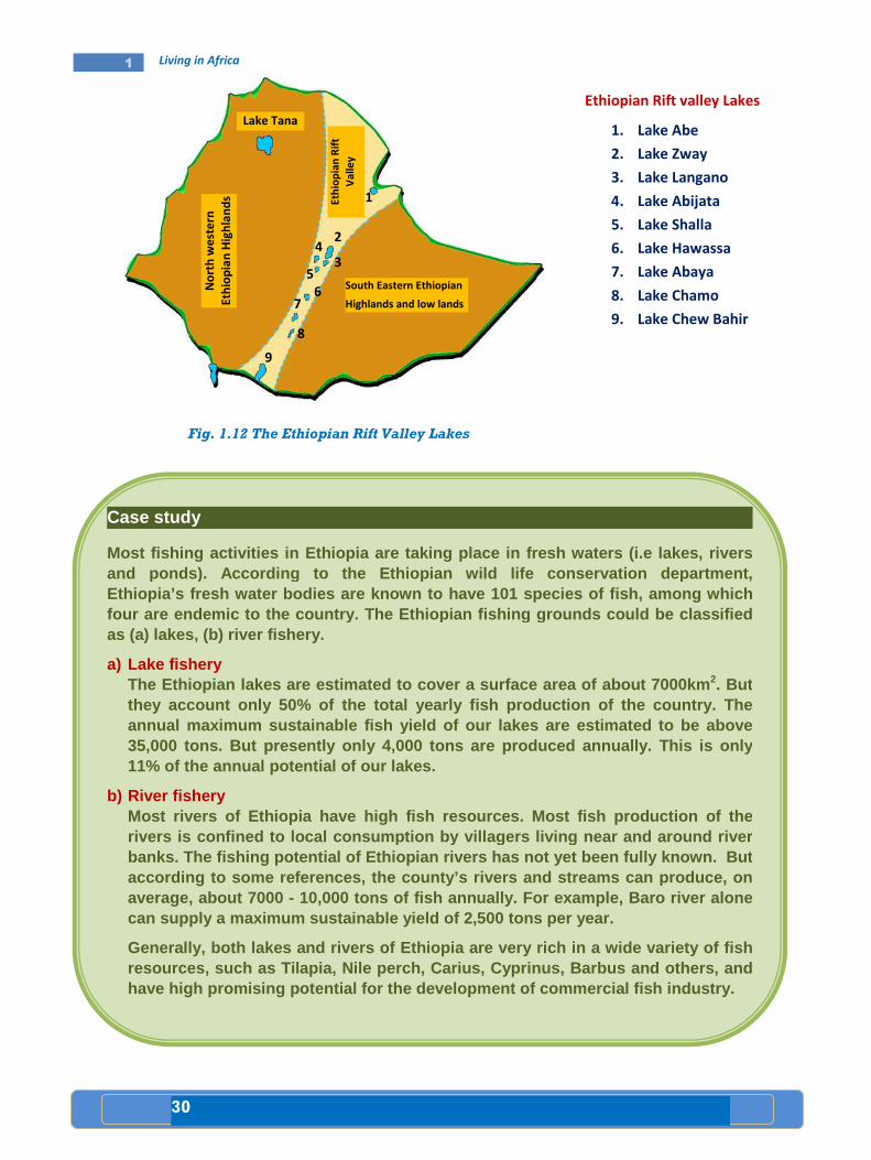
Fig. 1.12 The Ethiopian Rift Valley Lakes
Case study
Most fishing activities in Ethiopia are taking plac e in fresh waters (i.e lakes, rivers and ponds). According to the Ethiopian wild life co nservation department, Ethiopia’s fresh water bodies are known to have 101 species of fish, among which four are ende mic to the country. The Ethiopian fishing grounds c ould be classified as (a) lakes, (b) river fishery.
a) Lake fishery The Ethiopian lakes are estimated to cover a surfac e area of about 7000km 2. But they account only 50% of the total yearly fish prod uction of the country. The annual maximum sustainable fish yield of our lakes are estimated to be above 35,000 tons. But presently only 4,000 tons are prod uced annually. This is only 11% of the annual potential of our lakes.
b) River fishery Most rivers of Ethio pia have high fish resources. Most fish production of the rivers is confined to local consumption by villager s living near and around river banks. The fishing potential of Ethiopian rivers ha s not yet been fully known. But according to some references, th e county’s rivers and streams can produce, on average, about 7000 - 10,000 tons of fish annually. For example, Baro riv er alone can supply a maximum sustainable yield of 2,500 ton s per year.
Generally, both lakes and rivers of Ethiopia are ve ry rich in a wide variety of fish resources, such as Tilapia, Nile perch, Carius, Cyp rinus, Barbus and others, and have high promising potential for the development o f commercial fish industry.
Ethiopian Rift valley Lakes
1. Lake Abe
2. Lake Zway
3. Lake Langano
4. Lake Abijata
5. Lake Shalla
6. Lake Hawassa
7. Lake Abaya
8. Lake Chamo
9. Lake Chew Bahir
1
2
3 4
5
6 7
8
9
Lake Tana
No
rth
we
ste
rn
Eth
iop
ian
Hig
hla
nd
s
an
d l
ow
la
nd
s
Eth
iop
ian
Rif
t
Va
lle
y
South Eastern Ethiopian
Highlands and low lands

31
1 Living in Africa
B. Equatorial Lowlands and their Resources The following are major resources of the equatorial lowlands:
Palm Oil Palm tree grows throughout the equatorial lowlands of Africa. The fruits from palm trees are source of large amount of oil. Western Africa is the world’s largest producer of palm oil. Nigeria alone accounts for more than 75 percent of the export of palm oil. However, Africa accounts for 13 percent of the world’s palm oil production.
a) Harvesting from a low oil palm tree b) Harvesting from a tall oil palm tree
Fig. 1.13 Harvesting oil palm
Food Crops
• Shifting cultivation: is practiced in the hot wet equatorial rainforest regions of Africa. In these areas, farmers use the hoes for cultivation. It is difficult to use the ploughs because of tree stumps and roots in the ground. Instead, farmers use sticks to make holes and then put seeds into them. Crops grown include: manioc (cassava), maize, sweet potatoes, millet, yams, vegetables and fruits.
Case study
Peasant Cultivation (small scale agriculture) Peasant Cultivation (small scale agriculture) Peasant Cultivation (small scale agriculture) Peasant Cultivation (small scale agriculture)
Peasant cultivation is a settled agriculture becaus e the fields are cultivated on permanent basis. In peasant cultivation, the land i s usually a small area, often divided into several small plots. These plots are often sca ttered. Such farms are usually wor ked by the farmers and their family. The farmers gr ow a large variety of crops because their main purpose is to feed the family. T his type of farming is called subsistence farming. Such farms are usually mixed f arms, because the farmers not only grow crops but they also keep animals for work, milk or meat. The farmers use tools and ploughs that are quite simple.
32
1 Living in Africa
C. High Savannah Cattle Ranching
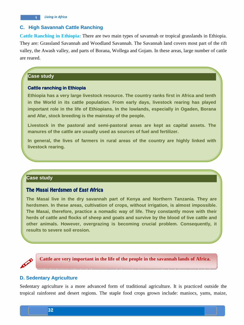
Cattle Ranching in Ethiopia: There are two main types of savannah or tropical grasslands in Ethiopia.
They are: Grassland Savannah and Woodland Savannah. The Savannah land covers most part of the rift
valley, the Awash valley, and parts of Borana, Wollega and Gojam. In these areas, large number of cattle
are reared.
����
D. Sedentary Agriculture
Sedentary agriculture is a more advanced form of traditional agriculture. It is practiced outside the tropical rainforest and desert regions. The staple food crops grown include: maniocs, yams, maize,
Case study
Cattle ranching in EthiopiaCattle ranching in EthiopiaCattle ranching in EthiopiaCattle ranching in Ethiopia
Ethiopia has a very large livestock resource. The c ountry ranks first in Africa and tenth
in the World in its cattle population. From early d ays, livestock rearing has played
important role in the life of Ethiopians. In the lo wlands, especially in Ogaden, Bora na
and Afar, stock breeding is the mainstay of the peo ple.
Livestock in the pastoral and semi-pastoral areas are kept as capital assets. The manures of the cattle are usually used as sources o f fuel and fertilizer.
In general, the lives of farmers in rural areas of the country are highly linked with livestock rearing.
Case study
The The The The Masai Herdsmen of East AfricaMasai Herdsmen of East AfricaMasai Herdsmen of East AfricaMasai Herdsmen of East Africa
The Masai live in the dry savannah part of Kenya an d Northern Tanzania. They are herdsmen. In these areas, cultivation of crops, wit hout irrigation, is almost impossible. The Masai, therefore, practice a nomadic way of lif e. They constantly move with their herds of cattle and flocks of sheep and goats and s urvive by the blood of live cattle and other animals. However, overgrazing is becoming cru cial problem. Consequently, it results to severe soil erosion.
Cattle are very important in the life of the people in the savannah lands of Africa.

33
1 Living in Africa
millet, sorghum, rice, wheat, barley, teff, inset, banana, beans, sweet potatoes, tomatoes, cucumbers onions and peppers (see fig 1.14).
Fig 1.14 Sedentary Agriculture
Livestock such as cattle, sheep, goats, horses and donkeys are also raised on sedentary farms. Such farming system is widely practiced in the tropical, subtropical and temperate plateaus and highlands. Mixed farming is dominant in the highlands of Ethiopia, Eastern and Southern Africa.
���� Commercial Grain FarmingCommercial Grain FarmingCommercial Grain FarmingCommercial Grain Farming
These types of agricultural systems, in Africa, were formerly developed by European colonizers. Their main purpose was to produce grains or cereals such as wheat, barley, rice and maize for European market. But after independence most European farm holdings had diminished due to insecurity caused by the struggle for independence and subsequent political pressures.
This is a modern large-scale agricultural system which has been developed by European farmers very recently. In general commercial farming is:
• More mechanized and fertilized
• Mainly monoculture, i.e. specializes in one or two cash crops
• Mostly found in the low population areas
Currently, in many African countries commercial farms are owned by governments or individual investors. A large number of the population in these countries are wage labourers in the farms. It should not be forgotten that the contribution of small peasant farmers in the production of some cash crops is very important.
Sorghum and Millet Cassava Banana
Maize Yam Rice
34
1 Living in Africa
The following description will help you to note some of the commercial crops of Africa.
• Coffee: It is a very popular cash crop. Africa accounts for about 20 percent of the world's coffee production. The chief coffee producers in Africa include Cote D'ivore, Ethiopia, Uganda, Cameroon, Kenya, Tanzania, Democratic Republic of Congo and Angola.
• Tea: It is grown in the wetter parts of the African highlands. Major producers include Tanzania, Kenya, Ethiopia, Mozambique, Zimbabwe, Congo and Mauritius.
• Horticulture: Uganda, Tanzania, Kenya are well known producers of flower which is destined to European markets. Ethiopia exports flower to Europe and the U.S.A. This is a new venture in the Ethiopian economy.
���� Factors Affecting the Distribution of Settlement and Livelihood Factors Affecting the Distribution of Settlement and Livelihood Factors Affecting the Distribution of Settlement and Livelihood Factors Affecting the Distribution of Settlement and Livelihood
• Enumerate factors favoring the site of Addis Ababa as a city. • In which African country is Mombasa found? • What are the causes for the formation of urban cent er? • Why do you think people are moving from rural areas to urban centers in great
number? • Explain the relationship between human settlements and security issues, like civil
disturbances and wars.
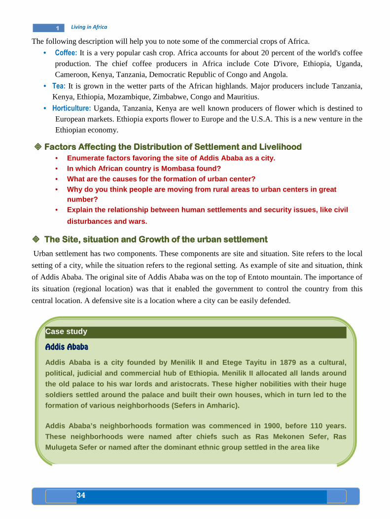
���� The SitThe SitThe SitThe Site, situatione, situatione, situatione, situation and Growth of the and Growth of the and Growth of the and Growth of the urban settlementurban settlementurban settlementurban settlement
Urban settlement has two components. These components are site and situation. Site refers to the local
setting of a city, while the situation refers to the regional setting. As example of site and situation, think
of Addis Ababa. The original site of Addis Ababa was on the top of Entoto mountain. The importance of
its situation (regional location) was that it enabled the government to control the country from this
central location. A defensive site is a location where a city can be easily defended.
Case study
Addis AbabaAddis AbabaAddis AbabaAddis Ababa
Addis Ababa is a city founded by Menilik II and Ete ge Tayitu in 1879 as a cultural,
political, judicial and commercial hub of Ethiopia. Menilik II allocated all lands around
the old palace to his war lords and aristocrats. Th ese higher nobilities with the ir huge
soldiers settled around the palace and built their own houses, which in turn led to the formation of various neighborhoods (Sefers in Amhar ic).
Addis Ababa’s neighborhoods formation was commenced in 1900, before 110 years.
These neighborhoods were named after chiefs such as Ras Mekonen Sefer, Ras Mulugeta Sefer or named after the dominant ethnic g roup settled in the area like

1 Living in Africa
Addis Ababa
Study the map of Addis Ababa given below carefully
Fig. 1.15 Map showing the position
Wollo Sefer, Adere Sefer, Gofa Sefer. Some Sefers a re named by their dominant function like neighborhoods of laborers(Zebegna Sefer) or neighborhoods of monastery (Geda m Sefer). Some neighborhoods derive their names after the names of nobles who we re granted plots around the place. In due course of time, more and more new com erneighborhoods.
The city, at its infancy served as a platdefeated the Italian invaders at the many countries have opened up their embassies inincreasing and altering the size and shapes of sett lements of the city. The introduction of modernization encouraged natives and foreigners to come, settle and engage in causal and permanent business in the
Unlike other Af rican cities, Addis Ababa is entirely built by Ethi opians. The city has played a significant role in transferring technolog ies to the remaining parts of the country. Addis Ababa is a melting pot of various na tionmultitude of cult ures and languages. The peripheral areas of Addis A baba, being an essential site, are under constant pressure due to their proximity and specific locational advantage.
Kolfe keranyo
Addis ketema
Lideta
Nefas Silk
Study the map of Addis Ababa given below carefully
Map showing the position of Addis Ababa
Wollo Sefer, Adere Sefer, Gofa Sefer. Some Sefers a re named by their dominant function like neighborhoods of laborers (Serategna Sefer), neighborhoods of guards (Zebegna Sefer) or neighborhoods of monastery (Geda m Sefer). Some neighborhoods derive their names after the names of nobles who we re granted plots around the place. In due course of time, more and more new com ers attracted to these
served as a plat form to coordinate the Ethiopian army that defeated the Italian invaders at the Battle of Adwa in 1896. After the victory of Adwa, many countries have opened up their embassies in the city. This resulted in increasing and altering the size and shapes of sett lements of the city. The
modernization encouraged natives and foreigners to come, settle and engage in causal and permanent business in the city.
rican cities, Addis Ababa is entirely built by Ethi opians. The city has played a significant role in transferring technolog ies to the remaining parts of the country. Addis Ababa is a melting pot of various na tion s and nationalities with a
ures and languages. The peripheral areas of Addis A baba, being an essential site, are under constant pressure due to their proximity and specific
Gullele
Addis ketema
Lideta
Arada
Kirkos
Nefas Silk-Lafto
Yeka
Bole
Akaki-Kality
35
Wollo Sefer, Adere Sefer, Gofa Sefer. Some Sefers a re named by their dominant (Serategna Sefer), neighborhoods of guards
(Zebegna Sefer) or neighborhoods of monastery (Geda m Sefer). Some neighborhoods derive their names after the names of nobles who we re granted plots around the
s attracted to these
form to coordinate the Ethiopian army that attle of Adwa in 1896. After the victory of Adwa,
the city. This resulted in increasing and altering the size and shapes of sett lements of the city. The
modernization encouraged natives and foreigners to come, settle and
rican cities, Addis Ababa is entirely built by Ethi opians. The city has played a significant role in transferring technolog ies to the remaining parts of the
nationalities with a ures and languages. The peripheral areas of Addis A baba, being an
essential site, are under constant pressure due to their proximity and specific
N

36
1 Living in Africa
Factors favoring the site of Addis Ababa include:
• Located between the old established provinces of the Northern half of the country and the Southern territories;
• Effectiveness for government administration;
• Located between Weyna Dega and the Dega zones;
• Located above the zone of tropical diseases;
• Enjoyed a temperate climate with adequate rainfall;
• Presence of extensive flatland for expansion and development;.
• Presence of a pre- existing pattern of natural route ways and tracks;
• Capacity to support large urban population; and
• Adequacy of water supplies for large growing population;
Since Addis Ababa was established, several geographical factors contributed to its further development.
These include:
• The importation and planting of the eucalyptus tree in 1894, provided solution to the problem of
wood supply for fuel and construction;
• The development of modern pattern of communications; and
• The growth of market facilities and power resources.
����
At present Addis Ababa is a highly centralized administrative and industrial capital of Ethiopia. It is the
fourth largest inland city in Africa.
Fig.1.16 A section of the city of
Addis Ababa
Settlement refers to groupings of population into occupancy units. These range from isolated one- family farmstead and tiny rural hamlet to the great metropolis like New York or London. Settlement is ,therefore, organized colony of human beings together with their residences and other buildings, i.e, stores, factories, warehouses, etc and the paths and streets.

37
1 Living in Africa
Case study
MombasaMombasaMombasaMombasa
Mombasa is the second largest city in Kenya. It has a major port and an International airport. The city is the center of co astal tourism industry. Its original Arabic name is Manbasa; in Swahili it is called Kis iwa Cha Mvita (or Mvita in short), which mean s ‘’Island of war,’’ due to the many changes in its ownership. The town is also the headquarters of Mombasa district named after its chief town.
Mombasa has a population of 727, 842, as per the 19 99 – census, and is located on an Island, separated from t he mainland by Tundor Greek and Kilindini Harbour. The Island is connected to the mainland by the Nyali Br idge, Likoni Ferry and the Makupa caseway. Mombasa serves both Kenya and count ries in the interior of Africa. Moi international Airport is found here.
Mombasa is mainly occupied by the Swahili people /M uslim Mijikenda/. For centuries, many immigrants and traders from Iran, t he Middle East, Somalia and the Indian sub- continent, have settled in Mombasa. For centuries t hese people made immense contributions to the development of present day Mombasa as well as Kenya.
The exact date for the establishment of Mombasa is still unknown. But in the 12 th
century, Mombasa was prosperous commercial center. This was proved by an Arab geographer called Al Indrisi in 1151 A.D.
Until December 12, 1963, Mombasa was part of the st ate of Zanzibar. But, later on it was incorporated into the newly independent State K enya.
Mombasa is characterized by a flat topography. It h as a warm, tropical climate. April and May have high rainfall whereas, January t o February rainfall is minimal.
Fig 1.17 Mombasa
The gateway to Mombasa

38
1 Living in Africa
���� Reasons for Urban SettlementReasons for Urban SettlementReasons for Urban SettlementReasons for Urban Settlement
The location of large villages and urban settlements depends upon:
• Old regional centers;
• Route centers;
• Air route;
• Rail centers;
• Market centers;
• Frontier posts; and
• Industrial developments.
Nowadays, cities are rapidly growing. They are getting over crowded. Though life in cities is becoming
difficult, more and more people are still migrating from rural areas to cities. This happens because of
varied reasons. Some of the reasons are:
• Looking for better paid jobs;
• Expectance of improved housing and better quality life;
• Improved services such as schools, medical treatment and entertainment;
• Attraction to electric facilities;
• Reliability of source of food;
• Safety from political affairs and
• Transport route and security issues
Case Study
Comparison between Addis Comparison between Addis Comparison between Addis Comparison between Addis Ababa and MombasaAbaba and MombasaAbaba and MombasaAbaba and Mombasa
• Addis Ababa occupies the heart land of Ethiopia, wh ich is a highland. Thus, has cooler temperature and greater amount of rainfall. The coffee packers in the city are working in such climatic conditions, w hich makes their work life easy an d comfortable. Compared to this, the port workers i n the sheltered harbor city of Mombasa have a working atmosphere wh ich is not easy.
This is because; the city is situated at the coasta l lowland area of the country, where the temperature is high. Otherwise, matters of living conditions and settlement makes the two cities similar. Population number in both cities (Addis Ababa nearly 3 million, Mombasa 727,842 (199 9-census)) is very high. While Mombasa is directly linked with the outside w orld through railway lines and through water transport, Addis Ababa does not h ave a direct link. On the other hand, both Addis Ababa and Mombasa linked with the rest of the world through International air ports.
•
39
1 Living in Africa
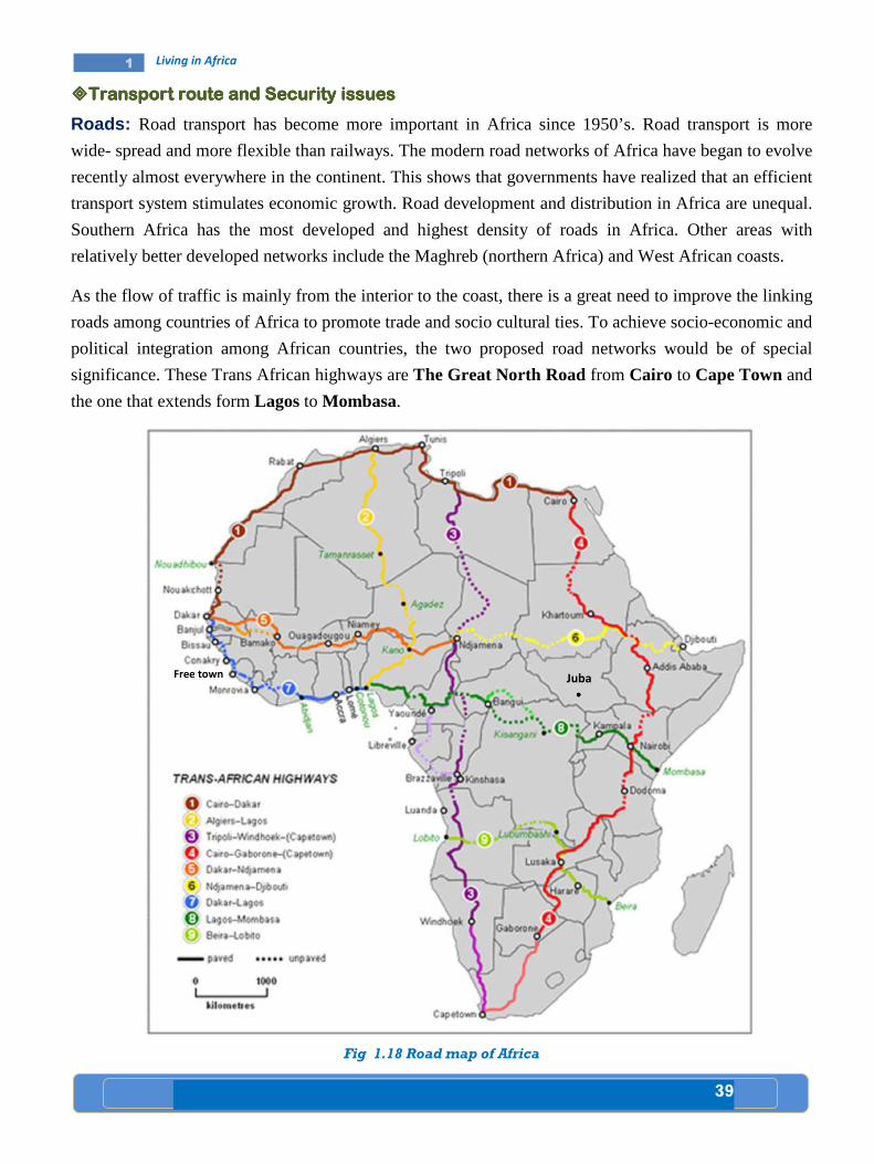
����Transport route and Transport route and Transport route and Transport route and Security issuesSecurity issuesSecurity issuesSecurity issues
Roads: Road transport has become more important in Africa since 1950’s. Road transport is more
wide- spread and more flexible than railways. The modern road networks of Africa have began to evolve
recently almost everywhere in the continent. This shows that governments have realized that an efficient
transport system stimulates economic growth. Road development and distribution in Africa are unequal.
Southern Africa has the most developed and highest density of roads in Africa. Other areas with
relatively better developed networks include the Maghreb (northern Africa) and West African coasts.
As the flow of traffic is mainly from the interior to the coast, there is a great need to improve the linking
roads among countries of Africa to promote trade and socio cultural ties. To achieve socio-economic and
political integration among African countries, the two proposed road networks would be of special
significance. These Trans African highways are The Great North Road from Cairo to Cape Town and
the one that extends form Lagos to Mombasa.
Fig 1.18 Road map of Africa
Free town Juba
••••
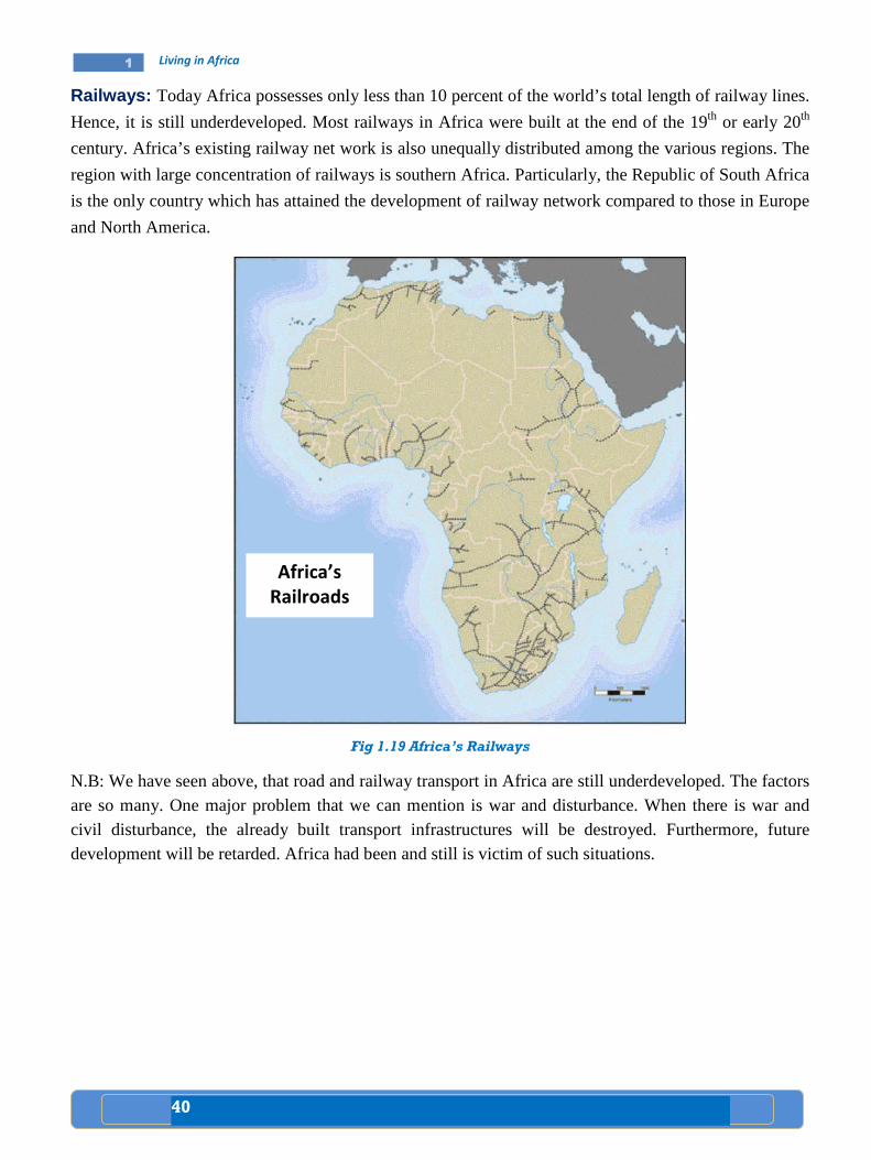
40
1 Living in Africa
Railways: Today Africa possesses only less than 10 percent of the world’s total length of railway lines.
Hence, it is still underdeveloped. Most railways in Africa were built at the end of the 19th or early 20th
century. Africa’s existing railway net work is also unequally distributed among the various regions. The
region with large concentration of railways is southern Africa. Particularly, the Republic of South Africa
is the only country which has attained the development of railway network compared to those in Europe
and North America.
Fig 1.19 Africa’s Railways
N.B: We have seen above, that road and railway transport in Africa are still underdeveloped. The factors are so many. One major problem that we can mention is war and disturbance. When there is war and civil disturbance, the already built transport infrastructures will be destroyed. Furthermore, future development will be retarded. Africa had been and still is victim of such situations.
Africa’s
Railroads

41
1 Living in Africa
Lesson Lesson Lesson Lesson ReviewReviewReviewReview
Activity 1.7 A A. Questions based on facts:
• What is the name of the west African country well known for its palm oil
production?
• What are the three most important and commercially popular fish species
in Ethiopia?
• What do you call the herdsmen of northern Tanzania and Kenya?
• List down staple grain (cereal) and root crops (tuber) that are produced in
Africa separately.
• Which countries of Africa produce coffee?
• Some fish species in the rift valley lakes of Ethiopia are being over fished
due to different reasons. What immediate measures should be taken in
order to alleviate the problem?
B. Group work: • In groups, compare and contrast a worker in Addis Ababa who packs
coffee and a person in Mombasa who works in a port, not forgetting that
there is relationship between work and climate. Bring the final work of
each group to the class and have a common discussion.
1.7

42
1 Living in Africa
• Africa has a compact shape. It has a regular coast line. Both North-South and
East-West dimensions of Africa are almost equal. Af rica is crossed by the Tropic
of Cancer, Capricorn and the Equator. It is bordere d by the Atlantic Ocean,
Mediterranean Sea, Indian Ocean and the Red Sea.
• On the map of the world or a globe, there are imagi nary lines running East-West
and North-South directions. The lines drawn East-We st are called parallels. They
are parallel to one another. Another group of lines are called Meridians . They are
great circles joining the poles, i.e. North and Sou th poles.
• There are major groups of languages in Africa. They are called Super language
Families. They are the Niger-Congo, Afro-Asiatic, N ilo-Saharan and Khoisan. In
Western, Central, Eastern, and Southern Africa, we have the speakers of the
Niger-Congo, whereas in Northern, Central, North Ea stern and the Horn, the
dominant language is the Afro-Asiatic. The Nilo-Sah aran speakers are found
around Nile valley. On the other hand, the Khoisan speakers are found in a few
areas of South Africa.
• Climate, vegetation and population pressure are key factors for the distribution
and settlement of population. For example, the equa torial lowlands, savannah
lowlands, and the deserts do not favour dense settl ement. They all experience
harsh climate. But, areas with rich fertile soil an d mild rainfall and temperature
could attract dense settlement.
• There are varied types of livelihood practiced in A frica. Some of them include
fishery, growing of tropical crops, pastoralism and the production of highland
crops.
• Settlements can be categorized into urban and rural . Urban settlements have pull
factors. They attract rural people in different way s and induce migration. For
example, Addis Ababa was first settled because of t he presence of a fertile and
sheltered valley. Then, it grew tremendously mainly because of rural-urban
migration. On the other hand, Mombasa, i.e. in Ken ya was established because
of sheltered harbour and the East African Railway.
• War and civil disturbances destroy the already buil t infrastructures.
Furthermore, it retards future development programs .
SummarySummarySummarySummary

43
1 Living in Africa
Glossary
• Absolute location: is the location that can be shown on globes or maps by using
astronomical grid references.
• Caravan: company of persons (merchants) making a journey together for safety usually across
desert area.
• Craftsman: skilled workman who practices a craft.
• Excavate: to dig in the ground to look for old buildings or objects that have been buried for a long
time.
• High latitudes: the area beyond the Arctic circle in the north and Antarctic circle in the south
(66�
�°°°°N or S- 90°N or S).
• Incense: (smoke of) substance producing a sweet smell when burning.
• Khoisan: the language super family of the khoikhoi and san people of southern Africa.
• Language super- families: highest form of language classification.
• Latitudes: are angular distances measured to the north and south of the equator in degrees.
• Low latitude: this is the belt between the tropic of cancer ( 23�
�°°°°N) and the tropic of
capricorn (23�
�°°°°S).
• Massive continent: if a continent is said to be massive that means, its size is very big or very huge.
• Meridians: are imaginary lines which connect the north pole and the south pole. All meridians are
labeled in degrees east or west of the prime meridian (0° longitude). • Middle latitudes: sometimes known as the temperate regions. They are found between the tropic of
cancer (23�
�°°°°N) and the Arctic circle (66
�
�°°°°N) in the northern hemisphere and the
tropic of capricorn (23�
�°°°°S) and the Antarctic circle (66
�
�°°°°S) in the southern
hemisphere. • Mummification: preserving a corpse.
• Musk: strong smelling substance produced in glands by civet cat used in the manufacture of
perfumes.
• Population distribution: describes the way in which people are spread out across the earth’s surface.
• Population density: describes the number of people living in a given area.
• Pre- colonial: before colonialism.
• Solstice: time of year when the sun’s vertical rays reach farthest north(June 21) or south(Dec.22) of
the equator.
• Spices: sorts of substance used to flavour food.
• Temple: building used for the worship of a god.
• Tomb: place dug in the ground for a dead body.
44
1 Living in Africa
I. True or false Direction: Write “True” if the statement is correct and ‘’False’’ if the statement is incorrect in the space
provided infront of each statement.
_______1. Europe is the smallest of all the continents.
_______ 2. Asia alone occupies 29.9 percent of the total land surface of the earth.
_______ 3. The concentration of people in an area is associated only with physical factors.
_______ 4. War and conflict can be equated with destruction of infrastructure, loss of insituional capacity
and damage to human life.
_______ 5. Settlement refers to a place where people have come to live permanently, usually when there
were very few people living there before.
_______ 6. The earth rotates through 1° of longitude every 4 minutes or 15°°°° every hour. _______ 7. The speakers of the Niger-Congo language super family occupy the largest part of Africa.
_______ 8. Ancient Egyptians believed in life after death.
II. Matching Direction: Match column B with column A.
Column A Column B
_______ 1. Modern agriculture
_______ 2. The spread of people across the earth’s surface.
_______ 3. The number of people living in a given area.
_______ 4. The largest landmass
_______ 5. Zero degree longitude
a) Continent
b) Population density
c) Population migration
d) Population pressure
e) Population distribution
f) Commercial farm
g) Ethiopia
h) Prime meridian
III. Multiple choices
Answer the following questions by choosing the best possible answer.
_______ 1. The largest continent in the world is
a) Europe c) North America
b) Africa d) Asia
Review Questions UNIT
1

45
1 Living in Africa
_______ 2. Another name of longitude is:
a) Meridian c) geographical Grid
b) Parallel d) net work
_______ 3. One of the following is not a physical factor for population distribution:
a) Stage of economic development c) Accessibility
b) Climate d) Water supply
_______ 4. An African state well known in palm oil production:
a) Ethiopia c) Nigeria
b) Sudan d) Ghana
_______ 5. The Mali Empire was built by the
a) Shona people c) Mandingo people
b) Shilluk d) Nguni people
_______ 6. The leader of the caravan merchants was known as
a) Jabarti c) Negadras
b) Afkala d) Basha
IV. Fill in the blanks
1. Cultivation type which is a step ahead of shifting cultivation is called .
2. The distribution of the earth’s peoples is determined by and factors.
3. The southern most point of Africa is called .
4. Eucalyptus tree was introduced to Ethiopia for the first time in the year E.C.
5. The Masai herdsmen are found in and .
6. The civilization of ancient Egypt began in the river valley.
7. The Empire of Mali achieved the highest stage of political power and cultural development during
the regime of .
V. Short answer questions
1. What do we mean by an absolute location of a place?
2. Explain the shape of Africa.
3. What can you say about the size of Africa?
4. Name the five important latitudes which act like a benchmark that tell us the amount of sunlight
reaching places along each line.
5. Give description on the factors affecting world population distribution.
6. Identify the rift valley lakes of Ethiopia and give brief explanation on the fish resources of these
lakes.
7. Write the major super-language families in Africa.
8. Explain the medium of exchange in Ethiopia in the 19th century.

46
1 Living in Africa
Check List
Put a tick (����) mark in each of the boxes for activities you can
perform
I can
1. Compare the size and shape of Africa with other
continents.
2. Identify the absolute location of Africa.
3. Explain the terms latitude and longitude in
relation to parallels and meridians.
4. Describe the factors which affect population
distribution.
5. Indicate the location of Egypt and Carthage as o ne of the
centers of ancient civilizations in Africa.
6. Explain the significance of the ancient civiliza tions of
Egypt and Carthage.
7. Analyze the economic bases of pre-colonial state s of
Zimbabwe, Mali and Fungi.
8. Relate determinants of population distribution t o
population settlement in Africa and identify settle ment
on a map.
9. Explain the types of livelihood commonly found i n Africa.
10. Relate determinants of population to climate an d
vegetation.
11. Discuss the reasons for urban settlement.
12. Identify key transport routes.
13. Explain the effect of civil unrest on security.
14. Name super language families in Africa.
15. Describe the achievements of pre-colonial Zimb abwe.
16. Explain the revival of long distance trade in E thiopia
In the 19 th century.

1
Unit Outcomes
After studying this unit, you will be able to:
���� Explain the size, shape, location, and the Super Language Families
of Africa.
���� Recognize the major ancient civilizations and pre-colonial states of
Africa.
���� Discuss factors that affect distribution, settlement and livelihood
in Africa.
UNIT
1
LIVING IN AFRICA

2
1 Living in Africa
Key terms
���� Absolute location ���� Massive continent
A. The Positions of Africa
• What is an absolute location?
• Referring to Fig 1.1. Can you give the four extreme points of Africa?
• When we say Africa has largely intertropical locati on, what does that mean? Explain.
The exact location of a place can be identified on globes or maps by using latitudes and longitudes.
Study fig 1.1 below carefully. It indicates the absolute location of Africa.
Fig 1.1 Astronomical location of Africa
Africa lies between 37° 21' N and 34° 52'S and 17° 11'W and 51° 24 E. What are the four extreme points
of Africa i.e N, S, W and E? Observe the map given above.
Lesson
The People of Africa, Location, Size and Shape of Africa
1.1
Competencies: After studying this lesson, you will be able to:
���� Compare the size and shape of Africa with other continents.
���� Identify the absolute location of Africa.
Somalia 51°°°° 24'E
Most easterly point:
Cape Guardefui (Ras
Kaafuun) Most Westerly
point: Cape Vert
17°°°° 11'W
Most northerly point: Ras
ben Sakka 37°°°°21'N
Most southerly point: Cape Agulhas South Africa 34°°°°52'S
km

3
1 Living in Africa
����
Let us compare the shape and size of Africa with other continents. Students study fig. 1.2 given below:
Fig 1.2 The size of Africa as compared with other continents
• The North - South distance of Africa is 7623 km and its East -West distance is 7260 km.
•••• Africa has almost a balanced position around the equator. The equator almost bisects Africa into two equal parts.
•••• Africa is the only continent crossed by both the tropic of cancer and tropic of capricorn.
•••• Africa has largely inter- tropical location
•••• The Prime Meridian passes through the western part of the continent via Accra (the capital city of Ghana)
• The four extreme points of the continent are: - Ras ben Sakka – Tunisia - Cape Agulhas – Republic of South Africa - Cape Guardafui (Ras Kaafuun) – Somalia - Cape Vert --------- Senegal
Africa
Europe
Asia
Australia
South
America
North
America
Green
Land
JapanJapanJapanJapan
VenezuelaVenezuelaVenezuelaVenezuela
United StatesUnited StatesUnited StatesUnited States
KalimantanKalimantanKalimantanKalimantan

4
1 Living in Africa
Africa has a compact shape. It has remarkably regular coastal lines. Such coastlines afford very few
harbours. The only indentations are Gulf of Guinea and the Gulf of Sidra. Try to locate these areas on
the map of Africa.
As it is indicated in Fig. 1.2 Asia is bigger than Africa. Therefore, Africa is the 2nd largest continent. It
has a total area of about 30,331,606 km2. This accounts for about 20.2 percent of the earth’s land
surface. Of course 75 percent of Africa’s area lies within the tropics. On the other hand, over 25 percent
of Africa’s land is covered by the Sahara desert.
���� The table below shows the size of major continents. Study it carefully
Table 1.1 Areal sizes of Major continents
Continent Approximate
area in Km2
percent of world
share
Asia 44, 810,880 29.9
Africa 30, 331,606 20.2
North America 24, 367,875 16.3
South America 17, 831,606 11.9
Antarctica 14,002,590 9.4
Europe 9, 935,233 6.6
Australia 8, 289,000 5.7
World total 149, 568,790 100
Africa is as large as the combined land area of U.S.A, Europe and China.
Africa’s land surface, approximately two third, lies north of the Equator.
Case Study Case Study Case Study Case Study
Comparison of two capitals: Accra and KampalaComparison of two capitals: Accra and KampalaComparison of two capitals: Accra and KampalaComparison of two capitals: Accra and Kampala
Accra Accra is the capital and the largest city in Ghana (Western Africa) with the population
of the city proper estimated at 3,963,264 as of 201 1. Accra also doubles as the capital
of Grea ter Accra region and of the Accra Metropolitan dist rict with which it is
coterminous (sharing a border). Accra is also the a nchor of a substantially l arger
metropolitan area called the Greater Accra Metropol itan area and includes eight
districts.
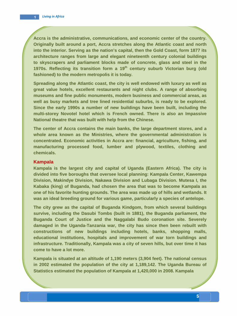
5
1 Living in Africa
Accra is the administrative, communications, and ec onomic center of the country. Originally built around a port, Accra stretches alo ng the A tlantic coast and north into the interior. Serving as the nation’s capital, then the Gold C oast, form 1877 its architecture ranges from large and elegant nineteen th ce ntury colonial buildings to skyscrapers and parliament blocks made of concre te, glass and steel in the 1970s. Reflecting its transition form a 19 th century suburb Victorian burg (old fashioned) to the modern metropolis it is today.
Spreading along the Atlantic coast, the city is wel l endowed with luxury as well as great value hotels, excelle nt restaurants and night clubs. A range of absorbin g museums and fine public monu ments, modern business and commercial areas, as well as busy markets and tree lined residential sub urbs, is ready to be explored. Since the early 1990s a number of new buildin gs have been built, including the multi- storey Novotel hotel which is French owned. There i s also an Impassive National theatre that was built with help from the Chinese.
The center of Accra contains the main banks, the la rge department stores, and a whole area known as the Ministries, where the gover nmental administration is concentrated. Economic activities in Accra are: fin ancial, agriculture, fishing, and manufacturing processed food, lumber and plywood, t extiles, clothing and chemicals.
Kampala Kampala is the largest city and capital of Uganda ( Eastern Africa). The city is divided into five boroughs that oversee local plann ing: Kampala Center, Kawempa Division, Makindye Division, Nakawa Division and Lu baga Division. Mutesa I, the Kabaka (king) of Buganda, had chosen the area that was to become Kampala as one of his favorite hunting grounds. The area was m ade up of hills and wetlands. It was an ideal breeding ground for various game, part icularly a species of antelope.
The city grew as the capit al of Buganda Kindgom, from which several buildings survive, including the Dasubi Tombs (built in 1881) , the Buganda parliament, the Buganda Court of Justice and the Naggalabi Budo cor onation site. Severely damaged in the Uganda-Tanzania war, the city has si nce then been rebuilt with constructions of new buildings including hotels, ba nks, shopping malls , educational institutions, hospitals and improvement of war torn buildings and infrastructure. Traditionally, Kampala was a city o f seven hills, but over ti me it hascome to have a lot more.
Kampala is situated at an altitude of 1,190 meters (3,904 feet). The national census in 2002 estimated the population of the city at 1,1 89,142. The Uganda Bureau of Statistics estimated the population of Kampala at 1 ,420,000 in 2008. Kampala

6
1 Living in Africa
Lesson Lesson Lesson Lesson ReviewReviewReviewReview
Activity 1.1 A A. Questions based on facts:
• What is the difference between an absolute and relative location of a place? • Give the absolute location of Africa. • Mention the four extreme points of the continent of Africa. • Which extension of the African land mass (N-S or E-W) is the longest? What is its
distance in km?
• How do we explain the compactness of a continent? • Give the name of the most northerly and the most southerly points of Africa and
indicate the latitudinal difference between them.
• Which part of Africa is wider? The northern or the southern?
B. Group discussion:
• Discuss the advantages and disadvantages of having large size of continent like that of Africa.
• In groups, discuss the advantages and disadvantages of compact shape.
C. Individual work:
• Draw a political map of Africa and label the countries with their respective capital cities. Then present it to your class mates for further comment. Finally let your teacher add if something is missing.
1.1
features a tropical wet and dry climate. However, d ue to the city’s higher altitude, average temperatures are noticeably cooler than wha t is typically seen in other cities with this type of climate. Kampala seldom gets hot during the course of the year, it s warmest month being January. Kampala’s weather feat ures two distinct seasons. There is a lengthy rainy season from August through December and another shorter rainy season that begins in February and lasts thro ugh June. The heaviest amount of precipitation at an average of around 175 mm of rai n.
Summary Although the two cities are long built cities, they are situated at the two extreme corners of the continent, i.e, Accra in western Afr ica and Kampa la in Eastern Africa. Accra is a port city while Kampala is the capital city of landlocked country ( Uganda). Furthermore, Accra stretches along the Atlantic coa st and north into the interior, occupying the coastal lowland, while Kampala is sai d to b e the city of several hills. Its altitude is about 1,190 meters (3,904 feet). Kampala features a tropical we t and dry climate. However, due to the city’s higher altitude, average temperat ures are cooler than cities of the same climate.
The population of Accra is estimated at 3,963,264 a s of 2011, while the population of Kampala had been estimated by Uganda Bureaus of sta tistics at 1,420,000 in 2008.

7
1 Living in Africa
Key terms
���� Low latitudes
���� Middle latitudes
���� High latitudes
���� Longitudes
���� Meridians
���� Solstice
���� Parallels
A. Latitudes and parallels
• What is the difference between a meridian and a pa rallel?
• What does high latitude and low latitude refer to?
• How do you explain the relationship between latitu de and climate?
• Latitudes: are angular distances measured north and south of the equator in degrees. To measure
latitude, equal distances from equator are marked off by parallels which are imaginary circles that
go around the earth parallel to the equator. Like the equator, parallels run in an East- West direction.
In addition, parallels are closer and smaller at North or South Pole.
• Parallels: are imaginary lines drawn on globes or maps joining all points with the same latitude in
degrees north and south of the equator. Since the equator is the origin of latitude, it is numbered 00.
Places north of the equator have north latitude; places south of the equator have south latitude. The
north and south poles are the most distant points from the equator; that is the North Pole’s latitude is
900 N and the South Pole’s latitude is 900 S. The location of a place relative to the equator
determines the amount of sunlight it receives. Fig 1.3, shows five important latitudes. These lines
are used as benchmarks for telling the amount of sunlight reaching various parts of the surface of
the earth.
Next, you will learn more about the latitudes indicated in fig 1.3. They are as follows: 1. The low latitudes or tropics: The equator receives more direct sunlight than any place on earth.
Areas near the equator are usually hot all year round. Both the tropic of Cancer (231/2° N) and tropic
of Capricorn (231/2°S) receive vertical sunrays. This happens on solstices. The belt between the two
lines of latitudes or parallels is called the low latitude or tropics.
Lesson
Latitudes and Longitudes 1.2
Competency: After studying this Lesson, you will be able to:
���� Explain the terms latitude and longitude in relation to
parallels and meridians.

8
1 Living in Africa
2. Middle latitudes or temperate regions: They are found between the Tropic of Cancer
(231/2°N) and the Arctic Circle (661/20N) in the north and the Tropic of Capricorn (231/2° S) and the
Antarctic Circle (661/20 S) in the south. (231/2° - 661/2°N and S)
3. High latitudes and the Arctic and Antarctic circles: (661/20N or S). Both have at least one
day of complete sunlight and darkness each year. This occurs on solstices. Beyond the Arctic circle and the Antarctic circle are the high latitudes or polar regions. These areas receive little heat from the sun and, therefore, they are cold. Each year both North and South Poles have six months of daylight and six months of darkness.
Fig 1.3 The Tropics, the Middle Latitudes and the High Latitudes
B. Longitudes and Meridians
• How do you explain the relationship between longitu des and time?
• Which longitude is the most important longitude?
Middle latitudes
High latitudes
90 0 S
66 1/2
0 S
231/2 °°°°S
0°°°°
231/2°°°° N
66 1/2
0 N
High Latitudes
Middle latitudes
Low latitudes
North Pole
South Pole
Arctic circleArctic circleArctic circleArctic circle
Tropic of cancer Tropic of cancer Tropic of cancer Tropic of cancer
Equator Equator Equator Equator
Tropic of Capricorn Tropic of Capricorn Tropic of Capricorn Tropic of Capricorn
AAAAntntntntarctic circlearctic circlearctic circlearctic circle
90 0 N

9
1 Living in Africa
• Longitudes: are angular distances
measured to the east and west of the
prime meridians in degrees
• Meridians: are imaginary lines drawn on
globes or maps joining all points with the
same longitude in degrees. All meridians
extend from the North Pole to the South
Pole and each meridian is, therefore, a
semi circle covering half of the earth’s
circumference. Distance between
meridians is known as Longitude.
The Prime Meridian or 0 ° longitude
There is “natural” midpoint like the equator from which longitude can be measured, but most countries have agreed to use the meridian that runs from the North Pole to the South Pole through the royal observatory at Greenwich. This meridian is called Prime Meridian.
All other meridians are labeled in degrees East or West of the prime meridian. The earth being a circle,
it is divided into 360° of longitude. The half of the earth that lies east of the Prime Meridian has east
longitude up to 180° (half of 360°); the half that lies west of Prime Meridian has west longitude up to
180°.
C. Travelling in Time
• What is the difference between local time and stan dard time?
• Why do we say a place east of the international da te time is earlier than a place west of the international date time?
���� Local Mean TimeLocal Mean TimeLocal Mean TimeLocal Mean Time
Time varies with longitude. The earth rotates on its axis from west to east. This motion of the earth determines the length of a day. All places on the face of the earth see the sun apparently rising in the East and setting in the West. Each day, in its path the sun moves across the sky at its zenith. This happens at noon time. All places located along a given meridian see the sun equally. They have also similar noon time. But the time East or West of this line will see the sun differently. Due to longitudinal variation in time, places observe varied Local Mean Time( L.M.T). For example, the earth completes one rotation or 360° in 24 hours. That means every 15° equals one hour and four minutes for a degree.
90°°°°N
North Pole
231/2 °°°°N
0°°°°
231/2
0 S
Fig 1.4 Prime meridian
66 ½ 0 S
661/2 °°°°N
90°°°°S
South Pole
Arctic circle
Tropic of cancer
Equator
Tropic of Capricorn
Antarctic circle
Prim
e m
erid
ian
(0 °° °°)
North latitude
South latitude

10
1 Living in Africa
Places East of the meridional position in relation to the sun will be ahead of places to the west. Therefore, the L.M.T for the East is always ahead. For example, you can find L.M.T. in New York when it is noon in London.
Fig 1.5 Longitude and Time
����
Once the time difference between two points is known, it is possible to calculate their longitudinal location. For example, if L.M.T. is 41/2 hour ahead of Greenwich as reported by radio officer on a ship, what will be its longitudinal location? To calculate this, you can proceed as follows:
����
Difference in longitude between New York and London: London 0°°°° New York 74°°°°W Longitudinal difference 0 + 74 = 74
• Difference in time: - 74 ÷÷÷÷ 15 = 4 hours, 56 minutes. Is L.M.T in New York behind or ahead of
London? The direction is west, therefore, L.M.T is behind. When it is noon at London, its L.M.T is 7:04 a.m at New York.
• Difference in time is 4 hours
• Difference in longitude is: 4 ×××× 15°°°° = 67 degrees
• Therefore, the longitudinal position of the ship is 67° 30' East.
Saturday/Sunday Sunday/Monday
Midnight
180°°°°
Prime
Meridian
Noon
Sunday
2 a.m. 150°°°°W
4 a.m. 120°°°°W
6 a.m. 90°°°°W
8 a.m. 60°°°°W
10 a.m. 30°°°°W
30°°°°E 2 p.m.
60°°°°E 4 p.m.
90°°°°E 6 p.m.
120°°°°E 8 p.m.
150°°°°E 10 p.m.
NROTATION
West to East
11
1 Living in Africa
Lesson Lesson Lesson Lesson
ReviewReviewReviewReview
Activity 1.2 A
A. Questions based on facts:
• Which longitude is known as the prime meridian?
• What do we mean by the apparent movement of the sun? • Is the time in Delhi (India) ahead or behind than the time in paris(France)?
• Explain the following abbreviations A.M, P.M, L.M.T, G.M.T.
B. Group work:
Do in two groups. Let the first group make a short study as to why time is ahead when
one goes from west to east. Let the second group make a short study as to why
temperature is decreasing when moving from the low latitude to the high latitude. Let
the representatives of each group present the results of their studies to their
classmates and invite them for further discussion.
C. Things to do:
• The news is broadcasted by the B.B.C at 7 p.m G.M.T 1. At what time is it heard in Addis Ababa,400 E? 2. At Singapore 105°E?
1.2
12
1 Living in Africa
Key terms
���� Khoisan ���� super Language families
���� Major Language Families Major Language Families Major Language Families Major Language Families Spoken in Africa Spoken in Africa Spoken in Africa Spoken in Africa
• Do all the peoples of Africa speak one language?
• List major language families spoken in Africa.
Niger – Congo
• Bantu family
• Kordofanian family
• Mande
• Dogon
Afro -Asiatic
• Semetic
• Cushitic
• Berber
• Chadic
• Omotic
Nilo -Saharan
• Kanuri
• Songhay
• Nubian
• Nilotic family
- Luo
- Dinka
- Masai
Khoisan
• Khoe
• Tuu
• Kxa
The languages spoken by the peoples of Africa are classified into four super-language families. They
are:
• Niger–Congo: It has between 300 and 400 million speakers. The Niger-Congo super–family
speakers are found in western, central, eastern and southern Africa. This language family occupies the
largest part of Africa.
•••• Afro–Asiatic: super family speakers are found in northern, central, northeastern and the Horn of
Africa. It is the second largest super language family. It has between 200 and 300 million speakers.
Competency: After studying this lesson, you will be able to:
���� Name super language families in Africa.
Lesson
Super Language Families of the Peoples of Africa and their
Distribution
1.3
13
1 Living in Africa
•••• Nilo Saharan: It is divided into seven subgroups. Chari-Nile, Songhay, Saharan, Meban, Koman and
Fur. Chari-Nile and Koman are spoken in parts of Ethiopia and the Horn. It has about 30 million
speakers.
•••• The Khoisan super-family speakers occupy a few areas of southern Africa. This language super
family has the smallest number of speakers. It has about 300,000 speakers.
Case Study
comparative case study of speakers from two major l anguage groups.
Speakers from Two Major Language Groups Speakers from Two Major Language Groups Speakers from Two Major Language Groups Speakers from Two Major Language Groups
The Niger-Congo Language family is the largest grou p in Africa (and probably in the
world) interms of the number of languages. A major branch of the Niger- Congo
Language is the Bantu family, which covers a greate r geographic area than the rest
of the famil y put together. Most of the ethnic groups living in Central and Southern
Africa today are Bantu speakers. In fact, more than 200 million people in the region
speak one of the many Bantu languages.
Afro-Asiatic Languages are spoken across North Africa, the Horn of Africa and the
Middle East. There are approximately 375 Afro – Asiatic languages spoken by 300
million people. The main sub-families of Afro-A siatic are the Semitic Languages, the
Cushitic Languages, Berber and the Chadic Languages . The Afro-A siatic language
family is believed to have originated in East Afric a, though its most famous sub -
branch, the Semitic Languages (including Arabic, Am haric and Hebrew among
others), seems to have developed in the Arabian pen insula . The Semitic Languages
are the only branch of the Afro- Asiatic family of languages that is spoken outside of
Africa.

14
1 Living in Africa
Fig. 1.6 Language Super-Families
Lesson Lesson Lesson Lesson ReviewReviewReviewReview
Activity 1.3 A A. Fact based questions:
1. Answer the following questions
• What are the major language classification of the peoples of Africa?
• Which of the four Super-Families of languages are spoken in Ethiopia
and the Horn?
• How many super language families are there in Africa?
• Which language Super-Family has the largest number of speakers?
• Which language Super-Family has the smallest number of speakers?
1.3
Afro-Asiatic
Nilo-Saharan
Niger –Congo
Khoisan
Austronesia

15
1 Living in Africa
Key terms
���� Craftsman ���� Temple
���� Mummification ���� Tomb
���� Ancient Civilization of EgyptAncient Civilization of EgyptAncient Civilization of EgyptAncient Civilization of Egypt
• Most ancient civilizations began in river valleys. Do you agree or disagree? Discuss.
• Have you ever seen the picture of a pyramid? Sketch it on the exercise book.
The civilization of Ancient Egypt began about 3000 BC in the Nile River valley. During this time, most
people lived in and around the Nile valley.
Lesson
Ancient Civilization in Africa (Egypt and Carthage)
1.4
Competencies: After studying this lesson, you will be able to:
���� Indicate the location of Egypt and Carthage as one of the centers
of ancient civilizations in Africa.
���� Explain the significance of the ancient civilizations of Egypt and
Carthage.

16
1 Living in Africa
]
Fig.1.7 Nile valley settlement
���� Social Classes in Ancient EgyptSocial Classes in Ancient EgyptSocial Classes in Ancient EgyptSocial Classes in Ancient Egypt In ancient Egypt, there were three social classes. These include:
• The Upper Class: consisted of kings, rich land owners, priests and government officials.
• The Middle Class: was made up of merchants, craftsmen and other skilled workers.
• The Lower Class: consisted of poor farmers. They lived in small mud huts.
���� Agriculture Agriculture Agriculture Agriculture
Ancient Egypt was a hot country with almost no rain fall. But farmers grew crops most of the year by irrigating their land. They built canals to take water from the Nile to their fields. Farmers used wooden ploughs pulled by oxen to prepare the fields for planting.
Wheat and barley were the main crops of ancient Egypt. Other crops included lettuce, beans, onions,
figs, dates, grapes, melons and cucumbers. Parts of the date of grape crops were crushed to make wine.
Shwa
Bahanya
Farafra
Dakhla Kharga
Abydos
Asyut
Luxer
Coptos
Amarna
Thebes
Aswan
Abu Simbel
Giza
Faiyum
Sais
Heliopolis
Tanis
Mendes
Rosetta Alexandria
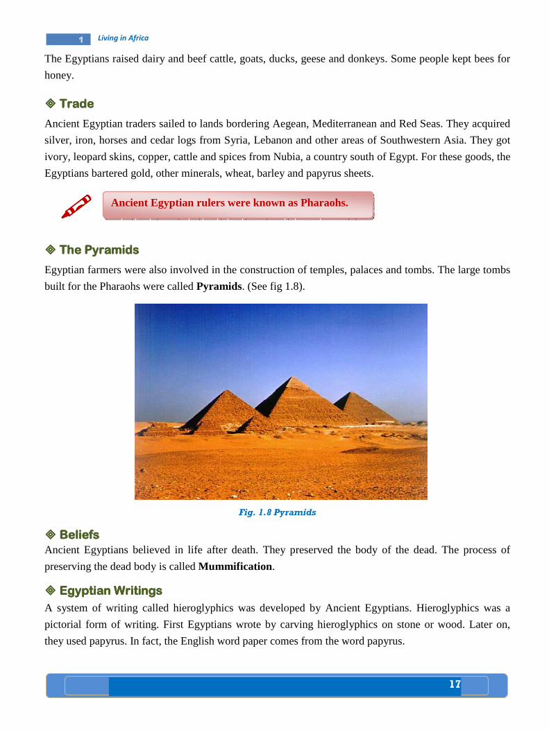
17
1 Living in Africa
The Egyptians raised dairy and beef cattle, goats, ducks, geese and donkeys. Some people kept bees for
honey.
���� TradeTradeTradeTrade
Ancient Egyptian traders sailed to lands bordering Aegean, Mediterranean and Red Seas. They acquired
silver, iron, horses and cedar logs from Syria, Lebanon and other areas of Southwestern Asia. They got
ivory, leopard skins, copper, cattle and spices from Nubia, a country south of Egypt. For these goods, the
Egyptians bartered gold, other minerals, wheat, barley and papyrus sheets.
����
���� The PyramidsThe PyramidsThe PyramidsThe Pyramids
Egyptian farmers were also involved in the construction of temples, palaces and tombs. The large tombs
built for the Pharaohs were called Pyramids. (See fig 1.8).
Fig. 1.8 Pyramids
���� Beliefs Beliefs Beliefs Beliefs Ancient Egyptians believed in life after death. They preserved the body of the dead. The process of
preserving the dead body is called Mummification .
���� Egyptian WritingsEgyptian WritingsEgyptian WritingsEgyptian Writings
A system of writing called hieroglyphics was developed by Ancient Egyptians. Hieroglyphics was a
pictorial form of writing. First Egyptians wrote by carving hieroglyphics on stone or wood. Later on,
they used papyrus. In fact, the English word paper comes from the word papyrus.
Ancient Egyptian rulers were known as Pharaohs.
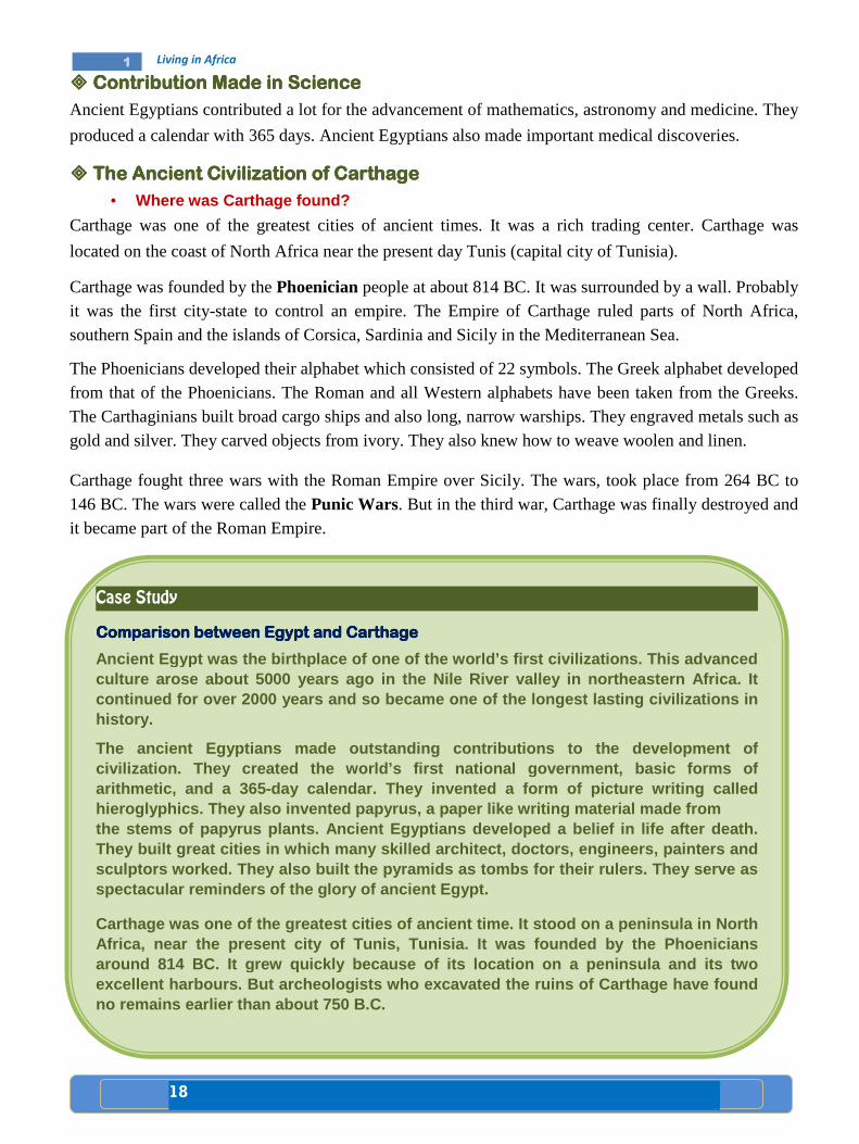
18
1 Living in Africa
���� Contribution Made in ScienceContribution Made in ScienceContribution Made in ScienceContribution Made in Science
Ancient Egyptians contributed a lot for the advancement of mathematics, astronomy and medicine. They
produced a calendar with 365 days. Ancient Egyptians also made important medical discoveries.
���� The Ancient Civilization of CarthageThe Ancient Civilization of CarthageThe Ancient Civilization of CarthageThe Ancient Civilization of Carthage
• Where was Carthage found?
Carthage was one of the greatest cities of ancient times. It was a rich trading center. Carthage was
located on the coast of North Africa near the present day Tunis (capital city of Tunisia).
Carthage was founded by the Phoenician people at about 814 BC. It was surrounded by a wall. Probably it was the first city-state to control an empire. The Empire of Carthage ruled parts of North Africa, southern Spain and the islands of Corsica, Sardinia and Sicily in the Mediterranean Sea.
The Phoenicians developed their alphabet which consisted of 22 symbols. The Greek alphabet developed from that of the Phoenicians. The Roman and all Western alphabets have been taken from the Greeks. The Carthaginians built broad cargo ships and also long, narrow warships. They engraved metals such as gold and silver. They carved objects from ivory. They also knew how to weave woolen and linen.
Carthage fought three wars with the Roman Empire over Sicily. The wars, took place from 264 BC to 146 BC. The wars were called the Punic Wars. But in the third war, Carthage was finally destroyed and it became part of the Roman Empire.
Case Study
Comparison between Egypt and CarthageComparison between Egypt and CarthageComparison between Egypt and CarthageComparison between Egypt and Carthage
Ancient Egypt was the birthplace of one of the worl d’s first civilizations. This advanced culture arose about 5000 years ago in the Nile Rive r valley in northeastern Africa. It continued for over 2000 years and so became one of the longest lasting civiliza tions in history.
The ancient Egyptians made outstanding contribution s to the development of civilization. They created the world’s first nation al government, basic forms of arithmetic, and a 365-day calendar. They invented a form of picture writing called hieroglyphics. They also invented papyrus, a paper like writing material made from
the stems of papyrus plants. Ancient Egyptians deve loped a belief in life after death. They built great cities in which many skilled archi tect, doctors, engineers, pa inters and sculptors worked. They also built the pyramids as t ombs for their rulers. They serve as spectacular reminders of the glory of ancient Egypt .
Carthage was one of the greatest cities of ancient time . It stood on a peninsula in North Africa, near the present city of Tunis, Tunisia. It was founded by the Phoenicians around 814 BC. It grew quickly because of its locat ion on a peninsula and its two excellent harbours. But archeologists who excavated the ruins of Carthage have found no remains earlier than about 750 B.C.

19
1 Living in Africa
Lesson Lesson Lesson Lesson ReviewReviewReviewReview
Activity 1.4 A A. Questions based on facts:
• Explain the time and place of the beginning of ancient Egyptian civilization.
• Why did the ancient Egyptians construct pyramids? • What are hieroglyphics?
• What is papyrus?
• Who were the founders of Carthage?
B. Things to do:
• Draw an outline map of Africa and locate the Nile valley and Egypt.
• Locate ancient Carthage on the map of Africa.
1.4

20
1 Living in Africa
Key term
���� Pre-colonial
Pre Pre Pre Pre –––– colonial colonial colonial colonial ZimbabweZimbabweZimbabweZimbabwe
• Where is the present day Zimbabwe located?
Zimbabwe took its name from the ancient trading city of Zimbabwe. The city was built by the Shona
people about 1000AD. The word “Zimbabwe” comes from a Shona language which meant "house of
stone".
The ruins of the city include a tower 9 meters high and a part of a wall 240 meters around. The structures
were made of huge granite stones which were fitted together without mortar.
By 1400's Zimbabwe reached its highest stage of civilization. During this time, a branch of the Shona
called the Karanga established the Mwenemutapa Empire. This empire included most of the present-day
Zimbabwe.
But in the late 1400's, a group called Rozwi from Karanga revolted against Mwenemutapa Empire and
founded another Empire called Changemire. The Rozwi took over the city of Zimbabwe and became
stronger than its counterpart. However, in turn the Changemire Empire was defeated by another people
called Nguni. After the fall of the Changemire Empire, the city of Zimbawe was abandoned.
The rulers of Zimbabwe built a large walled capital. Skilled masons constructed a huge complex of palaces, stone houses and temples.
1.5 Lesson
Pre-Colonial States (Zimbabwe, Mali, Funji)
Competencies: After studying this lesson, you will be able to:
���� Show appreciation to the architectural achievements of pre-colonial
state of Zimbabwe.
���� Analyze the economic bases of pre-colonial states of Mali and Funji.
21
1 Living in Africa
���� PrePrePrePre----colonial Malicolonial Malicolonial Malicolonial Mali
• When did the Empire of Mali reach its highest peak?
The Mali Empire was founded by the Mandingo people. By about 1240 A.D., a young leader named
Sundiata Keita defeated the kingdom of Ghana. By this time, Mali was able to control the gold fields and
salt deposits of West Africa. This formed the basis for its economy. From 1312 to 1337, Mali was ruled
by Mansa Musa. Under his rule, the Empire achieved the highest stage of political power and cultural
development. During this time, the city of Timbuktu became a famous center of Islamic learning. Other
cities of the Empire were centers of caravan trade. The Mali people were successful farmers and cattle
keepers. But, in the late14th century, Mali became weak due to civil war. Later on, the kingdom of
Songhai replaced Mali as the most powerful state in West Africa.
���� PrePrePrePre colonial Funjcolonial Funjcolonial Funjcolonial Funjiiii
• Where was the Funj kingdom located?
Funj was a Muslim Empire in present day Sudan. The empire began in the early 16th century and was destroyed by the Egyptians in 1821.
The origin of the Funj people was not clearly known. They might have come from a people called Shilluk who lived in the White Nile region.
The Funj Sultanate was a feudal state founded in the early 16th century by Amara Dunkas (r.1504 - 34). The Sultanate flourished during the 17th and 18th centuries. The population consisted mainly of the Funj people. Nubians, Arabs, Beja and other peoples also lived in the sultanate. Arabic was spoken in much of the Funj Sultanate proper. The state religion was Islam.
Case Study
Zimbabwe
Zimbabwe was the most powerful inland state that ex ported gold to the coastal cities of East Africa. Around 1000 AD, migrating farmers and herders settled in the lands between the Zambezi and Limpopo rivers. These pioneers disc overed gold in their new homeland. With the wealth from gold, they set u p a large trading empire. In the ruins of Zimbabwe, archeologists have found Chinese and Indian goods w hich the rulers of Zimbabwe had bought with profits from the gold trade. Zimbabwe reached its height in the 1400’s when the Portuguese destroyed the coas tal cites. Zimbabwe declined because trade was cutoff. About the same time, weak rulers, shortage of salt, and poor crops left the land open to invaders.
22
1 Living in Africa
The feudal structure of the sultanate retained elements of a slave holding system. Tribal clan relationships continued in the outlaying areas. The capital Sennar, was prosperous through trade. It hosted representatives from all over the Middle East and Africa. The wealth and power of the Sultans had long rested on the control of the economy. All caravans were controlled by the monarch. The monarch also controlled the gold supply that became the main source of the state’s currency. Foreign currencies were widely used by merchants in order to break the power of the monarch. The growing trade created a wealthy class of literate merchants who read widely about Islam.
In the early 16th century, the Funj accepted Islam. They founded also Sennar as their capital.
The Funj armies conquered the northern regions of the Sudan and nearly all the area between the Blue Nile and White Nile. Then, Funj became powerful. They were feared in the region between the Red Sea and the Nile River. But, since the middle of the 17th century, the Funj nobles revolted again and again. A period of decline followed. In 1821, it was invaded by Egypt which marked the end of the Funj Empire.
Lesson Lesson Lesson Lesson ReviewReviewReviewReview
Activity 1.5 A • Fact based questions:
1. Identify the following:
- Rozwi
- Karanga
- Nguni
- Mandingo
- Timbuktu - Sennar
- Mansa Musa - Shilluk
2. Answer the following questions:
• Who built the city of Zimbabwe?
• Which ruler established a powerful Empire in West Africa?
• Write the names of the Empires that came just before and after Mali.
• What does the word Zimbabwe mean?
• Who established the Mwenemutapa Empire?
• Which Empire was established by the Rozwi people?
• Which people defeated the Changamire Empire?
• Name the people who founded the Mali Empire.
• Explain the role of Sundiata Keita and Mansa Musa in Mali Empire.
• Which kingdom replaced Mali?
• Who defeated Funj Sultanate and when?
1.5

23
1 Living in Africa
Key terms
���� Caravan ���� Musk
���� Incense ���� Spices
����
•••• Is it possible for people to live without trade int eraction? Discuss.
���� Long Distance Trade in Ethiopia Long Distance Trade in Ethiopia Long Distance Trade in Ethiopia Long Distance Trade in Ethiopia
Long distance trade in Ethiopia was conducted by Muslim merchants. It revived in the 19th century.
The leading merchants of the time were known as Jabarti and Afkala.
����
Long distance trade was mainly conducted by caravan merchants who travelled far and wide distances in
large groups. The leader of the caravan merchants was called Negadras. The word comes from Amharic
and meant leader of merchants.
Trade: is an economic activity of buying and selling goods.
Local trade: refers to local exchanges of goods among peoples of a given region.
It was conducted at open markets held weekly on fixed days.
Long distance trade: involved different markets, peoples, regions and goods.
It combined both internal and external trade.
The Jabarti were Muslim merchants in Northern Ethiopia.
The Afkala were Oromo Muslim Merchants in South Western Ethiopia.
Competencies: After studying this lesson, you will be able to:
���� Appreciate the contribution of long distance trade in Ethiopia in
connecting peoples.
���� Recognize the existence of other trade routes in Africa.
���� Identify the origins of long distance trade routes in Ethiopia.
Lesson
Long Distance Trade as a Factor Connecting Peoples in Ethiopia
1.6

24
1 Living in Africa
���� Items of TradeItems of TradeItems of TradeItems of Trade
The major export items of trade were ivory, musk, gold, skins, hides, incense, coffee and slaves. The
major area of supply was South Western Ethiopia.
The main import items included copper, spice, clothes, beads, silk, silver, firearms, cartridges and
different tools.
���� Markets and Trade RoutesMarkets and Trade RoutesMarkets and Trade RoutesMarkets and Trade Routes
The major markets were located along the trade routes running from South Western to Northern
Ethiopia.
Some of the markets included Bonga in Keffa, Hirmata in Jimma, Assendabo in Wollega, Basso in
Gojjam and Adwa in Tigrai. Massawa was the end of the trade routes in this part of Ethiopia.
Markets located along the East –West trade route include Sodo in Gurage, Ankober and Aliyu Amba in
Northern Shewa and Dire Dawa and Harar in Hararge. The ports of Zeila and Berbera were the end
points.
The major trade routes linked the market centers along the North-South and East–West directions. South
- Western Ethiopia was the origin of both trade routes (See fig 1.9)
Fig. 1.9 Major trade routes in the 19th century
Trade routes
N
Rivers
Key
SOMALIA
Kenya
16°°°°
12°°°°
8°°°°
6°°°°
36°°°° 38°°°° 42°°°° 46°°°°
Asmara
Adwa
Matamma
Gondar
Darita
Bati o
Rogge Harar
Soddo
Bonga
Sqaq
jiren
Assandabo
Basso Alyu Amba
Zella Berber
0 200km
scale

1 Living in Africa
���� Medium of ExchangeMedium of ExchangeMedium of ExchangeMedium of Exchange
In the 19th century, one of the widelyimportant medium of exchange was called after its queen. It was imported into Ethiopia at the end of
���� Importance of Long Distance TradeImportance of Long Distance TradeImportance of Long Distance TradeImportance of Long Distance Trade
Long distance trade served as a major means of econBesides exchange of goods, people also of the major sources of income to ruleimported firearms. Furthermore, long distance trade contributedamong the Oromo of the Gibe River valley whomerchants they also accepted Islam. Withform of money. Above all, long distance Ethiopia and united them together.
Case study
Two major trade routesTwo major trade routesTwo major trade routesTwo major trade routes
The major trade routes consisted of two m
south western part of Ethiopia. One of the lines originated from Bonga , the capital
city of the kingdom of Kefa. It connected peoples a nd states of southern region with
the northern part of Ethiopia. This trade route ran north wards through trade centers,
such as Jiren (in Jimma), Seka (in Limmu
Basso (in Gojam) and Darita (in Begemder). From Dar ita the route entered Gond
where it branched into two. One branch proceeded west
Metemma, while the other branch ran no
entered Massawa on the Red Sea coast. This route wa s the most important in the
first decade of the 19 th century.
one of the widely used medium of exchange was salt bar called amolemedium of exchange was called Maria Theresa. It was a silver coin made in Austria
o Ethiopia at the end of the 18th century.
Fig. 1.10 Maria Theresa
Importance of Long Distance TradeImportance of Long Distance TradeImportance of Long Distance TradeImportance of Long Distance Trade served as a major means of economic relations among different peopl
exchange of goods, people also interchanged views and ideas. On the other handincome to rulers. To strengthen their economic and political power
, long distance trade contributed to the political and religious changes iver valley who formed the Oromo kingdoms. Through the Muslim
they also accepted Islam. With the introduction of money, rulers began to collect taxes, long distance trade created a strong attachment among the peoples
The major trade routes consisted of two m ain lines. Both lines star ted from the
of Ethiopia. One of the lines originated from Bonga , the capital
city of the kingdom of Kefa. It connected peoples a nd states of southern region with
the northern part of Ethiopia. This trade route ran north wards through trade centers,
Jimma), Seka (in Limmu - Enarya), Assendabo (in Horro Guduru),
Basso (in Gojam) and Darita (in Begemder). From Dar ita the route entered Gond
two. One branch proceeded west wards to Sudan through
Metemma, while the other branch ran no rthward through Adwa (in Tigray) and
entered Massawa on the Red Sea coast. This route wa s the most important in the
century.
25
called amole. The other made in Austria named
peoples of Ethiopia. On the other hand, trade was one
economic and political power, rulers to the political and religious changes
Through the Muslim began to collect taxes in the
trade created a strong attachment among the peoples of
ted from the
of Ethiopia. One of the lines originated from Bonga , the capital
city of the kingdom of Kefa. It connected peoples a nd states of southern region with
the northern part of Ethiopia. This trade route ran north wards through trade centers,
Enarya), Assendabo (in Horro Guduru),
Basso (in Gojam) and Darita (in Begemder). From Dar ita the route entered Gond ar
wards to Sudan through
rthward through Adwa (in Tigray) and
entered Massawa on the Red Sea coast. This route wa s the most important in the

26
1 Living in Africa
Lesson Lesson Lesson Lesson ReviewReviewReviewReview
Activity 1.6 A A. Fact based questions:
• Which merchants dominated the long distance trade in Ethiopia in the
19th century?
• Explain the advantages of having markets held on weekends.
• What was the impact of long distance trade on the social, economic
and political life of Ethiopian society?
B. Things to do:
• By visiting a nearby market, write a short report on the nature of the market
in relation to its merchants, major items of trade and its contribution to
the society.
1.6
The second major trade route connected the trade of Ethiopia with Zeila and Berbera.
This route started from Jiren and moved to Seka, wh ere it changed its course towards
the south east and continued to Soddo and Rogge nea r Mount Yerer. Then the route
passe d through Aliyu Amba and ran eastward to Harar. At Harar, the route branched
into two and proceeded to Zeila and Berbera. This r oute became very important after
the expansion of the power of the kingdom of Shewa under Sahle Selassie.

27
1 Living in Africa
Key terms
���� Population distribution
���� Population density
���� Population Distribution and Settlement Population Distribution and Settlement Population Distribution and Settlement Population Distribution and Settlement
A. Key factors affecting population distribution and settlement
• What do you understand by the phrase population dis tribution? • Define the term settlement. • What are the major causes of population distributio n?
The distribution of population in the world is uneven. It is affected by several factors. These factors
include: fertility of soil, relief, mineral resources, stage of economic development, and level of
technological development as well as socio-political organization. In agrarian societies, physical factors
such as climate have decisive roles in population distribution. But in advanced societies, cultural factors
have significant role in determining population distribution.
The following are major factors that affect population distribution:
• Climate: Favorable climate attracts more people than unfavorable climate.
• Natural vegetation: Forests and grasslands provide people with means of making a living.
Such areas are settled by large number of people.
Lesson
Population 1.7
Competencies: After studying this lesson, you will be able to:
���� Describe the factors which affect population distribution.
���� Relate these factors to population settlement in Africa and identify
settlement on a map.
���� Explain the types of livelihood commonly found in Africa.
���� Relate these factors to climate and vegetation.
���� Discuss reasons for urban settlement and identify some examples.
���� Identify key transport routes.
���� Be aware of key transport routes and the effect of civil unrest on
security.
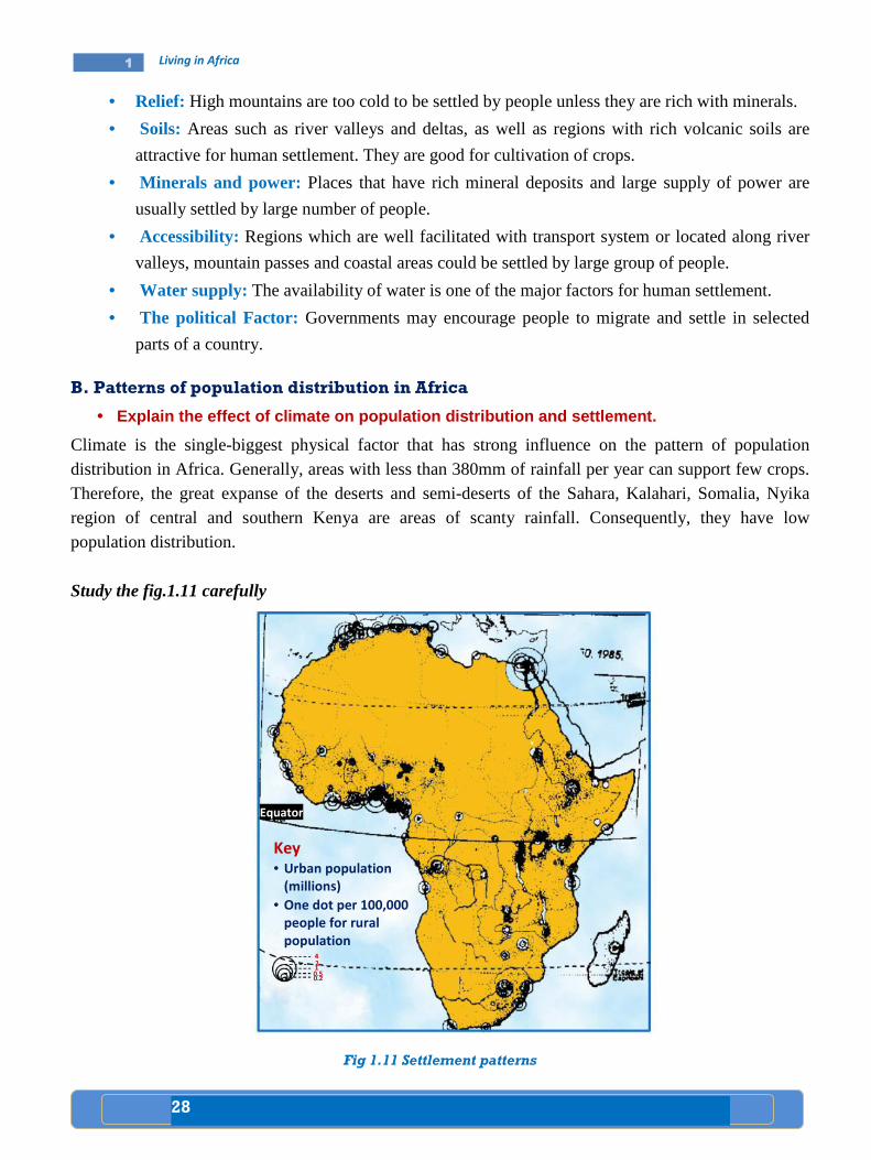
28
1 Living in Africa
• Relief: High mountains are too cold to be settled by people unless they are rich with minerals.
• Soils: Areas such as river valleys and deltas, as well as regions with rich volcanic soils are
attractive for human settlement. They are good for cultivation of crops.
• Minerals and power: Places that have rich mineral deposits and large supply of power are
usually settled by large number of people.
• Accessibility: Regions which are well facilitated with transport system or located along river
valleys, mountain passes and coastal areas could be settled by large group of people.
• Water supply: The availability of water is one of the major factors for human settlement.
• The political Factor: Governments may encourage people to migrate and settle in selected
parts of a country.
B. Patterns of population distribution in Africa
• Explain the effect of climate on population distrib ution and settlement.
Climate is the single-biggest physical factor that has strong influence on the pattern of population distribution in Africa. Generally, areas with less than 380mm of rainfall per year can support few crops. Therefore, the great expanse of the deserts and semi-deserts of the Sahara, Kalahari, Somalia, Nyika region of central and southern Kenya are areas of scanty rainfall. Consequently, they have low population distribution.
Study the fig.1.11 carefully
Fig 1.11 Settlement patterns
Equator
2 1
Key • Urban population
(millions)
• One dot per 100,000
people for rural
population
• 0.2 0.5
4
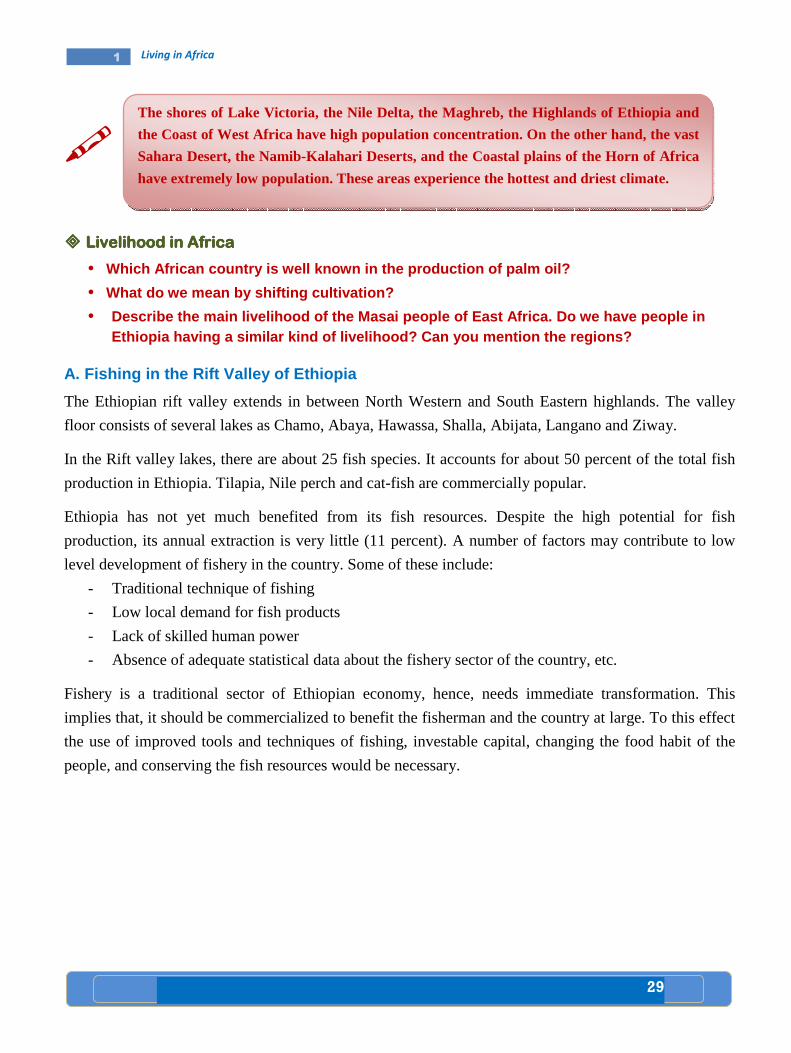
29
1 Living in Africa
�
���� Livelihood in AfricaLivelihood in AfricaLivelihood in AfricaLivelihood in Africa
• Which African country is well known in the producti on of palm oil?
• What do we mean by shifting cultivation?
• Describe the main livelihood of the Masai people of East Africa. Do we have people in Ethiopia having a similar kind of livelihood? Can y ou mention the regions?
A. Fishing in the Rift Valley of Ethiopia
The Ethiopian rift valley extends in between North Western and South Eastern highlands. The valley
floor consists of several lakes as Chamo, Abaya, Hawassa, Shalla, Abijata, Langano and Ziway.
In the Rift valley lakes, there are about 25 fish species. It accounts for about 50 percent of the total fish
production in Ethiopia. Tilapia, Nile perch and cat-fish are commercially popular.
Ethiopia has not yet much benefited from its fish resources. Despite the high potential for fish
production, its annual extraction is very little (11 percent). A number of factors may contribute to low
level development of fishery in the country. Some of these include:
- Traditional technique of fishing
- Low local demand for fish products
- Lack of skilled human power
- Absence of adequate statistical data about the fishery sector of the country, etc.
Fishery is a traditional sector of Ethiopian economy, hence, needs immediate transformation. This
implies that, it should be commercialized to benefit the fisherman and the country at large. To this effect
the use of improved tools and techniques of fishing, investable capital, changing the food habit of the
people, and conserving the fish resources would be necessary.
The shores of Lake Victoria, the Nile Delta, the Maghreb, the Highlands of Ethiopia and
the Coast of West Africa have high population concentration. On the other hand, the vast
Sahara Desert, the Namib-Kalahari Deserts, and the Coastal plains of the Horn of Africa
have extremely low population. These areas experience the hottest and driest climate.

30
1 Living in Africa
Fig. 1.12 The Ethiopian Rift Valley Lakes
Case study
Most fishing activities in Ethiopia are taking plac e in fresh waters (i.e lakes, rivers and ponds). According to the Ethiopian wild life co nservation department, Ethiopia’s fresh water bodies are known to have 101 species of fish, among which four are ende mic to the country. The Ethiopian fishing grounds c ould be classified as (a) lakes, (b) river fishery.
a) Lake fishery The Ethiopian lakes are estimated to cover a surfac e area of about 7000km 2. But they account only 50% of the total yearly fish prod uction of the country. The annual maximum sustainable fish yield of our lakes are estimated to be above 35,000 tons. But presently only 4,000 tons are prod uced annually. This is only 11% of the annual potential of our lakes.
b) River fishery Most rivers of Ethio pia have high fish resources. Most fish production of the rivers is confined to local consumption by villager s living near and around river banks. The fishing potential of Ethiopian rivers ha s not yet been fully known. But according to some references, th e county’s rivers and streams can produce, on average, about 7000 - 10,000 tons of fish annually. For example, Baro riv er alone can supply a maximum sustainable yield of 2,500 ton s per year.
Generally, both lakes and rivers of Ethiopia are ve ry rich in a wide variety of fish resources, such as Tilapia, Nile perch, Carius, Cyp rinus, Barbus and others, and have high promising potential for the development o f commercial fish industry.
Ethiopian Rift valley Lakes
1. Lake Abe
2. Lake Zway
3. Lake Langano
4. Lake Abijata
5. Lake Shalla
6. Lake Hawassa
7. Lake Abaya
8. Lake Chamo
9. Lake Chew Bahir
1
2
3 4
5
6 7
8
9
Lake Tana
No
rth
we
ste
rn
Eth
iop
ian
Hig
hla
nd
s
an
d l
ow
la
nd
s
Eth
iop
ian
Rif
t
Va
lle
y
South Eastern Ethiopian
Highlands and low lands
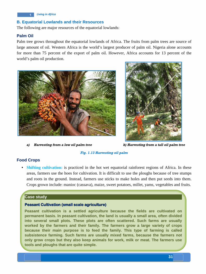
31
1 Living in Africa
B. Equatorial Lowlands and their Resources The following are major resources of the equatorial lowlands:
Palm Oil Palm tree grows throughout the equatorial lowlands of Africa. The fruits from palm trees are source of large amount of oil. Western Africa is the world’s largest producer of palm oil. Nigeria alone accounts for more than 75 percent of the export of palm oil. However, Africa accounts for 13 percent of the world’s palm oil production.
a) Harvesting from a low oil palm tree b) Harvesting from a tall oil palm tree
Fig. 1.13 Harvesting oil palm
Food Crops
• Shifting cultivation: is practiced in the hot wet equatorial rainforest regions of Africa. In these areas, farmers use the hoes for cultivation. It is difficult to use the ploughs because of tree stumps and roots in the ground. Instead, farmers use sticks to make holes and then put seeds into them. Crops grown include: manioc (cassava), maize, sweet potatoes, millet, yams, vegetables and fruits.
Case study
Peasant Cultivation (small scale agriculture) Peasant Cultivation (small scale agriculture) Peasant Cultivation (small scale agriculture) Peasant Cultivation (small scale agriculture)
Peasant cultivation is a settled agriculture becaus e the fields are cultivated on permanent basis. In peasant cultivation, the land i s usually a small area, often divided into several small plots. These plots are often sca ttered. Such farms are usually wor ked by the farmers and their family. The farmers gr ow a large variety of crops because their main purpose is to feed the family. T his type of farming is called subsistence farming. Such farms are usually mixed f arms, because the farmers not only grow crops but they also keep animals for work, milk or meat. The farmers use tools and ploughs that are quite simple.

32
1 Living in Africa
C. High Savannah Cattle Ranching
Cattle Ranching in Ethiopia: There are two main types of savannah or tropical grasslands in Ethiopia.
They are: Grassland Savannah and Woodland Savannah. The Savannah land covers most part of the rift
valley, the Awash valley, and parts of Borana, Wollega and Gojam. In these areas, large number of cattle
are reared.
����
D. Sedentary Agriculture
Sedentary agriculture is a more advanced form of traditional agriculture. It is practiced outside the tropical rainforest and desert regions. The staple food crops grown include: maniocs, yams, maize,
Case study
Cattle ranching in EthiopiaCattle ranching in EthiopiaCattle ranching in EthiopiaCattle ranching in Ethiopia
Ethiopia has a very large livestock resource. The c ountry ranks first in Africa and tenth
in the World in its cattle population. From early d ays, livestock rearing has played
important role in the life of Ethiopians. In the lo wlands, especially in Ogaden, Bora na
and Afar, stock breeding is the mainstay of the peo ple.
Livestock in the pastoral and semi-pastoral areas are kept as capital assets. The manures of the cattle are usually used as sources o f fuel and fertilizer.
In general, the lives of farmers in rural areas of the country are highly linked with livestock rearing.
Case study
The The The The Masai Herdsmen of East AfricaMasai Herdsmen of East AfricaMasai Herdsmen of East AfricaMasai Herdsmen of East Africa
The Masai live in the dry savannah part of Kenya an d Northern Tanzania. They are herdsmen. In these areas, cultivation of crops, wit hout irrigation, is almost impossible. The Masai, therefore, practice a nomadic way of lif e. They constantly move with their herds of cattle and flocks of sheep and goats and s urvive by the blood of live cattle and other animals. However, overgrazing is becoming cru cial problem. Consequently, it results to severe soil erosion.
Cattle are very important in the life of the people in the savannah lands of Africa.
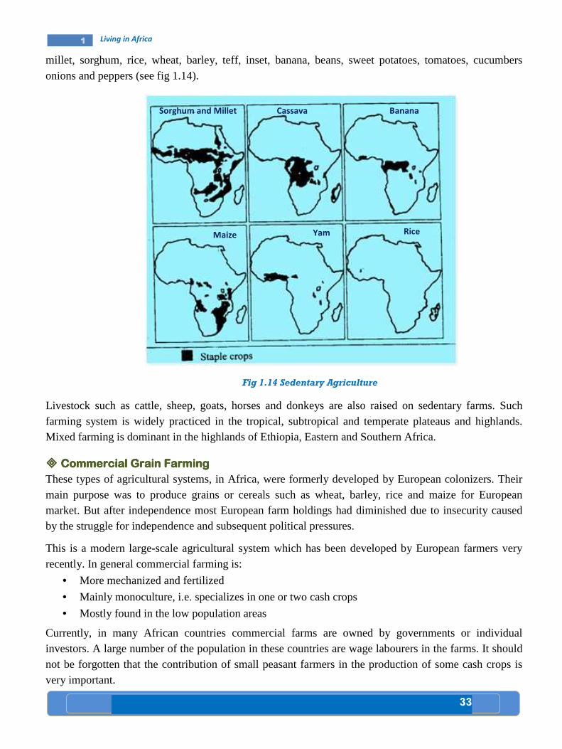
33
1 Living in Africa
millet, sorghum, rice, wheat, barley, teff, inset, banana, beans, sweet potatoes, tomatoes, cucumbers onions and peppers (see fig 1.14).
Fig 1.14 Sedentary Agriculture
Livestock such as cattle, sheep, goats, horses and donkeys are also raised on sedentary farms. Such farming system is widely practiced in the tropical, subtropical and temperate plateaus and highlands. Mixed farming is dominant in the highlands of Ethiopia, Eastern and Southern Africa.
���� Commercial Grain FarmingCommercial Grain FarmingCommercial Grain FarmingCommercial Grain Farming
These types of agricultural systems, in Africa, were formerly developed by European colonizers. Their main purpose was to produce grains or cereals such as wheat, barley, rice and maize for European market. But after independence most European farm holdings had diminished due to insecurity caused by the struggle for independence and subsequent political pressures.
This is a modern large-scale agricultural system which has been developed by European farmers very recently. In general commercial farming is:
• More mechanized and fertilized
• Mainly monoculture, i.e. specializes in one or two cash crops
• Mostly found in the low population areas
Currently, in many African countries commercial farms are owned by governments or individual investors. A large number of the population in these countries are wage labourers in the farms. It should not be forgotten that the contribution of small peasant farmers in the production of some cash crops is very important.
Sorghum and Millet Cassava Banana
Maize Yam Rice

34
1 Living in Africa
The following description will help you to note some of the commercial crops of Africa.
• Coffee: It is a very popular cash crop. Africa accounts for about 20 percent of the world's coffee production. The chief coffee producers in Africa include Cote D'ivore, Ethiopia, Uganda, Cameroon, Kenya, Tanzania, Democratic Republic of Congo and Angola.
• Tea: It is grown in the wetter parts of the African highlands. Major producers include Tanzania, Kenya, Ethiopia, Mozambique, Zimbabwe, Congo and Mauritius.
• Horticulture: Uganda, Tanzania, Kenya are well known producers of flower which is destined to European markets. Ethiopia exports flower to Europe and the U.S.A. This is a new venture in the Ethiopian economy.
���� Factors Affecting the Distribution of Settlement and Livelihood Factors Affecting the Distribution of Settlement and Livelihood Factors Affecting the Distribution of Settlement and Livelihood Factors Affecting the Distribution of Settlement and Livelihood
• Enumerate factors favoring the site of Addis Ababa as a city. • In which African country is Mombasa found? • What are the causes for the formation of urban cent er? • Why do you think people are moving from rural areas to urban centers in great
number? • Explain the relationship between human settlements and security issues, like civil
disturbances and wars.
���� The SitThe SitThe SitThe Site, situatione, situatione, situatione, situation and Growth of the and Growth of the and Growth of the and Growth of the urban settlementurban settlementurban settlementurban settlement
Urban settlement has two components. These components are site and situation. Site refers to the local
setting of a city, while the situation refers to the regional setting. As example of site and situation, think
of Addis Ababa. The original site of Addis Ababa was on the top of Entoto mountain. The importance of
its situation (regional location) was that it enabled the government to control the country from this
central location. A defensive site is a location where a city can be easily defended.
Case study
Addis AbabaAddis AbabaAddis AbabaAddis Ababa
Addis Ababa is a city founded by Menilik II and Ete ge Tayitu in 1879 as a cultural,
political, judicial and commercial hub of Ethiopia. Menilik II allocated all lands around
the old palace to his war lords and aristocrats. Th ese higher nobilities with the ir huge
soldiers settled around the palace and built their own houses, which in turn led to the formation of various neighborhoods (Sefers in Amhar ic).
Addis Ababa’s neighborhoods formation was commenced in 1900, before 110 years.
These neighborhoods were named after chiefs such as Ras Mekonen Sefer, Ras Mulugeta Sefer or named after the dominant ethnic g roup settled in the area like

1 Living in Africa
Addis Ababa
Study the map of Addis Ababa given below carefully
Fig. 1.15 Map showing the position
Wollo Sefer, Adere Sefer, Gofa Sefer. Some Sefers a re named by their dominant function like neighborhoods of laborers(Zebegna Sefer) or neighborhoods of monastery (Geda m Sefer). Some neighborhoods derive their names after the names of nobles who we re granted plots around the place. In due course of time, more and more new com erneighborhoods.
The city, at its infancy served as a platdefeated the Italian invaders at the many countries have opened up their embassies inincreasing and altering the size and shapes of sett lements of the city. The introduction of modernization encouraged natives and foreigners to come, settle and engage in causal and permanent business in the
Unlike other Af rican cities, Addis Ababa is entirely built by Ethi opians. The city has played a significant role in transferring technolog ies to the remaining parts of the country. Addis Ababa is a melting pot of various na tionmultitude of cult ures and languages. The peripheral areas of Addis A baba, being an essential site, are under constant pressure due to their proximity and specific locational advantage.
Kolfe keranyo
Addis ketema
Lideta
Nefas Silk
Study the map of Addis Ababa given below carefully
Map showing the position of Addis Ababa
Wollo Sefer, Adere Sefer, Gofa Sefer. Some Sefers a re named by their dominant function like neighborhoods of laborers (Serategna Sefer), neighborhoods of guards (Zebegna Sefer) or neighborhoods of monastery (Geda m Sefer). Some neighborhoods derive their names after the names of nobles who we re granted plots around the place. In due course of time, more and more new com ers attracted to these
served as a plat form to coordinate the Ethiopian army that defeated the Italian invaders at the Battle of Adwa in 1896. After the victory of Adwa, many countries have opened up their embassies in the city. This resulted in increasing and altering the size and shapes of sett lements of the city. The
modernization encouraged natives and foreigners to come, settle and engage in causal and permanent business in the city.
rican cities, Addis Ababa is entirely built by Ethi opians. The city has played a significant role in transferring technolog ies to the remaining parts of the country. Addis Ababa is a melting pot of various na tion s and nationalities with a
ures and languages. The peripheral areas of Addis A baba, being an essential site, are under constant pressure due to their proximity and specific
Gullele
Addis ketema
Lideta
Arada
Kirkos
Nefas Silk-Lafto
Yeka
Bole
Akaki-Kality
35
Wollo Sefer, Adere Sefer, Gofa Sefer. Some Sefers a re named by their dominant (Serategna Sefer), neighborhoods of guards
(Zebegna Sefer) or neighborhoods of monastery (Geda m Sefer). Some neighborhoods derive their names after the names of nobles who we re granted plots around the
s attracted to these
form to coordinate the Ethiopian army that attle of Adwa in 1896. After the victory of Adwa,
the city. This resulted in increasing and altering the size and shapes of sett lements of the city. The
modernization encouraged natives and foreigners to come, settle and
rican cities, Addis Ababa is entirely built by Ethi opians. The city has played a significant role in transferring technolog ies to the remaining parts of the
nationalities with a ures and languages. The peripheral areas of Addis A baba, being an
essential site, are under constant pressure due to their proximity and specific
N
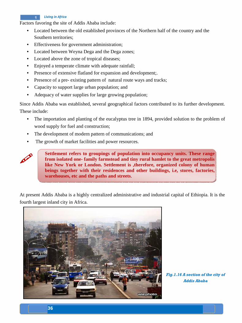
36
1 Living in Africa
Factors favoring the site of Addis Ababa include:
• Located between the old established provinces of the Northern half of the country and the Southern territories;
• Effectiveness for government administration;
• Located between Weyna Dega and the Dega zones;
• Located above the zone of tropical diseases;
• Enjoyed a temperate climate with adequate rainfall;
• Presence of extensive flatland for expansion and development;.
• Presence of a pre- existing pattern of natural route ways and tracks;
• Capacity to support large urban population; and
• Adequacy of water supplies for large growing population;
Since Addis Ababa was established, several geographical factors contributed to its further development.
These include:
• The importation and planting of the eucalyptus tree in 1894, provided solution to the problem of
wood supply for fuel and construction;
• The development of modern pattern of communications; and
• The growth of market facilities and power resources.
����
At present Addis Ababa is a highly centralized administrative and industrial capital of Ethiopia. It is the
fourth largest inland city in Africa.
Fig.1.16 A section of the city of
Addis Ababa
Settlement refers to groupings of population into occupancy units. These range from isolated one- family farmstead and tiny rural hamlet to the great metropolis like New York or London. Settlement is ,therefore, organized colony of human beings together with their residences and other buildings, i.e, stores, factories, warehouses, etc and the paths and streets.
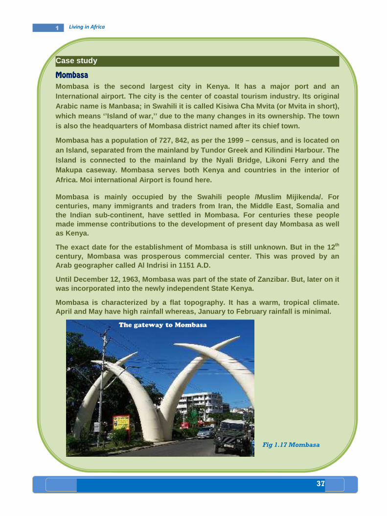
37
1 Living in Africa
Case study
MombasaMombasaMombasaMombasa
Mombasa is the second largest city in Kenya. It has a major port and an International airport. The city is the center of co astal tourism industry. Its original Arabic name is Manbasa; in Swahili it is called Kis iwa Cha Mvita (or Mvita in short), which mean s ‘’Island of war,’’ due to the many changes in its ownership. The town is also the headquarters of Mombasa district named after its chief town.
Mombasa has a population of 727, 842, as per the 19 99 – census, and is located on an Island, separated from t he mainland by Tundor Greek and Kilindini Harbour. The Island is connected to the mainland by the Nyali Br idge, Likoni Ferry and the Makupa caseway. Mombasa serves both Kenya and count ries in the interior of Africa. Moi international Airport is found here.
Mombasa is mainly occupied by the Swahili people /M uslim Mijikenda/. For centuries, many immigrants and traders from Iran, t he Middle East, Somalia and the Indian sub- continent, have settled in Mombasa. For centuries t hese people made immense contributions to the development of present day Mombasa as well as Kenya.
The exact date for the establishment of Mombasa is still unknown. But in the 12 th
century, Mombasa was prosperous commercial center. This was proved by an Arab geographer called Al Indrisi in 1151 A.D.
Until December 12, 1963, Mombasa was part of the st ate of Zanzibar. But, later on it was incorporated into the newly independent State K enya.
Mombasa is characterized by a flat topography. It h as a warm, tropical climate. April and May have high rainfall whereas, January t o February rainfall is minimal.
Fig 1.17 Mombasa
The gateway to Mombasa
38
1 Living in Africa
���� Reasons for Urban SettlementReasons for Urban SettlementReasons for Urban SettlementReasons for Urban Settlement
The location of large villages and urban settlements depends upon:
• Old regional centers;
• Route centers;
• Air route;
• Rail centers;
• Market centers;
• Frontier posts; and
• Industrial developments.
Nowadays, cities are rapidly growing. They are getting over crowded. Though life in cities is becoming
difficult, more and more people are still migrating from rural areas to cities. This happens because of
varied reasons. Some of the reasons are:
• Looking for better paid jobs;
• Expectance of improved housing and better quality life;
• Improved services such as schools, medical treatment and entertainment;
• Attraction to electric facilities;
• Reliability of source of food;
• Safety from political affairs and
• Transport route and security issues
Case Study
Comparison between Addis Comparison between Addis Comparison between Addis Comparison between Addis Ababa and MombasaAbaba and MombasaAbaba and MombasaAbaba and Mombasa
• Addis Ababa occupies the heart land of Ethiopia, wh ich is a highland. Thus, has cooler temperature and greater amount of rainfall. The coffee packers in the city are working in such climatic conditions, w hich makes their work life easy an d comfortable. Compared to this, the port workers i n the sheltered harbor city of Mombasa have a working atmosphere wh ich is not easy.
This is because; the city is situated at the coasta l lowland area of the country, where the temperature is high. Otherwise, matters of living conditions and settlement makes the two cities similar. Population number in both cities (Addis Ababa nearly 3 million, Mombasa 727,842 (199 9-census)) is very high. While Mombasa is directly linked with the outside w orld through railway lines and through water transport, Addis Ababa does not h ave a direct link. On the other hand, both Addis Ababa and Mombasa linked with the rest of the world through International air ports.
•

39
1 Living in Africa
����Transport route and Transport route and Transport route and Transport route and Security issuesSecurity issuesSecurity issuesSecurity issues
Roads: Road transport has become more important in Africa since 1950’s. Road transport is more
wide- spread and more flexible than railways. The modern road networks of Africa have began to evolve
recently almost everywhere in the continent. This shows that governments have realized that an efficient
transport system stimulates economic growth. Road development and distribution in Africa are unequal.
Southern Africa has the most developed and highest density of roads in Africa. Other areas with
relatively better developed networks include the Maghreb (northern Africa) and West African coasts.
As the flow of traffic is mainly from the interior to the coast, there is a great need to improve the linking
roads among countries of Africa to promote trade and socio cultural ties. To achieve socio-economic and
political integration among African countries, the two proposed road networks would be of special
significance. These Trans African highways are The Great North Road from Cairo to Cape Town and
the one that extends form Lagos to Mombasa.
Fig 1.18 Road map of Africa
Free town Juba
••••

40
1 Living in Africa
Railways: Today Africa possesses only less than 10 percent of the world’s total length of railway lines.
Hence, it is still underdeveloped. Most railways in Africa were built at the end of the 19th or early 20th
century. Africa’s existing railway net work is also unequally distributed among the various regions. The
region with large concentration of railways is southern Africa. Particularly, the Republic of South Africa
is the only country which has attained the development of railway network compared to those in Europe
and North America.
Fig 1.19 Africa’s Railways
N.B: We have seen above, that road and railway transport in Africa are still underdeveloped. The factors are so many. One major problem that we can mention is war and disturbance. When there is war and civil disturbance, the already built transport infrastructures will be destroyed. Furthermore, future development will be retarded. Africa had been and still is victim of such situations.
Africa’s
Railroads

41
1 Living in Africa
Lesson Lesson Lesson Lesson ReviewReviewReviewReview
Activity 1.7 A A. Questions based on facts:
• What is the name of the west African country well known for its palm oil
production?
• What are the three most important and commercially popular fish species
in Ethiopia?
• What do you call the herdsmen of northern Tanzania and Kenya?
• List down staple grain (cereal) and root crops (tuber) that are produced in
Africa separately.
• Which countries of Africa produce coffee?
• Some fish species in the rift valley lakes of Ethiopia are being over fished
due to different reasons. What immediate measures should be taken in
order to alleviate the problem?
B. Group work: • In groups, compare and contrast a worker in Addis Ababa who packs
coffee and a person in Mombasa who works in a port, not forgetting that
there is relationship between work and climate. Bring the final work of
each group to the class and have a common discussion.
1.7

42
1 Living in Africa
• Africa has a compact shape. It has a regular coast line. Both North-South and
East-West dimensions of Africa are almost equal. Af rica is crossed by the Tropic
of Cancer, Capricorn and the Equator. It is bordere d by the Atlantic Ocean,
Mediterranean Sea, Indian Ocean and the Red Sea.
• On the map of the world or a globe, there are imagi nary lines running East-West
and North-South directions. The lines drawn East-We st are called parallels. They
are parallel to one another. Another group of lines are called Meridians . They are
great circles joining the poles, i.e. North and Sou th poles.
• There are major groups of languages in Africa. They are called Super language
Families. They are the Niger-Congo, Afro-Asiatic, N ilo-Saharan and Khoisan. In
Western, Central, Eastern, and Southern Africa, we have the speakers of the
Niger-Congo, whereas in Northern, Central, North Ea stern and the Horn, the
dominant language is the Afro-Asiatic. The Nilo-Sah aran speakers are found
around Nile valley. On the other hand, the Khoisan speakers are found in a few
areas of South Africa.
• Climate, vegetation and population pressure are key factors for the distribution
and settlement of population. For example, the equa torial lowlands, savannah
lowlands, and the deserts do not favour dense settl ement. They all experience
harsh climate. But, areas with rich fertile soil an d mild rainfall and temperature
could attract dense settlement.
• There are varied types of livelihood practiced in A frica. Some of them include
fishery, growing of tropical crops, pastoralism and the production of highland
crops.
• Settlements can be categorized into urban and rural . Urban settlements have pull
factors. They attract rural people in different way s and induce migration. For
example, Addis Ababa was first settled because of t he presence of a fertile and
sheltered valley. Then, it grew tremendously mainly because of rural-urban
migration. On the other hand, Mombasa, i.e. in Ken ya was established because
of sheltered harbour and the East African Railway.
• War and civil disturbances destroy the already buil t infrastructures.
Furthermore, it retards future development programs .
SummarySummarySummarySummary

43
1 Living in Africa
Glossary
• Absolute location: is the location that can be shown on globes or maps by using
astronomical grid references.
• Caravan: company of persons (merchants) making a journey together for safety usually across
desert area.
• Craftsman: skilled workman who practices a craft.
• Excavate: to dig in the ground to look for old buildings or objects that have been buried for a long
time.
• High latitudes: the area beyond the Arctic circle in the north and Antarctic circle in the south
(66�
�°°°°N or S- 90°N or S).
• Incense: (smoke of) substance producing a sweet smell when burning.
• Khoisan: the language super family of the khoikhoi and san people of southern Africa.
• Language super- families: highest form of language classification.
• Latitudes: are angular distances measured to the north and south of the equator in degrees.
• Low latitude: this is the belt between the tropic of cancer ( 23�
�°°°°N) and the tropic of
capricorn (23�
�°°°°S).
• Massive continent: if a continent is said to be massive that means, its size is very big or very huge.
• Meridians: are imaginary lines which connect the north pole and the south pole. All meridians are
labeled in degrees east or west of the prime meridian (0° longitude). • Middle latitudes: sometimes known as the temperate regions. They are found between the tropic of
cancer (23�
�°°°°N) and the Arctic circle (66
�
�°°°°N) in the northern hemisphere and the
tropic of capricorn (23�
�°°°°S) and the Antarctic circle (66
�
�°°°°S) in the southern
hemisphere. • Mummification: preserving a corpse.
• Musk: strong smelling substance produced in glands by civet cat used in the manufacture of
perfumes.
• Population distribution: describes the way in which people are spread out across the earth’s surface.
• Population density: describes the number of people living in a given area.
• Pre- colonial: before colonialism.
• Solstice: time of year when the sun’s vertical rays reach farthest north(June 21) or south(Dec.22) of
the equator.
• Spices: sorts of substance used to flavour food.
• Temple: building used for the worship of a god.
• Tomb: place dug in the ground for a dead body.

44
1 Living in Africa
I. True or false Direction: Write “True” if the statement is correct and ‘’False’’ if the statement is incorrect in the space
provided infront of each statement.
_______1. Europe is the smallest of all the continents.
_______ 2. Asia alone occupies 29.9 percent of the total land surface of the earth.
_______ 3. The concentration of people in an area is associated only with physical factors.
_______ 4. War and conflict can be equated with destruction of infrastructure, loss of insituional capacity
and damage to human life.
_______ 5. Settlement refers to a place where people have come to live permanently, usually when there
were very few people living there before.
_______ 6. The earth rotates through 1° of longitude every 4 minutes or 15°°°° every hour. _______ 7. The speakers of the Niger-Congo language super family occupy the largest part of Africa.
_______ 8. Ancient Egyptians believed in life after death.
II. Matching Direction: Match column B with column A.
Column A Column B
_______ 1. Modern agriculture
_______ 2. The spread of people across the earth’s surface.
_______ 3. The number of people living in a given area.
_______ 4. The largest landmass
_______ 5. Zero degree longitude
a) Continent
b) Population density
c) Population migration
d) Population pressure
e) Population distribution
f) Commercial farm
g) Ethiopia
h) Prime meridian
III. Multiple choices
Answer the following questions by choosing the best possible answer.
_______ 1. The largest continent in the world is
a) Europe c) North America
b) Africa d) Asia
Review Questions UNIT
1
45
1 Living in Africa
_______ 2. Another name of longitude is:
a) Meridian c) geographical Grid
b) Parallel d) net work
_______ 3. One of the following is not a physical factor for population distribution:
a) Stage of economic development c) Accessibility
b) Climate d) Water supply
_______ 4. An African state well known in palm oil production:
a) Ethiopia c) Nigeria
b) Sudan d) Ghana
_______ 5. The Mali Empire was built by the
a) Shona people c) Mandingo people
b) Shilluk d) Nguni people
_______ 6. The leader of the caravan merchants was known as
a) Jabarti c) Negadras
b) Afkala d) Basha
IV. Fill in the blanks
1. Cultivation type which is a step ahead of shifting cultivation is called .
2. The distribution of the earth’s peoples is determined by and factors.
3. The southern most point of Africa is called .
4. Eucalyptus tree was introduced to Ethiopia for the first time in the year E.C.
5. The Masai herdsmen are found in and .
6. The civilization of ancient Egypt began in the river valley.
7. The Empire of Mali achieved the highest stage of political power and cultural development during
the regime of .
V. Short answer questions
1. What do we mean by an absolute location of a place?
2. Explain the shape of Africa.
3. What can you say about the size of Africa?
4. Name the five important latitudes which act like a benchmark that tell us the amount of sunlight
reaching places along each line.
5. Give description on the factors affecting world population distribution.
6. Identify the rift valley lakes of Ethiopia and give brief explanation on the fish resources of these
lakes.
7. Write the major super-language families in Africa.
8. Explain the medium of exchange in Ethiopia in the 19th century.

46
1 Living in Africa
Check List
Put a tick (����) mark in each of the boxes for activities you can
perform
I can
1. Compare the size and shape of Africa with other
continents.
2. Identify the absolute location of Africa.
3. Explain the terms latitude and longitude in
relation to parallels and meridians.
4. Describe the factors which affect population
distribution.
5. Indicate the location of Egypt and Carthage as o ne of the
centers of ancient civilizations in Africa.
6. Explain the significance of the ancient civiliza tions of
Egypt and Carthage.
7. Analyze the economic bases of pre-colonial state s of
Zimbabwe, Mali and Fungi.
8. Relate determinants of population distribution t o
population settlement in Africa and identify settle ment
on a map.
9. Explain the types of livelihood commonly found i n Africa.
10. Relate determinants of population to climate an d
vegetation.
11. Discuss the reasons for urban settlement.
12. Identify key transport routes.
13. Explain the effect of civil unrest on security.
14. Name super language families in Africa.
15. Describe the achievements of pre-colonial Zimb abwe.
16. Explain the revival of long distance trade in E thiopia
In the 19 th century.
1
Unit Outcomes
After studying this unit, you will be able to:
���� Explain the size, shape, location, and the Super Language Families
of Africa.
���� Recognize the major ancient civilizations and pre-colonial states of
Africa.
���� Discuss factors that affect distribution, settlement and livelihood
in Africa.
UNIT
1
LIVING IN AFRICA

2
1 Living in Africa
Key terms
���� Absolute location ���� Massive continent
A. The Positions of Africa
• What is an absolute location?
• Referring to Fig 1.1. Can you give the four extreme points of Africa?
• When we say Africa has largely intertropical locati on, what does that mean? Explain.
The exact location of a place can be identified on globes or maps by using latitudes and longitudes.
Study fig 1.1 below carefully. It indicates the absolute location of Africa.
Fig 1.1 Astronomical location of Africa
Africa lies between 37° 21' N and 34° 52'S and 17° 11'W and 51° 24 E. What are the four extreme points
of Africa i.e N, S, W and E? Observe the map given above.
Lesson
The People of Africa, Location, Size and Shape of Africa
1.1
Competencies: After studying this lesson, you will be able to:
���� Compare the size and shape of Africa with other continents.
���� Identify the absolute location of Africa.
Somalia 51°°°° 24'E
Most easterly point:
Cape Guardefui (Ras
Kaafuun) Most Westerly
point: Cape Vert
17°°°° 11'W
Most northerly point: Ras
ben Sakka 37°°°°21'N
Most southerly point: Cape Agulhas South Africa 34°°°°52'S
km

3
1 Living in Africa
����
Let us compare the shape and size of Africa with other continents. Students study fig. 1.2 given below:
Fig 1.2 The size of Africa as compared with other continents
• The North - South distance of Africa is 7623 km and its East -West distance is 7260 km.
•••• Africa has almost a balanced position around the equator. The equator almost bisects Africa into two equal parts.
•••• Africa is the only continent crossed by both the tropic of cancer and tropic of capricorn.
•••• Africa has largely inter- tropical location
•••• The Prime Meridian passes through the western part of the continent via Accra (the capital city of Ghana)
• The four extreme points of the continent are: - Ras ben Sakka – Tunisia - Cape Agulhas – Republic of South Africa - Cape Guardafui (Ras Kaafuun) – Somalia - Cape Vert --------- Senegal
Africa
Europe
Asia
Australia
South
America
North
America
Green
Land
JapanJapanJapanJapan
VenezuelaVenezuelaVenezuelaVenezuela
United StatesUnited StatesUnited StatesUnited States
KalimantanKalimantanKalimantanKalimantan

4
1 Living in Africa
Africa has a compact shape. It has remarkably regular coastal lines. Such coastlines afford very few
harbours. The only indentations are Gulf of Guinea and the Gulf of Sidra. Try to locate these areas on
the map of Africa.
As it is indicated in Fig. 1.2 Asia is bigger than Africa. Therefore, Africa is the 2nd largest continent. It
has a total area of about 30,331,606 km2. This accounts for about 20.2 percent of the earth’s land
surface. Of course 75 percent of Africa’s area lies within the tropics. On the other hand, over 25 percent
of Africa’s land is covered by the Sahara desert.
���� The table below shows the size of major continents. Study it carefully
Table 1.1 Areal sizes of Major continents
Continent Approximate
area in Km2
percent of world
share
Asia 44, 810,880 29.9
Africa 30, 331,606 20.2
North America 24, 367,875 16.3
South America 17, 831,606 11.9
Antarctica 14,002,590 9.4
Europe 9, 935,233 6.6
Australia 8, 289,000 5.7
World total 149, 568,790 100
Africa is as large as the combined land area of U.S.A, Europe and China.
Africa’s land surface, approximately two third, lies north of the Equator.
Case Study Case Study Case Study Case Study
Comparison of two capitals: Accra and KampalaComparison of two capitals: Accra and KampalaComparison of two capitals: Accra and KampalaComparison of two capitals: Accra and Kampala
Accra Accra is the capital and the largest city in Ghana (Western Africa) with the population
of the city proper estimated at 3,963,264 as of 201 1. Accra also doubles as the capital
of Grea ter Accra region and of the Accra Metropolitan dist rict with which it is
coterminous (sharing a border). Accra is also the a nchor of a substantially l arger
metropolitan area called the Greater Accra Metropol itan area and includes eight
districts.

5
1 Living in Africa
Accra is the administrative, communications, and ec onomic center of the country. Originally built around a port, Accra stretches alo ng the A tlantic coast and north into the interior. Serving as the nation’s capital, then the Gold C oast, form 1877 its architecture ranges from large and elegant nineteen th ce ntury colonial buildings to skyscrapers and parliament blocks made of concre te, glass and steel in the 1970s. Reflecting its transition form a 19 th century suburb Victorian burg (old fashioned) to the modern metropolis it is today.
Spreading along the Atlantic coast, the city is wel l endowed with luxury as well as great value hotels, excelle nt restaurants and night clubs. A range of absorbin g museums and fine public monu ments, modern business and commercial areas, as well as busy markets and tree lined residential sub urbs, is ready to be explored. Since the early 1990s a number of new buildin gs have been built, including the multi- storey Novotel hotel which is French owned. There i s also an Impassive National theatre that was built with help from the Chinese.
The center of Accra contains the main banks, the la rge department stores, and a whole area known as the Ministries, where the gover nmental administration is concentrated. Economic activities in Accra are: fin ancial, agriculture, fishing, and manufacturing processed food, lumber and plywood, t extiles, clothing and chemicals.
Kampala Kampala is the largest city and capital of Uganda ( Eastern Africa). The city is divided into five boroughs that oversee local plann ing: Kampala Center, Kawempa Division, Makindye Division, Nakawa Division and Lu baga Division. Mutesa I, the Kabaka (king) of Buganda, had chosen the area that was to become Kampala as one of his favorite hunting grounds. The area was m ade up of hills and wetlands. It was an ideal breeding ground for various game, part icularly a species of antelope.
The city grew as the capit al of Buganda Kindgom, from which several buildings survive, including the Dasubi Tombs (built in 1881) , the Buganda parliament, the Buganda Court of Justice and the Naggalabi Budo cor onation site. Severely damaged in the Uganda-Tanzania war, the city has si nce then been rebuilt with constructions of new buildings including hotels, ba nks, shopping malls , educational institutions, hospitals and improvement of war torn buildings and infrastructure. Traditionally, Kampala was a city o f seven hills, but over ti me it hascome to have a lot more.
Kampala is situated at an altitude of 1,190 meters (3,904 feet). The national census in 2002 estimated the population of the city at 1,1 89,142. The Uganda Bureau of Statistics estimated the population of Kampala at 1 ,420,000 in 2008. Kampala

6
1 Living in Africa
Lesson Lesson Lesson Lesson ReviewReviewReviewReview
Activity 1.1 A A. Questions based on facts:
• What is the difference between an absolute and relative location of a place? • Give the absolute location of Africa. • Mention the four extreme points of the continent of Africa. • Which extension of the African land mass (N-S or E-W) is the longest? What is its
distance in km?
• How do we explain the compactness of a continent? • Give the name of the most northerly and the most southerly points of Africa and
indicate the latitudinal difference between them.
• Which part of Africa is wider? The northern or the southern?
B. Group discussion:
• Discuss the advantages and disadvantages of having large size of continent like that of Africa.
• In groups, discuss the advantages and disadvantages of compact shape.
C. Individual work:
• Draw a political map of Africa and label the countries with their respective capital cities. Then present it to your class mates for further comment. Finally let your teacher add if something is missing.
1.1
features a tropical wet and dry climate. However, d ue to the city’s higher altitude, average temperatures are noticeably cooler than wha t is typically seen in other cities with this type of climate. Kampala seldom gets hot during the course of the year, it s warmest month being January. Kampala’s weather feat ures two distinct seasons. There is a lengthy rainy season from August through December and another shorter rainy season that begins in February and lasts thro ugh June. The heaviest amount of precipitation at an average of around 175 mm of rai n.
Summary Although the two cities are long built cities, they are situated at the two extreme corners of the continent, i.e, Accra in western Afr ica and Kampa la in Eastern Africa. Accra is a port city while Kampala is the capital city of landlocked country ( Uganda). Furthermore, Accra stretches along the Atlantic coa st and north into the interior, occupying the coastal lowland, while Kampala is sai d to b e the city of several hills. Its altitude is about 1,190 meters (3,904 feet). Kampala features a tropical we t and dry climate. However, due to the city’s higher altitude, average temperat ures are cooler than cities of the same climate.
The population of Accra is estimated at 3,963,264 a s of 2011, while the population of Kampala had been estimated by Uganda Bureaus of sta tistics at 1,420,000 in 2008.
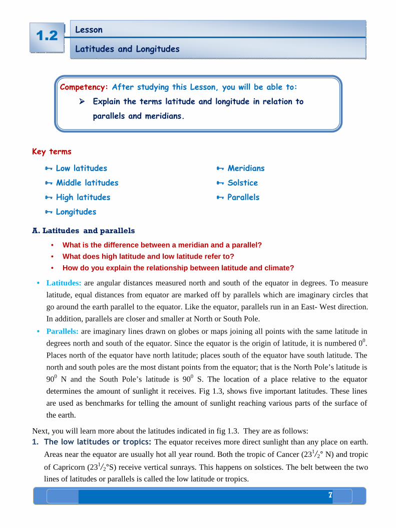
7
1 Living in Africa
Key terms
���� Low latitudes
���� Middle latitudes
���� High latitudes
���� Longitudes
���� Meridians
���� Solstice
���� Parallels
A. Latitudes and parallels
• What is the difference between a meridian and a pa rallel?
• What does high latitude and low latitude refer to?
• How do you explain the relationship between latitu de and climate?
• Latitudes: are angular distances measured north and south of the equator in degrees. To measure
latitude, equal distances from equator are marked off by parallels which are imaginary circles that
go around the earth parallel to the equator. Like the equator, parallels run in an East- West direction.
In addition, parallels are closer and smaller at North or South Pole.
• Parallels: are imaginary lines drawn on globes or maps joining all points with the same latitude in
degrees north and south of the equator. Since the equator is the origin of latitude, it is numbered 00.
Places north of the equator have north latitude; places south of the equator have south latitude. The
north and south poles are the most distant points from the equator; that is the North Pole’s latitude is
900 N and the South Pole’s latitude is 900 S. The location of a place relative to the equator
determines the amount of sunlight it receives. Fig 1.3, shows five important latitudes. These lines
are used as benchmarks for telling the amount of sunlight reaching various parts of the surface of
the earth.
Next, you will learn more about the latitudes indicated in fig 1.3. They are as follows: 1. The low latitudes or tropics: The equator receives more direct sunlight than any place on earth.
Areas near the equator are usually hot all year round. Both the tropic of Cancer (231/2° N) and tropic
of Capricorn (231/2°S) receive vertical sunrays. This happens on solstices. The belt between the two
lines of latitudes or parallels is called the low latitude or tropics.
Lesson
Latitudes and Longitudes 1.2
Competency: After studying this Lesson, you will be able to:
���� Explain the terms latitude and longitude in relation to
parallels and meridians.
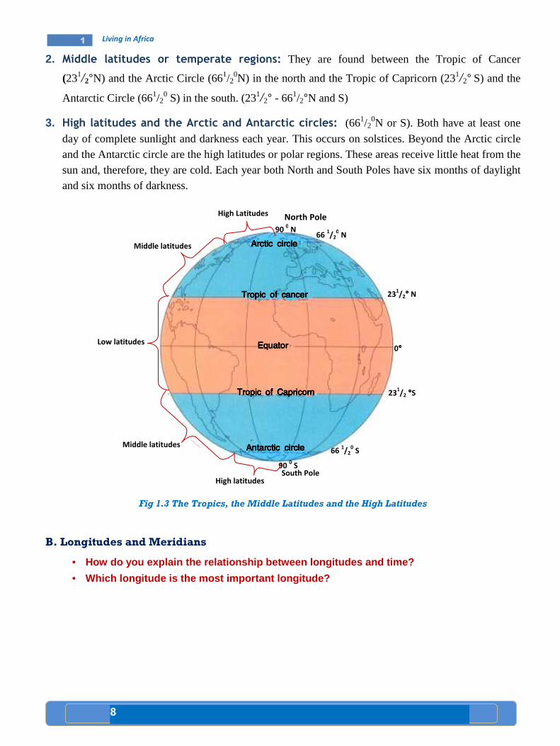
8
1 Living in Africa
2. Middle latitudes or temperate regions: They are found between the Tropic of Cancer
(231/2°N) and the Arctic Circle (661/20N) in the north and the Tropic of Capricorn (231/2° S) and the
Antarctic Circle (661/20 S) in the south. (231/2° - 661/2°N and S)
3. High latitudes and the Arctic and Antarctic circles: (661/20N or S). Both have at least one
day of complete sunlight and darkness each year. This occurs on solstices. Beyond the Arctic circle and the Antarctic circle are the high latitudes or polar regions. These areas receive little heat from the sun and, therefore, they are cold. Each year both North and South Poles have six months of daylight and six months of darkness.
Fig 1.3 The Tropics, the Middle Latitudes and the High Latitudes
B. Longitudes and Meridians
• How do you explain the relationship between longitu des and time?
• Which longitude is the most important longitude?
Middle latitudes
High latitudes
90 0 S
66 1/2
0 S
231/2 °°°°S
0°°°°
231/2°°°° N
66 1/2
0 N
High Latitudes
Middle latitudes
Low latitudes
North Pole
South Pole
Arctic circleArctic circleArctic circleArctic circle
Tropic of cancer Tropic of cancer Tropic of cancer Tropic of cancer
Equator Equator Equator Equator
Tropic of Capricorn Tropic of Capricorn Tropic of Capricorn Tropic of Capricorn
AAAAntntntntarctic circlearctic circlearctic circlearctic circle
90 0 N
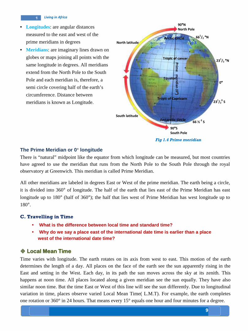
9
1 Living in Africa
• Longitudes: are angular distances
measured to the east and west of the
prime meridians in degrees
• Meridians: are imaginary lines drawn on
globes or maps joining all points with the
same longitude in degrees. All meridians
extend from the North Pole to the South
Pole and each meridian is, therefore, a
semi circle covering half of the earth’s
circumference. Distance between
meridians is known as Longitude.
The Prime Meridian or 0 ° longitude
There is “natural” midpoint like the equator from which longitude can be measured, but most countries have agreed to use the meridian that runs from the North Pole to the South Pole through the royal observatory at Greenwich. This meridian is called Prime Meridian.
All other meridians are labeled in degrees East or West of the prime meridian. The earth being a circle,
it is divided into 360° of longitude. The half of the earth that lies east of the Prime Meridian has east
longitude up to 180° (half of 360°); the half that lies west of Prime Meridian has west longitude up to
180°.
C. Travelling in Time
• What is the difference between local time and stan dard time?
• Why do we say a place east of the international da te time is earlier than a place west of the international date time?
���� Local Mean TimeLocal Mean TimeLocal Mean TimeLocal Mean Time
Time varies with longitude. The earth rotates on its axis from west to east. This motion of the earth determines the length of a day. All places on the face of the earth see the sun apparently rising in the East and setting in the West. Each day, in its path the sun moves across the sky at its zenith. This happens at noon time. All places located along a given meridian see the sun equally. They have also similar noon time. But the time East or West of this line will see the sun differently. Due to longitudinal variation in time, places observe varied Local Mean Time( L.M.T). For example, the earth completes one rotation or 360° in 24 hours. That means every 15° equals one hour and four minutes for a degree.
90°°°°N
North Pole
231/2 °°°°N
0°°°°
231/2
0 S
Fig 1.4 Prime meridian
66 ½ 0 S
661/2 °°°°N
90°°°°S
South Pole
Arctic circle
Tropic of cancer
Equator
Tropic of Capricorn
Antarctic circle
Prim
e m
erid
ian
(0 °° °°)
North latitude
South latitude
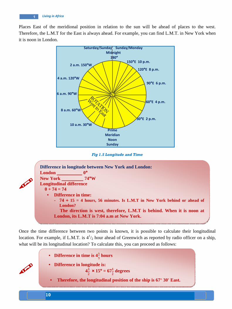
10
1 Living in Africa
Places East of the meridional position in relation to the sun will be ahead of places to the west. Therefore, the L.M.T for the East is always ahead. For example, you can find L.M.T. in New York when it is noon in London.
Fig 1.5 Longitude and Time
����
Once the time difference between two points is known, it is possible to calculate their longitudinal location. For example, if L.M.T. is 41/2 hour ahead of Greenwich as reported by radio officer on a ship, what will be its longitudinal location? To calculate this, you can proceed as follows:
����
Difference in longitude between New York and London: London 0°°°° New York 74°°°°W Longitudinal difference 0 + 74 = 74
• Difference in time: - 74 ÷÷÷÷ 15 = 4 hours, 56 minutes. Is L.M.T in New York behind or ahead of
London? The direction is west, therefore, L.M.T is behind. When it is noon at London, its L.M.T is 7:04 a.m at New York.
• Difference in time is 4 hours
• Difference in longitude is: 4 ×××× 15°°°° = 67 degrees
• Therefore, the longitudinal position of the ship is 67° 30' East.
Saturday/Sunday Sunday/Monday
Midnight
180°°°°
Prime
Meridian
Noon
Sunday
2 a.m. 150°°°°W
4 a.m. 120°°°°W
6 a.m. 90°°°°W
8 a.m. 60°°°°W
10 a.m. 30°°°°W
30°°°°E 2 p.m.
60°°°°E 4 p.m.
90°°°°E 6 p.m.
120°°°°E 8 p.m.
150°°°°E 10 p.m.
NROTATION
West to East
11
1 Living in Africa
Lesson Lesson Lesson Lesson
ReviewReviewReviewReview
Activity 1.2 A
A. Questions based on facts:
• Which longitude is known as the prime meridian?
• What do we mean by the apparent movement of the sun? • Is the time in Delhi (India) ahead or behind than the time in paris(France)?
• Explain the following abbreviations A.M, P.M, L.M.T, G.M.T.
B. Group work:
Do in two groups. Let the first group make a short study as to why time is ahead when
one goes from west to east. Let the second group make a short study as to why
temperature is decreasing when moving from the low latitude to the high latitude. Let
the representatives of each group present the results of their studies to their
classmates and invite them for further discussion.
C. Things to do:
• The news is broadcasted by the B.B.C at 7 p.m G.M.T 1. At what time is it heard in Addis Ababa,400 E? 2. At Singapore 105°E?
1.2

12
1 Living in Africa
Key terms
���� Khoisan ���� super Language families
���� Major Language Families Major Language Families Major Language Families Major Language Families Spoken in Africa Spoken in Africa Spoken in Africa Spoken in Africa
• Do all the peoples of Africa speak one language?
• List major language families spoken in Africa.
Niger – Congo
• Bantu family
• Kordofanian family
• Mande
• Dogon
Afro -Asiatic
• Semetic
• Cushitic
• Berber
• Chadic
• Omotic
Nilo -Saharan
• Kanuri
• Songhay
• Nubian
• Nilotic family
- Luo
- Dinka
- Masai
Khoisan
• Khoe
• Tuu
• Kxa
The languages spoken by the peoples of Africa are classified into four super-language families. They
are:
• Niger–Congo: It has between 300 and 400 million speakers. The Niger-Congo super–family
speakers are found in western, central, eastern and southern Africa. This language family occupies the
largest part of Africa.
•••• Afro–Asiatic: super family speakers are found in northern, central, northeastern and the Horn of
Africa. It is the second largest super language family. It has between 200 and 300 million speakers.
Competency: After studying this lesson, you will be able to:
���� Name super language families in Africa.
Lesson
Super Language Families of the Peoples of Africa and their
Distribution
1.3

13
1 Living in Africa
•••• Nilo Saharan: It is divided into seven subgroups. Chari-Nile, Songhay, Saharan, Meban, Koman and
Fur. Chari-Nile and Koman are spoken in parts of Ethiopia and the Horn. It has about 30 million
speakers.
•••• The Khoisan super-family speakers occupy a few areas of southern Africa. This language super
family has the smallest number of speakers. It has about 300,000 speakers.
Case Study
comparative case study of speakers from two major l anguage groups.
Speakers from Two Major Language Groups Speakers from Two Major Language Groups Speakers from Two Major Language Groups Speakers from Two Major Language Groups
The Niger-Congo Language family is the largest grou p in Africa (and probably in the
world) interms of the number of languages. A major branch of the Niger- Congo
Language is the Bantu family, which covers a greate r geographic area than the rest
of the famil y put together. Most of the ethnic groups living in Central and Southern
Africa today are Bantu speakers. In fact, more than 200 million people in the region
speak one of the many Bantu languages.
Afro-Asiatic Languages are spoken across North Africa, the Horn of Africa and the
Middle East. There are approximately 375 Afro – Asiatic languages spoken by 300
million people. The main sub-families of Afro-A siatic are the Semitic Languages, the
Cushitic Languages, Berber and the Chadic Languages . The Afro-A siatic language
family is believed to have originated in East Afric a, though its most famous sub -
branch, the Semitic Languages (including Arabic, Am haric and Hebrew among
others), seems to have developed in the Arabian pen insula . The Semitic Languages
are the only branch of the Afro- Asiatic family of languages that is spoken outside of
Africa.
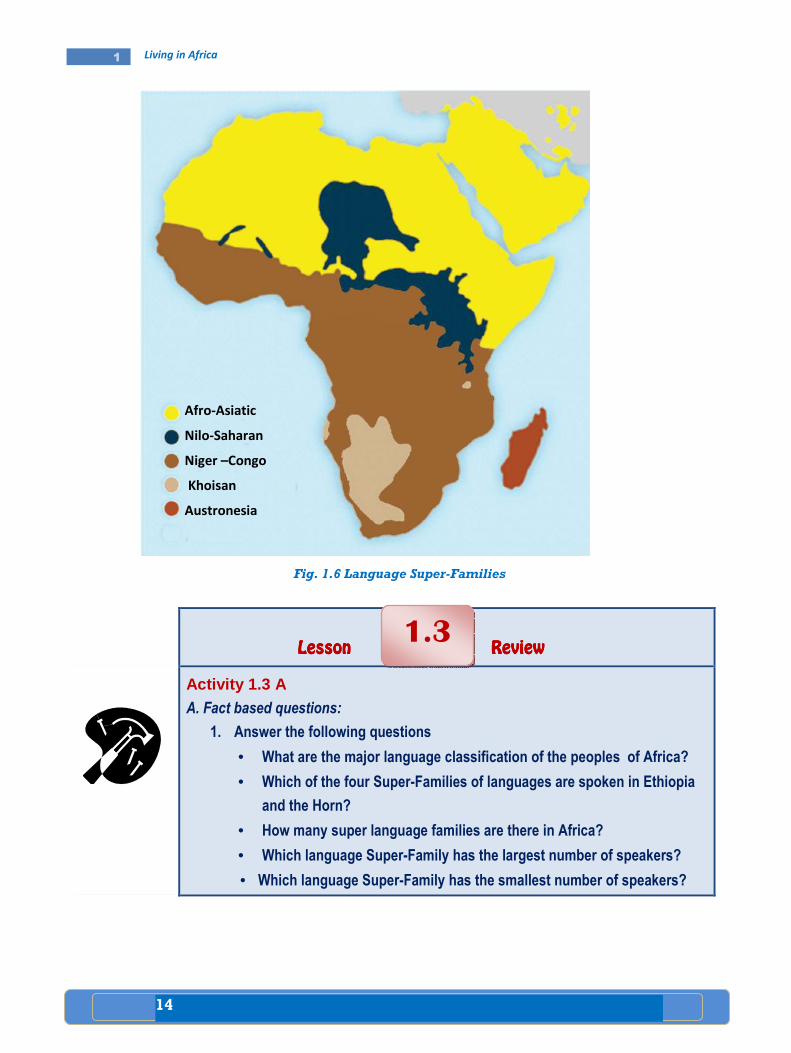
14
1 Living in Africa
Fig. 1.6 Language Super-Families
Lesson Lesson Lesson Lesson ReviewReviewReviewReview
Activity 1.3 A A. Fact based questions:
1. Answer the following questions
• What are the major language classification of the peoples of Africa?
• Which of the four Super-Families of languages are spoken in Ethiopia
and the Horn?
• How many super language families are there in Africa?
• Which language Super-Family has the largest number of speakers?
• Which language Super-Family has the smallest number of speakers?
1.3
Afro-Asiatic
Nilo-Saharan
Niger –Congo
Khoisan
Austronesia
15
1 Living in Africa
Key terms
���� Craftsman ���� Temple
���� Mummification ���� Tomb
���� Ancient Civilization of EgyptAncient Civilization of EgyptAncient Civilization of EgyptAncient Civilization of Egypt
• Most ancient civilizations began in river valleys. Do you agree or disagree? Discuss.
• Have you ever seen the picture of a pyramid? Sketch it on the exercise book.
The civilization of Ancient Egypt began about 3000 BC in the Nile River valley. During this time, most
people lived in and around the Nile valley.
Lesson
Ancient Civilization in Africa (Egypt and Carthage)
1.4
Competencies: After studying this lesson, you will be able to:
���� Indicate the location of Egypt and Carthage as one of the centers
of ancient civilizations in Africa.
���� Explain the significance of the ancient civilizations of Egypt and
Carthage.
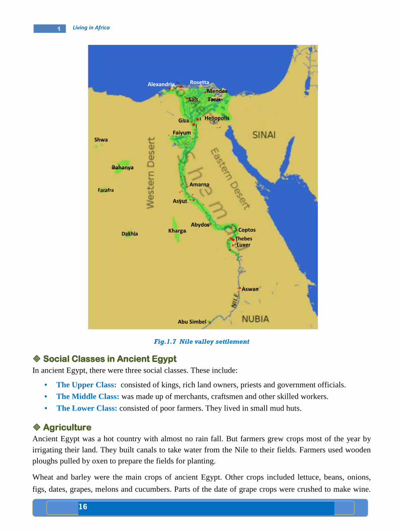
16
1 Living in Africa
]
Fig.1.7 Nile valley settlement
���� Social Classes in Ancient EgyptSocial Classes in Ancient EgyptSocial Classes in Ancient EgyptSocial Classes in Ancient Egypt In ancient Egypt, there were three social classes. These include:
• The Upper Class: consisted of kings, rich land owners, priests and government officials.
• The Middle Class: was made up of merchants, craftsmen and other skilled workers.
• The Lower Class: consisted of poor farmers. They lived in small mud huts.
���� Agriculture Agriculture Agriculture Agriculture
Ancient Egypt was a hot country with almost no rain fall. But farmers grew crops most of the year by irrigating their land. They built canals to take water from the Nile to their fields. Farmers used wooden ploughs pulled by oxen to prepare the fields for planting.
Wheat and barley were the main crops of ancient Egypt. Other crops included lettuce, beans, onions,
figs, dates, grapes, melons and cucumbers. Parts of the date of grape crops were crushed to make wine.
Shwa
Bahanya
Farafra
Dakhla Kharga
Abydos
Asyut
Luxer
Coptos
Amarna
Thebes
Aswan
Abu Simbel
Giza
Faiyum
Sais
Heliopolis
Tanis
Mendes
Rosetta Alexandria

17
1 Living in Africa
The Egyptians raised dairy and beef cattle, goats, ducks, geese and donkeys. Some people kept bees for
honey.
���� TradeTradeTradeTrade
Ancient Egyptian traders sailed to lands bordering Aegean, Mediterranean and Red Seas. They acquired
silver, iron, horses and cedar logs from Syria, Lebanon and other areas of Southwestern Asia. They got
ivory, leopard skins, copper, cattle and spices from Nubia, a country south of Egypt. For these goods, the
Egyptians bartered gold, other minerals, wheat, barley and papyrus sheets.
����
���� The PyramidsThe PyramidsThe PyramidsThe Pyramids
Egyptian farmers were also involved in the construction of temples, palaces and tombs. The large tombs
built for the Pharaohs were called Pyramids. (See fig 1.8).
Fig. 1.8 Pyramids
���� Beliefs Beliefs Beliefs Beliefs Ancient Egyptians believed in life after death. They preserved the body of the dead. The process of
preserving the dead body is called Mummification .
���� Egyptian WritingsEgyptian WritingsEgyptian WritingsEgyptian Writings
A system of writing called hieroglyphics was developed by Ancient Egyptians. Hieroglyphics was a
pictorial form of writing. First Egyptians wrote by carving hieroglyphics on stone or wood. Later on,
they used papyrus. In fact, the English word paper comes from the word papyrus.
Ancient Egyptian rulers were known as Pharaohs.

18
1 Living in Africa
���� Contribution Made in ScienceContribution Made in ScienceContribution Made in ScienceContribution Made in Science
Ancient Egyptians contributed a lot for the advancement of mathematics, astronomy and medicine. They
produced a calendar with 365 days. Ancient Egyptians also made important medical discoveries.
���� The Ancient Civilization of CarthageThe Ancient Civilization of CarthageThe Ancient Civilization of CarthageThe Ancient Civilization of Carthage
• Where was Carthage found?
Carthage was one of the greatest cities of ancient times. It was a rich trading center. Carthage was
located on the coast of North Africa near the present day Tunis (capital city of Tunisia).
Carthage was founded by the Phoenician people at about 814 BC. It was surrounded by a wall. Probably it was the first city-state to control an empire. The Empire of Carthage ruled parts of North Africa, southern Spain and the islands of Corsica, Sardinia and Sicily in the Mediterranean Sea.
The Phoenicians developed their alphabet which consisted of 22 symbols. The Greek alphabet developed from that of the Phoenicians. The Roman and all Western alphabets have been taken from the Greeks. The Carthaginians built broad cargo ships and also long, narrow warships. They engraved metals such as gold and silver. They carved objects from ivory. They also knew how to weave woolen and linen.
Carthage fought three wars with the Roman Empire over Sicily. The wars, took place from 264 BC to 146 BC. The wars were called the Punic Wars. But in the third war, Carthage was finally destroyed and it became part of the Roman Empire.
Case Study
Comparison between Egypt and CarthageComparison between Egypt and CarthageComparison between Egypt and CarthageComparison between Egypt and Carthage
Ancient Egypt was the birthplace of one of the worl d’s first civilizations. This advanced culture arose about 5000 years ago in the Nile Rive r valley in northeastern Africa. It continued for over 2000 years and so became one of the longest lasting civiliza tions in history.
The ancient Egyptians made outstanding contribution s to the development of civilization. They created the world’s first nation al government, basic forms of arithmetic, and a 365-day calendar. They invented a form of picture writing called hieroglyphics. They also invented papyrus, a paper like writing material made from
the stems of papyrus plants. Ancient Egyptians deve loped a belief in life after death. They built great cities in which many skilled archi tect, doctors, engineers, pa inters and sculptors worked. They also built the pyramids as t ombs for their rulers. They serve as spectacular reminders of the glory of ancient Egypt .
Carthage was one of the greatest cities of ancient time . It stood on a peninsula in North Africa, near the present city of Tunis, Tunisia. It was founded by the Phoenicians around 814 BC. It grew quickly because of its locat ion on a peninsula and its two excellent harbours. But archeologists who excavated the ruins of Carthage have found no remains earlier than about 750 B.C.
19
1 Living in Africa
Lesson Lesson Lesson Lesson ReviewReviewReviewReview
Activity 1.4 A A. Questions based on facts:
• Explain the time and place of the beginning of ancient Egyptian civilization.
• Why did the ancient Egyptians construct pyramids? • What are hieroglyphics?
• What is papyrus?
• Who were the founders of Carthage?
B. Things to do:
• Draw an outline map of Africa and locate the Nile valley and Egypt.
• Locate ancient Carthage on the map of Africa.
1.4

20
1 Living in Africa
Key term
���� Pre-colonial
Pre Pre Pre Pre –––– colonial colonial colonial colonial ZimbabweZimbabweZimbabweZimbabwe
• Where is the present day Zimbabwe located?
Zimbabwe took its name from the ancient trading city of Zimbabwe. The city was built by the Shona
people about 1000AD. The word “Zimbabwe” comes from a Shona language which meant "house of
stone".
The ruins of the city include a tower 9 meters high and a part of a wall 240 meters around. The structures
were made of huge granite stones which were fitted together without mortar.
By 1400's Zimbabwe reached its highest stage of civilization. During this time, a branch of the Shona
called the Karanga established the Mwenemutapa Empire. This empire included most of the present-day
Zimbabwe.
But in the late 1400's, a group called Rozwi from Karanga revolted against Mwenemutapa Empire and
founded another Empire called Changemire. The Rozwi took over the city of Zimbabwe and became
stronger than its counterpart. However, in turn the Changemire Empire was defeated by another people
called Nguni. After the fall of the Changemire Empire, the city of Zimbawe was abandoned.
The rulers of Zimbabwe built a large walled capital. Skilled masons constructed a huge complex of palaces, stone houses and temples.
1.5 Lesson
Pre-Colonial States (Zimbabwe, Mali, Funji)
Competencies: After studying this lesson, you will be able to:
���� Show appreciation to the architectural achievements of pre-colonial
state of Zimbabwe.
���� Analyze the economic bases of pre-colonial states of Mali and Funji.

21
1 Living in Africa
���� PrePrePrePre----colonial Malicolonial Malicolonial Malicolonial Mali
• When did the Empire of Mali reach its highest peak?
The Mali Empire was founded by the Mandingo people. By about 1240 A.D., a young leader named
Sundiata Keita defeated the kingdom of Ghana. By this time, Mali was able to control the gold fields and
salt deposits of West Africa. This formed the basis for its economy. From 1312 to 1337, Mali was ruled
by Mansa Musa. Under his rule, the Empire achieved the highest stage of political power and cultural
development. During this time, the city of Timbuktu became a famous center of Islamic learning. Other
cities of the Empire were centers of caravan trade. The Mali people were successful farmers and cattle
keepers. But, in the late14th century, Mali became weak due to civil war. Later on, the kingdom of
Songhai replaced Mali as the most powerful state in West Africa.
���� PrePrePrePre colonial Funjcolonial Funjcolonial Funjcolonial Funjiiii
• Where was the Funj kingdom located?
Funj was a Muslim Empire in present day Sudan. The empire began in the early 16th century and was destroyed by the Egyptians in 1821.
The origin of the Funj people was not clearly known. They might have come from a people called Shilluk who lived in the White Nile region.
The Funj Sultanate was a feudal state founded in the early 16th century by Amara Dunkas (r.1504 - 34). The Sultanate flourished during the 17th and 18th centuries. The population consisted mainly of the Funj people. Nubians, Arabs, Beja and other peoples also lived in the sultanate. Arabic was spoken in much of the Funj Sultanate proper. The state religion was Islam.
Case Study
Zimbabwe
Zimbabwe was the most powerful inland state that ex ported gold to the coastal cities of East Africa. Around 1000 AD, migrating farmers and herders settled in the lands between the Zambezi and Limpopo rivers. These pioneers disc overed gold in their new homeland. With the wealth from gold, they set u p a large trading empire. In the ruins of Zimbabwe, archeologists have found Chinese and Indian goods w hich the rulers of Zimbabwe had bought with profits from the gold trade. Zimbabwe reached its height in the 1400’s when the Portuguese destroyed the coas tal cites. Zimbabwe declined because trade was cutoff. About the same time, weak rulers, shortage of salt, and poor crops left the land open to invaders.

22
1 Living in Africa
The feudal structure of the sultanate retained elements of a slave holding system. Tribal clan relationships continued in the outlaying areas. The capital Sennar, was prosperous through trade. It hosted representatives from all over the Middle East and Africa. The wealth and power of the Sultans had long rested on the control of the economy. All caravans were controlled by the monarch. The monarch also controlled the gold supply that became the main source of the state’s currency. Foreign currencies were widely used by merchants in order to break the power of the monarch. The growing trade created a wealthy class of literate merchants who read widely about Islam.
In the early 16th century, the Funj accepted Islam. They founded also Sennar as their capital.
The Funj armies conquered the northern regions of the Sudan and nearly all the area between the Blue Nile and White Nile. Then, Funj became powerful. They were feared in the region between the Red Sea and the Nile River. But, since the middle of the 17th century, the Funj nobles revolted again and again. A period of decline followed. In 1821, it was invaded by Egypt which marked the end of the Funj Empire.
Lesson Lesson Lesson Lesson ReviewReviewReviewReview
Activity 1.5 A • Fact based questions:
1. Identify the following:
- Rozwi
- Karanga
- Nguni
- Mandingo
- Timbuktu - Sennar
- Mansa Musa - Shilluk
2. Answer the following questions:
• Who built the city of Zimbabwe?
• Which ruler established a powerful Empire in West Africa?
• Write the names of the Empires that came just before and after Mali.
• What does the word Zimbabwe mean?
• Who established the Mwenemutapa Empire?
• Which Empire was established by the Rozwi people?
• Which people defeated the Changamire Empire?
• Name the people who founded the Mali Empire.
• Explain the role of Sundiata Keita and Mansa Musa in Mali Empire.
• Which kingdom replaced Mali?
• Who defeated Funj Sultanate and when?
1.5
23
1 Living in Africa
Key terms
���� Caravan ���� Musk
���� Incense ���� Spices
����
•••• Is it possible for people to live without trade int eraction? Discuss.
���� Long Distance Trade in Ethiopia Long Distance Trade in Ethiopia Long Distance Trade in Ethiopia Long Distance Trade in Ethiopia
Long distance trade in Ethiopia was conducted by Muslim merchants. It revived in the 19th century.
The leading merchants of the time were known as Jabarti and Afkala.
����
Long distance trade was mainly conducted by caravan merchants who travelled far and wide distances in
large groups. The leader of the caravan merchants was called Negadras. The word comes from Amharic
and meant leader of merchants.
Trade: is an economic activity of buying and selling goods.
Local trade: refers to local exchanges of goods among peoples of a given region.
It was conducted at open markets held weekly on fixed days.
Long distance trade: involved different markets, peoples, regions and goods.
It combined both internal and external trade.
The Jabarti were Muslim merchants in Northern Ethiopia.
The Afkala were Oromo Muslim Merchants in South Western Ethiopia.
Competencies: After studying this lesson, you will be able to:
���� Appreciate the contribution of long distance trade in Ethiopia in
connecting peoples.
���� Recognize the existence of other trade routes in Africa.
���� Identify the origins of long distance trade routes in Ethiopia.
Lesson
Long Distance Trade as a Factor Connecting Peoples in Ethiopia
1.6
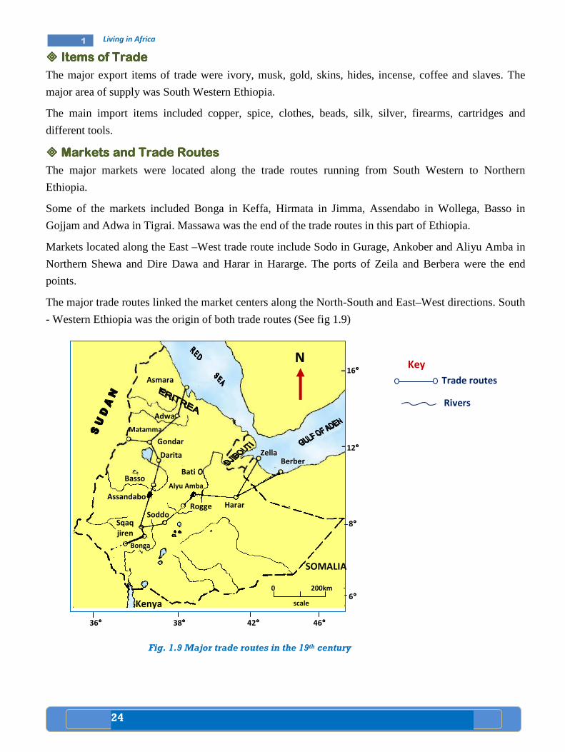
24
1 Living in Africa
���� Items of TradeItems of TradeItems of TradeItems of Trade
The major export items of trade were ivory, musk, gold, skins, hides, incense, coffee and slaves. The
major area of supply was South Western Ethiopia.
The main import items included copper, spice, clothes, beads, silk, silver, firearms, cartridges and
different tools.
���� Markets and Trade RoutesMarkets and Trade RoutesMarkets and Trade RoutesMarkets and Trade Routes
The major markets were located along the trade routes running from South Western to Northern
Ethiopia.
Some of the markets included Bonga in Keffa, Hirmata in Jimma, Assendabo in Wollega, Basso in
Gojjam and Adwa in Tigrai. Massawa was the end of the trade routes in this part of Ethiopia.
Markets located along the East –West trade route include Sodo in Gurage, Ankober and Aliyu Amba in
Northern Shewa and Dire Dawa and Harar in Hararge. The ports of Zeila and Berbera were the end
points.
The major trade routes linked the market centers along the North-South and East–West directions. South
- Western Ethiopia was the origin of both trade routes (See fig 1.9)
Fig. 1.9 Major trade routes in the 19th century
Trade routes
N
Rivers
Key
SOMALIA
Kenya
16°°°°
12°°°°
8°°°°
6°°°°
36°°°° 38°°°° 42°°°° 46°°°°
Asmara
Adwa
Matamma
Gondar
Darita
Bati o
Rogge Harar
Soddo
Bonga
Sqaq
jiren
Assandabo
Basso Alyu Amba
Zella Berber
0 200km
scale
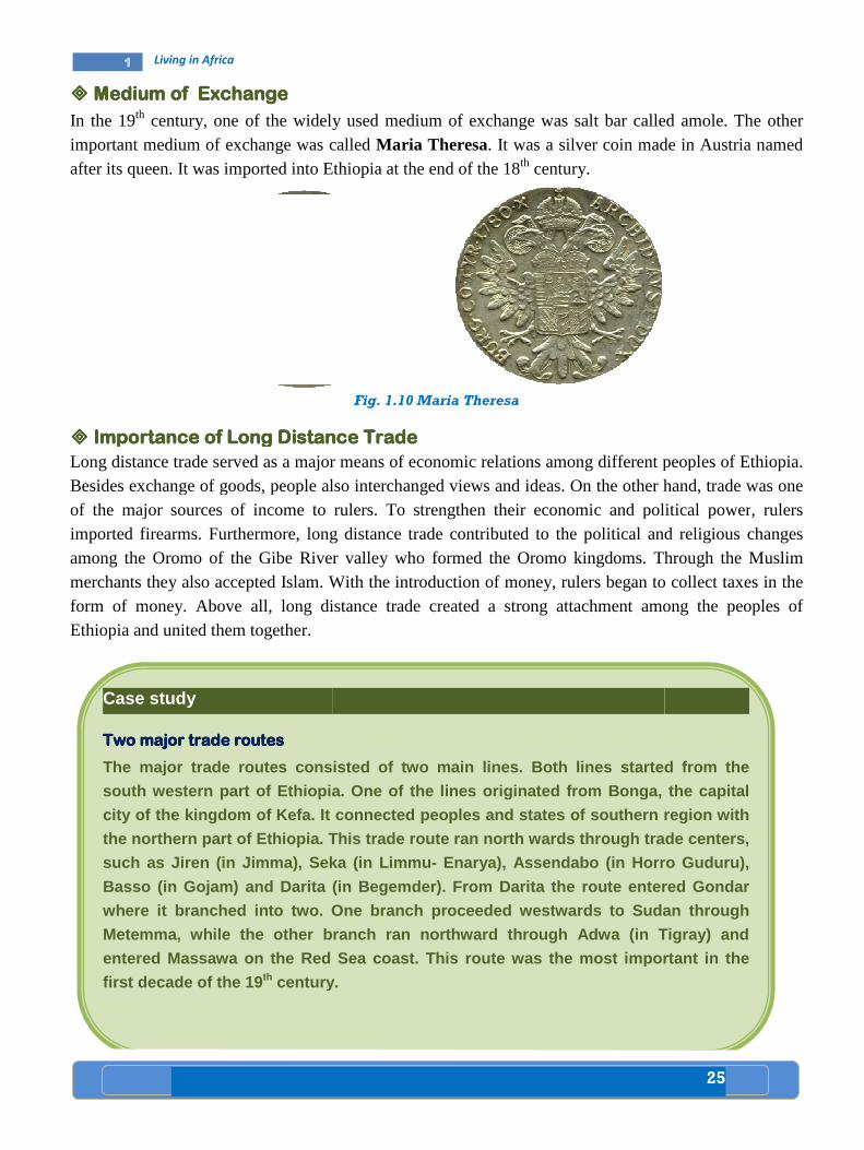
1 Living in Africa
���� Medium of ExchangeMedium of ExchangeMedium of ExchangeMedium of Exchange
In the 19th century, one of the widelyimportant medium of exchange was called after its queen. It was imported into Ethiopia at the end of
���� Importance of Long Distance TradeImportance of Long Distance TradeImportance of Long Distance TradeImportance of Long Distance Trade
Long distance trade served as a major means of econBesides exchange of goods, people also of the major sources of income to ruleimported firearms. Furthermore, long distance trade contributedamong the Oromo of the Gibe River valley whomerchants they also accepted Islam. Withform of money. Above all, long distance Ethiopia and united them together.
Case study
Two major trade routesTwo major trade routesTwo major trade routesTwo major trade routes
The major trade routes consisted of two m
south western part of Ethiopia. One of the lines originated from Bonga , the capital
city of the kingdom of Kefa. It connected peoples a nd states of southern region with
the northern part of Ethiopia. This trade route ran north wards through trade centers,
such as Jiren (in Jimma), Seka (in Limmu
Basso (in Gojam) and Darita (in Begemder). From Dar ita the route entered Gond
where it branched into two. One branch proceeded west
Metemma, while the other branch ran no
entered Massawa on the Red Sea coast. This route wa s the most important in the
first decade of the 19 th century.
one of the widely used medium of exchange was salt bar called amolemedium of exchange was called Maria Theresa. It was a silver coin made in Austria
o Ethiopia at the end of the 18th century.
Fig. 1.10 Maria Theresa
Importance of Long Distance TradeImportance of Long Distance TradeImportance of Long Distance TradeImportance of Long Distance Trade served as a major means of economic relations among different peopl
exchange of goods, people also interchanged views and ideas. On the other handincome to rulers. To strengthen their economic and political power
, long distance trade contributed to the political and religious changes iver valley who formed the Oromo kingdoms. Through the Muslim
they also accepted Islam. With the introduction of money, rulers began to collect taxes, long distance trade created a strong attachment among the peoples
The major trade routes consisted of two m ain lines. Both lines star ted from the
of Ethiopia. One of the lines originated from Bonga , the capital
city of the kingdom of Kefa. It connected peoples a nd states of southern region with
the northern part of Ethiopia. This trade route ran north wards through trade centers,
Jimma), Seka (in Limmu - Enarya), Assendabo (in Horro Guduru),
Basso (in Gojam) and Darita (in Begemder). From Dar ita the route entered Gond
two. One branch proceeded west wards to Sudan through
Metemma, while the other branch ran no rthward through Adwa (in Tigray) and
entered Massawa on the Red Sea coast. This route wa s the most important in the
century.
25
called amole. The other made in Austria named
peoples of Ethiopia. On the other hand, trade was one
economic and political power, rulers to the political and religious changes
Through the Muslim began to collect taxes in the
trade created a strong attachment among the peoples of
ted from the
of Ethiopia. One of the lines originated from Bonga , the capital
city of the kingdom of Kefa. It connected peoples a nd states of southern region with
the northern part of Ethiopia. This trade route ran north wards through trade centers,
Enarya), Assendabo (in Horro Guduru),
Basso (in Gojam) and Darita (in Begemder). From Dar ita the route entered Gond ar
wards to Sudan through
rthward through Adwa (in Tigray) and
entered Massawa on the Red Sea coast. This route wa s the most important in the
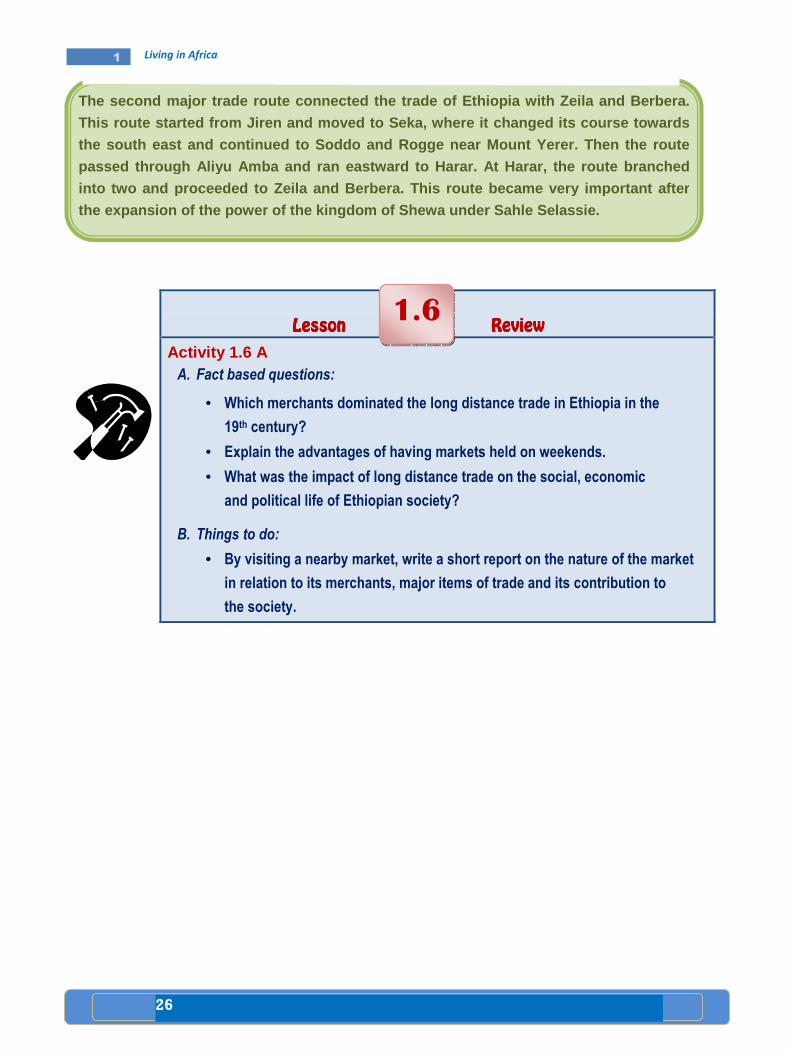
26
1 Living in Africa
Lesson Lesson Lesson Lesson ReviewReviewReviewReview
Activity 1.6 A A. Fact based questions:
• Which merchants dominated the long distance trade in Ethiopia in the
19th century?
• Explain the advantages of having markets held on weekends.
• What was the impact of long distance trade on the social, economic
and political life of Ethiopian society?
B. Things to do:
• By visiting a nearby market, write a short report on the nature of the market
in relation to its merchants, major items of trade and its contribution to
the society.
1.6
The second major trade route connected the trade of Ethiopia with Zeila and Berbera.
This route started from Jiren and moved to Seka, wh ere it changed its course towards
the south east and continued to Soddo and Rogge nea r Mount Yerer. Then the route
passe d through Aliyu Amba and ran eastward to Harar. At Harar, the route branched
into two and proceeded to Zeila and Berbera. This r oute became very important after
the expansion of the power of the kingdom of Shewa under Sahle Selassie.
27
1 Living in Africa
Key terms
���� Population distribution
���� Population density
���� Population Distribution and Settlement Population Distribution and Settlement Population Distribution and Settlement Population Distribution and Settlement
A. Key factors affecting population distribution and settlement
• What do you understand by the phrase population dis tribution? • Define the term settlement. • What are the major causes of population distributio n?
The distribution of population in the world is uneven. It is affected by several factors. These factors
include: fertility of soil, relief, mineral resources, stage of economic development, and level of
technological development as well as socio-political organization. In agrarian societies, physical factors
such as climate have decisive roles in population distribution. But in advanced societies, cultural factors
have significant role in determining population distribution.
The following are major factors that affect population distribution:
• Climate: Favorable climate attracts more people than unfavorable climate.
• Natural vegetation: Forests and grasslands provide people with means of making a living.
Such areas are settled by large number of people.
Lesson
Population 1.7
Competencies: After studying this lesson, you will be able to:
���� Describe the factors which affect population distribution.
���� Relate these factors to population settlement in Africa and identify
settlement on a map.
���� Explain the types of livelihood commonly found in Africa.
���� Relate these factors to climate and vegetation.
���� Discuss reasons for urban settlement and identify some examples.
���� Identify key transport routes.
���� Be aware of key transport routes and the effect of civil unrest on
security.

28
1 Living in Africa
• Relief: High mountains are too cold to be settled by people unless they are rich with minerals.
• Soils: Areas such as river valleys and deltas, as well as regions with rich volcanic soils are
attractive for human settlement. They are good for cultivation of crops.
• Minerals and power: Places that have rich mineral deposits and large supply of power are
usually settled by large number of people.
• Accessibility: Regions which are well facilitated with transport system or located along river
valleys, mountain passes and coastal areas could be settled by large group of people.
• Water supply: The availability of water is one of the major factors for human settlement.
• The political Factor: Governments may encourage people to migrate and settle in selected
parts of a country.
B. Patterns of population distribution in Africa
• Explain the effect of climate on population distrib ution and settlement.
Climate is the single-biggest physical factor that has strong influence on the pattern of population distribution in Africa. Generally, areas with less than 380mm of rainfall per year can support few crops. Therefore, the great expanse of the deserts and semi-deserts of the Sahara, Kalahari, Somalia, Nyika region of central and southern Kenya are areas of scanty rainfall. Consequently, they have low population distribution.
Study the fig.1.11 carefully
Fig 1.11 Settlement patterns
Equator
2 1
Key • Urban population
(millions)
• One dot per 100,000
people for rural
population
• 0.2 0.5
4

29
1 Living in Africa
�
���� Livelihood in AfricaLivelihood in AfricaLivelihood in AfricaLivelihood in Africa
• Which African country is well known in the producti on of palm oil?
• What do we mean by shifting cultivation?
• Describe the main livelihood of the Masai people of East Africa. Do we have people in Ethiopia having a similar kind of livelihood? Can y ou mention the regions?
A. Fishing in the Rift Valley of Ethiopia
The Ethiopian rift valley extends in between North Western and South Eastern highlands. The valley
floor consists of several lakes as Chamo, Abaya, Hawassa, Shalla, Abijata, Langano and Ziway.
In the Rift valley lakes, there are about 25 fish species. It accounts for about 50 percent of the total fish
production in Ethiopia. Tilapia, Nile perch and cat-fish are commercially popular.
Ethiopia has not yet much benefited from its fish resources. Despite the high potential for fish
production, its annual extraction is very little (11 percent). A number of factors may contribute to low
level development of fishery in the country. Some of these include:
- Traditional technique of fishing
- Low local demand for fish products
- Lack of skilled human power
- Absence of adequate statistical data about the fishery sector of the country, etc.
Fishery is a traditional sector of Ethiopian economy, hence, needs immediate transformation. This
implies that, it should be commercialized to benefit the fisherman and the country at large. To this effect
the use of improved tools and techniques of fishing, investable capital, changing the food habit of the
people, and conserving the fish resources would be necessary.
The shores of Lake Victoria, the Nile Delta, the Maghreb, the Highlands of Ethiopia and
the Coast of West Africa have high population concentration. On the other hand, the vast
Sahara Desert, the Namib-Kalahari Deserts, and the Coastal plains of the Horn of Africa
have extremely low population. These areas experience the hottest and driest climate.

30
1 Living in Africa
Fig. 1.12 The Ethiopian Rift Valley Lakes
Case study
Most fishing activities in Ethiopia are taking plac e in fresh waters (i.e lakes, rivers and ponds). According to the Ethiopian wild life co nservation department, Ethiopia’s fresh water bodies are known to have 101 species of fish, among which four are ende mic to the country. The Ethiopian fishing grounds c ould be classified as (a) lakes, (b) river fishery.
a) Lake fishery The Ethiopian lakes are estimated to cover a surfac e area of about 7000km 2. But they account only 50% of the total yearly fish prod uction of the country. The annual maximum sustainable fish yield of our lakes are estimated to be above 35,000 tons. But presently only 4,000 tons are prod uced annually. This is only 11% of the annual potential of our lakes.
b) River fishery Most rivers of Ethio pia have high fish resources. Most fish production of the rivers is confined to local consumption by villager s living near and around river banks. The fishing potential of Ethiopian rivers ha s not yet been fully known. But according to some references, th e county’s rivers and streams can produce, on average, about 7000 - 10,000 tons of fish annually. For example, Baro riv er alone can supply a maximum sustainable yield of 2,500 ton s per year.
Generally, both lakes and rivers of Ethiopia are ve ry rich in a wide variety of fish resources, such as Tilapia, Nile perch, Carius, Cyp rinus, Barbus and others, and have high promising potential for the development o f commercial fish industry.
Ethiopian Rift valley Lakes
1. Lake Abe
2. Lake Zway
3. Lake Langano
4. Lake Abijata
5. Lake Shalla
6. Lake Hawassa
7. Lake Abaya
8. Lake Chamo
9. Lake Chew Bahir
1
2
3 4
5
6 7
8
9
Lake Tana
No
rth
we
ste
rn
Eth
iop
ian
Hig
hla
nd
s
an
d l
ow
la
nd
s
Eth
iop
ian
Rif
t
Va
lle
y
South Eastern Ethiopian
Highlands and low lands

31
1 Living in Africa
B. Equatorial Lowlands and their Resources The following are major resources of the equatorial lowlands:
Palm Oil Palm tree grows throughout the equatorial lowlands of Africa. The fruits from palm trees are source of large amount of oil. Western Africa is the world’s largest producer of palm oil. Nigeria alone accounts for more than 75 percent of the export of palm oil. However, Africa accounts for 13 percent of the world’s palm oil production.
a) Harvesting from a low oil palm tree b) Harvesting from a tall oil palm tree
Fig. 1.13 Harvesting oil palm
Food Crops
• Shifting cultivation: is practiced in the hot wet equatorial rainforest regions of Africa. In these areas, farmers use the hoes for cultivation. It is difficult to use the ploughs because of tree stumps and roots in the ground. Instead, farmers use sticks to make holes and then put seeds into them. Crops grown include: manioc (cassava), maize, sweet potatoes, millet, yams, vegetables and fruits.
Case study
Peasant Cultivation (small scale agriculture) Peasant Cultivation (small scale agriculture) Peasant Cultivation (small scale agriculture) Peasant Cultivation (small scale agriculture)
Peasant cultivation is a settled agriculture becaus e the fields are cultivated on permanent basis. In peasant cultivation, the land i s usually a small area, often divided into several small plots. These plots are often sca ttered. Such farms are usually wor ked by the farmers and their family. The farmers gr ow a large variety of crops because their main purpose is to feed the family. T his type of farming is called subsistence farming. Such farms are usually mixed f arms, because the farmers not only grow crops but they also keep animals for work, milk or meat. The farmers use tools and ploughs that are quite simple.

32
1 Living in Africa
C. High Savannah Cattle Ranching
Cattle Ranching in Ethiopia: There are two main types of savannah or tropical grasslands in Ethiopia.
They are: Grassland Savannah and Woodland Savannah. The Savannah land covers most part of the rift
valley, the Awash valley, and parts of Borana, Wollega and Gojam. In these areas, large number of cattle
are reared.
����
D. Sedentary Agriculture
Sedentary agriculture is a more advanced form of traditional agriculture. It is practiced outside the tropical rainforest and desert regions. The staple food crops grown include: maniocs, yams, maize,
Case study
Cattle ranching in EthiopiaCattle ranching in EthiopiaCattle ranching in EthiopiaCattle ranching in Ethiopia
Ethiopia has a very large livestock resource. The c ountry ranks first in Africa and tenth
in the World in its cattle population. From early d ays, livestock rearing has played
important role in the life of Ethiopians. In the lo wlands, especially in Ogaden, Bora na
and Afar, stock breeding is the mainstay of the peo ple.
Livestock in the pastoral and semi-pastoral areas are kept as capital assets. The manures of the cattle are usually used as sources o f fuel and fertilizer.
In general, the lives of farmers in rural areas of the country are highly linked with livestock rearing.
Case study
The The The The Masai Herdsmen of East AfricaMasai Herdsmen of East AfricaMasai Herdsmen of East AfricaMasai Herdsmen of East Africa
The Masai live in the dry savannah part of Kenya an d Northern Tanzania. They are herdsmen. In these areas, cultivation of crops, wit hout irrigation, is almost impossible. The Masai, therefore, practice a nomadic way of lif e. They constantly move with their herds of cattle and flocks of sheep and goats and s urvive by the blood of live cattle and other animals. However, overgrazing is becoming cru cial problem. Consequently, it results to severe soil erosion.
Cattle are very important in the life of the people in the savannah lands of Africa.

33
1 Living in Africa
millet, sorghum, rice, wheat, barley, teff, inset, banana, beans, sweet potatoes, tomatoes, cucumbers onions and peppers (see fig 1.14).
Fig 1.14 Sedentary Agriculture
Livestock such as cattle, sheep, goats, horses and donkeys are also raised on sedentary farms. Such farming system is widely practiced in the tropical, subtropical and temperate plateaus and highlands. Mixed farming is dominant in the highlands of Ethiopia, Eastern and Southern Africa.
���� Commercial Grain FarmingCommercial Grain FarmingCommercial Grain FarmingCommercial Grain Farming
These types of agricultural systems, in Africa, were formerly developed by European colonizers. Their main purpose was to produce grains or cereals such as wheat, barley, rice and maize for European market. But after independence most European farm holdings had diminished due to insecurity caused by the struggle for independence and subsequent political pressures.
This is a modern large-scale agricultural system which has been developed by European farmers very recently. In general commercial farming is:
• More mechanized and fertilized
• Mainly monoculture, i.e. specializes in one or two cash crops
• Mostly found in the low population areas
Currently, in many African countries commercial farms are owned by governments or individual investors. A large number of the population in these countries are wage labourers in the farms. It should not be forgotten that the contribution of small peasant farmers in the production of some cash crops is very important.
Sorghum and Millet Cassava Banana
Maize Yam Rice

34
1 Living in Africa
The following description will help you to note some of the commercial crops of Africa.
• Coffee: It is a very popular cash crop. Africa accounts for about 20 percent of the world's coffee production. The chief coffee producers in Africa include Cote D'ivore, Ethiopia, Uganda, Cameroon, Kenya, Tanzania, Democratic Republic of Congo and Angola.
• Tea: It is grown in the wetter parts of the African highlands. Major producers include Tanzania, Kenya, Ethiopia, Mozambique, Zimbabwe, Congo and Mauritius.
• Horticulture: Uganda, Tanzania, Kenya are well known producers of flower which is destined to European markets. Ethiopia exports flower to Europe and the U.S.A. This is a new venture in the Ethiopian economy.
���� Factors Affecting the Distribution of Settlement and Livelihood Factors Affecting the Distribution of Settlement and Livelihood Factors Affecting the Distribution of Settlement and Livelihood Factors Affecting the Distribution of Settlement and Livelihood
• Enumerate factors favoring the site of Addis Ababa as a city. • In which African country is Mombasa found? • What are the causes for the formation of urban cent er? • Why do you think people are moving from rural areas to urban centers in great
number? • Explain the relationship between human settlements and security issues, like civil
disturbances and wars.
���� The SitThe SitThe SitThe Site, situatione, situatione, situatione, situation and Growth of the and Growth of the and Growth of the and Growth of the urban settlementurban settlementurban settlementurban settlement
Urban settlement has two components. These components are site and situation. Site refers to the local
setting of a city, while the situation refers to the regional setting. As example of site and situation, think
of Addis Ababa. The original site of Addis Ababa was on the top of Entoto mountain. The importance of
its situation (regional location) was that it enabled the government to control the country from this
central location. A defensive site is a location where a city can be easily defended.
Case study
Addis AbabaAddis AbabaAddis AbabaAddis Ababa
Addis Ababa is a city founded by Menilik II and Ete ge Tayitu in 1879 as a cultural,
political, judicial and commercial hub of Ethiopia. Menilik II allocated all lands around
the old palace to his war lords and aristocrats. Th ese higher nobilities with the ir huge
soldiers settled around the palace and built their own houses, which in turn led to the formation of various neighborhoods (Sefers in Amhar ic).
Addis Ababa’s neighborhoods formation was commenced in 1900, before 110 years.
These neighborhoods were named after chiefs such as Ras Mekonen Sefer, Ras Mulugeta Sefer or named after the dominant ethnic g roup settled in the area like
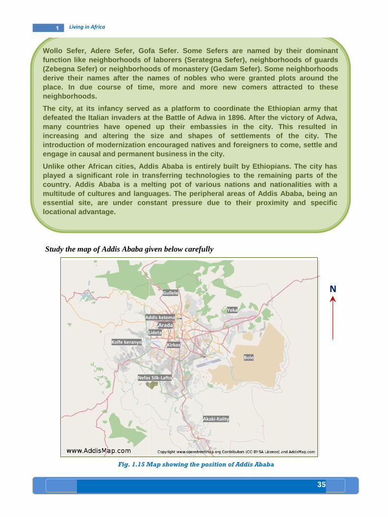
1 Living in Africa
Addis Ababa
Study the map of Addis Ababa given below carefully
Fig. 1.15 Map showing the position
Wollo Sefer, Adere Sefer, Gofa Sefer. Some Sefers a re named by their dominant function like neighborhoods of laborers(Zebegna Sefer) or neighborhoods of monastery (Geda m Sefer). Some neighborhoods derive their names after the names of nobles who we re granted plots around the place. In due course of time, more and more new com erneighborhoods.
The city, at its infancy served as a platdefeated the Italian invaders at the many countries have opened up their embassies inincreasing and altering the size and shapes of sett lements of the city. The introduction of modernization encouraged natives and foreigners to come, settle and engage in causal and permanent business in the
Unlike other Af rican cities, Addis Ababa is entirely built by Ethi opians. The city has played a significant role in transferring technolog ies to the remaining parts of the country. Addis Ababa is a melting pot of various na tionmultitude of cult ures and languages. The peripheral areas of Addis A baba, being an essential site, are under constant pressure due to their proximity and specific locational advantage.
Kolfe keranyo
Addis ketema
Lideta
Nefas Silk
Study the map of Addis Ababa given below carefully
Map showing the position of Addis Ababa
Wollo Sefer, Adere Sefer, Gofa Sefer. Some Sefers a re named by their dominant function like neighborhoods of laborers (Serategna Sefer), neighborhoods of guards (Zebegna Sefer) or neighborhoods of monastery (Geda m Sefer). Some neighborhoods derive their names after the names of nobles who we re granted plots around the place. In due course of time, more and more new com ers attracted to these
served as a plat form to coordinate the Ethiopian army that defeated the Italian invaders at the Battle of Adwa in 1896. After the victory of Adwa, many countries have opened up their embassies in the city. This resulted in increasing and altering the size and shapes of sett lements of the city. The
modernization encouraged natives and foreigners to come, settle and engage in causal and permanent business in the city.
rican cities, Addis Ababa is entirely built by Ethi opians. The city has played a significant role in transferring technolog ies to the remaining parts of the country. Addis Ababa is a melting pot of various na tion s and nationalities with a
ures and languages. The peripheral areas of Addis A baba, being an essential site, are under constant pressure due to their proximity and specific
Gullele
Addis ketema
Lideta
Arada
Kirkos
Nefas Silk-Lafto
Yeka
Bole
Akaki-Kality
35
Wollo Sefer, Adere Sefer, Gofa Sefer. Some Sefers a re named by their dominant (Serategna Sefer), neighborhoods of guards
(Zebegna Sefer) or neighborhoods of monastery (Geda m Sefer). Some neighborhoods derive their names after the names of nobles who we re granted plots around the
s attracted to these
form to coordinate the Ethiopian army that attle of Adwa in 1896. After the victory of Adwa,
the city. This resulted in increasing and altering the size and shapes of sett lements of the city. The
modernization encouraged natives and foreigners to come, settle and
rican cities, Addis Ababa is entirely built by Ethi opians. The city has played a significant role in transferring technolog ies to the remaining parts of the
nationalities with a ures and languages. The peripheral areas of Addis A baba, being an
essential site, are under constant pressure due to their proximity and specific
N

36
1 Living in Africa
Factors favoring the site of Addis Ababa include:
• Located between the old established provinces of the Northern half of the country and the Southern territories;
• Effectiveness for government administration;
• Located between Weyna Dega and the Dega zones;
• Located above the zone of tropical diseases;
• Enjoyed a temperate climate with adequate rainfall;
• Presence of extensive flatland for expansion and development;.
• Presence of a pre- existing pattern of natural route ways and tracks;
• Capacity to support large urban population; and
• Adequacy of water supplies for large growing population;
Since Addis Ababa was established, several geographical factors contributed to its further development.
These include:
• The importation and planting of the eucalyptus tree in 1894, provided solution to the problem of
wood supply for fuel and construction;
• The development of modern pattern of communications; and
• The growth of market facilities and power resources.
����
At present Addis Ababa is a highly centralized administrative and industrial capital of Ethiopia. It is the
fourth largest inland city in Africa.
Fig.1.16 A section of the city of
Addis Ababa
Settlement refers to groupings of population into occupancy units. These range from isolated one- family farmstead and tiny rural hamlet to the great metropolis like New York or London. Settlement is ,therefore, organized colony of human beings together with their residences and other buildings, i.e, stores, factories, warehouses, etc and the paths and streets.

37
1 Living in Africa
Case study
MombasaMombasaMombasaMombasa
Mombasa is the second largest city in Kenya. It has a major port and an International airport. The city is the center of co astal tourism industry. Its original Arabic name is Manbasa; in Swahili it is called Kis iwa Cha Mvita (or Mvita in short), which mean s ‘’Island of war,’’ due to the many changes in its ownership. The town is also the headquarters of Mombasa district named after its chief town.
Mombasa has a population of 727, 842, as per the 19 99 – census, and is located on an Island, separated from t he mainland by Tundor Greek and Kilindini Harbour. The Island is connected to the mainland by the Nyali Br idge, Likoni Ferry and the Makupa caseway. Mombasa serves both Kenya and count ries in the interior of Africa. Moi international Airport is found here.
Mombasa is mainly occupied by the Swahili people /M uslim Mijikenda/. For centuries, many immigrants and traders from Iran, t he Middle East, Somalia and the Indian sub- continent, have settled in Mombasa. For centuries t hese people made immense contributions to the development of present day Mombasa as well as Kenya.
The exact date for the establishment of Mombasa is still unknown. But in the 12 th
century, Mombasa was prosperous commercial center. This was proved by an Arab geographer called Al Indrisi in 1151 A.D.
Until December 12, 1963, Mombasa was part of the st ate of Zanzibar. But, later on it was incorporated into the newly independent State K enya.
Mombasa is characterized by a flat topography. It h as a warm, tropical climate. April and May have high rainfall whereas, January t o February rainfall is minimal.
Fig 1.17 Mombasa
The gateway to Mombasa

38
1 Living in Africa
���� Reasons for Urban SettlementReasons for Urban SettlementReasons for Urban SettlementReasons for Urban Settlement
The location of large villages and urban settlements depends upon:
• Old regional centers;
• Route centers;
• Air route;
• Rail centers;
• Market centers;
• Frontier posts; and
• Industrial developments.
Nowadays, cities are rapidly growing. They are getting over crowded. Though life in cities is becoming
difficult, more and more people are still migrating from rural areas to cities. This happens because of
varied reasons. Some of the reasons are:
• Looking for better paid jobs;
• Expectance of improved housing and better quality life;
• Improved services such as schools, medical treatment and entertainment;
• Attraction to electric facilities;
• Reliability of source of food;
• Safety from political affairs and
• Transport route and security issues
Case Study
Comparison between Addis Comparison between Addis Comparison between Addis Comparison between Addis Ababa and MombasaAbaba and MombasaAbaba and MombasaAbaba and Mombasa
• Addis Ababa occupies the heart land of Ethiopia, wh ich is a highland. Thus, has cooler temperature and greater amount of rainfall. The coffee packers in the city are working in such climatic conditions, w hich makes their work life easy an d comfortable. Compared to this, the port workers i n the sheltered harbor city of Mombasa have a working atmosphere wh ich is not easy.
This is because; the city is situated at the coasta l lowland area of the country, where the temperature is high. Otherwise, matters of living conditions and settlement makes the two cities similar. Population number in both cities (Addis Ababa nearly 3 million, Mombasa 727,842 (199 9-census)) is very high. While Mombasa is directly linked with the outside w orld through railway lines and through water transport, Addis Ababa does not h ave a direct link. On the other hand, both Addis Ababa and Mombasa linked with the rest of the world through International air ports.
•

39
1 Living in Africa
����Transport route and Transport route and Transport route and Transport route and Security issuesSecurity issuesSecurity issuesSecurity issues
Roads: Road transport has become more important in Africa since 1950’s. Road transport is more
wide- spread and more flexible than railways. The modern road networks of Africa have began to evolve
recently almost everywhere in the continent. This shows that governments have realized that an efficient
transport system stimulates economic growth. Road development and distribution in Africa are unequal.
Southern Africa has the most developed and highest density of roads in Africa. Other areas with
relatively better developed networks include the Maghreb (northern Africa) and West African coasts.
As the flow of traffic is mainly from the interior to the coast, there is a great need to improve the linking
roads among countries of Africa to promote trade and socio cultural ties. To achieve socio-economic and
political integration among African countries, the two proposed road networks would be of special
significance. These Trans African highways are The Great North Road from Cairo to Cape Town and
the one that extends form Lagos to Mombasa.
Fig 1.18 Road map of Africa
Free town Juba
••••

40
1 Living in Africa
Railways: Today Africa possesses only less than 10 percent of the world’s total length of railway lines.
Hence, it is still underdeveloped. Most railways in Africa were built at the end of the 19th or early 20th
century. Africa’s existing railway net work is also unequally distributed among the various regions. The
region with large concentration of railways is southern Africa. Particularly, the Republic of South Africa
is the only country which has attained the development of railway network compared to those in Europe
and North America.
Fig 1.19 Africa’s Railways
N.B: We have seen above, that road and railway transport in Africa are still underdeveloped. The factors are so many. One major problem that we can mention is war and disturbance. When there is war and civil disturbance, the already built transport infrastructures will be destroyed. Furthermore, future development will be retarded. Africa had been and still is victim of such situations.
Africa’s
Railroads
41
1 Living in Africa
Lesson Lesson Lesson Lesson ReviewReviewReviewReview
Activity 1.7 A A. Questions based on facts:
• What is the name of the west African country well known for its palm oil
production?
• What are the three most important and commercially popular fish species
in Ethiopia?
• What do you call the herdsmen of northern Tanzania and Kenya?
• List down staple grain (cereal) and root crops (tuber) that are produced in
Africa separately.
• Which countries of Africa produce coffee?
• Some fish species in the rift valley lakes of Ethiopia are being over fished
due to different reasons. What immediate measures should be taken in
order to alleviate the problem?
B. Group work: • In groups, compare and contrast a worker in Addis Ababa who packs
coffee and a person in Mombasa who works in a port, not forgetting that
there is relationship between work and climate. Bring the final work of
each group to the class and have a common discussion.
1.7
42
1 Living in Africa
• Africa has a compact shape. It has a regular coast line. Both North-South and
East-West dimensions of Africa are almost equal. Af rica is crossed by the Tropic
of Cancer, Capricorn and the Equator. It is bordere d by the Atlantic Ocean,
Mediterranean Sea, Indian Ocean and the Red Sea.
• On the map of the world or a globe, there are imagi nary lines running East-West
and North-South directions. The lines drawn East-We st are called parallels. They
are parallel to one another. Another group of lines are called Meridians . They are
great circles joining the poles, i.e. North and Sou th poles.
• There are major groups of languages in Africa. They are called Super language
Families. They are the Niger-Congo, Afro-Asiatic, N ilo-Saharan and Khoisan. In
Western, Central, Eastern, and Southern Africa, we have the speakers of the
Niger-Congo, whereas in Northern, Central, North Ea stern and the Horn, the
dominant language is the Afro-Asiatic. The Nilo-Sah aran speakers are found
around Nile valley. On the other hand, the Khoisan speakers are found in a few
areas of South Africa.
• Climate, vegetation and population pressure are key factors for the distribution
and settlement of population. For example, the equa torial lowlands, savannah
lowlands, and the deserts do not favour dense settl ement. They all experience
harsh climate. But, areas with rich fertile soil an d mild rainfall and temperature
could attract dense settlement.
• There are varied types of livelihood practiced in A frica. Some of them include
fishery, growing of tropical crops, pastoralism and the production of highland
crops.
• Settlements can be categorized into urban and rural . Urban settlements have pull
factors. They attract rural people in different way s and induce migration. For
example, Addis Ababa was first settled because of t he presence of a fertile and
sheltered valley. Then, it grew tremendously mainly because of rural-urban
migration. On the other hand, Mombasa, i.e. in Ken ya was established because
of sheltered harbour and the East African Railway.
• War and civil disturbances destroy the already buil t infrastructures.
Furthermore, it retards future development programs .
SummarySummarySummarySummary
43
1 Living in Africa
Glossary
• Absolute location: is the location that can be shown on globes or maps by using
astronomical grid references.
• Caravan: company of persons (merchants) making a journey together for safety usually across
desert area.
• Craftsman: skilled workman who practices a craft.
• Excavate: to dig in the ground to look for old buildings or objects that have been buried for a long
time.
• High latitudes: the area beyond the Arctic circle in the north and Antarctic circle in the south
(66�
�°°°°N or S- 90°N or S).
• Incense: (smoke of) substance producing a sweet smell when burning.
• Khoisan: the language super family of the khoikhoi and san people of southern Africa.
• Language super- families: highest form of language classification.
• Latitudes: are angular distances measured to the north and south of the equator in degrees.
• Low latitude: this is the belt between the tropic of cancer ( 23�
�°°°°N) and the tropic of
capricorn (23�
�°°°°S).
• Massive continent: if a continent is said to be massive that means, its size is very big or very huge.
• Meridians: are imaginary lines which connect the north pole and the south pole. All meridians are
labeled in degrees east or west of the prime meridian (0° longitude). • Middle latitudes: sometimes known as the temperate regions. They are found between the tropic of
cancer (23�
�°°°°N) and the Arctic circle (66
�
�°°°°N) in the northern hemisphere and the
tropic of capricorn (23�
�°°°°S) and the Antarctic circle (66
�
�°°°°S) in the southern
hemisphere. • Mummification: preserving a corpse.
• Musk: strong smelling substance produced in glands by civet cat used in the manufacture of
perfumes.
• Population distribution: describes the way in which people are spread out across the earth’s surface.
• Population density: describes the number of people living in a given area.
• Pre- colonial: before colonialism.
• Solstice: time of year when the sun’s vertical rays reach farthest north(June 21) or south(Dec.22) of
the equator.
• Spices: sorts of substance used to flavour food.
• Temple: building used for the worship of a god.
• Tomb: place dug in the ground for a dead body.

44
1 Living in Africa
I. True or false Direction: Write “True” if the statement is correct and ‘’False’’ if the statement is incorrect in the space
provided infront of each statement.
_______1. Europe is the smallest of all the continents.
_______ 2. Asia alone occupies 29.9 percent of the total land surface of the earth.
_______ 3. The concentration of people in an area is associated only with physical factors.
_______ 4. War and conflict can be equated with destruction of infrastructure, loss of insituional capacity
and damage to human life.
_______ 5. Settlement refers to a place where people have come to live permanently, usually when there
were very few people living there before.
_______ 6. The earth rotates through 1° of longitude every 4 minutes or 15°°°° every hour. _______ 7. The speakers of the Niger-Congo language super family occupy the largest part of Africa.
_______ 8. Ancient Egyptians believed in life after death.
II. Matching Direction: Match column B with column A.
Column A Column B
_______ 1. Modern agriculture
_______ 2. The spread of people across the earth’s surface.
_______ 3. The number of people living in a given area.
_______ 4. The largest landmass
_______ 5. Zero degree longitude
a) Continent
b) Population density
c) Population migration
d) Population pressure
e) Population distribution
f) Commercial farm
g) Ethiopia
h) Prime meridian
III. Multiple choices
Answer the following questions by choosing the best possible answer.
_______ 1. The largest continent in the world is
a) Europe c) North America
b) Africa d) Asia
Review Questions UNIT
1

45
1 Living in Africa
_______ 2. Another name of longitude is:
a) Meridian c) geographical Grid
b) Parallel d) net work
_______ 3. One of the following is not a physical factor for population distribution:
a) Stage of economic development c) Accessibility
b) Climate d) Water supply
_______ 4. An African state well known in palm oil production:
a) Ethiopia c) Nigeria
b) Sudan d) Ghana
_______ 5. The Mali Empire was built by the
a) Shona people c) Mandingo people
b) Shilluk d) Nguni people
_______ 6. The leader of the caravan merchants was known as
a) Jabarti c) Negadras
b) Afkala d) Basha
IV. Fill in the blanks
1. Cultivation type which is a step ahead of shifting cultivation is called .
2. The distribution of the earth’s peoples is determined by and factors.
3. The southern most point of Africa is called .
4. Eucalyptus tree was introduced to Ethiopia for the first time in the year E.C.
5. The Masai herdsmen are found in and .
6. The civilization of ancient Egypt began in the river valley.
7. The Empire of Mali achieved the highest stage of political power and cultural development during
the regime of .
V. Short answer questions
1. What do we mean by an absolute location of a place?
2. Explain the shape of Africa.
3. What can you say about the size of Africa?
4. Name the five important latitudes which act like a benchmark that tell us the amount of sunlight
reaching places along each line.
5. Give description on the factors affecting world population distribution.
6. Identify the rift valley lakes of Ethiopia and give brief explanation on the fish resources of these
lakes.
7. Write the major super-language families in Africa.
8. Explain the medium of exchange in Ethiopia in the 19th century.
46
1 Living in Africa
Check List
Put a tick (����) mark in each of the boxes for activities you can
perform
I can
1. Compare the size and shape of Africa with other
continents.
2. Identify the absolute location of Africa.
3. Explain the terms latitude and longitude in
relation to parallels and meridians.
4. Describe the factors which affect population
distribution.
5. Indicate the location of Egypt and Carthage as o ne of the
centers of ancient civilizations in Africa.
6. Explain the significance of the ancient civiliza tions of
Egypt and Carthage.
7. Analyze the economic bases of pre-colonial state s of
Zimbabwe, Mali and Fungi.
8. Relate determinants of population distribution t o
population settlement in Africa and identify settle ment
on a map.
9. Explain the types of livelihood commonly found i n Africa.
10. Relate determinants of population to climate an d
vegetation.
11. Discuss the reasons for urban settlement.
12. Identify key transport routes.
13. Explain the effect of civil unrest on security.
14. Name super language families in Africa.
15. Describe the achievements of pre-colonial Zimb abwe.
16. Explain the revival of long distance trade in E thiopia
In the 19 th century.

47
Unit Outcomes
After studying this unit, you will be able to:
Describe the layers of the earth and components of the crust.
Identify the formation, types and economic uses of rocks.
Explain and use lines of latitudes and longitude and meridians of
longitude.
Construct a sketch map.
Construct a sketch map.
UNIT
2

48
2 Structure of the Earth
Key terms
Map Cartographer Marginal information Direction
A. Using a map
What does a map mean?
Discuss the uses of a map
When you were in grades five and six you have learnt about the horn of Africa in particular and eastern
Africa in general. You have also learnt many features like water bodies, forests and grass lands. You
have also discussed how you identify countries and cities on maps. You have further learnt how you can
identify natural and human made features on maps.
Look at the following:
A map is a representation of part of the earth on a reduced scale.
Competencies: After studying this lesson, you will be able to:
Define the term map.
Express the uses of a map.
Draw a sketch map of Africa to indicate marginal information
on a map.
Lesson
Finding and Using Information from a Map
2.1
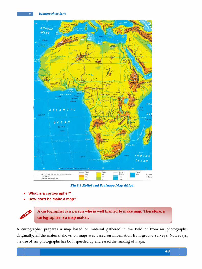
49
2 Structure of the Earth
Fig 2.1 Relief and Drainage Map Africa
What is a cartographer?
How does he make a map?
A cartographer prepares a map based on material gathered in the field or from air photographs.
Originally, all the material shown on maps was based on information from ground surveys. Nowadays,
the use of air photographs has both speeded up and eased the making of maps.
A cartographer is a person who is well trained to make map. Therefore, a
cartographer is a map maker.
50
2 Structure of the Earth
You know also how colours are used to determine map features. You have learnt something about signs
and symbols when you were in grade five and six.
Thus, the appearance, readability and usefulness of maps are determined by such considerations as:
Scale
Colouring scheme
Lettering and
Symbols used.
The accuracy of the map, however, depends mainly on the scale.
What does scale mean?
Why should a scale be used to make a map?
Ethiopian cartographer
A cartographer in the Ethiopian mapping agency is one of the very important
individuals in the making of different types of maps.
He is responsible mainly for the development of two major groups of maps
a) General purpose maps (Topographic maps)
These maps are made using different scales:
1:2,000,000, 1:250,000, 1:25,000, 1:2,000 scales
The areas covered are:
- Contours (height)
- Vegetation
- Settlement
- Hydrographic (water bodies)
Lakes, ponds, reservoirs, rivers and streams.
- Boundaries
b) Single purpose maps
These are maps based on single elements, such as: road maps, industrial site
maps, agriculture maps, population maps, climate maps etc.
In addition to the above duties, the cartographer is also responsible for
making national atlases (both analogue and digital).
Source: Interview made with the Avison of the Ethiopia Mapping Agency director.
Addis Ababa 2011.
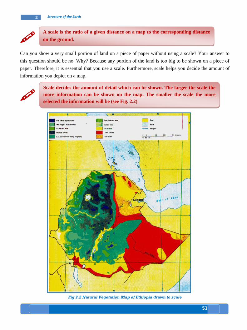
51
2 Structure of the Earth
Can you show a very small portion of land on a piece of paper without using a scale? Your answer to
this question should be no. Why? Because any portion of the land is too big to be shown on a piece of
paper. Therefore, it is essential that you use a scale. Furthermore, scale helps you decide the amount of
information you depict on a map.
Fig 2.2 Natural Vegetation Map of Ethiopia drawn to scale
A scale is the ratio of a given distance on a map to the corresponding distance
on the ground.
Scale decides the amount of detail which can be shown. The larger the scale the
more information can be shown on the map. The smaller the scale the more
selected the information will be (see Fig. 2.2)

52
2 Structure of the Earth
Can you mention some uses of map?
Suppose you are a tourist, for what purpose do you think you use a map?
Uses of Map
Ancient use
Primitive societies used to draw simple maps in sand soil to show location of water hole, an excellent
hunting ground and the way how to get there.
Modern use
Modern maps are used to show the location, distance, area and direction of a place.
B. Marginal Information
What does marginal information mean?
Discuss what points marginal information includes on a map.
When you study a map, you observe the outskirts of the map. These outskirts make up the margins of the
map. Usually information is included on the margins of the map. The information includes terms that
indicate different aspects of the map. All the terms included on the appropriate corner of the margin of
the map are generally termed as marginal information.
In order to make proper interpretation possible, all maps must bear the following marginal information:
title or heading
scale
compass direction
key to symbols and colours
date of publication
Thus, once you know these items of marginal information, you can read the information provided on a
given map.
Title or Heading
Every map is drawn on purpose. Therefore, every map has a name. The name is its title or heading. For
example, a map of Africa may show the various types of vegetation available in different parts of the
continent. The title of this map may be “vegetation map of Africa”. Can you cite another title of your
own? Please try one (see Fig. 2.3).
Do the following:
Make the plan of your class on a piece of paper.
Use appropriate scale.
Ask your teacher how you can manipulate a scale.
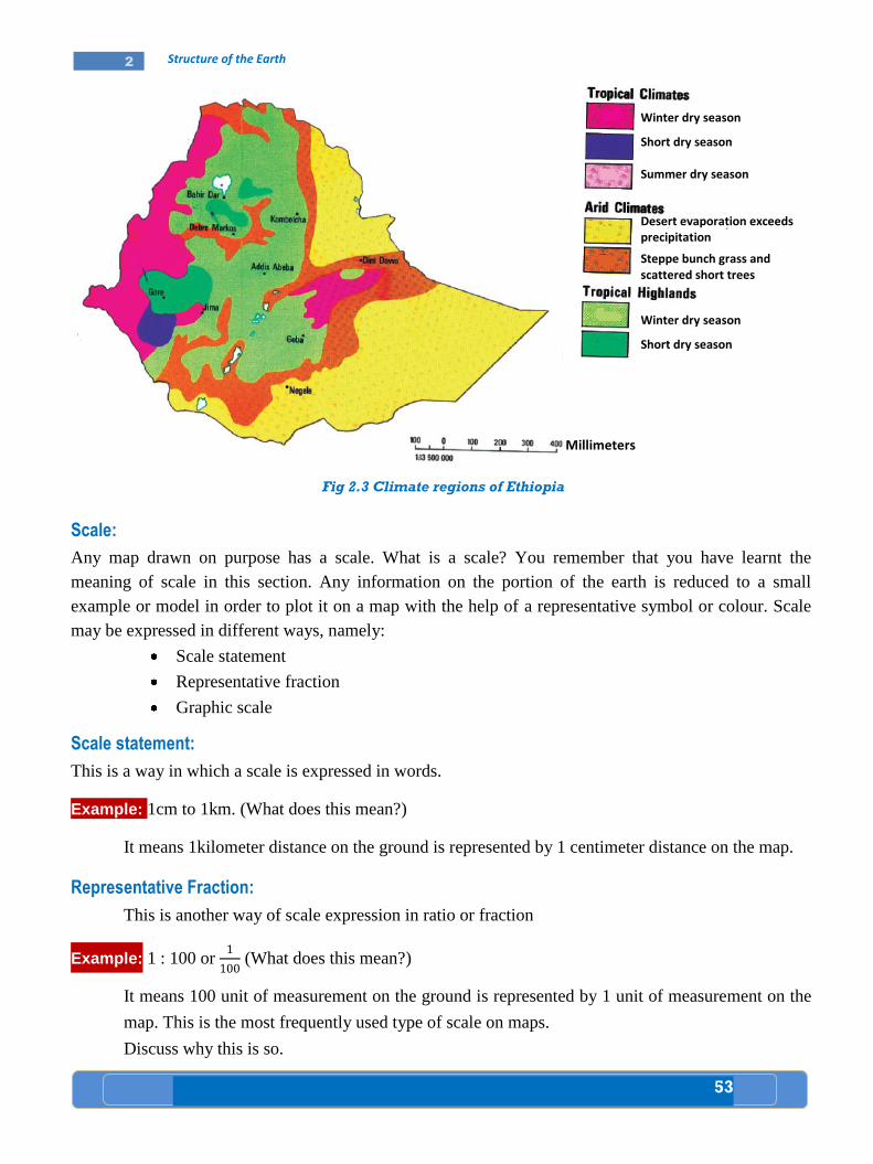
53
2 Structure of the Earth
Fig 2.3 Climate regions of Ethiopia
Scale:
Any map drawn on purpose has a scale. What is a scale? You remember that you have learnt the
meaning of scale in this section. Any information on the portion of the earth is reduced to a small
example or model in order to plot it on a map with the help of a representative symbol or colour. Scale
may be expressed in different ways, namely:
Scale statement
Representative fraction
Graphic scale
Scale statement:
This is a way in which a scale is expressed in words.
Example: 1cm to 1km. (What does this mean?)
It means 1kilometer distance on the ground is represented by 1 centimeter distance on the map.
Representative Fraction:
This is another way of scale expression in ratio or fraction
Example: 1 : 100 or (What does this mean?)
It means 100 unit of measurement on the ground is represented by 1 unit of measurement on the
map. This is the most frequently used type of scale on maps.
Discuss why this is so.
Desert evaporation exceeds precipitation
Steppe bunch grass and scattered short trees
Winter dry season
Short dry season
Summer dry season
Winter dry season
Short dry season
Millimeters
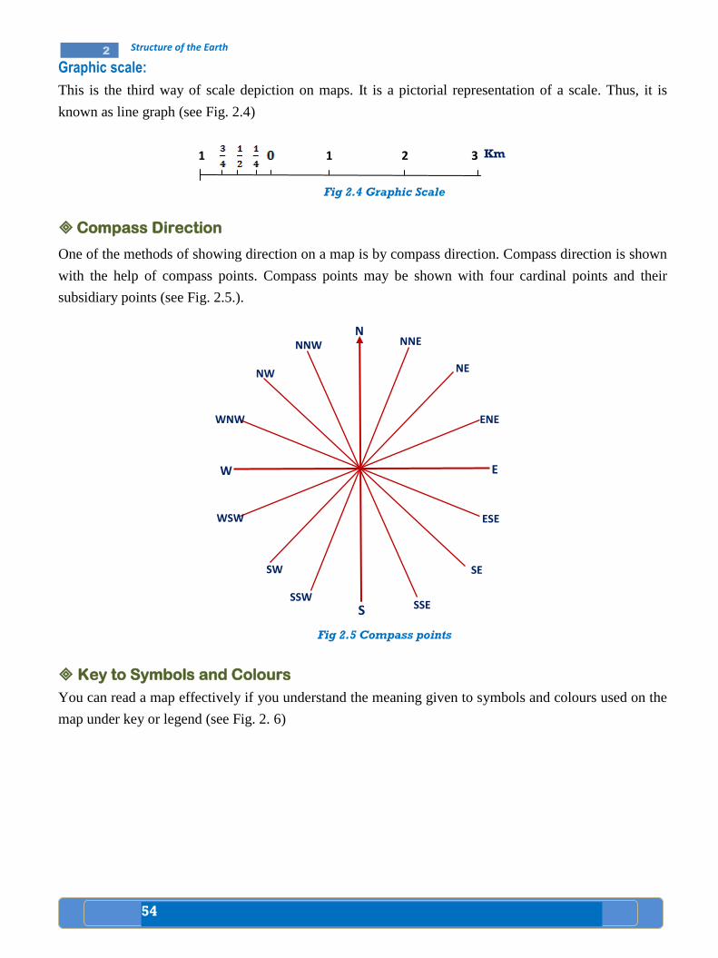
54
2 Structure of the Earth
Graphic scale:
This is the third way of scale depiction on maps. It is a pictorial representation of a scale. Thus, it is
known as line graph (see Fig. 2.4)
Km
Fig 2.4 Graphic Scale
Compass Direction
One of the methods of showing direction on a map is by compass direction. Compass direction is shown
with the help of compass points. Compass points may be shown with four cardinal points and their
subsidiary points (see Fig. 2.5.).
Fig 2.5 Compass points
Key to Symbols and Colours
You can read a map effectively if you understand the meaning given to symbols and colours used on the
map under key or legend (see Fig. 2. 6)
1 1 2 3
N NNE
ENE
NE
E
ESE
SE
SSE S
SSW
SW
WSW
W
WNW
NW
NNW
SSW
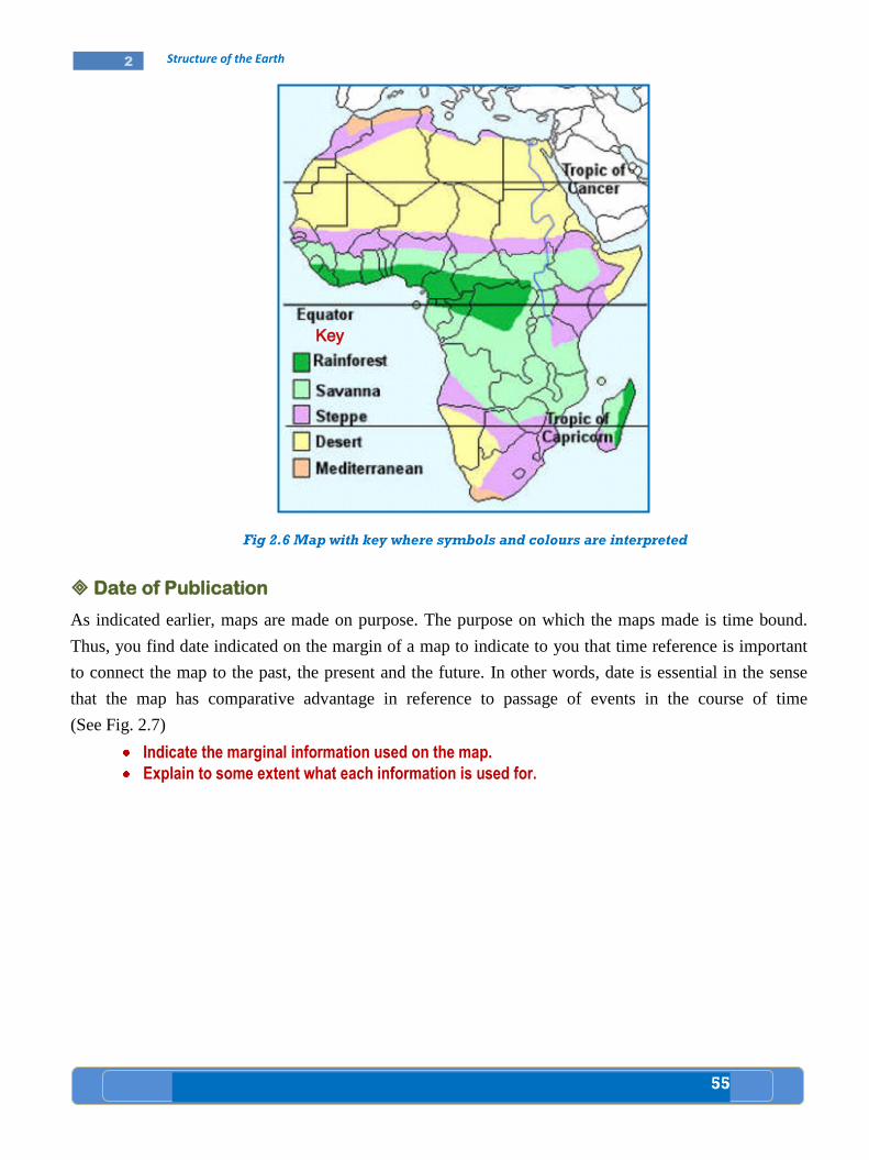
55
2 Structure of the Earth
Fig 2.6 Map with key where symbols and colours are interpreted
Date of Publication
As indicated earlier, maps are made on purpose. The purpose on which the maps made is time bound.
Thus, you find date indicated on the margin of a map to indicate to you that time reference is important
to connect the map to the past, the present and the future. In other words, date is essential in the sense
that the map has comparative advantage in reference to passage of events in the course of time
(See Fig. 2.7)
Indicate the marginal information used on the map.
Explain to some extent what each information is used for.
Key
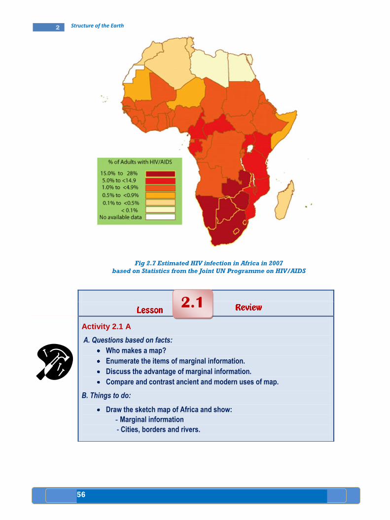
56
2 Structure of the Earth
Fig 2.7 Estimated HIV infection in Africa in 2007
based on Statistics from the Joint UN Programme on HIV/AIDS
Activity 2.1 A
A. Questions based on facts:
Who makes a map?
Enumerate the items of marginal information.
Discuss the advantage of marginal information.
Compare and contrast ancient and modern uses of map.
B. Things to do:
Draw the sketch map of Africa and show:
- Marginal information
- Cities, borders and rivers.
2.1
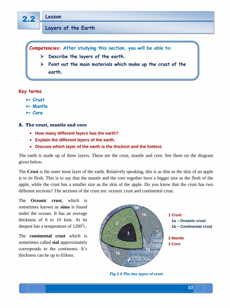
57
2 Structure of the Earth
Key terms
Crust
Mantle
Core
A. The crust, mantle and core
How many different layers has the earth?
Explain the different layers of the earth.
Discuss which layer of the earth is the thickest and the hottest.
The earth is made up of three layers. These are the crust, mantle and core. See them on the diagram
given below.
The Crust is the outer most layer of the earth. Relatively speaking, this is as thin as the skin of an apple
is to its flesh. This is to say that the mantle and the core together have a bigger size as the flesh of the
apple, while the crust has a smaller size as the skin of the apple. Do you know that the crust has two
different sections? The sections of the crust are: oceanic crust and continental crust.
The Oceanic crust, which is
sometimes known as sima is found
under the oceans. It has an average
thickness of 6 to 10 kms. At its
deepest has a temperature of 12000c.
The continental crust which is
sometimes called sial approximately
corresponds to the continents. It’s
thickness can be up to 65kms.
Fig 2.8 The two types of crust
2.2 Lesson
Layers of the Earth
Competencies: After studying this section, you will be able to:
Describe the layers of the earth.
Point out the main materials which make up the crust of the
earth.
1 Crust
1a – Oceanic crust
1b – Continental crust
2 Mantle
3 Core
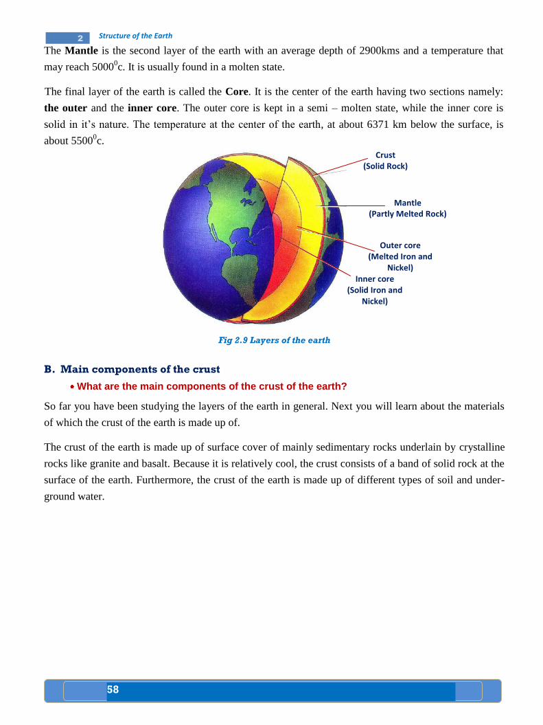
58
2 Structure of the Earth
The Mantle is the second layer of the earth with an average depth of 2900kms and a temperature that
may reach 50000c. It is usually found in a molten state.
The final layer of the earth is called the Core. It is the center of the earth having two sections namely:
the outer and the inner core. The outer core is kept in a semi – molten state, while the inner core is
solid in it’s nature. The temperature at the center of the earth, at about 6371 km below the surface, is
about 55000c.
Fig 2.9 Layers of the earth
B. Main components of the crust
What are the main components of the crust of the earth?
So far you have been studying the layers of the earth in general. Next you will learn about the materials
of which the crust of the earth is made up of.
The crust of the earth is made up of surface cover of mainly sedimentary rocks underlain by crystalline
rocks like granite and basalt. Because it is relatively cool, the crust consists of a band of solid rock at the
surface of the earth. Furthermore, the crust of the earth is made up of different types of soil and under-
ground water.
Crust (Solid Rock)
Mantle (Partly Melted Rock)
Outer core (Melted Iron and
Nickel) Inner core
(Solid Iron and Nickel)
59
2 Structure of the Earth
Activity 2
A. Questions based on facts:
Name the three layers of the earth.
Which of the layers is the outer most and the thinnest?
What do we call the two different parts of the crust?
Point out the main components of the three layers of the earth separately.
Which layer of the earth is the deepest? How deep is it? What about its
temperature?
As one goes from the upper most layer of the earth down to the deepest, are
temperature and pressure increasing or decreasing?
B. Things to do:
Draw the diagram of the internal structure of the earth and Indicate
The three layers of the earth.
The depth and temperature of the three layers.
The rock and mineral types available in each layer.
2.2
60
2 Structure of the Earth
Key terms
Intrusive igneous rocks Magma
Extrusive igneous rocks Lava
The Formation of Rocks
What is a rock?
How many types of rock do you know?
How does each type of rock formed?
You have learnt about the different layers of the earth and their main components in general and the
crust in particular in the previous lesson. Now you will learn about the different types of rock and their
formation. Then, what is a rock?
Rocks are classified into three according to their origin and age. They are:
Igneous rocks;
Sedimentary rocks and
Metamorphic rocks.
Igneous Rocks
What is the term igneous?
What are igneous rocks made up of?
The crust of the earth is composed of rocks. Rocks are made up of minerals
from such elements as oxygen, sulfur, calcium, carbon, aluminum etc.
Some rocks are made up of single mineral while others are from many. Most
minerals are compounds of several elements.
Competencies: After studying this section, you will be able to:
Identify the types and formation of rocks.
Explain the economic uses of rocks.
Verify the economic importance of rocks in Ethiopia.
Lesson
Types and Formation of Rocks 2.3
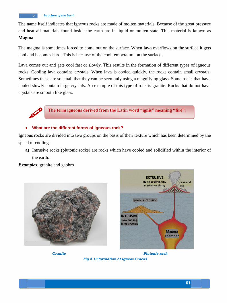
61
2 Structure of the Earth
The name itself indicates that igneous rocks are made of molten materials. Because of the great pressure
and heat all materials found inside the earth are in liquid or molten state. This material is known as
Magma.
The magma is sometimes forced to come out on the surface. When lava overflows on the surface it gets
cool and becomes hard. This is because of the cool temperature on the surface.
Lava comes out and gets cool fast or slowly. This results in the formation of different types of igneous
rocks. Cooling lava contains crystals. When lava is cooled quickly, the rocks contain small crystals.
Sometimes these are so small that they can be seen only using a magnifying glass. Some rocks that have
cooled slowly contain large crystals. An example of this type of rock is granite. Rocks that do not have
crystals are smooth like glass.
What are the different forms of igneous rock?
Igneous rocks are divided into two groups on the basis of their texture which has been determined by the
speed of cooling.
a) Intrusive rocks (plutonic rocks) are rocks which have cooled and solidified within the interior of
the earth.
Examples: granite and gabbro
The term igneous derived from the Latin word “ignis” meaning “fire”.
Granite
Plutonic rock
Fig 2.10 formation of Igneous rocks
EXTRUSIVE quick cooling, tiny crystals or glassy
Lava and ash
Igneous intrusion
INTRUSIVE slow cooling, large crystals
Magma chamber

62
2 Structure of the Earth
b) Extrusive rocks (volcanic rocks) are rocks which have cooled and solidified on the surface of the
earth.
Example: Basalt, obsidian
Basalt Obsidian Fig 2.11 Extrusive rocks
Fig. 2.9 Types of Igneous rocks
Fig 2.12 Types of Igneous rocks
Sedimentary Rocks
What are sedimentary rocks?
These are rocks derived from existing
rocks by the processes of weathering and
erosion. Sedimentary rocks would be
formed as the igneous rock surfaces
were fragmented and the rock particles
carried to lower ground nearby or
brought to the continental shelves of the
oceans or reached some ancient lake
floor. Here, the transporting agents of
wind, ice, rivers, and the waves of sea
would add layers until the deposits
become consolidated by pressure and
cemented rocks, therefore, show a
layered arrangement or stratification.
Plutonic Rocks
Volcanic Rocks
Fig 2.13 Layers of sedimentary rocks
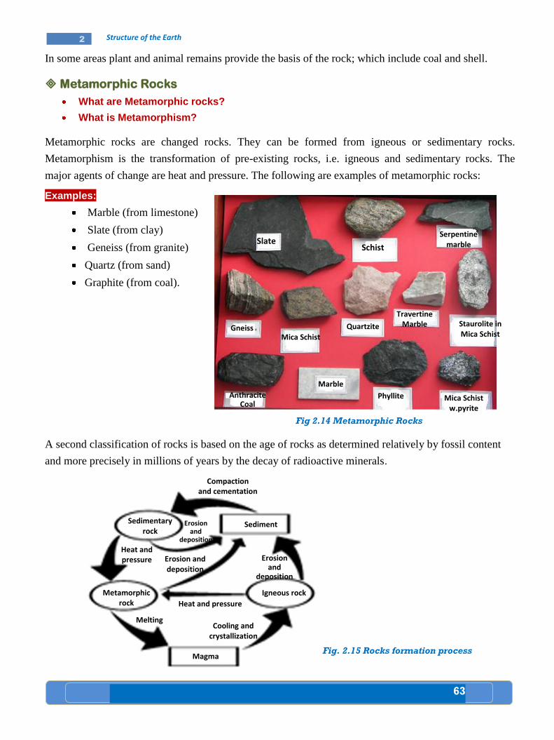
63
2 Structure of the Earth
In some areas plant and animal remains provide the basis of the rock; which include coal and shell.
Metamorphic Rocks
What are Metamorphic rocks?
What is Metamorphism?
Metamorphic rocks are changed rocks. They can be formed from igneous or sedimentary rocks.
Metamorphism is the transformation of pre-existing rocks, i.e. igneous and sedimentary rocks. The
major agents of change are heat and pressure. The following are examples of metamorphic rocks:
Examples:
Marble (from limestone)
Slate (from clay)
Geneiss (from granite)
Quartz (from sand)
Graphite (from coal).
A second classification of rocks is based on the age of rocks as determined relatively by fossil content
and more precisely in millions of years by the decay of radioactive minerals.
Fig. 2.15 Rocks formation process
Sedimentary rock
Sediment
Igneous rock Metamorphic rock
Compaction and cementation
Heat and pressure Erosion
and deposition
Erosion and
deposition
Melting
Heat and pressure
Cooling and crystallization
Magma
Erosion and deposition
Slate Schist
Anthracite Coal
Serpentine marble
Staurolite in Mica Schist
Travertine Marble Quartzite
Mica Schist Gneiss
Marble
Phyllite Mica Schist w.pyrite
Fig 2.14 Metamorphic Rocks
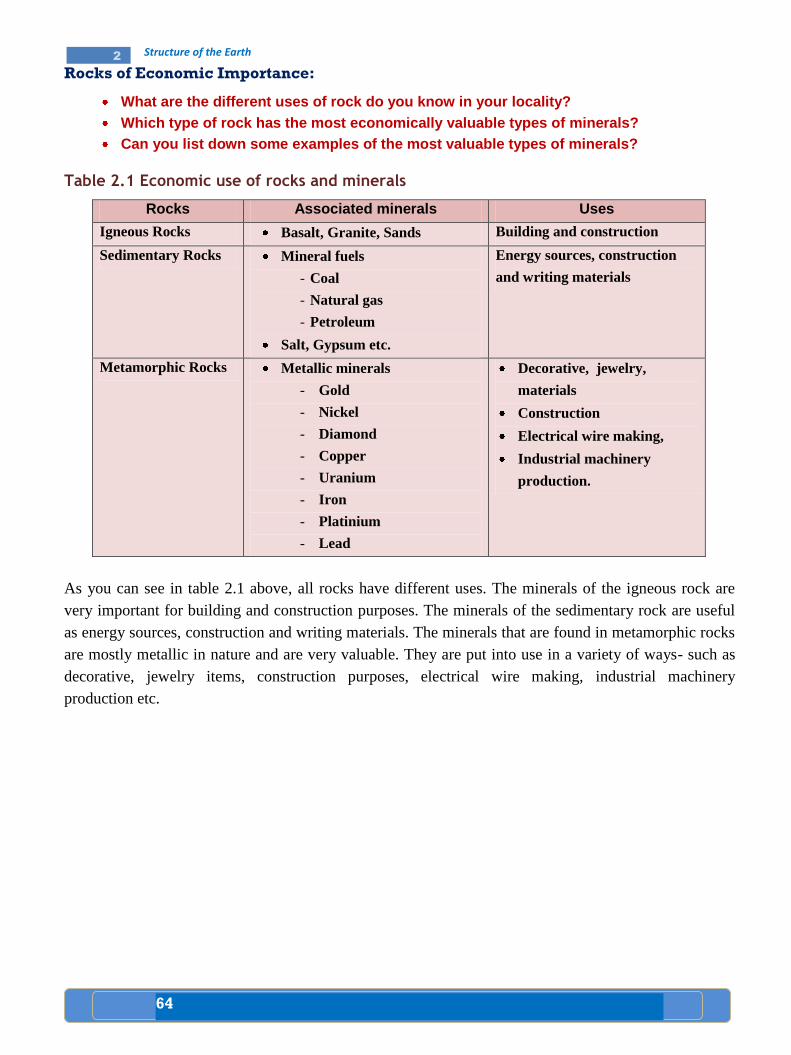
64
2 Structure of the Earth
Rocks of Economic Importance:
What are the different uses of rock do you know in your locality?
Which type of rock has the most economically valuable types of minerals?
Can you list down some examples of the most valuable types of minerals?
Table 2.1 Economic use of rocks and minerals
Rocks Associated minerals Uses
Igneous Rocks Basalt, Granite, Sands Building and construction
Sedimentary Rocks Mineral fuels
- Coal
- Natural gas
- Petroleum
Salt, Gypsum etc.
Energy sources, construction
and writing materials
Metamorphic Rocks Metallic minerals
- Gold
- Nickel
- Diamond
- Copper
- Uranium
- Iron
- Platinium
- Lead
Decorative, jewelry,
materials
Construction
Electrical wire making,
Industrial machinery
production.
As you can see in table 2.1 above, all rocks have different uses. The minerals of the igneous rock are
very important for building and construction purposes. The minerals of the sedimentary rock are useful
as energy sources, construction and writing materials. The minerals that are found in metamorphic rocks
are mostly metallic in nature and are very valuable. They are put into use in a variety of ways- such as
decorative, jewelry items, construction purposes, electrical wire making, industrial machinery
production etc.

65
2 Structure of the Earth
Activity 2.3 A
A. Questions based on facts:
How are rocks formed?
What are the main components of rocks?
Mention the names of the different types of igneous rock.
Give some examples of minerals that are found in three different kinds of
rocks.
Why do we say the minerals in metamorphic rock are the most valuable?
B. Group discussion:
In groups discuss on the following fact
“It is possible to learn of past conditions by studying sedimentary rocks”.
Bring the points that you have agreed upon to your class, and invite your
classmates for further discussion.
C. Individual work:
Visit your locality and collect sample rocks as much as possible. Then classify
them into major types. Finally, state the basis for your classification.
D. Things to do:
Define the following terms. Record the definitions in your note book.
- Rock - Plutonic rock
- Soil - Volcanic rock
- Magma - Extrusive rock
- Lava - Intrusive rock
2.3

66
2 Structure of the Earth
A map is a representation of part of the earth on a reduced scale. It is made by
cartographers.
Primitive societies used to draw simple maps on sand soil to show the location
of water holes, excellent hunting grounds and the way to go there.
In the modern world, maps are used to show the location, distance, area and
direction of a place.
The first step in reading a map is to study all the information available in the
margin of the map. These information include: title, date, key, scale, direction,
etc.
The earth is made up of layers with different thicknesses. The three layers of the
earth are crust, mantle and core.
The crust is the outer most part of the earth’s surface, which is made up of
mainly sedimentary rocks underlain by crystalline rocks like granite and basalt.
Mantle consists of mainly of silicate rocks rich in iron and magnesium which are
kept in semi – molten state.
The core consists of iron and nickel. It has two parts, the outer and the inner
core.
The rocks that compose the earth’s crust are aggregation of particles of various
substances called minerals.
A mineral consists of one or more chemical elements and has a definite physical
state and chemical composition.
Some minerals are found in combination with other minerals, while others occur
as a single element.
Some minerals are organic in nature.
The main chemical elements found in rocks are oxygen, silicon, aluminium, iron,
calcium, sodium, potassium, and magnesium.
Rocks are classified in two ways: by origin and age.
Igneous rocks are results of volcanic activities. They are of two nature: extrusive
and intrusive.
Sedimentary rocks are rocks derived from existing rocks by the process of
weathering and erosion. Therefore, they are secondary in origin.
Metamorphic rocks are changed rocks i.e changed either from igneous or
sedimentary rocks.
Summary
67
2 Structure of the Earth
Glossary
Cartographer: is a person well trained in the making of maps.
Core: is the central layer of the earth which is composed of a grid central core. It is divided into
an outer and inner core. It contains largely nickel and iron.
Crust : the outer surface or layer of the earth.
Direction: may mean the course taken by a moving person or thing, or point towards which a
person or thing looks or faces. It is showed by compass points and angular bearing.
Extrusive igneous rocks: when lava and other materials reach the earth’s surface they are called
extrusive.
Intrusive igneous rocks: materials injected into the crust are referred to as intrusive.
Lava: when molten rock reaches the surface it is called lava.
Map: a map is the representation of the earth’s surface on a reduced scale.
Marginal information: all the information included on the margins of a map.
Mantle: an intermediate layer of the earth. It is found between the crust and the core layers of the
earth.
68
2 Structure of the Earth
I. True / False questions
Direction: Write ‘’True’’ if the statement is correct and ‘’False’’ if the statement is incorrect in the space
provided infront of each statement
______ 1. All rocks are made up of minerals.
______ 2. Basalt and granite are both igneous rocks.
______ 3. Continental crust is sometimes called sial.
______ 4. Maps are used as a tool of research.
______ 5. The core of the earth consists of iron and nickel.
II. Matching
Match column B with column A. Write the letter of the correct term on your paper next to the number of
its matching definition.
Column A Column B
______1. The ratio of a given distance on a map to the corresponding distance on the ground
______2. Intrusive rocks. ______ 3. Pictorial representation
______ 4. Date of publication ______ 5. Made up of minerals
a) Plutonic igneous rocks b) Volcanic igneous rocks c) Marginal Information d) Scale e) Minerals f) Rocks g) Compass h) Graphic scale i) Representative fraction
III. Multiple choices
Choose the correct answer for each question from the given four alternatives.
______ 1. Another name of oceanic crust is:
a) dyke b) sial c) sima d) vent
______ 2. Rocks are classified by
a) origin c) size
b) age d) “a” and “b”
______ 3. Identify the correct statement:
a) When depth increases, temperature decreases inside the earth.
b) The crust is the outer most layer of the earth.
c) The low temperature of the interior of the earth makes the inner core solid.
d) None of the above.
Review Questions
UNIT
2
69
2 Structure of the Earth
______ 4. Intrusive rocks are not usually observed on the surface of the earth because:
a) They are laid beneath other rocks b) They can’t be seen by naked eye c) They were not found in the earth’s crust d) They were eroded from their place of origin
______ 5. The inner core of the earth is
a) solid c) gas
b) liquid d) none
______ 6. Which one of the following shows the importance of minerals?
a) Home consumption c) Construction
b) Raw materials for industry d) All
______ 7. One of the following is not a marginal information.
a) Colour c) Date
b) Title d) Key
IV. Fill in the blank space with the correct word or phrase
1. Mineral fuels such as coal, petroleum and natural gas are associated with rocks.
2. Map makers are sometimes called
3. It is impossible to read the signs and symbols used on a map without the of the map.
V. Short answer questions
1. What is a map?
2. Discuss the possible uses of a map and who would use or make them.
3. What are the major information obtained from the margins of a map?
4. Discuss why these marginal information are important.
5. Describe the layers of the earth.
6. What is the depth and the temperature of the core?
7. Define the terms extrusive and intrusive igneous rocks.
8. Explain the economic uses of rocks.
VI. Things to do
Draw an up – to – date political map of Africa showing all the marginal information.
70
2 Structure of the Earth
Check List
Put a tick () mark in each of the boxes for activities you can
perform
I can
1. Define the term map.
2. Express the uses of a map.
3. Draw a sketch map of Africa to indicate marginal
information on a map.
4. Describe the layers of the earth.
5. Point out the main materials which make up the crust
of the earth.
6. Identify the types and formation of rocks.
7. Explain the economic importance of rocks in Ethiopia.
71
3 The Eco-System and its Challenges
Unit Outcomes
After studying this unit, you will be able to:
Recognize the distribution, importance and the major factors that
affect natural vegetation and wild animals in Africa.
Recognize the availability and threats of potable water resources.
Realize the methods to conserve natural resources.
UNIT
3
72
3 The Eco-System and its Challenges
Key terms
Afforestation Deforestation Fossil fuels
Agroforestry Endemic animals Natural resource
Conservation
A. Distribution of natural vegetation and wild animals
What does natural vegetation mean?
Discuss the type and distribution of natural vegetation in Africa.
Natural Vegetation
When you were in grade six you have learnt about forests and grasslands in general. Now you will learn
about the type and distribution of natural vegetation of Africa in a more detailed manner.
Natural vegetation refers to all plants that have grown in a given area without any
human efforts. It is a plant cover of a region that results from normal conditions of
climate, soil, drainage and other elements of an environment.
Lesson
Natural Vegetation and Wild Animals
3.1
Competencies: After studying this lesson, you will be able to:
Identify and indicate the natural vegetation of Africa on the
map.
Distinguish the major wild animals of Africa.
Discuss how natural vegetation and wild life interrelate with
their environment.
Realize that plants and animals are part of an ecosystem.
Verify that the animals will become extinct if their habitat is
destroyed.
Discuss human factors which affect wildlife.
Reflect that we can act to prevent climate change.
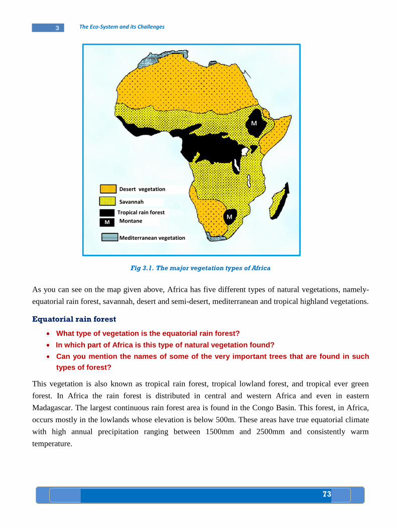
73
3 The Eco-System and its Challenges
Fig 3.1. The major vegetation types of Africa
As you can see on the map given above, Africa has five different types of natural vegetations, namely-
equatorial rain forest, savannah, desert and semi-desert, mediterranean and tropical highland vegetations.
Equatorial rain forest
What type of vegetation is the equatorial rain forest?
In which part of Africa is this type of natural vegetation found?
Can you mention the names of some of the very important trees that are found in such
types of forest?
This vegetation is also known as tropical rain forest, tropical lowland forest, and tropical ever green
forest. In Africa the rain forest is distributed in central and western Africa and even in eastern
Madagascar. The largest continuous rain forest area is found in the Congo Basin. This forest, in Africa,
occurs mostly in the lowlands whose elevation is below 500m. These areas have true equatorial climate
with high annual precipitation ranging between 1500mm and 2500mm and consistently warm
temperature.
Desert vegetation
M
Mediterranean vegetation
Montane
Tropical rain forest
Savannah
Desert vegetation

74
3 The Eco-System and its Challenges
Structurally, the rainforest is complete and multilayered, with the tallest trees reaching up to 50 meters in
height. The equatorial rain forest consists of hardwood trees such as: Mahogany, Ebony, Rosewood,
Ironwood, and Green heart. There are also shrubs, bamboos, climbers, epiphytes, etc. (See fig.3.2)
Fig 3.2. The equatorial rain forest
Savannah
What type of natural vegetation is savannah?
Discuss the nature and distribution of savannah vegetation in Africa.
Savannah vegetation in Africa covers extensive areas between the equatorial rain forest and the desert
areas north and south of the equator. Savannah lands mostly encircle the equatorial rain forests. It
occupies up to 65 percent of the continent and perhaps, this is the most widespread type of natural
vegetation in Africa. Savannah vegetation grows in the tropical climate regions where there is a marked
dry season.
Climatically, the savannah lands are transitional regions. They come under the influence of wet on shore
trade winds in summer and the dry off shore trade winds in winter. Temperature is high all year round,
seldom falling below 200c.
The Savannah vegetation consists of different types of grass and trees. Trees may vary in abundance
from continuous closed-canopy woodland to more open park savannah, grasslands with scattered trees
and treeless grasslands.(see fig: 3.3)
Upper
Middle
Lower
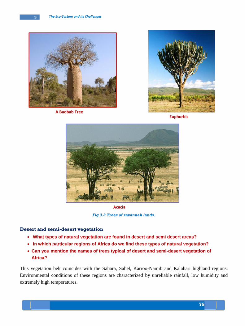
75
3 The Eco-System and its Challenges
Fig 3.3 Trees of savannah lands.
Desert and semi-desert vegetation
What types of natural vegetation are found in desert and semi desert areas?
In which particular regions of Africa do we find these types of natural vegetation?
Can you mention the names of trees typical of desert and semi-desert vegetation of
Africa?
This vegetation belt coincides with the Sahara, Sahel, Karroo-Namib and Kalahari highland regions.
Environmental conditions of these regions are characterized by unreliable rainfall, low humidity and
extremely high temperatures.
Acacia
Euphorbis A Baobab Tree

76
3 The Eco-System and its Challenges
The deserts and semi-deserts are not devoid of vegetation, rather the vegetation diversity is surprisingly
high. For example, North African semi-desert and desert zones support more than 3000 species, about 20
percent of which are endemic. The Namib, Kalahari and Karoo of southern Africa are perhaps, richer in
plant species. However, the most common plants are xerophytes.
Fig. 3.4 Xerophytes
Mediterranean vegetation
What type of vegetation is Mediterranean vegetation?
In which part of Africa, do we find Mediterranean vegetation?
This type of natural vegetation is found in the north and south extremes of the continent of Africa. The
vegetation grows in areas with warm dry summer alternating with a cool rainy winter. The
Mediterranean region is rich in its plant species. The very common types of vegetation found in the
Mediterranean region are called Maquis. There are also some tree species which include: Cork Oak,
Wild olive etc. Many of the trees belong to the evergreen and deciduous vegetation and are deep rooted
to protect themselves from shortage of moisture during summer.
Xerophytes are plants having the ability to arrange their life cycle to suit
drought conditions and high rate of evaporation.
Maquis: they are low bushes, which have hard evergreen leaves and thorns and
grasses.
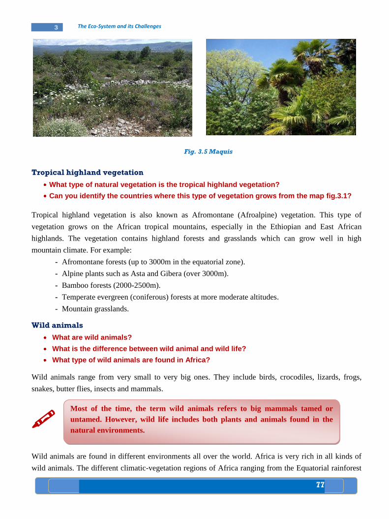
77
3 The Eco-System and its Challenges
Fig. 3.5 Maquis
Tropical highland vegetation
What type of natural vegetation is the tropical highland vegetation?
Can you identify the countries where this type of vegetation grows from the map fig.3.1?
Tropical highland vegetation is also known as Afromontane (Afroalpine) vegetation. This type of
vegetation grows on the African tropical mountains, especially in the Ethiopian and East African
highlands. The vegetation contains highland forests and grasslands which can grow well in high
mountain climate. For example:
- Afromontane forests (up to 3000m in the equatorial zone).
- Alpine plants such as Asta and Gibera (over 3000m).
- Bamboo forests (2000-2500m).
- Temperate evergreen (coniferous) forests at more moderate altitudes.
- Mountain grasslands.
Wild animals
What are wild animals?
What is the difference between wild animal and wild life?
What type of wild animals are found in Africa?
Wild animals range from very small to very big ones. They include birds, crocodiles, lizards, frogs,
snakes, butter flies, insects and mammals.
Wild animals are found in different environments all over the world. Africa is very rich in all kinds of
wild animals. The different climatic-vegetation regions of Africa ranging from the Equatorial rainforest
Most of the time, the term wild animals refers to big mammals tamed or
untamed. However, wild life includes both plants and animals found in the
natural environments.
78
3 The Eco-System and its Challenges
to the desert provide ideal condition for the existence of a great variety of wild animals. Generally,
Africa is rich in wild life because of the following reasons:
Tropical rainforest contains a variety of dense trees and undergrowths. This forest region hosts the
largest number of wild animals. These animals include tree-dwellers (arboreal) like monkeys,
apes, baboons, gorillas and birds. There are also other large animals that inhabit the water bodies,
such as hippopotamus, crocodiles, etc.
Savannah grasslands of Africa are also the natural habitat of a variety of wild animals both
(herbivores and carnivores). Most of them are herbivores which include antelopes, giraffes,
buffaloes, zebra, elephants, etc. The most common carnivorous animals are lion, leopard and
hyena.
African desert and semi-desert areas sustain burrowing animals. Some of the desert animals
include: wild ass, fox, reptiles (snakes, lizards and tortoise).
Major rivers, lakes and swamp lands of Africa are the habitat of diverse species of aquatic wild
life, such as fish, crocodiles, hippopotamus and etc.
B. Importance of natural vegetation and wild animals:
What are the importance of natural vegetation and wild animals for the world?
Discuss what will happen to the wild animals of the world if their habitats are destroyed?
What do we mean by the phrase-extinction of wild animals?
Importance of Natural Vegetation
The most important uses of plants include:
- sources of raw materials in industries.
- source of food.
- for the production of medicines.
- for fuel wood production.
- to moderate the local climate.
- to shelter the wild animals.
- to increase fertility of the soil.
- for recreational purposes.
- for house construction.
Herbivore animals are grass or plant eaters, while carnivore animals are that
feed on flesh or meat. Omnivore animals are group of wild animals that eat
both grass and meat, such as apes and monkeys.
79
3 The Eco-System and its Challenges
Importance of Wild Animals
The most important uses of wild animals include:-
- sources of food
- sources of raw material
- for educational research
- for recreational purposes
C. Major factors that affect natural vegetation and wild animals
Enumerate the major factors that affect natural vegetation and wild animals.
How does the destruction of natural vegetation affect the peaceful existence of wild
animals?
In the discussion above, we have seen that both natural vegetation and wild animals are very important
for humans and their environment. However, their peaceful existence is being disturbed due to different
human and natural factors. They are population pressure, lack of awareness, poverty, climate change and
wild fires.
Major Factors that Affect Natural Vegetation
1. Deforestation: By far the greatest of all threats to natural vegetation is deforestation. It refers
to the temporary or permanent clearance of forests for agriculture or some other land use. The
main causes of deforestation are:
- Shifting cultivation, particularly in the tropical rainforest areas.
- Permanent agriculture.
- Fuel wood cutting and collection, mostly in the developing countries as
a means of income source.
- Extractive forest use (sawmill factories) and timber production.
2. Impeded forest regeneration
Deforestation may be prolonged by subsequent burning and livestock grazing that impede forest
regeneration. Today, farmers in many countries burn savannah woodlands every year to promote
the growth of fresh grasses for their livestock. Frequent fires, combined with intensive animal
browsing of trees and shrubs, have major impacts on vegetation.
3. Forest Degradation
It is a temporal or permanent reduction (loss) in the density or structure of forest vegetation or
composition of its species.
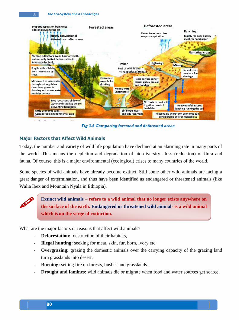
80
3 The Eco-System and its Challenges
Fig 3.6 Comparing forested and deforested areas
Major Factors that Affect Wild Animals
Today, the number and variety of wild life population have declined at an alarming rate in many parts of
the world. This means the depletion and degradation of bio-diversity –loss (reduction) of flora and
fauna. Of course, this is a major environmental (ecological) crises to many countries of the world.
Some species of wild animals have already become extinct. Still some other wild animals are facing a
great danger of extermination, and thus have been identified as endangered or threatened animals (like
Walia Ibex and Mountain Nyala in Ethiopia).
What are the major factors or reasons that affect wild animals?
- Deforestation: destruction of their habitats,
- Illegal hunting: seeking for meat, skin, fur, horn, ivory etc.
- Overgrazing: grazing the domestic animals over the carrying capacity of the grazing land
turn grasslands into desert.
- Burning: setting fire on forests, bushes and grasslands.
- Drought and famines: wild animals die or migrate when food and water sources get scarce.
Extinct wild animals – refers to a wild animal that no longer exists anywhere on
the surface of the earth. Endangered or threatened wild animal- is a wild animal
which is on the verge of extinction.
Shifting cultivators live in harmony with nature, only limited deforestation in Amazonia for fuel.
Evapotranspiration from trees adds moisture to the air
Heavy convectional storms most afternoons
Forested areas Deforested areas
Fewer trees mean less evapotranspiration
Ranching
Mainly for poor quality meat for hamburger
Plantation crops
Mining
Lack of trees creates a fuel shortage
Heavy rainfall causes leaching running the soil
Reasonable short term economic gain, considerable environmental loss
Highways Timber
Loss of wildlife and many species of trees
Rapid surface runoff causes gulley erosion and flooding
Clean river useable for drinking
Muddy water undrinkable
No roots to hold soil together results in landslides
Slit blocks river and tills reservoirs
Fragile soils shielded from heavy rain by trees
Movement of rain-water through soil regulates river flow, prevents flooding and stores water for drier periods
Tree roots control flow of water and stabilize the soil preventing landslides
Little economic gain Considerable environmental gain
81
3 The Eco-System and its Challenges
Loss of Biodiversity and Extinction
What do we mean by biodiversity?
What are the causes and effects of the loss of biodiversity?
Why is biodiversity important? Does it matter if there are not so many species?
The variety of life on earth, its biological diversity is commonly referred to as biodiversity. The number
of species of plants, animals and microorganisms, the enormous diversity of genes in these species, the
different ecosystems on the planet, such as deserts, rain forests and coral reefs are all part of a
biologically diverse earth.
Biodiversity is the huge variety of animals and plants on our planet, together with the places where they
are found.
Biodiversity boosts ecosystems productivity where each species, no matter how small, all have an
important role to play. For example, a larger number of plant species means greater variety of crops,
greater species diversity ensures natural sustainability for all life forms, and healthy ecosystem can
better withstand and recover from variety of disasters.
Almost all cultures have in some way or form recognized the importance that nature, and its biological
diversity has had upon them and the need to maintain it. Yet, power, greed and politics have affected the
precarious balance.
It has long been feared that human activity is causing massive extinctions. Despite increased efforts at
conservation, it has not been enough and biodiversity losses continue. The costs associated with
deteriorating or vanishing ecosystems will be high.
We can no longer see that continued loss of biodiversity as an issue separate form the core concerns of
society: to tackle poverty, to improve the health, prosperity, and security of present and future
generations, and to deal with climate change.
However, appropriate conservation and sustainable development strategies would help avail ecological
problems. While we dominate this planet, we still need to preserve the diversity in wildlife.

82
3 The Eco-System and its Challenges
Activity 3.1 A
3.1
83
3 The Eco-System and its Challenges
Key terms
Pollution
Sewage waste
A. The Importance of water for life
How do you explain the relationship between human beings and water?
Discuss the availability of clean water and potential water resources in Africa?
What are the threats to potable water in the world in general and in Africa in particular?
Water is very important for life. Almost over 70 percent of the earth’s surface is covered with water. It is
abundant but unevenly distributed resource. There are different sources of water. These include: ground
water, surface water, frozen water and water vapor.
The African region represents an important part of the world in terms of land and water: 20.2% of the
world's land area, and 9 percent of the world's actual water, with only 13 percent of the world’s
population. The following table shows the percentage rate of actual fresh water available in the different
sub-regions of Africa.
Lesson
Water, Soil and Air
3.2
Competencies: After studying this lesson, you will be able to:
Explain the relationship between human beings and water.
Compare and contrast the availability and scarcity of potable
water in Africa.
Predict threats and describe the causes of the threats to potable
water in Africa.
Identify the threat to soil resources in Africa.
Analyze the causes of urban air pollution.
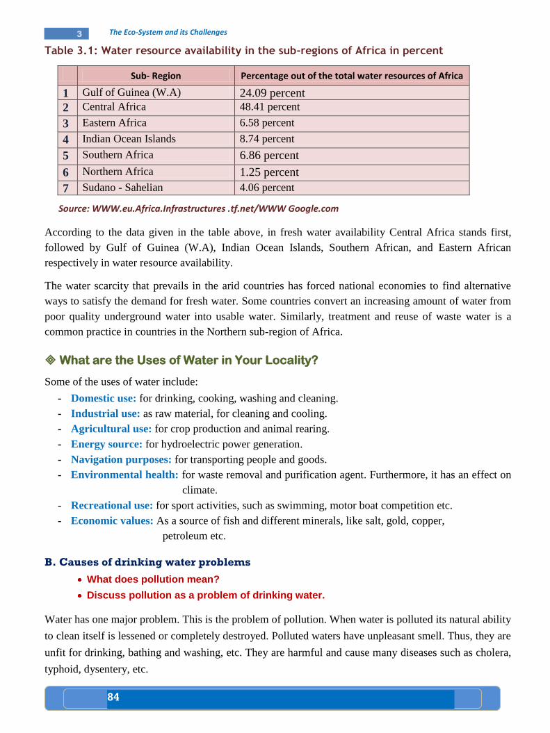
84
3 The Eco-System and its Challenges
Table 3.1: Water resource availability in the sub-regions of Africa in percent
Sub- Region Percentage out of the total water resources of Africa
1 Gulf of Guinea (W.A) 24.09 percent
2 Central Africa 48.41 percent
3 Eastern Africa 6.58 percent
4 Indian Ocean Islands 8.74 percent
5 Southern Africa 6.86 percent
6 Northern Africa 1.25 percent
7 Sudano - Sahelian 4.06 percent
Source: WWW.eu.Africa.Infrastructures .tf.net/WWW Google.com
According to the data given in the table above, in fresh water availability Central Africa stands first,
followed by Gulf of Guinea (W.A), Indian Ocean Islands, Southern African, and Eastern African
respectively in water resource availability.
The water scarcity that prevails in the arid countries has forced national economies to find alternative
ways to satisfy the demand for fresh water. Some countries convert an increasing amount of water from
poor quality underground water into usable water. Similarly, treatment and reuse of waste water is a
common practice in countries in the Northern sub-region of Africa.
What are the Uses of Water in Your Locality?
Some of the uses of water include:
- Domestic use: for drinking, cooking, washing and cleaning.
- Industrial use: as raw material, for cleaning and cooling.
- Agricultural use: for crop production and animal rearing.
- Energy source: for hydroelectric power generation.
- Navigation purposes: for transporting people and goods.
- Environmental health: for waste removal and purification agent. Furthermore, it has an effect on
climate.
- Recreational use: for sport activities, such as swimming, motor boat competition etc.
- Economic values: As a source of fish and different minerals, like salt, gold, copper,
petroleum etc.
B. Causes of drinking water problems
What does pollution mean?
Discuss pollution as a problem of drinking water.
Water has one major problem. This is the problem of pollution. When water is polluted its natural ability
to clean itself is lessened or completely destroyed. Polluted waters have unpleasant smell. Thus, they are
unfit for drinking, bathing and washing, etc. They are harmful and cause many diseases such as cholera,
typhoid, dysentery, etc.
85
3 The Eco-System and its Challenges
Thus, what are the major causes for water pollution? The causes include the following:
- Sewage wastes: include human excreta, paper, cloth, soap and other detergents, all sorts of
garbage and trash.
- Industrial wastes: including wastes from paper, food processing, chemical industries, etc.
- Agricultural pollutants: include chemicals such as fertilizers, herbicides, insecticides and
animal wastes, etc.
Water forms many industrial uses, ranging from boilers to canning, must have various mineral
specifications. The large industrial and municipal withdrawal uses of water also commonly are
associated with problems of pollution when the effluent (the used water) is returned to surface drainage.
Pollution affects recreation and wild life, as well as the municipal supplies of communities downstream
who may also use the surface water.
Urbanism has gone hand in hand with the spread of the European type of industrial civilization.
Urbanization marked the rise of the second human culture that affects the development of agriculture.
The fast growth of urban centers resulted in increased concentration of people in towns. Today there is a
real housing problem in many large cities where people are forced to live in cramped and unhealthy
environments what might be termed ‘’slum’’ or ‘’squatter’’ settlements. The speed and unplanned urban
growth in many parts of the world generated many environmental problems. The most serious of these
problems include:
- lack of piped water system for homes and businesses,
- inadequate sanitation and sewerage provision, and
- considerable water and air pollution.
C. Threats to soil
What do we mean by threats to soil?
Discuss the threats to soil.
Erosion and land degradation are serious problems to soil. The cause for soil erosion can be grouped
basically into two:
Natural: heavy rainfall and the type of the slope. Agents of erosion include: running water, wind,
sea waves, etc.
Human: deforestation, overgrazing and bad farming practices.
Water Pollution refers to any undesirable change in the quality of water.
86
3 The Eco-System and its Challenges
Natural factors
What are the natural factors that cause soil erosion?
What are the effects of soil erosion?
i. Erosion by running water
Erosion by running water is dominant and common in many parts of the world. It can cause the
following soil erosion:
Sheet erosion
Sheet erosion affects large areas and it occurs when rainfalls on a gentle slope which is bare of
vegetation. This type of erosion results in the removal of a uniform depth of soil.
Gulley erosion
This is more localized and occurs when heavy rainfall rushes down a steep slope, cutting deep groove in-
to the land. The grooves become deepened and widened to form gullies which finally cut up the land to
give 'bad lands'.
ii. Wind erosion
Regions having a low rainfall or definite dry seasons are liable to have their soils reduced to dust and
blown away by wind, if the land is bare of vegetation. The wind removes fine particles of materials
in desert regions.
Human factors: include, bad farming practices and deforestation.
Bad farming practices
The ploughing of land up and down the slope, provides human made channels which can be
enlarged into gullies by surface run off.
In shifting cultivation, a piece of forest is destroyed by fire and crops are grown in the soils of the
cleared patch which are now enriched by wood ash. After one or two years of such cultivation, the
patch soon abandoned and a new clearing is made. The abandoned patch soon experiences soil
erosion by rainfall. Shifting cultivation usually takes place in the wet tropical regions. It is a
common method of crop farming with wandering forest people.
The cutting down of forest, especially on the higher slopes, may result in soil erosion and the
spreading out of the transported soil over the lowlands where farmland can be seriously damaged.
D. The causes of urban air pollution
What are the main causes for an urban air pollution?
What does polluted air mean?
Ash from volcanoes, marsh gases, smoke from wild fires and sand blown dust are natural sources of air
pollution.
However, far more important than naturally occurring pollutants are substances that people discharge
into the air. These pollutants result primarily from:
87
3 The Eco-System and its Challenges
Burning fossil fuels (coal, gas, and oil). Scientists estimate that about three quarters of air
pollutants come from burning fossil fuels.
Industrial processes other than fuel burning.
Burning solid wastes.
Forest and agricultural fires.
The evaporation of solvents.
How would it be possible to reduce if not completely stop the damage of air pollution?
Do you think people in your community are aware of the dangers of air pollution and have started acting against it?
If your answer is No, what is your stand towards helping them in their effort to fight problems of air pollution?
Activity 3.2 A
3.2
88
3 The Eco-System and its Challenges
A. Conservation of natural vegetation
What do we mean by the term conservation?
Why do we need to conserve natural vegetation?
How can we conserve natural vegetation?
Every citizen is expected to use the available forest resources properly and wisely. Human intervention
against deforestation risks aims at conserving forests by:
- Reforestation: trees must be replaced wherever they are cut down.
- Afforestation: New forests must be planted where none existed before.
- Proper management of the existing forests.
- Using alternative energy sources (like solar, and wind power).
- Agro-forestry: in which trees, field crops and livestock raising are integrated together in
adjacent locations.
- Raising public awareness: on the use and management of forest resources.
In this manner, we have to conserve our natural vegetation. Why then we need to conserve our natural
vegetation? This is because:
- Natural resources are interdependent. This means that the destruction or the depletion of one
kind of natural resource is the destruction of another natural resource. For example, when we
are destroying the natural vegetation in an area, we are indirectly destroying the habitat of
wild animals.
- We want to keep water, air and soil free from pollution.
- We want to protect ourselves from the dangers of global warming.
Lesson
Intervention Measures to Conserve Natural Resources
3.3
Competencies: After studying this lesson, you will be able to:
Relate the conservation of natural vegetation to the
conservation of other resources.
Discuss how to control air and water pollution.
Show interest in participating in keeping water clean for
domestic use.
89
3 The Eco-System and its Challenges
B. How to control air and water pollution?
i. Water conservation methods
What are the methods of water conservation?
The following are some of the methods in the conservation of water:-
- Effective treatment of municipal and industrial waste.
- Removal of pollutants by purification.
- The regulations of chemical run off from agriculture, mining and forestry.
- The development of less pollution technologies.
- Recycling wastes.
- Use of chemicals – including the use of chlorine, etc.
ii. Air conservation methods.
What is air conservation?
There are a number of ways of preventing air pollution, some of them include:
- Government laws: air pollution can be controlled by laws.
- Filter systems: can be installed in chimneys to remove solid pollutants.
- Altering exhaust systems: vehicles can reduce pollution from their smokes.
- Use of mass transportation: reduce both fuel consumption and carbon monoxide
production.
What type of a role could you play in the attempt or effort of your community trying to stop or
reduce air pollution?
C. Soil conservation methods
The following are some of the methods in the conservation of soil:
Afforestation: provides a long term solution since once the trees have grown their leaves
intercept rainfall and their roots help to bind the soil together and reduce surface run off.
The growing of cover crops reduces rain splash and surface run off.
Improving farming methods: soil can also be conserved by improving farming methods such as:
- Rotation of crops: improves soil fertility.
- Recovery period: many tropical soils need a recovery period of five to 15 years in shrub or
forest for each three to six years in crop.
Conservation refers to the management of natural resource such as: water, soil,
energy, air, natural vegetation, wild animals, etc. in ways that prevent them from
being damaged or destroyed. In short it is a wise use of natural resources.
90
3 The Eco-System and its Challenges
- Contour ploughing: in areas where slopes are steep, ploughing should be done following
the contours to prevent excessive erosion.
- Terracing: helps to slow down run off, giving water more time to infiltrate and reducing
its erosional ability.
- Strip cropping: involves the planting of two or more crops in the same field. The crops
may differ in height, time of harvest and use of nutrients.
- Check dams: are small dams to trap silt washed from hills.
- Shelter belts: are trees planted at the edge of farm lands to protect the soil from wind
erosion.
Uses of alternative conservation methods
What do we mean by alternative methods of conservation?
What do we mean by renewable and non-renewable resources?
The Use of Renewable Resources In Place of Non-Renewable Resources
Materials supplied in nature and available for human use are both renewable and non- renewable.
Renewable resources include water, air, vegetation, animals, soil, etc. On the other hand, minerals are
non-renewable resources. Only a limited amount of each element exists on our planet, and they cannot
be replaced once they are used up. Therefore, if we are intending to conserve them, then we have to
replace them by other renewable resources. Examples, instead of using fuel minerals as a source of
energy or power it is possible to use solar, thermal or wind energy.
The Use of Organic Fertilizers in Place of Chemical Fertilizers
Too much use of chemical fertilizers such as nitrogen, potassium and phosphorus can cause
environmental damage. Therefore, organic fertilizers, such as animal dung, straw, etc. can be used to
improve soil structure and return its nutrients.
What do you know about UNEP?
Where is its headquarter found?
When was it established?
Renewable resources – are resources that can replace themselves, while non-
renewable resources are non- replaceable resources. Sometimes they are known
as finite or exhustable natural resources.
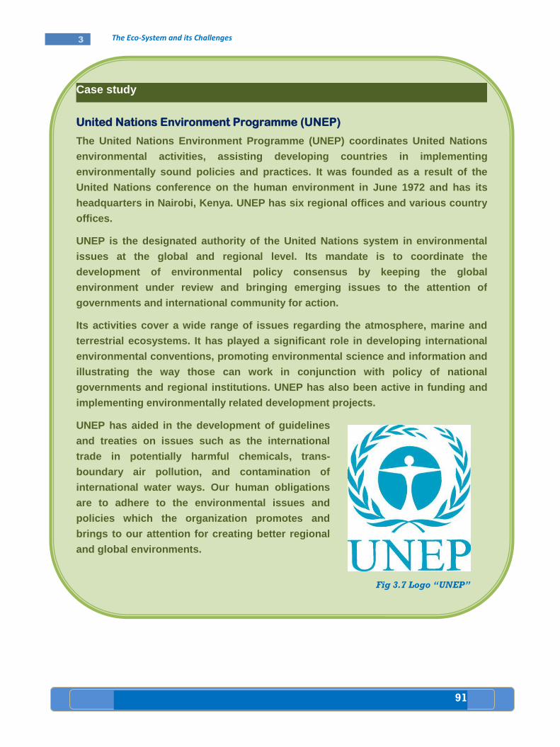
91
3 The Eco-System and its Challenges
Case study
United Nations Environment Programme (UNEP)
The United Nations Environment Programme (UNEP) coordinates United Nations
environmental activities, assisting developing countries in implementing
environmentally sound policies and practices. It was founded as a result of the
United Nations conference on the human environment in June 1972 and has its
headquarters in Nairobi, Kenya. UNEP has six regional offices and various country
offices.
UNEP is the designated authority of the United Nations system in environmental
issues at the global and regional level. Its mandate is to coordinate the
development of environmental policy consensus by keeping the global
environment under review and bringing emerging issues to the attention of
governments and international community for action.
Its activities cover a wide range of issues regarding the atmosphere, marine and
terrestrial ecosystems. It has played a significant role in developing international
environmental conventions, promoting environmental science and information and
illustrating the way those can work in conjunction with policy of national
governments and regional institutions. UNEP has also been active in funding and
implementing environmentally related development projects.
UNEP has aided in the development of guidelines
and treaties on issues such as the international
trade in potentially harmful chemicals, trans-
boundary air pollution, and contamination of
international water ways. Our human obligations
are to adhere to the environmental issues and
policies which the organization promotes and
brings to our attention for creating better regional
and global environments.
Fig 3.7 Logo “UNEP”
92
3 The Eco-System and its Challenges
Activity 3.3 A
3.3
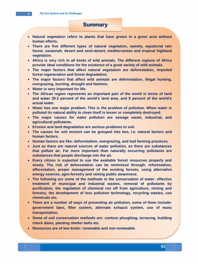
93
3 The Eco-System and its Challenges
Natural vegetation refers to plants that have grown in a given area without
human efforts.
There are five different types of natural vegetation, namely, equatorial rain
forest, savannah, desert and semi-desert, mediterranean and tropical highland
vegetation.
Africa is very rich in all kinds of wild animals. The different regions of Africa
provide ideal conditions for the existence of a great variety of wild animals.
The major factors that affect natural vegetation are deforestation, impeded
forest regeneration and forest degradation.
The major factors that affect wild animals are deforestation, illegal hunting,
overgrazing, burning, drought and famines.
Water is very important for life.
The African region represents an important part of the world in terms of land
and water 20.2 percent of the world’s land area, and 9 percent of the world’s
actual water.
Water has one major problem. This is the problem of pollution. When water is
polluted its natural ability to clean itself is lesser or completely destroyed.
The major causes for water pollution are sewage waste, industrial, and
agricultural pollutants.
Erosion and land degradation are serious problems to soil.
The causes for soil erosion can be grouped into two, i.e. natural factors and
human factors.
Human factors are like: deforestation, overgrazing, and bad farming practices.
Just as there are natural sources of water pollution, so there are substances
that pollute air. Far more important than naturally occurring pollutants are
substances that people discharge into the air.
Every citizen is expected to use the available forest resources properly and
wisely. The risk of deforestation can be minimized through: reforestation,
afforestation, proper management of the existing forests, using alternative
energy sources, agro-forestry and raising public awareness.
The following are some of the methods in the conservation of water: effective
treatment of municipal and industrial wastes, removal of pollutants by
purification, the regulation of chemical run off from agriculture, mining and
forestry, the development of less pollution technology, recycling wastes, use
chemicals etc.
There are a number of ways of preventing air pollution, some of them include:
government laws, filter system, alternate exhaust system, use of mass
transportation.
Some of soil conservation methods are: contour ploughing, terracing, building
check dams, planting shelter belts etc.
Resources are of two kinds: renewable and non-renewable.
Summary
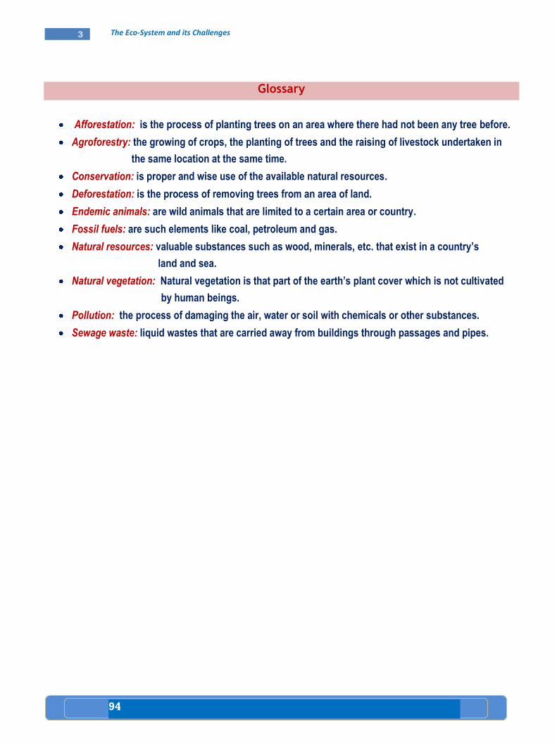
94
3 The Eco-System and its Challenges
Glossary
Afforestation: is the process of planting trees on an area where there had not been any tree before.
Agroforestry: the growing of crops, the planting of trees and the raising of livestock undertaken in
the same location at the same time.
Conservation: is proper and wise use of the available natural resources.
Deforestation: is the process of removing trees from an area of land.
Endemic animals: are wild animals that are limited to a certain area or country.
Fossil fuels: are such elements like coal, petroleum and gas.
Natural resources: valuable substances such as wood, minerals, etc. that exist in a country’s
land and sea.
Natural vegetation: Natural vegetation is that part of the earth’s plant cover which is not cultivated
by human beings.
Pollution: the process of damaging the air, water or soil with chemicals or other substances.
Sewage waste: liquid wastes that are carried away from buildings through passages and pipes.
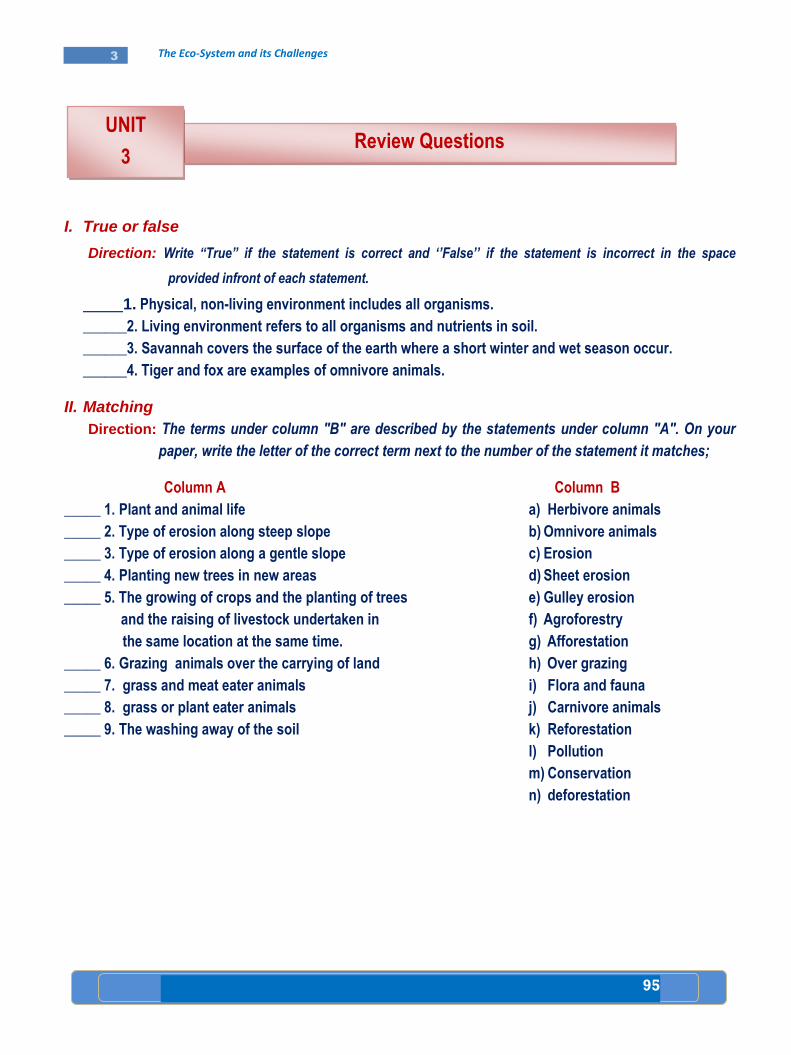
95
3 The Eco-System and its Challenges
I. True or false
Direction: Write “True” if the statement is correct and „‟False‟‟ if the statement is incorrect in the space
provided infront of each statement.
1. Physical, non-living environment includes all organisms.
______2. Living environment refers to all organisms and nutrients in soil.
______3. Savannah covers the surface of the earth where a short winter and wet season occur.
______4. Tiger and fox are examples of omnivore animals.
II. Matching
Direction: The terms under column "B" are described by the statements under column "A". On your
paper, write the letter of the correct term next to the number of the statement it matches;
Column A
_____ 1. Plant and animal life
_____ 2. Type of erosion along steep slope
_____ 3. Type of erosion along a gentle slope
_____ 4. Planting new trees in new areas
_____ 5. The growing of crops and the planting of trees
and the raising of livestock undertaken in
the same location at the same time.
_____ 6. Grazing animals over the carrying of land
_____ 7. grass and meat eater animals
_____ 8. grass or plant eater animals
_____ 9. The washing away of the soil
Column B
a) Herbivore animals
b) Omnivore animals
c) Erosion
d) Sheet erosion
e) Gulley erosion
f) Agroforestry
g) Afforestation
h) Over grazing
i) Flora and fauna
j) Carnivore animals
k) Reforestation
l) Pollution
m) Conservation
n) deforestation
Review Questions
UNIT
3
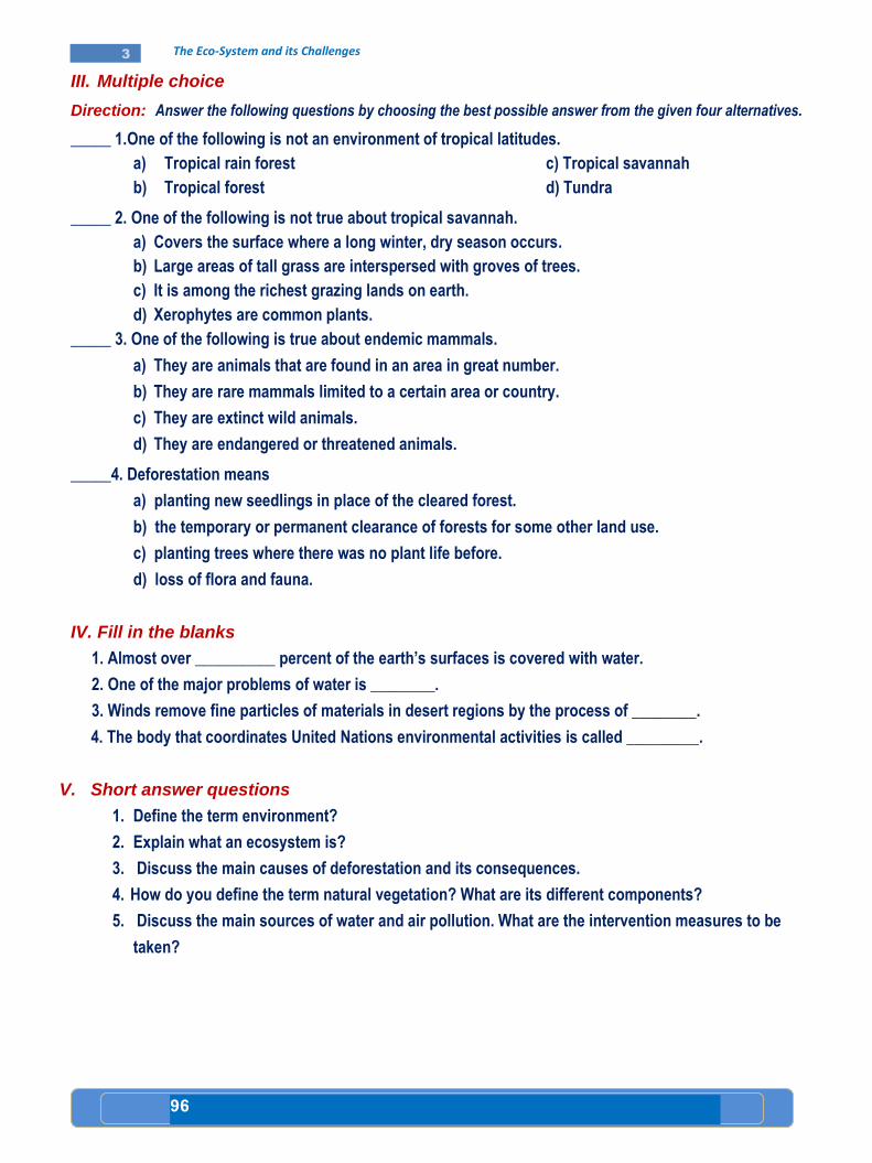
96
3 The Eco-System and its Challenges
III. Multiple choice
Direction: Answer the following questions by choosing the best possible answer from the given four alternatives.
_____ 1.One of the following is not an environment of tropical latitudes.
a) Tropical rain forest c) Tropical savannah
b) Tropical forest d) Tundra
_____ 2. One of the following is not true about tropical savannah.
a) Covers the surface where a long winter, dry season occurs.
b) Large areas of tall grass are interspersed with groves of trees.
c) It is among the richest grazing lands on earth.
d) Xerophytes are common plants.
_____ 3. One of the following is true about endemic mammals.
a) They are animals that are found in an area in great number.
b) They are rare mammals limited to a certain area or country.
c) They are extinct wild animals.
d) They are endangered or threatened animals.
_____4. Deforestation means
a) planting new seedlings in place of the cleared forest.
b) the temporary or permanent clearance of forests for some other land use.
c) planting trees where there was no plant life before.
d) loss of flora and fauna.
IV. Fill in the blanks
1. Almost over __________ percent of the earth’s surfaces is covered with water.
2. One of the major problems of water is ________.
3. Winds remove fine particles of materials in desert regions by the process of ________.
4. The body that coordinates United Nations environmental activities is called _________.
V. Short answer questions
1. Define the term environment?
2. Explain what an ecosystem is?
3. Discuss the main causes of deforestation and its consequences.
4. How do you define the term natural vegetation? What are its different components?
5. Discuss the main sources of water and air pollution. What are the intervention measures to be
taken?

97
3 The Eco-System and its Challenges
Check List
Put a tick () mark in each of the boxes for activities you can
perform
I can
1. Identify and indicate the natural vegetation of Africa
on a map.
2. Distinguish the major wild animals of Africa.
3. Discuss how natural vegetation and wild life
interrelate with their environment.
4. Realize that plants and animals are part of
an ecosystem.
5. Verify that animals will become extinct if their
habitat is destroyed.
6. Discuss human factors which affect wildlife.
7. Reflect that we can act to prevent climate change.
8. Explain the relationship between human
beings and water.
9. Compare and contrast the availability and
scarcity of potable water in Africa.
10. Predict threats and describe the causes of the
threats to potable water in Africa.
11. Identify the threats to soil resources in Africa.
12. Analyze the causes of urban air pollution.
13. Relate the conservation of natural vegetation
to conservation of other resources.
14. Discuss how to control air and water pollution.
15. Show interest in participating in keeping water
clean for domestic use.
98
UNIT
4
Unit Outcomes
After studying this unit, you will be able to:
Analyze the socio-economic impact of HIV/AIDS in Africa.
Verify the effect of the lack of good governance in Africa.
Identify the geographical coverage and targets of regional
organizations of Africa.
Analyze the impact of rapid population growth in Africa.
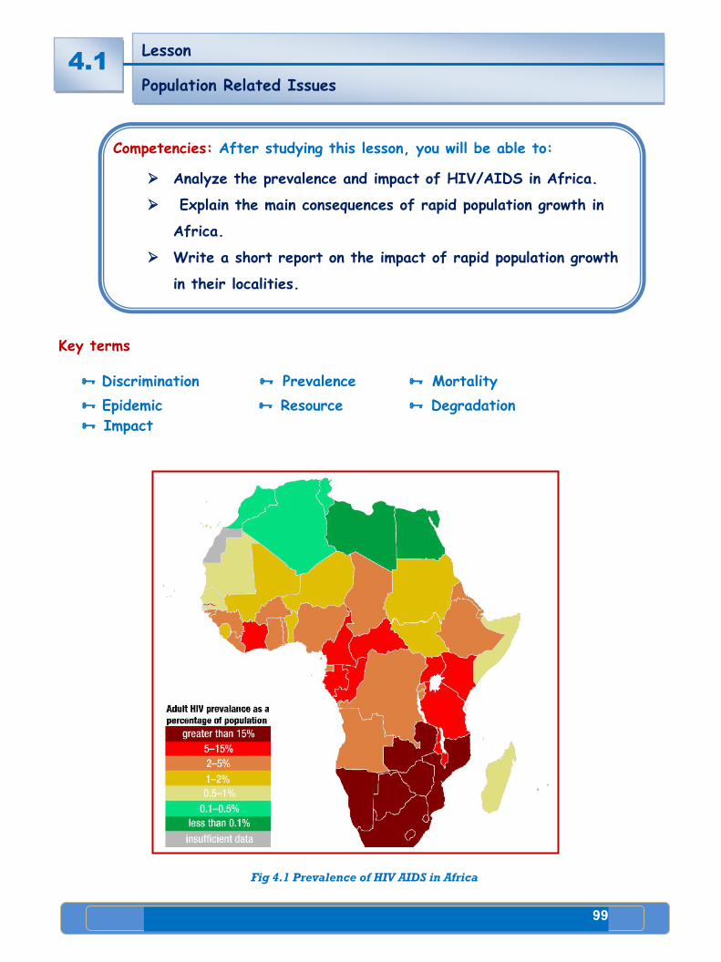
99
4 Public Agenda
Key terms
Discrimination Prevalence Mortality
Epidemic Resource Degradation
Impact
Fig 4.1 Prevalence of HIV AIDS in Africa
Lesson
Population Related Issues
THE PEOPLE AFRICA LOCATION, SIZE AND SHAPE
4.1
Competencies: After studying this lesson, you will be able to:
Analyze the prevalence and impact of HIV/AIDS in Africa.
Explain the main consequences of rapid population growth in
Africa.
Write a short report on the impact of rapid population growth
in their localities.
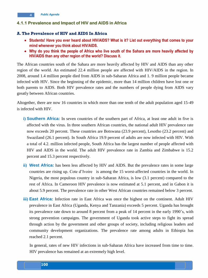
100
4 Public Agenda
4.1.1 Prevalence and Impact of HIV and AIDS in Africa
A. The Prevalence of HIV and AIDS In Africa
Students! Have you ever heard about HIV/AIDS? What is it? List out everything that comes to your
mind whenever you think about HIV/AIDS.
Why do you think the people of Africa who live south of the Sahara are more heavily affected by HIV/AIDS than any other region of the world? Discuss it.
The African countries south of the Sahara are more heavily affected by HIV and AIDS than any other
region of the world. An estimated 22.4 million people are affected with HIV/AIDS in the region. In
2008, around 1.4 million people died from AIDS in sub-Saharan Africa and 1. 9 million people became
infected with HIV. Since the beginning of the epidemic, more than 14 million children have lost one or
both parents to AIDS. Both HIV prevalence rates and the numbers of people dying from AIDS vary
greatly between African countries.
Altogether, there are now 16 countries in which more than one tenth of the adult population aged 15-49
is infected with HIV.
i) Southern Africa: In seven countries of the southern part of Africa, at least one adult in five is
affected with the virus. In three southern African countries, the national adult HIV prevalence rate
now exceeds 20 percent. These countries are Botswana (23.9 percent), Lesotho (23.2 percent) and
Swaziland (26.1 percent). In South Africa 19.9 percent of adults are now infected with HIV. With
a total of 4.2. million infected people, South Africa has the largest number of people affected with
HIV and AIDS in the world. The adult HIV prevalence rate in Zambia and Zimbabwe is 15.2
percent and 15.3 percent respectively.
ii) West Africa: has been less affected by HIV and AIDS. But the prevalence rates in some large
countries are rising up. Cote d’Ivoire is among the 15 worst-affected countries in the world. In
Nigeria, the most populous country in sub-Saharan Africa, is low (3.1 percent) compared to the
rest of Africa. In Cameroon HIV prevalence is now estimated at 5.1 percent, and in Gabon it is
about 5.9 percent. The prevalence rate in other West African countries remained below 3 percent.
iii) East Africa: Infection rate in East Africa was once the highest on the continent. Adult HIV
prevalence in East Africa (Uganda, Kenya and Tanzania) exceeds 5 percent. Uganda has brought
its prevalence rate down to around 8 percent from a peak of 14 percent in the early 1990’s, with
strong prevention campaigns. The government of Uganda took active steps to fight its spread
through action by the government and other groups of society, including religious leaders and
community development organizations. The prevalence rate among adults in Ethiopia has
reached 2.1 percent.
In general, rates of new HIV infections in sub-Saharan Africa have increased from time to time.
HIV prevalence has remained at an extremely high level.
101
4 Public Agenda
High prevalence rates of infection exist among teenagers and women in their early 20’s in
various urban and rural areas in Africa. The rates among teenage girls and especially among
women under 25 are beyond belief: more than one woman in five in their early 20’s is infected
with the virus. A large proportion of them will not live to see their 30th
birthday.
The infection rates in young African women are far higher than those in young men. The average
rates in teenage girls are over five times higher than those in teenage boys. Among young people
in their early 20’s, the rates are three times higher in women. This is because girls are more
easily infected during sexual intercourse with an infected partner than boys are.
B. The Impact of HIV and AIDS in Africa
Fig 4.2 Africa, hardest hit by AIDS, accounts for more than half of the people, globally,
living with HIV and dying of AIDS
Class Discussion
In Ethiopia, the majority of people affected, with HIV/AIDS are between 15-49 years old. There are more than one million orphans in Ethiopia who lost their parents, due to HIV/AIDS. What kind of impact do you think these problems have on the economic and social development of the country? Discuss this issue in your class.
HIV and AIDS are having a widespread impact on many parts of African people. Two-thirds of all
people infected with HIV live in sub-Saharan Africa. This region of Africa contains little more than 10
percent of the world’s population. AIDS has caused immense human suffering in the continent. The
most obvious effect of this crisis has been illness and death. However, some of the major impact of the
AIDS epidemic has been described below.

102
4 Public Agenda
i. The impact on life expectancy
HIV/AIDS epidemic has reduced the average life expectancy in sub-Saharan Africa
from 62 to 47. Does this have any impact on the socio-economic development of the
countries? Discuss the question in the class.
In many countries of sub-Saharan Africa, AIDS is destroying the progress made in extending life
expectancy. Millions of adults are dying from AIDS while they are still young, or in early middle age.
Average life expectancy in sub-Saharan Africa is now 47 years, when it could have been 62 without
AIDS.
ii. The impact on households
The presence of AIDS causes the household to dissolve. When parents die, children are sent to relatives
for care and upbringing.
Many families are losing their income earners. Individuals who would provide a household with income
are prevented from working if they are ill with AIDS. Such a situation affects every member of the
family. Children may be forced to abandon their education and women may be forced to turn to sex
work (prostitution).
Poor households with members who are sick from HIV and AIDS are often forced to cut their expenses
on basic necessities like food, clothing, electricity and other services. Food shortages have a devastating
effect on households where the head of the family died of AIDS epidemic.
iii. The impact on health sector
AIDS epidemic is adding additional pressure on the health sector. As the epidemic develops, the demand
for care for those affected with HIV rises.
In sub-Saharan Africa, people with HIV related diseases occupy more than half of all hospital beds.
Also, large numbers of health care workers are being directly affected by the epidemic.
iv. The impact on children
As parents and family members become ill, children take on more responsibility to earn an income,
produce food, and care for family members.
Case Study
Mr. living in South Africa. He suffers from HIV-related illness. As he is the only
person who provides the household with income, what would be the impact of his
sickness on the other members of the family? Discuss it in class.

103
4 Public Agenda
Often both of the parents are HIV positive in Africa. Consequently, more children have been orphaned
by AIDS in Africa than anywhere else. Many children are now raised by their grandparents or left on
their own.
v. The impact on the Education Sector
There are numerous ways in which AIDS can affect education. But equally there are many ways in
which education can help in controlling and preventing HIV/ AIDS.
A decline in school enrolment is one of the most visible effects of the epidemic. There are numerous
barriers to school attendance in Africa. Children may be removed from school to care for parents or
family members, or they themselves may be affected with HIV. Many are unable to afford school fees
and other such expenses. This is particularly a problem among children who have lost their parents due
to AIDS. They often struggle to generate income.
HIV and AIDS are having a devastating effect on teachers. When a teacher falls ill, the class may be
taken by another teacher, or may be combined with another class, or may be left untaught. The illness or
death of teachers is especially devastating in rural areas. There, schools depend heavily on one or two
teachers. Moreover, skilled teachers are not easily replaced. Tanzania has estimated that it needs around
45,000 additional teachers to make up for those who have died or left work because of HIV and AIDS.
vi. The impact on productivity
The HIV and AIDS epidemic has affected labour, which in turn slows down economic activity and
social progress. The vast majority of people affected with HIV and AIDS in Africa are between the ages
of 15 and 49-in the prime of their working lives. Employers, schools, factories and hospitals have to
train other staff to replace those at the work place that become too ill to work because of HIV and AIDS.
vii. The Impact on the Economy
Do you think that HIV/AIDS has any impact on the economic situation of Ethiopia?
List down the impact HIV/AIDS has on the economy of Ethiopia. Discuss the question
in the class.
One way in which AIDS affects the economy is by reducing the labour supply through increased
mortality and illness. Amongst those who are able to work, productivity is likely to decline as a result of
HIV related illness. Government income also declines as tax revenues fall. Governments are pressured to
increase their spending to deal with the expanding HIV epidemic.
AIDS also limits the limited ability of African countries to attract industries that make investments in
African businesses. HIV and AIDS, therefore, threaten the foundations of economic development in
Africa.
AIDS in Africa is linked to many other problems, such as poverty and poor public infrastructures. AIDS
is acting as the single greatest barrier to Africa’s development. Much wider access to HIV prevention,
treatment and care services is urgently needed.
104
4 Public Agenda
Activity 4.1 A
A. Questions based on facts:
Which part of Africa is the most affected region by HIV/AIDS?
How does HIV/AIDS affect the household?
How does HIV/AIDS affect the economy?
B. Things to do:
Develop a chart describing the prevalence of HIV/AIDS in Southern,
Western and Eastern Africa.
Group work:
Collect information about the impact of HIV/AIDS on children and write a
short report and present it to the class at a time.
4.1.2 Consequences of Rapid Population Growth
Some countries have set policies against population increase. Others have policies
that support population increase. Raised population growth negatively affects the
process of development. Do you agree or disagree? Discuss the issue in the class.
The Imbalance between Resources and Needs
Rapid population growth contributes for high demand of basic needs of individuals. Yet, in
overpopulated areas of the world, there are many people who cannot meet these needs; unmet needs may
lead to social unrest, and conflicts among and between nations.
In our discussion, which follows, we will examine the effects of rapid population growth on food supply,
natural resources supply, education, health and employment.
A. Effects on food supply
One of the most basic needs threatened by overpopulation is food. Demographers (scientists who study
population growth) and many other people worry that the world’s food supply will not be able to keep
up with the growing population. It is estimated that more than 10 million people die each year because
they do not have a good diet. More than 500 million people suffer from malnutrition.
B. Effects on natural resources supply
A growing population puts pressure not only on the food supply but also on the supply of natural
resources. If people today use up the resources, it will make problems for the future. Certain natural
resources like petroleum are in limited supply.
4.1
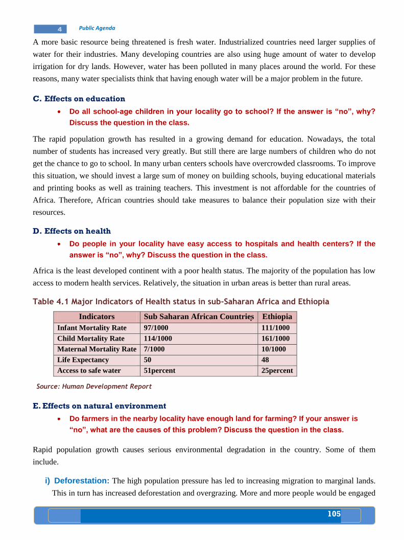
105
4 Public Agenda
A more basic resource being threatened is fresh water. Industrialized countries need larger supplies of
water for their industries. Many developing countries are also using huge amount of water to develop
irrigation for dry lands. However, water has been polluted in many places around the world. For these
reasons, many water specialists think that having enough water will be a major problem in the future.
C. Effects on education
Do all school-age children in your locality go to school? If the answer is “no”, why?
Discuss the question in the class.
The rapid population growth has resulted in a growing demand for education. Nowadays, the total
number of students has increased very greatly. But still there are large numbers of children who do not
get the chance to go to school. In many urban centers schools have overcrowded classrooms. To improve
this situation, we should invest a large sum of money on building schools, buying educational materials
and printing books as well as training teachers. This investment is not affordable for the countries of
Africa. Therefore, African countries should take measures to balance their population size with their
resources.
D. Effects on health
Do people in your locality have easy access to hospitals and health centers? If the
answer is “no”, why? Discuss the question in the class.
Africa is the least developed continent with a poor health status. The majority of the population has low
access to modern health services. Relatively, the situation in urban areas is better than rural areas.
Table 4.1 Major Indicators of Health status in sub-Saharan Africa and Ethiopia
Indicators Sub Saharan African Countries Ethiopia
Infant Mortality Rate 97/1000 111/1000
Child Mortality Rate 114/1000 161/1000
Maternal Mortality Rate 7/1000 10/1000
Life Expectancy 50 48
Access to safe water 51percent 25percent
Source: Human Development Report
E. Effects on natural environment
Do farmers in the nearby locality have enough land for farming? If your answer is
“no”, what are the causes of this problem? Discuss the question in the class.
Rapid population growth causes serious environmental degradation in the country. Some of them
include.
i) Deforestation: The high population pressure has led to increasing migration to marginal lands.
This in turn has increased deforestation and overgrazing. More and more people would be engaged
106
4 Public Agenda
in finding other sources of income such as selling firewood and charcoal to towns and cities. This
affects ecological balance and results in desertification and drought.
ii) Soil Erosion: High population pressure has led to expansion of land under cultivation, overuse
of cultivated land and the cultivation of steep slopes. This has resulted in increased soil erosion
and land degradation.
F. Effects on employment: Rapid population growth does not match with job opportunities. This in
turn makes the income of individuals very low.
Poverty
What do we call the lack of sufficient income to satisfy ones basic needs such as
food, clothing and shelter?
Today, there is a sharp difference in the stage of development among countries of the world. For
example, in sub-Saharan Africa, Latin America and parts of Asia, large number of people suffer from
absolute poverty. Under this condition, the majority of people could not satisfy their basic necessities
such as food, clothing and shelter.
In the richer countries, securing basic needs is rarely a problem. But in the poorer countries, hunger and
starvation are crucial problems.
Some of the reasons for the countries to be less developed include
Rapid population growth, which eats up resources that can be used for progress.
Lack of money to be invested in searching for and using reserves for raw materials.
Lack of money for establishing new industries.
Insufficient money to develop the infrastructure (roads, ports, railways, etc.) of a country.
Absolute Poverty is the lack of sufficient income in cash or in kind for basic
needs such as food, clothing and shelter.
107
4 Public Agenda
Activity 4.1 B
A. Questions based on facts:
Mention some of the most important needs of individuals.
How many people are estimated to die each year because of lack of good
diet?
How does rapid population growth affect education?
Give two examples of natural resource supply that are affected by rapid
population growth.
What are the reasons for countries to be less developed?
B. Things to do:
Look for references and write a short account on
Deforestation
Soil Erosion
Poverty
4.1
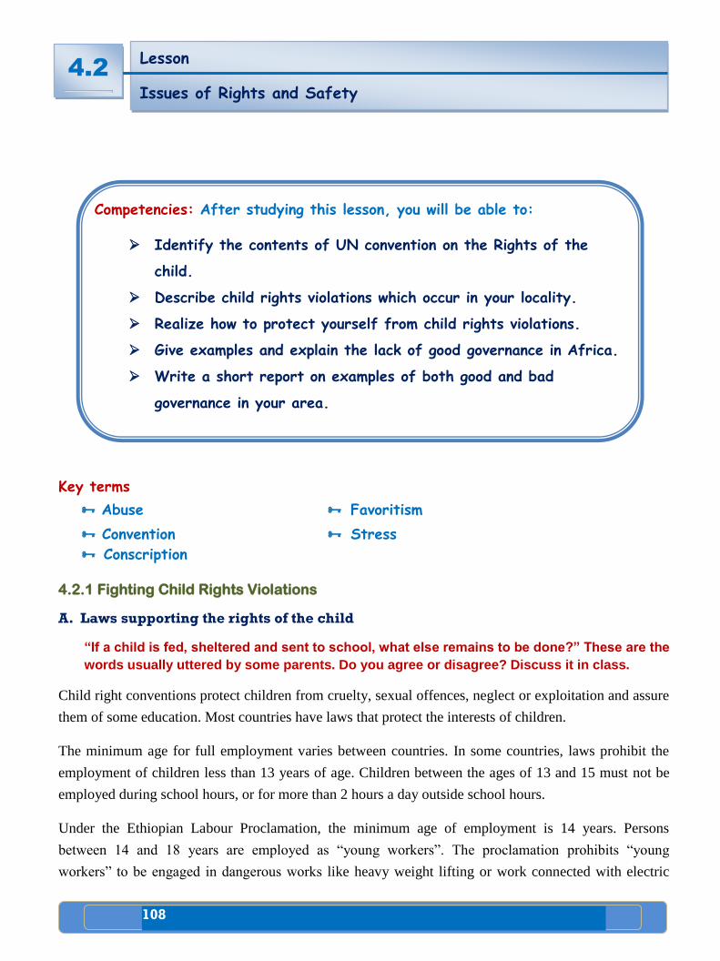
108
4 Public Agenda
Key terms
Abuse Favoritism
Convention Stress
Conscription
4.2.1 Fighting Child Rights Violations
A. Laws supporting the rights of the child
“If a child is fed, sheltered and sent to school, what else remains to be done?” These are the
words usually uttered by some parents. Do you agree or disagree? Discuss it in class.
Child right conventions protect children from cruelty, sexual offences, neglect or exploitation and assure
them of some education. Most countries have laws that protect the interests of children.
The minimum age for full employment varies between countries. In some countries, laws prohibit the
employment of children less than 13 years of age. Children between the ages of 13 and 15 must not be
employed during school hours, or for more than 2 hours a day outside school hours.
Under the Ethiopian Labour Proclamation, the minimum age of employment is 14 years. Persons
between 14 and 18 years are employed as “young workers”. The proclamation prohibits “young
workers” to be engaged in dangerous works like heavy weight lifting or work connected with electric
Lesson
Issues of Rights and Safety
LAYER OF THE EARTH
4.2
1
Competencies: After studying this lesson, you will be able to:
Identify the contents of UN convention on the Rights of the
child.
Describe child rights violations which occur in your locality.
Realize how to protect yourself from child rights violations.
Give examples and explain the lack of good governance in Africa.
Write a short report on examples of both good and bad
governance in your area.
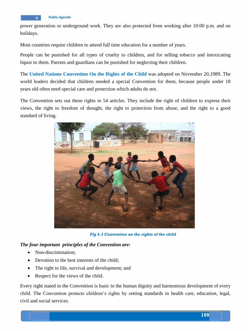
109
4 Public Agenda
power generation or underground work. They are also protected from working after 10:00 p.m. and on
holidays.
Most countries require children to attend full time education for a number of years.
People can be punished for all types of cruelty to children, and for selling tobacco and intoxicating
liquor to them. Parents and guardians can be punished for neglecting their children.
The United Nations Convention On the Rights of the Child was adopted on November 20,1989. The
world leaders decided that children needed a special Convention for them, because people under 18
years old often need special care and protection which adults do not.
The Convention sets out these rights in 54 articles. They include the right of children to express their
views, the right to freedom of thought, the right to protection from abuse, and the right to a good
standard of living.
Fig 4.3 Convention on the rights of the child
The four important principles of the Convention are:
Non-discrimination;
Devotion to the best interests of the child;
The right to life, survival and development; and
Respect for the views of the child.
Every right stated in the Convention is basic to the human dignity and harmonious development of every
child. The Convention protects children’s rights by setting standards in health care, education, legal,
civil and social services.
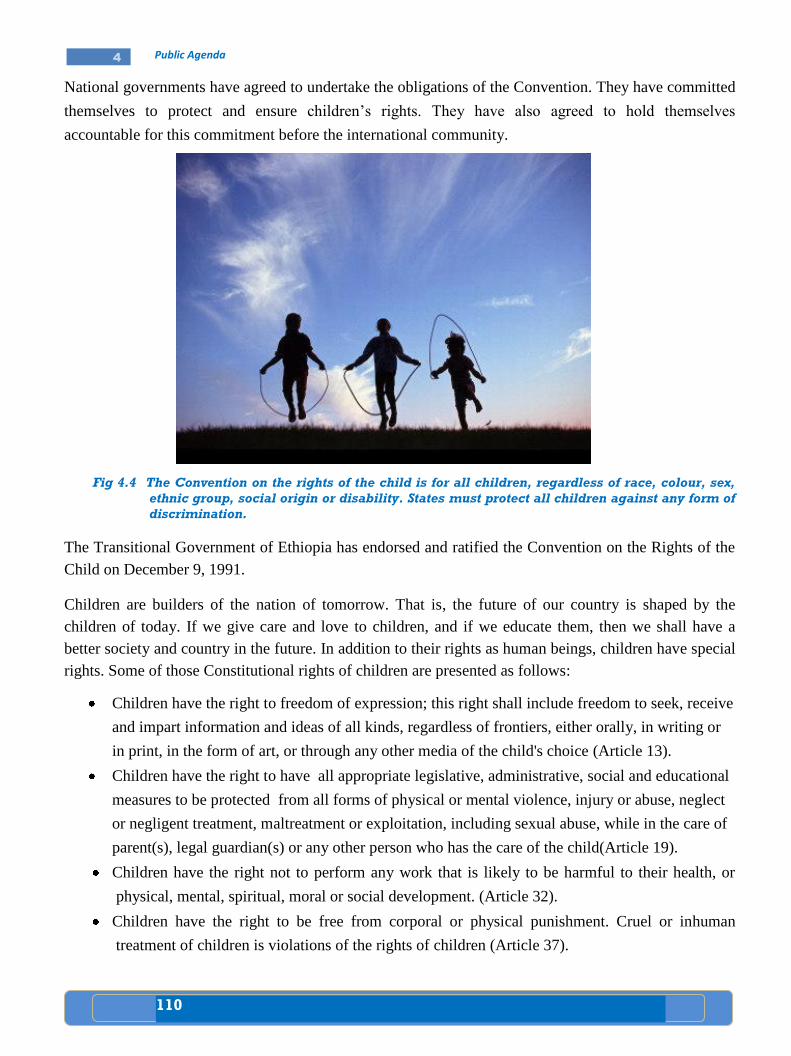
110
4 Public Agenda
National governments have agreed to undertake the obligations of the Convention. They have committed
themselves to protect and ensure children’s rights. They have also agreed to hold themselves
accountable for this commitment before the international community.
Fig 4.4 The Convention on the rights of the child is for all children, regardless of race, colour, sex,
ethnic group, social origin or disability. States must protect all children against any form of
discrimination.
The Transitional Government of Ethiopia has endorsed and ratified the Convention on the Rights of the
Child on December 9, 1991.
Children are builders of the nation of tomorrow. That is, the future of our country is shaped by the
children of today. If we give care and love to children, and if we educate them, then we shall have a
better society and country in the future. In addition to their rights as human beings, children have special
rights. Some of those Constitutional rights of children are presented as follows:
Children have the right to freedom of expression; this right shall include freedom to seek, receive
and impart information and ideas of all kinds, regardless of frontiers, either orally, in writing or
in print, in the form of art, or through any other media of the child's choice (Article 13).
Children have the right to have all appropriate legislative, administrative, social and educational
measures to be protected from all forms of physical or mental violence, injury or abuse, neglect
or negligent treatment, maltreatment or exploitation, including sexual abuse, while in the care of
parent(s), legal guardian(s) or any other person who has the care of the child(Article 19).
Children have the right not to perform any work that is likely to be harmful to their health, or
physical, mental, spiritual, moral or social development. (Article 32).
Children have the right to be free from corporal or physical punishment. Cruel or inhuman
treatment of children is violations of the rights of children (Article 37).
111
4 Public Agenda
Child abuse is a term that generally refers to mistreatment of a child by a parent or another adult. There
is no standard definition of child abuse, however. A narrow definition includes physical violence, like
severe beatings, burns, and strangulation. A broader definition includes neglect, sexual or emotional
abuse and exploitation.
Today, many experts believe that child abuse is widespread. Some parents regard physical punishment
as a reasonable way of changing children’s behaviour. Thus, adults who hurt children sometimes only
think to correct them and do not understand how easily children can be injured.
Another cause of child abuse is stress. Parents, who are unemployed, very isolated, or under great stress
are more likely to abuse their children than parents who do not have such problems. Children who are
difficult to care for, such as premature infants and handicapped children, create more stress to parents.
Thus, such children are more likely to be abused than other children.
Escaping Mechanisms
The problem of sexual abuse has received much attention in newspapers and on television. Children are
warned not to let people, even family members, touch them in ways that make them feel uncomfortable.
Children are also instructed to tell a trusted adult if they are sexually abused. Children should be
encouraged to discuss anything that bothers them with a trustworthy adult.
People all over the world have realized that child abuse is a big problem. One solution to the growing
problem of child abuse is preventing family members from becoming so isolated or stressed. Parent
support groups and other professional services can help relieve many of the stresses that lead to abuse.
The International Society for Prevention of Child Abuse and Neglect was founded in 1977. It has
members in 32 countries and aims to prevent cruelty to children in every nation.
Child Labour is the employment of children as wage earners. It became a serious social problem during
the Industrial Revolution in Great Britain during the 1700’s. The problem spread to other countries as
they became industrialized. The problem arose when children, many below the age of 10, were
employed in factories and mines. The children were forced to work long hours under dangerous and
unhealthy conditions, and their wages were very small.
Case study
A story of a young girl
A girl at the age of 15 was raped by a group of five youngsters while she was
sleeping on a street at night. Though she made efforts to resist the situation,
she was beaten and physically hurt in addition to undergoing forced sexual
abuse. Consequently, she became ill and psychologically despaired. She said “I
wish I were dead for I could see no purpose in life”.
What do you understand from this story? Discuss.
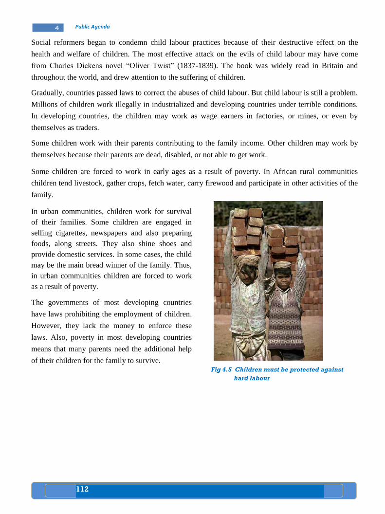
112
4 Public Agenda
Social reformers began to condemn child labour practices because of their destructive effect on the
health and welfare of children. The most effective attack on the evils of child labour may have come
from Charles Dickens novel “Oliver Twist” (1837-1839). The book was widely read in Britain and
throughout the world, and drew attention to the suffering of children.
Gradually, countries passed laws to correct the abuses of child labour. But child labour is still a problem.
Millions of children work illegally in industrialized and developing countries under terrible conditions.
In developing countries, the children may work as wage earners in factories, or mines, or even by
themselves as traders.
Some children work with their parents contributing to the family income. Other children may work by
themselves because their parents are dead, disabled, or not able to get work.
Some children are forced to work in early ages as a result of poverty. In African rural communities
children tend livestock, gather crops, fetch water, carry firewood and participate in other activities of the
family.
In urban communities, children work for survival
of their families. Some children are engaged in
selling cigarettes, newspapers and also preparing
foods, along streets. They also shine shoes and
provide domestic services. In some cases, the child
may be the main bread winner of the family. Thus,
in urban communities children are forced to work
as a result of poverty.
The governments of most developing countries
have laws prohibiting the employment of children.
However, they lack the money to enforce these
laws. Also, poverty in most developing countries
means that many parents need the additional help
of their children for the family to survive.
Fig 4.5 Children must be protected against
hard labour
113
4 Public Agenda
Activity 4.2 A
A. Questions based on facts:
Why did the world leaders decide to have a Convention on the Rights of
Children?
When was the Convention on the Rights of Children adopted?
How many articles does the Convention have?
Explain the four important principles of the Convention.
When did the Transitional Government of Ethiopia endorse the Convention?
Describe Child Abuse.
Explain Child Labour in Africa.
B. Things to do:
Look for some children in your locality who are forced to work in early ages as
a result of poverty and write a short account about them.
4.2.2 Example of the Lack of Good Governance in Africa
What does lack of good governance mean? Forward your ideas and discuss it in the class.
Good governance is a type of governance where sovereign power is in the hands of the people. In this
kind of democratic government, authorities would respect the people. The power of such a democratic
government is limited by law. A democratic government with limited power is accountable and
transparent to the people.
i) Accountability: means that the representatives of the people should make decisions that reflect the
interests of the people. The representatives are also responsible to the people. Finally, the
representatives are responsible to their actions individually or collectively. If the officials perform
unjust acts, they know they will take responsibilities for those acts.
ii) Transparency: refers to the idea that the actions and decisions of the government and its officials
should be clearly known to the people. The people must know the important decisions of their
government and why they are made. People and the media must be allowed to get information about
the activities of the government.
On the other hand, if there is no limitation upon the power of the government, that government is
unlimited government. Governments with unlimited power are not democratic governments. They lack
good governance. Unlimited governments do not recognize nor respect human rights.
In unlimited governments, power is concentrated in the hands of one person or a small group of officials.
People who live under unlimited government do not have an effective way to limit the power of their
rulers. There is no effective control over the power of the rulers.
4.2
114
4 Public Agenda
Ethiopia has been ruled for a long period of time by governments with unlimited power. From the 1930's
up to the 1970's, Ethiopia had been ruled by absolute monarchy. Absolute monarchy is a form of
government where the power of the king is not limited by law. In absolute monarchy, one person (the
king) is the sovereign. There is no rule of law but rule of men. Power is unlimited and at the same time
concentrated in one man, that is, the monarch or the king. In absolute monarchy, the king was
supreme law maker;
chief administrator;
supreme law giver and judge; and
the commander-in-chief of the national army.
This tells you that power was concentrated in one man-the king. There was no division of power in the
state. In absolute monarchy, popular participation was absent. Human rights, were not recognized and
respected. People were required to obey the king without any opposition, even if the king was bad.
Whatever the king performed was considered to be correct.
Ask your teacher
how and when the Derg came to power,
what the red terror is and how it happened.
From the mid-1970's to the early 1990's, Ethiopia had also been ruled by the military government called
the Derg. The Derg ruled Ethiopia with an iron fist. It was a rule by terror and violence. The power of
Derg government was unlimited. There was no division of power. Power was concentrated in the hand
of few political leaders. Under the Derg government, Ethiopia was a totalitarian state. Under
totalitarianism, there was total subordination of all possible oppositions. This was against the basic rights
and freedoms of citizens. Citizens lacked good governance, and also peaceful and stable life.
In addition, absence of rule of law or lack of good governance means unlimited government power. And
unlimited power puts the rights and freedoms of citizens in danger.
In addition, absence of rule of law or lack of good governance results in the prevalence of corruption and
civil war.
A. Corruption
Have you heard of any examples of corruption on the news? Suggest one example and
discuss on it.
i. Corruption is the misuse of public power for private gain. It is a dishonest behavior. Since
corruption is a serious problem in the world, all countries are fighting it. Corruption is an obstacle to
the development efforts of a nation. Corrupt officials act dishonestly or illegally in return for money
or personal gains.
ii. Forms of corruption
There are many forms of corruption. But the following are the most common forms of corruption.
a. Seeking or receiving bribe;
b. Delaying decisions, cases,…..;and
c. Favouritism
115
4 Public Agenda
a. Seeking or receiving bribe
Corruption can take the form of receiving bribe from individuals, groups or business organizations. In a
corrupt society, government officials at all levels may seek and receive bribe from individuals groups or
business organizations who want to have cases to be seen or decided. These officials pass inappropriate
decisions having received the bribe. They inappropriately collect money. Bribe, while enriching the
officials, impoverishes citizens as well as the country at large. Bribe is costing Africa many billion
dollars a year. It increases the cost of goods by as much as 20 percent and can block investment. Senior
government officials and private sector officials have been accused of bribery in government contracts.
b. Delaying decisions, cases or actions or anything that should be done for individual
citizens, groups or organizations is another form of corruption
Government officials are assumed to be the agents of people. They should serve the people. They
should pass decisions, formulate laws and administer programmes according to the interests of the
people. But if the officials are corrupt, they will not keep the interests of the people. They will delay
people’s interests or totally ignore popular interests and demand. By lengthening bureaucratic
process, corrupt officials create serious obstacles to the day to day activities of citizens and the
government itself. Corruption erodes the confidence that the public has in the government.
Corruption is dangerous to national security and order.
c. Favouritism
Favoritism is the practice of denying people of fair and equal opportunities and advantages. If an
official gives unfair advantages to individuals who belong to his family, kinship, clan, tribe,
religion, language or locality, that official is doing corruption. We know that all human beings are
equal and should have equal opportunities and access to everything: to education, job, health care,
national resources, political position, etc. Discriminating people on the basis of sex, language,
religion, birth, status, ethnicity, colour or any other ground is corruption.
Case study
Critical thinking
Suppose that you want an ID card from your Kebele. You applied for request of ID.
But you are given an appointment every time you go to the office. Finally, you
were told that unless you pay 50 Birr to the chief administrator, you couldn’t get
the ID card.
What would you do?
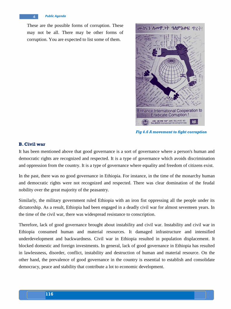
116
4 Public Agenda
These are the possible forms of corruption. These
may not be all. There may be other forms of
corruption. You are expected to list some of them.
B. Civil war
It has been mentioned above that good governance is a sort of governance where a person's human and
democratic rights are recognized and respected. It is a type of governance which avoids discrimination
and oppression from the country. It is a type of governance where equality and freedom of citizens exist.
In the past, there was no good governance in Ethiopia. For instance, in the time of the monarchy human
and democratic rights were not recognized and respected. There was clear domination of the feudal
nobility over the great majority of the peasantry.
Similarly, the military government ruled Ethiopia with an iron fist oppressing all the people under its
dictatorship. As a result, Ethiopia had been engaged in a deadly civil war for almost seventeen years. In
the time of the civil war, there was widespread resistance to conscription.
Therefore, lack of good governance brought about instability and civil war. Instability and civil war in
Ethiopia consumed human and material resources. It damaged infrastructure and intensified
underdevelopment and backwardness. Civil war in Ethiopia resulted in population displacement. It
blocked domestic and foreign investments. In general, lack of good governance in Ethiopia has resulted
in lawlessness, disorder, conflict, instability and destruction of human and material resource. On the
other hand, the prevalence of good governance in the country is essential to establish and consolidate
democracy, peace and stability that contribute a lot to economic development.
Fig 4.6 A movement to fight corruption
117
4 Public Agenda
Activity 4.2 B
A. Questions based on facts:
What are the important characteristics of good governance?
What would happen where there is no good governance?
Explain what transparency means.
Describe accountability.
Describe an unlimited power of the government.
C. Things to do:
Look for references and write a short account on the similarities and
differences between the absolute monarchy and the Derg regime.
Write down all you know about the cause and effect of a civil war and present
it in the class for discussion.
4.2
118
4 Public Agenda
Key terms
Co-operation Initiative Integration
Council Partnership
Major Regional Organizations
What is the first thing that comes to your mind when you hear or read the words “COMESA,
ECOWAS, SADC, Nile Basin Initiative, AU and OAU?”
1. COMESA
What is COMESA? What do you understand by a common market?
What do you think the main focus of COMESA is?
The history of the Common Market for Eastern and Southern
Africa (COMESA) began in December 1994. It was formed to
replace the former Preferential Trade Area (PTA) which had
existed from the earlier days of 1981. The headquarter is in
Lusaka, Zambia. COMESA was established "as an organization
of free independent sovereign states who have agreed to co-
operate in developing their natural and human resources for the
good of all their people". It has a wide–ranging series of
objectives. It includes the promotion of peace and security in the
region.
Lesson
Programmes for Partnership
4.3
Competencies: After studying this lesson, you will be able to:
Name African regional organizations.
Identify member states of African regional organizations.
Realize the partnership targets of African regional
organizations.
Discuss the formation of OAU and its transformation to AU.
Fig. 4.7 COMESA
119
4 Public Agenda
However, its main focus is on the formation of a large economic and trading unit. This unit is capable of
overcoming some of the barriers that are faced by individual states.
COMESA's current strategy can be summed up in the phrase "economic prosperity through regional
integration". With its 21 member states, COMESA forms a major market place for both internal and
external trading.
Member Countries
1. Angola
2. Burundi
3. Comoros
4. D.R. of Congo
5. Djibouti
6. Egypt
7. Eritrea
8. Ethiopia
9. Kenya
10. Madagascar
11. Malawi
12. Mauritius
13. Namibia
14. Rwanda
15. Seychelles
16. Sudan
17. Swaziland
18. Tanzania
19. Uganda
20. Zambia
21. Zimbabwe
COMESA Institutions
What kinds of institutions have direct relation with trade? Give examples.
Several institutions have been created to promote sub–regional co-operation and development. These
include:
The COMESA Trade and Development Bank in Nairobi, Kenya.
The COMESA Clearing Homes in Harare, Zimbabwe.
The COMESA Association of Commercial Banks in Harare, Zimbabwe.
The COMESA Leather Institute in Ethiopia.
The COMESA Re- Insurance Company in Nairobi, Kenya.
In addition, a Court of Justice was also established under COMESA Treaty and became formally
operational in 1998. Ethiopia had a great role in the establishment of first PTA and then COMESA since
the1960’s.
Partnership target for COMESA
COMESA offers its members and partners a wide range of benefits. These include:
A wider, harmonized and more competitive market.
Greater industrial productivity and competitiveness.
Increased agricultural production and food security.
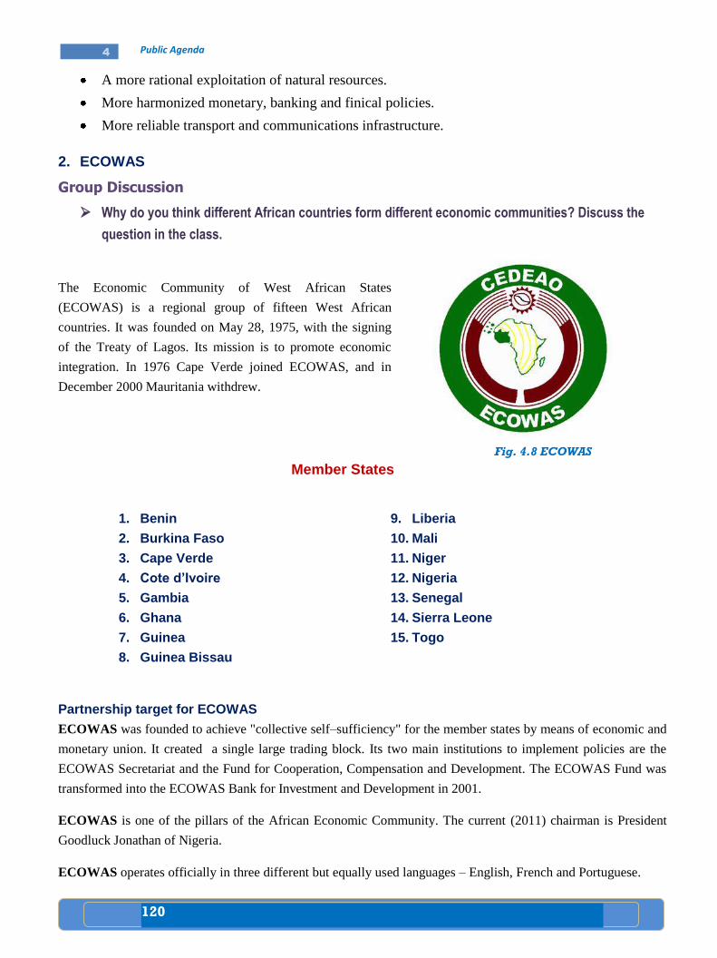
120
4 Public Agenda
A more rational exploitation of natural resources.
More harmonized monetary, banking and finical policies.
More reliable transport and communications infrastructure.
2. ECOWAS
Group Discussion
Why do you think different African countries form different economic communities? Discuss the
question in the class.
The Economic Community of West African States
(ECOWAS) is a regional group of fifteen West African
countries. It was founded on May 28, 1975, with the signing
of the Treaty of Lagos. Its mission is to promote economic
integration. In 1976 Cape Verde joined ECOWAS, and in
December 2000 Mauritania withdrew.
Member States
1. Benin
2. Burkina Faso
3. Cape Verde
4. Cote d’Ivoire
5. Gambia
6. Ghana
7. Guinea
8. Guinea Bissau
9. Liberia
10. Mali
11. Niger
12. Nigeria
13. Senegal
14. Sierra Leone
15. Togo
Partnership target for ECOWAS
ECOWAS was founded to achieve "collective self–sufficiency" for the member states by means of economic and
monetary union. It created a single large trading block. Its two main institutions to implement policies are the
ECOWAS Secretariat and the Fund for Cooperation, Compensation and Development. The ECOWAS Fund was
transformed into the ECOWAS Bank for Investment and Development in 2001.
ECOWAS is one of the pillars of the African Economic Community. The current (2011) chairman is President
Goodluck Jonathan of Nigeria.
ECOWAS operates officially in three different but equally used languages – English, French and Portuguese.
Fig. 4.8 ECOWAS
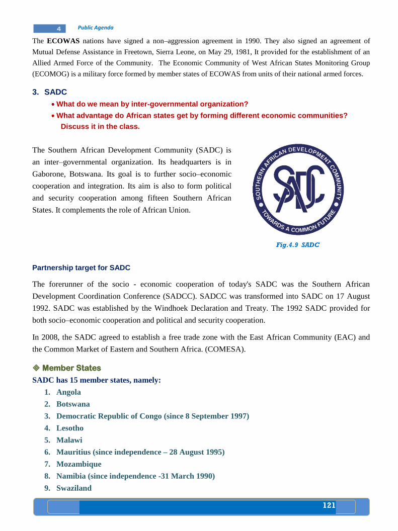
121
4 Public Agenda
The ECOWAS nations have signed a non–aggression agreement in 1990. They also signed an agreement of
Mutual Defense Assistance in Freetown, Sierra Leone, on May 29, 1981, It provided for the establishment of an
Allied Armed Force of the Community. The Economic Community of West African States Monitoring Group
(ECOMOG) is a military force formed by member states of ECOWAS from units of their national armed forces.
3. SADC
What do we mean by inter-governmental organization?
What advantage do African states get by forming different economic communities?
Discuss it in the class.
The Southern African Development Community (SADC) is
an inter–governmental organization. Its headquarters is in
Gaborone, Botswana. Its goal is to further socio–economic
cooperation and integration. Its aim is also to form political
and security cooperation among fifteen Southern African
States. It complements the role of African Union.
Fig.4.9 SADC
Partnership target for SADC
The forerunner of the socio - economic cooperation of today's SADC was the Southern African
Development Coordination Conference (SADCC). SADCC was transformed into SADC on 17 August
1992. SADC was established by the Windhoek Declaration and Treaty. The 1992 SADC provided for
both socio–economic cooperation and political and security cooperation.
In 2008, the SADC agreed to establish a free trade zone with the East African Community (EAC) and
the Common Market of Eastern and Southern Africa. (COMESA).
Member States
SADC has 15 member states, namely:
1. Angola
2. Botswana
3. Democratic Republic of Congo (since 8 September 1997)
4. Lesotho
5. Malawi
6. Mauritius (since independence – 28 August 1995)
7. Mozambique
8. Namibia (since independence -31 March 1990)
9. Swaziland

122
4 Public Agenda
10. Tanzania
11. Zambia
12. Zimbabwe
13. South Africa (since 30 August 1994)
14. Seychelles (1st from 8 September 1997 until July 2004 and then joined again in 2008)
15. Madagascar was suspended after the coup d’etat led by the former mayor of Antananarivo
(Capital of Madagascar) Andry Rajoelina.
4. Nile Basin Initiative
Discuss the following questions
Which countries use most of the waters of the Abay, Tekeze, Baro and Akobo rivers?
Why?
Do you think that Ethiopia has the right to use as much water as possible from its
international rivers? why?
The Nile River is known as the “Life blood” of Egypt, discuss.
The Nile Basin Initiative (NBI) is a partnership among the Nile
riparian (of a river) states. The NBI began with a dialogue among
the riparian states. It was formally launched in February 1999 by
the water ministers of ten countries that share the river. These
are: Egypt, Sudan, Ethiopia, Uganda, Kenya, Tanzania, Burundi,
Rwanda, Democratic Republic of Congo and Eritrea. Eritrea
which shares only a very small portion of the Nile Basin, is not
participating actively in the Initiative.
Fig.4.10 Nile Basin Initiative
Partnership target for Nile Basin Initiative
The Nile Basin Initiative (NBI) riparian states want to develop the river in a cooperative manner, share
socio–economic benefits and promote regional peace and security.
From its beginning the NBI has been supported by the World Bank and by other external partners.
The following projects are developing under the Nile Basin Initiative since early 2008.
a) The regional Watershed Management Project aims to establish continuous management of
watersheds on the Tekeze, Atbara, Mareb, Abbay (Blue Nile) and Baro (Akobo/Sobat) rivers in
Ethiopia and Sudan.
b) The Ethiopian Power Export Project will connect the power lines of Ethiopia and Sudan. It aims
to overcome the electricity shortage in both countries.
c) The Regional Irrigation and Drainage project aims to develop and expand irrigated agriculture
and improve the productivity of agriculture through efficient use of water.
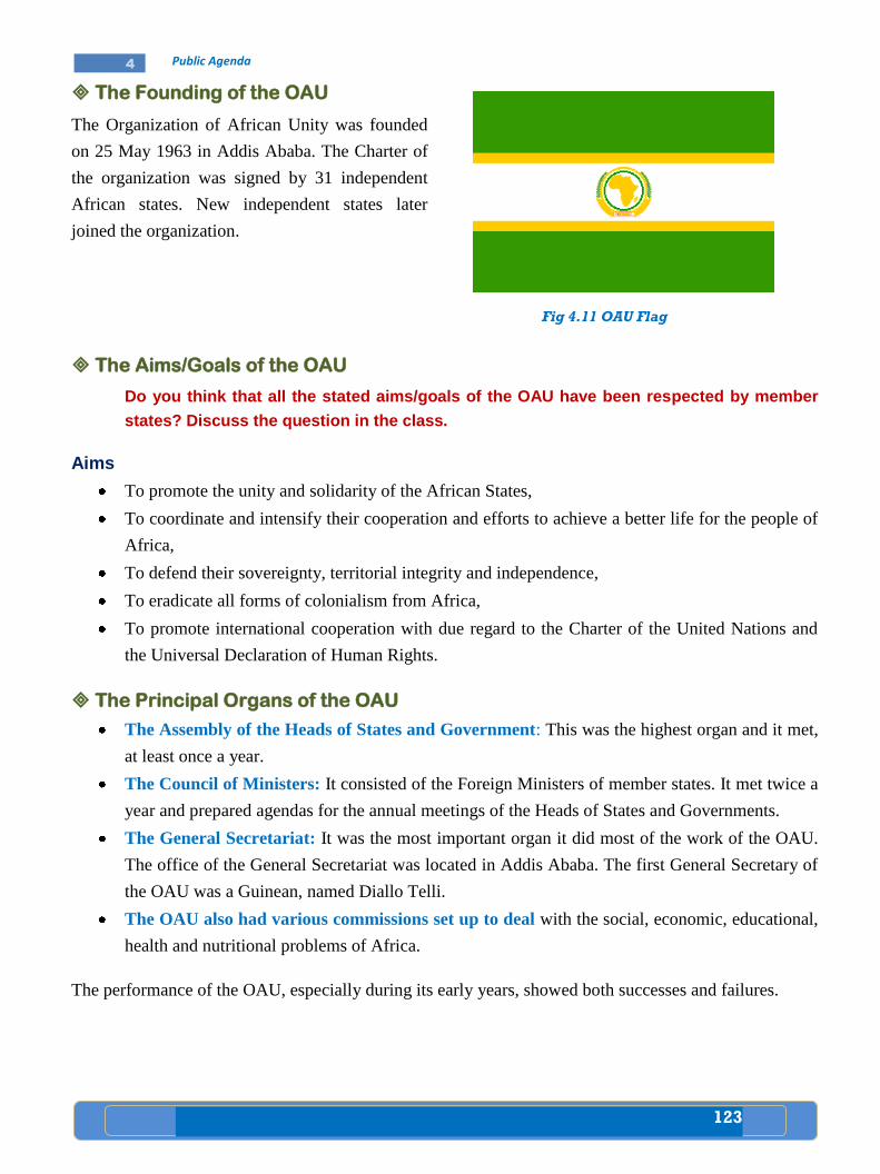
123
4 Public Agenda
The Founding of the OAU
The Organization of African Unity was founded
on 25 May 1963 in Addis Ababa. The Charter of
the organization was signed by 31 independent
African states. New independent states later
joined the organization.
Fig 4.11 OAU Flag
The Aims/Goals of the OAU
Do you think that all the stated aims/goals of the OAU have been respected by member
states? Discuss the question in the class.
Aims
To promote the unity and solidarity of the African States,
To coordinate and intensify their cooperation and efforts to achieve a better life for the people of
Africa,
To defend their sovereignty, territorial integrity and independence,
To eradicate all forms of colonialism from Africa,
To promote international cooperation with due regard to the Charter of the United Nations and
the Universal Declaration of Human Rights.
The Principal Organs of the OAU
The Assembly of the Heads of States and Government: This was the highest organ and it met,
at least once a year.
The Council of Ministers: It consisted of the Foreign Ministers of member states. It met twice a
year and prepared agendas for the annual meetings of the Heads of States and Governments.
The General Secretariat: It was the most important organ it did most of the work of the OAU.
The office of the General Secretariat was located in Addis Ababa. The first General Secretary of
the OAU was a Guinean, named Diallo Telli.
The OAU also had various commissions set up to deal with the social, economic, educational,
health and nutritional problems of Africa.
The performance of the OAU, especially during its early years, showed both successes and failures.
124
4 Public Agenda
Successes of the OAU
What were some of the political and socio-economic achievements of African states?
Discuss the question in the class.
Through its Committee for Liberation, the OAU assisted the liberation movement of non
independent nations. At present, all of Africa is independent from colonialism.
At the United Nations, African states often took a united stand on several issues.
It had attempted to make peace in several conflicts; for example, between Somalia and Ethiopia,
Morocco and Nigeria, Rwanda and the Great Lakes and in the struggle against Apartheid in
South Africa, it gained some successes.
One of its basic aims was to bring about cooperation among states for economic development. So
consequently, regional organizations have been set up: for example, ECOWAS, COMESA,
IGAD.
Failures of the OAU
What were some of the major problems of African states?
How did they try to overcome these problems?
Discuss the questions in the class.
The OAU had failed to achieve some of its goals like becoming self-sufficient in food production, establishing an
African monetary fund, etc. Africa has continued to depend on the developed countries in terms of finance as well
as food. The OAU was unable to end civil wars in Ethiopia (1970s- 1990s), Chad, Nigeria, Angola and Sudan. It
was even unable to stop wars between member states like Ethiopia and Somalia in 1977-78, and Uganda and
Tanzania in 1978-79. The OAU had also failed to solve the refugee problems. The problems had continued to
grow due to civil wars and other political reasons.
Factors responsible for failures of the OAU include:
Differences of opinion among member states.
Differences of attitude towards the ex- colonial powers and the structure of the OAU.
Differences in language: English, French, Portuguese, Spanish and Arabic are mainly spoken by
the peoples of the continent.
Many states are members of other non–African organizations. In North Africa many states
belong to the Arab League.
Independence was followed by ethnic and border conflicts, one party rule, military coup d'etats
and foreign interference in Africa. The overall effects of these were political instability and
economic and social backwardness.
Thus, the OAU has failed to solve these outstanding problems.
To overcome all these problems and to speed up African political and economic integration, the African
Union (AU) was established in 2002.
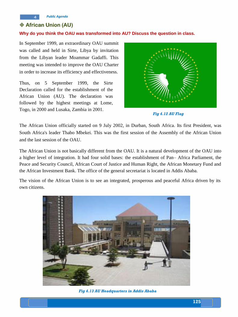
125
4 Public Agenda
African Union (AU)
Why do you think the OAU was transformed into AU? Discuss the question in class.
In September 1999, an extraordinary OAU summit
was called and held in Sirte, Libya by invitation
from the Libyan leader Moammar Gadaffi. This
meeting was intended to improve the OAU Charter
in order to increase its efficiency and effectiveness.
Thus, on 5 September 1999, the Sirte
Declaration called for the establishment of the
African Union (AU). The declaration was
followed by the highest meetings at Lome,
Togo, in 2000 and Lusaka, Zambia in 2001.
The African Union officially started on 9 July 2002, in Durban, South Africa. Its first President, was
South Africa's leader Thabo Mbekei. This was the first session of the Assembly of the African Union
and the last session of the OAU.
The African Union is not basically different from the OAU. It is a natural development of the OAU into
a higher level of integration. It had four solid bases: the establishment of Pan– Africa Parliament, the
Peace and Security Council, African Court of Justice and Human Right, the African Monetary Fund and
the African Investment Bank. The office of the general secretariat is located in Addis Ababa.
The vision of the African Union is to see an integrated, prosperous and peaceful Africa driven by its
own citizens.
Fig 4.12 AU Flag
Fig 4.13 AU Headquarters in Addis Ababa
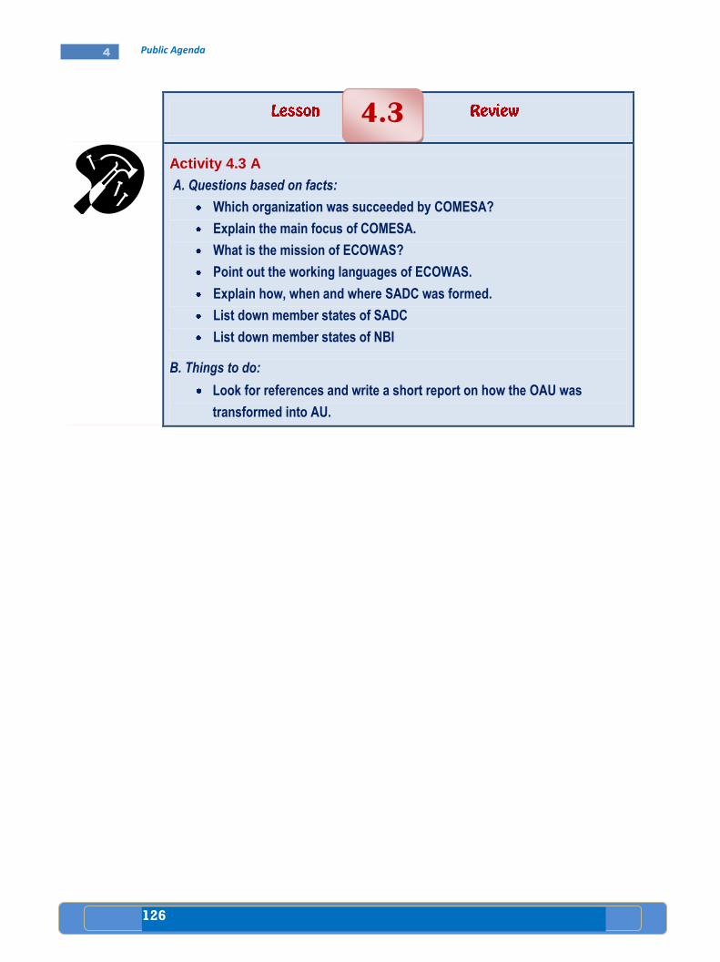
126
4 Public Agenda
Activity 4.3 A
A. Questions based on facts:
Which organization was succeeded by COMESA?
Explain the main focus of COMESA.
What is the mission of ECOWAS?
Point out the working languages of ECOWAS.
Explain how, when and where SADC was formed.
List down member states of SADC
List down member states of NBI
B. Things to do:
Look for references and write a short report on how the OAU was
transformed into AU.
4.3
127
4 Public Agenda
The first lesson which you have learned in this unit is about the prevalence and
impact of HIV/AIDS. HIV/AIDS is a global threat. Its distribution and impact is
higher in Africa especially is Sub-Saharan Africa, than anywhere else. It has
social, economic, demographic and political impacts. It has no curative
medicine but only preventive methods. Hence, everyone has great
responsibility to save the human race from destruction by taking care of
oneself and one’s own family as well as fellow citizens.
When population increases rapidly, the demand for food supply, health,
educational facilities and job opportunities increases. The rapid population
growth has resulted in greater food shortage, in a growing demand for
education, low access to modern health services and serious environmental
degradation such as deforestation and soil erosion.
Child rights violations include cruelty, sexual offences, neglect and
exploitations. However, children’s laws protect children from such violations.
People can be punished for all types of cruelty to children. Parents and
guardians can also be punished for neglecting their children. The United
Nations Convention on the Rights of the Child was adopted to protect the right
of children to express their views, the right to freedom of thought, the right to
protection from abuse and the right to a good standard of living.
Lack of good governance is a type of governance where the sovereign power is
in the hands of dictators. In this kind of government, authorities would not
respect and adhere to the people and exercise just full acts. Besides, in this
kind of government there would be no accountability and transparency.
The major African regional organizations include COMESA, ECOWAS, SADC
and NBI. Each of these regional organizations has its own individual aims and
purposes. The main focus is on the formation of a large economic development
unit. This unit is capable of overcoming the major problems of the sub-region.
The founding of the OAU goes back to May 25, 1963, at Addis Ababa. The
Charter of the OAU was signed by 31 independent African states. The OAU had
four major organs. The aims of the OAU included, promoting the unity of the
states, coordinating their cooperation, defending their sovereignty, eradicating
colonialism and promoting international cooperation. The OAU initiatives
paved the way for the birth of African Union (AU). In order to quicken the
process of economic and political integration in the continent, AU was officially
declared at the conference held in Durban, South Africa in 2002.
Summary
128
4 Public Agenda
Glossary
Abuse: make a bad or wrong use of something.
Conscription: compelling by law to serve in the armed forces.
Convention: agreement between states, rulers, etc.
Cooperation: working or acting together for a common purpose.
Council: group of persons appointed, elected, or chosen to give advice, make rules and carry out.
Degradation: falling to a lower position.
Discrimination: making a difference between persons.
Epidemic (disease): wide spread among many people in the same place for a time.
Favoritism: practice of favoring persons unequally.
Headquarters: place from which operations are controlled.
Impact: striking with force.
Initiative: first or introductory step or more.
Integration: combining into a whole.
Mortality: state of being mortal (which must die).
Partnership: taking part with another or others in some activity, plan, manage affairs etc.
Prevalence: common, seen or done every where.
Resources: wealth supplies of goods, raw materials, etc.
Stress: pressure condition sensing hardship, etc.
129
4 Public Agenda
I. True or false
Directions: Write “True” if the statement is correct and „‟False‟‟ if the statement is incorrect in the space
provided infront of each statement.
_______ 1. In Ethiopia, the majority of the HIV/AIDS victims are between 15 and 49 years old.
_______ 2. In Africa, access to modern health services in urban areas is better than rural areas.
_______ 3. Children have the right only to be free from corporal punishment.
_______ 4. Using public property for one’s own personal interest is not corruption.
_______ 5. The OAU is a natural development of the AU into a higher level of integration.
II. Matching
Direction: The terms under column "B" are described by the statements under column "A". On your
paper, write the letter of the correct term next to the number of the statement it matches;
Column “A” Column “B”
_______ 1. HIV/AIDS a) Population policy
_______ 2. Poverty b) The later COMESA
_______ 3. Non-discrimination c) Good Governance
_______ 4. Accountability d) Curable
_______ 5. PTA e) Principle of the Child Rights Convention
f) Lack of basic needs
g) Barrier to development
h) Child right violation
i) ECOWAS
j) SADC
III. Multiple choice
Direction: Answer the following questions by choosing the best possible answer from the given four
alternatives.
_______ 1. Ethiopia is one of the founding members of
a) ECOWAS c) OAU/AU
b) World Trade Organization d) Arab League
_______2. Which of the following institutions was established by COMESA in Ethiopia?
a) Leather Institution c) Trade and Development Bank
b) Clearing House d) Court of Justice
Review Questions
UNIT
4
130
4 Public Agenda
_______ 3. The first Secretary General of the OAU was
a) Haile Sellassie c) Diallo Telli
b) Kwame Nkrumah d) Koffi Anan
_______ 4. Which of the following is a major problem for African States?
a) Drought c) HIV/AIDS
b) Famine d) All
_______ 5. HIV/AIDS attacks mainly the adult population aged in Africa.
a) 15-49 years c) 18-49 years
b) 25-50 years d) 30-60 years
I. Fill in the blank space with the correct word or phrase
1. In 1976, joined ECOWAS, and in December 2000
withdrew.
2. A partnership among the Nile riparian states is known as __________:
3. On 5 September 1999, the called for the establishment of African Union (AU).
4. The was founded on 25 May 1963 in Addis Ababa.
5. In West Africa is among the 15 most HIV affected countries in the world.
II. Give short answers to the following questions.
1. Explain some forms of corruption.
2. How should children try to protect themselves from child right violations?
3. How was the OAU transformed into AU?
4. What is the impact of rapid population growth on food supply and natural resources?
5. Explain the impact of HIV/ AIDS on African children.
131
4 Public Agenda
Check List
Put a tick () mark in each of the boxes for activities you can
perform
I can
1. Analyze the prevalence and impact of HIV/AIDS in
Africa.
2. Explain the main consequences of rapid
population growth.
3. Write a short report on impact of rapid
population growth.
4. Identify the contents of UN Convention on the
Rights of the Child.
5. Describe child rights violations that occur in
my locality.
6. Protect myself from child rights violations.
7. Discuss the lack of good governance in Africa.
8. Write a short report on examples of both good and
bad governance in my area.
9. Name the major regional organizations in
Africa.
10. Identify member states of major regional
organizations of Africa.
11. Realize the partnership targets of major
regional organizations of Africa.
12. Outline the formation of the OAU and its
transformation to AU.
Related Documents