GPS constraints on continental deformation in the Africa-Arabia- Eurasia continental collision zone and implications for the dynamics of plate interactions Robert Reilinger, 1 Simon McClusky, 1 Philippe Vernant, 1 Shawn Lawrence, 1,2 Semih Ergintav, 3 Rahsan Cakmak, 3 Haluk Ozener, 4 Fakhraddin Kadirov, 5 Ibrahim Guliev, 5 Ruben Stepanyan, 6 Merab Nadariya, 7 Galaktion Hahubia, 7 Salah Mahmoud, 8 K. Sakr, 8 Abdullah ArRajehi, 9 Demitris Paradissis, 10 A. Al-Aydrus, 11 Mikhail Prilepin, 12 Tamara Guseva, 12 Emre Evren, 13,14 Andriy Dmitrotsa, 15 S. V. Filikov, 15 Francisco Gomez, 16 Riad Al-Ghazzi, 17 and Gebran Karam 18 Received 15 September 2005; revised 13 January 2006; accepted 31 January 2006; published 31 May 2006. [1] The GPS-derived velocity field (1988–2005) for the zone of interaction of the Arabian, African (Nubian, Somalian), and Eurasian plates indicates counterclockwise rotation of a broad area of the Earth’s surface including the Arabian plate, adjacent parts of the Zagros and central Iran, Turkey, and the Aegean/Peloponnesus relative to Eurasia at rates in the range of 20–30 mm/yr. This relatively rapid motion occurs within the framework of the slow-moving (5 mm/yr relative motions) Eurasian, Nubian, and Somalian plates. The circulatory pattern of motion increases in rate toward the Hellenic trench system. We develop an elastic block model to constrain present-day plate motions (relative Euler vectors), regional deformation within the interplate zone, and slip rates for major faults. Substantial areas of continental lithosphere within the region of plate interaction show coherent motion with internal deformations below 1–2 mm/yr, including central and eastern Anatolia (Turkey), the southwestern Aegean/Peloponnesus, the Lesser Caucasus, and Central Iran. Geodetic slip rates for major block-bounding structures are mostly comparable to geologic rates estimated for the most recent geological period (3–5 Myr). We find that the convergence of Arabia with Eurasia is accommodated in large part by lateral transport within the interior part of the collision zone and lithospheric shortening along the Caucasus and Zagros mountain belts around the periphery of the collision zone. In addition, we find that the principal boundary between the westerly moving Anatolian plate and Arabia (East Anatolian fault) is presently characterized by pure left-lateral strike slip with no fault-normal convergence. This implies that ‘‘extrusion’’ is not presently inducing westward motion of Anatolia. On the basis of the observed kinematics, we hypothesize that deformation in the Africa- Arabia-Eurasia collision zone is driven in large part by rollback of the subducting African lithosphere beneath the Hellenic and Cyprus trenches aided by slab pull on the southeastern side of the subducting Arabian plate along the Makran subduction zone. We JOURNAL OF GEOPHYSICAL RESEARCH, VOL. 111, B05411, doi:10.1029/2005JB004051, 2006 1 Department of Earth, Atmospheric, and Planetary Sciences, Massa- chusetts Institute of Technology, Cambridge, Massachusetts, USA. 2 Now at University Navstar Consortium (UNAVCO), Boulder, Color- ado, USA. 3 Turkish National Science Foundation, Marmara Research Center, Earth and Marine Sciences Research Institute, Gebze, Turkey. 4 Kandilli Observatory and Earthquake Research Institute, Bogazici University, Istanbul, Turkey. 5 Geology Institute, National Academy of Sciences, Baku, Azerbaijan. 6 National Survey for Seismic Protection, Yerevan, Armenia. 7 Joint Stock Company ‘‘Airgeodetic’’, Tbilisi, Georgia. 8 National Research Institute of Astronomy and Geophysics, Helwan, Cairo, Egypt. 9 King Abdulaziz City for Science and Technology, Riyadh, Kingdom of Saudi Arabia. Copyright 2006 by the American Geophysical Union. 0148-0227/06/2005JB004051$09.00 B05411 10 Higher Geodesy Laboratory, National Technical University, Athens, Greece. 11 Faculty of Science, Sana’a University, Yemen. 12 Universal Institute of Physics of the Earth, Moscow, Russia. 13 Eurasian Institute of Earth Sciences, Istanbul Technical University, Istanbul, Turkey. 14 Now at Geophysics Research Group, University of Ulster, Coleraine, County Derry, Northern Ireland. 15 Crimea Radio Astronomical Observatory, Simiez, Crimea, Ukraine. 16 Department of Geological Sciences, University of Missouri – Colum- bia, Columbia, Missouri, USA. 17 Higher Institute of Applied Science and Technology, Damascus, Syria. 18 Department of Civil Engineering, Lebanese American University, Jbeil, Lebanon. 1 of 26

Welcome message from author
This document is posted to help you gain knowledge. Please leave a comment to let me know what you think about it! Share it to your friends and learn new things together.
Transcript
GPS constraints on continental deformation in the Africa-Arabia-
Eurasia continental collision zone and implications
for the dynamics of plate interactions
Robert Reilinger,1 Simon McClusky,1 Philippe Vernant,1 Shawn Lawrence,1,2
Semih Ergintav,3 Rahsan Cakmak,3 Haluk Ozener,4 Fakhraddin Kadirov,5
Ibrahim Guliev,5 Ruben Stepanyan,6 Merab Nadariya,7 Galaktion Hahubia,7
Salah Mahmoud,8 K. Sakr,8 Abdullah ArRajehi,9 Demitris Paradissis,10 A. Al-Aydrus,11
Mikhail Prilepin,12 Tamara Guseva,12 Emre Evren,13,14 Andriy Dmitrotsa,15
S. V. Filikov,15 Francisco Gomez,16 Riad Al-Ghazzi,17 and Gebran Karam18
Received 15 September 2005; revised 13 January 2006; accepted 31 January 2006; published 31 May 2006.
[1] The GPS-derived velocity field (1988–2005) for the zone of interaction of theArabian, African (Nubian, Somalian), and Eurasian plates indicates counterclockwiserotation of a broad area of the Earth’s surface including the Arabian plate, adjacent parts ofthe Zagros and central Iran, Turkey, and the Aegean/Peloponnesus relative to Eurasia atrates in the range of 20–30 mm/yr. This relatively rapid motion occurs within theframework of the slow-moving (�5 mm/yr relative motions) Eurasian, Nubian, andSomalian plates. The circulatory pattern of motion increases in rate toward the Hellenictrench system. We develop an elastic block model to constrain present-day platemotions (relative Euler vectors), regional deformation within the interplate zone, and sliprates for major faults. Substantial areas of continental lithosphere within the region of plateinteraction show coherent motion with internal deformations below �1–2 mm/yr,including central and eastern Anatolia (Turkey), the southwestern Aegean/Peloponnesus,the Lesser Caucasus, and Central Iran. Geodetic slip rates for major block-boundingstructures are mostly comparable to geologic rates estimated for the most recent geologicalperiod (�3–5 Myr). We find that the convergence of Arabia with Eurasia isaccommodated in large part by lateral transport within the interior part of the collisionzone and lithospheric shortening along the Caucasus and Zagros mountain belts aroundthe periphery of the collision zone. In addition, we find that the principal boundarybetween the westerly moving Anatolian plate and Arabia (East Anatolian fault) ispresently characterized by pure left-lateral strike slip with no fault-normal convergence.This implies that ‘‘extrusion’’ is not presently inducing westward motion of Anatolia. Onthe basis of the observed kinematics, we hypothesize that deformation in the Africa-Arabia-Eurasia collision zone is driven in large part by rollback of the subducting Africanlithosphere beneath the Hellenic and Cyprus trenches aided by slab pull on thesoutheastern side of the subducting Arabian plate along the Makran subduction zone. We
JOURNAL OF GEOPHYSICAL RESEARCH, VOL. 111, B05411, doi:10.1029/2005JB004051, 2006
1Department of Earth, Atmospheric, and Planetary Sciences, Massa-chusetts Institute of Technology, Cambridge, Massachusetts, USA.
2Now at University Navstar Consortium (UNAVCO), Boulder, Color-ado, USA.
3Turkish National Science Foundation, Marmara Research Center, Earthand Marine Sciences Research Institute, Gebze, Turkey.
4Kandilli Observatory and Earthquake Research Institute, BogaziciUniversity, Istanbul, Turkey.
5Geology Institute, National Academy of Sciences, Baku, Azerbaijan.6National Survey for Seismic Protection, Yerevan, Armenia.7Joint Stock Company ‘‘Airgeodetic’’, Tbilisi, Georgia.8National Research Institute of Astronomy and Geophysics, Helwan,
Cairo, Egypt.9King Abdulaziz City for Science and Technology, Riyadh, Kingdom of
Saudi Arabia.
Copyright 2006 by the American Geophysical Union.0148-0227/06/2005JB004051$09.00
B05411
10Higher Geodesy Laboratory, National Technical University, Athens,Greece.
11Faculty of Science, Sana’a University, Yemen.12Universal Institute of Physics of the Earth, Moscow, Russia.13Eurasian Institute of Earth Sciences, Istanbul Technical University,
Istanbul, Turkey.14Now at Geophysics Research Group, University of Ulster, Coleraine,
County Derry, Northern Ireland.15Crimea Radio Astronomical Observatory, Simiez, Crimea, Ukraine.16Department of Geological Sciences, University of Missouri–Colum-
bia, Columbia, Missouri, USA.17Higher Institute of Applied Science and Technology, Damascus,
Syria.18Department of Civil Engineering, Lebanese American University,
Jbeil, Lebanon.
1 of 26

further suggest that the separation of Arabia from Africa is a response to plate motionsinduced by active subduction.
Citation: Reilinger, R., et al. (2006), GPS constraints on continental deformation in the Africa-Arabia-Eurasia continental collision
zone and implications for the dynamics of plate interactions, J. Geophys. Res., 111, B05411, doi:10.1029/2005JB004051.
1. Introduction
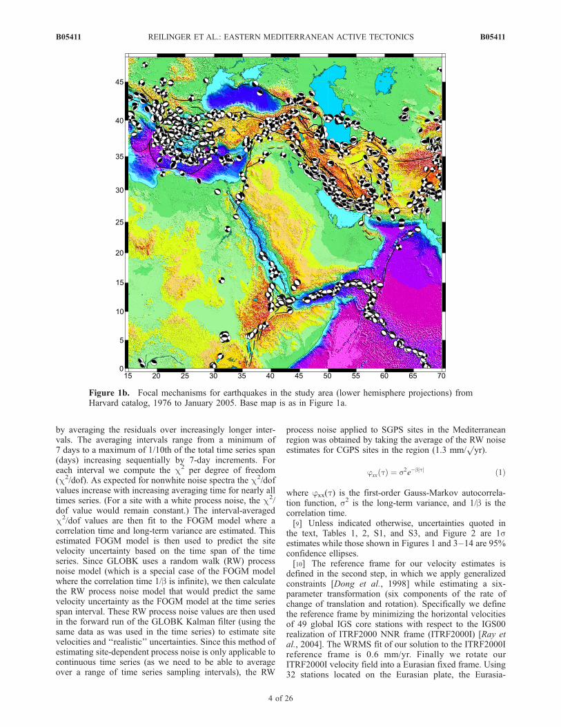
[2] The eastern Mediterranean, Asia Minor, the MiddleEast, and northeast Africa is a zone of complex tectonicsassociated with the interaction of four of the Earth’s majorlithospheric plates, Arabia, Nubia, Somalia, and Eurasia(Figures 1a and 1b). McKenzie [1970, 1972] and McKenzieet al. [1970] provided a first-order, plate tectonic descriptionof the region, recognizing active continental collision ineastern Turkey, the Caucasus, and the Zagros; lateraltransport of Anatolia (Turkey) toward the west accommo-dated by the North and East Anatolian faults; subduction ofAfrican oceanic lithosphere (i.e., Neotethys) along theHellenic and Cyprus trenches; extension in the Aegeanand western Turkey; crustal spreading along the EastAfrican Rift system; and ocean rifting along the Red Seaand Gulf of Aden. In regard to general principles thatcontrol continental deformation, McKenzie [1972] furthersuggested that large areas of continental lithosphere appearto be aseismic and not deforming at present, that platetectonic concepts provide a useful description of continentaldeformation, and that continental lithosphere tends to movelaterally out of zones of continental collision to avoidexcessive crustal thickening. Subsequent studies have addedimportant refinements to this tectonic characterization [e.g.,Jackson and McKenzie, 1984, 1988], including the partition-ing of crustal deformation in the eastern Turkey/Caucasuscontinental collision zone [Jackson, 1992], the importance ofsubduction and slab retreat along the Hellenic trench as adynamic mechanism for extension in the Aegean and westernTurkey [e.g., Le Pichon and Angelier, 1979; Sonder andEngland, 1989; Royden, 1993], and the influence of slabdetachment on regional tectonics [e.g., Spakman, 1991;Wortel and Spakman, 2000; Sengor et al., 2003].[3] Understanding the dynamics of plate motions and
interactions (i.e., the primary forces acting on the plates)and the rheology of the continental lithosphere are amongthe most fundamental questions in active tectonics [e.g.,Tapponnier et al., 2001; Thatcher, 2003; Wright et al.,2004; Conrad and Lithgow-Bertelloni, 2004]. While itwas recognized early in the development of plate tectonicsthat plate boundaries in continental areas are substantiallywider than those in the oceans [e.g., Isacks et al., 1968;Molnar and Tapponier, 1975], the underlying causes of thisdifferent behavior and the most appropriate way to describecontinental deformation (i.e., continuum vs. microplate orblock behavior) remain under debate. For the easternMediterranean this debate has centered on the interactionof the Arabian plate with Eurasia and the apparent ‘‘extru-sion’’ of Anatolia toward the west from the zone ofmost intense convergence. One school of thought [e.g.,McKenzie, 1978; England and McKenzie, 1983] considersthe continental lithosphere to be weak and models it as athin viscous sheet. They conclude that gravitational poten-tial energy associated with the thickened continental crustwithin the collision zone drives lateral motion out of the
area of maximum convergence. An alternate model [e.g.,Tapponier et al., 1982; Sengor et al., 1985; Philip et al.,1989] considers the continental lithosphere to be strong andattributes lateral motions from the zone of maximumcompression to forces acting on the edges of the plates. Inthe case of Arabia/Eurasia collision, this amounts to Ana-tolia being pushed along its SE edge by the impingingArabia plate.[4] Since the mid-1980s, the Global Positioning System
(GPS) has provided earth scientists a new opportunity toestimate directly present-day surface motions and deforma-tions [e.g., Hager et al., 1991]. In the eastern Mediterra-nean, prior GPS studies have helped quantify large-scaleplate motions [e.g., Sella et al., 2002; McClusky et al.,2003; Fernandez et al., 2003, 2004], regional deformationin the zone of plate interaction [e.g., Le Pichon et al., 1995;Reilinger et al., 1997; Davies et al., 1997; Clarke et al.,1998; McClusky et al., 2000; Kahle et al., 2000;Goldsworthy et al., 2002; Vernant et al., 2004a, 2004b;Nyst and Thatcher, 2004; Mahmoud et al., 2005], anddeformations associated with the earthquake cycle [e.g.,Hubert-Ferrari et al., 2000; Reilinger et al., 2000; Delouiset al., 2002; Hearn et al., 2002a; Ergintav et al., 2002;Meade et al., 2002]. The kinematic information provided byGPS is in turn providing new constraints on the rheologyand dynamics of the continental lithosphere [e.g., Meijerand Wortel, 1997; Lundgren et al., 1998; Wortel andSpakman, 2000; Mantovani et al., 2001; Jimenez-Muntand Sabadini, 2002; Hearn et al., 2002b; Provost et al.,2003; Flerit et al., 2004].[5] In this paper we present a new GPS-derived velocity
field including data from 1988 to 2005, updating the resultspresented by McClusky et al. [2000]. We formally incorpo-rate new, published GPS data from the Iran-French GPSProject [Vernant et al., 2004a, 2004b] and in east Africa[Bendick et al., 2005], and new observations on the Arabianplate to determine an internally consistent velocity fieldextending west-east from the Adriatic Sea to the Iran-Afghanistan border, and north-south from the Russianplatform to the East African rift. We use the extensivevelocity data to constrain an elastic block model [Meadeand Hager, 2005] developed on the basis of availablegeologic, seismic, and other geophysical data. Finally, weconsider the implications of the new velocity data andkinematic model results for the dynamics of continentaldeformation in the eastern Mediterranean, Arabia, andnortheast Africa region.
2. GPS Data and Analysis
[6] Table S1 in the auxiliary material lists details of theGPS observations and the horizontal velocity componentsderived from measurements made between 1988 and 2005.1
1Auxiliary material is available at ftp://ftp.agu.org/apend/jb/2005jb004051.
B05411 REILINGER ET AL.: EASTERN MEDITERRANEAN ACTIVE TECTONICS
2 of 26
B05411

In Figures 2 and 3 the velocities are plotted in a Eurasia-fixed reference frame (1s error ellipses are shown inFigure 2 for clarity; Figure 3 shows 95% confidenceellipses). GPS velocities are determined for 440 stations,337 measured with survey mode GPS (SGPS) and 103 arecontinuous stations (CGPS) in the study area (i.e., notincluding global stations used in the analysis). As indicatedin Table S1, velocities are determined for different timespans, although the large majority of SGPS measurementcampaigns were conducted between August and October inorder to minimize annual systematic errors.[7] We analyze the GPS data using the GAMIT/GLOBK
software [King and Bock, 2004; Herring, 2004] in a two-step approach [Dong et al., 1998]. In the first step, weuse GPS phase observations from each day to estimatestation coordinates, the zenith delay of the atmosphere ateach station, and orbital and Earth orientation parameters(EOP). In the second step we use the loosely constrainedestimates of station coordinates, orbits, and EOP and theircovariances from each day, aggregated by survey, as
quasi-observations in a Kalman filter to estimate a con-sistent set of coordinates and velocities. We provideorbital control and tie the regional measurements to anexternal global reference frame by including in theregional analysis data from 5 to 10 continuously operat-ing IGS stations for each day. The regional quasi-observations are then combined with quasi-observationsfrom an analysis of phase data from over 250 stationsperformed by the Scripps Orbital and Permanent ArrayCenter (SOPAC) at University of California, San Diego[Bock et al., 1997].[8] Before estimating velocities in the second step of our
analysis, we examine all of the position time series foroutliers and offsets or ‘‘jumps.’’ To account for correlatederrors in the time series, we calculate a unique noise modelfor each station. The algorithm used to model the data noisespectrum assumes that each time series can be adequatelymodeled using a first-order Gauss Markov (FOGM) processnoise described in equation (1) [Gelb, 1974]. The FOGMnoise model is estimated from individual stations time series
Figure 1a. Simplified topographic/bathymetric (SRTM30 PLUS; http://topex.ucsd.edu/WWW_html/srtm30_plus.html) and tectonic map of the study area, including the zone of interaction of the Nubian,Somalian, Arabian, and Eurasian plates. Abbreviations are North Anatolian fault (NAF), East Anatolianfault (EAF), Dead Sea fault (DSF), Mosha fault (MF), Pembak-Sevan-Sunik fault (PSSF), Tabriz fault(TF), Chalderan fault (CF), Gulf of Corinth (Cor), Peloponnesus (Pe), Aegean (Aeg), Lesser Caucasus(LC), Cyprus trench (Cyp), Karliova Triple junction (KT), Sinai (Sin), Caspian Sea (Cas), Main CaucasusThrust (MCT), East African rift (EAR), Kopet Dag (Kop), Apsheron Peninsula (AP), Alborz Mountains(Al).
B05411 REILINGER ET AL.: EASTERN MEDITERRANEAN ACTIVE TECTONICS
3 of 26
B05411
by averaging the residuals over increasingly longer inter-vals. The averaging intervals range from a minimum of7 days to a maximum of 1/10th of the total time series span(days) increasing sequentially by 7-day increments. Foreach interval we compute the c2 per degree of freedom(c2/dof). As expected for nonwhite noise spectra the c2/dofvalues increase with increasing averaging time for nearly alltimes series. (For a site with a white process noise, the c2/dof value would remain constant.) The interval-averagedc2/dof values are then fit to the FOGM model where acorrelation time and long-term variance are estimated. Thisestimated FOGM model is then used to predict the sitevelocity uncertainty based on the time span of the timeseries. Since GLOBK uses a random walk (RW) processnoise model (which is a special case of the FOGM modelwhere the correlation time 1/b is infinite), we then calculatethe RW process noise model that would predict the samevelocity uncertainty as the FOGM model at the time seriesspan interval. These RW process noise values are then usedin the forward run of the GLOBK Kalman filter (using thesame data as was used in the time series) to estimate sitevelocities and ‘‘realistic’’ uncertainties. Since this method ofestimating site-dependent process noise is only applicable tocontinuous time series (as we need to be able to averageover a range of time series sampling intervals), the RW
process noise applied to SGPS sites in the Mediterraneanregion was obtained by taking the average of the RW noiseestimates for CGPS sites in the region (1.3 mm/
pyr).
jxx tð Þ ¼ s2e�bjtj ð1Þ
where jxx(t) is the first-order Gauss-Markov autocorrela-tion function, s2 is the long-term variance, and 1/b is thecorrelation time.[9] Unless indicated otherwise, uncertainties quoted in
the text, Tables 1, 2, S1, and S3, and Figure 2 are 1sestimates while those shown in Figures 1 and 3–14 are 95%confidence ellipses.[10] The reference frame for our velocity estimates is
defined in the second step, in which we apply generalizedconstraints [Dong et al., 1998] while estimating a six-parameter transformation (six components of the rate ofchange of translation and rotation). Specifically we definethe reference frame by minimizing the horizontal velocitiesof 49 global IGS core stations with respect to the IGS00realization of ITRF2000 NNR frame (ITRF2000I) [Ray etal., 2004]. The WRMS fit of our solution to the ITRF2000Ireference frame is 0.6 mm/yr. Finally we rotate ourITRF2000I velocity field into a Eurasian fixed frame. Using32 stations located on the Eurasian plate, the Eurasia-
Figure 1b. Focal mechanisms for earthquakes in the study area (lower hemisphere projections) fromHarvard catalog, 1976 to January 2005. Base map is as in Figure 1a.
B05411 REILINGER ET AL.: EASTERN MEDITERRANEAN ACTIVE TECTONICS
4 of 26
B05411

ITRF2000I Euler vector is estimated in a simultaneous leastsquares solution, using the velocity solution and its associ-ated full variance covariance matrix. The WRMS fit of the32 sites to a nondeforming Eurasian plate is 0.5 mm/yr.Velocities in this realization of the Eurasian fixed referenceframe and their associated 1s standard deviations are givenin Table S1.
3. Principal Features of the GPS Velocity Field
[11] A striking aspect of the velocity map shown inFigure 2 is the rapid motion (�20–30 mm/yr) characteriz-ing the Arabian Peninsula, adjacent parts of Iran and theCaucasus, and the Anatolia/Aegean region within the frame-work of the large and slowly moving (relative to each other�5 mm/yr) Eurasian, Nubian, and Somalian plates. Theserapid motions are dominated by large-scale counterclock-wise rotation that encompasses Arabia, Anatolia, and theAegean region. The entire continental region south of theNorth Anatolian fault (NAF), and its E-SE extension intocentral and southern Iran, an area of roughly 7 � 10 6 km2
(�5% of the Earth’s continental surface), is involved in this
circulatory pattern. Furthermore, the rate of motion definingthis counterclockwise circulation appears to increase towardthe Hellenic trench system. Following an arc from thenorthern Arabian plate to the Hellenic trench (Figure 3),velocities in the Eurasia reference frame increase in mag-nitude from 17.8 ± 1.1 mm/yr (KIZI) on the northernmostArabian plate in SE Turkey to 20.6 ± 0.8 mm/yr in easternand central Turkey (SINC, ANKT), to 24.6 ± 1.0 mm/yr inwestern Turkey (YAYA), and to 31.1 ± 0.9 mm/yr in thecentral and southern Aegean (KYNS). In addition, the Sinai/Levant block and the Nubian Plate show trenchward motion(Figure 3). While we consider the implications of thevelocity field for regional dynamics in a subsequent sectionof this paper, the apparently coherent pattern of surfacemotion encompassing an area with dimensions >3000 kmwithin a region of large, slowly moving plates suggests adeep-seated dynamic source. Furthermore, the predomi-nance of trenchward motion, and the increasing rates ofmotion toward the eastern Mediterranean trench systemappear to us as strong evidence that the principal forcesdriving Anatolia, and perhaps the majority of deformation inthe eastern Mediterranean, arise from processes directly
Figure 2. Map showing decimated GPS velocities relative to Eurasia determined in this study. Forclarity, we plot 1s velocity uncertainties (see Table S1 for a complete tabulation of the velocitiesdetermined in this study). Topography is as in Figure 1a.
B05411 REILINGER ET AL.: EASTERN MEDITERRANEAN ACTIVE TECTONICS
5 of 26
B05411
related to active subduction of the African lithosphere alongthe Hellenic and Cyprus trenches, a mechanism that hasbeen under discussion since the advent of modern platetectonics [e.g., Elsasser, 1971; Wortel and Spakman, 2000].[12] The Aegean region is characterized by very uniform
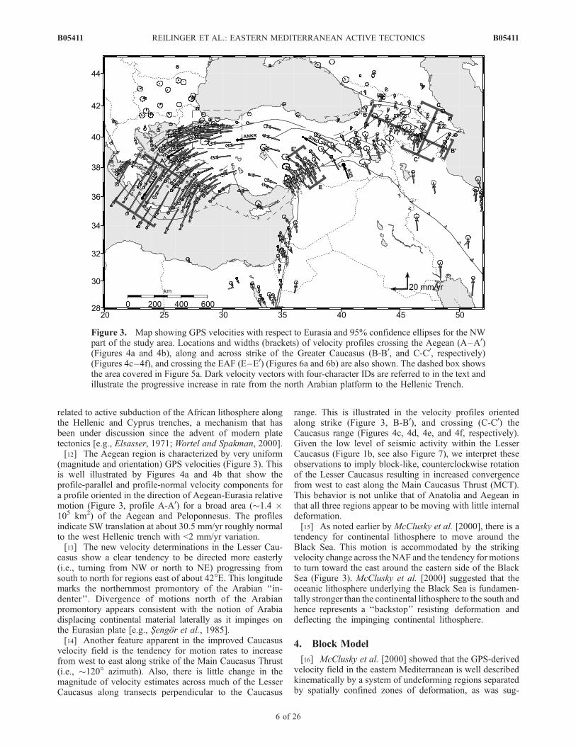
(magnitude and orientation) GPS velocities (Figure 3). Thisis well illustrated by Figures 4a and 4b that show theprofile-parallel and profile-normal velocity components fora profile oriented in the direction of Aegean-Eurasia relativemotion (Figure 3, profile A-A0) for a broad area (�1.4 �105 km2) of the Aegean and Peloponnesus. The profilesindicate SW translation at about 30.5 mm/yr roughly normalto the west Hellenic trench with <2 mm/yr variation.[13] The new velocity determinations in the Lesser Cau-
casus show a clear tendency to be directed more easterly(i.e., turning from NW or north to NE) progressing fromsouth to north for regions east of about 42�E. This longitudemarks the northernmost promontory of the Arabian ‘‘in-denter’’. Divergence of motions north of the Arabianpromontory appears consistent with the notion of Arabiadisplacing continental material laterally as it impinges onthe Eurasian plate [e.g., Sengor et al., 1985].[14] Another feature apparent in the improved Caucasus
velocity field is the tendency for motion rates to increasefrom west to east along strike of the Main Caucasus Thrust(i.e., �120� azimuth). Also, there is little change in themagnitude of velocity estimates across much of the LesserCaucasus along transects perpendicular to the Caucasus
range. This is illustrated in the velocity profiles orientedalong strike (Figure 3, B-B0), and crossing (C-C0) theCaucasus range (Figures 4c, 4d, 4e, and 4f, respectively).Given the low level of seismic activity within the LesserCaucasus (Figure 1b, see also Figure 7), we interpret theseobservations to imply block-like, counterclockwise rotationof the Lesser Caucasus resulting in increased convergencefrom west to east along the Main Caucasus Thrust (MCT).This behavior is not unlike that of Anatolia and Aegean inthat all three regions appear to be moving with little internaldeformation.[15] As noted earlier by McClusky et al. [2000], there is a
tendency for continental lithosphere to move around theBlack Sea. This motion is accommodated by the strikingvelocity change across the NAF and the tendency for motionsto turn toward the east around the eastern side of the BlackSea (Figure 3). McClusky et al. [2000] suggested that theoceanic lithosphere underlying the Black Sea is fundamen-tally stronger than the continental lithosphere to the south andhence represents a ‘‘backstop’’ resisting deformation anddeflecting the impinging continental lithosphere.
4. Block Model
[16] McClusky et al. [2000] showed that the GPS-derivedvelocity field in the eastern Mediterranean is well describedkinematically by a system of undeforming regions separatedby spatially confined zones of deformation, as was sug-
Figure 3. Map showing GPS velocities with respect to Eurasia and 95% confidence ellipses for the NWpart of the study area. Locations and widths (brackets) of velocity profiles crossing the Aegean (A–A0)(Figures 4a and 4b), along and across strike of the Greater Caucasus (B-B0, and C-C0, respectively)(Figures 4c–4f), and crossing the EAF (E–E0) (Figures 6a and 6b) are also shown. The dashed box showsthe area covered in Figure 5a. Dark velocity vectors with four-character IDs are referred to in the text andillustrate the progressive increase in rate from the north Arabian platform to the Hellenic Trench.
B05411 REILINGER ET AL.: EASTERN MEDITERRANEAN ACTIVE TECTONICS
6 of 26
B05411

Figure 4. GPS velocities with respect to Eurasia with 1s uncertainties plotted versus distance alongprofiles shown in Figure 3. The widths of the profiles are indicated by brackets in Figure 3. (a) Aegeanprofile (A-A0) showing profile-parallel velocities (component of velocity in direction of Aegean motionwith respect to Eurasia). (b) Aegean profile (A-A0) showing profile-normal velocity components.(c) Caucasus profile (B-B0; oriented parallel to the strike of the Main Caucasus Thrust) showing profile-parallel velocity components. (d) Caucasus profile (B-B0) showing profile-normal velocity componentsand illustrating progressive increase in the rate of convergence from NW to SE along strike of theCaucasus. (e) Caucasus profile (C-C0; oriented normal to the strike of the Main Caucasus Thrust) showingprofile-parallel velocity components and illustrating the concentration of convergence along the MCT andcoherent motion of the Lesser Caucasus (N. Caucasus, north Caucasus, L Caucasus, Lesser Caucasus).(f) Caucasus profile (C-C0) showing profile-normal velocity components.
B05411 REILINGER ET AL.: EASTERN MEDITERRANEAN ACTIVE TECTONICS
7 of 26
B05411
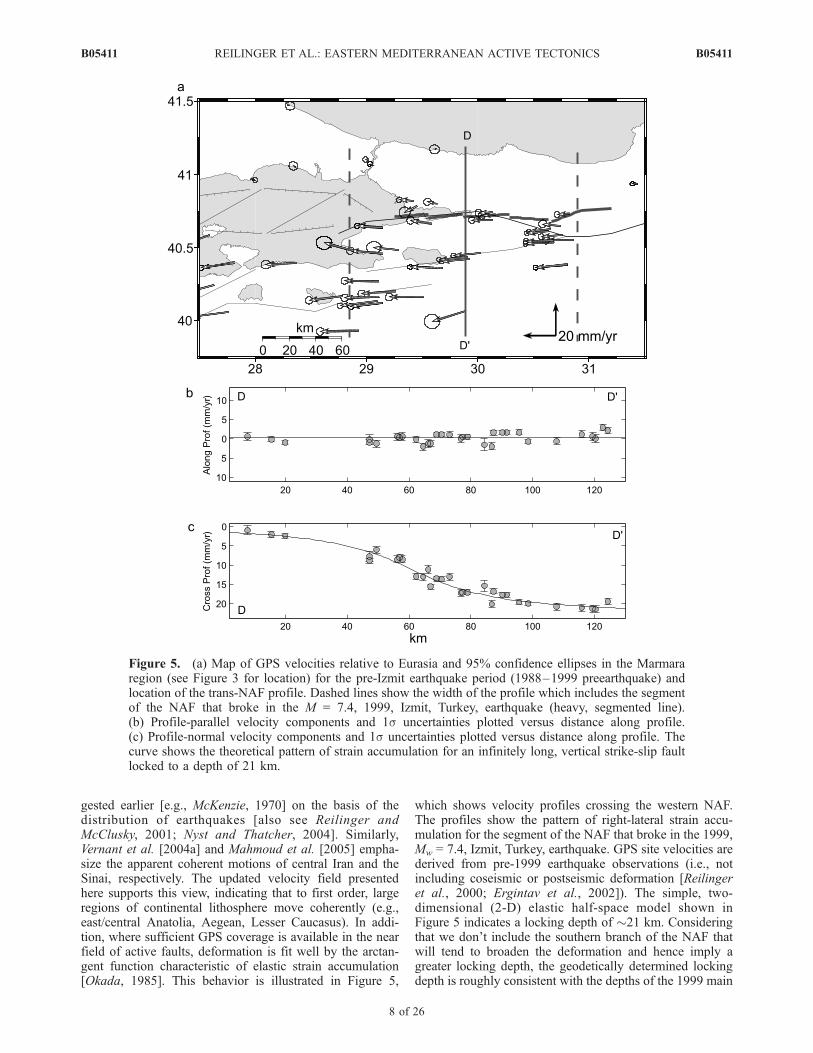
gested earlier [e.g., McKenzie, 1970] on the basis of thedistribution of earthquakes [also see Reilinger andMcClusky, 2001; Nyst and Thatcher, 2004]. Similarly,Vernant et al. [2004a] and Mahmoud et al. [2005] empha-size the apparent coherent motions of central Iran and theSinai, respectively. The updated velocity field presentedhere supports this view, indicating that to first order, largeregions of continental lithosphere move coherently (e.g.,east/central Anatolia, Aegean, Lesser Caucasus). In addi-tion, where sufficient GPS coverage is available in the nearfield of active faults, deformation is fit well by the arctan-gent function characteristic of elastic strain accumulation[Okada, 1985]. This behavior is illustrated in Figure 5,
which shows velocity profiles crossing the western NAF.The profiles show the pattern of right-lateral strain accu-mulation for the segment of the NAF that broke in the 1999,Mw = 7.4, Izmit, Turkey, earthquake. GPS site velocities arederived from pre-1999 earthquake observations (i.e., notincluding coseismic or postseismic deformation [Reilingeret al., 2000; Ergintav et al., 2002]). The simple, two-dimensional (2-D) elastic half-space model shown inFigure 5 indicates a locking depth of �21 km. Consideringthat we don’t include the southern branch of the NAF thatwill tend to broaden the deformation and hence imply agreater locking depth, the geodetically determined lockingdepth is roughly consistent with the depths of the 1999 main
Figure 5. (a) Map of GPS velocities relative to Eurasia and 95% confidence ellipses in the Marmararegion (see Figure 3 for location) for the pre-Izmit earthquake period (1988–1999 preearthquake) andlocation of the trans-NAF profile. Dashed lines show the width of the profile which includes the segmentof the NAF that broke in the M = 7.4, 1999, Izmit, Turkey, earthquake (heavy, segmented line).(b) Profile-parallel velocity components and 1s uncertainties plotted versus distance along profile.(c) Profile-normal velocity components and 1s uncertainties plotted versus distance along profile. Thecurve shows the theoretical pattern of strain accumulation for an infinitely long, vertical strike-slip faultlocked to a depth of 21 km.
B05411 REILINGER ET AL.: EASTERN MEDITERRANEAN ACTIVE TECTONICS
8 of 26
B05411

event (�13 km) and subsequent larger aftershocks (�8–17 km) [Ozalaybey et al., 2002]. Similar results are indi-cated in Figures 6a and 6b for the EAF (�18 km lockingdepth) and by Wdowinski et al. [2004] and Mahmoud et al.[2005] for the Dead Sea fault.[17] These observations lead us to investigate kinematic
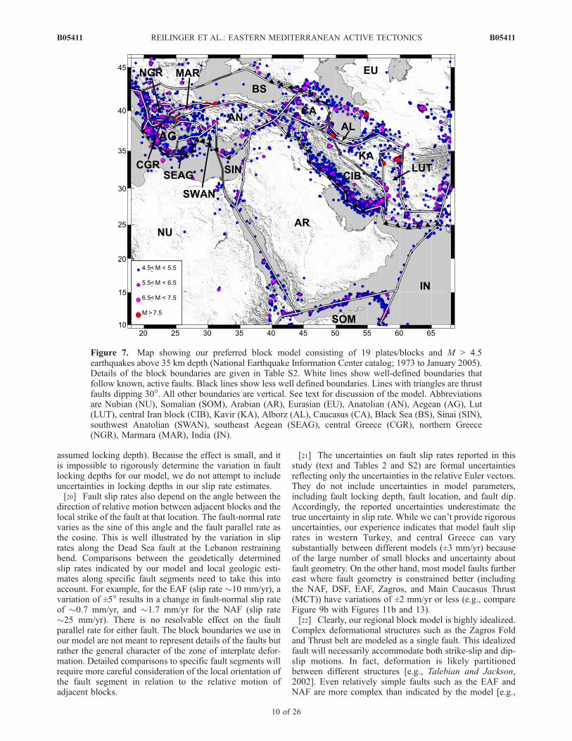
block models that include the effect of elastic strain accu-mulation on block boundaries [e.g., Meade et al., 2002;McCaffrey, 2002; Meade and Hager, 2005]. Our preferredmodel is shown in Figure 7 (see Table S2 for a compilationof faults used in the model). Block boundaries are pre-scribed and have been determined from mapped faults,seismicity, and historic earthquakes. Many of the majorfaults in the eastern Mediterranean are well defined (historicearthquakes, mapped coseismic surface offsets, seismicity,and geologic field studies). These faults are shown as lightlines in Figure 7. Less clearly defined block boundaries areshown as gray lines. The model includes block rotations ona sphere with elastic strain accumulation on block-boundingfaults following the formulation of Okada [1985]. Themodel allows no permanent deformation of the blocks orslip on ‘‘unconnected’’ fault segments (i.e., all faults used inthe model must be associated with a block boundary).Relative block motions (relative Euler vectors, Table 1)are solved for by minimizing the GPS residual motions(Figures 8a–8d) within the blocks in a least squares sense.Modeled faults are vertical except for thrusts which areassigned a 30� dip (shown with triangles in Figure 7). Mostfaults are assigned a 15 km locking depth, measuredvertically from the surface for vertical and dipping faults.The NAF in the Marmara Sea, the DSF, and the Gulf ofCorinth fault are locked to 10, 12, and 2 km, respectively,based on prior studies (NAF by Meade et al. [2002] andDSF by Mahmoud et al. [2005]), and the sharp velocitycontrast across the Gulf of Corinth. Fault slip rates, shownin Figures 9a–9d (see Table S2 for a complete compilation),are determined by decomposing relative block motions onblock boundaries into fault parallel (strike slip, positive left-
lateral) and fault-normal motions (normal and thrust, posi-tive compression).[18] WRMS residuals for each plate/block are given in
Table 1. As indicated in Table 1 and Figure 8, the blockmodel provides a reasonable fit to the GPS velocity field,accounting for the large majority of observed motions.About 63% of the observed velocities in the region are fitwithin their 95% confidence ellipses, while about 95%differ by less than 2 mm/yr. While more complex modelswould provide better fits to the data, the relatively simplemodel we use captures the main kinematics in the zone ofplate interaction.[19] For most faults in the model, the GPS coverage is not
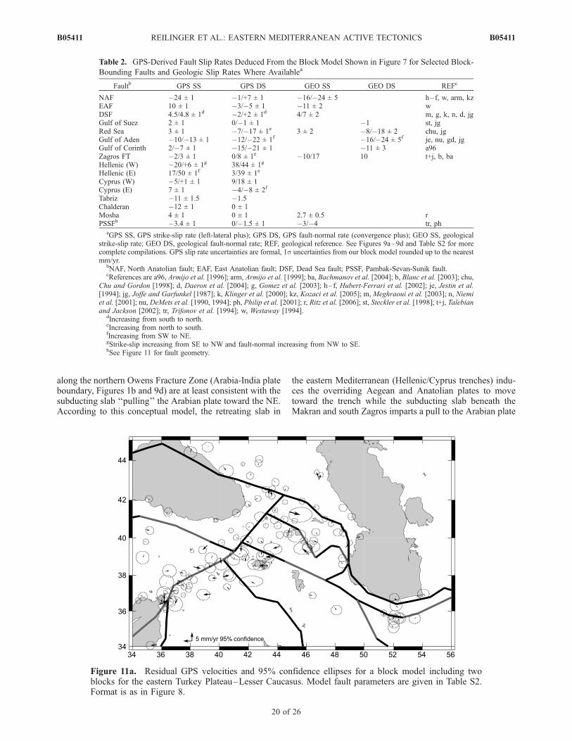
sufficiently dense near the faults to provide good constraintson fault locking depths. This adds an additional uncertaintyto model slip rates because there is a trade-off betweenlocking depth and slip rate [Meade and Hager, 2005] (sliprate increases with locking depth). This trade-off occursbecause GPS velocities near a locked fault will have smallervelocities than those within the block far from the fault dueto the effects of strain accumulation. Since the smallervelocities near the fault are not accounted for by strainaccumulation for models with shallow locking depth, themodel tends to give slower plate velocities for moreshallowly locked faults, and hence lower slip rates. This isillustrated in Figure 10 which shows a plot of local c2 (ameasure of goodness of fit to the model [Meade and Hager,2005]) and estimated slip rate versus fault locking depth fora section of the NAF, one of the better constrained faults inthe model (Figures 3 and 5). The local c2 is determinedusing the GPS stations shown in the inset of Figure 10. Theminimum c2 (i.e., best model fit) is for locking depths in therange 14–25 km, quite reasonable given the depths ofearthquakes. This adds an additional uncertainty of about±1 mm/yr for this fault. This is among the highest slip ratevariations as a function of fault locking depth for anyboundary fault (model slip rates on block boundaries withfew stations near the fault are insensitive to variations in
Figure 6. (a) East Anatolian fault velocity profile showing profile-parallel velocities and 1suncertainties relative to Eurasia (E-E0; see Figure 3 for profile location and width). (b) East Anatolianfault velocity profile (E-E0; Figure 3) showing profile-normal velocities. The curve is the theoretical strainaccumulation for a vertical, infinitely long strike-slip fault locked to a depth of 18 km.
B05411 REILINGER ET AL.: EASTERN MEDITERRANEAN ACTIVE TECTONICS
9 of 26
B05411
assumed locking depth). Because the effect is small, and itis impossible to rigorously determine the variation in faultlocking depths for our model, we do not attempt to includeuncertainties in locking depths in our slip rate estimates.[20] Fault slip rates also depend on the angle between the
direction of relative motion between adjacent blocks and thelocal strike of the fault at that location. The fault-normal ratevaries as the sine of this angle and the fault parallel rate asthe cosine. This is well illustrated by the variation in sliprates along the Dead Sea fault at the Lebanon restrainingbend. Comparisons between the geodetically determinedslip rates indicated by our model and local geologic esti-mates along specific fault segments need to take this intoaccount. For example, for the EAF (slip rate �10 mm/yr), avariation of ±5� results in a change in fault-normal slip rateof �0.7 mm/yr, and �1.7 mm/yr for the NAF (slip rate�25 mm/yr). There is no resolvable effect on the faultparallel rate for either fault. The block boundaries we use inour model are not meant to represent details of the faults butrather the general character of the zone of interplate defor-mation. Detailed comparisons to specific fault segments willrequire more careful consideration of the local orientation ofthe fault segment in relation to the relative motion ofadjacent blocks.
[21] The uncertainties on fault slip rates reported in thisstudy (text and Tables 2 and S2) are formal uncertaintiesreflecting only the uncertainties in the relative Euler vectors.They do not include uncertainties in model parameters,including fault locking depth, fault location, and fault dip.Accordingly, the reported uncertainties underestimate thetrue uncertainty in slip rate. While we can’t provide rigorousuncertainties, our experience indicates that model fault sliprates in western Turkey, and central Greece can varysubstantially between different models (±3 mm/yr) becauseof the large number of small blocks and uncertainty aboutfault geometry. On the other hand, most model faults furthereast where fault geometry is constrained better (includingthe NAF, DSF, EAF, Zagros, and Main Caucasus Thrust(MCT)) have variations of ±2 mm/yr or less (e.g., compareFigure 9b with Figures 11b and 13).[22] Clearly, our regional block model is highly idealized.
Complex deformational structures such as the Zagros Foldand Thrust belt are modeled as a single fault. This idealizedfault will necessarily accommodate both strike-slip and dip-slip motions. In fact, deformation is likely partitionedbetween different structures [e.g., Talebian and Jackson,2002]. Even relatively simple faults such as the EAF andNAF are more complex than indicated by the model [e.g.,
Figure 7. Map showing our preferred block model consisting of 19 plates/blocks and M > 4.5earthquakes above 35 km depth (National Earthquake Information Center catalog; 1973 to January 2005).Details of the block boundaries are given in Table S2. White lines show well-defined boundaries thatfollow known, active faults. Black lines show less well defined boundaries. Lines with triangles are thrustfaults dipping 30�. All other boundaries are vertical. See text for discussion of the model. Abbreviationsare Nubian (NU), Somalian (SOM), Arabian (AR), Eurasian (EU), Anatolian (AN), Aegean (AG), Lut(LUT), central Iran block (CIB), Kavir (KA), Alborz (AL), Caucasus (CA), Black Sea (BS), Sinai (SIN),southwest Anatolian (SWAN), southeast Aegean (SEAG), central Greece (CGR), northern Greece(NGR), Marmara (MAR), India (IN).
B05411 REILINGER ET AL.: EASTERN MEDITERRANEAN ACTIVE TECTONICS
10 of 26
B05411
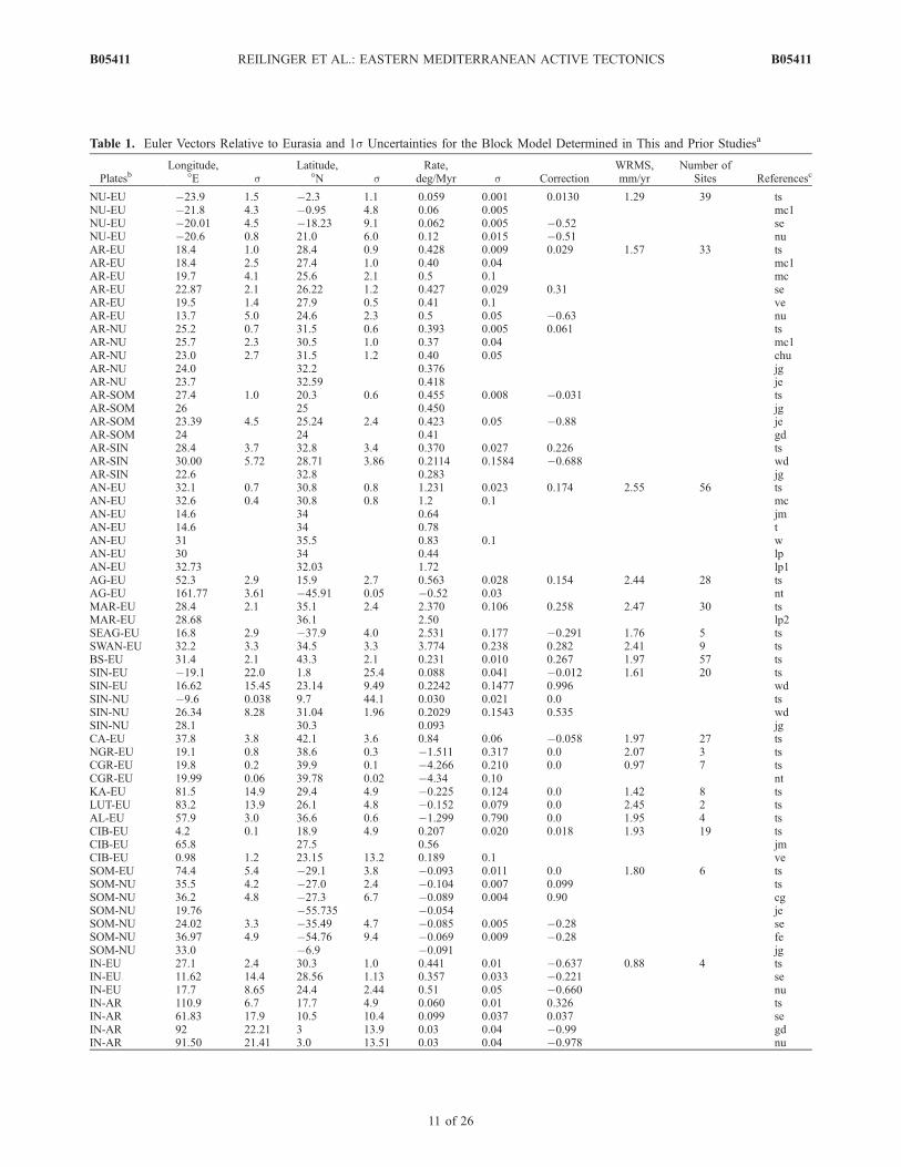
Table 1. Euler Vectors Relative to Eurasia and 1s Uncertainties for the Block Model Determined in This and Prior Studiesa
PlatesbLongitude,
�E sLatitude,
�N sRate,
deg/Myr s CorrectionWRMS,mm/yr
Number ofSites Referencesc
NU-EU �23.9 1.5 �2.3 1.1 0.059 0.001 0.0130 1.29 39 tsNU-EU �21.8 4.3 �0.95 4.8 0.06 0.005 mc1NU-EU �20.01 4.5 �18.23 9.1 0.062 0.005 �0.52 seNU-EU �20.6 0.8 21.0 6.0 0.12 0.015 �0.51 nuAR-EU 18.4 1.0 28.4 0.9 0.428 0.009 0.029 1.57 33 tsAR-EU 18.4 2.5 27.4 1.0 0.40 0.04 mc1AR-EU 19.7 4.1 25.6 2.1 0.5 0.1 mcAR-EU 22.87 2.1 26.22 1.2 0.427 0.029 0.31 seAR-EU 19.5 1.4 27.9 0.5 0.41 0.1 veAR-EU 13.7 5.0 24.6 2.3 0.5 0.05 �0.63 nuAR-NU 25.2 0.7 31.5 0.6 0.393 0.005 0.061 tsAR-NU 25.7 2.3 30.5 1.0 0.37 0.04 mc1AR-NU 23.0 2.7 31.5 1.2 0.40 0.05 chuAR-NU 24.0 32.2 0.376 jgAR-NU 23.7 32.59 0.418 jeAR-SOM 27.4 1.0 20.3 0.6 0.455 0.008 �0.031 tsAR-SOM 26 25 0.450 jgAR-SOM 23.39 4.5 25.24 2.4 0.423 0.05 �0.88 jeAR-SOM 24 24 0.41 gdAR-SIN 28.4 3.7 32.8 3.4 0.370 0.027 0.226 tsAR-SIN 30.00 5.72 28.71 3.86 0.2114 0.1584 �0.688 wdAR-SIN 22.6 32.8 0.283 jgAN-EU 32.1 0.7 30.8 0.8 1.231 0.023 0.174 2.55 56 tsAN-EU 32.6 0.4 30.8 0.8 1.2 0.1 mcAN-EU 14.6 34 0.64 jmAN-EU 14.6 34 0.78 tAN-EU 31 35.5 0.83 0.1 wAN-EU 30 34 0.44 lpAN-EU 32.73 32.03 1.72 lp1AG-EU 52.3 2.9 15.9 2.7 0.563 0.028 0.154 2.44 28 tsAG-EU 161.77 3.61 �45.91 0.05 �0.52 0.03 ntMAR-EU 28.4 2.1 35.1 2.4 2.370 0.106 0.258 2.47 30 tsMAR-EU 28.68 36.1 2.50 lp2SEAG-EU 16.8 2.9 �37.9 4.0 2.531 0.177 �0.291 1.76 5 tsSWAN-EU 32.2 3.3 34.5 3.3 3.774 0.238 0.282 2.41 9 tsBS-EU 31.4 2.1 43.3 2.1 0.231 0.010 0.267 1.97 57 tsSIN-EU �19.1 22.0 1.8 25.4 0.088 0.041 �0.012 1.61 20 tsSIN-EU 16.62 15.45 23.14 9.49 0.2242 0.1477 0.996 wdSIN-NU �9.6 0.038 9.7 44.1 0.030 0.021 0.0 tsSIN-NU 26.34 8.28 31.04 1.96 0.2029 0.1543 0.535 wdSIN-NU 28.1 30.3 0.093 jgCA-EU 37.8 3.8 42.1 3.6 0.84 0.06 �0.058 1.97 27 tsNGR-EU 19.1 0.8 38.6 0.3 �1.511 0.317 0.0 2.07 3 tsCGR-EU 19.8 0.2 39.9 0.1 �4.266 0.210 0.0 0.97 7 tsCGR-EU 19.99 0.06 39.78 0.02 �4.34 0.10 ntKA-EU 81.5 14.9 29.4 4.9 �0.225 0.124 0.0 1.42 8 tsLUT-EU 83.2 13.9 26.1 4.8 �0.152 0.079 0.0 2.45 2 tsAL-EU 57.9 3.0 36.6 0.6 �1.299 0.790 0.0 1.95 4 tsCIB-EU 4.2 0.1 18.9 4.9 0.207 0.020 0.018 1.93 19 tsCIB-EU 65.8 27.5 0.56 jmCIB-EU 0.98 1.2 23.15 13.2 0.189 0.1 veSOM-EU 74.4 5.4 �29.1 3.8 �0.093 0.011 0.0 1.80 6 tsSOM-NU 35.5 4.2 �27.0 2.4 �0.104 0.007 0.099 tsSOM-NU 36.2 4.8 �27.3 6.7 �0.089 0.004 0.90 cgSOM-NU 19.76 �55.735 �0.054 jeSOM-NU 24.02 3.3 �35.49 4.7 �0.085 0.005 �0.28 seSOM-NU 36.97 4.9 �54.76 9.4 �0.069 0.009 �0.28 feSOM-NU 33.0 �6.9 �0.091 jgIN-EU 27.1 2.4 30.3 1.0 0.441 0.01 �0.637 0.88 4 tsIN-EU 11.62 14.4 28.56 1.13 0.357 0.033 �0.221 seIN-EU 17.7 8.65 24.4 2.44 0.51 0.05 �0.660 nuIN-AR 110.9 6.7 17.7 4.9 0.060 0.01 0.326 tsIN-AR 61.83 17.9 10.5 10.4 0.099 0.037 0.037 seIN-AR 92 22.21 3 13.9 0.03 0.04 �0.99 gdIN-AR 91.50 21.41 3.0 13.51 0.03 0.04 �0.978 nu
B05411 REILINGER ET AL.: EASTERN MEDITERRANEAN ACTIVE TECTONICS
11 of 26
B05411
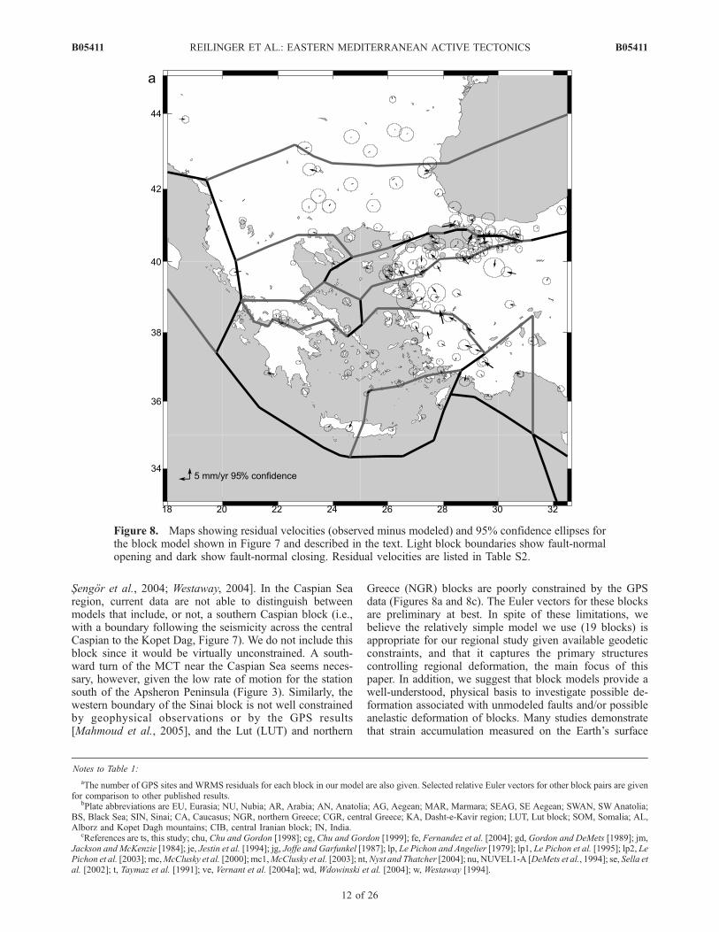
Sengor et al., 2004; Westaway, 2004]. In the Caspian Searegion, current data are not able to distinguish betweenmodels that include, or not, a southern Caspian block (i.e.,with a boundary following the seismicity across the centralCaspian to the Kopet Dag, Figure 7). We do not include thisblock since it would be virtually unconstrained. A south-ward turn of the MCT near the Caspian Sea seems neces-sary, however, given the low rate of motion for the stationsouth of the Apsheron Peninsula (Figure 3). Similarly, thewestern boundary of the Sinai block is not well constrainedby geophysical observations or by the GPS results[Mahmoud et al., 2005], and the Lut (LUT) and northern
Greece (NGR) blocks are poorly constrained by the GPSdata (Figures 8a and 8c). The Euler vectors for these blocksare preliminary at best. In spite of these limitations, webelieve the relatively simple model we use (19 blocks) isappropriate for our regional study given available geodeticconstraints, and that it captures the primary structurescontrolling regional deformation, the main focus of thispaper. In addition, we suggest that block models provide awell-understood, physical basis to investigate possible de-formation associated with unmodeled faults and/or possibleanelastic deformation of blocks. Many studies demonstratethat strain accumulation measured on the Earth’s surface
Notes to Table 1:
aThe number of GPS sites and WRMS residuals for each block in our model are also given. Selected relative Euler vectors for other block pairs are givenfor comparison to other published results.
bPlate abbreviations are EU, Eurasia; NU, Nubia; AR, Arabia; AN, Anatolia; AG, Aegean; MAR, Marmara; SEAG, SE Aegean; SWAN, SWAnatolia;BS, Black Sea; SIN, Sinai; CA, Caucasus; NGR, northern Greece; CGR, central Greece; KA, Dasht-e-Kavir region; LUT, Lut block; SOM, Somalia; AL,Alborz and Kopet Dagh mountains; CIB, central Iranian block; IN, India.
cReferences are ts, this study; chu, Chu and Gordon [1998]; cg, Chu and Gordon [1999]; fe, Fernandez et al. [2004]; gd, Gordon and DeMets [1989]; jm,Jackson and McKenzie [1984]; je, Jestin et al. [1994]; jg, Joffe and Garfunkel [1987]; lp, Le Pichon and Angelier [1979]; lp1, Le Pichon et al. [1995]; lp2, LePichon et al. [2003]; mc,McClusky et al. [2000]; mc1,McClusky et al. [2003]; nt,Nyst and Thatcher [2004]; nu, NUVEL1-A [DeMets et al., 1994]; se, Sella etal. [2002]; t, Taymaz et al. [1991]; ve, Vernant et al. [2004a]; wd, Wdowinski et al. [2004]; w, Westaway [1994].
Figure 8. Maps showing residual velocities (observed minus modeled) and 95% confidence ellipses forthe block model shown in Figure 7 and described in the text. Light block boundaries show fault-normalopening and dark show fault-normal closing. Residual velocities are listed in Table S2.
B05411 REILINGER ET AL.: EASTERN MEDITERRANEAN ACTIVE TECTONICS
12 of 26
B05411

during the interseismic period is well characterized bymodels that consider faults as buried, deep dislocations inan elastic half-space with the upper part of the fault lockedto depths of typically 10–25 km (e.g., Figures 5 and 6)[Okada, 1985]. While such models may not be an accuraterepresentation of the physics of faulting or the rheology ofthe lithosphere, they provide a good representation of fault-related surface deformation [e.g., Savage, 1990]. As such,we suggest that the elastic block model effectively removesthose motions that are associated with strain accumulationon block bounding faults, allowing identification of off-faultdeformation associated with either unmodeled faults orpermanent strain within the blocks.[23] While the block model provides a good fit to the
observations overall, a number of areas show significantresidual motions that likely reflect inadequacies of themodel. Residual motions in western Turkey are large,reaching 7 mm/yr and indicating unmodeled N-S extension.Internal deformation of this area is also indicated byseismicity (Figures 1b and 7) and local active fault studies[Westaway, 1994; Bozkurt, 2003]. Certainly, more detailedmodeling is warranted in this area, although beyond thescope of this regional study. In addition, there is evidence ofa small component of trench-parallel extension (�2 mm/yr)along the leading edge of both the SW and SE Aegeanblocks. This extension is consistent with mapped normal
faults [Armijo et al., 1992] and extensional earthquake focalmechanisms with nodal planes striking normal to the trench(Figure 1b). In the Lesser Caucasus there is marginallysignificant evidence for right-lateral strike-slip deformationalong the Pembak-Sevan-Sunik Fault (PSSF), Armenia(possible source of the 1988, M = 6.9, Spitak earthquake[Dorbath and Cisternas, 1997]). Figures 11a and 11b showsthe results of a block model including two blocks in theeastern Turkey Plateau–Lesser Caucasus. The boundaryfollows the PSSF and connects with the complex structuresnear the SW Caspian Sea. The model results in only a slightreduction in GPS residuals, but suggests a right-lateral sliprate for the PSSF of �3.5 mm/yr, consistent within uncer-tainties with results from paleoseismic studies [Trifonov etal., 1994; Philip et al., 2001] (Table 2).
5. Discussion
5.1. Relative Euler Vectors
[24] Euler vectors for the Nubian, Arabian, and Anatolianplates relative to Eurasia are generally consistent with thosereported in prior geodetic studies (Table 1). Similarly, thegeodetic and geologic Euler vectors for Arabia-Nubia,Somalia-Nubia, and Arabia-Somalia relative motion are ingood agreement using the most recent geologic results. Thediscrepancy between our geodetic Euler vector and the
Figure 8. (continued)
B05411 REILINGER ET AL.: EASTERN MEDITERRANEAN ACTIVE TECTONICS
13 of 26
B05411

geologic Euler vector for Africa-Eurasia relative motionreported for the NUVEL1-A model [DeMets et al., 1990,1994] is not surprising since the NUVEL model consideredNubia and Somalia as a single plate because of the lack ofdata to distinguish individual plate motions. Recently,McQuarrie et al. [2003] reevaluated Africa (Nubia)–Eura-sia relative motion from 67.7 Ma to present from updatedseafloor magnetic anomalies in the North Atlantic. Theyreport a post-10 Ma average rate of 7.5 ± 4 mm/yr at 38�N,48�E for Africa (Nubia) plate motion with respect to Eurasiawhich compares to 6.4 ± 1 mm/yr from the Nubia-EurasiaGPS Euler vector. In this same study, McQuarrie et al.[2003] report a rate of 20 ± 4 mm/yr (38�N, 48�E) forArabia-Eurasia relative motion (incorporating Red Seaspreading) that also agrees well with the present-day ratedetermined from the Arabia-Eurasia GPS Euler vector (21 ±1 mm/yr). While interpretations differ (Calais et al. [2003]suggest temporal variations in Nubia-Eurasia plate motion),we take this general agreement as support for the hypothesis
that broad-scale plate motions indicated by GPS for Arabia,Nubia, Somalia, and Eurasia accurately reflect plate motionsduring the recent geologic period (�5 Myr).[25] Geologic estimates of relative motions are not avail-
able for most of the smaller blocks within the zone ofinteraction of the Nubian, Arabian and Eurasian plates.However, it is possible to compare the GPS fault slip rateestimates to geologic rates for some block bounding faults.
5.2. Fault Slip Rates
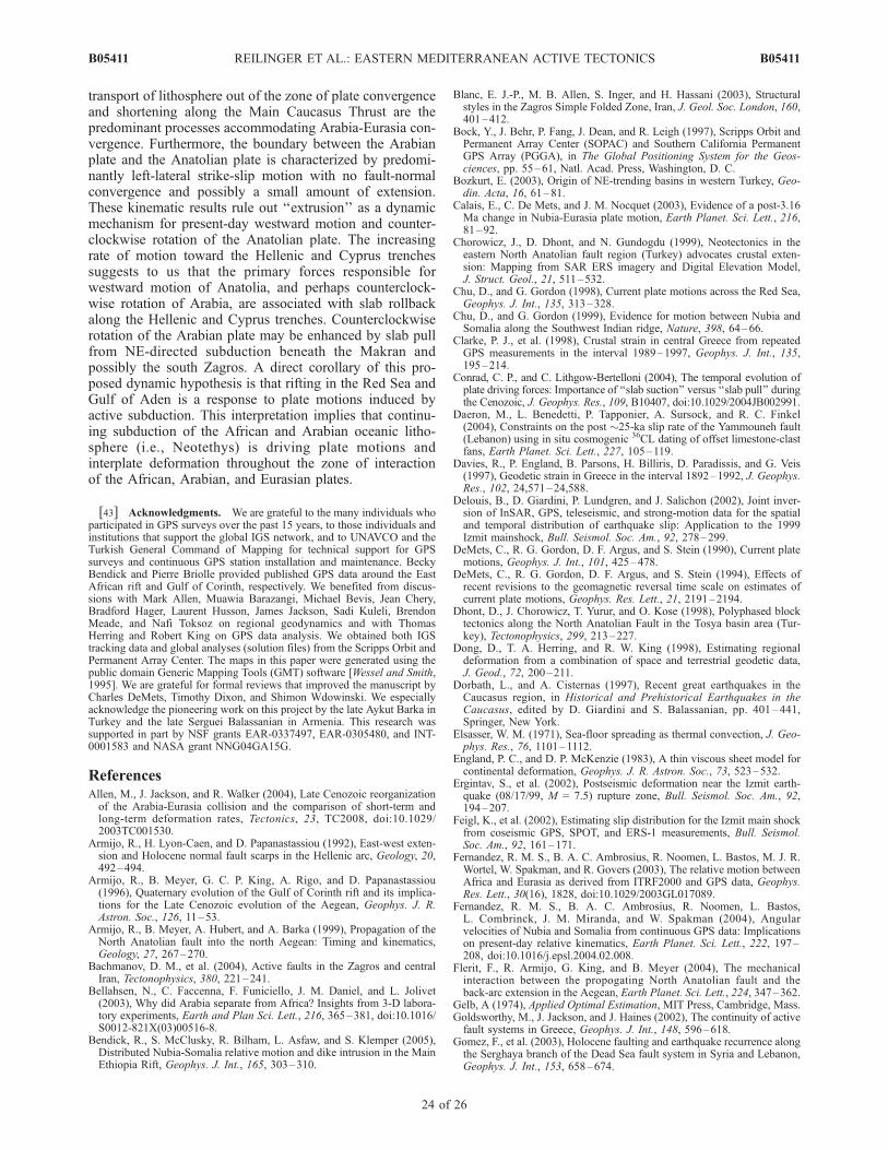
[26] Table 2 lists strike-slip and fault-normal rates forselected faults used to define the blocks shown in Figure 7along with longer-term slip rates from geologic studieswhere available. In Figure 12 we plot the GPS estimatefor fault slip rate from our preferred block model versus theaverage geologic slip rate reported in the literature. Uncer-tainties on the geologic rates reflect the range of slipestimates reported and their uncertainties. The GPS-derivedslip rates are upper bounds since they do not account for
Figure 8. (continued)
B05411 REILINGER ET AL.: EASTERN MEDITERRANEAN ACTIVE TECTONICS
14 of 26
B05411

possible permanent deformation of the blocks and all slip isassumed to occur on a single fault. In addition, becauseinversions of geodetic data for coseismic fault slip indicatethat surface offsets are significantly less than offsets atseismogenic depths [e.g., Feigl et al., 2002; Delouis etal., 2002], geologic estimates provide a lower bound onfault slip rates.[27] It is difficult to draw definitive conclusions about the
relationship between present-day rates of faulting andlonger-term geological rates because of the large uncertain-ties on most geologic estimates [e.g., Allen et al., 2004] andthe lack of detailed, near fault GPS coverage for manystructures. The best determined geologic rates are for RedSea and Gulf of Aden spreading since these are derivedfrom mapped magnetic anomalies with well-determinedages [Chu and Gordon, 1998, 1999]. In these cases, thereis close agreement between both the rates and directions ofGPS and geologic estimates (Table 2) [see also McClusky etal., 2003]. The North Anatolian, East Anatolian, Dead Sea,Gulf of Suez, Mosha, and Pembak-Sevan-Sunik faults allhave geodetic and geologic slip rates that agree within 1suncertainties. Long-term slip rates for the NAF may besomewhat lower than present-day slip rates [e.g., Sengor etal., 2004, Figure 23], although uncertainties on the timingof initiation of the fault and possible off-fault deformation[Sengor et al., 2004; Westaway, 2004] complicate thesecomparisons.[28] The Zagros Main Recent fault [Vernant et al., 2004a]
and the Gulf of Corinth show significant differences be-tween geodetic and geologic slip rates. The geologic strike-slip rate (averaged over 3–5 Myr) for the Zagros MainRecent fault in particular is a factor of 3–5 greater than thegeodetic rate [Talebian and Jackson, 2002; Bachmanov etal., 2004]. Even with the absence of direct control on the
age of the fault, this difference seems difficult to ascribe touncertainties in the geologic rate. Similarly, fault-normalextension on the main fault along the southern side of theGulf of Corinth determined from geologic observations[Armijo et al., 1996] averaged over 350 kyr are significantlyless than the geodetic rate. This difference is difficult toascribe to uncertainties in the geologic estimates, and mayreflect temporal variations in fault activity [Jackson, 1999].However, definitive conclusions are difficult since thegeodetic determination is not that well constrained andlikely integrates deformation over a substantially wider areathan the single geologic fault estimate.[29] While uncertainties on fault slip rate estimates are
generally too high to clearly define variations in slip rateswith time, GPS slip rates are mostly comparable to geologicestimates (Figure 12), and geologically active faults accountfor present-day block motions and regional deformation.This agreement, the consistent geodetic and geologic Eulervectors for Arabia-Nubia, Arabia-Somalia, and Somalia-Nubia, and the agreement between geologic and geodeticestimates of Nubia-Eurasia and Arabia-Eurasia relativemotions suggests to us that the GPS results reflect the samegeologic processes operating in the region during the mostrecent geologic period (�3–5 Ma).
5.3. Accommodation of Arabia-EurasiaContinental Collision
[30] The collision of Arabia with Eurasia results in areduction in the area of lithosphere within the deformingregion caught in the collision zone. This reduction occursvia lateral transport of lithosphere out of the collision zoneand by lithospheric shortening, presumably associated withthickening of the trapped lithosphere [e.g., McKenzie,1972]. The block model allows quantitative estimation of
Figure 8. (continued)
B05411 REILINGER ET AL.: EASTERN MEDITERRANEAN ACTIVE TECTONICS
15 of 26
B05411
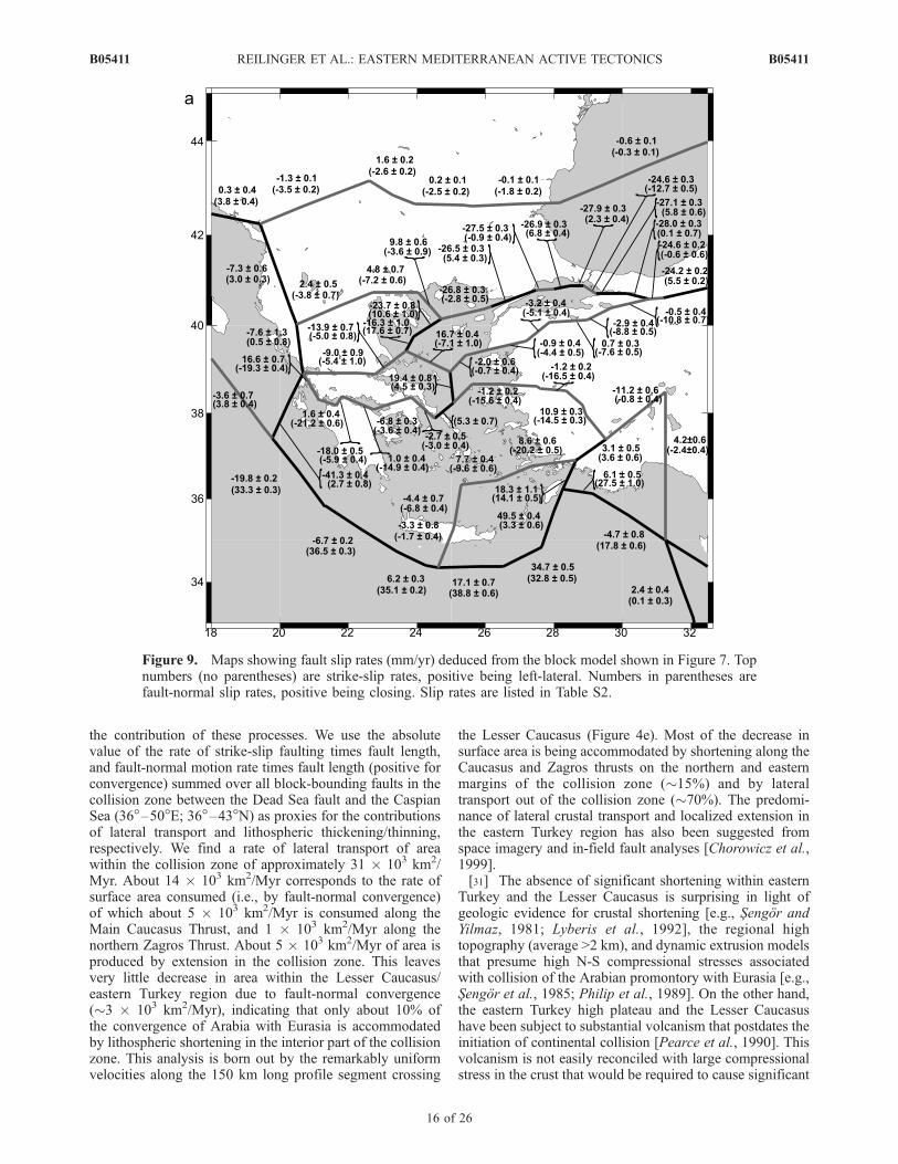
the contribution of these processes. We use the absolutevalue of the rate of strike-slip faulting times fault length,and fault-normal motion rate times fault length (positive forconvergence) summed over all block-bounding faults in thecollision zone between the Dead Sea fault and the CaspianSea (36�–50�E; 36�–43�N) as proxies for the contributionsof lateral transport and lithospheric thickening/thinning,respectively. We find a rate of lateral transport of areawithin the collision zone of approximately 31 � 103 km2/Myr. About 14 � 103 km2/Myr corresponds to the rate ofsurface area consumed (i.e., by fault-normal convergence)of which about 5 � 103 km2/Myr is consumed along theMain Caucasus Thrust, and 1 � 103 km2/Myr along thenorthern Zagros Thrust. About 5 � 103 km2/Myr of area isproduced by extension in the collision zone. This leavesvery little decrease in area within the Lesser Caucasus/eastern Turkey region due to fault-normal convergence(�3 � 103 km2/Myr), indicating that only about 10% ofthe convergence of Arabia with Eurasia is accommodatedby lithospheric shortening in the interior part of the collisionzone. This analysis is born out by the remarkably uniformvelocities along the 150 km long profile segment crossing
the Lesser Caucasus (Figure 4e). Most of the decrease insurface area is being accommodated by shortening along theCaucasus and Zagros thrusts on the northern and easternmargins of the collision zone (�15%) and by lateraltransport out of the collision zone (�70%). The predomi-nance of lateral crustal transport and localized extension inthe eastern Turkey region has also been suggested fromspace imagery and in-field fault analyses [Chorowicz et al.,1999].[31] The absence of significant shortening within eastern
Turkey and the Lesser Caucasus is surprising in light ofgeologic evidence for crustal shortening [e.g., Sengor andYilmaz, 1981; Lyberis et al., 1992], the regional hightopography (average >2 km), and dynamic extrusion modelsthat presume high N-S compressional stresses associatedwith collision of the Arabian promontory with Eurasia [e.g.,Sengor et al., 1985; Philip et al., 1989]. On the other hand,the eastern Turkey high plateau and the Lesser Caucasushave been subject to substantial volcanism that postdates theinitiation of continental collision [Pearce et al., 1990]. Thisvolcanism is not easily reconciled with large compressionalstress in the crust that would be required to cause significant
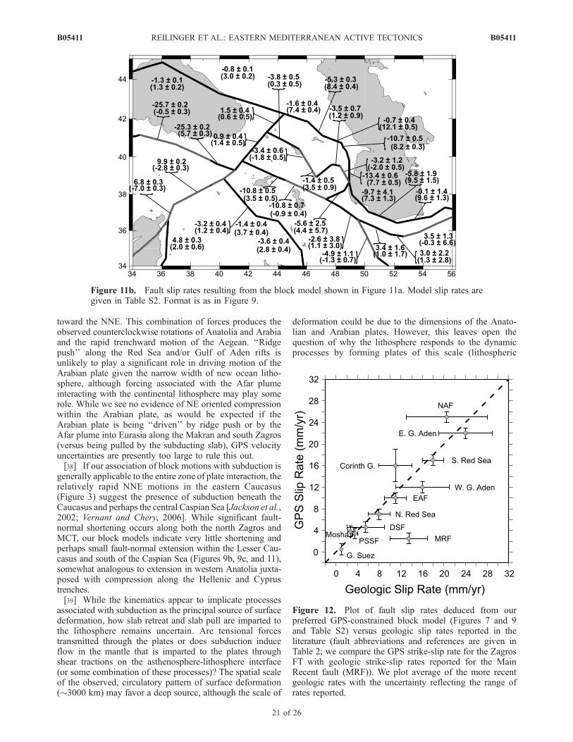
Figure 9. Maps showing fault slip rates (mm/yr) deduced from the block model shown in Figure 7. Topnumbers (no parentheses) are strike-slip rates, positive being left-lateral. Numbers in parentheses arefault-normal slip rates, positive being closing. Slip rates are listed in Table S2.
B05411 REILINGER ET AL.: EASTERN MEDITERRANEAN ACTIVE TECTONICS
16 of 26
B05411

crustal shortening [Dhont et al., 1998]. In addition, recentseismic observations have been interpreted to indicate onlyslightly thickened crust in the collision zone [Zor et al.,2003]. The slightly thickened crust, high topography, andresults from seismic wave propagation studies have in turnbeen interpreted to indicate the absence of a high-densitymantle lid and the presence of hot, low-density astheno-sphere at the base of the crust [Sengor et al., 2003]. Theseobservations imply that the deformation zone along thesouthern edge of the Eurasian plate north of the Arabianpromontory and south of the MCT has experienced only asmall amount of shortening during the period of Arabianplate collision.[32] The lack of substantial, present-day shortening with-
in the Lesser Caucasus and apparent coherent motion of theCaucasus block indicated by the GPS results appear tocontradict geologic evidence for distributed shortening[e.g., Sengor and Yilmaz, 1981; Philip et al., 1989]. Asimilar ‘‘discrepancy’’ occurs in the Aegean where the GPSresults indicate coherent motion with little internal defor-mation while there is substantial geologic evidence forwidespread extension [e.g., Armijo et al., 1996]. McCluskyet al. [2000] suggest that the change from widespreadextension to coherent plate translation in the Aegean mightbe related to propagation of the NAF across the NorthAegean Trough during the last 3–5 Myr [see also Flerit et
al., 2004]. Prior to this time, the overriding Aegean regionwas part of Eurasia and trench rollback was accommodatedby distributed extension in the back-arc region. Propagationof the NAF across the north Aegean decoupled the Aegeanfrom Eurasia, concentrating deformation in the northAegean and Gulf of Corinth and thereby allowing thecentral and southern Aegean and the Peloponnesus to movetrenchward with little internal deformation. We suggest asimilar scenario for the Lesser Caucasus–eastern Turkeyregion. Prior to the development of the NAF, Arabia–Eurasiaconvergence was accommodated primarily by lithosphericshortening and crustal thickening. With the development ofthe NAF and its eastward extension into the Lesser Caucasusand Iran, shortening south of the MCT ceased and wasreplaced by lateral escape of coherent lithospheric blockswith shortening being concentrated along the Main Caucasusand Zagros thrusts.
5.4. Some Implications for Plate Dynamicsand Rheology
[33] Determining the contributions of the various forcesto driving plate motions, and the rheology of the continentallithosphere (i.e., the response to these forces) are difficultproblems involving trade-offs between forcing and rheologyand a large number of poorly constrained parameters.However, the capability of GPS to map secular deformation
Figure 9. (continued)
B05411 REILINGER ET AL.: EASTERN MEDITERRANEAN ACTIVE TECTONICS
17 of 26
B05411

to high precision (i.e., relative plate motions) at regionalscales provides fundamentally new constraints that shouldlimit the range of allowable dynamic and rheologic models.Furthermore, in the greater east Mediterranean we havecaptured the entire region of plate interaction in a single,internally consistent velocity field allowing us to comparedeformation associated with the major tectonic features inthe zone of plate interaction, comparisons that may lead to abetter understanding of the relative importance of varioustectonic processes in driving plate motions.[34] The continuous increase in GPS velocities from
northern most Arabia across Anatolia toward the Hellenictrench requires that any ‘‘pushing’’ of Anatolia by Arabia,as is implicit in the extrusion model [Sengor et al., 1985]must be small or nonexistent to occur without any evidenceof fault-normal shortening along the EAF or within theAnatolian plate. This observation alone is strong evidenceagainst extrusion as a significant dynamic mechanismresponsible for present-day Anatolia motion.
[35] Because the character of interaction between theArabian and Anatolian plates in SE Anatolia is of criticalimportance for dynamic models of Anatolia motion, weinvestigate this further with a model that includes a separateeastern Turkey block (Figure 13). Our concern is thatwestward directed motions in western Turkey may biasthe overall motion of Anatolia. The eastern Turkey blockin the new model has a western boundary that follows thebreak in topography between the eastern Turkey highplateau and central Anatolia (compare Figures 1 and 13).Kocyigit and Beyhan [1998] proposed the existence of anactive fault (Central Anatolia Fault Zone; CAFZ) in thisapproximate location with a left-lateral slip rate of 2–3 mm/yr. In contrast, Westaway [1999] suggested that this faultwas currently inactive. Distinguishing between 0 and 2 mm/yr slip rates is difficult with the current data. Figure 13,however, indicates that slip on the NE-SW branch of theCAFZ is insignificant (0 ± 0.5 mm/yr) and adding this faultto the model does not significantly improve the fit to the
Figure 9. (continued)
B05411 REILINGER ET AL.: EASTERN MEDITERRANEAN ACTIVE TECTONICS
18 of 26
B05411
observations. More important for our discussion of platedynamics, the inclusion of an eastern Turkey block does notchange our conclusion that the Arabia-Anatolia plateboundary is characterized by pure strike slip with nofault-normal compression and possibly small extension.[36] The rapid trenchward motions along the Hellenic arc,
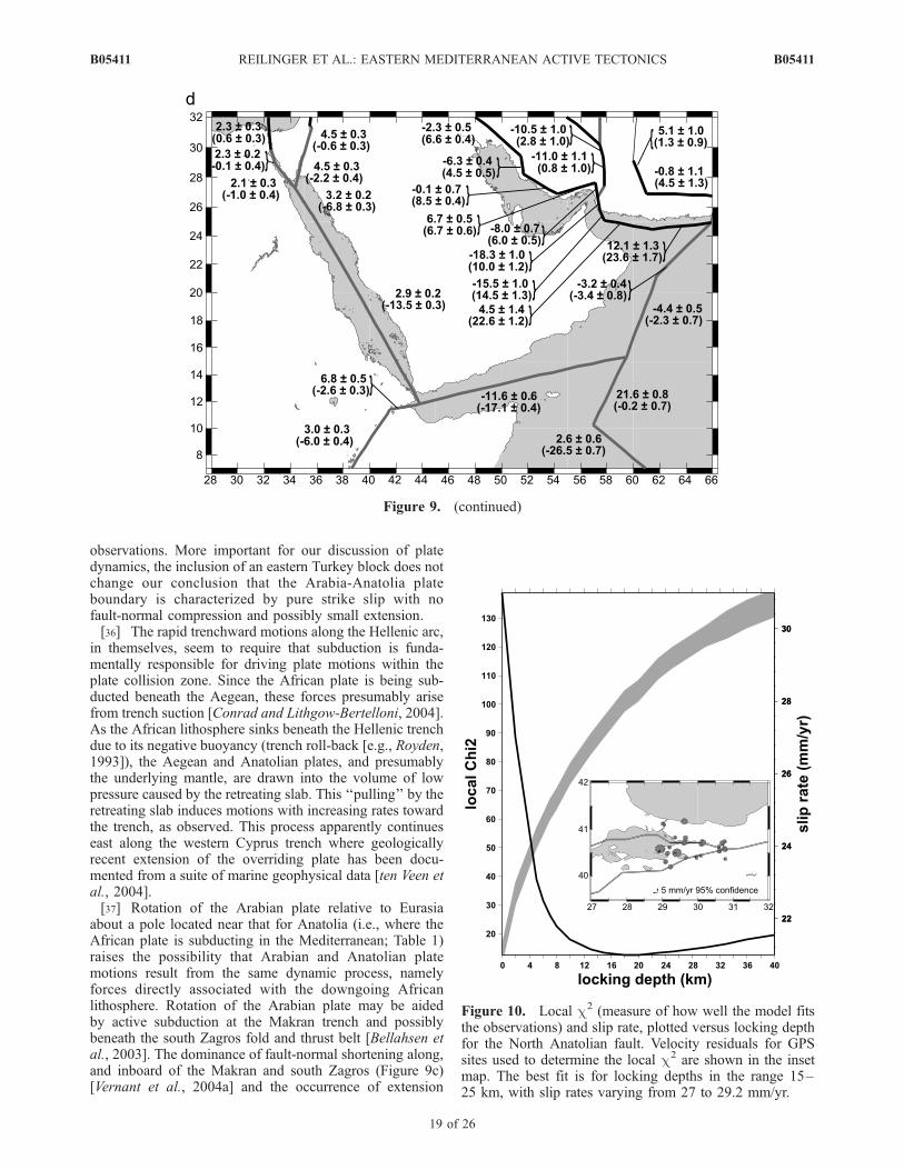
in themselves, seem to require that subduction is funda-mentally responsible for driving plate motions within theplate collision zone. Since the African plate is being sub-ducted beneath the Aegean, these forces presumably arisefrom trench suction [Conrad and Lithgow-Bertelloni, 2004].As the African lithosphere sinks beneath the Hellenic trenchdue to its negative buoyancy (trench roll-back [e.g., Royden,1993]), the Aegean and Anatolian plates, and presumablythe underlying mantle, are drawn into the volume of lowpressure caused by the retreating slab. This ‘‘pulling’’ by theretreating slab induces motions with increasing rates towardthe trench, as observed. This process apparently continueseast along the western Cyprus trench where geologicallyrecent extension of the overriding plate has been docu-mented from a suite of marine geophysical data [ten Veen etal., 2004].[37] Rotation of the Arabian plate relative to Eurasia
about a pole located near that for Anatolia (i.e., where theAfrican plate is subducting in the Mediterranean; Table 1)raises the possibility that Arabian and Anatolian platemotions result from the same dynamic process, namelyforces directly associated with the downgoing Africanlithosphere. Rotation of the Arabian plate may be aidedby active subduction at the Makran trench and possiblybeneath the south Zagros fold and thrust belt [Bellahsen etal., 2003]. The dominance of fault-normal shortening along,and inboard of the Makran and south Zagros (Figure 9c)[Vernant et al., 2004a] and the occurrence of extension
Figure 9. (continued)
Figure 10. Local c2 (measure of how well the model fitsthe observations) and slip rate, plotted versus locking depthfor the North Anatolian fault. Velocity residuals for GPSsites used to determine the local c2 are shown in the insetmap. The best fit is for locking depths in the range 15–25 km, with slip rates varying from 27 to 29.2 mm/yr.
B05411 REILINGER ET AL.: EASTERN MEDITERRANEAN ACTIVE TECTONICS
19 of 26
B05411
along the northern Owens Fracture Zone (Arabia-India plateboundary, Figures 1b and 9d) are at least consistent with thesubducting slab ‘‘pulling’’ the Arabian plate toward the NE.According to this conceptual model, the retreating slab in
the eastern Mediterranean (Hellenic/Cyprus trenches) indu-ces the overriding Aegean and Anatolian plates to movetoward the trench while the subducting slab beneath theMakran and south Zagros imparts a pull to the Arabian plate
Table 2. GPS-Derived Fault Slip Rates Deduced From the Block Model Shown in Figure 7 for Selected Block-
Bounding Faults and Geologic Slip Rates Where Availablea
Faultb GPS SS GPS DS GEO SS GEO DS REFc
NAF �24 ± 1 �1/+7 ± 1 �16/�24 ± 5 h�f, w, arm, kzEAF 10 ± 1 �3/�5 ± 1 �11 ± 2 wDSF 4.5/4.8 ± 1d �2/+2 ± 1d 4/7 ± 2 m, g, k, n, d, jgGulf of Suez 2 ± 1 0/�1 ± 1 �1 st, jgRed Sea 3 ± 1 �7/�17 ± 1e 3 ± 2 �8/�18 ± 2 chu, jgGulf of Aden �10/�13 ± 1 �12/�22 ± 1f �16/�24 ± 5f je, nu, gd, jgGulf of Corinth 2/�7 ± 1 �15/�21 ± 1 �11 ± 3 a96Zagros FT �2/3 ± 1 0/8 ± 1e �10/17 10 t+j, b, baHellenic (W) �20/+6 ± 1g 38/44 ± 1g
Hellenic (E) 17/50 ± 1f 3/39 ± 1e
Cyprus (W) �5/+1 ± 1 9/18 ± 1Cyprus (E) 7 ± 1 �4/�8 ± 2f
Tabriz �11 ± 1.5 �1.5Chalderan �12 ± 1 0 ± 1Mosha 4 ± 1 0 ± 1 2.7 ± 0.5 rPSSFh �3.4 ± 1 0/�1.5 ± 1 �3/�4 tr, ph
aGPS SS, GPS strike-slip rate (left-lateral plus); GPS DS, GPS fault-normal rate (convergence plus); GEO SS, geologicalstrike-slip rate; GEO DS, geological fault-normal rate; REF, geological reference. See Figures 9a–9d and Table S2 for morecomplete compilations. GPS slip rate uncertainties are formal, 1s uncertainties from our block model rounded up to the nearestmm/yr.
bNAF, North Anatolian fault; EAF, East Anatolian fault; DSF, Dead Sea fault; PSSF, Pambak-Sevan-Sunik fault.cReferences are a96, Armijo et al. [1996]; arm, Armijo et al. [1999]; ba, Bachmanov et al. [2004]; b, Blanc et al. [2003]; chu,
Chu and Gordon [1998]; d, Daeron et al. [2004]; g, Gomez et al. [2003]; h– f, Hubert-Ferrari et al. [2002]; je, Jestin et al.[1994]; jg, Joffe and Garfunkel [1987]; k, Klinger et al. [2000]; kz, Kozaci et al. [2005]; m, Meghraoui et al. [2003]; n, Niemiet al. [2001]; nu, DeMets et al. [1990, 1994]; ph, Philip et al. [2001]; r, Ritz et al. [2006]; st, Steckler et al. [1998]; t+j, Talebianand Jackson [2002]; tr, Trifonov et al. [1994]; w, Westaway [1994].
dIncreasing from south to north.eIncreasing from north to south.fIncreasing from SW to NE.gStrike-slip increasing from SE to NW and fault-normal increasing from NW to SE.hSee Figure 11 for fault geometry.
Figure 11a. Residual GPS velocities and 95% confidence ellipses for a block model including twoblocks for the eastern Turkey Plateau–Lesser Caucasus. Model fault parameters are given in Table S2.Format is as in Figure 8.
B05411 REILINGER ET AL.: EASTERN MEDITERRANEAN ACTIVE TECTONICS
20 of 26
B05411
toward the NNE. This combination of forces produces theobserved counterclockwise rotations of Anatolia and Arabiaand the rapid trenchward motion of the Aegean. ‘‘Ridgepush’’ along the Red Sea and/or Gulf of Aden rifts isunlikely to play a significant role in driving motion of theArabian plate given the narrow width of new ocean litho-sphere, although forcing associated with the Afar plumeinteracting with the continental lithosphere may play somerole. While we see no evidence of NE oriented compressionwithin the Arabian plate, as would be expected if theArabian plate is being ‘‘driven’’ by ridge push or by theAfar plume into Eurasia along the Makran and south Zagros(versus being pulled by the subducting slab), GPS velocityuncertainties are presently too large to rule this out.[38] If our association of block motions with subduction is
generally applicable to the entire zone of plate interaction, therelatively rapid NNE motions in the eastern Caucasus(Figure 3) suggest the presence of subduction beneath theCaucasus and perhaps the central Caspian Sea [Jackson et al.,2002; Vernant and Chery, 2006]. While significant fault-normal shortening occurs along both the north Zagros andMCT, our block models indicate very little shortening andperhaps small fault-normal extension within the Lesser Cau-casus and south of the Caspian Sea (Figures 9b, 9c, and 11),somewhat analogous to extension in western Anatolia juxta-posed with compression along the Hellenic and Cyprustrenches.[39] While the kinematics appear to implicate processes
associated with subduction as the principal source of surfacedeformation, how slab retreat and slab pull are imparted tothe lithosphere remains uncertain. Are tensional forcestransmitted through the plates or does subduction induceflow in the mantle that is imparted to the plates throughshear tractions on the asthenosphere-lithosphere interface(or some combination of these processes)? The spatial scaleof the observed, circulatory pattern of surface deformation(�3000 km) may favor a deep source, although the scale of
deformation could be due to the dimensions of the Anato-lian and Arabian plates. However, this leaves open thequestion of why the lithosphere responds to the dynamicprocesses by forming plates of this scale (lithospheric
Figure 11b. Fault slip rates resulting from the block model shown in Figure 11a. Model slip rates aregiven in Table S2. Format is as in Figure 9.
Figure 12. Plot of fault slip rates deduced from ourpreferred GPS-constrained block model (Figures 7 and 9and Table S2) versus geologic slip rates reported in theliterature (fault abbreviations and references are given inTable 2; we compare the GPS strike-slip rate for the ZagrosFT with geologic strike-slip rates reported for the MainRecent fault (MRF)). We plot average of the more recentgeologic rates with the uncertainty reflecting the range ofrates reported.
B05411 REILINGER ET AL.: EASTERN MEDITERRANEAN ACTIVE TECTONICS
21 of 26
B05411

weakening associated with the interaction of the Afar plumewith Africa/Arabia plate [e.g., Bellahsen et al., 2003]?).Perhaps relevant to this discussion is the apparent balancebetween surface area consumed at trenches and along thrustfaults (�112 � 103 km2/Myr) and that created at ridges andat normal faults (�105 � 103 km2/Myr) for the entire areaof plate interaction (19–66�E; 12–46�N). This balanceindicates that deformation in the Nubia-Somalia-Eurasiainterplate region forms a roughly closed system. This is atleast consistent with a dynamic ‘‘connection’’ betweendownwelling at trenches and upwelling at ridges. Whetherthis connection is via subduction pulling open the Red Seaand Gulf of Aden rifts (i.e., stresses transmitted through thelithosphere), or flow in the mantle from subduction zonestoward ridges remains unresolved.[40] While dynamic models that involve trench suction,
slab pull, and/or sublithospheric mantle flow may requireless strength in the lithosphere than extrusion models,coherent block and plate motions would appear to requirea relatively strong continental lithosphere. The observationthat the elastic block model provides a good fit to the GPSresults and that the deduced GPS fault slip rates arecomparable to geologic rates supports the notion that thecrust has sufficient strength to behave elastically overgeologic timescales (i.e., relative block motions are primar-ily accommodated by repeated cycles of elastic strainaccumulation and release on block-bounding faults). Inaddition, the lack of continuing postseismic deformationfrom the sequence of M > 7.5 earthquakes along the NAFsystem during the last century supports models with highmantle viscosities (>5 � 1020 Pa s [Hearn et al., 2002a]).Further support for a relatively strong lithosphere comes
from the pattern of elastic strain accumulation along theNAF segment that broke in theM7.4, 1999 Izmit earthquake(Figure 5). Lithospheric models that include an elastic layerover a sufficiently low viscosity (i.e., weak) Maxwellviscoelastic layer predict a broadening of the strain fieldadjacent to strike-slip faults late in the earthquake cycle[Savage and Prescott, 1978; Meade and Hager, 2005]. Theprofile across the NAF shown in Figure 5 is based on GPSobservations during a 10-year period immediately beforethe Izmit event, very late in the earthquake cycle. Theexcellent fit for an elastic half-space model with an�20 km locking depth implies a relatively high viscosity(�1020 Pa s) for the lower crust/upper mantle in NW Turkey(see Meade and Hager [2005] for quantitative discussion).The notion that blocks in the collision zone have significantstrength is further supported by the absence of a correlationbetween topographic relief in eastern and central Turkeyand surface deformation (i.e., no significant deformationacross the step in topography between eastern and centralAnatolia; compare Figures 1 and 13). This argues againstinternal, gravitationally driven body forces contributingsignificantly to the dynamics of Anatolia plate motion[see also Provost et al., 2003] and for a sufficiently strongcrust capable of maintaining stresses associated with largegravitational potential energy differences.
6. Conclusions
[41] The principal result of this study is the GPS-derived,secular velocity field for the period 1988–2005 in the zoneof interaction of the Nubian, Somalian, Arabian, and Eur-asian plates (Figures 2 and 3 and Table S1). Our main
Figure 13. Map showing revised block model including an eastern Turkey block, residual velocitiesfrom this model, and deduced fault slip rates (same format as Figures 8 and 9). Model fault parameters aregiven in Table S2.
B05411 REILINGER ET AL.: EASTERN MEDITERRANEAN ACTIVE TECTONICS
22 of 26
B05411

conclusions based on these new results are illustratedschematically in Figure 14. The velocity field indicatescounterclockwise rotation of a broad area including theArabian, Anatolian, and Aegean regions and adjacent partsof the Zagros and central Iran. Rates of motion associatedwith this rotation increase toward the Hellenic-Cyprustrench system. The velocity field is characterized well bya system of undeforming regions separated by concentratedzones of deformation (widths 100 km). Deformationzones correlate closely with mapped, active faults andhistoric seismicity, and coherent regions with seismicallyquiet zones, qualitatively consistent with the original platetectonic, kinematic models for this region [McKenzie, 1970;McKenzie et al., 1970]. We use a simple, kinematic blockmodel, including elastic strain accumulation on block-bounding faults, to quantify relative block motions(Table 1) and to determine present-day rates of strain
accumulation on block-bounding faults (modeled as deepfault slip). The GPS-derived Euler vectors for Arabia-Nubia, Somalia-Nubia, and Arabia-Somalia are in goodagreement with the most recent geologic Euler vectorsderived from plate reconstructions. In addition, the GPS-derived relative motions between Nubia and Eurasia, andArabia and Eurasia are consistent with the most recentgeologic estimates. We also find that, with some exceptions,the estimated GPS slip rates for major block-boundingfaults are comparable to geologic rates estimated for thepast few million years (Table 2 and Figure 12), most oftendiffering by less than 1s uncertainties. These comparisonsindicate that the GPS velocity field characterizes accuratelydeformation in the zone of plate interaction during the latePliocene (�3–5 Ma).[42] Within the zone of active continental collision in
eastern Turkey and the Lesser Caucasus, we find that lateral
Figure 14. Schematic map of the Arabia-Africa-Eurasia zone of plate interaction illustrating theprincipal results of this study. Names refer to plates and blocks (CAUC, Caucasus block; AN, Anatoliaplate; AE, Aegean plate). Double lines are extensional plate boundaries, plain lines are strike-slipboundaries (paired arrows show direction of strike-slip motion), and lines with triangles are thrust faults.Dark numbers are GPS-derived slip rates (mm/yr) on block-bounding faults (numbers in parentheses aredip slip and those without are strike slip). White arrows and corresponding numbers show GPS-derivedplate velocities (mm/yr) relative to Eurasia. Curved arrows show sense of block rotation relative toEurasia. Dark, heavy arrows show hypothesized forces associated with active subduction acting on theplate/block system and causing counterclockwise rotation of Arabia-central Iran-Anatolia-Aegeanrelative to Eurasia.
B05411 REILINGER ET AL.: EASTERN MEDITERRANEAN ACTIVE TECTONICS
23 of 26
B05411
transport of lithosphere out of the zone of plate convergenceand shortening along the Main Caucasus Thrust are thepredominant processes accommodating Arabia-Eurasia con-vergence. Furthermore, the boundary between the Arabianplate and the Anatolian plate is characterized by predomi-nantly left-lateral strike-slip motion with no fault-normalconvergence and possibly a small amount of extension.These kinematic results rule out ‘‘extrusion’’ as a dynamicmechanism for present-day westward motion and counter-clockwise rotation of the Anatolian plate. The increasingrate of motion toward the Hellenic and Cyprus trenchessuggests to us that the primary forces responsible forwestward motion of Anatolia, and perhaps counterclock-wise rotation of Arabia, are associated with slab rollbackalong the Hellenic and Cyprus trenches. Counterclockwiserotation of the Arabian plate may be enhanced by slab pullfrom NE-directed subduction beneath the Makran andpossibly the south Zagros. A direct corollary of this pro-posed dynamic hypothesis is that rifting in the Red Sea andGulf of Aden is a response to plate motions induced byactive subduction. This interpretation implies that continu-ing subduction of the African and Arabian oceanic litho-sphere (i.e., Neotethys) is driving plate motions andinterplate deformation throughout the zone of interactionof the African, Arabian, and Eurasian plates.
[43] Acknowledgments. We are grateful to the many individuals whoparticipated in GPS surveys over the past 15 years, to those individuals andinstitutions that support the global IGS network, and to UNAVCO and theTurkish General Command of Mapping for technical support for GPSsurveys and continuous GPS station installation and maintenance. BeckyBendick and Pierre Briolle provided published GPS data around the EastAfrican rift and Gulf of Corinth, respectively. We benefited from discus-sions with Mark Allen, Muawia Barazangi, Michael Bevis, Jean Chery,Bradford Hager, Laurent Husson, James Jackson, Sadi Kuleli, BrendonMeade, and Nafi Toksoz on regional geodynamics and with ThomasHerring and Robert King on GPS data analysis. We obtained both IGStracking data and global analyses (solution files) from the Scripps Orbit andPermanent Array Center. The maps in this paper were generated using thepublic domain Generic Mapping Tools (GMT) software [Wessel and Smith,1995]. We are grateful for formal reviews that improved the manuscript byCharles DeMets, Timothy Dixon, and Shimon Wdowinski. We especiallyacknowledge the pioneering work on this project by the late Aykut Barka inTurkey and the late Serguei Balassanian in Armenia. This research wassupported in part by NSF grants EAR-0337497, EAR-0305480, and INT-0001583 and NASA grant NNG04GA15G.
ReferencesAllen, M., J. Jackson, and R. Walker (2004), Late Cenozoic reorganizationof the Arabia-Eurasia collision and the comparison of short-term andlong-term deformation rates, Tectonics, 23, TC2008, doi:10.1029/2003TC001530.
Armijo, R., H. Lyon-Caen, and D. Papanastassiou (1992), East-west exten-sion and Holocene normal fault scarps in the Hellenic arc, Geology, 20,492–494.
Armijo, R., B. Meyer, G. C. P. King, A. Rigo, and D. Papanastassiou(1996), Quaternary evolution of the Gulf of Corinth rift and its implica-tions for the Late Cenozoic evolution of the Aegean, Geophys. J. R.Astron. Soc., 126, 11–53.
Armijo, R., B. Meyer, A. Hubert, and A. Barka (1999), Propagation of theNorth Anatolian fault into the north Aegean: Timing and kinematics,Geology, 27, 267–270.
Bachmanov, D. M., et al. (2004), Active faults in the Zagros and centralIran, Tectonophysics, 380, 221–241.
Bellahsen, N., C. Faccenna, F. Funiciello, J. M. Daniel, and L. Jolivet(2003), Why did Arabia separate from Africa? Insights from 3-D labora-tory experiments, Earth and Plan Sci. Lett., 216, 365–381, doi:10.1016/S0012-821X(03)00516-8.
Bendick, R., S. McClusky, R. Bilham, L. Asfaw, and S. Klemper (2005),Distributed Nubia-Somalia relative motion and dike intrusion in the MainEthiopia Rift, Geophys. J. Int., 165, 303–310.
Blanc, E. J.-P., M. B. Allen, S. Inger, and H. Hassani (2003), Structuralstyles in the Zagros Simple Folded Zone, Iran, J. Geol. Soc. London, 160,401–412.
Bock, Y., J. Behr, P. Fang, J. Dean, and R. Leigh (1997), Scripps Orbit andPermanent Array Center (SOPAC) and Southern California PermanentGPS Array (PGGA), in The Global Positioning System for the Geos-ciences, pp. 55–61, Natl. Acad. Press, Washington, D. C.
Bozkurt, E. (2003), Origin of NE-trending basins in western Turkey, Geo-din. Acta, 16, 61–81.
Calais, E., C. De Mets, and J. M. Nocquet (2003), Evidence of a post-3.16Ma change in Nubia-Eurasia plate motion, Earth Planet. Sci. Lett., 216,81–92.
Chorowicz, J., D. Dhont, and N. Gundogdu (1999), Neotectonics in theeastern North Anatolian fault region (Turkey) advocates crustal exten-sion: Mapping from SAR ERS imagery and Digital Elevation Model,J. Struct. Geol., 21, 511–532.
Chu, D., and G. Gordon (1998), Current plate motions across the Red Sea,Geophys. J. Int., 135, 313–328.
Chu, D., and G. Gordon (1999), Evidence for motion between Nubia andSomalia along the Southwest Indian ridge, Nature, 398, 64–66.
Clarke, P. J., et al. (1998), Crustal strain in central Greece from repeatedGPS measurements in the interval 1989–1997, Geophys. J. Int., 135,195–214.
Conrad, C. P., and C. Lithgow-Bertelloni (2004), The temporal evolution ofplate driving forces: Importance of ‘‘slab suction’’ versus ‘‘slab pull’’ duringthe Cenozoic, J. Geophys. Res., 109, B10407, doi:10.1029/2004JB002991.
Daeron, M., L. Benedetti, P. Tapponier, A. Sursock, and R. C. Finkel(2004), Constraints on the post �25-ka slip rate of the Yammouneh fault(Lebanon) using in situ cosmogenic 36CL dating of offset limestone-clastfans, Earth Planet. Sci. Lett., 227, 105–119.
Davies, R., P. England, B. Parsons, H. Billiris, D. Paradissis, and G. Veis(1997), Geodetic strain in Greece in the interval 1892–1992, J. Geophys.Res., 102, 24,571–24,588.
Delouis, B., D. Giardini, P. Lundgren, and J. Salichon (2002), Joint inver-sion of InSAR, GPS, teleseismic, and strong-motion data for the spatialand temporal distribution of earthquake slip: Application to the 1999Izmit mainshock, Bull. Seismol. Soc. Am., 92, 278–299.
DeMets, C., R. G. Gordon, D. F. Argus, and S. Stein (1990), Current platemotions, Geophys. J. Int., 101, 425–478.
DeMets, C., R. G. Gordon, D. F. Argus, and S. Stein (1994), Effects ofrecent revisions to the geomagnetic reversal time scale on estimates ofcurrent plate motions, Geophys. Res. Lett., 21, 2191–2194.
Dhont, D., J. Chorowicz, T. Yurur, and O. Kose (1998), Polyphased blocktectonics along the North Anatolian Fault in the Tosya basin area (Tur-key), Tectonophysics, 299, 213–227.
Dong, D., T. A. Herring, and R. W. King (1998), Estimating regionaldeformation from a combination of space and terrestrial geodetic data,J. Geod., 72, 200–211.
Dorbath, L., and A. Cisternas (1997), Recent great earthquakes in theCaucasus region, in Historical and Prehistorical Earthquakes in theCaucasus, edited by D. Giardini and S. Balassanian, pp. 401–441,Springer, New York.
Elsasser, W. M. (1971), Sea-floor spreading as thermal convection, J. Geo-phys. Res., 76, 1101–1112.
England, P. C., and D. P. McKenzie (1983), A thin viscous sheet model forcontinental deformation, Geophys. J. R. Astron. Soc., 73, 523–532.
Ergintav, S., et al. (2002), Postseismic deformation near the Izmit earth-quake (08/17/99, M = 7.5) rupture zone, Bull. Seismol. Soc. Am., 92,194–207.
Feigl, K., et al. (2002), Estimating slip distribution for the Izmit main shockfrom coseismic GPS, SPOT, and ERS-1 measurements, Bull. Seismol.Soc. Am., 92, 161–171.
Fernandez, R. M. S., B. A. C. Ambrosius, R. Noomen, L. Bastos, M. J. R.Wortel, W. Spakman, and R. Govers (2003), The relative motion betweenAfrica and Eurasia as derived from ITRF2000 and GPS data, Geophys.Res. Lett., 30(16), 1828, doi:10.1029/2003GL017089.
Fernandez, R. M. S., B. A. C. Ambrosius, R. Noomen, L. Bastos,L. Combrinck, J. M. Miranda, and W. Spakman (2004), Angularvelocities of Nubia and Somalia from continuous GPS data: Implicationson present-day relative kinematics, Earth Planet. Sci. Lett., 222, 197–208, doi:10.1016/j.epsl.2004.02.008.
Flerit, F., R. Armijo, G. King, and B. Meyer (2004), The mechanicalinteraction between the propogating North Anatolian fault and theback-arc extension in the Aegean, Earth Planet. Sci. Lett., 224, 347–362.
Gelb, A (1974), Applied Optimal Estimation, MIT Press, Cambridge, Mass.Goldsworthy, M., J. Jackson, and J. Haines (2002), The continuity of activefault systems in Greece, Geophys. J. Int., 148, 596–618.
Gomez, F., et al. (2003), Holocene faulting and earthquake recurrence alongthe Serghaya branch of the Dead Sea fault system in Syria and Lebanon,Geophys. J. Int., 153, 658–674.
B05411 REILINGER ET AL.: EASTERN MEDITERRANEAN ACTIVE TECTONICS
24 of 26
B05411
Gordon, R. G., and C. DeMets (1989), Present-day motion along the OwenFracture Zone and Dalrymple Trough in the Arabian Sea, J. Geophys.Res., 94, 5560–5570.
Hager, B. H., R. W. King, and M. H. Murray (1991), Measurements ofcrustal deformation using the Global Positioning System, Annu. Rev.Earth Planet Sci., 19, 351–382.
Hearn, E. H., B. H. Hager, and R. E. Reilinger (2002a), Viscoelastic de-formation from North Anatolian Fault Zone earthquakes and the easternMediterranean GPS velocity field, Geophys. Res. Lett., 29(11), 1549,doi:10.1029/2002GL014889.
Hearn, E. H., R. Burgmann, and R. E. Reilinger (2002b), Dynamics ofIzmit earthquake postseismic deformation and loading of the Duzceearthquake hypocenter, Bull. Seismol. Soc. Am., 92, 172–193.
Herring, T. A. (2004), GLOBK: Global Kalman filter VLBI and GPSanalysis program version 4.1, Mass. Inst. of Technol., Cambridge.
Hubert-Ferrari, A., A. Barka, E. Jacques, S. Nalbant, B. Meyer, R. Armijo,P. Tapponier, and G. C. P. King (2000), Seismic hazard in the MarmaraSea region following the 17 August 1999 Izmit earthquake, Nature, 404,269–271.
Hubert-Ferrari, A., R. Armijo, G. King, B. Meyer, and A. Barka (2002),Morphology, displacement, and slip rates along the North Anatolian fault,Turkey, J. Geophys. Res., 107(B10), 2235, doi:10.1029/2001JB000393.
Isacks, B., J. Oliver, and L. R. Sykes (1968), Seismology and the newglobal tectonics, J. Geophys. Res., 73, 5855–5899.
Jackson, J. (1992), Partitioning of strike-slip and convergent motionbetween Eurasia and Arabia in eastern Turkey, J. Geophys. Res., 97,12,471–12,479.
Jackson, J. (1999), Fault death: A perspective from actively deformingregions, J. Struct. Geol., 21, 1003–1010.
Jackson, J., and D. McKenzie (1984), Active tectonics of the Alpine-Himalayan belt between western Turkey and Pakistan, Geophys. J. R.Astron. Soc., 77, 185–246.
Jackson, J., and D. McKenzie (1988), The relationship between plate mo-tions and seismic tremors, and the rates of active deformation in theMediterranean and Middle East, Geophys. J. R. Astron. Soc., 93, 45–73.
Jackson, J., K. Priestley, M. Allen, and M. Berberian (2002), Activetectonics of the south Caspian Basin, Geophys. J. Int., 148, 214–245.
Jestin, F., P. Huchon, and J. Gaulier (1994), The Somali plate and the EastAfrican rift system: Present-day kinematics, Geophys. J. Int., 116, 637–654.
Jimenez-Munt, I., and R. Sabadini (2002), The block-like behavior ofAnatolia envisaged in the modeled and geodetic strain rates, Geophys.Res. Lett., 29(20), 1978, doi:10.1029/2002GL015995.
Joffe, S., and Z. Garfunkel (1987), Plate kinematics of the Red Sea–a re-evaluation, Geophys. J. Int., 116, 637–654.
Kahle, H.-G., M. Concord, Y. Peter, A. Geiger, R. Reilinger, A. Barka, andG. Veis (2000), GPS derived strain rate field within the boundary zonesof the Eurasian, African, and Arabian plates, J. Geophys. Res., 105,23,353–23,370.
King, R. W., and Y. Bock (2004), Documentation of the MIT GPS analysissoftware: GAMIT, Mass. Inst. of Technol., Cambridge.
Klinger, Y., J. P. Avouac, N. Abou Karaki, L. Dorbath, D. Bourles, and J. L.Reyes (2000), Slip rate on the Dead Sea transform fault in the northernAraba valley (Jordan), Geophys. J. Int., 142, 755–768.
Kocyigit, A., and A. Beyhan (1998), A new intra-continental transcurrentstructure: The Central Anatolian Fault Zone, Turkey, Tectonophysics,284, 317–336.
Kozaci, O., J. F. Dolan, R. Finkle, R. D. Hartleb, and M. Gurcan (2005),A 2000-year geologic slip rate for the North Anatolian Fault using cos-mogenic CL36 dating, Eos Trans. AGU, 86(52), Fall Meeting Suppl.,Abstract G53A-0869.
Le Pichon, X., and J. Angelier (1979), The Hellenic arc and trench system:A key to the neotectonic evolution of the eastern Mediterranean area,Tectonophysics, 60, 1–42.
Le Pichon, X., N. Chamot-Rooke, S. Lallemant, R. Noomen, and G. Veis(1995), Geodetic determination of the kinematics of central Greece withrespect to Europe: Implications for eastern Mediterranean tectonics,J. Geophys. Res., 100, 12,675–12,690.
Le Pichon, X., N. Chamot-Rooke, C. Rangin, and A. M. C. Sengor (2003),The North Anatolian fault in the Sea of Marmara, J. Geophys. Res.,108(B4), 2179, doi:10.1029/2002JB001862.
Lundgren, P., D. Giardini, and R. Russo (1998), A geodynamic frameworkfor eastern Mediterranean kinematics, Geophy. Res. Lett., 25, 4007–4010.
Lyberis, N., T. Yurur, J. Chorowicz, E. Kasapoglu, and N. Gundogdu(1992), East Anatolian fault: An oblique collision belt, Tectonophysics,204, 1–15.
Mahmoud, S., R. Reilinger, S. McClusky, P. Vernant, and A. Tealeb (2005),GPS evidence for northward motion of the Sinai block: Implications forE. Mediterranean tectonics, Earth Planet. Sci. Lett., 238, 217–224.
Mantovani, E., M. Viti, N. Cenni, and D. Babbucci (2001), Short and longterm deformation patterns in the Aegean-Anatolian system: Insights fromspace-geodetic data (GPS), Geophys. Res. Lett., 28, 2325–2328.
McCaffrey, R. (2002), Crustal block rotations and plate coupling, inPlate Boundary Zones, Geodyn. Ser., vol. 30, edited by S. Stein andJ. Freymueller, pp. 101–122, AGU, Washington, D. C.
McClusky, S., et al. (2000), Global Positioning System constraints on platekinematics and dynamics in the eastern Mediterranean and Caucasus,J. Geophys. Res., 105, 5695–5719.
McClusky, S., R. Reilinger, S. Mahmoud, D. Ben Sari, and A. Tealeb(2003), GPS constraints on Africa (Nubia) and Arabia plate motions,Geophys. J. Int., 155, 126–138.
McKenzie, D. P. (1970), Plate tectonics of the Mediterranean region, Nat-ure, 226, 239–243.
McKenzie, D. P. (1972), Active tectonics of the Mediterranean region,Geophys. J. R. Astron. Soc., 30, 109–185.
McKenzie, D. P. (1978), Active tectonics of the Alpine-Himalayan belt:The Aegean Sea and surrounding regions, Geophys. J. R. Astron. Soc.,55, 217–254.
McKenzie, D. P., D. Davies, and P. Molnar (1970), Plate tectonics of theRed Sea and East Africa, Nature, 226, 243–248.
McQuarrie, N., J. M. Stock, C. Verdel, and B. P. Wernicke (2003), Cen-ozoic evolution of Neotethys and implications for the causes of platemotions, Geophys. Res. Lett., 30(20), 2036, doi:10.1029/2003GL017992.
Meade, B. J., and B. H. Hager (2005), Block models of crustal motion insouthern California constrained by GPS measurements, J. Geophys. Res.,110, B03403, doi:10.1029/2004JB003209.
Meade, B. J., et al. (2002), Estimates of seismic potential in the Marmararegion from block models of secular deformation constrained by GPSmeasurements, Bull. Seismol. Soc. Am., 92, 208–215.
Meghraoui, M., et al. (2003), Evidence for 830 years of seismic quiescencefrom paleoseismology, archaeoseismology, and historical seismicityalong the Dead Sea fault in Syria, Earth Planet. Sci. Lett., 210, 35–52.
Meijer, P. T., and M. J. R. Wortel (1997), Present-day dynamics of theAegean region: A model analysis of the horizontal pattern of stress anddeformation, Tectonics, 16, 879–895.
Molnar, P., and P. Tapponier (1975), Cenozoic tectonics of Asia: Effects ofcontinental collision, Science, 189, 419–426.
Niemi, T. M., H. Zhang, M. Atallah, and J. B. J. Harrison (2001), LatePleistocene and Holocene slip rate of the northern Wadi Araba fault,Dead Sea Transform, Jordan, J. Seismol., 5, 449–474.
Nyst, M., and W. Thatcher (2004), New constraints on the active tectonicdeformation of the Aegean, J. Geophys. Res., 109, B11406, doi:10.1029/2003JB002830.
Okada, Y. (1985), Surface deformation due to shear and tensile faults in ahalf-space, Bull. Seismol. Soc. Am., 75, 1135–1154.
Ozalaybey, S., M. Ergin, M. Aktar, C. Tapirdamaz, F. Bicmen, andA. Yoruk (2002), The 1999 Izmit earthquake sequence in Turkey: Seismo-logical and tectonic aspects, Bull. Seismol. Soc. Am., 92, 376–386.
Pearce, J. A., et al. (1990), Genesis of collision volcanism in eastern Ana-tolia, Turkey, J. Volcanol. Geotherm. Res., 44, 189–229.
Philip, H., A. Cisternas, A. Gviskiani, and A. Gorshkov (1989), The Cau-casus: An actual example of the initial stages of continental collision,Tectonophysics, 161, 1–21.
Philip, H., A. Avagyan, A. Karakhanian, J.-F. Ritz, and S. Rabai (2001),Estimating slip rates and recurrence intervals for strong earthquakesalong an intercontinental fault: Example of the Pambak-Sevan-Sunikfault (Armenia), Tectonophysics, 343, 205–232.
Provost, A.-S., J. Chery, and R. Hassani (2003), 3D mechanical modelingof the GPS velocity field along the North Anatolian fault, Earth Planet.Sci. Lett., 209, 361–377.
Ray, J., D. Dong, and Z. Altamimi (2004), IGS reference frames: Status andfuture improvements, paper presented at IGS 2004 Workshop, Berne,Switzerland, 1 March .
Reilinger, R., and S. McClusky (2001), GPS constraints on block motionsand deformations in western Turkey and the Aegean: Implications forearthquake hazards, in Seismotectonics of the North-western Anatolia-Aegean and Recent Turkish Earthquakes, edited by T. Taymaz, pp.14–20, Istanbul Tech. Univ., Istanbul, Turkey.
Reilinger, R., et al. (1997), Global Positioning System measurements ofpresent-day crustal movements in the Arabia-Africa-Eurasia plate colli-sion zone, J. Geophys. Res., 102, 9983–9999.
Reilinger, R. E., et al. (2000), Coseismic and postseismic fault slip for the17 August,M = 7.5, Izmit, Turkey earthquake, Science, 289, 1519–1524.
Ritz, J.-F., H. Nazari, A. Ghassemi, R. Salamati, A. Shafei, S. Solaymani,and P. Vernant (2006), Active transtension inside central Alborz: A newinsight into the northern Iran–southern Caspian geodynamics, Geology,in press.
Royden, L. (1993), The tectonic expression of slab pull at continentalconvergent boundaries, Tectonics, 12, 303–325.
B05411 REILINGER ET AL.: EASTERN MEDITERRANEAN ACTIVE TECTONICS
25 of 26
B05411
Savage, J. C. (1990), Equivalent strike-slip earthquakes in half-space andlithosphere-asthenosphere Earth models, J. Geophys. Res., 95, 4873–4879.
Savage, J. C., and W. H. Prescott (1978), Asthenosphere readjustment andthe earthquake cycle, J. Geophys. Res., 83, 3369–3376.
Sella, G. F., T. H. Dixon, and A. Mao (2002), REVEL: A model for Recentplate velocities from space geodesy, J. Geophys. Res., 107(B4), 2081,doi:10.1029/2000JB000033.
Sengor, A. M. C., and Y. Yilmaz (1981), Tethyan evolution of Turkey: Aplate tectonic approach, Tectonophysics, 75, 181–241.
Sengor, A. M. C., N. Gorur, and F. Saroglu (1985), Strike-slip faulting andrelated basin formation in zones of tectonic escape: Turkey as a casestudy, in Strike-Slip Faulting and Basin Formation, edited by K. T.Biddle and N. Christie-Blick, Spec. Publ. SEPM Soc. Sediment. Geol.,37, 227–264.
Sengor, A. M. C., S. Ozeren, T. Genc, and E. Zor (2003), East Anatolianhigh plateau as a mantle-supported, north-south shortened domal struc-ture, Geophys. Res. Lett., 30(24), 8045, doi:10.1029/2003GL017858.
Sengor, A. M. C., O. Tuysuz, C. Imren, M. Sakinc, H. Eyidogan, N. Gorur,X. LePichon, and C. Rangin (2004), The North Anatolian fault: A newlook, Annu. Rev. Earth Planet. Sci., 33, 1–75.
Sonder, L., and P. England (1989), Effects of temperature dependent rheol-ogy on large scale continental extension, J. Geophys. Res., 94, 7603–7619.
Spakman, W. (1991), Delay-time tomography of the upper mantle belowEurope, the Mediterranean, and Asia Minor, Geophys. J. Int., 107, 309–332.
Steckler, M. S., S. Feinstein, B. P. Kohn, L. Lavier, and M. Eyal (1998),Pattern of mantle thinning from subsidence and heat flow measurementsin the Gulf of Suez: Evidence for the rotation of Suez and along-strikeflow from the Red Sea, Tectonics, 17, 903–920.
Talebian, M., and J. A. Jackson (2002), Offset on the Main Recent fault ofNW Iran and implications for the late Cenozoic tectonics of the Arabia-Eurasia collision zone, Geophys. J. Int., 150, 422–439.
Tapponier, P., A. Y. LeDain, R. Armijo, and P. Cobbold (1982), Propagatingextrusion tectonics in Asia: New insights with experiments with plasti-cine, Geology, 10, 611–616.
Tapponnier, P., X. Zhiqin, F. Roger, B. Meyer, N. Arnaud, G. Wittlinger,and Y. Jingsui (2001), Oblique stepwise rise and growth of the TibetPlateau, Science, 294, 1671–1677.
Taymaz, T., H. Eyidogan, and J. Jackson (1991), Source parameters of largeearthquakes in the east Anatolian fault zone (Turkey), Geophys. J. Int.,106, 537–550.
ten Veen, J. H., J. M. Woodside, T. A. C. Zitter, J. F. Dumont, J. Mascle,and A. Volkonsaia (2004), Neotectonic evolution of the AnaximanderMountains at the junction of the Hellenic and Cyprus arcs, Tectonophy-sics, 391, 35–65, doi:10.1016/j.tecto.2004.07.007.
Thatcher, W. (2003), GPS constraints on the kinematics of continentaldeformation, Int. Geol. Rev., 45, 191–212.
Trifonov, V. G., A. S. Karakhanian, and A. J. Kozhurin (1994), Majoractive faults of the collision area between the Arabian and Eurasianplates, paper presented at the Conference on Continental Collision ZoneEarthquakes and Seismic Hazard Reduction, IASPEI/IDNDR, Yerevan,Armenia.
Vernant, P., and J. Chery (2006), Low fault friction in Iran implies localizeddeformation for the Arabia-Eurasia collision zone, Earth Planet. Sci.Lett., in press.
Vernant, P., et al. (2004a), Present-day crustal deformation and plate kine-matics in the Middle East constrained by GPS measurements in Iran andnorthern Oman, Geophys. J. Int., 157, 381–398.
Vernant, P., et al. (2004b), Deciphering oblique shortening of central Alborzin Iran using geodetic data, Earth Planet. Sci. Lett., 223, 177–185.
Wdowinski, S., Y. Bock, G. Baer, L. Prawirodirdjo, N. Bechor, S. Naaman,R. Knafo, Y. Forrai, and Y. Melzer (2004), GPS measurements of currentcrustal movements along the Dead Sea Fault, J. Geophys. Res., 109,B05403, doi:10.1029/2003JB002640.
Wessel, R., and W. H. F. Smith (1995), New version of the generic mappingtools released, Eos Trans. AGU, 76, 329.
Westaway, R. (1994), Present-day kinematics of the Middle East and east-ern Mediterranean, J. Geophys. Res., 94, 12,071–12,090.
Westaway, R. (1999), Comment on ‘‘A new intra-continental transcurrentstructure: The Central Anatolian Fault Zone, Turkey,’’ Tectonophysics,314, 481–496.
Westaway, R. (2004), Kinematic consistency between the Dead Sea faultzone and the neogene and Quaternary left-lateral faulting in SE Turkey,Tectonophysics, 391, 203–238, doi:10.1016/j.tecto.2004.07.014.
Wortel, M. J. R., and W. Spakman (2000), Subduction and slab detachmentin the Mediterranean-Carpathian Region, Science, 290, 1910–1917,doi:10.1126/science.290.5498.1910.
Wright, T. J., B. Parsons, P. C. England, and E. J. Fielding (2004), InSARobservations of low slip rates on the major faults of western Tibet,Science, 305, 236–239.
Zor, E., E. Sandvol, C. Gurbuz, N. Turkelli, D. Seber, and M. Barazangi(2003), The crustal structure of the East Anatolian plateau (Turkey) fromreceiver functions, Geophys. Res. Lett., 30(24), 8044, doi:10.1029/2003GL018192.
�����������������������A. Al-Aydrus, Faculty of Science, Sana’a University, Sana’a, Yemen.R. Al-Ghazzi, Higher Institute of Applied Science and Technology,
Damascus, Syria.A. ArRajehi, King Abdulaziz City for Science and Technology, P.O. Box
6086, Riyadh 11442, Saudi Arabia.R. Cakmak and S. Ergintav, Turkish National Science Foundation
(TUBITAK), Marmara Research Center, Earth and Marine SciencesResearch Institute, Gebze 41470, Turkey.A. Dmitrotsa and S. V. Filikov, Crimea Radio Astronomical Observatory,
Simiez, Crimea, Ukraine.E. Evren, Geophysics Research Group, University of Ulster, Coleraine,
Co. Derry, N. Ireland.F. Gomez, Department of Geological Sciences, University of Missouri–
Columbia, Columbia, MO 65211, USA.I. Guliev and F. Kadirov, Geology Institute, National Academy of
Sciences, Az1143 Baku, H. Cavid 29A, Azerbaijan.T. Guseva and M. Prilepin, Universal Institute of Physics of the Earth,
Moscow, Russia.G. Hahubia and M. Nadariya, Joint Stock Company ‘‘Airgeodetic’’,
Tbilisi, Georgia.G. Karam, Department of Civil Engineering, Lebanese American
University, Jbeil, Lebanon.S. Lawrence, University Navstar Consortium (UNAVCO), Boulder, CO
80301, USA.S. Mahmoud and K. Sakr, National Research Institute of Astronomy and
Geophysics, Helwan, Cairo, Egypt.S. McClusky, R. Reilinger, and P. Vernant, Department of Earth,
Atmospheric, and Planetary Sciences, Massachusetts Institute of Technol-ogy, Cambridge, MA 02139, USA. ([email protected])H. Ozener, Bogazici University, Kandilli Observatory and Earthquake
Research Institute, 34680 Cengelkoy, Istanbul, Turkey.D. Paradissis, Higher Geodesy Laboratory, National Technical Uni-
versity, 9, Heroon Polytechniou Str., GR-15780 Zographou, Athens,Greece.R. Stepanyan, National Survey for Seismic Protection, Davidashen-
Massiv 4, 375054, Yerevan, Republic of Armenia.
B05411 REILINGER ET AL.: EASTERN MEDITERRANEAN ACTIVE TECTONICS
26 of 26
B05411
Related Documents