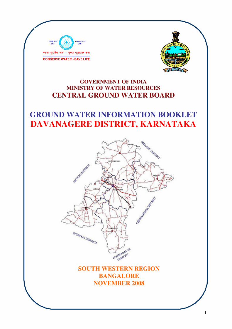
1 GOVERNMENT OF INDIA MINISTRY OF WATER RESOURCES CENTRAL GROUND WATER BOARD GROUND WATER INFORMATION BOOKLET DAVANAGERE DISTRICT, KARNATAKA SOUTH WESTERN REGION BANGALORE NOVEMBER 2008

Welcome message from author
This document is posted to help you gain knowledge. Please leave a comment to let me know what you think about it! Share it to your friends and learn new things together.
Transcript
1
GOVERNMENT OF INDIA
MINISTRY OF WATER RESOURCES
CENTRAL GROUND WATER BOARD
GROUND WATER INFORMATION BOOKLET
DAVANAGERE DISTRICT, KARNATAKA
SOUTH WESTERN REGION
BANGALORE
NOVEMBER 2008

2
FOREWORD
Ground water contributes to about eighty percent of the drinking water
requirements in the rural areas, fifty percent of the urban water requirements and
more than fifty percent of the irrigation requirements of the nation. Central
Ground Water Board has decided to bring out district level ground water
information booklets highlighting the ground water scenario, its resource
potential, quality aspects, recharge – discharge relationship, etc., for all the
districts of the country. As part of this, Central Ground Water Board, South
Western Region, Bangalore, is preparing such booklets for all the 27 districts of
Karnataka state, of which six of the districts fall under farmers’ distress category.
The Davanagere district Ground Water Information Booklet has been
prepared based on the information available and data collected from various
state and central government organisations by several hydro-scientists of Central
Ground Water Board with utmost care and dedication. This booklet has been
prepared by Shri. T.Rajendiran, Assistant Hydrogeologist, under the guidance of
Dr. K.Md. Najeeb, Superintending Hydrogeologist, Central Ground Water Board,
South Western Region, Bangalore. The figures were prepared by S/Sri.
H.P.Jayaprakash, Scientist-C and K.Rajarajan, Assistant Hydrogeologist. The
efforts of Report processing section in finalising and bringing out the report in this
format are commendable.
I take this opportunity to congratulate them for the diligent and careful
compilation and observation in the form of this booklet, which will certainly serve
as a guiding document for further work and help the planners, administrators,
hydrogeologists and engineers to plan the water resources management in a
better way in the district.
(T.M.HUNSE) Regional Director
3
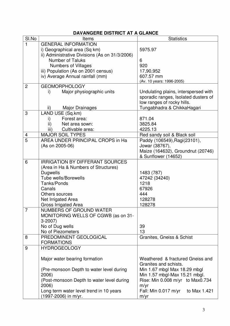
DAVANGERE DISTRICT AT A GLANCE
Sl.No Items Statistics
1 GENERAL INFORMATION i) Geographical area (Sq km) ii) Administrative Divisions (As on 31/3/2006) Number of Taluks Numbers of Villages iii) Population (As on 2001 census) iv) Average Annual rainfall (mm)
5975.97 6 920 17,90,952 607.57 mm (Av. 10 years: 1996-2005)
2 GEOMORPHOLOGY i) Major physiographic units
ii) Major Drainages
Undulating plains, interspersed with sporadic ranges, Isolated dusters of low ranges of rocky hills. Tungabhadra & ChikkaHagari
3 LAND USE (Sq.km) i) Forest area: ii) Net area sown: iii) Cultivable area:
871.04 3825.84 4225.13
4 MAJOR SOIL TYPES Red sandy soil & Black soil
5 AREA UNDER PRINCIPAL CROPS in Ha (As on 2005-06)
Paddy (106549),Ragi(23101), Jowar (38767), Maize (164632), Groundnut (20746) & Sunflower (14652)
6 IRRIGATION BY DIFFERANT SOURCES (Area in Ha & Numbers of Structures) Dugwells Tube wells/Borewells Tanks/Ponds Canals Others sources Net Irrigated Area Gross Irrigated Area
1483 (787) 47242 (34240) 1218 67926 444 128278 128278
7 NUMBERS OF GROUND WATER MONITORING WELLS OF CGWB (as on 31-3-2007) No of Dug wells No of Piezometers
39 13
8 PREDOMINENT GEOLOGICAL FORMATIONS
Granites, Gneiss & Schist
9 HYDROGEOLOGY Major water bearing formation (Pre-monsoon Depth to water level during 2006) (Post-monsoon Depth to water level during 2006) Long term water level trend in 10 years (1997-2006) in m/yr.
Weathered & fractured Gneiss and Granites and schists. Min 1.67 mbgl Max 18.29 mbgl Min 1.57 mbgl-Max 15.21 mbgl. Rise: Min 0.008 m/yr to Max0.734 m/yr Fall: Min 0.017 m/yr to Max 1.421 m/yr

4
Sl.No Items Statistics
10 GROUND WATER EXPLORATION BY CGWB (As on 31-03-2007) No of well drilled (EW, OW, PZ, Total) Depth range (m) Discharge (lps) Storativity (S) Transmissivity (m2/day)
43, 14,13, 70 26-200 0.07 to 9.9lps. - 0.1 to 260 m2/day
11 GROUND WATER QUALITY Presence of Chemical constituents more than permissible limits Type of water
Ec & Cl (only in shallow aquifers) Carbonate & Bicarbonate
12 DYNAMIC GROUND WATER RESOURCES (2004)- in mcm Annual replenish able Ground water Resources Net Annual Ground Water draft Projected Demand for Domestic and Industrial Uses upto 2025 Stage of Ground Water Development in %
591.27 456.70 48.97 77
AWARENESS AND TRAINING ACTIVITY Mass Awareness Programmes organized Date Place No of participants
Nil
13
Water Management Training Programmes organized Date Place No of participants
Nil
14 EFFORTS OF ARTIFICIAL RECHARGE & RAIN WATER HARVESTING Projects completed by CGWB (No & Amount spent) Projects under technical guidance of CGWB (Numbers)
Nil 2 (During the FSP 1999-2000)
15 GROUND WATER CONTROL AND REGULATION Number of OE Blocks No of Semi Critical Blocks No of Blocks notified
5 1 Nil
16 MAJOR GROUND WATER PROBLEMS AND ISSUES
5
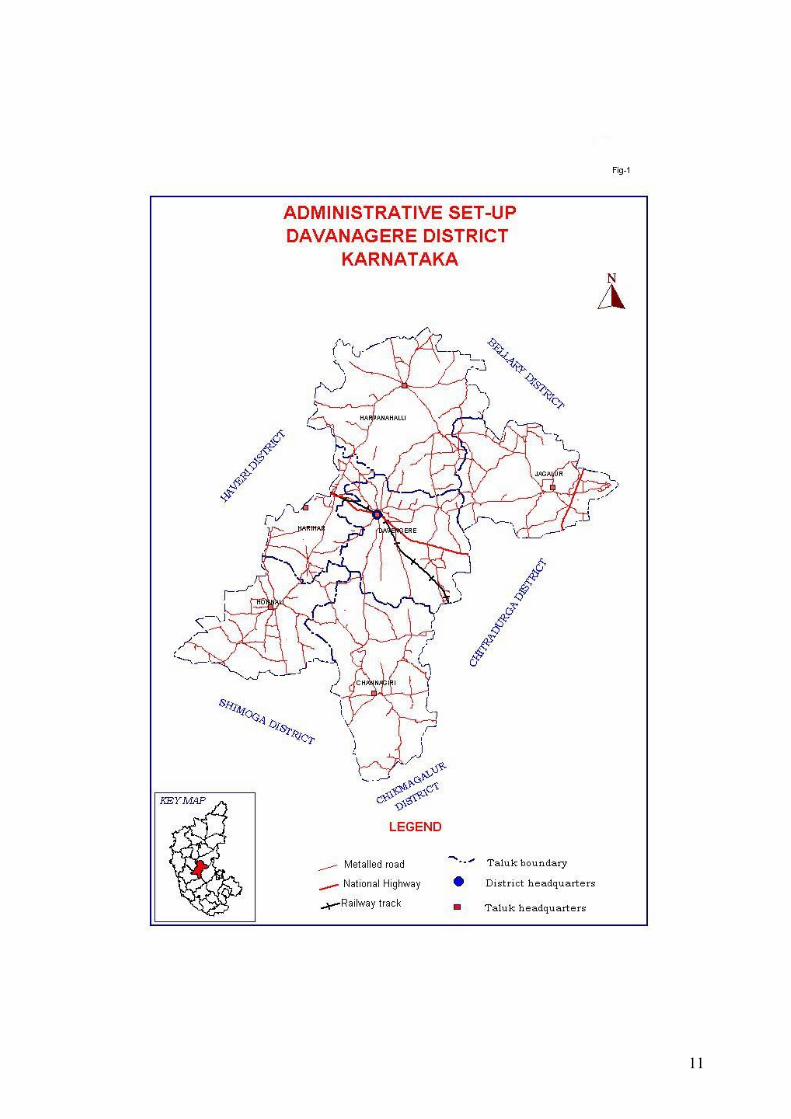
1.0 Introduction: Davangere district covers a geographical area of 5975.97 sq.kms and
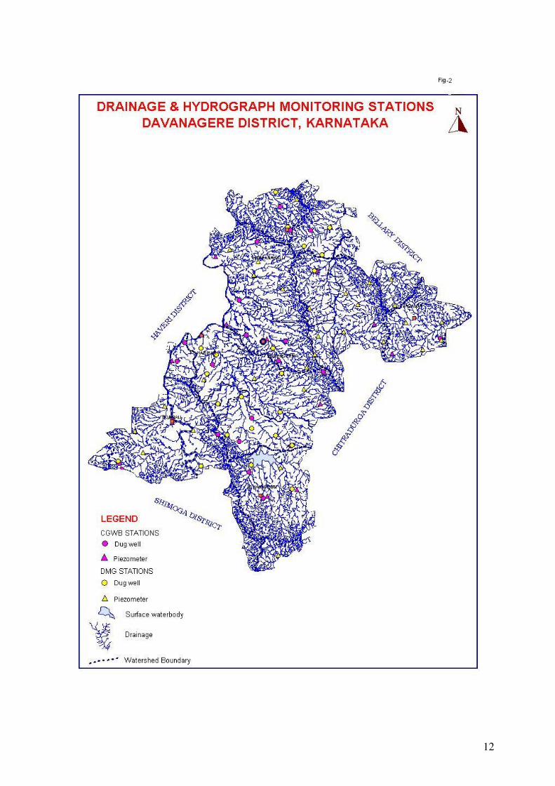
comprises of six taluks (Fig-1). Major part of the district lies in Krishna basin and is drained by Tungabhadra & Chikka Hagari Rivers. The other major streams in the district are Janagahalla and Haridra Nandi. Agriculture is the main source of income of the people in the district. Shantisagar tank constructed across Haridra stream is a source for irrigation in the district. Part of command area of Bhadra reservoir project falls within the district. Two irrigation canals viz., Davangere Branch canal and Harihar Branch canal of the Bhadra reservoir provides irrigation facilities to the people of Davangere and Harihar taluks. In the noncanal command area agriculture is dependant on rainfall. The drainage in the district is shown in the figure –2.
Central Ground Water Board has carried out Systematic & Reappraisal hydrogeological surveys in the district. Exploratory drilling was carried out during 1975-76, 1988-90 & 2004-07 in the district. Seventy bore wells were drilled by CGWB under ground water exploration programme. Further thirty bore wells were drilled by CGWB through out sourcing for water supply in the hardcore villages of Harpanahalli and Jagalur taluks during the year 2004-05. 2.0 Rainfall & Climate:
The district enjoys semi arid climate, dryness in the major part of the year and hot summer. In general, southwest monsoon contributes 58 % of total rainfall and northeast monsoon contributes 22 % rainfall. The remaining 20 % rainfall is received as sporadic rains in summer months. It receives low to moderate rainfall. Normal annual rainfall varies between 556 mm in Jagalur and 808 mm in Channagiri taluk.
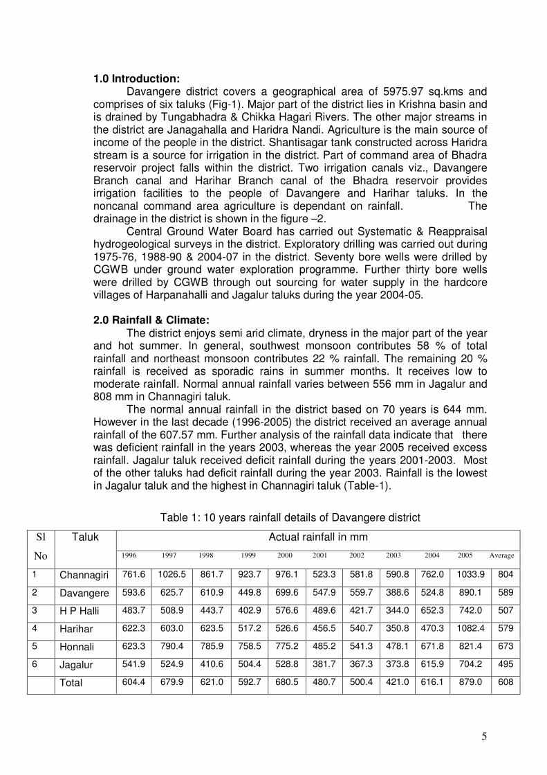
The normal annual rainfall in the district based on 70 years is 644 mm. However in the last decade (1996-2005) the district received an average annual rainfall of the 607.57 mm. Further analysis of the rainfall data indicate that there was deficient rainfall in the years 2003, whereas the year 2005 received excess rainfall. Jagalur taluk received deficit rainfall during the years 2001-2003. Most of the other taluks had deficit rainfall during the year 2003. Rainfall is the lowest in Jagalur taluk and the highest in Channagiri taluk (Table-1).
Table 1: 10 years rainfall details of Davangere district
Actual rainfall in mm Sl
No
Taluk
1996 1997 1998 1999 2000 2001 2002 2003 2004 2005 Average
1 Channagiri 761.6 1026.5 861.7 923.7 976.1 523.3 581.8 590.8 762.0 1033.9 804
2 Davangere 593.6 625.7 610.9 449.8 699.6 547.9 559.7 388.6 524.8 890.1 589
3 H P Halli 483.7 508.9 443.7 402.9 576.6 489.6 421.7 344.0 652.3 742.0 507
4 Harihar 622.3 603.0 623.5 517.2 526.6 456.5 540.7 350.8 470.3 1082.4 579
5 Honnali 623.3 790.4 785.9 758.5 775.2 485.2 541.3 478.1 671.8 821.4 673
6 Jagalur 541.9 524.9 410.6 504.4 528.8 381.7 367.3 373.8 615.9 704.2 495
Total 604.4 679.9 621.0 592.7 680.5 480.7 500.4 421.0 616.1 879.0 608

6
The district falls under central dry agro-climatic zone of the Karnataka state and is categorized as drought prone. Normal climatic parameters of Davangere district are increasing temperature from March to May, usually maximum in April month and minimum temperature that is coldest month during month of December.
3.0 Geomorphology & Soil Types: The geomorphology of the district is characterised by vast stretches of
undulated plains interspersed with sporadic ranges or isolated clusters of low ranges of rocky hills. This may be broadly divided into two regions. The eastern hilly region consisting of Jagalur and north –eastern parts of Harpanahalli taluks and the plain region consisting of Harihar, Davangere, Honnali, Channagiri and parts of Harpanahalli taluks. Dalba Ranga Gudda (1013mamsl) in Honnali taluk is the highest peak in the district. The other prominent peaks of the district are Jaikal Gudda (863mamsl), and Anaburu (916mamsl).
Major part of the district is covered by red sandy soil and followed by black soil. Red sandy soil is spread through out the district except in a small area in the northeastern part of the district where the area is covered by black soil. The Red Sandy soil comprises of red loams, red sandy, sandy loams and medium black soils.
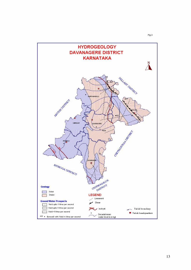
4.0 Ground Water Scenario: 4.1 Hydrogeology:
Groundwater occurs under phreatic and semi-confined conditions in the weathered and fractured rock formations of the ‘Peninsular Gneissic Group’ of rocks comprising of granites, gneisses and schist (Fig-3). The thickness of weathered zone varies from 4.0 – 36.74 m. The main source of ground water occurring in the district is through precipitation and return flow from applied irrigation.
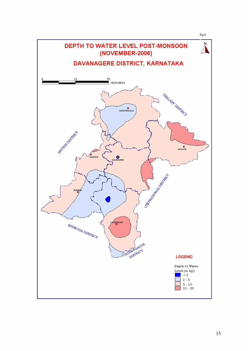
In Channagiri taluk granites, granitic-gneisses and schists are the main water bearing formations. Ground water exploration reveals the existence of 3 to 5 potential fracture zones between the depths of 21 mbgl to 170 mbgl. In Channagiri taluk exploratory bore wells were drilled from a minimum depth of 100 mbgl to a maximum of 200mbgl. Depth of weathered zone ranges from 10.3 mbgl to 23.10 mbgl. Yeild ranges from<1.0 to 9.9 lps. Specific Capacity ranges from 5.2 lpm/m to 707 lpm/m During May 2006 (pre-monsoon season) the minimum depth to water level and maximum depth to water level was 3.23 mbgl and 18.29 mbgl respectively (Fig-4). During November 2006 (post-monsoon) water levels ranged from 1.66 mbgl to 15.21 mbgl. (Fig-5).
In Davangere taluk fractured granitic-gneisses, gneisses and hornblende-schists are the main water bearing formations. Ground water occurs within the weathered and fractured rocks under water-table conditions and semi-confined conditions. Ground water exploration reveals that aquifers are encountered between the depths of 8.46 and 32 mbgl. In Davangere taluk bore wells were drilled from a minimum depth of 35 to a maximum of 200mbgl. Depth of weathered zone ranges from 5.5 mbgl to 30 mbgl. Yeild ranges from 1.5 to 4.0 lps. Transmissivity ranges from 5.27 to 110.67 m2/day. Specific capacity ranges from 4.54 to 36.0 lpm/m draw down.
7
During May 2006 (pre-monsoon season) the minimum and maximum depth to water level was 4.28 mbgl and 7.65 mbgl respectively. During November 2006 (post-monsoon) water level ranged from 5.30 mbgl to 10.20 mbgl.
In Harpanahalli taluk, gneisses and schists are the main water bearing formations. Ground water occurs within the weathered and fractured rocks. Ground water occurs under water-table condition and semi-confined condition. Ground water exploration reveals that aquifers were encountered between the depth of 41 mbgl and 190 mbgl. In Harpanahalli taluk bore wells were drilled from a minimum depth of 120.8 mbgl to a maximum of 200.1mbgl. Depth of weathered zone ranges from 5.55 mbgl to 25.7mbgl. Yield ranges from 0.08 to18.56 lps.
During May 2006 (pre-monsoon season) the minimum depth to water level and maximum water level was 5.85 mbgl to 8.55 mbgl respectively. During November 2006 (Post- monsoon) water level ranged from 4.29 mbgl to 9.58 mbgl.
In Harihar taluk schists are the main water bearing formation. Ground water occurs within the weathered and fractured rocks. Ground water exploration reveals that aquifer systems are encountered from depth of 21 mbgl to 51 mbgl. In Harihar taluk bore wells were drilled from a minimum depth of 86.55 mbgl to maximum of 200 mbgl. Depth of weathered zone ranges from 23 mbgl to 25 mbgl. Yeild ranged from 0.07 to 3.28 lps. Transmissivity ranged from 1.0 to 8.0 m2/day.
During May 2006 (pre-monsoon season) the minimum depth to water level and maximum water level was 2.37 mbgl and 8.42 mbgl respectively. During November 2006 (Post- monsoon) water level ranged from 2.27 mbgl to 7.08 mbgl.
In Honnali taluk schists are the main water bearing formation. Ground water occurs within the weathered and fractured schists under water-table condition and semi-confined condition. In Honnali taluk bore wells were drilled from a minimum depth of 64 mbgl to a maximum of 200.10mbgl. Depth of weathered zone ranges from 10.6 mbgl to 22.2.0 mbgl. Ground water exploration reveals that aquifer systems are encountered from depth of 21 mbgl to 155 mbgl. Yield ranges from 0.64 to 5.5 lps. Transmissivity ranges from 0.5 m2/day to 75.88m2/day. Storativity ranges from 0.07 to 0.21.
During May 2006 (pre-monsoon season) the minimum and maximum depths to water level was 4.55 mbgl and 10.10 mbgl respectively. During November 2006 (post-monsoon) depth to water level ranged from 3.42 mbgl to 10.44 mbgl.
In Jagalur taluk, granitic-gneisses and schists are the main water bearing formations. Ground water occurs within the weathered and fractured granitic-gneisses and schists under water table condition and semi-confined condition. Ground water exploration reveals that aquifers were encountered between the depth of 4.1 mbgl and 200 mbgl. In Jagalur taluk bore wells were drilled from a minimum depth of 26 mbgl to a maximum of 200 mbgl. Depth of weathered zone ranges from 5.7 mbgl to 36.74 mbgl. Yield ranges from 0.21 to 18.56 lps.
During May 2006 (pre-monsoon season) the minimum and maximum depths to water levels were 14.14 mbgl and 20.77mbgl respectively. During

8
November 2006(Post-monsoon) water level ranged from 12.59 mbgl to 23.04 mbgl.
4.2 Ground Water Resources:
The resource estimation and categorization is carried out as per the recommendations of GEM-97. As per ground water resource estimation studies (GEM-97), the district is over exploited with a groundwater draft of 45670 ham as against the available resource of 59127 ham. Thus the stage of ground water development in the district is 77 %. Major part of the district is falling under over-exploited category. (Fig-6). However some parts of the district fall in semi critical and very small part falls under safe category where there is scope for further development.
In Channagiri taluk, major part is over exploited, a small part in the southwest is safe where further ground water development can be taken up and a small part in the south bordering Chikmagalur district is suitable for artificial recharge. Major parts of Davangere, Harpanahalli, Harihar and Jagalur fall under over exploited category. Central part in Honnali taluk falls under semi critical category, eastern part is over exploited and a very small area in the southeast falls under safe category where further ground water development can be taken up (Table-2).
Table 2: Talukwise ground water resources and categorization of Davangere district as on 31st March 2004 Sl no
Taluk Net annual
GW availability
HAM
Existing gross GW draft for all uses
HAM
Allocation for
domestic and
industrial use for next
25 years HAM
Net GW availability for future irrigation
development
HAM
Balance GW
irrigation potential available
HA
Stage of
development
%
1 Channagiri 14811.56 13611.51 1075.31 4799.81 5941.49 92 2 Davangere 10576.79 6439.13 1032.85 4827.88 5905.66 61
3 H P Halli 11946.14 11370.59 1299.44 1984.57 2449.8 95 4 Harihar 6317.29 2966.95 537.23 3503.09 4319.48 47
5 Honnali 10145.2 5446.92 661.53 4619.45 5751.78 54 6 Jagalur 5330.12 5834.64 290.81 120.89 214.44 109
4.3 Ground Water Quality: Ground Water Quality in the district is generally potable and suitable for
irrigation and domestic purposes. Electrical conductivity of ground water in
general ranges from 584 to 2720 micro mhos /cm at 25 °C (Fig-7). In general ground water is of Carbonate and Bicarbonate type. Fluoride ranges from 0.2 mg/l to 2.41 mg/l. Nitrate ranges from 10 to 352 mg/l.
4.4 Status of Ground Water Development:
Generally the ground water development in the district is by dug well, dug –cum-bore well and bore well. The dug wells for irrigation use are mostly rectangular with dimension ranges of 4m x 6m and 10m x 14m. The depth of these wells ranges from 9m to 15m and some cases at the bottom of the dug well, one or two bore wells are constructed. In addition to this bore well irrigation
9
is also common. The bore wells range in depth from 60 mbgl to 200 mbgl with diameter of 148mm to 165mm. The yield of these bore wells varies from <1 to 10 lps.
The stage of groundwater development in the district is quite high. In Channagiri taluk 88% of the area falls under over exploited, 47% under semi critical and 4 % of the area falls under safe category. The stage of development of groundwater for the taluk is 92%. In Davangere taluk all the area is falling under over exploited category. The stage of development of groundwater for the taluk is 61%. In Harpanahalli Taluk 96% area falls under over exploited category and 4% of the area falls under safe category. The stage of development of groundwater for the taluk is 95%. In Harihar taluk 98% area falls under over exploited and 2% of the area falls under semi critical category. The stage of development of groundwater for the taluk is 47%, which is the lowest in the district. In Honnali taluk 56% of the area falls under semi critical, 40% under over exploited and 4% of the area falls under safe category. The stage of development of groundwater for the taluk is 54%. In Jagalur taluk 83% area falls under over exploited and 17% of the area falls under semi critical category. The stage of development of groundwater for the taluk is 109%, which is the highest in the district. 5.0 Ground Water Management Strategy:
5.1 Ground Water Development: Based on the annual ground water availability for future irrigation use, it is
proposed that the ground water development structure viz., dug wells, dug cum bore wells and bore wells can be constructed in those area falling under safe & semi critical category. Location of structure may be decided based on local hydrogeological condition and topography of the area after scientific surveys.
Dug wells are the ideal structures in weathered rocks. The diameter may be 4.5 to 5m and depth between 15 mbgl and 20 mbgl. In dug wells, boreholes may be drilled from the bottom to tap the weathered and fractured zones wherever feasible based on hydro geological considerations. These may be drilled with a dia of 100 to152mm up to a depth of 40 mbgl to 80 mbgl and extension bore wells can also be drilled.
Bore wells of 152 mm diameter can be constructed from the surface by lowering the casing pipe up to the semi weathered formation and leaving rest of bore well naked. The depth of bore wells in the range of 60 mbgl to 200 mbgl yielding between 2 lps to 10 lps or more can be drilled after scientific investigations for locating the sites.
5.2 Water Conservation & Artificial Recharge:
As per the resource assessment data, major part of the district is falling under over-exploited and semi critical category. The stage of groundwater development in the district is 77% which requires immediate intervention by way of conservation and artificial recharge to ground water in order to arrest the declining trend in water level. Artificial recharge to ground water though percolation tank, check dams and nalla bunds are the apt solution to mitigate the water scarcity in plain land of the district. Most of the tanks in the district are silted.

10
The rejuvenation of these tanks by desilting and construction of additional percolation tanks will help in recharging the phreatic zone. It is the most practical solution to prolong the onset of drought. Subsurface dykes are suitable along river course wherever the thickness of the alluvium is more. In canal command area, where ever there is rising trend in water levels, it is suggested to adopt conjunctive use of both surface and ground water by drilling additional bore wells in order to arrest the conditions of water logging and salinity of the soil.
6.0 SUM UP:
Major part of the district is falling under over-exploited and semi critical category. The stage of groundwater development in the district is 77% which requires immediate intervention by way of conservation and artificial recharge to ground water in order to arrest the declining trend in water level. Artificial recharge to ground water though percolation tank, check dams and nalla bunds are the apt solution to mitigate the water scarcity in plain land of the district. Most of the tanks in the district are silted.
Very small area in the district is safe for the further development of ground water. Bore wells of 152 mm diameter can be constructed in the area from the surface by lowering the casing pipe up to the semi weathered formation and leaving rest of bore well naked. The depth of bore wells in the range of 60 mbgl to 200 mbgl yielding between 2 lps to 10 lps or more can be drilled after scientific investigations for locating the sites.
A minimum spacing of 300 meters may be kept between the two bore wells to avoid mutual interference and affecting the yields. However, closer spacing up to 150 meters in the tanks/canal command areas can also be attempted.
A vast area outside the canal command is dependant on rainfall and since the district comes under the semi arid tract of the country and is also drought prone, it is necessary to monitor the future development and changes in ground water regime, so that preventive measures can be taken. Therefore, it is necessary that more number of observation stations and piezometers be established in the district so that any undesirable development, such as water table depletion, water logging and deterioration in water quality can be noticed early, demarcated and suitable remedial measures taken.
‘Conjunctive use’ of surface and ground water may be carried out in the canal command areas to bring more area under irrigation and also to control water logging and salinity.
11
12
13

14
15

16

17
Related Documents