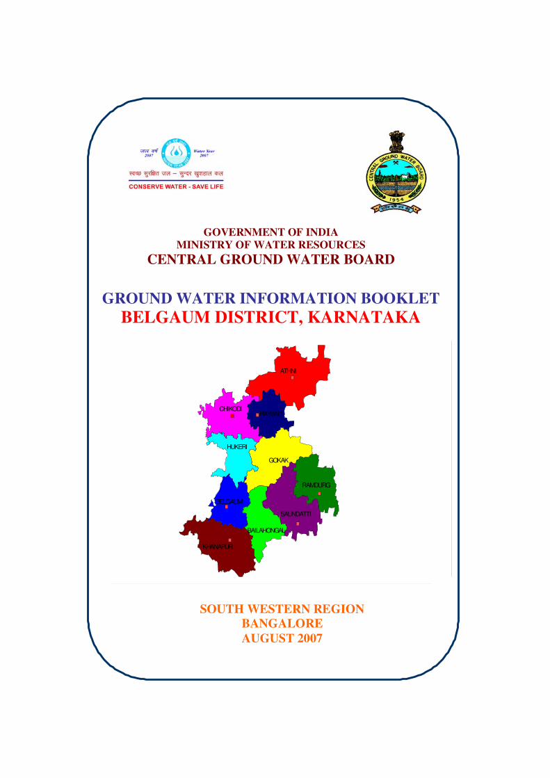
GOVERNMENT OF INDIA MINISTRY OF WATER RESOURCES CENTRAL GROUND WATER BOARD GROUND WATER INFORMATION BOOKLET BELGAUM DISTRICT, KARNATAKA SOUTH WESTERN REGION BANGALORE AUGUST 2007 SAUNDATTI BAILAHONGAL HUKERI ATHNI CHIKODI RAYBAG GOKAK RAMDURG BELGAUM KHANAPUR

Welcome message from author
This document is posted to help you gain knowledge. Please leave a comment to let me know what you think about it! Share it to your friends and learn new things together.
Transcript
GOVERNMENT OF INDIA
MINISTRY OF WATER RESOURCES
CENTRAL GROUND WATER BOARD
GROUND WATER INFORMATION BOOKLET
BELGAUM DISTRICT, KARNATAKA
SOUTH WESTERN REGION
BANGALORE
AUGUST 2007
SAUNDATTI
BAILAHONGAL
HUKERI
ATHNI
CHIKODIRAYBAG
GOKAK
RAMDURG
BELGAUM
KHANAPUR
FOREWORD
Ground water contributes to about eighty percent of the drinking water
requirements in the rural areas, fifty percent of the urban water requirements and
more than fifty percent of the irrigation requirements of the nation. Central
Ground Water Board has decided to bring out district level ground water
information booklets highlighting the ground water scenario, its resource
potential, quality aspects, recharge – discharge relationship, etc., for all the
districts of the country. As part of this, Central Ground Water Board, South
Western Region, Bangalore, is preparing such booklets for all the 27 districts of
Karnataka state, of which six of the districts fall under farmers’ distress category.
The Belgaum district Ground Water Information Booklet has been
prepared based on the information available and data collected from various
state and central government organisations by several hydro-scientists of Central
Ground Water Board with utmost care and dedication. This booklet has been
prepared by Shri J.S.S. Sharma, Scientist-D under the guidance of Dr. K. Md.
Najeeb, Superintending Hydrogeologist, Central Ground Water Board, South
Western Region, Bangalore. I take this opportunity to congratulate them for the
diligent and careful compilation and observation in the form of this booklet, which
will certainly serve as a guiding document for further work and help the planners,
administrators, hydrogeologists and engineers to plan the water resources
management in a better way in the district.
Sd/- (T.M.HUNSE)
Regional Director
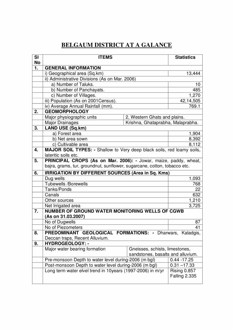
BELGAUM DISTRICT AT A GALANCE Sl No
ITEMS Statistics
1. GENERAL INFORMATION i) Geographical area (Sq.km) 13,444
ii) Administrative Divisions (As on Mar. 2006) a) Number of Taluks. 10 b) Number of Panchayats. 485 c) Number of Villages. 1,270 iii) Population (As on 2001Census). 42,14,505 iv) Average Annual Rainfall (mm). 769.1 2. GEOMORPHOLOGY
Major physiographic units 2, Western Ghats and plains. Major Drainages Krishna, Ghataprabha, Malaprabha. 3. LAND USE (Sq.km) a) Forest area 1,904 b) Net area sown 8,392
c) Cultivable area 8,112 4. MAJOR SOIL TYPES: - Shallow to Very deep black soils, red loamy soils,
lateritic soils etc. 5. PRINCIPAL CROPS (As on Mar. 2006): - Jowar, maize, paddy, wheat,
bajra, grams, tur, groundnut, sunflower, sugarcane, cotton, tobacco etc.
6. IRRIGATION BY DIFFERENT SOURCES (Area in Sq. Kms) Dug wells 1,093 Tubewells /Borewells 768 Tanks/Ponds 22 Canals 632 Other sources 1,210 Net Irrigated area 3,725 7. NUMBER OF GROUND WATER MONITORING WELLS OF CGWB
(As on 31.03.2007) No of Dugwells 87 No of Piezometers 41 8. PREDOMINANT GEOLOGICAL FORMATIONS: - Dharwars, Kaladgis,
Deccan traps, Recent Alluvium. 9. HYDROGEOLOGY: - Major water bearing formation Gneisses, schists, limestones,
sandstones, basalts and alluvium. Pre-monsoon Depth to water level during-2006 (m bgl) 0.44 -17.25 Post-monsoon Depth to water level during-2006 (m bgl) 0.31 –17.33 Long term water elvel trend in 10years (1997-2006) in m/yr Rising 0.857
Falling 2.335
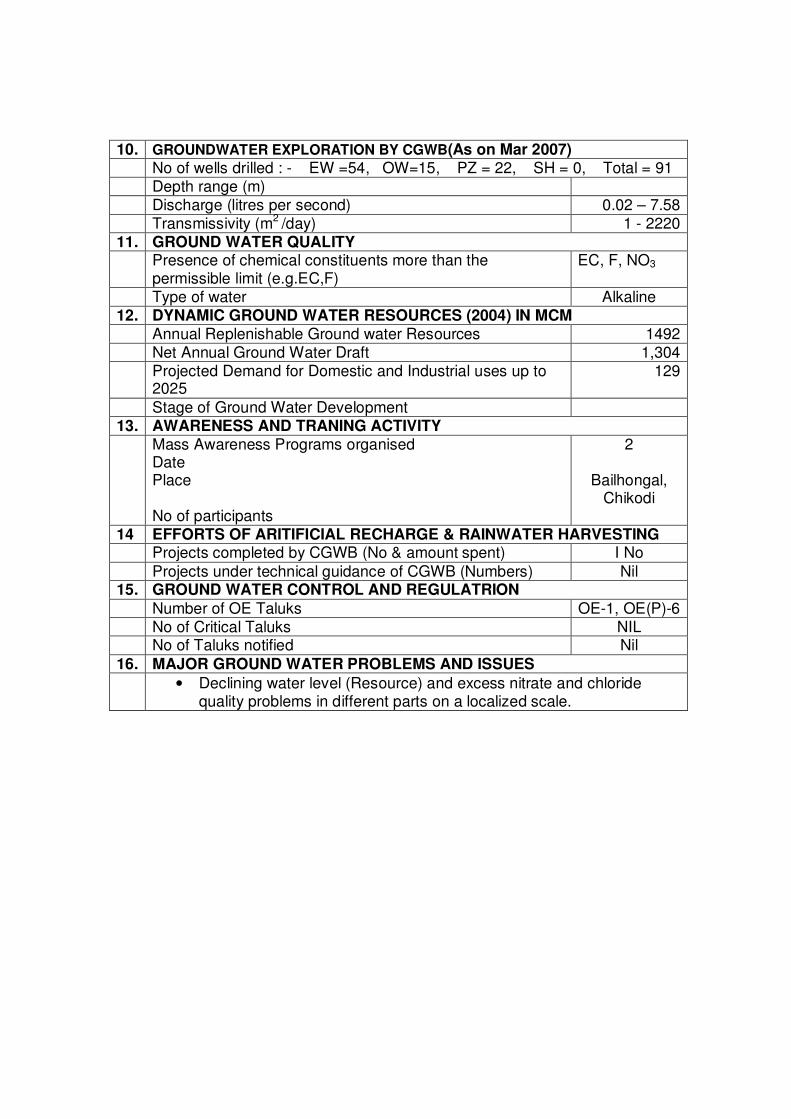
10. GROUNDWATER EXPLORATION BY CGWB(As on Mar 2007) No of wells drilled : - EW =54, OW=15, PZ = 22, SH = 0, Total = 91 Depth range (m) Discharge (litres per second) 0.02 – 7.58 Transmissivity (m2 /day) 1 - 2220 11. GROUND WATER QUALITY Presence of chemical constituents more than the
permissible limit (e.g.EC,F) EC, F, NO3
Type of water Alkaline 12. DYNAMIC GROUND WATER RESOURCES (2004) IN MCM Annual Replenishable Ground water Resources 1492 Net Annual Ground Water Draft 1,304 Projected Demand for Domestic and Industrial uses up to
2025 129
Stage of Ground Water Development 13. AWARENESS AND TRANING ACTIVITY Mass Awareness Programs organised
Date Place No of participants
2
Bailhongal, Chikodi
14 EFFORTS OF ARITIFICIAL RECHARGE & RAINWATER HARVESTING Projects completed by CGWB (No & amount spent) I No
Projects under technical guidance of CGWB (Numbers) Nil 15. GROUND WATER CONTROL AND REGULATRION
Number of OE Taluks OE-1, OE(P)-6 No of Critical Taluks NIL No of Taluks notified Nil
16. MAJOR GROUND WATER PROBLEMS AND ISSUES • Declining water level (Resource) and excess nitrate and chloride
quality problems in different parts on a localized scale.
1.0 INTRODUCTION: The district of Belgaum is located east of the Western Ghats and is
situated in the northwestern part of Karnataka state. It is bordered by the state of Goa on its southwest and Maharashtra state towards its west and north. The districts of Bijapur and Bagalkot of Karnataka state lie towards its northeast and east respectively whereas; the districts of Dharwar and Uttar Kanara lie towards its south and southwest, respectively (Figure-1). The district lies between 15°00’ and 17°00’ north latitudes and between 74°00 and 75°30’ east longitudes. It covers an area of 13,444 Sq. Km.
It has been reported that there were 87 cases of suicide among farmers in
Belgaum district, in the last three years between 2003 and 2006, out of which 34 cases were due to crop failure and the remaining were due to other reasons (table-1). Talukwise suicide cases reported due to crop loss, as per the data from the state government are 9 from Bailhongal, 8 from Athni, 6 from Hukkeri, 5 from Chikodi, 3 from Ramdurg and 1 each from Belgaum, Gokak and Raybag. No suicide case due to crop loss has been reported from Saundatti and Khanapur taluks. During 2006-07, 24 numbers of farmer’s suicide incidences were reported, but the numbers due to crops failure are not yet known.
Table-1. Talukwise statistics of farmers suicide cases in Belgaum district.
2003-04 2004-05 2005-06 Total
Sl; n
o
Talu
ks
Tota
l ca
ses r
epo
rted
Due to
Cro
p loss
Due to
oth
er
reason
s
Tota
l ca
ses r
epo
rted
Due to
Cro
p loss
Due to
oth
er
reason
s
Tota
l ca
ses r
epo
rted
Due to
Cro
p loss
Due to
oth
er
reason
s
Tota
l ca
ses r
epo
rted
Due to
Cro
p loss
Due to
oth
er
reason
s
2
006-0
7
1 Saundatti 11 - 11 01 - 01 02 - 02 14 00 14 1
2 Raybag 01 01 - - - - - - - 01 01 - 0
3 Belgaum 05 01 04 01 - 01 - - 06 01 05 2
4 Chikodi 03 02 01 03 02 01 01 01 - 07 05 02 0
5 Gokak 04 - 04 02 - 02 01 01 - 07 01 06 2
6 Hukeri 04 01 03 06 03 03 04 02 02 14 06 08 6
7 Khanapur - - - 01 - 01 - - - 01 - 01 2
8 Ramdurg 03 01 02 02 01 01 01 01 - 06 03 03 2
9 Baila-
hongal
07 02 05 11 05 06 02 02 - 20 09 11 3
10 Athni 03 03 - 06 04 02 02 01 01 11 08 03 6
TOTAL 41 11 30 33 15 18 13 08 05 87 34 53 24
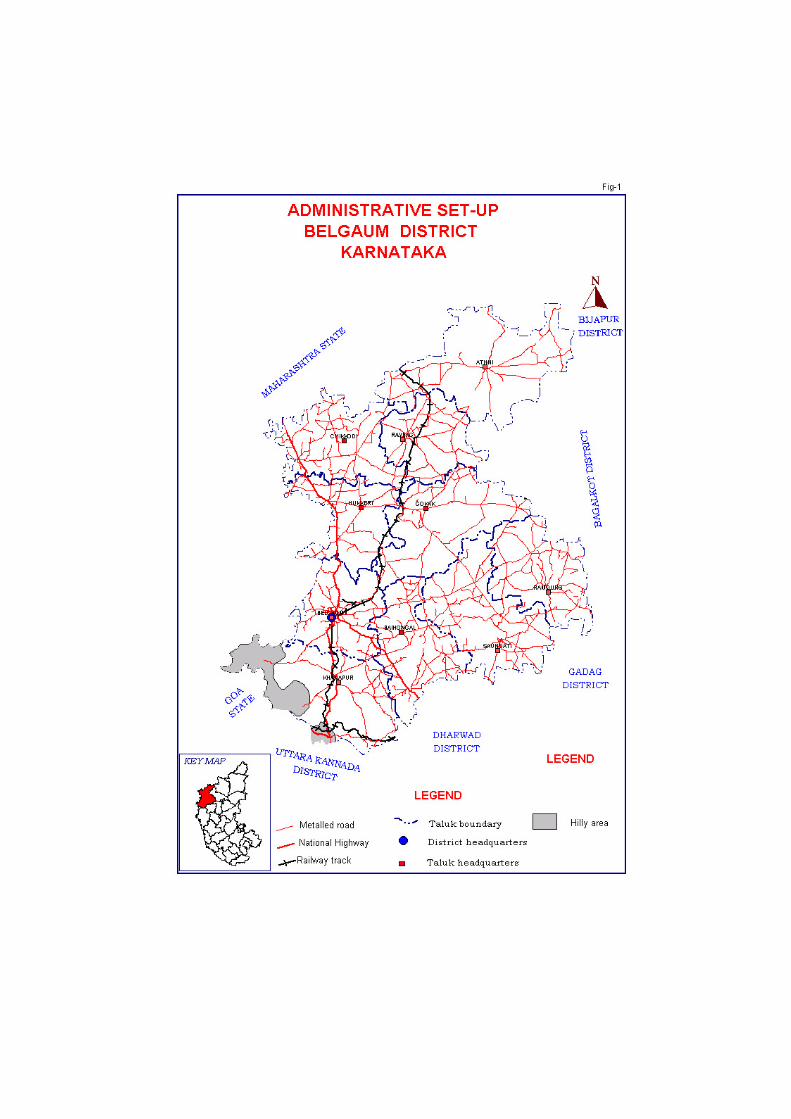
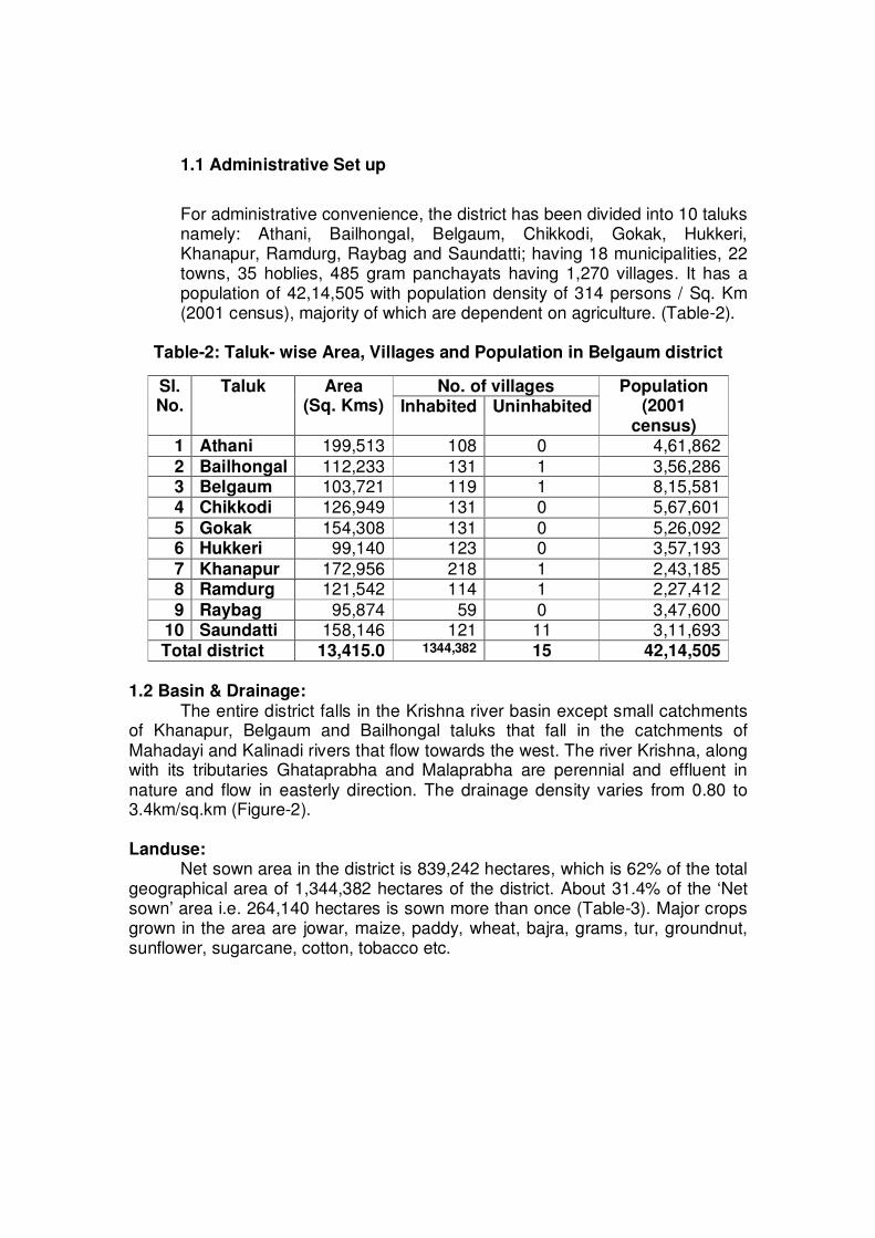
1.1 Administrative Set up
For administrative convenience, the district has been divided into 10 taluks namely: Athani, Bailhongal, Belgaum, Chikkodi, Gokak, Hukkeri, Khanapur, Ramdurg, Raybag and Saundatti; having 18 municipalities, 22 towns, 35 hoblies, 485 gram panchayats having 1,270 villages. It has a population of 42,14,505 with population density of 314 persons / Sq. Km (2001 census), majority of which are dependent on agriculture. (Table-2).
Table-2: Taluk- wise Area, Villages and Population in Belgaum district
1.2 Basin & Drainage:
The entire district falls in the Krishna river basin except small catchments of Khanapur, Belgaum and Bailhongal taluks that fall in the catchments of Mahadayi and Kalinadi rivers that flow towards the west. The river Krishna, along with its tributaries Ghataprabha and Malaprabha are perennial and effluent in nature and flow in easterly direction. The drainage density varies from 0.80 to 3.4km/sq.km (Figure-2). Landuse: Net sown area in the district is 839,242 hectares, which is 62% of the total geographical area of 1,344,382 hectares of the district. About 31.4% of the ‘Net sown’ area i.e. 264,140 hectares is sown more than once (Table-3). Major crops grown in the area are jowar, maize, paddy, wheat, bajra, grams, tur, groundnut, sunflower, sugarcane, cotton, tobacco etc.
No. of villages Sl. No.
Taluk Area (Sq. Kms) Inhabited Uninhabited
Population (2001
census) 1 Athani 199,513 108 0 4,61,862
2 Bailhongal 112,233 131 1 3,56,286 3 Belgaum 103,721 119 1 8,15,581 4 Chikkodi 126,949 131 0 5,67,601
5 Gokak 154,308 131 0 5,26,092 6 Hukkeri 99,140 123 0 3,57,193
7 Khanapur 172,956 218 1 2,43,185 8 Ramdurg 121,542 114 1 2,27,412
9 Raybag 95,874 59 0 3,47,600 10 Saundatti 158,146 121 11 3,11,693
Total district 13,415.0 1344,382 15 42,14,505
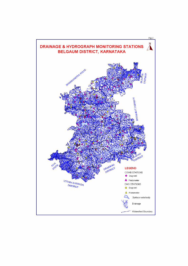
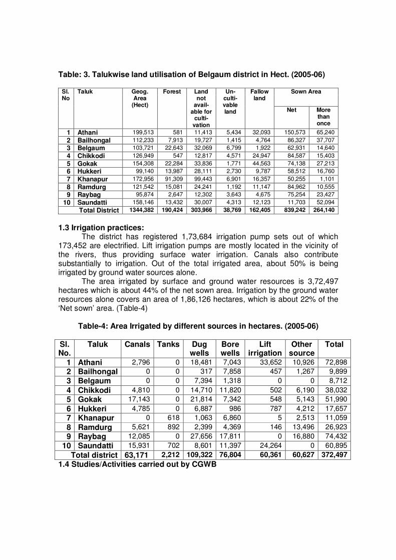
Table: 3. Talukwise land utilisation of Belgaum district in Hect. (2005-06)
Sown Area Sl. No
Taluk Geog. Area
(Hect)
Forest Land not
avail- able for
culti- vation
Un-culti- vable land
Fallow land
Net More than once
1 Athani 199,513 581 11,413 5,434 32,093 150,573 65,240
2 Bailhongal 112,233 7,913 19,727 1,415 4,764 86,327 37,707
3 Belgaum 103,721 22,643 32,069 6,799 1,922 62,931 14,640
4 Chikkodi 126,949 547 12,817 4,571 24,947 84,587 15,403
5 Gokak 154,308 22,284 33,836 1,771 44,563 74,138 27,213
6 Hukkeri 99,140 13,987 28,111 2,730 9,787 58,512 16,760
7 Khanapur 172,956 91,309 99,443 6,901 16,357 50,255 1,101
8 Ramdurg 121,542 15,081 24,241 1,192 11,147 84,962 10,555
9 Raybag 95,874 2,647 12,302 3,643 4,675 75,254 23,427
10 Saundatti 158,146 13,432 30,007 4,313 12,123 11,703 52,094
Total District 1344,382 190,424 303,966 38,769 162,405 839,242 264,140
1.3 Irrigation practices: The district has registered 1,73,684 irrigation pump sets out of which 173,452 are electrified. Lift irrigation pumps are mostly located in the vicinity of the rivers, thus providing surface water irrigation. Canals also contribute substantially to irrigation. Out of the total irrigated area, about 50% is being irrigated by ground water sources alone.
The area irrigated by surface and ground water resources is 3,72,497 hectares which is about 44% of the net sown area. Irrigation by the ground water resources alone covers an area of 1,86,126 hectares, which is about 22% of the ‘Net sown’ area. (Table-4)
Table-4: Area Irrigated by different sources in hectares. (2005-06)
Sl. No.
Taluk Canals Tanks Dug wells
Bore wells
Lift irrigation
Other source
Total
1 Athani 2,796 0 18,481 7,043 33,652 10,926 72,898
2 Bailhongal 0 0 317 7,858 457 1,267 9,899
3 Belgaum 0 0 7,394 1,318 0 0 8,712
4 Chikkodi 4,810 0 14,710 11,820 502 6,190 38,032
5 Gokak 17,143 0 21,814 7,342 548 5,143 51,990
6 Hukkeri 4,785 0 6,887 986 787 4,212 17,657
7 Khanapur 0 618 1,063 6,860 5 2,513 11,059
8 Ramdurg 5,621 892 2,399 4,369 146 13,496 26,923
9 Raybag 12,085 0 27,656 17,811 0 16,880 74,432
10 Saundatti 15,931 702 8,601 11,397 24,264 0 60,895
Total district 63,171 2,212 109,322 76,804 60,361 60,627 372,497
1.4 Studies/Activities carried out by CGWB
Central Ground Water Board carries out hydro-geological surveys, ground water exploration and ground water monitoring under its normal programme. Apart from the above, special studies and short-term water supply investigations for government agencies are also taken up, from time to time.
‘Systematic Hydro-geological Surveys’ were carried out in the initial
stages. The dynamic nature of ground water necessitates the continuation of such surveys. Therefore, ‘Ground Water Management’ studies were carried out in the district. These studies are also being carried out in the taluks of Athani, Chikodi, Hukkeri and Khanapur this year.
Groundwater exploration has been carried out in the district and 54
exploratory wells have been drilled. To mitigate the water supply needs of drought-affected villages, construction of additional bore wells were carried out by CGWB.
There are 87 National Hydrograph Network stations and 41 piezometers
that are monitored in order to evaluate the quantitative and qualitative changes in groundwater regime of the district. Of the above piezometers drilled, DWLR’s have been installed in 8.
‘Conjunctive Use’ studies in Ghataprabha basin were carried out to
quantify different components of water balance and identification of critical areas of water logging and salinity, so as to evolve suitable plan for proper management of surface and groundwater and to evaluate the cost benefit ratio. Studies have also been carried out on ‘Urban Hydrogeology’ of Belgaum town and identification of waterlogged areas has been carried out in Malaprabha basin.
Investigations have also been carried out for Central Ground Water Authority by assisting National Highway Authority of India in Golden Quadrilateral project by identification and clearance of groundwater abstraction structures. Similar studies were also carried out for Renuka Sugar Works located near Manoli in Saundatti taluk.
In addition to above ‘Short Term Water Supply Investigations’ for defence
have been carried out from time to time.
2.0 Rainfall and Climate
The climate of the district as a whole can be termed as semi-arid. The variation in the maximum temperature during the year ranges from 270C to 35.70 C and minimum from 13.90C to 20.60 C. The district experiences pleasant winters and hot dry summers. The hot season extends from March to May, during which the daily maximum temperature often shoots up to 35.7 0C.
Agro-climatologically the district can be divided into three zones i.e. high rainfall “Hilly zone”, “Northern transitional zone” and “Northern dry zone” from
southwest to northeast respectively. The normal rainfall in the district decreases from more than 1859 mm in Khanapur taluk in the southwest, to less than 491 mm in Raybag taluk towards northeasterly direction. Those areas, that receive less than 750 mm annual rainfall are classified as semi-arid and thus drought prone. Hence, the entire district except, the southwestern part is categorized as semi-arid and drought prone.
Total normal rainy days vary from 90 in Khanapur to 37 in Athani. Eastern and northeastern parts of the district are prone to drought of mild nature.
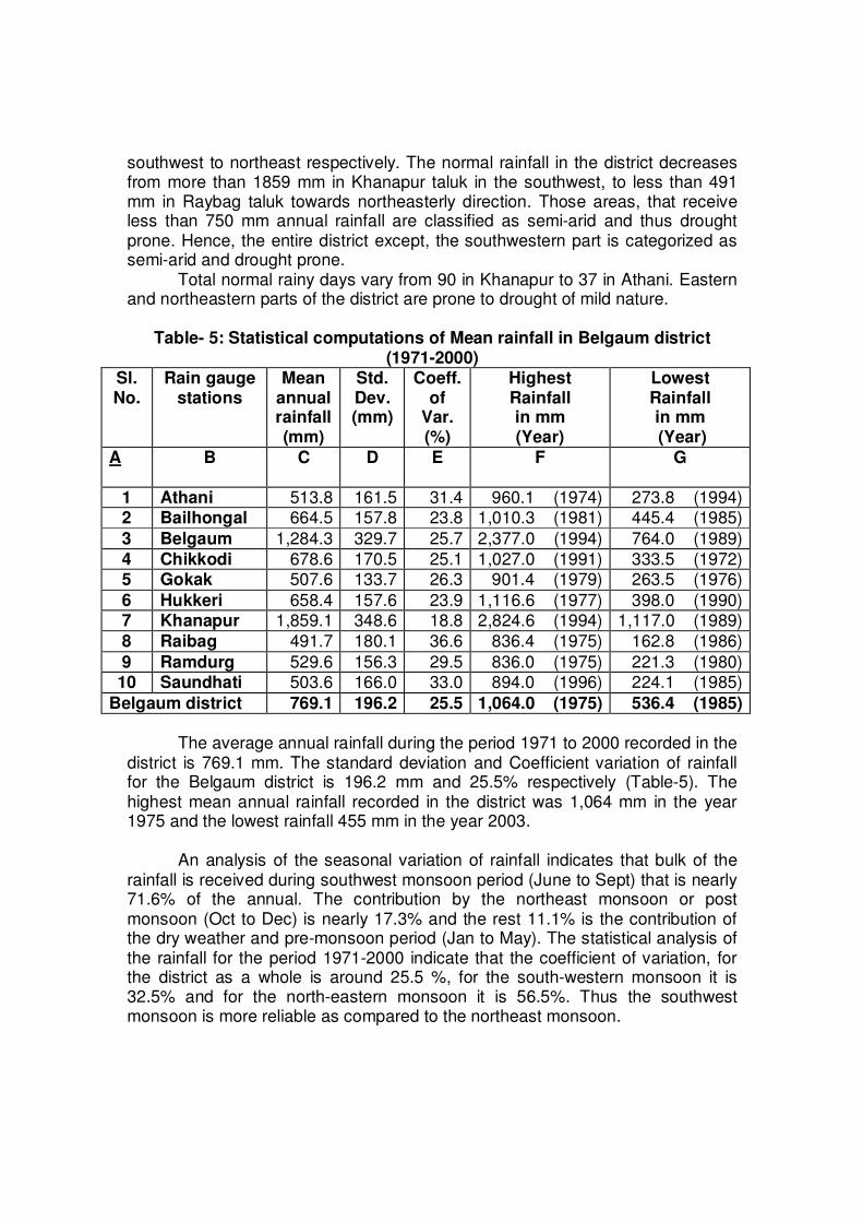
Table- 5: Statistical computations of Mean rainfall in Belgaum district
(1971-2000) Sl. No.
Rain gauge stations
Mean annual rainfall (mm)
Std. Dev. (mm)
Coeff. of
Var. (%)
Highest Rainfall in mm (Year)
Lowest Rainfall in mm (Year)
A B C D E F G
1 Athani 513.8 161.5 31.4 960.1 (1974) 273.8 (1994) 2 Bailhongal 664.5 157.8 23.8 1,010.3 (1981) 445.4 (1985)
3 Belgaum 1,284.3 329.7 25.7 2,377.0 (1994) 764.0 (1989)
4 Chikkodi 678.6 170.5 25.1 1,027.0 (1991) 333.5 (1972) 5 Gokak 507.6 133.7 26.3 901.4 (1979) 263.5 (1976)
6 Hukkeri 658.4 157.6 23.9 1,116.6 (1977) 398.0 (1990) 7 Khanapur 1,859.1 348.6 18.8 2,824.6 (1994) 1,117.0 (1989)
8 Raibag 491.7 180.1 36.6 836.4 (1975) 162.8 (1986)
9 Ramdurg 529.6 156.3 29.5 836.0 (1975) 221.3 (1980) 10 Saundhati 503.6 166.0 33.0 894.0 (1996) 224.1 (1985)
Belgaum district 769.1 196.2 25.5 1,064.0 (1975) 536.4 (1985)
The average annual rainfall during the period 1971 to 2000 recorded in the
district is 769.1 mm. The standard deviation and Coefficient variation of rainfall for the Belgaum district is 196.2 mm and 25.5% respectively (Table-5). The highest mean annual rainfall recorded in the district was 1,064 mm in the year 1975 and the lowest rainfall 455 mm in the year 2003.
An analysis of the seasonal variation of rainfall indicates that bulk of the
rainfall is received during southwest monsoon period (June to Sept) that is nearly 71.6% of the annual. The contribution by the northeast monsoon or post monsoon (Oct to Dec) is nearly 17.3% and the rest 11.1% is the contribution of the dry weather and pre-monsoon period (Jan to May). The statistical analysis of the rainfall for the period 1971-2000 indicate that the coefficient of variation, for the district as a whole is around 25.5 %, for the south-western monsoon it is 32.5% and for the north-eastern monsoon it is 56.5%. Thus the southwest monsoon is more reliable as compared to the northeast monsoon.
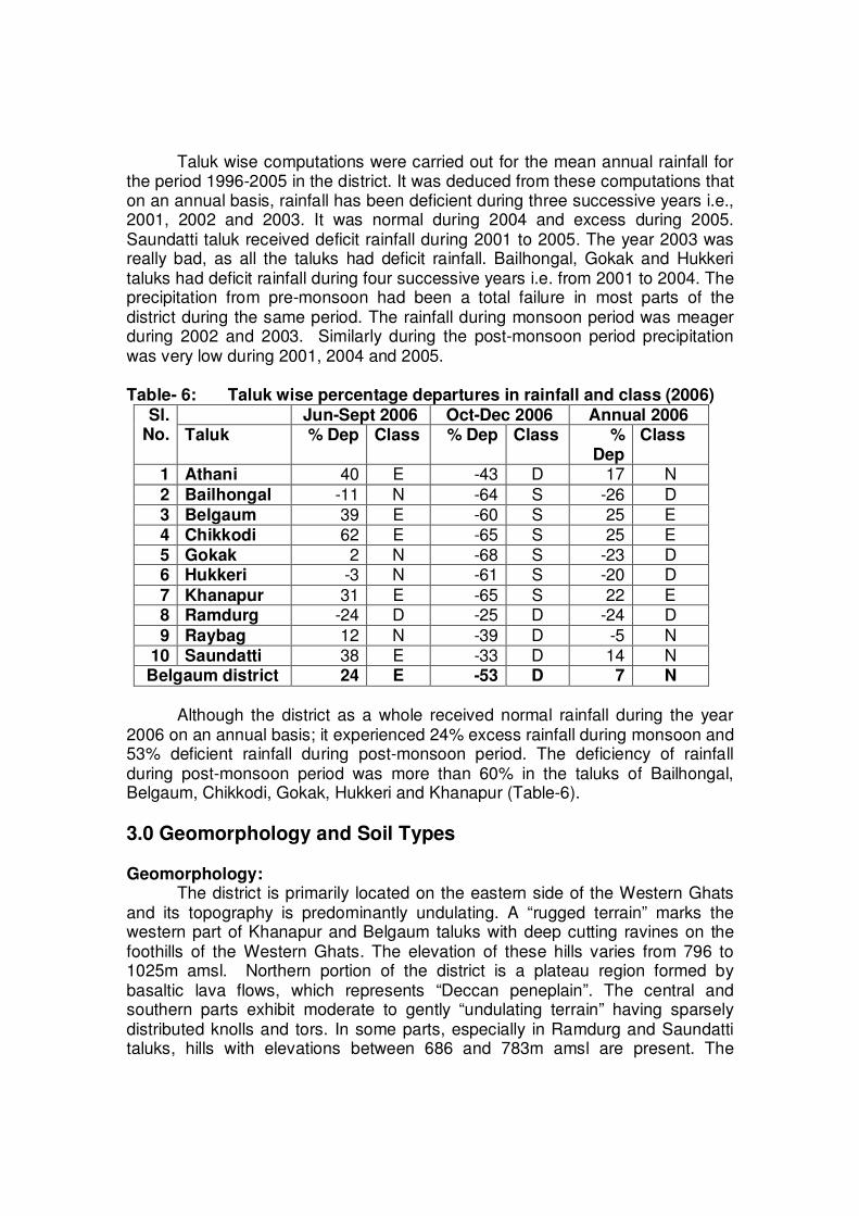
Taluk wise computations were carried out for the mean annual rainfall for the period 1996-2005 in the district. It was deduced from these computations that on an annual basis, rainfall has been deficient during three successive years i.e., 2001, 2002 and 2003. It was normal during 2004 and excess during 2005. Saundatti taluk received deficit rainfall during 2001 to 2005. The year 2003 was really bad, as all the taluks had deficit rainfall. Bailhongal, Gokak and Hukkeri taluks had deficit rainfall during four successive years i.e. from 2001 to 2004. The precipitation from pre-monsoon had been a total failure in most parts of the district during the same period. The rainfall during monsoon period was meager during 2002 and 2003. Similarly during the post-monsoon period precipitation was very low during 2001, 2004 and 2005. Table- 6: Taluk wise percentage departures in rainfall and class (2006)
Although the district as a whole received normal rainfall during the year
2006 on an annual basis; it experienced 24% excess rainfall during monsoon and 53% deficient rainfall during post-monsoon period. The deficiency of rainfall during post-monsoon period was more than 60% in the taluks of Bailhongal, Belgaum, Chikkodi, Gokak, Hukkeri and Khanapur (Table-6).
3.0 Geomorphology and Soil Types Geomorphology:
The district is primarily located on the eastern side of the Western Ghats and its topography is predominantly undulating. A “rugged terrain” marks the western part of Khanapur and Belgaum taluks with deep cutting ravines on the foothills of the Western Ghats. The elevation of these hills varies from 796 to 1025m amsl. Northern portion of the district is a plateau region formed by basaltic lava flows, which represents “Deccan peneplain”. The central and southern parts exhibit moderate to gently “undulating terrain” having sparsely distributed knolls and tors. In some parts, especially in Ramdurg and Saundatti taluks, hills with elevations between 686 and 783m amsl are present. The
Jun-Sept 2006 Oct-Dec 2006 Annual 2006 Sl. No. Taluk % Dep Class % Dep Class %
Dep Class
1 Athani 40 E -43 D 17 N
2 Bailhongal -11 N -64 S -26 D 3 Belgaum 39 E -60 S 25 E 4 Chikkodi 62 E -65 S 25 E 5 Gokak 2 N -68 S -23 D 6 Hukkeri -3 N -61 S -20 D
7 Khanapur 31 E -65 S 22 E 8 Ramdurg -24 D -25 D -24 D
9 Raybag 12 N -39 D -5 N 10 Saundatti 38 E -33 D 14 N Belgaum district 24 E -53 D 7 N
famous Yellamma temple in Saundatti taluk is located in one of these isolated hills. The remaining part of the district is in general a “plateau area”. The elevation in the plains varies from 534m in the northeastern part to 820m amsl in the southwestern part of the district. This has its bearing on the regional slope which is towards northeast. The differential altitude is significant because, it is likely to cause irregular ground water flow patterns on the micro scale. Soil Types:
The soils of Belgaum district can broadly be classified into red soils and black soils. These soils vary in depth and texture, depending on the parent rock type, physiographic settings and climatic conditions. By and large, black soils predominates the Deccan Trap terrain and the red soils are found in the southwestern and southeastern part of the district in gneissic terrain. These soils in turn can be grouped into seven categories as given below, out of which the first five cover large tracks of land while the last two are local in nature.
1. Shallow black soils: These soils occur in the Deccan trap region and to some extent are also developed in schist, shale and limestone terrains. They are greyish to dark greyish-brown in colour, with clayey texture. These soils have poor to moderate infiltration characteristics. 2 Medium black soils: These soils are predominantly derived from Deccan traps and occupy large parts of the district. They are dark greyish-brown to very dark greyish-brown with clayey texture. These are derived from the weathered products of basalts and limestone and are darker in valleys than in high lands. Their texture varies from loam to clay, with low to moderate infiltration characteristics. 3 Deep to Very deep black soils: These soils occupy large tracts in Deccan trap terrain along the Krishna River and also in the gneissic terrain. These soils are dark greyish-brown to very dark greyish-brown in colour and have clayey texture. These soils occur on plains or lands having gentle slopes. These soils exhibit wide cracks in summers. These are derived from a wide variety of parent rock types, like traps, schists, gneisses and sedimentary rocks. They are generally transported and therefore occur in valleys and depressions. Accumulation of lime, gypsum and soluble salts at varying depths in the soil profile often pose problems. They have poor infiltration characteristics. 4 Mixed red and black soils: These soils occur in the northern parts of the district. They are dark reddish-brown to dark greyish-brown in colour with silty-clay to clayey-loam textures. These soils are derived from gneisses, schists and sedimentary rocks. Red soils having high infiltration characteristics are confined to uplands, whereas, black soils of poor to medium infiltration characteristics occur in valleys and low lands.
5 Red loamy soils: These soils occur as small strips in the valleys adjacent to the Western Ghats. They are generally transported and are loamy to silty-loam in texture. They have moderate to good infiltration characteristics. 6 Lateritic soils: Lateritic soils are red in colour and occur as pockets. They occur at high-levels as insitu in Deccan Trap terrain and at low-levels as transported in Malnad region. They are derived from Deccan traps as well as sedimentary rocks, Dharwarian Schists and peninsular gneisses. These soils have good to moderate infiltration characteristics. 7 Alluvial soils: These soils are developed over the alluvium deposited by the Krishna River and its tributaries. They are very limited in extent and thickness and are local in nature. These soils have good infiltration characteristics and are composed of coarse sand, sandy-loam and loams.
4.0 Ground Water Scenario 4.1 Hydrogeology
Water table generally follows the topography of the area and is at greater depths in the water divides and topographic highs, but becomes shallower in the valleys and topographic lows and therefore, groundwater moves down and follows the gradient from the higher to lower elevations, that is, from recharge area to discharge area. Therefore, locally direction of flow from higher elevations is towards the rivers. Overall, the general flow direction of ground water in the district is generally towards the east (Figure-3).
The district is underlain by gneisses, schist, limestone, sandstone, basalts,
alluvium etc. of Archaean to Recent age. Deccan basalts cover an area of 7,650 Sq.Kms. in the northern part of the district and have a maximum thickness of around 256 m, which gradually thins out in the southern direction (Figure-3).
Hard rocks occupy a major part of the district; majority of which are basaltic lava flows. Most of these rocks have poor capacity of storing and transmitting water, except through favourable zones and at favourable locations. Aquifer systems encountered are therefore limited in nature. Ground water occurs both in weathered and fractured zones. Ground water occurs in all weathered formations of the district under phreatic conditions and in fractured and jointed formations under semi-confined conditions.
Deccan basalts act as a multilayer aquifers having low to medium
permeability. In Deccan basalts that comprise different flows, fractures and interstitial pore spaces of vesicular zones, are good repositories of ground water. Groundwater occurs under phreatic conditions in weathered zone of these basalts and under semi-confined to confined conditions in inter-trapeans and also in joints and fractures at deeper levels.
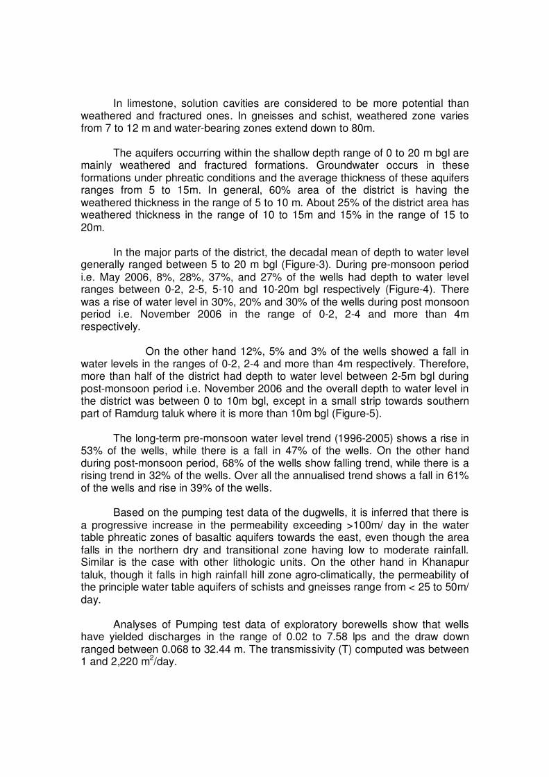
In limestone, solution cavities are considered to be more potential than weathered and fractured ones. In gneisses and schist, weathered zone varies from 7 to 12 m and water-bearing zones extend down to 80m.
The aquifers occurring within the shallow depth range of 0 to 20 m bgl are
mainly weathered and fractured formations. Groundwater occurs in these formations under phreatic conditions and the average thickness of these aquifers ranges from 5 to 15m. In general, 60% area of the district is having the weathered thickness in the range of 5 to 10 m. About 25% of the district area has weathered thickness in the range of 10 to 15m and 15% in the range of 15 to 20m.
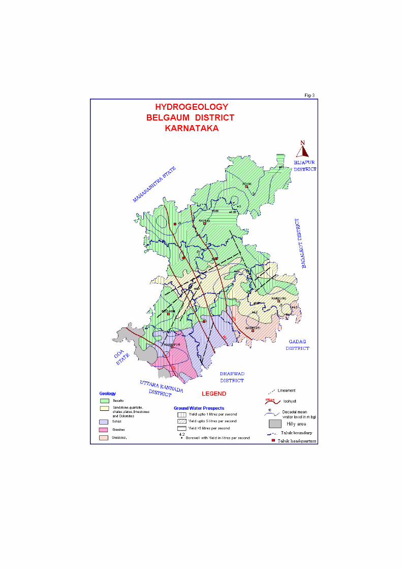
In the major parts of the district, the decadal mean of depth to water level
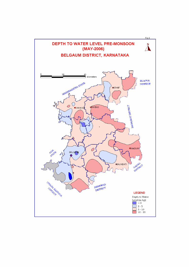
generally ranged between 5 to 20 m bgl (Figure-3). During pre-monsoon period i.e. May 2006, 8%, 28%, 37%, and 27% of the wells had depth to water level ranges between 0-2, 2-5, 5-10 and 10-20m bgl respectively (Figure-4). There was a rise of water level in 30%, 20% and 30% of the wells during post monsoon period i.e. November 2006 in the range of 0-2, 2-4 and more than 4m respectively.
On the other hand 12%, 5% and 3% of the wells showed a fall in
water levels in the ranges of 0-2, 2-4 and more than 4m respectively. Therefore, more than half of the district had depth to water level between 2-5m bgl during post-monsoon period i.e. November 2006 and the overall depth to water level in the district was between 0 to 10m bgl, except in a small strip towards southern part of Ramdurg taluk where it is more than 10m bgl (Figure-5).
The long-term pre-monsoon water level trend (1996-2005) shows a rise in
53% of the wells, while there is a fall in 47% of the wells. On the other hand during post-monsoon period, 68% of the wells show falling trend, while there is a rising trend in 32% of the wells. Over all the annualised trend shows a fall in 61% of the wells and rise in 39% of the wells.
Based on the pumping test data of the dugwells, it is inferred that there is
a progressive increase in the permeability exceeding >100m/ day in the water table phreatic zones of basaltic aquifers towards the east, even though the area falls in the northern dry and transitional zone having low to moderate rainfall. Similar is the case with other lithologic units. On the other hand in Khanapur taluk, though it falls in high rainfall hill zone agro-climatically, the permeability of the principle water table aquifers of schists and gneisses range from < 25 to 50m/ day.
Analyses of Pumping test data of exploratory borewells show that wells have yielded discharges in the range of 0.02 to 7.58 lps and the draw down ranged between 0.068 to 32.44 m. The transmissivity (T) computed was between 1 and 2,220 m2/day.
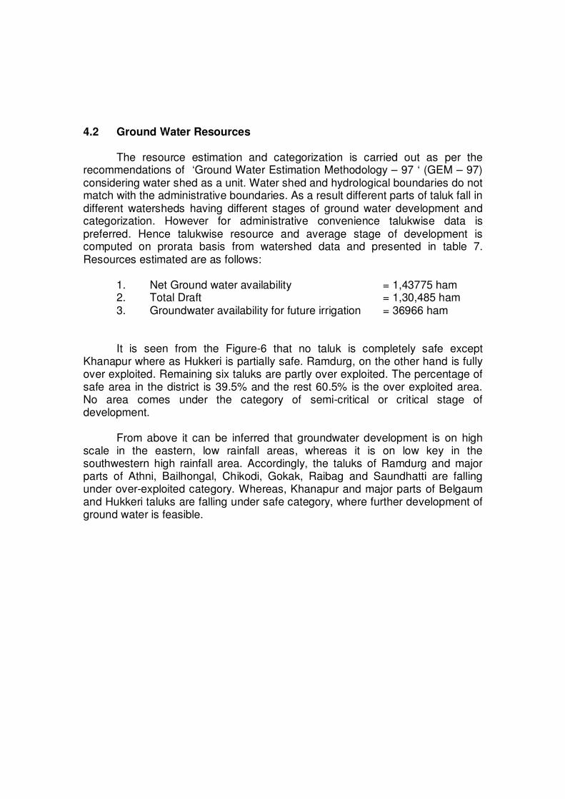
4.2 Ground Water Resources
The resource estimation and categorization is carried out as per the recommendations of ‘Ground Water Estimation Methodology – 97 ‘ (GEM – 97) considering water shed as a unit. Water shed and hydrological boundaries do not match with the administrative boundaries. As a result different parts of taluk fall in different watersheds having different stages of ground water development and categorization. However for administrative convenience talukwise data is preferred. Hence talukwise resource and average stage of development is computed on prorata basis from watershed data and presented in table 7. Resources estimated are as follows:
1. Net Ground water availability = 1,43775 ham 2. Total Draft = 1,30,485 ham 3. Groundwater availability for future irrigation = 36966 ham It is seen from the Figure-6 that no taluk is completely safe except
Khanapur where as Hukkeri is partially safe. Ramdurg, on the other hand is fully over exploited. Remaining six taluks are partly over exploited. The percentage of safe area in the district is 39.5% and the rest 60.5% is the over exploited area. No area comes under the category of semi-critical or critical stage of development.
From above it can be inferred that groundwater development is on high
scale in the eastern, low rainfall areas, whereas it is on low key in the southwestern high rainfall area. Accordingly, the taluks of Ramdurg and major parts of Athni, Bailhongal, Chikodi, Gokak, Raibag and Saundhatti are falling under over-exploited category. Whereas, Khanapur and major parts of Belgaum and Hukkeri taluks are falling under safe category, where further development of ground water is feasible.
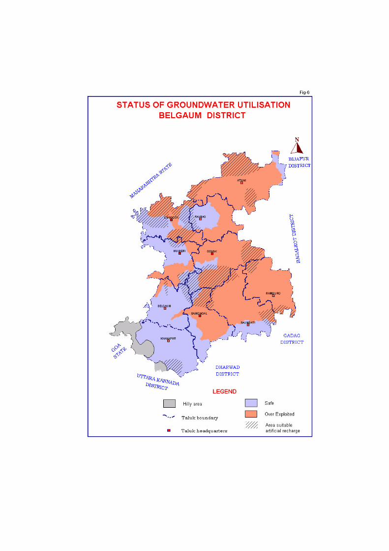
Ground water Resources and stage of development of Belgaum District, Karnataka state as on March 2004
TALUK
Recha
rge
fro
m r
ain
fall
du
rin
g
mon
so
on
se
aso
n (
HA
M)
Re
ch
arg
e f
rom
oth
er
sourc
es
duri
ng
m
on
so
on
se
aso
n (
HA
M)
Recha
rge
fro
m r
ain
fall
du
rin
g n
on-
mon
so
on
se
aso
n (
HA
M)
Re
ch
arg
e f
rom
oth
er
sourc
es
duri
ng
n
on
-mo
nsoo
n s
easo
n (
HA
M)
An
nu
al re
plin
ish
ab
le G
W
Re
so
urc
e(H
AM
)
Natu
ral d
ischa
rge
duri
ng
no
n
mon
so
om
se
ason
(HA
M)
Ne
t G
rou
nd
wa
ter
Availa
bili
ty (
HA
M)
Irri
ga
tio
n d
raft
(H
AM
)
Do
me
stic
an
d ind
ustr
ial d
raft
(H
AM
)
To
tal an
nu
al gro
un
d w
ate
r d
raft
(HA
M)
Pro
jecte
d d
om
estic a
nd
in
dustr
ial
dra
ft 2
02
5 (
HA
M)
Gro
und
wate
r ava
ilabili
ty f
or
futu
re
irri
gatio
n**
(H
AM
)
Ave
rag
e S
tage
of
de
velo
pm
en
t (%
)
Category
ATHNI 10925 1721 1194 2689 16554 842 15716 20486 1028 21518 1429 292 137 OE(P)
BAILAHONGAL 6304 2035 678 905 9930 505 9427 8537 611 9148 868 2188 97 OE(P)
BELGAUM 6483 2178 586 878 10133 515 9620 5585 914 6495 1389 4689 68 SAFE
CHIKODI 4514 14736 451 4385 24059 493 23559 17206 1219 18425 1748 6904 78 OE(P)
GOKAK 3657 6921 1043 4981 16608 524 16082 15124 769 15895 1228 1238 99 OE(P)
HUKERI 3839 11217 139 2617 17787 453 17331 11959 1301 13257 1991 7201 76 SAFE(P)
KHANAPUR 11828 2371 160 624 14993 762 14234 4081 438 4518 636 9525 32 SAFE
RAMDURG 3375 2222 787 1209 7598 386 7214 10615 755 11370 1066 62 158 OE
RAYBAG 3017 11575 557 4275 19407 352 19049 15671 840 16513 1224 3535 87 OE(P)
SAUNDATTI 7044 2618 1158 1328 12158 618 11543 12402 945 13347 1343 1333 116 OE(P)
TOTAL 60987 57595 6752 23891 149225 5450 143775 121666 8818 130485 12922 36966 91
Criteria for catagorisation of taluks- (I) Full- Entire taluka falling under a particular category, (II) Partial (P) - >50% of the area of the taluka falling under
a categoty, (III) Partial (P-I) where non of the category is having more than 50% area (As per figure 6)
4.3 Groundwater quality
The analyses of groundwater samples of the district between 2005 and 2007 revealed that the groundwater quality was in general found to be potable in nearly half of the district. It was also found suitable for irrigation purposes in the major parts of the district (Figure - 7). Drinking water:
It is essential to know the quality of water as it affects the health of those who consume it. Therefore, quality of groundwater was compared with BIS standards and parameters like Chloride, nitrate, pH and fluoride were evaluated.
Chloride concentrations in general are within permissible limits i.e. 1,000mg/l in the district. Gokak (2,691mg/l) is the only station where chloride concentration is more than permissible limits. Though major part of the district have chloride concentration within desirable limits i.e. less than 250mg/l, isolated patches of higher concentration but below permissible limits i.e. <1,000mg/l are present in most of the taluks. Gokak is the only taluk having about 80% coverage by such an area.
Nitrate, which may cause Methamoglobineimia if drinking water contains
more than 45mg/l of Nitrate content in it, seems to have polluted nearly 45% of the area of the district. Taluks of Gokak, Athani, Chikodi and eastern part of Ramdurg need special mention. This could be the result of excessive use of urea fertilizer.
Groundwater in the area is alkaline having pH values between 7.8 and
8.7. In general the groundwater samples revealed that majority of the area is having pH parameters within “Desirable” limits (6.5-8.5), exceptions being Hukkeri (8.7), Gokak and Soundalga (8.6).
Even though groundwater in majority of the district contains fluoride within
permissible limits i.e. less than 1.5mg/l, there are small isolated pockets in some of the taluks that contain fluoride in excess of permissible limits, except Belgaum, Bailhongal, Hukkeri and Raybag. Excessive fluoride in drinking water i.e. more than 1.5mg/l may cause mottling of teeth enamel and skeletal deformation. Therefore, a periodic analysis of water used for drinking is needed, especially adjacent to afflicted pockets.
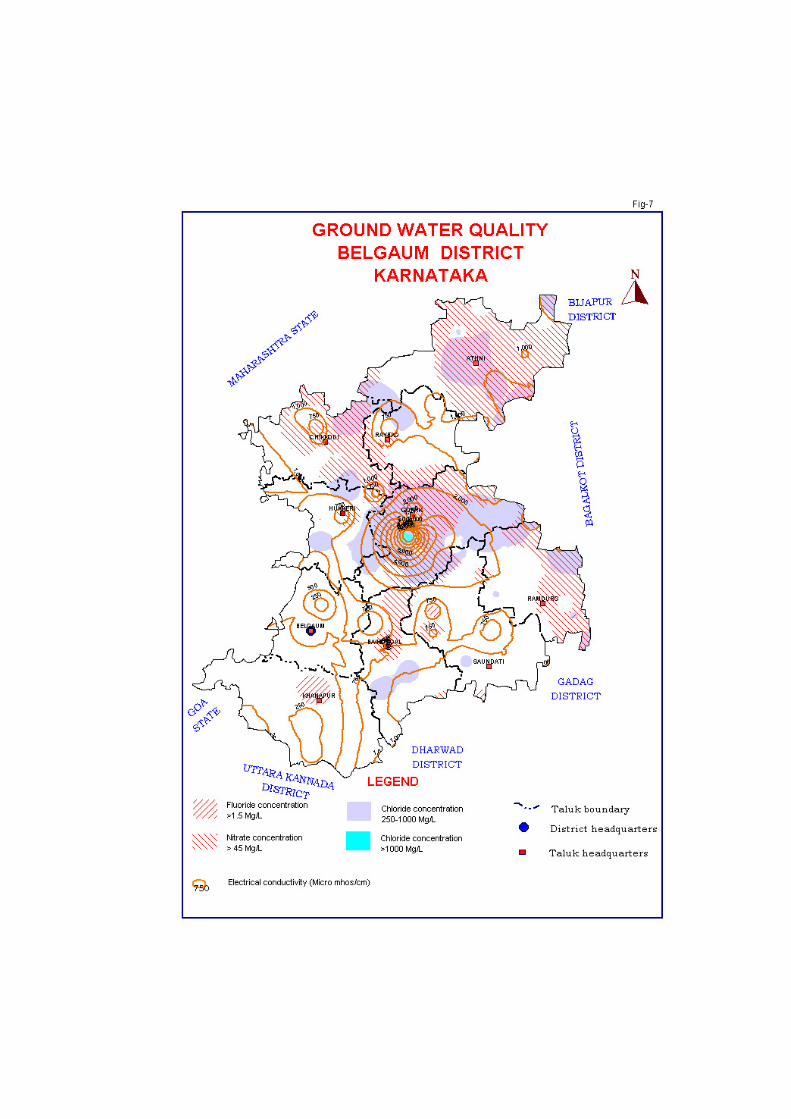
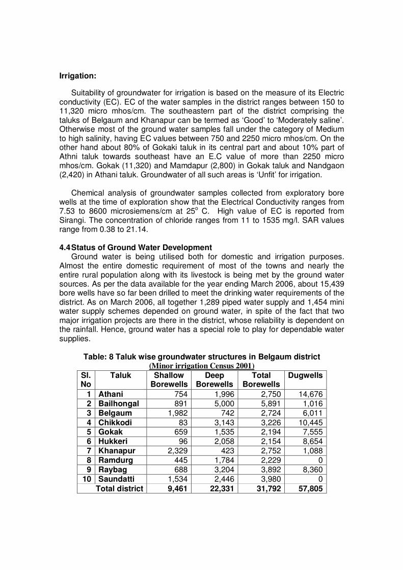
Irrigation:
Suitability of groundwater for irrigation is based on the measure of its Electric conductivity (EC). EC of the water samples in the district ranges between 150 to 11,320 micro mhos/cm. The southeastern part of the district comprising the taluks of Belgaum and Khanapur can be termed as ‘Good’ to ‘Moderately saline’. Otherwise most of the ground water samples fall under the category of Medium to high salinity, having EC values between 750 and 2250 micro mhos/cm. On the other hand about 80% of Gokaki taluk in its central part and about 10% part of Athni taluk towards southeast have an E.C value of more than 2250 micro mhos/cm. Gokak (11,320) and Mamdapur (2,800) in Gokak taluk and Nandgaon (2,420) in Athani taluk. Groundwater of all such areas is ‘Unfit’ for irrigation.
Chemical analysis of groundwater samples collected from exploratory bore
wells at the time of exploration show that the Electrical Conductivity ranges from 7.53 to 8600 microsiemens/cm at 25o C. High value of EC is reported from Sirangi. The concentration of chloride ranges from 11 to 1535 mg/l. SAR values range from 0.38 to 21.14.
4.4 Status of Ground Water Development Ground water is being utilised both for domestic and irrigation purposes.
Almost the entire domestic requirement of most of the towns and nearly the entire rural population along with its livestock is being met by the ground water sources. As per the data available for the year ending March 2006, about 15,439 bore wells have so far been drilled to meet the drinking water requirements of the district. As on March 2006, all together 1,289 piped water supply and 1,454 mini water supply schemes depended on ground water, in spite of the fact that two major irrigation projects are there in the district, whose reliability is dependent on the rainfall. Hence, ground water has a special role to play for dependable water supplies.
Table: 8 Taluk wise groundwater structures in Belgaum district (Minor irrigation Census 2001)
Sl. No
Taluk Shallow Borewells
Deep Borewells
Total Borewells
Dugwells
1 Athani 754 1,996 2,750 14,676 2 Bailhongal 891 5,000 5,891 1,016 3 Belgaum 1,982 742 2,724 6,011
4 Chikkodi 83 3,143 3,226 10,445 5 Gokak 659 1,535 2,194 7,555 6 Hukkeri 96 2,058 2,154 8,654 7 Khanapur 2,329 423 2,752 1,088 8 Ramdurg 445 1,784 2,229 0 9 Raybag 688 3,204 3,892 8,360
10 Saundatti 1,534 2,446 3,980 0
Total district 9,461 22,331 31,792 57,805
As per Minor Irrigation Census of 2001 (Table-8) there are 57,805
dugwells, 9,461 shallow borewells and 22,331 deep borewells used for irrigation in the district. The maximum numbers of dugwells i.e. 14,676 are in Athani taluk whereas there are no irrigation dugwells in Ramdurg and Saundhatti taluk. Minimum numbers of shallow borewells are in Chikodi taluk i.e. 83, whereas Khanapur taluk has maximum number i.e. 2329. On the other hand Khanapur taluk has the least number of deep borewells i.e. 423 while the maximum number are in Bailhongal taluk i.e. 5000.
Within the weathered and fractured formations, phreatic aquifers are
encountered at a shallow depth range of 0 to 20 mbgl and are tapped mainly by dug wells. Average thickness of these aquifers ranges from 5 to 15m.In 80% of the district area the yields of shallow zones upto the depth of 20m was less than 1 lps. In rest of the 20% area of the district the yields recorded were between 1 to 2 lps, especially in Athni, Raibag and Ramdurg taluk.
Bore wells are the most common abstraction structures with depths
ranging from 40 to 200m and have yields ranging from 1 to 8 lps. The unit draft of dug wells and bore wells range from 0.5 to 1.25 and 1 to 2.4 Ham respectively. 5.0 Ground Water Management Strategy
A well-planned groundwater resource management strategy is essential to make economical, efficient and judicious use of ground water, so as to make the availability of ground water, sustainable. Making aware, the water users on ground water conditions in the different terrain conditions and encouraging its judicious use, adopting conjunctive use techniques of ground water and surface water can improve the ground water scenario. In view of the ever-growing population and increasing demand for groundwater for various developmental activities, it is suggested to adopt methods to artificially recharge the ground water in the water level depleting areas, in order to increase the ground water availability. The ground water management will also help in environmental management and ecological stability in the area. The development of water management model should be resource based and the whole problem should be tackled in its totality, vis a vis surface and subsurface resources. Thereby, enabling us to meet the ever-growing demand for this precious natural resource by practicing conjunctive use in canal command areas.
Apart from above, farmers should be encouraged to grow crops that require less water for its production and should be discouraged from growing water intensive crops like sugarcane and paddy, especially in the areas where water levels are falling. Transfer of water from areas where water levels are rising to the areas where water levels are falling can also be thought off.
Inter basin transfer of water, from west flowing rivers during monsoon period, in order to recharge ground water in the Krishna basin, where water levels are falling can be a workable strategy.
It is further suggested that ground water recharge and rain water harvesting techniques, may be adopted, especially in over-exploited taluks so as to avoid further ground water depletion.
5.1 Ground water Development
There is 36,966 Ham of utilizable ground water as balance which can create an additional irrigation potential of 47231 hactares. It is suggested to sink additional 33600 borewells/dug wells with an average annual unit draft of 1.1 Ham. But as most of the area comes under overdeveloped category this development need to come up in the patches where there is still scope for further development i.e. in safe areas as demarcated in Figure-6. The least groundwater development of 31.88 % is computed for Khanapur taluk and highest groundwater development of 158.53 % is computed for Ramdurg taluk. So in the areas with over development, all the efforts be made to enhance the recharge to groundwater storage by constructing suitable artificial recharge structures at suitable places. In urban and semi-urban areas rooftop rainwater harvesting techniques will ease the pressure on surface water projects from where, those places are getting the water supply at present. For irrigation as far as possible bore wells should not be recommended where the groundwater is very deep i.e. more than 10 m bgl. Even in those areas dug cum borewells are suggested and by constructing suitable artificial recharge structures. All efforts should be made to bring the water levels up. The valley portions with thick valley fills supported by suitable artificial recharge structures in the proper viscinity are ideal sites for groundwater development. The well spacing should be maintained. The distance between two groundwater structures should not be less than 200 m to avoid the interference during simultaneous pumping of wells tapping the same aquifers. 5.2 Water conservation and Artificial Recharge.
Indiscriminate withdrawal of groundwater by means of different abstraction structures has resulted in the decline of ground water levels. Most part of the rain leaves the area as surface run-off causing floods and soil erosion, thus by constructing suitable structures, percolation into ground to recharge ground water can be enhanced.
Central Ground Water Board has constructed rainwater harvesting and
artificial recharge structures of different types in Air Force station Samra for demonstration and to increase the water supply to troops from existing boreholes.
Steps have been taken by the state government in this direction by
constructing check dams, Mini percolation tanks, farm ponds, nala bunds and vented dams at an average cost of 1.2, 0.25, 0.12, 1.37 and 1.0 lakh rupees respectively. The capacity of these structures varies from 1,000 to 2,000 cubic
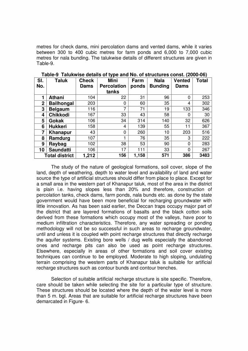
metres for check dams, mini percolation dams and vented dams, while it varies between 300 to 400 cubic metres for farm ponds and 6,000 to 7,000 cubic metres for nala bunding. The talukwise details of different structures are given in Table-9.
Table-9 Talukwise details of type and No. of structures const. (2000-06)
Sl. No.
Taluk Check Dams
Mini Percolation
tanks
Farm ponds
Nala Bunding
Vented Dams
Total
1 Athani 104 22 31 96 0 253
2 Bailhongal 203 0 60 35 4 302
3 Belgaum 116 7 71 19 133 346
4 Chikkodi 167 33 43 58 0 30
5 Gokak 106 34 314 140 32 626
6 Hukkeri 158 4 139 55 11 367
7 Khanapur 43 0 260 10 203 516
8 Ramdurg 107 1 76 35 3 222
9 Raybag 102 38 53 90 0 283
10 Saundatti 106 17 111 33 0 267
Total district 1,212 156 1,158 571 386 3483
The study of the nature of geological formations, soil cover, slope of the land, depth of weathering, depth to water level and availability of land and water source the type of artificial structures should differ from place to place. Except for a small area in the western part of Khanapur taluk, most of the area in the district is plain i.e. having slopes less than 20% and therefore, construction of percolation tanks, check dams, farm ponds, nala bunds etc. as done by the state government would have been more beneficial for recharging groundwater with little innovation. As has been said earlier, the Deccan traps occupy major part of the district that are layered formations of basalts and the black cotton soils derived from these formations which occupy most of the valleys, have poor to medium infiltration characteristics. Therefore, any water spreading or ponding methodology will not be so successful in such areas to recharge groundwater, until and unless it is coupled with point recharge structures that directly recharge the aquifer systems. Existing bore wells / dug wells especially the abandoned ones and recharge pits can also be used as point recharge structures. Elsewhere, especially in areas of other formations and soil cover existing techniques can continue to be employed. Moderate to high sloping, undulating terrain comprising the western parts of Khanapur taluk is suitable for artificial recharge structures such as contour bunds and contour trenches.
Selection of suitable artificial recharge structure is site specific. Therefore, care should be taken while selecting the site for a particular type of structure. These structures should be located where the depth of the water level is more than 5 m. bgl. Areas that are suitable for artificial recharge structures have been demarcated in Figure- 6.
6.0 Groundwater Related Issues & Problems Canals and lift irrigation schemes along major rivers are irrigating nearly
123,532 hectares of land in the district that constitutes 33.2 % of the irrigated area. Although, the area irrigated from these sources is only 14.7 % of the net sown area, it has been observed that large tracts of land in canal command area are facing water logged conditions and groundwater salinity. The problem is more acute in Ghataprabha and Krishna river command areas, as is evident from Figure- 7. There is an urgent need to tackle this issue by way of conjunctive use of surface and sub-surface water in canal command areas.
During drilling operations it has been observed that in areas underlain by
sandstones and quartzites of Kaladagi formation which is highly fractured in nature and especially in areas where Deccan traps are underlain by such a formation, normal DTH rig is not capable of drilling due to caving. It is therefore suggested that in such areas DTH rig with Odex attatchment may be employed. Such areas are located in Ramdurg, Gokak and Saundatti taluks.
In areas where long-term trend of water level indicates depletion of water
levels, drilling of deeper boreholes to tap deeper aquifers may not be the practical solution for irrigation. As any withdrawal from the aquifer is limited to its recharge, unless of course the recharge area of the deeper aquifer is situated elsewhere in a more favourable location than that of the shallow aquifer. It is therefore suggested, that areas where long-term trend of water level indicates depletion, drilling deeper wells is not in the interest of the public in general in the long run.
7.0 Awareness and Training Activity:
Central Ground Water Board has been conducting mass awareness programs in order to educate the public, the necessity of conservation of groundwater resources and also training state government officials in the management of these resources from time to time. In this direction CGWB has conducted these programs in Belgaum district as given below.
7.1 Mass awareness programme by CGWB (MAP):
Mass awareness training program has already been conducted in Bailhongal and Chikkodi towns of Belgaum district.
7.2 Water Management Training program by CGWB (WMTP):
Water management training program has been conducted twice in Zilla panchayat hall for the benefit of the state government officials and NGO’s. 8.0 Areas Notified by CGWB/CGWA
Although some taluks are overdeveloped, no area has yet been notified so far in the district.
9.0 RECOMMENDATIONS Taking into account the prevailing scenario of the groundwater resources and development, the following recommendations are made for the optimal utilisation of ground water resources for sustainable irrigation structures in the district.
1. Groundwater development is on high scale in the eastern, low rainfall areas, and is on low key in the southwestern high rainfall area. Considering the available 47231 ha irrigation potential and 36966 Ham of utilizable groundwater as balance still scope exists for sinking additional 33600 borewells/dug wells with an average annual unit draft of 1.1 Ham.
2. As most of the areas come under overdeveloped category, the
development of groundwater needs to come up in the patches where there is still scope for further development i.e. in safe areas as demarcated in Figure-6A. Therefore, the entire taluk of Ramdurg and major parts of Athni, Bailhongal, Chikodi, Gokak, Raibag and Saundhatti are not suitable for groundwater development. Whereas, Khanapur and major parts of Belgaum and Hukkeri taluks that fall under safe category, further development of ground water is feasible.
3. The well spacing should be maintained. The distance between two
groundwater structures should not be less than 200 m to avoid the interference during simultaneous pumping of wells tapping the same aquifers.
4. Adoption of conjunctive use techniques of ground water and surface water
can improve the ground water scenario.
5. Making ground water users aware of the groundwater conditions of the area and encourage its judicious and economical use so as to make the availability of ground water, sustainable.
6. Farmers should be encouraged to grow crops that require less water for
its production and should be discouraged from growing water intensive crops like sugarcane and paddy, especially in the areas where water levels are falling.
7. Inter basin transfer of water, from west flowing rivers during monsoon
period, in order to recharge ground water in the Krishna basin, where water levels are falling can be a workable strategy.
8. It is further suggested that ground water recharge and rain water
harvesting techniques, may be adopted, especially in over-exploited areas of taluks so as to avoid further groundwater depletion as suggested in Figure-6.
9. In basaltic terrain, which has poor to medium infiltration characteristics, recharge to groundwater will not be affective, until and unless it is coupled with point recharge structures that directly recharge the aquifer systems.
10. Existing bore wells / dug wells especially the abandoned ones and
recharge pits can also be used as point recharge structures.
11. In areas that are underlain by sandstones, limestones, granites and
gneisses etc. existing techniques can continue to be employed. 12. Moderate to high sloping, undulating terrain comprising the western parts
of Khanapur taluk is suitable for artificial recharge structures such as contour bunds and contour trenches.
Related Documents