M. V. DHEKANE, Associate Director (R&D) Vikram Sarabhai Space Centre, Indian Space Research Organisation Trivandrum, India Presentation at the International Symposium in Tokyo, on Stable use of Outer Space during March 3-4, 2016 1

Welcome message from author
This document is posted to help you gain knowledge. Please leave a comment to let me know what you think about it! Share it to your friends and learn new things together.
Transcript

M. V. DHEKANE, Associate Director (R&D)
Vikram Sarabhai Space Centre, Indian Space Research Organisation
Trivandrum, India
Presentation at the International Symposium
in Tokyo, on Stable use of Outer Space
during March 3-4, 2016 1

“There are some who question the relevance of space activities in a developing nation. To us, there is no
ambiguity of purpose. We are convinced that if we are to play a meaningful role in the comity of nations we should
be second to none in the applications of advanced technologies to the real problems of man and
Society.”
Dr. Vikram A Sarabhai
2
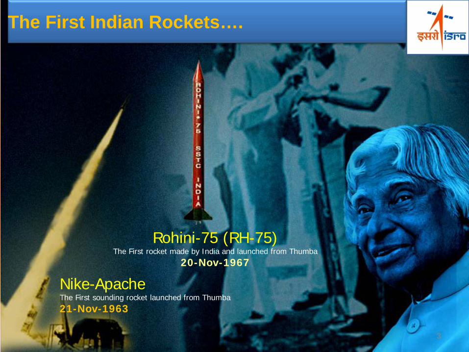
The First Indian Rockets….
Nike-Apache The First sounding rocket launched from Thumba 21-Nov-1963
Rohini-75 (RH-75) The First rocket made by India and launched from Thumba
20-Nov-1967
3
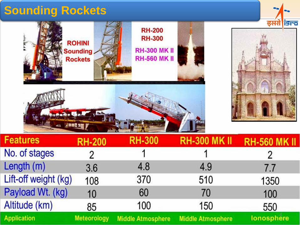
Sounding Rockets
4
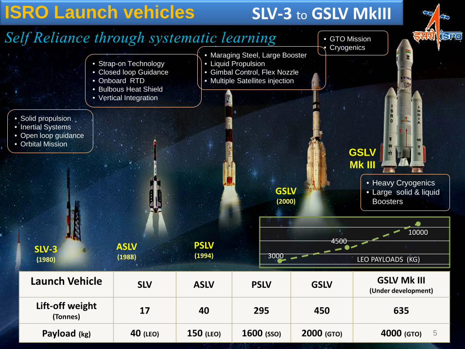
ISRO Launch vehicles
Launch Vehicle SLV ASLV PSLV GSLV GSLV Mk III (Under development)
Lift-off weight (Tonnes) 17 40 295 450 635
Payload (kg) 40 (LEO) 150 (LEO) 1600 (SSO) 2000 (GTO) 4000 (GTO)
SLV-3 (1980)
PSLV (1994)
GSLV (2000)
GSLV Mk III
LEO PAYLOADS (KG) 3000
4500 10000
ASLV (1988)
SLV-3 to GSLV MkIII
• Maraging Steel, Large Booster • Liquid Propulsion • Gimbal Control, Flex Nozzle • Multiple Satellites injection
• GTO Mission • Cryogenics
• Heavy Cryogenics • Large solid & liquid
Boosters
• Strap-on Technology • Closed loop Guidance • Onboard RTD • Bulbous Heat Shield • Vertical Integration
• Solid propulsion • Inertial Systems • Open loop guidance • Orbital Mission
5
Earth Observation (10 LEO + 3 GEO)
Satellite Navigation
(IRNSS & GAGAN)
Satellite Communication
(13 satellites; ~240 transponders)
Space Exploration
(MOM & ASTROSAT)
Space Technology Applications Agriculture, Forestry, Fisheries, Drinking Water,
Natural Resources, Snow & Glaciers, Watershed development, Urban, weather &
climate, communication applications, DMS….
Launch Vehicle
(PSLV; GSLV & MkIII)
Indian Space programme VISION: Harness space technology for national development, while pursuing space science research and planetary exploration
6
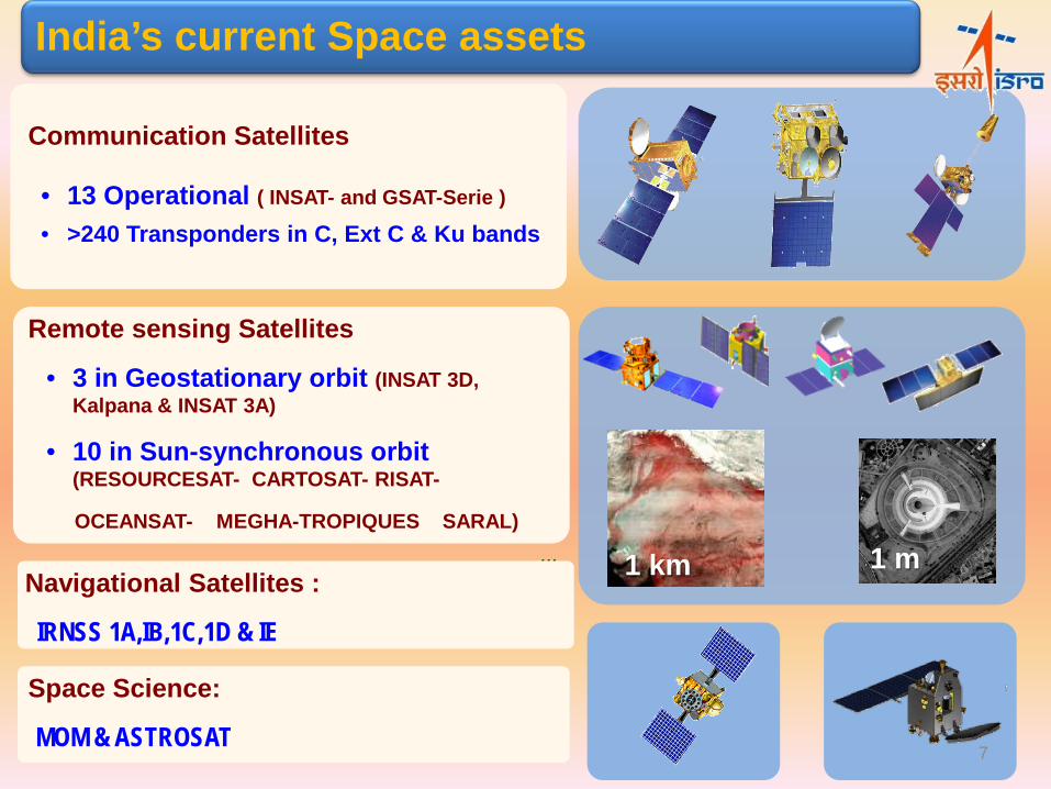
1 km 1 m
Communication Satellites
• 13 Operational ( INSAT- and GSAT-Serie )
• >240 Transponders in C, Ext C & Ku bands
India’s current Space assets
Remote sensing Satellites
• 3 in Geostationary orbit (INSAT 3D, Kalpana & INSAT 3A)
• 10 in Sun-synchronous orbit (RESOURCESAT- CARTOSAT- RISAT-
OCEANSAT- MEGHA-TROPIQUES SARAL) ...
Navigational Satellites :
IRNSS 1A,IB,1C,1D & IE
Space Science:
MOM & ASTROSAT 7

Potential Fisheries Zone (PFZ) Forecast
• Fish catch doubled, • Reduced search time by 60% • fuel cost by abut 30%
Fisheries
Area & Production estimation for 8 major crops
• In-season multiple forecast • Satellite data + agro-
meteorology + market economics
Agriculture Groundwater prospect zones & Recharge Sites
• 90 -95% Success rate for
Bore wells • Increased Water level
Drinking Water
Watershed Development Better productivity potential &
improved livelihood
• Soil & Water Conservation • Enhanced cropping yield • Decrease in fallow lands
Monitoring Irrigation Infrastructure
Inventory & Mapping of Irrigation Infrastructure
• Assessment of gaps in irrigation potential created and its utilization at the ground level.
NR Census Periodic Inventory of Natural
Resources
Land use , Soil, Geomorphology Wetland, Land degradation , Snow & Glaciers , Vegetation
Space applications in diversified areas
8
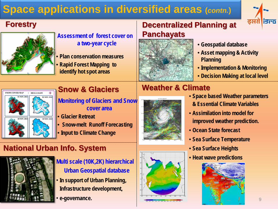
• Geospatial database • Asset mapping & Activity
Planning • Implementation & Monitoring • Decision Making at local level
Multi scale (10K,2K) hierarchical Urban Geospatial database
• In support of Urban Planning, Infrastructure development,
• e-governance.
National Urban Info. System
Monitoring of Glaciers and Snow
cover area • Glacier Retreat • Snow-melt Runoff Forecasting • Input to Climate Change
Snow & Glaciers
Forestry Assessment of forest cover on
a two-year cycle
• Plan conservation measures • Rapid Forest Mapping to
identify hot spot areas
• Space based Weather parameters
& Essential Climate Variables • Assimilation into model for
improved weather prediction. • Ocean State forecast • Sea Surface Temperature • Sea Surface Heights • Heat wave predictions
Weather & Climate
Decentralized Planning at Panchayats
Space applications in diversified areas (contn.)
9
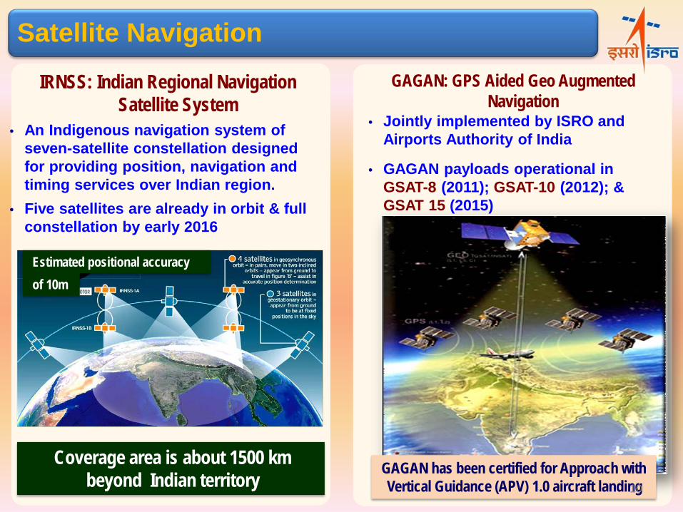
Coverage area is about 1500 km beyond Indian territory
Estimated positional accuracy
Satellite Navigation
• An Indigenous navigation system of seven-satellite constellation designed for providing position, navigation and timing services over Indian region.
• Five satellites are already in orbit & full constellation by early 2016
IRNSS: Indian Regional Navigation Satellite System
of 10m
GAGAN: GPS Aided Geo Augmented Navigation
GAGAN has been certified for Approach with Vertical Guidance (APV) 1.0 aircraft landing
• Jointly implemented by ISRO and Airports Authority of India
• GAGAN payloads operational in GSAT-8 (2011); GSAT-10 (2012); & GSAT 15 (2015)
10

CHANDRAYAAN 1:
• Objectives: High resolution remote sensing; 3D atlas & chemical mapping
• Instruments : 11 (6 from other countries) • Major discovery: Hydroxyl & water molecules on
lunar surface material • Ground Segment: Indian Deep Space Network
(IDSN); Spacecraft Control Centre (SCC) & Indian Space Science Data Centre (ISSDC)
MARS ORBITER MISSION: Exploration of Mars morphology, mineralogy and Martian atmosphere
ASTROSAT: Multi-wavelength (UV to X-ray) observation of astronomical objects
Upcoming Space Science Missions
• ADITYA: Studying the process of coronal heating & other phenomena in the magnetosphere
• CHANDRAYAAN-2: Exploring Moon with Orbiter-Lander-Rover
Space Science & Planetary Exploration
11
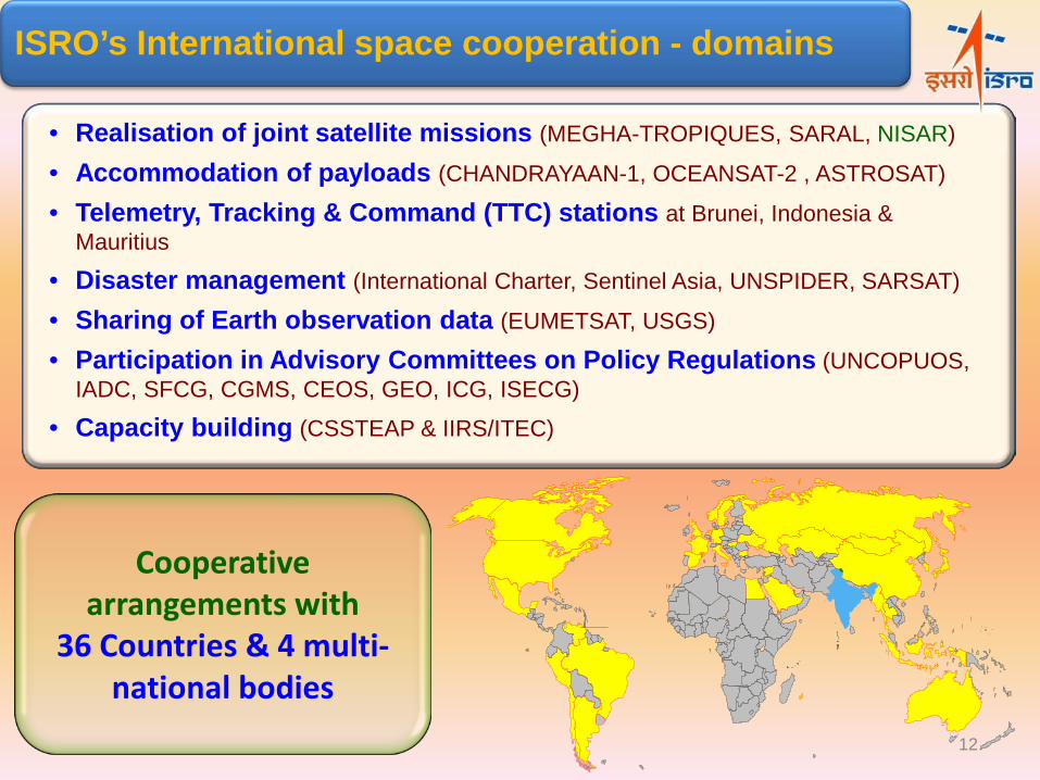
ISRO’s International space cooperation - domains
Cooperative arrangements with
36 Countries & 4 multi-national bodies
• Realisation of joint satellite missions (MEGHA-TROPIQUES, SARAL, NISAR)
• Accommodation of payloads (CHANDRAYAAN-1, OCEANSAT-2 , ASTROSAT)
• Telemetry, Tracking & Command (TTC) stations at Brunei, Indonesia & Mauritius
• Disaster management (International Charter, Sentinel Asia, UNSPIDER, SARSAT)
• Sharing of Earth observation data (EUMETSAT, USGS)
• Participation in Advisory Committees on Policy Regulations (UNCOPUOS, IADC, SFCG, CGMS, CEOS, GEO, ICG, ISECG)
• Capacity building (CSSTEAP & IIRS/ITEC)
12
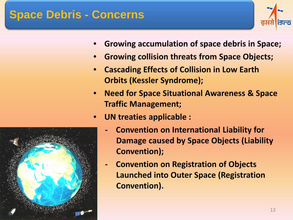
Space Debris - Concerns
• Growing accumulation of space debris in Space; • Growing collision threats from Space Objects; • Cascading Effects of Collision in Low Earth
Orbits (Kessler Syndrome); • Need for Space Situational Awareness & Space
Traffic Management; • UN treaties applicable :
- Convention on International Liability for Damage caused by Space Objects (Liability Convention);
- Convention on Registration of Objects Launched into Outer Space (Registration Convention).
13
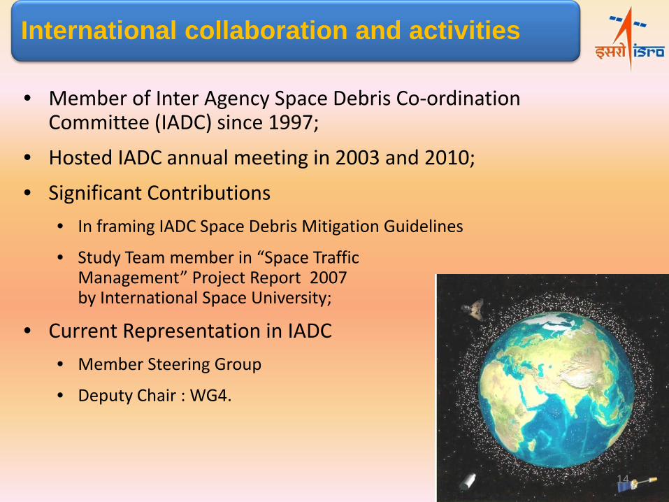
• Member of Inter Agency Space Debris Co-ordination Committee (IADC) since 1997;
• Hosted IADC annual meeting in 2003 and 2010;
• Significant Contributions • In framing IADC Space Debris Mitigation Guidelines
• Study Team member in “Space Traffic Management” Project Report 2007 by International Space University;
• Current Representation in IADC • Member Steering Group
• Deputy Chair : WG4.
International collaboration and activities
14

UN-Space Debris mitigation guidelines • Limit debris release during normal operations
• Minimize break-up potential during operations
• Limit accidental in-orbit collision probability
• Avoid intentional destruction & harmful activities
• Limit the probability of post-mission break-up
• Limit the long-term presence of spacecraft and launcher orbital stages in the
LEO protected region.
• Re-entry objects must not pose an undue risk to the ground population
• Limit the long-term interference of spacecraft and launcher orbital stages with
the GEO protected region.
• ISRO follows all guidelines to the maximum extent possible. 15

Major Activities
• Space Debris Mitigation; • Collision Avoidance studies for Launch Vehicle Lift-off
clearance (COLA); • Space Object Proximity Analysis (SOPA); • Space debris Modeling; • Long term evolution of Space Debris scenario; • Establishment of Multi-Object Tracking RADAR; • Joint activities with IADC; • Outreach programs.
Major activities
16
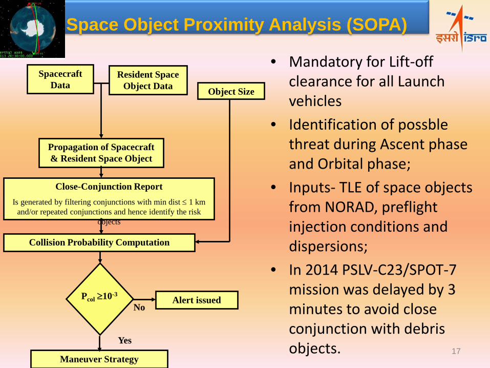
Spacecraft Data
Resident Space Object Data
Propagation of Spacecraft & Resident Space Object
Close-Conjunction Report Is generated by filtering conjunctions with min dist ≤ 1 km
and/or repeated conjunctions and hence identify the risk objects
Object Size
Collision Probability Computation
Pcol ≥10-3
Maneuver Strategy
Alert issued No
Yes
Space Object Proximity Analysis (SOPA)
• Mandatory for Lift-off clearance for all Launch vehicles
• Identification of possble threat during Ascent phase and Orbital phase;
• Inputs- TLE of space objects from NORAD, preflight injection conditions and dispersions;
• In 2014 PSLV-C23/SPOT-7 mission was delayed by 3 minutes to avoid close conjunction with debris objects. 17
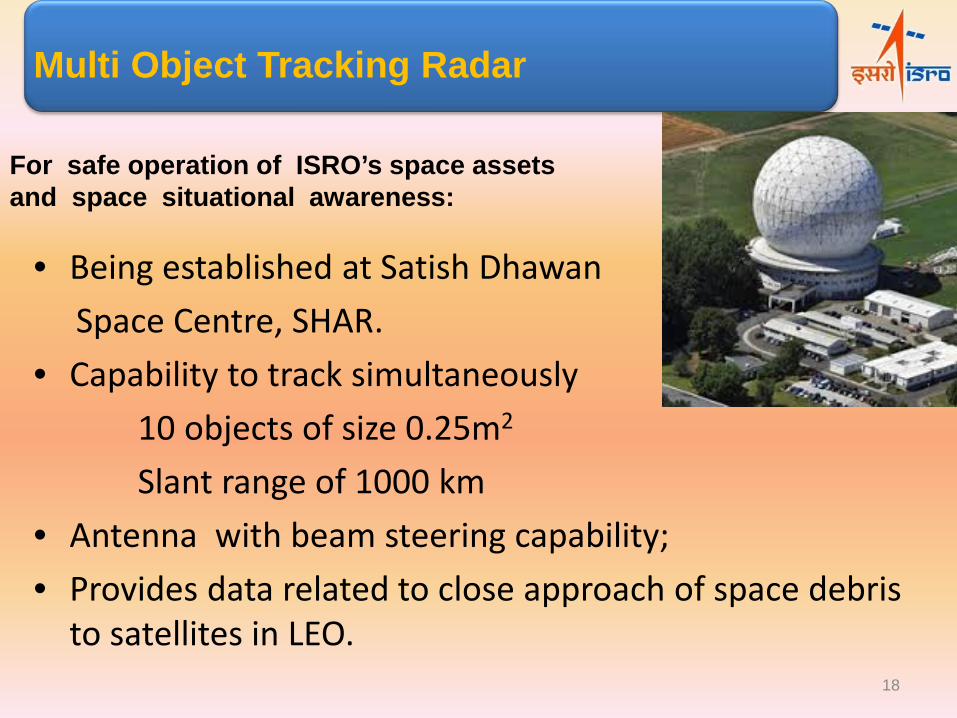
• Being established at Satish Dhawan Space Centre, SHAR. • Capability to track simultaneously 10 objects of size 0.25m2
Slant range of 1000 km • Antenna with beam steering capability; • Provides data related to close approach of space debris
to satellites in LEO.
Multi Object Tracking Radar
For safe operation of ISRO’s space assets and space situational awareness:
18
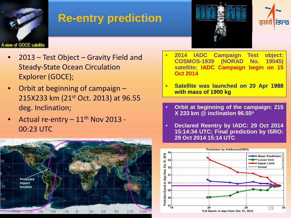
• 2013 – Test Object – Gravity Field and Steady-State Ocean Circulation Explorer (GOCE);
• Orbit at beginning of campaign – 215X233 km (21st Oct. 2013) at 96.55 deg. Inclination;
• Actual re-entry – 11th Nov 2013 - 00:23 UTC
Re-entry prediction
• 2014 IADC Campaign Test object: COSMOS-1939 (NORAD No. 19045) satellite; IADC Campaign begin on 15 Oct 2014
• Satellite was launched on 20 Apr 1988 with mass of 1900 kg
• Orbit at beginning of the campaign: 215 X 233 km @ inclination 96.55o
• Declared Reentry by IADC: 29 Oct 2014 15:14:34 UTC; Final prediction by ISRO: 29 Oct 2014 15:14 UTC
19
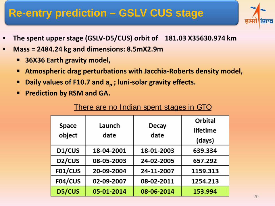
• The spent upper stage (GSLV-D5/CUS) orbit of 181.03 X35630.974 km • Mass = 2484.24 kg and dimensions: 8.5mX2.9m
36X36 Earth gravity model, Atmospheric drag perturbations with Jacchia-Roberts density model, Daily values of F10.7 and ap ; luni-solar gravity effects. Prediction by RSM and GA.
Re-entry prediction – GSLV CUS stage
There are no Indian spent stages in GTO
20
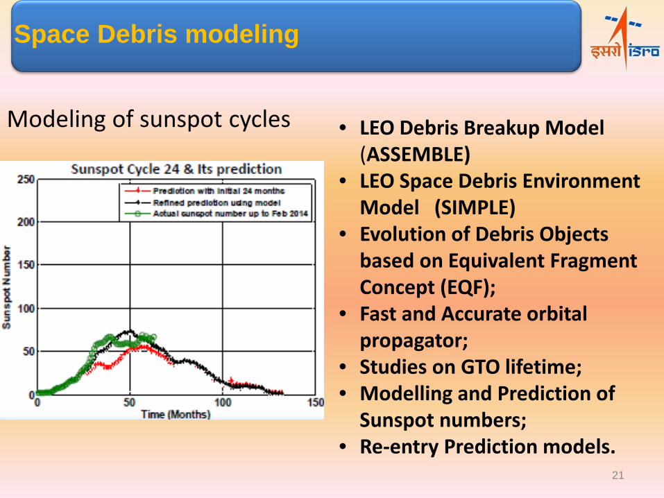
Space Debris modeling
Modeling of sunspot cycles • LEO Debris Breakup Model (ASSEMBLE)
• LEO Space Debris Environment Model (SIMPLE)
• Evolution of Debris Objects based on Equivalent Fragment Concept (EQF);
• Fast and Accurate orbital propagator;
• Studies on GTO lifetime; • Modelling and Prediction of
Sunspot numbers; • Re-entry Prediction models.
21
• National Conference on Space Debris Management and Mitigation Techniques June, 20-21, 2014 at ISRO Headquarters, Bangalore.
• Eight invited talks and 40 contributed papers; • 150 delegates attended the conference; • Talks on Space Debris under the auspices of
various societies like Aeronautical Society of India, Astronautical Society of India etc. to generate awareness among the scientific community.
Outreach programs
22
Conclusion
ISRO has well laid plan for future activities in moving towards -
• Augmenting our constellation of EO, Com and Navigation Satellites;
• Building capabilities to explore universe;
• Sustaining the vibrant application programme to touch everybody’s, everyday’s life;
And to ensure stable use of Outer Space.
• Space Debris mitigation guidelines are followed in lift off, trajectory, spacecraft injection and orbital phases, and in monitoring the re-entry of spent stages.
.
23
24
Related Documents
![Gaurav Verma , Eeshan Gunesh Dhekane , Tanaya Guha … · 2020. 7. 7. · Gaurav Verma1, Eeshan Gunesh Dhekane2, Tanaya Guha3 1Adobe Research, India ... [15] with a new music emotion](https://static.cupdf.com/doc/110x72/5fc3823688c78b40ae70e65d/gaurav-verma-eeshan-gunesh-dhekane-tanaya-guha-2020-7-7-gaurav-verma1.jpg)