GEOLOGIJA. 2009. Vol. 51. No. 3–4(67–68). P. 131–138 DOI: 10.2478/v10056-009-0014-0 © Lietuvos mokslų akademija, 2009 © Lietuvos mokslų akademijos leidykla, 2009 © Vilniaus universitetas, 2009 e origin of drumlins at Zbójno, Central Poland Piotr Głębicki, Leszek Marks Głębicki P., Marks L. e origin of drumlins at Zbójno, Central Poland. Geologija. Vilnius. 2009. Vol. 51. No. 3–4 (67–68). P. 131–138. ISSN 1392-110X Drumlins at Zbójno, Dobrzyń Lakeland, are located in a channel-like terminal basin, in the proximal part of the Chrostkowo end moraines. A fragment of the drumlin field was examined in detail. e drumlins are elongated ridges, parallel to one another and to the basin margins. eir orientation is parallel to perpendicular with regard to the presumed regional direction of the ice sheet advance. e drumlins’ geological structure is tripartite, including a lower till, a glaciofluvial core and a covering upper till. Georadar examination indicated the presence and extension of glaciotectonic deformations of the lower till. It is squeezed up to 3 m above its primary setting and forms protodrumlins that have not been, however, the bed bumps that stimulated a lee-side deposition. Protodrumlins are usually absent along a drumlin axis, but they occur also in pairs. ey could both initiate but also terminate drumlin development when thawing appeared in the subglacial zone and the ice body was disintegrated into dead-ice blocks. Glaciofluvial cores are less deformed than the lower till: their sediments are stratified, but commonly upliſted towards a protodrumlin. Key words: drumlins, georadar, Pleistocene, Poland Received 03 March 2009, accepted 15 April 2009 Piotr Głębicki, Leszek Marks (corresponding author). Institute of Geology, University of Warsaw, Żwirki i Wigury 93, 02-089 Warsaw, Poland. E-mail: [email protected] INTRODUCTION Drumlins are commonly connected with an active ice body, and their inner deformations seem to result both from vary- ing shearing stress and from lithologic inhomogeneity. Con- servation of drumlins in a marginal zone of active ice is due to its resistance to shearing stress. Preliminary classification of drumlins is always based on their morphologic description, what results in a varied in- ner structure, both in lithology and setting of sediments. A drumlin is usually found to present a tripartite structure: – a glaciofluvial, lenticular core, resting on a bedrock (mostly lower till), covered with a thin upper till; – glaciofluvial core that mantles emerging bedrock heights (protodrumlins) covered with the upper till; – glaciofluvial core that mantles a protodrumlin, com- posed of the glaciodislocated lower till and covered with the upper till. A protodrumlin is a component of a drumlin and is com- monly defined as an emerging bedrock fragment resistant to glacial erosion. It is composed either of a lithic rock or of a glaciodislocated till. e prefix ‘proto’ means a primary ele- ment if its origin is concerned, and determines the derivation of a drumlin. Drumlins are the outstanding landscape features char- acteristic of their specific shapes and collective occurrence. ey are especially distinct in a fresh glacial landscape and are easily identified, both on topographic maps and in the field. Drumlins in the Polish territory have been studied for over 100 years (Keilhack, 1896; Werth, 1909; Ebers, 1926; Nechay, 1927; Pawłowski, 1927; Dylikowa, 1952; Jewtuchowicz, 1956; Wiśniewski, 1956; Niewiarowski, 1959; Roszkówna, 1961; Liberacki, 1961; Ber, 1968; Baranowski, 1969, 1977, 1979; Lamparski, 1972; Rudnicki, 1979). It resulted in a detailed description of drumlin fields, accompanied by their interpre- tation and original theories of their development (Lampar- ski, 1972). A renewed interest in Polish drumlins has begun lately (Wysota, 1991, 1992, 1994, 1995, 2004; Olszewski, 1994, 1995a, b, 1997; Piotrowski, Wysota, 2001). e Zbójno drumlin field in the Dobrzyń Lakeland (Fig. 1) is the southernmost drumlin area in Poland. It oc- cupies an area of about 130 km 2 . Drumlins are located in a channel-like basin in the proximal part of the Chrostkowo end moraines. A fragment (30 km 2 ) of the central part of the

Welcome message from author
This document is posted to help you gain knowledge. Please leave a comment to let me know what you think about it! Share it to your friends and learn new things together.
Transcript
GEOLOGIJA. 2009. Vol. 51. No. 3–4(67–68). P. 131–138DOI: 10.2478/v10056-009-0014-0© Lietuvos mokslų akademija, 2009© Lietuvos mokslų akademijos leidykla, 2009© Vilniaus universitetas, 2009
Th e origin of drumlins at Zbójno, Central Poland
Piotr Głębicki,
Leszek Marks
Głębicki P., Marks L. Th e origin of drumlins at Zbójno, Central Poland. Geologija. Vilnius. 2009. Vol. 51. No. 3–4 (67–68). P. 131–138. ISSN 1392-110X
Drumlins at Zbójno, Dobrzyń Lakeland, are located in a channel-like terminal basin, in the proximal part of the Chrostkowo end moraines. A fragment of the drumlin fi eld was examined in detail. Th e drumlins are elongated ridges, parallel to one another and to the basin margins. Th eir orientation is parallel to perpendicular with regard to the presumed regional direction of the ice sheet advance. Th e drumlins’ geological structure is tripartite, including a lower till, a glaciofl uvial core and a covering upper till. Georadar examination indicated the presence and extension of glaciotectonic deformations of the lower till. It is squeezed up to 3 m above its primary setting and forms protodrumlins that have not been, however, the bed bumps that stimulated a lee-side deposition. Protodrumlins are usually absent along a drumlin axis, but they occur also in pairs. Th ey could both initiate but also terminate drumlin development when thawing appeared in the subglacial zone and the ice body was disintegrated into dead-ice blocks. Glaciofl uvial cores are less deformed than the lower till: their sediments are stratifi ed, but commonly uplift ed towards a protodrumlin.
Key words: drumlins, georadar, Pleistocene, Poland
Received 03 March 2009, accepted 15 April 2009
Piotr Głębicki, Leszek Marks (corresponding author). Institute of Geology, University of Warsaw, Żwirki i Wigury 93, 02-089 Warsaw, Poland. E-mail: [email protected]
INTRODUCTION
Drumlins are commonly connected with an active ice body, and their inner deformations seem to result both from vary-ing shearing stress and from lithologic inhomogeneity. Con-servation of drumlins in a marginal zone of active ice is due to its resistance to shearing stress.
Preliminary classifi cation of drumlins is always based on their morphologic description, what results in a varied in-ner structure, both in lithology and setting of sediments. A drumlin is usually found to present a tripartite structure:
– a glaciofl uvial, lenticular core, resting on a bedrock (mostly lower till), covered with a thin upper till;
– glaciofl uvial core that mantles emerging bedrock heights (protodrumlins) covered with the upper till;
– glaciofl uvial core that mantles a protodrumlin, com-posed of the glaciodislocated lower till and covered with the upper till.
A protodrumlin is a component of a drumlin and is com-monly defi ned as an emerging bedrock fragment resistant to glacial erosion. It is composed either of a lithic rock or of a glaciodislocated till. Th e prefi x ‘proto’ means a primary ele-
ment if its origin is concerned, and determines the derivation of a drumlin.
Drumlins are the outstanding landscape features char-acteristic of their specifi c shapes and collective occurrence. Th ey are especially distinct in a fresh glacial landscape and are easily identifi ed, both on topographic maps and in the fi eld. Drumlins in the Polish territory have been studied for over 100 years (Keilhack, 1896; Werth, 1909; Ebers, 1926; Nechay, 1927; Pawłowski, 1927; Dylikowa, 1952; Jewtuchowicz, 1956; Wiśniewski, 1956; Niewiarowski, 1959; Roszkówna, 1961; Liberacki, 1961; Ber, 1968; Baranowski, 1969, 1977, 1979; Lamparski, 1972; Rudnicki, 1979). It resulted in a detailed description of drumlin fi elds, accompanied by their interpre-tation and original theories of their development (Lampar-ski, 1972). A renewed interest in Polish drumlins has begun lately (Wysota, 1991, 1992, 1994, 1995, 2004; Olszewski, 1994, 1995a, b, 1997; Piotrowski, Wysota, 2001).
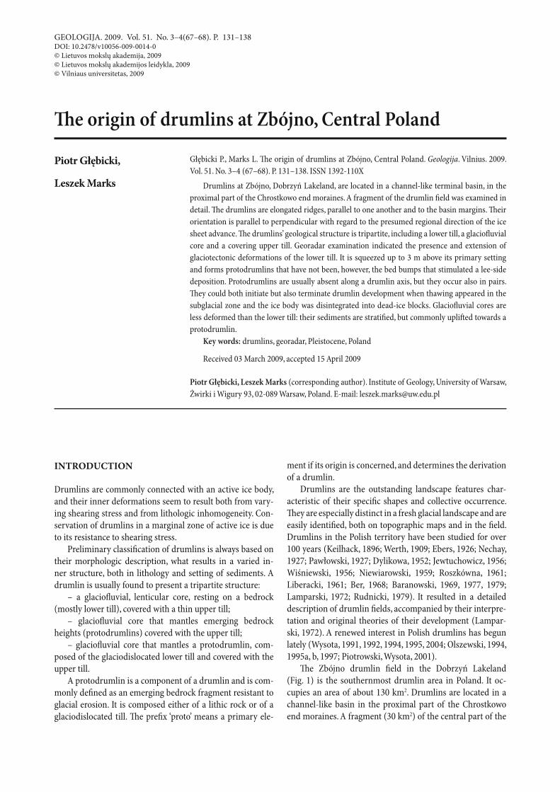
Th e Zbójno drumlin fi eld in the Dobrzyń Lakeland (Fig. 1) is the southernmost drumlin area in Poland. It oc-cupies an area of about 130 km2. Drumlins are located in a channel-like basin in the proximal part of the Chrostkowo end moraines. A fragment (30 km2) of the central part of the
Piotr Głębicki, Leszek Marks132
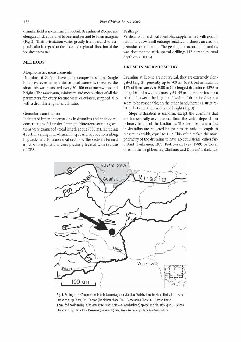
drumlin fi eld was examined in detail. Drumlins at Zbójno are elongated ridges parallel to one another and to basin margins (Fig. 2). Th eir orientation varies greatly from parallel to per-pendicular in regard to the accepted regional direction of the ice sheet advance.
METHODS
Morphometric measurementsDrumlins at Zbójno have quite composite shapes. Single hills have even up to a dozen local summits, therefore the short axis was measured every 50–100 m at narrowings and heights. Th e maximum, minimum and mean values of all the parameters for every feature were calculated, supplied also with a drumlin length / width ratio.
Georadar examinationIt detected inner deformations in drumlins and enabled re-construction of their development. Ninetteen sounding sec-tions were examined (total length about 7000 m), including 4 sections along inter-drumlin depressions, 5 sections along hogbacks and 10 transversal sections. Th e sections formed a net whose junctions were precisely located with the use of GPS.
Fig. 1. Setting of the Zbójno drumlin fi eld (arrow) against Vistulian (Weichselian) ice sheet limits: L – Leszno
(Brandenburg) Phase, Pz – Poznań (Frankfurt) Phase, Pm – Pomeranian Phase, G – Gardno Phase
1 pav. Zbójno drumlinų lauko vieta (strėlė) paskutiniojo (Weichseliano) apledėjimo ribų atžvilgiu: L – Leszno
(Brandenburgo) fazė, Pz – Poznanės (Frankfurto) fazė, Pm – Pomeranijos fazė, G – Gardno fazė
DrillingsVerifi cation of archival boreholes, supplemented with exami-nation of a few small outcrops, enabled to choose an area for georadar examination. Th e geologic structure of drumlins was documented with special drillings (12 boreholes, total depth over 100 m).
DRUMLIN MORPHOMETRY
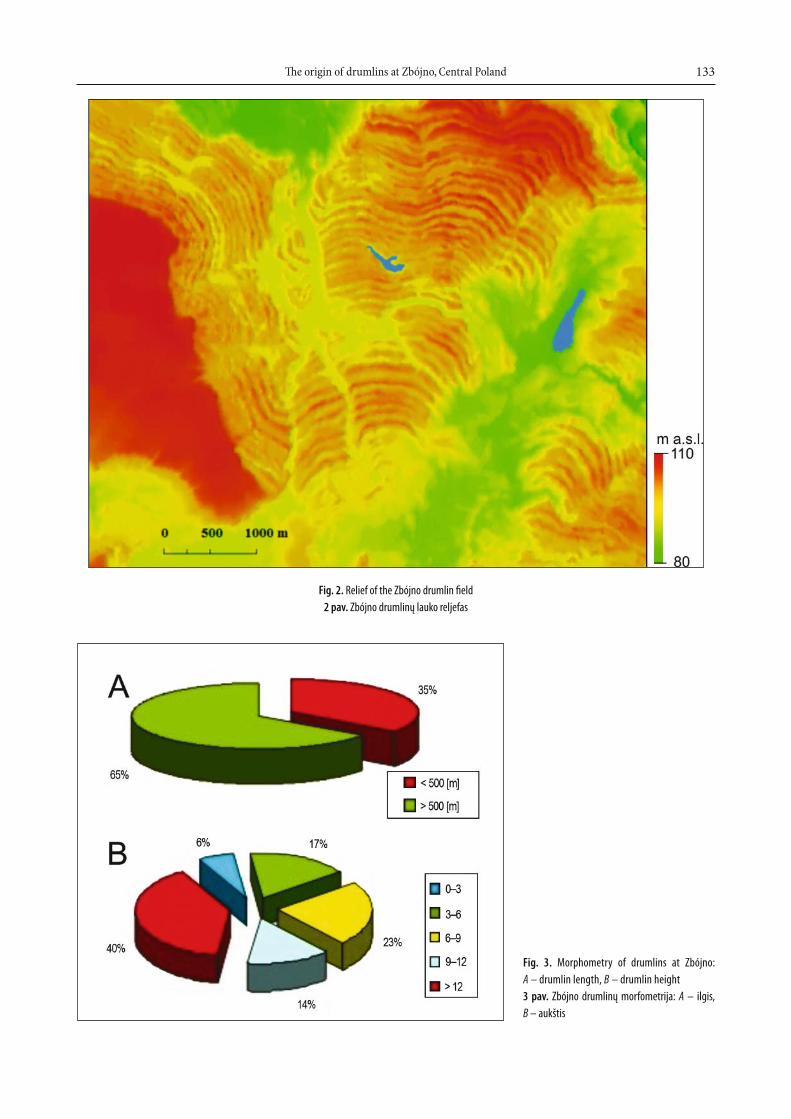
Drumlins at Zbójno are not typical: they are extremely elon-gated (Fig. 2), generally up to 500 m (65%), but as much as 12% of them are over 2000 m (the longest drumlin is 4393 m long). Drumlin width is mostly 55–95 m. Th erefore, fi nding a relation between the length and width of drumlins does not seem to be reasonable; on the other hand, there is a strict re-lation between their width and height (Fig. 3).
Slope inclination is uniform, except the drumlins that are transversally asymmetric. Th us, the width depends on primary height of the landforms. Th e described anomalies in drumlins are refl ected by their mean ratio of length to maximum width, equal to 11.2. Th is value makes the mor-phometry of the drumlins to have no equivalents, either far-distant (Jauhianen, 1975; Piotrowski, 1987, 1989) or closer ones. In the neighbouring Chełmno and Dobrzyń Lakelands,
Th e origin of drumlins at Zbójno, Central Poland 133
Fig. 2. Relief of the Zbójno drumlin fi eld
2 pav. Zbójno drumlinų lauko reljefas
Fig. 3. Morphometry of drumlins at Zbójno:
A – drum lin length, B – drumlin height
3 pav. Zbójno drumlinų morfometrija: A – ilgis,
B – aukštis
Piotr Głębicki, Leszek Marks134
the length / width ratio was estimated at 2.3 to 3.0, width be-ing equal to 41.6 m (Wysota, 1993). Th e width at the Zbójno fi eld is equal to 67.0 m.
INTERPRETATION OF GEORADAR EXAMINATION RESULTS
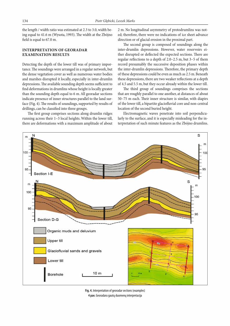
Detecting the depth of the lower till was of primary impor-tance. Th e soundings were arranged in a regular network, but the dense vegetation cover as well as numerous water bodies and marshes disrupted it locally, especially in inter-drumlin depressions. Th e available sounding depth seems suffi cient to fi nd deformations in drumlins whose height is locally greater than the sounding depth equal to 6 m. All georadar sections indicate presence of inner structures parallel to the land sur-face (Fig. 4). Th e results of soundings, supported by results of drillings, can be classifi ed into three groups.
Th e fi rst group comprises sections along drumlin ridges running across their 1–3 local heights. Within the lower till, there are deformations with a maximum amplitude of about
2 m. No longitudinal asymmetry of protodrumlins was not-ed; therefore, there were no indications of ice sheet advance direction or of glacial erosion in the proximal part.
Th e second group is composed of soundings along the inter-drumlin depressions. However, water reservoirs ei-ther disrupted or defl ected the expected sections. Th ere are regular refl ections to a depth of 2.0–2.5 m, but 3–5 of them record presumably the successive deposition phases within the inter-drumlin depressions. Th erefore, the primary depth of these depressions could be even as much as 2.5 m. Beneath these depressions, there are two weaker refl ections at a depth of 4.5 and 5.5 m, but they occur already within the lower till.
Th e third group of soundings comprises the sections that are roughly parallel to one another, at distances of about 50–75 m each. Th eir inner structure is similar, with diapirs of the lower till, a bipartite glaciofl uvial core and non-central location of the second buried height.
Electromagnetic waves penetrate into soil perpendicu-larly to the surface, and it is especially misleading for the in-terpretation of such minute features as the Zbójno drumlins.
Fig. 4. Interpretation of georadar sections (examples)
4 pav. Georadaru gautų duomenų interpretacija
Th e origin of drumlins at Zbójno, Central Poland 135
Not all refl ections are supported by the geological structure examined in boreholes; principally, some of them double the land surface.
GEOLOGICAL STRUCTURE OF DRUMLINS
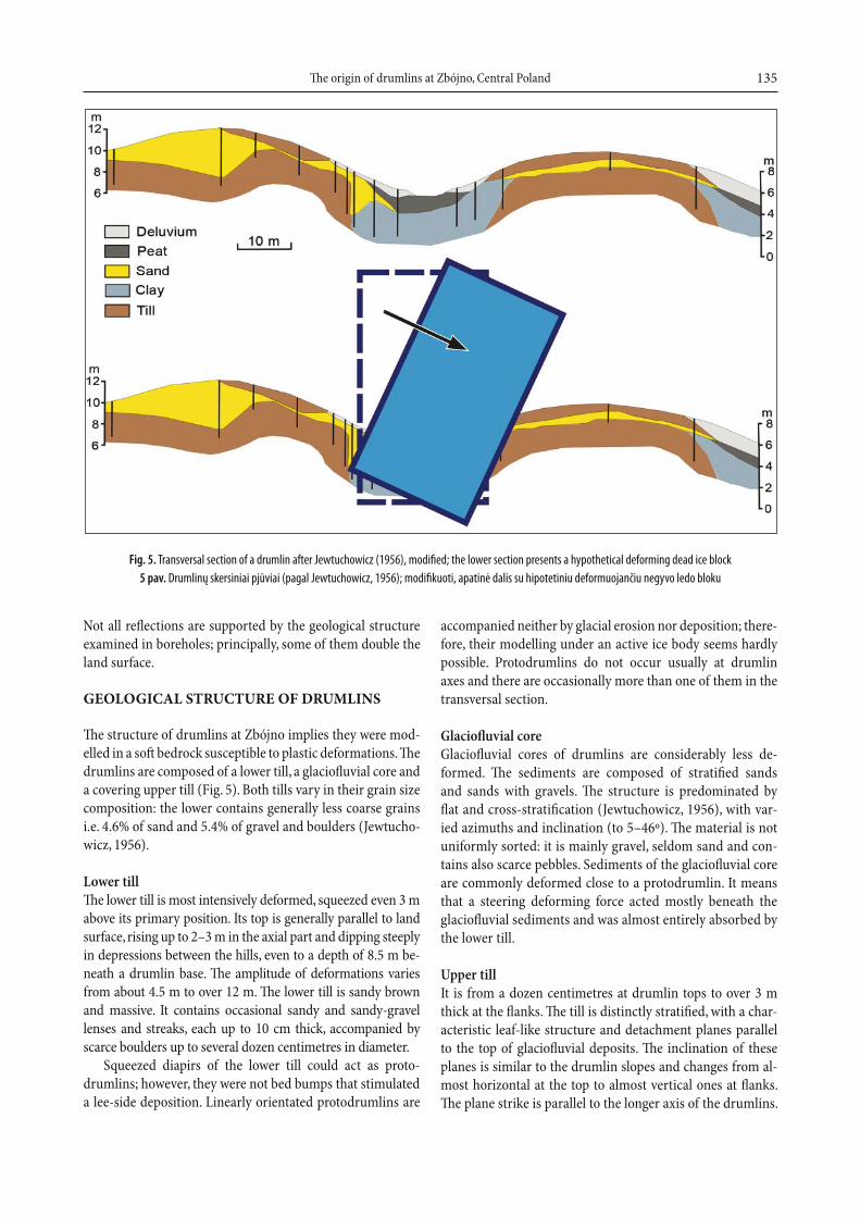
Th e structure of drumlins at Zbójno implies they were mod-elled in a soft bedrock susceptible to plastic deformations. Th e drumlins are composed of a lower till, a glaciofl uvial core and a covering upper till (Fig. 5). Both tills vary in their grain size composition: the lower contains generally less coarse grains i.e. 4.6% of sand and 5.4% of gravel and boulders (Jewtucho-wicz, 1956).
Lower tillTh e lower till is most intensively deformed, squeezed even 3 m above its primary position. Its top is generally parallel to land surface, rising up to 2–3 m in the axial part and dipping steeply in depressions between the hills, even to a depth of 8.5 m be-neath a drumlin base. Th e amplitude of deformations varies from about 4.5 m to over 12 m. Th e lower till is sandy brown and massive. It contains occasional sandy and sandy-gravel lenses and streaks, each up to 10 cm thick, accompanied by scarce boulders up to several dozen centimetres in diameter.
Squeezed diapirs of the lower till could act as proto-drumlins; however, they were not bed bumps that stimulated a lee-side deposition. Linearly orientated protodrumlins are
accompanied neither by glacial erosion nor deposition; there-fore, their modelling under an active ice body seems hardly possible. Protodrumlins do not occur usually at drumlin axes and there are occasionally more than one of them in the transversal section.
Glaciofl uvial coreGlaciofl uvial cores of drumlins are considerably less de-formed. Th e sediments are composed of stratifi ed sands and sands with gravels. Th e structure is predominated by fl at and cross-stratifi cation (Jewtuchowicz, 1956), with var-ied azimuths and inclination (to 5–46º). Th e material is not uniformly sorted: it is mainly gravel, seldom sand and con-tains also scarce pebbles. Sediments of the glaciofl uvial core are commonly deformed close to a protodrumlin. It means that a steering deforming force acted mostly beneath the glaciofl uvial sediments and was almost entirely absorbed by the lower till.
Upper tillIt is from a dozen centimetres at drumlin tops to over 3 m thick at the fl anks. Th e till is distinctly stratifi ed, with a char-acteristic leaf-like structure and detachment planes parallel to the top of glaciofl uvial deposits. Th e inclination of these planes is similar to the drumlin slopes and changes from al-most horizontal at the top to almost vertical ones at fl anks. Th e plane strike is parallel to the longer axis of the drumlins.
Fig. 5. Transversal section of a drumlin after Jewtuchowicz (1956), modifi ed; the lower section presents a hypothetical deforming dead ice block
5 pav. Drumlinų skersiniai pjūviai (pagal Jewtuchowicz, 1956); modifi kuoti, apatinė dalis su hipotetiniu deformuojančiu negyvo ledo bloku
Piotr Głębicki, Leszek Marks136
Inter-drumlin depressions are occupied by small water reservoirs, occasionally elongated and commonly parallel to drumlin longer axes. Depression systems resemble a channel net, indicating a signifi cant role of meltwaters in landscape development (Lamparski, 1972). Th e lower till in the inter-drumlin depressions is covered by clayey and locally sandy grey deposits, in places rather thick. Th ey are overlain by a thin (1–2 m) peat or sandy-clayey deluvium. At the saddles that separate local drumlin heights, the depressions are infi lled only by a thin deluvium resting straight on the lower till.
A CONCEPTUAL MODEL OF DRUMLIN FORMATION
Morphometric measurements indicate that only about 6% of drumlins at Zbójno have their length / width ratio equal to 3 and that in as much as 40% of them it is four times larger (Fig. 3). It is, however, striking that drumlins can be easily cor-related almost across the whole study area (Fig. 2). Th us, their creative factor acted on a macro-scale and could be later re-placed by erosion, transversal to elongation of the drumlins.
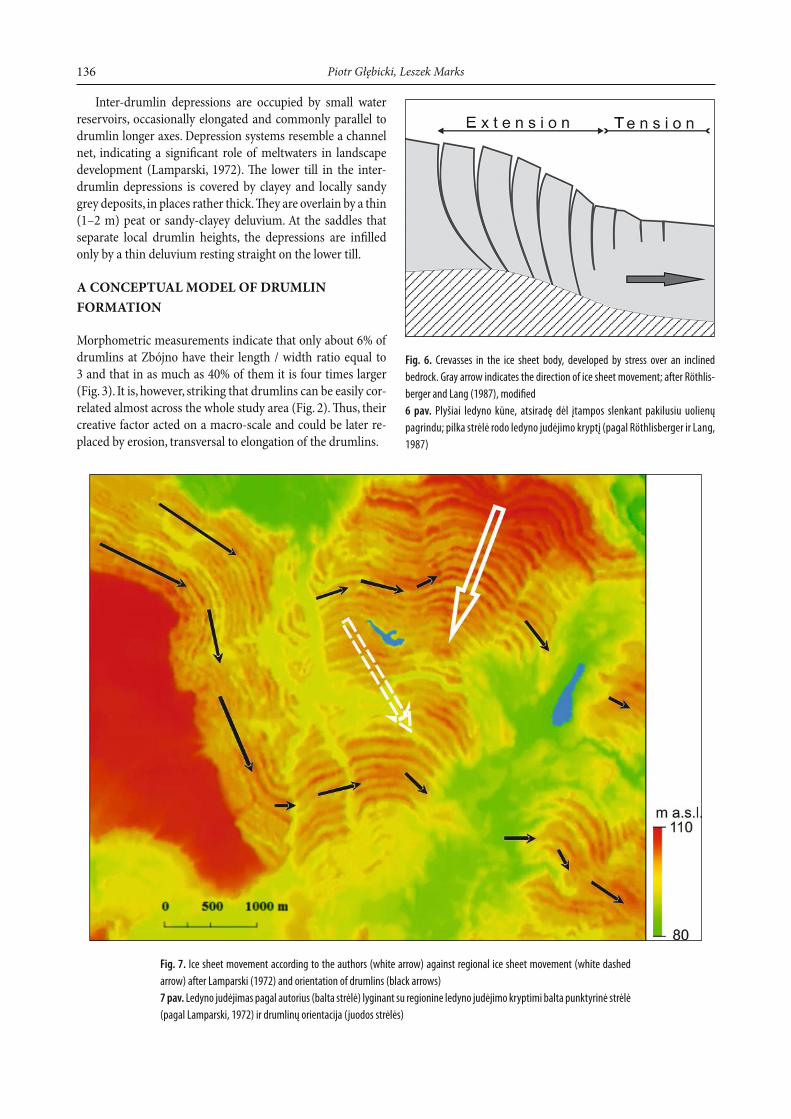
Fig. 6. Crevasses in the ice sheet body, developed by stress over an inclined
bedrock. Gray arrow indicates the direction of ice sheet movement; after Röthlis-
berger and Lang (1987), modifi ed
6 pav. Plyšiai ledyno kūne, atsiradę dėl įtampos slenkant pakilusiu uolienų
pagrindu; pilka strėlė rodo ledyno judėjimo kryptį (pagal Röthlisberger ir Lang,
1987)
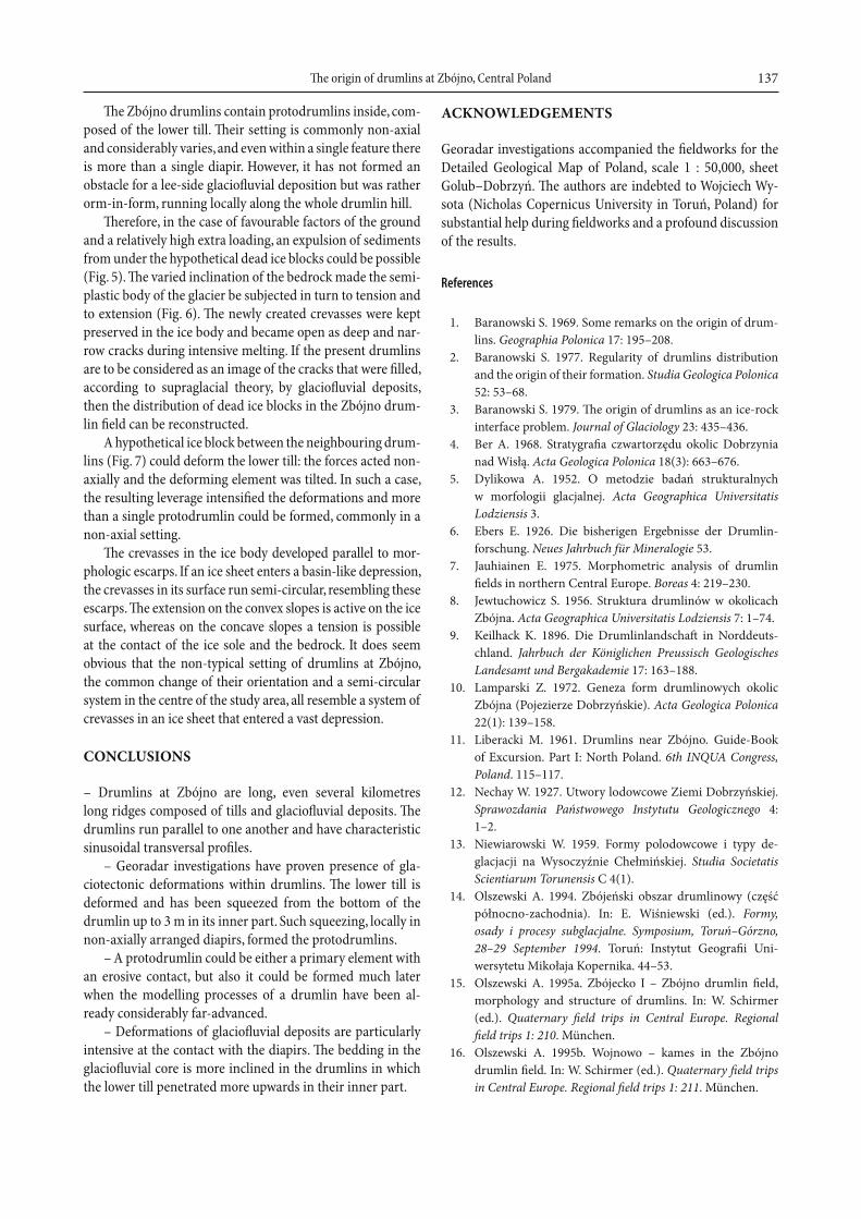
Fig. 7. Ice sheet movement according to the authors (white arrow) against regional ice sheet movement (white dashed
arrow) after Lamparski (1972) and orientation of drumlins (black arrows)
7 pav. Ledyno judėjimas pagal autorius (balta strėlė) lyginant su regionine ledyno judėjimo kryptimi balta punktyrinė strėlė
(pagal Lamparski, 1972) ir drumlinų orientacija (juodos strėlės)
Th e origin of drumlins at Zbójno, Central Poland 137
Th e Zbójno drumlins contain protodrumlins inside, com-posed of the lower till. Th eir setting is commonly non-axial and considerably varies, and even within a single feature there is more than a single diapir. However, it has not formed an obstacle for a lee-side glaciofl uvial deposition but was rather orm-in-form, running locally along the whole drumlin hill.
Th erefore, in the case of favourable factors of the ground and a relatively high extra loading, an expulsion of sediments from under the hypothetical dead ice blocks could be possible (Fig. 5). Th e varied inclination of the bedrock made the semi-plastic body of the glacier be subjected in turn to tension and to extension (Fig. 6). Th e newly created crevasses were kept preserved in the ice body and became open as deep and nar-row cracks during intensive melting. If the present drumlins are to be considered as an image of the cracks that were fi lled, according to supraglacial theory, by glaciofl uvial deposits, then the distribution of dead ice blocks in the Zbójno drum-lin fi eld can be reconstructed.
A hypothetical ice block between the neighbouring drum-lins (Fig. 7) could deform the lower till: the forces acted non-axially and the deforming element was tilted. In such a case, the resulting leverage intensifi ed the deformations and more than a single protodrumlin could be formed, commonly in a non-axial setting.
Th e crevasses in the ice body developed parallel to mor-phologic escarps. If an ice sheet enters a basin-like depression, the crevasses in its surface run semi-circular, resembling these escarps. Th e extension on the convex slopes is active on the ice surface, whereas on the concave slopes a tension is possible at the contact of the ice sole and the bedrock. It does seem obvious that the non-typical setting of drumlins at Zbójno, the common change of their orientation and a semi-circular system in the centre of the study area, all resemble a system of crevasses in an ice sheet that entered a vast depression.
CONCLUSIONS
– Drumlins at Zbójno are long, even several kilometres long ridges composed of tills and glaciofl uvial deposits. Th e drumlins run parallel to one another and have characteristic sinusoidal transversal profi les.
– Georadar investigations have proven presence of gla-ciotectonic deformations within drumlins. Th e lower till is deformed and has been squeezed from the bottom of the drumlin up to 3 m in its inner part. Such squeezing, locally in non-axially arranged diapirs, formed the protodrumlins.
– A protodrumlin could be either a primary element with an erosive contact, but also it could be formed much later when the modelling processes of a drumlin have been al-ready considerably far-advanced.
– Deformations of glaciofl uvial deposits are particularly intensive at the contact with the diapirs. Th e bedding in the glaciofl uvial core is more inclined in the drumlins in which the lower till penetrated more upwards in their inner part.
ACKNOWLEDGEMENTS
Georadar investigations accompanied the fi eldworks for the Detailed Geological Map of Poland, scale 1 : 50,000, sheet Golub–Dobrzyń. Th e authors are indebted to Wojciech Wy-sota (Nicholas Copernicus University in Toruń, Poland) for substantial help during fi eldworks and a profound discussion of the results.
References
1. Baranowski S. 1969. Some remarks on the origin of drum-lins. Geographia Polonica 17: 195–208.
2. Baranowski S. 1977. Regularity of drumlins distribution and the origin of their formation. Studia Geologica Polonica 52: 53–68.
3. Baranowski S. 1979. Th e origin of drumlins as an ice-rock interface problem. Journal of Glaciology 23: 435–436.
4. Ber A. 1968. Stratygrafi a czwartorzędu okolic Dobrzynia nad Wisłą. Acta Geologica Polonica 18(3): 663–676.
5. Dylikowa A. 1952. O metodzie badań strukturalnych w morfologii glacjalnej. Acta Geographica Universitatis Lodziensis 3.
6. Ebers E. 1926. Die bisherigen Ergebnisse der Drum lin-forschung. Neues Jahrbuch für Mineralogie 53.
7. Jauhiainen E. 1975. Morphometric analysis of drumlin fi elds in northern Central Europe. Boreas 4: 219–230.
8. Jewtuchowicz S. 1956. Struktura drumlinów w okolicach Zbójna. Acta Geographica Universitatis Lodziensis 7: 1–74.
9. Keilhack K. 1896. Die Drumlinlandschaft in Norddeuts-chland. Jahrbuch der Königlichen Preussisch Geologisches Landesamt und Bergakademie 17: 163–188.
10. Lamparski Z. 1972. Geneza form drumlinowych okolic Zbójna (Pojezierze Dobrzyńskie). Acta Geologica Polonica 22(1): 139–158.
11. Liberacki M. 1961. Drumlins near Zbójno. Guide-Book of Excursion. Part I: North Poland. 6th INQUA Congress, Poland. 115–117.
12. Nechay W. 1927. Utwory lodowcowe Ziemi Dobrzyńskiej. Sprawozdania Państwowego Instytutu Geologicznego 4: 1–2.
13. Niewiarowski W. 1959. Formy polodowcowe i typy de-glacjacji na Wysoczyźnie Chełmińskiej. Studia Societatis Scientiarum Torunensis C 4(1).
14. Olszewski A. 1994. Zbójeński obszar drumlinowy (część północno-zachodnia). In: E. Wiśniewski (ed.). Formy, osady i procesy subglacjalne. Symposium, Toruń–Górzno,28–29 September 1994. Toruń: Instytut Geografi i Uni-wersytetu Mikołaja Kopernika. 44–53.
15. Olszewski A. 1995a. Zbójecko I – Zbójno drumlin fi eld, morphology and structure of drumlins. In: W. Schirmer (ed.). Quaternary fi eld trips in Central Europe. Regional fi eld trips 1: 210. München.
16. Olszewski A. 1995b. Wojnowo – kames in the Zbójno drumlin fi eld. In: W. Schirmer (ed.). Quaternary fi eld trips in Central Europe. Regional fi eld trips 1: 211. München.
Piotr Głębicki, Leszek Marks138
17. Olszewski A. 1997. Drumlins of the northwestern Dobrzyń Moraine Plateau, location, structure and morphogenesis. Quaternary Studies in Poland 14: 71–83.
18. Pawłowski S. 1927. Krajobraz drumlinowy okolic Kobry-nia. Przegląd Geografi czny 7.
19. Piotrowski J. A., Smalley I. J. 1987. Th e Woodstock drumlin fi eld, southern Ontario, Kanada. In: J. Menzies, J. Rose (eds.). Drumlin Symposium. Rotterdam: Balkema. 309–321.
20. Piotrowski J. A. 1989. Relationship between drumlin length and width as a manifestation of the subglacial processes. Zeitschrift für Geomorphologie Neue Folge 33: 429–441.
21. Piotrowski J. A., Wysota W. (eds). 2001. Drumlins: the unsolved problem. Field excursion guide book. 6th International Drumlin Symposium. Toruń, June 17–23, 2001. Toruń: Nicholas Copernicus University. 100 p.
22. Roszkówna L. 1961. Drumlins near Gniew (Morzeszczyn). Guide-Book of Excursion. Part I: North Poland. 6th INQUA Congress, Poland. 84–86.
23. Röthlisberger H., Lang H. 1987. Glacial Hydrology. In: A. M. Gurnell, M. J. Clark (eds.). Glacio-fl uvial Sediment Transfer – an Alpine Perspective. London: Wiley & Sons, Ltd. 207–284.
24. Rudnicki J. 1979. Charakterystyka deformacji osadów drum linowych okolic Zbójna. Biuletyn Geologiczny Uni-wersytetu Warszawskiego 23: 143–153.
25. Werth E. 1909. Eine Drumlinlandschaft und Rinnenseen südlich von Posen. Zeitschrift der Deutschen Geologischen Gesellschaft 61.
26. Wiśniewski E. 1956. Formy drumlinowe okolic Gniewu. Przegląd Geografi czny 37: 171–182.
27. Wysota W. 1991. Morfologia, budowa wewnętrzna, struk tura i geneza drumlinów w środkowo-wschodniej części Pojezierza Chełmińsko-Dobrzyńskiego. I Zjazd Geomorfologów Polskich, Poznań, 24–25 September 1991. Poznań: Instytut Badań Czwartorzędu Uniwersytetu Ada-ma Mickiewicza. 78–79.
28. Wysota W. 1992. Morfogeneza środkowo-wschodniej części Pojezierza Chełmińsko-Dobrzyńskiego w świetle badań osadów i form zlodowacenia vistuliańskiego. Toruń: Uniwersytet Mikołaja Kopernika.
29. Wysota W. 1993. Geneza drumlinów w środkowo-wschodniej części Pojezierza Chełmińsko – Dobrzyńskiego. Przegląd Geologiczny 91: 335–361.
30. Wysota W. 1994. Górznieński obszar Drumlinowy. In: E. Wiś niewski (ed.). Formy, osady i procesy subglacjalne. Sym posium, Toruń – Górzno, 28–29 September 1994. Toruń: Ins ty tut Geografi i Uniwersytetu Mikołaja Kopernika.27–43.
31. Wysota W. 1995. Structure and mechanisms of drumlin for-mation in the glacial channels: a case study of the mid-east-ern part of the Chełmno-Dobrzyń Lakeland. Quaternary Studies in Poland. Special Issue 13: 109–124.
32. Wysota W. 2004. Gliny morenowe bazalne w rdzeniu drumlinu Świerczynki 2, NE Pojezierze Dobrzyńskie. In: Wysota W. (ed.). Gliny morenowe, typy genetyczne i środowiska depozycji. Toruń: Uniwersytet Mikołaja Kopernika. 40–45.
Piotr Głębicki, Leszek Marks
DRUMLINŲ PRIE ZBÓJNO (VIDURIO LENKIJA) KILMĖ
S a n t r a u k aDrumlinai yra labai būdingi ledyniniam kraštovaizdžiui, todėl lengvai identifi kuojami tiek topografi niuose žemėlapiuose, tiek ir gamtoje. Lenkijos teritorijoje drumlinai studijuojami daugiau kaip 100 metų. Zbójno (Vidurio Lenkija) apylinkėse esantis drumlinų laukas yra proksi-malinėje Chrostkowo galinių morenų dalyje. Tai piečiausias toks rajonas Lenkijoje. Lauko plotas siekia apie 130 km2. Drumlinų lauko vidurinės da-lies fragmentas (30 km2) buvo nuodugniai išnagrinėtas panaudojant geo-radarą ir gręžimo techniką. Zbójno drumlinai nėra tipiški. Jų ilgis dažnai siekia iki 500 m (65 %), bet yra ir ilgesnių nei 2000 m (12 %). Ilgiausias drumlinas yra 4393 m ilgio. Vyraujantis plotis 55–95 m. Šių ledyninių reljefo formų ilgosios keteros yra tarpusavyje lygiagrečios. Jų orientacija taip pat yra lygiagreti buvusiai ledyno slinkties krypčiai. Drumlinų struk-tūra paprastai yra trinarė: apatinis moreninis sluoksnis, fl iuvioglacialinis branduolys ir viršutinis moreninis sluoksnis. Georadaru nustatyta apa-tinio moreninio sluoksnio glaciotektoninė deformacija, žyminti pradinę drumlinų formavimosi stadiją, t. y. protodrumliną. Drumlinų fl iuviogla-cialiniai branduoliai yra mažiau deformuoti negu žemiau slūgsanti mo-rena. Atlikti tyrimai leido padaryti svarbią išvadą, kad ilgiems trinarės struktūros Zbójno drumlinams yra būdingos vidinės glaciotektoninės deformacijos. Suspaustas ir iškeltas aukštyn iki 3 m drumlinų vidinės dalies apatinis moreninis sluoksnis yra labiausiai deformuotas.
Петр Глебицки, Лешек Маркс
ПРОИСХОЖДЕНИЕ ДРУМЛИНОВ ОКОЛО ЗБУЙНО (ЦЕНТРАЛЬНАЯ ПОЛЬША)
Р е з ю м еДля ледникового ландшафта друмлины весьма характерны и легко идентифицируются как на топографических картах, так и в натуре. Друмлины на территории Польши изучаются уже более 100 лет. Друмлиновое „поле“ в окрестностях Збуйно (Центральная Польша) является самым южным в Польше. Оно расположено в проксималь-ной части конечных морен Хростково. Площадь друмлинового поля достигает около 130 км2. Фрагмент (30 км2) центральной части друм-линового поля изучен детально с применением георадара и буровой техники. Изученные друмлины являются нетипичными. Их длина часто достигает 500 м (65 %), но встречаются и более длинные – до 2000 м (12 %). Самый длинный достигает 4393 м. Преобладающая ширина друмлинов – 55–95 м. Гребни этих форм рельефа параллель-ны друг другу, а также прежнему направлению движения ледника. Строение друмлинов обычно трехчленное и состоит из нижнего моренного слоя, флювиогляциального ядра и покрывающего верх-него моренного слоя. Изучение георадаром выявило гляциотекто-ническую деформацию нижнего моренного слоя, фиксирующую начальную стадию формирования друмлинов, т. е. протодрумлины. Флювиогляциальные ядра друмлинов менее деформированы по сравнению с нижезалегающей мореной. Исследования позволили сделать важное заключение о том, что изученные длинные друм-лины трехчленной структуры характеризуются внутренней гля-циотектонической деформацией. Вследствие сжатия в ледниковой среде наиболее сильно деформированный нижний моренный слой во внутренней части друмлинов обычно приподнят (до 3 м).
Related Documents