GLASGOW AIRPORT INVESTMENT AREA 2016 Glasgow Airport Investment Area Scoping Report Doc Number: 117084_SWECO_EAC_00_SPP_EN_00003 Version: PO1.0 Suitability: S3 BIM Authorisation

Welcome message from author
This document is posted to help you gain knowledge. Please leave a comment to let me know what you think about it! Share it to your friends and learn new things together.
Transcript

GLASGOW AIRPORTINVESTMENT AREA
SCOPING REPORT
0
2016Glasgow Airport Investment Area
Scoping Report
Doc Number: 117084_SWECO_EAC_00_SPP_EN_00003Version: PO1.0Suitability: S3 BIM Authorisation
GLASGOW AIRPORTINVESTMENT AREA
SCOPING REPORT
1
Issue Date Reason for Issue Prepared Checked ApprovedPO1.0 26.08.16 Draft for Approval JB 22.08.16 RMcL 24.08.16 HC 02.09.16P01.1 16.09.16 Final Draft for Approval JB 14.09.16 RMcL 15.09.16 HC 16.09.16P01.2 20.09.16 Final Issued JB 16.09.16 HC 16.09.16 RMcL 20.09.16
GAIA City Deal: Scoping RequestDoc Number: 117084_SWECO_EAC_00_SPP_EN_00003117084/RMcLean/240816Revision PO1.2
SwecoSpectrum House2 Powderhall RoadEdinburghEH7 4GB
+44 (0)131 550 [email protected]
© Sweco 2016. This document is a Sweco confidential document; it may not be reproduced, stored in a retrieval system or transmitted inany form or by any means, electronic, photocopying, recording or otherwise disclosed in whole or in part to any third party without ourexpress prior written consent. It should be used by you and the permitted discloses for the purpose for which it has been submitted andfor no other.Registered Office: Sweco UK Limited, Grove House, Mansion Gate Drive, Leeds, LS7 4DN. Company Registration No 028883

2GLASGOW AIRPORTINVESTMENT AREASCOPING REPORT
Contents
Contents ........................................................................................................................................................ 2
Executive Summary ....................................................................................................................................... 3
1. Introduction and Approach to Scoping ............................................................................................... 4
2. The City Deals Proposals and Context ................................................................................................. 8
3. Land use and communities ................................................................................................................ 17
4. Geology, Hydrogeology, Soils and Contaminated Land .................................................................... 29
5. Water quality, drainage and flood defence....................................................................................... 41
6. Landscape and visual effects .............................................................................................................. 52
7. Ecology and nature conservation ...................................................................................................... 59
8. Archaeology and Cultural Heritage .................................................................................................... 68
9. Traffic and transport ........................................................................................................................... 76
10. Noise and Vibration ............................................................................................................................ 84
11. Air Quality ............................................................................................................................................ 96
12. Climate Change Mitigation and Adaptation .................................................................................... 102
13. Proposed Approach to EIA ............................................................................................................... 108
14. Summary of EIA Scoping ................................................................................................................... 113
List of Appendices:
Appendix 4.1: Schedule of Historical Contamination Sources
Appendix 6.1: LVIA Methodology
Appendix 7.1: Ecology Survey Methodology
Appendix 8.1: Cultural Heritage Assessment Criteria
Appendix 14.1: Agreed List of Scoping Report Consultees
GLASGOW AIRPORTINVESTMENT AREA
SCOPING REPORT
3
Executive Summary
Executive SummaryThe Glasgow City Region City Deal is an agreement between the Scottish Government, UKGovernment, and eight West of Scotland local authorities, including Renfrewshire Council(RC). The Glasgow Airport Investment Area (GAIA) infrastructure project (the proposeddevelopment), is one of three City Deal projects within the RC area. The GAIA project aimsto significantly improve connectivity and enhance economic development opportunitiesadjacent to Glasgow Airport and along the White Cart Corridor between the Airport andPaisley.
Renfrewshire Council (RC) is the applicant for the GAIA infrastructure project.
The Renfrewshire Council City Deal Team is seeking consent to realign Abbotsinch Road, create acycleway link to Inchinnan Business Park, a cycleway crossing of the Black Cart, a crossing of theWhite Cart close to the Westway Business Park and a further ‘Gateway’ crossing of the White Cartclose to Abercorn Industrial Estate to create a new and more direct gateway route from the airportto Paisley.
It is our view that the proposed development falls within Category 10 (f) of Schedule 2 to theTown and Country Planning (Environmental Impact Assessment) (Scotland) Regulations 2011(TCP EIA Regulations) as the proposed development exceeds the stated one hectare (forroads infrastructure). Marine Scotland have screened that the development has thepotential to impact upon the marine environment and therefore it also falls under theMarine Works (Environmental Impact Assessment) Regulations 2007 (MW EIA Regulations).As there is potential for significant environmental effects, the planning application will needto be supported by an Environmental Impact Assessment (EIA).
The competent authority for the terrestrial elements of the project will be RenfrewshireCouncil. The marine elements will be determined by Marine Scotland.
This report accompanies a formal EIA scoping opinion request submitted under Section 14 ofthe TCP EIA Regulations and under Schedule 4 of the MW EIA Regulations. The purpose ofthis report is to highlight the areas and approach currently considered appropriate forinclusion within the EIA to assist with the formal scoping process and this report sets out:
· a brief description of the proposed development;
· a plan to show the location of the development;
· a description of its possible effects on the environment; and
· a proposed methodology for undertaking an EIA of the proposed development.
An EIA will be undertaken to assess any likely significant effects of the proposal and itsresults will be presented within the Environmental Statement (ES) that will accompany theplanning application.
This Scoping Report provides an assessment of predicted likely significant effects and a
Introduction and Approach to Scoping
4GLASGOW AIRPORTINVESTMENT AREASCOPING REPORT
1. Introduction and Approach to Scoping
1.1 BackgroundThe Glasgow City Region Deal1 is an agreement between the Scottish Government, UKGovernment, and eight West of Scotland local Authorities, including Renfrewshire Council (RC).
This City Deal established a £1.13 billion Infrastructure Fund to progress 20 projects across theeight council areas. The City Deal is also to support further growth in the life science sector;provide additional business incubator and grow-on space; establish programmes to support 16-24 year olds and vulnerable adults back into employment; seek new ways to boost the incomesof people on low wages within the City Region.
Sweco is the lead consultant to the applicant for the Glasgow Airport Investment Area (GAIA)infrastructure project (the proposed development), which is one of three City Deal projectswithin the RC area. The GAIA project aims to significantly improve connectivity and enhanceeconomic development opportunities adjacent to Glasgow Airport and along the White CartCorridor between the Airport and Paisley.
The GAIA project aims facilitate the growth of existing businesses and create opportunities fornew businesses by opening up and improving access to economic development locationsadjacent to Glasgow Airport and along the White Cart Corridor between the Airport andPaisley.
The GAIA project is adjacent to the Clyde Waterfront and Renfrew Riverside (CWRR) projectwith which it has a strong synergy. The completed project will be designed to complement theother City Deal projects and potential cumulative environmental effects will be considered inthe preparation of the GAIA Environmental Statement. A separate Scoping Report has beenprepared for the CWRR project.
1.2 The ApplicantRenfrewshire Council (RC) City Deal Team is the applicant for the GAIA project.
The planning application will be supported by an Environmental Statement (ES) to meet therequirements of the Town and Country Planning (Environmental Impact Assessment) (Scotland)Regulations 2011 (’TCP EIA Regs’)). The project requires Environmental Impact Assessment(EIA) following screening determinations made by Renfrewshire Council (the local authoritywithin which the proposed development is located).
Consultation with Marine Scotland has confirmed that EIA is also required for the GAIA projectworks with the potential to affect the marine environment under the Marine Works(Environmental Impact Assessment) Regulations 2007 (as amended) (‘MW EIA Regs’). The EIAwill therefore be undertaken with reference to both sets of EIA Regulations.
1 www.glasgowcityregion.co.uk

Introduction and Approach to Scoping
GLASGOW AIRPORTINVESTMENT AREA
SCOPING REPORT
5
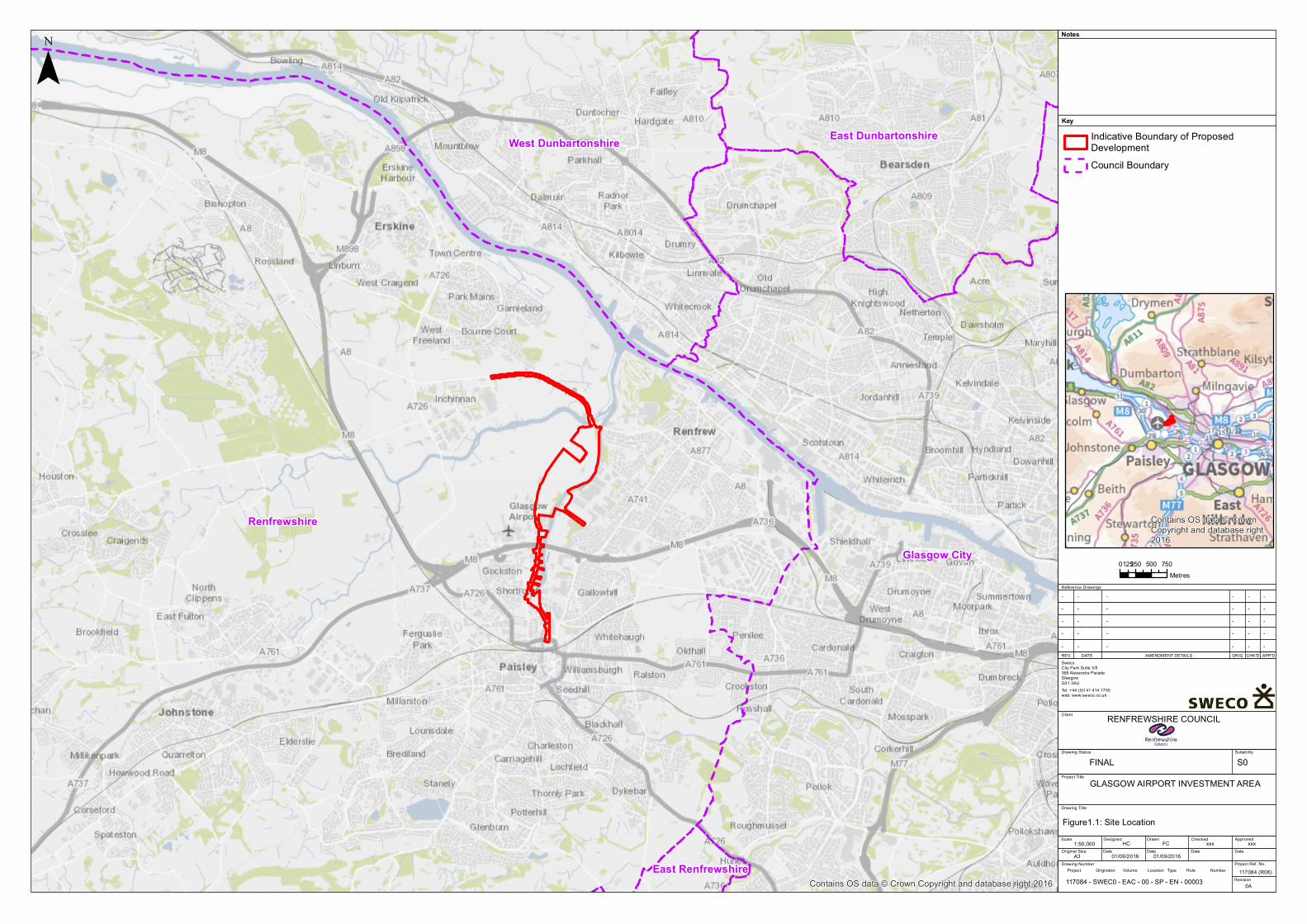
Figure 1.1 shows the site context, Figure 1.2 the indicative boundary2 of the new and upgradedroad, bridge crossings and new and upgraded cycleways that make up the proposeddevelopment and Figure 1.3 presents an overview of key environmental constraints in thestudy area.
1.3 Approach to ScopingThis document forms the Scoping Report for the EIA of the proposed development, to besubmitted to Renfrewshire Council and Marine Scotland (the competent authorities) in supportof a request for a formal Scoping Opinion under the provisions of Regulation 13 of the TCP EIARegulations and Schedule 4 of the MW EIA Regulations. This report presents the EIAcompetent authorities and consultees with sufficient information to provide consultationfeedback on the proposed scope of the EIA, in particular the approach to assessment and anyrelevant survey methodologies. This Scoping Report includes a preliminary environmentalassessment of the proposed development to identify where there is the potential for significantenvironmental effects and to propose the level of detail of assessment for each key topic in theEIA.
Prior to writing this report, Sweco held Scoping Interviews with each of the technical teams,who were tasked with presenting a summary of the initial baseline assessments, the likely‘significant’ effects and any elements that they considered could be ‘scoped out’. The reasonfor holding these interviews was to ensure that a pragmatic approach is adopted for thiscomplex project and that the resulting ES is focused and effective. The outcome of theseinterviews is the proposed methodology and scope that is presented in the following technicalchapters.
EIA is an iterative process which identifies the potential environmental effects that in turninform the eventual design of the proposal. It seeks to avoid, reduce, offset and minimise anyadverse environmental effects through careful design and mitigation. It takes into account theeffects arising during the construction and operational phases. Consultation is an importantpart of the EIA process and assists in the identification of potential effects and mitigationmeasures.
The consideration of the scope of the various technical assessments has taken into accountbroad mitigation which has been assumed as part of best practice construction and design ofthe road and bridge interventions. The following mitigation has been assumed in theassessments:
· construction of the proposals will follow good site practice to avoid or reduce thepotential for environmental effects associated with construction activities (e.g.increased sediment in surface water runoff, noise and vibration from constructionplant and traffic, accidental water and soil pollution from fuel and oil spills, damage tosoils, dust emissions etc.);
2 This figure provides a ‘red line’ boundary around the land which is currently anticipated may be required to construct andoperate the scheme (allowing space for mitigation and landscaping). The red line is indicative since project designdevelopment is not yet complete and does not necessarily represent the formal red line boundary which will be used for theplanning application(s).
Renfrewshire
Glasgow City
West Dunbartonshire East Dunbartonshire
East RenfrewshireContains OS data © Crown Copyright and database right 2016
¯Key
Notes
Reference Drawings
REV. DATE AMENDMENT DETAILS ORIG CHK'D APP'D
GLASGOW AIRPORT INVESTMENT AREA
Client
Drawing Title
Drawing Status Suitability
Scale
Original Size
Designed
Date
Drawn
Date Date Date
ApprovedChecked
Project Ref. No.
Revision
Drawing Number
SwecoCity Park Suite 3/5368 Alexandra Parade GlasgowG31 3AUTel: +44 (0)141 414 1700web: www.sweco.co.uk
RENFREWSHIRE COUNCIL
1:50,00001/09/2016A3
Figure1.1: Site Location
117084 (R06)
HC FC xxx
- - ----
xxx
Project Title
01/09/2016
0A
- - ----- - ----- - ----- - ----
Project Originator Volume Location Type Role Number
Indicative Boundary of ProposedDevelopmentCouncil Boundary
0 250 500 750125Metres
Contains OS data © CrownCopyright and database right2016
117084 - SWEC0 - EAC - 00 - SP - EN - 00003
FINAL S0

!( !( !( !( !( !( !( !( !( !( !( !( !( !( !( !( !( !( !( !( !( !( !( !( !( !( !(!(!(!(!(!(!(!(!(!(!(!(!(!(!(!(!(!(!(!(!(!(!(
!(!(!(!(!(!(!(!(
!(!(
!(!(!(!(!(
!( !( !( !(
© Crown copyright and database rights 2016. All Rights reserved. Ordnance Survey Licence number 100023417.
¯Key
Notes
Reference Drawings
REV. DATE AMENDMENT DETAILS ORIG CHK'D APP'D
GLASGOW AIRPORT INVESTMENT AREA
Client
Drawing Title
Drawing Status Suitability
Scale
Original Size
Designed
Date
Drawn
Date Date Date
ApprovedChecked
Project Ref. No.
Revision
Drawing Number
SwecoCity Park Suite 3/5368 Alexandra Parade GlasgowG31 3AUTel: +44 (0)141 414 1700web: www.sweco.co.uk
RENFREWSHIRE COUNCIL
1:18,00001/09/2016A3
Figure1.2: Site Layout
117084 (R06)
HC FC xxx
- - ----
xxx
Project Title
01/09/2016
0A
- - ----- - ----- - ----- - ----
Project Originator Volume Location Type Role Number
Indicative Boundary of ProposedDevelopmentPotential Location for ConstructionCompound
!( !( !( !( Indicative Line of New Cycle LinkIndicative Line of New / UpgradedRoad
0 250 500 750125Metres
117084 - SWEC0 - EAC - 00 - SP - EN - 00003
FINAL S0
_̂
_̂
_̂
_̂
_̂
_̂
_̂
_̂_̂
_̂
_̂
_̂̂_̂_
_̂
_̂
_̂
_̂
_̂
_̂
_̂̂__̂̂_
_̂
_̂_̂ _̂
_̂
_̂
_̂_̂
_̂
_̂_̂
_̂
_̂_̂
_̂_̂̂_
_̂̂_
_̂
_̂
_̂̂_
_̂_̂_̂_̂_̂̂_̂_
_̂_̂
_̂̂_̂_̂_
_̂
_̂̂_̂_̂_̂__̂
_̂_̂̂_̂_̂_̂__̂
_̂̂_̂_
_̂
_̂_̂
_̂
_̂̂_
_̂
_̂_̂
_̂̂_̂_̂_̂_̂_̂_̂_̂_
_̂_̂_̂̂_ _̂̂_̂_̂_
_̂̂_̂_
_̂_̂̂_̂_
_̂
_̂̂_̂_̂_
_̂̂_̂_̂_̂_̂_̂_̂__̂̂_ _̂ _̂_̂
_̂̂_̂_
_̂
_̂_̂
_̂
_̂_̂_̂̂__̂̂__̂
_̂_̂̂_̂__̂ _̂
_̂
_̂_̂̂__̂̂_̂_̂_̂_̂_̂_̂_̂_̂_̂_̂_̂__̂
_̂
_̂
_̂
_̂
_̂̂_̂_̂_̂__̂
_̂
_̂_̂
_̂̂__̂̂_̂_̂_̂_̂_̂_
_̂_̂
_̂_̂
_̂̂_̂_̂_̂_̂_̂_̂_̂_
_̂̂_
_̂̂_̂_
_̂̂_
_̂_̂
_̂_̂
_̂_̂_̂̂_̂_̂_
_̂
_̂
_̂
_̂_̂_̂_̂̂_̂_̂_
_̂̂_̂_̂_̂_̂_̂_̂__̂̂_̂_̂_̂_̂_̂_̂__̂_̂̂_̂_
_̂
_̂
_̂̂_̂_̂_̂_̂_̂_
_̂_̂̂_̂_̂_̂_
_̂̂_̂_
_̂
_̂
_̂
_̂
_̂ _̂
_̂
_̂
_̂
_̂ _̂
_̂_̂
_̂_̂
_̂
_̂
_̂̂_
_̂
_̂̂__̂_̂
_̂_̂_̂̂_̂_
_̂̂_̂__̂̂_̂_̂_̂__̂_̂_̂̂__̂_̂_̂̂__̂
_̂ _̂
_̂̂__̂
_̂
_̂̂__̂
_̂_̂_̂_̂
_̂_̂
_̂
_̂
_̂
_̂
_̂_̂
_̂
_̂
_̂̂_
_̂
_̂
_̂
_̂
_̂
_̂̂_
_̂̂_
_̂̂_
_̂
_̂
_̂
_̂
_̂
_̂
_̂
_̂
_̂
_̂
_̂
_̂_̂̂_
_̂̂_
All Hallows ChurchRef:SM2792
Paisley AbbeyRef:SM8078
Forth and Clyde CanalRef: SM6777
Glasgow City
Renfrewshire
East Dunbartonshire
1.
2.
¯Key
Notes
Reference Drawings
REV. DATE AMENDMENT DETAILS ORIG CHK'D APP'D
GLASGOW AIRPORT INVESTMENT AREA
Client
Drawing Title
Drawing Status Suitability
Scale
Original Size
Designed
Date
Drawn
Date Date Date
ApprovedChecked
Project Ref. No.
Revision
Drawing Number
SwecoCity Park Suite 3/5368 Alexandra Parade GlasgowG31 3AUTel: +44 (0)141 414 1700web: www.sweco.co.uk
RENFREWSHIRE COUNCIL
1:35,00005/09/2016A3
Figure1.3: Key Environmental Constraints
117084 (R06)
HC FC xxx
- - ----
xxx
Project Title
05/09/2016
0A
- - ----- - ----- - ----- - ----
Project Originator Volume Location Type Role Number
GAIA Wider Study AreaGAIA Core Study AreaAir Quality Management AreaAncient Woodland Inventory (AWI)
( ( (
( ( ( Tree Preservation Orders (TPO)Site of Importance for NatureConservation (SINC)Renfrewshire Council GreenbeltFluvial 200yr+Climate ChangeTidal 200yr +Climate ChangeScheduled Monument (SM)Listed Buildings:
_̂ Cat. A_̂ Cat. B_̂ Cat. C
Council Boundary
0 500 1,000 1,500250Metres
117084 - SWEC0 - EAC - 00 - SP - EN - 00003 © Crown copyright and database rights 2016. All Rights reserved. Ordnance Survey Licence number 100023417.Contains Historic Environment Scotland and Ordnance Survey data © Historic Environment Scotland - Scottish Charity No. SC045925 © Crown copyright and database right 2016
1. Westway Industrial Park2. Laigh Industrial Park
FINAL S0

Introduction and Approach to Scoping
6GLASGOW AIRPORTINVESTMENT AREASCOPING REPORT
· new road infrastructure will be designed in accordance with relevant standards andgood practice including for drainage (following SuDS principles), wildlife porosity (e.g.mammal underpasses) and to mitigate adverse effects on communities through noisereducing measures (e.g. acoustic barriers) where appropriate and through effectiveintegration with community facilities such as core paths and cycle routes;
· new bridge designs will aim to fit aesthetically with their surrounding landscapes andtownscapes, will accommodate non-motorised users and be designed whereverpossible to avoid in-channel structures and works which affect the riparian zone;
· opportunities will be sought wherever possible to enhance local biodiversity throughscheme design/landscaping works and habitat enhancement;
· invasive non-native plant species, for example giant hogweed, will be appropriatelycontained and treated within the boundary of the project;
· crossings and other accommodation works for core paths and national cycling routeswill be incorporated in the design to mitigate the effects of crossing these facilities forpedestrians and cyclists and to increase opportunities for accessibility;
· impacts on archaeological resources will be mitigated through avoidance and designiteration where practicable and otherwise through appropriate investigation andrecording of sites; and
· infrastructure designs will be developed and specified to take account of localtownscape context and conservation/heritage sensitivities and landscape designs willprovide appropriate visual screening of road and traffic and connect with areas ofgreenspace and local habitat networks.
Where relevant, additional mitigation measures specific to each environmental topic have beenset out in the technical chapters of this report.
1.4 Description of the SiteThe study area defined for the environmental assessment of the proposed development islocated just to north of Paisley Ring Road, approximately 10km to the west of Glasgow CityCentre on the south side of the River Clyde. The study area is bisected by the White CartWater, with Glasgow Airport located in the west of the study area. Renfrew Town is locatedwithin the east and north eastern parts of the area, with Paisley Town situated in the south.
A description of the GAIA project proposals is set out in Chapter 2 of this report.
1.5 Structure of this ReportThe remainder of the GAIA Scoping Report is structured as follows:
Chapter 2: describes the proposals and explains the project needs and objectives, socio-economic context, planning context and how the project interacts with the GAIA and CWRRMasterplan. A summary of the route options assessment process and the final alignment isalso presented within this chapter.
Chapters 3 – 12 present the environmental technical chapters. These chapters identify thebaseline conditions for each topic, present an initial environmental assessment, identify thepredicted significant effects (including those to be scoped out), the proposed approach to theEIA and any remaining surveys to be undertaken. The technical subjects included in this scopingreport are:

Introduction and Approach to Scoping
GLASGOW AIRPORTINVESTMENT AREA
SCOPING REPORT
7
· Chapter 3: Land use and communities· Chapter 4: Geology, hydrogeology, soils and contaminated land;· Chapter 5: Water quality, drainage and flood defence;· Chapter 6: Landscape and visual effects;· Chapter 7: Ecology and nature conservation;· Chapter 8: Archaeology and cultural heritage;· Chapter 9: Traffic and transport;· Chapter 10: Noise and vibration;· Chapter 11: Air quality;· Chapter 12: Carbon;
Chapter 13 outlines the overall approach to the EIA, by providing an overview of the approachto securing the required planning and other consents for the project. It highlights the overallmethodology for the prediction and assessment of environmental impacts including cumulativeeffects and how the significance of environmental effects will be evaluated. Chapter 14presents a summary of the scope of the EIA and sets out the structure of the proposed ES.

The City Deals Proposals and Context
8GLASGOW AIRPORTINVESTMENT AREASCOPING REPORT
2. The City Deals Proposals and Context
2.1 IntroductionThe Glasgow City Region comprises the largest city region in Scotland and one of the largest inthe United Kingdom, with a population of over 1.75 million people. The Glasgow City Region isa key area for economic growth for both the Scottish and UK economies, generating around32% of Scotland’s Gross Value Added, 33% of Scottish jobs and is home to over 29% of allbusinesses in Scotland.
2.2 Overall Project Needs and ObjectivesThe City Deal agreement aims to transform the City Region strengthening its position as amajor centre for economic growth in the UK. The delivery of the new transport infrastructurewill open up large areas of derelict and underused land for development and act as a catalystfor a transformational change in this area, which has the potential to be a very attractivebusiness and residential destination. The overall key aim and objectives of City Deal is toprovide opportunity for private sector investment creating employment, education and otherkey benefits. Over the lifetime it is estimated that the City Deal will:
· Support an overall increase in the economy of around 29,000 jobs in the city region;· Work with 19,000 unemployed residents and support over 5,500 back into sustained
employment;· Greatly improve our local transport network (in terms of roads and public transport);· Deliver key regeneration and development projects;· Encourage private sector investment into the area;· Ultimately provide an enormous boost to the city region’s economy; and· Secure £1 billion of Scottish Government and UK Government capital funding to
support the proposed infrastructure.
2.3 Alternatives ConsideredThe proposed development is a result of an optioneering process that considered a number ofpotential alignments for roads, cycleways and bridge crossings in the four key components ofthe GAIA project, which are described in Section 2.4. The various corridors and options wereassessed to determine which could best achieve the objectives detailed above. The results ofthat assessment identified the ‘proposed development’ components as the preferred schemesolution, which has now been taken forward for more detailed design.
2.4 Description of the Proposed Development
2.4.1 The Project Proposals
The proposed development comprises a number of infrastructure proposals that have beendeveloped to meet the project aims. The main elements of the project are:
· Inchinnan Cycleway: a proposed cycleway between the Black Cart Water stone archbridge in the north of the project area and Inchinnan Business Park following thecorridor of the A8 Greenock Road.
The City Deals Proposals and Context
GLASGOW AIRPORTINVESTMENT AREA
SCOPING REPORT
9
· Netherton Farm: realignment of a section of Abbotsinch Road, to the west of the WhiteCart Water, from Arran Avenue in the south and up to and including improvements tothe junction at the northern end of the road with the A8.
· Wright Street Crossing, a new bridge across the White Cart Water linking Wright Street,the Westway Business Park and adjacent development areas, to provide improvedconnectivity between the Business Park, Glasgow Airport complex and the strategicroad network. This crossing would also provide new and improved active travelopportunities.
· Gateway, a new ‘gateway’ route, incorporating a new bridge crossing of the White CartWater at Paisley Harbour, to provide improved connectivity between Paisley towncentre, the Airport and potential adjacent development sites.
An indicative plan showing the overall layout of the proposals and the indicative boundary ofland which may be required to construct the scheme (and to allow for sufficient land formitigation etc.) is presented in Figure 1.2. Further details on the scheme design at this stageare presented in the sub-sections below3.
There are also two further project elements that may be applied for as part of the proposeddevelopment but as yet, these have not received confirmed funding under the GAIA City Deal.These elements are:
· a new/upgraded cycle route between Arran Avenue and Sanderling Road, linking theother new/upgraded road sections described above; and
· the potential for a new pedestrian/cycle bridge across the Black Cart Water to link intothe new Inchinnan cycleway.
Prior to the submission of the planning application, it will be determined whether theseelements are to be included and to be ‘applied’ for. To ensure that there are no gaps in ourassessment or baseline data, we are considering these elements whilst gathering data andundertaking surveys.
2.4.1.1 Roads and NMU Facilities
Improved active travel links between population centres such as Renfrew, Erskine, Inchinnanand Paisley and key employment locations such as the Airport and Inchinnan Business Park,forms a key part of Council policy to promote modal shift, as set out in the Council’s LocalTransport Strategy, the Local Development Plan, it’s Outdoor Access Strategy and it’s soon tobe published Cycling Strategy.
Existing river crossings suitable for active travel are located approximately 4km apart and sufferfrom significant traffic congestion at peak periods. The new bridge crossings linked to highquality, segregated active travel infrastructure that runs parallel to the key transport routes willprovide a significant improvement in safety and connectivity and overcome the existingseverance issues presented by the White Cart River.
3 The preferred scheme is currently in the design development stage and a Specimen Design will be prepared by the end of2016. The design will be ‘frozen’ at this stage to allow the EIA to be undertaken.
The City Deals Proposals and Context
10GLASGOW AIRPORTINVESTMENT AREASCOPING REPORT
GAIA will provide a total of 5.78km of new/upgraded single carriageway road/cycleways toprovide improved transport connections to and from the GAIA development area.
The key road connections are:
· A new 2.2km cycle link from the Bascule Bridge, following the alignment of GreenockRoad and linking with Inchinnan Business Park.
· A new 1.7km section of single carriageway road extending south west from thejunction of Abbotsinch Road, Inchinnan Road and Greenock Road (west of the BasculeBridge) to the Abbotsinch Playing Fields. This road broadly follows the line of theWhite Cart Water, through an area of arable farmland at Netherton. The road wouldbe elevated in the north to sit above the 200yr tidal flood level and would slope downto existing ground level as it meets with the existing Abbotsinch Road at theAbbotsinch Playing Fields. The existing Abbotsinch Road would no longer be in use,allowing the growth of Glasgow Airport and opening up land around the airport forfuture airport related development.
· A new 0.55km section of single carriageway road connecting onto the east part ofArran Avenue adjacent to the airport car-parking area, turning north on the west sideof the White Cart Water and then turning east across the White Cart via a new bridgeto connect into the existing ‘dead-end’ of Wright Street.
· An upgrade of 0.64km section of Inchinnan Road from the junction with AbbotsinchRoad/Sanderling Road southwards towards its junction with New Inchinnan Road.
· A new 0.42km section of single carriageway road extending from Inchinnan Roadthrough an area of disused hardstanding, to the south of Nethercommon IndustrialEstate, and crossing the White Cart Water via a new ‘Gateway’ bridge. At the easternlanding of the Water, the new carriageway would pass across an area of disused carparking on the riverbank (west of Abercorn Industrial Estate) to meet the existingHarbour Road, which follows the eastern bank of the White Cart Water.
· Upgrade and widening of the 0.27m of the existing Harbour Road and 0.23km of theexisting Abercorn Street to provide a road connection with Niddry Street (the A726).
2.4.2 Project Construction
It is anticipated that GAIA construction would take approximately 24 months, assuming that allelements of the project are built at the same time. The sequence of construction would bedetermined by the future contractor(s) but for the purposes of the EIA it has been assumedthat construction work on all key parts of the scheme (roads and bridges) would commence ata similar time and be undertaken concurrently. The sequence of construction activity wouldindicatively be:
· site clearance and tree felling;· establishment of construction compounds, site access tracks and temporary drainage;· diversion of services and utilities where required and protection of existing services to
be maintained (particularly a high voltage cable);· ground works including earthworks and piling for bridge foundations;· installation of permanent drainage;· formation of new roads, NMU facilities and junctions (including traffic management at
junctions with existing roads);
The City Deals Proposals and Context
GLASGOW AIRPORTINVESTMENT AREA
SCOPING REPORT
11
· construction of the new bridges; and· planting and landscaping works.
The design of the Wright Street Bridge would require a clear span in the region of between 60and 80 metres. The Paisley Harbour (Gateway) Bridge would measure approximately 43m inlength. Given the length of span, conventional bridge forms such as precast concrete beam andsteel beam/concrete deck composite structures may require in-river piers to support the bridgedeck although these would be located close to the river banks. The most likely method toinstall the piers in the watercourse would be to install sheet piled cofferdams around thelocation of the piers, de-water, install a pile platform within the cofferdam and then build upthe structures in these contained environments.
Further details on the potential outline construction methods for the scheme will be developedas the detailed design progresses and used to inform the EIA. It is assumed (and a mitigationcommitment will be provided in the ES) that the principal contractor will undertake all works inaccordance with an Environmental Management System (EMS) accredited to a relevantrecognised standard and environmental issues overseen on site by an Environmental Clerk ofWorks (ECoW).
It has been assumed that construction would be undertaken on a working week based onworking hours from 07.00 to 19.00 Monday to Saturday and that night time and Sundayworking would not be permitted other than with prior approval of the relevant local authorityenvironmental health departments.
The exact location of construction compounds will be determined by the eventual contractorsfor the scheme. At this stage and for the purposes of the EIA, it has been assumed that up to 3construction compounds may be required. These include one compound on either side of theproposed road corridor at Netherton Farm (two in total), and one at Paisley Harbour tofacilitate the bridge crossing and road construction near Abercorn Industrial Estate.Compounds would be located on land without significant environmental constraints and withready access to the road network for heavy goods vehicles (HGVs). Further details of thelocation and size of the indicative construction compounds will be provided in theEnvironmental Statement (ES) for the proposals.
2.5 Sustainability of the ProposalsThis project offers a rare opportunity to facilitate large-scale sustainable development and tofurther the aims of the 2015 United Nation’s Sustainable Development Goals (SDGs), one ofwhich is to ‘take urgent action to combat climate change and its impacts’. The early stages ofthe infrastructure development offer the greatest opportunity for reducing whole-life projectcarbon (which is one of the guiding principles for the project), as well as measures to providedemonstrable economic, social and environmental benefits.
Opportunities for sustainable development, in line with the SDGs, have been consideredagainst their applicability to the project to minimise the likelihood of being designed out atsubsequent stages. Four key sustainability objectives were defined at the outset of the projectto allow comparison between route options and ensure their inclusion throughout all stages ofdevelopment. These are:
· To facilitate opportunities for learning through the project;
The City Deals Proposals and Context
12GLASGOW AIRPORTINVESTMENT AREASCOPING REPORT
· To connect opportunities for environmental improvements with community benefit;· Adopt and record sustainable resource management in design and construction;· Minimise whole life carbon associated with the project.
A number of recent Institute of Environmental Management and Assessment (IEMA) guidancedocuments on climate change and EIA have been followed during this assessment and aredetailed further in Chapter 12.
The EIA process provides an appropriate mechanism to assess the impact of the project on thereceiving environment (climate change mitigation through whole life carbon reduction) as wellas assessing the resilience of the project and receiving environment and communities to futurechanges in the environment (adapting to increased temperatures and sea level rise).
2.6 City Deal MasterplanA masterplan is being prepared to establish a framework for future land uses anddevelopments, which would result from the implementation of the both the CWRR and GAIAproposals to ensure that development resulting from these two projects is cohesive. Themasterplan seeks to ensure that the road alignment, and associated planned infrastructureinterventions, are suitably defined and that potential land uses in the future are identified andmaximised, while demonstrating the physical and commercial regeneration of the area. TheMasterplan is currently being developed and will be submitted as a supporting document tothe Environmental Statement.
2.7 Development Planning ContextA summary of the key relevant development plan policy is outlined in this section. Furtherdetails on policies and plans (national, regional and local) will be reported as part of the ESwhich will provide a planning context for the assessment work.
2.7.1 Glasgow and Clyde Valley Strategic Development Plan 2012
The Glasgow & Clyde Valley Strategic Development Plan 2012 (SDP) sets out the spatialdevelopment strategy for the region. This project is being developed to reflect the SDP’s spatialdevelopment strategy and support its spatial vision and strategy. The project will support thefive key components of the SDP’s spatial vision. Glasgow Airport Investment Area is identifiedas a Strategic Economic Investment Location (SEIL) in the SDP.
2.7.2 Renfrewshire Local Development Plan
The Renfrewshire Local Development Plan 2014 (LDP) sets out the spatial strategy that willfacilitate investment and guide the future use of land in Renfrewshire. The LDP lists GlasgowAirport Investment Zone and Westway Business Park as important economic investmentlocations and the project, together with the complementary CWRR City Deal project, willimprove connectivity to these locations.
A review of the LDP has been undertaken to identify strategically important developmentplanning designations, constraints and other land use allocations within the study area. Thestudy area for GAIA includes two Strategic Economic Investment Locations (SEILs) at WrightStreet and Inchinnan. There is an area of Green Belt designated in the LDP to the north (andwest) of the Glasgow Airport Operational Land Site. Three Renfrewshire LDP Transitional Zones
The City Deals Proposals and Context
GLASGOW AIRPORTINVESTMENT AREA
SCOPING REPORT
13
(areas where land use change is anticipated and encouraged) are located within the GAIA studyarea: Wright Street and Paisley North. These areas are located adjacent to a number of LocalIndustrial Areas. Abbotsinch Commercial Centre, comprised of a number of ‘big box’ retailstores is located centrally to the study area, along the southern edge of the M8. Keyenvironmental constraints are shown on Figure 1.3.
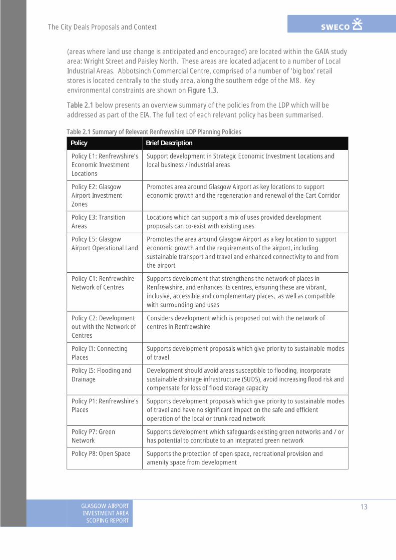
Table 2.1 below presents an overview summary of the policies from the LDP which will beaddressed as part of the EIA. The full text of each relevant policy has been summarised.
Table 2.1 Summary of Relevant Renfrewshire LDP Planning Policies
Policy Brief Description
Policy E1: Renfrewshire’sEconomic InvestmentLocations
Support development in Strategic Economic Investment Locations andlocal business / industrial areas
Policy E2: GlasgowAirport InvestmentZones
Promotes area around Glasgow Airport as key locations to supporteconomic growth and the regeneration and renewal of the Cart Corridor
Policy E3: TransitionAreas
Locations which can support a mix of uses provided developmentproposals can co-exist with existing uses
Policy E5: GlasgowAirport Operational Land
Promotes the area around Glasgow Airport as a key location to supporteconomic growth and the requirements of the airport, includingsustainable transport and travel and enhanced connectivity to and fromthe airport
Policy C1: RenfrewshireNetwork of Centres
Supports development that strengthens the network of places inRenfrewshire, and enhances its centres, ensuring these are vibrant,inclusive, accessible and complementary places, as well as compatiblewith surrounding land uses
Policy C2: Developmentout with the Network ofCentres
Considers development which is proposed out with the network ofcentres in Renfrewshire
Policy I1: ConnectingPlaces
Supports development proposals which give priority to sustainable modesof travel
Policy I5: Flooding andDrainage
Development should avoid areas susceptible to flooding, incorporatesustainable drainage infrastructure (SUDS), avoid increasing flood risk andcompensate for loss of flood storage capacity
Policy P1: Renfrewshire’sPlaces
Supports development proposals which give priority to sustainable modesof travel and have no significant impact on the safe and efficientoperation of the local or trunk road network
Policy P7: GreenNetwork
Supports development which safeguards existing green networks and / orhas potential to contribute to an integrated green network
Policy P8: Open Space Supports the protection of open space, recreational provision andamenity space from development
The City Deals Proposals and Context
14GLASGOW AIRPORTINVESTMENT AREASCOPING REPORT
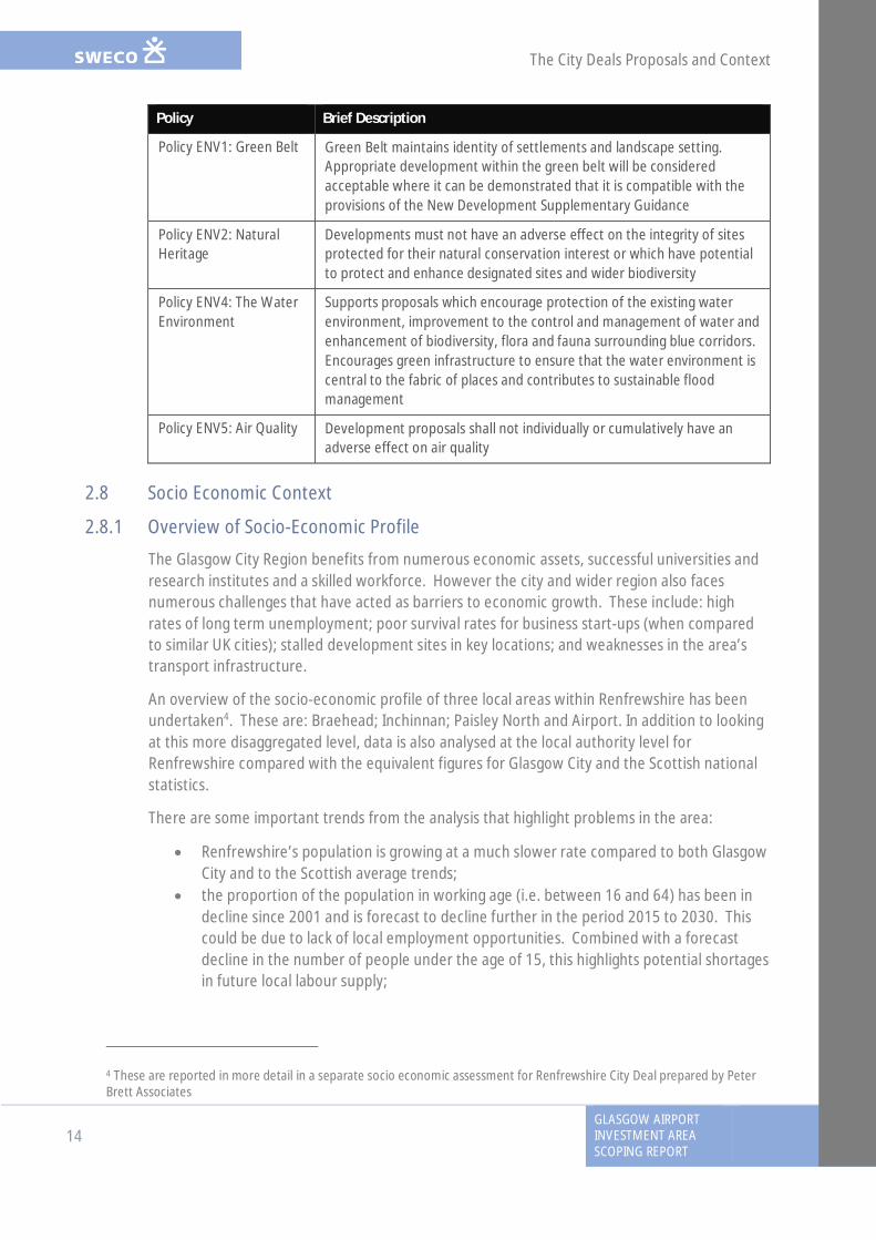
Policy Brief Description
Policy ENV1: Green Belt Green Belt maintains identity of settlements and landscape setting.Appropriate development within the green belt will be consideredacceptable where it can be demonstrated that it is compatible with theprovisions of the New Development Supplementary Guidance
Policy ENV2: NaturalHeritage
Developments must not have an adverse effect on the integrity of sitesprotected for their natural conservation interest or which have potentialto protect and enhance designated sites and wider biodiversity
Policy ENV4: The WaterEnvironment
Supports proposals which encourage protection of the existing waterenvironment, improvement to the control and management of water andenhancement of biodiversity, flora and fauna surrounding blue corridors.Encourages green infrastructure to ensure that the water environment iscentral to the fabric of places and contributes to sustainable floodmanagement
Policy ENV5: Air Quality Development proposals shall not individually or cumulatively have anadverse effect on air quality
2.8 Socio Economic Context
2.8.1 Overview of Socio-Economic Profile
The Glasgow City Region benefits from numerous economic assets, successful universities andresearch institutes and a skilled workforce. However the city and wider region also facesnumerous challenges that have acted as barriers to economic growth. These include: highrates of long term unemployment; poor survival rates for business start-ups (when comparedto similar UK cities); stalled development sites in key locations; and weaknesses in the area’stransport infrastructure.
An overview of the socio-economic profile of three local areas within Renfrewshire has beenundertaken4. These are: Braehead; Inchinnan; Paisley North and Airport. In addition to lookingat this more disaggregated level, data is also analysed at the local authority level forRenfrewshire compared with the equivalent figures for Glasgow City and the Scottish nationalstatistics.
There are some important trends from the analysis that highlight problems in the area:
· Renfrewshire’s population is growing at a much slower rate compared to both GlasgowCity and to the Scottish average trends;
· the proportion of the population in working age (i.e. between 16 and 64) has been indecline since 2001 and is forecast to decline further in the period 2015 to 2030. Thiscould be due to lack of local employment opportunities. Combined with a forecastdecline in the number of people under the age of 15, this highlights potential shortagesin future local labour supply;
4 These are reported in more detail in a separate socio economic assessment for Renfrewshire City Deal prepared by PeterBrett Associates
The City Deals Proposals and Context
GLASGOW AIRPORTINVESTMENT AREA
SCOPING REPORT
15
· in recent years Renfrewshire has seen relatively low levels of workplace earnings. Thiscan make it difficult to attract people looking for employment to the area; and
· Renfrewshire has a lower rate of business start-ups compared to Glasgow City andScotland as a whole. It has also seen a higher than average rate of business closures inrecent years. The areas to the north of Paisley and around Glasgow Airport are inparticular need of further investment going forward due to the higher than averageunemployment rate, lower qualification and car ownership rates and a significantlydecreasing population rate.
The vast majority of all travel to work in the local area is under 10km, making journeys to workby active travel modes practical. Renfrewshire shows a very similar pattern to that for Scotlandas a whole, with the majority of households having one or less cars available, with the majorityof households having one or no cars. At a more localised level, Inchinnan has the highest carownership levels, with 40.4% of households having two or more cars. Paisley North and theairport has the lowest car ownership rates with 51.3% of households having no cars. An aboveaverage proportion of public transport users reflects the low car ownership in the area as wellas the potential for promotion of travel by active travel modes.
2.8.2 Socio Economic Impact of the GAIA Proposals
The City Deal projects seek to maximise economic benefits for Glasgow, the wider City Regionand Scotland through the delivery of a programme of high impact investment. In order toensure happens, Member Authorities5 have engaged in an exercise to identify projects whichnot only maximise the economic outputs at a project level, but which also deliver positiveeconomic benefits to the region and Scotland collectively as a programme.
The GAIA project aims to open up and improve access to economic development locationsadjacent to Glasgow Airport, in particular along the White Cart Corridor which is blighted bysignificant areas of underused land, the development of which has been hampered by pooraccessibility. The infrastructure investments proposed for this location will assist in opening upthis corridor as a key business location by providing significantly improved accessibility andconnectivity to key development sites in the project area as well as facilitating the expansionand development of Glasgow Airport and enhanced productivity / GVA growth in existing sites.
An initial high level socio-economic assessment has been undertaken6 to establish the potentialgross impacts of the following elements of the future developments that would be anticipatedto be facilitated by the GAIA proposed development.
· approximately 21.1 ha advanced manufacturing / light industrial / commercial office;and
· approximately 2.9 ha residential / mixed use split across two sites either side of WhiteCart Water: 0.9ha and 2.0ha
5 East Dunbartonshire Council, East Renfrewshire Council, Glasgow City Council, Inverclyde Council, North LanarkshireCouncil, Renfrewshire Council, South Lanarkshire Council, West Dunbartonshire Council6 GAIA Part B – Options Generation and Assessment, Report Prepared for Renfrewshire Council, Sweco, August 2016(currently in draft)

The City Deals Proposals and Context
16GLASGOW AIRPORTINVESTMENT AREASCOPING REPORT
An Economic Impact Model has been built to establish the following indicators for theproposed GAIA development:
· Developable floorspace;· Residential units;· Construction costs;· Construction jobs (person years);· Construction Gross Value Added (GVA);7
· Permanent Full-time Equivalent (FTE8) jobs· GVA from permanent employees;· Estimated value of supply chain linkages; and· Council Tax contributions.
From the work undertaken to date it has been estimated that development of the elements ofthe proposed development to the north of the M8 would create around 147,700m2 ofdevelopable floor space. Assuming an 85%/15% split between advanced manufacturing, lightindustrial and office related uses, this would generate approximately 1,551 FTE office jobs and£79.0 million GVA. A further £32.7 million would be spent on supply chain linkages per annum.The advanced manufacturing /light industrial element would provide 2,270 FTE jobs, £214.6million GVA and £81.4 million in annual supply chain linkages.
The development proposed to the south of the M8 would provide a mix of residential units andmixed use floor space. An estimated 32 family homes would provide £0.04 million council taxper annum. The ongoing permanent impacts from the employment floor space would be 147FTE jobs and £7.5 million GVA for the office related element and 215 FTE jobs and £20.3 millionGVA for the light industrial element. A more detailed assessment of the socio-economicimplications of the future developments which are anticipated9 as a result of the GAIAinfrastructure proposals will be set out in the Environmental Statement (ES).
In summary, significant economic benefits are predicted from the future development ofresidential and commercial sites which will be stimulated through the infrastructure measuresthat are proposed to be delivered by the GAIA proposed development.
7 Gross value added (GVA) is the measure of the value of goods and services produced in an area, industry or sector of aneconomy8 One Full Time Equivalent worker is equivalent to one worker working full-time or two workers working part-time9 These developments are described further in the City Deal Masterplan which is being prepared for the proposals (seeSection 2.7)
Land use and communities
GLASGOW AIRPORTINVESTMENT AREA
SCOPING REPORT
17
3. Land use and communities
3.1 IntroductionThis section describes the proposed approach to the assessment of potential effects of theproposed development on land use, and on key community journeys by pedestrians, cyclists andequestrians.
Key land uses in the GAIA study area include business parks/industrial estates, residential andother properties, transport routes, woodlands, open space, agricultural land and waterways.Community journeys have been defined as key journeys representative of a range of journeytypes made by the local communities.
The assessment focuses on a wide study area representative of local land uses and the area usedby the local communities (centred over the route option) hereafter referred to as the ‘study area’(see Figure 3.1).
The objectives of this section of the report are to:
· outline consultation undertaken regarding the predicted effects of the proposeddevelopment in relation to land use and community use;
· describe baseline conditions relevant to the proposed development;· present an initial assessment of the potential effects on the baseline associated with
construction and operation of the proposed development; and· outline the proposed approach to the impact assessment, if further surveys are
required and what will be scoped out of the assessment.
3.2 ConsultationThe following consultees have been contacted to date and the information or feedbackprovided is summarised in Table 3.1.
Table 3.1 Summary of Consultation
Consultee Summary of Response
British HorseSociety
(Email from 01.03.16) noted that the areas for development are not considered tohave extensive equestrian activity.
CyclingScotland
(Email from 01.04.16) noted that:· there are threats including severance of communities from the infrastructure;· there should be enhanced routes for a coherent cycling network encouraged.
Where cycling linkages have already been identified in new bridges across theClyde and White Cart, facilities for cyclists should be incorporated into the initialdesigns and take cycling by Design standards into consideration;
· any projects in Renfrewshire should be implemented mindful that 30.6% ofhouseholds in the council area have no access to a car and that cycling canprovide an accessible form of transport for work, study and leisure;
· any developments should incorporate a clear, evidence based focus onimproving cycling infrastructure for journeys of up to 5 kilometres, the journeydistance that most people would choose to cycle; and
· the focus should be where demand is greatest, for example to schools, majoremployers, retail centres, rail stations and leisure attractions.

!( !( !( !( !( !( !( !( !( !( !( !( !( !( !( !( !( !( !( !( !( !( !( !(!(!(!(!(!(!(!(!(!(!(!(!(!(!(!(!(!(!(!(!(
!(!(!(!(!(!(!(!(!(
!(!(!(!(
!(
!( !( !(
3.
8.
13.
12.
7.
1.2.
6.
10.
11.
3.
4.
9.
1
2
2
4
3
REN/6RE
N/21
REN/20
REN/12
NP/22
REN/
21
REN/2
1RE
N/21
NP/6
NP/5
NP/2
NP/1
REN/13
REN/6
REN/7
REN/5
REN/4
Cycleway to Inchinnan Business Park
Renfrew
to Pais
ley Prop
osed C
yclew
ay
© Crown copyright and database rights 2016. All Rights reserved. Ordnance Survey Licence number 100023417.
¯Key
Notes
Reference Drawings
REV. DATE AMENDMENT DETAILS ORIG CHK'D APP'D
GLASGOW AIRPORT INVESTMENT AREA
Client
Drawing Title
Drawing Status Suitability
Scale
Original Size
Designed
Date
Drawn
Date Date Date
ApprovedChecked
Project Ref. No.
Revision
Drawing Number
SwecoCity Park Suite 3/5368 Alexandra Parade GlasgowG31 3AUTel: +44 (0)141 414 1700web: www.sweco.co.uk
RENFREWSHIRE COUNCIL
1:20,00001/09/2016A3
Figure 3.1 Land Use and Key Community Journeys
117084 (R06)
TB TB
- - ----
Project Title
01/09/2016
0A
- - ----- - ----- - ----- - ----
Project Originator Volume Location Type Role Number
1. Robertson Park2. Kirklandneuk Park3. Knockhill Park4. Fountain Gardens5. Moorcroft Park6. Abbotsinch Playing Fields7. Inchinnan Business Park
8. Westway Business Park9. Westpoint Business Park10. Abercorn Indutrial Estate11. Abbotsinch Retail Park12. Netherton Cottage13. Netherton Farm
Key Community Journeys:1.Inchinnan Business Park2. Glasgow Airport3.Paisley Town Centre4. Westway Business Park
!
0 250 500 750125Metres
Study Area!( !( !( !( Indicative Line of New Cycle Link
Indicative Line of New / Upgraded Road
GAIA Core PathsRenfrew To Paisley Proposed CyclewayLocal Cycle RouteCycleway to Inchinnan Business ParkGlasgow AirportSchool
"' Health CentrePlaying fieldsPublic park and gardenWoodlandsCommercialResidential
117084 - SWEC0 - EAC - 00 - SP - EN - 00003
FINAL S0

Land use and communities
18GLASGOW AIRPORTINVESTMENT AREASCOPING REPORT
Consultee Summary of Response
ForestryCommissionScotland
(Letter from 15.02.16 and meeting on 5.07.16) will require direct engagementregarding any design plans that may impact on Ancient Woodlands, Native andSemi-Native woodlands, SSSI (Black Cart), Local Nature Conservation Sites and TreePreservation Orders.
GCV GreenNetworkPartnership
(Email from 10.03.16) has identified that the Green Network delivery should focuson improvement of walkable access to greenspace, the greening of vacant andderelict land, intergrate Green Infrastructure and improve underperforming existinggreenspace.
Living Streets (Email from 11.03.16) recommends using the Scottish Government’s Place Standardand noted that cycling and walking improvements are welcomed. If the overallscheme does not achieve the best outcomes for NMUs, the difficult crossing at majorroads are a concern that must be addressed in the design. Attractive new bridgesconsist of good levels of pedestrian priority and cycle infrastructure.
Paths for All(PfA)
(Letter from 24.03.16) referred to the National Walking Strategy.
Scottish Rightsof Way &Access Society
(Letter from 26.04.16) indicates that rights of way SR52-54 and SR56 will be affectedby the GAIA project and informs that none of the proposed routes or bridges directlyaffects the routes.
3.3 Baseline DescriptionThe main settlements in the area are Renfrew in the north-east and Paisley in the south. Thestudy area contains land used for built development such as residential areas, roads, commercialand industrial, as well as semi-natural habitats, agricultural land (10% of the study area) andwoodland (10%)10 of the study area as shown on Figure 3.1.
3.3.1 Key Land Uses
3.3.1.1 Community Land
Within the study area, the Greenspace data and field work show that there are very few areasidentified as open space (i.e. woodlands or amenity greenspaces). The principal areas of openspace within the study area are located at:
· Robertson Park in Renfrew which includes a duck pond, floral gardens, BMX course,skateboard park, tennis courts, putting area, bowling green, sensory garden, cycletracks, swing parks and a small animal enclosure;
· Kirklandneuk Park located in Renfrew, west of Robertson Park next to the KirklandneukPrimary School;
· Knockhill Park, in Renfrew to the south-east of Westway Business Park; and· Fountain Gardens in Paisley between Love Street and the A726 is one of only three
category A listed fountains in Scotland.
The main woodland areas identified within the study area are riverine woodlands located on thebank of the White and Black Cart Water. An area of woodland is also located along the northernboundary of the study area, south of Greenock Road (A8).
10Information presented are estimates and are based upon the EUNIS Land Cover Scotland raster datahttps://gateway.snh.gov.uk/natural-spaces/dataset.jsp?dsid=EUNIS
Land use and communities
GLASGOW AIRPORTINVESTMENT AREA
SCOPING REPORT
19
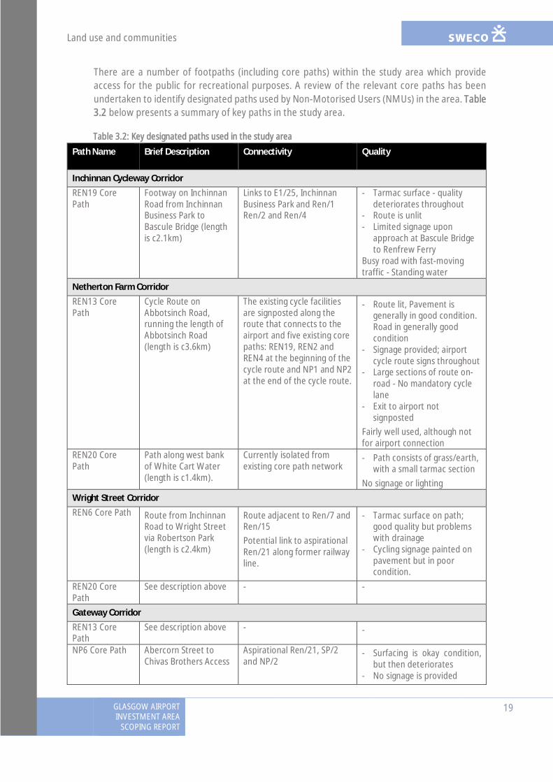
There are a number of footpaths (including core paths) within the study area which provideaccess for the public for recreational purposes. A review of the relevant core paths has beenundertaken to identify designated paths used by Non-Motorised Users (NMUs) in the area. Table3.2 below presents a summary of key paths in the study area.
Table 3.2: Key designated paths used in the study area
Path Name Brief Description Connectivity Quality
Inchinnan Cycleway CorridorREN19 CorePath
Footway on InchinnanRoad from InchinnanBusiness Park toBascule Bridge (lengthis c2.1km)
Links to E1/25, InchinnanBusiness Park and Ren/1Ren/2 and Ren/4
- Tarmac surface - qualitydeteriorates throughout
- Route is unlit- Limited signage upon
approach at Bascule Bridgeto Renfrew Ferry
Busy road with fast-movingtraffic - Standing water
Netherton Farm CorridorREN13 CorePath
Cycle Route onAbbotsinch Road,running the length ofAbbotsinch Road(length is c3.6km)
The existing cycle facilitiesare signposted along theroute that connects to theairport and five existing corepaths: REN19, REN2 andREN4 at the beginning of thecycle route and NP1 and NP2at the end of the cycle route.
- Route lit, Pavement isgenerally in good condition.Road in generally goodcondition
- Signage provided; airportcycle route signs throughout
- Large sections of route on-road - No mandatory cyclelane
- Exit to airport notsignposted
Fairly well used, although notfor airport connection
REN20 CorePath
Path along west bankof White Cart Water(length is c1.4km).
Currently isolated fromexisting core path network
- Path consists of grass/earth,with a small tarmac section
No signage or lighting
Wright Street CorridorREN6 Core Path Route from Inchinnan
Road to Wright Streetvia Robertson Park(length is c2.4km)
Route adjacent to Ren/7 andRen/15Potential link to aspirationalRen/21 along former railwayline.
- Tarmac surface on path;good quality but problemswith drainage
- Cycling signage painted onpavement but in poorcondition.
REN20 CorePath
See description above - -
Gateway CorridorREN13 CorePath
See description above - -
NP6 Core Path Abercorn Street toChivas Brothers Access
Aspirational Ren/21, SP/2and NP/2
- Surfacing is okay condition,but then deteriorates
- No signage is provided
Land use and communities
20GLASGOW AIRPORTINVESTMENT AREASCOPING REPORT
Path Name Brief Description Connectivity Quality
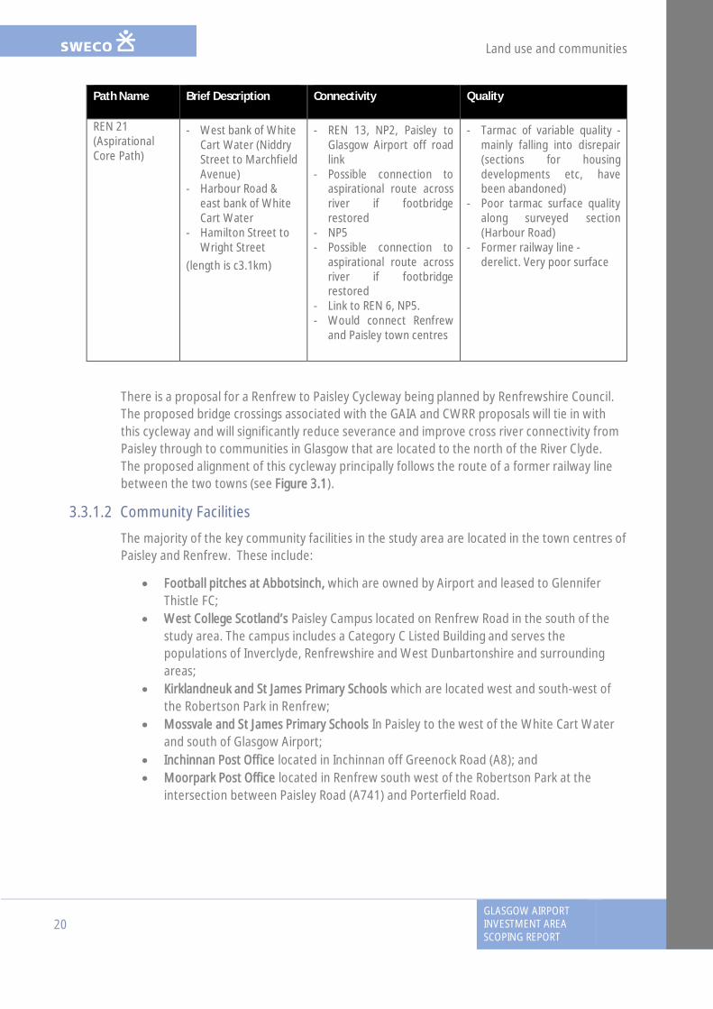
REN 21(AspirationalCore Path)
- West bank of WhiteCart Water (NiddryStreet to MarchfieldAvenue)
- Harbour Road &east bank of WhiteCart Water
- Hamilton Street toWright Street
(length is c3.1km)
- REN 13, NP2, Paisley toGlasgow Airport off roadlink
- Possible connection toaspirational route acrossriver if footbridgerestored
- NP5- Possible connection to
aspirational route acrossriver if footbridgerestored
- Link to REN 6, NP5.- Would connect Renfrew
and Paisley town centres
- Tarmac of variable quality -mainly falling into disrepair(sections for housingdevelopments etc, havebeen abandoned)
- Poor tarmac surface qualityalong surveyed section(Harbour Road)
- Former railway line -derelict. Very poor surface
There is a proposal for a Renfrew to Paisley Cycleway being planned by Renfrewshire Council.The proposed bridge crossings associated with the GAIA and CWRR proposals will tie in withthis cycleway and will significantly reduce severance and improve cross river connectivity fromPaisley through to communities in Glasgow that are located to the north of the River Clyde.The proposed alignment of this cycleway principally follows the route of a former railway linebetween the two towns (see Figure 3.1).
3.3.1.2 Community Facilities
The majority of the key community facilities in the study area are located in the town centres ofPaisley and Renfrew. These include:
· Football pitches at Abbotsinch, which are owned by Airport and leased to GlenniferThistle FC;
· West College Scotland’s Paisley Campus located on Renfrew Road in the south of thestudy area. The campus includes a Category C Listed Building and serves thepopulations of Inverclyde, Renfrewshire and West Dunbartonshire and surroundingareas;
· Kirklandneuk and St James Primary Schools which are located west and south-west ofthe Robertson Park in Renfrew;
· Mossvale and St James Primary Schools In Paisley to the west of the White Cart Waterand south of Glasgow Airport;
· Inchinnan Post Office located in Inchinnan off Greenock Road (A8); and· Moorpark Post Office located in Renfrew south west of the Robertson Park at the
intersection between Paisley Road (A741) and Porterfield Road.
Land use and communities
GLASGOW AIRPORTINVESTMENT AREA
SCOPING REPORT
21
3.3.1.3 Private Assets
Various key residential and private properties have been identified within the study area.Residential land uses in the study area are concentrated in and around the north of Paisleytown centre and Renfrew town centre, to the south of Glasgow Airport and east of RenfrewRoad (A741) in the Gallowhill area.
Local transport and other private assets include:
Netherton Farm (inhabited) and Netherton Cottage (uninhabited) residential properties aresingle detached houses located between Abbotsinch Road and the White Cart Water within anarea of agricultural land east of the airport runway and taxiway.
Town of Inchinnan Farm House, residential property and farm buildings located south ofGreenock Road. The buildings are accessible via a road off Greenock Road.
Inchinnan Cruising Club, a small sailing club located south of Inchinnan Road and White CartBridge along the western bank of the White Car Water.
Glasgow Airport is an International airport located west of Abbotsinch Road.
The Westway Business Park area is located in Renfrew to the immediate east of the White CartWater to the west of Paisley Road (A741). The park provides industrial, warehousing,distribution and office facilities including its own dock located on the tidal reaches of the WhiteCart Water.
Glasgow Airport Long Stay Car Park is a long stay car park located off the east of AbbotsinchRoad.
The Abercorn Industrial Estate is accessible via Abercorn Street in Paisley and a large number ofindustrial units, some of which are vacant. Abercorn Street ends at a Waste Water TreatmentPlant located to the immediate east of the White Cart Water. The facility serves about 74,000people in the Paisley area.
The Westpoint Business Park located west of the White Cart Water and south of the M8accessible via M8 junction 28. The park includes five modern buildings.
The Inchinnan Business Park is located north of Glasgow Airport and the Black Cart Water. It islinked from Renfrew via Greenock Road (A8) or the M8/A726. The park is well established witha number of major nationally owned occupiers including Rolls Royce, Vascutek, M&Co, GrahamTechnology, Bray Flow Technologies, Peak Scientific and Life Technologies.
A local business, Chalk Autos is located to the south of Greenock Road. Access to this localbusiness is located to the east of the fork in the road.
Land use and communities
22GLASGOW AIRPORTINVESTMENT AREASCOPING REPORT
3.3.1.4 Waterways
The White Cart Water and the Black Cart Water rivers are tributaries of the River Clyde and theircourses meet within the study area to the south-west of Renfrew Golf Course approximately1km south of their confluence with the River Clyde. The water features run under the A8 westof Renfrew through a number of ‘A’ Listed Bridges. The White Cart Water is navigable to apoint slightly upstream of the Westway Industrial Park, which is located in the middle of thestudy area (further information on the rivers including flooding and water quality is presentedin Chapter 5: Water Quality, Drainage and Flood Defence).
3.3.1.5 Agriculture
There are pockets of agricultural land identified in the north-west of the study area. Thefarmland surrounding Netherton Farm is classified as Class 3.2: Mixed Agricultural Land11 whichis described as ‘land capable of being used to grow a moderate range of crops includingcereals‘. The land further north, west of the Black Cart Water is classified as a mix of Class 3.2and 4.2, which is also classified as “Mixed Agricultural Land”.
3.3.2 Key Community Journeys
A review of representative journeys (by destination) has been undertaken to identify a set oftypical journeys within the study area by NMUs. Five key journeys have been identified (seeFigure 3.1):
Key Destination 1. Inchinnan Business Park: The business park is located north of GlasgowAirport and south of Greenock Road (A8). The park is accessible to NMUsvia core path REN19 which links to the Bascule Bridge along InchinnanRoad;
Key Destination 2. Glasgow Airport: Glasgow Airport is accessible to NMUs via core pathsREN/2 and REN/13 along Abbotsinch Road and provide links to a local off-road cycle road which also provide access from Paisley town centre;
Key Destination 3. Paisley Town Centre: The town centre is accessible to NMUs via corepaths REN/6, NP6 and aspirational core path REN21 and provide links toRenfrew Town Centre from Paisley; and
Key Destination 4. Westway Business Park: The business park is accessible via the REN/6 andREN/20 core paths. Aspirational core path REN/21 (the Renfrew/Paisleycycle route) is a potential link along the former railway line. Various localcycle paths run though the study area mainly via the core path network.
11The Macaulay Land Capability for Agriculture (LCA) classification. The Macaulay Land Use Research Institutehttp://www.macaulay.ac.uk/explorescotland/lca.html

Land use and communities
GLASGOW AIRPORTINVESTMENT AREA
SCOPING REPORT
23
3.4 Potential Effects
3.4.1 Construction
· temporary change in land use for construction compounds, and laydown areas (whichwould be restored after construction);
· direct and indirect impacts to current land uses and management including loss ofagricultural land;
· conflicts between construction activities and users of the existing area including tracksand the road network;
· disruption effects on users of the White Cart Water during bridge construction activity;· change in agricultural drainage patterns from development of new site infrastructure;· increased hazards to users of the area from construction activities; and· interruption to services through interference with utilities.
3.4.2 Operation
· permanent change of landuse;· direct and indirect impacts on properties including disruption of access;· permanent loss of woodland;· permanent loss of agricultural land;· impact on utilities in the area;· improved access routes for local residents and recreational users; and· increased hazards from operational traffic and new infrastructure into the area.
3.4.3 Inchinnan Cycleway Corridor
3.4.3.1 Land Use
Extending from the junction of Inchinnan, Abbotsinch and Greenock Roads, the proposedcycleway would reach the Black Cart Water. The cycleway would pass through an area ofwoodland on the northern bank of the Black Cart Water, which is designated as both a Site ofImportance of Nature Conservation and Semi-Natural Ancient Woodland. This would requirethe removal of a number of trees to facilitate the path of the cycleway. It is not known at thisstage whether these woodlands are used for recreational purposes however this would beinvestigated during work for the ES, and any effects reported.
Once the cycleway exits the woodland, effects would be limited to a corridor of non-primeagricultural land, currently in arable and grazing use. The development would slightly reducethe size of the fields and would require the removal of a hedgerow to facilitate construction.
Construction of the cycleway may permanently alter the accesses to Town of Inchinnan FarmHouse and Chalk Autos, the exact nature of these changes is currently unknown but will beassessed as part of the ES.
Land use and communities
24GLASGOW AIRPORTINVESTMENT AREASCOPING REPORT
3.4.3.2 Community Journeys
The proposed cycleway would not require the relocation or re-routing of any core paths. Corepath REN19 runs to the north of Greenock Road as indicated on Map 3 of RenfrewshireCouncil’s Core Paths Plan.
The development will also form part of a significantly improved network, reducing severanceand improving cross river connectivity between residential centres and key employmentlocations. Access to Inchinnan Business Park and to sites of greenspace in the wider Renfrewand Inchinnan area would be improved. The cycleway would provide members of thecommunity with a new path and option for non-motorised travel.
3.4.4 Netherton Farm Corridor
3.4.4.1 Land Use
The development of the Netherton Farm Corridor would result in the permanent loss of anarea of non-prime agricultural land as it routes from the junction at Greenock, Inchinnan andAbbotsinch Roads and passes south through Netherton Farm to meet with the existingalignment of Abbotsinch Road. At this point, the route would pass through the Abbotsinchplaying fields, potentially resulting in the permanent loss of this community recreational facility,however through the detailed design process, this impact maybe reduced. .
Construction of the proposed development would also create a new configured access to theoccupied property at Netherton Farm.
3.4.4.2 Community Journeys
Core path REN13 would be relocated and significantly improved to follow the new alignment ofAbbotsinch Road. There would be no overall change in access to public space and communityfacilities in Renfrew and Paisley as the realigned Abbotsinch Road would continue to providemotorised and non-motorised access to facilities and open spaces in the wider area.
3.4.5 Wright Street Corridor
3.4.5.1 Land Use
The proposed Wright Street Corridor would result in the permanent loss of an area of Semi-Natural Ancient Woodland as the water crossing lands on the western bank of the White CartWater. With regards to recreation and public use it is unlikely that these woodlands are usedfor recreation due to their location however further investigation will be undertaken as part ofthe EIA to understand what the implications of removal of this woodland would be onrecreation.
The proposed development would result in the loss of a small area of the Glasgow Airport’slong stay car park, located to the west of the White Cart Water. Only a small area of the carpark would be lost as a result of the works and its use would be maintained followingconstruction.
At the eastern landing of the river crossing, the Wright Street corridor would connect with theend of Wright Street, resulting in the permanent loss of an area of Semi-Natural AncientWoodland and storage land at the south of the Westway Business Park.
Land use and communities
GLASGOW AIRPORTINVESTMENT AREA
SCOPING REPORT
25
The White Cart Water is used by small boats and for recreational purposes (i.e. kayaking) at thelocation of the proposed development. The proposed bridge crossing is not considered torestrict these uses and it is likely that the proposed corridor would enhance the amenity valueof the waterway. This will be explored further in the land use chapter of the ES.
3.4.5.2 Community Journeys
The proposed development would intersect three core paths (REN6, REN13 and REN20),resulting in temporary impacts for users of these paths, as access would be diverted toconstruct the road. Following construction, these core paths would remain in use.
The Wright Street Corridor is predicted to reduce the length of some journeys for communities,resulting in improved access and connections in the Renfrew and Paisley area. The new bridgewould provide a new cycling/footpath for the local area and improve connections on the NMUpath network.
3.4.6 Gateway Corridor
3.4.6.1 Land Use
The proposed development would result in the permanent loss of a small area of nativewoodland along the western bank of the White Cart Water.
The Gateway Corridor predominantly follows existing roads (i.e. Inchinnan and Harbour Roads)therefore land-take will be kept to a minimum. However there will be land-take required forthe bridge landing areas and the road approaches to the bridge between Harbour Road andInchinnan Road.
The White Cart Water is used for small boats and recreational water sports (i.e. kayaking). Thisdevelopment of the river crossing is not predicted to impact on these uses.
3.4.6.2 Community Journeys
The proposed development would intersect three core paths (REN13, REN21 and NP6),resulting in temporary impacts on these paths during construction. Once operational, impactson core paths would cease.
It is anticipated that the proposed development would reduce the length of local journeys dueto the creation of a new bridge crossing. The new bridge would also create a newcycling/footpath lane in the local area and an improved path network connection.
Access to Glasgow Airport and greenspace in Paisley would be improved for local road usersand would also be increased for non-motorised users due to the inclusion of foot- and cycle-ways along the road corridor. The development will also form part of a significantly improvednetwork, reducing severance and improving cross river connectivity between residentialcentres and key employment locations.
Land use and communities
26GLASGOW AIRPORTINVESTMENT AREASCOPING REPORT
3.5 Proposed Scope of the Assessment
3.5.1 Land Use
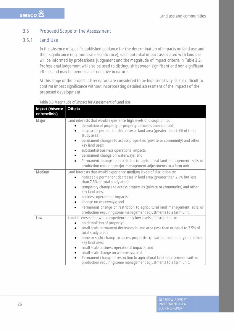
In the absence of specific published guidance for the determination of impacts on land use andtheir significance (e.g. moderate significance), each potential impact associated with land usewill be informed by professional judgement and the magnitude of impact criteria in Table 3.3.Professional judgement will also be used to distinguish between significant and non-significanteffects and may be beneficial or negative in nature.
At this stage of the project, all receptors are considered to be high sensitivity as it is difficult toconfirm impact significance without incorporating detailed assessment of the impacts of theproposed development.
Table 3.3 Magnitude of Impact for Assessment of Land Use
Impact (Adverseor beneficial)
Criteria
Major Land interests that would experience high levels of disruption to:· demolition of property or property becomes uninhabitable;· large scale permanent decreases in land area (greater than 7.5% of total
study area);· permanent changes to access properties (private or community) and other
key land uses;· substantial business operational impacts;· permanent change on waterways; and· Permanent change or restriction to agricultural land management, soils or
production requiring major management adjustments to a farm unit.
Medium Land interests that would experience medium levels of disruption to:· noticeable permanent decreases in land area (greater than 2.5% but less
than 7.5% of total study area);· temporary changes to access properties (private or community) and other
key land uses;· business operational impacts;· change on waterways; and· Permanent change or restriction to agricultural land management, soils or
production requiring some management adjustments to a farm unit.Low Land interests that would experience only low levels of disruption to:
· no demolition of property;· small scale permanent decreases in land area (less than or equal to 2.5% of
total study area);· none or slight change to access properties (private or community) and other
key land uses;· small scale business operational impacts; and· small scale change on waterways; and· Permanent change or restriction to agricultural land management, soils or
production requiring some management adjustments to a farm unit.

Land use and communities
GLASGOW AIRPORTINVESTMENT AREA
SCOPING REPORT
27
The estimated land-take will be based on the finalised red line boundary for the proposeddevelopment, which has taken into account the footprint of the development and a suitablebuffer to take into account any land required for maintenance (as described in Section 2.5). Italso includes land required for construction of infrastructure (e.g. construction compounds)and land-take required for aspects such as landscape planting or other essential mitigation.
3.5.2 Community Journeys
All paths and community facilities are considered to be of equal importance regardless of usertype or level of usage. The assessment of impact significance will be informed using theindicative criteria in Table 3.4.
Table 3.4 Magnitude of Impact for Community Journeys
Impact (Adverseor beneficial)
Criteria
Major NMUs that would experience high levels of disruption to:· permanent change in key journey pattern and will be increased/decreased by
over 500m;· permanent change of width of path and/or no barrier between NMU from
traffic;· clear signing for routes for NMUs;· permanent change in safety for NMUs;· permanent change in the quality of the landscape or townscape experience
by NMUs;· loss of community facilities resulting in fewer (or longer) journeys.
Medium NMUs that would experience medium levels of disruption to:· change in journey pattern with an increase /decrease by 250-500m with
possibility to use an alternative route;· temporary but noticeable change width of path and/or barrier between
NMU from traffic;· signing for routes for NMUs;· temporary but noticeable change in the quality of the landscape or
townscape experience by NMUs;· change of location of community facilities may result in some residents being
dissuaded from making these trips (i.e reduction of journeys).
Low NMUs that would experience only low levels of disruption to:· no change or temporary change in journey pattern with an
increase/decrease by up to 250m;· slight change of width of path and/or barrier between NMU from traffic· no or unclear signing for NMU routes;· small scale change in the quality of the landscape or townscape experience
by NMUs;· journey pattern to community facilities will be maintained but new bridge
will be need to be crossed or a subway traversed.
Land use and communities
28GLASGOW AIRPORTINVESTMENT AREASCOPING REPORT
3.5.3 Remaining surveys
No additional surveys are expected to be required to inform the land use and communityjourneys baseline during the EIA process.
3.5.4 Impacts to be scoped out
Based upon the baseline and initial assessment, it is proposed that the following are scoped outof the assessment.
· The proposed development will not require the demolition of any residentialproperties and community facilities therefore this impact has been scoped out and willnot be assessed further.
· With limited use of the existing infrastructure by equestrian riders, it has beenpredicted that there will be no direct impact on equestrians and this effect has beenscoped out of the assessment.
3.6 Summary of proposed EIA scope· Further work to define the detailed Land Use and Community journeys baseline
through desk-based research and GIS.· Consultation with statutory agencies and key consultees on key issues such as NMUs,
Greenspaces, Access, etc.· Assessment of predicted direct and indirect impacts (permanent, construction and
operational) of the specimen design on properties and other land uses includinggreenspaces, recreational interests and any designated paths.
· Development of appropriate mitigation including measures to ensure continuation ofexisting land uses and community journeys once the proposals are completed.
· Assessment of the residual effects predicted from the proposals taking into accountthe developed mitigation.
· Consideration of cumulative land use and community journeys implications incombination with the CWRR proposals.
Geology, Hydrogeology, Soils and Contaminated Land
GLASGOW AIRPORTINVESTMENT AREA
SCOPING REPORT
29
4. Geology, Hydrogeology, Soils and Contaminated Land
4.1 IntroductionThis section describes the proposed approach to the assessment of potential construction andoperational effects on geology, hydrogeology, soils and contaminated land. It has beenundertaken in accordance with the DMRB Volume 11 Section 3 Part 11 Geology and Soils andguidance on EIA by Scottish Natural Heritage (EIA Handbook).
The objectives of this section of the report are to:
· outline consultation undertaken with statutory organisations regarding the predictedeffects of the proposed project, especially in relation to potential contamination;
· describe baseline conditions relevant to the proposed development;· present an initial assessment of the potential effects of the proposals; and· outline the proposed approach to impact assessment, including the requirement for
site investigation data, and engineering and geotechnical design information to informthe design of mitigation measures.
4.2 ConsultationThe feedback from relevant consultation to date is summarised below (Table 4.1), with furtherdescription of the responses provided by consultees given in the subsequent subsections.
Table 4.1: Consultation Responses
Consultee Response/Action Data Action Taken
RenfrewshireCouncilContaminatedLand Officer
Meetings confirmed that no formally designatedcontaminated land is located within the study area,although a number of historical potentiallycontaminative former uses are noted in the Councils’Contaminated Land Inspection Strategy. Some siteinvestigation data was provided for the area around theformer oil refinery in the east of the study area.
Partial Furtherconsultation will beundertaken as partof the SiteInvestigation.
ScottishEnvironmentProtectionAgency (SEPA)
A meeting identified no potential contamination issuesrelevant to this stage of the process. An informationrequest provided data on the location of WML and PPClicences.
Yes Furtherconsultation will beundertaken as partof the SiteInvestigation.
4.2.1 Summary of Consultation Undertaken to Date
As part of the assessment undertaken to date, the Renfrewshire Council Contaminated LandOfficer (CLO) was consulted to request available information on potential significantcontamination issues at or within the vicinity of the study area. The consultation processconfirmed that no formally designated contaminated land is located within the study area.However, a number of areas of land with historical potentially contaminative former uses arenoted to have been included within the Council’s Contaminated Land Inspection Strategy,though these were noted to have been identified as part of the historical map review and thereare no plans to commence any investigation in relation to Part IIA (contaminated landlegislation).

Geology, Hydrogeology, Soils and Contaminated Land
30GLASGOW AIRPORTINVESTMENT AREASCOPING REPORT
Additionally, SEPA have been approached to request any licensed activities relating to PollutionPrevention and Control (PPC), Waste Management Licences (WML) and Controlled ActivitiesRegulations (CAR). This identified six records, including two PPC permits (for a tannery and awaste transfer station) and four Waste Management Licences (relating to a civic amenity site, acar breakers and a waste transfer station). None of the records are for processes in locationslikely to have a significant impact on (or from) the proposed development.
4.2.2 Proposed Future Consultation
During development of the specimen design, additional consultation with Renfrewshire CouncilContaminated Land Officer and SEPA will be required to request detailed information relatingto the proposed route. This will be undertaken primarily as part of a site investigation, and theinterpretative report will include consideration of any available information on historical siteinvestigation data or remediation works. Consultation will also be undertaken with the LocalAuthority Petroleum officer, to assess the potential presence of former or current above orunderground fuel storage tanks, predominantly to assess the associated potentialcontamination risks.
4.3 Baseline DescriptionExisting baseline conditions are presented in this section. Only information relevant to theproposed development and post option assessment have been included.
4.3.1 Historical Review
A review of the available historical map records, detailing the development of the entire studyarea from 1858 to the present day was undertaken, with only key developments pertinent tothe GAIA study area (as shown in Figure 4.1) highlighted.
The earliest available historical maps (1858) show the land alongside the White Cart Water tobe occupied by industry, including steel works, engineering and shipbuilding works, saw millsand dye works. The majority of these industries are noted to have been either demolished orredeveloped for different uses over the period examined. Railway land is also noted east of theWhite Cart Water, which has been dismantled by the present day.
In more recent years, additional industries appear along the White Cart Water, including asewage works, located on the eastern bank of the White Cart, south of the M8 motorwaybridge, works on the eastern bank of the White Cart Water. Glasgow Airport is noted to havebeen constructed during the 1960s, located west of Abbotsinch Road. The majority of the landto the west of the White Cart in this area remains as agricultural land over the periodexamined.
The surroundings of the study area are noted to have undergone significant residential andcommercial development over the historical period examined.
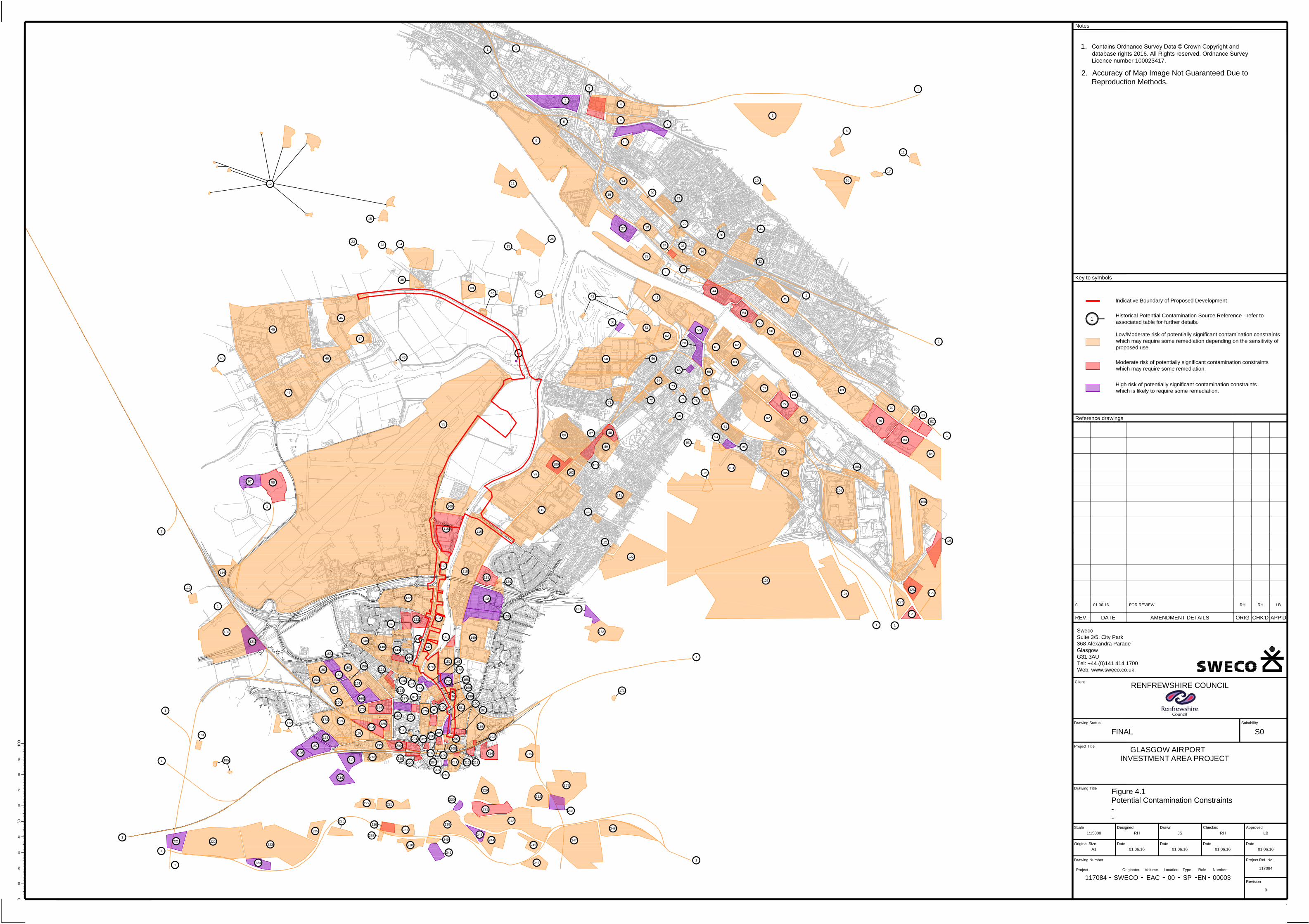
MOORPARK
Works
Works
PORTERFIELD
Hotel
Glynhill
Normandy Hotel
KIRKLANDNEUK
Works
House
P
a
t
h
Mud and B
oulders
Driving Range
3.0m
Tank
Bonded W
arehouse
Colin's
Slipways
Path
Black C
art W
ater
Isle
S
lo
p
in
g
m
a
s
o
n
r
y
P
a
th
4.3m
B
l
a
c
k
C
a
r
t
W
a
t
e
r
3.4m
Renfrew Golf Course
Pond
S
lo
p
in
g
M
a
s
o
n
r
y
Mud
El Sub Sta
4.3m
M
u
d
a
n
d
B
o
u
ld
e
rs
FS
Beacon
S
lo
p
in
g
M
a
s
o
n
r
y
Club
Depot
R
i
v
e
r
C
l
y
d
e
VICTORY
GARDENS
H
I
G
H
S
T
R
E
E
T
High School
M
I
L
L
B
U
R
N
R
O
A
D
Trinity
LOANHEAD
RENFREW
R
iv
e
r
C
ly
d
e
R
i
v
e
r
C
l
y
d
e
Depot
Depot
Industrial Estate
Meadowside
BLYTHSWOOD
Warehouses
WHITECROOK
Leisure Centre
Works
G
L
A
S
G
O
W
R
O
A
D
Works
Fuel Depot
R
o
t
h
e
s
a
y
D
o
c
k
Works
R
i
v
e
r
C
l
y
d
e
Works
Offices
Works
Depot
R
i
v
e
r
C
l
y
d
e
S
c
h
o
o
l
G
a
rs
c
a
d
d
e
n
P
rim
a
ry
Goods Shed
Goods Sheds
Warehouse
Shed
Goods
King George V Dock
Goods
Shed
Warehouse
R
i
v
e
r
C
l
y
d
e
Works
R
i
v
e
r
C
l
y
d
e
BRAEHEAD
Depot
Marsh
Marsh
W
ard B
dy
W
a
r
d
B
d
y
Goods Sheds
M
e
a
n
H
ig
h
W
a
t
e
r
S
p
r
in
g
s
Mean H
igh W
ater S
prings
Mean H
igh W
ater S
prings
M
L
W
S
M
e
a
n
H
i
g
h
W
a
t
e
r
S
p
r
i
n
g
s
Renfrew Ferry
Shopping
F
l
e
m
i
n
g
C
o
u
r
t
Cinema
B
l
e
a
s
d
a
l
e
C
o
u
r
t
Clyde
Centre
T
e
l
f
o
r
d
C
o
u
r
t
B
a
i
r
d
C
o
u
r
t
S
i
m
p
s
o
n
C
o
u
r
t
Clydebank
Business Park
M
a
rin
e
r C
o
u
rt
F
o
r
t
h
a
n
d
C
l
y
d
e
C
a
n
a
l
R
u
th
e
rfo
rd
C
o
u
rt
D
u
n
ro
b
in
C
o
u
rt
Clyde Shopping Centre
F
o
rth
a
n
d
C
ly
d
e
C
a
n
a
l
Works
LINNVALE
Linnvale Primary School
Depot
Depot
W
h
i
t
e
c
r
o
o
k
P
r
i
m
a
r
y
S
c
h
o
o
l
Forth
a
nd C
ly
de C
anal
West College Scotland
Clydebank Campus
St James'
Primary School
Kirklandneuk Park
W
h
i
t
e
C
a
r
t
W
a
t
e
r
Robertson Park
The King's Inch
The King's Inch
Industrial Estate
New Albion
Warehouse
Playarea
New Western Park
(Football Stadium)
A
7
2
6
4.0m
B
A
R
N
S
F
O
R
D
R
O
A
D
Issues
A
7
2
6
P
a
th
7.2m
7.5m
Brownsfield
C
A
R
T
S
I
D
E
A
V
E
N
U
E
B
l
a
c
k
C
a
r
t
1
Barnsford
ESS
B
A
R
N
S
F
O
R
D
R
O
A
D
A
7
2
6
B
A
R
N
S
F
O
R
D
A
V
E
N
U
E
F
O
U
N
T
A
I
N
A
V
E
N
U
E
El Sub Sta
Wireless Mast
B
7
9
0
M
e
a
n
H
i
g
h
W
a
t
e
r
S
p
r
i
n
g
s
W
a
t
e
r
Bridge
Sub Sta
Stone
El
S
O
U
T
H
S
T
R
E
E
T
B
R
O
W
N
S
F
I
E
L
D
R
O
A
D
Sub Sta
C
R
E
S
C
E
N
T
Factory
Factory
El Sub Sta
Tank
NEW
MAINS AVENUE
GP
Inchinnan
BROWNSFIELD
Path
Factory
El Sub Sta
FB
Tank
Industrial Estate
El
Pond
Sub Sta
El
8.1m
10.0m
8.2m
New Mains
P
a
th
BA
R
N
SF
O
R
D
R
O
AD
A
7
2
6
Murray Business Area
Factory
Car Park
Works
Breakers
Murray Business Area
Yard
Car
Sorting Office
Depot
Warehouse
GOCKSTON
Primary School
Mossvale St James
St James' Park
Pavilions
Depot
C
A
LE
D
O
N
IA
W
A
Y
A
7
2
6
6.9m
C
A
L
E
D
O
N
IA
W
A
Y
W
E
S
T
Hotel
Wind Sock
B
U
TE
R
O
A
D
El Sub Sta
Inchinnan Industrial
M
e
a
n
H
ig
h
&
L
o
w
M
e
a
n
H
ig
h
&
M
e
a
n
L
o
w
W
a
t
e
r
S
p
r
in
g
s
5.8m
4.1m
B
l
a
c
k
C
a
r
t
W
a
t
e
r
T
ra
c
k
Yonderton
Issues
Yonderton
F
O
U
N
T
A
I
N
D
R
I
V
E
FB
W
a
t
e
r
S
p
r
in
g
s
Estate
E
l
S
u
b
S
t
a
Wester
4.6m
E
l
S
u
b
S
t
a
Easter
Tk
Issues
3.5m
M
e
a
n
H
ig
h
&
M
e
a
n
L
o
w
W
a
t
e
r
S
p
r
in
g
s
D
ra
in
Walkinshaw
Factory
W
A
L
K
IN
S
H
A
W
R
O
A
D
M
e
a
n
H
ig
h
W
a
t
e
r
S
p
r
in
g
s
I
N
C
H
I
N
N
A
N
D
R
I
V
E
Easter
Inchinnan
A 8
Recreation Ground
Pond
El Sub Sta
Church
R
I
V
E
R
D
R
I
V
E
7.4m
9.4m
A 8
F
O
U
N
T
A
I
N
C
R
E
S
C
E
N
T
B
A
R
N
S
F
O
R
D
A
V
E
N
U
E
8.2m
Car Park
Factory
T
r
a
c
k
P
a
t
h
Posts
IN
DIA
D
RIV
E
Inchinnan Industrial Estate
Parish
Ppg Sta
Issues
8.9m
F
O
U
N
T
A
I
N
D
R
I
V
E
GREENOCK ROAD
ALLANDS AVENUE
8.9m
El Sub Sta
8.6m
LB
Abattoir
Sewage Works
Airlink Industrial E
state
Industrial Estate
Phoenix
Warehouse
Warehouses
New Harbour
LAIGH PARK
Warehouse
SHORTROODS
Warehouse
Works
Depot
Sewage Works
Netherton Farm Cottage
Track
Landing Stage
6.1m
Water Springs
M
H
W
S
T
ra
c
k
Mean High
7.1m
Holdings
Water Springs
Issues
6.8m
A
B
B
O
T
S
I
N
C
H
R
O
A
D
6.0m
7.3m
Mean High
M
H
&
M
L
W
S
Allands
Issues
(disused)
M
e
a
n
H
ig
h
Path
Posts
Bus
Issues
Florish
B
la
c
k
C
a
rt
G
R
E
E
N
O
C
K
R
O
A
D
LB
T
r
a
c
k
Town of Inchinnan Cottage
M
u
d
a
n
d
B
o
u
l
d
e
r
s
Water
Posts
3.8m
12.4m
Cottages
PO
Senga
O
L
D
G
R
E
E
N
O
C
K
R
O
A
D
Depot
Town of Inchinnan
Stranadarrif
13.2m
9.1m
Beardmore
W
a
te
r S
p
rin
g
s
A 8
4.4m
PH
12.4m
Centre
Training
Trident House
GALLOWHILL
Works
Works
A
8
Portnauld
G
R
E
E
N
O
C
K
Slipways
3.9m
M
u
d
a
n
d
B
o
u
ld
e
r
s
Shingle
B
l
a
c
k
C
a
r
t
W
a
t
e
r
A
8
R
O
A
D
6.1m
Sinks
Pond
T
ra
c
k
ESS
Marsh
ESS
Tks
Factory
IN
C
H
IN
N
A
N
D
R
IV
E
M
L
W
S
M
LW
S
M
L
W
S
MLWS
MLWS
M
L
W
S
MLWS
M
L
W
S
M
LW
S
MLWS
Issues
MLW
S
14a&b
12a&b
Pond
MLWS
Mast
L
o
m
o
n
d
H
o
u
s
e
D
r
a
in
D
ra
in
1
3
M
a
s
t
(
T
e
le
c
o
m
m
u
n
ic
a
ti
o
n
)
El Sub Sta
El Sub Sta
4
El Sub Sta
Tank
El Sub Sta
Katrine House
GG
El Sub Sta
El Sub Sta
7
A
7
B
W
a
r
d
B
d
y
W
a
r
d
B
d
y
Ward Bdy
Ward Bdy
Tanks
GG
PC
ESS
Memorial
Gardens
GG
R
u
n
w
a
y
A
p
p
r
o
a
c
h
L
i
g
h
t
s
S
T
A
N
D
R
E
W
'S
A
V
E
N
U
E
Glasgow Airport Business Park
Adm
in
istra
tio
n
Build
ing
El Sub Sta
IN
CHIN
NAN D
RIV
E
M
e
a
n
H
ig
h
W
a
t
e
r
S
p
r
in
g
s
R
u
n
w
a
y
A
p
p
r
o
a
c
h
L
ig
h
t
Air Passenger Terminal
Glasgow Airport
Tank
Ruin
T
ra
c
k
P
a
t
h
Ruin
Track
Track
Tank
T
ra
c
k
Track
Drain
D
r
a
i
n
Drain
D
r
a
i
n
Mast (Telecommunication)
West College
Scotland
Paisley Campus
Brown Egg Farm
St James' Park
Multistorey Car Park
4.9m
W
hite C
art W
ater
W
h
i
t
e
C
a
r
t
W
a
t
e
r
Wind Sock
W
h
ite
C
a
rt
W
a
te
r
Multistorey Car Park
Tower
Track
Tank
Runway Approach Lights
Tank
Ps
Tank
1
1
1
1
2
4
3
5
4
6
7
8
9
10
11
1213
14
1516
17
18
19
20
21
22
23
24
25
26
27
28
29
30
31
32
33
35
34
37
36
38
39
40
41
42
43
44
45
47
46
46
46
46
46
48
49
50
51
52
53
54
55
56
57
5859
60
61
63
64
65
66
67
68
69
71
72
76
73
74
75
91
77
78
79
70
80
81
82
83
84
85
86
87
88
89
90
92
96
93
94
95
97
98
99
100
101
104
105
107
106
108
102
103
109
110
112
111
115
116
114
113
117
118
119
120
121
122
123
124
125
126
127
128
129
130
131
132
133
135
136
134
137
138
139
140
141
142
143
144
146
147
148
149
150
151
152
153
153
155
154
156
157
158
160
161
159
145
162
163
164
165
166
168
169
167
170
171
172
173
174
175
176
177
178
179
180
181
182
185
183
184
186
187
188
189
190
191
192
193
194
195
196
197
198
199
200
201
203
202
206
205
207
204
208
209
212
211
210
213
214
215
216
217
218
219
220
221
222
223
224
225
226
227
228
229
230
231
234
233
232
235
237
236
238
239
240
241
242
243
244
245
246
247
248
1
1
1
1
1
1
1
1
1
1
1
1
1
1
1
1
62
1. Contains Ordnance Survey Data © Crown Copyright
and Database Right 2013.
2. Accuracy of Map Image Not Guaranteed Due to
Reproduction Methods.
Notes
10
0
20
30
40
50
60
70
80
90
10
0
Original Size
Client
REV. AMENDMENT DETAILSDATE ORIG CHK'D APP'D
Date Date Date Date
Drawing Number Project Ref. No.
Revision
Scale Designed Drawn Checked Approved
Project Originator Volume Location Type Role Number
Drawing Title
Project Title
Drawing Status Suitability
Key to symbols
Reference drawings
RENFREWSHIRE COUNCIL
Figure 4.1
Potential Contamination Constraints
-
-
1:15000 RH
01.06.16
JS
01.06.16
RH
01.06.16
LB
01.06.16
SWECO EAC 00 SP EN 00003
117084
117084
-
A1
0
0
01.06.16 RH RH LBFOR REVIEW
Sweco
Suite 3/5, City Park
368 Alexandra Parade
Glasgow
G31 3AU
Tel: +44 (0)141 414 1700
Web: www.sweco.co.uk
Indicative Boundary of Proposed Development
1
Historical Potential Contamination Source Reference - refer to
associated table for further details.
Low/Moderate risk of potentially significant contamination constraints
which may require some remediation depending on the sensitivity of
proposed use.
Moderate risk of potentially significant contamination constraints
which may require some remediation.
High risk of potentially significant contamination constraints
which is likely to require some remediation.
Contains Ordnance Survey Data © Crown Copyright and
database rights 2016. All Rights reserved. Ordnance Survey
Licence number 100023417.
FINAL S0
GLASGOW AIRPORT
INVESTMENT AREA PROJECT

Geology, Hydrogeology, Soils and Contaminated Land
GLASGOW AIRPORTINVESTMENT AREA
SCOPING REPORT
31
4.3.2 Potential Contamination Risks
A summary of the identified potential contamination risks associated with the historicaldevelopment of the study area is provided in Appendix 4.1 which provides a figure andschedule of historical contamination sources. A more detailed review of the historicaldevelopment of the study area is included within the Preliminary Sources Study Report, whichwill form a technical appendix to the ES.
4.3.3 Topography & Geomorphology
The study area is generally a large, low relief area at approximately 10m above ordnancedatum (AOD). Towards the north west and south east of the area, topography graduallyincreases with distance from the White Cart Water.
The floodplains of White Cart Water, Black Cart Water and the River Clyde dominate thegeomorphology of the study area, and associated alluvial deposits and river terrace depositscharacterise the majority of the study area.
4.3.4 Topsoil
Topsoil is generally expected to be present in scarce, segregated areas across the study area,although agricultural topsoil is likely to be present across much of the area in the vicinity ofNetherton Farm to the west of the White Cart.
4.3.5 Made Ground
BGS online mapping records made ground (undivided) of man-made and natural materials tobe present across the southern and eastern sections of the study area, extendingapproximately 2.3km south along the western bank of the White Cart Water, and along theapproximate eastern extent of the study area along the eastern bank of White Cart Water.
Within the extents of the previously mentioned undivided made ground, an approximate 10m2
area of infilled made ground is located on the western bank of White Cart Water.
The majority of the study area comprises undeveloped land between Abbotsinch Road and thewestern bank of White Cart Water in the vicinity of Netherton Farm. Although no made grounddeposits are recorded within this area, it is anticipated that localised made ground may beencountered associated with development of infrastructure within the surrounding area andresidential properties in the vicinity of Netherton Farm. Made ground is therefore likely tocomprise a variable mixture of road make up and structural soils, with potential for remnantburied structures and/ or obstructions to be encountered.
Analysis of historical ground investigation data confirms that made ground is known to bepresent across the southern and eastern sections of the study area, to a maximum recordeddepth of 4.5mbgl, noted to comprise sandy concrete and brick fill, sandy clay with gravel,sandstone, bricks and ash, sand and mud with ash, gravel and soft clay.

Geology, Hydrogeology, Soils and Contaminated Land
32GLASGOW AIRPORTINVESTMENT AREASCOPING REPORT
4.3.6 Drift Geology
Superficial deposits vary across the study area and include tidal flat deposits, sediment andundifferentiated river terrace deposits. Raised tidal flat deposits of Flandrian Age comprise siltand clay and are located across Netherton Farm area. Locally undifferentiated river terracedeposits of silt, sand and gravel are present immediately north west of these tidal flat deposits.
Superficial deposits of ‘sediment’ extend over the approximate area of the previouslymentioned undivided made ground, covering the eastern and south western sections of thestudy area. Raised tidal flat deposits of Late Devensian silt, sand and gravel, are locatedimmediately west of the river terrace deposits, on the western bank of the White Cart Water,and immediately east of the made ground/ sediment on the eastern bank of the White CartWater.
Borehole records obtained from the BGS note superficial deposits across the study area to bepresent to depths of between 4.78mbgl and 39.78mbgl.
4.3.7 Solid Geology
The solid geology underlying the majority of the study area is the Limestone Coal Formation, ofthe parent unit Clackmannan Group, noted to comprise cyclic sequences of sandstones,siltstones, mudstones, coals, blackband and clayband ironstones and seatrocks. The Top HosieLimestone marks the youngest, uppermost strata of the Dinantian Lower Limestone Formation,which is conformable with the Limestone Coal Formation. The beds are oriented approximatelynorth east to south west, and encountered approximately 600m north of the WestwayIndustrial Estate.
The Lower Limestone Formation, of the parent unit Clackmannan Group, is locatedimmediately south and east of the Top Hosie Limestone beds and is noted to comprise cyclicsequences of mainly mudstones with sandstones, siltstones, marine limestones, thin coals andclayband ironstones. Early Permian microgabbro sills of the Western Midland ValleyWestphalian to Early Permian Sill Suite intrude the Lower Limestone Formation, and otherstrata locally.
The Upper Limestone Formation, of the parent unit Clackmannan Group, is located within onefault-bounded area approximately 2km south west of the Westway Industrial Estate, andcomprises cyclic sequences of sandstones, siltstones, mudstones, marine limestones, coals andseatrocks. The north east-south west trending beds of the conformable Index Limestone,indicate a marker bed representing the youngest, uppermost strata of the Limestone CoalFormation.
The historical ground investigation data indicates that bedrock is present to depths between8.2mbgl and greater than 86.6mbgl. Due to lack of deep exploratory holes in the existingground investigation data, depth to rockhead cannot be accurately determined across thestudy area and results are limited to specific borehole locations. Historical boreholes and therelevant mapping indicate rockhead depth to be between 25mbgl and 30mbgl.

Geology, Hydrogeology, Soils and Contaminated Land
GLASGOW AIRPORTINVESTMENT AREA
SCOPING REPORT
33
4.3.8 Hydrology
The closest water body to the study area is the White Cart Water, which flows south to norththrough the study area, issuing north towards the River Clyde, which it meets at a confluenceapproximately 750m north of its confluence with the Black Cart Water. The SEPA RBMPindicates that the Inner Clyde Estuary (which covers both the Clyde and the White Cart at theselocations) has been given a classification of Moderate ecological potential (see Section 5.3).
The majority of the GAIA study area comprises predominantly either undeveloped agriculturalland or developed, brownfield land. It is therefore anticipated that the majority of surfacewater will either be infiltrated by pervious surfaces, runoff to local surface water drainagesystems or else drain topographically overland (predominantly from west to east, towards theWhite Cart).
4.3.9 Hydrogeology
The Groundwater Vulnerability Map of Scotland (1:625,000 scale) indicates that the study areais underlain by a moderately permeable aquifer that is noted to seldom produce largequantities of water for abstraction but are important for local supplies and in supplying baseflow to rivers.
The Hydrogeological Map of Scotland (1:625,000 scale) indicates that the quaternary sands,silts and clays underlying the study area form a concealed aquifer of limited or local potential,with borehole yields recorded to be typically 1 and 2l/s.
The online SEPA River Basin Management Plan interactive map records that the study area isunderlain by the Paisley and Rutherglen bedrock and localised sand and gravel aquifers which isclassified as having an overall status of Poor with High confidence, predominantly due tochemicals production and mining and quarrying of coal. It is noted that there is no trend forpollutants for this water body. The area is also noted to be within a SEPA Drinking WaterProtection Zone.
Groundwater strikes and seepages were encountered in a number of available historicalborehole records. Across the proposed project, groundwater strikes occurred between 2mbgland 8mbgl. Most groundwater strikes were encountered within the superficial deposits, withnone recorded at rockhead. Regional groundwater flow is likely to be dominated by the flow ofthe White Cart Water and the River Clyde and be towards the north or north west.
4.3.10 Unexploded Ordnance (UXO)
Regional unexploded bomb risk information was obtained through Zetica Ltd., which providedan indicative UXO risk map of the Glasgow region, and through BACTEC International Ltd. whoprovided a detailed UXO Risk Report covering the GAIA study area.
The Zetica Ltd. map details a moderate bomb risk for the Renfrew area, including the GAIAstudy area. Renfrew is noted have been subjected to >100 tons of bombs, which included76high explosive bombs, four anti-personnel and two incendiary recorded. BACTECInternational Limited confirm that the most significant UXO risks are associated with Renfrewand Abbotsinch Military Airfields (part of Glasgow Airport) which are located south west ofWestway Industrial Estate. A large National Filling Factory (WWI) managed by Nobel ExplosivesCo. Ltd. is located in Cardonald, approximately 5.2km south east of Westway Industrial Estate.
Geology, Hydrogeology, Soils and Contaminated Land
34GLASGOW AIRPORTINVESTMENT AREASCOPING REPORT
The BACTEC International Ltd. report states that the UXO risk associated with these sites ishighly dependent upon site history and should be fully investigated in order determine the UXOrisk.
In conclusion, there are significant potential sources of UXO recorded within the study area.The overall risk from UXO is considered to be moderate, although further investigation isrequired to confirm this.
4.3.11 Mining & Mineral Resources
The Coal Authority interactive mapping indicates that the corridors are all located within a CoalMining Reporting area and in many cases a Surface Coal Resource Area. There is only onedevelopment of high risk just to the south of Westway Industrial Estate.
The north of the study area, surrounding the Netherton Farm and Westway Industrial Estateareas, is indicated to be within Surface Coal Resource Areas.
4.4 Potential EffectsA construction impact is short term and will only occur during the construction of the proposedproject (e.g. contamination risks to construction workers, dust). Operational impacts are thosethat could potentially occur during construction but will have a longer lasting impact (e.g.groundwater contamination, loss of geological resource). The majority of potential impacts ongeology, soils, hydrogeology and contaminated land are generally considered to be long term innature.
The main operational impacts are predicted to be the potential dewatering and alteration of thegroundwater regime (both drift and bedrock aquifers), and contamination of the waterenvironment (predominantly associated with the mobilisation of existing soil or groundwatercontamination). However, a number of other potential impacts have been identified thatrequire further consideration, which are detailed in the following subsections. It should also benoted that the EIA process may identify additional impacts once additional baseline data anddesign information are obtained.
Refer to Chapter 5 (Water quality, drainage and flood defence) for information on hydrology andflood risk, and for construction effects on surface water quality such as accidental constructionimpacts.
4.4.1 Construction
There are a number of construction effects that predominantly relate to the exposure ofhuman or wider environment receptors to contamination. The consideration of potentialconstruction effects takes into account the site conditions, baseline sensitivities andconstruction activities anticipated. The following potential construction effects have beenidentified:
· Accidental release, leakage or spillages of hydrocarbons, chemicals, fuel or oils fromstorage tanks or construction plant during construction causing contamination ofgroundwater.

Geology, Hydrogeology, Soils and Contaminated Land
GLASGOW AIRPORTINVESTMENT AREA
SCOPING REPORT
35
· Localised increase in alkalinity from spillages of concrete or unset cement causingpollution of groundwater, the severity of which may be increased during times of heavyor prolonged rainfall.
· Human exposure to contamination (including ground gas) during construction.
4.4.2 Operation
Potential operational impacts on geology, soils, hydrogeology and contaminated land areimpacts that will occur (or continue to occur) once the proposed project is in operation. Thefollowing subsections detail the currently identified potential effects that require considerationas part of the impact assessment.
GeologyThe following potential effects on geological resources have been identified:
· Potential adverse effects on the superficial deposit geological resource fromexcavations or foundation construction.
· Potential adverse effects on the solid geological resource due to excavations orfoundation construction.
· Effects on the use of existing or potential geological resources (including topsoil andmineral reserves).
SoilsThe following potential effects associated with soil resources have been identified:
· Stripping of topsoil from construction areas on site has an adverse effect on the topsoilresource, and even if intended for reuse the storage and handling methodology shouldbe considered with respect to the potential to cause deterioration of the topsoil.
· Soil compaction associated with construction traffic may reduce soil permeability andincrease surface runoff.
· Potential for increased erosion effects on topsoil (and consequently the waterenvironment) associated with tree and vegetation removal.
· Potential for cross-contamination across ownership boundaries during investigation orconstruction.
HydrogeologyThe following potential effects on hydrogeology (including private water supplies) have beenidentified (note that risks to surface water associated with similar effects are consideredfurther in Chapter 5):
· Dewatering and alteration of the groundwater regime (both drift and bedrock aquifers)caused by the development, including from excavations and the construction offoundations.
· Potential contamination of water environment by leachable contamination fromimported fill materials or SUDS drainage.
· Surface runoff from the new road causing contamination of groundwater.· Disposal of effluent and sludges during the construction phase causing an impact on
groundwater quality.

Geology, Hydrogeology, Soils and Contaminated Land
36GLASGOW AIRPORTINVESTMENT AREASCOPING REPORT
· Reduction in infiltration caused by increased hardstanding cover or compaction of soils,resulting in impacts on groundwater.
Contaminated LandThe following potential effects associated with existing contamination within the site have beenidentified:
· Constraints on the proposed project due to contamination by previous land uses.· Potential contamination of water environment by increased mobilisation of existing
contamination, for example associated with excavations or SUDS.· Potential contamination of the water environment due to the disturbance or disposal
of contaminated sediment associated with dredging works.· Potential introduction of contaminative pathways along drainage routes, for example
leading to connectivity between historical contamination sources and sensitivereceptors (e.g. water environment, humans, or buildings).
· Mobilisation of contaminants into surface water or groundwater bodies, for exampledue to excavation or groundwater pumping within areas of contamination or due tothe excavation and stockpiling of contaminated soils.
· Human exposure to contamination (including ground gas) by users of the development,and by maintenance workers on the proposed infrastructure.
· Potential for human exposure to contamination in adjacent areas (including theredirection of ground gas caused by increased hardstanding cover).
· Potential harm to concrete due to corrosive soil conditions, or permeation ofhydrocarbons into water supply pipes.
· Potential plant exposure to phytotoxic contamination in areas of soft landscaping.
4.5 Proposed Scope of AssessmentThe impact assessment will be carried out in accordance with DMRB Volume 11, Section 3, Part11: Geology and Soils, and in consideration of the most up-to-date guidance on EIA includingfrom Scottish Natural Heritage, which is presented in their EIA Handbook.
In order to inform the understanding of baseline conditions and the risk assessment process,intrusive site investigation data are required, which will be undertaken in accordance with theguidance in BS 5930:2015 Code of practice for ground investigations and BS10175:2011+A1:2013 Investigation of potentially contaminated sites: code of practice. Aninterpretative report will be completed based on the findings of the site investigation, whichalong with the Preliminary Sources Study Report will form the technical appendix to thischapter of the ES.
4.5.1 Assumptions and Limitations
The main limitation to the risk assessment process and subsequent application of mitigationmeasures is an understanding of the baseline condition and the geotechnical and engineeringdesign, so consequently to complete the EIA the following data is required:
· The Interpretative Site Investigation Report, which is required to inform the baselineunderstanding and risk assessment.
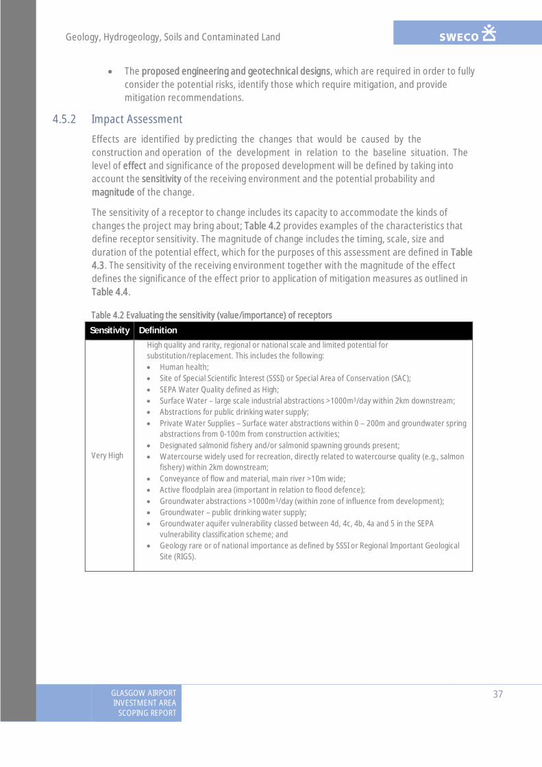
Geology, Hydrogeology, Soils and Contaminated Land
GLASGOW AIRPORTINVESTMENT AREA
SCOPING REPORT
37
· The proposed engineering and geotechnical designs, which are required in order to fullyconsider the potential risks, identify those which require mitigation, and providemitigation recommendations.
4.5.2 Impact Assessment
Effects are identified by predicting the changes that would be caused by theconstruction and operation of the development in relation to the baseline situation. Thelevel of effect and significance of the proposed development will be defined by taking intoaccount the sensitivity of the receiving environment and the potential probability andmagnitude of the change.
The sensitivity of a receptor to change includes its capacity to accommodate the kinds ofchanges the project may bring about; Table 4.2 provides examples of the characteristics thatdefine receptor sensitivity. The magnitude of change includes the timing, scale, size andduration of the potential effect, which for the purposes of this assessment are defined in Table4.3. The sensitivity of the receiving environment together with the magnitude of the effectdefines the significance of the effect prior to application of mitigation measures as outlined inTable 4.4.
Table 4.2 Evaluating the sensitivity (value/importance) of receptors
Sensitivity Definition
Very High
High quality and rarity, regional or national scale and limited potential forsubstitution/replacement. This includes the following:· Human health;· Site of Special Scientific Interest (SSSI) or Special Area of Conservation (SAC);· SEPA Water Quality defined as High;· Surface Water – large scale industrial abstractions >1000m3/day within 2km downstream;· Abstractions for public drinking water supply;· Private Water Supplies – Surface water abstractions within 0 – 200m and groundwater spring
abstractions from 0-100m from construction activities;· Designated salmonid fishery and/or salmonid spawning grounds present;· Watercourse widely used for recreation, directly related to watercourse quality (e.g., salmon
fishery) within 2km downstream;· Conveyance of flow and material, main river >10m wide;· Active floodplain area (important in relation to flood defence);· Groundwater abstractions >1000m3/day (within zone of influence from development);· Groundwater – public drinking water supply;· Groundwater aquifer vulnerability classed between 4d, 4c, 4b, 4a and 5 in the SEPA
vulnerability classification scheme; and· Geology rare or of national importance as defined by SSSI or Regional Important Geological
Site (RIGS).

Geology, Hydrogeology, Soils and Contaminated Land
38GLASGOW AIRPORTINVESTMENT AREASCOPING REPORT
Sensitivity Definition
High
Receptor with a high quality and rarity, local scale and limited potential forsubstitution/replacement or receptor with a medium quality and rarity, regional or national scaleand limited potential for substitution/replacement. This includes the following:· SEPA Water Quality defined as Good;· Large scale industrial agricultural abstractions 500-1000m3/day within 2km downstream;· Surface water abstractions for private water supply for more than 15 people;· Private Water Supplies – Surface water abstractions within 200m – 600m, groundwater
spring abstractions from 100 – 400m, and groundwater borehole abstractions from 0 – 200mfrom construction activities;
· Designated salmonid fishery and/or cyprinid fishery (Coarse Fish, including roach, carp,chubb, bream etc.);
· Watercourse used for recreation, directly related to watercourse quality (e.g. swimming,salmon fishery etc.);
· Conveyance of flow and material, main river >10m wide;· Active floodplain area (important in relation to flood defence);· Groundwater abstractions 500-1000m3/day (within zone of influence from development);· Groundwater abstraction for private water supply >10m3/day or serves >50 people; and· Groundwater aquifer vulnerability classed as 3 in the SEPA vulnerability classification scheme.
Medium
Receptor with a medium quality and rarity, local scale and limited potential forsubstitution/replacement or receptor with a low quality and rarity, regional or national scale andlimited potential for substitution/replacement. This includes the following:· SEPA Water Quality defined as Moderate;· Industrial/agricultural abstractions 50-499m3/day within 2km downstream;· Occasional or local recreation (e.g. local angling clubs);· Conveyance of flow and material, main river <10m wide or ordinary watercourse >5m wide;· Existing flood defences;· Groundwater abstractions 50-499m3/day;· Private Water Supplies – Surface water abstractions from 600 – >800m, groundwater spring
abstractions from 400m – 800m and groundwater borehole abstractions from 200m – 600mfrom construction;
· May be subject to improvement plans by SEPA;· Designated cyprinid fishery, salmonid species may be present and catchment locally
important for fisheries;· Watercourse not widely used for recreation, or recreation use not directly related to
watercourse quality; and· Groundwater aquifer vulnerability classed as 2 in the SEPA vulnerability classification scheme.
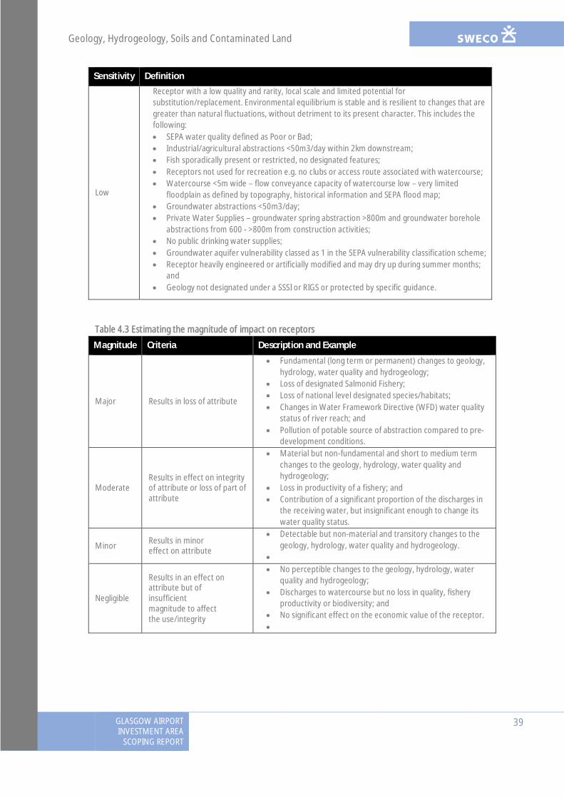
Geology, Hydrogeology, Soils and Contaminated Land
GLASGOW AIRPORTINVESTMENT AREA
SCOPING REPORT
39
Sensitivity Definition
Low
Receptor with a low quality and rarity, local scale and limited potential forsubstitution/replacement. Environmental equilibrium is stable and is resilient to changes that aregreater than natural fluctuations, without detriment to its present character. This includes thefollowing:· SEPA water quality defined as Poor or Bad;· Industrial/agricultural abstractions <50m3/day within 2km downstream;· Fish sporadically present or restricted, no designated features;· Receptors not used for recreation e.g. no clubs or access route associated with watercourse;· Watercourse <5m wide – flow conveyance capacity of watercourse low – very limited
floodplain as defined by topography, historical information and SEPA flood map;· Groundwater abstractions <50m3/day;· Private Water Supplies – groundwater spring abstraction >800m and groundwater borehole
abstractions from 600 - >800m from construction activities;· No public drinking water supplies;· Groundwater aquifer vulnerability classed as 1 in the SEPA vulnerability classification scheme;· Receptor heavily engineered or artificially modified and may dry up during summer months;
and· Geology not designated under a SSSI or RIGS or protected by specific guidance.
Table 4.3 Estimating the magnitude of impact on receptors
Magnitude Criteria Description and Example
Major Results in loss of attribute
· Fundamental (long term or permanent) changes to geology,hydrology, water quality and hydrogeology;
· Loss of designated Salmonid Fishery;· Loss of national level designated species/habitats;· Changes in Water Framework Directive (WFD) water quality
status of river reach; and· Pollution of potable source of abstraction compared to pre-
development conditions.
ModerateResults in effect on integrityof attribute or loss of part ofattribute
· Material but non-fundamental and short to medium termchanges to the geology, hydrology, water quality andhydrogeology;
· Loss in productivity of a fishery; and· Contribution of a significant proportion of the discharges in
the receiving water, but insignificant enough to change itswater quality status.
Minor Results in minoreffect on attribute
· Detectable but non-material and transitory changes to thegeology, hydrology, water quality and hydrogeology.
·
Negligible
Results in an effect onattribute but ofinsufficientmagnitude to affectthe use/integrity
· No perceptible changes to the geology, hydrology, waterquality and hydrogeology;
· Discharges to watercourse but no loss in quality, fisheryproductivity or biodiversity; and
· No significant effect on the economic value of the receptor.·
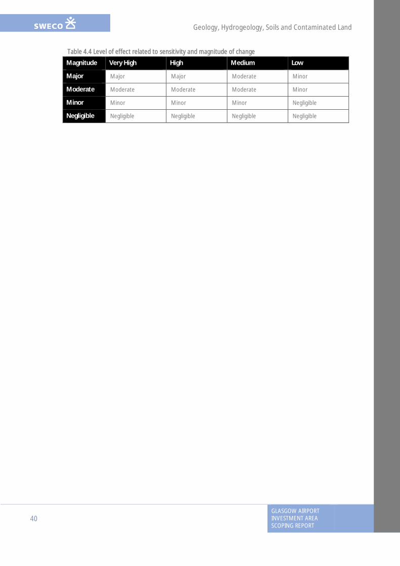
Geology, Hydrogeology, Soils and Contaminated Land
40GLASGOW AIRPORTINVESTMENT AREASCOPING REPORT
Table 4.4 Level of effect related to sensitivity and magnitude of change
Magnitude Very High High Medium Low
Major Major Major Moderate Minor
Moderate Moderate Moderate Moderate Minor
Minor Minor Minor Minor Negligible
Negligible Negligible Negligible Negligible Negligible

Water quality, drainage and flood defence
GLASGOW AIRPORTINVESTMENT AREA
SCOPING REPORT
41
5. Water quality, drainage and flood defence
5.1 IntroductionThis chapter provides an assessment of the potential effects of the proposed development onhydrology and flood risk, drainage and water quality. Previous and future consultation with theconsultation authorities and key stakeholders has been summarised, followed by a baselinedescription of the water environment and existing land drainage. The scope of assessment forthe EIA is then described, including sources of information and the proposed approach andmethods. The likely licensing requirements for works in the water environment is also outlined.
5.2 ConsultationThe following consultees have been contacted during the previous stages of the project andthe information or feedback that they have provided is summarised in Table 5.1 below. Futureconsultation to be undertaken during the EIA is also summarised.
Table 5.1: Previous and Proposed Consultation
Consultee Response/Action DataProvided
Action Taken
SEPA andRenfrewshireCouncil
Stage 2 response noted planning restrictions and floodmitigation requirements for development on thefunctional (1 in 200 year) floodplain with respect toScottish Planning Policy (SPP) (2014). Particular focuson realignment of Abbotsinch Road into the functionaltidal floodplain of the White Cart Water; clarified thatdevelopment critical for the operation of transportinfrastructure (e.g. Glasgow Airport) can be placedwithin undeveloped functional floodplain provided thatthe design requirements specified in SPP are satisfied.
Meeting with SEPA and Renfrewshire Council 21.04.16to discuss:· design proposals with respect to flood risk and
development constraints on land allocated asdeveloped/undeveloped; and
· potential requirements for sustainable drainagesystems (SuDS) and further water qualityassessment to be included in EIA.
Further consultation will be undertaken during the EIAto:· obtain information on any licensed abstractions
and discharges to the River Clyde and WhiteCart/Black Cart Waters;
· agree any further requirements for the flood riskassessment (FRA) and obtain feedback on thedetailed FRA and mitigation included in the design;
· inform the number, type and sizing of SuDSfeatures required for the proposed development;and
· inform the requirements for any engineeringactivities requiring authorisation under CAR and
No Requirements withrespect to SPP havebeen consideredwithin the evolvingdesign and flood riskassessment.
Update the existingbaseline dataset,inform the detailedFRA and drainagedesign andrequirements forCAR.

Water quality, drainage and flood defence
42GLASGOW AIRPORTINVESTMENT AREASCOPING REPORT
Consultee Response/Action DataProvided
Action Taken
relevant information to be included in theEnvironmental Statement (ES) and CARapplications.
MarineScotland
Meeting (02.06.16) noted presence of Atlantic salmon,sea trout, river lamprey and European eel in the RiverClyde and Black Cart/White Cart Waters.
EIA screening opinion (e-mail 20.07.16) noted thatMarine EIA will be required – the proposed bridge worksfall under developments included in Annex II of theMarine EIA Regs, and the size and nature of theproposed development is considered likely to havesignificant environmental effects.
Yes Assessment andmitigation ofcrossing structuresto take account ofspecies present.
Further consultationwill be undertakento inform therequirements of theMarine EIA.
Peel Ports andRenfrewshireCouncil
Bathymetric surveying data and flood modelling dataused for the North Renfrew Flood Prevention Scheme(FPS) to be supplied.
Further consultation will be undertaken with theCouncil to advise if flow attenuation prior to dischargeto the White Cart Water or River Clyde is required. Anyrequirements for restricting flow rate could have animpact on the sizing of attenuation features, andsubsequently flood compensatory storage provision, ifconstructed within the functional floodplain of theserivers.
Expectedsoon
Data will informStage 3 floodmodelling.
To inform the sizingof attenuationfeatures, if required,and subsequentlythe flood mitigationdesign.
5.3 Baseline DescriptionThe proposed development will cross the White Cart and Black Cart transitional waters, whichare associated with the Inner Clyde Special Protection Area (SPA) and Site of Special ScientificInterest (SSSI) (downstream) and Black Cart SPA and SSSI (upstream). Two Sites of Importancefor Nature Conservation (SINCs) are present within the vicinity of the proposals; one of theseSINCs is associated with semi-natural habitats along the banks of the White Cart Water. Referto Chapter 7 (Ecology and Nature Conservation) for further information on these ecologicaldesignations.
5.3.1 Hydrology and Flood Risk
The proposed development is within SEPA’s Potentially Vulnerable Area (PVA) 11/13 (WhiteCart Water catchment), as well as PVA Area 11/12 (Black Cart Water catchment) and PVA 11/09(Clyde south – Port Glasgow to Inchinnan).
Water quality, drainage and flood defence
GLASGOW AIRPORTINVESTMENT AREA
SCOPING REPORT
43
SEPA’s Flood Maps12 indicate fairly extensive river (fluvial) flooding of the Black Cart Water, andto a lesser degree the White Cart Water, and coastal flooding, attributed to tidal influence onthe River Clyde, extending into the downstream reaches of the River Cart. The 200-year floodenvelope extends into the northern and western sections of Glasgow Airport and inundatessections of the Paisley to Bishopton Railway line. Numerous localised areas of surface water(pluvial) flooding are identified in the Renfrew, Clydebank and Paisley areas to the south of theRiver Clyde.
The White Cart Water has historically been a significant source of flood risk, with more than 20significant flooding events recorded since 1908 and a flood event in 1984 affecting over 500properties. Further flooding events between 1984 and 1999 gave impetus to the developmentof the White Cart FPS. The FPS became operational in 2011 and was designed to protectproperties up to the 1 in 200 year flood event.
Revised modelling undertaken for the Stage 2 (options) assessment indicated that NethertonFarm is not at risk from fluvial flooding in response to the 200-year (+20% uplift for climatechange) flood event, in contrast to the SEPA Flood Maps. Peak water level predictions for thisflood event (approximately 3.0mAOD) were below the minimum bank spill point onto theadjacent land (approximately 3.6mAOD).
Improvements to the representation of extreme tidal forcing in the revised modelling, based onguidance for tidal representation in SEPA’s flood risk guidance13, have also reduced thepredicted peak tidal water level relative to Glasgow City Council’s River Clyde FloodManagement Strategy (RCFMS) (2005) study. Peak water level predictions in the 200-year plusclimate change event at Netherton Farm have reduced from 5.13mAOD to 4.99mAOD.
The modelling demonstrated that fluvial flooding at each of the proposed bridge crossings wascontained within the river banks, with patches of tidal inundation particularly at the disusedcarpark at Laigh Park to the east of the White Cart Water, in the vicinity of the GatewayCrossing.
5.3.2 Drainage
The study area of the proposed development is predominantly pervious which lends itself todrainage via infiltration. Surface waters which exceed the infiltration rate/capacity, typicallydrain overland from west to east following the natural topography towards the White CartWater. Any development with a north-south orientation, such as the proposed AbbotsinchRoad Realignment, has the potential to impede this natural drainage route.
5.3.3 Water Quality
The reach of the Black Cart and White Cart Waters in the study area (water body name: ClydeEstuary – Inner (Inc. Cart; ID: 200510)) is classified by SEPA as transitional waters and is tidallyinfluenced. The reach is classified as heavily modified with an overall status of “Moderateecological potential” in 201314. Existing pressures include pollution from sewage disposal and
12 SEPA Flood Maps: http://map.sepa.org.uk/floodmap/map.htm13 Technical Flood Risk Guidance for Stakeholders (SS-NFR-P-002) v9.1 (SEPA, 2015)14 SEPA River Basin Management Plan (RBMP) Interactive Map: http://gis.sepa.org.uk/rbmp
Water quality, drainage and flood defence
44GLASGOW AIRPORTINVESTMENT AREASCOPING REPORT
air transport, and morphological alterations through dredging, channelisation andimpoundment. These pressures have resulted in low dissolved oxygen levels and poormorphological status, leading to an overall ecological status of “Poor”. However, the waterbody achieves an overall chemical status of “Pass” as there is no known heavy metalcontamination. With improvement measures identified to reduce these pressures, the reach ofthe Black Cart and White Cart Waters has been set the target to obtain overall “Good” statusby 2027 and thereby achieving the aims of the 2000/60/EC Water Framework Directive (WFD).
Refer to Chapter 4 (Geology, hydrogeology, soils and contaminated land) for information onexisting groundwater quality and areas of identified contaminated land.
5.4 Potential Effects
5.4.1 Construction
5.4.1.1 Hydrology and Flood Risk
Potential temporary impacts on hydrology and flood risk could include:
· Reduced soil permeability and increased runoff from soil compaction due to workstraffic, which could increase the peak runoff and intensity of runoff during a rainfallevent. This is likely to be more of an issue for the Abbotsinch Road Realignment ontoexisting farmland, rather than other sections of the proposed project which are locatedwithin urbanised areas.
· Increased flood risk from any temporary works and structures within the functionalfloodplain and temporary loss of fluvial/tidal floodplain area within the constructionfootprint.
· Temporary bunding in the Black Cart and White Cart Waters or on the functionalfloodplain to create dry working areas could restrict flows and locally increase flood riskto nearby receptors.
· Re-routing of runoff into the existing drainage network could locally increase pluvialand sewer flooding in areas local to the proposed development if the existing drainagenetwork is under capacity.
5.4.1.2 Water Quality
Potential temporary impacts on water quality could include:
· Construction of the Wright Street Crossing, Inchinnan Cycleway and Gateway Crossingand approach roads, soil-stripping, compound preparation and other earthworks couldresult in sediment release and silt-laden runoff entering the Black Cart and White CartWaters, and the downstream River Clyde, adversely impacting water quality andaquatic ecology.
· A decline in water quality from accidental release/spillages of oil, fuels and chemicalsfrom mobile or stationary plant and a localised increase in alkalinity from spillages ofconcrete or unset cement. Due to the size of the rivers and high dilution/dispersaleffect, any impacts are considered to be minor. Refer to Chapter 4 for further impactson groundwater quality.
Water quality, drainage and flood defence
GLASGOW AIRPORTINVESTMENT AREA
SCOPING REPORT
45
· Mobilisation of contaminants into the Black Cart and White Cart Waters, and the RiverClyde downstream, due to excavation works or dewatering within areas ofcontaminated land or stockpiling of contaminated soil/spoils. The potential impacts ofdisturbance of contaminated land is considered in Chapter 4.
· Morphological changes to the channel banks and bed to accommodate construction ofabutments and piers for new river crossings on the Black Cart and White Cart Waters.
· Sewage inputs from accidental/uncontrolled release from sewers through damage topipelines or unsatisfactory disposal of sewage from site welfare facilities.
5.4.2 Operation
5.4.2.1 Hydrology and Flood Risk
Potential permanent impacts on hydrology and flood risk could include:
· Development on the functional floodplain could displace floodwaters and thereforeincrease flood risk to the proposed project and elsewhere. SuDS should be locatedoutwith the functional floodplain where possible and lined if located within an area ofknown contamination or to protect underlying groundwater, if required.
· New impermeable areas (e.g. road embankment and SuDS features) could increase thevolume and peak flow of surface runoff reaching the Black Cart and White Cart Watersdue to a reduction in infiltration capacity.
· The new road and its drainage system may act as a barrier to water movement withinexisting catchments, altering drainage patterns and increasing flood risk to theproposed project and upstream of the barrier. This is a particular focus of theAbbotsinch Road Realignment, which could potentially sever the natural west-east flowpath to the White Cart Water.
· Abutments and piers of the river crossings could restrict flow conveyance of the BlackCart and White Cart Waters and thereby increase fluvial/tidal flood risk duringhigh/extreme flows.
· Any permanent alterations to the drainage system as a result of the proposeddevelopment could increase pluvial and culvert flooding.
5.4.2.2 Water Quality
Potential permanent impacts on water quality could include:
· An increase in road traffic leading to an increase in volume and/or frequency ofcontaminated road runoff to the White Cart Water and/or River Clyde. Road runoff cancontain suspended solids and contaminants bound to them (e.g. heavy metals), oil andhydrocarbons, biodegradable organic materials (e.g. debris and grass cuttings) and de-icing salt in winter.
· Scour around the river crossing structures could result in transfer of suspendedsediment downstream and erosion of the river banks.
· Potential contamination of the water environment by increased mobilisation of existingsoil or groundwater contamination, or by leachable contamination from imported fillmaterials or SUDS. This is considered further in Chapter 4.
Water quality, drainage and flood defence
46GLASGOW AIRPORTINVESTMENT AREASCOPING REPORT
5.5 Proposed Scope of AssessmentThe assessment will be carried out in accordance with the ‘Simple Assessment’ methodsprescribed within the DMRB HD 45/0915, unless otherwise stated. The following legislation,policy and guidance documents will also be taken into account (any updates to guidance madebetween finalisation of this Report and completion of the EIA will be taken into account in theassessment):
· 2000/60/EC Water Framework Directive;· The Water Environment (Controlled Activities) (Scotland) Regulations 2011 (as
amended);· The Climate Change (Scotland) Act 2009;· The Flood Risk Management (Scotland) Act 2009;· Scottish Planning Policy (SPP) (Scottish Government, 2014);· Technical Flood Risk Guidance for Stakeholders (SS-NFR-P-002) v9.1 (SEPA, 2015);· The Fluvial Design Guide (Environment Agency, 2010);· Guidebook of Applied Fluvial Geomorphology (Sear et al., 2010);· SEPA Flood Maps (SEPA, 2015);· SEPA River Basin Management Plan (RBMP) Interactive Map (SEPA, 2011) and Water
Body Information Sheets (SEPA, 2014);· SEPA Regulatory Method (WAT-RM-08): Sustainable Urban Drainage Systems (SUDS or
SUD Systems), v6.0 March 2016;· SEPA Supporting Guidance (WAT-SG-12): General Binding Rules for Surface Water
Drainage Systems, v4.1 March 2016;· CAR: A Practical Guide (v7.3) (SEPA, 2016);· SUDS for Roads (SCOTS and SUDS Working Party, 2015); and· The SUDS Manual, C753 (CIRIA, 2015).
During the EIA, baseline data collected during earlier stages of the options assessments will bereviewed and updated as required with further desk-based and survey information, andadditional consultation responses obtained for the proposed development (Table 5.1:Consultation). The proposed methodologies for the hydrology/flood risk and water qualityassessments are presented below, including a consideration of potential licensingrequirements.
5.5.1 Hydrology and Flood Risk
A detailed FRA is required as the proposals are located on or immediately adjacent to thefunctional floodplain of the White Cart and Black Cart Waters and is at ‘medium to high risk’ offlooding, in line with SPP. The ‘functional’ floodplain is defined as land which is prone toflooding up to and including the 0.5% Annual Exceedance Probability (AEP) (1 in 200 yearreturn period) flood event.
15 DMRB Volume 11, Section 3, Part 10 (HD 45/09): Road Drainage and the Water Environment (The Highways Agency et al.,2009)
Water quality, drainage and flood defence
GLASGOW AIRPORTINVESTMENT AREA
SCOPING REPORT
47
The FRA will be undertaken in accordance with Methods E and F (Assessing Flood Impacts) ofthe DMRB HD 45/09 and will adhere to the requirements of SEPA’s Technical Flood RiskGuidance for Stakeholders and SPP, whereby development is prevented:
· which would have a significant probability of being affected by flooding; and/or· would increase the probability of flooding elsewhere.
Site-specific flood modelling has already been undertaken for existing (baseline) conditions viaone-dimensional hydrodynamic modelling of the River Clyde, White Cart and Black Cartwatercourses and adjoining floodplains based on the RCFMS (2005) ISIS model. The model willbe further refined to predict changes in peak runoff and water levels in the pre and post-development scenarios for the proposed development. Design flows up to the 0.5% AEP (1 in200 year return period) event will be modelled, including a climate change allowance of +20%on the estimated 200-year peak flow. The detailed FRA will include assessment of:
· the effect of the Wright Street Crossing, Inchinnan Cycleway and Gateway Crossingdesigns on water levels;
· the impact on water levels of road embankments and SuDS features constructed in thefunctional floodplain; and
· mitigation measures, such as provision of compensatory floodplain storage or floodrelief culverts in order to achieve a neutral effect on flood risk up to the 200-yeardesign level. This is a particular focus of the Abbotsinch Road Realignment.
Topographic and bathymetric surveys will be undertaken upstream and downstream of theproposed bridge crossing locations on the White Cart and Black Cart Waters to inform the floodmodelling. Bathymetric surveying of the White Cart and Black Cart are also being undertaken toprovide updated channel cross-sections within the river model to reflect alterations tobathymetry relative to the 2002-2003 data used to construct the RCFMS (2005) model (i.e. toaccount for dredging, sediment deposition and scour in the intervening period).
The potential impacts will be determined with reference to detailed engineering drawings ofthe Wright Street Crossing, Inchinnan Cycleway and Gateway Crossing, and the footprint of theproposed project.
5.5.1.1 Assumptions and Limitations
The FRA is based on the RCFMS ISIS model, which was extensively developed and validated aspart of the 2005 study. Updates to the model have been implemented to account for post-2005 alterations to river inflows and floodplain topography (including the White Cart FPS andvarious developments on the banks of the River Clyde). However, no further flow surveying ormodel validation will be conducted as part of the proposed modelling work to inform thespecimen design and EIA.
5.5.2 Water Quality
No water quality surveys or water quality monitoring will be required during the EIA.Construction impacts of the proposed project on water quality will be assessed qualitativelybased on valued, expert judgement and taking account of experience from similar projects inother comparable locations. Assessment of potential impacts will take into account the size andlocation of the construction footprint, type and nature of construction activities likely to occur

Water quality, drainage and flood defence
48GLASGOW AIRPORTINVESTMENT AREASCOPING REPORT
in-channel or within the catchment, the potential risk from pollutant spillages and silt-ladenrunoff entering the White Cart/Black Cart Waters and River Clyde, and the pollutant dilution/dispersal capacity of these rivers. Methods to assess impacts on groundwater quality anddisturbance of contaminated land is considered in Chapter 4.
To assess potential operational impacts on water quality, calculations will be undertaken toestimate the probability of an accidental spillage from a heavy good vehicle (HGV) leading to aserious pollution incident in line with DMRB HD 45/09 (Method D – Pollution Impacts fromAccidental Spillages). To undertake these calculations, traffic and drainage information will berequired, including:
· two-way annual average daily traffic (AADT) flow;· %HGV;· lengths of road draining to the White Cart Water and/or River Clyde outfall(s); and· SuDS components included in the drainage design.
Impacts of scour around the bridge structures on the White Cart and Black Cart Waters will alsobe assessed.
In line with SEPA’s guidance16, only ‘minimal’ SuDS treatment is required for discharges totransitional/tidal waters. This is likely to take the form of basic source control measures (e.g.filter drains, swales, filtration trenches, permeable paving). The type and density of SuDSincluded in the drainage design will be agreed with SEPA as design work progresses.
5.5.2.1 Assumptions and Limitations
For road schemes that propose to discharge routine runoff to non-tidal watercourses, anassessment following DMRB HD 45/09 Methods A and B (Effects of Routine Runoff on SurfaceWaters) would normally be undertaken. However, this assessment is based on discharges towatercourses with hydrological catchments and which exhibit one flow direction in order tocalculate the low flow value, and therefore the potential dilution/dispersal capacity, of thewatercourse. For the proposed GAIA development, discharge is proposed to the White CartWater and/or River Clyde which are tidal and saline in this location; a low flow value cannot beaccurately determined for waters which are tidally-influenced and the estimated pollutantloadings/concentrations cannot be compared against the freshwater pollutant thresholdswithin the assessment tool. As a result, the assessment method is not applicable and thereforehas been scoped out of the EIA. Due to the large size of the rivers, and implementation of SuDS,it is considered that routine runoff would have a negligible impact on water quality.
Detailed pollutant transport modelling in line with SEPA’s WAT-SG-11 Guidance17 is notrequired as there are no designated shellfish or bathing waters in the vicinity of the proposedproject, as agreed with SEPA.
16 SEPA Regulatory Method (WAT-RM-08): Sustainable Urban Drainage Systems (SUDS or SUD Systems), v6.0 March 2016;SEPA Supporting Guidance (WAT-SG-12): General Binding Rules for Surface Water Drainage Systems, v4.1 March 201617 SEPA Supporting Guidance (WAT-SG-11): Modelling Coastal and Transitional Discharges, v3.0 April 2013

Water quality, drainage and flood defence
GLASGOW AIRPORTINVESTMENT AREA
SCOPING REPORT
49
5.5.3 Controlled Activities Regulations (CAR)
CAR licence applications may be required for engineering activities which have the potential toimpact on the water environment, e.g. abutments/piers of the river crossings and anyassociated bed/bank scour protection. It has already been agreed with SEPA that road drainagewill fall under CAR General Binding Rules (GBRs)18, and as long as the conditions of the GBR aremet, no further consultation with SEPA is necessary on this issue. In addition, in-river worksbelow Mean High Water Springs (MHWS) will fall under the marine licensing process andfurther consultation will be undertaken with Marine Scotland to confirm potential consentrequirements.
Although CAR is a separate consenting regime to EIA, much of the information collated as partof the Stage 3 assessment and EIA will be used in the CAR applications and any marine licenceapplications. In the event that engineering activities are licensable under CAR, the approachand programme of delivery will be agreed with SEPA and Renfrewshire Council, andopportunities to combine efforts, e.g. baseline data collection for EIA and CAR, will beinvestigated.
5.5.4 Impact Assessment
Impact significance is a function of the sensitivity (value/importance) of an attribute and themagnitude of impact. Tables 5.2 to 5.4 are based on DMRB HD 45/09 criteria and will be usedto inform the assessment.
The significance of impacts on flood risk and water quality will be reported for residual impactsonly (i.e. the remaining impacts following implementation of mitigation) for the constructionand operation phases of the proposed project. As per DMRB HD 45/09 guidance, where thereare two alternatives provided in Table 5.4, a single significance rating will be chosen based onprofessional judgement. Criteria to inform assessment of the impacts on groundwater areprovided in Chapter 4.
Table 5.2: Evaluating the Sensitivity (value/importance) of Water Environment Attributes
Importance Criteria Typical Examples
Very High
Attribute has ahigh quality andrarity on regionalor national scale
Surface Water:EC Designated Salmonid/Cyprinid fisheryWFD Class ‘High’Site protected/designated under EC or UK habitat legislation (SAC, SPA,SSSI, WPZ, Ramsar site, salmonid water)/species protected by EClegislationFlood Risk: Floodplain or defence protecting more than 100 residentialproperties from flooding
High
Attribute has ahigh quality andrarity on localscale
Surface Water:WFD Class ‘Good’Major Cyprinid Fishery Species protected under EC or UK habitatlegislation
Flood Risk: Floodplain or defence protecting between 1 and 100residential properties or commercial/industrial premises from flooding
18 SEPA (2016) CAR: A Practical Guide, v7.3 June 2016
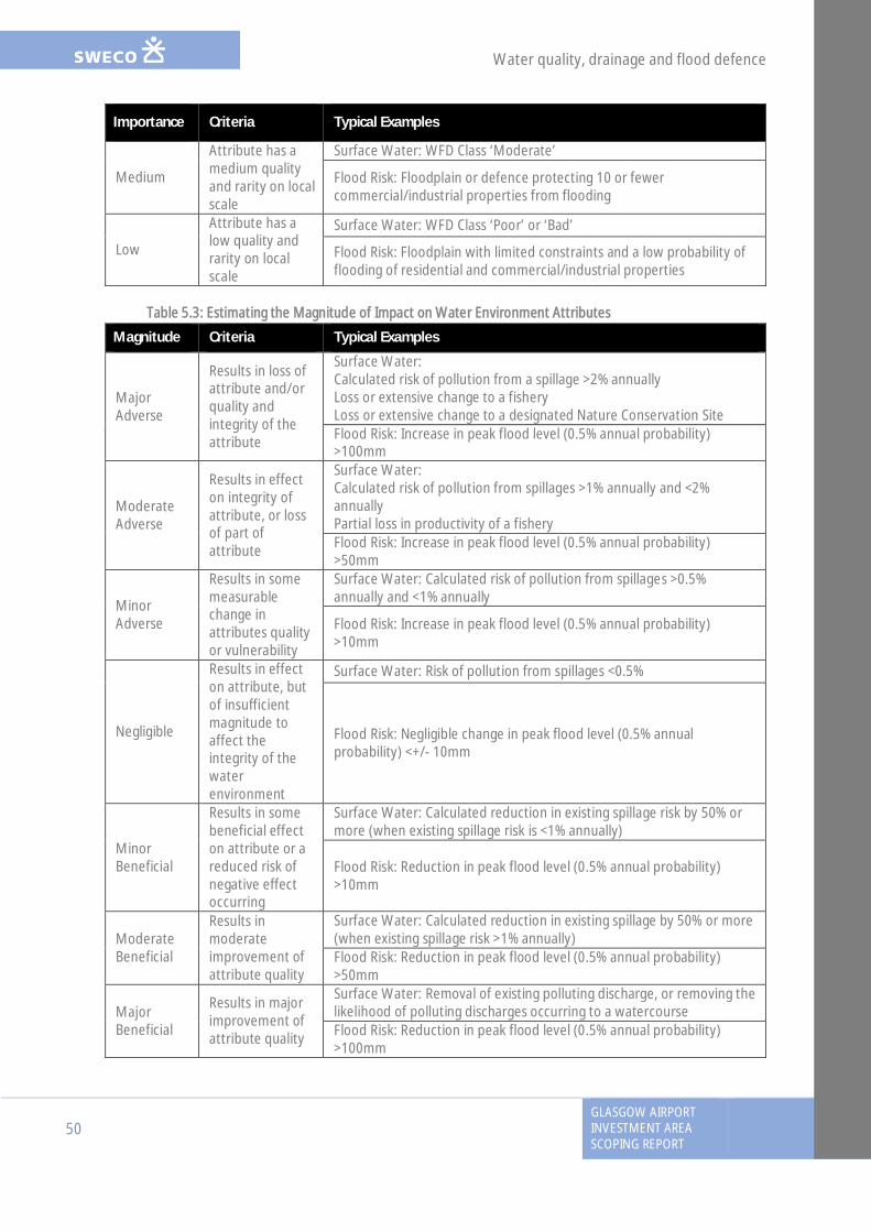
Water quality, drainage and flood defence
50GLASGOW AIRPORTINVESTMENT AREASCOPING REPORT
Importance Criteria Typical Examples
Medium
Attribute has amedium qualityand rarity on localscale
Surface Water: WFD Class ‘Moderate’
Flood Risk: Floodplain or defence protecting 10 or fewercommercial/industrial properties from flooding
Low
Attribute has alow quality andrarity on localscale
Surface Water: WFD Class ‘Poor’ or ‘Bad’
Flood Risk: Floodplain with limited constraints and a low probability offlooding of residential and commercial/industrial properties
Table 5.3: Estimating the Magnitude of Impact on Water Environment Attributes
Magnitude Criteria Typical Examples
MajorAdverse
Results in loss ofattribute and/orquality andintegrity of theattribute
Surface Water:Calculated risk of pollution from a spillage >2% annuallyLoss or extensive change to a fisheryLoss or extensive change to a designated Nature Conservation SiteFlood Risk: Increase in peak flood level (0.5% annual probability)>100mm
ModerateAdverse
Results in effecton integrity ofattribute, or lossof part ofattribute
Surface Water:Calculated risk of pollution from spillages >1% annually and <2%annuallyPartial loss in productivity of a fisheryFlood Risk: Increase in peak flood level (0.5% annual probability)>50mm
MinorAdverse
Results in somemeasurablechange inattributes qualityor vulnerability
Surface Water: Calculated risk of pollution from spillages >0.5%annually and <1% annually
Flood Risk: Increase in peak flood level (0.5% annual probability)>10mm
Negligible
Results in effecton attribute, butof insufficientmagnitude toaffect theintegrity of thewaterenvironment
Surface Water: Risk of pollution from spillages <0.5%
Flood Risk: Negligible change in peak flood level (0.5% annualprobability) <+/- 10mm
MinorBeneficial
Results in somebeneficial effecton attribute or areduced risk ofnegative effectoccurring
Surface Water: Calculated reduction in existing spillage risk by 50% ormore (when existing spillage risk is <1% annually)
Flood Risk: Reduction in peak flood level (0.5% annual probability)>10mm
ModerateBeneficial
Results inmoderateimprovement ofattribute quality
Surface Water: Calculated reduction in existing spillage by 50% or more(when existing spillage risk >1% annually)Flood Risk: Reduction in peak flood level (0.5% annual probability)>50mm
MajorBeneficial
Results in majorimprovement ofattribute quality
Surface Water: Removal of existing polluting discharge, or removing thelikelihood of polluting discharges occurring to a watercourseFlood Risk: Reduction in peak flood level (0.5% annual probability)>100mm
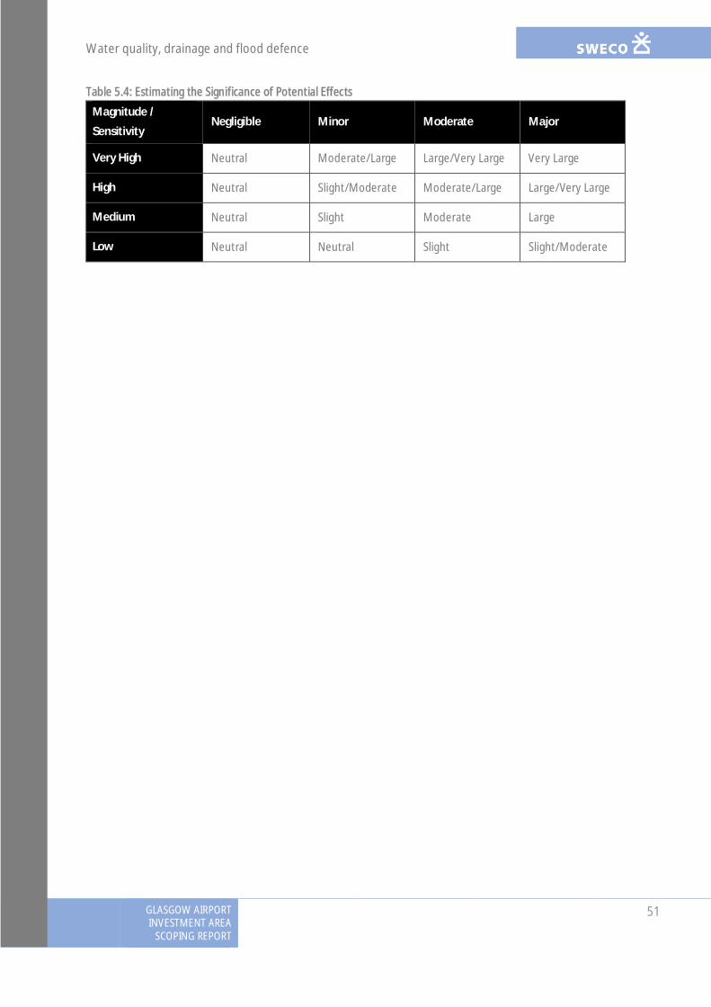
Water quality, drainage and flood defence
GLASGOW AIRPORTINVESTMENT AREA
SCOPING REPORT
51
Table 5.4: Estimating the Significance of Potential Effects
Magnitude /
SensitivityNegligible Minor Moderate Major
Very High Neutral Moderate/Large Large/Very Large Very Large
High Neutral Slight/Moderate Moderate/Large Large/Very Large
Medium Neutral Slight Moderate Large
Low Neutral Neutral Slight Slight/Moderate
Landscape and visual effects
52GLASGOW AIRPORTINVESTMENT AREASCOPING REPORT
6. Landscape and visual effects
6.1 IntroductionA detailed landscape, townscape and visual impact assessment (LVIA), including a cumulativeassessment, will be carried out to identify and assess any significant landscape, townscape orvisual effects anticipated to be associated with the proposed development and to informfurther refinement of the proposed layout and design. The acronym ‘LVIA’ will be used in thisreport and in the subsequent assessment to refer to the assessment of effects including thoseon townscape character. The landscape, townscape and visual assessments will be undertakenby chartered Landscape Architects at Sweco (a practice registered by the Landscape Institute)with relevant assessment experience.
The following will form the main focus of the LVIA:
· the general effect of the proposed development on local landscape and townscapecharacter and the ability of the landscape/townscape to accommodate the change;
· visual effects on key receptors such as people in settled areas, at recognisedviewpoints, tourist and visitor attractions and using key transport routes; and
· the potential cumulative effects with other consented and proposed developments inthe area which are of a similar scale and type to the proposed development
An LVIA consists of two separate but interlinked components: a landscape assessment; and avisual assessment. Given the nature of the site and study area, in this instance the landscapeassessment includes a townscape assessment. When presenting the methodology, this chapterrefers to ‘landscape assessment’ and this can generally be taken to also refer to ‘townscapeassessment’. Where applicable specific detail on the approach to townscape assessment will beset out.
The landscape assessment considers the effects of the proposed development on thelandscape as an environmental resource. The visual assessment considers the change topeople’s views (identified as residents, visitors to the area, people working in the area etc.).Landscape and visual effects will be considered for both the construction and operationalphases of the proposed development.
The LVIA is underway and will be informed by a combination of desk and site-based assessmenttechniques. At this stage the initial findings of the LVIA are being used to inform the design ofthe proposed development. The LVIA chapter of the ES will present the findings of the iterativeassessment process including identification of any mitigation that has been incorporated intothe design.
The LVIA will build on landscape and visual assessment work already carried out in relation tothe proposed development. A number of route options were considered at a previous stageand a preliminary landscape and visual assessment of each of the options has informed a widerdecision on the most suitable routes.
6.2 ConsultationNo consultation has been carried out at this stage specifically in relation to the LVIA.Consultation responses received with relevance to the landscape and visual assessment aresummarised in Table 6.1.
Landscape and visual effects
GLASGOW AIRPORTINVESTMENT AREA
SCOPING REPORT
53
Table 6.1: Pre-Scoping Consultation Responses
Consultee Response/ActionDataProvided
Action Taken
A&DS Has no comment to make at this stage of thedevelopment
No No action required
ForestryCommissionScotland
FCS encouraged the promotion of the Policyon Control of Woodland Removal. Any of thefollowing: Ancient Woodland Inventory,Native and Semi-Native Woodlands, or TreePreservation Orders (amongst others), ifimpacted by the development, should requirea direct engagement with the relevantauthority.
No
No action required atthis stage howeverfurther consultationwill take place onceareas of woodlandloss are known
GCV GreenNetworkPartnership
Noted that the City Deal projects presentsignificant opportunities to deliver importantelements of the Green Network in Renfrew.Green Network elements need to be properlydesigned and any environmentalimprovements should follow the IntegratedGreen Infrastructure approach.
No Noted. No actionrequired at this stage
Living Streets
Living Streets recommends using the ScottishGovernment’s Place Standard at areas ofsignificant potential change to help establishcommunity perception
No Noted. No actionrequired at this stage
Going forward, as part of the EIA, the following key stages of consultation will be undertaken:
· Review of consultation responses received in relation to this scoping report;· Discussion with SNH/Renfrewshire Council on the assessment methodology, including
the interpretation of the ‘worst case assessment scenario’ from a landscape and visualperspective. This stage will require the completion of a ‘design-fix’ for the proposeddevelopment; and
· Agreement on the location of representative viewpoints with Renfrewshire Council.
6.3 Baseline Description
6.3.1 Study Area
Following the preliminary landscape and visual desk and site based assessments, the extent ofthe study area has been defined as a 1km radius around the site boundary. It is considered thatthe nature and form of the proposed development and the surrounding urban context are suchthat no significant landscape or visual effects would be experienced outside of this study area.
Landscape and visual effects
54GLASGOW AIRPORTINVESTMENT AREASCOPING REPORT
The 1km LVIA study area provides a boundary to the assessment, identification of receptorsand the selection of representative viewpoints is shown on Figure 6.1. However, thepreliminary assessment has identified that potentially significant effects, particularly onpeople’s views, would be located within a more immediate radius to the site and the focus ofthe assessment, including the majority of viewpoint locations, will be within approximately 0.5km of the site boundary.
6.3.2 Desk Based Research
Preliminary LVIA work has made reference to the following information sources:
· survey data related to the site, e.g. topographical and tree surveys;· drawings relating to the development proposals and their construction;· Ordnance Survey mapping and aerial photography;· development plans and guidance containing information relating to landscape
designations and landscape related policies at the local, regional and national level; and· the published SNH landscape character assessment for the study area
Relevant details of information from these sources are provided in Section 6.3.
6.3.3 Field Surveys
Preliminary field surveys have been undertaken from public roads, public rights of way andpublically accessible areas, including areas of public open space. The site and study area hasbeen visited in relation to landscape and visual studies in: April; May; and July 2016.
Site work has involved:
· a corroboration of the findings of the desktop review;· gathering of additional information on landscape elements, character, views and
localised screening;· confirming a list of preliminary viewpoints and taking reference photographs;· preliminary identification of landscape and visual effects; and· consideration of opportunities for landscape and visual mitigation
6.3.4 Landscape and Townscape Character
The site and 1 km study area is located within Renfrewshire and is covered by ‘Glasgow and theClyde Valley Landscape Character Assessment’, completed for Scottish Natural Heritage (SNH)by Land Use Consultants in 1999 (Report No. 116). The proposed development site is located inareas identified as ‘Urban’ and the following character types:
· Alluvial Plain· Green Corridors
In addition, the wider 1km study area also includes the ‘Rugged Upland Farmland’ charactertype.
The areas identified as ‘Urban’ are not attributed a landscape character description. Thereforethe LVIA will set out the descriptions for the character areas that are available, i.e.: AlluvialPlain; Green Corridors; and Rugged Upland Farmland, and townscape character assessment willbe carried out for the ‘Urban’ areas.

© Crown copyright and database rights 2016. All Rights reserved. Ordnance Survey Licence number 100023417.
¯Key
Notes
Reference Drawings
REV. DATE AMENDMENT DETAILS ORIG CHK'D APP'D
GLASGOW AIRPORT INVESTMENT AREA
Client
Drawing Title
Drawing Status Suitability
Scale
Original Size
Designed
Date
Drawn
Date Date Date
ApprovedChecked
Project Ref. No.
Revision
Drawing Number
SwecoCity Park Suite 3/5368 Alexandra Parade GlasgowG31 3AUTel: +44 (0)141 414 1700web: www.sweco.co.uk
RENFREWSHIRE COUNCIL
1:25,00001/09/2016A3
Figure 6.1: Landscape Character Areas
117084 (R06)
JM FC xxx
- - ----
xxx
Project Title
01/09/2016
0A
- - ----- - ----- - ----- - ----
Project Originator Volume Location Type Role Number
Indicative Boundary of ProposedDevelopmentStudy Area
Glasgow and the Clyde Valley CharacterAreas (SNH, 1999)
Alluvial PlainDrumlin FoothillsGreen CorridorsRugged Upland FarmlandUrbanised Area
Alluvial Plain LCA- Distinctive and low-lying landform- Open landscape with woodland blocks- Pasture and arable fields- Influenced by urban expansion and transport infrastructureDrumlin Foothills LCA- Distinctive undulating landform- Transitional landscape between lowland areas and the rugged moorland hills in the north- Pastoral farming dominates in the lower areas, before extending into areas of moorland- Woodland is a mix of semi-natural and farm woodland and conifer plantationsGreen Corridors LCA- Undeveloped land along rivers and canals- Mix of landscape, industrial and transport featuresRugged Upland Farmland LCA- A rugged landform including rocky bluffs and shallow troughs- Pastoral farming dominates- Tree cover often emphasisies landform(The 'Urban Area' LCA does not pick up on any geographically specific sensitivities or characteristics of the urban area, and the classification is considered too broad. Therefore, Townscape Character Areas have been developed to provide more detailed characteristic of the urban environment. Theseare shown and described on Figure D7.3 Townscape Character Areas) 0 250 500 750125
Metres
117084 - SWEC0 - EAC - 00 - SP - EN - 00003
FINAL S0

Landscape and visual effects
GLASGOW AIRPORTINVESTMENT AREA
SCOPING REPORT
55
Figure 6.1 presents the landscape character areas and Figure 6.2 shows the townscape areaswhich were identified during LVIA work undertaken to date. The potential effects on theselandscape and townscape areas will be identified within the LVIA chapter.
6.3.5 Landscape Designations
There are no national landscape designations (e.g. National Scenic Areas) on the site or withinthe study area. There are also no local landscape designations (e.g. Special Landscape Areas) onthe site or within the study area.
There are protected areas which are of relevance to the LVIA (shown on Figure 6.3), including:
· Greenbelt, defined by Renfrewshire Council. The nearest area of Greenbelt to theproposed development is located within the north-western extent of the site. This isprimarily a planning designation, however it is relevant to the consideration ofopenness within the site and study area;
· Ancient Woodland, which is relevant to the consideration of value attributed tolandscape features within the site and the potential for loss of such features due to theproposed development. The site passes through areas of Ancient Woodland, close toGlasgow Airport, the impact of which will be considered within the LVIA; and
· Conservation Areas, which are primarily designated for their heritage value, howeverthey are of particular relevance to the consideration of townscape character and valueand also visual receptors, therefore they will be considered within the LVIA. Thenearest Conservation Areas to the site are:
- Greenlaw Conservation Area, which is located 0.3 km south-east of the site; and
- Paisley Town Centre, which is located 0.2 km south of the site.
6.3.6 Visual Envelope and Potential Visual Receptors
The site is located on the western extent of the town of Renfrew and north of Paisley centre.The built nature of the site and study area limits visibility of the site due to the screening effectof residential and industrial buildings. A full visual analysis will be carried out of the site andproposed development, however at this stage the following can be stated with regards topotential visual receptors:
6.3.6.1 Residential Receptors
The site is located within or adjacent to industrial and agricultural areas and is largely set awayfrom residential properties. However, there are some notable residential receptors including:
· Kirklandneuk at the northern extent of the site;· the Shortroods area, near to Inchinnan Road and New Inchinnan Road;· the New Sneddon Street area, facing into the White Cart Water;· a tenement building on Abercorn Street; and· residential villas and the new Keepmoat development on Inchinnan Road.
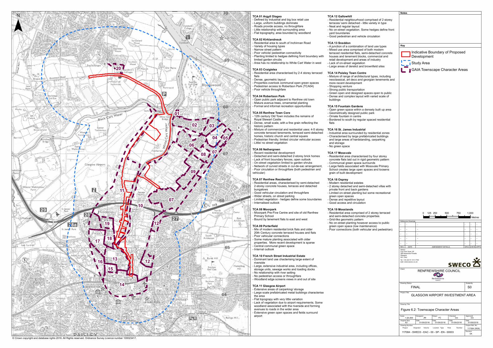
10
11
14
07
13
09
06
02
1817
04
08
16
03
19
1215
07
12
05
20
01
© Crown copyright and database rights 2016. All Rights reserved. Ordnance Survey Licence number 100023417.
¯Key
Notes
Reference Drawings
REV. DATE AMENDMENT DETAILS ORIG CHK'D APP'D
GLASGOW AIRPORT INVESTMENT AREA
Client
Drawing Title
Drawing Status Suitability
Scale
Original Size
Designed
Date
Drawn
Date Date Date
ApprovedChecked
Project Ref. No.
Revision
Drawing Number
SwecoCity Park Suite 3/5368 Alexandra Parade GlasgowG31 3AUTel: +44 (0)141 414 1700web: www.sweco.co.uk
RENFREWSHIRE COUNCIL
1:25,00001/09/2016A3
117084 (R06)
JM FC xxx
- - ----
xxx
Project Title
01/09/2016 01/09/2016 01/09/2016
0A
- - ----- - ----- - ----- - ----
Project Originator Volume Location Type Role Number
Indicative Boundary of ProposedDevelopmentStudy AreaGAIA Townscape Character Areas
TCA 01 Argyll Diageo- Defined by industrial and big box retail use- Large, uniform buildings dominate- Roads provide access, no throughfare- Little relationship with surrounding area- Flat topography, area bounded by woodlandTCA 02 Kirklandneuk- Residential area to south of Inchinnan Road- Variety of housing types- Narrow street pattern- Poor vehicle/ pedestrian connectivity- Planting limited to hedges defining front boundary with limited garden shrubs- Area has no relationship to White Cart Water in westTCA 03 Craigielea- Residential area characterised by 2-4 storey terraced flats- Dense, geometric layout- Properties overlook communal open green spaces- Pedestrian access to Robertson Park (TCA04)- Poor vehicle throughfareTCA 04 Robertson Park- Open public park adjacent to Renfrew old town- Mature avenue trees, ornamental planting- Formal and informal recreation opportunitiesTCA 05 Renfrew Town Core- 12th century Old Town includes the remains of Royal Stewart Castle - Dense, small scale, with a fine grain reflecting the historic pattern- Mixture of commercial and residential uses: 4-5 storey concrete terraced tenements, terraced semi-detached homes, historic church and central square- Pedestrian friendly; limited circular vehicular access - Little/ no street vegetationTCA 06 Nethergreen- Recent residential development- Detached and semi-detached 2-storey brick homes- Lack of front boundary fences, open outlook- On-street vegetation limited to garden shrubs- Network of curved streets in cul-de-sac arrangement, - Poor circulation or throughfare (both pedestrian and vehicular) TCA 07 Renfrew Residential- Residential areas, characterised by semi-detached 2-storey concrete houses, terraces and detached bungalows- Good vehicular circulation and throughfare- Wider streets, on street parking- Limited vegetation - hedges define some boundaries- Internalised outlookTCA 08 Moorpark- Moorpark Pre-Five Centre and site of old Renfrew Primary School- Bound by tenement flats to east and westTCA 09 Porterfield- Mix of modern residential brick flats and older 20th Century concrete terraced houses and flats- Poor vehicular connections- Some mature planting associated with older properties. More recent development is sparse- Central communal green space- Internal outlookTCA 10 French Street Industrial Estate- Dominant land use chacterising large extent of riverside- Large, extensive industrial area, including offices, storage units, sewage works and loading docks- No relationship with river setting- No pedestrian access or throughfare- Woodland edge screens views in and out of site TCA 11 Glasgow Airport- Extensive areas of carparking/ storage- Large scale prefabricated metal buildings characterise the area - Flat topograpy with very little variation- Lack of vegetation due to airport requirements. Some woodland associated with the riverside and forming avenues to roads in the wider area- Extensive green open spaces and fields surround airport
TCA 12 Gallowhill- Residential neighbourhood comprised of 2 storey terraces/ semi detached - little variety in type- Neat and regular layout - No on-street vegetation. Some hedges define front yard boundaries- Good pedestrian and vehicle circulationTCA 13 Sneddon- A junction of a combination of land use types- Mixed use area comprised of both modern terraced residential flats, semi-detached concrete houses and tenement blocks, commercial and retail development and areas of industry- Lack of on-street vegetation- Large areas of derelict and brownfield sitesTCA 14 Paisley Town Centre- Mixture of range of architectural types, including neoclassical, art deco and georgian tenements and more recent development- Shopping venture- Strong public transportation- Green open and designed spaces open to public- Dense and complex layout with varied scale of buildingsTCA 15 Fountain Gardens- Open green space within a densely built up area- Geometrically designed public park- Ornate fountain in centre- Bordered to south by regular spaced residential flatsTCA 16 St. James Industrial- Industrial area surrounded by residential zones- Characterised by large prefabricated buildings and large areas of hardstanding, carparking and storage- No green space TCA 17 Mossvale- Residential area characterised by four storey concrete flats laid out in rigid geometric pattern- Communcal green space surrounds- Large fields associated with Mossvale Primary School creates large open spaces and loosens grain of built developmentTCA 18 Osprey- Modern residential estates- 2 storey detached and semi-detached villas with private front and back gardens- Limited on-street planting but some recreational green open spaces- Dense and repetitive layout- Good access and circulationTCA 19 Mosslands- Residential area comprised of 2 storey terraced and semi-detached concrete properties- Grid-like geometric pattern- No on-street planting however access to public green open space (low maintenance)- Poor connections (both vehicular and pedestrian)
0 250 500 750 1,000125Metres
117084 - SWEC0 - EAC - 00 - SP - EN - 00003
FINAL S0
Figure 6.2: Townscape Character Areas

© Crown copyright and database rights 2016. All Rights reserved. Ordnance Survey Licence number 100023417.
¯Key
Notes
Reference Drawings
REV. DATE AMENDMENT DETAILS ORIG CHK'D APP'D
GLASGOW AIRPORT INVESTMENT AREA
Client
Drawing Title
Drawing Status Suitability
Scale
Original Size
Designed
Date
Drawn
Date Date Date
ApprovedChecked
Project Ref. No.
Revision
Drawing Number
SwecoCity Park Suite 3/5368 Alexandra Parade GlasgowG31 3AUTel: +44 (0)141 414 1700web: www.sweco.co.uk
RENFREWSHIRE COUNCIL
1:25,00001/09/2016A3
Figure 6.3: Landscape Designations
117084 (R06)
JM FC xxx
- - ----
xxx
Project Title
01/09/2016
0A
- - ----- - ----- - ----- - ----
Project Originator Volume Location Type Role Number
Indicative Boundary of ProposedDevelopmentStudy AreaCouncil BoundaryAncient Woodland Inventory (AWI)Semi-Natural Ancient WoodlandConservation AreasRenfrewshire Council Greenbelt
0 250 500 750 1,000125Metres
117084 - SWEC0 - EAC - 00 - SP - EN - 00003
FINAL S0
Landscape and visual effects
56GLASGOW AIRPORTINVESTMENT AREASCOPING REPORT
6.3.6.2 Transport / Recreation Routes
Transport and recreational route receptors are likely to comprise the following:
· Users of the Greenock Road / Inchinnan Cycle Link;· Users of the riverside footpath from Inchinnan Road South;· Inchinnan Cruising Club;· Abbotsinch Road North;· Abbotsinch Road South; and· Abbotsinch Playing Fields
Users of transport and/or recreational routes are likely to be identified may range between lowand medium sensitivity within the LVIA, dependent on their individual characteristics andcontext.
6.3.6.3 Receptors at employment sites
Receptors at employment sites are likely to comprise the following:
· Arran Avenue Industrial Area, located directly to the east of Glasgow Airport;· Inchinnan Road Industrial Area;· Abercorn Street Industrial Estate;· Inchinnan Business Park, located north of Glasgow Airport and the Black Cart Water;· the Westway Business Park area, located in Renfrew to the immediate east of the
White Cart Water to the west of Paisley Road (A741);· the Westpoint Business Park, located west of the White Cart Water and south of the
M8 accessible via M8 junction 28. The park includes five buildings;· the Chivas Brothers Headquarters located between Renfrew Road and Abercorn Street
in Paisley; and· premises north of Paisley Gilmour Street
Receptors at employment sites are likely to be identified as being of low sensitivity to changewithin the LVIA.
6.3.6.4 Receptors at educational facilities
The Paisley campus of West College Scotland is located on Renfrew Road (A741) in thesouthern extent of the study area and is identified as a potential visual receptor.
Receptors at educational facilities are likely to be identified as being of low sensitivity to changewithin the LVIA.
6.3.7 Representative Viewpoints
A list of viewpoints will be agreed with Renfrewshire Council, however the followingpreliminary list of viewpoints have been identified.

Landscape and visual effects
GLASGOW AIRPORTINVESTMENT AREA
SCOPING REPORT
57
Table 6.2 – Preliminary Viewpoints
No. Name OS Location Location and position inrelation to site
Reason for selection
1 White Cart BridgeApproach
NS 4928067859
Adjacent to the northernboundary of the site
Representative of road usersand pedestrians
2 Abbotsinch Road NS 4836266691
Adjacent to the westernboundary of the site
Representative of road usersand pedestrians
3 Wright Street NS 4915466240 0.3 km east of the site Representative of residential
receptors
4 Inchinnan Road NS 4815565082
Located adjacent to thewestern boundary of the site
Representative of residentialreceptors
5 Harbour Road NS 4837764936
Located at southern extent ofthe site Representative of road users
Viewpoint locations are illustrated on Figure 6.4.
6.4 Potential EffectsThe LVIA will consider the effects arising from the proposed development during theconstruction and operation phases. The operation phase is taken as being the point at which allconstruction is complete and the scheme appears as it was designed in the final proposals. It isnot proposed to split the operational phase assessment into separate Year 1 and Year 15assessments. This approach is generally taken in areas in which extensive mitigation planting isproposed and the Year 15 assessment would take into account the mitigating effect ofmature/semi-mature vegetation. However as the study area is urban and potential forsignificant landscape or visual effects relatively limited, it is expected that the necessity forextensive mitigation planting will be limited and there is no requirement for a Year 15assessment.
6.4.1 Landscape
Anticipated operational phase landscape effects relate to:
· change to the landscape and townscape character of the site. A particular focus will beon the introduction of new bridge crossings over the White Cart Water and therealignment of the Abbotsinch Road through arable fields;
· change to adjacent landscape character areas. The full landscape and townscapecharacter assessment will consider the impact of the introduction of a new roadscheme, including bridge crossings, into a predominantly urban area and how well thescheme assimilates into that existing context; and
· the loss of some landscape features within the site, including agricultural fields,hedgerow and trees
In addition to the operational phase landscape effects, the proposed development isanticipated to give rise to landscape effects during construction. Effects on the site and studyarea during the construction phase will be temporary. The landscape assessment will thereforefocus on the changes to the local landscape/townscape which would be unique to construction,e.g. the introduction of: site compounds; and heavy machinery.
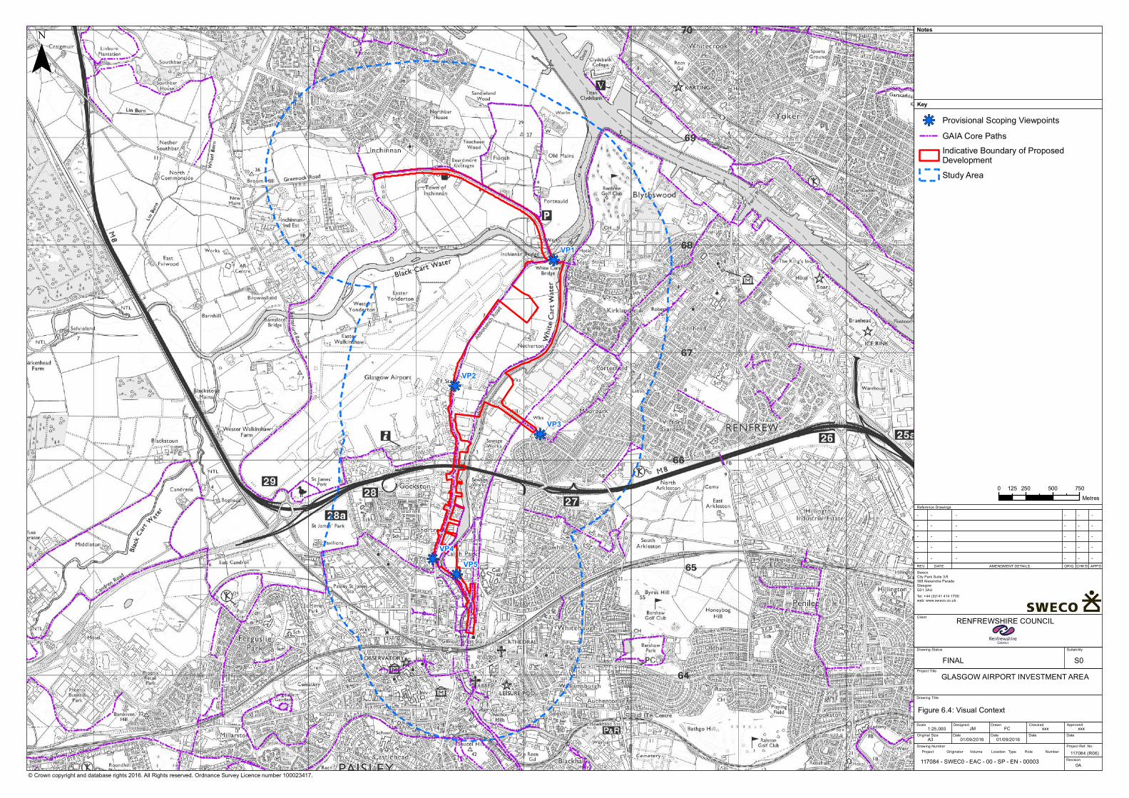
kj
kj
kj
kjkj
VP5VP4
VP3
VP2
VP1
© Crown copyright and database rights 2016. All Rights reserved. Ordnance Survey Licence number 100023417.
¯Key
Notes
Reference Drawings
REV. DATE AMENDMENT DETAILS ORIG CHK'D APP'D
GLASGOW AIRPORT INVESTMENT AREA
Client
Drawing Title
Drawing Status Suitability
Scale
Original Size
Designed
Date
Drawn
Date Date Date
ApprovedChecked
Project Ref. No.
Revision
Drawing Number
SwecoCity Park Suite 3/5368 Alexandra Parade GlasgowG31 3AUTel: +44 (0)141 414 1700web: www.sweco.co.uk
RENFREWSHIRE COUNCIL
1:25,00001/09/2016A3
Figure 6.4: Visual Context
117084 (R06)
JM FC xxx
- - ----
xxx
Project Title
01/09/2016
0A
- - ----- - ----- - ----- - ----
Project Originator Volume Location Type Role Number
kj Provisional Scoping ViewpointsGAIA Core PathsIndicative Boundary of ProposedDevelopmentStudy Area
0 250 500 750125Metres
117084 - SWEC0 - EAC - 00 - SP - EN - 00003
FINAL S0
Landscape and visual effects
58GLASGOW AIRPORTINVESTMENT AREASCOPING REPORT
6.4.2 Visual
Anticipated operational phase visual effects relate to change in the visual amenity of receptorssuch as those listed in Section 6.3.4. The assessment of change in visual amenity will focus onthe following aspects of the development:
· the loss of arable fields to the east of Glasgow Airport and the introduction of arealigned road;
· the introduction of new bridge crossings over the White Cart Water; and· changes to existing roads within the scheme corridor.
In addition to the operational phase visual effects, the proposed development is anticipated togive rise to visual effects during construction. Effects on the site and study area during theconstruction phase will be temporary but may last up to two years. The construction phasevisual assessment will focus on the changes to the visual amenity experienced by receptorswhich are unique to the construction phase, e.g. the introduction of: site compounds; heavymachinery; and lighting into people’s views.
6.5 Proposed Scope of AssessmentThe assessment will be carried out in accordance with the Guidelines for Landscape and VisualImpact Assessment Third Edition (GLVIA) as well as other current and relevant advisoryguidelines. The proposed draft methodology has been included within Appendix 1 which willform the basis of the LVIA.
Ecology and nature conservation
GLASGOW AIRPORTINVESTMENT AREA
SCOPING REPORT
59
7. Ecology and nature conservation
7.1 IntroductionThis section sets out the proposed approach to the assessment of potential ecological effectsof the proposed development, which has been undertaken in accordance with the Guidelinesfor Baseline Ecological Assessment19 and the Guidelines for Ecological Impact Assessment inthe UK20.
Specifically, this section seeks to:
· describe key consultation undertaken with statutory and non-statutory organisationsregarding the predicted ecological effects of the proposal;
· describe initial baseline conditions relevant to the proposed project and wider studyarea;
· present an initial assessment of the ecological effects associated with construction andoperation of the proposed project;
· describe outline mitigation proposed to ameliorate predicted ecological effects;· outline the proposed approach to the Ecological Impact Assessment (EcIA) (as part of
the wider EIA);· present the proposed survey methods that will be used to generate ecological and
baseline information for the EcIA; and· present a justification for predicted significant effects to be scoped out of the EcIA.
7.2 ConsultationA range of organisations have been consulted to date. The results of the consultation process,are summarised below (Table 7.1).
Table 7.1: Consultation Responses
Consultee Response/Action DataProvided
Action Taken
ClydeAmphibian andReptile Group
Advised the group does not hold up-to-daterecords and that contact should be made withGlasgow Museums Biological Records Centreregarding relevant amphibian and reptile datafor the search area.
No No action required.
Clyde BatGroup
No response received to date. No No action required.
GlasgowMuseumsBiologicalRecordsCentre
Advised the organisation holds records and thata search could be undertaken subject to anadditional fee.
Yes Additional costs wereapprovad; data is describedbelow will be presented inthe EIA.
19 IEMA (1995) Guidelines for Baseline Ecological Assessment. Institute of Environmental Management & Assessment20 CIEEM (2016) Guidelines for Ecological Impact Assessment in the UK and Ireland
Ecology and nature conservation
60GLASGOW AIRPORTINVESTMENT AREASCOPING REPORT
Consultee Response/Action DataProvided
Action Taken
MarineScotland
Marine Scotland confirmed use of the RiverClyde and Black and White Cart Waters bydiadromous fish including: Atlantic salmon, seatrout, river lamprey and European eel. As part oftheir response, use of the rivers as spawningstaging areas was noted, in addition to arequirement to account for effects to thesespecies. In addition, Marine Scotland noted arequirement for screening of Likely SignificantEffects (LSE) associated with the Endrick WaterSpecial Area of Conservation (SAC) andproximity of the Inner Clyde and Black CartWater SPA.
n/a Following meeting MSconfirmed fish surveys in theClyde would not be neededand that the proposedapproach to HRA Screening(for Endrick Water SAC) wasacceptable. An HRAScreening appraisal will beundertaken and reported toMS and SNH
RenfrewBiologicalRecords
Advised the organisation holds records butcould not access them due to on-going IT issues.The group stated that Glasgow MuseumsBiological Records centre hold all of their dataand to contact this organisation regarding therequest.
No No action required.
River ClydeFoundation
Advised the group does not hold up-to-daterecords and that contact should be made withGlasgow Museums Biological Records Centreregarding relevant amphibian and reptile data.
No See above under ‘GlasgowMuseums Biological RecordsCentre’
RSPB Advised the charity holds records and that asearch could be undertaken subject to anadditional fee.
Yes Additional costs wereapprovad; data is describedbelow will be presented inthe EIA
ScottishBadgers
The group confirmed the existence of onerecorded within 1km of the search area andrecommended a survey is carried out.
n/a Surveys for badger will beundertaken to inform anassessment of theconstruction and operationaleffects as part of the EIA.
ScottishNaturalHeritage
SNH initially provided a response confirming apotential requirement to take into accountimpacts to designated sites, protected speciesand birds. Subsequent consultation hasconfirmed a Habitats Regulation Appraisal is notrequired in respect to the Black Cart WaterSpecial Protection Area (SPA) but that protectedSpecies and development licences may berequired at a later stage in the project.
n/a Information will be taken intoconsideration as part of EIA.
ScottishOrnithologistClub
Initial information request is still beingprocessing within the organisation as of18/03/16.
Pending No action required.
ScottishWildlife Trust
The group confirmed they only hold/issue datarelevant to their nature reserves and as thereare no reserve within the search area, no furtherexchange is anticipated.
n/a No action required.
Consultation undertaken for the project to date has provided clear advice and direction, inaddition to sufficient background information for the purpose of the assessment of ecologicaleffects. Therefore, no additional consultation is proposed as part of the EIA process other thanfor agreement of HRA screening for the Endrick Water SAC.

Ecology and nature conservation
GLASGOW AIRPORTINVESTMENT AREA
SCOPING REPORT
61
7.2.1 Glasgow Museums Biological Records Centre
Consultation with Glasgow Museums Biological Records Centre provided biological records fora 5km search area extending from the centre of the DMRB Stage 2 Study Area.
Records of common toad (Bufo bufo), common frog (Rana temporaria) and palmate newt(Lissotriton helveticus) were common throughout the search area, in addition to eight recordsof great crested newt (Triturus cristatus), which were specifically noted by Glasgow MuseumsBiological Records Centre as being questionable in terms of the reliability and veracity of thesource information. Regardless, the nearest great crested newt record (centred in BarshawPark) is located approximately 3.5 km to the proposed project, in-between an area of denselypopulated urban settlement.
Historical records of marine mammal were recorded within the vicinity of the proposed optioncrossings, these comprised: common seal (Phoca vitulinax), grey seal (Halichoerus grypus) andcommon porpoise (Phocoena phocoena). However, it should be noted that the records werenoted to be in excess of 20 years old.
In addition, records of seven terrestrial mammal species were provided for the search area, asoutlined in Table 7.2 below.
Table 7.2: Records of Terrestrial Mammals
Species No of Records Date Location
Badger (Meles meles) 7 2003-2010 Confidential
Brown long-eared bat (Plecotus auritus) 4 1904 - 1989 -
Common pipistrelle (Pipistrellus pipistrellus) 13 1986 - 2010 -
Daubenton’s bat (Myotis daubentonii) 1 1992 Glasgow airport
Otter (Lutra lutra) 10 1935 - 2015 -
Soprano pipistrelle (Pipistrellus pygmaeus) 1 2008 -
Water vole (Arvicola amphibius) 27 1977 - 2009 -
Records of 3,936 bird species were provided for the search area, which included 33 bird specieslisted on Schedule 1 of the Wildlife and Countryside Act 1981 (as amended).
7.2.2 RSPB
Consultation with the RSPB provided 2,762 biological records for a 5 km search area extendingfrom the proposed project. Of the records provided, 17 were provided in respect to birdspecies listed on Schedule 1 of the Wildlife and Countryside Act 1981 (as amended), in additionto records of the following mammal species:
· brown hare (Lepus europaeus);· soprano pipistrelle; and· European hedgehog (Erinaceus europaeus).
Consultation undertaken in line with DMRB Stage 2 Assessment methodology, provided clearadvice and direction, in addition to sufficient background information for the purpose of theassessment of ecological effects and therefore no additional consultation is proposed as part ofthe EIA process.
Ecology and nature conservation
62GLASGOW AIRPORTINVESTMENT AREASCOPING REPORT
7.3 Baseline Description
7.3.1 Site Description
The proposed development lies within an area comprising a mosaic of mixed residentialhousing and industrial businesses, interspersed by amenity areas, parkland, areas of semi-natural habitat, running water (the Black Cart Water and the White Cart Water – tributaries tothe River Clyde) and hard-standing.
7.3.2 Desk Study
A search of publically available data21 has been undertaken to inform earlier stages of theproject. This has been used to inform the scope of the ecological assessment. The searchestablished a number of European and nationally important sites designated for ecologicalconsiderations within proximity of the proposals, which are described below.
7.3.2.1 Nature Conservation Sites
There are no statutory designated sites within the red line boundary. However within 2km, twostatutory designated sites of international importance (the Inner Clyde SPA and Inner ClydeRamsar Site) were identified within 10 km of the proposed project, in additional to twonationally important sites (the Inner Clyde and Black Cart Water SSSI) recorded within 2 km ofthe proposed project (see Figure 7.1; Table 7.3).
Table 7.3: Statutory Designated Sites
Site Name Designation Grid Reference Size Distance from Site
Inner Clyde SPA, SSSI NS 482 702 1825.29 ha 1.34 km (west)
Inner Clyde Ramsar site NS 482 702 1824.29 ha 1.48 km (west)
Black Cart Water SPA/SSSI NS 468 670 56 ha 0.31 km (west)
Two of the sites (the Inner Clyde SPA and Black Cart SPA) receive statutory protection underthe European Union (EU) Directive on the Conservation of Wild Birds (79/409/EEC). Incomparison, SSSIs receive statutory protection under the Wildlife and Countryside Act 1981 (asamended), while Ramsar Sites receive protection under the Convention on Wetlands ofInternational Importance, which came in to force in December 1975.
The Inner Clyde SSSI/SPA is designated under Article 4.1 of the Directive (79/409/EEC) bysupporting populations of European importance of the following species listed on Annex I ofthe Directive (redshank (Tringa tetanus), 1,918 individuals representing at least 1.3% of thewintering Eastern Atlantic - wintering population (winter peak mean)).
The Black Cart SSSI/SPA is designated under Article 4.1 of the Directive (79/409/EEC) bysupporting populations of European importance of the following species listed on Annex I ofthe Directive (whooper Swan (Cygnus Cygnus), 220 individuals representing at least 4.0% of thewintering population in Great Britain (early 90s winter peak mean)).
21 Including SNH (2016) Information Database at http://www.snh.gov.uk/publications-data-and-research/snhi-information-service
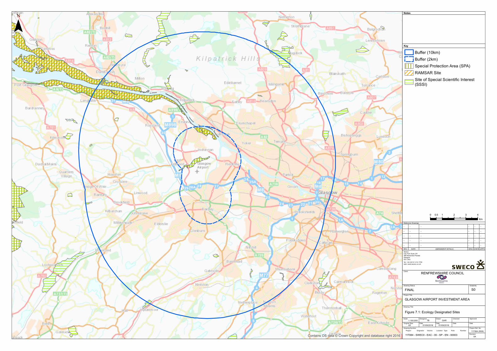
Contains OS data © Crown Copyright and database right 2016
¯Key
Notes
Reference Drawings
REV. DATE AMENDMENT DETAILS ORIG CHK'D APP'D
GLASGOW AIRPORT INVESTMENT AREA
Client
Drawing Title
Drawing Status Suitability
Scale
Original Size
Designed
Date
Drawn
Date Date Date
ApprovedChecked
Project Ref. No.
Revision
Drawing Number
SwecoCity Park Suite 3/5368 Alexandra Parade GlasgowG31 3AUTel: +44 (0)141 414 1700web: www.sweco.co.uk
RENFREWSHIRE COUNCIL
1:100,00001/09/2016A3
Figure 7.1: Ecology Designated Sites
117084 (R06)
TB GAR
- - ----
Project Title
01/09/2016
0A
- - ----- - ----- - ----- - ----
Project Originator Volume Location Type Role Number
Buffer (10km)Buffer (2km)Special Protection Area (SPA)RAMSAR SiteSite of Special Scientific Interest(SSSI)
0 1 2 3 40.5Km
117084 - SWEC0 - EAC - 00 - SP - EN - 00003
FINAL S0
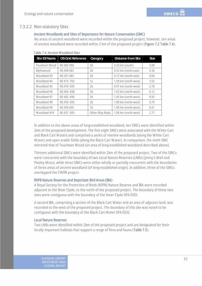
Ecology and nature conservation
GLASGOW AIRPORTINVESTMENT AREA
SCOPING REPORT
63
7.3.2.2 Non-statutory Sites
Ancient Woodlands and Sites of Importance for Nature Conservation (SINC)No areas of ancient woodland were recorded within the proposed project; however, ten areasof ancient woodland were recorded within 2 km of the proposed project (Figure 7.2 Table 7.4).
Table 7.4: Ancient Woodland Sites
Site ID/Name OS Grid Reference Category Distance from Site Size
Teucheen Wood NS 482 690 2b 0.20 km (south) 5.09
Blythswood NS 498 682 2b 0.52 km (north-east) 4.36
Woodland #3 NS 501 683 2b 0.72 km (north-east) 4.64
Woodland #4 NS 473 702 1a 1.58 km (north-west) 2.52
Woodland #5 NS 470 695 2b 0.91 km (north-west) 2.76
Woodland #6 NS 464 698 2b 1.62 km (north-west) 6.12
Woodland #7 NS 462 696 2b 1.45 km (north-west) 8.92
Woodland #8 NS 459 695 2b 1.80 km (north-west) 0.79
Woodland #9 NS 458 695 1b 1.90 km (north-west) 0.61
Woodland #10 NS 457 695 Other (Roy Map) 1.96 km (north-west) 2.71
In addition to the above areas of long-established woodland, ten SINCs were identified within2km of the proposed development. The first eight SINCs were associated with the White Cartand Black Cart Waters and comprised a series of riverine woodlands (along the White CartWater) and open arable fields (along the Black Cart Water). In comparison, the ninth SINCmirrored that of Teucheen Wood (an area of long-established woodland described above).
Thirteen additional SINCs were identified within 2km of the proposed project. Two of the SINCswere concurrent with the boundary of two Local Nature Reserves (LNRs) (Jenny’s Well andPaisley Moss), while three SINCs were either wholly or partially concurrent with the boundariesof three areas of ancient woodland (of long-established origin). In addition, three of the SINCsoverlapped the CWRR project.
RSPB Nature Reserves and Important Bird Areas (IBA)A Royal Society for the Protection of Birds (RSPB) Nature Reserve and IBA were recordedadjacent to the River Clyde, to the north of the proposed project. The boundary of these twosites were contiguous with the boundary of the Inner Clyde SPA/SSSI.
A second IBA, comprising a section of the Black Cart Water and an area of adjacent land, wasrecorded to the west of the proposed project. The boundary of this site was noted to becontiguous with the boundary of the Black Cart Water SPA/SSSI.
Local Nature ReservesTwo LNRs were identified within 2km of the proposed project and are designated for theirlocally important habitats that support a range of flora and fauna (Table 7.5).
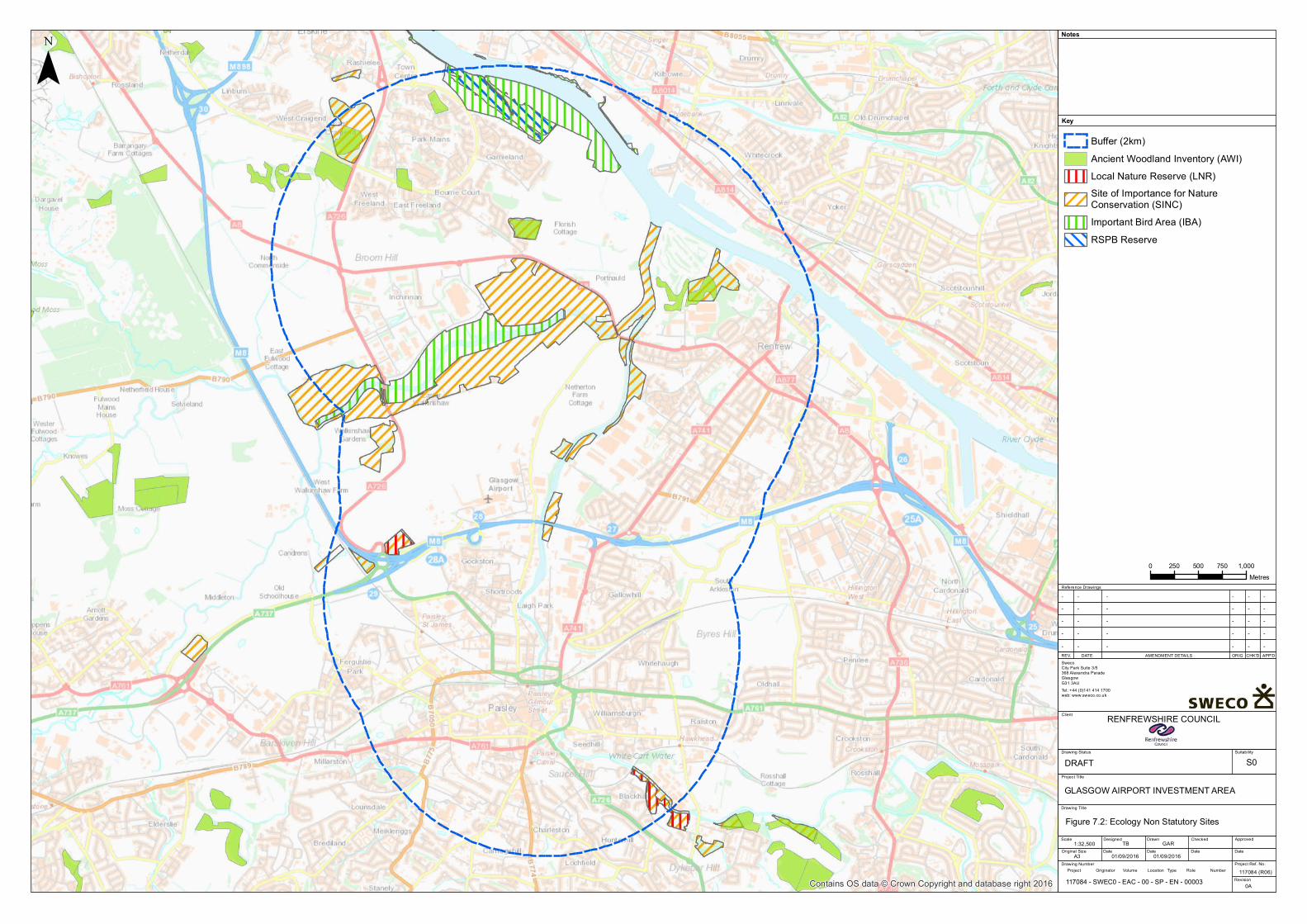
Contains OS data © Crown Copyright and database right 2016
¯Key
Notes
Reference Drawings
REV. DATE AMENDMENT DETAILS ORIG CHK'D APP'D
GLASGOW AIRPORT INVESTMENT AREA
Client
Drawing Title
Drawing Status Suitability
Scale
Original Size
Designed
Date
Drawn
Date Date Date
ApprovedChecked
Project Ref. No.
Revision
Drawing Number
SwecoCity Park Suite 3/5368 Alexandra Parade GlasgowG31 3AUTel: +44 (0)141 414 1700web: www.sweco.co.uk
RENFREWSHIRE COUNCIL
1:32,50001/09/2016A3
Figure 7.2: Ecology Non Statutory Sites
DRAFT S0
117084 (R06)
TB GAR
- - ----
Project Title
01/09/2016
0A
- - ----- - ----- - ----- - ----
Project Originator Volume Location Type Role Number
Buffer (2km)Ancient Woodland Inventory (AWI)Local Nature Reserve (LNR)Site of Importance for NatureConservation (SINC)Important Bird Area (IBA)RSPB Reserve
0 250 500 750 1,000Metres
117084 - SWEC0 - EAC - 00 - SP - EN - 00003

Ecology and nature conservation
64GLASGOW AIRPORTINVESTMENT AREASCOPING REPORT
Table 7.5: Local Nature Reserves
SiteID/Name
OS GridReference
Distancefrom Site
Size(ha)
Site Information
Jenny’s Well NS 497 630 0.91 km(south-east)
8.17 The LNR was designated in 1986 and is notified for itsflora (oaks) and fauna (song birds).
Paisley Moss NS 469 657 0.52 km(west)
4.02 The LNR was designated in 1993 and supports ponds,mossy marshes, reeds and sedge beds. The site is knownfor its wintering jack snipe (Lymnocryptes minimus),common snipe (Gallinago gallinago) , 22 different types ofgrass and 11 types of sedge, marsh orchids (Dactylorhizamajalis) and the common blue butterfly (Polyommatusicarus)
7.3.2.3 Protected Species Records
Records for protected and notable species were identified by interrogating online data sourcesfor the 10km Ordnance Survey (OS) Grid (NS46, NS47, NS56, NS57).
Sixty-four protected and/or notable bird species were identified, the desk study identified fourspecies which are afforded protection under Annex 1 of the Birds Directive (barnacle goose(Branta leucopsis), kingfisher (Alcedo atthis), merlin (Falco columbarius) and white-tailed eagle(Haliaeetus albicilla)) and seven species offered protection under Schedule 1 of the Wildlife andCountryside Act 1981 (as amended) (barn owl (Tyto alba), common crossbill (Loxia curvirostra),fieldfare (Turdus pilaris), kingfisher, merlin, redwing and white-tailed eagle). Similarly, and withrespect to bird species of conservation concern/priority, the desk study identified thefollowing:
· twenty-three bird species listed as an action species within the historical UK BAP22;· twenty-six species listed as Red List Species of Conservation Concern23; and· one species (lesser whitethroat) listed as an action species within the LBAP.
Ten protected/notable mammal species were recorded by the desk study. The first species(badger) is afforded specific legal protection under the Protection of Badger Act 1992 (asamended) and Wildlife and Countryside Act 1981 (as amended), while all species of bat, otterand pine marten (Martes martes) are fully protected under the Conservation (Natural Habitat&c) Regulations 1994 (as amended). Although red squirrel (Sciurus vulgaris) and water vole arenot afforded protection at a European level, unlike bats and otters, they are affordedprotection under the Wildlife and Countryside Act 1981 (as amended), in addition to brownhare, hedgehog and pine marten.
22 The UK Government (1992) The UK Biodiversity Action Plan (http://jncc.defra.gov.uk)23 Eaton M A, Aebischer N J, Brown A F, Hearn R, Lock L, Musgrove A J, Noble D G, Stroud D and Gregory D (2015) Birds ofConservation Concern 4: the population status of birds in the United Kingdom, Channel Islands and the Isle of Man. BritishBirds 108, pp 708-746

Ecology and nature conservation
GLASGOW AIRPORTINVESTMENT AREA
SCOPING REPORT
65
Similarly, and with respect to mammal species of conservation concern/priority, the desk studyidentified the following:
· seven species (hedgehog, brown hare, otter, water vole, pine martin, red squirrel andsoprano pipistrelle) listed as an action species within the historical UK BAP; and
· five species (brown hare, common pipistrelle, otter, soprano pipistrelle and water vole)listed as an action species within the LBAP.
One single protected amphibian species (great crested newt) was recorded by the desk study,which receives strict protection under the Conservation (Natural Habitat &c) Regulations 1994(as amended) and Wildlife and Countryside Act 1981 (as amended). This species is additionallysubject to a UK BAP.
7.3.2.4 Invasive non-native Species
Records of the following invasive/non-native species were identified by the desk study:
· Japanese knotweed (Fallopia japonica);· giant hogweed (Heracleum mantegazzianum); and· Himalayan balsam (Impatiens glandulifera).
7.4 Potential EffectsThe key ecology and nature conservation impacts with respect to the proposed project arelikely to include the following:
· Construction:
- direct mortality of fauna during construction;
- habitat loss (temporary and permanent) through land-take;
- fragmentation of existing habitats;
- disturbance and displacement during construction;
- pollution to water courses from runoff during development phases;
- point source and diffuse pollution;
- increased sediment loading;
- decreased habitat complexity; and
- changes to discharge regime.
· Operation:
- direct mortality of fauna during operation;
- behavioural changes of fauna during operation;
- fragmentation of existing habitats;
- disturbance and displacement during operation;
- pollution to water courses from road drainage;
- point source and diffuse pollution;
- increased sediment loading;
Ecology and nature conservation
66GLASGOW AIRPORTINVESTMENT AREASCOPING REPORT
- decreased habitat complexity; and
- changes to discharge regime.
7.5 Proposed Scope of AssessmentIn accordance with the CIEEM EcIA good practice guidance24, the Ecology and NatureConservation Chapter of the ES will present the results of consultation and a detailed desk-study, in addition to a description of the habitats and fauna baseline for the proposed projectand wider ecological study area (the zone of influence). The findings of the survey work will beanalysed and presented (where appropriate) in a technical report providing baseline conditionsand summarised as part of the chapter.
Activities during the construction and operational phases and their predicted impactsignificance on important ecological features, such as protected species, will be identified andcharacterised at the geographical scale at which they are significant taking into account thefollowing parameters:
· positive or negative;· magnitude;· extent;· duration;· reversibility; and· timing and frequency.
Following the determination and assessment of predicted significant ecological effects,professional judgement will be used, coupled with an understanding of important ecologicalfeatures and legal requirements, to determine the requirements for appropriate mitigation.Mitigation will be proposed (where practicable) at the relevant geographical scale ofsignificance to avoid, reduce or offset identified potential effects.
Residual effects will be assessed using the same methodology for the assessment of predictedecological effects but taking into consideration committed mitigation. In addition and whereapplicable, an assessment of predicted cumulative ecological effects will be undertaken asdiscussed in Chapter 13.
7.5.1 Study Area
Field surveys will be undertaken within all suitable areas of the proposed project and a widerstudy area (outside the proposed project), which varied in width relevant to the importantecological feature.
Further information regarding the width of the pertinent study area is presented below:
· Extended Phase 1 Habitat (the proposed project and adjacent area up to 100m fromthe outmost edge of development);
· badger survey (the proposed project and adjacent area up to 100m from the outmostedge of development);
24 CIEEM. (2016). Guidelines for Ecological Impact Assessment in the UK and Ireland. Accessed: July 2016. Available at:http://www.cieem.net/ecia-guidelines-terrestrial-. Accessed: July 2016.
Ecology and nature conservation
GLASGOW AIRPORTINVESTMENT AREA
SCOPING REPORT
67
· otter survey (the proposed project and 250 m up and downstream of freshwaterhabitats);
· water vole survey (the proposed project and 100-200m up and downstream offreshwater habitats); and
· bat survey (the proposed project and adjacent area, between 20-100m from theoutmost edge of development).
It should be noted that, where applicable, the relevant study area will be extended to provide agreater level of ecological understanding regarding the ecological effects on an importantecological feature. Further details of survey methodology is contained within Appendix 7.1.
7.5.2 Matters to be scoped out of the Ecological Assessment
7.5.2.1 Baseline Surveys
It is considered that there is sufficient evidence to show that there are unlikely to be significanteffects on Great Crested Newts, breeding birds and fresh water fish species or habitats, andtherefore no further surveys are proposed for these as part of the assessment of ecologicaleffects. This approach has been agreed in consultation with SNH and Marine Scotland. Basedon our current understanding of the site and informed by Phase 1 habitat survey work it is alsoconsidered that NVC surveys are not required and have therefore been scoped out of the EIA.
7.5.2.2 Habitat Regulations Appraisal (HRA)
Consultation with SNH in April 2016 (Dave Laing – Operations Officer, Pers. Com., 19 April2016) confirmed an absence of Likely Significant Effects (LSE) between the proposed projectand the Black Cart Water SPA and Inner Clyde SPA. Consequently, a Habitats RegulationsAppraisal (HRA) will not be required in support of the proposed project for these sites.
An HRA Screening appraisal will be undertaken to assess the potential for LSE of the proposalson the Endrick Water SAC following consultation with Marine Scotland (see Section 7.2).

Archaeology and Cultural Heritage
68GLASGOW AIRPORTINVESTMENT AREASCOPING REPORT
8. Archaeology and Cultural Heritage
8.1 IntroductionThis section sets out the approach to assessing impacts of the proposals on the historicenvironment, including designated heritage assets (Scheduled Monuments, Listed Buildings,World Heritage Sites, Conservation Areas, Inventory Gardens and Designed Landscapes,Inventory Historic Battlefields) and other undesignated features of cultural significance.Specifically, this section aims to address the topic as follows:
· summarise consultation carried out to date during the options assessment, and identifyfurther consultation which will take place as part of the EIA;
· provide a high-level summary of baseline conditions relating to the historicenvironment;
· identify potential effects based on the high-level baseline study previously undertaken;· set out the scope of the desk-based assessment which will be undertaken to provide
detailed cultural heritage baseline data and identify all potential effects arising fromthe proposed development;
· describe proposed mitigation measures; and· describe the methodology which will be applied in assessing any residual effects.
8.2 ConsultationHistoric Environment Scotland (HES) and West of Scotland Archaeology Service (WoSAS) wereconsulted for initial comments on the proposals (see Table 8.1).
Table 8.1 Consultation to Date
Consultee Response/Action DataProvided
ActionTaken
HistoricEnvironmentScotland
Letters dated 29 January and 15 April 2016 noted presence of a numberof Category A Listed Buildings and a Scheduled Monument within thestudy area.Site meeting, 26 May 2016: confirmed the importance of the CategoryA listed bridges over the White Cart Water and Black Cart Water andthe potential for sensitive archaeology between the A8 Greenock Roadand the Scheduled Monument at All Hallows Church, Inchinnan.
No No actionrequired
West ofScotlandArchaeologyService
Meeting in April 2016: identified a number of areas of archaeologicalinterest within the study area, where early investigation may beworthwhile; and suggested a number of historic locations/themes thatcould be enhanced by providing information to visitors, with theinvolvement of Renfrewshire Local History Forum.Letter dated 24 May 2016: identified a number of heritage assets in thevicinity of the route options where potential impacts may requiremitigation through archaeological investigation and recording.Site meeting, 26 May 2016: confirmed the importance of the CategoryA listed bridges over the White Cart Water and Black Cart Water andthe potential for sensitive archaeology between the A8 Greenock Roadand the Scheduled Monument at All Hallows Church, Inchinnan.
No No actionrequired

Archaeology and Cultural Heritage
GLASGOW AIRPORTINVESTMENT AREA
SCOPING REPORT
69
The following organisations will be consulted during the preparation of the EnvironmentalStatement:
· Historic Environment Scotland (HES), regarding Scheduled Monuments and Category AListed Buildings;
· West of Scotland Archaeology Service (WoSAS), regarding archaeological remains,whether designated or not;
· Renfrewshire Council Buildings Conservation, regarding Listed Buildings andConservation Areas; and
· Renfrewshire Local History Forum, regarding any aspect of cultural heritage, andparticularly where there may be opportunities to enhance community involvement.
Consultees will be invited to comment on potential impacts identified through a desk-basedassessment, and on mitigation proposals.
8.3 Baseline Description
8.3.1 Baseline data sources
A high-level baseline study has been carried out for the proposed development, the findings ofwhich are described in this section. This study aims to support the identification of anypotentially significant effects on cultural heritage assets under the three sub-topics identified inDMRB guidance (archaeological remains, historic buildings and historic landscapes), based on areview of the following data sources:
· heritage designations (Scheduled Monuments, Listed Buildings, Conservation Areas,Inventory Gardens and Designed Landscapes and Inventory Historic Battlefields);
· archaeological records in the West of Scotland Archaeology Service HistoricEnvironment Record (WoSAS HER); and
· archaeological records in the National Monuments Record of Scotland (NMRS).
Figures 8.1 and 8.2 show the heritage designations and archaeologically sensitive areasidentified within the study area defined for the proposed development. The archaeologicallysensitive areas are defined through professional judgment as areas where it is considered thatthere is potential for significant impacts on archaeological remains.
8.3.2 Archaeological Remains
8.3.2.1 Designated heritage assets
There is one Scheduled Monument located within the study area defined for the proposeddevelopment: Inchinnan, site of All Hallows Church (SM2792). This is the location of an earlyChristian monastic site and of at least three successive churches built between the medievalperiod and the late 19th century. The late 19th century All Hallows Church was demolished in1965 to accommodate the expansion of Glasgow Airport. Only parts of the church’sfoundations are visible above ground level, and its cultural significance relates mainly to thearchaeological research potential of site, including remains of the medieval church, monasticstructures and burials.

EE
EE
EEEEE
E
E
E
E
E
E
E
E
E
EE
E
E
EEE
E
EEEE
E
E EE
EEE
E
E
E E
E
E
E
EE EE
E
E
E
E
E
E EEEE
E
EEE
E
E E
EE
EE
E
E
E
E
E
EEEE
EE
EE
E
E
E
E
E
EE
E
EE
EE
E
E
E
E
E
EE
E
EEE
EE
E
E
EEE
EEE
LB40423
LB40425
LB13459
LB12732
LB40424
LB12729
SM1655
SM2792
Knock
Paisley town centre
Paisley:Riverside Industry
Kirkton of Inchinnan
Paisley Town CentreConservation Area
GreenlawConservation Area
¯Key
Notes
Reference Drawings
REV. DATE AMENDMENT DETAILS ORIG CHK'D APP'D
GLASGOW AIRPORT INVESTMENT AREA
Client
Drawing Title
Drawing Status Suitability
Scale
Original Size
Designed
Date
Drawn
Date Date Date
ApprovedChecked
Project Ref. No.
Revision
Drawing Number
SwecoCity Park Suite 3/5368 Alexandra Parade GlasgowG31 3AUTel: +44 (0)141 414 1700web: www.sweco.co.uk
RENFREWSHIRE COUNCIL
1:20,00001/09/2016A3
Figure 8.1: Heritage Designations and Areas of Archaeological Sensitivity
DRAFT S0
117084 (R06)
PM LG
Project Title
01/09/2016
0A
Project Originator Volume Location Type Role Number
GAIA core study area
ECategory A listed building (LBXX)(Historic Environment Scotland data 2016)
ECategory B listed building (LBXX)(Historic Environment Scotland data 2016)
ECategory C listed building (LBXX)(Historic Environment Scotland data 2016)Scheduled monument (SMXX)(Historic Environment Scotland data 2016)Conservation area(Historic Environment Scotland data 2016)Archaeological sensitivity
0 250 500 750125Metres
© Crown copyright and database rights 2016. All Rights reserved. Ordnance Survey Licence number 100023417.Contains Historic Environment Scotland and Ordnance Survey data © Historic Environment Scotland - Scottish Charity No. SC045925 © Crown copyright and database right 2016
117084 - SWEC0 - EAC - 00 - SP - EN - 00003
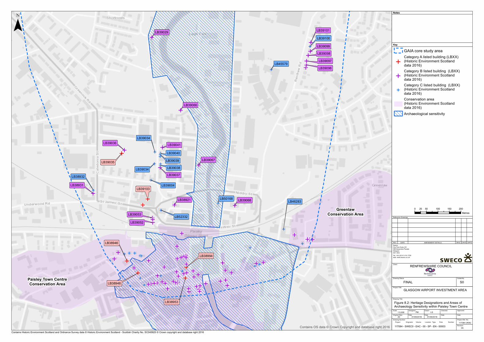
E
E
E
E
EEE
EE
E
E
E
E
E
E
EE
E
E
EEE
E
EEEE
E
EEE
EE
E
E
E
E E
E
E
E
EE
E
E
E
E
E
E
EE
EEE
E
EE
E
E
EE
E
E
E
E
E
E
E
EEE
E
E
EE
E
E
E
E
E
EE
E
EE
E
E
E
E
E
E
EE
E
E
EE
E E
E
E
E E
E
E
EE
LB39037
LB39101
LB39052
LB39067
LB38921
LB39036
LB39097
LB39068
LB39041
LB39098
LB39066
LB39029
LB39096
LB38931
LB39053
LB39099
LB38946
LB39035
LB52332
LB39034
LB39100
LB50168
LB39034
LB38932
LB45579
LB46283
LB39004
LB39040LB39039LB39038
LB38994
LB38948
LB38953
LB39103
Paisley Town CentreConservation Area
GreenlawConservation Area
Contains OS data © Crown Copyright and database right 2016
¯Key
Notes
Reference Drawings
REV. DATE AMENDMENT DETAILS ORIG CHK'D APP'D
GLASGOW AIRPORT INVESTMENT AREA
Client
Drawing Title
Drawing Status Suitability
Scale
Original Size
Designed
Date
Drawn
Date Date Date
ApprovedChecked
Project Ref. No.
Revision
Drawing Number
SwecoCity Park Suite 3/5368 Alexandra Parade GlasgowG31 3AUTel: +44 (0)141 414 1700web: www.sweco.co.uk
RENFREWSHIRE COUNCIL
1:5,00001/09/2016A3
Figure 8.2: Heritage Designations and Areas of Archaeology Sensitivity within Paisley Town Centre
117084 (R06)
PM LG
Project Title
01/09/2016
0A
Project Originator Volume Location Type Role Number
GAIA core study area
ECategory A listed building (LBXX)(Historic Environment Scotland data 2016)
ECategory B listed building (LBXX)(Historic Environment Scotland data 2016)
E
Category C listed building (LBXX)(Historic Environment Scotland data 2016)Conservation area(Historic Environment Scotland data 2016)Archaeological sensitivity
0 50 100 150 20025Metres
Contains Historic Environment Scotland and Ordnance Survey data © Historic Environment Scotland - Scottish Charity No. SC045925 © Crown copyright and database right 2016117084 - SWEC0 - EAC - 00 - SP - EN - 00003
FINAL S0

Archaeology and Cultural Heritage
70GLASGOW AIRPORTINVESTMENT AREASCOPING REPORT
Three sculptured stones, originally from All Hallows Church, were removed when it wasdemolished and are now in an enclosure adjacent to the modern parish church, where they aredesignated as a Scheduled Monument (SM1655).
8.3.2.2 Undesignated heritage assets
Paisley town centre: An area of archaeological sensitivity corresponds to the area mapped inWoSAS HER for Paisley (WoSASPIN 7730), and includes the pre-industrial town whichdeveloped from a medieval core around the east end of the High Street and the north end ofCauseyside, as well as the abbey to the east of the river.
Paisley - riverside industry and harbour: The riverside north of Old Sneddon Street / Weir Streethas a particularly high concentration of industrial sites recorded in the WoSAS HER, includingquays, ironworks and textile mills. Paisley was a notable industrial centre in the 18th-19thcentury, and significant industrial archaeology dating from this period may exist in this area.Structures relating to the harbour may also have archaeological interest.
Knock: A number of antiquities are recorded on the 1st edition OS map in the vicinity of Knock,a farmstead situated on Knock Hill which may have replaced an earlier manor house(WoSASPIN 42630). Cinerary urns were found near the summit of Knock Hill in the late 18thcentury (WoSASPIN 7651) and further east are the sites of a possible motte ‘Kemp Knowe’(WoSASPIN 7621) and a high cross known as ‘Queen Blearie’s Stone’ (WoSASPIN 7620). Novisible features relating to these heritage assets are likely to survive, and much of the area isnow covered by housing developments; nevertheless the presence of these features suggestsan area of importance in prehistoric and medieval times.
Kirkton of Inchinnan (WoSASPIN 62749): A small settlement is shown beside All Hallows’ Churchon Roy’s Military Survey (1747-52). The area indicated on the constraints map corresponds tothe record for this site in the WoSAS HER. There is potential for medieval or post-medievalsettlement remains within this area, associated with the Scheduled monastery and church.
8.3.3 Historic Buildings
The study area for the proposed development includes parts of Paisley Town Centre andGreenlaw Conservation Areas. A Character Appraisal has been published for the Paisley TownCentre Conservation Area, though not for Greenlaw. Paisley’s origins are linked to the medievalAbbey established on the east bank of the White Cart Water, at an important crossing point. Atown developed on the west bank, which in the medieval period was small and subordinate toRenfrew, but expanded rapidly in the 19th century as a manufacturing centre. Its expansionwas not formally planned, giving the town an irregular street plan and a varied appearance.
The Character Appraisal document identifies a number of distinctive areas within theConservation Area. The riverside area around the Abbey and Town Hall is dominated by thesetwo monumental buildings and contains much green space which contrasts with the adjacentcity centre. The High Street, with Paisley Cross and County Square at the east end, was theprincipal street of the medieval town and retains its central function today. Oakshaw Street,occupying an east/west ridge above the High Street, has a quieter residential character with anumber of landmark buildings which form a varied skyline particularly looking north over thetown from viewpoints such as Saucel Hill. Moss Street, running north from County Square, is astreet with late medieval origins which, unlike others, was not widened in the 19th century.
Archaeology and Cultural Heritage
GLASGOW AIRPORTINVESTMENT AREA
SCOPING REPORT
71
New Street and George Street, to the south of the High Street, retain much of their originalGeorgian character, while Causeyside Street, a principal approach to the town from the south,has an urban character created by four-storey tenements with eye-catching corner features.
Paisley town centre contains numerous Listed Buildings; within the Conservation Area, onlyCategory A Listed Buildings within the study area are shown in Figure 8.2. These include theHigh Church on Oakshaw Street (LB38946), Middle Church on Church Hill, Clydesdale Bank at 7Gilmour Street (LB38994), and The Cross war memorial (LB38953). Other Listed Buildingsinclude churches and church halls, schools, commercial premises and shops, statues, therailway station and private houses.
Greenlaw Conservation Area includes an area which developed as a residential suburb ofPaisley during the 19th century, including a Category B Listed Georgian terrace on GarthlandPlace.
Other Listed Buildings within the 19th century town, to the north of the Conservation Area,include the Category A Listed fountain in Fountain Gardens (LB39035) and the Classical-styleSheriff Court (LB39103). North of the town centre, on Renfrew Road (A741) are a row of 18thand 19th century houses which originally formed a separate settlement called Gateside.
There are three Category A Listed bridges on Inchinnan Road (A8) where it crosses the WhiteCart Water and the Black Cart Water west of Renfrew. Inchinnan Bridge (HB 12732) and WhiteCart Bridge (HB 40424) are stone bridges with multiple arches, both of which were built in 1812in a similar style. The Rolling Lift Bridge over the White Cart Water (HB 40425), built in 1924, isthe only lifting bridge of this type in Scotland and therefore represents an important element ofindustrial/engineering heritage. The setting of all three bridges is experienced principally interms of short-range views along and across the rivers and the approaches along the road.
Close to the White Cart Water on the north side of Inchinnan Road, the ‘Argyll Stone’ and ‘StConval’s Chariot’ (HB 40423) are respectively the base of a medieval cross, and a graniteboulder (on which St Conval was said to have floated across the Irish Sea). They are enclosed byornate cast iron railings, within wooded gardens in the grounds of the Normandy Hotel. Thesetting of this Listed Building is limited to these gardens.
India Tyre Factory, Greenock Road, Inchinnan (HB 13459) is a Category A Listed Art Deco styleoffice for a former tyre factory, located on the south side of the A8. Town of Inchinnan Farm(HB 12729) is a plain farmhouse built ca 1800, currently a working farm surrounded byfarmland.
8.3.4 Historic Landscapes
The Scotland Historic Land Use Map (HLAMap25) identifies one area of historic landscape withinthe study area, corresponding to the medieval town of Paisley, and with the same extent as thearea of archaeological sensitivity described above and shown on Figure 8.2.
25 http://hlamap.org.uk
Archaeology and Cultural Heritage
72GLASGOW AIRPORTINVESTMENT AREASCOPING REPORT
8.4 Potential Effects
8.4.1 Construction
Typical construction impacts which could occur as a result of the proposed developmentinclude:
· Removal of or disturbance to archaeological deposits, due to topsoil removal andexcavation associated with site activities including road construction, site investigation,site clearance, landscaping, installation of structures and services.
· Damage to fabric of historic buildings due to demolition works, vibration from piling orother construction works.
· Change to historic landscape integrity from removal of trees and landscape features.
There is potential for an impact on the Category A Listed Inchinnan Bridge (LB12732) wherethere are proposals to realign the parapets at the south end of the bridge in order to improvetraffic flow at the junction with the realigned Abbotsinch Road.
There is potential for an impact on the Kirkton of Inchinnan (WoSASPIN 62749), due to theproposed construction of a cycle path and new bridge to the west of Inchinnan Bridge.
There is potential for archaeological remains associated within the ‘Paisley – Riverside industryand harbour’ archaeologically sensitive area to be disturbed by the proposed development.However, in all cases the structures have been completely demolished and any subsurfaceremains which survive would be of low or negligible importance. Any residual effects followingimplementation of mitigation measures (i.e. excavation and recording) will be of negligiblesignificance.
Currently unknown archaeological remains may be affected by construction impacts. All suchimpacts will be mitigated through archaeological investigation and recording, resulting in anegligible or at most minor negative residual impact.
8.4.2 Operation
Typical operational impacts which could occur as a result of the proposed developmentinclude:
· Impacts on the settings of archaeological sites and monuments, historic buildings orareas of historic landscape, resulting from visual or noise intrusion associated withroads/paths, fences, structures, lighting, landscaping or other elements.
· Traffic movement leading to vibration and compaction, causing damage toarchaeological deposits and historic buildings.
· Changes to access, e.g. severance, leading to neglect, dereliction or other change inland-use with secondary effects on archaeological sites and monuments, historicbuildings or historic landscapes.
There is potential for operational impacts on the site of All Hallows Church (ScheduledMonument 2792), and Inchinnan Bridge (Category A Listed Building no. 12732), resulting fromthe proposed cycleway bridge which may affect the settings of these heritage assets.
No other potentially significant operational impacts have been identified.
Archaeology and Cultural Heritage
GLASGOW AIRPORTINVESTMENT AREA
SCOPING REPORT
73
8.5 Proposed Scope of Assessment
8.5.1 Desk-based Assessment
A desk-based assessment will be carried out to inform assessment of the proposeddevelopment and cumulative and secondary effects identified in the emerging masterplan. Theinner study area will include all areas where construction activities could have a physical impacton archaeological remains or historic buildings. The outer study area will extend up to 1kmfrom the proposals, to allow for the identification of any potential impacts on the settings ofheritage assets.
All readily available and relevant documentary sources for the inner study area will beexamined, following the Chartered Institute for Archaeologists’ (CIfA) Standard and Guidancefor archaeological desk-based assessment. This will include:
· spatial data and descriptions of designated assets from Historic Environment Scotland;· the National Record of the Historic Environment (NRHE), including the Canmore
database and associated photographs, prints/drawings and manuscripts held by HES;· Historic Landscape Assessment data, viewed through the HLAMap website;· the West of Scotland Archaeology Service Historic Environment Record (WoSAS HER);· the National Collection of Aerial Photography (NCAP);· lidar data supplied by the Scottish Government;· geological data available online from the British Geological Survey;· historic maps held by National Library of Scotland;· historic maps and plans held by the National Records of Scotland; and· other readily available published sources and unpublished archaeological reports.
A walkover survey will be carried out to assess the condition of heritage assets identified fromthe desk-based study, identify any previously unrecorded assets, and gather information aboutcurrent site conditions (e.g. land use and topography) relevant to the assessment.
The results of the desk-based assessment will be presented in a report which will serve as abasis for consultation and will be included as an appendix to the ES.
8.5.2 Impacts to be assessed
The cultural heritage chapter of the ES will include a summary of the results of the desk-basedassessment, and will identify all potential impacts from the proposals. Any impact which mayresult in an effect of minor or greater significance on a heritage asset will be assessed in full;impacts which will clearly lead to no effect, or a negligible effect on heritage assets will bescoped out. The advice of consultees will be sought on which impacts should be assessed infull, or scoped out, based on the results of the desk-based assessment.
On the basis of the high-level baseline study carried out to date, potentially significant impactson the following heritage assets have been identified, which will be assessed in theEnvironmental Statement:
· Kirkton of Inchinnan (WoSASPIN 62749)· Site of All Hallows Church (Scheduled Monument 2792)· Inchinnan Bridge (Category A Listed Building no. 12732)

Archaeology and Cultural Heritage
74GLASGOW AIRPORTINVESTMENT AREASCOPING REPORT
8.5.3 Mitigation
Mitigation may comprise the following measures, where appropriate:
· Design to avoid or minimise the extent of physical disturbance to archaeological sitesand monuments, historic buildings and historic landscape, allowing preservation in situ.
· Design modifications to avoid or reduce impacts on setting, through reducing orscreening visual intrusion or enhancing the surroundings in which a historic site ormonument, historic building or landscape is experienced.
· Measures to offset adverse effects and deliver added value to the project by enhancingunderstanding and appreciation of the historic environment, for instance througharchaeological investigation, recording, analysis, interpretation and publication; orimproving access and presentation of heritage assets to the public.
8.5.4 Impact Assessment Methodology
Residual effects on heritage assets will be assessed in line with relevant legislation, policy andguidance relating to cultural heritage, including:
· The Ancient Monuments and Archaeological Areas Act 1979;· The Planning (Listed Buildings and Conservation Areas) (Scotland) Act 1997;· Scottish Planning Policy (paragraphs 135-151);· Historic Environment Scotland Policy Statement 2016;· Planning Advice Note 2/2011: Planning and Archaeology;· Design Manual for Roads and Bridges: Volume 11, Section 3 Part 2 (HA 208/07 Cultural
Heritage, August 2007);· Guidance published by Historic Environment Scotland in the series ‘Managing Change
in the Historic Environment’, including ‘Setting’ and ‘Engineering Structures’;· The ‘Standard and guidance for commissioning work or providing consultancy advice
on archaeology and the historic environment’ (2014) and the ‘Standard and guidancefor historic environment desk-based assessment’ (2014), both published by theChartered Institute for Archaeologists (CIfA); and
· WoSAS Procedural Guidance for Archaeology and Development (West of ScotlandArchaeology Service 2009).
Impact assessment will follow a step-by-step approach as set out below. The standardassessment criteria applied by Headland Archaeology are included in Appendix 8.1.
1. Characterisation of the heritage asset in terms of its type, date, extent, principalfeatures and condition.
2. An objective description of the asset’s setting (if a potential setting impact isidentified), including topography, land use, key views and other attributes, e.g. paths ofapproach, sound, sense of place etc.
3. Assessment of the asset’s cultural significance, with reference to Historic EnvironmentScotland Policy Statement Annexes 1-6. HES guidance ‘Managing Change in the HistoricEnvironment: Setting (Assessment Stage 2)’ is referred to in determining how, and towhat extent setting contributes to the asset’s significance.
Archaeology and Cultural Heritage
GLASGOW AIRPORTINVESTMENT AREA
SCOPING REPORT
75
4. Objective description of the impact of the development on the heritage asset. Whereappropriate, effects on setting will be informed by visualisations to show the extent ofvisibility. Historic Environment Scotland and WoSAS will be consulted to ensure thevisualisations provided meet their requirements. Site visits will be undertaken wherenecessary to confirm the findings of the assessment.
5. Assessment of the magnitude of effect(s), with reference to ‘MCHE: Setting’(Assessment Stage 3) where a potential setting impact is identified. Magnitude isdefined as the extent to which the heritage asset’s cultural significance (as defined inStep 3) is adversely or beneficially affected by the changes identified in Step 4.
6. Assessment of the significance of effect in EIA terms: this is broadly based on a matrixcombining the magnitude of the effect with the importance of the asset, but alsoinvolves professional judgement, particularly where the matrix gives two possibleresults for a particular combination of magnitude and importance.
Traffic and transport
76GLASGOW AIRPORTINVESTMENT AREASCOPING REPORT
9. Traffic and transport
9.1 IntroductionThis section presents an overview of baseline traffic and transport conditions in the area of theproposed development including for road traffic and for non-motorised users (NMUs). Thetraffic modelling work which is being undertaken for the project is explained and initial findingsof traffic appraisal work are presented to set out a context for the anticipated effects of theproposed development on future traffic flows and for NMU users.
9.2 ConsultationConsultation has been undertaken with a number of key traffic and transport stakeholders. Aspart of the development of the traffic model, technical meetings were held with TransportScotland and Renfrewshire Council. Details of the traffic modelling work are not presented inthis Scoping Report but can be found in the project’s transport modelling reports26.
It was recognised at an early stage of the GAIA project that the input of NMU groups wouldhelp to achieve an important project objective of providing better quality, integrated walkingand cycling routes to key employment, healthcare, and leisure locations. A number of relevantNMU organisations were consulted and an NMU workshop was held with key representativesin April 2016. The key feedback from a number of these groups is presented in Chapter 3: LandUse and Communities (see Table 3.1).
The NMU workshop allowed attendees to consider the emerging design proposals and gavethem the opportunity to highlight issues and provide their views on design for pedestrians andcyclists. Feedback from the workshop is being used to input to the emerging design ofcycleways and pedestrian facilities.
9.3 Baseline DescriptionThis section describes the baseline traffic and transport environment within the proposeddevelopment area and the existing transport infrastructure.
9.3.1 NMUs
The existing provision for NMUs varies considerably throughout the GAIA study area. Theselargely consist of a network of cycle routes and footways, including various forms of pedestrianand/or cycle crossings within the local road network. The provision of existing NMU userfacilities in and around Paisley are shown on Figure 3.1. A number of aspirational routes havealso been outlined by Renfrewshire Council.
The existing Core Path and cycling network is currently largely leisure based in format, due tothe variable quality of the infrastructure in place. In general, the on-road cycle facilitiesidentified within the study area do not include provision of dedicated cycle lanes andsegregation from motorised traffic or advance stop lines at junctions, both major and minor.There is also a lack of crossing opportunities for White Cart Water.
26 SIAS (June 2016) Renfrewshire City Deal, Part B Option Testing Report

Traffic and transport
GLASGOW AIRPORTINVESTMENT AREA
SCOPING REPORT
77
9.3.2 Model Development
In order to establish the existing traffic conditions in the GAIA area, a variety of surveys werecommissioned and undertaken on the 26th and 27th August 2015.
Initial analysis of link flows has indicated that, when compared to the theoretical capacities setout in Tables 5.3.1 and 5.3.2 in the NESA Manual (DMRB Volume 15, Section 1, Part 5):
· Abbotsinch Road, Inchinnan Road, Paisley Road and Renfrew Road are currentlyoperating within capacity;
· The M8 between Junctions 27 and 28 is operating close to capacity; and· The gyratory system in Paisley Town Centre is currently operating above capacity.
Traffic flow levels in the GAIA area vary throughout the hours of the day. An operational modelcreated in S-Paramics was developed covering the areas of Renfrew, Paisley and Yoker. Thestudy area can be seen in Figure 9.1.
Figure 9.1: Traffic Model Study Area
The traffic model has been used to generate traffic flow information for a ‘base year’ (2015)and for future traffic levels predicted (in 2037) to take account of the anticipated growth intraffic. This future year scenario is based on anticipated development between now and 2037in line with the Local Development Plans (LDPs) of the three local authorities in the modelarea27. The option tests include:
27 The LDP model scenario includes a crossing of the White Cart Water at Wright Street as this is an assumed developmentwithin the LDP
Traffic and transport
78GLASGOW AIRPORTINVESTMENT AREASCOPING REPORT
· 2015 base scenario;· 2037 LDP scenario (including developments and infrastructure from the local plans; Re-
alignment of Abbotsinch Road, Wright Street link and Renfrew Road link); and· 2037 option test including the proposed Gateway Crossing (and removal of the
Renfrew Road link).
9.4 Potential Effects
9.4.1 Construction
During the construction process it is expected that traffic on the local road network willincrease as a result of the presence of construction vehicles, in addition to the associatedgrowth forecasts which accompany future traffic flows. With regard to the construction traffic,all traffic will be expected to follow pre-designated routes upon entering and exiting the siteduring specified operating hours. This will ensure that any disruption to local residents,businesses, and the local road network in general is kept to a minimum.
A construction management plan will be developed with facilities such as wheel-washing pointslocated at site accesses, temporary pedestrian routes and temporary hoardings are, amongother things, to be in place to help minimise the adverse effects of the construction processand to maximise safety.
9.4.2 Operation
9.4.2.1 NMU
Although the proposed alignments of walking and cycling routes for the GAIA project are tohave little impact on the route taken by commuters due to the similarity in alignment to theexisting roads, the cycling infrastructure in place will be of a much higher quality, with all routesdesigned, where possible and appropriate, to incorporate 3m wide shared use foot/cycle waysadjacent to the carriageways. These are aimed at all users, including commuters. The routesproposed as part of the GAIA project mean that journeys to destinations including the WestwayBusiness Park, Glasgow Airport, and Inchinnan Business Park via active travel modes will besignificantly improved.
9.4.2.2 Traffic flows
The traffic flows for the base (2015), LDP (2037) and option test (2037) for GAIA can be seen inFigure 9.2 and Table 9.1 displaying the respective locations of each of the test points.

Traffic and transport
GLASGOW AIRPORTINVESTMENT AREA
SCOPING REPORT
79
Figure 9.2: GAIA Traffic Model Focus Area
Table 9.1: AM Peak period GAIA two-way traffic flows on key links
Point Road Direction 2015 Base 2037 (LDP) 2037 Gateway Crossing
1 Abbotsinch Road (1)Northbound 800 1,000 1,400Southbound 1,250 1,600 1,800
2 Abbotsinch Road (2)Northbound 800 1,000 1,400Southbound 1,250 1,600 1,800
3 Wright Street LinkEastbound - 350 350Westbound - 125 125
4 Abbotsinch Road (3)Northbound 500 700 1,000Southbound 1,200 1,450 1,650
5 Sanderling RoadEastbound 775 875 875Westbound 1,550 1,650 1,850
6 Inchinnan Road SNorthbound 1,500 1,700 2,150Southbound 1,400 1,650 1,800
7 Love StNorthbound 900 1,200 375Southbound 1,150 1,150 775
8 Abercorn St (South) Northbound 2,250 2,450 2,950
9Abercorn St (South)
Northbound 125 150 1,200Southbound 50 50 925
10 Gateway CrossingNorthbound - - 1,100Southbound - - 900
11 Renfrew Road LinkEastbound - 850 -Westbound - 350 -
12 Renfrew Rd SNorthbound 3,300 3,300 3,150Southbound 2,650 3,100 2,750
13 Renfrew Rd NNorthbound 3,300 3,750 3,150Southbound 2,650 3,050 2,750
14 Greenock RoadNorthbound 1,650 2,300 1,950Southbound 1,850 2,250 2,200
15 Paisley Rd SNorthbound 1,800 1,800 1,950Southbound 1,850 1,850 1,950
Traffic and transport
80GLASGOW AIRPORTINVESTMENT AREASCOPING REPORT
Point Road Direction 2015 Base 2037 (LDP) 2037 Gateway Crossing
16 Paisley Rd NNorthbound 525 550 575Southbound 675 700 725
17 M8 WhitecartEastbound 11,800 12,550 12,750Westbound 12,350 14,900 14,550
The main traffic findings in terms of predicted changes in future traffic flows between the Basemodel, LDP scenario and option test are:
· the introduction of the LDP traffic up to 2037 is predicted to result in increases inqueued traffic during the AM and PM peak periods as a result of new developments;
· with the introduction of the Gateway Crossing, flows increase both northbound andsouthbound on Abbotsinch Road and on Inchinnan Road. This is because the GatewayCrossing provides an alternative less congested route to the airport and to the newCWRR river crossing areas;
· the Gateway Crossing records a significant reduction in flow on Love Street in both anorthbound and southbound direction. This is due to the downgrading of Love Streetunder the Gateway Crossing option;
· there are a large number of new trips using the new Gateway Crossing inboth directions;
· flows on Abercorn Street south have increased as a result of the introduction of theGateway Crossing; and
· flows on Renfrew Road northbound and southbound are lower under the GatewayCrossing option. This is linked to the increase in flows using the InchinnanRoad/Abbotsinch Road corridor.
The realignment of Abbotsinch Road at Netherton Farm has no impact on traffic volumes, whilethe Wright Street Corridor accommodates only development traffic from Westway and adjacentdevelopment plots28. There are predicted to be congestion issues at the Rolling Lift Bridgejunction just to the north, which is significantly congested under the LDP scenario particularly inthe PM peak, which will remain with the proposed development in place. As such it not only actsas a constraint to traffic movements, it also acts to push traffic away from the area to otheralternative routes. Further mitigation therefore will need to be developed (during SpecimenDesign stages) for the Rolling lift bridge junction.
9.4.2.3 Journey Times
The introduction of the Gateway Crossing helps to manage the queues on the network moreefficiently compared to the LDP scenario, thus is predicted to provide a minor positive impact onjourney time reliability and traffic speeds in the GAIA area.
28 In the traffic model, the LDP scenario assumes that the Wright Street bridge crossing is in place. This link is not proposedto carry general traffic but only commercial vehicles associated with the industrial site.

Traffic and transport
GLASGOW AIRPORTINVESTMENT AREA
SCOPING REPORT
81
The multi-modal accessibility tool TRACC was used to assess any potential differences inmotorised and non-motorised journey time savings for the Gateway Crossing. However, due tothe similarity in the alignments, any journey time savings differences for motorised and non-motorised users were not significant. The new NMU route will be of a higher standard to caterfor leisure and commuter trips, thus a minor positive impact for accessibility. Vehicle journeytime savings relating to the introduction of the Wright Street Link have also been assessed andthese are reported in Table 9.2.
Table 9.2: Vehicle Journey Time Savings from Wright Street
From Westway to: Existing Journey Time(Google)
Wright StreetAlignment (TRACC)
Journey time savings
(mins)
West College Scotland,Paisley 8 minutes 2 – 4 minutes -4
UWoS Paisley 12 minutes 4 - 6 minutes -6
Glasgow Airport 7 minutes 2 – 4 minutes -3
Inchinnan Business Park 11 minutes 6 – 8 minutes -3
Junction 28 5 minutes 2 – 4 minutes -1
Total -17
There is a minor positive impact for the journey times, speeds and accessibility of traffic enteringand exiting the Wright Street Link. There is no change due to the realignment of AbbotsinchRoad at Netherton Farm.
A queue length accumulative review was undertaken in the GAIA area during the AM peak andFigure 9.3 shows the comparison between the base, LDP and Gateway option.

Traffic and transport
82GLASGOW AIRPORTINVESTMENT AREASCOPING REPORT
Figure 9.3: GAIA Average Vehicles in Queued State
Table 9.3 summarises the assessment results for the preferred alignments of the GAIA projectwhen comparing from 2037 LDP to 2037 preferred option test across three key assessmentcriteria.
Table 9.3: GAIA Key Traffic Assessment
Criteria Abbotsinch Road Re-Alignment
Wright StreetCrossing
GatewayCrossing
Traffic Flows 0 0 ü
Journey Times and Speeds to keydestinations 0 ü ü
Accessibility (TRACC) 0 ü ü
As Table 9.3 shows the proposals for the Netherton Farm, Wright Street Crossing and theGateway Crossing show that the alignments are generally predicted to provide transportbenefits as a result of their implementation.
9.5 Proposed Scope of AssessmentFor Traffic and Transport, three main criteria will be used to inform the transport assessmentprocess. These are:
· Traffic Flows· Journey times and speeds to key destinations· Accessibility (TRACC)

Traffic and transport
GLASGOW AIRPORTINVESTMENT AREA
SCOPING REPORT
83
The detailed information and analysis prepared for the traffic and transport economicassessments will be summarised and used to present an overview of the predicted effects ofthe proposed development’s construction and operation in a traffic chapter for the ES. Trafficmodelling will also be undertaken for the GAIA project in combination with the infrastructuremeasures proposed for the adjacent CWRR City Deal project. The outputs from this modellingwill be presented in the cumulative effects assessment volume of the ES (see Section 13.4) andwill be used to inform noise and air quality modelling of these changes.

Noise and Vibration
84GLASGOW AIRPORTINVESTMENT AREASCOPING REPORT
10. Noise and Vibration
10.1 IntroductionThis section describes the scope and approach of the noise and vibration impact assessment.Drawing on the results of work that has already been undertaken for the options assessmentstages of the proposed development, initial consideration is given to potentially significanteffects that could arise during the construction and operational phases.
The noise and vibration impact assessment methodology will be based on guidance containedin the Design Manual for Roads and Bridges, Volume 11:Environmental Assessment, Section 3:Environmental Assessment Techniques, in particular Part 7: HD 213/11- Revision 1 Noise andVibration (HD 213/11).
Assessment of the construction phase impacts would be focussed in the region of the proposednew routes and any improvements to the existing network. Operational phase impacts couldalso arise in these areas, but also across the wider area due to associated traffic redistribution.
The potential for impacts over a wider area during the operational phase is recognised in thedetermination of the Study Area as defined within HD 213/11. The Study Area is derived basedon distance buffers around the proposed new routes but also those routes which are being‘bypassed or improved’. In the case of this development, the alternative routes to the twoproposed crossings of White Cart Water are:
· White Cart Bridge, which is 1.5km to the north of the proposed crossing linking toWright Street,
· the White Cart Viaduct (M8) which is 700m south of the proposed crossing to WrightStreet, but use of which would be a notable alternative detour including use ofAbbotsinch Road, Sanderling Road, the M8, Arkleston Road, the A741 Paisley Road andWright Street
· The A726 Niddry Street, which is 660m south of the proposed crossing linking toHarbour Road.
Those routes which might therefore be considered to be ‘bypassed’ would include not onlythese existing White Cart Crossings, but also the direct routes between these crossings and theproposed new routes. This will clearly result in a large Study Area.
The work undertaken to date has recognised that road traffic noise impacts could arise acrosssuch a large Study Area, but has focussed on a comparison of the impacts which could ariseacross a common area local to the proposed new route options that were assessed. This isbecause it is the new routes that have the potential to generate the greatest adverse effectsand so were identified as a key differentiator between the options being compared.
The noise and vibration assessment work that has been undertaken to date has included initialconsultation with West Dunbartonshire Council, Renfrewshire Council, and Glasgow CityCouncil, a review of baseline conditions local to the proposed development, including theidentification of nearby noise and vibration sensitive receptors and a review of the prevailinglocal noise environment.
Noise and Vibration
GLASGOW AIRPORTINVESTMENT AREA
SCOPING REPORT
85
Pertinent information from this work is presented below, but the need to quantify the impactof the proposed development across the wider DMRB compliant Study Area is recognised andaccounted for in the proposed assessment methodology.
10.2 ConsultationInitial consultation has been undertaken with the Environmental Health Department ofRenfrewshire Council.
Additional consultation will be undertaken as the detailed noise and vibration assessmentprogresses. In particular, this consultation will seek input on:
· available information on known local sources of noise and vibration across the area;· any specific noise or vibration related local planning policies;· national noise and vibration policies that are considered particularly relevant to the
local area;· any known local receptors, other than dwellings, that could be particularly sensitive to
noise and vibration (e.g. medical facilities, research centres etc.);· sources of historic noise or vibration complaint; and· if any Candidate Nosie Management Areas (CNMAs) and Candidate Quiet Areas (CQAs)
are within the jurisdiction of each Local Authority and any information on workundertaken to progress these from ‘candidate’ status to ‘confirmed’.
10.3 Baseline Description
10.3.1 Prevailing Noise and Vibration Environment
The introduction of a new noise source to a low noise area usually has greater potential togenerate significant impacts than if it were introduced to a high noise area. There is however ajudgement to be made in that it may be desirable not to significantly increase noise levels inareas where high noise levels already exist, for example within any NMAs or CNMAs as definedwithin agglomeration Noise Management Plans29.
In response to the European Parliament and Council Directive for Assessment and Managementof Environmental Noise 2002/49/EC, more commonly referred to as the Environmental NoiseDirective (END), the Scottish Government has undertaken an environmental noise mappingexercise. Separate noise maps have been prepared for the Lden noise index (a weighted averageof the daytime, evening and night-time noise levels) and the Lnight noise index (night-time onlynoise levels). For each index, noise maps have been prepared for the following:
· road traffic noise only;· rail traffic noise only;· industrial noise only;· aircraft noise only; and· consolidated noise (all sources combined).
29 Glasgow Agglomeration Noise Action Plan, The Scottish Government, July 2014 ISBN 978-1-78412-702-2 (Web only -http://www.scottishnoisemapping.org/downloads/NAPS/round-2/Glasgow%20Noise%20Action%20Plan.pdf)
Noise and Vibration
86GLASGOW AIRPORTINVESTMENT AREASCOPING REPORT
This exercise is repeated every five years and the latest ‘second round’ noise maps werecompleted in 2012. Figure 10.1 presents the second round Lden (day, evening and night) noisemap for the consolidated sources, whilst Figure 10.2 presents the second round Lnight (nightonly) noise map (also consolidated sources).
Also presented on these figures is an outline of the proposed development routes that are tobe assessed and a nominal 300m buffer around these routes (but not including the proposedInchinnan Cycleway as this will not be generating a new noise source).
Whilst the Study Area for the noise and vibration assessment will be greater than this, (seeSection 10.5.2), it is considered that the greatest potential for adverse noise and vibrationeffects will be in the vicinity of the proposed new road traffic routes upon which these 300mbuffers have been determined.
With regards to baseline vibration, the key operational phase vibration impact that could arisefrom the proposed development is road traffic induced airborne vibration, e.g. that associatedwith low frequency noise causing movement in building elements (window rattle etc.). Inaccordance with HD 213/11, the potential for this is directly related to noise levels. Thereforeconsideration of the environmental noise maps, in conjunction with the location of receptors,inherently accounts for consideration of those existing receptors which are either more, or less,susceptible to existing levels of airborne vibration.
From consideration of Figures 10.1 and 10.2 it can be seen that the main sources ofenvironmental noise in the vicinity of the proposed new road elements are transport related,including road traffic noise and air traffic noise. With regards to rail traffic noise, the GlasgowCentral to Paisley Gilmour Street railway (linking onwards to Ayr, Largs and Gourock in thewest) is just within the southern bounds of the 300m buffer, providing a contribution to thenoise environment in this area. No obvious sources of industrial noise are present within the300m buffers.
The key sources of road traffic noise are Inchinnan Road, Greenock Road, Abbotsinch Road andthe M8, Love Street, the A726, Weir Street, Renfrew Road, whilst the Glasgow Airport noisecontours cover a significant portion of the local area to the north-west.
Considering the wider area, beyond the vicinity of the proposed development, the ScottishGovernment noise maps depict a noise environment typical of what is expected of an urban /suburban area, comprising a combination of road, rail, aircraft and industrial / commercialnoise sources.
10.3.2 Noise and Vibration Sensitive Receptors
HD 213/11, details that examples of sensitive receptors include ‘dwellings, hospitals, schools,community facilities, designated areas (e.g. National Park, SAC, SPA, SSSI, SAM), and publicrights of way’. Consideration will be given to sensitive receptors that exist and those that areproposed / approved.

!( !( !( !( !( !( !( !( !( !( !( !( !( !( !( !( !( !( !(!( !( !( !( !( !( !( !(!(!(!(!(!(!(!(!(!(!(!(!(!(!(!(!(!(!(!(!(!(!(
!(!(!(!(!(!(!(!(!(
!(!(!(!(!(!(
!( !( !( !(
© Crown copyright and database rights 2016. All Rights reserved. Ordnance Survey Licence number 100023417.
¯Key
Notes
Reference Drawings
REV. DATE AMENDMENT DETAILS ORIG CHK'D APP'D
GLASGOW AIRPORT INVESTMENT AREA
Client
Drawing Title
Drawing Status Suitability
Scale
Original Size
Designed
Date
Drawn
Date Date Date
ApprovedChecked
Project Ref. No.
Revision
Drawing Number
SwecoCity Park Suite 3/5368 Alexandra Parade GlasgowG31 3AUTel: +44 (0)141 414 1700web: www.sweco.co.uk
RENFREWSHIRE COUNCIL
1:18,00007/09/2016A3
Figure 10.1: Scottish Government Noise Mapping (Lden),Proposed Development Alignment and 300m Buffers
BIM AUTHORISATION S6
117084 (R06)
BR BR JP
- - ----
HC
Project Title
07/09/2016 07/09/2016 07/09/2016
0A
- - ----- - ----- - ----- - ----
Project Originator Volume Location Type Role Number
Indicative Line of New / UpgradedRoad
!( !( !( !( Indicative Line of New Cycle LinkIndicative Line of New / UpgradedRoad 300m bufferx < 55 dB (A)55 => x<= 60 dB (A)60 => x <= 65 dB (A)65 => x <= 70 dB (A)70 => x <= 75 dB (A)75 => x <= 80 dB (A)x >= 80 dB (A)
0 400 800200Meters
117084 - SWECO - EAC - 00 - SP - EN - 00003
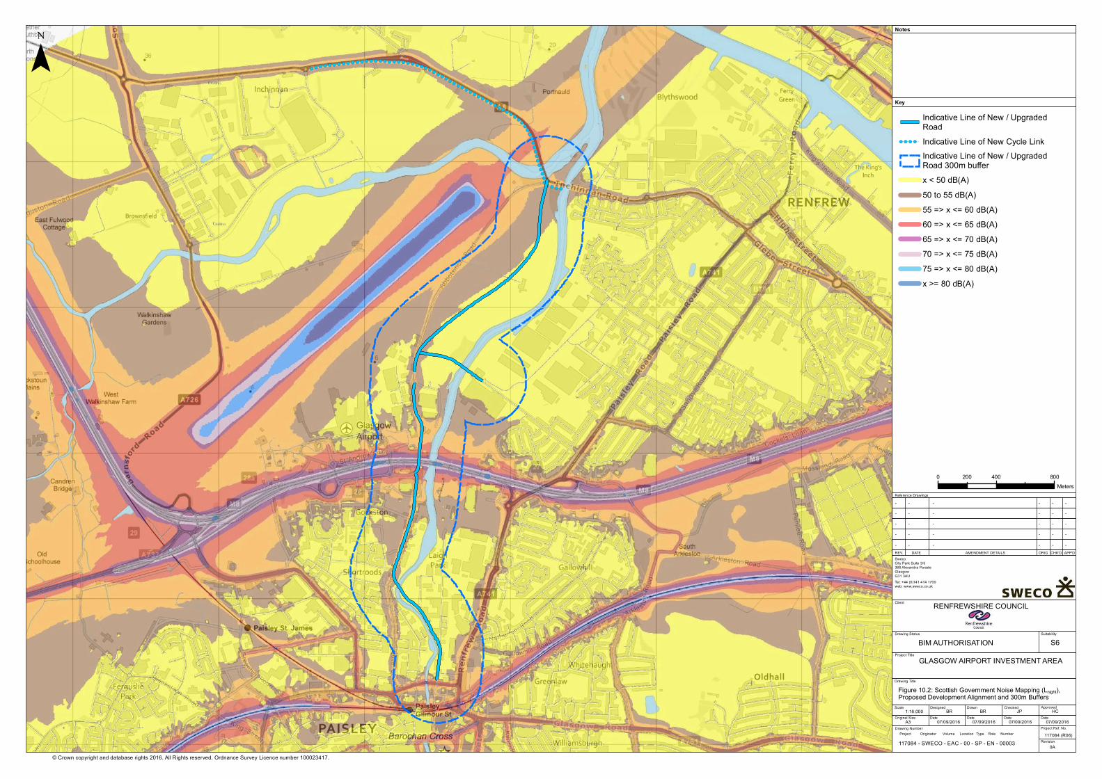
!( !( !( !( !( !( !( !( !( !( !( !( !( !( !( !(!( !( !( !( !( !( !( !( !( !( !(!(!(!(!(!(!(!(!(!(!(!(!(!(!(!(!(!(!(!(!(!(!(
!(!(!(!(!(!(!(!(!(
!(!(!(!(!(!(
!( !( !( !(
© Crown copyright and database rights 2016. All Rights reserved. Ordnance Survey Licence number 100023417.
¯Key
Notes
Reference Drawings
REV. DATE AMENDMENT DETAILS ORIG CHK'D APP'D
GLASGOW AIRPORT INVESTMENT AREA
Client
Drawing Title
Drawing Status Suitability
Scale
Original Size
Designed
Date
Drawn
Date Date Date
ApprovedChecked
Project Ref. No.
Revision
Drawing Number
SwecoCity Park Suite 3/5368 Alexandra Parade GlasgowG31 3AUTel: +44 (0)141 414 1700web: www.sweco.co.uk
RENFREWSHIRE COUNCIL
1:18,00007/09/2016A3
Figure 10.2: Scottish Government Noise Mapping (Lnight), Proposed Development Alignment and 300m Buffers
BIM AUTHORISATION S6
117084 (R06)
BR BR JP
- - ----
HC
Project Title
07/09/2016 07/09/2016 07/09/2016
0A
- - ----- - ----- - ----- - ----
Project Originator Volume Location Type Role Number
Indicative Line of New / UpgradedRoad
!( !( !( !( Indicative Line of New Cycle LinkIndicative Line of New / UpgradedRoad 300m bufferx < 50 dB(A)50 to 55 dB(A)55 => x <= 60 dB(A)60 => x <= 65 dB(A)65 => x <= 70 dB(A)70 => x <= 75 dB(A)75 => x <= 80 dB(A)x >= 80 dB(A)
0 400 800200Meters
117084 - SWECO - EAC - 00 - SP - EN - 00003
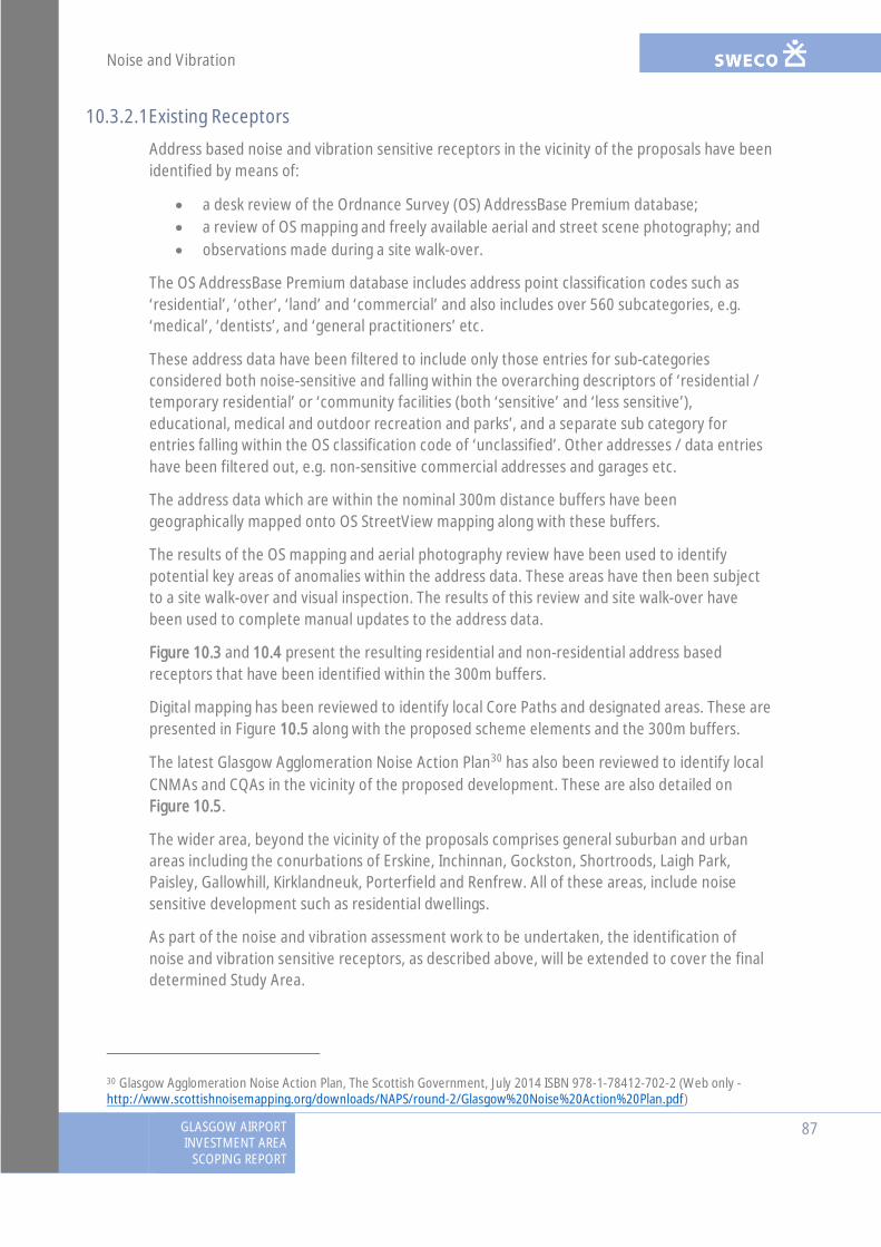
Noise and Vibration
GLASGOW AIRPORTINVESTMENT AREA
SCOPING REPORT
87
10.3.2.1Existing Receptors
Address based noise and vibration sensitive receptors in the vicinity of the proposals have beenidentified by means of:
· a desk review of the Ordnance Survey (OS) AddressBase Premium database;· a review of OS mapping and freely available aerial and street scene photography; and· observations made during a site walk-over.
The OS AddressBase Premium database includes address point classification codes such as‘residential’, ‘other’, ‘land’ and ‘commercial’ and also includes over 560 subcategories, e.g.‘medical’, ‘dentists’, and ‘general practitioners’ etc.
These address data have been filtered to include only those entries for sub-categoriesconsidered both noise-sensitive and falling within the overarching descriptors of ‘residential /temporary residential’ or ‘community facilities (both ‘sensitive’ and ‘less sensitive’),educational, medical and outdoor recreation and parks’, and a separate sub category forentries falling within the OS classification code of ‘unclassified’. Other addresses / data entrieshave been filtered out, e.g. non-sensitive commercial addresses and garages etc.
The address data which are within the nominal 300m distance buffers have beengeographically mapped onto OS StreetView mapping along with these buffers.
The results of the OS mapping and aerial photography review have been used to identifypotential key areas of anomalies within the address data. These areas have then been subjectto a site walk-over and visual inspection. The results of this review and site walk-over havebeen used to complete manual updates to the address data.
Figure 10.3 and 10.4 present the resulting residential and non-residential address basedreceptors that have been identified within the 300m buffers.
Digital mapping has been reviewed to identify local Core Paths and designated areas. These arepresented in Figure 10.5 along with the proposed scheme elements and the 300m buffers.
The latest Glasgow Agglomeration Noise Action Plan30 has also been reviewed to identify localCNMAs and CQAs in the vicinity of the proposed development. These are also detailed onFigure 10.5.
The wider area, beyond the vicinity of the proposals comprises general suburban and urbanareas including the conurbations of Erskine, Inchinnan, Gockston, Shortroods, Laigh Park,Paisley, Gallowhill, Kirklandneuk, Porterfield and Renfrew. All of these areas, include noisesensitive development such as residential dwellings.
As part of the noise and vibration assessment work to be undertaken, the identification ofnoise and vibration sensitive receptors, as described above, will be extended to cover the finaldetermined Study Area.
30 Glasgow Agglomeration Noise Action Plan, The Scottish Government, July 2014 ISBN 978-1-78412-702-2 (Web only -http://www.scottishnoisemapping.org/downloads/NAPS/round-2/Glasgow%20Noise%20Action%20Plan.pdf)

!( !( !( !( !( !( !( !( !( !( !( !( !(!( !( !( !( !( !( !( !( !( !( !( !( !( !(!(!(!(!(!(!(!(!(!(!(!(!(!(!(!(!(!(!(!(!(!(!(
!(!(!(!(!(!(!(!(!(
!(!(!(!(!(!(
!( !( !( !(
6
11
207
106
© Crown copyright and database rights 2016. All Rights reserved. Ordnance Survey Licence number 100023417.
¯Key
Notes
Reference Drawings
REV. DATE AMENDMENT DETAILS ORIG CHK'D APP'D
GLASGOW AIRPORT INVESTMENT AREA
Client
Drawing Title
Drawing Status Suitability
Scale
Original Size
Designed
Date
Drawn
Date Date Date
ApprovedChecked
Project Ref. No.
Revision
Drawing Number
SwecoCity Park Suite 3/5368 Alexandra Parade GlasgowG31 3AUTel: +44 (0)141 414 1700web: www.sweco.co.uk
RENFREWSHIRE COUNCIL
1:18,00007/09/2016A3
Figure 10.3: Proposed Development Alignment, 300m Buffersand Residential Receptors
BIM AUTHORISATION S6
117084 (R06)
BR BR JP
- - ----
HC
Project Title
07/09/2016 07/09/2016 07/09/2016
0A
- - ----- - ----- - ----- - ----
Project Originator Volume Location Type Role Number
Indicative Line of New / UpgradedRoadIndicative Line of New / UpgradedRoad 300m buffer
!( !( !( !( Indicative Line of New Cycle LinkResidential ReceptorsTemporary Residential Receptors
0 400 800200Meters
117084 - SWECO - EAC - 00 - SP - EN - 00003

!( !( !( !( !( !( !( !( !( !( !( !( !(!( !( !( !( !( !( !( !( !( !( !( !( !( !(!(!(!(!(!(!(!(!(!(!(!(!(!(!(!(!(!(!(!(!(!(!(
!(!(!(!(!(!(!(!(!(!(
!(!(!(!(!(
!( !( !( !(
6
11
207
106
© Crown copyright and database rights 2016. All Rights reserved. Ordnance Survey Licence number 100023417.
¯Key
Notes
Reference Drawings
REV. DATE AMENDMENT DETAILS ORIG CHK'D APP'D
GLASGOW AIRPORT INVESTMENT AREA
Client
Drawing Title
Drawing Status Suitability
Scale
Original Size
Designed
Date
Drawn
Date Date Date
ApprovedChecked
Project Ref. No.
Revision
Drawing Number
SwecoCity Park Suite 3/5368 Alexandra Parade GlasgowG31 3AUTel: +44 (0)141 414 1700web: www.sweco.co.uk
RENFREWSHIRE COUNCIL
1:18,00007/09/2016A3
Figure 10.4: Proposed Development Alignment, 300m Buffersand Non-Residential Receptors
BIM AUTHORISATION S6
117084 (R06)
BR BR JP
- - ----
HC
Project Title
07/09/2016 07/09/2016 07/09/2016
0A
- - ----- - ----- - ----- - ----
Project Originator Volume Location Type Role Number
Indicative Line of New / UpgradedRoad
!( !( !( !( Indicative Line of New Cycle LinkIndicative Line of New / UpgradedRoad 300m bufferEducational ReceptorsMedical Receptors
0 400 800200Meters
117084 - SWECO - EAC - 00 - SP - EN - 00003
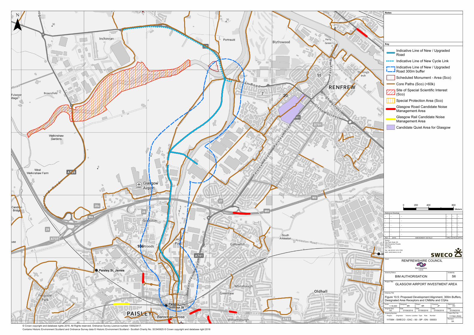
! ! ! ! ! ! ! !
! ! ! ! ! ! ! !
! ! ! ! ! ! ! !
! ! ! ! ! ! ! !
! ! ! ! ! ! ! !
! ! ! ! ! ! ! !
! ! ! ! ! ! ! !
! !
! !
! !
!( !( !( !( !( !( !( !( !( !( !( !( !( !( !( !( !( !( !( !( !( !( !( !( !( !( !(!(!(!(!(!(!(!(!(!(!(!(!(!(!(!(!(!(!(!(!(!(!(
!(!(!(!(!(!(!(!(!(
!(!(!(!(!(!(
!( !( !( !(
6
11
207
106
© Crown copyright and database rights 2016. All Rights reserved. Ordnance Survey Licence number 100023417.
¯Key
Notes
Reference Drawings
REV. DATE AMENDMENT DETAILS ORIG CHK'D APP'D
GLASGOW AIRPORT INVESTMENT AREA
Client
Drawing Title
Drawing Status Suitability
Scale
Original Size
Designed
Date
Drawn
Date Date Date
ApprovedChecked
Project Ref. No.
Revision
Drawing Number
SwecoCity Park Suite 3/5368 Alexandra Parade GlasgowG31 3AUTel: +44 (0)141 414 1700web: www.sweco.co.uk
RENFREWSHIRE COUNCIL
1:18,00007/09/2016A3
Figure 10.5: Proposed Development Alignment, 300m Buffers,Designated Area Receptors and CNMAs and CQAs
BIM AUTHORISATION S6
117084 (R06)
BR BR JP
- - ----
HC
Project Title
07/09/2016 07/09/2016 07/09/2016
0A
- - ----- - ----- - ----- - ----
Project Originator Volume Location Type Role Number
Indicative Line of New / UpgradedRoad
!( !( !( !( Indicative Line of New Cycle LinkIndicative Line of New / UpgradedRoad 300m buffer
! ! ! ! ! !
! ! ! ! ! !
! ! ! ! ! !
! ! ! ! ! ! Scheduled Monument - Area (Sco)Core Paths (Sco) (<60k)Site of Special Scientific Interest(Sco)Special Protection Area (Sco)Glasgow Road Candidate NoiseManagement AreaGlasgow Rail Candidate NoiseManagement AreaCandidate Quiet Area for Glasgow
0 400 800200Meters
117084 - SWECO - EAC - 00 - SP - EN - 00003
Contains Historic Environment Scotland and Ordnance Survey data © Historic Environment Scotland - Scottish Charity No. SC045925 © Crown copyright and database right 2016
Noise and Vibration
88GLASGOW AIRPORTINVESTMENT AREASCOPING REPORT
10.3.2.2Proposed / Approved Receptors
As well as considering existing receptors HD 213/11 states that ‘Where planning permission fora residential development or any other sensitive receptor has been granted but for whichconstruction has not started, the potential impacts on these locations should be estimated andreported separately’. Consideration will also therefore be given to those proposeddevelopments which: a) include a residential element, and b) benefit from a planning consent.Such consented developments as identified within the 300m buffers are depicted in Figure10.6.
As part of the noise and vibration assessment work to be undertaken, account will be given toconsented developments, with residential elements, across the final determined Study Area.
10.4 Potential Effects
10.4.1 Construction
The following construction phase impacts are considered to have the potential to give rise tosignificant effects and have been ‘scoped-in’ to the proposed assessment:
· construction noise on existing and consented noise-sensitive receptors;· construction traffic noise on existing and consented noise-sensitive receptors; and· construction vibration on existing and consented vibration sensitive receptors.
The above impacts would be short term, only having the potential to arise during theconstruction period.
At this stage it is not known whether any substantial or lengthy traffic diversions will berequired to facilitate delivery of the on-line aspects of the project, although this is consideredunlikely. Where such diversions are not required, an assessment of associated temporary noiselevel changes will be scoped-out of the assessment methodology. This will be reviewed as theconstruction detail / construction programme for the project is developed.
10.4.2 Operation
The following operational phase impacts are considered to have the potential to give rise tosignificant effects and have been ‘scoped-in’ to the noise and vibration assessment:
· road traffic noise level changes (from both new routes and traffic redistribution) onexisting and consented noise sensitive receptors; and
· road traffic induced airborne vibration (from both new routes and traffic redistribution)on existing and consented vibration sensitive receptors.
The above impacts would be long term / permanent.
With regards to groundborne vibration, HD 213/11, states that an assessment of this “will onlyapply in rare cases where, for example, traffic is expected to pass very close to buildings”. In thecase of this development, new road traffic routes are not proposed in very close proximity toresidential dwellings. The only road sections proposed in very close proximity to dwellings arewhere the scheme ties-in to existing route sections. Therefore, an assessment of groundbornevibration has been scoped-out of the assessment.
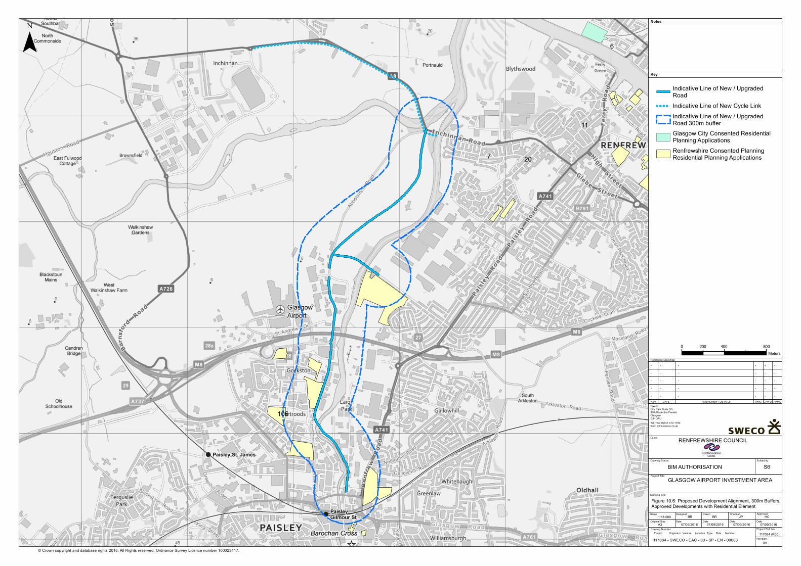
!( !( !( !( !( !( !( !( !( !( !( !( !( !( !( !( !( !( !( !( !( !( !( !( !( !( !(!(!(!(!(!(!(!(!(!(!(!(!(!(!(!(!(!(!(!(!(!(!(
!(!(!(!(!(!(!(!(!(!(
!(!(!(!(!(
!( !( !( !(
6
11
207
106
© Crown copyright and database rights 2016. All Rights reserved. Ordnance Survey Licence number 100023417.
¯Key
Notes
Reference Drawings
REV. DATE AMENDMENT DETAILS ORIG CHK'D APP'D
GLASGOW AIRPORT INVESTMENT AREA
Client
Drawing Title
Drawing Status Suitability
Scale
Original Size
Designed
Date
Drawn
Date Date Date
ApprovedChecked
Project Ref. No.
Revision
Drawing Number
SwecoCity Park Suite 3/5368 Alexandra Parade GlasgowG31 3AUTel: +44 (0)141 414 1700web: www.sweco.co.uk
RENFREWSHIRE COUNCIL
1:18,00007/09/2016A3
Figure 10.6: Proposed Development Alignment, 300m Buffers,Approved Developments with Residential Element
BIM AUTHORISATION S6
117084 (R06)
BR BR JP
- - ----
HC
Project Title
07/09/2016 07/09/2016 07/09/2016
0A
- - ----- - ----- - ----- - ----
Project Originator Volume Location Type Role Number
Indicative Line of New / UpgradedRoad
!( !( !( !( Indicative Line of New Cycle LinkIndicative Line of New / UpgradedRoad 300m bufferGlasgow City Consented ResidentialPlanning ApplicationsRenfrewshire Consented PlanningResidential Planning Applications
0 400 800200Meters
117084 - SWECO - EAC - 00 - SP - EN - 00003

Noise and Vibration
GLASGOW AIRPORTINVESTMENT AREA
SCOPING REPORT
89
10.5 Proposed Scope of AssessmentHD 213-11 details a staged approach to the noise and vibration assessment, with the stagesnamed ‘Scoping’, ‘Simple’ and ‘Detailed’. The methodology for the Scoping stage assessmentrequires that the Study Area is defined and noise level changes of 1dB LA10,18hr or greater in theshort term, or 3dB LA10,18hr or greater in the long term arising as a result of the scheme aredetermined. However, both of these points are dependent upon the scheme traffic data whichare currently being finalised. It is therefore proposed that the Study Area and noise levelchanges associated with the proposed development are considered at the outset of thedetailed assessment work to be undertaken for the EIA.
It is also stated within HD 213/11 that where it is evident there are dwellings within 1km of thescheme / bypassed routes that would be subject to noise level changes of 1dB LA10,18hr orgreater in the short term, or 3dB LA10,18hr or greater in the long term, then the Simple stageassessment can be bypassed, with progress directly to the Detailed stage assessment.
It can be seen from Figure 10.3 that there are several existing dwellings in the vicinity of theproposed development and it is anticipated that at least some of these will be subject to noiselevel changes greater than these stated criteria.
The proposed assessment methodology has therefore been based upon that prescribed withinHD 213/11 for the Detailed stage assessment. It is however proposed that, an initial review ofthe scheme traffic data will be undertaken for the full DMRB compliant Study Area. This reviewwill be undertaken in the form of a ‘sift exercise’, to identify those routes which would andwould not be subject to the stated 1dB and 3dB noise level change criteria. This initial siftexercise would then be used to reduce the Study Area for the Detailed Stage assessment suchthat areas that are not anticipated to be subject to significant impacts are scoped-out of theassessment (See Section 10.5.2).
10.5.1 Construction Noise
10.5.1.1Study Area
Whilst HD 213/11 adopts the same Study Area for construction phase impacts as identified foroperational phase impacts, the nature of the proposed development is that applying thisapproach would mean the inclusion of extensive areas in which construction operations are notproposed and therefore for which significant effects are not anticipated.
In accordance with DMRB Volume 11 Section 3 Part 3: Disruption due to Construction it isproposed that a reduced Study Area is adopted for construction noise. The Study Area forconstruction noise will be defined based on a 100m set back distance from proposed keyconstruction working operations / working areas.
10.5.1.2Assessment Methodology
Available information on the construction of the proposed development will be reviewedincluding the construction programme, proposed working method statements, phasingdiagram, compound locations and working areas etc. This review will be undertaken to identifythose operations which could give rise to significant impacts and will include consideration topotential night-time working and the likely duration of impact.
Noise and Vibration
90GLASGOW AIRPORTINVESTMENT AREASCOPING REPORT
Based on the results of this review, the construction noise Study Area(s) will be determined asdescribed above and the numbers of receptors will be identified. Any receptors likely to beparticularly sensitive to construction noise impacts will be highlighted.
Noise level predictions will be undertaken in accordance with the methodology detailed withinBS5228-1 for a sample of key working operations / working phases and local noise sensitivereceptors within the Study Area(s).
Appropriate construction noise assessment criteria will be derived based on the guidancecontained within BS5228-1+A1:2014, the prevailing local noise environment and the outcomesof consultation with the Local Authority Environmental Health Officers.
The results of the noise level predictions will be assessed by comparison with the adoptedassessment criteria and the number of properties likely to be subject to different degrees ofeffect will be determined. Noise level predictions will take account of any proposed noisemitigation measures, such as environmental barriers etc.
10.5.2 Construction Traffic Noise
10.5.2.1Study Area
Given the generally urban / suburban nature of the local area, it is anticipated that constructioncompounds will be located adjacent to the existing road network and therefore that new haulroutes will not be required either to access the compounds or to provide access between thecompounds and the construction working areas.
The construction traffic noise Study Areas will therefore be defined based on a 50m bufferaround any existing local road traffic routes linking the construction compounds to the widernetwork. The wider network (at which the defined study areas finish), will constitute thoseexisting routes as judged to already be subject to moderate to high existing traffic flows, andtherefore for which significant noise level changes would not be anticipated.
10.5.2.2Assessment Methodology
The proposed construction traffic access routes will be reviewed, as well as the proposedconstruction compound locations. For each compound, a qualitative assessment of the existinglocal road network will be undertaken to determine those local routes that are anticipated tobe subject to reasonable or high traffic flows currently. The remaining routes (subject to lowflows) linking each compound with the wider network will be identified and the constructiontraffic noise Study Area(s) will be calculated as described above.
For each identified link within the Study Area(s), the Basic Noise Level (BNL) will be determinedin accordance with the Calculation of Road Traffic Noise memorandum 1988 (CRTN).Calculations will be undertaken for both ‘baseline’ and ‘with construction’ scenarios and theassociated noise level change will be determined. For each link, the number of receptors withinthe Study Area will be determined and allied with the calculated noise level changes.
Noise and Vibration
GLASGOW AIRPORTINVESTMENT AREA
SCOPING REPORT
91
10.5.3 Construction Vibration
10.5.3.1Study Area
The Study Areas will be defined based on set-back distances from the proposed keyconstruction working areas. The set-back distances adopted will depend on the workingoperations to be undertaken, as considered further below.
10.5.3.2Assessment Methodology
BS5228-2:2009+A1: 2014: Code of practice for noise and vibration control on construction sites.Vibration details ground-borne vibration prediction methods for a range of commonconstruction working operations such as percussive piling, dynamic compaction, vibratory pilingand vibratory compaction etc. Also presented within this Standard are historic measurementresults for these operations and assessment criteria corresponding to different degrees ofhuman response to groundborne vibration.
Available information on the construction of the proposed development will be reviewedincluding the construction programme, proposed working method statements, phasingdiagram, compound locations and working areas etc. From this review, the potential vibrationgenerative working operations which are anticipated to be required in the delivery of thedevelopment will be identified.
For these working operations, and drawing on the published prediction methods and historicdata, typical set-back distances at which different degrees of adverse comment might beexpected will be determined.
The construction vibration Study Area will then be defined based on these set-back distancesand the location at which such working operations are anticipated to be required.
The number of receptors within the Study Area(s) will be determined and split into categoriescorresponding to different degrees of effect.
10.5.4 Operational Traffic Noise
10.5.4.1Study Area
Initially the Study Area for the Operational Traffic Noise assessment will be defined in fullaccordance with HD 213/11. i.e.:
· The start and end points of the physical works associated with the road project will beidentified.
· Existing routes that are being bypassed or improved, and any proposed new routesbetween the start and end points will be identified.
· A boundary one kilometre from the carriageway edge of the routes identified in bulletpoint 2 above will be determined.
· A boundary 600m from the carriageway edge around each of the routes identified inbullet point 2 above and also 600m from any other affected routes within theboundary defined in bullet point 3 above will be determined. The total area withinthese 600m boundaries is termed the ‘calculation area’. An affected route is wherethere is the possibility of a change of 1dB LA10,18h or more in the short-term or 3dB
Noise and Vibration
92GLASGOW AIRPORTINVESTMENT AREASCOPING REPORT
LA10,18h or more in the long-term (i.e. conditions (ii), (iii), (iv) or (v) given in paragraphA1.8 of HD 213/11).
· Any affected routes beyond the boundary defined in (iii) above will be determined.· A boundary 50m from the carriageway edge of the routes identified in bullet point 5
above will be determined.
It is proposed that with regards to the first point above, ‘the road project’ would be defined toinclude the proposed new / improved road traffic routes, but not include the Inchinnan cyclepath (as this would not generate vehicular noise) or the proposed new access at the northernend of Glasgow Airport (as this would be subject to minimal traffic)
A sift exercise will then be undertaken drawing upon the scheme traffic data to identify thoseroutes which will and will not be subject to significant noise level changes within the abovedefined Study Area. This sift exercise will be as follows:
1. Basic Noise Level (BNL) calculations will be undertaken for all routes within the StudyArea, for the following scenarios:
- (a) Year of Opening ‘Without scheme’;
- (b) Year of Opening ‘With Scheme’; and
- (c) Design Year (Year of Opening +15) ‘With Scheme’.
2. The short term noise level changes will be determined based on ’scenario b’ minus‘scenario a’ and the longer term noise level changes will be determined based on‘scenario c’ minus ‘scenario a’. Those routes which are predicted to be subject to ashort term noise level change of less than 1dB and a long term noise level change ofless than 3dB will be identified.
The routes identified from the above sift will be used to reduce the Study Area such that theseroutes are effectively scoped-out of the assessment. The approach to reducing the Study Areawill be that a 600m buffer will be drawn around all proposed new routes and all routes whichremain following the completion of the above sift exercise. The 50m boundaries aroundcarriageway edges of effected routes beyond the original 1km boundary will be retained in thedetermination of the revised Study Area.
The resulting appraisal will be focussed only on those routes for which there is the potential forsignificant effects to arise. The updated Study Area is referenced here after as the ‘finaldetermined Study Area’.
Whilst the approach above is an adaption of the DMRB guidance, it is anticipated that this willgive rise to an assessment focused only on those routes for which there is the potential forsignificant effects to arise.
10.6 Assessment MethodologyFor the final determined Study Area (post sift exercise), an assessment of operational roadtraffic noise impacts will be undertaken following the Detailed stage assessment methodologyas defined within HD 213/11. This will include the elements described below.
Noise and Vibration
GLASGOW AIRPORTINVESTMENT AREA
SCOPING REPORT
93
10.6.1 Baseline Noise Survey
A review of the Scottish Government noise mapping and address based receptor data (seeSections 10.2.1 and 10.2.2.1 above) will be undertaken and the need for a baseline noisesurvey will be determined. It is anticipated that a baseline noise survey is likely to be requiredto:
1. establish the prevailing baseline noise conditions for receptors in areas which are wellremoved from significant sources of road traffic noise;
2. establish the prevailing baseline noise conditions for receptors which are subject tosignificant sources of noise that are not road traffic, e.g. aircraft noise / industrial /commercial noise; and
3. assist in the determination of appropriate noise level limits / assessment criteria forconstruction noise.
Subject to access and appropriate site security, it is anticipated that the survey would comprisea series of 24-hour continuous weekday measurements at a sample of locations within the finaldetermined Study Area. Where the site is not sufficiently secure to allow unattendedmonitoring, a sampled measurement approach may be followed. This would include, forexample, a series of fully attended 15 minute measurements at each position during daytime,evening and night-time periods.
10.6.2 Noise Modelling
Using proprietary PC based noise modelling software, detailed ‘Do Minimum’ and ‘DoSomething’ noise models will be prepared for both the Year of Opening and a Future (+15)assessment year. The noise models will be used to undertake receptor based road traffic noiselevel predictions in accordance with the methodology detailed within CRTN, and Annex 4 of HD213/11, for all receptors within the 600m buffers used in the determination of the finaldetermined Study Area.
Predictions will include noise from all roads within the 600m buffers. For sensitive receptorstowards the edge of the 600m buffers, consideration will be given to the contribution fromroads outside the 600m area, by application of professional judgement.
The noise models will be used to undertake noise level predictions of the LA10,18hr noise index.For building receptors (e.g. dwellings), these predictions will include façade corrections.Predictions will be undertaken for first floor height (i.e. 4m), unless the building is identified assingle storey, in which case a 1.5m height will be used. For open space receptors such as parks,free-field noise levels will be predicted at ground floor height (1.5m).
10.6.3 Assessment of Traffic Noise Impacts
For all adopted receptors, the following comparison of the receptor noise levels will be made:
· Do-Minimum baseline year versus Do-Minimum future assessment year (long term);· Do-Minimum baseline year versus Do-Something baseline year (short term); and· Do-Minimum baseline year versus Do-Something future assessment year (long term).
Where it is identified that night-time impacts require consideration, only comparisons for thelong term will be considered (in compliance with HD 213/11).

Noise and Vibration
94GLASGOW AIRPORTINVESTMENT AREASCOPING REPORT
The comparisons will be reported by completing Tables A1.1 and A1.2 of HD 213/11.
For each of the routes identified in bullet point 5 of the Study Area definition outlined inSection 10.5.2 above, calculated BNLs will be reported and counts of sensitive receptors within50m of the centrelines of these routes will be made. These counts will be reported bycompleting Tables A1.1 and A1.2 of HD 213/11.
Where a building is predicted to experience different changes in noise level on differentfaçades, the least beneficial change in noise level will be accounted for in the assessmentresults. When all façades show a decrease in noise level, then the smallest decrease will bereported. When all facades show an increase in noise level then the largest increase will bereported. Where this approach leads to the reporting of two or more facades (i.e. where thesame least beneficial change in noise level is shown on two or more facades) then the changeon the façades with the highest noise level in the Do-Minimum scenario will be reported. Thesame approach will be adopted for non-residential receptors. Where this approach is such thatbeneficial effects from the scheme could potentially be overlooked, these will be reportedseparately.
Consideration will be given to whether any significant impacts are anticipated to arise outsidethe final determined Study Area, e.g. in any areas out to the original 1km buffer area appliedfor the sift study. Where appropriate, a qualitative assessment of any identified significantimpacts will be made.
Short term and long term noise level difference maps will be prepared indicating the level ofchange at each receptor position. These maps will use 1dB or 3dB noise level change bands asappropriate. A list of receptor noise level changes will also be prepared.
For the night-time period, the following sift exercise will be undertaken:
· Night-time noise maps will be prepared for the full Study Area for the followingscenarios:
- Year of Opening ‘Without scheme’
- Year of Opening ‘With Scheme’
- Design Year (Year of Opening +15) ‘With Scheme’
· These maps will be prepared by application of the guidance detailed within the TRLreport Converting the UK Traffic noise index LA10,18h to EU noise indices for noisemapping, and will present free-field night-time noise levels.
· Receptor locations will be overlaid onto the noise maps and the noise maps will beused to depict those areas which would be subject to noise levels of 55dBLnight,outside or higher.
· Those receptors which are subject to noise levels lower than the 55dB contour for allscenarios, will be scoped-out of the assessment.
· Those remaining receptors which would be subject to a noise level change of less than3dB will also be scoped-out of the assessment.

Noise and Vibration
GLASGOW AIRPORTINVESTMENT AREA
SCOPING REPORT
95
Table A1.2 of HD 213/11 will then be completed for the remaining receptors not scoped-out ofthe assessment. The following will be highlighted:
1. where the introduction of the project results in a sensitive receptor being exposed tonight-time noise levels in excess of 55dB Lnight,outside where it is currently below thislevel; and
2. where a receptor is exposed to pre-existing Lnight,outside in excess of 55dB and this ispredicted to increase.
The above assessment will be undertaken for existing receptors, but consideration will also begiven to receptors which benefit from a valid planning consent. For consented receptors, aseparate appraisal of potential impact will be undertaken and reported.
10.6.4 Assessment of Traffic Nuisance Impacts
An assessment of traffic noise nuisance will be undertaken in accordance with the guidancedetailed within HD 213/11 for the Detailed stage assessment. This will include:
· Calculation of the change in noise nuisance for all dwellings at which full CRTN noiselevel calculations have been undertaken. The change in noise nuisance will bedetermined in accordance with Annex 6 of HD 213/11.
· The results will be tabulated to detail the change in the number of people bothered in10% change bands up to 40%, with a further band for >40%.
· Separate assessments will be undertaken for Do-Minimum baseline year versusDo-Minimum in the future assessment year and for Do-Minimum in the baseline yearversus Do-Something in the future assessment year.
· The results of the assessments will be presented by completing Table A1.3 ofHD 213/11.
· Calculations will be based on the highest nuisance levels determined during the first 15years after opening.
· Nuisance calculations will be undertaken on the façade with the least beneficial changein noise (i.e. the one used in the completed noise assessment as detailed above).
10.6.5 Assessment of Traffic Induced Airborne Vibration
A review of the noise nuisance assessment results will be undertaken and it will be consideredwhether an assessment of airborne vibration nuisance is warranted. Where this is deemed tobe appropriate, this will be completed in accordance with the guidance in HD 213/11 for theDetailed stage assessment. This will include:
· Calculation of the change in vibration nuisance for all dwellings within 40m of routesfor which full CRTN noise level calculations have been undertaken.
· The results will be tabulated to detail the change in the number of people bothered in10% change bands up to 40%, with a further band for >40%.
· Separate assessments will be undertaken for Do-Minimum baseline year versusDo-Minimum in the future assessment year and for Do-Minimum in the baseline yearversus Do-Something in the future assessment year.
The results of the assessment will be presented in Table A1.4 of HD 213/11.
Air Quality
96GLASGOW AIRPORTINVESTMENT AREASCOPING REPORT
11. Air Quality
11.1 IntroductionThis section describes the proposed approach to the assessment of potential effects to local airquality associated with the proposed development. The method of assessment of air qualityeffects has been developed with reference to relevant non-statutory guidance, including:
· Design Manual for Roads and Bridges, Volume 11:Environmental Assessment, Section3: Environmental Assessment Techniques, Part 1: HA 207/07 Air Quality;
· Local Air Quality Management (LAQM) Technical Guidance TG(16);· Institute of Air Quality Management guidance on Land-Use Planning & Development
Control: Planning for Air Quality; and· Institute of Air Quality Management guidance on Assessment of dust from demolition
and construction.
The proposals have the potential to affect local air quality during the construction andoperational (post-construction) phases of the project. During construction, potential effects willoccur in proximity to the locations of construction activity, whilst post-construction effects toair quality will occur over a wider area due to the effects of changes in road traffic flows on thelocal road network.
For the operational phase of the project the assessment considers air pollutants harmful tohuman health, as identified within the National Air Quality Strategy. The principal source ofatmospheric emissions during the operational phase of the project will be from enginecombustion (from road traffic) therefore the pollutants considered within the assessment ofthe operational phase of the project are therefore the products of combustion, namelynitrogen dioxide (NO2), fine particulates (PM10) and carbon monoxide (CO).
For the construction phase the assessment also considers the combustion generated emissionsfrom road traffic and construction equipment but also considers the potentially effects toreceptor amenity through the deposition of dust.
11.2 ConsultationConsultation has been undertaken with the relevant Environmental Health Officer responsiblefor air quality within Renfrewshire Council.
Initial consultation was undertaken during early project work to identify potential constraints inthe options generation and assessment phases of the project design. This consultation includedobtaining existing baseline air quality data and discussion on the proposals to undertakeadditional baseline monitoring.
Further consultation was undertaken in the form of a meeting in August 2016. A presentationwas provided of the proposed project design, preliminary findings of the initial assessmentwork and an outline of the proposed scope of work for the EIA.
Air Quality
GLASGOW AIRPORTINVESTMENT AREA
SCOPING REPORT
97
11.3 BaselineBaseline air quality conditions within the study area were determined with reference toambient monitoring undertaken by Renfrewshire Council, published LAQM reports and ScottishGovernment collated data on ambient air quality conditions.
The estimated annual average background pollutant concentrations across the study area arebelow the relevant annual average air quality objectives, indicating air quality is good. Theestimates are, however, an average concentration across the grid square and therefore do notreflect concentrations at hotspot locations.
The principal air pollutant emissions sources within the study area are road traffic andemissions associated with Glasgow Airport operations. Monitoring of ambient air quality levelsat locations most likely to be affected by these emission sources (hotspot locations) isundertaken by Renfrewshire Council. Ambient air quality monitoring locations across the studyarea, and locations outside the study area which may provide representative air qualitymonitoring data for areas potentially affected by the project are presented in Figure 11.1.
Monitoring across the GAIA project study area is concentrated around the town centre areas ofPaisley and Renfrew including relevant monitoring locations within the Wider Study Area. Inmost cases monitoring has been of ambient NO2 concentrations, using passive diffusion tubes(PDTs). Monitoring of NO2 provides a good indicator of ambient air quality levels attributable totraffic emissions. Additional monitoring using automatic analysers for NO2 and PM10 has beenundertaken at locations in Paisley town centre, close to the M8 in Renfrew and historically atthe perimeter of Glasgow International Airport.
Existing monitoring has indicated that air quality across the study area and buffer is generallygood, however potential for exceedance of National Air Quality Strategy (NAQS) objectives forNO2 and PM10 have been identified with both Paisley and Renfrew town centres. An Air QualityManagement Area (AQMA) was declared in Paisley town centre in 2009 (amending an existingsmaller AQMA), and covers most of the town centre area as indicated in Figure 11.1.
The principal source of emissions affecting the AQMA is from road traffic. Renfrewshire Councilis currently developing proposals for the declaration of an Air Quality Management Area(AQMA) in Renfrew. Road traffic is again the principal emission source for this area. A furtherarea of elevated concentrations has been identified by the Council in Renfrew, at Cockles Loan,overlooking the M8, however no AQMA is currently proposed at this location.
Some gaps in the monitoring network were identified which would allow appraisal of baselineconditions in respect of the GAIA project, therefore a number of additional monitoringlocations have been commissioned to measure ambient air quality (NO2 as a marker pollutant).The locations of monitoring are indicated on Figure 11.1. Only three months of monitoring dataare available at the time of writing for most of these locations, however measured air qualitylevels (NO2 concentrations) are generally low and significantly below NAQS objective levels.
11.4 Potential EffectsAn initial assessment of the potential effects to local air quality associated with the operationalphase of the project was undertaken during the options generation and assessment phase ofthe project.

!
!
!
!
!
!
!!!
!!!
!!
!!
!
!
!
!
!
!!
!
!
!
!
!
!
!
!
!
!
!
!
!
!
!
!
!
!
!
!
!
!
!
!!
!
!
!
!
!
!
!
!
! !
!
!
!
!
!!
!
!
!
!
!
!
!!!
!
!!
!
!
!
!
!
!
!! !
!
!
!!
!
!!
!
!
!
!
!
!
!
!
!
!
!
!
!
! !
!
!
!!
!
!
!
!
!
!
!
!
!
!
!
!
!
!
!
!
!
! !
!
!
!!
!
!
!
© Crown copyright and database rights 2016. All Rights reserved. Ordnance Survey Licence number 100023417.
¯
0 0.25 0.5 0.75 1km
Key
Notes
Reference Drawings
REV. DATE AMENDMENT DETAILS ORIG CHK'D APP'D
Client
Drawing Title
Drawing Status Suitability
Scale
Original Size
Designed
Date
Drawn
Date Date Date
ApprovedChecked
Project Ref. No.
Revision
Drawing Number
SwecoCity Park Suite 3/5368 Alexandra Parade GlasgowG31 3AUTel: +44 (0)141 414 1700web: www.sweco.co.uk
RENFREWSHIRE COUNCIL
1:30,000
15/09/2016A3
Figure 11.1: Air Quality Monitoring Site Locations
117084 (R06)
JB JB SMcG
- - ----
SMcG
Project Title
S0
0A
Project Originator Volume Location Type NumberRole
Paisley AQMA
15/09/2016 15/09/2016 15/09/2016
GAIA Core Study Area
! Diffusion Tubes Round 1 & 2Diffusion Tubes from Round 3 Onwards(including locations from round 1 and 2)
! Renfrewshire Council Monitoring Sites! Glasgow Council Monitoring Sites! Dunbartonshire Council Monitoring Sites
GLASGOW AIRPORT INVESTMENT AREA
117084 - SWEC0 - EAC - 00 - SP - EN - 00003
Monitoring Sites per Local Authority
Additional Monitoring Sites
FINAL
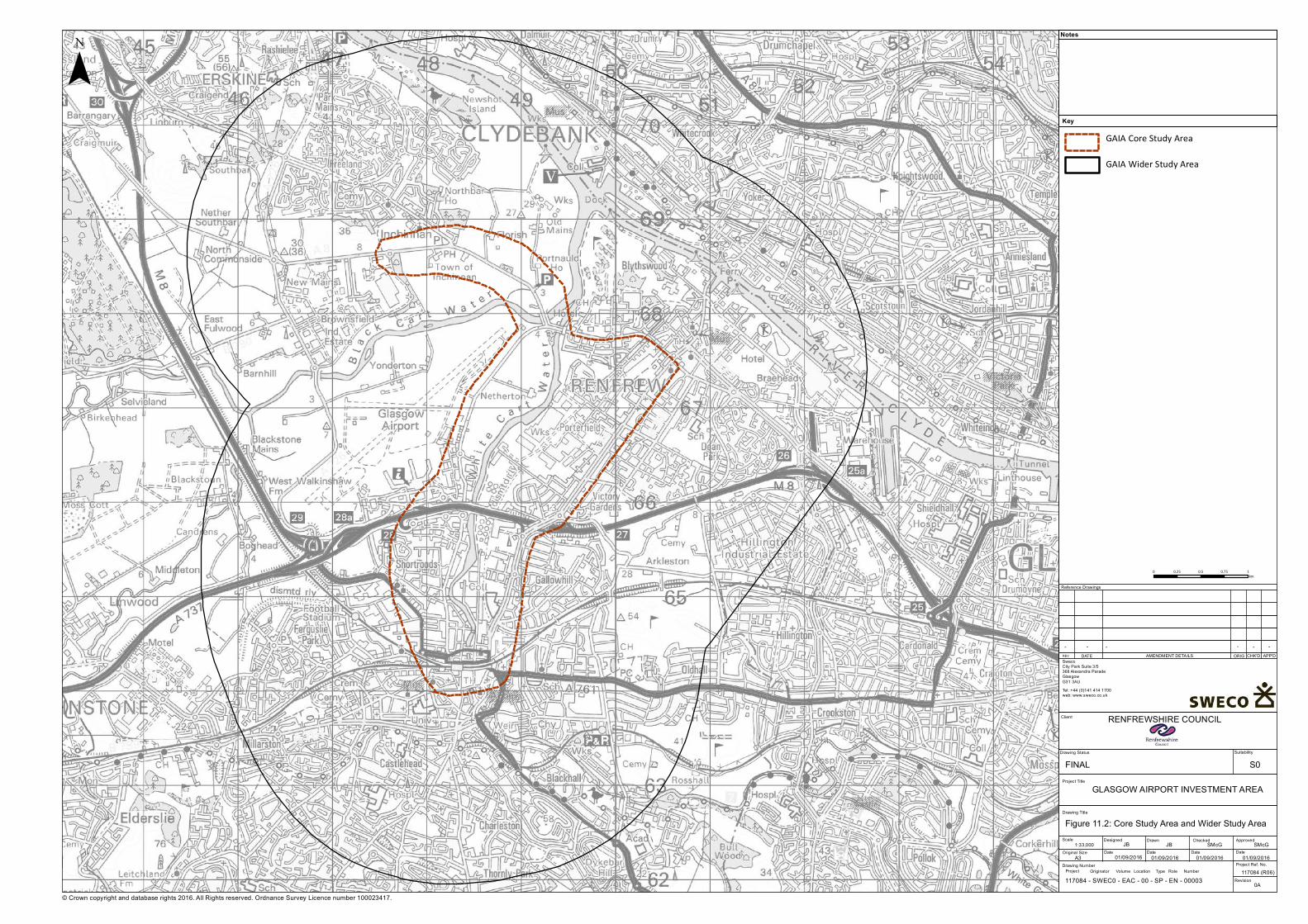
© Crown copyright and database rights 2016. All Rights reserved. Ordnance Survey Licence number 100023417.
¯
0 0.25 0.5 0.75 1km
Key
Notes
Reference Drawings
REV. DATE AMENDMENT DETAILS ORIG CHK'D APP'D
Client
Drawing Title
Drawing Status Suitability
Scale
Original Size
Designed
Date
Drawn
Date Date Date
ApprovedChecked
Project Ref. No.
Revision
SwecoCity Park Suite 3/5368 Alexandra Parade GlasgowG31 3AUTel: +44 (0)141 414 1700web: www.sweco.co.uk
RENFREWSHIRE COUNCIL
1:33,000
01/09/2016A3
Figure 11.2: Core Study Area and Wider Study Area
117084 (R06)
JB JB SMcG
- - ----
SMcG
Project Title
S0
0A
01/09/2016 01/09/2016 01/09/2016
GAIA Core Study Area
GLASGOW AIRPORT INVESTMENT AREA
GAIA Wider Study Area
Drawing NumberProject Originator Volume Location Type NumberRole117084 - SWEC0 - EAC - 00 - SP - EN - 00003
FINAL

Air Quality
98GLASGOW AIRPORTINVESTMENT AREASCOPING REPORT
The initial assessment considered the potential for change to ambient air qualityconcentrations as a result of potential changes to road traffic flows. The potential changes toroad traffic flows across the roads within the study area were determined with reference topreliminary traffic model outputs of predicted traffic flows for differing options for the projectdesign.
The potential significance of changes to local air quality within the study area was determinedbased on an evaluation of the potential change in road traffic flows (and therefore thepotential change in emissions from road traffic), the presence and number of sensitivereceptors located in proximity to proposed project development locations or roads affected bythe project and the prevailing baseline conditions within each area.
Overall the project proposals were predicted to have both adverse and positive effects on airquality when benchmarked against a future baseline without the project. Potential forimprovements in air quality were identified throughout the Paisley Town Centre AQMA,particularly on Love Street and western sections of NiddryStreet. Potential for deterioration ofair quality was identified for eastern sections of Niddry Street and Weir Street. Predictedchanges in air quality associated with changes to the road network around Abbotsinch Roadand the northerly White Cart Crossing were principally neutral.
11.5 Proposed Scope of Assessment
11.5.1 Proposed Approach to EIA
The assessment of potential effects in ambient air quality will be undertaken to establish thechange in ambient NO2, PM10 and CO concentrations and the potential for exceedance ofambient air quality standards as set out in the National Air Quality Strategy. The relevant airquality objectives are presented in Table 11.1.
Table 11.1 Air Quality Objectives for Scotland
Pollutant Air Quality Objective
Concentration Averaging period
Carbonmonoxide (CO)
10 mg/m3 Maximum daily 8-hour mean
Nitrogen dioxide(NO2)
40 µg/m3 Annual mean200 µg/m3 not to be exceeded more than 18 times ayear
1-hour mean
Particles (PM10) 18 µg/m3 Annual mean50 µg/m3 not to be exceeded more than 7 times ayear
24-hour mean
Particles (PM2..5) 10 µg/m3 Annual mean
The air quality objectives will apply at all identified sensitive air quality receptors, defined as alocation where public exposure over a time period equivalent to the air quality objectiveaveraging period will occur. For annual mean concentrations this will include residentialproperties and institutional buildings, including schools and hospitals. For shorter termobjectives (e.g. 1-hour mean NO2) the objectives will apply to locations where public exposureis likely, including pavements and locations of leisure activities.
Air Quality
GLASGOW AIRPORTINVESTMENT AREA
SCOPING REPORT
99
11.5.2 Study Area
The project assessment study area is presented in Figure 11.2. The study area comprises awider study area, encompassing all roads potential affected by the project, and a core studyarea encompassing a 1km buffer area around the locations of project development.
11.5.3 Construction Phase
The potential for adverse effects to local air quality and residential amenity during theconstruction phase of the project will comprise two phases. The initial phase will adopt ascreening risk assessment of the potential for adverse effects associated with:
· construction road traffic;· emissions from construction equipment and temporary power generation;· dust generated from construction activities, and the storage and movement of
materials.
Where the initial screening assessment identifies the potential for significant effects then amore detailed assessment will be adopted.
Construction road traffic will be assessed based on the predicted traffic movements associatedwith each phase of the project development. The predicted vehicle movements, includingheavy goods vehicle (HGV) movements associated with deliveries and transport of materialswill be assessed in accordance with established thresholds in technical guidance, includingDMRB and LAQM TG(16) to establish the potential for adverse effects to air quality. Wherepredicted traffic flows exceed threshold levels, or where potential for significant adverseeffects is established, detailed dispersion modelling of traffic emissions will be undertaken topredicted the change in ambient air quality levels.
Similarly, screening assessment of combustion generated emissions from fixed or mobileconstruction equipment will be undertaken in accordance with relevant technical guidanceLAQM TG(16). Where potential for significant adverse effects is established then detaileddispersion modelling of emissions will be undertaken to predict the change in ambientconcentrations.
Screening assessment of dust generated from construction activities will be undertaken inaccordance with relevant IAQM guidance. The potential for significant adverse effects will beassessed based on the potential for emission generation, separation distance betweenemission sources and receptors, climatic conditions and dust control techniques. Wherepotential for significant effects are established, a more detailed assessment will be undertakenusing dispersion modelling to predict dust migration.
The findings of the various assessments will inform the development of the requirement formitigation and control measures within the Construction Environmental Management Plan(CEMP).
11.5.4 Operational Phase
The assessment of the operational phase of the development will consider the potential forsignificant changes to air quality as a consequence of changes to traffic movements on the road

Air Quality
100GLASGOW AIRPORTINVESTMENT AREASCOPING REPORT
network as a consequence of the project. To determine the potential effects of the project theassessment will consider five scenarios, as follows:
· 2015 baseline scenario;· 2020 future scenario, without project;· 2020 future scenario, with project;· 2037 future scenario, without project; and· 2037 future scenario, with project.
A two-step approach will be undertaken for assessment of road traffic emissions for eachscenario. The initial step will be a screening assessment of the changes to road traffic flows toidentify roads which will experience a potentially significant change in traffic flows. Thescreening assessment will focus on identifying roads where:
· a change in traffic flows of greater than 10% is predicted on a road with a baselinetraffic flow greater than 5,000 annual average daily traffic (AADT) flow is predicted;
· a change in traffic flows of greater than 5% is predicted on a road with a baseline trafficflow greater than 10,000 AADT flow is predicted; or
· an overall change in traffic flows of greater than 1,000 AADT is predicted.
The predicted change in traffic flows will be determined from traffic model predictions. Thescreening assessment will consider all roads within the Wider Study Area.
Any road identified as having a predicted change to traffic flows above the specified criteria,along with all roads within the core Study Area, will be considered in a detailed assessmentutilising dispersion modelling to predict changes to pollutant concentrations.
A dispersion model will be developed of the 2015 baseline traffic scenario. The model will bedeveloped using the proprietary dispersion model ADMS Road, an advance new generationmodel identified as fit for purpose within LAQM technical guidance.
The model will include for a digitised road network, with traffic emissions defined as a series ofline emission sources within the model. The emissions will be calculated based on predictedtraffic flows (including traffic speeds and breakdown of vehicle types) on each road and the in-built emissions factor database. Traffic flows will be provided from the traffic models discussedin Section 9.
The dispersion model will account for local topography and topology (including street canyons)and will include for meteorological data measured at Glasgow Airport for 2015.
The 2015 baseline model predictions will be verified against local monitoring data from withinthe study area in accordance with the methods described in LAQM technical guidance. Thedispersion model will be refined based on the findings of the verification and a modeladjustment factor determined. The adjusted baseline model will be used to establish futurepollutant concentrations based on future traffic scenarios.
The dispersion model will be updated for the future scenarios with and without the project.The predicted change in concentrations will be established by the difference in predictionsbetween the ‘with and without’ project scenarios. The significance of effect will be establishedbased on the magnitude of effect.
Air Quality
GLASGOW AIRPORTINVESTMENT AREA
SCOPING REPORT
101
11.5.5 Assessment of significance
The significance of effects will be evaluated based on the magnitude of change in air qualityconcentrations relative to the relevant air quality objective for the pollutant considered. Thesignificance of effects will be evaluated based on the criteria defined in IAQM guidance fordevelopment control.
11.5.6 Mitigation
It is anticipated that appropriate controls and management for the release of dust and otheremissions during the construction phase of the project will be specified as part of a Dust andEmissions Management Plan which form part of the CEMP. The Plan will be tailored to thefindings of the impact assessment and will follow good practice guidance to minimise potentialeffects.
The requirement for mitigation for any adverse effects identified for the operational phase ofthe project will be identified during the detailed air quality impact assessment.
11.5.7 Remaining surveys
Monitoring of baseline air quality within the study area is ongoing and will be continued at leastuntil December 2016 to provide a minimum 6-month period of monitoring (incorporating 3-months of summer and 3 months of autumn/winter). The requirement to extend themonitoring into 2017 will be assessed on completion of the survey and agreed in consultationwith Renfrewshire Council.
11.6 Summary of Proposed EIA scopeThe assessment will consider the potential effects to local air quality and residential amenity asa consequence of the construction and operational phases of the project.
The potential for adverse effects during the construction phase will be established throughscreening risk assessment of potential for adverse effects based on the likely magnitude ofemissions, the separation distance between emission sources and receptors, and climaticfactors affecting the transport of emissions. Where potential for significant adverse effects areidentified a more detailed assessment will be undertaken to establish the source(s) of locationsof concern. The findings of the study will be used to inform the development of appropriateemissions controls and management to mitigate any potential adverse effects.
The assessment of the operations phase will initially consider roads within the Wider StudyArea and the predicted change in traffic flows to establish roads which will require furtherassessment. These roads, along with roads within the Core Study Area, will be considered indetailed dispersion modelling of scenarios, with and without the project. The predicted changein concentrations as a consequence of the project will be established based on comparison ofwith and without scenarios. The significance of effects will be established based on publishedindustry guidance. The requirement to mitigate significant effects from the operational phasewill be considered based on the predicted significance of effects.

Climate Change Mitigation and Adaptation
102GLASGOW AIRPORTINVESTMENT AREASCOPING REPORT
12. Climate Change Mitigation and Adaptation
12.1 IntroductionThis chapter sets out the proposed scope of the climate change mitigation and adaptationassessment, in accordance with the recent 2014 European Union Directive on EIA31. ThisDirective focuses greater attention on the threats and challenges that face the environment,requiring the consideration of the potential effects of projects on climate (Article 3) andclimatic factors (Annex IV).
The EIA process provides an ideal platform for assessing the potential cumulative effects of aproject and future climate change on sensitive receptors. It is accepted that the challenges andopportunities associated with climate change mitigation and adaptation should be consideredside by side to optimise integration during the design stage.
Consideration of the proposed development’s direct and indirect impact on climate change andresilience to climate change will be based on the recent IEMA guidance documents:
· Principles on Climate Change Mitigation and EIA (2010); and· IEMA Environmental Impact Assessment Guide to Climate Change Resilience and
Adaptation (2015).
12.1.1 Climate Change Mitigation
The consequences of climate change have the potential to lead to significant interrelatedcumulative environmental effects, including on the different areas considered by this EIA. TheUK has legally binding greenhouse gas (GHG) emissions targets most notably a requirement toachieve an 80% reduction in GHG emissions by 2050 compared to a 1990 baseline.Development projects result in the release of GHGs to the atmosphere, with infrastructureprojects, such as this City Deal project, being a particular contributor. Efforts to mitigate theseemissions and contribute to the achievement of UK targets should therefore be considered aspart of the EIA.
12.1.2 Note on Terminology
The term ‘carbon dioxide equivalent’ (CO2e) has been used to simplify comparison of theimpact of different greenhouse gas emissions (GHGs) and refers to the equivalent globalwarming potential of carbon dioxide (CO2). ‘Capital Carbon’ refers to the GHG emissionsassociated with the creation of an asset. ‘Operational carbon’ describes GHG emissionsassociated with the operation and maintenance of an asset. ‘End-user’ carbon describes GHGemissions from the end-users of an asset, e.g. emissions from vehicles.
31 Directive 2014/52/EU amending the EIA Directive 2011/92/EU
Climate Change Mitigation and Adaptation
GLASGOW AIRPORTINVESTMENT AREA
SCOPING REPORT
103
12.2 ConsultationWe would propose the following list of organisations would be consulted regarding the carbonassessment during the EIA:
· Renfrewshire Council (Carbon Management & Sustainability Teams);· Transport Scotland;· Highways England (as creator of the DMRB regional (end-user) carbon tool and its
proposed recent updates);· SNH; and· SEPA.
12.2.1 Consultation Undertaken to Date
As part of the assessment undertaken to date, Transport Scotland was consulted regarding thecapital carbon accounting methodology. Transport Scotland advised that their 2014 CarbonManagement System (CMS) tool will shortly be revised, the 2015 version of the tool isanticipated to be available for the EIA for this project.
Highways England (HE) was consulted regarding the end-user carbon assessment undertakento date. HE advised that the DMRB screening tool used for regional (end-user) carbonassessment is currently being revised and is not available at this time. However, it may beavailable for the EIA for this project.
12.2.2 Proposed Future Consultation
Transport Scotland and Highways England will be consulted further regarding the carbonassessment methodology. Following the principles of PAS 2080:2016, Carbon Management inInfrastructure, Sweco will also seek to engage early in the process with the potential supplychain regarding project sustainability objectives to minimise whole life carbon.
12.3 BaselineFor the capital and operational carbon the EIA baseline is taken as the current situation wherenone of the proposed infrastructure is built. Impacts from emissions associated with theconstruction, operation and decommissioning of the road infrastructure are then assessed.
12.4 Potential Effects from Carbon Emissions
12.4.1 Construction
As noted above, according to the Infrastructure Carbon Review (ICR)32, capital carbon refers to“emissions associated with the creation of an asset” and is applied to the construction phase ofthe project. It is noted to be comparable to the concept of capital cost.
32 Infrastructure Carbon Review, 2013, Page 7

Climate Change Mitigation and Adaptation
104GLASGOW AIRPORTINVESTMENT AREASCOPING REPORT
Activities associated with the construction of the proposed infrastructure elements (roads,structures and earthworks), such as the transport of construction materials on to site andexcavation for bridge abutments, will all contribute to the capital carbon emissions of theproposed development. The potential impacts associated with these activities are generallyconsidered to be long term in nature and contribute to global GHG emissions, intensifying theeffects of climate change.
12.4.2 Operation
The Infrastructure Carbon Review (ICR) describes operational carbon as “emissions associatedwith the operation and maintenance of an asset” and is “analogous to operation cost and isquantified in tCO2e/year”.
The operation and maintenance over the design life of the proposed roads and structures willcontribute to the operational carbon emissions of the proposed development, through variousactivities, e.g. street lighting, resurfacing, replacement of bridge joints, etc. The potentialimpacts associated with the operation and maintenance of the proposed project elements(roads and bridges) are also generally considered to be long term in nature and contribute toglobal GHG emissions and climate change.
The Infrastructure Carbon Review (ICR) describes end-user carbon as “emissions from the end-users of infrastructure assets. Although not directly controlled by infrastructure asset owners,end-user carbon can be influenced”.
End-user carbon associated with the proposed development particularly refers to vehicle use ofthe infrastructure elements (roads and structures), therefore it is regarded as a continuous,long term source of GHG emissions.
It is worth noting that the Infrastructure Carbon Review (ICR)33 defines whole life carbon as thecombination of both capital and operational carbon and is “analogous to whole life cost”.Therefore consideration of the end-user carbon emissions associated with changes to trafficflows in the regional network as a result of the project in comparison to the capital andoperational carbon emissions is also considered appropriate in assessing the net climatechange impact (release of GHGs to the atmosphere) from the proposed project.
12.5 Proposed Scope of AssessmentThe goal, scope and boundary of the assessment will be defined in accordance with Clause 7 ofPAS 2080:2016 (Quantification of Carbon Emissions).
12.5.1 Guidelines
PAS 2080:2016, the new standard for carbon management in infrastructure, has informed theproposed approach to carbon assessment and reduction to date. The PAS 2080 principles willcontinue to be applied during the development of the specimen design to establish thebaseline setting for the proposed development and will set out the measures taken as part ofthe carbon management process of the proposed project. Where relevant, how thesemeasures align with the requirements of PAS 2080 will also be made clear.
33 Infrastructure Carbon Review, 2013, Page 7

Climate Change Mitigation and Adaptation
GLASGOW AIRPORTINVESTMENT AREA
SCOPING REPORT
105
12.5.2 Methodology
At the specimen design stage, the whole life carbon of the proposed project will be consideredin greater detail. The carbon assessment will focus on capital carbon emissions associated withthe construction of the road, structures and associated earthworks and operational carbonemissions associated with the operation and maintenance of the roads and structures. Theend-user carbon emissions associated with the vehicle use of the transport infrastructure willalso be considered.
12.5.3 Proposed Approach
The carbon assessment of the different project infrastructure elements (roads, structures andearthworks), and end-user carbon undertaken in the project to date (i.e. for optionsassessment), will feed into the carbon baseline and target setting for the design developmentof the proposed project. The emission sources considered during the carbon assessment willbe assessed in accordance with Clause 7 of PAS 2080.
The latest version available of sector-specific tools that allow for consistent assessment such asTransport Scotland’s Carbon Management System (CMS) tool will be applied where possible.Where a GHG quantification is required to be calculated independently of such tools the studyshall be conducted using generic, specific or average data from consistent methodologies andemissions factors as appropriate. It shall be applicable to the UK and reflect the technologiesused in the supply chain for the project.
12.6 Climate Change AdaptationFuture projections of how our climate is changing are filled with uncertainties regarding themagnitude, frequency and spatial occurrence of how and when these changes will occur,making accurate assessment of potential effects challenging. However, it is vital to considerthe potential effects (positive or negative) of how a project, its objectives and viability, will beaffected by these potential future changes as well as the potential effects on the resilience ofthe receiving environment and communities.
The design and assessment stage of a project is widely agreed be crucial in the minimisation ofvulnerability, maximising resilience and managing risk. All uncertainties and assumptions usedwithin the EIA assessment, will be set out within the ES, providing a clear assessmentmethodology. In order to set out an appropriate proposed approach to this assessment, thefollowing areas are covered in this chapter:
· requirement for assessment;· identification of key regulations and policies on climate change;· identification of relevant stakeholders/regulators;· methodologies that will be adopted for the assessment; and· identification of a climate change projection for use in the future assessments.
Climate Change Mitigation and Adaptation
106GLASGOW AIRPORTINVESTMENT AREASCOPING REPORT
12.6.1 Requirement for Assessment
The key consideration at this scoping stage is whether there is potential for significant effectson the proposed project design arising from climate change to warrant further assessment inthe EIA.
The proposed development includes bridge crossings, new roads and cycleways in tidal andfluvial areas where there is the current potential for flood events. It is recognised that theimpacts of climate change, e.g. sea level rise and increased precipitation, has the potential toimpact upon the accessibility, use and resilience of the project. Potential increases intemperature could also impact upon the operational capacity of the infrastructure or the costof maintenance. These increases could also significantly change the existing ecosystems andbiodiversity that are currently present and therefore impact upon future planting or habitatdesign/management proposals.
Based on these potential effects, it is considered necessary to consider climate change withinthe EIA process on an interdisciplinary basis which will consider the design, relevant climateparameters and identify suitable mitigation (pre and post design) that will cover the proposedlifespan of the project.
12.6.2 Key Regulations and Policies
Consideration of the project’s resilience to climate change will be based on the recent IEMAguidance document IEMA Environmental Impact Assessment Guide to Climate ChangeResilience and Adaptation (2015). The guidance addresses aspects of the 2014 EIA Directiverelevant to climate change adaptation. Other relevant programmes, guidance and policies thatwill be taken into account in the approach to climate change adaptation on the project include:
· Scotland’s Climate Change Adaptation Framework (Scottish Government, 2009);· Scotland’s Climate Change Adaptation Framework: Transport Sector Action Plan
(Scottish Government, 2011);· A Climate Change Risk Assessment for Scotland (Defra, 2012);· Climate Ready Scotland: Scottish Climate Change Adaptation Programme (The Scottish
Government, 2014);· Climate Ready Clyde Vision Document (Adaptation Scotland, Sniffer);· Climate Change Adaptation in the GCV (GCV Green Network); and· Green Infrastructure for Overheating Adaptation in Glasgow (GCV Green Network,
2013).
A regional Climate Change and Strategy Action Plan for Glasgow and the Clyde Valley isunderstood to be in development and will also be taken into consideration if available at thetime of the EIA.
Climate Change Mitigation and Adaptation
GLASGOW AIRPORTINVESTMENT AREA
SCOPING REPORT
107
12.6.3 Relevant Stakeholders and Regulators
It is proposed that the following list of organisations will be consulted regarding the climatechange projections and to discuss the potential effects to be considered.
· Renfrewshire Council (Carbon Management & Sustainability Teams);· Adaption Scotland;· Central Scotland Green Network;· Clydeplan, Glasgow and Clyde Valley Strategic Development Planning Authority;· Forestry Commission;· SNH; and· SEPA.
12.6.4 Methodology
Workshops will be held with each of the disciplines inputting into the EIA to establish aconsistent approach to consideration of climate change adaptation. The methodology appliedwill vary for each discipline and will follow the IEMA Guidance.
12.6.5 Climate Change Projection and Baseline
To accurately assess the potential effects arising from climate change, it is important to agreerelevant climate change projections that will be applied to the EIA. Projections will be based onthe best available scientific information and future projections, based on a range ofprobabilities, e.g. the Met Office (2009) UKCP09 maps and key findings34. The futureenvironmental baseline will be informed with cognisance of these projections and inaccordance with IEMA guidance.
Climate change parameters will be taken into account with particular reference to resilience inthe rainfall-related areas of drainage infrastructure and flood risk management. Potentialtemperature increases will also be considered, noting that SEPA suggests temperatures inScotland may rise by up to 4 degrees C by the end of the century35.
34 http://ukclimateprojections.metoffice.gov.uk/2170835 http://www.sepa.org.uk/environment/climate-change/the-effects-of-climate-change/
Proposed Approach to EIA
108GLASGOW AIRPORTINVESTMENT AREASCOPING REPORT
13. Proposed Approach to EIA
13.1 IntroductionThis section outlines the overall approach which is proposed for the EIA. The followinginformation is presented:
· Section 13.2 provides an overview of the approach to securing the required planningand other consents for the project and how the EIA supports these;
· Section 13.3 highlights the overall methodology for the prediction and assessment ofenvironmental impacts and how the significance of environmental effects is to beevaluated;
· Section 13.4 presents a summary of the proposed approach to assessment andreporting of the potential for cumulative effects of the project with other majordevelopment proposals; and
· Section 13.5 sets out the proposed draft structure for the Environmental Statement(ES).
13.2 Planning and Consenting StrategyIt is intended that a planning application (or applications) will be submitted by the RenfrewshireCouncil City Deal team (the Applicant) for the GAIA project to Renfrewshire Council and amarine licence application (and possibly a Harbour Revision Order) will be made to MarineScotland. Consent to develop the project will be sought under the Town and Country Planning(Scotland) Act 1997, as amended by The Planning etc. (Scotland) Act 2006. At this stage it isanticipated that an application for full (detailed) planning consents will be made.
The proposed development has been positively screened for EIA by Renfrewshire Council (seeSection 1.2) and an EIA will be undertaken in accordance with the requirements of the Townand Country Planning (Environmental Impact Assessment) (Scotland) Regulations 2011.Consultation with Marine Scotland has confirmed that EIA is also required for the GAIA projectworks with the potential to affect the marine environment under the Marine Works(Environmental Impact Assessment) Regulations 2007 (as amended). The EIA will therefore beundertaken with reference to both sets of EIA Regulations.
At this stage it is not anticipated that a Habitats Regulations Appraisal (HRA) will be required.Consultation with SNH has indicated that they do not consider there is potential for likelysignificant effects from the proposed development on the two closest Natura sites to the GAIAproject (the Inner Clyde Special Protection Area (SPA) and the Black Cart SPA). Consultationwith Marine Scotland has identified some potential for connectivity between the proposeddevelopment and the Endrick Water Special Area of Conservation (SAC), a tributary of LochLomond which is connected with the River Clyde via the River Leven which outflows to theClyde approximately 12km downstream of the confluence with the Cart Water. An HRAscreening exercise will be undertaken in relation to the potential for likely significant effects onthis SAC and the findings agreed with Marine Scotland. If HRA is required then this will beundertaken and the findings captured within the ES.
Proposed Approach to EIA
GLASGOW AIRPORTINVESTMENT AREA
SCOPING REPORT
109
The proposed development includes proposals for new bridge crossings on the White CartWater and a number of other development consents are anticipated to be required in additionto planning permission. These may include:
· a Scheme for Crossing of Navigable Waters under Section 75 of the Roads (Scotland)Act (http://www.legislation.gov.uk/ukpga/1984/54) ;
· a Marine Licence for works to be constructed below Mean High Water Springs; and,potentially;
· a Seabed Lease from the Crown Estate.
Other consents which may be required for the proposed development include:
· Traffic Regulation Orders including Redetermination Orders and Stopping Up Orders;· Compulsory Purchase Orders;· Controlled Activities Licences; and· Protected Species Licences.
Applications for these consents will be progressed in parallel with the planning applications, oron programmes to be defined with the relevant consenting authorities.
13.3 Assessment of Environmental Effects and SignificanceThe environmental assessment will take account of information on the design andcharacteristics of each element of the proposed development and its likely construction andoperational effects including the potential to change traffic flows on existing roads in the studyarea36. This information will be used to inform the prediction of potential impacts and theirlikely scale (or magnitude).
The assessment will be undertaken for the preferred scheme taking account of the landrequired for construction and permanent development of the proposals including mitigation.The EIA process is being integrated with the development of the design for the preferredscheme to help reduce impacts through the design and planning process and the ES will reportthe predicted effects of the final (frozen) design.
The potential significance of environmental impacts will be determined by taking account ofthe magnitude of impact in combination with the sensitivity of the baseline (or ‘receiving’environment). This will include use of matrices to help inform the evaluation of significanteffects which are defined as those which in the judgement of the EIA team should be broughtto the attention of decision makers, and which can be thought of as analogous to the conceptof material considerations in the development management process. The approach tocharacterising the baseline and its sensitivity will be supported through the use of a projectGIS-based analysis with respect to surrounding constraints and areas of environmentalsensitivity. The predicted environmental effects of the proposal will be reported after assumedkey mitigation has been taken into account (i.e. residual effects).
36 Transport modelling is being undertaken for a series of future year scenarios and the outputs will be used to inform theEIA

Proposed Approach to EIA
110GLASGOW AIRPORTINVESTMENT AREASCOPING REPORT
Impact evaluation for each topic area will take account of relevant EIA guidance and will drawon the expertise and professional judgement of key specialists in each relevant discipline. Topicspecific consideration of significance will be set out in each key chapter of the ES.
13.4 Cumulative Environmental AssessmentIn parallel with the proposed GAIA development, the Applicant is seeking to promote the ClydeWaterfront and Renfrew Riverside (CWRR) City Deal project (see Section 1.1). The two projectsare adjacent in geographical terms and they have extensive synergies in their objectives andpotential impacts. The EIA will take account of the potential for significant cumulativeenvironmental effects across these two projects in particular. A cumulative environmentalassessment (CEA) will be undertaken and presented in its own volume of the ES (see Section13.5).
Cumulative effects have been defined as ‘those that result from additive effects caused byother past, present or reasonably foreseeable actions together with the project itself and fromsynergistic effects, which arise from the reaction between the effects of the project ondifferent aspects of the environment’. This may be summarised as those effects added by, orthat result from, the interaction of two or more projects or activities37 38.
The CEA will focus on the prediction of significant cumulative effects taking account of thefollowing ‘scenarios’:
· the predicted environmental effects of the CWRR and GAIA projects when combinedincluding:
- the physical interventions in each project;
- the combined effects of the projects on modelled traffic flow changes;
· the predicted effects of the ‘build out’ of residential and commercial developmentanticipated in the masterplan (see Section 2.7) for City Deal as a result of developmentof CWRR and GAIA in the longer term; and
· the predicted effects of the CWRR and GAIA projects, plus masterplan build out plusany other reasonably foreseeable major development proposals.
The CEA will identify any ‘step’ changes in significance for the predicted cumulative effects ineach of the above three scenarios. The predicted effects of the proposals on noise, local andglobal air quality in particular due to changes in future traffic flows will draw from trafficmodelling. This is likely to be based on an assumed GAIA and CWRR opening year of 2020 and afuture assessment year of 2037.
The identification of other ‘reasonably foreseeable’ major developments will be agreed withthe relevant planning authorities and is proposed to be restricted to a small number of keyproposals which are of regional scale i.e. with the potential for significant effects.
37 Source: Durning B & Broderick M (2015) Mini Review of Current Practice in the assessment of Cumulative EnvironmentalEffects of UK Offshore Renewable Energy Developments when carried out to aid decision making in a regulatory context.Oxford Brookes University/NERC http://www.nerc.ac.uk/innovation/activities/infrastructure/offshore/cea-mini/38 Scottish Government Planning Advice Note 1/2013 (Environmental Impact Assessment) similarly defines two cumulativeimpact types as ‘impact interactions’ and ‘additive impacts’
Proposed Approach to EIA
GLASGOW AIRPORTINVESTMENT AREA
SCOPING REPORT
111
Developments which have planning consent and are likely to be constructed prior to 2020 willbe included as part of the future baseline for the assessment, rather than specifically as‘cumulative’ projects.
To make the CEA process manageable the focus will be on the prediction and evaluation ofsignificant cumulative effects. A focused review of the findings of the GAIA and CWRR EIAs intheir own right will inform the consideration of significant effect cumulation when the projectsare combined. The CEA will also focus on key receptor groups (sometimes called ‘valuedenvironmental components’) which are the human, physical, cultural and biological receptorswhich may be significantly affected by cumulative impacts. Defining these groups allows theCEA to focus on key effects/receptors rather than following the baseline topic-led approach inEIA. This also allows for more concise reporting.
The approach to assessing cumulative effects will follow a series of steps anticipated as follows:
· Step 1. identification of predicted significant effects from the developing EIAs for GAIAand CWRR together with those from any available documentation for other projects tobe considered;
· Step 2. based on this review, identify the key receptors/groups with the potential to besignificantly affected by cumulative impacts and characterise these receptors includingtheir sensitivity and any relevant environmental thresholds;
· Step 3. scope the CEA by listing (e.g. in a matrix) the potentially significant effects fromstep 1 against the receptor groups in step 2 to identify the potential for significantcumulative effects taking account of both additive and synergistic effects; and
· Step 4. evaluating the significance of the predicted cumulative effects which have beenscoped into the assessment from step 3 on the key receptor groups, taking account asfar as practical of future baseline conditions.
Significance of residual39 cumulative and in-combination environmental effects will beevaluated taking account of mitigation measures developed specifically for each topic areabased on the identification and scoping of potentially significant cumulative impacts. Thisprocess will take account of mitigation commitments already made for the project EIAs.Measures will therefore be presented as additional commitments in the CEA where these areconsidered necessary to avoid, reduce or offset potentially significant cumulative effects whichcannot be mitigated by measures determined for the individual projects’ effects.
The approach to assessment of environmental effects will follow similar methodologies in eachtechnical (topic) area to the EIA but will be tailored to be proportionate to the overall CEAapproach and taking account of the focus on key receptors. This is expected to result in ashorter and more focused assessment than for the EIAs of the individual projects.
The CEA will consider and report the potential for short term cumulative impacts associatedwith, for example, concurrent construction of GAIA and CWRR (and any other significantdevelopment proposal). It will then report the longer term potential for the two City Dealprojects and the anticipated masterplan development they will stimulate to have cumulativepermanent and operational effects.
39 Residual effects are those evaluated following mitigation

Proposed Approach to EIA
112GLASGOW AIRPORTINVESTMENT AREASCOPING REPORT
The CEA will also assess the cumulative predicted socio-economic benefits of the GAIA andCWRR proposals. This assessment will draw on wider work being undertaken to inform the CityDeal programme. It will predict the employment and economic impacts of the developmentwhich is anticipated (in the masterplan) in the longer term e.g. resulting from the developmentof commercial and residential development on land opened up as a result of the transportinterventions from GAIA and CWRR.
Summary of EIA Scoping
GLASGOW AIRPORTINVESTMENT AREA
SCOPING REPORT
113
14. Summary of EIA Scoping
14.1 SummaryRenfrewshire Council City Deal Team is seeking permission to develop two new bridges acrossthe White Cart Water, the realignment of a section of Abbotsinch Road, a Gateway routebetween airport and paisley town centre, and new cycle and pedestrian links to InchinnanBusiness Park. New and upgraded cycling and pedestrian links will also form part of all newinfrastructure proposed.
The proposed development falls within Schedule 2 of the TCP EIA Regulations and under MWEIA Regulations with the potential for significant environmental effects. An EIA will beundertaken, and an environmental statement ES produced to accompany the planningapplication.
This EIA Scoping Report supports a formal request for a Scoping Opinion from RenfrewshireCouncil and Marine Scotland, as the EIA competent authorities.
Where there are factors which have the potential to cause significant environmental impacts,these will be examined and the results included within the ES.
The planning application for the proposed development will be accompanied by a supportingPlanning Statement as well as the ES.
The ES will draw upon the interactions identified in this Scoping Report, in order to provide anassessment of the scale and significance of the potential impacts which are predicted to occuras a result of the proposed development. The ES will propose mitigation measures, asappropriate, to minimise and potential adverse impacts.
As an iterative process, the scope of the assessment will be refined as part of this scopingprocess but also following consultation with a wide range of stakeholders, statutory agenciesand interested parties.
14.2 Issues to be Scoped OutThis scoping exercise has been undertaken to help enable the project to be designed to avoidor minimise negative environmental impacts and provides an opportunity to incorporatepositive environmental enhancements into the project. It has also been completed to focusthe scope of the EIA on only those ‘likely significant effects’, to provide a more pragmaticapproach.
The scope of works for each environmental topic is set out in Chapters 3 to 12 of the ScopingReport. The principal elements that are proposed to be scoped out from further detailedconsideration in the EIA are set out in Table 14.1.

Summary of EIA Scoping
114GLASGOW AIRPORTINVESTMENT AREASCOPING REPORT
Table 14.1 Elements to be scoped out of the Environmental Technical Assessments
Topic Elements to be scoped out
Land use andCommunities
· impacts upon equestrians;· impacts from demolition of properties.
Geology,hydrogeology, soilsand contaminatedland
All potential effects are currently scoped in, however following thecompletion of the detailed Site Investigation, some of these may not berequired. Any changes to proposed scope will be agreed in advance withthe consultees where required.
Water quality,drainage and flooddefence
· Method A of DMRB (water quality modelling for routine runoff) wouldnot be undertaken as discharges will be to transitional waters.
· No water quality surveys or monitoring are proposed as part of theEIA.
· Detailed pollutant transport modelling in line with SEPA’s WAT-SG-11Guidance40 is not required as there are no designated shellfish orbathing waters in the vicinity of the proposed project, as agreed withSEPA.
Landscape,townscape andvisual impact
Requirement for extensive mitigation planting will be limited and thereforethere is no requirement for a Year 15 assessment.
Ecology and natureconservation
Surveys for· great crested newts;· breeding birds;· fresh water fish species or habitats; and· NVC Surveys.Full Habitats Regulations Appraisal (HRA) (although an HRA screeningappraisal will be undertaken for Endrick Water SAC)
Archaeology andcultural heritage
A desk based assessment is currently being undertaken assessing thepotential impacts identified in Chapter 8. If that assessment predictedthat some impacts will clearly lead to no effect, or a negligible effect onheritage assets, it is proposed that these will be scoped out of the finalenvironmental statement following further consultation with theconsultees.
Noise and vibration Groundborne vibration
Air QualityAll potential effects are currently scoped in. Further assessment willconfirm the need for quantitative assessment of construction related airquality in accordance with relevant technical guidance.
40 SEPA Supporting Guidance (WAT-SG-11): Modelling Coastal and Transitional Discharges, v3.0 April 2013
Summary of EIA Scoping
GLASGOW AIRPORTINVESTMENT AREA
SCOPING REPORT
115
14.3 Format of the Environmental StatementIt is proposed that a single multi-volume ES is prepared to support the planning (and other)applications for the proposed development (GAIA) and which also incorporates the findings ofthe EIA for the neighbouring CWRR project. This allows for both a ‘standalone’ presentation ofthe findings of each project and an integrated approach presenting the cumulative effectsassessment for the two projects. This approach has been based on legal advice provided to theApplicant which seeks to provide flexibility through separate presentation of the EIAs for thetwo projects but which also brings them together to reflect their key inter-relationships andcumulative effects.
The environmental information produced as part of the EIA will be submitted within an ESreport. The ES which will comprise a series of technical reports, figures and appendicescombined within four volumes as set out below:
· Volume 1: Introductory sections for the ES and baseline descriptions for the GAIA and CWRRprojects;
· Volume 2: Reports the findings of the predicted environmental effects of the CWRR project;· Volume 3: Reports the findings of the predicted environmental effects of the GAIA project;
and· Volume 4: Reports the findings of the predicted cumulative environmental effects for GAIA
and CWRR projects in combination.
This approach is proposed to recognise the geographical proximity of the two Renfrewshire CityDeal projects and their potential to be promoted and developed over similar timescales thatcould result in cumulative effects.
The information provided within the ES will comply with Schedule 4 of the TCP EIA Regulationsand Schedule 3 of the MW EIA Regulations; ‘Information to be included within anEnvironmental Statement’. The ES will be a publicly available document on the RenfrewshireCity Deal website that will be made available on request as hard copy (for a charge) and ondisplay with the scheme documents during the statutory consultation period in locations to beagreed with the relevant EIA competent authorities.
14.4 How to Comment?This Scoping Report has formed a package of information presented to all regulatory authority,Renfrewshire Council and Marine Scotland requesting their official EIA Scoping Opinion, whowill forward it to an agreed list of consultees (Appendix 14.1) to gain agreement for the scopeof the environmental assessment to be carried out (EIA). Consultee comments will besummarised in the ES with a note on how they have been addressed, and they will be used tohelp inform the development of the design.
Please send your Scoping Response to the following address;
Please ensure that you title all responses “GAIA City Deal – Scoping Response”.
If you have any additional baseline information, you wish to comment on the scope of theassessment or you have any other information that you think is relevant to this project pleasealso contact the City Deal team on the email address set out above.
Summary of EIA Scoping
116GLASGOW AIRPORTINVESTMENT AREASCOPING REPORT
Appendices

Summary of EIA Scoping
GLASGOW AIRPORTINVESTMENT AREA
SCOPING REPORT
117
Appendix 4.1: Schedule of Historical Contamination Sources

Potential Contamination Constraints (Associated Tables)
117086-SWECO-EGT-0-DR-EN-00033
Drawing Source ReferenceNumber
Potential Contamination Source Historical Map File ReferenceYear of FirstAppearance
Risk Ranking*
1 Railway line GS-2673721_SS_1_1 1857-1858 Low/Moderate2 Gasometer GS-2673721_SS_2_3 1895-1896 High3 Kilbowie Iron Works GS-2673721_SS_2_3 1895-1896 Moderate4 Works GS-2673721_SS_2_3 1955-1956 Low/Moderate5 Works GS-2673721_SS_3_3 1971-1973 Low/Moderate6 Brickhouse GS-2673721_SS_2_3 1861 Low/Moderate7 Chemical Works GS-2673721_SS_2_3 1895-1896 High7 Chemical Works & Gravel Pit GS-2673721_SS_2_3 1915-1920 High8 Nursery GS-2673721_SS_3_3 1922-1924 Low/Moderate9 Clydebank Engineering & Shipbuilding Works GS-2673721_SS_2_3 1895-1896 Low/Moderate
10 Refuse Destructor GS-2673721_SS_2_3 1923 Low/Moderate11 Old Quarry GS-2673721_SS_3_3 1895-1896 Low/Moderate12 Old Quarry GS-2673721_SS_1_3 1857 Low/Moderate13 Refuse Tip GS-2673721_SS_2_3 2002 Low/Moderate14 Goods Shed GS-2673721_SS_2_3 1923 Low/Moderate14 Engine Shed & Drill Hall GS-2673721_SS_2_3 1923 Low/Moderate15 Dam GS-2673721_SS_3_3 1861 Low/Moderate16 Brick & Tile Works GS-2673721_SS_3_3 1895-1896 Low/Moderate17 Coal Pit GS-2673721_SS_3_3 1861 Low/Moderate18 Sewage Tank GS-2673721_SS_1_3 1912 Low/Moderate19 Works GS-2673721_SS_2_3 1985-1987 Low/Moderate19 Works GS-2673721_1250scale_7_11 1982-1986 Low/Moderate20 Bakery GS-2673721_SS_2_3 1922-1924 Low/Moderate20 Depot GS-2673721_SS_2_3 1985-1987 Low/Moderate21 Elgin Works (Engineering) GS-2673721_SS_2_3 1915-1920 Low/Moderate22 Garage GS-2673721_SS_1_3 1974-1978 Low/Moderate23 Curling Pond GS-2673721_SS_1_3 1895 Low/Moderate24 Reservoirs GS-2673721_SS_1_3 1985-1987 Low/Moderate25 Gravel Pit GS-2673721_SS_2_3 1911-1914 Low/Moderate26 Sewage Treatment works GS-2673721_SS_2_3 1985-1987 Low/Moderate27 Electricity Generation Station GS-2673721_SS_2_3 1971-1974 Low/Moderate27 Fuel Depot GS-2673721_SS_2_3 2002 High28 Works (including Cabinet Works) GS-2673721_SS_2_3 1971-1974 Low/Moderate30 Corn Mill GS-2673721_SS_3_3 1861 Low/Moderate31 Standard Laundry GS-2673721_SS_3_3 1914 Low/Moderate31 Motor Works GS-2673721_SS_3_3 1934 Low/Moderate31 Factory GS-2673721_SS_3_3 1971-1973 Low/Moderate32 Motor works GS-2673721_SS_3_3 1914 Low/Moderate32 Albion Works Industrial Estate GS-2673721_SS_3_3 1983-1987 Low/Moderate33 Shipbuilding Yard GS-2673721_SS_2_3 1895 Low/Moderate33 Timber Dock GS-2673721_SS_2_3 1895 Low/Moderate33 Scrap Yard GS-2673721_SS_2_3 2002 Low/Moderate34 Flooring Works GS-2673721_1250scale_8_10 1948-1949 Low/Moderate34 Asphalt Works GS-2673721_1250scale_8_10 1966-1969 Moderate35 Works GS-2673721_SS_3_3 1914 Low/Moderate35 Warehouses GS-2673721_SS_3_3 1934 Low/Moderate35 Joinery & Cabinet Works GS-2673721_1250scale_8_10 1948-1949 Low/Moderate35 Depots & Factory GS-2673721_1250scale_8_10 1990-1992 Low/Moderate36 Distillery GS-2673721_SS_3_3 1857 Low/Moderate37 Car Breakers Yard GS-2673721_1250scale_8_10 1990-1992 Low/Moderate38 Omnibus Depot GS-2673721_SS_1_3 1939 Low/Moderate39 Nursery GS-2673721_SS_2_3 1938-1939 Low/Moderate40 Spoil Heaps GS-2673721_SS_2_3 1895-1896 Low/Moderate41 Quarry GS-2673721_LS_4_8 1897 Low/Moderate42 Curling Pond GS-2673721_SS_2_3 1857 Low/Moderate42 Curling Pond GS-2673721_SS_2_3 1861 Low/Moderate42 Curling Pond GS-2673721_SS_2_3 1895-1896 Low/Moderate43 London Works (Shipbuilding & Engineering) GS-2673721_SS_3_3 1857 Low/Moderate43 London Works (Shipbuilding & Engineering) GS-2673721_SS_2_3 1857 Low/Moderate43 Ship Building Yard GS-2673721_SS_2_3 1857 Low/Moderate43 Storage Depot & Factory GS-2673721_SS_2_3 1973 Low/Moderate43 Meadowside Industrial Estate GS-2673721_SS_2_3 1985 Low/Moderate43 Car Breakers Yard GS-2673721_1250scale_8_10 1992 Low/Moderate44 Clyde Trustees Works GS-2673721_SS_3_3 1857 Low/Moderate44 Clyde Valley Electrical Power Station GS-2673721_SS_3_3 1914 Moderate45 Yoker Mains & Dam GS-2673721_SS_3_3 1857 Low/Moderate45 Engine Shed GS-2673721_SS_3_3 1914 Low/Moderate45 Yoker Industrial Estate GS-2673721_SS_3_3 1983-1987 Low/Moderate46 Works GS-2673721_SS_1_2 1974 Low/Moderate46 Works & Factory associated with Inchinnan Industrial Estate GS-2673721_SS_1_2 1985 Low/Moderate46 Tyre Works GS-2673721_SS_1_3 1939 Low/Moderate46 Factory and Works GS-2673721_SS_1_3 1985-1987 Low/Moderate46 Inchinnan Industrial Estate GS-2673721_SS_1_3 2002 Low/Moderate47 Allands Nursery GS-2673721_SS_1_3 1955 Low/Moderate47 Factory GS-2673721_SS_1_3 2010 Low/Moderate48 Tank GS-2673721_SS_1_2 1985 Low/Moderate49 Gasholder GS-2673721_LS_4_7 1895-1897 High50 Laundry GS-2673721_SS_2_3 1857 Low/Moderate50 Gas Works GS-2673721_SS_2_3 1895 High51 Sewage Disposal Works GS-2673721_SS_2_3 1955-1956 Low/Moderate52 Contractors Yard GS-2673721_SS_2_3 1971-1974 Low/Moderate53 Oil Refinery GS-2673721_SS_3_3 1971-1973 High54 Metal Works GS-2673721_SS_3_3 1914 Moderate55 Bon-Accord Works GS-2673721_SS_3_3 1914 Low/Moderate

Potential Contamination Constraints (Associated Tables)
117086-SWECO-EGT-0-DR-EN-00033
56 Elderslie Brick Works GS-2673721_SS_3_3 1934 Low/Moderate57 Works GS-2673721_SS_3_2 1966 Low/Moderate57 Docks - works GS-2673721_SS_3_3 1922-1924 Low/Moderate57 Elderslie Dockyard GS-2673721_SS_3_3 1934 Low/Moderate58 Laboratory GS-2673721_SS_2_2 1911 Low/Moderate58 Warehouses GS-2673721_SS_2_2 1973-1974 Low/Moderate58 Laboratory GS-2673721_SS_2_3 1911-1914 Low/Moderate58 Bonded Warehouses GS-2673721_SS_2_3 1971-1974 Low/Moderate58 Tank & Depot GS-2673721_SS_2_3 1985-1987 Low/Moderate59 Old Shaft GS-2673721_SS_2_2 1895-1896 Low/Moderate60 Gas Works GS-2673721_SS_3_3 1857 High60 Gas Works GS-2673721_SS_3_3 1914 High61 Clyde Navigation Works (Shipbuilding) GS-2673721_SS_3_2 1911-1914 Low/Moderate61 Clyde Navigation Works (Shipbuilding) GS-2673721_SS_3_3 1914 Low/Moderate62 Yacht Works GS-2673721_SS_3_2 1938 Low/Moderate62 Boatbuilding Works GS-2673721_SS_3_2 1956 Low/Moderate62 Boatbuilding Yard GS-2673721_SS_3_3 1955-1956 Low/Moderate63 Factory GS-2673721_SS_3_2 1956 Low/Moderate63 Factory (Animal Feeding Stuffs) GS-2673721_SS_3_3 1955-1956 Low/Moderate64 Goods Shed GS-2673721_SS_2_2 1924 Low/Moderate65 Chemical Works GS-2673721_SS_2_2 1857 High66 Depot GS-2673721_SS_3_2 1987 Low/Moderate67 Factory GS-2673721_SS_3_2 1956 Low/Moderate67 Travelling Crane and Coal Conveyors GS-2673721_LS_8_6 1955 Low/Moderate68 Spoil Heap GS-2673721_1250scale_10_8 1968 Low/Moderate69 Yarrow's Shipbuilding Works GS-2673721_SS_3_2 1911-1914 Low/Moderate70 Albion Motor Car Works GS-2673721_SS_3_2 1911-1914 Low/Moderate71 Cement Works GS-2673721_SS_2_2 1955-1956 Low/Moderate71 Garage GS-2673721_SS_2_2 1955-1956 Low/Moderate72 Refuse Heap GS-2673721_LS_6_6 1949 Low/Moderate73 Engineering Works GS-2673721_1250scale_8_8 1972 Low/Moderate74 Garage GS-2673721_1250scale_8_8 1972 Low/Moderate75 Workshop GS-2673721_1250scale_8_8 1972 Low/Moderate76 Goods Shed & Electricity Sub Station GS-2673721_LS_7_6 1913 Low/Moderate77 Power Station GS-2673721_SS_3_2 1966 Moderate78 Braehead Works GS-2673721_SS_3_2 1956 Low/Moderate79 Coventry Ordnance Works GS-2673721_SS_3_2 1911-1914 Moderate79 Diesel Engine Works GS-2673721_SS_3_2 1934 Low/Moderate80 Balmoral Iron Yard GS-2673721_SS_3_2 1911-1914 Low/Moderate81 Iron Works GS-2673721_SS_3_2 1911-1914 Moderate82 Roxburgh Works GS-2673721_SS_3_2 1911-1914 Moderate83 Scotstoun Iron Works GS-2673721_SS_3_2 1911-1914 Moderate84 Scotstoun Shipbuilding Yard GS-2673721_SS_3_2 1895-1896 Low/Moderate85 Glasgow Airport GS-2673721_SS_1_2 1968 Low/Moderate86 Engineering Works GS-2673721_SS_2_2 1911 Low/Moderate87 Rifle Range GS-2673721_SS_2_2 1911 Moderate88 Carntyne Steel Foundry GS-2673721_SS_2_2 1911 Moderate89 Works GS-2673721_SS_2_2 1973-1974 Low/Moderate89 Albert Laundry GS-2673721_SS_2_2 1924 Low/Moderate90 Garage GS-2673721_1250scale_8_7 1982-1984 Low/Moderate91 Works GS-2673721_SS_3_2 1987 Low/Moderate92 Braehead Transit Depot GS-2673721_SS_3_2 1956 Low/Moderate93 Nursery GS-2673721_1250scale_8_7 1949 Low/Moderate94 Old Corn Mill GS-2673721_SS_3_2 1857 Low/Moderate95 Dye Works GS-2673721_SS_3_2 1857 High96 Works GS-2673721_SS_3_2 1973 Low/Moderate97 Gasometer GS-2673721_SS_1_2 1857 High98 Brick Works GS-2673721_SS_1_2 1895 Low/Moderate98 Walkinshaw Colliery & Shaft GS-2673721_SS_1_2 1895 Moderate99 Works GS-2673721_SS_2_2 1955-1956 Low/Moderate
100 Renfrew Forge & Steel Works GS-2673721_SS_2_2 1895-1896 Moderate101 Albert Cabinet Works GS-2673721_SS_2_2 1895-1896 Low/Moderate101 Chy Works GS-2673721_SS_2_2 1973-1974 Low/Moderate102 Rubber Works GS-2673721_SS_2_2 1939 Low/Moderate103 Refuse Destructor GS-2673721_SS_3_2 1939 Low/Moderate104 Reservoir GS-2673721_SS_3_2 1857 Low/Moderate104 Meadowside Works & Tanks GS-2673721_SS_3_2 1956 Low/Moderate104 Renfrew Airport GS-2673721_SS_3_2 1966 Low/Moderate105 Cable Works GS-2673721_SS_3_2 1939 Low/Moderate106 Deanside Depot GS-2673721_SS_3_2 1911-1914 Low/Moderate107 Bonded Warehouses GS-2673721_SS_3_2 1987 Low/Moderate108 Goods Shed GS-2673721_SS_3_2 1934 Low/Moderate108 Goods Shed GS-2673721_SS_3_2 1956 Low/Moderate108 Goods Shed GS-2673721_SS_3_2 1973 Low/Moderate109 Thistle Works (Shipbuilding & Engineering) GS-2673721_SS_2_2 1895-1896 Low/Moderate109 Depot GS-2673721_SS_2_2 1955-1956 Low/Moderate109 Thistle Works (Engineering & Shipbuilding) GS-2673721_SS_1_2 1895 Low/Moderate110 Engineering Works GS-2673721_SS_2_2 1939 Low/Moderate110 Moorpark Works GS-2673721_SS_2_2 1939 Low/Moderate110 Works & Factory GS-2673721_SS_2_2 1985-1987 Low/Moderate111 Tramway Depot GS-2673721_SS_2_2 1911 Low/Moderate112 Moorpark Mill (Corn) GS-2673721_SS_2_2 1857 Low/Moderate112 Cotton Spinning Factory GS-2673721_SS_2_2 1895-1896 Low/Moderate113 Poultry Packing Station GS-2673721_SS_1_2 1974 Low/Moderate114 Walkinshaw Pit (Ironstone) GS-2673721_SS_1_2 1857 Low/Moderate114 Old Shaft GS-2673721_SS_1_2 1895 Low/Moderate
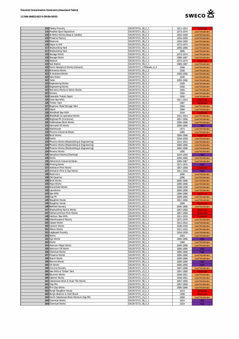
Potential Contamination Constraints (Associated Tables)
117086-SWECO-EGT-0-DR-EN-00033
115 Paisley Foundry GS-2673721_SS_2_2 1911-1914 Moderate115 Possible Spoil Deposition GS-2673721_SS_2_2 1973-1974 Low/Moderate116 St Rollox Works (Soap & Candle) GS-2673721_SS_2_2 1934-1939 Low/Moderate116 Preserve Factory GS-2673721_SS_2_2 1934-1939 Low/Moderate116 Reservoir GS-2673721_SS_2_2 1934-1939 Low/Moderate116 Depot & Mill GS-2673721_SS_2_2 1973-1974 Low/Moderate117 Shipbuilding Yard GS-2673721_SS_2_2 1895-1896 Low/Moderate117 Shipbuilding Yard GS-2673721_SS_1_2 1895 Low/Moderate118 Sewage Works GS-2673721_SS_2_2 1973-1974 Low/Moderate118 Sewage Works GS-2673721_SS_2_2 1985-1987 Low/Moderate119 Abattoir GS-2673721_SS_2_2 1973-1974 Moderate119 Sub Station GS-2673721_SS_2_2 1985-1987 Low/Moderate120 North Sandyford Works (Cement) GS-2673721_1250scale_4_4 1948 Low/Moderate121 Brittannia Works GS-2673721_SS_2_2 1939 Low/Moderate121 St Andrews Works GS-2673721_SS_2_2 1955-1956 Low/Moderate122 New Mains GS-2673721_SS_2_2 1939 Low/Moderate122 Tanks GS-2673721_SS_2_2 1955-1956 Low/Moderate123 Engineering Works GS-2673721_SS_3_2 1939 Low/Moderate123 Engineering Works GS-2673721_SS_3_2 1956 Low/Moderate123 Sternette Works & Kelvin Works GS-2673721_SS_3_2 1956 Low/Moderate123 Nursery GS-2673721_SS_3_2 1956 Low/Moderate124 Deanside Transit Depot GS-2673721_SS_3_2 1956 Low/Moderate125 Dock Saw Mills GS-2673721_SS_3_2 1911-1914 Moderate126 Timber Yard GS-2673721_SS_3_2 1987 Moderate127 Bogmoor Road Storage Yard GS-2673721_SS_3_2 1956 Low/Moderate127 Depot GS-2673721_SS_3_2 1966 Low/Moderate128 Shieldhall Saw Mills GS-2673721_SS_3_2 1934 Moderate129 Shieldhall Co-operative Works GS-2673721_SS_3_2 1911-1914 Low/Moderate130 Boghead Pit (Ironstone) GS-2673721_SS_1_1 1857-1858 Low/Moderate130 Walkinshaw Brick Works GS-2673721_SS_1_1 1895-1896 Low/Moderate131 Hermand Oil Works GS-2673721_SS_1_1 1895-1896 High132 Warehouse GS-2673721_SS_1_2 1974 Low/Moderate132 Phoenix Industrial Estate GS-2673721_SS_1_2 1985 Low/Moderate133 Brick Works GS-2673721_SS_1_1 1895-1896 Moderate133 Works GS-2673721_SS_2_2 1934-1939 Low/Moderate134 Phoenix Works (Shipbuilding & Engineering) GS-2673721_SS_1_1 1912-1916 Low/Moderate134 Phoenix Works (Shipbuilding & Engineering) GS-2673721_SS_2_1 1895-1896 Low/Moderate134 Phoenix Works (Shipbuilding & Engineering) GS-2673721_SS_2_2 1895-1896 Low/Moderate134 Phoenix Works GS-2673721_SS_1_2 1895 Low/Moderate135 Sandyford Works (Chemical) GS-2673721_SS_2_2 1934-1939 High135 Works GS-2673721_SS_2_2 1955-1956 Low/Moderate135 Abbotsinch Industrial Estate GS-2673721_SS_2_2 1985-1987 Low/Moderate136 Printing Works GS-2673721_SS_2_1 1971-1976 High137 Arkleston Print Works GS-2673721_SS_2_1 1857-1858 Moderate137 Arkleston Print & Dye Works GS-2673721_SS_2_1 1911-1916 High138 Reservoirs GS-2673721_SS_2_1 1896 Low/Moderate138 Old Quarries GS-2673721_SS_2_1 1896 Low/Moderate139 Brick Works GS-2673721_SS_1_1 1895-1896 Low/Moderate140 Rope Works GS-2673721_SS_1_1 1895-1896 Low/Moderate141 Marchfield Works GS-2673721_SS_1_1 1938-1939 Low/Moderate142 Laundrette GS-2673721_SS_1_1 1895-1896 Low/Moderate143 Saw Mills GS-2673721_SS_1_1 1895-1896 Moderate144 Clay Pit GS-2673721_SS_1_1 1895-1896 Low/Moderate145 Slaughter House GS-2673721_SS_1_1 1857-1858 Low/Moderate145 Slaughter House GS-2673721_LS_2_2 1858 Moderate146 Bellfield Nursery GS-2673721_SS_1_1 1895-1896 Low/Moderate147 Shipbuilding Yard & Works GS-2673721_SS_1_1 1857-1858 Moderate147 Nethercommon Print Works GS-2673721_SS_2_1 1857-1858 Moderate148 Harbour Saw Mills GS-2673721_SS_2_1 1911-1916 Moderate149 Warehouses & Factory GS-2673721_SS_2_1 1971-1976 Low/Moderate150 Carpet Works GS-2673721_SS_1_1 1912-1916 Low/Moderate150 Cement Works GS-2673721_SS_1_1 1938-1939 Low/Moderate151 Albion Works GS-2673721_SS_2_1 1911-1916 Low/Moderate151 Laighpark Foundry GS-2673721_SS_2_1 1934-1939 Low/Moderate151 Works GS-2673721_SS_2_1 1955 Low/Moderate152 Dye Works GS-2673721_SS_2_1 1895-1896 High153 Works GS-2673721_SS_1_1 1968 Low/Moderate154 Abercorn Rope Works GS-2673721_SS_1_1 1895-1896 Low/Moderate155 Abercorn Oil Works GS-2673721_SS_1_1 1895-1896 High156 Chemical Works GS-2673721_SS_1_1 1895-1896 High157 Preserve Works GS-2673721_SS_1_1 1895-1896 Low/Moderate158 Starch Works GS-2673721_SS_1_1 1895-1896 Low/Moderate159 Retorts Works GS-2673721_SS_1_1 1895-1896 High160 Oil Works GS-2673721_SS_1_1 1895-1896 High160 Victoria Foundry GS-2673721_LS_2_2 1897-1898 Low/Moderate160 Saw Mills & Timber Yard GS-2673721_LS_2_2 1897-1898 Moderate160 Bitumen Works GS-2673721_LS_2_2 1949-1951 Low/Moderate160 Cabinet Works GS-2673721_LS_2_2 1949-1951 Low/Moderate161 Caledonian Brick & Drain Tile Works GS-2673721_SS_1_1 1857-1858 Low/Moderate161 Clay Pits GS-2673721_SS_1_1 1857-1858 Low/Moderate161 Fire Clay Works GS-2673721_SS_1_1 1895-1896 Low/Moderate162 Burgh Slaughter House GS-2673721_LS_2_2 1913 Moderate162 Burgh Abattoir & Cold Stores GS-2673721_LS_2_2 1938 Moderate163 North Caledonian Brick Works & Clay Pits GS-2673721_LS_2_2 1858 Low/Moderate164 Chemical Works GS-2673721_SS_1_1 1924 High164 Chemical Works GS-2673721_SS_2_1 1924 High

Potential Contamination Constraints (Associated Tables)
117086-SWECO-EGT-0-DR-EN-00033
165 Cartside Dye Works GS-2673721_SS_2_1 1857-1858 High166 Snowdown Soap Works GS-2673721_SS_2_1 1857-1858 Low/Moderate167 Builders Yard GS-2673721_SS_1_1 Current Low/Moderate168 Adelphi Cotton Mill GS-2673721_SS_2_1 1857-1858 Low/Moderate169 Thread Factory GS-2673721_SS_2_1 1857-1858 Low/Moderate170 Rope Works and Engine & Machine Works GS-2673721_LS_3_2 1897 Low/Moderate170 Laighpark Engineering Works GS-2673721_LS_3_2 1950 Low/Moderate171 Earth Works on Byres Hill GS-2673721_SS_2_1 1911-1916 Low/Moderate172 Clay Pits GS-2673721_SS_1_1 1857-1858 Low/Moderate173 Works GS-2673721_SS_1_1 1983-85 Low/Moderate174 Refuse Destructor GS-2673721_SS_1_1 1912-1916 Low/Moderate175 Hot House Works GS-2673721_SS_1_1 1895-1896 Low/Moderate176 Caledonian Print Works & Clay Pit GS-2673721_SS_1_1 1857-1858 Moderate176 Saw Mills GS-2673721_LS_2_1 1897 Moderate177 Dye Works GS-2673721_SS_1_1 1857-1858 High178 Saw Mills & Wood Yard GS-2673721_SS_1_1 1857-1858 Moderate179 Warehouses & Depots GS-2673721_SS_1_1 Current Low/Moderate180 Timber Yards GS-2673721_LS_3_2 1858 Moderate181 Thread Mill GS-2673721_SS_2_1 1857-1858 Low/Moderate181 Imperial Starch Works GS-2673721_SS_2_1 1857-1858 Low/Moderate181 Station & Works GS-2673721_LS_3_2 1897 Low/Moderate182 Works GS-2673721_SS_1_1 Current Low/Moderate182 Nursery & Manure Yard GS-2673721_LS_2_1 1858 Low/Moderate183 Brick Works & Clay Pits GS-2673721_SS_1_1 1857-1858 Low/Moderate183 Starch Works GS-2673721_SS_1_1 1857-1858 Low/Moderate183 Engine Works GS-2673721_SS_1_1 1895-1896 Moderate184 Coal Depots GS-2673721_SS_1_1 1857-1858 Moderate185 Saw Mills GS-2673721_SS_1_1 1895-1896 Moderate186 Aerated Water Factory GS-2673721_LS_2_1 1950 Low/Moderate187 Timber Yard GS-2673721_SS_1_1 1857-1858 Moderate187 Iron Works GS-2673721_LS_3_1 1897 Moderate188 Brass Foundry GS-2673721_LS_3_1 1913 Low/Moderate188 Sheet Metal Works GS-2673721_LS_3_1 1950 Low/Moderate189 Coachbuilding Works GS-2673721_LS_3_1 1950 Low/Moderate189 Mill GS-2673721_LS_3_1 1962 Low/Moderate190 Dye Works & Oil Works GS-2673721_SS_2_1 1857-1858 High190 Mill GS-2673721_SS_2_1 1955 Low/Moderate190 Weaving Mill GS-2673721_LS_3_1 1938 Low/Moderate191 Vulcan Foundry (Iron) GS-2673721_SS_2_1 1857-1858 Moderate192 Vulcan Works (Engineering) GS-2673721_SS_2_1 1857-1858 Low/Moderate192 Starch Works GS-2673721_SS_2_1 1895-1896 Low/Moderate192 Goods Station GS-2673721_SS_2_1 1895-1896 Low/Moderate193 Timber Yard GS-2673721_LS_3_1 1858 Moderate194 Sewage Works GS-2673721_SS_1_1 1912-1916 Low/Moderate195 Old Quarries GS-2673721_SS_1_1 1857-1858 Low/Moderate196 Chemical Works GS-2673721_SS_1_1 1857-1858 High197 Gasworks GS-2673721_SS_1_1 1857-1858 High198 Dye Works GS-2673721_SS_1_1 1895-1896 High199 Underwood Cotton Mill GS-2673721_SS_1_1 1857-1858 Low/Moderate200 Coal Depot GS-2673721_SS_1_1 1857-1858 Moderate201 Timber Yard GS-2673721_SS_1_1 1857-1858 Moderate202 Print Works GS-2673721_LS_3_1 1858 Moderate203 Paisley Foundry (Iron) GS-2673721_LS_3_1 1858 Moderate203 Coal Yard GS-2673721_LS_3_1 1858 Moderate204 Soap Works GS-2673721_LS_3_1 1858 Low/Moderate205 Shipbuilding Yard GS-2673721_LS_3_1 1897 Low/Moderate206 Abercorn Timber Yard GS-2673721_LS_3_1 1858 Moderate207 Abercorn Works (Engineering) GS-2673721_LS_3_1 1858 Low/Moderate208 Works GS-2673721_LS_3_1 1897 Low/Moderate209 Smithhills Dye Works GS-2673721_LS_3_1 1858 High210 Smithy GS-2673721_LS_3_1 1913 Low/Moderate211 Newtown Foundry (Iron) GS-2673721_LS_3_1 1858 Low/Moderate211 Abbey Works GS-2673721_LS_3_1 1858 Low/Moderate212 Timber Yard & Saw Mill GS-2673721_LS_3_1 1858 Moderate213 Timber Yards & Saw Mills GS-2673721_LS_3_1 1858 Moderate213 Walneuk Saw Mills GS-2673721_LS_3_1 1950 Moderate214 Print Works GS-2673721_SS_2_1 1857-1858 Moderate214 Print Works GS-2673721_LS_3_1 1858 Moderate214 Timber Yard GS-2673721_LS_3_1 1858 Moderate215 East Greenlaw Nursery GS-2673721_SS_2_1 1857-1858 Low/Moderate216 Liquor Works GS-2673721_SS_1_1 1857-1858 High217 Dye Works GS-2673721_SS_1_1 1857-1858 High218 Thread Mill GS-2673721_SS_1_1 1895-1896 Low/Moderate218 Store GS-2673721_SS_1_1 1983-85 Low/Moderate219 Coal Depot GS-2673721_LS_2_1 1858 Moderate219 Timber Yard GS-2673721_LS_2_1 1858 Moderate220 Timber Yard & Saw Pit GS-2673721_LS_2_1 1858 Moderate221 Brediland Chemical Works GS-2673721_SS_1_1 1895-1896 High222 Fireclay Works GS-2673721_SS_1_1 1857-1858 Low/Moderate223 Thread Works GS-2673721_SS_1_1 1857-1858 Low/Moderate223 Goods Shed, tank GS-2673721_SS_1_1 1895-1896 Low/Moderate223 Thread Works GS-2673721_SS_1_1 1895-1896 Low/Moderate224 Dye Works GS-2673721_SS_1_1 1895-1896 High225 Starch Works GS-2673721_SS_2_1 1895-1896 Low/Moderate226 Castlehead Colliery GS-2673721_SS_1_1 1857-1858 Low/Moderate227 Lady Lane Works GS-2673721_SS_1_1 1857-1858 Low/Moderate
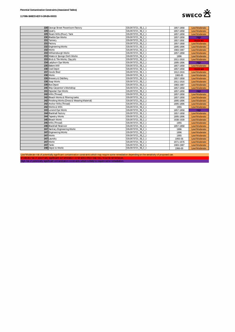
Potential Contamination Constraints (Associated Tables)
117086-SWECO-EGT-0-DR-EN-00033
228 George Street Powerloom Factory GS-2673721_SS_1_1 1857-1858 Low/Moderate229 Quarry GS-2673721_SS_2_1 1857-1858 Low/Moderate229 Steam Mills (Flour); Tank GS-2673721_SS_2_1 1857-1858 Low/Moderate230 Bladda Dye Works GS-2673721_SS_2_1 1857-1858 High231 Tannery GS-2673721_SS_2_1 1857-1858 Moderate231 Factory GS-2673721_SS_2_1 1857-1858 Low/Moderate232 Engineering Works GS-2673721_SS_2_1 1895-1896 Low/Moderate232 Works GS-2673721_SS_2_1 1983-1987 Low/Moderate233 Williamsburgh Works GS-2673721_SS_2_1 1857-1858 Low/Moderate233 Waste & Sponge Cloth Works GS-2673721_SS_2_1 1896 Low/Moderate233 Brick & Tile Works, Clay pits GS-2673721_SS_2_1 1911-1916 Low/Moderate234 Ladyburn Dye Works GS-2673721_SS_2_1 1895-1896 High235 Bakers Mill GS-2673721_SS_1_1 1857-1858 Low/Moderate236 Coal Depot GS-2673721_SS_1_1 1857-1858 Moderate237 Goods Shed GS-2673721_SS_1_1 1912-1916 Low/Moderate238 Works GS-2673721_SS_1_1 1983-85 Low/Moderate239 Brewery & Distillery GS-2673721_SS_2_1 1857-1858 Low/Moderate239 Soap Works GS-2673721_SS_2_1 1911-1916 Low/Moderate239 Bus Depot GS-2673721_SS_2_1 1983-1987 Low/Moderate240 Ship Carpenter's Workshop GS-2673721_SS_2_1 1857-1858 Low/Moderate241 Espedair Dye Works GS-2673721_SS_2_1 1857-1858 High242 Mills (Thread) GS-2673721_SS_2_1 1857-1858 Low/Moderate242 Bleach Works & Filtering tanks GS-2673721_SS_2_1 1857-1858 Low/Moderate242 Finishing Works (Dress & Weaving Material) GS-2673721_SS_2_1 1895-1896 Low/Moderate242 Anchor Mills (Thread) GS-2673721_SS_2_1 1895-1896 Low/Moderate242 Works & Mills GS-2673721_SS_2_1 1955 Low/Moderate243 Lonend Dye Works GS-2673721_SS_2_1 1857-1858 High244 Blackhall Factory GS-2673721_SS_2_1 1857-1858 Low/Moderate244 Tapestry Works GS-2673721_SS_2_1 1895-1896 Low/Moderate245 Bleach Works GS-2673721_SS_2_1 1938-1939 Low/Moderate245 Mills (Thread) GS-2673721_SS_2_1 1955 Low/Moderate246 Blackhall Reservoir GS-2673721_SS_2_1 1857-1858 Low/Moderate247 Sanitary Engineering Works GS-2673721_SS_2_1 1896 Low/Moderate247 Engineering Works GS-2673721_SS_2_1 1896 Low/Moderate247 Works GS-2673721_SS_2_1 1955 Low/Moderate247 Laundry GS-2673721_SS_2_1 1955-56 Low/Moderate247 Works GS-2673721_SS_2_1 1971-1976 Low/Moderate247 Tanks GS-2673721_SS_2_1 1983-1987 Low/Moderate248 Depot & Works GS-2673721_SS_2_1 1966-69 Low/Moderate
Low/Moderate risk of potentially significant contamination constraints which may require some remediation depending on the sensitivity of proposed use.Moderate risk of potentially significant contamination constraints which may require some remediation.High risk of potentially significant contamination constraints which is likely to require some remediation.
Summary of EIA Scoping
118GLASGOW AIRPORTINVESTMENT AREASCOPING REPORT
Appendix 6.1: LVIA Methodology
Page 1 of 9
Appendix 6.1 – Proposed LVIA Methodology
The purpose of a Landscape and Visual Impact Assessment (LVIA) is to identify and describethe likely landscape and visual effects of a development and to determine whether or notthey would be significant. The LVIA will consider the effects of the proposed developmenton both the landscape as an environmental resource and on people's visual amenity. Theintended use of this environmental information is to inform stakeholders and to assistdecision making. An LVIA is undertaken in a sequence of iterative stages:
· Identification of aspects of the development that may give rise to significant effectson the landscape resource or on visual amenity;
· Description of baseline landscape and visual conditions: for the landscapeassessment this provides an understanding of the character and value of thelandscape resource and for the visual assessment this identifies the people in specificlocations that may be visually affected;
· Identification of the landscape and visual receptors that may be affected by thedevelopment and an initial assessment of the likely significant effects upon them;
· Identification of mitigation measures appropriate to the development and itslandscape context; and
· Assessment of the residual landscape and visual effects of the developmentincorporating mitigation and categorisation of their significance to decision makers.
The significance of the likely effects of the proposed development on identified landscapeand visual receptors will be assessed using professional judgement. This professionaljudgement may take into account a number of different considerations including: thesusceptibility of different receptors to the likely changes that would be associated with thescheme; the value or importance that is attached to the landscape receptor or a particularview; and the degree, geographical extent, duration and reversibility of the change that islikely to arise. The relevance and weighting of these many considerations will varydepending on the type of receptor being assessed.
As has been stated previously within this report, the LVIA will also include a townscapeassessment..
1.1.1 Guidance
The LVIA will be carried out in accordance with all current and relevant advisory guidelinescomprising:
· Guidelines for Landscape and Visual Impact Assessment, 3rd Edition (2013) E & FNSpon, Copyright the Institute of Environmental Assessment and the LandscapeInstitute
· Landscape Character Assessment – Guidance for England and Scotland (2002)Prepared on behalf of the Countryside Agency and Scottish Natural Heritage by LandUse Consultants; and

Page 2 of 9
· Advice Note 01/09 - Use of Photography and Photomontages in Landscape and VisualImpact Assessment (2009) Landscape Institute; and
· DMRB Volume 11, Section 3, Part 5 Landscape Effects (1993) (hereafter referred to asDMRB) The Highways Agency.
Reference to DMRB relates to the stages of assessment through which the project hasdeveloped and not the specific approach to LVIA.
1.1.2 Assessing the level and significance of landscape effects
The level and significance of the likely effects of the proposed development on identifiedlandscape receptors will be assessed using professional judgement. This professionaljudgement may take into account a number of different considerations including:
· The susceptibility of different landscape receptors to the likely changes that wouldbe associated with the Proposed Development;
· The value or importance that is attached to them; and· The degree, geographical extent, duration and reversibility of the change to the
landscape that is likely to arise.
Considerations of susceptibility and value may both be considered as the ‘sensitivity’ oflandscape receptors. Considerations of degree, geographical extent, duration andreversibility of landscape change, may be considered as the ‘magnitude of landscapechange’ that may arise due to the proposed development.
The level of landscape effect is categorised using a four point scale: major; moderate;minor; and negligible. The level of effect is assessed by combining all of the considerationsand criteria set out above. This is described by GLVIA3 as an ‘overall profile’ approach tocombining judgements and requires that all the judgements against each of the identifiedcriteria (i.e. susceptibility; value; degree of change; extent of change; duration of change;and reversibility of change) are utilised to allow a reasoned professional assessment of theoverall level of landscape effect.
The relative weight attributed to each consideration is a matter of professional judgementand will vary depending on the specific landscape receptor being assessed. For example,susceptibility is more relevant to landscape character than to the removal of landscapeelements such as tree cover and short term reversible effects on the landscape may still bejudged to be significant by the decision makers.
Where possible to do so with a reasonable level of professional objectivity the effects of theproposed development on the landscape are identified as likely to be generally consideredpositive (beneficial), neutral or negative (adverse).
The significance of landscape effects is categorised as ‘significant’ or ‘not significant’. Thejudgement on the significance of effect is informed directly by the level of effect that isidentified as follows:

Page 3 of 9
· A major or moderate level of effect is considered to be significant; and· A minor or a negligible level of effect is considered to be not significant.
GLVIA3 states the following with regard to the judgement of significant landscape effects:
“There are no hard and fast rules about what makes a significant effect, and there cannotbe a standard approach since circumstances vary with the location and landscape contextand with the type of proposal. At opposite ends of a spectrum it is reasonable to say that:
· Major loss or irreversible negative effects, over an extensive area, on elementsand/or aesthetic and perceptual aspects that are key to the character ofnationally valued landscapes are likely to be of the greatest significance;
· Reversible negative effects of short duration, over a restricted area, on elementsand/or aesthetic and perceptual aspects that contribute to but are not keycharacteristics of the character of landscapes of community value are likely to beof the least significance and may, depending on the circumstances, be judged asnot significant;
· Where assessments of significance place landscape effects between theseextremes, judgements must be made about whether or not they are significant,with full explanations of why these conclusions have been reached.”
1.1.2.1 Susceptibility of Landscape and Townscape Receptors to Change
The susceptibility of the landscape refers to its ability to accommodate the changes likely tobe brought about by the proposed development without undue consequences for themaintenance of the baseline situation. Tables 6.2 and 6.3 provides a list of keycharacteristics and attributes that will be used in this assessment as indicators of levels oflandscape and townscape susceptibility. The tables are indicative rather than prescriptiveand the susceptibility of the landscape or townscape is categorised as High, Medium or Lowusing professional judgement.
Table 6.2 – Susceptibility of landscape character to changeKey characteristics Attributes indicating higher
susceptibility to changeAttributes indicating lowersusceptibility to change
Scale Small-scale landform/landcover;fine grained; enclosed; sheltered
<---> Large-scale landform/land cover;coarse grained
Enclosure Open <---> Enclosed
Landform A flat, uniform landscape <---> An undulating landscape
Landcover and Pattern Complex, irregular or intimatelandscape patterns; diverse landcover
<---> Simple, regular landscape patterns;uncluttered, sweeping lines; consistentland cover
Engineered / Built Influences General absence of stronglyengineered, built or manmadeinfluences such as: electrical
<---> Engineered forms/land use pattern;frequent presence of man-madeelements, brownfield or industrial
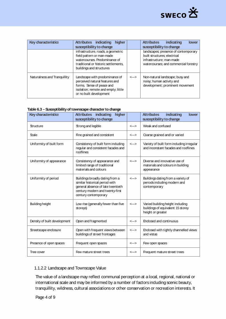
Page 4 of 9
Key characteristics Attributes indicating highersusceptibility to change
Attributes indicating lowersusceptibility to change
infrastructure, roads, a geometricfield pattern or man-madewatercourses. Predominance oftraditional or historic settlements,buildings and structures
landscapes; presence of contemporarybuilt structures; electricalinfrastructure; man-madewatercourses; and commercial forestry
Naturalness and Tranquillity Landscape with predominance ofperceived natural features andforms. Sense of peace andisolation; remote and empty; littleor no built development
<---> Non-natural landscape; busy andnoisy; human activity anddevelopment; prominent movement
Table 6.3 – Susceptibility of townscape character to changeKey characteristics Attributes indicating higher
susceptibility to changeAttributes indicating lowersusceptibility to change
Structure Strong and legible <---> Weak and confused
Scale Fine grained and consistent <---> Coarse grained and/or varied
Uniformity of built form Consistency of built form includingregular and consistent facades androoflines
<---> Variety of built form including irregularand inconstant facades and rooflines
Uniformity of appearance Consistency of appearance andlimited range of traditionalmaterials and colours
<---> Diverse and innovative use ofmaterials and colours in buildingappearance
Uniformity of period Buildings broadly dating from asimilar historical period withgeneral absence of late twentiethcentury modern and twenty-firstcentury contemporary
<---> Buildings dating from a variety ofperiods including modern andcontemporary
Building height Low rise (generally fewer than fivestoreys)
<---> Varied building height includingbuildings of equivalent 15 storeyheight or greater
Density of built development Open and fragmented <---> Enclosed and continuous
Streetscape enclosure Open with frequent views betweenbuildings of street frontages
<---> Enclosed with tightly channelled viewsand vistas
Presence of open spaces Frequent open spaces <---> Few open spaces
Tree cover Few mature street trees <---> Frequent mature street trees
1.1.2.2 Landscape and Townscape Value
The value of a landscape may reflect communal perception at a local, regional, national orinternational scale and may be informed by a number of factors including scenic beauty,tranquillity, wildness, cultural associations or other conservation or recreation interests. It
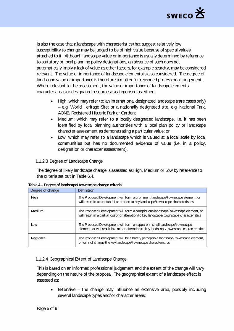
Page 5 of 9
is also the case that a landscape with characteristics that suggest relatively lowsusceptibility to change may be judged to be of high value because of special valuesattached to it. Although landscape value or importance is usually determined by referenceto statutory or local planning policy designations, an absence of such does notautomatically imply a lack of value as other factors, for example scarcity, may be consideredrelevant. The value or importance of landscape elements is also considered. The degree oflandscape value or importance is therefore a matter for reasoned professional judgement.Where relevant to the assessment, the value or importance of landscape elements,character areas or designated resources is categorised as either:
· High: which may refer to: an international designated landscape (rare cases only)– e.g. World Heritage Site; or a nationally designated site, e.g. National Park,AONB, Registered Historic Park or Garden;
· Medium: which may refer to a locally designated landscape, i.e. it has beenidentified by local planning authorities with a local plan policy or landscapecharacter assessment as demonstrating a particular value; or
· Low: which may refer to a landscape which is valued at a local scale by localcommunities but has no documented evidence of value (i.e. in a policy,designation or character assessment).
1.1.2.3 Degree of Landscape Change
The degree of likely landscape change is assessed as High, Medium or Low by reference tothe criteria set out in Table 6.4.
Table 4 – Degree of landscape/townscape change criteriaDegree of change Definition
High The Proposed Development will form a prominent landscape/townscape element, orwill result in a substantial alteration to key landscape/townscape characteristics
Medium The Proposed Development will form a conspicuous landscape/townscape element, orwill result in a partial loss of or alteration to key landscape/townscape characteristics
Low The Proposed Development will form an apparent, small landscape/townscapeelement, or will result in a minor alteration to key landscape/townscape characteristics
Negligible The Proposed Development will be a barely perceptible landscape/townscape element,or will not change the key landscape/townscape characteristics
1.1.2.4 Geographical Extent of Landscape Change
This is based on an informed professional judgement and the extent of the change will varydepending on the nature of the proposal. The geographical extent of a landscape effect isassessed as:
· Extensive – the change may influence an extensive area, possibly includingseveral landscape types and/or character areas;

Page 6 of 9
· Medium – the change may influence the wider landscape type and/or characterarea within which the Proposed Development is located; and
· Localised – the change may be within the PDA itself and its immediate setting.
1.1.2.5 Duration of Landscape Change
For this scheme the following categories of duration of landscape effect have beenadopted:
· Short term – an effect likely to last up to five years;· Medium term – an effect likely to last between five and fifteen years; and· Long term – an effect likely to last longer than fifteen years.
1.1.2.6 Reversibility of Landscape Change
In terms of the reversibility of landscape change, the following categories have beenadopted:
· Reversible – an effect which is entirely reversible, i.e. the landscape can berestored to its original state prior to the development occurring;
· Partially reversible – the landscape can be partially restored to its original stateprior to the development occurring; and
· Irreversible – the landscape is considered to be irreversibly altered following theoccurrence of the development.
It should be noted however that Duration of Change and Reversibility of Change are linkedconsiderations and where it is deemed that landscape change due to a proposeddevelopment is permanent in duration, it is not necessary to consider the reversibility ofthat change.
1.1.3 Level and Significance of Visual Effects
The significance of the likely visual effects of the proposed development on identifiedreceptors will also be assessed using professional judgement. This professional judgementmay take into account a range of considerations including:
· the susceptibility of people in different contexts to the likely visual changes thatwould be associated with the scheme;
· the value or importance that they are considered likely to attach to the existingview; and
· the degree, geographical extent, duration and reversibility of the visual changethat is likely to arise.
As was the case for the landscape assessment approach, considerations of susceptibilityand value may be considered as comprising the ‘sensitivity’ of visual receptors.Considerations of degree, geographical extent, duration and reversibility of visual change,may be considered as the ‘magnitude of visual change’.

Page 7 of 9
The significance of visual effects is categorised as ‘significant’ or ‘not significant’.Significance is assessed by combining all of the considerations and criteria set outpreviously. The relative weight attributed to each consideration is a matter of professionaljudgement and will vary depending on the specific visual receptor being assessed. Forexample, the geographical extent of visual change is more relevant to an area or route thanto a fixed viewpoint and short term reversible visual effects may still be judged to besignificant to decision makers.
Where possible to do so with a reasonable level of professional objectivity the visual effectsof the proposed development are identified as likely to be considered positive (beneficial),neutral or negative (adverse).
1.1.3.1 Susceptibility of Visual Receptors to Change and Value Attributed to a View
People’s susceptibility to visual change varies depending on their purpose for being in aparticular location (principally whether for residence, recreation, travel or employment).The susceptibility to change of different categories of visual receptor is assessed on a scaleof High, Medium or Low and is typically defined based on the categories of viewer set out inTable 6.5.
Table 6.5 – Susceptibility of visual receptor types to changeLevel of susceptibility Typical receptors
High People with a particular interest in the available view or with prolonged viewingopportunities, such as:
· Promoted viewpoints (often recognised by the provision of interpretation),promoted scenic drives or tourist routes;
· Tourist, visitor and/or heritage destinations providing a specific, important andhighly valued view;
· Recreational hilltops and peaks;
· Residential locations;
· Ornamental parks and public open spaces; and
· Nationally or locally named trails and cycle routes
Medium People with a general interest in their surroundings or with transient viewingopportunities, such as:
· General and incidental footpaths and rights of way;
· Residential distributor and local road network; and
· General public open spaces, recreation grounds and play areas
Low People with a limited or passing interest in their surroundings, such as:
· Places of employment;
· Major highways (sensitivity may be higher in scenic locations);
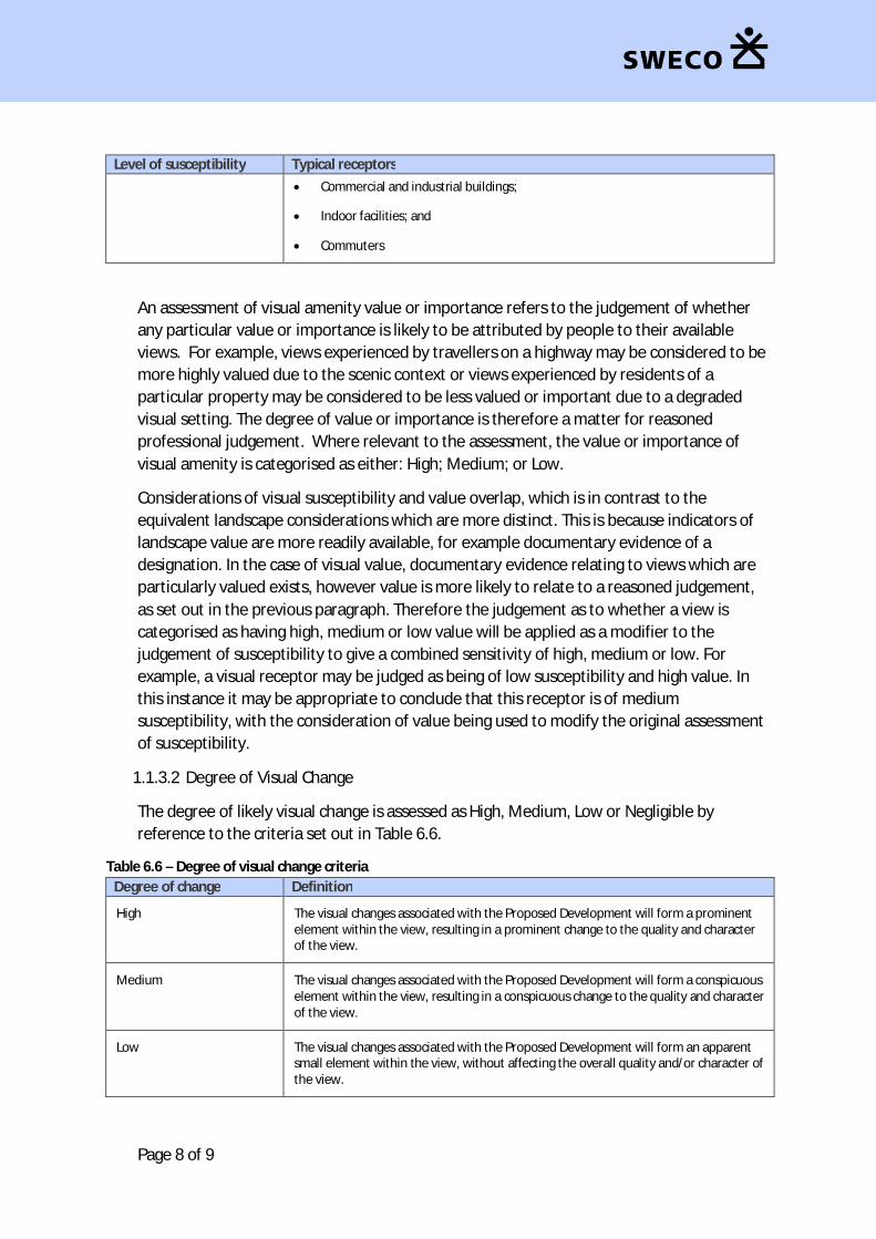
Page 8 of 9
Level of susceptibility Typical receptors· Commercial and industrial buildings;
· Indoor facilities; and
· Commuters
An assessment of visual amenity value or importance refers to the judgement of whetherany particular value or importance is likely to be attributed by people to their availableviews. For example, views experienced by travellers on a highway may be considered to bemore highly valued due to the scenic context or views experienced by residents of aparticular property may be considered to be less valued or important due to a degradedvisual setting. The degree of value or importance is therefore a matter for reasonedprofessional judgement. Where relevant to the assessment, the value or importance ofvisual amenity is categorised as either: High; Medium; or Low.
Considerations of visual susceptibility and value overlap, which is in contrast to theequivalent landscape considerations which are more distinct. This is because indicators oflandscape value are more readily available, for example documentary evidence of adesignation. In the case of visual value, documentary evidence relating to views which areparticularly valued exists, however value is more likely to relate to a reasoned judgement,as set out in the previous paragraph. Therefore the judgement as to whether a view iscategorised as having high, medium or low value will be applied as a modifier to thejudgement of susceptibility to give a combined sensitivity of high, medium or low. Forexample, a visual receptor may be judged as being of low susceptibility and high value. Inthis instance it may be appropriate to conclude that this receptor is of mediumsusceptibility, with the consideration of value being used to modify the original assessmentof susceptibility.
1.1.3.2 Degree of Visual Change
The degree of likely visual change is assessed as High, Medium, Low or Negligible byreference to the criteria set out in Table 6.6.
Table 6.6 – Degree of visual change criteriaDegree of change Definition
High The visual changes associated with the Proposed Development will form a prominentelement within the view, resulting in a prominent change to the quality and characterof the view.
Medium The visual changes associated with the Proposed Development will form a conspicuouselement within the view, resulting in a conspicuous change to the quality and characterof the view.
Low The visual changes associated with the Proposed Development will form an apparentsmall element within the view, without affecting the overall quality and/or character ofthe view.

Page 9 of 9
Negligible The visual changes associated with the Proposed Development will result in a barelyperceptible change in the view, or will cause ‘no change’ to the existing view.
1.1.3.3 Geographical Extent of Visual Change
The geographical extent of a visual effect is assessed as: Extensive; Medium; and Localised.This is based on an informed professional judgement and reflects the extent of the areaover which the changes will be visible.
However, this consideration is not applicable when the assessment refers to a single visualreceptor, such as a single residential property. Geographical extent would apply whenassessing the visual effects on multiple users of an extent of road or groups of propertieswithin a settlement for example.
1.1.3.4 Duration of Visual Change
For this scheme the following categories of duration of visual effect have been adopted:
· Short term – an effect likely to last up to five years;· Medium term – an effect likely to last between five and fifteen years; and· Long term – an effect likely to last longer than fifteen years.
1.1.3.5 Reversibility of Visual Change
In terms of the reversibility of visual change, the following categories have been adopted:
· Reversible – an effect which is entirely reversible, i.e. the view can be restored tothat which was experienced prior to the occurrence of the development;
· Partially reversible – the view can be partially restored to that which wasexperienced prior to the occurrence of the development; and
· Irreversible – the view is considered to be irreversibly altered following theoccurrence of the development.
It should be noted however that Duration of Change and Reversibility of Change are linkedconsiderations and where it is deemed that visual change due to a proposed developmentis permanent in duration, it is not necessary to consider the reversibility of that change.
1.1.4 Cumulative Assessment
An assessment of likely significant landscape and visual cumulative effects will beundertaken. A list of schemes relevant to the landscape and visual assessment will beagreed in advance with Renfrewshire Council. However, this will comprise developmentswithin the study area which are of a similar: size; appearance; or use. Examples of types ofdevelopments which may be considered within the cumulative assessment would be: roaddevelopments, including bridges; industrial developments; and medium to large-scaleresidential developments.
Summary of EIA Scoping
GLASGOW AIRPORTINVESTMENT AREA
SCOPING REPORT
119
Appendix 7.1: Ecology Survey Methodology
Page 1 of 5
Appendix 7.1
Vegetation Surveys
Phase 1 Habitat Survey
A Phase 1 Habitat Survey was undertaken in February/March 2016 and is scheduled to beupdated in August 2016. The surveys will be undertaken in accordance with JNCC’s ‘Handbookfor Phase 1 Habitat Survey – A Technique for Environmental Audit‘(JNCC, 2007), takingrecognisance of best practice guidelines (CIEEM, 2006).
Collectively, the surveys will seek to establish the ecology baseline of the proposed project andwider study area and a 100m zone of influence, which will be used to inform the ecologicalimpact assessment in terms of permanent and temporary habitat loss.
The surveys will catalogue habitats and where applicable, record target notes using the DAFORscale regarding the abundance of plant species.
Aerial photographs and OS maps will additionally be consulted (where appropriate) to identifypotential habitats areas of nature conservation importance within the proposed project andzone of influence.
The Phase 1 Habitat survey additionally seek to identify the presence of non-native invasivespecies within and adjacent to the proposed project, with particular regard to those specieslisted on Schedule 9 of the Wildlife and Countryside Act 1981 (as amended).
Protected Species Surveys
Further detailed species specific surveys will be undertaken during the optimal season, inaccordance with the following methods.
Badger SurveyAll suitable habitats within the proposed project and 100 m zone of influence will be surveyedin October 2016 by an experienced ecologist for signs of badger following Harris et al. (1989).
As part of the survey, all hedgerows, field boundaries, watercourses, paths and other linearfeatures will be walked to locate badger field signs including but not limited to: badger setts,badger paths, evidence of foraging and dung pits. In addition, all areas of woodland and scrubwill be systematically searched for evidence of badger activity.
Where applicable, badger paths will be identified through the observation of field signsincluding prints, badger hairs on barbed wire or vegetation, dung pits and scratching posts.Similarly, the interiors of fields will be surveyed, in addition to their boundaries, where theyexhibit evidence of badger foraging or where badger paths pass through them.
Other areas offering the potential to support badger setts, identified during survey and fromOS maps, will be actively searched, where practicable.
Otter SurveyAll watercourses and water features within the proposed project and 250 m zone of influence(up and downstream of identified watercourses) were surveyed in June 2016 by anexperienced ecologist for signs of otter. Where possible, surveys were conducted from withinthe water channel, along the river bank and on ground within 10 m of watercourses.

Page 2 of 5
The survey focussed on identifying the presence of otter signs, which included: spraint(droppings) and footprints. Resting sites, for example, holts, couches and hovers, were alsoidentified following ‘Ecology of the European Otter: Conserving Natura 2000 Rivers EcologySeries No.10’ (Chanin, 2003), in addition to potential signs of otter activity including runs orother well-used access points to watercourses (slides), feeding remains e.g. fish carcasses andsightings, including otter road accident causalities.
Additional survey effort for otter (following the above methods) will be undertaken in autumn2016 to account for seasonal variation in the use of the White and Black Cart Waters.
Water Vole SurveyAll suitable watercourses and water features within the proposed project and 100-200m zoneof influence (up and downstream of identified watercourses) will be surveyed in August 2016by an experienced ecologist for signs of water vole taking cognisance of Strachan &Moorhouse (2006) and Dean et al. (2016).
Survey effort will focus on suitable riparian and/or terrestrial habitats and will seek todetermine the presence of the following field signs:
· burrows with entrances surrounded by grazed ‘lawns’;· runs through vegetation;· feeding stations (characterised by neatly chopped pieces of grass, sedge, or rush up to
10 cm long); and· latrines.
As part of the above proposed methods, it should be noted that following completion of theotter survey, White Cart Water and Black Cart Water were assessed as being un-suitable forwater vole and therefore will not be subject to any further investigation for this species as partof on-going and future survey effort.
Bat SurveyAerial photographs and topographical maps were used to identify areas of potential habitat forbats and to make an initial evaluation of the proposed project and wider study area.
The following survey methods are proposed, which were developed according to good practicestandards taking cognisance of the document ‘Bat Survey - Good Practice Guidelines’ (BatConservation Trust, 2016).
Preliminary Roost AssessmentIn line with the above best practice guidelines, a Preliminary Roost Assessment (comprising aninitial daytime walkover survey) was undertaken by an appropriately qualified bat worker(consultant) to identify potentially valuable foraging, commuting and roosting features for batswithin the proposed project and the following zones of influence, which were discussedthrough consultation with SNH (Graeme Heenan – Operations Officer, Pers. Com., 8 June2016):
30m - urban/built-up areas and all habitats adjacent to proposed cycleway infrastructure; and
100m - semi-natural areas (including woodland habitats).
As part of the survey, where possible/practicable an external inspection of all suitablestructures was undertaken, in addition to a systematic search for evidence of bats (usingbinoculars where appropriate), for example: live bats, bat corpses, droppings, feeding remains,

Page 3 of 5
scratch marks, and urine and grease staining. However, where access was not available e.g.private third-party residential property, such structures were assessed from areas of publicaccess, with any additional examination undertaken following landowner consent.
Bat Activity SurveysThe above good practice guidelines were consulted to establish survey methods and effort forthe Bat Activity Surveys, taking into consideration factors such as likely species present, surveyarea location, habitat type and presence of suitable features.
Walked TransectsBased on an initial examination of the Extended Phase 1 Habitat Survey data, three walkedtransects were established along the route of the proposed project and wider study area (tothe west of the White Cart Water).
Surveys along each of the three transects will be completed by two surveyors (for health andsafety purposes) on six occasions between April to September 2016 ensuring that at least oneof the surveys for each transect comprises a dusk and pre-dawn survey separate by less than24 hours.
Each of the transects will be walked at a steady pace from sunset for a period of up to 2-3hours after sunset; dawn transects will commence approximately 3-2 hours before sunrise andconcluded at sunrise. Each transect will be walked in an alternative direction (clockwise/anti-clockwise) to allow for different emergence times of bat species and to provide acomprehensive representation of habitat use throughout the survey period.
A series of five-minute pre-determined point counts will be incorporated into each of the threetransects to allow for a sample of bat activity to be taken within a range of habitat types(including habitats which are considered to be of minimum value to bats). Where possible,listening points will be sampled at the same locations continuously throughout the activeseason.
Survey data will be recorded using a Batbox Duet, which uses both frequency division andheterodyne functions, and a Tascam DR-07 recording device, using the reference button toprovide survey notes.
Data will be stored onto a compact flash card and analysed using BatSound software under thesupervision of a licensed bat worker. Where there is any doubt or uncertainties regarding batecholocation calls, British Bat Calls: A Guide to Species Identification (Russ, 2012) will beconsulted as a reference tool.
Automated SurveysDue to the medium value of the habitats within and adjacent to the proposed project and inline with the requirements of the above good practice guidance, two Songmeter SM2 staticdetectors will be erected on 1.5m poles (to reduce animal interference) and will be left at twopre-determined positions along each of the three proposed transects – making sure thatdetector locations are not easily discovered by members of the public due to the highlyurbanised nature of the survey areas. However, it should be noted that if detectors areremoved and cannot be located, consultation will be undertaken with SNH to determine analternate means of provided static data.
The static detectors will be programmed to record over a minimum of five consecutive nightsduring the above survey period (April to September 2016). Survey locations will be selected to
Page 4 of 5
provide a representative sample of all the habitats present within the proposed project andwider study area, in addition to locations along features likely to provide value for bats such as,riparian and edge habitats. Each device will be programmed to record all bat activity from 15minutes before sunset to 15 minutes after sunrise. Devices will be rotated around each staticdetector location in accordance with best practice guidelines in order to reduce data errorscaused by mechanical differences and failures.
All data collected by the static devices will be converted to zero crossing files and analysedusing Analook. British Bat Calls: A Guide to Species Identification (Russ, 2012) was used to aididentification of sonograms.
Bat Surveys: Tree SurveysWhere trees are assessed as having the potential to support bat roost based on the presence ofpotential roosting features, ‘at height’ inspection surveys will be completed by licenced andtrained tree climbers using an endoscope to inspect trees for current and/or historicalpresence of roosting bats.
Where evidence of bats is recorded, additional bat roost surveys will be undertaken (asoutlined below). However, it should be noted that where it is considered trees of moderate tohigh suitability are unsafe to climb, emergence surveys will be completed as outlined below.
Bat Roost Surveys: Emergence and Re-entryWhere suitable structures/trees and/or evidence of roosting bats is identified by thePreliminary Roost Assessment, dusk emergence and dawn re-entry surveys were carried outunder the supervision of a licenced ecologist (at ground level) by a sufficient number ecologistsin order to allow complete visual coverage of the properties, associated buildings and trees.
In line with the above good practice guidelines, surveys will be undertaken as per the following:
Low roost suitability: one survey required between May and August (excluding trees);
Moderate roost suitability: two surveys required between May and August;
High roost suitability: three surveys required, with at least two surveys completed betweenMay and August.
Dusk surveys will begin 15 minutes before sunset and continue for 2 hours (weatherdependent) after sunset. Dawn re-entry surveys will begin 2 hours before sunrise and willconclude 15 minutes at sunrise or 10 minutes after the last bat had returned to its roost aftersunrise.
As outlined above, the surveys will be recorded using Batbox Duets and Tascam DR-07recorders and analysed using BatSound software using Russ (2012) as a reference tool.
Baseline Surveys to be ‘Scoped Out’ of the Ecological AssessmentThe following ecological surveys will not be undertaken in support of the assessment ofecological effects.
National Vegetation Classification (NVC) Survey
Due to the disturbed structure of woodland habitats within the proposed project and widerzone of influence, coupled with the presence of large quantities of sycamore, influx ofregenerating birch and willow and small quantities of remnant semi-natural woodland habitat,a National Vegetation Classification (NVC) survey will not be undertaken, as the resulting survey

Page 5 of 5
is unlikely to provide a greater level of understanding of the woodland habitats, in terms ofcharacterisation and impact assessment.
Great Crested Newt Survey
As a result of the desk study investigation, which established records of great crested newt forthe 10 km OS Grid Square (NS46, NS47, NS56, NS57), coupled with consultation with SNH(Graeme Heenan – Operations Officer, Pers. Com., 25 May 2016), a Habitat SuitabilityAssessment (HSI) for this species was completed for the proposed project and wider 500mzone of influence taking cognisance of Oldham et al. (2000). HSI is a numerical index, between0 and 1. Values close to 0 indicate unsuitable habitat; 1 represents optimal habitat. The HSI forthe great crested newt incorporates ten suitability indices, all of which are factors known toaffect this species.
Following completion of the above assessment, it was determined that due to an absence ofauthenticated great crested newt records, coupled with low suitability of freshwater habitatsfor great crested newt populations within the proposed project and wider zone of influence, nofurther survey effort for great crested newt was required, which was agreed throughconsultation with SNH (Graeme Heenan – Operations Officer, Pers. Com., 20 June 2016).
Breeding Bird Survey
Consultation with SNH as part of the DMRB Stage 1 Assessment confirmed that surveys forbreeding birds would not be required in support of a future EIA, provided vegetation clearance,undertaken in connection with future construction works, is completed outside of the mainbreeding bird season (Dave Laing – Operations Officer, Pers. Com., 29 January 2016).Consequently, no specific survey effort is proposed in support of the ecological assessment.
Freshwater Fish Surveys
Following consultation with SNH and Marine Scotland, it was determined that specific surveyeffort for freshwater fish and migratory salmonids would not be required in support of theecological assessment.

Summary of EIA Scoping
120GLASGOW AIRPORTINVESTMENT AREASCOPING REPORT
Appendix 14.1: Agreed List of Scoping Consultees
Page 1 of 1
GAIA Consultee ListConsenting Authorities
Consenting AuthoritiesRenfrewshire Council:Marine Scotland (MS Lot)
Statutory/Non-Statutory ConsulteesSEPAScottish Natural HeritageHistoric Environment ScotlandScottish WaterTransport ScotlandHSEForestry CommissionSustransGlasgow & the Clyde Valley Green NetworkSPTCycling ScotlandCivil Aviation AuthorityCrown EstateVisit ScotlandCentral Scotland Green NetworkNATSRSPB ScotlandScottish Rights of Way & Access SocietyScottish Wildlife TrustGlasgow Airport SafeguardingWest of Scotland Archaeology ServiceMCANLBClydeportClyde Fishermen’s AssociationAssociation of Salmon Fishery BoardsBritish ShippingUK Chamber of ShippingDIOMarine Safety ForumRYASFFSFOWDCSWhalesAyr Fishery OfficeClydeplan
Landowners/Key StakeholdersGlasgow AirportWestwayInchinnan Community CouncilPaisley North Community CouncilGallowhill Community CouncilRenfrew Community CouncilPaisley West and Central Community CouncilPaisley East and Whitehaugh
Related Documents