Marine Geophysical Researches 22: 417–443, 2001. © 2002 Kluwer Academic Publishers. Printed in the Netherlands. 417 Glacial morphology and post-glacial contourites in northern Prince Gustav Channel (NW Weddell Sea, Antarctica) Angelo Camerlenghi 1,∗ , Eugene Domack 2 , Michele Rebesco 1 , Robert Gilbert 3 , Scott Ishman 4 , Amy Leventer 5 , Stefanie Brachfeld 6 and Allison Drake 2 1 Istituto Nazionale di Oceanografia e di Geofisica Sperimentale – OGS, Trieste, Italy; 2 Geology Department, Hamilton College, Clinton, NY, USA; 3 Department of Geography, Queen’s University, Kingston ON, Canada; 4 Department of Geology, Southern Illinois University, Carbondale, IL, USA; 5 Department of Geology, Colgate University, Hamilton, NY USA; 6 Byrd Polar Research Center, Ohio State University, Columbus, OH USA; ∗ Author for correspondence (Tel: +39-040-2140253; Fax: +39-040-327307; E-mail: [email protected]) Received 9 July 2001; accepted 3 December 2001 Key words: Antarctica, contourite drifts, glacial morphology, Prince Gustav Channel, Weddell Sea Abstract We present the results of a marine geophysical investigation of the northern Prince Gustav Channel. By comparative analysis of multibeam bathymetric data, single channel seismic reflection profiles, underway chirp sonar data, ADCP current data and sediment coring, we define the main morphological elements of the area. In particular we define the glacial morphogenesis in relation to the excavation of inner shelf basins and troughs along structural discontinuities and lithologic boundaries. We identify streamlined surfaces that testify to the grounding of ice and past ice flow directions. These glacial forms are found only on glacial tills preserved in the deepest part of the basins, while net erosion to bedrock has occurred elsewhere. Since the Last Glacial Maximum (LGM), the relict glacial morphology has been draped by hemipelagic and diatomaceous mud, and bottom currents have played a major role in focusing sedimentation within small depocentres, that we define as contouritic drifts. Based on shallow sediment architecture and supported by direct measurements, we propose that the direction of bottom water flow is from the outer shelf into the Prince Gustav channel as a result of a combination of tidal currents and ice shelf-related thermohaline circulation. Introduction and geographical framework This study presents results of a marine geological and geophysical investigation of the northern sector of the Prince Gustav Channel, conducted in May 2000 by RVIB Nathaniel B. Palmer as part of a larger study of the seafloor exposed by the recent break-up of the Larsen A Ice Shelf (Domack et al., 2001a). The purpose of this work is to illustrate the seafloor topography and the shallow geological structure of the northern Prince Gustav Channel primarily using geo- physical information. Sediment composition is only discussed briefly in a dedicated section of this pa- per, and will be the subject of a separate specific publication. We recognise evidence of glacial sedi- mentation, and of the lift-off of grounded ice from the seafloor after the Last Glacial Maximum (LGM). Con- touritic sedimentation occurs during the Holocene, with accumulation of sediment drifts owing to the in- teraction between post glacial oceanic circulation and the glacial relict morphology. The study area (Figure 1) is located on the in- ner continental shelf of the northwestern Weddell Sea. Prince Gustav Channel is a narrow (6–7 km) seaway bordered to the northwest by the Trinity Peninsula (the northern tip of the Antarctic Peninsula), and to the southeast by James Ross and Vega islands. We stud- ied the northern part of the channel, elongated in an east-west direction, where the width of the channel in- creases to the east, from the narrow gateway between Vega and Eagle islands towards the open waters of Erebus and Terror Gulf south of Tabarin Peninsula.

Welcome message from author
This document is posted to help you gain knowledge. Please leave a comment to let me know what you think about it! Share it to your friends and learn new things together.
Transcript
Marine Geophysical Researches 22: 417–443, 2001.© 2002 Kluwer Academic Publishers. Printed in the Netherlands.
417
Glacial morphology and post-glacial contourites in northern PrinceGustav Channel (NW Weddell Sea, Antarctica)
Angelo Camerlenghi1,∗, Eugene Domack2, Michele Rebesco1, Robert Gilbert3, Scott Ishman4,Amy Leventer5, Stefanie Brachfeld6 and Allison Drake2
1Istituto Nazionale di Oceanografia e di Geofisica Sperimentale – OGS, Trieste, Italy;2Geology Department, Hamilton College, Clinton, NY, USA;3Department of Geography, Queen’s University, Kingston ON, Canada;4Department of Geology, Southern Illinois University, Carbondale, IL, USA;5Department of Geology, Colgate University, Hamilton, NY USA;6Byrd Polar Research Center, Ohio State University, Columbus, OH USA;∗Author for correspondence (Tel: +39-040-2140253; Fax: +39-040-327307;E-mail: [email protected])
Received 9 July 2001; accepted 3 December 2001
Key words: Antarctica, contourite drifts, glacial morphology, Prince Gustav Channel, Weddell Sea
Abstract
We present the results of a marine geophysical investigation of the northern Prince Gustav Channel. By comparative analysis of multibeambathymetric data, single channel seismic reflection profiles, underway chirp sonar data, ADCP current data and sediment coring, we define themain morphological elements of the area. In particular we define the glacial morphogenesis in relation to the excavation of inner shelf basinsand troughs along structural discontinuities and lithologic boundaries. We identify streamlined surfaces that testify to the grounding of iceand past ice flow directions. These glacial forms are found only on glacial tills preserved in the deepest part of the basins, while net erosionto bedrock has occurred elsewhere. Since the Last Glacial Maximum (LGM), the relict glacial morphology has been draped by hemipelagicand diatomaceous mud, and bottom currents have played a major role in focusing sedimentation within small depocentres, that we define ascontouritic drifts. Based on shallow sediment architecture and supported by direct measurements, we propose that the direction of bottom waterflow is from the outer shelf into the Prince Gustav channel as a result of a combination of tidal currents and ice shelf-related thermohalinecirculation.
Introduction and geographical framework
This study presents results of a marine geologicaland geophysical investigation of the northern sector ofthe Prince Gustav Channel, conducted in May 2000by RVIB Nathaniel B. Palmer as part of a largerstudy of the seafloor exposed by the recent break-upof the Larsen A Ice Shelf (Domack et al., 2001a).The purpose of this work is to illustrate the seafloortopography and the shallow geological structure of thenorthern Prince Gustav Channel primarily using geo-physical information. Sediment composition is onlydiscussed briefly in a dedicated section of this pa-per, and will be the subject of a separate specificpublication. We recognise evidence of glacial sedi-mentation, and of the lift-off of grounded ice from the
seafloor after the Last Glacial Maximum (LGM). Con-touritic sedimentation occurs during the Holocene,with accumulation of sediment drifts owing to the in-teraction between post glacial oceanic circulation andthe glacial relict morphology.
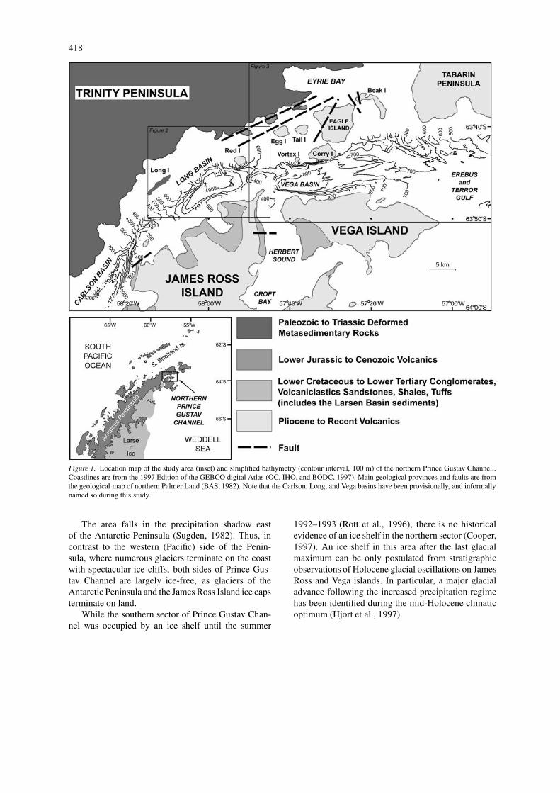
The study area (Figure 1) is located on the in-ner continental shelf of the northwestern Weddell Sea.Prince Gustav Channel is a narrow (6–7 km) seawaybordered to the northwest by the Trinity Peninsula (thenorthern tip of the Antarctic Peninsula), and to thesoutheast by James Ross and Vega islands. We stud-ied the northern part of the channel, elongated in aneast-west direction, where the width of the channel in-creases to the east, from the narrow gateway betweenVega and Eagle islands towards the open waters ofErebus and Terror Gulf south of Tabarin Peninsula.
418
Figure 1. Location map of the study area (inset) and simplified bathymetry (contour interval, 100 m) of the northern Prince Gustav Channell.Coastlines are from the 1997 Edition of the GEBCO digital Atlas (OC, IHO, and BODC, 1997). Main geological provinces and faults are fromthe geological map of northern Palmer Land (BAS, 1982). Note that the Carlson, Long, and Vega basins have been provisionally, and informallynamed so during this study.
The area falls in the precipitation shadow eastof the Antarctic Peninsula (Sugden, 1982). Thus, incontrast to the western (Pacific) side of the Penin-sula, where numerous glaciers terminate on the coastwith spectacular ice cliffs, both sides of Prince Gus-tav Channel are largely ice-free, as glaciers of theAntarctic Peninsula and the James Ross Island ice capsterminate on land.
While the southern sector of Prince Gustav Chan-nel was occupied by an ice shelf until the summer
1992–1993 (Rott et al., 1996), there is no historicalevidence of an ice shelf in the northern sector (Cooper,1997). An ice shelf in this area after the last glacialmaximum can be only postulated from stratigraphicobservations of Holocene glacial oscillations on JamesRoss and Vega islands. In particular, a major glacialadvance following the increased precipitation regimehas been identified during the mid-Holocene climaticoptimum (Hjort et al., 1997).
419
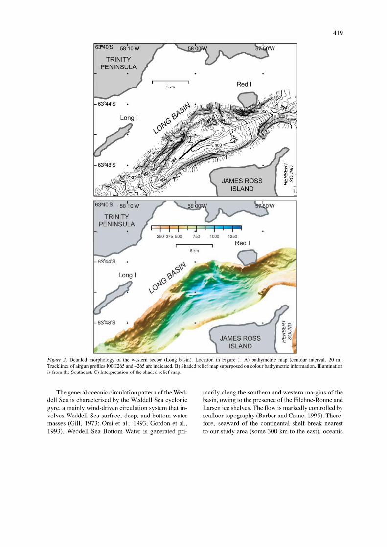
Figure 2. Detailed morphology of the western sector (Long basin). Location in Figure 1. A) bathymetric map (contour interval, 20 m).Tracklines of airgun profiles I00H265 and –265 are indicated. B) Shaded relief map superposed on colour bathymetric information. Illuminationis from the Southeast. C) Interpretation of the shaded relief map.
The general oceanic circulation pattern of the Wed-dell Sea is characterised by the Weddell Sea cyclonicgyre, a mainly wind-driven circulation system that in-volves Weddell Sea surface, deep, and bottom watermasses (Gill, 1973; Orsi et al., 1993, Gordon et al.,1993). Weddell Sea Bottom Water is generated pri-
marily along the southern and western margins of thebasin, owing to the presence of the Filchne-Ronne andLarsen ice shelves. The flow is markedly controlled byseafloor topography (Barber and Crane, 1995). There-fore, seaward of the continental shelf break nearestto our study area (some 300 km to the east), oceanic
420
Figure 2. Continued.
water masses flow northeast following the continentalslope contours. There is evidence of contour-followingbottom water flow both from direct measurements(Muench and Gordon, 1995; Barber and Crane, 1995)and from sedimentary structures (Hollister and Elder,1969). However, although measurements and modelsof continental shelf and sub-ice shelf circulation havebeen obtained for the southern Weddell Sea (Foldviket al., 1985; Hellmer and Olbers, 1991; Yaremchuket al., 1998), virtually nothing is known of the oceaniccirculation of the inner continental shelf of the north-western Weddell Sea. A mixed effect of bottom waterformation, tidal currents, and ice shelf-related thermo-haline circulation can be expected to influence the flowof water masses in the study areas and surroundings.
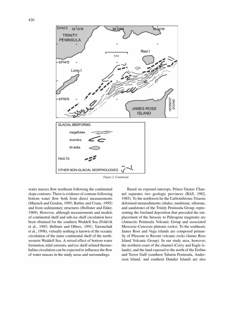
Based on exposed outcrops, Prince Gustav Chan-nel separates two geologic provinces (BAS, 1982,1985). To the northwest lie the Carboniferous-Triassicdeformed metasediments (shales, mudstone, siltstone,and sandstone) of the Trinity Peninsula Group, repre-senting the foreland deposition that preceded the em-placement of the Jurassic to Paleogene magmatic arc(Antarctic Peninsula Volcanic Group and associatedMesozoic-Cenozoic plutonic rocks). To the southeast,James Ross and Vega islands are composed primar-ily of Pliocene to Recent volcanic rocks (James RossIsland Volcanic Group). In our study area, however,the northern coast of the channel (Corry and Eagle is-lands), and the land exposed to the north of the Erebusand Terror Gulf (southern Tabarin Peninsula, Ander-sson Island, and southern Dundee Island) are also
421
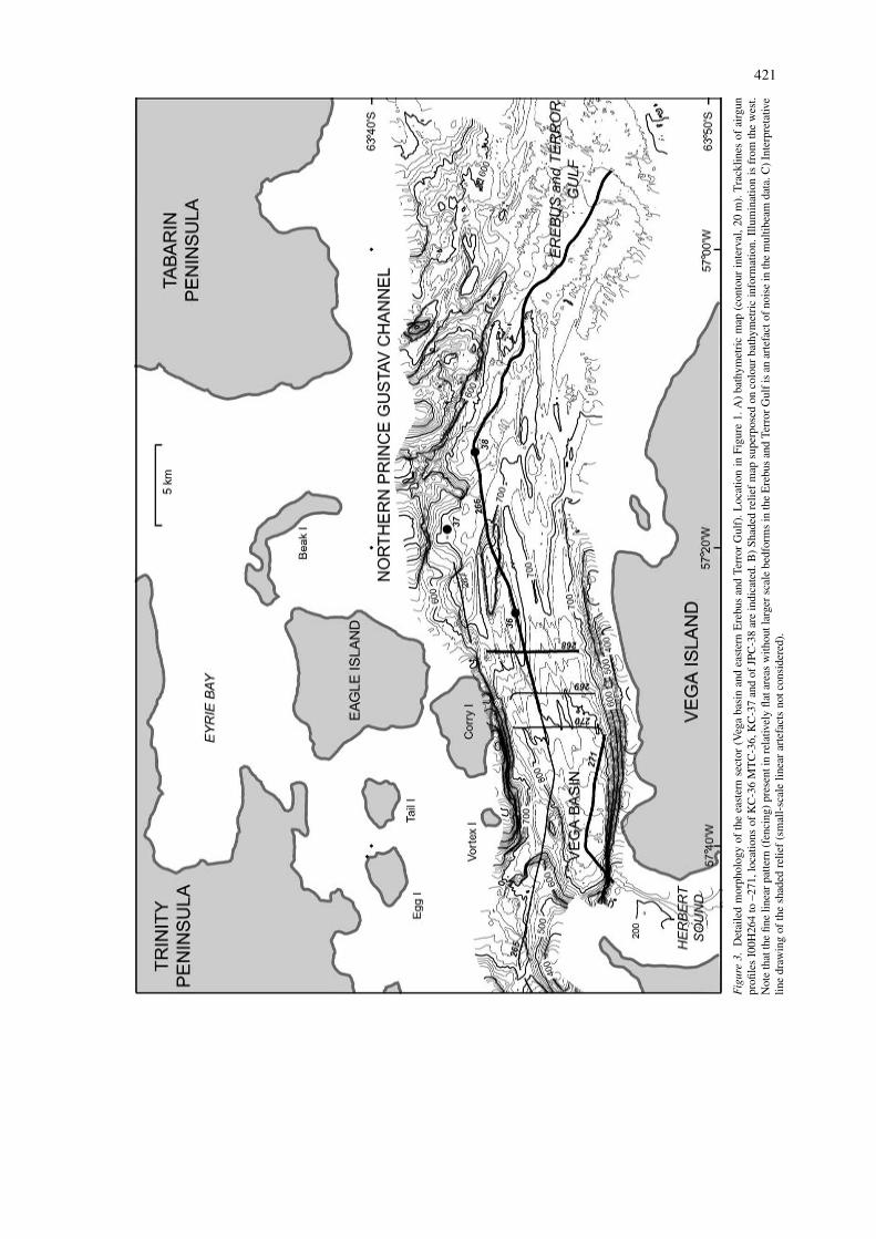
Fig
ure
3.D
etai
led
mor
phol
ogy
ofth
eea
ster
nse
ctor
(Veg
aba
sin
and
east
ern
Ere
bus
and
Terr
orG
ulf)
.Loc
atio
nin
Figu
re1.
A)
bath
ymet
ric
map
(con
tour
inte
rval
,20
m).
Tra
cklin
esof
airg
unpr
ofile
sI0
0H26
4to
–271
,loc
atio
nsof
KC
-36
MT
C-3
6,K
C-3
7an
dof
JPC
-38
are
indi
cate
d.B
)Sh
aded
relie
fm
apsu
perp
osed
onco
lour
bath
ymet
ric
info
rmat
ion.
Illu
min
atio
nis
from
the
wes
t.N
ote
that
the
fine
linea
rpa
ttern
(fen
cing
)pr
esen
tin
rela
tivel
yfla
tare
asw
ithou
tlar
ger
scal
ebe
dfor
ms
inth
eE
rebu
san
dTe
rror
Gul
fis
anar
tefa
ctof
nois
ein
the
mul
tibea
mda
ta.C
)Int
erpr
etat
ive
line
draw
ing
ofth
esh
aded
relie
f(s
mal
l-sc
ale
linea
rar
tefa
cts
notc
onsi
dere
d).
422
Fig
ure
3.C
ontin
ued.
.
423
Fig
ure
3.C
ontin
ued.
.
424
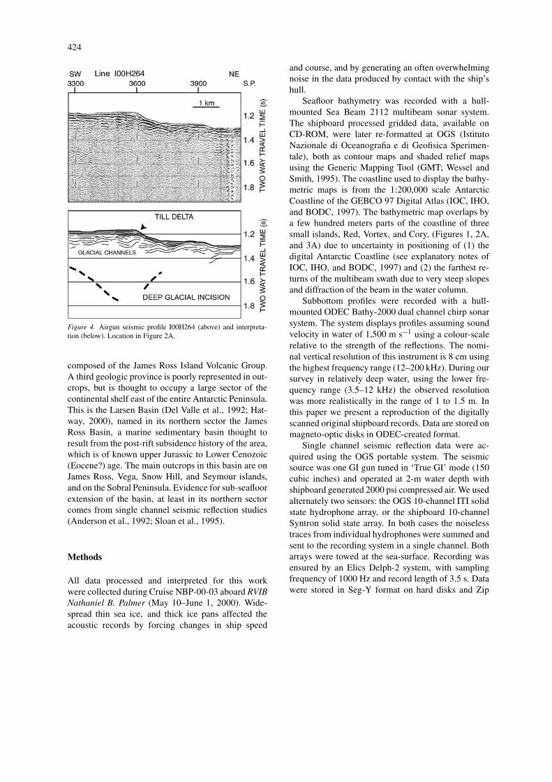
Figure 4. Airgun seismic profile I00H264 (above) and interpreta-tion (below). Location in Figure 2A.
composed of the James Ross Island Volcanic Group.A third geologic province is poorly represented in out-crops, but is thought to occupy a large sector of thecontinental shelf east of the entire Antarctic Peninsula.This is the Larsen Basin (Del Valle et al., 1992; Hat-way, 2000), named in its northern sector the JamesRoss Basin, a marine sedimentary basin thought toresult from the post-rift subsidence history of the area,which is of known upper Jurassic to Lower Cenozoic(Eocene?) age. The main outcrops in this basin are onJames Ross, Vega, Snow Hill, and Seymour islands,and on the Sobral Peninsula. Evidence for sub-seafloorextension of the basin, at least in its northern sectorcomes from single channel seismic reflection studies(Anderson et al., 1992; Sloan et al., 1995).
Methods
All data processed and interpreted for this workwere collected during Cruise NBP-00-03 aboard RVIBNathaniel B. Palmer (May 10–June 1, 2000). Wide-spread thin sea ice, and thick ice pans affected theacoustic records by forcing changes in ship speed
and course, and by generating an often overwhelmingnoise in the data produced by contact with the ship’shull.
Seafloor bathymetry was recorded with a hull-mounted Sea Beam 2112 multibeam sonar system.The shipboard processed gridded data, available onCD-ROM, were later re-formatted at OGS (IstitutoNazionale di Oceanografia e di Geofisica Sperimen-tale), both as contour maps and shaded relief mapsusing the Generic Mapping Tool (GMT; Wessel andSmith, 1995). The coastline used to display the bathy-metric maps is from the 1:200,000 scale AntarcticCoastline of the GEBCO 97 Digital Atlas (IOC, IHO,and BODC, 1997). The bathymetric map overlaps bya few hundred meters parts of the coastline of threesmall islands, Red, Vortex, and Cory, (Figures 1, 2A,and 3A) due to uncertainty in positioning of (1) thedigital Antarctic Coastline (see explanatory notes ofIOC, IHO, and BODC, 1997) and (2) the farthest re-turns of the multibeam swath due to very steep slopesand diffraction of the beam in the water column.
Subbottom profiles were recorded with a hull-mounted ODEC Bathy-2000 dual channel chirp sonarsystem. The system displays profiles assuming soundvelocity in water of 1,500 m s−1 using a colour-scalerelative to the strength of the reflections. The nomi-nal vertical resolution of this instrument is 8 cm usingthe highest frequency range (12–200 kHz). During oursurvey in relatively deep water, using the lower fre-quency range (3.5–12 kHz) the observed resolutionwas more realistically in the range of 1 to 1.5 m. Inthis paper we present a reproduction of the digitallyscanned original shipboard records. Data are stored onmagneto-optic disks in ODEC-created format.
Single channel seismic reflection data were ac-quired using the OGS portable system. The seismicsource was one GI gun tuned in ‘True GI’ mode (150cubic inches) and operated at 2-m water depth withshipboard generated 2000 psi compressed air. We usedalternately two sensors: the OGS 10-channel ITI solidstate hydrophone array, or the shipboard 10-channelSyntron solid state array. In both cases the noiselesstraces from individual hydrophones were summed andsent to the recording system in a single channel. Botharrays were towed at the sea-surface. Recording wasensured by an Elics Delph-2 system, with samplingfrequency of 1000 Hz and record length of 3.5 s. Datawere stored in Seg-Y format on hard disks and Zip
425
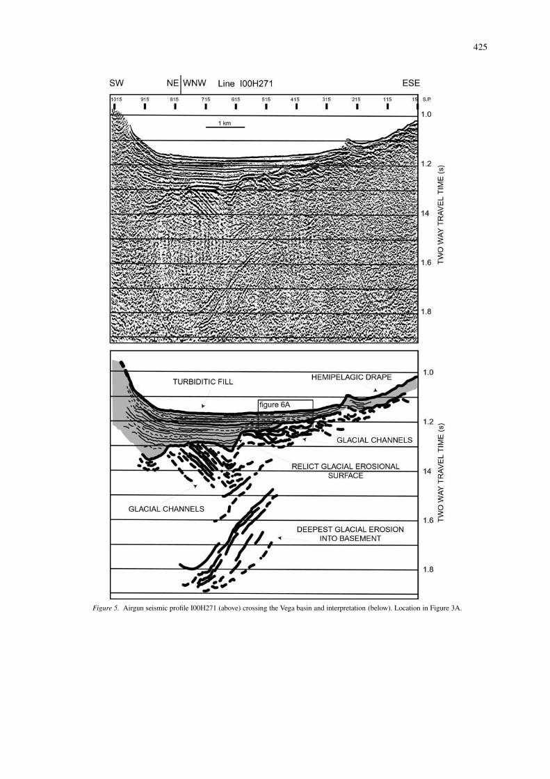
Figure 5. Airgun seismic profile I00H271 (above) crossing the Vega basin and interpretation (below). Location in Figure 3A.
426
disks1. Navigation was provided by the ship’s GPSTrimble Centurion instrument. The shooting intervalwas 5 s. Firing was triggered by the acquisition boardthrough a Real Time Systems Sure Shot 4-channel guncontroller. The ship speed during the surveys varieddepending on ice conditions. With the average ship’sspeed of 4 knots during acquisition, the average, dis-tance between shots is about 10 m. With a measuredfrequency spectrum centred on 150 Hz in the nearfield, the nominal resolution of this system is about3.5 m assuming a sediment velocity of 2000 m s−1. Inreality, within the most reflective sediments encoun-tered during our survey, we discriminate strata that areabout 5 to 10 m in thickness.
Single channel seismic reflection data wereprocessed at OGS with the Paradigm Focus process-ing package. The noise of the ship’s hull against seaice severely affected the quality of data. Noisy recordswere manually identified and zeroed in all displayedseismic sections. The processing sequence included:manual editing of records; recovery of equipment-induced delays at the seafloor; spherical divergencecorrection; debiasing; filtering (20, 40, 120, 240 Hz);trace balancing; trace mixing; and muting above theseafloor reflection. Deconvolution did not improve thedata quality. Some parts of the seismic sections havebeen migrated using velocity values close to that ofseawater.
Current-meter data were obtained with a hull-mounted acoustic doppler current profiler (ADCP)RDI model VM150, which records two orthogonalcomponents of water velocity at 5-m intervals betweendepths of 50 and 350 m. Data were post-processed byErick Firing at the University of Hawaii, and releasedin both ASCII and Mat Lab format. Ship positioningduring data collection was by GPS (not differentialGPS), and bottom tracking was not used in data ac-quisition. Because of the high noise level due to seaice friction against the ship’s hull, part of the data wasdiscarded and the majority of the good data were from50–200 m water depth, often collected while the shipwas on station. For the purpose of this work, the ve-locity vectors contained in the water depth layer withthe highest number of data (125 m below sea surface)were displayed at OGS.
1The digital record of seismic line I00H264 (partly shown inthis paper) was lost due to a computer system crash during acquisi-tion. We retain only the original paper copy and its scanned digitalversion.
In the study area one Jumbo Piston Core (25 m corebarrel) (JPC), two Kasten cores (3 m core barrel) (KC),and two triple-tube multi-cores (MTC) were collected.
Seafloor bathymetry and morphology
The bathymetry of northern Prince Gustav Channel(Figures 1, 2A, and 2B) is characterised by a dis-continuous, narrow, U-shaped trough with steep wallsranging from about 20 ◦ to 45–50 ◦. The trough isinterrupted by two shallow sills separating three deep,elongated axial basins, in which water depth decreasesfrom southwest to northeast. Carlson basin (1,240 mdeep) is separated by a 350-m deep sill from Longbasin (980–1 000 m), which is in turn separated bya 600-m deep sill from Vega basin (880–900 m).Although the slope of the seafloor decreases consid-erably in the deepest part of each basin, there is onlya relatively small area of flat floor. In general, alongthe southern side of the channel there is little evidenceof valleys tributary to the sides of the axial trough ex-cept that coastal embayments and glacial valleys occurin shallow water, at the edges of the surveyed area.Conversely, the northern side of the channel is incisedalmost to the deepest parts of the basins.
The bathymetry of the channel changes east ofVega basin. Here axially elongated ridges and troughslead into Erebus and Terror Gulf where the seafloorundulates irregularly at an average depth of about750 m. Another peculiarity in this easternmost sectorof the channel is the markedly dissected character ofthe northern side (south of Corry and Eagle islands),where isolated bathymetric highs, margins promonto-ries, and margin incisions are widespread. This alsooccurs less strikingly elsewhere on the northern sideof the channel.
Glacial bed-forms are evident in the deepest partsof the basins (Figures 2B, C and Figure 3B, C) as par-allel and sub-parallel grooves and ridges (megaflutes)up to 10 km long and a few hundred meters wide.Because the heights of these megaflutes are normallyless than the 20-m contour interval of our maps, theyare more evident in the shaded relief maps than in thecontour maps. Megaflutes are generally elongated inthe direction of the channel axial trough. In places,such as the western slope of the sill between Longand Vega basins, and the northwestern slope of Vegabasin, the flutes assume an anastomosed pattern. InVega basin and at the eastern mouth of Prince GustavChannel, the flutes point in the direction of elongation
427
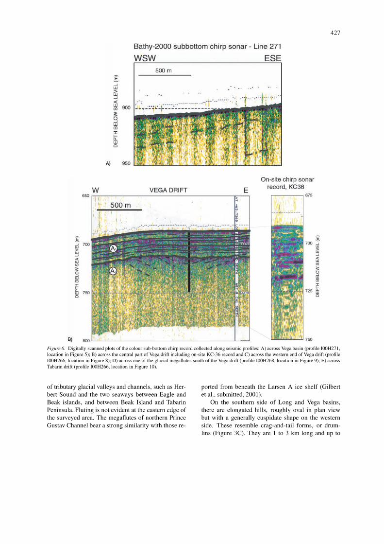
Figure 6. Digitally scanned plots of the colour sub-bottom chirp record collected along seismic profiles: A) across Vega basin (profile I00H271,location in Figure 5); B) across the central part of Vega drift including on-site KC-36 record and C) across the western end of Vega drift (profileI00H266, location in Figure 8); D) across one of the glacial megaflutes south of the Vega drift (profile I00H268, location in Figure 9); E) acrossTabarin drift (profile I00H266, location in Figure 10).
of tributary glacial valleys and channels, such as Her-bert Sound and the two seaways between Eagle andBeak islands, and between Beak Island and TabarinPeninsula. Fluting is not evident at the eastern edge ofthe surveyed area. The megaflutes of northern PrinceGustav Channel bear a strong similarity with those re-
ported from beneath the Larsen A ice shelf (Gilbertet al., submitted, 2001).
On the southern side of Long and Vega basins,there are elongated hills, roughly oval in plan viewbut with a generally cuspidate shape on the westernside. These resemble crag-and-tail forms, or drum-lins (Figure 3C). They are 1 to 3 km long and up to
428
Figure 6. Continued.
1 km wide. One large isolated elongated hill is presentin the axial part of Long basin at about 880 m wa-ter depth. The identification of crag-and-tail forms ordrumlins in this deep water inner continental shelf set-ting relies solely on seabed morphology. Although wecannot substantiate our interpretation with lithologicinformation, their shape, orientation, and distributionin clusters is compatible with the same forms com-monly observed on land (Brodzikowsky and van Loon,1991; Ehlers, 1996) and in a few other continen-tal shelf settings of modern polar regions (Solheimet al., 1990; Shipp and Anderson, 1997; Longva andThorsen, 1997; Anderson, 1999).
The steep slope north of Vega Island and at theoutlet of Herbert Sound shows obvious signs of grav-
itational instability, with debris lobes, small-scalegullies, and in one case evidence of straight chan-nelling into the deepest part of the basin (Figure 3C).The more irregular morphology of the northern slopeof the channel shows less obvious evidence of slopeinstability.
We observe two tectonic lineations that survivedthe glacial morphological imprint. One in Vega basintrends north-south and seems to affect the Vega Islandslope (Figure 3C). The other to the east and trendingNE–SW to ENE–WSW seems to relate to the oppositeside of the channel, generally parallel to the northerncoast (Figure 3C).
429
Shallow sediment architecture
Air gun seismic profiles indicate little penetration ofthe sea floor in northern Prince Gustav Channel. Sed-iment depocentres are present, as shown below, butthey are not typical even along the axis of the trough.The acoustic response below the seafloor reflectionis chaotic, with very poor reflector continuity, andhyperbolic diffractions commonly mask meaningfulreflectors. In the following paragraphs we describe thesedimentary features that have been recognised withthe combined interpretation of underway chirp sonarprofiles, and dedicated air gun surveys.
Till delta in Long basin
At about 880 m depth in Long basin there occursan elongated, isolated hill at a small break of slope.Steeper reflectors (Figure 4) downlap the substratumtowards the deepest basin floor, while sub-horizontalreflectors onlap at very low angle the substratum onthe opposite part of the hill. The stratal architectureis that of a wedge or delta prograding eastwards (Al-ley et al., 1987). Maximum thickness of the delta is50 ms two-way travel time (twt), which is probably50 m or less. The delta rests on an irregular, highly-reflective surface, below which are weak reflectors thatidentify small channels, lateral termination and a gen-eral hummocky configuration. The channelled unit isnot thicker than 100 ms (twt). A much deeper seriesof discontinuous reflectors identifies a wide channelthat reaches about 600 ms (twt) below the seafloor(Figure 4).
Although we do not have sediment samples in thisarea, the lack of penetration in the high frequencychirp sonar record (not shown) suggests hard and re-flective material at the seafloor. Therefore we interpretthe wedge as a till delta, or diamict apron (Inverson,1995; Ehlers, 1996). The thin drape and fill of depres-sions above the underlying unit is also highly reflectiveand is probably formed by gravity flows. Becauseof the seismic character, we interpret the underlyingsediments as glacial deposits. The deeper reflectionrepresents a glacial channel, probably imaged as alow-angle cross section.
Turbiditic fill of the Vega basin
In the south-western and deepest corner of the Vegabasin, the seafloor is nearly flat and underlain by upto 200 ms (twt) of highly reflective sediments onlap-ping an erosional surface (Figures 5 and 6A). This unit
has a typical basin-fill reflector configuration, withfairly continuous reflectors in the central part of thebasin, representing turbidites. The southwestern edgeof the basin contains evidence of truncated reflectorsand small chaotic lenses representing debris flow de-posits originating from slumping on the steep side wallof Prince Gustav Channel, at the mouth of HerbertSound. The evidence for slumps in adjacent areas ap-pears in the shaded relief images (Figure 3B, C). Thesediment fill thins to below the limit of resolution ofthe air gun profile on the opposite (eastern), gentlerside, where the underlying eroded unit is probablyexposed at the seafloor.
The underlying eroded unit is composed of highlyreflective sediments, with termination not only at thetop (erosion) but also at depth to define a complexpattern of generally asymmetric channels of differ-ent size. Prominent dipping reflectors represent foresetstrata downlapping on a basal reflector belonging to aformer glacial wedge. Deeper down, a large channel isidentified by a set of discontinuous though strong re-flectors down to about 900 ms (twt) below the seafloor.The entire unit below the turbiditic fill is thought torepresent a glacial sequence in which large, deep, ero-sional events seem to have focused erosion near thesteep southern side wall of Prince Gustav Channel.
Sediment draping in and east of Vega basin
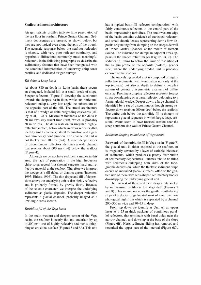
Eastwards of the turbiditic fill in Vega basin (Figure 7)the glacial unit is either exposed at the seafloor, oris irregularly covered by a layer of variable thicknessof sediments, which produces a patchy distributionof sedimentary depocentres. Furrows tend to be filledwith sediments onlapping both sides of the topo-graphic depression, while the thickest sediment drapeoccurs on mounded glacial surfaces, often on the gen-tler side of these with lens-shaped sedimentary bodiesdownlapping the underlying glacial unit.
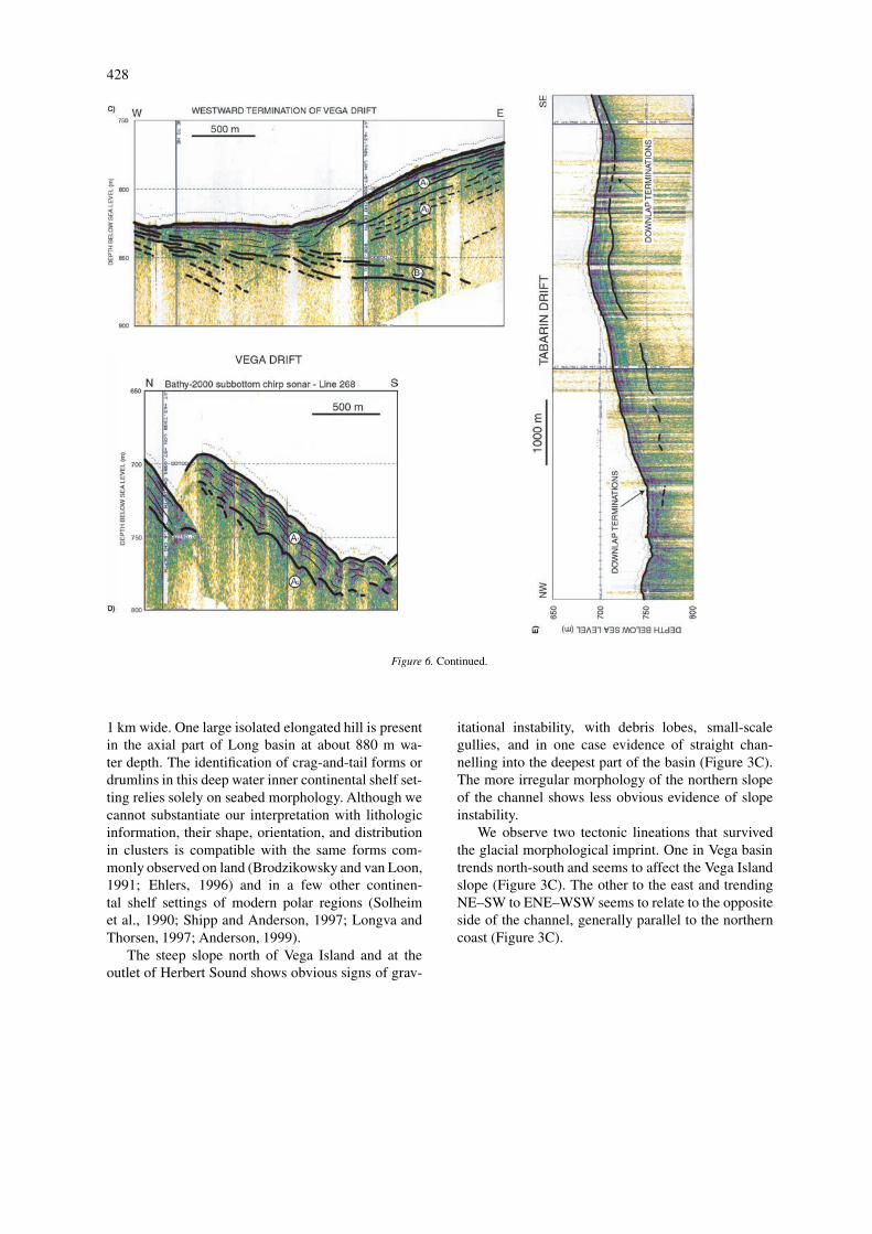
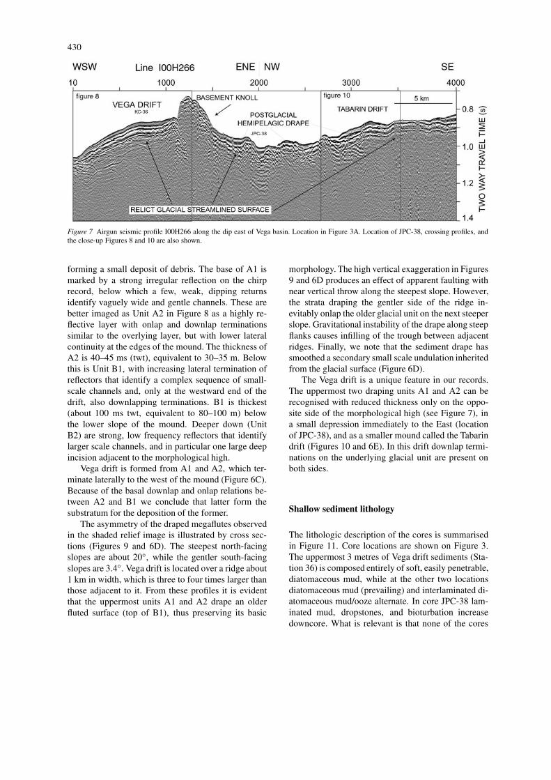
The thickest of these sediment drapes intersectedby our seismic profiles is the Vega drift (Figures 7and 8). This mound occupies the gentle, south-facingslope of a glacial ridge located west of a narrow mor-phological high from which is separated by a channel200–300 m wide and 70–75 m deep.
From top down we identify as Unit A1 an upperlayer as a 25-m thick package of continuous paral-lel reflectors, that terminate with basal onlap near thenarrow channel, and downlap at the base of the slope(Figure 6B). Here, sediment sliding has removed andreworked the upper part of the interval (Figure 6C),
430
Figure 7 Airgun seismic profile I00H266 along the dip east of Vega basin. Location in Figure 3A. Location of JPC-38, crossing profiles, andthe close-up Figures 8 and 10 are also shown.
forming a small deposit of debris. The base of A1 ismarked by a strong irregular reflection on the chirprecord, below which a few, weak, dipping returnsidentify vaguely wide and gentle channels. These arebetter imaged as Unit A2 in Figure 8 as a highly re-flective layer with onlap and downlap terminationssimilar to the overlying layer, but with lower lateralcontinuity at the edges of the mound. The thickness ofA2 is 40–45 ms (twt), equivalent to 30–35 m. Belowthis is Unit B1, with increasing lateral termination ofreflectors that identify a complex sequence of small-scale channels and, only at the westward end of thedrift, also downlapping terminations. B1 is thickest(about 100 ms twt, equivalent to 80–100 m) belowthe lower slope of the mound. Deeper down (UnitB2) are strong, low frequency reflectors that identifylarger scale channels, and in particular one large deepincision adjacent to the morphological high.
Vega drift is formed from A1 and A2, which ter-minate laterally to the west of the mound (Figure 6C).Because of the basal downlap and onlap relations be-tween A2 and B1 we conclude that latter form thesubstratum for the deposition of the former.
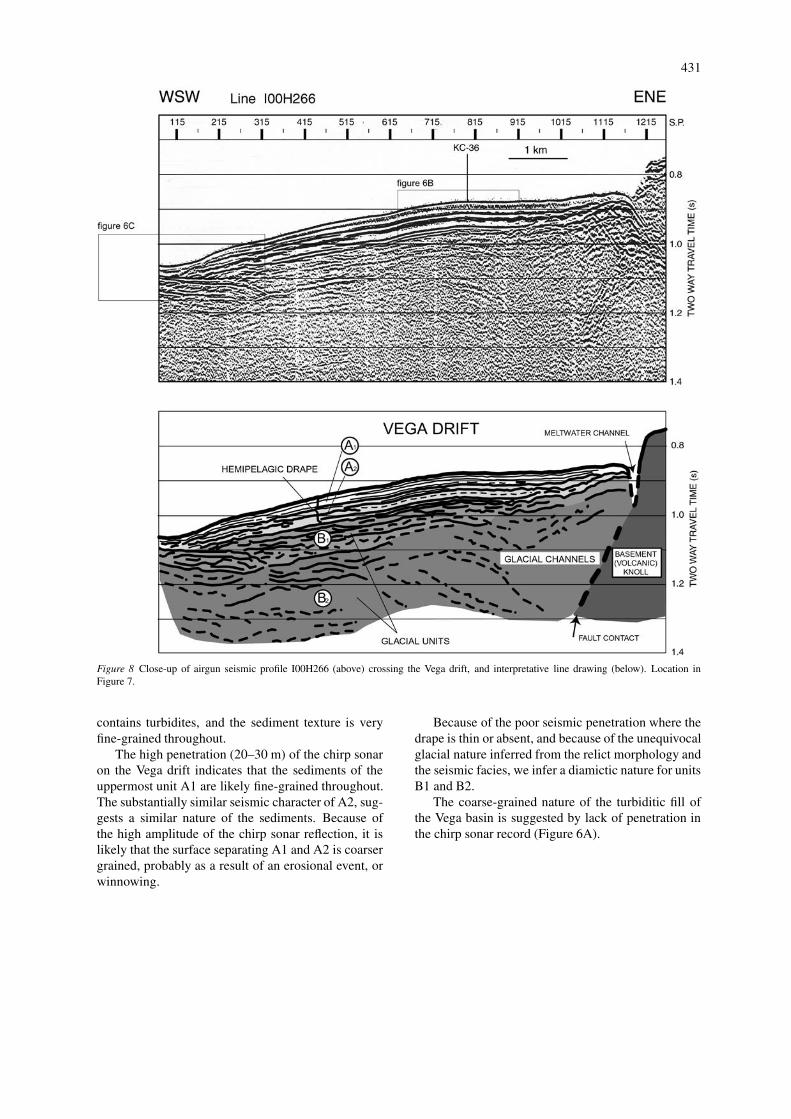
The asymmetry of the draped megaflutes observedin the shaded relief image is illustrated by cross sec-tions (Figures 9 and 6D). The steepest north-facingslopes are about 20◦, while the gentler south-facingslopes are 3.4◦. Vega drift is located over a ridge about1 km in width, which is three to four times larger thanthose adjacent to it. From these profiles it is evidentthat the uppermost units A1 and A2 drape an olderfluted surface (top of B1), thus preserving its basic
morphology. The high vertical exaggeration in Figures9 and 6D produces an effect of apparent faulting withnear vertical throw along the steepest slope. However,the strata draping the gentler side of the ridge in-evitably onlap the older glacial unit on the next steeperslope. Gravitational instability of the drape along steepflanks causes infilling of the trough between adjacentridges. Finally, we note that the sediment drape hassmoothed a secondary small scale undulation inheritedfrom the glacial surface (Figure 6D).
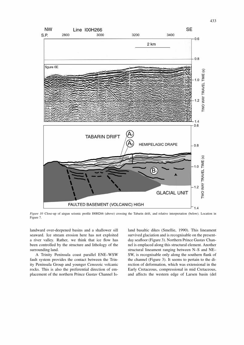
The Vega drift is a unique feature in our records.The uppermost two draping units A1 and A2 can berecognised with reduced thickness only on the oppo-site side of the morphological high (see Figure 7), ina small depression immediately to the East (locationof JPC-38), and as a smaller mound called the Tabarindrift (Figures 10 and 6E). In this drift downlap termi-nations on the underlying glacial unit are present onboth sides.
Shallow sediment lithology
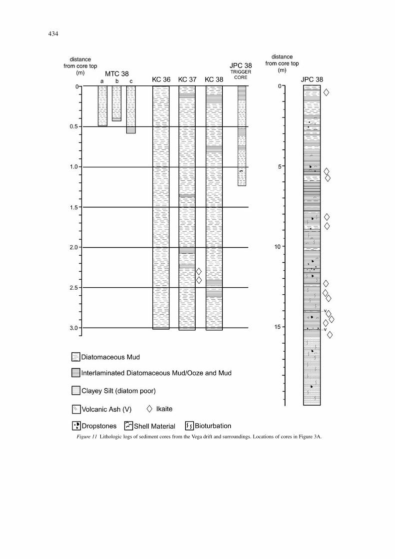
The lithologic description of the cores is summarisedin Figure 11. Core locations are shown on Figure 3.The uppermost 3 metres of Vega drift sediments (Sta-tion 36) is composed entirely of soft, easily penetrable,diatomaceous mud, while at the other two locationsdiatomaceous mud (prevailing) and interlaminated di-atomaceous mud/ooze alternate. In core JPC-38 lam-inated mud, dropstones, and bioturbation increasedowncore. What is relevant is that none of the cores
431
Figure 8 Close-up of airgun seismic profile I00H266 (above) crossing the Vega drift, and interpretative line drawing (below). Location inFigure 7.
contains turbidites, and the sediment texture is veryfine-grained throughout.
The high penetration (20–30 m) of the chirp sonaron the Vega drift indicates that the sediments of theuppermost unit A1 are likely fine-grained throughout.The substantially similar seismic character of A2, sug-gests a similar nature of the sediments. Because ofthe high amplitude of the chirp sonar reflection, it islikely that the surface separating A1 and A2 is coarsergrained, probably as a result of an erosional event, orwinnowing.
Because of the poor seismic penetration where thedrape is thin or absent, and because of the unequivocalglacial nature inferred from the relict morphology andthe seismic facies, we infer a diamictic nature for unitsB1 and B2.
The coarse-grained nature of the turbiditic fill ofthe Vega basin is suggested by lack of penetration inthe chirp sonar record (Figure 6A).
432
Figure 9 Airgun seismic profile I00H268 along the strike (above) showing the glacial megaflutes south of the Vega drift, and relativeinterpretation (below). Location in Figure 3A.
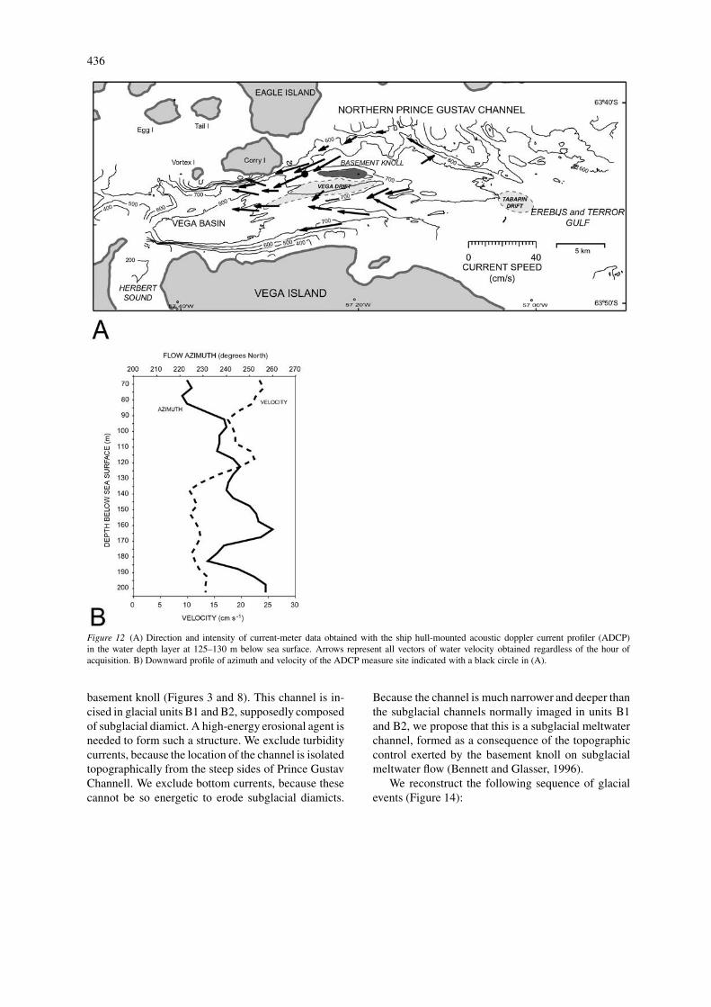
Current flow
Current measurements between 125 and 130 m depth,the best data set available, are presented in Figure 12.There is uniformity in flow direction towards the westin the channel (Figure 12A), and a rather wide rangeof flow velocities. The mean observed value is 11 cms−1, and the maximum observed speed is 40 cm s−1.Minimum speed of 1 cm s−1 is probably within the er-ror of the measurement. Figure 12B displays a verticalprofile of current velocity obtained over the Vega driftbetween 65 and 205 m water depth. At this locationthe velocity ranges from 10 to 25 cm s−1, with a de-creasing trend from top to bottom of the investigated
layer. The azimuth direction oscillates between 220◦and 255◦, consistently parallel to the WSW orientationof the channel.
Discussion
Glacial morphology and processes
Ice flow pattern
Prince Gustav Channel can be regarded only in a broadsense as a fjord, because it is obviously a glacial troughwhose floor is occupied by the sea. It has a fjord-like cross section, typically sided by steep walls, with
433
Figure 10 Close-up of airgun seismic profile I00H266 (above) crossing the Tabarin drift, and relative interpretation (below). Location inFigure 7.
landward over-deepened basins and a shallower sillseaward. Ice stream erosion here has not exploiteda river valley. Rather, we think that ice flow hasbeen controlled by the structure and lithology of thesurrounding land.
A Trinity Peninsula coast parallel ENE–WSWfault system provides the contact between the Trin-ity Peninsula Group and younger Cenozoic volcanicrocks. This is also the preferential direction of em-placement of the northern Prince Gustav Channel Is-
land basaltic dikes (Smellie, 1990). This lineamentsurvived glaciation and is recognisable on the present-day seafloor (Figure 3). Northern Prince Gustav Chan-nel is emplaced along this structural element. Anotherstructural lineament ranging between N–S and NE–SW, is recognisable only along the southern flank ofthe channel (Figure 3). It seems to pertain to the di-rection of deformation, which was extensional in theEarly Cretaceous, compressional in mid Cretaceous,and affects the western edge of Larsen basin (del
434
Figure 11 Lithologic logs of sediment cores from the Vega drift and surroundings. Locations of cores in Figure 3A.
435
Valle and Miller, 2001). The Croft Bay-Herbert Soundsystem and Southern Prince Gustav Channel are par-allel and superimposed on this coast-parallel structuraltrend.
In addition, the emplacement of the more than1500-m thick James Ross and Vega Island shield vol-canic complex in Miocene to Pliocene time must haveprovided an offshore physical barrier to the TrinityPeninsula continental ice flow. This was not only be-cause of the presence of volcanic edifices, but alsobecause the volcanic land was occupied by an icedome (there is evidence of sub-ice eruptions on JamesRoss Island: Smellie, 1990) which in turn drainedcontinental ice towards Prince Gustav Channel.
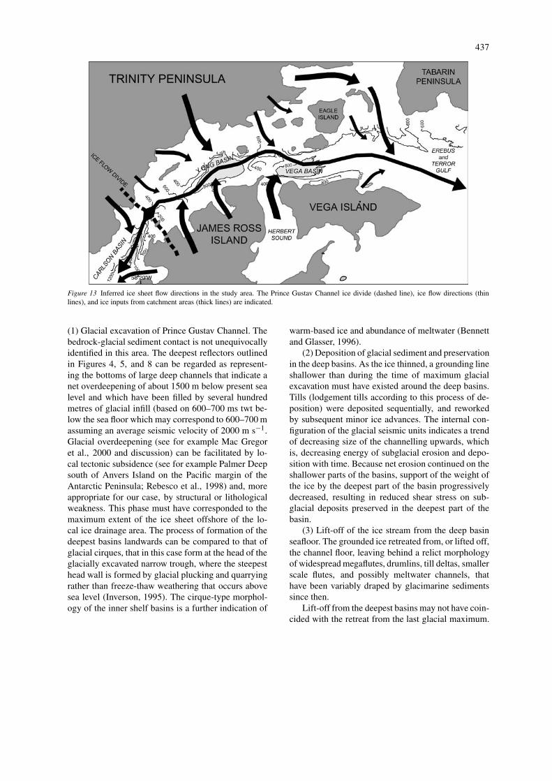
Figure 13 summarises evidence of ice flow to theeast in northern Prince Gustav Channel (till delta inLong basin, convergent pattern of streamlines, drum-lins and crag-and-tail forms in Vega basin). In ad-dition, streamlines identify past ice tributaries fromHerbert Sound and from the northern islands. Becausean ice flow direction towards the south can be inferredin southern Prince Gustav Channel (Bentley and An-derson, 1998; Pudsey et al., 2001), we conclude thatthe Prince Gustav Channel ice divide, the place ofminimum sub-ice erosion, was probably located onthe present day sill between James Ross, and Longbasins, the shallowest seafloor of the entire PrinceGustav Channel. The morphology results from two icestreams capturing ice flow in a divergent pattern asa consequence of the morpho-structural barrier of theJames Ross Volcanic Group. The multiple occurrencesof overdeepened basins is related to the multiple icecatchment of the channel and therefore to an alterna-tion of extending and compressive ice flow (Inverson,1995).
Origin of glacial bedformsIce-contact processes typically produce the glacialbedforms identified in the Long and Vega basins.Therefore, we provide direct evidence of the pastpresence of a grounded ice sheet at water depth upto 900–1,000 m in northern Prince Gustav Chan-nel. The marked erosional character of the surfaceof the glacial units imaged by air gun profiles sug-gests that megafluting is caused by ice scouring ofolder diamicts, rather than by subglacial deposition ofelongated diamict ridges. The only truly depositionalglacial features, though not substantiated by air gunprofiles, are the crag-and-tail forms and/or drumlinslocated preferentially on the southern margin of thechannel, and the till delta.
We observe that the streamlined surface, includingthe depositional bedforms, is present preferentially inthe deepest part of the basins, as if it stands as anindication of glacial overdeepening. Air gun profilesshow that the erosional surface at the top of the glacialunits is also present below the turbiditic fill in the Vegabasin. By morphological analogy, the same situationapplies to Long basin below the small, flat-floored anddeepest part of the basin.
The preferential occurrence of megaflutes and bed-forms in the deepest part of the Antarctic inner conti-nental shelf has been observed also in the Greenpeacetrough, below the former Larsen-A ice shelf (Gilbertpersonal communication), in the western Bransfieldbasin (Canals et al., 2000), and in other parts ofthe inner shelf of the Pacific margin of the AntarcticPeninsula (Anderson, in press; Anderson et al., 2001).Another common observation from seismic profilesis that these megaflutes occur on glacial till, ratherthan incised in bedrock. Therefore, the most recentadvances of the ice sheet on the inner continental shelfhave allowed preservation of glacial sediments only inthe deepest part of the inner shelf basins, while neterosion down to bedrock has commonly occurred onthe outer slope leading to the middle continental shelf.Bedrock outcropping at the seafloor, possibly drapedby a thin veneer of post-glacial glacimarine sediments,has been widely documented from seismic reflectionprofiling on the inner continental shelf seaward of theinner shelf basins on the north-western Weddell SeaMargin close to our survey area (Anderson et al., 1992;Sloan et al., 1995), and on the Northern Pacific marginof the Antarctic Peninsula (Larter et al., 1997).
The secondary, small-scale undulation of themegafluted surface, described in acoustic records ofFigures 9 and 6D, but not resolved in the grid ofthe bathymetric data, likely reflects the presence ofsmaller scale fluting, such as parallel sided flutes ofBenn and Evans (1996). The stratigraphic position onthe last glacial surface (top of B2 unit) and the appar-ent dimensions of the secondary flutes are analogousto those described in Greenpeace Trough by Gilbertet al. (unpublished data). By analogy, although welack the two-dimensional control on shape and orienta-tion, as well as the lithologic evidence, we suggest thatthese bedforms indicate a lower energy subglacial re-working (see also O’Brien et al., 1999) of pre-existingdiamicts that occurred just prior to lift-off of the icesheet in northern Prince Gustav Channel.
Another remarkable erosional feature is the narrowchannel that separates the Vega drift from the adjacent
436
Figure 12 (A) Direction and intensity of current-meter data obtained with the ship hull-mounted acoustic doppler current profiler (ADCP)in the water depth layer at 125–130 m below sea surface. Arrows represent all vectors of water velocity obtained regardless of the hour ofacquisition. B) Downward profile of azimuth and velocity of the ADCP measure site indicated with a black circle in (A).
basement knoll (Figures 3 and 8). This channel is in-cised in glacial units B1 and B2, supposedly composedof subglacial diamict. A high-energy erosional agent isneeded to form such a structure. We exclude turbiditycurrents, because the location of the channel is isolatedtopographically from the steep sides of Prince GustavChannell. We exclude bottom currents, because thesecannot be so energetic to erode subglacial diamicts.
Because the channel is much narrower and deeper thanthe subglacial channels normally imaged in units B1and B2, we propose that this is a subglacial meltwaterchannel, formed as a consequence of the topographiccontrol exerted by the basement knoll on subglacialmeltwater flow (Bennett and Glasser, 1996).
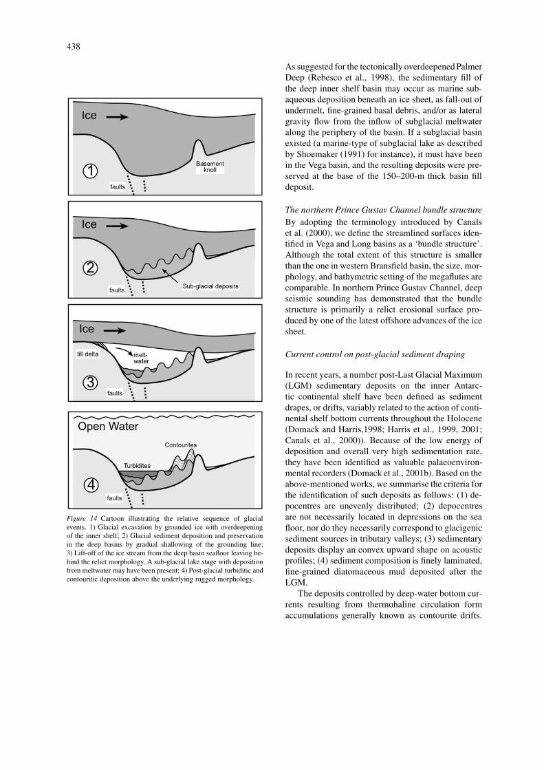
We reconstruct the following sequence of glacialevents (Figure 14):
437
Figure 13 Inferred ice sheet flow directions in the study area. The Prince Gustav Channel ice divide (dashed line), ice flow directions (thinlines), and ice inputs from catchment areas (thick lines) are indicated.
(1) Glacial excavation of Prince Gustav Channel. Thebedrock-glacial sediment contact is not unequivocallyidentified in this area. The deepest reflectors outlinedin Figures 4, 5, and 8 can be regarded as represent-ing the bottoms of large deep channels that indicate anet overdeepening of about 1500 m below present sealevel and which have been filled by several hundredmetres of glacial infill (based on 600–700 ms twt be-low the sea floor which may correspond to 600–700 massuming an average seismic velocity of 2000 m s−1.Glacial overdeepening (see for example Mac Gregoret al., 2000 and discussion) can be facilitated by lo-cal tectonic subsidence (see for example Palmer Deepsouth of Anvers Island on the Pacific margin of theAntarctic Peninsula; Rebesco et al., 1998) and, moreappropriate for our case, by structural or lithologicalweakness. This phase must have corresponded to themaximum extent of the ice sheet offshore of the lo-cal ice drainage area. The process of formation of thedeepest basins landwards can be compared to that ofglacial cirques, that in this case form at the head of theglacially excavated narrow trough, where the steepesthead wall is formed by glacial plucking and quarryingrather than freeze-thaw weathering that occurs abovesea level (Inverson, 1995). The cirque-type morphol-ogy of the inner shelf basins is a further indication of
warm-based ice and abundance of meltwater (Bennettand Glasser, 1996).
(2) Deposition of glacial sediment and preservationin the deep basins. As the ice thinned, a grounding lineshallower than during the time of maximum glacialexcavation must have existed around the deep basins.Tills (lodgement tills according to this process of de-position) were deposited sequentially, and reworkedby subsequent minor ice advances. The internal con-figuration of the glacial seismic units indicates a trendof decreasing size of the channelling upwards, whichis, decreasing energy of subglacial erosion and depo-sition with time. Because net erosion continued on theshallower parts of the basins, support of the weight ofthe ice by the deepest part of the basin progressivelydecreased, resulting in reduced shear stress on sub-glacial deposits preserved in the deepest part of thebasin.
(3) Lift-off of the ice stream from the deep basinseafloor. The grounded ice retreated from, or lifted off,the channel floor, leaving behind a relict morphologyof widespread megaflutes, drumlins, till deltas, smallerscale flutes, and possibly meltwater channels, thathave been variably draped by glacimarine sedimentssince then.
Lift-off from the deepest basins may not have coin-cided with the retreat from the last glacial maximum.
438
Figure 14 Cartoon illustrating the relative sequence of glacialevents. 1) Glacial excavation by grounded ice with overdeepeningof the inner shelf; 2) Glacial sediment deposition and preservationin the deep basins by gradual shallowing of the grounding line;3) Lift-off of the ice stream from the deep basin seafloor leaving be-hind the relict morphology. A sub-glacial lake stage with depositionfrom meltwater may have been present; 4) Post-glacial turbiditic andcontouritic deposition above the underlying rugged morphology.
As suggested for the tectonically overdeepened PalmerDeep (Rebesco et al., 1998), the sedimentary fill ofthe deep inner shelf basin may occur as marine sub-aqueous deposition beneath an ice sheet, as fall-out ofundermelt, fine-grained basal debris, and/or as lateralgravity flow from the inflow of subglacial meltwateralong the periphery of the basin. If a subglacial basinexisted (a marine-type of subglacial lake as describedby Shoemaker (1991) for instance), it must have beenin the Vega basin, and the resulting deposits were pre-served at the base of the 150–200-m thick basin filldeposit.
The northern Prince Gustav Channel bundle structureBy adopting the terminology introduced by Canalset al. (2000), we define the streamlined surfaces iden-tified in Vega and Long basins as a ‘bundle structure’.Although the total extent of this structure is smallerthan the one in western Bransfield basin, the size, mor-phology, and bathymetric setting of the megaflutes arecomparable. In northern Prince Gustav Channel, deepseismic sounding has demonstrated that the bundlestructure is primarily a relict erosional surface pro-duced by one of the latest offshore advances of the icesheet.
Current control on post-glacial sediment draping
In recent years, a number post-Last Glacial Maximum(LGM) sedimentary deposits on the inner Antarc-tic continental shelf have been defined as sedimentdrapes, or drifts, variably related to the action of conti-nental shelf bottom currents throughout the Holocene(Domack and Harris,1998; Harris et al., 1999, 2001;Canals et al., 2000)). Because of the low energy ofdeposition and overall very high sedimentation rate,they have been identified as valuable palaeoenviron-mental recorders (Domack et al., 2001b). Based on theabove-mentioned works, we summarise the criteria forthe identification of such deposits as follows: (1) de-pocentres are unevenly distributed; (2) depocentresare not necessarily located in depressions on the seafloor, nor do they necessarily correspond to glacigenicsediment sources in tributary valleys; (3) sedimentarydeposits display an convex upward shape on acousticprofiles; (4) sediment composition is finely laminated,fine-grained diatomaceous mud deposited after theLGM.
The deposits controlled by deep-water bottom cur-rents resulting from thermohaline circulation formaccumulations generally known as contourite drifts.
439
According to their geometry and context, four differ-ent drift types can be distinguished: sheets, elongatemounds, channel-related drifts, and confined drifts(Faugères et al., 1999). They have dimensions rang-ing in area from <100 km2 for small patch drifts to>100 000 km2 for abyssal sheeted drifts (Stow et al.,1996).
The Vega drift cannot be ascribed to any of thedrift types above on the basis of the information avail-able. In the sections below we demonstrate that also innorthern Prince Gustav Channel bottom water circu-lation exerted a major control on sedimentation sincethe LGM, and we characterise the Vega drift in termsof morphostructural context, general morphology, andhydrodynamic conditions.
Morphostructural contextVega Drift is located toward the eastward mouth ofthe narrow and steep sided Prince Gustav Channel.Similar topographic constraints are found in channel-related and confined drift types.
Channel-related contourite deposits show repeatedseafloor scouring as a result of increased flow veloci-ties due to constrained bottom circulation (e.g., VemaChannel, South Brazilian basin). Deposition may oc-cur in contourite fans at the downcurrent exit of thechannel (e.g., Vema muddy contourite fan, Mèzerais,1991; Mèzerais et al., 1993; Faugères et al., 1998).Such contourite fans are cone-shaped deposits, up to100 km or more in width, mostly composed of ag-grading lenses, with little evident migration, althoughdownflow progradation may be shown (Faugères et al.,1999).
Drifts confined within small basins (e.g., Sumbadrift in the Indonesian arc: Reed et al., 1987) aremounded elongate drifts having distinct moats alongboth margins. These sediment bodies are generallycomposed of aggrading lenses filling the whole trough,with limited erosion along the lateral boundary chan-nels. A downstream progradation of the drift is sus-pected.
In Prince Gustav Channel, the sedimentary coverabove the underlying glacigenic sediments is gen-erally absent or extremely reduced. Only the Vegadrift, as well as the smaller Tabarin drift, show arelatively thick cover composed by mostly aggrad-ing units with no evident progradation. In relation toits morphostructural location toward the eastern exitof a narrow channel, the Vega drift might be inter-preted as either: 1) a contourite fan deposited by aneastward flowing bottom current; or 2) a confined
drift deposited by either an eastward or westwardflowing bottom current. The former interpretation isdiscounted because of the limited dimensions of thedrift, and because it is located inside the channel inone of its narrowest parts (between Corry and Vegaislands). The latter hypothesis does not seem entirelyappropriate either, because of the limited extent of thedrift, which does not fill in the whole trough. Further-more, the general morphology of the drift is clearlyrelated to the presence of a structural high rather thanto its confinement within the Prince Gustav Channel.
General morphologyThe Vega Drift is a low mounded body plasteredagainst the slope of an elongated basement high. Itis elongated at a small angle with respect to the highfrom which it is separated by a narrow moat. Simi-lar ‘plastered’ morphologies are shown by large-scaledrifts (or sheets) elongated at small angle with respectto relatively gentle continental slope (e.g., Gardardrift: Kidd and Hill, 1986). According to Faugèreset al. (1999), slope-plastered sheets generally exhibitlittle apparent migration, with gently downlappingreflections showing only slight downcurrent progra-dation, and either a basinward or landward obliquecomponent. Progradation is more evident in giantelongated drifts, with migration direction (either up-slope or downslope) dependent on the location of theaxial flow pathway.
The smaller size slope patch sheets and patch driftsshow a migration trend similar to the larger scale ana-logues, but generally less evident. Patch drifts aretypically small, a few tens of km2 in area, 10–150 mthick and are either irregular in shape or elongate inthe direction of flow without regular progradationalgeometry (Faugères et al., 1999). Patch drifts plasteredagainst basement highs (e.g., Hikurangi plateau patchdrifts, Carter and McCave, 1994) typically form iso-lated mounds perched on the basement knolls. Suchdrifts may have an undulatory morphology resultingfrom erosional/non depositional moats at the bases ofthe basement scarp, or inherited from subbottom re-lief, or from sediment waves (Carter and McCave,1994). The seismic facies of sheet drifts and patchdrifts frequently shows the occurrence of transparentlayers of variable thickness intercalated with zones ofseismic reflectors. Low inclination reflectors truncatedat erosional surfaces are common to this as well to alldrift types (Faugères et al., 1999).
Both the external elongated morphology and inter-nal gently downlapping geometry of the Vega Drift are
440
comparable with plastered patch drifts (or sheets). Theundulatory morphology of the Vega Drift is interpretedas having been inherited from the underlying glacialrelief.
Post-glacial sediments in northern Prince GustavChannel are divided into two acoustic units: an upperunit characterised by laterally continuous reflectorswith lap-out terminations towards both margins of thedrift; and a lower unit characterised by relatively dis-continuous reflectors and erosional surfaces of limitedextent. Deposition of both units is interpreted to havebeen controlled by bottom currents. The upper unitis composed of fine-grained sediments (Figure 13)pinching out at both margins (with downlap termina-tions in the deeper unit and onlap in the upper unitagainst the underlying mounded geometry). The highamplitude of the reflector separating the two units sug-gests the presence of coarser grained sediments, prob-ably produced by winnowing and/or erosion. From theconfiguration of its internal reflectors and the limitedpenetration of the chirp signal, the lower unit is inter-preted as having been deposited under the influence ofhigher energy bottom currents.
Hydrodynamic conditionsAccording to the general model of Weddell Seadeep and bottom water formation (see for exampleFahrbach et al., 1995) these water masses result fromcooling and increase in salinity of continental shelfwater that spills over the shelf edge. It follows that anet flow from the shelf towards the open waters (east-ward, in our case) is expected. However, because ofthe geological evidence, we think that bottom waterflow may have been directed differently in the studyarea.
The isolated, E-W elongated basement knoll at theeastern side of the drift obviously has (and must havehad in the past) a substantial control on bottom currentflow. Except in a very few particular cases (e.g., thesandy contourite drifts against the upcurrent side ofdiapirs elongated normal to the flow direction in theGulf of Cadiz, Nelson et al., 1993), deposition relatedto flow perturbations produced by obstacles usuallyoccur in the downcurrent lee side. The location of theVega Drift with respect to the basement high supportsa westward-directed bottom current flow.
Moreover, acceleration and deceleration around aseamount in the southern hemisphere as a result ofCoriolis deflection of the flow lines (Roberts et al1974; McCave and Carter, 1997) would require de-position separated by a small moat on the left side of
the relief, and scouring or no deposition on the rightside (viewed looking down current). If we considera westward flow within the Northern Prince GustavChannel, the Vega drift lies on the left side of theisolated basement knoll (Figure 8). The small moatseparating the drift from the southern (left) side ofthe knoll is possibly the result of post-glacial bottomcurrent flow preventing the infilling of a pre-existingsubglacial meltwater channel. No seismic profile isavailable to document the scouring area implied to thenorth (right) side of the knoll. However, the absenceon the northern side of the knoll of a sedimentary ac-cumulation comparable to the Vega Drift is supportedby the available bathymetric data (Figure 3B). Henceagain, a westward directed bottom current flow is sup-ported by the geometric relationship between VegaDrift and the adjacent basement high.
If geological evidence is for westward flow atthe bottom, a westward flow of the surface water isshown by the ADCP data collected during our cruise.Although bottom and surface currents are normallydecoupled in the oceans, they are quite concordant interms of direction in the relatively non-stratified wa-ter masses of the circum-Antarctic seas (Gordon andMolinelli, 1982). Therefore ADCP measurements andflow direction inferred from the seismic analysis arenot necessarily in contrast.
In the absence of an oceanographic model, we can-not explain the origin of this supposed net westwardflow. Thermohaline circulation induced by a pump-ing mechanism (Hellmer and Olbers, 1989) beneaththe former Larsen Ice Shelf may have acted in re-cent times. In addition, tidal currents may contributesignificantly to local circulation by interference withthermohaline and barotropic circulation. Models showthat the semidiurnal component of tides is particu-larly strong in this region (Robertson et al., 1998). Asproven by the few available measurements at Belgranostation, tidal currents may reach tens of centimetresper second with known amplification effects intro-duced by complex topography. Because the averagevelocity of the Weddell Gyre current is less than10 cm s−1, we invoke the existence of a local forcingto explain the observed westwards currents in northernPrince Gustav Channel. Any closed circulation modelimplies a balance between inflow and outflow of water.We speculate that in order to compensate a net west-ward inflow from the Erebus and Terror Gulf, watermasses must flow westwards, out of Northern PrinceGustav Channel into the southern channel, across thesill between Long and Carlson basins. A circulation
441
pattern dominated by a anti-clockwise gyre aroundJames Ross Island it therefore suggested.
The Vega drift is therefore interpreted as a con-tourite sediment accumulation deposited by a west-ward flowing bottom current in a patch drift/sheetplastered against a basement high. Hence, its loca-tion is controlled by the presence of the high, butits morphology is partly controlled by the underlyingglacial topography. Deposition further west is inferredto be prevented by accelerated flow velocities in theconfined Prince Gustav Channel.
As a final consideration, we note that a limitationto the above lines of reasoning comes from the obser-vation in other parts of the Antarctic margin (Harriset al., 2001) that the current regime on the continentalshelf during the Holocene has been different, at times,from the modern one. By analogy, the mid-Holoceneclimatic optimum of the James Ross Island (Hjortet al., 1997) could have induced rapid local changesin circulation and sedimentation patterns, for which atthe moment we cannot find a geological evidence.
Conclusions
We have provided geophysical evidence of pastgrounding of an ice sheet in northern Prince GustavChannel. Subglacial bedforms (megaflutes, drumlins,crag-and-tail forms, meltwater flow channels and atill delta) are widespread only in the deepest part ofthe inner shelf basins within Prince Gustav Chan-nel, where a progressively shallower grounding linehas allowed the deposition of subglacial till. Glacialbedforms point to paleo-ice flow direction towardsthe Erebus and Terror Gulf. An ice flow divide wasprobably located in correspondence to the shallowestsill between deep basins. We identify a preferentialSW–NE direction of development of the glacially ex-cavated basins and troughs along regional structuraltrends and lithologic discontinuities created by the re-cent development of the James Ross Island volcaniccomplex.
The streamlined surfaces described in this workare defined as bundle structures inherited from thelast glacial advance of the ice sheet on the innercontinental shelf.
The relict glacial morphology has been draped byhemipelagic and diatomaceous muds since the lastglacial maximum. The thickness of the drape is vari-able, from below the limit of resolution of the geo-physical investigation, to a few tens of meters. We
interpret the patchy distribution of depocenters, the in-ternal stratification pattern, and the relation to seabedas contourite drifts. The Vega drift is defined as apatch drift/sheet plastered against a basement high.Based primarily on the geological setting, we suggestthat the Vega drift was deposited under the action ofwestward flowing bottom currents (directed into thechannel from the outer continental shelf). ADCP datacollected in the uppermost 200 m of water are consid-ered consistent with the inferred deeper water flow. Wefurther speculate that the topographic effect on tidalcurrents, associated possibly with pumping mecha-nisms related to the paleo Larsen Ice shelf may havesustained this continental shelf water flow throughoutthe Holocene.
Acknowledgements
The work was funded by the U.S. National ScienceFoundation, Office of Polar Programs (grant OPP-9814383 to E. Domack), the Programma Nazionaledi Ricerche in Antartide (PNRA) and the Natural Sci-ences and Engineering Research Council of Canada.
We thank Captain J. Borkowski III, officers andcrew of N.B. Palmer for their superb efforts duringa logistically difficult winter cruise. Maurizio Grossiran, managed and fixed the seismic acquisition sys-tem on board the N.B. Palmer. Kathleen Gavahanand Sheffield Corey of Raytheon Corp. provided thetechnical expertise to acquire the SeaBeam data, andthe scientific personnel on board helped edit the data.R. Sinceri helped in signal processing, C. DeCil-lia contributed to the generation of the shaded reliefmap. ADCP data were processed by Erick Firing atthe University of Hawaii and displayed at OGS withassistance of L. Ursella.
References
Anderson, J. B., in press, Geomorphic and sedimentological recordsof grounded ice sheets and paleo-ice streams, in Dowdeswell, J.,and O’Cofaigh, C. (eds.), Glacier-influenced sedimentation onhigh-latitude continental margins, Geol. Soc. Spec. Pub. London.
Anderson, J. B., Smith Wellner, J., Lowe, A. L., Mosola, A. B., andShipp, S. S., 2001, Footprint of the expanded West Antarctic icesheet: Ice stream history and behaviour, GSA Today 11 (10), 4–9.
Anderson, J. B., 1999, Antarctic Marine Geology. CambridgeUniversity Press, Cambridge, UK, 289 pp.
Anderson, J. B., Shipp, S. S., and Siringan, F. P., 1992, Pre-liminary seismic stratigraphy of the Northwestern Weddell Seacontinental shelf, in Yoshida, Y., Kaminuma, K., and Shiraishi,
442
K. (eds.), Recent Progress in Antarctic Earth Science, Terra Sci.Pub. Tokyo, 606–612.
Alley, R. B., Blankenship, D. D., Bentley, C. R., and Rooney, S.T., 1987, Till beneath ice stream B. 3. Till deformation: evidenceand implications, J. Geophys. Res. 92, 8921–8929.
Barber, M., and Crane, D., 1995, Current flow in the north-westWeddell Sea, Ant. Sc. 7, 39–50.
BAS, 1982, British Antarctic Territory geological map, Sheet 5.Northern Palmer Land, 1:500,000, BAS 500G Series, BritishAntarctic Survey, Cambridge.
BAS, 1985, Tectonic Map of the Scotia arc. 1:3,000,000, BAS(Misc) 3, British Antarctic Survey, Cambridge.
Benn, D. I. and Evans, D. J. A., 1996, The interpretation and clas-sification of subglacially deformed materials. Quat. Sc. Rev. 15,23–52.
Bennett, M. R., and Glasser, N. F., 1996, Glacial Geology: IceSheets and Landforms, Wiley, Chichester, UK, 364 pp.
Bentley, M. J., and Anderson, J. B., 1998, Glacial and marinegeological evidence for the ice sheet configuration in the Wed-dell Sea – Antarctic Peninsula region during the Last GlacialMaximum, Ant. Sc. 10, 309–325.
Brodzikowsky, K. and van Loon A. J., 1991, Glacigenic Sedi-ments. Developments in Sedimentology Series, Vol. 6, Elsevier,Amsterdam, 674 pp.
Canals, M., Urgeles, R., and Calafat, A. M., 2000, Deep sea-floor evidence of past ice streams off the Antarctic Peninsula,Geology, 28, 31–34.
Carter, L. and McCave, I. N. 1994, Development of sedimentdrifts approaching an active plate margin under the SW Pa-cific Deep Western Boundary Undercurrent. Paleoceanography9, 1061–1085.
Cooper, A. P. R., 1997, Historical observations of Prince Gustav IceShelf, Polar Record 33, 285–294.
Del Valle, R. A. and Miller, H., 2001, Transpressional deforma-tion along the margin of Larsen Basin: New data from PedersenNunatak, Antarctic Peninsula, Ant. Sc. 13, 158–166.
Del Valle, R. A., Elliot, D. H., and MacDonald, D. I. M., 1992,Sedimentary basins of the east flank of the Antarctic Peninsula:proposed nomenclature, Ant. Sc. 4, 477–478.
Domack, E., Leventer, A., Gilbert, R., Brachfeld, S., Ishman, S.,Camerlenghi, A., Gavahan, K., Carlson, D., and Barkoukis, A.,2001a, Cruise reveals history of Holocene Larsen ice shelf, EOSTransaction AGU 82, 16–17.
Domack, E., Leventer, A., Dunbar, R., Taylor, F., Brach-feld, S., Sjunneskog, C., and ODP Leg 178 Scientific Party,2001b, Chronology of the Palmer Deep site, Antarctic Penin-sula: A Holocene paleoenvironmental reference for the circum-Antarctic, Holocene 11, 1–9.
Domack E. W. and Harris, P. T., 1998, A new depositional model forice shelves, based upon sediment cores from the Ross Sea and theMac Robertson shelf, Antarctica, Ann. Glaciol. 27, 281–284.
Ehlers, J., 1996, Quaternary and Glacial Geology, J. Wiley & Sons,Chicester, UK, 578 pp.
Fahrbach, E., Rohardt, G., Scheele, N., Schroeder, M., Strass, V.,and Wisotzki, A., 1995, Formation and discharge of deep andbottom water in the Northwestern Weddell Sea, J. Mar. Res. 53,515–538.
Faugères, J.-C., Stow, D. A. V., Imbert P. and Viana A., 1999,Seismic features diagnostic of contourite drifts, Mar. Geol. 162,1–38.
Faugères, J. C., Imbert, P., Mèzerais, M. L., Cremer, M., 1998, Seis-mic patterns of a muddy contourite fan (Vema Channel, SouthBrazilian Basin) and a sandy deep-sea fan (Cap Ferret systemBay of Biscaye): A comparison. Sed. Geol. 115 (1–4), 81–110.
Foldvik, A., Kvinge, T., and Tørresen, T., 1985, Circulation andwater masses on the southern Weddell Sea, in Jacobs S. S. (ed.),Oceanology of the Antarctic Continental Shelf, AGU AntarcticRes. Ser. 43, 21–34.
Gill, A. E., 1973, Circulation and bottom water production in theWeddell Sea, Deep-Sea Res 86, 4193–4197.
Gordon, A. L., and Molinelli E., 1982, Southern Ocean Atlas:Thermohaline and Chemical Distribution, Columbia UniversityPress, New York, 11 pp, 223 plates.
Gordon, A. L., Huber, B. A., Hellmer, H. H., and Field, A.,1993, Deep and bottom water of the Weddell Sea’s western rim,Science 262, 95–97.
Hatway, B., 2000, Continental rift to back-ark basin: Jurassic-Cretaceous stratigraphical and structural evolution of the LarsenBasin, Antarctic Peninsula J. Geol. Soc. London 157, 417–432.
Harris, P. T., Brancolini, G., Armand, L., Busetti, M., Beaman,R.J., Giorgetti, G., Presti, M. and Trincardi, F., 2001, Continen-tal shelf drift deposit indicates non-steady state Antarctic bottomwater production in the Holocene, Mar. Geol. 179, 1–8.
Harris, P. T., Domack, E. Manley, P. L., Gilbert, R., and Leventer,A. 1999, Andvord drift: A new type of inner shelf, glacial marinedeposystem from the Antarctic Peninsula, Geology 27, 683–686.
Hellmer, H. H. and Olbers, D. J., 1989, On the thermohalinecirculation beneath the Fichne-Ronne ice shelves, Ant. Sc. 3,433–442.
Hjort, C., Ingólfsson, Ó., Möller, P., and Lirio, J. M., 1997,Holocene glacial history and sea-level changes on James RossIsland, Antarctic Peninsula, J. Quat. Sc. 12, 259–273.
Hollister, C. D. and Elder, R. B., 1969, Contour currents in theWeddell Sea, Deep-Sea Res. 16, 99–101.
Inverson, N.R., 1995, Processes of Erosion, in Menzies, J. (ed.),Modern Glacial Environments: Processes, Dynamics, and Sed-iments. Glacial Environments, Vol. 1, Butterworth Heinemann,Oxford, UK, pp. 241-260.
IOC, IHO, and BODC, 1997, GEBCO097: The 1997 Edition ofthe GEBCO digital Atlas, published on behalf of the Intergov-ernmental Oceanographic Commission (of UNESCO) and theInternational Hydrographic Organisation as part of the GeneralBathymetric Chart of the Oceans (GEBCO); British Oceano-graphic Data Centre, Birkenhead. (including CD-ROM).
Kidd, R. B., and Hill, P. R., 1986, Sedimentation on mid-oceansediment drifts, in Summerhayes, C. P. and Shackleton, N. J.(eds.), North Atlantic Paleoceanography, Geol. Soc. Spec. Pub.London 21, 87–102.
Longva, O. and Thorsen, T. (eds.), 1997, Skagerrak in the pastand at the present – An integrated study of geology, chem-istry, hydrography, and microfossil ecology, Norges GeologiskeUndersøkelse, Special Pub. 8, 100 pp.
Larter, R. D., Rebesco, M., Vanneste, L. E., Gambôa, L. A. P., andBarker, P. F., 1997, Cenozoic tectonic, sedimentary and glacialhistory of the continental shelf west of Graham Land, AntarcticPeninsula, in Cooper, A. K. and Barker, P. F. (eds.), Geologyand Seismic Stratigraphy of the Antarctic Margin, Part 2. AGUAntarctic Res. Ser. 71, 1–27.
MacGregor, K. R., Anderson, R. S, Anderson, S. P. and WaddingtonE. D., 2000, Numerical simulation of glacial-valley longitudinalprofile evolution, Geology 28, 1031–1034.
McCave, IN and Carter, L., 1997, Recent sedimentation beneaththe Deep Western Boundary Current off northern New Zealand,Deep-Sea Res. 44, 1203–1237.
Mèzerais, M.L., 1991, Accumulations sedimentaires profondes tur-biditique (deep-sea fan du Cap Ferret) et contouritique (bassinsud-bresilien): Geometrie, facies, edification, Theèse, Univ.Bordeaux I, 606, 301 pp.
443
Mèzerais, M. L., Faugères, J. C., Figueiredo, A., Massé, L.,1993, Contour current accumulation off Vema Channel mouth,southern Brazil basin. Sed. Geol. 82, 173–188.
Muench, R. D. and Gordon, A. L., 1995, Circulation and transportof water along the western Weddell Sea margin, J. Geophys. Res.100, 18503–18515.
Nelson, C. H., Baraza, J., Maldonado, A., 1993, Mediterranean un-dercurrent ‘contourites’ in the eastern Gulf of Cadiz, Sed. Geol.82, 103–132.
O’Brien, P. E. DeSantis, L., Harris, P. T., Domack, E., and Quilty,P. G., 1999, Ice shelf grounding zone features of western PrydzBay, Antarctica. Sedimentary processes from seismic and sidescan images, Ant. Sc. 11, 78–91.
Orsi, A. H., Nowlin, W. D., Jr. and Whitworth, T. III, 1993, On thecirculation and stratification of the Weddell Gyre, Deep-Sea Res.40, 169–203.
Pudsey, C. J., Evans, J., Domack, E. W., Morris, P., and Del Valle,R., 2001, Bathymetry and acoustic facies beneath the formerLarsen-A and Prince Gustav ice shelves, NW Weddell Sea, Ant.Sc., 13, 312–322.
Rebesco, M., Camerlenghi, A., DeSantis, L., Domack, E., andKirby, M., 1998, Seismic stratigraphy of Palmer Deep: Afault-bounded late Quaternary sediment trap on the inner conti-nental shelf, Antarctic Peninsula Pacific margin, Mar. Geol. 151,89–110.
Reed, D. L., Meyer, A. W., Silver, E. A., Prasetyo, H., 1987, Con-tourite sedimentation in an intraoceanic forearc system: EasternSunda Arc, Indonesia, Mar. Geol. 76, 223–242.
Roberts, D. G., Hogg, G. N., Bishop, D. G., Flewellen, C. G., 1974,Sediment distribution around moated seamounts in the RockallTrough, Deep-Sea Res. 21, 175–184.
Robertson, R. A., Padman, L., and Egbert, G. D., 1998, Tides inthe Weddell Sea, in Jacobs, S. S. and Weiss R. F. (eds.), Ocean,Ice, and Atmosphere: Interactions at the Antarctic ContinentalMargin, AGU Antarctic Res. Ser. 75, 341–369.
Rott., H., Skvarca, P., and Nagler, T., 1996, Rapid collapse ofNorthern Larsen Ice Shelf, Antarctica, Science 271, 788–792.
Shipp, S. and Anderson, J. B., 1997, Drumlin field on the Ross Seacontinental shelf, Antarctica, in Davies, T. A., Bell, T., Cooper,A. K., Josenhans, H., Polyak L., Solheim, A., Stoker, A. M.S., and Stravers, J. A. (eds.), Glaciated Continental Margins. AnAtlas of Acoustic Images. Chapman & Hall, London, pp. 52–53.
Shoemaker, E. M., 1991, On the formation of large subglacial lakes,Can J. Earth Sc. 28 1975–1981.
Sloan, B. J., Lawrer, L. A. and Anderson, J. B., 1995, Seismicstratigraphy of the Larsen Basin, Eastern Antarctic Peninsula, inCooper, A. K., Barker, P. F., and Brancolini, G. (eds.), Geologyand Seismic Stratigraphy of the Antarctic Margin, AGU AntarcticRes. Ser. 68, 59–74.
Smellie, J. L., 1990, Graham Land and South Shetland Islands, inLeMasurier, W. E. and Thomson, J. W. (eds.), Volcanoes of theAntarctic Plate and Southern Oceans, AGU Antarctic Res. Ser.48, 303–359.
Solheim, A., Russwurm, L., Elverøi, A., and Nylan-Berg, M., 1990,Glacial geomorphic features in the northern Barents Sea: Directevidence for grounded ice and implications for the pattern ofdeglaciation and late glacial sedimentation, in Dowdeswell, J. A.and Scourse, J. D. (eds.), Glacimarine environments processesand sediments, Geol. Soc. Spec. Publ. London 53, 253–268.
Stow, D. A. V., Reading, H. G., Collinson, J., 1996, Deep Seas, inReading, H. G. (ed.), Sedimentary Environments, Blackwell Sc.Pub. Oxford, 395–453.
Sugden, D. E., 1982, Arctic and Antarctic. A Modern GeographicalSynthesis. Blackwell, Oxford, 472 pp.
Wessel, P. and Smith, W. H. F., 1995, New version of the GenericMapping Tools released, EOS Trans. AGU 76, 329.
Yaremchuk, M., Nechaev, D., Schroter, J., and Fahrbach, E., 1998,A dynamically consistent analysis of circulation and transports inthe Southwestern Weddell Sea, Ann. Geophys. 16, 1024–1038.
Related Documents