GIS Web Services for Road Management System in Tigrai, Mekelle Kidu Gebremedhin 1* , Desta Luel 2 1 Department of Geoinformatics, Institute of Geo-Information and Earth Observation Sciences (I-GEOS), Mekelle University, Mekelle, Ethiopia 2 Institute of Pedagogical Science, Mekelle University, Mekelle, Ethiopia ABSTRACT The development of road transport is one of the key features to an overall better standard of living; it is currently the heart of regional connectivity for the continents of Africa. Road management covers the activities of planning, designing, implementing, and decision makings for road development programs. In Tigrai, Ethiopia, road management is still managed in a poorly organized way, leading to data slow decision making processes. There are issues of data redundancy, inconsistency and incompleteness, no use of spatial technologies for spatial information as such, long processing time and inaccurate information is implemented. The objective of this study was to explore the role of new and emerging Geographic information System (GIS) technologies, explicitly Service Oriented Architecture (SOA) web services for road management and thereby supports the planning and management functions of the The research started by assessing the status of current road management and planning activities using questionnaires, interviews, observation and consulting existing documents. The study then reviewed the current trends of SOA web services for effective road management and planning. System design which includes use case, activity diagrams were modeled using Unified Modeling Language (UML) and creation of shape files for map files were done. Next, the SOA web service prototype was developed using map server with p-mapper scripts. Various queries using map server scripts were developed and tested. Results were used as a baseline in order to develop the system that can be implemented in reality. This study showed how such a system can be developed with low-cost available technologies. The method can be adopted to develop road management and planning in other cities of the country. The prototype is simple to use and facilitates searching roads’ information in space and time supported by interactive analytical tools. Keywords: Web Services; Service Oriented Architecture (SOA); MeRA INTRODUCTION Currently roads are the heart of regional connectivity for the continent especially in Africa. Roads are major components of urban infrastructures that constitute the main infrastructure serving to regional connectivity, carrying majority goods and passengers in day to day activities. However, it is characterized by missing links and poor road maintenance managements [1]. Web services in road management is an important tool to get the accurate information from relevant bodies in space and time. This information can be used as a guidance for decision makers to make decisions as it is used as spatial decision support systems (SDSS). SOA web services provides an integrated system for spatial and non-spatial roads’ information in order to retrieve, select, query and generate reports of road information on web [2, 3]. Web services with the provided by the GIS, merges for a model for visualization, management, and analysis of geographic information, as a valid and effective tool for public administrators to aid in decision making in management and planning of the regional entity[4]. Journal of Remote Sensing & GIS Research Article Correspondence to: Kidu Gebremedhin, Department of Geoinformatics, Institute of Geo-Information and Earth Observation Sciences (I-GEOS), Mekelle University, Mekelle, Ethiopia, Tel: 251963488728; E-mail: [email protected] Received: September 03, 2020; Accepted: August 30, 2021; Published: September 09, 2021 Citation: Gebremedhin K (2021) GIS Web Services for Road Management System in Tigrai, Mekelle. J Remote Sens GIS 10: p222 Copyright: © Gebremedhin K. This is an open-access article distributed under the terms of the Creative Commons Attribution License, which permits unrestricted use, distribution, and reproduction in any medium, provided the original author and source are credited. J Remote Sens GIS, Vol. 10 Iss.7 No:1000P222 1

Welcome message from author
This document is posted to help you gain knowledge. Please leave a comment to let me know what you think about it! Share it to your friends and learn new things together.
Transcript
GIS Web Services for Road Management System in Tigrai, Mekelle
Kidu Gebremedhin1*, Desta Luel2
1Department of Geoinformatics, Institute of Geo-Information and Earth Observation Sciences (I-GEOS), Mekelle University, Mekelle,Ethiopia
2 Institute of Pedagogical Science, Mekelle University, Mekelle, Ethiopia
ABSTRACTThe development of road transport is one of the key features to an overall better standard of living; it is currently the
heart of regional connectivity for the continents of Africa. Road management covers the activities of planning,
designing, implementing, and decision makings for road development programs. In Tigrai, Ethiopia, road
management is still managed in a poorly organized way, leading to data slow decision making processes. There are
issues of data redundancy, inconsistency and incompleteness, no use of spatial technologies for spatial information as
such, long processing time and inaccurate information is implemented. The objective of this study was to explore the
role of new and emerging Geographic information System (GIS) technologies, explicitly Service Oriented
Architecture (SOA) web services for road management and thereby supports the planning and management functions
of the The research started by assessing the status of current road management and planning activities using
questionnaires, interviews, observation and consulting existing documents. The study then reviewed the current
trends of SOA web services for effective road management and planning. System design which includes use case,
activity diagrams were modeled using Unified Modeling Language (UML) and creation of shape files for map files
were done. Next, the SOA web service prototype was developed using map server with p-mapper scripts. Various
queries using map server scripts were developed and tested. Results were used as a baseline in order to develop the
system that can be implemented in reality. This study showed how such a system can be developed with low-cost
available technologies. The method can be adopted to develop road management and planning in other cities of the
country. The prototype is simple to use and facilitates searching roads’ information in space and time supported by
interactive analytical tools.
Keywords: Web Services; Service Oriented Architecture (SOA); MeRA
INTRODUCTIONCurrently roads are the heart of regional connectivity for thecontinent especially in Africa. Roads are major components ofurban infrastructures that constitute the main infrastructureserving to regional connectivity, carrying majority goods andpassengers in day to day activities. However, it is characterized bymissing links and poor road maintenance managements [1].
Web services in road management is an important tool to get theaccurate information from relevant bodies in space and time.
This information can be used as a guidance for decision makersto make decisions as it is used as spatial decision support systems(SDSS). SOA web services provides an integrated system forspatial and non-spatial roads’ information in order to retrieve,select, query and generate reports of road information on web[2, 3]. Web services with the provided by the GIS, merges for amodel for visualization, management, and analysis of geographicinformation, as a valid and effective tool for publicadministrators to aid in decision making in management andplanning of the regional entity[4].
Journal of Remote Sensing & GIS Research Article
Correspondence to: Kidu Gebremedhin, Department of Geoinformatics, Institute of Geo-Information and Earth Observation Sciences (I-GEOS),Mekelle University, Mekelle, Ethiopia, Tel: 251963488728; E-mail: [email protected]
Received: September 03, 2020; Accepted: August 30, 2021; Published: September 09, 2021
Citation: Gebremedhin K (2021) GIS Web Services for Road Management System in Tigrai, Mekelle. J Remote Sens GIS 10: p222
Copyright: © Gebremedhin K. This is an open-access article distributed under the terms of the Creative Commons Attribution License, whichpermits unrestricted use, distribution, and reproduction in any medium, provided the original author and source are credited.
J Remote Sens GIS, Vol. 10 Iss.7 No:1000P222 1
In this study, the researcher has envisioned to underline SOAweb services that will serve as a platform for road managementand planning in Mekelle Road Authority. The current Roadmanagement and planning system in Mekelle, it is lacking therequired functionalities of a modern road management andplanning system; data requirement definitions, data collectionmethods, data organization and storage mechanism, softwareplatform, data analysis techniques, data update andmaintenance, data production techniques, data searchingtechniques, standards and data exchange as well as data accesstechniques. SOA comprises a flexible set of design principlesused during the phases of system development and integration.The deployment of a SOA based architecture will provide aloosely integrated suite of services that can be used withinmultiple areas of domains. The enabling technologies in SOAallows services to be discovered, composed, and executed. Forinstance, when an end-user wishes to accomplish a certain task,a service can be employed to discover the required resources forthe task. This will be followed by a composition service whichwill plan the road-map to provide the desired functionality andquality of service to the end-users [5, 6].
Architecture of Service Oriented Architecture(SOA)
SOA approach applies within the GIS domain where severalstandards have been launched. This technology moves fromstandalone GIS applications towards a more loosely coupled anddistributed model based on self-contained, specialized, andinteroperable geospatial web services. In order to create SOAarchitecture for the GIS services it is necessary to create webservice correspondences of each GIS services. GIS services canbe grouped into three categories- data services, processingservices and registry services [7].
Data Services- are tightly coupled with specific data sets andoffer access to customized portions of that data. Web FeatureService (WFS), Web Feature Service-Transactional (WFS-T),Web Mapping Service (WMS) and Web Coverage Service(WCS) can be considered in this group. WMS produces maps astwo-dimensional visual portrayals of geospatial data. WCSprovides access to un-rendered geospatial information (rasterdata). WFS provides geospatial feature data (vector data)encoded in Geography Markup Language (GML) whereas WFS-T enables editing feature coordinate geometry (i.e. position andshape) and related descriptive information (i.e. attribute values),as well.
Processing Services- provide operations for processing ortransforming data in a manner determined by user-specificparameters. They provide generic processing functions such asprojection and coordinate conversion, rasterization andvectorization. Coverage Portrayal Service (CPS) and CoordinateTransformation Service (CTS) can be considered in this group.
Registry or Catalog Service- allows users and applications toclassify, register, describe, search, maintain, and accessinformation about Web Services. Web Registry Service (WRS)and Catalog Service for the Web (CS-W) are considered in thisgroup.
Service Orientation is the result of the natural evolution ofcurrent development models such as structural, object orientedand component based methods. Object-oriented models wereused in the 1980s; and then they were replaced by thecomponent-based development models in the 1990s. And nowwe have service orientation. Service orientation retains thebenefits of component-based development (self-description,encapsulation, dynamic discovery and loading), but there is ashift in paradigm from remotely invoking methods on objects,to passing messages between services [8].
Service Oriented Architecture is an architecture used in softwaredevelopment based on the concept of Service. A service can bedefined as an independent function which is well defined andself-contained. In SOA, different services communicate witheach other to perform some activity. SOA is a very populararchitecture paradigm for designing and developing distributedsystems. SOA solutions have been created to satisfy businessgoals that include easy and flexible integration with legacysystems, streamlined business processes, reduced costs,innovative service to customers, and agile adaptation andreaction to opportunities and competitive threats of SOA. Aservice is a unit of work done by a service provider to achievedesired end results for a service consumer. Both provider andconsumer are roles played by software agents on behalf of theirowners. The key component in the SOA is services. A service iswell defined set of actions. It is self-contained, stateless, anddoes not depend on the state of other services [8-11].
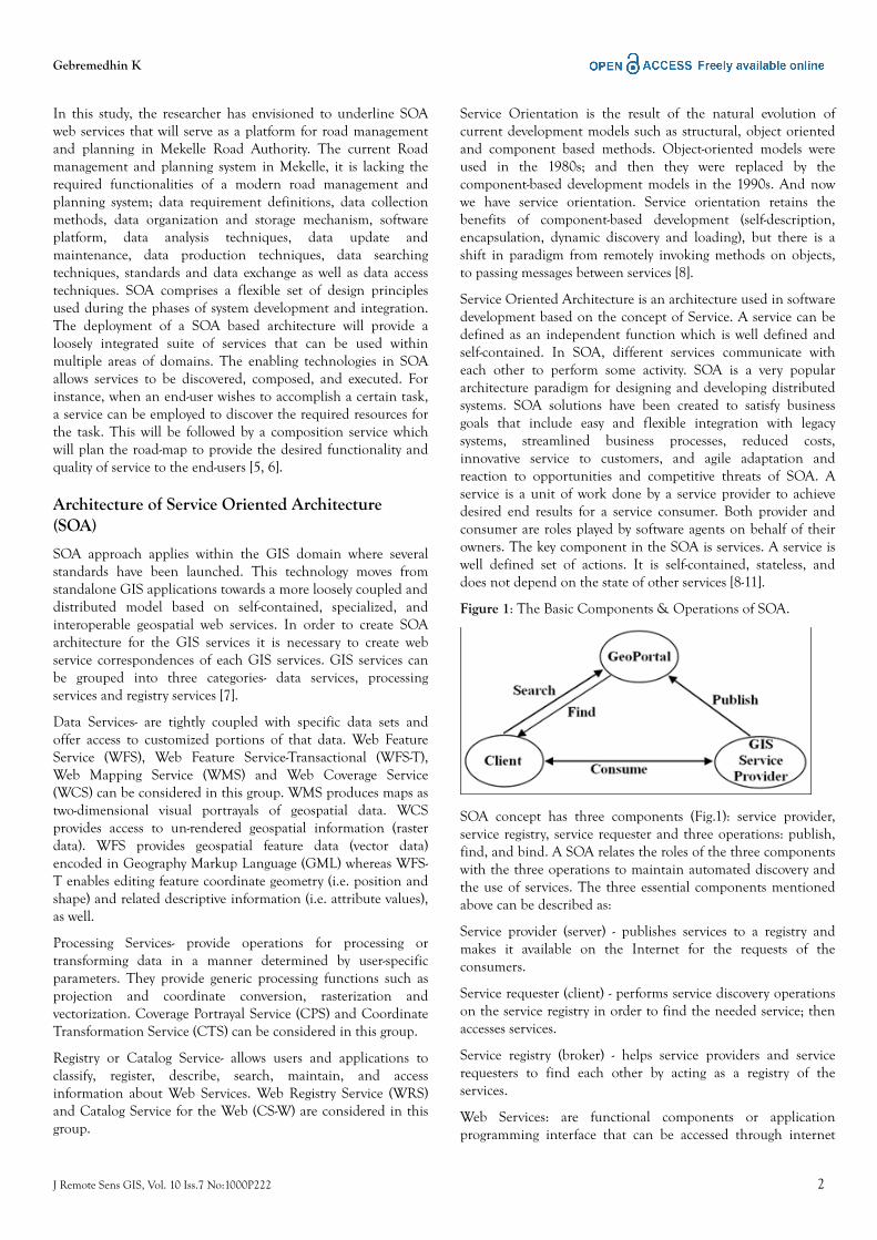
Figure 1: The Basic Components & Operations of SOA.
SOA concept has three components (Fig.1): service provider,service registry, service requester and three operations: publish,find, and bind. A SOA relates the roles of the three componentswith the three operations to maintain automated discovery andthe use of services. The three essential components mentionedabove can be described as:
Service provider (server) - publishes services to a registry andmakes it available on the Internet for the requests of theconsumers.
Service requester (client) - performs service discovery operationson the service registry in order to find the needed service; thenaccesses services.
Service registry (broker) - helps service providers and servicerequesters to find each other by acting as a registry of theservices.
Web Services: are functional components or applicationprogramming interface that can be accessed through internet
Gebremedhin K
J Remote Sens GIS, Vol. 10 Iss.7 No:1000P222 2
and SOA can be implemented at many different networkenvironments. The implementation of SOA in web environmentis called Web Services. The concept of Web services is based onservice oriented architecture paradigm where a completeapplication can be constructed from various services whichprovide different functionalities. Web services are designed to bepublished as far as possible like web sites. Web services are self-contained, self-describing, modular new raise of webapplications that can be published, located, and dynamicallyinvoked across the web.
Simple Object Access Protocol (SOAP) - Messaging protocol - isresponsible for encoding messages in a common XML format sothat they can be understood at either end of a networkconnection. Simple Object Access Protocol (SOAP) is thespecific format for exchanging Web services data over HTTP.
Web Service Description Language (WSDL) - DescriptionProtocol- it is an XML format used for describing the publicinterface to a specific web service. Web Service DefinitionLanguage(WSDL) is used to describe what type of message a webservice accepts and generates. It gives the answers to thequestions who? What? Where? Why? How? When?
Universal Description Discovery and Integration (UDDI) –Discovery protocol- is the core and open registry standard forweb services or centralizes services into a common registry.UDDI specification can be used by the service providers toadvertise the existence of their services and by requesters tosearch and discover already registered services.
HyperText Transfer Protocol (HTTP) – Transport Protocol- isresponsible for transporting messages between networkapplications. HTTP is the low-level protocol used by the Internetfor the transport layer.
SOA web services can facilitate the road management systemactivities, which optimizes performance functionality,performance measurement, management costs, informationflow, interoperability and reusability, organizational flexibility,software development, data confidentiality and integrity,reliability and ability to develop new functions rapidly [12].
Road management system in Mekelle activities compriseplanning, designing, constructing, maintenance and other roadrelated issues. Mekelle Road Authority is responsible to performthese activities. The activities of the Authority is lacking ofsearching road information in space and time. Hence, we aimedto design and develop SOA web services that will serve as aplatform for road management and planning in Mekelle RoadAuthority.
Road Management in Mekelle RoadAuthority(MeRA)
As mentioned, in the above section, data and information inMekelle road management, and activities are scattered indifferent departments and sections. There is no efficientlymaintained data management system that supports roadmanagement and planning activities. Problems arise whenplanners of roads want to access and possibly query roadsinformation. The first problem is that the spatial data related to
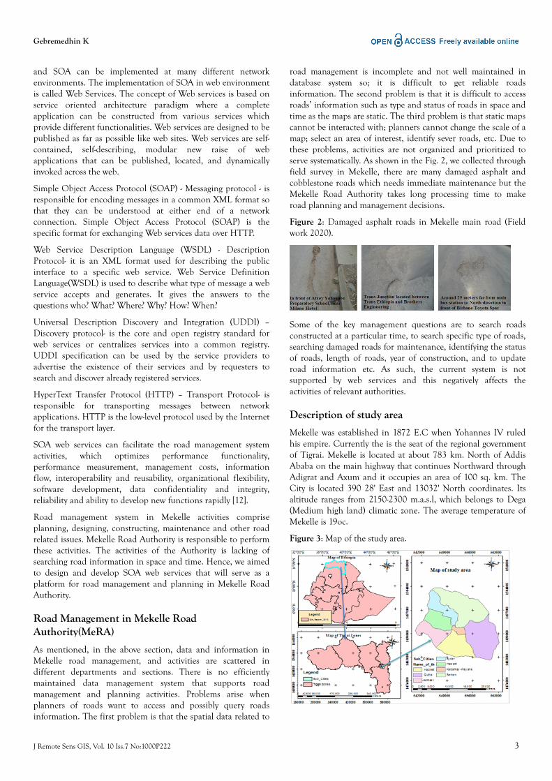
road management is incomplete and not well maintained indatabase system so; it is difficult to get reliable roadsinformation. The second problem is that it is difficult to accessroads’ information such as type and status of roads in space andtime as the maps are static. The third problem is that static mapscannot be interacted with; planners cannot change the scale of amap; select an area of interest, identify sever roads, etc. Due tothese problems, activities are not organized and prioritized toserve systematically. As shown in the Fig. 2, we collected throughfield survey in Mekelle, there are many damaged asphalt andcobblestone roads which needs immediate maintenance but theMekelle Road Authority takes long processing time to makeroad planning and management decisions.
Figure 2: Damaged asphalt roads in Mekelle main road (Fieldwork 2020).
Some of the key management questions are to search roadsconstructed at a particular time, to search specific type of roads,searching damaged roads for maintenance, identifying the statusof roads, length of roads, year of construction, and to updateroad information etc. As such, the current system is notsupported by web services and this negatively affects theactivities of relevant authorities.
Description of study area
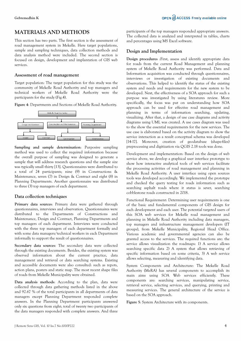
Mekelle was established in 1872 E.C when Yohannes IV ruledhis empire. Currently the is the seat of the regional governmentof Tigrai. Mekelle is located at about 783 km. North of AddisAbaba on the main highway that continues Northward throughAdigrat and Axum and it occupies an area of 100 sq. km. TheCity is located 390 28' East and 13032' North coordinates. Itsaltitude ranges from 2150-2300 m.a.s.l, which belongs to Dega(Medium high land) climatic zone. The average temperature ofMekelle is 19oc.
Figure 3: Map of the study area.
Gebremedhin K
J Remote Sens GIS, Vol. 10 Iss.7 No:1000P222 3
MATERIALS AND METHODSThis section has two parts. The first section is the assessment ofroad management system in Mekelle. Here target populations,sample and sampling techniques, data collection methods anddata analysis method were included. The second section isfocused on design, development and implantation of GIS webservices.
Assessment of road management
Target population: The target population for this study was thecommunity of Mekelle Road Authority and top managers andtechnical workers of Mekelle Road Authority were theparticipants for the study (Fig.4).
Figure 4: Departments and Sections of Mekelle Road Authority.
Sampling and sample determination: Purposive samplingmethod was used to collect the required information becausethe overall purpose of sampling was designed to generate asample that will address research questions and the sample sizewas typically small thirty [13]. Questionnaires were distributed toa total of 24 participants; nine (9) in Constructions &Maintenance, seven (7) in Design & Contract and eight (8) inPlanning Departments. Another questionnaire was distributedto three (3) top managers of each department.
Data collection techniques
Primary data sources: Primary data were gathered throughquestionnaires, interviews and observation. Questionnaires weredistributed to the Departments of Constructions andMaintenance, Design and Contract, Planning Departments andtop managers of each department. Interviews were conductedwith the three top managers of each department formally andwith some data managers/technical workers in each Departmentinformally to support the result of questionnaires.
Secondary data sources: The secondary data were collectedthrough the existing documents. Besides, the existing system wasobserved information about the current practice, datamanagement and retrieval or data searching systems. Existingand accessible documents were also consulted: such as repots,action plans, posters and static map. The most recent shape filesof roads from Mekelle Municipality were obtained.
Data analysis methods: According to the plan, data werecollected through data gathering methods listed in the aboveand 92.67 % of the total participants in all departments of datamanagers except Planning Department responded completeanswers. In the Planning Department participants answeredonly six questions from eight; total of twenty two participants ofthe data managers responded with complete answers. And three
participants of the top managers responded appropriate answers.The collected data is analyzed and interpreted in tables, chartsand percentages using MS Excel software.
Design and Implementation
Design procedures :First, assess and identify appropriate datafor roads from the current Road Management and planningsystem of Mekelle Road Authority was performed. Data andInformation acquisition was conducted through questionnaires,interviews or investigation of existing documents andobservations. This helped to identify the status of the existingsystem and needs and requirements for the new system to bedeveloped. Next, the effectiveness of a SOA approach for such apurpose was investigated by using literatures review. Morespecifically, the focus was put on understanding how SOAapproach can be used for effective road management andplanning in terms of information searching, updating,visualizing. After that, a design of use case diagrams and activitydiagrams using UML was created. A use cases diagram was usedto the show the essential requirements for the new services. Theuse case is elaborated based on the activity diagram to show theservice interaction as a result conceptual schema was developed[14-17]. Moreover, creation of geodatabase (shape-files)preprocessing and digitization via QGIS 2.18 tools was done.
Development and implementation: Based on the design of webservice above, we develop a graphical user interface prototype toshow how interactive analytical tools of web services facilitatethe processing activities of road management and planning inMekelle Road Authority. A user interface using open sourcestools was developed accordingly. We implemented the prototypeand checked the query testing for roads information such assearching asphalt roads where it status is sever, searchingcobblestone roads constructed in 2018.
Functional Requirement: Determining user requirements is oneof the basic and fundamental components of GIS design foreach development and each user. The potential targeted users ofthis SOA web services for Mekelle road management andplanning in Mekelle Road Authority including data managers,top managers and infrastructure management developers (ITgroups), from Mekelle Municipality, Regional Head Office.Various academic and governmental agencies can also begranted access to the services. The required functions are: theservice allows visualization the roadmaps: 1) A service allowssearching specific data 2) A system that allows retrieving ofspecific information based on some criteria, 3) A web serviceallows selecting, measuring and identifying data.
System Components and Architecture: The Mekelle RoadAuthority (MeRA) has several components to accomplish itsmain aims using SOA Web services efficiently. Thesecomponents are: searching services, manipulating service,retrieval service, selecting services, and querying, printing andmeasuring services. The general architecture of the service isbased on the SOA approach.
Figure 5: System Architecture with its components.
Gebremedhin K
J Remote Sens GIS, Vol. 10 Iss.7 No:1000P222 4
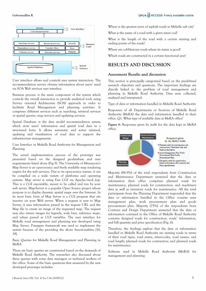
User interface- allows and controls user system interaction. Therecommendation service obtains information about users’ needvia SOA Web services user interface.
Business process- is the main component of the system whichcontrols the overall interaction to provide analytical tools usingService oriented Architecture (SOA) approach in order tofacilitate Road Management and planning activities. Itcomprises different services such as searching, retrieval servicesor spatial queries, map services and updating services.
Spatial Database- is the data model recommendation systemwhich store users’ information and spatial road data in astructured form. It allows automatic and active retrieval,updating and visualization of road data to support theinfrastructure managements.
User Interface in Mekelle Road Authority for Management andPlanning
The actual implementation process of the prototype waspresented based on the designed geodatabase and userrequirements listed above (Fig.5). The University of Minnesota’sMap Server is an open-source and freely available map renderingengine for the web services. Due to its open-source nature, it canbe compiled on a wide variety of platforms and operatingsystems. Map server is using Fast CGI via Apache/mod_fcgi.This is a CGI executable, meant to be called and run by yourweb server. Map-Server is a popular Open Source project whosepurpose is to display dynamic spatial maps over the Internet. Inits most basic form of Map Server is a CGI program that sitsinactive on your Web server. When a request is sent to MapServer, it uses information passed in the request URL and theMap file to create an image of the requested map. The requestmay also return images for legends, scale bars, reference maps,and values passed as CGI variables. The user interface forMekelle road management and planning was developed usingMap Server. P-mapper framework was used to implement thesystem because of the providing the above functionalities [18,19].
Basic Queries for Mekelle Road Management and Planning inMeRA
There are basic queries we constructed based on the demands ofMekelle Road Authority. The researcher also discussed aboutthese queries with some data managers or technical workers ofthe office. Some of the basic questions that answered by the newdeveloped prototype includes:
Where is the greatest sever of asphalt roads in Mekelle sub city?
What is the name of a road with a given street cod?
What is the length of the road with a certain starting andending points of the roads?
Where are cobblestone roads where its status is good?
Which roads are constructed in a certain functional year?
RESULTS AND DISCUSSION
Assessment Results and discussion
This section is principally categorized based on the predefinedresearch objectives and questions. The important findings aredirectly linked to the problem of road management andplanning in Mekelle Road Authority. Data were collected,analyzed and interpreted.
Type of data or information handled in Mekelle Road Authority
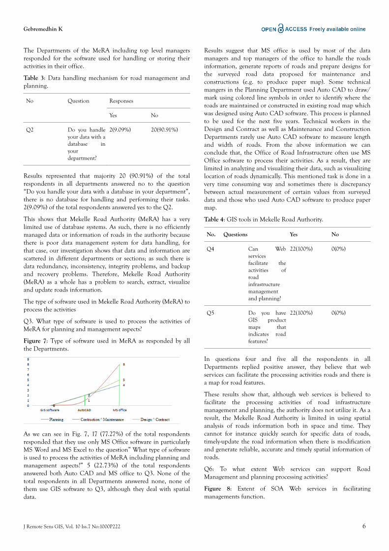
Responses of all Departments or Sections of Mekelle RoadAuthority (MeRA) the data and information handled in theiroffice. Q1. What type of available data at MeRA office?
Figure 6: Responses given by staffs for the data kept in MeRAoffice.
Majority (88.9%) of the total respondents from Constructionand Maintenance Department answered that the data orinformation their office comprises planned roads formaintenance, planned roads for construction, and machinerydata as well as inventory roads for maintenance. All the totalparticipants from the Planning Department responded that thedata or information handled in the Office consists assetmanagement plan, work procurement plan and goodsprocurement plan. Majority (75%) of the respondents fromContract and Design Department answered that the data orinformation conveyed in the Office of Mekelle Road Authoritycontains designed roads for construction, roads’ information,and bill quantity and price specification (Fig. 6).
Therefore, the findings explore that the data or informationhandled in Mekelle Road Authority are existing roads in termsof their road types, road status, street-codes, road names, androad length; planned roads for contraction; and planned roadsfor maintenance.
Software used in Mekelle Road Authority (MeRA) formanagement and planning
Gebremedhin K
J Remote Sens GIS, Vol. 10 Iss.7 No:1000P222 5
The Departments of the MeRA including top level managersresponded for the software used for handling or storing theiractivities in their office.
Table 3: Data handling mechanism for road management andplanning.
No Question Responses
Yes No
Q2 Do you handleyour data with adatabase inyourdepartment?
2(9.09%) 20(90.91%)
Results represented that majority 20 (90.91%) of the totalrespondents in all departments answered no to the question“Do you handle your data with a database in your department”,there is no database for handling and performing their tasks.2(9.09%) of the total respondents answered yes to the Q2.
This shows that Mekelle Road Authority (MeRA) has a verylimited use of database systems. As such, there is no efficientlymanaged data or information of roads in the authority becausethere is poor data management system for data handling, forthat case, our investigation shows that data and information arescattered in different departments or sections; as such there isdata redundancy, inconsistency, integrity problems, and backupand recovery problems. Therefore, Mekelle Road Authority(MeRA) as a whole has a problem to search, extract, visualizeand update roads information.
The type of software used in Mekelle Road Authority (MeRA) toprocess the activities
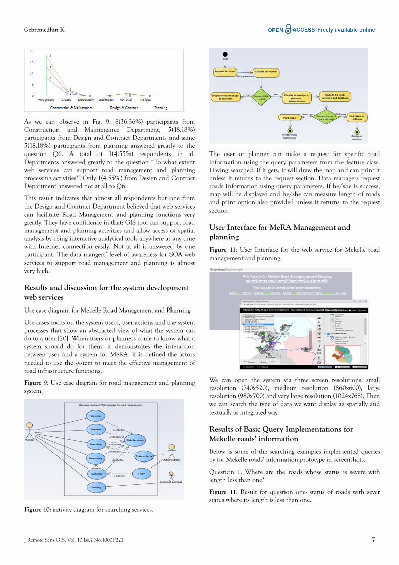
Q3. What type of software is used to process the activities ofMeRA for planning and management aspects?
Figure 7: Type of software used in MeRA as responded by allthe Departments.
As we can see in Fig. 7, 17 (77.27%) of the total respondentsresponded that they use only MS Office software in particularlyMS Word and MS Excel to the question” What type of softwareis used to process the activities of MeRA including planning andmanagement aspects?” 5 (22.73%) of the total respondentsanswered both Auto CAD and MS office to Q3. None of thetotal respondents in all Departments answered none, none ofthem use GIS software to Q3, although they deal with spatialdata.
Results suggest that MS office is used by most of the datamanagers and top managers of the office to handle the roadsinformation, generate reports of roads and prepare designs forthe surveyed road data proposed for maintenance andconstructions (e.g. to produce paper map). Some technicalmangers in the Planning Department used Auto CAD to draw/mark using colored line symbols in order to identify where theroads are maintained or constructed in existing road map whichwas designed using Auto CAD software. This process is plannedto be used for the next five years. Technical workers in theDesign and Contract as well as Maintenance and ConstructionDepartments rarely use Auto CAD software to measure lengthand width of roads. From the above information we canconclude that, the Office of Road Infrastructure often use MSOffice software to process their activities. As a result, they arelimited in analyzing and visualizing their data, such as visualizinglocation of roads dynamically. This mentioned task is done in avery time consuming way and sometimes there is discrepancybetween actual measurement of certain values from surveyeddata and those who used Auto CAD software to produce papermap.
Table 4: GIS tools in Mekelle Road Authority.
No. Questions Yes No
Q4 Can Webservicesfacilitate theactivities ofroadinfrastructuremanagementand planning?
22(100%) 0(0%)
Q5 Do you haveGIS productmaps thatindicates roadfeatures?
22(100%) 0(0%)
In questions four and five all the respondents in allDepartments replied positive answer, they believe that webservices can facilitate the processing activities roads and there isa map for road features.
These results show that, although web services is believed tofacilitate the processing activities of road infrastructuremanagement and planning, the authority does not utilize it. As aresult, the Mekelle Road Authority is limited in using spatialanalysis of roads information both in space and time. Theycannot for instance quickly search for specific data of roads,timely-update the road information when there is modificationand generate reliable, accurate and timely spatial information ofroads.
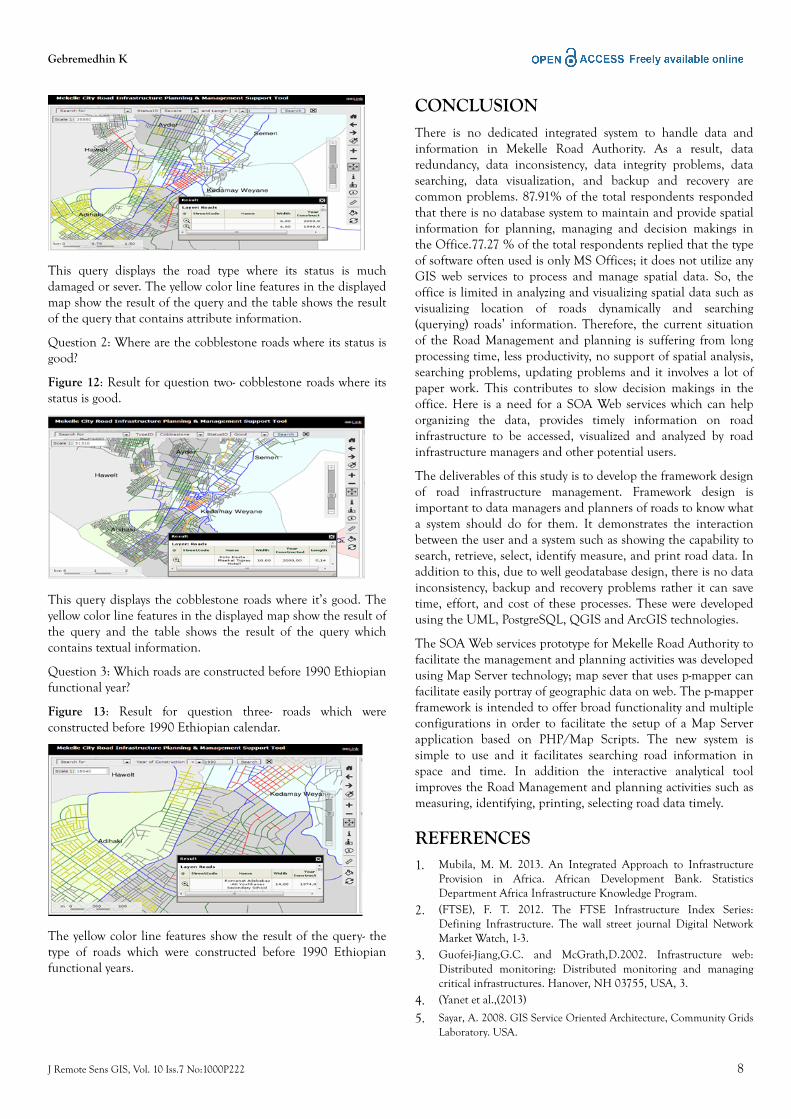
Q6: To what extent Web services can support RoadManagement and planning processing activities?
Figure 8: Extent of SOA Web services in facilitatingmanagements function.
Gebremedhin K
J Remote Sens GIS, Vol. 10 Iss.7 No:1000P222 6
As we can observe in Fig. 9, 8(36.36%) participants fromConstruction and Maintenance Department, 5(18.18%)participants from Design and Contract Departments and same5(18.18%) participants from planning answered greatly to thequestion Q6. A total of 1(4.55%) respondents in allDepartments answered greatly to the question “To what extentweb services can support road management and planningprocessing activities?” Only 1(4.55%) from Design and ContractDepartment answered not at all to Q6.
This result indicates that almost all respondents but one fromthe Design and Contract Department believed that web servicescan facilitate Road Management and planning functions verygreatly. They have confidence in that; GIS tool can support roadmanagement and planning activities and allow access of spatialanalysis by using interactive analytical tools anywhere at any timewith Internet connection easily. Not at all is answered by oneparticipant. The data mangers’ level of awareness for SOA webservices to support road management and planning is almostvery high.
Results and discussion for the system developmentweb services
Use case diagram for Mekelle Road Management and Planning
Use cases focus on the system users, user actions and the systemprocesses that show an abstracted view of what the system cando to a user [20]. When users or planners come to know what asystem should do for them, it demonstrates the interactionbetween user and a system for MeRA, it is defined the actorsneeded to use the system to meet the effective management ofroad infrastructure functions.
Figure 9: Use case diagram for road management and planningsystem.
Figure 10: activity diagram for searching services.
The user or planner can make a request for specific roadinformation using the query parameters from the feature class.Having searched, if it gets, it will draw the map and can print itunless it returns to the request section. Data managers requestroads information using query parameters. If he/she is success,map will be displayed and he/she can measure length of roadsand print option also provided unless it returns to the requestsection.
User Interface for MeRA Management andplanning
Figure 11: User Interface for the web service for Mekelle roadmanagement and planning.
We can open the system via three screen resolutions, smallresolution (740x520), medium resolution (860x600), largeresolution (980x700) and very large resolution (1024x768). Thenwe can search the type of data we want display as spatially andtextually as integrated way.
Results of Basic Query Implementations forMekelle roads’ information
Below is some of the searching examples implemented queriesby for Mekelle roads’ information prototype in screenshots.
Question 1: Where are the roads whose status is severe withlength less than one?
Figure 11: Result for question one- status of roads with severstatus where its length is less than one.
Gebremedhin K
J Remote Sens GIS, Vol. 10 Iss.7 No:1000P222 7
This query displays the road type where its status is muchdamaged or sever. The yellow color line features in the displayedmap show the result of the query and the table shows the resultof the query that contains attribute information.
Question 2: Where are the cobblestone roads where its status isgood?
Figure 12: Result for question two- cobblestone roads where itsstatus is good.
This query displays the cobblestone roads where it’s good. Theyellow color line features in the displayed map show the result ofthe query and the table shows the result of the query whichcontains textual information.
Question 3: Which roads are constructed before 1990 Ethiopianfunctional year?
Figure 13: Result for question three- roads which wereconstructed before 1990 Ethiopian calendar.
The yellow color line features show the result of the query- thetype of roads which were constructed before 1990 Ethiopianfunctional years.
CONCLUSIONThere is no dedicated integrated system to handle data andinformation in Mekelle Road Authority. As a result, dataredundancy, data inconsistency, data integrity problems, datasearching, data visualization, and backup and recovery arecommon problems. 87.91% of the total respondents respondedthat there is no database system to maintain and provide spatialinformation for planning, managing and decision makings inthe Office.77.27 % of the total respondents replied that the typeof software often used is only MS Offices; it does not utilize anyGIS web services to process and manage spatial data. So, theoffice is limited in analyzing and visualizing spatial data such asvisualizing location of roads dynamically and searching(querying) roads’ information. Therefore, the current situationof the Road Management and planning is suffering from longprocessing time, less productivity, no support of spatial analysis,searching problems, updating problems and it involves a lot ofpaper work. This contributes to slow decision makings in theoffice. Here is a need for a SOA Web services which can helporganizing the data, provides timely information on roadinfrastructure to be accessed, visualized and analyzed by roadinfrastructure managers and other potential users.
The deliverables of this study is to develop the framework designof road infrastructure management. Framework design isimportant to data managers and planners of roads to know whata system should do for them. It demonstrates the interactionbetween the user and a system such as showing the capability tosearch, retrieve, select, identify measure, and print road data. Inaddition to this, due to well geodatabase design, there is no datainconsistency, backup and recovery problems rather it can savetime, effort, and cost of these processes. These were developedusing the UML, PostgreSQL, QGIS and ArcGIS technologies.
The SOA Web services prototype for Mekelle Road Authority tofacilitate the management and planning activities was developedusing Map Server technology; map sever that uses p-mapper canfacilitate easily portray of geographic data on web. The p-mapperframework is intended to offer broad functionality and multipleconfigurations in order to facilitate the setup of a Map Serverapplication based on PHP/Map Scripts. The new system issimple to use and it facilitates searching road information inspace and time. In addition the interactive analytical toolimproves the Road Management and planning activities such asmeasuring, identifying, printing, selecting road data timely.
REFERENCES1. Mubila, M. M. 2013. An Integrated Approach to Infrastructure
Provision in Africa. African Development Bank. StatisticsDepartment Africa Infrastructure Knowledge Program.
2. (FTSE), F. T. 2012. The FTSE Infrastructure Index Series:Defining Infrastructure. The wall street journal Digital NetworkMarket Watch, 1-3.
3. Guofei-Jiang,G.C. and McGrath,D.2002. Infrastructure web:Distributed monitoring: Distributed monitoring and managingcritical infrastructures. Hanover, NH 03755, USA, 3.
4. (Yanet et al.,(2013)
5. Sayar, A. 2008. GIS Service Oriented Architecture, Community GridsLaboratory. USA.
Gebremedhin K
J Remote Sens GIS, Vol. 10 Iss.7 No:1000P222 8

6. Sahin, K. and Gumusay, M. U.. Service Oriented Architecture(SOA) based on web services for Geographic Information System.The International Archives of the Photogrammetry, RemoteSensing and Spatial Information Sciences. Vol. XXXVII. Part B2.Beijing. 2008.
7. Gardner, G., Baumstarc, k.and Sego, P. Industry Best Practices inAchieving Service Oriented Architecture (SOA). Virginia :Association for Enterprise Integration 2111 Wilson Boulevard,Suite 400 Arlington, Virginia 22201. 2005.
8. Fronckowiak, J. SOA best practices and design patterns keys tosuccessful service oriented architecture implementation. 2008.
9. Vinoski, S. Web services Interaction Models, Part1: CurrentPractice, IEEE Internet Computing. 2002; 6(3): 89–91.
10. Groups, O.. Service Oriented Architecture: SOA Features andbenefites for infrastractures. 1995.
Gebremedhin K
J Remote Sens GIS, Vol. 10 Iss.7 No:1000P222 9
Related Documents