GIS & Water Resources II Dr Parris Lyew-Ayee Jr Mona GeoInformatics Institute University of the West Indies

Welcome message from author
This document is posted to help you gain knowledge. Please leave a comment to let me know what you think about it! Share it to your friends and learn new things together.
Transcript

GIS & Water Resources II
Dr Parris Lyew-Ayee JrMona GeoInformatics InstituteUniversity of the West Indies
Applications of GIS in Water
Resources Management
Remote Sensing
Watershed management
Flood management
Groundwater
Water quality
Permitting

Remote Sensing
Use of aerial photography and/or satellite
imagery to assess water resources
Allows rapid assessment of large areas, and
selection of subsets for detailed analyses
Water has distinctive spectral properties; water
absorbs radiation – in infrared imagery, water
appears black
Water quality can also be picked up from remote
sensing – turbidity and/or depth
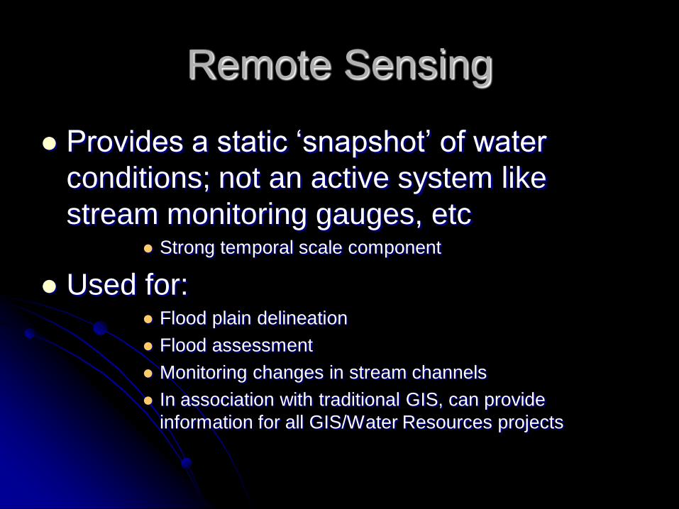
Remote Sensing
Provides a static ‘snapshot’ of water
conditions; not an active system like
stream monitoring gauges, etc Strong temporal scale component
Used for: Flood plain delineation
Flood assessment
Monitoring changes in stream channels
In association with traditional GIS, can provide
information for all GIS/Water Resources projects
Watershed Management
Terrain modeling
Flow modeling
Debris flow probability

Watershed Management
Terrain modeling Creation of DEMs
Automated watershed extraction from topography
Flow determination – direction and accumulation
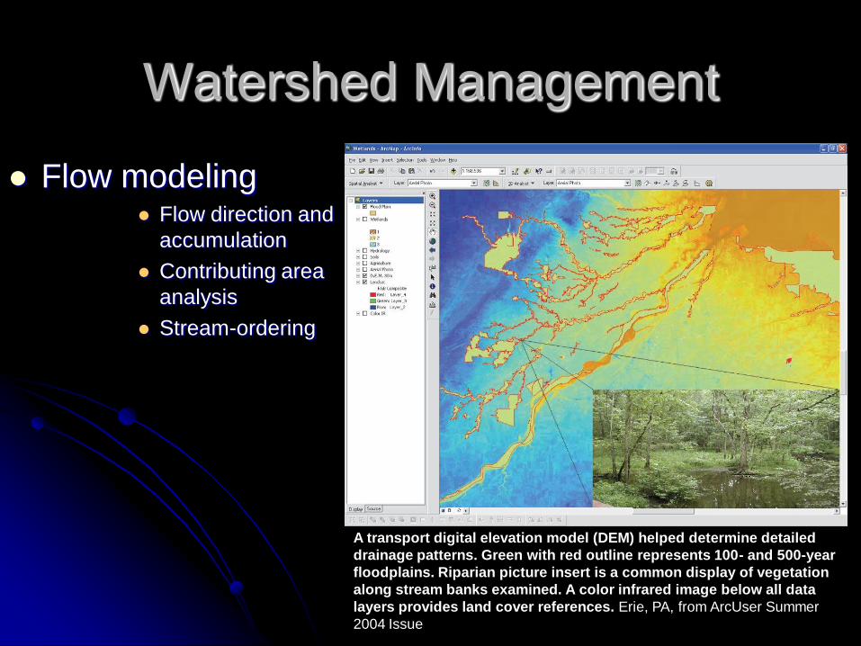
Watershed Management
Flow modeling Flow direction and
accumulation
Contributing area
analysis
Stream-ordering
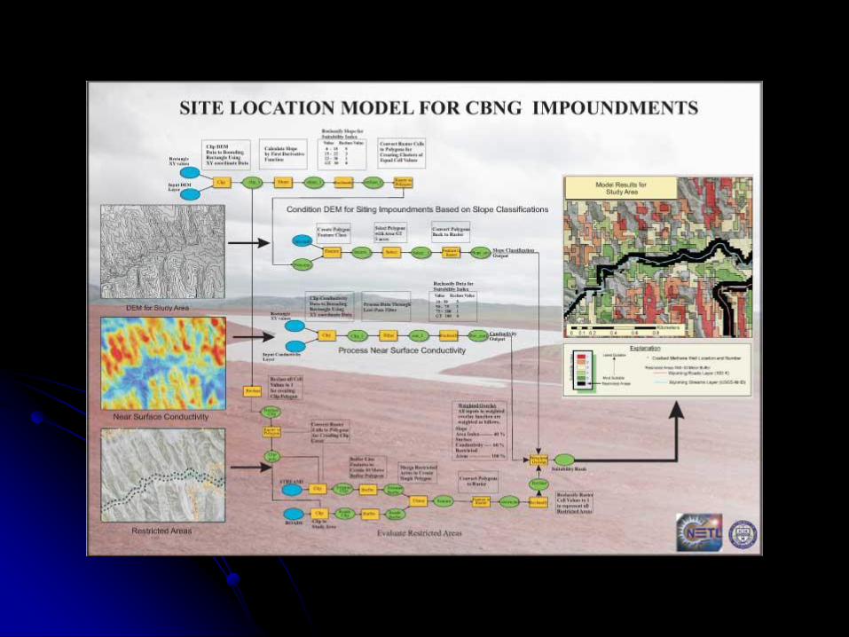
A transport digital elevation model (DEM) helped determine detailed
drainage patterns. Green with red outline represents 100- and 500-year
floodplains. Riparian picture insert is a common display of vegetation
along stream banks examined. A color infrared image below all data
layers provides land cover references. Erie, PA, from ArcUser Summer
2004 Issue
Watershed Management
Debris flow probability Saturation and viscosity calculation

Flood Management
Flood plain delineation
Channel characteristics
Inundation modeling
Infrastructure analysis
Risk modeling and mitigation

Flood Management
Flood plain delineation Use of satellite imagery
Assessment/modeling of topography
Soil
Hydrology
Flood Management
Channel characteristics Channel cross-section
Channel length
Channel shape
Changes over time
Channel erosion and depositional features

Flood Management
Inundation modeling Prediction of return periods
Simulation of models on contemporary situation
Assessment of potentially flood-prone sites
Implementation of mitigation measures
Large-scale and small-scale mitigation
Flood Management
Infrastructure analysis From analysis of inundation models, determine effects on
infrastructure
Assessment of bridge and other structures that span river
channels
Assessment of dykes and other mitigation structures that
run parallel to channel
Effects of these on sedimentation and erosion
processes downstream
Assessment of road and other critical networks and
facilities with respect to flood hazards
Flood Management
Risk modeling and mitigation From inundation models and infrastructural analyses,
can compute risk factors, and determine probabilities,
return periods, and acceptable risk
Can begin planning appropriate engineering mitigation
plans
Mitigation can range from legislation (zoning) to
engineering
All have to consider socio-economic realities with respect
to:
Demand for land for development
Cost of implementing mitigation
Environmental impact of mitigation downstream

Groundwater
Modeling subsurface
flow – rate, advection,
concentration
Well and spring
models

Water Quality
Management of surface and subsurface
water
Use of GPS and photographic tie-points
Use of passive and active water quality
monitoring systems
Water Quality
Management of surface and subsurface
water Instrument-based assessments
Used in conjunction with GIS/GPS, ties location of
sample collection to map to show patterns and
distributions
Water quality measurements of oxygen, pH, bacterial
content, etc
Measures flow rates and turbidity

Water Quality
Use of GPS and
photographic tie-
points Hot-linking functions
relate pictures,
reports, and tables for
each location within a
single system
GPS transmission
can relay real-time
information on water
flow and quality

Water Quality
Use of passive and
active water quality
monitoring systems Depends on costs
and risk; may not
need advanced active
system on a river that
floods often, but is far
from any settlement
or developments
Need to consider
quantity of measuring
stations; more
stations equal greater
detail and accuracy
but greater cost
Permitting
Population and consumption demand
analyses and forecasts
Water quality modeling
Flow analyses
EIA and development review and approval
Engineering

Permitting
Population and consumption demand
analyses and forecasts Consider population and consumption characteristics as
end users of water resources
Includes domestic, commercial, industrial and civil uses
Need to know the location and distribution of these
Permitting
Water quality modeling Level of quality monitoring is a function of the use of the
resource
Water may be used for:
Generation of hydro-electricity
Agricultural irrigation
Human consumption
Permitting
Flow analyses Looks at:
Rate of flow of water for downstream flood control
Content and concentrations of dissolved and
suspended particles for pollution control and
sedimentation analyses
Permitting
EIA and development review and approval Important when considering major infrastructural
development within watersheds and along rivers or flood
plains
Downstream impacts important
Range from major capital development projects, such as
dams, to smaller activities such as sand-mining
Implications may extend to other jurisdictions, locally and
internationally
Permitting
Engineering For:
Generation of hydro-electricity
Agricultural irrigation
Human consumption
Flood control
Transport
Extraction of resource
Consider topography and other natural physical
elements, and population/demand centres to determine
means to supply resource from source
Related Documents