GIS Tutorial 1 Lecture 6 Digitizing

GIS Tutorial 1 Lecture 6 Digitizing. Outline Digitizing overview GIS features Digitizing features Advanced digitizing tools Spatial adjustments.
Dec 22, 2015
Welcome message from author
This document is posted to help you gain knowledge. Please leave a comment to let me know what you think about it! Share it to your friends and learn new things together.
Transcript

GIS Tutorial 1
Lecture 6Digitizing

Outline
Digitizing overview
GIS features
Digitizing features
Advanced digitizing tools
Spatial adjustments
Digitizing sources
2GIS TUTORIAL 1 - Basic Workbook

DIGITIZING OVERVIEWLecture 6
3GIS TUTORIAL 1 - Basic Workbook

Why digitize?
New maps
Map features are wrong
Missing features
Other?
4GIS TUTORIAL 1 - Basic Workbook

Digitizing tablets Used to digitize
hard copy maps into GIS
Transform wire intersections into coordinates of the tablet’s coordinate system
Heads down digitizing
5GIS TUTORIAL 1 - Basic Workbook

Steps for heads down digitizing Tape map to the
digitizer Register control
points on the map Estimate two
conversion equations (one for vertical and one for horizontal coordinates)
Digitize vectors (points, lines, or polygons)
6GIS TUTORIAL 1 - Basic Workbook 6
Control points
Map
Puck
Tape

Heads up digitizing Mouse on a screen Digitizes paper maps, aerial photos, or
other images
GIS TUTORIAL 1 - Basic Workbook 77

GIS FEATURESLecture 6
8GIS TUTORIAL 1 - Basic Workbook
Points
Single features
Nodes Line endpoints
Vertex points Controls shapes of lines
and polygons
9GIS TUTORIAL 1 - Basic Workbook

Creating points
Heads up digitizing Single point features Sketch tool and snapping features
Points added as XY event files Points geocoded using addresses
10GIS TUTORIAL 1 - Basic Workbook

Lines Starting and ending points with shape
vertices as needed
Vertex points
11GIS TUTORIAL 1 - Basic Workbook
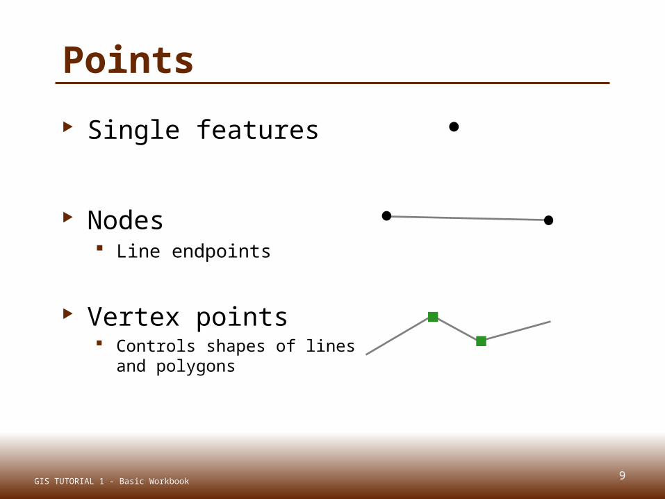
Lines Physical attributes of TIGER streets
Shape From and To attributes
Node Address Lat/long
Length
GIS TUTORIAL 1 - Basic Workbook 12

Polygons Three or more lines joined to form a
closed area
Single polygons or multipart features (Hawaiian islands can be multiple polygons
as one feature)
13GIS TUTORIAL 1 - Basic Workbook
0
0
1 2
43

Polygons
Physical attributes Shape Area Perimeter Length
14GIS TUTORIAL 1 - Basic Workbook

DIGITIZING FEATURESLecture 6
15GIS TUTORIAL 1 - Basic Workbook
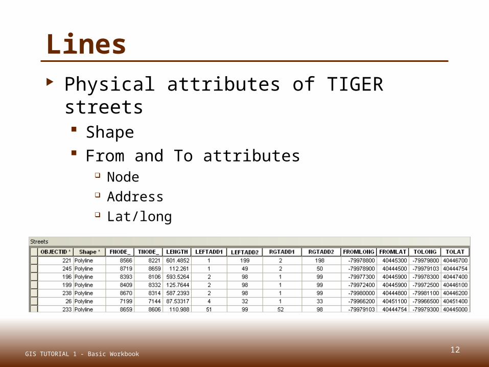
Create new feature class Created in ArcCatalog
16GIS TUTORIAL 1 - Basic Workbook
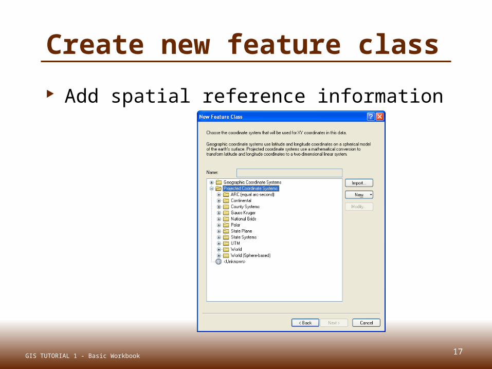
Create new feature class
Add spatial reference information
17GIS TUTORIAL 1 - Basic Workbook

Create new feature class
Add new fields
GIS TUTORIAL 1 - Basic Workbook 18

Create new feature class
Feature class created
19GIS TUTORIAL 1 - Basic Workbook

Creating Feature Layers or Shapefiles in ArcMap
20GIS TUTORIAL 1 - Basic Workbook
Within ArcMap:
-Locate an existing data layer that is similar to the layer that you wish to create.
-Start editing the existing layer, then digitize the new feature
-Select the new feature
-Export the selection to a shapefile
-Add the shapefile- fields already present and map projection is already defined -Examples in the instructor exercise

Digitize new features Create base map Add feature in ArcMap Start editing (Editor toolbar) Digitize feature Stop editing and save
21GIS TUTORIAL 1 - Basic Workbook

Create base map for digitizing Vector features or raster images
22GIS TUTORIAL 1 - Basic Workbook

Add new feature class
23GIS TUTORIAL 1 - Basic Workbook
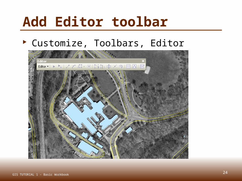
Add Editor toolbar Customize, Toolbars, Editor toolbar
24GIS TUTORIAL 1 - Basic Workbook

Start editing Editor, Start editing
25GIS TUTORIAL 1 - Basic Workbook

Begin digitizing
26GIS TUTORIAL 1 - Basic Workbook

Click point (tree) locations
27GIS TUTORIAL 1 - Basic Workbook

Stop editing Editor, Stop editing
28GIS TUTORIAL 1 - Basic Workbook

Edit attribute data Start editing, populate fields in table
29GIS TUTORIAL 1 - Basic Workbook
1 2

ADVANCED DIGITIZING TOOLSLecture 6
30GIS TUTORIAL 1 - Basic Workbook

Specify angle and length
Lines and polygons
Straight segment tool
Type length and angle
31GIS TUTORIAL 1 - Basic Workbook

Snapping tools
Snapping toolbar
32GIS TUTORIAL 1 - Basic Workbook
Point Snapping
Endpoint Snapping
Vertex Snapping
Edge Snapping

Trace tool Good for complicated shapes Editor toolbar, Trace tool
33GIS TUTORIAL 1 - Basic Workbook

Generalize tool Creates features for use at small scales
with less detail while preserving basic shapes
U.S. Census cartographic boundary files
34GIS TUTORIAL 1 - Basic Workbook
Census TIGER water feature City planning rivers

Smooth tool Smoothes sharp angles in polygon
outlines to improve aesthetic or cartographic quality
35GIS TUTORIAL 1 - Basic Workbook
Smooth before Smooth after

Cut polygons Creates two polygons from one original Cut polygon tool
GIS TUTORIAL 1 - Basic Workbook
Polygon before Polygon after
36

SPATIAL ADJUSTMENTSLecture 6
37GIS TUTORIAL 1 - Basic Workbook

Transforms Converts data
from one coordinate system to another. from digitizer or scanner units to real world
coordinates.
Shifts data within a coordinate system, (e.g. feet to meters).
38GIS TUTORIAL 1 - Basic Workbook

Rubbersheeting Geometric distortions commonly occur
in source maps may be introduced by imperfect registration in map
compilation lack of geodetic control in source data variety of other causes
Corrects flaws through the geometric adjustment of coordinates
GIS TUTORIAL 1 - Basic Workbook 39

Edgematching Aligns features along the edge of one
layer to features of an adjoining layer
Layer with the less accurate features is adjusted, while the adjoining layer is used as the control.
Attribute transfer is typically used to copy attributes from a less accurate layer to a more accurate one.
40GIS TUTORIAL 1 - Basic Workbook

Spatial adjustment example Hamburg Hall CAD Drawing
CAD drawings generally do not have geographic coordinates
41GIS TUTORIAL 1 - Basic Workbook

Spatial adjustment example Spatially match drawing to map using
displacement links
GIS TUTORIAL 1 - Basic Workbook 42

DIGITIZING SOURCESLecture 6
43GIS TUTORIAL 1 - Basic Workbook

USGS
United States Geological Survey
Common Data Types & Standards Digital Elevation Models (DEMs) Digital Orthophoto Quads(DOQQs) Digital Line Graphs(DLGs) Digital Raster Graphics (DRGs) Landsat Satellite Images Land Use Land Cover (LULC) Spatial Data Transfer Standard(SDTS)
44GIS TUTORIAL 1 - Basic Workbook

Orthophotography Digital imagery in which distortion from
the camera angle and topography have been removed, thus equalizing the distances represented on the image
45GIS TUTORIAL 1 - Basic Workbook

Digital Ortho Quarter Quads—DOQQs
http://online.wr.usgs.gov/ngpo/doq/ Grayscale or color-infrared (CIR) images 1-meter ground resolution; Cover an area measuring 3.75 minutes
longitude by 3.75 minutes latitude, approximately 5 miles on each side
Referenced to the North American Datum of 1983 (NAD83) and cast on the Universal Transverse Mercator (UTM) projection
46GIS TUTORIAL 1 - Basic Workbook

DOQQ image resolutions The ground length of one pixel of the
image image with one meter resolution means
that each pixel in the image represents one square meter on the ground.
30 meters30 meters 10 meters10 meters 5 meters5 meters
47GIS TUTORIAL 1 - Basic Workbook

DOQQ image resolutions
2 meters2 meters 1 meter1 meter
48GIS TUTORIAL 1 - Basic Workbook

National Elevation Data Sets United States Geological Survey
(USGS) National Elevation Dataset (NED) Shaded Relief Imagery Data (Free)
Maps provide highest-resolution elevation data available across the United States, in raster format
http://ned.usgs.gov/
49GIS TUTORIAL 1 - Basic Workbook

Scanning paper documents Raster to vector conversion Paper (historic) maps Scanned maps and images become
vectors Special software needed
50GIS TUTORIAL 1 - Basic Workbook

Summary
Digitizing overview
GIS features
Digitizing features
Advanced digitizing tools
Spatial adjustments
Digitizing sources
51GIS TUTORIAL 1 - Basic Workbook
Related Documents