Engineering | Architecture | Design-Build | Surveying | GeoSpatial Solutions Water and Sanitary District GIS Management GISCO – Spring Meeting Yaneev Golombek, GISP Rifle, CO April, 22 2015 April 24, 201

GIS Enterprise Solutions - Water & Sanitation
Jul 24, 2015
Welcome message from author
This document is posted to help you gain knowledge. Please leave a comment to let me know what you think about it! Share it to your friends and learn new things together.
Transcript

Engineering | Architecture | Design-Build | Surveying | GeoSpatial Solutions
Water and Sanitary District GIS Management
GISCO – Spring Meeting
Yaneev Golombek, GISPRifle, CO
April, 22 2015
April 24, 201
PREXXXX 2
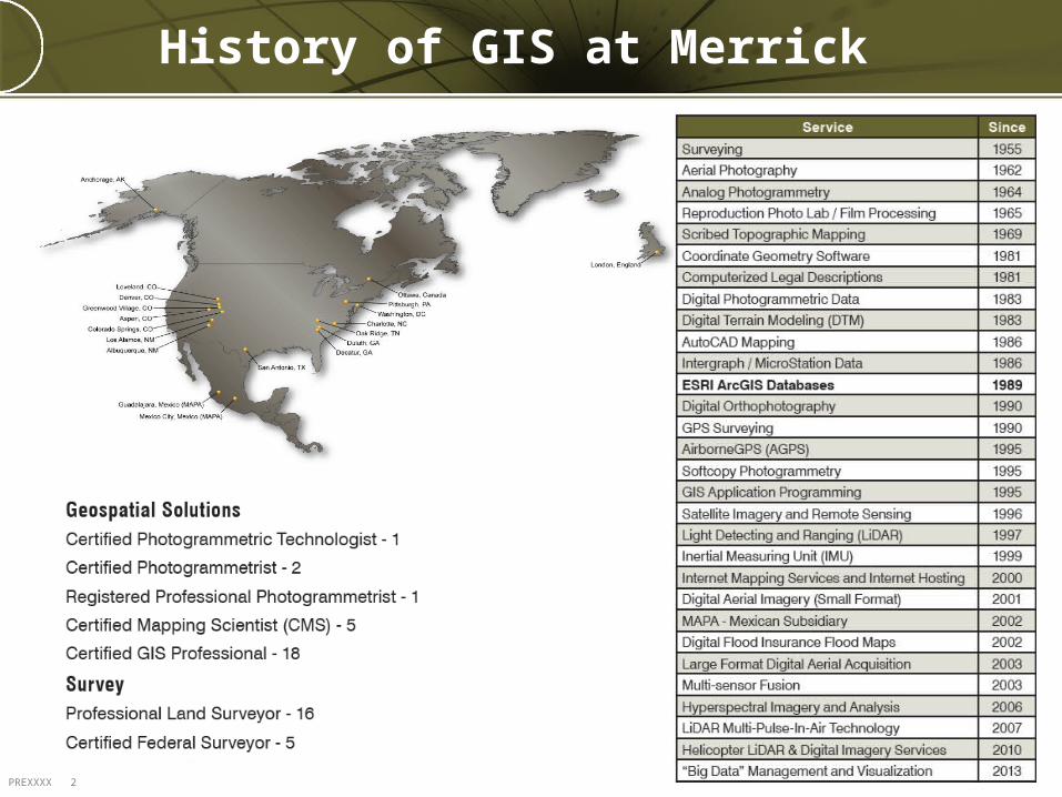
History of GIS at Merrick
PREXXXX 3
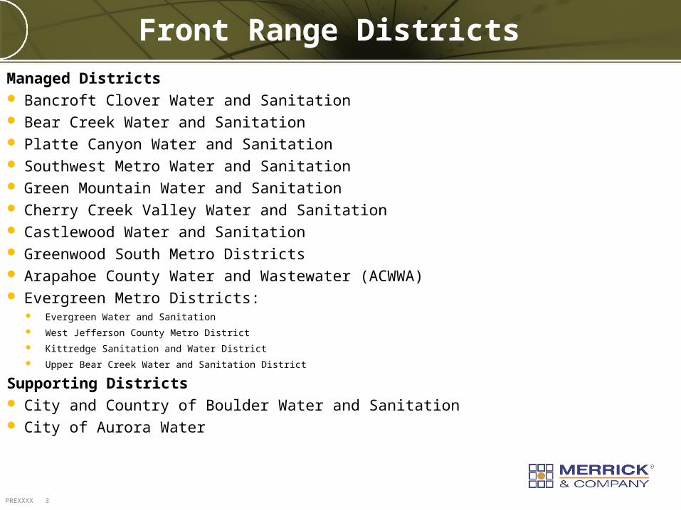
Front Range Districts
Managed Districts Bancroft Clover Water and Sanitation Bear Creek Water and Sanitation Platte Canyon Water and Sanitation Southwest Metro Water and Sanitation Green Mountain Water and Sanitation Cherry Creek Valley Water and Sanitation Castlewood Water and Sanitation Greenwood South Metro Districts Arapahoe County Water and Wastewater (ACWWA) Evergreen Metro Districts:
Evergreen Water and Sanitation
West Jefferson County Metro District
Kittredge Sanitation and Water District
Upper Bear Creek Water and Sanitation District
Supporting Districts City and Country of Boulder Water and Sanitation City of Aurora Water
PREXXXX 4
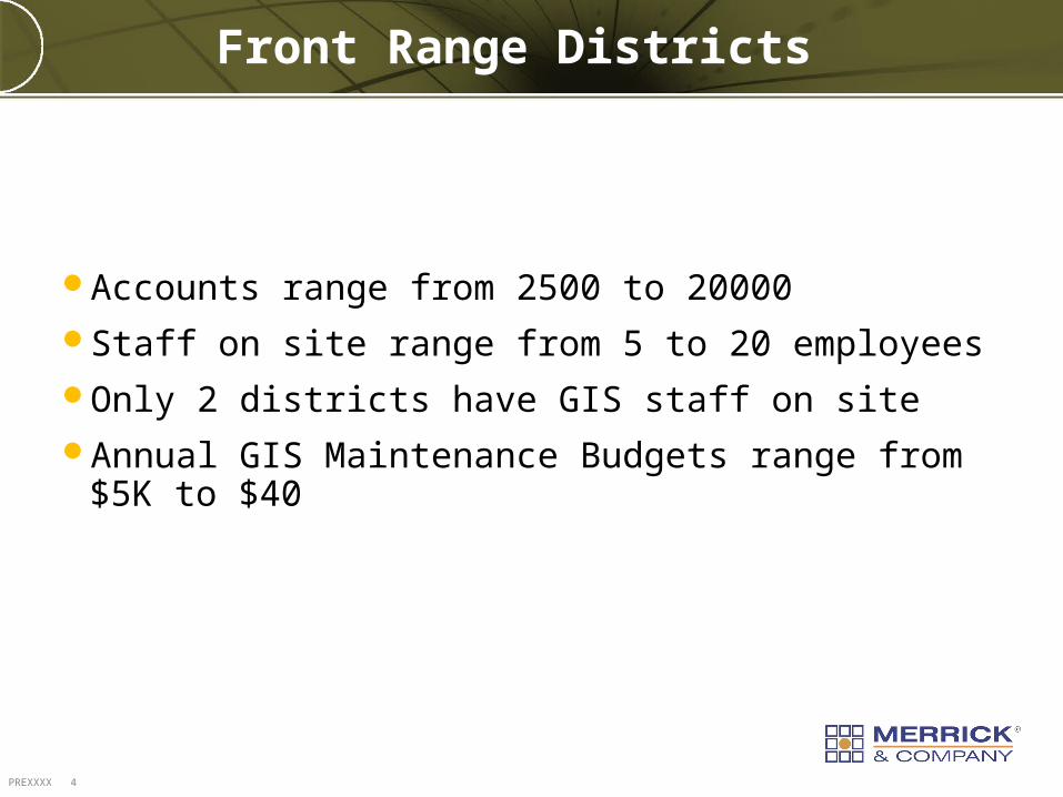
Front Range Districts
Accounts range from 2500 to 20000Staff on site range from 5 to 20 employeesOnly 2 districts have GIS staff on siteAnnual GIS Maintenance Budgets range from $5K to $40
PREXXXX 5
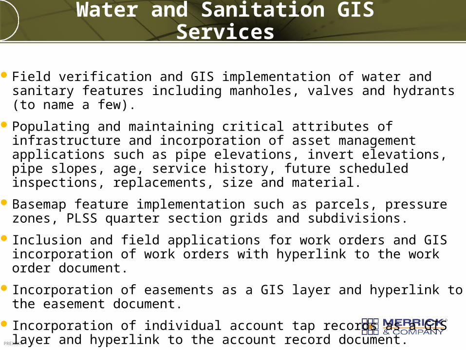
Water and Sanitation GIS Services
Field verification and GIS implementation of water and sanitary features including manholes, valves and hydrants (to name a few).
Populating and maintaining critical attributes of infrastructure and incorporation of asset management applications such as pipe elevations, invert elevations, pipe slopes, age, service history, future scheduled inspections, replacements, size and material.
Basemap feature implementation such as parcels, pressure zones, PLSS quarter section grids and subdivisions.
Inclusion and field applications for work orders and GIS incorporation of work orders with hyperlink to the work order document.
Incorporation of easements as a GIS layer and hyperlink to the easement document.
Incorporation of individual account tap records as a GIS layer and hyperlink to the account record document.

PREXXXX 6
Water and Sanitation GIS Services (cont.)
Incorporation of sewer videos with hyperlinking to the current video file.
Incorporation of sewer inspection report databases and diagrams from programs such as Flex6 and IT.
Sewer service tap and service lateral mapping.
Sewer obstruction-point mapping.
CAD to GIS as-built incorporation and legacy hard-map incorporation.
GIS incorporation of fire hydrant flushing program.
Custom map viewer and web viewers and incorporation with field laptop.
General Asset Management
PREXXXX 7
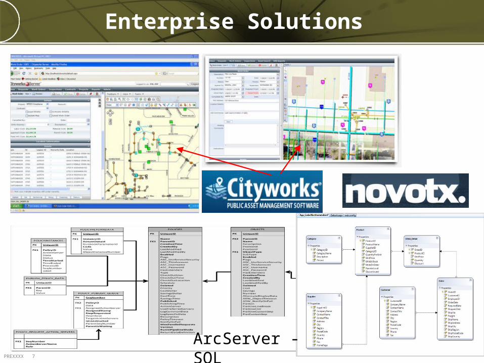
Enterprise Solutions
ArcServer - SQL
PREXXXX 8
DEMO
PREXXXX 9
Thank You!Questions?
Related Documents