GIS Applications for Water, Wastewater, and Stormwater Systems U.M. Shamsi Taylor & Francis Taylor &. Francis Group Boca Raton London New York Singapore A CRC title, part of the Taylor & Francis imprint, a member of the Taylor & Francis Group, the academic division of T&F Informa pic.

Welcome message from author
This document is posted to help you gain knowledge. Please leave a comment to let me know what you think about it! Share it to your friends and learn new things together.
Transcript

GIS Applicationsfor Water, Wastewater,
and Stormwater Systems
U.M. Shamsi
Taylor & FrancisTaylor &. Francis Group
Boca Raton London New York Singapore
A CRC title, part of the Taylor & Francis imprint, a member of theTaylor & Francis Group, the academic division of T&F Informa pic.

Contents
Chapter 1 GIS ApplicationsLearning Objective 2Major Topics 2List of Chapter Acronyms 2Introduction 2What Are GIS Applications? 3History of GIS Applications 44M Applications 6Advantages and Disadvantages of GIS Applications 6
Advantages 7GIS Applications Save Time and Money 7GIS Applications Are Critical to Sustaining GIS Departments 7GIS Applications Provide the Power of Integration 8GIS Applications Offer a Decision Support Framework 8GIS Applications Provide Effective Communication Tools 9GIS Applications Are Numerous 9
Disadvantages 12Success Stories 13
San Diego 13Boston 13Cincinnati 13Knoxville 14Dover 14Charlotte 14Albany County 14GIS Applications Around the World 15
Evolving GIS Applications and Trends .': 15Future Applications and Trends 16GIS Application Development Procedure 19Application Programming 20
GIS-Based Approach 20GIS Customization 20Scripting 20Extensions 21External Programs :... 23
Application-Based Approach 24Useful Web Sites 24Chapter Summary 24Chapter Questions 25
Chapter 2 Needs AnalysisLearning Objective 28Major Topics 28
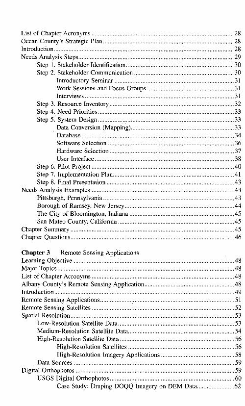
List of Chapter Acronyms 28Ocean County's Strategic Plan 28Introduction 28Needs Analysis Steps 29
Step 1. Stakeholder Identification 30Step 2. Stakeholder Communication 30
Introductory Seminar 31Work Sessions and Focus Groups 31Interviews 31
Step 3. Resource Inventory 32Step 4. Need Priorities 33Step 5. System Design 33
Data Conversion (Mapping) 33Database 34Software Selection 36Hardware Selection 37User Interface 38
Step 6. Pilot Project 40Step 7. Implementation Plan 41Step 8. Final Presentation 43
Needs Analysis Examples 43Pittsburgh, Pennsylvania 43Borough of Ramsey, New Jersey 44The City of Bloomington, Indiana 45San Mateo County, California 45
Chapter Summary 45Chapter Questions 46
Chapter 3 Remote Sensing ApplicationsLearning Objective 48Major Topics 48List of Chapter Acronyms 48Albany County's Remote Sensing Application 48Introduction 49Remote Sensing Applications 51Remote Sensing Satellites 52Spatial Resolution 53
Low-Resolution Satellite Data 53Medium-Resolution Satellite Data 54High-Resolution Satellite Data 56
High-Resolution Satellites 56High-Resolution Imagery Applications 58
Data Sources 59Digital Orthophotos 59
USGS Digital Orthophotos 60Case Study: Draping DOQQ Imagery on DEM Data 62

Examples of Remote Sensing Applications 62LULC Classification 62Soil Moisture Mapping 65Estimating Meteorological Data 66
Geographic Imaging and Image Processing Software 66ERDAS Software Products 66
ERDAS Software Application Example ; 68Arc View Image Analysis Extension 69MrSID 69PCIGeomatics 70Blue Marble Geographies 71
Future Directions 72Useful Web Sites 73Chapter Summary 73Chapter Questions 73
Chapter 4 DEM ApplicationsLearning Objective 76Major Topics 76List of Chapter Acronyms 76Hydrologic Modeling of the Buffalo Bayou Using GIS and DEM Data 76DEM Basics 77DEM Applications 79
Three-Dimensional (3D) Visualization 79DEM Resolution and Accuracy 80USGSDEMs 81
USGS DEM Formats 82National Elevation Dataset (NED) 83
DEM Data Availability 83DEM Data Creation from Remote Sensing 84
Image Processing Method 84Data Collection Method 84LIDAR 85IFSAR 85
DEM Analysis : 86Cell Threshold for Defining Streams 86The D-8 Model 86DEM Sinks 87Stream Burning 88DEM Aggregation 88Slope Calculations 88
Software Tools 88Spatial Analyst and Hydro Extension 90ARC GRID Extension 93IDRISI 94TOPAZ 95

Case Studies and Examples 95Watershed Delineation 95Sewershed Delineation 101•Water Distribution System Modeling 103
WaterCAD Example 104Useful Web Sites 105Chapter Summary 105Chapter Questions 106
Chapter 5 GPS ApplicationsLearning Objective 108Major Topics 108List of Chapter Acronyms 108Stream Mapping in Iowa 108GPS Basics 109GPS Applications in the Water Industry 110
Surveying I l lFleet Management I l l
GPS Applications in GIS I l lGPS Survey Steps 112GPS Equipment 113
Recreational GPS Equipment 113Basic GPS Equipment 114Advanced GPS Equipment 115
Survey Grade GPS Equipment 116Useful Web Sites 117Chapter Summary 117Chapter Questions 118
Chapter 6 Internet ApplicationsLearning Objective 120Major Topics 120List of Chapter Acronyms 120Dublin's Web Map ; 120Internet GIS 122
Internet Security 123Internet GIS Software 124Internet GIS Applications 124
Data Integration 124Project Management 1243D Visualization Applications 126
Case Studies 126Tacoma's Intranet and Mobile GIS 126Montana's Watershed Data Information Management System 127
Useful Web Sites 128

Chapter Summary 128Chapter Questions 128
Chapter 7 Mobile GISLearning Objective 130Major Topics 130List of Chapter Acronyms 130Mobile GIS Basics 130Mobile GIS Applications 131Wireless Internet Technology 133GPS Integration 133Useful Web Sites 134Chapter Summary 135Chapter Questions 135
Chapter 8 MappingLearning Objective 138Major Topics 138List of Chapter Acronyms 138Los Angeles County's Sewer Mapping Program 138Mapping Basics 139
Map Types 139Topology 139Map Projections and Coordinate Systems 140Map Scale 140Data Quality 140Data Errors 141Map Accuracy 141
Map Types 142Base Map 142
Digital Orthophotos 143Planimetric Maps 143Small-Scale Maps 144
Advantages of GIS Maps 145GIS Mapping Steps .-. 147
Needs Analysis 147Data Collection 148Data Conversion 148
Capturing Attributes 148Capturing Graphics 149
Digitization 149Scanning 150Data Conversion Software 150
Data Processing 153Data Preparation 153Topological Structuring 153

Data Management 154Quality Control 155Map Production .„, 155
Case Studies 156Borough of Ramsey, New Jersey 156City of Lake Elsinore, California 158Allegheny County, Pennsylvania 159
Useful Web Sites 159Chapter Summary 160Chapter Questions 160
Chapter 9 Mapping ApplicationsLearning Objective 162Major Topics 162List of Chapter Acronyms 162Customer Service Application in Gurnee 162Common Mapping Functions 164
Thematic Mapping 164Spatial Analysis 164Buffers 164Hyperlinks 167
Water System Mapping Applications 167MWRA Water System Mapping Project 167Service Shutoff Application 167Generating Meter-Reading Routes 169Map Maintenance Application 169
Wastewater System Mapping Applications 169Public Participation with 3D GIS '.... 169Mapping the Service Laterals 170
Stormwater System Mapping Applications 173Stormwater Permits 173
Chapter Summary 175Chapter Questions 175
Chapter 10 Monitoring ApplicationsLearning Objective 178Major Topics 178List of Chapter Acronyms 178Monitoring Real Time Rainfall and Stream-Flow Data in Aurora 178Monitoring Basics 179Remotely Sensed Rainfall Data 179
Satellite Rainfall Data 180Radar Rainfall Data ; 181NEXRAD Rainfall Data 181
NEXRAD Level III Data 181Estimating Rainfall Using GIS 183

Radar Rainfall Application: Virtual Rain-Gauge Case Study 184Flow-Monitoring Applications 187
SCADA Integration 187NPDES-Permit Reporting Applications 188Monitoring via Internet 189Monitoring the Infrastructure 190Useful Web Sites 190Chapter Summary 191Chapter Questions 191
Chapter 11 Modeling ApplicationsLearning Objectives 194Major Topics 194List of Chapter Acronyms 194Temporal-Spatial Modeling in Westchester County 194H&H Modeling 195Application Methods 196Interchange Method 197
Subbasin Parameter Estimation 198Runoff Curve Number Estimation 199Water Quality Modeling Data Estimation 200Demographic Data Estimation 202Land-Use Data Estimation 204
Interface Method 205HEC-GEO Interface 207HEC-GeoHMS 207HEC-GeoRAS 207Watershed Modeling System 208GISHydro Modules : 208
GISHydro Prepro 209GISHydro Runoff 210
Arclnfo Interface with HEC Programs 210Intermediate Data Management Programs 211Interface Method Case Study 212
Integration Method 212EPA's BASINS Program 213
BASINS Examples 217MIKE BASIN 218Geo-STORM Integration 219ARC/HEC-2 Integration 219Integration Method Case Study 220
Which Linkage Method to Use? 221Useful Web Sites 222Chapter Summary 222Chapter Questions 223

Chapter 12 Water ModelsLearning Objective 226Major Topics 226List of Chapter Acronyms 226City of Germantown's Water Model 226GIS Applications for Water Distribution Systems 227Development of Hydraulic Models 229Software Examples 231
EPANET 231H2ONET™ and H2OMAP™ 232
Demand Allocator 235Skeletonizer 235Tracer 235
WaterCAD™ and WaterGEMS™ 235MIKE NET™ 236Other Programs 237
EPANET and Arc View Integration in Harrisburg 237Mapping the Model Output Results 242
Network Skeletonization 243Estimation of Node Demands 249
Demand-Estimation Case Studies 252Newport News, Virginia 252Round Rock, Texas 252Lower Colorado River Authority, Texas 253
Estimation of Node Elevations 253Pressure Zone Trace 255Chapter Summary 255Chapter Questions .255
Chapter 13 Sewer ModelsLearning Objectives 258Major Topics 258List of Chapter Acronyms 258Maplnfo™ and SWMM Interchange 258GIS Applications for Sewer Systems 259Sewer System Modeling Integration 260Software Examples 261SWMM 261Useful SWMM Web Sites 264
SWMM Graphical User Interface 264XP-SWMM and XP-GIS 266
GIS Data for SWMM 267Estimating Green-Ampt Parameters Using STATSGO/SSURGO
GIS Files 267GIS Applications for SWMM 270

AVSWMM 270AVSWMM RUNOFF Extension 271AVSWMM EXTRAN Extension 274
Task 1: Create EXTRAN input file 274Task 2: Create SWMM EXTRAN output layers in
ArcViewGIS 277SWMMTools 278AGSWMM 280PCSWMMGIS™ 281SWMM and BASINS 282SWMMDUET 283AVsand™ 284
Other Sewer Models 284DHI Models 284
MOUSE™ 284MIKE SWMM™ 285MOUSE GIS™ 285MOUSE GM™ 286
InfoWorks™ 287SewerCAD™ and StormCAD™ 289
Sewer Modeling Case Studies 289XP-SWMM and Arclnfo Application for CSO Modeling 289AM/FM/GIS and SWMM Integration 290SWMM and Arclnfo™ Interface 290Hydra™ and Arclnfo™ Interface 291
Useful Web Sites 291Chapter Summary 291Chapter Questions 292
Chapter 14 AM/FM/GIS ApplicationsLearning Objective 294Major Topics 294List of Chapter Acronyms 294Hampton's Wastewater Maintenance Management 294Infrastructure Problem 295AM/FM/GIS Basics .....297
Automated Mapping (AM) 298Facilities Management (FM) 300Automated Mapping (AM)/Facilities Management (FM) 300AM/FM/GIS Systems 300
AM/FM/GIS Software 300ArcFM , 302Cityworks 304
Chapter Summary 305Chapter Questions 305

Chapter 15 Maintenance ApplicationsLearning Objective 308Major Topics 308List of Chapter Acronyms 308Buncombe County's Sewer System Inspection and Maintenance 309Asset Management 310GASB 34 Applications 312Wet Weather Overflow Management Applications 312
AutoCAD Map GIS Application for CMOM 313CCTV Inspection of Sewers 314
Convert Existing Video Tapes to Digital Files 315Digitize Existing VHS Tapes 316
WinCan 317Retrofit Tape Systems with Digital Systems 317Record Directly in Digital Format...-. 319Linking Digital Movies to GIS 319
Video Mapping 321Thematic Mapping of Inspection Data 322Work Order Management 325Water Main Isolation Trace 327Case Studies 328
Isolation Trace Case Studies 328Sewer System Inspections in Washington County 328Sewer Rehabilitation in Baldwin 330
Useful Web Sites 333Chapter Summary 333Chapter Questions 333
Chapter 16 Security Planning and Vulnerability AssessmentLearning Objective 336Major Topics 336List of Chapter Acronyms 336GIS Applications in Planning 336Security Planning 337
Vulnerability of Water Systems... 338Vulnerability of Sewer Systems 338
GIS Applications in Vulnerability Assessment 338Security Modeling Software 340
H2OMAP™ Protector 340WaterS AFE™ 340VSAT™ 342
Security Planning Data Issues 342Useful Web Sites : 343Chapter Summary 343Chapter Questions 343
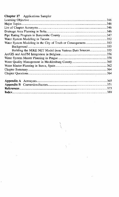
Chapter 17 Applications SamplerLearning Objective 346Major Topics 346List of Chapter Acronyms 346Drainage Area Planning in Sofia 346Pipe Rating Program in Buncombe County 347Water System Modeling in Tucson 352Water System Modeling in the City of Truth or Consequences 353
Background 355Building the MIKE NET Model from Various Data Sources 355
ArcGIS and ArcFM Integration in Belgium 356Water System Master Planning in Prague 358Water Quality Management in Mecklenburg County 360Water Master Planning in Sueca, Spain 362Chapter Summary 364Chapter Questions 364
Appendix A Acronyms 365Appendix B Conversion Factors 371References 373Index 389
Related Documents