Abstract— This paper creates a role model to simplify and streamline how waste management is currently in Romania. This model can be further improved and extended to larger scale. To begin an analysis was made concrete in the Sibiu Surroundings on the current situation of waste management. Following tests have found new ways to improve the management process. One of them is to use GIS techniques to centralize and analyze data for a permanent significant improvements in this area. Also we present notions of geospatial databases. The work is highlighted in the use of GIS techniques in goal. Another method involves the implementation of specific rules from which all the inhabitants of studies should be encouraged to practice composting individual. Keywords—composting, database, management, waste. I. INTRODUCTION he purpose of this paper is to create a model needed to streamline the management system of municipal solid waste which can then be extended more widely. At first will be a reality check that will be taken into account all factors influencing waste management: environmental performance indicators for cost, service, process indicators-general, external factors affecting the performance so I can be influenced by the mayor or local council. The data obtained will be centralized with the GeoMedia software for viewing spatial data obtained, the project will be more easily presented, to support, and will be much easier for people who will subsequently require information regarding the situation in the area (points selective waste collection, the amount collected in each island collection, the distance from one place to the nearest collection point, the area area it serves) to obtain in the relatively short and accessible through paper[1]. II. OBJECTIVES OF THE PAPERS Regional objectives and targets presented in the paper are representative in following aspects: 1) Development of a geodatabase to manage waste in a particular geographical area; 2) Presentig the main characteristics of geospatial databases; 3) Stimulate the creation and development of a viable market of recyclable waste; 4) Promoting a system of information, awareness and motivation for all parties by Enhancing communication between all parties involved; 5) Organization and support programs for education and wareness population by all parties involved (public authorities and central local companies, public institutions, etc..); 6) Develop information materials; 7) Improved local and regional system for collecting, processing, analysis and validation of data and information related to the generation and management waste; 8) Establish a regional system for the collection, analysis and validation related to the generation and waste management. III. GEOSPATIAL DATABASE A Objectual Relational Database Management System (ORDBMS), also referred to simply as a database, is a complex suite of software applications that collectively controls the organisation, storage, and retrieval of data. Modern database systems provide support for data types other than numbers and strings. The type system may be extended allowing new types and operations to be introduced. All the major database vendors support extensions to the traditional type system to include spatial data types and associated functions. The term geospatial database describes an ORDBMS that supports geographic information in the same way as any other data in the database. Vector data types such as points, lines, and polygons can be used and this data may make use of a Spatial Reference System (SRS) describing the coordinate system used. Raster, or gridded data, may also be supported in the form of an array structure where the cells contain information being modelled. Examples are satellite imagery or Digital Elevation Models (DEMs). A geospatial database may be used as the data repository for a Geographical Information System (GIS). The GIS supports an advanced user interface and incorporates specialised tools for the processing and presentation of spatial data. Experienced few years ago, but already confirmed now, the approach is geometric entities that store recordings of relational databases or object-relational, not graphic files, it allows solving problems in GIS applications for data storage. This approach is also encouraged by the OGC (Open Geospatial Consortium) has issued several standards and GIS application with a Geospatial Database for improving the waste management in Sibiu Surrouding Area S. Borza, C. Simion and I. Bandrea T Issue 5, Volume 5, 2011 653 INTERNATIONAL JOURNAL of ENERGY and ENVIRONMENT

Welcome message from author
This document is posted to help you gain knowledge. Please leave a comment to let me know what you think about it! Share it to your friends and learn new things together.
Transcript

Abstract— This paper creates a role model to simplify and
streamline how waste management is currently in Romania. This
model can be further improved and extended to larger scale. To begin
an analysis was made concrete in the Sibiu Surroundings on the
current situation of waste management. Following tests have found
new ways to improve the management process. One of them is to use
GIS techniques to centralize and analyze data for a permanent
significant improvements in this area. Also we present notions of
geospatial databases. The work is highlighted in the use of GIS
techniques in goal. Another method involves the implementation of
specific rules from which all the inhabitants of studies should be
encouraged to practice composting individual.
Keywords—composting, database, management, waste.
I. INTRODUCTION
he purpose of this paper is to create a model needed to
streamline the management system of municipal solid
waste which can then be extended more widely.
At first will be a reality check that will be taken into
account all factors influencing waste management:
environmental performance indicators for cost, service,
process indicators-general, external factors affecting the
performance so I can be influenced by the mayor or local
council.
The data obtained will be centralized with the GeoMedia
software for viewing spatial data obtained, the project will be
more easily presented, to support, and will be much easier for
people who will subsequently require information regarding
the situation in the area (points selective waste collection, the
amount collected in each island collection, the distance from
one place to the nearest collection point, the area area it
serves) to obtain in the relatively short and accessible through
paper[1].
II. OBJECTIVES OF THE PAPERS
Regional objectives and targets presented in the paper are
representative in following aspects:
1) Development of a geodatabase to manage waste in a
particular geographical area;
2) Presentig the main characteristics of geospatial databases;
3) Stimulate the creation and development of a viable market
of recyclable waste;
4) Promoting a system of information, awareness and
motivation for all parties by Enhancing communication
between all parties involved;
5) Organization and support programs for education and
wareness population by all parties involved (public
authorities and central local companies, public
institutions, etc..);
6) Develop information materials;
7) Improved local and regional system for collecting,
processing, analysis and validation of data and
information related to the generation and management
waste;
8) Establish a regional system for the collection, analysis
and validation related to the generation and waste
management.
III. GEOSPATIAL DATABASE
A Objectual Relational Database Management System
(ORDBMS), also referred to simply as a database, is a
complex suite of software applications that collectively
controls the organisation, storage, and retrieval of data.
Modern database systems provide support for data types other
than numbers and strings. The type system may be extended
allowing new types and operations to be introduced. All the
major database vendors support extensions to the traditional
type system to include spatial data types and associated
functions.
The term geospatial database describes an ORDBMS that
supports geographic information in the same way as any other
data in the database. Vector data types such as points, lines,
and polygons can be used and this data may make use of a
Spatial Reference System (SRS) describing the coordinate
system used. Raster, or gridded data, may also be supported in
the form of an array structure where the cells contain
information being modelled. Examples are satellite imagery or
Digital Elevation Models (DEMs). A geospatial database may
be used as the data repository for a Geographical Information
System (GIS). The GIS supports an advanced user interface
and incorporates specialised tools for the processing and
presentation of spatial data.
Experienced few years ago, but already confirmed now, the
approach is geometric entities that store recordings of
relational databases or object-relational, not graphic files, it
allows solving problems in GIS applications for data storage. This approach is also encouraged by the OGC (Open
Geospatial Consortium) has issued several standards and
GIS application with a Geospatial Database for
improving the waste management in Sibiu
Surrouding Area
S. Borza, C. Simion and I. Bandrea
T
Issue 5, Volume 5, 2011 653
INTERNATIONAL JOURNAL of ENERGY and ENVIRONMENT

recommendations in this direction. Among the current
solutions using this approach deserve mention Oracle Spatial
suitable for large and very large Microsoft Access used by Arc
/ Gis and by Intergraph Geomedia. The solution presented in
this paper is based on Geomedia Professional 6.1 software
environment.
The advantages of a geodatabase are:
linear referencing system;
queries based on direct interaction of geometric
entities;
advanced geospatial functions;
aggregation functions for spatial queries;
SQL spatial extensions;
coordinate transformation functions;
ability to manage raster images.
A. Object approach to geospatial databases
Object-oriented approach to geospatial databases has
advantages not only to the design / modeling and GIS
applications, but the data collection phase. The main
advantage is that data can be validated even as the data is
entered or captured. Object approach allows all digitization,
drawings, data input required by the model data to be supplied
during data capture [8]. The process of capturing data in a GIS
has three distinct phases:
modeling to create the conceptual model for data to be
collected based on the requirements / specifications of
the GIS project;
measurement data sources that meet the requirements /
specifications are used to capture defined locations for
the entities defined in the conceptual model
Preparation according to sources, the data are passed
through specific processing before being integrated into
GIS
Because Object-Oriented concept and data collection can be
assumed from the beginning, the entities and objects modeled
in GIS, unified consideration of the geometry, attributes and
behavior. It follows that since the introduction phase of GIS
data relationships and constraints can be imposed only to
require further interventions [8]. It thus appears that in all
databases Object theory principle more realistic presentation
of the environment, which is particularly important for GIS
systems and geospatial databases serving them
In practice and considering a Geomedia GIS environment for
entities that make up a network for example, require
conditionings geometric shapes using topological facilities and
creating the network connection. For specific conditions are
imposed on entities with functions topological integrity of
creation and network nodes. The media object topological
features disappear they are replaced with methods on
constraints, association, multiplicity and generalization [8].
To maintain compatibility of existing applications, and
technology to exploit the relational and object-oriented
technology motivated, major manufacturers in the field of GIS
software, ESRI, Intergraph, created in recent years object-
relational hybrid models such as Arc / Info, Arc View,
Geomedia Professional. He was created as an extension of
geodatabase technology database than a model of completely
new database. This system can provide the properties of
objects with their behavior, resulting in a specific smart object
database object [9]. Experience shows that such user is
allowed to add data about geospatial entities conduct, rules
and relationships.
Moreover, if data is imported into a geodatabase, then they
automatically inherit the properties of the domain is already
defined. Polymorphism is generally supported by the
geospatial database, so that only the appropriate components
will provide a response to a command / query. An important
aspect is that in practice a geodatabase combined in a single
file space and all the data nonspatiale project. In GIS products
are now two possible approaches:
1. the file system data model GIS data sets include such
classics Arc View
2. management systems of databases where information is
stored in traditional geospatial database software, such as
Geomedia.
It can be concluded that current geospatial databases are
based on relational object model, built on the same concept
of spatial data as shape files, files on its coverage grid,
which were added to various advanced features.
B. Geospatial metadata
Acording with Wikipedia ” Geospatial metadata (also
geographic metadata, or simply metadata when used in a
geographic context) is a type of metadata that is applicable to
objects that have an explicit or implicit geographic extent, in
other words, are associated with some position on the surface
of the Globe. Such objects may be stored in a geographic
information system (GIS) or may simply be documents,
datasets, images or other objects, services, or related items that
exist in some other native environment but whose features
may be appropriate to describe in a (geographic) metadata
catalogue (may also be known as a data directory, data
inventory, etc.).
Geospatial metadata are necessary for:
data can be difficult to find;
data can be difficult to access;
data can be difficult to query;
data may not be current;
data may be incomplete;
data may be redundant.
Fig 1 The role of metada in GIS
Issue 5, Volume 5, 2011 654
INTERNATIONAL JOURNAL of ENERGY and ENVIRONMENT
The creation and maintenance of metadata easily retrieved,
one of the possible solutions is the computer network, with the
advantage of decentralization and access information quickly.
Disadvantages should be mentioned that the discrepancies in
the definition of the differences in the search protocol,
different storage formats and hardware and software
incompatibilities. The basic idea in designing a metadata is to
build systems that allow easy data entry or retrieval.
One approach in this field is the national data infrastructure,
which are deposits large data including materials, technologies
and personnel, the purchase, processing, storage and
distribution of spatial data. This method has been adopted in
several countries as a result of increased use of GIS
production of spatial data sharing requirements of data in
international projects and not least as a method of inducing or
maintaining economic competitiveness at regional or national
leve.
Of these existing systems can include: National systems of
metadata: SNIG (Portugal), GEODAN (Netherlands),
AFIGEO (France), Sines (UK), Geodata (Denmark), Info
Space Directory (Belgium), ATKIS (Germany), FAD
Geospatial Data Clearing House (USA), AUSLIG (Australia),
NGDF (United Kingdom).
International systems of metadata: MEGRIN (Euro
topographic) GEIXS (Euro Geological data), RCADE (Euro
statistics and Some topo), ESMI (Future European clearing
house), EWSE (Euro earth observation data).
These systems must, however, have a common framework for
communication, where it resides, as described above, the need
for standards.
Spatial data, is the position and shape of objects or terrestrial
phenomena using three entities:
Points - GIS is too small to be described by
lines or polygons, can be trees, islands of garbage
collection. Therepresents the graphic symbols and may be
accompanied by explanatory text.
Lines - GIS is too narrow to be described by
polygons, eg roads, streams or objects that have linear
length but did not surface. It is characterized by length.
Polygons - is closed surfaces representing the shape and
position GIS homogeneous, eg administrative units, lakes,
plots.
In Geomedia exists also entities composed - they contain all
three.
In Figure 2 we illustrated the three entities that have
represented spatial data
Fig. 2 Illustration of spatial data type: point, line and plygon
Descriptive data, is information about the objects located on a
map they may be:
an Attribute; a Values of attributes.
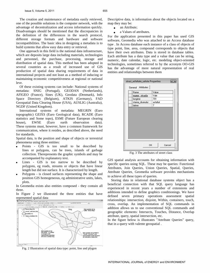
For the application presented in this paper has used GIS
software, Geomedia who was attached to an Access database
type . In Access database each instance of a class of objects of
type point, line, area, compound corresponds to objects that
have their own attributes. Data is stored in database tables.
Each attribute has a data type and a value that can be string,
numeric, date calendar, logic, etc. modeling object-oriented
technologies, sometimes referred to by the acronym OO-GIS
has the advantage of more natural representation of real
entities and relationships between them
Fig. 3 The attributes of street class
GIS spatial analysis accounts for obtaining information with
specific queries using SQL. These may be queries: Functional
Attributes, Join Queries, Union Queries, Spatial, Queries,
Attribute Queries. Geomedia software provides mechanisms
to achieve all these types of queries.
Storing data in relational database systems object has a
beneficial connection with that SQL query language has
experienced in recent years a number of extensions and
additions intended to define graphics conditionings. We have
defined seven primary operations assessment spatial
relationships: intersection, disjoint, Within, containers, touch,
cross, overlap. An implementation of SQL commands in
addition allows us to use conventional SQL commands and
geographic elements: Intersects, Touches, Distance, Overlap
attribute, query, spatial intersection, etc.
In the figure below is illustrates ”Attribute Queries” query,
that in a query with valente geospatial .
Issue 5, Volume 5, 2011 655
INTERNATIONAL JOURNAL of ENERGY and ENVIRONMENT

Fig. 4 Query type”Attribute Query”
IV. THE AREA WHERE THE STUDY PRESENTED IN THIS PAPER
WAS DONE
The area is presented in the paper is in the South West of Sibiu
county, in the mountainous hills Cibin Mountains, in the south
of Transylvania. The map that we have developed using
GeoMedia software location area can be seen, both within the
country and in the county.
Fig. 5 Location in country and county area
The area in which to do research presented in the paper
consists of:
Saliste City and neighboring villages: Gales, Vale Sibiel
Fântânele, Aciliu, Amnas, Sacel, Mag;
Miercurea Sibiului city, with neighboring villages:
Apoldul de sus, Dobârca;
Tilisca village with village belonging Rod;
Poiana Sibiului village, Jina village;
Apoldul de sus village with village belonging Sîngatin;
Ludos village with village belonging Gusu[5].
All cities and villages of Sibiu Surrouding Area are seeing
in figure 5.
Fig. 6 The cities and the village of the area
V. COMPOSTING
Composting is a process of decomposition and
transformation of substances organic solids by
microorganisms (mainly bacteria and fungi) in a material
stable, which can be exploited in agriculture. Compost is a
stable and hygienic material similar to humus in the forest,
which can be used as natural fertilizer, thus avoiding the need
to use chemical fertilizers. He is said to have relented on land
and property. Adding compost to soil is considered as a
natural way of increasing fertility and restore quality to them
[2].
Waste suitable for composting:
a) Scraps from the kitchen: fruit and vegetable scraps,
leftovers, Residues of coffee filter paper, etc..
b) Residues from animal manure, manure from poultry,
rabbit manure, feathers and hair, etc..
c) Scrap garden: grass and dry leaves, twigs and bark,
weeds, trimming hedges material resulted after, the vines,
trees, etc.
Composting takes place in two phases:
• Mechanical treatment (grinding);
• Decomposition (fermentation) - occurs in conditions
aerobic / anaerobic formation of CO2, water and humic
substances.
Factors affecting the composting process: air content of
compost, humidity, waste composition, temperature, pH level,
the grain waste subject to fermentation, homogeneity of the
mixture, the settlement of waste ground in piles or containers
of fermentation, the percentage of carbon and nitrogen.
It can be done in the simplest way, without significant
cost, small scale in own yard, as far away from inhabited areas
(the so-called back-yard composting). In this particular case
will be composted in the green waste from the garden, orchard
and waste biodegradable kitchen (potato peelings, cabbage
Issue 5, Volume 5, 2011 656
INTERNATIONAL JOURNAL of ENERGY and ENVIRONMENT

leaves, fruit and vegetable scraps, etc.). If higher courts (>
5000 m) can make compost from waste above that can be
added and solid manure from animals (horses, cows, sheep,
poultry, etc.). In all cases will be avoided meat, bones, the
fetid smell and also attract rats and other rodents [4].
Stages of development:
a) collect, transport, reception, storage;
b) treatment of mechanical, manual (metal removal) and
shredded (optional);
c) biological treatment - composting and finish - only with
humidity control;
d) Final preparation of compost - Choppers, sieve (optional),
and packaging.
If such waste compost obtained from the degree of safety
can check simply by placing compost in a plastic bag, seal and
open 48 hours. If after 48 hours compost smells bad, meant
that the finishing stage is finished.
Location of green waste composting area must be
evaluated in terms of construction impacts on the
environment. Some development work is necessary but is
preferred to minimize their investment to reduce and maintain
a "buffer zone" natural (eg trees along the road and limit
accces from adjacent living area, hilly, etc.). The site should
not be in flooded areas (water and storm suprafa_a), do not
allow the accumulation of water inside and be protected from
erosion. It is considered optimum for composting suprafa_a
land with a slope – 37. Minimum of 1% and the optimum 2-
4% (drain rainwater and leachate from the chamber for pre-
treatment facilities).
It is very important to have a water supply system. The
average amount of water needed for composting leaves is a m3
of approximately 80 liters of water.
Important elements in designing green waste composting
area is:
a) pretreatment area;
b) the treatment (composting);
c) postratare area (finishing);
d) access roads and internal roads;
e) utilities and security of the entire site[6].
VI. ANALYSIS OF THE AMOUNT OF WASTE TO BE TREATED
The formula for calculating the amount of waste is:
Amount generated in a locality [tons / year] = (population*
index generation * 365) / 1000
Table 1
FORECAST TOTAL AMOUNT OF HOUSEHOLD WASTE,
HOUSEHOLD WASTE AND WASTE ASIMILABLE THE
STREET ACCORDING TO THE INDICATIONS OF
WASTE GENERATION (TONS / YEAR)
View parallel to the total amount of household waste,
household waste and assimilated waste street is presented in
the graphic in figure 7.
Fig. 7 The total amount of household waste, equivalent to the waste
household and street waste
From the analysis we conclude that it takes an updated
analysis of the areal amount of waste generated in each
locality including the separate periods of the year. This will
help to better waste management and of course to a decrease
in transport expenditure[3].
The extent of waste recovery depends on factors such as:
a) education;
b) zonal development process;
a) efficient collection system and selection;
b) specific equipment;
c) population more interested
In setting targets for the percentage of recovery was held
”Marginimea Sibiu” account the average percentage recovery
target, set in the Regional Plan Waste Management (RPWM)
with data corrections zonal situation[7].
Forecast recovery of waste fractions I did it from 2010
because it is the year that is being implemented in the selective
collection area. Biodegradabilele compost is considered to be
inividual each as part of the household in many cases will not
be possible and much of that amount will go to waste disposal
along with other household waste. From calculations carried
out so far it follows that the biodegradable waste large share of
the total waste that is intended to be recovered, it is therefore
need to take more radical measures for this type of waste not
may be stored or be burnt in the household.
Table 2
PROGNOSIS FOR RECOVERY OF WASTE FRACTIONS
IN THE SIBIU SURROUNDINGS
VII. WASTE COLLECTION
Waste collection is as follows: first sorting is done at source
on the islands of collection, the four types of recoverable
wastes:paper, glass, metal, plastic.
Recoverable waste collection is done in three containers
as follows:
Issue 5, Volume 5, 2011 657
INTERNATIONAL JOURNAL of ENERGY and ENVIRONMENT

1 x eurocontainer for recovered waste paper and
cardboard;
1 x eurocontainer for recoverable waste metal and glass;
1 x eurocontainer to recover from plastic waste.
The 81 islands are set collection. Each area of the island
having 25m². In total there are 243 euro containers with a
capacity of 1.1 m3 (of different colors and properly labeled for
each type of material collected). Mixed waste is collected at
home in a separate container. The 8800 bins are provided for
120 l (1 for each household in part). Recoverable waste is
sorted by the sorting station will carry, where secondary
sorting will be applied and mixed waste will be collected
separately and will be transported directly from a warehouse
that is emptied containers central. Frequency of empty
containers is the type of waste and the period of filling
dumpsters. The islands are located by mapping the collection
made in Geomedia. These maps are used for spatial analysis
project.
Fig. 8 Collection islands from Saliste area
In Figure 8 are illustrated the collection of islands from
Saliste area and 150 m radius around them. I considered
that 150m is the distance for which the island has an
efficient collection best.
Fig. 9 Buffer zone arround the collection islands from Saliste area
For spatial analysis [1] of the area have used existing
maps that were vectorize. Specific attributes were used for
each instance of existing classes of objects in the map. An
example is the map which shows the roads and the islands
waste collection of area.
Fig. 10 The roads and the collection islands in Saliste town
Using data entered for each island may be part of
collection perform spatial queries to be viewed as data that are
needed at a particular time, eg during filling to view the
fractions used to collect recyclable cans. In this way it can
reduce the time needed to centralize and analyze data can be
achieved and maps can be viewed as a drain for frequencies
each locality and recyclable fraction.
In this paper we highlighted the use of GIS technology in
managing waste, these include:
a) Data on existing access roads, road situation and the
situation on waste are better organized. They are
relatively easy highlighted by spatial analysis is
performed directly on the paper;
b) Updating databases related to spatial information can be
easily and quickly, they provide interactive and accurate
data on waste management in the "Sibiu Surroundings";
c) Also by using GIS technology can avoid some mistakes
due to ignorance of the area design.
Fig. 11 Filling period per day of recyclabe waste dumpsters
VIII. ESTABLISHING A DATABASE FOR THE RECYCLABLE WASTE FRACTIONS SALISTE
We positioned on map each locality islands for fraction
collection recyclable waste - Zone location platforms Saliste I
got from the Data Salitte sanitation service (SC Eco
Marginime.SRL) and for other localities have taken
information about the number of platforms is
located in every locality of the project financed by PHARE
Issue 5, Volume 5, 2011 658
INTERNATIONAL JOURNAL of ENERGY and ENVIRONMENT
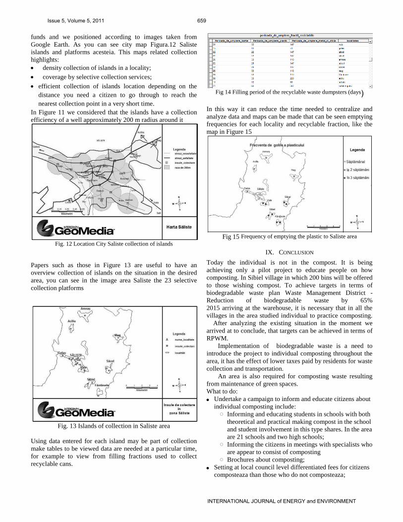
funds and we positioned according to images taken from
Google Earth. As you can see city map Figura.12 Saliste
islands and platforms acesteia. This maps related collection
highlights:
density collection of islands in a locality;
coverage by selective collection services;
efficient collection of islands location depending on the
distance you need a citizen to go through to reach the
nearest collection point in a very short time.
In Figure 11 we considered that the islands have a collection
efficiency of a well approximately 200 m radius around it
Fig. 12 Location City Saliste collection of islands
Papers such as those in Figure 13 are useful to have an
overview collection of islands on the situation in the desired
area, you can see in the image area Saliste the 23 selective
collection platforms
Fig. 13 Islands of collection in Saliste area
Using data entered for each island may be part of collection
make tables to be viewed data are needed at a particular time,
for example to view from filling fractions used to collect
recyclable cans.
Fig 14 Filling period of the recyclable waste dumpsters (days)
In this way it can reduce the time needed to centralize and
analyze data and maps can be made that can be seen emptying
frequencies for each locality and recyclable fraction, like the
map in Figure 15
Fig 15 Frequency of emptying the plastic to Saliste area
IX. CONCLUSION
Today the individual is not in the compost. It is being
achieving only a pilot project to educate people on how
composting. In Sibiel village in which 200 bins will be offered
to those wishing compost. To achieve targets in terms of
biodegradable waste plan Waste Management District -
Reduction of biodegradable waste by 65%
2015 arriving at the warehouse, it is necessary that in all the
villages in the area studied individual to practice composting.
After analyzing the existing situation in the moment we
arrived at to conclude, that targets can be achieved in terms of
RPWM. Implementation of biodegradable waste is a need to
introduce the project to individual composting throughout the
area, it has the effect of lower taxes paid by residents for waste
collection and transportation.
An area is also required for composting waste resulting
from maintenance of green spaces.
What to do:
Undertake a campaign to inform and educate citizens about
individual composting include: o Informing and educating students in schools with both
theoretical and practical making compost in the school
and student involvement in this type shares. In the area
are 21 schools and two high schools; o Informing the citizens in meetings with specialists who
are appear to consist of composting o Brochures about composting;
Setting at local council level differentiated fees for citizens
composteaza than those who do not composteaza;
Issue 5, Volume 5, 2011 659
INTERNATIONAL JOURNAL of ENERGY and ENVIRONMENT

Acquisition or construction dumpsters for their composting
system composting
Among the statistical procedures used for instrument
making strategic objectives national waste management can
include the use of programs GIS computer to handle
information in the geodatabase object-relational type, which
helps to organize the most accessible and efficient
of information related to waste management field.
Smart maps that we presented in this paper allow
Location in the country and county area
Determination of infrastructure in the area studied
Location of collection of islands in each locality
Frequency of emptying recyclable fractions
REFERENCES
[1] S. Borza, “Introduction to Geomedia Professional”, Eds
University “Lucian Blaga”of Sibiu, ISBN-973-739-516-0,
2008.
[2] C. Bachert, W. Bidlingmaier, S. Wattanachira, „Open
Windrow Composting Manual, Eds ORBIT e. V.,
Weimar, ISBN 3-935974-23-X, 2008
[3] R. V. Pascu “Waste management,” Eds University
“Lucian Blaga”of Sibiu, ISBN- 978-973-739-718-8, 2009.
[4] M. S. Castiñeira, “Manual to Obtain Composting in
Household”, Eds. Consellería de Medio Ambiente e
Desenvolvemento Sostible da Xunta de Galicia e
Sociedade Galega do Medio Ambiente (SOGAMA).
[5] County Waste Management Plan - Environmental
Protection Agency Sibiu.
[6] National Waste Management Plan, Part 1 of 954bis,
Gazette Official 10/18/2004;
[7] Regional Plan Waste Management (RPWM);
[8] N.Swan,”An Objectual Oriented Approach toSpatial Data
Capture” Doctoral Thesis, University of California, Santa
Barbara, 2002;
[9] Borza S., Visual Fox Objectual Relational Databases
Programming, Eds University “Lucian Blaga”of Sibiu
ISBN 973-651-683-0, 330 pag, 2003.
Sorin I. Borza (M’76–SM’81–F’87) and the other authors may include
biographies at the end of regular papers. Biographies are often not included in conference-related papers. This author became a Member (M) of NAUN in
1976, a Senior Member (SM) in 1981, and a Fellow (F) in 1987. The first
paragraph may contain a place and/or date of birth (list place, then date). Next, the author’s educational background is listed. The degrees should be listed
with type of degree in what field, which institution, city, state or country, and
year degree was earned. The author’s major field of study should be lower-cased.
The second paragraph uses the pronoun of the person (he or she) and not
the author’s last name. It lists military and work experience, including summer and fellowship jobs. Job titles are capitalized. The current job must
have a location; previous positions may be listed without one. Information
concerning previous publications may be included. Try not to list more than three books or published articles. The format for listing publishers of a book
within the biography is: title of book (city, state: publisher name, year) similar
to a reference. Current and previous research interests ends the paragraph. The third paragraph begins with the author’s title and last name (e.g., Dr.
Smith, Prof. Jones, Mr. Kajor, Ms. Hunter). List any memberships in
professional societies other than the NAUN. Finally, list any awards and work for NAUN committees and publications. If a photograph is provided, the
biography will be indented around it. The photograph is placed at the top left
of the biography. Personal hobbies will be deleted from the biography.
Issue 5, Volume 5, 2011 660
INTERNATIONAL JOURNAL of ENERGY and ENVIRONMENT
Related Documents


