GIS and document GIS and document management syst em management syst em Wor k Toget her Wor k Toget her Jacek Jani a Jacek Jani a I nst i t ut e of Spat i al and Cadast r al Syst ems I nst i t ut e of Spat i al and Cadast r al Syst ems ( I SPI K S. A) (I SPI K S. A)

GIS and document management systemWork Together. Jacek Jania
Jul 15, 2015
Welcome message from author
This document is posted to help you gain knowledge. Please leave a comment to let me know what you think about it! Share it to your friends and learn new things together.
Transcript

GI S and document GI S and document management syst emmanagement syst em
Wor k Toget herWor k Toget her
Jacek Jani aJacek Jani aI nst i t ut e of Spat i al and Cadast r al Syst ems I nst i t ut e of Spat i al and Cadast r al Syst ems
( I SPI K S. A)( I SPI K S. A)

Smart Ci t i es – Vi nnyt si a, 26- 27. 07. 2012
The Municipality of Kielce in 2008 asked ISPIK to develop a pilot system based on GIS and document management in the department of Architecture. The technology components delivered by the ISPIK include ISDS (Internet Spatial Data Server) and SOWA Document Management System (DMS). With this project, the goal was not only to present data, but to provide coherent information assembled from two main automated data sources: mainframe legacy database and GIS.
Since 2008 integrated GIS and DMS system covers a growing number of departments
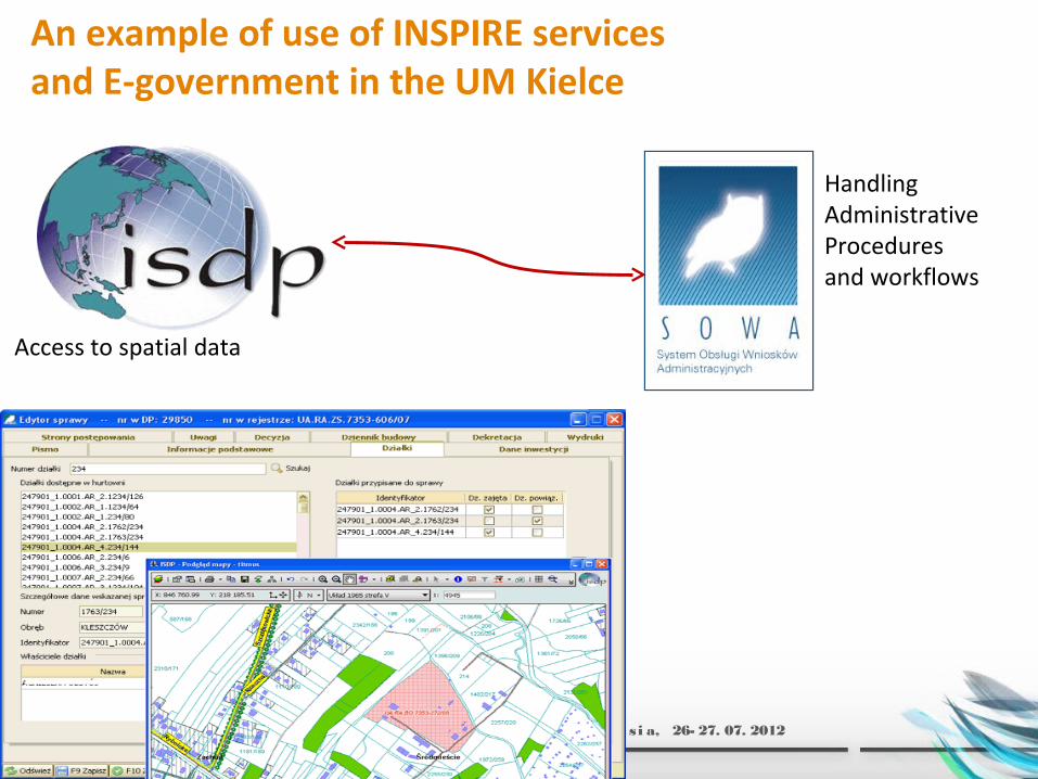
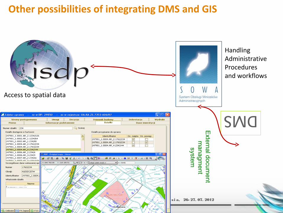
Access to spatial data
HandlingAdministrativeProcedures and workflows
Smart Ci t i es – Vi nnyt si a, 26- 27. 07. 2012
An example of use of INSPIRE services and E-government in the UM Kielce
Smart Ci t i es – Vi nnyt si a, 26- 27. 07. 2012
Origin of ISDS
ISDS was fully developed at the Institute of Spatial and Cadastral Systems as a result of various research, development and implementation projects. ISDS is a complex and ready to use system for the end user as well as a software tool for developing web mapping applications.
Briefly ISDS may be described as:•An information system and spatial database, which together make it possible to collect, update and provide access to interactive maps and lists of the map object attributes within the environment of WWW browser •A platform which makes it possible to create individual applications based on Internet technologies.

Smart Ci t i es – Vi nnyt si a, 26- 27. 07. 2012
What is ISDS for?
ISDS is used to provide access to spatial data within the Internet/Intranet environment. It is a sophisticated server, which allows any number of users to access information resources stored in a relational database and view the information in a form of interactive maps and list map object attributes within a WWW browser. The users can search and look through spatial database resources, display data and documents integrated from different sources and carry out complex description and spatial analysis.
ISDS makes possible to visualize interactively spatial data in the form of maps, images and reports through a WWW browser. To do these, users do not need to have sophisticated (and often expensive) software of GIS or CAD type. User access to the system is through the Internet and is controlled by the appropriate authorization procedure during the logon.
Origin of SOWA
SOWA was also fully developed at the Institute of Spatial and Cadastral Systems due to the lack of spatial data solutions that integrate document management systems.
Briefly SOWA may be described as:• A system that improves the process flow of documents and exchange of information in public administration offices. • A system facilitates and accelerates the process of issuing a decision. The documents, which previously had a traditional form can now be archived and distributed in digital form.
Smart Ci t i es – Vi nnyt si a, 26- 27. 07. 2012

Smart Ci t i es – Vi nnyt si a, 26- 27. 07. 2012

Integration with ISDS Map Server
Smart Ci t i es – Vi nnyt si a, 26- 27. 07. 2012

Smart Ci t i es – Vi nnyt si a, 26- 27. 07. 2012
PARCEL OWNERS
OTHER MAPS
AERIAL IMAGERY
LAND USE
TAX INFORMATION
STREETS AND ADDRESSES
SOIL-AGRICULTURAL MAP
Document managment system
autom
ated
update
…
IPE-P
N
Spatial
databaseo
n-l
ine
Intranet Internet
Itranet map viewer
Internet – WWW
Integration of ISDS and SOWA
Smart Ci t i es – Vi nnyt si a, 26- 27. 07. 2012
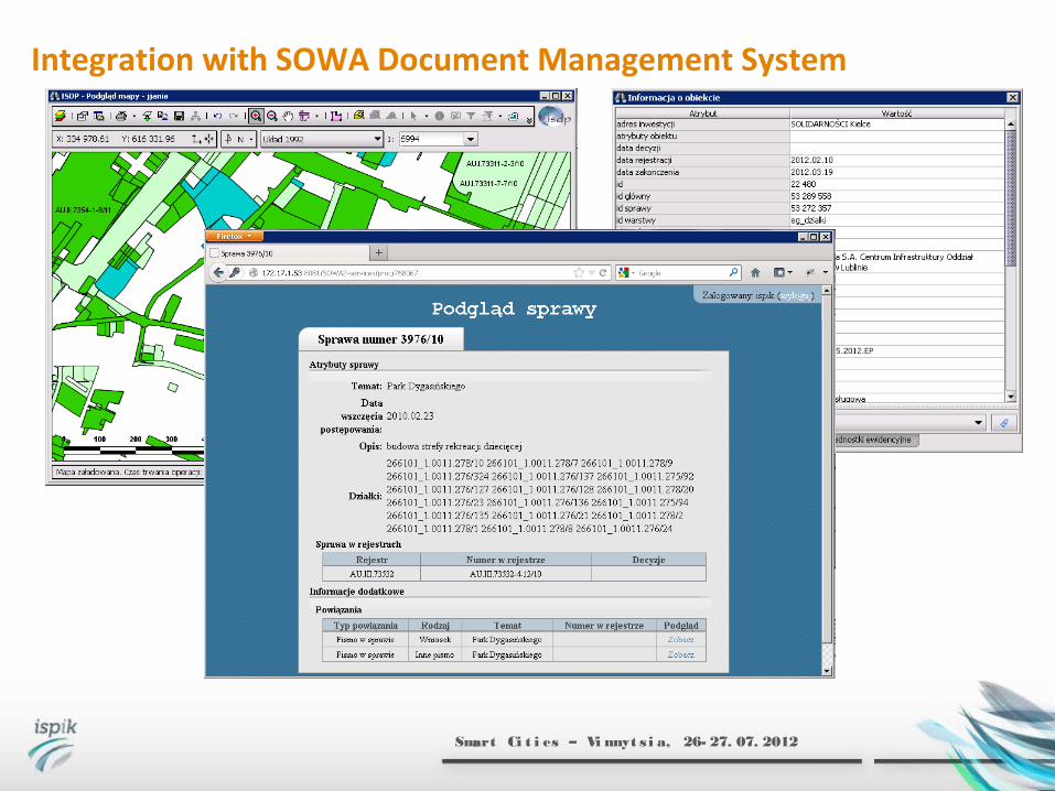
Integration with SOWA Document Management System

Integration with SOWA - Document Management System
Smart Ci t i es – Vi nnyt si a, 26- 27. 07. 2012

Geoportal
Smart Ci t i es – Vi nnyt si a, 26- 27. 07. 2012
Smart Ci t i es – Vi nnyt si a, 26- 27. 07. 2012
Access to spatial data
HandlingAdministrativeProcedures and workflows
Other possibilities of integrating DMS and GIS
External docum
e nt m
anagment
systemDMS

motto:motto:
Postępu nie da się zatrzymać!Postępu nie da się zatrzymać!
Progress cannot be stopped!Progress cannot be stopped!
THANK YOU FOR YOUR ATTENTIONTHANK YOU FOR YOUR ATTENTION
Related Documents