An Early Thirteenth-Century Map in Dublin: A Window into the World of Giraldus Cambrensis Author(s): Thomas O'Loughlin Reviewed work(s): Source: Imago Mundi, Vol. 51 (1999), pp. 24-39 Published by: Imago Mundi, Ltd. Stable URL: http://www.jstor.org/stable/1151437 . Accessed: 12/03/2012 11:01 Your use of the JSTOR archive indicates your acceptance of the Terms & Conditions of Use, available at . http://www.jstor.org/page/info/about/policies/terms.jsp JSTOR is a not-for-profit service that helps scholars, researchers, and students discover, use, and build upon a wide range of content in a trusted digital archive. We use information technology and tools to increase productivity and facilitate new forms of scholarship. For more information about JSTOR, please contact [email protected]. Imago Mundi, Ltd. is collaborating with JSTOR to digitize, preserve and extend access to Imago Mundi. http://www.jstor.org

Welcome message from author
This document is posted to help you gain knowledge. Please leave a comment to let me know what you think about it! Share it to your friends and learn new things together.
Transcript
An Early Thirteenth-Century Map in Dublin: A Window into the World of GiraldusCambrensisAuthor(s): Thomas O'LoughlinReviewed work(s):Source: Imago Mundi, Vol. 51 (1999), pp. 24-39Published by: Imago Mundi, Ltd.Stable URL: http://www.jstor.org/stable/1151437 .Accessed: 12/03/2012 11:01
Your use of the JSTOR archive indicates your acceptance of the Terms & Conditions of Use, available at .http://www.jstor.org/page/info/about/policies/terms.jsp
JSTOR is a not-for-profit service that helps scholars, researchers, and students discover, use, and build upon a wide range ofcontent in a trusted digital archive. We use information technology and tools to increase productivity and facilitate new formsof scholarship. For more information about JSTOR, please contact [email protected].
Imago Mundi, Ltd. is collaborating with JSTOR to digitize, preserve and extend access to Imago Mundi.
http://www.jstor.org
An Early Thirteenth-Century Map in Dublin: A Window into
the World of Giraldus Cambrensis
THOMAS O'LOUGHLIN
ABSTRACT: An early thirteenth-century manuscript (Dublin, N.L.I. 700) of two works of Giraldus Cambrensis (Gerald of Wales, c.1146-c.1223) also contains a map of Europe, of which no close parallels are known. While it is integral to the manuscript, it has no obvious relationship with either of the texts. The outlines of the map were derived from earlier and contemporary world maps and its principal contents from itineraries; its core is an itinerary from Britain to Rome. Overall, the map displays a sophisticated awareness of the role of generalization and also shows how insular clerics viewed the continent and their location relative to Rome. It is suggested that the entire manuscript belonged to Giraldus, and that he was in some way involved with the creation of the map.
KEYWORDS: Ireland; Wales; Britain; Europe; Rome; Expugnatio Hibernica; Topographia Hiberniae; Giraldus Cambrensis [Gerald of Wales]; Matthew Paris; Archbishop Sigeric; generalization; itineraries; mappaemundi; medieval cartography; orientation; palaeography; National Library of Ireland.
Neither the medieval view of the world nor the
mapping conventions of the period are always easy
to understand. In the case of a medieval represen-
tation of a specific geographical area, however, the
shape of the territory in question provides us with a
point of access from which we can try to observe
how the mapmaker would have seen himself and
his contemporaries in relation to the world around
him. The aim in this paper is to examine one of the
earliest extant maps of Europe in such a light. This
map is found in a codex of Giraldus Cambrensis's
two books on Ireland-the Topographia Hiberniae
and the Expugnatio Hibernica-now housed in the
National Library of Ireland (N.L.I. 700). The books
were written in the aftermath of the Anglo-Norman
invasion of Ireland: the first was intended as a
description of Ireland, its land, climate and people;
the other is an account of the invasion written by
someone closely related to several of its leaders.
Both books were popular and survive in many
manuscripts.' Although the map bears no title and
shows Europe in much the same way as a number
of mappaemundi, it was plainly intended as a map
of Europe. Giraldus himself was one of the more colourful
clerics of the period. He was born in Pembrokeshire
c. 1146 and was both Welsh and Norman. Educated
in Paris as a young man, he returned (1175) to
Wales in the hope of becoming bishop of St David's.
He entered the service of Henry II of England in
1184, and it was in connection with this that he
wrote his two books dealing with Ireland. In 1188
he preached the crusade alongside the Archbishop
of Canterbury in Wales, and this led to his two
books on Wales. In 1199 he was again elected by
the chapter of St David's as their choice for bishop,
but this was to neither the king's nor the
Archbishop of Canterbury's liking, and so began
* Dr Thomas O'Loughlin, Department of Theology and Religious Studies, University of Wales Lampeter,
Lampeter, Ceredigion, SA48 7ED, U.K. Tel: (44) (0)1570 424708. Fax: (44) (0)1570 423641. E-mail:
24 [email protected] ? Imago Mundi. Vol. 51, 1999, 24-39.
four years of bitter legal disputes between Giraldus and the archbishop. Giraldus travelled to Rome on three occasions (1199, 1201 and 1203) to plead his case but eventually acknowledged defeat. The last twenty years of his life (he died c.1223) are obscure. We know that he was reconciled with the archbishop, and that he continued his literary pursuits. He made a final trip to Rome in 1207 as a pilgrim, after which he retired to a living in the diocese of Lincoln.2
The Manuscript
The National Library of Ireland purchased MS 7003 in 1945 from the Phillipps Collection where it had the shelf-mark 6914.4 Of its earlier history we have only two details. First, the codex was given in 1438 by a Walter Mybbe to the vicars-choral of Hereford. This gift is recorded on folio 99r in a fifteenth-century hand.5 Second, it was bought by Sir Thomas Phillipps in 1831. On the front end- paper of the modem cover Sir Thomas wrote in his own hand that it escaped being destroyed in the Bristol Riots of 1831 through being sent up to London some days earlier by the bookseller Mr Strong.6 The note is initialled and dated: 'T. P. Middle Hill, 1831'. The fact that the anonymous compiler of the entry on Sir Thomas in the Dictionary of National Biography in 1898 thought fit to single out this particular manuscript for mention, may be taken as indicating that Sir Thomas himself was known to have been especially proud of it.7
Recent scholarship has added precision regarding the date of the manuscript and, indeed, has put it into the circle of Giraldus himself. In his edition of the Expugnatio, Brian Scott has dated the manu- script on textual and palaeographical grounds to around 1200, describing it thus:
Written c. 1200 in two cols. of 36 lines, with the writing above the top ruling; red and light blue initials with flourishes in the alternate colour, chapters numbered in red and blue, and the title of the Distinctio at the top of each page in alternating red and blue letters.... There is a map of Europe (fol. 48), ... and numerous marginal drawings illustrating both Topo- graphia and Expugnatio.8
The textual grounds for the date of the manuscript also link the manuscript directly with Giraldus. Revising James Dimock's classification of various extant texts of the Expugnatio into three editions, Scott proposed that there was an a-text, a P-text, and a third variant, which came from the gradual reworking and development of the a-text9 Given the alterations and additions to the Expugnatio in
N.L.I. 700, first by the original scribe himself, then in 'another more rounded contemporary hand', and by a third hand on two intercalated leaves, Scott concluded that N.L.I. 700 represents 'a slight and gradual evolution of the text'.'0 The alterations and annotations led him to believe that the manu- script 'spent a long time with Giraldus, and [that it was] used by his secretaries to enter in additions to the text of the two Irish works'."
A connection between N.L.I. 700 and Giraldus had earlier been proposed on quite different grounds. In 1951 John O'Meara recorded a suggestion by Aubrey Gwynn (probably made on the basis of the 1438 link with Hereford): 'It is just possible, as Fr. Gwynn tentatively suggested to me, that [N.L.I. 700] is the very copy mentioned by Giraldus himself in the De rebus [a se gestis] (Rolls Series 35, London, 1861)], p. 409'.12 There, in a letter to the chapter of Hereford, Giraldus refers of a volume sent to the chapter which, like N.L.I. 700, contained both his Irish works. Gwynn's suggestion was taken up and explored in detail by Scott, who pointed out that, whether or not this identification of N.L.I. 700 with the one mentioned by Giraldus could be proven, lack of proof does not detract the claim that N.L.I. 700 had especially intimate ties with Giraldus.'3 It is worth quoting Scott in full:
I firmly believe that, whether or not [N.L.I. 7001 is in fact one of the two manuscripts sent to Hereford by Giraldus, it was copied by his scribes, and was used by them to copy in improvements and corrections which he felt impelled to make from time to time. However, if the reader feels that further proof of Giraldine provenance is necessary, then this is given by the presence in [it] of two maps, one of Europe and the other of the British Isles.'4 We know that Giraldus must have been interested in maps, for he tells us himself in that same letter to the Hereford chapter [op. cit., p. 4141 that he produced a mappa totus Kambriae. A few of the Topographia manuscripts contain the map of Britain,"5 but the map of Europe is unique to this manuscript, as are the illustrations already men- tioned.'6 Both are surely an indication that this was a manuscript lovingly executed for Giraldus' own plea- sure, then subsequently used to enter later additions and alterations.'7
According to Scott, then, the codex that is the subject of this paper dates from the late-twelfth or early-thirteenth century and comes from the circle of Giraldus. The crucial question is whether the map of Europe on folio 48r is integral to the manuscript or a later insertion. The manuscript contains 99 folios in, as noted, three contemporary hands. The corrections and additions show that it was conceived as a single volume from the outset, 25
as codicological details such as ruling, page layout and illuminations also make clear. The manuscript would have been made up of twelve regular quires, each of four bifolia. The irregular number of 99 folios is the result of the insertion of three leaves at or shortly after the time of writing to deal with the
corrections and additions to the Expugnatio referred to by Scott. The extra leaves are these: one in the middle of quire 9 (fol. 69); one inserted just after the middle bifolium of quire 11 (fol. 87); and finally one added at the very end of the codex after quire 12 (that is, making fol. 99). This last sheet, of much
rougher skin than the rest of the manuscript, contains the last lines of the text and the reference to Walter Mybbe. The intercalated leaves (fols. 69 and 87) are contemporary with the first binding of the manuscript, and their connections with the text are marked by signes de renvoi. The quires are signed in the usual place in two sequences: quires 1-6 (fols. 1-48) which contain the Topographia are signed j, ij, iij, iiij and v, with the final quire unsigned at folio 48v; quires 7-12 (fols. 49-99) which contain the Expugnatio are signed j, ij, iij, iiij
and v, with the final quire unsigned at folio 98v.
The map is found almost exactly in the middle of the manuscript between the two works. The Topographia ends on folio 47v (in the left-hand column) and the rest of the page is blank. The map is on the recto of folio 48, and this is followed by a
blank verso. Then, the Expugnatio begins on folio 49r. However, an empty page at the end of a quire in which a work concludes is not uncommon, and often these blank pages have been filled with miscellaneous items. For the sake of argument, it
could be suggested that the map was the work of a
later scribe who took advantage of an empty folio.
However, the similarities of script between the names on the map and the display script in the rest
of the codex make this most unlikely. Moreover, map and texts use a similar range of colours-to the
naked eye they appear to be the same colours.
Conclusive evidence comes from the gutter of
quire 6. While the page size of the manuscript is
273 X 180 mm, and the map takes up the whole width of the page, the map does not run right to the
bottom of the page but leaves a 45 mm strip blank.
Along the other edges of the map (left, top and
right), the green (the colour used for sea) has been
brushed out to the edge of the page. Looking at the
left margin where the green goes fully into the
gutter and binding we find no green marks on the
26 opposite page, folio 47V, as would be expected were
the map a later addition on the spare page. However, on the corresponding page of the bifolium, folio 41v, the green wash is just visible in the gutter (about 1 mm). The absence of green on folio 47v and its presence on 41v can only be explained as the result of the map being drawn prior to binding.'8 The conclusion that the map is contemporary with the rest of the codex, or at least with the additional sheets bound in to contain the additions and corrections to the Expugnatio, seems secure. Thus we can ascribe to the map, the same date and conditions that Scott has argued for the codex.
I want to go on from here to suggest that, combining what is known of the manuscript's origin with finding the map to be a product of skilled observation and drawing, and knowing Giraldus's interest in drawing maps and his care- fulness as an observer, we can ascribe to Giraldus a central role in its creation.'9 I am not concerned with any possible relationship of the map to either text in N.L.I. 700, but only with the link between Giraldus and the map. Our starting points have to be the contents of the map and the manuscript's inferred provenance from within his immediate circle of scholars, churchmen and courtiers. All that we can point to otherwise is the text of Topographia on the one hand and that of the Expugnatio on the other and- literally between them-the map itself. While it has been customary to refer to the map in connection with the Topographia, and O'Meara has
printed it with his translation of that work, the association is based merely on its presence at the end of that work in this richly illuminated manu-
SCript.20 Nothing in that text suggests a map is
required.2' The map's connection with Giraldus is
not textual but is dependent on context-on its
presence in the codex from the outset-and on the
codex's links with Giraldus.
The Map
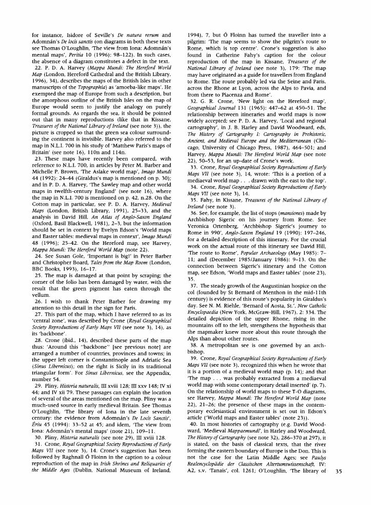
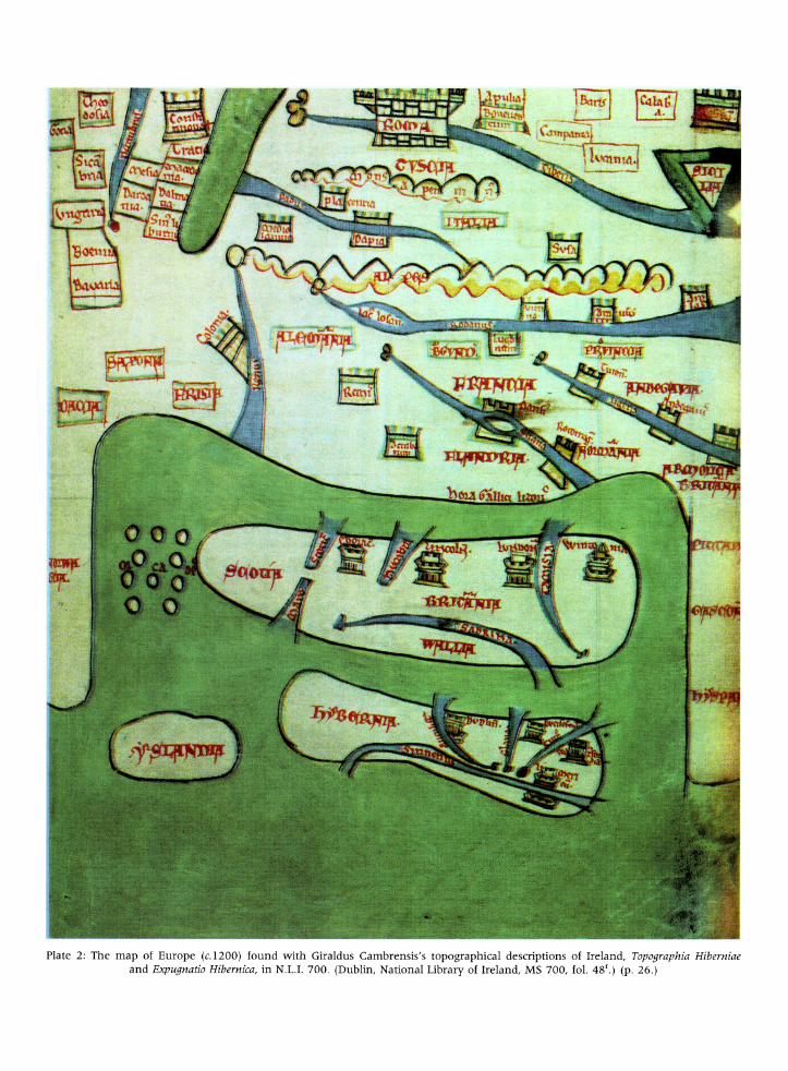
At first sight, the map in N.L.I. 700 is a crudely drawn image of Ireland and Britain almost sur- rounded by the European land-mass, with south- east at the top, and the whole surrounded by water
(Fig. 1 and Plate 2).22 In contrast to the late tenth-
or early eleventh-century Anglo-Saxon (or Cotton) world map, the thirteenth-century Psalter world
map, and the Hereford mappamundi, for example, our map looks like a sketch map drawn during a
lecture.23 While these maps show a variety of
features, such as animals, in addition to places and
l~ * 1 1
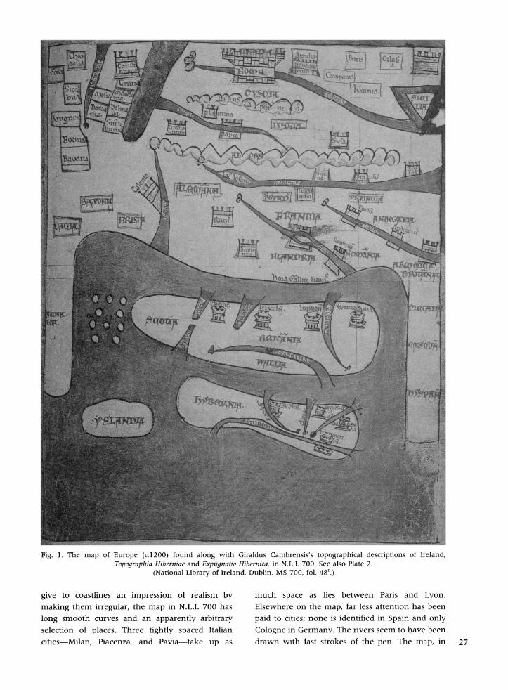
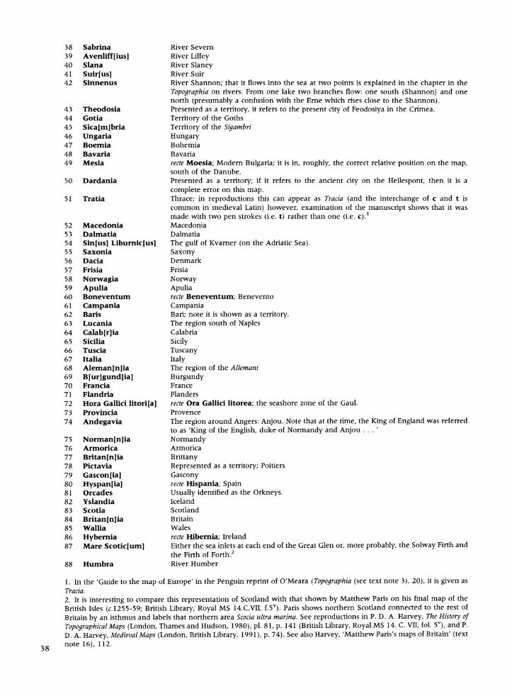
Fig. 1. The map of Europe (c.1200) found along with Giraldus Cambrensis's topographical descriptions of Ireland, Topographia Hiberniae and Expugnatio Hibernica, in N.L.I. 700. See also Plate 2.
(National Library of Ireland, Dublin. MS 700, fol. 48'.)
give to coastlines an impression of realism by making them irregular, the map in N.L.I. 700 has long smooth curves and an apparently arbitrary selection of places. Three tightly spaced Italian cities-Milan, Piacenza, and Pavia-take up as
much space as lies between Paris and Lyon. Elsewhere on the map, far less attention has been paid to cities; none is identified in Spain and only Cologne in Germany. The rivers seem to have been drawn with fast strokes of the pen. The map, in 27
short, lacks geographical accuracy in the modem sense. However, the drawing was accomplished with confidence: there is only one place (the line representing the north coast of Spain which was originally 18 mm longer towards the bottom of the map), where a line was drawn and then corrected by erasure.
If, however, we look at the map's 'grammar' the structures underlying its articulation of the relationship between places-we find that this map is quite a sophisticated artefact. Its vertical central axis runs through the British Isles at the bottom centre to Rome at the top. It would seem that the chief interests of its creator lay in the prominently drawn British Isles on the one hand, and the connection between those islands and Rome on the other.
The first clue that this is a map of Britain in relation to Rome, as opposed to a geographical map of part of Europe, is the size of the images used to represent the key localities.24 It is an established feature of mental maps that the more significant a place is in the mind of the mapmaker, the larger it is represented in proportion to other places. Thus on N.L.I. 700, we immediately notice the British Isles, areally equal to over a fifth of all the land shown. Rome is less obviously exaggerated, but the symbol for this city-a crenellated box-is unique on the map. It is also nearly twice the size of the next largest city symbol, namely that used for the cities of Constantinople, Paris, and what was probably intended to be Reggio di Calabria.25
This size coding of cities raises questions. That Rome should stand out in the map of a medieval cleric is not surprising, nor that Constantinople should be emphasized; their relative sizes are undoubtedly a function of the Roman focus of Latin Christendom and the culture of distinctive- ness that we associate with the schism of 1053. Likewise, that Paris should be enlarged is under- standable: already in 1200 it was the intellectual capital of the West-Giraldus was one of its alumni-and its importance was steadily increas- ing. But why the emphasis on Reggio (top right)? Could it be linked with the fact that this city was captured by the Norman leader Robert Guiscard in 1060, or is it just a error in cartography? Is it significant that this is the only place-name on the map that is blurred almost to the point of illegibility? No definite answer to any of these questions can be given, but what is certain is that
28 four settlement ranks are differentiated. The high-
est rank is accorded to Rome alone; Constantinople, Paris, and Reggio follow.
Paris might appear to be in a different category from Constantinople and Reggio, since the place- sign incorporates a piece of geographical realism, the Ile de la Cite. However, that detail apart, as a sign for a city it shares the same format of a box with turrets as found in the other two cases. The inclusion of the island in the heart of Paris is, though, another indication that in part the map is based on the personal knowledge of someone like Giraldus, who had studied there.26 The third rank comprises a group of continental cities represented by small crenellated boxes such as those indicating Cologne, Reims, Milan and Pavia; and the fourth is represented by a distinctive sign, a crenellated tower (no smaller, though, than the sign for third-rank places), which is used for the eight towns of the British Isles (four in Britain, four in Ireland). The separateness of the last place-sign would imply that the person who initiated this map had a special interest in these towns in the British Isles as well as in the uniquely important Rome.
A second indication that what loomed largest in the mind of the map's creator was the religious and political axis between Britain and Rome is the way information is concentrated into the broad band of land in the middle of the map.27 Starting at the bottom within this zone we move from the British Isles into France (Francia). Within France sub- divisions are named (for example, Flandria, Bur- gundia), a number of its cities are marked, and three rivers are shown and named. The Alpine massif is identified. Then comes Italy, where both regional and city names are also given. Italy occupies as much of the map as France does. Beyond these countries, however, the mapmaker's interest declines. Norway, Spain and Germany are only outlined and contain no internal detail. Further east, Bavaria, Bohemia, Hungary and the lands of the Goths (Gotia) and Sigambri (Sicambria) are indicated but hopelessly in the wrong place- somewhere between the Crimea (Theodosia is Feodosiya) and Constantinople-that one cannot help feeling that this was the price of being far from the centre of concern.28 Clearly, these are periph- eral places, mentioned by default. The map really concerns Britain, Ireland, France and Italy. Since the page demands that the surrounding areas be drawn, completeness requires that some details be filled in, giving a context to the mapmaker's principal concerns.
The concentration on lands between Britain and Rome does not mean there was no logic in the arrangement of items on the map's periphery. Each place on the map is located with reference to the places near it. Beginning with Italy, for instance, it is clear that the Po flows into the Adriatic (not named on the map), which is on the other side of the Italian peninsula from Rome. Leaving Rome by the Tiber and going first downstream then south- ward along the coast to round the toe of Italy, one passes Sicily on one side of the straits, and Reggio on the other. Continuing across the opening of the Adriatic brings one eventually to Constantinople, north of which-as was well-known since Pliny- the Danube reaches the sea, as is shown here.29 Furthermore, it was known that the Crimea was beyond the mouth of the Danube (as here) and that lands of the Goths, the Sigambri were 'above', that is, north of, the Danube (again, as here). The Danube flows through the lands of Bavaria, near Bohemia, and through Hungary: on this map we see these lands in the Danube's vicinity. Pliny pointed out that no river drained from the direction of the Danube into the Adriatic and that opposite Italy were the lands beyond the eastern shore of the Adriatic: Thrace, Macedonia and Dalmatia.30 All these places are shown topologically in the correct relationship to one another, but not to any under- lying astronomically derived map structure.
Geographically inaccurate as the map may appear to modern eyes, it is by no means an irrational compilation. Time did not affect the medieval cartographer in the way it affects the modern. The map in N.L.I. 700 shows information from its own day close to the zone of the maker's greatest interest (Flanders, Burgundy and the places emphasized in Ireland), and also information that relates to the distant past near the periphery (the lands of the Goths and the Sigambri).
So what sort of map is in N.L.I. 700? Although presented as a general map of Europe, what we are looking at is a map based upon itineraries for the way from Britain to Rome and, to a lesser extent, between important cities within France and Italy. The notion that the map was related to an itinerary to Rome was first suggested by G. R. Crone:
The representation of Europe is schematic, but within the limits of its design it appears intended as a rough guide for the traveller from the west to Rome, the route being Winchester, the mouth of the Seine (Secana), Paris, across the Rhone (Rodanus) at Lyon (Lugdunum), across the Alps to Pavia (Papia) [sic, see the Appendix, no 6], leaving the Lake of Geneva (Lacus
Losan) on the left hand, thence to Piacenza (Placentia) and through Tuscany to Rome. The presence of Susa beyond the Alps suggests an alternative route by the Mont Cenis Pass.3'
Crone was also among the first to draw attention to the role of itineraries as sources for world maps, such as the Hereford Map, which covered western Europe.32 For the map in N.L.I. 700, likewise, such sources have been combined with more general information about other areas where knowledge based on direct experience was lacking, notably for Norway, Germany and as far as Feodosiya in the Crimea to one side of the central zone, and for Spain, western France, the far south of Italy on the other.
Another indication that the map is based on itineraries comes from the map's orientation or, more precisely, orientations. It is a commonplace to state that a medieval convention was usually to place east at the top of the map, and a quick glance at N.L.I. 700 seems to confirm that the convention applies here too, inasmuch as Ireland is shown at the bottom of the map with Britain above it.33 But there the convention stops. If we examine the orientations in the map's central zone we find the following sequence (Fig. 2). First, a line from Dublin to Lincoln is almost at right angles to the base of the map, and this line does face east. Second, a line roughly parallel to that which connects Dublin and Lincoln can connect London and Paris. The map's orientation has shifted to south south-east. Third, after Paris the orientation changes to south, since Lyon (very close to south of Paris) is directly above Paris on the map, while the Loire, Tours and Angers ranging out to the west are to the right of a line from Lyon to Paris. Fourth, from Pavia to Rome the orientation is again south- east. These shifts in orientation are consistent with itineraries, or memories of actual travel, being the source of the map of France and Italy.
It is tempting to imagine the routes or travels which might underlie the map in N.L.I. 700, but this would be no more than guesswork. Crone offered two possibilities. The first route might have been one which began at Winchester, then crossed the Channel and followed the Seine upstream to Paris. From there it went on to Lyons, the Alps, Pavia, Piacenza and through Tuscany to Rome. The second was 'an alternative route by the Mont Cenis Pass' to Susa.34 Fahy adopted the first suggestion.35 My own suspicion, formed principally by the knowledge that earlier ecclesiastics from Britain 29
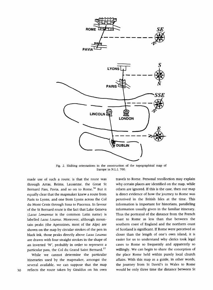
ROME SE
PAVIA
S LYONS
(- ~~LINCOLNQ \ \ ~~~~LONDON
Fig. 2. Shifting orientations in the construction of the topographical map of Europe in N.L.I. 700.
made use of such a route, is that the route was
through Arras, Reims, Lausanne, the Great St
Bernard Pass, Pavia, and so on to Rome.36 But it
equally clear that the mapmaker knew a route from
Paris to Lyons, and one from Lyons across the Col
du Mont Cenis through Susa to Piacenza. In favour
of the St Bernard route is the fact that Lake Geneva
(Lacus Lemannus is the common Latin name) is
labelled Lacus Losanus. Moreover, although moun-
tain peaks (the Apennines, most of the Alps) are
shown on the map by circular strokes of the pen in
black ink, those peaks directly above Lacus Losanus
are drawn with four straight strokes in the shape of
an inverted 'W', probably in order to represent a
particular pass, the Col du Grand Saint Bernard.37
While we cannot determine the particular
itineraries used by the mapmaker, amongst the
several available, we can suppose that the map
30 reflects the route taken by Giraldus on his own
travels to Rome. Personal recollection may explain
why certain places are identified on the map, while
others are ignored. If this is the case, then our map
is direct evidence of how the journey to Rome was
perceived in the British Isles at the time. This
information is important for historians, paralleling
information usually given in the familiar itinerary.
Thus the portrayal of the distance from the French
coast to Rome as less than that between the
southern coast of England and the northern coast
of Scotland is significant. If Rome were perceived as
closer than the length of one's own island, it is
easier for us to understand why clerics took legal
cases to Rome so frequently and apparently so
willingly. We can begin to share the conception of
the place Rome held within purely local church
affairs. With this map as a guide, in other words,
the journey from St David's in Wales to Rome
would be only three time the distance between St
A BZV Italy ~~~~~~~~~~~~~~talY
France~~~~~~~rac
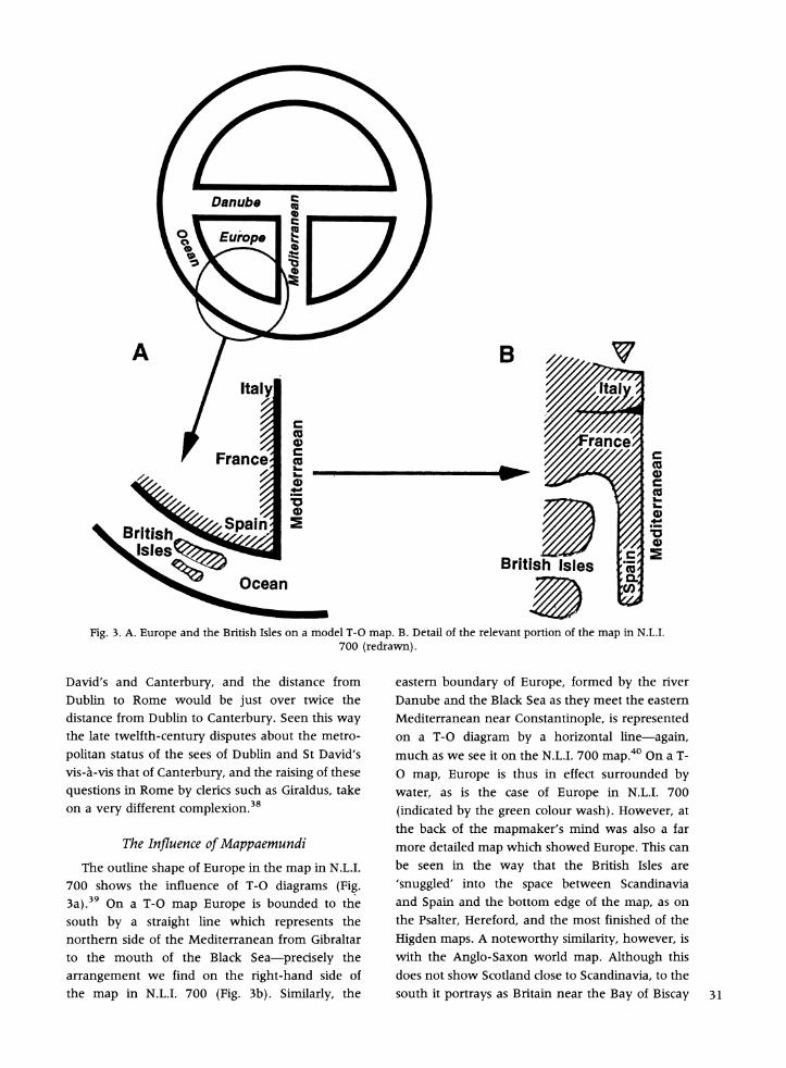
British Isles c
Fig. 3. A. Europe and the British Isles on a model T-O map. B. Detail of the relevant portion of the map in N.L.I. 700 (redrawn).
David's and Canterbury, and the distance from Dublin to Rome would be just over twice the distance from Dublin to Canterbury. Seen this way the late twelfth-century disputes about the metro- politan status of the sees of Dublin and St David's vis-a-vis that of Canterbury, and the raising of these questions in Rome by clerics such as Giraldus, take on a very different complexion.38
The Influence of Mappaemundi
The outline shape of Europe in the map in N.L.I. 700 shows the influence of T-O diagrams (Fig. 3a).39 On a T-O map Europe is bounded to the south by a straight line which represents the northern side of the Mediterranean from Gibraltar to the mouth of the Black Sea-precisely the arrangement we find on the right-hand side of the map in N.L.I. 700 (Fig. 3b). Similarly, the
eastern boundary of Europe, formed by the river Danube and the Black Sea as they meet the eastern Mediterranean near Constantinople, is represented on a T-O diagram by a horizontal line-again, much as we see it on the N.L.I. 700 map.40 On a T- O map, Europe is thus in effect surrounded by water, as is the case of Europe in N.L.I. 700 (indicated by the green colour wash). However, at the back of the mapmaker's mind was also a far more detailed map which showed Europe. This can be seen in the way that the British Isles are 'snuggled' into the space between Scandinavia and Spain and the bottom edge of the map, as on the Psalter, Hereford, and the most finished of the Higden maps. A noteworthy similarity, however, is with the Anglo-Saxon world map. Although this does not show Scotland close to Scandinavia, to the south it portrays as Britain near the Bay of Biscay 31
and Spain. Furthermore, the Orkneys are indicated in a similar way on both maps.4' In the case of N.L.I. 700, in short, the mapmaker's idea of Europe
had clearly been formulated by some of the basic shapes found on the schematic T-O diagrams or by one of the more detailed mappaemundi.42
Map Style
A particular feature of the map in N.L.I. 700 is the mapmaker's portrayal of geographical features by class icons rather than by the use of individual images. The map is a model of abstraction, and many features, such as we have already noted with reference to cities, are consistently generalized.43 We can see this most obviously in the colour coding. Land is left uncoloured; all sea water is green; fresh water (rivers and a lake) is blue; mountains are
shadowed in orange or brown, edged with red, and their tops outlined in black; and all 88 place-names are written in red (see Appendix and Fig. 4). Mountains and rivers appear to be drawn to a formula. Squiggles at the top of a river indicate its source, then the river's line thickens as its proceeds toward the sea, which it enters with an estuary. Both of the mountain ranges on the map are depicted as a line of curves showing that they impede the way
forward (with the possible exception of the inverted W-shaped black lines above Lake Geneva).
In the names on the map the hierarchy of scripts is analogous to that found in literary texts.44 The
names of major regions of Europe (for example,
Sicilia, Flandria, Italia, Wallia) and the name Roma
are placed in a top category in capitals. The other
category of script, used for everything else, is
slightly smaller in size and uses capitals and
minuscule. There is, however, some inconsistency regarding the names of geographical areas. Some
area names (25, for example, Boemia, Italia, Calabria), are placed in boxes, the rest (17, for
example, Francia, Armorica, Scotia, Tuscia), are not.
And of those in boxes, four (Alemannia, Burgundia, Italia, Provincia), are outlined in green, while the
others are within either red or red-and-green frames. The last group is confined to the left of
the Rhine. This sophistication in map style predates several thirteenth-century English maps which
have been used as bench-marks by historians for
assessing the degree to which conventional signs are used consistently on map.45
The Link with Giraldus Cambrensis
32 Is it possible to identify the origins of the map in
N.L.I. 700 more precisely? Once assembled, the evidence reveals good grounds for asserting that the
map came from the immediate circle of Giraldus, that he knew it and contributed to it, and that it
reflects his view of the world. The first link with Giraldus was made by Scott when he pointed out that the text shows that the manuscript remained with Giraldus for some years. Since the map is an
integral part of the manuscript and contemporary with the other illuminations, this would point to the personal involvement of Giraldus. The second link is Giraldus's known interest in cartography. Not only are there maps in several manuscripts of his works, but Giraldus tells us himself that he
produced a map of Wales.46 Together, these links
point to Giraldus as the inspiration for the map in N.L.I. 700 and suggest that he directed what was to be represented on it, and that the route to Rome reflects his own experience as a traveller.
From Giraldus's autobiographical writings we know when and why he travelled to Rome, although we cannot trace his route in detail. The little we do know, however, fits the map. In his De rebus a se gestis a, V, Giraldus describes crossing 'the
sea of Flanders' (that is, from Calais) to Canterbury
(et mari Flandriae ... Cantuariam).4 Moreover, we
know that Giraldus had first hand knowledge of the
region from the Channel coast to Arras and Paris.48 His mention of places further south, such as
Burgundy, Piacenza and Tuscany, is of little value in trying to determine his own route, since these
places are on the way to Rome.49 More useful, if
tantalizing, are the chapter headings for those parts of the De rebus a se gestis which do not survive. From
them, we learn that Giraldus passed through Clairvaux and then, having crossed the Alps, went
on to Piacenza, Parma and Bologna.50 Elsewhere
Giraldus reports by-passing Parma to avoid a
personal enemy and going straight to Bologna, and thence to Florence via Faenza.5' Other places in Britain and Ireland named on the map and the
depiction of Iceland, reflect what we know of the
personal interests of Giraldus as a churchman-
politician and as a topographer.52 Several objections can be raised to linking the
map in N.L.I. 700 with Giraldus Cambrensis. For
instance, although Giraldus states in his description of Wales that he wanted to show the country's cathedral churches-in line with his interest in St
David's-St David's is omitted from the map. The
counter-argument is that Canterbury is also miss-
ing, although other cathedral cities are shown.
While it is conceivable that many clerics would omit St David's, they would hardly omit Canter- bury. The omissions make sense, however, if the map is associated with Giraldus, who would not have wanted to be reminded of the see he could not have or of the see which blocked his advancement. Apart from York, Lincoln, to which diocese Giraldus retired in 1207, is the only other northern city identified. This raises the question whether N.L.I. 700 might not have been still in Giraldus's posses- sion at that time and that the map was drawn while he was in Lincoln.54 However, the evidence is not sufficient to produce a definite conclusion.
A second objection could be that the dimensions given in the Topographia for Britain (N-S 800 miles; E-W 200 miles) and Ireland (N-S 320 miles; E-W 160 miles) are not reflected in either the structure of or the outlines on the map accompanying the text.55 An idea of this sort of consistency is wholly anachronistic, however. If one were to insist that the map should reflect the text of the Topographia, a lengthy list of rivers (starting with the Boyne) and towns (starting with Armagh) which are mentioned in the text but not shown on the map could be produced. Moreover, the 'discrepancies' remain even if we attempt to distance the map from Giraldus, for whoever produced it must have had an interest not only in Ireland but specifically in Giraldus's information about Ireland, otherwise he would not have chosen this manuscript to work with. The fact that so many discrepancies exist should remind us not to link the map too closely with either the Topographia or the Expugnatio. In the same way that the map stands apart from either text in the manuscript, so we should treat it separately as evidence of one more of Giraldus's interests, which ranged from topography and clerical discipline to theology and education.56
However the map was made, or whoever made it, the map in N.L.I. 700 would have had consider- able political significance for a twelfth-century cleric like Giraldus. For the map is of a world dominated by the Roman Church. It was con- structed from knowledge of a route to Rome, an itinerary clearly of importance to the creator of the map. At the same time, it demonstrates the way that power and authority flow directly from Rome to the British Isles, as to every other part of the map. The reader's attention is immediately focused on Rome. For whoever created the map, to live in the British Isles was to live in the environs of Rome
itself. It would have been to Rome that one would want to travel, and from Rome that one would want to receive news.
A similar core-periphery relationship operates in the British Isles. England (identified as Britannia) is clearly portrayed as the focal region in relation to which Ireland, Wales and Scotland are peripheral. Likewise, within Ireland, it is the secular Viking cities, now Anglo-Norman centres, to which atten- tion is directed; even the great ecclesiastical centre of Armagh is not shown. Although the map could be described as a map of English political and Roman ecclesiastical power-politics, it surely does not reflect the narrow world-view of a Rome- orientated Norman cleric. On the contrary, it is the work of someone who was not in the least insular in outlook; someone who had a firm mental picture of his place within a larger European unity, who confidently knew his way about, and who would have felt at home in any of the cities he had placed in the central area of his map. Such a man would have been Giraldus Cambrensis.
Acknowledgements. I wish to thank the Trustees of the National Library of Ireland for permission to reproduce a photograph of folio 48r of Manuscript N.L.I. 700 which is in their keeping. I am grateful to the Pantyfedwen Fund of the University of Wales, Lampeter. I also wish to thank Dr Noel Kissane, Assistant Keeper of Manuscripts, and his assistants, for their help when I examined the manuscript in Dublin. In addition I wish to thank Dr Kissane, Peter Barber, and the two anonymous readers for Imago Mundi, for their many helpful suggestions and corrections to an earlier draft of this paper. However, for the positions taken, and any errors that remain, I am alone responsible.
Manuscript submitted March 1998. Revised text received October 1998.
NOTES AND REFERENCES
1. For an account of the manuscripts, see James F. Dimock, ed., Giraldi Cambrensis opera, 5 (London, Long- man, Green, Reader and Dyer, 1867), ix-xlvi; compare A. B. Scott and F. X. Martin, Expugnatio Hibernica, The Conquest of Ireland by Giraldus Cambrensis (Dublin, Royal Irish Academy, 1978), xxxiv-xxxix. For the background to these works by Giraldus, see Michael Lapidge and Richard Sharpe, A Bibliography of Celtic-Latin Literature 400- 1200 (Dublin, Royal Irish Academy, 1985), 22-24.
2. For the period up to and including his dispute over the see of St David's we have Giraldus's autobiography as a source (De rebus a se gestis, J. S. Brewer, ed., Rolls Series 35: Giraldi Cambrensis opera I (London, Longmans, Green, Reader and Dyer, 1861)); for the later period we have to rely on incidental references in his works. All the autobiographical material in Giraldus has been gathered together in H. E. Butler, The Autobiography of Giraldus Cambrensis (London, Jonathan Cape, 1937).
3. See Richard J. Hayes, Manuscript Sources for the History of Irish Civilization, 2: Persons E-K (Boston, G. K. Hall and 33
34
Co., 1965), 237, who describes the manuscript thus: 'MS 700: Giraldus Cambrensis, Topographica Hibernica and Expugnatio Hiberniae with illustrations and map of Ireland. Early 13th century'. More recently it has been described by Gerard Lyne ('Manuscripts', in Noel Kissane, ed., Treasures of the National Library of Ireland (London, Alpine Fine Arts Collection, 1995), 131-58, at 137-38), who gives a brief description of it, dates it as 'around the year 1200' and notes that it has a 'map of Europe'. In the same volume, Catherine Fahy's 'Maps' (175-201), con- tains a colour reproduction and description of the map at pp. 178-79. John J. O'Meara reproduced the map in black and white in his translation of the Topographia (The First Version of the Topography of Ireland by Giraldus Cambrensis (Dundalk, Dundalgan Press, 1951)), 7, and the map is also found in the Penguin Books reprint (Harmondsworth, 1982), 18-20 [it should be noted that the Latin text of the Topographia in Dimock's edition (see note 1) is of a longer recension than that translated by O'Meara]. G. R. Crone included the map in halftone in his Royal Geographical Society Reproductions of Early Maps VII: Early Maps of the British Isles A.D. 1000 - A.D. 1579 (London, Royal Geographical Society, 1961), pl. 2 and see p. 14.
4. Its contents are noted in the catalogue of the manuscripts belonging to Sir Thomas Phillipps along with the fact that it is 'written in Red and Black in Gothic letters', and that it contains 99 folios, in two columns of 36 lines. No reference is made to the manuscript's illustra- tions or to the map, but the catalogue does state that this is the manuscript referred to in the entry on Phillipps in the Dictionary of National Biography (see note 7 below).
5. I have been unable to find any other reference to Walter Mybbe; see Neil R. Ker, Medieval Libraries of Great Britain (2nd ed., London, Royal Historical Society, 1964), 99 and 268. A. B. Scott in his 'Introduction', in Scott and Martin, Expugnatio Hibernica (see note 1), xxxvii, does not mention a date and next to Walter Mybbe's name he placed '(? 14th cent.)'; this is an error since Ker, whom he cites for this detail, gives the precise date.
6. The Bristol Riots took place on 29-31 October, 1831; the dates and month are not mentioned by Phillipps.
7. 'Among manuscripts relating to Ireland that found their way into Phillipps's library from Cooper, O'Reilly, Betham, Monck Mason, Todd, and other collections, was a far-famed manuscript of Giraldus Cambrensis of the twelfth to the thirteenth century, illustrated with spirited contemporary drawings'. See 'Phillipps, Sir Thomas', in Sidney Lee, ed., Dictionary of National Biography 45 (London, Smith, Elder and Co., 1896), 192-95, at 193 [this entry is anonymous].
8. Scott, 'Introduction' (see note 5), xxxvii. Drawings from, and photographs of, this manuscript have been reproduced in O'Meara, Topographia (see note 3), and in the edition by Scott and Martin, Expugnatio Hibernica (see note 1); but these coloured features can be best seen in Kissane, Treasures of the National Library of Ireland (see note 3), 138-39.
9. Scott, 'Introduction' (see note 5), xl; also see the summary in Robert Bartlett, Gerald of Wales: 1146-1223 (Oxford: Oxford University Press, 1982), 214-15.
10. Scott, 'Introduction' (see note 5), xxxvii and xl. 11. Ibid., xlvi. 12. O'Meara, Topographia (see note 3), 7. See also
Brewer, De rebus a se gestis (note 2). 13. Scott, 'Introduction' (see note 5), liii-lv. 14. This is an error; only one map is found in N.L.I. 700,
that of Europe. 15. This should read: 'a map of the British Isles'.
16. Scott (Expugnatio Hibvernica (see note 1), note 29), had in mind those copies of the Topographia which do contain a map of the British Isles, namely Cambridge, Corpus Christi College, MS 400; London, British Library, Arundel MS 14; London, British Library, Additional MS 33991; and Paris, Bibliotheque Nationale, MS latin 4846. Descriptions of the maps in the Arundel and Corpus Christi College manuscripts are found in Dimock, Giraldi Cambrensis opera (see note 1), xiv-xv. There are references to the maps in the three manuscripts held in England in P. D. A. Harvey, 'Matthew Paris's maps of Britain', in Peter R. Cross and Simon D. Lloyd, eds, Thirteenth Century England: IV (Woodbridge, Boydell Press, 1992), 114; and idem, 'The Sawley map and other world maps in twelfth- century England', Imago Mundi 49 (1997): 33-42 at 42 (note 28).
17. Scott, 'Introduction' (see note 5), lv; further down on this page Scott gave another textual argument (the substitution of arcarii with satillites equestres) in favour of N.L.I. 700 being 'a manuscript which Giraldus himself used and had annotated by his scribes'.
18. One could argue that someone unbound the manu- script just to draw the map, but such a notion is absurd: if the map had been inserted after binding, then the obvious procedure would have been to use 2 or 3 mm less green on the left: no detail would have suffered and the map would have looked exactly the same when open before the reader.
19. The connection between Giraldus's observational powers and his interest in cartography is made by Bartlett, Gerald of Wales (see note 9), 133-35 and 194, especially note 84 which mentions N.L.I. 700. On Giraldus's observational skills in his topographical works, but with- out any reference to maps, see Antonia Gransden, 'Realistic observation in twelfth-century England', Spec- ulum 47 (1972): 29-51, at 48-51. However, Bartlett
doubts links between Giraldus and the tradition of illustrations that are found in copies of the Topographia on the basis that if Giraldus had involvement with these illustrations, he would have mentioned it. But these doubts are not directly relevant to the reasoning here, since I am not arguing that the map is intrinsically related to either text found in N.L.I. 700, but that the manuscript is linked with Giraldus's circle.
20. Linking the map with the text of the Topographia, with the implicit suggestion that it serves as a map for the text, was first mentioned in the 19th century (see the biographical entry of Sir Thomas Phillipps in the Dictionary of National Biography, note 7 above). From the time of O'Meara's translation this link has become a common- place (see O'Meara, Topographia (note 3), and Kissane, Treasures of the National Library of Ireland (note 3)), and has even found its way into specialist works on the history of cartography. Crone wrote, 'The map accompanying Giraldus Cambrensis's "Topographia Hiberniae" was probably extracted from a mediaeval world map with some contemporary detail inserted' (Royal Geographical Society Reproductions of Early Maps VII (see note 3), 7), and the connection is implied in his more detailed description of the map: 'Giraldus Cambrensis first visited Ireland in A.D. 1183, and his "Topographia Hiberniae" is the sole source of information on Ireland in the early Middle Ages' (ibid., 14). However, this is a false path, since not only is the map unique among copies of the Topographia, but it is more accurately described as one more item in a codex designed for the Topographia and the Expugnatio.
21. There are plenty of cases where the author of a medieval text mentions a map or other illustration. See,
for instance, Isidore of Seville's De natura rerum and Adomndn's De locis sanctis (on diagrams in both these texts see Thomas O'Loughlin, 'The view from Iona: Adomndn's mental maps', Peritia 10 (1996): 98-122). In such cases, the absence of a diagram constitutes a defect in the text.
22. P. D. A. Harvey (Mappa Mundi: The Hereford World Map (London, Hereford Cathedral and the British Library, 1996), 34), describes the maps of the British Isles in other manuscripts of the Topographia) as 'amoeba-like maps'. He exempted the map of Europe from such a description, but the amorphous outline of the British Isles on the map of Europe would seem to justify the analogy on purely formal grounds. As regards the sea, it should be pointed out that in many reproductions (like that in Kissane, Treasures of the National Library of Ireland (see note 3)), the picture is cropped so that the green sea colour surround- ing the continent is invisible. Harvey also referred to the map in N.L.I. 700 in his study of 'Matthew Paris's maps of Britain' (see note 16), 11 On and 114n.
23. These maps have recently been compared, with reference to N.L.I. 700, in articles by Peter M. Barber and Michelle P. Brown, 'The Aslake world map', Imago Mundi 44 (1992): 24-44 (Giraldus's map is mentioned on p. 30); and in P. D. A. Harvey, 'The Sawley map and other world maps in twelfth-century England' (see note 16), where the map in N.L.I. 700 is mentioned on p. 42, n.28. On the Cotton map in particular, see P. D. A. Harvey, Medieval Maps (London, British Library, 1991), 25-33, and the analysis in David Hill, An Atlas of Anglo-Saxon England (Oxford, Basil Blackwell, 1981), 2-3, but the information should be set in context by Evelyn Edson's 'World maps and Easter tables: medieval maps in context', Imago Mundi 48 (1996); 25-42. On the Hereford map, see Harvey, Mappa Mundi: The Hereford World Map (note 22).
24. See Susan Gole, 'Important is big!' in Peter Barber and Christopher Board, Tales from the Map Room (London, BBC Books, 1993), 16-17.
25. The map is damaged at that point by scraping; the comer of the folio has been damaged by water, with the result that the green pigment has eaten through the vellum.
26. I wish to thank Peter Barber for drawing my attention to this detail in the sign for Paris.
27. This part of the map, which I have referred to as its 'central zone', was described by Crone (Royal Geographical Society Reproductions of Early Maps VII (see note 3), 14), as its 'backbone'.
28. Crone (ibid., 14), described these parts of the map thus: 'Around this "backbone" [see previous note] are arranged a number of countries, provinces and towns; in the upper left corner is Constantinople and Adriatic Sea (Sinus Libernicus); on the right is Sicily in its traditional triangular form'. For Sinus Libernicus, see the Appendix, number 54.
29. Pliny, Historia naturalis, III xviii 128; III xxv 148; IV xi 44; and IV xii 79. These passages can explain the location of several of the areas mentioned on the map. Pliny was a much-used source in early medieval Britain. See Thomas O'Loughlin, 'The library of Iona in the late seventh century: the evidence from Adomnan's De Locis Sanctis', Briu 45 (1994): 33-52 at 45; and idem, 'The view from Iona: Adomndn's mental maps' (note 21), 109-11.
30. Pliny, Historia naturalis (see note 29), III xviii 128. 31. Crone, Royal Geographical Society Reproductions of Early
Maps VII (see note 3), 14. Crone's suggestion has been followed by Raghnall 0 Floinn in the caption to a colour reproduction of the map in Irish Shrines and Reliquaries of the Middle Ages (Dublin, National Museum of Ireland,
1994), 7, but 0 Floinn has turned the traveller into a pilgrim: 'The map seems to show the pilgrim's route to Rome, which is top centre'. Crone's suggestion is also found in Catherine Fahy's caption for the colour reproduction of the map in Kissane, Treasures of the National Library of Ireland (see note 3), 179: 'The map may have originated as a guide for travellers from England to Rome. The route probably led via the Seine and Paris, across the Rhone at Lyon, across the Alps to Pavia, and from there to Piacenza and Rome'.
32. G. R. Crone, 'New light on the Hereford map', Geographical Journal 131 (1965): 447-62 at 450-51. The relationship between itineraries and world maps is now widely accepted; see P. D. A. Harvey, 'Local and regional cartography', in J. B. Harley and David Woodward, eds, The History of Cartography I: Cartography in Prehistoric, Ancient, and Medieval Europe and the Mediterranean (Chi- cago, University of Chicago Press, 1987), 464-501; and Harvey, Mappa Mundi: The Hereford World Map (see note 22), 50-53, for an up-date of Crone's work.
33. Crone, Royal Geographical Society Reproductions of Early Maps VII (see note 3), 14, wrote: 'This is a portion of a mediaeval world map. . . drawn with the east to the top'.
34. Crone, Royal Geographical Society Reproductions of Early Maps VII (see note 3), 14.
35. Fahy, in Kissane, Treasures of the National Library of Ireland (see note 3).
36. See, for example, the list of stops (mansiones) made by Archbishop Sigeric on his journey from Rome. See Veronica Ortenberg, 'Archbishop Sigeric's journey to Rome in 990', Anglo-Saxon England 19 (1990): 197-246, for a detailed description of this itinerary. For the crucial work on the actual route of this itinerary see David Hill, 'The route to Rome', Popular Archaeology (May 1985): 7- 11; and (December 1985/January 1986): 9-13. On the connection between Sigeric's itinerary and the Cotton map, see Edson, 'World maps and Easter tables' (note 23), 35. 37. The steady growth of the Augustinian hospice on the
col (founded by St Bernard of Menthon in the mid-i Ith century) is evidence of this route's popularity in Giraldus's day. See N. M. Riehle, 'Bernard of Aosta, St.', New Catholic Encyclopaedia (New York, McGraw-Hill, 1967), 2: 334. The detailed depiction of the upper Rhone, rising in the mountains off to the left, strengthens the hypothesis that the mapmaker knew more about this route through the Alps than about other routes.
38. A metropolitan see is one governed by an arch- bishop.
39. Crone, Royal Geographical Society Reproductions of Early Maps VII (see note 3), recognized this when he wrote that it is a portion of a medieval world map (p. 14); and that 'The map . . . was probably extracted from a mediaeval world map with some contemporary detail inserted' (p. 7). On the relationship of world maps to these T-O diagrams, see Harvey, Mappa Mundi: The Hereford World Map (note 22), 21-26; the presence of these maps in the contem- porary ecclesiastical environment is set out in Edson's article ('World maps and Easter tables' (note 23)). 40. In most histories of cartography (e.g. David Wood-
ward, 'Medieval Mappaemundi', in Harley and Woodward, The History of Cartography (see note 32), 286-370 at 297), it is stated, on the basis of classical texts, that the river forming the eastern boundary of Europe is the Don. This is not the case for the Latin Middle Ages; see Paulys Realencyclopddie der Classischen Altertumswissenschaft, IV: A2, s.v. 'Tanais', col. 1261; O'Loughlin, 'The library of 35
Iona in the late seventh century' (note 29)', and idem, 'The view from Iona: AdomnAn's mental maps' (note 21). 41. I wish to thank Peter Barber for this comparison with
the Psalter, Hereford, Higden, and Anglo-Saxon maps. Contrast the treatment of the British Isles in Vat. Lat. 6018: see Leonid S. Chekin, 'Easter tables and the pseudo- Isidorean Vatican map', Imago Mundi 51 (1999): 13-23 and Plate 1. 42. It is certain that Giraldus had seen such T-O
diagrams in at least Isidore of Seville's Etymologiae and De natura rerum; see Bartlett, Gerald of Wales (see note 9), 141 and 180. On the wide diffusion of such T-O diagrams, see Edson, 'World maps and Easter tables' (note 23); and on their role in English cartography, see Peter Barber, 'The Evesham world map: a late medieval English view of God and the world', Imago Mundi 47 (1995): 13-33 at 27. 43. See Anna-Dorothee von den Brincken, 'Die Ausbil-
dung konventionelle Zeichen und Farbgebungen in der Universalkartographie des Mittelalters', Archiv fur Diplo- matik: Schriftgeschichte Siegel- und Wappenkunde 16 (1970): 325-49; and Catherine Delano Smith, 'Cartographic signs on European maps and their explanation before 1700', Imago Mundi 37 (1985): 9-30. 44. For an introduction to the notion of a hierarchy of
scripts, see Bernhard Bischoff, Latin Palaeography: Antiquity and the Middle Ages (English translation by Daibhi 0 Cr6inin and David Ganz; Cambridge, Cambridge Univer- sity Press, 1990), 77-80. 45. Barber and Brown, 'The Aslake world map' (see note
23), 30, compared the use of conventional signs on the Aslake map with those on the Psalter map and in the work of Roger Bacon. 46. Catalogus breuior librorum suorum, in Brewer, Giraldi
Cambrensis opera (see note 2), 1: 422. In the Catalogus Giraldus states that he showed 'the tough mountains, bristling forests, lakes, rivers, and high-raised castles; also the cathedral churches and many monasteries' (Bartlett's translation in Gerald of Wales (see note 9), 134). It might be argued that showing the 'tough mountains and bristling forests' is the opposite of the generalization just described, but this is not the case: the statement merely says that he showed Wales's tough mountains, not that he shows them in any particular way. Indeed it could mean that he
selected from all the mountains and hills that could be shown in Wales those which deserved to be identified on a map because they stood out for their toughness. Both mountain ranges shown on our map could be called 'tough' in contrast with other, lesser, hills that are omitted. 47. De rebus a segestis (see note 2), p. 51; and compare III,
XVII, p. 117: 'properans apud Sandwich mare Flandricum transfretavit'. The verb used here seems to demand that it be a crossing of the Strait of Dover.
48. De rebus a se gestis (see note 2), II, IV, pp. 49-50. 49. Ibid., III, XVII and XVIII, pp. 117-20. 50. Ibid., p. 14 (chapter headings CLXIII and CLXV). 51. De iure et statu IV (see Butler, Autobiography of Giraldus
Cambrensis (note 2), 265-66). The later Titchfield Abbey itinerary (c. 1400) also records the use of the Piacenza- Parma-Bologna-Faenza-Florence section, although the traveller reached Italy by the Rhine route (Aachen- Cologne-Speyer-Strasbourg-Gotthard Pass-Como-Milan): see Catherine Delano Smith and Roger J. P. Kain, English Maps: A History (London, British Library Publications, in press).
52. We know that Giraldus was interested in Iceland because it features on four occasions in the Topographia Hiberniae (Distinction 1, chs. 1 and 3, where mention is made of its location in relation to the British Isles; Distinction 2, ch. 13, where the customs of its people are described; and Distinction 2, ch. 17, where Giraldus discusses classical and patristic opinions on Thule ultima, which he takes to be Iceland). See Richard Vaughan, 'The Arctic in the Middle Ages', Journal of Medieval History 8 (1982): 313-42 at 324, and his comment on Iceland on medieval world maps at 336.
53. Peter Barber has pointed out to me that both the Anglo-Saxon and N.L.I. 700 show Winchester but omit Canterbury. However, there is insufficient evidence to draw definite conclusions from the similarity.
54. I wish to thank Peter Barber for this suggestion. 55. Topographia Hiberniae, Distinction 1, ch. 2. 56. The omission of any mention of a map in his
Catalogus breuior (see note 46) is not significant, since that list is not exhaustive.
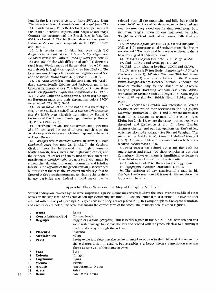
Appendix: Place-Names on the Map of Europe in N.L.I. 700
Several endings are covered by the same suspension sign ('c' (sometimes reversed) above the line); over the middle of other names on the map is found an abbreviation sign (something like this: -A-); and the terminal m-suspension ( - above the line) is found with a variety of meanings. All expansions in this register are placed in [ ]. In a couple of places the legend is unclear, and such cases are noted. The term recte means the correct form of the word. The numbers here relate to Figure 4.
1 Roma Rome 2 Consta[nltinopol[isJ Constantinople 3 Regiulmj Reggio di Calabria (Rhegium). This is barely legible in the MS as it has been scraped and
some water damage has spread the inks and reacted with the green ink close to it, turning it black, and eating through the vellum.
4 Placentia Piacenza 5 Mediolanum Milan 6 Pavia Pavia; while it is clear that the scribe intended to write v in the middle of this name, the
shape chosen is not his usual v, but resembles a p, hence Crone's transcription (see text above at note 28) of this name as Papia.
7 Susa Susa 8 Colonia Cologne 9 Lugdunum Lyons
10 Vienna Vienne 11 Arausis recte Arausio; Orange 12 Arelas Arles
36 13 Remis recte Remi; Reims
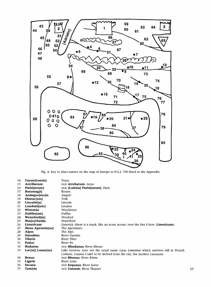
Fig. 4. Key to place-names on the map of Europe in N.L.I. 700 listed in the Appendix.
14 Turon[icensisJ Tours 15 Aetribatum recte Atrebatum; Arras 16 Parisi[orumJ recte [Luletia] Parisi[orumJ; Paris 17 Rotomagli] Rouen 18 Andegavlenslis Angers 19 Eboraclum 9 York 20 Lincolni[a 5 Lincoln 21 Lundoni[um 5 London 22 Wmntonia Winchester 23 Dublin[umJ Dublin 24 Weiseford[ia3 Wexford 25 Wat[elrfordia Waterford 26 Limenicum Limerick (there is a mark, like an acute accent, over the first i here: Limericum) 27 Mons Apennmn[usJ The Apennines 28 Alpes The Alps 29 Danubius River Danube 30 Tiberis River Tiber 31 Padus River Po 32 Rodanus recte Rhodanus; River Rhone 33 Lac[usj Losan[usJ Lake Geneva; note not the usual name Lacus Lemannus which survives still in French
(Letman). Losanus I take to be derived from the city, the modern Lausanne. 34 Renus recte Rhenus; River Rhine 35 Ligenis River Loire 36 Secana recte Sequana; River Seine 37 Tamisia recte Tamesis; River Thames 37
38 Sabrina River Severn 39 Avenliff[iusJ River Liffey 40 Slana River Slaney 41 Suir[us] River Suir 42 Sinnenus River Shannon; that it flows into the sea at two points is explained in the chapter in the
Topographia on rivers. From one lake two branches flow: one south (Shannon) and one north (presumably a confusion with the Erne which rises close to the Shannon).
43 Theodosia Presented as a territory, it refers to the present city of Feodosiya in the Crimea.
44 Gotia Territory of the Goths 45 Sica[mlbria Territory of the Sigambri 46 Ungaria Hungary 47 Boemia Bohemia 48 Bavaria Bavaria 49 Mesia recte Moesia; Modern Bulgaria; it is in, roughly, the correct relative position on the map,
south of the Danube. 50 Dardania Presented as a territory; if it refers to the ancient city on the Hellespont, then it is a
complete error on this map. 51 Tratia Thrace; in reproductions this can appear as Tracia (and the interchange of c and t is
common in medieval Latin) however, examination of the manuscript shows that it was made with two pen strokes (i.e. t) rather than one (i.e. c).'
52 Macedonia Macedonia 53 Dalmatia Dalmatia 54 Sin[us] Liburnic[us] The gulf of Kvarner (on the Adriatic Sea). 55 Saxonia Saxony 56 Dacia Denmark 57 Frisia Frisia 58 Norwagia Norway 59 Apulia Apulia 60 Boneventum recte Beneventum; Benevento 61 Campania Campania 62 Baris Bari; note it is shown as a territory. 63 Lucania The region south of Naples 64 Calab[rlia Calabria 65 Sicilia Sicily 66 Tuscia Tuscany 67 Italia Italy 68 Aleman[nlia The region of the Allemani 69 B[urlgund[ial Burgundy 70 Francia France 71 Flandria Flanders 72 Hora Gallici litori[aJ recte Ora Gallici litorea; the seashore zone of the Gaul.
73 Provincia Provence 74 Andegavia The region around Angers: Anjou. Note that at the time, the King of England was referred
to as 'King of the English, duke of Normandy and Anjou .
75 Norman[nlia Normandy 76 Armorica Armorica 77 Britan[nlia Brittany 78 Pictavia Represented as a territory; Poitiers
79 Gascon[ial Gascony 80 Hyspan[ial recte Hispania; Spain 81 Orcades Usually identified as the Orkneys. 82 Yslandia Iceland 83 Scotia Scotland 84 Britan[nlia Britain 85 Wallia Wales 86 Hybernia recte Hibernia; Ireland
87 Mare Scotic[um] Either the sea inlets at each end of the Great Glen or, more probably, the Solway Firth and
the Firth of Forth.2
88 Humbra River Humber
1. In the 'Guide to the map of Europe' in the Penguin reprint of O'Meara (Topographia (see text note 3), 20), it is given as
Tracia. 2. It is interesting to compare this representation of Scotland with that shown by Matthew Paris on his final map of the
British Isles (c.1255-59; British Library, Royal MS 14.C.VII, f.5V). Paris shows northern Scotland connected to the rest of
Britain by an isthmus and labels that northern area Scocia ultra marina. See reproductions in P. D. A. Harvey, The History of
Topographical Maps (London, Thames and Hudson, 1980), pl. 81, p. 141 (British Library, Royal MS 14. C. VII, fol. 5v), and P.
D. A. Harvey, Medieval Maps (London, British Library, 1991), p. 74). See also Harvey, 'Matthew Paris's maps of Britain' (text note 16), 112.
Une carte du debut du treizieme siecle a Dublin: une eclairage sur le Monde de Ge'rard de Cambrai Un manuscrit du debut du treizieme siecle (Dublin N.L.I. 700) de deux ouvrages de Gerard de Cambrai (Gerard le Gallois c.1146-c.1223) contient aussi une carte d'Europe, dont on ne connaft pas d'equivalent proche. Bien qu'elle soit bien integree dans le manuscrit, elle n'a de rapport evident avec aucun des deux textes. Les traces de la carte sont empruntes a des cartes du monde anterieures ou contemporaines, et l'essentiel de son contenu provient surtout d'itineraires; il est centre sur un itineraire de Grande-Bretagne a Rome. Mais surtout la carte prouve une perception tres fine de l'importance de la generalisation et montre comment les clercs insulaires voyaient le continent et comment ils se placaient par rapport a Rome. On suggere que l'ensemble du manuscrit a appartenu a Gerard de Cambrai, et que celui-ci a ete lie plus ou moins a la conception de la carte.
Eine Karte des fruhen 13. Jahrhunderts in Dublin: Ein Fenster zur Welt des Giraldus Cambrensis Ein Manuskript des fruhen 13. Jahrhunderts (Dublin, N.L.I. 700) mit zwei Werken des Giraldus Cambrensis (Gerald of Wales, ca. 1146-ca. 1223) enthalt augerdem eine Europakarte, zu der keine vergleichbaren Beispiele bekannt sind. Obwohl originaler Bestandteil der Handschrift, hat sie keinen direkten Bezug zu den beiden Texten. Die Umrisse der Karte basieren auf alteren und zeitgenossischen Weltkarten. Ihre wesentlichen Details sind aus Itineraren abgeleitet, hauptsachlich aus der Darstellung einer Reise von den Britischen Inseln nach Rom. Insgesamt dokumentiert die Karte ein hochentwickeltes Gefuhl fur die Bedeutung der Generalisierung und zeigt, welche Vorstellung die insularen Geistlichen vom Kontinent und von ihrer geographischen Lage in Bezug auf Rom hatten. Es darf vermutet werden, dag Giraldus das gesamte Manuskript besag und er an der Herstellung der Karte beteiligt war.
NEW EDMON
Who's Who in the History of Cartography. The International Guide to the Subject
(D9, 1998)
Both sections of this indispensable research and reference tool-'What's What' and 'Who's Who'-have been updated and augmented. The latter gives addresses, decribes the research interests, and lists recent publications of some 630 individuals currently working in the field of the history of cartography. The new format ensures easy handling and ready access to the answers to all those urgent queries: Who ? What? Where? When?
Read what reviewers are saying:
* This is a '... book every reference library should have and every researcher should have access to'. Eugene Burden, IMCoS Journal, 77 (1999), p.66.
* 'The "International" in the title does not mean just a geographical publication describing researchers in 45 countries worldwide. It also represents a friendly working collaboration between people involved in research, teaching, archives, libraries, as well as collectors and dealers'. Markus Oehrli, Cartographica Helvetica, 19 (1999), p. 53.
Who's Who's in the History of Cartography is edited by Mary Alice Lowenthal and is published for Imago Mundi Ltd. by Map Collector Publications Ltd. For your copy, please contact: Valerie Scott, Map Collector Publications, 48 High Street, Tring, Herts HP23 5BH, England. Tel: (0)1442 824977; Fax: (0)1442 827712; E-mail: [email protected] Or order from: http://www.mapcollector.com
39
,A*
Plate 2: The map of Europe (c.1200) found with Giraldus Cambrensis's topographical descriptions of Ireland, Topographia Hiberniae and Expugnatic Hibernica, in N L I. 700. (Dublin, National Library of Ireland MS 700, fol- 48r) (p. 26.)
Related Documents