Gila River Indian Community Anthropolog ical Research Papers Number 4 Arizona State University Anthropological Field Studies Number 43 TRAILS, ROCK FEATURES AND HOMESTEADING IN THE GILA BEND AREA A Report on the State Route 85 Gila Bend To Buckeye Archaeological Project Edited by John L. Czarzasty Kathleen Peterson Glen E. Rice J. Andrew Darling Contributions by Karen Adams Matthew Chamberlin John L.Czarzasty J. Andrew Darling B. Sunday Eiselt Kathleen Peterson Glen E. Rice Arleyn Simon Susan Smith Pat H. Stein Erik Steinbach Michael Waters Gila River Indian Community Cul tu ral Resource Management Program Sacaton, Arizona

Welcome message from author
This document is posted to help you gain knowledge. Please leave a comment to let me know what you think about it! Share it to your friends and learn new things together.
Transcript
Gila River Indian Community Anthropolog ical Research Papers Number 4
Arizona State University Anthropological Field Studies Number 43
TRAILS, ROCK FEATURES AND HOMESTEADING
IN THE GILA BEND AREA
A Report on the State Route 85 Gila Bend To Buckeye Archaeological Project
Edited by John L. Czarzasty Kathleen Peterson
Glen E. Rice J. Andrew Darling
Contributions by Karen Adams
Matthew Chamberlin John L.Czarzasty
J. Andrew Darling B. Sunday Eiselt
Kathleen Peterson Glen E. Rice
Arleyn Simon Susan Smith Pat H. Stein
Erik Steinbach Michael Waters
Gila River Indian Community Cul tural Resource Management Program
Sacaton, Arizona
ii
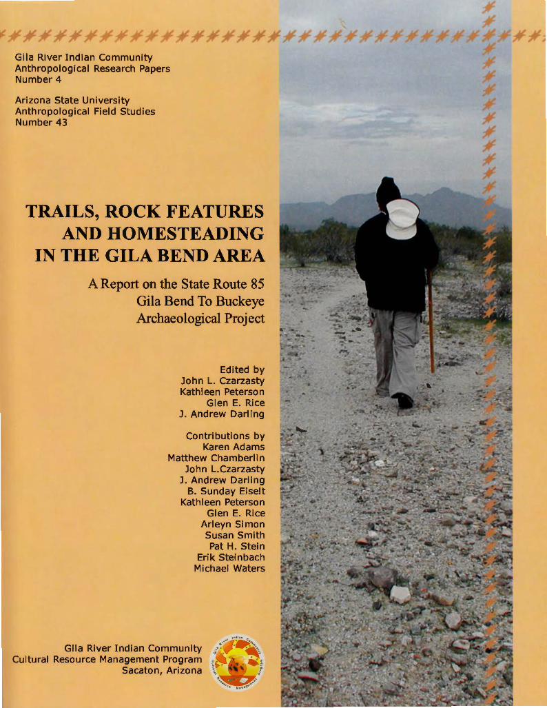
Unititled mural by Emil Pedro for the exhibit He 'kugam V:og, Huhugam Heritage Center, Gila River Indian Community.

iv
Cover: Ryan Stone, archaeologist for the Cultural Resource Management Program, Gila River Indian Community, recording a trail in the Maricopa Mountains near State Route 85.
© 2009 Gila River Indian Community, Cultural Resource Management Program
All Rights Reserved
Printed in the United States of America
ISBN 0-9723347-3-4
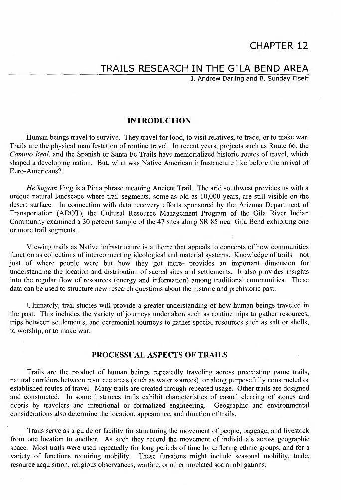
CHAPTER 12
TRAILS RESEARCH IN THE GILA BEND AREA J. Andrew Darling and B. Sunday Eiselt
INTRODUCTION
Human beings travel to survive. They travel for food, to visit relatives, to trade, or to make war. Trails are the physical manifestation of routine travel. In recent years, projects such as Route 66, the Camino Real, and the Spanish or Santa Fe Trails have memorialized historic routes of travel, which shaped a developing nation. But, what was Native American infrastructure like before the arrival of Euro-Americans?
He 'kugam Vo:g is a Pima phrase meaning Ancient Trail. The arid southwest provides us with a unique natural landscape where trail segments, some as old as 10,000 years, are still visible on the desert surface. In connection with data recovery efforts sponsored by the Arizona Department of Transportation (ADOT), the Cultural Resource Management Program of the Gila River Indian Community examined a 30 percent sample of the 47 sites along SR 85 near Gila Bend exhibiting one or more trail segments.
Viewing trails as Native infrastructure is a theme that appeals to concepts of how communities function as collections of interconnecting ideological and material systems. Knowledge of trails-not just of where people were but how they got there-provides an important dimension for understanding the location and distribution of sacred sites and settlements. It also provides insights into the regular flow of resources (energy and information) among traditional communities. These data can be used to structure new research questions about the historic and prehistoric past.
Ultimately, trail studies will provide a greater understanding of how human beings traveled in the past. This includes the variety of journeys undertaken such as routine trips to gather resources, trips between settlements, and ceremonial journeys to gather special resources such as salt or shells, to worship, or to make war.
PROCESSUAL ASPECTS OF TRAILS
Trails are the product of human beings repeatedly traveling across preexisting game trails, natural corridors between resource areas (such as water sources), or along purposefully constructed or established routes of travel. Many trails are created through repeated usage. Other trails are designed and constructed. In some instances trails exhibit characteristics of casual clearing of stones and debris by travelers and intentional or formalized engineering. Geographic and environmental considerations also determine the location, appearance, and duration of trails.
Trails serve as a guide or facility for structuring the movement of people, baggage, and livestock from one location to another. As such they record the movement of individuals across geographic space. Most trails were used repeatedly for long periods of time by differing ethnic groups, and for a variety of functions requiring mobility. These functions might include seasonal mobility, trade, resource acquisition, religious observances, warfare, or other unrelated social obligations.
200 Trails Research in the Gila Bend Area
Becker and Altschul (2003:33-38) present a number of themes that outline certain basi processual aspects of trails research. These include Settlement Pattern and Trail Use, Trade. Territorial Boundaries, and Trail Systems. Each of these themes considers the ways in whi economic, sociopolitical, and religious behavior may relate to the structure and use of trail systems over time. The most basic fact underlying all of these behaviors is that mobility or travel is n~· random. Repeated actions in the social and natural landscape produce trails, which remain visible o stable desert ground surfaces. Trail networks evolve in tandem with other aspects of a society' infrastructure or the ways that information, material culture, and people circulate and interact.
TYPOLOGICAL ASPECTS OF TRAILS
Classification schemes serve to describe and organize information about trails. These can used to establish relationships between individual trail segments, interconnected trail networ individual settlements, and settlement systems. Trail typologies normally organize specific trail types in terms of their function, chronology or history, and/or physical characteristics.
Stein (1994:37) provides a typology for historic trails as a guide for managing histori properties. She identifies nine different trail types:
1. Native American Trails 2. Spanish Period Trails and Roads 3. Mexican Period Trails and Roads 4. U.S. Government Trails and Roads of the Early American Period 5. Mormon Trails and Roads 6. Stagecoach, Freight, and Toll Roads 7. Stock Trails 8. Early Automotive Routes 9. Other Historic Trials and Transportation Corridors
Stein's classification scheme favors chronology and function over physical properties, although she does associate certain trail characteristics with specific transport facilities, such as foot traffi c. livestock, wagons or automobiles. Stein's typology is useful for identifying and organizing information on trails in historical documents. As she notes, many historically documented trails no longer exist and therefore cannot be considered eligible for the National Register of Historic Places. 3
Other typologies also serve to describe the physical characteristics and putative function of prehistoric or historic trails as they occur in the field. Outmoded classification schemes utilize familiar categories including hunting trail, war path, and trade trail (Jones 1967:5). Becker and Altschul (2003:28-30) provide a functional scheme based on three trail types-trackways, minor trails, and major trails. We will present a classification scheme that is similar but focuses on the mode of travel (as a human behavior) rather than the trail itself. As noted by Becker and Altschul, among others, the disadvantage of any trail typology is that any one trail could have carried man different kinds of traffic. By focusing on travel in relation to general theories of human mobility, the process becomes one of human decision-making with reference to which trails would best serve the purpose of the trip. This approach acknowledges that certain trails may be used exclusively for certain kinds of travel whereas most trails are multi-functional and the features and artifacts found along them represent a wide range of activities.
3The physical integrity of a trail is critical for evaluation of a trail's eligibility status including its location, associations, and other materials.
Trails Research in the Gila Bend Area 201
Network analysis offers some compelling avenues for research (see for example Helbing, Keltsch and Molnar 1997, see also Becker and Altschul 2003:3 8) and incorporates human decision making in models of trail evolution. These studies suggest that trail networks initiate simply as the most direct route between two destinations. As preferred routes of travel become part of the knowledge base of pedestrians they will make small detours to access preferred routes. In time mature trail networks may acquire a configuration that reflects a compromise between constraints of preference (reflecting social and functional choices by travelers) and spatial efficiency. Furthermore, what underlies effective modeling of trail network evolution is the realization that individual travelers receive and process information (or knowledge) as they travel (see for example Kelly 1995:150; Rockman and Steel 2003). Thus, the act of travel goes beyond the simple act of getting from place to place. While research on trail network evolution is beyond the scope of the current study, the unusual degree of trail preservation along SR 85 may provide an opportunity for research in the future.
TRAILS RESEARCH ALONG SR 85
Trails research was conducted along SR 85 to address two primary research questions:
1) What kinds of features and artifacts co-occur with trail sites?
2) Where do the trails go?
Native American trails are as much represented by the trail itself as the artifacts and features scattered along it. These commonly include rock cairns/rock piles, trail markers, shrines, hearths, campsites, and linear artifact scatters (Bretemitz 1975; Brown and Stone 1982; Harmon and Beyer 1995; Rodgers 1976, Rogers n.d. [notes on file San Diego Museum ofMan], 1966; Stone 1986, 1991; Woodall 1995). Woodall (1995:13-14) notes that the most frequently observed feature adjacent to trails were rock clusters. Rock clusters/piles could represent roasting pits, hearths, or trail markers. Rock piles may also represent trail shrines as noted by Treutlein (1949:228); cited in Ezell1961:78-79). Ezell (1961:79) noted this trait on a San Dieguito shrine identified in the saddle of the Buckeye Hills northeast of Gila Bend and a similar shrine in the saddle of Gila Butte along the Gila River.
The second question addresses the origin and destination of trails in relation to their characteristics including associated artifacts and features. Prehistoric and historic indigenous trails can be classified in terms of the types of travel conducted along them. This includes travel between settlements (Type I), travel from a settlement to a resource area (Type II), and ritualized travel, from a settlement to a particular location for a specific social-ceremonial function (Type III). As discussed above, the relationship of types or modes of travel will be considered in more detail in relation to the archaeological record of trails in the Gila Bend area.
TRAILS RESEARCH METHODOLOGY
Trail research followed two phases:
I. Background research and review of the trails records of Malcolm Rogers at the San Diego Museum of Man
II. Field Survey along SR 85.
Background research included extensive use of Malcolm Rogers' survey records, located at the San Diego Museum of Man, to contextualize the historic and prehistoric trail networks maintained by the O'odham (Pima) and Pee Posh (Maricopa) Tribes. These data provide important views of how local trail systems are integrated into extra-local networks of travel. Oral histories, creation stories,
202 Trails Research in the Gila Bend Area
and other accounts further document the manner in which trails are used. Rogers recorded over 6000 sites, ceramic and preceramic, during several field seasons between 1928 and 1960. Regrettably on! a small number of reports were produced, none of which provide a synthesis of over 20 volumes of notes resulting from his regional survey and extensive research (McGuire 1982:440).
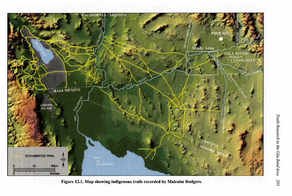
We were particularly interested in records related to Rogers' thorough mapping and recording of trails in southwestern Arizona, since further studies of this important data set would help place the SR-85 trails in a regional context. Combined with the research of Stein (1994), Pendleton (1986) Von Werlhof (1988), and Hayden (1965, 1967, 1972), historical accounts of trail use (e.g. Manje 1971; Sedelmeyer 1955), ethnographies describing trail use (e.g. Bean 1974; Jett 2001; Laird 1976) and finally synthetic studies of trail systems (e.g. Davis 1961; Johnston and Johnston 1957; Sample 1950), a clear picture of trail use and Native American infrastructure emerges which incorporates the Gila Bend and extends throughout the arid Southwest (Figure 12.1 ).
As part of the ADOT archaeological project along SR 85, Arizona State University collaborated with the Gila River Indian Community, Cultural Resource Management Program, in their on-going Traditional Cultural Properties Research project funded by the Pima-Maricopa Irrigation Project and the National Park Service. The immediate goal was to identify previously recorded trails and map them beyond the existing SR 85 right-of-way. A 30 percent sample of 14 sites out of the 47 sites with trail segments reported by Harmon and Beyer (1994) was selected for visual examination in the field. Selection was based on three priorities designated in the research plan. First, survey was conducted to verify the continuation and integrity of the trail as a long linear archaeological feature on the landscape and to distinguish it from other animal trails or recently created vehicle tracks. Second, sites were selected in strategic locations along major routes of travel connecting the Gila Bend region with other known or suspected historic and prehistoric indigenous routes of travel. Third, trails in the vicinity of the Butterfield Stage Route were examined to determine the relationship between them and this long-standing historic Euro-American road.
Field recording focused on following the trails out of the previously recorded site boundaries away from the SR 85 right-of-way in an easterly or westerly direction, or roughly perpendicular to the north-south trending highway. In general, no trails along the bajada of the Gila Bend Valley were shown to travel north-south (a few short north-south tracks were used by cattle). Field crews consisted of 2-4 persons and trail locations were mapped using a GPS unit. Approximately three weeks were spent documenting trails in the field. Intact trail segments could exceed a kilometer in length and waypoints were taken regularly at 50-meter intervals or less when specific features along the trail were identified. Field notes were taken at each waypoint describing the character of the trail, artifacts or features, and where possible, a width measurement was made. Digital photography was used to record specific details of the trails and associated features .
TRAIL IDENTIFICATION
Trails consist of segments, which in tum are composed of one or more tracks or linear artifact scatters. Tracks are the walking surface or the physical representation of the trail on the ground. A track normally consists of a cleared linear area approximately 40-60 centimeters wide with a central walking surface that may be compacted slightly, lowered a few centimeters below ground surface with occasional slight lateral berms or stone-lining marking the edge of the track. In many cases well-used trails may be represented by more than one parallel track. At other times trails may only appear as linear vegetation changes resulting from the accumulation of moisture in the worn walking
DOCUMENTED TRAIL
l 40 80km I ; I; I ; I i': I
Figure 12.1. Map showing indigenous trails recorded by Malcolm Rodgers.
~ t:l
~ ::0 ~ ~ ;:; ~
s~
s. (1)
C)
~ O:l (1)
::s t:l, ~
~ N ~ \,;,)
204 Trails Research in the Gila Bend Area
surface. Tracks occasionally became erosion channels and were downcut sometimes as much as 10-20 em. The occurrence of multiple tracks is not considered evidence of braiding or branching as the individual parallel tracks of prehistoric trails do not tend to cross back and forth. Instead, these may represent varying chronological stages of a continuously used trail. Each trail segment was of varying length and characteristics and was numbered in the order of its discovery. Segments recorded in the field were mapped and associated with each other to form trails based on field observations and their location.
Trail recording generally focused on attributes useful for testing the validity of a prehistoric or historic trail observed in the field. These included the following (see also Becker and Altschul 2003:46-47 for a similar series of attributes):
1. width, variability in width 2. depth of trail 3. presence of parallel trails or multiple tracks 4. presence or absence of desert pavement 5. compaction in the trail 6. presence of a berm 7. rock border 8. vegetation patterns 9. branching or fading (particularly at the endpoints of a trail segment) 10. location on the geomorphic landscape 11. use or reuse by animals or humans
Trail integrity varied along its length and was subject to natural or geomorphic processes that would greatly modify its appearance including erosion, cross-cutting animal tracks and vegetation cover. Contextual elements include associated features, artifacts, and geomorphology, which were critical for verifying that a trail was generated by humans rather than other domestic or wild animals. In certain cases the only evidence for a trail segment consisted of a linear artifact scatter, which connected visible trail segments or tracks on the ground surface. In these instances, the track or pathway had been entirely removed by erosion or other disturbance.
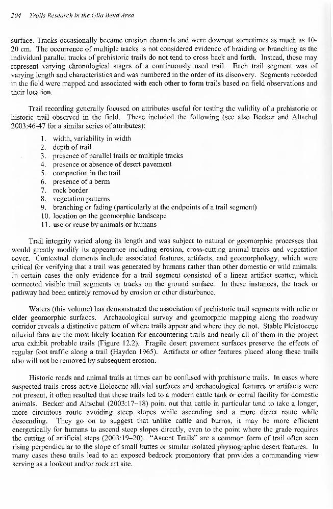
Waters (this volume) has demonstrated the association of prehistoric trail segments with relic or older geomorphic surfaces. Archaeological survey and geomorphic mapping along the roadway corridor reveals a distinctive pattern of where trails appear and where they do not. Stable Pleistocene alluvial fans are the most likely location for encountering trails and nearly all of them in the project area exhibit probable trails (Figure 12.2). Fragile desert pavement surfaces preserve the effects of regular foot traffic along a trail (Hayden 1965). Artifacts or other features placed along these trails also will not be removed by subsequent erosion.
Historic roads and animal trails at times can be confused with prehistoric trails. In cases where suspected trails cross active Holocene alluvial surfaces and archaeological features or artifacts were not present, it often resulted that these trails led to a modem cattle tank or corral facility for domestic animals. Becker and Altschul (2003: 17-18) point out that cattle in particular tend to take a longer, more circuitous route avoiding steep slopes while ascending and a more direct route while descending. They go on to suggest that unlike cattle and burros, it may be more efficient energetically for humans to ascend steep slopes directly, even to the point where the grade requires the cutting of artificial steps (2003: 19-20). "Ascent Trails" are a common form of trail often seen rising perpendicular to the slope of small buttes or similar isolated physiographic desert features. In many cases these trails lead to an exposed bedrock promontory that provides a commanding view serving as a lookout and/or rock art site.
Trails Research in the Gila Bend Area 205
, ... ...... .......... (~ .......... ..-........... _.,.,..,'
Komatke T! '!l'---'"' ... -t ~ , -------------------
, , ~.
' G) \ '"""\ .. '
. __.
\ !a
\i .I
, ~
\~ I
' \ I
\ . I I
I ;
I Prehistoric trail (previously documented)
I - Prehistoric trail
I (recently documented) Pleistocene fan Holocene fan N Modern floodplain
t 0 2km ~ ... -.~ I ,
•••• .... Butterfield Overland Trail (19th C.) --.. ------Figure 12.2. Map showing study area trails in relation to geomorphic landforms.
206 Trails Research in the Gila Bend Area
Historic or modern roads also tend to obscure prehistoric trails or in some instances mimic them. However, like animal trails many roads tended to cross-cut both recent and older geomorphic surfaces. Even in the case of the Butterfield stage route, which has been out of use for more than 100 years, the road follows a direct line across both recent arroyo bottoms and older terraces, unlike older indigenous trails found on relic Pleistocene surfaces. It was also observed that roads and trails might coincide in the same location. This is not surprising since the preferred route of travel in the past may continue to be preferred today. In these instances, trails might be found paralleling historic or modern roads and two tracks.
RESULTS OF TRAIL SURVEY ALONG SR 85
A total of 39 trail segments representing 30.3 km of prehistoric and historic indigenous trail directly associated with sites along SR-85 were recorded as part of data recovery. Most trail segments could be linked with other segments to form what were identified as trails. In many cases these linkages were assumed and were not visible on the ground, whereas other direct connections between segments were observed as trail branching. An additional 9.08 km of linear distance may be added to the total distance covered by trail segments to account for these linkages for a total of 39.83 km of trail observed within the Gila Bend portion of the Gila River Valley. Finally, the OyadaibuicKomatke Trail is a prehistoric and historical period trail which extends from east of the Estrella Mountains to as far as the painted rocks area beyond the Gila bend, passing through passes in the Estrella Mountains, the Maricopa Mountains east of SR-85, and the Gila Bend Mountains, immediately west of SR-85 across the Gila River. Portions of this trail were observed in each location. Adding the 3.7 km of this trail observed in the Estrellas as well as the 35.41 km of intervening sections of the trail that must have existed in the now eroded valley bottoms yields a grand total of78.94 km (49 mi) of indigenous trail considered as part of this study.
Trail characteristics and features along trails are an important part of this research. Features observed include linear sherd and lithic scatters, trail markers, trail shrines, rock art (petroglyph boulders and panels), stone circles, and pot-rests. The trails themselves can be linear segments or multiple tracks across the desert landscape, which in some cases are constructed or are the byproduct of constant use for hundreds of years. Other trails may only be seen as long linear scatters of artifacts. A characteristic of many trails in the study area is the prevalence of white quartz or feldspar nodules made into trail markers or lining the trail. Some scholars have remarked on the sacred significance of quartz (Ezzo and Altschul 1993; Rogers 1976; and Stone 1991). However, O'odham (Pima) tradition also records that quartz served to illuminate trails on moonlit nights or when torches were used for night-time travel. An historical account describes one trail as a "river of torches" due to the prevalence of burned-out torches observed along its length (Sedelmayr 1955).
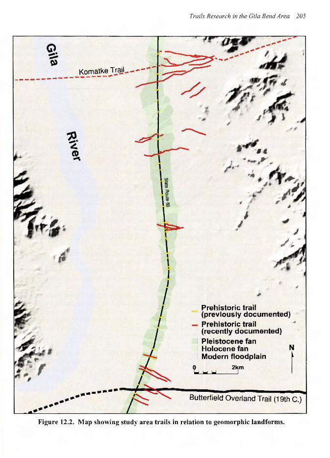
Trail segments appeared as sets representing individual trails or groups of trails crossing the Gila Bend Valley and beyond (Figure 12.3). To describe each individual trail segment would go beyond the scope of this chapter. Each of the eight groups or segment sets will be described below with respect to its particular characteristics. These will be summarized in a discussion that follows.
TRAIL SEGMENT SETS
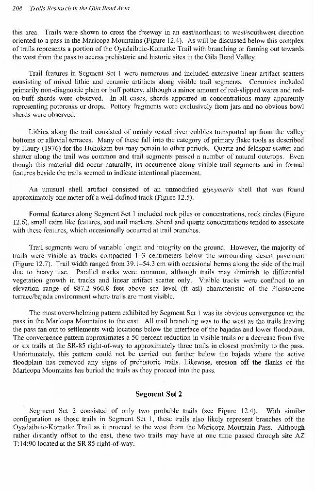
Segment Set 1
Segment Set 1 consisted of 11 trail segments originating at sites AZ T: 14:92-93 in the SR-85 right-of-way. Selected segments were identified and mapped to establish the pattern of trails crossing
Figure 12.3. Map showing recorded trail segment sets 1 to 7.
~ c ~ ::0 ~ £5 ;:s ::s-;:s· ~ ~
C)
~ 0;, ~ ;:s c. A
~ N a '-l
208 Trails Research in the Gila Bend Area
this area. Trails were shown to cross the freeway in an east/northeast to west/southwest direction oriented to a pass in the Maricopa Mountains (Figure 12.4). As will be discussed below this complex of trails represents a portion of the Oyadaibuic-Komatke Trail with branching or fanning out towards the west from the pass to access prehistoric and historic sites in the Gila Bend Valley.
Trail features in Segment Set 1 were numerous and included extensive linear artifact scatters consisting of mixed lithic and ceramic artifacts along visible trail segments. Ceramics included primarily non-diagnostic plain or buff pottery, although a minor amount of red-slipped wares and redon-buff sherds were observed. In all cases, sherds appeared in concentrations many apparently representing potbreaks or drops. Pottery fragments were exclusively from jars and no obvious bowl sherds were observed.
Lithics along the trail consisted of mainly tested river cobbles transported up from the valley bottoms or alluvial terraces. Many of these fall into the category of primary flake tools as described by Haury (1976) for the Hohokam but may pertain to other periods. Quartz and feldspar scatter and shatter along the trail was common and trail segments passed a number of natural outcrops. Even though this material did occur naturally, its occurrence along visible trail segments and in formal features beside the trails seemed to indicate intentional placement.
An unusual shell artifact consisted of an unmodified glycymeris shell that was found approximately one meter off a well-defined track (Figure 12.5).
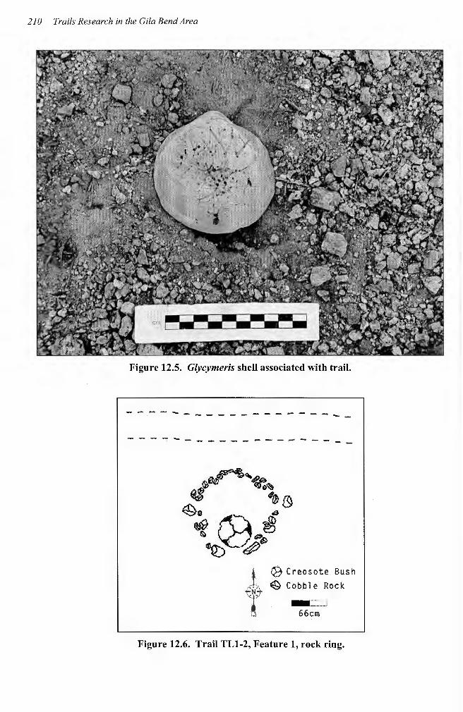
Formal features along Segment Set 1 included rock piles or concentrations, rock circles (Figure 12.6), small cairn like features, and trail markers. Sherd and quartz concentrations tended to associate with these features, which occasionally occurred at trail branches.
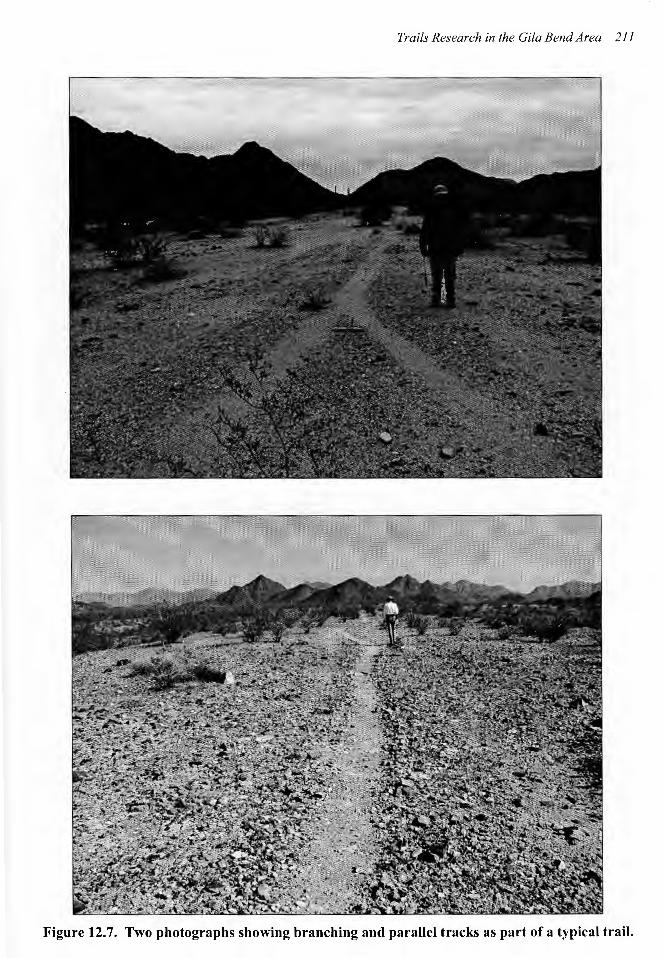
Trail segments were of variable length and integrity on the ground. However, the majority of trails were visible as tracks compacted 1-3 centimeters below the surrounding desert pavement (Figure 12.7). Trail width ranged from 39.1-54.3 em with occasional berms along the side of the trail due to heavy use. Parallel tracks were common, although trails may diminish to differential vegetation growth in tracks and linear artifact scatter only. Visible tracks were confined to an elevation range of 887.2-960.8 feet above sea level (ft asl) characteristic of the Pleistocene terrace/bajada environment where trails are most visible.
The most overwhelming pattern exhibited by Segment Set 1 was its obvious convergence on the pass in the Maricopa Mountains to the east. All trail branching was to the west as the trails leaving the pass fan out to settlements with locations below the interface of the bajadas and lower floodplain. The convergence pattern approximates a 50 percent reduction in visible trails or a decrease from five or six trails at the SR-85 right-of-way to approximately three trails in closest proximity to the pass. Unfortunately, this pattern could not be carried out further below the bajada where the active floodplain has removed any signs of prehistoric trails. Likewise, erosion off the flanks of the Maricopa Mountains has buried the trails as they proceed into the pass.
Segment Set 2
Segment Set 2 consisted of only two probable trails (see Figure 12.4). With similar configuration as those trails in Segment Set 1, these trails also likely represent branches off the Oyadaibuic-Komatke Trail as it proceed to the west from the Mari~opa Mountain Pass. Although rather distantly offset to the east, these two trails may have at one time passed through site AZ T:14:90 located at the SR 85 right-of-way.
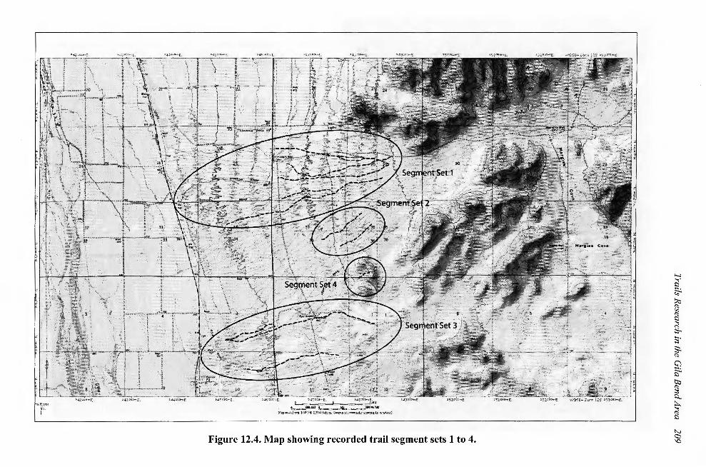
Figure 12.4. Map showing recorded trail segment sets 1 to 4.
~ ::::,
~ ~ ~
! ;:;;· ~ (\)
~
~ tJ;;j
~ l:l... ~
~ ~
~
210 Trails Research in the Gila Bend Area
Figure 12.5. Glycymeris shell associated with trail.
------------ ---------- -~---------------
~~':..'fl:~ ~ ~~
49 ~0. t\'"") ~ ~ ~"""' ~~Q)· ~
·*· t<+A, "t'J.]
.. '"'
Q9 Creosote Bush ~Cobble Rock
- =::J 66cm
Figure 12.6. Trail TL1-2, Feature 1, rock ring.
Trails Research in the Gila Bend Area 211
Figure 12.7. Two photographs showing branching and parallel tracks as part of a typical trail.
212 Trails Research in the Gila Bend Area
Artifact remains along the trail consisted primarily of non-diagnostic buff, plain, and redware body sherds concentrated into pot drops. Some lithics occur consisting of tested rhyolite river cobbles but quartz and feldspar is less common. Trail characteristics include parallel tracks and welldefined trail segments averaging 35.4 em in width. Elevation of the trails ranged from 937 to 946ft. asl. The southernmost trail is obscured in part by recent cattle traffic to access low spots where grass was observed. No formal features or rock concentrations were observed along these trail segments.
Segment Set 3
Segment Set 3 consisted of six trail segments representing two trails. These segments cross SR-85 and appear to associate with sites AZ T:14:86 and AZ T:14:88 located in the right-of-way. Located south of Sets 1 and 2, Segment Set 3 follows a similar east/northeast to west/southwest orientation and may represent a subsidiary route into the Maricopa Mountain pass that passes through a small side canyon identified as Margies Cove (see Figure 12.4).
The northern of the two trails is most similar to the trails described in Segment Sets 1 and 2 consisting of parallel tracks, abundant sherd and lithic scatters, and up to ten formal rock features including rock rings, rock concentrations, and possible trail markers. One petroglyph boulder, as well as chipping stations utilizing locally occurring basalt-rhyolite, was noted as the trail passes to the east toward the base of the mountains. Trail width ranged from 33 to 35 em, and trail segments were clearly visible as tracks with well defined walking surfaces. Elevation of this trail ranged from 761-926 ft asl.
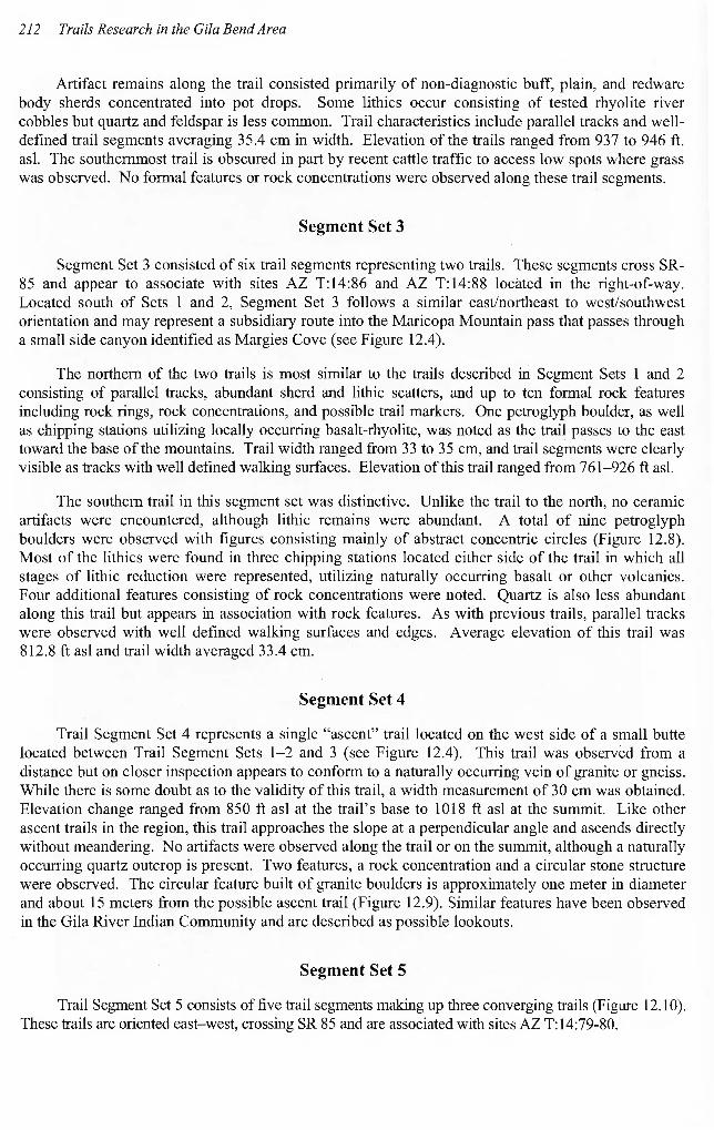
The southern trail in this segment set was distinctive. Unlike the trail to the north, no ceramic artifacts were encountered, although lithic remains were abundant. A total of nine petroglyph boulders were observed with figures consisting mainly of abstract concentric circles (Figure 12.8). Most of the lithics were found in three chipping stations located either side of the trail in which all stages of lithic reduction were represented, utilizing naturally occurring basalt or other volcanics. Four additional features consisting of rock concentrations were noted. Quartz is also less abundant along this trail but appears in association with rock features. As with previous trails, parallel tracks were observed with well defined walking surfaces and edges. Average elevation of this trail was 812.8 ft asl and trail width averaged 33.4 em.
Segment Set 4
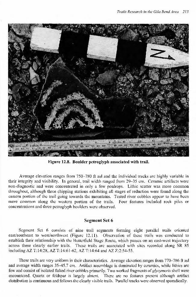
Trail Segment Set 4 represents a single "ascent" trail located on the west side of a small butte located between Trail Segment Sets 1-2 and 3 (see Figure 12.4). This trail was observed from a distance but on closer inspection appears to conform to a naturally occurring vein of granite or gneiss. While there is some doubt as to the validity of this trail, a width measurement of 30 em was obtained. Elevation change ranged from 850 ft asl at the trail's base to 1018 ft asl at the summit. Like other ascent trails in the region, this trail approaches the slope at a perpendicular angle and ascends directly without meandering. No artifacts were observed along the trail or on the summit, although a naturally occurring quartz outcrop is present. Two features , a rock concentration and a circular stone structure were observed. The circular feature built of granite boulders is approximately one meter in diameter and about 15 meters from the possible ascent trail (Figure 12.9). Similar features have been observed in the Gila River Indian Community and are described as possible lookouts .
Segment Set 5
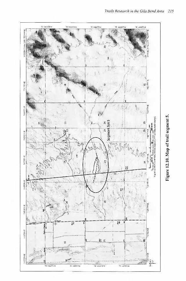
Trail Segment Set 5 consists of five trail segments making up three converging trails (Figure 12.1 0). These trails are oriented east-west, crossing SR 85 and are associated with sites AZ T:14:79-80.
Trails Research in the Gila Bend Area 213
Figure 12.8. Boulder petroglyph associated with trail.
Average elevation ranges from 7 50-780 ft asl and the individual tracks are highly variable in their integrity and visibility. In general, trail width ranged from 29-35 em. Ceramic artifacts were non-diagnostic and were concentrated in only a few potdrops. Lithic scatter was more common throughout, although three chipping stations exhibiting all stages of reduction were found along the eastern portion of the trail going towards the mountains. Tested river cobbles appear to have been more common along the western portion of the trails. Four features included rock piles or concentrations and three petroglyph boulders were observed.
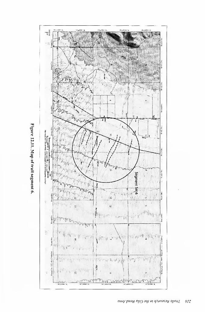
Segment Set 6
Segment Set 6 consists of nine trail segments forming eight parallel trails oriented east/southeast to west/northwest (Figure 12.11). Observation of these trails was conducted to establish their relationship with the Butterfield Stage Route, which passes on an east-west trajectory across these clearly earlier trails. These trails are associated with sites recorded along SR 85 including AZ T:14:28, AZ T:14:61-62, AZ T:14:64 and AZ 2:2:54-55.
These trails are very uniform in their characteristics. Average elevation ranges from 770-786 ft asl and average width ranges 35-45.7 em. Artifact assemblage is dominated by ceramics, while lithics are few and consist of isolated flaked river cobbles primarily. Two worked fragments of glycymeris shell were encountered. Quartz or feldspar is largely absent. There are no features present although artifact distribution is continuous and follows the clearly visible trails. Parallel tracks were observed sporadically.
214 Trails Research in the Gila Bend Area
Figure 12.9. Circular feature associated with ascent trail.
Two of the trails were shown to cross the Butterfield stage route which cuts through the preexisting indigenous trail visible on either side of the road. The stage route is a visible cut up to 30 em or more beneath ground surface with visible berms to either side. At each location where the trails crossed the stage line, historic solder seam, and hole-in-top cans were observed.
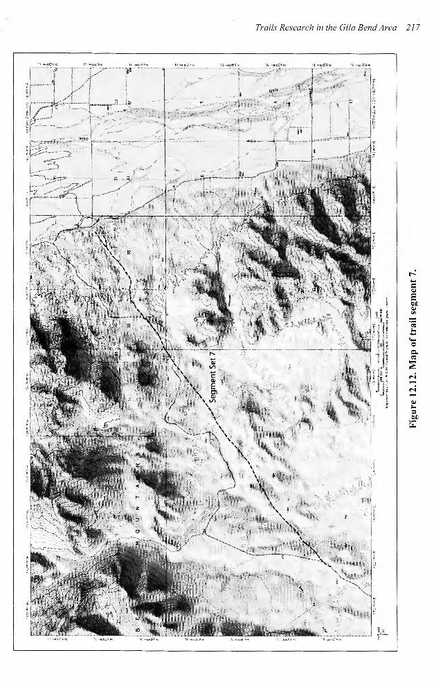
Segment Set 7
Segment Set 7 consists of a continuation of the Oyadaibuic-Komatke Trail through a pass in the Gila Bend Mountains into the painted rocks area (Figure 12.12). Actual visible segments were short, located at either end of the segment set with a 6 km segment assumed to connect the two. The trail is oriented northeast-southwest. The northwest portion rises out of the Gila Bend Valley onto the narrow bajada and enters the pass. A later wagon road or two-track dating to the early part of the last century partially obscures the trail. Average elevation on the eastern portion of the trail is 750.1 ft asl, whereas on the western end the elevation is 837.6 ft. asl, where the trail has already crossed the uppermost portion of the pass and is descending into the painted rocks area. Average width of the trail, where visible, was 35 em.
Artifact presence is much less than other trails but consists of non-diagnostic ceramics and lithic scatters. Where the trail originates, in proximity to the Gila River floodplain, a ground stone mano
Trails Research in the Gila Bend Area 215
t v) .... = e Q.j
]!
E :;-
t OJ) Q.j
• "' ~; -I eo: ~ ;.. .... ....
0 0.. eo: ::; c ,..;
N ,..;
Q.j ;..
= OJ)
~
~ riO. c: ~
'"I ~
(D l ..... ~; ~ ..... il
:- ~
~ s:: ~
' ~ ~
"0 f Q ...., I;'
..... I '"I • ~ . i "' (D r;
(JQ ~ = (D !
= ..... ?'
" ;;; ~ Iii t'
1
Trails Research in the Gila Bend Area 21 7
218 Trails Research in the Gila Bend Area
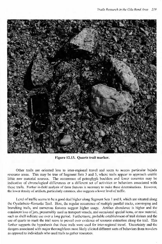
fragment and red-on-buff ceramics were observed. Further along the trail, lithic artifacts tended to exhibit higher amounts of desert varnish, similar to artifacts found in Colorado or Mojave Desert environments. Formal features were also less common than on the Gila Bend Valley but were more discrete and included two quartz trail markers (Figure 12.13). The westernmost portion of the trail was reminiscent of Colorado Desert trails marked by a clear track with occasional ceramics.
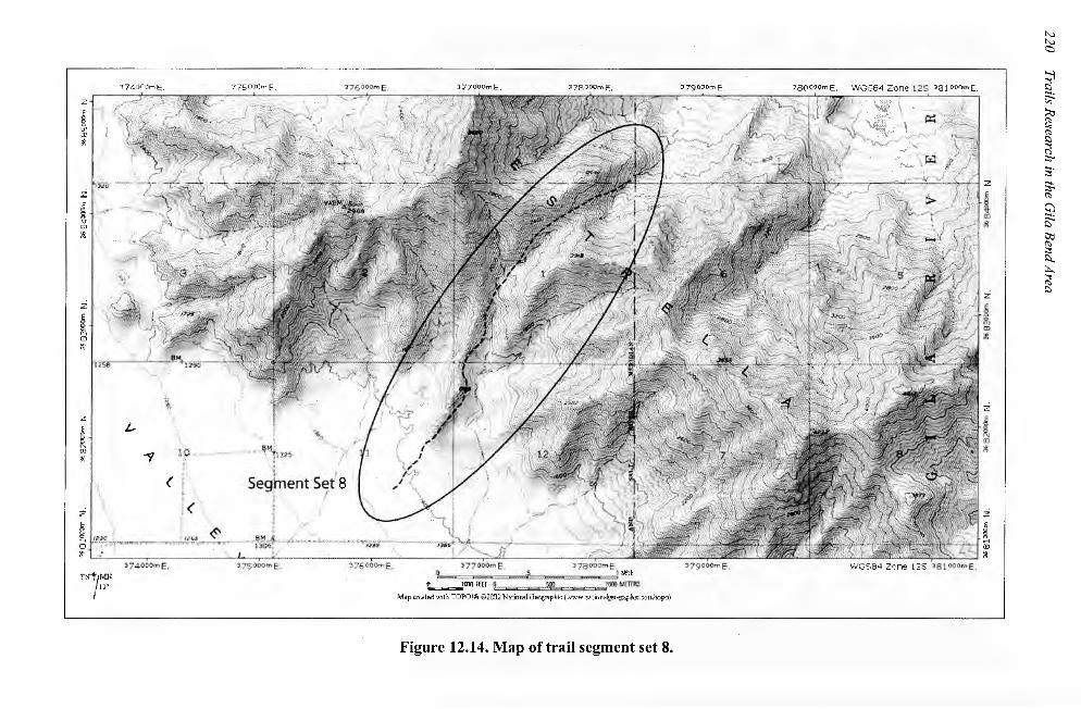
Segment Set 8
Trail Segment Set 8 is 3.72 km. in length and is the easternmost documented section of the Oyadaibuic-Komatke Trail, which crosses the Estrella Mountains from the Rainbow Valley on the west to the Middle Gila Valley on the east (Figure 12.14). This trail is indicated primarily by a long linear artifact scatter dominated by Hohokam pottery jars of plain, buff, and red-on-buff wares and some lithics. Occasional trail segments were visible but have mainly washed out. When measurable, trail width ranged between 30 and 40 em. Elevation change was dramatic from the trail's starting point on the west at 1350 ft asl to 2400 ft asl at the summit and a descent to 1835 ft asl at the limit the trail could be followed to the east.
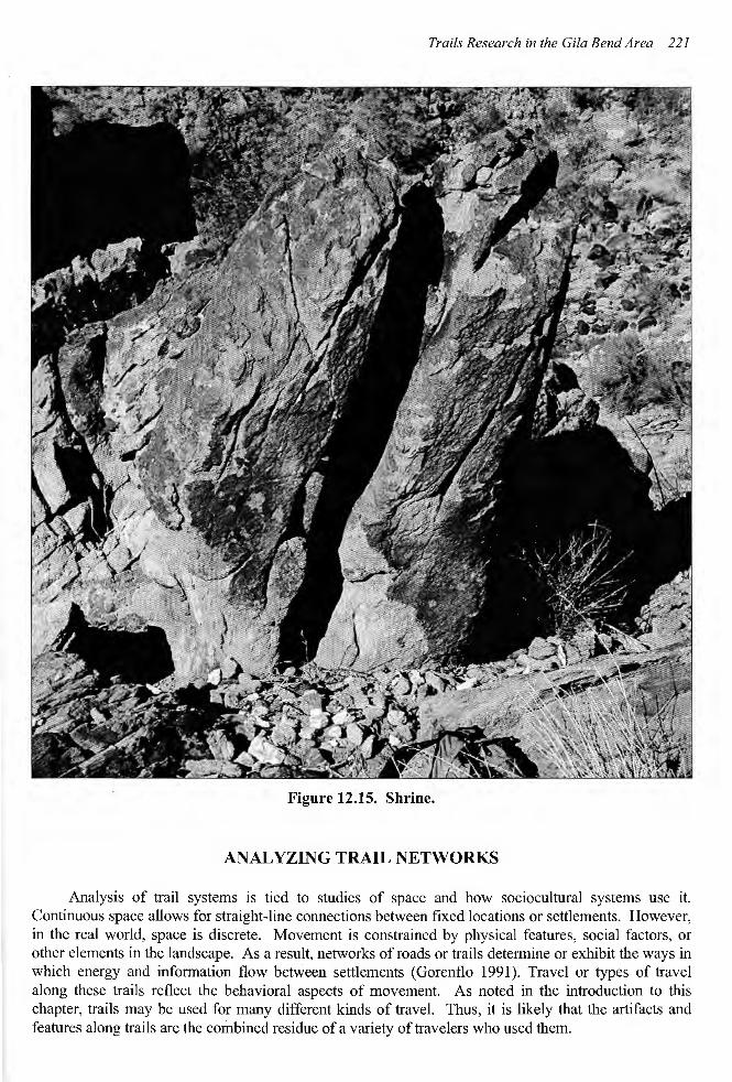
In spite of the ephemeral nature of the trail segments, the artifact scatter clearly links a series of rock art panels or petroglyph sites, cairns (some of them modern), and shrines as well as passing by quartz outcrops which were evidently mined for material scatter along the trails . Probable shrines are large and formal with one shrine located below the trail summit represented by a large natural stone column with preclassic Hohokam cache vessels broken at its base (Figure 12.15). A split in the column also had a small stone shelf placed in it presumably to receive offerings. Rock rings and possible campsites were evident at the base of the Estrella Pass on the western side.
SUMMARY
Trail survey in connection with SR 85 data recovery in the Gila Bend Valley confirmed the existence and integrity of numerous unusually well preserved trails initially identified by surveys in the highway's right-of-way. The sheer quantity of trails seems attributable to the stability of Pleistocene terraces located on the bajada on the east side of the valley. As was shown through the current survey, it is likely that many more trail segments or individual tracks also may exist than was actually sampled by the earlier survey ofSR 85.
The large number of trails on the bajada may also be attributed in part to the pattern by which trails enter from outside the valley into the Gila Bend. As trails emerge from mountain passes, they fan out or branch before descending off the bajada. These branches or secondary trails leave the passes and head toward village settlements scattered along the upper edge of the Gila River floodplain. The distance between trail segments is smallest on the bajada, nearest their branch points from the main trails, resulting in a high density of trail segments near gateways or passes into the next valley. In this way, mountain passes act as nodes or convergence points for numerous trails extending throughout the valley.
This pattern contrasts with Segment Set 6, which crosses the Butterfield Stage Line. In this area the trails exhibit a distinctly different orientation and direction. Trails on the bajada are parallel and show no tendency to converge on a main trail or pass. The pattern of these trails may be attributed to unobstructed travel. In contrast the Stage Line tends to crosscut existing ridges and may be characteristic of travel using domestic animals and wheeled conveyances.
Trails Research in the Gila Bend Area 219
Figure 12.13. Quartz trail marker.
Other trails are oriented less to inter-regional travel and seem to access particular bajada resource areas. This may be true of Segment Sets 3 and 5, where trails appear to approach usable lithic raw material sources. The occurrence of petroglyph boulders and fewer ceramics may be indicative of chronological differences or a different set of activities or behaviors associated with these trails. Further in-field analysis of these features is necessary to make these determinations. However, the lower density of artifacts, particularly ceramics, also suggests a lower level of traffic.
Level of traffic seems to be a good deal higher along Segment Sets 1 and 8, which are situated along the Oyadaibuic-Komatke Trail. Here, the regular occurrence of multiple parallel tracks, converging and branching trails, and numerous features suggest higher usage. Artifact abundance is higher and the consistent loss of jars, presumably used as transport vessels, and occasional special items, or raw material, such as shell indicate use over a long period. Furthermore, probable establishment of trail shrines and the use of quartz to mark the trail seem to prevail over evidence of resource extraction along the trail. This further supports the hypothesis that these trails were used for inter-regional travel. Uncertainty and the dangers associated with major thoroughfares most likely elicited different sorts of behaviors from travelers as opposed to individuals who used trails to gather resources.
J 7 4 00DmE.
z
i w ~
3 ]5000ml= 3 77000mE.
~, r.~~~--~~----------~~~~r-------~.,~-~~~-~.,~,. 7,-r~ 'lf600.0mE , '3 78 000m E, 'l79COOmE , J SQOOOmE . \'VGS 8 4 Zone l 2S :lBlOOOm E.
_,. .. -'-" I f ~ ,"'.t __ A> a t
------r ·-- _;_:·~.::=~+~71 2
i
{ ro ~ 1 \
z
' .• "'
z
l w ;4<
z
t-
""?
~ ~.~~J \i' :• A .~~~ . ) 03 f""''~~-~""' ''""eo:"""'" ''·"~~'<r<~ -,, , .. ,..~,t.,.,.--~·--- ~-- - '"'
i'!
mt/M_N ~n"
i. J
se9rent s7r s ' I I ' -' : /"
~ro! ffH ~"""'==m/<X»MH!RS
Map crrattd with TOPO!ti @)2002 thHonal OeogM.phic (WWW. !i!l ic>~~].;'rePiii: . ootrJiopc-)
Figure 12.14. Map of trail segment set 8.
i :<l
i
l "' ill
z
l "' i'!
t>..J t>..J c:::,
~ t:l
~ ~ i;; (1)
t:l ;:s ;::;-.
;:;· ~ (1)
c:J ~ ~ (1) ;:s l:l_
::.:...
~
Trails Research in the Gila Bend Area 221
Figure 12.15. Shrine.
ANALYZING TRAIL NETWORKS
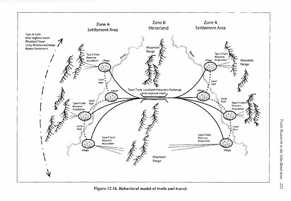
Analysis of trail systems is tied to studies of space and how sociocultural systems use it. Continuous space allows for straight-line connections between fixed locations or settlements. However, in the real world, space is discrete. Movement is constrained by physical features, social factors, or other elements in the landscape. As a result, networks of roads or trails determine or exhibit the ways in which energy and information flow between settlements (Gorenflo 1991). Travel or types of travel along these trails reflect the behavioral aspects of movement. As noted in the introduction to this chapter, trails may be used for many different kinds of travel. Thus, it is likely that the artifacts and features along trails are the combined residue of a variety of travelers who used them.
222 Trails Research in the Gila Bend Area
Contextual studies of trails, particularly their location and situation in a trail network may help to narrow down the range of travel types exhibited along them. Preliminary analysis of trails and a review of the Rogers record of trails in the Arid Southwest reveal that many inter-valley routes of travel crosscut major drainage systems rather than paralleling river courses or streams (see Figure 12.1). As illustrated in this study all the trails examined were located on the bajada and therefore were trails to access bajada resources or to reach inter-regional routes of travel. The Oyadaibuic-Komatke Trail, for example, crosses three mountain passes and connects settlement areas in three river valleys along the Gila River.
This may be modeled in terms of modes of travel (Figure 12.16). Movement along Type I trails between zones of settlement (Zone A) through hinterlands (Zone B) characterizes intra-regional travel patterns. Type II trails provide access to resources and materials outside settlements. Movement along Type I trails consists of travel from zones of security (Zone A) to areas where loss of life and possessions increases (Zone B). Higher amounts of artifacts especially broken pottery jars as well as shrines, rock art, and other features in Zone B attest to the dangers of travel between settled areas particularly mountainous zones. Desert travel may be equally dangerous due to the lack of water. Along the Gila River drainage this may not be as much of an issue. However as shown by the trail record amassed by Malcolm Rogers, zones of security may consist of wells or water sources separated by large stretches of waterless desert (Zone B).
Type III trails are routes utilized for ritualized travel including salt journeys, warfare, pilgrimages, etc. Unlike Type I trails, Type III trails may bypass local settlements as travelers leave familiar landscapes or homelands for distant lands. Rituals of preparation as well as cleansing or purification upon their return are activities required of the traveler. Type III trails may be highly specialized and recapitulate itineraries stipulated in stories of historical events or songs.
HISTORICAL CONTEXT OF TRAILS AND THE TRAILS OF GILA BEND
As Ezell (1968) once noted, from the time of their first entry into the Desert Southwest to the end of the Mexican Period, it is likely that no European ever blazed a new trail across the desert and that all routes of travel were based on preexisting Indian trail networks. With increasing usage by Europeans, descriptions of these trails became available. In time, several major routes were recognized as significant ethnohistoric routes of travel including the Mohave Trail, the CocoMaricopa Trail, the Yuma Trail, the Camino del Diablo, and the Gila Trail, among others. One such trail, the Oyadaibui-Komatke Trail, was described by Fr. Eusebio Francisco Kino and Captain Juan Mateo Manje in 1699. Its circuitous route across mountain passes proved less advantageous to explorers with horses and wagons and subsequently this route was forgotten, while other trails became enshrined in the annals of exploration. Nineteenth and twentieth century historians and archaeologists later confused this route with a route that followed the old Gila Trail or what became the Butterfield Stage Route. Data recovery along SR-85 has helped to clarify the historical record and relocate this important indigenous trail connecting the Gila Bend and Middle Gila River Valleys.
The Oyadaibuic - Komatke Trail
In the winter of 1699, while on an exploration trip to investigate the peninsularity of the oncebelieved island of Lower California, the Spanish explorers, Fr. Eusebio Francisco Kino and Captain Juan Mateo Manje, reluctantly turned their party back from the Colorado River, well short of their intended goal. They headed east, and several days later, they proceeded around the first curve of the
Type Ill Trails Inter-regional travel Ritualized Travel Long-distance exchange Bypass Settlement
I I
I I
I I
\ \
\ \
I I
~
1
Zone A Settlement Area
Type II Trails: Resource Acquisition ......
Type II Trails: Resource
Type II Trails: Resource Acquisition
•• ,,~:::: :.=.=.=.=.:_:_:_:_:_: •.
>
Zone B Hinterland
Mountain Range
Zone A Settlement Area
Type I Trails: Localized Interaction/Exchange
~tra-regio~al trave'l
Mountain Range
Type II Trails: ResourcE!" Acquisition
• ::::::::::::::::::::::::::: =~ ,._ ••• ......... ............ , ........................ .
Figure 12.16. Behavioral model of trails and travel.
Mountain Range
~ 1:)
~ ;:;:, ~ ~ ;::s ;:s...
s· s. (1)
c;J
~ t:>;:, (1) ~ l:l.. ~ ~ t::l
"-' "-' '-"'-'
224 Trails Research in the Gila Bend Area
great bend of the Gila River. The explorers arrived at the O'odham (Pima) village of San Felipe Santiago de Oyadoibuise (Oxibahibuiss) located approximately halfway along the length ofthe large S-curve made by the river. Here they were greeted by as many as 132 Opa and Pima Indians (Manje reports a total of 150 adult males, having neglected to count the women and children).
Seeking a short-cut across the bend, the explorers and three Pima guides left the village after mas on Sunday, March 1, 1699. They headed east along a trail through the north Maricopa Mountains. After a ride of 11 leagues (36 kilometers) across the Rainbow Valley, the group stopped for the night at a small, unnamed rancheria, where pasturage and a small well were located. The following morning the explorers continued their journey ascending 1000 feet along a narrow trail to the spine of the Estrella Mountains. Here a low pass offered an easy descent into the Middle Gila River Valley, the heartland of the Akimel O'odham (River People) and their ancestors the Huhugam (Hohokam).
From the summit of the Estrella Mountains, Kino and Manje observed the confluence of the Salt and Gila Rivers. Following the trail into the fertile valley, their guides led them to a Pima village, which they named San Barlolome del Comac (Komatke or Komatkl). Having passed two days and approximately 48 kilometers along the Komatke Trail, they were greeted by 200 inhabitants, some of whom recognized them from previous exploratory trips to villages located further upstream.
Manje's account of this trip across the Maricopa and Estrella ranges is detailed and may be found in two sources-his journal of the fifth expedition undertaken with Kino from February 7 to March 14, 1699 (Burrus 1971:223-248) and Manje's memoir, Luz de Tierra Incognita, which was written in 1716 (Karns 1954). Karns translation of the latter work, under the title Unknown Arizona and Sonora, 1693-1721, provides a nearly exact duplicate of Manje's original journal account. This description is provided below (the Spanish original of which is provided in a footnote) .4
On March 1, with guides furnished by the Indians, we left the river and turned left. We traveled east through rock-ribbed and arid hills, and after having gone 11 leagues, we camped for the night near a well of water, and a plain covered with pasture.
On the 2"ct, traveling east and climbing to the top of a small mountain, which the guides pointed out to us, we could see plainly the Verde River which takes its rise in the land of the Apaches, running northeast to southeast, with a grove of trees along its banks. It is joined by another salty river, running northeast to southeast, with a grove of trees along
4 En primero de marzo, con guias que nos dieron, dejando el rio a Ia izquierda, por ~a gran vuelta que da,
caminamos, al oriente, por entre ceros pedregosos y esteriles; y, a 11 leguas andadas, dormimos en un pozo y llano de buen pas to.
En 2, prosiguiendo al oriente y trasmontando el puerto de una sierrecilla, de Ia cumbre nos enseiiaron los guias, que vimos patentemente, el rio Verde que nace en Ia tierra de los apaches y corre de nordeste a sudueste, poblado de ancha y frondosa arboleda, ya florida, que lo guarnece; y, juntandosele otro rio salobre de oriente a poniente, ya juntos, desaguan en este grande, cuya junta tambien vimos. Dijeron le llaman Verde, por pasar por una sierra de muchas vetas de piedras verdes, azules, y otros colores.
No sabemos si sera esta Ia Sierra Azul de que hay tradici6n de haber visto infinidad de minas de oro y plata, de que sacaron mucha ley repecto al poco metal que llevaron, y ensayaron en el Nuevo Mexico, a los principios de su pacificaci6n, y no pudieron vovler mas, recelosos los pacificadores de que no se sublevasen los pueblos, como cristianidad nueva; y, habiendo pasado aiio, solo qued6 Ia noticia de Ia Sierra Azul, rica de plata, sin haber hoy quien de raz6n de ella.
Bajando de Ia curnbre al rio, 3 leguas distante de Ia junta, y 13, de donde salimos, dormimos en una rancheria de pimas que intitulamos San Bartolome del Comac, con 200 personas, d6ciles y afables; y de fertiles tierras. Recibieron nos con jubilo y se les intim6 el conocirniento de Dios; y bautizaron a 3 parvulos. [Manje ( 1699) in Burrus 1971: 400-401]
Trails Research in the Gila Bend Area 225
its banks. It is joined by another salty, river running from east to west, and the two merging together flow into this Rio Grande River, the junction of which we were able to see. They told us its name was Verde and it flows by a mountain streaked with several veins of green, blue and variegated colored stones. We do not know if this could be the Blue Mountain range of which a tale is told to the effect that innumerable gold and silver mines, very rich and of high grade character of ore, have been discovered. The conquerors of New Mexico at the time, when they came to this place, took some ore to be refined; but they never returned. As the years passed only the tradition of the Blue Mountain, rich in silver, remained. However, no one could give its exact location.
Coming down from the hill to the river, three leagues distance from the junction, and 13 leagues from where we started on that day, we camped for the night in a Pima settlement, which we called San Bartolome del Comac. It contained 200 peaceful and courteous Indians who welcomed us gladly. They were told about God, and three children were baptized. There are good fertile lands here. [Manje 1716 (Karns, trans. 1954:122-123)]
An Historical Controversy
Little did Kino or his companions realize that based on ceramic artifacts encountered 300 years later, they were traversing a trail used continuously by the Pima and the Hohokam and potentially earlier populations. Ironically, the actual location of the route followed by Kino and his companions on March 151
and 2nd, 1699, also appears to have been misidentified repeatedly by historians and archaeologists; first by Bolton (1919), and subsequently by Karns (1954), Schroeder (1961) and Burrus (1971).
Based on Kino and Manje's accounts, these scholars identified the village of San Felipe y Santiago de Oyadoibuise (Oxibahibuiss), at the southwest end of the Gila Bend in roughly the same location as the village of El Tutto or Aritutac, later identified by Ezell (1961, 1963 :7). As Bolton and other scholars proposed, the explorers would have followed a route roughly approximating the later Butterfield Overland Trail, pioneered after 1850 (Figure 12.17). In 1699, this route would have brought the exploring party around the south end of the Estrella Mountain range, requiring that they pass several villages in the vicinity of Pima Butte (including Hueso Parado) without notice. From this location they would have had to travel north to Komatke, only to reverse their direction to continue on their journey. As Ezell proposes, the location of the village of Oxibahibuiss, midway along the north-south portion of the Gila Bend, concurs with Kino and Manje's description. This includes the presence of wells at the unidentified village still used into the twentieth century, as well as the panoramic view of the Salt-Gila River Valley, which would not have been visible on the misidentified route located too far to the south.
Period artifacts have not been found during archaeological survey of the Komatke Trail, which might verify the explorers' accounts. However, the Kino-Manje record serves to accomplish more by drawing attention to the centuries-old route of travel that communicated the Middle Gila River Valley with the Gila Bend and into the Painted Rocks Reservoir area to the west. Field identification of portions of the trail in passes in the Estrella Mountains, the Maricopa Mountains, and the Gila Bend Mountains provides sufficient evidence that this route extended from the central Hohokam region, dominated by such archaeological sites as Snaketown, to its western periphery. During the Historic Period, the trail communicated between Yuman (Patayan) areas along the river inhabited by the Cocamaricopa, the Opa (including Pima and Opa living in mixed villages in the Gila Bend), the Maricopa, and the Pima. Unusual preservation of the trails west of the Maricopa Mountains reveals extensive branching as the main Komatke Trail split into numerous smaller trails accessing villages along the length of the valley at Gila Bend.

-- ,,. 11' .- ·
.. :· :-,· . .,. _
.,,..
Unidentified ~ Village • // ~,~6. ,/ o, _,-'
\ta.\\ "'"' -~ ..,.\\<..e __ .,..,,.. ~.r. . \(.0~~ - -.. ;:;. ,.'-·- I ~ t -';
~ d, . "~· I _, ,·,. ~· ~ -JI•' . I' '~~ ·!'1 ,_, ., ,) /, ,(If{.
- . 11
I . f:J: I ,.'=.:..~ ·. ,fA' :; 1-.. -,, ~., ,{ / ,. " .t..t ,~ .
"' "'
J,. ~~ ~
Komatke
Oxibahibuiss ~flf·-~~ ....... 1f~t~ · ~ -, . _ / J~;:;;~;;; _1f,r,, ..
• -- ~ .. .:; A- -. - ~ ., -- ~ 7ft. .J,~ . .,.a - ~,, ... / ~ '/',:f. '~- "Ci ....., ,·, , "'·
-~ · ,.. ( ":,t
; ·' 1'1,' ·~"-! / , •/ ;,_ ,.,_ ,' ~ ' ,.,' .z ,' _, " ' ~~~ ,
• .. . .,. Q .. H !A' » .~.. -,_i ~., ~~~-· ,..-.. ~ ' ·.~_.,._ ,,.,., -
- ·.:i' .... d .. · · --~- ~~ • • ,., tr. , J ;'~.; '..-.:li· • A# ..
. .' • • ';"-~-.. &' ' • -;. • .• •• I • " ' J-'J . ' ' , 1 • :. .. ,tr l!i" ~ . .. /1 .. ~;J"'tf; J/ . ... '/;) :-_ ~
~~~.:.~"-· ! " .,...,. , ' , .• 11'1) _,. ,..r--
~- j , .•
.,
~ . .v ~ ·• -11. ·/ / ,... . "1~ . .!.,f'T
,,.,., .... ,. : '"./4 ,' . , , . !" , , "' • , . ,' --- . ___________ ,
overl~d-Tr;ii ~ '\ 9\\\ C.) :;. /4 ... •' f t; ..... ....
N
t • ·JrPrP.·-
~ ---- *-""' ,.---
., tl I •• r
,."'1/1 •r · -~-
..,;.,.. • Historic Pima-Maricopa Villag•
Prehistoric trail --·----EITutto 0 ·-r .. ,., ~-~~~~~ I 10km
Figure 12.17. Oyodoibuic-Komatke Trail and the Butterfield Overland Trail.
N N 0\
~ ~
~ >;, ~ "" ~ ~ ::· s. "" CJ ~ I:<:)
"" ::::; !::)_ ::,..
~
Trails Research in the Gila Bend Area 227
CONCLUSION
The previous analysis reveals several useful observations about understanding trails:
1. Trails are regionally extensive archaeological features that cannot be fully understood without mapping and study well outside standard project areas (areas of potential effect) or road right-of-ways.
2. Recent advances in remote sensing and low elevation imaging (not available to this project) may be useful for identifying and mapping trails , and can be used in the design of research prior to entry into the field. These may provide data for hypothesis generation and network analysis testable through targeted data recovery efforts. We feel that emphasizing the behavioral aspects of different modes of travel in relation to decision-making processes will provide a productive avenue for research over previous typological studies.
3. The unusual preservation of trails in the Gila Bend provides a rare opportunity to understand travel as a cultural behavior and its relationship to indigenous infrastructures that existed long before Europeans entered on the scene. Clearly other areas up and down the Gila River maintained similarly complex, if not more complex trail networks, no longer visible today. Further work in the Gila Bend Valley is warranted to document this unusual and highly fragile cultural resource.
4. Much of the literature on indigenous trails and trail networks is dominated by European accounts reflecting the early explorers' reliance on Native Americans as guides and sources of information on local landscapes. The co-opting of Native American infrastructures and dramatic reshaping of them into stage lines and mail routes is a little understood process by which preexisting structures of information and communication were transformed. This has resulted in a not insignificant bias in the historical literature on trails in which only the preeminent trails used by Europeans continue to be recognized while the thousands of kilometers ofNative American trails have been lost.
Related Documents