Geotrekking in Southeast Arabia: A Field Guide to World Class Geology in the United Arab Emirates and Oman By Benjamin R. Jordan, Ph.D. =DRAFT= Note: This is a draft copy of a book that is currently in preparation. It does not include all of the features of the books, which will include a lot more images, a rock, mineral, and fossil guide, a generalized geologic map, and information on museums and previously published books. Nor is it in the final layout of the book, which is being prepared by Jonathon Russell. If you are a publisher, or you know of a publisher, who is interested in publishing a commercial version of this book, please contact Benjamin R. Jordan at: [email protected] Please also contact me if you find errors, typos, etc. I would very much appreciate it. Geologic Structure In order to understand the geology of southeast Arabia it is important to understand the structure of the Earth. The Earth is much like an egg, with a hard, brittle, outer shell and a soft, but solid, interior. The shell, in a sense, "floats" on the hot, soft rocks below. However, unlike an egg, the interior of the Earth can be described by geologists by either its chemical or physical characteristics. When it is described by its chemical characteristics it only has three layers: a core, mantle, and crust. The core is made of iron (Fe) and nickel (Ni), with a little bit of sulfur (S). The mantle consists of mostly iron (Fe), magnesium (Mg), and silica (Si). The crust is mostly silica (Si) with lots of aluminum (Al) and calcium (Ca). When the Earth is described by its physical characteristics it has an inner core, outer core, mesosphere, asthenosphere, and lithosphere. The lithosphere thus includes both the upper part of the mantle and the crust and is hard and brittle. The boundary between the crust and

Welcome message from author
This document is posted to help you gain knowledge. Please leave a comment to let me know what you think about it! Share it to your friends and learn new things together.
Transcript
Geotrekking in Southeast Arabia: A Field Guide to World Class Geology in the United Arab Emirates and Oman
By
Benjamin R. Jordan, Ph.D.
=DRAFT=
Note: This is a draft copy of a book that is currently in preparation. It does not include all of the features of the books, which will include a lot more images, a rock, mineral, and fossil guide, a generalized geologic map, and information on museums and previously published books. Nor is it in the final layout of the book, which is being prepared by Jonathon Russell. If you are a publisher, or you know of a publisher, who is interested in publishing a commercial version of this book, please contact Benjamin R. Jordan at:
[email protected] Please also contact me if you find errors, typos, etc. I would very much appreciate it. Geologic Structure
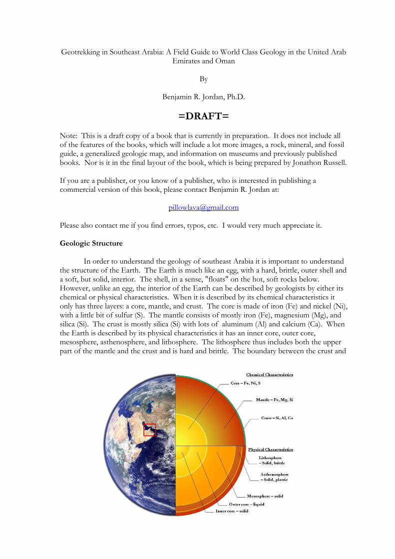
In order to understand the geology of southeast Arabia it is important to understand the structure of the Earth. The Earth is much like an egg, with a hard, brittle, outer shell and a soft, but solid, interior. The shell, in a sense, "floats" on the hot, soft rocks below. However, unlike an egg, the interior of the Earth can be described by geologists by either its chemical or physical characteristics. When it is described by its chemical characteristics it only has three layers: a core, mantle, and crust. The core is made of iron (Fe) and nickel (Ni), with a little bit of sulfur (S). The mantle consists of mostly iron (Fe), magnesium (Mg), and silica (Si). The crust is mostly silica (Si) with lots of aluminum (Al) and calcium (Ca). When the Earth is described by its physical characteristics it has an inner core, outer core, mesosphere, asthenosphere, and lithosphere. The lithosphere thus includes both the upper part of the mantle and the crust and is hard and brittle. The boundary between the crust and
the mantle is called the “Moho,” which is short for “Mohorovičić discontinuity” and is named after Andrija Mohorovičić, a Croatian seismologist who first described it in 1909. The lithosphere “floats” on the asthenosphere, which is solid, but soft, like modeling clay.
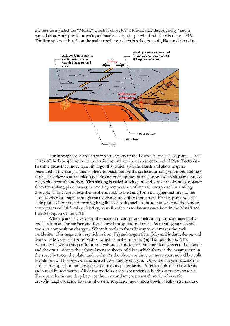
The lithosphere is broken into vast regions of the Earth's surface called plates. These plates of the lithosphere move in relation to one another in a process called Plate Tectonics. In some areas they move apart in large rifts, which split the Earth and allow magma generated in the rising asthenosphere to reach the Earths surface forming volcanoes and new rocks. In other areas the plates collide and push up mountains, or one will sink as it is pulled by gravity beneath another. This sinking is called subduction and leads to volcanoes as water from the sinking plate lowers the melting temperature of the asthenosphere it is sinking through. This causes the asthenospheric rock to melt and form a magma that rises to the surface where it erupts through the overlying lithosphere and crust. Finally, plates will also slide past each other and forming long lines of faults such as those that generate the famous earthquakes of California or Turkey, as well as the lesser known ones here in the Masafi and Fujeirah region of the UAE.
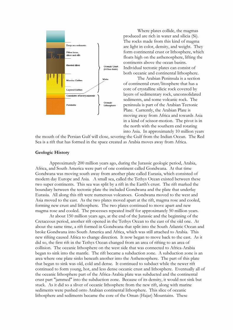
Where plates move apart, the rising asthenosphere melts and produces magma that cools as it nears the surface and forms new lithosphere and crust. As the magma rises and cools its composition changes. Where it cools to form lithosphere it makes the rock peridotite. This magma is very rich in iron (Fe) and magnesium (Mg) and is dark, dense, and heavy. Above this it forms gabbro, which is higher in silica (Si) than peridotite. The boundary between this peridotite and gabbro is considered the boundary between the mantle and the crust. Above the gabbro layer are sheets of dikes, which form as the magma rises in the space between the plates and cools. As the plates continue to move apart new dikes split the old ones. This process repeats itself over and over again. Once the magma reaches the surface it erupts from underwater volcanoes as pillow lavas. After it cools the pillow lavas are buried by sediments. All of the world’s oceans are underlain by this sequence of rocks. The ocean basins are deep because the iron- and magnesium-rich rocks of oceanic crust/lithosphere settle low into the asthenosphere, much like a bowling ball on a mattress.
Where plates collide, the magmas produced are rich in water and silicia (Si). The rocks made from this kind of magma are light in color, density, and weight. They form continental crust or lithosphere, which floats high on the asthenosphere, lifting the continents above the ocean basins. Individual tectonic plates can consist of both oceanic and continental lithosphere.
The Arabian Peninsula is a section of continental crust/litosphere that has a core of crystalline silicic rock covered by layers of sedimentary rock, unconsolidated sediments, and some volcanic rock. The peninsula is part of the Arabian Tectonic Plate. Currently, the Arabian Plate is moving away from Africa and towards Asia in a kind of scissor-motion. The pivot is in the north with the southern end rotating into Asia. In approximately 10 million years
the mouth of the Persian Gulf will close, severing the Gulf from the Indian Ocean. The Red Sea is a rift that has formed in the space created as Arabia moves away from Africa. Geologic History
Approximately 200 million years ago, during the Jurassic geologic period, Arabia, Africa, and South America were part of one continent called Gondwana. At that time Gondwana was moving south away from another plate called Eurasia, which consisted of modern day Europe and Asia. A small sea, called the Tethys Ocean existed between these two super continents. This sea was split by a rift in the Earth's crust. The rift marked the boundary between the tectonic plate the included Gondwana and the plate that underlay Eurasia. All along this rift were numerous volcanoes. Gondwana moved to the west and Asia moved to the east. As the two plates moved apart at the rift, magma rose and cooled, forming new crust and lithosphere. The two plates continued to move apart and new magma rose and cooled. The processes repeated itself for approximately 50 million years.
At about 150 million years ago, at the end of the Jurassic and the beginning of the Cretaceous period, another rift opened in the Tethys Ocean to the east of the old one. At about the same time, a rift formed in Gondwana that split into the South Atlantic Ocean and broke Gondwana into South America and Africa, which was still attached to Arabia. This new rifting caused Africa to change direction. It now began to move back to the east. As it did so, the first rift in the Tethys Ocean changed from an area of rifting to an area of collision. The oceanic lithosphere on the west side that was connected to Africa-Arabia began to sink into the mantle. The rift became a subduction zone. A subduction zone is an area where one plate sinks beneath another into the Asthenosphere. The part of this plate that began to sink was old, cold and dense. It continued to subduct while the newer rift continued to form young, hot, and less dense oceanic crust and lithosphere. Eventually all of the oceanic lithosphere part of the Africa-Arabia plate was subducted and the continental crust part "jammed" into the subduction zone. Because of its density, it would not sink but stuck. As it did so a sliver of oceanic lithosphere from the new rift, along with marine sediments were pushed onto Arabian continental lithosphere. This slice of oceanic lithosphere and sediments became the core of the Oman (Hajar) Mountains. These
mountains are special because they are a piece of ocean lithosphere that did not subduct, but instead got sliced and pushed up onto a continent. Geologically they are called an “ophiolite,” which means a piece of ocean crust on top of continental crust. These mountains are the largest and best preserved section of exposed ocean crust/lithosphere anywhere in the world and are officially called the Semail Ophiolite.
At about 70 million years ago, during the Cretaceous, a new subduction zone formed to the northeast of Arabia as Arabia rifted from Africa forming a third rift that became the Red Sea. At this time the Tethys Ocean extended from the region that now includes the Mediterranean Sea to the Indian Ocean and the rocks of the Oman Mountains formed a chain of islands. During this time a lot of the original oceanic lithosphere and most of the marine sediments were eroded away. Around these islands new beach (sandstones and conglomerates) and marine (limestone and dolostone) sediments were deposited—reburying much of the older sediments and rocks of the oceanic lithosphere and forming the limestones of Jebel Hafit, UAE and many that top the mountains of the ophiolite. Limestone forms in shallow oceans, similar to areas like the Arabian Gulf from coral and tiny animals and plants called plankton. These plankton built shells from calcium and silica and when they died their shells sank and formed layers of sediment on the bottom of the shallow sea. Over millions of years these layers became very thick and solidified to form rock. These new sediments were very rich in fossils. Eventually the second rift and its oceanic crust was subducted in the east, closing the Tethys Ocean completely except for the present Gulf and the Mediterranean Sea. The Gulf is underlain by partially subducted continental lithosphere that was jammed in this second subduction zone.
At 23 million years ago this new collision and partial subduction between Arabia and Asia began to form the Zagros Mountains of Iran as the continental lithosphere of Arabia resisted sinking. This process is still occurring and it is also the reason for the many earthquakes that occur in Iran today. This partial subduction also results in the overall structure of the peninsula being tilted to the east as it moves away from the rifting Red Sea. As part of the collision, uplift and deformation is occurring that has exposed the rocks of the Hajar Mountains and the Semail Ophiolite due to erosion.
It is thought that from this time until about 5 million years ago, Africa and Arabia were still connected at the Gulf of Aden, which allowed for migrations of land animals between Africa and Arabia. At that time the climate was also much wetter than is today.
Route 1 Abu Dhabi Sabhka, United Arab Emirates Features Giant mud cracks, evaporite deposits of salt (halite) and gypsum (desert roses), hoodoos, and stromatolites Directions from Abu Dhabi, UAE: This is a good route to follow on your way to the Liwa route (Route 2). Take either Route 11 (Sheikh Zayed Road) from Dubai toward Abu Dhabi (southwest), or Route 22 (Old Airport Road) from Abu Dhabi towards Al Ain (east). This route begins at the Route 11 interchange with Route 22. Route Sidetrip Mileage Mileage (km) (km)
(The distance from the last stop is in parentheses) 0.0 (0.0) N 24° 18.546' E 054° 36.147'
Route 11-Route 22 interchange. Set your odometer to 0. Take Route 11 towards Mirfa, Sila, and/or Liwa.
5.5 (5.5) 0.0 N 24° 17.327' E 054° 33.300' -Beginning of Sidetrip-
Route 11-Musaffah Truck Road Interchange. This is a very large interchange with a roundabout at the end of the exit ramp. The main highway continues as a flyover overpass. There are large power lines to the north and a power substation a little ways to the northwest of this interchange. To go to a nice gypsum rose collection site take the exit to the right and go north.
4.3 N 24° 18.953' E 54° 31.616'
Take this exit ramp to make a U-turn to the other side of the highway. 5.2 N 24° 19.377' E 054° 31.646'
Roundabout at end of the exit ramp. Go left across the flyover overpass.
5.7 N 24° 19.400' E 054° 31.554'
Next roundabout on the other side of overpass. Go left to get back on the highway headed west.
6.6 N 24° 18.957' E 054° 31.572' Take a right (north) turn onto a heavily used truck road that heads for some
industrial buildings in the distance. There should be a large manmade harbor/bay ahead (north).
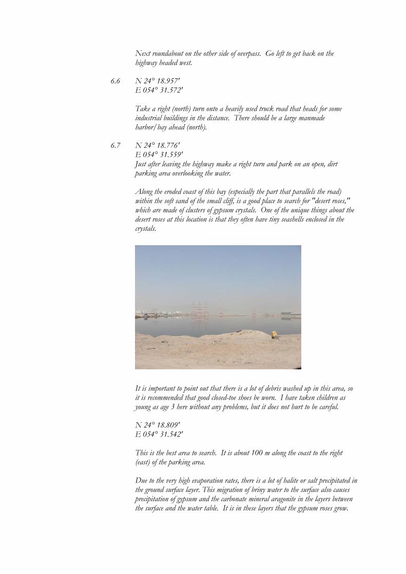
6.7 N 24° 18.776' E 054° 31.559' Just after leaving the highway make a right turn and park on an open, dirt
parking area overlooking the water.
Along the eroded coast of this bay (especially the part that parallels the road) within the soft sand of the small cliff, is a good place to search for "desert roses," which are made of clusters of gypsum crystals. One of the unique things about the desert roses at this location is that they often have tiny seashells enclosed in the crystals.
It is important to point out that there is a lot of debris washed up in this area, so it is recommended that good closed-toe shoes be worn. I have taken children as young as age 3 here without any problems, but it does not hurt to be careful. N 24° 18.809' E 054° 31.542' This is the best area to search. It is about 100 m along the coast to the right (east) of the parking area.
Due to the very high evaporation rates, there is a lot of halite or salt precipitated in
the ground surface layer. This migration of briny water to the surface also causes precipitation of gypsum and the carbonate mineral aragonite in the layers between the surface and the water table. It is in these layers that the gypsum roses grow.
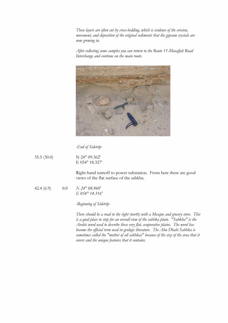
These layers are often cut by cross-bedding, which is evidence of the erosion, movement, and deposition of the original sediments that the gypsum crystals are now growing in.
After collecting some samples you can return to the Route 11-Musaffah Road
Interchange and continue on the main route.
-End of Sidetrip-
35.5 (30.0) N 24° 09.362' E 054° 18.327' Right-hand turnoff to power substation. From here there are good
views of the flat surface of the sabkha. 42.4 (6.9) 0.0 N 24° 08.960' E 054° 14.316' -Beginning of Sidetrip-
There should be a road to the right (north) with a Mosque and grocery store. This is a good place to stop for an overall view of the sabhka plain. "Sabkha" is the Arabic word used to describe these very flat, evaporative plains. The word has become the official term used in geologic literature. The Abu Dhabi Sabhka is sometimes called the "mother of all sabhkas" because of the size of the area that it covers and the unique features that it contains.
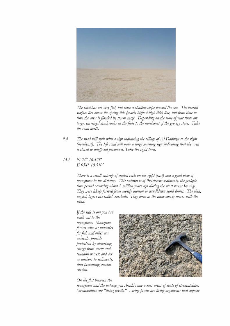
The sabkhas are very flat, but have a shallow slope toward the sea. The overall surface lies above the spring tide (yearly highest high tide) line, but from time to time the area is flooded by storm surge. Depending on the time of year there are large, car-sized mudcracks in the flats to the northwest of the grocery store. Take the road north.
9.4 The road will split with a sign indicating the village of Al Dabbiya to the right
(northeast). The left road will have a large warning sign indicating that the area is closed to unofficial personnel. Take the right turn.
15.2 N 24° 16.425'
E 054° 10.510'
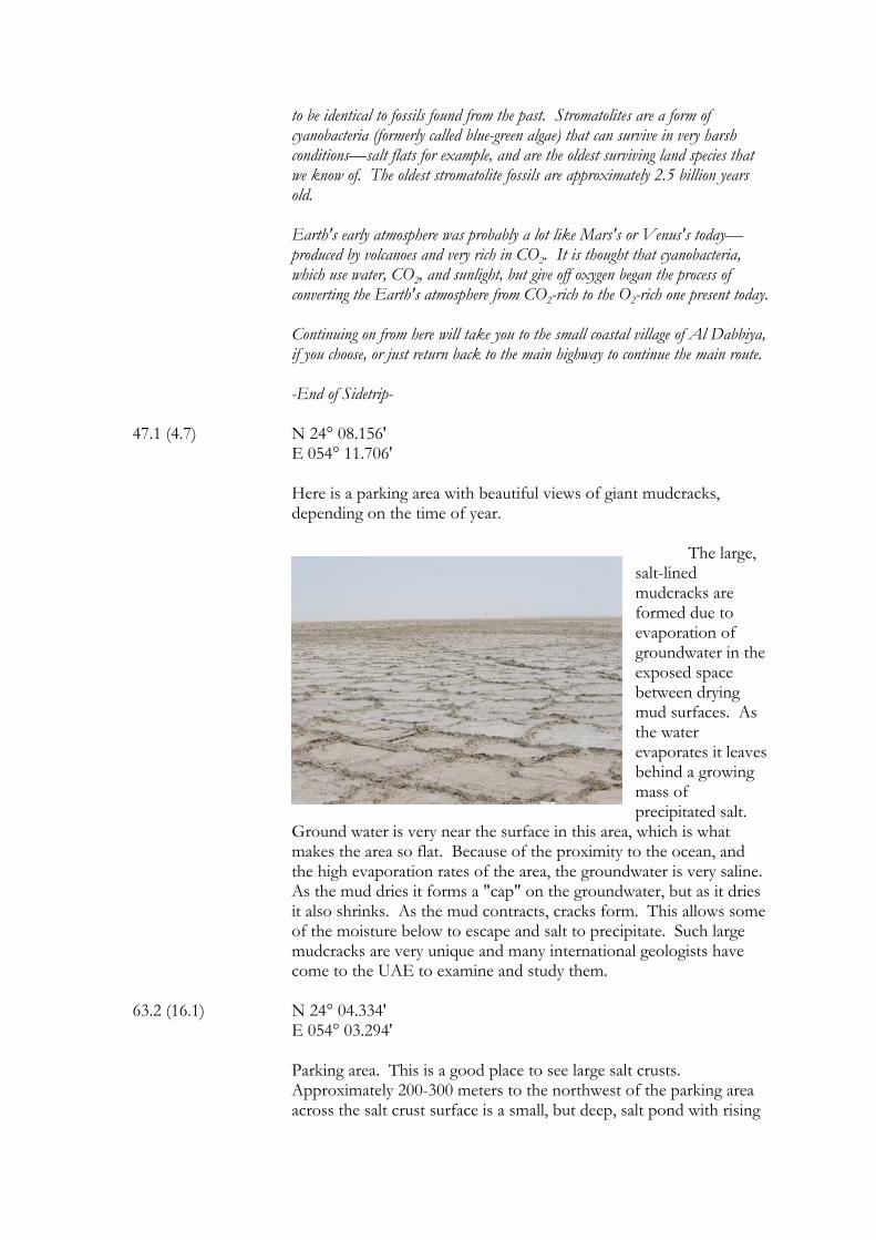
There is a small outcrop of eroded rock on the right (east) and a good view of mangroves in the distance. This outcrop is of Pleistocene sediments, the geologic time period occurring about 2 million years ago during the most recent Ice Age. They were likely formed from mostly aeolian or windblown sand dunes. The thin, angled, layers are called crossbeds. They form as the dune slowly moves with the wind. If the tide is out you can walk out to the mangroves. Mangrove forests serve as nurseries for fish and other sea animals; provide protection by absorbing energy from storm and tsunami waves; and act as anchors to sediments, thus preventing coastal erosion. On the flat between the mangroves and the outcrop you should come across areas of mats of stromatolites. Stromatolites are "living fossils." Living fossils are living organisms that appear
to be identical to fossils found from the past. Stromatolites are a form of cyanobacteria (formerly called blue-green algae) that can survive in very harsh conditions—salt flats for example, and are the oldest surviving land species that we know of. The oldest stromatolite fossils are approximately 2.5 billion years old. Earth's early atmosphere was probably a lot like Mars's or Venus's today—produced by volcanoes and very rich in CO2. It is thought that cyanobacteria, which use water, CO2, and sunlight, but give off oxygen began the process of converting the Earth's atmosphere from CO2-rich to the O2-rich one present today. Continuing on from here will take you to the small coastal village of Al Dabbiya, if you choose, or just return back to the main highway to continue the main route. -End of Sidetrip-
47.1 (4.7) N 24° 08.156' E 054° 11.706' Here is a parking area with beautiful views of giant mudcracks,
depending on the time of year.
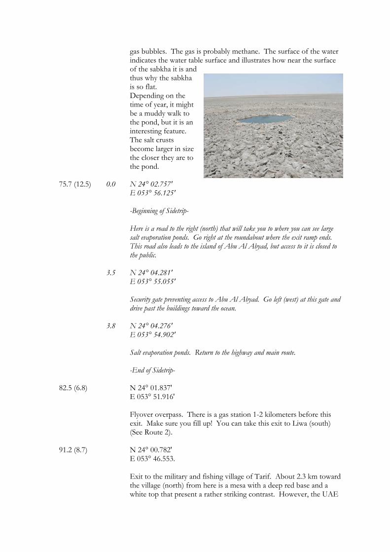
The large, salt-lined mudcracks are formed due to evaporation of groundwater in the exposed space between drying mud surfaces. As the water evaporates it leaves behind a growing mass of precipitated salt.
Ground water is very near the surface in this area, which is what makes the area so flat. Because of the proximity to the ocean, and the high evaporation rates of the area, the groundwater is very saline. As the mud dries it forms a "cap" on the groundwater, but as it dries it also shrinks. As the mud contracts, cracks form. This allows some of the moisture below to escape and salt to precipitate. Such large mudcracks are very unique and many international geologists have come to the UAE to examine and study them.
63.2 (16.1) N 24° 04.334' E 054° 03.294'
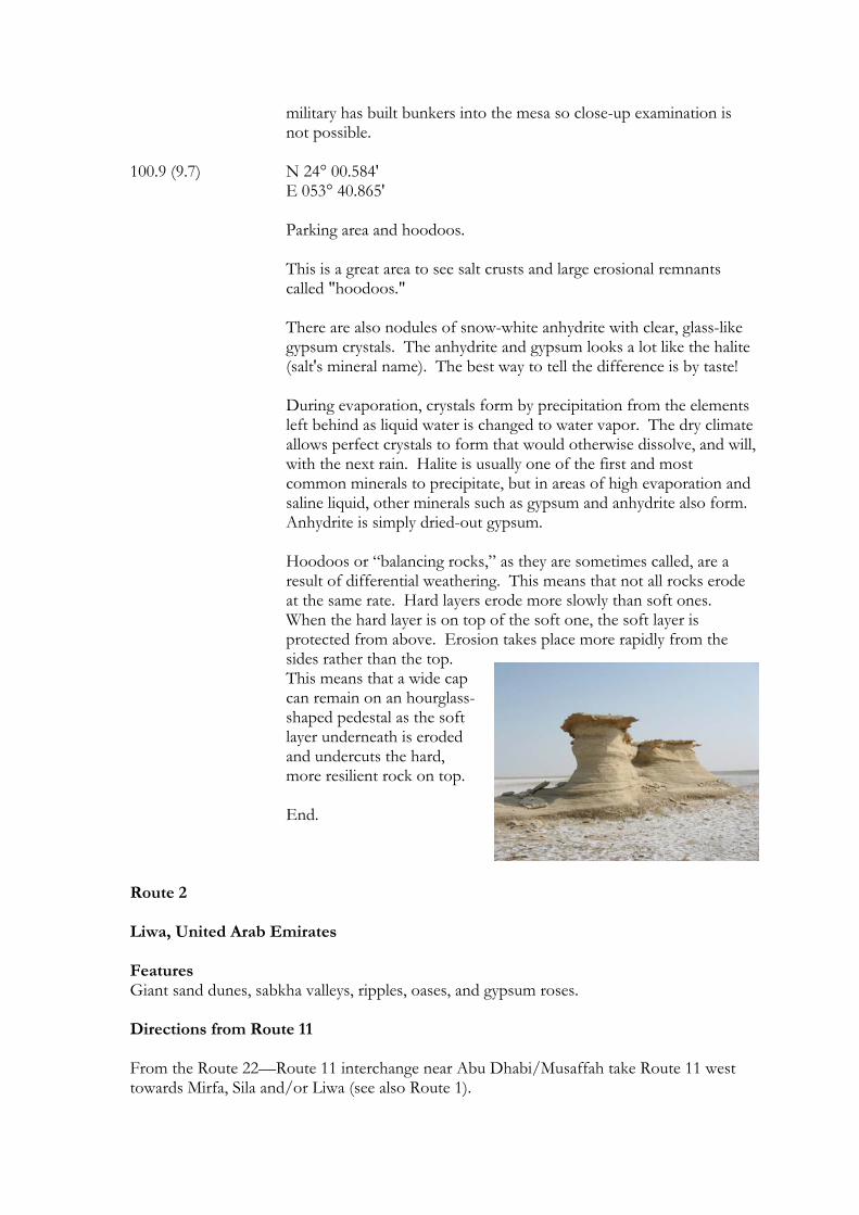
Parking area. This is a good place to see large salt crusts. Approximately 200-300 meters to the northwest of the parking area across the salt crust surface is a small, but deep, salt pond with rising
gas bubbles. The gas is probably methane. The surface of the water indicates the water table surface and illustrates how near the surface of the sabkha it is and thus why the sabkha is so flat. Depending on the time of year, it might be a muddy walk to the pond, but it is an interesting feature. The salt crusts become larger in size the closer they are to the pond.
75.7 (12.5) 0.0 N 24° 02.757' E 053° 56.125' -Beginning of Sidetrip-
Here is a road to the right (north) that will take you to where you can see large salt evaporation ponds. Go right at the roundabout where the exit ramp ends. This road also leads to the island of Abu Al Abyad, but access to it is closed to the public.
3.5 N 24° 04.281'
E 053° 55.055' Security gate preventing access to Abu Al Abyad. Go left (west) at this gate and drive past the buildings toward the ocean.
3.8 N 24° 04.276' E 053° 54.902'
Salt evaporation ponds. Return to the highway and main route. -End of Sidetrip-
82.5 (6.8) N 24° 01.837' E 053° 51.916'
Flyover overpass. There is a gas station 1-2 kilometers before this exit. Make sure you fill up! You can take this exit to Liwa (south) (See Route 2).
91.2 (8.7) N 24° 00.782'
E 053° 46.553. Exit to the military and fishing village of Tarif. About 2.3 km toward the village (north) from here is a mesa with a deep red base and a white top that present a rather striking contrast. However, the UAE
military has built bunkers into the mesa so close-up examination is not possible.
100.9 (9.7) N 24° 00.584' E 053° 40.865' Parking area and hoodoos. This is a great area to see salt crusts and large erosional remnants
called "hoodoos." There are also nodules of snow-white anhydrite with clear, glass-like gypsum crystals. The anhydrite and gypsum looks a lot like the halite (salt's mineral name). The best way to tell the difference is by taste! During evaporation, crystals form by precipitation from the elements left behind as liquid water is changed to water vapor. The dry climate allows perfect crystals to form that would otherwise dissolve, and will, with the next rain. Halite is usually one of the first and most common minerals to precipitate, but in areas of high evaporation and saline liquid, other minerals such as gypsum and anhydrite also form. Anhydrite is simply dried-out gypsum.
Hoodoos or “balancing rocks,” as they are sometimes called, are a result of differential weathering. This means that not all rocks erode at the same rate. Hard layers erode more slowly than soft ones. When the hard layer is on top of the soft one, the soft layer is protected from above. Erosion takes place more rapidly from the sides rather than the top. This means that a wide cap can remain on an hourglass-shaped pedestal as the soft layer underneath is eroded and undercuts the hard, more resilient rock on top.
End. Route 2 Liwa, United Arab Emirates Features Giant sand dunes, sabkha valleys, ripples, oases, and gypsum roses. Directions from Route 11 From the Route 22—Route 11 interchange near Abu Dhabi/Musaffah take Route 11 west towards Mirfa, Sila and/or Liwa (see also Route 1).
Route Sidetrip Mileage Mileage (km) (km)
(The distance from the last stop is in parentheses) 0.0 (0.0) N 24° 18.546' E 054° 36.147'
Route 11-Route 22 interchange. Set your odometer to 0 here.
82.4 (82.4) N 24° 01.837' E 053° 51.916'
Flyover overpass. There is a gas station 1-2 kilometers before this exit. Take this exit to Liwa (south). If you get to the exit for the village of Tarif then you have gone too far.
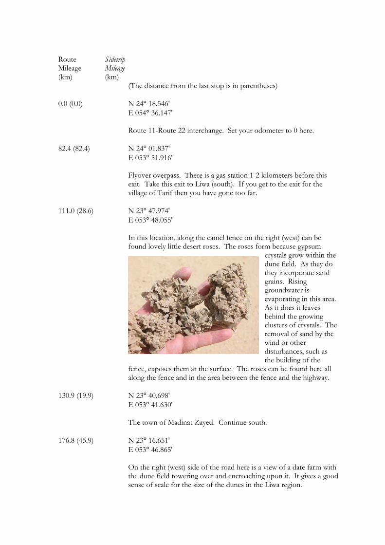
111.0 (28.6) N 23° 47.974' E 053° 48.055' In this location, along the camel fence on the right (west) can be
found lovely little desert roses. The roses form because gypsum crystals grow within the dune field. As they do they incorporate sand grains. Rising groundwater is evaporating in this area. As it does it leaves behind the growing clusters of crystals. The removal of sand by the wind or other disturbances, such as the building of the
fence, exposes them at the surface. The roses can be found here all along the fence and in the area between the fence and the highway.
130.9 (19.9) N 23° 40.698' E 053° 41.630' The town of Madinat Zayed. Continue south. 176.8 (45.9) N 23° 16.651' E 053° 46.865' On the right (west) side of the road here is a view of a date farm with
the dune field towering over and encroaching upon it. It gives a good sense of scale for the size of the dunes in the Liwa region.
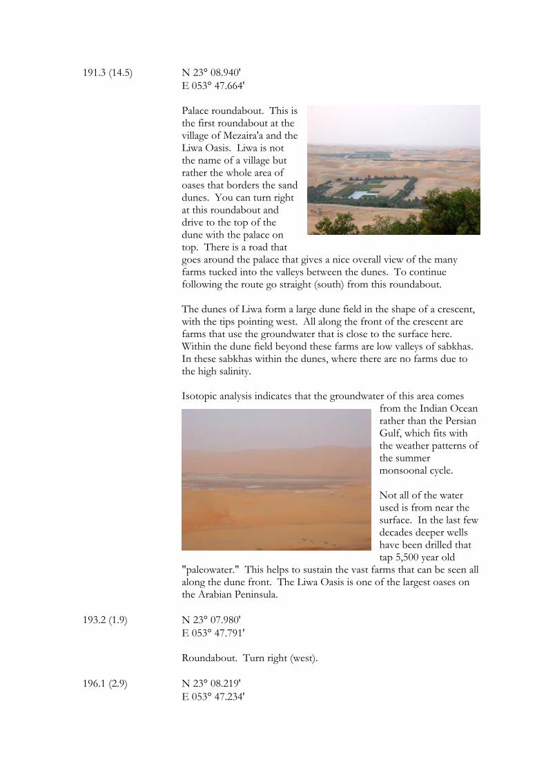
191.3 (14.5) N 23° 08.940' E 053° 47.664'
Palace roundabout. This is the first roundabout at the village of Mezaira'a and the Liwa Oasis. Liwa is not the name of a village but rather the whole area of oases that borders the sand dunes. You can turn right at this roundabout and drive to the top of the dune with the palace on top. There is a road that goes around the palace that gives a nice overall view of the many farms tucked into the valleys between the dunes. To continue following the route go straight (south) from this roundabout.
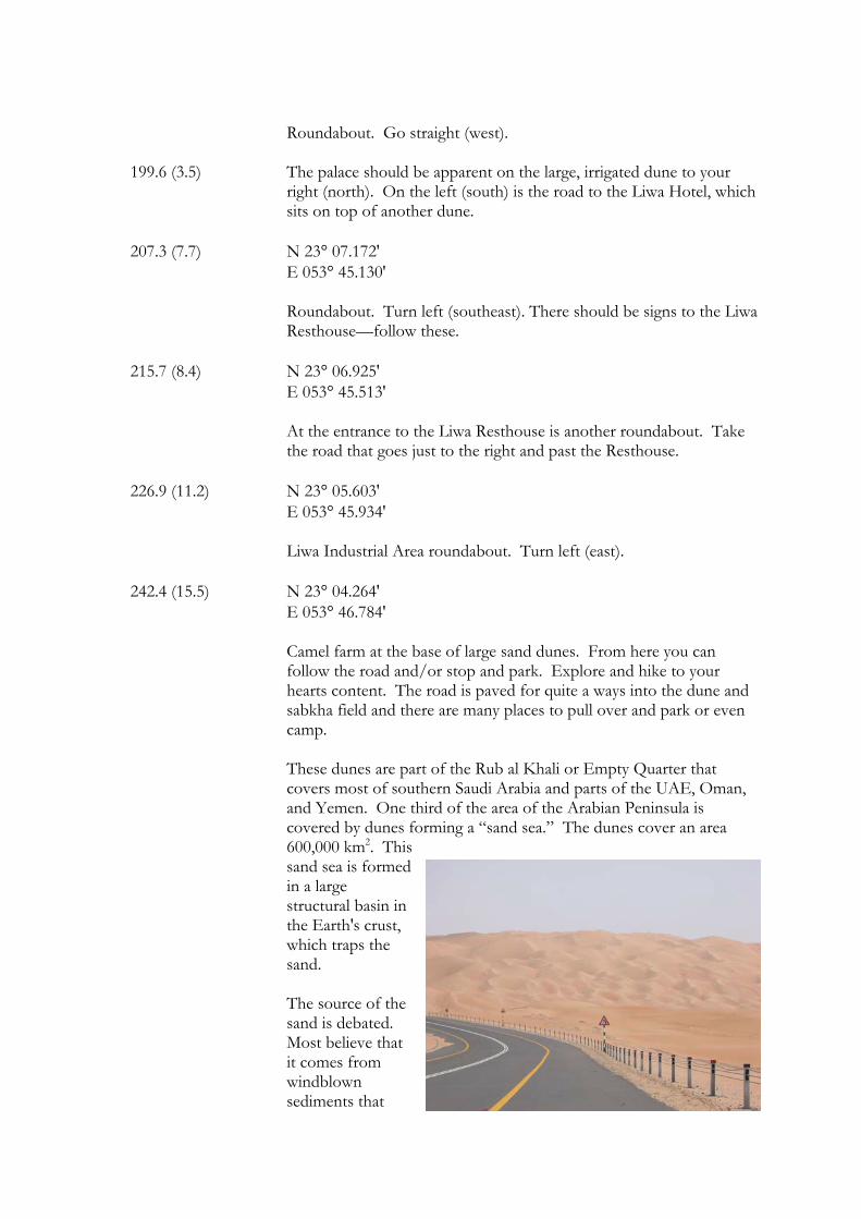
The dunes of Liwa form a large dune field in the shape of a crescent,
with the tips pointing west. All along the front of the crescent are farms that use the groundwater that is close to the surface here. Within the dune field beyond these farms are low valleys of sabkhas. In these sabkhas within the dunes, where there are no farms due to the high salinity.
Isotopic analysis indicates that the groundwater of this area comes
from the Indian Ocean rather than the Persian Gulf, which fits with the weather patterns of the summer monsoonal cycle.
Not all of the water used is from near the surface. In the last few decades deeper wells have been drilled that tap 5,500 year old
"paleowater." This helps to sustain the vast farms that can be seen all along the dune front. The Liwa Oasis is one of the largest oases on the Arabian Peninsula.
193.2 (1.9) N 23° 07.980'
E 053° 47.791' Roundabout. Turn right (west).
196.1 (2.9) N 23° 08.219'
E 053° 47.234'
Roundabout. Go straight (west).
199.6 (3.5) The palace should be apparent on the large, irrigated dune to your
right (north). On the left (south) is the road to the Liwa Hotel, which sits on top of another dune.
207.3 (7.7) N 23° 07.172' E 053° 45.130' Roundabout. Turn left (southeast). There should be signs to the Liwa
Resthouse—follow these. 215.7 (8.4) N 23° 06.925' E 053° 45.513' At the entrance to the Liwa Resthouse is another roundabout. Take
the road that goes just to the right and past the Resthouse. 226.9 (11.2) N 23° 05.603' E 053° 45.934'
Liwa Industrial Area roundabout. Turn left (east).
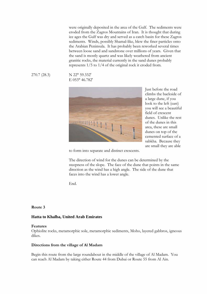
242.4 (15.5) N 23° 04.264' E 053° 46.784' Camel farm at the base of large sand dunes. From here you can
follow the road and/or stop and park. Explore and hike to your hearts content. The road is paved for quite a ways into the dune and sabkha field and there are many places to pull over and park or even camp.
These dunes are part of the Rub al Khali or Empty Quarter that
covers most of southern Saudi Arabia and parts of the UAE, Oman, and Yemen. One third of the area of the Arabian Peninsula is covered by dunes forming a “sand sea.” The dunes cover an area 600,000 km2. This sand sea is formed in a large structural basin in the Earth's crust, which traps the sand. The source of the sand is debated. Most believe that it comes from windblown sediments that
were originally deposited in the area of the Gulf. The sediments were eroded from the Zagros Mountains of Iran. It is thought that during ice ages the Gulf was dry and served as a catch basin for these Zagros sediments. Winds, possibly Shamal-like, blew the finer particles onto the Arabian Peninsula. It has probably been reworked several times between loose sand and sandstone over millions of years. Given that the sand is mostly quartz and was likely weathered from ancient granitic rocks, the material currently in the sand dunes probably represents 1/5 to 1/4 of the original rock it eroded from.
270.7 (28.3) N 22° 59.332' E 053° 46.782'
Just before the road climbs the backside of a large dune, if you look to the left (east) you will see a beautiful field of crescent dunes. Unlike the rest of the dunes in this area, these are small dunes on top of the cemented surface of a sabkha. Because they are small they are able
to form into separate and distinct crescents. The direction of wind for the dunes can be determined by the steepness of the slope. The face of the dune that points in the same direction as the wind has a high angle. The side of the dune that faces into the wind has a lower angle. End.
Route 3 Hatta to Khalba, United Arab Emirates Features Ophiolite rocks, metamorphic sole, metamorphic sediments, Moho, layered gabbros, igneous dikes. Directions from the village of Al Madam Begin this route from the large roundabout in the middle of the village of Al Madam. You can reach Al Madam by taking either Route 44 from Dubai or Route 55 from Al Ain.
Route Sidetrip Mileage Mileage (km) (km)
(The distance from the last stop is in parentheses) 0.0 (0.0) N 24° 54.772’
E 055° 46.572’ Large roundabout in Madam. There is a mosque on the west side and a large, five-story building, on the southwestern corner. Set your odometer to 0 here. Take Route 44 going east. As you leave the roundabout there is a gas station on the left (north) side of the road.
13.9 (13.9) N 24° 52.461’ E 55° 54.323’ A long jebel (mountain) will be on the left-hand side (north) made of
light colored limestone. This limestone is part of the Sumeini Group. Although along most of the ridge the limestone layers are horizontal, on the western end, which is the first part that you pass, the layers are tilted. That is because this part is the front of a large fold that formed as the ridge was compressed from the northeast.
If you look carefully at its base in the distance you will see much darker-colored rocks. These are outcrops of gneiss, a highly metamorphosed rock. Here they represent parts of the metamorphic sole, or underlying continental crustal rock of the Arabian Peninsula.
At the GPS location listed here there are easily driveable tracks on the
north side of the road that can be followed over to the outcrops of metamorphic rocks.
18.2 (4.3) N 24° 51.895’
E 055° 56.670’ Roundabout with gas station on right (southwestern) side. The ridge of limestone on the left (north) is still part of the Sumeini Group. The numberless holes and rounded features of this limestone are a result of dissolution during which the climate in the region was much wetter.
24.1 (5.9) N 24° 51.340’
E 055° 59.998’ Large bridge over a wadi. After passing over this bridge the road is lined with many carpet and pottery shops, on both sides of the road.
30.4 (6.3) N 24° 50.129’ E 056° 03.543’
Behind the industrial and commercial buildings are the limestones of the Sumeini Group. Within this layer are two dark layers. The upper, reddish one consists of a layer of chert. The lower, darker gray one is basalt lava.
Chert is microcrystalline quartz and is made up of silica (SiO2). Limestone and chert both form in the marine environment. Small microscopic plants (phytoplankton) and animals (zooplankton) form tiny shells of either calcium carbonate (CaCO3) or SiO2 around themselves. When these plants and animals die, their shells sink and form layers of sediments (called ooze) on the ocean floor. As new layers bury the old layers, eventually the old layers are buried so deep that the heat and pressure lithifies or bakes and cements them into limestone and/or chert. It is not known exactly why the silica separates from the carbonate, but in some cases, especially when the chert forms a distinct layer, it is probably related to the depth of the water the sediments originally sank in. Chert layers form in deep water while limestone layers form in shallow water. This is because if the water is really deep then the pressure is high, which allows limestone to be dissolved in the water. It is similar to why the CO2 in a soft drink stays dissolved in the liquid until the bottle is opened and the inside loses pressure and foams out. The types of mud and sand found along the coasts of the United Arab Emirates today are the same that produced the limestone and chert of the past. The basalt lava layer probably formed as underwater eruptions and lava flows. The lava flowed over the previous sediments and was then subsequently buried by the sinking shells of new carbonate and silica (sometimes called "marine snow").
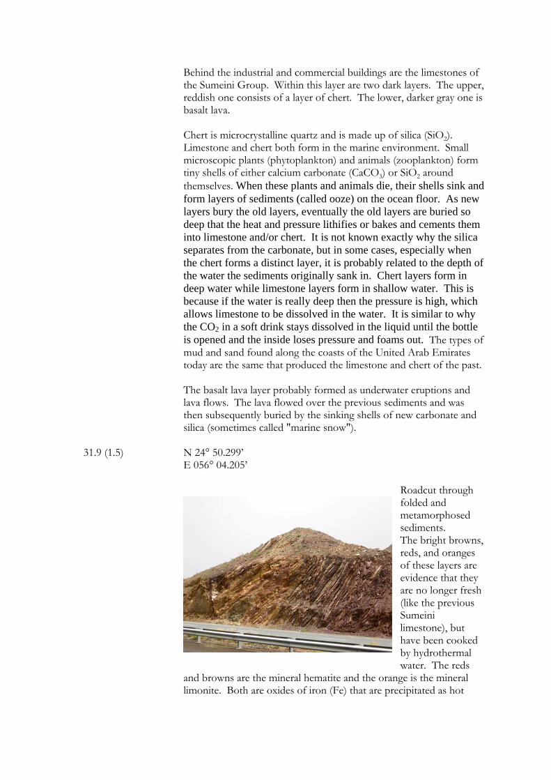
31.9 (1.5) N 24° 50.299’
E 056° 04.205’
Roadcut through folded and metamorphosed sediments. The bright browns, reds, and oranges of these layers are evidence that they are no longer fresh (like the previous Sumeini limestone), but have been cooked by hydrothermal water. The reds
and browns are the mineral hematite and the orange is the mineral limonite. Both are oxides of iron (Fe) that are precipitated as hot
water alters other minerals. These layers are called the Howasina Formation. The folds in these layers are quite extreme and beautiful. In addition to the tight folding, if you look closely you will see where several faults also cut the layers. The folds indicate that the rocks were soft when they were compressed and the faults indicate when either the rocks became brittle or the elasticity of the rocks was overcome. These layers formed at the same time as those of the peridotites and gabbros to be seen later in this route. However, while the peridotites and gabbros formed in the deep ocean beneath underwater volcanoes, the Howasina sediments were forming in the shallow water of the continental shelf that formed the edge of the ancient continent the consisted of Africa and Arabia. Anciently, there was an ocean called the Tethys Sea between what is now Arabia and Asia. The peridotites and gabbros formed beneath a ridge of underwater volcanoes that ran down the center of this sea. It is similar to the ridge that runs down the center of the Red Sea today. Eventually, the continents changed direction and Arabia and Asia collided with each other. When this happened the peridotites and gabbros were thrust up from the ocean onto the continent. They were shoved into these sediments, thus deforming them. Later, along one of the faults, which formed an easy path to the surface, magma rose and as it did it "cooked" the sediments and produced what geologists call contact metamorphism. This is metamorphism that is due usually to heat only rather than heat and pressure. At the end of this roadcut (east) is a beautiful example of this. The layers approach and are sharply folded at the fault where there is a dark, straight-line structure of a dark red-brown color. This is the "baked" contact. On the left is the greenish magma, now altered, that was probably a gabbro, but has since been cooked and altered itself. Just to the right of this contact and at the base of some of the sediments is another layer of this altered magma that was probably a sill or intrusion of magma parallel to the beds about it.
To the northwest is an old quarry in the peridotite rocks of the Semail
(Oman) Ophiolite and it is easy to see the difference between the fresh peridotite, which is light gray in color and the oxidized and weathered surface, which is a dark red-brown. Within and on the eastern side of the quarry is another exposure of the continental crust metamorphic sole. Here it is marble (from ancient metamorphosed limestone) and greenstone of the minerals chlorite and epidote (probably from ancient metamorphosed basalt). The gray-colored jebel almost due north from this roadcut, with streaky white, horizontal layers consists of this metamorphic sole.
37.8 (5.9) N 24° 49.225’
E 056° 07.381’ Large mosque on left (north) side of road.
38.9 (1.1) N 24° 49.065’ E 056° 07.963’ Hatta Roundabout with a large, fort-like structure in the middle. There is a community library and municipality building on the southwest corner and a hypermarket on the southeast corner. Continue straight (east).
39.9 (1.0) N 24° 49.115’
E 056° 08.508’ Road to Khalba on left (north). The northwestern corner is an outcrop of Hawasina metasediments. Turn left here.
40.2 (0.3) N 24° 49.240’
E 056° 08.480’ This is a roadcut through altered rocks of the Earth’s Mantle. The rock is serpentinized peridotite and is formed as hydrothermal water alters the olivine and pyroxene minerals of the peridotite into serpentine and amphibole minerals.
40.7 (0.5) N 24° 49.555’ E 056° 08.508’ Beginning of the Moho boundary or transition zone between rocks of the Earth's Mantle (peridotite) and the Crust (gabbro). There are very few places on Earth where this boundary can be seen. This is because rocks, such as peridotite, from the Mantle and lower Crust are so dense that it is rare for them to reach the surface of the Earth. The Hajar Mountains are one of the rare places where tectonic processes have pushed a slice of the deep Earth to the surface and exposed this boundary. Moho is short for Mohorovičić discontinuity and is named after Andrija Mohorovičić, a Croatian seismologist who first described it in 1909.
From the turnoff until this point the rocks on both sides of the road have been peridotite, or rocks of the Earth's Mantle. At this roadcut the peridotite is beginning to interfinger with gabbro. On the right (east) side of the road is mostly peridotite, but on the left (west) side there are outcrops of layered gabbros (especially on the north end) that are inter-layered with the peridotite. The black rock is peridotite and the gray is mostly gabbro. Peridotite is a rock very rich in iron (Fe) and magnesium (Mg) (called "mafic" by geologists) and makes up most of the upper Mantle. Fresh peridotite
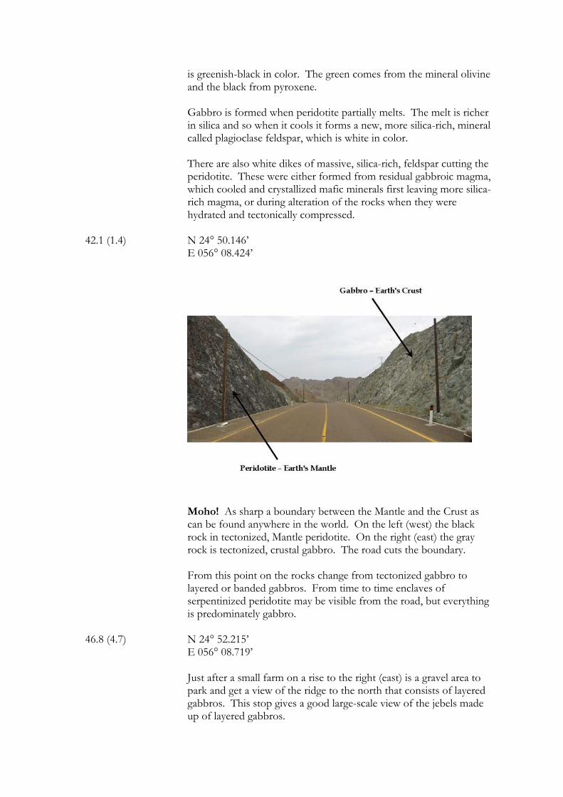
is greenish-black in color. The green comes from the mineral olivine and the black from pyroxene. Gabbro is formed when peridotite partially melts. The melt is richer in silica and so when it cools it forms a new, more silica-rich, mineral called plagioclase feldspar, which is white in color. There are also white dikes of massive, silica-rich, feldspar cutting the peridotite. These were either formed from residual gabbroic magma, which cooled and crystallized mafic minerals first leaving more silica-rich magma, or during alteration of the rocks when they were hydrated and tectonically compressed.
42.1 (1.4) N 24° 50.146’
E 056° 08.424’
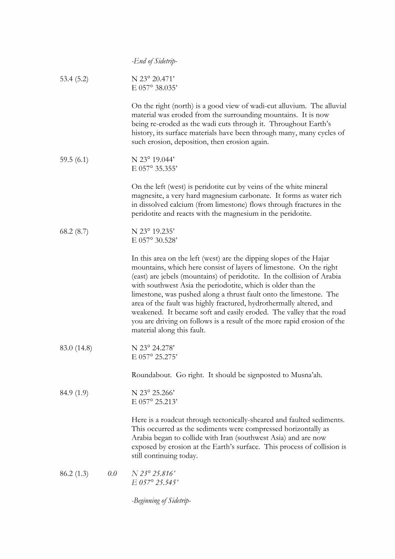
Moho! As sharp a boundary between the Mantle and the Crust as can be found anywhere in the world. On the left (west) the black rock in tectonized, Mantle peridotite. On the right (east) the gray rock is tectonized, crustal gabbro. The road cuts the boundary. From this point on the rocks change from tectonized gabbro to layered or banded gabbros. From time to time enclaves of serpentinized peridotite may be visible from the road, but everything is predominately gabbro.
46.8 (4.7) N 24° 52.215’ E 056° 08.719’ Just after a small farm on a rise to the right (east) is a gravel area to park and get a view of the ridge to the north that consists of layered gabbros. This stop gives a good large-scale view of the jebels made up of layered gabbros.
Magma within the earth is usually not static, but rather very dynamic. As it cools, heavy, dark minerals form first and sink forming a dark layer. These are followed by lighter (in both color and weight) minerals that form a light layer. Over time, more magma is added and the process goes on, which over time produces alternating light and dark bands.
47.0 (0.2) N 24° 52.320’
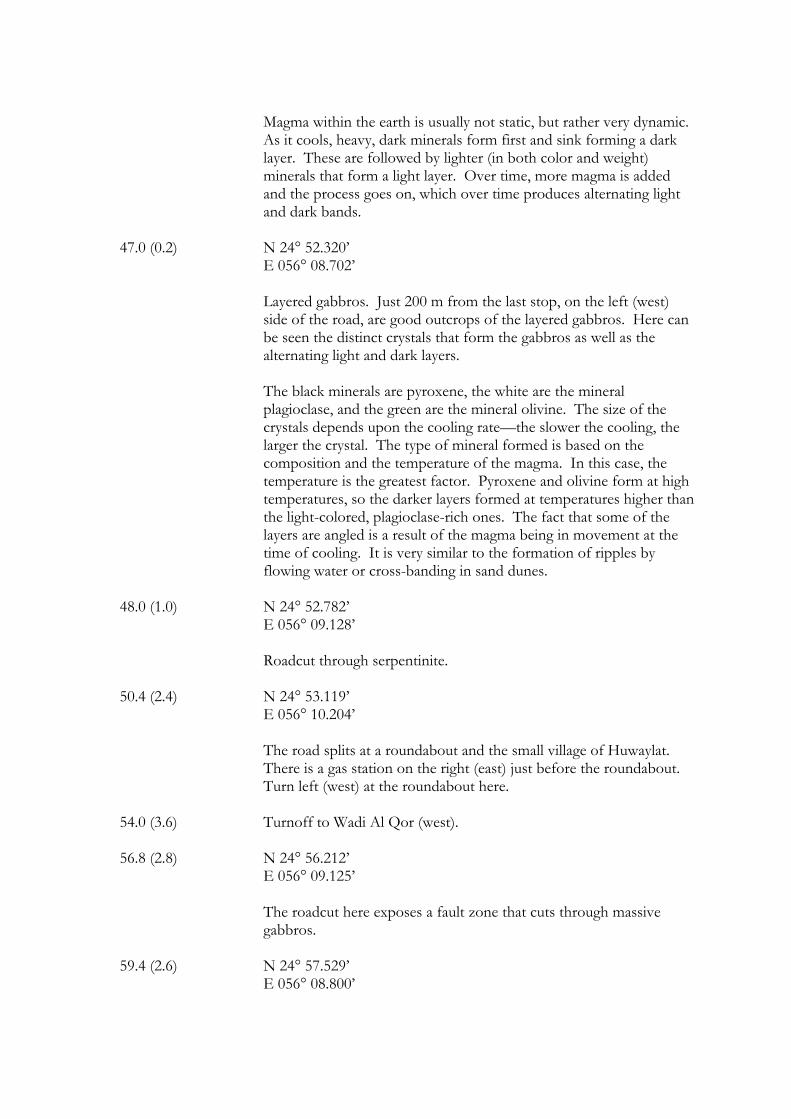
E 056° 08.702’ Layered gabbros. Just 200 m from the last stop, on the left (west) side of the road, are good outcrops of the layered gabbros. Here can be seen the distinct crystals that form the gabbros as well as the alternating light and dark layers.
The black minerals are pyroxene, the white are the mineral plagioclase, and the green are the mineral olivine. The size of the crystals depends upon the cooling rate—the slower the cooling, the larger the crystal. The type of mineral formed is based on the composition and the temperature of the magma. In this case, the temperature is the greatest factor. Pyroxene and olivine form at high temperatures, so the darker layers formed at temperatures higher than the light-colored, plagioclase-rich ones. The fact that some of the layers are angled is a result of the magma being in movement at the time of cooling. It is very similar to the formation of ripples by flowing water or cross-banding in sand dunes.
48.0 (1.0) N 24° 52.782’
E 056° 09.128’ Roadcut through serpentinite.
50.4 (2.4) N 24° 53.119’
E 056° 10.204’ The road splits at a roundabout and the small village of Huwaylat. There is a gas station on the right (east) just before the roundabout. Turn left (west) at the roundabout here.
54.0 (3.6) Turnoff to Wadi Al Qor (west). 56.8 (2.8) N 24° 56.212’
E 056° 09.125’ The roadcut here exposes a fault zone that cuts through massive gabbros.
59.4 (2.6) N 24° 57.529’ E 056° 08.800’
Junction with the Masafi-Khalba Road. Turn right (east). The rest of the route from here is through an area of beautifully banded gabbros.
67.0 (7.6) N 24° 56.870’
E 056° 12.571’ Wadi Al Hilo overpass.
67.9 (0.9) N 24° 57.118’ E 056° 12.423’ There is a beautiful exposure of tilted, layered gabbros behind the houses and mosque on the mountain straight ahead.
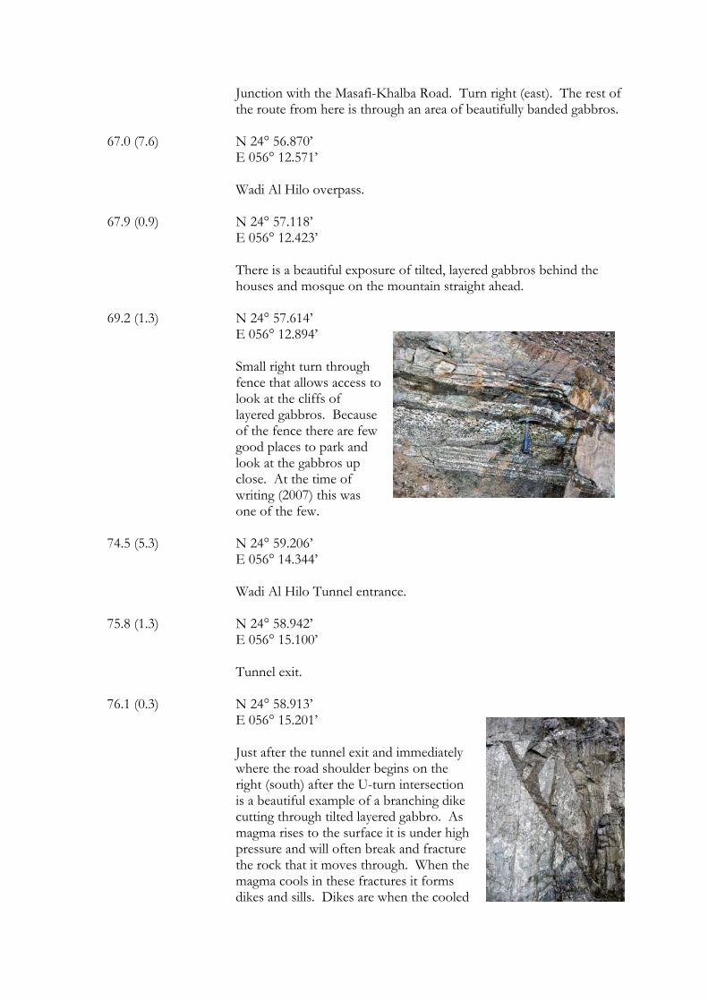
69.2 (1.3) N 24° 57.614’ E 056° 12.894’ Small right turn through fence that allows access to look at the cliffs of layered gabbros. Because of the fence there are few good places to park and look at the gabbros up close. At the time of writing (2007) this was one of the few.
74.5 (5.3) N 24° 59.206’ E 056° 14.344’ Wadi Al Hilo Tunnel entrance.
75.8 (1.3) N 24° 58.942’
E 056° 15.100’ Tunnel exit.
76.1 (0.3) N 24° 58.913’ E 056° 15.201’ Just after the tunnel exit and immediately
where the road shoulder begins on the right (south) after the U-turn intersection is a beautiful example of a branching dike cutting through tilted layered gabbro. As magma rises to the surface it is under high pressure and will often break and fracture the rock that it moves through. When the magma cools in these fractures it forms dikes and sills. Dikes are when the cooled
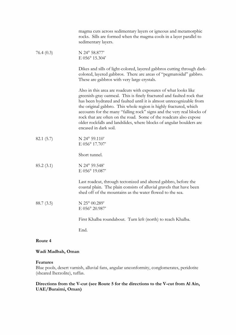
magma cuts across sedimentary layers or igneous and metamorphic rocks. Sills are formed when the magma cools in a layer parallel to sedimentary layers.
76.4 (0.3) N 24° 58.877’
E 056° 15.304’ Dikes and sills of light-colored, layered gabbros cutting through dark-colored, layered gabbros. There are areas of “pegmatoidal” gabbro. These are gabbros with very large crystals. Also in this area are roadcuts with exposures of what looks like greenish-gray oatmeal. This is finely fractured and faulted rock that has been hydrated and faulted until it is almost unrecognizable from the original gabbro. This whole region is highly fractured, which accounts for the many “falling rock” signs and the very real blocks of rock that are often on the road. Some of the roadcuts also expose older rockfalls and landslides, where blocks of angular boulders are encased in dark soil.
82.1 (5.7) N 24° 59.110’
E 056° 17.707’ Short tunnel.
85.2 (3.1) N 24° 59.548’
E 056° 19.087’ Last roadcut, through tectonized and altered gabbro, before the coastal plain. The plain consists of alluvial gravels that have been shed off of the mountains as the water flowed to the sea.
88.7 (3.5) N 25° 00.289’ E 056° 20.987’ First Khalba roundabout. Turn left (north) to reach Khalba. End.
Route 4 Wadi Madbah, Oman Features Blue pools, desert varnish, alluvial fans, angular unconformity, conglomerates, peridotite (sheared lherzolite), tuffas. Directions from the V-cut (see Route 5 for the directions to the V-cut from Al Ain, UAE/Buraimi, Oman)
At the roundabout just to the east of the large v-cut roadcut you will need to set your odometer to zero. This is also the starting point for Route 5 if you are coming from Buraimi. Route Sidetrip Mileage Mileage (km) (km)
(The distance from the last stop is in parentheses) 0.0 (0.0) N 24° 13.833’ E 055° 57.465’
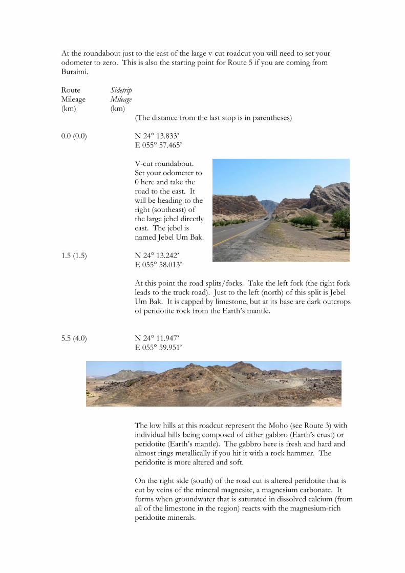
V-cut roundabout. Set your odometer to 0 here and take the road to the east. It will be heading to the right (southeast) of the large jebel directly east. The jebel is named Jebel Um Bak.
1.5 (1.5) N 24° 13.242’ E 055° 58.013’ At this point the road splits/forks. Take the left fork (the right fork
leads to the truck road). Just to the left (north) of this split is Jebel Um Bak. It is capped by limestone, but at its base are dark outcrops of peridotite rock from the Earth’s mantle.
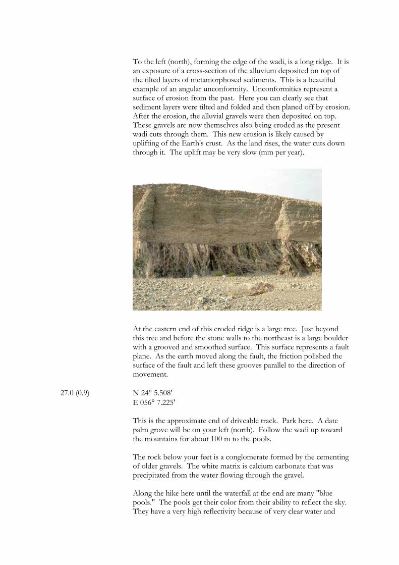
5.5 (4.0) N 24° 11.947’ E 055° 59.951’
The low hills at this roadcut represent the Moho (see Route 3) with
individual hills being composed of either gabbro (Earth’s crust) or peridotite (Earth’s mantle). The gabbro here is fresh and hard and almost rings metallically if you hit it with a rock hammer. The peridotite is more altered and soft.
On the right side (south) of the road cut is altered peridotite that is
cut by veins of the mineral magnesite, a magnesium carbonate. It forms when groundwater that is saturated in dissolved calcium (from all of the limestone in the region) reacts with the magnesium-rich peridotite minerals.

12.9 (7.4) N 24° 8.676’
E 056° 1.781’ There should be a small mosque on
the left-hand (north) side of the road. 20.7 (7.8) N 24° 5.798’ E 056° 4.344’ On the left-hand (east) side of the road is the entrance to a gravel
quarry. 22.0 (1.3) N 24° 5.148' E 056° 4.376'
The turn off to Wadi Madbah is here to the left (east). There should be a sign. The route from here is across the alluvial skirts extending from the mountains to the east. These alluvial fans formed during a period of time in the geologically-recent past when the climate of the area was much wetter and heavy erosion took place. Since that time, many of the surface stones have been exposed to the atmosphere for thousands of years and have acquired a thick, reddish-colored, desert varnish, which forms as the minerals in the rocks are exposed to the atmosphere and, with the aid of bacteria, are oxidized. If you stop and break open the dark, rounded rocks of this area you will find that they are a dark green on the inside. They are made of peridotite (see Route 3) and are from the mountains to the East. These mountains make the Semail (Oman) Ophiolite – a slice of the Earth, including pieces of the Mantle that have been thrust up onto the continental crust of the Arabian Peninsula. The upper part of the Mantle is made of the rock peridotite. The green color comes from the mineral olivine. Desert varnish takes hundreds to thousands of years to form. It is thought to be a result of oxidation of the iron (Fe) and manganese (Mn) in the rock, caused by contact with the atmosphere and by bacterial action.
26.0 (4.0) N 24° 5.477' E 056° 6.995'
The road forks here. Take the road to the right (southeast) that goes down the slope and into the wadi towards the village on the other side.
26.1 (0.1) Then take an almost immediate left (east) to follow the track that
enters the wadi.
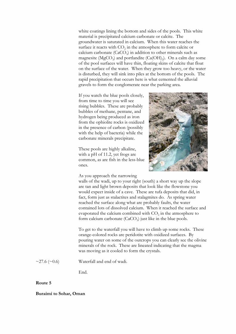
To the left (north), forming the edge of the wadi, is a long ridge. It is an exposure of a cross-section of the alluvium deposited on top of the tilted layers of metamorphosed sediments. This is a beautiful example of an angular unconformity. Unconformities represent a surface of erosion from the past. Here you can clearly see that sediment layers were tilted and folded and then planed off by erosion. After the erosion, the alluvial gravels were then deposited on top. These gravels are now themselves also being eroded as the present wadi cuts through them. This new erosion is likely caused by uplifting of the Earth's crust. As the land rises, the water cuts down through it. The uplift may be very slow (mm per year).
At the eastern end of this eroded ridge is a large tree. Just beyond this tree and before the stone walls to the northeast is a large boulder with a grooved and smoothed surface. This surface represents a fault plane. As the earth moved along the fault, the friction polished the surface of the fault and left these grooves parallel to the direction of movement.
27.0 (0.9) N 24° 5.508' E 056° 7.225'
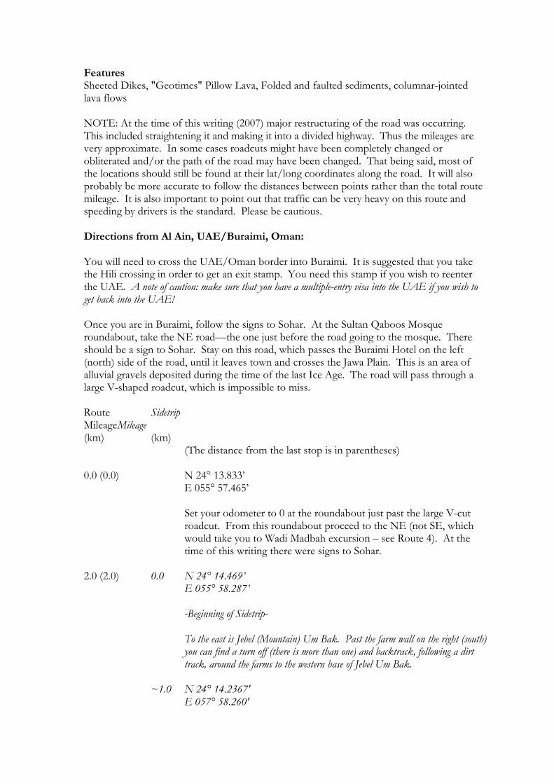
This is the approximate end of driveable track. Park here. A date palm grove will be on your left (north). Follow the wadi up toward the mountains for about 100 m to the pools. The rock below your feet is a conglomerate formed by the cementing of older gravels. The white matrix is calcium carbonate that was precipitated from the water flowing through the gravel. Along the hike here until the waterfall at the end are many "blue pools." The pools get their color from their ability to reflect the sky. They have a very high reflectivity because of very clear water and
white coatings lining the bottom and sides of the pools. This white material is precipitated calcium carbonate or calcite. The groundwater is saturated in calcium. When this water reaches the surface it reacts with CO2 in the atmosphere to form calcite or calcium carbonate (CaCO3) in addition to other minerals such as magnesite (MgCO3) and portlandite (Ca(OH)2). On a calm day some of the pool surfaces will have thin, floating skins of calcite that float on the surface of the water. When they grow too heavy, or the water is disturbed, they will sink into piles at the bottom of the pools. The rapid precipitation that occurs here is what cemented the alluvial gravels to form the conglomerate near the parking area. If you watch the blue pools closely, from time to time you will see rising bubbles. These are probably bubbles of methane, pentane, and hydrogen being produced as iron from the ophiolite rocks is oxidized in the presence of carbon (possibly with the help of bacteria) while the carbonate minerals precipitate. These pools are highly alkaline, with a pH of 11.2, yet frogs are common, as are fish in the less-blue ones. As you approach the narrowing walls of the wadi, up to your right (south) a short way up the slope are tan and light brown deposits that look like the flowstone you would expect inside of a cave. These are tufa deposits that did, in fact, form just as stalactites and stalagmites do. As spring water reached the surface along what are probably faults, the water contained lots of dissolved calcium. When it reached the surface and evaporated the calcium combined with CO2 in the atmosphere to form calcium carbonate (CaCO3) just like in the blue pools. To get to the waterfall you will have to climb up some rocks. These orange-colored rocks are peridotite with oxidized surfaces. By pouring water on some of the outcrops you can clearly see the olivine minerals of the rock. These are lineated indicating that the magma was moving as it cooled to form the crystals.
~27.6 (~0.6) Waterfall and end of wadi. End. Route 5 Buraimi to Sohar, Oman
Features Sheeted Dikes, "Geotimes" Pillow Lava, Folded and faulted sediments, columnar-jointed lava flows NOTE: At the time of this writing (2007) major restructuring of the road was occurring. This included straightening it and making it into a divided highway. Thus the mileages are very approximate. In some cases roadcuts might have been completely changed or obliterated and/or the path of the road may have been changed. That being said, most of the locations should still be found at their lat/long coordinates along the road. It will also probably be more accurate to follow the distances between points rather than the total route mileage. It is also important to point out that traffic can be very heavy on this route and speeding by drivers is the standard. Please be cautious. Directions from Al Ain, UAE/Buraimi, Oman: You will need to cross the UAE/Oman border into Buraimi. It is suggested that you take the Hili crossing in order to get an exit stamp. You need this stamp if you wish to reenter the UAE. A note of caution: make sure that you have a multiple-entry visa into the UAE if you wish to get back into the UAE! Once you are in Buraimi, follow the signs to Sohar. At the Sultan Qaboos Mosque roundabout, take the NE road—the one just before the road going to the mosque. There should be a sign to Sohar. Stay on this road, which passes the Buraimi Hotel on the left (north) side of the road, until it leaves town and crosses the Jawa Plain. This is an area of alluvial gravels deposited during the time of the last Ice Age. The road will pass through a large V-shaped roadcut, which is impossible to miss. Route Sidetrip Mileage Mileage (km) (km)
(The distance from the last stop is in parentheses) 0.0 (0.0) N 24° 13.833’ E 055° 57.465’ Set your odometer to 0 at the roundabout just past the large V-cut
roadcut. From this roundabout proceed to the NE (not SE, which would take you to Wadi Madbah excursion – see Route 4). At the time of this writing there were signs to Sohar.
2.0 (2.0) 0.0 N 24° 14.469’ E 055° 58.287’ -Beginning of Sidetrip-
To the east is Jebel (Mountain) Um Bak. Past the farm wall on the right (south) you can find a turn off (there is more than one) and backtrack, following a dirt track, around the farms to the western base of Jebel Um Bak.
~1.0 N 24° 14.2367'
E 057° 58.260'
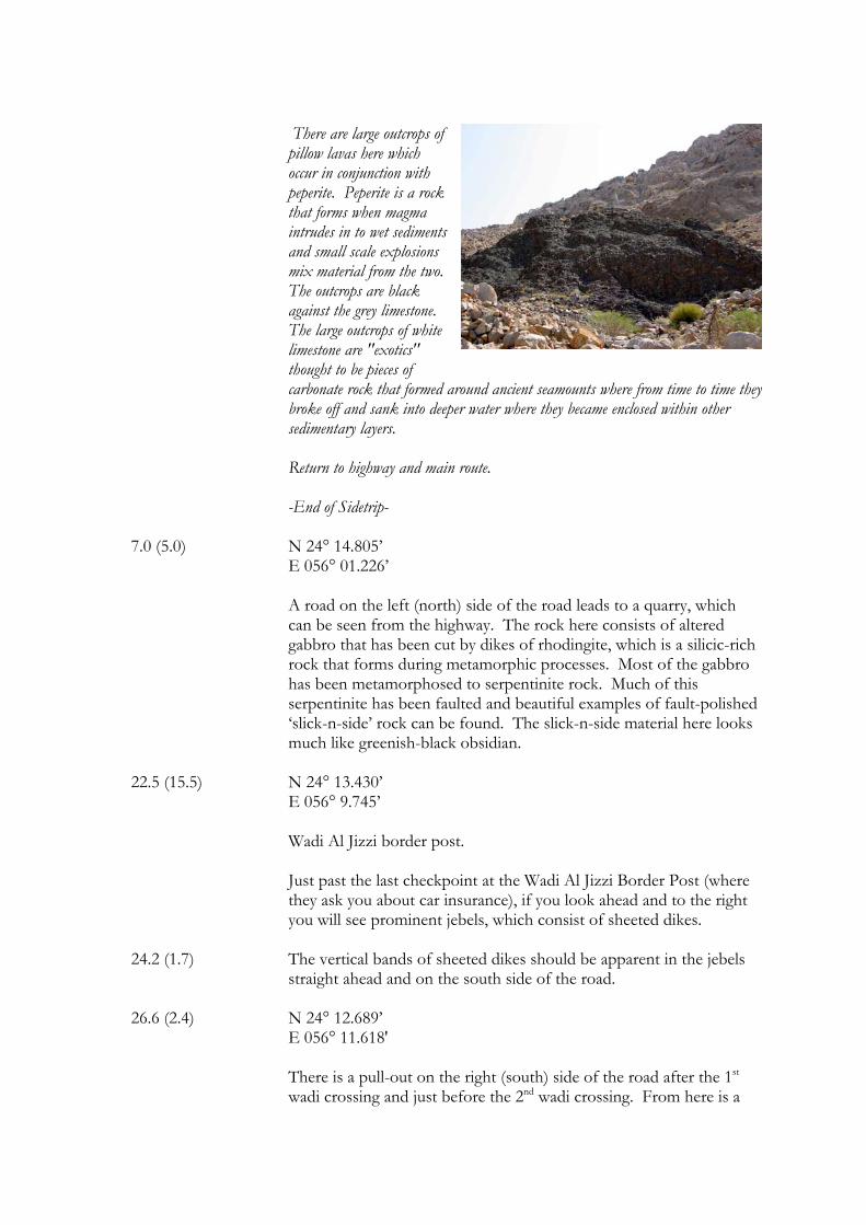
There are large outcrops of pillow lavas here which occur in conjunction with peperite. Peperite is a rock that forms when magma intrudes in to wet sediments and small scale explosions mix material from the two. The outcrops are black against the grey limestone. The large outcrops of white limestone are "exotics" thought to be pieces of carbonate rock that formed around ancient seamounts where from time to time they broke off and sank into deeper water where they became enclosed within other sedimentary layers. Return to highway and main route. -End of Sidetrip-
7.0 (5.0) N 24° 14.805’ E 056° 01.226’ A road on the left (north) side of the road leads to a quarry, which
can be seen from the highway. The rock here consists of altered gabbro that has been cut by dikes of rhodingite, which is a silicic-rich rock that forms during metamorphic processes. Most of the gabbro has been metamorphosed to serpentinite rock. Much of this serpentinite has been faulted and beautiful examples of fault-polished ‘slick-n-side’ rock can be found. The slick-n-side material here looks much like greenish-black obsidian.
22.5 (15.5) N 24° 13.430’
E 056° 9.745’ Wadi Al Jizzi border post.
Just past the last checkpoint at the Wadi Al Jizzi Border Post (where they ask you about car insurance), if you look ahead and to the right you will see prominent jebels, which consist of sheeted dikes.
24.2 (1.7) The vertical bands of sheeted dikes should be apparent in the jebels
straight ahead and on the south side of the road. 26.6 (2.4) N 24° 12.689’ E 056° 11.618'
There is a pull-out on the right (south) side of the road after the 1st wadi crossing and just before the 2nd wadi crossing. From here is a
nice view of the sheeted dikes. In association with the dikes are apparent intrusions of dioritic material. Diorites are igneous rocks that form by cooling within the Earth and have an intermediate composition between iron (Fe)- and
magnesium (Mg)-rich rocks such as basalt and gabbro and silica (Si)-rich rocks such as rhyolite or granite.
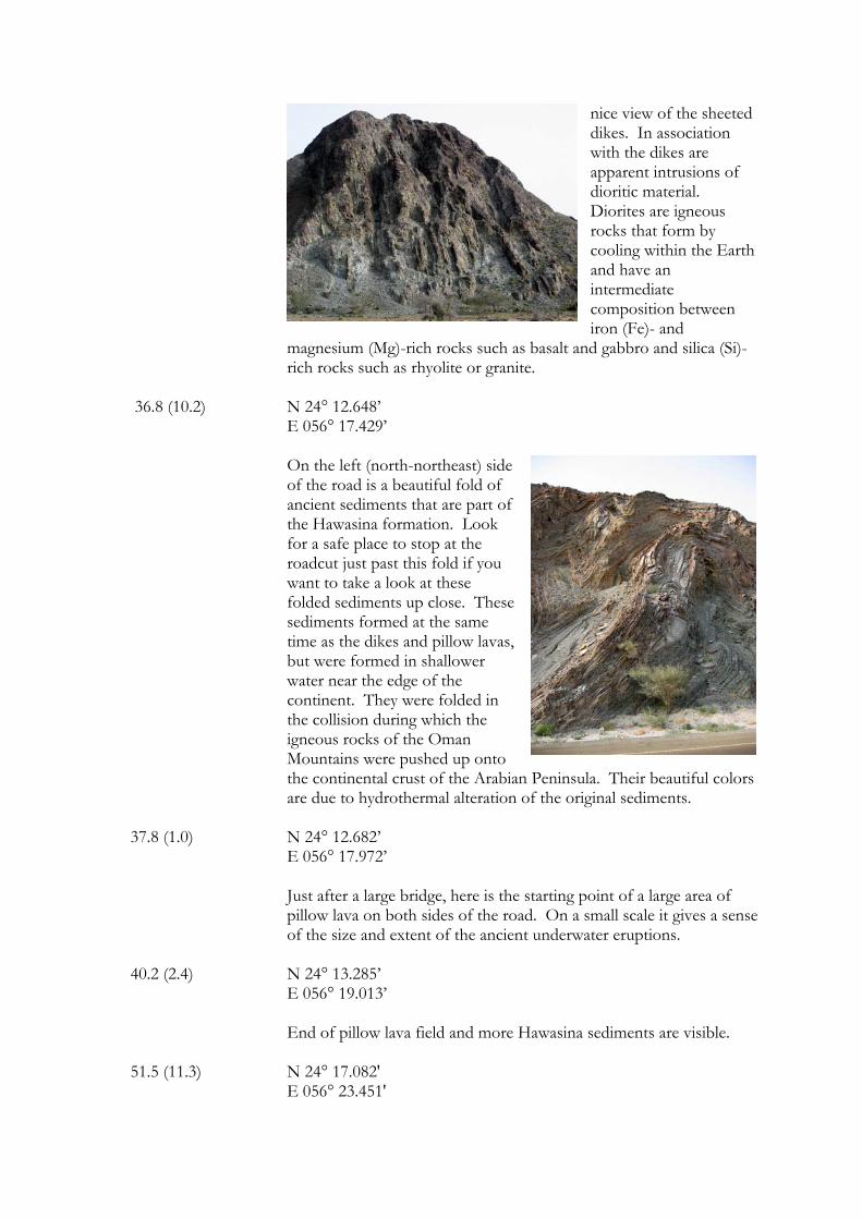
36.8 (10.2) N 24° 12.648’ E 056° 17.429’
On the left (north-northeast) side of the road is a beautiful fold of ancient sediments that are part of the Hawasina formation. Look for a safe place to stop at the roadcut just past this fold if you want to take a look at these folded sediments up close. These sediments formed at the same time as the dikes and pillow lavas, but were formed in shallower water near the edge of the continent. They were folded in the collision during which the igneous rocks of the Oman Mountains were pushed up onto the continental crust of the Arabian Peninsula. Their beautiful colors are due to hydrothermal alteration of the original sediments.
37.8 (1.0) N 24° 12.682’ E 056° 17.972’
Just after a large bridge, here is the starting point of a large area of pillow lava on both sides of the road. On a small scale it gives a sense of the size and extent of the ancient underwater eruptions.
40.2 (2.4) N 24° 13.285’ E 056° 19.013’
End of pillow lava field and more Hawasina sediments are visible. 51.5 (11.3) N 24° 17.082' E 056° 23.451'
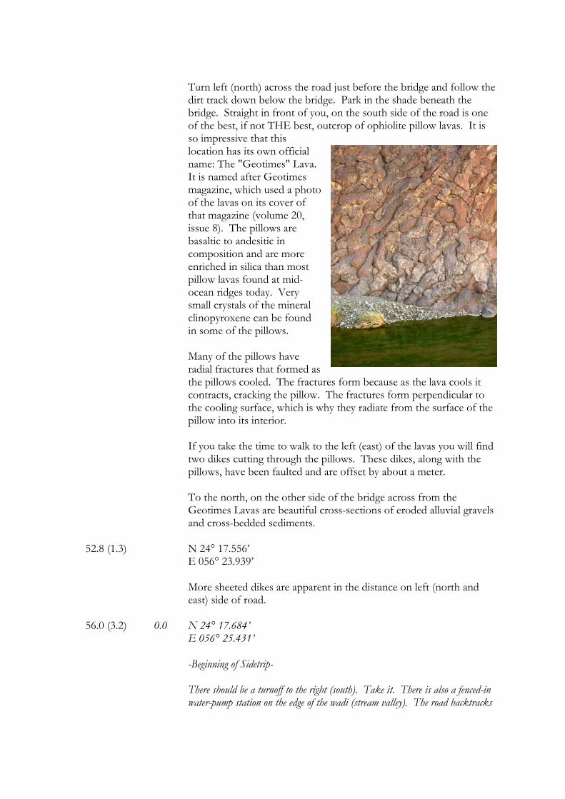
Turn left (north) across the road just before the bridge and follow the dirt track down below the bridge. Park in the shade beneath the bridge. Straight in front of you, on the south side of the road is one of the best, if not THE best, outcrop of ophiolite pillow lavas. It is so impressive that this location has its own official name: The "Geotimes" Lava. It is named after Geotimes magazine, which used a photo of the lavas on its cover of that magazine (volume 20, issue 8). The pillows are basaltic to andesitic in composition and are more enriched in silica than most pillow lavas found at mid-ocean ridges today. Very small crystals of the mineral clinopyroxene can be found in some of the pillows. Many of the pillows have radial fractures that formed as the pillows cooled. The fractures form because as the lava cools it contracts, cracking the pillow. The fractures form perpendicular to the cooling surface, which is why they radiate from the surface of the pillow into its interior. If you take the time to walk to the left (east) of the lavas you will find two dikes cutting through the pillows. These dikes, along with the pillows, have been faulted and are offset by about a meter. To the north, on the other side of the bridge across from the Geotimes Lavas are beautiful cross-sections of eroded alluvial gravels and cross-bedded sediments.
52.8 (1.3) N 24° 17.556’ E 056° 23.939’
More sheeted dikes are apparent in the distance on left (north and east) side of road.
56.0 (3.2) 0.0 N 24° 17.684’ E 056° 25.431’ -Beginning of Sidetrip-
There should be a turnoff to the right (south). Take it. There is also a fenced-in water-pump station on the edge of the wadi (stream valley). The road backtracks
along the main road a little before turning to the left (south) and travels across the wadi and up the far side (it may not be paved where it crosses the wadi).
0.9 N 24° 17.249’ E 056° 25.218’
Just on the other side of the wadi there is a large outcrop of pillow lavas on the right (west) side.
1.2 N 24° 17.126’ E 056° 25.311’ Here are small, weathered, pillow lavas. 1.6 N 24° 17.049' E 056° 25.483'
Just before the top of the hill should be a gas pipeline crossing. Off to the left (east) is a processing plant that turns copper slag into roadfill.
2.7 N 24° 16.729' E 056° 25.941' The road ends at a large berm that has been built across it. Park here. A short
hike over the berm and to the south will take you through old workings of the Lasial Mine, which had been the largest known massive sulfide deposit in the Oman Mountains. As evidenced by the piles of slag at its south end, near the open pit, the area was mined from ancient times. It was most recently mined beginning in 1983, when underground tunnels were dug. Common minerals here are chrysocolla, pyrite, chalcopyrite, magnetite, hematite, limonite, and sphalerite. The copper-sulfide deposits here were formed by ancient, submarine hydrothermal vents, similar to those that exist today on the bottom of the ocean and which consist of chimneys of "black" and "white" smokers and have extensive communities of tubeworms, clams, and other exotic life. Magma near the surface heats seawater that has percolated into the rocks. As this seawater is heated it dissolves metals from the surrounding rocks. As this heated water reenters the overlying seawater it cools very rapidly (sometimes from 400° C to 2° C) and precipitates the now concentrated metals, such as copper, and other elements, such as sulfur.
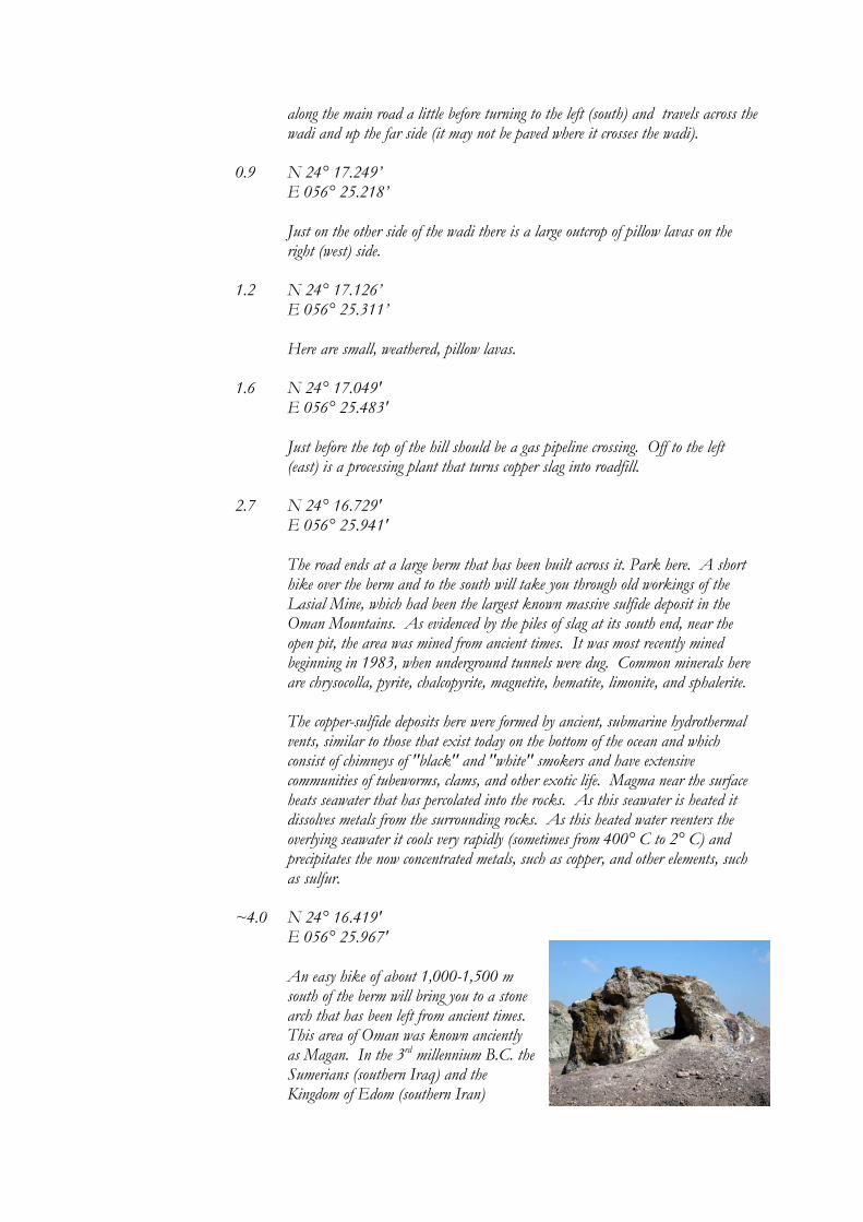
~4.0 N 24° 16.419'
E 056° 25.967' An easy hike of about 1,000-1,500 m
south of the berm will bring you to a stone arch that has been left from ancient times. This area of Oman was known anciently as Magan. In the 3rd millennium B.C. the Sumerians (southern Iraq) and the Kingdom of Edom (southern Iran)
obtained most of their copper from this region. Copper has been mined here for well over 4,000 years and the copper in many ancient artifacts from all over the Gulf Region have been identified as coming from Oman.
The hill just north of the arch consists of more sheeted dikes that have been tilted
and are almost horizontal. After exploring the area you can return to the highway and the main route. -End of Sidetrip- 56.1 (0.1) Just past the turn to the copper mine, on the left (north) side of the
road is a hill of what appears to be hydrothermally-altered basaltic rocks.
57.3 (1.2) N 24° 18.180' E 056° 25.595'
Al Hayool. Oman Mining Company copper smelter entrance – look for large smokestack and overpass. Copper is still being actively mined today.
61.4 (4.1) N 24° 19.098’ E 56° 27.616’
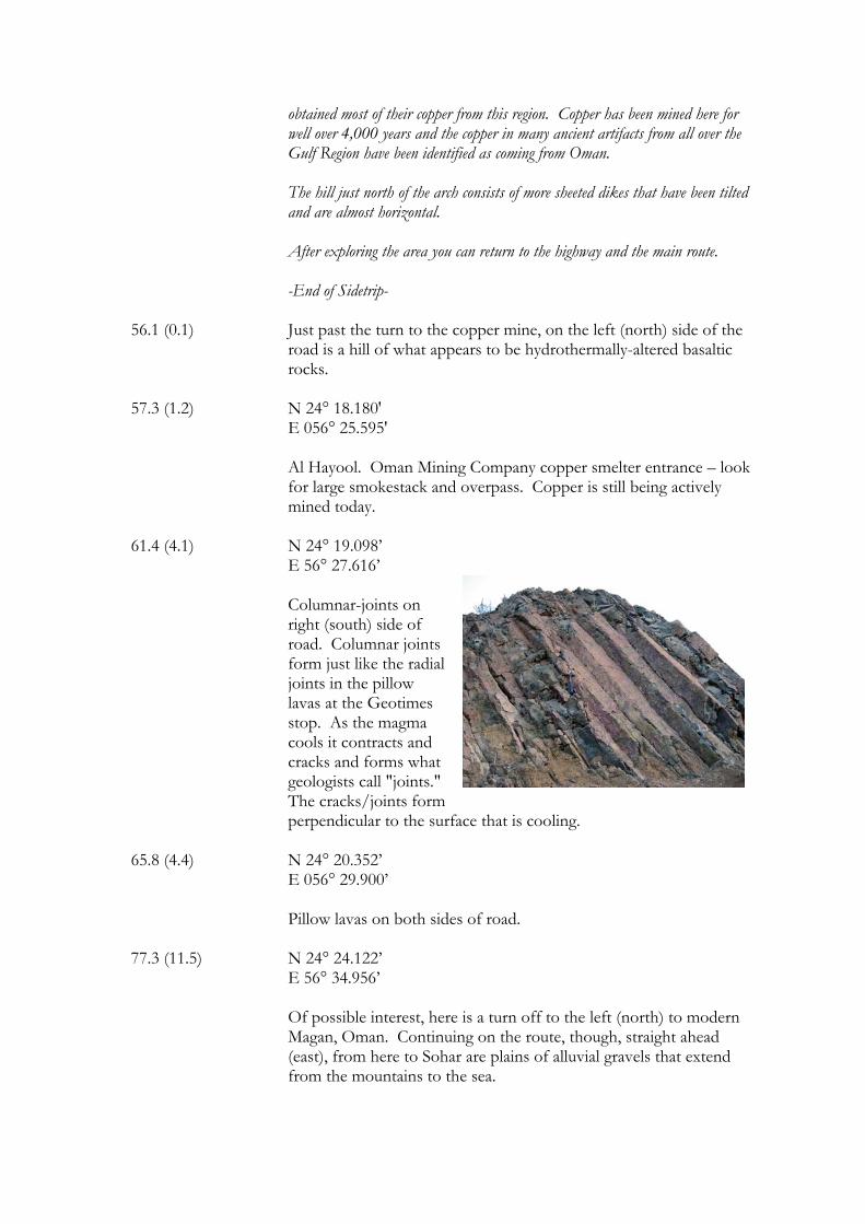
Columnar-joints on right (south) side of road. Columnar joints form just like the radial joints in the pillow lavas at the Geotimes stop. As the magma cools it contracts and cracks and forms what geologists call "joints." The cracks/joints form perpendicular to the surface that is cooling.
65.8 (4.4) N 24° 20.352’ E 056° 29.900’
Pillow lavas on both sides of road. 77.3 (11.5) N 24° 24.122’ E 56° 34.956’
Of possible interest, here is a turn off to the left (north) to modern Magan, Oman. Continuing on the route, though, straight ahead (east), from here to Sohar are plains of alluvial gravels that extend from the mountains to the sea.
81.0 (3.7) N 24° 25.416' E 056° 36.677'
Buraimi/Sohar Road roundabout. It is officially named the Falaj al Qabail Roundabout. There is a rock fountain in the middle of it. Turning right will take you to Muscat and to the Nakhl chromite deposit (see Route 6). End.
Route 6 Slice of Moho and the Nakhl Chromite Quarry, Oman Features Chromite deposit, asbestos veins, Moho in Wadi al Abyad, magnesite veins in peridotite, unconformity, faulted slice of Moho. Directions from Muscat, Oman on the Coast Road (Highway 01) At the intersection/roundabout in Barka, where Highway 01 connects to Highway 13 zero your odometer and take Highway 13 towards Nakhl, Oman (west). Route Sidetrip Mileage Mileage (km) (km)
(The distance from the last stop is in parentheses) 0.0 (0.0) N 23° 40.037’
E 057° 53.018’ Barka/Rustaq/Nahkl roundabout in Barka. Zero your odometer and go left (west).
30.1 (30.1) Of possible interest, here is a left (south) turn towards Nakhl. It is an
area worth exploring, but for this route, continue going straight. 39.1 (9.0) 0.0 N 23° 22.832’
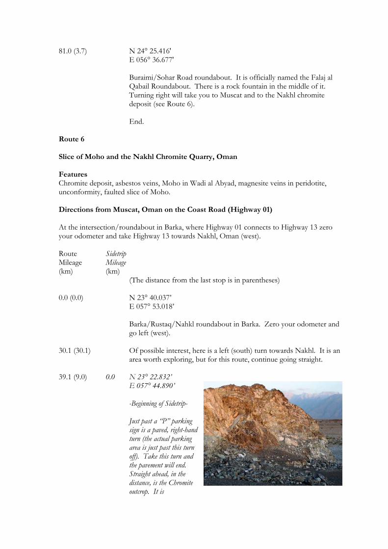
E 057° 44.890’ -Beginning of Sidetrip- Just past a “P” parking sign is a paved, right-hand turn (the actual parking area is just past this turn off). Take this turn and the pavement will end. Straight ahead, in the distance, is the Chromite outcrop. It is
whitish/grayish in color. Follow the dirt track straight to the exposure. Do not take the left trail if the road splits.
0.7 N 23° 23.181’
E 057° 44.839’ Chromite quarry and outcrop. Chromite crystals are clearly evident, often in a matrix of serpentinized olivine. Chromite is a very dense and dark-colored, silvery mineral that forms in the Earth's mantle. It is rarely found on the surface of the Earth because of its great density. When it forms in a magma chamber it sinks, forming layers or pods on the bottom of the chamber. The rock here is also cut by thin veins of magnesite, a magnesium carbonate mineral. Approximately 150 m (165 yards) to the west is an outcrop of altered peridotite containing altered dunite (olivine) pods and cut by veins of asbestos. After collecting a few samples you can return to the highway and the main route.
-End of Sidetrip- 48.2 (9.1) 0.0 23° 21.817 N 057° 40.233 E -Beginning of ANOTHER Sidetrip-
A’Subaikha turnoff to Wadi al Abyad on the right (north). Turn here for a relatively easy and enjoyable sidetrip and hike to an exposure of Moho.
0.4 N 23° 22.060’
E 057° 40.115’ Roadcut exposure of a large, 30 cm (12 in) wide vein of asbestos on right (east) side of road.
2.7 Paved road ends. From here a 4-wheel drive vehicle is needed. From this point
the round trip to the Moho is approximately 3-4 hours, including driving and hiking time.
3.4 N 23°23.401’
E 057° 39.617’ On the left (north) is a large cliff of exposed peridotite. In this appears to be large tectonic slivers of dark, coarse-grained peridotite within a lighter, fine-grained peridotite.
5.2 N 23° 25.420’
E 057° 40.348’ Approximate end of driveable track. On the left (north) the hill-face is cut by many rhodingite dikes, which, in turn, are cut by multiple faults. Approximate easy hiking time to Moho from here is 2 to 3 hours roundtrip.
All along the hike the dark rock with the reddish-oxidized surface is peridotite, with the more specific name of harzburgite. The brown minerals are oxidized olivine, the green orthopyroxene, and the black chrome spinel. All through the peridotite are thin dikes of gabbro, which form as peridotite melts.
~6.2 N 23° 25.529’ E 057° 40.183’
Very old conglomerate with rounded peridotite and limestone clasts cemented to outcrops of peridotite. The peridotite is cut by many small gabbroic and rhodingite dikes.
~7.0 N 23° 25.993’ E 057° 40.058’ There is a natural arch on the southeast side of river formed in recent cemented
conglomerate. Also in this area are outcrops of the older cemented conglomerate in which
limestone cobbles have been replaced by magnesite. The replacement process forms concentric rings within the space once occupied by the limestone cobble.
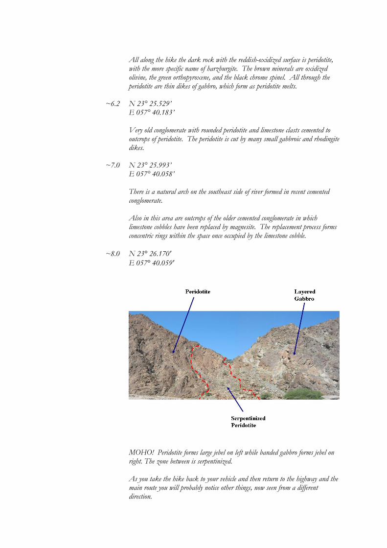
~8.0 N 23° 26.170' E 057° 40.059'
MOHO! Peridotite forms large jebel on left while banded gabbro forms jebel on right. The zone between is serpentinized. As you take the hike back to your vehicle and then return to the highway and the main route you will probably notice other things, now seen from a different direction.
-End of Sidetrip- 53.4 (5.2) N 23° 20.471’ E 057° 38.035’
On the right (north) is a good view of wadi-cut alluvium. The alluvial material was eroded from the surrounding mountains. It is now being re-eroded as the wadi cuts through it. Throughout Earth’s history, its surface materials have been through many, many cycles of such erosion, deposition, then erosion again.
59.5 (6.1) N 23° 19.044’ E 057° 35.355’
On the left (west) is peridotite cut by veins of the white mineral magnesite, a very hard magnesium carbonate. It forms as water rich in dissolved calcium (from limestone) flows through fractures in the peridotite and reacts with the magnesium in the peridotite.
68.2 (8.7) N 23° 19.235’ E 057° 30.528’
In this area on the left (west) are the dipping slopes of the Hajar mountains, which here consist of layers of limestone. On the right (east) are jebels (mountains) of peridotite. In the collision of Arabia with southwest Asia the periodotite, which is older than the limestone, was pushed along a thrust fault onto the limestone. The area of the fault was highly fractured, hydrothermally altered, and weakened. It became soft and easily eroded. The valley that the road you are driving on follows is a result of the more rapid erosion of the material along this fault.
83.0 (14.8) N 23° 24.278’ E 057° 25.275’
Roundabout. Go right. It should be signposted to Musna’ah. 84.9 (1.9) N 23° 25.266’ E 057° 25.213’ Here is a roadcut through tectonically-sheared and faulted sediments.
This occurred as the sediments were compressed horizontally as Arabia began to collide with Iran (southwest Asia) and are now exposed by erosion at the Earth’s surface. This process of collision is still continuing today.
86.2 (1.3) 0.0 N 23° 25.816’
E 057° 25.545’ -Beginning of Sidetrip-
Roundabout to Musna’ah (straight – east), Ibri (left – north), and Rustaq. For the side trip to a beautiful roadcut of faulted Moho turn left toward Ibri (north).
6.2 Blocks of limestone and sediments on left (south) side of road.
11.3 An area of peridotite.
14.9 N 23° 25.300’ E 057° 17.968’
On the left (west) side of this roadcut is an exposure of recent sediments sitting unconformably on top of peridotite rock. An unconformity is a surface that was eroded in the past (in this case, peridotite) and then buried by later sedimentary material.
15.2 N 23° 24.406’ E 057° 17.803’
Here is a roadcut exposure of another unconformity with recent sediments resting on the ancient erosional surface of serpentinite rock or altered peridotite.
19.3 N 23° 25.541’ E 057° 15.653’
To the right (north) are alluvial fans extending from the mountains. There upper surfaces are covered with very dark, desert-varnished cobbles (see Route 4).
19.8 N 23° 25.307’ E 057° 15.664’
This is a roadcut through layered gabbros (see Route 3).
20.4 N 23° 24.953’ E 057° 15.700’ Turnoff to Sai village.
20.7 N 23° 24.805’
E 057° 15.646’ Slice of Moho! Roadcut through a section of interbedded peridotite and gabbro on the left (south) side of the road. The section is bound by faults on either side. Across the road from the Moho outcrop are exposures of layered gabbros.
Return back to main route. -End of Sidetrip- 91.3 (5.1) N 23° 28.277’
E 057° 26.725’ Roundabout. Go straight to continue on to Musna’ah. 93.2 (1.9) Another roundabout. Continue straight. 101.4 (8.2) N 23° 33.458’
E 057° 29.211’ Another roundabout. Continue straight.
126.1 (24.7) N 23° 45.339’
E 057° 34.730’ Musna’ah – Rustaq roundabout. End.
Route 7 Fossil Valley (Jebel Hawaya), Oman Features Rudist bivalve, fusilinid, and ammonite fossils. Dogtooth calcite. (This route is great fun for children and easy for them to find fossils.) Directions from the Hili, UAE/Buraimi, Oman border crossing
If you are coming from Dubai or from Al Ain in the UAE, follow the road signs on the Dubai-Al Ain Road to the Hili Border Crossing. This will be on the north side of Al Ain and near the Hili Archaeological Park. Route Sidetrip Mileage Mileage (km) (km)
(The distance from the last stop is in parentheses) 0.0 (0.0) N 24° 15.704' E 055° 46.065'
The Hili, UAE/Buraimi, Oman border crossing. You will need your passports. If you are coming from the UAE, make sure that you have a multiple entry visa. Set your odometer to 0 here.
0.5 (0.5) N 24° 15.490' E 055° 46.150 Roundabout. Go left (east) towards Sohar. 2.2 (1.7) N 24° 15.490' E 055° 47.036'
Large roundabout. The Sultan Qaboos Mosque is just north of this roundabout. Go relatively straight (northeast), following road towards Sohar.
3.6 (1.4) The Buraimi Hotel on the left (north) side of the road. 4.1 (0.5) N 24° 15.291' E 055° 48.143'
This is called Hospital Roundabout. Turn left (north) here towards Mahdah.
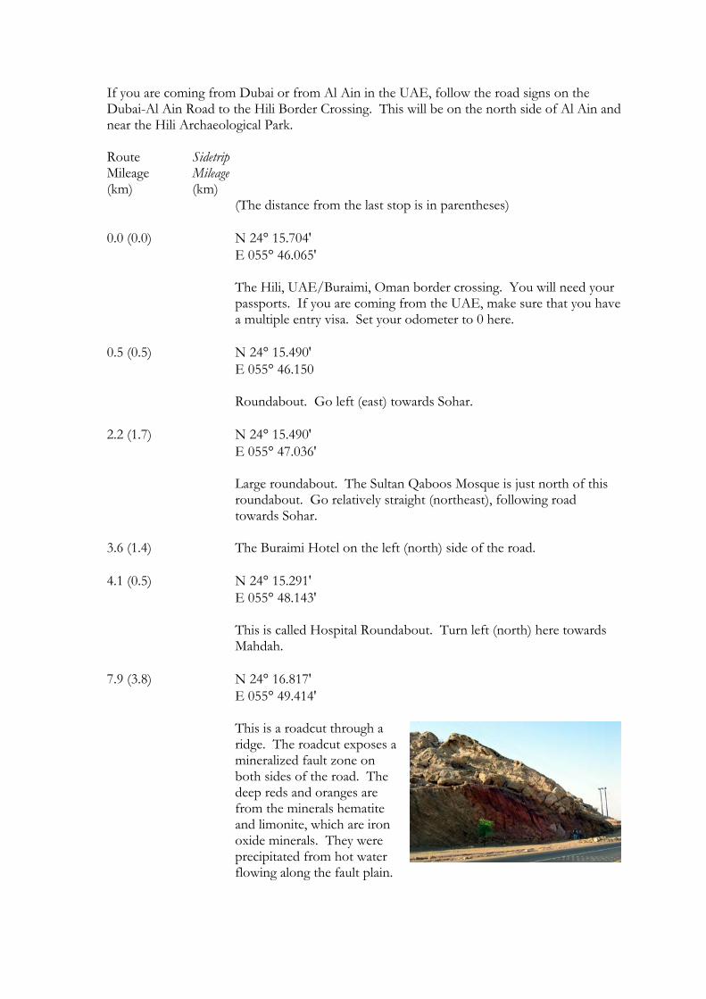
7.9 (3.8) N 24° 16.817' E 055° 49.414'
This is a roadcut through a ridge. The roadcut exposes a mineralized fault zone on both sides of the road. The deep reds and oranges are from the minerals hematite and limonite, which are iron oxide minerals. They were precipitated from hot water flowing along the fault plain.
12.1 (4.2) N 24° 18.935' E 055° 49.660'
Just past the roadcut here you have entered into "Fossil Valley." The valley is really an open plain between a horseshoe-shaped ridge named Jebel Hawaya. Within the center is a group of ghaf trees. At this location is a dirt road (easily driveable by car) following the ridge to the south. Take this track.
There is another track on the opposite side of the valley and running along the far ridge, but it is also closer to waste collection area on the other side of the ridge. The valley has lots of flies because of the proximity of this, but they are worse on the east side of the valley. That side of the valley is not recommended.
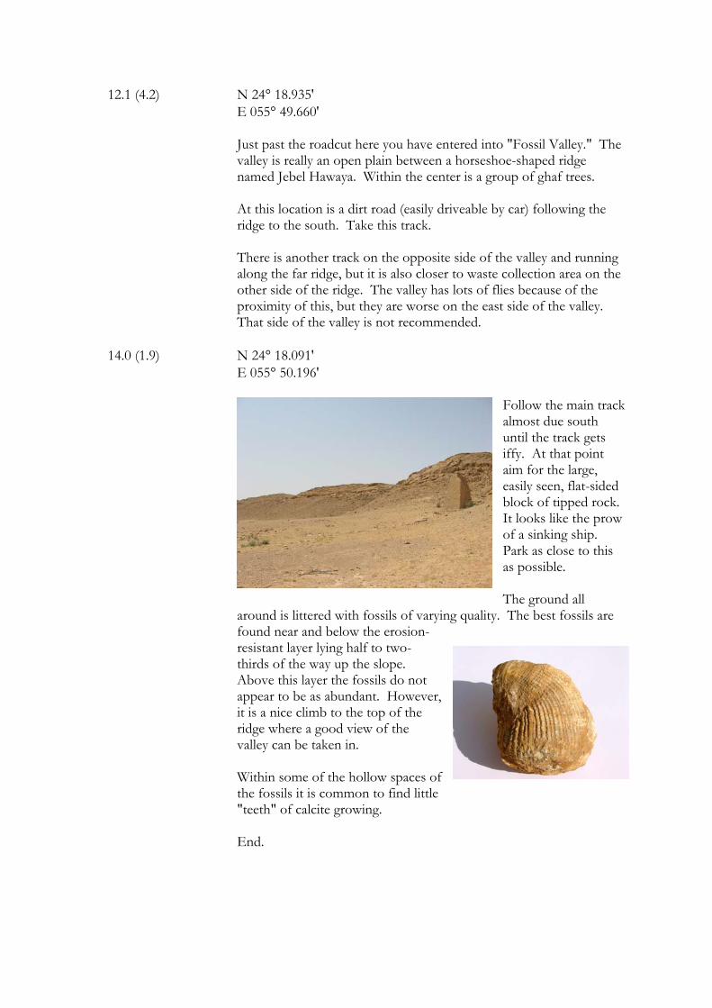
14.0 (1.9) N 24° 18.091' E 055° 50.196'
Follow the main track almost due south until the track gets iffy. At that point aim for the large, easily seen, flat-sided block of tipped rock. It looks like the prow of a sinking ship. Park as close to this as possible.
The ground all
around is littered with fossils of varying quality. The best fossils are found near and below the erosion-resistant layer lying half to two-thirds of the way up the slope. Above this layer the fossils do not appear to be as abundant. However, it is a nice climb to the top of the ridge where a good view of the valley can be taken in. Within some of the hollow spaces of the fossils it is common to find little "teeth" of calcite growing.
End.
Related Documents