GEOGRAPHIC INFORMATION SERVICES, INC 2100 Riverchase Center, Suite 105 - Birmingham, AL 35244 Phone: (205) 941-0442 l Fax: (205) 982-7733 Geospatial Intelligence and Data Sharing for Asset Management and Operations, Vicksburg GIS Day 14 March 2011 Dan Levine Caleb Carter

Welcome message from author
This document is posted to help you gain knowledge. Please leave a comment to let me know what you think about it! Share it to your friends and learn new things together.
Transcript

GEOGRAPHIC INFORMATION SERVICES, INC 2100 Riverchase Center, Suite 105 - Birmingham, AL 35244
Phone: (205) 941-0442 l Fax: (205) 982-7733
Geospatial Intelligence and Data Sharing for
Asset Management and Operations, Vicksburg GIS Day
14 March 2011 Dan Levine
Caleb Carter

Agenda • Who We Are and What we Do • Geospatial Intelligence and Asset Management • Some Examples • Demonstration • Questions
Presenter
Presentation Notes
First of all I would like to thank you for taking time to listen to this presentation. In this presentation Susan and I would like to introduce who we are and what we do and give you a better understanding of the solutions that we support and how you maybe able to use them to grow your accounts Cover each bullet briefly…

Who We Are…
• Small Business founded in 1991 • Award-winning GIS consulting firm • ESRI Platinum Business Partner • Federal, State & Local, and Private Sector Clients • Offices and/or staff in 27 states - Global Execution
Presenter
Presentation Notes
Intro yourself And then hit the highlights of the company – just a quick intro of GISi.

What We Do– Overview
Application Development
Services:
• Web • Mobile
• Desktop • Integration
Data Services:
• Design & Modeling • Migration
• Performance Optimization
Professional Services:
• Strategy
• Architecture • Staff Augmentation
• Installation & Configuration
• Training
C u s t o m e r D r i v e n S o l u t i o n s
Emerging Technologies Research and Development
Value Innovation
Presenter
Presentation Notes
These are GISi’s core competencies – Application Development, Data Services and Professional Services. Data fusion services work across all of these – apps, data sources, and architecture /business process modeling.
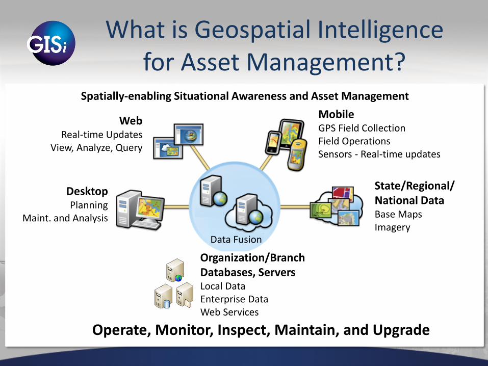
What is Geospatial Intelligence for Asset Management?
Web Real-time Updates
View, Analyze, Query
Mobile GPS Field Collection Field Operations Sensors - Real-time updates
State/Regional/ National Data Base Maps Imagery
Organization/Branch Databases, Servers Local Data Enterprise Data Web Services
Desktop Planning
Maint. and Analysis
Data Fusion
Spatially-enabling Situational Awareness and Asset Management
Operate, Monitor, Inspect, Maintain, and Upgrade

Some Examples
• 3M Sign Inventory Management • Arlington National Cemetery • Panhandle Energy • Railroad Inspection

3M Sign Inventory Management
• Federal Sign Inventory mandate – Retro-reflectivity
• Web and Mobile Product – Initial inventory creation – Work order management – Asset tracking and reporting
• Turned into a Product for 3M
Presenter
Presentation Notes
Sign mgmt Work orders - Utilities location and maintenance Tri and quad view tools – street view (Google streets), overhead aerial/map layers, doc mgmt window (Or facility pics) and information review/entry

GEOGRAPHIC INFORMATION SERVICES, INC 2100 Riverchase Center, Suite 105 - Birmingham, AL 35244
Phone: (205) 941-0442 l Fax: (205) 982-7733

GEOGRAPHIC INFORMATION SERVICES, INC 2100 Riverchase Center, Suite 105 - Birmingham, AL 35244
Phone: (205) 941-0442 l Fax: (205) 982-7733
Tasks created against assets in the office (web) can be synced to workers in the field (mobile), and vice-versa.

GEOGRAPHIC INFORMATION SERVICES, INC 2100 Riverchase Center, Suite 105 - Birmingham, AL 35244
Phone: (205) 941-0442 l Fax: (205) 982-7733
Tasks completed in the field (mobile) can be synced to office staff (i.e., supervisors, analysts, etc.) in the office (web)

Users can dynamically construct custom queries and the results can be visualized on the map or displayed in a report

Arlington National Cemetery
• Big Data collection effort • Plot Management System • Ceremony Planning • Work Order Management • Public Web, Kiosk, Mobile apps

Operations Support Arlington National Cemetery
• Support Mobile Work Teams using smartphones, tablets
• iOS, Android, Blackberry
• Increase efficiency and accuracy of operations
– QA/QC real-time – Map based interface – GPS enabled – Audit trail
• Collect and update data
• Streamlined data collection and data integration
• Mobile vehicle tracking
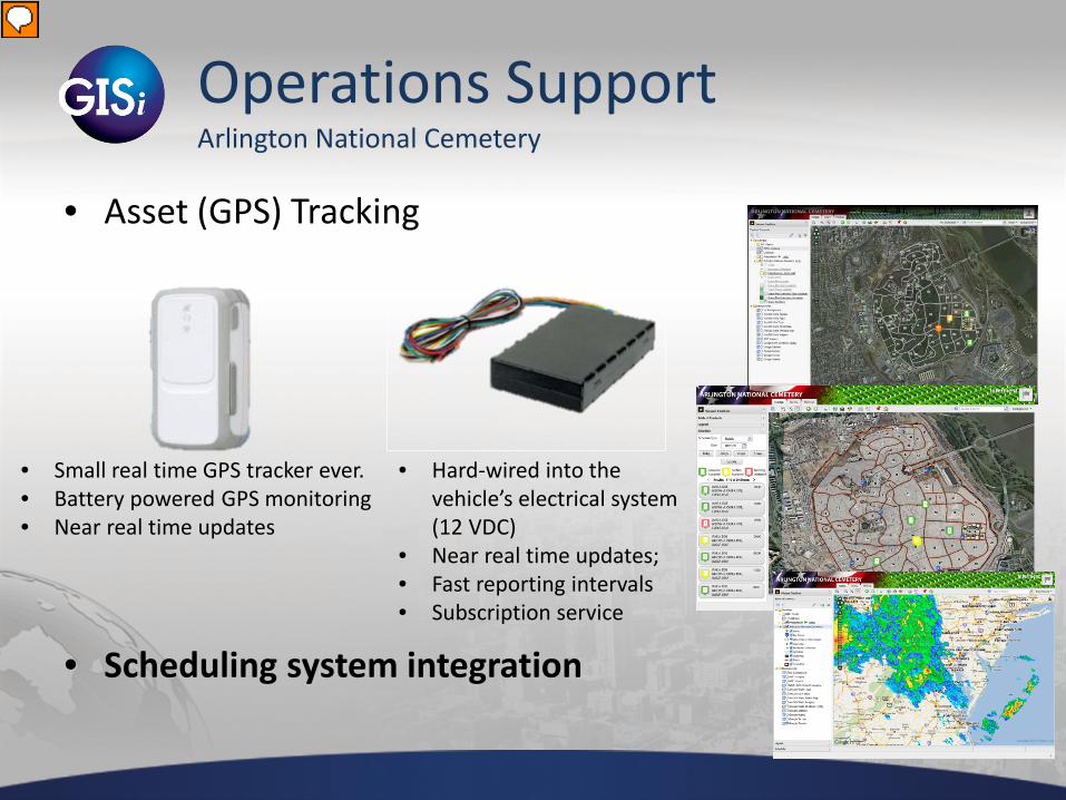
Operations Support Arlington National Cemetery
• Asset (GPS) Tracking
• Scheduling system integration
• Hard-wired into the vehicle’s electrical system (12 VDC)
• Near real time updates; • Fast reporting intervals • Subscription service
• Small real time GPS tracker ever. • Battery powered GPS monitoring • Near real time updates
Presenter
Presentation Notes
Need Dave O to help with images/short video and GPS Tracking Unit Specs

Panhandle Energy
• SCADA Integration • Airborne Pipeline Surveillance
Demo
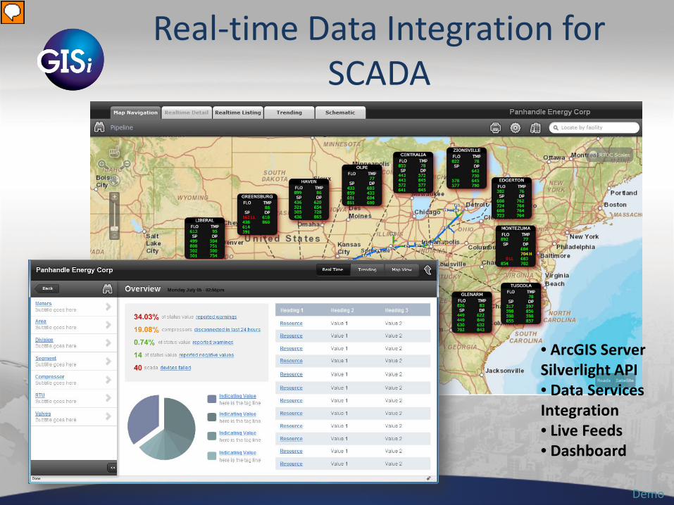
Real-time Data Integration for SCADA
• ArcGIS Server Silverlight API • Data Services Integration • Live Feeds • Dashboard
Presenter
Presentation Notes
Integrating live information back to dashboard- data fusion from sensors, meters, services. Panhandle Energy Energy field Emergency response Monitoring & compliance site – env, utilities, clean-up

Surveillance w/ Mobile (Energy Distribution Example)
Demo
• ArcGIS Server Mobile 10 WPF • Integrated Voice • Dashboard
Presenter
Presentation Notes
Panhandle Energy

USACE Railroad Inventory and Inspections
• Project Goals – Reduce/Eliminate paper notes. – Increase Productivity – Shorten Delivery Schedule
• Technology – ArcGIS Mobile/Server – Trimble Positions
• Challenges – Single Pass Collection (Multiple Features Simultaneously) – Integration With Existing RAILER Software.

Inspection Programs - Streamlining Railroad
• Inspection Teams using Mobile GPS handhelds
• Increase efficiency and accuracy of rail inspections
– Map based interface – GPS enabled – Photo collection
• Streamlined data collection and
data integration
• Replace paper-based workflows
– Collect once – Check into to enterprise
database
• Army Corps of Engineers, ERDC-GSL, Vicksburg
• Framework for other assets
– Facilities, Dams, Bridges

Questions? Dan Levine
[email protected] Caleb Carter
www.gisinc.com showcase.gisinc.com
blog.gisinc.com
Thank You!
Emerging Technologies
• Augmented Reality – LAYARs with Geospatial Data – It’s not just about where the first down market is.
• Kinect – physical interaction with a map / app • GateWing
– Small UAV for aerial photo collection
• Humans vs. Zombies – Human Intelligence – Social Networking
Presenter
Presentation Notes
So we need to mock up an example with services data on ENCs, bathy, coastline, live weather feeds – see links above. Maybe hurricane tracking or flood live data? Then your idea on updating db or spreadsheet for real time refresh- could be one of those 3 above from agenda….

Our Solutions – Learn More
http://showcase.gisinc.com/
Presenter
Presentation Notes
Growing daily and also porting to ArcGIS.com… searchable project listings with videos, case studies, live app links Usually between 85 – 100 active projects at any given point in time… 44 listed today on portal - so about 50% built out - look for much more by this summer’s UC!!
Related Documents