Brazilian Geographical Journal: Geosciences and Humanities research medium, Ituiutaba, v. 5, n. 1, p. 20-45, jan./jun. 2014 20 ARTICLES/ARTIGOS/ARTÍCULOS/ARTICLES Agriculturization and environmental impacts in a representative area of the ecoregion of the Pampas, Argentina Master Patricia Vazquez Universidad Nacional del Centro de la Provincia de Buenos Aires. Facultad de Agronomía y de Ciencias Humanas. CESAL. Nodo CONICET. Paraje Arroyo Seco s/nº, Campus Universitario (CP 7000) Tandil, Buenos Aires Province (Argentina). E-mail: [email protected] Doctor Laura Zulaica Universidad Nacional de Mar del Plata. Facultad de Arquitectura, Urbanismo y Diseño, Centro de Investigaciones Ambientales – CONICET. Funes 3350 (CP 7600) Mar del Plata, Buenos Aires Province (Argentina). E-mail: [email protected] RESUMO: AGRICULTURIZAÇÃO E IMPACTOS AMBIENTAIS NUMA ÁREA REPRESENTATIVA DA ECORREGIÃO DAS PAMPAS, ARGENTINA. Estudos prévios demonstram a existência do processo de agriculturização na ecorregião das Pampas, e o partido de Tandil constitui um exemplo desse processo. Esse trabalho compara as áreas ocupadas pelos distintos usos da terra e seus impactos ambientais na Bacia Superior do Arroio Langueyú e no Partido de Tandil, na qual ela está inserta, em três cortes temporais: 1988, 2002 e 2010. Aplicou-se uma classificação supervisada sobre imagens captadas pelo sensor TM com ajustes realizados no campo. Entre 1988 e 2002, os usos agrícolas têm aumentado significativamente na Bacia (159,5%), enquanto no Partido aumentaram 39,4%. Como conseqüência, os impactos ambientais sobre o meio natural, medidos com indicadores de sustentabilidade, foram mais intensos na Bacia do que no conjunto do Partido. Os resultados obtidos permitem colaborar no desenvolvimento de propostas de gestão ambiental tendentes à sustentabilidade agroecológica. Brazilian Geographical Journal: Geosciences and Humanities research medium UFU ARTICLE HISTORY Received: 12 July 2013 Accepeted: 21 December 2013 PALAVRAS-CHAVE: Sensores remotos Uso da terra Expansão agrícola Indicadores de sustentabilidade Gestão ambiental Ordenamento territorial

Welcome message from author
This document is posted to help you gain knowledge. Please leave a comment to let me know what you think about it! Share it to your friends and learn new things together.
Transcript

Brazilian Geographical Journal: Geosciences and Humanities research medium, Ituiutaba, v. 5,
n. 1, p. 20-45, jan./jun. 2014
20
ARTICLES/ARTIGOS/ARTÍCULOS/ARTICLES
Agriculturization and environmental impacts in a representative area of the ecoregion of the Pampas, Argentina Master Patricia Vazquez Universidad Nacional del Centro de la Provincia de Buenos Aires. Facultad de Agronomía y de Ciencias Humanas. CESAL. Nodo CONICET. Paraje Arroyo Seco s/nº, Campus Universitario (CP 7000) Tandil, Buenos Aires Province (Argentina). E-mail: [email protected] Doctor Laura Zulaica Universidad Nacional de Mar del Plata. Facultad de Arquitectura, Urbanismo y Diseño, Centro de Investigaciones Ambientales – CONICET. Funes 3350 (CP 7600) Mar del Plata, Buenos Aires Province (Argentina). E-mail: [email protected]
RESUMO: AGRICULTURIZAÇÃO E IMPACTOS AMBIENTAIS NUMA ÁREA REPRESENTATIVA DA ECORREGIÃO DAS PAMPAS, ARGENTINA. Estudos prévios demonstram a existência do processo de agriculturização na ecorregião das Pampas, e o partido de Tandil constitui um exemplo desse processo. Esse trabalho compara as áreas ocupadas pelos distintos usos da terra e seus impactos ambientais na Bacia Superior do Arroio Langueyú e no Partido de Tandil, na qual ela está inserta, em três cortes temporais: 1988, 2002 e 2010. Aplicou-se uma classificação supervisada sobre imagens captadas pelo sensor TM com ajustes realizados no campo. Entre 1988 e 2002, os usos agrícolas têm aumentado significativamente na Bacia (159,5%), enquanto no Partido aumentaram 39,4%. Como conseqüência, os impactos ambientais sobre o meio natural, medidos com indicadores de sustentabilidade, foram mais intensos na Bacia do que no conjunto do Partido. Os resultados obtidos permitem colaborar no desenvolvimento de propostas de gestão ambiental tendentes à sustentabilidade agroecológica.
Brazilian Geographical Journal: Geosciences and Humanities research
medium
UFU
ARTICLE HISTORY
Received: 12 July 2013 Accepeted: 21 December 2013
PALAVRAS-CHAVE: Sensores remotos Uso da terra Expansão agrícola Indicadores de sustentabilidade Gestão ambiental Ordenamento territorial

Brazilian Geographical Journal: Geosciences and Humanities research medium, Ituiutaba, v. 5,
n. 1, p. 20-45, jan./jun. 2014
21
ABSTRACT: Agriculturization and environmental impacts in a representative area of the ecoregion of the Pampas, Argentina. Previous studies have shown the existence of the process of agriculturization in the Ecoregion of the Pampas, and Tandil County is a representative example of the process. This paper compares the areas occupied by different land uses and their environmental impacts in the Upper Basin of the Langueyú Creek and in Tandil County, in which the basin is located, in three points of time: 1988, 2002, and 2010. Supervised classification was applied on images captured by the sensor TM with adjustments to field. Between 1988 and 2010, agricultural uses in the Basin increased significantly (159.5%) while in the County, the agricultural areas increased 39.4%. Consequently, the environmental impacts on the environment, measured by sustainability indicators, were more intense in the Basin than in the County as a whole. The results allow collaborate in the development of environmental management proposals aimed at agroecological sustainability. Keywords: remote sensing; land use; agricultural expansion; sustainability indicators; environmental management; land use planning.
RÉSUMÉ. Agriculturization et impacts environnementaux dans une zone representative de l’ecoregion des Pampas, Argentina. Des études préalables démontrent l’existence d’un processus d’agriculturization dans l’écorégion des Pampas, et le département de Tandil constitue un exemple de ce processus. Ce travail compare des zones occupées par des différents usages de la terre et ses impacts environnementaux dans le Bassin Supérieur du Ruisseau Langueyú et dans le département de Tandil, où elle s’insère, dans trois périodes de temps: 1988, 2002 et 2010. On a appliqué une classification supervisée par des images captées avec le senseur TM et des ajustements réalisé sur le terrain. Entre 1988 et 2002, des usages agricoles ont augmenté considérablement dan le Bassin (159,5%), alors que l’augmentation dans tout le département a été de 39,4%. En conséquence, les impacts environnementaux sur le milieu naturel, mesurés avec des indicateurs de durabilité, ont été plus intenses dans le Bassin que dans la totalité du département. Les résultats obtenues permettent de collaborer dans le développement de propositions de gestion environnemental tendent à durabilité agroécologique. RESÚMEN. Agriculturización e impactos ambientales en un área representativa de la ecorregión de las pampas, argentina. Estudios previos demuestran la existencia del proceso de agriculturización en la Ecorregión de las Pampas y el
KEY-WORDS: Remote sensing Land use Agricultural expansion Sustainability indicators Environmental management Land use planning.
MOTS CLÉS: Capteurs à distance Usages de la terre Expansion agricole Indicateurs de durabilité Gestion environnemental Aménagement territorial.
RESÚMEN: Sensores remotos Uso de la tierra Expansión agrícola Indicadores de sustentabilidad Gestión ambiental Ordenamiento territorial

Brazilian Geographical Journal: Geosciences and Humanities research medium, Ituiutaba, v. 5,
n. 1, p. 20-45, jan./jun. 2014
22
partido de Tandil constituye un ejemplo del proceso. Este trabajo, compara las áreas ocupadas por distintos usos de la tierra y sus impactos ambientales en la Cuenca Superior del Arroyo Langueyú y en el partido de Tandil, en el cual se haya inserta, en tres cortes temporales: 1988, 2002 y 2010. Se aplicó una clasificación supervisada sobre imágenes captadas por el sensor TM con ajustes realizados a campo. Entre 1988 y 2010, los usos agrícolas aumentaron significativamente en la Cuenca (159,5%), mientras que en el Partido 39,4%. En consecuencia, los impactos ambientales sobre el medio natural, medidos con indicadores de sustentabilidad, fueron más intensos en la Cuenca que en el Partido en su conjunto. Los resultados obtenidos permiten colaborar en el desarrollo de propuestas de gestión ambiental tendientes a la sustentabilidad agroecológica.
Introduction
The current agricultural revolution demands intense, complex, and expensive mechanization that has not spread far beyond the developed countries, with the exception of some small areas of Latin America, Northern and Southern Africa, and Asia. In these areas, only large farms – public or private, national or foreign – which have access to the necessary economic resources have joined this process (FAO, 2000).
Requesens (2010) analyzes reports of the FAO about agriculture and livestock projections for the next 20 years and stresses that the production activity of global agriculture in the near future is relevant. The FAO estimates that, by 2030, over one billion tones of cereal will be needed each year to meet the demands. To meet these new demands, it is considered that there are still potentially arable lands that have not been used. At present, 1,500 million hectares are used for crops, representing approximately 11% of the world's surface. It is also important to note that unused potential arable land is very unequally distributed.
In Latin America, the expansion of the agricultural area reached 46% and the FAO projections suggest that these trends will remain in developing countries until 2030. However, despite the fact the expansion of land will remain important in Latin America, it is likely that its relative importance will be gradually exceeded by increases in yields. Among Argentina ecoregions described by Burkart et al. (1999), the ecosystems of the Ecoregion of the Pampas are the ones which manifest higher signs of human intervention. Given the productive capacity of the region, the Pampas grasslands have been heavily replaced by agriculture and livestock, and are evidence for, in addition to a significant level of degradation, a low degree of conservation.
This process has been intensified in recent decades as a result of strong agro-productive changes. Thus, the expansion process called "agriculturization" is defined as the continuous and increasing use of land for agricultural crops rather than for livestock or mixed uses (MANUEL-NAVARRETE et al., 2005), and it is

Brazilian Geographical Journal: Geosciences and Humanities research medium, Ituiutaba, v. 5,
n. 1, p. 20-45, jan./jun. 2014
23
associated with technological change, livestock intensification, expansion of the agricultural frontier and development of monoculture oriented productions, mainly soybean, or wheat-soy blend. This process, emerged in the early seventies, is deepened in the mid-nineties with the diffusion of transgenic (GM) varieties of soybean and its expansion into extra pampas regions.
The Pampas has undergone a consistent advancement of agriculture on areas traditionally used for mixed production and a substantial increase in the intensity of land use (VIGLIZZO et al., 2002). In recent years, the advance of soy has further enhanced this phenomenon, which has expanded into other ecoregions of the country.
According to Pengue (2002), the agriculturization process is driven by an unrestricted opening to the entry of external inputs (agrochemicals, fertilizers, machinery) that contributed to the destruction of local industries and prevented a genuine enrichment that contributes to the virtuous circle of development.
In the relationship that man has with nature – the provider of natural resources – man produces a series of changes on it, defined as environmental impacts.
These amendments made by man in agroecosystems affect virtually all processes studied by ecologists, ranging from the behavior of individuals and population dynamics to community composition and matter and energy flow (GHERSA; MARTINEZ -GHERSA, 1991; HALD, 1999). Moreover, it involves alteration of some or several natural factors, thus modifying the interaction between them, and therefore the systemic balance (MONTICO; POUEY, 2001).
To the extent that society recognizes the damage thereof, they are identified as environmental problems, which are understood "as the manifestation of a deficiency (decrease or absence) of rationality between the expressions of the natural subsystem and the social subsystem. On the other hand, the predicament is referred as the network of problems which has effects or impacts on social actors (agents representing society), that become visible, making them more noticeable when they are perceived as risks. It follows from the aforementioned that the cause of the problems is inferred as expressions of imbalances in the relationship between nature and society, determined by a crisis of environmental rationality, on which, concurrently, the objectives of environmental economics erect: achieving maximum social benefit with minimum natural deterioration (FERNANDEZ, 2000).
Altieri (1999) states that agriculture after the Green Revolution brought about environmental problems such as soil and water pollution by extensive use of agrochemicals, substitution and simplification of native ecosystems with biodiversity loss, extreme fragmentation of ecosystems, and soil loss, among others. In similar terms, different authors (CHAPIN et al., 2000; NORRIS; CASWELL-CHEN; KOGAN, 2003; HOOPER et al., 2005, SCHRÖTER et al., 2005) express the alterations linked to agriculturization: 1) changes in biogeochemical cycles, which are partially responsible for global warming and environmental pollution, 2) changes in land use, because of the replacement of forests, grasslands and wetlands for agricultural sites, 3) change in global biodiversity at all levels, from genetic diversity within populations to the diversity
Brazilian Geographical Journal: Geosciences and Humanities research medium, Ituiutaba, v. 5,
n. 1, p. 20-45, jan./jun. 2014
24
of ecosystems in a landscape, either by altering the composition, richness and evenness, or the interactions among organisms, and 4) the dispersion of biota beyond natural boundaries, because of human action.
Given this situation, a response to the worsening of the environmental impacts is the paradigm of sustainable agriculture, which suggests that the achievement of its objectives depends on the proper social, political, economic, technological and environmental management based on ethical values (ZAHEDI; GUDYNAS, 2008).
These environmental problems caused by agriculture, which determine variations in the properties of the ecosystem and its services can, in turn, contribute to the process directly by generating new environmental effects, or indirectly by triggering actions by humans in response to these environmental effects (a representative example of this is the increased use of goods) (HOOPER et al., 2005).
This raises the need for proper management of the agroecosystem, which necessarily implies knowing the role of its different natural components and the effects of agricultural practices on these components. This knowledge is the starting point to develop technologies for sustainable use of resources (SWIFT; ANDERSON, 1993).
The presented problems require tools for assessing their intensity. In this connection, the environmental indicators are mechanisms for articulating the goals of sustainability. Indicators can be defined as variables endowed with meanings derived from their own scientific setting, reflecting a synthetic social interest of the environment that can be consistently included in the decision making process (RUEDA, 1999).
According to Sarandon (2002), the use of indicators should allow fully understanding of the state of sustainability of an agroecosystem or the danger of losing it. Then, the analysis by means of using the indicators allows detecting those critical points of the agroecosystem which extenuate or compromise sustainability. This allows special attention, in subsequent inspections, to the management of such aspects in order to see progress or setbacks. From this diagnosis, it can be proposed corrective measures of the critical points or else an alternative production system that improves or minimizes risks. The proposals should also be evaluated through indicators to know what the impact would be on the sustainability of the system. Finally, after applying this methodology, an analysis should be conducted on the usefulness of the indicators, their degree of difficulty and the importance and relevance of the information they provided. This will serve to make the necessary adjustments to allow developing an appropriate and validated methodology for the circumstances and objectives.
There are specific papers directly related to measures of environmental impacts from indicators generated before and after the major changes in the pampean agriculture (VIGLIZZO et al., 2002; VAZQUEZ, 2004, FRANK, 2007; VAZQUEZ, 2011a, 2011b; VAZQUEZ; ZULAICA, 2010; VAZQUEZ; ZULAICA, 2011; VAZQUEZ, ZULAICA 2012; VAZQUEZ; ZULAICA; SACIDO, 2012; VAZQUEZ; ZULAICA; FERREYRA, 2013; VAZQUEZ, 2013; among others), in which it is concluded that while some impacts tend to improve (soil erosion resulting from application of direct seeding) others are increasing significantly, as
Brazilian Geographical Journal: Geosciences and Humanities research medium, Ituiutaba, v. 5,
n. 1, p. 20-45, jan./jun. 2014
25
in the case of the use of herbicides, insecticides, fungicides, and the decrease of corridors and patches for flora and fauna, among others.
Given the problems derived from the process of agriculturization in the Ecoregion of the Pampas, the interest arouses in evaluating such process and its environmental impacts in a test case. Based on previous studies, Tandil County (Buenos Aires, Argentina) was selected, which has characteristic landscapes of inter-hill areas and also depressed areas, showing important ecosystem diversity (SÁNCHEZ; MATTUS; ZULAICA, 1999). Between 1988 and 2010, 70.1% of the surface of the County showed changes of use (VAZQUEZ; ZULAICA, 2012; VAZQUEZ; ZULAICA; FERREYRA, 2013) and advancement of agriculture does not show the same intensity over the entire surface of the County. This prompted conducting a comparative analysis of this political-administrative unit with a particular area within it: the Upper Basin of the Langueyú Creek (UBLC). This basin is relevant to the County since it concentrates almost its entire population (where the capital city is located).
In order to evaluate the agriculturization process in a sector of the Ecoregion of the Pampas, the present study compares the areas occupied by different land uses and their environmental impacts in the Upper Basin of the Langueyú Creek in Tandil County, in which the Basin is inserted, in three points of time: 1988, 2002 and 2010. Study Area
Tandil County, embedded in the so-called Austral Pampa, is located in the
southeastern sector of the province of Buenos Aires (Figure 1), which covers an area of 493,500 ha. It borders on Rauch, Ayacucho, Balcarce, Lobería, Necochea and Benito Juárez Counties. According to the last population census in 2010, the County has a stable population of 123,343 inhabitants, indicating a relative increase of 14.1% over 2001. Most of the population lives in Tandil City, capital of the County, which is around 300 km away from Buenos Aires City and it is linked to the rest of the province through the 226 National Route and the 30 and 74 Provincial Routes.

Brazilian Geographical Journal: Geosciences and Humanities research medium, Ituiutaba, v. 5,
n. 1, p. 20-45, jan./jun. 2014
26
Figure 1. Tandil County location.
From a climate perspective, Tandil has a humid-subhumid mesothermal
climate with little or no water deficiency. The water balance data reported by Ruiz de Galarreta; Banda Noriega (2010) for the 1900-2000 period show an average annual rainfall of 838 mm, actual and potential evapotranspiration of 649 mm and 712 mm, respectively, an insignificant deficit of 18 mm in total in the months of December, January, and February, and water surplus of 144 mm distributed from May to November.
According to the analysis conducted by the same authors, within the County, different basins of creek are formed, draining waters northeastward toward the depressed Salado basin, except the Basin of the Small Quequén Creek, which drains southbound. One of the basins draining to the northeast is the Basin of the Langueyú Creek, called Upper Basin of the Langueyú Creek (UBLC) when referring to it within Tandil County (Figure 2).
The UBLC, reaching an approximate area of 100,000 ha, has great social significance in the County because there lies the capital city and many of the effluents generated by the city are drained in the waters of the creek that carries the same name with different treatment levels.
The Langueyú Creek has its source in the hills of Tandil because of the contribution of small inter-hill basins of creeks with a torrential regime, located in the south of the city (RUIZ DE GALARRETA; BANDA NORIEGA; BARRANQUERO, 2007). The main sources of the Langueyú Creek (sub-basins of the Blanco and Del Fuerte Creeks) are between 300 and 400 m above sea level in the compartment of the hills.
There are, within the Basin, three rural settlements: Base Aérea, De la Canal, and Iraola on the edge of the watershed, which are linked with each other and with the city of Tandil through an extensive network of roads.

Brazilian Geographical Journal: Geosciences and Humanities research medium, Ituiutaba, v. 5,
n. 1, p. 20-45, jan./jun. 2014
27
Figure 2. Upper Basin of the Langueyú Creek location.
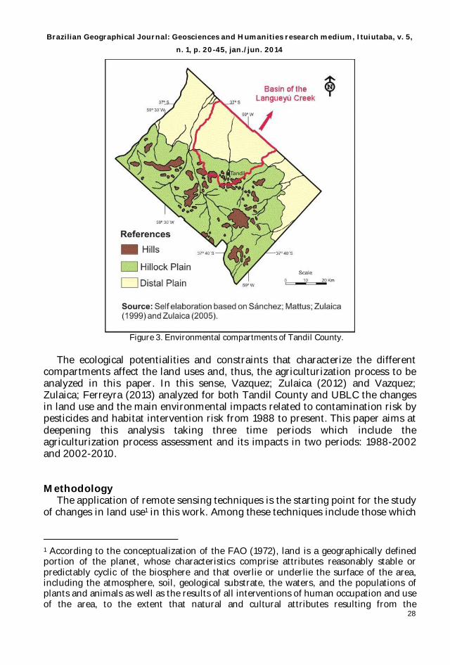
There are integrated studies of Tandil County which have their origin in a
paper by Sánchez; Mattus; Zulaica, (1999) who identified three environmental compartments: Hills, Hillock Plain and distal Plain. The Hills compartment associates different elements of the orographic system of the northern hills of the province of Buenos Aires (Tandilia). Hillock plains succeed the hilly landscape, where relatively low hills and lower slopes sectors integrate, which have good aptitude for agricultural development. The distal or depressed plain compartment altimetrically succeeds the hillock plain. The distal plain consists of flat landscapes, sometimes very flattened, sometimes lightly and evenly inclined. There usually are internal cavities having more or less permanent water bodies, especially in the most depressed plains.
The aforementioned compartments, which can also be differentiated within the UBLC, were characterized in this area in more detailed studies published later on (SÁNCHEZ; ZULAICA, 2002; ZULAICA; SÁNCHEZ, 2003; ZULAICA, 2004; 2005; 2008). The environmental compartments in the County and in the Basin are presented in Figure 3.
Brazilian Geographical Journal: Geosciences and Humanities research medium, Ituiutaba, v. 5,
n. 1, p. 20-45, jan./jun. 2014
28
Figure 3. Environmental compartments of Tandil County.
The ecological potentialities and constraints that characterize the different
compartments affect the land uses and, thus, the agriculturization process to be analyzed in this paper. In this sense, Vazquez; Zulaica (2012) and Vazquez; Zulaica; Ferreyra (2013) analyzed for both Tandil County and UBLC the changes in land use and the main environmental impacts related to contamination risk by pesticides and habitat intervention risk from 1988 to present. This paper aims at deepening this analysis taking three time periods which include the agriculturization process assessment and its impacts in two periods: 1988-2002 and 2002-2010.
Methodology The application of remote sensing techniques is the starting point for the study
of changes in land use1 in this work. Among these techniques include those which
1 According to the conceptualization of the FAO (1972), land is a geographically defined portion of the planet, whose characteristics comprise attributes reasonably stable or predictably cyclic of the biosphere and that overlie or underlie the surface of the area, including the atmosphere, soil, geological substrate, the waters, and the populations of plants and animals as well as the results of all interventions of human occupation and use of the area, to the extent that natural and cultural attributes resulting from the

Brazilian Geographical Journal: Geosciences and Humanities research medium, Ituiutaba, v. 5,
n. 1, p. 20-45, jan./jun. 2014
29
make use of satellite-borne sensors that record electromagnetic energy emitted or reflected by an object or area in different portions of the electromagnetic spectrum (PARUELO et al., 2004).
Once identified the uses and their developments, sustainability indicators pose an interesting alternative for assessing the impacts derived from the agriculturization process.
Following is the procedure used to achieve the objectives proposed in this paper.
Application of remote sensing to the study of changes in land use in Tandil
County and in the UBLC Following the methodological sequence used in other papers in the province of
Buenos Aires (VAZQUEZ; ZULAICA, 2011; VAZQUEZ; ZULAICA, 2012; VAZQUEZ; ZULAICA; FERREYRA, 2013; VAZQUEZ; SACIDO; ZULAICA, 2012), the three images utilized were obtained from previous studies captured by the TM sensor from the Landsat 5 mission with Path/Row 225-86. The acquisition dates were 09/06/1988, 01/16/2002 and 02/23/2010, obtained from the webpage of the National Institute for Space Research (INPE) belonging to the Ministry of Science and Technology of Brazil (www.inpe.br).
In the study of changes in land use in the Tandil County and in the UBLC, we used the software ENVI 4.5 (Research System Inc., Boulder, CO, USA) for image processing. The radiometric calibration performed involved a process in which the DL (digital level) was converted at satellite level to TOA (top of the atmosphere) reflectivity. Landsat 5 images were converted first to radiance values (CHANDER, MARKHAM, 2003; CHANDER; MARKHAM; BARSI, 2007; Science Data). The TOA reflectance was converted to surface reflectance, assuming a uniform Lambertian surface and cloud-free conditions (SCHROEDER et al., 2006; SOUDANI et al., 2006).
Firstly, all the images were drawn to the projection of UTM-Datum WGS-84 - Zone 21, South. The images were georeferenced using as the base image the one provided by the cut of a mosaic of images (2135) from the ETM+ sensor, obtained from the website http://www.landcover.org, Global Land Cover Facility, Earth Science Data Interface . The operation mode of georeferencing consisted of a technique based on obtaining control points between two images, which was conducted by selecting points (a minimum of 20) of the same sector in each image and, through a matrix interpolation done by the software, the images were geometrically corrected with an error of one pixel (Armand, 1995).
To perform the supervised classification, it was necessary to obtain knowledge and information of the County and of the Basin. To do this, field campaigns were conducted, where the GPS (Global Position System) points were obtained, along with information gathered by qualified informants and information extracted
intervention significantly influence on the current and future use of man of such piece of land.

Brazilian Geographical Journal: Geosciences and Humanities research medium, Ituiutaba, v. 5,
n. 1, p. 20-45, jan./jun. 2014
30
from the processed images. With all of the above, the classes or ROIs (Regions of Interest) were oriented, which were then used to implement the algorithm.
For the detection of ROIs, visualization techniques of the images in each selected year were used to represent more accurately the classes associated with the basin (in this case land uses). The used composition was called false color or infrared color on the bands corresponding to near-infrared, red and green, respectively. This composition facilitates mapping plant masses, water bodies, and cities (SOBRINO, 2000).
To adjust the classes, data were surveyed from qualified informants distributed in Tandil County adding, of course, information included in the UBLC. In this way, information was gathered about the crops grown on the date on which the images were selected for the job.
Based on this information, transects were conducted in areas with crops, entering the center of each pasture (to avoid the edge effect) and get a GPS point of the place. Then, this data was referenced in the image defining a ROI buffer around each point. This ensured that the reflectivity of the area is specific to a crop, apart from analyzing the electromagnetic spectrum curves for each ROI obtained and their statistics. Following the same procedure, data were obtained on available pasture for livestock development. Depending on the gathered data and queries conducted to the same informants, classes were adjusted for the image classification of 1998.
These surveys facilitated the achievement of a more precise supervised classification. Then, in the allocation phase, the Maximum Likelihood Classifier (ENVI 4.5) was applied, which is more complex and demands the greatest volume of calculation. However, it is the most used in remote sensing, because of its robustness and the capacity of adjusting with more accuracy to the general layout of the data (CHUVIECO, 2007).
Once obtained the classified images for each selected year, statistics were obtained for the classified images by units, the pixels for each class and their surface was estimated.
Finally, the results of the processing of the images were adjusted on a history database from previous studies (SANCHEZ; ZULAICA, 2002; ZULAICA; SÁNCHEZ, 2003 and ZULAICA, 2004; 2005), using a Geographic Information System (ArcView 3.2).
Evaluation of environmental impacts The assessment of the main environmental impacts of the agriculturization
process was performed using two sustainability indicators: Pesticides Contamination Risk (PCR) and Habitat Intervention Risk (HIR). These indicators were developed by Viglizzo (2003) and were calculated based on the Software Agro-Eco-Index with modifications made from the available data.
For the calculation of PCR, based on the information provided by the satellite images and interviews to qualified informants, the major used pesticides in 1988, 2002 and 2010 were identified. Subsequently, the following equation was used to estimate the relative risk of the compounds:

Brazilian Geographical Journal: Geosciences and Humanities research medium, Ituiutaba, v. 5,
n. 1, p. 20-45, jan./jun. 2014
31
SCTKocRKspLD
RCP2
1250
1000 (1)
10000000000 Where: LD 50 is the average lethal dose of the major used pesticides, which
determines the toxicity of the compounds, Ksp is the average water solubility of the major used pesticides, R expresses soil permeability in surface layers; Koc is the average ratios of adsorption of compounds by the organic soil phase, T ½ is the average half-life of the used products, C expresses the amount of product applied per surface unit; and S is the total surface in which the product is applied (in this case, it corresponds to the agricultural areas of the County and the UBLC). Since the risk indicator was calculated considering a regional space, the equation was adjusted dividing the final result to achieve data between 0 and 1.
In order to assess the consequences of the agroproductive transformations on the habitat, and therefore on the native flora, a second agroecological and environmental sustainability indicator (HIR) was utilized, which was also obtained from the Software Agro-Eco-Index. This indicator was calculated for the main activities in the County and in the UBLC and it was modified to perform temporal analysis at regional level.
According to Viglizzo (2003), the calculation of this indicator aims at generating a relative index which determines the negative impact that imposes a production process on the biodiversity where such process takes place. By using certain coefficients, the indicator compares the present vegetation with the potential vegetation (vegetation that would be present if man had not intervened in the succession process). The comparison is made through "Impact Points", where the highest scores can be understood as major negative effects on native flora and biodiversity. The coefficients used to achieve this comparison are presented in Table 1.

Brazilian Geographical Journal: Geosciences and Humanities research medium, Ituiutaba, v. 5,
n. 1, p. 20-45, jan./jun. 2014
32
Table 1. Coefficients used to estimate the Habitat Intervention Risk. Number of species This is the factor that is considered of greater relative importance, and 10 impact
points are assigned if there is a significant change (both loss and gain of species) in the number of species due to human intervention and 0 points if there is no change.
Origin 7.5 impact points are assigned if a significant proportion of the present species in the
current vegetation is introduced to an ecosystem. It is assumed that the native vegetation, having coexisted with native fauna, is better able to serve the habitat rather than the exotic vegetation.
Periodicity Referred to the dominant vegetation. If the potential vegetation was perennial and it
was replaced by annual species (even if they were native), 5 impact points are assigned. The same happens if the potential vegetation was mostly annual and it becomes perennial.
Vertical Strata Organization It is assumed that a larger number of strata corresponds with a greater availability of
sites for use as natural habitats. Therefore, a change in this number determines a change in the ability of providing shelter and food of the ecosystems. 2.5 impact points are assigned when this occurs.
Vertical Sub-strata Organization It has a lower level of importance and it includes the changes in the number of sub-
strata within one (or some) of the main strata. To get the value of the HIR indicator of the County and of the Basin, in the first
instance, the coefficients obtained for each activity are added and this sum is divided by 26 (to get a value from zero to one). This procedure allows estimating the "Partial Risk of Habitat Intervention" (PRHI).
The PRHI is expressed as follows:
26SvsoVsoFeOrNsPRHI (2)
Where: PRHI is the PRHI indicator, Ns is the coefficient relative to the number
of species, Or indicates the coefficient related to the origin, Fe expresses the frequency coefficient, Vso is the coefficient of vertical strata organization, and Svso is the coefficient of sub-vertical strata organization.
Subsequently, the values obtained for each activity (PRHI) are multiplied by a weighting coefficient that expresses the area occupied by each activity in the County and in the basin. Thus, the sum of the values obtained constitutes the PRHI, which is represented as follows:
PRHIwfAcSurHIR * (3)

Brazilian Geographical Journal: Geosciences and Humanities research medium, Ituiutaba, v. 5,
n. 1, p. 20-45, jan./jun. 2014
33
Where: HIR is the HIR indicator; wfAcSur is the weighting factor that indicates the proportion of the surface of the County and the basin occupied by the activity, and PRIH is the PRIH indicator.
The data provided by the supervised classification of satellite imagery, field campaign data, and the methodologies developed in the works cited at the beginning were taken as reference when analyzing the agriculturization process and assessing the mentioned indicators.
Results and discussion Land uses
As posed by Marlenko (2003) and Altieri (1999), the analysis of land use is an important variable in research in various disciplines that have as study the interaction between the environment and the dynamic changes which anthropic action stamps.
According to Guerschman et al. (2003), the images generated by remote sensors provide qualitative and spatially continuous data of the surface, proving useful to describe the use of large pieces of land. The distinction of cover types is based on the uniqueness of their spectral response and on temporary changes that might occur. In similar terms, Alperín; Borges; Sarandón (2002) argue that remote sensing, especially satellite images, is an important source of information to map and characterize land use and landscape structure at regional level.
In order to analyze the agriculturization process in the region from a study area as it is Tandil County, the classified images were obtained in the years 1988, 2002 and 2010. These images allowed making a comparative analysis of changes in land use in Tandil County and in UBLC, (Figure 4, Tables 2 and 3), which allowed identifying different classes for both cases: grassland and pasture areas, arable land (no crops at the time the image was taken), cultivated areas, surface waters, and urban areas. Arable and cultivated areas together represent the total of agricultural land, while the area occupied with grasslands and pastures, the cattle land.

Brazilian Geographical Journal: Geosciences and Humanities research medium, Ituiutaba, v. 5,
n. 1, p. 20-45, jan./jun. 2014
34
Figure 4. Classes that define land uses in Tandil Countyand in the UBLC (1988, 2002, and
2010).
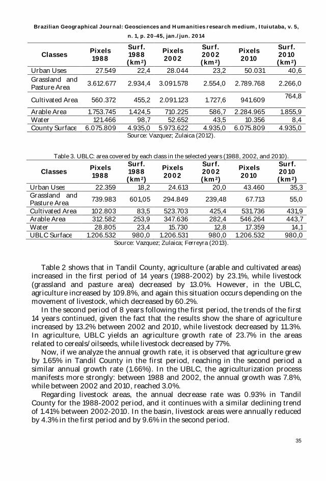
Table 2. Tandil County: occupied area by each class in the selected years (1988, 2002 and 2010).
Brazilian Geographical Journal: Geosciences and Humanities research medium, Ituiutaba, v. 5,
n. 1, p. 20-45, jan./jun. 2014
35
Classes Pixels 1988
Surf. 1988 (km2)
Pixels 2002
Surf. 2002 (km2)
Pixels 2010
Surf. 2010 (km2)
Urban Uses 27.549 22,4 28.044 23,2 50.031 40,6 Grassland and Pasture Area 3.612.677 2.934,4 3.091.578 2.554,0 2.789.768 2.266,0
Cultivated Area 560.372 455,2 2.091.123 1.727,6 941.609 764,8
Arable Area 1.753.745 1.424,5 710.225 586,7 2.284.965 1.855,9 Water 121.466 98,7 52.652 43,5 10.356 8,4 County Surface 6.075.809 4.935,0 5.973.622 4.935,0 6.075.809 4.935,0
Source: Vazquez; Zulaica (2012).
Table 3. UBLC: area covered by each class in the selected years (1988, 2002, and 2010).
Classes Pixels 1988
Surf. 1988 (km2)
Pixels 2002
Surf. 2002 (km2)
Pixels 2010
Surf. 2010 (km2)
Urban Uses 22.359 18,2 24.613 20,0 43.460 35,3 Grassland and Pasture Area 739.983 601,05 294.849 239,48 67.713 55,0
Cultivated Area 102.803 83,5 523.703 425,4 531.736 431,9 Arable Area 312.582 253,9 347.636 282,4 546.264 443,7 Water 28.805 23,4 15.730 12,8 17.359 14,1 UBLC Surface 1.206.532 980,0 1.206.531 980,0 1.206.532 980,0
Source: Vazquez; Zulaica; Ferreyra (2013).
Table 2 shows that in Tandil County, agriculture (arable and cultivated areas) increased in the first period of 14 years (1988-2002) by 23.1%, while livestock (grassland and pasture area) decreased by 13.0%. However, in the UBLC, agriculture increased by 109.8%, and again this situation occurs depending on the movement of livestock, which decreased by 60.2%.
In the second period of 8 years following the first period, the trends of the first 14 years continued, given the fact that the results show the share of agriculture increased by 13.2% between 2002 and 2010, while livestock decreased by 11.3%. In agriculture, UBLC yields an agriculture growth rate of 23.7% in the areas related to cereals/oilseeds, while livestock decreased by 77%.
Now, if we analyze the annual growth rate, it is observed that agriculture grew by 1.65% in Tandil County in the first period, reaching in the second period a similar annual growth rate (1.66%). In the UBLC, the agriculturization process manifests more strongly: between 1988 and 2002, the annual growth was 7.8%, while between 2002 and 2010, reached 3.0%.
Regarding livestock areas, the annual decrease rate was 0.93% in Tandil County for the 1988-2002 period, and it continues with a similar declining trend of 1.41% between 2002-2010. In the basin, livestock areas were annually reduced by 4.3% in the first period and by 9.6% in the second period.

Brazilian Geographical Journal: Geosciences and Humanities research medium, Ituiutaba, v. 5,
n. 1, p. 20-45, jan./jun. 2014
36
The results for the basin and the County as a whole reflect the technological changes that have taken place in the region. In this connection, it is important to note that crop production technology has changed significantly (OESTERHELD, 2008). First, between 1980 and 1990, the tillage technique grew rapidly replacing conventional sowing. Then, production was intensified through increased use of chemicals, mainly fertilizers. Later on, GM crops followed (DE LA FUENTE; SUÁREZ, 2008) and, more recently, the differential handling by environments began to spread, also called "precision agriculture" (SATORRE, 2005). This technological growth was accompanied by a significant expansion of the agricultural frontier into various extra-Pampean areas and by the agriculturization of the agricultural and cattle rotation system in the Pampas region, resulting in movement and intensification of livestock activity into marginal areas (PARUELO; GUERSCHMAN; VERÓN, 2005) and towards confined environments, known as feedlots (HERRERO; GIL, 2008).
The areas with water in Tandil County significantly decreased especially in the second period: in the first one, the reduction of the area used to this class was by 61%, while in the second period it was by 78.1% in Tandil County. In the UBLC, in the first period, the percentage of occupied area decreased by 45.30%, while in the second period, it increased by 10.16%. The reports produced by the National Institute of Agricultural Technology (INTA) and the used of interviews support the conclusion that the period between 2004 and 2009 is characterized by being drier than others. This could have also affected the progress of agriculture in areas where in 1988 would not have been possible to progress because of waterlogging (VAZQUEZ ; ZULAICA, 2012). The reduction of water areas from 1988 to 2010 in Tandil County was by 91.5% and by 39.54% for the UBLC.
The annual percentage of annual decrease in the first period for Tandil County was by 4.4%, while for the second period, it was by 9.8%. In the Basin, the annual rates of growth of areas occupied by water were by -3.2% and 1.3% for the first and second period, respectively.
Spatial analysis of the obtained results suggest that, in the first period, agricultural expansion occurred primarily in the Hillock Plain, which is the compartment defined by Sánchez; Mattus; Zulaica (1999), which has the best agricultural suitability. In the second period, and once the soils with higher potential are occupied, agriculture continues to advance on the Hillock Plain and onto the Distal Plains, which occupy 35% of the surface of the County. This process of occupation of more depressed areas is directly associated with the presence of the driest period mentioned before.
The agriculturization is manifested most strongly in the Basin than in the County. This difference can be attributed partly to the presence of a higher proportion of very good soils suitable for agriculture (Usability I). In this sense, according to Sánchez; Zulaica (2002) and Zulaica (2005), soils classified as typical argiudolls occupy 81.9% of the Hillock Plains of the County and 98.5% of these plains in the Basin.
There is also a difference in the proportion of areas occupied by water in the last period: in the County as a whole, they decrease, while in the Basin, they slightly increase. This could be justified by the greater difficulty of the Basin in releasing water excesses due to a higher proportion of wet soils (typical

Brazilian Geographical Journal: Geosciences and Humanities research medium, Ituiutaba, v. 5,
n. 1, p. 20-45, jan./jun. 2014
37
Natraquolls, typical Natraqualfs and undifferentiated soils of low areas) in the distal plains, which are distributed by 26.5% in the Basin and 7.4% in the County.
In Tandil County, urban uses increased in the first period by 3.6% and in the second by 75%. This increase was reflected in the UBLC because the urban center, the city of Tandil, is located within the UBLC. The results show that the growth rate of area occupied for urban uses between 1988 and 2002 was by 9.9%, while in the period 2002-2010 was by 76.5%. According to census data, the County grew from 101,228 inhabitants in 1991 to 123,343 in 2010, i.e. population grew by 21.8% over a period of twenty years. This increase took place in urban areas. Thus, annual growth because of urban uses in the first period in Tandil was by 0.3% and in the second period by 9.4% whereas in the UBLC the growth was by 0.7% and by 9.6%, respectively.
Evaluation of environmental impacts
As mentioned in the methodology, sustainability indicators were used for the assessment of some of the most significant environmental impacts.
Pesticides Contamination Risk Indicator
The risk of contamination by pesticides is determined by calculating an indicator. It is important to note that the absolute value of the indicator has no meaning in itself, but its usefulness lies in the ability to compare, in this case, the potential contamination in the County and in the Basin in different years. To conduct the estimate, some of the main chemicals used on farms in 1988, 2002, and 2010 were determined through interviews.
The results show that many of the active ingredients of the chemicals applied in both periods are essentially the same, what varies is the trademark and sale values of the products. It also changes the amount per unit area applied in the year and the area in which they are employed. It may also be noted that, in 1988, pesticides of high hazard and impact on the environment were still used, such as DDT (dichlorodiphenyltrichloroethane) (VAZQUEZ; ZULAICA, 2012).
Table 3 shows the main pesticides used in the cultivation areas in 1988, 2002, and 2010 with the parameters to assess in the risk of contamination.

Brazilian Geographical Journal: Geosciences and Humanities research medium, Ituiutaba, v. 5,
n. 1, p. 20-45, jan./jun. 2014
38
Table 3. Pesticides Contamination Risk in Tandil County and in the UBLC, in 1988, 2002, and 2010. Pesticides LD 50 Ksp R Koc T1/2 C S PCR
Picloran (1988) 0,048 3 4 5 5
Glyphosate (2002, 2010) 0,086 5 4 1 3 Paraquat (1988, 2002, 2010) 1,840 2 4 1 5 Chlorimuron (1988, 2002, 2010) 0,196 4 4 4 3 2,4-d amine salt (1988, 2002, 2010) 0,882 3 4 5 2 Herbicides (1988)
0,20
Herbicides (2002)
0,30 Herbicides (2010)
4,90
Propiconazole (1988, 2002, 2010) 0,125 3 4 4 3
Tebuconazole (1988, 2002, 2010) 0,063 2 4 2 2 Fungicides (1988)
0,15
Fungicides (2002)
0,20 Fungicides (2010)
0,30
Cypermethrin (1988, 2002, 2010) 0,061 1 4 2 3
Endosulfan (1988, 2002, 2010) 2,692 1 4 3 3 Chlorpyrifos (1988, 2002, 2010) 2,152 1 4 3 3 Metamidophos (1988, 2002, 2010) 50,000 5 4 5 1 Aldrin (1988) 25,641 2 4 2 2 DDT (1988) 8,850 4 4 5 1 Insecticides (1988)
0,10
Insecticides (2002)
0,10 Insecticides (2010)
0,20
Tandil County (1988) 1879,6 0,0100 UBLC (1988) 337,4 0,0024 Tandil County (2002) 2314,3 0,0220 UBLC (2002) 707,8 0,0067 Tandil County (2010) 2620,7 0,2230 UBLC (2010) 875,6 0,0745
Source: Self elaboration based on Vazquez; Zulaica (2012) and Vazquez; Zulaica; Ferreyra (2013). References:
LD 50: lethal dose 50 (t/g); Ksp: Solubility (g/g); R: permeability (4 corresponds to the value set for the southern Pampa); Koc: adsorption coefficient of the compound in the soil organic phase (g/g); T ½: half-life of the used products (days); C: amount of product applied annually per hectare (l/ha), S: surface of agricultural areas in the County (km2); and PCR: Pesticides contamination risk in the specified year.
Following the procedure outlined in the methodology, the PCR 1988
indicator shows a value of 0.010. In 2002, it is 0.022, and in 2010, it amounted to

Brazilian Geographical Journal: Geosciences and Humanities research medium, Ituiutaba, v. 5,
n. 1, p. 20-45, jan./jun. 2014
39
0.223. Therefore, there is an increase of 120% and 913.6% for each selected period, the total ascent between 1988 and 2010 being 2,130%.
Similarly, and even more intensely, the same happens in the UBLC, where the PCR indicator in 1988 reveals a value of 0.0024, in 2002 a value of 0.0067, while in 2010, it amounted to 0.0745. Therefore, there is a rise of 179.16% and 1011.94% for each selected period, the total ascent between 1988 and 2010 being 3400.16%. This is mainly justified by the change in production practices, including the change in the type of sowing to unconventional tillage (or direct seeding) (VIGLIZZO et al, 2002).
The foregoing is consistent with the points stated by Pimentel (1992) and Matson et al. (1997), which express that over the last 50 years, pesticides (insecticides, herbicides, and fungicides) have become one of the primary components of agriculture and, although their use is considered economically feasible for most systems, the side effects they have on the environment are often negative (REGANOLD, 1989; PIMENTEL; HEICHEL, 1991; DAILY; EHRLICH, 1992; LEHMAN, 1993; PIMENTEL, 1993; LEVITAN; MERWIN; KOVACH, 1995; BERGELSON; PURRINGTON, 1996; JASENIUK; BRULE-BABEL; MORRISON, 1996; TILMAN, 1998). The above leads to consider the urgent need for responsible use of pesticides, this being a priority in the agenda of agricultural research (NRC, 1999).
The current agroproductive model demands sustained application of pesticides, usually second-generation, of low to moderate persistence. This new productive method allows extending the actual surface to be sown, increasing the amount of pesticides applied per unit area in the year. According to the values obtained in the calculation of the indicator, the risks of pesticide contamination were multiplied approximately by 22.3 between 1988 and 2010 in the County, while in the Basin, they were multiplied by 31.04. The consequences are not insignificant, given that pollution directly affects the quality of surface and ground water resources, which are the main source of supply in the area and this situation leads, in turn, to negative impacts on human health, especially for operators (VAZQUEZ ; ZULAICA, 2010).
Habitat Intervention Risk Indicator The modifications made by man in ecosystems virtually affect all processes
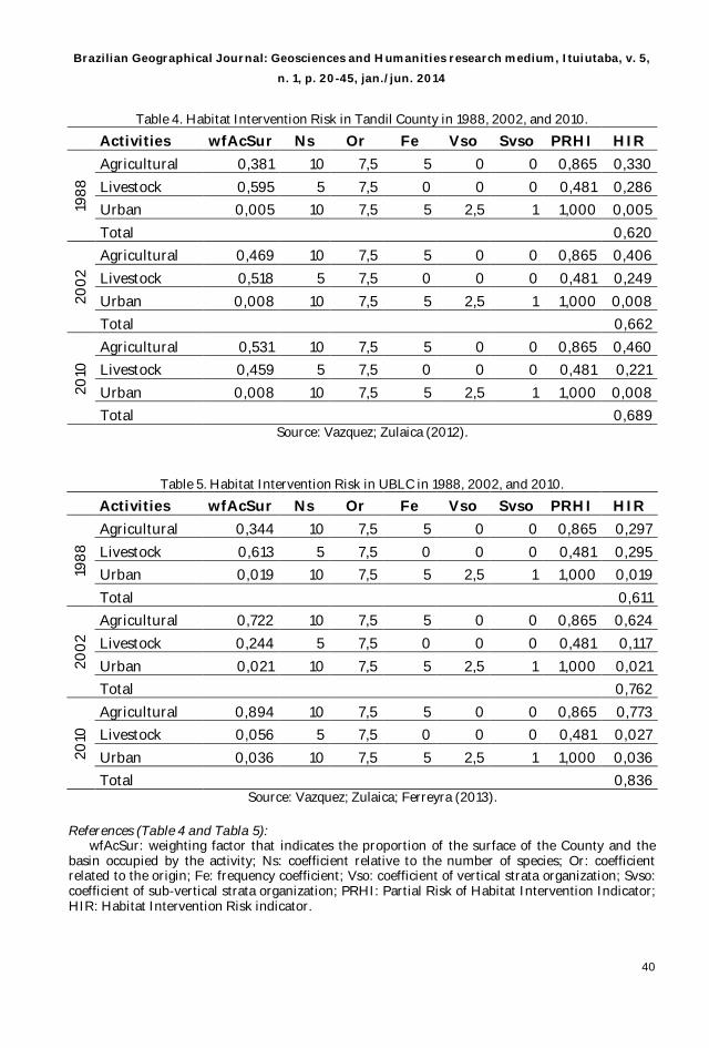
studied by ecologists, ranging from the behavior of individuals and population dynamics to community composition and matter and energy flow (GHERSA; MARTINEZ –GHERSA, 1991; HALD, 1999). In order to measure the impact of the agroproductive changes on the original habitat and biodiversity of the County and of the Basin, we used the Habitat Intervention Risk (HIR) indicator. This indicator was calculated for 1988, 2002, and 2010, following the procedure outlined in the methodology. In Table 4 and Table 5, the applied rates are specified for each year and the obtained HIR results for the different periods.
Brazilian Geographical Journal: Geosciences and Humanities research medium, Ituiutaba, v. 5,
n. 1, p. 20-45, jan./jun. 2014
40
Table 4. Habitat Intervention Risk in Tandil County in 1988, 2002, and 2010.
Activities wfAcSur Ns Or Fe Vso Svso PRHI HIR
1988
Agricultural 0,381 10 7,5 5 0 0 0,865 0,330 Livestock 0,595 5 7,5 0 0 0 0,481 0,286 Urban 0,005 10 7,5 5 2,5 1 1,000 0,005 Total 0,620
2002
Agricultural 0,469 10 7,5 5 0 0 0,865 0,406 Livestock 0,518 5 7,5 0 0 0 0,481 0,249 Urban 0,008 10 7,5 5 2,5 1 1,000 0,008 Total 0,662
2010
Agricultural 0,531 10 7,5 5 0 0 0,865 0,460 Livestock 0,459 5 7,5 0 0 0 0,481 0,221 Urban 0,008 10 7,5 5 2,5 1 1,000 0,008 Total 0,689
Source: Vazquez; Zulaica (2012).
Table 5. Habitat Intervention Risk in UBLC in 1988, 2002, and 2010.
Activities wfAcSur Ns Or Fe Vso Svso PRHI HIR
1988
Agricultural 0,344 10 7,5 5 0 0 0,865 0,297 Livestock 0,613 5 7,5 0 0 0 0,481 0,295 Urban 0,019 10 7,5 5 2,5 1 1,000 0,019 Total 0,611
2002
Agricultural 0,722 10 7,5 5 0 0 0,865 0,624 Livestock 0,244 5 7,5 0 0 0 0,481 0,117 Urban 0,021 10 7,5 5 2,5 1 1,000 0,021 Total 0,762
2010
Agricultural 0,894 10 7,5 5 0 0 0,865 0,773 Livestock 0,056 5 7,5 0 0 0 0,481 0,027 Urban 0,036 10 7,5 5 2,5 1 1,000 0,036 Total 0,836
Source: Vazquez; Zulaica; Ferreyra (2013). References (Table 4 and Tabla 5):
wfAcSur: weighting factor that indicates the proportion of the surface of the County and the basin occupied by the activity; Ns: coefficient relative to the number of species; Or: coefficient related to the origin; Fe: frequency coefficient; Vso: coefficient of vertical strata organization; Svso: coefficient of sub-vertical strata organization; PRHI: Partial Risk of Habitat Intervention Indicator; HIR: Habitat Intervention Risk indicator.

Brazilian Geographical Journal: Geosciences and Humanities research medium, Ituiutaba, v. 5,
n. 1, p. 20-45, jan./jun. 2014
41
When data related to the surface of the activities in Tandil County, and therefore in the Basin, are incorporated, it is observed that biodiversity decreases. Thus, it can be verified that between 1988 and 2002 there is an increase in the value of the HIR, which rises from 0.620 to 0.662. The increase also continues between 2002 and 2010, increasing to 0.689. In the 1988-2002 period, the HIR is increased by 6.84% while, in the 2002-2010 period, the increase was by 3.94%. Now, if what happened in the UBLC between 1988 and 2002 is analyzed, it can be observed that there is a significant increase in the value of HIR (with respect to the County in general), which amounts from 0.611 to 0.762. The same happens, and in greater proportion, between 2002 and 2010, where the HIR is 0.836. Then, between 1988-2002, the HIR is increased by 24.07%, while in the 2002-2010 period the increase was by 9.71%.
This is consistent with what is stated by Chapin et al. (2000), Norris et al. (2003), Hooper et al. (2005) and Schröter et al. (2005), who argue that environmental problems generated by increases in agricultural expansion and intensification of agriculture increased, causing alterations from the replacement of forests, grasslands, and wetlands for agricultural sites. This causes changes in global biodiversity at all levels, i.e. from genetic diversity within populations to the diversity of ecosystems in a landscape, either by altering the composition, richness and evenness or the interactions between organisms and dispersal of biota beyond the natural geographical boundaries.
Given the above and the growing concern for the conservation of biodiversity and agrobiodiversity (inescapable fact in this agroproductive planning), it is necessary the implementation of new experiences, as in the case of Good Agricultural Practices (GAP). These practices are a tool aimed at the sustainability of farms. Currently, the possibilities of certification of such practices pose a challenge for farmers and scientists, promoting new agroproductive forms (VAZQUEZ; ZULAICA, 2011). Conclusions
The major change, which affects the ecoregion of the Pampas from the agriculturization process, soon replaced pastoral and mixed areas with purely agricultural ones. This process, based on the direct seeding technique, and the use of GM crops affect Tandil County and the UBLC. These areas are characterized, within the region, by generally having very good soils suitable for agriculture (Usability I), producing numerous environmental problems. This is the reason why this study analyzes the changes in land uses and some environmental impacts associated with this activity through indicators, such as the Pesticides Contamination Risk (PCR) and the Habitat Intervention Risk (HIR). To achieve the objectives of the paper, it was validated the use of remote sensing, previous papers, remote sensing techniques, use of a geographic information system, and interviews to qualified informants.
The results observed with respect to land use show that agriculture advances to the detriment of livestock, with greater intensity in the first period, 1988-2002, mainly in the Basin (in comparison with the County). In the second period (2002-
Brazilian Geographical Journal: Geosciences and Humanities research medium, Ituiutaba, v. 5,
n. 1, p. 20-45, jan./jun. 2014
42
2010), there is a reduction in the expansion, with consequent agricultural intensification determined by the incorporation of new technology packages and precision planting.
The potential environmental impacts associated with agricultural activities are numerous and of various kinds. Oesterheld (2008), Ghersa et al. (2002), and Giuffré (2008) agree on emphasizing that the main problems associated with agriculture and livestock are pollution because of fertilizers, pesticides, and animal waste (in the case of animal production in confined spaces). They also agree on the concern for various manifestations of land degradation, such as loss of organic matter, nutrients and erosion, and loss of diversity.
Below are the results of this case study relating to the environmental impacts associated with the PCR and HIR: these indicators show a more intense increase in the second period analyzed (2002-2010), both in the County and in the Basin. However, in the latter space unit, the increase is more significant.
The results suggest the need to strengthen the integrated analysis of the County and the UBLC and to generate interdisciplinary knowledge that allows sorting and properly planning agroproductive activities from the study of changes in land use and their main environmental impacts. This practice should be conducted in order to ensure the sustainable use of resources in the areas worked in this paper. The above also applies to the region, as the chosen territory is but one example of a process that acquires these characteristics and whose scale of demonstration transcends political and administrative boundaries.
Given these problems, it is imperative to advance towards environmental management proposals applicable to production processes. Altieri; Nicholls (2000) propose the so-called "alternative agriculture", which is defined as one approach to agriculture that attempts to provide a balanced environment, sustained soil yield and fertility, and natural pest control through the design of diversified agroecosystems and the use of self-sustained technologies. The strategies are based on ecologic concepts, so that the operation results in optimum cycling of nutrients and organic matter, closed energy flows, balanced pest populations, and multiple uses of soil and landscape. These strategies require the implementation of tools such as those raised by the Good Agricultural Practices (GAP) (VAZQUEZ; ZULAICA, 2011). In this connection, the GAP encourage a perspective for the management of natural resources of the County and the Basin, to the extent that they help to assess the potentialities and limitations of the ecosystems for agricultural purposes from an integral perspective, facilitating the design of strategies for land use planning. References ALPERÍN, M.I., BORGES, V.G., SARANDÓN, R. Caracterización Espacial de los Tipos de Cobertura de Suelo usando Técnicas Geoestadísticas a partir de Información Satelital. Revista de la Facultad de Agronomía. 105 (1), 40-51. 2002. ALTIERI, M. Agricultura tradicional y la conservación de la biodiversidad, in: Matteucci, S., Solbrig, O., Morello, J., Halffter, G. (Eds.), Biodiversidad y uso de la tierra; conceptos y ejemplos de Latinoamérica. EUDEBA, Buenos Aires, pp. 71-83. 1999. ALTIERI, M., NICHOLLS, C.I. Agroecología. Teoría y práctica para una agricultura sustentable, 1a edición. Serie Textos Básicos para la Formación Ambiental 4, Programa de las Naciones Unidas para el Medio Ambiente Red de Formación Ambiental para América Latina y el Caribe, México, DF. 2000.

Brazilian Geographical Journal: Geosciences and Humanities research medium, Ituiutaba, v. 5,
n. 1, p. 20-45, jan./jun. 2014
43
ARMAND, M. Télédétection, urbanisme et aménagement. Groupement pour le développement de la télédétection aérospatiale (GDTA), Toulouse. 1995. BERGELSON, J., PURRINGTON, C. Surveying patterns in the cost of resistance in plants. American Naturalist. 148, 536-558. 1996. BURKART, R., BÁRBARO, N.O., SÁNCHEZ, R.O., GÓMEZ, D.A. Eco-regiones de la Argentina. Secretaría de Recursos Naturales y Desarrollo Sustentable, Buenos Aires. 1999. CHANDER, G., MARKHAM. B.L. Revised Landsat-5 TM Radiometric Calibration Procedures and Postcalibration Dynamic Ranges. IEEE Transactions on Geoscience and Remote Sensing. 41(11), 2674-2677. 2003. CHANDER, G., MARKHAM, B.L., BARSI, J.A. Revised Landsat-5 Thematic Mapper Radiometric Calibration. IEEE Geoscience and Remote Sensing Letters. 4(3), 490-494. CHAPIN III, S., ZAVALETA, E., EVINER, V., NAYLOR, R., VITOUSEK, P., 2000. Consequences of changing biodiversity. Nature. 405, 234-242. 2007. CHUVIECO, E. Teledetección Ambiental. La observación de la tierra desde el espacio. Editorial Ariel Ciencia, Barcelona. 2007. DAILY, G., EHRLICH, P. Population, sustainability and Earth's carrying capacity. Bioscience. 42, 761-771. 1992. DE LA FUENTE, E., SUÁREZ, S. Problemas ambientales asociados a la actividad humana: la agricultura. Ecología Austal. 18(3), 235-252. 2008. FAO. El estado mundial de la agricultura y la alimentación 2000, Organización de las Naciones Unidas para la agricultura y la alimentación, Roma. 2000. FERNÁNDEZ, R. La ciudad verde: teoría de la gestión ambiental urbana. Centro de Investigaciones Ambientales-Espacio Editorial, Buenos Aires. 2000. FRANK, F.C. Impacto agro-ecológico del uso de la tierra a diferentes escalas en la región pampeana argentina. Tesis de Magister Scientiae, Facultad de Ciencias Agrarias, Universidad Nacional de Mar del Plata, Balcarce. 2007. GHERSA, C.M., MARTÍNEZ-GHERSA, M.A. Cambios ecológicos en los agroecosistemas de la Pampa Ondulada. Efectos de la introducción de la Soja. Ciencia e Investigación. 5, 182-188. 1991. GHERSA, C.M., FERRARO D.O., OMACINI M., MARTÍNEZ-GHERSA M.A., PERELMAN S., SATORRE, E., SORIANO, A. Farm and landscape level variables as indicators of sustainable land-use in the Argentine Inland Pampa. Agriculture, Ecosystems and Environment. 93, 279-293. 2002. GUERSCHMAN, J.P., PARUELO, J.M., DI BELLA, C.M., GIALLORENZI, M.C., PACÍN, F. Land cover classification in the Argentine Pampas using multi-temporal LANDSAT TM data. International Journal of Remote Sensing. 24, 3381-3402. 2003. GIUFFRÉ, L. Agrosistemas. Impacto ambiental y sustentabilidad. Editorial Facultad de Agronomía, Universidad de Buenos Aires, Buenos Aires. 2008. HALD, A.B. The impact of changing the season in which cereals are sown on the diversity of the weed flora in rotational fields in Denmark. Journal of Applied Ecology. 36, 24-32. 1999. HERRERO, M.A., GIL, S.B. Consideraciones ambientales de la intensificación en producción animal. Ecología Austral. 18, 273-289. 2008. HOOPER, D., CHAPIN, III, S., EWEL, J., HECTOR, A., INCHAUSTI, P. Effects of biodiversity on ecosystem functioning: a consensus of current knowledge. Ecological Monographs. 75(1), 3-35. 2005. JASENIUK, M., BRULE-BABEL, A., MORRISON, L. The Evolution and Genetics of Herbicides Resistance in Weeds. Weed Science. 44, 176-193. 1996. LEHMAN, H. Values, ethics and the use of synthetic pesticides in agriculture, in: Pimentel, H. (Ed.), The Pesticides Question: Environment, Economics and Ethics. Chapman y Hall, London. 1993. LEVITAN, L., MERWIN, L., KOVACH, J. Assessing the relative environmental impacts of agricultural pesticides: the quest for a holistic method. Agriculture. Ecosystems and Environment. 55, 153-168. 1995. MANUEL-NAVARRETE, D., GALLOPÍN, G., BLANCO, M., DÍAZ-ZORITA, M., FERRARO, D., HERZER, H., LATERRA, P., MORELLO, J., MURMIS, M., PENGUE, W., PIÑERO, M., PODESTA, G., SATORRE, E., TORRENT, M., TORRES, F., VIGLIZZO, E., CAPUTO, M., CELIS, A. Análisis sistémico de la agriculturización en la pampa húmeda argentina y sus consecuencias en regiones extrapampeanas: sostenibilidad, brechas de conocimiento e integración de políticas. Serie Medio Ambiente y Desarrollo, Nº 118, División de Desarrollo Sostenible y Asentamientos Humanos, CEPAL, Santiago de Chile. 2005.

Brazilian Geographical Journal: Geosciences and Humanities research medium, Ituiutaba, v. 5,
n. 1, p. 20-45, jan./jun. 2014
44
MARLENKO, N. Uso de la Tierra, in: Navone, S.M. (Ed.), Sensores Remotos aplicados al estudio de los recursos naturales. Editorial Facultad de Medicina, Buenos Aires. 2003. MATSON, P., PARTON, W., POWER, A., SWIFT, M. Agricultural Intensification y Ecosystem Properties. Science. 277, 504-509. 1997. MONTICO, S., POUEY, N. Cuencas Rurales. Pautas y criterios para su ordenamiento. Ed. UNR. Rosario. 2001. NORRIS, R., CASWELL-CHEN, E., KOGAN, M. Ecosystems biodiversity y IPM, in Norris, R.F., Caswell-Chen, E.P., Kogan, M. (Eds.), Concepts in integrated pest management, Prentice Hall, USA, 155-171. 2003. NRC (National Research Council), Our Common Journey: A Tranestablecimient on Toward Sustainability. The National Academic Press, Washington. 1999. OESTERHELD, M. Impacto de la agricultura sobre los ecosistemas. Fundamentos ecológicos y problemas más relevantes. Ecología Austral. 18, 337-346. 2008. PARUELO, J.M., GUERSCHMAN, J.P., BALDI ,G., DI BELLA, C.M. La estimación de la superficie agrícola; antecedentes y una propuesta metodológica. Interciencia. 29, 421-427. 2004. PARUELO, J.M., GUERSCHMAN J.P., VERÓN, S.R. Expansión agrícola y cambios en el uso del suelo. Ciencia Hoy. 15, 14-23. 2005. PENGUE, W. Comercio desigual y deuda ecológica, lo que el Norte le debe al Sur. Le Monde Diplomatique, Edición Cono Sur, Año III, Número 34. 2002. PIMENTEL, D. Ecological effects of pesticides of Non-Target species in terrestrial ecosystems, in Tardiff, R.G. (Ed.), Methods to Assess Adverse Effects of Pesticides on Non-target Organisms. John Wiley & Sons, New York, pp. 171-190. 1992. ------------. Economics and energetics of organic and conventional farming. Agricultural and Environmental Ethics. 6, 53-60. 1993. PIMENTEL, D., HEICHEL, G. Energy Efficiency and Sustainability of Farming Systems, in: Pierce, F.J., Lal, R. (Eds.), Soil Management for Sustainability. Soil Water Conservation Society, Ankeny, IO, pp. 25-34. 1991. REGANOLD, J. Farming's organic future. New Scientist. 122, 49-52. 1989. REQUESENS, E. Perspectivas mundiales, nacionales y regionales de la producción de cereales y carne. Revista de la Sociedad Rural de Azul. 7-10. 2010. RUEDA, S. Modelos e indicadores para ciudades más sostenibles. Fundació Fòrum Ambiental, Cataluña. 1999. RUIZ DE GALARRETA, A., BANDA NORIEGA, R., BARRANQUERO, R. Caracterización Geohidrología preliminar en la Cuenca del Arroyo Langueyú, Partido de Tandil, Buenos Aires, Argentina, in: Centro de Investigaciones Ambientales (CINEA), Estudios Ambientales I, Tandil y área de influencia. Facultad de Ciencias Humanas, Universidad Nacional del Centro de la Provincia de Buenos Aires, Tandil. 2007. RUIZ DE GALARRETA, A., BANDA NORIEGA, R. Caracterización del recurso hídrico y su calidad vinculada a la presencia de nitratos en el partido de Tandil, in: Centro de Investigaciones Ambientales (CINEA), Estudios Ambientales II, Tandil y área de influencia. Facultad de Ciencias Humanas, Universidad Nacional del Centro de la Provincia de Buenos Aires, Tandil, pp. 71-79. 2010. SÁNCHEZ, R., MATTUS, G., ZULAICA, L. Compartimentación ecológica y ambiental del partido de Tandil (Provincia de Buenos Aires), in: Congreso Ambiental ´99. Programa de Estudios Ambientales, Universidad Nacional de San Juan, San Juan, pp. 338-346. 1999. SÁNCHEZ, R., ZULAICA, L. Ordenamiento morfoedáfico de los sistemas ecológico-paisajísticos del partido de Tandil (provincia de Buenos Aires). Contribuciones Científicas. 63, 387-402. 2002. SARANDÓN, S.J. El desarrollo y uso de indicadores para evaluar la sustentabilidad de los agroecosistemas, in: Sarandón (Ed.), Agroecología. El camino hacia una agricultura sustentable. E.C.A., La Plata, pp. 393-414. 2002. SATORRE, E. Cambios tecnológicos en la agricultura argentina actual. Ciencia Hoy. 15, 24-31. 2005. SCHRÖTER, D., CRAMER, W., LEEMAN, R., PRENTICE, C., ARAUJO, M. Ecosystem service supply and vulnerability to global change in Europe. Science. 310, 1333-1337. 2005. SCHROEDER, T.A., COHEN, W.B., SONG, C., CANTY, M.J., YANG, Z. Radiometric correction of multi-temporal Landsat data for characterization of early successional forest patterns in western Oregon. Remote Sensing of Environment. 103, 16-26. 2006. SOBRINO, J.A. Teledetección. Universidad de Valencia, Valencia. 2000.

Brazilian Geographical Journal: Geosciences and Humanities research medium, Ituiutaba, v. 5,
n. 1, p. 20-45, jan./jun. 2014
45
SOUDANI, K., FRANCOIS, C., LE MAIRE, G., LE DANTEC, V., DUFRÊNE, E. Comparative analysis of IKONOS, SPOT, and ETM+ data for leaf area index estimation in températe coniferouns, and deciduos forest stands. Remote Sensing of Environment. 102, 161-175. 2006. SWIFT, M.J., ANDERSON, J. Biodiversity and ecosystem function in agricultural systems, in: Schluze, E.D., Mooney, H.A. Biodiversity and ecosystem function. Springer-Verlag, New York, pp. 15-41. 1993. TILMAN, D. The greening of the green revolution. Nature. 396, 211-212. 1998. VAZQUEZ, P. Comparación temporal de dos modalidades de producción en una estancia del sudeste pampeano (Tandil, Argentina). Tesis de Grado, Facultad de Ciencias Humanas, UNCPBA, Tandil. 2004. ------------. Transformaciones en el uso de la energía en un establecimiento rural del sudeste pampeano, in: III Congreso de Geografía de Universidades Públicas. Departamento de Geografía, Facultades de Humanidades y Ciencias, Universidad Nacional del Litoral, Santa Fe. 2011a. ------------. Evolución de los indicadores agroecológicos del uso del espacio rural en el sudeste pampeano austral in: III Congreso de Geografía de Universidades Públicas. Departamento de Geografía, Facultades de Humanidades y Ciencias, Universidad Nacional del Litoral, Santa Fe. 2011b. ------------. Comparación de índices de estrés hídrico a partir de información captada por el sensor MODIS en la Región Pampeana. Cuadernos Geográficos. V. 53, N. 1, 46-69. 2013. VAZQUEZ, P., ZULAICA, L. Implicancias ambientales de las transformaciones agroproductivas en la Cuenca del río Quequén Grande (Provincia de Buenos Aires, Argentina), in: X Congreso Latinoamericano de Hidrología Subterránea, ALHSUD N° 45, Caracas. 2010. ------------. Aplicación de sensores remotos al estudio de los cambios en el uso de la tierra y su incidencia sobre el hábitat, en la cuenca del rio Quequén Grande (Provincia Buenos Aires, Argentina). Revista Geografia em Questão. 4(2), 270-289. 2011. ------------. Transformaciones agroproductivas e indicadores de sustentabilidad en el Partido de Tandil (Provincia de Buenos Aires) durante los períodos 1988-2002 y 2002-2010. Revista Campo-Território: Revista de Geografía Agrária. 7 (13), 5-39. 2012. VAZQUEZ, P., ZULAICA, L., FERREYRA, V. Expansión agrícola e impactos territoriales en la Cuenca superior del Arroyo Langueyú (Partido de Tandil, provincia de Buenos Aires, Argentina). Revista Geografia em Questão, in press, 2013. VAZQUEZ, P., SACIDO, M., ZULAICA, L. Transformaciones agroproductivas e indicadores de sustentabilidad en la Cuenca del río Quequén Grande (Provincia de Buenos Aires, Argentina) durante los períodos 1988-1998 y 1998-2008. Cuadernos Geográficos. 50, 88-119. 2012. VIGLIZZO, E. Manual AGRO-ECO-INDEX. Programa Nacional de Gestión Ambiental Agropecuaria-Proyecto de Eco-Certificación, Instituto Nacional de Tecnología Agropecuaria, Buenos Aires. 2003. VIGLIZZO, E., PORDOMINGO, A., CASTRO, M., LÉRTORA, F. La sustentabilidad ambiental de la agricultura pampeana ¿oportunidad o pesadilla? 2002. Ciencia Hoy. 12(68), 38-51. 2002. ZAHEDI, K., GUDYNAS, E. Ética y desarrollo sostenible. América Latina frente al debate internacional, in: Gottsbacher, S., Lucatello, M. (Eds.), Reflexiones sobre la ética y la cooperación internacional para el desarrollo: los retos del siglo XXI. Instituto Mora, México, DF, pp. 273–292. 2008. ZULAICA, L. Aproximación al dimensionamiento de la problemática ambiental de los sistemas ecológicos de la Cuenca del Arroyo Langueyú (partido de Tandil). Contribuciones Científicas. 65, 369-389. 2004. ------------. Zonificación Ecológica y Diagnóstico Ambiental de la Cuenca del Arroyo Langueyú (partido de Tandil). Tesis de Maestría en Gestión Ambiental, Facultad de Ingeniería y Ciencias Económico-Sociales, Universidad Nacional de San Luis, Villa Mercedes. 2005. ------------. Sistemas ambientales de la Cuenca Superior del Arroyo Langueyú (partido de Tandil, Argentina). Revista Investigaciones Geográficas. 45, 251-269. 2008. ZULAICA, L., SÁNCHEZ, R. Zonificación ecológica de la Cuenca del Arroyo Langueyú (partido de Tandil). Contribuciones Científicas. 64, 665-684. 2003.
Related Documents