George Washington Birthplace National Monument and Thomas Stone National Historic Site Geologic Resources Inventory Report Natural Resource Report NPS/NRPC/GRD/NRR—2009/127 National Park Service U.S. Department of the Interior Natural Resource Program Center

Welcome message from author
This document is posted to help you gain knowledge. Please leave a comment to let me know what you think about it! Share it to your friends and learn new things together.
Transcript
George Washington Birthplace National Monument and Thomas Stone National Historic Site Geologic Resources Inventory Report
Natural Resource Report NPS/NRPC/GRD/NRR—2009/127
National Park Service U.S. Department of the Interior Natural Resource Program Center
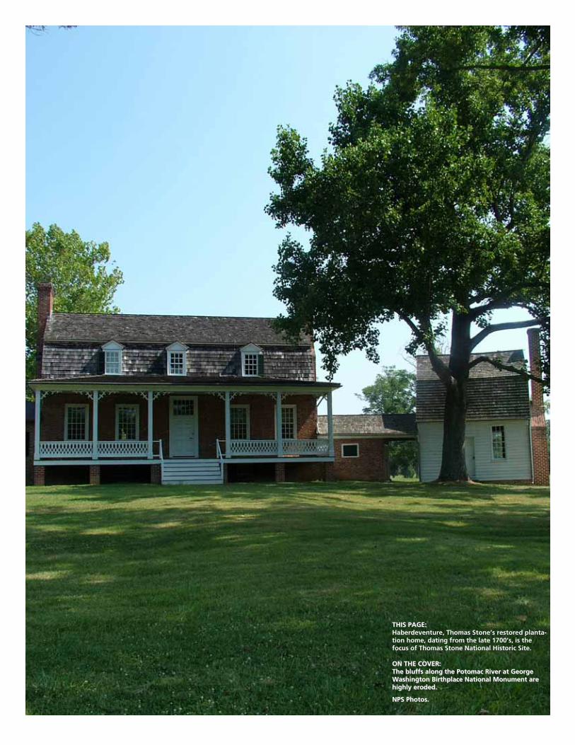
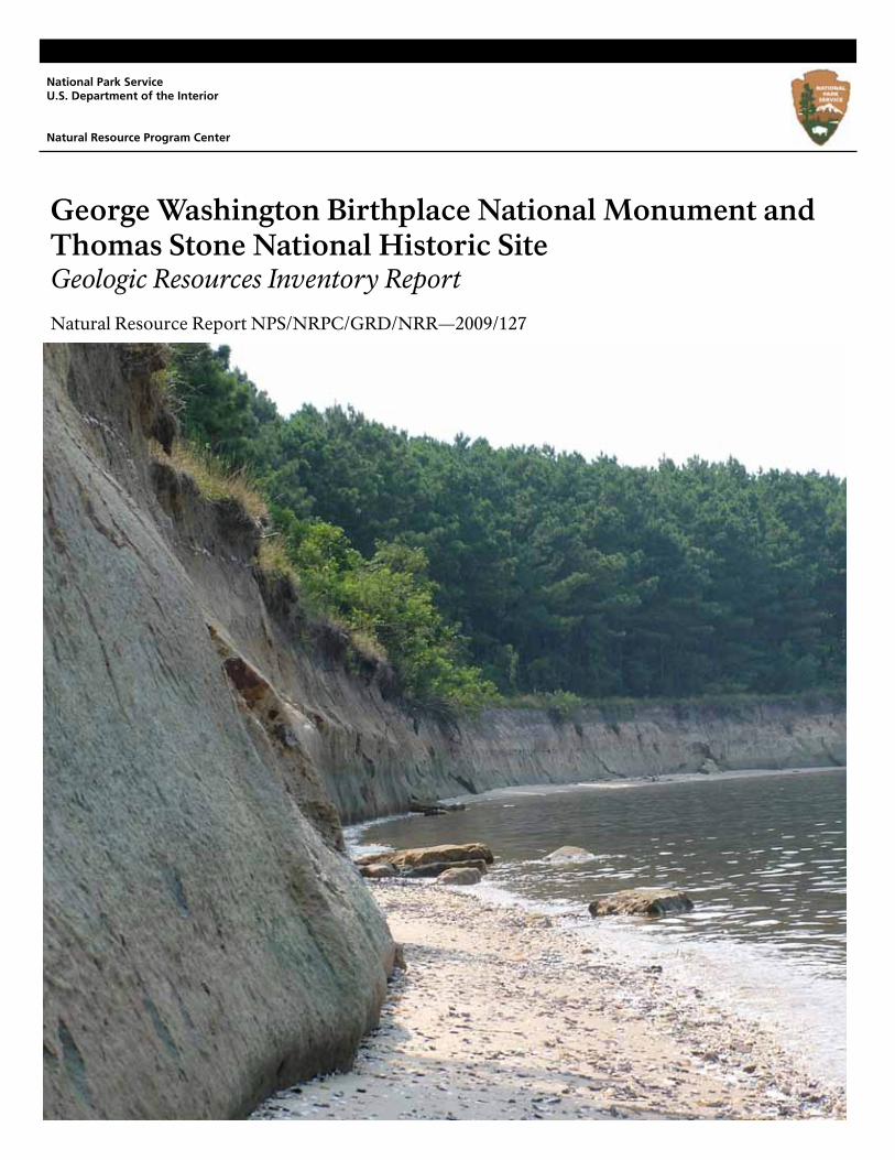
THIS PAGE: THIS PAGE: Haberdeventure, Thomas Stone’s restored planta-tion home, dating from the late 1700’s, is the focus of Thomas Stone National Historic Site. ON THE COVER: ON THE COVER: The bluffs along the Potomac River at George The bluffs along the Potomac River at George Washington Birthplace National Monument are Washington Birthplace National Monument are highly eroded.highly eroded.
NPS Photos. NPS Photos.
George Washington Birthplace National Monument and Thomas Stone National Historic Site Geologic Resources Inventory Report
Natural Resource Report NPS/NRPC/GRD/NRR—2009/127 Geologic Resources Division Natural Resource Program Center P.O. Box 25287 Denver, Colorado 80225
September 2009 U.S. Department of the Interior National Park Service Natural Resource Program Center Denver, Colorado
The Natural Resource Publication series addresses natural resource topics that are of interest and applicability to a broad readership in the National Park Service and to others in the management of natural resources, including the scientific community, the public, and the NPS conservation and environmental constituencies. Manuscripts are peer-reviewed to ensure that the information is scientifically credible, technically accurate, appropriately written for the intended audience, and is designed and published in a professional manner. Natural Resource Reports are the designated medium for disseminating high priority, current natural resource management information with managerial application. The series targets a general, diverse audience, and may contain NPS policy considerations or address sensitive issues of management applicability. Examples of the diverse array of reports published in this series include vital signs monitoring plans; "how to" resource management papers; proceedings of resource management workshops or conferences; annual reports of resource programs or divisions of the Natural Resource Program Center; resource action plans; fact sheets; and regularly-published newsletters. Views, statements, findings, conclusions, recommendations and data in this report are solely those of the author(s) and do not necessarily reflect views and policies of the U.S. Department of the Interior, National Park Service. Mention of trade names or commercial products does not constitute endorsement or recommendation for use by the National Park Service. Printed copies of reports in these series may be produced in a limited quantity and they are only available as long as the supply lasts. This report is also available online from the Geologic Resources Inventory website (http://www.nature.nps.gov/geology/inventory/gre_publications.cfm) and the Natural Resource Publication Management website (http://www.nature.nps.gov/publications/NRPM/index.cfm) or by sending a request to the address on the back cover. Please cite this publication as: Thornberry-Ehrlich, T. 2009. George Washington Birthplace National Monument and Thomas Stone National Historic Site Geologic Resources Inventory Report. Natural Resource Report NPS/NRPC/GRD/NRR—2009/127. National Park Service, Denver, Colorado.
NPS 332/100136, 477/100136, September 2009
ii
GEWA-THST Geologic Resources Inventory Report iii
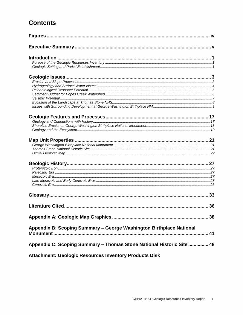
Contents Figures .......................................................................................................................... iv Executive Summary ...................................................................................................... v Introduction ................................................................................................................... 1
Purpose of the Geologic Resources Inventory ........................................................................................................... 1 Geologic Setting and Parks’ Establishment ................................................................................................................ 1
Geologic Issues ............................................................................................................. 3
Erosion and Slope Processes..................................................................................................................................... 3 Hydrogeology and Surface Water Issues ................................................................................................................... 4 Paleontological Resource Potential ............................................................................................................................ 6 Sediment Budget for Popes Creek Watershed ........................................................................................................... 6 Seismic Potential ........................................................................................................................................................ 7 Evolution of the Landscape at Thomas Stone NHS .................................................................................................... 8 Issues with Surrounding Development at George Washington Birthplace NM ........................................................... 9
Geologic Features and Processes ............................................................................. 17
Geology and Connections with History ..................................................................................................................... 17 Shoreline Erosion at George Washington Birthplace National Monument ................................................................ 18 Geology and the Ecosystem ..................................................................................................................................... 19
Map Unit Properties .................................................................................................... 21
George Washington Birthplace National Monument ................................................................................................. 21 Thomas Stone National Historic Site ........................................................................................................................ 21 Digital Geologic Map ................................................................................................................................................ 22
Geologic History.......................................................................................................... 27
Proterozoic Eon ........................................................................................................................................................ 27 Paleozoic Era ........................................................................................................................................................... 27 Mesozoic Era ............................................................................................................................................................ 27 Late Mesozoic and Early Cenozoic Eras .................................................................................................................. 28 Cenozoic Era ............................................................................................................................................................ 28
Glossary ....................................................................................................................... 33 Literature Cited ............................................................................................................ 36 Appendix A: Geologic Map Graphics ........................................................................ 38 Appendix B: Scoping Summary – George Washington Birthplace National Monument .................................................................................................................... 41 Appendix C: Scoping Summary – Thomas Stone National Historic Site ............... 48 Attachment: Geologic Resources Inventory Products Disk
NPS Geologic Resources Division iv
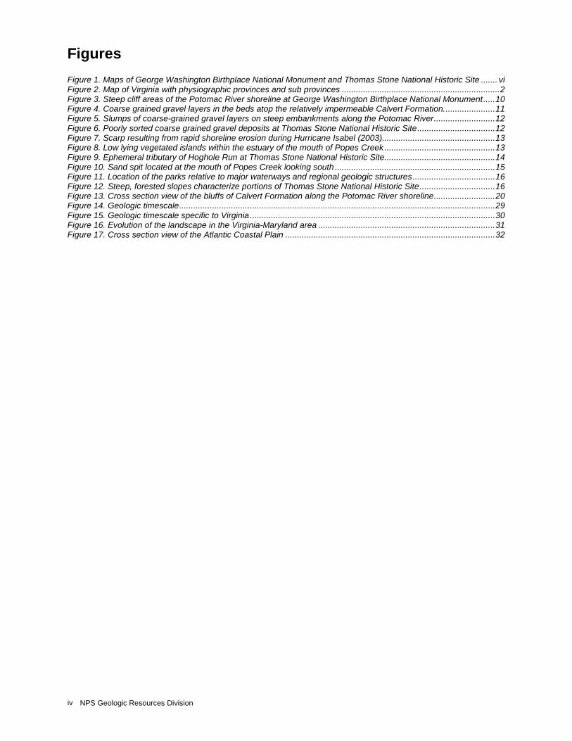
Figures Figure 1. Maps of George Washington Birthplace National Monument and Thomas Stone National Historic Site ....... vi Figure 2. Map of Virginia with physiographic provinces and sub provinces ................................................................... 2 Figure 3. Steep cliff areas of the Potomac River shoreline at George Washington Birthplace National Monument ..... 10 Figure 4. Coarse grained gravel layers in the beds atop the relatively impermeable Calvert Formation. ..................... 11 Figure 5. Slumps of coarse-grained gravel layers on steep embankments along the Potomac River .......................... 12 Figure 6. Poorly sorted coarse grained gravel deposits at Thomas Stone National Historic Site ................................. 12 Figure 7. Scarp resulting from rapid shoreline erosion during Hurricane Isabel (2003)................................................ 13 Figure 8. Low lying vegetated islands within the estuary of the mouth of Popes Creek ............................................... 13 Figure 9. Ephemeral tributary of Hoghole Run at Thomas Stone National Historic Site ............................................... 14 Figure 10. Sand spit located at the mouth of Popes Creek looking south .................................................................... 15 Figure 11. Location of the parks relative to major waterways and regional geologic structures ................................... 16 Figure 12. Steep, forested slopes characterize portions of Thomas Stone National Historic Site ................................ 16 Figure 13. Cross section view of the bluffs of Calvert Formation along the Potomac River shoreline .......................... 20 Figure 14. Geologic timescale ...................................................................................................................................... 29 Figure 15. Geologic timescale specific to Virginia ........................................................................................................ 30 Figure 16. Evolution of the landscape in the Virginia-Maryland area ........................................................................... 31 Figure 17. Cross section view of the Atlantic Coastal Plain ......................................................................................... 32
GEWA-THST Geologic Resources Inventory Report v
Executive Summary This report accompanies the digital geologic map for George Washington Birthplace National Monument in Virginia and Thomas Stone National Historic Site in Maryland, which the Geologic Resources Division produced in collaboration with its partners. It contains information relevant to resource management and scientific research. This document incorporates preexisting geologic information and does not include new data or additional fieldwork. The recognition and designation of George Washington Birthplace National Monument and Thomas Stone National Historic Site represent the patriotism and commitment of those individuals integral in the founding of the United States. Efforts to commemorate Wakefield Plantation, the birthplace of George Washington, lead to the establishment of this monument. It is among the first historical parks in the National Park Service. Thomas Stone, a signer of the Declaration of Independence and early Maryland state senator, was a successful farmer and lawyer. Thomas Stone National Historic Site is set in a pastoral 18th-century landscape and includes his home, Haberdeventure. These two units also support notable natural resources. George Washington Birthplace National Monument and Thomas Stone National Historic Site are part of the Atlantic Coastal Plain physiographic province. The geologic units in this province are relatively flat lying, unconsolidated, and undeformed, which differs from the tilted, metamorphosed, and deformed geologic units west of the Fall Line in the Piedmont province. In the mid-Potomac River area, geologic surface exposures consist primarily of late Tertiary through recent Holocene age sedimentary deposits, including marine sediments with local shell-rich zones and alluvial complexes. Locally, these deposits contain fossils, phosphate- and glauconite-rich sands and some iron-rich minerals. These units delineate the history of ocean transgression and regression. Geologic resources and the natural history of the area merit emphasis and interpretation to enhance the visitor’s experience. Geology serves as the foundation on which an ecosystem rests. For example, many plant species are endemic to certain rock types. Therefore, the geology plays a role in the relationship among organisms in an ecosystem. Geologic processes initiate complex responses that give rise to rock formations, topographic expression, surface and subsurface fluid movement, and soils. Geologic processes form a landscape that sometimes welcomes and sometimes discourages human use. At Wakefield Plantation and Haberdeventure, human land-use disturbances are clear, indicating the environment was suitable for human exploitation. Slopes and meadows have been logged and cleared for agricultural use, irrigation ditches were dug, creeks and streams were dammed, and buildings and roadways constructed. These practices altered the landscape and interfered with natural processes. An understanding of how these
historic impacts have altered the environment and how the sequence of processes has changed the ecological relationships is one goal of cultural resource management. The following high-level management concerns are of importance within the monument and/or historic site:
· Erosion and Slope Processes. Landslides, slumping, slope creep and erosion are dynamic processes, which continue to change the landscape in the management area. These processes alter the historical context of the landscape. Deforested fields and clearings with a greater slope are more susceptible to erosion. Shoreline erosion along the Potomac River at the monument is an ongoing process. Infrequent large storms can cause many meters of shoreline erosion, in addition to the background erosion rate. Therefore, efforts are underway to determine the best way to preserve cultural resources threatened by erosion.
· Hydrogeology and Surface Water Issues. Streams, springs and wetlands were integral to the historic land development at the monument and historic site. Today, knowledge of the area hydrogeologic systems is necessary for resource management and to better predict ecosystem response to changing conditions. Wetlands are located in both parks, which are at risk nationwide. Therefore, these parks merit characterization and monitoring. Marshes, tidal marshes and freshwater wetlands contain soils and sediments, which, in addition to being a reservoir of water and nutrients, contain a record of ecosystem change over the last few hundred years, including changes in vegetation, paleoclimate, biodiversity and predevelopment conditions.
· Paleontological Resource Potential. An assessment and formal inventory of fossil resources will add to the understanding of the geologic history of both parks. Index fossils are useful to correlate geologic units through time and across space. Fossils record information about the depositional environment and provide post-burial information including geochemical and deformational changes. Fossils at the monument are well documented and theft of these resources has been and remains a problem. Fossils have not been formally recorded from within the boundaries of the historic site; however, the geologic units located within the park are known to contain fossils outside of the park.
NPS Geologic Resources Division 6 vi
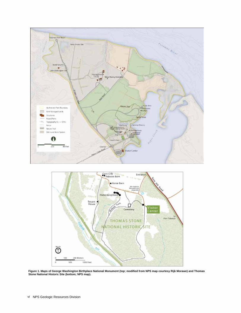
Figure 1. Maps of George Washington Birthplace National Monument (top; modified from NPS map courtesy Rijk Morawe) and Thomas Stone National Historic Site (bottom; NPS map).
GEWA-THST Geologic Resources Inventory Report 1
Introduction The following section briefly describes the National Park Service Geologic Resources Inventory and the regional geologic setting of George Washington Birthplace National Monument and Thomas Stone National Historic Site. Purpose of the Geologic Resources Inventory The Geologic Resources Inventory (GRI) is one of 12 inventories funded under the National Park Service (NPS) Natural Resource Challenge designed to enhance baseline information available to park managers. The program carries out the geologic component of the inventory effort. The Geologic Resources Division of the Natural Resource Program Center administers this program. The GRI team relies heavily on partnerships with the U.S. Geological Survey, Colorado State University, state surveys, and others in developing GRI products. The goal of the GRI is to increase understanding of the geologic processes at work in parks and provide sound geologic information for use in park decision making. Sound park stewardship relies on understanding natural resources and their role in the ecosystem. Geology is the foundation of park ecosystems. The compilation and use of natural resource information by park managers is called for in section 204 of the National Parks Omnibus Management Act of 1998 and in NPS-75, Natural Resources Inventory and Monitoring Guideline. To realize this goal, the GRI team is systematically conducting a scoping meeting for each of the identified 270 natural area parks and providing a park-specific digital geologic map and geologic report. These products support the stewardship of park resources and are designed for nongeoscientists. Scoping meetings bring together park staff and geologic experts to review available geologic maps and discuss specific geologic issues, features, and processes. The GRI mapping team converts the geologic maps identified for park use at the scoping meeting into digital geologic data in accordance with their Geographic Information Systems (GIS) Data Model. These digital data sets bring an interactive dimension to traditional paper maps by providing geologic data for use in park GIS and facilitating the incorporation of geologic considerations into a wide range of resource management applications. The newest maps come complete with interactive help files. This geologic report aids in the use of the map and provides park managers with an overview of park geology and geologic resource management issues. For additional information regarding the content of this report and current GRI contact information please refer to the Geologic Resources Inventory Web site (http://www.nature.nps.gov/geology/inventory/).
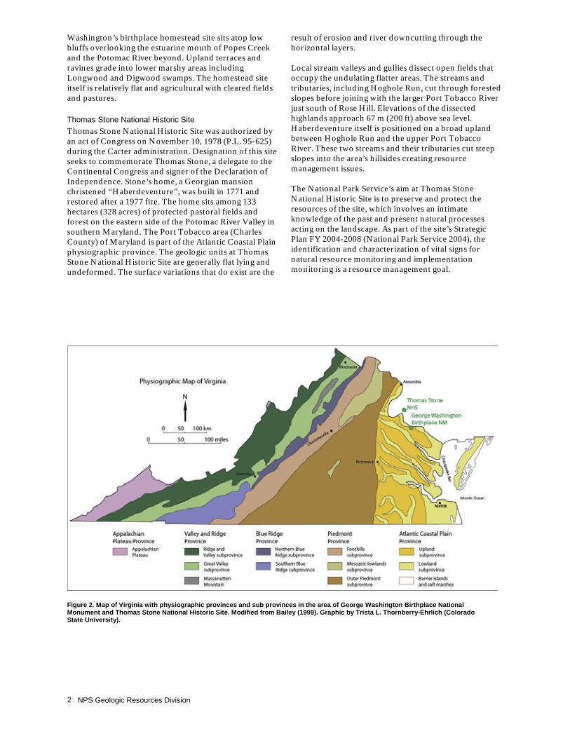
Geologic Setting and Parks’ Establishment In the geographic area of George Washington Birthplace National Monument and Thomas Stone National Historic Site (fig. 1), the eastern United States is divided into five physiographic provinces with associated local subprovinces. From east to west, the provinces are as follows: the Atlantic Coastal Plain, the Piedmont, the Blue Ridge, the Valley and Ridge, and the Appalachian Plateaus (fig. 2). The monument and historic site are part of the Atlantic Coastal Plain. The Atlantic continental margin consists of a series of deeply buried tectonic basins and arches flanked on the west by Proterozoic (“Precambrian”) and Paleozoic metamorphic, igneous, and sedimentary rocks and on the east by the Atlantic Basin. The Atlantic Coastal Plain is primarily flat terrain, dissected by river valleys, and elevations ranging from sea level to about 100 m (300 ft) in coastal Virginia and Maryland. Sediments eroding from the Piedmont and Appalachian highlands to the west formed a wedge-shaped sequence of soft, unconsolidated sedimentary geologic units. These units were deposited intermittently during periods of higher sea level over the past 100 million years punctuated by periods of erosion during marine low stands. These sediment mixtures range from clay to gravel and exceed 2,500 m (8,000 ft) in thickness at the Atlantic coast. Fluctuating sea levels, rivers, tides and the erosive action of waves along the coastline continually rework the mixed deposits. Large streams and rivers in the Coastal Plain province, including the James, York, Potomac and Rappahannock continue to transport sediment and extend the coastal plain eastward.
George Washington Birthplace National Monument The establishment of George Washington Birthplace National Monument occurred during President Herbert Hoover’s administration on January 23, 1930. It is among the first units of the National Park Service established for preserving history. The monument commemorates the 1732 birthplace of George Washington, preserving the heart of Augustine Washington’s Popes Creek Plantation as well as the 17th century home site of John Washington and the Washington family burial ground. Water surrounds George Washington Birthplace National Monument on three sides. The monument covers 268 hectares (662 acres) of Atlantic Coastal Plain on the Northern Neck of Virginia between the Rappahannock and Potomac Rivers, approximately 61 km (38 mi) east of Fredericksburg, Virginia. The watershed of Popes Creek and Potomac shoreline dominate the landscape at the monument. George
NPS Geologic Resources Division 2
Washington’s birthplace homestead site sits atop low bluffs overlooking the estuarine mouth of Popes Creek and the Potomac River beyond. Upland terraces and ravines grade into lower marshy areas including Longwood and Digwood swamps. The homestead site itself is relatively flat and agricultural with cleared fields and pastures.
Thomas Stone National Historic Site Thomas Stone National Historic Site was authorized by an act of Congress on November 10, 1978 (P.L. 95-625) during the Carter administration. Designation of this site seeks to commemorate Thomas Stone, a delegate to the Continental Congress and signer of the Declaration of Independence. Stone’s home, a Georgian mansion christened “Haberdeventure”, was built in 1771 and restored after a 1977 fire. The home sits among 133 hectares (328 acres) of protected pastoral fields and forest on the eastern side of the Potomac River Valley in southern Maryland. The Port Tobacco area (Charles County) of Maryland is part of the Atlantic Coastal Plain physiographic province. The geologic units at Thomas Stone National Historic Site are generally flat lying and undeformed. The surface variations that do exist are the
result of erosion and river downcutting through the horizontal layers. Local stream valleys and gullies dissect open fields that occupy the undulating flatter areas. The streams and tributaries, including Hoghole Run, cut through forested slopes before joining with the larger Port Tobacco River just south of Rose Hill. Elevations of the dissected highlands approach 67 m (200 ft) above sea level. Haberdeventure itself is positioned on a broad upland between Hoghole Run and the upper Port Tobacco River. These two streams and their tributaries cut steep slopes into the area’s hillsides creating resource management issues. The National Park Service’s aim at Thomas Stone National Historic Site is to preserve and protect the resources of the site, which involves an intimate knowledge of the past and present natural processes acting on the landscape. As part of the site’s Strategic Plan FY 2004-2008 (National Park Service 2004), the identification and characterization of vital signs for natural resource monitoring and implementation monitoring is a resource management goal.
Figure 2. Map of Virginia with physiographic provinces and sub provinces in the area of George Washington Birthplace National Monument and Thomas Stone National Historic Site. Modified from Bailey (1999). Graphic by Trista L. Thornberry-Ehrlich (Colorado State University).

GEWA-THST Geologic Resources Inventory Report 3
Geologic Issues The Geologic Resources Division held a Geologic Resources Inventory scoping session for George Washington Birthplace National Monument and Thomas Stone National Historic Site on July 25-26, 2005, to discuss geologic resources, address the status of geologic mapping, and assess resource management issues and needs. This section synthesizes the scoping results, in particular those issues that may require attention from resource managers. Issues in this section are identified in relative order of resource management significance with the most critical listed first. Potential research projects and topics of scientific interest are presented at the end of this section. Contact the Geologic Resources Division for technical assistance.
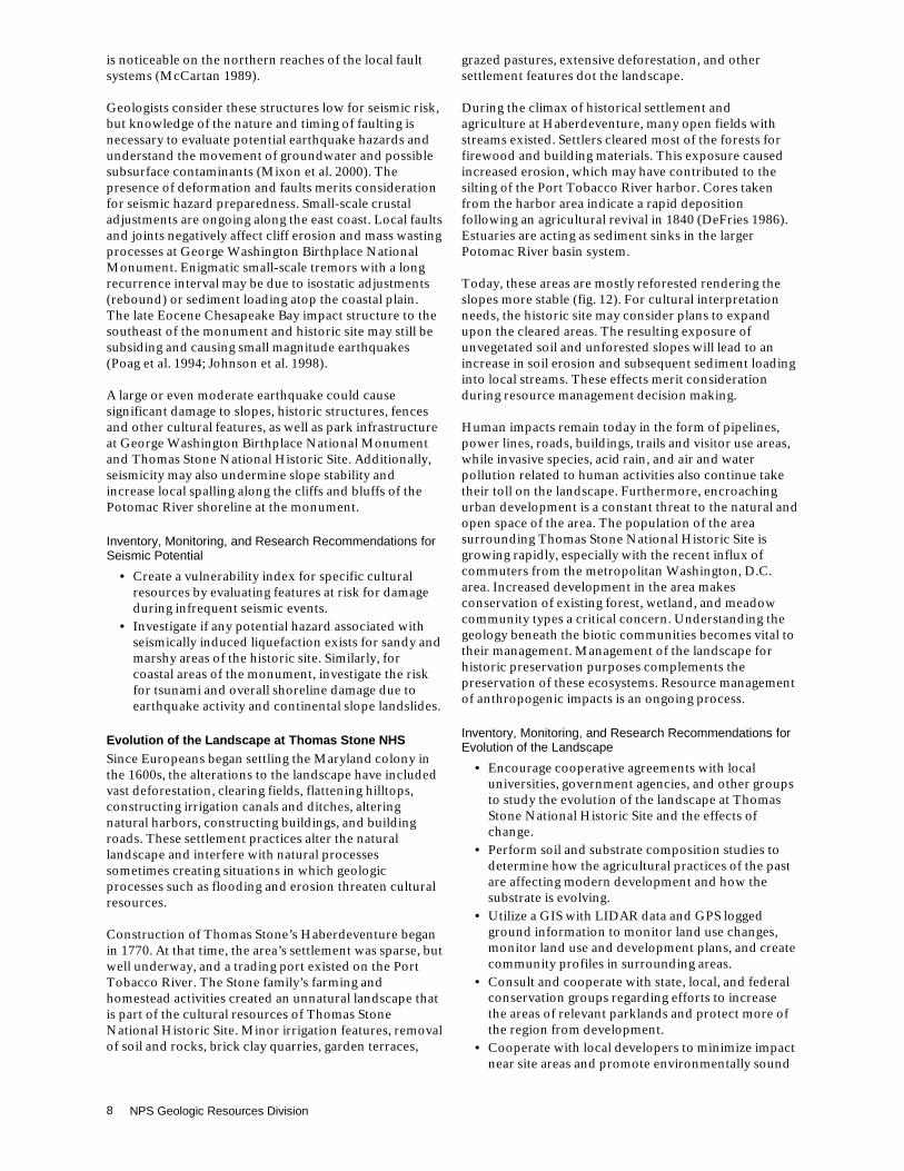
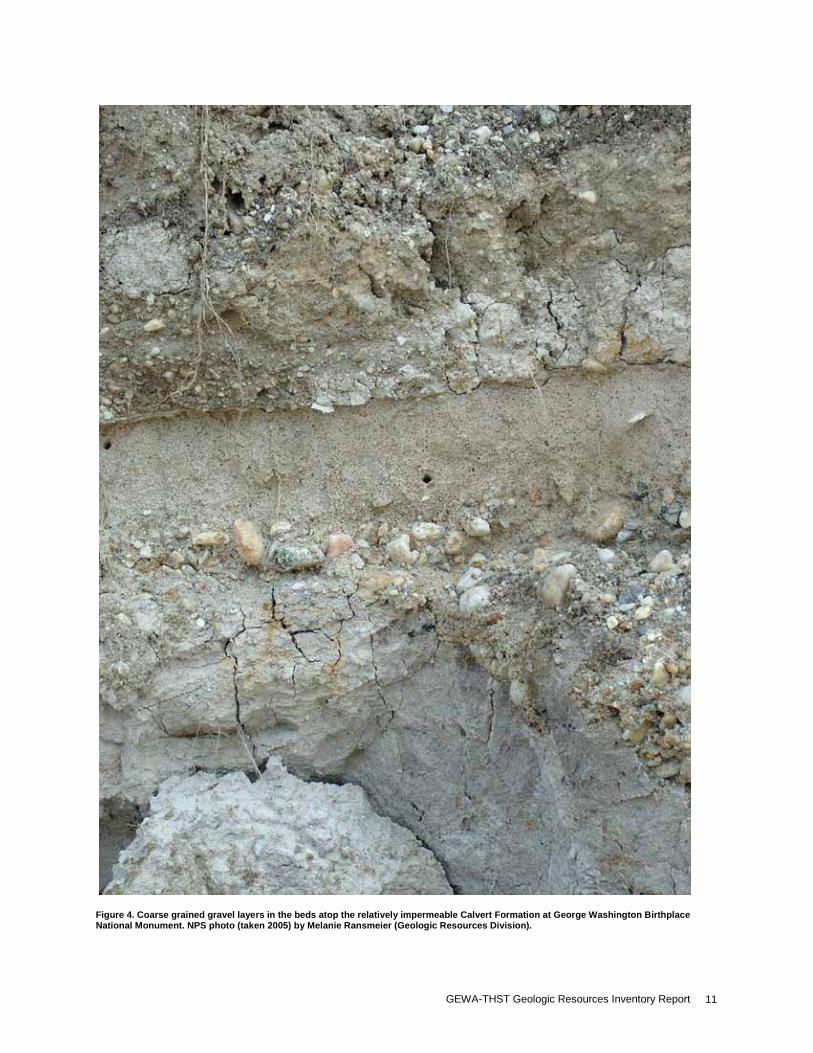
Erosion and Slope Processes One of the major goals of the monument and historic site is to present the historical context of their respective areas; this includes preserving open field areas and restoring historic structures and the landscape around them. Maintaining this agrarian and colonial landscape often means working against natural geologic changes, which presents several resource management challenges. Even slight alterations to the area’s vegetation along steep, exposed slopes lead to changes in the mass wasting and erosional potential. Mass wasting (slump, slides, earthflow, and creep) and erosion are constantly changing the landscape at the monument and historic site. Erosion reduces higher areas such as ridges and hills, degrades building and bridge foundations, causes streams to cut into restoration areas, and fills in the lower areas such as trenches, ditches, and stream ravines. The result is a landscape changed from its historical context. In general, the slopes surrounding the fields and homestead site at George Washington Birthplace National Monument are moderate and forested. In shoreline areas, the Potomac River has cut low steep cliffs into unconsolidated sediment (fig. 3). The heart of the monument sits between the Potomac River and Popes Creek estuary, both of which are areas of dynamic erosion and sedimentation processes (GRI scoping meeting notes 2005). Shore erosion provides abundant sediment to the tidal Potomac River in Maryland and Virginia (Miller 1987). Cracks and joints (vertical tectonic joints and horizontal sheet joints) within the sedimentary strata of the Potomac shoreline bluffs focus water flow and consequently erode material, widening the cracks until stability is lost and a large portion of the bluff spalls off. The middle and lower Miocene Calvert Formation crops out along the Potomac River shoreline. The unit consists of compact fine to very fine quartzose sand, with silt and clay in thick to massive beds. When this unit weathers, characteristic blocky fractures, including high angle
planer joints and concentric sets of sheet joints, develop (Newell et al. 2006). The characteristic stratigraphic relationship between the underlying relatively impermeable Calvert Formation and the overlying permeable, loose sediments (unconsolidated sand, pebble-cobble beds and fluvial channels of the Tabb Formation, Sedgefield Member) creates an inherent ramp surface that facilitates large slumps and slides along the bluffs (figs. 4 and 5) (W. Newell, personal communication 2005; Newell et al. 2006). The steep terrain of the forested valleys, gullies, and ravines that defines the area surrounding Thomas Stone National Historic Site is prone to several mass wasting hazards including landslides, slumps, and slope creep. Loose, rounded, reworked channel sediments derived from Piedmont rocks cap the slopes at Thomas Stone National Historic Site (fig. 6). The geologic units underlying the area contain unconsolidated heterogeneous mixtures of gravel and glauconitic sand, silt, and clay. These rocks erode easily by regular surface runoff. Clay minerals may slip or swell when they become water saturated and are prone to cause slope failure when exposed resulting in a slide or slump. Shrink-and-swell clays (swell when water saturated, shrink upon drying) undermine the stability of the ground by their change in volume. Where more resistant units such as gravel or sand lenses are located above clay-rich units, the potential for large slump development exists. The clearing of trees and their stabilizing roots for historical restoration or by fire can lead to increased sediment load in nearby streams and could potentially contribute to slumps and landslides. Hiking trails and other high use areas are also at risk of erosion. Seasonal storms and large events such as Hurricane Isabel in 2003 and Tropical Storm Ernesto in 2006 can cause rapid and substantial changes to the landscape of the monument and historic site (Hardaway et al. in review). Coastal erosion rates for the slopes and bluffs of the middle Potomac River are 0.42 to 0.52 m per year (1.3 to 1.6 ft/year) (Miller 1987). For the area from Mattox Creek to the monument, Hardaway et al. (in review) reported a similar average (but highly variable) shoreline change rate of about -0.5 m/year (-1.6 ft/year) between 1936 and 2002. However, from 2002 to 2007, a shoreline change rate of between -6 and -9 m (-20 and-30 ft) occurred in some places within the monument (fig. 7; Hardaway et al. in review). Most of this shoreline change was likely due to Hurricane Isabel and Tropical Storm Ernesto. One-third of an entire archaeological site was
NPS Geologic Resources Division 4
lost during Isabel and the Henry Brooks house site (1651-1725) is now threatened (George Washington Birthplace National Monument staff, personal communication 2006). Erosion from Tropical Storm Ernesto was estimated to be as bad if not worse than the hurricane damage (George Washington Birthplace National Monument staff 2006). The monument boundaries extend to the Potomac shoreline, thus shoreline erosion is causing loss of park land, significant natural and cultural resources, and additionally altering microenvironments. Flooding and channel erosion are naturally occurring along small streams within the monument and historic site. This flooding and erosion can threaten wetlands and visitor facilities. As erosion increases so does the sediment load carried by the local streams and rivers. In fact, sedimentation has occurred over the years to such an extent that Hoghole Run, once a local trade route for the area, has silted up. This increased sediment load is evident in the sediment-choked channels of incising, dendritic streams, in places, some of which expose the Calvert Formation. Erosion within the Popes Creek estuary is also causing tidal wetlands and islands of marsh deposits, including Great Island, to disappear (fig. 8). Scientists at the Virginia Institute of Marine Science have modeled options to protect the shoreline, beaches, points, and bluffs at George Washington Birthplace including breakwaters, pocket beach formation, chevron rock structures, etc. Similar structures are employed in shoreline areas at Colonial National Historical Park to some success (S. Hardaway, personal communication 2005). Their efforts may provide a working model for similar goals at the monument; however, funding is not adequate at this time to implement these measures. If built, these structures would inherently create a 21st century landscape—a considerable compromise between cultural and natural resource management (W. Newell, written communication 2009). As discussed in the “Geologic Features and Processes” section, natural riprap in the form of woody debris may provide an attractive alternative to imported riprap along the area’s shorelines (D. Steensen, personal communication 2006).
Inventory, Monitoring, and Research Recommendations for Erosion and Slope Processes
· Perform topographic surveys and regular sampling to determine if sediment and/or soil loss is occurring at the monument and historic site.
· Define the mappable shoreline (high tide, low tide, median wave crest, etc.) at George Washington Birthplace National Monument.
· Perform further investigations regarding the possibility of using natural woody debris to act as riprap to anchor shorelines at the monument.
· Study erosion rates and processes in the rolling hills, ravines and fields of the monument and correlate to the overall sediment budget of the Popes Creek watershed. This may lead to regular monitoring of the loss and/or change of islands within the Popes Creek estuary.
· Instigate a shoreline change program surveying shoreline position several times annually to detect seasonal variations. This may involve recruiting a volunteer to map the 2–3-km (1–2-mi) shoreline extent each season and supplementing this information with storm-response surveys, LIDAR (airborne or ground-based), GPS surveys, and aerial photographs. Shoreline and marsh surveys of summer 2003, January 2004, March 2005, and 2008 may provide model efforts. Refer to the storm vulnerability assessment report (Hardaway et al. in review) for results and recommendations from recent shoreline change survey.
· Continue to study shoreline evolution and change incorporating information dating from the 1930s.
· Promote and cooperate with coastal erosion rate studies such as the U.S. Geological Survey study of the middle Potomac River (Miller 1987) and the storm vulnerability assessment (Hardaway et al. in review). These studies would ultimately include suggestions for coastal shoreline stability measures.
· Monitor topographic changes on the edges of the monument’s bluffs due to surface and cliff erosion. This may illustrate the impacts of weakened slope stability.
· Research measures including anchoring, or increased vegetation to slow cliff erosion at the monument.
· Research effectiveness of plans to plant new vegetation along any vulnerable reaches of the monument’s and historic site’s slopes to prevent excess erosion and subsequent sediment loading.
· Perform sediment load studies to relate to aquatic ecosystem health to determine if increased erosion is negatively impacting aquatic biota at the monument.
· Identify undercut, jointed, and potentially vulnerable reaches of the bluffs of the Calvert Formation at the monument to attempt to keep visitors away from potentially hazardous areas.
· Determine if historic features are at risk due to slope processes at Thomas Stone National Historic Site. This may involve fine-scale archaeological work to determine new relevant areas along forested slopes.
· Investigate whether increased sediment loading caused by increased sheet runoff and erosion is adversely affecting aquatic ecosystems at the historic site.
· Monitor slope processes in the forested areas along the tributaries of Hoghole Run within the historic site.
Hydrogeology and Surface Water Issues Water surrounds three sides of George Washington Birthplace National Monument. Therefore, the hydrogeologic system is a significant factor in resource management decision making. Much of the precipitation and ensuing sheet flow at the monument channels into small-scale streams and creeks, through ponds, wetlands, and swampy areas, into the larger watersheds of Popes Creek and ultimately the Potomac River. Three primary basins drain the monument land area—Popes Creek, Bridges Creek, and a small, unnamed creek. Marsh areas
GEWA-THST Geologic Resources Inventory Report 5
include Longwood and Digwood swamps and wetlands cover nearly 17 percent of the monument’s land area (Belval et al. 1997 from National Wetlands Inventory Maps). Understanding the dynamics of the wetland areas and the estuarine mouth of Popes Creek is a major resource management goal. Low-lying areas including tidal marshes and freshwater wetlands accumulate peat and sediment recording climate, vegetation, and landuse changes. Ecologists typically consider wetlands to be indicators of overall ecosystem health and as such, they merit research and monitoring. Recent swamp surveys indicate that anthropogenic land use patterns are having effects on erosion and deposition within the Popes Creek estuary. As inhabitants removed stabilizing vegetation for farming and settlement of the land, increases in runoff and erosion deposited more sediment in the local streams and wetlands. Early tree removal efforts, aimed at increasing visibility of the commemorative obelisk, seem correlative to swamp degradation and tidal channel proliferation. Though this hypothesis remains to be tested, erosion of the wetlands has likely increased due to area deforestation over the past 100 years (GRI scoping meeting notes 2005). There are several smaller streams and springs as well as some associated marshy riparian areas located within Thomas Stone National Historic Site. All surface water in the park is part of the larger Port Tobacco River watershed and ultimately flows into the Potomac River system. To the west of the site, Hoghole Run and its tributaries cut through the sedimentary deposits creating steep slopes. Some of the tributaries are very short and ephemeral, occasionally disappearing during dry summer months (fig. 9). There are several seasonal wetlands within the site boundaries that merit research and monitoring. The rest of the historic site’s water comes from groundwater inputs and springs. The monument and historic site utilize groundwater resources as the public drinking water supply and very little information exists on the condition or quality of the water resources at the units (Belval et al. 1997; GRI scoping meeting notes 2005). It is crucial for resource management to understand the hydrogeologic systems at the monument and historic site. Knowledge of how water is traveling through the subsurface hydrogeologic systems into, under, and from the monument and historic site can be used to predict hydrologic responses to inputs such as contaminants. Further information about the nature of the underlying substrate, including structure, stratigraphy, composition, permeability and porosity, can be obtainable with cores. The Oak Grove core was obtained within the Rollins Fork Quadrangle west of the monument. This core was 365 m (1,200 ft) deep and was part of a 1977-1978 study by the U.S. Geological Survey (W. Newell, written communication 2009). This core defines the stratigraphy from the Cretaceous through the Tertiary in the area. The Virginia Department of Mineral Resources (VDMR) and College of William and Mary periodically document changes in wetland area composition and vegetation in the Longwood Swamp area. For Popes Creek, the Alliance
for the Chesapeake Bay has monitored turbidity, temperature, pH, salinity, and dissolved oxygen of the creek on a weekly basis (Ellett 1993). National Park Service staff monitor groundwater salinity, lead, and copper for public drinking water safety (Belval et al. 1997). These cooperative efforts are a positive research endeavor that merit expansion at George Washington Birthplace National Monument and Thomas Stone National Historic Site to increase overall understanding of natural resources. Visitor use and surrounding developments are increasing the levels of anthropogenic substances in the water at the parks. The movement of nutrients and contaminants through the hydrogeologic systems can be modeled by monitoring the composition of system inputs, such as rainfall, and outputs, such as streamflow. Other input sources include wind, surface runoff, groundwater transport, sewage outfalls, landfills, and fill dirt. Streams integrate surface runoff and groundwater flow of their watersheds. Thus, they provide a cumulative measure of the status of the watershed’s hydrologic system (Hickman 1987). Consistent measurement of these parameters is crucial to establishing baselines for comparison. Management should also understand how water tables change through time. The installation of several wells throughout the monument and historic site would be useful for monitoring groundwater quality. It would be useful to perform tracer studies in these wells to see how quickly and in what direction water is moving through the systems.
Inventory, Monitoring, and Research Recommendations for Hydrogeology and Surface Water Issues
· Map and quantify groundwater recharge zones especially in areas where wastewater treatment and septic systems coincide with recharge zones. Investigate additional methods to characterize groundwater recharge areas and flow directions. Use this information to create hydrogeologic models for the monument and historic site to better manage the groundwater resources and predict the systems’ response to contamination.
· Install regularly spaced monitoring wells throughout the monument and historic site to monitor groundwater quality and to measure inputs of chemical components such as nitrogen, mercury, phosphate, volatile hydrocarbons, and pH. Focus on areas near facilities.
· Inventory groundwater levels at the monument and historic site and use regular monitoring of water well levels, dye tracer tests and pumping tests to help define hydrogeologic models.
· Define the influences of underlying sedimentary strata, geologic structures, and topography on local watersheds.
· Inventory and map any existing springs in the site, testing water quality at each, and describe each feature especially with regards to their potential historical importance and incorporate this information into the site’s GIS.
· Coordinate with the Water Resources Division and Geologic Resources Division Soils Inventory to
NPS Geologic Resources Division 6
comprehensively map and monitor water and soil quality at all wetland areas within the monument and historic site. This creates a baseline level of ecosystem health to use for understanding future changes.
· Obtain subsurface data (depth to layers, composition, well data, or seismic) for the monument and historic site areas to understand groundwater movement through layers of variable permeability.
· Investigate the feasibility of additional cooperative studies and other efforts to obtain additional cores within the Popes Creek watershed to expand existing data (from the U.S. Geological Survey) from the delta and estuary mouth areas. A survey of cores at regular intervals across the mouth of Popes Creek and the estuary would be especially helpful in understanding the underlying sedimentary structure and deposition patterns.
· Develop 3-D terrane models of the hydrogeologic system at the monument focusing on cliff, terrace, upland, and bluff morphological changes.
Paleontological Resource Potential Fossils add to the understanding of the geologic history of the Atlantic Coastal Plain province. Certain fossils are useful to correlate units across time and space. For example, in Charles County, Maryland, over 115 species of tiny dinoflagellates are in the fossil record as cysts present in the Nanjemoy Formation and are used to date specific beds within the unit (Goodman 1984). Fossils also give clues as to the depositional environment when they were alive. They also provide post-burial information including geochemical changes, deformational regimes, and changes in bedding orientation. Fossil resources should be inventoried, monitored, and protected. The geologic units located in the George Washington Birthplace National Monument and Thomas Stone National Historic Site area are known to contain fossils. Exposed within both the monument and historic site are Tertiary age deposits of the Calvert and Nanjemoy formations. According to the NPS paleontological inventory report, the Calvert Formation on the coastal plain of Virginia and Maryland contains fossilized remains of mollusks, gastropods, pelecypods, turtles, rays, whales, sea cows, dolphins, tapirs, mastodons, rhinoceros, horses, and dogs and shark teeth from several species (Kenworthy and Santucci 2003). No fossils have been formally sampled from within the boundaries of Thomas Stone National Historic Site. However, park staff noticed a fossil bone fragment during an informal 2003 paleontological investigation (J. Kenworthy, written communication 2008). Paleontological resources, if discovered, would be an important resource at the historic site adding to the geologic history of the area. The Nanjemoy Formation exposed at Thomas Stone National Historic Site contains mollusks outside of the park (Kenworthy and Santucci 2003). Erosion is constantly exposing fossils in the monument and historic site along coastal margins and incised streams.
Paleocene to Miocene age shark teeth, crocodile teeth, dugongs, and bones from seals, whales, and porpoises are among the many fossils present in the bluffs facing the Potomac River and local slope deposits (Kenworthy and Santucci 2003). Mastodon teeth, a testament to Pleistocene ice age climatic conditions, are also present in some subaerial, reworked deposits at the monument. Due to upland erosion and reworking of sediments, fossils tend to be concentrated along the larger river shorelines (GRI scoping meeting notes 2005). These sediments contain fossils that are attractive to both researchers and collectors. Paleontologists excavated marine mammal, shark teeth, and other fossils from the Calvert Formation discovered within and near the monument. These fossils are curated in the Smithsonian Institution National Museum of Natural History collection. Fossil theft is a concern for paleontological resources at the monument and historic site. Local publications describe fossil locations within the monument and unfortunately inform people interested in the removal of fossils and artifacts (Benson 1989). At the monument, shoreline erosion exposes these fossils, along the base of the Potomac River bluffs. The bluffs are also eroding and placing visitor safety at risk. At the historic site, potential fossil resources would be exposed and removed from the formation during fluvial erosion and deposited in sediment-choked streams.
Inventory, Monitoring, and Research Recommendations for Paleontological Resource Potential
· Perform a comprehensive onsite inventory of fossil resources at the monument and historic site.
· Work with researchers to ensure that permitted paleontological resource collections made within the monument meet National Park Service museum management and permitting mandates.
· Develop a paleontological resource monitoring and protection plan.
· Develop a study collection of fossils commonly found within the monument. This collection could be used for resource management training and/or interpretation.
· Develop interpretive products that incorporate the fossil story along with the geologic history of the area. Products should address the role of natural processes such as erosion. These products should also educate the public on the resource management and stewardship mission of the National Park Service.
Sediment Budget for Popes Creek Watershed The sedimentary strata underlying the landscape at George Washington Birthplace National Monument are hundreds of meters thick. Rivers, eroding the Appalachian highlands to the west deposited these sediments, building the Atlantic Coastal Plain eastward. Certain layers contain clasts that are traceable to a specific provenance hundreds of kilometers away, such as the gneiss and red mudstone of the Windsor Formation (Mixon et al. 2000).
GEWA-THST Geologic Resources Inventory Report 7
Once deposited, the unconsolidated layers are in turn subject to erosion and redeposition. Vast amounts of sediment are stored on the landscape at George Washington Birthplace. Ravine fill up to 2 m (6 ft) thick is observable covering 17th century logs and stumps (Newell et al. 1999). These sediments are recycled and weathered from unconsolidated upland terrace units such as the Charles City Formation from a proto-Potomac estuary (W. Newell, written communication 2009). Repeating sequences of sands, coarser grained channel crossbeds, silt, clay, and organic rich floodplain deposits as well as weathered terraces exposed in upland ravines record movement of the river system over the landscape. In addition to sediments trapped on the land surface, other sediments are entrained within the fluvial system of Popes Creek and form migrating bars, deltas, and channel deposits. Local streams transport sediment via two processes: 1) the water entrains and carries fine-grained suspended load, and 2) the bedload of coarser material slides, skips, and rolls along the stream bottom (Hickman 1987). The watershed is far from a mere sediment conveyor belt. As water channels, knick points develop in the upland areas, the river then passes in turn into a meandering breach, a gullied reach, and then passes into another knick point before unloading the sediment behind a sediment trap. This system of progressive knick points and sediment traps retains much of the reworked sediments that would otherwise almost immediately wash into the Potomac River. The estuary is particularly effective at trapping sediment (Newell et al. 1999). This system of weathering, erosion, slope deposit accumulation, and fluvial to estuarine terrace deposition that has been moving, weathering, storing, and reworking local sediments has been active at Popes Creek since the Pliocene (Newell et al. 1999). Geologists estimate that the bedload leaving streams such as Popes Creek into the Potomac is only about 10 percent of the suspended load of finer grained material (Hickman 1987). Several bars, low terraces, and paleoscarps across the mouth of Popes Creek record some of the watershed’s former reaches. Former highstand periods leave alluvium several meters higher than present day water levels. A sandy spit and flood-tide delta derived from long-shore movement of Potomac River sediment stripped from eroding bluffs buffers and protects the estuarine bay at the mouth of Popes Creek from the flow and tidal fluctuations of the Potomac River whose width is approximately 4 km (2.4 mi) locally (fig. 10) (Newell et al. 1999). Proto-Popes Creek channel deposits supply sediments to this system today keeping a relatively consistent supply of sand moving towards the spit. However, this dynamic environment changes rapidly and channels cutting into the bar itself may result in a net loss of sediment to the spit. Locally, a thin veneer of loose, fine-grained, windblown (eolian) sediments adds to the sediment budget.
Inventory, Monitoring, and Research Recommendations for Sediment Budget for Popes Creek Watershed
· Investigate if erosion will cause an island to form where the present day sand spit separates the Popes Creek estuary from the Potomac River. Also model the effects on salinity of increased sedimentation in inland wetland areas.
· Quantitatively measure the amount of sediment contributed to the Chesapeake Bay from the Popes Creek watershed using repeat surveys and sediment load estimates.
· Assess sediment flow patterns noting the deposition areas of fine-grained material.
· Spatially correlate hurricane and seasonal storm layers. Incorporate the information into the monument’s GIS.
· Investigate if sediment loading is following a seasonal pattern.
· Assess the effects of sediment loading on riparian ecosystems and submerged aquatic vegetation (W. Newell, written communication 2009).
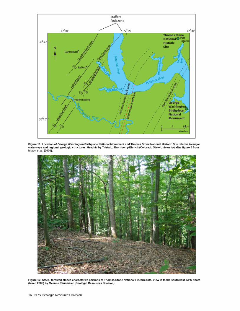
Seismic Potential The term passive margin, applied to the Atlantic seaboard area, does not imply tectonic quiescence as numerous large- and small-scale crustal movements (between regional-scale basins and arches) have occurred along the eastern edge of the continent during the last 150 million years (McCartan 1989). Geologists do not consider the Atlantic Coastal Plain to be especially prone to seismic activity; however, several extensive regional faults exist in the George Washington Birthplace National Monument and Thomas Stone National Historic Site area and may be zones of weakness. The Stafford fault system, a structure deep beneath the regolith west of the monument and historic site, consists of en echelon high angle reverse faults that strike northeast along a 68-km (42-mi) trend. This fault thrust Piedmont rocks over younger sedimentary formations of the coastal plain. The fault zone is comprised of four mapped faults: the Dumfries fault zone, the Fall Hill fault, the Hazel Run fault, and the Brooke fault zone (fig. 11). The Port Royal fault zone runs east of the historic site and is delineated as a 3-km (2-mi)-wide zone of sedimentary strata exhibiting down-to-the-coast displacement and local thickening of the sedimentary section locate the deformation zone. The fault zone may be a shallow graben-like structure resulting from local extension. Vertical displacement estimates are more than 15 m (49 ft) (Mixon et al. 2000). Movement along the Brandywine fault system, located east of the Potomac River, caused folds in the thick, overlying Cenozoic stratigraphic section. It may be responsible for the sharp bend in the Potomac River near the Port Tobacco River estuary. Many of these eastern faults bound Triassic-Jurassic age extensional basins, buried deep below Cenozoic sediments. Movement along most of these faults is down to the east, some local reactivation of the opposite sense
NPS Geologic Resources Division 8
is noticeable on the northern reaches of the local fault systems (McCartan 1989). Geologists consider these structures low for seismic risk, but knowledge of the nature and timing of faulting is necessary to evaluate potential earthquake hazards and understand the movement of groundwater and possible subsurface contaminants (Mixon et al. 2000). The presence of deformation and faults merits consideration for seismic hazard preparedness. Small-scale crustal adjustments are ongoing along the east coast. Local faults and joints negatively affect cliff erosion and mass wasting processes at George Washington Birthplace National Monument. Enigmatic small-scale tremors with a long recurrence interval may be due to isostatic adjustments (rebound) or sediment loading atop the coastal plain. The late Eocene Chesapeake Bay impact structure to the southeast of the monument and historic site may still be subsiding and causing small magnitude earthquakes (Poag et al. 1994; Johnson et al. 1998). A large or even moderate earthquake could cause significant damage to slopes, historic structures, fences and other cultural features, as well as park infrastructure at George Washington Birthplace National Monument and Thomas Stone National Historic Site. Additionally, seismicity may also undermine slope stability and increase local spalling along the cliffs and bluffs of the Potomac River shoreline at the monument.
Inventory, Monitoring, and Research Recommendations for Seismic Potential
· Create a vulnerability index for specific cultural resources by evaluating features at risk for damage during infrequent seismic events.
· Investigate if any potential hazard associated with seismically induced liquefaction exists for sandy and marshy areas of the historic site. Similarly, for coastal areas of the monument, investigate the risk for tsunami and overall shoreline damage due to earthquake activity and continental slope landslides.
Evolution of the Landscape at Thomas Stone NHS Since Europeans began settling the Maryland colony in the 1600s, the alterations to the landscape have included vast deforestation, clearing fields, flattening hilltops, constructing irrigation canals and ditches, altering natural harbors, constructing buildings, and building roads. These settlement practices alter the natural landscape and interfere with natural processes sometimes creating situations in which geologic processes such as flooding and erosion threaten cultural resources. Construction of Thomas Stone’s Haberdeventure began in 1770. At that time, the area’s settlement was sparse, but well underway, and a trading port existed on the Port Tobacco River. The Stone family’s farming and homestead activities created an unnatural landscape that is part of the cultural resources of Thomas Stone National Historic Site. Minor irrigation features, removal of soil and rocks, brick clay quarries, garden terraces,
grazed pastures, extensive deforestation, and other settlement features dot the landscape. During the climax of historical settlement and agriculture at Haberdeventure, many open fields with streams existed. Settlers cleared most of the forests for firewood and building materials. This exposure caused increased erosion, which may have contributed to the silting of the Port Tobacco River harbor. Cores taken from the harbor area indicate a rapid deposition following an agricultural revival in 1840 (DeFries 1986). Estuaries are acting as sediment sinks in the larger Potomac River basin system. Today, these areas are mostly reforested rendering the slopes more stable (fig. 12). For cultural interpretation needs, the historic site may consider plans to expand upon the cleared areas. The resulting exposure of unvegetated soil and unforested slopes will lead to an increase in soil erosion and subsequent sediment loading into local streams. These effects merit consideration during resource management decision making. Human impacts remain today in the form of pipelines, power lines, roads, buildings, trails and visitor use areas, while invasive species, acid rain, and air and water pollution related to human activities also continue take their toll on the landscape. Furthermore, encroaching urban development is a constant threat to the natural and open space of the area. The population of the area surrounding Thomas Stone National Historic Site is growing rapidly, especially with the recent influx of commuters from the metropolitan Washington, D.C. area. Increased development in the area makes conservation of existing forest, wetland, and meadow community types a critical concern. Understanding the geology beneath the biotic communities becomes vital to their management. Management of the landscape for historic preservation purposes complements the preservation of these ecosystems. Resource management of anthropogenic impacts is an ongoing process.
Inventory, Monitoring, and Research Recommendations for Evolution of the Landscape
· Encourage cooperative agreements with local universities, government agencies, and other groups to study the evolution of the landscape at Thomas Stone National Historic Site and the effects of change.
· Perform soil and substrate composition studies to determine how the agricultural practices of the past are affecting modern development and how the substrate is evolving.
· Utilize a GIS with LIDAR data and GPS logged ground information to monitor land use changes, monitor land use and development plans, and create community profiles in surrounding areas.
· Consult and cooperate with state, local, and federal conservation groups regarding efforts to increase the areas of relevant parklands and protect more of the region from development.
· Cooperate with local developers to minimize impact near site areas and promote environmentally sound
GEWA-THST Geologic Resources Inventory Report 9
methods of developing land parcels including partial clearing of trees and proper construction of stable slopes.
· Perform studies to attempt to define the impact of surrounding land use patterns on the geomorphology of the landscape at the site.
· Perform soil assessments in the park, relating these to past climatic patterns (i.e. colder periods with more precipitation, less vegetation, and wind patterns).
· Investigate the effects of acid rain on the area’s soils and substrate. Investigate if acid rain is increasing humus decomposition and accelerating weathering of underlying bedrock.
· Investigate location and geology of historic quarries used for brick construction.
· Map historic and cultural features to incorporate into the historic site’s GIS.
· Develop interpretive products highlighting the area’s underlying geologic units and structures. Discuss how the geology affects terrain, landscape evolution, and ultimately Thomas Stone’s decision to settle and farm there.
· Create a general interest map with simple explanatory text on geological-historical connections for visitors to the site.
· Update the historic site’s website relating geology with other natural and cultural resources.
Issues with Surrounding Development at George Washington Birthplace NM The population of the area surrounding George Washington Birthplace National Monument is growing rapidly. In 2000, Westmoreland County had 16,718 residents, making it among the least populated counties in eastern Virginia. Recent census results suggest that there was population increase of approximately 25% between the years 2000-2004 in the greater area (U.S. Census Bureau 2006). Increasing populations and subsequent development in the area make conservation of existing forest, wetland, and meadow community types a critical concern. Estimates indicate that in only a few years, the urban encroachment from northern Virginia may infiltrate the Northern Neck area (Hedelt 2005). Understanding the geology and hydrogeologic system beneath the biotic communities facilitates their management. At George Washington Birthplace National Monument, management of the landscape for historic preservation purposes can complement the preservation of these natural ecosystems. Popes Creek is generally considered to be a low impact watershed. There is a modest human population influence on the system. This is an uncommon status among local watersheds of the Chesapeake Bay. Geologists consider Popes Creek to be representative other estuary watersheds in the Chesapeake Bay region in terms of geologic formations, surficial processes, etc. (U.S. Geological Survey 2002). For these reasons, monitoring the geochemical changes in the water and sediments of Popes Creek watershed is vital for extrapolating baseline conditions to other estuaries and
to maintaining the overall high quality of this area (Newell et al. 1999). Surrounding development and agriculture add nutrients and pollutants to Popes Creek tributaries, which ultimately end up in the estuary. Water entering the estuary from the Potomac River and Chesapeake Bay as high tide influx also create geochemical changes in water and sediments. These issues need regional cooperative efforts to improve water quality throughout the region. Local residents have thus far exercised relatively good stewardship of the land rendering Popes Creek a valuable “pristine” scientific resource (U.S. Geological Survey 2002). As described above baseline erosion punctuated by rapid erosion during storm events is removing land and shoreline reaches from the area. As land and shoreline erodes from the surface at George Washington Birthplace National Monument, surrounding landowners also face loss of valuable property along shoreline areas. These landowners often expect the federal government to put measures in place at the monument to secure the shoreline instead of allowing natural processes to continue. A separate issue related to overall land loss is an increase in property value making the lands around the monument too expensive to consider purchasing for inclusion within the park. Anthropogenic impacts continue today as pipelines, power lines, roads, buildings, trails, visitor use areas, invasive species, acid rain, and air and water pollution take their toll on the landscape. State Route 3 crosses the Popes Creek watershed. This road increases the likelihood of the introduction of contaminants such as hydrocarbons, salts, and roadside herbicides into the Popes Creek Watershed. The Virginia Department of Transportation has a fueling plant within the watershed and there are also three dams within the watershed.
Inventory, Monitoring, and Research Recommendations for Issues with Surrounding Development
· Determine the impacts of surrounding land use changes on the geomorphology of the landscape. Create community profiles incorporating fine scaled topography into a GIS to monitor land use changes. Also, incorporate information on historical land use located in the monument library and county library/museum in Montross, Virginia. Of particular interest is a careful survey of Popes Creek dating to 1891.
· Be informed of and cooperate with local development activities to minimize impacts near park areas. This could involve education programs of environmentally sound methods of developing land parcels including only partial clearing of trees, recycling of downed timber from large storms into lumber for park use (W. Newell, written communication 2009), and stable slope construction.
· Promote the monument area as a place to monitor fluvial processes and changes in the Popes Creek watershed—an important opportunity to expand the mission of the national monument (W. Newell, written communication 2009). This includes
NPS Geologic Resources Division 10
establishing comprehensive baseline conditions for comparison and future monitoring.
· Promote the reduction of fertilizer use in surrounding areas.
· Consult with conservation groups regarding cooperative efforts to increase the amount of local areas to be protected from development.
· Create a general interest map with simple explanatory text on geologic influences for visitors to the monument.
Figure 3. Steep cliff areas of the Potomac River shoreline at George Washington Birthplace National Monument. Note spalling and blocks being reworked by the river flow (arrows). View is to the west. NPS photo (taken 2005) by Melanie Ransmeier (Geologic Resources Division).
GEWA-THST Geologic Resources Inventory Report 11
Figure 4. Coarse grained gravel layers in the beds atop the relatively impermeable Calvert Formation at George Washington Birthplace National Monument. NPS photo (taken 2005) by Melanie Ransmeier (Geologic Resources Division).
NPS Geologic Resources Division 12
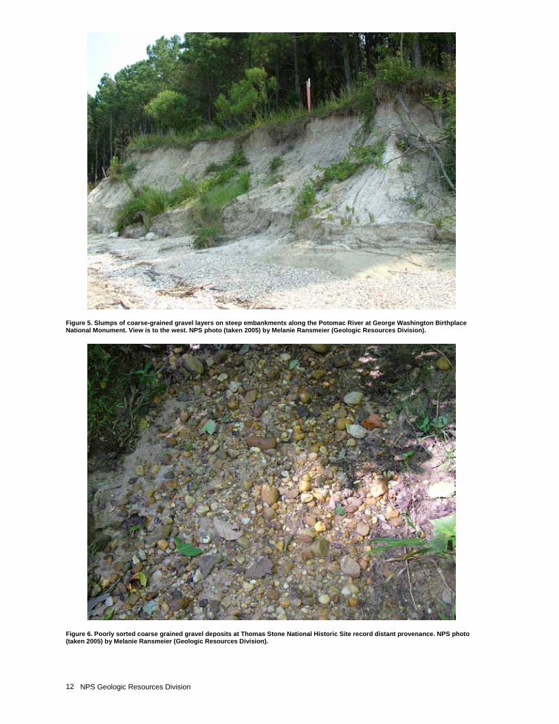
Figure 5. Slumps of coarse-grained gravel layers on steep embankments along the Potomac River at George Washington Birthplace National Monument. View is to the west. NPS photo (taken 2005) by Melanie Ransmeier (Geologic Resources Division).
Figure 6. Poorly sorted coarse grained gravel deposits at Thomas Stone National Historic Site record distant provenance. NPS photo (taken 2005) by Melanie Ransmeier (Geologic Resources Division).
GEWA-THST Geologic Resources Inventory Report 13
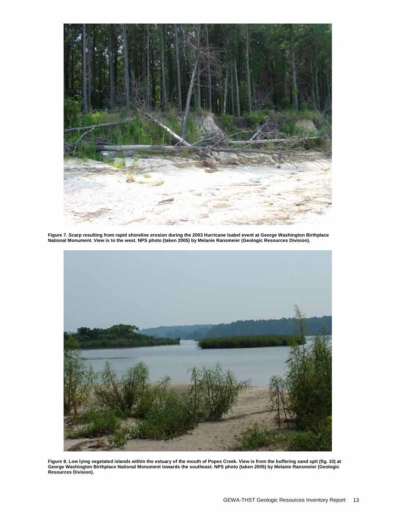
Figure 7. Scarp resulting from rapid shoreline erosion during the 2003 Hurricane Isabel event at George Washington Birthplace National Monument. View is to the west. NPS photo (taken 2005) by Melanie Ransmeier (Geologic Resources Division).
Figure 8. Low lying vegetated islands within the estuary of the mouth of Popes Creek. View is from the buffering sand spit (fig. 10) at George Washington Birthplace National Monument towards the southeast. NPS photo (taken 2005) by Melanie Ransmeier (Geologic Resources Division).
NPS Geologic Resources Division 14
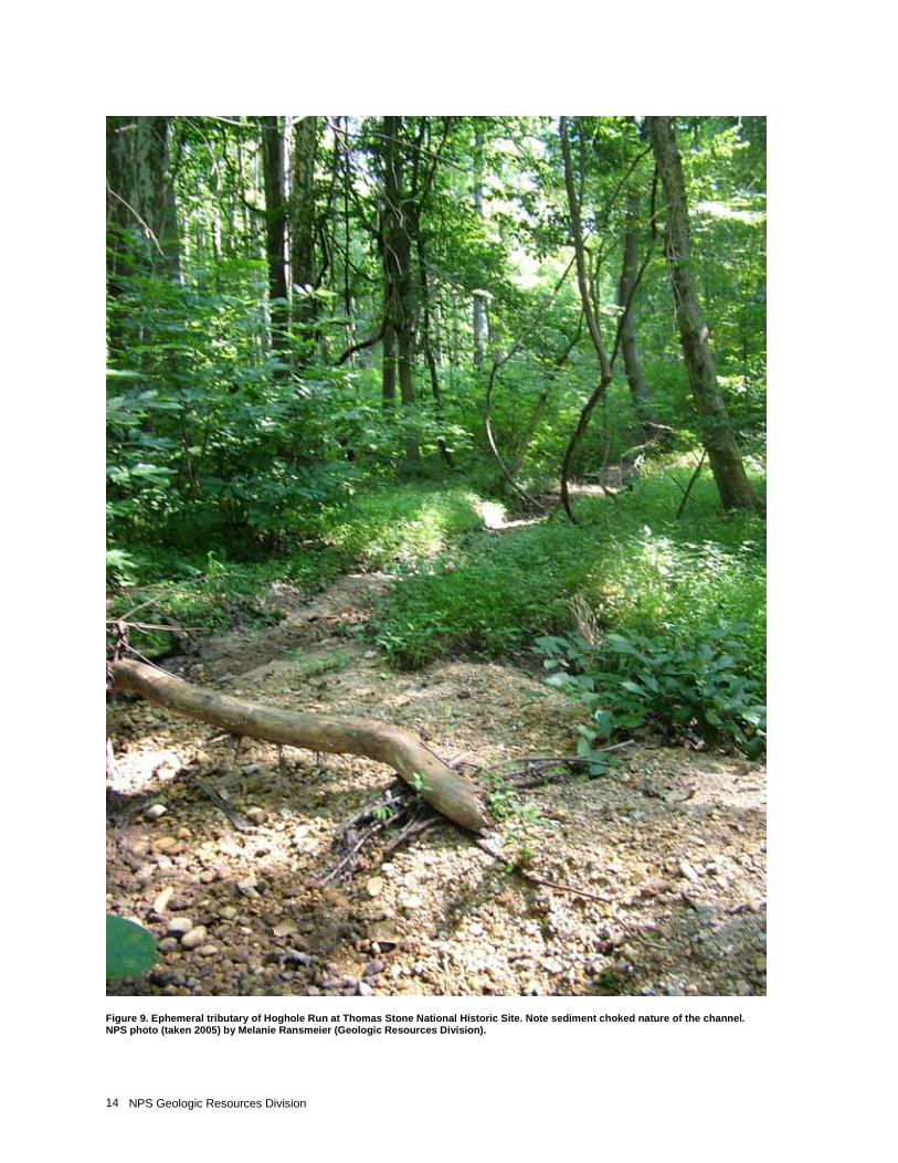
Figure 9. Ephemeral tributary of Hoghole Run at Thomas Stone National Historic Site. Note sediment choked nature of the channel. NPS photo (taken 2005) by Melanie Ransmeier (Geologic Resources Division).
GEWA-THST Geologic Resources Inventory Report 15
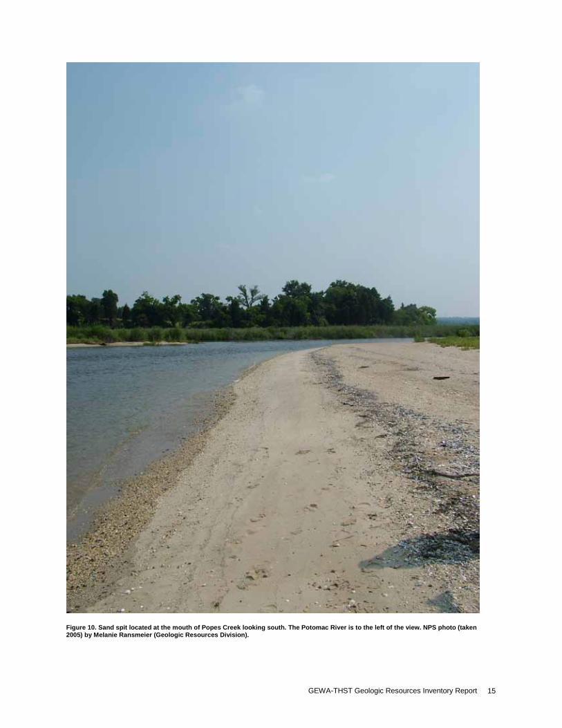
Figure 10. Sand spit located at the mouth of Popes Creek looking south. The Potomac River is to the left of the view. NPS photo (taken 2005) by Melanie Ransmeier (Geologic Resources Division).
NPS Geologic Resources Division 16
Figure 11. Location of George Washington Birthplace National Monument and Thomas Stone National Historic Site relative to major waterways and regional geologic structures. Graphic by Trista L. Thornberry-Ehrlich (Colorado State University) after figure 6 from Mixon et al. (2000).
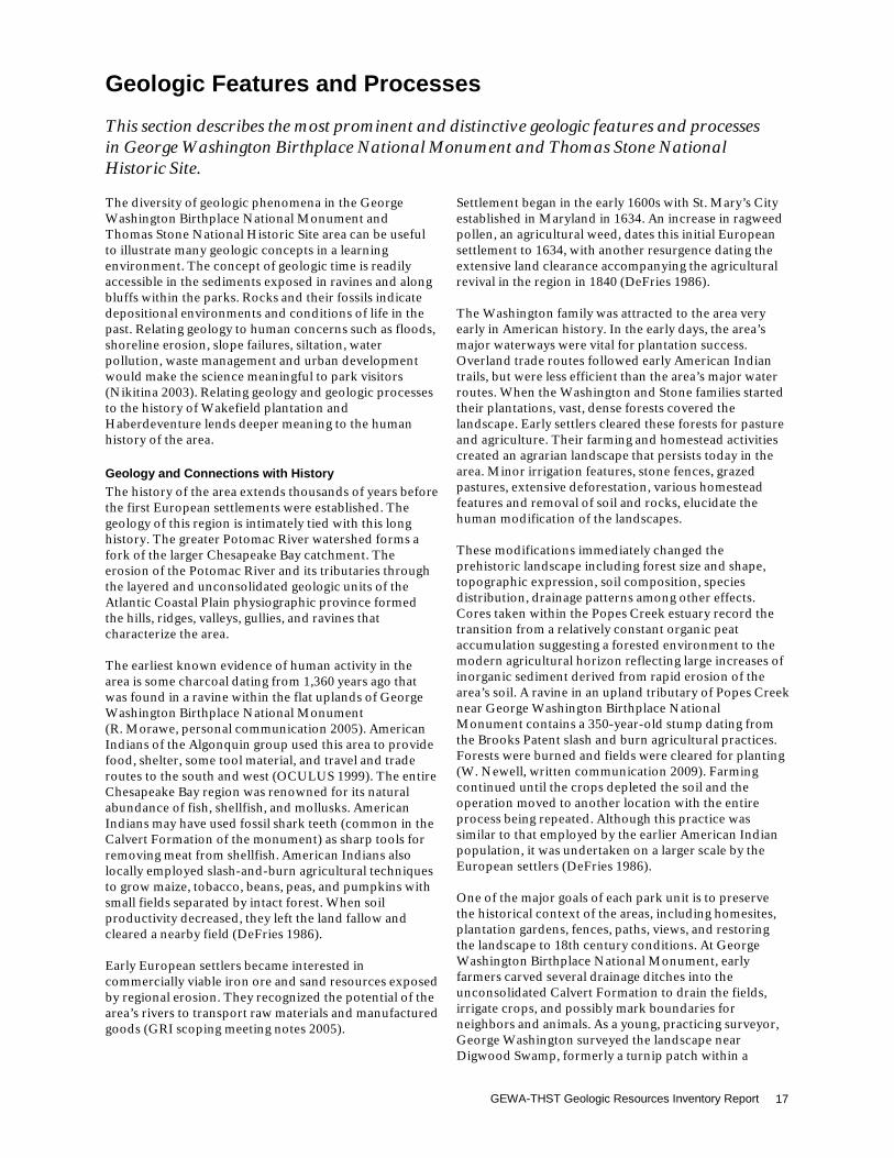
Figure 12. Steep, forested slopes characterize portions of Thomas Stone National Historic Site. View is to the southwest. NPS photo (taken 2005) by Melanie Ransmeier (Geologic Resources Division).
GEWA-THST Geologic Resources Inventory Report 17
Geologic Features and Processes This section describes the most prominent and distinctive geologic features and processes in George Washington Birthplace National Monument and Thomas Stone National Historic Site. The diversity of geologic phenomena in the George Washington Birthplace National Monument and Thomas Stone National Historic Site area can be useful to illustrate many geologic concepts in a learning environment. The concept of geologic time is readily accessible in the sediments exposed in ravines and along bluffs within the parks. Rocks and their fossils indicate depositional environments and conditions of life in the past. Relating geology to human concerns such as floods, shoreline erosion, slope failures, siltation, water pollution, waste management and urban development would make the science meaningful to park visitors (Nikitina 2003). Relating geology and geologic processes to the history of Wakefield plantation and Haberdeventure lends deeper meaning to the human history of the area.
Geology and Connections with History The history of the area extends thousands of years before the first European settlements were established. The geology of this region is intimately tied with this long history. The greater Potomac River watershed forms a fork of the larger Chesapeake Bay catchment. The erosion of the Potomac River and its tributaries through the layered and unconsolidated geologic units of the Atlantic Coastal Plain physiographic province formed the hills, ridges, valleys, gullies, and ravines that characterize the area. The earliest known evidence of human activity in the area is some charcoal dating from 1,360 years ago that was found in a ravine within the flat uplands of George Washington Birthplace National Monument (R. Morawe, personal communication 2005). American Indians of the Algonquin group used this area to provide food, shelter, some tool material, and travel and trade routes to the south and west (OCULUS 1999). The entire Chesapeake Bay region was renowned for its natural abundance of fish, shellfish, and mollusks. American Indians may have used fossil shark teeth (common in the Calvert Formation of the monument) as sharp tools for removing meat from shellfish. American Indians also locally employed slash-and-burn agricultural techniques to grow maize, tobacco, beans, peas, and pumpkins with small fields separated by intact forest. When soil productivity decreased, they left the land fallow and cleared a nearby field (DeFries 1986). Early European settlers became interested in commercially viable iron ore and sand resources exposed by regional erosion. They recognized the potential of the area’s rivers to transport raw materials and manufactured goods (GRI scoping meeting notes 2005).
Settlement began in the early 1600s with St. Mary’s City established in Maryland in 1634. An increase in ragweed pollen, an agricultural weed, dates this initial European settlement to 1634, with another resurgence dating the extensive land clearance accompanying the agricultural revival in the region in 1840 (DeFries 1986). The Washington family was attracted to the area very early in American history. In the early days, the area’s major waterways were vital for plantation success. Overland trade routes followed early American Indian trails, but were less efficient than the area’s major water routes. When the Washington and Stone families started their plantations, vast, dense forests covered the landscape. Early settlers cleared these forests for pasture and agriculture. Their farming and homestead activities created an agrarian landscape that persists today in the area. Minor irrigation features, stone fences, grazed pastures, extensive deforestation, various homestead features and removal of soil and rocks, elucidate the human modification of the landscapes. These modifications immediately changed the prehistoric landscape including forest size and shape, topographic expression, soil composition, species distribution, drainage patterns among other effects. Cores taken within the Popes Creek estuary record the transition from a relatively constant organic peat accumulation suggesting a forested environment to the modern agricultural horizon reflecting large increases of inorganic sediment derived from rapid erosion of the area’s soil. A ravine in an upland tributary of Popes Creek near George Washington Birthplace National Monument contains a 350-year-old stump dating from the Brooks Patent slash and burn agricultural practices. Forests were burned and fields were cleared for planting (W. Newell, written communication 2009). Farming continued until the crops depleted the soil and the operation moved to another location with the entire process being repeated. Although this practice was similar to that employed by the earlier American Indian population, it was undertaken on a larger scale by the European settlers (DeFries 1986). One of the major goals of each park unit is to preserve the historical context of the areas, including homesites, plantation gardens, fences, paths, views, and restoring the landscape to 18th century conditions. At George Washington Birthplace National Monument, early farmers carved several drainage ditches into the unconsolidated Calvert Formation to drain the fields, irrigate crops, and possibly mark boundaries for neighbors and animals. As a young, practicing surveyor, George Washington surveyed the landscape near Digwood Swamp, formerly a turnip patch within a
NPS Geologic Resources Division 18
6-hectare (14-acre) area (Rijk Morawe, personal communication 2005). In 2004, an earthen dam (impounding the unnamed creek running through the monument to Dancing Marsh), used to hold the “ice pond” failed during flood events that damaged main roads and buildings (Belval et al. 1997; George Washington Birthplace National Monument staff, personal communication 2005). Efforts to commemorate the site have also at times been thwarted by geologic features and processes. William Augustus Washington’s 1820 attempt to sail into Popes Creek estuary failed due to the sand spit and shallow depths at the mouth of the creek. The memorial obelisk, a prominent feature at George Washington Birthplace National Monument, required transport on a custom-made railway because the estuary was too shallow to allow it to float by boat up Popes Creek (George Washington Birthplace National Monument staff, personal communication 2005). Siltation of many of the local estuary heads was a direct result of European settlement (DeFries 1986). Maintaining a historic landscape often entails resisting natural geologic processes. Processes such as landsliding, slumping, chemical weathering, block sliding, shoreline erosion, and slope creep are constantly changing the landscape at both park units. Runoff erodes sediments from any open areas and carries them down streams and gullies. Erosion naturally diminishes higher areas and fills in the lower areas distorting the historical context of the landscape. Information gleaned from a study of the evolution of historic land use patterns at the monument and historic site would help prioritize interpretive and restorative efforts. Archaeological sites including American Indian pre-settlement campsites as well as extensive plantation artifacts are under constant threat of degradation or loss by erosion. Baseline erosion rates, if carefully monitored, have less impact on buried cultural resources than major storm events. Hurricanes and tropical storms such as Isabel in 2003 and Ernesto in 2006 removed several meters of cliff face at once along the Potomac River shoreline at George Washington Birthplace National Monument (George Washington Birthplace National Monument staff, personal communication 2006). Waterways are changing position continuously as part of natural river flow. As the Potomac River alters its course, the local shoreline changes threaten existing monument facilities and the historical context of the landscape. As a measure of historic erosion, previous surveys indicate that 120 to 500 m (400 to 1,650 ft) of shoreline extended into the Potomac River from Brooks Patent Point that has since eroded away. In addition, Church Point, the site of Washington’s baptism, washed away before the site even became a national monument in 1930.
Shoreline Erosion at George Washington Birthplace National Monument The Potomac River shoreline at George Washington Birthplace National Monument formed as a result of Holocene episodes of sea-level rise. The local rate of sea-
level rise is 27.4 cm (11 in)/century (Froomer 1980). The margins of the system are drowned tributary valleys modified by wave activity in the shore zone and by slope processes on bluffs steepened by basal-wave erosion (Miller 1987). The morphology of the shoreline is affected by a complex system of geomorphic processes and hydrologic conditions that make its management difficult. The Potomac River in the monument area is very wide at nearly 4 km (2.4 mi). At this point, tidal fluctuations (≈0.7 m, 2 ft) in addition to seasonal precipitation and tributary input strongly influence the flow regime of the river (Maryland Department of Natural Resources 2006). Shoreline morphology and relief are determined by the underlying geology of the region and by distributions of the various terraces bordering the entire Potomac River tidal area (Miller 1987). The shoreline itself at the monument is a mixture of estuarine wetland areas, sandy beaches, sand spits, low bluffs and cliffs. The lowermost areas of unconsolidated sands, silts, clays, and some gravel layers are constantly shifting position. The nature of the sediment controls the landscape response to erosion and as a result control the degree of landscape change. Human development and historic use has changed the natural regime as tributaries have been dammed, erosionally resistant surfaces constructed and deforestation, waterway dredging, and shoreline-anchoring practices applied. These human processes locally increased or decreased the sediment supply to the system. In sediment-starved areas, beach erosion and shoreline loss is an issue. Tidal surges inundate low-lying wetland and estuarine areas with brackish water. In areas with too much sediment, siltation and sediment choking are affecting riparian zones, wetland habitat and recreational use. Estuaries seem to act as depositional sinks for excess sediments shed from accelerated erosion from land used in the larger drainage basin with little effects on the greater Potomac River (DeFries 1986). The higher bluffs and cliffs at the monument shoreline are composed of Tertiary age sediments from the Calvert Formation and overlying reworked sediments, gravels, and pebbles. The Calvert Formation contains unconsolidated fine to very fine quartzose sand with variable silt and clay contents (McCartan et al. 1995; Mixon et al. 2000; Newell et al. 2006). Its bedding is thick to massive and locally it forms an impermeable barrier to percolating water coming through the overlying permeable gravel and sand beds. Seep zones are associated with this geologic framework (Miller 1987). This creates a natural slump-ramp surface along the shorelines of George Washington Birthplace National Monument (fig. 13). High angle, planar joints and concentric sets of sheet joints on weathered sections also characterize the bluffs and cliffs (Newell et al. 2006). These joints funnel percolating water and groundwater through the section, thereby increasing the likelihood of large blocks spalling into the Potomac River. Perhaps most devastating to the area’s shoreline are the effects of hurricanes and other seasonal storms. In 2003,
GEWA-THST Geologic Resources Inventory Report 19
Hurricane Isabel caused significant damage at the monument. In addition to hundreds of downed trees (including some 1800s era historic cedars) and roofs, more than 17 m (50 ft) of shoreline was lost to the swollen Potomac River (Hedelt 2003). Recent investigation by Hardaway et al. (in review) suggest that shoreline loss between 2002 and 2007 amounted to between 6 and 7 m (20 and 30 ft), mostly resulting from Isabel and Tropical Storm Ernesto. Numerous cultural artifacts have been lost to steady erosion along the shoreline, but such artifacts are usually exposed long enough to catalog and excavate. Average erosion rates for the entire Potomac River estuary range from 0.42 to 0.52 m per year (1.3 to 1.5 ft/year) (Miller 1987). Near the monument, Hardaway et al. (in review) reported an average, but highly variable, shoreline change rate of -0.5 m/year (-1.6ft/year) from 1937 to 2002. Catastrophic losses, such as can occur during storms, wash away artifacts before they can be identified. Tropical Storm Ernesto in 2006 caused as much, if not more, shoreline erosion than the storms of 2003 (George Washington Birthplace National Monument staff, personal communication 2006). Further south within the Chesapeake Bay system, efforts are underway at Colonial National Historical Park to decrease shoreline erosion and to protect cultural resources as well as recreation areas along the James and Yorktown Rivers. The height of the beach face at the base of river bluffs is important for buffering wave energy and in determining whether waves reach the bank itself. Protective measures such as groins, jetties, riprap zones, and block breakwaters are designed to either withstand the force of wave impacts or to trap sediments, building the beach front (Miller 1987). These measures tend to remediate only a limited area and thus further structures are necessary in adjacent areas to create a self-perpetuating network of shoreline anchors. During a 2006 visit to the monument, Dave Steensen (Geologic Resources Division) and other geologists noticed a lack of significant woody debris along Potomac shorelines. The presence of woody debris helps to maintain relatively intact shorelines by acting as natural riprap. The absence of adequate woody debris is a concern. As large logs and other woody debris anchor sediment, further vegetation has an opportunity to establish itself. This may be a more ecological and attractive way to slow shoreline erosion at the monument (D. Steensen, personal communication 2006). More research is necessary to determine the longstanding effects of adding woody debris to Potomac shorelines.
Geology and the Ecosystem The scope and mission of George Washington Birthplace National Monument and Thomas Stone National Historic Site is to preserve and protect a historical landscape. This mission does not necessarily include scientific study of the area’s geology or natural resources; however, geology is an integral part of any environment
and not factoring geological issues, features and processes into remediation or management plans can have negative impacts on both the natural ecosystem and cultural resources. Relationships between geologic features and processes and the ecosystem are complex. At George Washington Birthplace National Monument and Thomas Stone National Historic Site, the underlying geologic structure affects the hydrogeologic system and the nature and geometry of the deposition of the thick stacks of sediment underlying the entire region. Characteristics of the sediments such as layering, grain size, composition, porosity, permeability and degree of compaction all influence the success and nature of the vegetation growing within the ecosystem. The formation of soil matter (beyond the scope of this report—see Soils Inventory database [National Park Service 2007]) is also intimately tied with geology as rock units are weathered, broken down, reworked and combined with organic matter to create soils. Shoreline erosion affects not only park boundaries, but also significant wildlife habitat at George Washington Birthplace National Monument. The estuarine habitat within the Popes Creek watershed is shifting and affecting the wetland species thriving there. Larger tree clumps within the wetland areas are being lost during erosive storms. These woodland areas provide vital habitat for osprey. Bald eagles also nest among the woodlands lining the Potomac shoreline. Loss of this habitat is affected by anthropogenic and natural processes (George Washington Birthplace National Monument staff, personal communication 2005). Estuaries, such as the mouth of Popes Creek and the greater Potomac estuary, are natural sinks for sediments, nutrients, metals and organic pollutants. This combined with the circulation of saltwater and freshwater under the influence of tides, winds, and river discharges through the hydrogeologic framework creates a complex system (Miller 1987). George Washington Birthplace National Monument is part of the Chesapeake Bay Gateway Network that strives to encourage stewardship of the Chesapeake Bay and its rivers through a partnership system of parks, refuges, museums, historic sites, and water trails (Chesapeake Bay Gateways Network 2006). As such, the management of the natural resources and other bay related issues depends on cooperative efforts with numerous agencies, such as the U.S. Geological Survey, the Virginia Institute of Marine Science, the Virginia Department of Mineral Resources and others. This cooperation and outreach is essential for resource management at the monument. If more ties between geology and the ecosystem can be elucidated, then gaining an understanding of the environment at George Washington Birthplace National Monument and Thomas Stone National Historic Site will become a greater cooperative resource management priority.
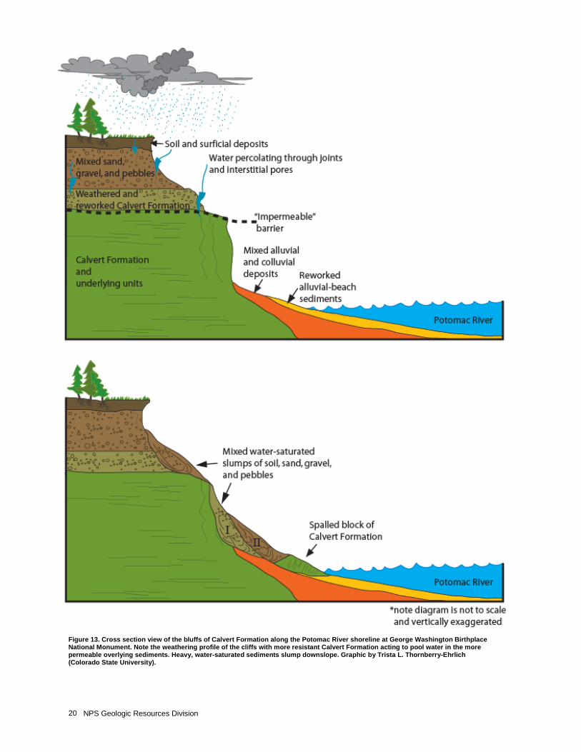
NPS Geologic Resources Division 20
Figure 13. Cross section view of the bluffs of Calvert Formation along the Potomac River shoreline at George Washington Birthplace National Monument. Note the weathering profile of the cliffs with more resistant Calvert Formation acting to pool water in the more permeable overlying sediments. Heavy, water-saturated sediments slump downslope. Graphic by Trista L. Thornberry-Ehrlich (Colorado State University).
GEWA-THST Geologic Resources Inventory Report 21
Map Unit Properties This section identifies characteristics of map units that appear on the Geologic Resources Inventory digital geologic maps of George Washington Birthplace National Monument and Thomas Stone National Historic Site. The accompanying tables are highly generalized and for background purposes only. Ground-disturbing activities should not be permitted or denied on the basis of information in this table. George Washington Birthplace National Monument The oldest mapped unit in the George Washington Birthplace National Monument area is the Nanjemoy Formation. This sand-rich unit contains abundant glauconitic clay and silt deposits and is nearly 70 m (230 ft) thick (McCartan et al. 1995). Miocene age units include the Calvert Formation, prevalent on the Potomac River bluffs at the monument, the Choptank Formation, and the Eastover Formation. These units contain interlayered sands, shell-rich sands, silts and clays, with occasional quartz pebble layers. (McCartan et al. 1995; Mixon et al. 2000). The Pliocene age map units comprise a thick stack of mixed sands, clays, silts, pebbles, cobbles, and sparse boulder layers of the Yorktown Formation, Bacons Castle Formation, and the Moorings Unit of Oaks and Coch (1973). The Bacons Castle Formation contains a series of fining upward sequences and numerous scour channels cut into the Yorktown Formation (Mixon et al. 2000; Newell et al. 2006). The Windsor Formation and colluvium deposits record the transition from Tertiary to Quaternary in the monument area. The Windsor Formation contains interbedded sand, gravel, silt, and clay in terrace landforms. Clasts from these formations were transported from hundreds of kilometers away (Mixon et al. 2000). Pleistocene age map units at the monument include the Charles City, Chuckatuck, Shirley, and Tabb Formations. These units contain numerous fining upward sequences grading from gravels, pebbles and sands to silts and clays. Colluvium beds grade into most of these units (Mixon et al. 2000; Newell et al. 2006). The youngest units include alluvium from the Holocene and Pleistocene transition. These units record important information about the migration of waterways across the landscape during climatic shifts. Colluvium, beach deposits, swamp and marsh deposits, and sand are currently being deposited and reworked (Mixon et al. 2000; Newell et al. 2006). These units may contain abundant archaeological remains as well as reworked fossils and climatic indicators such as pollen and plant fragments.
Thomas Stone National Historic Site Thomas Stone National Historic Site sits on thick deposits of sands, silts and clays, all of which were shed from the erosion of the Piedmont and Appalachian highlands to the west. The oldest rocks recorded on the map are the glauconitic quartz sands, clays, and shell rich
layers of the Paleocene Aquia Formation, and the dense clay and silt layers of the Marlboro Clay. Deep gullying and erosion poorly expose these oldest units in the northwestern portion of the map area (Mixon et al. 2000; Glaser 1984). Eocene age units in the area include the glauconitic quartz sands, silts, and clays of the Nanjemoy Formation. This unit is fossiliferous and contains distinctive iron sulfide concretions. Atop the Nanjemoy Formation are the Calvert Formation, upland gravels and Moorings Unit. These are all Pliocene age. These units contain alternating beds, often in fining upward cycles, of quartzose sand, silt, and clay, with occasional lenticular gravel and pebble beds. Marine fossils, burrows, and casts are all present in these units (Mixon et al. 2000). The transition from the Tertiary to the Quaternary Period is recorded in the Pliocene to Pleistocene age Ravens Crest and Windsor Formations. Coarse gravelly sand grading upwards to silty and clayey sand define the cyclic deposition of the Ravens Crest Formation. This unit contains cobble to boulder-sized clasts indicative of source areas as far west as the Valley and Ridge physiographic province west of the Blue Ridge Mountains. The Windsor Formation contains gravel, sand, silt, and clay, mostly derived from the early Mesozoic Culpeper basin and the local Piedmont (Mixon et al. 2000). The shifting climatic conditions of the Pleistocene Epoch are recorded in the alluvial terrace deposits, and the Chicamuxen Church, Charles City, Omar, Shirley, Maryland Point and Tabb Formations (Mixon et al. 2000; Glaser 1984). These units contain abundant gravel and pebbles interlayered with finer grained sands and silts indicative of active erosion and high-energy transport during the cooler climate of the periglacial conditions dominant in Maryland during the Pleistocene ice age events (Mixon et al. 2000). Holocene and Pleistocene age alluvium lines most stream valleys and channels. These are also present on floodplains, and in some places, they form low terraces above the larger river valleys. These consist of unconsolidated clay, silt, sand, gravel, and occasional boulder deposits (Mixon et al. 2000; Glaser 1984). This pattern, which exhibits underfit streams, is indicative of the transition from recent higher flow rates associated with melting of glacial ice and the transition from the Pleistocene to the Holocene. Recent, unconsolidated, Holocene age sand and swamp-marsh deposits line local

NPS Geologic Resources Division 22
river and stream valleys covering much of the low-lying tidal coastal areas (Mixon et al. 2000).
Digital Geologic Map Geologic maps facilitate an understanding of Earth, its processes, and the geologic history responsible for its formation. Hence, the geologic maps for George Washington Birthplace National Monument and Thomas Stone National Historic Site informed the “Geologic History,” “Geologic Features and Processes,” and “Geologic Issues” sections of this report. Geologic maps are essentially two-dimensional representations of complex three-dimensional relationships. The various colors on geologic maps illustrate the distribution of rocks and unconsolidated deposits. Bold lines that cross or separate the color patterns mark structures such as faults and folds. Point symbols indicate features such as dipping strata, sample localities, mines, wells, and cave openings. Incorporation of geologic data into a Geographic Information System (GIS) increases the usefulness of geologic maps by revealing the spatial relationships to other natural resources and anthropogenic features. Geologic maps are indicators of water resources because they show which rock units are potential aquifers and are useful for finding seeps and springs. Geologic maps do not show soil types and are not soil maps, but they do show parent material, a key factor in soil formation. Furthermore, resource managers have used geologic maps to make connections between geology and biology; for instance, geologic maps have served as tools for locating sensitive, threatened, and endangered plant species, which may prefer a particular rock unit. Although geologic maps do not show where earthquakes will occur, the presence of a fault indicates past movement and possible future seismic activity. Geologic maps do not show where the next landslide, rockfall, or volcanic eruption will occur, but mapped deposits show areas that have been susceptible to such geologic hazards. Geologic maps do not show archaeological or cultural resources, but past peoples may have inhabited or been influenced by various geomorphic features that are shown on geologic maps. For example, alluvial terraces may preserve artifacts, and formerly inhabited alcoves may occur at the contact between two rock units. The geologic units listed in the following table correspond to the accompanying digital geologic data. Map units are listed in the table from youngest to oldest. Please refer to the geologic timescale (fig. 14) for the age associated with each time period. This table highlights characteristics of map units such as susceptibility to
hazards; the occurrence of fossils, cultural resources, mineral resources, and caves; and the suitability as habitat or for recreational use. Some conclusions are conjectural and meant to serve as a suggestion for further investigation. The GRI digital geologic maps reproduce essential elements of the source maps including the unit descriptions, legend, map notes, graphics, and report. The following references are source data for the GRI digital geologic maps for George Washington Birthplace National Monument and Thomas Stone National Historic Site: Mixon, R. B., L. Pavlides, D. S. Powars, A. J. Froelich, R. E. Weems, J. S. Schindler, W. L. Newell, L. E. Edwards and L. W. Ward. 2000. Geologic Map of the Fredericksburg 30’ x 60’ Quadrangle, Virginia and Maryland. Scale 1:100,000. Geologic Investigations Series I-2607. Reston, VA: U.S. Geological Survey. McCartan, L., W. L. Newell, J. P. Owens, and G. M. Bradford. 1995. Geologic Map and Cross Sections of the Leonardtown 30 x 60 Minute Quadrangle, Maryland and Virginia. Scale 1:100,000. Open-File Report OF 95-665. Reston, VA: U. S. Geological Survey. Newell, W. L., O. P. Bricker, and M. S. Robertson. 2006. Geologic Map of the Colonial Beach South 7.5' Quadrangle, Virginia. Scale 1:24,000. Open-File Report OF 2005-1025. Reston, VA: U.S. Geological Survey. Glaser, J. D. 1984. Geologic Map of Port Tobacco Quadrangle, Maryland and Virginia. Scale 1:24,000. Quadrangle Geologic Map. Baltimore, MD: Maryland Geological Survey. The GRI team implements a geology-GIS data model that standardizes map deliverables. This data model dictates GIS data structure including data layer architecture, feature attribution and data relationships within ESRI ArcGIS software, increasing the overall quality and utility of the data. GRI digital geologic map products include data in ESRI personal geodatabase, shapefile, and coverage GIS formats, layer files with feature symbology, Federal Geographic Data Committee (FGDC)-compliant metadata, a Windows help file that contains all of the ancillary map information and graphics, and an ESRI ArcMap map document file that easily displays the map. GRI digital geologic data are included on the attached disk and are available through the NPS Data Store (http://science.nature.nps.gov/nrdata/).
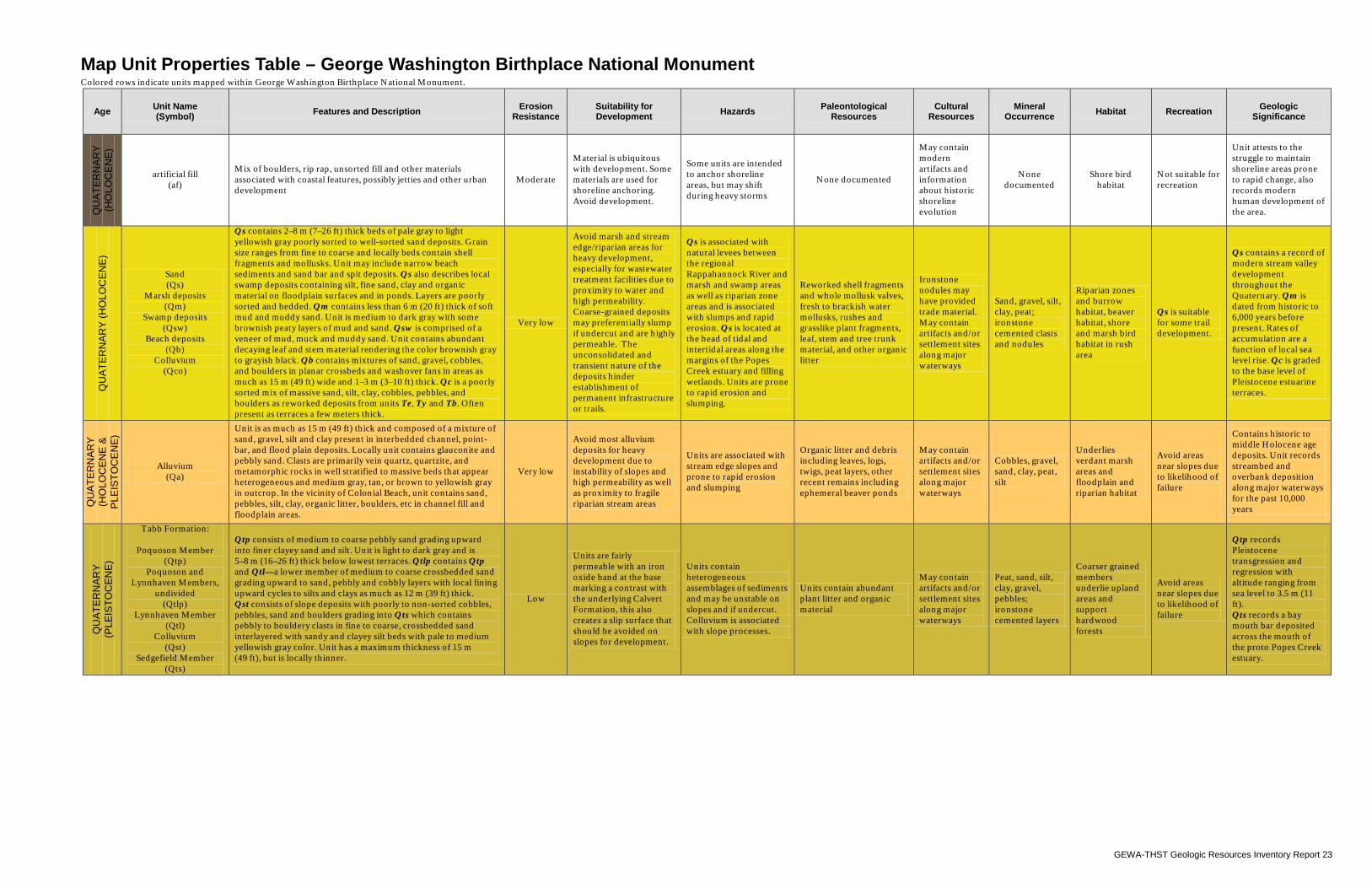
GEWA-THST Geologic Resources Inventory Report 23
Map Unit Properties Table – George Washington Birthplace National Monument Colored rows indicate units mapped within George Washington Birthplace National Monument.
Age Unit Name (Symbol) Features and Description Erosion
Resistance Suitability for Development Hazards Paleontological
Resources Cultural
Resources Mineral
Occurrence Habitat Recreation Geologic Significance
QU
ATE
RN
AR
Y
(HO
LOC
EN
E)
artificial fill (af)
Mix of boulders, rip rap, unsorted fill and other materials associated with coastal features, possibly jetties and other urban development
Moderate
Material is ubiquitous with development. Some materials are used for shoreline anchoring. Avoid development.
Some units are intended to anchor shoreline areas, but may shift during heavy storms
None documented
May contain modern artifacts and information about historic shoreline evolution
None documented
Shore bird habitat
Not suitable for recreation
Unit attests to the struggle to maintain shoreline areas prone to rapid change, also records modern human development of the area.
QU
ATE
RN
AR
Y (H
OLO
CE
NE
)
Sand (Qs)
Marsh deposits (Qm)
Swamp deposits (Qsw)
Beach deposits (Qb)
Colluvium (Qco)
Qs contains 2–8 m (7–26 ft) thick beds of pale gray to light yellowish gray poorly sorted to well-sorted sand deposits. Grain size ranges from fine to coarse and locally beds contain shell fragments and mollusks. Unit may include narrow beach sediments and sand bar and spit deposits. Qs also describes local swamp deposits containing silt, fine sand, clay and organic material on floodplain surfaces and in ponds. Layers are poorly sorted and bedded. Qm contains less than 6 m (20 ft) thick of soft mud and muddy sand. Unit is medium to dark gray with some brownish peaty layers of mud and sand. Qsw is comprised of a veneer of mud, muck and muddy sand. Unit contains abundant decaying leaf and stem material rendering the color brownish gray to grayish black. Qb contains mixtures of sand, gravel, cobbles, and boulders in planar crossbeds and washover fans in areas as much as 15 m (49 ft) wide and 1–3 m (3–10 ft) thick. Qc is a poorly sorted mix of massive sand, silt, clay, cobbles, pebbles, and boulders as reworked deposits from units Te, Ty and Tb. Often present as terraces a few meters thick.
Very low
Avoid marsh and stream edge/riparian areas for heavy development, especially for wastewater treatment facilities due to proximity to water and high permeability. Coarse-grained deposits may preferentially slump if undercut and are highly permeable. The unconsolidated and transient nature of the deposits hinder establishment of permanent infrastructure or trails.
Qs is associated with natural levees between the regional Rappahannock River and marsh and swamp areas as well as riparian zone areas and is associated with slumps and rapid erosion. Qs is located at the head of tidal and intertidal areas along the margins of the Popes Creek estuary and filling wetlands. Units are prone to rapid erosion and slumping.
Reworked shell fragments and whole mollusk valves, fresh to brackish water mollusks, rushes and grasslike plant fragments, leaf, stem and tree trunk material, and other organic litter
Ironstone nodules may have provided trade material. May contain artifacts and/or settlement sites along major waterways
Sand, gravel, silt, clay, peat; ironstone cemented clasts and nodules
Riparian zones and burrow habitat, beaver habitat, shore and marsh bird habitat in rush area
Qs is suitable for some trail development.
Qs contains a record of modern stream valley development throughout the Quaternary. Qm is dated from historic to 6,000 years before present. Rates of accumulation are a function of local sea level rise. Qc is graded to the base level of Pleistocene estuarine terraces.
QU
ATE
RN
AR
Y
(HO
LOC
EN
E &
P
LEIS
TOC
EN
E)
Alluvium (Qa)
Unit is as much as 15 m (49 ft) thick and composed of a mixture of sand, gravel, silt and clay present in interbedded channel, point-bar, and flood plain deposits. Locally unit contains glauconite and pebbly sand. Clasts are primarily vein quartz, quartzite, and metamorphic rocks in well stratified to massive beds that appear heterogeneous and medium gray, tan, or brown to yellowish gray in outcrop. In the vicinity of Colonial Beach, unit contains sand, pebbles, silt, clay, organic litter, boulders, etc in channel fill and floodplain areas.
Very low
Avoid most alluvium deposits for heavy development due to instability of slopes and high permeability as well as proximity to fragile riparian stream areas
Units are associated with stream edge slopes and prone to rapid erosion and slumping
Organic litter and debris including leaves, logs, twigs, peat layers, other recent remains including ephemeral beaver ponds
May contain artifacts and/or settlement sites along major waterways
Cobbles, gravel, sand, clay, peat, silt
Underlies verdant marsh areas and floodplain and riparian habitat
Avoid areas near slopes due to likelihood of failure
Contains historic to middle Holocene age deposits. Unit records streambed and overbank deposition along major waterways for the past 10,000 years
QU
ATE
RN
AR
Y
(PLE
ISTO
CE
NE
)
Tabb Formation:
Poquoson Member (Qtp)
Poquoson and Lynnhaven Members,
undivided (Qtlp)
Lynnhaven Member (Qtl)
Colluvium (Qst)
Sedgefield Member (Qts)
Qtp consists of medium to coarse pebbly sand grading upward into finer clayey sand and silt. Unit is light to dark gray and is 5–8 m (16–26 ft) thick below lowest terraces. Qtlp contains Qtp and Qtl—a lower member of medium to coarse crossbedded sand grading upward to sand, pebbly and cobbly layers with local fining upward cycles to silts and clays as much as 12 m (39 ft) thick. Qst consists of slope deposits with poorly to non-sorted cobbles, pebbles, sand and boulders grading into Qts which contains pebbly to bouldery clasts in fine to coarse, crossbedded sand interlayered with sandy and clayey silt beds with pale to medium yellowish gray color. Unit has a maximum thickness of 15 m (49 ft), but is locally thinner.
Low
Units are fairly permeable with an iron oxide band at the base marking a contrast with the underlying Calvert Formation, this also creates a slip surface that should be avoided on slopes for development.
Units contain heterogeneous assemblages of sediments and may be unstable on slopes and if undercut. Colluvium is associated with slope processes.
Units contain abundant plant litter and organic material
May contain artifacts and/or settlement sites along major waterways
Peat, sand, silt, clay, gravel, pebbles; ironstone cemented layers
Coarser grained members underlie upland areas and support hardwood forests
Avoid areas near slopes due to likelihood of failure
Qtp records Pleistocene transgression and regression with altitude ranging from sea level to 3.5 m (11 ft). Qts records a bay mouth bar deposited across the mouth of the proto Popes Creek estuary.
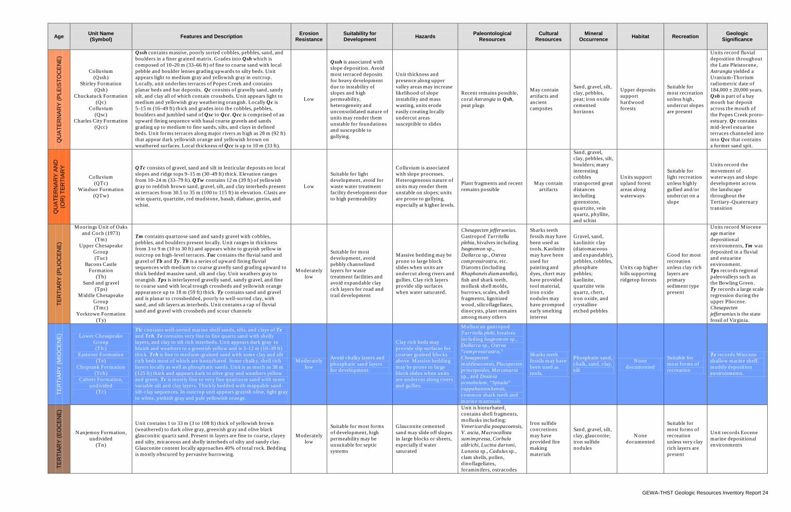
GEWA-THST Geologic Resources Inventory Report 24
Age Unit Name (Symbol) Features and Description Erosion
Resistance Suitability for Development Hazards Paleontological
Resources Cultural
Resources Mineral
Occurrence Habitat Recreation Geologic Significance
QU
ATE
RN
AR
Y (P
LEIS
TOC
EN
E)
Colluvium (Qssh)
Shirley Formation (Qsh)
Chuckatuck Formation (Qc)
Colluvium (Qsc)
Charles City Formation (Qcc)
Qssh contains massive, poorly sorted cobbles, pebbles, sand, and boulders in a finer grained matrix. Grades into Qsh which is composed of 10–20 m (33–66 ft) of fine to coarse sand with local pebble and boulder lenses grading upwards to silty beds. Unit appears light to medium gray and yellowish gray in outcrop. Locally, unit underlies terraces of Popes Creek and contains planar beds and bar deposits. Qc consists of gravelly sand, sandy silt, and clay all of which contain crossbeds. Unit appears light to medium and yellowish gray weathering orangish. Locally Qc is 5–15 m (16–49 ft) thick and grades into the cobbles, pebbles, boulders and jumbled sand of Qsc to Qcc. Qcc is comprised of an upward fining sequence with basal coarse gravels and sands grading up to medium to fine sands, silts, and clays in defined beds. Unit forms terraces along major rivers as high as 28 m (92 ft) that appear dark yellowish orange and yellowish brown on weathered surfaces. Local thickness of Qcc is up to 10 m (33 ft).
Low
Qssh is associated with slope deposition. Avoid most terraced deposits for heavy development due to instability of slopes and high permeability, heterogeneity and unconsolidated nature of units may render them unstable for foundations and susceptible to gullying.
Unit thickness and presence along upper valley areas may increase likelihood of slope instability and mass wasting, units erode easily creating locally undercut areas susceptible to slides
Recent remains possible, coral Astrangia in Qsh, peat plugs
May contain artifacts and ancient campsites
Sand, gravel, silt, clay, pebbles, peat; iron oxide cemented horizons
Upper deposits support hardwood forests
Suitable for most recreation unless high, undercut slopes are present
Units record fluvial deposition throughout the Late Pleistocene, Astrangia yielded a Uranium-Thorium radiometric date of 184,000 ± 20,000 years. Qsh is part of a bay mouth bar deposit across the mouth of the Popes Creek proto-estuary. Qc contains mid-level estuarine terraces channeled into into Qcc that contains a former sand spit.
QU
ATE
RN
AR
Y A
ND
(O
R) T
ER
TIA
RY
Colluvium (QTc)
Windsor Formation (QTw)
QTc consists of gravel, sand and silt in lenticular deposits on local slopes and ridge tops 9–15 m (30–49 ft) thick. Elevation ranges from 10–24 m (33–79 ft). QTw contains 12 m (39 ft) of yellowish gray to reddish brown sand, gravel, silt, and clay interbeds present as terraces from 30.5 to 35 m (100 to 115 ft) in elevation. Clasts are vein quartz, quartzite, red mudstone, basalt, diabase, gneiss, and schist.
Low
Suitable for light development, avoid for waste water treatment facility development due to high permeability
Colluvium is associated with slope processes. Heterogeneous nature of units may render them unstable on slopes; units are prone to gullying, especially at higher levels.
Plant fragments and recent remains possible
May contain artifacts
Sand, gravel, clay, pebbles, silt, boulders; many interesting cobbles transported great distances including greenstone, quartzite, vein quartz, phyllite, and schist
Units support upland forest areas along waterways
Suitable for light recreation unless highly gullied and/or undercut on a slope
Units record the movement of waterways and slope development across the landscape throughout the Tertiary–Quaternary transition
TER
TIA
RY
(PLI
OC
EN
E)
Moorings Unit of Oaks and Coch (1973)
(Tm) Upper Chesapeake
Group (Tuc)
Bacons Castle Formation
(Tb) Sand and gravel
(Tps) Middle Chesapeake
Group (Tmc)
Yorktown Formation (Ty)
Tm contains quartzose sand and sandy gravel with cobbles, pebbles, and boulders present locally. Unit ranges in thickness from 3 to 9 m (10 to 30 ft) and appears white to grayish yellow in outcrop on high-level terraces. Tuc contains the fluvial sand and gravel of Tb and Ty. Tb is a series of upward fining fluvial sequences with medium to coarse gravelly sand grading upward to thick bedded massive sand, silt and clay. Unit weathers gray to orangish. Tps is interlayered gravelly sand, sandy gravel, and fine to coarse sand with local trough crossbeds and yellowish orange appearance up to 18 m (59 ft) thick. Ty contains sand and gravel and is planar to crossbedded, poorly to well-sorted clay, with sand, and silt layers as interbeds. Unit contains a cap of fluvial sand and gravel with crossbeds and scour channels
Moderately low
Suitable for most development, avoid pebbly channelized layers for waste treatment facilities and avoid expandable clay rich layers for road and trail development
Massive bedding may be prone to large block slides when units are undercut along rivers and gullies. Clay rich layers provide slip surfaces when water saturated.
Chesapecten jeffersonius. Gastropod Turritella plebia, bivalves including Isognomon sp., Dallarca sp., Ostrea compressirostra, etc. Diatoms (including Rhaphoneis diamantella), fish and shark teeth, mollusk shell molds, burrows, scales, shell fragments, lignitized wood, silicoflagellates, dinocysts, plant remains among many others
Sharks teeth fossils may have been used as tools. Kaolinite may have been used for painting and dyes, chert may have provided tool material, iron oxide nodules may have prompted early smelting interest
Gravel, sand, kaolinitic clay (diatomaceous and expandable), pebbles, cobbles, phosphate pebbles; kaolinite, quartzite vein quartz, chert, iron oxide, and crystalline etched pebbles
Units cap higher hills supporting ridgetop forests
Good for most recreation unless clay rich layers are primary sediment type present
Units record Miocene age marine depositional environments, Tm was deposited in a fluvial and estuarine environment. Tps records regional paleovalleys such as the Bowling Green. Ty records a large scale regression during the upper Pliocene. Chesapecten jeffersonius is the state fossil of Virginia.
TER
TIA
RY
(MIO
CE
NE
) Lower Chesapeake Group (Tlc)
Eastover Formation (Te)
Choptank Formation (Tch)
Calvert Formation, undivided
(Tc)
Tlc contains well-sorted marine shelf sands, silts, and clays of Te and Tch. Te contains very fine to fine quartz sand with shelly layers, and clay to silt rich interbeds. Unit appears dark gray to bluish and weathers to a greenish yellow and is 3–12 m (10–39 ft) thick. Tch is fine to medium-grained sand with some clay and silt rich beds most of which are bioturbated. Some chalky, shell rich layers locally as well as phosphatic sands. Unit is as much as 38 m (125 ft) thick and appears dark to olive gray and weathers yellow and green. Tc is mostly fine to very fine quartzose sand with some variable silt and clay layers. Thickly bedded with mappable sand-silt-clay sequences. In outcrop unit appears grayish olive, light gray to white, pinkish gray and pale yellowish orange.
Moderately low
Avoid chalky layers and phosphatic sand layers for development.
Clay rich beds may provide slip surfaces for coarser grained blocks above. Massive bedding may be prone to large block slides when units are undercut along rivers and gullies.
Molluscan gastropod Turritella plebi, bivalves including Isognomon sp., Dallarca sp., Ostrea “compressirostra,” Chesapecten middlesexensis, Placopecten princepoides, Mercenaria sp., and Dosinia acetabulum, “Spisula” rappahannockensis, common shark teeth and marine mammals
Sharks teeth fossils may have been used as tools.
Phosphatic sand, chalk, sand, clay, silt
None documented
Suitable for most forms of recreation
Te records Miocene shallow marine shelf, muddy deposition environments.
TER
TIA
RY
(EO
CE
NE
)
Nanjemoy Formation, undivided
(Tn)
Unit contains 1 to 33 m (3 to 108 ft) thick of yellowish brown (weathered) to dark olive gray, greenish gray and olive black glauconitic quartz sand. Present in layers are fine to coarse, clayey and silty, micaceous and shelly interbeds of silty and sandy clay. Glauconite content locally approaches 40% of total rock. Bedding is mostly obscured by pervasive burrowing.
Moderately low
Suitable for most forms of development, high permeability may be unsuitable for septic systems
Glauconite cemented sand may slide off slopes in large blocks or sheets, especially if water saturated
Unit is bioturbated, contains shell fragments, mollusks including: Venericardia poapacoensis, V. ascia, Macrocallista sumimpressa, Corbula aldrichi, Lucina dartoni, Lunatia sp., Cadulus sp., clam shells, pollen, dinoflagellates, foraminifers, ostracodes
Iron sulfide concretions may have provided fire making materials
Sand, gravel, silt, clay, glauconite; iron sulfide nodules
None documented
Suitable for most forms of recreation unless very clay rich layers are present
Unit records Eocene marine depositional environments
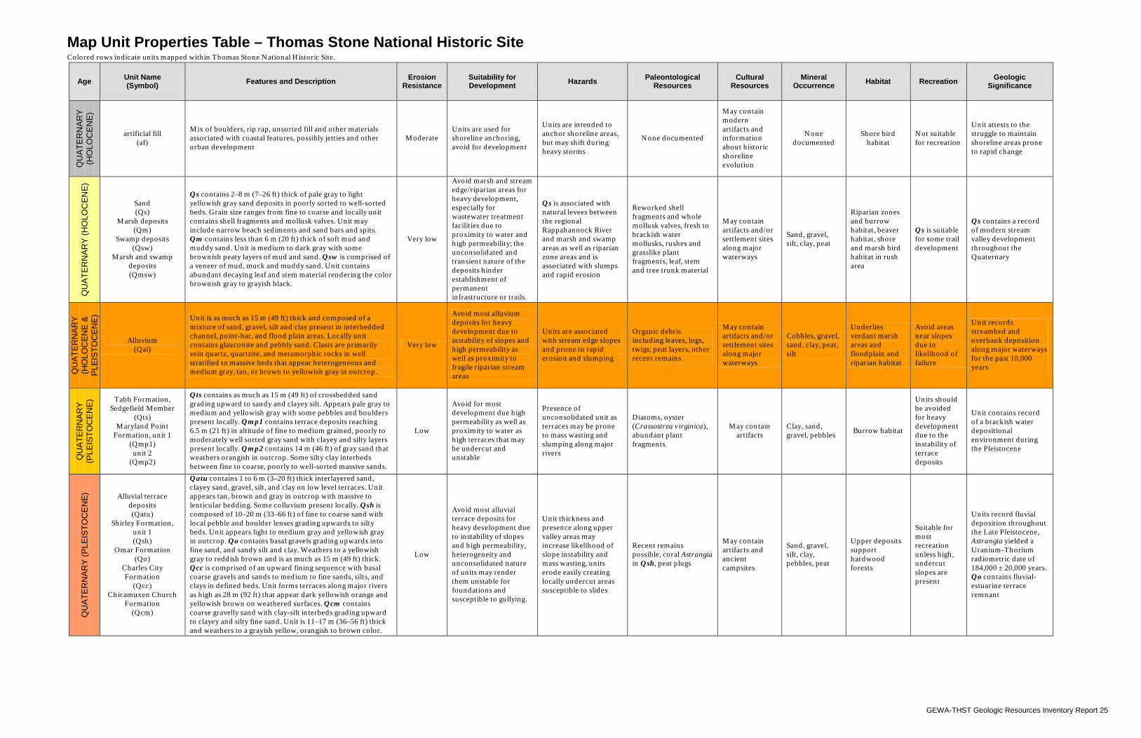
GEWA-THST Geologic Resources Inventory Report 25
Map Unit Properties Table – Thomas Stone National Historic Site Colored rows indicate units mapped within Thomas Stone National Historic Site.
Age Unit Name (Symbol) Features and Description Erosion
Resistance Suitability for Development Hazards Paleontological
Resources Cultural
Resources Mineral
Occurrence Habitat Recreation Geologic Significance
QU
ATE
RN
AR
Y
(HO
LOC
EN
E)
artificial fill (af)
Mix of boulders, rip rap, unsorted fill and other materials associated with coastal features, possibly jetties and other urban development
Moderate Units are used for shoreline anchoring, avoid for development
Units are intended to anchor shoreline areas, but may shift during heavy storms
None documented
May contain modern artifacts and information about historic shoreline evolution
None documented
Shore bird habitat
Not suitable for recreation
Unit attests to the struggle to maintain shoreline areas prone to rapid change
QU
ATE
RN
AR
Y (H
OLO
CE
NE
)
Sand (Qs)
Marsh deposits (Qm)
Swamp deposits (Qsw)
Marsh and swamp deposits (Qmsw)
Qs contains 2–8 m (7–26 ft) thick of pale gray to light yellowish gray sand deposits in poorly sorted to well-sorted beds. Grain size ranges from fine to coarse and locally unit contains shell fragments and mollusk valves. Unit may include narrow beach sediments and sand bars and spits. Qm contains less than 6 m (20 ft) thick of soft mud and muddy sand. Unit is medium to dark gray with some brownish peaty layers of mud and sand. Qsw is comprised of a veneer of mud, muck and muddy sand. Unit contains abundant decaying leaf and stem material rendering the color brownish gray to grayish black.
Very low
Avoid marsh and stream edge/riparian areas for heavy development, especially for wastewater treatment facilities due to proximity to water and high permeability; the unconsolidated and transient nature of the deposits hinder establishment of permanent infrastructure or trails.
Qs is associated with natural levees between the regional Rappahannock River and marsh and swamp areas as well as riparian zone areas and is associated with slumps and rapid erosion
Reworked shell fragments and whole mollusk valves, fresh to brackish water mollusks, rushes and grasslike plant fragments, leaf, stem and tree trunk material
May contain artifacts and/or settlement sites along major waterways
Sand, gravel, silt, clay, peat
Riparian zones and burrow habitat, beaver habitat, shore and marsh bird habitat in rush area
Qs is suitable for some trail development
Qs contains a record of modern stream valley development throughout the Quaternary
QU
ATE
RN
AR
Y
(HO
LOC
EN
E &
P
LEIS
TOC
EN
E)
Alluvium (Qal)
Unit is as much as 15 m (49 ft) thick and composed of a mixture of sand, gravel, silt and clay present in interbedded channel, point-bar, and flood plain areas. Locally unit contains glauconite and pebbly sand. Clasts are primarily vein quartz, quartzite, and metamorphic rocks in well stratified to massive beds that appear heterogeneous and medium gray, tan, or brown to yellowish gray in outcrop.
Very low
Avoid most alluvium deposits for heavy development due to instability of slopes and high permeability as well as proximity to fragile riparian stream areas
Units are associated with stream edge slopes and prone to rapid erosion and slumping
Organic debris including leaves, logs, twigs, peat layers, other recent remains
May contain artifacts and/or settlement sites along major waterways
Cobbles, gravel, sand, clay, peat, silt
Underlies verdant marsh areas and floodplain and riparian habitat
Avoid areas near slopes due to likelihood of failure
Unit records streambed and overbank deposition along major waterways for the past 10,000 years
QU
ATE
RN
AR
Y
(PLE
ISTO
CE
NE
) Tabb Formation, Sedgefield Member
(Qts) Maryland Point
Formation, unit 1 (Qmp1)
unit 2 (Qmp2)
Qts contains as much as 15 m (49 ft) of crossbedded sand grading upward to sandy and clayey silt. Appears pale gray to medium and yellowish gray with some pebbles and boulders present locally. Qmp1 contains terrace deposits reaching 6.5 m (21 ft) in altitude of fine to medium grained, poorly to moderately well sorted gray sand with clayey and silty layers present locally. Qmp2 contains 14 m (46 ft) of gray sand that weathers orangish in outcrop. Some silty clay interbeds between fine to coarse, poorly to well-sorted massive sands.
Low
Avoid for most development due high permeability as well as proximity to water as high terraces that may be undercut and unstable
Presence of unconsolidated unit as terraces may be prone to mass wasting and slumping along major rivers
Diatoms, oyster (Crassostrea virginica), abundant plant fragments
May contain artifacts
Clay, sand, gravel, pebbles Burrow habitat
Units should be avoided for heavy development due to the instability of terrace deposits
Unit contains record of a brackish water depositional environment during the Pleistocene
QU
ATE
RN
AR
Y (P
LEIS
TOC
EN
E) Alluvial terrace
deposits (Qatu)
Shirley Formation, unit 1 (Qsh)
Omar Formation (Qo)
Charles City Formation
(Qcc) Chicamuxen Church
Formation (Qcm)
Qatu contains 1 to 6 m (3–20 ft) thick interlayered sand, clayey sand, gravel, silt, and clay on low level terraces. Unit appears tan, brown and gray in outcrop with massive to lenticular bedding. Some colluvium present locally. Qsh is composed of 10–20 m (33–66 ft) of fine to coarse sand with local pebble and boulder lenses grading upwards to silty beds. Unit appears light to medium gray and yellowish gray in outcrop. Qo contains basal gravels grading upwards into fine sand, and sandy silt and clay. Weathers to a yellowish gray to reddish brown and is as much as 15 m (49 ft) thick. Qcc is comprised of an upward fining sequence with basal coarse gravels and sands to medium to fine sands, silts, and clays in defined beds. Unit forms terraces along major rivers as high as 28 m (92 ft) that appear dark yellowish orange and yellowish brown on weathered surfaces. Qcm contains coarse gravelly sand with clay-silt interbeds grading upward to clayey and silty fine sand. Unit is 11–17 m (36–56 ft) thick and weathers to a grayish yellow, orangish to brown color.
Low
Avoid most alluvial terrace deposits for heavy development due to instability of slopes and high permeability, heterogeneity and unconsolidated nature of units may render them unstable for foundations and susceptible to gullying.
Unit thickness and presence along upper valley areas may increase likelihood of slope instability and mass wasting, units erode easily creating locally undercut areas susceptible to slides
Recent remains possible, coral Astrangia in Qsh, peat plugs
May contain artifacts and ancient campsites
Sand, gravel, silt, clay, pebbles, peat
Upper deposits support hardwood forests
Suitable for most recreation unless high, undercut slopes are present
Units record fluvial deposition throughout the Late Pleistocene, Astrangia yielded a Uranium-Thorium radiometric date of 184,000 ± 20,000 years. Qo contains fluvial-estuarine terrace remnant
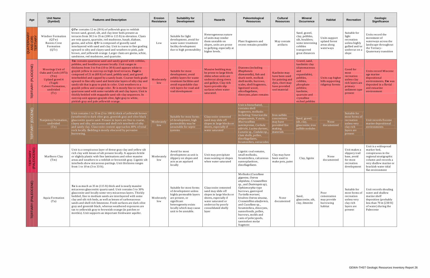
GEWA-THST Geologic Resources Inventory Report 26
Age Unit Name (Symbol) Features and Description Erosion
Resistance Suitability for Development Hazards Paleontological
Resources Cultural
Resources Mineral
Occurrence Habitat Recreation Geologic Significance
QU
ATE
RN
AR
Y
AN
D (O
R)
TER
TIA
RY
Windsor Formation
(QTw) Ravens Crest
Formation (QTr)
QTw contains 12 m (39 ft) of yellowish gray to reddish brown sand, gravel, silt, and clay inter beds present as terraces from 30.5 to 35 m (100 to 115 ft) in elevation. Clasts are vein quartz, quartzite, red mudstone, basalt, diabase, gneiss, and schist. QTr is composed of gravelly sand interlayered with sand and clay. Unit is coarse to fine grading upward to silty and clayey sand and weathers to pink, pale brown, and yellowish orange. Larger clasts are gneiss, schist, sandstone, red mudstone, and quartzite.
Low
Suitable for light development, avoid for waste water treatment facility development due to high permeability
Heterogeneous nature of units may render them unstable on slopes, units are prone to gullying, especially at higher levels.
Plant fragments and recent remains possible
May contain artifacts
Sand, gravel, clay, pebbles, silt, boulders; some interesting cobbles transported great distances
Units support upland forest areas along waterways
Suitable for light recreation unless highly gullied and/or undercut on a slope
Units record the movement of waterways across the landscape throughout the Tertiary–Quaternary transition
TER
TIA
RY
(PLI
OC
EN
E)
Moorings Unit of Oaks and Coch (1973)
(Tm) Upland gravel 4
(Tug4) Calvert Formation,
undivided (Tc)
Tm contains quartzose sand and sandy gravel with cobbles, pebbles, and boulders present locally. Unit ranges in thickness from 3 to 9 m (10 to 30 ft) and appears white to grayish yellow in outcrop on high-level terraces. Tug4 is composed of 21 m (69 ft) of sand, pebbly sand, and gravel interbedded and capped by a sandy loam. Coarser beds grade upward to fine silty sand and lenticular layers of silty clay and sandy silt that is gray to pink in color. Unit weathers to a grayish yellow and orange color. Tc is mostly fine to very fine quartzose sand with some variable silt and clay layers. Unit is thickly bedded with mappable sand-silt-clay sequences. In outcrop unit appears grayish olive, light gray to white, pinkish gray and pale yellowish orange.
Moderately low
Suitable for most development, avoid pebbly layers for waste treatment facilities and avoid expandable clay rich layers for road and trail development
Massive bedding may be prone to large block slides when units are undercut along rivers and gulleys. Clay rich layers provide slip surfaces when water saturated.
Diatoms (including Rhaphoneis diamantella), fish and shark teeth, mollusk shell molds, burrows, scales, shell fragments, lignitized wood, silicoflagellates, dinocysts, plant remains
Kaolinite may have been used for painting and dyes, chert may have provided tool material
Gravel, sand, kaolinitic clay (diatomaceous and expandable), pebbles, cobbles, phosphate pebbles; kaolinite, quartzite and crystalline etched pebbles
Units cap higher hills supporting ridgetop forests
Good for most recreation unless clay rich layers are primary sediment type present
Units record Miocene age marine depositional environments, Tm was deposited in a fluvial and estuarine environment
TER
TIA
RY
(EO
CE
NE
)
Nanjemoy Formation, undivided
(Tn)
Unit contains 1 to 33 m (3 to 108 ft) thick of yellowish brown (weathered) to dark olive gray, greenish gray and olive black glauconitic quartz sand. Present in layers are fine to coarse, clayey and silty, micaceous and shell rich interbeds of silty and sandy clay. Glauconite content approaches 40% of total rock locally. Bedding is mostly obscured by pervasive burrowing.
Moderately low
Suitable for most forms of development, high permeability may be unsuitable for septic systems
Glauconite cemented sand may slide off slopes in large blocks or sheets, especially if water saturated
Unit is bioturbated, contains shell fragments, mollusks including: Venericardia poapacoensis, V.ascia, Macrocallista sumimpressa, Corbula aldrichi, Lucina dartoni, Lunatia sp., Cadulus sp., clam shells, pollen, dinoflagellates, foraminifers, ostracodes
Iron sulfide concretions may have provided fire making materials
Sand, gravel, silt, clay, glauconite; iron sulfide nodules
None documented
Suitable for most forms of recreation unless very clay rich layers are present
Unit records Eocene marine depositional environments
TER
TIA
RY
(P
ALE
OC
EN
E)
Marlboro Clay (Tm)
Unit is a conspicuous layer of dense gray clay and yellow silt rich clay with lenses of silt present locally. It appears brittle or slightly plastic with fine laminations and other massive areas and weathers to a reddish or brownish gray. Lignitic silt interbeds show micaceous partings. Unit thickness ranges from 1 to 10 m (3 to 33 ft).
Moderately low
Avoid for most development as unit is slippery on slopes and acts as an aquitard locally
Unit may precipitate mass wasting on slopes when water saturated
Lignitic coal remains, small mollusks, foraminifera, calcareous nannoplankton, dinoflagellates
Clay may have been used to make pots, paint
Clay, lignite None documented
Unit makes a slippery trail base, avoid for most recreation development
Unit is a widespread marker bed, conspicuous in the regional stratigraphic column and records a very shallow marine or brackish water tidal flat environment
TER
TIA
RY
(PA
LEO
CE
NE
)
Aquia Formation (Ta)
Ta is as much as 35 m (115 ft) thick and is nearly massive micaceous glauconitic quartz sand. Unit contains 5 to 30% glauconite and locally some very micaceous layers. Thickly bedded, fine to medium sands are interlayered with some clay and silt rich beds, as well as lenses of carbonaceous sands and shell rich limestone. Fresh surfaces are dark olive gray and greenish black, whereas weathered exposures are tan to yellowish gray to brownish orange (in patches or mottles). Unit supports an important freshwater aquifer.
Moderately low
Suitable for most forms of development unless highly permeable layers are present, or significant heterogeneity exists locally which may cause unit to be unstable.
Glauconite cemented sand may slide off slopes in large blocks or sheets, especially if water saturated or undercut by poorly consolidated shelly layer
Mollusks (Cucullaea gigantea, Ostrea alepidota, Crassatellites sp., and Dosiniopsis sp), Ophiomorpha-type burrows, gastropod Turitella mortoni, bivalves Ostrea sinuosa, Crassatellites alaeformis, and Cucullaea sp., foraminifera, dinocysts, nannofossils, pollen, burrows, molds and casts of pelecypods, taeniodont molar fragment
None documented
Sand, glauconite, silt, clay, ilmenite
Poor cementation may provide burrowing habitat
Suitable for most forms of recreation unless very clay rich layers are present
Unit records shoaling water and shallow marine shelf deposition (probably less than 70 m [230 ft] of water) during the Paleocene
GEWA-THST Geologic Resources Inventory Report 27
Geologic History This section describes the rocks and unconsolidated deposits that appear on the digital geologic map of George Washington Birthplace National Monument and Thomas Stone National Historic Site, the environment in which those units were deposited, and the timing of geologic events that created the present landscape. George Washington Birthplace National Monument and Thomas Stone National Historic Site are located east of the Fall Line, which is the erosional boundary between the Piedmont and Atlantic Coastal Plain physiographic provinces. The Atlantic Coastal Plain is a thick wedge-shaped body of layers of sediment shed from the highlands to the west. These sediments are mostly unlithified sand, gravel, silt, and clay. The origin (provenance) of larger clasts is often located several hundred kilometers away indicating relatively long distance transportation. The Atlantic Coastal Plain contains a record, in reverse stratigraphic order, of the erosion of the highlands to the west. Initial uplift, in the current cycle, is represented by the lowest sediments in the Atlantic Coastal Plain. As uplift and dissection of the highlands continued the cycle of erosion and deposition continued to record the geologic history of the eastern coast of the North American continent. The regional perspective presented here is intended to connect the landscape and geology of the monument and historic site to their surroundings.
Proterozoic Eon The history recorded in the rocks of the Appalachian Mountains begins in the Proterozoic Eon (figs. 14 and 15). In the mid Proterozoic, during the Grenville Orogeny, a supercontinent formed that included most of the continental crust in existence at that time. Grenville rocks are more than a billion years old and they form the basement upon which the rocks of the Appalachians were deposited (Southworth et al. 2001). During the Neoproterozoic (late Proterozoic) (fig. 16A), roughly 600 million years ago, extensional tectonic forces rifted the continents apart and formed a rift basin that continued to open and became the Iapetus Ocean (fig. 16B). This basin subsided and collected many of the sediments that would eventually lithify and comprise the Appalachian Mountains and Piedmont Plateau.
Paleozoic Era Throughout the Paleozoic, several mountain building episodes uplifted overlapping portions of the Appalachian Mountains. From Early Cambrian through Early Ordovician time, the Taconic Orogeny involved the closing of the Iapetus Ocean, subduction of oceanic crust, creation of volcanic arcs, and the uplift of continental crust (fig. 16C) (Means 1995). The Acadian Orogeny (≈360 million years ago) continued the mountain building of the Taconic Orogeny as the African continent approached North America (Harris et al. 1997). During the Late Paleozoic, the North American continent collided with the African continent during the
last major mountain building phase of the Appalachians, the Alleghanian Orogeny (fig. 16D). The event ultimately formed the supercontinent Pangaea (Means 1995). During this orogeny, paleoelevations of the Alleghanian-Appalachian Mountains were over 6,000 m (20,000 ft), analogous to the modern day Himalayas in Asia. Erosion now exposes the metamorphosed core of the mountain range.
Mesozoic Era During the late Triassic (~ 230–200 million years ago), following the Alleghanian Orogeny, a period of rifting began as the deformed rocks of the joined continents began to break apart (fig. 16E). Pangaea separated into roughly the continents that persist today. This episode of rifting initiated the formation of the current Atlantic Ocean and resulted in many block-faulted basins along the continental margin along with accompanying volcanism (Harris et al. 1997; Southworth et al. 2001). At this time, the sedimentation began that would eventually form the vast Atlantic Coastal Plain. Starting in the Jurassic, the region underwent a period of slow uplift and erosion. The uplift was in response to isostatic adjustments within the crust, which forced the continental crust upwards and exposed it to erosion. Erosion from the Alleghanian mountains resulted in thick sections of sediment. The sediments deposited on the Atlantic Coastal Plain accumulated slowly over at least 110 million years (McCartan 1989). They were deposited at the base of the mountains as alluvial fans and spread eastward (fig. 16F) (Duffy and Whittecar 1991; Whittecar and Duffy 2000; Southworth et al. 2001). Prograding deposits of sediment derived from erosion of Piedmont rocks coalesced into a submarine delta system in the Early Cretaceous. The fan-delta deposits were later uplifted and eroded acting as a source of material for deposits further eastward (McCartan 1989). A delta plain environment persisted throughout much of the Cretaceous (McCartan 1989) resulting in widespread deposition of the Cretaceous Potomac Formation as a clastic sedimentary wedge. This formation sits directly on the Paleozoic and Proterozoic crystalline basement rocks deep below the surface at George Washington Birthplace National Monument and Thomas Stone National Historic Site. It crops out at the surface further west lapping onto crystalline rocks of the Piedmont (Mixon et al. 2000). In the area of the monument and historic site periods of sediment accumulation represent nearby uplifting of the source area and depositional basin configurations (downwarping) capable of trapping sediment. Gaps, or unconformities, in the record indicate
NPS Geologic Resources Division 28
relative tectonic quiescence in the source area as well as uplift and erosion of the depositional basin (McCartan et al. 1995).
Late Mesozoic and Early Cenozoic Eras In the Late Cretaceous and early Paleocene, a transgression resulted in marine sediments being deposited over the older fluvial-deltaic units (McCartan 1989; Mixon et al. 2000). These layers are primarily fine- to medium-grained quartz sand and clay with alternating shell rich beds and glauconite rich sands. This depositional pattern persisted throughout the Eocene and into the middle Miocene resulting in the Marlboro clay and Nanjemoy Formation among others (Newell et al. 2006; McCartan et al. 1995). In the middle to late Miocene, relative sea level dropped in a marine regression and regional streams began transporting large volumes of quartzose sand into the system (McCartan 1989). Geologic units deposited at this time include the Calvert Formation, Choptank Formation, and Eastover Formation (Newell et al. 2006; McCartan et al. 1995).
Cenozoic Era Regional erosion continued throughout the Cenozoic. As much as 2–3 km (1–2 mi) of rock has been removed by erosion since the Miocene (W. Newell, written communication 2009). The amount of erosion inferred from the uplifted and now-exposed metamorphic rocks of the Piedmont and Blue Ridge to the west is immense (fig. 16F). Based on geochemical data and geo-barometric evidence, many of the rocks exposed at the present surface were buried at least 20 km (≈10 mi) below the surface prior to regional uplift and erosion. The modern landscape of the greater Potomac, Rappahannock and other large river valleys has developed over the last 5 million years (end of the Miocene). A marine regression in the late Miocene allowed fluvial processes to dominate, carving channels into marine deposits and leaving a thin gravel sheet over the coastal plain by the end of the Pliocene. Units deposited during this time include the Charles City Formation and the Tabb Formation (Newell et al. 2006; McCartan et al. 1995). Following deposition of these units, the development of the modern Potomac River estuary began with a marine transgression (relative sea-level rise) drowning regional river valleys (McCartan 1989). Much of the Virginia coastal plain is now exposed above sea level and cut by entrenched tidewater estuaries (fig. 17) (W. Newell, written communication 2009). The distribution of flood plain alluvium and ancient, fluvial, step-like terraces of the rivers and adjacent tributaries record the development of the drainage systems from the latest Pliocene to recent. A series of ancient terraces and intervening scarps parallel the present-day Rappahannock and Potomac rivers (Mixon et al. 2000). Flood plain and terrace erosional features
include islands, islets, pinnacles, oxbows, shoestring canals, potholes, and plungepools (Southworth et al. 2001). The elevations of terraces along the rivers suggest the slope values of the ancient and modern river valleys are similar indicating that the terraces formed as the result of a marine regression caused by either global sea level drop or uplift (Zen 1997a and 1997b). The rivers have incised through older, more resistant rocks, overprinting their early courses without notable meandering (Southworth et al. 2001). When the Potomac River cut through bedrock, it left deposits of large quartzite and diabase boulders in its river terraces. Fluvial and estuarine sand, silt, and gravel associated with each set of terraces reflect deposition during interglacial highstands of the Atlantic Ocean whereas downcutting commenced during glacially influenced periods of low sea level (Mixon et al. 2000). Although glaciers from the Pleistocene never reached the southern Maryland-eastern Virginia area (the southern terminus was in northeastern Pennsylvania), the colder climate played a role in the formation of the landscape at the monument and historic site. Immense quantities of water bound up as glacial ice caused a relative drop in global sea level and increased downcutting by rivers as mentioned above. The cooler periglacial conditions that existed close to the glaciers intensified weathering and other erosional processes (Harris et al. 1997). Glaciers, as powerful erosive agents, increased the sediment supply to the area’s rivers, building terraces and filling basins. Freeze and thaw cycles inherent to a colder climate would have increased weathering, especially for sloped areas. Frozen ground would cause an increase in sheetflow and runoff with extra water flowing into the ancestral river channels enhancing downcutting and erosion by waterways (Means 1995; Zen 1997a and 1997b). The Chesapeake Bay formed approximately 18,000 years before present (Bailey and Roberts no date). Since that time, surficial geologic units such as marsh deposits, swamp deposits, beach deposits, colluvium, and alluvium record the modern geomorphological processes and changes to the landscape at George Washington Birthplace National Monument and Thomas Stone National Historic Site (Newell et al. 2006; McCartan et al. 1995). Organic rich swamp and marsh deposits contain plant remains that can provide clues to climate changes throughout the Holocene. Alluvium lines stream channels, point-bars, and floodplain areas with clasts such as quartzite and metamorphic rocks that record long transport from source areas in the highlands of the Piedmont to the west. Colluvium is a poorly sorted deposit formed by active slope processes consisting of reworked clasts of older units and records mass wasting events (Newell et al. 2006; McCartan et al. 1995). Continuous wave action reworks beach deposits along the modern Potomac River.
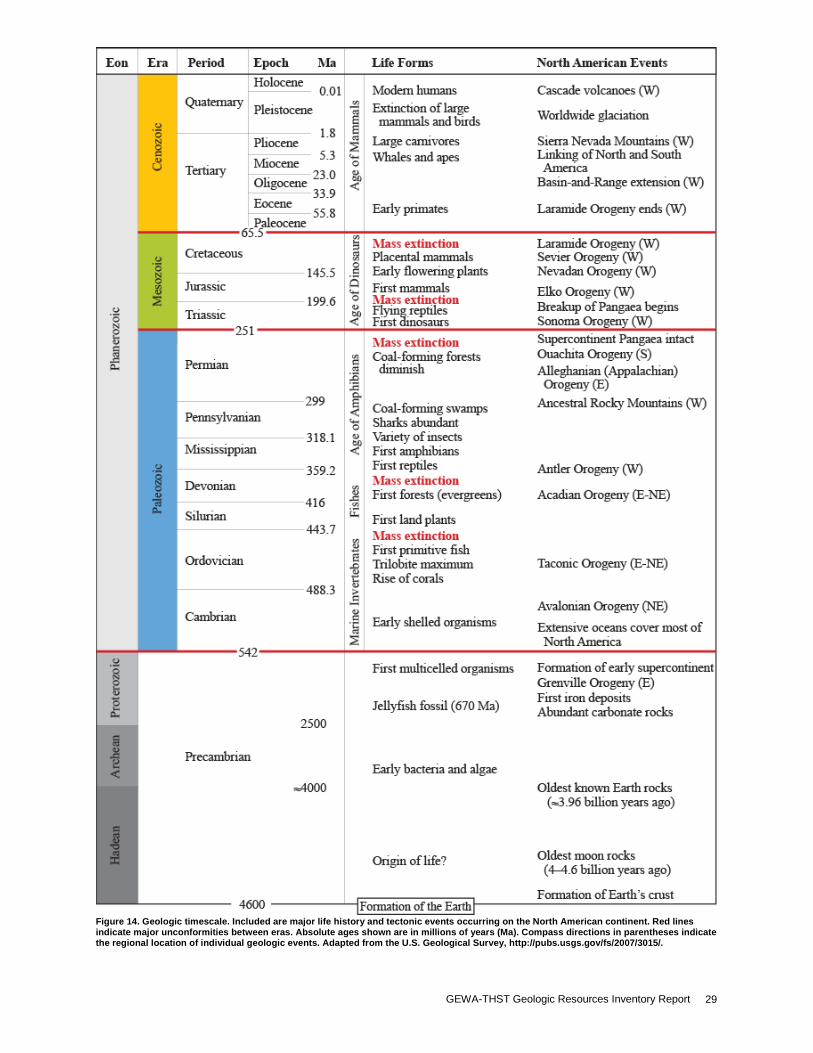
GEWA-THST Geologic Resources Inventory Report 29
Figure 14. Geologic timescale. Included are major life history and tectonic events occurring on the North American continent. Red lines indicate major unconformities between eras. Absolute ages shown are in millions of years (Ma). Compass directions in parentheses indicate the regional location of individual geologic events. Adapted from the U.S. Geological Survey, http://pubs.usgs.gov/fs/2007/3015/.
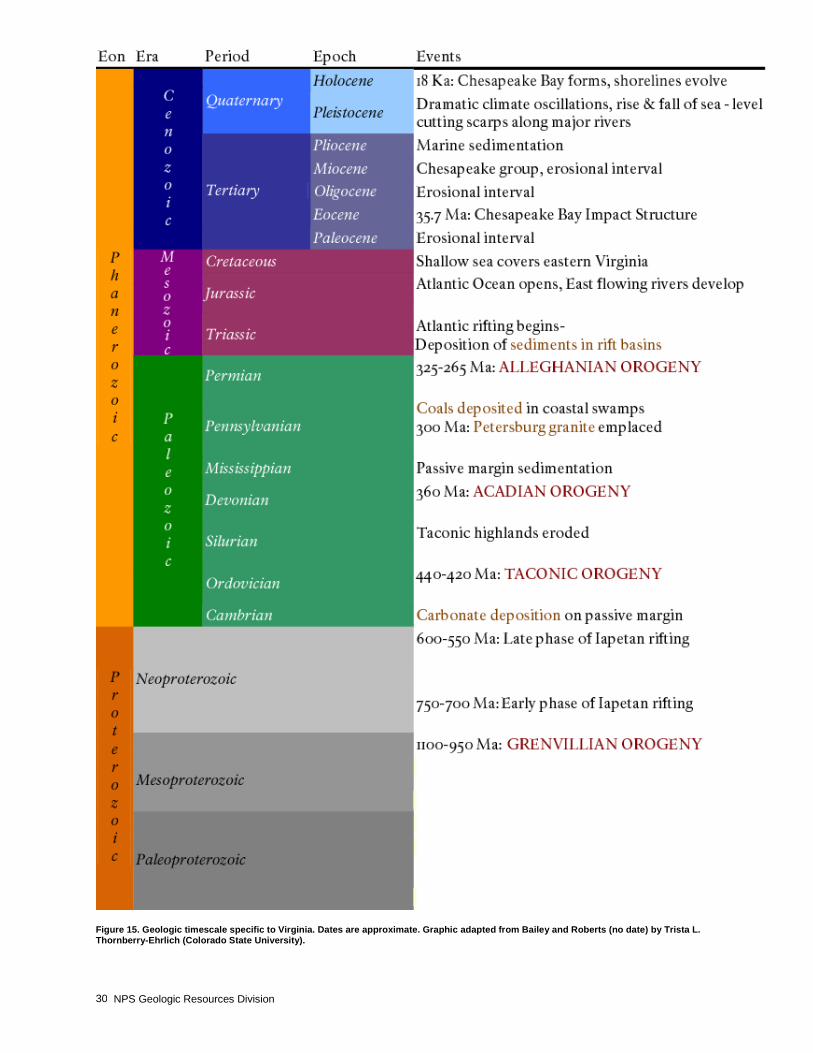
NPS Geologic Resources Division 30
Figure 15. Geologic timescale specific to Virginia. Dates are approximate. Graphic adapted from Bailey and Roberts (no date) by Trista L. Thornberry-Ehrlich (Colorado State University).
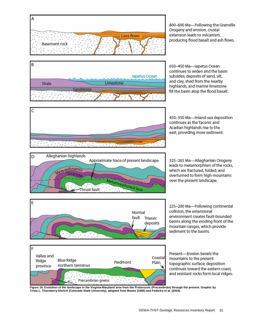
GEWA-THST Geologic Resources Inventory Report 31
Figure 16. Evolution of the landscape in the Virginia-Maryland area from the Proterozoic (Precambrian) through the present. Graphic by Trista L. Thornberry-Ehrlich (Colorado State University), adapted from Means (1995) and Fedorko et al. (2004).
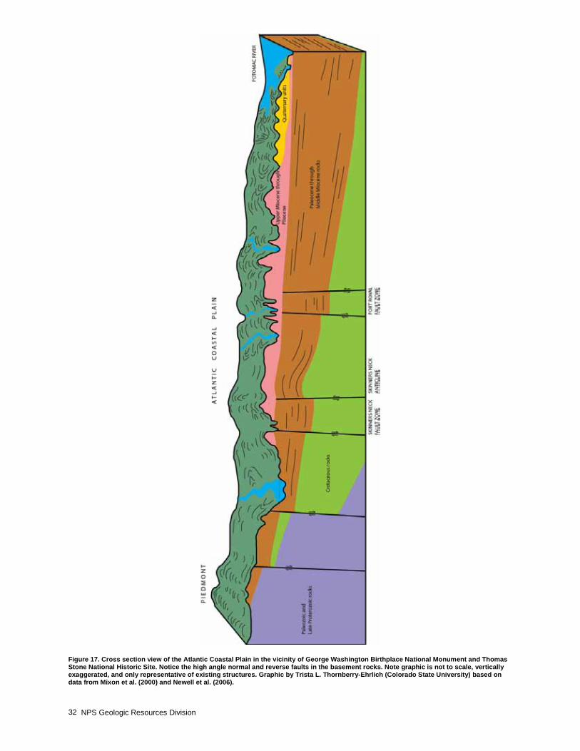
NPS Geologic Resources Division 32
Figure 17. Cross section view of the Atlantic Coastal Plain in the vicinity of George Washington Birthplace National Monument and Thomas Stone National Historic Site. Notice the high angle normal and reverse faults in the basement rocks. Note graphic is not to scale, vertically exaggerated, and only representative of existing structures. Graphic by Trista L. Thornberry-Ehrlich (Colorado State University) based on data from Mixon et al. (2000) and Newell et al. (2006).
GEWA-THST Geologic Resources Inventory Report 33
Glossary This glossary contains brief definitions of technical geologic terms used in this report. Not all geologic terms used are referenced. For more detailed definitions or to find terms not listed here please visit: http://geomaps.wr.usgs.gov/parks/misc/glossarya.html. active margin. A tectonically active margin where
lithospheric plates converge, diverge or slide past one another (also see “passive margin”). Typically associated with earthquakes and, in the case of convergent and divergent boundaries, volcanism.
alluvial fan. A fan-shaped deposit of sediment that accumulates where a hydraulically confined stream flows to a hydraulically unconfined area. Commonly out of a mountain front into an area such as a valley or plain.
alluvium. Stream-deposited sediment. aquifer. A rock or sedimentary unit that is sufficiently
porous that it has a capacity to hold water, sufficiently permeable to allow water to move through it, and currently saturated to some level.
arc. See “volcanic arc” and “island arc.” barrier island. A long, low, narrow island formed by a
ridge of sand that parallels the coast. base flow. Stream flow supported by groundwater flow
from adjacent rock, sediment, or soil. base level. The lowest level to which a stream can erode
its channel. The ultimate base level for the land surface is sea level, but temporary base levels may exist locally.
basement. The undifferentiated rocks, commonly igneous and metamorphic, that underlie the rocks exposed at the surface.
basin (structural). A doubly-plunging syncline in which rocks dip inward from all sides (also see dome).
basin (sedimentary). Any depression, from continental to local scales, into which sediments are deposited.
beach. A gently sloping shoreline covered with sediment, often formed by the action of waves and tides.
beach face. The section of the beach exposed to direct wave and/or tidal action.
bed. The smallest sedimentary strata unit, commonly ranging in thickness from one centimeter to a meter or two and distinguishable from beds above and below.
bedding. Depositional layering or stratification of sediments.
bioturbated. Describes sediment displaced and reincorporated in younger units (reworked) by an organism.
block (fault). A crustal unit bounded by faults, either completely or in part.
cementation. Chemical precipitation of material into pores between grains that bind the grains into rock.
chemical weathering. Chemical breakdown of minerals at the Earth’s surface via reaction with water, air, or dissolved substances; commonly results in a change in chemical composition more stable in the current environment.
clastic. Describes rock or sediment made of fragments of pre-existing rocks.
clay. Can be used to refer to clay minerals or as a sedimentary fragment size classification (less than 1/256 mm [0.00015 in]).
colluvium. A general term applied to any loose, heterogeneous, and incoherent mass of rock fragments deposited by unconcentrated surface runoff or slow continuous downslope creep, usually collecting at the base of gentle slopes or hillsides.
conglomerate. A coarse-grained, generally unsorted, sedimentary rock consisting of cemented rounded clasts larger than 2 mm (0.08 in).
continental crust. The crustal rocks rich in silica and alumina that underlie the continents; ranging in thickness from 35 km (22 mi) to 60 km (37 mi) under mountain ranges.
continental shelf. The shallowly-submerged portion of a continental margin extending from the shoreline to the continental slope with water depths of less than 200 m (656 ft).
continental slope. The relative steep slope from the outer edge of the continental shelf down to the more gently sloping ocean depths of the abyssal plain.
convergent boundary. A plate boundary where two tectonic plates are moving together (i.e., a zone of subduction or obduction).
craton. The relatively old and geologically stable interior of a continent (also see continental shield).
creep. The slow, imperceptible downslope movement of mineral, rock, and soil particles under gravity.
cross-bedding. Uniform to highly-varied sets of inclined sedimentary beds deposited by wind or water that indicate distinctive flow conditions.
cross section. A two-dimensional graphical representation of a geologic interpretation, The two-dimensional plane is oriented vertically so as to show the vertical relationships of rocks.
crust. The Earth’s outermost compositional shell, 10 to 40 km (6 to 25 mi) thick, consisting predominantly of relatively low-density silicate minerals (also see “oceanic crust” and “continental crust”).
debris flow. A rapid flow of rock and soil material involving a wide range of types and sizes.
deformation. A general term for the process of faulting, folding, and shearing of rocks as a result of various Earth forces such as compression (pushing together) and extension (pulling apart).
delta. A sediment wedge deposited where a stream flows into a lake or sea.
dip. The angle between a bed or other geologic surface and horizontal.
dip-slip fault A fault with measurable offset where the relative movement is parallel to the dip of the fault.
drainage basin. The total area from which a stream system receives or drains precipitation runoff.
NPS Geologic Resources Division 34
earth flow. Mass wasting process in which soil and weathered rock travel downslope along a basal surface (landslide) parallel to the downslope ground surface and within well defined side boundaries. Little or no rotation of material occurs.
en echelon. Describes geologic features (particularly faults) that overlap in a step-like pattern.
estuary. The seaward end or tidal mouth of a river where fresh and marine waters mix; many estuaries are drowned river valleys caused by sea level rise (transgression) or coastal subsidence.
eustatic. Relates to simultaneous worldwide rise or fall of sea level.
facies (sedimentary). The grouping of similar rock units based on the sedimentary structures, textures, mineralogy, fossils, etc. of a sedimentary rock.
fan delta. An alluvial fan that builds into a standing body of water. This landform differs from a delta in that a fan delta is next to a highland and typically forms at an active margin.
fault. A break in rock along which relative movement has occurred between the two sides.
formation. Fundamental rock-stratigraphic unit that is mappable, lithologically distinct from adjoining strata, and has definable upper and lower contacts.
glauconite. A green mineral, closely related to the micas and essentially a hydrous potassium silicate. It is an indicator of very slow sedimentation.
graben. A down-dropped structural block bounded by steeply dipping, normal faults (also see “horst”).
horst. Area of relative up between grabens, representing the geologic surface left behind as grabens drop. The best example is the basin and range province of Nevada. The basins are grabens and the ranges are weathered horsts. Grabens become a locus for sedimentary deposition.
igneous. Refers to a rock or mineral that originated from molten material; one of the three main classes of rocks—igneous, metamorphic, and sedimentary.
intrusion. A body of igneous rock that invades (pushes into) older rock. The invading rock may be a plastic solid or magma.
interstitial. Describes a material filling voids in a rock or mineral.
island arc. A line or arc of volcanic islands formed over and parallel to a subduction zone.
isostasy. The process by which the crust “floats” at an elevation compatible with the density and thickness of the crustal rocks relative to underlying mantle.
isostatic adjustment. The shift of the lithosphere to maintain equilibrium between units of varying mass and density; excess mass above is balanced by a deficit of density below, and vice versa.
joint. A semi-planar break in rock without relative movement of rocks on either side of the fracture surface.
landslide. Any process or landform resulting from rapid mass movement under relatively dry conditions.
levees. Raised ridges lining the banks of a stream. May be natural or artificial.
lignite. Brownish-black coal intermediate between peat and subbituminous coal.
lithification. The conversion of sediment into solid rock through cementation and compaction.
lithology. The physical description or classification of a rock or rock unit based on characters such as its color, mineralogic composition, and grain size.
longshore current. A current parallel to a coastline caused by waves approaching the shore at an oblique angle.
matrix. The fine grained material between coarse (larger) grains in igneous rocks or poorly sorted clastic sediments or rocks. Also refers to rock or sediment in which a fossil is embedded.
meanders. Sinuous lateral curves or bends in a stream’s channel.
mechanical weathering. The physical breakup of rocks without change in composition. Synonymous with physical weathering.
member. A lithostratigraphic unit with definable contacts; a member subdivides a formation.
mid-ocean ridge. The continuous, generally submarine, seismic, median mountain range that marks the divergent tectonic margin(s) in the Earth’s oceans.
normal fault. A dip-slip fault in which the hanging wall moves down relative to the footwall.
orogeny. A mountain-building event. outcrop. Any part of a rock mass or formation that is
exposed or “crops out” at the Earth’s surface. outwash. Glacial sediment transported and deposited by
meltwater streams. overbank deposits. Alluvium deposited outside a stream
channel during flooding. paleontology. The study of ancient life. Pangaea. A theoretical, single supercontinent that
existed during the Permian and Triassic periods. parent rock. The original rock from which a
metamorphic rock was formed. Can also refer to the rock from which a soil was formed.
passive margin. A margin where no plate-scale tectonism is taking place; plates are not converging, diverging, or sliding past one another. An example is the east coast of North America. (also see “active margin”).
permeability. A measure of the relative ease with which fluids move through the pore spaces of rocks or sediments.
plate tectonics. The concept that the lithosphere is broken up into a series of rigid plates that move over the Earth’s surface above a more fluid asthenosphere.
point bar. A sand and gravel ridge deposited in a stream channel on the inside of a meander where flow velocity slows.
porosity. The proportion of void space (e.g., pores or voids) in a volume of rock or sediment deposit.
prodelta. The part of a delta below the level of wave erosion.
progradation. The seaward building of land area due to sedimentary deposition.
provenance. A place of origin. The area from which the constituent materials of a sedimentary rock were derived.
radiometric age. An age in years determined from radioactive isotopes and their decay products.
GEWA-THST Geologic Resources Inventory Report 35
recharge. Infiltration processes that replenish groundwater.
regolith. General term for the layer of rock debris, organic matter, and soil that commonly forms the land surface and overlies most bedrock.
regression. A long-term seaward retreat of the shoreline or relative fall of sea level.
relative dating. Determining the chronological placement of rocks, events, fossils, etc. from geological evidence.
reverse fault. A contractional high-angle (greater than 45°) dip-slip fault in which the hanging wall moves up relative to the footwall (also see “thrust fault”).
rift valley. A depression formed by grabens along the crest of an oceanic spreading ridge or in a continental rift zone.
ripple marks. The undulating, subparallel, usually small-scale, ridge pattern formed on sediment by the flow of wind or water.
scarp. A steep cliff or topographic step resulting from displacement on a fault, or by mass movement, or erosion.
seafloor spreading. The process in which tectonic plates diverge and new lithosphere is created at oceanic ridges.
sediment. An eroded and deposited, unconsolidated accumulation of rock and mineral fragments.
silt. Clastic sedimentary material intermediate in size between fine-grained sand and coarse clay (1/256 to 1/16 mm [0.00015 to 0.002 in]).
slope. The inclined surface of any geomorphic feature or rational measurement thereof. Synonymous with gradient.
slump. A generally large, coherent mass movement with a concave-up failure surface and subsequent backward rotation relative to the slope.
soil. Surface accumulation of weathered rock and organic matter capable of supporting plant growth and often overlying the parent material from which it formed.
spring. A site where water issues from the surface due to the intersection of the water table with the ground surface.
strata. Tabular or sheetlike masses or distinct layers of rock.
stratigraphy. The geologic study of the origin, occurrence, distribution, classification, correlation, and age of rock layers, especially sedimentary rocks.
strike. The compass direction of the line of intersection of an inclined surface with a horizontal plane.
subsidence. The gradual sinking or depression of part of the Earth’s surface.
tectonic. Relating to large-scale movement and deformation of the Earth’s crust.
tectonics. The geological study of the broad structural architecture and deformational processes of the lithosphere and asthenosphere.
terraces (stream). Step-like benches surrounding the present floodplain of a stream due to dissection of previous flood plain(s), stream bed(s), and/or valley floor(s).
terrane. A large region or group of rocks with similar geology, age, or structural style.
thrust fault. A contractional dip-slip fault with a shallowly dipping fault surface (less than 45°) where the hanging wall moves up and over relative to the footwall.
topography. The general morphology of the Earth’s surface, including relief and locations of natural and anthropogenic features.
trace (fault). The exposed intersection of a fault with the Earth’s surface.
trace fossils. Sedimentary structures, such as tracks, trails, burrows, coprolites (dung), etc., that preserve evidence of organisms’ life activities, rather than the organisms themselves.
transgression. Landward migration of the sea as a result of a relative rise in sea level.
unconformity. An erosional or non-depositional surface bounded on one or both sides by sedimentary strata that marks a period of missing time.
uplift. A structurally high area in the crust, produced by movement that raises the rocks.
volcanic arc. A commonly curved, linear, zone of volcanoes above a subduction zone.
water table. The upper surface of the saturated zone; the zone of rock in an aquifer saturated with water.
weathering. The set of physical, chemical, and biological processes by which rock is broken down.
NPS Geologic Resources Division 36
Literature Cited This section lists references cited in this report. A more complete geologic bibliography is available from the National Park Service Geologic Resources Division. Bailey, C. M. 1999. Generalized Geologic Terrane Map
of the Virginia Piedmont and Blue Ridge. College of William and Mary, Williamsburg, Va. http://web.wm.edu/geology/virginia/provinces/ terranes.html (accessed November 15, 2006).
Bailey, C. M., and C. Roberts. no date. The geology of
Virginia. College of William and Mary, Williamsburg, Va. http://www.wm.edu/geology/virginia/ (accessed June 6, 2005);
Belval, D. L., K. Beppler, and M. D. Flora. 1997. Water
Resources Management Plan, George Washington Birthplace National Monument, Virginia. Department of Interior, National Park Service.
Benson, R. L. 1989. Fossils on the Potomac. Rock and
Gem 19 (10): 62-65. Chesapeake Bay Gateways Network. 2006. Gateways
Network Mission and Vision. http://www.baygateways.net/vision.cfm (accessed December 15, 2006).
DeFries, R. S. 1986. Effects of land-use history on
sedimentation in the Potomac Estuary, Maryland. Water-Supply Paper W 2234-K. Reston, VA: U.S. Geological Survey.
Duffy, D. F., and Whittecar, G. R. 1991. Geomorphic
development of segmented alluvial fans in the Shenandoah Valley, Stuarts Draft, Virginia. Geological Society of America Abstracts with Programs 23 (1): 24.
Ellett, K. K. 1993. Chesapeake Bay Citizen Monitoring
Program Manual. Baltimore, MD: Alliance for the Chesapeake Bay.
Fedorko, N., W. C. Grady, C. F. Eble, and B. C. Cecil.
2004. Stop 1; Upper Conemaugh and lower Monongahela Group strata on the north side of the Morgantown Mall complex on Interstate 79 at Exit 152, Morgantown, W. Va. In: Geology of the National Capital Region; field trip guidebook, eds. Southworth, S., and W. Burton. U. S. Geological Survey Circular: 84-88. Reston, VA: U. S. Geological Survey.
Froomer, N. L. 1980. Sea level changes in the
Chesapeake Bay during historic times. Marine Geology 35 (3-4): 289-305.
Glaser, J. D. 1984. Geologic Map of Port Tobacco
Quadrangle, Maryland and Virginia. Scale 1:24,000. Quadrangle Geologic Map. Baltimore, MD: Maryland Geological Survey.
Goodman, D. K. 1984. Dinoflagellate biostratigraphy of the Nanjemoy Formation at Popes Creek, southeastern Maryland. In Cretaceous and Tertiary stratigraphy, paleontology, and structure, southwestern Maryland and northeastern Virginia, eds. Fredericksen, N. O., K. Krafft, L. T. Hickey, and L. W. Ward, 153-161. Reston, VA: American Association of Stratigraphic Palynologists.
Hardaway, C. S, Jr., D. A. Milligan, K. P. O’Brien, and C.
A. Wilcox. In review. Shore status, evolution, and storm vulnerability assessments for George Washington Birthplace National Monument. National Park Service Natural Resource Technical Report. Gloucester Point, VA: Virginia Institute of Marine Science, College of William & Mary.
Harris, A. G., E. Tuttle, and S. D. Tuttle. 1997. Geology of
National Parks. Dubuque, IA: Kendall/Hunt Publishing Company.
Hedelt, R. 2003. Help came from all over after Isabel
struck. The Free Lance-Star, December 4. Hedelt, R. 2005. Neck gets growth warning. The Free
Lance-Star, April 21. Hickman, R. E. 1987. Loads of suspended sediment and
nutrients from local nonpoint sources to the tidal Potomac River and Estuary, Maryland and Virginia, 1979-81 water years. Water-Supply Paper: W 2234-G. Reston, VA: U.S. Geological Survey.
Johnson, G. H., S. E. Kruse, A. W. Vaughn, J. K. Lucey, C.
H. Hobbs III, and D. S. Powars. 1998. Postimpact deformation associated with the late Eocene Chesapeake Bay impact structure in southeastern Virginia. Geology 26 (6): 507-510.
Kenworthy, J. P., and V. L. Santucci. 2003.
Paleontological Resource Inventory and Monitoring—Northeast Coastal and Barrier Network. TIC # D-340. National Park Service.
Maryland Department of Natural Resources. 2006.
Maryland’s Tide Finder: Goose Bay, Port Tobacco River, MD. http://mddnr.chesapeakebay.net/tides/Potomac.html (accessed December 2, 2006).
McCartan, L. 1989. Atlantic Coastal Plain sedimentation
and basement tectonics southeast of Washington, D.C. In Field trips for the 28th international geological congress, ed. Hanshaw, P.M. Washington, DC: American Geophysical Union.
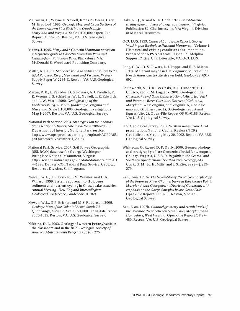
GEWA-THST Geologic Resources Inventory Report 37
McCartan, L., Wayne L. Newell, James P. Owens, Gary
M. Bradford. 1995. Geologic Map and Cross Sections of the Leonardtown 30 x 60 Minute Quadrangle, Maryland and Virginia. Scale 1:100,000. Open-File Report OF 95-665. Reston, VA: U.S. Geological Survey.
Means, J. 1995. Maryland's Catoctin Mountain parks; an
interpretive guide to Catoctin Mountain Park and Cunningham Falls State Park. Blacksburg, VA: McDonald & Woodward Publishing Company.
Miller, A. J. 1987. Shore erosion as a sediment source to the
tidal Potomac River, Maryland and Virginia. Water-Supply Paper W 2234-E. Reston, VA: U.S. Geological Survey.
Mixon, R. B., L. Pavlides, D. S. Powars, A. J. Froelich, R.
E. Weems, J. S. Schindler, W. L. Newell, L. E. Edwards, and L. W. Ward. 2000. Geologic Map of the Fredericksburg 30’ x 60’ Quadrangle, Virginia and Maryland. Scale 1:100,000. Geologic Investigations Map I-2607. Reston, VA: U.S. Geological Survey.
National Park Service. 2004. Strategic Plan for Thomas
Stone National Historic Site Fiscal Year 2004-2008. Department of Interior, National Park Service: http://www.nps.gov/thst/parkmgmt/upload/ACF9A65.pdf (accessed November 1, 2006).
National Park Service. 2007. Soil Survey Geographic
(SSURGO) database for George Washington Birthplace National Monument, Virginia. http://science.nature.nps.gov/nrdata/datastore.cfm?ID=41636. Denver, CO: National Park Service, Geologic Resources Division, Soil Program.
Newell, W.L., O.P. Bricker, L.M. Weimer, and D.A.
Willard. 1999. Systems approach to Holocene sediment and nutrient cycling in Chesapeake estuaries. Annual Meeting - New England Intercollegiate Geological Conference, Guidebook 91: 369.
Newell, W.L., O.P. Bricker, and M.S. Robertson. 2006.
Geologic Map of the Colonial Beach South 7.5' Quadrangle, Virginia. Scale 1:24,000. Open-File Report 2005-1025. Reston, VA: U.S. Geological Survey.
Nikitina, D. L. 2003. Geology of western Pennsylvania in
the classroom and in the field. Geological Society of America Abstracts with Programs 35 (6): 275.
Oaks, R. Q., Jr. and N. K. Coch. 1973. Post-Miocene
stratigraphy and morphology, southeastern Virginia. Publication 82. Charlottesville, VA: Virginia Division of Mineral Resources.
OCULUS. 1999. Cultural Landscape Report, George
Washington Birthplace National Monument. Volume 1: Historical and existing conditions documentation. Prepared for NPS Northeast Region Philadelphia Support Office. Charlottesville, VA: OCULUS.
Poag, C. W., D. S. Powars, L. J. Poppe, and R. B. Mixon.
1994. Meteroid maybe in Ole Virginny: Source of the North American tektite strewn field. Geology 22: 691-692.
Southworth, S., D. K. Brezinski, R. C. Orndorff, P. G.
Chirico, and K. M. Lagueux. 2001. Geology of the Chesapeake and Ohio Canal National Historical Park and Potomac River Corridor, District of Columbia, Maryland, West Virginia, and Virginia. A, Geologic map and GIS files (disc 1); B, Geologic report and figures (disc 2). Open-File Report OF 01-0188. Reston, VA: U. S. Geological Survey.
U.S. Geological Survey. 2002. Written notes from: Oral
presentation, National Capital Region (NCR) Geoindicators Meeting May 20, 2002. Reston, VA: U.S. Geological Survey.
Whittecar, G. R.; and D. F. Duffy. 2000. Geomorphology
and stratigraphy of late Cenozoic alluvial fans, Augusta County, Virginia, U.S.A. In Regolith in the Central and Southern Appalachians. Southeastern Geology, eds. Clark, G. M., H. H. Mills, and J. S. Kite, 39 (3-4): 259-279.
Zen, E-an. 1997a. The Seven-Storey River: Geomorphology
of the Potomac River Channel between Blockhouse Point, Maryland, and Georgetown, District of Columbia, with emphasis on the Gorge Complex below Great Falls. Open-File Report OF 97-60. Reston, VA: U.S. Geological Survey.
Zen, E-an. 1997b. Channel geometry and strath levels of
the Potomac River between Great Falls, Maryland and Hampshire, West Virginia. Open-File Report OF 97-480. Reston, VA: U.S. Geological Survey.

NPS Geologic Resources Division 38
Appendix A: Geologic Map Graphics The following pages are snapshots of the geologic maps for George Washington Birthplace National Monument and Thomas Stone National Historic Site. For a poster-size PDF of these maps or for digital geologic map data, please see the included disk or visit the Geologic Resources Inventory publications Web page (http://www.nature.nps.gov/geology/inventory/gre_publications.cfm).
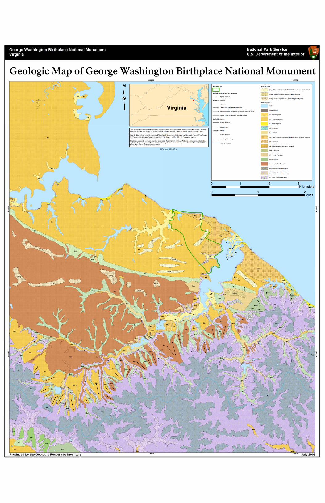
GEWA-THST Geologic Resources Inventory Report 41
Appendix B: Scoping Summary – George Washington Birthplace National Monument The following excerpts are from the GRI scoping summary for George Washington Birthplace National Monument. The contact information and Web addresses in this appendix may be outdated. Please contact the Geologic Resources Division for current information. Executive Summary A Geologic Resources Evaluation scoping meeting and field trip for George Washington Birthplace National Monument (GEWA) took place at the monument near Colonial Beach, Virginia on July 25, 2005. Scoping meeting participants identified the following list of geologic resource management issues. These topics are discussed in detail below. 1. Sediment budget for Popes Creek watershed including
sediments contributed to the Chesapeake Bay, sediment transport with migrating knick points and sediment traps, and sediment storage behind the spit at the mouth of the estuary.
2. Erosion rates and processes affecting upland ravines and terraces, slope stability, lateral fluvial migration, swamp and spit erosion, and Potomac shoreline erosion of beaches and bluffs
3. Connections between geology and other scientific disciplines at George Washington Birthplace including biology, archaeology, and paleontology
4. Hydrogeologic system at Popes Creek including the development of a 3-D terrane model and the establishment of baseline conditions
5. Recreational demands including visitor safety along scarps and at the base of bluffs, and fossil collecting
6. Seismicity from the nearby Stafford fault system deep beneath the regolith and numerous other small-scale faults, as well as the continual subsidence of the Chesapeake Bay impact structure
7. Geologic outreach and cooperation 8. Geochemical characteristics of the Popes Creek
watershed including nutrients and pollutants trapped in sediments
9. Surrounding development and landownership concerns including urban encroachment at park boundaries, potential pollution influx from neighboring areas, and conflicts regarding shoreline erosion of private lands
10. Connections between geology and the Plantation’s history to appeal to visitors interested in a deeper connection to the landscape
Introduction George Washington Birthplace National Monument was established during President Herbert Hoover’s administration on January 23, 1930. The park commemorates the 1732 birthplace of the first president, preserving the heart of Augustine Washington’s Popes Creek Plantation as well as the 17th century home site of John Washington and the Washington Family burial ground. The area is archaeologically rich with sites pre-
dating European settlement. The monument covers 662 acres of Atlantic Coastal Plain on the Northern Neck of Virginia between the Rappahannock and Potomac Rivers. The park is 61 km (38 mi) east of Fredericksburg, VA. It protects one of the most pristine Potomac River tributary watersheds (Popes Creek) as well as a stretch of Potomac River shoreline.
Map Notes The Inventory and Monitoring Program and George Washington Birthplace National Monument identified 3 quadrangles of interest. The park is also interested in the geology of the following 5 quadrangles: Dahlgren, Colonial Beach North, Loretto, Champlain, and Montross. Rollins Fork Quadrangle is mapped as part of the 2000 Mixon et al. Fredericksburg 30' X 60' quadrangle that was incorporated in the digital Geologic map database of the Washington DC area: Mixon,, R.B., Pavlides, Louis, Powars, D.S., Froelich, A.J.,
Weems, R.E., Schindler, J.S., Newell, W.L., Edwards, L.E., and Ward, L.W., 2000, Geologic map of the Fredericksburg 30' X 60' quadrangle, Virginia and Maryland (Sheet 1 of 2), U.S. Geological Survey, Geologic Investigations Series Map I-2607, 1:100,000 scale (2540)
Davis, A.M., Southworth, C.S., Reddy, J.E., and
Schindler, J.S., 2001, Geologic map database of the Washington DC area featuring data from three 30 X 60 minute quadrangles: Frederick, Washington West, Fredericksburg, U.S. Geological Survey, Open-File Report OF-01-227, 1:100,000 scale (3136)
A recently published U.S. Geological Survey Open File Report (OF-2005-1025) covers the Colonial Beach South Quadrangle at 1:24,000 scale. In addition, the Colonial Beach South and Stratford Hall Quadrangles are both mapped as part of the Lenoardtown 30x60 minute quadrangle: McCartan, Lucy, Newell, W.L., Owens, J.P., and
Bradford, G.M., 1995, Geologic map and cross sections of the Leonardtown 30 x 60-minute quadrangle, Maryland and Virginia, U.S. Geological Survey, Open-File Report OF-95-665, 1:100,000 scale (3457)

NPS Geologic Resources Division 42
Additionally, Wayne Newell of the U.S. Geological Survey has 1:24,000 scale map coverage of 9 quadrangles in the GEWA area, including 6 of some interest to the park, as part of the Geology of the Central Rappahannock River Area mapping project. To date, this map has not been published. The Maryland Geological Survey produced the following geologic maps for Charles and St. Mary’s Counties at 1:62,500 scale. However, none of these maps completely covers the GEWA quadrangles of interest. Dryden, A.L., Jr., 1939, Map of Charles County showing
the geological formations, Maryland Geological Survey, County Geologic Maps, 1:62,500 scale (GMAP_ID 3251)
Hack, J.T., 1977, Geologic map for land-use planning,
Prince Georges County, Maryland, U.S. Geological Survey, I-1004, 1:62,500 scale (GMAP_ID 1442)
McCartan, Lucy, 1989, Geologic map of Charles County,
Maryland Geological Survey, County Geologic Maps, 1:62,500 scale (GMAP_ID 2943)
McCartan, Lucy, 1989, Geologic map of St. Mary's
County, Maryland Geological Survey, County Geologic Maps, 1:62,500 scale (GMAP_ID 3353)
Many other maps exist for the region that include coverage of the geology, shoreline change, aeromagnetic-gravity, mineral and mineral potential, folio, geochemical and hydrogeology, and stratigraphy, etc. The maps are available from agencies such as the U.S. Geological Survey, the Maryland Geological Survey, and the Geological Society of America. Lidar surveys provide vital information for mapping Quaternary age deposits, which is traditionally difficult given the level of vegetative cover of the coastal plain. Lidar surveys were completed for the monument area in 2001 and 2005. These surveys could be used for shoreline change comparisons. The use of aerial photographs, erosion rates, as well as seasonal GPS shoreline surveys would also help the monument monitor the changes in shoreline and better manage this resource. Additional mapping at a smaller scale within park boundaries would be helpful for park resource management and interpretation.
Mapping Deliverables Each of the three quadrangles of interest for GEWA will be approached differently. The Rollins Fork quadrangle will be extracted from the digital Geologic map database of the Washington DC area (OF-01-227) and converted to the NPS GRE Geology – GIS Data Model. GRE staff will digitize the recently published Colonial Beach South quadrangle (OF-2005-1025) using the NPS GRE Geology – GIS Data Model. It is likely that the Stratford Hall quadrangle will be clipped from the USGS Leonardtown 30’x60’ (OF-95-665) and digitized using the NPS GRE Geology – GIS Data Model. However, if it is possible to obtain the Stratford Hall portion of Wayne Newell’s
unpublished Geology of the Central Rappahannock River Area mapping project that information could be digitized instead. Bruce Heise will investigate this possibility and make a decision in collaboration with the GRE team during the early part of NPS fiscal year 2006. Once the three quadrangle maps have been digitized or converted according to the standards of the NPS GRE Geology – GIS Data Model they will then be compiled for delivery to the park.
Significant Geologic Resource Management Issues 1. Sediment budget for Popes Creek watershed Enormous amounts of sediment are stored on the landscape at George Washington Birthplace. These sediments are recycled and weathered from unconsolidated upland units such as the Charles City Formation. Repeating sequences of sands, channel cross beds, silt, clay and humic floodplain deposits exposed in upland ravines record movement of the river system over the landscape. Other sediments are entrained within the fluvial system of Popes Creek and form migrating bars, marshes, deltas, and channel deposits. Knick points develop in the upland areas, the river then passes in turn into a meandering breach, a gullied reach, and then passes into another knick point before unloading the sediment behind a sediment trap. This system of progressive knick points and sediment traps retains much of the reworked sediments that would otherwise be washed into the Potomac River. Several bars and paleoscarps across the mouth of Popes Creek record some of the watershed’s former reaches. A sandy spit protects the estuarine bay at the mouth of Popes Creek. Proto-Popes Creek channel deposits supply sediments to this system today. However, this dynamic environment changes rapidly and channels cutting into the bar are resulting in a net loss of sediment to the spit. A thin veneer of loose, wind blown sediments add fine-grained deposits locally. Research and monitoring questions and suggestions include:
· How much sediment is contributed to the Chesapeake Bay from the Popes Creek watershed?
· Where is the fine-grained sediment deposited? · Correlate hurricane and storm layers spatially. · Research stream sediment loads to determine their
effects on aquatic and riparian biota. Is sediment loading in the monument streams following a seasonal pattern?
2. Erosion rates and processes One of the major goals of the monument is to present the historical context of the area; this includes preserving and restoring any old buildings and the landscape around them. Maintaining this colonial landscape often means working against natural geologic changes, which presents several management challenges. Geologic processes such as landsliding, slumping, chemical weathering, and slope creep are constantly changing the landscape at the park. Runoff erodes sediments from

GEWA-THST Geologic Resources Inventory Report 43
any open areas and carries them down streams and gullies. Erosion naturally diminishes higher areas such as ridges and hills, undermines foundations, degrades bridge foundations, erodes streams back into restoration areas, and fills in the lower areas such as trenches, ditches, and stream ravines distorting the historical context of the landscape. Erosion processes at George Washington Birthplace range from rain and surface flow, freeze and thaw cycles to mass wasting. Cracks (vertical tectonic joints and horizontal sheet joints) within the Potomac shoreline bluffs focus water flow and consequently erode, widening until stability is lost and a large portion of the bluff spalls off. The stratigraphic relationship between the relatively impermeable Calvert Formation and the permeable, loose sediments (pebble-cobble beds and fluvial channels) above creates a ramp surface that facilitates large slumps and slides along the bluffs. Erosion within the estuary is also causing islands, including Grand Island, to disappear. Storms such as Hurricane Isabel in 2003 cause significant changes to the landscape of the park. Coastal erosion rates for the slopes and bluffs of the middle Potomac River are 1.3 to 2.5 cm (0.5 – 1 inch) per year. However, during the Isabel storm event, between 8 and 9 m (25-30 ft) of bluff and beach erosion occurred in places. One-third of an entire archaeological site was lost during the storm and the Henry Brooks site is now threatened. The park boundaries extend to the Potomac shoreline, thus shoreline erosion is causing loss of park land and additionally altering microenvironments. Scientists at the Virginia Institute of Marine Science have modeled ways to attempt to protect the shoreline, beaches, points, and bluffs at George Washington Birthplace including breakwaters, pocket beach formation, chevron rock structures, etc. However, funding is not adequate at this time to take these measures. Research and monitoring questions and suggestions include:
· Perform several shoreline surveys per year to detect seasonal variations. Possibly recruit a volunteer to monitor the shoreline by walking the 1-2 hour distance each season. Supplement these surveys with lidar, GIS surveys (such as the shoreline and marsh survey of summer, 2003, January 2004, and March 2005), and aerial photographs.
· Continue to study shoreline changes since the 1930’s.
· Promote and support coastal erosion rate studies such as the USGS study of the middle Potomac River in the mid-1980’s (Miller 1987).
· Study erosion rates and processes in surrounding areas and relate to the sediment budget of the Popes Creek watershed.
· Define the mappable shoreline and its scale. · Monitor loss of islands within Popes Creek estuary. · Monitor topographic changes due to surface and
cliff erosion.
· What if any slope stability impacts exist? · Can cliff erosion be slowed or stopped? · Promote coastal shoreline stability measures. · What are the effects of increased erosion on aquatic
ecosystems at the monument? · Is runoff in the monument increasing due to
surrounding development? If so, are there any remedial efforts resource management can undertake to reduce this impact?
3. Connections between geology and other scientific
disciplines Geology forms the basis of any environment. Relationships between geologic features and processes and the ecosystem are complex. Shoreline erosion affects park boundaries and wildlife habitat at George Washington Birthplace National Monument. Estuarine habitat is shifting and impacting wetland species. Larger tree clumps within the wetland areas are being lost during erosive storms. These woodland areas provide vital habitat for osprey. Bald eagles also nest among the woodlands lining the Potomac River shoreline. Archaeological sites including Native American pre-settlement campsites and plantation artifacts are threatened by erosion. In addition to the continual slope processes active along the shoreline, major storm events can remove meters of cliff face at one time. Further discussion on archaeology at the park is under item number 10, below. Paleontological resources are constantly exposed within the monument by erosion. Paleocene to Miocene age shark teeth, duodongs, and bones from seals, whales, and porpoises are among the many fossils present in the bluffs and slope deposits. Calvert fossils are part of the Smithsonian collection. Mastodon teeth, a testament to Pleistocene ice age climate fluctuations, are also present in some subaerial deposits at the monument. Due to upland erosion and reworking of sediments, fossils tend to be concentrated along the shorelines. These specimens are attractive to collectors, but also are a unique resource within the monument that requires management. Research and monitoring questions and suggestions include:
· Monitor paleontological exposures as they are exposed by erosion.
· Map archaeological sites. · Establish a time estimate to cultural resource loss
due to erosion processes. 4. Hydrogeologic system at Popes Creek Resource management staff need to understand how water is moving through the hydrogeologic system into, under, and from the monument. Management also needs to understand how the water table might change over time. Several wells throughout the area could be used for monitoring of groundwater quality. It would be useful to perform tracer studies in these wells to see how quickly and in what direction water is moving through the system.
NPS Geologic Resources Division 44
Understanding the hydrogeologic system is critical to understand the impacts of human introduced contaminants on the ecosystem. The interaction between groundwater flow and the overall water quality should be quantitatively determined at the monument. Swamp surveys indicate that land use patterns have effects on erosion and deposition within the estuary. Logging efforts aimed at increasing visibility of the commemorative obelisk seems correlative to swamp degradation and tidal channel proliferation. Erosion of the wetlands has increased due to logging over the past 100 years. Wetlands are typically considered indicators of overall ecosystem health and should be researched and monitored periodically. Research and monitoring questions and suggestions include:
· Obtain subsurface data (depth to layers, composition, etc.) for quadrangles of interest to understand groundwater movement through layers of variable permeability. The Oak Grove core hole exists within the Rollins Fork Quadrangle. This core was 365 m (1,2000 ft) deep and was part of a 1977-1978 study by the Virginia Department of Mineral Resources (VDMR).
· Cooperate with the USGS to obtain further cores within the Popes Creek watershed to accompany cores from the delta and estuary mouth.
· Study estuarine terraces cut into the upland areas to chart fluvial changes within the watershed.
· Will an island form from the spit and Longwood swamp due to increased erosion?
· Will sedimentation trap the swamp lands, leading to increased salinity there?
· Obtain core surveys across the mouth of Popes Creek and the estuary.
· Monitor hydrologic changes of Popes Creek and its interface with the Potomac River.
· Develop a 3-D terrane model of the hydrogeologic system at the monument incorporating cliff morphological changes.
· Inventory groundwater levels. · Perform dye tests to look at the hydrogeologic
effects of local geologic structures on the watershed. · Test for and monitor phosphate and volatile
hydrocarbon levels in the groundwater at the park, focusing on areas near facilities.
· Test water quality at any existing springs. · Comprehensively map and monitor water and soil
quality at all wetlands within the monument. This creates a baseline level of ecosystem health to use for understanding future changes.
· Determine any hotspots for water contamination. Remediate and monitor results.
5. Recreational demands Although George Washington Birthplace National Monument was not established for recreation, visitor use includes hiking, swimming, picnicking, and wildlife viewing. Fossils within the Calvert Formation are
attractive to collectors. These fossils are exposed by shoreline erosion and line the shore at the base of the Potomac River bluffs. In addition to the potential loss of paleontological resources, visitor safety is at risk along and at the base of the actively eroding cliffs. Research and monitoring questions and suggestions include:
· How can fossil specimen collecting be prevented? · Identify weaker areas along the bluffs for targeted
resource management efforts · Warn visitors of the potential danger from spalls
defined by joints within the Calvert Formation. · Identify undercut areas vulnerable to mass wasting
and attempt to keep visitors away from the potential hazard.
· Create an interpretive program discussing the inevitability of resource change due to natural processes as a means to educate the public on resource management at the monument.
6. Seismicity The Stafford fault system, a structure deep beneath the regolith west of the monument, is considered low for seismic risk. More local faults and joints effect cliff erosion and mass wasting. The Chesapeake Bay impact structure southeast of the monument is still downloading and causes frequent small magnitude earthquakes. Earthquakes may cause significant damage to buildings, fences and other cultural features at George Washington Birthplace. Seismic waves may also undermine slope stability and increase local spalling along the cliffs. Research and monitoring questions and suggestions include:
· Promote the development of an active seismic network for the area.
· Evaluate risk for tsunami and shoreline damage due to earthquake activity and continental slope landslides.
· Evaluate cultural features at risk for damage during infrequent seismic events.
7. Geologic outreach and cooperation The scope and mission of George Washington Birthplace National Monument is to preserve and protect a historical landscape. This mission does not necessarily include scientific study of the monument’s geology. The monument is a gateway for Chesapeake Bay related issues and depends on cooperative efforts with numerous other agencies such as the U.S. Geological Survey, the Virginia Institute of Marine Science, the Virginia Department of Mineral Resources, etc. to effectively study and manage geologic features and processes. This cooperation and outreach is essential for resource management. Research and monitoring questions and suggestions include:
· Cooperate with the Chesapeake Gateway Network Program.
GEWA-THST Geologic Resources Inventory Report 45
· Attempt to cooperate with other agencies studying hurricane-related issues.
· Promote studies correlating land use changes with movement of Native Americans and early settlers.
8. Geochemical characteristics of the Popes Creek
watershed Popes Creek is generally considered a low impact watershed. For this reason, monitoring the geochemical changes in the water and sediments is vital to maintaining the overall high quality. Surrounding development and agriculture add nutrients and pollutants to Popes Creek tributaries as does water entering the estuary from the Potomac River. Popes Creek is vulnerable to changes within the Chesapeake Bay and Potomac River watersheds due to influx into the estuary during high tides. Research and monitoring questions and suggestions include:
· Promote the monument as a site to monitor continuous fluvial processes and geochemical changes in the Popes Creek watershed.
· What is the salinity gradient within Popes Creek Estuary?
· Establish a baseline for comparison of water quality at Popes Creek.
· Monitor sediments for pollutants and nutrients. · Promote less biosolid fertilizer use in surrounding
areas. 9. Surrounding development and landownership
concerns The population of the area surrounding George Washington Birthplace National Monument is growing rapidly. Increased development in the area makes conservation of existing forest, wetland, and meadow community types a critical concern. Understanding the geology beneath the biotic communities is vital to their management. Management of the landscape for historic preservation purposes complements the preservation of these ecosystems. As land and shoreline erodes from the surface at George Washington Birthplace, surrounding landowners also face land loss issues. These landowners often expect the monument to put measures in place to secure the shoreline instead of allowing natural processes to continue. Another issue with land loss is an increase in property value making the lands around the monument too expensive to consider attaining for inclusion within the park. Human impacts continue today as pipelines, power lines, roads, buildings, trails, visitor use areas, invasive species, acid rain, and air and water pollution take their toll on the landscape. State Route 3 crosses the Popes Creek watershed. Associated with the Virginia Department of Transportation are a fueling plant and three dams within the watershed. Research and monitoring questions and suggestions include:
· Perform studies to define the impact of surrounding land use patterns on the geomorphology of the landscape at the monument.
· Keep rigorous track of land use and development and create community profiles in surrounding areas. Possibly employ a GIS to monitor land use changes.
· Cooperate with local developers to minimize impact near park areas.
· Consult conservation groups regarding cooperative efforts to increase the areas of relevant parklands and protect more of the region from development.
· Promote environmentally sound methods of developing land parcels including partial clearing of trees and proper construction of stable slopes.
10. Connections between geology and the Plantation’s
history Interpreters make the landscape come alive for visitors and give the scenery a deeper meaning. Because geology forms the basis of the entire ecosystem and is directly responsible for the unique history at George Washington Birthplace National Monument, geologic features and processes should be emphasized to improve the visitor’s experience. The website for the park needs to be updated for geologic content and connections with other scientific and cultural disciplines. Charcoal found in a ravine within the flat uplands dates from 1360 years ago. Another ravine contained a 350-year-old stump that dates the Brooks Colony slash and burn agricultural practices. Cores within the Popes Creek estuary record the transition from a relatively constant peat accumulation of a forested environment to the modern agricultural horizon. Europeans began settling the George Washington Birthplace area in the late 1600’s. Their farming and homestead activities created an unnatural landscape that persists today at the monument. Minor irrigation features, removal of soil and rocks, stone fences, grazed pastures, extensive logging, and other homestead features dot the landscape. As part of the historical landscape at the monument, several drainage ditches were carved into the Calvert Formation. These served to drain the fields, irrigate crops, and possibly mark boundaries for neighbors and animals. As a young, practicing surveyor, George Washington surveyed the landscape near Digwood Swamp, formerly a turnip patch within a 14 acre area. The park is charged with maintaining the historic context of the landscape at the monument. This often means working against natural geologic changes. Many of the historical features at the monument have been lost to coastline erosion. The waterways are changing position constantly as part of natural meandering river flow. These shoreline changes threaten existing park facilities and the historical context of the landscape. From Brooks Patent Point 120 to 500 m (400 to 1,650 ft) more coastline extended into the Potomac River. Church Point, the site of Washington’s baptism washed away before the site became a national monument. In

NPS Geologic Resources Division 46
2004, the earthen dam that holds the “ice pond” blew out. Main roads and buildings are susceptible to flooding during high water storm events. Efforts to commemorate the site are also sometimes thwarted by geologic features and processes. In 1820, William Augustus Washington’s efforts to sail into the estuary failed due to the shallowness of the mouth of Popes Creek. The obelisk, a prominent feature at the monument, was carted in on railway because the estuary was too shallow to allow water transport up Popes Creek. Research and monitoring questions and suggestions include:
· Use the park library to track the history of land use. Resources within the library include an 1891 survey of the eastern side of Popes Creek Estuary as well as historical photographs.
· Use N-alkanes to measure changes in land use through time.
· Create interpretive programs concerning geologic features and processes and their effects on the settlement history of the monument.
· Encourage interaction between geologists and the interpretive staff to come up with a list of features and programs to execute.
· Create a general interest map with simple explanatory text on geologic influences for visitors to the monument.
References Duffy, D.F., Whittecar, G.R., 1991, Geomorphic
development of segmented alluvial fans in the Shenandoah Valley, Stuarts Draft, Virginia. Abstracts with Programs - Geological Society of America, vol.23, no.1, p.24.
Harris, A.G., Tuttle, E., Tuttle, S.D., 1997, Geology of National Parks. Kendall/Hunt Publishing Company, 759 p.
Means, J., 1995, Maryland's Catoctin Mountain parks; an
interpretive guide to Catoctin Mountain Park and Cunningham Falls State Park. McDonald & Woodward Publishing Company : Blacksburg, VA, United States, 168 p.
Mixon, R.B., Pavlides, L., Powars, D.S., Froelich, A.J.,
Weems, R.E., Schindler, J.S., Newell, W.L., Edwards, L.E., Ward, L.W., 2000, Geologic Map of the Fredericksburg 30’x60’ Quadrangle, Virginia and Maryland. U.S. Geological Survey, Geologic Investigations Series Map I-2607, 1:100,000 scale.
Onasch, C.M., 1986, Structural and metamorphic
evolution of a portion of the Blue Ridge in Maryland. Southeastern Geology, Vol. 26, Issue 4, pp. 229-238.
Southworth, S., Brezinski, D.K., Orndorff, R.C., Chirico,
P.G., Lagueux, K.M, 2001, Geology of the Chesapeake and Ohio Canal National Historical Park and Potomac River Corridor, District of Columbia, Maryland, West Virginia, and Virginia; A, Geologic map and GIS files (disc 1); B, Geologic report and figures (disc 2). U. S. Geological Survey, Open-File Report: OF 01-0188.
Whittecar, G. R., Duffy, D.F., 2000, Geomorphology and
stratigraphy of late Cenozoic alluvial fans, Augusta County, Virginia, U.S.A. In: Regolith in the Central and Southern Appalachians, Clark, G.M., Mills, H.H., Kite, J.S., eds., Southeastern Geology, vol.39, no.3-4, p.259-279.

GEWA-THST Geologic Resources Inventory Report 47
Scoping meeting participants
NAME AFFILIATION PHONE EMAIL
Rijk Morawe NPS, GEWA, THST
804-224-1732, ext. 237 [email protected]
Bruce Heise NPS, GRD 303-969-2017 [email protected]
Melanie Ransmeier NPS, GRD 303-969-2315 [email protected]
Mark Duffy NPS, NCBN 410-641-1443, ext. 219 [email protected]
Wayne Newell USGS 703-648-6991 [email protected]
Cheryl Hapke USGS, BRD 401-874-5532 [email protected]
Carol Cook NPS, NARO 215-597-6471 [email protected]
Lindsay McClelland NPS, GRD 202-28-4958 [email protected]
Trista Thornberry-Ehrlich Colorado State University 757-416-5928
NPS Geologic Resources Division 48
Appendix C: Scoping Summary – Thomas Stone National Historic Site The following excerpts are from the GRI scoping summary for Thomas Stone National Historic Site. The contact information and Web addresses in this appendix may be outdated. Please contact the Geologic Resources Division for current information. Executive Summary A Geologic Resource Evaluation scoping meeting and field trip for Thomas Stone National Historic Site (THST) took place in at the site in Maryland on July 26, 2005. The scoping meeting participants identified the following list of geologic resource management issues. These topics are discussed in detail below. 1. Evolution of the landscape 2. Slope processes and erosion 3. Seismicity from nearby Stafford fault system and
numerous other small-scale faults, as well as the continual downloading of the Chesapeake Bay impact structure
4. Hydrogeologic characterization to understand the flow of water beneath the site and be equipped to predict hydrologic response to contaminants
5. Surrounding development including urban encroachment at park boundaries, and potential pollution influx from neighboring areas
6. Potential fossil resources and unique geologic features
Introduction Thomas Stone National Historic Site was established during President Jimmy Carter’s administration on November 10, 1978. The National Park Service acquired the land in 1981. Thomas Stone National Historic Site covers 328 acres of western coastal plain south of Washington, D.C. It protects Haberdeventure, the colonial plantation of patriot Thomas Stone, signer of the Declaration of Independence. The home was constructed in 1770 and housed 5 generations of the Stone family until 1936. A fire partially destroyed the house in 1977. It protects some of the rapidly disappearing open space in the Atlantic Coastal Plain physiographic province, a variety of threatened habitats, not to mention the historical landscape.
Map Notes The Inventory and Monitoring Program and Thomas Stone National Historic Site identified 2 quadrangles of interest: Port Tobacco and Mathias Point. Both of the THST quadrangles of interest are contained within the Geologic map database of the Washington DC area: Davis, A.M., Southworth, C.S., Reddy, J.E., and
Schindler, J.S., 2001, Geologic map database of the Washington DC area featuring data from three 30 X 60 minute quadrangles: Frederick, Washington West, Fredericksburg, U.S. Geological Survey, Open-File Report OF-01-227, 1:100,000 scale (3136)
In addition the Maryland Geological Survey produced geologic maps for Charles and Prince George’s Counties at 1:62,500 scale. However, none of these maps completely covers the THST quadrangles of interest. Dryden, A.L., Jr., 1939, Map of Charles County showing
the geological formations, Maryland Geological Survey, County Geologic Maps, 1:62,500 scale (GMAP_ID 3251)
Hack, J.T., 1977, Geologic map for land-use planning, Prince Georges County, Maryland, U.S. Geological Survey, I-1004, 1:62,500 scale (GMAP_ID 1442)
McCartan, Lucy, 1989, Geologic map of Charles County, Maryland Geological Survey, County Geologic Maps, 1:62,500 scale (GMAP_ID 2943)
McCartan, Lucy, 1989, Geologic map of St. Mary's County, Maryland Geological Survey, County Geologic Maps, 1:62,500 scale (GMAP_ID 3353)
Many other maps exist for the region that include coverage of the geology, shoreline change, reconnaissance, surficial, glacial, land use, aeromagnetic-gravity, mineral and mineral potential, folio, geochemical and hydrogeology, and stratigraphy, etc. The maps are available from agencies such as the U.S. Geological Survey, the Maryland Geological Survey, the Virginia Division of Mineral Resources, and the Geological Society of America. Mapping with lidar provides vital information for mapping Quaternary age deposits, which is traditionally difficult given the level of vegetative cover of the coastal plain. Lidar surveys are useful for landscape change comparisons. The use of aerial photographs, erosion rates, as well as historical surveys would also help the site monitor the changes in land surface expression and better manage geologic resources. Additional mapping at a smaller scale within park boundaries would be helpful for park resource management and interpretation.
Mapping Deliverables The GRE team plans to conduct quality control comparisons between the Port Tobacco portion of the Geologic map database of the Washington DC area OF-01-227 and an earlier map of the Port Tobacco quadrangle (Glaser, J.D., 1984, Geologic map of the Port Tobacco quadrangle, Prince Georges and Charles Counties, Maryland Geological Survey, Quadrangle Geologic Map, 1:24,000 scale). If the Geologic map database of the Washington DC area OF-01-227 is found to be of comparable quality to the older map then the GRE team will convert the Port Tobacco and Mathais Point portions of the OF-01-227 into the NPS GRE Geology-GIS Data Model for delivery to the park. If the 1984

GEWA-THST Geologic Resources Inventory Report 49
Glaser map is found to be superior in quality then it will be digitized for the Port Tobacco quadrangle and merged with the Mathais Point portion of OF-01-227 according to the standards of the NPS GRE Geology-GIS Data Model. The combined digital map will then be provided to the park.
Significant Geologic Resource Management Issues 1. Natural and historical evolution of the landscape Haberdeventure was constructed starting in 1770. The Stone family’s farming and homestead activities created an unnatural landscape that persists today at Thomas Stone National Historic Site. Minor irrigation features, removal of soil and rocks, garden terraces, grazed pastures, extensive logging, and other settlement features dot the landscape. Many open fields with streams existed during the time of the historic agricultural activities at Haberdeventure. These areas are now mostly forested and for cultural interpretation needs, plans may be proposed to expand upon the cleared areas. The resulting increase in soil erosion and subsequent sediment loading into local streams must be taken into account during resource management decision making. Human impacts continue today as pipelines, power lines, roads, buildings, trails, visitor use areas, invasive species, acid rain, and air and water pollution take their toll on the landscape. Resource management of these impacts is an ongoing process. Research and monitoring questions and suggestions include: • Encourage further cooperative efforts with local universities, government agencies, and other groups to study the evolution of the landscape at Thomas Stone National Historic Site and the effects of change. • Perform clay mineralogy and grain size studies on the soils in the park, relating these to past climatic patterns. • How is the landscape rebounding from early agricultural effects? • Should the unnatural landscapes created by early settlers be remediated? • Are soils becoming more acidic due to acid rain? • Should the historic pond (attracting mosquitoes) be removed? • Identify and study a possible quarry for early brick construction suspected on the site. 2. Slope processes and erosion One of the major goals of the site is to present the historical context of the area; this includes preserving and restoring any old buildings and the landscape around them. Maintaining this colonial landscape often means working against natural geologic changes, which presents several management challenges. Geologic processes such as landsliding, slumping, chemical weathering, and slope creep are constantly changing the landscape at the site. Runoff erodes sediments from any open areas and carries them down streams and gullies. Erosion naturally diminishes higher areas such as ridges and hills, undermines foundations, degrades bridge
foundations, erodes streams back into restoration areas, and fills in the lower areas such as trenches, ditches, and stream ravines distorting the historical context of the landscape. Erosion processes at Thomas Stone National Historic Site range from rain and surface flow and freeze/thaw cycles to small-scale mass wasting. Sedimentation has occurred over the years to the extent that Hoghole Run, as a former trade route for the area, has silted up. Incising, dendritic channels, in places, expose the Calvert Formation. Storms such as Hurricane Isabel in 2003 can cause significant changes to the landscape of the site. Flooding and channel erosion are naturally occurring along small streams within the site. This flooding and erosion can threaten wetlands and visitor facilities. Alterations to site vegetation along any steep, exposed slopes lead to changes in the hydrologic regime. Thomas Stone National Historic Site slopes are covered with loose, rounded, reworked channel sediments derived from piedmont rocks. These rocks are easily transported by surface runoff. The clearing of trees and their stabilizing roots for historical restoration or by fire can lead to increased sediment load in nearby streams and could potentially contribute to slumps and landslides. Hiking trails and other high use areas are also at risk of erosion. Research and monitoring questions and suggestions include: • Research planting new vegetation along any vulnerable reaches of park streams to prevent excess erosion and sediment loading. • Monitor topographic changes due to surface erosion. • What, if any, slope stability impacts exist? • Can slope erosion be slowed or stopped? • Identify areas prone to slope failure during intense storm events. • Are slope processes destroying the historic features at the site? • What are the effects of increased erosion on aquatic ecosystems at the site? • Is runoff in the site increasing due to surrounding development? If so, are there any remedial efforts resource management can undertake to reduce this impact? • Is soil loss occurring at the site? 3. Seismic potential The Stafford fault system, a structure deep beneath the regolith west of the site, is considered low for seismic risk. Enigmatic small-scale tremors with a long recurrence interval may be due to isostatic rebound or sediment loading atop the coastal plain. The Chesapeake Bay impact structure to the southeast of the site is still subsiding and causes frequent small magnitude earthquakes. A large earthquake could cause significant damage to slopes, and buildings, fences and other cultural features at Thomas Stone National Historic Site.

NPS Geologic Resources Division 50
Research and monitoring questions and suggestions include: • Promote the development of an active seismic network for the area. • Evaluate cultural features at risk for damage during infrequent seismic events. 4. Hydrogeologic characterization Resource management staff need to understand how water is moving through the hydrogeologic system into, under, and from the site. Management also needs to understand how the water table might change over time. The installation of several wells throughout the site could be useful for monitoring of groundwater quality. It would be useful to perform tracer studies in these wells to see how quickly and in what direction water is moving through the system. Understanding the hydrogeologic system is critical for understanding the impacts of human introduced contaminants on the ecosystem. The interaction between groundwater flow and the overall water quality should be quantitatively determined at the site. Visitor use and surrounding development are increasing the levels of certain substances in the water at the park. There are several seasonal wetlands within the site boundaries. Though small in scale, wetlands are typically considered indicators of overall ecosystem health and should be researched and monitored periodically. Research and monitoring questions and suggestions include: • Inventory groundwater levels at the site. • Test for and monitor phosphate and volatile hydrocarbon levels in the groundwater at the park, focusing on areas near facilities. • Inventory and map any existing springs in the site, especially with regards to their potential historical importance. • Test water quality at any existing springs in the site. • Create hydrogeologic models for the site to better manage the groundwater resource and predict the system’s response to contamination. • Comprehensively map and monitor water and soil quality at all wetlands within the site. This creates a baseline level of ecosystem health to use for understanding future changes. 5. Surrounding development concerns The population of the area surrounding Thomas Stone National Historic is growing rapidly, especially with commuters to Washington, D.C. Increased development in the area makes conservation of existing forest, wetland, and meadow community types a critical concern. Understanding the geology beneath the biotic communities becomes vital to their management. Management of the landscape for historic preservation purposes complements the preservation of these ecosystems. A major issue with decreasing available land is an increase in property value making the lands around the site too expensive to consider acquiring for inclusion within the park.
Research and monitoring questions and suggestions include: • Perform studies to define the impact of surrounding land use patterns on the geomorphology of the landscape at the site. • Keep rigorous track of land use and development and create community profiles in surrounding areas. Possibly employ a GIS to monitor land use changes. • Cooperate with local developers to minimize impact near site areas. • Consult conservation groups regarding cooperative efforts to increase the areas of relevant parklands and protect more of the region from development. • Promote environmentally sound methods of developing land parcels including partial clearing of trees and proper construction of stable slopes. 6. Unique geologic features and potential paleontological resources Interpreters make the landscape come alive for visitors and give the scenery a deeper meaning. The rolling hills and gentle landscape and topography at Thomas Stone National Historic Site are defined by the geology. Because geology forms the basis of the entire ecosystem and is directly responsible for the unique history at Thomas Stone National Historic Site, geologic features and processes should be emphasized to improve the visitor’s experience. The website for the site needs to be updated for geologic content and connections with other scientific and cultural disciplines. Within Thomas Stone National Historic Site are Tertiary age rocks of the Calvert Formation. These rocks have the potential to contain fossils, which would be exposed and removed from the formation during fluvial erosion and deposited in sediment-choked streams. A fossil bone fragment was discovered during a 2003 paleontological survey. Paleontological resources, if discovered, would be an important resource at the site adding to the geologic history of the area. Fossils are also attractive targets for visitors. Fossil theft would be a concern to any paleontologic resources at the site. Research and monitoring questions and suggestions include: • Are there potential fossil and mineral resources that might be subject to theft? • Create interpretive programs concerning geologic features and processes and their effects on the settlement history of the site. • Encourage the interaction between geologists and the interpretive staff to come up with a list of features and programs to execute. • Create a general interest map with simple explanatory text on geological-historical connections for visitors to the site. • Update the site website relating geology with other resources.
References Duffy, D.F., Whittecar, G.R., 1991, Geomorphic development of segmented alluvial fans in the
GEWA-THST Geologic Resources Inventory Report 51
Shenandoah Valley, Stuarts Draft, Virginia. Abstracts with Programs - Geological Society of America, vol.23, no.1, p.24. Harris, A.G., Tuttle, E., Tuttle, S.D., 1997, Geology of National Parks. Kendall/Hunt Publishing Company, 759 p. Means, J., 1995, Maryland's Catoctin Mountain parks; an interpretive guide to Catoctin Mountain Park and Cunningham Falls State Park. McDonald & Woodward Publishing Company : Blacksburg, VA, United States, 168 p. Mixon, R.B., Pavlides, L., Powars, D.S., Froelich, A.J., Weems, R.E., Schindler, J.S., Newell, W.L., Edwards, L.E., Ward, L.W., 2000, Geologic Map of the Fredericksburg 30’x60’ Quadrangle, Virginia and Maryland. U.S. Geological Survey, Geologic Investigations Series Map I-2607, 1:100,000 scale.
Onasch, C.M., 1986, Structural and metamorphic evolution of a portion of the Blue Ridge in Maryland. Southeastern Geology, Vol. 26, Issue 4, pp. 229-238. Southworth, S., Brezinski, D.K., Orndorff, R.C., Chirico, P.G., Lagueux, K.M, 2001, Geology of the Chesapeake and Ohio Canal National Historical Park and Potomac River Corridor, District of Columbia, Maryland, West Virginia, and Virginia; A, Geologic map and GIS files (disc 1); B, Geologic report and figures (disc 2). U. S. Geological Survey, Open-File Report: OF 01-0188. Whittecar, G. R., Duffy, D.F., 2000, Geomorphology and stratigraphy of late Cenozoic alluvial fans, Augusta County, Virginia, U.S.A. In: Regolith in the Central and Southern Appalachians, Clark, G.M., Mills, H.H., Kite, J.S., eds., Southeastern Geology, vol.39, no.3-4, p.259-279.
Scoping meeting participants
NAME AFFILIATION PHONE EMAIL
RIJK MORAWE NPS, GEWA, THST 804-224-1732, EXT. 237 [email protected]
BRUCE HEISE NPS, GRD 303-969-2017 [email protected]
MELANIE RANSMEIER NPS, GRD 303-969-2315 [email protected]
MARK DUFFY NPS, NCBN 410-641-1443, EXT. 219 [email protected]
LINDSAY MCCLELLAND NPS, GRD 202-28-4958 [email protected]
TRISTA THORNBERRY-EHRLICH
COLORADO STATE UNIVERSITY 757-416-5928 [email protected]
George Washington Birthplace National Monument and Thomas Stone National Historic Site Geologic Resources Inventory Report
Natural Resource Report NPS/NRPC/GRD/NRR—2009/127 National Park Service Acting Director • Dan Wenk Natural Resource Stewardship and Science Associate Director • Bert Frost Natural Resource Program Center The Natural Resource Program Center (NRPC) is the core of the NPS Natural Resource Stewardship and Science Directorate. The Center Director is located in Fort Collins, with staff located principally in Lakewood and Fort Collins, Colorado and in Washington, D.C. The NRPC has five divisions: Air Resources Division, Biological Resource Management Division, Environmental Quality Division, Geologic Resources Division, and Water Resources Division. NRPC also includes three offices: The Office of Education and Outreach, the Office of Inventory, Monitoring, and Evaluation, and Office of Natural Resource Information Systems. In addition, Natural Resource Web Management and Partnership Coordination are cross-cutting disciplines under the Center Director. The multidisciplinary staff of NRPC is dedicated to resolving park resource management challenges originating in and outside units of the National Park System. Geologic Resources Division Chief • Dave Steensen Planning, Evaluation, and Permits Branch Chief • Carol McCoy Geoscience and Restoration Branch Chief • Hal Pranger Credits Author • Trista Thornberry-Ehrlich Review • Wayne Newell and Jodi Eshleman Editing • Jeffrey Matthews Digital Map Production • Stephanie O’Meara, Ron Karpilo, Cory Karpilo, John Detring, and Heather Stanton Map Layout Design • Josh Heise and Georgia Hybels Report Production • Lisa Fay The Department of the Interior protects and manages the nation’s natural resources and cultural heritage; provides scientific and other information about those resources; and honors its special responsibilities to American Indians, Alaska Natives, and affiliated Island Communities NPS 332/100136, NPS 477/100136, September 2009

EXPERIENCE YOUR AMERICATM
Geologic Resources Division Natural Resource Program Center P.O. Box 25287 Denver, CO 80225 www.nature.nps.gov
National Park Service U.S. Department of the Interior
Related Documents