42A07NW2007 2.18409 CABMAN 010 GEOPHYSICS REPORT CARMEN BAY PROPERTY PORCUPINE MINING DISTRICT ONTARIO 1998 FOR Ag ARMENO MINES A MINERALS INC RE f^ r GEOsntr Dan Patrie Dan Patrie Exploration Ltd April, 1998

Welcome message from author
This document is posted to help you gain knowledge. Please leave a comment to let me know what you think about it! Share it to your friends and learn new things together.
Transcript

42A07NW2007 2.18409 CABMAN 010
GEOPHYSICS REPORT
CARMEN BAY PROPERTY
PORCUPINE MINING DISTRICT
ONTARIO
1998
FOR
Ag ARMENO MINES A MINERALS INC
REf^ r
GEOsntr
Dan PatrieDan Patrie Exploration Ltd
April, 1998

42A07NW2007 2.18409 CARMAN 010C
TABLE OF CONTENTS
1. INTRODUCTION
2 SUMMARY AND RECOMMENDATIONS
3. PROPERTY LOCATION AND ACCESS
3. l INSTRUMENTATION AND WORK DONE
4. REGIONAL GEOLOGY
5. PROPERTY GEOLOGY
6. HISTORY OF EXPLORATION
7. CURRENT EXPLORATION PROGRAM 7. l WORK DONE
8. INTERPRETATION
9. CONCLUSIONS
REFERENCES
PERSONNEL
CERTIFICATE OF QUALIFICATION
LETTER OF CONSENT
PAGE
l
1
2
2
3
4
6
8
9
10
MAGNETIC AND HLEM MAPS

Page l
L INTRODUCTION
The Carmen Property, (or Nighthawk Lake area), has been recognized since the early
1900's as one of the world's leading gold producing areas, situated near Timmins, Ontario, part of
the Porcupine mining camp. Since 1991 Cross Lake Minerals has been exploring an area
approximately 15 km east of Nighthawk Lake and in 1997 announced that drill hole CLS-97-16
returned a 33 meter section which assayed b .11% zinc, 1.86*^0 lead, 215.44 g/tonne of silver and
Q.16% copper. Since Kidd Creek Mine (a major VMS copper-zinc deposit), and Redstone,
Langmuir, McWatters and the Hart nickel deposits are present in this area, the economical
potential for nickel and gold, combined with this Cross Lake Minerals' discovery of VMS-type
zinc-lead-copper-silver mineralization makes this area very attractive for exploration.
2. SUMMARY AND RECOMMENDATIONS
The property acquired by Ag Armeno Mines & Minerals Inc. situated along the perimeter
of the Shaw Dome, the main structure southeast of Timmins and the host for the Redstone,
Langmuir, McWatters and Hart nickel deposits. Several strong EM conductors and magnetic
anomalies occur on the Carmen property, most of which lie beneath Carmen Bay. This property
holds the potential for containing quartz vein-hosted gold mineralization, VMS-type nickel or
zinc-lead-copper mineralization, or ultramafic-hosted nickel-copper mineralization. In order to
test the property for mineralization of these types, Dan Patrie Exploration Ltd was requested by
Ag Armeno Mines fc Minerals Inc to do an exploration program on their newly acquired ground.
The program consisted of cutting of a grid, a Max-Min EM and magnetometer survey carried
out under the supervision of Mr. Whayne Murton, consulting Geologist for Ag Armeno Mines 8c
Minerals Inc..
The results of the survey have been summarized and is shown on the accompanying maps.
A drill program is recommended to evaluate the HLEM conductors for the potential of
finding a base metal and or gold deposit.

\+
CARMAN PROPERTY
l
Night ffjiawk Lakef G(J
-di
8to
44-2:

Page 2
i PROPERTY LOCATION AND ACCESS
Located 20 km southeast of the town of Timmins, Ontario, in the southeast quarter of
Carmen Township, (District of Cochrane), the Carmen property covers Carmen Bay, which lies at
the south end of Nighthawk Lake, and the east side of the bay as far as the boundary with Thomas
Township. Access to the east shore of Carmen Bay is by boat or by snowmachine south from
Nighthawk Lake. The west side of the property, which lies along the west shore of Carmen Bay,
is accessible by secondary roads and trails extending southeast from the town of South Porcupine,
Timmins and Highway 101. The Carmen property lies approximately 15 kilometers southwest of
the Cross Lake discovery (which is in Sheraton Township). It is surrounded by claims held or
controlled by Band-Ore Resources, Outokumpu, Canadian Golden Dragon, Southern Africa
Minerals, Brownstone Resources, Maple Minerals, Pacific Vangold Ltd. and East West Resources
Ltd. It is in close proximity to claims held by Golden Knight Resources and Royal Oak
Resources.
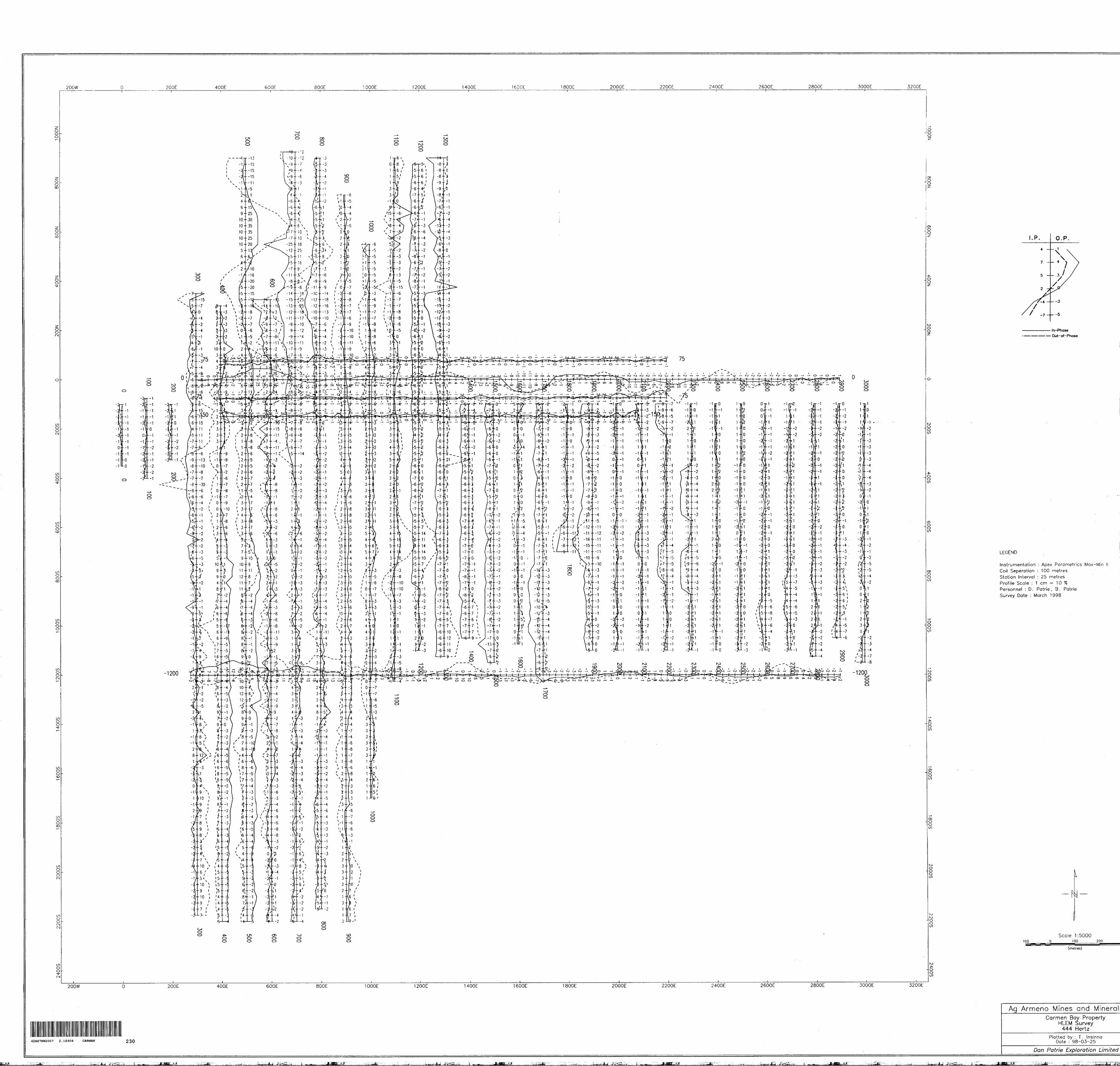
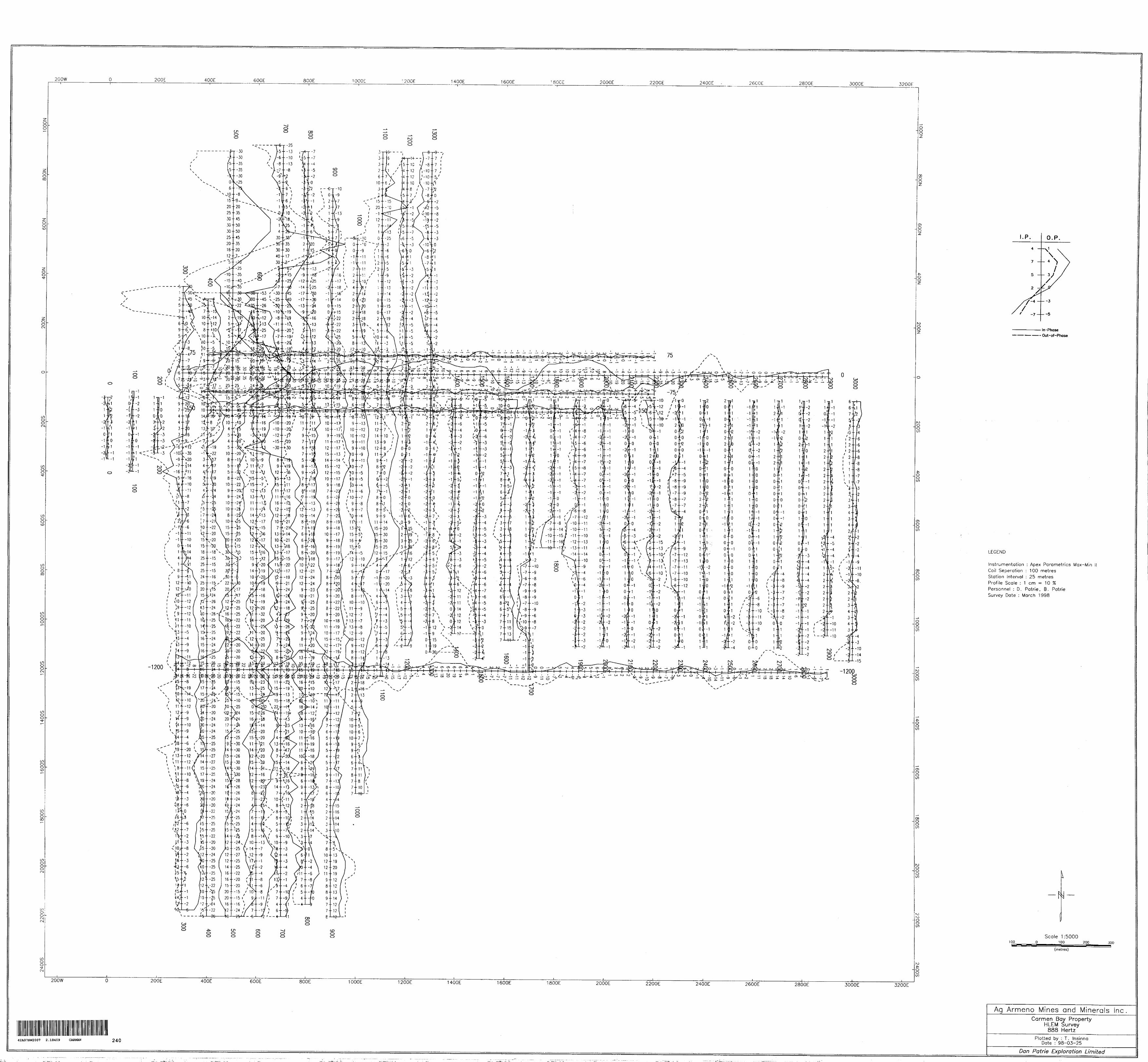
3J. INSTRUMENTATION AND WORK DONE
The Max-Min Horizontal Loop survey was done using a Max-Min II Apex transmitter and
Receiver with 2 frequencies read, 444 Hz and 888Hz at 25 meter intervals and a 200 meter coil
spacing. The total field magnetometer survey was carried out using an EDA OMNI PLUS
magnetometer unit in combination with an OMNI base station magnetometer. These are total field
magnetometers which measure the magnetic field through the use of proton processional effects
caused by the interactive of a magnetic field with spin aligned rich fluid. An instrument accuracy
precision and resolution of 0.5 nT may be obtained with this instrument under ideal conditions.
The total magnetic field was measured at 25 meter intervals along grid lines and corrected
using a base station located on grid. The corrected magnetic data and Max-Min HLEM data was
plotted and is presented on maps in back of report. A total of 57 kilometers of line cutting and
mag, and 61.3 kilometers of HLEM was surveyed on the Carmen Bay Property.

Page 3
4 REGIONAL GEOLOGY
The Carmen Property is underlain by rocks of the Abitibi subprovince of the Superior
Structural Province of the Canadian Shield. More locally the Night Hawk Lake area is underlain
by Archean age felsic, mafic and ultramafic metavolcanic rocks, with minor associated Fe
formations and metasediments. All of these units have been cut by a few relatively small felsic
intrusive bodies and diabase dykes. The metavolcanics comprise two groups: the Deloro Group
rocks, and the Tisdale Group rocks - consisting of two separate ultramafic through mafic to felsic
volcanic cycles.
The Deloro Group (the older of the two), is confined generally to the Shaw Dome, the
dominant structure of south and southeast Timmins, which is a large east-west trending elliptical
body with a core of calcalkaline basaltic pillow lavas overlain by felsic flows and pyroclastic
rocks. Occurring regionally at or near the contact between the felsic rocks of the Deloro Group
and the overlying rocks of the Tisdale Group are the Sulphide facies Fe formations. The felsic
pyroclastics and Fe formations of the Deloro Group are interfingered with and overlain by
ultramafic to mafic komatiite flows and intrusives (peridotite and dunite). Komatiite flows are in
turn overlain by a thick sequence of tholeiitic basalt and an uppermost volcaniclastic unit of
calcalkaline composition. The komatiites, basalts and volcaniclastics are all part of the Tisdale
Group. The contact between the Deloro rocks and the Tisdale Group rocks appears to lie under
and along the northeast shore of Carmen Bay. Metasediments referred to as the Porcupine Group,
occur along the west side of Night Hawk Lake. They are composed of a turbidite sequence of
interlayered greywacke, siltstone and lesser conglomerate. They are considered time equivalent to
the upper portion of the Deloro Group and all of the Tisdale group. Concordant dunite-peridotite
sills occur with the Deloro Group felsic metavolcanics. They are considered to be magma
reservoirs for the komatiites in the area. Late Archean granodiorite and trondhjemite stocks have
intruded the region. All units are cut by northeast trending diabase dyke swarms of Proterozoic
age. A series of parallel lineaments trends northwest-southeast through the Night Hawk Lake
area. Regional metamorphism is prehnite-pumpellyite to greenschist facies. Carbonatized rocks

u CROSS LAKE DISCOVERY
CARMAN PROPERTY
k
ttL 3^^,M,,:,fX | e j,,*. Tfr^ \'•rtfv .1,,^^ -, ,, li k\ i e v-. N * Nln i c i i
V'".'*L*;

Page 4
in the region are associated with gold mineralization. The area has been eroded by continental
glaciation during Pleistcene times. Ice flow direction from glacial striae indicates movement
slightly east of south. A thin boulder clay till lies on the bedrock. Covering this are fluvial
deposits of well sorted sand and gravel. Lake sediments in the form of varved clays from Lake
Barlow-Ojibway cover the fluvial deposits.
The Redstone, McWatters, Langmuir and Hart nickel deposits are all situated along the
southern and southeastern flank of the Shaw Dome along or near the contact between felsic
metavolcanic rocks of the Deloro Group and the overlying komatiite flows of the Tisdale Group.
The Redstone deposit is hosted by dacitic tuff, overlain by komatiitic flows. The McWatters,
Langmuir and Hart deposits are hosted by komatiite flows overlying felsic to intermediate crystal
tuff. All four deposits are spatially associated with sulphide facies Fe formations. Gold
mineralization in the Timmins region has been postulated to be derived from on e of two methods:
1) from small rocks of quartz-feldspar porphyry of subvolcanic origin (Griffs, 1972), or 2) from
mobilization out of ultramafic volcanic rocks (the sourcebed) into structurally favorable sites
during carbonization of the ultramafics (Pyke, 1975).
5 PROPERTY GEOLOGY
Covering the southeast quarter of Carmen Township, the Carmen property extends from
the boundary with Thomas Township westward to the western shore of Carmen Bay, then north
from the south boundary of Carmen Township to the south end of Night Hawk Lake. West of the
Bay and south of Night Hawk Lake is an area underlain by Deloro Group mafic to felsic
metavolcanic rocks. East of the northeast shore of Carmen Bay, as far as Thomas Township, and
along the southeast shore of the Bay, the rocks have been interpreted as Tisdale Group massive
mafic to intermediate lavas, and the general strike of these Tisdale volcanics is N-S and NW-SE.
West of the Carmen property, faulted units of serpentinized peridotite and dunite are found, these
mafic/ultramafic rocks have not been interpreted as komatiites but as intrusive bodies. Diamond
drilling under the Bay (Hunt and Maharaj, 1980), has shown that the bedrock there contains
Page 5
ultramafics, recognized peridotite serpentinized rocks and lamprophyre dykes, it also shows the
presence of massive felsic and mafic flows under the Bay. Carbonatized horizons have been
recognized in mafic and felsic flows along the southern Carmen Township boundary west of
Carmen Bay. These are assumed to be in the Deloro volcanics. The presence of felsic volcanics
and ultramafics intrusive rocks under Carmen Bay indicates that the top of the Deloro Group dips
west under Carmen Bay. Numerous EM conductors trending N-S strike of the bedding in those
rocks. All of these units are cut by a NE-striking diabase dyke which crosses Carmen Bay and
passes through the northeast corner of the property. In the Night Hawk Lake area north of
Carmen Bay, a series of parallel NE trending faults cut all of the older units. Subsequent to this, a
series of NW trending parallel faults cut all previous bedrock and faults, and shows lateral
movement. Some vertical movement is indicated as well, by anticlines with NE trending axes
extending from the southwest corner of Carmen Twp. Across to the north end of the Carmen Bay
property at the north end of Carmen Bay.
Gold and silver-copper mineralization has been reported from the southwest corner of
Carmen Twp. Trio Porcupine Mines Limited had claims on the east shore of Carmen Bay.
Mapping showed sheared and carbonatized greenstones cut by numerous feldspar porphyry and
felsic dykes striking 025 degrees. Stripping and trenching in 1936 uncovered quartz stringers in
the dykes and enclosing schists. Pyrite and galena occur in the stringers and pyrite disseminated
throughout the carbonatized schist. Gold up to S6.007ton (at a gold price of approximately
535/oz) was reported by the owners. Scattered gold values were reported from drill holes put
down on the lake ice in 1937. Other properties explored north of the present Carmen property
returned no significant mineralization. Patented claims on the west shore of Carmen Bay contain
pyrrhotite Fe formation. No significant gold mineralization was present there. South of Carmen
Twp., the Shaw Dome continues into Langmuir, McWatters and Hart nickel deposits. The
Redstone nickel deposit in Eldorado Twp., lies within dacitic tuffs at the top of the Deloro Group,
overlain by Komatiitic flows at the base of the Tisdale Group.
Page 6
6 HISTORY OF EXPLORATION
E.M. Burwash, in 1896, found rocks containing traces of gold in the outcrops along the
present boundaries of Carmen/Shaw twp. During 1899, W. A. Parks explored between Porcupine
Lake and Night Hawk Lake. In their study of the regional Abitibi area, 1904, G.F. Kay and T.D.
Jarvis examined parts of Night Hawk Lake. Porcupine Mining Camp's first recorded claim was
somewhere on the southwest shore of Night Hawk Lake. In May of 1905, by Edward Orr Taylor
(Brown, 1907). Native gold was discovered in 1907 on the Eastern tip of the Northern
Penninsula (Cody Twp.), by Victor Manson and Harry Benella. Gold was being discovered
further west over the next two years. A paper on the gold occurences at Night Hawk Lake,
(Miller, 1907), was published by W.G. Miller, then A.G. Burrows published three amps and two
reports on the area from 1910 to 1912 (Burrows and Rogers, 1910; Burrows, 1911 and map;
1912 and map). A third map was issued in 1915 (Burrows, 1915), a map of the "Gold Area
Between Lakes Abitibi and Night Hawk," produced in 1919 (Knight et al., 1919), and then
Burrows' fourth map, covering the townships west of the lake (Burrows, 1924). The same year,
Hopkins, issued a report on the gold occurences of Night Hawk Lake (Hopkins, 1924). A
summary was produced by E.D. Kindle, of the gold occurences around Night Hawk Lake (Kindle,
1926). Between 1935 and 1937 the Porcupine area, in part, was remapped, including parts of
Cody and Carmen townships (Hurst, 1939). In the late 1930's the Langmuir-Sheraton area, and
parts of Carmen and Thomas townships were explored (Berry, 1940). In 1971 an additional
outcrop map was produced by E.J. Leahy (Leahy, 1971). W.R. Dunbar published a paper on the
structural relationships of the ore deposits in the Porcupine camp, and subdivided the volcanic
rocks and associated sediments into the Deloro Group and the Tisdale Group (Dunbar, 1948).
"The Porcupine Gold Area", report was published in 1950 by the Resident Geologist at Timmins
(Hogg, 1950). The Geological Survey of Canada published aeromagnetic maps of the Night
Hawk Lake area in 1956 (G. S.C., 1956) from work done by the Dominion Gulf Company from
work carried out between 1947 and 1949. The Timmins-Kirkland Lake Compilation Map was
issued, and this map included the Night Hawk Lake area (Ginn et al., 1964). Between 1964 and
Page 7
1971 geological maps and reports have been published to cover nearby parts of the Porcupine
camp (Pyke, 1970, 1975, 1982; Coad, 1979; Fyon and Crockett, 1983). Many other studies have
been carried out on the Porcupine gold and base metals camp over the last 20 years but have not
been used in this report.
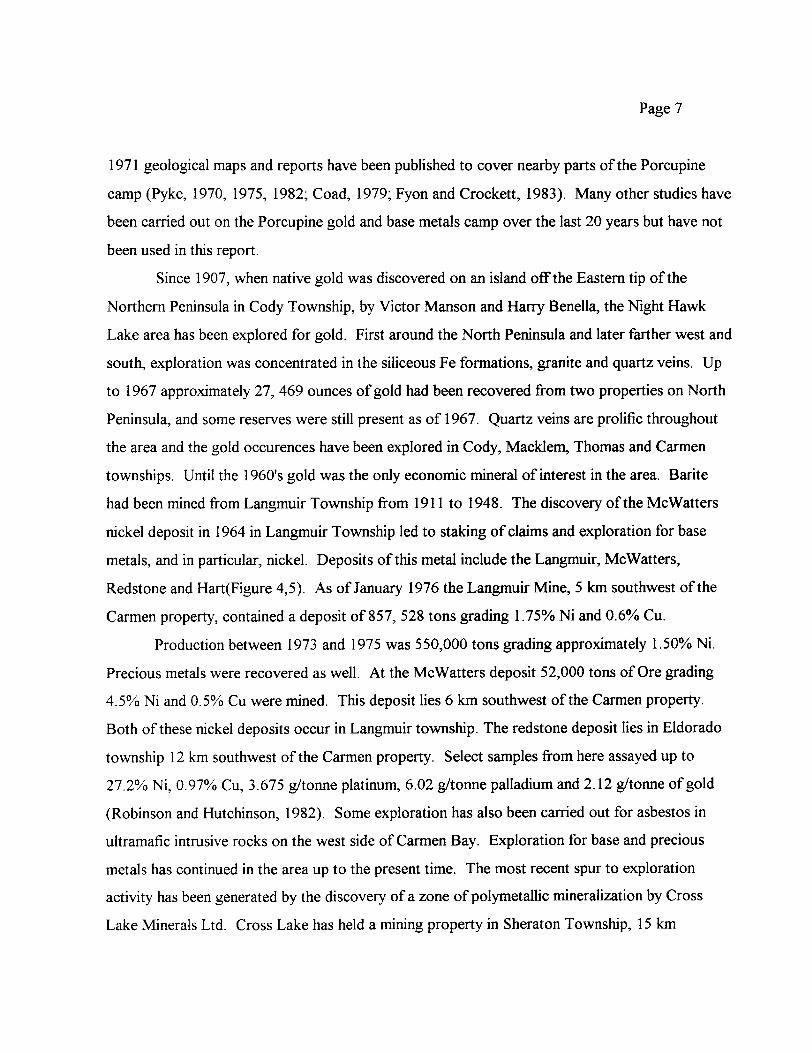
Since 1907, when native gold was discovered on an island off the Eastern tip of the
Northern Peninsula in Cody Township, by Victor Manson and Harry Benella, the Night Hawk
Lake area has been explored for gold. First around the North Peninsula and later farther west and
south, exploration was concentrated in the siliceous Fe formations, granite and quartz veins. Up
to 1967 approximately 27, 469 ounces of gold had been recovered from two properties on North
Peninsula, and some reserves were still present as of 1967. Quartz veins are prolific throughout
the area and the gold occurences have been explored in Cody, Macklem, Thomas and Carmen
townships. Until the 1960's gold was the only economic mineral of interest in the area. Barite
had been mined from Langmuir Township from 1911 to 1948. The discovery of the Me Walters
nickel deposit in 1964 in Langmuir Township led to staking of claims and exploration for base
metals, and in particular, nickel. Deposits of this metal include the Langmuir, McWatters,
Redstone and Hart(Figure 4,5). As of January 1976 the Langmuir Mine, 5 km southwest of the
Carmen property, contained a deposit of 857, 528 tons grading t.75% Ni and G.6% Cu.
Production between 1973 and 1975 was 550,000 tons grading approximately 1.50*^ Ni.
Precious metals were recovered as well. At the McWatters deposit 52,000 tons of Ore grading
4.507o Ni and G.5% Cu were mined. This deposit lies 6 km southwest of the Carmen property.
Both of these nickel deposits occur in Langmuir township. The redstone deposit lies in Eldorado
township 12 km southwest of the Carmen property. Select samples from here assayed up to
27.207o Ni, Q.97% Cu, 3.675 g/tonne platinum, 6.02 g/tonne palladium and 2.12 g/tonne of gold
(Robinson and Hutchinson, 1982). Some exploration has also been carried out for asbestos in
ultramafic intrusive rocks on the west side of Carmen Bay. Exploration for base and precious
metals has continued in the area up to the present time. The most recent spur to exploration
activity has been generated by the discovery of a zone of polymetallic mineralization by Cross
Lake Minerals Ltd. Cross Lake has held a mining property in Sheraton Township, 15 km

PageS
northeast of the Carmen property, since 1991. In October 1997 Cross Lake Minerals released the
assay results from drill hole CLS-97-16. Between 278 m and 311m down this hole the weighted
average grade over a length of 33 m was 6.71 07o zinc, and 1.860A lead, 106.95 g/tonne silver,
Q.16% copper and 0.555 g/tonne gold. This includes a 6 m section from 281 m to 287 m
containing an average grade of IS.4% zinc, 314 g/tonne silver, 9 .28Vo lead, Q.69% copper and
0.183"^o g/tonne gold (Cross Lake, 1997). The zone is hosted by a cherty rhyolite overlying a
sericite and chlorite schist containing cherty bands and disseminated sphalerite (zinc) and galena
(lead). Additional mineralization is present above and below the main horizon. Zinc found below
the main horizon is contained in a rhyolite breccia. Drilling since that time has confirmed the
presence of a VMS ( volcanogenic massive sulphide) system within a 3 km long geophysical trend
known as the Cross Lake Zone.
7 CURRENT EXPLORATION PROGRAM
7.1 WORK DONE
A program of HLEM and MAG surveys were completed on the property between March
12 to March 30, 1998.
A total of 57 kilometers of line cutting, 57 kilometers of magnetometer survey and 61.3
kilometers of Max-Min Horizontal Loop Survey was done over Ag Armeno Mines and Minerals
Inc Carmen Bay Property.
The work covered the following claims all or in part:
1224441 (5 units),
1224442 (12 units),
1224443 (l unit),
1224444 (l5 units),
1224445 (l2 units)
1224446 (9 units).
Total 54 units.

Page 9
8 INTERPRETATION
There is a high linear magnetic anomaly running north-east and south-west at the top of
the property across lines 3+00 E to 10+00 E.
The high magnetic signature of the grid north is relatively uniform and relatively uniform
in the range of 60,000 nt which suggests a dyke like bedrock formation.
The Max-Min Horizontal Loop Electromagnetic Survey located significant anomalies.
There is one conductor on lines 26+OOE to line 30+00 E running in a north east direction
for 400 meters and another conductor striking north west from line 23+OOE to 20+OOE 300
meters in length. Another conductor is located at approximately 4+OON from 5+OOE to 8+OOE.
There is one small classic anomaly on base line 0+00 centered at 16+25E.
For more detail see maps included.
It is often the case that a zone of massive mineralization has only weak gold
concentrations but disseminated to one side of the zone or the other have high concentrations.
These disseminated zones would not be detectable by Max-Min HLEM surveys through the
overburden depth sometimes encountered and may not be conductive enough even for sensitive
EM systems.
Disseminated mineralization is an excellent target for induced polarization method, and is
strongly recommended for this property to locate gold bearing disseminated sulfides.
Diamond drill testing of any of the detected conductors should be preceded by a more
powerful, more sensitive electromagnetic survey. To gain a depth and sensitivity a PEM survey
should be directed at and around conductors. The increased spatial and geometric resolution of
fixed transmitter TDEM system will collect much more information about the conductors than
currently known.
The results of the survey are considered to be encouraging and in view of the potential of
the property, all of the claim group being surveyed by other types of geophysics is recommended.

Page 10
9 CONCLUSIONS
In summary, the Carmen property is considered a very favorable geological environment
for the localization of gold mineralization of economic importance. Found within the Porcupine
mining camp (one of the world's most productive mining camps), It contains quartz vein-hosted
gold deposits, ultramafic intrusive hosted nickel-hosted nickel-copper deposits and VMS-type
nickel and zinc-lead-copper-silver-gold deposits. The entire perimeter of the Shaw Dome, along
the Deloro/Tisdale contact, where the Carmen property lies, is an excellent area for exploration
for massive sulphide deposits. Exploration by previous owners has revealed numerous EM
conductors under Carmen Bay, some of which are associated with magnetic anomalies, which
suggest that there are sulphide bearing horizons concordant to the bedding of the enclosing rocks.
In order to further evaluate the potential of this property, it is suggested that a program consisting
of diamond drilling on the HLEM conductors found on the property.
If drilling proves promising a more detailed exploration program should be conducted.
Daniel F. PatrieGeological and Geophysics Technologist (Dipl.T)March, 1998
Page 11 REFERENCES
Atkinson, B. (1988): Ontario Geological Survey Resident Geologists Office, Timmins:Personal communications
Burrows, A.G. (1911): The Porcupine gold area; Ont. Bureau Mines, Vol.20, pt. 2, 39 p
Cross Lake Mines Ltd. (1997); news releases
Dunbar, W. R. (1948) Structural Relations of the Porcupine Ore Deposits; in Structural Geology of Canadian Ore Deposits, C.I.M. Symposium, p. 442-456
Bain, D. (1998). Economic Potential For Zn, Pb, Cu, Au and NI-CU Mineralization, Carman Property, Cochrane Mining District, N.E. Ontario
Fyon, J.A., and Crockett, J.H. (1983): Gold Exploration in the Timmins Area Using Field and Lithogeochemical Characteristics of Carbonate Alteration Zones; Ontario Geological Survey Study 26
Ginn, R.M., Savage, W.S., Thomson, R., Thomas, I.E., and Fenwick, K.G. (1964):Timmins-Kirkland Lake Sheet, Cochrane, Sudbury and Temiskaming Districts; Ont. Dept. Mines, Geol. Compilation Series, Map 2046, scale l" ^ miles
Hopkins, P.E. (1924) Night Hawk Lake gold area; Ont. Dept. Mines, Vol. 33, pt. 3, p.27-36
Kay, G.F. (1904): The Abitibi Region; Ont. Bureau Mines, Vol. 13 pt. l, p. 104-121
Kindle, E.D. (1936) Gold Occurences of Ontario East of Lake Superior; Geol. Survey Canada, Memoir 192, 162 p.
Leahy, E. J. (1971): Geology of the Night Hawk Lake Area, District of Cochrane; Ontario Geological Survey Geol. Rpt. 96
Miller, W.G. (1907): Lake Abitibi gold deposits; Ont. Bureau Mines, Vol. 16, pt. l, p.219-220
Ontario Geological Survey (1973): Precambrian Geology, Timmins-Kirkland Lake; Ont. Dept. Mines Map 2205, Compilation Series, l '^4 miles
Pyke, D.R. (1970): Geology of Langmuir and Blackstone Townships; Ontario Dept. Mines Geol. Rpt. 86

Page 12 PERSONNEL
Dan Patrie P.O. Box 45
Massey, Ontario POP 1PO
Charles LaundnaultGeneral DeliveryWalford, Ontario
POP2EO
Bruce McLeod Elliot Lake, Ontario
Tim Kelly General Delivery Spanish, Ontario
Micheal Burns General Delivery Massey, Ontario
Brent PatrieGeneral DeliveryMassey, Ontario
POP 1PO
Julien RicherGeneral DeliveryMassey, Ontario
POP 1PO
Henry Grimmard Spanish, Ontario
Ron Bilton Massey, Ontario
Christopher RiversGeneral DeliveryWalford, Ontario
POP 2EO
CERTIFICATE OF QUALIFICATION
I, Daniel Patrie do hereby certify:
1. That I am a Geology and Geophysics Technologist and I reside at Hwy. 17 West, P.O. Box 45, Massey, Ont., Canada, POP 1PO,
2. I graduated from Cambrian College Of Applied Arts and Technology, Sudbury, Ontario, in 1987 with a diploma in Geological Technology with a one year certificate in Geophysics,
3. And I have practiced my profession continuously since graduation, as well as being an active prospector since 1972.
4. That my report on the Carmen property, Carmen Township, Porcupine Mining Division, Ontario, is based on my personal knowledge of the geology of the area, and on a review of published and unpublished information on the property and surrounding area.
Daniel F. PatrieGeology and Geophysics Technologist (Dipl. T)March, 1998

LETTER OF CONSENT
I, Daniel F. Patrie, of the Town of Massey, Ontario, do hereby consent to Ag Armeno
Mines and Minerals Inc., using in whole or in part my Geophysics report on the Carmen Bay
Property in a prospectus of statement of material facts or for filing with government regulatory
bodies as deemed necessary.
Dated at Massey, Ontario, this 2nd day of April, 1998, in the District of Sudbury.
Daniel F. Patrie
Geology and Geophysics Technologist

Vj*i|^^lIQ Northani Davatopcnant vi rtoovovinoiit WIWIM
PtrfbrnMd on Mining Und4 MM, MAO. HSS
7i ^^:iHl ifeaagln
ly o( tubMcfloM 86(9 and SS]8) of tha MnlnQ Ad. Undac McHon B ol lha l to ravtow Via aMaamant work i ndoorrtapond wHh Ilw mMng land hoMvr
42A07NW2007 2.18409 CARMAN900
r, MMatty of North NWiO*v*lopn**nl:*nrf.,|iBni4i|,""Wi Floor.orncc. - CL r.r ; ;,,v '
R EC E l V E D
Instructions: - For work performed on Crown Lands before recording a dalm, ust i - Please type or print In Ink.
1. Recorded hoMer(s) (Attach a Ust If necessary)
form 0240.-- - -JA.M. /?|8|9|1P|U|12|1|2|3|4|5|6
*- ft\ i nj e A/9 1. stfumbar
P/5. /n33ZL , PACIFIC. C en)Fax Numbar
BSSCMfN
Fttt NUMDvV
2. Type of work performed: Check ( ^ ) and report on only ONE of the following groups for this declaration.
'Geotechnical: prospecting, surveys, assays and work under section 18 (regs)
Physical: drifting, stripping, trenching and associated iassays Q Rehabilitation
Wolfe Typo Office Use
Total f Value o* WorkCtaJmad
TO1 Ita* l YMT
NTSFfeferanc*
Mfcrtng DMatoni&
li Of Q*PlMI NUfflDeV Resident District
Please remember to: - obtain a work permit from the Ministry of Natural Resources as required;provide proper notice to surface rights holders before starting work; complete and attach a Statement of Costs, form 0212;
a map showing contiguous mining lands that are linked for assigning work;two copies of your technical report.
3. Pereon or companies who prepared the technical report (Attach a list If necessary)
BoiL fringe V ID POP - -3 o .
4. CertMteatlon by Recorded Holder or Agent_______^_________
l. T)**tiei- f. PA-T#*IZ:_____ , do hereby certify tha\fPflnl Nwiiv|
forth In tWs Declaration of Assessment Work having caused the work to be or after Ka completion and, lo the best of my knowledge, HI* annexed
a-rJTrtiphi Numb

MM ItttlU wmtflti N* utira nvniv n
r. Or Ifwork wo* done on mining land, enow to Ms column
of othw
of work •ppftrttot*
VshM of work Ml0nMl to ottwr
Bank. Vthw of work&MK ^ iSJaltSiai^aii10 Dfj uiBunwwa tsMurodm.
TB7827 16 ha 926, 828 N/A 924,000 92,825
1234567 12 824,000
1234508 88,692 94,000 94,892
s-
2 J22y IP
a0*
130.
00
ao- oo.
8
10
11
12
13
14
18 ICotumn Totals
gO ffQ
i, D an t c. i do hereby certtfy that the above work credits are eligible under
subsection 7 (1) of the Assessment Work Regulation 6/96 for assignment to contiguous dalms or for application to
the dahn where the work was done.of AQWH
6. Instructions for cutting back credits that are no! approved.7
Some of the credits claimed In this declaration may be cut back. Please check (^ ) In the boxes below to show
you wish to prioritize the deletion of credNs:
0^1. Credits are to be out back from the Bank first, followed by option 2 or 3 or 4 as Indicated.
D 2. Credits are to be cut back starting wtth the dakns Isted last, working backwards; or
0^3. Credits are to be cut back equally over si dalms Msted In this declaration; or
D 4. Credits are to be cut back as prioritized on the attached append*
APR 09
GEOSCIENCE ASSESSMENT _____OFFICf
Note: If you have not Indicated how your credits are to be deleted, credits wW be cut back from the Bank first, followed by option number 2 H necessary.
For Office Uae Only_______________Appnxmd Dm
DM* Appnwwi Toul VMM of CradN Approve

Ontario Ministry ofNorthern Development Statement of Costs
for Assessment CreditTransaction Number (onto* use)
Personal Information collected on thto form It obtained undtr the authority of subsection 6(1) of the Assessment Work Regulation 6/96. Under Mctkm S of the Mining Ad, the Information to a public record. Thto Information wM b* uaad to review the assessment work and correspond wtth the mining land holder. Questions about thto collection should be directed to the Chief Mining Recorder, Ministry of Northern Development and Mines, 6th Floor, MS Ramsay Lake Road, Sudbury, Ontario, PSE 686.
Work Type
/^fn-f - C tcyyr'*.*sJ
ft\ *c*
h)**- JYI/n/
iCePo K i - PLO ff/rtt * //i faro n
Su.PCft v is.ionJ
Units of WorkD6MndkiQ on th6 typ0 ol woclc, (tot tht) nurnbcr
(TwtfM of 0rid HM| nuinbof of wnplM* Mo.
^/. 3
57.
LI. 3
Jfm*rv\
/^ Loiff (Q Sno. ^
Associated Costs (e.g. supplies, mobilization and demobilization).
bvn Di lizc* /in* - C-u^i-4-e^r^
rv. D D i ji 2. -e J . P. C r^\jJ
Transportation Costs
4 * |r,,Jno fa* tot. 0* ** c tueek ILue^k*}
1 '
Food and Lodging Costs
rn^nlS 4 k 0 el si "j rx c, - ( O An. e^w l Ci UJf.^k^.}
* J J
Cost Per Untt of work
*3AO. **
cro I^O.
2Ltt.**
Total Value of Assessment Work
Total Cost
UT* *^tJ
/^ 39D ,t, }?yo. crb
PO / C 33^.
J ^e) f fi DO .
- **
^ Cfro.
Xoo-*^
90n. tro
L^crt. **
"i rrcro .
~4f cro S? Ts-S-.
Calculations of Filing Discounts:
1. Work filed within two years of performance Is claimed at KXWb of the above Total Value of Assessment Work.2. If work is filed after two years and up to five years after performance, K can only be claimed at SOW* of the Total
Value of Assessment Work. If this situation applies to your claims, use the calculation below:
TOTAL VALUE OF ASSESSMENT WORK x 0.50 Total S value of worked claimed.
Note:- Work older than 5 years Is not eligible for credit.- A recorded holder may be required to verify expenditures claimed In this statement of costs within 45 days of a request for verification and/or correcttort/clarincatlon. If verification and/or correction/clarification to not made, the Minister may reject all or part of the assessment work submitted. ~]PpplP'f\7FfT'
Certification verifying costs: APR O 9 1S23
(ptease print M nairn), do hereby certify, that curate as may
OFFIQFreasonably be determined and the costs were Incurred while conducting assessment work on the lands indicated on
the accompanying Declaration of Work form as
to make this certification. ;
(racofdad hopir. agent, Of stua company position wtth signing authority)l am authorized
Signature
,/1/27

OntarioMinistry of Ministers duNorthern Development Developpement du Nordand Mines st des Mines ^
Geoscience Assessment Office 933 Ramsey Lake Road
August 14, 1998 6th FloorSudbury, Ontario
AG ARMENO MINES AND MINERALS INC. P3E 6B5 P.O. BOX 10332, SUITE 1650PACIFIC CENTRE, 609 GRANVILLE STREET Telephone: (888) 415-9846 VANCOUVER, B.C. Fax: (705) 670-5881 V7Y-1G5
Visit our website at:www.gov.on.ca/MNDM/MINES/LANDS/mlsmnpge.htm
Dear Sir or Madam: Submission Number: 2 .18409
Status Subject: Transaction Number(s): W9860.00386 Approval After Notice
We have reviewed your Assessment Work submission with the above noted Transaction Number(s). The attached summary page(s) indicate the results of the review. WE RECOMMEND YOU READ THIS SUMMARY FOR THE DETAILS PERTAINING TO YOUR ASSESSMENT WORK.
If the status for a transaction is a 45 Day Notice, the summary will outline the reasons for the notice, and any steps you can take to remedy deficiencies. The 90-day deemed approval provision, subsection 6(7) of the Assessment Work Regulation, will no longer be in effect for assessment work which has received a 45 Day Notice. Allowable changes to your credit distribution can be made by contacting the Geoscience Assessment Office within this 45 Day period, otherwise assessment credit will be cut back and distributed as outlined in Section #6 of the Declaration of Assessment work form.
Please note any revisions must be submitted in DUPLICATE to the Geoscience Assessment Office, by the response date on the summary.
If you have any questions regarding this correspondence, please contact Lucille Jerome by e-mail at [email protected] or by telephone at (705) 670-5858.
Yours sincerely,
ORIGINAL SIGNED BYBlair KiteSupervisor, Geoscience Assessment OfficeMining Lands Section
Correspondence ID: 12677
Copy for: Assessment Library

Work Report Assessment Results
Submission Number: 2 .18409
Date Correspondence Sent: August 14, 1998_____________________Assessor: Lucille Jerome—^-^—^^—^
Transaction First ClaimNumber Number Township(s) l Area(s) Status Approval Date
W9860.00386 1224441 CARMAN Approval After Notice August 14, 1998
Section:14 Geophysical EM 14 Geophysical MAG
The 45 days outlined in the Notice dated June 29,1998 have passed.
Assessment work credit has been approved as outlined on the attached Distribution of Assessment Work Credit sheet.
Correspondence to: Recorded Holder(s) and/or Agent(s):Resident Geologist Daniel PatrieSouth Porcupine, ON MASSEY, ONTARIO, CANADA
Assessment Files Library AG ARMENO MINES AND MINERALS INC.Sudbury, ON VANCOUVER, B.C.
Page:1
Correspondence ID: 12677

Distribution of Assessment Work Credit
The following credit distribution reflects the value of assessment work performed on the mining land(s).
Date: August 14, 1998
Submission Number: 2 .18409
Transaction Number: W9860.00386
Claim Number Value Of Work Performed
1224441 3,100.001224442 2,050.001224443 650.001224444 11,600.001224445 20,695.001224446 1,300.00
Total: * 39,395.00
Page: l
Correspondence ID: 12677

LEGENDCODY TWP.
HIGHWAY AND ROUTE No.
OTHER RdADS
TRAILS
SURVEYED LINES:
TOWNSHIPS, BASE LINES. ETC.
Atriol Cableway
Boundary
LOTS, MINING CLAIMS, PARCELS, ETC UNSURVEYED LINES
LOT LINESPARCEL BOUNDARYMINING CLAIMS ETC
RAILWAY AND RIGHT OF WAY UTILITY-LINES NON PERENNIAL STREAM FLOODING OR FLOODING RIGHTS
MOOSE ISLAND
(ALL IN CODY TJ**)
1213297
NIGHT HAWK LAKE:
IM 60 oo MMt 1213298
\ --A il2UN,r-S) (12 UNITS)
121^295
UNITS)
1213293
(16 U NITS)Bridge
, H o 1 1 rot*
Building
Cfiimney
Cliff, Pri,*,.*
SUBDIVISION OR COMPOSITE PLAN
RESERVATIONS
ORIGINAL SHORELINE
MARSH OR MUSKEG
ivhl* li** nvrr /' it* Itlplt rap.41
#*ervoir p***^
*iv*r, Streom.Canol
TRAVERSE MONUMENT
QNEST ISLANDI2I328J(re UNITS)1213512
(12 UNITS) DISPOSITION OF CROWN LANDSt?
GULL ISLAND1213277 (M UNITS)
I2I32BO (14 UNITS)
TYPE OF DOCUMENTP12288591(16 UNITS]
PATENT, SURFACE ft MINING RIGHTS
.SURFACE RIGHTS ONLY ,.
.MINING RIGHTS ONLY ... _ . ...........^, O
LEASE, SURFACE ft MINING1 RIGHTS
" .SURFACE RIGHTSONLY...... , .. , .... B
" , MINING RIGHTSONLY
LICENCE OF OCCUPATION . ......,........... — ... . T
ORDER-IN-COUNCIL . .,,.^....,...... ........ OC
RESERVATION .
CANCELLED
SAND 8. GRAVEL
Spot ElevationOat* 111.11,0*1)
Tower B
Trantmittion Lint
iT. "~ - ~ "
Utility Pol*i
Whorl , Dock , Pier
Wood*d Arta
Marsh or Swamp
Matt
Mint Head Frame a
Ouicrop i'.'--
L. - -. ^ - _ _^1223401 (15 UNITS)
1213278 tlG UNITS)1213313
fl2*JNrTS) {213282 (l 6 UNITS)
NOTE: MINING RIGHTS IN PARCELS f ATtMTiO PRIOR TO MAT 8, 1913. VESTED IN ORIGINAL PATCNTCE BY THE PUBLIC LANDS ACT, R.S.O 197O. CHAP 360. SEC. 83, SUBSEC 1
AREAS WITHDRAWN FROM DISPOSITION
M.R.O. - MINING RIGHTS ONLY
S.R.O. - SURFACE RIGHTS ONLY
M.+ S. - MINING AND SURFACE RIGHTS
DMcription Ord*r No. Dvti DupOMtion File
1228560 (16
to 20 30 *0 SO 60 70
1000 2000 3000 4000 5000
1223406 (15 UNITS]
SCALE 1 :20 000
GRID ZONE: 171^13285 (fe UNITS)
-J -----W^--^'--\ \ 1207729
J (6 UNITS)1213283
UNITS)1213284 06 UNITS)
(10 UI^TSJ\\ I2O773O
UNITS) ^-—^ItC^,,_l ___ _ L_
- 12238.5-2
DATE OF ISSUEAUG 1 4
_______|^____ _____i __^l___._
.122^968222966
** i—^ -^ '
TOWNSHIP n^'i rN y - - CARMAN
.N. R. ADMINISTRATIVE DISTRICT
TIMMINSMINING DIVISION
PORCUPINELAND TITLES/ REGISTRY DIVISION
COCHRANE
i J23I946
Lj/.i ,.- / /CVJTHE INFORMATION THAT APPEARS ON THIS MAP HAS BEEN COMPILED FROM VARIOUS SOURCES, AND ACCURACY IS NOT GUARANTEED THOSE WISHING Td STAKC MIN ING CLAIMS SHOULD CON SULT WITH THE MINING RECORDER, MINISTRY OF NORTHtRN DEVELOP *, MENT AND MINES, FOR AD blTlONAL INFORMATION ON THE STATUS OF THE LANDS SHOWN HEREON.
-Or-12045IB ' |?O45J3
Ministryof LandNatural * Management
Resources Branch
-s--------ORIGINALCOMPILATION JULY 1984
G-4000LANGMUIR TWP.
42A07NW2007 2.18409 CARMAH 200

LJ LJ LJ\D 1^ 00ru cu
o \LJ LJ LJ
IP;
CAR
4442
LJ LJ
l
t:
l
Jl2S BE
OM 100 200 300 400 500
42A07NW2007 2.18409 CARMAN 210
AG ARMEND MINES AND MINERAES EO,
CARMEN BAY PROPERTY BASE MAP v
SCALE 1:5000
PLDTTED BY KIMBERLY ZARICHNEY98-03-28 ;
DAN PATRIE EXPEDRATIDNS ETD,

s.
o oCM
Oo o
o oCD
O O (D
Oo
o oCM
O -
i/) O O CM
CD
ViOo00
LO QO
oiOh CNi
00
LO Ooh to i
l
o oo
200W
to oo - o
COoo -CMCM
CM
200E 4QOE 600E 800E 1000E 1200E i—— 1400E 1600E 1800E 2000E 2200E 2400E 2600E 2800E 3000E 3200E
en o o
oo o o
h-5843ft/-*saM7
^576 y-58613
-^8029- -58010
- -580265882358936
58820
58853
58805
57967
57976
57983
- -57896
- -57982- -57998
5S062
58054
58067
58073
58064
+ 5SQ8B
58198
+ 5813B
58084
58062
56065
58071
SMQ5
56536
58JI3
58599
3S78?
+58108
58968
H-58077BOO
4-578•58089
•58079
•5807458076
458060
58064-- 58053--58060
--58073
- -58080--58086
- -578S4
- -57890
--57888
rOo
-p"CD O
CJlo o
CT) OO
oo
OOo o
200W O 200E 400E 600E 800E 1000E 200E 1400E 600E 1800E 2000E 2200E 2400E } 600E 3000E
ro o o
o oo
oo o o
Olo o
-fi o o
ro o o
o O 00
o oCO
O)o o
00 o o en
o o oLO
o oLO
o o to
en o oLO
ooo oI/O
ro o o oLO
NJo oLO
ho-^ o oLO
3200E
42A07NW2007 2.18409 CABMAN 220
LEGEND
Instrumentation : OMNi Plus Field Magnetometer
OMNI IV Base Station Magnetometer
Reference Eield : 61300 nT
Datum Subtracted : O nT
Line Spacing : 100 Metres
Station Spacing : 25 Metres
Contour Interval i 100 nT
Personnel: D. Patrie, B. Patne
Survey Dote: March 1998
-N-
100
Scale 1:5000O 100 200 300
(metres)
Ag Armeno Mines and Minerals IncCarmen Bay Property
Magnetic Total Field Survey
Plotted by : T, Insinna Date : 98-04-04
Dan Patrie Exploration Limited
200W 200E 400E 600E 800E 1000E 1200E 1400E 1800E 2000E 2200E MOOE 2600E 2800E 300QE 3200E
oo - o
o o oo
o o
o o
o oCM
COo oCM
in o o
CO O O tO
COoo00
COo oo
COo oCsJ
LOo o
OOOo to
LO O Ooo
00oo oCM
00 O O CM CM
00 O O^fCM
O O
2rr1-1-1
h-l
o-1-1-1
-o-O
o o
75
—i O -- O — -"
jr^j
\-9Y-l
T*1wi -^^*x-6}
-P--6-7-
-8f7-
t6t*\5
-6--6--6 ^-6--7-6-•5/-5 l6-
-7--7--7 J
/-7-- 18'.-10--7--1i2--1)--U;
-10--ir--^--12--fc-
'-z-•-1"trt^ 1 *- l—-f--2
•-1•-2*1li•-1•-2•-1•-1! 1n-0•-1•)2'1iH--1
f•-1 ^
H ; ji 1 ',, . L-v./i•-3•-3•-3-4
•-3•-5
^•-3--4-4
--4
-1
i— i—
u: 1
_ CT) OCDi i iro — ' — "
—l —— 1 —— 1 —
-6-
-7--6--6-r6--" CI-C-
PMt•C•!z•12 i i i i i i)) OJ rvj NJ 1VJ OJ NJ — 1-1 ——— 1 ——— 1 ——— 1 ——— 1 ——— 1 ——
-T. CD
-r—P-K*.gi oj*trf
--J Oo
Oo o o
1-n 1-
-1. --2
-r-3-1
i•-3•-3
•-4-J]-lltf-4
--3-h--2
-1-O
1 OJOife0 T 1
-IfrO-1-2
-1 \j--1 O' -2
'••-5-•-5---4-\2
o-i2--1 - 1 -2-3-f-,
---3 ..-4---7
-8
•120ft.o o o
IOHOo
loo
gI.R.
o o
M O O In-Phose
- — Out-of-Phase
NJoS)
DCO
O O CO
xoC/)
LEGEND
Instrumentation : Apex Parametrics Max-Min IICoil Seperation : 100 metresStation Interval : 25 metresProfile Scale : ^ cm = W 70Personnel : D. Patrie, B. PatrieSurvey Date : March 1998
D O CO
N) O O CO
-P" OoCO
CD OoCO
00o oUl
NJOo oCO
to o o oo
100Scole 1:5000
o 100 200(metres)
r-j-p- O O CO
200W O 200E 400E 600E 800E 1000E 1200E 1400E 1600E 1800E 2000E 2200E 2400E 2600E 2800E 3000E 3200E
42A07HW2007 2.18409 CARMAN 230
Ag Armeno Mines and Mineral:Carmen Bay Property
HLEM Survey444 Hertz
Plotted by : T. tnsinna Date : 98-03-25
Dan Patrie Exploration Limited
i*
200W O 2COE 400E 60CE 800E ' 2 0GE 14QOE 1600E '80CE 2000E 220CE 2400E 26COE 2800E JOOOE 3200E
o oo
o o00
o o
z:o o
o oCN
GO O O CM
00o o
00o oCO
00o o00
c/) o oo
00ooCM
t/) o o
00oo
LO O Ooo
00o ooCN
inO
CNI
00o o
O
Oo
'/f- 1Or f -2 4-3 -4-2
-1
-1-1-1
O-1
O o
1I3--14 sV-20
\ 11---10 *j
o o o
00o o
-iCT) O
lg
M O O In-Phase
————— —— Out-of-Phose
00o
LEGEND
Instrumentation Coil Separation : Station Interval : Profile Scale : 1
: Apex Porametrics Max-Min 100 metres 25 metres cm ^ 10 %
Personnel : D. Patrie, B. Patrie Survey Dote : March 1998
o of)
O Ot/)
O
enD
CO OO CO
NJ OOo00
N
KJ O O 00
100Scate 1:5000
O 100 200 300
(metres)
W-p-o o in
200W 200E 400E 600E 800E 1000E 1200E 1400E 1600E 1800E 2000E 2200E 2400E 2600E 2800E 3000E 3200E
42A07NW2007 2.18409 CARMAN 240
Ag Armeno Mines and Minerals incCarmen Bay Property
HLEM Survey888 Hertz
Plotted by : T. Insinna Date : 98-03-25
Dan Patrie Exploration Limited
Related Documents