Geophysical investigations for the characterization of fractured rock aquifers in Itu, SE Brazil Jorge Luı ´s Porsani * , Vagner Roberto Elis, Francisco Yukio Hiodo Departamento de Geofı ´sica, Instituto de Astronomia, Geofı ´sica e Cie ˆncias Atmosfe ´ricas, Universidade de Sa ˜o Paulo, Rua do Mata ˜o, 1226, Cidade Universita ´ria, 05508-090, Sa ˜o Paulo, Brazil Received 15 April 2004; received in revised form 15 April 2004; accepted 25 October 2004 Abstract This paper presents the results of integrated geophysical investigations to characterize aquifers in fractured rocks in the Granite complex of Itu, SE Brasil, to help locate sites for tubular wells for groundwater exploration. Ground penetrating radar (GPR) profiles, dipole–dipole electric survey, gamma spectrometry, and radon gas emanometry were applied on a same line for a comparative study of these methodologies. The results allowed us to characterize structural discontinuities up to 30 m in depth, such as, dipped, or vertical fractures. The dipped fractures appear as strong GPR reflectors, probably due to the presence of water. Besides, two anomalous regions were identified, one at 50 m and other at 75 m, both showing high attenuation of the GPR signals, and they correspond to the vertical fracture zones. 2D modeling of the dipolar electric survey shows that the two anomalous areas correspond to high electric conductivity zones, and that in the position of 75 m, a vertical fracture zone is clearly identified. In the gamma rays profiles, the values of K and Th concentrations observed in the position of 50 m indicate the presence of vertical fractures filled with clay minerals. On the other hand, in the position of 70 m of the Rn gas emanometry profile, the peak of Rn emanation is five times higher than the regional level, indicating the presence of a vertical fracture zone, clearly filled with fresh water in circulation. The geophysical characterization of the vertical fracture zones with fresh water subsidized the drilling of a well for groundwater exploration in fractured aquifers, which was an important contribution for the local community because the main sources of surface water are contaminated. D 2004 Elsevier B.V. All rights reserved. Keywords: Ground penetrating radar (GPR); Electric resistivity; Gamma ray spectrometry; Radon gas emanometry; Fractured aquifer; Granite complex of Itu; SE Brazil 1. Introduction and objectives Nowadays, there are several geophysical methods for the mapping of fractured rocks filled with some representative mineral (Orellana, 1972; Morse, 1977; Daniels, 1996; Lane et al., 2001). The Ground 0926-9851/$ - see front matter D 2004 Elsevier B.V. All rights reserved. doi:10.1016/j.jappgeo.2004.10.005 * Corresponding author. Tel.: +55 11 3091 4734; fax: +55 11 3091 5034. E-mail address: [email protected] (J.L. Porsani). Journal of Applied Geophysics 57 (2005) 119 – 128 www.elsevier.com/locate/jappgeo

Welcome message from author
This document is posted to help you gain knowledge. Please leave a comment to let me know what you think about it! Share it to your friends and learn new things together.
Transcript
www.elsevier.com/locate/jappgeo
Journal of Applied Geophys
Geophysical investigations for the characterization of
fractured rock aquifers in Itu, SE Brazil
Jorge Luıs Porsani*, Vagner Roberto Elis, Francisco Yukio Hiodo
Departamento de Geofısica, Instituto de Astronomia, Geofısica e Ciencias Atmosfericas, Universidade de Sao Paulo, Rua do Matao,
1226, Cidade Universitaria, 05508-090, Sao Paulo, Brazil
Received 15 April 2004; received in revised form 15 April 2004; accepted 25 October 2004
Abstract
This paper presents the results of integrated geophysical investigations to characterize aquifers in fractured rocks in the
Granite complex of Itu, SE Brasil, to help locate sites for tubular wells for groundwater exploration. Ground penetrating radar
(GPR) profiles, dipole–dipole electric survey, gamma spectrometry, and radon gas emanometry were applied on a same line for
a comparative study of these methodologies. The results allowed us to characterize structural discontinuities up to 30 m in
depth, such as, dipped, or vertical fractures. The dipped fractures appear as strong GPR reflectors, probably due to the presence
of water. Besides, two anomalous regions were identified, one at 50 m and other at 75 m, both showing high attenuation of the
GPR signals, and they correspond to the vertical fracture zones. 2D modeling of the dipolar electric survey shows that the two
anomalous areas correspond to high electric conductivity zones, and that in the position of 75 m, a vertical fracture zone is
clearly identified. In the gamma rays profiles, the values of K and Th concentrations observed in the position of 50 m indicate
the presence of vertical fractures filled with clay minerals. On the other hand, in the position of 70 m of the Rn gas emanometry
profile, the peak of Rn emanation is five times higher than the regional level, indicating the presence of a vertical fracture zone,
clearly filled with fresh water in circulation. The geophysical characterization of the vertical fracture zones with fresh water
subsidized the drilling of a well for groundwater exploration in fractured aquifers, which was an important contribution for the
local community because the main sources of surface water are contaminated.
D 2004 Elsevier B.V. All rights reserved.
Keywords: Ground penetrating radar (GPR); Electric resistivity; Gamma ray spectrometry; Radon gas emanometry; Fractured aquifer; Granite
complex of Itu; SE Brazil
0926-9851/$ - see front matter D 2004 Elsevier B.V. All rights reserved.
doi:10.1016/j.jappgeo.2004.10.005
* Corresponding author. Tel.: +55 11 3091 4734; fax: +55 11
3091 5034.
E-mail address: [email protected] (J.L. Porsani).
1. Introduction and objectives
Nowadays, there are several geophysical methods
for the mapping of fractured rocks filled with some
representative mineral (Orellana, 1972; Morse, 1977;
Daniels, 1996; Lane et al., 2001). The Ground
ics 57 (2005) 119–128
J.L. Porsani et al. / Journal of Applied Geophysics 57 (2005) 119–128120
penetrating radar (GPR) and the electric resistivity
methods are the most commonly used in the world.
These methods allow the locating of fractures filled
with water, but they do not bring any information
about the subsurface circulation itself, since the
fracture can be filled with clay and have a low free
water content.
In many cases, the nuclear techniques can bring
some additional information about water circulation
in fracture zones, in spite of the low penetration of
the gamma photons of the natural radioactive decays
in hard rock. Soil created by the exposure of the
basement rock to the weather elements carries in it
almost the same minerals present in the crystalline
rock. Besides, the radon (Rn) radioactive gas of the
uranium (U) and thorium (Th) series can decay
before escaping to the atmosphere, leaving polonium
(Po) halos that can decay to 214 Bi and 208 Tl, and
then can be detected by gamma ray spectrometry.
Another nuclear technique used to detect fractures
was radon gas emanometry, as was previously
explained.
In this paper, GPR and dipole–dipole electric
surveys were performed to locate fracture zones and
to determine the top of the fresh granite rock. As these
methods do not discriminate if the fractures are filled
with clay minerals or free water, gamma ray spec-
Fig. 1. Map of the location of the study area and geologic
trometry and radon gas emanometry techniques were
also applied to locate fractures filled with fresh water.
The geophysical profiles were surveyed on a same
line, hence a comparative study between these
methodologies was executed, and the integrated
interpretation was effected to characterize the aquifer
in fractured rocks.
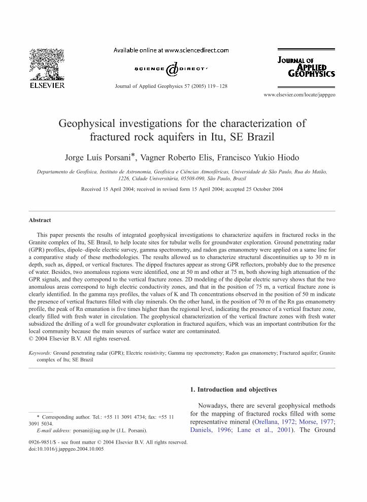
The study area is the Granite complex of Itu, an
area of environmental protection located in the
municipal district of Itu, State of Sao Paulo, SE
Brazil (Fig. 1). In that area, the main sources of
surface water (Tiete, Piraı and Fonte Rivers) are quite
polluted, and the provisioning of potable water for the
local community is accomplished through the explo-
ration of groundwater, by means of tubular wells in
fractured aquifers. Therefore, the application of the
geophysical methods to locate fracture zones filled
with free water becomes of great importance for the
countryside communities.
The main contribution of this project was to locate
fracture zones filled with fresh water, given that the
exploration of groundwater in fractured aquifers in
granite rocks can be efficiently carried out in this area.
Results from the geophysical surveys showed ideal
areas to drill wells for the exploration of groundwater,
and they were important for the provisioning of the
local community.
al structures of the Itu Granite complex, SE Brazil.
J.L. Porsani et al. / Journal of Applied Geophysics 57 (2005) 119–128 121
2. Local geology
The Granite complex of Itu is located approx-
imately 90 km from Sao Paulo city, SE Brazil, and it
has an area about of 400 km2 (Fig. 1). In the area, a
transition region between the Pre-Cambrian terrain of
the state of Sao Paulo and the Parana sedimentary
basin occurs (Pascholati, 1989). Due to the lack of
outcrop and the covering by more recent geological
units, exhibitions of the contacts of the Granite
complex with the host rocks are rare and can be
tectonic or intrusive. The most prominent geological
Fig. 2. Location of the ge
structures of the Granite complex of Itu are the
lineaments that correspond to the curved fault zones,
subparallel or convergent to the Jundiuvira fault
zone. Those zones coincide partially with the
orientation of the main drainages of the region, such
as, the Tiete, Piraı and Fonte Rivers. The most
important lineaments that affect the Granite complex
show preferential directions of N20–30E and N45–
50W (Fig. 2). Geologically, these lineaments repre-
sent the fault/fracture zones, which are important
structures for the exploration of groundwater in
granite rocks.
ophysical profiles.
J.L. Porsani et al. / Journal of Applied Geophysics 57 (2005) 119–128122
3. Acquisition and processing of the geophysical
data
The GPR, dipolar electric resistivity, gamma ray
spectrometry, and radon gas emanometry profiles
were acquired along an 80-m line, along the N45E
direction (Fig. 2). This direction was chosen so that
the profiles crossed the most representative structural
lineaments in the study area. The profiles are on the
same line to evaluate the geophysical signatures of
fracture zones through a comparative study between
these methodologies.
A very irregular relief characterizes the study area.
Hence, the geophysical profiles were positioned on
the land based on field logistics, the topography, and
the direction of the main fractures. Profiles were
disposed following a same topographical level. There-
fore, it was not necessary to do a topographical
correction in the GPR profiles.
The GPR data were acquired after a period of 20
days of rains in the study region. This is a favorable
situation for the mapping of fracture zones in the
granite rocks, because the high contrast between the
dielectric constant of the water present in the fractures
and the host rock results in strong reflection in the
GPR profiles (Olhoeft, 1998). On the other hand, the
presence of a fracture zone filled with free water
produces an increase in the electric conductivity,
consequently, this induces a strong attenuation in the
GPR profile. Besides, an anomaly is expected in the
radon gas emanometry profile due to its leakage to the
atmosphere.
3.1. Ground penetrating radar
With the GPR method (Davis and Annan, 1989;
Daniels, 1996; Porsani, 1999), three reflection
profiles of 50, 100, and 200 MHz were acquired to
map the fracture zones and the top of the fresh
granite rock (Fig. 2). The data were acquired with
the Ramac equipment from the Geophysics Depart-
ment of the IAG/USP. The profiles were performed
on a same line to get good penetration with the 50
MHz antenna and sharp resolution with the 200
MHz antenna. The data were acquired with apertures
of 2 m for the 50 MHz antenna, 1 m for 100 MHz,
and 0.6 m for 200 MHz. The interval between the
traces was 0.5 m (for 50 and 100 MHz antennas) and
0.25 m (for 200 MHz). The total stacking times of
the traces in all the profiles was 512. All data were
acquired in the step-by-step mode, and the trans-
mitter and receiver antennas were positioned in a
transverse orientation in relation to the direction of
the profile to guarantee maximum coupling between
the transmitted and received signals (Annan and
Cosway, 1992; Versteeg, 1996).
In this paper, a representative GPR profile of 100
MHz of the studied area is presented (Fig. 2). On the
reflection profiles, four velocity soundings of the wide
angle reflection and refraction (WARR) type were
performed, using 100 MHz antenna and spacing of 0.1
m between the traces. The propagation velocity of the
electromagnetic wave in the subsurface was deter-
mined by the Semblance method (Yilmaz, 1987), and
it was used in the migration and in the conversion of
the time profiles for depth.
The GPR data were processed by the Radan
software (GSSI). A time filtering band pass was
applied to remove noise. To compensate energy losses
due to the absorption and the geometric scattering,
gains in time were applied to the data. The fk-
migration was applied to spatially reposition the
reflectors in subsurface. The time to depth conversion
was performed using a constant speed of 0.125 m/ns.
A spatial filtering of a three trace moving average
kind was applied, and it resulted in a horizontal
smoothing.
3.2. Electric resistivity
By the electric resistivity method (Orellana, 1972;
Elis, 1999), it was possible to obtain a dipolar electric
sounding with 10 m aperture to characterize the
geoelectric stratigraphy of the fracture zones in the
Granite complex of Itu (Fig. 2). The data were
acquired with an Iris resistivimeter, and five levels
were studied, allowing a theoretical investigation of
up to 30 m in depth. For comparative purposes, the
origin of that profile corresponds to the 15 m position
in the GPR profile.
To explain the true spatial positions of the geo-
electric anomalies and to identify the presence of the
fracture zones, the data were interpreted quantitatively
through 2D modeling (Ross et al., 1990), and the
many geological structures of the subsurface were
identified.
J.L. Porsani et al. / Journal of Applied Geophysics 57 (2005) 119–128 123
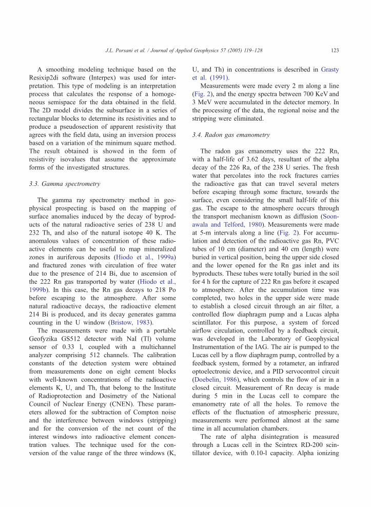
A smoothing modeling technique based on the
Resixip2di software (Interpex) was used for inter-
pretation. This type of modeling is an interpretation
process that calculates the response of a homoge-
neous semispace for the data obtained in the field.
The 2D model divides the subsurface in a series of
rectangular blocks to determine its resistivities and to
produce a pseudosection of apparent resistivity that
agrees with the field data, using an inversion process
based on a variation of the minimum square method.
The result obtained is showed in the form of
resistivity isovalues that assume the approximate
forms of the investigated structures.
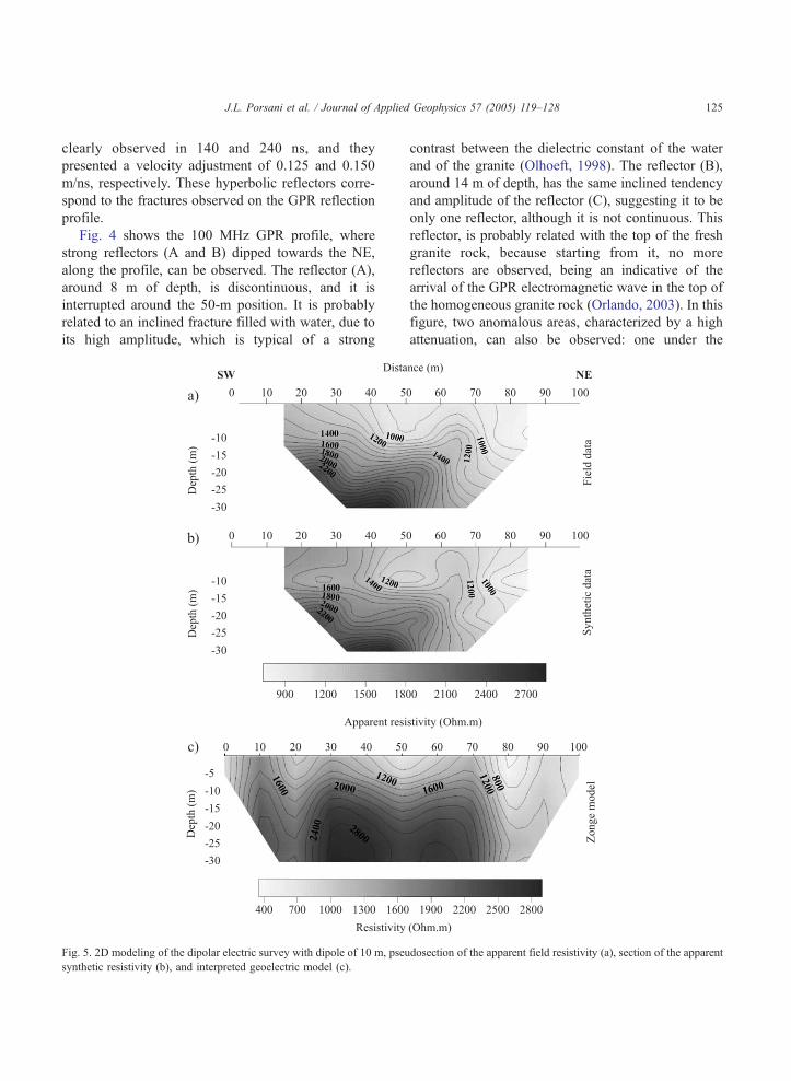
3.3. Gamma spectrometry
The gamma ray spectrometry method in geo-
physical prospecting is based on the mapping of
surface anomalies induced by the decay of byprod-
ucts of the natural radioactive series of 238 U and
232 Th, and also of the natural isotope 40 K. The
anomalous values of concentration of these radio-
active elements can be useful to map mineralized
zones in auriferous deposits (Hiodo et al., 1999a)
and fractured zones with circulation of free water
due to the presence of 214 Bi, due to ascension of
the 222 Rn gas transported by water (Hiodo et al.,
1999b). In this case, the Rn gas decays to 218 Po
before escaping to the atmosphere. After some
natural radioactive decays, the radioactive element
214 Bi is produced, and its decay generates gamma
counting in the U window (Bristow, 1983).
The measurements were made with a portable
Geofyzika GS512 detector with NaI (Tl) volume
sensor of 0.33 l, coupled with a multichannel
analyzer comprising 512 channels. The calibration
constants of the detection system were obtained
from measurements done on eight cement blocks
with well-known concentrations of the radioactive
elements K, U, and Th, that belong to the Institute
of Radioprotection and Dosimetry of the National
Council of Nuclear Energy (CNEN). These param-
eters allowed for the subtraction of Compton noise
and the interference between windows (stripping)
and for the conversion of the net count of the
interest windows into radioactive element concen-
tration values. The technique used for the con-
version of the value range of the three windows (K,
U, and Th) in concentrations is described in Grasty
et al. (1991).
Measurements were made every 2 m along a line
(Fig. 2), and the energy spectra between 700 KeV and
3 MeV were accumulated in the detector memory. In
the processing of the data, the regional noise and the
stripping were eliminated.
3.4. Radon gas emanometry
The radon gas emanometry uses the 222 Rn,
with a half-life of 3.62 days, resultant of the alpha
decay of the 226 Ra, of the 238 U series. The fresh
water that percolates into the rock fractures carries
the radioactive gas that can travel several meters
before escaping through some fracture, towards the
surface, even considering the small half-life of this
gas. The escape to the atmosphere occurs through
the transport mechanism known as diffusion (Soon-
awala and Telford, 1980). Measurements were made
at 5-m intervals along a line (Fig. 2). For accumu-
lation and detection of the radioactive gas Rn, PVC
tubes of 10 cm (diameter) and 40 cm (length) were
buried in vertical position, being the upper side closed
and the lower opened for the Rn gas inlet and its
byproducts. These tubes were totally buried in the soil
for 4 h for the capture of 222 Rn gas before it escaped
to atmosphere. After the accumulation time was
completed, two holes in the upper side were made
to establish a closed circuit through an air filter, a
controlled flow diaphragm pump and a Lucas alpha
scintillator. For this purpose, a system of forced
airflow circulation, controlled by a feedback circuit,
was developed in the Laboratory of Geophysical
Instrumentation of the IAG. The air is pumped to the
Lucas cell by a flow diaphragm pump, controlled by a
feedback system, formed by a rotameter, an infrared
optoelectronic device, and a PID servocontrol circuit
(Doebelin, 1986), which controls the flow of air in a
closed circuit. Measurement of Rn decay is made
during 5 min in the Lucas cell to compare the
emanometry rate of all the holes. To remove the
effects of the fluctuation of atmospheric pressure,
measurements were performed almost at the same
time in all accumulation chambers.
The rate of alpha disintegration is measured
through a Lucas cell in the Scintrex RD-200 scin-
tillator device, with 0.10-l capacity. Alpha ionizing

Fig. 3. WARR velocity sounding of 100 MHz and velocity spectrum.
J.L. Porsani et al. / Journal of Applied Geophysics 57 (2005) 119–128124
particles from radon decay interact with the internal
phosphor film of the Lucas chamber, which emits a
luminous radiation near the ultraviolet range, which
is converted into an electric pulse by a photo-
multiplier tube. A countercircuit controlled by an
adjustable timer allows for the determining of the
number of events in the adjusted interval. After each
measurement, the Lucas cell is changed because of
the byproduct elements of the Rn that become
impregnated in the chamber wall. After about an
hour, the counting level reaches the electronic noise
and the cell can be used again.
Fig. 4. GPR profile acquired
4. Interpretation and discussion of the results
4.1. Ground penetrating radar
The GPR profiles supplied information of the
subsurface until about 20 m of depth. To convert
time to depth, the velocity of the WARR surveys was
used. Fig. 3 shows the WARR survey of 100 MHz
obtained in the position of 45 m of the GPR profile,
followed by the velocity spectrum. In this figure, the
arrival of the airwave and of the groundwave are
observed; besides, two hyperbolic reflectors are
with 100 MHz antenna.
J.L. Porsani et al. / Journal of Applied Geophysics 57 (2005) 119–128 125
clearly observed in 140 and 240 ns, and they
presented a velocity adjustment of 0.125 and 0.150
m/ns, respectively. These hyperbolic reflectors corre-
spond to the fractures observed on the GPR reflection
profile.
Fig. 4 shows the 100 MHz GPR profile, where
strong reflectors (A and B) dipped towards the NE,
along the profile, can be observed. The reflector (A),
around 8 m of depth, is discontinuous, and it is
interrupted around the 50-m position. It is probably
related to an inclined fracture filled with water, due to
its high amplitude, which is typical of a strong
Fig. 5. 2D modeling of the dipolar electric survey with dipole of 10 m, pseu
synthetic resistivity (b), and interpreted geoelectric model (c).
contrast between the dielectric constant of the water
and of the granite (Olhoeft, 1998). The reflector (B),
around 14 m of depth, has the same inclined tendency
and amplitude of the reflector (C), suggesting it to be
only one reflector, although it is not continuous. This
reflector, is probably related with the top of the fresh
granite rock, because starting from it, no more
reflectors are observed, being an indicative of the
arrival of the GPR electromagnetic wave in the top of
the homogeneous granite rock (Orlando, 2003). In this
figure, two anomalous areas, characterized by a high
attenuation, can also be observed: one under the
dosection of the apparent field resistivity (a), section of the apparent
Fig. 6. Gamma spectrometry profile for the K channel.
J.L. Porsani et al. / Journal of Applied Geophysics 57 (2005) 119–128126
position of 50 m (discontinuity of the reflector A) and
the other in the end of the profile (starting from the
75-m position). Both areas are interpreted as vertical
fracture zones filled with water or clay, due to the high
electric conductivity of these materials.
4.2. Electric resistivity
Fig. 5 shows the result of the 2D modeling of the
dipolar electric survey, where the pseudosection of
apparent electric resistivity (Fig. 5a), the section of
synthetic apparent resistivity (Fig. 5b), and the
interpreted geoelectric model (Fig. 5c) are presented.
The geoelectric model shows a tendency of dipping of
the isovalue lines of electric resistivity towards NE up
to the position of 70 m, agreeing with the tendency of
the GPR reflectors (Fig. 4). The high resistivities
found around the 20-m depth agree with the hypoth-
Fig. 7. Gamma spectrometry p
esis of the top of the fresh granite rock. In this figure,
two conductive anomalous areas can be observed: one
under the position of 50 m (with about 5 m of
thickness) and the other starting from the 70 m
position (with at least 30 m of thickness). These
conductive anomalies coincide with the high attenu-
ation anomalies observed in the GPR profile (Fig. 4).
4.3. Gamma spectrometry
Figs. 6 and 7 show the profiles of the concentration
of K and Th obtained by gamma ray spectrometry. At
the 50-m position of the gamma profile, K and Th
concentration peaks can be clearly seen, at about
twice the regional level, and they show the presence
of a fractured zone filled with clay material. Besides,
another small fracture zone in the position of 34 m can
also be observed. The micas and feldspars of the rocks
rofile for the Th channel.

J.L. Porsani et al. / Journal of Applied Geophysics 57 (2005) 119–128 127
are easily decomposed in potassium-enriched clay
minerals. The clay minerals have an open crystalline
structure that favors the inclusion of radioactive
elements, such as Th, by ionic exchange or adsorp-
tion. As Th is insoluble in water, after the erosion
process and the liberation of the rock, it can be carried
to the fracture by mechanical action, and K by
dissolution. In the absence of clay, a depletion of K
and a small enrichment of U occurs, due to the
ascension of the Rn gas, whose byproduct 214 Bi
provides a net count in the window used for the
detection of U. The small decrease of the concen-
tration of K on the border of the fractures can be
explained by the fact that the micas and feldspars of
the rocks are easily decomposed by the meteoric water
and transported to the inside of the fracture, provoking
the observed depletion. This anomaly corresponds to
the area of high electric conductivity observed in the
dipolar electric survey (Fig. 5) and to the area of high
attenuation of the electromagnetic waves observed in
the GPR profile (Fig. 4).
4.4. Radon gas emanometry
Fig. 8 shows the radon gas emanometry profile
performed in the same line of the gamma spectrom-
etry for the windows of K and Th. In the 50-m
position, where K and Th gamma anomalies were
detected due to the clay minerals filling the fracture,
no peak of Rn emanation was detected. Probably this
result is due to the absence of porosity in the
constituent material, which did not permit the
ascension of the Rn gas to the surface. On the other
Fig. 8. Radon gas ema
hand, in the 70-m position, an anomalous area
characterized by a peak of Rn emanation five times
higher than the regional level is clearly observed. The
radioactive gas is carried by the free water that
percolates the microfractures of the rock, and when
the gas finds a fracture, it probably ascends in a
convective movement and escapes to the atmosphere.
Before escaping to the atmosphere, the Rn gas can
travel hundreds of meters before its decay. Therefore,
the emanometry detection becomes a good indicative
of the presence of free water in the fractured aquifers.
These results are in agreement with the GPR profiles
and the dipolar electric survey that showed a very
fractured zone of high attenuation and high electric
conductivity, respectively.
5. Conclusions
The GPR investigations, electric resistivity, gamma
spectrometry, and radon gas emanometry were inter-
preted in an integrated study through the comparison
of the geophysical results. The results obtained
showed an excellent agreement among the methods,
and they allowed the characterization of a zone of
vertical fractures filled with free water in the granites
of Itu up until a depth of 30 m. These results were
used as subsidies to drill a tubular well for the
exploration of groundwater in fractured aquifers, this
being of fundamental importance for the resident
community in the municipal district of Itu, SE Brazil,
because in the study area, the sources of superficial
water are completely polluted.
nometry profile.
J.L. Porsani et al. / Journal of Applied Geophysics 57 (2005) 119–128128
Acknowledgements
We thank Mr. Luiz Henrique Hacker for permis-
sion to perform fieldwork in the study area. We thank
the Geophysical Department (IAG/USP) for providing
the necessary infrastructure for the accomplishment of
this project.
References
Annan, A.P., Cosway, S.W., 1992. Ground penetrating radar
survey design. Proceedings of the Symposium on the
Application of Geophysics to Engineering and Environmental
Problems (SAGEEP’92), Oakbrook, IL, USA, Apr. 26–29,
pp. 329–352.
Bristow, Q., 1983. Airborne gamma-ray spectrometry in uranium
exploration-principles and current practice. In: Clayton, C.G.
(Ed.), Nuclear Geophysics: Selected Papers on Applications of
Nuclear Techniques in Mineral Exploration, Mining and Process
Control. Pergamon Press, pp. 199–229.
Daniels, J.J., 1996. Surface Penetrating Radar. The Institution of
Electrical Engineers, London, UK.
Davis, J.L., Annan, A.P., 1989. Ground penetrating radar for high
resolution mapping of soil and rock stratigraphy. Geophys.
Prospect. 37, 531–551.
Doebelin, E.O., 1986. Measurements Systems-Application and
Design. McGraw-Hill.
Elis, V.R., Avaliacao da aplicabilidade de metodos eletricos de
prospeccao geofısica no estudo de areas utilizadas para
disposicao de resıduos. DSc thesis, Instituto de Geociencias da
UNESP, Campus de Rio Claro-SP, Brasil.
Grasty, R.L., Holman, P.B., Blanchard, Y.B., 1991. Transportable
calibration pads for ground and airborne gamma-ray spec-
trometers. Geological Survey of Canada, Internal Report IR-
90. 23 pp.
Hiodo, F.Y., Mendonca, C.A., Moraes, C.F., Shiraiwa, S., 1999.
Deteccao de zonas mineralizadas em depositos aurıferos na
regiao de Pocone-MT usando espectrometria gama. Proceedings
of the Sixth International Congress of the Brazilian Geophysical
Society, Rio de Janeiro. SBGf, Rio de Janeiro, Brazil. Expanded
Abstract, CD-ROM.
Hiodo, F.Y., Mane, M.A., Yamabe, T.H., 1999. Uso de emanometria
do gas radioativo 222Rn da serie do 238U, para deteccao de
fraturas em rochas. Proceedings of the Sixth International
Congress of the Brazilian Geophysical Society, Rio de Janeiro.
SBGf, Rio de Janeiro, Brazil. Expanded Abstract, CD-ROM.
Lane, J.W., Williams, J.H., Johnson, C.D., Savino, S.D.M.,
Haeni, F.P., 2001. Application of a geophysical btool-boxQapproach to characterization of fractured-rock aquifers: a case
study from Norwalk, Connecticut. Proceedings of the Sym-
posium on the Application of Geophysics to Engineering and
Environmental Problems (SAGEEP ’2001), Denver, Colorado,
USA, CD-ROM.
Morse, J.G., 1977. Nuclear Methods in Mineral Exploration and
Production. Elsevier Scientific Publishing.
Olhoeft, G., 1998. Electrical, magnetic, and geometric properties
that determine ground penetrating radar performance. Proceed-
ing of 7th International Conference on Ground Penetrating
Radar (GPR’ 98), Lawrence, USA, pp. 177–182.
Orellana, E., 1972. Prospeccion geolectrica en corriente continua.
Ed. Paraninfo, Madrid.
Orlando, L., 2003. Semiquantitative evaluation of massive rock
quality using ground penetrating radar. J. Appl. Geophys. 52,
1–9.
Pascholati, E.M., 1989. Caracterizacao geofısica da suıte intrusiva
de Itu. DSC thesis, Instituto de Astronomia, Geofısica e
Ciencias Atmosfericas, Universidade de Sao Paulo, Brasil.
Porsani, J.L., 1999. Ground Penetrating Radar (GPR): Proposta
metodologica de emprego em estudos geologico-geotecnicos
nas regioes de Rio Claro e Descalvado-SP. DSc thesis,
Instituto de Geociencias da UNESP, Campus de Rio Claro-SP,
Brasil.
Ross, H.P., Mackelprang, C.E., Wright, P.M., 1990. Dipole–dipole
electrical resistivity surveys at waste disposal study sites in
Nothern Utah. In: Ward, S.H. (Ed.), Geotechnical and Environ-
mental Geophysics, Investigations in Geophysics n. 5, vol. II.
Society of Exploration Geophysicist Press, pp. 145–152.
Soonawala, N.M., Telford, W.M., 1980. Movement of radon in
overburden. Geophysics 45, 1297–1315.
Versteeg, R., 1996. Optimization of GPR acquisition and noise
elimination parameters. Proceedings of the Sixth International
Conference on Ground Penetrating Radar (GPR’96), Sendai,
Japan, pp. 289–292.
Yilmaz, O., 1987. Seismic Data Processing. Society of Exploration
Geophysics Press, Tulsa.
Related Documents


