Ken Ashton, Geologist Lee Stocks, Geologist West Virginia Geological and Economic Survey The Geology of One in a Series of State Parks Bulletins Canaan Valley Resort and Blackwater Falls State Parks

Welcome message from author
This document is posted to help you gain knowledge. Please leave a comment to let me know what you think about it! Share it to your friends and learn new things together.
Transcript
Ken Ashton, GeologistLee Stocks, Geologist
West Virginia Geological and Economic Survey
West Virginia Geological and Economic SurveyWest Virginia State Parks
The
Geology of
One in a Series of State Parks Bulletins
Canaan Valley Resort andBlackwater Falls State Parks
West Virginia Department of Commerce

West Virginia Geological and Economic Survey • Morgantown, WV(304) 594–2331 • www.wvgs.wvnet.edu
�������������
��������
���������
������������
����������������
�������������������������������
���������
����������
��������������������
���������
����������
������������������������
�������������
�������������
��������������������
����������
���������
��������������
����������
�����������
�����
����������� ������������
������������
����������
�������
���������������������
������������
������
���������������
������������
�����������
����������
������������
�����������
���������������������
��������
�������
������
����������������������
��������������������
���������������
���������
������
�����������
������������������
����������
������
������
��������������������
�������
���������
���������
�������
���������� ������
���������������������
������������
�����������
�������
�������������������������
���������
��
��
��
��
�� ����������������
�����������
West Virginia State Parks1–800–CALL WVAwww.wvstateparks.com
GEOLOGIC MAPS Canaan Valley Resort State Park and Blackwater Falls State Park A geologic map shows the distribution of different kinds of rocks and structural features (anticlines, synclines, faults, etc.) It is a summary of all the geologist knows in an area, and is usually printed on top of a topographic map, called a base map, for orientation. The base map is printed with light colors so it doesn’t interfere with the geologic features on the map. The geology is represented by colors, lines and special symbols unique to geologic maps. The map itself is usually accompanied by one or more vertical cross sections so that a person can picture rocks at and below the surface in three dimensions.
The rock units depicted on these maps are described in the “Rocks of Blackwater Falls and Canaan Valley Resort state parks vicinity” section, beginning on page 11. The base maps used are the standard USGS 7.5 minute topographic maps. Topographic maps of West Virginia are available from West Virginia Geological and Economic Survey.
INFORMATIONAL LINKS Blackwater Falls State Park .................www.blackwaterfalls.comCanaan Valley Resort State Park ..........www.canaanresort.comCathedral State Park ..........................www.cathedralstatepark.comWest Virginia Geological and Economic Survey .......................................................www.wvgs.wvnet.eduWest Virginia State Parks ....................www.wvstateparks.comWest Virginia Division of Tourism ........www.wvtourism.comMonongahela National Forest ..............www.fs.fed.us/r9/mnfDolly Sods Wilderness ........................ www.fs.fed.us/r9/mnf/sp/dolly_sods_wilderness.htmUnited States Geological Survey ..........www.usgs.gov

1
Table of ConTenTs
overview of wesT virginia geology .............3
geology of blaCkwaTer falls and Canaan valley resorT sTaTe parks Introduction ................................................8
Rocks of the Blackwater Falls and Canaan Valley state parks vicinity ................. 11
Structural Geology ...................................... 14
Geology of the Falls and Gorge ..................... 19
Geology of Canaan Valley, Canaan Mountain and Cabin Mountain ........... 24
Differential Weathering and Erosion............... 29
Building Stones ......................................... 30
Periglacial and Canyon Ecology ..................... 31
Suggested Readings .................................... 32

3
overview of wesT virginia geology
West Virginia is called the Mountain State largely because the average elevation is over 1,500 feet above sea level. This is the highest average elevation of any state east of the Mississippi River. The relief, the difference between the highest and lowest points, of the state is 4,613 feet. The lowest point is at Harpers Ferry on the Potomac River (247 feet); the highest is at Spruce Knob on the Allegheny Plateau in Pendleton County (4,860 feet).
The geologic history of West Virginia prior to one billion years ago is poorly understood. More recent geologic history can be deciphered from clues found in the exposed bedrock. For example, the oldest exposed rock in the state is a metamorphosed lava deposited 600 million years ago called the Catoctin Greenstone. The Catoctin is found in the Blue Ridge Mountains of the Eastern Panhandle. Most rocks in West Virginia are sedimentary and were deposited during the Paleozoic Era, 542–245 million years ago.
All sedimentary rocks were deposited originally in rivers and streams on older land surfaces (terrestrial) or in oceans (marine) compressed by the weight of added deposits, and generally cemented by quartz or calcite. Clastic sedimentary rocks contain particles and grains of older rocks, disintegrated by weathering and carried by wind or water to the site of deposition. Calcareous rocks have been cemented with calcite (calcium carbonate) and siliceous rocks by quartz (silicon dioxide). A limestone contains mainly calcite, deposited as grains, nodules or fossils, or formed by chemical dissolution from water.
figure 1. Harpers Ferry — 247 feet above sea level.
figure 2. Spruce Knob — 4,860 feet above sea level.
arTwork
figure 1 Harpers Ferry, West Virginia page 3 figure 2 Spruce Knob, West Virginia page 3 figure 3 Geological history of West Virginia page 5 figure 4 Seneca Rocks, West Virginia page 6 figure 5 Physiographic Provinces of West Virginia page 7 figure 6 Cross section of physiographic provinces page 7 figure 7 Locator map for Blackwater Falls and Canaan Valley Resort state parks page 8 figure 8 Blackwater Canyon from Pase Point page 9 figure 9 Gas wells across the road from Canaan Valley Resort State Park page 10 figure 10 Example of rock formation page 12 figure 11 Example of rock formation page 12 figure 12 Generalized Stratigraphic Column of West Virginia and Rocks Found in the Parks page 13 figure 13 Cross section of Blackwater Falls State Park and Canaan Valley Resort State Park page 14-15 figure 14 Southwest dipping Pottsville Group Sandstone on Cabin Mountain page 16-17 figure 15 Blackwater River continues down gorge below falls page 18 figure 16 Main drop of Blackwater Falls page 19 figure 17 Elkala Falls viewed from Pendleton Point page 20 figure 18 Differential weathering and cross beds page 21 figure 19 Fossil imprint in sandstone page 21 figure 20 Blackwater Falls State Park facilities map pages 22-23 figure 21 Marine fossil shell in Greenbrier Limestone page 24 figure 22 Canaan Valley viewed from Cabin Mountain page 25 figure 23 Canaan Valley Resort State Park facilities map pages 26-27 figure 24 Chemically weathered Greenbrier Limestone page 28 figure 25 Balanced Rock, Blackwater Falls State Park page 29 figure 26 Examples of differential weathering on exposed rocks at Lindy Point page 29 figure 27 Blackwater Falls State Park lodge page 30 figure 28 Cheat Mountain Salamander page 31 figure 29 Virginia Big-Eared Bat page 31

4 5
West Virginia contains little igneous rock (molten or volcanic source) or metamorphic rock (changed from preexisting rock by heat, pressure and time). Exceptions include igneous bodies in Pendleton County and the Catoctin Greenstone in the Eastern Panhandle.
Movements of the earth’s crust (tectonic plates) cause episodes of mountain building, called orogenies, which have major effects on the land surface of an area. The Taconic Orogeny was the first of these to affect West Virginia. This event formed mountains to the northeast of the state that subsequently became a source of sands and silts (clastics) and marine (carbonates) sediments deposited during the Ordovician, Silurian and early Devonian periods. Highlands to the northeast were again uplifted during the Devonian Period in an episode called the Acadian Orogeny, which provided a source of clastic sediments in the Middle and Late Devonian. Shallow seas covered West Virginia in the Middle Mississippian Period (about 330 million years ago), during which time carbonate sediments (limestones) were deposited. During the Pennsylvanian Period, West Virginia was a low-lying and swampy coastal plain that allowed the deposition of sandstone, shale, and most importantly, the numerous coal deposits for which West Virginia is famous.
The Appalachian Orogeny began during the Permian Period. This was the dominant geologic event in the formation of the Appalachian Mountains. Europe, Asia, North America (Laurasia), Africa, South America, Australia, Antarctica, and India (Gondwanaland) all came together forming a supercontinent called Pangea. This collision resulted in folding and thrust-faulting, especially in the eastern part of the state, as the Appalachian Mountains rose to heights approaching the modern Alps. Erosion then became the predominant geological process; hence, there are no sedimentary rocks younger than the late Paleozoic Era found in West Virginia. There are, however, several Mesozoic (Jurassic) igneous bodies of rocks found in Pendleton County.
Although the mile-thick ice sheets of the “Ice Age” figure 3. Geological history of West Virginia.
nuggeTThe dominant
geologic event in the
formation of the
Appalachian Mountains
began during the Permian
Period — more than
250 million years ago.
6 7
(Pleistocene Epoch of the Neogene Period) never reached West Virginia, they impacted the state by damming rivers, forming lakes and creating new drainage patterns. Lake Monongahela formed when advancing ice sheets and glacial sediments dammed the ancestral Monongahela River system near Pittsburgh. Farther south, Lake Tight was formed when the ancestral Kanawha River, known
as the Teays River, was blocked by ice and/or glacial sediments.
During the Jurassic Period of the Mesozoic Era, tectonic activity associated with the opening of the Atlantic Ocean caused fracturing of the earth’s crust in the Pendleton County area of eastern West Virginia and
subsequent intrusion of mafic (iron rich) igneous dikes. In the early Cenozoic period, more extensive igneous activity in the same area resulted in the intrusion of numerous igneous sills and dikes. A dike is an igneous body that cuts across layers of adjacent rock. Sills are igneous bodies that parallel adjacent beds. No known tectonic event has been linked to the Cenozoic intrusives.
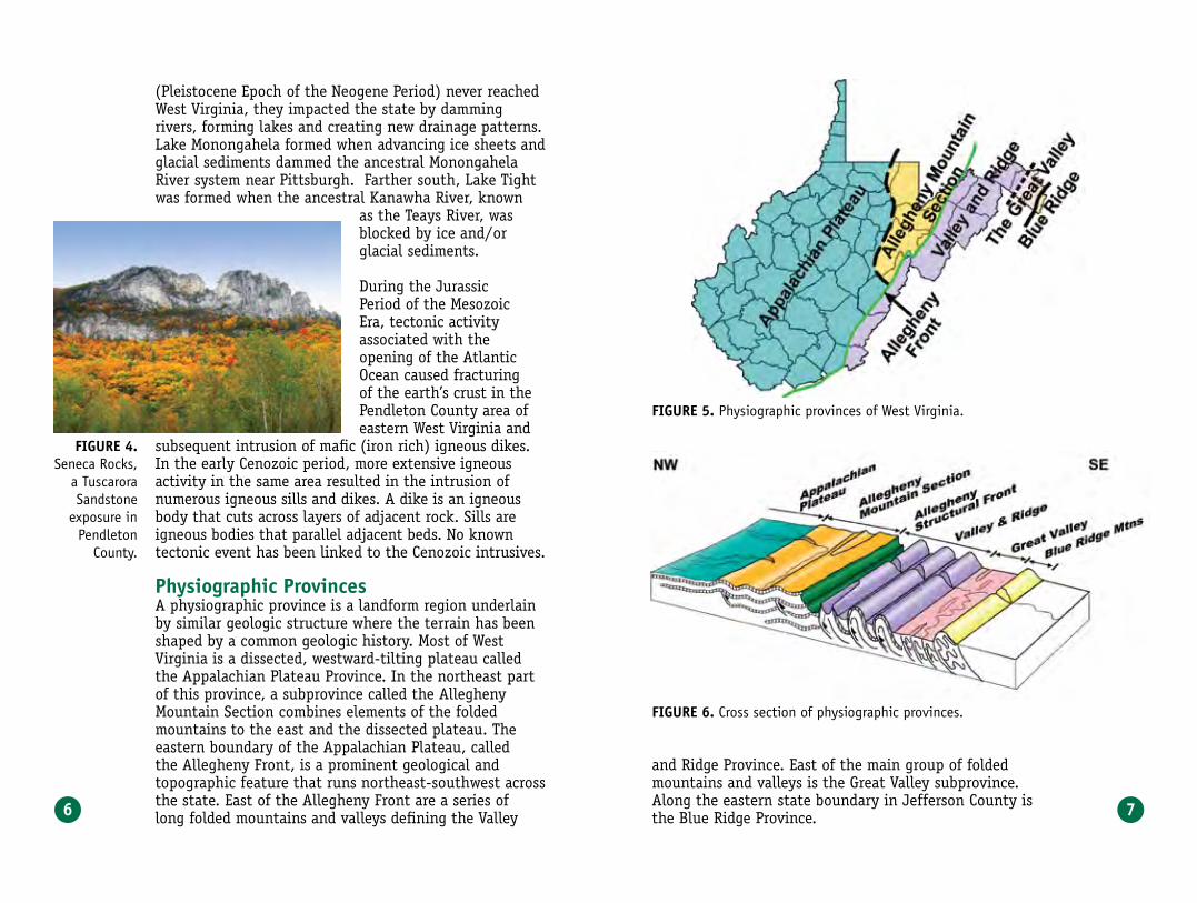
physiographic provincesA physiographic province is a landform region underlain by similar geologic structure where the terrain has been shaped by a common geologic history. Most of West Virginia is a dissected, westward-tilting plateau called the Appalachian Plateau Province. In the northeast part of this province, a subprovince called the Allegheny Mountain Section combines elements of the folded mountains to the east and the dissected plateau. The eastern boundary of the Appalachian Plateau, called the Allegheny Front, is a prominent geological and topographic feature that runs northeast-southwest across the state. East of the Allegheny Front are a series of long folded mountains and valleys defining the Valley
figure 5. Physiographic provinces of West Virginia.
figure 6. Cross section of physiographic provinces.
figure 4.Seneca Rocks,
a Tuscarora Sandstone
exposure in Pendleton
County.
and Ridge Province. East of the main group of folded mountains and valleys is the Great Valley subprovince. Along the eastern state boundary in Jefferson County is the Blue Ridge Province.

8 9
��������������������������
������������������
����������
geology of blaCkwaTer falls sTaTe park
and Canaan valley resorT sTaTe park
introductionThe rugged terrain and thick vegetation cover of the
park areas discouraged Native American settlement in the same manner it discouraged early colonial settlement. The first settlement in what would become Tucker County was made in 1774 between Parsons and St. George on the Cheat River; however, the area drained by the Blackwater River was avoided. Canaan Valley was described in the 1850s by early explorers as so savage and inaccessible that it had rarely been penetrated by even the most adventurous individuals. The vast thickets of rhododendron, which are still found today,
are apparently minor compared to the thick network of original vegetation. Early settlement of the region began after the Civil War to exploit the vast natural resources of lumber and coal. In 1885, with the extension of the West Virginia Central and Pittsburgh Railway to Davis, there was rapid increase in the rates of resource extraction. Intensive logging between 1890 and 1920 and countless forest fires laid waste to much of the region. By the 1920s, the area around Davis was desolate and unrecognizable. Federal protection was finally provided in 1911, which structured the creation of the Monongahela National Forest.
figure 8. Blackwater Canyon from Pase Point.
figure 7. Blackwater Falls State
Park and Canaan Valley
Resort State Park locator
map.
These federal forest lands border the parks in many places, providing large tracts of protected forests. These measures have led to new forest growth, particularly in the stands of spruce on Canaan Mountain.
In 1865, a forest fire cleared out much of the tangled growth, enabling the first settler, Solomon W. Cosner, to make his way across the Allegheny Front and clear some land in the Blackwater area. Cosner found the wild country filled with cattle, horses and stock that had been run in by thieves during the Civil War. The nearest stores were at St. George or Maysville, 25 miles away.
In 1856, Tucker County was formed from the northern end of Randolph County, Virginia. The towns of Davis and Thomas were incorporated in 1889 and 1892, respectively. Davis was a center of the lumber industry. Thomas was associated with railroads and producing coal and lumber. The geologic and written histories of this area are interrelated due to the influence of the physical environment on human activities. The major topographic features such as the position and nature of the ridges,
10 11
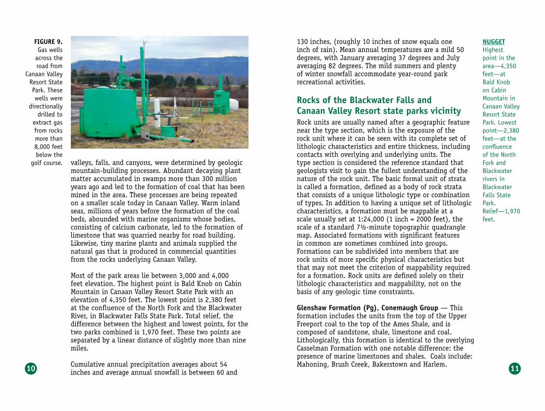
valleys, falls, and canyons, were determined by geologic mountain-building processes. Abundant decaying plant matter accumulated in swamps more than 300 million years ago and led to the formation of coal that has been mined in the area. These processes are being repeated on a smaller scale today in Canaan Valley. Warm inland seas, millions of years before the formation of the coal beds, abounded with marine organisms whose bodies, consisting of calcium carbonate, led to the formation of limestone that was quarried nearby for road building. Likewise, tiny marine plants and animals supplied the natural gas that is produced in commercial quantities from the rocks underlying Canaan Valley.
Most of the park areas lie between 3,000 and 4,000 feet elevation. The highest point is Bald Knob on Cabin Mountain in Canaan Valley Resort State Park with an elevation of 4,350 feet. The lowest point is 2,380 feet at the confluence of the North Fork and the Blackwater River, in Blackwater Falls State Park. Total relief, the difference between the highest and lowest points, for the two parks combined is 1,970 feet. These two points are separated by a linear distance of slightly more than nine miles.
Cumulative annual precipitation averages about 54 inches and average annual snowfall is between 60 and
130 inches, (roughly 10 inches of snow equals one inch of rain). Mean annual temperatures are a mild 50 degrees, with January averaging 37 degrees and July averaging 82 degrees. The mild summers and plenty of winter snowfall accommodate year-round park recreational activities. rocks of the blackwater falls and Canaan valley resort state parks vicinityRock units are usually named after a geographic feature near the type section, which is the exposure of the rock unit where it can be seen with its complete set of lithologic characteristics and entire thickness, including contacts with overlying and underlying units. The type section is considered the reference standard that geologists visit to gain the fullest understanding of the nature of the rock unit. The basic formal unit of strata is called a formation, defined as a body of rock strata that consists of a unique lithologic type or combination of types. In addition to having a unique set of lithologic characteristics, a formation must be mappable at a scale usually set at 1:24,000 (1 inch = 2000 feet), the scale of a standard 7½-minute topographic quadrangle map. Associated formations with significant features in common are sometimes combined into groups. Formations can be subdivided into members that are rock units of more specific physical characteristics but that may not meet the criterion of mappability required for a formation. Rock units are defined solely on their lithologic characteristics and mappability, not on the basis of any geologic time constraints.
glenshaw formation (pg), Conemaugh group — This formation includes the units from the top of the Upper Freeport coal to the top of the Ames Shale, and is composed of sandstone, shale, limestone and coal. Lithologically, this formation is identical to the overlying Casselman Formation with one notable difference: the presence of marine limestones and shales. Coals include: Mahoning, Brush Creek, Bakerstown and Harlem.
figure 9. Gas wells
across the road from
Canaan Valley Resort State Park. These wells were
directionally drilled to
extract gas from rocks more than 8,000 feet below the
golf course.
nuggeTHighest point in the area—4,350 feet—at Bald Knob on Cabin Mountain in Canaan Valley Resort State Park. Lowest point—2,380 feet—at the confluence of the North Fork and Blackwater rivers in Blackwater Falls State Park.Relief—1,970 feet.
12 13
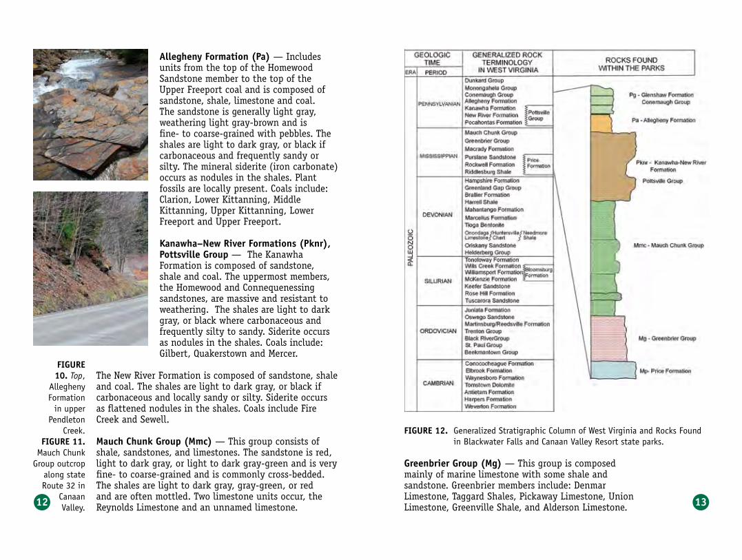
allegheny formation (pa) — Includes units from the top of the Homewood Sandstone member to the top of the Upper Freeport coal and is composed of sandstone, shale, limestone and coal. The sandstone is generally light gray, weathering light gray-brown and is fine- to coarse-grained with pebbles. The shales are light to dark gray, or black if carbonaceous and frequently sandy or silty. The mineral siderite (iron carbonate) occurs as nodules in the shales. Plant fossils are locally present. Coals include: Clarion, Lower Kittanning, Middle Kittanning, Upper Kittanning, Lower Freeport and Upper Freeport.
kanawha–new river formations (pknr), pottsville group — The Kanawha Formation is composed of sandstone, shale and coal. The uppermost members, the Homewood and Connequenessing sandstones, are massive and resistant to weathering. The shales are light to dark gray, or black where carbonaceous and frequently silty to sandy. Siderite occurs as nodules in the shales. Coals include: Gilbert, Quakerstown and Mercer.
The New River Formation is composed of sandstone, shale and coal. The shales are light to dark gray, or black if carbonaceous and locally sandy or silty. Siderite occurs as flattened nodules in the shales. Coals include Fire Creek and Sewell.
Mauch Chunk group (Mmc) — This group consists of shale, sandstones, and limestones. The sandstone is red, light to dark gray, or light to dark gray-green and is very fine- to coarse-grained and is commonly cross-bedded. The shales are light to dark gray, gray-green, or red and are often mottled. Two limestone units occur, the Reynolds Limestone and an unnamed limestone.
figure 12. Generalized Stratigraphic Column of West Virginia and Rocks Found in Blackwater Falls and Canaan Valley Resort state parks.
greenbrier group (Mg) — This group is composed mainly of marine limestone with some shale and sandstone. Greenbrier members include: Denmar Limestone, Taggard Shales, Pickaway Limestone, Union Limestone, Greenville Shale, and Alderson Limestone.
figure 10. Top,
Allegheny Formation
in upper Pendleton
Creek.figure 11.
Mauch Chunk Group outcrop
along state Route 32 in
Canaan Valley.

14 15
figure 13.Generalized
cross section of Blackwater
Falls State Park and
Canaan Valley Resort State
Park.
price formation (Mp) — This group is composed of sandstone and shale. The lower half of the formation consists of interbedded light to medium gray or light to medium gray-green shale and very fine- to coarse-grained sandstone. The sandstones are generally light to medium gray or light to medium gray-green, weathering light gray-brown, and fine- to coarse-grained. Shales are light to medium gray. The Rockwell Member (Mpr) consists of sandstone and shale. Quartz pebbles are scattered throughout the sandstone in this member.
structural geologyDeposition of sediment ceased during the Permian. The sea that had served as a basin of accumulation was finally eliminated by uplift and folding of the rock layers at the end of the Paleozoic Era. Uplift was brought about as a result of the collision of the European and African crustal plates with the North American Plate. This event, called the Appalachian Orogeny, is responsible for the structure of the underlying bedrock and contributes to the topography that we see in the parks today. Folds (anticlines and synclines) in this area are broad and extend across the entire county. The major structural features of the park area are the Blackwater Anticline and the Canaan Valley Fault, a normal or gravity type fault where bedrock planes were broken and offset during the folding of the anticline. The axis of the Stony River Syncline lies just west of Blackwater Falls State
nuggeTThe major structural features of the park area are the Blackwater Anticline and the Canaan Valley Fault.
Park. The parks are located in the eastern section of the Allegheny Mountain Section of the Appalachian Plateau Physiographic Province. The Allegheny Structural Front is about six miles east of Canaan Valley State Park, just east of the Dolly Sods Wilderness Area.
The Blackwater Anticline is a broad uplifted area that lies between the North Potomac Syncline, six to eight miles to the east, and the Stony River Syncline, three to five miles to the west. It extends from Maryland on the North Branch of the Potomac River into Grant County and enters Tucker County in the extreme northeastern corner between Dobbin Ridge and Cabin Mountain. This anticline trends southwesterly for 16 miles to the southwest end of the Canaan Valley, closely paralleling the Little Blackwater River. Rocks exposed at the surface along the anticline in Tucker County range from the lower portion of the Conemaugh Group, down through the Allegheny and Pottsville groups into the Mauch Chunk and Greenbrier groups. The Stony River Syncline crosses the eastern edge of Tucker County and is fairly symmetrical, with the rise to the northwest and southeast being about the same. The surface geology in the syncline ranges from the lower portion of the Conemaugh down through the Allegheny, Pottsville and Mauch Chunk groups. The topography is extremely rugged, with both mountain slopes and valleys covered with sandstone talus or rock fragments.

16 17
figure 14.Southeast
dipping Pottsville
Group sandstone on Cabin
Mountain, eastern
side of the Blackwater Anticline.
Since the end of the Appalachian Orogeny, erosion has slowly reduced the elevation of the Appalachians to what we see today. The forces of weathering slowly break up the rocks from which fragments slide down the slopes into streams and rivers. The sandstones, being the most resistant to weathering, have remained the ridge-formers around the rim of Canaan Valley. They also form the caps of the waterfalls at Blackwater Falls. Sandstone layers were cut through where streams found weaknesses such as fractures and joints in the bedrock, frequently near the axes of anticlines and synclines. The limestones and shales beneath were then weathered and eroded more rapidly to form the broad valleys like Canaan.
The Blackwater River most likely established its course on a plain, then during sequences of uplift, its gradient (steepness of slope) increased. Each uplift event would stimulate and hasten erosion and plain evolution. In several million years the Blackwater may flow once more on a broad plain. Spruce Knob to the south, the highest point in the state at 4,860 feet, by then will be only a modest hill. The eroded material would have been carried to the sea, possibly to be uplifted and form some sandstone-walled canyon millions of years from now. Such is the nature of geology.
nuggeTSeveral million years from now, the Blackwater River may once again flow across a broad plain.

19
figure 15.At left, the Blackwater River continues down the gorge below the falls. Its unusual dark colored water is caused by organic substances, including tannic acid.
figure 16.Above, the main drop of Blackwater Falls is 57 feet.
geology of the falls and gorge
The Blackwater River derives its name from the unusual dark color of its waters that is in sharp contrast to the clear waters of other nearby tributaries of the Cheat. The color originates from organic substances such as tannic acid from the peaty soil of the hemlock and spruce stands and marshes along its course, particularly in Canaan Valley. Historical evidence shows that the water has always been dark. The Blackwater River rises in the southwestern end of Canaan Valley and flows northwestward through marshes and meadows developed on Price Formation and Greenbrier Group rocks. It then turns 90 degrees westward, cutting across the edges of the northwesterly-dipping rocks of the Mauch Chunk and Pottsville groups, and flows down the dip slope of the Pottsville.
The massive sandstone ledges of Blackwater Falls are within the middle portion of Connoque-nessing sandstone of the Kanawha Formation.The main drop of the falls is 57 feet. The Connoquenessing also forms the 40-foot cliff above the falls. A 20-foot shaly section occurs between the Connoquenessing and the overlying Homewood sandstone. The top of the Homewood is at the level of the lodge overlook, where the gorge at this point is about 525 feet deep. The grade of the old Western Maryland railroad that ran between Parsons and Thomas is visible in the lower gorge area from the lodge overlook to the left (west).

20 21
figure 17.Elkala Falls, viewed from
Pendleton Point.
The Blackwater River is 30 miles long, falling 1,500 feet in that distance and draining a basin of 142 square miles. Because the resistant Pottsville rim protects Canaan Valley from being lowered, the gradient (drop) of the river there is only 8.3 feet per mile. However, on the Pottsville near Davis, the gradient is 20 feet per mile. Once the river breaches the resistant sandstone, the gradient in the gorge increases to 136 feet per mile.
The slabby sandstones at Pendleton Point overlook on the north side of the gorge are in the stratigraphically higher and younger Allegheny Formation. The overlook at the lodge on the south side of the gorge is somewhat below the contact between the Pottsville and the overlying Allegheny. The vertical distance from Pendleton Point to the
mouth of Pendleton Run is about 500 feet. Much of the bedrock section is hidden beneath boulders and soil, but, aside from a streak of coal near the base, most of what is visible is sandstone. When the sediments making up these rocks were deposited, the park area was probably near the mouth of a river flowing from the east toward a shallow sea to the west. From time to time, the sea flooded the area and sand was deposited as
figure 18.Above, differential weathering and cross beds, indicating shifting stream channel deposits in Pottsville Group sandstone, at Lindy Point.figure 19.Left, fossil plant imprint in sandstone beneath Pendleton Point.
part of a delta. At other times the sea receded and sand was deposited as bars in a river. Occasionally, the area was covered by the swamps that formed coal deposits. Trunks, limbs, and twigs of trees were buried in the sand and silt. Before they decayed, many left their mark as dark streaks and fossil imprints in the sandstones and are the most characteristic fossils to be found in the park today.
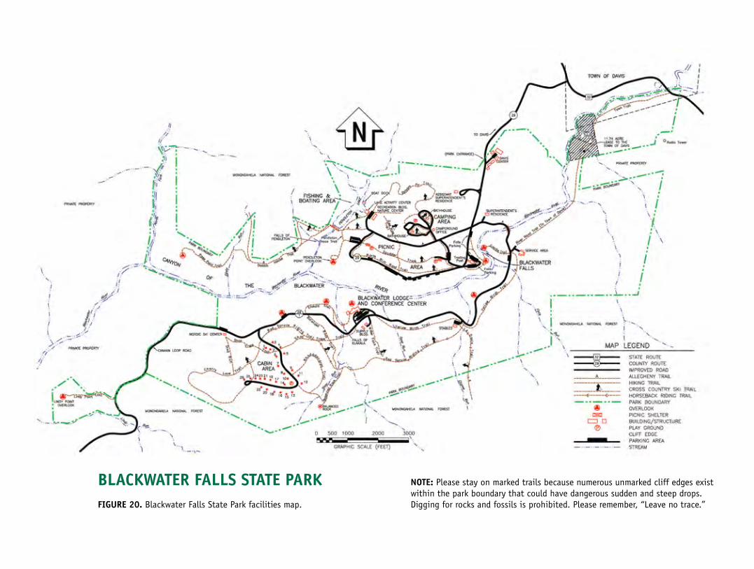
blaCkwaTer falls sTaTe parkfigure 20. Blackwater Falls State Park facilities map.
noTe: Please stay on marked trails because numerous unmarked cliff edges exist within the park boundary that could have dangerous sudden and steep drops. Digging for rocks and fossils is prohibited. Please remember, “Leave no trace.”

24 25
figure 21. Marine
fossil shell (brachiopod) in Greenbrier
limestone.
geology of Canaan valley, Canaan Mountain and Cabin MountainViewing Canaan Valley from the overlook of the Pottsville Group sandstones on Bald and Weiss Knobs, the older rocks of Mississippian age can be seen exposed on the steep slope of the valley walls. Over a vertical distance of about 700 feet, 1,300 feet of rock strata are exposed on the slopes of Canaan Valley due to the anticlinal folding. Once the more resistant Pottsville Group sandstones were breached, the less resistant, older beds of the Mauch Chunk and Greenbrier groups were subsequently removed by physical and chemical actions of the Blackwater River and its tributaries to form Canaan Valley.
The axis or crest of the anticline coincides with a linear, northeast-trending low ridge of Price Formation sandstone located northeast of the park. Farther southwest, the axis of the anticline follows the lower ridge of Greenbrier Limestone to the east of the park area and West Virginia state Route 32 and then swings
southwest across low knolls underlain by beds of the Greenbrier Limestone. Deposition of the Greenbrier Limestone occurred during a time in the geologic past when the area was covered by warm, shallow seas.
Abundant marine life in these seas that provided
the calcium carbonate sediments to form the limestones and marine fossils can readily be found in much of the Greenbrier Limestone today. Limestone is chemically weathered as weak acids dissolve the soluble calcium carbonate. Carbon dioxide dissolves in rain and stream water to form carbonic acid. Forest vegetation can contribute tannic acid to stream and groundwater. Groundwater can become acidified from carbon dioxide in soils. Dissolution (the process of a rock or mineral figure 22. Canaan Valley viewed from Cabin Mountain.
nuggeTThe beds of Greenbrier Limestone that form
Canaan Valley were deposited
during a time when the area
was covered by warm,
shallow seas.
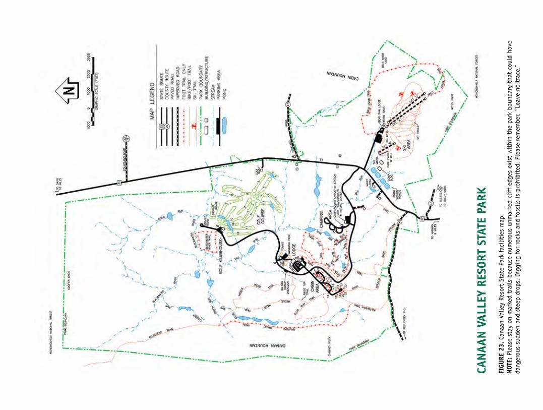
Can
aan
val
ley
reso
rT s
TaTe
par
kfi
gure
23.
Can
aan
Valle
y Re
sort
Sta
te P
ark
faci
litie
s m
ap.
noT
e: P
leas
e st
ay o
n m
arke
d tr
ails
bec
ause
num
erou
s un
mar
ked
clif
f ed
ges
exis
t w
ithi
n th
e pa
rk b
ound
ary
that
cou
ld h
ave
dang
erou
s su
dden
and
ste
ep d
rops
. Di
ggin
g fo
r ro
cks
and
foss
ils is
pro
hibi
ted.
Ple
ase
rem
embe
r, “L
eave
no
trac
e.”

28 29
passing into solution through chemical weathering) of limestone occurs not only at the surface, forming valleys and small depressions, but also in the sub-surface. Dissolution of the Greenbrier Limestone has contributed greatly to the formation of Canaan Valley. The ski slopes, which are on Mauch Chunk red shale and sandstone and basal Pottsville sandstone, are southeast of the axis of the anticline, which means the rocks dip to the southeast. Much of the Canaan Valley park area is on or to the northwest of the axis of the anticline, meaning the rocks here dip to the northwest. The lodge and cabin area are on higher ground, underlain by Mauch Chunk beds, while the entrance, park headquarters, golf clubhouse and golf course are located on the Greenbrier Limestone.
figure 24. Chemically weathered Greenbrier Limestone
along Blackwater River Trail.
differential weathering and erosion Differential weathering, defined as weathering that occurs at different rates as a result of variations in composition and resistance of rock, is responsible for sculpting interesting shapes and features into exposed rock. An example of this is Balanced Rock, near the cabin area of Blackwater Falls Park. The upper part of Balanced Rock has resisted weathering better than the lower zone that has been attacked and eroded by rain water and winter frost. Consequently, a large mass rests on a smaller stem, a rock form that is often called a table rock. The rocks exposed at Lindy Point also exhibit good examples of differential weathering. At many places in the park, weathering of sandstone has removed the cementing substance and the rock has returned to its original state as sediment of loose grains of sand and pebbles. This breakdown of rock by chemical and physical weathering is the first step in soil-forming processes.
figure 25.Balanced Rock, created by differential weathering of sandstone.
figure 26.Examples of differential weathering on exposed rocks at Lindy Point in Blackwater Falls State Park.

30 31
building stones Almost all of the stone used in building the walls and fireplace of the Blackwater Falls Lodge and chimneys of the cabins were quarried about 20 miles away near Aurora, W.Va., in Preston County. These rocks are from sandstones of the Price Formation of Mississippian age. The large blocks used to protect the lawns around the parking lots are local sandstones and conglomerates of the Pottsville Group. This rock is also used in some of the higher terrace walls on the north side of the lodge. Peculiar jagged marks on some of these surfaces are called stylolites, produced in the bed rock by dissolution of the silica sand grains under intense pressure from the weight of thousands of feet of overlying rock layers. The red flagstones leading to the lodge, and in some of the retaining walls leading to the lodge overlook, are Mauch Chunk sandstone obtained from a quarry on the slopes of Weiss Knob at the south end of Canaan Valley.
Light colored, massive stone steps leading to the lodge overlook and paving the overlook itself are Price Formation sandstone quarried near U.S. Route 219 north of Thomas. One of the massive stone steps shows shallow, parallel ridges that were the ripple marks fashioned from the original loose sand by water currents and now preserved in the solid stone. Most of the fine crushed-stone used in the black-top paved roads is Greenbrier Limestone obtained from a quarry on state Route 32 on the edge of Canaan Valley. Mortar sand, which is generally the finest sand available, was quarried and produced from the Pottsville Group sandstone north of Thomas.
figure 27. Blackwater Falls State Park lodge.
periglacial and Canyon ecology
In spite of the lack of glaciers in West Virginia, the impact of climate change coincident with Pleistocene glaciation was profound. The high elevations of the Blackwater-Canaan area resulted in extremely cold climates during glacial intervals. The anomalous local flora are a relic of the much colder climates. A number of plant species thrive in the local bogs much farther south than their usual range in North America, due to this periglacial environment. On Cabin Mountain, east of Canaan Valley, there have been found plants of two aristocrats of the Scottish highlands; Scotch heather and Bell heather. They are found growing wild at only one other spot in North America.
Many other unique and endangered species are found in the Blackwater Canyon region, including: the Virginia Northern Flying Squirrel, Indiana Brown Bat, Cheat Mountain Salamander, Virginia Big-Eared Bat, Northern Water Shrew and Running Buffalo Clover. The Virginia Northern Flying Squirrel is a reclusive nocturnal mammal that is only found in seven counties in West Virginia and one in Virginia. The Indiana Bat is a small brown bat that forages in the canyon and is on the endangered species list. The Cheat Mountain Salamander is one of the smaller woodland salamander species and is endemic to the highlands of West Virginia. Virginia Big-Eared Bats spend winters hibernating in the caves around Blackwater and foraging in warm months within a seven-mile radius of the caves of the canyon.
figure 29.Virginia Big-Eared Bat.
Crai
g St
ihle
rJe
ff H
ajen
ga
figure 28.Cheat Mountain Salamander.

32
suggesTed readings
“West Virginia Adventure Guide Blackwater Falls State Park” by Emily Grafton, Headline Books, 2002.
“History of Davis and Canaan Valley” by Pearle G. Mott, McClain Printing Company, Parsons, WV, 1972.
“History of Tucker County, West Virginia,” by Cleta Long, McClain Printing Co., Parsons, WV, 1996.
Publications of the U.S. Government“Soil Survey Tucker County, Part of Northern Randolph County, West Virginia” by Craig K. Losche and W. W. Beverage, Soil Conservation Service, US Dept. of Agriculture, 1967.
“Physical, chemical, and biological data for four wetland habitats in Canaan Valley, West Virginia” by D.B. Chambers, USGS Open File Report 95-334, 1996.
“Geohydrology and ground-water quality of Southern Canaan Valley, Tucker County, West Virginia” by M.D. Kozar, USGS Water-Resources Investigations Report 96-4103, 1996.
“Water quality and processes affecting dissolved oxygen concentrations in the Blackwater River, Canaan Valley, West Virginia” by M.C. Waldron and J.B. Riley, USGS Water-Resources Investigations Report 95-4142, 1996.

West Virginia Geological and Economic Survey • Morgantown, WV(304) 594–2331 • www.wvgs.wvnet.edu
�������������
��������
���������
������������
����������������
�������������������������������
���������
����������
��������������������
���������
����������
������������������������
�������������
�������������
��������������������
����������
���������
��������������
����������
�����������
�����
����������� ������������
������������
����������
�������
���������������������
������������
������
���������������
������������
�����������
����������
������������
�����������
���������������������
��������
�������
������
����������������������
��������������������
���������������
���������
������
�����������
������������������
����������
������
������
��������������������
�������
���������
���������
�������
���������� ������
���������������������
������������
�����������
�������
�������������������������
���������
��
��
��
��
�� ����������������
�����������
West Virginia State Parks1–800–CALL WVAwww.wvstateparks.com
GEOLOGIC MAPS Canaan Valley Resort State Park and Blackwater Falls State Park A geologic map shows the distribution of different kinds of rocks and structural features (anticlines, synclines, faults, etc.) It is a summary of all the geologist knows in an area, and is usually printed on top of a topographic map, called a base map, for orientation. The base map is printed with light colors so it doesn’t interfere with the geologic features on the map. The geology is represented by colors, lines and special symbols unique to geologic maps. The map itself is usually accompanied by one or more vertical cross sections so that a person can picture rocks at and below the surface in three dimensions.
The rock units depicted on these maps are described in the “Rocks of Blackwater Falls and Canaan Valley Resort state parks vicinity” section, beginning on page 11. The base maps used are the standard USGS 7.5 minute topographic maps. Topographic maps of West Virginia are available from West Virginia Geological and Economic Survey.
INFORMATIONAL LINKS Blackwater Falls State Park .................www.blackwaterfalls.comCanaan Valley Resort State Park ..........www.canaanresort.comCathedral State Park ..........................www.cathedralstatepark.comWest Virginia Geological and Economic Survey .......................................................www.wvgs.wvnet.eduWest Virginia State Parks ....................www.wvstateparks.comWest Virginia Division of Tourism ........www.wvtourism.comMonongahela National Forest ..............www.fs.fed.us/r9/mnfDolly Sods Wilderness ........................ www.fs.fed.us/r9/mnf/sp/dolly_sods_wilderness.htmUnited States Geological Survey ..........www.usgs.gov

Ken Ashton, GeologistLee Stocks, Geologist
West Virginia Geological and Economic Survey
West Virginia Geological and Economic SurveyWest Virginia State Parks
The
Geology of
One in a Series of State Parks Bulletins
Canaan Valley Resort andBlackwater Falls State Parks
West Virginia Department of Commerce
Related Documents