GEOLOGY VOL. 32, NO. 2

Welcome message from author
This document is posted to help you gain knowledge. Please leave a comment to let me know what you think about it! Share it to your friends and learn new things together.
Transcript

GEOLOGY
VOL. 32, NO. 2

CONTENTS
PAMAP—the future of topographic maps................................................. 1Dry wells, streams, soil: groundwater and the drought............................. 2Photos from the past: solving the mystery of the Yocumtown fossil footprints 7Announcements ....................................................................................... 13Earth science teachers’ corner................................................................. 15
ON THE COVER
Mud cracks on the bottom of the Youghiogheny River Lake basin during thefall of 1991. The cracks are in sediments that were eroded from Mississippianand Pennsylvanian rocks in Maryland, carried downstream, and deposited asthe current slowed. Because of recent drought conditions, the lake was 10to 15 feet lower than its normal level when this photograph was taken (seearticle on page 2 for a discussion of this year’s drought). At this site in 1752,George Washington and his troops crossed the Youghiogheny River on theirway to Fort Duquesne. Later, this area was the location of the resort townof Somerfield, which was destroyed when the Army Corp of Engineers con-structed the reservoir for flood-control purposes in the late 1940s. Photo-graph by Jim Shaulis.
PENNSYLVANIA GEOLOGY
PENNSYLVANIA GEOLOGY is published quarterly by the Bureau of Topographic andGeologic Survey, Pennsylvania Department of Conservation and Natural Resources,3240 Schoolhouse Road, Middletown, PA 17057–3534.Editors: Anne B. Lutz, Caron E. O’Neil, and Jay B. Parrish.Contributed articles are welcome. Guidelines for manuscript preparation may be obtainedat www.dcnr.state.pa.us/topogeo/mag-ins.htm or by contacting the editors at the addresslisted above.Articles may be reprinted from this magazine if credit is given to the Bureau of Topographicand Geologic Survey.
VOL. 32, NO. 2 SUMMER 2002
DEPARTMENT OF CONSERVATION AND NATURAL RESOURCESBUREAU OF TOPOGRAPHIC AND GEOLOGIC SURVEY
IN COOPERATION WITH THE U.S. GEOLOGICAL SURVEYTOPOGRAPHIC MAPPING
GROUNDWATER-RESOURCE MAPPING
Main Headquarters3240 Schoolhouse Road
Middletown, PA 17057–3534717–702–2017
FAX: 717–702–2065
Pittsburgh Office500 Waterfront Drive
Pittsburgh, PA 15222–4745412–442–4235
FAX: 412–442–4298
BUREAU STAFF AND TELEPHONE NUMBERSDirector and State GeologistJay B. Parrish, P.G. 717–702–2053
Assistant DirectorSamuel W. Berkheiser,
Jr., P.G. 717–702–2055
Administrative ServicesElizabeth C. Lyon 717–702–2063
Library ServicesRichard C. Keen 717–702–2020
Publication ServicesJody R. Zipperer
(General Inquiries) 717–702–2073Christine E. Miles, P.G. 717–702–2044Caron E. O’Neil, P.G. 717–702–2042Anne B. Lutz 717–702–2043
Local Government Outreach ServicesKristen L. Reinertsen
(East) 717–702–2047Jaime Kostelnik (West) 412–442–5828
Web and Computer ServicesKristin J. H. Warner 717–702–2029
Database ServicesCheryl L. Cozart 412–442–4234Karen L. Andrachick (Oil
and Gas GIS Services) 412–442–5826Janice Hayden 412–442–4287Joseph E. Kunz 412–442–4235Lynn J. Levino 412–442–4299
GIS ServicesMichael E. Moore, P.G. 717–702–2024John H. Barnes, P.G. 717–702–2025Thomas G. Whitfield, P.G. 717–702–2023Stuart O. Reese, P.G. 717–702–2028
GIS Services (continued)John G. Kuchinski 717–702–2027James H. Dolimpio 717–702–2026Water Well ServicesSharon E. Garner 717–702–2074Jody R. Zipperer 717–702–2073Groundwater ServicesGary M. Fleeger, P.G. 717–702–2045Thomas A. McElroy, P.G. 717–702–2046Geologic Mapping ServicesJon D. Inners, P.G. 717–702–2034Gale C. Blackmer 717–702–2032Helen L. Delano, P.G. 717–702–2031Clifford H. Dodge, P.G. 717–702–2036William E. Kochanov, P.G. 717–702–2033James R. Shaulis, P.G. 717–702–2037Viktoras W. Skema, P.G. 717–702–2035Laboratory and Geochemical ServicesRobert C. Smith, II, P.G. 717–702–2021Leslie T. Chubb 717–702–2022Coal-Bed Methane ServicesAntonette K. Markowski,
P.G. 717–702–2038Coal Quality and Availability ServicesRodger T. Faill, P.G. 717–702–2041Leonard J. Lentz, P.G. 717–702–2041John C. Neubaum 717–702–2039Oil, Gas, and Subsurface GeologicalServicesJohn A. Harper, P.G. 412–442–4230Christopher D. Laughrey 412–442–4232Joseph R. Tedeski 412–442–4295Kristin M. Carter, P.G. 412–442–4233Lajos J. Balogh 412–442–4231
COMMONWEALTH OF PENNSYLVANIAMark Schweiker, Governor
DEPARTMENT OF CONSERVATION AND NATURAL RESOURCESJohn C. Oliver, Secretary
OFFICE OF CONSERVATION AND ENGINEERING SERVICESRichard G. Sprenkle, Deputy Secretary
BUREAU OF TOPOGRAPHIC AND GEOLOGIC SURVEYJay B. Parrish, Director
Bureau web site: www.dcnr.state.pa.us/topogeoDCNR web site: www.dcnr.state.pa.us
Pennsylvania home page: www.state.pa.us

STATE GEOLOGIST’S EDITORIAL
PAMAP—The Future ofTopographic Maps
For more than 100 years, the Pennsylvania Geological Surveyand the U.S. Geological Survey (USGS) have partnered to make topo-graphic maps of the state. The 1:24,000-scale, 7.5-minute maps areused by hikers, businesses, campers, consultants, girl scouts, explo-rationists—you name it. Well, all that is coming to an end. Here’s why:Pennsylvania spends more money on updating topographic maps thanall the other states combined. Even so, it would take 130 years to up-date all of the maps given our current budget. So we have to find afaster, cheaper way to get up-to-date maps into the hands of the public.
The solution is to continue the USGS-Pennsylvania GeologicalSurvey partnership but use it to produce a digital, seamless, and cur-rent on-line map called PAMAP, a pilot of the National Map. We willbe basing it on county-level data available at 1:2400 scale and usingan orthoimage with 2-foot pixels as the base. So you can see, it willbe much more detailed than the old 1:24,000-scale maps and, by part-nering with counties, much more current.
My hope is that the counties will receive orthophotography andprovide vector data for PAMAP on a regular basis. These vector lay-ers will include parcels, buildings, transportation, hydrology, topogra-phy, monuments, and boundaries. You could look at the data on-line,print it, or download it for use on your own system.
These maps may take a few years toconstruct. The state budget is tight, as youmay have heard. But this is critical for pub-lic safety and economic development. Andwe have partners in the USGS and localgovernment who will make it possible, forwhich I’m grateful. We will be working withyour county to obtain or create data, whichwill be interoperable with any other county.It all boils down to relationships.
Jay B. ParrishState Geologist

Dry Wells, Streams, Soil:Groundwater and the Drought
by Gary M. FleegerBureau of Topographic and Geologic Survey
As I write this article, Pennsylvania is once again in the grip ofa drought. Stream levels in many areas are noticeably low. Many wellshave dried up. In the past decade, Pennsylvania has experienced anumber of droughts. What exactly is a drought, and how does a droughtaffect the amount of water available to us? What crucial role doesgroundwater play?
SOME WATER-BUDGET BASICS. To begin, we need to understanda little about groundwater flow and the water budget.
In any area, there is a water budget (Figure 1). Water is input, orrecharged, into the groundwater system mainly through the infiltra-tion of precipitation. Water is removed, or discharged, from the ground-water system by various natural and artificial means: (1) groundwaterdischarge (springs and seeps), or base flow, to surface water bodies,(2) evapotranspiration, and (3) water wells. Groundwater is stored with-in the rocks. The difference between the amount of water input intogroundwater storage and the amount of water removed from storageis the change in groundwater storage. If more water enters the systemthan leaves over a period of time, groundwater storage increases. Ifmore leaves than enters, groundwater storage decreases and ground-water levels drop.
The amount of water recharged to and discharged from the sys-tem varies throughout the year. Although we get a significant amountof precipitation in the summer, very little of it becomes part of thegroundwater storage. Because of the large amount of vegetation inPennsylvania, most of the summer precipitation is taken up by plantsand transpired back into the atmosphere. Recharge to the ground-water system primarily takes place from fall through spring. Plantsare dormant at these times, and if the ground is not frozen, water in-filtrates to the groundwater system (Figure 2). Water that was re-moved from groundwater storage during the summer is then replaced.
TYPES OF DROUGHT. There are three types of drought, which oftenoccur simultaneously (Alley and others, 1999). A meteorological drought
2

is the result of reduced precipitation for an extended period of time.It is the cause of the other two types of drought—agricultural drought(dry soil conditions) and hydrological drought (significantly reducedgroundwater levels).
There are two main effects of a hydrological drought. First, shal-low wells may go dry as the groundwater level drops below the bot-tom of the wells. Second, as the groundwater level drops, streamflowis reduced. The majority of water flowing in a stream is derived fromthe natural discharge of groundwater. During a meteorological drought,virtually all streamflow is derived from groundwater. Because of the
3
GROUNDWATERSTORAGEover 100 inches
13 inches
20
inc
he
sT
OT
AL
ST
RE
AM
FLO
W
BASE FLOW
13 inches
7 inches
SURFACE
RUNOFFINFILTRATION
PR
EC
IPIT
AT
ION
42
inch
es
22
inches
TR
AN
SP
IRA
TIO
N
EV
AP
O-
Figure 1. The average annual water budget for Pennsylvania includes ground-water, surface water, and atmospheric components (from Fleeger, 1999, p. 7).The groundwater component includes recharge, discharge, and storage.

slow flow of groundwater and the lag time between a precipitationevent and recharge to groundwater storage, it may take awhile for ahydrological drought to develop, even though a meteorological andagricultural drought may have been under way for some time.
The timing of a meteorological drought controls whether it is ac-companied by an agricultural or hydrological drought. If the rainfalldeficit starts during the summer, there is a serious depletion of soilmoisture, and an agricultural drought occurs. However, because littleprecipitation reaches the water table in the summer, a hydrologicaldrought is less likely to occur unless the reduced precipitation con-tinues into the fall. A meteorological drought during the fall, winter,or spring is more likely to cause a hydrological drought. The conse-quences of an agricultural drought are minimized if it occurs duringthe winter because most vegetation is dormant during that time.
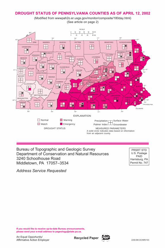
DROUGHT STATUS. The U.S. Geological Survey and U.S. NationalWeather Service monitor precipitation, groundwater levels, surfacewater (streamflow and reservoir levels), and soil moisture across thestate (wwwpah2o.er.usgs.gov). These four parameters help the Penn-sylvania Department of Environmental Protection to determine theexistence and severity of overall drought conditions (back cover). Pre-cipitation data are analyzed for variance from 30-year monthly aver-ages. Surface and groundwater conditions are based on measure-ments at stream gages and observation wells across the state. Soilmoisture is reported using the Palmer Drought Severity Index.
The map on the back cover shows the drought status as declaredby the Governor for each county as of April 12, 2002. Drought con-ditions are classified as normal, watch, warning, or emergency status.As of mid-April, the drought was most severe in the southeastern part
4
V
V V
V
V V
SeptemberAugustJulyJuneMayApril
Rain in the spring causesgroundwater levels to rise
Little rain reaches the groundwater systemin the summer because of high evapotranspiration
4
3
2
1
0
RA
IN(in
ches
)
8
7
6
5
4
(fee
t bel
ow la
nd s
urfa
ce)
GR
OU
ND
WA
TE
RLE
VE
LV
VRain
Groundwater level in well
Figure 2. A 6-month graph of the water level in a well versus precipitation(from Fleeger, 1999, p. 11). Precipitation has less effect on groundwater levelsduring the summer than at other times of the year.

of the state. On the map, the boxes inside each county illustrate thedrought status of the monitored parameters for the underlying county.The precipitation levels are based on deficits from the monthly aver-ages during the previous 180 days. As can be seen on the map, thedrought status of a county is not entirely based on a single parameteror combination of parameters. The continuity of conditions, weatherforecasts, and other current information are factored into the decisionto change a county’s drought status.
THE DROUGHT OF 2001–02. This past fall and winter, while con-ditions were best for infiltration of precipitation, there was very littleprecipitation in much of Pennsylvania. As a result, the amount ofgroundwater storage decreased, rather than increased, during thistime (Figure 3). Therefore, the state is in a hydrological drought.
At the current time (mid-April 2002), lawns are starting to greenas a result of recent rains. These rains have been sufficient to alle-
5
J F M A M J J A S O N D J F M A M J J A S O N D2001 2002
30-D
AY
MO
VIN
GA
VE
RA
GE
OF
DE
PT
HT
OW
AT
ER
(fee
tbe
low
land
surf
ace)
–10
11
–12
–13
–14
–15
–16
–
Figure 3. Water levels in the Chester County observation well (modified fromwwwpah2o.er.usgs.gov/monitor/gw/images/w30_ch10.html [April 12, 2002]).The black line indicates the 30-day moving average of depth to water. For anygiven day, this value represents the average value of the depth to water recordedfor each of the 30 preceding days. The light through dark shades of red areranges for the normal, watch, warning, and emergency drought condition levels,respectively. Where the black line dips below the shaded areas, it represents anew recorded low for the 30-day moving average.

viate the agricultural drought conditions. If we continue to get adequateprecipitation, we will see an end to the meteorological and agricul-tural droughts. Unfortunately, sustained precipitation will not end thehydrological drought, because once the leaves are out, most of theprecipitation will be taken up by the vegetation. Little will reach thewater table and be added to groundwater storage, which is alreadybelow normal.
Meteorological and agricultural droughts can end relatively quicklywith a return to adequate precipitation. These drought types are notcumulative. In contrast, just as it takes longer for hydrological droughtconditions to develop than it does for meteorological and agriculturaldrought conditions, recovery from a hydrological drought takes a longerperiod of time. Even after precipitation has returned to “normal” levels,a hydrological drought will continue. Not only is there the lag time forthe precipitation to be added to groundwater storage, but the hydrolog-ical drought is cumulative. Enough water must be returned to ground-water storage to raise the groundwater levels back to near their pre-drought levels before the hydrological drought is over. Some parts ofPennsylvania have not yet fully recovered from the hydrological droughtof 1998–99. Because we are now entering the spring and summergrowing season when little precipitation will reach the water table,and groundwater levels have not reached their predrought levels,the hydrological drought will likely last through the summer, even ifwe do get a “normal” amount of precipitation.
MORE INFORMATION. Up-to-date hydrologic and drought conditioninformation can be found on the U.S. Geological Survey web site atwwwpah2o.er.usgs.gov. In addition to the current conditions, this siteincludes details of the monitoring program, criteria used in droughtdetermination, and definitions of the various drought levels. Additionalinformation can be found on the Pennsylvania Department of Envi-ronmental Protection web site at www.dep.state.pa.us (DirectLINK“drought”). As always, please contact the Pennsylvania GeologicalSurvey if you have a question about the drought or any other Penn-sylvania geological topic.
REFERENCES
Alley, W. M., Reilly, T. E., and Franke, O. L., 1999, Sustainability of ground-water re-sources: U.S. Geological Survey Circular 1186, 79 p.
Fleeger, G. M., 1999, The geology of Pennsylvania’s groundwater: PennsylvaniaGeological Survey, 4th ser., Educational Series 3, 34 p.
6

PHOTOS FROM THE PAST:SOLVING THE MYSTERY OF THEYOCUMTOWN FOSSIL FOOTPRINTS
by Bill Melater*Bureau of Topographic and Geologic Survey
THE PHOTOS. Not a breeze stirred. The steamy afternoon air clungto my skin like a blanket of $1.95 plastic wrap. The whir of fans andthe humming of air conditioners brought attention to the battle betweenhot and cold taking place along Third and Reily Streets. It was a los-ing battle, but it was summer. Summer in the capital city.
I was working the day shift out of the survey office, trying to cor-relate a layer of sandstone across two counties, when SHE turned thecorner into my cubicle and asked if I could help her. I knew I had to.It was my job. I’m a geologist.
Without a word, she handed me a small package wrapped inlunch-bag brown paper. As I slowly unwrapped it, she began her story.
It seemed that while scanning through Pennsylvania GeologicalSurvey General Geology Report 1 (Ashley, 1931), she had noted twophotographs on page 78 that displayed fossilized footprints on anoutcrop of Triassic bedrock near Yocumtown, York County (Figures1 and 2).
Coming on the heels of the discovery of the Graterford trackway(Sullivan and others, 1994), the unearthing of these photographs hadled her to make some futile attempts to locate the outcrop shown.There were references to dinosaur footprints near Yocumtown, but aprecise location was never mentioned (Hickok and Willard, 1933;Stose and Jonas, 1939).
“So who’s the stiff in the picture?” I asked, looking across the clut-tered expanse of office. “I’m not sure,” she replied, “but if you could findout, this could be an important clue to uncovering the footprint location.”
I turned her story over and over in my head. Just identify the manin the photo and this will lead her to the footprints? It all seemed tooeasy. What had really brought her to my desk? Sullivan was the realmastermind behind the Graterford tracks. . . .
7
*a.k.a. Bill Kochanov

“Dr. Sullivan was my first contact,” she threw out, as though shewere reading my thoughts, “but he’s been out of town. Some sort ofcutting-edge research in the deserts of New Mexico.”
I checked my schedule and my lunch bag before taking the case.I gave her my card and told her I’d call if I discovered anything. I lether out the door and watched as she slid into a metallic-blue FordTaurus. As if mesmerized, I stayed there until she made her way tothe end of the street and disappeared around the corner.
I was puzzled. Who was that man in the photograph? What didSullivan know about the pictures? The answers to these questionsswam tantalizingly before me as I came to a sudden realization. I hadlocked myself out of the building.
THE SEARCH. After being let back into the office, my first stop wasthe library, where I met with an old friend, Chin Fong Yee, the librarian.He greeted me in his usual cheerful manner as I smiled and crypticallydropped into his hand a weathered piece of paper I had pulled outof my pocket. He unfolded the paper and spent several minutes read-ing and rereading the faded parchment before looking into my eyesand, with a look of understanding, saying in a joking voice, “Steameddumplings and a pint of pork fried rice? You should clean out your
8
SNYDER
FR
AN
KL
IN
ADAMSYORK
CUMBERLAND
PERRY
JUNIATA
MIFFLIN
DAUPHIN
LEBANON
NORTHUMBERLAND
LANCASTER
CHESTER
DELAWARE
MONTGOMERY
BUCKSBERKS
SCHUYLKILL
LEHIGH
NORTHAMPTON
PHILADELPHIA
75°
77° 76°
40°
75°
SCALE0
0
20 MI
30 KMMD.
DEL.
N. J.
Yocumtown
Figure 1. Map of southeastern Pennsylvania showing Yocumtown, Pa., andthe location of Triassic and Jurassic rocks (red) in the state (modified fromPennsylvania Geological Survey, 1990).

pockets more often.” We both laughed as he tossed the old lunch re-ceipt into a nearby wastebasket.
We made our way to a small table away from the main flow ofpatrons. “What do you make of this, Chin?” I asked, holding out thebook. “Check out page 78.” Chin carefully studied the photos andmuttered, “It looks like someone from the ’20s or possibly the ’30s,educated, maybe a college student, and about size 10 EE boots andsize 7-1/2 hat. That’s about as close as I can get. However, I thinkyou’ll have better luck with a colleague of mine, Dr. Miles O’Neill, whoworks for the Government Clearinghouse for Geologic Documents.”
I tucked away this bit of information as I went back to my deskto examine the photos once again. I pulled out my 10x hand lens and,after careful scrutiny of the outcrop, decided that there were a fewpossibilities. It could be the highwall of a small quarry, a railroad cutor roadcut, or perhaps an area along a stream.
This led to my examination of topographic maps printed at vari-ous times and at different scales. I spent days looking at the crum-bling maps and reviewing dusty literary sources that I found hiddenbehind a stack of time cards from 1985.
I chose likely areas to investigate around Yocumtown from thetopographic and geologic maps, and I made a field reconnaissancesurvey. The field survey, however, proved to be unsuccessful. It seemedthat all my efforts to unravel this mystery had ended up in knots.
Then it happened. It jumped out at me like a lunch special atDick’s Diner. It turned out to be the turning point in the case. Logichad left and dumb luck had entered the cubicle.
JUST FOLLOW THE FOOTPRINTS . . . It was 2:28 when the callcame. With some degree of expeditiousness, I reached out to the tele-phone, knocking over a jar of Mom’s homemade pickles, and blurtedout, “Hello, Bill Melater, Professional Geologist.” The response mademy jaw drop. There went another gherkin. Of all of the possible peo-ple in the world, I never thought it would be him. It was Dr. Sullivan.
Dr. Robert M. Sullivan, world-renowned paleontologist and Se-nior Curator at the Pennsylvania State Museum. We had worked to-gether on the Graterford job a few years back and small jobs off andon since then—but why was he calling?
I almost fell off the chair when he told me. It appeared that hehad just received a letter from someone that contained a referenceto dinosaur footprints in a small quarry behind that person’s house.The address was Yocumtown, York County.
9

Yocumtown! Could this possibly be the site I was searching for?We hastily made plans to visit the site and examine the fossil
footprints on the property. It was a sunny afternoon when we arrived
Figure 2. Photographs from General Geology Report 1 showing the unidenti-fied person pointing to the fossil footprints.
10
A
B

at a beautifully built brownstone house in York County. We were di-rected to a small quarry around the back of the house, and sureenough, the footprints were there. It was even more startling when
11
Figure 3. Recent photographs showing Dr. Sullivan pointing to the fossil foot-prints.
A
B

Dr. Sullivan climbed up the outcrop and pointed to the footprints. Bellsrang in my head as it immediately became clear that these were thesame footprints that were shown in the photographs in General Ge-ology Report 1 (Figure 3).
THE IDENTIFICATION. Born out of curiosity and the strange resem-blance of the man in the photograph to Dr. Sullivan, one question stillremained. Who was that gentleman?
On the ride back to the office, I recalled Chin’s referral to Dr. MilesO’Neill. Upon my arrival, Miles led me to the Pennsylvania Geologi-cal Survey’s collection of photographs. As I found out, the Survey hasa vast collection of historic photographs that somehow escaped dam-age from the flood caused by tropical storm Agnes in 1972. I beganmy search, leaving the half-jar of Mom’s pickles back at my desk.
Fortunately for me, the collection of photographs was indexed.Under the York County heading, there were three listings for “fossils.”As luck would have it, the first two listings were the two original pho-tographs in General Geology Report 1.
The first photograph was mounted on a card that provided addi-tional information. It read that the photograph was taken by George H.Ashley (first director of the Fourth Pennsylvania Geological Survey)on October 3, 1923. On the back of the card was a handwritten entrydescribing the photograph. The name “Bissell” was also written. WasBissell the individual in the photograph? Further research in personnelrecords indicated that a gentleman by the name of Malcolm HavensBissell worked for the Pennsylvania Geological Survey during thattime period. I had found the gentleman in the photograph.
EPILOGUE. With some detective work and a little bit of luck, the ques-tions surrounding the Yocumtown fossil footprints were answered tomy client’s satisfaction. I pushed my back into the padded desk chair,feeling at ease as I handed her the final report on the Yocumtownphotos.
A soft smile spread across her face as she reflected, “It’s alwaysinteresting to note the similarities between geology and sleuthing.Outcrops of bedrock and pieces of rock provide geologists with thenecessary clues to solve the mysteries of Pennsylvania’s geology.”I nodded my head in agreement.
She is gone now, but there will be others. After all, it’s a place ofintrigue and mystery, this Pennsylvania.
12

13
ACKNOWLEDGMENTS. Thanks to Dr. Robert M. Sullivan (State Mu-seum of Pennsylvania) and Kesler Randall (San Diego Natural HistoryMuseum) for organizing the expedition to the Yocumtown site, GlenEbersole for bringing the footprint locality to our attention and for his on-site cooperation, Tina Miles and Caron O’Neil for help “tracking” downthe photographs, and Dr. Donald M. Hoskins and Shirley Barner forhelpful hints and direction with regard to identifying the mystery man.
The rock slab containing the footprints has been removed andis now in the collections of the State Museum of Pennsylvania.
REFERENCES
Ashley, G. H., 1931, A syllabus of Pennsylvania geology and mineral resources: Penn-sylvania Geological Survey, 4th ser., General Geology Report 1, 160 p.
Hickok, W. O., IV, and Willard, Bradford, 1933, Dinosaur foot tracks near Yocumtown,York County, Pennsylvania: Proceedings of the Pennsylvania Academy of Science,Harrisburg, Pa. v. 7, p. 55–58.
Pennsylvania Geological Survey, 1990, Geologic map of Pennsylvania (3rd ed.): Penn-sylvania Geological Survey, 4th ser., Map 7, scale 1:2,000,000.
Stose, G. W., and Jonas, A. I., 1939, Geology and mineral resources of York County,Pennsylvania: Pennsylvania Geological Survey, 4th ser., County Report 67, p. 120–121.
Sullivan, R. M., Randall, Kesler, Hendricks, Michael, and Kochanov, W. E., 1994,The Graterford dinosaurs—tracking Triassic travelers: Pennsylvania Geology, v. 25,no. 4, p. 2–9.
The Pennsylvania GeologicalSurvey’s database of water wellrecords (Pennsylvania Ground-water Information System, orPaGWIS) is now available for freeon our web site. The home page(www.dcnr.state.pa.us/topogeo)contains a link to PaGWIS, whereon-line searches can be per-formed. Data for a single county
of interest or for the entire statecan be downloaded.
ANNOUNCEMENTS
PaGWIS Now Availableas a Free On-Line Database
E S T. 1 8 3 6
PENN
SYLV
AN
IAGEOLOGICAL
SURVEYPa GWIS

The Pennsylvania GeologicalSurvey has made PaGWIS avail-able on CD since 1998. PaGWIScontains Microsoft® Access data-bases and ESRI® ArcExplorerfiles. Many businesses and aca-demic institutions have purchasedPaGWIS on CD for a multitude ofuses. However, the data on theCD have not been updated since1999. Some additional data are in-cluded in the new on-line version.
Also available for download-ing are the same queries andforms necessary for user-friendlysearches as those found on theCD, and the files for use with Arc-Explorer® or ArcView®. ArcEx-plorer® can be downloaded forfree from the ESRI® web site atwww.esri.com.
The PaGWIS link from theSurvey home page takes you toa site where you can create an
account to log on to PaGWIS.Creating an account is free andrequires only your e-mail address,a password, and your affiliation.After the account is established,you can subsequently log on toPaGWIS by entering your e-mailaddress and password.
Some well data from recentyears are not yet in PaGWIS andare only available in paper formfor viewing and copying at ourMiddletown office. If you cannoteasily travel to our office, we canphotocopy all of the records for arequested municipality for a nomi-nal charge.
If you have any questions orsuggestions for the improvementof PaGWIS, please contact thePaGWISard Gary Fleeger at 717–702–2045 or at the mailing ad-dress shown on the inside backcover.
14
67th Field Conference ofPennsylvania Geologists to beHeld in Susquehanna County
This year’s Field Conferenceof Pennsylvania Geologists, en-titled The Geology of the EndlessMountains, will be headquarteredin Tunkhannock, Pa. It will be heldon October 3–5, 2002. Attendeeswill be treated to a variety of gla-cial, bedrock, and historical visualdelights. In addition to the two-dayfield trip, three pre-conference trips
DAY ONE1. State Aggregates
quarry2. Old Starrucca
Viaduct (Grover’s)quarry and glacialkame
3. Starrucca Viaduct4. Endless Mountain
Stone Companyquarry
5. Gravel pit in esker
DAY TWO6. Nicholson Viaduct7. Glacial sluiceway
divide8. Grover’s gravel pit
(ice-contactstratified drift)
9. Railroad cut10. Salt Spring State
Park11. Gravel pit (optional)
PLANNED STOPS
15
The Pennsylvania GeologicalSurvey has recently published re-vised editions of two EducationalSeries (ES) booklets. The book-lets are Educational Series 7,Coal in Pennsylvania, and Edu-cational Series 8, Oil and Gasin Pennsylvania.
Coal in Pennsylvania is a 28-page booklet that was revised byWilliam E. Edmunds, consultinggeologist (formerly a geologistwith the Survey). Coal is an impor-tant natural resource of the state,having been mined since 1761;approximate remaining resources
EARTH SCIENCE TEACHERS’ CORNER
Coal in Pennsylvania andOil and Gas in PennsylvaniaRejoin Educational Series Lineup
are planned, one to the Wyalusing-French Azilum area, one to ex-amine sites related to Glacial LakeGreat Bend, and the other to theNicholson Viaduct and Tunnels.
The Field Conference is spon-sored by the Pennsylvania Geo-logical Survey; Bloomsburg Uni-versity; Pennsylvania Departmentof Environmental Protection; Ex-calibur Group, LLC; Friends ofSalt Spring State Park; Susque-hanna County Historical Society;Bradford County Historical Soci-
ety; and French Azilum HistoricalSite (Pennsylvania Historical andMuseum Commission).
The announcement and regis-tration forms will be available inlate July on the Field Conferenceweb page at www.paonline.com/gfleeger/fcopg. For a hard copy ofthe forms, please send your nameand address to Field Conferenceof Pennsylvania Geologists, c/oPennsylvania Geological Survey,3240 Schoolhouse Road, Middle-town, PA 17057–3534.
IN PENNSYLVANIA
COMMONWEALTH OF PENNSYLVANIADEPARTMENT OF
CONSERVATION AND NATURAL RESOURCES
BUREAU OFTOPOGRAPHIC AND GEOLOGIC SURVEY
Educational Series 7

16
are 76.4 billion tons. Coal formsby the accumulation and altera-tion of plant material over millionsof years. Several illustrations showthe types of plants that grew inthe Pennsylvanian Period, 290to 323 million years ago, whichis the age of most of the coal inPennsylvania. The types, or ranks,of coal include bituminous and an-thracite, both of which are minedin Pennsylvania. The distributionof these types of coal in the stateis shown on a centerfold map. Themethods of mining coal are alsoexplained.
Oil and Gas in Pennsylvania,32 pages long, has been com-pletely revised and has all new il-lustrations. The booklet was writ-ten by Kathy J. Flaherty of theAbarta Oil and Gas Company(formerly a geologist with the Sur-vey) and Thomas Flaherty, III, ofthe Department of Environmen-
tal Protection. “Spud,”a knowledgeable oil-barrel character, ex-plains various aspectsof the petroleum in-dustry throughout thebooklet. Petroleum isformed by the accu-mulation and preser-
vation of dead organic material.Algae and microscopic creaturesthat lived in the ocean are thoughtto be the major contributors. Theauthors explain why petroleumaccumulates in certain rock units
and how it is obtained by drillingwells that penetrate these units.Other topics include how geologyis used to find favorable locationsto drill; procedures that are usedto obtain as much petroleum aspossible from the rocks; and therefinement of oil. ES 8 has a cen-terfold map showing the distribu-tion of oil and gas fields in Penn-sylvania.
Copies of these two new book-lets, as well as other booklets inthe Educational Series, are freeupon request from the Pennsyl-vania Geological Survey, 3240Schoolhouse Road, Middletown,PA 17057–3534, telephone 717–702–2017. The booklets are alsoavailable on the Survey web siteat www.dcnr.state.pa.us/topogeo/pub/pub.htm.
SPUD
COMMONWEALTH OF PENNSYLVANIADEPARTMENT OF
CONSERVATION AND NATURAL RESOURCESBUREAU OF TOPOGRAPHIC AND GEOLOGIC SURVEY
OIL AND GAS IN
PENNSYLVANIA
Educational Series 8

CONTENTS
PAMAP—the future of topographic maps................................................. 1Dry wells, streams, soil: groundwater and the drought............................. 2Photos from the past: solving the mystery of the Yocumtown fossil footprints 7Announcements ....................................................................................... 13Earth science teachers’ corner................................................................. 15
ON THE COVER
Mud cracks on the bottom of the Youghiogheny River Lake basin during thefall of 1991. The cracks are in sediments that were eroded from Mississippianand Pennsylvanian rocks in Maryland, carried downstream, and deposited asthe current slowed. Because of recent drought conditions, the lake was 10to 15 feet lower than its normal level when this photograph was taken (seearticle on page 2 for a discussion of this year’s drought). At this site in 1752,George Washington and his troops crossed the Youghiogheny River on theirway to Fort Duquesne. Later, this area was the location of the resort townof Somerfield, which was destroyed when the Army Corp of Engineers con-structed the reservoir for flood-control purposes in the late 1940s. Photo-graph by Jim Shaulis.
PENNSYLVANIA GEOLOGY
PENNSYLVANIA GEOLOGY is published quarterly by the Bureau of Topographic andGeologic Survey, Pennsylvania Department of Conservation and Natural Resources,3240 Schoolhouse Road, Middletown, PA 17057–3534.Editors: Anne B. Lutz, Caron E. O’Neil, and Jay B. Parrish.Contributed articles are welcome. Guidelines for manuscript preparation may be obtainedat www.dcnr.state.pa.us/topogeo/mag-ins.htm or by contacting the editors at the addresslisted above.Articles may be reprinted from this magazine if credit is given to the Bureau of Topographicand Geologic Survey.
VOL. 32, NO. 2 SUMMER 2002
DEPARTMENT OF CONSERVATION AND NATURAL RESOURCESBUREAU OF TOPOGRAPHIC AND GEOLOGIC SURVEY
IN COOPERATION WITH THE U.S. GEOLOGICAL SURVEYTOPOGRAPHIC MAPPING
GROUNDWATER-RESOURCE MAPPING
Main Headquarters3240 Schoolhouse Road
Middletown, PA 17057–3534717–702–2017
FAX: 717–702–2065
Pittsburgh Office500 Waterfront Drive
Pittsburgh, PA 15222–4745412–442–4235
FAX: 412–442–4298
BUREAU STAFF AND TELEPHONE NUMBERSDirector and State GeologistJay B. Parrish, P.G. 717–702–2053
Assistant DirectorSamuel W. Berkheiser,
Jr., P.G. 717–702–2055
Administrative ServicesElizabeth C. Lyon 717–702–2063
Library ServicesRichard C. Keen 717–702–2020
Publication ServicesJody R. Zipperer
(General Inquiries) 717–702–2073Christine E. Miles, P.G. 717–702–2044Caron E. O’Neil, P.G. 717–702–2042Anne B. Lutz 717–702–2043
Local Government Outreach ServicesKristen L. Reinertsen
(East) 717–702–2047Jaime Kostelnik (West) 412–442–5828
Web and Computer ServicesKristin J. H. Warner 717–702–2029
Database ServicesCheryl L. Cozart 412–442–4234Karen L. Andrachick (Oil
and Gas GIS Services) 412–442–5826Janice Hayden 412–442–4287Joseph E. Kunz 412–442–4235Lynn J. Levino 412–442–4299
GIS ServicesMichael E. Moore, P.G. 717–702–2024John H. Barnes, P.G. 717–702–2025Thomas G. Whitfield, P.G. 717–702–2023Stuart O. Reese, P.G. 717–702–2028
GIS Services (continued)John G. Kuchinski 717–702–2027James H. Dolimpio 717–702–2026Water Well ServicesSharon E. Garner 717–702–2074Jody R. Zipperer 717–702–2073Groundwater ServicesGary M. Fleeger, P.G. 717–702–2045Thomas A. McElroy, P.G. 717–702–2046Geologic Mapping ServicesJon D. Inners, P.G. 717–702–2034Gale C. Blackmer 717–702–2032Helen L. Delano, P.G. 717–702–2031Clifford H. Dodge, P.G. 717–702–2036William E. Kochanov, P.G. 717–702–2033James R. Shaulis, P.G. 717–702–2037Viktoras W. Skema, P.G. 717–702–2035Laboratory and Geochemical ServicesRobert C. Smith, II, P.G. 717–702–2021Leslie T. Chubb 717–702–2022Coal-Bed Methane ServicesAntonette K. Markowski,
P.G. 717–702–2038Coal Quality and Availability ServicesRodger T. Faill, P.G. 717–702–2041Leonard J. Lentz, P.G. 717–702–2041John C. Neubaum 717–702–2039Oil, Gas, and Subsurface GeologicalServicesJohn A. Harper, P.G. 412–442–4230Christopher D. Laughrey 412–442–4232Joseph R. Tedeski 412–442–4295Kristin M. Carter, P.G. 412–442–4233Lajos J. Balogh 412–442–4231
COMMONWEALTH OF PENNSYLVANIAMark Schweiker, Governor
DEPARTMENT OF CONSERVATION AND NATURAL RESOURCESJohn C. Oliver, Secretary
OFFICE OF CONSERVATION AND ENGINEERING SERVICESRichard G. Sprenkle, Deputy Secretary
BUREAU OF TOPOGRAPHIC AND GEOLOGIC SURVEYJay B. Parrish, Director
Bureau web site: www.dcnr.state.pa.us/topogeoDCNR web site: www.dcnr.state.pa.us
Pennsylvania home page: www.state.pa.us
Bureau of Topographic and Geologic SurveyDepartment of Conservation and Natural Resources3240 Schoolhouse RoadMiddletown, PA 17057–3534
Address Service Requested
PRSRT STDU.S. Postage
PAIDHarrisburg, PAPermit No. 747
An Equal Opportunity/Affirmative Action Employer 2200-BK-DCNR0103
Recycled Paper
ERIE
CRAWFORD
WARREN McKEAN POTTER TIOGA
VENANGOFOREST
MERCER
LAWRENCE BUTLER
BEAVER
ALLEGHENY
ARMSTRONG
WESTMORELAND
WASHINGTON
GREENEFAYETTE
CLARIONJEFFERSON
INDIANA
CLEARFIELD
CENTRE
ELK
CAMERON
CLINTONLYCOMING
UNION
SNYDER
CAMBRIABLAIR
HUNTINGDON
SOMERSET FULTONBEDFORD FRANKLINADAMS
YORK
CUMBERLAND
PERRY
JUNIATAMIFFLIN
DAUPHINLEBANON
NORTHUM-
BERLAND
MON-TOUR
LANCASTERCHESTER
DELAWARE
MONTGOMERY
BUCKSBERKS
SCHUYLKILL
LEHIGH
NORTHAMPTON
CARBON
MONROE
COLUMBIA
LUZERNE
PHILADELPHIA
SULLIVAN
LACKA-WANNA PIKE
WYOMING
WAYNE
BRADFORD SUSQUEHANNA
79° 77° 76°
75°
75°
78°
80°
79° 77°78° 76°
40°
80°
41°
42°
40°
75°
75°
42°
41°
0 10 20 30 40 50 MI
0 20 40 60 80 KM
SCALE
Normal
Watch
Warning
Emergency
EXPLANATION
DROUGHT STATUS MEASURED PARAMETERS
Precipitation Surface Water
GroundwaterPalmer Index
A solid circle indicates data based on informationfrom an adjacent county.
If you would like to receive up-to-date Bureau announcements,please send your e-mail address to [email protected].
DROUGHT STATUS OF PENNSYLVANIA COUNTIES AS OF APRIL 12, 2002(Modified from wwwpah2o.er.usgs.gov/monitor/composite/180day.html)
(See article on page 2)
Related Documents