The geology of the Washington margin

Welcome message from author
This document is posted to help you gain knowledge. Please leave a comment to let me know what you think about it! Share it to your friends and learn new things together.
Transcript

The geology of the Washington margin

Accreted sediments along the Cascadia
subduction zone contain high
concentrations of organic matter, which is converted to methane.

Where does the organic material come from?
Organic material formed from photosynthesis and other biological activity settles on the sea floor. This material trapped within the thrust complexes within the formed accretionary wedge.
faults
McNeill, L.C., K.A. Piper, C. Goldfinger, L.D. Kulm, and R.S. Yeats (1997). Listric normal faulting on the Cascadia continental margin. J. Geophys. Res. 102 (B6): 12,123-12,138.
The image above is from McNeill et al (1997) and right image is EM300 swath bathymetry from the WA margin in 2007; showing faults that appear to be associated with methane emission sites on the WA shelf.
Faulting possibly associated with methane emissions

48° 00' N
rock outcrop
0 - 5
5 - 10
10 - 20
20 - 30
30 - 40
Thickness of Mid-Shelf Holocene Mud Layer (m)
10 0 10 Miles
1 inch represents 7.89 milesSCALE 1:500,000
Projection - UTM 10 Datum - NAD83
10 0 10 Kilometers
125° 00' W 124° 00' W 123° 00' W
46° 00' N
47° 00' N
48° 00' N
125° 00' W 124° 00' W 123° 00' W
Willapa Bay
GraysHarbor
Washington
Columbia River
Queets River
Oregon
Quinault River
Willapa Canyon
Grays Canyon
Quinault Canyon
GuideCanyon
Astoria Canyon
Vancouver Island
Strait of Juan de Fuca
MoclipsRiver
PointGrenville
RaftRiver
HohRiver
HohHead
TillamookHead
TillamookBay
CopalisRiver
Juan de Fuca Canyon
Bathymetric contour (interval = 10 m)
50100
150
50
150
50100
150200
10
9 Nittrouer estimate of sedimentthickness in meters
Figure 1. Isopach map of the Mid-Shelf Silt Deposit compiled from pre-existing USGS seismic survey data. Bathymetry contours generated by Michael R. Hamer from NOS hydrographic soundings obtained from NOAA
.
3
PACIFIC
OCEAN
Flattening and truncation of the margin sediments during low sea stands during glacial periods has exposed the folded sediment layers.
Mid-shelf
mud deposit
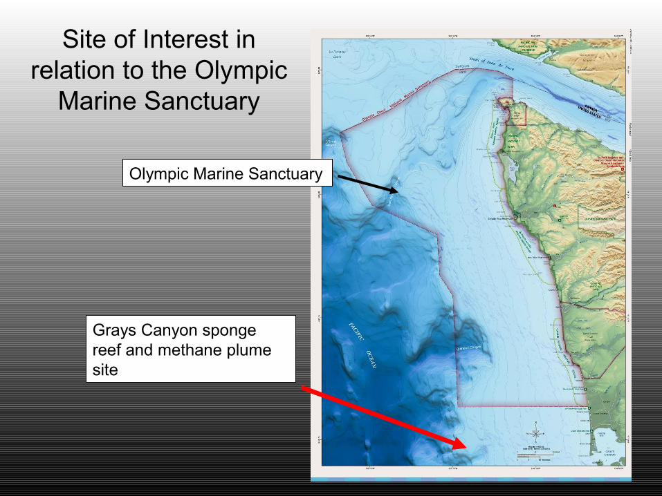
Grays Canyon sponge reef and methane plume site
Olympic Marine Sanctuary
Site of Interest in relation to the Olympic
Marine Sanctuary

Related Documents