Geology of the Thomas Range Fluorspar District Juab County, Utah GEOLOGICAL SURVEY BULLETIN 1069 This report concerns work done on behalf of the U. S. Atomic Energy Commission and is published with the permission of the Commission

Welcome message from author
This document is posted to help you gain knowledge. Please leave a comment to let me know what you think about it! Share it to your friends and learn new things together.
Transcript

Geology of the Thomas Range Fluorspar District Juab County, Utah
GEOLOGICAL SURVEY BULLETIN 1069
This report concerns work done on behalf of the U. S. Atomic Energy Commission and is published with the permission of the Commission

Geology of the Thomas Range Fluorspar District Juab County, UtahBy M. H. STAATZ and F. W. OSTERWALD
GEOLOGICAL SURVEY BULLETIN 1069
This report concerns work done on behalf of the U. S. Atomic Energy Commission and is published with the permission of the Commission
UNITED STATES GOVERNMENT PRINTING OFFICE, WASHINGTON j 1959

UNITED STATES DEPARTMENT OF THE INTERIOR
FRED A. SEATON, Secretary
GEOLOGICAL SURVEY
Thomas B. Nolan, Director
The U. S. Geological Survey Library has cataloged this publication as follows:
Staatz, Mortimer Hay, 1918-Geology of the Thomas Range fluorspar district, Juab
County, Utah, by M. H. Staatz and F. W. Osterwald. Wash ington, U. S. Govt. Print. Off., 1959.
v, 97 p. maps (part fold., part col.) diagrs., tables. 24 cm. ( CU. S.j Geological Survey. Bulletin 1069)
"This report concerns work done on behalf of the U. S. Atomic Energy Commission and is published with the permission of the Com mission."
Bibliography: p. 91-93.1. Geology Utah Juab Co. 2. Fluorspar. i. Osterwald, Frank
W., joint author. 11. Title: Thomas Range fluorspar district, Juab Co., Utah. (Series)
OE75.B9 no. 1069 557.9244 GS 59-153 Copy 2. QE170. J8S8
For sale by the Superintendent of Documents, U. S. Government Printing OfiBce Washington 25, D. C.

CONTENTS
(PageAbstract.. __.____________________ .._________-_..._._.. 1Introduction. ___________________________.-__--____.-_- ._. 2
Scope of report________________.__-__--_----_--_--_-_-__---__ 2Location and surface features______-_-__--_---__-_-----_-------- 2History and production___________________________-_-__________ 5Previous work__________________________________ _________ 6Fieldwork and acknowledgments________-____-___-_-__-___--_-_. 7
Geology _. __ - 8Sedimentary rocks._______-_______-_---___---__-------_-_----_- 9
Rocks of Ordovician age____..______-___-_--__-_____ 9Garden City formation.._______________________________ 9*Swan Peak formation._________________________________ 13
Shale member___________---__----_-_---_--_-_-____ 14Quartzite member____________._-___.___.__________ 16
Fish Haven dolomite________-_-_____--_--_____-______ 17Rocks of Ordovician or Silurian age____________--____________ 21
Floride dolomite______.___ _______________________ 21Rocks of Silurian age_____.____ _________________________ 22
Bell Hill dolomite...._______.____..---__ r _____ 23Harrisite dolomite-__--_____---_-----_.________________ 25Lost Sheep dolomite.________--__---______-----___-____ 26Thursday dolomite-_--_-_-_---_-----_-_-_-----________ 28
Rocks of Devonian age____-___-___-_-_-_-__-----__.______ 29Sevy dolomite_______________________________________ 29Simonson and Guilmette formations, undivided..__________ 31
Rocks of Quaternary age.--_________-_.-_____._--_-___-____ 32Lake Bonneville beds..--.-.....-.----.____.--__.______ 32
Volcanic rocks________________________________________________ 34Classification__ _________________________________________ 34Petrography ______________________________________________ 35
Enstatite-augite latite________________________________ 35Hypersthene latite_--___-__________--___-__---_________ 36Silicic igneous rocks__--_________-_--____-_---__________ 36Intrusive breccia______________________________________ 37Pyroclastic rocks_______._______-_____-________________ 38
Petrology_____ __ _______ __ _______. 40Chemical composition.of rhyolites_--_-________._________ 40Petrogenesis___-_______________--_--_____-__-_________ 41
Structure.--__-__-_-__-____--_--_-__--_--_------__---__-__________ 42Folding. __________________;__________________ 42Faulting________________-__-__-___-_-__.-__--_-______ 43
Thrusts, _______________.-_______-.________________ 43Northeast-trending normal and reverse faults_________________ 43Northwest-trending faults.____-______-_--_-----__-__.______ 44North-trending faults._____________________________________ 44East-trending faults_____________________________________ 44Age of faulting_____________.-__-_____---_._____________ 45Mechanics of faulting___________________.__________________ 45
m

IV CONTENTS
PageOre deposits.__-__________________________________!_______________ 46
Types of deposits____________________________________________ 46Pipelike bodies.___________________________________________ 46Veins.__ _____________________________________________ 47Disseminated deposits_-'_--___-____-______--____-____.____ 47
Structural control _____________________________________________ 48Character of ore___--_-_-___--_-_-_______________________l_____ 49Uranium mineralization ________________________________________ 52Origin__ ____________________________________________________ 59
Descriptions of individual deposits___-___-________--_-___.____-_____ 62Bell Hill..._____________________________________________ 62Blowout________-_-__-_-_-_--------_-----_--------_-----__ 70BlueQueenNo. 1.........._...._____ ..._..... __--_----_- 72Fluorine Queen______________________________________________ 72Fluorine Queen No. 4_-____-___-_____-_--_-_-----_____--__-_-_- 76Harrisite _______-_______________-__-_________-_------_-_--_-__ 76Hilltop No. !________________________.___-._____ 80Lost Sheep___________________________________________________ 81
Main pipe.____________-______.________-_-_---______--__ 82South pipe______________________________________________ 83
Lost Soul No. !________________________-___---_-_-_---_._-_- 84Lucky Louie._________________________________________________ 84Oversight__ _________________________________________________ 85Unnamed adit____________-__-__.__________-____-_----_-_-_- 88Deposits in tuff.______________________________________________ 89
Deposit 1____________________________________--___-__ 90Deposit 2_________ _ _______________________ 90Rainbow No. 2______________________________________ 90
Literature cited.__________________________________________________ 91Index._________________________________________________________ 95
ILLUSTRATIONS
Page [Plates 1-4 and 9-12 are in pocket]
PLAT* 1. Geologic map of fluorspar district.2. Structure sections of fluorspar district.3. Geologic map of south end, Spors Mountain.4. Geologic map of Eagle Rock Ridge.5. A, Fish Haven dolomite, along canyon; B, Bell Hill dolo-
mite__ _ _______.__;.___.__________________Face§ 106. Horn corals from bed near base of Bell Hill dolomite_ .Face* 117. A, Harrisite dolomite, with Halysites; B, Tuff, 168-foot level,
Bell Hill___________________________Faces 268. A, Fault pattern north of Dell; B, Fault traces southwest of
Blowout...____._.___________________-_._____Faces 279. Map of the Bell Hill ore body.
10. Geologic sections of Bell Hill property.11. Map and sections of Blowout property.12. Map and section, east pit, Fluorine Queen property.
CONTENTS V
Page FIGURE 1. Index map, Thomas Range------------------------------- 3
2. Generalized stratigraphic sections of the Fish Haven, Floride,Bell Hill, Harrisite, Lost Sheep, and Thursday dolomites.__ 19
3. Depth and uranium-content relations in Bell Hill mine______- 574. Underground maps of Bell Hill mine__-_-_-____-_____---__- 645. Block diagram showing the shape of the large pipe on the Bell
Hill property._____________________________- 676. Underground maps of Blue Queen no. 1 and Lost Soul no. 1
mines._______________________________________________ 737. Map of Fluorine Queen no. 4._______.___-----_---________ 778. Diagrammatic section of fluorspar bodies, Harrisite property__ 789. Maps of Lost Sheep property.__-____.____________________ 82
10. Block diagram of Lucky Louie pipe-____________________.-- 8611. Map of adit southeast of Thursday prospect________________ 89
TABLES
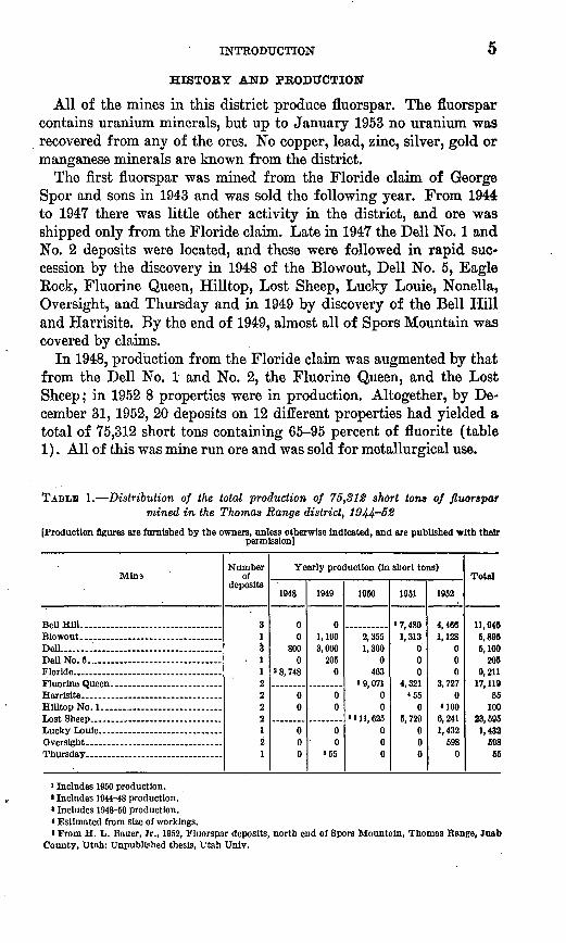
Page TABLE 1. Distribution of the total production of 75,312 short tons of
fluorspar mined in the Thomas Range district, 1944-52___ . 52. Stratigraphic section of the Garden City formation.__________ 103. Lime and magnesia content of limestone and dolomite from
Spors Mountain._______________________________________ 124. Stratigraphic section of upper part of shale member of the Swan
Peak formation._______________________________________ 155. Stratigraphic section of the Se vy dolomite ___________________ 316. Stratigraphic section of the Simonson and Guilmette forma
tions, undivided._______________________________________ 337. Chemical composition in weight percent of Thomas Range rocks. 408. Analyses of samples from the Thomas Range fluorspar district. 54

GEOLOGY "OF THE THOMAS RANGE FLUORSPAR DISTRICT, JUAB COUNTY, UTAH
By M. H. STAATZ and F. W. OSTERWALD
ABSTRACT
The Thomas Range fluorspar district is an area of about 34 square miles surrounding Spors Mountain in central .Tuab County, 46 miles northwest of Delta, Utah. From its discovery in 1943 to the end of 1952, 12 properties in this district yielded a total of 75,312 short tons of fluorspar. Almost all the fluorspar deposits have an abnormally high uranium content. All but 1 of the 7 fluorspar veins and pipes that contained over 0.050 percent uranium are on the southern end of Spors Mountain.
The exposed rocks range in age from Early Ordovician to Pleistocene. The greater part of Spors Mountain is made up of a thick sequence of apparently conformable Paleozoic rocks, which are chiefly carbonates. The Garden City formation, of Ordovician age which is chiefly limestone, is the oldest rock exposed in the district. Two other Ordovician formations, the Swan Peak formation (consisting of a lower shale member and an upper quartzite member) and the Fish Haven dolomite, overlie the Garden City formation. The Floride dolomite of either Ordovician or Silurian age overlies the Fish Haven. Four newly named Middle Silurian formations: the Bell Hill dolomite, the Harrisite dolomite, the Lost Sheep dolomite, and the Thursday dolomite overlie the Floride. The Sevy dolomite, of Devonian age, and the Simonson and Guilmette formations, undivided (dolomites and limestones), overlie the Silurian dolomites and are the youngest Paleozoic rocks in the district. Volcanic rocks, which include latite, dacitic tuff, quartz latite, rhyolite, volcanic breccia, lapilli tuff, quartz latite tuff, and rhyolitic tuff, of probable Tertiary age, surround the Paleozoic sedimentary rocks. Dikes and plugs of intrusive breccia, rhyolite, and quartz latite intrude the Paleozoic rocks, commonly along faults.
All the Paleozoic sedimentary rocks and the volcanic rocks were tilted and now strike northeast and dip northwest. These consistently dipping rocks are cut by about 980 faults belonging to at least 5 sets of faulting: 1, northeast- trending thrusts; 2, northeast-trending normal and high-angle reverse faults; 3, northwest-trending faults; 4, east-trending faults; and 5, north-trending faults. The first three sets were formed before the emplacement of the volcanic rocks, but the remaining two sets cut both groups of rocks; movement along the north-trending set raised Spors Mountain to its present elevation.
During Pleistocene time, Lake Bonneville surrounded the Thomas Range, and gravels, conglomerate, and marl were deposited at that time on the flanks of the range and in the surrounding area which is now a desert.
Fluorspar deposits are of three types: oval to irregular pipes, veins, and disseminated deposits. The pipes, which show considerable range in shape and size with depth, have produced more than 99 percent of the ore. Fluorspar deposits are found chiefly in the Silurian and Ordovician dolomites and show
1
2 GEOLOGY, THOMAS RANGE FLUORSPAR DIST., JUAB COUNTY, UTAH
evidence of two chief types of structural control: faults and intrusive breccia bodies. The ore consists of 65-95 percent of fluorite with montmorillonite, dolomite, quartz, chert, calcite, and opal as impurities. The fluorspar closely resembles a brown, white, or purple clay and forms either pulverulent masses or boxworks. With depth the grade of the ore commonly decreases, and masses of montmorillonite, chert, or quartz and dolomite have been.found in increasing abundance in some deposits.
The ore is believed to have been formed from fluorine-rich fluids, containing minor amounts of uranium, which were derived from the magma that formed the topaz-rich rhyolites of the Thomas Range during the last stages of volcanism. These fluids rose along faults and replaced shattered zones in the dolomite. Introduced elements other than fluorine and uranium were probably obtained from rocks underlying the deposits.
Analyses of 155 fluorspar samples revealed a range of from 0.003 to 0.33 per cent of uranium. The highest grade uranium samples came from the Bell Hill, Harrisite, Eagle Rock, Lucky Louie, and two small prospects. Deposits at all of these properties except the Bell Hill are small. The grade of the uranium in the fluorspar ranges considerably even on the same levels of a single mine. However, near the surface most deposits were enriched in uranium. This is believed to have been effected in an arid climate by slow leaching of the upper part of the ore body, in part by material being actively eroded. The uranium was redeposited a few inches to 30 feet below the rock from which it was leached, owing probably to the absorption of the ground water by the dry under lying ore. The uranium content of the fluorspar from the upper workings may be as much as twice that depth.
INTRODUCTION
SCOPE OF REPORT
The fluorspar district in the western part of the Thomas Kange, Juab County, Utah, is one of the newest mining districts in the Western United States; since 1950 it has been one of the largest pro ducers of fluorspar west of the Mississippi Kiver. The present report covers the geology of the entire fluorspar producing area and supple ments an earlier report by Staatz, Wilmarth, and Bauer (Thurston, and others, 1954) on the individual mining properties. Additional information about all old operating properties is given as well as information about those properties opened between September 1950 and February 1953.
LOCATION AND SURFACE FEATURES
The Thomas Range is on the eastern edge of the Basin and Range province in central Juab County, Utah (fig. 1). The range is 17^ miles long and 9 miles in maximum width. It trends northwest and is composed of three distinct topographic units. The eastern unit is a block approximately 12 miles long and 3-6 miles wide and composed of rhyolite and tuff of Tertiary (?) age. About 2 miles to the west is a second unit, approximately 6 miles long and 1V&-2 miles wide and

_____TOOELE CO JUAB CO
o c ft
V
^-*t__I .T. k
3 Salt Lake City
JUAB CO "^
Delta0 ^
UTAH
|\ #s? =: ^r»l:«* f »
%?
MILLARD CO Mr"""""^FIGURE 1. Index map of the Thomas Range fluorspar district, Juab County, showing
areas of plates 1, 3, and 4.
composed chiefly of complexly faulted lower to middle Paleozoic sedimentary rocks. The third unit, S1/^ miles farther northwest, is a circular group of mountains about 4 miles in diameter and composed of middle Paleozoic sedimentary rocks and latite of Tertiary (?) age.
All the known fluorspar deposits are in the second unit, called Spors Mountain by Fitch, Quigley, and Barker (1949, p. 63-66). Mining

4 GEOLOGY, THOMAS RANGE FLUORSPAR DIST., JUAB COUNTY, UTAH
has been limited to an area approximately 5 miles long by 1 mile wide along the eastern side of Spors Mountain. The present report covers an area of approximately 34 square miles, which includes all of Spors Mountain and about 2.4 miles south of its southernmost end.
The mapped area is in Tps. 12 and 13 S., R. 12 W., Salt Lake principal meridian. The nearest town is Delta, in Millard County, approximately 46 miles southeast from the southern part of the district. The area is reached from Delta, the nearest railhead on the Union Pacific Railroad, by 15.4 miles of paved and 30.9 miles of im proved dirt road. In the spring of 1952 the U. S. Bureau of Public Roads improved and straightened the road along the east side of Spors Mountain. From this road a second road leads around the south end and north along the western side of Spors Mountain (fig. 1). The north part of this second road is passable only by jeep. Several haulage roads lead to the mines from the main east-side road. During the summer months, cloudbursts sometimes wash out the roads.
Spors Mountain rises steeply out of the Lake Bonneville beds which surround it and forms a small but rugged range (pi. 1). The base of the mountain is at an elevation of approximately 5,000 feet, and the highest peak reaches an elevation of 6,584 feet. Along the western and southern sides of this small range, low hills, as much as several hundred feet high, protrude through a gravel cover of Lake Bonne ville beds. Bars of gravel of the Lake Bonneville beds as much as 50 feet high are also found across the mouth of valleys, and wave-cut benches formed by old Lake Bonneville are prominent in the southern most part of the district. Along the east side of the district, especially the central and northern parts, the topography is steep, and the val leys are V-shaped.
No permanent streams are in the area, and water flows in the water courses only during and shortly after occasional summer cloudbursts. Rainfall is scant; during the winter as much as 2 feet of snow falls hampering mining operations from late December to early April. The nearest permanent water supply is the slightly saline Wildhorse Spring (fig. 1), approximately 1 mile east from the northeast corner of the district. There is also a well for watering sheep near the Delta- Callao road approximately 2y2 miles south of the district. As the nearest water is either saline or in remote locations, drinking water is generally obtained in Delta.
The area is covered by bushes 6 inches to a foot high which are thickest in the flat area surrounding Spors Mountain. The only trees are twisted junipers, averaging about 7 feet in height, which are most abundant in the north and central parts of the mountain.
INTRODUCTION 0
HISTORY AND PRODUCTION
All of the mines in this district produce fluorspar. The fluorspar contains uranium minerals, but up to January 1953 no uranium was recovered from any of the ores. No copper, lead, zinc, silver, gold or manganese minerals are known from the district.
The first fluorspar was mined from the Floride claim of George Spor and sons in 1943 and was sold the following year. From 1944 to 1947 there was little other activity in the district, and ore was shipped only from the Floride claim. Late in 1947 the Dell No. 1 and No. 2 deposits were located, and these were followed in rapid suc cession by the discovery in 1948 of the Blowout, Dell No. 5, Eagle Rock, Fluorine Queen, Hilltop, Lost Sheep, Lucky Louie, Nonella, Oversight, and Thursday and in 1949 by discovery of the Bell Hill and Harrisite. By the end of 1949, almost all of Spors Mountain was covered by claims.
In 1948, production from the Floride claim was augmented by that from the Dell No. 1 and No. 2, the Fluorine Queen, and the Lost Sheep; in 1952 8 properties were in production. Altogether, by De cember 31, 1952, 20 deposits on 12 different properties had yielded a total of 75,312 short tons containing 65-95 percent of fluorite (table 1). All of this was mine run ore and was sold for metallurgical use.
TABLB 1. Distribution of the total production of 75,812 short tons of fluorspar mined in the Thomas Range district,
[Production figures are furnished by the owners, unless otherwise indicated, and are published with theirpermission]
Mlna
Bell Hill.. -........- .... ..............
Dell .....'.... ........ ............ ...Dell No. 5.. Floride.. ... __ ................ ...
Hilltop No. 1- ..... .
Thursday _____ .... ___ . .......
Number of
deposits
313
112222121
Ye
1048
00
8000
» 8, 748
00
000
arly pnx
1949
01,1003,000
2050
00
00
»65
luction (in
1950
2,3551,300
0463
»9,07100
1 « 11, 625000
short to
1951
<7,4SO1,313
000
4,321<65
06,729
000
as)
1952
4,4661,128
000
3,7270
MOO6,2411,432
6980
Total
n Q4ft
6,8906,100
2069,211
17, 11965
10023, 6951,432
69855
i Includes 1950 production. Includes 1944-48 production. Includes 1948-50 production. Estimated from size of workings. From H. L. Bauer, Jr., 1952, Fluorspar deposits, north end of Spors Mountain, Thomas Range, Juab
County, Utah: Unpublished thesis, Utah Univ.

6 GEOLOGY, THOMAS RANGE FLUORSPAR DIST., JTJAB COUNTY, UTAH
From 1944 to 1949 ore was shipped to Geneva Steel Company, at Geneva, Utah. Since 1950 most of the ore has been sold to Continental Ore Company, New York, N. Y., brokers, who ship it to different parts of the country.
Ore sold for approximately $23.50 a ton in 1952, delivered in Delta, Utah, based upon a 60 percent effective grade of CaFo.1
Mining in the district is generally begun by open-pit method, which is continued as long as walls remain intact, but underground methods have been used in several mines when the open pits became too deep. The small ore pipe on the Lost Sheep and the east ore pipe on the Fluorine Queen deposits have been mined by driving a short adit to the ore body and raising to the surface. The ore in the open pit is then drawn by slusher to the raise and trammed out. The Lucky Louie and Oversight deposits were shaft mined by sinking on the ore body and hauling the ore out in a bucket. The Bell Hill operators drove an adit 86 feet below the surface and then mined the ore body from a number of stopes both above and below the adit. The large ore pipe on the Dell Nos. 1 and 2 was mined by an adaptation of the block- caving technique. The wallrocks are sufficiently solid in all mines, so that little timber is necessary.
PREVIOUS WORK
Early work on the Thomas Kange was confined to the eastern part, where rhyolite yields beautiful amber-colored topaz crystals, which have long been collector's items. The area is the type locality of the mineral bixbyite [ (Fe, Mn) 203], which was first collected by Maynard Bixby (Penfield and Foote, 1897, p. 105-108).
The topaz area was first reported by Henry Engelmann, geologist for Captain J. H. Simpson's expedition across the Great Basin of Utah, in 1859 (Simpson, 1876, p. 325). Since that time, many articles on topaz and its associated minerals have been published (Kunz, 1885, p. 738; Cross, 1886, p. 436-438; Ailing, 1887, p. 146-147; Kunz, 1893, p. 764; Jones, 1895, p. 175-177; Penfield and Foote, 1897, p. 105-108; Hillebrand, 1905, p. 330-331; Patton, 1908, p. 177-192; Palache, 1934, p. 14-15; and Montgomery, 1934, p. 82-87).
The western part of the Thomas Range (Spors Mountain) attracted little geologic attention before 1948. No published geologic maps of the Thomas Range are known, though some mapping was done by W. R. Thurston for the U. S. Geological Survey, W. P. Fuller for International Smelting and Refining Co., J. J. Beeson for Geneva Steel Co., and James Quigley for Chief Consolidated Mining Co.
1 The effective CaF8 Is determined from an analysis of the ore by subtracting 2% percent of fluorlte for each 1 percent of silica in the ore. Thus, an ore containing 75 percent of fluorite and 4 percent of silica would be rated at 65 percent effective.

INTRODUCTION 7
The fluorspar district is briefly described by Fitch, Quigley, and Barker (1949, p. 63-66). The district was visited during August and September of 1950 by M. H. Staatz,. V. R. Wilmarth, and H. L .Bauer, Jr., of the U. S. Geological Survey, who were investigating uranium resources in western Utah. Most of the mining properties were sampled and were mapped in 1950 by planetable and telescopic alidade on scales of 1 inch to 40 feet and 1 inch to 50 feet. The.results of this work are combined in a paper on fluorspar deposits of Utah (Thurston and others, 1954).
Herman L. Bauer, Jr., mapped and described the mines and the areal geology of part of the northern end of Spors Mountain during the fall of 1951.2
During 1952 under the direction of Arden Blair the district was inspected by geologists from the Union Pacific Railroad Co.
FIELDWORK AND ACKNOWLEDGMENTS
The present study of the Thomas Range fluorspar mining district is regional and includes detailed mapping of the whole of Spors Mountain, as well as economic evaluation of the potential sources of fluorspar and uranium. This investigation was made on behalf of the Division of Raw Materials of the U. S. Atomic Energy Commis sion.
Fieldwork in the area was started in July 1951 by Staatz, who was assisted until September 1951 by H. L. Bauer, Jr., and E. W. Tooker. R. A. Christman assisted between September and December 1951, and the fieldwork was recessed in February 1952 until July 1952, when work was started by Staatz and Osterwald, assisted by L. F. Emmett and P. B. Barton. This fieldwork was completed in September 1952.
The area was mapped on aerial photographs at the approximate scale of 1 :12,000. The final geologic map was compiled by multi plex from the aerial photographs on the original topographic map manuscript (pi. 1). Structure sections were constructed from this final map (pi. 2). The southern end of Spors Mountain, an area of about 1.6 square miles (pi. 3), and the east side of the district contain ing the Eagle Rock claim (pi. 4), an area of about 0.9 of a square mile, were mapped by planetable and telescopic alidade at a scale of 1 :6,000. These two areas included all deposits from which analyses showed more than 0.05 percent of uranium. In addition, planetable maps on the scale of 1 inch to 40 feet and mine maps were made of deposits not described by Thurston and others (1954).
Two core holes were drilled on the Bell Hill property by the U. S. Bureau of Mines under direction of A. A. McKinney, and the results
a Bauer, H. L., Jr., 1952, Fluorspar deposits, north end of Spors Mountain, Thomas Range, Juab County, Utah : Utah Univ., unpub. thesis.

8 GEOLOGY, THOMAS RANGE FLUORSPAR DIST., JUAB COUNTY, UTAH
were made available to the writers. The writers were visited in the field and received helpful advice on the stratigraphy from Helen Duncan, Jean Berdan, and R. J. Boss, Jr., of the U. S. Geological Survey, and C. C. Towle, T. P. Anderson, and E. E. Thurlow, of the U. S. Atomic Energy Commission. Robert Winkle, of the Atomic Energy Commission, aided in some of the sampling.
The miners and owners of all the mines have freely given their time and knowledge of the district. Those who have been particularly helpful are Chad Spor, Ray Spor, Faye Spor, Fred Staats, Les Price, Earl Dalton, Scott Chesley, T. A. Claridge, L. N. Rasmussen, Al Willden, Earl Willden, W. W. Watson, and C. D. Searle.
GEOLOGY
The rocks in the Thomas Range fluorspar district range in age from Early Ordovician to Pleistocene. Spors Mountain, which occupies the greater part of the district, is composed of Paleozoic sedimentary rocks intruded by small dikes and pipes of latites and silicic igneous rocks; volcanic explosion pipes filled with breccia are common along its east side. The Paleozoic rocks of the Thomas Range fluorspar district range in age from Early Ordovician to Devonian and appear to be a conformable sequence consisting of the Garden City formation (mostly limestone), Swan Peak formation (lower part shale; upper part quartzite), and Fish Haven dolomite of Ordovician age; the Floride dolomite of Ordovician or Silurian age; the Bell Hill dolomite, Harrisite dolomite, Lost Sheep dolomite, and Thursday dolomite of Silurian age; and the Sevy dolomite and the Simonson and Guilmette formations, undivided (lower part mostly dolomite, upper part mostly limestone) of Devonian age. The Floride dolomite is a new Ordovician or Silurian formation name and the Bell Hill, Harrisite, Lost Sheep, and Thursday dolomites are new Middle Silurian formation names. Outcrops of Devonian rocks are more abundant north and west of Spors Mountain, and Ordovician rocks are found only to the south and east.
Volcanic flows and tuffs of probable Tertiary age overlie and sur round the Paleozoic sedimentary rocks.
The Lake Bonneville beds of Pleistocene age cover the surrounding desert and the lower elevations of Spors Mountain. Gravel bars, as much as 60 feet high, are found in the mouths of several canyons.
The Paleozoic sedimentary rocks and the Tertiary (?) volcanic rocks strike consistently northeast and dip northwest. Though the beds have been tilted, no fold axes cross the district.
The district is cut by numerous faults, which can be divided on the basis of strike and dip into five groups. Three of these, namely a few

SEDIMENTAKY ROCKS 9
small thrusts, a prominent northeast-trending set of faults, and an apparently later northwest-trending set, cut the Paleozoic rocks but must have preceded the volcanic rocks because they served as conduits for plugs and dikes. Two later sets, trending east-northeast to east, and north, cut both the Paleozoic sedimentary rocks and the volcanic rocks. The north-trending set shows the largest offset, and along this set Spors Mountain and the neighboring ridges were ele vated to their present altitude.
SEDIMENTARY HOCKS
BOCKS OF ORDOVICIAN AGE
GARDEN CITY FORMATION
NAME AND DISTBIBUTION
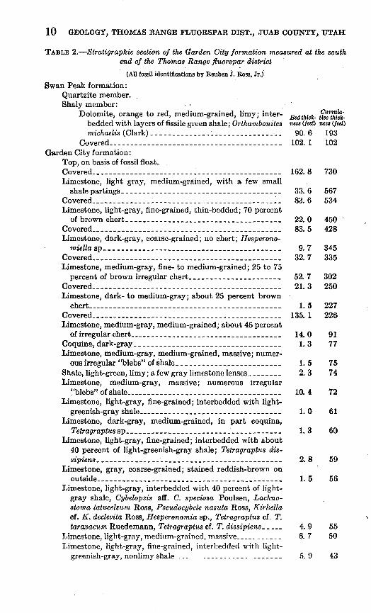
The Garden City formation, of Ordovician age, was first described by Richardson (1913, p. 408-409) from Garden City Canyon in north eastern Utah. The most comprehensive publication is that of Ross (1951), who has studied the stratigraphy and paleontology in detail. At its type locality the Garden City is 1,225 feet thick (Ross, 1951, p. 3).
The Garden City formation crops out in only two places in the fluorspar district: in hills along the extreme southern margin of the district (pi. 3) and in a small area about 2,800 feet southeast of the Fluorine Queen mine along the east flank of Spors Mountain. At neither place is the entire formation exposed, for in the southern area the base is covered by Quaternary sediments, and in the eastern area it is cut out by faulting. At both localities the Garden City is over lain conformably by the shale member of the Swan Peak formation.
LITHOLOGY
Most of the Garden City formation is gray to greenish-gray lime stone. The bedding is very irregular with numerous pinches and swells, and individual beds are most commonly less than 1 inch thick. The rock has a characteristic lumpy appearance, though the lower part of the measured section (table 2) contains massive limestone beds up to 3 feet thick. Thin laminae of fissile green shale separate many beds of limestone. Some beds contain irregular chert nodules, particularly between 77 and 302 feet above the base of the measured section (table 2). Edgewise conglomerates within the Garden City formation crop out in fault blocks, along the south margin of the district. Similar conglomerates are common in the type section (Ross, 1951, p. 7-24) in the lower part of the formation.
10 GEOLOGY, THOMAS RANGE FLUORSPAR DIST., JUAB COUNTY, UTAH
TABLE 2. Stratigraphic section of the Garden City formation measured at the south end of the Thomas Range fluorspar district
(All fossil identifications by Reuben J. Boss, Jr.)
Swan Peak formation: Quartzite member. Shaly member:
Dolomite, orange to red, medium-grained, limy; inter- ^edthick- ftoe"tMcfc bedded with layers of fissile green shale; Orthambonites «««« (feet) ness (feet) michaelis (Clark)______________:_______..____. 90.6 193
Covered__________-----_-__-___---_-__-___---_-_- 102.1 102Garden City formation:
Top, on basis of fossil float. .Covered________________.____.___.___ 162.8 730Limestone, light gray, medium-grained, with a few small
shale partings________--__________-.________________ 33.6 567Covered......_____________________________________ 83.6 534Limestone, light-gray, fine-grained, thin-bedded; 70 percent
of brown chert.______________________________ 22.0 450Covered____,____._____________________ 83.5 428Limestone, dark-gray, coarse-grained; no chert; Hesperono-
mteWa sp-_________-_--_-______-__---__________-__- 9.7 345Covered______________________________ 32.7 335 Limestone, medium-gray, fine- to medium-grained; 25 to 75
percent of brown irregular chert._____________________ 52. 7 302Covered______________________________ 21.3 250 Limestone, dark- to medium-gray; about 25 percent brown
chert___-_-_.-__-_.------________--__-________-_.-. 1.5 227Covered..._.____..___________________________ 135. 1 226Limestone, medium-gray, medium-grained; about 45 percent
of irregular chert__________________________________ 14.0 91Coquina, dark-gray ___________________________________ 1.3 77Limestone, medium-gray, medium-grained, massive; numer
ous irregular "blebs" of shale. ____-----__-____-_______ 1.5 75Shale, light-green, limy; a few gray limestone lenses _ ___.__ 2. 3 74 Limestone, medium-gray, massive; numerous irregular
"blebs" of shale_______._-________.___________ 10.4 72Limestone, light-gray, fine-grained; interbedded with light-
greenish-gray shale________________________________ 1.0 61Limestone, dark-gray, medium-grained, in part coquina,
Te^ragfrap<«ssp_____________________________________ 1.3 60Limestone, light-gray, fine-grained; interbedded with about
40 percent of light-greenish-gray shale; Tetragraptus dis- sipiews_____________-______________________________ 2.8 59
Limestone, gray, coarse-grained; stained reddish-brown onoutside___----_______--_______________-_-___--____- 1.5 56
Limestone, light-gray, interbedded with 40 percent of light- gray shale, Cybelopsis aff. C. speciosa Poulsen, Lachno- stoma latucelsum Ross, Pseudocybele nasuta Ross, Kirkella cf. K. declevita Ross, Hesperonomia sp., Tetragraptus cf. T. taraxacum Ruedemann, Tetragraptus cf. T. dissipiens- _ _ 4. 9 55
Limestone, light-gray, medium-grained, massive-_--_--_-__ 6.7 50 Limestone, light-gray, fine-grained, interbedded with light-
greenish-gray, nonlimy shale.------------------------- 5.9 43
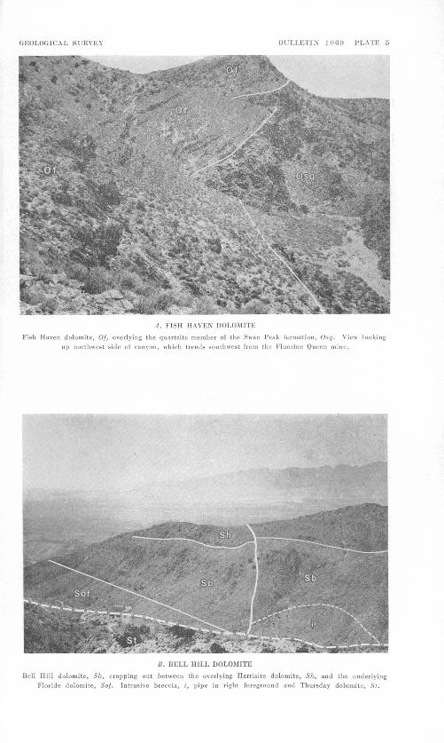
GEOLOGICAL SURVEY BULLETIN 1000 PLATE 5
A. FISH HAVEN DOLOMITE
Fish Haven dolomite, Of, overlying the quartzite member of the Swan Peak formation, Osq. View looking up northwest side of canyon, which trends southwest from the Fluorine Queen mine.
B. BELL HILL DOLOMITE
Bell Hill dolomite, 56, cropping out between the overlying Harrisite dolomite, Sh, and the underlying Floride dolomite, So/. Intrusive breccia, i, pipe in right foreground and Thursday dolomite, St.
GEOLOGICAL SURVEY BULLETIN 1009 PLATE 6
HORN CORALS
Horn corals from conspicuous fossil-bearing bed, 4-10 feet above the base of the Bell Hill dolomite.

SEDIMENTARY ROCKS 11
TABLE 2. Stratigraphic section of the Garden City formation measured at the south end of the Thomas Range fluorspar district Continued
(All fossil identifications by Reuben J. Ross, Jr.)Cumula
te , -,., , ,. n ,. , Bedtthick-tivethick- Garden City formation Continued ness}(feet) ness (feet)Limestone coquina, dark-gray, Cybelopsis aff. C. speciosa
Poulsen, Lachnostoma latucelsum Ross, Pseudocybele na- suta Ross, Kirkella cf. K. declevita Ross, Hesperonomia sp., Tetragraptus cf. T. taraxacum Ruedemann, Tetragraptus cf. T. dtssipi'ens-______________________________________ 2.1 37
Limestone, light-gray; about 20 percent greenish-gray shale as fine partings, contains a few coarse-grained purplish- gray coquina lenses_______________________________ 5.6 35-
Coquina, purplish-gray, coarse-grained, lenticular; Cybel opsis aff. C. speciosa Poulsen, Lachnostoma latucelsum Ross, Pseudocybele nasuta Ross, Kirkella cf. K. declevila Ross, Hesperonomia sp., Tetragraptus cf. T. taraxacum Ruedemann, Tetragraptus cf. T. dissipiens.............. .7 29
Shale, light-green and gray, limy________________________ .3 29Coquina,-dark-purplish-gray___________________________ .2 28Shale, light-greenish-gray, limy; a few coquina lenses. ______ .6 28Coquina, dark-purplish-gray___________________________ .1 28Limestone, light-gray, fine-grained; about 25 percent of
shale as partings; Cybelopsis aff. C. speciosa Ross, Lachno- tloma latucelsum Ross, Pseudocybele nasuta Ross, Kirktlla cf. K. declevita Ross, Hesperonomia sp., Tetragraptus cf. T. taraxacum Ruedemann, Tetragraptus cf. T. dissipitns..... 10.9 28
Limestone, light-gray, medium-grained; small layers of greenish-yellow and pinkish shale, Cybelopsis aff. C. speci osa Ross, Lachnostoma latucelsum Ross, Pseudocybele na- .suta Ross, Kirkella cf. K. declevita Ross, Hesptronomia sp., Tetragraptus cf. T. taraxacum Ruedemann, Tetragraplus cf. T. dissipieras____________________________.___-.___ 4.2 17
Limestone, light-gray, fine-grained, irregularly bedded, con taining green shale partings_________________________ 2.4 12
Limestone, light-gray, medium-grained___.____-______-._ 10. 0 10Covered
Chemical analyses of both massive and lumpy limestones (table 3) indicate that the sample of massive limestone contains 4 percent of constituents that form dolomite in the carbonate fraction and the sample of lumpy limestone contains 5 percent of these constituents.
THICKNESS AND CORRELATION
The Garden City formation was measured at the southern edge of the district (pi. 1) in SE^ sec. 23, T. 13 S., K. 12 W. The exact place of measurement is a prominent ledge about 80 feet high along the north side of a large dry wash. The exposed thickness is Y30 feet; the base of the section is covered by Lake Bonneville beds, and the top of the formation apparently conforms to the Swan Peak.
460083 59 2

12 GEOLOGY, THOMAS RANGE FLUORSPAR DIST., JTJAB COUNTY, UTAH
TABLE 3. Lime and magnesia content of limestone and dolomite from SporsMountain
Formation
Garden City.
Do-.. .
Do .... .
Ftoride ....
Bell Hill
Lost Sheep. ..
Do Thursday .....
Simonson ..... Quilmette..-.
Location
district. ... ..do ... ...
Mine road northeast of Fluorine Queen mine.
east of the Dell No. 5 mine.
mine. . .do... .......Near Blowout
mine.
do... ..... ..800 feet northeast
of Lost Sheep mine.
Spors Moun tain.
... -do..... ... ..... ..do..
CaOcontent ' (percent)
38.13
42.41
9Q fil
30.59
33.64
30.59
30.6929.25
14.1129.74
30.29
35. 90 ' 55.08
MgO content « (percent)
0.63
.88
10 fiQ
21.11
17.01
21.52
21.2719.43
9.5920.80
20.41
16.20 .31
Dolomite in car bonate fraction (percent)
4
5.2
05
98
81
98
OS
95
9698
96
75 1.4
Rock name *
Borderline mag-nesinn limestone.
..... do...... ...... .
Calcitic dolomite-
Dolomite.
..... do ......
.... .do r ....
..... do. ....
..... do ....
..... do...... .......
Calcittc dolomite. Limestone.
Remarks
Lumpy beds.
formation Black-mottled
member.
Slopemakermember.
Mottled gray part of the gray member.
' All CaO and MgO analyses were done by Lucille M. Kehl in the Denver laboratory of the U. 8. Geologi cal Survey.
» Rock classification is after Pettijohn (1949, p. 313).
The formation contains many fossils; one 2-inch slab of limestone about 14 inches long by 8 inches wide yielded over 3,000 parts of trilobites (R. J. Ross, Jr., oral communication). Brachiopods are very common, and some beds are almost entirely composed of their remains. Locally, planospiral gastropods are common, and the thin shale beds contain a few graptolites. The following fossils were identified by Reuben J. Ross, Jr. (composite listing):
Pliomerid free cheek, probably Pseudomera cf. P. larrandi (Billings)Anomalorthis sp.Orthis cf. 0. subalata, Ulrich and CooperHesperonomiella cf. H. minor (Walcott)Hesperonomia sp.Cybelopsis aff. 0. speciosa PoulsenLachnostoma latucelsum RossPseudocybele nasuta RossKirkella cf. K. declevita RossTetragraptus cf. T. taraxacum BuedemannTetragraptus cf. T. dissipiensMacronotella sp.
SEDIMENTARY ROCKS 13
Mr. Ross after a field examination of the Spors Mountain area states that
At the south end of the Thomas Range the Ordovician limestone, shale, and quartzite are strikingly similar to the Garden City-Swan Peak sequence of north eastern Utah. The similarity is both lithic and faunal. Beneath a thick vitreous quartzite are interbeds of quartzitic, shaly, and calcareous nature in which Anomalorthis is present and Orthambonites michaelis (Clark) forms a coquina much as it does in the lower part of the lithologically similar Swan Peak to the northeast. The underlying limestones contain a high percentage of chert similar to the northeasterly sections of the Garden City formation, with a trilobite assemblage typical of Boss's (1951, p. 27-28) "J" zone in a similar stratigraphie- position. Beneath the cherty strata lies a sequence composed largely of intra- formational conglomerates.
In my opinion this section resembles those in northeast Utah so closely that the limestones should be considered the Garden City formation.
Parts of this same fauna are listed by L. F. Hintze (1951, p. 17) from the Ibex area, Utah, in the lower part of the Wahwah limestone, one of his subdivisions of the Pogonip group. He prefers to use the name Pogonip because the name antedates Garden City and because* his measured sections are closer to the type locality of the Pogonip group (Hansen and Bell, 1949, p. 47). Mr. Hintze divided the Pogonip in western Utah into six mappable units. 1 He divided the lower part of the Pogonip, which corresponds to the Garden City in age, into four units mainly on the basis of the amount of silt and sand in the limestone units. These lithologic divisions have not been recognized in the Ordovician limestones of Spors Mountain. Because the limestones from Spors Mountain show a much closer litho logic similarity to the Garden City formation of northeastern Utah than they do the Pogonip, the authors prefer to use the name Garden City formation.
SWAN PEAK FORMATION
The Swan Peak formation, in the Eandolph quadrangle of north eastern Utah and western Wyoming, was named by Richardson (1913, p. 409). As shown in the Randolph quadrangle, by Ross (1951, p. 10-23), and in the Logan quadrangle, by Williams (1948, p. 1136), the formation consists of three parts: a lower shale interbedded with silty quartzite and limestone beds, a middle reddish-brown .quartzite interbedded with shale, and an upper quartzite.
In the Thomas Range the Swan Peak formation consists of two prominent parts: the lower of shale interbedded at the top with hema- titic quartzite beds which grade downward into a shale interbedded with hematitic sandy dolomite beds and the upper of massive white quartzite. The upper massive quartzite forms prominent cliffs, and the lower shaly forms gentle slopes. These two members have been mapped separately (pis. 1, 3, and 4).
14 GEOLOGY, THOMAS RANGE FLUORSPAR DIST., JUAB COUNTY, UTAH
SHALE MEMBER
Distribution. The shale member of the Swan Peak formation conformably overlies the Garden City formation. The shaly part is easily weathered and in most places is covered by slope wash, the best exposures occurring in little steep-sided gullies. The shale member crops out most extensively in several hills at the extreme southern end of the district, but it is also found along the east side of Spors Mountain, chiefly north of the Floride mine and south of the road to the Dell No. 5 mine. The shale member is not as prevalent as the overlying quartzite member because of faulting.
Lithology. The shale member has not been entirely exposed in any section. The upper 100 feet is best known, and a detailed section made a quarter of a mile northeast of the Floride mine is given in table 4. The rock is composed chiefly of dull-green shale stained reddish brown along numerous fractures. The shale contains much fine grained chert. Most of the shale is calcareous and is interbedded with more resistant beds of quartzite and dolomite, 0.1-10 feet thick, with the quartzite near the top of the section grading downward through quartzitic dolomite into dolomite. The undersides of some of the quartzite beds show fucoids. The dolomite of the shale member is readily distinguished from the other dolomites in this area because it is hematitic stained.
Thickness and correlation, The shale member was measured com pletely in two places: two-thirds of a mile southeast of the Fluorine Queen mine in sec. 35, T. 12 S., R. 12 W. (pi. 1), and in the extreme southern end of the district in sec. 23, T. 13 S., R. 12 W. (pi. 1). At the first locality the shale member is 251 feet thick, and at the second locality, approximately 4 miles to the south, it is 388 feet thick. Indi vidual beds also vary in thickness, and the quartzite and dolomite beds cannot be correlated in sections a mile apart.
Two varieties of brachiopods were the only fossils noted; these were scattered throughout both the shale and dolomite from 50 feet below the top of the unit to the bottom. In some small dolomite and shale layers, these fossils make up almost the entire layer. Most com mon is Orthambonites michaelis (Clark) (previously called Orthis michaetts Clark). The second brachiopod belongs to the genus AnomalortJiis; the species is not certain. These fossils were identified by R. J. Ross, Jr., of the U. S. Geological Survey.
The shale member is correlated both stratigraphically and paleontologically with the lower part of the Swan Peak formation at the type locality. The Swan Peak in northeastern Utah consists of an upper massive quartzite and a shaly fossiliferous lower part (Ross, 1951, p. 10; Williams, 1948, p. 1136-1137), which is similar to the beds in the Thomas Range. R. J. Ross, Jr., (written communi-
SEDIMENTARY ROCKS 15
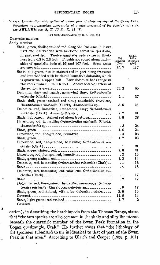
TABLE 4. Stratigraphic section of upper part of shale member of the Swan Peak formation approximately one-quarter of a. mile northeast of the Floride mine in the SW%NW% sec. 2, T. 13 S., R. 12 W.
[All fossil Identification by R. J. Ross, Jr.] Quartzite member. Shaly member:
Shale, green, fissile; stained red along the fractures in lower t part and interbedded with brick-red hematitic quartzite,
in part mottled. Twelve quartzite beds range in thick- Cumu- ness from 0.3 to 2.8 feet. Fucoids are found along under- <ft,^feM thfcimess sides of quartzite beds at 95 and 107 feet. Some areas (feet) (fat) are covered_---_____---______ _------_-____-______ 50. 7 117
Shale, dull-green, fissile; stained red in part along fractures and interbedded with brick-red hematitic dolomite, which is quartzitic in upper half. Four dolomite beds range in thickness from 0.1 to 1.6 feet. About three-quarters of the section is covered_____-____-----_--________-.___ 29.2 66
Dolomite, dark-red, sandy, somewhat limy; Orthambonites michaelis (Clark)_...._____________._____ 2.1 37
Shale, dull, green; stained red along conchoidal fractures,Orthambonites michaelis (Clark), Anomalorthis sp..______ 3. 6 35
Dolomite, red, hematitic, arenaceous, limy; Orthambonites '" michaelis (Clark), Anomalorthis sp____________________ 2.7 31
Shale, light-green, stained red along fractures ____________ 3. 9 28Limestone, red, hematitic; Orthambonites michaelis (Clark),
Anomalorthis sp____._______________________.________ .2 24Shale, green.___________________________ 1.0 24 Limestone, red, fine-grained, hematitic__________________ .4 23Shale, green___________ __________ _ _____ 1.7 23Limestone, red, fine-grained, hematitic; Orthambonites mi-
chaelis (Clark)__________________________ .1 21Shale, green; stained red____________________________ 2.0 21Limestone, red, fine-grained, hematitic._________________ .2 19Shale, green; stained red____________________________ 1.2 19Dolomite, red, hematitic; Orthambonites michaelis (Clark)__ .1 '18 Shale---_--_----__-_-_----__-_----_ ----- -_-----_._ .4 18Dolomite, red, hematitic; lenticular lens, Orthambonites mi-
chaelis (Clark).__._____________-________ .1 17Shale__-__-__--_-__----________-__--__---.-____--__- .2 17Dolomite, red, fine-grained, hematitic, arenaceous; Ortham^
bonites michaelis (Clark), Anomalorthis sp______-_______ .6 17Shale, green; red-stained, with a few dolomite nodules.___ 2. 0 16 Covered..___________________________________________ 12.5 14Shale, light-green; red-stained__---------_---_-------___ 1.7 2Covered
. . cation), in describing the brachiopods from the Thomas Range, statesthat "the two species are also common in the shaly and silty limestones beneath the quartzitic member of the Swan Peak formation in the Logan quadrangle, Utah." He further states that "the lithology of the specimen submitted to me is identical to that of part of the Swan Peak in that area." According to Ulrich and Cooper (1938, p. 101)
16 GEOLOGY, THOMAS RANGE FLUORSPAR DIST., JUAB COUNTY, UTAH
Orthambonites michaelis (Clark) (listed as Orthis michaelis Clark) has also been found in the Swan Peak formation in Utah at the following localities: A mile west of Ibex in the Confusion Range, on the west shore of Bear Lake on Swan Creek, and in Wasatch Canyon, 41/£ miles north of Brigham.
Orthambonites 'michaelis (Clark) and Anomalorthis sp. have been described from the Pogonip group by Hintze (1951, p. 18-19, 57, 62r 64, 68-73,75-78, 80-81, 83, 85). According to Hintze the faunal zones of the Pogonip group for the most part correspond with those in the Garden City and Swan Peak formations of northeastern Utah. Hintze subdivided the Pogonip into six formations and the two brachiopod species are found only in his Kanosh shale, which is probably equivalent in age to the shale member of the Swan Peak formation. The upper part of Hintze's Kanosh shale contains inter- bedded orange siltstones and sandstones (Hintze, 1951, p. 19). At Spors Mountain and in northeast Utah, these rocks correspond to the dark-reddish-brown quartzites. Thus, lithology of the shale mem ber corresponds more closely to the lower part of the Swan Peak formation than to Hintze's Kanosh shale.
QTJABTZITE MEMBEB
Distribution. The quartzite member of the Swan Peak formation is the most resistant rock to weathering of any formation in the district and forms prominent reddish-brown cliffs along the eastern side of Spors Mountain. It is also found in fault blocks near the center part of the range and crops out extensively in several hills at the extreme southern end of the district.
Lithology. The quartzite member is a remarkably uniform rock that is generally white, although in some places pinkish where un- weathered, and reddish-brown to black where weathered. Black is most common along fractures and appears to be a manganese oxide staining. Most of the quartzite is fine grained and consists chiefly of clear interlocking subrounded quartz grains. Amethyst, ortho- clase, and rounded biotite books are present in minor amounts. The chief heavy minerals are well-rounded and pitted olive-green tourmaline and well-rounded clear zircons. Most of the beds are well cemented, but locally some beds are friable. Crossbedding was noted throughout the section. Individual beds in this formation range from 1 to 10 feet thick, but most are between 2-4 feet thick.
R. J. Ross, Jr., who has studied the fossils and stratigraphy of the Spors Mountain area, states that * * * The designation of this quartzite as Swan Peak can and undoubtedly will be questioned, Eureka quartzite being preferred by some stratigraphers.
The brachiopods of the transitional beds between the quartzite and under lying limestones are the same in the Thomas range and in northeast Utah. The
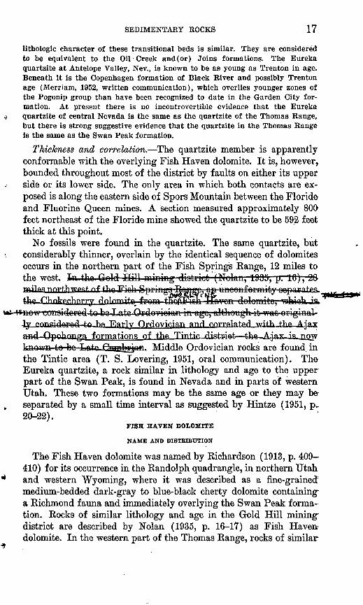
Errata sheet, Bull. 1069, Geology of the Thomas Range Fluorspar District, Juab County, Utah. > !
Page 17, 3d paragraph, 3d sentence, should read:
In the Gold Hill mining district (Nolan, 1935, p. 16), 28 miles northwest of the Fish Springs Range, an unconformity separates the Chokecherry dolomite from the overlying Fish Haven dolomite; the Fish Haven is now considered to be Late Ordovician in age. The Chokecherry dolomite was originally considered to be Early Ordovician and was correlated with the Ajax and Opohonga formations of the Tintic dis trict the AJax is now known to be Late Cambrian.
SEDIMENTARY ROCKS 17
lithologic character of these transitional beds is similar. They are considered to be equivalent to the Oil Creek and (or) Joins formations. The Eureka quartzite at Antelope Valley, Nev., is known to be as young as Trenton in age. Beneath it is the Copenhagen formation of Black River and possibly Trenton age (Merriam, 1952, written communication), which overlies younger zones of the Pogonip group than have been recognized to date in the Garden City for mation. At present there is no incontrovertible evidence that the Eureka quartzite of central Nevada is the same as the quartzite of the Thomas Range, but there is strong suggestive evidence that the quartzite in the Thomas Range is the same as the Swan Peak formation.
Thickness and correlation. The quartzite member is apparently conformable with the overlying Fish Haven dolomite. It is, however, bounded throughout most of the district by faults on either its upper side or its lower side. The only area in which both contacts are ex posed is along the eastern side of Spors Mountain between the Floride and Fluorine Queen mines. A section measured approximately 800 feet northeast of the Floride mine showed the quartzite to be 592 feet thick at this point.
No fossils were found in the quartzite. The same quartzite, but considerably thinner, overlain by the identical sequence of dolomites occurs in the northern part of the Fish Springs Kange, 12 miles to the west. In-.tho.Gold Hill mining diotrict (Nolan, 1995,
is now conaidore4-to be-Late .Or do vioion in age, although it wao originally r».rm<?idmWl tnhft Fiajty tydovician and correlated with t.hfl Ajax
formations of t.hft Tmtic_disteiefc fchirnrmrn in Inn T ntrx PffiTT^jcMfi. Middle Ordovician rocks are found in the Tintic area (T. S. Levering, 1951, oral communication). The Eureka quartzite, a rock similar in lithology and age to the upper part of the Swan Peak, is found in Nevada and in parts of western Utah. These two formations may be the same age or they may be- separated by a small time interval as suggested by Hintze (1951, p.. 20-22).
FISH HAVEN DOLOMITE
NAME AND DISTRIBUTION
The Fish Haven dolomite was named by Richardson (1913, p. 409- 410) for its occurrence in the Randolph quadrangle, in northern Utah and western Wyoming, where it was described as a fine-grained' medium-bedded dark-gray to blue-black cherty dolomite containing- a Richmond fauna and immediately overlying the Swan Peak forma tion. Rocks of similar lithology and age in the Gold Hill mining district are described by Nolan (1935, p. 16-17) as Fish Haven dolomite. In the western part of the Thomas Range, rocks of similar

18 GEOLOGY, THOMAS RANGE FLUORSPAR DIST., JUAB COUNTY, UTAH
lithology, lying on top of the Swan Peak formation and containing Upper Qrdovician fossils, are correlated with the Fish Haven.
The Fish Haven dolomite crops out chiefly along the east side of the southern half of Spors Mountain. Other good sections are found on the northwest side of the canyon that trends southwest from the Fluorine Queen property (pi. 5A) and along the northwest side of the canyon that trends southwest from the Dell No. 5 property. In general, this formation weathers easily and commonly forms smooth debris-covered slopes.
LITHOLOGY
The Fish Haven dolomite is composed of two distinct members: .a lower slope-forming member of thin- to medium-bedded gray to black smooth-weathering dolomite and limestone, and an upper member of massive ledge-forming black-mottled dolomite.
The lower member, which comprises two-thirds of the Fish Haven, is in general a light-gray to black fine-grained dolomite with chert in some parts (fig. 2). The lower 30 to 50 feet is banded, contains small amounts of quartz sand in some layers, and as much as 10 per- cent of chert, chiefly along fractures. Commonly, a thin, 2-foot, quartzite bed is found about 20 feet from the base of the section. Above this lower part the dolomite lacks visible quartz sand and contains little chert. About two-fifths of the way up in the forma tion, a light-gray fine-grained calcitic dolomite, containing numerous ;small holes as much as 1 mm in diameter that are commonly filled with white calcite, forms a distinctive marker bed approximately 30 feet thick. A light- to dark-gray banded smooth-weathering calcitic dolomite overlies this unit in the middle and northern parts of the district. In the southern part, however, the rock is chiefly limestone. (See sec. 2, fig. 2.)
The upper member comprising one-third of the Fish Haven is a :resistant black-mottled dolomite, which forms a prominent band .along the mountainsides. This rock is a dark-gray to black medium- :grained locally crossbedded detrital dolomite with sand-sized grains. The most distinctive feature is a dark mottling, which is most pro- Jiounced in the lower half. Small cavities are common and near the 'base of this member are commonly lined with white dolomite.
The Fish Haven dolomite is distinctive because it is the only car- ibonate rock containing visible quartz sand and the only formation .above the Garden City (Ordovician) and below the Simonson and Ouilmette formations (Middle Devonian) that contains any limestone.
Although the upper part of the lower member consists of calcitic dolomites and limestones, the lower part is dolomite. A sample col lected from the lower part of this member, in the vicinity of the

SEDIMENTARY ROCKS
3'Starts 1200 feel northeast of Thursday mini sec. 21, T. 12 S.. R. 12 W.
1 DOLOMITE _
Mottled dolomite
mQuartzit-
395 ItThickness of member
or formation
FIQCBB 2. Generalized diagrammatic sections of the Fish Haven, Florida, Bell Hill,. Harrisite, Lost Sheep, and Thursday dolomites.
Floride mine, was analyzed (table 3) and found to contain 29.81 per cent CaO and 19.69 percent MgO. The MgO content of this sample- compares favorably with the 21.35 percent of MgO found in a sample from near the type section on Fish Haven Creek (Richardson, 1913,. p. 410). A sample of the upper member (table 3) was also analyzed and found to contain 98 percent of dolomite in its carbonate fraction..
THICKNESS AND CORRELATION
The Fish Haven dolomite was measured in two places: half a mile- north of the Floride mine in the NE^NE^, sec. 3, T. 13 S., K. 12 W.,. and 1,700 feet northeast of the Dell No. 5 mine in sec. 27, T. 12 S.r
20 GEOLOGY, THOMAS RANGE FLUORSPAR DIST., JTJAB COUNTY, UTAH
R. 12 W. The thickness in the two sections (fig. 2) is 303 feet and 280 feet, respectively.
The only fossils found in the lower member came from a limestone bed in its upper part in the southern part of Spors Mountain. The following assemblage was identified by Jean Berdan, of the Geological Survey:
Stromatoporoids Horn coral, undet. Favosites sp. Bryozoans, undet. Catazyga'i sp. Hesperortliis sp. Fardenia sp. High-spired gastropod, undet.
Berdan states that "this collection contains two genera, Hesperorthis and Fardenia^ which could be either Ordovician or Silurian in age, and one species questionably referred to the genus Catazyga which has previously been considered to be restricted to the Upper Ordo vician (Richmond)." P. E. Cloud, Jr., who reviewed this list of fossils (written communication, 1955) states that the fossil list "lacks certain forms that are particularly diagnostic of the Upper Ordo vician of the region but the general aspect is pre-Silurian and probably not as old as middle Ordovician." Fossils found in the upper member were restricted to a few poorly preserved corals and-crinoid stems from near the top of this unit. The corals are reported t>y Berdan as horn corals and the colonial coral, Palaeophyllum*. sp. Better specimens of this genus are found in this same member in the neighboring Dugway and Fish Spring Ranges, verifying the Late Ordovician age of these rocks.
The Upper Ordovician has been separately mapped as the Fish Haven dolomite in northeast Utah (Richardson, 1913, p. 409^410, William, 1948, p. 1137) and at Gold Hill, Utah (Nolan, 1935, p. 16-17), and as the Hanson Creek formation in central Nevada (Merriam and Anderson, 1942, p. 1685-1696). The lithology of the Hanson Creek formation consists of three calcareous sandstones at the base, overlain by dolomitic limestones commonly interbedded with .shaly layers, which are in turn, overlain by blue-gray limestones. Lithologically, the Hanson Creek formation does not resemble closely the dolomite of Late Ordovician age exposed in the Thomas Range. The Fish Haven dolomite was examined by R. J. Ross, Jr., at its type section, and he states (1952, oral communication) that it is almost identical with the lithology of the dolomite of Late Ordo vician age exposed in the Thomas Range. This dolomite in the Thomas Range, on the basis of its probable Late Ordovician age, its
SEDIMENTARY ROCKS 21
stratigraphic position above the Swan Peak formation, and the similarity between the two lithologies, is correlated with the Fish Haven dolomite.
ROCKS OF OBDOVICIAN OB SILURIAN AGE
The Ordovician-Silurian boundary is difficult to locate exactly in many areas in western Utah and eastern Nevada. The Floride dolo- jnite is described under this heading as it lies above rocks containing Upper Ordovician fossils and below rocks containing Middle Silurian fossils. This formation might be wholly Ordovician, wholly Silurian or both.
FLORIDE DOLOMITE
NAME AND DISTRIBUTION
The Floride dolomite, named for its occurrence at the Floride mine, crops out chiefly along the east side of Spors Mountain in the southern half of the range. In addition, prominent outcrops occur along the lower northwest sides of three canyons which trend southwest from the Fluorine Queen, Dell No. 5, and Blowout mines, respectively. Although the section is complete at the Floride mine, the type section (sec. 2, fig. 2) was measured on a steep hillside, starting half a mile north of the Floride because of better exposures. Other good sections are located on the northwest side of a steep canyon 1,400 feet south west of the west pipe of the Fluorine Queen and on a mountain 1,700 feet northeast of the Dell No. 5.
IJTHOLOQY
The easily weathered Floride dolomite separates two resistant dolo mites and is covered by slope wash in most places. Several distinct units are found but all are fine grained light to medium gray and smooth weathering. The 39 feet at the bottom consists of thin undu lating beds, which weather with an irregular bumpy surface. This dolomite is pinkish in a few places and is commonly stained red by iron oxide along bedding-plane surfaces and fractures. The next 20 feet is light-gray limy dolomite, followed by 8 feet of medium-gray dolomite containing numerous small cavities as much as 1 millimeter in diameter. The uppermost unit is a light- to medium-gray banded dolomite showing a faint mottling in a few places. In general, chert is rare in this member, although locally 1- to 2-inch bands of chert parallel the bedding in the upper part. A sample of the limy dolomite (table 3) with numerous small cavities was analyzed and found to contain 81 percent of dolomite in its carbonate fraction. According to Pettijohn (1949, p. 313) this rock would be classified as a calcitic dolomite.
22 GEOLOGY, THOMAS RANGE FLUORSPAR DIST., JUAB COUNTY, UTAH
THICKNESS AND CORRELATION
The thickness of the Floride dolomite was measured in three places: at the type section half a mile north of the Floride mine in the NE^NE^4 sec. 3, T. 13 S., R. 12 W.; 1,700 feet northeast of the Dell No. 5 mine in sec. 27, T. 12 S., R. 12 W.; and 2,750 feet southwest of the Blowout mine in sec. 28, T. 12 S., R. 12 W. The thickness of the Floride ranges from 100 to 135 feet (fig. 2).
The Floride dolomite yielded only a few unidentified horn corals from the upper part. The age of this formation, thus, rests on its position between the Fish Haven and Bell Hill dolomites. Near the top of the Fish Haven the Upper Ordovician coral Pdlaeophyllum has been found; and in the lowest beds of the Bell Hill Silurian corals have been gathered. Hence, the age of the Floride may be either Late Ordovician, Silurian, or both.
ROCKS OF SILURIAN AGE
Dolomites of Middle Silurian age crop out over most of the western part of the Thomas Range. In order to show the structure in the range, the Middle Silurian rocks were divided into four new forma tions. These are the Bell Hill dolomite, the Harrisite dolomite, the Lost Sheep dolomite, and the Thursday dolomite (fig. 2), in order of decreasing age. The new formations were also recognized by the authors in the northern part of the Fish Springs Range, 15 miles northwest of the northern end of Spors Mountain. The lithologic change between these formations is as striking as the contrast between the Sevy formation of Devonian age and the formation of Middle Silurian age which underlies it.
Fossils from these formations were examined by Helen Duncan and Jean Berdan, who state that all collections appear to be Middle Silurian. The fossils submitted for study consist largely of corals and pentamerid brachiopods, poorly preserved in dolomite or coarsely silicified rock and therefore difficult to assign even generally. The lowest formation (Bell Hill dolomite) contains a reef with Circophyllum, two kinds of Holy sites with small corallites, Heliolites, many horn corals, and pentameroid brachiopods. The uppermost formation (Thursday dolomite) contains a reef in which stromatoporoids appear to be much more abundant than in the lower formations. This fauna also contains the coral Zelophyllum in fair abundance and a form of Holy sites characterized by larger corallites than the two species common in the lower reef. Many of the species found in the earlier reef also appear to persist into the later reef.
Fossils, such as Favosites sp., Holy sites sp., Heliolites sp., Virgiana sp., collected from the four Silurian dolomites are similar to those

SEDIMENTARY ROCKS 23
found in the Laketown dolomite in the Logan quadrangle, of north eastern Utah (William, 1948, p. 1138), the Randolph quadrangle, of northern Utah and western Wyoming (Richardson, 1913, p. 410), and the Gold Hill mining district, in western Utah (Nolan, 1935, p. 18). Some of the fauna, however, contains elements not observed in the type Laketown. The Silurian rocks of the Thomas Range are probably correlative, at least in part, with the Laketown dolomite of north eastern Utah; however, too little is known about the exact age of the type Laketown to correlate the Silurian formations in the Thomas Range with all of it.
BELL HILL DOLOMITE
NAME AND DISTRIBUTION
The Bell Hill dolomite, named from the Bell Hill mine, on the southern end of Spors Mountain, is the thickest Silurian formation in the district. Numerous faults and poor exposures at the Bell Hill mine, however, make this one of the poorer places to study the for mation; therefore, section 2 (fig. 2), on a steep mountainside half a mile north of the Floride mine, is designated the type section. Other good sections are found on the north side of the canyon southwest of the Fluorine Queen property and on the north side of the canyon southwest of the Blowout property (sec. 6, fig. 2). Fault blocks con taining the Bell Hill dolomite are scattered throughout all but the northern tip of Spors Mountain.
The Bell Hill dolomite is a resistant formation and forms steep hills with prominent outcrops (pi. 55), especially in the central and southern parts of the range.
LITHOLOQTThe Bell Hill dolomite is made up of two members: the eight-ninths
at the bottom is a dark-gray coarse-grained clastic dolomite, and the one-ninth at the top is a light-gray fine-grained dolomite. The cliff- forming lower part is most commonly dark gray, but in some places ranges to light gray along strike, with color differences possibly being related to the intensity of dolomitization. This massive rock is characterized by detrital sand grains of dolomite, local crossbedding. common banding, and few distinctive layers. However, in the northern part of Spors Mountain, a 28-foot-thick dolomite bed with a highly distinctive contorted, convoluted appearance (thinly laminated "curly" beds) occurs approximately 40 feet from the top of the unit. The upper part is commonly covered, but where exposed it is a thin- bedded light-gray banded dolomite. Unlike the sandy lower part, this fine-grained upper part is a smooth-weathering rock that in places is somewhat limy. This rock is the marker bed between the lower dark-gray sandy-textured part of the Bell Hill dolomite and the overlying dark-gray sandy-textured Harrisite dolomite.

24 GEOLOGY, THOMAS RANGE FLUORSPAR DIST., JUAB COUNTY, UTAH
A sample from the lower part of the Bell Hill dolomite (table 3) was analyzed and found to contain 98 percent of dolomite in the carbonate fraction.
THICKNESS AND CORRELATION
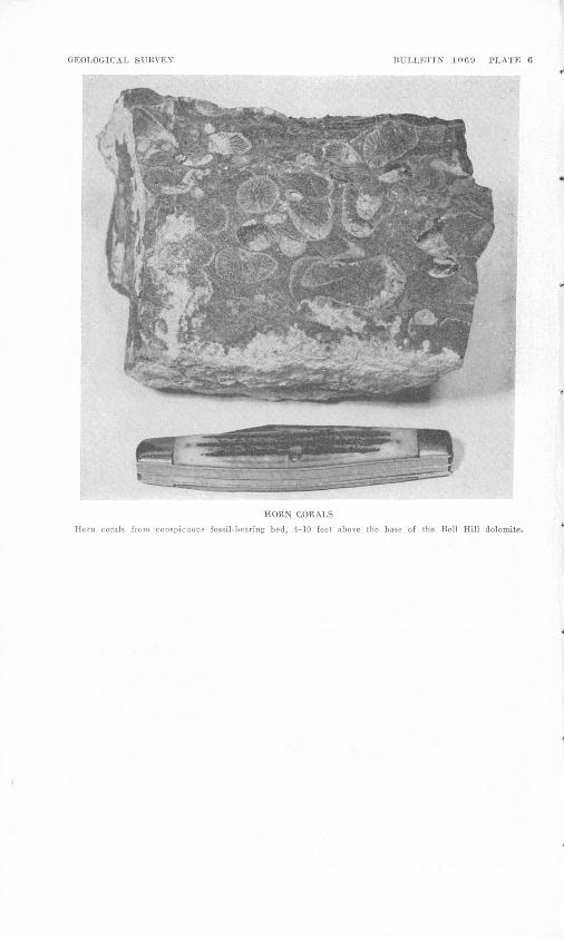
The Bell Hill dolomite was measured in three places: half a mile north of the Floride mine, in the NEi/4 sec. 3, T. 13 S., R. 12 W.,; 1,000 feet northeast of the Dell No. 5 mine, in sec. 27, T. 12 S., R. 12 W.; and 2,000 feet southwest of the Thursday mine, in sec. 28, T. 12 S., R. 12 W. The measured thickness of the entire formation ranged from 395 to 430 feet (fig. 2), with the upper member making up 34-53 feet of this formation. Fossils are common in the lower 200 feet of the lower member but are scarce in the upper part; none were noted in the upper member. The most conspicuous fossil-bearing bed is a detrital dolomite with thin shale lenses, 4-10 feet above the base of the formation (pi. 6).
Horn corals make up better than 85 percent of the fossiliferous material in this bed. The following fossils were identified from this bed by Helen Duncan and Jean Berdan:
StromatoporoidsCircophyllum sp.Entelophylluml sp.Favosites sp. (small corallites)Halysites (Cateniporal) sp.Halysites (Cystihaly sites) cf. H. ~brownsportensis (Amsden)Pycnactisl sp. and other horn coralsHeliolites sp.Branching favositid coralsCrinoid columnalsFragments of pentamerid brachiopodsCephalopod, undet.
Above this bed the fossils scattered through the rock consist chiefly of Favosite's sp., horn corals, and cfinoid columnals. The following fossils were identified:
Favosites sp. A (small corallites) Favosites sp. B (large corallites) Crinoid columnalsVirgiana cf. V. decussata (Whiteaves) Platyceratid gastropod
Two of the best localities for fossil collecting in this dolomite were found on the Bell Hill property. The first locality is a prominent ledge 190 feet S. 30° W. of the southwest end of the largest ore body, and the second locality is on the top of a hill, 450 feet S. 66° W. of the largest ore body. Several other localities were found on the Fluorine Queen property a few feet southeast of the west pipe, 40 feet northwest of the same pipe, and 50 feet east of the east pipe.

SEDIMENTARY ROCKS 25
The age of the Bell Hill dolomite is Middle Silurian. Some of the fossils are similar to those described in the Laketown dolomite in the Randolph quadrangle (Richardson, 1941, p. 18), the Logan quadrangle (Williams, 1948, p. 1138), the Gold Hill mining district (Nolan, 1935, p. 18) and the Hidden Valley dolomite in the Quartz Spring area, California (McAllister, 1952, p. 15-18).
HARRISITE DOLOMITE
NAME AND DISTRIBUTION
The Harrisite dolomite is named for exposures that cap the hill a short distance east of the Harrisite mine. The section here is not complete, however, and the type section is therefore designated as the steep west side of a canyon 2,000 feet northeast of the Harrisite mine (sec. 1, fig. 2). Other good sections are found on the northwest side of a canyon 3,000 feet southwest of the Blowout mine and on the northwest side of a canyon 4,000 feet south-southwest of the Over sight mine. Fault blocks containing the Harrisite dolomite are scattered throughout Spors Mountain area. The Harrisite dolomite is a resistant formation and, with the Bell Hill dolomite, forms many steep mountainsides and caps numerous ridges.
A sample from the Harrisite dolomite (table 3) taken near the Lost Sheep mine was analyzed and found to contain 98 percent of dolomite in its carbonate fraction.
LITHOLOGY
The Harrisite dolomite is a massive dark-gray to black locally banded dolomite, containing as much as 20 percent of black chert, chiefly as nodules and discontinuous layers along the bedding. The lower 10 feet of this formation has a mottled appearance and is commonly limy. The Harrisite closely resembles the Bell Hill dolomite in lithology but does not change color along the strike. The most distinguishing feature of the Harrisite dolomite is faint white squiggly lines (pi. 7J.), which are dolomitic replacements of the remains of Holy sites (chain corals).
THICKNESS AND CORRELATION
The Harrisite dolomite shows considerable differences in thickness. It was measured at three places: the type section, in sec. 10, T. 13 S., R. 12 W., 2,000 feet northeast of the Harrisite mine; 1,000 feet north east of the Dell No. 5 mine, in sec. 27, T. 12 S., R. 12 W.; and 2,750 feet southwest of the Blowout mine, in sec. 28, T. 12 S., R. 12 W. The thickness of the Harrisite dolomite ranges from 110 to 174 feet (fig-2).
Halysites and crinoid stems are common throughout the formation but are generally too poorly preserved to identify. Dolomitization
26 GEOLOGY, THOMAS RANGE FLUORSPAR DIST., JUAB COUNTY, UTAH
has destroyed the distinguishing characteristics of most of the fossils. The best preserved ones are commonly silicified. One of the best exposures of the Halysites-bea,Tin.g Harrisite dolomite is seen on the hill just east of the workings of the Harrisite mine (pi. 3). The following fossils collected from this hill were identified by P. E. Cloud, Jr., of the Geological Survey.
Ealysites sp. Pentamerid brachiopod Gastropod, undet. Crinoid stem
According to Cloud the pentamerid brachiopod, along with the Hah/sites sp., indicates that this rock is of Silurian age, even without knowledge of its stratigraphic position between the Bell Hill and Lost Sheep dolomites.
LOST SHEEP DOLOMITE
NAME AND DISTBIBTTTION
The Lost Sheep dolomite, named for its occurrence at the Lost Sheep mine, is widely distributed on the western side of Spors Mountain. The type section is in the same outcrop strip as that surrounding the Lost Sheep mine but was measured on the northwest side of a steep canyon 2,000 feet southwest of the neighboring Blow out mine (sec. 6, fig. 2). Other good sections are found 1,550 feet and 4,000 feet southwest of the Oversight mine. In addition to the main Lost Sheep ore body, the Blowout, Oversight, and Lucky Louie ore bodies are found in this formation.
UTHOLOQT
The Lost Sheep dolomite is made up of two members, mapped separately on the detailed regional maps (pis. 3 and 4). The two- thirds at the bottom is called the gray member, and the third at the top, the cherty member. The gray member is made up of 3 light- to medium-gray units and 1 thin black bed. The lower unit, which averaged 43 feet in thickness, consists of light-gray coarse detrital dolomite, whose upper part is somewhat darker and more limy near the center of Spors Mountain. Chert is only found in a few places as thin fracture fillings. On top of this unit is a thin 6- to 13-foot bed of fine-grained black to dark-gray banded dolomite, containing 20-50 percent of gray to black chert in discontinuous 1- to 5-inch bands, which parallel the bedding. This unit forms a prominent marker bed, being somewhat more resistant than the dolomite above and below. The next unit, which averaged 32 feet in thickness, is medium-gray mottled dolomite, whose subtle gray mottling is one of the best guides in recognizing this member. Chert is common only in insoluble residues, where it occurs as white dolocasts with little

GEOLOGICAL SURVEY BULLETIN 100!) PLATK
A. HARRISITE DOLOMITE
Harrisite dolomite contains numerous partly dolomitized Halysiles.
B. RHYOLITIC TUFF
Irregular band of intrusive rliyolitic tuff cutting the fluorspar body on 168-foot level of the Bell Hill mine.

GEOLOGICAL SUBVEY BULLETIN 1069 PLATE 8
A. FAULT PATTERN
Fault pattern just north of Dell property. Cto, shale member, and 0sg, quartzite member, Swan Peak formation; Of, Fish Haven dolomite; 56, Bell Hill dolomite; i, intrusive breccia.
Blowout
Fault traces southwest of Blowout mine. Ds, Sevy dolomite; St, Thursday dolo: dolomite; 5A, Harrisite dolomite; 56, Bell Hill dolomite; i, intrusive b
Jte; SJ, reccia.
Lost
SEDIMENTARY ROCKS 27
clear quartz. A sample of this rock (table 3) taken near the Blowout mine was analyzed and found to contain 95 percent of dolomite in the carbonate fraction.
The uppermost unit of the gray member, which averaged 67 feet in thickness, is a light-gray medium- to coarse-grained detrital dolo mite. It closely resembles the lowest unit of the gray member; the chief difference is the little smaller grain size at some places in the upper unit.
The cherty member of the Lost Sheep dolomite is a gray medium- grained locally faintly mottled dolomite, which is considerably darker than the underlying light-gray unit of the gray member and which crops out as prominent ledges, forming an excellent marker bed. The most distinctive feature is pink to gray chert in bands 1-6 inches wide parallel to the bedding. The chert content commonly ranges from 15 to 60 percent of the rock, though in the southern part of SpOrs Mountain the 10-20 feet in the center of this member con tains no chert and in a few places in the northwestern part of the range small sections are made up of as much as 95 percent of chert. These small high-chert areas appear to be related to fractures, sug gesting that some of the chert may be of later origin. In the northern part of the mountain, the chert is white to pink, and this unit was called the pink chert unit by Bauer,3 though in other parts the chert is light gray. A sample of dolomite from near the Blowout mine was analyzed and found to contain 96 percent of dolomite in the carbonate fraction.
THICKNESS AND COBBELATION
The thickness of the entire Lost Sheep dolomite was measured in two places: at the type section, 2,000 feet southwest of the Blowout mine in sec. 28, T. 12 S., R. 12 W., and 2,700 feet east of the Thursday mine, in sec. 27, T. 12 S., R. 12 W. In addition, the lower gray member was also measured 2,000 feet northeast of the Harrisite mine in N% SEi/4 sec. 10, T. 12 S., R. 12 W. The gray member ranges from 149 to 159 feet in thickness, and the cherty member, from 66 to 92 feet (fig. 2), averaging about 70 feet.
The thin black cherty dolomite unit is the chief fossil bearer in the gray member, though a few fossils have been found in the gray, mottled unit. The gray member contained crinoid -:columnals, un identified horn corals, Holy sites sp., fragments of a smooth pentamerid brachiopod, fragments of a ribbed brachiopod, and an undetermined gastropod. Though fossil debris is abundant, it is difficult to collect identifiable material.
8 Bauer, H. L., Jr., 1952, Fluorspar deposits, north end of Spors Mountain, Thomas Range, Juab County, Utah: Utah Univ., unpub. thesis., p. 12.
469083 59 3

28 GEOLOGY, THOMAS RANGE FLUORSPAR DIST., JUAB COUNTY, UTAH
Fossils are exceedingly rare in the cherty member, but Holy sites (Cystihalysites) sp. was identified by Helen Duncan and Jean Berdan. This coral, in conjunction with the pentamerid brachiopods, identifies this formation as of Silurian age, a conclusion which is verified by its position in the section between the more complete Silurian fossil collections in the lower Bell Hill and the upper Thursday dolomites.
THURSDAY DOLOMITE
NAME AND DISTRIBUTION
The Thursday dolomite, named for outcrops at the Thursday mine, is best exposed in the northern half of Spors Mountain, where it caps a series of long northeast-trending ridges. Smaller areas are found in fault blocks scattered throughout the rest of the range, though they are commonest in the western half. Complete sections of the Thursday dolomite are rare; the formation is either cut off by faults, or covered by Lake Bonneville beds in most of this district. The only known complete section crops out on the west side of Spors Mountain, 4,200 feet west-southwest of the Thursday mine and is here designated the type section.
LITHOLOGY
The Thursday dolomite is a light-gray medium-grained friable rock, which is in general a slopemaker. A medium-grained gray dolomite bed approximately 15 feet thick with 1- to 4-inch bands of pink chert parallel to the bedding occurs about 135 feet from the base of the formation in the northern part of Spors Mountain. The lithology of this band is identical with the underlying cherty member of the Lost Sheep dolomite. In the northern part of the district, a network of thin brown chert is found in several beds of dolomite approximately 340 feet above the bottom of the formation. This silicified part of the Thursday is very resistant and was mapped as a separate unit by Bauer.4 More recent mapping has shown, however, that the chert is secondary and the chert-bearing beds are not regional in scope.
Insoluble residues of the dolomite show that it contains jninor amounts of clear quartz grains as well as small amounts of white chert.
A sample of the light-gray medium-grained dolomite (table 3) from the lower part of this formation was analyzed; the carbonate fraction contained 98 percent of dolomite.
THICKNESS AND CORRELATION
The lower part of this formation, from the base to the thin network chert bed, was measured 100 feet west of the Blowout mine, in sec.
* Bauer, H. L., Jr., 1952, op. cit., p. 12.
SEDIMENTARY ROCKS 29
21, T. 12 S., R. 12 W. (sec. 7, fig. 2), and the thickness from the bottom of this bed to the overlying Sevy dolomite was measured 1,400 feet southeast of the lower part of the section (sec. 5, fig. 2). The composite thickness thus obtained is 329 feet. The lower light- gray dolomite is unfossiliferous; the only fossils found were pre served in chert in the upper part of the formation. A collection made on the east side of the extreme northern end of Spors Mountain except for the species of Holy sites was identified by Helen Duncan and Jean Berdan. The species of Halysites was identified by E. J. Buchler. The collection contained the following fossils:
StromatoporoidsZelophyllum aff. Z. intermedium Wedekind Halysites magnitubus Buchler Favositest sp. (small cor alii tes) Alveolites sp.
These fossils suggest a Middle Silurian age for the formation.
NAME AND DISTBIBTTTION
The Sevy dolomite was named by Nolan (1935, p. 18) from out crops in Sevy Canyon in the Deep Creek Eange, Utah. Donovan (1951, p. 50) and Campbell (1951, p. 21-22) have applied the name to Devonian rocks hi the Confusion Range in western Utah.
The Sevy dolomite crops out extensively west and northwest of the main ridge of Spors Mountain. It also forms many isolated ridges and hills whose angular ledges project above the flat surface of the Lake Bonneville beds. A few smaller blocks of Sevy dolomite are found within the main mass of Spors Mountain, particularly east of the Blowout mine and on the southern end of Eagle Rock Ridge.
LITHOLOGT
The Sevy dolomite is a fine-grained massive mouse-gray dolomite of uniform and distinctive character. The color is even for the most part, though a few beds in the lower part are a little darker or lighter gray and a few show vague mottling. Toward the top of the forma tion some of the dolomite layers are blue gray. The composition is not uniform, as weathered surfaces are rough with many sharp projections and trenches. Exposed surfaces are characteristically grooved with numerous curving and crisscrossing channels one thirty- second to three-sixteenths of an inch deep, probably formed by differential solution. The formation is thin to medium bedded. Some of the beds contain a few scattered orange, white, or colorless euhedral and subhedral grains of dolomite, most of which are less than three-

30 GEOLOGY, THOMAS RANGE FLUORSPAR DIST., JUAB COUNTY, UTAH
sixteenths of ah inch in diameter. Toward the base of the formation, a little dark irregular chert fills joints and other fracture planes.
In some places the Sevy dolomite has a gradational contact with the underlying Thursday dolomite, but in others the contact is sharp. Near the contact in the northern part of Spors Mountain, beds of typical mouse-gray dolomite are interlayered with beds of white detrital dolomite in which thin chert bands fill a network of fractures. In measuring the stratigraphic section (table 5), the base of the Sevy dolomite was arbitrarily placed at the top of the uppermost white sandy dolomite layer. Near the south end of Spors Mountain the contact is abrupt, and no interlayering is evident. The upper contact with the undivided Simonson and Guilmette formations is similarly gradational; the top of the Sevy dolomite was placed at the base of a 10-foot bed of white massive dolomite, which underlies a 3-foot bed of black massive dolomite. These two thin beds are very persistent and constitute a conspicuous sedimentary marker, even though some beds of lithology similar to the Sevy are present above them. Nolan (1935, p. 19) found a similar break above the Sevy dolomite in the Gold Hill district.
A sample of the Sevy dolomite (table 3) collected northwest of Spors Mountain was analyzed; dolomite made up 96 percent of the carbonate fraction.
In thin section the rock is very fine grained, and the epiclastic fraction is well sorted; most of the slide consists of a mixture of clay and clay-size: dolomite grains. Scattered through the fine-grained matrix,are numerous irregular-shaped aggregates of clear dolomite ahhedra less than 1 millimeter long. The matrix also contains scat tered clots of fine-grained clay and carbonate, all of which contain limonite. The limonite either forms a well-defined ring inside the clot but parallel to its outline or is spread throughout the clot with the highest concentration at the center.
Thirty grams of powdered Sevy dolomite yielded 0.4 grams of acid insoluble material, neglecting the clay fraction which was not saved. Of the residue 50 percent was sugary white chert occurring as dolocasts, and 50 percent was clear quartz; a trace of pyrite also was noted.
THICKNESS AND CORRELATION
The thickness of the Sevy dolomite was measured across the forma'- tion beginning at a point 5,540 feet N. 78° W. of the Oversight mine. Total thickness at this point is 1,122 feet (table 5). At the type locality (Nolan, 1935, p. 18), the Sevy consists of 450 feet of homo geneous mouse-gray well-bedded dolomite. Compbell's composite sec tion (1951, p. 21) shows 2,560 feet of Sevy dolomite in the Confusion Range.

SEDIMENTARY ROCKS 31
The formation is unfossiliferous in the Spors Mountain district. It has been assigned to the Devonian because it underlies the Middle Devonian sequence of the Simonson and Guilmette formations, un divided, and because of its lithologic similarity to the type Sevy dolomite at Gold Hill, Utah.
TABLE 5. Stratigraphic section of the Sevy dolomite; measuring started at a point 6,640 feet N. 78° W. of the Oversight mine
Cumula- Bed live
thickness thickness (feet) (feet)
Dolomite, black, fine-grained______.___________._.._._..-_ 2. 8 13Dolomite, massive, white, marked by a fine-textured, brecciated
chert network at the base_____________________________ 10.3 10Sevy dolomite:
Top; covered interval, with small projecting ledges of fine grained light-medium-gray dolomite_________________ 122. 4 1, 122
Dolomite, light-gray to tan; black chert lenses along bed- ding_.________-_______________________________ 11.3 1,000
Covered, with small projecting ledges of medium-gray fine grained dolomite_-_-___-___________________________ 91.0 989
Dolomite, medium- to light- to bluish-gray, fine-grained,with large covered intervals___.---________________- 123.4 898
Dolomite, light-gray, fine-grained, with small beds of light- bluish-gray in one-third at bottom and with large covered intervals____________________________. 485.3 774
Dolomite, light- to medium-gray, fine-grained, in part covered...._________________________ 69.1 289
Covered interval, with 1.3-foot bed of gray to buff medium- grained dolomite, slabby to blocky at base___________ 219.9 220
Thursday dolomite:Top; dolomite, weathers with a characteristic reticulate
surface, buff to brown, blocky, thick-bedded, numerous chert veinlets along fractures and bedding planes; chert stains black.
SIMONSON AND GUILMETTE FORMATIONS, UNDIVIDED
NAME AND DISTRIBUTION
Two formations of Middle Devonian age overlying the Sevy dolomite in the Gold Hill mining district have been described by Nolan (1935, p. 18-21). The older is the Simonson dolomite, a dark crystalline laminated dolomite with interlayers of light-gray dolo mite resembling the Sevy; the younger is the Guilmette forma tion, which includes both dark- to medium-gray dolomites and brownish- to bluish-gray limestones. In Gold Hill, Nolan placed the base of the Guilmette at the bottom of a persistent limestone conglomerate. In Spors Mountain, however, no such marker bed could be found; and for this reason, though rocks resembling both the Simonson and Guilmette formations are present, the authors have not attempted to separate the two.
32 GEOLOGY, THOMAS RANGE FLUORSPAR DIST., JUAB COUNTY, UTAH
LITHOLOQT
The base of the Simonson and Guilmette formations is placed at the base of a persistent black dolomite layer 10-25 feet thick, in many places directly overlain by a white massive dolomite bed about 10 feet thick (table 5). These beds represent a distinct lithologic break from the monotonous mouse-gray dolomites of the Sevy.
The 188 feet at the bottom of the sequence is a series of medium- gray to black dolomites and calcitic dolomites with thin dolomitic limestones and limestones. A few of the beds are medium to dark brown on weathered surfaces. Near the base of the formation, several dolomite beds exhibit the jagged surface and weathering channels characteristic of the Sevy. The color of these beds is not, however, the typical mouse-gray of the Sevy dolomite but is olive drab. All of the rocks of the Simonson and Guilmette consist of sand-size clastic grains of calcite and dolomite.
Specimens of both the Simonson and Guilmette formations (table 3) were collected northwest of Spors Mountain and analyzed. The dolomite (lithology of the Simonson type) contained 75 percent of dolomite in the carbonate fraction, and the limestone (lithology of the Guilmette type) contained 1.4 percent of dolomite in the carbonate fraction.
Samples of the rock types of Simonson and Guilmette were dis solved in acid, and clay fractions were decanted. The insoluble residue from Simonson dolomite was made up of a small amount of clear quartz. The limestone of the Guilmette yielded no insoluble residue.
THICKNESS AND COBBELATION
The unit consisting of the Simsonson and Guilmette formations, undivided, was measured starting from a point 11,970 feet S. 77° W. of the Lost Sheep main pit, in sec. 30, T. 12 N., R. 12 W. The measurement started at the top of the Sevy dolomite and ended where covered by Lake Bonneville beds. The thickness at this lo cality is 348 feet (table 6).
Fossil fragments found 56.7 feet above the base were identified by Jean Berdan, of the U. S. Geological Survey, as Amphipora sp. Berdan states that this fossil suggests Devonian age, for it occurs widely in the Great Basin and Rocky Mountains regions in dolomites considered to be of Middle and Late Devonian age.
BOCKS OF QUATERNARY AGE
LAKE BONNEVILLE BEDS
Spots Mountain is entirely surrounded by valley fill of the Lake Bonneville beds. The greater part of these are gravels, which are most conspicuous along the west side of the range and are plastered

SEDIMENTARY ROCKS 33
TABLE 6. Stratigraphic section of the Simonson and Guilmette formations, undi vided; measuring started at a point 11,970 feet S. 77° W, from the Lost Sheepmain pit
[All fossil identifications by Jean Berdan]Cutnula-
Lake Bonneville beds (A£M <AJ£M, Simonson and Guilmette formations: (feet) (feet)
Limestone, black to gray, fine- to medium-grained, sandy._ 10. 8 348 Covered, limestone float__--___-_----_-_-_.____________ 39.0 337Limestone breccia, black to gray, sandy; probable small
fault__________________________________________ 6.5 298Covered, limestone float_-_-_--_-_------_--_-_----_.___ 2.6 291Limestone, black, fine-to medium-grained, sandy _________ 2.9 289Covered, limestone float.----.--.---______--_-.____ 17.0 286Limestone, black, medium-grained, sandy______________ 6. 0 269Limestone, medium-brown, fine- to medium-grained, sandy,
dolomitic-.__.______..____._________ 3.0 263 Covered, limestone float.-__..____-____._____... 44.7 260 Limestone, medium- to dark-gray, medium-grained, sandy,
thick-bedded -------_-----..---____-------_-.-_._ 11.4 215Covered, black, gray, and brown limestone float..._______ 12.9 204Limestone, black, medium-grained, sandy_____________ 2. 7 191Limestone, light-brown, medium-grained, sandy, dolomitic,
thinly-laminated to thick-bedded_____________________ 6. 5 188Covered.____________________________ 21.9 182 Limestone, medium-brown, medium-grained, sandy, dolo
mitic, massive_-_--_-__-__----__-_____.__-_._-.... 1.4 160Covered......--..------.--.-.-.....--......_....-... 13.5 158Covered, limy dolomite float______._-___-__.___________ 16.0 145Dolomite, light-gray, fine-grained.______________________ 5. 0 129Covered, dolomite float___.______________ 7.0 124Dolomite, light-brown, coarse-grained, massive.___-_--__- 7. 0 117 Dolomite, dark-gray to brown, coarse-grained, sandy, limy. 4. 0 110 Covered_____________________________ 29.0 106 Dolomite, medium-gray, fine-grained____________________ 14. 9 77Dolomite, medium- to dark-gray, medium-grained, sandy,
limy, thick-bedded__________________..._ 5. 1 62Dolomite, black to dark-gray, fine-grained, sandy, Amphi-
poiasp________________________________________- 2.0 57Covered, brown to gray limestone float________________ 29. 6 55Dolomite, black, fine- to medium-grained, sandy, thin- to
thick-bedded, blocky to platy_-_-_-__--_-_----------- 25.1 25Sevy dolomite:
Top, covered_ __._.____-___ _.._. _-- 5. 8 7Dolomite, light-gray, medium-grained, sandy. ______,. 1. 5 2
against the sides of outlying hills of Devonian sedimentary rocks. They also form bars across some of the canyon mouths; on the north western end of Spors Mountain, there is a large semicircular bar, approximately 50 feet high and half a mile across.
The gravels consist of subangular fragments of dolomite, limestone, quartzite, and volcanic rocks. Generally the dominant rock types are those derived from nearby outcrops.

34 GEOLOGY, THOMAS RANGE FLUORSPAR DIST., JUAB COUNTY, UTAH
Most of the gravels are uncohsolidated, but along the south side of Spors Mountain near the Harrisite and Bell Hill properties and on the east side, north of the Oversight property, a well-consolidated conglomerate with calcareous cement is found along the sides of small canyons. These beds are flat lying and dip from 3° to 10° down stream. Eroded gravel remnants cover canyon walls along many water courses in the northwest part of Spors Mountain, at elevations as much as 100 feet above the nearby desert.
Marl underlies the gravels but is only exposed at a few places in the deeper washes at the northern and southern ends of the district. This rock is cream colored, friable, and extremely susceptible to weathering.
VOLCANIC BOCKS
The volcanic rocks of the Thomas Kange consist of flows, tuffs, breccias, and intrusive plugs, which range in composition from augite- enstatite latite to rhyolite. Light-colored rhyolitic rocks present a striking escarpment 1,000 feet high on the west side of the main mass of the Thomas Kange, 2 miles east of Spors Mountain (fig. 1). Smaller outcrops of volcanic rocks are scattered around Spors Mountain, and numerous plugs and intrusive breccia bodies cut the Paleozoic rocks. The volcanic rocks, which surround Spors Mountain, strike northeast and dip northwest, generally parallel to the sedimentary rocks. Volcanic rocks in the main part of the Thomas Range are nearly horizontal. Many masses of intrusive breccia and plugs are distributed along faults, but others are cut by faults; they are partly synchronous with deformation and partly later. Though most re lations are obsure, the latites seem to be older than the quartz latites and rhyolites. The pyroclastic rocks are probably of intermediate age. In general, latites are more abundant in the southern part of the district; quartz latite and rhyolite predominate to the north (pi. 1). It is probable that some welded tuffs are included in the rocks mapped as rhyolite, spherulitic rhyolitic glass, and tuff, but because of the varying degrees of welding, these rocks cannot be separated until more detailed work is done in the main Thomas Range.
CLASSIFICATION
The intrusive and extrusive rocks were classified according to Grout (1932, p. 50) because his system is sufficiently definite to allow accurate subdivision of intermediate rock types, yet not too complex and cumbersome to permit use of simple rock names. This classifi cation is also.quite similar to that used by Hatch, Wells, and Wells (1949, p. 181-356). The chief difference is that Grout bases his terminology of the silicic and intermediate rocks mainly on the

VOLCANIC ROCKS 35
quartz and feldspar content, while in addition Hatch, Wells, and Wells use the color index and the presence of various other minerals. In some rocks these added determinants lead to confusion, as one set of indicators points toward one rock name and a second set toward another.
In describing the different rock types, it was found that the anorthite content of many of the plagioclases was higher than normal. For that reason, thin-section measurements were made only on grains with clearly identifiable orientation. These included grains showing well-defined combined carlsbad-albite twins, combined albite-pericline twins, and those showing sharp albite twins with sharp transverse cleavage. Extinction angles were measured and anorthite content determined by using the curve of Crump and Kettner (Emmons and others, 1953, fig. 6) for combined albite-pericline twins and the curve of F. E. Wright (Rogers and Kerr, 1933, p. 212) for combined carlsbad-albite twins. Because of the carefully identified grain orientations, the determinations are probably as accurate as ones made by the usual universal-stage thin-section techniques. However, as shown by the chart of Crump and Kettner, the results can be statisti cally accurate only to about ±10 percent. The curve given by Wahlstrom (1947, p. 73) was used to determine the anorthite content of plagioclase microlites.
PETROGRAPHY
ENSTATITE-AUGIIE LATITE
Enstatite-augite latites are restricted to a few scattered areas in the southern part of the Spors Mountain district (pis. 1 and 3). Most contacts of the latites with other rocks are obscured, but they are probably small intrusive masses. The rocks are dark gray or brown to black and contain as much as 30 percent of anhedral phenocrysts of green pyroxene. The phenocrysts are about one-sixteenth to one- eighth inch across.
In thin section the latites contain between 15 and 30 percent of subhedral to euhedral enstatite and augite phenocrysts in approxi mately equal amounts. Many of the augite crystals are twinned, and some show distinct zoning. Quartz phenocrysts less than 1 millimeter in diameter make up a maximum of 3 percent of the rock; most are deeply corroded and show marked reaction runs. Scattered ragged and zoned crystals of plagioclase (An53 ), biotite laths largely altered to hematite, and a very few orthoclase crystals make up the rest of the phenocrysts. Occasional ragged grains of magnetite are scattered through the slides.
The groundmass consists of numerous felted plagioclase microlites (An72 ) and minute crystals of pyroxene, probably pigeonite, with

36 GEOLOGY, THOMAS RANGE FLUORSPAR DIST., JUAB COUNTY, UTAH
considerable black opaque iron-oxide "dust." Much of the ground- mass has an index that is lower than balsam, which suggests the presence of considerable occult potassium feldspar. To verify the presence of potassium, several rock slabs and thin sections were stained with a sodium cobaltinitrite solution according to the method of Gabriel and Cox (1929, p. 290-292). The results indicated that the groundmass is high in potassium and, therefore, contained consider able amounts of potassium feldspar. Similar rocks, from the Gold Hill district, containing no visible potassium feldspar, which when analyzed showed a high K20 content, were described by Nolan (1935, p. 50-51).
HYPERSTHENE LATITE
Hypersthene latite is most abundant in the south-central part of the Spors Mountain district, near the Bell Hill mine (pis. 1 and 3). The rock is dark gray to black in hand specimen and contains 30-60 percent of subhedral plagioclase phenocrysts as much as a quarter of an inch long. The matrix is fine grained, and locally glassy. In a few places the latite has good flow structure, marked by platy plagioclase phenocrysts. Clear contact relations between hypersthene latite and other rocks are rare. A mass of latite with a fine-grained to glassy matrix, which intruded Lost Sheep dolomite, is exposed along a wash 2,000 feet west of the Bell Hill mine. Rhyolite that invaded and incorporated pieces of latite may be seen along a large wash a few hundred feet north of the area shown on plate 3.
Thin sections of hypersthene latite show abundant subhedral to euhedral plagioclase phenocrysts (An50_93 ), with good albite and carlsbad twins and oscillatory zones, in a matrix of plagioclase microlites and hypersthene rods. Associated with the plagioclase phenocrysts are scattered pleochroic, subhedral to anhedral crystals of hypersthene as much as 0.1 millimeter in medial dimension. Ac cessories include magnetite and apatite. Some thin sections have abundant brown glass (hyalopilitic texture), which has an index less than balsam. Stain tests (Gabriel and Cox, 1929, p. 290-292) reveal that the groundmass contains considerable potassium; hence, the rock is designated a latite.
A few of the latites contain abundant calcite, which is probably secondary.
SILICIC IGNEOUS ROCKS
Though the rhyolites and quartz latites are geographically re stricted and sufficiently distinct to be mapped individually, they have many common and interrelated features. To avoid repetition, they will be described together.
The silicic igneous rocks are light colored; some are almost white; others have a pale-reddish or purplish cast. Though there are ex-
VOLCANIC ROCKS 37
ceptions, the rhyolites tend to be white or reddish, the quartz latites, purplish. Euhedral and subhedral crystals of smoky quartz as much as 4 millimeters long are common; most are doubly terminated pyramids, with very poorly formed prism faces. Phenocrysts of glassy sanidine and plagioclase are also commdn. Many of the rocks contain transparent to opaque euhedral topaz crystals as much as 1 inch long. Flow structure is pronounced in some of the extrusive silicic rocks, particularly the glassy ones. Locally the silicic rocks contain lithophysae as much as 4 inches in diameter. The large lithophysae are most numerous along the ridge northeast of the U. S. Bureau of Public Roads haulage road in the northeastern part of the district.
In thin section most of the silicic igneous rocks show a mosaic of quartz and feldspar anhedra less than 0.1 millimeter in diameter. Phenocrysts of quartz, sanidine, and plagioclase (An28-s2 percent) are scattered through the matrix and constitute a maximum of 40 percent of the rock; some are partly resorbed. The borders of some large sanidine crystals enclose grains of matrix minerals, suggesting a late stage growth of the larger crystals. Ragged green pleochroic biotite plates are the chief accessory. The glassy rocks show irregular areas of granular "matrix," and scattered individual crystals, sug gesting devitrification. Spherulitic intergrowths of quartz and potash feldspar as much as 0.2 millimeter in diameter are common in glassy rocks and in a few quartz latites which contain no glass. Elongate aggregates of quartz anhedra are distributed along flow planes. Topaz subhedra, less than 0.1 millimeter long, are common in thin sections of all silicic rocks except the glasses, though they are more commonly found in quartz latite. Many of the topaz crystals are arranged in rosettes. Rocks that contain topaz crystals locally have a little micro scopic fluorite and garnet. Topaz rods appear in feldspar crystals, but not in quartz, suggesting selective replacement. This observation is in general agreement with the findings of Patton (1908, p. 187-188) on Topaz Mountain.
INTRUSIVE BRECCIA
Masses of intrusive breccia are common on Spors Mountain. They range from small dikes an inch or two in thickness, to large masses 200-300 feet wide (pi. 1). The largest masses of intrusive breccia are distributed along the east side of Spors Mountain where they are easily recognized by a distinctive pale-brick-red soil, smooth slopes with poor outcrops, and randomly oriented blocks up to 200 feet in diameter made up from all formations. Because the slopes are smooth, rounded, and underlain by intrusive breccia bodies, they are easily misidentified as slope wash overlying other types of rock. In such places the red soil is the best criterion of the intrusive breccia pipes.

38 GEOLOGY, THOMAS RANGE FLUORSPAR DIST., JUAB COUNTY, UTAH
Many masses of intrusive breccia consist of dolomite blocks in a red matrix of secondary dolomite. Elsewhere, blocks of igneous rock are associated with the dolomite, and some of the bodies are composed entirely of igneous blocks, in a red dolomitic matrix. Though most intrusive breccia bodies with igneous blocks contain pieces of rhyolite or quartz latite, a few contain enstatite-augite latite. The most notable example is about 3,000 feet south-southeast of the Bell Hill mine, along both sides of a wash. At this locality, a mass of enstatite- augite latite contains blocks of dolomite up to 15 feet in diameter from formations stratigraphically higher than the sedimentary rocks of Paleozoic age which surround the latite mass. Intrusive breccia com posed of rhyolite fragments may be observed best in the Blowout adit (pi. 11).
In a few places some material has been introduced into the intrusive breccia after its emplacement. For example, fluorite replacing the intrusive breccia was seen in the Blowout tunnel and on the Dell property.
The intrusive breccia masses are similar to the British ones described by Geikie (1897, p. 276-297) although the material in the breccia masses in the Thomas Range shows no evidence of stratifica tion as do some of those described. The inclusion of fragments of Paleozoic sedimentary rocks in a matrix of dolomitic material is suggestive of the diatremes in Missouri (Rust, 1937, p. 48-75). The Spors Mountain intrusive breccias are believed to have formed by gaseous "blow-out," similar to the processes outlined by Geikie, Rust, and particularly Walker (1928). In the classification proposed by Walker (1928, p. 942), the intrusive breccia masses would be divided into three types of explosion pipes: those occupied only by explosion breccia, those partly filled by lava, and those completely filled by lava. All three types are found in the Thomas Range.
PYROCLASTIC ROCKS
In subdividing the pyroclastic rocks into map units, the classifica tion recommended by the Committee on Sedimentation of the National Research Council (Wentworth and Williams, 1932) was followed. An igneous rock name (as rhyolitic) was added to the pyroclastic rock name as a general description of the composition.
Large areas east and northeast of Spors Mountain are underlain by tuffs and lapilli tuffs containing crystal, vitric, and lithic frag ments. Most of these rocks are rhyolitic in composition though a few are quartz latitic and latitic. The tuffs range from white and yellow through pink and orange to reddish; most of the rhyolitic tuffs are white or yellow, and the quartz latitic ones are darker. The body of dacitic crystal tuff shown at the south edge of plate 1 does not

VOLCANIC ROCKS 39
resemble any other rock in the district. This dacitic tuff is white to light gray with numerous biotite crystals as much as three-sixteenths
v> of an inch in diameter, which distinguish it from other white tuffs. Welded rhyolitic tuff is found in a few small outcrops north of Spors Mountain.
Volcanic breccia. The oldest pyroclastic rock in the district is a dark-reddish volcanic breccia, which contains boulders and cobbles
i of hypersthene latite and Paleozoic dolomites. Many of the volcanic'* fragments are epidotized. The rock has a well-defined stratification,
which parallels the regional structure.I Quartz latitic tuff. Quartz latitic tuff is pink to reddish, in places
with an orange, green, or purplish cast. It is most abundant west of Eagle Rock Ridge. Crystal fragments are most common in quartz latitic tuff, but some fragments are vitric and lithic. Latitic and silicic rock fragments, with a few sedimentary blocks, are scattered through the tuff.
Thin sections of quartz latitic tuff show anhedral and subhedral broken crystals of quartz. and feldspars as much as 2 millimeters across in a matrix of fine-grained crystal and vitric fragments. Small
' v pleochroic biotite laths are not uncommon. Rock fragments are rare.'; Rhyolitic tuff. Rhyolitic tuff is distributed in patches on the
northeast, east, south, and west sides of Spors Mountain (pi. 1). . The white or light-colored rocks generally are fine grained and uniform. In most places they form smooth rounded slopes with a pronounced yellow or white soil. In a few places the rhyolitic tuffs are weakly fluoritized.
Microscopically, the rocks show numerous angular pieces of quartz,fi sanidine, and plagioclase, less than 1 millimeter in diameter, set in a
matrix of small glass fragments together with a few fragments of chert, dolomite, quartzite from the Swan Peak, and scattered frag-
1 ments of vesicular glass. The glassy parts show many crystallites, > probably of quartz and feldspars. Laths of dark-brown biotite are
associated with the other crystal fragments.j^ Lapilli tuff. Lapilli tuff is a light-gray to purplish rock, commonly
rhyolitic in composition. Lithic fragments in the rock are subangular| to rounded and as much as 4 inches long; the average is less than
half an inch. The matrix is fine grained and under the microscopeshows minute quartz and feldspar crystals, associated with fragments
, of glass. Though the rock has been partly devitrified, some of thef glass shows the curved and concave surfaces of fractured vesicular
material (vitroclastic texture) and includes fragments of glass with i good internal flow structure. Lapilli tuff commonly underlies spheru-
litic rhyolite glass.

40 GEOLOGY, THOMAS RANGE FLUORSPAE DIST., JUAB COUNTY, UTAH
PETROLOGY
CHEMICAL COMPOSITION OF KHYOLITES
Because some of the uraniferous fluorspar pipes are in or near intrusive rhyolite plugs, chemical analyses were made of intrusive and extrusive rhyolite, in the hope that some light might be shed on the chemistry of ore deposition. The analyses, together with two taken from previous publications, are given in table 7.
The relatively high potassium content of the Thomas Eange rocks is demonstrated by sanidine phenocrysts in latites, as well as in rhyelites, and by the high K20 to (Na2O + CaO) ratio found in the analyzed rocks. Because of their relatively high potassium content, as compared with sodium, it is suggested that the rocks of the Thomas Kange did not follow the "normal" crystallization series of rocks derived from primary basaltic magma.
The late introduction of material into the rocks is suggested by topaz crystals, which replace feldspar and fill vugs, and the presence
TABLE 7. Chemical composition in weight percent of Thomas Range rocks l
SiOj __ . _ _ _- ______ -__ -_A1203 Fe208 - --- ----- -FeO_ _-_--------- -_--McOCaO--- ------------------NajO _-.- --_-_---_------_----.K20 - - H 2O- _ .. __ ...._ __ _ _ -_ _H20+. _ -__.. -----------------------Ti02 . -._-._. ---------------------CO,-.-----.-.--- ------ _-_P rv
MnO Li03 . ------ __ ._._.___-_-- .F . __ __ __ ___ _
eU U
I
76.5412. 16
.92
.37
.14
.783.504.97.05. 11.09.16.02.05
.32
100. 18 . 13
100. 05 .37.003.001
II
73.3014.27
.341.89.13.34
3.864.76.11.39.03.06.03.07
.39
99.97 . 16
99.81 .22.004.001
III
74 4914.51
.57
.32Trace
1.033.794.64
.64
TraceTrace
99.99
IV
7/1 eft1O OQ
1 Kft
TVapft
1.465.233.54
99. 51
11, Rhyolite flow, Topaz Mountain, Utah, L. M. Kehl, (U. S. Geological Survey) analyst; II, Rhyolite plug, Eagle Rock Ridge, Thomas Range, Utah, L. M. Kehl, (U. S. Geological Survey) analyst; III, Rhyolite, Thomas Range, Utah, L. G. Eakins, analyst (Cross, 1887, p. 69); IV, Rhyolite tuff, Thomas Range, Utah, J. W. Whitehurst, analyst (Patton, 1908, p. 187).

VOLCANIC ROCKS 41
of fluorite veinlets. Late recombination of material is suggested by devitrification of glassy parts of the rocks. Similar late-stage (deu- teric and hydrothermal) changes in rhyolitic rocks have been previ ously described from the Esterel region of France (Terzaghi, 1948) and from the Yellowstone Park (Alien, 1934; Alien and Day, 1935; Fenner, 1936). In addition, the chemical compositions and petrog raphy of some rocks described by Terzaghi are very similar to those of the Thomas Kange. The changes in such rocks may have taken place during, or slightly after, the solidification of the rocks; and, according to Terzaghi (1948, p. 29-30), the source of introduced material may be either from magmatic emanations or from leached parts of the rhyolites themselves. Some of the rhyolites of the Esterel region (Terzaghi, 1948, p. 20) contain late fluorite and galena. Such late-stage changes may have been responsible for the formation of epithermal mineral deposits in other similar volcanic areas.
PETROGENESIS
The assemblage of igneous rocks in the Spors Mountain district correlated remarkably well with the series proposed by Turner and Verhoogen (1951, p. 201, 212-224) for the end stages of an erogenic region. They quote examples from previous publications, particularly those from the San Juan province in Colorado and the Cascade province in Northwestern United States. The characteristic features of the association found in the Spors Mountain rocks are given below.
1. Range in An percent of plagioclase in phenocrysts.2. Corroded phenocrysts of quartz and sanidine scattered in
latites.3. Composition of plagioclase phenocrysts shows little relation
to the rocks in which they occur.4. Chemical composition of Spors Mountain rocks closely resem
bles analyses of rhyolitic rocks from the Cascade province.The latites of the Spors Mountain district, although not typical of
erogenic regions, probably reflect the mildly alkalic character of the volcanic rocks of the eastern part of the Basin and Range province (Merriam and Anderson, 1942, p. 1724). Nolan (1935, p. 49-52) has described mildly alkalic rocks from the Gold Hill quadrangle in western Utah, and it is probable that many others have been over looked.
Because of poor outcrops, the age relations of the various rocks are by no means clear, but on the basis of stratigraphic position and general field association, the latites probably preceded the more silicic rocks. Because of the anomalous character of the rocks (and general alkalic composition), it is unlikely that the series resulted from pure crystallization differentiation. Differentiation and contamination of

42 GEOLOGY, THOMAS RANGE FLUORSPAR DIST., JUAB COUNTY, UTAH
palingenic magma, formed as a result of depression of the Cordilleran geosyncline, is more likely. High-calcium plagioclase in most rock types and hypersthene phenocrysts in latite make assimilation of calcium and magnesium from dolomite a possibility.
Though many of the volcanic and pyroclastic rocks of Spors Moun tain conform to the regional strike and dip, and are thus earlier than some of the faults, at least some of the intrusive rocks rose along faults (pis. 1, 2, and 4). Volcanism, thus, was relatively late in the geologic history of the region.
The exact age of the volcanic rocks has not been determined. Nolan (1935, p. 49) tentatively assigned the volcanic rocks in the Gold Hill quadrangle, Utah, to the late Pliocene. Westgate and Knopf (1932, p. 26) concluded the lavas of Pioche, Nev., were Tertiary(?). Gilluly (1932, p. 65-66) found that a late Eocene or Oligocene age for the volcanic rocks in the Stockton and Fairfield quadrangles, Utah, was most reasonable. Muessig 5 reports that the pyroclastic rocks of Long Ridge, Utah, near Nephi, are middle Eocene, on the basis of a flora in his interbedded Sage Valley limestone member. By analogy with these surrounding areas, it seems likely that the volcanic rocks of Spors Mountain are early Tertiary in age.
STRUCTURE
The Spors Mountain district is structurally complex. Although the strata have a consistent northeast strike and northwest dip, the area is broken by many faults which give the rocks of .Paleozoic age a mosaiclike outcrop pattern (pi. 8A, B, pi. 1). Several long steeply dipping north-trending faults brought the volcanic rocks of Ter tiary (?) age down against the sedimentary rocks of Paleozoic age, as Spors Mountain was uplifted above the surrounding desert.
FOLDING
The strike of the Paleozoic strata ranges from east-northeast to almost north; the dip ranges between 20° and 60".northwest. This range in strike and dip is the only evidence of folding in the district. In general, the strike is nearer north in the northern and eastern parts of the district and nearer east in the southern and western parts.
The strike and dip of bedding in tuffs and of layering in flows surrounding .Spors Mountain are generally parallel to the bedding of the rocks of Paleozoic age. Volcanic rocks east of Eagle Eock Ridge and on the main eastern mass of the Thomas Range are more nearly horizontal, and locally, as on the ridge half a mile east of the Lost Sheep mine (pi. 1), the volcanic rocks strike northeast and dip
6 Muessig, S. J., 1951, Geology of part of Long Ridge, Utah: Ohio State Univ., unpub. thesis, p. 97-99.
STRUCTURE 43
southeast. This suggests that some of the volcanic rocks were em- placed before the region was uplifted and tilted, and some after. The intrusive rhyolite plugs and the ore pipes are steeply plunging and show no evidence of folding or rotation; some were emplaced after faulting and occur along faults (pi. 1).
FAULTING
Nearly a thousand of the many faults that cut Spors Mountain have been mapped (pi. 1), and many are not shown because of small displacement, lack of key beds, or a cover of alluvium. Because the relations appear so complex, it is particularly useful to group the faults according to probable relative age, and on this basis 5 sets of faults have been distinguished. Beginning with the oldest, these are (1) small northeast-trending thrust faults, (2) northeast-trending normal and reverse faults with moderate dip, (3) northwest-trending faults mostly high-angle, (4) north-trending faults, and (5) east- trending faults. Faults 1, 2, and 3 are locally occupied by igneous rock and are therefore clearly prevolcanic; the fault sets 4 and 5 cut and displace the volcanic rocks and are therefore postvolcanic. Within these groups, however, the relative ages are based on fault offsets and thus are subject to some error, but no better means of dating them is available.
THRUSTS
The oldest and least common faults in the district are thrusts, which parallel the northeast-trending normal and reverse faults and dip west or northwest at angles less than 45°. Thrusts cut Silurian rocks along the west side of Eagle Rock Ridge (pi. 4) and 700 feet southeast of the Harrisite workings (pi. 3). The thrusts on Eagle Kock Ridge are associated with a low-angle normal fault, which has an outcrop pattern similar to that of the thrusts. A prominent westward-dipping breccia zone, up to 20 feet thick northwest of Spors Mountain, seemingly marks a thrust near the top of the Sevy dolomite. It is not known whether this fault is contemporaneous with those on Eagle Rock Ridge and near the Harrisite property. The amount of movement on these faults is difficult to measure, as the trend of the faults parallels the strike of the beds and with depth the fault cuts across them at a small angle; the dip slip, how ever, is approximately 400-1,000 feet. Faults of all other systems cut the thrusts. The thrusts are probably prevolcanic in age, as shown by plates 1 and 4.
NORTHEAST-TRENDING NORMAL, AND REVERSE FAUI/TS
Many northeast-trending normal and reverse faults cut across the trend of Spors Mountain and repeat the stratigraphic section many
469083 59 i

44 GEOLOGY, THOMAS RANGE FLUORSPAR DIST., JTJAB COUNTY, UTAH
times. Most of these faults dip between 35° and 65° SE. Many of the canyons that are cut into the flanks of the mountain approximately follow major northeast fault traces. Brecciated rock and zones of varicolored coarsely crystalline travertine as much as 10 feet wide are common along the faults, which are also the locus of many small intrusions of rhyolite porphyry and breccia. These small intrusions are closely grouped along several faults on the west side of Spors Mountain and in plan view resemble a string of link sausages. Most of the large ridges in Spors Mountain are separated by these faults. Dip-slip movement ranges from a few inches to about 1,100 feet.
NORTHWEST-TRENDING FAULTS
A series of nearly vertical faults, which trend northwest, intersects and commonly offsets the northeast set of faults. Though faults of this series may be observed throughout the length of Spors Mountain, they are most numerous in the northeastern part (pi. 1). All of the Paleozoic strata are cut by faults in this series. Many faults belonging to this series have a displacement too small to show on plate 3. Dip slip displacement on individual faults of the northwest set ranges from a few feet to several hundred feet.
NORTH-TRENDING FAULTS
A few large steeply dipping north-trending faults have brought volcanic rocks of Tertiary (?) age against sedimentary rocks of Paleozoic age along the east side of Spors Mountain (pi. 1). This set resembles a typical Basin and Range fault system and has produced striking physiographic and structural effects; Spors Mountain is the result of displacements along this set. Although in most places along the east side of Spors Mountain, these faults are covered by Lake Bonneville beds, they can be traced by abrupt changes in topography and by the different rock types on opposite sides of covered areas. Plunge of striations on the fault surfaces indicates that most of the movement is dip slip, and displacements are as much as 1,700 feet as shown by relative offset of beds in structure sections (pi. 2). Faults of the north-trending set commonly offset northwest- and northeast- trending faults.
EAST-TRENDING FAULTS
A few faults of moderate displacement strike east across Spors Mountain. Apparent dip-slip displacement on individual faults ranges from 300 to 500 feet. These faults most commonly intersect and offset the north-trending faults, but at the south end of Eagle Rock Ridge (pi. 4), a north-trending fault offsets an east-trending fault. Most east-trending faults dip steeply south, and most of the striae on the fault planes plunge 50°-55° southeast. The hanging-

STRUCTURE 45
wall side of the fault has commonly moved down, though on some faults it has moved up (pis. 1 and 2).
AGE OF FAULTING
The exact geologic time at which the rocks were faulted is not known. Middle Devonian strata are faulted, and Pleistocene sedi ments show no visible offset. The volcanic rocks have been faulted but cannot be accurately dated by geologic means; they are question ably assigned a Tertiary age. (See page 42).
In the Deep Creek Range, Utah, Nolan (1935, p. 64) concluded that the faulting began in Cretaceous or early Eocene time and that the latest stage of faulting began before late Pliocene time. Gilluly (1932, p. 85-86) in the Stockton and Fairfield quadrangles, Utah, found an early stage of faulting dating from the early Tertiary, and a later stage (the Basin and Range faulting) which began in Miocene or early Pliocene time. Large-scale high-angle faults trending north through central Utah are believed to be Pliocene by Eardley (Hansen and Bell, 1949, p. 22-23). It is possible that the north-trending set of faults in the Thomas Range can be correlated with Gilluly's Miocene or early Pliocene faults and the Pliocene fault system of Eardley. In the structurally similar Fish Springs Range (Butler and others, 1920, p. 467-468), 15 miles west of Spors Mountain, Gilbert (1928, p. 71) found evidence of post-Lake Bonneville move ment on the north-trending fault bounding the east side of the range.
MECHANICS OF FAULTING
The complex pattern of faulting cannot have been produced by any simple mechanism. Each set of faults of different orientation was probably produced by diverse forces. A simple interpretation is possible only for the northeast-trending faults. Inasmuch as most of the larger northeast faults dip southeast toward the structurally higher part of the area, they are probably similar to the antithetic fractures of Hans Cloos (1928). Many small northeast-trending frac tures that dip northwest probably represent Cloos' synthetic fractures. This pattern is probably the result of relative uplift to the southeast and relative depression to the northwest, combined with rotation and tilting of individual fault blocks. Alternatively, the pattern could be formed by effective northwest-directed compression, with resultant block rotation in a vertical plane. The large north-trending Basin and Range faults probably are the result of effective tension, caused by either regional uplift and stretching or a relaxation of compression. The grabenlike valley between Spors Mountain and the main part of the Thomas Range to the east suggests that these faults are similar to the graben-border faults of Cloos (1939, p. 416), formed by uplift and stretching.
46 GEOLOGY, THOMAS RANGE FLUORSPAR DIST., JUAB COUNTY, UTAH
ORE DEPOSITS
TYPES OP DEPOSITS
Over 40 fluorspar deposits, not including the many small veinlets, are known in the Spors Mountain district. These deposits may be divided into three types: pipelike bodies, veins, and disseminated deposits.
PIPELIKE BODIES
The pipelike bodies are the most important deposits in the district, and 19 of the 20 producers, with 99.95 percent of the total production, are of this type. Pipelike ore bodies are found on the deposits at the Lost Sheep, Fluorine Queen, Blowout, Bell Hill, Floride, Lucky Louie, Oversight, Hilltop No. 1, Dell, Dell No. 5, and Harrisite properties.
The pipelike deposits range from less than a foot in diameter to 155 feet long by 106 feet wide. In plan some are oval, as at the Lucky Louie mine, and others are highly irregular as at the Bell Hill property. In section, a few of the pipes are vertical, but most show a definite plunge at a moderate to high angle (52°-90°). Most of the pipes plunge east with little variation, but a few show a reversal of plunge. The Bell Hill pipe, for example, plunges 52° northeast above the 87-foot level, and 70° east-southeast below it.
Most of the fluorspar pipes show a consistent tendency to narrow with depth. Some bodies, such as the large pipe on the Dell claims, were remarkably uniform, but most ore bodies diminish in size down ward. Some pipes pinch within a short distance, as at the Lucky Louie, where the pipe has an oval cross section with a length of 35 feet and a maximum width of 14 feet at the surface, and a length of 10 feet and a maximum width of 7.5 feet at a depth of 120 feet below the surface. The small oval pipe on the Harrisite property was 6 feet long by 4 feet in maximum width at the surface and 4 feet long by 2 feet wide at a depth of 22 feet. Other pipes that diminish with depth are the Floride, the east pipe on the Fluorine Queen property, the Blowout, the two large pipes on the Bell Hill property, and the Oversight.
Some ore bodies differ radically in shape. The large ore body of the Bell Hill has an H-shape at the surface and is lenticular at the 60-foot level. The east ore body of the Fluorine Queen on the adit level has a large irregular dolomite horse, which is not found on the surface. The large pipe on the Oversight property splits into two smaller pipes about 60 feet below the surface.6
At the surface and in underground workings the fluorspar pipes are found in both members of the Lost Sheep dolomite, the Harrisite
6 Bauer, H. L., Jr., 1952, Fluorspar deposits, north end of Spors .Mountain, Thomas Range. Juab County, Utah : Utah Univ., unpub. thesis, p. 36.
ORE DEPOSITS 47
dolomite, the Bell Hill dolomite, the Floride dolomite, both members of the Fish Haven dolomite, silicic intrusive rocks, and intrusive breccias. Two pipes on the Dell property are reported to have been followed to the massive quartzite member of the Swan Peak forma tion. The miners reported the ore bodies were cut off at both places. The bottom of the large pipe was inaccessible, but the smaller western pipe was examined. Although this ore body is cut off, mineralization does not end at the quartzite because anastamosing fluorspar veins as wide as 6 inches extend into the quartzite for at least several feet. Farther into the quartzite, however, the fluorspar veins appear to become smaller.
VEINS
Veins are common throughout Spors Mountain, but most are small. Only one vein, the Thursday, has produced fluorspar and its produc tion amounted to only about 55 tons.7 Claims have been located, however, on a number of vein deposits. Besides the Thursday these include the Eagle Rock, Lost Soul, and Blue Queen No. 1 claims. In addition, some of the properties including the Bell Hill, Harrisite, and Dell, which have pipelike deposits, contain lesser amounts of fluorite in veins.
Fluorspar veins range in width from a fraction of an inch to 14 feet and in length from a few inches to at least 220 feet. One of the chief characteristics of the veins is their range in thickness; In a trench on the Eagle Eock property, for example, a vein 4 feet wide at the depth of 6 to 12 feet is absent above at the depth of 2 feet.
The veins strike in all directions, and most of them dip steeply. In some places the veins form irregular networks. Examples of these networks may be seen at two places on the Bell Hill property and also on the adit level of the Oversight property.
Veins have been found in the Sevy dolomite, Thursday dolomite, Lost Sheep dolomite, Harrisite dolomite, Bell Hill dolomite, Floride dolomite, Fish Haven dolomite, silicic intrusive rocks, intrusive breccias, and even in lapilli tuff. No fluorite has been reported from the Simonson and Guilmette formations, the shale member of the Swan Peak formation, or the Garden City formation, but outcrops of these formations are not common on the main ridge of Spors Mountain; the apparent lack of mineralization may be due to the scarcity of these rocks in the highly mineralized parts of the district.
DISSEMINATED DEPOSITS
Fluorite is disseminated in volcanic rocks chiefly along the south and west sides of Spors Mountain. The fluorite content of these
7 Bauer, H. L., Jr., 1952, op. clt., p. 38.

48 GEOLOGY, THOMAS RANGE FLUORSPAR DIST., JUAB COUNTY, UTAH
deposits rarely exceeds 30 percent, and no attempt has been made to market this low-grade material, though many claims have been located.
The deposits occur in latite, rhyolite, and tuff, commonly close to the contact with the dolomite where the volcanic rocks have been altered. This alteration zone is several feet thick and starts in fresh volcanic rock and gradually becomes soft and clayey toward the dolomite. The carbonate content of this zone increases in the same direction. Original texture of the volcanic rock can be traced in the altered zone to within approximately 1 foot of the dolomite. At the Harrisite mine and at a prospect 1,650 feet northwest of the Lucky Louie mine (pi. 1), disseminated deposits are adjacent to veins and pipelike fluorspar bodies in the dolomite. At other properties, such as the Kainbow No. 2, the disseminated deposits are in tuff adjacent to faults.
The size and shape of the disseminated deposits are not known, as both fluorite and volcanic rocks weather easily and are covered with a blanket of debris. Exposures are limited to pits and trenches, and the low grade of the deposits has encouraged little prospecting.
The distribution of fluorite in the volcanic rocks is irregular; it may constitute 15 percent of the rock in one place and only a fraction of a percent a few feet away. The richest and most extensive deposits occur in tuff, where fine-grained purple fluorite is found completely replacing clay-rich layers around large fragments in the tuff as well as replacing some of the smaller lithic fragments. Fluorite in flow rocks occurs as thin veinlets and as small crystals lining cavities and fractures.
STRUCTURAL CONTROL
The fluorspar deposits are formed by replacement along shattered zones in dolomite or volcanic rocks. Most of the deposits that have been mined were found in the dolomites and were controlled by two chief types of structural environment: in or adjacent to faults and adjacent to intrusive breccia bodies. Fluorspar bodies along faults include the pipe in pit 1 on the Bell Hill property, which is in a fracture zone between two faults; the pipe in pit 2 on the Bell Hill property, which is on the footwall of a fault; the deposit in trench 1 on the same property found along the same fault; the Floride pipe, on the hanging-wall side of a fault; and the small Harrisite pipe. Most other deposits are in fracture zones adjacent to intrusive breccia pipes. These include the three pipes on the Dell property, the Blowout pipe, and the main pipe on the Lost Sheep property.
Some pipes, though in areas containing both faults and intrusive breccias, seemingly are not adjacent to either. The ore body at the
ORE DEPOSITS 49
Oversight mine, for example, is 65 feet from the closest fault and 150 feet from an intrusive breccia body. The Lucky Louie pipe is also in a highly faulted area but is approximately 90 feet from the nearest fault. Similarly, both pipes on the Fluorine Queen property are in a faulted area, but neither is adjacent to any of the faults. These ore bodies may, however, overlie an intrusive body, during whose intrusion the overlying sediments were shattered forming channelways for the later fluorine-rich fluids.
Veins commonly fill faults or small shears. The large Thursday vein is along a small fault, and many veins adjacent to faults may be noticed on plate 3.
Relict structures indicate replacement of the country rock by fluorite. Deposits disseminated in volcanic rocks with only part of the rocks replaced by fluorite provide the clearest examples, but relict structures still remain in the more completely replaced dolomite. Bauer 8 states that the chert from a black bed in the middle gray unit of the Lost Sheep dolomite was probably more resistant to the min eralizing agents and can be traced through both the Blowout and the main Lost Sheep pipes. In the underground workings of the Blowout deposit, relict bedding which conforms to that of the adjacent wall- rocks can be seen in the fluorspar.
Silurian corals completely replaced by fluorite have been found in three mines. Bauer found a Favosites sp. in the main Lost Sheep pit. The writers discovered another Favosites sp. in the east pipe of the Fluorine Queen property and a horn coral in the large pipe on the Bell Hill property.
During the early work in the area, the possibility that all the fluorspar pipes were replacements of small igneous and intrusive breccia pipes was considered. Because the volcanic material is less completely replaced than the dolomitic rocks, this view is credible, but more careful examination of the larger and higher grade pipes and the relicts of both fossils and bedding showed that most of the ore bodies were in dolomite.
CHARACTER OF ORE
The fluorspar of the Thomas Range is unique in the United States, and though it contains 65-95 percent of fluorite, it has so little resemblance to ordinary fluorite as to be almost unrecognizable. Instead of forming coarse purple or green cubes, it is fine grained, almost claylike, and occurs in soft friable masses that may be brown, white, bluish, purple, or any mixture of these colors. The less com-
8 Bauer, H. L., Jr., 1952, Fluorspar deposits, north end of Spors Mountain, Thomas Range, Juab County, Utah: Utah Univ., unpub. thesis, p. 20.

50 GEOLOGY, THOMAS RANGE FLUORSPAR DIST., JUAB COUNTY, UTAH
mon resistant pieces are generally boxworks consisting of a network of fine fluorite veinlets from which the interstitial material has been removed, leaving open vuggy spaces.
Narrow veinlets of hard crystalline fluorite, consisting of a few colorless or pale-purple cubes 1-2 millimeters across, were found in only four places: the Hilltop No. 1 claim, the Dell No. 5 claim, a claim in the northern part of Spors Mountain, and in rhyolite along the eastern edge of the district.
The chief impurity is a white waxy clay mineral called by the miners "mutton tallow," which it closely resembles. This mineral is not readily distinguishable from the fluorite when well intermixed with it. On some properties concentrations of clay as much as 1 foot across were found, as in the undergrounding workings of the Blowout pipe. Three specimens of clay were taken from the main underground workings of the large Blowout pipe and one specimen each from the underground workings on a second small pipe on the same property, from a stope on the 87-foot level of the Bell Hill mine, and from sur face workings of the main pipe on Harrisite property. Edwin W. Tooker, of the Geological Survey, X-rayed the samples using nickel- filtered copper Ka radiation. The resulting data indicated that all samples are calcium magnesium montmorillonite.
Quartz; opal; chalcedony, which resembles chert; calcite; and dolomite are the other gangue minerals. Small clear quartz crystals form coatings on boxwork-type ore in the Oversight and Blowout mines. White wedge-shaped dolomite crystals accompany the quartz in many places, and in one place in the Oversight mine they fill frac tures in the dolomitic country rock. Ore at the Lost Sheep mine, the Lucky Louie mine, the unnamed adit, and the Rainbow No. 2 mine contains chalcedony. Calcite is much less common than dolomite and was observed only from the underground workings of the Blowout mine. Opal has been reported (Thurston and others, 1954) from the Nonella property.
The fluorspar bodies have sharp contacts with the surrounding dolomite. The dolomite shows no alteration even adjacent to the largest ore bodies, such as those on the Lost Sheep and Fluorine Queen properties.
The fluorite content of some of the ore has been high. The first carload of fluorspar shipped from the Floride mine in 1944 contained 95 percent of fluorite and 1 percent of silica (Fitch, Quigley, and Barker, 1949, p. 65). A carload of ore shipped from the Lost Sheep mine in 1948 contained 94.9 percent of fluorite, 0.044 percent of silica, and 0.012 percent of sulfur (Fitch, Quigley, and Barker, 1949, p. 66). Bay Spor (1953, written communication) reported that shipments from the Floride mine between 1944 and 1948 averaged 77.5 percent

ORE DEPOSITS 51
of fluorite and 0.9 percent of silica and in 1950 averaged 75.2 percent of fluorite and 1.1 percent of silica. Shipments from the Dell No. 5, which also was operated by the Spor family, averaged 71.9 percent of fluorite and 5.2 percent of silica. Fred Staats (1953, written com munication) reports that carload lots from the Oversight mine in 1952 contained 73-89.8 percent of fluorite and 2.2-4.2 percent of silica. W. W. Watson (1953, written communication), of Chief Consolidated Mining Company, states that, though the assay values for every ship ment were not returned, a composite of those available from the Lucky Louie in 1952 averaged 81.6 percent of fluorite and 5.2 percent of silica. The silica content of the ore in some deposits, such as the Blowout, Lost Sheep, and Fluorine Queen mines, comes mainly from montmorillonite, because quartz and chalcedony are but minor constituents.
Not only does the size of some deposits change with depth, but in some the character of the ore changes also. Many of the deposits have been worked only near the surface, and no information is avail able at depth. The large ore body on the Dell property was mined to a depth of 200 feet below the surface with no reported change in grade. In contrast the Blowout deposit shows considerable change. In the surface pit the fluorite contains few impurities, but on the adit level 240 feet below, the fluorite contains masses of montmorillonite with minor quartz, dolomite, and calcite. At the surface the Lucky Louie was made up almost entirely of fluorite; at 90 feet below the surface, black angular pieces of hydrothermal chalcedony resembling chert are found in the ore; and at 120 feet below the surface the entire central part of the much-reduced pipe is made up of chalcedony. From the surface to a depth of approximately 80 feet, the large pipe on the Oversight property consisted of a brown boxwork of fluorite; however, an adit driven 150 feet below the surface revealed only frac tured dolomite country rock surrounded by a boxwork of brown fluorite veinlets. The large ore body on the Bell Hill can be followed down to the 129-foot level with little change, but on the 150-foot level the east end of the ore body contains a band approximately 8 feet thick of hard vuggy material consisting of quartz and light-colored dolomite. On the lowest level this material is noted both on the east end and along the south side of the deposit. Mineralization of most ore bodies changes with depth, and the upper parts of those that have been mined to depths of greater than 80 feet contain chiefly fluorite and the lower parts contain other minerals in addition to fluorite. The change from rich to lean fluorspar is commonly fairly abrupt, and the tenor of the ore continues to decrease with depth. The lower parts of the deposits differ from one another in composi tion ; chief differences being presence of montmorillonite, chalcedony,

52 GEOLOGY, THOMAS RANGE FLUORSPAR DIST., JTJAB COUNTY, UTAH
or hydrothermal dolomite and small quartz crystals. This difference in impurities may reflect the type of country rock through which the fluorine-rich fluids passed.
URANIUM MINERALIZATION
Almost all the fluorspar deposits show abnormal radioactivity; however, visible uranium minerals are scarce. Powdery yellow uranium minerals were observed at only five deposits: the Eagle Kock vein, the large pipe on the Bell Hill property, a small vein on the contact between latite and dolomite on the Harrisite. property, the Floride pipe, and the west pipe on the Fluorine Queen property. They were rare at all these localities except the small Eagle Kock vein. At only two of these properties, the Eagle Rock and Fluorine Queen, did a megascopic uranium mineral actually occur in the ore itself; in the others it was found on the dolomite or the latite adjacent to the fluorspar body. X-ray examination showed the yellow uranium mineral from the Eagle Rock and Bell Hill properties to be carnotite, but the powder pattern of the yellow uranium mineral from the Harrisite property did not match that of any known mineral. Subse quent spectrographic analysis showed that uranium and silicon were the two major constituents.
Fluorspar from the large Bell Hill pipe, west pipe of the Fluorine Queen mine, main pipe of the Lost Sheep mine, and Blowout pipe was analyzed for vanadium. In the ratio of uranium to vanadium in the Bell Hill ore, the uranium was in excess of that which would be required for the composition of carnotite. In the ratio of uranium to vanadium in ores from all of the other properties, however, the vanadium was 2.5-6.5 times that which would be required for the composition of carnotite. If this mineral is one of the other six known uranium-vanadium minerals (Frondel and Fleischer, 1952, p. 3-5, 8-11), it is probably rauvite (CaO2IKV5V2(V16H2O), as this is the only mineral with high enough vanadium to uranium ratio. It, however, might equally well be a vanadium mineral with no uranium.
Autoradiographs were made of several specimens of ore containing more than 0.10 percent of uranium in an attempt to localize uranium minerals in the fluorspar. The autoradiographs showed no concen tration of uranium but an almost uniform haze across the whole auto- radiograph. Heavy-mineral separates, some of which were centri- fuged, contained no recognizable uranium minerals. It is probable that the uranium is either in a uranium mineral of clay size scattered through the fluorite or in the fluorite lattice. If it is in the lattice, it may substitute for calcium in the lattice or it may fill holes in the structure.

ORE DEPOSITS 53
The uranium content of samples from the various veins and pipes ranged from less than 0.003 to 0.33 percent. (See table 8.) Samples from only 4 properties, however, were found to contain more than 0.10 percent of uranium. The largest of these is the pit 1 ore body on Bell Hill, from which 4 surface samples contained over 0.20 percent of uranium. The ore bodies on the other 3 properties are small. These include a vein of dark-purple fluorite several inches thick and 6 feet or so long, which analyzed 0.15 percent of uranium, in a prospect 3,200 feet northeast of the Lucky Louie mine; a similar vein with a maximum width of 4 feet and at least 40 feet long on the Eagle Kock claim; and 2 small pipes and several veins filled with whitish fluorite on the Harrisite claims. The small pipes are in the hanging wall of a small thrust, along which the ore appears to have been moved for a short distance.
The Eagle Eock prospect occurs on the northeast part of Eagle Eock Eidge (pis. 1 and 4). The other three deposits occur on the southern end of Spors Mountain (fig. 1; pi. 3). This small area appears to be the best place to prospect for fluorspar deposits with a relatively high uranium content.
The uranium content (see table 8) within the same deposit differs from place to place, even on the same level. A distinct decrease in grade occurs in a number of deposits between the surface and the underground workings; an excellent example of this is the large ore body on the Bell Hill property. Samples from the opencut contained 0.32, 0.26, 0.093, 0.25, 0.33, 0.17, and 0.18 percent of uranium and samples from the 69-foot level contained 0.17, 0.094, 0.15, 0.049, 0.15, and 0.069 percent of uranium. Another example is the east pipe of the Fluorine Queen, where samples from the opencut contained 0.020, 0.019, and 0.023 percent of uranium and those from the adit contained 0.010, 0.006, and 0.008 percent of uranium. A similar trend, but on fewer samples, is seen both at the Oversight, where a surface sample contained 0.006 percent of uranium and one from the adit about 150 feet below contained 0.003 percent of uranium, and at the south ore body of the Lost Sheep property, which had 0.014 percent of uranium at the surface and 0.009 percent in the adit 45 feet below. The main ore body on the Lost Sheep property showed no statistically signifi cant decrease in percent of uranium between the surface and a depth of 71 feet.
At first it was believed that the change in uranium content was due to zoning with a gradual decrease in uranium content with depth. As some of the ore deposits are exposed only at the surface and others are accessible only at two levels (the surface and at one place below), this theory appeared quite feasible. Table 8 and graphs of the uranium content of individual samples plotted against depth also seemed to substantiate this view.
54 GEOLOGY, THOMAS RANGE FLUORSPAR DIST., JUAB COUNTY, UTAH
TABLE 8. Analyses of samples from the Thomas Range fluorspar district, JuabCounty, Utah
[All analyses by TJ. S. Geological Survey, Denver, Colo.]
Property
Bell Hill
Do. Do-Do
Do-
Do Do.. Do-Do . Do Do-Do Do Do... Do ...Do Do Do Do-Do Do Do ..Do Do-Do Do ... -Do... .......Do Do-Do .Do-Do ..Do-Do Do. ...Do-Do Do .....Do-Do .Do .... ...Do..... ..... Do-Do
Do Do....... ...Do-Do Do..... .....
Do ...
Do .
Do-
Do.
Do... .......
Do-
Do
Do... .......
Do... .......
Do ...
Location of ore body on property
body.
body.
body.
TVpnnli 4Pitl.. .........
... -do ... .....
.....do ......
..... do.... ...... ... ..do ..... ....... . do ....... ......do ............ -do..... ............ .do.... ......... do ..... do ...... .......do ..... ... do . .....do ......... .do ........ do.... ..............do... ......... ......do. ........ do ......... do... ............... do ........... ..do .............. do .... . ... do do....... ...........do ...........do .........do .........do ........... ..do ... ...... ..do ......... -do .....do ......... ..do ........do ..... ... ... . .do ...... .- do .........
... ..do ......
.....do ......
..... do.. .. . .do ... ........do .........
.....do.............
Pit 1. .............
.... -do ... ...
..... do ..... .
..... do... .... ... ...
. do.. ....
..... do ....... ..
.do ..... ...
.....do ......
Location
.....do .
.... .do ... ... do .......
.....do .......
.....do - _ .
..... do .... ..
do . .do ........ do... ........ do ...... do ....69-f t level. ... ... do .... ......do ........ .do ...... do ..... do .... 87-ft level. ... ... ..... do ......do ... ....... .do ............ do ..... do .......... do 108-ft level do... ... .......... do ... ... ..do .... ..do .....do. .. 129-ft level
... ..do ...
.... .do ... . do.... ... .... .do 150-ft level. ... ..
..... do .
..... do... ... ..
.... .do
.....do ..
... ..do ...
168-ft level.... . ......do. . do ...... .do SW.-trending
winze. 103 ft down,
NE. -trending winze.
Drill hole 2,256.3-256.8 ft.
Drill hole 2,291.6-296.7 ft.
Drill hole 2,296.7-299.7 ft.
Drill hole 2,299.7-304.7 ft.
Drill hole 2,305.8-307.8 ft.
Drill hole 2,307.8-311.2 ft.
Drill hole 2,311.2-312.3 ft.
Drill hole 2,312.3-315.8 ft.
Drill hole 2, .315.8-320.7 ft.
Material
do ........... do.... .....do... ........
.... .do..... ......
do .......... do .......... do ..... .do.......... . do........... do .... .do .... .... do .......... ..do...... ..... . .do ..... do.... ....... do .... .do ........do.... ............do .... . . do ..... ... ..do ..... . do ..... do ....... do ...... do.......... ..... .do ......... do...... ......... . do . -do ..... do . do ..do... ...... ..... ..do ..... .do... ............ .do .... ..do... . - do .... . do - ..do ..... .do...... ..........do... ........ -do ..... do....
.....do .
.....do
... . .do ........ ..do ... . .do
.....do .
silicifled dolo mite.
spar, do ...... .
Fluorspar. __ .
..... do -
.....do... ........
do
Dolomite cutby fluorspar.
..do ....
Equiv alent
uranium (percent)
> 0.028
i.044».012'.030
'.012
».038s.006>.27>.22».085».25».33a. 16».19'.19«.ll5.17
«.067«.19'.095«.13 ».15«.15«.18«.069».0580.088o.lO0.180.0430.074o.lOo.lO0.0940.190.0720.120.0660.140.170.12«,17 «.14«.14
0.18».0930.14
. o.lio.ll
».21
«.087
0.070
«.076
0.14
0.15
«. 13
0.13
o.ll
«.011
Uranium (percent)
«0.029
».059'.012'.036
».010
«.038«.006«.32».26'.093«.25«.33«.17«.18'.17'.094'.15'.049'.15'.069«.ll «.158.14'.14'.049'.051'.059'.076'.12'.029'.056'.090'.072'.070'.16'.060'.096'.050'.12'.15'.092'.14 '.12'.13
'.15'.074'.11'.080'.090
.15
'.060
'.051
0.054
«.ll
».12
'. 10
».10
».080
'.008
Fluorite « (percent)
78.588.290.1
ou. o
87.8 88.2
69.0
67.6
89.8
o4. 9
,f &S, O
194.3
88.0
25.6
65.6
55.1
63.3
76.4
63.5
75.2
46.7
5.17
See footnotes at end of table.

ORE DEPOSITS 55
TABLE 8. Analyses of samples from the Thomas Range fluorspar district, JuabCounty, Utah Continued
Property .
Bell Hill.... ....
Do
Do
Do
Do
Do-Do Do-Do Do .-Do Do Do Do-Do Do
Do Do-Do Do .....Do Do .-Do.. Do-Do.....
Dell....... Do
Dell No. ........Do Do.
Do .....Floride. ...
Do ... -Do...- Do..... -Do .-Do Do- Do
Do .....Do Do-Do Do .- Do -Do .Do .-
Do
No. 4. Do .-Do Do-
Do.. Do-Do Do-Do Do Do-Do Do
Location of ore body on property
..... do.
..... do ....... .
..... do ..... .
do... ......... .
..... do ........
..... do ..... .
.....do.............
..... do ..........
.....do..... ........
..... do ...... . do ..... do ...Pit 2 ....... .
..... do .... ...
..... do .... ...
..... do..... ........
erty. do ; .do ..... ........ .do ..... ........ .do... ..... .... ......do ............. do... ...... ........ .do ..... ... .do ... ... .do... . .do .
Vein..
erty. .do ... ..... .... ..do ... .... .do . .do..... .............do... .............. .do ... ..do ......... . do .... . .do ..... ....
.do .
.... . do.... ..... .... .do .... .do.... ...... ... . .do.... ..... .... .do
body.
erty.
... ..do... .......... .do ........
.....do .........
.... .do.. ....
.... .do .... . .do ........ .Vein . do..... ...... ..
do,
Location
Drill hole 2.320.7-323.7 ft.
Drill hole 2,323.7-328.1 ft.
Drill hole 2,328.1-330.4 ft.
Drill hole 2,330.4-334.2 ft.
Drill hole 2,334.2-344.0 ft.
..... do.. ...
.....do ......
.....do ......
..... do ... .... .
..... do..... ..... .
..... do ...
do .... ..... .do .......... do
.....do... ........ do... ............ .do ...........do ...... do.... .......Adit... .....do ..... do...... .... . do ....... do ..........do ......North adit. .....
Adit.. do Pit.. .... ....
.do ........... .do .... Upper adit level.Lower adit level.
.... .do do ..... ..... do
do ..... do ...... do Adit.. ... ..... do ..... do ...
.-.. ..do ... do......
_ .do.... _ .... do do ...... . do....... ....
do .....
.....do... ...... ..
NW. of main workings.
Material
.....do...........
.....do ......
dolomite. Dolomite with
fluorspar velnlets.
__ do.. _ _ ..... .do ..... . do .... ........do........... do ... -..... do .do ... ......... .do do ......... do .......... .do .....
.....do..
.... .do ... ...
.... .do . .do .
_ .do. . _ . do .......... .do ........ .do ... .do..... ...... do .....do .......... do ....... .do .........do...........
..... do ... ....
.... .do .... do .... .do ... ... .do ....... .do ..... ........do ........ .do .... .... .do .do... ........ do ........... do ........... .do .....do ..... .do ... .... .do... ....... ...... do do
.... .do.... Fluorspar with
quartz latite. __ do __ . .... do
..... do do do...... .. .do . do-Altered lattte .do ..... do .
Equiv alent
uranium (percent)
« 11
.19
12
«.014
.19
.15 .14».13'.042'.070'.048'.061'.067'.010
'.028 .007«.014 .Oil .003'.013 .008«.012'.012«.006'.076'.015'.024'.012'.033
' 18«.017».029 .035«.022«.014 .007'.016 '.006'.040'.033'.017'.021 .016 .012 «.015 .013«.013
«.002'.019
«.014». 017«.019'.12'.13».088'.15
'.084'.Oil .039«.094 .037
Uranium (percent)
t non
.15
.076
.088
«.009
'0.2010. 1510. 18'0.16
'' 10. 086
.073'.052'.061'.064«.005
«.033'.008'.Oil'.Oil4 (VU
10. 013.11.004'1.004i'.005 .004 .0838.016
10. 0208.012
10. 03010. 17
. 10. 1811.008". 021'.025'.015'. 010'.006
, 0.015 «.005
10. 039'0. 01810. 02010. 01910. 023
. '.010 " >.006
e.0088.010
«.022
8.0158.012', 015
' 16». 0958.17
«.073' o. 089
0.008«. 039«.0944 070
Fluorite ' (percent)
ai R
77.0
75.2
68.9
7 79
fift Q
88.0«4 R
72.5O1 C
OO ft
W ft
} fiA Q
70 1
49.566.863.5
"""65."i"
61.071.3
68.0 82.572.6
57; 3
See footnotes at end of table.

56 GEOLOGY, THOMAS RANGE FLUORSPAR DIST., JUAB COUNTY, UTAH
TABLE 8. Analyses of samples from the Thomas Range fluorspar district, JuabCounty, Utah Continued
Property
Do Do
Do Do ... ..Do Do-Do Do .Do
Do Do .
Do...
Do-
Do
Do .Do-Do.. .
Do .... .
Do .
Do
Do .
Do
Do
Do-
Do
Do
Do
Location of ore body on property
... . -do ... ... _ .
do .......... do ........ .
... ..do..... ....... do .do Vein 25 ft east of
main ore body.
erty. -do.
.do .. .
do-. ..Main ore body ....
do
body. T^rpe veinProsDcct
erty. .... .do....... .....Vein
.do..... ...
do.. ......
Vein .. .
..do ..... .
.... .do .
erty.
Location
do .... -do. ... do.... .... ..do . do .......... do... ........ do. do. ..;.... .do ...
Surface. .........Adit..
.,.._ do... _ do
6 ft below surface.
face. Surface .... . .do. Ore pile ...Adit...... 21 ft below sur-
.face.
Adit
do
the Eagle Bock.
4,300 ft southeast of the Fluorine Queen.
3,200 ft northeast of the Lucky Louie.
do
1,650 ft north-west of the Lucky Louie.
6,000 ft west ofthe Bell Hill.
9,300 ft southwest of the Thursday.
1,600 ft north ofthe Oversight.
Material
.do ... ..... do... ........... ..do ;. ..do... ..... ... ..do ............ .do... ........ ..do. . do..... ..... ..do .... ..... .do .do...... ... .
... ..do....... ... ..do ... .do
dolomite.
..do.... ......
.do
.... .do.. do...... .... -do -do .... .do
.... .do do
fluorspar.
do
.do....
Fluorspar andclay.
Fluorspar __ ..
altered quartz latite.
Fluorspar intuff.
Fluorspar Inrhyolite.
Equiv alent
uranium (percent)
'.007«.005».009».020>.014'.018«.024«.019
- «.021«.021".048
>.016».012'.005«.005
».059
«.069
s.059
>.014«.0075.005
5 ». 0048.005
».0128.002«.002
5.0035.001
5.019
8.12
8.012
8.059
e.016
8.009
5.005
8.001
Uranium (percent)
: »°. 010'.006
10. Oil10. 020i°.009w. Oil'.016'.014'.029'.016'.033
10. 014'.0098.0038.004
ic.051
io.078
8 fUQ
«.008'.006
10.007' ». 003
10.005
«.012
8.011
'0.15
io.019
10.064
10.021
«.007
V004
Fluorite « (percent)
59.5
ft*> 7s<s n
88.5
I 78.6
66.782.5
60.4
74.0
78.6
62.1
83.5
2.9
3.8
i Fluorite content calculated from fluorine analyses by Blanche Ingram. * J. M. Rosholt, Jr., radiolo gist. 8 Jesse Meadows, analyst. «James Wahlberg, analyst. 5 s. P. Furman, radiologist. O. W. Boyes, Jr., A. C. Horr, and E. O. Mallory, Jr., analysts. ' R. F. Dufour, analyst. 8 Wayne Mount- Joy, analyst. ' Q. T. Burrow and Wayne Mountjoy, analysts. 1° O. W. Boyes, Jr., analyst. n Jesse Meadows and J. P. Schuch, analysts, u Rock consists of a network of brown friable fluorspar surrounding blocks of dolomite. Sample consists of only the fluorspar part.
With the deepening of the Bell Hill mine, it was possible to obtain many samples from several depths, and a series of samples was taken on six underground levels and from the drill hole that cut the ore
-body. The analyses of the samples from all levels below and including the 69-foot level showed no greater deviation from the mean than was found between individual samples from the same level.

ORE DEPOSITS 57
The average uranium content of each level was obtained by weight ing the chemical analyses of channel and grab samples. This average was plotted on a graph (fig. 3). Although averages from the levels differ, most of the averages fall within rather narrow range, deter mined on figure 3 by plotting the standard error of the mean for all averages, except that for pit 1, above and below the mean value. The exact slope of the line of regression probably has little significance as the surface and 250-foot intercepts differ by only 0.007 percent which is much less than the standard error of 0.016 percent. For this reason the line is considered vertical at 0.097 percent (mean value). The steepness of the regression line and the standard error suggest that 68 percent of all averages in percent of uranium from all levels in the pipe will lie within ±0.016 of 0.097 percent of uranium.
To test further the distribution of uranium in the Bell Hill ore body, the statistical t-test as outlined by Blair (1944, p. 481) for com-
O-i
50-
100-
o.UJQ 150-
200-
250-
Grade limits determined from standard serror of the mean I
UPPER LEVEL
1ST SUBLEVEL,
2ND SUBLEVEL
\ADIT
D.H. 2 (212-286 feet) @
®
3RD SUBLEVEL
SUBLEVEL
D.H. 2 (194-212 feet)
.05 JO .15 .20 AVERAGE GRADE, IN PERCENT OF URANIUM
.25
FIGURE 3. Graph showing relations between uranium content and depth In the large ore body on the Bell Hill property.
58 GEOLOGY, THOMAS RANGE FLUORSPAR DIST., JUAB COUNTY, UTAH
paring groups of samples was used. This statistical method is used to calculate the probability that the difference in the means of two sample groups is significant and to show whether or not the two sample groups are related.
The samples from Bell Hill pit 1 were compared with the samples from the 69-foot level. For these 2 groups of 6 samples each, the figure of 0.05-0.02 for the probability suggests that the chances are at least 20-1 that the sample groups are different. According to Blair (1944, p. 481), this is not conclusive proof that the two groups are separate, but it is a strong indication that they are. Groups of samples from the 82-foot (adit) level in the Bell Hill mine and the 110-foot level give a probability of 0.4-0.5. The difference between these groups is, therefore, not significant, and they could have come from the same population. For groups of samples from the 129-foot level and the 150-foot level, the probability is 0.9-0.8; so the chances are about 20-1 that all samples were drawn from the same group; this is a statistically significant probability and suggests that the two groups of samples are related.
The statistical results suggest, perhaps strongly, that the high uranium percentages near the surface in the Bell Hill ore body are not related to the lower grade ore found at depth and that the min eralization at the surface is, therefore, not due to primary mineral ization but to some later reorganization of the material.
The abrupt increase in grade at the east ore body of the Fluorine Queen came at approximately the same distance from the surface as at the Bell Hill mine. The higher grade uranium samples from the opencut came from between 5 and 20 feet below the surface, and the lower grade ones from the adit 53 feet below the surface. The change can be demonstrated close to the surface at the south ore body on the Lost Sheep property. Thus, the increase of grade at the top appears to be related to the present topographic surface rather than to a gradual zoning.
A comparison of fluorite and uranium content of individual samples (table 8) shows no apparent relation. The uranium content of any two samples from the same or different elevations may either increase or decrease with the increase of the fluorite content.
The increase of uranium content near the surface is believed to have been caused by slow leaching of the upper part of the ore body, and in part from material being actively eroded. The uranium is carried downward and redeposited, at some level between a few inches and approximately 30 feet below the surface.
Uranium is commonly carried in ground water, and many of its salts are highly soluble. D. M. Sheridan (1953, oral communication) noted that in a uranium deposit in the Ked Desert of Wyoming the
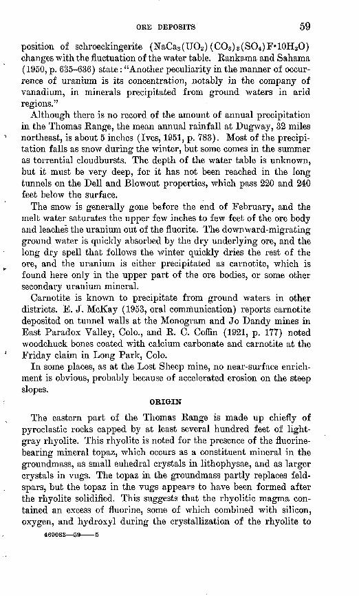
ORE DEPOSITS 59
position of schroeckingerite (NaCa3 (UO2 ) (CO3 )3(S04 )F«10H20) changes with the fluctuation of the water table. Rankama and Sahama (1950, p. 635-636) state: "Another peculiarity in the manner of occur rence of uranium is its concentration, notably in the company of vanadium, in minerals precipitated from ground waters in arid regions."
Although there is no record of the amount of annual precipitation in the Thomas Range, the mean annual rainfall at Dugway, 32 miles northeast, is about 5 inches (Ives, 1951, p. 783). Most of the precipi tation falls as snow during the winter, but some comes in the summer as torrential cloudbursts. The depth of the water table is unknown, but it must be very deep, for it has not been reached in the long tunnels on the Dell and Blowout properties, which pass 220 and 240 feet below the surface.
The snow is generally gone before the end of February, and the melt water saturates the upper few inches to few feet of the ore body and leaches the uranium out of the fluorite. The downward-migrating ground water is quickly absorbed by the dry underlying ore, and the long dry spell that follows the winter quickly dries the rest of the ore, and the uranium is either precipitated as carnotite, which is found here only in the upper part of the ore bodies, or some other secondary uranium mineral.
Carnotite is known to precipitate from ground waters in other districts. E. J. McKay (1953, oral communication) reports carnotite deposited on tunnel walls at the Monogram and Jo Dandy mines in East Paradox Valley, Colo., and R. C. Coffin (1921, p. 177) noted woodchuck bones coated with calcium carbonate and carnotite at the Friday claim in Long Park, Colo.
In some places, as at the Lost Sheep mine, no near-surface enrich ment is obvious, probably because of accelerated erosion on the steep slopes.
OBIGIN
The eastern part of the Thomas Range is made up chiefly of pyroclastic rocks capped by at least several hundred feet of light- gray rhyolite. This rhyolite is noted for the presence of the fluorine- bearing mineral topaz, which occurs as a constituent mineral in the groundmass, as small euhedral crystals in lithophysae, and as larger crystals in vugs. The topaz in the groundmass partly replaces feld spars, but the topaz in the vugs appears to have been formed after the rhyolite solidified. This suggests that the rhyolitic magma con tained an excess of fluorine, some of which combined with silicon, oxygen, and hydroxyl during the crystallization of the rhyolite to
469083 59 5
60 GEOLOGY, THOMAS RANGE FLUORSPAR DIST., JUAB COUNTY, UTAH
form the small topaz crystals in the groundmass and some of which formed the larger topaz crystals in the lithophysae and vugs.
On Spors Mountain light-gray rhyolites and quartz latite occur in small veins and plugs and as fragments in intrusive breccias. Topaz was identified in thin sections of these rocks collected from parts of Spors Mountain, as well as in the rhyolitic tuffaceous dikes found in the underground workings of the Bell Hill mine. Table 8 gives rock analyses from a sample of topaz-rich rhyolite from the large rhyolite flow near Topaz Mountain and from a small plug 400 feet southwest of the Eagle Rock fluorspar pit. Although some minor differences are obvious, the similarity of these two analyses suggests that the two rocks crystallized from a melt derived from the same or at least from similar magmas.
The fluorspar deposits were in general formed after most of the volcanic rocks were crystallized. This can be illustrated: in the tunnel leading to the Blowout mine, where a small purple fluorite vein cuts the intrusive breccia composed of rhyolite fragments; at the north end of a small tunnel on the Dell property, where a fluorspar pipe partly replaces a small rhyolite plug; on the Harrisite property, where a small fluorite vein occurs on a dolomite-latite contact and partly replaces both rocks; and at other localities in tuff, such as the Rainbow No. 2, which are described in a succeeding section on Indi vidual deposits. Bauer 9 also describes fluorite veinlets in agglomerate, and the authors found minute purple fluorite crystals filling fractures and vugs in rhyolite near the north flank of Spors Mountain. Although most of the fluorite mineralization followed the formation of the volcanic rocks, at one place the volcanic rocks appear to be later. An intrusive rhyolite tuff cuts a fluorspar body in the under ground workings of the Bell Hill mine. Thus, the fluorspar deposits formed after the bulk of the volcanic activity, but before the last eruptions.
Fluorine is the only major element (those present in amounts greater than 0.25 percent) in these deposits that could not be derived from the underlying country rocks. That the fluorine is of hydro- thermal origin is strongly suggested by the unusual fluorine content of the rhyolites of the adjoining Thomas Range. Similarly, uranium, which makes up only minor amounts of the fluorspar ore bodies probably was derived from the same magmas as the rhyolites. The association of these rhyolites with uranium was noted on the eastern side of the eastern part of the Thomas Range, where a yellow sec ondary uranium mineral coats fracture surfaces in tuff and rhyolite (Bauer and Staatz, 1951, written communication).
8 Bauer, H. L., Jr., 1952, Fluorspar deposits, north end of Spors Mountain, Thomas Range, Juab County, Utah: Utah Univ., unpub. thesis.

ORE DEPOSITS 61
Topaz was found in all the silicic igneous rocks in the Thomas Kange fluorspar district, but it was not noted in the latites and is most common in the thick rhyolite flow that caps the eastern part of the Thomas Range. This suggests that the fluorine was most concen trated in the more silicic rocks and hence probably the later part of the volcanic activity. Thus, it is probable that the fluorine was pro gressively concentrated during the differentiation of the volcanic melt, with an excess of fluorine being left in a hydrothermal fluid after the consolidation of at least most of the rhyolite. These fluids are believed to be the source of the fluorine that reacted with the calcium-rich dolomite on Spors Mountain to form fluorite.
This fluorine could have come either directly from the last massive rhyolite flow by separating from it during the last stages of crystal lization or from the source magma from which the volcanic rocks were differentiated. The authors feel that the latter explanation most closely fits the data as shown below. The volcanic rocks are younger than the Paleozoic sedimentary rocks, as can be seen from the numerous dikes and plugs that cut the sediments. As the massive topaz-rich rhyolite is younger and is a flow, it must have overlain the Paleozoic sedimentary rocks, if it was present in the area that is now Spors Mountain. The fluorspar pipes and veins plunge and dip steeply, indicating that the fluorine-rich fluids either went down or came up, but had very little horizontal movement. Thus, the fluorine has either come from a consolidating rhyolite above or from a deep- seated magma below. Because the relief of pressure is easiest upwards and the dikes and plugs suggest a source magma below connected by fractures, it seems more likely that the fluorine-rich fluids came from below.
The extremely fine-grained friable ore of the Thomas Range is unusual among fluorspar deposits, though fine-grained fluorspar is also found at the Poncha Springs and Brown's Canyon deposits in Chaffee County, Colo., the Daisy deposit in Nye County, Ney., and elsewhere in western United States (Van Alstine, R. E., 1954, oral communication). These ores, however, differ by having a grain size clearly visible to the naked eye and by being compact. The Thomas Range ore, though simple in mineralogy, consists entirely of minerals common to low temperature deposits. Ore structure, where visible, commonly shows brecciation and open boxworks. Most of the deposits exposed to a depth of greater than 80 feet show a change in min eralogy with a marked decrease in the fluorite content. All these characteristics suggest that the deposits are epithermal.
The depth of burial of the ore bodies at the time of their formation differs; the surf ace elevation of the East pipe of the Fluorine Queen is 1,200 feet above that of the Lucky Louie. If patches of the flows
62 GEOLOGY, THOMAS RANGE FLUORSPAR DISTV JTJAB COUNTY, UTAH
covered the Paleozoic sedimentary rocks on Spors Mountain, it might be possible to calculate the amount of the sediments removed since the volcanic activity; but as neither the amount of erosion of the sediments nor the thickness of any overlying volcanic sequence is known, it is impossible to estimate the depth of formation of the ore bodies.
DESCRIPTIONS OF INDIVIDUAL, DEPOSITS
The chief fluorspar deposits in the Thomas Range were investigated in 1950 by Staatz, Wilmarth, and Bauer (Thurston and others, 1954), who described 24 deposits on 14 properties. Since 1950, 15 properties containing 27 deposits have been further exploited, have started pro duction, or have been recently discovered. These properties are de scribed below. Six properties, the Dell, the Dell No. 5, the Eagle Rock, the Floride, the Nonella, and the Thursday, have had no further work done on them and are therefore not described.
BELL HILL
The Bell Hill property is on the top of a group of hills 80-120 feet high that form the southeastern corner of Spors Mountain (pis. 1 and 3). This property adjoins the Harrisite group of claims on the northwest and is in the SE^SE^ sec. 10, T. 13 S., R. 12 W. Total distance from the Bell Hill mine to Delta, Utah, is 47.5 miles.
The Bell Hill group of claims was located during July 1949 by H. J. Ruthiford, D. W. Searle, C. D. Searle, and H. E. Searle. The Spor brothers leased the property in 1950 and mined fluorspar by opencut methods from the two largest ore bodies. By October 1950 they had produced a total of 3,385 short tons of fluorspar. From October 1950 through August 1951 the property was under contract to the Harrises, who drove a 230-foot adit from the east side of the hill, to the largest ore body. Fifty feet from the main ore body, the adit struck a smaller ore body, which was covered by alluvium on the surface, and had not previously been discovered. The small ore body was stoped out to the surface, and some ore also was taken from the ore body at pit 2 (pi. 9). The Harrises shipped a total of 1,530 tons. From September 1951 Les Price and Earl Dalton mined the large ore body of the Bell Hill under contract and stoped out ore from the adit level and from 3 sublevels above the adit level, and 4 sublevels below. They produced 2,565 tons of ore during the rest of 1951 and 4,466 tons in 1952. Total production from this property through 1952 is 11,946 short tons.10
10 Data are furnished by Bell Hill Mining Co. and are published with permission of the owners.

BELL HILL 63
The Bell Hill property contains 2 main ore bodies, 4 smaller deposits, and many small veins and stockworks. Surface workings (pi. 9) consists of 4 large bulldozer trenches (Nos. 1, 2, 3, and 4) measuring 135 by 13 feet, 60 by 55 feet, 100 by 58 feet, and 130 by 7 feet, respectively; and 2 open pits; pit 1 is 160 feet long and as much as 50 feet wide, and pit 2 is 170 feet long and 25 feet wide. Pit 1, on the largest fluorspar body, was 10-35 feet deep when open pit mining was stopped; the pit was connected to the uppermost underground workings late in 1952; pit 2 is 6-25 feet deep. In addition to the adit to the large ore body, underground workings consist of a 78-foot long raise on the small ore body adjacent to the adit; a stope in the large ore body on the adit (87-foot) level, 106 feet long by 11-38 feet wide, 1 large and 2 small stopes on levels above the adit level, an inclined winze in the ore body starting from the west end of the adit level, 4 stopes on levels below the adit level, an inclined raise from the bottom of the winze up to the adit in the country rock, and several raises connecting the various levels (fig. 4). The winze is approxi mately 125 feet long and is inclined 50-54^° to the northeast. Approximately 50 percent of the ore was mined by stoping out large rooms on the various levels leaving pillars to hold up the ceilings. The plan was to blast down pillars and remaining ore to the winze bottom, and then haul it to the adit through the raise in the country rock.
DIAMOND DRILLING
To extend the area of known reserves of the Bell Hill ore body and to determine the uranium content, the U. S. Atomic Energy Com mission drilled two diamond drill holes. The drilling was done by U. S. Bureau of Mines crew of nine men under the direction of A. A. McKinney from September 25, 1951, to January 29, 1952.
The first hole (pi. 9) was started approximately 138 feet north of the northeastern end of the ore body and drilled S. 26^° E. at a 57^° angle. On the basis of the dip of the ore body at the surface, this hole was aimed at a point calculated to intersect the ore body approximately 270 feet below the surface. Unfortunately, the plunge of the ore body changed between 100 and 180 feet below the top of the opencut, and the ore body gradually turned until the plunge was southeast. The drilling penetrated no fluorite, and the hole was abandoned at a length of 526 feet. The hole started in the Bell Hill dolomite, passed through the Floride dolomite and upper member of the Fish Haven dolomite, and ended in lower member of the Fish Haven. The Floride dolomite is 119 feet thick, and the upper member of the Fish Haven 100 feet thick, where cut in the drill hole.
The second hole was started 54.5 feet S. 80° W. of the first hole (pis. 9, 10). It was drilled S. 28° E. at a 51° angle to hit the ore

Ore
poc
ke
MA
P
OF
6
9
LE
VE
L
'.Rhy
oliti
c tu
fface
ous
dike
8-in
ch f
luor
spar
str
inge
r
Rhy
oliti
c tu
fface
ous
dike
Fluo
rspa
r sh
owin
g br
ecci
ated
str
uctu
re
Rhy
oliti
c tu
fface
ous
dike
MA
P O
F 8
7
LE
VE
L
Rhy
oliti
c tu
fface
ous
strin
ger
Rhy
oliti
c tu
fface
ous
dike
(6
inch
es t
hick
)
MA
P
OF
1O
8 L
EV
EL
MA
P O
F
129
LE
VE
L
Rhy
oliti
c tu
fface
ous
strin
ger
Rhy
oliti
c tu
fface
ous
dike
(4
inch
es t
hick
)
led
and
clay
ey m
ater
ial
cont
aini
ng s
ome
fluor
ite
MA
P O
F
15O
LE
VE
L
Rhy
oliti
c tu
fface
ous
dike
(6
inch
es th
ick)
Ore
mix
ed w
ith
silic
a an
d ch
ert
Sili
ceou
s an
d ch
erty
m
ater
ial w
ith s
ome
ore
MA
P
OF
168
LE
VE
L
Hig
h-gr
ade
ore
Low
-gra
de o
re
Dol
omite
bre
ccia
Con
tact
, sh
owin
g di
p D
ashe
d w
here
app
roxi
mat
ely
loca
ted
Faul
t, sh
owin
g di
p
_*2
Stri
ke a
nd d
ip o
f be
ds
0
Hea
d of
rai
se o
r w
inze
S.
Foot
of
rais
e
HI
Win
ze e
xten
ding
thr
ough
lev
el
Geo
logy
by
M.
H.
Sta
atz,
Aug
ust
1952
o
FIG
UR
E 4. U
nder
gro
und g
eolo
gic
map
s of
the
Bel
l H
ill
min
e, J
uab
Cou
nty,
Uta
h.
BELL HILL 65
body higher and approximately 48 feet southwest of the expected target for the first hole. Ore was first detected at 206 feet below the surface (pi. 10), and the drill left the fluorspar body at 240 feet. In the center of the ore body, a dolomite horse approximately 6 feet thick was found. Where the drill entered the fluorspar, the ore deposit was approximately 19 feet thick. The total length of the hole was 353.7 feet.
Diamond drilling proved to be a poor method of exploration, as almost the entire length of both holes had to be cemented at least once and part of it twice. Total length of cement core drilled from two holes which had a combined length of 880 feet, was 1,368 feet. The direction of the holes deviated in two places in each hole where the drill did not follow its original path during the drilling of the cement. Core recovery was poor in the dolomite and was worse in the fluorspar.
GEOLOGY
Outcrops of the Harrisite dolomite, the Bell Hill dolomite, and the Floride dolomite, and the upper member of the Fish Haven dolomite cross the Bell Hill group of claims. The Bell Hill dolomite surrounds all the fluorspar bodies at the surface; in the deeper workings the Floride dolomite surrounds the largest ore body. These dolomites strike N. 13°-54° E. and dip 25°-44° NW.
Exposures are poor,.and the bedrock is partly covered by a thin veneer of gravel of the Lake Bonneville beds. Along both sides of the small valley with trench 1 (pi. 9) near its head, about 2 feet of conglomerate of the Lake Bonneville beds unconformably overlies dolomite with angular discordance. The conglomerate strikes N. 71° E. and dips 7° SE., whereas the dolomite strikes N. 40° E. and dips 44° NW.
The Bell Hill claims are crossed by numerous branching northeast- trending faults; this area is one of the most broken in Spors Moun tain. Faults in the Bell Hill dolomite are extremely difficult to trace, unless they contain breccia, because no distinctive marker beds exist except the light-gray dolomite that makes up the upper 45 feet of the formation. The displacement of faults represented by breccia zones is difficult to determine. Only where the faults cut more than one formation is the apparent horizontal displacement measurable. One of the largest faults that crops out on this property passes through trench 1 and pit 2. It has a true displacement of approxi mately 175 feet; the south side moved down along slickensides that plunge 54°, S. 62° E.
ORE DEPOSITS
The Bell Hill property has yielded ore from the two largest ore bodies (pits 1 and 2) and the small ore body east of pit 1. (See pi. 9.)
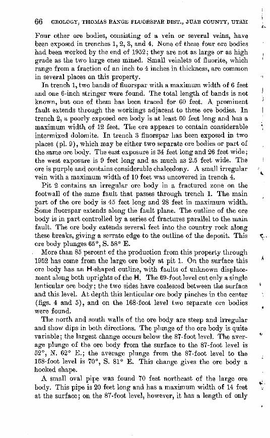
66 GEOLOGY, THOMAS RANGE FLUORSPAR DIST., JTJAB COUNTY, UTAH
Four other ore bodies, consisting of a vein or several veins, have been exposed in trenches 1, 2, 3, and 4. None of these four ore bodies had been worked by the end of 1952; they are not as large or as high grade as the two large ones mined. Small veinlets of fluorite, which range from a fraction of an inch to 4 inches in thickness, are common in several places on this property.
In trench 1, two bands of fluorspar with a maximum width of 6 feet and one 6-inch stringer were found. The total length of bands is not known, but one of them has been traced for 60 feet. A prominent fault extends through the workings adjacent to these ore bodies. In trench 2, a poorly exposed ore body is at least 60 feet long and has a maximum width of 12 feet. The ore appears to contain considerable intermixed dolomite. In trench 3 fluorspar has been exposed in two places (pi. 9), which may be either two separate ore bodies or part of the same ore body. The east exposure is 34 feet long and 26 feet wide; the west exposure is 9 feet long and as much as 2.5 feet wide. The ore is purple and contains considerable chalcedony. A small irregular vein with a maximum width of 10 feet was uncovered in trench 4.
Pit 2 contains an irregular ore body in a fractured zone on the footwall of the same fault that passes through trench 1. The main part of the ore body is 45 feet long and 28 feet in maximum width. Some fluorspar extends along the fault plane. The outline of the ore body is in part controlled by a series of fractures parallel to the main fault. The ore body extends several feet into the country rock along these breaks, giving a serrate edge to the outline of the deposit. This ore body plunges 65°, S. 58° E.
More than 85 percent of the production from this property through 1952 has come from the large ore body at pit 1. On the surface this ore body has an H-shaped outline, with faults of unknown displace ment along both uprights of the H. The 69-foot level cut only a single lenticular ore body; the two sides have coalesced between the surface and this level. At depth this lenticular ore body pinches in the center (figs. 4 and 5), and on the 168-foot level two separate ore bodies were found.
The north and south walls of the ore body are steep and irregular and show dips in both directions. The plunge of the ore body is quite variable; the largest change occurs below the 87-foot level. The aver age plunge of the ore body from the surface to the 87-foot level is 52°, N. 62° E.; the average plunge from the 87-foot level to the 168-foot level is 70°, S. 81° E. This change gives the ore body a hooked shape.
A small oval pipe was found 70 feet northeast of the large ore body. This pipe is 20 feet long and has a maximum width of 14 feet at the surface; on the 87-foot level, however, it has a length of only
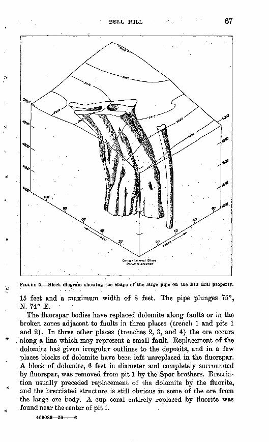
67
FIGURB 5. Block diagram showing the shape of the large pipe on the Bill Hill property.
15 feet and a maximum width of 8 feet. The pipe plunges 75°, N. 74° E.
The fluorspar bodies have replaced dolomite along faults or iii the broken zones adjacent to faults in three places (trench 1 and pits 1 and 2). In three other places (trenches 2, 3, and 4) the ore occurs along a line which may represent a small fault. Keplacement of the dolomite has given irregular outlines to the deposits, and in a few places blocks of dolomite have been left unreplaced in the fluorspar. A block of dolomite, 6 feet in diameter and completely surrounded by fluorspar, was removed from pit 1 by the Spor brothers. Breccia- tion usually preceded replacement of the dolomite by the fluorite, and the brecciated structure is still obvious in some of the ore from the large ore body. A cup coral entirely replaced by fluorite was found near the center of pit 1.
469083 59 6

68 GEOLOGY, THOMAS RANGE FLUORSPAR DIST., JUAB COUNTY, UTAH
The ore in the large pipe is cut at the 87-foot and lower levels by highly irregular bands of fine-grained dark-brown extremely friable tuffaceous volcanic material that range from a fraction of an inch to several feet in thickness (pi. 7Z?). These bands are chiefly in the ore but also follow the contact of the ore body with the dolomite and in a few places extend a few inches into the country rock. Micro scopic examination revealed that 73 percent of it is highly altered and now made up of a clay mineral, zeolites, and sericite flakes. The unaltered part can be roughly divided into 15 percent of clear sani- dine, 5 percent of smoky quartz, 3 percent of magnetite, and 2 percent each of chalcedony and topaz. The rock is designated an intrusive rhyolitic tuff and was probably, formed by early consolidation of some of the minerals, which were rounded and altered as they were forced up into the ore body by hot gases.
The fluorspar is soft and pulverulent; most of the ore in trench 1 is white, and most of the ore in pit 2 is a dark purple. The large ore body in pit 1 contains both white ore and purple ore that occurs irregularly throughout the body. Impurities consist of a waxy clay, cream-colored dolomite, and quartz. Waxy brown clay from the stope on the 87-foot level of the large pipe was identified by E. W. Tooker as being chiefly a calcium magnesium montmorillonite with a small amount of another unidentified clay mineral. The ore changes some with depth, and on the 150-foot level a hard vuggy material made chiefly of light-colored dolomite and quartz occurs with a little fluorite at the east end of the large ore body. More of the same material is found around the edges of the ore body on the 158-foot level, and 25 feet down the small winze driven southwest from this level, the siliceous dolomitic material occurs near the center of the ore body. The fluorspar, which includes this material, was too low a grade to sell without beneficiation at 1952 prices.
Analyses were made for the fluorite content of ore from the large body. Three samples taken from the opencut ranged from 78.5 to 90.1 percent of fluorite (table 8). Composite samples made of 4-6 channel samples from each level showed the fluorite content of ore at the 69-foot level to be 80.8 percent; at the 87-foot level, 63.0 per cent; at the 108-foot level, 67.6 percent; at the 129-foot level, 89.5 percent; at the 150-foot level, 84.8 percent; and at the 168-foot level, 84.8 percent. Samples were devoid of any of the rhyolitic tuff bands and the siliceous dolomite material that are most common on the lower levels. Samples on the same level from different parts of the ore body show considerable variation. The composite sample of the 87-foot level is probably low, as five samples taken from the ore bin containing ore which came from this level ranged from 72.5 to 88.8 percent of fluorite. Fluorite content of drill-hole samples from the

BELL HILL 69
lower part of the ore body is recorded in table 8. These results should be used with caution as the sample was small and the core recovery was poor.
Thin yellow coatings on gray dolomite adjacent to the ore body in pit 1 gave an X-ray powder pattern that matches the standard powder pattern for carnotite. Not all of the uranium, however, occurs as carnotite, as the analyzed sample from pit 1 contained 0.26 percent of uranium and 0.03 percent of vanadium. The uranium content by weight is approximately twice that needed to form carnotite if all the vanadium was in carnotite. No other uranium mineral was noted in the ore or in heavy mineral separates from it.
The uranium content of the individual deposits on the Bell Hill property varies considerably at the surface. Three parallel bodies are exposed in trench 1. The small northern 6-inch stringer shows no abnormal radioactivity; the central vein composed of white fluorspar has a radioactivity equivalent to less than 0.01 percent of uranium; and the southern vein composed of white and purple fluorspar con tained 0.029 and 0.059 percent of uranium in 2 channel samples.
The poorly exposed ore body in trench 2 is composed of white to purple fluorspar. One channel sample, 5.5 feet long, cut across the center of this body contained 0.012 percent of uranium.
Two separate bodies (or a single irregular body) of purple fluorite are exposed in trench 3. Two samples taken from the larger eastern body contained 0.036 and 0.038 percent of uranium, respectively. One sample taken from the smaller western body contained 0.010 percent of uranium.
An irregular vein of white to purple fluorspar is exposed in trench 4. One channel sample, 4.0 feet long, across the center of this vein contained 0.006 percent of uranium.
Pit 2 contains the darkest purple fluorite found on the Bell Hill property. Three channel samples cut around the sides in the upper 15 feet of the pit contained 0.052, 0.061, and 0.064 percent of uranium, respectively. A chip sample around the entire body contained 0.073 percent of uranium.
The large ore body exposed in pit 1 is the most extensively sampled ore body in the district, with a total of 64 samples (table 8). The uranium content of these samples ranged from 0.008 to 0.33 percent. The lowest content was found in ore recovered in drill hole 2, where the samples were small and the ore was commonly intermixed with wallrock. The lowest content in a sample excluding those obtained from drill-hole cores was 0.029 percent of uranium. Analyses of fluorspar from several points on the same level show a considerable range in uranium content. The levels, however, have approximately the same range in grade. The surface material exposed in the opencut

70 GEOLOGY, THOMAS RANGE FLUORSPAR DIST., JUAB COUNTY, UTAH
has a higher uranium content than that exposed in the underground workings. The ore from the opencut ranges from 0.093 to 0.33 percent of uranium. The highest grade specimen of the 57 samples taken from below the opencut contained 0.21 percent of uranium.
BLOWOUT
The Blowout mine is on the east side of Spors Mountain, near the crest in sec. 21, T. 12 S., R. 12 W. (pi. 1). The Blowout mine adjoins the west line of the Lost Sheep No. 1 mine. The ore body was worked \>y an opencut and a haulage adit, both of which are connected to the main haulage road along the east side of Spors Mountain.
The claim, located May 19, 1948, by T. A. Claridge and Rex Claridge of Delta, Utah, was named the "Blowout" because fluorspar veinlets were first discovered in an intrusive plug next to the fluorspar pipe. A road was built up the west side of Spors Mountain and mining began with an opencut. The adit was jointly started in 1950 by the owners of both the Blowout and Lost Sheep properties; the portal is located on the Lost Sheep group of claims. Mining ceased in the opencut in the fall of 1950, when large dolomite blocks, as much as 20 feet across, caved into the cut. Approximately 3,000 tons of ore averaging 75 percent of fluorite had been mined. During the fall of 1950 and winter of 1951, mining was by a series of stopes above the adit level, under contract to the Centennial Development Company of Eureka, Utah. This ore contained considerable clay, and the grade was lower than at the surface. The road leading to the opencut from the west side of Spors Mountain was washed out by cloudbursts during the summer of 1951, and work during the summer of 1952 consisted of constructing a road from the adit portal up the east side of Spors Mountain to the opencut, removing the loose material from the opencut, and extending the tunnel from the ore body for about 50 feet to the west (not shown in pi. 11). Production to the end of 1952 is 5,896 short tons.11
The opencut (pi. 11) is 140 feet long and 25 feet wide with a 40- by 12-foot projection to the northeast along the north contact of an intrusive rhyolite breccia plug. A 500-foot haulage adit intersects the ore pipe 240 feet below the outcrop. Three raises and a stope enter the ore body from the haulage level. Bauer12 states that stoping was hampered by dolomite blocks cavings and obstructing the raises.
Two small bodies of fluorspar crop out about 800 feet north of the open pit. A drift intersected these bodies from the haulage level (pi. 11), but they proved too high in free silica to mine.13
11 Data are furnished by the owners, and are published with their permission. 18 Bauer, H. L., Jr., 1952, Fluorspar deposits, north end of Spors Mountain, Thomas
Range, Juab County, Utah: Utah Univ., unpub. thesis, p. 28, 30. " Bauer, H. L., Jr., op. clt, p. 30.

BLOWOUT 71
GEOLOGY
The Blowout claim is crossed by the outcrops of the Bell Hill, Harrisite, and Lost Sheep dolomites. The open pit is in the gray member of the Lost Sheep dolomite; the ore body at the haulage level is in Harrisite dolomite. A plug of intrusive rhyolite and breccia of Tertiary (?) age adjoins the fluorspar pipe at the surface but it was not seen underground. This suggests that the fluorspar pipe and intrusive mass plunge at divergent angles or that the intrusive mass is not continuous in depth. A larger mass of intrusive breccia (pis. 1 and 11) lies 470 feet east of the ore pipe; it is best seen in the walls of the haulage adit.
At the surface the dolomites strike northeast and dip 33°-40° NW.; dip of beds at the haulage level ranges from 40° to 51° NW. No large faults are known in the immediate vicinity of the Blowout mine, but a fault of small displacement trends south from the rhyolite intrusion. Bauer mapped six small steeply dipping faults within a few hundred feet of the Blowout open pit.14 The rectangular outcrop pattern of the ore body suggests a control by fracturing, but no offset of beds can be seen (pi. 11).
The rhyolite and breccia plug is well exposed in the walls of the opencut. The altered iron-stained rhyolite contains small smoky quartz crystals less than three-sixteenths of an inch in diameter and remnants of feldspar crystals less than half an inch in size. The breccia consists of blocks of porphyritic rhyolite and small pieces of chert, probably derived from the Lost Sheep dolomite.
ORE DEPOSITS
At the surface the Blowout ore body forms a crude rectangle about 100 by 30 feet, with an extension to the northeast 40 by 13 feet. At the 240-foot level the ore body is only about 47 by 16 feet. The ore body plunges 71°, N. 49° E.
The fluorspar is lavender to purple and crumbly though it has a well-defined boxwork structure. The spaces in the boxwork are angular and reach a maximum size of l1/^ inches. Some of the open ings contain small colorless fluorite crystals. Bauer15 described a series of three specimens taken within a distance of 2 feet which showed a gradation from dolomite with minute fluorite veinlets, through fluorite enclosing angular remnants of dolomite, to boxwork fluorite. Kelict bedding, in apparent continuity with bedding in near by Lost Sheep dolomite, is visible in the eastern part of the open pit. These facts strongly suggest replacement of brecciated dolomite by fluorite. The ore body changes texturally and mineralogically with
i* Bauer, H. L., Jr., 1952, op. clt., fig. 4. » Bauer, H. L., Jr., 1952, op. clt., pi. 1.

72 GEOLOGY, THOMAS RANGE FLUORSPAR DIST., JUAB COUNTY, UTAH
'depth, as it is not as porous and contains more clay and water on the haulage level.
Two individual samples and one composite sample were taken in the opencut and analyzed for fluorite (table 8). The grade of these three ranged from 79.6 to 92.0 percent of fluorite. One sample taken from the haulage adit contained 72.1 percent of fluorite. Average fluorite content of ore from the haulage level is lower than that in the opencut owing to considerable admixture of montmorillonite.
Five samples from the fluorspar body in the opencut and four from the haulage level were analyzed for uranium (table 8). Samples from the opencut ranged from 0.005 to 0.033 percent of uranium, and those from the haulage level, from 0.004 to 0.013 percent.
BLUE QUEEN NO. 1
The Blue Queen No. 1 is on the south face of a steep canyon, on the west side of Spors Mountain (pi. 1). It is about 3,000 feet south of the Thursday prospect, north of the Blue Queen No. 2, and east of the Blue Queen No. 3. The claim was staked April 1,1952, by Wesley Sampson, Harold Goodwin, and Archie A. Searle, all of Delta, Utah. The workings consist of an incline, an adit, and several small pits. Most of the workings are in the gray member of the Lost Sheep dolomite, though two shallow trenches about 100 feet east of the dump showed a red dolomitic intrusive breccia. The Lost Sheep dolomite strikes N. 40° E. and dips 30° NW.
The adit (fig. 6) showed a few fine-grained purple fluorspar masses in dolomite along the west wall near the portal. Most of the fluorite filled fractures and lined vugs. The adit crossed a fault, and no more fluorite was noted.
The incline (fig. 6) is about 12 feet deep, and plunges 50° south. Dark-gray Lost Sheep dolomite contains irregular masses of fine grained purple fluorspar, which replace some of the chert nodules as well as the dolomite. The fluorspar is restricted to a zone in dolomite which strikes N. 22° E. and dips 52° southeast and which contains about 25 percent of fluorite. The zone was followed to a depth of about 12 feet. A few small pieces of green crystalline fluorite were scattered on the dump, but none was found in place. A sample made up of uniform-size chips taken every 6 inches across the face contained 0.004 percent of uranium. A stockpile of purple fluorspar, probably handpicked, was 14 by 8 feet by a maximum of 4 feet high, in August 1952.
FLUORINE QUEEN
The Fluorine Queen property straddles a 6,220-foot saddle on the central ridge of Spors Mountain. This property is the highest of any producing mine in the Thomas Range. The ore came from two pipes:

FLUORINE QUEEN 73
FWO-25-52; 0.003 EXPLANATION
Ore pile
FWO-26-52; 0.004
LOST SOUL NO 1
FWO-35-52;0.004
BLUE QUEEN NO 1
-16'3rv
Dashed where approximately located
Fault, .showing dip
Fault zone
Strike and dip of bads
Fluorspar vein, showing dip
Low-grade fluorspar
mInclined shaft
Portal and opencut
Dump
FWO-35-52; 0.004 Sample number; percent of uranium
50 Feet
Geology by F. W. Osterwald, July 1952
FIOUBD 6. Underground geologic maps of the Blue Queen No. 1 and Lost Soul No. 1, JuabCounty, Utah.
74 GEOLOGY, THOMAS RANGE FLUORSPAR DIST., JUAB COUNTY, UTAH
one about 500 feet west of the saddle and the other 300 feet northeast of it. The Fluorine Queen is near the center of Spors Mountain, in the NE^4 sec. 34, T. 12 S., R. 12 W. (pi. 1). A steep mountain road, approximately 1 mile long, connects the property with the main ore haulage road along the east side of Spors Mountain.
The Fluorine Queen was located in March 1948 by W. E. Black and F. B. Chesley of Delta, Utah. The road to the mine was built, and the first ore shipped in 1948.
From 1948 to the spring of 1950, all the ore was mined by open-pit method from the pipe on the west side of the saddle (west pipe). The pit has nearly vertical walls, 21-45 feet high, and was entered by a cut in its southern end. From 1950 until the fall of 1952 all produc tion came from the east pipe. At that time the cut into the west pipe was deepened about 10 feet and a carload of ore was shipped. In 1951 a tunnel (pi. 12) was driven under the ore body from the road .level, 34 feet below the lower edge of the pit, and a raise was driven up into the center of the ore body. Ore was then slushed into the raise and trammed out the tunnel.
Total production through 1952 amounted to 17,119 short tons.16 Mr. Chesley reported that railroad carloads of ore mined from the main part of the west pipe assayed from 65 to 75 percent of fluorite; the southeast end, however, contained around 90 percent of fluorite. The east pipe contained 74-83 percent of fluorite. Mr. Chesley re-r ported the grade of the ore increased slightly with depth.
: GEOLOGY
Both of the Fluorine Queen ore bodies are in Bell Hill dolomite; and both occur in the same fault block (pi. 1). The largest fault, with a minimum lateral displacement of at least 680 feet, crosses the saddle, and its northeastern extension passes close to the canyon bot tom south of the fluorspar pipes. This fault commonly contains a 1- to 6-foot band of brownish travertine. Several smaller faults cross the saddle, and the entire area appears to be a zone of shattering with many small shears.
ORE DEPOSITS
The west fluorspar pipe, which is 105 feet long and ranges from 13 to 55 feet in width, is irregular in shape and has almost vertical walls. The contact of the fluorspar with the dolomite is sharp, and the dolomite is not altered, even at the edge of the ore body. A map of this pipe has previously been published (Thurston and others, 1954), and as little work has been done since the map was made in September 1950, the ore body was not reexamined.
18 Data are furnished by owners, and are published with their permission.

FLUORINE QUEEN 75
The east pipe is shaped like an irregular parallelogram, with the long diagonal measuring 155 feet and the short diagonal 106 feet (pi. 12). The outline of this pipe is now entirely exposed; therefore, its shape has been somewhat modified from that previously reported (Thurston and others, 1954). To the south of the main eastern ore body (pi. 12) two smaller adjoining pipes have recently been un covered. The first one, 7 feet to the south, has a length of 22 feet and a maximum width of 13 feet; the second ore body, 26 feet to the south, has a length of 32 feet and a maximum width of 20 feet. As of No vember 1952, neither of these two smaller ore bodies had been mined. The adit driven under the main east ore body struck a large horse of dolomite (pi. 12) in the western half of the ore body, which consider ably diminishes the amount of fluorspar on that level. The pipe has an average plunge of 82° to the east.
The ore is soft and friable and white to dark purple. The chief impurity is a white waxy clay (montmorillonite). Quartz stringers and crystals are found in a few places. Scott Chesley reports that carload lots of fluorspar from the west pipe contained from 65 to 90 percent of fluorite. A powdery yellow mineral, probably carnotite, occurs in a streak of hard fluorspar, approximately 40 feet long and 1 foot wide, in the center of the west pipe. Two channel samples cut on either side of the west-pipe pit bottom (table 8) contained 0.018 and 0.039 percent of uranium. The latter sample also contained 0.04 percent VaOs and 2.64 percent MgO. The vanadium is present in about the right amount for carnotite, which has been identified by X-ray methods on the Eagle Rock and Bell Hill properties. The magnesium oxide content, which is more than 2 percent higher than that obtained from other properties, suggests a high clay content, as there was no visible dolomite.
Two samples were taken close to the surface of the east pipe, soon after mining started. These samples contained 0.011 and 0.020 per cent of uranium and 61.0 and 71.3 percent of fluorite. A third sample, from a deeper part of the opencut, contained 0.023 percent of uranium. Three samples were taken later from the three parts of the ore body on the tunnel level, and they contained 0.006, 0.008, and 0.010 percent of uranium, and 82.5, 72.6, and 68.0 percent of fluorite, respectively. The average of these samples at the various elevations (pi. 12) shows a marked decrease in the grade of the uranium with depth. The fluorite content of the ore, however, increases. This later observation has been borne out by carload shipments.
A sample taken at the surface of the small ore body 26 feet to the south of the east pipe contained only 0.010 percent of uranium.
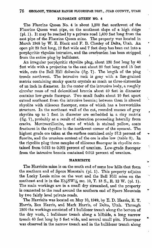
76 GEOLOGY, THOMAS RANGE FLUORSPAR DIST., JUAB COUNTY, UTAH
FLUOBINE QUEEN NO. 4
The Fluorine Queen No. 4 is about 1,200 feet southwest of the Fluorine Queen west pipe, on the southeast slope of a high ridge (pi. 1). It may be reached by a private road 1,400 feet long from the east pipe of the Fluorine Queen mine. The property was located in March 1948 by W. E. Black and F. B. Chesley of Delta, Utah. An open pit 20 feet long, 12 feet wide and 7 feet deep has been cut into a porphyritic rhyolite intrusion, and the overburden has been stripped from the entire plug by bulldozer.
An irregular porphyritic rhyolite plug, about 130 feet long by 40 feet wide with a projection to the east about 80 feet long and 15 feet wide, cuts the Bell Hill dolomite (fig. 7). The length of the plug trends northwest. The intrusive rock is gray with a fine-grained matrix containing smoky quartz crystals as much as three-sixteenths of an inch in diameter. In the center of the intrusive body, a roughly circular mass of red dolomitized breccia about 40 feet in diameter contains low-grade fluorspar. Two small faults about 10 feet apart extend southeast from the intrusive breccia; between them is altered rhyolite with siliceous fluorspar, some of which has a boxworklike structure. In the northeast wall of the cut, rounded masses of gray rhyolite up to 1 foot in diameter are embedded in a clay matrix (fig. 7), probably as a result of alteration proceeding laterally from cracks. Montmorillonite, some of which is stained yellow, coats fractures in the rhyolite in the northwest corner of the opencut. The highest grade ore taken at the surface contained only 57.3 percent of fluorite, and the uranium content of the ore is also low (table 8). In the rhyolite plug three samples of siliceous fluorspar in rhyolite con tained from 0.012 to 0.022 percent of uranium. Low-grade fluorspar from the intrusive breccia contained 0.015 percent of uranium.
HABRISITE
The Harrisite mine is on the south end of some low hills that form the southern end of Spors Mountain (pi. 1). This property adjoins the Lucky Louie mine on the west and the Bell Hill mine on the southeast and is in the Ey2SWi/4 sec. 10, T. 13 S., K. 12 W. (pi. 1). The main workings are in a small dry streambed, and the property is connected to the road around the southern end of Spors Mountain by two fairly level private roads.
The Harrisite was located on May 10,1949, by E. D. Harris, E. T. Harris, Rex Harris, and Mark Harris, of Delta, Utah. Through 1950 the workings consisted of 1 bulldozer trench along the bottom of the dry wash, 1 bulldozer trench along a hillside, a long narrow trench 40 feet long by 5 feet wide, and several small pits. Fluorspar was observed in the narrow trench and in the bulldozer trench along

HARRISITE 77
EXPLANATION
Bell Hill dolomite
.90
Vertical fault Dashed where approximately located
_37
Strike and dip of beds
Low-grade fluorspar
Opencut
I
Contact Dashed where approximately located
50 0
I
Position of channel sample
FWO-56-52; 0.012 Sample number; percent of uranium
100 FeetI_____________|
Geology by F. W. Osterwald and L. F. Emmett, August 1952
FIGURE 7. Geologic map of the Fluorine Queen No. 4, Juab County, Utah.
the wash; in the trench, scattered pits were dug from time to time exposing several small fluorspar pipes. During June 1951 the Harrises sank shafts on two of these small pipes. The largest, which was 10 feet across and highly irregular, was followed to a depth of approxi mately 8 feet. The other pipe, which was 6 by 4 feet at the surface and narrowed with depth, was followed downward for 23 feet. Up

78 GEOLOGY, THOMAS RANGE FLUORSPAR DIST., JUAB COUNTY, UTAH
Surface
0 6 Feet
FiotJBH 8. Diagrammatic vertical section showing the relationship of fluorspar bodies to thrust fault, Harrisite property.
to the end of 1952, one carload of ore (approximately 55 tons) was shipped, which according to Mr. E. T. Harris, contained 78 percent of fluorite and 4 percent of silica. In August 1951 a cloudburst filled all the workings with gravel and water. No further work was done until November 1951, when the property was leased to the Davis brothers, who excavated a large trench along the dolomite latite contact where fluorite occurs in the altered latite. As this fluorspar was too low a grade to ship, the working was abandoned. The brothers next excavated a trench about 15 feet deep in the central part of the wash. A flat fault (fig. 8) was uncovered, revealing fluorspar masses which at points extend up toward the surface. Below this fault only small stringers of fluorspar were noted. An inclined shaft, 64 feet deep, was sunk from the bottom of the excavation beneath the fault and under the largest of the two small pipes. Except for a few small stringers near the top, no fluorite was found.
GEOLOGY
The contact between the latite porphyry of Tertiary (?) age and the dolomites of Silurian age crosses the Harrisite claim. These rocks are in part overlain by gravels and conglomerate formed by old Lake Bonneville.
Owing to considerable faulting, the Harrisite dolomite, the upper cherty and lower gray members of the Lost Sheep dolomite, and the

HARRISITE 79
Thursday dolomite are all present on the Harrisite claim. The beds strike from N. 6° W. to N. 29° E. and dip 25°-42° NW.
In the southern part of the claim, augite-enstatite latite porphyry is intruded into dolomite. This rock consists chiefly of dark-green phenocrysts of enstatite and augite in a dark fine-grained groundmass containing numerous plagioclase microlites. Along its contact with the dolomite, the latite porphyry contains calcite and clay minerals, and the color has changed from dark gray to light gray probably owing to reaction of the latite porphyry with the dolomite along its periphery.
The dolomite is cut by numerous northeast-trending faults that dip 60°-75° SE.; the largest of these faults has a vertical displace ment of at least 250 feet. A northwestward-trending fault offsets one of the strike (northeasterly) faults about 65 feet north of the worK- ings in the wash and has a horizontal offset of 34 feet. A flat thrust fault was exposed in the excavation in the wash. Most fault move ment took place before the emplacement of the latite porphyry, but a trench shows sheared latite porphyry along a strike fault.
ORE DEPOSITS
Fluorspar is localized in the altered latite porphyry, on a fault between the latite porphyry and the dolomite and in shattered zones in the dolomites.
In the latite porphyry the fluorspar veins cut this soft altered rock and separate the altered mineral constituents of the rock. The grade is low and does not exceed 30 percent of fluorite. A channel sample taken across a 4-foot vein contained 0.094 percent of uranium, and a composite chip sample from several pits with fluorspar veinlets cut ting altered latite porphyry contained 0.039 percent of uranium.
A fault separates Lost Sheep dolomite from latite porphyry and contains a small vein of light- to dark-purple fluorite. This irregular vein, i£-3 feet wide, is exposed for 20 feet along a narrow trench, and dips 74° east. The fluorspar, whose chief impurity is clay, replaces both the dolomite and the altered latite porphyry. A yellow uranium mineral was found along shear planes in the altered latite porphyry adjacent to the fluorspar vein. This mineral has uranium and silicon as its major constituents; however, an X-ray powder pattern of it did not match that of any known uranium mineral. A sample of this altered porphyry showing the yellow uranium minerals contained 0.011 percent of uranium; the adjacent fluorspar, which had no visible uranium minerals, contained 0.084 percent.
A zone of fracturing, which cuts the Thursday dolomite, the cherty and gray members of the Lost Sheep dolomite, and the Harrisite dolomite, contains a series of small veins and two small pipes of
80 GEOLOGY, THOMAS RANGE FLUORSPAR DIST., JUAB COUNTY, UTAH
fluorspar. The veins are small, irregular, and as much as 3.5 feet thick. Staatz, Wilmarth, and Bauer (Thurston and others, 1954, p. 40) reported one large ore body and several small stringers. The exposures at that time (1950) consisted of a series of small pits in fluorspar, which gave the appearance of one large connected ore body. Actually, when the gravel was cleared off, two small pipes and several small veins were found. The pipes and veins are extremely irregular with abundant horses of dolomite. The larger pipe has a 10-foot diameter, and the smaller one is 4 feet wide by 6 feet long and plunges 65° S. 62° E. It lies along a fault that dips 62°-75° SE. The deep cut made in the dry creek bed by the Davis brothers shows that the larger pipe and the veins do not extend below a flat thrust fault. Only small 1- to 3-inch stringers of fluorspar were noted below the thrust. This fault is older than the fluorspar bodies, as a thin vein is found in some places along it with small ore bodies extending upward (fig. 8). The fault appears to have acted as a passageway along which the fluorine-bearing fluids rose towards the surface. Small stringers of fluorspar below the fault suggest downward move ment of a small part of the fluorine-bearing fluids.
The soft friable ore ranges from dark purple to white. The chief impurity is a green waxy clay identified by E. W. Tooker as a calcium-magnesium montmorillonite. Three samples taken in 1950 from the larger pipe and the two veins contained 0.16, 0.095, and 0.17 percent of uranium, respectively. All three of these bodies bottom on the thrust fault and are now completely worked out. Another sample taken in 1952 across a 2-foot vein, 80 feet west of the large excavation, contained 0.073 percent of uranium.
HILLTOP NO. 1
The Hilltop No. 1 mine is near the top of the southeast side of a steep ridge (pi. 1), 400 feet above the valley bottom. It is south of the Oversight mine in the NEV4 sec. 21, in T. 12 S., E. 12 W. if the township were subdivided. A steep private road, 550 yards long, connects the mine workings with the north end of the road built by the U. S. Bureau of Public Roads.
The property was located by P. W. Watts, E. J. Hamblin, W. B. Hamblin, and Lee McCallister, of Delta, Utah, on September 18, 1948. In 1951 a bulldozer-cut exposed several small veins. Two small pipes were discovered on the hillside above this cut, and a narrow cut was driven at right angles from the bulldozer working through the first small pipe to the second. This narrow cut was 18 feet deep at the back of the second pipe by November 1952. Production through 1952 from these two pipes is not known, but from the size of the workings approximately 2 carloads or about 100 tons of fluorspar was mined.
LOST SHEEP 81
The Harrisite dolomite surrounds the fluorspar pipes at the surface. Southwest of the pipes is a small fault with approximately 50 feet of horizontal displacement, and to the north and east is a small irregular intrusive breccia pipe. This rock is made up of angular fragments of white porphyritic rhyolite, one thirty-second to three- quarters of an inch across, embedded in an extremely fine-grained hematitic red matrix. The rhyolite contains quartz and orthoclase phenocrysts and chalcedony rosettes.
The smaller pipe is irregular in cross section and has a maximum diameter of 5 feet. The larger pipe has an almost rectangular cross section, 16 feet long by 5 feet wide, with almost vertical walls.
The ore consists chiefly of a brown fluorspar boxwork, similar to that found on the Oversight property. The voids in the boxwork were formed by leaching out of dolomite fragments. Few small quartz crystals were seen on this boxwork. Some of the ore is high grade, but a sample chipped from along the sides of the north pipe con tained only 59.5 percent of fluorite.
Uranium content of the two pipes is low. A chip sample from the south pipe (table 8) contained 0.011 percent; 2 chip samples from the north pipe contained 0.006 and 0.010 percent of uranium.
LOST SHEEP
The Lost Sheep group of claims is on the east side of Spors Mountain, and would be in sec. 21 of T. 12 S., R. 12 W. (pi. 1), if the township was subdivided. The property was located May 10, 1948, by Albert and Earl Willden, of Delta, Utah. The claims adjoin the east line of the Blowout property.
Three fluorspar pipes crop out on the Lost Sheep property: one large body called the main pipe, a smaller one 700 feet south of the main pipe and 300 feet east of the Blowout pit, and a very small pipe 75 feet south of the main pipe. The main pipe can be reached by a private road 500 yards long from the haulage road built by the U. S. Bureau of Public Roads. The adit portal of the south pipe, which crops out a hundred feet higher than the main pipe, is near the haulage road to the Blowout pit, 500 yards from its junction with the main pipe haulage road (pi. 1).
The property was discovered in 1948 when the Willden brothers, following stray sheep, found fluorspar at the entrance to a badger hole in the South pipe.17 The. fluorspar is soft and crumbly, and mining is very easy. In November 1952 the main pit was 71 feet deep. In plan view the pit is an oval about 130 by 60 feet (fig. 9).
17 Bauer, H. L., 1952, Fluorspar deposits, north end of Spors Mountain, Thomas Range, Juab County, Utah: Utah Univ., unpub.thesia, p. 32.
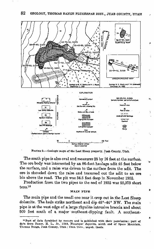
82 GEOLOGY, THOMAS RANGE FLUORSPAR DIST., JTJAB COUNTY, UTAH
EXPLANATION
Concealed contact-
kitrwrra rtiyollt* breccia 1
I Sh | Hwrnite dolomite
I So j Bell Hill dolomite
Calclte vein, showing dip
a Strike and dip ol beds
High-grade fluorspar
low-grade fluorspar
Position of channel (ample
SB-65-50-. 0.009 Sample number; percent of uranium
Underground workings
Opencut
'WrDurnp
Dt/um mumeit
FIGURE 9. Geologic maps of the Lost Sheep property, Juab County, Utah.
The south pipe is also oval and measures 28 by 16 feet at the surface. The ore body was intersected by an 86-foot haulage adit 45 feet below the surface, and a raise was driven to the surface from the adit. The ore is shoveled down the raise and trammed out the adit to an ore bin above the road. The pit was 34.5 feet deep in November 1952.
Production from the two pipes to the end of 1952 was 22,373 short tons.18
MAIN PIPE
The main pipe and the small one near it crop out in the Lost Sheep dolomite. The beds strike northeast and dip 42°-44° NW. The main pipe is at the west edge of a large rhyolite intrusive breccia and about 500 feet south of a major southeast-dipping fault. A southeast-
18 Part of data furnished by owners and is..published with their permission; part of data from Bauer, H. L., Jr., 1952, Fluorspar deposits, north end of Spors Mountain, Thomas Range, Juab County, Utah: Utah Univ., unpub. thesis.
LOST SHEEP 83
trending fault of small displacement is cut off by the intrusive breccia about 150 feet southwest of the main pipe. The pipe is irregular in plan view, and its long dimension trends about west-northwest. The ore body is 145 feet long and has a maximum width of 73 feet; the ratio of length to average width is 2.9 :1. A small southward- trending ore lobe at the west end of the ore body did not crop out and was discovered in 1952 during mining. The contact between fluorspar and intrusive breccia appears to be gradational; a transitional zone of fluorspar and cherty breccia separates the two rocks.19 The ore is white to deep purple and in most places is soft and friable; locally, however, it contains hard pieces, which commonly have a boxwork structure. Four channel samples (table 8) taken in the opencut con tained from 78.6 to 88.5 percent of fluorite. A carload lot averaging 94.9 percent of fluorite is reported by Fitch, Quigley, and Barker (1949, p. 66).
The uranium content of this large pipe is low, ranging from 0.009 to 0.029 percent of uranium in 7 samples (table 8).
An irregular fluorspar vein as much as 8 feet thick cuts the intrusive breccia 25 feet east of the narrow part of the haulage cut (fig. 9).. This vein, which averages less than 5 feet in thickness, has the highest uranium content of any fluorspar body found on the Lost Sheep property. The one sample cut across the entire vein at its thickest place contained 0.033 percent of uranium.
SOUTH PIPE
The south pipe is a rough oval whose long axis trends north- northeast (fig. 9). The ratio of length to average width is 2.2:1. The pipe measured 16 by 28 feet at the surface but on the haulage level was 13 feet in diameter. Thirteen feet from the portal, which is in Bell Hill dolomite, the adit enters Harrisite dolomite. At the portal a 6-inch to 3-foot dike of reddish-brown claylike material with dolo mite fragments up to one-fourth inch in diameter cuts the Bell Hill dolomite. This dike probably is an intrusive breccia.
The south pipe is about 220 feet south-southwest of the large intrusive breccia plug. No faults were observed on the surface, but a fault of small displacement was cut by the adit. A large northeast- trending fault lies 710 feet south of the pipe. The plunge of the pipe is almost vertical.
The ore of the south pipe is similar to that of the Blowout pipe and the Lost Sheep main pipe. It is of particular interest that the Harrisite dolomite cut by the haulage adit contains, along bedding planes, thin irregular layers of chert, which form small resistant
18 Bauer, H. L., 1952, op. clt., i>v32,
469083 59 7
84 GEOLOGY, THOMAS RANGE FLUORSPAR DIST., JUAB COUNTY, UTAH
ledges. These resistant ledges pass without interruption into layers of more resistant fluorspar in the ore body. This relict bedding in ore suggests replacement of dolomite by fluorite.
A sample taken at the surface contained 66.7 percent of fluorite and 0.014 percent of uranium; a second sample taken at the back of the small adit contained 82.5 percent of fluorite and 0.009 percent of uranium.
LOST SOUL NO. 1 ,
The Lost Soul No. 1, owned by Wesley Sampson and Sherman Perkins, of Delta, Utah, is on the west side of Spors Mountain, approximately 4,300 feet south-southwest of the Thursday prospect ^ (pl.l).
The workings a long bulldozer bench on a steep hillside with a 40-foot branching adit, and a small 7-foot adit may be reached from the road along the west side of Spors Mountain by a 1,250-yard rough Jeep trail partly in a dry wash and partly on a steep slope.
The opencut and adit portals are in the upper gray member of the Bell Hill dolomite. The face of the 40-foot adit is in Harrisite dolo mite. Between 8 and 15 feet from the portal the longer adit (fig. 6) passed through a zone of fracturing which changed the strike of the - beds from north near the portal to N. 15° E. at 15 feet. These facts suggest a fault near the top of the Bell Hill dolomite. All observed fluorspar is near the contact between the Bell Hill and Harrisite dolomites. At the surface fluorspar fills fractures near the base of ^ the Harrisite dolomite.
In the northern branch of the adit, a zone 1.8 feet wide contains 10-60 percent of fluorite. Most of the material is a boxwork of dark- purple fine-grained fluorite and white dolomite. The adjacent dolo mite country rock contains irregular masses of purple fluorite.
The south branch of the adit cuts an 8-inch zone of dolomite with ^ less than 10 percent of fine-grained purple fluorite as coatings along fractures and as irregular masses. Near this zone the dolomite is brecciated, with individual blocks as much as 3 feet in size.
A stockpile of hand-picked fluorspar approximately 6 feet long, 4 feet wide, and 2^ feet high, had been collected before August 1952.
The fluorite at the Lost Soul No. 1 contains little uranium. A f. sample taken across the vein in the north branch of the adit had only 0.003 percent of uranium, and another sample taken in the south branch of the adit had 0.004 percent.
LUCKY LOUIE
The Lucky Louie mine is on the south end of some low hills that * form the south-central part of Spors Mountain (pi. 3), in the
sec. 10, T. 13 S., R. 12 W. (pi. 1).

LUCKY LOUIE 85
The Lucky .Louie claim was located on December 12, 1948, by James Quigley, Ehard Snell, H. E. Carlson, and Hyrum Schmidt. It was explored by several bulldozer trenches, and an area about 8 feet wide containing some fluorspar was exposed at the site of the present workings. Several large fluorspar boulders were found about 700 feet to the east in the Lake Bonneville beds. Except for assess ment work, no mining was attempted until the fall of 1951, when the owiiers began to do exploratory work. An oval pipe, 35 feet long with a maximum width of 14 feet, was uncovered. The first ore was shipped in January 1952 and through October 1952 the pipe was actively mined; at that time the pipe had been mined to a vertical depth of 120 feet. Production through December 1952 amounted to 1,432 short tons.20
Although the Lucky Louie claim is in a highly faulted area, the pipe itself is near the center of a fault block, approximately 90 feet from the nearest fault (pi. 3). The pipe crops out in the gray cherty meiaber of the Lost Sheep dolomite and plunges approximately 60°!/N. 89° E. Hence, the lower half of the workings is in the gray member of the Lost Sheep dolomite.
The ore body becomes smaller with depth (fig. 10). About 50 feet below the surface the hanging-wall side of the pipe becomes steeper. At the bottom of the workings, the long dimension of the pipe has decreased from 35 to 7.5 feet, and the short dimension, from 14 to 10 feet. The character of the ore also changes. In the upper part the ore consists of soft white to purple fluorite with a little residual chert derived from the gray cherty wallrock. At about 90 feet from the surface, large pieces of black angular hydrothermal chalcedony, which resembles chert, appear in the ore; at 120 feet from the surface this chalcedony makes up the entire central part of the ore body, with narrow 18-inch bands of fluorspar on both sides.
A composite assay compiled from individual carload assays by the operators shows the ore to contain 81.6 percent of fluorite and 5.2 percent of silica. Three samples taken at the surface, 6 feet below the surface, and 59 feet below the surface ranged from 60.4 to 78.6 percent of fluorite and from 0.049 to 0.078 percent of uranium. The uranium content of the ore was moderately high for the producing fluorspar properties and was exceeded only at the Bell Hill and the Harrisite mines.
OVERSIGHT
The Oversight mine is on the top of a steep ridge (pi. 1), 450 feet above the valley separating Spors Mountain from the eastern part of
"Data are furnished by the Chief Consolidated Mining Co. and are published with permission of the owners.

86 GEOLOGY, THOMAS RANGE FLUORSPAR DIST., JUAB COUNTY, UTAH
Block diagram showing shape of the Lucky Louie pipe.
OVERSIGHT ' 87
the Thomas Range; it is north of the Hilltop No. 1 claim to the south east, and is in sec. 21, T. 12 S., R. 12 W.
The property was located during July 1948 by Frank Lowder, Fred Staats, and Harold Stephensen. Early work consisted of bull dozer trenches along the top of the ridge, several small pits, and a cut 4 feet wide by 20 feet long. In the face of the cut, there was exposed a 3- to 4-foot-thick ore body, which appeared to be a vein but actually was an apophysis from a circular pipe. Further work uncovered this main pipe, and ore was first mined in 1951 by sinking a circular winze 15 feet in diameter. The winze was sunk on a 79° angle for 80 feet.21 A smaller pipe, approximately 10 feet southeast of the main pipe, was mined by driving a short crosscut from the winze, 24 feet below the surface, and raising. The main ore body became smaller with depth, and at 80 feet mining ceased. Then a 200-foot-long adit was driven south from the road level. Several small stringers were found, and a boxwork of fluorite surrounding large pieces of dolomite was found on what was thought to be a downward extension of the main pipe. No ore was mined, and work stopped in the spring of 1952.
Production22 through 1952 totaled 598.5 tons of fluorite ore ranging from 82.3 to 89.8 percent of CaF2 and from 2.2 to 4.2 percent of Si02.
GEOLOGY
The fluorspar pipes on the Oversight property crop out near the middle of the gray member of the Lost Sheep dolomite and occur in the central part of a fault block in one of the most faulted areas in the northern part of Spors Mountain. The most numerous faults trend northwest, with the main ore body 65 feet north of the closest one. An intrusive breccia pipe made up of rhyolite fragments crops out on the Hilltop No. 1 property, 150 feet southeast of the main Oversight ore body, and several small intrusive breccia pipes occur approximately 250 feet to the northwest.
ORE DEPOSITS
The main ore body and several smaller bodies crop out in a group on the top of the ridge. The main ore body is approximately circular with a veinlike apophysis extending for a short distance to the north at the surface. The ore body is about 15 feet in diameter and plunges 79° southeastward. At about 60 feet below the surface, the ore body splits into two smaller shoots. A crosscut 80 feet from the top of the winze showed the two small ore shoots to be only a few feet in diameter.28
81 Bauer, H. L., 1952, op. clt, p. 36.88 Data are furnished by the owners and are published with their permission.»Bauer, H. L., 1952, op. clt, p. 36.

88 GEOLOGY, THOMAS RANGE FLUORSPAR DIST., JUAB COUNTY, UTAH
The second largest ore body is southeast of the main ore body. It is oval in cross section 12 feet long, with a maximum width of 6 feet. This oval pipe plunges 70°, N. 83° E. and has been mined to the depth of 24 feet.
Several smaller pipes, 1-5 feet in diameter, are found south and west of the main ore body. These bodies are very irregular and have been prospected to a depth of only a few feet. Fluorspar is present also along the northwestward-trending fault south of the ore body.
The fluorite at the Oversight mine shows the best boxwork structure of any ore in the Thomas Eange district. It is chiefly gray to brown, pale purple tinged in a few places and occurs in a coarse angular boxwork surrounding voids y8-2 inches across. In addition to fluorite, small quartz crystals less than 1 millimeter long commonly line the cavities of the boxwork. Small white rhombohedral dolomite crystals, 1-2 millimeters across, also coat the boxwork in places.
The boxwork was formed by shattering of the dolomite country rock, filling of the cracks with fluorite, and leaching of the dolomite from the central parts. In one place along the side of the pipe, a white vein-type dolomite instead of fluorite fills the cracks in the shattered dolomite country rock. The dolomite-cemented breccia is very limited in extent and seemingly was not subjected to later leaching because the dolomite country rock remains. In two small drifts off the long adit, two adjacent stockworks were noted. These consisted of frac tured dolomite country rock surrounded by thin veinlets of brown fluorite and resemble the upper part of the ore body except that the dolomite country rock has not been leached from the boxwork.
The fluorite at this deposit contains little uranium (table 8). Chip samples cut from across the main ore body at the surface contained only 0.006 percent; a sample of an ore pile, which came from the winze, contained 0.007 percent; and a sample of the fluorite sepa rated from the dolomite from the two stockworks on the adit level contained 0.003 percent. A sample from the ore body southeast of the main ore body contained 0.005 percent of uranium.
UNNAMED ADIT
Approximately 500 feet southeast of the Thursday prospect (pi. 1) a 240-foot adit has been driven N. 13° E., into a steep hillside. It apparently follows a thin zone of low-grade purple fluorspar along a fault in Lost Sheep dolomite (fig. 11).
The dolomite strikes N. 39° E. and dips 41° NW. Several other narrow low-grade veins of purple fluorspar were partly explored; most were zones of fault breccia containing a little fluorspar. All of the fluorspar contains chalcedony. A 2-foot channel sample across the
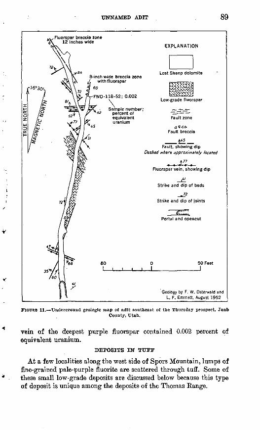
UNNAMED ADIT 89
.^Fluorspar breccia zone x 12 inches wide
8-inch wide breccia zone ./. with fluorspar
60
FWO-118-52; 0.002
Sample number; percent of equivalent uranium
EXPLANATION
Low-grade fluorspar
Fault zone
d^OFault breccia
Fault, showing dip Dashed where approximately located
A 77^» *J ^ -«-
Fluorspar vein, showing dip
Strike and dip of beds
_m 72
Strike and dip of joints
Portal and opencut
50 Feet J
Geology by F. W. Osterwald and L. F. Emmett, August 1952
FIGURE 11. Underground geologic map of adit southeast of the Thursday prospect, JuabCounty, Utah.
vein of the deepest purple fluorspar contained 0.002 percent of equivalent uranium.
DEPOSITS IN TUFF
At a few localities along the west side of Spors Mountain, lumps of fine-grained pale-purple fluorite are scattered through tuff. Some of these small low-grade deposits are discussed below because this type of deposit is unique among the deposits of the Thomas Range.

90 GEOLOGY, THOMAS RANGE FLUORSPAR DIST., JUAB COUNTY, UTAH
....._._......... .._. ---DEPOSIT 1 -
Deposit 1 is 2,000 yards west of the Bell Hill mine (pi. 1). The only working on the claim is a bulldozer cut 200 feet south of a private road leading to a prospect from the west-side haulage road.
The area in which tuff crops out is very small. The west end of the bulldozer cut is in gray rhyolite that overlies the tuff; the northern and eastern limits of the tuff are covered by Lake Bonneville beds of Quaternary age. The bulldozer cut is near the intersection of north east and north-northwest-trending faults. Six hundred feet northwest of the cut is a larger area of tuff, but it contains no visible fluorite and only a little calcite.
Nodular fine-grained purple fluorite masses are embedded in hard massive cream-colored calcareous tuff. Most of the fluorite is asso ciated with small fragments of fine-grained volcanic rock. The tuff contains 10-15 percent of fluorite and 0.007 percent of uranium.
Thin sections of tuff from deposit 1 show angular fragments and subhedral crystals of quartz, sanidine, and scattered plagioclase, as well as rare pieces of biotite, set in a fine-grained glassy fragmental matrix. An approximately equal amount of subangular rock frag ments is associated with the crystal fragments; both crystal and rock fragments are as much as 2 by 6 millimeters. The rock fragments are mostly glass and show minute vesicles and well-defined flow structure. A few rounded pieces of sedimentary dolomite and chert are scattered through the slide, and one piece of Swan Peak quartzite was seen. Fine-grained microcrystalline fluorite is distributed along the few layers rich in clay, particularly around dolomite and chert fragments. One well-rounded dolomite fragment is almost completely fluoritized. Some of the glassy pieces contain minute dolomite euhedra. A little fine-grained fluorite was found in tuff that contained no megascopi- cally visible fluorite. ' ' .
DEPOSIT 2
Deposit 2 is 2,500 yards northwest of the Bell Hill pit No. 1 and 1,950 yards nortl^northeast of deposit 1. A small area of white fine grained altered volcanic rock crops out through gravels of the Lake Bonneville beds. Paleozoic sedimentary rocks nearby (pi. 1) are cut by several faults, which may pass close to the fluoritized area. The fluorite content is very low.
RAINBOW NO. 2
The Rainbow No. 2 claim is west of Spors Mountain, along a wash 1,800 feet east-northeast from the west-side haulage road (pi. 1). The claim was staked July 27,1949, by O. L. Turner, La Vee Turner, Russell Knight, and Eloyne Turner, and the deposit is mined by a

LITERATURE CITED 91
small adit, which was full of water in August 1952. Light-colored rhyolitic tuff crops out on the north side of the wash and on the south side of the wash it is separated by a fault from a dark-gray to purplish spherulitic rhyolitic glass with conspicuous flow structure. The tuff contains %- to 2-inch fragments of volcanic rocks, chert, and clay. Purple fluorite has replaced tuff, chiefly around frag ments, but makes up less than 15 percent of the rock. As shown on plate 1, the prospect is near the intersection of 2 faults; 1 is 20 feet southeast of the adit, and 1 is 110 feet north-northwest.
LITERATURE CITED
Alien, B. T., 1934, Neglected factors In the development of thermal springs:Natl. Acad. Sci. Proc., v. 20, p. 345-349.
Alien, E. T., and Day, A. L., 1935, Hot springs of the Yellowsftone National Park.Microscopic examinations by Herbert Eugene Merwin: Carnegie Inst. Wash.,Pub. 466, v. 18, 525 p.
Ailing, A. N., 1887, On the topaz from the Thomas Range, Utah: Am. Jour. Sci.,3d ser., v. 33, p. 146-147.
Earth, T. F. W., 1952, Theoretical petrology: New York, John Wiley and Sons,Inc., 387 p.
Blair, M. M., 1944, Elementary statistics: New York, Henry Holt and Co., 648 p. Butler, B. S., Loughlin, G. F., Heikes, V. C., and others, 1920, The ore deposits
of Utah: U. S. Geol. Survey Prof. Paper 111, 672 p. Campbell, G. S., 1951, Stratigraphy of the House and Confusion Ranges, Millard
County, Utah, in Utah Geol. Soc., Guidebook, no. 6, p. 19-25. Clods, Hans, 1928, Ueber antithetische bewegungen: Geol. Rundschau, Band 19,
p. 246-251. 1939, Hebung-Spaltung-Vulcanismus: Geol. Rundschau, Band 30, p:
405-519. Coffin, R. C., 1921, Radium, uranium, and vanadium deposits of southwestern
Colorado: Colo. Geol. Survey Bull. 16, 231 p. Cross, Whitman, 1886, On the occurrence of topaz and garnet in lithophyses of
rhyolite: Am. Jour. Sci., 3d ser., v. 31, p. 432-438. 1887, On the occurrence of topaz and garnet in lithophses of rhyolite: ;
Colo. Sci. Soc. Proc., v. 2, p. 61-70.Daly, R. A., 1914, Igneous rocks and their origin: New York, McGraw-Hill
Book Co., 563 p.Donovan, J. T., 1951, Devonian rocks of the Confusion Basin and vicinity, in
Utah Geol. Soc., Guidebook, no. 6, p. 47-53.Emmons, R. C., and others, 1953, Selected petrogenic relationships of plagioclase:
Geol. Soc. America Mem. 52, 142 p.Fenner, C. N., 1936, Bore-hole investigations in Yellowstone Park: Jour. Geology,
v. 44, p. 225-315.Fitch, C. A., Quigley, James, and Barker, C. S., 1949, Utah's new mining district:
Eng. and Min. Jour., v. 150, p. 63-69.Frondel, J. W., and Fleischer, Michael, 1952, A glossary of uranium- and thorium-
bearing minerals: U. S. Geol. Survey Circ. 194, 25 p.Gabriel, A., and Cox, E. P., 1929, A staining method for the quantitative deter
mination of certain rock minerals: Am. Mineralogist, v. 14, p. 290-292.
92 GEOLOGY, THOMAS RANGE FLUORSPAR DIST., JUAB COUNTY, UTAH
Geikie, Archibald, 1897, Ancient volcanoes of Great Britain, v. 2: London,MacMillan and Co., Ltd., 492 p.
Gilbert, G. K., 1928, Studies of Basin Range structure: U. S. Geol. Survey Prof.Paper 153, 92 p.
Gilluly, James, 1932, Geology and ore deposits of the Stockton and Fairfleldquadrangles, Utah: U. S. Geol. Survey Prof. Paper 173, 171 p.
Grout, F. F., 1932, Petrography and petrology: New York, McGraw-Hill BookCo., 522 p.
Hansen, G. H., and Bell, M. M., 1949, The oil and gas possibilities of Utah:Utah Geol. Mineralog. Survey, 341 p.
Hatch, F. H., Wells, A. K., and Wells, M. K., 1949, The petrology of the igneousrocks, 10th ed.: London, Thomas Murby and Co., 469 p.
Hillebrand, W. F., 1905, Red beryl from Utah: Am. Jour. Sci., 4th ser., v. 19,p. 330-331.
Hintze, L. F., 1951, Lower Ordovician detailed stratigraphic sections for westernUtah: Utah Geol. Mineralog., Survey Bull. 39, 99 p.
Ives, R. L., 1951, Pleistocene valley sediments of the Dugway area, Utah: Geol.Soc. America Bull., v. 62, p. 781-797.
Jones, A. J., 1895, Topaz crystals of Thomas Mountain, Utah: Iowa Acad. Scl.Proc., v. 2, p. 175-177.
Kunz, G. F., 1885, Precious stones: U. S. Geol. Survey Min. Res. U. S., 1883-1884,p. 723-782.
1893, Precious stones: U. S. Geol. Survey Min. Res. U. S., 1892, p. 756-781. Merriam, C. W., and Anderson, C. A., 1942, Reconnaissance of the Roberts Moun
tains, Nev.: Geol. Soc. America Bull., v. 53, p. 1675-1727. McAllister, J. F., 1952, Rocks and structure of the Quartz Spring area, northern
Panamint Range, Calif.: Calif. Div. Mines Special Rept. 25, 38 p. Montgomery, Arthur, 1934, A recent find of bixbyite and associated minerals In
the Thomas Range, Utah: Am. Mineralogist, v. 19, p. 82-87. Niggli, Paul, 1936, Ueber Molekularnormen zur Gesteinsberechnung: Schweizer
min. pet. Mitt, Band 16, p. 295-317. Nolan, T. B., 1935, The Gold Hill mining district, Utah: U. S. Geol. Survey Prof.
Paper 177, 172 p. Palache, Charles, 1934, Minerals from Topaz Mountain, Utah: Am. Mineralogist,
v. 19, p. 14-15. Patton, H. B., 1908, Topaz-bearing rhyolite of the Thomas Range, Utah: Geol.
Soc. America Bull., v. 19, p. 177-192. Penfield, S. L., and Foote, H. W., 1897, On bixbyite, a new mineral, and notes on
the associated topaz: Am. Jour. Sci., 4th ser., v. 4, p. 105-108. Pettijohn, F. J., 1949, Sedimentary rocks: New York, Harper and Brothers, 526 p. Rankama, Kalervo, and Sahama, T. G., 1950, Geochemistry: Chicago, Univ.
Chicago Press, 912 p. Richardson, G. B., 1913, The Paleozoic section in northern Utah: Am. Jour. Scl.,
4th ser., v. 36, p. 406-416. 1941, Geology and mineral resources of the Randolph quadrangle, Utah-
Wyoming : U. S. Geol. Survey Bull. 923, 54 p.Rogers, A. F., and Kerr, P. F., 1933, Thin-section mineralogy: New York, McGraw-
Hill Book Co., 311 p.Ross, R. J., Jr., 1951, Stratigraphy of the Garden City formation in northeastern
Utah and its trilobite faunas: Peabody Mus. Nat. History, Bull. 6,161 p.Rust, G. W., 1937, Preliminary notes on explosive volcanism in southern Mis
souri : Jour. Geology, v. 45, p. 48-75.

LITERATURE CITED 93
Simpson, J. H., 1876, Report of exploration across the Great Basin of the Terri tory of Utah for a direct wagon-route from Camp Floyd to Genoa in Carson Valley in 1859: Engineer Dept., U. S. Army, Washington, 518 p.
Terzaghi, R. D., 1948, Potash-rich rocks of the Esterel, France: Am. Mineralogist, v. 33, p. 18-30.
Thurston, W. R., Staatz, M. H., Cox, D. C., and others, 1954, Fluorspar deposits of Utah: U. S. Geol. Survey Bull. 1005, 53 p.
Turner, F. J., and Verhoogen, Jean, 1951, Igneous and metamorphic petrology, 1st ed.: New York, McGraw-Hill Book Co., 602 p.
Ulrich, E. O., and Cooper, G. A., 1938, Ozarkian and Canadian Brachiopoda: Geol. Soc. America Special Paper 13, 323 p.
Wahlstrom, E. E., 1947, Igneous minerals and rocks: New York, John Wiley and Sons, 367 p.
Walker, R. T., 1928, Mineralized volcanic explosion pipes: Eng. and Min. Jour., v. 126, p. 895-898, 939-942. 976-984.
Wentworth, C. K., and Williams, Howel, 1932, The classification and terminology of the pyroclastic rocks: Rept. Comm. Sedimentation 1930-1932, Nat. Res. Council Bull. 89, p. 19-53.
Westgate, L. G., and Knopf, Adolph, 1932, Geology and ore deposits of the Pioche district, Nev.: U. S. Geol. Survey Prof. Paper 171, 79 p.
Williams, J. S., 1948, Geology of the Paleozoic rocks, Logan quadrangle, Utah: Geol. Soc. America Bull., v. 59, p. 1121-1163.

INDEX
Acknowledgments 7-8 Ajax formation__._ 17 Analysis of samples 54-56
B
Basin and Range faulting.. 45 Bell Hill deposit .. --.- . -- 5,6,
46,47,48,49,50,52,53,58,60,62-70 Bell Hill dolomite-........ 19,22,23-25,47,65,83,84Bibliography__.._ 91-93 Blxbyite..................................... 6Blowout mine...... 5,46,48,49,50,51,52,58,60,70-72Blue Queen No. 1.____-__.. __ 47,72 Breccia,-intrusive ____ .... . 34,
37-38,47,48,49,60,71,76,81,82,83 volcanic_ 39
Calotte . ... .. . 50,51Carnotlte..._______________ 62,59,.69,75 Chalcedony___._.. 50,61,85,88 Chert............................ 26, 27,29,30,49,83Chokecherry dolomite____.__._.___ 17 Clay. ... ... 50,68,76,80Control, structural._____________. 48-49 Copenhagen formation. ____________ 17
DDaclte crystal tuff.... . 38Dell No. 1............'.................... 5,6,46,59
No. 2._....._._................. 5,6,46,59No. 5.._........................ 5, 46, 50,51,59
Deposits, ore_________._____.___ 46-62 . character._______...___ ..-._ 49-52 disseminated......... 47-48, 49origin.._________________.__ 59-62 pipcllke bodies......__......._....... 46-47,
66, 68, 71, 72, 74-75, 77, 79-«0, 81-84, 85, 87-88 structural control..____________ 48-49 types.___ ._'_ ___ _...46-48 uranium mineralization (see also Ura
nium)____________-.___ 52-59 veins..................... 47, 49, 53, 60, 66, 79-80
Devonian rocks. ______________ 8, 29-32 Bevy dolomite____________ 22, 29-31, 47 Slmonson and Ouilmette formation, un
divided.. ...- ._...-. 30, 31-32, 47Dikes........ .__ . 60, 61Disseminated deposits. .. .. . 47-48, 49 Dolomite...... -_ 50, 51, 52, 68,Drainage_______.________.___ 4
Eagle Rock mine..___ __ 6, 47, 52, 53 Eakins, L. Q., analyst .. 40 Edgewise conglomerates ..... ... Enstatite-augite latlte (see also Latite)..... 35-36, 79 Eureka quartzite____ ___ __.. 16
F PageFaults...................................... 8-9, 23,
28, 42, 43, 48, 49, 76, 78, 79, 80, 81, 82, 87, 88, 91 age._ 45east-trending___ .. . 44-45 mechanics_______.___ ___ 45 northeast-trending normal and reverse..43-44,65 northwest-trending. . 44, 79, 87, 88
Fieldwork._ ... 7-8 Fish Haven dolomite. .______ 17-21, 47, 63 Floride claim............................ 5,46,60,52Floride dolomite..................... 19,21-22,47,63Flow structure.._________~____ 37,39 Flows..__ .. 34 Fluorine Queen... 5,6,9,46,49,51,52,53,68,61,72-76
No. 4... _......._.................. 76Fluorite.... 37, 47, 48, 49, 50, 61, 62, 63, 68, 60, 66, 67,
68, 71, 72. 79, 81, 83, 84, 87, 88, 90. Folding................ ................... 42-43Fossils:
Bell Hill dolomite............. ........ 24Fish Haven dolomite___________ 20 Floride dolomite. 22 Garden City formation________ 10,11,12 Harrlsite dolomite______~_____ 25-28 Lost Sheep dolomite 27 Silurian rocks. ____._________ 22-23 Swan Peak formation, shale member..... 14,15Thursday dolomite __ . 29
Q Garden City formation.... __.... 9-13,16,17,47Garnet.____________________ 37 Geology (see also in descriptions of individual
mines').....'....................... 8-42Gravel of Lake Bonnevllle beds____ 4,33,34,78 Guilmette and Simonson formations, un
divided 30,31-32,47
HHanson Creek formation... . 20 Harrison deposit....... 6,46,47,48,60,52,60,76-80Harrislte dolomite__....___....___.. 19,
22, 23, 25-26, 46, 47, 71, 78, 81, 83, 84 Hidden Valley dolomite_______.___ 25 Hilltop No. I . 6,46,50,80-81History.................... ................ 6-6Hypeisthene latlte (see also Latite)_____ 36
Igneous rocks, silicic_....__ . 8,36-37,47,61 Introduction. _________________ 2-8 Intrusive breccia.. 34, 37-38, 47, 48, 49, 60, 71, 76,81,
82,83 J
Joins formation.____.__________ 17
KKanosh shale_________________ 16 Kehl, L. M., analyst. .____...__... 40
95
96 INDEX
Lake Bonnevllle beds....... 4,11,28,29,32-34,65,90Laketown dolomite...___ ___~__.. 23,25 Lapllli tuff (see also Tuff).................... 39Latite .. .... 3, 8, 36,38,39,41,42,48,60,78
enstatlte-auglte_____________ 35-36,79hypersthene_______________- 36
Llthophysae_________________ 37,59,60Lost Sheep deposit.. 5, 26, 46,48,49, 50, 51, 52, 53, 58,
59,81-84Lost Sheep dolomite.. 6, 19, 22, 26-28, 46,"47, 49, 72,
78,85,87,88 Lost Soul deposit.._ . ..... 47Lucky Louie deposit... 5,6,46,48,49,50,51,61,84-85
M34Marl.............-.. ...................
Mines, deposits, and prespects:Bell Hill. . 5,6,46,47,48,49, 50, 52,63,58,60,62-70 Blowout mine.. 5,46,48,49,50,51,52,59,60,70-72 Blue Queen No. 1........................ 47,72Dell No. 1........ ...... ... .. 5,6,46,59
2.........._._......_....... 5,6,46,595............................. 5,46,60,51,59
deposits In tuff (see also Tuff).._____ 89-91 Eagle Eock mine________.... 6,47,52,53Floride claim....__........._.... 5,46,50,52Fluorine Queen.. .5,6,9,46,49,51,52,53,61,72-76 Fluorine Queen No. 4. __________ 76 Harrlsite............. 6,46,47,48,50,52,60,76-80Hilltop No. 1..................... 5,46,50,80-81Lost Sheep-._ .-........ 5,26,46,48,49,50,51,
62,63,58, 59,81-84Lost Soul deposit_________.___ 47 Lucky Louie...__ 5,6,46,48,49,50,51,61,84-85 Oversight-......... 6,6,46,47,49,60,51,63,85-88Thursday....._ ...._ 5,47,49Unnamed adit_. _ __. ________ 88-89
Montmorillonite (see also Clay) . 60,51,68,72,75,76,80
O Oil Creek formation.. ..... ___..._ 17Opal. ..................................... 50Opohonga formation.. _J _ _. 17Ordovicianrocks.._ ..._ 8,9-21
Fish Haven dolomite._______ 17-21,47,63Garden City formation........... 9-13,16,17,47Swan Peak formation.... ... 9,13-17,21
quartzite member..________ 16-17,46 shale member. __________ 14-16,47
Ordovician or Siluilan rocks. (See Silurianor Ordovician rocks.)
Ore deposits. (See Deposits.) Origin of deposits ....___ . .. 59-62Oversight deposit...... 5,6,46,47,49,60,51,63,85-88
Paleozoic rocks (see also individual systems').. 3,8, 42,61,62,90
Petrogenesls_.___ . .. 41-42 Petrography of volcanic rocks.. 35-39 Petrology__....._ . 40-42Pipelike deposits................ 46-47,66,68,71,72,
74-75,77,79-80,81-84,85,87-88 Plugs.........-...... ..................... 34,61Pogonip group....._ 13,16,17Potassium.....______.___...-..... 36,40Precipitation_________ _ 59
Pag*Production............. 6-6,62,70,74,77-78,82,85,87Pyroclastic rocks_______________ 38-39,69
QQuartz........................... 50,51,52,68,75,88Quartz latitic tuff.________________ 39 Quartzite member, Swan Peak formation__ 16-17 Quaternary rocks, Lake Bonneville beds.. _ 32-34
Rainbow No. 2________________ 48,50,60- Rauvlte________________..__... 62 Relief. (See Topography.) Replacement..__.................. 48,49,67,71,84Rhyolite.-............. 2,6,36,38,40,41,48,59,60,61
chemical composition of . _ 40-41tuff (see also Tuff) _____________ 39
Ross, R. J., Jr., quoted.__ __....... 13,16-17
8Sage Valley limestone..._.. .. _ 42 Schroecklngerite__ . . 69 Sedimentary rocks.. 9-34 Sevy dolomite.................___... 22,29-31,47Shale member, Swan Peak formation___ 14-16,47Silurian or Ordovician rocks____..____ 21-22
Floride dolomite. . 19,21-22,47,63Silurian rocks.--._ .. . 22-29
Bell Hill dolomite...... 19,22,23-25,47,65,83,84Harristie dolomite___.___ __.. 19,
22,23,25-26,46,47, 71,78,81,83,84 Lost Sheet dolomite__ .. __.. 6,
19,22,26-28,46,47,49,72,78,85,87,88 Thursday dolomite____ 19,22,28-29,30,47,79
Simonson and Gullmette formations, un divided.......... ..' 30,31-32,47
Structure........_. .... . ... 42-45control... _______...__ __.. 48-49 fault .. -. 8-9,23,
28,42,43,48,49, 76, 78, 79,80,81,82,87,88,91age.__._..__ ..... 46east-trending.-..______..__.. 44-45 mechanics...- -._ .... 46northeast-trending -normal and re-
- verse...__._ . . . 43-44,65northwest-trending.______ 44,79,87,88
folding.................. ............ 42-43thrusts... -- .--__.. ._ 9,43,80
Swan Peak formation_____.____ 9,13-17,21quartzite member---. ._______ 16-17,46shale member-..^. .. _______ 14-16,47
Tertiary faulting (tee also .Faults)_ ..... 48lavas... .. . ^ - .. 42 rocks. .... . 2,3,42
Thrusts... 9,43,80Thursday deposit-... . _. .... 5,47,49Thursday dolomite.- 19,22,28-29,30,47,79 Topaz . 6,37,40,59,60,61,68 Topography__________.___._.. 2- 4 Transportation._______________ 4 Travertine.--..____.__...__ 44 Tuff 2,34,38,39,60,68
deposits in. ....-.-_____.___ 48,89-91
INDEX 97
UUnnamed adit..________._... _- 88-89Uranium..___________.____. 62-59,60,
69,72,75,76,79,81,83,84,85,88,89,90
V Vanadium....________________.. 52,75Vein deposits.................. 47,49,53,60,66,79-80Volcanic rocks_ . .. .. .. .... 34-42
breccia.._________________ 39 classification__ .. _ .. _. 34-35 petrography__._.._.._..... __ 35-39
enstatite-auglte latite (see alsoLatlte)..____._...____ 35-36,79
bypersthene latite (see also Latite)_ 36
PageVolcanic rocks Continued
petrography 0 ontinuedhyperstbene latite (see also Latite)... 36intrusive breccia. .. . .. 34,
37-38,47,48,49,60,71,76,81,82,83pyroclastic rocks............ 38-39,59silicic igneous rocks.....__.. 8,36-37,47,61
petrology._________ . .. . 40-42 chemical composition of rhyolites__ 40-41 petrogenesis..___._.... .. . 41-42
Vegetation-_______... .. .. . 4
W Wahwah limestone...... 13Whttehurst, J. W., analyst......__.... . 40
Related Documents