Geology of the Mineral Mountain quadrangle, Pinal County, Arizona Item Type text; Thesis-Reproduction (electronic); maps Authors Schmidt, Eberhard Adalbert, 1936- Publisher The University of Arizona. Rights Copyright © is held by the author. Digital access to this material is made possible by the University Libraries, University of Arizona. Further transmission, reproduction or presentation (such as public display or performance) of protected items is prohibited except with permission of the author. Download date 03/06/2018 10:16:38 Link to Item http://hdl.handle.net/10150/551954

Welcome message from author
This document is posted to help you gain knowledge. Please leave a comment to let me know what you think about it! Share it to your friends and learn new things together.
Transcript
Geology of the Mineral Mountainquadrangle, Pinal County, Arizona
Item Type text; Thesis-Reproduction (electronic); maps
Authors Schmidt, Eberhard Adalbert, 1936-
Publisher The University of Arizona.
Rights Copyright © is held by the author. Digital access to this materialis made possible by the University Libraries, University of Arizona.Further transmission, reproduction or presentation (such aspublic display or performance) of protected items is prohibitedexcept with permission of the author.
Download date 03/06/2018 10:16:38
Link to Item http://hdl.handle.net/10150/551954
GEOLOGY OF THE MINERAL MOUNTAIN QUADRANGLE PINAL COUNTY, ARIZONA
byEberhard Adalbert Schmidt
A Thesis Submitted to the Faculty of theDEPARTMENT OF GEOLOGY
In Partial Fulfillment of the Requirements For the Degree ofMASTER OF SCIENCE
In the Graduate CollegeTHE UNIVERSITY OF ARIZONA
19 6 ?

STATEMENT BY AUTHOR
This thesis has been submitted In partial fulfillment of requirements for an advanced degree at The University of Arizona and Is deposited In the University Library to be made available to borrowers under rules of the Library.
Brief quotations from this thesis are allowable without special permission, provided that accurate acknowledgment of source is made. Requests for permission for extended quotation from or reproduction of this manuscript In whole or in part may be granted by the head of the major department or the Dean of the Graduate College when in his Judgment the proposed use of the material is In the Interests of scholarship. In all other instances, however, permission must be obtained from the author.
SIGNED:
APPROVAL BY THESIS DIRECTOR This thesis has been approved on the date shown below:
John W. Anthony Professor of Geology
/ 9 /s'Date

ACKNOWLEDGMENTS
I wish to thank Drs. J. W. Anthony, thesis director, S. R. Titley, and R. L. DuBois for their helpful advice and review of this manuscript, and Dr. J. Guilbert for his assistance in the preparation of photomicrographs.
The constructive criticism of fellow graduate students was greatly appreciated as the work progressed.
Bear Creek Mining Company was most cooperative in permitting the use of data collected by the author in 1964 while employed with the company.
Thanks is also due to Mr. Charles Seel of Tucson who kindly furnished the drilling data for the Reymert mine.
I am especially thankful to the understanding given by my wife, Susan, and her forbearance while I was absorbed in this study.
ill
TABLE OF CONTENTS
PageLIST OF FIGURES...........................LIST OF PLATES............................ABSTRACT..................................INTRODUCTION..............................
Purpose and Scope of Investigation....Method of Study..................... &Location.............................Topography and Accessibility.........Previous Work........................
GENERAL GEOLOGIC SETTING..................OLDER PRECAMBRIAN PERIOD..................
Pinal Schist........... ..............Sandy Schist............ ........Spotted Phyllite................Quartzose Variety...............Amphibolite.....................
Madera Diorite........................Ruin Granite.........................
YOUNGER PRECAMBRIAN PERIOD, APACHE GROUP...Pioneer Shale........................Dripping Spring Quartzite............Mescal, Limestone.............. ......Troy Quartzite........................
INTRUSIVE ROCKS OF UNCERTAIN AGE..........Mineral Mountain Quartz Monzonlte....Dikes associated with the MineralMountain Quartz Monzonlte..........Aplite..........................
Quartz Diorite Porphyry -Diorite Porphyry...............Trachy-Andesite Porphyry........Diabase.........................Diabase..............................
viviiix1
711111415 18 19 22 2428283033353636414l
44
lv
rH CM (<A(r\V't
V
TABLE OF CONTENTS (continued)
TERTIARY PERIOD 51Page
White tall Conglomerate....................... 51Rhyolite-Dacite Extrusive Complex.............. 52Rhyolite Intrusive Rocks....................... 5^Gila Conglomerate........ ...............t •. .v •. 56Recent Gravel Cover...... ’..................... 57
STRUCTURE 59Regional Structural Setting...PreCambrian Structures.......Tertiary Structures...........
Fissure Vein System.....Pinal Thrust Sheet.......The Volcanic Flow Complex
64646667
MINERAL DEPOSITS......... 69General Statement............... 69Reymert Mine................................... 72Martinez Mine.................................. 77Silver Bell Mine............................... 78Woodpecker Mine.......... 79Talley Mine.................................... 80Other Prospects................................ 81
GEOLOGIC HISTORY 83SELECTED BIBLIOGRAPHY 109

LIST OF FIGURES
1. LOCATION MAP - MINERAL MOUNTAINQUADRANGLE................................. 4
2. LOG OF DIAMOND DRILL HOLE RI-1............... ?43* LOG OF DIAMOND DRILL HOLE R-2................ 754. LOG OF DIAMOND DRILL HOLE R-3................ 76
Figure Page
vi

LIST OF PLATES
1- GEOLOGIC MAP OF MINERAL MOUNTAINQUADRANGLE............................. In pocket
2. CROSS SECTIONS OF THE AREA............... in pocket3‘ MINERAL MOUNTAIN.............................. 8?4. FISSURE VEINS................................. 885. COLLOFORM BANDING IN FISSURE VEIN AND HAND
SPECIMEN OF DRIPPING SPRING QUARTZITE....... 896. PHOTOMICROGRAPHS OF PINAL SCHIST.............. 90?. HAND SPECIMEN AND PHOTOMICROGRAPH OF
PINAL SCHIST................................ 918. PHOTOMICROGRAPHS OF AMPHIBOLITE............... 929. PHOTOMICROGRAPHS OF DIABASE AND AMPHIBOLITE.... 9310. HAND SPECIMEN AND PHOTOMICROGRAPH OF DIABASE... 9411. PHOTOMICROGRAPHS OF MADERA DIORITE............ 9512. HAND SPECIMEN AND PHOTOMICROGRAPH OF
MADERA DIORITE.............................. 9613. PHOTOMICROGRAPHS OF RUIN GRANITE.............. 9714. PHOTOMICROGRAPH OF RUIN GRANITE AND
MINERAL MOUNTAIN QUARTZ MONZONITE........... 9815« PHOTOMICROGRAPHS OF MINERAL MOUNTAIN
QUARTZ MONZONITE............................ 9916. PHOTOMICROGRAPHS OF MINERAL MOUNTAIN
QUARTZ MONZONITE............................ 10017. PHOTOMICROGRAPHS OF MINERAL MOUNTAIN
QUARTZ MONZONITE............................ 101
Plate . Page
vii

viilLIST OF PLATES (continued)
18. PHOTOMICROGRAPHS OF MINERAL MOUNTAINQUARTZ MONZONITE............................ 102
19. PHOTOMICROGRAPH OF MINERAL MOUNTAIN* QUARTZ MONZONITE AND APLITE................. 103
20. HAND SPECIMEN OF QUARTZ DIORITE PORPHYRYAND PHOTOMICROGRAPH OF VOLCANIC FLOWCOMPLEX..................................... 104
21. POLISHED SECTIONS FROM SILVER BELL MINE....... 10522. POLISHED SECTIONS FROM SILVER BELL AND
MARTINEZ MINE............................... 10623. HAND SPECIMEN AND POLISHED SECTION OF
VEIN FROM WOODPECKER MINE................... 10?24. POLISHED SECTION AND HAND SPECIMEN FROM
WOODPECKER MINE............................. 108
Plate Page

ABSTRACT
The Mineral Mountain quadrangle is located in Pinal County, Arizona, about 15 miles west of Ray and 12 miles northeast of Florence.
Older Precambrian Pinal Schist crops out widely in this area and has been intruded by Madera Diorite, Ruin Granite, Mineral Mountain Quartz Monzonite, diabase, and rhyolite. Steeply dipping units of the younger Precambrian Apache Group occur in a narrow north-trending belt. These sedimentary units were extensively dilated through the intrusion of abundant diabase sills. The southeastern portion of the investigated area is underlain by a thick Tertiary rhyolite-daclte extrusive complex.
The schist shows a prominent northwest- and east- west- trending foliation pattern. A gently eastward dipping thrust plate of Pinal Schist crops out in Telegraph Canyon where it overlies the Apache Group and diabase.
A strongly developed northwest-trending epithermal fissure vein system occurs around Mineral Mountain proper and occupies earlier developed tension cracks and fault zones. Mineralization is probably related to Tertiary volcanic activity in this area. The gangue minerals are quartz, chalcedony, calcite, barite, and fluorite. The ore
lx

minerals include galena, cerussite, angleslte, chalcopyrite, hematite, and some manganese oxide. Locally, a little malachite and chrysocolla are present.
Numerous small mines explored these fissure veins for precious metals in the past but only limited mining activity is performed at the present time.
I
L
INTRODUCTION
Purpose and Scope of InvestigationIt is the purpose of this investigation to clarify
the complex structural setting in the Mineral Mountain quadrangle, Pinal County, Arizona, and to determine the nature and origin of the widespread mineralization present in this area. The existence of a broad pediment to the west made this area additionally attractive in the light of a possible extension of mineralization under post mineral cover.
It is the aim of this study to locate and record carefully and accurately all rock contacts and structural features such as faults, dikes, bedding and schistosity. These data in conjunction with petrographic analyses of rock samples collected in the area will aid in the interpretation of the geologic history.
At this time, no attempt is made to separate the individual volcanic rock units of the extensive Tertiary rhyolite-dacite complex recognized in the eastern and southeastern portion of the mapped area. It is also beyond the scope of this investigation to delineate individual metamorphic units within the older Precambrian Pinal Schist.
1
2Method of Study
All field data were plotted on Army Map Service aerial photographs to a scale of one inch equals about 2500 feet, and the information was then transferred with the aid of a stereographic plotter, a proportional divider, and by visual Inspection to the new 7*5 minute U. S» Geological Survey topographic map of the Mineral Mountain quadrangle on a scale of one inch equals 2000 feet.
The initial field work was carried out during the winter of 1964 while employed with Bear Creek Mining Company. The extensive final mapping was concluded during the summer and fall of 1965. A total of about 4 months was spent in the field.
Fifty thin sections of rock specimens were petro- graphically analysed under the microscope to determine the composition and texture of the igneous and metamorphic rock types. In addition, a few polished ore specimen were prepared to aid in the interpretation of the nature of mineralization.
Photomicrographs of thin sections showing characteristic textural and mineraloglcal relationships were taken by the writer using a new Vickers polarizing microscope in conjunction with a Linhof 4 by 5 inch plate camera. The developing was done in the laboratory of the Department of Geology.
3Location
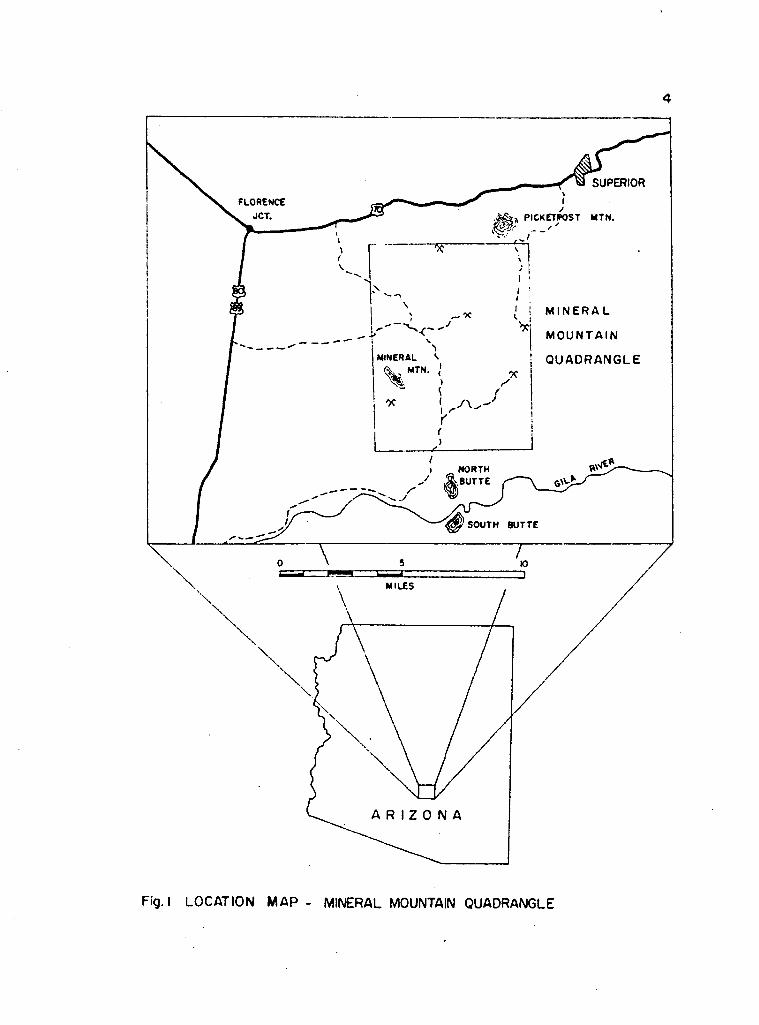
The Mineral Mountain quadrangle is bounded by Latitude N 33° 07* 30" - 33° 15' and Longitude W 111° 07*30" - 111° 15*, and is located in Townships 2 and 3 South and Ranges 11 and 12 East, about 15 miles west of Ray and 12 miles northeast of Florence, Pinal County, Arizona. The area lies just within the mountain region of the Basin and Range province according to Ransome1s (1923) geomorphic classification.
The investigated region comprises about 63 square miles (Fig. 1) and stretches from Martinez Canyon near the Gila River in the south to Plcketpost Mountain in the north. To the west the area is bounded by a vast pediment extending toward the Florence basin, and to the east it is bounded by a complex felsitic volcanic sequence that reaches into the vicinity of Ray and Superior.
Topography and AccessibilityThe portions underlain primarily by Pinal Schist
and granite develop generally a moderate topographic relief with gently rolling hills that range in elevation from 2000 to 4000 feet. This is in marked contrast to portions covered by the Tertiary volcanic rocks, where steep box canyons and cliffs extending several hundred feet in a vertical direction were formed as a result of streamerosion
4
SUPERIOR
MTN.
M I N E R A L
MOUNTAINMINERAL QUADRANGLE
MTN.
NORTH.BUTTE
SOUTH BUTTE
MILES
A R I Z O N A
Fig. I LOCATION MAP - MINERAL MOUNTAIN QUADRANGLE
5The rock units of the younger Precambrian Apache
Group and the diabase developed a topography of their own. The more resistant quartzite beds form prominent ridges, whereas the softer shaly units and the diabase are commonly exposed along slopes. At certain places abundant talus makes an accurate location of rock contacts difficult. However, the lack of heavy underbrush and vegetation, aside from the everpresent cactuses and similar species, aided greatly in the overall investigation.
The Mineral Mountain quadrangle is accessible only via several graded gravel roads which lead into the area from the Phoenix-Superior highway to the north, from U. S. Highway 80-89 to the west, and from Florence along the Southern Pacific Railroad tracks to the south. The area can also be reached via a difficult jeep trail from Superior which leads along Picketpost Mountain into Telegraph Canyon. The more Important access ways are kept in working condition by the State Highway Department and by several mining companies that have an interest in this area. Many of the access roads will temporarily be Impassable after major rain storms especially during the summer months. Occasional snow fall during the winter period will restrain field work in the higher portions of the area.
Previous WorkAside from the highly generalized geologic map of
Pinal County (Arizona Bureau of Mines, 1959 edition), no

6detailed work has yet been published from this region* Undoubtedly, several unpublished mining company reports do exist which describe portions of the Mineral Mountain quadrangle, but the writer has no access to these sources of information.
Donald C. Lamb (1962) mentions several structural and stratigraphic features of the Mineral Mountain area in his discussion of the Tertiary rocks south and west of Superior, but he does not explore them further to any great extent. At the present time he is preparing a Ph. D. dissertation on the Tertiary volcanic rocks of this general area.
Passing mention was made by Nels P. Peterson (1962) who considers the Mineral Mountain area to be the southwest extension of the northeast trending mineral belt that stretches as a slx-mile-wlde zone from Globe through Miaml-Insplration to Superior.
Just to the north of this quadrangle Mrs. Eleanor Nelson is preparing a M. S. thesis on the structure and petrography of the igneous extrusive rocks of Plcketpost Mountain.
GENERAL GEOLOGIC SETTING
The rocks exposed within the Mineral Mountain quadrangle range in age from older PreCambrian to recent and are of igneous, sedimentary, metamorphic, and volcanic origin. Older PreCambrian Pinal Schist underlies the major portion of the investigated area and displays a general west-northwest to east-west trending foliation pattern. Locally, distinct bands of amphibolite are exposed trending parallel to the foliation of the Pinal.The amphibolites may represent basic volcanic flows that were interbedded in the original sediments.
During the older PreCambrian Mazatzal Revolution the Pinal Schist became invaded by irregular bodies of Madera Diorite and Ruin Granite. The Madera Diorlte crops out widely in the northern portion of the quadrangle whereas the Ruin Granite forms a portion of the southern boundary. The Ruin marks the beginning of the older Precambrian granite terrain that extends southeastward for 40 miles to Oracle, Arizona.
Upon this older basement rest with an angular unconformity, the sediments of the younger Precambrian Apache Group consisting, in ascending order, of Pioneer Shale with the basal Scanlan Conglomerate, Dripping Spring
7
8Quartzite with the basal Barnes Conglomerate, Mescal Limestone and Troy Quartzite. The thin basaltic layer on top of Mescal Limestone recognized in the Superior area is not exposed in this region. Generally, the Apache Group dips steeply to the east under Tertiary volcanic cover and its exposure is confined to a narrow north-south trending belt in Telegraph Canyon in the northeastern portion of the quadrangle.
The entire younger Precambrlan sedimentary sequence and to some extent the Pinal Schist have been intruded extensively by diabase sills. These sills forced their way up along bedding surfaces, fault planes, and other zones of weakness especially in the Pioneer Shale, the upper portions of the Dripping Spring Quartzite and the Mescal Limestone. As a result the entire sedimentary sequence became dilated. The absolute age of the diabase intrusion is not known in this particular area; however, from the stratigraphic relationship it is evident, that the diabase must be post-Apache but probably pre-Devonian in age, as is indicated in the Magma mine at Superior (H. J. Steele, 1952)• In the Sierra Ancha mountains the diabase is 1200 million years old (Damon, Livingston, and Erickson, 1962).
No Paleozoic and Mesozoic rocks are exposed in the Mineral Mountain quadrangle, but indirect field evidence indicates that they probably exist beneath the rhyolite- dacite flows to the east and southeast of the area. A
9number of Tertiary aplite, diorite porphyry and andesite porphyry dikes, and irregular masses of rhyolite are found Intruding the Pinal Schist as well as a quartz monzonite stock of uncertain age in the western and southwestern portion of the area.
The latest volcanic event is manifested in the extrusion of felsic lava flows and tuffs which attain a thickness of about 800 feet. In the Superior area the daclte is up to 1200 feet thick. However, it remains to be determined whether the daclte near Superior and the rhyolite flows in the Mineral Mountain area are actually equivalent in age. Mrs. Nelson (oral communication) has good evidence that the rhyolite flows and tuffs in the Picketpost Mountain area are younger than the daclte.
A characteristic feature of the investigated area is a north-northwest trending epithermal vein system that occupies earlier-developed tension cracks and fault zones within the Pinal Schist. The gangue consists of quartz, calcite, barite, chalcedony, and altered schist fragments. Ore minerals include galena, manganese oxide, hematite, copper carbonates, and copper silicates, Locally, some fluorite is present. The veins have been mined in the past especially for their silver content. Limited mining operations are carried out at the present time in Martinez Canyon and at the Talley mine in Telegraph Canyon as a direct result of the favorable silver price situation.
The extensive vein system may have originated from a north- northwest or south-southeast stress direction which caused the development of a tenslonal force normal to this stress direction. The resulting tension gashes may then have served as channelways for the ascending mineralizing solutions.
10

OLDER PRECAMBRIAN PERIOD
Pinal SchistIn the investigated area the Pinal Schist is the
most widely exposed unit. It is found especially in the western and central portion of the Mineral Mountain quadrangle and comprises about 60 per cent of the mapped area. To the south the schist is bounded by Precambrlan Intrusive and Tertiary extrusive rocks, to the east by younger Pre- cambrian sedimentary rocks, but to the north and west the schist extends beyond the limits of the quadrangle and continues into the Iron Mountain area and dips under recent gravel cover.
The type locality for the Pinal Schist is in the Pinal Mountains south of Globe, Gila County, Arizona, where it was first described by Ransome in 1903. There the schist is fine grained, strongly foliated and consists mainly of muscovite and quartz. The foliation trends predominantly northeast and probably represents bedding of the older Precambrlan sediments.
The Pinal Schist in southeastern Arizona is considered to be of older Precambrlan age because of the presence of granitic Intrusions that yielded an older Precambrlan age through various radioactive dating methods.
11

12The schist exposed in the Mineral Mountain quadrangle indicates the same characteristics that are present at the type locality, hence, it is also considered to he of older PreCambrian age.
The schist is the only true metamorphic rock unit found in this area and reflects regional dynamometamorphic conditions during older Precamhrian time. The rock varies in composition from a muscovite-albite-quartz schist, a cordierite?-muscovite-quartz schist, to an almost pure quartzose schist. Locally, hands of amphibolite are present within the sbhlst that parallel the foliation.
In the northern and central portion of the mapped area the schist foliation has a definite northwest direction which changes into a more easterly trend as Telegraph Canyon is approached. In the southern portion of the map a northeasterly trend predominates. The schist has been intruded by many irregular masses of diabase and rhyolite along northwest trending fracture zones. Several quartz pegmatite veins are exposed south of Cottonwood Canyon, and a single massive quartz plug is present in the northwestern corner of the map. These quartz concentrations may represent remobilized silica at depth as a result of metamorphism and subsequent intrusion along fracture zones. On the other hand, they may be related to the later rhyolite intrusions comprising a silica rich phase. In any event, the quartz accumulations certainly do not represent original sedimentary features.
Small intrusive bodies of older Precambrian Madera Diorite are found in the northeast part of the mapped area where they are locally overlain by the younger Precambrian Apache Group. To the southwest a more massive quartz monzonite body of uncertain age intrudes the Pinal with a very irregular, discordant contact.
An extensive epithermal vein system dissects the Pinal Schist in a predominantly northwesterly direction regardless of the pre-established schistosity trend.
During the field investigation it became evident that varieties of schist types are present in this area which differ in composition, physical appearance and degree of foliation. With the exception of the amphibolite bands, which were mapped as individual units, it is beyond the scope of this investigation to delineate the different zones of the Pinal in detail. However, a general petrographic description of each zone will follow with a note on the general geographic extent.
The mineral assemblage assigns the zones to the quartz-alblte-epidote-biotlte subfacies of the greenschlst facies which is characteristic of regional metamorphism.Four different types could be recognized:
1. a fine to medium grained quartz-muscovite schist with a sandy texture.
. a very fine grained, extensively foliated spotted phyllite.
13
2

143. a quartzose schist with very little foliation.4. the greenish black amphibolite bands.
Sandy SchistThe most common variety is a fine grained, friable,
greenish gray to beige colored muscovite-quartz schist, displaying a somewhat sandy texture and an ill-defined foliation pattern. It is exposed mainly around Mineral Mountain proper and extends in a broad easterly trending belt across the area. The rock weathers readily on the outcrop and locally forms abundant iron and manganese oxide staining along fractures. At one place very fine quartz segregation bands are present that cut the general muscovite foliation with a 45° angle, and may actually represent original bedding.
Under the microscope the rock has a holocrystalline, hypidiomorphic granoblastic, fine grained texture with an average grain size of 0.2 mm. An ill-defined foliation is apparent that results from the preferred orientation of muscovite and blotlte. The average composition of the sandy variety as estimated from several thin sections is tabulated below:
quartz 70 75 60muscovite 20 17 10oligoclase 5 5 30blotlte 2 2 trchlorite 2 tr trapatite 1 tr trmagnetite tr 1 trepidote — — —— trsericite tr tr tr

In all these specimens quartz is the most abundant constituent. It occurs in small, anhedral grains and commonly is concentrated in segregation bands. Muscovite is always aligned to some extent in a subparallel manner.The individual mica flakes usually bend around larger quartz and magnetite grains indicating a yielding to the prevailing stress. With one exception, plagioclase is not very abundant. Locally, some poikilitic plagioclase porphyroblasts show a considerable amount of apatite inclusions. Plagioclase invariably indicates incipient sericite alteration. The latter usually prefers the crystallographic directions within the porphyroblast. Biotite is usually somewhat altered to chlorite along the edges. Small biotite aggregates commonly contain magnetite grains. In general, the magnetite occurs finely disseminated in small amounts throughout the rock. Judging from the mineral composition and the texture the sandy variety of the schist probably derived from a silty sandstone.
Spotted PhylliteThis variety is easily recognizable in the field
by its strongly developed muscovite foliation, its fine grained texture, and bluish gray color. It is exposed primarily in the Cottonwood Canyon area where it trends in a narrow belt from northwest to southeast. Abundant greenish chloritized biotite porphyroblasts can be
15
16recognized in the hand specimen giving the rock a spotted texture. These porphyrohlasts are always oriented obliquely to the main direction of muscovite foliation. Ptygmatic folding that even involves small quartz lenses is characteristic of this variety. Superimposed upon this folding is a secondary, much finer crenulation which measures only a few mm from crest to crest. Iron and manganese oxide occur frequently on weathered surfaces and along fractures.
Under the microscope the rock has a holocrystalllne, but very fine grained texture and consists mainly of quartz, muscovite, magnetite and little feldspar. The well developed foliation is a result of the preferred orientation of muscovite. Locally, a fine train of magnetite grains developed parallel to the foliation pattern. The greenish porphyrohlasts appear to be chloritized biotite crystals containing abundant magnetite inclusions. The flakes are subhedral and commonly measure 6 mm in diameter. Their orientation is almost at right angle to the foliation trend. A secondary strain-slip cleavage developed across the porphyroblast crystal and is also somewhat inclined to the main foliation trend. It probably represents additional deformation in the rock subsequent to the main metamorphic phase. Strain-slip cleavage or flexure folding was also observed elsewhere in the schist involving the entire rock rather than an individual crystal. Thus, the area has been subjected to at least two cycles of deformation.
The growth of the blotite porphyroblast across the general grain of the rock must have been aided by a stress direction that was superimposed upon the older foliation pattern. Also, the muscovite adjacent to the blotite porphyroblast begins to turn into the direction of least pressure together with a string of magnetite grains.
Throughout the rock, quartz occurs as fine, 0.2 mm wide segregation bands and very rarely as individual grains. Feldspar always indicates incipient sericite alteration. Locally, some small garnet blebs were observed that were always associated with magnetite clusters and some chlorite.
In one specimen cordierlte was Identified. The presence of cordierlte is somewhat anomalous in this mineral assemblage, because it is considered to represent a higher grade of metamorphism than is indicated by the remaining minerals. It may reflect an abundance of MgO. According to Turner and Verhoogen (i960) abundant cordierlte is commonly found in muscovite rich rocks.
In several different thin sections quartz comprises 20 to 65 per cent of the rock, muscovite ranges from 15 to 55 per cent, blotite from 2 to 5 per cent, and traces of chlorite, apatite, garnet, magnetite and sericite are always present. Locally, some K-feldspar was noted, but very little albite, if any, was recognized.
17

18Quartzose Variety
This type is recognized in the field by its very fine grained quartz-rich texture. Fine alternating bands of pink feldspar and clear quartz can be recognized in the hand specimen. Very-fine-grained layers of biotite and magnetite follow the general foliation pattern. Along foliation planes silver gray muscovite can readily be observed. Minute specks of limonite are abundant on weathered surfaces.
Outcrops of this type are not widely distributed, but are restricted to narrow zones at certain localities. The field occurrence indicates that these quartzose bands represent an original higher concentration of siliceous material within the silty sediments rather than a secondary introduction of silica or even a different grade of metamorphism.
In thin sections the rock is holocrystalline, hypidioblastic granular, very fine grained and somewhat foliated on account of grain size segregations and limited preferred orientation of muscovite. A secondary strain slip cleavage developed obliquely to the main foliation trend which is especially emphasized by the folding of the muscovite foliation.
The mineral percentages within the quartzose rock vary from locality to locality. Quartz ranges from 65 to
95 per cent, muscovite from 4 to 6 per cent, albite from 20 to 40 per cent, and trace amounts of blotite, chlorite, serlcite, apatite and magnetite are always present. Quartz and feldspar form an anhedral, inequigranular interlocking matrix with an average grain size of 0.2 mm. Locally, in coarser quartz segregations the grains may reach 0.6 mm in diameter. Apatite and muscovite commonly form inclusions in larger feldspar grains. Feldspar also frequently shows incipient serlcite alteration.
AmphiboliteThe amphibolite is a very distinct mappable unit
within the Pinal Schist and occurs in relatively narrow discontinuous bands and lenses that follow the general trend of the schist foliation. In places the amphibolite may attain a thickness of up to 200 feet and a strike length of over one mile. As indicated on plate 1 the amphibolite bands crop out primarily in the northwestern portion of the quadrangle from where they swing eastward across the area toward Telegraph Canyon. Several isolated exposures occur also in the central portion of the quadrangle.
In the outcrop the amphibolite is dark greenish gray to black, fine grained and somewhat foliated as the result of a preferred orientation of hornblende needles.Iron oxide and epidote occur very commonly along fractures.
19
20Under the microscope the rock appears holocrystal
line, hypidioblastic granular and very fine grained with hornblende needles attaining a length of 0.5 mm. The latter show a fibrous development. A definite foliation pattern is indicated by the parallel alignment of hornblende and the elongation of epidote aggregates. Very seldom does the epidote occur as individual grains. In places, a closely packed cluster of epidote surrounds Irregular blebs of pyrite and may replace the hornblende present. Elsewhere, small veinlets of calotte and epidote cut across the fabric of the rock and cause a calotte enrichment in the adjacent portions of the veinlet. Locally, plagioclase is extensively altered to serlclte. Quartz forms a high percentage of the rock.
The effects of flexure folding are also evident in the amphibolite through the development of minute crenula- tions in the plagioclase segregation bands. Hornblende needles commonly grow into the folds of the plagioclase layers by taking advantage of the areas of least pressure.
The average composition of the amphibolite as estimated from thin sections is tabulated below (in per cent):
hornblende 45 50 50 45plagioclase 20 35 30 35epidote 20 2 6 5quartz 14 10 10 12apatite 1 1 1 1serlclte tr tr tr 2calcite tr 1 1 trpyrite tr tr tr trbiotite — — — — 2 — —

21This mineral assemblage seems to be diagnostic of the quartz-albite-epidote-almandine subfacies of the regional metamorphic greenschist facies and appears to be transitional between the latter and the true amphibolite facies.It is reasonable to assume, that the amphibolite bands are the result of the same grade of metamorphism which developed the surrounding pelltic schist. The alternative interpretation, that the amphibolite is the result of high grade metamorphism (almandine-amphlbolite facies), is discarded here at least for the time being until more detailed petrographic work becomes available in this area. According to Turner and Verhoogen (i960), the mineral assemblage of the amphibolite and the greenschist subfacies mentioned above can be Identical, namely hornblende, plagioclase and epldote, but the critical aspect is the composition of the plagioclase. Albite would indicate a lower grade of meta- morphism, whereas the presence of oligoclase and andeslne would reflect a high grade metamorphic condition. Unfortunately, the plagioclase in the amphibolite is usually strongly altered and very fine grained, making a definite identification very difficult. Twinning, where present, is always strained and distorted, and causes a wavy extinction.
The absence of dlopslde and almandine garnet, and the presence of relatively abundant granular quartz suggests.
that the amphibolite represents an interbedded basic volcanic tuff layer rather than a calcareous sediment.
Madera DioriteSeveral isolated exposures of an intermediate
igneous intrusive rock that are found in the Pinal Schist in the northern portion of the Investigated area are so similar in composition, texture and occurrence to the Pre- cambrlan Madera Diorite (Ransome, 1903) of the Pinal Mountains, Gila County, that the same name has also been given to these igneous bodies in the Mineral Mountain quadrangle. The Madera Diorite crops out in several semicircular to ellipsoidal shaped, medium-sized stocks especially east of the Reymert mine and in the vicinity of Telegraph Canyon. The long dimension of the stocks measures between 3000 and 4000 feet and the short dimension between 1500 and 2000 feet.
The Madera intrudes only the Pinal Schist. In the vicinity of Telegraph Canyon the Madera Diorite is overlain by the sediments of the younger Precambrian Apache Group with a smooth depositlonal contact. Thus, the Madera is older than the Apache Group, but younger than the Pinal Schist. An absolute K-Ar date (Damon, Livingston, and Erickson, 1962) was obtained for the Madera Diorite in the Pinal Mountains which amounted to 1660 m.y. Therefore, the Madera is even older than the Ruin Granite (1500 m.y., Damon, Livingston, and Erickson, 1962).
22

23In the outcrop the Madera Diorite appears as a
homogeneous, medium grained, greenish gray Igneous mass that weathers readily Into a granule soil. White to pink feldspar crystals alternate with greenish black mafic minerals giving rise to a typical "salt and pepper" texture. Locally, the mafic constituents form distinct dark segregation bands which are easily dlsceraable within the lighter colored matrix. Small velnlets of epldote are common along fractures. On the weathered surfaces abundant Iron oxide Is present which Is probably the result of oxidation of the mafic minerals.
hypidlomorphlc granular, medium grained, with a more or less equlgranular non-foliated texture. The plagloclase measures on the average 2 mm In diameter, whereas the other major constituents range from 0.5 mm to 1 mm In size. The average composition of the Madera Dlorlte as determined from thin sections Is given below (In percent):
Under the microscope the rock Is holocrystalline
quartzPennineepldoteapatitebiotltesericlte
andeslnehornblende 3530
15155trtrabundant In plagloclaseas alteration product
The andeslne Is completely altered to sericlte especially along crystallographic directions. Epldote occurs In

24individual crystals. Hornblende and biotite are moderately chloritized along the outer portions of the grains.
A small exposure of Madera Diorite in section 30, Township 2 South, Range 12 East, contains abundant epldote veinlets that measure up to 1 cm in diameter. In one specimen epldote comprises 50 per cent of the rock. No quartz is visible in the latter specimen and the pink plagloclase appears unaltered. Thus, with varying amounts of quartz, plagloclase and epldote the Madera may range in composition from a quartz diorite to a granodiorite.
Ruin GraniteIn central Arizona the Ruin Granite was named by
Ransome in 1903 after extensive exposures of a coarse grained, porphyritic igneous rock found within the Ruin Basin about 5 miles northwest of Miami, Arizona. In the southwestern portion of the Mineral Mountain quadrangle a porphyritic biotite granite or quartz monzonite is exposed which closely resembles in composition and texture Ransome*s original Ruin Granite so that this name has been retained. Owing to its coarse grained habit the rock disintegrates easily into a granule soil. Abundant large K-feldspar phenocrysts can be observed that measure locally 4 cm in diameter.
Under the microscope the rock exhibits a holocrystalline , hypidiomorphic granular, porphyritic texture with
25an average grain size ranging from 0.5 mm to 6 mm. The general composition of the rock as determined from thin sections is given below (in per cent):
quartz 25 microcline 40 oligoclase 25 biotlte 8 muscovite 1 magnetite 1 chlorite tr hornblende tr sericite tr apatite tr
Quartz occurs in medium-grained, anhedral interlocking crystals which measure up to 2 mm in diameter. A stressed extinction pattern is common suggesting straining after solidification of the granite. Subhedral microcline is the predominant feldspar and displays distinct polysynthetic twinning. Locally, abundant apatite in mlcrocline gives rise to a poikilitic texture. Incipient alteration of the microcline is less common and can only occasionally be observed. Subhedral oligoclase, on the other hand, with well developed albite twinning invariably shows extensive clay-serlclte alteration especially in the center portion of the crystal. Usually, a 0.1 mm wide unaltered rim is preserved around each oligoclase crystal. This selectivity of alteration between the two feldspars creates a striking effect under the microscope. Biotlte occurs either in large individual flakes measuring up to 5 mm in diameter or in clusters that commonly contain magnetite grains.
26Some iron oxide and, locally, some chlorite can be seen forming along the edges of individual biotite flakes. Biotite is strongly pleochroic with colors ranging from olive green to dark yellowish brown. Fine-grained muscovite develops locally along fractures in microcline and oligoclase.
Throughout the exposed portion, the Ruin Granite is uniform in composition and is more a quartz monzonite than a granite. The Ruin Granite develops a gentle topography and readily disintegrates into a coarse granule soil on the weathered surface. The rock is usually so friable that it is difficult to obtain a solid hand - specimen.
The Ruin Granite Intrudes with sharp contacts the older Precambrian Pinal Schist. No particular megascopic metamorphic effect could be observed in the Pinal Schist adjacent to the contact. A few schist inclusions occur in the eastern portion of the Ruin Granite stock which also seem to be unaffected by contact metamorphism. This relationship, at least, indicates a relative younger age for the Ruin Granite in respect to the Pinal Schist.
In the type locality the Ruin Granite is overlain by the sediments of the younger Precambrian Apache Group with a dlsconformity, thus establishing an older Precambrian age for the Ruin Granite on a stratigraphic basis.
No absolute age date has yet been obtained from the Ruin Granite in the immediate vicinity of the investigated area. However, a K-Ar date (Damon, Livingston, and Erickson, 1962) of the Ruin Granite from the south slope of the Sierra Ancha Mountains, about 25 miles northeast of Mineral Mountain, indicated an age of 1500 million years. This is in good agreement with a Rb-Sr date (Wasserburg and Lamphere, I965) of Ruin Granite collected in northern Arizona which indicated 1450 million years.
A north-trending diabase dike transects the Ruin Granite in the western portion of the outcrop area. The diabase in turn is cut by an east-trending diorite porphyry dike.
To the west and northwest the Ruin Granite is bounded by a finer-grained granitic intrusive rock of uncertain age that differs markedly from the Ruin Granite in texture and composition. It is believed that the finer grained granitic rock is younger than the Ruin Granite, but older than the diorite porphyry dike because it is cut by the latter.
27

YOUNGER PRECAMBRIAN PERIOD,APACHE GROUP
Pioneer ShaleThe Pioneer Shale was named by Ransome in 1903
from exposures in the Pioneer Mountains, about 20 miles east of the investigated area. The Pioneer is the lowermost unit of the Apache Group and usually develops at its base a coarse-grained pebbly layer, the Scanlan Conglomerate. In agreement with Shride (1961) it is felt that the Scanlan should merely be considered a basal portion of the Pioneer Shale rather than a separate unit because its thickness rarely exceeds 5 feet which is too small to indicate on a standard geologic map. Plate 1 shows the Scanlan Conglomerate as a dotted line at the base of the Pioneer Shale.
The Scanlan Conglomerate rests with an angular unconformity upon the older PreCambrian Pinal Schist and Madera Diorite and represents the first reworked debris of the younger Precambrian transgressive sea (Wilson, 1962). Judging from the unusual straight contact line the deposi- tional surface must have been relatively smooth and without any major topographic relief. Later faulting, however, has complicated this relationship considerably as can be seen in section 19 west of Telegraph Canyon.
28

29The Scanlan Conglomerate Is composed mainly of
subrounded quartz and schist pebbles measuring up to 2 inches in diameter which are set in a fine grained matrix composed of silt, quartz and schist. Where the conglomerate overlies the Madera Diorite the composition becomes more arkoslc. Generally, a certain amount of hematite is present in the matrix giving the unit its typical reddish-maroon color. The thickness of the conglomerate varies considerably from place to place ranging from several Inches up to 5 feet. Even where the Pioneer Shale wedges out completely a thin veneer of pebbles is still present that separates the diabase from the underlying Madera Diorite or Pinal Schist.
The basal conglomerate gives way upward to the typical Pioneer Shale, a firmly indurated, dark-maroon to reddish siltstone or mudstone which contains abundant arkoslc detrital material. Fragments of pink feldspar are common. Locally, some cross-lamination was recognized.In places the Pioneer becomes quite quartz!tic and attains a more light gray color. The most conspicuous feature of this unit is the abundance of bleached reduction spots which are clearly recognizable within the dark maroon host rock.
The total thickness of the Pioneer Shale can not accurately be determined in this area because nowhere is
there a complete stratigraphic section exposed on account of the presence of abundant diabase sills. Assuming that no assimilation took place and that the diabase merely dilated the sedimentary sequence, a maximum thickness of 450 feet is evident from the outcrop pattern.
The Pioneer Shale is overlain by the Dripping Spring Quartzite with an apparent conformable contact.
Dripping Spring Quartzite The Dripping Spring Quartzite was described by
P. L. Ransome in 1903 at Barnes Peak, which was the original type locality for the Apache Group. Here, the unit overlies with a conformable contact the Pioneer Shale and underlies the Mescal Limestone.
The lowermost unit of the Dripping Spring is the Barnes Conglomerate which serves as an excellent marker horizon to separate the Pioneer from the Dripping Spring. Again, the Barnes Conglomerate is considered an integral part of the Dripping Spring Quartzite and should not be separated from the main quartzite unit. On the geologic map (Plate 1) the Barnes Conglomerate is indicated by a dotted line at the base of the Dripping Spring Quartzite.
The conglomerate consists of very resistant, well rounded ellipsoidal quartz pebbles that are imbedded in a coarse-grained, arkosic matrix. The pebbles are less than 6 inches in diameter and commonly lie with their flattened
30

31faces parallel to the "bedding. The unit Is very well indurated and usually "breaks across the fragments. In the outcrop the Barnes Conglomerate forms a resistant ledge and is always exposed along hill tops. In places, where the amount of matrix predominates over the pebble material the bed becomes more susceptible to weathering and the rounded fragments can easily be picked out of the unit.
The matrix is commonly somewhat iron stained and probably represents reworked material from the underlying Pioneer Shale.
The sudden increase of grain size from shale to conglomerate may indicate a new period of erosion and a renewed impetus of sedimentation; however, no definite unconformity was observed between the Barnes and Pioneer strata and the contact appears to be conformable. The Barnes Conglomerate is only 5 to 15 feet thick but the unit is very persistent in its occurrence.
The quartzite overlying the conglomerate bed is generally recognized as a massive, light reddish-brown, coarse- to medium-grained unit. It resists weathering and forms prominent cliffs and ridge tops. Locally, the unit is very arkosic showing abundant pink feldspar and fragmental quartz.
The upper portion of the Dripping Spring Quartzite is distinctively thinner bedded giving the rock a flaggy

32and laminated appearance. The individual beds measure from 2 to 12 inches in thickness and are of a deep reddish- brown to pale yellow and greenish-gray color. Alternating beds of arenaceous shale and quartzite are common. The shaly portions show a distinct dark maroon red discoloration especially along fractures. Minute specks of iron oxide are finely disseminated in the coarser portions of the shale. Commonly, a crust of yellowish brown limonite (mixture of goethite and Jaroslte?) is present within the wider fractures. It appears that the limonite specks within the rock are pseudomorphs after diagenetlc pyrite or original magnetite, whereas the limonite along even the most minute fractures is of a transported rather than indigenous nature.
The actual thickness of the Dripping Spring Quartzite is difficult to determine because of the presence of extensive diabase intrusions and abundant fault displacements.From the outcrop pattern it is evident that the Dripping Spring Quartzite is at least 800 feet thick.
Throughout most of the exposed portion of the quartzite unit the beds dip steeply (75-85°) to the east. Farther south in Telegraph Canyon, however, the structural relationship becomes more complex as a result of the development of an anticline. At one place the Dripping Spring unit dips 75° west but flattens rapidly to 20°

closer to the crest of the anticline. As can be seen from section BM - B*’*, two portions of the Dripping Spring Quartzite dip steeply toward each other and are separated by a fault. Locally, this fault acted as a channelway for the intruding diabase.
The contact between the Dripping Spring Quartzite and the younger Mescal Limestone is very seldom observable. Heavy underbrush and quartzite talus tend to obscure this feature.
33
Mescal LimestoneThe Mescal Limestone overlies the Dripping Spring
Quartzite with an apparent conformable contact. However, a small exposure of Dripping Spring Quartzite and Mescal Limestone in Telegraph Canyon, section 29. adjacent to the Tertiary volcanic flow indicates a divergence in strike between the two formations. This suggests that the contact may actually be an unconformity.
Ransome (1923) named the Mescal Limestone from exposures found in the Mescal mountains, Ray quadrangle, about 20 miles east of the investigated area. He reported a thickness of 225 feet. In the Mineral Mountain quadrangle, however, it is impossible to give an accurate thickness of the formation because of intense folding, faulting, and dilation by the diabase. The only exposures of Mescal in this area are found in Telegraph Canyon where they crop out in a discontinuous, strongly faulted belt.
The Mescal Limestone is a thinly laminated.silici- fied limestone containing abundant cherty layers that parallel the bedding. The cherty layers are more resistant to weathering and stand out in bold, relief on the limestone outcrop. Through the microscope an aggregate of fine grained calcite and silica can usually be seen. No typical contact metamorphic minerals were observed.
The distinct chalky white appearance of the Mescal in the outcrop is in strong contrast to all adjacent rock types, especially the dark greenish gray diabase. This color difference may be used advantageously in tracing the unit on aerial photographs.
Shride (1961) was able to separate the Mescal Limestone into three members based on lithology and fossil assemblage. In the Mineral Mountain area, however, the exposures are too scanty and the stratigraphic section is too incomplete to distinguish a definite threefold separation. The maximum thickness of the unit approaches 250 feet as calculated from the outcrop pattern on the geologic map.
At the type locality the Mescal is overlain unconformably by a thin layer of basalt. In the investigated area no such feature could be recognized, and the limestone is directly overlain by Troy Quartzite.
34

35Troy Quartzite
The Troy Quartzite is considered to be the uppermost unit of the younger PreCambrian Apache Group. In the Mineral Mountain area only a few isolated blocks, that are believed to represent Troy Quartzite, are exposed strati- graphically above Mescal Limestone, immediately adjacent to the Tertiary volcanic flow complex in Telegraph Canyon. Locally, the Troy is overlain by Whitetail Conglomerate.In the Globe quadrangle (N. P. Peterson, 1962) and in the Dripping Spring range, the Troy Quartzite exhibits a distinct basal conglomerate unit measuring several tens of feet in thickness. Usually, the rock becomes more massive in the upper portions and shows abundant cross stratification. In Telegraph Canyon, however, the quartzite unit that overlies the Mescal Limestone lacks the typical basal conglomerate layer and indicates a more thinly-bedded development. The unit has an overall reddish appearance, the result of abundant iron oxide staining along fractures.
On the basis of its stratigraphic position, and in spite of the lack of some typical characteristics, it is believed that this fragmental unit represents the Troy Quartzite. If this unit, however, is actually uppermost Dripping Spring Quartzite, then the entire stratigraphic sequence has to have been overturned. No evidence for such a structural setting was observed in the field.

INTRUSIVE ROCKS OF UNCERTAIN AGE
Mineral Mountain Quartz MonzoniteIt is the intention of the writer to assign the
name Mineral Mountain Quartz Monzonite to an igneous intrusive rock which has hitherto not been recognized.* The name refers to Mineral Mountain, a prominent landmark in this area, after which the investigated quadrangle was also named.
The Mineral Mountain Quartz Monzonite is exposed in the southwestern comer of the area, about 1-1/2 miles south of Mineral Mountain proper, and covers portions of sections 20, 21, 22, 28, 29, 32, 33 of Township 3 South and Range 11 East.
The rock is medium grained, equigranular, greenish gray to yellowish gray in color, locally extensively iron stained and easily distinguishable from the adjacent coarser grained Ruin Granite in texture and composition.A moderate amount of dark, olive green blotite and hornblende can be recognized in the hand specimen.
The quartz monzonite is an irregular, discordant igneous mass that intrudes the older Precambrian Pinal Schist and Ruin Granite with a sharp contact. The exact
1. Geologic map of Pinal County, Arizona Bureau of Mines, 1959 edition.
36

age of the rock, however, is not known. No obvious alteration effects were noted in the schist or in the granite.A few schist inclusions without any striking alteration features were observed in the northern and northeastern portion of the quartz monzonite. The northern contact of the rock is highly irregular and may indicate that the igneous body is plunging gently beneath the schist toward north. The most intense clay-serlclte alteration and iron staining found within the quartz monzonite is confined to this contact. Several exploratory adits have been driven into the contact zone, but apparently no commercial mineralization was encountered. The fact that the quartz monzonite may underly the adjacent Pinal Schist is further substantiated by an isolated exposure of a similar intrusive rock in Box Canyon, section 22, Township 3 South, Range 11 East. This exposure undoubtedly connects at depth with the main mass. How far the quartz monzonite may extend further to the east beneath the Tertiary volcanic flow complex can not be determined with certainty because of the lack of surface exposures in this area. The moderate amount of iron staining in Pinal Schist and the presence of a little copper carbonate in a fault zone in the northern portion of section 23 may be Indirect evidence of an igneous body at depth. To the west the quartz monzonite extends beneath recent gravel cover for an unknown distance.

A series of dikes, ranging in composition from aplite to diabase, transect the igneous mass in different directions. Diabase and trachy-andesite porphyry dikes trend northward, diorite and quartz diorite porphyry dikes trend eastward, and aplite dikes have a predominant northeast orientation. These hypabyssal rocks will be discussed in more detail in a subsequent chapter.
The Mineral Mountain Quartz Monzonite is not a homogeneous rock but varies in composition and physical appearance from quartz monzonite to granodiorite. The latter variety is confined to the exposure in Box Canyon.On the whole the rock appears unaltered in hand specimens in spite of some weathering on the surface.
Under the microscope the rock is holocrystalline, hypidiomorphic granular, fine to medium grained with a grain size ranging from 0.5 mm to 2 mm. The composition of the Mineral Mountain Quartz Monzonite as estimated from five thin sections is presented below (in percent):
plagioclase(oligoclase-andesine) 40 40 53 40 42orthoclase 40 34 20 35 30quartz 15 15 8 15 15biotite 1 8 1 10 7hornblende 1 — «— 15 tr 5magnetite 1 2 tr 1muscovite 2 — — tr — —apatite tr 1 1 tr tr
Pyrite, chlorite, sphene, epidote and calclte occur in minor amounts. Sericite is a common alteration product of
plagioclase. Andesine plagioclase (Ab^An^) is the predominant mineral present and usually forms subtledral crystals. Zoning is frequently developed; the outer rims increase in albite component. Strong sericite alteration is locally present following twin lamellae, fractures, and zoning patterns. Usually, the center portion of the plagioclase is extensively altered in contrast to the outer rim which rarely, if ever, shows any incipient alteration. Anhedral orthoclase and quartz form the general matrix of the rock. Orthoclase occurs in large crystals up to 6 mm in diameter, and inclusions of plagioclase, biotite and hornblende are very common. Very rarely is any alteration visible. The poikllitic texture of orthoclase suggests that potassium was secondarily introduced forming K-feldspar which subsequently engulfed earlier minerals present. Subhedral biotite and hornblende are commonly altered to chlorite along the edges of the crystals. Locally, calcite is present in hornblende. Magnetite occurs in minute grains, 0.15 mm in diameter, and is always associated with the mafic constituents of the rock. In places, the breakdown of magnetite causes extensive iron staining. The effects of stress are well displayed by the undulatory extinction of quartz, and by the curvature and faulting of the feldspar twlnn lamellae.
The igneous intrusive rock in Box Canyon is very similar in mineral composition to the main quartz monzonite.
39

The amount of plagioclase, however, exceeds by far that of orthoclase so that the rock should be termed a granodlorlte. Introduction of secondary K-feldspar Is also evident. Instead of magnetite pyrlte Is here the metallic constituent. The rock Is fine grained, dark greenish gray and has a general unaltered appearance In the outcrop. Under the microscope, however, the Inner portions of the plagioclase are extensively altered to serlclte.
The most pronounced Iron staining In the quartz monzonlte stock Is developed In the small, northeasttrending neck-llke extension. Here the rock shows considerable brecclatlon and development of Iron oxide along fractures and narrow shear zones. The weathered surfaces are strongly coated by dark brown llmonlte (goethlte) but no sulfide casts were observed. Viewed microscopically subhedral plagioclase is completely altered to serlclte and is locally heavily iron stained. No pyrlte was recognized In thin sections. Magnetite is relatively abundant and occurs with biotite. The rock is cut by many north-trending quartz hematite veins which may be the cause for the extensive iron staining in this area. These quartz-hematite structures are the extension of the more fully developed vein system to the northwest around Mineral Mountain. A genetic relationship between the quartz monzonlte stock and the vein structures, however.
40
41is not apparent. The writer feels that the veins are related to the Tertiary volcanic activity in this area. Several of the east-trending, fault controlled vein structures in the quartz monzonite have been explored by prospecting pits for copper mineralization.
Dikes associated with the Mineral Mountain Quartz Monzonite
Four different dike rocks were recognized transecting the quartz monzonite in various directions. Their mutual age relationship can not readily be determined because only two dikes cross-cut one another. The dike rocks recognized are:
aplitequartz diorite porphyry - diorite porphyrytrachy-andesite porphyrydiabase
ApliteIn hand specimen the rock has a typical phaneritlc,
sugary texture and contains a minor amount of fine-grained biotite. Cream- to rose-colored feldspar crystals and glassy quartz grains are very distinct on weathered surfaces. Generally, the rock has a pinkish gray color, is mediumgrained and very hard.
The aplite forms narrow northeast-trending dikes which measure only a few feet in width. Their contacts

with the quartz monzonite are sharp and even. Because the aplite is more resistant to erosion it stands out as narrow ribs in the general terrain.
Under the microscope the rock is seen to be holo- crystalline, aliotriomorphlc granular with an average grain size of 1 mm. Occasionally, feldspar crystals may attain a diameter of 2 mm. The minerals form an anhedral, interlocking fabric with quartz predominating in the assemblage. The average composition of the aplite as determined from thin sections is tabulated below.
42
quartz 40microcline 35perthlte-orthoclase 18alblte 5biotite 2apatite trsericite locally abundant as
alteration product in albite
Microcline and orthoclase locally show a very distinct perthitic texture with plagioclase forming parallel oriented exsolution Mflames” in the host mineral. Biotite occurs in very small corroded flakes 0.25 mm to 0.1 mm in diameter, and displays a very strong greenish pleochroism from chlorite alteration. Incipient clay alteration is present in all feldspars giving the minerals a general cloudy appearance in plane polarized light.

43Quartz Diorite Porphyry - Diorite Porphyry
One major diorite porphyry dike is present transecting the quartz monzonite in an east-west direction.In the outcrop the rock is porphyritic, very hard and greenish gray as a result of abundant olive green hornblende needles that are randomly oriented throughout the rock. Irregular blebs of pink feldspar are common.
Under the microscope the rock is seen to be porphyritic with a microcrystalline matrix. About 25 per cent of the phenocrysts are plagioclase (oligoclase- andesine) and 20 per cent are hornblende and biotite.The matrix consists of microcrystalline plagioclase, hornblende, biotite, sericite and calcite. Plagioclase is strongly altered to sericite especially along crystallographic directions. The sericite occurs in fine individual flakes and shred-like aggregates. Hornblende is commonly altered to calcite; a thin chlorite border remains behind. Very fine-grained magnetite is crowded along the border zones of the altered hornblende. The rock is very resistant to weathering and forms narrow ridges above the low lying quartz monzonite terrain.
In the extreme southwestern corner of the quadrangle an east-trending porphyritic dike cuts both the Mineral Mountain Quartz Monzonite and the Ruin Granite. Because of the presence of abundant quartz phenocrysts the rock is

44a quartz diorite porphyry. It is pinkish gray, very hard and contains distinctly zoned feldspar phenocrysts that measure up to 10 mm in diameter. Phenocrysts comprise about 30 per cent of the rock. Quartz occurs as well rounded grains measuring 3 mm in diameter. It commonly develops a myrmekitic intergrowth in the form of a narrow halo zone around each grain. Micromyrmekitic texture is found throughout the rock in small blebs and aggregates wherever quartz is present. Epidote and calcite are common alteration products of hornblende. Plagioclase is always altered to sericite.
Trachy-Andesite PorphyryThe trachy-andesite is an orange-gray porphyritic
rock with a very hard microcrystalline matrix. Small, unaltered black books of biotite are visible on the weathered surface. Well-rounded quartz grains comprise about 2 per cent of the phenocrysts, but angular anhedral quartz crystals are an important constituent of the matrix. On the weathered surface abundant chalky-white, subhedral to anhedral plagioclase crystals are visible which, as seen under the microscope, are completely replaced by calcite. Locally, magnetite accumulates as cluster-like aggregates in plagioclase and hornblende. A little iron oxide staining is usually developed around the magnetite grains. In a few cases magnetite forms small inclusions
in unaltered biotite in association with calcite replacing plagioclase. In plane polarized light the matrix has an overall cloudy appearance, probably as the result of incipient clay alteration of the fine grained feldspar.
The name trachy-andesite has been tentatively applied to this rock on the basis of the plagioclase composition (oligoclase-andesine) and the abundance of biotite and quartz phenocrysts, as well as microcrystalline constituents of the ground mass. The north-trending trachy-andesite dike cuts the east-west trending diorite porphyry dike and thus is younger than the latter.
DiabaseA north-trending diabase dike is exposed in the
southern portion of the quartz monzonite. Its composition and texture is almost identical to the diabase sills described in detail below. Of interest here is the age relationship between diabase and quartz monzonite. If the diabase is of Younger PreCambrian age then the quartz monzonite must also be Younger Precambrian, if not older.The quartz monzonite, however, shows many characteristics of a Laramide intrusive body as far as composition, texture, and general appearance is concerned. Small intrusive rocks of Tertiary age and of similar composition as the quartz monzonite are exposed in the Dripping Spring Range and the Tortilla Mountains near Ray, Arizona, about 10 to 20
45

46
miles east of Mineral Mountain. In this case the diabase dike has to be also of Tertiary age. It may very well be that two ages of diabase intrusion exist in this part of Arizona; a Precambrian diabase found largely as sills associated with the sedimentary rocks of the Apache Group, and a Tertiary diabase occurring as isolated dikes mainly in other intrusive rocks.
DiabaseIn the Mineral Mountain quadrangle the diabase
appears in two modes of occurrence. The first is the extensive sill-like intrusion into the Apache Group in Telegraph Canyon, and the second is the formation of small, irregular intrusive bodies and narrow dikes within the Pinal Schist. Locally, the diabase also forms selvage zones along the northwest-trending tension fractures and vein structures.
In Telegraph Canyon the diabase intrudes the entire exposed sedimentary sequence of the younger Precambrian Apache Group. The diabase took advantage of bedding planes, formation boundaries and fault structures to form sills ranging in thickness from 100 to 1200 feet. The intrusion caused a dilation of the whole sedimentary section. The thinly bedded Pioneer Shale and Mescal Limestone were especially susceptible to the diabase intrusion, in contrast to the more massive Dripping Spring
Quartzite. Small apophyses of diabase are present in the quartzite, but they are very narrow and die out quickly. Heavy talus cover usually obscures these features. On the whole, the diabase sills are concordant to the sedimentary formations, but in detail, they locally transect the bedding along faults and fracture zones and follow more favorable horizons. It was primarily for this reason that no measured stratigraphic sections of the sedimentary units were obtained. The diabase restricted itself almost completely to the Apache Group and did not invade the adjacent Pinal Schist, at least not in this immediate area. Usually, a very narrow strip of Pioneer Shale separates the diabase from the Pinal Schist and Madera Dlorite. In the central and southwestern portion of the area the diabase occurs as irregular intrusive masses and narrow dike-like features mainly within Pinal Schist. These discontinuous and discordant intrusive bodies have a general north-northwest orientation and probably follow a weak structural zone in the Pinal.
The age of the diabase in this area can only be determined on the basis of the following reasoning:Because the diabase intrudes the younger Precambrian Apache Group, it definitely has to be younger than these sedimentary rocks. An absolute K-Ar date of a similar diabase in the Sierra Ancha Mountains, Gila County, Arizona (Damon,
47
48Livingston and Erickson, 1962), indicates an age of 1140 million years, thus placing the diabase into late younger Precambrian time. If the diabase dike intruding the Mineral Mountain Quartz Monzonite is actually of Tertiary age, then two periods of diabase intrusion may very well be present in this area. Proof of this interpretation must await the age determination of the Mineral Mountain Quartz Monzonite. A Tertiary age for the diabase is postulated in the Globe-Miami and Superior area on the basis of stratigraphic evidence (N. P. Peterson, 1962).
The diabase is a holocrystalline, very fine to coarse grained, dark greenish gray intrusive rock displaying typical diabasic to ophitic texture. The coarse variety weathers readily into a dark green granule soil and usually forms topographic depressions adjacent to more resistant sedimentary units. Extensive talus cover is commonly present and locally obscures the contact relationships between diabase and adjacent rocks. A detailed survey will undoubtedly reveal more diabase than could be shown on this map.
Under the microscope the diabase is seen to be a holocrystalline, hypidiomorphic granular, medium- to coarse grained rock. Subhedral plagioclase laths are intergrown with augite and hornblende and may attain a length of 6.5 mm. Plagioclase is commonly altered to sericite in the coarse diabase. Since the rock is highly

49weathered in the outcrop it is difficult to determine whether the alteration is a result of supergene or deuteric processes* Secondary overgrowth of a more sodium-rich feldspar and/or orthoclase containing abundant hornblende inclusions is common around plagioclase. Pyroxene is almost completely recrystallized and shows a rim of small hornblende needles that extend outward from the original mineral into the adjacent plagioclase. Magnetite occurs in large inequidimensional grains filling open spaces or replacing mafic minerals. Locally, anomalous large apatite crystals can be observed.
In Telegraph Canyon the diabase is medium-grained with an average grain size of 1.5 mm, and the rock shows distinct signs of feldspathization. The diabase is very hard and almost black in color, and contains abundant conspicuous blebs and veinlets of pink feldspar. Under the microscope these blebs are revealed to be myrmekitic inter- growths of quartz and alkali feldspar. Secondary overgrowth on plagioclase is also present. Turner and Verhoogen (I960) observed a similar feature in the tholeitic quartz diabases and attributed it to differentiation of the magma upon cooling during intrusion. Another possibility for introducing silica and alkalies is limited assimilation of the host rock during diabase intrusion. The sedimentary units of the Apache Group could serve as a ready source for the

50needed constituents. The margins of the diabase sill, then, should indicate some changes in the mineral composition if conditions were favorable. Not nearly enough petrographic work has been carried out, however, to either support or disprove the validity of this hypothesis. J. W. Anthony (i960) pointed out, that because of the extreme differences in chemical composition of the host rock and the intruding diabase magma, one should not expect to find extensive assimilation of the sedimentary units (Dripping Spring Quartzite, Mescal Limestone) by the magma.
A narrow, very fine-grained diabase dike in Pinal Schist (section 12) indicates strong shearing which now is rehealed by calcite and chlorite (pennine). Abundant finely disseminated sulfide and magnetite grains are present. The mafic minerals are completely altered to calcite.

TERTIARY PERIOD
Whitetall ConglomerateA deposit of detrital material directly "beneath
the Tertiary volcanic flow complex in the southern end of Telegraph Canyon is here termed Whitetail Conglomerate on the basis of its similarity in composition and stratigraphic position with the Whitetail exposed at Teapot Mountain near Ray, Arizona. A more extensive exposure of Whitetail Conglomerate is found in the extreme southeast comer of the quadrangle where it underlies thick rhyolite-dacite flows.
The Whitetail Conglomerate is composed mainly of schist and quartzite fragments imbedded in a clayey matrix. In Telegraph Canyon the conglomerate overlies Pinal Schist, Troy Quartzite and diabase, and partly obscures the trace of the Pinal thrust sheet. Here, the unit is about 100 feet thick and dips 5° to 18° east. Some stratification present may indicate a water-laid origin or perhaps local sorting.
The Whitetail Conglomerate represents a period of continued erosion that followed the middle Tertiary structural disturbance, and rapid deposition into shallow basins and stream valleys before the extensive extrusion of rhyolite and dacite flows.
51
52Rhyolite-Daclte Extrusive Complex
Large portions of the Mineral Mountain quadrangle are covered by felsitic volcanic rocks of upper Miocene age. The eastern margin and southeastern portion of the mapped area are underlain by thick sequences of rhyolite tuffs, dacites, some vitrophyres, and a massive rhyolite intrusive rock centering in Martinez Canyon. No attempt was made to differentiate these individual volcanic rock units at this time, and for convenience they are indicated on the geologic map (plate 1) as the rhyolite-dacite extrusive complex of Tertiary age.
At the time of writing a thesis is being prepared by Eleanor Nelson, University of Arizona, which describes in detail the rhyolitic extrusive rock sequence in the vicinity of Picketpost Mountain, located just north of the Mineral Mountain quadrangle. According to Mrs. Nelson these rhyolitic tuffs are about 17 million years old and thus post-date the dacitic extrusive event near Superior.The dacite was dated by Damon (1965) to be about 20 million years old. The rhyolite tuffs in the investigated area are probably related in time and space to the extrusive activity around Picketpost Mountain. A doctoral dissertation presently being prepared by Mr. Donald Lamb, University of Cincinnati, discusses the Tertiary volcanic history of this general area (written communication). Mr. Lamb's interpretation agrees well with the one stated above.

Erosional remnants of rhyolitic flows are exposed south of Telegraph Canyon where they cap small hills and ridges of Pinal Schist. In the northeast corner of section 6 a black vitrophyre occurs which correlates with a similar rock overlying rhyolite tuff east of Telegraph Canyon. The black glassy matrix of the vitrophyre contains about 15 per cent subhedral to euhedral sanidine pheno- crysts. In this area the volcanic sequence dips 15° to 30° east and indicates a basin-like configuration trending generally north-south to the east of the quadrangle. Some stratification within the tuff layers can be recognized. Generally, a creamy-white pumice breccia with foreign rock fragments occurs at the lower portion of the sequence and grades upward into a welded tuff. In certain areas the flow sheet attains a thickness of 800 to 1000 feet.
In thin sections the rhyolite flow contains 7 per cent quartz and plagloclase phenocrysts; the remainder is microcrystalline quartz and feldspar matrix. The phenocrysts are about 1 mm in diameter. Plagioclase is commonly fragmental and ranges from albite to andesine in composition. The quartz grains are always well rounded and show solution embayments. Corrosion halos around the quartz grains are locally present. In the matrix quartz occurs as very fine spiculite and longulite crystals. At places the rock attains a more reddish matrix because of abundant orthoclase
53

54phenocrysfcs. Fine-grained, brown biotite occurs in individual flakes with a preferred sub parallel orientation conformable with the predominant flow direction.
In places the rock has the texture and composition of a welded dacite flow containing about 15 per cent ortho- clase, plagioclase and quartz phenocrysts. The remaining portion is microcrystalline matrix. Plagioclase is always fragmental and usually shows corrosion rims. The plagioclase ranges from albite to andesine in composition. Quartz, again, is well rounded and shows typical embayment features. Small quartz veinlets occur parallel to the general flow pattern.
Judging from the texture and distribution of the overall volcanic sequence it becomes apparent that the initial pyroclastic outburst in Miocene time was followed by the extrusion of siliceous lava flows which filled every basin-like feature in the pre-existing topography.
Rhyolite Intrusive RocksIn the western half of the investigated quadrangle
abundant elongated rhyolite masses intrude discordantly the older PreCambrian Pinal Schist. These intrusive bodies trend predominantly in a northwesterly direction, subparallel to the epithermal fissure vein system. Because the rhyolite is very resistant to erosion it generally forms prominant ridge tops. Mineral Mountain proper is underlain by one of the more extensive intrusive masses.

55In spite of their northwesterly elongation the
rhyolite intrusive bodies seem to be arranged in a north- east- trending, en echelon pattern. This orientation may reflect the stress pattern which prevailed within the schist during the intrusion of the rhyolite. One tabular rhyolite body in Cottonwood Canyon dips concordantly 35° southwest with the schist foliation and appears to be a sill-like intrusive mass.
In the outcrop the rhyolite is a pinkish gray, very hard and somewhat porphyritic rock. Quartz pheno- crysts are distinctively set in an aphanitic matrix and comprise about 5 to 10 per cent of the rock. Under the microscope quartz appears as clean, subhedral to euhedral grains about 1 mm in diameter. Commonly, a rim of dustlike material surrounds each crystal, and in places a narrow zone of recrystallized quartz can definitely be recognized. Feldspar occurs only occasionally as pheno- crysts, but may be more abundantly present in the micro-crystalline matrix. Locally, minute opaque mineral grains measuring 0.2 mm in diameter are finely disseminated in the rhyolite and show a faint rim of iron oxide. The matrix of the rock has a general cloudy appearance and is composed mainly of quartz.
The age of the rhyolite intrusive rock is considered to be younger Tertiary because a similar but much larger

56rhyolite mass intrudes the volcanic flow complex of Miocene age in the Martinez Canyon area. The intrusive event, however, must have preceded the development of the fissure vein system because south of Mineral Mountain and in Martinez Canyon the rhyolite is transected by these mineralized structures. The rising magma has probably served as a source for the epithermal mineralization in this area.
Gila ConglomerateThe Gila Conglomerate is a coarse sedimentary unit
of probable late Tertiary or early Quaternary age. It overlies stratigraphically the rhyolite-dacite extrusive complex and is restricted in its occurrence to the southern portion of the quadrangle.
The Gila Conglomerate was originally named by Gilbert in I875 from exposures in the headwaters of the Gila River. Ransome, in 1903, applied the same name to sedimentary rocks exposed widely in the Globe-Miaml-Ray area and which were younger than the daclte.
In the investigated area the conglomerate contains a high percentage of volcanic material, either as large, angular boulders, or as fine-grained matrix material cementing the larger fragments. Some stratification is present within the unit and may indicate that the conglomerate dips 25° to the southwest. Near Kearny, 15 miles
to the southeast, the Gila Conglomerate dips very steeply to the east together with sedimentary units of the Apache Group. Thus, late Pliocene or early Pleistocene faulting must have been active in this area in order to produce such a structural relationship.
To differentiate the Gila Conglomerate from the Whitetail Conglomerate is a difficult task if the intervening dacite flow is not present. Usually, the Whitetail Conglomerate does not contain any volcanic fragments because it was deposited prior to the volcanic extrusive event. The Gila Conglomerate, however, contains abundant volcanic debris if it occurs near a volcanic terrain. Obviously, the composition of the conglomerate unit will vary accordingly with a change in the source material.
The boundary between the Gila Conglomerate and the underlying rocks is invariably an erosion surface of high relief. Therefore, the Gila Conglomerate represents a period of rapid erosion which was probably the result of considerable tectonic activity. The poorly-sorted texture of the unit and the presence of abundant angular fragments indicate that the conglomerate was deposited near its source into basin-like configurations.
Recent Gravel CoverThe Mineral Mountain Quadrangle is bounded in the
west by a gently sloping alluvial plain that is composed
57

50mainly of flaggy schist fragments near the outcrop but which changes quickly to a granule soil further away from the bedrock exposures* Adjacent to the igneous terrain in the southwest corner of the map the gravel material is mainly decomposed granite.
Where Cottonwood Canyon enters the gravel covered area schist bedrock is still exposed in the wash for a considerable distance to the west. Thus, there is no visible evidence that a front fault separates the outcrop area from the gravel covered terrain as is commonly the case in this part of the state. Chances of finding a pediment here are very good. In the light of mineral exploration this pediment would provide an excellent target area. The mineralized fissure veins which may represent a fringe zone to a mineralized intrusive body presently buried under post-mineral gravel cover trend generally obliquely into the schist - gravel cover.
Geophysical surveys such as induced polarization, gravity or magnetometer conducted in this covered area should certainly prove or disprove the validity of this hypothesis.

STRUCTURE
Regional Structural SettingThe Mineral Mountain quadrangle lies within the
Mountain Region of the Basin and Range Province and has a complex structural history from older Precambrlan to Recent time. Present day topography is governed to some extent by structural events of the past. The general picture is complicated through the superposition of many younger tectonic events upon older, less discernible structural features. The structural history of this region will not be completely unraveled until more detailed information becomes available in the adjoining areas to the north and east.
Three major structural trends are evident from the geologic map (plate 1). The first is the Precambrlan schlstoslty of the Pinal Schist, second is the northtrending belt of sediments of the Precambrlan Apache Group, and third is the northwest-trending Tertiary fault and vein system developed extensively in Pinal Schist. The two different structural periods will be discussed in detail in the following chapters.
59

60Precambrian Structures
The schistosity of the older Precambrian Pinal Schist has no consistent trend throughout the area. In the northern and central portion the direction is northwesterly but changes into a predominant east-west direction as Telegraph Canyon is approached. The interbedded amphibolite bands follow in minute detail the foliation trend of the schist. This is especially evident in the northwestern portion of the map. Here, the foliation dips predominantly to the southwest at angles ranging from 36° to 55°• Further to the south the dip steepens to 60° and 70°. South of Cottonwood Canyon the dip reverses to northeast, indicating a general northwest-trending synclinal structure in the schist. To the west of Mineral Mountain the foliation still strikes north-northwest but the dip is again reversed to the southwest outlining a small anticlinal configuration between Mineral Mountain and Cottonwood Canyon.
The foliation pattern becomes more complicated in the vicihity of Telegraph Canyon and near the Tertiary volcanic complex. West of Telegraph Canyon the schistosity trends east-northeast with a general dip (38° - 75°) to the north. Southwest of Telegraph Canyon the trend is less distinct as the result of the constant change in strike and dip. This irregular pattern may be the reflection of faulting and shearing which is very difficult to depict as such in the schistose terrain.

61One major thrust fault occurs in the southern
portion of Telegraph Canyon where Pinal Schist overrides younger Apache Group sediments; its trace is subsequently lost within the adjacent schist body. A careful and detailed mapping of the foliation pattern in this area should eventually delineate the extent of the thrust sheet.
Another conspicuous structural feature in Telegraph Canyon is the north-northwest-trending belt of the younger Precambrian sediments. The beds strike generally N 15° W and dip persistently to the east 50° to 83° with some local exceptions. It is believed that the sedimentary rocks are part of the northwest-trending, younger Precambrian geosyncline representing a transgressional period after the older Precambrian sediments were substantially metamorphosed, uplifted, and eroded as a result of the Mazatzal Revolution. This sequence may be correlated in time with the Grand Canyon Series in northern Arizona but apparently no direct connection existed between the two basins of deposition (Wilson, 1962).
The contact between the sedimentary rocks and the underlying schist and granitic rocks represents a regional dlsconformity which is recognized throughout Arizona and which was named by E. Wilson (1962) the ep-Archean unconformity. This old erosion surface shows very little relief and a tremendous time interval of no deposition or deposition and subsequent erosion is indicated. In the investigated

62area this surface Is locally offset by later cross faulting, as can be seen In the northern portion of Telegraph Canyon.
The steep dip of the Apache Group can be Interpreted In two ways: 1. After deposition of the sediments thegeneral region was tilted during Nevadan, Laramide, or younger time; 2. the steep Inclination Is part of a northtrending monocline which has since been eroded. Monocllnal folding of regional extent Is especially developed In the Plateau Province where entire sequences of Paleozoic strata are draped over deep-seated fault structures developed In underlying Precambrlan rocks. This tectonic event apparently took place during Miocene time. However, no monocllnal folding has yet been recognized south of the Mogollon Rim Involving only younger and older Precambrlan rocks.
One aspect that may support a monocllnal origin Is the presence of well-developed northwest-trending tension fractures within the Pinal Schist. These fractures could have formed during the folding process along the crest of the monocline which later on became the site of mineralization and intrusion of rhyolite and diabase. Much more work, however, remains to be done before a final answer can be given to this problem.
Abundant cross-faulting in the Apache Group probably developed before and simultaneous with the diabase intrusion because the diabase seems to have taken advantage of every

weak structure available during its emplacement. Locally, lateral displacement or dilation amounts to 750 feet. For example, wherever the lower portion of the Dripping Spring Quartzite has been cross-faulted and laterally displaced . the amount of separation can readily be determined from the position of the Barnes Conglomerate which serves as an excellent marker unit. It seems as if individual blocks of Apache sediments float in a sea of diabase like huge xenoliths. In the light of this concept it is actually surprising to find such a consistency in dip within a certain formation for a considerable strike length.
In the southern part of Telegraph Canyon, section 32, field evidence suggests a small anticlinal structure involving diabase in the core and Mescal Limestone and Troy Quartzite on the flanks. The orientation of the sediments suggests a tight, northward-plunging, asymmetrical fold whose western side is in fault contact with the easterly dipping Dripping Spring Quartzite but whose eastern flank dips gently under Tertiary volcanic cover. This small fold may have developed in front of an advancing thrust sheet from the southwest.
In southern Telegraph Canyon, along the dividing line between Township 2 South and Township 3 South, a completely overturned block of quartzite is exposed dipping 28° to 48° west. On the basis of two widely spaced
63

64
conglomerate (Barnes?) layers and the similarity in lithology, the exposure is considered to be Dripping Spring Quartzite and some Pioneer Shale.
Tertiary StructuresBecause no rocks of Paleozoic or Mesozoic age are
present in this area. Tertiary tectonic events were superimposed directly upon the Precambrian terrain. The most prominent structural features are:
1. The north-northwest-trending fissure vein system in conjunction with elongated rhyolite intrusive bodies and irregular diabase masses.
2. The Pinal thrust sheet in Telegraph Canyon.3* The volcanic flow complex with a rhyolite
intrusive mass.These structural features are discussed in the following paragraphs.
Fissure Vein SystemThe Pinal Schist has been transected extensively
by a N 15° - 20° W trending fissure system which subsequently became mineralized by ascending hydro thermal solutions forming shallow high grade manganese-lead-silver ore pockets. The Reymert, Oklahoma, Woodpecker, Ajax, and Martinez mines are located along one of these larger vein structures.
The fissures are mainly concentrated around Mineral Mountain proper and the north central portion of the

quadrangle. The more strongly developed fissures can be traced for several miles along their strike length, whereas the smaller structures are very discontinuous and Irregular In their orientation. West of Mineral Mountain the fissures dip consistently 58° to 86° southwest. North of here the dip (4-5° - 60°) reverses to the northeast. At the Woodpecker mine the dip is again to the southwest (32° - 60°) but at the Reymert mine further to the north the dip is steeply (75°) to the northeast. Vertical sllckensides within the fissures Indicate considerable movement.
The northwest-trending fissure system represents tensional release in the crust which could either be due to large scale folding with compressional forces acting from northeast-southwest, or to a northwest directed stress pattern which would cause the formation of tension fractures similar to Q joints in granitic rocks.
Generally, the fissures are confined to the Pinal Schist and only locally do they extend into Mineral Mountain Quartz Monzonlte (section 21). The age of the fissures is difficult to determine. They may represent PreCambrian structures that became rejuvinated during later structural disturbances. In part, at least, they have to be post-rhyolite intrusions because at Mineral Mountain and in Martinez Canyon the mineralized veins cut and border the intrusive rocks.
65

66Similar northwest-trending fissures were mapped
by Nelson on the west side of Picketpost Mountain.
Pinal Thrust SheetIn the southern portion of Telegraph Canyon, sections
32 and 5» the edge of a thrust fault is exposed that dips 20° - 30° east beneath the Tertiary volcanic complex. The upper plate consists of highly brecciated Pinal Schist which overlies diabase and the sedimentary rocks of the Apache Group. The thrust fault could not be traced further southwest into Pinal Schist primarily because of the similarity of rock types involved. However, as pointed out before, detailed mapping of the foliation pattern on a large scale should aid in delineating this structure.
The thrust could have originated either by gravity gliding from an adjacent highland, or from regional compression acting in an east-west direction. Major thrusting was described by E. Wilson (1952) in the Ray area where high angle reverse faults and completely overturned strata are common. Wilson also recognized an eastward dipping, low angle thrust fault west of the Concentrator fault where Pinal Schist is thrust over Paleozoic limestone. Wilson could not trace this fault further to the northwest because the structure is concealed by dacite. The writer feels very strongly, that the thrust fault exposed in Telegraph

Canyon connects with Wilson*s thrust fault 3 miles to the east beneath the Tertiary volcanic cover.
If the thrust in Telegraph Canyon represents a gravity glide sheet then uplift must have occurred in the north central portion of the quadrangle which caused the gliding process to originate. In any event, the thrusting occurred before the deposition of the Whitetail Conglomerate because the latter overlaps the fault with a depositional contact. The thrusting is probably the result of the early phase of the Laramide orogeny.
The Volcanic Flow ComplexThe extensive felsitic extrusive material completely
covers the southeastern and eastern portion of the quadrangle and extends for 6 miles further southeast into the vicinity of Copper Butte. Lamb (1962) recognized at least 30 rhyolitic necks in this area.
The volcanic flows outline several small synclines which may be an expression of the pre-volcanic topography. One shallow, west-northwest-trending syncline is transected at almost right angles by Box Canyon. A somewhat larger, basin-like structure is outlined by the north-northeasttrending lobe of volcanic rock that includes the Martinez mine area. This synclinal structure was then intruded by an elongated north-trending rhyolite mass, perhaps along a weak structural zone in the crust. A third synclinal
configuration is indicated by the gentle eastward dip of the volcanic strata in Telegraph Canyon. The center of this basin probably lies several miles east of the mapped
68
area

MINERAL DEPOSITS
General StatementThe Mineral Mountain quadrangle is characterized
by an extensive northwest-trending mineralized fissure system that occurs exclusively in older PreCambrian Pinal Schist. In some instances individual veins attain a strike length of several miles and a width of up to 20 feet, whereas at other places the mineralized structures are very narrow and discontinuous. The vein system follows a steady northwest trend regardless of the orientation of the predominant schist foliation. Locally, the foliation is parallel with the fissure structure, however, this is more the exception than the rule. Usually, the vein system trends at right angles to the prevailing foliation pattern.
Abundant small prospecting shafts and surface diggings neatly follow each individual vein structure and give evidence of extensive mining at one time in this area. Exploitation of the metals was primarily confined to near surface high grade ore pockets, probably because of the rapid decrease of metals with depth.
Mining activity in this general area started with the discovery of the Magma vein at Superior in 1874 and
69
the Silver King ore body in 1875• In the Mineral Mountain area only the Reymert and Martinez mine, aside from several smaller workings, became somewhat famous; the first for its silver content and the second for its massive galena mineralization. Owing to the unfavorable price situation, however, these mines could not maintain a continuous operation and had to close down in the early thirties.The recent upsurge in the silver price created quite an interest among mining companies in this area again. At the present time small mining groups undertake the difficult task to reopen and deepen old adits and shafts in the search for additional high grade ore pockets. Some diamond drilling has been carried out on the surface to explore for ore at depth.
The individual veins are usually 500 to 1000 feet apart and their mineral assemblage, texture, and regional occurrence clearly suggest an epithermal origin for these deposits. Open space filling is the predominant form of emplacement resulting in the formation of conspicuous drusy cavities, comb structures, crustlfication, and symmetrical banding. Brecciation and extensive slickensiding along the footwall of the fissures indicates post-mineral movement. A six- to ten-inch-wide zone of intense mylo- nitization is commonly developed and the fault plane is usually straight and smooth. Brecciated Pinal Schist is almost always present within the vein structure.
70
Alteration adjacent to Individual fissures Is very Inconspicuous. Because the host rock Is already a muscovlte-chlorlte-quartz schist any superimposed propyll- tizatlon as the result of ascending mineralizing solutions Is difficult to recognize in the outcrop. A small zone of bleaching is usually developed in the schist ranging outward from the vein for several feet into the host rock. The emplacement of diabase into the fissure veins must have occurred before the mineralizing event because fragments of diabase are present in the mineralized breccia.
The veins form distinct iron stained exposures and stand out as narrow, elongated ridges because of the high amount of silica present. Quartz is the predominant gangue mineral forming typical crustification bands. Calcite and dolomite are next in abundance followed by barite and locally some fluorite. Visible ore minerals are sparse and include galena, malachite, specular!te, manganese and possibly some sulfarsenides, although none were definitely identified megascopically.
The only extensive galena mineralization occurs in the Martinez mine. Reportedly, the galena does not contain any silver. Another small occurrence of galena, sphalerite and very little chalcopyrlte is found 2500 feet southeast of Mineral Mountain in the vicinity of a
71

rhyolite Intrusive body. Minor amounts of small euhedral limonite pseudomorphs after pyrite are always visible in the deposits.
Epithermal deposits are considered to be the result of near surface, low temperature (200° C) precipitation of ascending hydrothermal solutions circulating freely through the fractured rock as they are being expelled from a magmatic source at depth. Because the mineralized veins in this area are found in close proximity to volcanic necks and vents (Picketpost Mountain) an association of mineralization with Tertiary volcanic activity seems to be evident rather than an association with deepseated intrusive bodies.
In the following paragraphs a more detailed discussion of the larger mining properties is given.
, Reymert MineThe Reymert mine is located in the E 1/2 of section
22, T2S, RilE along a N 15° W trending fissure vein system. On the surface the veins are 10 to 20 feet wide and dip 75° W in the northern portion and 75° E in the southern portion.
The mineralized structures transect the schist foliation almost at right angles. Because of the strong silicification the veins form prominant narrow ridges within the general schist terrain. Abundant shafts and
72
73trenches (Alaska, Australia) have been dug along these structures In the search for high-grade silver mineralization.
Between IbS? and 1930 the Reymert mine produced S575.000 worth of silver but the mine is Inactive at the present time. Two years ago the Phelps Dodge Corporation undertook some surface exploration in this area and bored three diamond drill holes in an attempt to intersect the mineralized structures at depth. Drilling in the schist proved to be very difficult and the veins were never intersected at depth to the extent as they appear on the surface. DDR RI-1 (fig. 2), an inclined hole, indicates some sulfide mineralization and a little fluorite in Madera Dlorite about 400 feet deep. The mineralization is usually confined to 1/2 to 4 inch velnlets which may indicate that the massive vein structures exposed on the surface thin out rapidly with depth. DDR R-2 and DDR R-3 (fig. 3 and 4 respectively) show a similar mineral assemblage.
From the drill logs it is also evident that the Madera Dlorite is much more extensive at depth than can be seen from surface exposures. The Alaska shaft, for instance, intercepted dlorite at 260 feet and bottomed in the same rock at 420 feet.
Mineralization at depth appears to be mainly confined to Madera Dlorite, rather than the overlying and
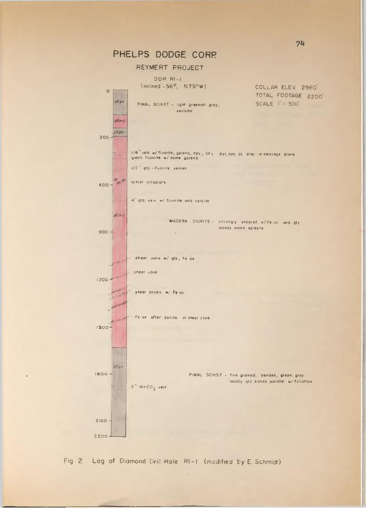
74
REYMERT PROJECT
DDK R l- I(inclined -5 6 ° , N 7 5 °W )
PHELPS DODGE CORP
3 0 0 -
pCpn
pCmd
pCpn
6 0 0
:..
p€md
9 0 0 1
PINAL SCHIST - light greenish groy, sencitic
COLLAR ELEV. 2 9 6 0 ' TOTAL FOOTAGE 2 2 00 ' SCALE l"= 300'
1/4 vem w /fiuonte , gaieno, cpy , cc v pyr, cpy, cc oiso m cleavage plane green fluorite w /som e galena
1/2 " qtz - fluorite veiniet
schist inclusions
4 qtz vem w / fluorite and coicite
1200
T
1500-
p€pn
1 8 0 0
2100
2200
j
MADERA DIORITE - strongly sheared w /Fe o* and qtz locally some epidote
shear zone w / qtz , Ft o*
shear zone
shear zones w / Fe os
Fe os offer pynte in shear zone
P i NAl SCHIST - fine groined, bonded, green graylocally qtz bonds parallel w /fo lia tion
3 Mn CCg vein
Fig 2 Log of Diamond Drili Hole Rl - 1 (modified by E. Schmidt)

3 0 0
6 0 0
9 0 0
I 200
1300
1800
REYM ER T PROJECT
DDH R - 2
P HELPS D O D G E C ORR75
BRECCIA
» fouif
p€pn
COLLAR ELEV. 3 4 0 0 '
TOTAL FOOTAGE 1 8 0 0 '
SCALE 1= 3 0 0 '
PINAL SCHIST - fine groined, thinly bonded, tencitic
locally massive quartz chior clots
ond magnetite grains
f fault breccia
1/2 qtz. w / galena
faults
vemiets w / colcite, qtz., f lu o r ite , cpy, covel, brn
qtz w / covelhte
small lamprophyre dikes
pCmd
MADERA DlOPITE - fine grained, contains abundant
qfz vemiets w /hem atite , epidote
........... , 3 /8 qtz vein * / fluorite
• ......... 6 " zone w /q tz , hem , fluorspar in fault
Fig. 3 Log of Diamond Drill Hole R - 2 (modified by E Schmidt)
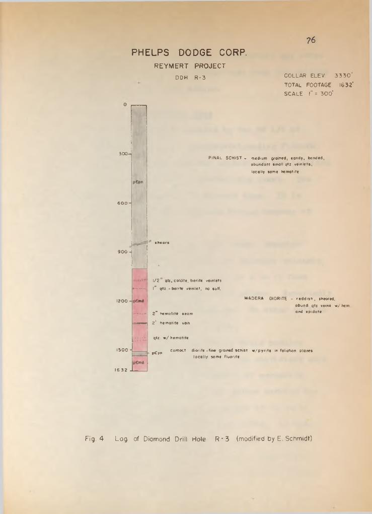
300-
600
900
1200
1300
16 32
REYMERT PROJECT
DDH R -3
PHELPS D O D G E CORP.76
COLLAR ELEV 3 3 3 0 '
TOTAL FOOTAGE 1632'
SCALE l" = 3 0 0 '
P i NAl SCHIST - medium groined, sandy, bonded, obundont small qtz vein lets,
locally some nemotite
shears
1/2 qtz, colcite, barite vemlets
l" qtz - barite vein let, no suit,
MADERA OlORlTE - redd ish , sheared,obund qtz veins w / hem
2" hematite seam ond «',ldote
2 1 hematite vein
qtz w / hematite
pGpn contact diorite -fine groined schist w /p y n te in foliation planes locally some fluorite
Fig. 4 Log of Diamond Drill Hole R * 3 (modified by E. Schmidt)
underlying Pinal Schist. Additional exploration may prove that the diorite is actually a better host rock for sulfide mineralization than the Pinal Schist.
Martinez MineThe Martinez mine is located in the SW 1/4- of
section 18, T3S, R12E along a northwest-trending fissure vein that dips 50° W. The workings consist of two inclined shafts, one adit, and a small concentrating plant. The Martinez mine is inactive at the present time. It is owned by the Ball, Owen and Wingfield Mining Company of Phoenix, Arizona.
The host rock is a pink, very dense, somewhat porphyrltic rhyolite which intruded the Tertiary volcanic flow complex. On the surface the vein is 5 to 10 feet wide and contains predominantly massive galena. Reportedly no silver is associated with the galena. No other sulfide minerals were recognized in the outcrop.
Generally, the galena occurs as solid nodules measuring up to 6 inches in diameter. The unoxidized core is usually engulfed by concentric layers of cerusslte, angles!te(?), and some hematite. The galena nodules are found in the sheared and brecciated gangue of volcanic material. Some sllicification was also noted. As seen in polished sections quartz penetrates every available fracture in the massive galena and locally forms drusy cavities. Under the microscope no solid solution phase
77
78of argent!te could be recognized in the galena. The strong plastic deformation of the galena is probably the result of tectonic stresses developed after crystallization.
Silver Bell MineThe Silver Bell mine is located in the N 1/2 of
section 18, T3S, R12E about 3000 feet northwest of the Martinez mine and apparently lies along the same north- west- trending mineralized structure. The mine is owned and operated at the present time by the Ball, Owen and Wingfield Mining Company.
The Silver Bell structure strikes N 8° W, dips 6?° W, and cuts the rhyolite intrusive body described above. The vein is about 20 feet wide and is bordered on both sides by a fault. Slicken-sides along the faults Indicate a normal down-dip, post-mineral movement. A 5 foot gouge zone is developed along the hanging wall containing abundant galena nodules. The latter show concentric oxidation layers of cerusslte and angles!te. Some hematite, azurite and chrysocolla was also noted. In polished sections some covellite was seen replacing galena along incipient fractures. Quartz fills open spaces and forms drusy cavities. Galena again shows a strongly deformed texture.
The gangue material in the vein is a rhyolite breccia recemented mainly by quartz and chalcedony. A
few specks of chrysocolla were noted locally. According to the field personnel of the B. 0. W. Mining Company (oral communication) the silver tends to be concentrated near the footwall of the vein. In hand specimens fine veinlets of cerargyrite can be recognized filling fractures in the brecciated rhyolite. No native silver and/or argent!te could be seen.
Long hole exploratory drilling in the footwall of the vein confirmed silver mineralization for 40 feet to the east.
79
Woodpecker MineThe Woodpecker mine is located along a series of
fissure veins in the W 1/2 of section 35» T2S, RllE. The structures strike generally N 20° W, dip 32 - 72° SW and cut the foliation of the Pinal Schist with an oblique angle. Post-mineral faulting along these veins is indicated by the presence of abundant slicken-sides on the footwall. Numerous shafts, trenches, and adits have been dug in the vein to explore for metals but the mine is inactive at the present time.
The main portion of the vein consists of quartz, chalcedony and hematite showing characteristic colloform banding and crustification. Generally, the vein material is a brecciated mixture of quartz and schist with a dark greenish gray siliceous matrix. Here and there, a few specks of galena are visible.

80A vein located near the center of section 35
contains galena, chalcopyrlte, malachite, hematite and abundant drusy quartz. Galena occurs In blebs up to 2 cm In diameter and Is replaced In part by angleslte. The latter penetrates the host along fractures and crystallographic boundaries, and locally completely encloses small portions of galena. Chalcopyrlte Is present In minor amounts as small Isolated grains. Specular hematite forms consplceous fine bands outlining In minute detail the colloform texture of the rock. Quartz Is the latest mineral In this assemblage filling open spaces and giving rise to typical comb structure and crustification. No silver minerals were definitely identified in hand specimens and polished sections.
Talley MineThe Talley mine Is located in the N 1/2 NW 1/4 of
section 5. near the dividing line between T2S and T3S, R12E. In August 1965 the mine was operated by Dick Heros who developed a 300 foot drift and a 100 foot shaft. Reportedly, the property had been worked from 1935 to 1937 and produced 4000 tons of ore averaging 15 oz. silver per ton. Present plans are to deepen the shaft at least 400 more feet.
The mine is located along an 8 feet wide fault zone that trends N 70° W and dips 55° S. The fault

91separates a block of Pinal Schist from Madera Diorlte. A one foot wide gouge zone Is developed along the footwall of the structure and forms a uniformly Inclined smooth surface.
The vein material consists mainly of a brecclated and mylonltlzed greenish-gray mixture of diorlte and schist which Is recemented by calclte. Locally, quartz forms open space fillings. Individual grains of galena are finely disseminated throughout the dark-green matrix. A brown, earthy manganese coating is common along fractures.No definite silver mineralization was recognized in hand specimens collected from the shaft.
Other ProspectsEach one of the indicated vein structures in the
Mineral Mountain quadrangle (plate 1) has invariably been explored extensively for precious and base metals. However, the mines are too numerous to be described here individually in detail. The Oklahoma mine, Ajax mine, Coronado mine, just to mention a few, are all similar in occurrence to and show the same mineral assemblage as the Reymert and Woodpecker mine. Needless to say, none of these mines are active today.
A drilling program initiated by the B. 0. W. Mining Company in 1964 attempted to confirm disseminated copper mineralization in Pinal Schist about one-half mile

82northeast of the isolated Mineral Mountain Quartz Monzonite exposure in Box Canyon. The schist in this particular area is somewhat iron stained on the surface, and at one place a gently eastward dipping shear zone exposes considerable amounts of copper carbonates. The company drilled several AX holes down to 537 feet and reportedly intercepted copper oxide mineralization from the surface to the bottom. No sulfide mineralization or an enriched zone were encountered. According to the field personnel (oral communication) silver averaged 2 to 8 oz. per ton.
As pointed out elsewhere in this manuscript, the writer believes that the Mineral Mountain Quartz Monzonite extends further to the east beneath Pinal Schist. The observed iron staining in the overlying schist and the sparse copper mineralization may be intricately associated with the monzonite intrusion. However, the amount of mineralization appears to be insufficient for an economic metal deposit at the present time.

GEOLOGIC HISTORY
The older PreCambrian Pinal Schist is the product of widespread regional metamorphism of sedimentary rocks and interbedded basic volcanic rocks that accumulated in a major northeast-trending geosyncline across the State of Arizona. Time equivalent units are the Yavapai Schist in the Bradshaw Mountains and the Vishnu Schist in the Grand Canyon area (Wilson, 1962). The original sedimentary rocks were largely mudstones, sandstones and arkoses with some basic volcanic tuff layers. During the Mazatzal Revolution, at the end of older Precambrian time, these rocks underwent extensive metamorphism and folding and were intruded by a wide range of igneous rocks as evidenced by the presence of Ruin Granite and Madera Diorite. The clastic sediments were converted into quartz-muscovite schist and the mafic tuff layers to amphibolites. The developed schistosity coincides in general with the original bedding of the sediments. The foliation indicates a predominant northeast trend over large portions of Arizona. In the Mineral Mountain quadrangle, however, the schistosity trends predominantly northwest and east-west.
Following the Mazatzal Revolution the area was uplifted and subjected to extensive erosion which carried
83

84on long enough to produce an essentially flat surface of regional extent, the ep-Archean erosion surface• Upon this flat surface were deposited the sediments of the younger Precambrian Apache Group in a northwest-trending, steadily sinking trough. The rocks were mainly sandstone, shale, and limestone. The presence of a basal conglomerate unit in the clastic sediments indicates repeated uplift and subsidence during the cycle of sedimentation. Locally, submarine volcanism spread a basaltic layer over Mescal Limestone.
At the end of younger Precambrian time the Grand Canyon Disturbance was accompanied by a widespread diabase intrusive activity which thoroughly penetrated the sediments along bedding planes and fracture zones and caused a dilation of the entire sedimentary sequence. The Grand Canyon Disturbance was followed by another erosion cycle which produced the ep-Algonkian surface. Although no Paleozoic rocks are exposed in the Mineral Mountain quadrangle they may have been deposited and since then eroded again because thick Paleozoic sections crop out in the vicinity of Superior, only 4 miles to the east.
The next tectonic event recognized in this area is the tilting and folding of the older and younger Precambrian rocks reflecting the onset of the Laramide Revolution. This event lasted until middle and late

85Tertiary time. The steeply dipping beds of the Apache Group, the small scale folding of the Mescal Limestone, and the Pinal overthrust are evidence for this movement.
Igneous intrusions were plentiful during this tectonic period and the Mineral Mountain Quartz Monzonite may be such an intrusion. Throughout southern Arizona extensive mineralization accompanied these Intrusions and formed the large porphyry copper deposits which are being mined today.
The vein-type mineralization in the quadrangle is certainly of similar, if not younger, age. The fissure system in the schist probably originated during this time either as a result of directed compressions! stress in a northwest direction, or as a result of regional monoclinal folding. In the latter case the axis of the fold would lie somewhere near Mineral Mountain trending parallel to the present fissure system. Ascending solutions rich in silica, lead, silver, and manganese readily penetrated the structurally prepared ground and deposited near surface ore pockets.
Uplift must have been vigorous enough to cause tremendous erosion and the deposition of abundant coarse material as indicated by the Whitetail Conglomerate.Regional studies have shown that the Whitetail was deposited in isolated structural basins and stream channels, the material having been derived from adjacent high mountain areas.

PLATE 3
Mineral Mountain
Figure 1. View of Mineral Mountain looking northeast. Rhyolite intrusive forms bold outcrop. Pinal Schist is in the foreground transected by fissure veins.
Figure 2. View of the Rhyolite-Daclte Flow Complex looking east. The bedded sequence overlies Pinal Schist.

«7
Figure 2
PLATE 3. MINERAL MOUNTAIN

PLATE 4
Fissure Veins
Figure 1. An eastward dipping fissure vein transects Pinal Schist. High relief due to strong sillciflcation.
Figure 2. Close-up view of same vein. Note the smooth, eastward dipping fault surface. The vein consists mainly of banded silica and brecciated Pinal Schist.
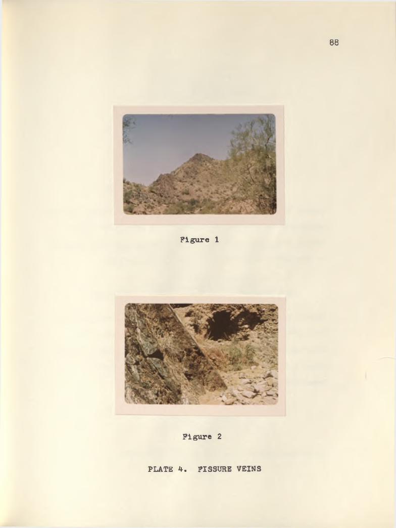
88
Figure 1
Figure 2
PLATE 4. FISSURE VEINS

PLATE 5
Colloform Banding In Fissure Vein
Figure 1. Hand specimen of vein material showing typical colloform banding and crustiflcation caused by alternating layers of silica. Some specular hematite present in the upper and lower portion of the specimen.
Hand Specimen of Dripping Spring Quartzite
Figure 2. Hand specimen of Dripping Spring Quartzite. Note graded bedding and incipient cross-bedding in upper portion of picture. Hematite penetrates the rock along favorable horizons and along minute crossfractures.

89
t
Figure 2. HAND SPECIMEN OF DRIPPING SPRING QUARTZITE
PLATE 5
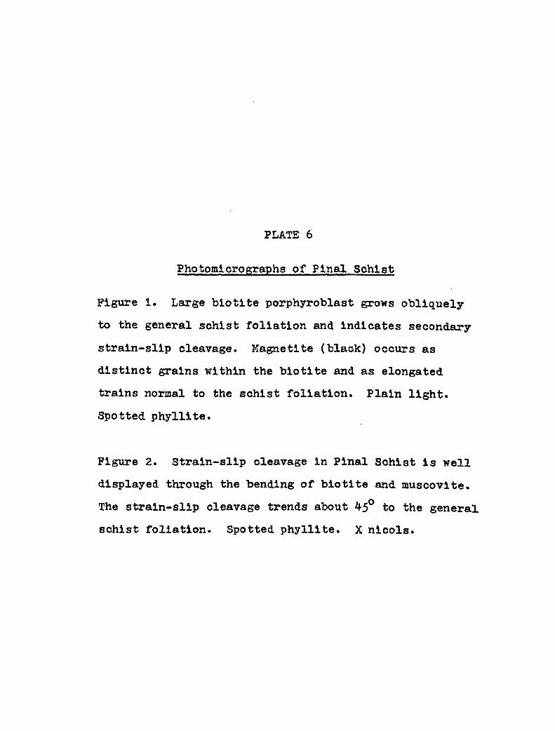
PLATE 6
Photomicrographs of Pinal Schist
Figure 1. Large blotlte porphyroblast grows obliquely to the general schist foliation and indicates secondary strain-slip cleavage. Magnetite (black) occurs as distinct grains within the blotlte and as elongated trains normal to the schist foliation. Plain light. Spotted phyllite.
Figure 2. Strain-slip cleavage in Pinal Schist is well displayed through the bending of blotlte and muscovite. The strain-slip cleavage trends about 45° to the general schist foliation. Spotted phyllite. X nicols.
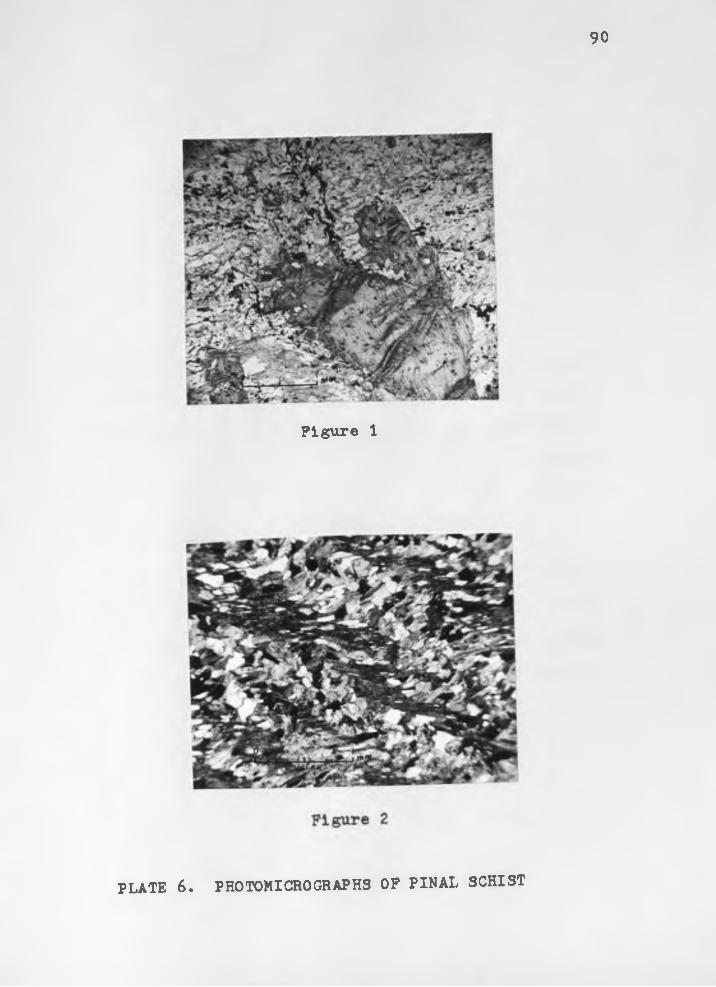
90
Figure 1
PLATE 6. PHOTOMICROGRAPHS OF PINAL SCHIST

PLATE 7
Hand Specimen of Pinal Schist
Figure 1. Hand specimen of quartzose variety. Banding is caused by alternating layers of microcrystalline quartz and muscovite. Rock consists of 95 per cent quartz.
Photomicrograph of Pinal Schist
Figure 2. Large pyrite grain grows obliquely to the trend of foliation. Biotite is deflected around the grain, and coarse crystalline quartz develops in the pressure shadow of the pyrite. Crossed nicols.

Figure 1. HAND SPECIMEN OF PINAL SCHIST
Figure 2. PHOTOMICROGRAPH OF PINAL SCHIST
PLATE 7

PLATE 8
Figure 1. Strongly foliated amphibolite as a result of the parallel alignment of slender hornblende needles. Interstitial material is plagloclase. and quartz. Locally, clusters of epidote are present. Nicols not crossed.
Photomicrographs of Amphibolite
Figure 2. Ptygmatic folding in amphibolite. Hornblende appears to grow into the regions of least pressure. The fold is outlined by a quartz segregation layer. Nicols not crossed.

92
Figure 1
Figure 2
PLATE 8. PHOTOMICROGRAPHS OF AMPHIBOLITE

PLATE 9
Figure 1. Photomicrograph of diabase shows the radial arrangement of hornblende around a large pyroxene grain. Hornblende extends into the surrounding plagio clase. Nicols not crossed.
Photomicrograph of Diabase
Photomicrograph of Amphibolite
Figure 2. Photomicrograph of amphibolite with a preferred orientation of hornblende. Interstitial material is plagioclase and quartz. Epidote occurs locally in anhedral blebs. Nicols not crossed.

93
Figure 1. PHOTOMICROGRAPH OF DIABASE
PLATE 9

PLATE 10
Hand Specimen of Diabase
Figure 1. Hand specimen of coarse crystalline diabase showing distinct, slightly weathered plagioclase laths arranged in an ophitic texture. Augite and magnetite form the interstitial material.
Photomicrograph of Diabase
Figure 2. Photomicrograph of diabase with myrmekitic intergrowth of quartz and K-feldspar. Locally, secondary K-feldspar overgrowth on plagioclase present. Large, subhedral black grain is pyrite. Crossed nicols.

94
Figure 1. HAND SPECIMEN OF DIABASE
Figure 2. PHOTOMICROGRAPH OF DIABASE
PLATE 10
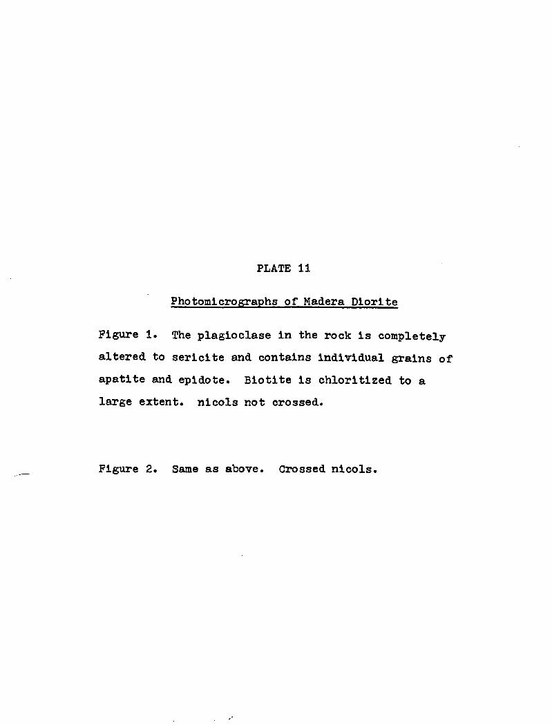
PLATE 11
Figure 1. The plagioclase In the rock is completely altered to sericlte and contains individual grains of apatite and epldote. Biotite is chloritized to a large extent, nicols not crossed.
Photomicrographs of Madera Dlorlte
Figure 2. Same as above. Grossed nicols

95
Figure 2
PLATE 11. PHOTOMICROGRAPHS OF MADERA DIORITE

PLATE 12
Hand Specimen of Madera Dlorlte
Figure 1. Hand specimen showing holecrystalline, equigranular texture of Madera Diorite. The plagio- clase has a pronounced pink color. Two 5 mm wide epidote veinlets cut the rock, and smaller veinlets and blebs of epidote are scattered abundantly throughout the rock.
Photomicrograph of Madera Dlorlte
Figure 2. Photomicrograph of Madera Dlorlte shows relatively unaltered plagioclase with apatite. Irregular blebs of epidote replace hornblende and plagioclase locally. Crossed nlcols.

96
Figure 1. HAND SPECIMEN OF MADERA DIORITE
PLATE 12

PLATE 13
Figure 1. Photomicrograph of Ruin Granite shows holo- crystalline, coarse grained, interlocking hypidiomorphic granular texture composed of quartz, microcline, oilgo- clase and blotite. Oligoclase is commonly altered to clay and sericite. Crossed nicols.
Photomicrographs of Ruin Granite
Figure 2. Detail of above. Unaltered microcline phenocryst shows typical polysynthetic twinning adjacent to a completely altered oligoclase crystal. In places, an unaltered rim of oligoclase remains behind. Crossed nicols.

Figure 1
PLATE 13. PHOTOMICROGRAPHS OP RUIN GRANITE

PLATE 14
Figure 1. Photomicrograph of Ruin Granite showing large irregular flakes of biotlte surrounded by magnetite (black). Light gray, equant grains with high, relief are apatite. Nicols not crossed.
Photomicrograph of Ruin Granite
Photomicrograph of Mineral Mountain Quartz Monzonlte
Figure 2. Photomicrograph of Mineral Mountain Quartz Monzonlte. Plagioclase crystals with alblte twinning are locally completely engulfed by K-feldspar. Plagioclase shows corroded edges and incipient alteration. Crossed nicols.

98
Figure 2. PHOTOMICROGRAPH OF MINERAL MOUNTAIN QUARTZ MONZONITE
PLATE 14

PLATE 15
Figure 1. Plagioclase phenocryst showing typical albite twinning and Incipient clay-sericite alteration along minute fractures, twin lamellae and zonal directions. Anhedral quartz and K-feldspar constitute the matrix. Crossed nicols.
Photomicrographs of Mineral MountainQuartz Monzonlte
Figure 2. Detail of above showing incipient clay sericite alteration in subhedral plagioclase phenocryst. Crossed nicols.

99
Figure 2PLATE 15. PHOTOMICROGRAPHS OF MINERAL MOUNTAIN QUARTZ
MONZONITE

PLATE 16
Figure 1. Incipient clay-serlcite alteration in strongly- zoned plagioclase. Alteration follows minute fractures and zonal directions. Biotite is replaced by magnetite (black) in upper right corner. Crossed nlcols.
Photomicrographs of Mineral MountainQuartz Monzonlte
Figure 2. Strongly altered plagioclase surrounded by unaltered K-feldspar (dark gray). A rim of unaltered plagioclase is left behind. Crossed nlcols.

100
Figure 1
Figure 2
PLATE 16. PHOTOMICROGRAPHS OF MINERAL MOUNTAIN QUARTZMONZONITE
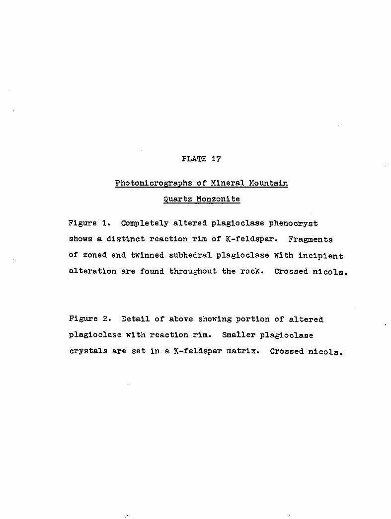
PLATE I?
Figure 1. Completely altered plagloclase phenocryst shows a distinct reaction rim of K-feldspar. Fragments of zoned and twinned subhedral plagloclase with incipient alteration are found throughout the rock. Crossed nicols.
Photomicrographs of Mineral MountainQuartz Monzonlte
Figure 2. Detail of above showing portion of altered plagloclase with reaction rim. Smaller plagloclase crystals are set in a K-feldspar matrix. Crossed nicols

101
Figure 2
PLATE 17. PHOTOMICROGRAPHS OP MINERAL MOUNTAIN QUARTZMONZONITE

PLATE 18
Figure 1. This specimen represents a K-feldspar rich phase of Mineral Mountain Quartz Monzonlte occurring in the southern portion of the intrusive. K-feldspar shows microperthitic intergrowth and plagioclase is commonly altered in the central portions. Crossed nicols.
Figure 2. Strongly altered portion of.quartz monzonlte in the northeast portion of the intrusive. Note cloudy appearance of plagioclase. The black areas represent hematite developed in fractures and small shear zones. Nicols not crossed.
Photomicrographs of Mineral MountainQuartz Monzonlte

102
Figure 2
PLATE 18. PHOTOMICROGRAPHS OF MINERAL MOUNTAIN QUARTZMONZONITE
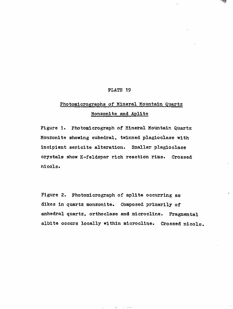
PLATE 19
Figure 1. Photomicrograph of Mineral Mountain Quartz Monzonlte showing euhedral, twinned plagioclase with incipient sericlte alteration. Smaller plagioclase crystals show K-feldspar rich reaction rims. Crossed nicols.
Photomicrographs of Mineral Mountain QuartzMonzonlte and Apllte
Figure 2. Photomicrograph of apllte occurring as dikes in quartz monzonlte. Composed primarily of anhedral quartz, orthoclase and mlcrocline. Fragmental albite occurs locally within mlcrocline. Crossed nicols.
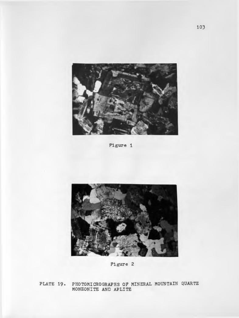
103
Figure 1
Figure 2
PLATE 19. PHOTOMICROGRAPHS OF MINERAL MOUNTAIN QUARTZMONZONITE AND APLITE

PLATE 20
Hand Specimen of Quartz Dlorlte Porphyry
Figure 1. Quartz dlorlte porphyry shows distinct sub- hedral feldspar phenocrysts and well rounded quartz grains set in a very fine grained matrix consisting of plagioclase, hornblende, epidote and calcite. Plaglo- clase is commonly altered to clay and sericite.
Photomicrograph of Volcanic Flow Complex
Figure 2. Photomicrograph of volcanic flow complex. Subhedral plagioclase always shows reaction rims. Quartz is well-rounded and typically embayed. Fine-grained blotlte shows commonly a preferred orientation. The rock is a rhyo-dacite. Crossed nicols.

104
Figure 1. HAND SPECIMEN OF QUARTZ DIORITE PORPHYRY
PLATE 20
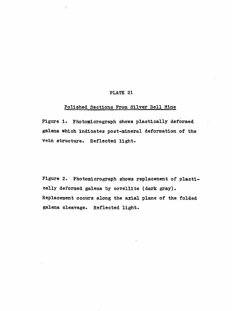
PLATE 21
Polished Sections From Silver Bell Mine
Figure 1. Photomicrograph shows plastically deformed galena which indicates post-mineral deformation of the vein structure. Reflected light.
Figure 2. Photomicrograph shows replacement of plastically deformed galena by covellite (dark gray). Replacement occurs along the axial plane of the folded galena cleavage. Reflected light.
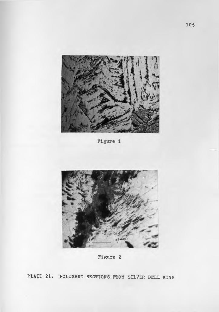
105
Figure 2
PLATE 21. POLISHED SECTIONS FROM SILVER BELL MINE

PLATE 22
Polished Sections From Silver Bell and Martinez Mine
Figure 1. Photomicrograph of specimen from Silver Bell mine showing the replacement of galena (light gray) by cerussite (dark gray) along minute fractures and crystallographic boundaries. Reflected light.
Figure 2. Photomicrograph of specimen from Martinez mine showing plastically deformed galena (light gray) and fracture filling subhedral quartz (dark gray). Reflected light.

106
Figure 1
Figure 2
PLATE 22. POLISHED SECTIONS FROM SILVER BELL AND MARTINEZ MINE

PLATE 23
Hand Specimen of Vein From Woodpecker Mine
Figure 1. Polished slab shows typical colloform banding of specular hematite (light gray) and quartz (pinkish gray). White rectangular area in upper left in galena.
Polished Section of Vein From Woodpecker Mine
Figure 2. Detail of above showing colloform banding of hematite (light gray) and quartz (dark gray). A small grain of galena (white) is surrounded by cerussite in upper left. Reflected light.

10?
Figure 1.
Figure 2
HAND SPECIMEN OF VEIN FROM WOODPECKER MINE
PLATE 23

PLATE 24
Polished Section From Woodpecker Mine
Figure 1. Photomicrograph of galena (with triangular pits) being replaced by cerussite along fractures. Quartz (dark gray) and hematite (light gray) are later fracture filling material. (Detail of specimen on Plate 23). Reflected light.
Hand Specimen From Woodpecker Mine
Figure 2. Hand specimen shows crustification of quartz in center of vein. Fine irregular banding of specular hematite (bluish gray) occurs mainly in the right half of the specimen; malachite (green) can be seen as specks and small blebs to the left. A few chalcopyrite grains occur in the lower left corner.
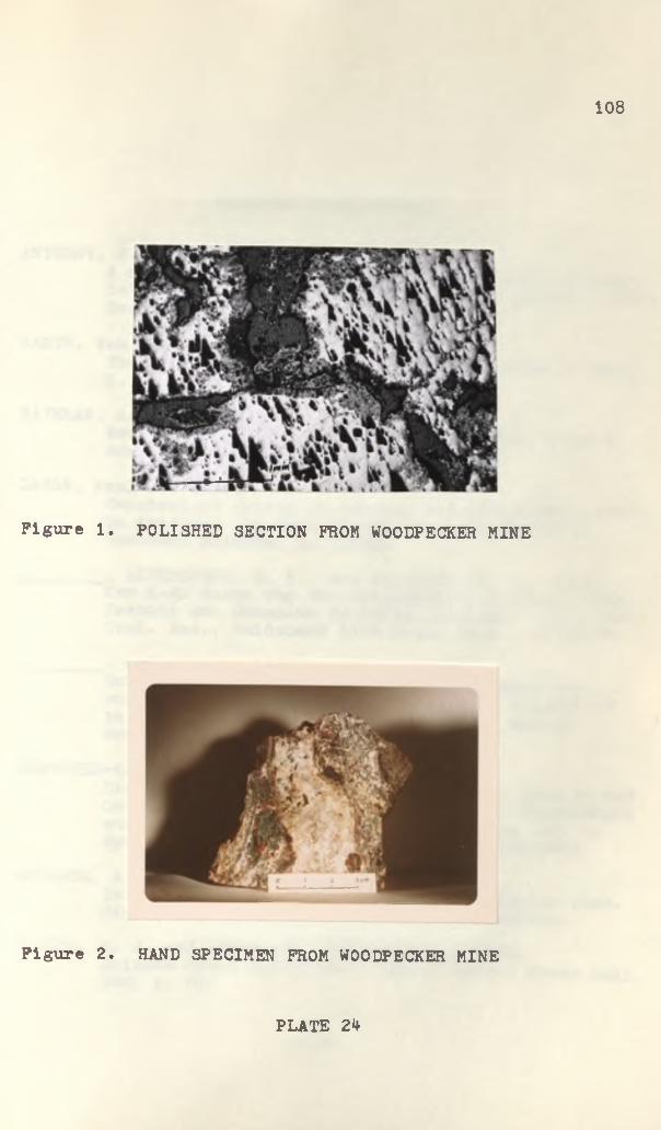
108
Figure 1. POLISHED SECTION FROM WOODPECKER MINE
Figure 2. HAND SPECIMEN FROM WOODPECKER MINE
PLATE 24

SELECTED BIBLIOGRAPHY
ANTHONY, J. W., I960,A note on the probability of assimilation of rocks intruded by central Arizona diabases in Ariz. Geol. Soc., Digest vol. 3, p. 99-102.
BARTH, Tom F. B., 1962,Theoretical Petrology, 2nd ed., John Wiley & Sons,N. Y.
BATEMAN, A. M., 1959.Economic Mineral Deposits, 2nd ed., John Wiley & Sons, N . Y.
DAMON, Paul E., 1959.Geochemical dating of igneous and metamorphic rocks in Arizona: in Ariz. Geol. Soc., Guidebook IISouthern Arizona, p. 16-20.
________, LIVINGSTON, D. E., and ERICKSON, R. C., 1962,New K-Ar dates for the Precambrian of Pinal, Gila, Yavapai and Coconino Counties, Arizona: in N. Mex.Geol. Soc., Guidebook 13th Field Conf•, p. 56-58*
________, and others, 1965,Correlation and cronology of ore deposits and volcanic rocks: Ann. Progr. Rep. No. COO-689-50to Research Div. United States Atomic Energy Commission, Appendix A-I.
DRESCHER-KADEN, F. K., 1948,Die Feldspat-Quarz Reaktionsgeftige der Granite und
* Gneise und ihre genetische Bedeutung: Mlnerplogieund Petrographic in Einzeldarstellungen, Bd. 1, Springer Verlag Berlin, Gfdttingen, Heidelberg.
EDWARDS, A. B., 1965,Textures of the ore minerals: Australasian Inst.Mining and Metallurgy, 2nd ed., 2nd reprint.
ELSING, M. J. and HEINEMANN, Robert E. S., 1936,Arizona Metal Production: Ariz. Bureau Mines Bull.140, p. 99.
109

110FORD, W. E., 1958,
Dana's Textbook of Mineralogy, 4th ed., John Wiley and Sons, N. Y.
HAMMER, D. F., WEBSTER, R. N. and LAMB, D. C., 1962,Some geologic features of the Superior area, Pinal County, Arizona: N. Mex. Geol. Soc., Guidebook13th Field Conf., p. 148-153.
LANCE, J. F., 1959,PreCambrian rocks of southeastern Arizona: Ariz.Geol. Soc., Guidebook II, p. 12-15*
LINDGREN, Waldemar, 1933,Mineral Deposits, 4th ed., McGraw-Hill Book Co.,N. Y.
MAYO, E. B., 1958,Lineament tectonics and some ore districts of the Southwest: Trans. AIME, vol. 211, p. 1169-1175*
PARK, Charles F. and MacDIARMID, Roy A., 1964,Ore Deposits, W. H. Freeman & Co., San Francisco.
PETERSON, D. W., 1962,Preliminary geologic map of the west part of the Superior quadrangle, USGS MF 253*
PETERSON, N. P., 1962,Geology and ore deposits of the Globe-Miami district, Arizona, USGS Prof. Paper 342, 151 P*
RAMDOHR, Paul, 1955,Die Erzmineralien und ihre Verwachsungen, 2nd ed., Akademie Verlag Berlin.
RANSOME, F. L., 1903,Geology of the Globe copper district, Arizona:USGS Prof. Paper 12.
________. 1923,Description of the Ray quadrangle: USGS Folio 21?.SCHNEIDERHOHN, Hans, 1952,
Erzmikroskopisches Praktikum: E. Schweitzerbart'scheVerlagsbuchhandlung, Stuttgart.________ , 1962,
Erzlagerst&tten: 4th ed., VEB Gustav FischerVerlag, Jena.

IllSHORT, et al., 1943,
Geology and ore deposits of the Superior mining area: Arlz. Bur. Mines Bull. 151*
SHRIDE, A. F., 1961,Some aspects of younger Precambrian geology in southern Arizona: Ph. D. Dissertation, Dept.Geol., Univ. of Arizona, 234 p.
STEELE, H. J., 1952,Superior area: in Arlz. Geol. Soc., GuidebookSouthern Arizona, p. 106-111.
TURNER, F. J. and VERH00GEN, J., I960,Igneous and metamorphic petrology, 2nd, ed., McGraw-Hill Book Go., N. Y.
WASSERBURG, G. J. and LAMPHERE, M. A., 1965,Age determinations in the Precambrian in Arizona and Nevada: Geol. Soc. Amer. Bull. vol. 76,P- 735-758.
WILLIAMS, H., TURNER, F. J. and GILBERT, C. M., 1958,Petrography: W. H. Freeman & Go., San Francisco.
WILSON, E. D., 1950,Superior area: in Arlz. Bur. Mines Bull. 156,p. 84—98.
________, 1952,General geology between Ray and Superior, Arizona: Arlz. Geol. Soc., Guidebook I, p. 97-105*
_________, 1962,A resume of the geology of Arizona: Arlz. Bur.Mines Bull. 171.
WINKLER, H. G. F., 1965,Petrogenesis of metamorphic rocks. Springer Verlag Berlin, Heidelberg, New York.
-5 P/a-fe
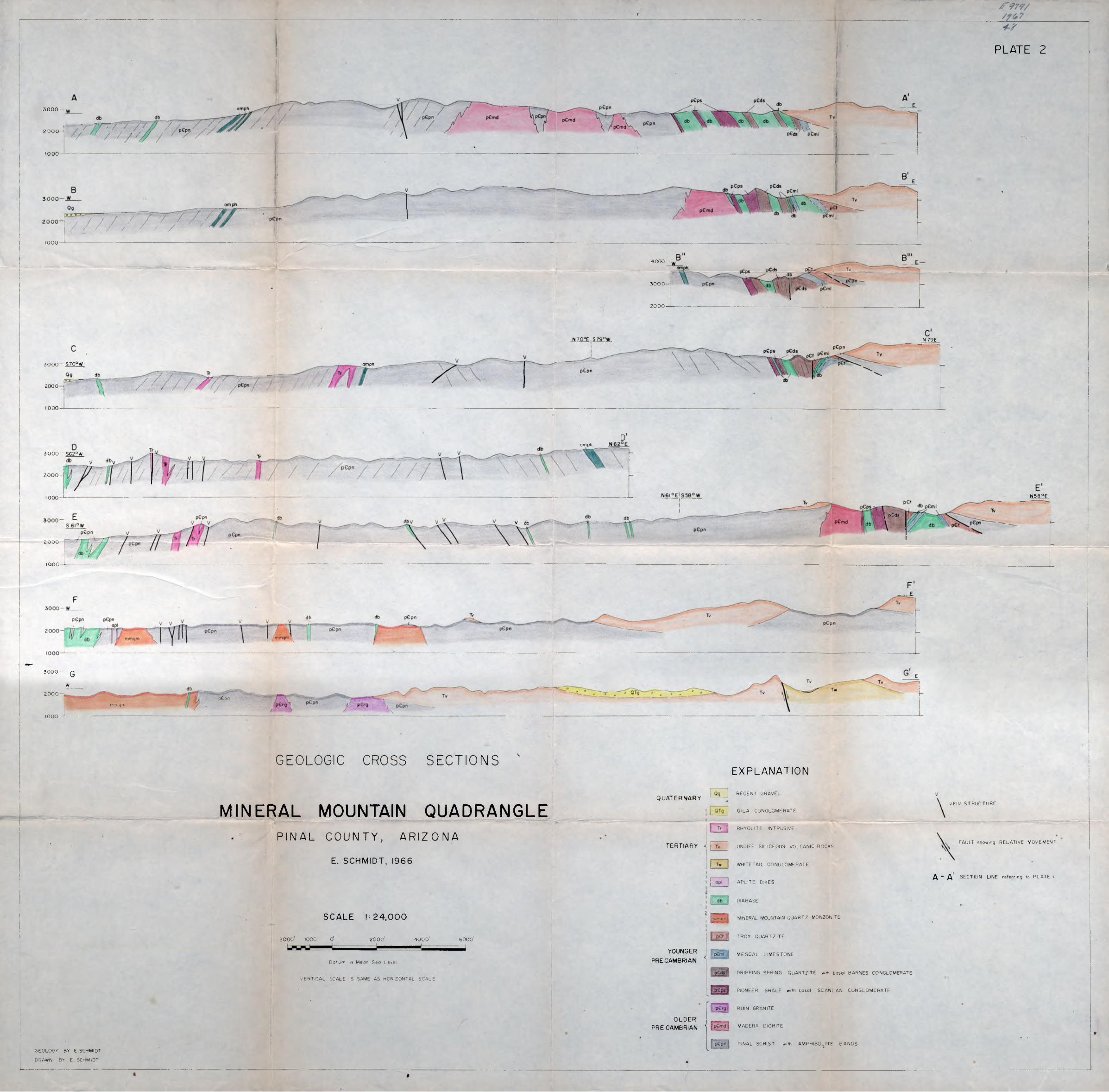
f
PLATE 2
i-r
3 0 0 0 -
2000 -
1000
1000
4 0 0 0 -
3 0 0 0 -
2000
N 70°E ,S 7 9 0W N 79 E
3 0 0 0 - S70°W amph
2000
1000
D'amph
3 0 0 0 - S62°W
2000-
N58 °E1000 J---
\ pGdsV db
2000 —
1000
3 0 0 0 - Q
w2000 -
1000-*mmqm
p£pn
GEOLOGIC CROSS SECTIONS '
MINERAL MOUNTAIN QUADRANGLEPINAL COUNTY, ARI ZONA
E. SCHMIDT, 1966
S C A L E l: 24,000
2 0 0 0 ' 1000' O' 2 0 0 0 ' 4 0 0 0 ' 60 00 '
— i .....^Datum is Mean Sea Level
VERTICAL SCALE IS SAME AS HORIZONTAL s c a l e
EXPLANATION
QUATERNARY
TERTIARY
m m qm
YOUNGER
PRE CAMBRIAN
OLDER PRE CAMBRIAN
RECENT GRAVEL
GILA CONGLOMERATE
RHYOLITE INTRUSIVE
UNDIFF SILICEOUS VOLCANIC ROCKS
WHITETAIL CONGLOMERATE
APLITE DIKES
DIABASE
MINERAL MOUNTAIN QUARTZ MONZONITE
TROY QUARTZITE
MESCAL LIMESTONE
DRIPPING SPRING QuARTZlTE w,th basal BARNES CONGLOMERATE
PIONEER SHALE with basal SCANLAN CONGLOMERATE
RUIN GRANITE
MADERA DIORITE
PINAL SCHIST with AMPHIBOLITE BANDS
#
VEIN STRUCTURE
FAULT showing RELATIVE MOVEMENT
/ \ - A * SECTION LINE referring to PLATE I
'
GEOLOGY BY E SCHMIDT
DRAWN BY E SCHMIDT
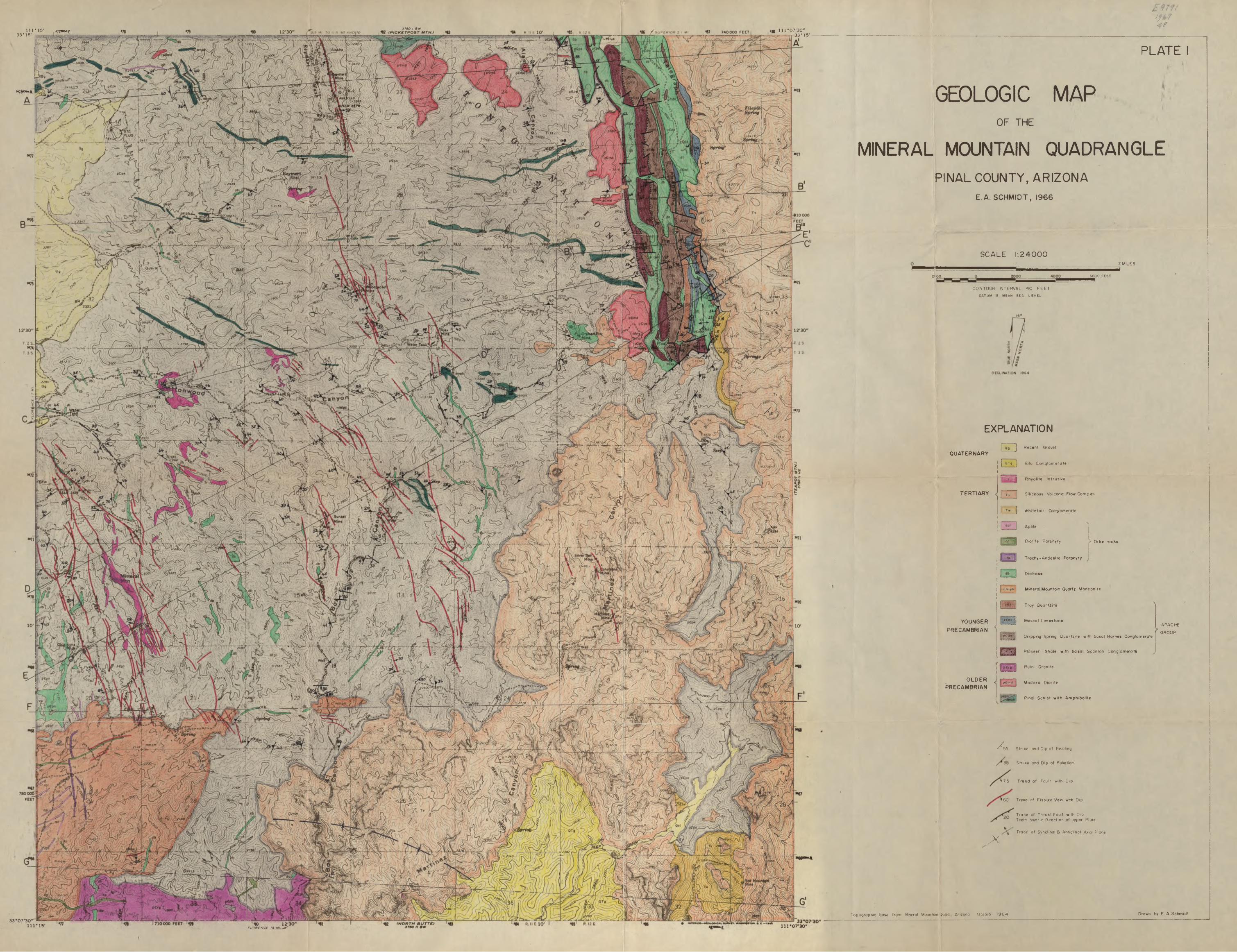
111 0 15' 33 * 15'
«77«o-E. 3790 / S W <88 111 *0 7 '3 0 '■■ 3 3 *1 5 '
* 78* * " *
33*07'30'r
C 7 / 7 /
TPLATE I
GEOLOGIC MAPOF THE
MINERAL MOUNTAIN QUADRANGLEPINAL COUNTY, ARIZONA
E.A. SCHMIDT, 1966
S C A L E 1:24000I
■V2 MILES
2COO 6 0 0 0 FEET
CONTOUR INTERVAL 4 0 FEET
DATUM IS MEAN SEA LEVEL
EXPLANATION
QUATERNARY
TERTIARY \ TW
Recent 'Grovel
j | OTg | Gilo Conqlomerote
I| Tr Rhyolite Intrusive
Siliceous Vo conic Flow Complex
W h ite to il Conglomerate
Aplite
dp Diorite Porphyry
Trochy-Andesite Porphyry
z Dike rocks
Diabase
mmqm Mineral Mountain Quartz Monzonite
YOUNGERPRECAMBRIAN
'F7
Troy Quartzite
Mescal Limestone
peer» Dripping Spring Quartzite with basal Barnes Conglomerate
Pioneer Shale with basal Scanlon Conglomerate
OLDERPRECAMBRIAN
m s
Ruin Granite
APACHE
GROUP
pGmd j Madera Diorite
Pinol Schist with Amphibolite
/^ 5 5 Strike and Dip of Bedding
Strike and Dip of Foliation
7 5 Trend of Fault with Dip
/ X
60 Trend of Fissure Vein with Dip
Trace of Tnrust Fault with Dip Teeth point m Direction of upper Plate
Trace of Synclinal B Anticlinal Axial Plane
Topographic base from Mineral Mountain 3uod., Arizona U S G S 1964 Drown by E.A Schmidt
111* 15' <80 12'FLORENCE 19 Ml 111 " 0730"
Related Documents


