31 Geology, Geomorphology and Seismotectonics of Bengal Basin with special emphasis on Kolkata and its adjoining region 2 The Bengal Basin in the eastern part of the Indian subcontinent constitutes the largest fluvio- deltaic to shallow marine sedimentary basin comprising of riverine channel, floodplain and delta plain environments (Alam et al., 2003; Roy and Chatterjee, 2015; Goodbred, 2003). The Bengal Basin is in the vicinity of three active plate boundaries viz. the Eurasian plate, the Indian plate, the Indo-Burma plate and two advancing deformation fronts viz. the Himalaya and the Indo-Burmese orogenic belts which represent intense seismic activity in the region (Nath et al., 2014). The tilting, warping and folding of the strata with anomalous drainages are the common indicators of deformations in the basin (Dasgupta, 2011). The intensity and pattern of plate-to-plate interaction varies with time, affecting the basin architecture and the sedimentation style throughout the Basin (Alam et al., 2003). The Bengal Basin and its adjoining region have survived more than 23 devastating earthquakes indicating neotectonic activities in the region and the reactivation of different older lineaments/faults (Kayal, 2008). It has a regional striking tectonic trend oriented in the N-S, NE-SW and ENE-WSW directions (Khan and Chouhan, 1996). Manifestation of ongoing tectonic activity in the Bengal Basin and its adjoining region includes the disastrous earthquakes namely the 1885 Bengal earthquake of M w 6.8, the 1897 Shillong earthquake of M w 8.1, the 1918 Srimangal earthquake of M w 7.6, the 1930 Dhubri earthquake of M w 7.1, the 1934 and 1988 Bihar-Nepal earthquakes of M w 8.1 & M w 6.8 respectively, the 1935 Pabna earthquake of M w 6.2, 1964 Sagar Island earthquake of M w 5.4 and the recent 2015 Nepal earthquake of M w 7.8. The geology and geomorphology serve as significant attributes towards the seismic ground motion depiction at a site of interest (Nath et al., 2008b). The surface expressions of a rupture/deformation in a geomorphic unit may serve as the primary indicator of an earthquake that was previously ignored in the case of 2.1 Introduction

Welcome message from author
This document is posted to help you gain knowledge. Please leave a comment to let me know what you think about it! Share it to your friends and learn new things together.
Transcript
31
Geology, Geomorphology and Seismotectonics of Bengal Basin
with special emphasis on Kolkata and its adjoining region
2
The Bengal Basin in the eastern part of the Indian subcontinent constitutes the largest fluvio-deltaic to shallow marine sedimentary basin comprising of riverine channel, floodplain and delta plain environments (Alam et al., 2003; Roy and Chatterjee, 2015; Goodbred, 2003). The Bengal Basin is in the vicinity of three active plate boundaries viz. the Eurasian plate, the Indian plate, the Indo-Burma plate and two advancing deformation fronts viz. the Himalaya and the Indo-Burmese orogenic belts which represent intense seismic activity in the region (Nath et al., 2014). The tilting, warping and folding of the strata with anomalous drainages are the common indicators of deformations in the basin (Dasgupta, 2011). The intensity and pattern of plate-to-plate interaction varies with time, affecting the basin architecture and the sedimentation style throughout the Basin (Alam et al., 2003). The Bengal Basin and its adjoining region have survived more than 23 devastating earthquakes indicating neotectonic activities in the region and the reactivation of different older lineaments/faults (Kayal, 2008). It has a regional striking tectonic trend oriented in the N-S, NE-SW and ENE-WSW directions (Khan and Chouhan, 1996). Manifestation of ongoing tectonic activity in the Bengal Basin and its adjoining region includes the disastrous earthquakes namely the 1885 Bengal earthquake of Mw 6.8, the 1897 Shillong earthquake of Mw 8.1, the 1918 Srimangal earthquake of Mw 7.6, the 1930 Dhubri earthquake of Mw 7.1, the 1934 and 1988 Bihar-Nepal earthquakes of Mw 8.1 & Mw 6.8 respectively, the 1935 Pabna earthquake of Mw 6.2, 1964 Sagar Island earthquake of Mw 5.4 and the recent 2015 Nepal earthquake of Mw 7.8. The geology and geomorphology serve as significant attributes towards the seismic ground motion depiction at a site of interest (Nath et al., 2008b). The surface expressions of a rupture/deformation in a geomorphic unit may serve as the primary indicator of an earthquake that was previously ignored in the case of
2.1 Introduction
Geology, Geomorphology and Seismotectonics of Bengal Basin with special emphasis on Kolkata and its adjoining region32
the Great Assam earthquake (Dasgupta, 2011). Youd and Perkins (1978) assessed liquefaction susceptibility by mapping the surface and near surface lithology. The Bengal Basin between the Indian Shield and Indo-Burma Ranges, comprises of three Geo-tectonic provinces, namely: (i) the Stable Shelf, (ii) the Central Deep Basin (extending from the Sylhet Trough in the northeast towards the Hatia Trough in the south), and (iii) the Chittagong-Tripura Fold Belt (Alam et al., 2003). The Bengal Basin has a thick blanket of quaternary sediments approximately 22 km thick (Curray and Munasinghe, 1989). The sediments below the surface are the contributing factor in the ground failure and are capable of amplifying the ground motion, thus enhancing the hazard potential during a strong earthquake. Compaction of the sediments, the age of the sediments and the water table depth lying under a specific area play important roles in quantifying the earthquake hazard of the area in terms of liquefaction susceptibility. The association of ground strain with the soil-structure has contributed to triggering of ground failure (Boulanger and Idriss, 2006). The Quaternary environmental changes can be reconstructed through the study of Late Pleistocene and Holocene sediments (Umitsu, 1993). The Late Quaternary Ganges–Brahmaputra delta has been shown to be heavily influenced by eustatic sea-level rise (Goodbred et al., 2003). The Ganga Brahmaputra delta system unveils an intriguing Late Quaternary history controlled by immense sediment discharge, tectonics and eustasy (Goodbred and Kuehl, 2003). The Bengal Basin is a structurally subsiding basin, filled with sediments carried by the Ganges and the Brahmaputra Rivers (Morgan and McIntire, 1959).
Kolkata is the oldest and the capital city of West Bengal situated on the east bank of the river Hooghly. Due to a small distance from the Bay of Bengal, Kolkata city experiences high tidal actions by the Hooghly River. The Kolkata city represents an educational and industrial hub in the eastern part of the country as well as the gateway of Indian business through international ports. The paleoseismicity of the area revealed that the City stands highly vulnerable to seismic hazards owing to the burgeoning population of about 14 million as per census 2011 and extensive development activities. The 1737 Kolkata earthquake (Gentleman’s magazine, 1738), the 1897 Shillong earthquake of Mw 8.1 and the 1934 Bihar-Nepal earthquake of Mw 8.1 caused widespread damage in the City (Oldham, 1899; GSI, 1939). It is, therefore, necessary to predict ground-shaking levels to facilitate building codal-provisions for earthquake-resistant design of structures. According to Youd and Hoose (1977), the unconsolidated fluvial deposits as well as the deltaic deposits have posed greatest threats of damage from liquefaction. Youd and Perkins (1978) summarized that, the younger unconsolidated sediments are prone to liquefaction and under favorable geomorphic unit it creates hazardous scenario. The lithostratigraphic mapping of the City reveals that most parts have been built-up on unconsolidated/loosely consolidated alluvial sediments which require analysis on finer resolution for seismic hazard microzonation. This outcome necessitated a review of the Tectonic, Geologic, Geomorphic and Lithostratigraphic setting of the Bengal Basin in the seismic hazard perspective.
33Geology, Geomorphology and Seismotectonics of Bengal Basin with special emphasis
on Kolkata and its adjoining region
2.2 Tectonic Settings of Bengal Basin and its adjoining region
The Bengal Basin is an asymmetric polycyclic tectonic basin on the eastern margin of the Indian shield. Evolution of the Bengal Basin took place in different phases through plate movements in space and time. The Indian plate started moving with a velocity of approximately 10 cm/yr initially in a N-NE direction and collided with the Eurasian plate, then started moving in the N-NW direction at 4 cm/yr (Rangin, 2012). After the collision of the Indian plate with the Eurasian plate, the Indian plate rotated clockwise to become prominent in the north south direction (Kundu and Gahalaut, 2013). The tectonic evolutionary stages of Bengal Basin are (i) the Pre-Rift stage (Permo-Carboniferous), (ii) the Rift-Drift stage (Late Jurassic-Early Cretaceous), (iii) the Post-Rift stage (Mid Cretaceous-Paleocene), and (iv) the Depositional stage (Mid Pliocene to Quaternary) (Pahari et al., 2008). The Pre-Rift stage, in which the Indian plate was associated with the Australian plate, is located in the southern hemisphere (Stamofli and Borel, 2001). The Rift stage of the Bengal Basin, evidenced by the Gondwana sediments in block faulted troughs, is associated with Rajmahal volcanism and the breakup of the Gondwana land, while the Post-Rift stage is evidenced by the differentiation of the basin into the shelf slope and rise (Pahari et al., 2008). According to the tectonic geodesy, the Burma plate behaves as the sliver line between the Indian and the Sunda plate (Maurin and Rangin, 2009). The eastern block moves slower than the western block of the Indo-Burmese Wedge (Kundu and Fallout, 2013). The Indian plate moves northward with a velocity of 36 mm/yr, out of which about 20 mm/yr is accommodated across the Sunda fault in the east and the remaining motion is accommodated in the Indo-Burmese wedge (Kundu and Gahluat, 2013).
2.2.1 Tectonic Divisions of Bengal Basin
The Bengal Basin is tectonically disturbed due to the proximity of major faults like the Main Boundary Thrust (MBT), the Main Central Thrust (MCT), the Main Frontal Thrust (MFT) in the north of the Bengal Basin and the Dauki Fault, the Oldham Fault marking the boundary of the strikingly elevated Shillong plateau (Guha et al. 2010) as shown in Figure 2.1(a). Besides these, the Garhmoyna-Khandaghosh Fault, the Jangipur-Gaibandha Fault, the Pingla Fault, the Debogram-Bogra Fault, the Rajmahal Fault, the Malda-Kishanganj Fault, the Eocene Hinge, the Sainthia-Bahmani Fault, the Purulia Shear Zone, the Tista Lineament and the Purulia Lineament are the major faults and lineaments of the Bengal Basin as depicted in Figure 2.1(a) (Nath et al. 2014). The broad shelf zone of the basin is marked by the Precambrian outcrops in the west and the Eocene Hinge Zone in the east. The tectonic units of the Bengal Basin have been divided into (i) the Shelf Zone, (ii) the Hinge, (iii) the Deep Basin, and (iv) the Western Shear Zone from west to east (Mukherjee and Hazara, 1997; Khan and Agarwal, 1993; Alam et al., 2002; Guha et al., 2010).
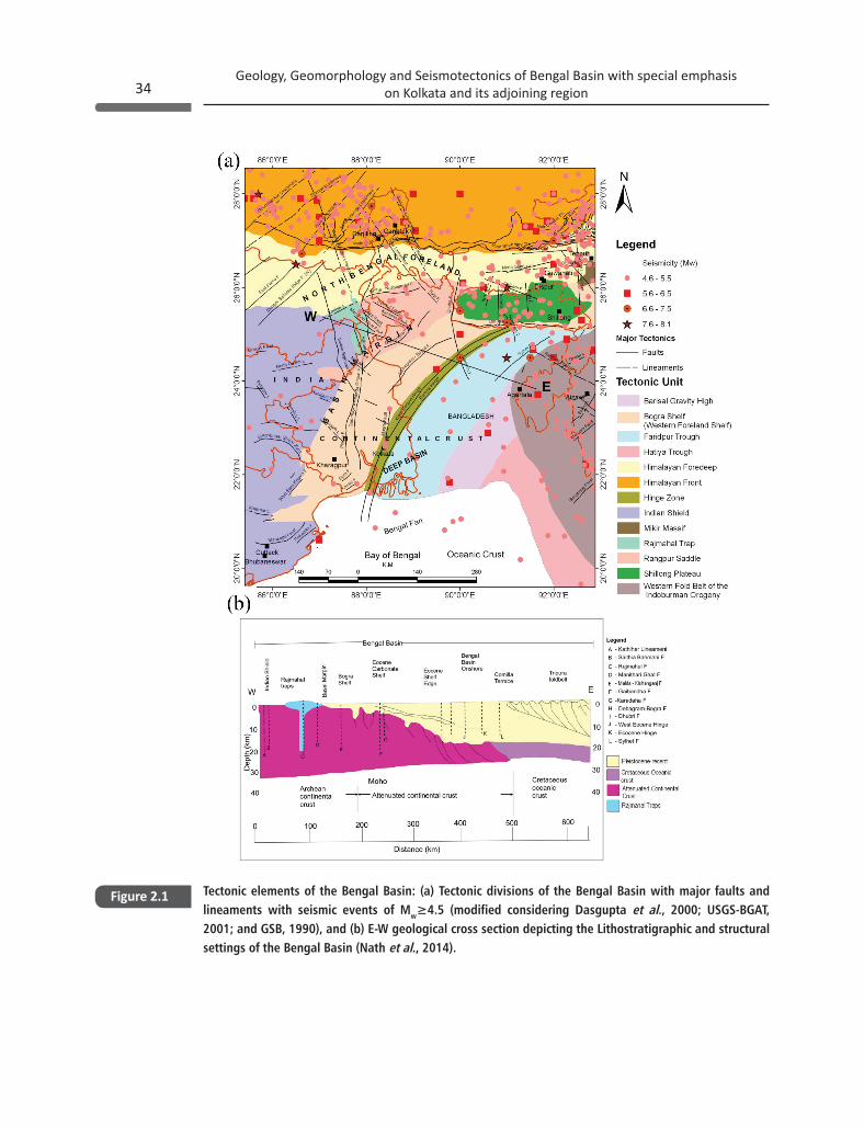
Geology, Geomorphology and Seismotectonics of Bengal Basin with special emphasis on Kolkata and its adjoining region34
Tectonic elements of the Bengal Basin: (a) Tectonic divisions of the Bengal Basin with major faults and lineaments with seismic events of Mw≥4.5 (modified considering Dasgupta et al., 2000; USGS-BGAT, 2001; and GSB, 1990), and (b) E-W geological cross section depicting the Lithostratigraphic and structural settings of the Bengal Basin (Nath et al., 2014).
Figure 2.1
35Geology, Geomorphology and Seismotectonics of Bengal Basin with special emphasis
on Kolkata and its adjoining region
2.2.1.1 The Shelf Zone
The Shelf Zone denotes the west and the northwest region of the Basin. It has an elongated shape extending from north to south and bounded by the basin margin fault like the Oldham Fault, the Dauki Fault, the Jamuna Fault and the Tista Fault (Mukherjee and Hazara, 1997). The Shelf Zone has further been subdivided into the Baharampur Terrace, the Baidyapur depression, the Contai terrace from north to south, the Dinajpur slope, the Rangpur Saddle and the Bogra slope from west to east. The Dinajpur slope represents the broad elongated depression with a sediment column of 200 m to 800 m. The Rangpur saddle is an uplifted land surface, which is bounded by two faults from the western and the eastern margin of the Garo-Rajmahal gap. The Bogra slope represents a monocline plunging fold gently sloping towards the southeast of the Hinge Zone and the width of it varies from 60-125 km (Guha et al., 2010).
2.2.1.2 The Hinge Zone or Calcutta Mymensingh Gravity High
The most prominent tectonic feature in the Bengal Basin is the NE-SW trending Eocene Hinge Zone (EHZ), also known as Calcutta-Mymensing Hinge Zone as shown in Figure 2.1(a). It is ‘S’ shaped alignment, which swings at Jagli and Contai areas marked by a system of conjugate lineaments and possibly tectonically related to a deep seated basement fault (Guha et al., 2010). The Eocene Hinge Zone has a width of 25 km and covered by upper Paleozoic to Holocene sedimentary fill to a maximum thickness of about 7.5 km (Nath et al., 2014). The subsidence pattern differs across the Hinge Zone (Morgan and McIntire, 1959; Alam et al., 2003). The gravity pattern revealed a steep change across the Eocene Hinge Zone, so that the Eocene Hinge Zone marked a continental Ocean Boundary (COB) beneath the Bengal Basin in the west and the Barisal-Chandpur gravity High in the east (Dehlinger, 1978; Alam et al., 2003).
2.2.1.3 The Deep Basin
The deep basin or the Geosynclinal basin in the southeast is filled with huge clastic sediments and the thickness of the sediments increasing towards S-E as depicted in Figure 2.1(a) and (b). The eastern part of the basin is much deeper than the western part and is occupied by the sub basins viz. the Sylhet Trough, the Faridpur Trough and the Hatiya Trough. The Bengal Basin and its adjoining region emphasize the tectonic mobility or instability of the area, causing rapid subsidence and high sedimentation in a relatively short span of geological time. The Geosynclinal basin is further classified into (i) the Faridpur Trough, (ii) the Barisal-Chandpur High, (iii) the Hatiya Trough, and (iv) the Madhupur High (Khan and Agarwal, 1993; Guha et al., 2010).
The Hatiya Trough exhibits the deepest trough in the Bengal Basin with its thickest clastic sedimentary deposits as depicted in Figure 2.1(a) at the S-E margin of the Basin. The Hatiya Trough consists of offshore anticlinal structures with their oil reserves (Guha et al. 2010). The
Geology, Geomorphology and Seismotectonics of Bengal Basin with special emphasis on Kolkata and its adjoining region36
Madhupur High or Pleistocene terraces, separating the Faridpur Trough from the Sylhet basin are slightly elevated from the adjacent flood plain. A series of en-echelon fault flanks the western side of the uplifted Madhupur tract (Alam et. al., 2003).
2.2.1.4 Western Shear Zone
The western boundary of the Bengal Basin is marked by the Indian shield as depicted in Figure 2.1(a). The western shield region of the Bengal Basin has nearly 100 km long narrow tectonic zone named Tamar-Porapahar Shear Zone (TPSZ) trending in WNW-ESE direction. The TPSZ is recognized by the visible surface feature as cataclastic movement resulting in brecciation, grinding, fracturing, shearing and mylonitisation. An E-W trending zone within Chhotanagpur Gneiss Complex (CGC) is named as North Purulia Shear Zone (NPSZ) located in the Belma-Panrkidih-Nowahara area in Purulia district. This NPSZ is recognized by the silicified rocks, fault breccia, baryte, apatite and Rare Earth Elements (REE) mineralization, numerous Quartz reef of varied dimensions are also encountered in the ductile to brittle shear zone.
The Bengal Basin together with the offshore continuation upto the Bengal fan constitutes the Bengal geosyncline which evolved during the Mesozoic-Cenozoic period (Evans, 1964; Kayal, 2008). The area of the geosynclines shrunk with time as a consequence of the eastward subduction of the Indian plate below the Andaman-Burmese arc (Curray et al., 1979; Kayal, 2008; Kundu and Gahlaut, 2013). The collision of the Indian plate with the Eurasian plate results in the upliftment and the erosion of the Himalaya since the Tertiary to the Quaternary and the transportation of the eroded materials by the confluent Ganges and Brahmaputra Rivers caused a huge deposition of sediments in the newly formed Bengal Geosyncline (Curray and Moore, 1971; Johnson et al., 1976; Curray et al., 1982; Kayal, 2008). Thus, the Bengal Basin is a consequence of active seismotectonism, which is still continuously posing earthquake threat to the Basin and its adjoining region.
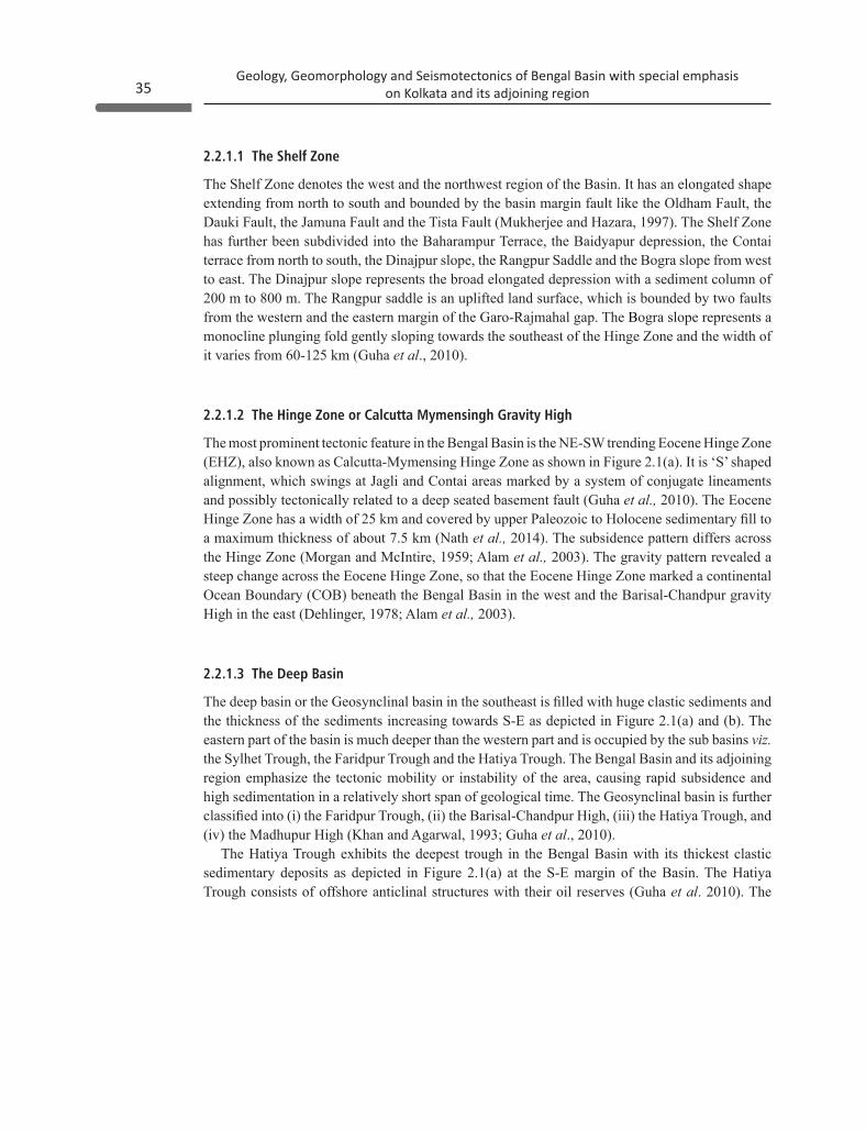
The Bengal Basin is divided into six seismotectonic provinces viz. (i) The Northeast Himalayan collision zone (demarcated as Zone A), (ii) The Indo-Burma subduction zone (demarcated as Zone B), (iii) The Eastern Himalayan syntaxis zone (demarcated as Zone C), (iv) The Shillong Plateau-Mikir Hills-Assam valley zone (demarcated as Zone D), (v) The Bengal Basin & Tripura fold Belt zone (demarcated as Zone E), and (vi) The Peninsular zone (demarcated as Zone F) as depicted in Figure 2.2.
2.3 Seismicity of Bengal Basin and its adjoining region
37Geology, Geomorphology and Seismotectonics of Bengal Basin with special emphasis
on Kolkata and its adjoining region
2.3.1 The Northeast Himalayan Collision Zone
The seismicity of the northeastern Himalaya is the result of the collision tectonics between the Indian plate and the Eurasian plate (Dewey and Bird, 1970; Tandon and Srivastava, 1975; Chandra, 1978; Seeber et al., 1981; Ni and Barazangi, 1984; Kayal, 2008). The intense seismicity along the Kopili lineament in NNW-SSE direction is transverse to the MBT/MCT trend (Kayal et al., 1993; Kayal, 2008). The NNW directed compression in the northeast Himalaya is supported by the NNE directed relative motion of the Indian plate as it under thrusts at the boundary that strikes obliquely to the direction of the motion (Holt et al., 1991; Kayal, 2008). Due to these collision tectonic activities major seismic events of Mw ≥5.5 triggered in the northeastern Himalaya as listed in Table 2.1. Some notably disastrous earthquakes viz. the 1934 Bihar-Nepal earthquake of Mw 8.1, the 1988 Bihar-Nepal Earthquake of Mw 6.8, the 2011 Sikkim Earthquake of Mw 6.9 and the 2015 Nepal Earthquake of Mw 7.8 which caused widespread damage and loss in the Bengal Basin and its adjoining region have been discussed at length below.
Seismotectonic provinces of the Bengal Basin and its adjoining region (modified after Kayal, 2008) with seismicity distribution.
Figure 2.2
Geology, Geomorphology and Seismotectonics of Bengal Basin with special emphasis on Kolkata and its adjoining region38
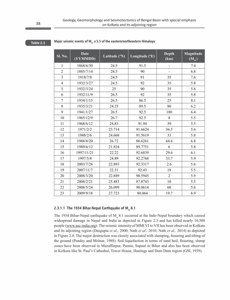
Major seismic events of Mw ≥5.5 of the eastern/northeastern HimalayaTable 2.1
Sl. No. Date (YYMMDD) Latitude (ºN) Longitude (ºE) Depth
(km)Magnitude
(MW)
1 1868/6/30 24.5 91.5 - 7.42 1885/7/14 24.5 90 - 6.83 1918/7/8 24.5 91 35 7.64 1932/3/27 24.5 92 35 5.85 1932/3/24 25 90 35 5.86 1932/11/9 26.5 92 35 5.87 1934/1/15 26.5 86.5 25 8.18 1935/3/21 24.25 89.5 80 6.29 1941/1/27 26.5 92.5 180 6.4
10 1965/12/9 26.7 92.5 8 5.511 1968/6/12 24.83 91.94 39 5.512 1971/2/2 23.714 91.6624 36.5 5.613 1988/2/6 24.668 91.5619 33 5.814 1988/8/20 26.72 86.6261 64.6 6.815 1989/6/12 21.834 89.7751 6 5.816 1997/11/21 22.22 92.6839 29.6 6.117 1997/5/8 24.89 92.2768 33.7 5.918 2003/7/26 22.893 92.3317 2.6 5.619 2007/11/7 22.31 92.43 18 5.520 2008/3/20 22.889 90.5945 2 5.921 2008/2/21 25.483 87.8743 10 5.522 2008/5/24 26.099 90.0614 60 5.623 2009/9/18 27.723 88.064 19.7 6.9
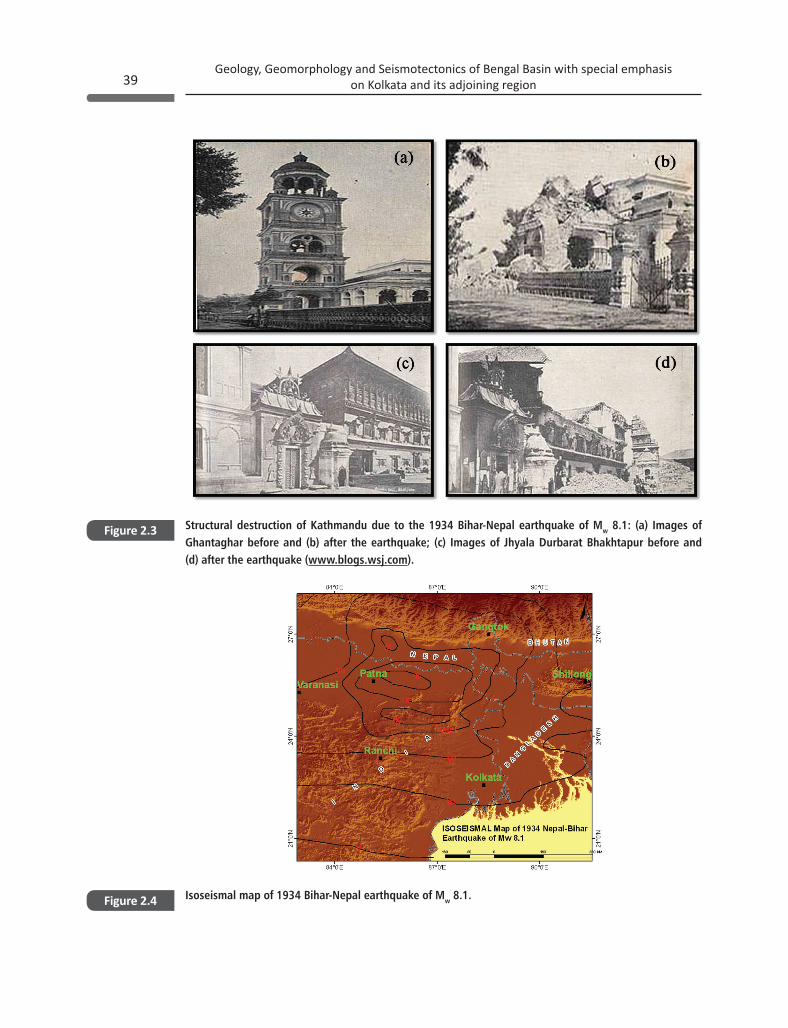
2.3.1.1 The 1934 Bihar-Nepal Earthquake of Mw 8.1
The 1934 Bihar-Nepal earthquake of Mw 8.1 occurred at the Indo-Nepal boundary which caused widespread damage in Nepal and India as depicted in Figure 2.3 and has killed nearly 10,500 people (www.asc-india.org). The seismic intensity of MMI VI to VII has been observed in Kolkata and its adjoining region (Dasgupta et al., 2000; Nath et al., 2010; Nath et al., 2014) as depicted in Figure 2.4. The major destruction was closely associated with slumping, fissuring and tilting of the ground (Pandey and Molnar, 1988). Soil liquefaction in terms of sand boil, fissuring, slump zones have been observed in Muzaffarpur, Purnia, Supaul in Bihar and also has been observed in Kolkata like St. Paul’s Cathedral, Tower House, Hastings and Dum Dum region (GSI, 1939).
39Geology, Geomorphology and Seismotectonics of Bengal Basin with special emphasis
on Kolkata and its adjoining region
Structural destruction of Kathmandu due to the 1934 Bihar-Nepal earthquake of Mw 8.1: (a) Images of Ghantaghar before and (b) after the earthquake; (c) Images of Jhyala Durbarat Bhakhtapur before and (d) after the earthquake (www.blogs.wsj.com).
Isoseismal map of 1934 Bihar-Nepal earthquake of Mw 8.1.
Figure 2.3
Figure 2.4
Geology, Geomorphology and Seismotectonics of Bengal Basin with special emphasis on Kolkata and its adjoining region40
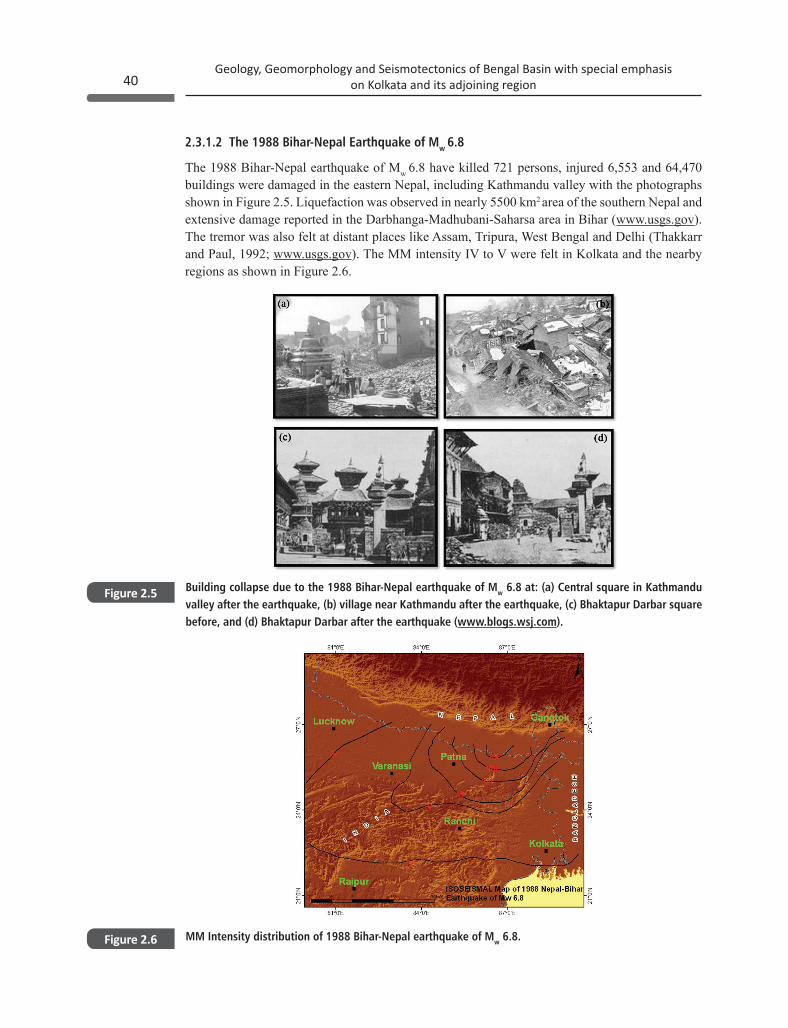
2.3.1.2 The 1988 Bihar-Nepal Earthquake of Mw 6.8
The 1988 Bihar-Nepal earthquake of Mw 6.8 have killed 721 persons, injured 6,553 and 64,470 buildings were damaged in the eastern Nepal, including Kathmandu valley with the photographs shown in Figure 2.5. Liquefaction was observed in nearly 5500 km2 area of the southern Nepal and extensive damage reported in the Darbhanga-Madhubani-Saharsa area in Bihar (www.usgs.gov). The tremor was also felt at distant places like Assam, Tripura, West Bengal and Delhi (Thakkarr and Paul, 1992; www.usgs.gov). The MM intensity IV to V were felt in Kolkata and the nearby regions as shown in Figure 2.6.
Building collapse due to the 1988 Bihar-Nepal earthquake of Mw 6.8 at: (a) Central square in Kathmandu valley after the earthquake, (b) village near Kathmandu after the earthquake, (c) Bhaktapur Darbar square before, and (d) Bhaktapur Darbar after the earthquake (www.blogs.wsj.com).
MM Intensity distribution of 1988 Bihar-Nepal earthquake of Mw 6.8.
Figure 2.5
Figure 2.6
41Geology, Geomorphology and Seismotectonics of Bengal Basin with special emphasis
on Kolkata and its adjoining region
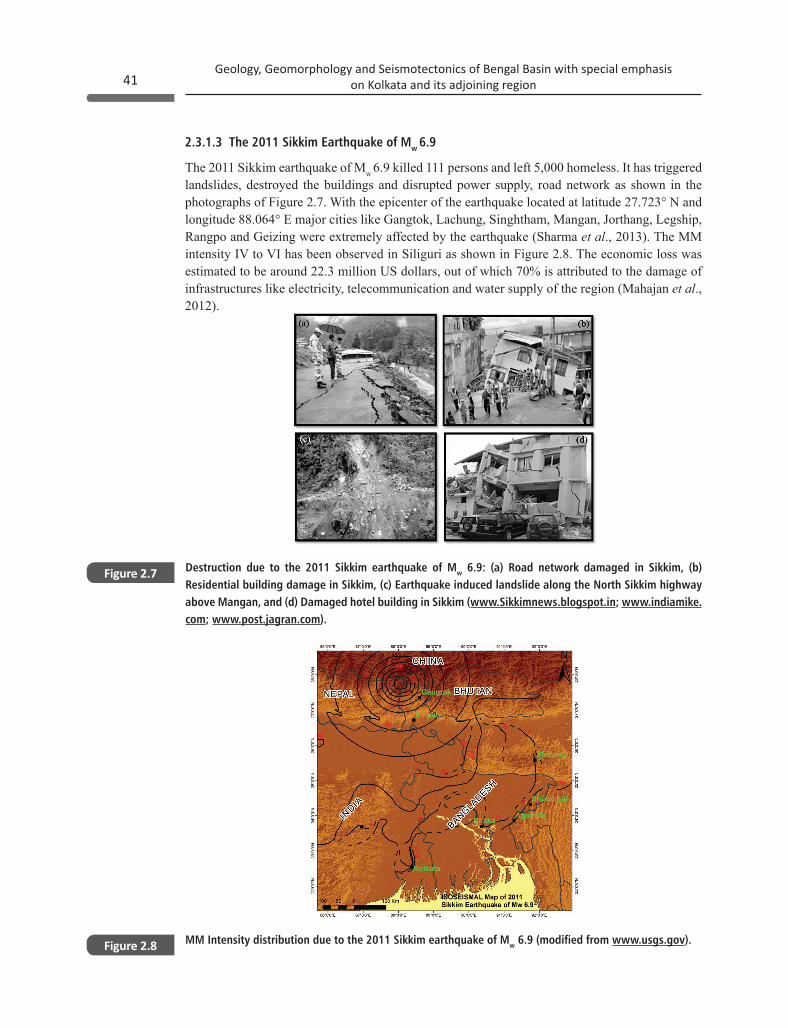
2.3.1.3 The 2011 Sikkim Earthquake of Mw 6.9
The 2011 Sikkim earthquake of Mw 6.9 killed 111 persons and left 5,000 homeless. It has triggered landslides, destroyed the buildings and disrupted power supply, road network as shown in the photographs of Figure 2.7. With the epicenter of the earthquake located at latitude 27.723° N and longitude 88.064° E major cities like Gangtok, Lachung, Singhtham, Mangan, Jorthang, Legship, Rangpo and Geizing were extremely affected by the earthquake (Sharma et al., 2013). The MM intensity IV to VI has been observed in Siliguri as shown in Figure 2.8. The economic loss was estimated to be around 22.3 million US dollars, out of which 70% is attributed to the damage of infrastructures like electricity, telecommunication and water supply of the region (Mahajan et al., 2012).
Destruction due to the 2011 Sikkim earthquake of Mw 6.9: (a) Road network damaged in Sikkim, (b) Residential building damage in Sikkim, (c) Earthquake induced landslide along the North Sikkim highway above Mangan, and (d) Damaged hotel building in Sikkim (www.Sikkimnews.blogspot.in; www.indiamike.com; www.post.jagran.com).
MM Intensity distribution due to the 2011 Sikkim earthquake of Mw 6.9 (modified from www.usgs.gov).
Figure 2.7
Figure 2.8
Geology, Geomorphology and Seismotectonics of Bengal Basin with special emphasis on Kolkata and its adjoining region42
2.3.1.4 The 2015 Nepal Earthquake of Mw 7.8
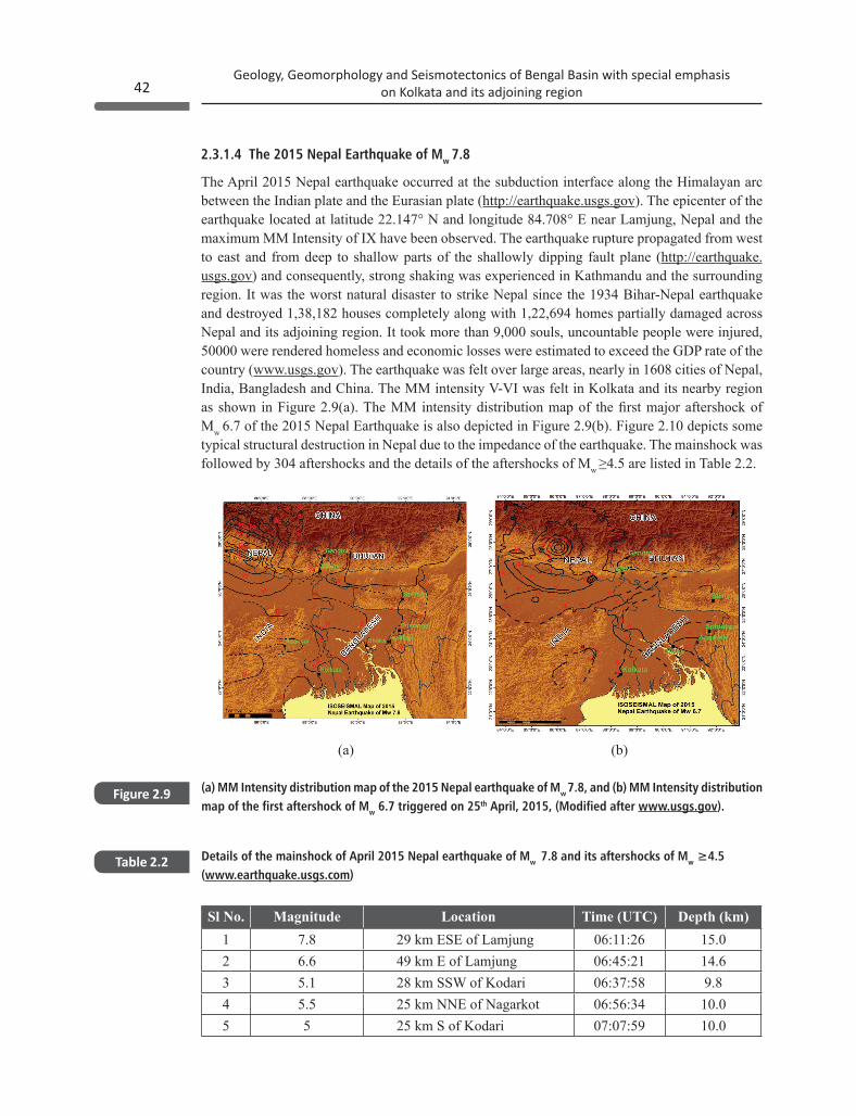
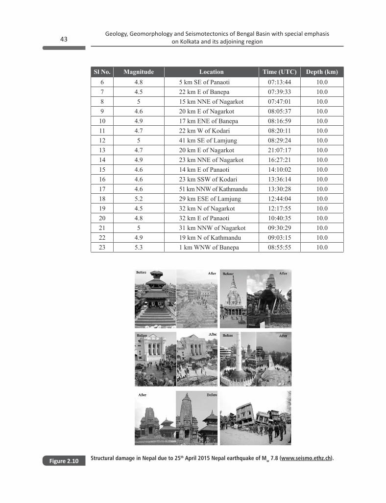
The April 2015 Nepal earthquake occurred at the subduction interface along the Himalayan arc between the Indian plate and the Eurasian plate (http://earthquake.usgs.gov). The epicenter of the earthquake located at latitude 22.147° N and longitude 84.708° E near Lamjung, Nepal and the maximum MM Intensity of IX have been observed. The earthquake rupture propagated from west to east and from deep to shallow parts of the shallowly dipping fault plane (http://earthquake.usgs.gov) and consequently, strong shaking was experienced in Kathmandu and the surrounding region. It was the worst natural disaster to strike Nepal since the 1934 Bihar-Nepal earthquake and destroyed 1,38,182 houses completely along with 1,22,694 homes partially damaged across Nepal and its adjoining region. It took more than 9,000 souls, uncountable people were injured, 50000 were rendered homeless and economic losses were estimated to exceed the GDP rate of the country (www.usgs.gov). The earthquake was felt over large areas, nearly in 1608 cities of Nepal, India, Bangladesh and China. The MM intensity V-VI was felt in Kolkata and its nearby region as shown in Figure 2.9(a). The MM intensity distribution map of the first major aftershock of Mw 6.7 of the 2015 Nepal Earthquake is also depicted in Figure 2.9(b). Figure 2.10 depicts some typical structural destruction in Nepal due to the impedance of the earthquake. The mainshock was followed by 304 aftershocks and the details of the aftershocks of Mw ≥4.5 are listed in Table 2.2.
(a) MM Intensity distribution map of the 2015 Nepal earthquake of Mw 7.8, and (b) MM Intensity distribution map of the first aftershock of Mw 6.7 triggered on 25th April, 2015, (Modified after www.usgs.gov).
Figure 2.9
Details of the mainshock of April 2015 Nepal earthquake of Mw 7.8 and its aftershocks of Mw ≥4.5 (www.earthquake.usgs.com)
Table 2.2
Sl No. Magnitude Location Time (UTC) Depth (km)1 7.8 29 km ESE of Lamjung 06:11:26 15.0 2 6.6 49 km E of Lamjung 06:45:21 14.6 3 5.1 28 km SSW of Kodari 06:37:58 9.8 4 5.5 25 km NNE of Nagarkot 06:56:34 10.0 5 5 25 km S of Kodari 07:07:59 10.0
(a) (b)
43Geology, Geomorphology and Seismotectonics of Bengal Basin with special emphasis
on Kolkata and its adjoining region
Structural damage in Nepal due to 25th April 2015 Nepal earthquake of Mw 7.8 (www.seismo.ethz.ch).Figure 2.10
Sl No. Magnitude Location Time (UTC) Depth (km)6 4.8 5 km SE of Panaoti 07:13:44 10.0 7 4.5 22 km E of Banepa 07:39:33 10.0 8 5 15 km NNE of Nagarkot 07:47:01 10.0 9 4.6 20 km E of Nagarkot 08:05:37 10.0 10 4.9 17 km ENE of Banepa 08:16:59 10.0 11 4.7 22 km W of Kodari 08:20:11 10.0 12 5 41 km SE of Lamjung 08:29:24 10.0 13 4.7 20 km E of Nagarkot 21:07:17 10.0 14 4.9 23 km NNE of Nagarkot 16:27:21 10.0 15 4.6 14 km E of Panaoti 14:10:02 10.0 16 4.6 23 km SSW of Kodari 13:36:14 10.0 17 4.6 51 km NNW of Kathmandu 13:30:28 10.0 18 5.2 29 km ESE of Lamjung 12:44:04 10.0 19 4.5 32 km N of Nagarkot 12:17:55 10.0 20 4.8 32 km E of Panaoti 10:40:35 10.0 21 5 31 km NNW of Nagarkot 09:30:29 10.0 22 4.9 19 km N of Kathmandu 09:03:15 10.0 23 5.3 1 km WNW of Banepa 08:55:55 10.0
Geology, Geomorphology and Seismotectonics of Bengal Basin with special emphasis on Kolkata and its adjoining region44
2.3.2 Indo-Burma Subduction zone
The Indo-Burma Subduction Zone is an intercontinental region. On the basis of seismicity, the Indo-Burma ranges classified as (i) the plate boundary earthquakes, (ii) the Benioff-zone earthquakes, and (iii) the Overriding-plate earthquakes (Kayal, 2008). The Benioff zone earthquakes occurred at depth < 90 km (Kayal, 2008). Rao and Kalpna (2005) have reported various stages of subduction of the Indian plate beneath the Burma and represent an overturn in the Indian plate at the 410 km discontinuity. The earthquakes in the Benioff zone have shown normal faulting as well as the strike-slip faulting due to bending/flexes of the plate, while the earthquakes at depth > 90 km show thrust/reverse faulting due to compressional forces (Kalpna and Rao 2005; Kayal, 2008). Kundu and Gahlaut (2013) explained, that the Indian plate aseismically subducted under Burmese plate. This zone has a history of moderate to large earthquakes as depicted in Figure 2.2. Some major earthquakes occurred in the Indo-Burma subduction zone are illustrated in Table 2.3.
Sl. No. Date (YY/MM/DD) Latitude (°N) Longitude (°E) Magnitude (MW)1 1946/12/9 24.054 95.666 82 1931/1/27 25.851 96.79 7.63 1988/8/6 25.149 95.127 7.34 1938/8/16 22.752 93.915 75 1991/1/5 23.613 95.901 76 1970/7/29 25.977 95.34 77 1908/12/12 26.948 96.773 78 1956/7/16 22.178 95.781 6.89 2012/11/11 23.005 95.885 6.8
10 1937/8/31 26.015 96.708 6.611 1975/7/8 21.485 94.7 6.5
Seismicity of Mw≥6.5 in the Indo-Burma seismotectonic zoneTable 2.3
2.3.3 The Eastern Himalayan Syntaxis Zone
The eastern Himalayan syntaxis extends upto the Main Boundary Thrust (MBT) in the Himalayas with the Burma arc (Holt et al., 1991). The eastern Himalayan syntaxis region is a complex junction of the Indian plate and the Eurasian plate along with Burma plate (Curray, 1989). The 1950 great Assam earthquake of Mw 8.7 occurred in this syntaxis. The tremor killed 780 persons and it destroyed about 70 villages. The earthquake was felt as far away as Kolkata with MMI VI (www.usgs.gov). The Cachar 1869 earthquake with of Mw 7.5 occurred in this zone (Kayal, 2008). The damage description of this earthquake was given by Oldham and Oldham (1882). The epicentral tract was 5-6 km wide and 32-48 km long nearly in the east-west direction of the northern border of Jaintia Hills, Meghalaya (Oldham and Oldham, 1882; Kayal, 2008). It is noticeable that the
45Geology, Geomorphology and Seismotectonics of Bengal Basin with special emphasis
on Kolkata and its adjoining region
earthquakes in the eastern Himalayan syntaxis zone are much shallower in comparison with the earthquake events of Indo-Burmese ranges (Kayal, 1996a; 1996b; 2008).
2.3.4 The Shillong Plateau-Mikir Hills-Assam Valley
The frequency of earthquake events in the Shillong Plateau-Mikir Hill zone is very high. The 1897 great Shillong earthquake of Mw 8.1 occurred in this zone. These earthquakes are considered under the category of plate boundary earthquakes which are produced by the stress accumulation due to the collision and subduction of the Indian plate (Kayal, 2008). The Shillong-plateau and the Mikir hills are the fragmented portion of the Indian shield, but seismically more active than the Peninsular Indian shield (Kayal, 2008). The Dauki fault in the south of the Shillong plateau behaved as the tear fault for the separation of the Shillong plateau from the Indian shield (Evans, 1964). The north dipping Dapsi and the South dipping Brahmaputra faults are more seismogenic than the Dauki fault, so that the Pop up tectonics may occur between the Dapsi and the Brahmaputra fault (Kayal et al., 2006).
On the basis of the geological observations, Evans (1964) proposed that the Dauki fault is either vertical or southerly dipping fault which separates the Precambrian basement of the Shillong plateau with thick tertiary sediments of the Bengal Basin in the South. In the south of the Dapsi thrust no seismic activity has been reported, while along the eastern segment of the E-W trending Dauki fault frequent earthquakes have been observed (Kayal, 2008). From the south of the Mikir hills of the Arunanchal Himalaya beneath the Kopili fault intense seismic activity was reported (Bhattacharya et al., 2002; Bhattacharya and Kayal, 2003). Some major earthquakes of Shillong Mikir Hills zone are listed in Table 2.4.
Earthquakes of Mw≥5 of Shillong Mikir HillsTable 2.4
Sl. No. Date (YY/MM/DD)
Latitude (°N)
Longitude (°E)
Depth (km) Magnitude (Mw)
1 1897/6/12 26 91 - 8.12 1908/4/4 25.3 92.6 - 63 1923/9/9 25.25 91 35 6.84 1930/7/2 25.5 90 - 7.15 1932/3/6 25.5 92.5 35 5.86 1933/3/6 26 90.5 35 5.87 1966/6/26 26.14 92.84 74 5.28 1982/8/31 25.385 91.4601 32.3 5.29 1982/12/30 26.009 91.6912 61.1 5.110 1984/9/30 25.436 91.5072 34.1 5.211 1999/10/5 26.26 91.926 33 5.512 2007/9/7 25.676 91.2091 10 5.3
Geology, Geomorphology and Seismotectonics of Bengal Basin with special emphasis on Kolkata and its adjoining region46
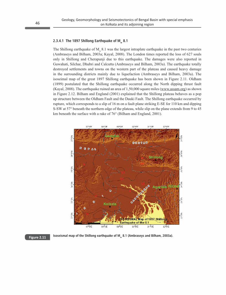
2.3.4.1 The 1897 Shillong Earthquake of Mw 8.1
The Shillong earthquake of Mw 8.1 was the largest intraplate earthquake in the past two centuries (Ambraseys and Bilham, 2003a; Kayal, 2008). The London times reported the loss of 627 souls only in Shillong and Cherapunji due to this earthquake. The damages were also reported in Guwahati, Silchar, Dhubri and Calcutta (Ambraseys and Bilham, 2003a). The earthquake totally destroyed settlements and towns on the western part of the plateau and caused heavy damage in the surrounding districts mainly due to liquefaction (Ambraseys and Bilham, 2003a). The isoseimal map of the great 1897 Shillong earthquake has been shown in Figure 2.11. Oldham (1899) postulated that the Shillong earthquake occurred along the North dipping thrust fault (Kayal, 2008). The earthquake ruined an area of 1,50,000 square miles (www.assam.org) as shown in Figure 2.12. Bilham and England (2001) explained that the Shillong plateau behaves as a pop up structure between the Oldham Fault and the Dauki Fault. The Shillong earthquake occurred by rupture, which corresponds to a slip of 16 m on a fault plane striking E-SE for 110 km and dipping S-SW at 57° beneath the northern edge of the plateau, while slip on the plane extends from 9 to 45 km beneath the surface with a rake of 76° (Bilham and England, 2001).
Isoseismal map of the Shillong earthquake of Mw 8.1 (Ambraseys and Bilham, 2003a).Figure 2.11
47Geology, Geomorphology and Seismotectonics of Bengal Basin with special emphasis
on Kolkata and its adjoining region
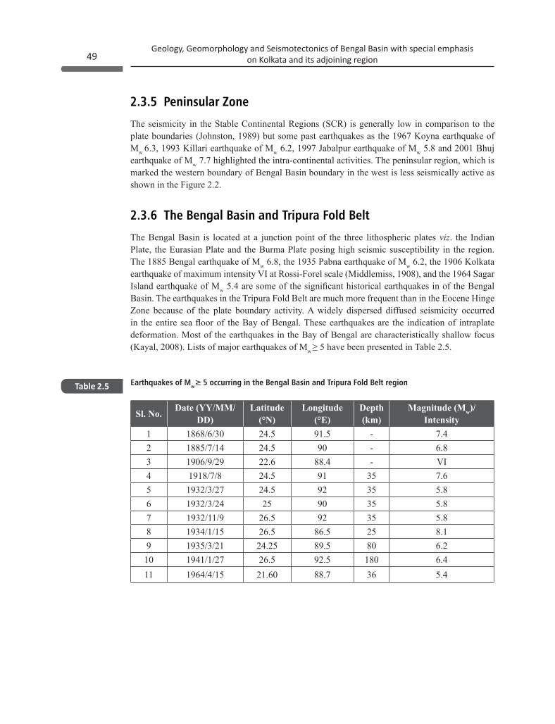
2.3.4.2 The 1930 Dhubri Earthquake of Mw 7.1
The 1930 Dhubri earthquake of Mw 7.1 occurred near the north-western end of Garo hills and adjoining valley of the Brahmputra River. It destroyed most constructions in the epicentral area around the villages of Dhubri and damage occurred in Rangpurand Turra as shown in Figure 2.13. The tremor was distinctly felt over a wide area in Dibrugarh and Manipur in the east, Chittagong and Calcutta in the south, Patna in the west and beyond the frontiers of Nepal, Sikkim and Bhutan in the north (Gee, 1934). On the basis of the reported destruction, the intensity of the earthquake was assigned MMI IX in the epicentral region and MMI IV at Kolkata as shown in Figure 2.14. 54 aftershocks were recorded within the first 24 hours of the mainshock (Gee, 1934).
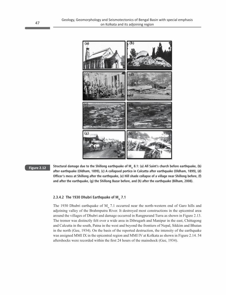
Structural damage due to the Shillong earthquake of Mw 8.1: (a) All Saint’s church before earthquake, (b) after earthquake (Oldham, 1899), (c) A collapsed portico in Calcutta after earthquake (Oldham, 1899), (d) Officer’s mess at Shillong after the earthquake, (e) Hill shade collapse of a village near Shillong before, (f) and after the earthquake, (g) the Shillong Bazar before, and (h) after the earthquake (Bilham, 2008).
Figure 2.12
Geology, Geomorphology and Seismotectonics of Bengal Basin with special emphasis on Kolkata and its adjoining region48
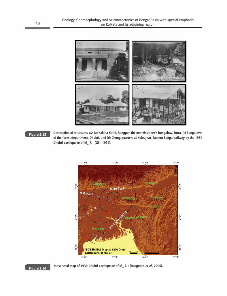
Destruction of structures viz. (a) Kakina Kothi, Rangpur, (b) commissioner’s bungalow, Turra, (c) Bungalows of the forest department, Dhubri, and (d) Chung quarters at Kokrajhar, Eastern Bengal railway by the 1930 Dhubri earthquake of Mw 7.1 (GSI, 1939).
Isoseismal map of 1930 Dhubri earthquake of Mw 7.1 (Dasgupta et al., 2000).
Figure 2.13
Figure 2.14
49Geology, Geomorphology and Seismotectonics of Bengal Basin with special emphasis
on Kolkata and its adjoining region
2.3.5 Peninsular Zone
The seismicity in the Stable Continental Regions (SCR) is generally low in comparison to the plate boundaries (Johnston, 1989) but some past earthquakes as the 1967 Koyna earthquake of Mw 6.3, 1993 Killari earthquake of Mw 6.2, 1997 Jabalpur earthquake of Mw 5.8 and 2001 Bhuj earthquake of Mw 7.7 highlighted the intra-continental activities. The peninsular region, which is marked the western boundary of Bengal Basin boundary in the west is less seismically active as shown in the Figure 2.2.
2.3.6 The Bengal Basin and Tripura Fold Belt
The Bengal Basin is located at a junction point of the three lithospheric plates viz. the Indian Plate, the Eurasian Plate and the Burma Plate posing high seismic susceptibility in the region. The 1885 Bengal earthquake of Mw 6.8, the 1935 Pabna earthquake of Mw 6.2, the 1906 Kolkata earthquake of maximum intensity VI at Rossi-Forel scale (Middlemiss, 1908), and the 1964 Sagar Island earthquake of Mw 5.4 are some of the significant historical earthquakes in of the Bengal Basin. The earthquakes in the Tripura Fold Belt are much more frequent than in the Eocene Hinge Zone because of the plate boundary activity. A widely dispersed diffused seismicity occurred in the entire sea floor of the Bay of Bengal. These earthquakes are the indication of intraplate deformation. Most of the earthquakes in the Bay of Bengal are characteristically shallow focus (Kayal, 2008). Lists of major earthquakes of Mw ≥ 5 have been presented in Table 2.5.
Earthquakes of Mw≥ 5 occurring in the Bengal Basin and Tripura Fold Belt regionTable 2.5
Sl. No. Date (YY/MM/DD)
Latitude (°N)
Longitude (°E)
Depth (km)
Magnitude (Mw)/Intensity
1 1868/6/30 24.5 91.5 - 7.42 1885/7/14 24.5 90 - 6.83 1906/9/29 22.6 88.4 - VI4 1918/7/8 24.5 91 35 7.65 1932/3/27 24.5 92 35 5.86 1932/3/24 25 90 35 5.87 1932/11/9 26.5 92 35 5.88 1934/1/15 26.5 86.5 25 8.19 1935/3/21 24.25 89.5 80 6.210 1941/1/27 26.5 92.5 180 6.411 1964/4/15 21.60 88.7 36 5.4
Geology, Geomorphology and Seismotectonics of Bengal Basin with special emphasis on Kolkata and its adjoining region50
The 1734 Bay of Bengal earthquake reported as a violent earthquake (Gentleman’s magazine, 1738). It created most furious hazard, wrecking nearly 20,000 ships and killed thousands of people (Gentleman’s magazine, 1738). Another earthquake in April 1762 was felt all over the Bengal and Arakan region affecting the northern part of the east coast of the Bay of Bengal (Oldham, 1883). These events are evidence of the fact that either the Delta itself or the substructure of hard strata underlying the Bengal Basin still has the capability of generating occasional earthquakes, and cannot be regarded as having attained that degree of stability and immunity from shocks as desirable in the neighborhood of an important center such as Kolkata (Middlemiss, 1908). Besides these large earthquakes, hundreds of small and micro earthquakes have also been recorded in the Bengal Basin. The recent and past seismicity in the study region during 1846-2015 have been shown in Figure 2.2.
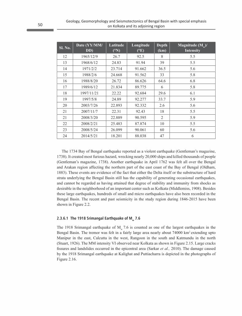
2.3.6.1 The 1918 Srimangal Earthquake of Mw 7.6
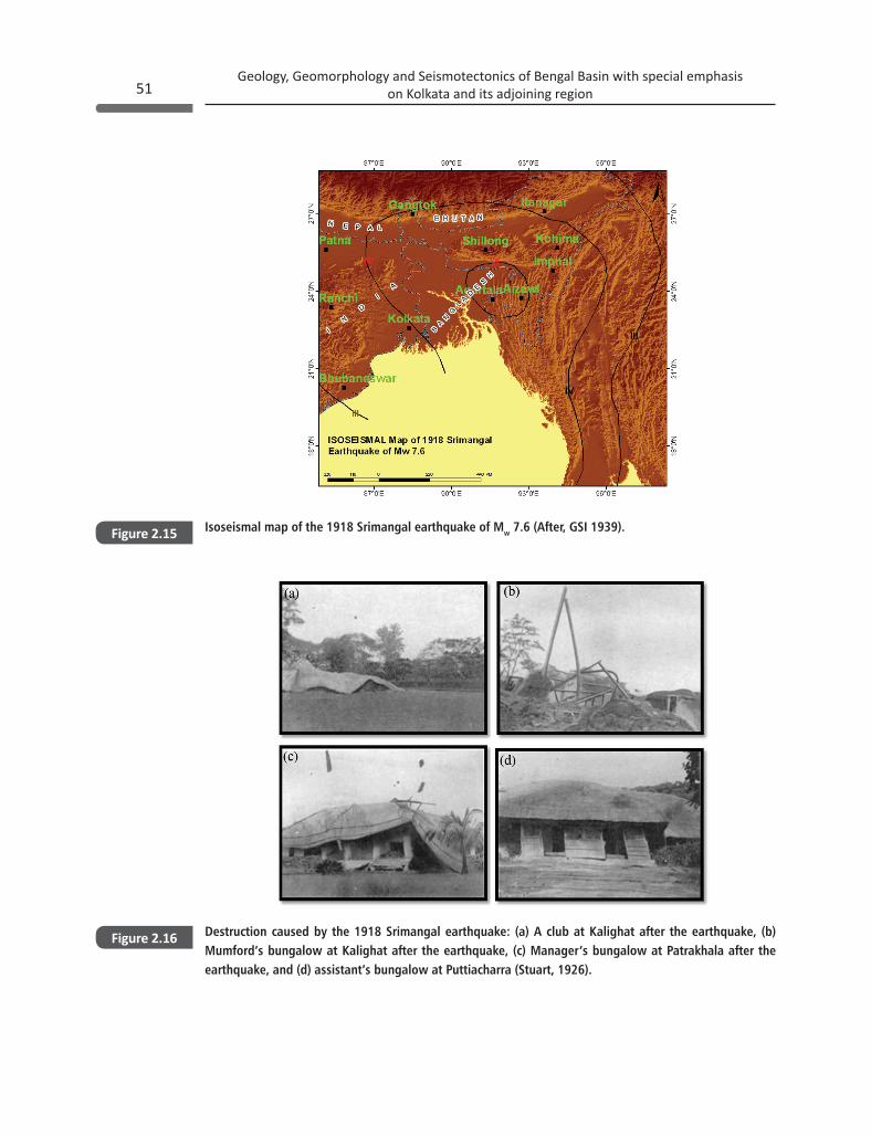
The 1918 Srimangal earthquake of Mw 7.6 is counted as one of the largest earthquakes in the Bengal Basin. The tremor was felt in a fairly large area nearly about 74000 km2 extending upto Manipur in the east, Calcutta in the west, Rangoon in the south and Katmundu in the north (Stuart, 1926). The MM intensity VI observed near Kolkata as shown in Figure 2.15. Large cracks fissures and landslides occurred in the epicentral area (Sarkar et al., 2010). The damage caused by the 1918 Srimangal earthquake at Kalighat and Puttiacharra is depicted in the photographs of Figure 2.16.
Sl. No. Date (YY/MM/DD)
Latitude (°N)
Longitude (°E)
Depth (km)
Magnitude (Mw)/Intensity
12 1965/12/9 26.7 92.5 8 5.513 1968/6/12 24.83 91.94 39 5.514 1971/2/2 23.714 91.662 36.5 5.615 1988/2/6 24.668 91.562 33 5.816 1988/8/20 26.72 86.626 64.6 6.817 1989/6/12 21.834 89.775 6 5.818 1997/11/21 22.22 92.684 29.6 6.119 1997/5/8 24.89 92.277 33.7 5.920 2003/7/26 22.893 92.332 2.6 5.621 2007/11/7 22.31 92.43 18 5.521 2008/3/20 22.889 90.595 2 5.922 2008/2/21 25.483 87.874 10 5.523 2008/5/24 26.099 90.061 60 5.624 2014/5/21 18.201 88.038 47 6
51Geology, Geomorphology and Seismotectonics of Bengal Basin with special emphasis
on Kolkata and its adjoining region
Isoseismal map of the 1918 Srimangal earthquake of Mw 7.6 (After, GSI 1939).
Destruction caused by the 1918 Srimangal earthquake: (a) A club at Kalighat after the earthquake, (b) Mumford’s bungalow at Kalighat after the earthquake, (c) Manager’s bungalow at Patrakhala after the earthquake, and (d) assistant’s bungalow at Puttiacharra (Stuart, 1926).
Figure 2.15
Figure 2.16
Geology, Geomorphology and Seismotectonics of Bengal Basin with special emphasis on Kolkata and its adjoining region52
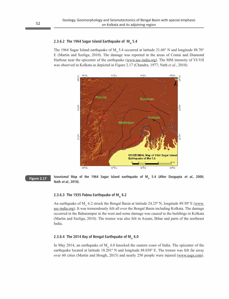
2.3.6.2 The 1964 Sagar Island Earthquake of Mw 5.4
The 1964 Sagar Island earthquake of Mw 5.4 occurred at latitude 21.60° N and longitude 88.70° E (Martin and Szeliga, 2010). The damage was reported in the areas of Contai and Diamond Harbour near the epicenter of the earthquake (www.asc-india.org). The MM intensity of VI-VII was observed in Kolkata as depicted in Figure 2.17 (Chandra, 1977; Nath et al., 2010).
Isoseismal Map of the 1964 Sagar Island earthquake of Mw 5.4 (After Dasgupta et al., 2000; Nath et al., 2010).
Figure 2.17
2.3.6.3 The 1935 Pabna Earthquake of Mw 6.2
An earthquake of Mw 6.2 struck the Bengal Basin at latitude 24.25º N, longitude 89.50º E (www.asc-india.org). It was tremendously felt all over the Bengal Basin including Kolkata. The damage occurred in the Baharampur in the west and some damage was caused to the buildings in Kolkata (Martin and Szeliga, 2010). The tremor was also felt in Assam, Bihar and parts of the northeast India.
2.3.6.4 The 2014 Bay of Bengal Earthquake of Mw 6.0
In May 2014, an earthquake of Mw 6.0 knocked the eastern coast of India. The epicenter of the earthquake located at latitude 18.201º N and longitude 88.038º E. The tremor was felt far away over 60 cities (Martin and Hough, 2015) and nearly 250 people were injured (www.usgs.com).

53Geology, Geomorphology and Seismotectonics of Bengal Basin with special emphasis
on Kolkata and its adjoining region
Isoseismal map of the 2014 Bay of Bengal earthquake of Mw 6.0 (After, www.usgs.gov).Figure 2.18
The epicentral region of the earthquake was previously considered as low seismic susceptible, thus this event was considered unusual (Martin and Hough, 2015). The maximum MM intensity V occurred in the Bay of Bengal as shown in Figure 2.18. Due to this earthquake a tectonic review of the zone was felt necessary.
2.4.1 Physiography
The Bengal Basin represents a tectonically originated geosyncline basin. The physiographic divisions of the Bengal Basin are carved and controlled by tectonic activity. The Ganga-Padma, the Brahmaputra-Jamuna and the Surma-Meghna are the major river systems, which piled up the Bengal Basin with thick Quaternary sediments (Goswami et al., 2013). The eastward shift of the Ganga and the Tista River as well as the westward shift of the Brahmaputra River during the last
2.4 Physiography & Geomorphology of Bengal Basin and its adjoining region
Geology, Geomorphology and Seismotectonics of Bengal Basin with special emphasis on Kolkata and its adjoining region54
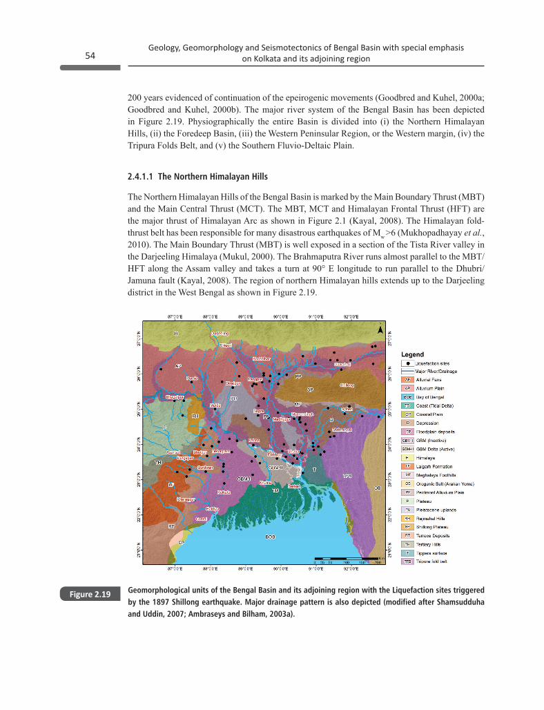
200 years evidenced of continuation of the epeirogenic movements (Goodbred and Kuhel, 2000a; Goodbred and Kuhel, 2000b). The major river system of the Bengal Basin has been depicted in Figure 2.19. Physiographically the entire Basin is divided into (i) the Northern Himalayan Hills, (ii) the Foredeep Basin, (iii) the Western Peninsular Region, or the Western margin, (iv) the Tripura Folds Belt, and (v) the Southern Fluvio-Deltaic Plain.
2.4.1.1 The Northern Himalayan Hills
The Northern Himalayan Hills of the Bengal Basin is marked by the Main Boundary Thrust (MBT) and the Main Central Thrust (MCT). The MBT, MCT and Himalayan Frontal Thrust (HFT) are the major thrust of Himalayan Arc as shown in Figure 2.1 (Kayal, 2008). The Himalayan fold-thrust belt has been responsible for many disastrous earthquakes of Mw >6 (Mukhopadhayay et al., 2010). The Main Boundary Thrust (MBT) is well exposed in a section of the Tista River valley in the Darjeeling Himalaya (Mukul, 2000). The Brahmaputra River runs almost parallel to the MBT/HFT along the Assam valley and takes a turn at 90° E longitude to run parallel to the Dhubri/Jamuna fault (Kayal, 2008). The region of northern Himalayan hills extends up to the Darjeeling district in the West Bengal as shown in Figure 2.19.
Geomorphological units of the Bengal Basin and its adjoining region with the Liquefaction sites triggered by the 1897 Shillong earthquake. Major drainage pattern is also depicted (modified after Shamsudduha and Uddin, 2007; Ambraseys and Bilham, 2003a).
Figure 2.19
55Geology, Geomorphology and Seismotectonics of Bengal Basin with special emphasis
on Kolkata and its adjoining region
2.4.1.2 The Foredeep Basin
The Foredeep basin is a low lying area with a gentle slope in the south of the Himalayan region as depicted in Figure 2.19. This region is made up of riverine sediments carried by the rivers from the Himalayas. It is an elongated feature in the E-W direction. This zone covers a part of the Dinajpur district in the West Bengal.
2.4.1.3 The Western Peninsular Region
The Western peninsular region is a part of the Chota Nagpur Plateau on the western margins of the basin. The spatial extent of the Western Peninsular Region has been exhibited in Figure 2.19. Although this region is tectonically not active, but is highly dissected by drainage and follow the regional slope NE-SW. This region constitutes various micro-geomorphic units like the Ayodhya plateau, the Purulia High plains and the Rarh uplands.
2.4.1.4 The Tripura Folds Belt
The Tripura Folds Belt comprises of almost parallel running ridges nearly in the north-south direction on the eastern boundary of the Bengal Basin as shown in Figure 2.19. The hills of this zone have their own distinctive tectonic and stratigraphic framework with steep slopes which are subjected to landslides.
2.4.1.5 Fluvial Deltaic Plain
Fluvial deltaic plain is a rapidly subsiding geosyncline basin, which covers an approximately 1.4×10⁵ km2 area in Bangladesh and West Bengal (Acharyya and Shah, 2010). The fluvio deltaic region is characterized by multiple Pleistocene terraces that separate the fluvio deltaic region of the foredeep basin in the north as shown in Figure 2.19. Quaternary geology of this region is influenced by the structural activity primarily faulting (Morgon and McIntire, 1957). Ball (1877a, b) classified Quaternary deposits of Bengal Basin into the older and newer alluvium.
2.4.2 Geomorphology
Geomorphology of the region is the expression of surface or subsurface lithostratigraphy. The entire Bengal Basin is divided into four geomorphic unit’s viz. the northern hilly region, the central river terrace, the foredeep basin zone and the southern geosynclinal zone. The Himalayan region represents the convergent region of two plates from the northern margin and from eastern margin ridge and the valley topography of Tripura fold belt evidenced of plate convergent. The rivers of the Himalayan region deposited their sediments and formed the alluvial plains/fans with gently
Geology, Geomorphology and Seismotectonics of Bengal Basin with special emphasis on Kolkata and its adjoining region56
undulating topography as depicted in Figure 2.19. The geomorphic units of the Basin are the coastal plains, floodplain, piedmont alluvial plain, pleistocene uplands, terrace deposits, shillong plateau, tertiary hills, active and inactive Ganga-Brahmaputra-Meghna delta, tidal delta and rajmahal hills as depicted in Figure 2.19. These units of the basin can be classified as geomorphic features of the northern zone and the southern zone of Bengal Basin.
2.4.2.1 Geomorphic Features of Northern Zone of Bengal Basin
The northern zone of the Bengal Basin is bordered by the Tertiary hills. Vertical erosion is much greater than lateral erosion in the northern zone due to a high gradient of slope. The eroded sediments are deposited by the rivers to the south of the foothills and form the alluvial fans as shown in Figure 2.19. The distinct geomorphic features of the northern zone are the mountains, the piedmont plains, the alluvial plains, the flood plains, Shillong plateau, Pleistocene uplands and depression.
2.4.2.1.1 The Mountains
The northern mountain ranges of the Basin are the part of the Himalayan mountain system and extended upto Darjeeling and the Cooch Behar district. The hills in this region are highly dissected and covered with thin sediments over the Granite-Gneisses rocks. The Teesta River and its tributaries cut the entire geological formations as illustrated in Figure 2.19. In Bangladesh the hills are confined to a narrow strip along the southern margin of the Shillong Plateau.
2.4.2.1.2 The Piedmont Plains
The Piedmont zone is characterized by a low gradient and undulating surface expression to the south of the Tertiary hills as shown in Figure 2.19. The piedmont plains of north Bengal comprises of the Bhabhar-Terai belt. The Piedmont zone is a narrow striped land between the mountains and the Great Plains.
2.4.2.1.3 The Alluvial Plains/Fans
The alluvial plains covered a large spatial extent in the southern front of the mountain region, after the piedmont plain as depicted in Figure 2.19. The lithofacies of the alluvial plains show high porosity of rocks. The region comprises of younger and older alluvial fans, the older fan material much oxidized than the younger fan and occupy a narrow width. Samsing formation is the oldest alluvial fan formation of this zone and Baikunthpur formation represents the youngest fan in the region. The sand and gravel deposits of the Mahananda and Karatoya Rivers may possibly be as old as late Pleistocene or as early as the Holocene. The alluvial plains gently slope to the south from about 96 m down to 33 m above MSL (www.banglpedia.org).
57Geology, Geomorphology and Seismotectonics of Bengal Basin with special emphasis
on Kolkata and its adjoining region
2.4.2.1.4 Flood Plain
The flood plains are made up of silty sediments near the river bank and unsorted material away from the river in the monsoon season. The spatial extent of the flood plains is shown in Figure 2.19. The northern flood plains have an extension from west to east and are characterized by less vertical and high lateral erosion of the river due to low gradient. In the southern flood plains, meander loops often cut off from the main channel stream and form Oxbow. These flood plains are further divided on the basis of river basins and their encroached areas, as the Tista Floodplain, the Old Brahmaputra Floodplain and the Jamuna Floodplain. The northern flood plain has developed by filling the shallow inland water body and the southern riverine plain has developed as deltas by pushing out sea water from the shallow continental shelf. The Teesta and the Brahmaputra rivers changed their path towards east, while the Mahananda and the Mechi have not changed their course and merged in the Ganga River. This behavior of rivers indicates the presence of some subsurface structures.
2.4.2.1.5 Shillong Plateau
In the N-E of the Bengal Basin, the Shillong plateau represents a large geomorphic unit with an up arch of Precambrian metamorphic rocks characterized by the basement Gneissic complex with a structural trend of NE-SW. The Assam plains marked the northern boundary and the alluvial plains sharply marked the southern boundary of the Shillong plateau. The structural hills show various degrees of dissections to the prominent parallel trend to the structural strike along NE-SW (Talukdar and Talukdar, 2012).
2.4.2.1.6 The Pleistocene Uplands
The Pleistocene uplands are also known as the Barind and the Madhupur uplands. These uplands are made up of ferralitic soils. These uplifted regions are associated with an east-west trending Horst block (Singh et al., 1998) and highly dissected by several rivers. In the eastern part of the zone, the Mahananda and the Kalindi Rivers have removed the surface expression of the ferralitic formations and covered it with alluvial sediments.
2.4.2.1.7 Depression
The Depression or Haor basins are the left depressions filled with water in between the streams of the north of Barind in India and Sylhet in Bangladesh. These units covered very small region and noticed that the water bodies in Barind had not been totally filled up before the rivers started cutting through the ferralitic formations. The Chalan beel of Rajshahi in Bangladesh is a well-known example of such depressions. The major part of this zone lies in Bangladesh whereas the southern part of West Dinajpur district and some part of the western Malda district located in West Bengal.
Geology, Geomorphology and Seismotectonics of Bengal Basin with special emphasis on Kolkata and its adjoining region58
2.4.2.2 Geomorphic Features of Southern Zone of Bengal Basin
The southern Bengal Basin has a very low gradient which provides suitable conditions for rivers to deposit sediment. Although the major part of the southern zone of the basin is covered by the flood plains and Delta, the western margin of the zone exhibits peninsular region marked by the Ayodhya Plateau and the undulating Purulia High Plain. In the eastern part of the Bengal Basin, the Syllhet depression is a significant feature as shown in Figure 2.19. The southern zone of Bengal Basin can be divided into the Peninsular region, the Ganga-Brahmaputra-Meghna delta and the Tidal delta.
2.4.2.2.1 Peninsular Region
On the western margin, the Bengal Basin is bounded by a plateau region. The micro-geomorphic units in the peninsular region are the Rajmahal hills, the Ayodhya plateau, the Purulia Highlands and the Rarh uplands. The Ayodhya Plateau is a block of highland in the south-western part of the Purulia district in West Bengal, also known as the Baghmundi hills. The Ayodhya plateau represents the extension of the Ranchi surface and is characterized by similar Granite-Gneisses of Chhotanagpur Gneissic Complex (CGC) (Nag, 2005). The Subarnarekha River flows from north to south in this tract through some structural weak planes and separates the Ayodhya Plateau from Ranchi Plateau. In this manner it appears as a residual hill. The similar feature as of Purulia high plain has been noticed in some parts of the Bankura, Medinipur and Birbhum district in the western part of the Bengal Basin. In Purulia High plain metamorphic rocks like Gneiss, Schist and varieties of Phyllites are dominant. The southern margin of the zone is marked by the east-west oriented metamorphosed rocks, which are nearly parallel to the Dalmaorogenic belt. The northern margin is marked by the Gondwana rift valley. Many residual hillocks scattered on the high plain evidenced ancient volcanism in the terrain. The east Purulia high land, which is made up of ferralitic soil is known as the Rarh uplands. The Rarh uplands are characterized by a variety of rocks, deposited during the Miocene period through repeated marine transgression. This zone covers the western part of Burdwan district in the Bengal Basin. The Rarh uplands are characterized by the undulating landform which is subjected to extensive soil erosion (Jana and Majumdar, 2010).
2.4.2.2.2 The Ganga-Brahmaputra-Meghna Delta
The southern part of the Bengal Basin is characterized by Delta deposits. On the basis of the deposition pattern the delta is divided into an inactive and an active delta system (Shamsudduha and Uddin, 2007). The southern riverine delta has developed through alluviation, where river sediments have pushed away the sea front from a shallow offshore zone. The river gradient has decreased to the southward of the zone and Oxbow lakes, acute meander loops formed profusely and conspicuously on the outward margins of the Deltas (Jana and Majumdar, 2010). This zone covers the eastern part of the district Murshidabad, where the largest Delta is formed by the Ganga River. The Ganga delta extends southward upto the border of the districts of Nadia and North 24-Paraganas. The Delta of the Ajoy and the Damodar Rivers in the south-west of the Ganga delta covers the eastern Bardhman district and the northern Hooghly district. The spatial extent of the Delta system has been shown and marked as GBM I-II in Figure 2.19.
59Geology, Geomorphology and Seismotectonics of Bengal Basin with special emphasis
on Kolkata and its adjoining region
2.4.2.2.3 Tidal Delta
The Tidal delta or marine delta is developed by the interlacing tidal channels. The Tidal influx, scouring the shallow continental shelf, supplies the sediments to carve the landscape of the region as shown in Figure 2.19. The Tidal delta land provides favorable conditions for the mangrove forest and exhibits world’s largest mangrove forest in the Sundarban region.
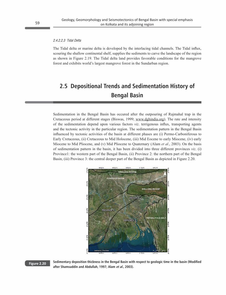
2.5 Depositional Trends and Sedimentation History of Bengal Basin
Sedimentation in the Bengal Basin has occured after the outpouring of Rajmahal trap in the Cretaceous period at different stages (Biswas, 1999; www.dghindia.org). The rate and intensity of the sedimentation depend upon various factors viz. terrigenous influx, transporting agents and the tectonic activity in the particular region. The sedimentation pattern in the Bengal Basin influenced by tectonic activities of the basin at different phases are (i) Permo-Carboniferous to Early Cretaceous, (ii) Cretaceous to Mid Holocene, (iii) Mid Eocene to early Miocene, (iv) early Miocene to Mid Pliocene, and (v) Mid Pliocene to Quaternary (Alam et al., 2003). On the basis of sedimentation pattern in the basin, it has been divided into three different provinces viz. (i) Province1: the western part of the Bengal Basin, (ii) Province 2: the northern part of the Bengal Basin, (iii) Province 3: the central deeper part of the Bengal Basin as depicted in Figure 2.20.
Sedimentary deposition thickness in the Bengal Basin with respect to geologic time in the basin (Modified after Shamsuddin and Abdullah, 1997; Alam et al., 2003).
Figure 2.20
Geology, Geomorphology and Seismotectonics of Bengal Basin with special emphasis on Kolkata and its adjoining region60
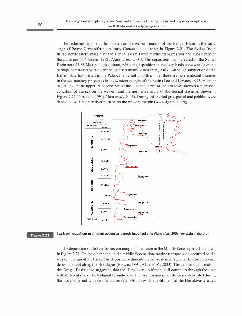
The sediment deposition has started on the western margin of the Bengal Basin in the early stage of Permo-Carboniferous to early Cretaceous as shown in Figure 2.21. The Sylhet Basin in the northeastern margin of the Bengal Basin faced marine transgression and subsidence at the same period (Banerji, 1981; Alam et al., 2003). The deposition has increased in the Sylhet Basin near 84-88 Ma (geological time), while the deposition in the deep basin zone was slow and perhaps dominated by the Hemipelagic sediments (Alam et al., 2003). Although subduction of the Indian plate has started in the Paleocene period upto this time, there are no significant changes in the sedimentary processes in the western margin of the basin (Lee and Lawner, 1995; Alam et al., 2003). In the upper Paleocene period the Eustatic curve of the sea level showed a regressed condition of the sea on the western and the northern margin of the Bengal Basin as shown in Figure 2.21 (Pirazzoli, 1991; Alam et al., 2003). During this period grit, gravel and pebbles were deposited with coarser riverine sand on the western margin (www.dghindia.org).
Sea level fluctuations in different geological periods (modified after Alam et al., 2003; www.dghindia.org).Figure 2.21
The deposition started on the eastern margin of the basin in the Middle Eocene period as shown in Figure 2.21. On the other hand, in the middle Eocene time marine transgression occurred on the western margin of the basin. The deposited sediments on the western margin marked by carbonate deposits traced along the Himalayas (Biswas, 1991; Alam et al., 2003). The depositional trends in the Bengal Basin have suggested that the Himalayan upliftment still continues through the time with different rates. The Kalighat formation, on the western margin of the basin, deposited during the Eocene period with sedimentation rate >36 m/my. The upliftment of the Himalayas created
61Geology, Geomorphology and Seismotectonics of Bengal Basin with special emphasis
on Kolkata and its adjoining region
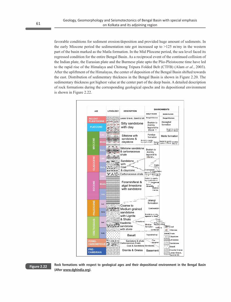
Rock formations with respect to geological ages and their depositional environment in the Bengal Basin (After www.dghindia.org).
Figure 2.22
favorable conditions for sediment erosion/deposition and provided huge amount of sediments. In the early Miocene period the sedimentation rate got increased up to >125 m/my in the western part of the basin marked as the Matla formation. In the Mid Pliocene period, the sea level faced its regressed condition for the entire Bengal Basin. As a reciprocal event of the continued collision of the Indian plate, the Eurasian plate and the Burmese plate upto the Plio-Pleistocene time have led to the rapid rise of the Himalaya and Chittong Tripura Folded Belt (CTFB) (Alam et al., 2003). After the upliftment of the Himalayas, the center of deposition of the Bengal Basin shifted towards the east. Distribution of sedimentary thickness in the Bengal Basin is shown in Figure 2.20. The sedimentary thickness got highest value at the center part of the deep basin. A detailed description of rock formations during the corresponding geological epochs and its depositional environment is shown in Figure 2.22.
Related Documents


![Seismotectonics - CaltechAUTHORS...Seismotectonics is the synthesis of earthquake, geophysical, geodetic and geological data to deduce the tectonic framework of a region [Scholz, 1990].](https://static.cupdf.com/doc/110x72/5f0e6bc67e708231d43f299a/seismotectonics-caltechauthors-seismotectonics-is-the-synthesis-of-earthquake.jpg)