1 Geology and Setting of the Miguela A-Zone, Guarayos Greenstone Belt, Eastern Bolivia By Michael Biste, M.Sc., Ph.D. Exploration Manager, Essex Resource Incorporated - Bolivia Calle Aruma No 10/11, Urbari, Casilla 2341 and Andrew W. Gourlay, B. Sc., P. Geol., FGAC Senior Geologist, Essex Resource Corporation Suite 1220 - 800 West Pender Street Vancouver, B.C., Canada, V6C 2V6

Welcome message from author
This document is posted to help you gain knowledge. Please leave a comment to let me know what you think about it! Share it to your friends and learn new things together.
Transcript
1
Geology and Setting of the Miguela A-Zone, Guarayos Greenstone Belt,
Eastern Bolivia
By
Michael Biste, M.Sc., Ph.D. Exploration Manager, Essex Resource Incorporated - Bolivia
Calle Aruma No 10/11, Urbari, Casilla 2341
and
Andrew W. Gourlay, B. Sc., P. Geol., FGAC Senior Geologist, Essex Resource Corporation
Suite 1220 - 800 West Pender Street Vancouver, B.C., Canada, V6C 2V6
2
Geology and Setting of the Miguela A-Zone,
Guarayos Greenstone Belt, Eastern Bolivia
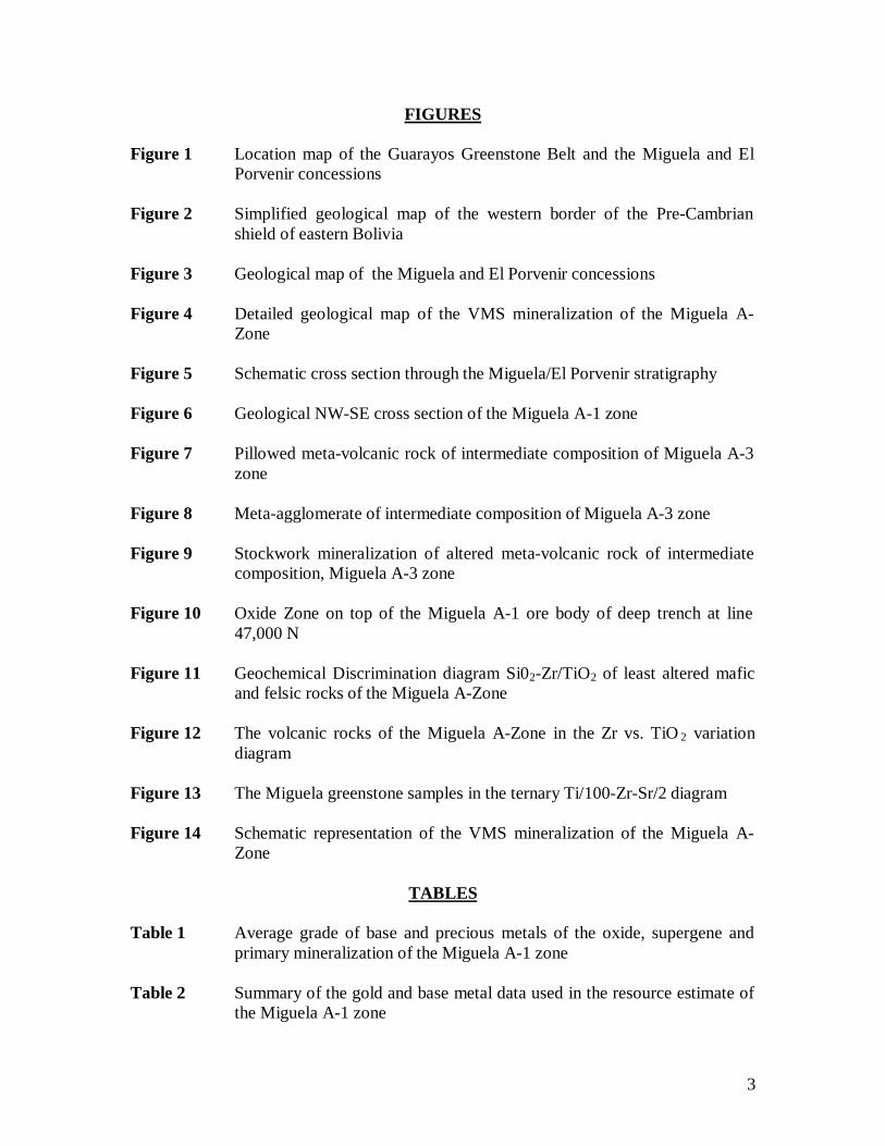
TABLE OF CONTENTS ABSTRACT INTRODUCTION GENERAL INFORMATION
Location, Access and Topography Bolivian Tenure System Previous Mining and Exploration
GEOLOGY
Regional Setting Discovery and Exploration Property Geology Structure
MINERALISATION
Form and Shape Ore Mineralogy and Fabric Hydrothermal Alteration Weathering Zone Metal Distribution
LITHOCHEMISTRY RESOURCE ESTIMATE DISCUSSION ACKNOWLEDGEMENTS BIBLIOGRAPHY
3
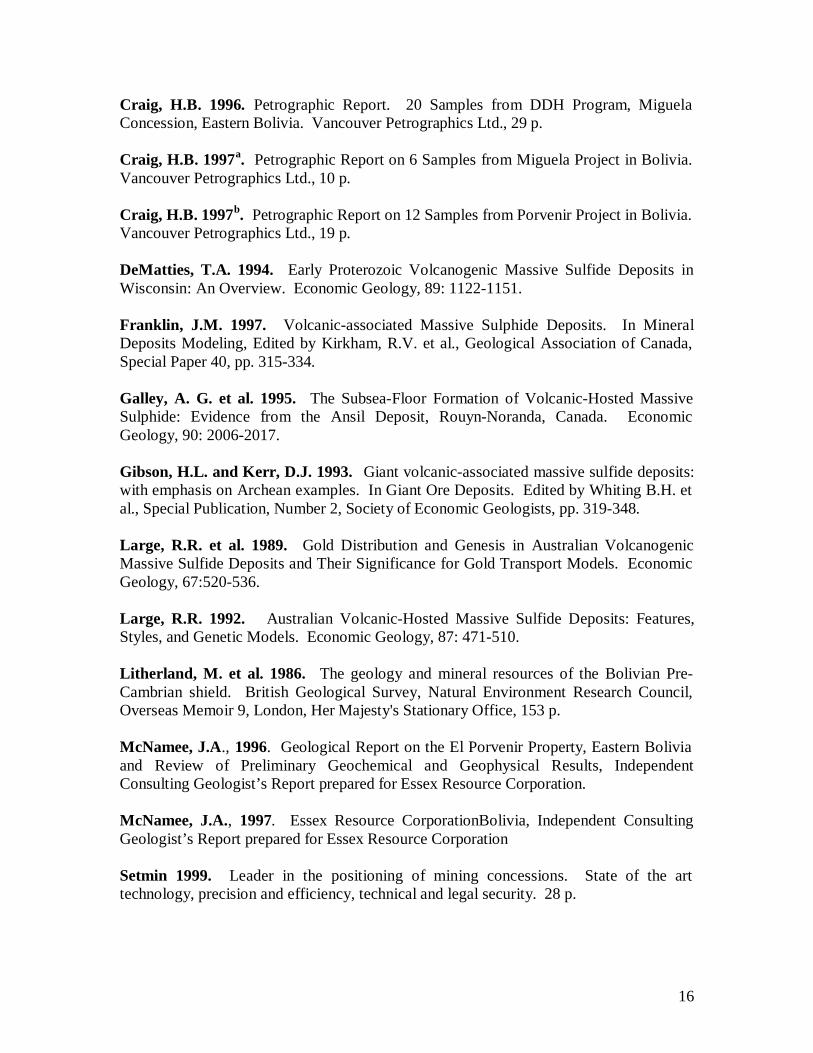
FIGURES Figure 1 Location map of the Guarayos Greenstone Belt and the Miguela and El
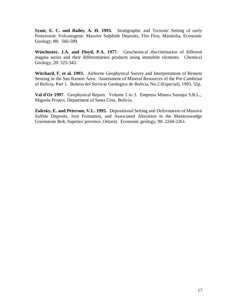
Porvenir concessions Figure 2 Simplified geological map of the western border of the Pre-Cambrian
shield of eastern Bolivia Figure 3 Geological map of the Miguela and El Porvenir concessions Figure 4 Detailed geological map of the VMS mineralization of the Miguela A-
Zone Figure 5 Schematic cross section through the Miguela/El Porvenir stratigraphy Figure 6 Geological NW-SE cross section of the Miguela A-1 zone Figure 7 Pillowed meta-volcanic rock of intermediate composition of Miguela A-3
zone Figure 8 Meta-agglomerate of intermediate composition of Miguela A-3 zone Figure 9 Stockwork mineralization of altered meta-volcanic rock of intermediate
composition, Miguela A-3 zone Figure 10 Oxide Zone on top of the Miguela A-1 ore body of deep trench at line
47,000 N Figure 11 Geochemical Discrimination diagram Si02-Zr/TiO2 of least altered mafic
and felsic rocks of the Miguela A-Zone Figure 12 The volcanic rocks of the Miguela A-Zone in the Zr vs. TiO 2 variation
diagram Figure 13 The Miguela greenstone samples in the ternary Ti/100-Zr-Sr/2 diagram Figure 14 Schematic representation of the VMS mineralization of the Miguela A-
Zone
TABLES Table 1 Average grade of base and precious metals of the oxide, supergene and
primary mineralization of the Miguela A-1 zone Table 2 Summary of the gold and base metal data used in the resource estimate of
the Miguela A-1 zone
4
ABSTRACT The Miguela A-Zone volcanogenic massive sulphide (VMS) deposit is a new discovery. It is located at the western border of the Pre-Cambrian shield of eastern Bolivia, hosted in a Proterozoic greenstone belt and metamorphosed to amphibolite facies. The mineralization occurs in a 400-meter thick felsic unit within a thicker succession of tholeiitic mafic volcanic rocks. The main rock types are meta-rhyolite and quartz-muscovite-rich meta-sediments close to the VMS mineralization, and silica and iron-rich mudstone and siltstone, magnetite or pyhrrotite-rich banded iron-formation on top and lateral to the known VMS mineralization. This litho-facies is informally known as the “La Pastora” formation and can be traced for at least 28 kilometers of strike length. This unit hosts all important geochemical and geophysical anomalies and gold and base metal showings of the area. The mineralization occurs in three lenses, is confined to two different stratigraphic levels, and is related to a system of synvolcanic growth faults. The texture of the mineralization is massive, semi-massive and finely laminated. The most important minerals are pyrite and chalcopyrite with lesser amounts of sphalerite and galena. Magnetite and pyrrhotite are rare in the A-Zone, but abundant in the northern El Bagre and southern El Porvenir zones. The lowermost A-3 lens is underlain and laterally surrounded by a zone of hydrothermal alteration, intense pyritization and sodium depletion. The main A-1 lens is the best investigated mineralized structure. It is tabular in shape, dips 45 degrees northwest, exhibits a true thickness between 12 and 23 meters and carries a quartz-rich layer on top with a significant enrichment of barium. It is continuous for 450 meters in strike, 350 metres down-dip and remains open along strike and to depth. It contains an Inferred Resource of 1.62 Million tonnes grading 3.76% Cu, 1.26 g/t Au, 11.3 g/t Ag and 0.33% and a geological resource potential of 4.25 million tonnes. This size compares well with the dimensions of the deposits of other VMS districts and places it in the median size category of known VMS deposits in Canada and Australia. The A-Zone is deeply weathered due to the intensive lateritization of the regolith since the Miocene. A 45-meter thick supergene chalcocite and a 40-meter thick oxide zone overlie the primary sulphide mineralization. The oxide zone is enriched in gold and depleted in base metals and silver, whereas copper is strongly enriched in the supergene zone. Routine geochemical and geophysical surveys, commonly used in massive sulphide exploration in Canada and elsewhere, have proved effective in the deeply laterized Bolivian Shield. Exploration on the Miguela and El Porvenir concessions have identified several targets with geochemical and geophysical signatures comparable to the A-Zone, which remain to be drill tested. Further exploration of the remainder of the Guarayos Greenstone Belt is a priority. Given the exploration success in a short period of time the Guarayos Greenstone Belt has excellent potential to host world class deposits.
5
INTRODUCTION The Pre-Cambrian of eastern Bolivia is the southwestern extension of the Brazilian Shield, which is host to large primary gold and base metal deposits in Brazil. Exploration in Bolivia commenced relatively late after the lifting of the fiscal reserve in 1986, when a few small exploration companies started exploration for primary gold mineralization in areas of old alluvial gold workings (Biste et al., 1991). This trend changed at the beginning of the 1990's when Rio Tinto Zinc and COMSUR started to explore the layered ultra-mafic intrusion Rincon del Tigre for nickel and platinum. ESSEX RESOURCE CORPORATION has participated since 1996 in the exploration of volcanogenic massive sulphide (VMS) mineralization in eastern Bolivia, which was initiated by TANGANIKA A.V.V. in June 1993 (Biste and Matthews, 1995, 1996ª and 1996b). The project concentrated exploration at the Miguela and El Porvenir concessions of the Guarayos region, where an environment favourable for VMS and the A-Zone mineralization was identified. This publication describes the discovery, the geological setting and potential of this new mineral district. GENERAL INFORMATION Location, Access and Topography
The Miguela Concession is located at the southwestern edge of the Pre-Cambrian shield of Central South America, about 230 kilometers to the north of Santa Cruz in the Guarayos Province of eastern Bolivia, at 630 08’ West and 150 98’ South (Figure 1). Access is via vehicle from Santa Cruz de la Sierra to Ascension de Guarayos which are connected by a 275 kilometer asphalt road. From Guarayos the property is accessed by 15 kilometers of secondary dirt road and five kilometers of rehabilitated timber track, which is readily accessible during the dry season. The journey takes about four hours from Santa Cruz to Ascension de Guarayos, and a further ½ hour to the property.
The Miguela Concession, and the adjoining El Porvenir Property, also controlled by Essex, covers a gently undulating lateritic surface at an average elevation of approximately 275 metres above sea level. Locally, isolated hills reach an elevation of 400 meters above sea level. Tropical forests with limited areas of slash-and-burn agriculture cover the entire area. Most of the marketable timber has been already harvested.
Bolivian Tenure System
Bolivia’s mineral sector relied almost exclusively on tin mining for many decades. The collapse of the price of tin in 1985 emphasized the need for diversification. As a result, Bolivia has developed an open-door policy with respect to mining. All minerals belong to the state, and exploration and mining rights can be applied for and obtained through the Superintendent of Mines. The new Mining Code, in effect since March 17, 1997, modernized the Bolivian
6
mining tenure system. With the adoption of the mining square, which comprises an area totalling 25 hectares and whose surface vertices are determined by the World Geodetic System WGS-84, and the use of modern satellite technology (Setmin, 1999), noticeable progress has made in establishing mining rights. No differentiation between the Bolivian national and the foreigner is made, with the exception for a 50 kilometer “frontier zone" where a Bolivian national must own the concession. The foreign nationals or companies are allowed to enter into working agreements with Bolivian nationals within the border zone. In parallel, a change in the tax law was made that establishes that mining operations have to pay a 30% tax on profits and royalties based on commodity quotations. An investment law has been enacted, not limited only to the mining sector, which will be based on equal treatment for all investors. The state-owned mining company CORPORACION MINERA DE BOLIVIA (“COMIBOL”) was restructured during 1985 as part of a plan to convert it into an effective holding company. As such it seeks partners to join with it in the exploration, development and operation of its properties.
Previous Mining and Exploration
The Guarayos and the adjacent Ñuflo de Chavez provinces have a long history of small-scale gold mining (Biste, 1985; Biste et al., 1991). Exploitation by Jesuits in the 17th century, a rush on small alluvial placer deposits during the 1880's and another between 1980 and 1982 are the most notable mining events. Some placers around San Ramon, east of Ascensión de Guarayos and of the Serrania San Simon close to the border with Brazil are still worked on a small scale. Between 1975 and 1983 the Bolivian shield was mapped jointly by the British and Bolivian Geological Surveys, which produced the first geological maps and the first inventory of mineral potential (Litherland et al., 1986). At least 50 percent of the total area have never been ground surveyed due to difficult or non-existent access. In 1991 and 1992 an airborne magnetic and radiometric test survey was carried out in the Ñuflo de Chavez and portions of Guarayos Province over an area of 13,000 square kilometres. The published maps are useful for interpreting the geological structure of the highly tectonized southwest margin of the shield and for the delimitation of greenstone belts (Witchard et al., 1993).
The San Ramon greenstone belt, located approximately 100 kilometers to the southeast of the Miguela concession, outcrops over a 40-kilometer strike length and is the best known and most accessible area. The most advanced project in this belt is Comsur’s “Puquio Norte” gold deposit (Figure 2), which has an indicated mineral resource of 4 million tonnes with a gold content of about 2.4 g/t, suitable for an open-pit/heap leaching operation. Production commenced during 1997. In recent years, west of the Miguela concession, there has been small-scale exploitation of small alluvial and colluvial placer deposits. A privately owned Bolivian Exploration Company EMSA LTDA. investigated the alluvial gold potential of the area between 1986 and1989 (Bufler et. al, 1990; Biste et al., 1991). COMIBOL staked the El Porvenir claim in 1989 and other companies
7
followed, staking the remaining claims between 1994 and 1996. Several small miners (garimpeiros) have exploited the gold placer deposits “La Pampa” and “Iyozar” since 1994, producing a total of approximately 300 kilograms of gold. These activities were suspended at the end of 1997 due to the declining gold price and the depletion of resources. The exploration companies TANGANIKA A.V.V. and EMSU S.R.L. started an extensive grass root exploration program on the Miguela concession in 1993 mainly focused on gold and base metal mineralization in a volcano-sedimentary rock belt (Biste and Matthews, 1995 and 1996a). In 1995 Essex Resource Corporation acquired a 100% interest in Tanganika A.V.V. and accelerated systematic exploration of the Miguela concession (Biste and Matthews, 1997; Biste, 1998a and 1998 b).
GEOLOGY Regional Setting
The Pre-Cambrian surface of eastern Bolivia conforms to an up-domed Tertiary laterized plain buried by Quaternary alluvial sediments at its margins (Figure 2). Three well-defined Proterozoic tectonic units are recognized, are essentially sub-parallel and decrease in width and intensity from north to South. These are known as the Parana Craton and the Sunsas and Tucavaca/Aquapei tectonic belts (Litherland et al., 1986). Approximately 10 percent of the Pre-Cambrian shield consist of so-called schist belts, which were metamorphosed under greenschist/amphibolite transition conditions and intruded by granite. They are characterized by the presence of mafic and felsic volcanics, some ferruginous meta-exhalites, graphitic schists, phyllites and quartzites. Less than 30 percent of these belts have been investigated. They represent greenstone belts and have excellent geological potential for auriferous banded iron formation, shear zone related gold mineralization, volcanogenic massive sulphide (VMS) deposits and secondary gold mineralization of the laterite type.
The Guarayos Greenstone Belt is host of the VMS mineralization of the Miguela concession. It comprises supracrustal volcano-sedimentary rocks of amphibolitic metamorphic grade, rests on top of an older crystalline basement and has been affected by the 1,400 million years old Mid-Proterozoic San Ignacio Orogeny. Rock outcrops are rare and the major part of the area is flat and deeply laterized to a depth of up to 40 meters.
Discovery and Exploration
The A-Zone mineralization was discovered in 1994 by stream sediment and soil sampling, which delineated a 2.0 by 0.7 kilometer gold anomaly close to boulders of gossan and iron-stained meta-quartzite (Biste and Matthews, 1995). A trenching program in 1995 and 1996 confirmed the presence of meta-volcanic rocks and a strata-bound gossan formation enriched in gold in the 1 to 70 gram/tonne range and with peak values of up to 250,000 gram/tonne (Biste and
8
Matthews, 1996a). Induced polarization and ground magnetic surveys were completed at a regional scale across the Miguela and El Porvenir concessions with detailed surveys over the A-Zone (Val d'Or, 1997, Biste 1998 a). This work identified a favourable stratigraphic sequence, informally known as the “La Pastora” formation, which were traced for approximately 12 kilometers across the Miguela and adjoining El Porvenir concessions. During 1996 2,464 meters of diamond drilling in 19 holes were completed at the A-Zone, and two holes totalling 434 meters wide drilled at El Porvenir. The drilling at the A-Zone intersected VMS mineralization below a 40-meter thick oxide zone (Biste and Matthews, 1997). A subsequent Horizontal Loop Electromagnetic (“HLEM”) survey confirmed successfully the extensions of three individual massive conductors (Val d'Or, 1998).
A 4,000-meter diamond-drilling program was carried out in 1997 to explore the continuity of VMS mineralization of the A-Zone. It delineated an upper mineralized level 350 meters down-dip to a vertical depth of approximately 240 meters, and traced the mineralization for over 550 meters of strike length. Three diamond holes were drilled also north of the A-zone in the El Bagre Zone to explore the extension of the VMS mineralization. In parallel 3,399 meters of reverse circulation drilling was carried out to investigate the weathered zone on top of the A-Zone mineralization up to a depth of 80 meters below surface. Follow up soil sampling, geological mapping, trenching, trench sampling, test pitting, auger drilling, HLEM, ground magnetic and IP surveys have been completed at the Miguela and El Porvenir concessions. This work has been concentrated in the central and southern part of the area to explore the continuation of the prospective La Pastora formation (Biste, 1999ª and 1999 b).
An 800-meter reconnaissance drilling program was completed in 1998 in the southern central part of the El Porvenir concession (Biste 1998a). It was found that the soil base metal anomalies and electromagnetic conductors are related to a sulphide and magnetite-bearing banded iron formation with anomalous base metal content.
Property Geology
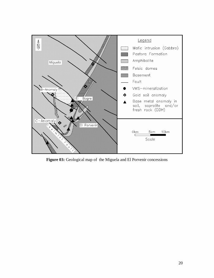
The geology of the area has been derived from a synthesis of geological surface mapping, interpretation of geophysical airborne and ground surveys, and logging of soil, auger, trench, reverse and diamond drill samples (Figure 3). A gneiss-granite basement complex borders the eastern side of the Miguela claim. The major part of the area consists of mafic, intermediate and felsic meta-volcanic rocks, tuff and clastic sediments, and a meta-exhalitic facies consisting of chert and banded iron formation. An oval shaped mafic body occurs in the centre of the Miguela claim, which represents a younger intrusion of probable Upper Proterozoic age.
9
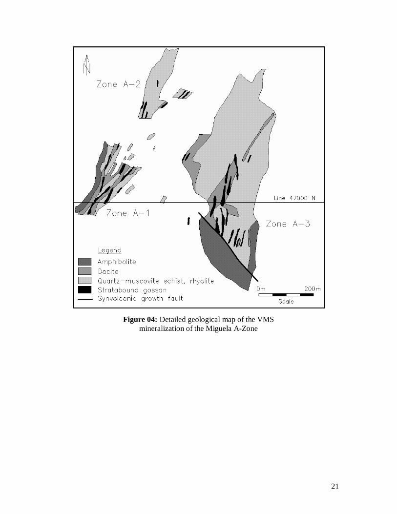
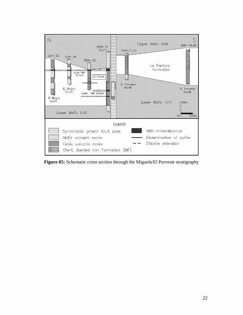
The lithostratigraphical relation between the different investigated sites is not always clearly understood due to the absence of rock outcrops and the presence of complex tectonic structures. It is assumed that the rock sequence of the A-Zone mineralization is in a normal position, striking 40 degrees and dipping between 40 and 60 degrees north-west. The VMS mineralization is confined to a 400-meter thick felsic sequence, which is composed of intermediate to rhyolitic meta-volcanic rocks, quartz-muscovite-rich meta-sediments with thin layers of mafic material (Figure 4). The hanging and the footwall of this felsic unit consist mainly of massive fine-grained amphibolite. The felsic rocks diminishes along strike to the south of the A-Zone due to the presence of a synvolcanic growth fault and are replaced completely by amphibolitic andesite.
The lithological units of the El Porvenir claim trend 40 degrees and dip 45 to 55 degrees to the north-west. The western part of the claim consists of deeply laterized amphibolite with minor inclusions of felsic volcanic rocks. These are overlain by the “La Pastora” formation, which consists of silica, and iron-rich metamorphosed mudstone and siltstone, thin layers of felsic meta-tuff and tuffite, and a magnetite or pyhrrotite-rich banded iron-formation, which covers approximately 20 % of the claim. It is assumed that this formation forms the hanging wall and the lateral equivalents of the A-Zone mineralization and other inferred ore bodies.
Felsic dome structures occur about 2 kilometres north of the A-Zone in the El Bagre area and in the footwall of the La Pastora formation in the southern part of the El Porvenir claim. A major, six kilometre long, north-south striking elongated felsic lens exists in the central part of the Miguela claim about 5 kilometres west of the A-Zone (Figure 4). These bodies consist mainly of massive recrystallized quartz-rich granofels and are sandwiched in the less competent country rocks like mega-boudins.
Structure
The contact zone between the local basement and the described supracrustal rock sequence is not exposed. Most of the rock types are highly foliated. Only the massive felsic and quartz-rich units form rigid bodies of mega-boudins up to several kilometers length. Several regional-scale faults and mega-fractures cross the area trending 115 to 135 degrees (Figure 4). They are parallel to the shape of a seven by three kilometre large elongated magnetic anomaly in the centre of the Miguela claim and are of Upper Proterozoic age. The most important lineament is the Ibaimini fault, which divides the area in two parts of different structural regime. The lithological units north of the fault trend 25 to 40 degrees and dip 45 to 75 degrees northwest. The Pastora formation forms a complex tectonic structure in the El Porvenir claims, which is “V”-shaped, forming overturned isoclinal fold structures and with axial planes dipping northwest. The strike of the “La Pastora” formation turns to the west close to the Ibaimini fault, indicating the presence of a large “U”-shaped mega-fold structure. The rocks south of the
10
Ibaimini fault are outside of the Miguela claim. They strike 140 degrees, are vertical and consist principally of pelitic meta-sediments, thin layers of banded iron-formation and mafic material.
MINERALIZATION Form and Shape
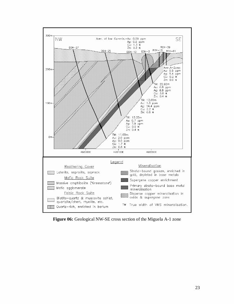
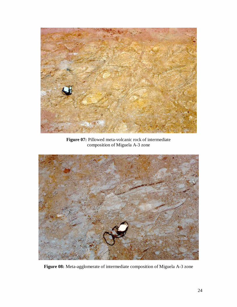
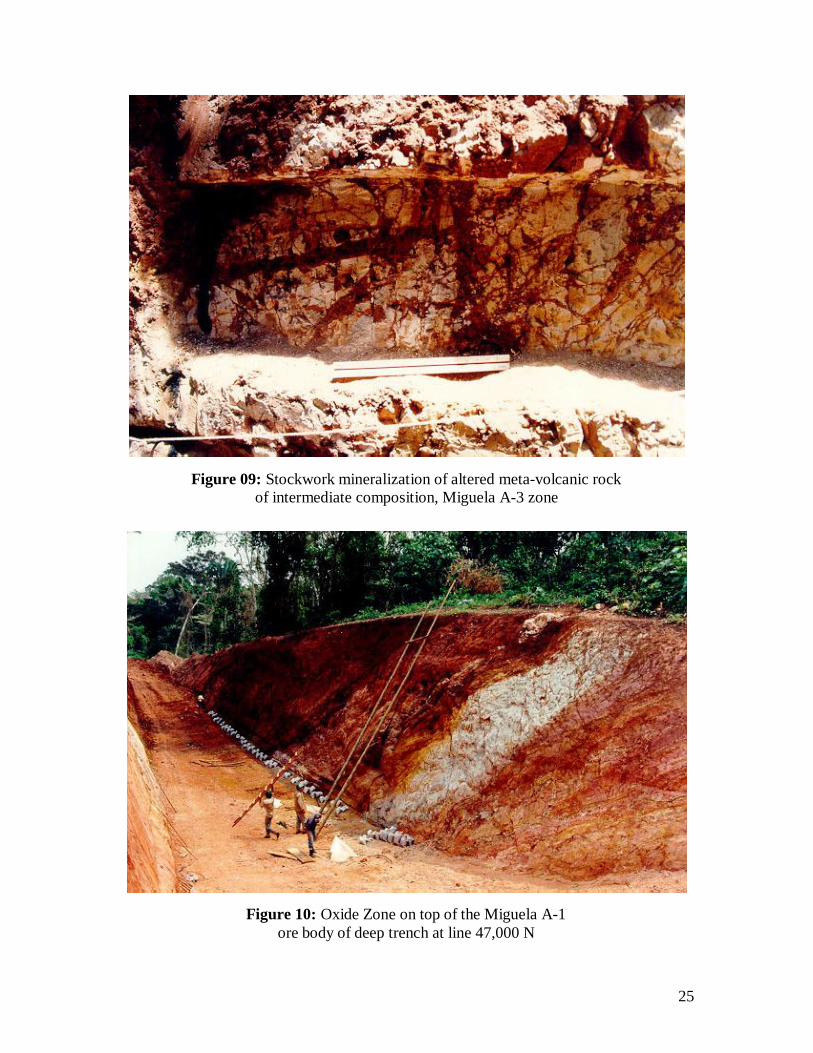
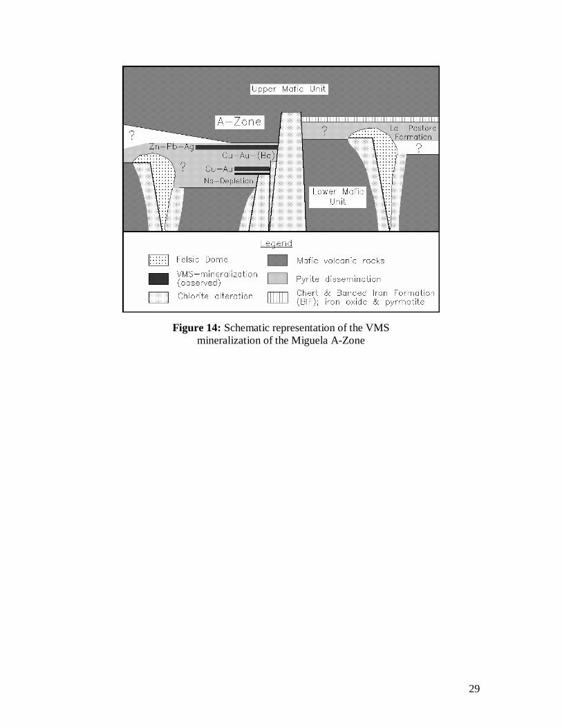
The VMS mineralization of the Miguela A-Zone consists of three individual mineralized bodies confined to two separate stratigraphical levels within the felsic unit. The western A-1 and A-2 bodies occur in an upper horizon and the eastern A-3 body in a lower horizon, separated by a 300-meter thick sequence of volcano-sedimentary rocks (Figure 5). Massive sulphides predominate in the A-1, semi-massive to disseminated in the A-2 and thin, massive to semi-massive sulphide layers and a large strata-bound pyrite dissemination in the A-3 body. The main A-1 body is the best explored mineralized lense. It is tabular in shape, dips 45 degrees northwest and exhibits a true thickness between 12 and 23 meters along the drilled section (Figure 6). It is continuous for 450 meters along strike, 350 metres down-dip and remains open to depth and along strike. The mineralization is hosted in a sequence of biotite-quartz fels, muscovite schist and meta-rhyolite and overlain by amphibolitic meta-andesite. The direct hanging wall of the VMS layer is a quartz-rich rock, which exhibits high barium values of up to 7,199 ppm, equivalent to 1.3 weight-% of baryte. There is evidence of pillow structure and volcanic agglomerate (Figures 7 and 8).
Ore Mineralogy and Fabric
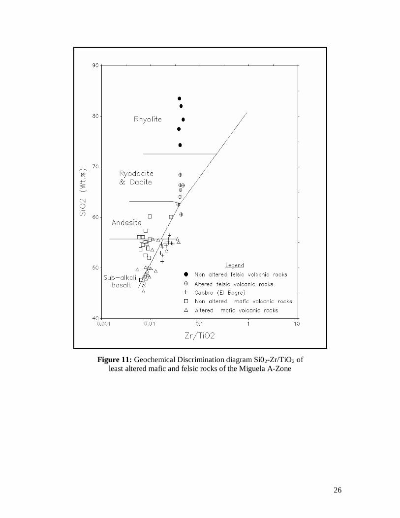
The VMS mineralization contains only a restricted range of opaque minerals. The most important primary minerals are pyrite and chalcopyrite with minor amounts of sphalerite and galena in places. Magnetite and pyrrhotite are rare in the A-Zone but are very abundant in the El Bagre and El Porvenir zones. No arsenopyrite is present; consequently the arsenic assay values of mineralized samples are generally lower than 100 ppm. The dominant nonsulphide oxide gangue minerals are sericite/muscovite, biotite, quartz and minor chlorite and carbonate. North and south of the A-Zone strata-bound calcsilicate minerals such as garnet, actinolite and diopside are abundant. The sulphide mineral are mostly coarse grained due to strong recrystallization by metamorphism and deformation. For this reason primary sulphide bedding is rarely preserved, but bedding between sulphide layers and volcanic material is quite common. Stockwork (Figure 9) mineralization is less frequent but occurs in the lowermost A-3 body where massive sulphide layers are in contact with andesitic layers.
Hydrothermal Alteration
Hydrothermal alteration occurs both strata-bound and semiconformably in the footwall and laterally to the known VMS mineralization as pervasive pyritization,
11
muscovitization, silicification and minor tourmalinization, carbonation and chloritization. The alteration is most intense in the footwall and laterally adjacent to the A-3 lens, and can be traced at least two kilometers to the north within the favourable horizon. The southern limit of the A-Zone is marked by a synvolcanic fault zone, which on local scale has controlled the geometry of the sulphide mineralization and hydrothermal alteration. The felsic rocks disappear abruptly south of this fault and are replaced by amphibolitic andesite and the serizite/muscovite and pyrite alteration by chlorite and carbonate.
Weathering Zone
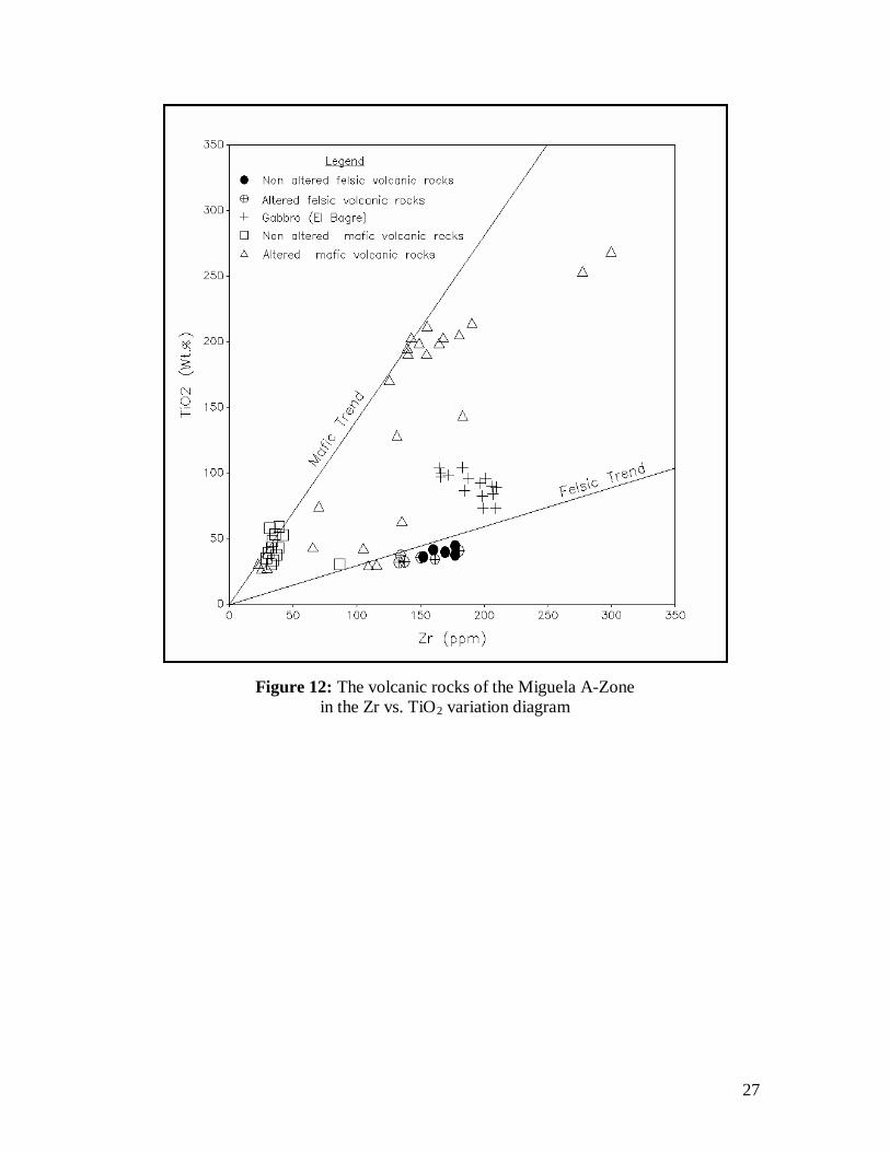
The VMS mineralization of the A-Zone exhibits a deep weathering profile, which is due to the lateritization of the regolith since the Miocene. The primary sulphide mineralization is overlain by up to 45-meter thick supergene chalcocite and 40 meter thick oxide zones. The latter consists of iron-silica-rich rocks and a strata-bound gossan formation with a strong enrichment of gold (Figure 10). Copper is also enriched in the hanging wall of the strata-bound A-1 Zone mineralization forming a halo of dispersed native copper, chrysocolla, malachite and azurite, and secondary chalcocite averaging 1.12 % copper (Figure 6).
Metal Distribution
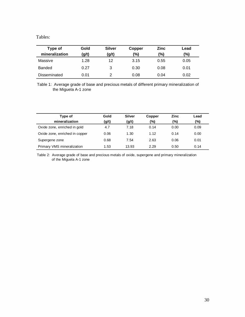
The A-Zone plots in the ternary Zn-Cu-Zn diagram in the field of copper-rich VMS mineralization. Diamond drill core samples average the following grades:
• 122 massive sulphide samples 1.28 g/t Au, 12 g/t Ag, 3.15 % Cu, 0.55 % Zn and 0.05 % Pb.
• 335 banded sulphide samples 0.27 g/t Au, 3.0 g/t Ag, 0.30 % Cu, 0.08 % Zn and 0.01 % Pb.
• 1,378 disseminated samples 0.009 g/t Au, 2.0 g/t Ag, 0.08 % Cu, 0.04 % Zn and 0.02 % Pb.
Most of the gold and silver is concentrated in the strata-bound massive pyrite-chalcopyrite mineralization reaching maximum values of 8.25 g/t Au and 162 g/t silver respectively. The alteration zone in the footwall of the A-3 zone is highly anomalous in Au but of uneconomic grade. The gold distribution as a rule is erratic and no correlation with any mineralogical parameters can be recognized. The width of the massive and semi-massive sulphide layers diminishes north of the A-Zone and the mineralization becomes richer in zinc, lead and silver such as in:
DDH-29, 4.35 m with 3.2 g/t Au, 29.3 g/t Ag, 0.60 % Cu, 5.34 % Zn, 0.16 % Pb, DDH-31, 1.2 m with 0.34 g/t Au, 5.6 g/t Ag and 0.51 % Cu and DDH-32, 0.5 m with 0.79 g/t Au, 71.9 g/t Ag, 3.01 % Cu, 1.1 % Zn and 1.42 % Pb.
12
The drilling at the El Bagre Zone intersected a 340-meter thick zone of pyrite/pyrrhotite mineralization, an extensive zone of chloritization and a thin massive pyrite layer with highly anomalous cobalt (411 to 680 ppm). Sulphide mineralization south of the A-Zone is only moderately developed. It is confined to the meta-exhalitic sediments of the “La Pastora” formation and consists of disseminated and well-laminated pyrrhotite, minor pyrite, and traces of sphalerite and chalcopyrite. The base metal content is anomalous but only sub-economic and reaches the highest level in the southern part of the El Porvenir claim.
Gold is enriched in the oxide zone, where base metals are leached away from the parent rock by deep weathering (Table 1). Copper is highly concentrated in the supergene zone, where gold and base metals are depleted. The best element correlation exists in the primary mineralization, where gold correlates well with silver and copper, and copper with silver. Gold correlates only with lead in the oxide and supergene zone (Biste, 1999c).
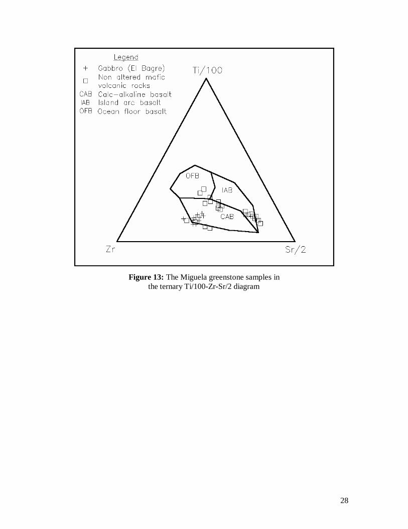
LITHOCHEMISTRY The volcanic rocks of the Guarayos greenstone belt were deposited in a subaqueous environment, having been affected by hydrothermal alteration processes during the formation of the VMS mineralization and by regional metamorphism under amphibolitic conditions. For that reason least altered rock samples were used for a rock classification based on lithochemical composition. Major and minor element analyses were performed by X-Ray-Fluorescence analysis, and trace elements by Atomic Absorption Spectroscopy both at the laboratory of Bondar Clegg/Inchcape Testing Services of Canada. The rocks represent a wide compositional range from basalt to rhyolite. The more mafic varieties contain actinolitic hornblende, tremolite, actinolite, plagioclase, minor biotite, chlorite and epidote plus accessory magnetite, ilmenite, sphene and apatite, and the felsic rocks mainly quartz, plagioclase, muscovite and minor biotite (Craig, 1996, 1997ª and 1997b). The SiO2-Zr/TiO2 diagram (Winchester and Floyd, 1977) confirms that the host lithology of the Miguela VMS mineralization is of andesitic and rhyolitic composition (Figure 11). Drill cores, which were logged as hydrothermically altered, plot generally in the field of rhyodacite/dacite. The mafic and felsic trend is clearly established in the plot of TiO2 versus Zr (Figure 12). The magmatic affinity is tholeiitic according the Y versus Zr diagram. Least-altered mafic rocks plot into the three fields of ocean floor, island arc and calc-alkaline basalts of the Zr-Ti/100-Sr/2 ternary diagram (Figure 13). The hydrothermal alteration in the footwall of the A-3 lens mineralization is characterized by sodium depletion of rocks of rhyolitic composition. The material on top of the A-1 lense is quartz rich and carries high barium values up to 7,199 ppm in a lense of several meters thickness. The chromium content of quartz-rich schist ranges from 200 to 1,300 ppm indicating that it has been possibly derived from the erosion of mafic to ultra-mafic material.
13
RESOURCE ESTIMATE A preliminary resource estimate has been carried out for the best investigated A-1 lense by an independent consulting geologist (McNamee, 1997). Eight diamond drill holes placed in a small area of the southwestern portion of the upper mineralized level have demonstrated continuity of mineralization in three dimensions. The assay results from these eight drill holes on three section lines were used in the calculation of an Inferred Mineral Resource by application of the following criteria (Table 2).
• The mineralization has a down-dip length of 350 meters. • No projection has been made down-dip beyond the deepest intersection. • The mineralization has an indicated strike length of 210 meters using a projection of
50 meters to the north and 50 meters to the south of the three section lines. • The specific gravity of the massive sulphide mineralization is 4.5. Based on these assumptions an Inferred Resource of 1,620,000 tonnes has been calculated with weighted average grades of 3.76 % Cu, 1.27 g/t Au, 11.27 g/t Ag and 0.33 % Zn. Assuming that the A-1 lense mineralization is continuous over 450 meters of strike length and down-dip for 450 meters, it has the potential to host about 4.25 million tonnes of a gold-bearing copper-rich base metal mineralization. DISCUSSION The discovery of VMS mineralization at the Miguela A-Zone is a very significant development in the exploration of the Bolivian Shield because the first geochemical target drill tested intersected encouraging copper and gold values. The mineralization is hosted in a bimodal tholeiitic meta-volcanic sequence of the Guarayos schist belt which extends over a distance of about 100 kilometers parallel to the western border of the shield area (Litherland and al., 1996). This belt appears to be of a comparable age of the greenstone belts of the Canadian and Australian shield areas, which host many VMS mineralization in similar geological conditions (Large et al., 1989; Large, 1992, Gibson and Kerr,1993; Syme and Bailes, 1993; DeMatties, 1994; Zaleski and Peterson 1995, Franklin, 1997). The Miguela VMS mineralization is confined to a felsic unit, informally known as “La Pastora” formation, which has been traced for at least 28 kilometers in strike, but its limits have not yet been defined. It may extend over the whole length of the Guarayos greenstone belt. The VMS mineralization of the Miguela A-Zone occurs in three lenses related to two different stratigraphical levels. The mineralization is copper-gold-rich and its formation has been probably controlled by a synvolcanic growth fault system (Figure 14). The ore bodies are strata-bound and no stringer zone has been observed so far. The copper-zinc metal zonation expected in a VMS deposit is not well defined at the A-1 Horizon. However the drill holes completed north of the A-Zone intersected significant zinc and lead grades. The ore lenses represent sea-floor precipitates and/or a near-sea-floor replacement mineralization within permeable host lithologies of the felsic unit (Large, 1992; Galley et al., 1995; Zalesky and Peterson, 1995). The geological resource potential of the A-1 lens is estimated in 4.25 million tonnes assuming that the mineralization is
14
continuous over 450 meters strike length and down-dip of 350 meters. This size compares well with deposits of other VMS districts and places the A-1 resource in the median size category of VMS deposits of Canada and Australia (Large, 1992; Franklin, 1997). Pre-Cambrian VMS deposits are known to occur in clusters and the recognition of three massive sulphide lenses at the A-Zone and various other significant showings along the strike of the favourable horizon is an extremely positive development at such an early exploration stage. The known anomalies with geochemical and geophysical signatures comparable to the A-Zone is most encouraging, and provides ample evidence that the Guarayos greenstone belt may have the potential to host a significant VMS camp. ACKNOWLEDGEMENTS This paper is the result of an intensive exploration program, which was financed by TANGANICA A.V.V. and ESSEX RESOURCE CORPORATION. The authors give thank to the Bolivian colleagues and employees of Essex's Santa Cruz office who made with their qualified work an important contribution to this publication. Critical comments by two GAC reviewers were very helpful in refining the manuscript.
15
BIBLIOGRAPHY Biste, M.H. 1985. Stata-bound Gold Mineralization in the Pre-Cambrian Basement of Eastern Bolivia and the Rondonia/Pará Region (Brazil). In Monograph Series of Mineral Deposits 25: 137-150; Gebrüder Borntraeger, Berlin-Stuttgart, 1985. Biste, M.H., Bufler R. and Friedrich, G. 1991. Geology and Exploration of Gold Placer Deposits of the Pre-Cambrian Shield of Eastern Bolivia. In Gisements Alluviaux d'Or, Alluvial Gold Placer, Yacimientos Aluviales de Oro. Edited by Gérard Hérail et Michel Fonari. Editions de I'ORSTORM, La Paz 1991, pp. 145-158. Biste, M.H. and Matthews, M.J. 1995. Report on the First Year of Geological Exploration in the Pre-Cambrian Claims of Tanganika A.V.V, Eastern Bolivia. Internal Exploration Report, 17 p. Biste, M.H. and Matthews, M.J. 1996 a. Tanganika A.V.V. - 1995 Work Progress Report and 1996 Work Program and Budget. Internal Exploration Report, 32 p. Biste, M.H. and Matthews, M.J 1996b. Essex Resource Corporation - 1996 Work Program and Budget for Geological Exploration of the Bolivian Pre-Cambrian Projects. Internal Exploration Report, 11 p. Biste, M.H. and Matthews, M.J. 1997. Essex Resource Incorporated Bolivia. 1996 Work Progress and 1997 Work Program and Budget. Internal Exploration Report, 36 p. Biste, M.H. 1998a. Essex Resource Incorporated Bolivia. Results of Geological Exploration. First Phase from 1995 to 1998. El Porvenir Joint Venture COMIBOL - ESSEX, Final Exploration Report, Volume 1 to 10. Biste, M.H 1998b. Summary Report. The Guarayos VMS-Belt and Its Exploration Potential, Private Consulting Report, 16 p. Biste, M.H. 1999a. Essex Resource Incorporated Bolivia. 1997 Work Progress and 1998 Work Program and Budget. Internal exploration report, 51 p. Biste, M.H 1999b. Essex Resource Incorporated Bolivia. Results of Test-Pitting Program, Miguela Zone A, 1998. Internal Exploration Report, 9 p. Biste, M.H 1999c. Essex Resource Incorporated Bolivia. Miguela Zone A-1. Preliminary Report on Estimation of Mineral Resources as of January 01, 1998. Internal Exploration Report, 18 p. Bufler, R., Friedrich, G. and Biste, M.H. 1990. Supergene gold enrichment in laterites of the Ascensión de Guarayos area, eastern Bolivia. In Lateinamerika Koloquium, Abstracts, München.
16
Craig, H.B. 1996. Petrographic Report. 20 Samples from DDH Program, Miguela Concession, Eastern Bolivia. Vancouver Petrographics Ltd., 29 p. Craig, H.B. 1997a. Petrographic Report on 6 Samples from Miguela Project in Bolivia. Vancouver Petrographics Ltd., 10 p. Craig, H.B. 1997b. Petrographic Report on 12 Samples from Porvenir Project in Bolivia. Vancouver Petrographics Ltd., 19 p. DeMatties, T.A. 1994. Early Proterozoic Volcanogenic Massive Sulfide Deposits in Wisconsin: An Overview. Economic Geology, 89: 1122-1151. Franklin, J.M. 1997. Volcanic-associated Massive Sulphide Deposits. In Mineral Deposits Modeling, Edited by Kirkham, R.V. et al., Geological Association of Canada, Special Paper 40, pp. 315-334. Galley, A. G. et al. 1995. The Subsea-Floor Formation of Volcanic-Hosted Massive Sulphide: Evidence from the Ansil Deposit, Rouyn-Noranda, Canada. Economic Geology, 90: 2006-2017. Gibson, H.L. and Kerr, D.J. 1993. Giant volcanic-associated massive sulfide deposits: with emphasis on Archean examples. In Giant Ore Deposits. Edited by Whiting B.H. et al., Special Publication, Number 2, Society of Economic Geologists, pp. 319-348. Large, R.R. et al. 1989. Gold Distribution and Genesis in Australian Volcanogenic Massive Sulfide Deposits and Their Significance for Gold Transport Models. Economic Geology, 67:520-536. Large, R.R. 1992. Australian Volcanic-Hosted Massive Sulfide Deposits: Features, Styles, and Genetic Models. Economic Geology, 87: 471-510. Litherland, M. et al. 1986. The geology and mineral resources of the Bolivian Pre-Cambrian shield. British Geological Survey, Natural Environment Research Council, Overseas Memoir 9, London, Her Majesty's Stationary Office, 153 p. McNamee, J.A., 1996. Geological Report on the El Porvenir Property, Eastern Bolivia and Review of Preliminary Geochemical and Geophysical Results, Independent Consulting Geologist’s Report prepared for Essex Resource Corporation. McNamee, J.A., 1997. Essex Resource CorporationBolivia, Independent Consulting Geologist’s Report prepared for Essex Resource Corporation Setmin 1999. Leader in the positioning of mining concessions. State of the art technology, precision and efficiency, technical and legal security. 28 p.
17
Syme, E. C. and Bailes, A. H. 1993. Stratigraphic and Tectonic Setting of early Proterozoic Volcanogenic Massive Sulphide Deposits, Flin Flon, Manitoba, Economic Geology, 88: 566-589. Winchester, J.A. and Floyd, P.A. 1977. Geochemical discrimination of different magma series and their differentiation products using immobile elements. Chemical Geology, 20: 325-343. Witchard, F. et al. 1993. Airborne Geophysical Survey and Interpretations of Remote Sensing in the San Ramon Area. Assessment of Mineral Resources of the Pre-Cambrian of Bolivia, Part 1. Boletin del Servicio Geologico de Bolivia, No.2 (Especial), 1993, 55p. Val d'Or 1997. Geophysical Report. Volume 1 to 3. Empresa Minera Suruqui S.R.L., Miguela Project, Department of Santa Cruz, Bolivia. Zalesky, E. and Peterson, V.L. 1995. Depositional Setting and Deformation of Massive Sulfide Deposits, Iron Formation, and Associated Alteration in the Manitouwadge Greenstone Belt, Superior province, Ontario. Economic geology, 90: 2244-2261.
18
Figures:
Figure 01: Location map of the Guarayos Greenstone Belt and the Miguela and El Porvenir concessions
19
Figure 02: Simplified geological map of the western border of the Pre-Cambrian shield of eastern Bolivia
20
Figure 03: Geological map of the Miguela and El Porvenir concessions
21
Figure 04: Detailed geological map of the VMS mineralization of the Miguela A-Zone
22
Figure 05: Schematic cross section through the Miguela/El Porvenir stratigraphy
23
Figure 06: Geological NW-SE cross section of the Miguela A-1 zone
24
Figure 07: Pillowed meta-volcanic rock of intermediate composition of Miguela A-3 zone
Figure 08: Meta-agglomerate of intermediate composition of Miguela A-3 zone
25
Figure 09: Stockwork mineralization of altered meta-volcanic rock of intermediate composition, Miguela A-3 zone
Figure 10: Oxide Zone on top of the Miguela A-1 ore body of deep trench at line 47,000 N
26
Figure 11: Geochemical Discrimination diagram Si02-Zr/TiO2 of least altered mafic and felsic rocks of the Miguela A-Zone
27
Figure 12: The volcanic rocks of the Miguela A-Zone in the Zr vs. TiO2 variation diagram
28
Figure 13: The Miguela greenstone samples in the ternary Ti/100-Zr-Sr/2 diagram
29
Figure 14: Schematic representation of the VMS mineralization of the Miguela A-Zone
30
Tables:
Type of Gold Silver Copper Zinc Leadmineralization (g/t) (g/t) (%) (%) (%)
Massive 1.28 12 3.15 0.55 0.05
Banded 0.27 3 0.30 0.08 0.01
Disseminated 0.01 2 0.08 0.04 0.02
Table 1: Average grade of base and precious metals of different primary mineralization of the Miguela A-1 zone
Type of Gold Silver Copper Zinc Leadmineralization (g/t) (g/t) (%) (%) (%)
Oxide zone, enriched in gold 4.7 7.18 0.14 0.00 0.09
Oxide zone, enriched in copper 0.06 1.30 1.12 0.14 0.00
Supergene zone 0.68 7.54 2.63 0.06 0.01
Primary VMS mineralization 1.53 13.93 2.29 0.50 0.14
Table 2: Average grade of base and precious metals of oxide, supergene and primary mineralization of the Miguela A-1 zone
Related Documents