Geology and Production History of the Moonlight Uranium-Vanadium Mine, Navajo County, Arizona By William L. Chenoweth Consulting Geologist, Grand Junction, Colorado July, 2003 Arizona Geological Survey Contributed Report CR-03-E (Supercedes CR-95-D) Arizona Geological Survey 416 W. Congress, Suite #100, Tucson, Arizona 85701 Interpretations and conclusions in this report are those of the consultant and do not necessarily coincide with those of the staff of the Arizona Geological Survey This report is preliminary and has not been edited or reviewed for conformity with Arizona Geological Survey standards. -1-

Welcome message from author
This document is posted to help you gain knowledge. Please leave a comment to let me know what you think about it! Share it to your friends and learn new things together.
Transcript
Geology and Production History ofthe Moonlight Uranium-Vanadium
Mine, Navajo County, Arizona
ByWilliam L. Chenoweth
Consulting Geologist, Grand Junction, Colorado
July, 2003
Arizona Geological SurveyContributed Report CR-03-E
(Supercedes CR-95-D)
Arizona Geological Survey416 W. Congress, Suite #100, Tucson, Arizona 85701
Interpretations and conclusions in this report are those ofthe consultant and donot necessarily coincide with those ofthe staffofthe Arizona Geological Survey
This report is preliminary and has not been
edited or reviewed for conformity with Arizona
Geological Survey standards.
-1-
INTRODUCTION
During the mid-1950s exploration drilling located several large uranium ore bodies in buried channels,
in the Oljeto syncline area of the Monument Valley, Navajo County, Arizona. The channels occupy the
basal portion of the Shinarump Member of the Triassic Chinle Formation. The Moonlight Mine was the
largest of these deposits and was the second largest deposit in the entire Monument Valley area. The
deposit was located on a Navajo Tribal Mining Permit, which was issued in 1953, at a time when mining
and exploration were just commencing in this part of Monument Valley. The Moonlight was originally an
underground mine but was converted to an open pit operation once the size of the deposit was established.
As the result of a lawsuit involving the Moonlight Mine, considerable additional information was
located including a map of the underground workings. This report incorporates the new information and
supersedes a former report CR-95-D.
LOCATION AND LAND STATUS
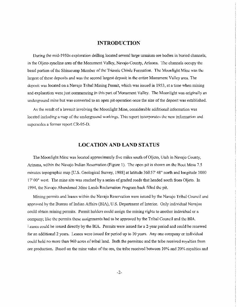
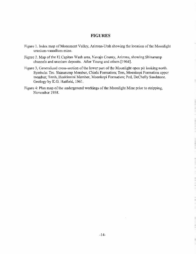
The Moonlight Mine was located approximately five miles south ofOljeto, Utah in Navajo County,
Arizona, within the Navajo Indian Reservation (Figure 1). The open pit is shown on the Boot Mesa 7.5
minutes topographic map [U.S. Geological Survey, 1988] at latitude 36857' 48" north and longitude 1008
17' 00" west. The mine site was reached by a series of graded roads that headed south from Oljeto. In
1994, the Navajo Abandoned Mine Lands Reclamation Program back filled the pit.
Mining permits and leases within the Navajo Reservation were issued by the Navajo Tribal Council and
approved by the Bureau of Indian Affairs (BIA), U.S. Department ofInterior. Only individual Navajos
could obtain mining permits. Permit holders could assign the mining rights to another individual or a
company; like the permits these assignments had to be approved by the Tribal Council and the BIA.
Leases could be issued directly by the BIA. Permits were issued for a 2-year period and could be renewed
for an additional 2 years. Leases were issued for period up to 10 years. Anyone company or individual
could hold no more than 960 acres of tribal land. Both the permittee and the tribe received royalties from
ore production. Based on the mine value of the ore, the tribe received between 10% and 20% royalties and
-2-
the permittee between 2% and 5% royalties. In addition to mining permits, the tribe issued drilling and
exploration permits. These permits were good for 120 days and were not renewable.
GEOLOGICAL SETTING
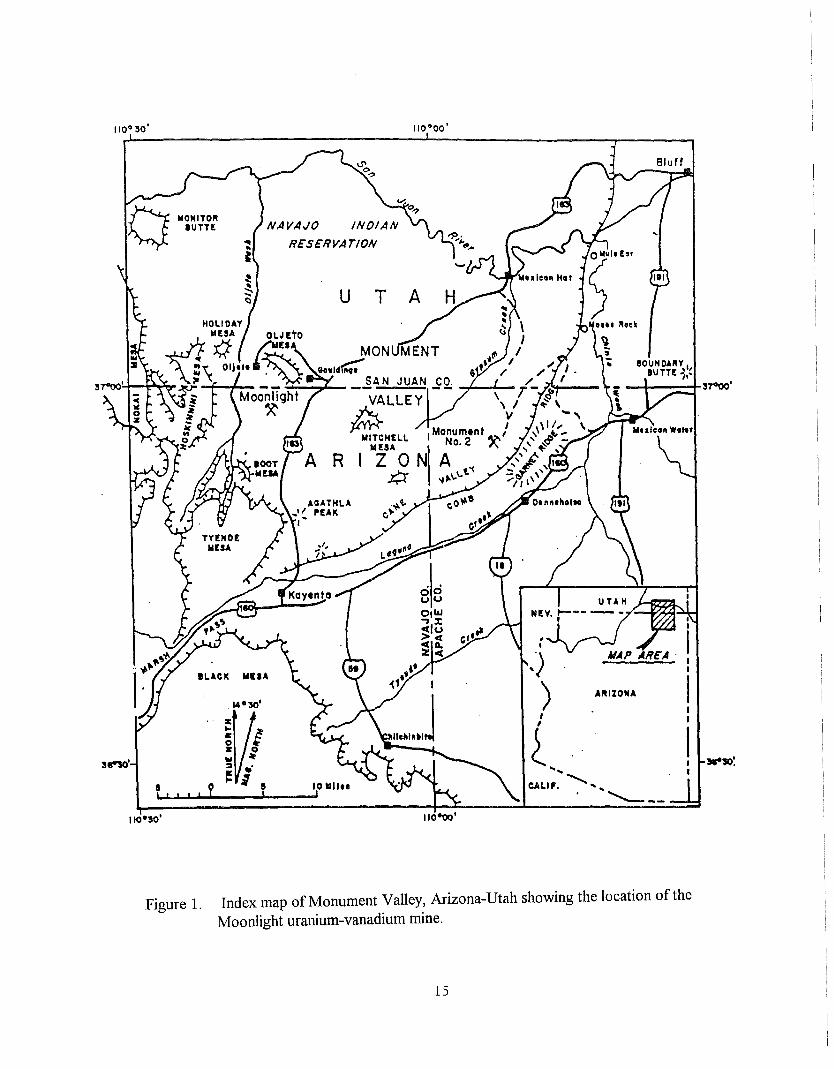
The Moonlight ore deposit was one of several uranium ore deposits that were located by "blind" drilling
in the El Capitan Flat area ofMonument Valley in 1955-1956. The Flat is a large, sand dune-covered area
on the eastern side of the Oljeto syncline, which is between the Organ Rock anticline to the west and the
crest of the Monument Uplift to the east. Underlying the dune sand in the mine area is the Upper Triassic
Chinle Formation. Rocks of this formation dip approximately 2 degrees to the west-southwest into the
syncline [Witkind and Thaden, 1963].
The ore bodies at the Moonlight Mine were formed in a channel deposit in the basal portion of the
Shinarump Member of the Chinle Formation. The channel, scoured into the underlying Moenkopi
Formation of Lower Triassic age, was filled with gray, medium-to-coarse-grained sandstone and
conglomerate. Carbonaceous plant materials, including fossil logs were abundant in the channel sediments.
The channel at the mine was 300 feet wide and was scoured 50 to 75 feet into the underlying siltstone of
the Moenkopi Formation. Locally, the scouring reached the Permian DeChelly Sandstone, which underlies
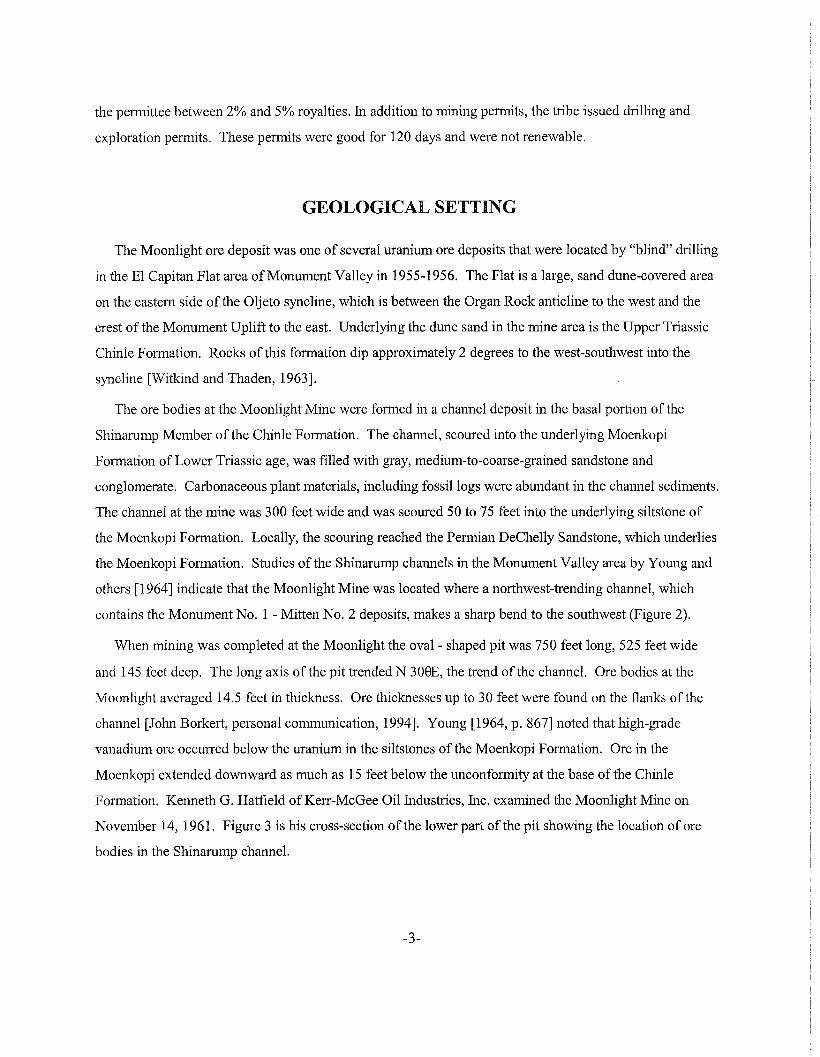
the Moenkopi Formation. Studies of the Shinarump channels in the Monument Valley area by Young and
others [1964] indicate that the Moonlight Mine was located where a northwest-trending channel, which
contains the Monument No.1 - Mitten No.2 deposits, makes a sharp bend to the southwest (Figure 2).
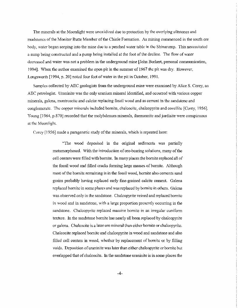
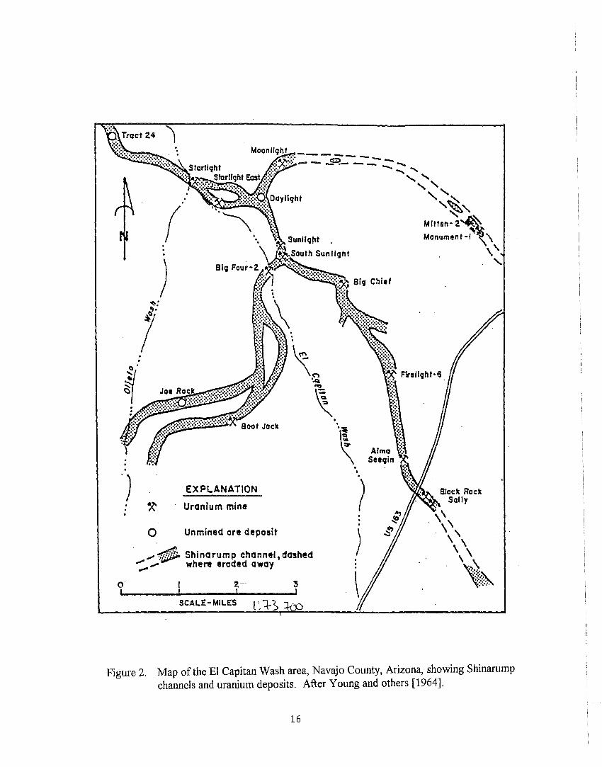
When mining was completed at the Moonlight the oval- shaped pit was 750 feet long, 525 feet wide
and 145 feet deep. The long axis of the pit trended N 308E, the trend of the channel. are bodies at the
Moonlight averaged 14.5 feet in thickness. are thicknesses up to 30 feet were found on the flanks of the
channel [John Borkert, personal communication, 1994]. Young [1964, p. 867] noted that high-grade
vanadium ore occurred below the uranium in the siltstones of the Moenkopi Formation. are in the
Moenkopi extended downward as much as 15 feet below the unconformity at the base of the Chinle
Formation. Kenneth G. Hatfield ofKerr-McGee Oil Industries, Inc. examined the Moonlight Mine on
November 14, 1961. Figure 3 is his cross-section ofthe lower part of the pit showing the location of ore
bodies in the Shinarump channel.
-3-
The minerals at the Moonlight were unoxidized due to protection by the overlying siltstones and
mudstones of the Monitor Butte Member of the Chinle Fonnation. As mining commenced in the south ore
body, water began seeping into the mine due to a perched water table in the Shinarump. This necessitated
a sump being constructed and a pump being installed at the foot of the decline. The flow of water
decreased and water was not a problem in the underground mine [John Borkert, personal communication,
1994]. When the author examined the open pit in the summer of 1967 the pit was dry. However,
Longsworth [1994, p. 20] noted four feet ofwater in the pit in October, 1991.
Samples collected by AEC geologists from the underground mine were examined by Alice S. Corey, an
ABC petrologist. Uraninite was the only uranium mineral identified, and occurred with various copper
minerals, galena, montroseite and calcite replacing fossil wood and as cement in the sandstone and
conglomerate. The copper minerals included bornite, chalcocite, chalcopyrite and covellite [Corey, 1956].
Young [1964, p.870] recorded that the molybdenum minerals, ilsemannite andjordisite were conspicuous
at the Moonlight.
Corey [1956] made a paragenetic study of the minerals, which is repeated here:
"The wood deposited in the original sediments was partially
metamorphosed. With the introduction of ore-bearing solutions, many of the
cell centers were filled with bornite. In many places the bornite replaced all of
the fossil wood and filled cracks fonning large masses ofbornite. Although
most of the bornite remaining is in the fossil wood, bornite also cements sand
grains probably having replaced early fine-grained calcite cement. Galena
replaced bornite in some places and was replaced by bornite in others. Galena
was observed only in the sandstone. Chalcopyrite veined and replaced bornite
in wood and in sandstone, with a large proportion presently occurring in the
sandstone. Chalcopyrite replaced massive bornite in an irregular cunifonn
texture. In the sandstone bornite has nearly all been replaced by chalcopyrite
or galena. Chalcocite is a later ore mineral than either bornite or chalcopyrite.
Chalcocite replaced bornite and chalcopyrite in wood and sandstone and also
filled cell centers in wood, whether by replacement of bornite or by filling
voids. Deposition ofuraninite was later than either chalcopyrite or bornite but
overlapped that ofchalcocite. In the sandstone uraninite is in some places the
-4-
only cement. In others it occurs with galena and/or bornite and/or
chalcopyrite. Needles of montroseite selectively replaced uraninite and
occasionally chalcopyrite. Rare blebs of covellite were observed in the
massive bornite in woody sections. The covellite appears to be later than the
bornite and chalcopyrite, but its relations other ore minerals was not seen. In
the sandstone organic materials appear to have been mobile enough to fill
fractures and penetrate along grain boundaries.
There is a hint of zoning present, with bornite and chalcocite being
concentrated in woody portions and decreasing with increasing distance from
the wood, while chalcopyrite and uraninite increased in the amount in the
sandstone away from the wood. Montroseite was not observed in woody
sections".
There is no information available regarding the overall copper content of the Moonlight ore. John
Borkert [personal communication, 1994] recalled that the Moonlight Mine contained less copper than the
other deposits mine by Industrial Uranium Company in the Oljeto syncline, especially the Starlight and the
Sunlight. The mill at Mexican Hat, Utah paid for sulfide copper in uranium ores in excess of one percent.
It is doubtful payments were made for any Moonlight ore [Borkert, personal communication, 1994].
In October 1956, a 333-pound sample ofMoonlight ore was sent to the AEC's Raw Materials
Development Laboratory at Winchester, Massachusetts, operated by the National Lead Company, Inc. This
sample contained 0.375 percent U30 S, 0.53 percent V20 S and 0.66 percent Cu [Porter and others, 1958].
EXPLORATION AND PRODUCTION HISTORY
Early in 1953, Seth T. Bigman staked the Moonlight Nos. 1 and 2 claims in the El Capitan Flat area of
Navajo County, approximately five miles northwest ofMonument No.1 - Mitten No.2 uranium mines
(Figure 2). The land was acquired in anticipation of future exploration drilling in the area of a projected
trend of the Monument No.1 - Mitten No.2 channel. Navajo Tribal Mining Permit (MP) No. 73 was
approved to Mr. Bigman on February 19, 1953. It included the 320 acres No.1 claim and the contiguous
280 acres No.2 claim.
-5-
In 1954, Industrial Uranium Company of Salt Lake City, Utah obtained a drilling permit for the entire
600 acres. This drilling was successful as a large ore body was located in the southwest comer of the
Moonlight 1 claim, which extended on to the Moonlight No.2 claim. Industrial applied for the assignment
of the mining rights for only 40.8 acres of the mining permit. This assignment was approved on November
3, 1955.
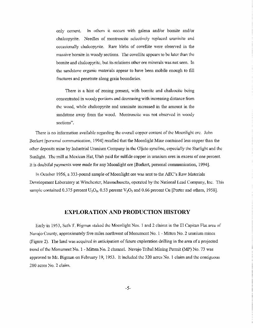
Industrial drove an 8 x 10 foot, 430 foot-long decline to the ore body. Track haulage in the ore zone
was used with a modified room and pillar mining method. A 1.5-ton, 15 horsepower electric hoist was
used to pull ore cars up the 20 degree decline [U.S. Atomic Energy Commission, 1959]. An initial
shipment of 44 tons averaging 0.17 percent U30 g was made to the ABC ore-buying station at Monticello,
Utah on March 1, 1956. During 1956 a total o£10,426.12 tons of ore averaging 0.34 percent U30 g and
0.38 percent VzOs were shipped to Monticello (Tables 1 and 2). At Monticello, the AEC paid for the
vanadium content of the ore as well as for the uranium.
On June 26, 1957, the 40.8 acres of the Moonlight mining permit and 67.2 acres of Seth T. Bigman's
Navajo Tribal Mining Permit 354, the Starlight Nos. 1 and 2 were converted to Lease No. 14-120-603
2289 [Chenoweth, 1997]. This lease was for a period often years.
During 1957, underground mining continued with a total of39,736.45 tons of ore averaging 0.33
percent U30 g and 0.54 percent VzOs shipped to Monticello (Tables land 2). The Arizona mine inspector
recorded that during 1957 between 25 and 63 men were employed underground at the Moonlight Mine
(Table 3).
During 1958, shipments continued to Monticello with some 1,426.31 tons shipped to the newly opened
mill at Mexican Hat, Utah, operated by Texas Zinc Minerals Corporation. The distance from the mine to
Mexican Hat was 30 miles compared to 67 miles to Monticello. Mexican Hat did not pay for, or recover
vanadium. In 1958 the mine inspector noted that 27 men were underground and 11 men were on the
surface (Table 3).
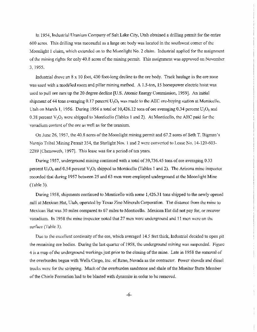
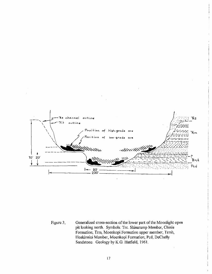
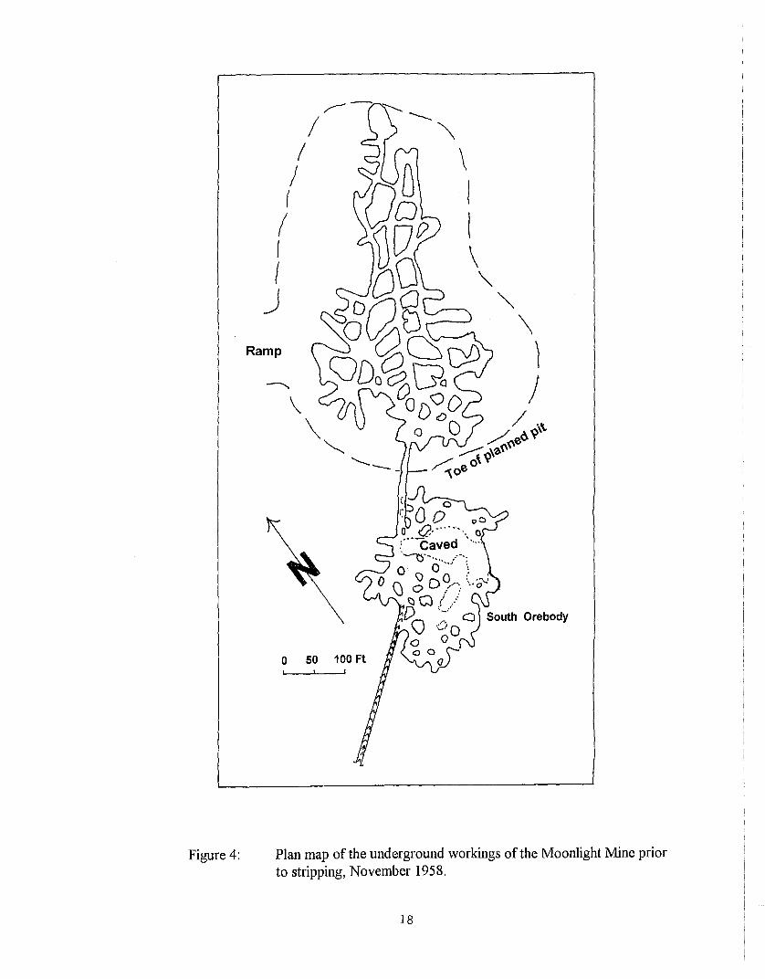
Due to the excellent continuity of the ore, which averaged 14.5 feet thick, Industrial decided to open pit
the remaining ore bodies. During the last quarter of 1958, the underground mining was suspended. Figure
4 is a map of the underground workings just prior to the closing of the mine. Late in 1958 the removal of
the overburden began with Wells Cargo, Inc. ofReno, Nevada as the contractor. Power shovels and diesel
trucks were for the stripping. Much of the overburden sandstone and shale of the Monitor Butte Member
of the Chinle Formation had to be blasted with dynamite in order to be removed.
-6-
Total production during 1958 was 27,877.68 tons, averaging 0.34 percent U30 g (Table 1). Industrial
reported to the AEC that as ofNovember 24, 1958, the Moonlight Mine had a remaining reserves of
136,000 tons of ore that averaged 0.26 percent U30 S and 0.50 percent V20 S•
On January 15, 1959, production began from the open pit with the ore being shipped to Mexican Hat.
In mid-1959, Rare Metals Corporation of American, which operated a mill at Tuba City, Arizona, signed a
contract with Industrial to purchase 20,000 tons of ore over the next 12 months. Production in 1959
reached an all time annual high when 73,730.63 tons averaging 0.23 percent U30 g were shipped (Table 1).
In this same year the mine inspector recorded that 14 men were employed in the open pit (Table 3).
Operations in the open pit mine were turned over to a contractor, North Elk Mining Co. ofBlanding
Utah, in 1960. During that year production continued to be shipped to both Mexican Hat and Tuba City,
but declined to 34,018.47 tons averaging 0.23 percent U30 S, a 54 percent drop from 1959 (Table 1).
During 1961 production continued to decline when 17,824.60 tons averaging 0.20 percent U30 g were
shipped to Mexican Hat (Table 1). This was a drop of 48 percent over 1960.
In 1962, some 1,717.10 tons ofhigh vanadium ore (1.49 percent V20 S) were shipped to Monticello,
before the ore-buying station closed on March 31, 1962 (Table 2). Total production in 1962 was 9,866.95
tons averaging 0.30 percent U30 g (Table 1), a decline of 44 percent from 1961. The mine inspector
recorded that North Elk Mining Co. had only 2 to 3 men employed at the mine in 1962 (Table 3).
On July 31, 1963, the Atlas Corporation acquired Texas Zinc Minerals Corporation, including the
Mexican Hat mill. Texas Zinc's AEC contract was merged into the Atlas Minerals contract at their mill at
Moab, Utah. Atlas continued to operate the Mexican Hat mill through a subsidiary, A-Z Minerals
[Albrethsen and McGinley, 1982].
The only ore shipped from the Moonlight Mine in 1963 was some high vanadium ore, which was
delivered to the uranium-vanadium mill at Grand Junction, Colorado operated by Climax Uranium
Company. This shipment consisted of 148.10 tons averaging 0.39 percent U30 S and 1.37 percent V20 S
(Tables 1 and 2). The high -grade vanadium ore produced in 1962 and 1963 no doubt came from the ore
bodies in the Moenkopi Formation.
With most of the higher grade ore exposed in the open pit depleted by 1963, clean up mining
commenced in 1964. During that year shipments resumed to the Mexican Hat mill now operated by A-Z
Minerals. A total of 2,520.17 tons with an average grade of 0.18 percent U30 g were produced during 1964
-7-
(Table 1). The mine inspector recorded four men employed by North Elk Mining in the Moonlight pit
during 1964 (Table 3).
At the end of February 1965, A-Z Minerals closed the Mexican Hat mill [Albrethsen and McGinley,
1982]. Since Atlas Minerals had acquired the Moonlight's ore purchase contract with the Mexican Hat
mill, shipments now had to be sent to the Atlas mill at Moab, Utah. During 1965 a total of 3,139.84 tons
averaging 0.18 percent U30 g were shipped from the Moonlight Mine (Table 1).
As the ore bodies in the floor of the open pit were mined out, a contract miner, D.A. Small mined ore
outside of the pit via adits from the pit walls. During 1966 the mine inspector noted that the only
employees at the Moonlight were two men working underground (Table 3). In 1966, the final shipments
from the mine totaled 3,947.76 tons with an average grade of 0.13 percent. All of the ore was shipped to
Moab (Table 1).
SUMMARY
During the 11 years the Moonlight Mine was operating a total of223,236.77 tons of ore averaging 0.26
percent U30 g and containing 1,177,501.29 pounds U30 g were produced. This production ranks the
Moonlight the second largest uranium mine in the Monument Valley area. The largest mine was the
Monument No.2 in Apache County, Arizona (Figure 1). This mine, the largest in Arizona during the ABC
program, produced 773,132 tons averaging 0.34 percent and containing 5,276,093 pounds U30 g [Gregg
and Eversen, 1989].
All of the uranium concentrate produced from the Moonlight ore was sold to the remainder was sold by
the AEC to vanadium companies [Albrethsen and McGinley, 1982]. AEC. The vanadium recovered at the
Climax mill at Grand Junction, Colorado was sold to the steel industry. Ores purchased by the ABC at
Monticello, Utah were processed at the adjacent AEC owned mill. Vanadium was recovered only during
the September 1949 - March 1956 period [Albrethsen and McGinley, 1982]. The majority of the vanadium
recovered at the Monticello mill was transferred to the General Service Administration. The remainder
was sold by the ABC to vanadium companies [Albrethsen and McGinley, 1982].
ACKNOWLEDGMENTS. John Borkert, a former mining engineer for Industrial Uranium Company in
Monument Valley, supplied many details of mining operations. Nyal J. Niemuth of the Arizona
-8-
Department ofMines and Mineral Resources kindly made the annual reports of the Arizona mine inspector
available to the author. Research by Tad Woods, ofMeyer, Hendricks and Bivens, located much of the
new material presented in this report. Stephen M. Richard of the Arizona Geological Survey reviewed and
improved the manuscript. Tom McGarvin located Corey's petrographic report in the Arizona Survey's
files.
REFERENCES
Albrethsen, Holger, Jr., and McGinley, F .A., 1982, Summary history of domestic uranium procurement under U.S.Atomic Energy Commission contracts, final report: U.S. Deparmtnet of Energy Report GJBX-220(82), 162 p.
Corey, A.S., 1956, Moonlight mine, Navajo County, Arizona: U.S. Atomic Energy Commission Petrographic ReportNo. 1812,4 p.
Chenoweth, W.L., 1997, The geology and production history of the Starlight and Starlight East uranium mines, NavajoCounty, Arizona: Arizona Geological Survey Contributed Report CR-97-B-12 p.
Gregg, c.c., and Eversen, C.S., 1989, Maps of the underground workings, Monument No.2 mine, Apache County,Arizona, with a text by W.L. Chenoweth: Arizona Geological Survey Contributed Report CR-89-D, 31 p.
Longsworth, S.A., 1994, Geohydrology and water chemistry of abandoned uranium mines and radiochemistry of spoilmaterial leachate, Monument Valley and Cameron areas, Arizona and Utah: u.s. Geological Survey WaterInvest. Report 93-4226, 43 p.
Porter, E.S., Vikund, H.I., and Hammond, E.I., 1958, Laboratory investigation of Moonlight claim ore: U.S. AtomicEnergy Commmission Winchester Laboratory Topical Report WIN-87, 16 p.
U.S. Atomic Energy Commission, 1959, Moonlight mine, mMine operation data report: U.S. Atomic EnergyCommission Production Evaluation Division Report AEC-PED-l, p. 127.
U.S. Geological Survey, 1988, Boot Mesa quadrangle1, Arizona-Utah: 7.5 minute series (topographic), provisional,scale 1:24,000.
Witkind, 1.1., and Thaden, R.E., 1963, Geology and uranium-vanadium deposits of the Monument Valley aarea Apacheand Navajo Counties, Arizona, with sections on Serpentine at Garnet Ridge, by H.E. Malde, and RE. Thaden,and Mineralogy and paragenesis ofthe ore deposit at the Monument No.2 and Cato Sells mines, by D.H.Johnson: Geological Survey Bulletin 1103, 171 p., 7 sheets.
Young, RG., 1964, Distribution ofuranium deposits in the White Canyon - Monument Valley districts, Utah-Arizona:Economic Geology, v. 59, p. 850-873.
Young, RG., Malan, R.C. and Gray, L.B., 1964, Geologic map showing uranium deposits and Shinarump channels inthe Monument Valley district, San Juan County, Utah, Navajo and Apache Counties, Arizona: U.S. Departmentof Energy Preliminary Map 34, scale 1:95,000.
-9-
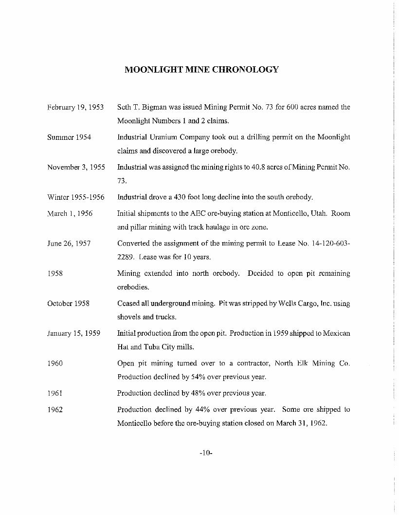
MOONLIGHT MINE CHRONOLOGY
February 19, 1953 Seth T. Bigman was issued Mining Permit No. 73 for 600 acres named the
Moonlight Numbers 1 and 2 claims.
Summer 1954 fudustrial Uranium Company took out a drilling permit on the Moonlight
claims and discovered a large orebody.
November 3,1955 fudustrial was assigned the mining rights to 40.8 acres ofMining Permit No.
73.
Winter 1955-1956
March 1, 1956
June 26, 1957
1958
October 1958
January 15, 1959
1960
1961
1962
fudustrial drove a 430 foot long decline into the south orebody.
Initial shipments to the AEC ore-buying station at Monticello, Utah. Room
and pillar mining with track haulage in ore zone.
Converted the assignment of the mining permit to Lease No. 14-120-603
2289. Lease was for 10 years.
Mining extended into north oreb0dy. Decided to open pit remaining
orebodies.
Ceased all underground mining. Pit was stripped by Wells Cargo, Inc. using
shovels and trucks.
Initial production from the open pit. Production in 1959 shipped to Mexican
Hat and Tuba City mills.
Open pit mining turned over to a contractor, North Elk Mining Co.
Production declined by 54% over previous year.
Production declined by 48% over previous year.
Production declined by 44% over previous year. Some ore shipped to
Monticello before the ore-buying station closed on March 31, 1962.
-10-
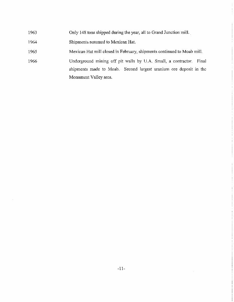
1963
1964
1965
1966
Only 148 tons shipped during the year, all to Grand Junction mill.
Shipments resumed to Mexican Hat.
Mexican Hat mill closed in February, shipments continued to Moab mill.
Underground mining off pit walls by D.A. Small, a contractor. Final
shipments made to Moab. Second largest uranium ore deposit in the
Monument Valley area.
-11-
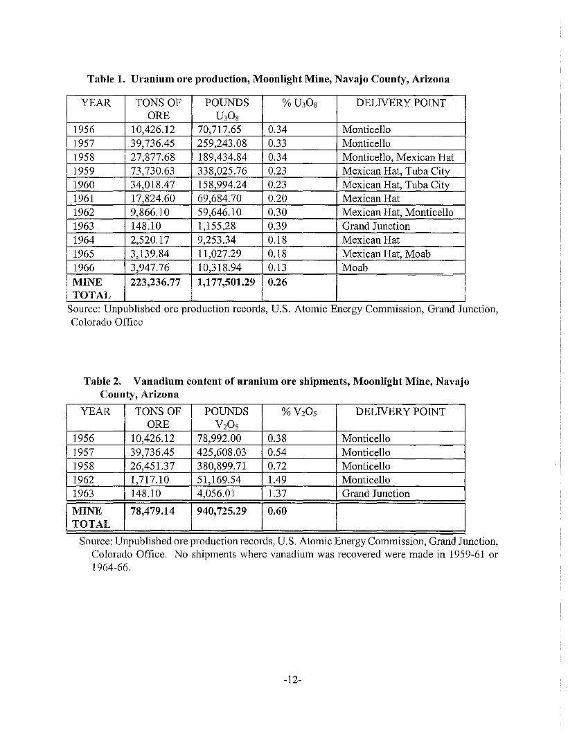
Table 1. Uranium ore production, Moonlight Mine, Navajo County, Arizona
YEAR TONS OF POUNDS O/OU3OS DELNERY POINTORE U30s
1956 10,426.12 70,717.65 0.34 Monticello1957 39,736.45 259,243.08 0.33 Monticello1958 27,877.68 189,434.84 0.34 Monticello, Mexican Hat1959 73,730.63 338,025.76 0.23 Mexican Hat, Tuba City1960 34,018.47 158,994.24 0.23 Mexican Hat, Tuba City1961 17,824.60 69,684.70 0.20 Mexican Hat1962 9,866.10 59,646.10 0.30 Mexican Hat, Monticello1963 148.10 1,155.28 0.39 Grand Junction1964 2,520.17 9,253.34 0.18 Mexican Hat1965 3,139.84 11,027.29 0.18 Mexican Hat, Moab1966 3,947.76 10,318.94 0.13 Moab
MINE 223,236.77 1,177,501.29 0.26TOTAL
Source: Unpublished ore production records, U.S. Atomic Energy Commission, Grand Junction,Colorado Office
Table 2. Vanadium content of uranium ore shipments, Moonlight Mine, NavajoCounty, Arizona
YEAR TONS OF POUNDS O/OV20s DELNERY POINTORE V20S
1956 10,426.12 78,992.00 0.38 Monticello1957 39,736.45 425,608.03 0.54 Monticello1958 26,451.37 380,899.71 0.72 Monticello1962 1,717.10 51,169.54 1.49 Monticello1963 148.10 4,056.01 1.37 Grand Junction
I:~~ 1 78,479.14 1 940,725.29 I 0.60
Source: Unpublished ore production records, U.S. Atomic Energy Commission, Grand Junction,Colorado Office. No shipments where vanadium was recovered were made in 1959-61 or1964-66.
-12-
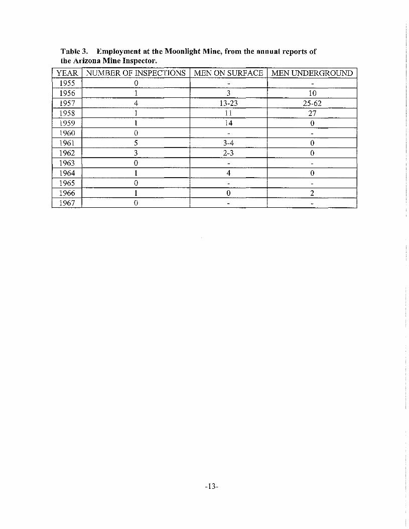
Table 3. Employment at the Moonlight Mine, from the annual reports ofthe Arizona Mine Inspector.
YEAR NUMBER OF INSPECTIONS MEN ON SURFACE MEN UNDERGROUND1955 0 - -1956 1 3 101957 4 13-23 25-621958 1 11 271959 1 14 01960 0 - -1961 5 3-4 01962 3 2-3 01963 0 - -1964 1 4 01965 0 - -1966 1 0 21967 0 - -
-13-
FIGURES
Figure 1. Index map of Monument Valley, Arizona-Utah showing the location of the Moonlighturanium-vanadium mine.
Figure 2. Map of the EI Capitan Wash area, Navajo County, Arizona, showing Shinarumpchannels and uranium deposits. After Young and others [1964].
Figure 3, Generalized cross-section of the lower part of the Moonlight open pit looking north.Symbols: Trc. Shinarump Member, Chinle Formation; Trm, Moenkopi Formation uppermember; Trmh, Hoskinnini Member, Moenkopi Formation; Pcd, DeChelly Sandstone.Geology by K.G. Hatfield, 1961.
Figure 4: Plan map of the underground workings of the Moonlight Mine prior to stripping,November 1958.
-14-
~'
-+---+37"00'
)) ARIZONA
,
~ .................
"'---110-30' 110-00'
Figure 1. Index map of Monument Valley, Arizona-Utah showing the location oftheMoonlight uranium-vanadium mine.
15
o Unmined ore deposit
. .....1f1i/P- Shinarump channel, dashed-:::-"",. where eroded away
SCALE-MILES L +3>
Black Rock. Sally
. \'\. \ \
\ \\ \,~
,,\":::::~
"::::~
..
Moonlight _-.::. 0- -- ................... -------- .......- ""'" "" "" ", ,,~.
~"Mllten.2~Monument -j\,\\
. \ \.
"
2- :3, !
EXPLANATION
~ Uranium mine
()
~:
f..
o!
Figure 2. Map of the EI Capitan Wash area, Navajo County, Arizona, showing Shinarumpchannels and uranium deposits. After Young and others [1964].
16
.....\
\\
\\
\"
+70' 20'
~ t
ou+linQ
outline
Po~i+jon of
of low.gradq
o"e
0,..
Figure 3, Generalized cross-section of the lower part of the Moonlight openpit looking north. Symbols: Trc. Shinarump Member, ChinleFormation; Trm, Moenkopi Formation upper member; Trmh,Hoskinnini Member, Moenkopi Formation; Pcd, DeChellySandstone. Geology by K. G. Hatfield, 1961.
17
o 50 100 Ft
\\
'" '-----
~- \'....
I --",! \
II II II \
! '"j ~
\!)
Ramp
Figure 4: Plan map of the underground workings of the Moonlight Mine priorto stripping, November 1958.
18
Related Documents