Geology and Paleontology Of Canal Zone and Adjoining Parts of Panama GEOLOGY AND DESCRIPTION OF TERTIARY MOLLUSKS (GASTROPODS: TROCHIDAE TO TURRITELLIDAE) By W. P. WOODRING GEOLOGICAL SURVEY PROFESSIONAL PAPER 306-A A contribution to the history of the Panama land bridge UNITED STATES GOVERNMENT PRINTING OFFICE, WASHINGTON : 1957

Welcome message from author
This document is posted to help you gain knowledge. Please leave a comment to let me know what you think about it! Share it to your friends and learn new things together.
Transcript

Geology and Paleontology
Of Canal Zone and
Adjoining Parts of Panama GEOLOGY AND DESCRIPTION OF TERTIARY MOLLUSKS (GASTROPODS:
TROCHIDAE TO TURRITELLIDAE)
By W. P. WOODRING
GEOLOGICAL SURVEY PROFESSIONAL PAPER 306-A
A contribution to the history of the Panama land bridge
UNITED STATES GOVERNMENT PRINTING OFFICE, WASHINGTON : 1957

UNITED STATES DEPARTMENT OF THE INTERIOR
FRED A. SEATON, Secretary
GEOLOGICAL SURVEY
Thomas B. Nolan, Director
For sale by the Superintendent of Documents, U. S. Government Printing Office Washington 25, D. C.

CONTENTS
Abstract __________________________________________ _ Introduction ______________________________________ _
Historical background __________________________ _ Purpose and scope of report_ ____________________ _ Orthography of geographic names ________________ _ Acknowledgments ______________________________ _ Annotated bibliography ________________________ _
Geology __________________________________________ _ Stratigraphy __________________________________ _
Outline of stratigraphy _____________________ _ Cretaceous(?) system _______________________ _ Eocene series ______________________________ _
Gatuncillo formation ___________________ _ Eocene or Oligocene series __________________ _
Marine member of Bohio(?) formation ____ _ Oligocene series ____________________________ _
Bohio formation ______ ------- __________ _ Caimito formation, exclusive of Madden
basin and Pacific coastal area _________ _ Tuffaceous strata in Chorrera area _______ _ Bas Obispo formation and Las Cascadas
agglomerate _________________________ _ Oligocene and Miocene series ________________ _
Caimito formation of Madden basin and Pacific coastal area ___________________ _
Miocene series _____________________________ _
Culebra formation, including Emperador limestone member ___________________ _
Cucaracha formation ___________________ _ Panama formation, including La Boca
marine member and Pedro Miguel ag-glomerate member ___________________ _
Gatun formation _____ -------- __________ _ Pliocene series _____________________________ _
Chagres sandstone, including Toro lime-stone member _______________________ _
Pleistocene series __________________________ _
Correlation of Tertiary forrliations in different
Paa-e
1 2 2 3 4 4 5
10 10 10 13 13 13 22 22 24 24
28 31
31 32
32 34
34 39
39 42 47
47 50
areas____________________________________ 50
Geology-Continued Igneous rocks _________________________________ _
Cretaceous(?) volcanic and intrusive rocks ____ _ Tertiary volcanic and intrusive rocks _________ _
Granular intrusive rocks ________________ _ Dike rocks ____________________________ _ Volcanic rocks and tuff _________________ _ Chemical composition __________________ _ Age __________________________________ _
Structure _____________________________________ _ Structural history __________________________ _ Structural features _________________________ _
Mineral resources ______________________________ _ Metallic mineral deposits ___________________ _ Nonmetallic mineral deposits ________________ _ Oil possibilities ____________________________ _
Description of Tertiary mollusks _____________________ _ Gastropods ___________________________________ _
Family Trochidae __________________________ _ Family Turbinidae _________________________ _ Family Phasianellidae ______________________ _ Family Phasianellidae? _____________________ _ Family Neritidae __________________________ _
Family Thiaridae? --------------------------Family Littorinidae ________________________ _ Family Vitrinellidae ______ -- _ -- _______ ---- __ _ Family Rissoidae __________________________ _ Family Rissoinidae _______ -- ________________ _ Family Xenophoridae ____ -- ________________ _ Family Hipponicidae _______________________ _ Family Hipponicidae? ______________________ _ Family Crepidulidae _______________________ _ Family Calyptraeidae ______________________ _ Family Naticidae _____________ - ________ -- __ _ Family Turritellidae _______________________ _
Localities at which fossils were collected ______________ _ References cited ____________________________________ _ Index ____________________________________________ _
ILLUSTRATIONS
[Plates 1, 2 in pocket, plates 3-23 follow p. 145]
Page
52 52 53 53 54 54 55 56 57 57 58 58 58 59 60 62 62 62 64 65 66 66 68 68 69 76 77 77 78 78 79 79 84 97
112 131 137
PLATE 1. Geologic map of Canal Zone and adjoining parts of Panama _________________________________________ In pocket 2. Geologic map of Gaillard Cut area, Canal Zone _____________________________________________________ In pocket
3. Foraminiferal limestone from Gatuncillo formation of Madden basin, Panama. 4. Echinoid-bearing limestone from Gatuncillo formation of Madden basin, Panama. 5. Boulder conglomerate of Bohio formation at Salud Point, Barro Colorado Island, Canal Zone. 6. Poorly sorted conglomerate of Bohio formation on Transisthmian Highway near Las Cumbres, just south of
continental divide, Panama. 7. Alhajuela sandstone member of Caimito formation at north abutment of Madden Dam, Canal Zone.
m

IV CONTENTS
PLATE 8. Emperador limestone member of Culebra formation on west bank of Panama Canal at canal station 1619, Canal Zone.
9. Coralliferous limestone at base of La Boca marine member of Panama formation on Rio Masambi 200 meters upstream from east bank of Panama Canal, Canal Zone.
10. Strata in middle part of Gatun formation on east side of Gatun Third Locks excavation, Canal Zone. 11. Toro limestone member of Chagres sandstone resting on marly siltstone in middle part of Gatun formation in
road cut 3 kilometers southwest of Gatun, Canal Zone. 12. Toro limestone member of Chagres sandstone in road cut 3 kilometers north-northwest of Gatun, Canal Zone. 13. Chagres sandstone in road cut 3 kilometers south of Lagarto, Panama. 14. Middle and late Eocene mollusks from Gatuncillo formation. 15. Late Eocene or early Oligocene mollusks from marine member of Bohio(?) formation and late Oligocene mollusks
from middle member of Caimito formation in Gatun Lake area. 16. Early Miocene mollusks from Culebra formation and La Boca marine member of Panama formation. 17. Middle and late Miocene mollusks from Gatun formation. 18. Middle and late Miocene mollusks from Gatun formation and early Pliocene mollusk from Chagres sandstone.
19, 20. Middle Miocene mollusks from Gatun formation. 21, 22. Middle and late Miocene mollusks from Gatun formation.
23. Middle Miocene mollusks from Gatun formation. Page
FIGURE 1. Map of Panama showing principal areas of Tertiary marine sedimentary formations and area covered by plate L _ 11 2. Ungulate metapodial from transition zone between Culebra and Cucaracha formations______________________ 38 3. Reconnaissance geologic map of Caribbean coastal part of Panama immediately west of Canal Zone___________ 45 4. Correlation of Tertiary formations in different areas____________________________________________________ 51

GEOLOGY AND PALEONTOLOGY OF CANAL ZONE AND ADJOINING PARTS OF PANAMA
GEOLOGY, AND DESCRIPTION OF TERTIARY MOLLUSKS (GASTROPODS: TROCHIDAE TO TURRITELLIDAE)
By W. P. WooDRING
ABSTRACT
Most of the area covered by the present report lies in the central Panama area of Tertiary marine sedimentary rocks, which extends obliquely across the trend of the isthmus. The central Panama area contains a sequence of Tertiary deposits, for the most part marine, ranging in age from middle Eocene to early Pliocene. In the southwestern part of the Canal Zone and farther west a thick sequence of volcanic rocks borders the
· marine area. In the Gaillard Cut area, along the Panama Canal, the marine and volcanic rocks interfinger.
The oldest rocks, forming the basement on which the Tertiary formations rest, are more or less altered basaltic and andesitic lavas. Altered tuffs containing microscopic marine fossils are interbedded with the lavas. These basement rocks are of Cretaceous(?) age. Sometime during Late Cretaceous, Paleocene, or early Eocene time they were strongly deformed and perhaps at about the same time were intruded by dioritic and dacitic rocks. This is the strongest regional deformation in the known geologic history of this part of Panama.
The middle and upper Eocene Gatuncillo formation rests with marked unconformity on the basement rocks. The Gatuncillo is widely transgressive and is essentially uniform lithologically, consisting principally of fine-grained detrital rocks. There is no indication of nearby volcanism during middle and late Eocene time.
Volcanism reached a climax during Oligocene and early Miocene time. The volcanic centers, which presumably are now concealed by later volcanic rocks, evidently were located in southern Panama not far west of the Canal Zone. A tongue of Oligocene(?) volcanic rocks, interpreted to have accumulated at the periphery of a volcanic pile, extends eastward across the canal in the northern part of the Gaillard Cut area. These volcanic rocks, consisting of agglomerate, tuff, and thin andesitic flows and flow breccias, constitute the Bas Obispo formation and Las Cascadas agglomerate. They are considered of Oligocene(?) age because of their inferred relation to Oligocene deposits in the adjoining marine area.
The Oligocene deposits in the marine area are heterogenous and contain much volcanic debris. The earliest of these deposits are basaltic boulder conglomerate and basaltic graywacke forming the Bohio formation. This coarse debris, directly overlying the fine-grained rocks of the Gatuncillo formation, indicates movements in the source areas. As a result of these movements the Bohio formation overlaps the Gatuncillo formation in the Pacific coastal area east of the Canal Zone. The Bas Obispo formation is thought to grade northward into the Bohio. Though the Bohio represents for the most part an extension of nonmarine deposits into the marine area, it includes marine deposits. Marine upper Eocene or lower Oligocene strata in the western part of the Gatun Lake area are interpreted as a marine member in the lower part of the Bohio(?); the basal part of the Bohio in the Quebrancha syncline includes lower Oligocene marine siltstone; and the upper part of the formation on Barro Colorado Island and in the Pacific coastal area contains thin upper Oligocene marine deposits.
Late Oligocene time also witnessed the deposition in the marine area of heterogenous strata overlying the Bohio formation. These strata are almost entirely marine and are grouped as the Caimito formation. The Caimito overlaps the Bohio in the northern part of Madden basin and apparently also northeast of Gatun Lake, where it evidently rests directly on the basement. The overlap indicates continuation of the minor movements that affected the distribution of the Bohio formation. The Caimito formation is made up chiefly of tuffaceous sandstone, tuffaceous siltstone, conglomerate, tuff, agglomerate, and limestone. In the Quebrancha syncline it includes the economically important Quebrancha limestone member, which is quarried for the manufacture of cement. The lower member in the Gatun Lake area (or perhaps the entire formation) is thought to grade southward into the Las Cascadas agglomerate of the Gaillard Cut area.
Alternating marine and volcanic deposits were laid down in the Gaillard Cut area in early Miocene time. These deposits make up, in ascending order, the Culebra formation, including the Emperador limestone member, the Cucaracha formation, and the Panama formation, including the La Boca marine member and the Pedro Miguel agglomerate member. Though the Culebra formation contains much tuffaceous material, it consists of dark thin-bedded shale, mudstone, and siltstone; calcareous sandstone, and limestone-all laid down during a minor marine transgression. The Cucaracha formation consists almost entirely of nonmarine tuff, altered to bentonitic clay. Tuff and relatively fine grained agglomerate are the chief constituents of the Panama formation proper; silty mudstone, sandstone, limestone, and tuff make up the La Boca marine member; coarse-grained agglomerate the Pedro Miguel agglomerate member. The La Boca marine member represents a reinvasion of the sea that transgressed across the Cucaracha and Culebra formations onto the Bas Obispo formation. Two of these lower Miocene formations, the Culebra and Cucaracha, are readily eroded. They form topographic basins between hills of agglomerate and basalt, and these topographic basins determined the course of the canal. The Panama formation is the youngest Tertiary formation in the Gaillard Cut area and in the Pacific coastal area east of the Canal Zone.
Tuffaceous sandstone and limestone deposited in Madden basin during early Miocene time are grouped -with the underlying strata of late Oligocene age in that area as the Caimito formation. Though the lower Miocene part of the Caimito formation of Madden basin is thought to include the equivalent of the lower Miocene formations of the Gaillard Cut area, there is no satisfactory faunal or lithologic correlation from one area to the other. The lower Miocene formations of the Gaillard Cut area and the deposits in Madden basin considered to be their equivalent represent the early half of the early Miocene, which corresponds to the late Oligocene of some paleontologists. The youngest deposits in Madden basin (the Alhajuela sandstone member of the Caimito formation), however, are younger than the disputed Oligocene or Miocene. Madden basin is the only area where
1

2 GEOLOGY AND PALEONTOLOGY OF CANAL ZONE
late lower Miocene marine deposits have been found. They are almost exactly in the center of the present isthmus.
The Oligocene and lower Miocene volcanic rocks include widespread remnants of basalt flows in the Gaillard Cut and adjoining areas. The climax of volcanism during Oligocene and early Miocene time was accompanied by marked intrusive activity. Stocks of quartz diorite, diorite, and dacitic and andesitic rocks, dikes of andesite, and dikes and irregular bodies of basalt represent that interval of intrusive activity and are not known to be younger.
The Gatun formation was deposited during a middle and late Miocene marine transgression. The Gatun of the area covered by plate 1 is assigned to the middle Miocene. The upper part at the west end of the outcrop area is considered late Miocene. The relations between the Gatun formation and the Caimito formation-the next older formation in the Gatun Lake and Caribbean coastal areas-are unknown. The apparent absence of lower Miocene deposits in those areas indicates discontinuity, and transgressive overlap of the Caimito is shown by relations at the east end of the outcrop area of the Gatun, where it directly overlies the basement rocks. At least minor movements (and perhaps regional deformation) took place before the Gatun was deposited. How far inland beyond its present outcrop area the Gatun formation extended is not known. If it extended far inland, presumably it extended through Madden basin. The only tuff in the Gatun formation is very fine-grained and evidently was derived from a distant source.
The Chagres sandstone, including the Toro limestone member, represents a minor early Pliocene transgression. The Chagres crops out in a narrow belt along the Caribbean coast. The Toro limestone member consists of thin basal calcareous strata deposited in shallow water. These shallow-water deposits suggest that the formation did not extend much beyond its present inland border. The Chagres contains little tuffaceous material.
The moderately strong deformation of the pre-Gatun Tertiary formations is of regional extent, the results of the second regional deformation, but is not well dated. It may have taken place during early Miocene time or during Pliocene time after deposition of the Chagres sandstone. The Gatun formation and Chagres sandstone are only mildly deformed, but mild deformation in the Caribbean coastal area may have taken place at the same time as stronger deformation elsewhere.
Pleistocene deposits, characterized by much black organic material, are found in valleys that were cut in the Chagres standstone and older formations and later filled during submergence. Near the coast the Pleistocene strata include fossiliferous marine deposits.
Seventy-eight species and subspecies of Tertiary mollusks, representing 15 families of gastropods, are described and 13 others are recorded. Fifty of the 91 forms are from the Gatun formation. These 91 forms are estimated to represent about a seventh of the total available molluscan fauna in the marine Tertiary formations.
INTRODUCTION
HISTORICAL BACKGROUND
Marked advances in knowledge of the geology of the present Canal Zone coincide with three periods of active investigations bearing on construction of the canal or on proposed changes affecting it: French operations (1881-89 and 1895-99), American construction (1905-13), and Third Locks and Sea-level Conversion Route studies (1938-48).
With one exception, accounts of the geology that were published before French operations started are of historical interest only (Garella, 1845, 1849, pp. 519-524; Wagner, 1861; Maack, 1874, pp. 164-167; Wyse, Reclus, and Sosa, 1879, pp. 153-163; Boutan, 1880). The exception is Boutan's account. His scientifically and historically important paper, published in 1880, a few years after the earliest description of the microscopic petrology of American rocks, was based on a microscopic examination at the Ecole de Mines of rocks he collected along the Panama Railroad just before French operations got under way. He also had a better idea of the age of the sedimentary rock formations than his predecessors. Chaper's report (1890), written during liquidation of the first French company, does not add much to Boutan's.
During the operations of the first French company collections of fossils were sent to the French paleontologist Henri Douville. His age assignments (Douville, 1891), published after liquidation of the first company, placed the geology on a firmer footing.
The most important publication during the period of French operations was prepared by the French geologist Marcel Bertrand in collaboration with a Swiss engineer who had worked on the canal, Philippe Zurcher (Bertrand and Ziircher, 1899). It was based on the work done by the French companies and on a new set of age assignments by Douville (1898). The account by Bertrand and Zurcher emphasized the following major features of the geology along the canal: the pyroclastic rocks and associated lavas southeast of the big bend in Rio Chagres at the present site of Gamboa are the oldest rocks; the strata overlying them are in general progressively younger toward both the Caribbean Sea and the Pacific Ocean; the fossiliferous strata are of Oligocene and Miocene age. The volcanic rocks are now thought to be of the same age as the oldest sedimentary formations along the shores of Gatun Lake. Otherwise Bertrand and Zurcher's conclusions have been confirmed by later investigations and are accepted at the present time.
In the meantime R. T. Hill visited Panama in 1895, before the second French company resumed operations. He evidently did not have access to most of the subsurface records and there is no indication that he was aware of Douville's 1891 note. His report (1898) was supported by paleontologic work by Dall. Hill thought the oldest strata, probably pre-Tertiary, to be on the Pacific coast. Through some misfortune, one of his collections of fossils was mislabelled before it reached Dall's hands. As a result of the mislabelling, Dall referred part of the Gatun forrnation to the Eocene, an error that affected American geologic literature for many years.

INTRODUCTION 3
Soon after American operations were started, Ernest Howe was employed by the Isthmian Canal Commission to study the geology. Though he was in the Canal Zone only five months during 1906 and 1907, his reports clearly set forth the essential features and went a long way toward systematizing the stratigraphic nomenclature (Howe, 1907, 1907a, 1908). Appointment of D. F. MacDonald, formerly of the U. S. Geological Survey, as resident geologist during the last two years of the construction period (1911-13) led to further advances and to the gathering of much information (MacDonald, 1913, 1913a, 1915, 1919). Only the first of the four publications by MacDonald just cited is generally cited on the following pages in the discussion of the stratigraphy. The others contain practically identical descriptions, aside from new names. Many of the fossils described in the present report were collected by MacDonald or by MacDonald and Vaughan, when Vaughan collaborated with him in the latter part of 1911. The stratigraphy, as worked out by MacDonald and Vaughan, was described in Bulletin 103 of the U. S. National Museum (Vaughan, 1919). Though Bulletin 103 was issued in 1919, many of its parts were published separately in 1918, and Jackson's part on the echinoids was issued separately in 1917 and again in 1918. In the preparation of Bulletin 103 Vaughan enlisted the services of a group of paleontologists, who described practically all the Canal Zone fossils then available in the National Museum collections, except the n10llusks. Not all the fossils described in Bulletin 103 are mentioned in the summaries on the following pages. Calcareous algae (M.A. Howe, 1918), land plants (Berry, 1918), Bryozoa (Canu and Bassler, 1918), decapod crustaceans (Rathbun, 1918), and barnacles (Pilsbry, 1918) are omitted.
The third period of marked advances resulted from investigations, including the study of some 2,000 cores, of the Geological Section of the Special Engineering Division of the Panama Canal, carried out under the direction of T. F. Thompson. The surface and subsurface studies undertaken by this staff of geologists were for the most part directly related to the Third Locks and Sea-level Conversion Route projects. The published reports prepared by the Geological Section include summaries of the geology and more detailed descriptions of particular areas (Thompson, 1943, 1943a, 1944, 1947, 1947a). The oldest rocks, older than any along the canal, were found to consist of a basement of unknown age overlain by deposits of Eocene age. Agglomerate along the southeastern part of the canal, formerly correlated with agglomerate underlying the Culebra formation, overlies the Culebra. Marine deposits in the same region formerly identified
as the Culebra formation, also are younger than that formation.
PURPOSE AND SCOPE OF REPORT
The National Museum's collection of fossil mollusks from the Canal Zone represent a collecting span of a century. Not many collections, however, were received prior to 1911, when the fossils collected by MacDonald began to arrive. It was expected that the mollusks would be studied by W. H. Dall, the dean of American Tertiary invertebrate paleontologists. For the most part he got no further than generic identification of MacDonald's early collections. Therefore the mollusks-the most abundant fossils then availablewere omitted when Bulletin 103 was assembled. A considerable number of mollusks from the richly fossiliferous Gatun formation, collected while the canal was being constructed, were described by Toula (1909, 1911) and by Brown and Pilsbry (1911, 1913) before the publication of Bulletin 103. Other Gatun species have been recorded in scattered publications, and also a few from other formations (Culebra formation and its Emperador limestone member, Toro limestone member of Chagres sandstone). Nevertheless the National Museum collections represent much valuable information, which is not in useable form until the fossils are adequately studied. The present report is designed to meet that need.
The collections obtained before and during construction of the canal are especially valuable, for very few of them can be duplicated. Some of them, particularly in Gaillard Cut, represent excavated prisms of rock; many other localities are now submerged; still others are inaccessible through the rapid disintegration of rock and the rapid growth of a thick cover of vegetation.
To take advantage of the store of information gathered by the Geological Section of the Special Engineering Division, field work in the Canal Zone was undertaken during the dry season early in 1947. By that time it was evident that work in the fairly complete succession of lower and middle Tertiary marine formations in Panama east of the Canal Zone was needed to interpret the less complete partly marine succession of the same age in the Zone. Further field work was carried out early in 1949 and early in 1954. The work in 1954 was limited to Barro Colorado Island and nearby parts of the Gatun Lake area. The geology of Barro Colorado is to be described in a separate publication.
The field work was designed as a stratigraphic and paleontologic project-not as a mapping project, which would have been very time-consuming. Some kind of map, however, was needed to show the localities

4 GEOLOGY AND PALEONTOLOGY OF CANAL ZONE
at which fossils were collected. A decision was reached to compile a geologic map, based on the material in the publications and files of the Geological Section of the Special Engineering Division, supplemented by scattered personal observations. The resulting map on the scale of 1:75,000, issued as a separate publication in 1955, is reproduced with minor alterations as plate 1 of the present report. The quality of the map is very uneven. Parts of it show the geology in considerable detail; other parts are greatly generalized and represent rapid reconnaissance. Despite its defects, however, it shows the geologic setting of the Canal Zone and adjoining parts of Panama. The only comparable map was published by MacDonald (1915, pl. 4; 1919, pl. 153) on a scale of about 1:260,000. The base used for the 1955 map does not show the recent suburban expansion of the city of Panama.
At first the present report was planned to consist of a discussion of the stratigraphy, summaries of the occurrence of fossils other than mollusks, and description of the Tertiary mollusks. While the work was in progress, an incomplete carbon copy of a manuscript by MacDonald on the geology of Panama was found among Dall's effects at the U. S. National Museum. This report, prepared soon after MacDonald's tour of duty as resident geologist in the Canal Zone, was mentioned by MacDonald (1913, p. 579) and Vaughan (1919, p. v). It was not finished because Dall's work on the fossils was not completed. One of MacDonald's duties as resident geologist was to recommend rock for use as concrete aggregate, as armoring for breakwaters and earth dams, and for other construction purposes. In carrying out this assignment he examined outcrops of igneous rocks, studied thin sections of them, and arranged for chemical analyses of some of the rocks to be made in the chemical laboratory of the U.S. Geological Survey. His description of the rocks, which is more complete than his published notes, and the chemical· analyses are included in his manuscript. They have been incorporated in the present report, although the analyses have already been published.
Though the present report includes more than stratigraphy and paleontology, the title-chosen for brevity-is too comprehensive. Many aspects of the geology are omitted or are only briefly considered. This report is, in fact, a progress report so far as the geology is concerned. Much of the area covered by plate 1 has not yet been studied and it may be a long time before the entire region is adequately studied.
The systematic paleontology deals with the mollusks in about 260 collections from all the fossiliferous Tertiary formations, which range in age from middle and late Eocene to early Pliocene. In chapter A, 78 species and subspecies of gastropods are described and 13 others
are recorded. These 91 forms are estimated to represent about a seventh of the total available molluscan fauna to be described. Fifty of the 91 are from the Gatun formation, an indication of the size of the Gatun fauna.
Fuller discussion of the age and correlation of the formations is planned for the final part of the report. That part also is to contain a discussion of the broader aspects of the succession of faunas, including their bearing on the history of the Panama land bridge and the light they shed on paleoecology.
ORTHOGRAPHY OF GEOGRAPHIC NAMES
Spanish orthography, including accent marks, is used for geographic names in Panama. In the Canal Zone, however, many names of Spanish origin are anglicized and for such names accent marks are omitted. The major streams cross the boundary, and therefore "rio" or "quebrada" is used for all the streams that are named, regardless of location. The plan just outlined results in "Panama" for the name of the country, the capital city, and a geologic formation, but "Panama Railroad" and "Panama Canal" for two features in the Canal Zone.
ACKNOWLEDGMENTS
Brig. General J. H. Stratton, (retired, then Col.), Supervising Engineer in charge of the Special Engineering Division, and T. F. Thompson, Chief of the Geological Section of the Division, placed every facility at my disposal during the field work in 1947, and Mr. Thompson again in 1949, when the Division had practically completed its work and its staff was greatly reduced. Mr. Thompson has a wide familiarity with the geology of the Canal Zone and Panama, which he freely shared, and he guided me to many localities where fossils are available. Other geologists of the Geological Section were very helpful. Special acknowledgment should be made to S. K. Bartholomew, L. H. Henderson, S. M. Jones, J. M. Matthews, T. G. Moran, J. R. Schultz, R. H. Stewart, J. A. Tavelli, and L. C. Woolfe.
The general geologic map (pl. 1) is based for the most part on material gathered by geologists of the Geological Section: principally a published map of the Gatun Lake area by S. M. Jones (1950, pl. 2); a map of the Quebrancha syncline by T. F. Thompson, a small part of which was published (Thompson, 1944); a map of an area east of Gamboa, between Rio Chagres and Madden Highway, by L. C. Woolfe; strip maps along the proposed sea-level canal (Thompson, 194 7 a, figs. 29-32); strip maps of the Chorerra route by J. R. Schultz. Mr. Thompson and Mr. Stewart offered valuable suggestions for filling in gaps. I, however, must assume responsibility for the map's shortcomings,

INTRODUCTION 5
which will become apparent as additional work is done. G. E. Lewis, of the U.S. Geological Survey, and J. G. Marks, of Creole Petroleum Corporation, assisted in preparation of the Spanish explanation. The sealevel canal strip maps already mentioned were used for the more detailed map of the Gaillard Cut area (pl. 2). The field photographs, from the files of the Special Engineering Division, are available through the kindness of Mr. Thompson.
Large faunas of smaller Foraminifera from the Gatuncillo and Bohio formations, collected in 1947 and 1949, were identified by H. H. Renz and P. J. Bermudez, both of Caracas, Venezuela. Larger Foraminifera collected at the same time were identified by W. S. Cole, of Cornell University and the U. S. Geological Survey (Cole, 1952 (1953)); corals by J. W. Wells, of Cornell University and the U. S. Geological Survey; echinoids by C. W. Cooke, of the U. S. Geological Survey (Cooke, 1948). M. N. Bramlette, of the Scripps Institution of Oceanography and the U. S. Geological Survey, furnished notes on smaller Foraminifera found in the Caimito and Culebra formations and in the La Boca marine member of the Panama formation. R. A. Stirton, of the University of California, kindly furnished drawings of a mammal bone and comments concerning that interesting fossil. Samples of lava and tuff from the basement complex were examined by W. S. Burbank, of the U.S. Geological Survey, who also kindly read the part of the report dealing with the igneous rocks.
Extensive collections of mollusks from the Gatun formation, deposited at Stanford University by Mr. Thompson, were generously loaned by Miss A. Myra Keen. For permission to examine types and other specimens I am indebted to H. A. Pilsbry, A. A. Olsson, and Miss Anne Harbison, of the Academy of Natural Sciences of Philadelphia; W. S. Cole, of Cornell University; the late G. D. Harris, of the Paleontological Research Institution; J. W. Durham, of the University of California; and L. G. Hertlein, of the California Academy of Sciences. For much advice I am indebted to H. A. Rehder, of the U. S. National Museum, and R. T. Abbott, formerly of that institution, where this work was carried out.
ANNOTATED BIBLIOGRAPHY
The following briefly annotated bibliography lists publications on the geology and paleontology of the Canal Zone and adjoining parts of Panama. It includes publications containing information on those subjects, though the publications are primarily devoted to other areas. With three exceptions, it does not include publications on engineering aspects of construction of
413788-57--2
the canal-notably on the canal slides-despite mention or discussion of geologic features. The three exceptions are MacDonald's U. S. Bureau of Mines Bulletin 86, issued in 1915, the National Academy of Sciences 1924 report on slides, and MacDonald's 1947 posthumous publication on the same subject. No attempt has been made to glean incidental geologic observations from early literature. A great number of travelers crossed the isthmus during the California gold rush, first by boat up Rio Chagres to Las Cruces (a short distance above the present site of Gamboa) and thence by muleback, and later by the Panama Railroad, which was completed in 1855. Some of the travelers who wrote about their journey in books or nongeologic periodicals may have recorded observations on the geology. 1845. Garella, Napoleon, Projet d'un canal de jonction de
l'Ocean Pacifique et de l'Ocean Atlantique a travers l'isthme de Panama, 233 p., maps, profiles, Paris.
Chapter 4 (p. 35-46), "AperQu geologique sur la constitution des terrains de l'isthme", is generalized and of little interest. The 1:200,000 hachured topographic map, prepared in 1844, is an important historical document.
1849. Garella, Napoleon, Project of a canal to connect the Atlantic and Pacific oceans across the Isthmus of Panama: U. S. 30th Cong., 2nd sess., House Rept. 145, p. 506-590, maps, profiles.
Translation of preceding publication. 1853. Moore, J. C., Notes on the fossil Mollusca and fish from
San Domingo: Geol. Soc. London Quart. Jour., v. 9, p. 129-132.
A note at the end of this paper (p. 132) is the first record in a scientific journal of the discovery of Miocene fossils in the present Canal Zone. The fossils were found "about 27-'z miles from the shores of Navy Bay [Limon Bay] * * * in a cutting of the Panama Railway" [near Mindi].
1855. Deck, Isiah, Notes on the geological features of the Panama Railroad: Mining Mag., v. 4, p. 240-245, New York.
Fossils were observed at Monkey Hill [Mount Hope] but not at Gatun.
1855. Conrad, T. A., Report on the fossil shells collected in California by W m. P. Blake, geologist of the expedition under the command of Lieutenant R. S. Williamson, United States Topographical Engineers; appendix to the preliminary geological report of William P. Blake: U. S. Pacific R. R. Expl., U. S. 33rd Cong., 1st sess., House Ex. Doc. 129, p. 5-20.
Includes three species of mollusks collected by Blake. The type of one species (Gratelupia? mactropsis) is in the National Museum.
1857. Blake, W. P., Geological report [Williamson's reconnaissance in California]: U. S. Pacific R. R. Expl., v. 5, pt. 2, 370 p., 11 pls., maps, sections.
Observations on trip across Panama are recorded (p. 1-2). A few fossils were collected "at Gatun, or Monkey Hill?." The species indicate they were collected at Gatun.

6
1857.
1857.
1861.
1874.
1879.
1880.
1881.
1886.
1890.
1890-1903.
GEOLOGY AND PALEONTOLOGY OF CANAL ZONE
Conrad, T. A., Descriptions of the fossil shells [Williamson's reconnaissance in California]: Idem, app., art. 2, p. 317-329, pls. 2-9.
Conrad's 1855 descriptions are repeated and poor illustrations are added.
Conrad, T. A., Description of the Tertiary fossils collected on the survey [Williamson's survey in California and Oregon]: Idem, v. 6, pt. 2, p. 69-73, pls. 2-5.
Includes five species of mollusks collected by Newberry at Gatun.
Wagner, Moritz, Beitrage zu einer physisch-geographischen Skizze des Isthmus von Panama: Petermanns Mitt., Erganzungsheft 5, 25 p., map.
Geologic observations are incidental and unimportant. Reddish conglomerate and fragmental rocks at city of Panama are assigned to Permian.
Maack, G. A., Report on the geology and natural history of the isthmuses of Choco, of Darien, and of Panama, in Selfridge, T. 0., Reports of explorations and surveys to ascertain the practicability of a ship-canal between the Atlantic and Pacific Oceans by the way of the Isthmus of Darien, p. 155-175, Washington.
Geologic observations along Panama Railroad (p. 164-167) are inconsequential. Maack, like Wagner, suggested a Permian age for red conglomerate at Panama.
W yse, L. N. B., Reclus, Armand, and Sosa, P., Rapports sur les etudes de la commission internationale d'exploration de l'isthme americain, 294 p., 2 maps, Paris.
Account of geology along route of proposed canal, like earlier accounts, is of historical interest only. List of rocks collected (p. 279-280) was prepared by Daubree.
Boutan, E., Note sur la constitution geologique de l'isthme de Panama: Annales de Mines, 7th ser., t. 18, p. 5-58, 2 pls. (map and profiles).
Interesting account of geology along route of proposed canal, based on microscopic examination, at Ecole des Mines, of rocks collected along Panama Railroad.
Gabb, W. M., Descriptions of Caribbean Miocene fossils: Acad. Nat. Sci. Philadelphia Jour., 2d ser., v. 8, p. 337-348, pls. 44, 45.
Includes eight species of mollusks collected by Newberry at Gatun.
Wyse, L. N. B., Le canal de Panama, 399 pp., maps, woodcuts, Paris.
Discussion of geology (pp. 12-20) is drawn from earlier accounts. Fossils at scattered localities are mentioned. Shaded relief map of canal route is on scale of 1: 100,000.
[Chaper, ---], Description geologique des terrains traversees par le canal: Commission d'etudes instituee par le liquidateur de la compagnie universelle, Rapport 6, 30 p., Paris.
According to Douville (1898, p. 589, footnote), Chaper, an engineer of the first French company, wrote this account. It does not add much to Boutan's. Black fossiliferous limestone at Vamos Vamos, however, is mentioned.
Dall, W. H., Contributions to the Tertiary fauna of Florida: Wagner Free Inst. Sci. Trans., v. 3, 6 pts., 1,654 p., 60 pis.
1891.
1896.
1898.
1898.
1899.
1899.
1901.
1904.
1904.
1907.
1907.
1908.
1909.
Includes mollusks from Vamos Vamos, Gatun, and Monkey Hill [Mount Hope].
Douville, Henri, Sur l'~ge des couches traversees par le canal de Panama: Acad. Sci. Paris Compte Rendu, t. 112, p. 497-499.
First modern age assignments. The fossiliferous strata are assigned to Oligocene and Miocene.
Guppy, R. J. L., and Dall, W. H., Descriptions of Tertiary fossils from the Antillean region: U. S. Natl. Mus. Proc., v. 19, p. 303-331, pls. 27-30.
Includes two species of mollusks from Gatun and Monkey Hill [Mount Hope].
Hill, R. T., The geological history of the Isthmus of · Panama; and portions of Costa Rica: Mus. Comp.
Zool. Harvard College Bull., v. 28, p. 151-285, 19 pis., 24 figs.
Geology of Panama Railroad and French canal. Douville, Henri, Sur l'~ge des couch~s traversees par
le canal de Panama: Soc. Geol. Frsnce Bull., 3me ser., t. 26, p. 587-600.
Some of Douville's 1891 age assignments are changed; others are reinforced by additional data.
Bertrand, Marcel, and Zurcher, Philippe, Etude geologique sur l'isthme de Panama: Compagnie Nouvelle du Canal de Panama, Rapport de la Commission, app. 1, p. 83-106, map, structure sections, Paris.
Most satisfactory of earlier accounts of geology of canal route. The map (scale 1:100,000), which has 10-meter (or several tens of meters) contours along route of canal and up Rio Chagres to Alhs.juela, is the last and the best of the French maps.
Bouvier, E. L., Calappa zurcheri, crabe nouveau des terrains miocenes de Panama: Mus. Hist. Nat. Paris Bull., t. 5, p. 189-192, 1 fig.
Locality where this fossil was found is not specified. Hershey, 0. H., The geology of the central portion of the
Isthmus of Panama: Calif. Univ., Dept. Geol., Bull., v. 2, p. 231-267, map.
Panama formation at and near Panama is briefly mentioned (p. 245-246). Hershey's age assignments are much too old.
Cushman, J. A., Pleistocene foraminifera from Panama: Am. Geologist, v. 33, p. 265-266.
List of 14 species from a locality near Mindi. Lemoine, P., and Douville, R., Sur le genre Lepidocyctina
Gumbel: Soc. Geol. France Mem. 32 (t. 12), p. 1-42, pis. 1-3.
Includes Lepidocyclina chaperi and L. canellei, both named for engineers of first French company.
Howe, Ernest, Report on the geology of the Canal Zone: Isthmian Canal Comm., Ann. Rept., 1907, app. E, p. 108-138, pl. 147.
Principal features of Canal Zone geology. Howe, Ernest, Isthmian geology and the Panama Canal:
Econ. Geology, v. 2, p. 639-658, pl. 8. Economic aspects of geology are emphasized.
Howe, Ernest, The geology of the Isthmus of Panama: Am. Jour. Sci., 4th ser., v. 26, p. 212-237.
Stratigraphy and paleontology are emphasized. Toula, Franz, Eine jungtertiare ·Fauna von Gatun am
Panama-Kana!: K. k. Geol. Reichsanstalt Jahrb., Band 59, p. 673-760, pis. 25-28, 15 figs.
Mollusks, otoliths, and a few other fossils from Gatun formation, mostly from Gatun I.ocks site and spillway of Gatun Dam.

INTRODUCTION 7
1911. Brown, A. P., and Pilsbry, H. A., Fauna of the Gatun formation, Isthmus of Panama: Acad. Nat. Sci. Phila. Proc., v. 63, p. 336--373, pis. 22-29.
Mollusks from Gatun Locks site, one of which also occurs at Monkey Hill [Mount Hope].
1911. Toula, Franz, Die jungtertiare Fauna von Gatun am Panama-Kana!; 2. Teil: K. k. Geol. Reichsanstalt Jahrb., Band 61, p. 487-530, pis. 30, 31.
Mollusks and a few coral, echinoid, and crab remains.
1912. Dall, W. H., New species of fossil shells from Panama and Costa Rica: Smithsonian Misc. Coil., v. 59, no. 2, 10 p., March, 1912.
Includes 11 species of Pleistocene mollusks collected near Mount Hope and 1 species and variety collected at Toro Point [Toro limestone member of Chagres sandstone].
1912. de Boury, E., in Cossmann, M., Essais de paleoconchologie comparee t. 9, 215 p., 10 pis., August, 1912.
The fossil from Toro Point described by Dall five months earlier as Epitonium (Sthenorytis) toroense is described by de Boury as Stenorhytis chaperi (p. 177).
1913. de Boury, E., Catalogue raisonne de la collection de Scalaria vivants et fossiles du Museum de Paris: Mus. Hist. Nat. Paris Nouv. Arch., 5me ser., t. 4, p. 209-266, pls. 12-16.
Includes another description of Stenorhytis chaperi (p. 252).
1913. Brown, A. P., and Pilsbry, H. A., Fauna of the Gatun formation, Isthmus of Panama; pt. 2: Acad. Nat. Sci. Phila. Proc., v. 64, p. 50(}-519, pis. 22-26, 5 figs., 1912 (1913).
Mollusks from Gatun formation, from "the Pecten bed at tower N, Las Cascadas" [Emperador limestone member of Cuelbra formation], and mollusks and a crab from "the lignitic layers near tower N, Las Cascadas" [Culebra formation proper].
1913. Brown, A. P., and Pilsbry, H. A., Two collections of Pleistocene fossils from the Isthmus of Panama: Idem, v. 65, p. 493-500, 3 figs.
Numerous Pleistocene mollusks and a barnacle collected near Mount Hope and at north end of Gatun Locks are listed, and 6 species and subspecies of mollusks are described.
1913. MacDonald, D. F., Geology of the Isthmus: Canal Record, v. 6, no. 27, p. 213-215, Feb. 26, 1913.
A preliminary account. Stratigraphic nomenclature is same as in next item, but it would be inappropriate to cite a weekly periodical of limited distribution for new stratigraphic names.
1913. MacDonald, D. F., Isthmian Geology: Isthmian Canal Comm., Ann. Rept., 1913, app. S, p. 564-582, pls. 65-77.
With exception of names published later, this publication is cited in present report for MacDonald's stratigraphic geolcgy. Published in latter part of 1913; transmittal of volume is dated Sept. 15.
1913. MacDonald, D. F., Geologic section of the Panama Canal Zone (abstract): Geol. Soc. America Bull., v. 24, p. 707-710.
Aside from omission of first two paragraphs, this is a republication of the earlier "Canal Record" account.
1913. Cossmann, M., Etude comparative de fossiles mioceniques recueillis a la Martinique et a l'isthme de Panama: Jour. Conchyliologie, t. 61, pp. 1-64, pis. 1-5.
Includes mollusks from Gatun formation at Mindi and Monkey Hili [Mount Hope].
1915. Douville, Henri, Les couches a orbitoides de l'isthme de Panama: Soc. Geol. France Compte Rendu Som., 1915, no. 16, p. 129-131.
Oligocene age of limestone on upper Chagres [Gatuncillo formation] is reiterated, despite presence of a discocyclinid. Strata at Peiia Blanca [Caimito formation] and Pedro Miguel [probably Culebra formation] are considered to be of Aquitanian age.
1915. MacDonald, D. F., Some engineering problems of the Panama Canal in their relation to geology and topography: U. S. Bur. Mines Bull. 86, 88 p., 29 pis., 9 figs.
The name "Toro limestone" is proposed. Description of some formations is more detailed than in
~cDonald's earlier publications.
1917. Sheld , ~· G., Atlantic slope Areas: Palaeontographica encana, v. 1, no. 1, p. 1-101, pls. 1-16.
A new name, Area balboai (p. 69), is proposed for a species from Culebra formation.
1917. Jackson, R. T., Fossil echini of the Panama Canal Zone and Costa Rica: U. S. Natl. Mus. Proc., v. 53, p. 489-501, pls. 62-68, 4 figs.
Echinoids from Emperador limestone [member of Culebra formation] and Gatun formation.
1918. Howe, M.A., On some fossil and Recent Lithothamnieae of the Panama Canal Zone: U. S. Natl. Mus. Bull. 103, p. 1-13, pls. 1-11.
Calcareous algae from Caimito formation [misidentified as Culebra formation and Emperador limestone member] and Pleistocene deposits. Reissued in complete volume, 1919.
1918. Berry, E. W., The fossil higher plants from the Canal Zone: Idem, p. 15-44, pls. 12-18.
Plants from Bohio, Culebra, Cucaracha, and Gatun formations. Reissued in complete volume, 1919.
1918. Cushman, J. A., The smaller fossil Foraminifera of the Panama Canal Zone: Idem, p. 45-87, pls. 19-33.
Foraminifera from Caimito [misidentified as Culebra] and Culebra formations, Emperador limestone member of Culebra formation, La Boco marine member of Panama formation [misidentified as Culebra formation], Gatun formation, and Pleistocene strata. Reissued in complete volume, 1919.
1918. Cushman, J. A., The larger fossil Foraminifera of the Panama Canal Zone: Idem, p. 89-102, pis. 34-45.
Foraminifera from Caimito formation [misidentified as Culebra formation and Emperador limestone member], Culebra formation and Emperador limestone member, and La Boca marine member of Panama formation [misidentified as Culebra formation]. Reissued in complete volume, 1919.
1918. Jackson, R. T., Fossil echini of the Panama Canal Zone and Costa Rica: Idem, p. 103-116, pls. 46--52, figs. 1-3.
Reissue, with slight changes, of 1917 publication having same title. Reissued in complete volume, 1919.

8
1918.
1918.
1918.
1919.
1919.
1919.
1919.
1919.
1921.
1921.
GEOLOGY AND PALEONTOLOGY OF CANAL ZONE
Canu, Ferdinand, and Bassler, R. S., Bryozoa of the Canal Zone and related areas: Idem, p. 117-122, pl. 53.
Two species from Emperador limestone [member of Culebra formation]. Reissued in complete volume, 1919.
Rathbun, M. J., Decapod crustaceans from the Panama region: Idem, p. 123-184, pls. 54-66.
Species from Caimito [misidentified as Culebra], Culebra, and Gatun formations, and Pleistocene strata. Reissued in complete volume, 1919.
Pilsbry, H. A., Cirripedia from the Panama Canal Zone: Idem, p. 185-188, pl. 67.
Five species from so-cllled Pliocene [Alhajuela sandstone member of Caimito formation], Gatun formation, and Pleistocene strata. Reissued in complete volume, 1919.
Vaughan, T. W., Contributions to the geology and paleontology of the Canal Zone, Panama, and geologically related areas in Central America and the West Indies: U. S. Natl. Mus. Bull. 103, 612 p., 154 pls., 27 figs.
Separate parts of this volume are listed in present bibliography as 1918 or 1919 items.
Vaughan, T. W., Fossil corals from Central America, Cuba, and Porto Rico, with an account of the American Tertiary, Pleistocene, and Recent coral reefs: Idem, p. 189-524, pls. 68-152, figs. 4-25.
Species from Caimito formation [misidentified as Culebra formation and Emperador limestone member], Culebra formation and Emperador limestone member, and La Boca marine member of Panama formation [misidentified as Emperador limestone member of Culebra formation] are described, and species from Pleistocene strata are listed.
MacDonald, D. F., The sedimentary formations of the Panama Canal Zone, with special reference to the stratigraphic relations of the fossiliferous beds: Idem, p. 525-545, pis. 153, 154, figs. 26, 27.
The name "Chagres sandstone" is proposed. Aside from that new name and slight changes in some age assignments, discussion of stratigraphy is essentially similar to that in MacDonald's 1915 account. Includes measured stratigraphic sections.
Vaughan, T. W., The biologic character and geologic correlation of the sedimentary formations of Panama in their relation to the geologic history of Central America and the West Indies: Idem, p. 547-612.
Paleontology, age, and correlation of formations in Canal Zone.
Sears, J. D., Deposits of manganese ore near Boqueron River, Panama: U. S. Geol. Survey Bull. 710, p. 85--91, figs. 1-3.
Manganese prospects near Rio Boquer6n. Southernmost prospect is shown on plate 1 of present report.
Berry, E. W., A palm nut from the Miocene of the Canai Zone: U. S. Natl. Mus. Proc., v. 59, p. 21-22, 3 figs.
Found in Gatun formation. Cooke, C. W., Orthaulax, a Tertiary guide fossil: U. S.
Geol. Survey Prof. Paper 129, p. 23-37, pis. 2-5. Orthaulax gabbi is recorded from Caimito forma
tion (not so specified] and Culebra formation.
1922.
1923.
1924.
1924.
1924.
1924-1925.
1925.
1925.
1926.
1926.
1926.
Olsson, A. A., The Miocene of northern Costa Rica: Bull. Am. Paleontology, v. 9, no. 39, 309 p., 32 pis.
Includes mollusks from Gatun formation of Canal Zone and one species from Toro limestone member of Chagres sandstone (Pecten macdonald~).
Vaughan, T. W., Studies of the larger Tertiary foraminifera from tropical and subtropical America: Natl. Acad. Sci. Proc., v. 9, p. 253-257.
Includes Lepidocyclina miraftoren$is from a locality, apparently now submerged, evidently representing La Boca marine member of Panama formation.
Hanna, G. D., Rectifications of nomenclature: Calif. Acad. Sci. Proc., 4th ser., v. 13, p. 151-186.
Three new names are proposed for Canal Zone fossil mollusks.
National Academy of Sciences, Report of the Committee of the National Academy of Sciences on Panama Canal Slides: Natl. Acad. Sci. Mem., v. 18, 84 p., 51 pls., 19 figs.
Appendix B on geology, by MacDonald, includes structure sections of part of Gaillard Cut. Appendix Cis a discussion of chemical and physical properties of Cucaracha formation.
Vaughan, T. W., American and European Tertiary larger Foraminifera: Geol. Soc. America BulL, v. 35, p. 785-822, pls. 30-36, 6 figs.
Includes Miogypsina cushmani, from Culebra formation, and M. panamensis from strata now referred to Caimito formation.
Douville, Henri, Revision des Lepidocyclines: Soc. Geol. France Me.m., new ser., Mem. 2 (t. 2), 115 p., 7 pis., 83 figs.
Includes Lepidocyclina canellei and L. chaperi, and a new species from upper valley of Rfo Chagres, L. decorata, which has not been recognized in later collections (see Cole, 1952, [1953], p. 3).
Dall, W. H., Illustrations of unfigured types of shells in the collections of the United States National Museum: U. S. Natl. Mus. Proc., v. 66, art. 17, 41 p., 36 pls.
Includes a Pliocene species (Sthenorytis toroense) and two Pleistocene species ( Corbu,la macdonaldi and Yoldia perprotracta) described by Dall in 1912.
Maury, C. J., A further contribution to the paleontology of Trinidad (Miocene horizons): Bull. Am. Paleontology, v. 10, no. 42, 250 p., 43 pls.
Includes a species from Culebra formation (Scapharca balboai) and two from Gatun formation (Scapharca dariensis and Clementia dariena).
Hodson, Floyd, Venezuelan and Caribbean Turritellas: Idem, v. 11, no. 45, 50 p., 30 pis.
Turritella altilira is illustrated. Vaughan, T. W., The stratigraphic horizon of the beds
containing Lepidocyclina chaperi on Haut Chagres, Panama: Natl. Acad. Sci. Proc., v. 12, p. 519-522.
At type locality, San Juan de Pequenf in upper Chagres valley (locality 3 of present report), Lepidocyclina chaperi is associated with upper Eocene species.
Woodring, W. P., American Tertiary mollusks of the genus Clementia: U. S. Geol. Survey Prof. Paper 147, p. 25--47, pis. 14-17, 1 fig.

INTRODUCTION 9
Includes Clementia dariena, which occurs in Gatun formation and is doubtfully recorded from Culebra formation.
1927. Vaughan, T. W., Larger Foraminifera of the genus Lepidocyclina related to Lepidocyclina mantelli: U.S. Natl. Mus. Proc., v. 71, art. 8, 5 p., 4 pls.
Includes Lepidocyclina miraflorensis. 1927. Palmer, K. V. W., The Veneridae of eastern America,
Cenozoic and Recent: Palaeontographica Americana, v. 1, no. 5, 428 p., 45 pls.
Includes described fossil species from the Canal Zone.
1927. Hodson, Floyd, Hodson, H. K., and Harris, G. D., Some Venezuelan and Caribbean mollusks: Bull. Am. Paleontology, v. 13, no. 49, 160 p., 40 pls.
Includes species from Gatun formation. 1929. Anderson, F. M., Marine Miocene and related deposits
of north Colombia: Calif. Acad. Sci. Proc., 4th ser., v. 18, no. 4, p. 73-213, pls. 8-23.
Includes mollusks collected from Gatun formation at spillway of Gatun Dam.
1930. Li, Chih Chang, The Miocene and Recent Mollusca of Panama Bay: Geol. Soc. China Bull., v. 9, p. 249-279, 8 pis., map.
Includes species characteristic of Gatun formation, stated to have been dredged at Pacific entrance to canal.
1930. Rutsch, R., Einige interessante Gastropoden aus dem TertHir der Staaten Falc6n und Lara (Venezuela): Eclogae Geol. Helvetiae, Band 23, p. 604-614, pl. 17.
Type of Distorsio gatunensis is discussed and illustrated.
1930. Reeves, Frank, and Ross, C. P., A geologic study of the Madden Dam project, Alhajuela, Canal Zone: U. S. Geol. Survey Bull. 821, p. 11-49, pis. 4-13, figs. 1-5.
Geology of Madden Dam site and area to be flooded by Madden Lake.
1931. Pilsbry, H. A., The Miocene and Recent Mollusca of Panama Bay: Acad. Nat. Sci. Phila. Proc., v. 83, p. 427-440, pl. 41, 3 figs.
Eight of the species described by Li in 1930 are Miocene fossils. One (Clementia dariena) is labelled "Gatun Locks and Spillway" and all have matrix characteristic of Gatun formation at and near Gatun.
1931. Hodson, Floyd, and Hodson, H. K., Some Venezuelan mollusks: Bull. Am. Paleontology, v. 16, no. 59, 94 p., 24 pls.
Includes Macoma gatunensis. 1932. Vaughan, T. W., and Cole, W. S., A new species of
Lepidocyclina from the Panama Canal Zone: Washington Acad. Sci. Jour., v. 22, p. 510-514, 9 figs.
Lepidocyclina pancanalis is described. The type locality, which is also the type locality of Miogypsina panamensis and Nummulites panamensis, represents Caimito formation, but is not so specified [locality 56 of present report].
1933. Vaughan, T. W., Studies of American species of Foraminifera of the genus Lepidocyclina: Smithsonian Misc. Coil., v. 89, no. 10, 53 p., 32 pis.
Includes Lepidocyclina canellei and L. vaughani. 1934. Collins, R. L., A monograph of the American Tertiary
pteropod mollusks: Johns Hopkins Univ., Studies in Geology, no. 11, p. 137-234, pls. 7-14.
Includes a species from Gatun formation, Vaginella caribbeana.
1936. Tucker, H. I., The Atlantic and Gulf coast Tertiary Pectinidae of the United States: Am. Midland Naturalist, v. 17, p. 471-490, 4 pls.
Includes Pecten macdonaldi, from Toro limestone member of Chagres sandstone.
1937. Coryell, H. N., and Embich, J. R., The Tranquilla shale (upper Eocene) of Panama and its foraminiferal fauna: Jour. Paleontology, v. 11, p. 289-305, · pis. 41-43, 1 fig.
Foraminifera from a locality on Rio Chagres, now flooded by Madden Dam.
1937. Coryell, H. N., and Fields, Suzanne, A Gatun ostracode fauna from Cativa, Panama: Am. Mus. Novitates 956, 18 p., 47 figs.
Ostracodes from lower part of Gatun formation. 1941. Vaughan, T. W., and Cole, W. S., Preliminary report on
the Cretaceous and Tertiary larger Foraminifera of Trinidad, British West Indies: Geol. Soc. America Special Paper 30, 137 p., 46 pls., 2 figs.
Includes Operculinoides panamensis. 1941. Merriam, C. W., Fossil Turritellas from the Pacific coast
region of North America: Calif. Univ., Dept. Geol. Sci., Bull., v. 26, no. 1, p. 1-214, pis. 1-41, 19 figs.
Turritella altilira is illustrated. 1942. Olsson, A. A., Tertiary deposits of northwestern South
America and Panama: Eighth Am. Sci. Cong. Proc., v. 4, p. 231-287.
Tertiary formations of Panama. 1943. [Thompson, T. F.], Geology: Panama Canal, Dept. Oper
ation and Maintenance, Special Eng. Div., Third Locks Project, pt. 2, chap. 3, 33 p., 21 figs.
General discussion of geology of Canal Zone. 1943. [Thompson, T. F.], Foundations and slopes: Idem, pt. 2,
chap. 5, 138 p., 6 pis., 136 figs. Detailed geology of Third Locks sites.
1944. Thompson, T. F., Geological explorations in the vicinity of Rio Quebrancha for the Panama Cement Company: Panama Canal, Dept. Operation and Maintenance, Special Eng. Div., 34 p., 10 pis., 4 figs.
Geology of part of Quebrancha syncline, east of Canal Zone.
1945. Nicol, David, Restudy of some Miocene species of Glycymeris from Central America and Colombia: Jour. Paleontology, v. 19, p. 622-624, pl. 85.
Includes Glycymeris canalis. 1946. Vaughan, T. W., Initiation of geological investigations in
the Panama Canal Zone: Science, v. 104, no. 2696, p. 209.
Geologic investigations during construction period after 1910 are attributed to a suggestion from Lord Bryce to President Taft.
1946. Keen, A. M., and Thompson, T. F., Notes on the Gatun formation (Miocene), Panama Canal Zone (abstract): Geol. Soc. America Bull., v. 57, p. 11260.
Three faunal zones are recognized. 1947. Nicol, David, Tropical American species of Glycymeris
from the Tertiary of Colombia, and a new species from Panama: Jour. Paleontology, v. 21, p. 346-350,. pl. 50.
Includes Glycymeris schencki from Gatun formation.
1947. MacDonald, D. F., Panama Canal slides: Panama Canal,. Dept. Operation aud Maintenance, Special Eng~ Div., Third Locks Project, 73 p., 52 pis., 5 fig:s.

10 GEOLOGY AND PALEONTOLOGY OF CANAL ZONE
A posthumous publication. Discussion of geology includes some modification of MacDonald's earlier views. Geology of slide area in Gaillard Cut is shown on detailed map (scale, 1 inch=465 feet).
1947. [Thompson, T. F.], Geology: Panama Canal, Rept. Governor under Public Law 280, 79th Cong., 1st Sess., Annex 3, 30 p., 8 figs.
Geology of proposed sea-level canal is summarized. 1947. [Thompson, T. F.], Geology: Idem, App. 8, 84 p., 38 figs.
Geology of proposed sea-level canal. Areal geology is shown on strip maps, scale 1:40,000 and 1:20,000.
1948. Cooke, C. W., Eocene echinoids from Panama: Jour. Paleontology, v. 22, p. 91-93, pl. 22.
Eocene echinoids collected in Madden basin during field work for present report.
1949. Woodring, W. P., and Thompson, T. F., Tertiary formations of Panama Canal Zone and adjoining parts of Panama: Am. Assoc. Petroleum Geologists Bull., v. 33, p. 223-247, 2 figs.
Summary of stratigraphy and paleontology of Tertiary formations.
1949. Cole, W. S., Upper Eocene larger Foraminifera from the Panama Canal Zone: Jour. Paleontology, v. 23, p. 267-275, pis. 52-55.
First published record of Eocene deposits in Canal Zone. The fossils were collected at locality 29 of present report.
1949. Bermudez, P. J., Pavoninoides, a new genus of the Miliolidae from Panama: Cushman Lab. Foram. Research Contr., v. 25, pt. 3, p. 58, 1 fig.
Pavoninoides panamensis, from "marly limestone of the Oligocene (probably middle), Madden Lake." Though the locality is indefinite, the limestone presumably is in Gatuncillo formation.
1949. Rubio, Angel, Notas sobre geologia de Panama: Panama, Ministerio de Educaci6n, Depto. de Cultura y Publicaciones, 183 p., 32 figs.
Compilation of data on geology of Panama. 1950. Pilsbry, H. A., and Olsson, A. A., Review of Anticlimax,
with new Tertiary species (Gastropoda, Vitrinellidae): Bull. Am. Paleontology, v. 33, no. 135, 22 p., 4 pis.
Includes Anticlimax gatunensis and A. teleospira, from lower part of Gatun formation.
1950. Jones, S. M., Geology of Gatun Lake and vicinity, Panama: Geol. Soc. America Bull., v. 61, p. 893-922 2 pls., 2 figs.
Geology of Gatun Lake area. Includes a geologic map, scale 1:125,000.
1952. Drooger, C. W., Study of American Miogypsinidae, 80 p., 3 pls., 14 figs., Zeist, Nether lands.
Includes species from Caimito ·formation and Culebra formation, including Emperador limestone member.
1952. Thompson, T. F., Ring dikes of the continentfll divide region, Panama Canal Zone (abstract): Geol. Soc. America Bull., v. 63, p. 1346, 1952.
Ring-shaped and cup-shaped dikes surrounding hills of agglomerate in Gaillard Cut area.
1953. Cole, W. S., Eocene and Oligocene larger Foraminifera from the Panama Canal Zone and vicinity: U. S. Geol. Survey Prof. Paper 244, 41 p., 28 pis., 2 figs., 1952 [1953].
Eocene and Oligocene larger Foraminifera collected during field work for present report.
1953. Cole, W. S., Some late Oligocene larger Foraminifera from Panama: Jour. Paleontology, v. 27, p. 332-337, pis. 43, 44.
Species in MacDonald's collections from Culebra formation, including Emperador limestone member, and La Boca marine member of Panama formation.
1954. Bramlette, M. N., and Riedel, W. R., Stratigraphic value of discoasters and some other microfossils related to Recent coccolithophores: Jour. Paleontology, v. 28, p. 385-403, pls. 38-39, 3 figs.
Includes records of discoasters from Gatuncillo and Culebra formations.
1955. Woodring, W. P., Geologic map of Canal Zone and adjoining parts of Panama: U. S. Geol. Survey, Misc. Geol. Invest., Map I-1, sca.Ie 1:75,000.
Reproduced with minor alterations as plate 1 of present report.
1956. Terry, R. A., A geological reconnaissance of Panama: Calif. Acad. Sci. Occasional Paper 23, 91 p., 3 pls., 8 figs.
A general account of the geology of Panama, including Canal Zone. Published after present report was prepared.
1957. Cole, W. S., Late Oligocene larger Foraminifera from Barro Colorado Island, Panama Canal Zone: Bull. Am. Paleontology, v. 37, no. 163, p. 309-338, pis. 24-30.
Description of species from Bohio and Caimito formations of Barro Colorado Island.
GEOLOGY STRATIGRAPHY
OUTLINE OF STRATIGRAPHY
The region covered by plate 1 embraces all except the extreme western part of a Tertiary marine sedimentary area which may be designated the central Panama area (fig. 1). The boundaries of the areas shown in figure 1 represent the approximate known extent of Tertiary marine formations, not the outlines of depositional basins. In the central Panama area, Tertiary marine formations extend across the continental divide.
The stratigraphy in the region covered by plate 1 is notably different from place to place. For the purpose of description six main regions are recognized: Quebrancha syncline, Madden basin, Gatun Lake area, Caribbean coastal area, Gaillard Cut area, Pacific coastal region in Panama east of the Canal Zone. Quebrancha syncline and Madden· basin are structural features east of the Canal Zone. Gaillard Cut, designated Culebra Cut during the construction period, is the part of the canal excavation beginning opposite the south end of the Panama Railroad bridge across Rio Chagres at Gamboa and extending southeastward, across the continental divide, to the north end of Pedro Miguel Locks. The correlation of the formations in different areas is shown in figure 4.
The basement on which the Tertiary formations rest consists principally of altered and strongly deformed volcanic rocks, including tuffs that contain marine

82' -,----i
I
s1• so• -------,------~ ---------~-- ,.-----~-------
1
I A R I B
I
79'
_17~ ---
s
77' -~10'
I B E A N c
.e or</
I I
·';~l
G()LJO DE
PANA,yA
20 0 60 Mileo <'f .. 20 0 100 Kilometros
I ~ ~ ·~ '
r
~ \ ,.. I IS'
,.I A 4 c l. I ;;YJ: 1 ~,. ;·tl;, ----83'
0 c E A N ~
~
----~----------------L----------------------~---~~----~---------7' ~ ~ w ~
Base from American Geographical Society's 1:1,000,000 map of Hispanic America
FIGURE 1.-Map of Panama showing principal areas of Tertiary marine sedimentary formations and area covered by plate 1. Base from American Geographical Society's 1:1,000,000 map of Hispanic America.
0 t-:1 0 s ~
1-l 1-l

12 GEOLOGY AND PALEONTOLOGY OF CANAL ZONE
fossils. The volcanic rocks are intruded by dioritic rocks. This basal complex is probably of Cretaceous age, but so far all that is known about its age, in the region covered by plaiJe 1, is that it is older than middle Eocene. It is much older than MacDo.1ald's (1913, pl. 4) igneous complex-a map term he used for volcanic and intrusive rocks of Oligocene and early Miocene age.
The middle and upper Eocene Gatuncillo formation rests with marked unconformity on the basement rocks. It has been identified east of the Canal Zone and in the eastern part of the Zone. Lithologically it is more uniform than the Oligocene and lower Miocene formations.
Formations of known or inferred Oligocene age are of wide extent and very heterogeneous. They are marine and nonmarine, volcanic and nonvolcanic, at least nonvolcanic aside from tuffaceous debris. They represent all of Oligocene time and for the most part are conformable to each other and to the Gatuncillo formation. In the Pacific coastal area, however, the Bohio formation overlaps the Gatuncillo formation and in the northern part of Madden basin the Caimito formation overlaps the Bohio. Except in the Gaillard Cut area, the Oligocene formations are marine or partly marine: the Bohio and Caimito formations. Though the Bohio formation (the older of the two) appears to be for the most part nonmarine, marine strata are found in it at different horizons. Isolated outcrops in the Gatun Lake area, inferred to represent a tongue of marine strata in the lower part of the Bohio formation, contain mollusks considered of eady Oligocene age and larger Foraminifera assigned to the late Eocene. Smaller Foraminifera of early Oligocene age are found in the basal part of the Bohio in the Quebrancha syncline. In both the Gatun Lake and Pacific coastal areas thin marine deposits in the upper part of the Bohio contain late Oligocene fossils. The Caimito formation overlies the Bohio and is for the most part marine. Late Oligocene fossils, particularly larger Foraminifera, are widespread in the Caimito. In Madden basL.1, however, the lower part of the formation is late Oligocene and the upper part is early Miocene.
In the Gaillard Cut area the place of the Bohio and Caimito formations apparently is taken by the wholly nonmarine and volcanic Bas Obispo formation and Las Cascadas agglomerate. They are considered Oligocene(?) on the basis of their inferred relations to the Bohio and Caimito formations. The Bas Obispo formation-the older of the two-seems to grade northwestward into the Bohio formation. Thtp Las Cascadas agglomerate is thought to be the equivalent of the lower part, or perhaps all, of the Caimito formation of the Gatun Lake area.
The upper part of the Caimito formation of Madden basin, including the formally named Chilibrillo limestone and Alhajuela sandstone members, consists of marine deposits of early Miocene age. Nonmarine and marine lower Miocene deposits in the Gaillard Cut area are subdivided into relatively thin formations: in ascending order, the Culebra formation (including the Emperador limestone member), the Cucaracha formation, and the Panama formation (including the La Boca marine member and Pedro Miguel agglomerate member). These three formations contain more volcanic material than supposedly equivalent deposits in Madden basin. The marine Culebra formation transgresses northward across the Las Cascadas agglomerate. According to present interpretations, the La Boca marine member of the Panama formation interfingers with the upper part of the Cucaracha, or overlaps the Cucaracha and Culebra formations and rests on the Bas Obispo. All three formations and some of the lower Miocene of Madden basin are assigned to the upper Oligocene by some paleontologists.
The two Tertiary formations younger than those of early Miocene age are found only in the Gatun Lake and Caribbean coastal areas. These youngest formations are marine and, like the Eocene Gatuncillo formation, are more uniform lithologically than those of Oligocene and early Miocene age. The middle and upper Miocene Gatun formation is famous for its wellpreserved fossils. Though the field relations between the Gatun and Caimito formations are unknown, the two formations evidently are separated by a discontinuity and perhaps by slight discordance. East of the Canal Zone the Gatun overlaps onto the Cretaceous(?) basement. The Gatun of the region covered by plate 1 is considered to be middle !\1iocene. The Gatun at the west end of the outcrop area, about 5C kilometers southwest of Colon, in the western part of the region shown in figure 3, is assigned to the late Miocene.
The lower Pliocene Chagres sandstone is the youngest. of the Tertiary formations. It overlies and partly overlaps the Gatun formation. The thin Toro limestone member lies at the base of the Chagres in the eastern part of the outcrop area.
All the Tertiary formations are somewhat tuffaceous but the oldest and youngest contain the least tuffaceous debris, the Oligocene and lower Miocene the most .. Moreover, the Oligocene and lower Miocene formations show a progressive southwestward increase in volcanic and intrusive rocks, until in the southwestern part of the region covered by plate 1 there is nothing but volcanic and intrusive rocks. The change is strikingly shown on plate 1; in fact, more so than would e the case if the map were equally detailed throughout. The volcanic rocks themselves and also the intrusive ocks

GEOLOGY 13
are undifferentiated in the southwestern part of the map area. 'lhese undifferentiated rocks, however, adjoin a strip along the canal where greater detail is shown than elsewhere on the map.
CRETACEOUS(?) SYSTEM
The oldest rocks in the Canal Zone and nearby, much older than any seen along the canal, are chiefly altered lavas and dioritic rocks. These extrusive and intrusive rocks are briefly described or mentioned under the heading "Igneous rocks." Altered tuffs and other altered sedimentary rocks are associated with the lavas. None of these rocks, sedimentary or igneous, was studied during the field work and they were observed only casually. They crop out in the eastern part of the Zone and extensively in Panama east of the Zone, making up the basement on which the Tertiary formations rest. This basement on the borders of Madden basin was designated the volcanic complex by Reeves and Ross (1930, p. 18).
Everywhere the basement forms high, rugged forested uplands and mountains. The composition, structure, and age of these rocks are important aspects of Panamanian geology that remain to be studied. Contrary to the expectation of geologists not familiar with the tropics, the high-gradient streams in the rugged terrain characteristic of the basement offer a wealth of rock outcrops. Moreover, the streams are so numerous that a closely spaced network of outcrops is available.
Strongly deformed altered tuffs were seen at a few localities. Three samples of different grain size, ranging from very fine-grained to very coarse and agglomeratic, were collected on the Transisthmiw Highway 2 kilometers east-southeast of the bridge across Rio Gattln. They were examined by W. S. Burbank, who found them to be moderately to strongly chloritized and carbonatized. The coarse-grained rock contains andesitic andlatiticfragmentsand some devitrified glass. The two samples of finer grain contain angular fragments of feldspar, pyroxene, iron oxides, and quartz. These rocks of finer grain are sheared and fractured, and cut by veinlets of calcite and a colorless mineral, probably a zeolite.
Sedimentary and pyroclastic rocks of the basement complex at the Hyatt manganese prospects near Rio Boquer6n, the southernmost of which is shown at the north edge of the general geologic map (pl. 1), consist of siliceous limestone, quartzite, sheared agglomerate, and fine-grained tuff(?) altered to schist (Simons, in Roberts and Irving, 1957, p. 121, 124).
Thougb the age of the basement rocks is unkownother than that they are older than the unconformably overlying middle and late Eocene deposits-they probably are Cretaceous, like widespread volcanic and
associated rocks throughout the Caribbean region (Woodring, 1954, p. 722-725). Late Cretaceous Foraminifera ( Globotruncana and GUmbel ina.) are reported to have been found in northwestern Panama, near the Costa Rican border, in siliceous limestone that presumably represents the same major unit as the basement rocks of plate 1. The basement, however, may include rocks older and younger than Cretaceous. The altered tuffs sa.mpled near Rio Gattln are not the kinds of rocks that would be chosen as being likely to contain fossils. Yet thin sections of the three types sampled show indeterminable Foraminifera and Radiolaria. If further work on the basement rocks is undertaken, it doubtless is only a matter of time until identifiable fossils are found. The siliceous limestones are particularly promising for microscopic fossils.
EOCENE SERIES
GATUNCILLO FORMATION
Formations of Paleocene and early Eocene age are unknown in the central Panama area. They may, however, be represented in the basement complex or by overlapped deposits in the structurally deeper parts of the area. The oldest known Tertiary formation is the Gatuncillo formation, which lies directly on the Cretaceous(?) basement.
The Gatuncillo formation was named by Thompson (1944, p. 12-13) as the Gatuncillo shale. The type region is in the valley of Rio Gatuncillo on the east limb of the Quebrancha syncline. The name Tranquilla shale has priority, but that name was defined inadequately, principally on the basis of foraminiferal samples from a locality in Madden basin later flooded by Madden Dam (Coryell and Embich, 1937, p. 289; for location of Tranquilla see Reeves and Ross, 1930, pl. 5).
The Gatuncillo crops out in the eastern part of the Canal Zone and east of the Zone. It forms rolling lowlands, which stand in contrast to the rugged uplands characteristic of the basement complex. The thickness of the Gatuncillo is estimated to range from 150 to 800 meters. The formation unconformably overlies the Cretaceous(?) basement. In the type region and in other areas wherever the succession is complete, the Gatuncillo is conformably overlain by the Bohio formation. In Madden basin, however, the Bohio is overlapped by the Caimito formation. In the Pacific coastal area the Gatuncillo does not appear between the basement and the Bohio formation, being overlapped by the Bohio. Collections of larger Foraminifera sent to T. W. Vaughan many years ago by A. A. Olsson and R. A. Terry indicate that Eocene deposits reappear farther east in the Pacific coastal area in the valley of Rio Bayano, 45 kilometers east-

14 GEOLOGY AND PALEONTOLOGY OF CANAL ZONE
northeast of the eastern edge of the area shown on plate 1 (Terry, 1956, p. 32).
Though the Gatuncillo consists chiefly of mudstone and siltstone, it includes bentonitic mudstone, sandstone, and limestone, and at the base conglomerate of variable thickness.
STRATIGRAPHY AND LITHOLOGY
Rio Agua Sucia area.-The Rio Agua Sucia area lies west of the Quebrancha sync1ine, between the Azota Caballo and the Agua Sucia faults. Before it was realized that the deposits in the Rio Agua Sucia area are of Eocene age, the name Rio Duque shale was proposed for them (Thompson, 1944, p. 21-23). 'fhe area is crossed by the Transisthmian Highway. Cuts along the highway expose mudstone, siltstone, and sandstone of the Gatuncillo formation. Mudstone and siltstone are more prevalent in the southeastern part of the area, sandstone in the northwestern part. The :mudstone is :more silty than in the Quebrancha syncline; sandstone is :more prevalent than in other areas; and northwestward, which also is stratigraphically upward, the sandstone is of coarser grain than in other areas. Sandstone at locality 27 1 is mediu:m-grained, poorly sorted, and contains :much carbonaceous debris. The strata at locality 28 consist of poorly sorted gritty sandstone. The northwestward increase in grain size suggests that the depositional margin of the central Panama area was not far to the north.
So far as observed, limestone is not common. Algalforaminiferal limestone, about 15 meters thick, forms a little hill at locality 25, and formniniferal limestone crops out at locality 23a.
Quebrancha syncline.-In the type region, on the east flank of the Quebrancha syncHne, the maximum thickness of the Gatuncillo formation is estimated to be 800 meters, apparently greater than in other areas. An earlier estimate of 3,(0(, feet (900 meters) probably is excessive (Woodring and Thompson, 1949, p. 227). Fine-grained rocks-mudstone and s:iltstone-make up the bulk of the formation. Limestone, bentonic mudstone, sandstone, and conglomerate are minor constituents. Typical fine-grained rocks are readily accessible on Rio Quebrancha about 100 meters upstream from the Transisthmian Highway bridge (locality 21). l'he limestones are algal and foraminiferal and most of them have a thickness of less than a meter, such as
t The localities at which fossils were collected are listed on pages 112-130 and, un· less otherwise specified in the list, are plotted on the general geologic map (pi. 1).
those off the north side of the Transisthmian High way 50 meters east of the bridge across Rio Gatuncillo (locality 20) and along the road leading southward from the Transisthmian Highway to Nuevo San Juan (localities 22, 23). On Quebrada Fea (the stream on the -east side of Rio Gatuncillo valley 4 kilometers northeast of the Transisthmian Highway bridge across Rio Gatuncillo), however, algal-foraminiferalli:mestone has a thickness of at least 10 :meters. Conglomerate and sandstone at the base of the formation are exposed on the Transisthmian Highway. The conglomerate, resting on Cretaceous(?) altered volcanic rocks, has a thickness of 30 to 90 centi:meters and is :made up of pebbles and cobbles of altered volcanic rock. It is overlain by soft mediu:m- to fine-grained sandstone grading upward into soft silty fine-grained sandstone. The thickness of the sandstone is 6,% :meters.
Madden basin.-The largest outcrop area of the Gatuncillo formation is in the northern and northeastern parts of Madden basin. Much of the outcrop area, however, is flooded by Madden Lake. · The Eocene deposits of Madden basin were included in the Bohio formation by Reeves and Ross (1930, p. 17-18), although they are strikingly unlike those of the Bohio. The thickness of the formation is difficult to estimate, but probably is not more than 300 meters.
Limestones are more extensive and individual units of limestone are thicker than in other areas. As elsewhere, algal or algal-foraminiferal limestone is most common, but other kinds of limestone are represented. Algal and algal-foraminiferal limestone in the upper part of the Gatuncillo at locality 14 is fully 30 meters thick. It is separated by sandy strata from an overlying algal limestone that reaches a thickness of about 15 meters. Similar algal limestone, also about 15 meters thick, forms the natural bridge (puente natural) on Rio Puente. A cliff on the north side of Rio Puente, 800 meters in a direct line upstream from the natural bridge, exposes almost the same thickness of limestone. Silty somewhat fissile echinoidbearing limestone (plate 4), soft yellowish marly limestone, moderately soft coralliferous limestone, and hard algal limestone, all representing a thickness of 10 meters, are exposed in a partly demolished hill at locality 11. There are numerous other exposures of limestone in Madden basin; in fact, all the fossils from that area were found in limestone. That limestone may occur at the base of the formation is shown by the following section measured on the south side of Rio Pequeni:

GEOLOGY 15
Section of basal part of Gatuncillo formation on south side of Rio Pequeni near head of Madden Lake (locality 1)
Gatuncillo formation: Meters Limestone, thin-bedded nodular-weathering; low-
est 1 meter more granular and somewhat sandy. Scattered angular pieces and few pebbles of base-ment rocks (diameter of largest 8 centimeters) throughout lower half, more numerous in some layers. Lepidocyclina abundant; many Yaberinella in one layer. Collection (locality la) 3 to 4.5 meters above base __ -------------------------- 10. 6
Unexposed (possibly sandy or silty strata)_________ 1. 5 Limestone, thin-bedded, in thicker beds than over-
lying limestone. Contains Lepidocyclina and Yaberinella. Collection (locality 1) 0.5 meter above base___________________________________ 1. 5
Unexposed (possibly sandy or silty strata)________ 1. 5 Limestone, few boulders of altered volcanics at base__ . 5
Basement of altered volcanic rock.
Thickness of section___________________________ 15. 6
Fine-grained and sandy rocks presumably make up the bulk of the formation. Fine-grained rocks are not readily accessible, but they doubtless could be found by traversing streams. Sandy strata form a treeless area surrounding locality 11 and sandy strata in the upper part of the formation near locality 13 include practically pure quartz sand.
Rio Agua Salud area.-The Rio Agua Salud area is the long, narrow strip of the Gatuncillo formation on the upthrown side of the Chinilla fault, in the eastern part of the Canal Zone. Coring along the alinement for a diversion channel for Rio Chagres-part of the Sea-level Canal project-showed the presence of the Gatuncillo formation in this area, the first record of Eocene deposits in the Canal Zone. R. H. Stewart and T. F. Thompson recognized larger Foraminifera of the Gatuncillo formation in cores from core hole SL84 (locality 29), drilled in 1947, and in float limestone at the core-hole locality. Their age identification was confirmed by W. S. Cole, who described the Foraminifera (Cole, 1949). The three localities in the Rio Agua Salud area are core holes (localities 29-31), which started and bottomed in the Gatuncillo formation. The strata penetrated consist of mudstone, siltstone, silty sandstone, calcareous siltstone, silty limestone, and limestone. The depth of penetration ranged from 30.7 to 54.1 meters.
Rio Frijol area.-The Rio Frijol area includes the outcrop area of the Gatuncillo formation in the drainage
basin of Rio Frijol and the smaller area farther east. The thickness of the formation along Rio Frijol is estimated to be between 300 and 400 meters. The lithologic types are similar to those elsewhere: mudstone, siltstone, sandstone, and thin beds of limestone. Some of the sandstone contains carbonaceous debris. For a discussion of the Gatuncillo formation in the Gatun Lake area seaward from the Rio Frijol area see page 61.
Gamboa area.-A narrow band of Gatuncillo rocks lies in the lowland north of the high ridge north of Gamboa. The strata dip northeastward and appear to be overlain in normal succession by the Bohio formation. If the high ridge is underlain by basement rocks, as shown on plate 1, and if the Gatuncillo is not bounded by faults to the south or north, the thickness of the Gatuncillo is not more than 150 meters. The only outcrop of the Gatuncillo seen in this area consists of calcareous mudstone containing a thin layer of limestone (locality 37).
Rio Oasaya area.-Outcrops of fossiliferous rocks of the Gatuncillo formation were found by R. H. Stewart along Quebrada de Oro, a northwestward-flowing tributary of Rio Casaya about 4 kilometers southeast of Gamboa (locality 38). The stream may be recognized by mine-machinery debris and caved adits. Limestone, sandstone, and siltstone of the Gatuncillo formation are intruded by dacite porphyry. These sedimentary rocks are partly silicified. They probably are faulted against the Caimito formation, although no fault is shown on plate 1.
No outcrop areas of the Gatuncillo formation are known southwest of the Rio Casaya area. Though the formation seems to be thinning southwestward, it may extend farther in that direction beneath the Oligocene and lower Miocene strata penetrated by the canal and the undifferentiated volcanic rocks farther southwest.
FOSSILS AND AGE
Smaller Foraminifera.-In most of the areas smaller Foraminifera are abundant in mudstone and siltstone. Coryell and Embich described species collected at Tranq uilla, a village on Rio Chagres flooded by Madden Lake, and assigned the fauna to the upper Eocene (Coryell and Embich, 1937). H. H. Renz and P. J. Bermudez kindly identified the following species in five samples:

16 GEOLOGY AND PALEONTOLOGY OF CANAL ZONE
Smaller Foraminifera from Gatuncilloformation
[Identifications by H. H. Renz and P. J. Bermudez}
Localities
"' 'd "' ·s E! Q)
p "' a
"' Q) 00 00.
..!:l .s ·tete "'"' 0 0 '0 p<l> PE ;;::<' § ~ !f~ bll<e r£: ,_,
....:1 .0
"' 0 .s .9 p 1il 0' ~ ~
17 21 24 31 35 ------------------1-- --------
Alabamina sp ______________________ ---- ? X X Allomorphina trigona Reuss __________ ---- ---- X Angulogerina sanjuanensis Coryell and
Embich _________________________ X ---- X X X sp _ _ _ _ _ _ _ _ _ _ _ _ _ _ _ _ _ _ _ _ _ _ _ _ _ _ _ _ _ - - _ - _ _ _ X
Anomalina pacoraensis Coryell and Embich _________________________ X ---- X _______ _
cf. A. alazanensis Nuttall_ ___________ -------- X ___ _ sp ____________________________ ---- X ---- X ----
Anomalinoides sp ___________________ ---- X ---- _______ _ Astacolus sp ________________________ ---- X ---- _______ _
Bathysiphon eocenica Cushman and Hanna_ _ _ _ _ _ _ _ _ _ _ _ _ _ _ _ _ _ _ _ _ _ _ _ _ _ X X X X X
Bolivina alazanensis Cushman ________ ---- X ---- _______ _ byramensis Cushman ____________ --- _ X -- _________ _ gracilis Cushman and Applin _____ ---- ____ ---- ____ X cf. B. gracilis Cushman and Ap-
plin___ _ _ _ _ _ _ _ _ _ _ _ _ _ _ _ _ _ _ _ _ _ _ X - -- .:. - -- _ X ___ _ jacksonensis Cushman and Applin __ - ___ - _ _ X _______ _
cf. B. jacksonensis Cushman and Applin_ _ _ _ _ _ _ _ _ _ _ _ _ _ _ _ _ _ _ _ _ _ X
maculata Cushman and Stone____ X cf. B. maculata Cushman and
Stone_ _ _ _ _ _ _ _ _ _ _ _ _ _ _ _ _ _ _ _ _ _ _ _ - _ _ _ _ _ _ X _ _ _ _ _ __ _ malkinae Coryell and Embich_ _ _ _ X _ _ _ _ _ _ _ _ X X cf. B. ventricosa Galloway and
Heminway _______________________ X ___________ _ sp _ _ _ _ _ _ _ _ _ _ _ _ _ _ _ _ _ _ _ _ _ _ _ _ _ _ X _ _ _ _ - _ _ _ _ _ _ _ _ __ _
Bulimina alazanensis Cushman_______ X X _ _ _ _ X X
Smaller Foraminifera from Gatuncillo formation-Continued
[Identifications by H. H. Renz and P. J. Bermudez]
Localities
"' 'd "' ·s ~ ~ p
"' Q) 00. 00.
..!:l ;:::
"'"' "'"' ~ 0 ;g p<l> PE ~ ~ !f~ bOte ';:::
....:1 ~ .0
"' .s .s 0 p ~ 0' ~ ~
----17 21 24 31 35
----------------------------
Buliminella sp______________________ X _______________ _ Cassidulina crassa d'Orbigny _____________________ X ___ _
havanensis Cushman and Ber-mudez ______________________ - __ - - __ - ___ - __ -- X
subglobosa Brady_______________ _ __ _ X _ ___ X ___ _
sp- - - --- - - - -- -- - _ ---- _ - - - --- - - X X X --- - X
Cassidulinoides sp _ _ _ _ _ _ _ _ _ _ _ _ _ _ _ _ _ _ _ _ _ _ X Ceratobulimina alazanensis Cushman
and Harris__ _ _ _ _ _ _ _ _ _ _ _ _ _ _ _ _ _ _ _ _ _ _ _ _ _ X X X ___ _ Chilostomella mexicana NuttalL___________ X X _______ _
cf. C. ovoidea Reuss _________________ X ___________ _
sp- - _ - - - _ - - - - - - -- --- -- - - - - -- - - -- - - - -- - X - -- - X Chilostomelloides oviformis (Sherborn
and Chapman) _______________________ ----____ X Chrysalogonium cf. C. asperum Cush-
man and Stainforth_______________ ____ X ____ X elongatum Cushman and Jarvis___________ X _______ _ sp _ _ _ _ _ _ _ _ _ _ _ _ _ _ _ _ _ _ _ _ _ _ _ _ _ _ _ _ X _ _ _ _ _ _ _ _ _ _ _ _ ?
Cibicides cocoaensis (Cushman) _ _ _ _ _ _ _ X _ _ _ _ X X ___ _ cf. C. concentricus (Cushman) ____ X ---- ________ X cf. C. cookei Cushman and Gar-
rett_________________________ X ---- ---- ---- ----leoni (Bermudez) _______________ X X ___________ _ mexicanus Nuttall ___ ------ _________ --- _ _ __ _ X
perlucidus NuttalL_____________ _ __ _ __ __ ___ _ X cf. C. perlucidus NuttalL ________ -------- X _______ _ cf. C. pseudoungerianus (Cush-
man)________________________ X ---- X ---- ----
SP---------------------------- X ---- X ---- X n. SPP-----------~------------- ---- X ---- X ----
consanguinea Parker and Ber- Clavulinoides cubensis Cushman and mudez ______________________ X ____ X ____ ____ Bermudez ________________________ X X X X ___ _
cf. B. cooperensis Cushman __________________ X ___ _ havanensis Cushman and Ber-guayabalensis Cole______________ _ _ _ _ X ___________ _ mudez_ _ _ _ _ _ _ _ _ _ _ _ _ _ _ _ _ _ _ _ _ _ _ _ _ _ _ _ _ _ X _____ - __
cf. B. impendens Parker and Ber- sp ________________ - - __ - - - - - - - _ - - - - - - - - - - - - X X mudez __________________________ X -------- ___ _ Cornuspira olygogyra Hantken of
jacksonensis Cushman__ _ _ _ _ _ _ _ _ _ X _ _ _ _ _ _ _ _ X X Cushman__ _ _ _ _ _ _ _ _ _ _ _ _ _ _ _ _ _ _ _ _ _ _ _ _ _ _ X _ _ _ _ _ _ _ _ _ __ _ cf. B. jacksonensis var. cuneata Cyclammina cf. C. pacifica Beck ______ ---- X X X ----
Cushman__ _ _ _ _ _ _ _ _ _ _ _ _ _ _ _ _ _ _ _ _ _ _ X _ _ _ _ _ _ _ _ _ __ _ sp ________________________ - _ _ _ X - - - - - - - - - __ - - - - -
palmerae Parker and Bermudez___________ X _______ _ Dentalina cf. D. communis d'Orbigny _ _ X _ _ _ _ X X - __ -cf. B. palmerae Parker and Ber- cf. D. cooperensis Cushman __________________ X ----
mudez ________________ -_____ _ _ _ _ _ _ _ _ _ _ _ _ _ _ _ _ X cf. D. mucronata Neugeboren_____ X _______________ _ pupoides d'Orbigny _ _ __ _ _ _ _ _ _ __ _ _ _ _ _ _ _ _ _ X X X semilaevis Hantken _ _ _ _ _ _ _ _ _ _ _ _ _ X _______________ _ cf. B. pyrula d'Orbigny__________ ____ ____ ____ X ___ _ sp ____________________ - - - _ - - - _ X X X - - - - - - - -tuxpamensis Cole_ _ _ _ _ _ _ _ _ _ _ _ _ _ _ _ _ _ _ _ _ _ _ _ _ _ _ X ___ _ spp _ _ _ _ _ _ _ _ _ _ _ _ _ _ _ _ _ _ _ _ _ _ _ _ _ _ _ - _ _ _ - - _ _ - -- - X - ---sp _ - - - - - - - - - - - _ - - __ - - __ - - - - - - - - - - - _ - - - X - - - _ X Discorb is sp _ _ _ _ _ _ _ _ _ _ _ _ _ _ _ _ _ _ _ _ _ _ _ _ _ _ _ _ _ _ _ X _ _ _ _ _ __ _

GEOLOGY 17
Smaller Foraminifera from Gatuncillo formation-Continued
[Identifications by H. H. Renz and P. J. Bermudez}
Localities
·~ 'd gj :::1 ~ ~
o:l ~ 00. 00. .s:l .s «!o:l o:Jo:l 0 Q 'Z :;!<l> ::If ~ ~ ~ ~~ bllo:l
.0 -< <l)
£ s £ :::1 0' ~ ~ ~
----17 21 24 31 35
------·-------------1-·-· --------
Dorothia cylindrica (Nuttall) _________ X ____________ X cf. D. nuttalli Cushman__________________ X _______ _ sp - _ - - __ - _ _ _ _ _ _ _ _ _ _ _ _ _ _ _ _ _ _ _ _ _ - - - - X X X X
Ellipsoglandulina labiata (Schwager)__ _ _ _ _ _ _ _ _ X ____ -- _-multicostata (Galloway and Mor~
rey) _________________________ ---- ____ X ---- ----
Entosolenia cf. E. laevigata (Reuss)__ _ _ _ _ X ______ - _ ----cf. E. marginata (Walker and
Boys) ___________________________ X ____ X ----orbignyana (Seguenza) _ _ _ _ _ _ _ _ _ _ _ _ _ _ _ _ _ _ X ____ -- __
SP---------------------------- X ---- ---- X ----
Eponides jacksonensis Cushman ______________________ X cf. E. rutteni Cushman and Ber-
mudez ______________________________ X _______ _
umbonatus (Reuss)______________ X X X X ___ _ var. multisepta Koch____________ X ___________ _
Frondicularia tenuissima Hantken _____ X _______________ _
Gaudryina (Pseudogaudryina) cf. G. jacksonensis Cushman ________________________ _ X
X Glandulina SP·---------------------- X X Globigerina ci peroensis Bolli___ _ _ _ _ _ _ _ _ _ _ _ X
ouachitaensis Howe and Wallace__ _ _ _ _ X
SP---------------------------- X X
---- ---- X X X X X X
Globigerinoides mexicanus (Cushman)______________ X X sp ________________________________ ---- X X
Globobulimina hannai Cushman and Ellisor_ _ _ _ _ _ _ _ _ _ _ _ _ _ _ _ _ _ _ _ _ _ _ _ _ _ X X _ _ _ _ - _ _ _ _ __ _
cf. G. hannai Cushman and Ellisor_________ ____ X X sp _ _ _ _ _ _ _ _ _ _ _ _ _ _ _ _ _ _ _ _ _ _ _ _ _ _ _ _ _ _ _ _ - __ - X - - - - - - __
Globorotalia centralis Cushman and Bermudez _______________________ X ____ X X X
Globulina cf. G. gibba d'Orbigny __________ X ___________ _ rotundata (Bornemann)__________ X _______________ _ sp- __ - __ - _ _ _ _ _ _ _ _ _ _ _ _ _ _ _ _ _ _ _ _ _ _ - _ _ X X - - - - - - - -
GUmbelina cubensis Palmer_______________ X ____ ---- X martini (Pjipers)________________ ____ ____ X X ___ _
Guttulina irregularis (d'Orbigny)______ ____ ____ X --- ____ _ Gyroidinoides girardana (Reuss)______ _ _ _ _ _ _ _ _ X _______ _
guayabalensis (Cole) ________________ X ___________ _
soldanii var. octocamerata (Cush-man and Hanna)_____________ X X X X
sp _ _ _ _ _ _ _ _ _ _ _ _ _ _ _ _ _ _ _ _ _ _ _ _ _ _ _ _ _ _ _ _ _ _ _ _ _ _ _ _ X
Smaller Foraminifera from Gatuncillo formation-Continued
[Identifications by H. H. Renz and P. J. Bermudez]
Localities
o:l 'd o:l ·a c ~ ~
:::1 ~ d .s 00. 00. .g 'Z dd dd '0
c<l> ::If ~ § 1=1 ~~ ~ b.O«!
.Ei ..:: <l) .s .s .s :::1 Cj ~ ~ ~
17 21 24 31 35
---------------------------Hantkenina alabamensis Cushman _____ X ____ X ---- X
suprasuturalis Bronnimann ___________ -- _ X X ----Haplophragmoides cf. H. dibollensis
Cushman and Applin_____________________ X ---- ----Hastigerinella eocanica NuttalL ____________ --- X ---- ----
sp ____________________________ ---- ---- X ---- ----
Hoglundina elegans (d'Orbigny)_______ ____ X X X X Karreriella arenasensis Cushman and
Bermudez _______________________ ---- X ------------
chilostoma (Reuss)-------------- X X ---- ---- ----mexicana (Nuttall) _______________ - _ _ X ---- ---- ---. cf. K. mexicana (Nuttall)________________ X ---- ----
SP---------------------------- X ---- ---- X
Lagena acuticostata Reuss__ _ _ _ _ _ _ _ _ _ _ _ ____ - - - X -- - - X cf. L. hexagona (Williamson) _____ X ____ ------------sp _ _ _ _ _ _ _ _ _ _ _ _ _ _ _ _ _ _ _ _ _ _ _ _ _ _ _ _ _ __ - - - - - - - - - X - - - -
Lagenoglandulina subovata var. cha-gresensis Coryell and Embich _ _ _ _ _ _ X _ - - - - - - - - --- X
Lagenonodosaria cf. L. sigmoidea Cory-: ell and Rivero ________ .___________ X ---- ---- ---- ----
sp _ _ _ _ _ _ _ _ _ _ _ _ _ _ _ _ _ _ _ _ _ _ _ _ _ _ _ _ - - _ - - - - - X - - - - - - - -Loxostoma dalli (Cushman) __________ X ____ ---- X ----
Marginulina cf. M. abbreviata Neu-geboren _________________________ ---- ---- X ---- ----
cf. M. attenuata Neugeboren _____ X ---- ---- ---- ----cf. M. eximia Neugeboren_ _ _ _ ___ X X ---- X ----hantkeni (Bandy) _______________ ---------------- X cf. M. subcrassa Schwager _______ ---- X ---- ---- ----cf. M. triangularis var. panamen-
sis Coryell and Embich ________ ---- ---- X ---- ----sp __________________________ - _ X X X X
M arginulinopsis cocoaensis (Cushman) _________ ---- ---- X sp _ _ _ _ _ _ _ _ _ _ _ _ _ _ _ _ _ _ _ _ _ _ _ _ _ _ _ _ - - - - - - - - X - - - - - - - -
M atanzia? sp _________________ - _-- - - --- - -- - - - - - - - - - X N odogenerina heteroscul pta Bermudez ___ - _ _ X - - - - - - - - - - - -
sp __________________________ - - X - - - - - - - - - - - - - - - -
Nodosaria chirana Cushman and Stone ______________ - __ --- -- ---- - X - - - - - - - - -- - - - - - -
longiscata d'Orbigny ____________ X X X X ----multilineata (Bornemann) ____________ ------------ X soluta (Reuss) __________________ ------------ X sp _________________________ - - _ X X X X X

18 GEOLOGY AND PALEONTOLOGY OF CANAL ZONE
Smaller Foraminifera from Gatuncillo formation-Continued
[Identifications by H. H. Renz and P. J. Bermudez}
Localities
"" '1:1 ~ ·s :l CD
.s :l til a ~ 1:12 1:12 -§ 'a """" ~"" '0 § ~
:lf :lf :;: .<~ bl)~
~ "" .....:: ..0
~ 0 .s .9 Ci ~ ~ ~
----17 21 24 31 35
----------------------------Nonion danvillense Howe and Wallace_ X ____ X X X
pompilioides (Fichtel and Moll)_______ X ___________ _ cf. N. pompilioides (Fichtel and
Moll)_______________________ _ _ _ _ _ _ _ _ X _______ _ sp ____________________________ X X ---- X ----
Orthomorphina cf. 0. rohri (Cushman and Stainforth) ___________________ ---- ---- X ---- ___ _
Osangularia me:cicana (Cole) _________ -------- X X ___ _ sp _ - __ - __ - ____ - ___________ - - _ - X X - - - - - - - - - - __
Planularia sp ______________________ -------- ____ ---- X Planulina marialana Hadley _____________ --- _ ___ _ _ __ _ X
suturata Cushman and Bermudez_ X ____ X ---- ___ _
Plectina nuttalli Cushman and Stain-forth________________________________________ X ___ _
Plectofrondicularia cookei Cushman____ X _ _ _ _ X _______ _ morreyae Cushman__________________ X ___________ _ vaughani Cushman______________ X X X X ___ _ sp _ _ _ _ _ _ _ _ _ _ _ _ _ _ _ _ _ _ _ _ _ _ _ _ _ _ _ _ _ _ _ _ - _ _ _ X - __ - ___ _
Pleurostomella alternans Schwager_________ X ___________ _ cf. P. palmerae Bermudez________________ X _______ _ cf. P. praegerontica Cushman and
Stainforth _______________________ X ____ ---- ___ _ sp ____________________________ ---- ---- X X ----
Pseudoglandulina laevigata (d'Or-bigny) _ _ _ _ _ _ _ _ _ _ _ _ _ _ _ _ _ _ _ _ _ _ _ _ _ _ _ _ _ _ _ _ _ _ _ _ _ _ _ _ _ _ X
cf. P. laevigata (d'Orbigny) __________________ X ___ _ ovata (Cushman and Applin) _____________ X _______ _ radicula (Linne)________________ X ________ - ______ _ cf. P. radicula (Linne)_______________ X ___________ _
SP---------------------------- X ---- X X ___ _
Pullenia cf. P. bulloides (d'Orbigny)___ X _______________ _
SP---------------------------- X ---- X X ----Pyrgo pseudoinornata Cushman and
Stainforth _ _ _ _ _ _ _ _ _ _ _ _ _ _ _ _ _ _ _ _ _ _ _ _ _ _ _ X ___________ _ sp ____________________________ ---- X X
Quinqueloculina sp__________________ ____ X X Robulus cf. R. dicampylus (Franzenau) _ ____ ____ ____ X
terryi Coryell and Embich_______ ____ X ___________ _
spp- ----- -- -- -- - ----- -- --- --- - X X X X X Rotaliatina me:cicana Cushman_______ X _ __ _ _ _ _ _ X ___ _
Smaller Foraminifera from Gatuncillo formatfon-Continued
[Identifications by H. H. Renz and P. J. Be1miidez}
\ Localities
"" '1:1 ~
'S :l e .s :l til ~
"" 1:12 1:12 .g 'a ~~ ~~ '0
~ ~ ='e ~e :c !f"" .....::"" ~
..0
~ .9 .9 .9 Ci ~ ~ ~
------
------------------1--17 _ _i_~~~-Saracenaria acutauricularis (Fichtel I
I and Moll) _______________________ X -~- ___________ _ cf. S. hantkeni (Cushman ____________ -- _ ____ ____ X cf. S. latifrons (Brady)_------------- X ____ ----cf. S. schencki Cushman and Hob- ~
son_------------------------ ---- - -~- X ---- ----
Schenckiella ,cf. S. petrosa (Cushman I
and Bermudez)___________________ X --.L- ____________ _
Sigm:~~-:.~~=-(~z~::~~::::::::::: :::: -J -~- :::: :::: Sigmomorphina sp_ ----------------- X --f- ____ X ----Siphogenerina sp____________________ ____ ><j ---- X ----Siphonina advena Cushman __________ ---- --1- X ---- X
tenuicarinata Cushman __________ ---- --i- ---- X ----
Siphonodosaria cf. S. annuiifera (Cush- I
man and Bermudez) ____________________ j _____ ---- X aff. S. curvatura (Cushman) __________ --!- ____ X ___ _ cf. S. dentaliniformis (Cushman
ard Jarvis) ___ ----- ___________ --- -- - X ---- ----cf. S. nuttalli (Cushman and
Jarvis)---------------------------------- X ----paucistriata (Galloway and Mor-
rey) _____ -- _-- _-- _-- _-- _---- ---- X X ---- ----puntensis Coryell and Embich____ X ---- ____ ---- ___ _
I
recta (Palmer and Bermudez) _____ -- _ ---1- X ---- ----aff. S. subspinosa (Cushman) _____ X ___ It ____ --------verne1tili (d'Orbigny) ________________ ---- ---- X X
var. emaciata (Palmer and Bermudez)______________ _ _ _ _ _ _ _ _ _ _ _ _ _ _ _ X
sp __ - - - - - - - - - - - - - - - - - - - - - - - - - - X X - - - - X X Siphote:ctularia sp ___ ---------------- ---- X ---- ---- ----
Spiroloculina cf. S. te:cana Cushman and Ellisor _______________________ ---- X
sp ____________________________ X Spiroplectammina planulis (Coryell
and Embich) _____________________ X 1- ·-
Textularia hockleyensis var. malkinae Coryell and Embich _ _ _ _ _ _ _ _ _ _ _ _ _ _ _ _ _ _ X
cf. T. recta Cushman____________ X 1- ·
Textularia? sp_ _ _ _ _ _ _ _ _ _ _ _ _ _ _ _ _ _ _ _ _ _ X ,_
---- ---- X
---- ---- X

GEOLOGY 19
Smaller Foraminifera from Gatu.ncillo formation-Continued
[Identifications by H. H. Renz and P. J. Bermudez]
Localities
til "0 til 'S :I ~ Q;) :I <a
til .E! 00 rll ~ "'"' as"' 0 0 t3 :sa:> :;a:> :;: s::= s::= !f~ !f~ ~ ~ ~ ,Q Q;) .s 0 0 :s
~ ~ 0' ~
----17 21 24 31 35
------------·---------------
Textu.lariella sp _____________________________________ X
Trilocu.lina cf. T. globosa (Hanna and Hanna) _ _ _ _ _ _ _ _ _ _ _ _ _ _ _ _ _ _ _ _ _ _ _ _ _ _ _ _ _ X ___________ -
cf. T. su.brotu.ndata (Montagu)____ ____ ____ X _______ _ sp ____________________________ X ---- X ____ ----
Uvigerina adelinensis Palmer and Bermudez_ _ _ _ _ _ _ _ _ _ _ _ _ _ _ _ _ _ _ _ _ _ _ X _______________ _
cf. U. atwilli Cushman and Simon-son_ _ _ _ _ _ _ _ _ _ _ _ _ _ _ _ _ _ _ _ _ _ _ _ _ _ _ _ _ _ _ _ _ _ _ _ _ _ _ _ _ X
cf. U. chirana Cushman and Stone_ X _ _ _ _ _ _ _ _ X cu.rta Cushman and Jarvis_ _ _ _ _ _ _ _ _ _ _ _ _ _ _ _ _ _ _ X X gardnerae var. nu.ttalliana Howe
and Wallace _ _ _ _ _ _ _ _ _ _ _ _ _ _ _ _ _ _ _ _ _ X _ _ _ _ _ _ _ _ _ __ _
spinicostata Cushman and Jarvis__ X X X X ___ _ spinu.losa Coryell and Embich ________ X ___________ _ cf. U. spinu.losa Coryell and Em-
bich_ _ _ _ _ _ _ _ _ _ _ _ _ _ _ _ _ _ _ _ _ _ _ _ _ _ _ _ _ _ _ _ _ _ _ _ X ___ _
SP---------------------------- X X ---- ____ X
Vaginu.linopsismexicanu.s(Nuttall) ___ X X X ______ _ cf. V. mexicanus (Nuttall) ___________________ X ___ _ sp __________ - ________ - _ _ _ _ _ _ _ _ _ _ _ _ _ _ _ _ X _ _ _ _ _ __ ·-
V alvu.lineria cushmani Coryell and Embich _ _ _ _ _ _ _ _ _ _ _ _ _ _ _ _ _ _ _ _ _ _ _ _ _ _ _ _ _ _ _ _ _ _ _ _ _ _ _ _ _ X
gasparensis Bermudez_______________ X ___________ _
Virgu.lina cf. V. danvillensis Howe and Wallace ______________________ .. _ _ _ _ _ _ _ _ _ _ X _ _ _ _ _ __ _
cf. V. dibollensis Cushman and Applin __________________________ X ________ ----
cf. V. advena Cushman _ _ _ _ _ _ _ _ _ _ X __ . _ X _ _ _ _ _ __ _ pachyheilu.s Hadley_ _ _ _ _ _ _ _ _ _ __ _ _ _ _ _ _ _ _ _ _ X X sp ____________________________ X X ---- X ----
Barring unknown structural complications and overlaps, localities 24 and 31 represent the lower third of the Gatuncillo formation, localities 17 and 35 the middle third, and locality 21 the upper third. The following comments concerning the five samples were prepared by Messrs. Renz and Bermudez:
A considerable number of species and varieties are unidentified, either because they are undescribed or because comparative material was not available.
The smaller Foraminifera in the five samples represent various levels in the upper Eocene. The age determinations are based on a correlation of the faunas-with special emphasis on some
of the pelagic species-with assemblages from other regions where the stratigraphic position and age are fairly well established. It should be mentioned, however, that the boundary between the lower part of the upper Eocene and the upper part of the middle Eocene, on the basis of smaller Foraminifera, is uncertain throughout the Caribbean region.
Two main upper Eocene faunal units are represe~ted: an earlier (localities 24, 31, 17, and 35) and a later (locality 21). The earlier unit itself suggests two minor units: the old¢r represented by localities 24 and 31, the younger by localities 11j and 35.
The faunas from localities 24, 31, 17, and 35 are char~cterized by the occurrence of Bu.limina jacksonensis (or a relate~ form), Globorotalia centralis, and Hantkenina alabamensis or If su.prasu.tu.ralis. They show distinct affinities with faunas! of the Jackson group of southeastern United States, the Jicotia member of the Jabaco formation Dnd the San Luis formation1of Cuba (Bermudez, 1950, p. 249-258), the Paujf formation of V~nezuela (Nuttall, 1935), and the lower part of the Mount Moriah formation and the Hospital Hill marl in the San Fernando group of Trinidad (Cushman and Renz, 1948).
The fauna from locality 21 has upper Eocene and lower Oligocene affinities. It lacks Globorotalia centralis and Hantkenina. The presence of a form related to Bu.limina jacksonensis, however, indicates a late Eocene age. This fauna suggests relationship with that of the Consuela formation of Cuba (Bermudez, 1950, p. 258-262).
Larger Foraminijera.-The first Eocene fossils from Panama were recorded in 1891, when Douville wrote that calcareous algae and heterostegine and orbitoid Foraminifera were found in limestone at San Juan in the upper Chagres valley (Douville, 1891, p. 498, 499). He thought the fossils to be of Oligocene age. By the time his second note on the age of the beds along and near the canal was published, he recognized that the orbitoid found at San Jua11 represents the genus Lepidocyclina (Douville, 1898, p. 598-599), later named L. chaperi as a tribute to the collector, an engineer of the first French canal company (Lemoine and R. Douville, 1904, p. 14). In a still later publication Douville reiterated the Oligocene age, as he was not then aware of the presence of Lepidocyclina in the Eocene (Douville, 1915, p. 129-130). At that time, however, he recorded the occurrence of a stellate discocyclinid ("Asierodiscus") in association with Lepidocyclina in another sample of limestone from the upper Chagres valley. Vaughan (1919b, p. 549, table opposite p. 595) left these strata in the Oligocene, despite Cushman's suggestion (in a footnote to Vaughan's table) that they should be referred to the upper Eocene. San Juan was located on Rio Pequeni and is submerged by Madden Lake. (For location see Reeves and Ross, 1930, pl. 5.) E. R. Lloyd collected at San Juan in 1919 before Madden Dam was built (locality 3 of present report). When this collection was sent to Vaughan in 1926, he found that at its type locality Lepidocyclina chaperi is associated with late Eocene species (Vaughan, 1926).

20 GEOLOGY AND PALEONTOLOGY OF CANAL ZONE
Larger Foramiaifera are the most abundant and wide- table of identified species, they were Jound in the area. spread fossils in limestone and calcareous mudstone of The partly silicified limestone that !yielded mollusks the Gatuncillo formation. Loose specimens weathered under acid treatment also yielded 1many specimens out of both kinds of rock are most suitable for identi- which probably are Lepidocyclina pu~ulosa. They are fication, as oriented thin sections can be prepared. At hollow, however, and therefore indet rminable. Float many localities these fossils weather out of hard lime- limestone in the Rio Casaya area c ntains somewhat stone because they are silicified or partly silic,ified, silicified specimens of a saddle-shap d Lepidocyclina, whereas the limestone is not silicified. Plate 3 shows probably L. chaperi. ~ slective silicification and iron staining in a slab of lime- Samples of larger Foraminifera we e collected at 27 stone coHected at locality 14. At locality 13 specimens localities. Those from 15 localities w re selected, on a of a small Lepidocyclina, probably L. pustulosa, are basis of favorable preservation and geo~raphic and stratcompletely silicified and covered with beekite excres- igraphic range, for study by W. S. gole, whose report cences, producing fantastic effects. Though no larger was published in 1953 (Cole, 1952 [19153]). His identi-Foraminifera from the Rio Casaya area appear in the fications are as follows: 1
Larger Foraminifera from Gatuncillo formation
[Cole, 1952 (1953), p. 4]
Localities 1
Madden basin Quebrancha syncline Rio Rfo Gam·
Rio f\.!!:Ua Agua Frijol boa Suci, area Salud area area
_ area l---,---,---.---.---.---l---.---,---,---l----r---l---------
27a I 28 29 33 37 1a 2 4 10 11 19 22 23 26 -------------------------------------1-------------------------------------
Yaberinellajamaicensis Vaughan ____________________ X X ________ ---- ________________ ---- ____ ----------------Operculinoides floridensis (Heilprin) _ _ _ _ _ _ _ _ _ _ _ _ _ _ _ _ _ _ _ _ _ _ _ _ _ _ _ _ _ _ _ _ _ _ X _ _ _ _ _ _ _ _ _ _ _ _ _ _ _ _ _ _ _ _ _ _ _ _ _ _ _ _ X _______ _
jacksonensis (Gravell and Hanna) _______________________________ X _______________________________________ _ moodybranchensis (Gravell and Hanna) ___________________________ X _______________________________________ _ ocalanus (Cushman) _______________________________ X X ____________________ X ________ X X ____ X vaughani (Cushman) _______________________________ X ____________________________________ X ___________ _
Nummulites 2 striatoreticulatus L. Rutten. ____________________________________ X ____ X X ____ X X X ----H eterostegina ocalana Cushman_____ _ _ _ _ _ _ _ _ _ _ _ _ _ _ _ _ _ _ _ _ _ _ _ _ _ _ _ _ _ _ _ _ _ _ _ _ _ _ _ _ _ _ _ _ _ _ _ _ _ X X X _ _ _ _ _ _ _ _ _ __ _ Fabiania cubensis (Cushman and Bermudez)__________ X X ____ ____ ____ X ____ ____ ____ ____ X X ____ ____ X Helicostegina soldadensis (Grimsdale) ________________________________________________________ X _______________ _
Lepidocyclina (Lepidocyclina) rnontgomeriensis Cole____________________ X ____ ____ ____ X ________ 1
_ _ X _______ _ (Pliolepidina) gubernacula Cole____________________________________________________ X X
1
_____________ _
macdonaldi Cushman ______________________ X X X X ____ X X X X ________ X X X pustulosa H. Douville______________________ X X X X ____ X X X ____ ____ X X X X X pustulosa tobleri H. Douville ____________________ X X ____ X ____ X X ________________ X X
(Nephrolepidina) chaperi Lemoine and R Douville_____________ X ____ X ____ ____ X X X X ____ X X
Helicolepidina spiralis Tobler _______________________________ X X ________________ X X ____ X X Asterocyclina georgiana (Cushman) __________________________ X ____________ X X X X ____ X _______ _
mariannensis (Cushman) _ _ _ _ _ _ _ _ _ _ _ _ _ _ _ _ _ _ _ _ _ _ _ _ _ _ _ _ _ _ _ _ _ _ _ _ _ _ _ _ _ _ _ _ _ _ _ _ _ _ _ _ _ _ _ _ _ _ _ _ _ _ _ _ _ _ _ X _ _ _ _ _ ______ _ minima (Cushman)____________________________________________________________________ X X X _______ _
Pseudophragmina (Proporocyclina) jlintensis (Cush-man)------------------------------------------ ---- ---- ---- ---- ---- ---- ---- ---- X ---- ---- X X ---- ----
1 The locality numbers in Cole's publication are field numbers. For correlation with report numbers of present report seep. 112-116. 2 Cited by Cole as Camerina.

GEOLOGY 21
Lepidocyclina pustulosa, L. macdonaldi, and L. chaperi are abundant and widespread. Discocyclinids (Asterocyclina and Pseudophragmina) were collected at 7 of the 15 localities, Helicolepidina spiralis at 6 localities, Fabiania cubensis at 6, Helicostegina soldadensis at only one. Y aberinella jamaicensis was found in the basal part of the formation (localities 1, 1a), associated with Fabiania cubensis. Nummulites striatoreticulatus is a relatively large nummulite for an American species. Operculinoides is extraordinarily abundant at locality 10.
According to Cole (1952 [1953], p. 4-5), the larger Foraminifera of the Gatuncillo formation are dominated by species characteristic of the upper Eocene rocks of Trinidad and Florida. He also pointed out that two of the species ( Yaberinella jamaicensis and Fabiania cubensis) are recorded only from the middle Eocene, but that there are good grounds for considering that the former ranges upward into upper Eocene in Jamaica and the latter into upper Eocene in Cuba.
Corals.-Corals are fairly common in limestone, for the most part hard limestone that yields only random sections. Specimens that weathered out of softer marly limestone and calcareous mudstone were collected at five localities. Such fossils, which generally are poorly preserved, were found to be abundant only at locality 11, where slabs of limestone from a partly demolished hill are disintegrating. The collections were examined by J. W. Wells, who identified the following species:
Corals from Gatuncillo formation
[Identifications by J. W. Wells]
Localities
Rio Madden Agua
basin Sucia area
8 11 12 16 26 -------------------------
Heliopora SP----------------------- ---- X ---- ---- ----Astrocoenia incrustans Duncan_______ _ _ _ _ _ _ _ _ _ _ _ _ X X Astreopora n. sp ________________________ X ____________ _
Diploastrea n. sp. aff. D. crassolamellata (Duncan) _____________________________ X ------------
Goniopora aff. G. taberi Wells _____________ ? X _______ _ Porites (Synaraea) n. sp _________________ X ___________ _ Favia cf. F. weisbordi Wells______________ X ___________ _ Colpophyllia sp _____________________________ X _______ _ Antillia cf. A. hadleyi Wells __________ X ____ X _______ _ Millepora aff. M. alcicornis Linne_________ X ___________ _
Wells reports that the new species of Diploastrea is closely allied to the widespread late Oligocene D. crassolamellata and that the fossils from locality 11 constitute the first record of a pre-Pleistocene alcicornislike Millepora in America. He points out that most of the other species show close relationship to upper Eocene Cuban corals and a less marked relationship to middle Eocene corals from St. Bartholomew.
Mollusks from Gatu,ncillo formation (Neritidae to Turritellidae)
Localities
I Rio
Madden basin Rio Frijol Casa-area ya
area i---,----o-------,---....----.------1----- -
6 9 11 12 16 32 34 38 --------------------------------!------------------
Velates perversus (Gmelin), subsp.? _____________________________________________ X X X X ---- ---- ---- ---- X Hannatoma? cf. H. emendorferi Olsson __________________________________________________________ ---------------- X Xenophora sp ________________________________________________________________________ X ____ X ____ ------------HipponiT sp _________________________________________________________________________________________________ X Calyptraea cf. C. aperta (Solander) ____________________________________________________ - X _- _- X ---- ---- ---- ----Polinices? sp ________________________________________________________________________________ X ____ ------------
Neverita? sp _________________________________________________________________________ X X X X ------------Sinum sp ___________________________________________________________________________________________________ X Amaurellina? sp _____________________________________________________________________ X X X ----------------Pachycrommium? solenaeum Woodring, n. sp _____________________________________________ ---- ---- ---- ---- ---- ---- X Turritella cf. T. carinata Lea __________________________________________________________________________________ X
cf. T. samanensis Olsson ______________________________________________________________________________ X sp _ _ _ _ _ _ _ _ _ _ _ _ _ _ _ _ _ _ _ _ _ _ _ _ _ _ _ _ _ _ _ _ _ _ _ _ _ _ _ _ _ _ _ _ _ _ _ _ _ _ _ _ _ _ _ _ _ _ _ _ _ _ _ _ _ _ _ _ _ _ _ _ _ _ _ _ _ _ - _ _ X X - -- - X X - - - -

I
22 GEOLOGY AND PALEONTOLOGY OF CANAL ZONE I
Mollusks.-A few microscopic mollusks were re- Foraminifera from the basal part of }he formation are covered from foraminiferal mudstone and siltstone. now available. The collection of ~?llusks from the Molds of mollusks weather out of limestones in Madden Rio Casaya area includes species of middle Eocene basin. The largest number of species represented by affinities, such as Turritella cf. T. carinata, which are such molds was found at localities 11 and 12. Some- not represented in other collectio~s. Stratigraphic what calcareous sandstone in the Rio Frijol area con- control, however, is completely lacf:ing in the Rio tains a few species. The best preservation is shown by Casaya area. 1
silicified fossils collected in the Rio Casaya area (local- ~ ity 38). These silicified fossils are casts composed of EOCENE OR OLIGOCENE s s granular silica. They occur in partly silicified lime- MARINE MEMBER OF BOHIO(?) FOR ATION
stone and therefore can be extracted by treatment with Marine strata of early Tertiary age i. the Gatun Lake acid. area are tentatively designated the ~arine member of
The species listed on p. 21 are represented in the the Bohio(?) formation, pending furt,er data on their families covered by Chapter A of the present report. stratigraphic relations. They are thought to represent
The mollusks of the Gatuncillo formation include a marine tongue, or tongues, in the lbwer part of the species of Tethyan affinities, an example of which is essentially nonmarine Bohio formati~n, which is deVelates perversus. Hannatoma is an American genus, scribed on pages 24-28. That interpr~tation, however, found in the Eocene of Peru, Colombia, and Venezuela, is a matter of inference. It is adJEted principalJy and in the Oligocene of Peru. It is not certain, how- because in one of the outcrop areas t, e strata include ever, that Hannatoma occurs in the Gatuncillo forma- rocks similar to those of the Bohio for ation. tion, as the aperture and growth line of the species Whatever the stratigraphic relation~l of the unnamed identified as Hannatoma? cf. H. emendorjeri is unknown. strata may be, a separate formation ~1ame may evenTurritella cf. T. carinata, and other species from the tually be preferred for them. As a iatter of fact, a Rio Casaya area not included in the preceding list, in- name was casually used for them ma y years ago-a dicate a middle Eocene age, but the bulk of the fauna name incorrect in orthography and no longer suitable: suggests late Eocene. Vamos a Vamos beds or Vamos a lamos formation
Echinoids.-Echinoids collected at locality 11 were (HiH, 1898, p. 179, 205). identified by C. W. Cooke (1948) as Oubanaster 1 acufiai, Though the thickness and extent if this unit are Weisbordella dalli, W. cubae, Schizaster armiger, and unknown, the thickness probably is at east 100 meters. Eupatagus clevei. Oubanaster acufiai is very abundant in slabs of silty limestone that are strewn about at sTRATIGRAPHY ANn LITHOLO Y
locality 11 (pl. 4). Incomplete remains of Eupatagus Vamos Vamos.-The unnamed ma~·ne strata were were seen at other places in the southern part of Madden first observed near a now submerged village on Rio basin. According to Cooke, four of the five species at Chagres that had the intriguing name Vamos Vamos. locality 11 are found in the upper Eocene Ocala lime- The approximate position of the fossil"ferous strata is stone of Florida, two in the upper Eocene of Cuba, and shown as locality 40 on plate 1. T ough the name one in the middle Eocene of St. Bartholomew. Vamos Vamos suggests American slang, my colleague
Age.-The GatunciHo formation is considered to be G. E. Lewis informs me that "vamos'r is a colloquial of middle and late Eocene age. The faunal evidence equivalent of the more elegant "vam~nos" and that consistently indicates that the greater part of the for- reiteration for emphasis is common in any languages. mation is late Eocene. Contrary to a former opinion The name appears on Garella's 1:200,00' map, prepared (Woodring and Thompson, 1949, p. 228), the formation, in 1844 and published in 1845 (Gare~a, 1845). Hill perhaps only a small part of it, evidently includes had his own hybrid version of the arne: Vamos a middle Eocene, at least in Madden basin and the Rio Vamos (Hill, 1898, p. 179), gallicized to amos a Vamos Casaya area. Yaberinella jamaicensis was found in by MacDonald (1919, p. 542). 1
two collections at the very base of the formation, but The strata described as those at lvamos Vamos not in other collections. Though that species occurs actually were exposed in a cut on th~southwest side in both middle and upper Eocene in Jamaica, its ap- of the French Canal, about 2 kilomete s northwest of parently more closely restricted range in Panama the place where the canal joined Rio tagres just upsuggests that the basal part of the Gatuncillo is middle stream from the village of Vamos Va os. (See map, Eocene. Unfortunately no other collections of larger pl. 1, accompanying publication cited nder Bertrand
I The generic names for the first three species have been changed to agree with Durham's reclassification (Durham, J. W ., A new family of clypeastroid echinoids: Jour. Paleontology, v. 28, p. 677-684, 3 figs., 1954).
and Zurcher, 1899.) These fossiliferops strata were first mentioned by Chaper (1890, p. 7} and were described by Hill (1898, p. 179-180), Itowe (1907, p.

GEOLOGY 23
113; 1908, p. 219), and MacDonald (1919, p. 542). According to these descriptions, the strata dipped toward the northwest and consisted of dark tuffaceous silty sandstone, containing practically black calcareous concretions, and small-pebble conglomerate. Fossils were found in the calcareous concretions and a]so in the sandstone. MacDonald reported a thickness of 95 feet (29 meters) at locality 40.
Hill thought the strata at Vamos Vamos to be younger than the foraminiferal marl exposed farther east (Hill, 1898, p. 179), and so did Bertrand and Zurcher (1899, p. 88). (The foraminiferal marl, now submerged, is presumed to be part of the Caimito formation.) Howe concluded that the coarse conglomerate and volcanic breccia at Bohio, still farther east, and the strata of finer grain at Vamos V an1os represent different facies of the same formation: the Bohio formation (Howe, 1908, p. 221). MacDonald and Vaughan assigned the strata at Vamos Vamos to the Gatun formation (MacDonald, 1919, p. 542). Though little data on the structure and stratigraphy of the marine member of the Bohio(?) formation are now available, that unit seems to be exposed on an anticline, as suggested on plate 1.
Palenquilla Point.-When Mr. Thompson was reminded of the record of dark fossiliferous calcareous concretions at Vamos Vamos, he remembered that he had seen such concretions near Palenquilla Point, which is close to the submerged Vamos Vamos locality. Tuffaceous siltstone, tuffaceous medium- and coarsegrained sandstone, and lenses of conglomerate made up of basaltic pebbles, cobbles, and boulders are exposed at scattered localities on the east side of the peninsula ending at Palenquilla Point. The coarse basaltic fragments generally have a maximum diameter of 10 centimeters, exceptionally 30 centimeters. Loose dark fossiliferous calcareous concretions were found at the edge of Gatun Lake at locality 41 and in place in medium-grained sandstone halfway between that locality and Palenquilla Point. At other places mediumgrained sandstone contains molds of mollusks. The basaltic conglomerate suggests the Bohio formation. Whether these marine strata will be found in an extensive area south and southwest of Palinquilla Point, as suggested on plate 1, remains to be determined.
Trinidad Island.-The same stratigraphic unit forms Trinidad Island. The following section is exposed on the north coast of the island:
Section of marine member of Bohio(?) formation on north coast of Trinidad Island
Meters
Siltstone, sandy. Locality 42c, 4.5 meters above base___ 6 Sandstone, ledge-forming, silty, medium-grained, calcareous,
containing few pebbles, few worn small heads of calcareous algae, and worn shell tips of Turritella. Locality 42b ______________________________ -- _ 1
Siltstone, sandy. Locality 42; locality 42a represents a thin calcareous layer ______________________ - _ _ _ 3
Thickness of section_________________________ 10
FOSSILS AND AGE
Larger Foraminijera.-N o Foraminifera of any kind are in the collections from Vamos Vamos and none were observed in the exposures near Palenquilla Point. The following larger Foraminifera were identified by Cole in two collections from Trinidad Island:
Larger Foraminifera from marine member of Bohio(?) formation, Trinidad Island
[Cole, 1952 (1953), p. 5]
Operculinoides jacksonensis (Gravell and Hanna)-----kugleri Vaughan and Cole ___________________ _
trinitatensis (Nuttall)----------------_--------Nummulites 1 striatoretic'l.tlatus (L. Rutten) _____ - __ --Fabiania cubensis (Cushman and Bermudez) ____ - __ --Lepidocyclina (Pliolepidina) macdonaldi Cushman ___ _
(Pliolepidina) pustulosa H. Douville ______ --_---pustulosa tobleri H. Douville ______________ _
I Cited by Cole as Camerina.
Localities 42 42b
X X X X X X
X X
X X X X
X
Cole pointed out that all the larger Foraminifera collected at Trinidad Island are found elsewhere in deposits of late Eocene age; in fact, all except two ( Operculinoides kugleri and 0. trinitatensis) are found in the Gatuncillo formation. Moreover two (Fabiana cubensis and Lepidocyclina pustulosa) occur in the middle Eocene, but none in the early Oligocene.
Mollusks.-A collection of mollusks from Vamos Vamos was forwarded to the U. S. National Museum by Alexander Agassiz in 1891. Other collections were made by Hill and by Vaughan and MacDonald. All these collections presumably represent the same general locality. For some reason Hill sent in three lots that have different field numbers. Dall used specimens from the Agassiz and Hill collections to describe four species he named Glyptostyla panamensis, Mactra (Mactrella?) dariensis, Cardium (Fragum) gatunense, and Pitaria (Lamelliconcha) hilli in his monumental

I
I
24 GEOLOGY AND PALEONTOLOGY OF CANAL ZONE
Tertiary Fauna of Florida (Dall, 1890-1903, p. 233, tematic descriptions of chapter A of the~present report. 895, 1100, 1268). The collections from localities 41a Species in the families covered by ch pter A of the and 41b were received too late to be included in the sys- present report are tabulated below.
1
Mollusks from marine member of Bohio(?) formation (Phasianellidae to Turritellidae) I
Localities I
Vamos Vamos Palenqu~la Point Trinidad 1
Island .
-------------------------------1--40-~ 4<lb 400 ~~4-~~~ ~;~~;;.;:z;:~~ ~~~d~~~~'-~~~:~:::::::: :::::::::::::::::::::::::::::::::: :::: ~ :::: -~ _ :::: :::: + -X- :::: ::::
~:;:::::r:;~~~ =~~:::::::::=: :::::::: = :::::::::: =:: ::::::::::::::::: =: = = ~ = = ~ = ::=: -;- :::: = ~ = +-;-_ ~ _ :::: ::::::,(:~.~~:~~-:~~::~:.~~:::~~:~~~~~~~:~:,-~-~~~~~~~::::::::::_::--:: -~- -~- :::: -~- :::: : ::r-~- :::: :::: Sinum SP--------------------------------------------------------------- ____ X ____ X ________ --+- ___________ _ Globularia (Ampulella) SP-----~------------------------------------------- ---- X ---- X ---- X --t- X ---- ----
(Ampulella?) nana Woodrmg, n. sp ___________________________________ -------------------- X --r ---- X ----Pach~crommium? proin_um Woodring, n. sp _________________________________ ---- X X X X --r X --------Turntella adela Woodrmg, n. SP------------------------------------------- X X X ? X __
1_ X ----~----
cf. T. caleta Olsson_ _ _ _ _ _ _ _ _ _ _ _ _ _ _ _ _ _ _ _ _ _ _ _ _ _ _ _ _ _ _ _ _ _ _ _ _ _ _ _ _ _ _ _ _ _ _ _ _ _ X X X X X _ _ _ X X X
The mollusks of the marine member of the Bohio (?) formation are unlike those of the Gatuncillo formation. Tricolia calypta and the unnamed Tectonatica are the earliest known American species of genera that appear in the Paleocene and Eocene, respectively, of Europe. Neverita bolivarensis tapina is a subspecies of a late Eocene Colombian species. Pachycrommium? proinum, the other globularines, and Turritella adela also have Eocene affinities. Turritella cf. T. caleta appears to be allied to the Oligocene Peruvian T. caleta.
Age.-In view of their stratigraphic range elsewhere, the eight forms of larger Foraminifera point to a late Eocene age (Cole, 1952 [1953], p. 5-6). Had these fossils been found only in the sandstone that contains pebbles, worn small heads of calcareous algae, and worn shell tips of Turritella (locality 42b), the possibility of reworking might be considered, despite the lack of any other evidence for reworking. Five of them, however, were found also in siltstone (locality 42). So far no early Oligocene fauna of larger Foraminifera in the Caribbean region has been described, although larger Foraminifera of that age quite certainly are represented in the White Limestone of Jamaica, in similar limestones in Haiti and the Dominican Republic, and in Cuba.
Dall informed Hill that the Vamos Vamos mollusks are Eocene (Hill, 1898, p. 271, 273). Some of the species found there and at the other localities have Eocene affinities, but others have later affinities (Woodring and Thompson, 1949, p. 231). The latter affinities
and, above all, the rbsence of typical Eocene genera are thought to outweigh the Eocene affinitic s and to indicate an early Oligocene age. That ag~, however, is not based on faunal similarity to the ear y Oligocene of western Europe or southeastern United~ States. The most marked faunal similarity is with tie late Eocene of Colombia and the late Eocene and etrly Oligocene of Peru.
Pending resolution of the apparentlly conflicting testimony of the larger Foraminifera a!1 d mollusks, a late Eocene or early Oligocene age is a signed to the marine member of the Bohio (?) formatio .
OLIGOCENE SERIES l BOHIO FORMATION
The Bohio formation proper, excludin the doubtful marine member just described, has f~irly uniform lithologic features. It is characterized! by the preponderance of poorly sorted debris, m stly basaltic: very coarse debris in the form of boulder and cob hies, and finer debris forming beds of sands one, or more properly graywacke, and the matrix of [onglomerate. The debris evidently came principally fr m the south and southwest. Boulder conglomerate is the dominant type of rock in the Gatun Lake area, the southern part of Madden basin, and the Pacific coastal area. In the Quebrancha syncline conglomerate is repl ced by graywacke grit. In the Gatun Lake area he formation apparently grades southeastward into a glomerate of the Bas Obispo formation.

GEOLOGY 25
The poorly sorted conglomerate and the poorly sorted graywacke contain no marine fossils and seem to be nonmarine. Marine fossils are found in thin units in the upper part of the formation, in algal limestone and in both poorly sorted and fairly well sorted subgraywacke. If the tentatively designated marine member of the Bohio(?) formation is indeed the equivalent of the lower part of the Bohio, it represents a northwestward replacement of nonmarine conglomerate by marine sandstone, siltstone, and conglomerate.
Hill named the Bohio formation, but used the spelling Bujio (Hill, 1898, p. 183). The name was derived from Bohio or Bohio Soldado, a village on the Panama Railroad located on a bluff overlooking Rio Chagres and now under the waters of Gatun Lake north of Barro Colorado Island. In Spanish orthography the name, anglicized in the Canal Zone, is Bohio. Though the little islands north of Barro Colorado Island are closer to the location of the village, the Bohio Peninsula may be considered the type region.
In his description of outcrops Hill casually used many names that have the form of formal stratigraphic names. His expression "Bujio formation" evidently was intended to mean no more than "the formation at "Bujio." Four of his names-Bujio (Bohio) formation, Culebra clays (altered to Cu1ebra formation), Empire limestone (altered to Emperador limestone member of Culebra formation), and Panama formation-have been preserved.
In complete sections the Bohio formation overlies the Gatuncillo formation. So far as known the two formations are conformable, except in the Pacific coastal area, where the Bohio overlaps the Gatuncillo and rests on basement rocks. The thickness of the Bohio ranges from about 7 5 meters to perhaps as much as 450 meters.
STRATIGRAPHY AND LITHOLOGY
Gatun Lake area.-Boulder conglomerate is the most characteristic rock type of the Bohio formation in the Gatun Lake area. As shown on plate 5, the conglomerate is a rude assortment of boulders, cobbles, and pebbles. Boulders predominate and reach a diameter of 2 meters. Basalt is by far the dominant rock in the coarse constituents. In general the coarse constituents are better rounded in the northwestern part of the outcrop area; including Barro Colorado Island, where the view reproduced as plate 5 was taken. Conglomerate like that shown on plate 5 borders the launch channel between the two small islands just northwest of the first peninsula on Barro Colorado Island west of Salud Point (Orchid Island and de Lesseps Island, not labelled on plate 1). This channel is the site of the excavation
for the French locks near the village of Bohio, mentioned in early descriptions of the Bohio formation.
The poorly sorted coarse-grained matrix of the conglomerate and similar graywacke forming separate beds is made up chiefly of angular grains of basalt in a clay-like binder. On Barro Colorado Island carbonaceous debris is common in medium- to coarsegrained subgraywacke containing scattered pebbles, generally poorly rounded Marine fossils were found in such sandstone in the upper part of the formation on Barro Colorado Island at locality 42g and 42i. They also were found at locality 42d in medium-grained subgraywacke that is better sorted and has little carbonaceous debris. The fossiliferous sandstone at locality 42d contains somewhat calcareous irregular lumps.
Though conglomerate and sandstone predominate, the formation includes tuffaceous siltstone.
The Bohio formation and Bas Obispo formation appear to intertongue. Both Hill and Howe described agglomerate (volcanic breccia of their terminology) exposed in a quarry at Bohio (Hill, 1898, p. 183; Howe, 1907, p. 112; Howe, 1908, p. 216-217), and Howe described subsurface evidence indicating equivalence of agglomerate and conglomerate (1908, p. 217-218). According to Howe, between Darien and Gamboa a few patches of conglomerate could be seen overlying agglomerate before the flooding of Gatun Lake (1908, p. 215, "in the neighborhood of Mamei, Gorgona, and Matachin"). According to Jones, in the same region conglomerate and sandstone of the .Bohio formation grade into agglomerate of the Bas Obispo (1950, p. 899-900).
MacDonald (1913, p. 568) estimated the thickness of the Bohio in the Gatun Lake area to be almost 1,000 feet (300 meters).
Quebrancha syncline.-The Bohio formation in the Quebrancha syncline consists of a graywacke grit member and an overlying volcanic member. Both members have been described by Thompson (1944, p. 13-17). The grit member is made up of poorly sorted coarse, angular grains and scattered pebbles of basalt and thin lenses of conglomerate, in which basalt predominates. The pebbles have an observed maximum diameter of 10 centimeters. In other words, the graywacke grit closely resembles conglomerate in the Gatun Lake area, but has a much finer texture. Like the conglomerate, the grit appears to be nonmarine. Thin marine siltstone, however, was found in the basal part of the member. The maximum thickness of the member is estimated to be 450 meters.
The volcanic member has a thickness of 30 meters. It consists, in ascending order, of porphyritic basalt (18 meters), agglomerate (9 meters), and greenish waxy

26 GEOLOGY AND PALEONTOLOGY OF CANAL ZONE
bentonitic clay (3 meters). Spheroidal exfoliated masses, which weather out of the basalt and are very durable, were found by Thompson to be useful guides in mapping. This thin volcanic member evidently is a product of the eruptions that produced the Bas Obispo formation and the Las Cascades agglomerate. Study of the volcanic rocks may yield clues as to whether the volcanic member is the equivalent of part of the J3as Obispo or of part of the Las Cascadas.
Madden basin.-The Bohio formation has been recognized only in the southeastern part of Madden basin. The outcrop area in the basin extends southeastward across the continental divide and joins the Pacific coastal area. As in the Pacific coastal area, the formation consists chiefly of poorly sorted massive conglomerate. The estimated maximum thickness is 200 meters. The absence of the Bohio in the northern part of Madden basin is attributed to overlap by the Caimito formation.
Pacific coastal area.-In the Pacific coastal area the Bohio formation overlaps the Gatuncillo formation and lies directly on basement rocks. The Bohio thins abruptly eastward. On the west side o£ Rio Cabra, where the formation rests on coarse-grained diorite, the thickness is not more than 7 5 meters. The outcrop in the western part of the area is very wide because the grade of the slope south of the continental divide is almost the same as the dip of the formation. Cuts along the Transisthmian Highway expose massive poorly sorted conglomerate (pl. 6) and poorly sorted graywacke. Basaltic debris predominates along the highway, but the proportion of basalt decreases eastward. Thin lenses of algal limestone are interbedded with conglomerate in the upper part of the formation at localities 43-45. At locality 44 the limestone has an exposed thickness of 60 centimeters, the greatest observed thickness.
FOSSILS AND AGE
The bulk of the Bohio formation evidently is nonmarine, as suggested by Howe (1907, p. 112-113) and MacDonald (1915, p. 20). Silicified wood is recorded from the formation in the Bohio Pennisula (Berry, 1918, p. 32). Marine fossils, however, establish the presence of marine strata in at least the basal and upper parts of the formation.
Smaller Foraminifera .-Sandy siltstone in the basal part of the graywacke grit member of the Bohio at locality 39, in the Quebrancha syncline, yielded the following smaller Foraminifera, identified by H. H. Renz and P. J. Bermudez:
Smaller Foraminifera from basal part of grayw zbke grit member of Bohio formation at locaUty 39 in Quebran~ha syncl1:ne
[Identifications by H. H. Renz and P. J. Be~ddez]
Alabamina cf. A. scitula Brady I
Ammospirata mexicana (Cushman) 1
1
Angulogerina sp. Astacolus nuttalli (Todd and Kniker)
s~ I
Bathysiphon eocenica Cushman and Hanna 1
Bolivina alazanensis Cushman I
byramensis Cushman 1
cf. B. gracilis Cushman and Applin plicatella var. mera Cushman and Ponton rhomboidalis (Millett) I
tectiformis Cushman sp. I
Bulimina alazanensis Cushman J Cassidulina subglobosa Brady Chrysalogonium asperum Cushman and Stainf rth
sp. Cibicides mexican us Nuttall
perlucidus Nuttall spp.
Clavulinoides cubensis Cushman and Bermudez Cyclammina cf. C. deformis Guppy Dentalina alazanensis (Nuttall)
cf. D. mucronata Neugeboren semilaevis Hantken sp.
Discorbis araucana (d'Orbigny) of Nuttall Eponides umbonatus var. multisepta Koch Gaudryina (Pseudogaudryina) alazanensis Chus an Glandulina sp. Globigerina ciperoensis Bolli
ouachitaensis Howe and Wall ace sp.
Gumbelina cubensis Palmer Guttulina byramensis (Cushman)
sp. Gyroidinoides cf. G. girardana (Reuss) Karreriella mexicana (Nuttall) I
Lagena striata (d'Orbigny) Marginulina pseudohirsuta Nuttall
similis d'Orbigny I
Nodogenerina cf. N. havanensis Cushman and Bhmudez sp. I
Nodosaria longi8cata d'Orbigny multilineata Bornemann obliqua (Linne)-cf. N. pyrula d'Orbigny cf. N. soluta (Reuss) sp.
Nonion cf. N. grateloupi (d'Orbigny) pompilioides (Fichtel and Moll)
Osangularia mexicana (Cole) Planularia sp. Planulina marialano Hadley
cf. P. wuellerstorfi (Schwager) Plectina nuttalli Cushman and Stainforth Plectofrondicularia alazanensis Cushman
mexicana (Cushman) vaughani Cushman
•

GEOLOGY 27
Pleurostomella alterans Schwager bierigi Palmer and Bermudez cf. P. naranjoensis Cushman and Bermudez
Pseudoglandulina conica (N eugeboren) sp.
Pullenia cf. P. quinqueloba (Reuss) Quinqueloculina cf. Q. maculata Galloway and Heminway Robulus cf. R. alazanensis (Cushman)
articulatus var. texanus (Cushman and Applin) iotus (Cushman) sp.
Schenckiella sp. Sigmomorphina cf. S. trinitatensis Cushman and Ozawa Siphonina tenuicarinata Cushman Siphonodosaria nuttalli var. gracillima (Cushman and Jarvis)
sp. Spiroloculina texana Cushman and Ellisor Uvigerina cf. U. adelinensis Palmer and Bermudez
chirana Cushman and Stone gardnerae var. nuttalliana Howe and Wallace spinicostata Cushman and Jarvis sp.
VaginuUna sp. Vaginulinopsis alazanensis (Nuttall) Virgu.lina cf. V. dibollensis Cushman and Applin Vulvulina pachyheilus Hadley
Messrs. Renz and Bermudez prepared the following comments concerning these fossils:
The Foraminifera collected at locality 39 are of early Oligocene age. They have distinct affinities with the early Oligocene faunas of the Alazan formation (or Huasteca formation) of the Tampico region in Mexico (Nuttall, 1932), the Tinguaro formation (or Finca Adeline marl) of Cuba (Bermudez, 1950, p. 264-270), and Zone I in the lower part of the Cipero formation of Trinidad (Cushman and Stainforth, 1945).
Larger Foraminifera._:_The upper part of the Bohio on Barro Colorado Island yielded Heterostegina antillea, Archaias compressus, Lepidocyclina canellei, L. giraudi, L. waylandvaughani, L. vaughani, Miogypsina antillea, and M. gunteri (Cole, 1957). Cole identified the following species, which were collected at localities 43 and 45 in the upper part of the formation in the Pacific Coastal area:
Larger Foraminifera from upper part of Bohio formation in Pacific coastal area.
[Cole, 1952 (1953), p. 6]
Heterostegina antillea Cushman _______ ------- _____ _ Lepidocyclina (Lepidocyclina) parvula Cushman _____ _
waylandvaughani Cole _____________________ _ yurnagunensis Cushman ___ -------- ________ _ yurnagunensis morganopsis Vaughan _________ _
(Nephrolepidina) vaughani Cushman ___________ _ (Eulepidina) favosa Cushman _________________ _ gigas Cushman _____________________________ _
Localities 43 45
X X X
X X X X
X X X X
Mollusks.-The upper part of the Bohio formation in the Pacific coastal area yielded pectinids, but no other mollusks. On Barro Colorado Island the upper part of the formation yielded marine mollusks at two
localities (42d, 42i) and a mixture of marine, brackishwater, and fresh-water mollusks at a third locality (locality 42f). Howe recorded the presence of marine mollusks in carbonaceous sandstone penetrated in a core hole at the French lock site near Barro Colorado Island (Howe, 1908, p. 220-221).
The fossils from Barro Colorado Islands, all of which occur in subgraywacke interbedded with conglomerate, were received too late to be included in the systematic descriptions of chapter A of the present report. The species in the families covered by chapter A are as follows:
Mollusks from upper part of Bohio formation on Barro Colorado Island (Trochidae to Turritellidae)
Solariella n. sp., cf. S. depressa Dall ___________ _ Neritina sp _________________________________ _
Hemisinus (Longiverena) n. sp., cf. H. atriformis Cooke ___________________________________ _
Crepidula1 sp ______________________ - __ - _____ _ Notica (Naticarius) sp _______________________ _ Polinices sp _________________ -- _-- ----- ___ -- _ Sinumsp __________________________________ _
Gl(bularia (Globularia) aff. G. fischeri (Dall) ____ _ Pachycrmnmium aff. P. guppyi (Gabb) _________ _ Turritella cf. T. altilira Conrad _______________ _
n. sp., aff. T. venezuelana Hodson _________ _
Localities 42d 42f 42g
X X
X X
X ? X ? X X ? X X X ?
In chapter B of the present report, it is proposed to describe the new species in the preceding list and to redescribe the species identified as Globularia aff. G. .fischeri. The last species mentioned is abundant at locality 42d and is the same as that from the Caimito and Culebra formations described under the same name on page 94. The fossils found on Barro Colorado Island are of late Oligocene age.
Age.-The basal part of the Bohio in the Quebrancha syncline contains smaller Foraminifera of early Oligocene age and the upper part of the formation in the Pacific coastal and Gatun Lake areas, respectively, contains late Oligocene larger Foraminifera and mollusks. Whether the formation represents so great a time span in each of the areas where it crops out is not known at present. It represents, however, more than the early Oligocene age previously suggested (Woodring and Thompson, 1949, p. 228). That it does not include all of the Oligocene is shown by the late Oligocene age of the overlying Caimito formation.
The larger Foraminifera in the upper part of the Bohio formation of the Pacific coastal area represent th~ widespread Caribbean Eulepidina fauna. That fauna and the Antiguan coral fauna that accompanies it at many localities is traditionally assigned to the middle Oligocene, because Vaughan correlated the Caribbean deposits with the Rupelian of northeastern Italy on the basis of the corals and because he thought a middle

28 GEOLOGY AND PALEONTOLOGY OF CANAL ZONE
Oligocene assignment fitted the occurrence of these representation of the Caimito as over~ing the Emperafossils in southeastern United States (Vaughan, 1919a, dor limestone (now assigned member ank in the Culep. 199-203, 207). The Eulepidina fauna is found in the bra formation) was based on misiden ification of both Chickasawhay limestone of Alabama, the Suwannee Emperador and Caimito (MacDona! , 1913, pl. 68). limestone of Florida, and the Flint River formation of In complete sections the Caimito fbrmation overlies Georgia usage, and the Antiguan coral fauna in the the Bohio formation or volcanic rocks I that are thought Flint River formation. These three formations are to include the equivalent of the Boh;io. Though the now assigned to the upper Oligocene (Cooke, Gardner, actual contact has not been obser~ed, it evidently and Woodring, 1943, chart; MacNeil, 1944, fig. 1; Cole, represents a discontinuity. In the ~ortheastern part 1952 (1953), p. 6). A middle Oligocene age is not of the Gatun Lake area the Caimito-fseems to overlap unreasonable, if the American deposits that are essen- the Bohio and Gatuncillo formations, firectly overlying tially the equivalent of the European Aquitanian stage the basement complex, and in the :porthern part of are assigned to the upper Oligocene. In the present Madden basin the Caimito overlaps thJe Bohio and rests report, however, they are referred to the lower Miocene. on the Gatuncillo. In the southeastern part of the The age range of the Eulepidina-Antiguan coral fauna Gatun Lake area the lower part of thfCaimito (or percannot be assumed to be narrowly restricted. It is a haps the entire formation), appears t grade into the reef fauna and may eventually be found to have a con- Las Cascadas agglomerate. Where er the Caimito siderable time range, like the Lower Cretaceous Urgo- formation is dated it is of late Oligoc~lne age, except in vian reef fauna. In the Canal Zone and Panama the Madden basin, where it includes bot upper Oligocene Eulepidina fauna occurs in the upper part of the Bohio and lower Miocene deposits. The Ca'
1
mito of that area formation and at one locality in the Caimito formation is described under the heading "Oligogene and Miocene (locality 51), and the closest approach to an Antiguan series." The Caimito of the Pacific cdastal area, which coral fauna is in the Caimito formation (localities 52 is entirely of Oligocene age, appears o be continuous and 57). The time span between the deposition of the with the Oligocene part in Madden asin and is disupper part of the Bohio in the Pacific coastal area and cussed under the same heading. deposition of the Caimito at localities 51, 52, and 57 in According to estimates, the thickne s of the Caimito the Gatun Lake area doubtless is not great, but it ranges from 250 to 400 meters. would be rash to correlate these deposits closely.
CAIMITO FORMATION EXCLUSIVE OF MADDEN BASIN AND PACIFIC COASTAL AREA
The Gatuncillo and Bohio formations are widespread, but are fairly uniform lithologically despite their widespread distribution. The Caimito formation is the youngest widely distributed formation. It is, however, lithologically heterogeneous. Deposits in too many areas have perhaps been included in the Caimito, but within the type region the formation is heterogeneous. In all the areas where the formation is identified it is marine, or at least mainly marine, and contains much volcanic debris.
The name for the Caimito formation was proposed by MacDonald (1913, p. 569). He did not properly define the name then or later, and he specified no type region. In the absence of evidence to the contrary, it may be assumed that the type region was intended to be the region that furnished the name. Caimito, or Cain1ito Junction, was located on the present alinement of the Panama Railroad near Darien in the Gatun Lake area (MacDonald, 1913, pl. 68). On the basis of accepting the Darien region as the type region, the Caimito formation consists of the strata, mostly tuffaceous, overlying the Bohio formation. MacDonald included in the Caimito formation strata now assigned to the La Boca marine member of the Panama formation and his
I
STRATIGRAPHY AND LITHO~GY
Gatun Lake area.-Three members of the Caimito formation were recognized by Jones i the Gatun Lake area: lower, middle and upper (Jones, t50, p. 900-901), which correspond, respectively, to the asal, lower, and upper members of his former usage (Woodring and Thompson, 1949, p. 232-233). Acc<l,rding to Jones, the lower member is made up of ~nglomerate and tuffaceous sandstone. The conglo erate resembles conglomerate of the underlying Bohi formation, but includes pebbles of tuff. The sandstor and the matrix of the conglomerate contain acidic uff. The lower member is correlated by Jones with t e Las Cascadas agglomerate, but perhaps the entire fdrmation is to be correlated with the Las Cascadas. The lower member of the Caimito is recognized only locahy. Its absence elsewhere may indicate discontinuity;r lateral gradation into deposits grouped with the mi die member.
The middle member consists chie y of tuffaceous sandstone, some of which is calcareo s, and lenticular limestone, mostly algal limestone. Tuff, tuffaceous calcareous siltstone, and conglomerat are other constitutents. Agglomerate and poorly sorted, coarsegrained, tuffaceous, nonmarine sandst ne in the northeastern part of Barro Colorado Isla d evidently are the equivalent of marine strata in the middle member. Foraminiferal soft limestone, such as that at locality

GEOLOGY 29
54f, doubtless corresponds to the foraminiferal marl of publications issued before the flooding of Gatun Lake. Foraminiferal marl was exposed at localities on Rio Chagres, including Pefia Blanca, the type of locality of Lepidocyclina canellei. The approximate location of Pefia Blanca is shown as locality 55 on plate 1. Hill claimed that foraminiferal marl could be seen to rest unconformably on conglomerate (of the Bobio formation) near Bohio (Hill, 1898, p. 178-179), but Howe (1907, p. 113) was unable to recognize the locality Hill described. The rhyolitic tuff on Rio Chagres at Barbacoas, where the original line of the Panama Railroad crossed the river about 9 kilometers west of Gamboa, presumably is to be included in the Caimito. The tuff was found to be so similar to tuff in the Panama formation that Hill (1898, p. 201), Bertrand and Zurcher (1899, p. 91), and Howe (1907, p. 117) did not hesitate to correlate them. Though no data are available on the comparative volcanic constituents of the different formations, the correlation is not accepted (p. 41). Hill casually used the expression "Barbacos.s forma.tion" for the tuff and "San Pablo phase of the Barbacoas formation" or "San Pablo formation" for underlying rock he described as conglomerate of volcanic material (Hill, 1898, p. 184-185, 187).
Tuff, agglomeratic tuff, tuffaeeous siltstone, and discontinuous sandy tuffaceous limestone are the principal constituents of the upper member, the thickest and most widespread part of the formation (Jones, 1950, p. 901).
The thickness of the Caimito in the Gatun Lake area is estimated to be at least 300 meters and may be eonsiderably more.
Rio Mandinga area.-Along a tributary of Rio J\1andinga, west of the canal and south of Gamboa, the Caimito formation is characterized by a unit of conglomerate and conglomeratie sandstone that has a thickness of between 75 and 100 meters. Conglomerate is not rare in the Caimito of other areas, but it eonsists of thin seattered beds. The unusual thickness of conglomerate prompted Jones to propose the name "Caraba facies of the Caimito formation" (Jones, 1950, p. 901). The eonglomerate is overlain by fossiliferous silty calcareous sandstone (loealities 59 and 60) and limestone. Locality 61 represents coralliferous limestone in this area.
The distribution of the eonglomerate is unknown. 'The extensive area farther west along the south border of Gatun Lake, shown on plate 1 as doubtfully underlain by the Caimito formation, has not been examined.
Quebrancha syncline.-The Caimito formation of the Quebrancha syncline consists of two members: in .ascending order, the Quebrancha limestone member
413788-57-3
and the calcareous siltstone member. They have been mapped and described by Thompson (1944, p. 17-21). The economically important Quebrancha limestone member, which is quarried for the manufactur-e of eement, was named by Thompson (1944, p. 17) as a separate formation. The type region is on the east limb of the syncline and includes the quarry of the Panama Cement Company. The Quebrancha member has a thickness of 110 to 135 meters. Subsurface explorations and outcrops reveal that it is made up, in ascending order, of three parts: calcareous siltstone and calcareous medium-grained sandstone, limestone and thin partings of calcareous siltstone, and somewhat marly foraminiferal limestone eonsisting for the most part of closely packed specimens of Lepidocyclina. The foraminiferal limestone is by far the thickest part.
The calcareous siltstone member, which gradationally overlies the Quebrancha limestone member, includes caleareous siltstone, tuffaceous pumice-bearing siltstone, and calcareous medium-grained sandstone. This member has an estimated thickness of 150 meters and is the youngest unit in the Quebraneha syncline.
Rio Chagres area.-The lowland along Rio Chagres north-northeast of Gamboa probably is underlain by the Caimito formation, but only a small part of it • southwest of Nuevo San Juan was examined. Calcareous coarse-grained pebbly sandstone at locality 93 and limestone and siltstone farther west contain Foraminifera, including orbitoids identified in the field as Lepidocyclina canellei and L. vaughani. Limestone exposed at and near Las Cruees before the flooding of Gatun.Lake yielded a few mollusks (localities 94, 94a).
FOSSILS AND AGE
Larger Foraminifera.-Larger Foraminifera are widespread and locally abundant in the Caimito formation of the areas just described, particularly in limestone and calcareous siltstone. No fossils of any kind, however, are known in the lower member in the Gatun Lake area and larger Foraminifera from one locality are the only fossils available for the upper member in that area. Douville recorded larger Foraminifera and calcareous algae in colleetions from localities near Pefia Blanea and Bohio Soldado, and expressed the opinion that they are Oligocene (Douville, 1891, p. 498, 499). Later he identified the small orbitoid from Pefia Blanca as Lepidocyclina and reaffirmed the Oligocene age (Douville, 1898, p. 598-599). This small species, one of the most eommon in the Caimito, was still later named L. canellei for the colleetor, an engineer of the first French company (Lemoine and R. Douville, 1904, p. 20). L. vaughani, another common species, is extraordinarily abundant in the Quebrancha limestone

30 GEOLOGY AND PALEONTOLOGY OF CANAL ZONE
metnber. The type locality of L. vaughani IS In the type region of the Caitnito formation on the Panama Railroad near Darien: locality 49, which was referred to the Emperador limestone member of the Culebra formation by MacDonald and Vaughan (MacDonald, 1919, p. 539, locality 6021). Seven samples of larger
Foraminifera were submitted to W S. Cole, who identified the species in the following ~.~able. Recently Cole (1957, p. 314) also recorded 8 pecies from the Caitnito of Barro Colorado Island, a l except one of which occur In the Caitnito elsewhere. The exception is Archaias compressus, which is stillli v-ing.
Larger Foraminifera from Caimito formation of Gatun Lake area, Rio Mandinga area, and Quebrancha syncline
[Cole, 1952 (1953), p. 7]
Lopalities
Gatun Lake rea Rio Que
Man- brandinga cha area syn
cllne 1---·--- --------
QueNo bran
Upper mem- cha Middle member mem- bers Iime-
ber recog- stone nized mem
ber ------,.-f---------
48 51 53 56a 58 59 62a --------·-----------------·---------·--------1------,--------
Operculinoides panamensis (Cushman)---------------------------------------------------____________ X ___________ _
Hete:~;~:z:~~t~t:~~:nc:~~:n~~~~~~~ ~~~~~~~~~~ ~~~~~~ ~~~~~~ ~~~~~~ ~~ ~~ ~~~~~~ ~~~~~~~~~~ ~~~ _ ~ __ ~ _ ---- -~ f--- ---- -X- -~ _ pan a mens£s Gra veil_ _ _ _ _ _ _ _ _ _ _ _ _ _ _ _ _ _ _ _ _ _ _ _ _ _ _ _ _ _ _ _ _ _ _ _ _ _ _ _ _ _ _ _ _ _ _ _ _ _ _ _ _ _ _ _ _ _ _ _ _ _ _ X
Lepidocyclina (I epidocyclina) asterodisca NuttalL_________________________________________ _ __ X ___ _ (Lepidocyclina) canellei Lemoine and R. Douville _____________________________________ X X X
parvula Cushman ___ - _ -- -- -- - ---- --- --- ----- -- ---- -- -- --- - - - -- -- ---------- - -- - X B X waylandvaughani Cole ____ ----------------------------------------------------- _ __ X yurnagunensis Cushman_______________________________________________________ X X yurnagunensis morganopsis Vaughan____________________________________________ X X _ __ X
(Nephrolepidina) dartoni Vaughan__________________________________________________ _ j\ _ _ X tournoueri Lemoine and R. Douville_____________________________________________ X __ _ vaughani Cushman ___________________________________________________________ X X X
(Eulepidina) undosa Cushman______________________________________________________ X __ _ Miogypsina (Miogypsina) antillea (Cushman) ___ ----------------------------------------- X _j__
(Miolepidocyclina) panamensis (Cushman)___________________________________________ ~
All the spemes m the precedmg table occur elsewhere in deposits of late Oligocene age. Though the table does not include the calcareous siltstone member of the Quebrancha syncline, Lepidocyclina canellei has been recognized by R. H. Stewart in that member (Woodring and Thompson, 1949, p. 234).
Corals .-MacDonald and Vaughan found corals in the middle member of the Caimito formation of the Gatun Lake area at localities 52 (Geological Survey 6024b) and 57 (Geological Survey 6026). Locality 52 was assigned to the Emperador limestone [member of the Culebra formation] and locality 57 to the Culebra
I
j formation (MacDonald, 1919, p. 540, 54V. Four of the seven species identified by Vaughan occ r in the upper Oligocene Antigua formation of the isl d of Antigua and one in the lower Miocene Anguilla f rmation of the island of Anguilla (Vaughan, 1919a, p. 208, 209). Numerous specimens of a coral in I' estone of the Caimito at locality 61 in the Rfo M dinga area is identified by J. W. Wells as Goniopora cftG. cascadensis.
Mollusks.-Mollusks have been foun in the areas described in the preceding pages, but th yare nowhere abundant. The species covered in chJpter A of the present report are as follows: [

GEOLOGY 31
Mollusks from Caimito formation of Gatun Lake area, Rio Mandinga area, and Quebrancha syncline (Calyptraeidae to Turritellidae)
Localities
Rio Que· Man- bran·
Gatun Lake area dinga cba area syn
cline
QueNo bran
mem- cba Middle member bers lime
recog- stone nized mem·
ber
56 57 57a 60 62 ---------------------------
Trochita cf. T. troch?"formis (Born)____ _ _ _ _ ? X _______ _ Notica (Noticarius?) sp______________ X _______________ _ Sinum sp ________ ------------------ X ? ____ ---- ----Globularia (Globularia) aff. G. fischeri
(Dall) ___________________________ X X X ---- ----Pachycrommium? cf. P.? trinitotensis
(Mansfield) _ _ _ _ _ _ _ _ _ _ _ _ _ _ _ _ _ _ _ _ _ _ _ _ _ _ _ _ _ _ _ _ _ _ X ___ _ Turritella meroensis Olsson ___________ X ____________ X
( Torcula) altilira Conrad, subsp _ _ X _ _ _ _ _ _ _ _ _ _ _ _ X
Collections of mollusks from Barro Colorado Island and Pato Horqueto Island are not included in the systematic descriptions of chapter A of the present report. (Pato Horqueto Island is one of the Brujas Islands northwest of Barro Colorado Island.) The Barro Colorado collections, which represent a moderate-depth facies, contain unidentified species of Solariella? (locality 541), Calyptraea? (locality 54m), Natica (Natica?) (locality 54k), Polinices (locality 54h and probably localities 54j and .IJ4k), and Neverita? (locality 54m). Conglomerate on Pato Horqueto Island yielded mollusks of shallow-water facies, including Calyptraea sp., Sinum sp., Ampullinopsis spenceri, 3Jld Turritella sp. Ampullinopsis spenceri, a representative of a genus mainly of Oligocene age not found heretofore in the Canal Zone, is to be described in chapter B.
Echinoids.-Fragmentary remains of Clypeaster are fairly common in some areas. C. W. Cooke identified a complete specimen from locality 60 as C. concavus.
Age.-A late Oligocene age for the fossiliferous parts of the Caimito in the areas described in the preceding pages is indicated by larger Foraminifera, corals, and mollusks. Most of the mollusks just listed would not be out of place in either upper Oligocene or lower Miocene deposits. Ampullinopsis spenceri [late Oligocene of Antigua, Puerto Rico(?), western Pan tma (?), Ecuador(?), and Peru(?)] and Turritella meroensis (late Oligocene of western Panama, Ecuador, and Peru) however, indicate late Oligocene. The lower member
in the Gatun Lake area, the age of which is unknown, is tentatively grouped with the middle and upper members as la,te Oligocene.
TUFFACEOUS STRATA IN CHORRERA AREA
Tuffaceous strata in the Chorrera area, west of the Canal Zone 3Jld south of Gatun Lake, are shown by a separate pattern on the geologic map (pl. I) in a region of undifferentiated volcanic rocks. Though the unnamed tuffaceous strata consist principally of tuffaceous siltstone, tuffaceous sandstone, and tuff, they include bentonitic clay, conglomerate, and agglomerate. Leaf imprints are the only fossils that have been found. The unnamed strata, which may be the equivalent of part of the Caimito formation of the Gatun Lake area, are doubtfully referred to the late Oligocene.
BAS OBISPO FORMATION AND LAS CASCADAS AGGLOMERATE
The Oligocene formations so far described contain more or less volcanic material, mostly in the form of tuffaceous debris. The Bas Obispo formation and Las Cascadas agglomerate are entirely volcanic. They are interpreted to represent pyroclastic rocks and minor flows that accumulated at the periphery of a volcanic pile. The center of the pile evidently was west of the Canal Zone south of the continental divide, but presumably is concealed by later flows. At all events that region is characterized by thick volcanic rocks. Still farther out from the center of the volcanic pile the Bas Obispo formation and Las Cascadas agglomerate are thought to grade, respectively, into the Bohio and Caimito formations.
The volcanic rocks now included in the Bas Obispo formation and Las Cascadas agglomerate were described as massive igneous rocks by Hill (1898, p. I89-I9I), and as "roche de Gamboa" by Bertrand and Zurcher (I899, p. 86). They were named the Obis-po formation or Obispo breccia by Howe (1907, p. I10-I1I). The emendation to Bas Obispo formation and the splitting off of the younger part as the Las Cascadas agglomerate were proposed by MacDonald (19I3, p. 568). The type region of both formations is in the northern pa.rt of Gaillard Cut, where they are the oldest exposed formations. Their thickness is unknown, but the combined thickness is presumably several hundred meters. According to plate I, near Gamboa the Las Cascadas agglomerate rests on the Bohio formation, the Gatuncillo formation, or the basement complex. Confirmation of this overlap is needed.
STRATIGRAPHY AND LITHOLOGY
The Bas Obispo formation and Las Cascadas agglomerate probably would ordinarily be combined as one formation. They differ, however, in induration and

I
32 GEOLOGY AND PALEONTOLOGY OF CANAL ZONE II
therefore have different properties in excavations. Both crop out in the northern part of Gaillard Cut and in the Gamboa area northwest of the cut. The Las Cascadas agglomerate extends farther west along the canal than the Bas Obispo formation. To the southwest both merge into undifferentiated and unmapped volcanic rocks.
According to Howe and MacDonald (in the publications just cited) and to accounts published by geologists of the Geological Section of the Special Engineering Division, both formations consist principally of agglom.erate and tuff. The m.atrix: of agglomerate of the Bas Obispo is hard sandy tuff so firmly indurated that the rock breaks through the larger constituents. Crude bedding is apparent in local thin deposits of the Bas· Obispo made up of im.perfectly rounded pebbles and cobbles. Such rock is not as well indurated as the agglomerate. The m.atrix of agglomerate of the Las Cascadas consists of soft fine-grained altered tuff and bentonitic clay. Beds of tuff in the Las Cascadas also are softer than those of the Bas Obispo. Both formations include andesitic and dacitic flow breccias and both are cut by a few andesitic dikes and by numerous hasaltic dikes.
AGE
Fossils have not been found in either the Bas Obispo or Las Cascadas. They are doubtfully referred to the Oligocene because of their inferred relations to the Bohio and Cai:mito formations (p. 25, 28). The Bas Obispo and Las Cascadas presumably represent most of the Oligocene, not only early Oligocene as previously suggested (Woodring and Tuo:mpson, 1949, p. 228).
OLIGOCENE AND MIOCENE SERIES
CAIMITO FORMATION OF MADDEN BASIN AND PACIFIC COASTAL AREA
The Caimito formation of Madden basin, unlike that of other areas, includes both upper Oligocene and lower ~fiocene deposits. As shown on plate 1, in the northern part of the basin the Bohio formation is overlapped by the Caimito. The thickness of the Caimito in the basin appears to be about 450 meters. The deposits now referred to the Caimito formation were designated the Culebra formation, En1perador limestone, Caimito(?) formation, and Gatun(?) formation by Reeves and Ross (1930, p. 14-17).
The strata in the Pacific coastal area assigned to the lower part of the Caimito appear to be a direct extension of that part in Madden basin. These strata in the Pacific coastal area have an estimated thickness of not more than 250 meters.
STRATIGRAPHY AND LITHO~OGY
Afadden basin.-Five members are~entatively recognized in the Caimito formation o Madden basin. The only formal member names t at are used are those that have already been prop sed, for detailed work may show that some arrange ent other than that adopted in the present report is preferable. Two members are grouped as the lower par of the formation and the upper three as the upper par . In the following paragraphs the members are des ,ribed in upward stratigraphic sequence.
The calcareous sandstone-siltstone member overlies the Bohio formation or overlaps it ~nd rests on the Gatuncillo for.mation. Sandstone f this member, ranging fro.m very fine-grained to ve y coarse-grained and conglomeratic, is well exposed qn Rio Chilibrillo upstream and downstream from the ~ridge on the road from Buenos Aires to Casa Larga.
1
The sandstone is variably tuffaceous, and at least jn Rio Chilibrillo the member includes massive co rse-grained tuff. The exposures on Rio Chilibrillo indialate a thickness of at least 200 meters.
The pyroclastic-clay member incl des agglomerate, tuff, bentonitic clay, conglomerate,1 and limestone. Agglomerate may be seen on the Tr;sisthmian Highway near Rio Chilibre on the east ide of the. basin. The strata on the east side of the asin also include three lenses of limestone, two of whi9h are exposed on the Transisthmian Highway. The !thickness of the member on the east side of the basin is rbout 110 meters. On the west side of the basin, whe~e the member is represented by steeply dipping clay immediately north of Rio Chagres and just west of t~e Transisthmian Highway, the thickness is probably 1ot more than 50 meters.
The Chilibrillo limestone merrtber-~he lowest member in the upper part of the formJtion -consists of lenticular limestone that has a maxi1um thickness of about 30 meters. Detailed mappin may show that limestone of that thickness lies at more than one horizon. The name Chilibrillo was asually used by Olsson (1942, p. 234). The type reg· n is on the east side of the basin near Rio Chilibrill . Entrances to caves in the limestone are located at I cality 81, about 150 meters west of the Transisthmi n Highway, and nearby.
The calcareous sandstone mem er overlies the Chilibrillo limestone member, or in it absence overlies the pyroclastic-clay member and in that event is at the base of the upper part of the formation. The most accessible exposures of the medium-grained

GEOLOGY 33
calcareous and tuffaceous sandstone are on the east side of the basin along the Transisthmian Highway. Highly calcareous sandstone is exposed at the north abutment of the Transisthmian Highway bridge across Rio Chagres. The thickness of this member is about 30 meters.
The Alhajuela sandstone member is confined to a small area in the central part of the basin at and near Madden Dam. Before the construction of the dam the village of Alhajuela was located on Rio Chagres opposite locality 85. (For location of Alhajuala see Reeves and Ross, 1930, pl. 5.) The massive fine- to coarsegrained tuffaceous sandstone forms the foundation of Madden Da.m and the gorge of Rio Chagres below the dam. Plate 7 is a view at the dam site. Fossil shells are more conspicuous in this member than in anv other part of the Caimito formation in Madden basi~. The thickness of the Alhajuela is 85 meters. The name, in the form ".A.lajuela sandstones", was proposed by Olsson (1942, p. 234, 243). The restricted usage suggested by his chart (Olsson, 1942, p. 234) is adopted in the present report.
Pacific coastal area.- The lower part of the Cain1ito formation appears to extend continuously from :Niadden basin to the Pacific coastal area. Agglomerate, tuffaceous sandstone, tuffaceous conglomeratic sandstone, and conglomerate in the region between the basin and the coastal area are thought to represent the lower part of the Caimito. The geology of this intermediate region, however, is complicated by numerous intrusive stocks, and the succession of sedimentary strata t)nd their relations to those in adjoining areas have not been worked out. Limestone at locality 97, just east of Madden Highway, contains a small Lepidocyclina suggesting L. canellei on the basis of field identification.
In the Pacific coastal area the lower part of the Caimito is made up mainly of tuffaceous siltstone, tuffaceous sandstone, and conglomerate. Algal limestone, like that at localities 95 and 96, is a minor constituent.
FOSSILS AND AGE
Smaller Forarninijera.-Smaller Foraminifera were found in the calcareous sandstone-siltstone member of Madden basin on Rio Chilibrillo: in silty very finegrained sandstone at locality 68 and in sandy siltstone at locality 70. These collections have not been identified.
Larger Forarnin~fera.-Lepidocyclina vaughani is widespread and abundant in the calcareous sandstone-siltstone member on the west side of Madden basin, ranges throughout that member in the exposures on Rio Chilibrillo, and occurs in the lower part of the formation in the Pacific coastal area. Despite an apparently favorable depositional environment, no orbitoids were
observed in limestone of the pyroclastic-clay member in Madden basin. In fact, an Archaias-like species is the only larger foraminifer noticed in limestone of that member. The species in the table that follows were identified by Cole.
Larger Foraminifera from lower part of Caimito formation of Madden basin and Pacific coastal area
[Cole, 1952 (1953), p. 7]
Localities
Pa-Madden cific
basin coast-al
area
64 67 69 95 ------
Heterostegina antillea Cushman____________ _ _ _ _ _ _ _ _ _ _ _ _ X Lepidocyclina (Lepidocyclina) canellei Le-
moine and R. Douville_________________ X ___________ _ parvula Cushman ________________________________ X yurnagunensis morganopsis Vaughan___ _ _ _ _ _ _ _ _ _ _ _ _ X (Nephrolepidina) vaughani Cushman___ X X X X
Miogypsina (Miogypsina) antillea Cush-man _____________________________________________ X
Moll,usks.-Mollusks occur in the Caimito of Madden basin, but none was found in the Pacific coastal area. Limestone in the pyroclastic-clay member (localities 71-73) and submerged calcareous strata of the lower part of the Caimito (localities 65, 66) contain mollusks, but none of the families covered by chapter A of the present report is represented in the collections. The typical form of Turritella altilira occurs in the Alhajuela sandstone n1ember at locality 89. Specimens of T. altilira from the Alhajuela at localities 88 and 92, and from the underlying calcareous sandstone member at localities 77 (T. cf. T. altilira) and 80, are not sufficiently well preserved to determine whether they represent the typical form. Turritella gatunensis? was found in the calcareous sandstone member (locality 82).
Echinoids.--According to identifications by C. W. Cooke, Clypeaster lanceolatus occurs in limestone of the pyroclastic-clay 1nember (locality 71) and in submerged calcareous strata of the lower part of the Caimito (locality 66), and Clypeaster cf. C. pinarensis in the calcareous sandstone member (locality 84a).
Age.-The lower part of the Caimito formation in Madden basin, consisting of the calcareous sandstonesiltstone member and the pyroclastic-clay member, and the formation in the Pacific coastal area are considered of late Oligocene age, like the entire Caimito of other areas. The two species of larger Foraminifera from the calcareous sandstone-siltstone member in Madden

I
1.
34 GEOLOGY AND PALEONTOLOGY OF CANAL ZONE I
basin and the five species from the Pacific coastal area perador limestone, presumably becatse of the possiare typical Caimito species and typical upper Oligocene bility of confusion with the Emp · e formation of species. The age of the pyroclastic-clay member of Oregon. Empire was the American arne for a town ~1adden basin is based principally on an early species near Culebra, whereas the French sed the Spanish of Nodipecten found also in the middle member of the name Emperador for the same towntl The town was Caimito in the Gatun Lake area. located on the pre-construction a inement of the
The upper part of the Caimito in Madden basin, Panama Railroad near Culebra, a proximately at consisting of the Chilibrillo limestone member, the locality 117 as plotted on plate 2. frhe quarry near calcareous sandstone member, and the Alhajuela sand- Empire (locality 118 of plate 2), which is to be regarded stone member, is assigned to the early Miocene on the as the type locality of the Emperado limestone membasis of mollusks. The lower two members would be her, is overgrown and unrecognizabl , and so is the referred to the late Oligocene by those who claim that similar limestone formerly exposed on a street in the Aquitanian and its essential American equivalents Empire. Limestone agreeing with d ,scriptions of the are of late Oligocene age. The Alhajuela sandstone Emperador is still exposed along t~e canal. These member, however, is late early Miocene; that is, beds of relatively pure coralliferous liTestone probably younger than the disputed Oligocene or Miocene. are at different horizons in the upper p~t of the Culebra That it may include early middle Miocene, as suggested formation and probably grade sou heastward into in a. preliminary account (Woodring and Thompson, calcareous sandstone (Woodring and hompson, 1949, 1949, p. 236), appears to be unlikely. p. 237). Should it be demonstrated]hat the name is
Only the Oligocene part of the Caimito is recognized being used for limestone at different h rizons, the name in the Pacific coastal area. It is overlain and perhaps should be abandoned, except for the imestone at the partly overlapped by the Panama formation, which is type locality. In that event, howeve ,, a formal name correlated with the lower part of the Miocene strata would hardly be needed for a single lociality, even if the in the Caimito of Madden basin. No fossiliferous locality were again found. In the mealntime no serious strata as young as the Alhajuela sandstone member errors should result from usage of. the name. The have so far been found in the Pacific coastal or Gaillard coralliferous limestone has a maximunt thickness of 15 Cut areas. meters. It therefore is a minor constituent and is
MIOCENE SERIES
CULEBRA FORMATION, INCLUDING EMPERADOR LIMESTONE MEMBER
The Culebra formation is recognized along and near the canal in the Gaillard Cut area and immediately to the southeast in the region straddling Pedro Miguel Locks. (For a large-scale map of the Gaillard Cut area see plate 2.) To the southwest presumably it merges into undifferentiated and unmapped volcanic rocks, like other formations in the Gaillard Cut area. The Culebra itself contains volcanic debris, but not nearly so much as the underlying and the overlying formations. The name for the formation, in the form "Culebra clays," was first used by Hill (1898, p. 192-195). The type region is in the central Gaillard Cut area,. where the town of Culebra was located on the west side of the canal before and during the construction period. The Culebra formation unconformably overlies the Las Cascadas agglomerate. The maximum thickness of the formation is about 150 meters. The thickness decreases northward, evidently as a result of overlap of successively younger parts of the formation on the Las Cascadas agglomerate.
Coralliferous limestone exposed in a quarry near Empire attracted attention at an early date and was named the Empire limestone by Hill (1898, p. 195-196). 11acDonald (1913, p. 569) changed the name to Em-
given member rank in the Culebra for ation. The Emperador limestone member of the Culebra
formation is known to occur only in t e northern part of the outcrop area of the Culebra. MacDonald's representation of the Emperador as widespread and resting unconformably on formations of different age was based on misidentification of lim stone in several formations (MacDonald, 1913, pl. 68). According to present interpretations, coralliferous lfmestone in the La Boca marine member of the Pana~a formation on Rio Masambi, in the Gaillard Cut ar a, was recently misidentified as Emperador (Woodring and Thompson, 1949, p 237).
STRATIGRAPHY AND LITIIOLO Y
Stratigraphic sections of the Culeb a formation in Gaillard Cut have been published by M cDonald (1919, p. 535-539) and he also published st ucture sections of part of the cut (Natl. Acad. Sci., 19 4 figs. 4, 5, op. p. 52). He divided the Culebra into lbwer and upper parts. The lower part consists chiefly pf dark-colored, thin-bedded or laminated, fine-grained !rocks: carbonaceous or lignitic shale, carbonaceous rilty mudstone, tuffaceous siltstone. It includes, howerer, minor beds of tuffaceous and calcareous sandstone land conglomerate. The upper part is characterize1 by calcareous and sandy strata ranging in thickness !from 0.3 to 3.5
I
I
I
I

GEOLOGY 35
meters and in composition from tuffaceous and pebbly calcareous sandstone to sandy limestone. The calcareous and sandy strata are separated by dark calcareous or somewhat carbonaceous shale and mudstone. Carbonaceous strata in both parts of the formation contain land plant debris, including identifiable leaves (Berry, 1918).
Generally the Culebra formation is overlain directly by conglomerate at the base of the Cucaracha formation, marking a discontinuity, evidently a minor discontinuity. On both sides of Gaillard Cut, however, just northeast of the site of Culebra, somewhat calcareous silty sandstone and sandy siltstone interbedded with clay like that of the Cucaracha form a transition zone between the two formations. The transition zone is included in the Culebra formation. Sluicing operations carried on in 1947 on the west side of the canal, in the region where the transition zone is represented, exposed the section below. Unit 1 is at the level of the canal.
Section of upper part of Culebra formation, including transition zone between Culebra and Cucaracha formations, on west side of Gaillard Cut at canal station 1759 2 near site of Culebra
Transition zone between Culebra and Cucaracha forma-tions: Meters
15. Clay, dark-gray, slickensided, and silty carbonaceous clay. Overlain by light-gray mediumgrained locally conglomeratic sandstone taken as base of Cucaracha formation____________ 4. 6
14. Siltstone, limonitic-weathering, dark-gray; few gypsiferous shell tips of Turritella weathered out_____________________________________ . 9
13. Siltstone, dark-gray, sandy; includes a 15-cm fossiliferous somewhat calcareous layer at base (locality 112) and fossiliferous calcareous concretions at and within 30 em of top (locality 112a) _ _ _ _ _ _ _ _ _ _ _ _ _ _ _ _ _ _ _ _ _ _ _ _ _ _ _ 1. 0
12. Clay, greenish-brown, slickensided, silty_______ . 5 11. Sandstone, greenish-gray, silty, medium-grained;
and siltstone_____________________________ 1. 6 10. Sandstone, brownish-gray, silty, medium
grained; and siltstone containing petrified wood_ _ _ _ _ _ _ _ _ _ _ _ _ _ _ _ _ _ _ _ _ _ _ _ _ _ _ _ _ _ _ _ _ _ _ 1. 1
9. Clay, limonitic-weathering, slickensided, dark-gray____________________________________ 1. 3
8. Clay, grayish-green, somewhat carbonaceous and somewhat fissile______________________ 2. 3
Culebra formation proper, upper part: 7. Sandstone, light-gray, medium-grained, poorly
sorted, silty, calcareous; siltstone partings___ 1. 5 6. Shale, dark-gray, silty, somewhat carbonaceous;
includes thin layers of calcareous sandy silt-stone___________________________________ 1. 3
2 The canal stations are located at intervals of 100 feet (30~ meters) along the center alinement and are numbered from the Caribbean terminus to the Pacific terminus. Strictly speaking the rock exposures are opposite the stations, not at them.
Section of upper part of Culebra formation, including transition zone between Culebra and Cucaracha formations, on west side of Gaillard Cut at canal station 1759 near site of CulebraContinued
5. Sandstone, light-gray, medium- to coarsegrained, poorly sorted, calcareous; siltstone
Meters
partings____ _ _ _ _ _ _ _ _ _ _ _ _ _ _ _ _ _ _ _ _ _ _ _ _ _ _ _ _ _ 3. 2
4. Shale, dark to black, calcareous, somewhat carbonaceous____________________________ 1. 4
3. Sandstone, light-gray, medium- to coarsegrained, poorly sorted, calcareous, in beds 30 to 90 em thick and interbedded with poorly exposed somewhat carbonaceous shale. Includes a 15-cm layer of conglomerate_____ 8. 1
2. Sandstone, coarse-grained to conglomeratic, calcareous; contains a moderately large smooth species of oyster_____ _ _ _ _ _ _ _ _ _ _ _ _ _ _ . 5
1. Sandstone, light-gray fine- to medium-grained, poorly sorted, calcareous, in beds 30 em thick and interbedded with dark to black calcareous and carbonaceous shale and mudstone. Locality 108, 1.5 m above edge of canal___________________________________ 4. 2
Thickness of section__________________ 33. 5
Part of the transition zone is exposed on the east side of the canal at canal station 1754. Fossiliferous strata corresponding to the fossiliferous parts of bed 13 of the preceding section are recognizable on the east side, but the best-preserved fossils are weathered out and were put in one collection (locality 110). Silicified wood is common at that locality, including segments of logs riddled with shipworm tubes (Teredo).
Limestone of Emperador type in the upper part of the Culebra crops out farther northwest on the west side of the canal on both limbs of a syncline near the site of Las Cascadas. At locality 120 (canal station 1600) the limestone is 6 meters thick and in a nearby core hole is 24.3 meters above the base of the Culebra. At locality 121 (canal station 1619, pl. 8) the thickness is 15.2 meters and the limestone is about 27.5 meters above the base of the Culebra. At both localities the underlying strata consist of dark carbonaceous clay and tuffaceous siltstone. The basal 30 to 60 centimeters of the limestone at locality 120 is silty and contains numerous pectinids. The limestone at locality 121 includes a basal calcareous siltstone bed that has a thickness of 15 to 30 centimeters and a middle calcareous siltstone bed 2.4 meters thick. The limestone at these two localities appears to represent the same zone and probably is the same as limestone near Tower N, a signal tower on the pre-construction line of the Panama Railroad near Las Cascadas. Fossils from "the Pecten bed" near Tower N were recorded by Brown and Pilsbry (1913, p. 502-503). The limestone in the Las Cascadas area is presumed to be the equivalent of

36 GEOLOGY AND PALEONTOLOGY OF CANAL ZONE
calcareous sandstone in the measured· section at canal (locality 100) are in the Culebra f1rmation. Miostation 1759. MacDonald (1919, p. 537) assigned to gypsina intermedia is recorded from lthe Culebra at the Emperador "somewhat sandy limestone" at locality locality 115 near Paraiso (Drooger, 1942, p. 36). 99g (canal station 1606). The matrix of the numerous Corals.-Of the four species of co~ils recorded by fossils MacDonald collected at that locality consists Vaughan from the Cu~ebra formation p oper, one _occurs of sandy limestone that does not resemble the Emper- in the Emperador hmestone membe , three m the ador limestone. Antigua formation, and all in the A uilla formation
FossiLs AND AGE (Vaughan, 1919a, p. 208; Geological I Survey locality Smaller Foraminijera.-A few species of smaller For- 6026 represents the Caimito formation). Vaughan
aminifera from the Culebra formation were recorded listed 24 species of corals from the Emp~rador limestone by Cushman (1918). Some of the localities referred to member. Four of them occur in the A tigua formation the Culebra in Cushman's publication represent other and nine in the Anguilla formation ( aughan, 1919a, formations: Geological Survey localities 6009 and 6010 p. 209; Geological Survey locality 6024~ represents the represent the La Boca marine member of the Panama Caimito formation and 6256 the La Bo a marine memformation; localities 6024a, 6025, and 6026 the Caimito ber of the Panama formation). formation. Though the fauna of the Culebra is not Mollusks.-MacDonald made nume~ous collections extensive, n1ore species than the few recorded by Cush- of mollusks from. the Culebra forma}ion during ~he man are represented in core collections obtained during excavation of Gaillard Cut. Much qf. the materi.al, the operations of the Geological Section of the Special however, is poorly preserved. Except!, m the Para1so Engineering Division. Meager collections can still be area, the Culebra fauna includes sp cies indicating obtained at outcrop localities, such as localities 104 and brackish water, particularly in the transition zone 108. It has been claimed that Siphogenerina trans- between the Culebra and Cucaracha fo mations (localiversa is not found in the Culebra formation (Woodring ties 110 to 112a). The Neritina, for ex mple, indicates and Thompson, 1949, p. 241). M. N. Brs.mlette, brackish water and Littorina angulip~a is a modern however, identified a small specimen of that species species that lives in mangrove swamp . Most of the in core material from a depth of 88 feet (26.7 meters) species indicating brackish water are absent in the in core hole SL108 and another small specimen from Paraiso area (localities 113 to 116). late 2 indicates a depth of 133 feet (40.4 meters) in the same core hole. that the fossiliferous strata in the P raiso area are Core hole SL108 was located 1.1 kilometers west- close to the top of the Culebra. It has~been suggested southwest of locality 101 and evidently the Culebra that the uppermost part of the formatio in the Paraiso formation was penetrated at the depths just specified. area is the equivalent of the transition zone but repre-
Larger Foraminijera.-Cushman's identifications of sents an environment farther seaward (Woodring and the species of Lepidocyclina in the Culebra formation Thompson, 1949, p. 239). According to the evoluhave not been confirmed (Cushn1an, 1918a, p. 90). H. G. tionary scheme worked out by Dr~oger for mioSchenck identified Lepidocyclina canellei in core samples gypsinids, however, Miogypsina int~media, which at horizons 30 to 45 meters below the top of the Culebra occurs in the Paraiso area, is less adv need than M. (Woodring and Thompson, 1949, p. 238). Cole cushmani, found in the upper part f the Culebra recently described and illustrated L. mirajlorensis farther northwest (locality 107), wher the transition (locality 99g) and L. waylandvaughani (locality 99a)
zone is not known to be present (Droog r, 1952, fig. 17, from the Culebra formation proper, and L. miraflorensis (locality 119a) from the Emperador limestone member P· 72). (Cole, 1953a). The type localities of Miogypsina The following mollusks are in the fam lies covered by cushmani (locality 107) and "Orb?'tolites" americana chapter A of the present report:

GEOLOGY 37
Mollusks from Culebra formation, exclusive of Emperador limestone member (Neritidae to Turritellidae)
98 99a 99b 99c 99d 99f 99g 99h 100 100b 104b 106 107 108b 108c 110 llOa lila 111b 112 112a 114 115a 115b 116
Neritina (Yitta?) sp ______________________________________________________ X _____________________________ _
Littorina aff. L. angulifera (Lamarck)__________________ _ _ _ _ _ _ _ _ _ _ _ _ _ _ _ _ _ _ _ _ _ _ _ _ _ _ _ _ _ _ _ _ _ _ _ _ _ _ _ _ _ _ _ _ _ X __________________________ _
Rissoina (Zebinella?) sp _______________ X _______________________________________________________________ ---X enophora sp _ _ _ _ _ _ _ _ _ _ _ _ _ _ _ _ _ _ _ _ _ _ _ _ _ _ _ _ _ _ _ _ _ _ _ X _ _ _ _ _ _ _ _ _ _ _ _ _ _ _ _ _ _ _ _ _ _ _ _ _ _ _ _ _ _ _ _ _ _ _ _ _ _ _ _ _ _ _ _ _ _ _ _ _ _ _ - - -H" . P tppontx. sp ____________________________________________________________ X _____________________________ _ Crepidula sp _ _ _ _ _ _ _ _ _ _ _ _ _ _ _ _ _ _ _ _ _ _ _ _ X _ _ _ _ _ _ _ _ _ _ _ _ _ _ _ X _____________________________________________ -- -
Calyptraea cf. C. centralis (Conrad) - _- ____________ - _ _ _ _ _ _ _ _ _ X X _ _ _ _ _ _ _ _ _ _ _ _ X _ _ _ _ _ _ _ _ _ _ _ _ _ _ _ X _ _ _ X _______________________ _
Trochita? cf. T. trochiformis (Born) _______________________________________________________________________________________ X X X
Crucibulum sp _______________________ X X _____________________ X ___________________________ X ________ _ Natica (Naticarius?) sp ______________________________________________________ X __________________________ _ Polinices? sp ______________________________ X _________ X ______ X ______________________________ X X __ _ Neverita? sp ______________________ X X X X X _______________ X _____________ _, _______ X ___ X X _____ _ s· mum sp _____________________ --- --- --- X X --- --- --- --- --- X --- --- ------ --- --- --- --- --- X X --- --- ---Globularia ( Globularia) aff. G.
fischeri (Dall) _ _ _ _ _ _ _ _ _ _ _ _ _ _ _ _ _ _ _ _ _ _ _ _ _ _ _ _ _ _ _ _ _ ? _ _ _ _ _ _ X ____________________________________________ _ Pachycrommium? cf. P.? trini-
tatensis (Mansfield) _ _ _ _ _ _ _ _ _ _ _ _ _ _ _ _ _ _ _ _ _ _ _ _ _ _ _ _ _ _ _ X _________________________________________________ - -cf. P. guppyi (Gabb) ________________________________________________________________ X ______ X _____ _
Turritella ( Torcula?) amaras Woodring, n. sp_- _ _ _ _ _ _ _ _ _ _ _ X _ _ _ X _ _ _ _ _ _ _ _ _ _ _ _ _ _ _ _ _ _ _ _ _ _ _ _ _ _ _ X X X X X X X X X _ _ _ _ _ _ _ _ _ X
sp- - - - - - -- -- -- -- - -- - -- -- - - - - - - - - - - - - - - - - X X X - - - - - - - - - - - - - - - - - - - - - - - - - - - - - - - - - - - - - - - - - - - - - - - - - - -cf. T. subgrundifera Dall ________________ X _____________________ ---------------------------------------venezuelana Hodson_ _ _ _ _ _ _ _ _ _ _ _ _ _ X _ _ _ _ _ _ _ _ _ _ _ _ _ _ _ _ _ _ _ _ _ _ _ _ _ _ _ X _ _ _ _ _ _ X _ _ _ X _ _ _ X X X ________ _ cf. T. berjadinensis cocodi-
tana Hodson_ _ _ _ _ _ _ _ _ _ _ _ _ _ _ _ _ _ _ _ _ _ _ _ _ _ _ _ _ _ _ _ _ _ _ _ _ _ _ _ _ _ _ _ _ _ _ _ _ _ _ _ _ _ _ _ _ _ _ _ _ _ _ _ _ _ _ _ _ _ _ _ _ _ _ _ _ _ _ _ _ X __ _
Collections from the type locality of the Emperador member contain only a few species of mollusks, none of which represents the families described in chapter A of the present report. Limestone in the Las Cascadas area assigned to the Emperador contains Neverita? sp. (localities 119a, 120) and Turritella altilira in the unrestricted sense (locality 120).
Echinoids .-Olypeaster lanceolatus and Echinolampas semiorbis were recorded from the Emperador limestone member by Jackson (1917, p. 490, 498).
Ma.mmal.-In 1942 T. F. Thompson found an incomplete mammal bone in the transition zone between the Culebra and Cucaracha formations at locality 110 on.'the east side of the canal-the first Tertiary mammal to be found in Panama. The following comments on this fossil and the drawings by 0. J. Poe reproduced as figure 2 are available through the kindness of R. A. Stirton, of the University of California.
The bone found by Mr. Thompson is the distal part (length 78 millimeters) of a metapodial of an ungulate of medium size. It was examined by H. E. Wood, 2nd, who thought it represents a rhinoceros similar to Diceratherium. G. G. Simpson doubted that it is a South American ungulate, but had no material for close comparison with the leontiniids. The apparent rhinoceros affinities seemed to be conclusive until late Miocene leontiniid foot bones, collected by University of California expeditions in
413788-57--4
Colombia, were available for comparison. This material indicates that the metapodial from the Canal Zone may represent a South American leontiniid or a North American rhinocerotid.
Despite a search in 1947 and 194.9, no additional mammal remains were found at or near locality 110
Age.-Douville (1891, p. 499) and Hill (1898, p. 195), relying entirely on lithologic similarity to lignitic strata in the Eocene of the Gulf states, suggested that the Culebra is Eocene. A review of other age assignments-Eocene, Oligocene, Miocene-would hardly be profitable. It may be pointed out, however, that Douville (1898, p. 591) and Bertrand and Zurcher (1899, p. 89, 90), evidently following his advice, thought that small orbitoids in strata that presumably represent the Culebra are reworked.
The fossils of the Culebra formation, including the Emperador member, have both Oligocene and Miocene affinities. The orbitoids (three lepidocycline species of Lepidocyclina) point to Oligocene. In fact, some paleontologists consider lepidocycline species to be decisive for an age not younger than late Oligocene. According to Vaughan's data, the corals favor correlation with the Anguilla formation of Anguilla, which contains no orbitoids. The mollusks also favor correlation with the Anguilla and other formations of the same age,

38 GEOLOGY AND PALEONTOLOGY OF CANAL ZONE
1 2
3
Figure 2.-Ungulate mEtapodial from transition zone between Culebra and Cucaracha formations. Univ. Calif. Mus. Paleontology 37363, natural size.
1, 4. Lateral views 2. Front view 3. Distal view 5. Posterior view
including the Tampa limestone of Florida, which also contains no orbitoids. None of the mollusks in the preceding list suggest species that are only of greater age than disputed Oligocene or Miocene, whereas Littorina aff. L. angulifera, Pachycrommium? cf. P. guppyi, and Turritella cf. T. subgrundifera suggest species that are only of younger age, than disputed Oligocene or Miocene. Whether the Culebra formation is to be assigned to the late Oligocene or early Miocene is part
of the larger question of whether the Aq itanian stage of western Europe is late Oligocene or e rly Miocene, for the Culebra and correlated formations are the essential equivalent of the Aquitanian. It as long been recognized that the marine type Aqui anian of the Aquitaine basin contains an early Miocen fauna. The argument concerning the age of the Aqui anian centers on the Oligocene aspect of the mamma ian fauna in nonmarine strata that are thought to be ihe equivalent

GEOLOGY 39
of the marine type Aquitanian. An early Miocene age for the Culebra formation .agrees with the age assignment adopted by the Geological Survey for the Tampa limestone. That assignment for the Culebra, including the Emperador member, is adopted for the present report, instead of the late Oligocene(?) and early Miocene age assignment recently used (Woodring and Thompson, 1949, p. 239).
CUCARACHA FORMATION
The Cucaracha formation crops out along and near the canal in the Gaillard Cut area and southeastward to Miraflores Lake. Its distribution is much like that of the underlying Culebra formation, but it is reeognized at a greater distance from the canal than the Culebra. The name was proposed by MacDonald (1913, p. 569). Up to that time the strata constituting the Cucaraeha formation had been included in the Culebra. The type region is in the southern Gaillard Cut area. The site of the village of Cucaracha was on the east side of the canal between the continental divide and Paraiso. The maximum thickness of the formation is about 190 meters. The discontinuity at the base of the Cucaracha generally is sharp and marked by conglomerate, but in central Gaillard Cut a transition zone lies between the two formations. (Seep. 35.)
STRATIGRAPHY AND LITHOLOGY
The Cucaracha formation is the most distinctive and the most uniform formation in the Canal Zone. It was involved in the extensive slides in Gaillard Cut during excavation of the cut and during a period of several years after the canal was opened. Its physical properties were exhaustively investigated during the studies of the Third Locks project, carried out by the Special Engineering Division.
The principal constituent of the formation is massive generally grayish yellow green waxy highly slickensided bentonitic clay. Carbonaceous and lignitic clay, clayey siltstone containing yellowish gray calcareous concretions, tuffaceous clayey sandstone, and small-pebble conglomerate that has a tuffaceous matrix are minor constituents (Thompson, 1947a, p. 16-17). A bed of dacitic welded tuff is a useful and exact datum plane. Its thickness ranges from 0.3 to 10 meters. In the type region of the Cucaraeha it lies 85 meters above the base of the formation and 60 meters below the top (MacDonald, 1947, p. 9; Thompson, 1947a, p. 17). It is the only hard rock in the formation and looks much like a lava flow. In faet, it was described as a sill by Howe (1908, p. 231), as a flow by MacDonald (1913, p. 569), and was shown as a flow in MacDonald's structure sections (Natl. Acad. Sci., 1924, figs. 4, 5, op. p.
52). Later, however, it was found to be an agglomeratic tuff (MacDonald, 1947, p. 9-10; Thompson, 1947a, p. 16). Hand specimens show feldspar crystals, flattened little lentils of dark clay, and greenish angular rock fragments. During the investigations of the Geological Section of the Special Engineering Division this bed of tuff was known as the ash flow. Description of thin sections of the tuff and a chemical analysis are presented on pages 54, 55. Chemical analyses of six samples of clay from the Cucaracha were published in the National Academy of Sciences report on slides (N a tl. Acad. Sci., 1924, p. 54) and were reproduced by ~lacDonald (1947, p. 10). Both reports just cited also include descriptions of microscopic and other features of the clay (N a tl. A cad. Sci., 1924, p. 54-66 ; MacDonald, 1947, p. 12-19, 65-70). No mineralogical study of the clay by modern techniques has been undertaken.
FOSSILS AND AGE
The absence of marine fossils and the presence of plant debris in carbonaceous clay suggest that the bulk of the Cucaracha formation is nonmarine. The only plant remains recorded consist of wood (Berry, 1918). A few marine and brackish-water fossils have been found in the lower part of the formation: Anadara and Crassostrea in conglomerate and poorly preserved molds and impressions of Anadara, Lucina?, and Tellina? in carbonaceous clay (locality 122). The collection from locality 122 is the only collection now available.
In November, 1956, R. H. Stewart found the distal end of a femur in the Cucaracha formation, about 10 meters above the top of the welded tuff, at Contractors Hill, in the Gaillard Cut area at the continental divide. It was examined by R. A. Stirton, of the University of California, who reports (in a personal communication) that it may represent a North American rhinocerotid or a South American notoungulate. In other words, the uncertainty is the same as that for the metapodial from the transition zone between the Culebra and Cucaracha formations (p. 37).
The few fossils found thus far furnish no reliable evidence concerning the age of the Cucaracha. It is assigned to the early Miocene because both the underlying Culebra formation and the overlying Panama formation are considered to be of that age.
PANAMA FORMATION, INCLUDING LA BOCA MARINE MEMBER AND PEDRO MIGUEL AGGLOMERATE MEMBER
The Panama formation is the youngest Tertiary formation in the Gaillard Cut and Pacific coastal areas. It crops out in scattered areas in the central and southern Gaillard Cut area and more extensively farther southeast and east. It consists mostly of volcanic rocks, the youngest volcanic rocks in the Canal Zone. To the

I
40 GEOLOGY AND PALEONTOLOGY OF CANAL ZONE
west it grades into undifferentiated volcanic rocks and racha formation are shown by subsurfa~e sections. The west of the border of plate 1 volcanism continued much town of La Boca, which furnished the ntme, was located later. near the entrance to Balboa Harbor, bu was abancloned
The marine strata constituting the La Boca marine in 1954. Though the La Boca mem er overlies the member and the agglomerate making up the Pedro Cucaracha formation, the lower part of the La Boca l\1iguel agglomerate member interfinger with each other evidently is the southward marine e uivalent of the and with the lower part of the tuff and generally fine- upper part of the Cucaracha formatio in the area of grained agglomerate forming the Panama formation maximum thickness of that formation. The maximum proper. All three were formerly given formation rank thickness of the La Boca member is a out 185 meters. (Thompson, 1947a, p. 18-19, 20; Woodring and Thomp- Along and near the canal the La oca member is son, 1949, p. 241-242). For the time being, however, represented principally by mudstone 'n both outcrop men1ber rank appears to be preferable for the La Boca and subsurface sections. The mudsto e is similar to and the Pedro lVfiguel. that in the Culebra formation, but may e distinguished
The Panama formation was named by Hill (1898, p. by the lower content of carbonaceous matter and the 200-202). That the name was casual is indicated by richer foraminiferal fauna of the La oca. Locality the expression "so-called Panama formation" on page 124, on the east side of the canal at ca al station 1702, 206 in his publication. The formation was named for is the northernmost locality where su h mudstone is exposures along the water front in the city of Panama, now known to crop out along the canal. Core drilling, which is considered the type area. The names La Boca however, penetrated the La Boca far her north in a formation and Pedro Miguel agglomerate were proposed syncline on the west side of the canal. by Thompson (1943, p. 16-18). The Mirafiores Locks Mudstone of the La Boca exposed in the canal excaarea has been designated the type region of the La Boca vation between Paraiso and Pedro Miguel Locks marine member (Woodring and Thompson, 1949, p. (locality 130), at the north end of arifiores Locks, 241) and the Pedro Miguel area is the type region of and south of those locks (Geological Survey locality the Pedro Miguel agglomerate member. The thickness 6009) was described by MacDonald as part of the of the formation is estimated to be at least 300 meters. Culebra formation (MacDonald, 1919, . 533-534).
STRATIGRAPHY AND LITHOLOGY
The La Boca marine member extends farther inland than any other part of the Panama formatio~1. It overlies the Cucaracha formation or interfingers with the upper part of that formation. N everthe]ess, if the La Boca is correctly identified, it also overlaps the Cucaracha and Culebra formations and rests directly on the Bas Obispo formation. The member consists principally of silty or sandy tuffaceous mudstone, fiaggy tuffaceous sandstone, calcareous tuffaceous sandstone, conglomerate, and coralliferous limestone. Agglomerate and tuff, presumed to represent tongues from the Pedro ~figuel agglomerate member and the main part of the formation, respectively, are other constituents. The stratigraphic relations of these strata, most of which contain marine fossils, were not understood until the subsurface explorations of the Geological Section of the Special Engineering Division revealed evidence that they overlie the Cucaracha formation. The fine-grained strata formerly were assigned to the Culebra formation, sandstone to the Caimito formation, and limestone to the Emperador limestone member of the Culebra formation. No satisfactory outcrop section showing both a considerable part of the member and its stratigraphic relations is known. For that reason the Mirafiores Locks area has been designated the type region. In that area there are outcrops, and relations to the Cuca-
Fossiliferous calcareous tuffaceous m ssive sandstone of the La Boca is exposed in an aband ned quarry off old Gaillard Highway near Summit (locality 128). When the cuts along the present alt'nement of the Panama Railroad were fresh, MacDon ld found fossils in similar but less massive sandstone in cuts north and south of Summit (localities 126 to 127 .) At locality 127b the sandstone is overlain by tuff t~at MacDonald identified as representing the Panama f rmation. (See his data in description of locality 127b, p. 124.) Finegrained fossiliferous tuff and tuffaceou siltstone crop out at locality 132 near Red Tank, a ~illage that has been abandoned since plate 1 was d afted. Flaggy tuffaceous strata, ranging in grain si e from sandy siltstone to poorly sorted gritty sandstone, are exposed in a cliff at the mouth of Rio MasaTitbi on the east side of the canal. These strata are coqsidered part of the La Boca member. They are u!1 ike any strata in the Culebra formation and, like the L Boca member elsewhere, contain molds of Acila cf. . isthmica.
Cream-colored and gray corallifero s limestone of Emperador type at the base of the L, Boca member overlies, and partly interfingers with, the Cucaracha formation on Gaillard Highway 400 mtters northwest of the junction with Madden Highwayt (locality 129). Similar limestone on Rio Masambi, on he east side of the canal (locality 123), lies directly on he Bas Obispo formation and has a thickness of 35 met~rs, the greatest
I

GEOLOGY 41
known thickness for limestone of Emperador type. A view of this limestone is shown in plate 9. It was recently identified as the Emperador limestone member of the Culebra formation (Woodring and Thompson, 1949, p. 237), but is now thought to represent the La Boca member. It is in an area where the La Boca is known to be present, although no continuity with other La Boca rocks has been established. If the limestone is now correctly identified, the La Boca member overlaps onto the Bas Obispo formation. The strata in Gaillard Cut between canal stations 1720 and 1730, described by MacDonald as "light-colored tuff bed locally overlapping Culebra beds'' may possibly represent overlapping La Boca (Natl. Acad. Sci., 1924, p. 52, fig. 4). Limestone of the La Boca near Red Tank (locality 131) was referred by MacDonald to the Emperador member of the Culebra formation, and
. sandstone and agglomerate overlying the limestone to the Caimito formation (MacDonald, 1919, p. 534, "section at Bald Hill near Miraflores Locks"; for other locality data see p. 124). In fact, MacDonald used the section near Red Tank to define the Caimito formation and its stratigraphic relations to the Emperador limestone member of the Culebra formation (MacDonald, 1913, p. 569).
The Pedro Miguel agglomerate member is a lens of essentially coarse-grained pyroclastic rocks. In the Pedro Miguel area, the type region, these rocks overlie the Cucaracha formation. The lower part of the pyroclastic rocks, like the lower part of the La Boca marine member, apparently is the equivalent of the upper part of thick Cucaracha sections. Farther south the pyroclastics appear as a tongue in the lower part of the La Boca marine member. The pyroclastic rocks of the Pedro Miguel member, as described by Thompson (1947a, p. 18-19), consist chiefly of fine- to very coarse-grained agglomerate. Bedding and sorting are poor to moderately well developed. Fine-grained tuff is interbedded with the agglomerate. The thickness of the Pedro Miguel member is variable, but the maximum averages about 100 meters. Agglomerate of the Pedro Miguel in the Miraflores area was formerly considered part of the Las Cascadas agglomerate or was doubtfully referred to that formation (MacDonald, 1919, p. 533). Howe, however, realized that agglomerate near the continental divide rests on the Culebra formation (1908, p. 222-223). (The Cucaracha formation had not yet been differentiated.) Like MacDonald, he thought that agglomerate farther south near Corozal is of pre-Culebra age (Howe, 1908, p. 223).
Much agglomerate is known to be present in an unmapped area between Madden Highway and Curundu. It is not known, however, whether all this agglomerate represents the Pedro Miguel member, as shown on
plate 1, or what rocks other than agglomerate crop out in the area.
The Panama formation proper is made up of tuff, tuffaceous siltstone, tuffaceous sandstone, and agglomera..te. They evidently represent nonmarine essentially fine-grained tuff and tuffaceous strata that interfinger with and overlie the La Boca marine member and the Pedro Miguel agglomerate member. The geologic map (pl. 1) suggests that in the Pacific coastal area the Panama formation proper overlaps part of the Caimito formation, but that relation needs confirmation. Tuff characteristic of the Panama formation is light gray, rhyolitic, and contains much pumice and minute fragments of glass (Hill, 1898, p. 200-201; Howe, 1907, p. 116-117). Such tuff is exposed along the water front in Panama arid in street cuts in Diablo Heights. Similar tuff near Miraflores, now included in the La Boca marine member, was informally designated the 1\1iraflores pumice by Hill (1898, p. 198-199), a name he suppressed on a later page (Hill, 1898, p. 206). Comparison of the volcanic constituents of the Panama and Caimito formations may afford a basis for confirming or rejecting earlier correlations of tuff in the Panalna formation with rhyolitic tuff along the canal north of the continental divide (Hill, 1898, p. 201; Bertrand and Zurcher, 1899, p. 91; Howe, 1907, p. 117). The apparent overlap of the La Boca marine member of the Panama formation across the Cucaracha and Culebra formations indicates that their correlation deserves further consideration. In the meantime, howevel', it is not accepted.
FOSSILS AND AGE
The only available fossils were found in the La Boca marine member.
Smaller Foraminijera .. -Smaller Foraminifera are fairly abundant in fine-grained strata. They repre~ent a more open-sea marine environment than the meager fauna of the Culebra formation. M. N. Bramlette, who examined the outcrop sample from locality 124 and some subsurface samples, points out the abundance of Siphogenerina transversa. The type locality of that species (Geological Survey locality 6010, 130 of present report) is in strata of the La Boca member penetrated in the canal excavation between Paraiso and Pedro Miguel. Siphogenerina also is found in calcareous sandstone at locality 128. Both the type locality of Siphogenerina transversa and Geological Survey locality 6009 were assigned to the Culebra formation in Cushman's account of Canal Zone smaller Foraminifera (Cushman, 1918).
Larger Foraminifera.-The type locality of Lepidocyclina miraflorensis (locality 132a), a lepidocycline species, represents the La Boca marine member. It has been suggested that that locality is near the rail-

I
I
I
I
42 GEOLOGY AND PALEONTOLOGY OF CANAL ZONE 1 road tunnel north of Miraflores Locks (Woodring and been taken seriously, Hill was incline to consider the Thompson, 1949, p. 241), but it probably is submerged formation pre-Tertiary (Hill, 1898, p. 02). Bertrand by Mirafiores Lake. Cole has recently described thin and Zurcher (1899, p. 90-91), howe ~r, pointed out sections of specimens from the type lot (Cole, 1953a). that the tuff on the Pacific slope of t e district to be He also identified and described Lepidocyclina parvula, traversed by the canal is younger th n strata ("gres also a lepidocycline species, and Miogypsina panamensis ligniteux") now referred to the Culebr formation, and from locality 131a, MacDonald's locality near Red Howe (1907, p. 117) came to the same conclusion. Tank. Though the La Boca fossils and the Culebra fossils
Corals.-MacDonaJd found two species of corals in for the most part indicate somewhat different facies, limestone at his locality near Red Tank (locality 131). they have essentially the same age si ificance: both Both were recorded by Vaughan from the Emperador have Oligocene and Miocene affinities. The La Boca limestone member of the Culebra formation and one member-and presumably the entire anama formafrom the Anguilla formation (Vaughan, 1919a, p. 209; tion-is not much younger than the Cu ebra formation. Geological Survey locality 6256). The following corals, Like the Culebra formation, it is c nsidered early found in limestone at the base of the La Boca member Miocene. The entire succession abov the Las Casat localities 123 and 129, were identified by J. W. Wells: cadas agglomerate (Culebra, Cucarach , and Panama
formations) is thought to represent t e . early half of early Miocene time; that is, the disput d Oligocene or Corals from limestone at base of La Boca marine member of
Panama formation Miocene. If the Panama formation e st of the Canal
Localities Zone does not include the equivalent of the Culebra 1~ 129 formation, presumably there is a slig t discontinuity
[Identification by J. W. WellsJ
Stylophora irnperatoris Vaughan ___________________ _ between the Caimito and Panama fo+ations east of the Zone.
Stylophora rnacdonaldi Vaughan ___________________ _ Acropora saludensis Vaughan _____________________ _ Porites cf. P. douvillei Vaughan____________________ X ]}f ontastrea imperatoris Vaughan __________________ _ llfontastrea costata (Duncan)_______________________ X
X X X X X
According to Wells, all except one of the above species (or comparable species) occur in the Emperador limestone member of the Culebra formation and that species CAfontastrea costata) occurs in the Culebra formation proper. Two are found in the Antigua formation and three in the Anguilla formation of the Leeward Islands.
1\,follusks.-Though mollusks are widespread in the La Boca member, they are nowhere abundant and most of them are not weJl preserved. Crepidula sp. (locality 125), Neverita? sp. (locality 130), and Turritella cf. T. collazica (locality 123) are the only species in the families covered by chapter A of the present report.
Echinoids.-Limestone at the base of the La Boca member at locality 123 yielded an echinoid identified by C. W. Cooke as Clypeaster concavus?. That species occurs in the Caimito formation of the Rio Mandinga area and in both the Antigua and Anguilla formations of the Leeward Island~. According to Jackson, Olypeaster gatuni, a Gatun species, was found in limestone in a swamp north of Ancon Hill (Jackson, 1917, p. 491). The swamp is now filled, but limestone occuring in that region presumably is in the La Boca marine member.
Age.-The Panama formation was the first formation in or near the Canal Zone to be given a.n age assignment. Wagner thought that reddish conglomerate and fragmental rocks at Panama are Permian (Wagner, 1861, p. 6, 16). Though that opinion, of course, has not
GATUN FORMATION
The two remaining Tertiary for ations to be described are found in the Gatun Lake and Caribbean coastal districts. The older of the tw is the Gatun formation, well-known for its rich faun . In fact, the fossils of the Gatun formation attract~d attention. at an early date. When Blake traveled cross Panama in 1853 on his way to California to join one of the transcontinental railroad surveying p rties, he collected a few Gatun fossils (Blake, 185i, p. 1). Two years later Newberry crossed Panam on the same mission and also collected some Gatun ossils, but left no account of his observations. At a out the same time another traveler briefly commented on fossils at Monkey Hill (now known as Mount ~ope) but saw none at Gatun (Deck, 1855, p. 241). A search of books and magazine articles written by Californiabound travelers during and after the gol rush doubtless would reveal other accounts. I
The Gatun formation was named b;t Howe (1907, p. 113-114). In Spanish orthographJ the name is Gatlin. That name, however, was not he earliest for the formation. Hill had already us d the names Monkey Hill formation and Mindi Hi(ll beds (1898, p. 176, 180). Howe, indeed, used bothl Gatun formation and Monkey Hill formation in a sttucture section in the publication in which he prop9sed his name (1907, pl. 147), and in a later publication used only Monkey Hill formation (1908, p. 228). MacDonald's usage apparently established preferen for Howe's name (MacDonald, 1913, p. 530). Th type area is
I

GEOLOGY 43
the one described by Howe: from Gatun to Mount Hope (Monkey Hill of Howe's time). As a result of faulty paleontological information, Howe excluded the oldest strata near Gatun from the Gatun formation and grouped them with the Bohio formation (1907, p. 113). It is now known that the oldest outcropping part of the formation is not represented in the type region.
The outcrop area of the Gatun extends from Maria Chiquita, 20 kilometers northeast of Col6n (pl. 1), to Rio Miguel, 50 kilometers southwest of Col6n (fig. 11), but much of that area has not yet been examined. The relations of the Gatun to the next older formation in the Gatun Lake and Caribbean coastal districts-the Caimito formation-are unknown. In the Canal Zone the contact between the two formations is covered by the waters of Gatun Lake and even before the flooding of the lake perhaps all of the contact was concealed by swamps. East and west of the Canal Zone, however, the Gatun presumably rests on the Caimito formation at outcrop localities, as shown on plate 1. So far as now known, no deposits of early Miocene age are included in the Caimito formation of the Gatun Lake area. The boundary between the two formations therefore is presumed to represent a discontinuity representing early Miocene time. Still farther east the Gatun formation overlaps the Caimito and directly overlies the Cretaceous(?) basement. At the west end of the outcrop area the upper part of the formation is interpreted as overlapping on the Caimito formation, not on the basement complex as previously surmised (Woodring and Thompson, 1949, p. 243).
The dip of the Gatun is low, between 5° and 10°, and flattens out northwestward toward the coast. Nevertheless a water well at Mount Hope penetrated a thickness of 425 meters of Gatun strata without reaching the base of formation (Thompson, 1947a, p. 20). The total thickness is estimated to be at least 500 meters and perhaps a considerable thickness is concealed by overlap.
STRATIGRAPHY AND LITHOLOGY
Massive medium- to very fine-grained sandstone and siltstone are the chief constituents of the Gatun formation. They are somewhat calcareous, or marly, somewhat tuffaceous, and have a clay-like matrix. The sandstone contains numerous grains of black and greenish volcanic rocks and is practically a subgraywacke, as indicated by Boutan's (1880, p. 13) early account, the only description of the microscopic petrology so far published. Conglomerate and hard brittle very fine-grained tuff make up a small part of the formation. Basalt intrudes older formations in the
Gatun Lake area, but is not known to penetrate the Gatun.
The Gatun formation has been subdivided in various ways on faunal grounds (Woodring, 1928, p. 76-77; Olsson, 1942, p. 244-247; Thompson and Keen, 1946). The subdivisions adopted for the present report correspond to the three faunal zones proposed by Thompson and Keen. Though the subdivisions are based on faunal grounds, they are simply designated lower, middle, and upper parts, at least until the study of the fossils is completed. Both fossil collections and observations on the lithology, however, are scattered and eventually some other nomenclature may be found to be more satisfactory.
The lower part consists principally of medium- to very fine-grained sandstone. This part of the formation was unknown before the explorations of the Geological Section of the Special Engineering Division. In some exposures along the Transisthmian Highway and the road from the highway to Maria Chiquita, a basal conglomerate of variable thickness is present. It is most conspicuous along the Transisthmian Highway immediately south of Sabanita and is thin or absent along the road to Maria Chiquita. At locality 135 molds and impressions of marine mollusks were found in sandstone partings in the conglomerate: in the sandstone itself and in ferrugineous concretions. At some localities along the road to Maria Chiquita, sandstone is at the base of the formation and at others, where the base itself is not exposed, carbonaceous siltstone or mudstone, containing molds of marine mollusks, is close to the base. Fine-grained sandstone is exposed in cuts on the Transisthmian Highway between Sabanita and Cativa. Much of the sandstone, as at localities 136-1:18, contains numerous well-preserved fossils.
The middle part includes the best known strata: those at and near Gatun, including the strata excavated for the Gatun Locks and the uncompleted Gatun Third Locks. The three members recognized by MacDonald (1913, p. 570) and the strata he described later (1919, p. 542-543) are in the middle part. Though sandstone is the chief constituent, the middle part includes conglomerate, siltstone, and tuff. When dry the tuff is almost white and forms conspicuous outcrops in excavations. It was designated fullers earth by MacDonald.
The following section, described in a report by the Geological Section of the Special Engineering Division (Thompson, 1943a, p. 10-19, figs. 5-13 to 5-22) and by Jones (1950, p. 916-917, table 3), is exposed in the Gatun Third Locks excavation east of Gatun. The numbering of the units is that used by Thompson and Jones.

I
44 GEOLOGY AND PALEONTOLOGY OF CANAL ZONE I
Section of strata in middle part of Gatun formation as exposed in Section of strata in middle part of Gatun formhltion as exposed in Gatun Third Locks excavation Gatun Third Locks excavation-Co tinued
[After Thompson and Jones]
12. Sandstone and siltstone d. Massive very fine-grained silty sand
s.tone; thin lenses of conglomerate {thickness a few em) made up of pebbles of volcanic rocks. Contains leached shells and few carbonized plant renlains __________________________ _
c. Marly siltstone ______________________ _
b. Clayey marly siltstone. Contains abundant well-preserved shells and some plant remains. Locality 155c _______ _
a. Lens of medium- to very fine-grained silty and marly sandstone _______________ _
11. Massive medium- to very fine-grained, silty and marly sandstone. Contains abundant shells and fragments of carbonized wood. Shells arranged in layers and concentrated in pockets. Locality 155 represents units 11 and 12 _______________________________ _
10. Poorly sorted conglomerate, increasingly calcareous upward. Consists of pebbles of dense volcanic rocks (maximum length 10 em) in matrix of medium-grained sandstone. Contains shells and bits of carbonized wood. Locality 154 ___________________________ _
9. Coarse-grained tuffaceous sandstone, consisting principally of grains of dark-colored volcanic rocks, quartz, and pumice. Uppermost 60 em conglomeratic; thin lenses of conglomerate throughout. Contains a few shells, mostly leached _________________________ _
8. Sandy and silty tuff. ·Grain size decreasing downward and pumice more abundant downward. Contains a few leached shells_
7. Hard, brittle, massive, very fine-grained tuff, consisting chiefly of minute glass shards. Contains rounded pieces of pumice (maxi-mum diameter generally 5 em) ___________ _
6. Coarse-grained sandstone, upper part conglom-eratic _________________________________ _
5. Massive medium- to fine-grained, poorly sorted, somewhat tuffaceous sandstone. Contains scattered basalt pebbles, leached shells, and bits of carbonized wood _________________ _
4. Medium- to very fine-grained tuffaceous sandstone, sandy tuff, and very fine-grained tuff in beds 15 to 90 em thick. Increasingly fine-grained, tuffaceous, and pumiceous downward _____________________________ _
3. Massive, medium- to very fine-grained somewhat marly sandstone. Glass shards and pumice fairly common in lowest 3 meters, decreasing upward. Contains scattered shells, echinoid fragments, and fragmentary carbonized and calcified plant remains. Locality 153a __________________________ _
2. Hard, brittle, massive, very fine-grained tuff __ _
Meters
7. 9 3. 3
8. 4
0-1. 5
7. 5-9. 1
3. 6
7. 2
9. 1
3. 6-6
1.2
11. 5
33.5
21. 3 1. 8
[After Thompson and Jone ]
1. Massive medium- to very fine-grained, ilty to somewhat marly sandstone. Conta ns numerous shells, for most part more or less
Meters
leached. Locality 153____________ ______ 31. 1
Thickness of section ___________________ 151-156. 5
Units 1 to 4, inclusive, of the prece ing section are shown in plate 10. The conglomerate orming unit 10 probably is the same bed as the co glomerate near Gatun described by Howe (1907, pp. 113-114; 1908, pp. 228-229). In his 1908 account Ho e was tempted to select the conglomerate as the bast of the Gatun formation (his Monkey Hill formation of that account), but his view was influenced by fault paleontologic information. Unit 10 is stratigraphica y not far from the base of the Gatun at Gatun Dam spillway as selected by Olsson (1942, p. 244--245). At all events his unconformity between the Gatun d Caimito formations, as he now realizes (personal c mmunication), is a minor discontinuity in the middle pa t of the Gatun formation. J
Sandy and marly siltstone seem to e the principal constituents of the upper part of th1 formation, at least in the Mindi (localities 171-17 ) and Mount Hope (localities 174-178) areas.
Both upper and middle parts are re~1 resented west of the canal. Farther south-that is, west of Gatun Lake-the upper part evidently is ove lapped by the Chagres sandstone and its Toro limestone member. Collections of fossils west of the can~1 1 and west of Gatun Lake were made by A. A. Olsson uring explora-tions for the Sinclair Central America Oil Corporation in 1918, but his map and report are no longer available. Some of the localities at wh ch fossils were collected cannot be plotted on plate 1 nd those that are plotted are located only approxim tely. Olsson's Anomia zone west of Gatun Lake is nsidered part of the Toro limestone member of the Chagres sandstone, not part of the Gatun formation (Olsson, 1942, p. 246-247).
No information is available concerm[ng the Gatun formation between locality 170, west 9f Gatun Lake near Escobal, and the western end of the outcrop area, where the formation emerges on the c~ast, as shown in figure 3. Collections of fossils mad~ by geologists of the Sinclair Central American Oil orporation in 1918 indicate that only the upper part of the Gatun is represented in the far western coast I area. That

GEOLOGY 45
81~-----------------------+----~~--------------------------~~
c
Base from Pan-ama sheet of American Geographical Society's map of Hispanic America
6 A s
Scale 1:1,000,000
Caimito(?) formation >a:: <(
1-a:: ILl 1-
Contact
.180 I where fossils were collected
I
Figure a.-Reconnaissance geologic map of C~ribbean coastal part of Panama immediately west of Canal Zone. Base from Panama sheet of Amertcan Geographical Society's map of Hispanic America.
I
interpretation, however, and the areal geology ~hown on figure 3 need confirmation. The matrix j·f the fossils consists of silty very fine-grained sandstone and sandy siltstone.
FOSSILS AND AGE
Smaller Foraminifera.-Smaller Foraminifera fron1 the Gatun formation were recorded by Cushman 0918). Marly siltstone in the upper part of the formatfon in the Canal Zone contains more species than th~se of Cushman's report. I
Mollusks.-Mollusks are by far the most abundant and widespread fossils in the Gatun formation. The collections at the U. S. National Museum represent a collecting span of a century. In 1853 Blake collected three species described two years later by Conrad (1855, p. 18; 1857, p. 328, pl. 6, figs. 53-55). Only one of the fossils found by Blake is known to have survived: the type of "Gratelupia?" mactropsis [Lirophora mactropsis], a double-valve mold to which some inner shell material clings. Blake's form of locality citation is equivocal:

46 GEOLOGY AND PALEONTOLOGY OF CANAL ZONE I
"At Gatun, or Monkey Hill?, where we stopped for a A total of 90 collections is being ktudied for the few moments, I obtained sE>veral fossil shells from the present report: 9 from the lower part o the formation, embankment at the side of the road" (Blake, 1857, p. 58 from the middle part, and 23 from the upper part. 1). He evidently meant he was not certain whether On the basis of slight faunal differenti tion, the collecthe place where the train stopped was Gatun or Mon- tions from the middle part are divided into those from key Hill, although that uncertainty seems strange. an eastern area (east of the canal, 43 ollections) and Two of the three species he collected (Lirophora mac- those from a western area (west of the canal and west tropsis and Clementia dariena) are not known to occur of Gatun Lake, 15 collections). On t e basis of both at Monkey Hill [Mount Hope], whereas they do occur faunal and age differentiation, an eas~1ern area in the at Gatun. The preservation and matrix of the type of Canal Zone (15 collections) and a welern area, comLirophora mactropsis strongly suggests unit 1 of the prising the western coastal district (8 ollections), are section on page 44. There is no reasonable doubt that recognized in the outcrop area of the pper part. As Blake picked up his fossils at Gatun. According to the shown by the data in the descripti n of localities locality data in Conrad's description of Newberry's (p. 125-129), many collections, parti ularly from the fossils, Newberry on his trip two years after Blake's middle part of the formation in the e stern area, are also collected at Gatun (Conrad, 1857a, p. 72). Conrad duplicates or virtual duplicates. T ee collections recorded five species, but Gabb added eight others, contain more than 100 species: those from localities including the only cephalopod to be found in the Gatun 138a and 155 (both about 125 specie ), and locality formation (Gabb, 1881). Some of Newberry's fossils 147b (about 110 species). The first wo are among have been found recently at the Academy of Natural Thompson's collections from the lower d middle parts Sciences of Philadelphia. of the formation, respectively. The third, one of
Other Gatun fossils of the same vintage were collected MacDonald and Vaughan's from the middle part, is at Monkey Hill (Mount Hope of present terminology) especially rich in minute specimens, i eluding 300 or in 1857 by J. Rowell. Some of RoweJl's specimens have more of Teinostoma spermatia and ab ut 200 microearly Smithsonian Institution catalog numbers (6391- scopic shell tips of Turritella altilira. 6395), which were entered in 1880 under the locality The scattered publications describing mollusks of the "Monkey Hill, near Gatun." Most of them, however, Gatun formation are listed on pages 5 10. The most have National Museum catalog numbers entered in 1893 important are those by Toula (1909, 19 1), Brown and under the locality "near Gatun." One of the latter Pilsbry (1911, 1913), and Olsson (192 ). Almost all series of numbers has the notation "collected in 1857." the large species that occur in the mi1dle part of the It is assumed that "near Gatun" should read "Mon- formation have been described, but mo t of the minute key Hill, near Gatun." According to Dall, Rev. J. species in that part, and many of both I rge and minute Rowell was an old collaborator of the Smithsonian species in the lower and upper parts ate described for Institution and a pioneer of 1849 in California (Guppy the first time in the present report. and Dall, 1896, p. 307). Rowell also collected fossils The available molluscan fauna is estimated to total in the Dominican Republic. Unfortunately some of about 350 species. In chapter A of the ptesent report 46 his specimens, including the types of Phos metulm'des, species and subspecies are described anlld 4 others, not Terebra bipartita spirijera, and Pecten scissuratus, are represented in the collections at hand
1
, are recorded. alleged to be from the Dominican Republic, but evi- The species included in chapter A are ta · ulated on page dently were collected at Mount Hope. On the con- 48. In that table "cf." in the locality co umns indicates trary, a tew labeled "near Gatun" apparently were the presence of incomplete or poorly pr served material collected in the Dominican Republic. that may or may not represent the for listed opposite
The bulk of the collections at the National Museum in the species column. Likewise the d signation "sp." was gathered during the period 1911-13 by MacDonald in the locality columns means an uni entified incomand Vaughan. Notable later accessions resulted from plete or poorly preserved species that ~ay or may not the field work of Olsson and other geologists of the be the same as that in the species colu n. The desigSinclair Central American Oil Corporation in 1918. nation "?sp." in the locality columns indicates that The most recent collections studied for the present the genus is questioned. The columns labeled "Other report are Thompson's made in 1942--43 and my own collections" list species or occurrences ot represented resulting from the 1947 field work for the present report. in the collections at hand.

GEOLOGY 47
The table on page 48 includes two of the most characteristic species of the Gatun formation: Turr-itella altilira and T. gatunensis. It also includes species that have living relatives in the Pacific Ocean but not in the Caribbean Sea, and species that survived in the Pacific but not in the Caribbean Sea (Trochita trochi-formis, Neverita reclusiana, and N. helicoides).
Echinoids .-Clypeaster gatuni, Encope annectens, E. platytata, E. megatrema, and Schizaster panamensis were described by Jackson (1917).
Ostracodes.-Strata in the lower part of the Gatun formation at Cativa, for which the name Cativa marl was casually used, yielded 18 species and varieties of ostracodes (Coryell and Fields, 1937).
Age.-Age assignment of the Gatun formation was off to a good start when Douville (1891, p. 497-498) wrote that strata at Monkey Hill, Mindi, and Gatun are Miocene, and a few years later ventured the opinion that the strata at Monkey Hill are perhaps of Helvetian age, whereas those on the upper Chagres [Alhajuela sandstone member of Caimito formation] seem to be of Burdigalian age (Douville, 1898, p. 592). Both age assignments are practically the same as those of the present time. Between publication of Douville's two reports, Dall beclouded the issue by maintaining that the strata at Gatun and Mindi are Eocene, and those at Monkey Hill Oligocene (Hill, 1898, p. 176, 180-181, 271-272, 273-274). As already outlined (Woodring and Thompson, 1949, p. 231), Dall was a victim of unfortunate circumstances so far as the Eocene part is concerned. One of Hill's collections was labelled Vamos Vamos, though there is no doubt it was collected from the Gatun formation near Gatun (locality 158), apparently from strata near the base of the middle part; that is, it was labelled as though it represents the late Eocene or early Oligocene marine memberoftheBohio(?) formation. (See notations under localities 40 and 158 on p. 115, 127.) Nevertheless Dall certainly would have been suspicious had he arranged the collections according to Hill's field numbers, instead of arranging the real and alleged collections from Vamos Vamos biologically in one lot. The same mistake was made much later when an ill-advised early Miocene age was proposed for Hill's mixed fossils (Woodring, 1928, p. 76). All except a few of the alleged fossils from Vamos Vamos have Hill's field number 17 on the specimens, in the vials, or on the labels written by Dall. Two lots bear the field number 18 (a Vamos Vamos collection, locality 40a), but 17 is written on the labels. One lot of Turritella altilira praecellens (USNM 135160) has 18 on the label and nothing but the catalog number in the vial. Regardless of numbering, the fossils from the Gatun formation may readily be sorted out, not only because the rock
matrix on microscopic examination is seen to be characteristic, but also because none of the species occurs at Vamos Vamos.
Dall's assignment of part of the Gatun formation to the Oligocene was the result of his conviction, first published in 1896 (Guppy and Dall, 1896, p. 303-304), that the Miocene of the Caribbean region (and all except the very latest of the Miocene in southeastern United States) really is upper Oligocene. Toula justly protested against an early Tertiary age for the Gatun formation, but went too far in the opposite direction in claiming that the Gatun (that is, the middle part of the formation) is of late Miocene or even Pliocene age (Toula, 1909, p. 737). For many years the Gatun formation has been considered middle 11iocene. A discussion of the age would be premature until the numerous mollusks are identified. Preliminary examination suggests that in the Canal Zone the formation represents the entire span of middle Miocene timeessentially the equivalent of the Cercado and Gurabo formations of the Dominican Republic-and that the upper part in the western area, west of the Canal Zone, is late Miocene.
PLIOCENE SERIES
CHAGRES SANDSTONE, INCLUDING TORO LIMESTONE MEMBER
The youngest Tertiary marine formation, the Chagres sandstone, overlies and partly overlaps the Gatun formation. The outcrop area lies entirely west of the canal, extending from the Canal Zone southwestward along the Caribbean coast to a locality between Rio Indio and Rio Miguel, about 45 kilometers southwest of Col6n (fig. 3). Much of the outcrop area, except in the Canal Zone and along the coast, still remains to be examined. Calcareous strata at the base of the formation throughout most of the outcrop area in the Canal Zone constitute the Toro limestone member.
The name Chagres sandstone was proposed by MacDonald for the sandstone forming the hills that overlook the coast from Toro Point to the mouth of Rio Chagres (MacDonald, 1919, p. 532). The sandstone is so massive that estimates of thickness are uncertain. MacDonald's estimate of 1,000 feet (300 meters) or more may be excessive.
The Toro limestone member also was named by MacDonald, who designated it a separate formation (MacDonald, 1915, p. 26). Toro Point was specified as the type locality. Earlier MacDonald (1913, p. 570) used the informal name Carib bean limestone for this unit. The average thickness of the Toro is about 40 meters (Thompson, 1947a, p. 21)~
STRATIGRAPHY AND LITHOLOGY
The Toro limestone member is a local basal calcareous deposit of variable thickness. It consists princi-

I
48 GEOLOGY AND PALEONTOLOGY OF CANAL ZONE
Mollusks froi Gatun formation [For explanation of symbols seep. 46] 1
Localities _L1
1-------------------------~-------------------------------------------------- ------------1 Middle part
Lower part
Eastern area
-----------------1--------------------------------------
"Margarites" SP---------------------------- --- --- --- --- --- --- --- ---- ---- --- --- --- ---- --- ---- --- --- --- --- ---- --- ---- --- --- --- --- ---- --- --- --- --- --- ---Calliostoma (Leiotrochus) eremum Woodring,
n. sp ___________________________________________________________________ --- ____ --- ____ --- --- --- _______ --- ?sp ---
Turbo (Marmarostoma) aff. T. castaneus Gmelin _____________________________ --- --- --- --- --- --- --- ---- ---- --- --- --- ---- --- ---- --- --- --- --- ---- --- ---- --- --- --- --- ---- --- --- --- --- --- ---
Tricolia? syntoma Woodring, n. sp _____________ --- --- --- --- --- --- ---- ---- --- --- --- ---- --- ---- --- --- --- --- ---- --- ---- --- --- --- --- ---- --- --- --- --- --- ---Neritina (Fitta?) cf. N. virginea (Linne) ________ ---------------------- ____ ------------------------------------ --- ---- --- --- --- --- ---- --- --- --- --- --- ---
Teinostoma (ldioraphe) spermatia Woodring, n. sp. __________________________________ --- ___ --- --- --- --- ---- ____ --- --- --- ---- --- ---- X------ X----------- X X X ? ---- --- --- --- --- --- X
angulatumtrochalumWoodring,n.subsp _ ___ --- X X------ X-------------------------------------------------------------------------------------(Aepystoma) andrium Woodring, n. sp _______ --- --- X------------- ---- --- --- --- ---- --- ---- --- --- --- --- ---- --- ---- --- --- --- X---- --- --- --- --- --- ---(Pseudorotella) pycnum (Woodring) ________________ ------ X------- ____ --------- --- ------- --- ------ X----------- --- --- --- --- ---- --------------- ---
stemonium Woodring, n. sp ______________________ --- --- ___ X---- ____ ----------------------- --- --- --- ---- --- ---- --- --- --- --- ---- --- --- --- --- --- ---(Diaerecallus) sychnum Woodring. n. sp ____________ --- --- ___ --- ---- ____ --- --- --- ---- --- ---- --- --- --- X--------------------------- --- --- --- --- --- ---
Aniiclimax (Anticlimax) gatunensis Pilsbry and Olsson __________________________________ --- --- X X-------- --- --- --- ---- --- ---- --- --- --- --- ---- --- ---- --- --- --- --- ---- --- --- --- --- --- ---
( Su bclimax) teleospira teleospira Pilsbry and_ Olsson _______________________________________ --- --- ___ --- ---- X--------------------hystata Woodring, n. subsp _________ --- --- --- --- --- -- --- ---- ---- --- --- --- ---- --- ---- ~-- --- --~ --- ---- --- ---- --- --- --- --- ---- --- --- --- --- --- ---
Cyclostremiscus (Ponocyclus) pentagonu.~ (Gabb) _____________________________ --- ______ --- --- X X---- ____ --- --- --- ---- ------- X------ X----------- X X X------- --- --- --- --- --- X
Solariorbis (Solariorbis) strongylus Woodring, n. sp ________________________________________ --- --- X X-------- --- --- --- ---- --- ---- --- --- --- --- ---- --- ---- --- --- --- --- ---- --- --- --- --- --- ---
(Hapalorbis) hyptius hyptius Woodring, n. sp. and n. subsp _______________________ --- ___ ----- ___ X---- ____ --- ___ --- ---- --- ---- X"----- X---- --- ---- X--- --- --- ---- --- --- --- --- --- ---
anebus Woodring, n. subsp _____________ --- --- --- --- --- --- --- ---- ---- --- --- --- ---- --- ---- --- --- --- --- ---- --- ---- --- --- --- --- ---- --- --- --- --- --- ---Episcynia megalia Woodring, n. sp _____________ --- ___ --- --- X---------------------------------------------------------------------- --- --- --- ---------
"Alvania" aff. "A.'' epulata (Pilsbry and Johnson) ______________________________ --- X --- --- ___ --- ---- ---- --- --- --- ---- --- ---- --- --- --- --- ---- --- ---- --- --- --- --- ---- --- --- --- --- --- ---
Rissoina (Phosinella) oncera Woodring, n. SP---------------------------------- --- --- --- --- --- --- --- ---- ---- --- --- --- ---- --- ---- --- --- --- -- ---- --- ---- --- --- --- --- ---- --- --- ---- --- --- ---
Xenophora delecta (Guppy) __________________ --- --- . -- - --- --- ---- ---- --- --- --- --- --- ---- --- --- ---- - ---- --- ---- --- --- --- --- ---- -- --- --- --- --- ---Crepidula cf. C. maculosa Conrad___________ ___ X ___ X----------- ------------- ------- --------- X----------- --------- ------ -------- ----- ---
plana Say ______________________________________ --- X X X-------- --- ------ ---- --- ---- ------ ---- ------- ------- --------- ------- -- --------------
Calyptraea centralis (Conrad) ________________________ X _ X X ____________________________ --- ___ --- _______ --- ____ --- --- --- --- cf.l ________ --- --- __ _
'g:~:~l:~c~g;;t:~:t~:~~~-i;~l-;~~~-D-~li- --- X X-~~~~~~~~~~:~~~: ~:~: ~:~ ~~: ~:: ~::~ ~:~ :~:~ :~: :~: ::: ::~ ~::~ :~~ :::: ~~= :~~ ::~ ::: :::: L~ -:~ ~~: ::~ ~:: ~:: (Dispotaea) springvaleense Rutsch ________________ X X X X X-- ____ --- ___ --- ---- --- ---- X------ X------- X ? X X------- -- --- X X------
Cheilea princetonia Brown and Pilsbry ________________________ --- --- _ ---- --- --- --- ---- --- -- -- -- --- --- --- ---- --- ---- --- --- --- --- ---- -- --- --- --- --- ---
Natica (Natica?) bolus Brown and Pilsbry __________________ X--- ________ --- --- X ? --- ---- --- --- --- X----------- --- X -- --- ---- -- --- --- --- --- ---(Naticarins) canrena (Linne) _____________________________ ---------- ---- ------ ------- ------- --------- --- ---- ------- ------------ ---- -- ----------------
stenopa Woodring, n. sp ___________________ X ___ X X X X---- ---- --- -- --- ---- --- ---- X------ X --- --- ---- --- X ? --- ---- X---------Stigmaulaxguppiana (Toula) ______________________ X X X X ______________ X---- ------- X ? --- X---------- X X X------ -- X X--- X X Tectonatica agna Woodring. n. sp _____________________________________________ --- ____ --- ____ X ------ X---- ------- X X X------ X------ X
Polin ices canalizonalis (Brown and Pilsbry)_ __ _ _ __ X _________ --- _______ - --- --- --- ---- --- ---- --- --- --- --- ---- --- ---- --- ---brunneus subclausus (Sowerby)_________ --- --- --- -- - --- ---- --- --- --- --- ---- -- ---- --- --- --- --- ----stanislas-meunieri Maury _________________ X X X ___ X X---- ---- X---------- --- --- ? --- --- ? ---- --- ---- --- ? --- ----
Neverita (Glossaulax) reclusiana xena Wood-ring n. subsp _____________________________ X X X ___ --- ____ ---- --- --- --- ---- --- ?sp. --- --- --- --- ---- --- ---- --- --- --- --- ----
(Hypterita) helicoides (Gray) ______________________ X _________ ----------- --- --- --- --- --- ---- -- --- --- --- ---- --- ---- --- --- --- --- ----
Sinum gatunense (Toula) ____________________________ --- ______ --- ---- ____ --- --- --- --- --- ---- --- --- --- --- ---- --- ---- --- --- --- --- ---- -- --- --- --- --- ---euryhedra Woodring, n. sp _________________ --- ___ --- X--- --- ---- ---- --- --- --- ---- --- ---- --- --- --- --- ---- --- ---- --- --- --- --- ---- -- --- --- --- --- ---gabbi (Brown and Pilsbry) _________________________________________ -- ___ --- ---- --- ---- --- --- --- X---- --- --- --- --- ----
,.,~~~~§~~~;~~~-- ::: ~:: ·~ :~ ·~ ·~ ·~ -:~ :~ --~ -~ ·~ -•. ,: :~ :::~ -~ :-: -~~ :~ _:cl :~~ - ~ :~ -~ :~ _:: -:: t :~ -~ -~ -~ ~~ matarucana Hodson____________________ ? X X X X ___ X ________ ------ ------- ? ---- --- ------- ---- --- ---- ------ ---------- --- ------ --- --- ---gatunensis gatunensis Conrad _________________ X X X X X sp. ____ X X___ X ? -- ·- --- --- X--- --- X X--------- X---- -- X------ X---
rhytodes Woodring, n. subsp __________ ·- _______ --- --- ___ --- ________ --- --- -- ---- --- ---- --- --- --- --- ---- --- ---- --- --- --- --- ---- --- --- --- --- --- ---mimetes Brown and Pilsbry ________________________ --- ___ ___ ____ ____ ___ ? ___ ---- ___ ---- --- --- --- --- ---- --- ---- --·· ------ --- ---- X---------------bifastigata Nelson__________________________ - X X--- - --- ---- --- --- --- --- ----- ---- ~-- ---- --- ---- .,- --- --- --- --- ---
1

GEOLOGY 49
( Trochidae to Turritellidae) [For explanation of symbols seep. 46]
Localities
Middle part Upper part
Eastern area Western area Eastern area Western area
------------------------------------------------------------------
X------ -- ------ --- ---- ---- --- ------ ---- --- ---- --- --- --- --- -- --- ---
--- X------ X---------------------- ---- --- --- --- ----- --- ---- --- ---
- --- X --- --- --- --- --- X--·
X--- --- --- --- --- --- --- X-
-- --- --- -- ------ --- --- X - --- sp.
X---
X
X--- X - X --- - X
--- --- --- --- --- --- --- --- --- --- --- ---- ---- --- --- --- ---- --- ____ --- --- --- --- --- --- --- --- --- --- X------------------------ --- --- --- --- --- --- --- X --- --- --- --- --- --- --- --- -- --- --- ---- ---- --- --- --- ---- --- ---- --- --- --- --- --- --- --- --- --- --- --- --- --- --- --- --- --- --- --- --- --- -- --- --- --- --- ---
--- ---- - --- --- --- --- --- --- --- --- ---- ---- --- --- --- ---- --- ---- --- --- --- --- --- --- --- --- --- --- X------------------ --- --- --- --- --- --- --- --- --- ---
--- --- --- --- --- --- --- --- --- --- --- ---- ---- --- --- --- ---- --- ---- --- --- --- --- --- --- --- --- --- --- --- --- --- --- --- --- -- --- --- X --- --- --- --- --- --- ------ --- --- --- ---- - --- --- --- --- --- ---- ---- --- --- --- ---- --- ---- --- --- --- --- --- --- --- --- --- --- X------ --- --- --- --- --- --- --- --- --- --- --- --- - - ------ --- --- --- X--- X --- --- --- --- --- ---- --- --- --- ---- --- ____ --- --- --- --- --- --- --- --- --- --- --- --- --- --- --- --- --- --- --- --- X--------- --- --- --- --- --- --- --- --- --- --- ---- X--- -- --- ---- --- ---- --- --- --- --- --- --- --- --- --- --- --- --- --- --- --- --- --- ---
---- - --- --- --- --- --- ---- ---- -- --- --- ?sp. --- ---- --- --- --- --- --- --X--- X X------ --- --- --- --- sp. ---- ______ -- _________________ --- ___ --- __ _
X X X X--------- X------ ef. ---- --- --- --- ---- --- ____ X------------ ----- --- --- --- --- --- --- --- --- --- ---- X -- --- --- ---- --- --- --- --- ---- --- ---
X X X X --- X --- X --- --- ---- ---- --- X--- X X --- --- --- --- --- -- --- --- --- --- X X ----- --- --- --· ---------- X ------ ---- --- --- --- --- --- --- ------ --- --- ------
X X--- X -- --- ---------- ---- X X--- X X ?sp. --- --- --- --- --- X X-----------X -- X X X X ? --- --- --- ---- ---- X X X---- --- --- --- --- --- --- --- X---
-:: -~ J X. ~ : ·~ ·: :·: -~ :: ::: -.~ X
X--------------------------------X X X ___ sp. ___ _
X X -- --- --- --- ---- ---- --- --- --- X------- --
X -- --- --- ---- --- ---- ---
X X X X--- X -- --- --- --- ____ ---- --- --- --- ------ --- --- --- --- --- --- --- --- X---- ______ --- ____ X X X X X X
X --
-- X --- X X
--- X--- X -- X X X
- X X
X
X X X X X
x_ -- X X
X
- - X
-- --- --- - - --- X
X---
- X -- X X X X X - X
--- X
- - X X X
- X -
X X X X X--- X X X X----------- --- --- --- X X--- X--·· -- X X X X X - X - X
--- --- --- --- X------------- ---- --- --- --- ---- ---
--- --- --- --- ---- ---- --- --- --- X X ---- --- --- --- --- X--- --- --- --- --- --- --- --- --- --- --- ----- --- --- --- ---- ---- --- --- --- X------- --- ---
X X X X X X X X X X---- X X------- --- ---- --- --- X--- X--- X X X X --- --- --- X X X X X X
- - --- --- ---=--~-=-.::_-_:.:.._:__::__::.:_____:__~--=-.:..:--:...·-_-_--:___··_-_-_:_--:_____-_-_--_-_-_--_-_-_-_--_-_-_--_-_-_-_-_-__ - _-_-_--_--

50 GEOLOGY AND PALEONTOLOGY OF CANAL ZONE
pally of lime-cemented coquina made up of small fragments of barnacles, shells, echinoid spines, and corals (pls. 11, 12). Barnacle fragments predominate at many localities and cross-bedding is common. Lenses of medium- to coarse-grained sandstone occur in the coquina. Descriptions of outcrops of the Toro have been published by MacDonald (1919, p. 544-545) and Olsson (1942, p. 246).
The Chagres sandstone proper is made up of massive generally fine-grained sandstone and some siltstone (pl. 13). Unlike the Gatun formation, the Chagres is not known to include conglomerate or tuff, and the sandstone itself contains less volcanic material than sandstone of the Gatun.
FOSSILS AND AGE
Mollusks.-A few molds of mollusks from Olsson's Anomia zone are included in the families covered by chapter A of the present report: Calliostoma? sp. and Turri.tella gatunensis? from locality 194; Turritella altilira s. I. from locality 195; Turbo aff. T. castaneus, Turri.tella gatunensis?, and Turritella mi.metes? from locality 195. Olsson's Anomia zone (Olsson, 1942, p. 246-247) appears to be part of the shallow-water calcareous deposits forming the overlapping Toro limestone member of the Chagres sandstone rather than part of the Gatun formation.
A new species of Calliostoma, C. metalium (localities 206, 206a), an unidentified mold of Crucibulum (locality 201), and Stigma1tlax guppiana (locality 208) occur in the Chagres sandstone proper. The mollusks of the Chagres sandstone proper, unlike those of the Toro limestone member, indicate deposition in water of moderate depth.
Echinoid.-A large species of Clypeaster, found in the Toro limestone member at locality 196 (Olsson's Anomia zone), is identified by C. W. Cooke as C. aff. C. bowersi. C. bowersi occurs in the Imperial formation of the Colorado Desert, of disputed Miocene or Pliocene age (probably late Miocene).
Age.-The Chagres sandstone is close to the border between Miocene and Pliocene; it has been assigned to both series. Preliminary examination of the mollusks suggests early Pliocene, despite the presence of a few Gatun species, such as Stigmaulax guppiana, and of other species that have Gatun affinities.
PLEISTOCENE SERIES
STRATIGRAPHY AND LITHOLOGY
Pleistocene marine deposits occur at altitudes of a few feet above sea level and in the seaward part of buried valleys are interbedded with swamp and stream deposits. Swamp and stream deposits filling buried valleys extend as far inland as Gamboa on the Caribbean side of the Canal Zone and as far as Miraflores Lo~ks on
the Pacific side (Thompson, 1947a, p. 22). Black organic muck is the most widely distributed type of deposit. In fact, the geologists of the Geological Section of the Special Engineering Division used the informal designations Atlantic muck and Pacific muck for the Pleistocene deposits (Thompson, 1947a, p. 22). According to Thompson's description, much of the black muck represents swamp deposits and is a mixture of silt, very fine-grained organic debris, and partly carbonized wood, stems, and leaves. Layers of marine fossils are found in black organic silt and calcareous mud containing plant matter. They were encountered at the north end of the excavation for the Gatun Locks and in ditches in swamps north and east of Mount Hope (Brown and Pilsbry, 1913, p. 493-494; MacDonald, 1919, p. 544). Brown and Pilsbry casually used the name ~fount Hope formation, which they attributed to W. B. Scott, for Pleistocene strata near Mount Hope (Brown and Pilsbry, 1913a, p. 493).
FOSSILS AND AGE
Corals.-Corals in collections from localities near 1-ft. Hope have been listed by Brown and Pilsbry (1913ar p. 497) and Vaughan (1919b, p. 563). They evidently represent reef-flat species.
Mollusks.-A few new species of mollusks were described by Dall (1912, p. 1-6) and Brown and Pilsbry (1913a). Brown and Pilsbry listed the species in the two collections they studied. The few species in their collection from the north end of the Gatun Locks excavation indicate brackish water and the deposits themselves point to deposition in a swamp. The depositional environment of the large number of marine species in their collection from a locality near Mount Hope, and in MacDonald's collections from the same region, is uncertain on the basis of published data.
Contrary to Dall's statement (1912, p. 1), MacDonald's collections from the Caribbean side do not contain any species now living along the Pacific side.
The Pleistocene mollusks are not described in the systematic part of the present report.
Age.-With the exception of the new species of mollusks, the identified fossils from the Pleistocene marine deposits on the Caribbean side of the Canal Zone are known to be living in the Caribbean Sea. Dall, and Brown and Pilsbry realized that their new species may be found to be living when the fauna along the Caribbean coast of Panama is better known. The Pleistocene deposits-at least the marine deposits-probably are of late Pleistocene age, but may be too old for radiocarbon dating. CORRELATION OF TERTIARY FORMATIONS IN DIFFERENT
.AREAS
Correlation of the Tertiary formations in different areas and age assignments, as adopted in the present

Age Madden Basin, Panama
late LIJ
~I···· Early
late
LIJE ~ Mlddlo ------
o --- dstone member ~ ·--r-- Alhajuela san
Quebrancha syncline, Panama' Gatun lake area and Caribbean coastal area, Canal Zone
- -:Cilagres--- Toroi"imestone---
sandstone ~
illillllllllllllllllllll Gatun formation
Gaillard Cut, Canal Zone
Panama formation, including La Boca marine member and Pedro Miguel agglom·
Pacific coastal area in Panama east of Canal Zone
Early o g Calcareous sandstone Chilibrillo limestone _£ucaracha formation- ~ate membe~- -
1---+----1 ~ ~ member member -~~l.Jj_f-LlJl_U.JJJ)~jJlJJJLl4;:;=;=~~~~~~~~~:;;::;::;=;~:P[[ITIJIUTIJJIITJJiJ[[IIDJj l3 ~ Pyroclastic. clay member Caimito - CaiCareauSSiilsione mber-
~ late Calcareous sandstone-siltstone member formation Quebrancha limes~one member
u ? . 7 0 ' Volcanic member/ • § Bohio formation Bohi? Bas Obispo formation
0 Early formalion Graywacke grit member Marine member
r-+-----r------? ?-------+------~----------------~ of Bohio(?) , ___ __.., formation ·
c LIJ
g~ Early
late
LIJI--z LIJ @I Middle
~ O..f---
Early
v? Gatuncillo formation Gatuncillo formation Gatuncillo formation
l-r.,.-;..,-,-r-r'T"T-r-r-rTT"T"'T-rr"l-T'T..,-rr+;--;..,-,-.,- ? ? ? ? I I
f--'----+..J.....l--'-1-1-LL? ? I I I I ? I I ? I I I I I I...L.LJ... ? I I ? ...1-L....L..J-'-W.....
..... en ::> @
~ a:: u
Basement complex Basement complex Basement complex
FIGURE 4.-Correlation of Tertiary formations in different areas.
Broken horizontal line indicates top or base of formation is not represented. Vertical ruling indicates hiatus.
Bohio formation
n-,-,--,~-r? ?..,-,-,--,r"'T"".......-1
I I I ? ? I I I I
Basement complex
0 t"j
g 0
~
01 J--1.

52 GEOLOGY AND PALEONTOLOGY OF CANAL ZONE
report, are shown in figure 4. Some features cannot be shown properly in figure 4: the age assignment for the Bas Obispo formation and Las Cascadas agglomerate is Oligocene(?), despite the seemingly definite position on the chart; the age assignment for the marine n1ember of the Bohio(?) formation of the Gatun Lake area is late Eocene or early Oligocene, not late Eocene and early Oligocene as the chart suggests.
The correlations differ only in some minor details from those of Woodring and Thompson in 1949 (fig. 2). The following changes have been made in age assignments: Gatuncillo formation, middle and late Eocene instead of late Eocene; Bohio formation of all five areas, early and late Oligocene instead of only early Oligocene (except in Pacific coastal area, which was not shown in the 1949 chart); Culebra formation, including Emperador limestone member, early Miocene instead of late Oligocene(?) and early Miocene; upper part of Gatun formation in western area (not shown in figure 4), late Miocene, instead of middle or late Miocene; Chagres sandstone, early Pliocene instead of late Miocene or early Pliocene. Though the Bas Obispo and Las Cascadas formations a-re still considered Oligocene(?), they are given a greater probable time range in the Oligocene.
Some of the proposed correlations are unsatisfactory. There is no satisfactory faunal or lithologic correlation between Madden basin and the Gaillard Cut area. On the contrary, at least parts of the Caimito formation of the Quebrancha syncline, the Gatun Lake area and the Pacific coastal area can be correlated with the lower part of the Caimito of Madden basin on fairly satisfactory faunal grounds. Plate 1 shows at a glance that Gaillard Cut and the Pacific part of the canal are close to the eastern border of a pile of volcanic rocks. Madden basin, the Quebrancha syncline, and the Gatun Lake area are farther seaward in the marine basin. The coarse pyroclastic rocks and flows of the Bas Obispo formation and Las Cascadas agglomerate, and the coarse pyroclastic rocks in the Panama form.ation represent seaward extensions of volcanic rocks from the volcanic pile. In Madden basin and the Quebr~tncha syncline such rocks are much thinner and are found only in the volcanic member of the Bohio forn1ation and the pyroclastic-clay member of the Ca'imito formation. Pyroclastic deposits in the Gatun Lake area are of much finer grain than in Gaillard Cut. Tuffaceous debris is present in the Tertiary formations of all the area, but is more dominant in the Gaillard Cut area and the Pacific part of the canal than in Madden basin, the Quebrancha syncline, or the Gatun Lake area. The Cucaracha formation, for example, consists almost entirely of altered volcanic ash.
The lack of studies of the pyroclastic rocks and the
tuffaceous constituents of other rocks is the most serious deficiency in present knowledge of the geology of the Canal Zone and adjoining parts of Panama. Such studies are likely to yield clues to correlations of the formations that may be more convincing than the faunal correlations.
IGNEOUS ROCKS
The following brief account of the igneous rocks is based principally on MacDonald's manuscript on the geology of Panama mentioned on page 4. ~fuch of the original manuscript, including some pages of the part dealing with the igneous rocks, is not preserved and his rock specimens and thin sections are no longer available. MacDonald's 1915 publication (p. 27-30) contains more data on the igneous rocks than his other publications.
The igneous rocks may be divided into two age groups: Cretaceous(?) and Tertiary. That classification embodies the chief addition to MacDonald's treatment.
CRETACEOUS(?) VOLCANIC AND INTRUSIVE ROCKS
Altered basaltic and andesitic lavas are the most common rocks in the basement complex, at least along the Transisthmian Highway and the pipe-line road in the eastern part of the Canal Zone. Two samples from the eastern part of the Canal Zone were examined by W. S. Burbank, who reports that the rocks are similar in texture and composition to the basaltandesite rocks of the Southern Peninsula of Haiti (Woodring, Brown, and Burbank, 1924, p. 320-330). Chlorite, calcite, and a little epidote are the principal alteration products in the two samples.
Basalt containing unaltered olivine is exposed on Quebrada L6pez (between Sabanita and Rio Agua Clara) at the Transisthmian Highway bridge. According to R. H. Stewart, similar olivine-rich basalt crops out in an extensive area northeast of the highway.
Andesite at Porto Bello-the colonial settlement 35 kilometers northeast of Col6n-is presumed to be part of the basement complex. As described by MacDonald, the rock is dark. Under tile microscope it is m.arkedly porphyritic and the phenocrysts are andesine, labr .tdorite, bronzite, and some augite. The groundmass is largely glassy, but contains some minute crystals of plagioclase. This rock was used for concrete in the construction of Gatun Locks and great slabs were quarried for armoring the Limon Bay breakwaters.
The Cretaceous(?) lavas are intruded by dioritic rocks and dacitic porphyry. Though no debris from these intrusive rocks was noticed at the few localities where conglomerate of the Gatuncillo formation was observed, they probably antedate the Gatuncillo

GEOLOGY 53
form.ation and probably are of late Cretaceous, Paleocene, or early Eocene age. Cobbles of granodiorite, found by MacDonald in the gravels of Rio Chagres and in conglomerate of the Bohio formation, presumably represent a group related to the Cretaceous(?) dioritic rocks.
TERTIARY VOLCANIC AND INTRUSIVE ROCKS
Though Tertiary lavas are found east of the canal and are widespread west of the canal, m.ost of the Tertiary igneous rocks described by MacDonald and selected by him for chemical analysis were obtained from intrusive bodies.
GRANULAR INTRUSIVE ROCKS
Qua.rt:z diorite.-Cocovi Island, a small island in Panama Bay west of the en trance to the canal, was found by MacDonald to be made up of quartz diorite porphyry. The rock is light gray but weathers almost white. It is markedly porphyritic, the phenocrysts, up to 6 millimeters in diameter, consisting of andesine, andesine-labradorite, some quartz, and a little orthoclase. Some of the feldspars are partly saussuritized. The ferromagnesian minerals are highly altered and for the most part unidentifiable; a few outlines of hornblende crystals were recognized. Though the finely crystalline groundmass is somewhat cloudy and altered, it seen1s to consist of plagioclase and shreds of ferromagnesian minerals. Magnetite, apatite, and chlorite are found in the rock. A chemical analysis of the porphyry is included in the table on page 55 (analysis 1).
Augite quartz diorite forms Point Farfan, on the west side of the Pacific approach to the canal at the ferry terminus opposite La Boca. At Point Farfan, like on Cocovi Island, MacDonald obtained, by blasting, rock that proved to be considerably altered, although of fresh appearance. The quartz diorite at Point Farfan is gray and weathers light gray. In hand specimens it is slightly porphyritic and the groundmass is granular and almost medium grained. In thin sections andesine and somewhat altered augite are conspicuous. Qwutz is present in small irregular masses, some of which appear to be secondary. Many small shreds of highly altered indeterminable ferromagnesian minerals were observed. Magnetite and apatite are accessory minerals and chlorite is the chief secondary mineral. The rock was analyzed and the results of the analysis are presented in the table on page 55 (analysis 2).
Dacite.-The rock forming the Ancon Hill stock (between An con and Balboa), as well as N aos Island and Culebra Island in Panama Bay, was described as rhyolite by Howe (1908, p. 230-231) and MacDonald (1915, p. 28-29). In his manuscript MacDonald points out that although the rock has the appearance of rhyolite and some thin sections show as much quartz as shown
by many rhyolites, the chemical analysis and additional microscopic examination show that it is dacite.
The dacite at Ancon Hill is light gray and weathers to a light creamy color. As described by MacDonald, it has a fine-grained texture and some lathlike phenocrysts of plagioclase, the largest of which have faces measuring about 1 by 5 millimeters. In thin section the rock shows flow structure, particularly around the phenocrysts, which consist principally of andesine and some albite. Quartz in irregular grains, some augite, and a few small greatly altered needles of hornblende are present. The phenocrysts are widely scattered and grade in size into the coarser particles of the groundmass. Though the groundmass is somewhat cloudy and altered, it consists principally of perthitic aggregates of orthoclase and plagioclase and some quartz and feldspar intergrowths. Accessory minerals, in order of decreasing abundance, are magnetite, ilmenite, and apatite. A considerable amount of chlorite is present and scattered patches of an unidentified light yellowish secondary mineral show in the groundmass. (See analysis 3, p. 55.) W. S. Burbank suggests that MacDonald's description and the chemical analysis indicate that the rock is considerably altered, principally by processes allied to albitization. During the construction of the canal a quarry on the west face of Ancon Hill, at a locality now known as Quarry Heights, furnished great quantities of this dacite for use in concrete in the construction of Miraflores and Pedro Miguel Locks.
The stocks of porphyry between the canal and Madden basin, northeast of Gaillard Cut, include dacite porphyry, according to geologists of the Geological Section of the Special Engineering Division. The porphyry intruding the Gatuncillo formation in the Rio Casaya area (locality 38), for example, is dacite porphyry. The borders of this stock and the intruded rocks are slightly mineralized and some mining operations were carried on many years ago, as described on p. 59. MacDonald thought some of the rock in this area probably is granodiorite, but he found nothing suitable for microscopic examination.
Diorite.-A minor facies of the quartz diorite at Point Farfan is described by MacDonald as quartz-bearing gabbro. W. S. Burbank, however, points out that MacDonald's description of the mineralogical composition and the chemical analysis indicate a classification near diorite. The rock is dark gray, medium-grained, and equigranular. The principal minerals, arranged in approximate order of relative abundance, are andesine, augite, and oligoclase. Quartz in small irregular patches is a minor constituent, which W. S. Burbank suggests may be secondary. Accessory magnetite, apatite, and ilmenite are present. Chlorite is found in the rock and some of the feldspars show slight saus-

54 GEOLOGY AND PALEONTOLOGY OF CANAL ZONE
suritization. W. S. Burbank points out that the soda content of the analysis of this rock on page 55 (analysis 4) is slightly high for normal diorite and suggests that the alteration recorded by MacDonald may indicate weak albitization.
Andesite.-Andesite porphyry forms some of the stocks in the area between the canal and Madden basin. A small stock of hornblende andesite, characterized by conspicuous needles of hornblende, is being quarried along the road between Miraflores Lake and the Transisthmian Highway.
DIKE ROCKS
Andesite. -Andesitic dike rocks that cut the Las Cascadas agglomerate are mentioned by MacDonald.
Basalt.-Dikes and small irregular intrusive bodies of almost black rocks, all grouped as basalt, are widely distributed southwestward from the southeastern part of the Gatun Lake area and the southern part of Madden basin. The irregular intrusive bodies form hills; in fact, most of the high hills in the southeastern part of the Canal Zone are formed by intrusive or extrusive basalt.
Basalt obtained from dikes at 10 localities, for the most part in Gaillard Cut, was examined by MacDonald. These rocks are very dark and fine-grained. Labradorite, andesine, and augite are the principal constituents among the larger crystals. Some of the rocks also contain enstatite and a little biotite. The groundmass is made up of laths of plagioclase and grains of augite, but generally includes a little glassy material. Magnetite and ilmenite are the chief accessory minerals. Some chlorite and a few patches of serpentine-possibly an alteration product of olivine-are present.
Basalt from a dike on the Panama Railroad 3 kilometers northwest of Monte Lirio was selected for chemical analysis. (See table, p. 55, analysis 5.) As described by MacDonald, the rock is of coarser texture than the usual basalt in the Canal Zone and its feldspars are more calcic. Hand specimens show crystal faces of pyroxene that shine with a resinous luster and have a maximum diameter of 4 millimeters. Under the microscope the largest phenocrysts are seen to be augite. The feldspar crystals, slightly in excess of the ferromagnesian minerals, are for the most part labradorite and some of them are zoned. A little andesine is present. Augite occurs in granular aggregates as well as in phenocrysts. Magnetite, apatite, some ilmenite, and a few small grains of zircon are present. Secondary minerals consist of numerous patches of iron oxide(?), some serpentine that may be an alteration product of olivine, and a few small patches of chlorite. Some of the feldspar crystals are partly saussuritized and in zoned crystals the alteration is zonally selective. This
rock was quarried for use in facing the water-level part of Gatun Dam.
VOLCANIC ROCKS AND TUFF
Dacite.-Dacitic glassy lava from the Las Cascadas agglomerate is included in the rocks selected for chemical analysis (see analysis 6, p. 55). According to MacDonald's description, the glassy lava forms· the matrix of thin flow breccia. The brecciated fragments enclosed in the glassy matrix consist chiefly of pyroclastic rocks of the Las Cascadas. Some of the glassy lava contains elongated gas cavities drawn out in the direction of flow.
The hard dacitic tuff in the Cucaracha formation, mentioned in the description of that formation, was also analyzed (analysis 7, p. 55). Thin sections of the tuff were examined by W. S. Burbank and R. L. Smith, who found it to be a welded tuff. The glassy base consists of compressed glass shards, for the most part partly or entirely altered to clay. Some of the plagioclase (andesine-labradorite) crystals are euhedral; others are fragmental. Decomposition products of a few unidentifiable ferromagnesian minerals are recognizable and the rock has a few veinlets of calcite. Fragments of finely crystalline lavas of varying composition are scattered through the tuff. The dark little lentils, conspicuous in hand specimens, consist of saponite (a clay mineral of the montmorillonite group), evidently an alteration product of compressed pumice lapillae.
Andesite. -MacDonald mentioned andesitic flow breccias and dark coarse-grained andesitic flows in the Las Caseadas agglomerate.
Basalt. -Some of the basalt in the southern part of the Canal Zone consists of remnants of flows and the undifferentiated volcanic rocks in the southwestern part of the map area include much basaltic lava.
A flow remnant capping Gold Hill, whieh forms the continental divide on the east side of Gaillard Cut, is deseribed by MacDonald as dark fine-grained basalt. The larger crystals consist of feldspar, mostly labradorite, and augite. Augite also occurs as grains and irregular aggregates. The groundmass is distinctly crystalline, though very fine-grained. It has about the same composition as the larger erystals. Small grains and irregular aggregates of magnetite, some apatite, and a little ilmenite are scattered through the rock. Epidote in light and dark yellow irregular patches fills cracks in broken feldspars and occurs as cloudy masses in the interior of some feldspar erystals. The thin sections show no olivine, but a light yellow secondary mineral may represent altered remnants of olivine. A chemical analysis (No. 8) of this rock is included in the table on page 55.

GEOLOGY 55
CHEMICAL COMPOSITION
The chemical analyses of some of the rocks described in the preceding paragraphs are included in MacDonald's manuscript. As noted in the explanatory matter following the table of analyses, they have already been published in the Geological Survey's Bulletin 591. Missing pages of the manuscript may contain descriptions of the "andesitic rock near Empire" and the "lava near Las Cascadas", analyses of wl~ich were published
in Bulletin 591. The norms of the analyzed rocks were calculated by MacDonald.
Some abnormalities in mineralogical composition resulting from various degrees of albitization probably account for the high soda and low lime content of some of the rocks, particularly the dacites (analyses 3, 6). The low potash content is typical of many similar rocks in the Caribbean region.
Analyses of igneous rocks and tuff from Canal Zone
[Analysts: 1, 2, 6, 7, R. C. Wells; 3, 8, George Steiger; 4, 5, W. C. Wheeler]
Granular intrusive rocks Dike rock Volcanic rocks and tuff
_____ , ______________ ---~-~-- ___ 2_2 __ ---3---1-----4 __ 1 ___ 5 ___
1 ___ 6 ___
1 ___ 7 __ .
1 ___ 8 __
SiOz____________________________ 63. 51 57. 39 69.20 51. 72 48.23 51.04 62. 23 65. 17 Al20a--------------------------- 18.07 15.84 15.00 15.38 14.69 17.34 14.95 15. 22 FezOa--------------------------- 2. 01 2. 38 L 57 3. 35 4. 49 2. 88 2. 04 2. 08 FeO____________________________ 2. 18 5. 96 1. 83 7. 91 5. 85 7. 33 L 52 3. 98 MgO___________________________ 2.19 2. 41 . 69 4. 38 6. 73 5. 50 . 75 1. 19 CaO____________________________ 5. 14 5. 24 L 88 7. 84 12. 12 9. 79 3. 10 3. 79 ~a20___________________________ 4. 08 5. 23 5. 87 4. 37 2. 55 2. 88 5. 08 3. 71 K20____________________________ . 88 . 84 1. 81 . 47 1. 49 . 53 L 26 L 52 H20- ----- _ _ _ _ _ _ _ _ _ _ _ _ _ _ _ _ _ _ _ _ _ L 07 1. 09 . 90 . 56 1. 50 . 96 } 8. 94 2. 57 { H20+-------------------------- .60 1.74 .67 2.00 .98 .72 Ti02---------------------------- . 33 1. 35 . 52 L 67 1. 00 . 59 . 96 L 32 C02- - - -- -- _ _ _ _ _ _ _ _ _ _ _ _ _ _ _ _ _ _ _ _ _ None Trace None None Trace Trace . 32 None P20s---------------------------- . 19 . 68 . 10 . 49 . 46 . 04 __________ . 25 SOa_------------ _ _ _ _ _ _ _ _ _ _ _ _ _ _ _ _ _ _ _ _ _ _ _ _ _ _ _ _ _ _ _ _ _ _ _ _ _ _ _ _ _ _ _ _ _ _ . 03 . 05 _____________________________ _ Cl______________________________ . 01 . 05 __________ . 12 . 09 ____________________ ----------
8_______________________________ • 01 . 01 ---------- ---------- ---------- ---------- ---------- ----------Cr203--------------------------- __________ __________ __________ None . 06 __________ ---------- ----------MnO___________________________ . 06 . 18 . 15 . 16 . 17 __________ . 06 . 13 BaO____________________________ . 03 . 02 ________________________________________ ---------- ----------
TotaL ___________________ _ 100. 36 100. 41
I Shows a trace of V203. 2 Shows traces of Zr02, F, and V20 3•
1. Quartz diorite porphyry, Cocovi Island, Panama Bay. Clarke, F. ,V., Analyses of rocks and minerals from the laboratory of the U. S. Geol. Survey: U. S. Geol. Survey Bull. 591, p. 214, 1915, analysis 0.
2. Augite quartz diorite, Point Farfan. Bull. 591, p. 214, analysis N. 3. Dacatie, Ancon Hill. Bull. 591, p. 213, analysis A. 4. Diorite, Point Farfan. Bull. 591, p. 214, analysis P.
100. 19 100. 45 100. 46 100. 50 100. 57 100. 67
5. Basalt, Panama Railroad, 3 km northwest of Monte Lirio. Bull. 591, p. 214, analysis Q.
6. Dacitic glassy lava in Las Cascadas agglomerate, Gaillard Cut. Bull. 591, p. 213, analysis E.
7. Dacitic tuff in Cucaracha formation, Gaillard Cut. Bull. 591, p. 213, analysis B. 8. Basalt capping Gold Hill, Gaillard Cut. Bull. 591, p. 213, analysis G.

56 GEOLOGY AND PALEONTOLOGY OF CANAL ZONE
Norms
· [Cross-lddings-Pirsson-Washington classification]
2 3 4 5 6 8 -----
Quartz_ _ _ _ _ _ _ _ _ _ _ _ _ _ _ _ _ _ _ _ _ _ _ _ _ _ _ _ _ _ _ _ _ _ _ _ 22. 26 8. 22 22. 74 2. 40 ---------- 20. 16 3. 06 Orthoclase_ _ _ _ _ _ _ _ _ _ _ _ _ _ _ _ _ _ _ _ _ _ _ _ _ _ _ _ _ _ _ _ _ 5. 00 5. 00 10. 56 2. 78 8. 34 7. 78 2. 78 AI bite_ _ _ _ _ _ _ _ _ _ _ _ _ _ _ _ _ _ _ _ _ _ _ _ _ _ _ _ _ _ _ _ _ _ _ _ _ 34. 58 44. 01 49. 25 35.63 20. 96 42. 97 24. 10 Anorthite__________________________________ 24. 7 4 20. 01 9. 45 21. 68 24. 74 14. 18 33.08 Corundum___ _ _ _ _ _ _ _ _ _ _ _ _ _ _ _ _ _ _ _ _ _ _ _ _ _ _ _ _ _ _ 1. 22 ___________________________________________________________ _ Diopside___________________________________ __________ . 81 __________ 11. 19 26. 26 . 99 11. 12 Hypersthene_______________________________ 6. 06 12. 63 3. 15 14. 63 3. 09 1. 63 17. 40 Olivine____________________________________________________________________________ 4. 75 ___________________ _ Magnetite_________________________________ 2. 78 3. 48 2. 32 4. 87 6. 50 3. 02 4.17 Ilmenite___________________________________ . 60 2. 58 . 91 3. 19 1. 82 1. 22 2. 43 Apatite____________________________________ . 31 1. 55 1. 57 1. 24 . 93 __________ . 62
Symbols: (1) 1.4.3.5, amadorose; (2) II.5.3.5, beerbachose; (3) !.4.2.4, lassenose; (4) II.5.3.5, beerbachose; (5) III.5.3.4, camptonose; (6) !.4.3.4, yellowstonose; (8) II.5.4.4-5, hessose.
AGE
The Bobio formation of tJ:!e Quebrancha syncline, which is of Oligocene age, includes a thin flow of basalt. Flow breccias and minor flows are found in the Oligocene(?) Bas Obispo formation and Las Cascadas agglomerate. Coarse-grained fra.smental voJcanic rocks, in the form of agglomerates, make up the bulk of the Bas Objspo formation and Las Cascadas ag5lomera t1e 'l.nd occur in other formations of Oligocene and early Miocene age, particularly the Caimito formation of the Gatun Lake area (Oligocene), the Oligocene part of the Caimito formation of Madden basin, and the Panama formation (early Miocene). Altered tuff is the chief constituent of the early Miocene Cucaracha formation, which underlies the Panama formation. The Gatuncil1o formation (middle and late Eocene) and Chagres sandstone (early PJioc3ne) contain very little tuffaceous material, 9,nd tuff in the middle Miocene Ga tun formation is very fine-grained.
The distribution outlined in the preceding parag;~aph indicates that the well-dated Tertiary volcanic rocks, including the fragmental volca"1ics derived from a nearby source, are of Oligocene and early Miocene age. The volcanic centers presumably were in the area of undifferentiated volcanic roeks in the southwestern part of the an~a covered by plate 1 or farther west. Ma 1y remnants of basaltic flows in the southeastern part of the Canal Zone which are not dated, except insofar as they lie on rocks of Oligocene or early Miocene age, probably are of the same age as the better dated volcanic rocks. The fine-grained tuffaceous material in formations of earlier and younger age than Oligocene and early Miocene evidently was erupted at distant localities, probably west of the map area, where a thick
succession of volcanic rocks is known to be present. The thick succession of that area doubtless includes flows and intrusives younger than those of the map area.
The intrusive Tertiary rocks are intruded into formations ranging in age from middle and late Eocene to early Miocene. In the Gatun Lake area the Oligocene Caimito formation is intruded by basalt, but no intrusiv-e rocks have been found in the next younge.r formation-the middle Miocene Gatun formation-or in the still younger Chagres sandstone. In the Gaillard Cut area and still farther southeast, the formations of early Miocene age (Culebra, Cucaracha, and Panama formations) are widely intruded by dikes, sills, and stocks. In that area, however, no Tertiary deposits younger than those just mentioned are recognized and they represent the early half of the early Miocene. If the upper limit of intrusive activity in the Gatun Lake area is applicable in the Gaillard Cut area and farther southeast, none of the intrusive rocks is younger than early Miocene. Some of them, however, may be older. The intrusive rocks, like the volcanic rocks, probably represent the period of time from Oligocene to early Miocene.
The youngest intrusive rocks include the basalt forming dikes that extend around small hills of agglomerate in the Gaillard Cut area (Thompson, 1947a, p. 27; 1952). The agglomerate, which represents part of the Pedro Miguel agglomerate member of the Panama formation, is faulted into the underlying Cucaracha formation along a more or less circular minor fault dipping steeply toward the agglomerate. Movement along the fault may have resulted principally from plastic deformation of the bentonitic clay of the Oucaracha formation. The basalt dike is intruded

GEOLOGY 57
along the fault. Drilling through the agglomerate, however, shows that some of the dikes are cup-shaped rather than ring-shaped (Thompson, 1952).
STRUCTURE STRUCTURAL HISTORY
Late Cretaceous or early Tertiary deformation.-The strongest deformation in the known geologic history of the Canal Zone and adjoining parts of Panama took place after eruption of the Cretaceous(?) lavas and deposition of the interbedded sedimentary rocks and before the laying down of the basal part of the Gatuncillo formation in middle Eocene time. At the present time this deformation is poorly dated and the structural pattern it produced will not be known until the basement rocks are studied and mapped. Almost vertical altered tuffs on the Transisthmian Highway between Rio Gatun and Rio Agua Sucia strike northward. The basement rocks elsewhere in the eastern part of the Canal Zone and nearby show a north-south grain (Jones, 1950, pl. 2). The intrusion of the dioritic and dacitic rocks that metamorphosed the lavas and tuffs probably aeco:rnpanied the deformation.
]fovements during late Eocene(?) to early Miocene time.-Minor and local movements during middle Tertiary time are indicated by coarse detritus and overlaps. The earliest of these movements, late Eocene or early Oligocene, is suggested by the coarse detritus of the Bohio formation and the overlap of the Bohio on the basement complex in the Pacific coastal area east of the Canal Zone. The source of the coarse detritus may have been beyond the limits of the region covered by plate 1, both to the southwest and northeast.
Minor movement during the middle or late Oligocene is indicated by overlap of the Caimito formation on the Gatuncillo formation in the northern part of Madden basin and by the presumed overlap of the Caimito on the basement northeast of Gatun Lake. Overlap of the Culebra formation on the Las Cascadas agglomerate points to late Oligocene movement.
The overlap of the La Boca marine member of the Panama formation on the Bas Obispo formation suggests comparable minor movement during early Miocene time.
]1iocene or Pliocene deformation.-Regional deformation, the second period of regional deformation now recognized, took place during Miocene or Pliocene time. The present structural features of the central Panama area were then formed. The dating is uncertain not only because basic data are still incomplete, but also because the Gatun formation and the Chagres sandstone do not have an extensive distribution. The Gatun formation, which is of middle Miocene age in the region covered by plate 1, is not known to overlie early
Miocene deposits at outcrop localities anywhere in the central Panama area. The structural relations between the Gatun formation and the Caimito formation-the next older formation in t,he Gatun Lake and Caribbean coastal areas-are at present unknown. The overlap of the Gatun on the basement, however, indicates at least minor movement presumably at the end of early Miocene time and the regional deformation probably took place at that time. The Gatun formation and also the early Pliocene Chagres sandstone dip gently seaward in the relatively narrow coastal strip where those formations are preserved. The distribution of the Caimito formation and the marine member of the Bohio(?) formation in the western part of the Gatun Lake area indicates a pronounced unconformity between the Gatun and those older formations or that the Gatun is separated from them by a fault. A fault is suggested on plate 1. Minor movement, evidently of late Miocene age, is indicated by the partial overlap of the Chagres sandstone on the Gatun formation. The regional deformation may have taken place in middle or late Pliocene time after deposition of the Chagres sandstone, but that appears to be unlikely.
How far southward the Chagres sandstone and Gatun formation extended is not known. The Chagres sandstone, however, apparently did not extend far. The Toro limestone member, at the base of the Chagres in the northeastern part of its outcrop area, and the Anomia-bearing strata at the base farther southwest are shallow-water deposits. The conglomerate and other deposits at the base of the Gatun formation between Sabanitas and Maria Chiquita also represent a shallow-water facies. That area, however, is at the east end of the basin. To the southwest, in the Gatun Lake area, the Gatun may have extended considerably beyond its present inland border.· The base of the formation east of Zorra Island, however, has not yet been examined and farther southwest the inland border of the formation is under Gatun Lake, and was concealed by extensive swamps before the flooding of the lake. In the area where the inland border of the Gatun is concealed, the middle part of the formation may overlap the lower part, just as farther west, in the region covered by figure 3, the upper part seems to overlap both lower and middle parts. If the formation extended far beyond its present inland border, the submerged area probably passed through Madden basin. Fossils characteristic of the Gatun formation are supposed to have been dredged in Panama Bay off La Boca during the construction of the canal (Li, 1930). Pilsbry, (1931, p. 427-428), who examined the types and figured specimens described by Li, found that the few Miocene fossils, among the Recent species actually dredged in Panama Bay, are indeed characteristic of the Gatun.

58 GEOLOGY AND PALEONTOLOGY OF CANAL ZONE
One of them, however, is labeled "Gatun Locks and Spillway" and all have a matrix typical of the Gatun formation at and near Gatun. The record of Gatun fossils in Panama Bay is spurious.
STRUCTURAL FEATURES
During the period when geological work was practically limited to a narrow strip along the canal, the canal appeared to cross a major anticlinal crest which is located immediately southeast of Gamboa, about halfway across the isthmus, and is essentially parallel to the trend of the isthmus. When two sets of volcanic rocks (Cretaceous(?) and Oligocene to early Miocene) were differentiated, however, it was evident that the anticlinal crest along the canal is a minor feature in a belt of Tertiary rocks extending obliquely across the isthmus.
Plate 1 shows a marked contrast between the Gaillard Cut area and the region to the north and east. Though the numerous minor faults and folds of the Gaillard Cut area reflect the detailed work that has been carried out there, its location with reference to the trough of the Tertiary marine basin may have a bearing on its structural features. The Gaillard Cut area is in the transition zone between a volcanic sequence and a marine sequence, and the cover of sedimentary strata in the transition zone is thin.·
The largest well-defined folds-Madden basin and Quebrancha syncline-lie east of the Canal Zone in the trough of the Tertiary marine basin. Madden basin has the greater structural relief. It is the only area where late early Miocene marine deposits have been found and they are almost exactly at the middle of the isthmus. Madden basin is a broad gentle fold trending north-northeastward. Toward the south it flares out in an area where the geology is not well known. As shown by Reeves and Ross (1930, pl. 6), a narrow belt of relatively steeply dipping rocks (20° to 45 °) extends northward from Rio Chagres on the west side of the basin. The floor of the basin may be irregular through overlap of the Bohio formation by the Caimito formation.
Quebrancha syncline also trends north-northeastward, but is more sharply folded than Madden basin. The southward-plunging anticline between Quebrancha syncline and Madden basin is greatly modified by the Lim6n fault.
The northeastward trending anticline in Bohio Peninsula, in the Canal Zone, appears to be well defined. The interpretation that it extends farther southwestward, and there reaches its greatest structural relief, is adopted to account for the upper Eocene or lower Oligocene strata of the marine member of the Bohio(?) formation in the northern part of the peninsula ending in Palenquilla Point and on Trinidad Island.
Evidence for a major eastward-trending fault, just north of Trinidad Island and just south of the Brujas Islands, is presented on page 61.
So far as known the faults are steeply dipping normal faults and many of them probably have strike-slip displacement (Jones, 1950, p. 906). Most of the major faults have a general northward trend, but the trend of that group of faults ranges from about N. 30° W. to about N. 30° E. A few major faults, such as the Rio Gatlin fault and a fault along the lower course of Rio Frijol northwest of Gamboa, trend more to the east, about N. 70° E. The Chinilla fault, one of the group of major faults having a general northward trend, lies close to the Panama Railroad south of the embayment of Gatun Lake formed by Rio Agua Salud and RiD Frijolito. When MacDonald and Vaughan examined the fresh cuts and collected fossils from the Caimito formation along the railroad in 1911, they had no way of knowing that strata older than any along the canal or railroad (strata of the Gatuncillo formation) crop out only 200 meters east of the railroad.
Jones' geologic map of the Gatun Lake area (1950, pl. 2) shows many faults and fractures not shown on plate 1 of the present report.
The structure of the volcanic rocks west of Gaillard Cut is practically unknown. Detailed field work east of the Gaillard Cut area should show whether there is any correlation between the thin sedimentary cover and the structure of the Gaillard Cut area. Two characteristic formations of the thin sedimentary cover do not extend far east; the Culebra and Cucaracha formations. The distribution of those two formations in the complexly faulted Gaillard Cut area determined the course of the canal. Both are readily eroded and form topographic basins between irregularly arranged hills of basalt and agglomerate.
MINERAL RESOURCES
METALLIC MINERAL DEPOSITS
Gold.-Gold ore has been mined in two districts: in the basement rocks southeast of Sabanita and at a stock of dacite porphyry southeast of Gamboa.
I am indebted toR. H. Stewart for guiding me to the area southeast of Sabanita. Evidence of three periods of mining activity may be seen along streams immediately north and northeast of Cerro Santa Rita (at the summit of which is located the 268-meter triangulation station plotted on plate 1): remnants of large stone mortars pointing to aboriginal operations; caved and also almost imperceptible adits associated with a French boiler still standing upright; and modern adits. The aboriginal operations suggest the origin of the name for Bahia de las Minas, the bay into which the streams drain. When Mr. Stewart first visited this

GEOLOGY 59
region in 194 7, the boiler fire-box door (now missing) bore the name of a French manufacturer and the date 1883. The country rock is olivine-rich basalt, a typical exposure of which is readily accessible at the Transisthmian Highway bridge across Quebrada L6pez, a small stream 1% kilometers in a direct line northwest of the junction with the road to Nueva Providencia. The ore occurs in sulphide-bearing small quartz veins. No data are available on the mineralogy and tenor of the ore or on the tonnage that has been mined.
Gold-mining operations at a stock of dacite porphyry southeast of Gamboa were carried on near the head of Quebrada de Oro, a small northwestward-flowing tributary of Rio Casaya. Locality 38 is located on Quebrada de Oro downstream from the adits (pl. 1). Remnants of mine and mill machinery and stretches of tram track are strewn along the stream. Mr. Adrian Bouche, of Pedro 11iguel, the present owner of the property, orally reported that an English Company installed the mine and mill in the late 1870's or early 1880's, but that there is no evidence any gold was produced. The adits are located in a narrow aureole of mildly contactmetamorphosed sedimentary rocks of the Gatuncillo formation at the border of the porphyry stock. No attempt was made to enter the caved adits.
Other adits and pits are located in the same stock of dacite porphyry, across the divide and 700 meters south of locality 38, near the head of a tributary of Rio Sardanilla, which flows southward and westward toward the Panama Canal. Boutan (1880, p. 31-32) mentioned a road built to haul machinery to a gold mine on Rio Sardanilla. The last French map, in the report of a Commission of the second French canal company that includes an account of the geology by Bertrand and Zurcher (1899), shows near Rio Sardanilla a "mine de quartz aurifere en exploitation."
In his unpublished manuscript, written about 1918 and mentioned on page 4 of the introduction of the present report, MacDonald reported that none of some 40 samples from the most promising veinlets, "about 2_% miles east of the canal opposite Las Cascadas," showed gold values of more than $1.00 to the ton. That statement evidently refers to the Quebrada de Oro area. He also reported on samples collected "a mile more or less in a southeasterly direction from these [those of preceding two sentences] old workings"; that is, in the Rio Sardanilla area. The gold value of his samples is as follows:
Gold value (as of about 1912) of sarnples collected in Rio Sardanilla area
[Extracted from manuscript by D. F. MacDonald] Value of gold
Sample per ton Float from quartz vein ______________________________ $6. 80 End of open cut____________________________________ 1. 04 Open cut__________________________________________ . 41 Outcrop, top of ridge________________________________ . 20 Lower part of cut ___________________________________ Trace
Manganese.-Plate 1 was extended far enough to the north to show the location of the southern of two manganese prospects near Rio Boquer6n. An abandoned tram line extends from the prospects to the coast near N ombre de Di6s. The country rock consists of strongly deformed, low-grade metamorphic rocks-quartzite, siliceous limestone, micaceous schist (probably metamorphosed tuff), and greenstone (highly altered alglomerate)-all representing the Cretaceous(?) basement complex. The ore deposits are manganese oxides associated with red jasper. Boulder-like masses of ore form great trains down the slopes and streams. These deposits were described briefly by Sears (1919) and are described in greater detail by Simons in a recent publication (Roberts, R. J., and Irving, E. M., 1957, p. 119-128), from which the preceding sentences were abstracted.
In the publication just cited Simons mentions a minor manganese prospect in Madden basin, south of Rio Chilibrillo and about 2 kilometers south of Casa Larga. According to a written communication from T. F. Thompson, shallow pits and trenches scattered over an area of about a hectare show aggregations of manganiferous concretions and lenses in the Bohio formation.
NONMETALLIC MINERAL DEPOSITS
Limestone for cement.-Limestone in the Quebrancha limestone member of the Caimito formation is at present the most important nonmetallic mineral deposit. The limestone is quarried by the Cia. Cemento Panama, S.A., immediately east of the Transisthmian Highway on the east limb of the Quebrancha syncline (locality 62, pl. I) and is processed as an ingredient for cement in the company's adjoining plant. The thickness and properties of three grades of limestone and one of calcareous siltstone are described in Thompson's (1944) detailed report. The reserves are enormous.
Other limestones in the Caimito formation of Madden basin and the Gatun Lake area, the Emperador limestone member of the Culebra formation, and at the base of the La Boca marine member of the Panama formation

60 GEOLOGY AND PALEONTOLOGY OF CANAL ZONE
may be suitable for cement. According to an oral communication from Thompson, the widespread limestones of the Gatuncillo formation are too high in magnesia.
Rock for construction.-MacDonald (1915, p. 35-38) adequately covered construction material used in the building of the canal. The great quarry in dacite on the west face of Ancon Hill, the quarry in basalt at Sosa Hill adjoining the Balboa docks, and the quarry in basalt on the west side of the Panama Railroad 3 kilometers northwest of Monte Lirio, are reminders of the construction period.
Since MacDonald wrote his account, a quarry has been opened in hornblende andesite on the Chiva Chiva Road 6 ~~ kilometers northeast of Pedro Miguel.
OIL POSSIBILITIES
Though the central Panama area of Tertiary marine sedimentary formations is small and the total thickness of marine strata is moderate, the oil possibilities deserve consideration, especially since the discovery in 1956 of oil in the Costa Rican part of the Bocas del Toro area. The southeastern end of the Costa Rican part of the Bocas del Toro area is shown in figure 1. At the time of writing (Sept., 1956) the discovery well, Union Oil Co. No. 2 Cocoles, located 176 kilometers north of the international boundary, had just been completed and stratigraphic data had not been released.
In many respects the stratigraphic succession in the southeastern part of the Bocas del Toro area is similar to that in the central Panama area, which includes the Canal Zone. On the islands of Bocas del Toro Archipelago a thin section of carbonate and other rocks of Pliocene age crops out. They are underlain in the archipelago and on the mainland by Miocene strata, designated by Olsson the Gatun stage or formation (Olsson, 1922, p. 10-16). The upper part of Olsson's Gatun consists of carbonate and fine-grained, calcareous detrital rocks of late Miocene age, correlated with the upper part of the Gatun formation in the western area of the present report. The lower part of Olsson!s Ga tun corresponds to the late middle Miocene middle part of the Gatun in the Canal Zone and also to the late middle Miocene upper part in the eastern area, although the depth-facies in the Bocas del Toro basin is shallower than that of the upper part in the Canal Zone. The equivalent of the early middle Miocene lower part of the Gatun in the Canal Zone is missing at the outcrop in the Bocas del Toro area or is partly represented by nonmarine conglomerate, rocks of finer
grain containing land plants, and lignite. Olsson's Gatun rests unconformably on the Uscari formation (or better Uscari shale), which consists almost entirely of moderately deep-water fine-grained rocks (Olsson, 1922, p. 10). Light oil issues from fractures in strongly deformed strata of the Uscari in the type region along Uscari Creek. The Uscari is of late Oligocene and early Miocene age and corresponds in age to the Caimito formation of Madden basin. The oldest outcropping Tertiary strata in the southeastern part of the Bocas del Toro area are limestones, probably of both Oligocene and Eocene age. The presence of subsurface marine strata of Eocene age is a reasonable expectation. There are two important differences between the two areas. No oil seeps have been found in the central Panama area and nothing in the Oligocene and lower Miocene outcrop section closely resembles the almost uniformly fine-grained rocks of the U scari shale.
Three districts in the part of the central Panama area covered by plate 1 are promising for testing oil possibilities: the Gatun Lake district, Madden basin, and the Pacific coastal district east of Panama City.
Gatun Lake district.-Estimates of outcrop and probable maximum subsurface thickness in the Gatun Lake district are as follows.
Estimated outcrop and probable ma.r;hnurn subsurface thickness of sedimentary rock formations in Gatun Lake district
Formation Chagres sandstone ________________ _ Deposits of late Miocene age _______ _ Gatun formation __________________ _ Deposits of early Miocene age ______ _ Caimito formation ________________ _ Bohio formation __________________ _
Marine member of Bohio('?) forma-tion ___________________________ _
Gatuncillo formation ______________ _
Total _________ ~-------------
Outcrop thickness in meters
l•Iaximum subsurface thickness in
meters
250 250 Overlapped 100
250 500 Overlapped 300
300 400 300 300
100 250 25+ 300
1, 225 + 2, 400
The outcropping formations in the Gatun Lake district are marine, with the exception of the Bohio formation, which is nonmarine throughout most of the area. On Barro Colorado Island, however, the upper part of the Bohio includes thin marine tongues of somewhat calcareous, medium-grained subgraywacke, suggesting that the nonmarine coarse-grained rocks are replaced seaward by marine rocks of finer grain.
The upper part of the Gatun formation consists of more or less calcareous, sandy and silty rocks containing

GEOLOGY 61
a clay-like matrix. The fauna, which includes pelagic Foraminifera, a few pteropods, and a rich assortment of benthonic foraminifera and mollusks, indicates a moderate-depth environment (50 to 100 fathoms; outer neritic zone of forthcoming "Treatise on paleoecology" to be published by the Geological Society of America). The late Miocene upper part of the Gatun in the western area west of the Ca.nal Zone (fig. 3), is overla.pped by the ' . Chagres sandstone, but is presumed to be present 1n the subsurfa.ce section.
Deposits of ea.rly Miocene a.ge are unknown in the Gatun Lake district. That they were deposited there is indicated by the Ca.ribbean faunal affinities of the early Miocene pa.rt of the Caimito formation in Madden basin. As it is unlikely tha~ they were removed before deposition of the Ga.tun formation, it is concluded that they are overlapped by the Gatun, which, along the northeast border of the central Panama area, overlaps the Caimito formation and rests on the Cretaceous(?) basement.
Except on Barro Colorado Island, the Caimito formation consists of moderately coarse, shallow-water, highly tuffaceous rocks and thin algal-foraminiferal limestone. Though the lower part of the Caimito on Barro Colorado includes thin algal-foraminiferal limestone, it is made up chiefly of medium- to very finegrained, somewhat tuffaceous sandstone. These finegrained rocks contain a moderate-depth fauna. At one locality (54n) silty, very fine-grained sandstone contains numerous discoasters and other pelagic coccolithophores and numerous pelagic Foraminifera. The outcrop section of the Caimito on Barro Colorado, like that of the Bohio formation, points to progressively deeper water and finer grain size in a seaward direction.
By the same line of reasoning outlined for deposits of early Miocene age, the Gatuncillo formation is expectable in the subsurface section of the Gatun Lake district. That expectation recently was realized, when the Gatuncillo was indentified at a depth much shallower than expected. In 1955 R. H. Stewart, of the Panama Canal Company's Meteorological and Hydrographic Branch, examined the cores obtained in Core Hole CH-5, drilled in 1946 at a locality in Gatun Lake 325 meters south of Guava Island, a small island of the Brujas Islands group. (The core-hole locality is 1.3 kilometers east of locality 55a of plate 1.) The cores include a considerable thickness of fossiliferous limestone, logged as part the Caimito(?) formation when the core hole was drilled. Mr. Stewart, however, thought it probably is a limestone of the Gatuncillo formation and his suspicion was confirmed when W. S. Cole identified Heterostegina ocalana, Lepidocyclina macdonaldi, L. chaperi, and Asterocyclina georgiana in
413788-57--5
a sample of readily disintegrated limestone from the core. A synopsis of the core is as follows:
Log of Core Hole CH-5, drilled in Gatun Lake
Thickness (meters)
Lake sediments ____________ -- __ ---------------------- 0. 9 Caimito(?) formation:
Bentonitic tuff grading downward into sandy siltstone in basal3 m ___________________________________ 11. 2
Gatuncillo formation: Hard fossiliferous limestone grading downward into
soft marly limestone in lower 1.9 m_- ------------ 11. 5 Sandy siltstone and thin beds of tuff and limestone_- 14. 4
Total thickness _______ --- _____ ----------------- 38. 0
The presence of the Gatuncillo formation 11.2 meters below the bottom of the lake sediments can hardly be accounted for without an assumption of a major fault trending a little north of east and lying just north of Trinidad Island and just south of the Brujas Islands group. The Caimito formation is not known to overlap
. the Bohio formation anywhere in the central part of the Gatun Lake area, although in the northeastern part of the area north of Nueva Providencia, it evidently overlaps both Bohio and Gatuncillo. The strata in the core hole overlying the Gatuncillo formation do not ~uggest overlapping deposits. Nevertheless the siltstone strongly suggests the tuffaceous siltstone of the Caimito exposed on the south coast of Pato Horqueto Island (locality 55a, pl. 1), the island in the Brujas group west of the core-hole site. If these suggestions are correct, the core hole passed through a fault at a depth of 29.7 meters below the surface of the lake-a fault having a stratigraphic displacement of about 300 meters. No evidence indicating a fault, however, was recorded by the geologist who prepared the log. As a matter of fact, a fault of that character and of the trend just specified accounts for the marine member of the Bohio(?) formation on Trinidad Island much more satisfactorily than plate 1. The Gatuncillo formation, consisting chiefly of moderate-depth siltstone and mudstone is a likely source for oil throughout the central P~nama area and its limestones are suitable reservoirs.
Madden basin.-The following table shows estimates of outcrop and probable maximum subsurface thickness in Madden basin.
Estimated outcrop and probable maximum subsurface thickness of sedimentary rock formations in Madden basin
Formation Caimito formation_------------------Bohio formation ____ -- __ -------------Gatuncillo formation __ -- __ -----------
Total ________________________ _
Outcrop thickness (meters)
450 0-200
300
750-950
Maximum subsurface thickness (meters)
450 300 500
1,250

62 GEOLOGY AND PALEONTOLOGY OF CANAL ZONE
As in the Gatun Lake district, the bulk of the Bohio formation consists of nonmarine boulder conglomerate. At the continental divide the upper part of the formation includes thin lenses of algal-foraminiferal limestone. In the Quebrancha syncline, northwest of Madden basin, the Bohio is made up of graywacke grit, the basal part of which includes marine siltstone. In the northern part of Madden basin the Caimito formation overlaps the Bohio.
The Gatuncillo formation evidently rests on an uneven surface of the basement complex. Reeves and Ross (1930, p. 18, pl. 5) mentioned and mapped a small outcrop of dioritic rock near the head of Rio Azote Caballo, just south of the present south shore of Madden Lake. This outcrop evidently is the top of a basement hill or ridge, on the sides of which the Gatuncillo is overlapped by the Caimito. Practically pure quartz sandstone in the upper part of the Gatuncillo is exposed along the road from Casa Larga to Laguna, near locality 13-the only locality where such sandstone was observed in the area covered by plate 1.
Pacific coastal district east of Panamd City.-In. the Pacific coastal district east of Panama City, the Gatuncillo formation is overlapped by the Bohio formation. The Gatuncillo reappears farther east in the valley of Rio Bayano, 45 kilometers east-northeast of the eastern border of plate 1 (Terry, 1956, p. 32).
DESCRIPTION OF TERTIARY MOLLUSKS
The formal description of species is held to a minimum. Lengthy descriptions almost invariably include matter at the generic level which is of no value in the discrimination of species.
The following terms are used for type material of species:
Type: A specimen selected by the describer as the namebearer of a species. Also known as holotype.
Paratype: A specimen showing a feature, or features, not shown by type. Also used by others for any specimen, other than type, on which the description of a species is based.
Syntype: A specimen in a lot of two or more on which a species is based, but none of which was selected by the describer as the name-bearer. Also known as cotype.
Lectotype: A syntype subsequently selected as the namebearer.
Neotype: A specimen, from the same locality and horizon, selected as the name-bearer to take the place of destroyed or lost type material.
Topotype: A specimen from the same locality and horizon as the name-bearer.
Terms used for types of genera are as follows: Orthotype: Type by original designation. Monotype: Type by monotypy. Also known as haplotype. Tautotype: Type by tautonymy. Logotype: Type by subsequent designation.
Adoption of the preceding terms for the types of genera, which have the advantage of brevity, was prompted by Iredale's (1939, p. 223) usage in his Great Barrier Reef report. Monotype, however, has been substituted for haplotype. Iredale's usage was based on Jordan's, who in turn picked up terms from Cooke, but also added one of his own. Those interested in the origin and varying usage of the terms in the preceding two lists will find definitions and citations in Frizzell's useful "Terminology of types" (1933). It is entirely appropriate to use the term "type" for a species and a genus. There can be no confusion: the type of a species is a specimen, whereas the type of a genus is a species.
The following new subgeneric names are proposed: Aepystoma, subgenus of Teinostoma, Vitrinellidae.
Type: Teinostoma (Aepystoma) andrium Woodring, n. sp., Gatun formation, Miocene, p. 70. Gender neuter.
Diaerecallus, subgenus of Teinostoma, Vitrinellidae. Type: Teinostoma (Diaerecallus) sychnum Woodring, n. sp., Gatun formation, Miocene, p. 71. Gender masculine.
Hapalorbis, subgenus of Solariorbis, Vitrinellidae. Type: Circulus liriope Bartsch, Recent, Gulf of California, p. 75. Gender masculine.
Hypterita, subgenus of Neverita, N aticidae, Polinicinae. Type: Natica helicoides Gray, Recent, Baja California to Peru, p. 92. Gender feminine.
GASTROPODS
Family TROCHIDAE
Trochids are rare in the Tertiary formations of the Canal Zone and adjoining parts of Panama. Each of the two species of Oalliostoma herewith described is represented by two specimens. In addition three other trochids are recognized: a minute "Margarites" from the middle part of the Gatun formation; an exfoliated apical fragment sculptured with nodose spirals, evidently a calliostome, also found in the middle part of the Gatun formation; and an incomplete impression, probably a calliostome sculptured with weakly noded spirals, from the Toro limestone member of the Chagres sandstone. Each of these three trochids is represented by only one specimen.
Subfamily MARGARITINAE
Genus?
"Margarites" species
Minute, very thin-shelled, outline naticid, whorls rapidly enlarging. Protoconch consisting of a smooth naticoid whorl. End of protoconch marked by fine closely spaced axial and spiral threads. Both sets of threads gradually become more widely spaced and on later part of penult they disappear, the early part of the penult bearing a sutural thread, a thread on the shoulder, and widely spaced retractive axial threads

GASTROPODS: TROCEITDAE TO TURRITELLIDAE 63
between them. Body whorl smooth. Outer lip broken far back. Columellar lip incomplete. Umbilicus evidently very narrow, umbilical border broadly rounded.
Height 2.4 mm, diameter 2.2 mm. This curiously sculptured species represents an un
known genus of the Margaritinae. The outline and thin shell suggest "Solariella" iridea Dall (1889, p. 382), dredged by the Blake off Cape Florida at a depth of 193 fathoms. "Solariella" iridea, however, has more inflated whorls, no axial sculpture, a faintly undulated spiral near the suture, a wider umblicus, and elongate nodes on the umbilical border. Though "Solariella" iridea was described as a variety of "Solariella" lubrica Dall, it is not closely related to that species, which is the type of the genus Suavotrochus (Dall, 1924, p. 90), described as a section of Solariella.
Occurrence: Middle part of Gatun formation (middle Miocene), eastern area, locality 155c.
Subfamily CALLIOSTOMATINAE
Genus Calliostoma Swainson
Swainson, A treatise on malacology, p. 351, 1840. Type (logotype, Herrmannsen, Indicis generum malacozoorum,
v. 1, p. 154, 1846): Trochus conulus Linne (cited by Swainson as "conula Mart."), Recent, Mediterranean Sea.
Subgenus Calliostoma s. s.
Calliostoma (Calliostoma) metalium Woodring, n. sp.
Plate 18, figures 12-14
An imperforate very weakly sculptured, nonnoded, carinate callistome of medium size. Whorls rapidly enlarging, outline of spire concave. Whorls, except body whorl of matUJ'e shells near outer lip, very strongly carinated by a peripheral spiral, which is visible on spire whorls adjoining anterior suture. Three weak spirals visible on earliest preserved whorl, which is somewhat exfoliated. A few very faint spirals visible on anterior part of other spire whorls. Body whorl between suture and periphery bearing weak spirals. Base bearing faint spirals adjoining periphery and wider faint spirals adjoining columellar lip. Columellar lip everted, molded against base of shell except n3ar base of lip.
Height (almost complete, but crushed) 19.5 mm, diameter (incomplete) 24 mm (type).
Type: USNM 561430. Type locality: 206a (Stanford Univ. locality 2699,
Caribbean coast near mouth of Rio Pifia, road cut on west side of river about 90 m. west of road fork, Panama; same locality as USGS 16937), Chagres sandstone.
Though the type is somewhat crushed and evidently is immature, the characters of this weakly sculptured, nonnoded, carinate species are well defined. Much of the type is more or less exfoliated, but even unex-
foliated patches are very weakly sculptured, aside from the strong peripheral spiral. That the type is not mature and that the peripheral spiral is reduced near the outer lip of mature shells are shown by an exfoliated body whorl fragment from the type locality-the only specimen other than that illustrated. This fragment indicates a body-whorl diameter of at least 30 millimeters.
In outline of spire, strongly carinate periphery, and almost smooth base, Oalliostoma metalium is allied to 0. aurora Dall (1889, p. 366, pl. 37, fig. 2), dredged at a depth of 140 fathoms off Barbados. (Dall also recorded a fragment from a depth of 576 fathoms.) 0. metalium, however, lacks the noded spirals of 0. aurora and the basal spirals of the fossil are even weaker.
Occurrence: Chagres sandstone (early Pliocene), localities 206, 206a.
Subgenus Leiotrochus Conrad
Conrad, Acad. Nat. Sci. Philadelphia Proc., p. 288, 1862. Type (monotype): Leiotrochus distans Conrad, Miocene,
Maryland.
Assignment of Oalliostoma eremum to Leiotrochus has the advantage of indicating that this species has an umbilicus. It is doubtful, however, whether the: strongly sculptured 0. eremum and its allies are closely related to the faintly sculptured 0. distans. For th~ characters of 0. distans, reliance is placed on specimen$ in the U.S. National Museum from Yorktown, Virginia,. labelled 0. briani Conrad. According to Dall (1890--1903, pt. 2, p. 402, 1892), who handled specimensidentified by Conrad, 0. briani is 0. distans. The 0. distans of the Maryland Geological Survey Miocene· volume (Martin, 1904, p. 258, pl. 61, fig. 6) is imper-forate and has moderately strong sculpture. Evidently· it is not 0. distans, as it does not agree with Conrad's. description.
As suggested by Gardner (1926-47, p. 619-620, 1947), a more natural grouping of perforate and im-perforate species of Oalliostoma may possibly be gained~ through a study of the development of the sculpture.
Calliostoma (Leiotrochus) eremum Woodring, n. sp.
Plate 22, figures 3,5
A perforate calliostome of medium size. Whorls; of spire slightly inflated, body whorl strongly inflated. Sculpture of spire whorls and of body whorl between. periphery and suture consisting of strongly noded: primary spirals (3 on earliest preserved whorl, 5 to 6 · on penult, and 9 to 12 on body whorl). A weakly noded secondary spiral in some interspaces. On late · whorls some secondary spirals are transformed into · primaries by becoming wider and more strongly noded. Base sculptured with 10 or 11 primary spirals. A-

64 GEOLOGY AND PALEONTOLOGY OF CANAL ZONE
secondary spiral present or absent in interspaces on base. Nodes on basal spirals long, low, and not well defined. Edge of umbilicus not sharply angulated and therefore junction of basal and columellar lips not angulated. Interspaces on base and umbilical wall adjoining innermost basal spiral roughened by axial wrinkles. Remainder of umbilical wall smooth, aside from subdued growth lines.
Height (incomplete) 17.5 mm, diameter 19 mm (type). Height (almost complete) 18.7 mm, diameter 19 mm (paratype).
Type: USNM 561311; paratype, Stanford Univ. Type locality: 155c (USGS 16915, Gatun Third
Locks excavation, east side of excavation, 1 mile (1.6 km) north of Gatun Lake, Canal Zone), middle part of Gatun formation.
This species is represented by two specimens, both collected at the Gatun Third Locks. It has a less angulated umbilical border than Oalliostoma grabaui l\faury (1917, p. 155, pl. 24, fig. 19), from the middle Miocene Gurabo formation of the Dominican Republic, and also has weaker nodes on the spirals of the body whorl, particularly on the base. 0. mancinella Olsson (1922, p. 164, pl. 15, figs. 9, 10), from the middle Miocene of Costa Rica, has a lower spire, less inflated spire whorls, and more widely spaced basal nodes. The more inflated spire whorls and less angulated umbilical border of 0. eremum differentiate it from the living 0. sayanum Dall (1889, p. 370, pl. 33, figs. 10, 11), which furthermore is twice as large. The two specimens of 0. sayanum mentioned by Dall in 1889 still are the only representatives of that species in the collections of the U. S. National Museum: the type dredged at a depth of 120 fathoms 20 miles southeast of Cape Hatteras and a body-whorl fragment from a depth of 107 fathoms 36 miles south of Cape Hatteras.
Occurrence: Middle part of Gatun formation (middle Miocene), eastern area, localities 155, 155c.
Family TURBINIDAE
Genus Turbo Linne
Linne, Systema naturae, ed. 10, p. 761, 1758. Type (logotype, Montfort, Conchologie systematique, v. 2,
p. 203, 1810): Turbo petholatus (Turbo petholatus Linne), Recent, tropical western Pacific and Indian Oceans.
Subgenus Marmarostoma Swainson
Swainson, Zoological illustrations, 2d ser., v. 1, text accompanying pl. 14 (unnumbered), 1829.
Type (orthotype): Tur9o chrysostomus Linne, Recent, tropical western Pacific.
When Swainson proposed the generic name Marmarostoma, he designated Turbo chrysostomus as the type. The only species of Marmarostoma, however, described by him at that time, M. undulata (correctly M. un-
dulatum), evidently is the Panamic species named Turbo saxosus by Wood (1828, p. 20, pl. 6, fig. 45) a year earlier; that is, it is a species of the subgenus Oallopoma Gray (Gray, M. E., 1850, p. 87; type (logotype, Cossmann, 1895-1924, pt. 11, p. 116, 1918): Turbo .fluctuosus Wood, cited by Cossmann as Turbo
.fluctuatus Gray), Recent, tropical eastern Pacific), characterized by a deep central pit and granular ribs on the operculum.
Many years ago Iredale (1915, p. 444) discussed Swainson's type designation, but, apparently on the tacit assumption that Turbo marmoratus Linne is the type of Turbo, he considered Marmarostoma to be a. synonym of Turbo. Thiele in his Handbuch der systematischen W eichtierkunde and Wenz in his treatise on fossil gastropods have called attention to the availability of Marmarostoma in place of the better known Senectus Swainson (1840, p. 348; type (logotype), Herrmannsen, 1846-52, v. 2, p. 438, 1848: Turbo chrysostomus Linne, (cited by Swainson as "chrysostomus Mart."), which is an objective synonym.
Caribbean fossil and Recent species that are referred to Marmarostoma are not typical of that subgenus. The operculum of Turbo chrysostomus and its close allies has marginal oblique na1row grooves separating minutely granular bands, whereas the operculum of the Caribbean species has a more or less distinct shallow marginal ledge and is faintly granular or smooth.
Turbo (Marmarostoma) aft'. T. castaneus Gmelin
Plate 20, figure 10
Of medium size, sculpture non lamellar. Early whorls bearing a conspicuous practically smooth basal spiral. Later whorls weakly shouldered, sculptured with noded spirals. Somewhat worn operculum assumed to represent this species is smooth, bearing a poorly defined shallow marginal ledge.
Height (not quite complete) 20.5 mm, diameter (incomplete) 18 mm (figured specimen).
An incomplete apparently immature shell and associated opercullllll from the middle part of the Gatun formation and a mold of a few whorls from the Toro limestone member of the Chagres sandstone are identified as Turbo aff. T. castaneus. They may, in fact, represent the Recent Caribbean T. castaneus. The operculum fitted into a shell considerably larger than the only shell collected at the same locality.
The typical form of T. castaneus, as long accepted, is sculptured with nonlamellar noded spirals. Recent Caribbean shells that have noded spirals but also have thin lamellae forming vaulted scales on the primary spiral at the shoulder, or on that spiral and others, have been referred to T. crenulatus, also named by Gmelin. T. crenulatus has the same geographic range

GASTROPODS: TROCHIDAE TO TURRITELLIDAE 65
as T. castaneus (North Carolina to the West Indies), but is snid to be more common at slightly shallower depths (Dall, 1890-1903, pt. 2, p. 382, 1892). It has been considered a synonym of T. castaneus, a variety of castaneus, or a valid species. The collections of the U. S. N:~tional Museum indicate that the two forms intergrade. They are considered forms of a variable species, at least until more is known about their habitat and habits.
The fossils from Panama are nonlamellar. They are not as strongly shouldered as most Recent shells-that is, the spiral at the shoulder is not as strong-and the nodes on the sutural spiral, particularly on the specimen from the Gatun formation, are not as coarse as those of most Recent shells. In both features, however, a few Recent shells closely approach the fossils.
Other fossils suggest that Turbo castaneus was living in the Miocene Caribbean Sea. A small incomplete strongly shouldered lamellar specimen from the middle Miocene Bowden formation of Jamaica is recorded as Turbo (Senectus) species (Woodring, 1928, p. 411). A strongly shouldered nonlamellar form, Turbo (Senectus) cf. castaneus (Rutsch, 1934, p. 40, pl. 1, figs. 1, 2) occurs in the late Miocene Punta Gavilan formation of V enezuela. Turbo crenulatoides Maury (1917, p. 153, pl. 24, fig. 14), from the middle Miocene Cercado and Gurabo formations of the Dominican Republic, is sculptured with strong lamellae that extend from suture to base on the body whorl. It is doubtful, however, whether it can be differentia ted from strongly lamellar Recent Bhells.
Late Miocene deposits in western Florida yielded a strongly shouldered Turbo bearing a few lamellae on spirals below the shoulder on the later part of the body whorl. It was recorded as Turbo castaneus var. crenulatus (M[ansfield, 1930, p. 127, pl. 19, fig. 5). T. castaneus and T. castaneus var. crenulatus are recorded from the Pliocene Caloosahatchie formation of Florida.
Occurrence: Middle part of Gatun formation (middle Miocene), eastern area, locality 155b. Toro limestone member of Chagres sandstone, (early Pliocene), locality 196.
Family PHASIANELLIDAE
When the family name Tricoliidae was used in 1928 (Woodring, 1928, p. 418), it was not intended as a new name. It was used under the impression that the name had been proposed or suggested: evidently the result of an erroneous interpretation, perhaps of !rediae's (1924, p. 232) statement. At all events the name is to be suppressed, for Tricolia appears to be properly referred to the family Phasianellidae.
Genus Tricolia Risso
Risso, Histoire naturelle des principales productions de !'Europe meridionale, v. 4, p. 122, 1826.
Type (logotype, Gray, Zool. Soc. London Proc., p. 144, 1847): Turbo pull us (Turbo pull us Linne), Recent, Mediterranean. (Gray cited the generic name as Tricolea.)
Before the generic name Trt'colia can be used it is necessary to dispose of Lamarck's name Phasianella (1804, p. 295). Though that name appeared in a publication on fossils from the vicinity of Paris and two Eocene species are the only ones that were described, Lamarck stated that he was naming the genus for a Recent shell, "faisan (phasianus)". Despite Lamarck's clear intention and although there is no doubt about the identification of the shell he mentioned and partly described, he cited no references that could be used in fixing its Latin name. Therefore the view that jaisan ( =Buccinum australis Gmelin) is the type by original designation (Woodring, 1928, p. 418, 419, footnote) is hardly admissible. I am indebted to H. A. Rehder forpointing out that the deficiency in Lamarck's treatment was rectified within the next year by Roissy (1805 or 1806, p. 330), when he wrote "Le type de ce nouveau genre, que l'on doit encore a M. de Lamarck, est une jolie coquille appeleejaisan, * *." He stated that this species is from New Holland and on the next page described it as Phasianella variegata, citing Buccinum tritonis Chemnitz in synonymy. This is an unequivocal type designation and it is irrelevant that Lamarck used only a vernacular name for the type species. The type of Pha.sianella therefore is P. variegata Roissy ( =Buccinum australis Gmelin). Roissy's action fortunately saves the traditional usage of Phasianella.
Tricolia calypta Woodring, n. sp.
Plate 15, figures 1, 2
Of medium size, moderately inflated, spire high. Columellar lip and parietal callus thin. Umbilical groove narrow. Type showing curved strongly retractive bands on later part of body whorl, bands standing out in slight relief on the somewhat altered and corroded shell, but may originally have been color bands. Operculum unknown.
Height 4.8 mm, diameter 3.1 mm (type). Type: USNM 561327. Type locality: 40a (USGS 2683, Vamos Vamos, off
Palenquilla Point, Canal Zone, now submerged), marine member of Bohio(?) formation.
The type and an additional specimen are in one of Hill's collections from Vamos Vamos, and two others are in MacDonald and Vaughan's collection from the same locality. The type is the only Bpecimen that shows the retractive bands.
The whorls of Tricolia calypla are less constricted at the suture than those of T. precursor tDall) (1915, p. 94, pl. 12, fig. 5), and the species from Panama has a

66 GEOLOGY AND PALEONTOLOGY OF CANAL ZONE
narrower umbilical groove. T. precursor occurs in the early Miocene Tampa limestone of Florida.
In Europe Tricolia is recognized in strata as old as Paleocene, but T. calypta is the earliest American species so far described.
Occurrence: Marine member of Bohio(?) formation (late Eocene or early Oligocene), Gatun Lake area, localities 40a, 40d.
Family PHASIANELLIDAE?
Tricolia? syntoma Woodring, n. sp.
Plate 17, figure 47
Small, strongly inflated, spire low, outline like that of a :minute naticid. Columellar lip wide, its outer edge bearing a faint low narrow rim. Parietal callus thick, continuous with the columellar lip, its edge sharply defined. Umbilical groove very narrow, almost ,closed. Operculum unknown.
Height 2.2 mm, diameter 2.2 mm (type). Type: USNM 561328. Type locality: 170a (USGS 8411, headwaters of
·Quebrada Cafia (Rio Caiio Quebrado), Panama, :middle part of Gatun formation.
The family and generic assignment of this minute species, represented by one specimen from the middle part of the Gatun formation, are doubtful. Some features suggest a low-spired Tricolia, but no species of Tricolia examined has a wide-rimmed columellar lip. 'The type and only specimen of "Eucosmia" lurida Dall (1897, p. 15, pl. 1, fig. 11) in the collection of the U. S. National Museum (a Recent shell from British Columbia) has a wide distinctly rimmed columellar lip, which -is not shown on the poorly drawn aperture of Dall's illustration. This species, however, is probably a Homalopoma related to H. subobsoletum (Willett) (1937, p. 63, pl. 25). Most species of Tricolia have a thin parietal callus that fades out on the parietal wall. Nevertheless some species have a moderately thick .callus that joins the columellar lip. Despite its relatively narrow aperture, Tricolia? syntoma may represent an undescribed turbinid genus remotely related to Homalopoma.
In outline Tricolia? syntoma suggests the Miocene Jamaican species Tricolia (Eulithidium) hadra Woodring (1928, p. 420, pl. 34, figs. 10, 11) and a minute Recent Cuban Tricolia described by Dall (1889, p. 351, pl. 19, fig. lOb) as "Phasianella (Eucosmia)" brevis d'Orbigny. Both species, however, have Tricolia-like apertural features.
Occurrence: Middle part of Gatun formation (middle Miocene), western area, locality 170a.
Family NERITIDAE
Subfamily NERITINAE
Genus Velates Montfort
Montfort, Conchyliologie systematique, v. 2, p. 355, 1810. Type ( orthotype) : Velates conoideus ( N erita conoidea Lamarck c::
Nerita perversa Gmelin), Eocene, Paris Basin.
Velates perversus (Gmelin), subspecies?
Plate 14, figures 5-8
Reaching a large size, ovid in ventral plan, apex moderately eccentric. Columellar lip bearing seven or eight teeth. Callus deeply indented adjoining lower end of columellar lip and extending along inner border of outer lip, forming a wide rim.
Approximate height 60 mm, restored diameter 100 mm (largest specimen). Height 22.5 mm, diameter 43.7 mm (larger figured specimen).
Though Velates was found in limestone of the Gatuncillo formation at five localities, the only specimens showing the aperture are from locality 38 in the Rio Casaya area. The shell of medium size shown on plate 14, figures 5, 7 is the largest of 18 colleeted at that locality. Twelve of the 18 have complete columellar lips, and on 9 the outer lip is preserved. The shells from locality 38, and the incomplete specimens from the other localities so far as they are preserved, closely resemble Lutetian Paris Basin specimens of Velates perversus (for citations and synonymy see Eames, 1952, p. 12). The fossils from Panama that show the outer lip, however, have a wide rim along the inner border of the lip, whereas the rim is absent on 10 Paris Basin shells ranging in diameter from three to 70 millimeters.
Katherine V. W. Palmer has kindly called my attention to the illustrations of V. balkanicus .Bontscheff (1896 [1897], p. 380, pl. 6, figs. 1-5), based on specimens from the Eocene of Bulgaria. The illustrations show a rim on the outer lip like that on the specimens from Panama. Bontscheff (1896 [1897], p, 380, pl. 6, fig. 6) also described a variety (V. balkanicus marginatus) for specimens on which the thin edge of the outer lip extends around the entire aperture, bordering the callus. The teeth of the Bulgarian fossils are heavier than those of specimens from Panama. It is doubtful whether the rim on the outer lip is an indication of close relationship.
Velates has a range of Late Cretaceous to late Eocene. V. perversus is widely distributed in Eocene deposits from India to the Mediterranean region and the Paris Basin, reaching its acme in the middle Eocene. The genus is relatively rare in the American Eocene. Under the name V. schmideliana, V. perversus is recorded from

GASTROPODS: TROCHIDAE TO TURRITELLIDAE 67
the Yell ow Limestone of Jamaica (Trechmann, 1923, p. 347, pl. 15, figs. 1-3). A similar, if not identical, form (Trechmann, 1929, p. 490, pl. lS, figs. 19a, b) and an unidentified species (Trechmann, 1924, p. 10, pl. 1, fig. 7) have been found in other Eocene strata of that island. :Fossils from California have been referred to V. perversu_s (Vokes, 1935, p. 3S2, pl. 25, figs. 1, 3, 5, pl. 26, fig. 1) and to a species of doubtful validity, V. californicus Vokes (1935, p. 3S4, pl. 26, figs. 3-S. A Florida locality yielded a large Velates, possibly a large form of 17. perversus, described as V. jloridanus Richards (1946; Richards and Palmer, 1953, p. 13, pl. 1, figs. 6-9). V. vokesi Cooke (1946; 1919, p. 126, pl. 5, figs. 7, S), from the middle Eocene of the island of St. Bartholomew, is represented by poorly preserved specimens, none of which shows the aperture. The apex of V. vokesi is almost marginal, like that of V. noetlingi Cossmann and Pissarro (Cox, 1931, p. 37). The groove on the large specimen of V. vokesi figured by Cooke and also on the small figured specimen, which is the type, evidently marks the boundary between the area where growth takes place by addition to the outer lip and the area where growth is the result of resorption of the callus. The boundary between these two areas on the opposite side of the shell is not apparent. A species of Velates, similar in outline to V. vokesi, is found in limestone of middle(?) Eocene age in the Sierra de Bahoruco of the Dominican Republic, and in deposits of probable middle Eocene age in Chiriqui Province, Panama and Baja California.
The remarkable architecture of Velates was described many years ago by Woodward (1S92).
Occurrence: Gatuncillo formation (middle and late Eocene), Madden basin, localities 6, 7, 9, 15; Rio Casaya area, locality 3S.
Genus Neritina Lamarck
Lamarck, Encyclopedie methodique, Histoire naturelle des vers, v. 3, pl. 455; Liste, p. 11, 1816.
Type (logotype, Children, Lamarck's Genera of shells, p. 111, 1823): Neritina pulligera (Nerita pulligera Linne), Recent, rivers of India and Melanesia.
Opinion 119 of the International Commission on Zoological Nomenclature, issued in 1931, placed Neritina, Lamarck, with N. pulligera as the type, in the O:ffieial List of Generic Names.
Subgenus Vitta M:Hrch
Morch, Catalogus conchyliorum * * * Comes de Yoldi, pt. 1, p. 166, 1852.
Type (logotype, Baker, Acad. Nat. Sci. Phila. Proc., v. 75, p. 137, 1923): Nerita virginea Linne, Recent, southern Florida to northern South America, mainly estuarine.
The convex callus and color pattern suggest that the following two species may be allied to Neritina 'l>irginea. They therefore are doubtfully assigned to the subgenus
Vitta. According to Baker, in the publication just cited, Vitta is estuarine to fresh-water and is found in eastern America and western Africa.
Neritina (Vitta?) species
Small, spire worn. Callus thick, moderately convex. Columellar lip finely and weakly denticulate. Color pattern poorly preserved, consisting of dark wavy axial lines.
Height (practically complete) 7 mm, diameter (incomplete) 6 mm. Height (practically complete) 5 mm, diameter (practically complete) 5 mm.
This unidentified Neritina is represented by four incomplete specimens from the Culebra formation at locality lOSe. The columellar lip is exposed on only one of them. The smallest has traces of dark axial lines and another shows such lines on a remnant of the outer calcite shell layer adjoining the edge of the callus. This Culebra species, like the following Gatun species, may be allied to the Recent Caribbean Neritina virginea (Linne). It has a thicker callus than small specimens of that Recent species.
Occurrence: Culebra formation (early Miocene). Gaillard Cut, locality lOSe.
N eritina (Vitta ?) cf. N. virginea (Linne)
Plate 21, figures 1, 2
Small, spire corroded. Callus moderately thick, strongly convex. Columellar lip finely and weakly d,enticulate. Color pattern consisting of closely spaced minutely zigzag dark axial lines, wider at forward apex of V's (apex toward outer lip). Near outer lip and also near call us the widened apices disintegrate into isolated triangles. On later half of body whorl a solid relatively wide dark spiral band adjoins suture.
Height (incomplete, spire corroded) 3.6 mm, diameter 3.6 mm (figured specimen).
Two small shells, collected from the middle part of the Gatun formation at two localities in the western area, are referred to Neritina cf. N. virginea (Linne). The color pattern is well preserved on the figured specimen. On the other, slightly larger, specimen only small patches of the outer calcite layer, and therefore of the color lines, remain. The lines evidently are not as closely spaced as on the figured specimen.
The convex callus and color pattern suggest relstionship to the Caribbean Recent N. virginea, which reaches a much larger size. The most common color pattern of N. virginea consists of wavy dark lines interrupted by dark-bordered ovoid or triangular lightcolored eyes. The eyes are absent on some specimens and in some subspecies, but on Recent shells that lack eyes the lines are not as strongly zigzagged as on the figured fossil from Panama. A specimen collected at

68 GEOLOGY AND PALEONTOLOGY OF CANAL ZONE
the type locality of Neritina (Puperita) .figulopicta Maury (1917, p. 152, pl. 24, fig. 10; Cercado formation, Dominican Republic), presumably conspecific with N. .figulopicta, has the callus and the prevailing color pattern of N. virginea and evidently belongs to that species.
The fossils from the Gatun formation, and also those from the Culebra formation referred to Neritina sp., may be immature shells of species as large as N. virginea, or may be mature shells of small species. As shown by numerous specimens, N. chipolana Dall (1890-1903, pt. 2, p. 422, pl. 23, fig. 19, 1892), from the Chipola formation of Florida, is a small species (height 5 millimeters) comparable in size to the fossils from Panama. It has a color pattern of widely spaced, irregularly curved or zigzag, axial lines, or widely spaced groups of two to five such lines. The callus is thinner than that of the fossils from Panama and is indented by a ledge adjoining the base of the columellar lip.
Occurrence: Middle part of Gatun formation (middle Miocene), western area, localities 161c, 170a.
Family THIARIDAE?
Genus Hannatoma Olsson?
Olsson, Bull. Am. Paleontology, v. 17, no. 63, p. 80, 1931. Type (orthotype): Melanatria? gesteri Hanna and Israelsky,
Oligocene, Peru.
Hannatoma? cf. H. emendorferi Olsson
Plate 14, figure 3
Of small size for genus Hannatoma, Mesalia-like in outline. Preserved spire whorls preceding penult sculptured with two strong flangelike spirals, the posterior spiral adjoining the suture, the anterior spiral lying a Jittle in front of middle of whorl. Penult bearing also a narrower spiral emerging from anterior suture. Body whorl broken; aperture and growth line unknown.
Height (incomplete) 35.5 mm, diameter (incomplete) 15 mn1 (figured specimen).
An incomplete silicified fossil from the Gatuncillo formation in the Rio Casaya area is doubtfully identified as a species of Hannatoma comparable to H. emendorjeri, which occurs in the Eocene of Peru, in strata that were thought to be of Oligocene age when the species was described (Olsson, 1931, p. 82, pl. 15, figs. 3,. 8). Unfortunately the aperture is not preserved and the growth line is not discernable. The spirals are more flangelike than those of H. emendorjeri and of a closely allied, or identical, form found in strata of late Eocene age in eastern Colombia and western Venezuela.
Some species of Mesalia, including forms of the widely distributed Eocene M. jasciata. (Lamarck) (Cox, 1930, p. 157, pl. 18, figs. 2, 3) have two flangelike spirals on
spire whorls. The spirals, however, are narro'Y" and the posterior one does not adjoin the suture.
Occurrence: Gatuncillo formation (middle Eocene), Rio Casaya area, locality 38 .
Family LITTORINIDAE
Genus Littorina Ferussac
Ferussac, Tableaux systematiques des animaux mollusques, p. XI (vernacular name "littorine" for "paludines marines", five species of which are listed on p. ix-x with the designation "Paludina, marine"), p. XXXIV ["Littorine, Littorina" as subgenus of "Paludine, Paludina, Feruss. (fluv. et marin)", no species mentioned], 1822.
Type (logotype, de Blainville, Dictionnaire des sciences naturelles, v. 56, p. 98 ("le genre Littorine, ayant pour type le T. littoreus"), 1828: Turbo littoreus Linne, Recent, western Europe.
Ferussac gave no definition of the name Littorina and cited no species under it. On other pages, however, he listed five species as marine species of Paludina and on still another page he stated that he was forming a subgenus under the name littorine for marine paludines, which constituted the genus Trochus of Adanson. These vernacular names are the same as those used on page XXXIV with the corresponding formal names. This is a roundabout method, involving vernacular names, of determining what species Ferussac included under Littorina.
Littorina a:ff. L. angulifera (Lamarck)
Plate 16, figures 1, 2
Of medium size, high-spired. Periphery of body whorl sharply angulated at beginning of whorl, obtusely angulated toward outer lip. Narrow spiral grooves visible on preserved parts of outer shell. Columellar lip excavated.
Height (practically complete) 12 mm, diameter 8.5 mm (figured specimen).
An imperfect speci1nen of the genus Littorina was found in the uppermost part of the Culebra formation in an association of brackish-water and marine species. Much of the shell is not preserved, including the edge of the basal and outer lips. The sculpture, however, remains on two patches of outer shell. It shows to best advantage on the base of the body whorl adjoining the thin wash of parietal callus.
Imperfect as this fossil is, it is of exceptional interest, as it is the first Tertiary Littorina to be recorded from the Caribbean region and it extends back to the early Miocene the lineage of a living Caribbean species, L. angulifera (Lamarck) (Bequaert, 1943, p. 23, pl. 7). The fossil so closely resembles small angulated specimens of L. angulifera that unequivocal assignment to that species may be justified. The columellar lip is wider than on most small shells of L. angulifera ex-

GASTROPODS: TROCHIDAE TO TURRITELLIDAE 69
amined, but on some small shells of the Recent species it is as wide or wider.
According to Bequaert (1943, p. 24), in his recent monogrnph of the western Atlantic species of the genus, L. angmifera is found, generally on mangroves in brackish inlets, from Florida to Brazil, on the west coast of Africa, and has reached the Pacific coast of Panama by transportation through the Panama Canal. This species is recorded from Pleistocene deposits on the Caribbean side of the Canal Zone near Mount Hope (Brown and Pilsbry 1913a, p. 495). It is represented in three of MacDonald's Pleistocene collections from that area (USGS 5849, 5850, 5868) and also in two lots of Pleistocene fossils he collected at and near the north end of Gatun Locks (USGS 5867, 6038).
After this report was in proof a small imperfect specimen that seems to be L. angulijera was found in a collection from strata of middle Miocene age on Rio Banana in southeastern Costa Rica (USGS 5882f) and a large specimen, unequivocally identified as that species, was found in a collection of late Miocene fossils f:rom Swan Cay, in the Bocas del Toro Archipelago, northwestern Panama (USGS 8305).
Bequaert (1943, p. 3) assigned L. angulifera to the subgenus Littoraria.
Occurrence: Uppermost part of Culebra formation (early l\1iocene), Gaillard Cut, locality 110.
Family VITRINELLIDAE
Studies of Recent vitrinellids have not yet progressed far enough to sort the genera of probably diverse affinities that are currently placed in this family. The Gatun formation yielded all the vitrinellids described in the pre8ent report.
Genus Teinostoma H. and A. Adams
H. and A. Adams, Genera of Recent Mollusca, v. 1, p. 122, August,, 1853.
Type (virtual monotype and logotype, A. Adams, Thesaurus conchyliorum, pt. 22, p. 259, 1863): Teinostoma politum A. Adams, Recent, Santa Elena (presumably Ecuador).
Pilsbry and McGinty (1945-50, pt. 1, p. 1, 1945) have pointed out that Teinostoma was virtually monotypic, as T. anomalum C. B. Adams, the only species mentioned other than T. politum, was a nude name.
No known Caribbean fossil species has the characters of the subgenus Teinostoma s.s.: greatly depressed shell and spoutlike extension of the peristome.
Subgenus Idioraphe Pilsbry
Pilsbry, Acad. Nat. Sci. Phila. Proc., v. 73, p. 398, 1922. Type (orthotype): Teinostoma angulatum (Gabb) (Cyclops
angulatus Gabb), Miocene, Dominican Republic.
It has been claimed that the spire of Teinostoma s.s. is concealed by overlap of the body whorl (Woodring, 1928, p. 444) and that it is not concealed (Pilsbry and
413788-57-6
Olsson, 1941, p. 47). As a matter of fact, it has become evident that both statements are justified (Pilsbry and Olsson, 1945-52, p. 38, 1952). The typical form of the type species, known only from Arthur Adams' descriptions and illustrations, reproduced by Pilsbry and Olsson (1945-52, p. 251, pl. 22, fig. 6, 1945; p. 38, pl. 2, figs. 1, 1a, 1b, 1952), has an exposed spire. A form from the Gulf of California, so similar in essential features to T. politum that it was described as T. politum 11ltimum (Pilsbry and Olsson, 1945-52, p. 252, pl. 22, figs. 1, 1a, 1b, 1945), has a concealed spire. In other words, the subgenus Idioraphe, which has a concealed spire, is not as sharply set off as it was once thought to be. Idioraphe also resembles Teinostoma s.s. in having a thick shell, thick callus, and thick enamel. Nevertheless I dioraphe is a useful name for small teinostomes that have a concealed spire, are not strongly depressed, and lack the spoutlike extension of the peristome characteristic of T. politum.
Teinostoma (Idioraphe) spermatia Woodring, n. sp.
Plate 17, figures 19-24, 31-33, 37-39
?Teinostoma cf. carinatum d'Orb., Toula, K. k. Geol. Reichsanstalt Jahrb., Band 61, p. 497, pl. 31, fig. 10, 1911 (Miocene, Canal Zone).
Small, thick-shelled, depressed but somewhat domeshaped. Periphery bluntly angular on early part of body whorl, narrowly rounded on later part. Tip of spire exposed, remainder concealed by overlap of body whorl. Entire spire concealed by enamel on very large specimens. Umbilical and parietal callus thick and completely coalesced.
Height 0.7 mm, diameter 1.8 mm (type); height 1.1 mm, diameter 2.6 mm (large form, figured).
Type: USNM 561312; paratypes, Stanford Univ. Type locality: 147b (USGS 6033c, Panama Railroad,
about 3,500 feet (1,065 m) southeast of Gatun railroad station, Canal Zone), middle part of Gatun formation.
Teinostoma spermatia is the most widespread teinostome in the middle part of the Gatun formation and is particularly abundant at the type locality, where several hundred specimens were collected. It is represented, however, by only one specimen from the upper part of the formation, and none was found in the lower part.
Immature shells (pl. 17, figs. 22-24) are more nearly circular than mature shells. Furthermore the outer lip of immature shells ascends almost to the tip of the spire and therefore has a different outline from that of mature shells. Three specimens from the type locality, one of which is illustrated (pl. 17, figs. 19-21), show faint to fairly strong microscopically punctate spiral striae. This sculpture is doubtless a normal character, but is ordinarily concealed by enamel. The three

70 GEOLOGY AND PALEONTOLOGY OF CANAL ZONE
specimens that show it have thin enamel, except on the later part of the body whorl, where the sculpture gradually disappears under the thicker coat of enamel. Fourteen specimens from the type locality that are assigned to T. spermatia are exceptionally large as compared with scores of apparently mature specimens, like the type. As shown on plate 17, figure 31, the tip of the spire of this relatively large form is covered with a thin glaze of enamel. These 14large specimens, which do not intergrade with the much more abundant smaller apparently also mature form, may represent a different species. If so, however, immature shells of the large and the small species have not been distinguished and apparently are indistinguishable.
Species more or less closely resembling Teinostoma spermatia have been living in American waters since Eocene time. The very similar T. tectispira (Pilsbry, in Olsson and Harbison, 1953, p. 417, pl. 50, figs. 6-6c), a Pliocene species from Florida, has no trace of spiral sculpture. T. spermatia is more depressed and more elongate in dorsal outline than T. angulatum (Gabb) (Pilsbry, 1922, p. 398, pl. 37, figs. 1, 1a, 1b), and even the large form of T. spermatia is a little smaller. T. angulatum, which is found in the Cercado formation of the Dominican Republic, has very faint closely spaced spiral striae. Species similar to T. spermatia are living in both western Atlantic and eastern Pacific waters. T. cryptospira (Verrill) (Bush, 1897, p. '118, figs. 1, 2) ranging from Cape Hatteras to Florida, is more circular in dorsal outline. T. cecinella Dall (1919, p. 369), a species from Lower California, is more elongate in dorsal outline, larger, and has a thicker shell.
Toula's Teinostoma cf. T. carinatum may be T. spermatia, though his illustrations show an exposed spire and a peripheral carina. Pilsbry (in Olsson and Harbison, 1953, p. 415), however, thought it is very similar to the Recent T. carinatum (d'Orbigny).
Occurrence: Middle and upper parts of Gatun formation (middle Miocene). Middle part, eastern area, localities 146, 147b, 147f, 147g, 147h, 147i (identification doubtful), 153a. Upper part, eastern area, locality 177.
Teinostoma (Idioraphe) angulatum trochalum Woodring, n. subsp.
Pia te 17, figures 4-6
Small, moderately depressed, dome-shaped. Periphery moderately angular on early part of body whorl, rounded on later part. Spire partly concealed by overlap of body whorl and glaze of enamel. Umbilical and parietal callus thick and coalescing.
Height 1 mm, diameter (incomplete) 1. 7 mm (type). Type: USNM 561431; para types, Stanford Univ.
Type locality: 137 (USGS 16911, Transisthmian Highway, 1. 7 km northwest of Sabanita, Panama), lower part of Gatun formation.
This teinostome, found in the lower part of the Gatun formation, is considered a small race of T. angulatum (Gabb), the type of Idioraphe, from the Miocene of the Dominican Republic (Pilsbry, 1922, p. 398, pl. 37, figs. 1, 1a, 1b). Gabb's specimens were collected at an unknown locality in the Dominican Republic. Specimens from the Cercado formation -Maury's T. sandomingense (Maury, 1917, p. 156, pl. 24, fig. 24)-evidently are conspecific, although the early part of the body whorl of the type has a more sharply angulated periphery. T. ang111atum trochalum is smaller and lacks spiral sculpture. T. umbilicatum (Lea) (Mansfield, 1930, p. 134, pl. 20, figs. 1-3) and other Tertiary species from southeastern United States, as well as the Recent T. cryplospira (Verrill), have a less angular periphery.
Occurrence: Lower part of Gatun formation (middle Miocene), localities 136a, 137, 138a.
Subgenus Aepystoma Woodring, n. subgen.
Type: Teinostoma (Aepystoma) andrium Woodring, n. sp., Miocene, Gatun formation, Panama and Canal Zone.
Of medium size, thick-shelled, spire moderately depressed, exposed. Smooth or sculptured with punctate fine spiral striae. Umbilical and parietal callus thick, more or less coalesced. Callus filling umbilicus on mature shells.
The subgeneric name Aepystoma is proposed for a group of thick-shelled teinostomes that have an exposed spire and callus-filled umbilicus. Fossil and Recent Panamic species allied to Teinosloma andrium have been assigned to the subgenus Pseudorotella by Pilsbry and Olsson. Pseudorotella, however, has a smaller and thinner shell and less depressed spire.
Teinostoma (Aepystoma) andrium Woodring, n. sp.
Plate 17, figures 40-42; plate 18, figures 9-11
Of medium size, thick-shelled, dorsal surface slightly domed. Periphery rounded on later part of body whorl, faintly and bluntly angular on early part. Sculpture of microscopically punctate faint spiral striae, for most part concealed on body whorl of mature specimens by glaze of enamel. Umbilical and parietal callus thick and coalescing.
Height 2 mm, diameter 4. 7 mm (type). Type: USNM 561315; para type, Stanford, Univ. Type locality: 137 (USGS 16911, Transisthmian
Highway, 1.7 lun northwest of Sabanita, Panama), lower part of Gatun formation.
Teinostoma andrium is by far the largest of the Gatun teinostomes. The sculpture is distinct only on early

GASTROPODS: TROCHIDAE TO TURRITELLIDAE 71
whorls. The umbilicus of immature shells is not completely filled with callus (pl. 17, fig. 41).
T. andrium is closely related to T. caroniense Maury (1925, p .. 249, pl. 43, figs. 3, 4), a late lviiocene species from Trinidad, but has a flatter columellar lip and flatter umbilical callus. The recent Ecuadorean T. millepunctatum Pilsbry and Olsson (1945-52, p. 253, pl. 23, figs. 1, 1a, 1b, 1945) has more coarsely punctate spirals, n.nd is smaller and thinner. The Recent western Pann.mic T. imperfectum Pilsbry and Olsson (1945-52, p. 254, pl. 22, figs. 2, 2a, 2b, 1945) also is smaller and thinner, and has a thin, narrow umbilical callus.
Occurrence: Lower and middle parts of Gatun formation (middle Miocene). Lower part, locality 137. Middle part, eastern area, locality 14 7i.
Subgenus Pseudorotella Fischer
Fischer, Jour. Conchyliologie, t. 6, p. 52, 1857. Type (monotype): Pseudorotella semistriata (d'Orbigny) (Rotella
semistr·iata d'Orbigny), Recent, Cuba.
Pseudorotella is used in the present report for small, smooth or spirally sculptured teinostomes that have a moderately thick shell, exposed relatively high spire, wide umbilical callus filling-or not quite filling-the umbilicus, and narrow parietal callus. This usage may be found to be inappropriate when specimens of the type species are available. The type species has fine spiral striae above the periphery, according to d'Orbigny's illustrations.
As suggested by Pilsbry and McGinty (1945-50, pt. 1, p. 2, 1945), subgeneric rank is preferable to the generic rank that has been assigned to Pseudorotella (Woodring, 1928, p. 445). The Miocene Jamaican "Pseudorotella" homala Woodring (1928, p. 447, pl. 38, figs. 13-15) represents a minor group of teinostomes, more closely related to Aepystoma than to Pseudorotella, characterized by a bicarinate truncated periphery and relatively strong spiral sculpture.
Teinostoma (Pseudorotella) pycnum (Woodring)
Plate 17, figures 25-27
Pseudorotella pycna Woodring, Carnegie Inst. Washington Pub. 385, p. 446, pl. 38, figs. 10-12, 1928 (Miocene, Jamaica).
Small, moderately thick-shelled, periphery rounded. Body whorl pinched against suture, producing a suggestion of a sutural collar, corresponding to faint gutter between outer lip and parietal callus. Umbilical callus thick, filling umbilicus. Parietal callus narrow, its edge sharply defined.
Height 0.8 rom, diameter 1.3 rom (figured specimen). Type: USNM 135502. Type locality: Bowden, Jamaica, Bowden formation
(middle Miocene).
The faint sutural collar and narrow parietal callus are characteristic features of Teinostoma pycnum. The few specimens from the Gatun formation are slightly smaller than the type. T. vitreum (Gabb) (Pilsbry, 1922, p. 399, pl. 37, figs. 3, 3a, 3b), from the Cercado formation of the Dominican Republic, lacks the faint sutural collar. T. parvicallum Pilsbry and McGinty (1945-50, pt. 1, p. 4, pl. 2, fig. 2, 1945), a Recent teinostome from Florida, is slightly larger and has a higher spire.
Occurrence: Lower and middle parts of Gatun formation (middle Miocene). Lower part, locality 138. Middle part, eastern area, locality 14 7b. Bowden formation (middle Miocene), Jamaica.
Teinostoma (Pseudorotella) stemonium Woodring, n. sp.
Plate 17, figures 1-3
Small, moderately thick-shelled, periphery rounded; but marked by a spiral thread. Body whorl somewhat pinched against suture. Whorls smooth between suture and periphery. Periphery and base near periphery sculptured with four or five relatively heavy spiral threads (three or four on immature shells). Umbilical callus completely, or not quite completely,_ filling umbilicus. Parietal callus narrow, overlapping umbilical callus. Junction of outer lip and parietal callus forming a faint gutter.
Height 1 mm, diamter 1.5 rom (type). Type: USNM 561432. Paratype, USNM 561433.
Paratypes, Stanford Univ. Type locality: 138a (Stanford Univ. locality 2656,_
Transisthmian Highway 1.6 km northeast of Canal Zone boundary, Panama; same as USGS 16909), lower part of Gatun formation.
This sculptured Pseudorotella is represented by ninespecimens collected by T. F. Thompson from the lowerpart of the Gatun formation. It seems to have no known close allies.
Occurrence: Lower part of Gatun formation (middleMiocene), locality 138a.
Subgenus Diaerecallus Woodring, n. subgen.
Type: Teinostoma (Diaerecallus) sychnum Woodring, n. sp. Miocene, Gatun formation, Canal Zone.
Small, thick-shelled, smooth or practically smoothr Suture strongly impressed. Umbilicus filled with callus• Edge of umbilical callus forming well defined ridge. Extension of parietal callus overlapping umbilical callus, deeply grooved adjoining columellar lip.
Diaerecallus is characterized by the strongly impressed suture and the abrupt overlap of a grooved extension of the parietal callus. It may represent a modification of Aepystoma, or possibly of a teinostome more or less

72 GEOLOGY AND PALEONTOLOGY OF CANAL ZONE
similar to the subgenus Annulicallus Pilsbry and McGinty (1945-50, pt. 4, p. 17, 1946; type (orthotype): Teinostoma carinicallus Pilsbry and McGinty, Recent, Florida). Annulicallus has a sharp ridge at the edge of the umbilical callus, which is concave.
Teinostoma (Diaerecallus) sychnum Woodring, n. sp.
Plate 17, figures 28-30
Small, thick-shelled, periphery rounded. Apical whorl large for size of shell. Very faint microscopic spiral striae visible on penult or earlier whorls of some specimens. Umbilical callus bounded by ridge, which is overlapped by extension of parietal callus. Extension of parietal callus deeply grooved adjoining outer lip.
Height 1.1 mm, diameter 1.7 mm (type). Height 1.6 mm, diameter 2.2 mm (largest specimen).
Type: USNM 561316. Type locality: 14 7b (USGS 6033c, Panama Railroad,
about 3,500 ft (1,065 m) southeast of Gatun railroad station, Canal Zone), middle part of Gatun formation.
The curious callus, shown by four specimens from the type locality, at first glance suggests abnormality. The extension of the patietal callus is formed at a late growth stage. It is missing on three immature shells from the type locality and also on an immature shell from locality 155a, the only specimen from that locality. These immature shells resemble the subgenus Aepystoma, but have a low ridge at the edge of the umbilical callus. The large apical whorl and strongly impressed suture of this species are noteworthy feature~. No close fossil or living allies are known.
Occurrence: Middle part of Gatun formation (middle Miocene), eastern area, localities 147b, 155a.
Genus Anticlimax Pilsbry and McGinty
Subgenus Anticlimax s.s.
Pilsbry and McGinty, Nautilus, v. 60, p. 12, 1946.
Type (logotype (Pilsbry and McGinty, Nautilus, v. 59, p. 77, 1946) of Climacia Dall, 1903 (not M'Lachlan, 1869), renamed Climacina Aguayo and Borro, 1946 (not Gemmellaro, 1878), renamed Anticlimax): Teinostoma (Climacia) calliglyptum Dall, Pliocene, Florida.
Perhaps Anticlimax, the second name proposed in rapid succession as replacement of the homonym Climacia, was not intended to be as derisive as it sounds. It recalls some of Jousseaume's names.
Teinostoma ( Climacia) calliglyptum was virtually the monotype of Climacia. Dall used that combination in a list of fossils and in the explanation of a plate (Dall, 1890-1903, pt. 6, p. 1,610, 1,633, 1903). He also used the combination Teinostoma (Climacia) radiata Dall in the same list of fossils. There is, however, no indication that he intended that name for his Collonia
radiata, no matter how unequivocal his intention proves to be.
The species of Anticlimax have recently been reviewed by Pilsbry and Olsson. The genus is strongly domeshaped and has axial folds or undulations of varying strength on the base of the shell. The subgenus Anticlimax s. s. is characterized by a narrow callus on the columellar lip, from which a ridge spirals up the widely open umbilicus. The earliest species occurs in the early Miocene Thomonde formation of Haiti. A Recent species is found in the Caribbean Sea and another possibly off Florida, but none so far in the Panamic region.
Anticlimax (Anticlimax) gatunensis Pilsbry and Olsson
Plate 18, figures 5-7
Anticlimax gatunensis Pilsbry and Olsson, Bull. Am. Paleontology, v. 33, No. 135, p. 7, pl. 2, figs. 5, 5a, 5b, 1950 (Miocene, Panama).
Dome-shaped, base flattened. Peripheral carina a relatively wide thin ledge. Upper surface sculptured with weak spiral striae, which disappear near periphery and on upper surface of peripheral ledge are replaced by microscopic axial threads. Base bearing 13 heavy axial folds. Outer half of base, including base of peripheral ledge, sculptured with spiral striae. Ridge bordering umbilicus moderately narrow.
Height 1.7 mm, diameter (incomplete) 3 mm (figured specimen).
Type: Acad. Nat. Sci. Phil a. 18401. Type locality: Cut on Boyd-Roosevelt (Trans
isthmian) Highway, just below bridge over Rio Cativa and about 3% miles from road junction at Margarita, Panama (same as USGS 16909) lower part of Gatun formation.
The figured specimen, a topotype, has a damaged peristome and carina. It is the only specimen in the U.S. National Museum collections; two smaller specimens are in the Stanford University collection from the same locality. The flattened base and wide peripheral carina are the most characteristic features of this species. These features distinguish it from the most closely related species, A. schumoi (Vanatta) (1913, p. 24, pl. 2, figs. 2, 7), a Recent species from British Honduras. A. derbyi (Maury) (1917, p. 156, pl. 24, fig. 20), the only other described Miocene species of Anticlimax s.s., occurs in the Cercado formation of the Dominican Republic and in the Thomonde formation of Haiti. It has a more swollen base, narrower peripheral ledge, fewer and heavier folds on the base, and no spiral striae on the base.
Occurrence: Lower part of Gatun formation (middle Miocene), localities 138, 138a.

GASTROPODS: TROCHIDAE TO TURRITELLIDAE 73
Subgenus Subclimax Pilsbry and Olsson
Pilsbry and Olsson, Bull. Am. Paleontology, v. 33, No. 135, p. 5, 1950.
Type ( orthotype): Anticlimax hispaniolensis Pilsbry and Olsson, Miocene, Dominican Republic.
Subclimax, which is somewhat intermediate between Anticlimax s.s. and dome-shaped species of Teinostoma, has the umbilicus partly or completely closed by a wide untbilical callus. It has, however, axial undulations or folds of varying strength on the base, like those of Anticlimax s. s. The earliest species, occurring in the early J\
74 GEOLOGY AND PALEONTOLOGY OF CANAL ZONE
erally faint spiral cords more or less roughened by growth threads. Upper part of peristome gently arched forward.
Height 1 mm, diameter 1.6 mm (figured bicarinate specimen). Height 1.1 mm, diameter 2.3 mm (figured large specimen).
Type: Acad. Nat. Sci. Phila. 2831. Type locality: Dominican Republic, Miocene. This small Cyclostremiscus occurs throughout the
Gatun formation. It is rare in the lower part., rare to abundant in the middle part, and rare in the upper part. Several hundred specimens were collected from the middle part at locality 14 7b.
These fossils show a considerable range of variation in the outline of the body whorl, in the presence or absence of spiral threads near the upper and lower carinae, and in the strength and coarseness of the spiral cords facing the umbilicus. The usual form is bicarinate (pl. 17, figs. 7-9). Though tricarinate shells (pl. 17, figs. 10-12) are not common in the middle part of the Gatun formation, the few specimens from the lower and upper parts (one and two, respectively) are tricarinate. Spiral threads, generally faint, near the upper and lower carinae are exceptional. The umbilical spirals generally are weak. They are, however, exceptionally strong on the large specimen shown on plate 17, figures 13-15. This large specimen, collected from the middle part of the Gatun fmmation, shows a further modification in the rounded outline of the body whorl. At the beginning of the body whorl of this specimen the upper carina is moderately strong, the basal carina is weak, and the peripheral angulation is faint. These carinae and angulation rapidly disappear. This specimen is larger than the bicarinate and tricarinate forms. Inasmuch as mature bicarinate and tricarinate forms are rounded near the peristome, the exceptional features of the rounded specimen are presumably correlated with its size. Toula's illustrations, however, show a shell of moderate size, the body whorl of which is rounded at an early stage.
Cyclostremiscus pentagonus occurs in the Cercado formation of the Dominican Republic and in the Bowden formation of Jamaica. The few available specimens from the Dominican Republic and Jamaica are tricarinate. It was formerly thought that the Gatun form could be differentiated by the weak sculpture on the umbilical wall (Woodrmg, 1928, p. 441). That sculpture, however, is too variable for consistent differentiation.
Closely related forms are living in the western Atlantic and the eastern Pacific. "Circulus" trilix (Bush) (1897, p. 127, pl. 22, figs. 6, 10, lOa, 12, pl. 23, figs. 10, 15), ranging from Cape Hatteras to Cuba, is consistently tricarinate and enlarges more rapidly, so
that with the same number of whorls (about 4M) Recent shells are almost twice as large. Recent shells and those from the Gatun formation have the same kind of protoconch and aperture. Inasmuch as the degree of enlargement is the only character now apparent to differentiate Recent shells and tricarinate fossils, treatment of "C." trilix as a subspecies of C. pentagonus appears to be preferable. Fossils from the early Miocene Chipola formation and the middle Miocene Shoal River formation of Florida have been referred to "Circulus" trilix (Gardner, 1926-47, p. 600, 1947). These Florida fossils are tricarinate and are larger than those from the Gatun formation.
"Circulus" cerrosensis Bartsch (1907, p. 173, figs. 9a, b, c), which ranges from Santa Catalina Island, California, to Baja California and the Gulf of California, and probably to Panama, is the eastern Pacific analog of "Circulus" trilix. It has not been determined whether Pacific and Atlantic shells can consistently be distinguished. Relatively strong spiral cords facing the umbilicus are more common in the few lots of Pacific shells. Shells from both oceans that are still lustrous show under strong light very faint microscopic spiral lineation. It is doubtful whether Cyclostremiscus glyptomphalus Pilsbry and Olsson (1945-52, p. 67, pl. 7, fig. 3, 1952), a Pleistocene form from the Pacific coasts of western Panama, can be distinguished from "Circulus" cerrosensis. Pilsbry and Olsson suggested the probability of local races of a widely spread species. Cyclostremiscus glyptobasis Pilsbry and Olsson (1945-52, p. 66, pl. 7, figs. 4, 4a, 1952), also from the Pleistocene of western Panama, probably is a variety, or subspecies, of "C." cerrosensis with a sculptured base. The Ecuadorean form "Circulus" cosmius Bartsch (1907, p. 173, figs. 8a, b, c) also is closely allied to "Circulus" cerrosensis, but is characterized. by a slight downward bending of the upper margin of the peristome where it extends forward. Though the peristome of the type of "Circulus" cosmius is damaged, four specimens in the type (and only) lot have a perfect peristome. The seven specimens in the type lot have very weak umbilical sculpture. "Circulus" occidentalis Pilsbry and Olsson (1941, p. 48, pl. 9, fig. 3), from the Pliocene of Ecuador, shows downward bending of the peristome and should be compared with "Circulus" cosmius.
Oyclostremiscus tricarinatus (C. B. Adams) (Pilsbry and Olsson, 1945, p. 271, pl. 28, figs. 3, 3a, 3b), living on the Pacific coast of Panama, is similar to the tricarinate species so far mentioned. It has, however, faint axial riblets between the periphery and suture, and therefore is intermediate between Ponocyclus and Oyclostremiscus s.s.
Occurrence: Lower, middle, and upper parts of Gatun formation (middle and late Miocene). Lower

GASTROPODS: TROCHIDAE TO TURRITELLIDAE 75
part, localities 138, 138a. Middle part, eastern area, localities 146, 147b, 147f, 147g, 147h, 153a, 155c; western area, locality 161. Upper part, eastern area, locality 173; western area, locality 185. Cercado and Gurabo formations (middle Miocene), Dominican Republic. Bowden formation (middle Miocene), Ja-maica.
Genus Solariorbis Conrad
Conrad, American Jour. Conch., v. 1, p. 30, 1865. Type (logotype, Dall, Wagner Free Inst. Sci. Trans., v. 3, pt. 21
p. 414, 1892): Delphinula depressa Lea, Eocene, Alabama.
Subgenus Solariorbis s.s.
The subgenus Soliariorbis s. s. is characterized by relatively large size, faint spiral sculpture (microscopically punctate in the type species), and a wide umbilical wall on the body whorl adjoining the aperture.
Solariorbis (Solariorbis) Strongylus Woodring, n. sp.
Plate 17, figures 43-45
Of medium size, thick-shelled, moderately depressed. Periphery faintly and bluntly angulated, except at and near peristome where it is rounded. Penult and part of precE~ding whorl sculptured with closely spaced spiral threads. Spirals become faint and even disappear on body whorl, but most persistent near suture and just above periphery. Under strong light base shows barely discernible microscopic spiral striation. Umbilicus modera.tely narrow, asymmetrical, bounded by a crude spiral ridge, which is slightly roughened by growth wrinkles. Parietal callus thin.
Height 1.3 mm, diameter 2.4 mm (type). Height 1.5 mrrt, diameter 3 mm (largest specimen).
Type: USNM 561322; paratypes, Stanford Univ. Type locality: 138 (USGS 16909, Transisthmian
Highway, 1.6 kilometers northeast of Canal Zone boundary, Panama), lower part of Gatun formation.
The weak sculpture and moderately narrow asymmetricnl umbilicus are characteristic features of this species. It is represented by 13 specimens, all from the type locality.
Occurrence: Lower part of Gatun formation (middle Miocene), localities 138, 138a.
Subgenus Hapalorbis Woodring, n. subgen.
Type: Circulus liriope Bartsch, Recent, Gulf of California.
The name Hapalorbis is proposed for a minor group of Solnriorbis consisting of small carinate species that have a narrow umbilical wall on the body whorl adjoining the aperture. The type species has a spiral thread above and below the peripheral carina-formmg thread. Others have one to three threads below the periphery and one or two above. Still others have none below or above the periphery.
The subgenus Systellomphalus (Pilsbry and Olsson, 1941, p. 48; type (orthotype): Systellomphalus perornatus Pilsbry and Olsson, Pliocene, Ecuador), with which Pilsbry and Olsson associated species closely allied to "Circulus" liriope, may be defined as embracing species that have axial riblets on spire whorls and axial wrinkles on the base of the body whorl adjoining the umbilicus.
Hapalorbis is not known to have survived the Miocene in Caribbean waters.
Solariorbis (Hapalorbis) hyptius hyptius Woodring, n. sp. and n. subsp.
Plate 17, figures 16-18
Small, thick-shelled, depressed, body whorl increasing rapidly in diameter. Periphery sharply or moderately carinate, except at and near peristome. Umbilicus very narrow, asymmetrical. Umbilical wall very narrow, the angulated umbilical border being inserted almost flush with base of body whorl where it emerges from umbilicus. Parietal callus moderately thick.
Height 0.7 mm, diameter 1.4 mm (type). Type: USNM 561323; para types Stanford Univ. Type locality: 147b (USGS 6033c, Panama Railroad,
about 3,500 feet (1,065 meters) southeast of Gatun railroad station, Canal Zone), middle part of Gatun formation.
The very narrow and asymmetrical umbilicus, and very narrow umbilical wall are conspicuous and characteristic features of this species. It is closely related to the type of Hapalorbis: "Circulus" liriope Bartsch (1911, p. 231, pl. 40, figs. 7-9), which is represented by the type and an imperfect specimen, both dredged at a depth of 21 fathoms off La Paz, Lower California. The fossils are smaller, more depressed, have a smaller more asymmetrical umbilicus and narrower umbilical wall, and lack a spiral thread above and below the peripheral carina.
Solariorbis hyptius proper was found in the lower and middle parts of the Gatun formation, but is rare except at the type locality. The 68 specimens collected at the type locality and the 2 additional specimens from the middle part of the Gatun have remarkably uniform characters. The five specimens from the lower part, however, are not so sharply carinate and reach a slightly larger size.
Occurrence: Lower and middle parts of Gatun formation (middle Miocene). Lower part, locality 138a. Middle part, localities 146, 147b, 147f.
Solariorbis (Hapalorbis) hyptius anebus Woodring, n. subsp.
Plate 17, figures 34-36
Resembling S. hyptius proper, but larger and umbilicus correspondingly larger. Peripheral carina. flanked above and below by a narrow low spiral thread.

76 GEOLOGY AND PALEONTOLOGY OF CANAL ZONE
Height 0.9 mm, diameter 1.5 mm (type). Type: USNM 561324. Type locality: 185 (USGS 8383, Caribbean coast,
west of Rio Miguel, Panama), upper part of Gatun formation.
This subspecies is based on two specimens from the upper part of the Gatun formation. Though the spirals flanking the periphery are narrower and lower than those of "Circulus" liriope, the sculptural pattern is the same, suggesting close relationship. As indicated by the name, however, alliance with the smaller Hapalorbis from the middle part of the Gatun formation is thought to be closer. Both Solariorbis hyptius proper and S. hyptius anebus have a depressed outline and very narrow umbilical wall, whereas "Circulus" liriope is less depressed and has a wider umbilical wall.
A Pliocene species from Ecuador, "Pseudorotella" lens Plisbry and Olsson (1941, p. 47, pl. 9, fig. 2; 1945-52, p. 51, 1952) has the same sculptural pattern as Solariorbis hyptius anebus and "Circulus" liriope, but has a heavy callus facet almost closing the umbilicus and is sculptured with two spiral threads above the periphery, The Recent Panamic "Vitrinella" seminuda C. B. Adams (Pilsbry and Olsson, 1945-52, p. 278, pl. 27, figs. 3, 3a, 3b, 1945; p. 51, 1952) lacks spirals above the periphery.
Occurrence: Upper part of Gatun formation (middle and late Miocene), eastern area, locality 173, western area, locality 185.
Genus Episcynia Morch
Morch, Malakozool. Blatter, Band 22, p. 155, 1875. Type (monotype): Architectonica (Episcynia) inornata (d'Orbigny)
(Solarium inornatum d'Orbigny), Recent, West Indies.
In the western Atlantic Episcynia ranges from North Carolina to Brazil, and in the eastern Pacific from Santa Cruz Island, Calif., to Peru. Miocene species from Florida and the Caribbean region are the earliest known.
Episcynia megalia Woodring, n. sp.
Plate 18, figures 4, 8
Large, thin-shelled, whorls 5. Suture shallow, located on peripheral carina of preceding whorl, even at peristome. Peripheral carina minutely and irregularly roughened by exaggerated growth wrinkles. Similar growth wrinkles adjoin suture on later part of body whorl. Umbilical half of base and umbilical wall sculptured with more strongly emphasized growth wrinkles. Upper half of umbilical wall also sculptured with two narrow spiral threads that disappear near peristome. Umbilical border sharply angular.
Height 2.7 mm, diameter 5.3 mm (type). Type: USNM 561325.
Type locality: 138 (USGS 16909, Transisthmian Highway, 1.6 kilometers northeast of Canal Zone boundary, Panama), lower part of Gatun formation.
Episcynia megalia, which is based on one specimen from the lower part of the Gatun formation, is the largest Episcynia so far described. It is most closely related to two species living in the eastern Pacific: E. nicholsoni (Strong and Hertlein) (1939, p. 241, pl. 22, figs. 2-4; Panama) and the closely allied E. bolivari Pilsbry and Olsson (1946, p. 11, pl. 1, figs. 6-8; Colombia and Peru; Pleistocene, western Panama). On both Recent forms the carina is exposed on the later whorls of the spire. E. nicholsoni evidently is more depressed than E. megalia, and E. bolivari has a slight angulation on the body whorl above the periphery.
E. naso (Pilsbry and Johnson) (Pilsbry, 1922, p. 379, pl. 37, figs. 5, 5a), the only other described fossil species from the Caribbean region (Miocene, Dominican Republic and Jamaica), has strong regularly spaced serrations on the peripheral carina.
Occurrence: Lower part of Gatun formation (middle Miocene), locality 138.
Family RISSOIDAE
Subfamily RISSO IN AE
Genus?
"Alvania" aft'. "A." epulata (Pilsbry and Johnson)
Minute, rapidly enlarging. Protoconch very large for size of shell, consisting of 2 ~ rapidly enlarging smooth whorls. Remaining 2 X whorls sculptured with closely spaced axial ribs (17 on body whorl), between which are closely spaced spiral threads. Base sculptured with three wider and more widely spaced spirals. Outer lip varicose, its interior inaccessible.
Height 1.2 mm, diameter 0. 7 mm. Two minute specimens, both found by T. F.
Thompson in the Gatun formation, are the only rissoids. They evidently are conspecific and are closely allied to "Rissoa" epulata Pilsbry and Johnson (Pilsbry, 1922, p. 384, pl. 34, fig. 5), a Miocene species from an unknown locality in the Dominican Republic. That species is narrowly umbilicate. The specimen from the lower part of the Gatun formation is immature and has a narrow umbilical groove, but the mature specimen from the upper part of the formation, of approximately the same dimensions as the type of "Rissoa" epulata, is completely nonumbilicate.
Rissoids more or less similar to the Gatun species are generally referred to the genus Alvania (Risso, 1826, p. 140; logotype, Nevill, 1884 [1885], p. 105, Alvania europea Risso= Turbo cimex Linne, Recent, Mediterranean). The type of Alvania is four times as large, and has a relatively much smaller protoconch, coarser sculpture, and lirations on the interior of the outer lip.

GASTROPODS: TROCHIDAE TO TURRITELLIDAE 77
One or more of the numerous generic and subgeneric names proposed for European, Australian, and N eozelanic rissoids may possibly be suitable for "Alvania" aff. "A." epulata.
Nevill's designation for the type of Alvania-"type A. cimex Lin. [as Alv. europaea Risso]"-appears to be the earliest valid designation. It has the same effect as numerous designations of Turbo cimex Linne and the much later designation of Alvania freminvillea Risso, also a synonym of Turbo cimex (Gordon, 1939, p. 29).
Occurrence: Lower and upper parts of Gatun formation (middle Miocene). Lower part, locality 136a (1 immature). Upper part, eastern area locality 173 (1 mature, protoconch crushed during examination).
Family RISSOINIDAE
Genus Rissoina d'Orbigny
d'Orbigny, Voyage dans 1' Amerique Meridionale, t. 5 (Mollusques), p. 395, 1840.
Type (monotype): Rissoina inca d'Orbigny, Recent, Peru and Chile.
Subgenus Zebinella Morch
Morch, Malakozool. Blatter, Band 23, p. 47, 1876. Type (logotype, von Martens, Zool. Record, 1876, p. 30, 1877):
Rissoina decussata (Montagu) (Helix. decussata Montagu), Recent, West Indies and Florida (described as a British species).
Rissoina (Zebinella?) species
A poorly preserved altered shell from the Culebra formation is assigned to Rissoina on the basis of outline and sculpture. The outer lip and aperture are not preserved. The sculpture, consisting of narrow axial ribs and fine spiral threads between the ribs, suggests the subgenus Zebinella.
Occurrence: Culebra formation (early Miocene), Gaillard Cut, locality 99b.
Subgenus Phosinella Morch
Morch, Malakozool. Blatter, Band 23, p. 51, 1876. Type (logotype, Nevill, Hand list of Mollusca in the Indian
Museum, pt. 2, p. 73, 83, 1885): Rissoina pulchra (C. B. Adams) (Rissoa pulchra C. B. Adams), Recent, West Indies.
Rissoina (Phosinella) oncera Woodring, n. sp.
Plate 23, Figure 3
Small, slender. Protoconch of 3~ smooth rapidly enlarging whorls, the last half whorl obscurely angulated. Sculpture reticulate; axial ribs slightly wider than spiral threads. Four spirals at beginning of penult, five on later half. Outer lip strongly varicose. Fasciolelike swelling on base strongly inflated. ·
Height 4.3 mm, diameter 1.7 mm (type). Type: USNM 561332. Type locality: 177 c (USGS 5855, west side of Panama
Railroad, opposite Mount Hope cemetery, Canal Zone), upper part of Gatun formation.
The type (and only) specimen of this species was collected from the upper part of the Gatun formation at Mount Hope. It is closely allied to R. guppyi Cossmann (Woodring, 1928, p. 366, pl. 28, fig. 10), which occurs in the Bowden formation of Jamaica and in the Cercado and Gurabo formations of the Dominican Republic, but has a more widely expanding protoconch, slightly narrower spirals on the early whorls, more inflated fasciolelike swelling, and wider space between the swelling and the lowest spiral. The Recent West Indian and Florida species identified by Dall (1890-1903, pt. 2, p. 343, 1892) as R. cancellata Philippi has a smaller protoconch, coarser sculpture, and less inflated fasciolelike swelling.
Occurrence: Upper part of Gatun formation (middle Miocene), eastern area, locality 177c.
Family XENOPHORIDAE
Genus Xenophora Fischer von Waldheim
Fischer [von Waldheim], Museum-Demidoff, t. 3, p. 213, 1807. Type (logotype, Harris, Catalogue of Tertiary Mollusca in the
British Museum; pt. 1, Australasian, p. 253, 1897): Xenophora laevigata Fischer [von Waldheim] ("Trochus conchyliophorus Gmel., Bose, Born")= Trochus conchyliophorus Born, Recent, West Indies.
Unidentified species of Xenophora are represented by two molds from the Gatuncillo formation and an incomplete mold from the Culebra formation.
Xenophora delecta (Guppy)
Plate 22, figures 1, 2,4
Phorus agglutinans (Lamarck), Gabb, Am. Philos. Soc. Trans., n. ser., v. 15, p. 241, 1873 (Miocene, Dominican Republic).
Phorus delecta Guppy, Geol. Soc. London Quart. Jour., v. 32, p. 529, pl. 28, fig. 10, 1876 (Miocene, Dominican Republic).
Xenophora delecta (Guppy), Maury, Bull. Am. Paleontology, v. 5, no. 29, p. 134, pl. 23, figs. 8, 9, 1917 (Miocene, Dominican Republic). Pilsbry, 1922, Acad. Nat. Sci. Phila. Proc., v. 73, p. 385, pl. 32, figs. 7, 8, 1922 ("dilecta" by error; Miocene, Dominican Republic). Woodring, Carnegie Inst. Washington Pub. 385, p. 376, pl. 30, figs. 3, 4, 1928 (Miocene, Jamaica).
Xenophora conchyliophora (Born), Maury, Bull. Am. Paleontology, v. 5, no. 29, p. 133, pl. 23, fig. 7, 1917 (Miocene, Dominican Republic).
Xenophora aff. trochiformis (Born), Rutsch, Schweizer. Palaeont. Gesell. Abh., Band 54, no. 3, p. 48, pl. 2, figs. 2, 3, 1934 (Miocene, Venezuela).
Moderately large, widely umbilicate. Spire low, periphery somewhat extended. Sculpture above periphery, between agglutinated shells and shell fragments, consisting of strongly protractive irregularly rippled threads. Base sculptured with more uniform rippled arcuate threads parallel to columeller lip, which is broken back.
Height 25 mm, diameter (incomplete) 46 mm (figured specimen).

78 GEOLOGY AND PALEONTOLOGY OF CANAL ZONE
Type: British Mus. (Nat. Hist.), Geol. Dept., Geol. Soc. London 12842.
Type locality: Dominican Republic, Miocene. An incomplete Xenophora, found by T. F. Thompson
in the upper part of the Gatun formation at Stanford University locality 2654 near Fort Davis, is referred to X. delecta. The attached shells and shell fragments with one exception (a fragment of the body whorl of a Phos-like gastropod, attached by the exterior surface) consist of pelecypods, Aequipecten being most abundant. These pelecypods and pelecypod fragments are concave side upward, also with one exception: a fragment of a mature Aequipecten scissuratus.
The generally open umbilicus and relatively strong sculpture differentiate X. delecta from the only Recent species in the Caribbean region, X. conchyliophora (Born). The Gatun fossil is widely umbilicate. On specimens of comparable size from the Dominican Republic the umbilicus is narrower and even reduced to a narrow groove. Rutsch's illustration of a specimen from the late Miocene Punta Gavilan formation of Venezuela also shows only a narrow groove.
The type of X. delecta is a small specimen, like specimens from the Gurabo formation in the collections of the U. S. National Museum (maximum diameter 24 mm). Two imperfect shells from the Cercado formation are even smaller. The Bowden formation of Jamaica also has yielded only small specimens (maximum diameter 19 inm). The ripples on the base of these small specimens, from both the Dominican Republic and Jamaica, are so strong that they form nodes. Pilsbry figured two large specimens (diameter 51 and 56 mm) that are in Gabb's collection of fossils from the Dominican Republic, and Maury illustrated, under the name X. conchyliophora, a large specimen from the Gurabo formation.
X. textilina Dall (Gardner, 1926-47, p. 561, pl. 58, figs. 31, 32, 1947), of the Chipola formation of Florida, evidently is an early form of X. delecta. It is umbilicate, but its sculpture is not as strong as that of X. delecta. The larger of the two syntypes figured by Gardner is herewith designated the lectotype. The widely umbilicate strongly sculptured fragment from the Shoal River formation, doubtfully recorded as X. textilina, is indistinguishable from X. delecta. It might, however, be the high-spired subspecies of X. delecta, X. delectajloridana Mansfield (1930, p. 121, pl. 18, figs. 5, 6), which occurs in upper Miocene deposits in western Florida.
X. delecta left no descendents in the Caribbean or Panamic regions. It is closely related, however, to X. senegalensis Fischer, a Recent west African species, and its close Recent Mediterranean ally, X. crispa "Konig" Bronn, which occurs in rocks of late Miocene and
Pliocene age in Italy. X. delecta has somewhat coarser sculpture than those species.
The Recent Caribbean X. conchyliophora has a long history in the southeastern states and is one of the few Recent species recognized in the Eocene of that region. The Recent Panamic X. robusta Verrill, characterized by the deep orange-brown parietal callus and adjoining inner half of the interior of the body whorl, is better treated as a subspecies of conchyliophora.
Occurrence: Upper part of Gatun formation (middle Miocene), eastern area, locality 173. Cercado and Gurabo formations (middle Miocene), Dominican Republic. Bowden formation (middle Miocene), Jamaica. Punta Gavilan formation (late Miocene), Falc6n, Venezuela.
Family HIPPONICIDAE
Genus Hipponix Defrance
Defrance, Jour. Phys. Chim. Hist. Nat. Arts, t. 88, p. 217, 1819. Type (logotype, Gray, Zool. Soc. London Proc., p. 157, 1847):
Patella cornucopia (Patella cornucopia Lamarck), Eocene, Paris Basin.
Hipponix species
The Gatuncillo fossils from the Rio Casaya area include a small presumably immature Hipponix, shaped like a wide cornucopia. Some growth lamellae are exaggerated and there is a faint suggestion of fine radial sculpture. The muscle scar is not discernible.
Length (not quite complete) 9 mm, width 7.5 mm, approximate height 6.5 mm.
So far as this small specimen goes, it suggests a miniature replica of the type species of the genus.
Occurrence: Gatuncillo formation (middle Eocene), Rio Casaya area, locality 38.
Family HIPPONICIDAE?
Hipponix? species
A poorly preserved limpet-shaped fossil from the Culebra formation is doubtfully referred to Hipponix. It is moderately large and elongate, and the apex is near the posterior end. The apex is worn and practically smooth. Preserved parts of the outer shell are sculptured with crude radial ribs overriden by crude concentric threads. The interior is inaccessible.
Approximate dimensions: length 21 mm, width 17 mm, height 9 mm.
If this fossil is an Hipponix, it is more similar to the Pacific H. pilosus (Desha yes) (an earlier name for H. barbatus Sowerby) than to Caribbean Recent species. H. pilosus ranges from California to Ecuador and the Galapagos, and is found in the western Pacific. It is recorded from the Miocene of the Dominican Republic (Pilsbry, 1922, p. 384).
Occurrence: Culebra formation (early Mi"ocene), Gaillard Cut, locality 108c.

GASTROPODS: TROCmDAE TO TURRITELLIDAE 79
Family CREPIDULIDAE
Genus Crepidula Lamarck
Lamarck, Soc. Hist. Nat. Paris Mem., p. 78, 1799. Type (monotype): Patella jornicata Linne, Recent, eastern
United States.
Molds from the Culebra formation are identified as Crepidula sp.
Crepidula cf. C. maculosa Conrad
Plate 19, figures 4, 5
Crepidula gatunensis Toula, K. k. Geol. Reichsanstalt Jahrb., Band 61, p. 498, pl. 31, figs. 12a, b, 1911 (Miocene, Canal Zone).
Of medium size, moderately narrow, moderately vaulted. Protoconch of small specimens consisting of about 1X whorls of neritoid outline. Deck of small specimens moderately deep seated, bearing a wide shallow median indentation.
Length 28.5 mm, width 17.5 mm, approximate height 10.5 mm (figured specimen).
A species of Crepidula from the Gatun formation is comparable to the Recent C. maculosa, to which attention has recently been called (Stingley, 1952). As pointed out by Stingley, C. maculosa has a pedal muscle scar adjoining the ada pi cal insertion of the deck and the edge of the deck has a very slight median indentation, whereas the better known and more northern C. jornicata (with which C. maculosa has been confused) lacks the muscle scar and has a pronounced median indentation.
The only fairly large shell from Gatun (pl. 19, figs. 4, 5) is attached to a crab carapace and the interior is inaccessible. Owing presumably to inequalities on the carapace, this shell has two faint depressions and correspondingly modified growth lines. The other sheHs (all of which are small, ranging in length from 1.5 to 12 millimeters) evidently represent the same species as the fairly large specimen. Two that are moderately small show the muscle scar of C. maculosa.
According to Toula's description and illustration, C. gatunensis was based on a small shell (length 2.8 millimeters) like those in the collections at hand. That name is available, should the name C. maculosa be found to be inappropriate for the fossils.
Though C. fornicata is recorded from the Miocene of Trinidad (Maury, 1925, p. 244), it is unlikely that that species lived in the Caribbean Sea at any time.
Occurrence: Lower, middle, and upper parts of Gatun formation (middle Miocene). Lower part, localities 137, 138. Middle part, eastern area, localities 147b, 155c, 157. Upper part, eastern area, locality 178.
Crepidula plana Say
Plate 19, figures 1-3
Crepidula plana Say, Acad. Nat. Sci. Phila. Jour., 1st ser., v. 2, p. 226, 1822 (Recent, Maryland to Florida). Dall, Wagner Free Inst. Sci. Trans., v. 3, pt. 2, p. 358, 1892 (Miocene to Recent, eastern United States). Brown and Pilsbry, Acad. Nat. Sci. Phila. Proc., v. 63, p. 360, 1911 (Miocene, Canal Zone). Brown and Pilsbry, idem, v. 65, p. 495, 1913 (Pleistocene, Canal Zone). Pilsbry, idem, v. 73, p. 385, 1922 (Miocene, Dominican Republic). Olsson, Bull. Am. Paleontology, v. 9, no. 39, p. 159, 1922 (Miocene, northwestern Panama). Gardner, U. S. Geol. Survey Prof. Paper 142, p. 565, 1947 (Miocene, Florida); see this publication for other citations.
Crypta fornicata (Linne), Gabb, Am. Philos. Soc. Trans., v. 15, p. 242, 1873 (Miocene, Dominican Republic).
Of medium size, narrow, compressed, flat or concave. Protoconch of immature shells consisting of 1X to 1~ rapidly enlarging whorls of neritoid outline, destroyed at later stage by encroachment of aperture. Deck bearing a moderately deep narrow abapical marginal indentation and a moderately deep very wide median indentation.
Length 15 mm, width 10.5 mm, height 2 mm (larger figured specimen).
Slipper limpets recovered from the apertures of Gatun coiled gastropods agree closely with the Recent Crepidula plana. All the fossils were found in the lower part of the formation. C. plana is already recorded from the Gatun formation of the Canal Zone and from late Miocene strata in northwestern Panama.
A species of Crepidula that has a similar outline and similar deck characters is living in the eastern Pacific Panamic region. It presumably is C. nivea C. B. Adams, but is generally known as C. nummaria Gould. The few specimens of this species from Panama in the collection of the U. S. National Museum have slightly deeper deck indentations than C. plana.
Occurrence: Lower part of Gatun formation (middle Miocene), localities 137a, 138, 138a. Middle part of Gatun formation (middle Miocene), eastern area (Brown and Pilsbry). Late Miocene, Water Cay, Panama. Miocene, Dominican Republic. Early to late Miocene, Maryland to Florida. Pliocene, North Carolina to Florida. Pleistocene, Massachusetts to Florida, Canal Zone. Recent, Prince Edward Island, Canada, to Texas and the West Indies.
Family Calyptraeidae
The genus Cheilea is not represented in the collections at hand. Cheilea princetonia Brown and Pilsbry (1911, p. 360, fig. 2), based on an internal and external mold from the Gatun formation, may be conspecific with the Cheilea from the Bowden formation of Jamaica

80 GEOLOGY AND PALEONTOLOGY OF CANAL ZONE
identified as the Recent Caribbean form designated G. equestris (Linne) (Woodring, 192S, p. 375, pl. 30, figs. 1, 2).
Genus Calyptraea Lamarck
Lamarck, Soc. Hist. Nat. Paris Mem., p. 78, 1799. Type (monotype): Patella chinensis Linne, Recent, western
Europe.
An unidentified small Galyptraea that has an eccentric apex is represented by poorly preserved specimens from the marine member of the Bohio(?) formation at Vamos Vamos.
Calyptraea cf. C. aperta (Bolander)
Molds of a relatively large, relatively high-spired Galyptraea from the Gatuncillo formation of Madden basin are comparable to G. aperta, which is widely distributed in the Eocene and Oligocene of western Europe and southeastern United States. (For citation and synonomy see Palmer, 1937, p. 145.) In tropical America G. aperta, or a comparable form, is recorded from the Paleocene of Trinidad and the Eocene of Colombia and Peru.
Occurrence: Gatuncillo formation (late Eocene), localities 9, 12.
Calyptraea centralis (Conrad)
Infundibulum centralis Conrad, Am. Jour. Sci., 1st ser., v. 41, p. 348, 1841 (Miocene, North Carolina, p. 343). Conrad, Fossils of the Medial Tertiary of the United States, No. 3 (Fossils of the Miocene formation of the United States), p. 80, pl. 45, fig. 5, 1845 (Miocene, North Carolina).
Trochita sp. indet., Gabb, Am. Philos. Soc. Trans., v. 15, p. 242, 1873 (Miocene, Dominican Republic).
?Trochita collinsii Gabb; Acad. Nat. Sci. Phila. Jour., 2d ser., v. 8, p. 342, pl. 44, figs. 11, lla, 1881 (Miocene, Costa Rica).
Calyptraea centralis (Conrad), Dall, Wagner Free Inst. Sci. Trans., v. 3, pt. 2, p. 353, 1892 (Miocene to Recent). Maury, Acad. Nat. Sci. Phila. Jour., 2d ser., v. 15, p. 100, pl. 13, fig. 6, 1912 (Miocene, Trinidad). Maury, New York Acad. Sci., Scientific Survey of Porto Rico and Virgin Islands, v. 3, pt. 1, p. 48, 1920 (Miocene, Puerto Rico). Pilsbry, Acad. Nat. Sci. Phila. Proc., v. 73, p. 385, 1922 (Miocene, Dominican Republic). Maury, Bull. Am. Paleontology, v. 10, no. 42, p. 243, pl. 43, fig. 2, 1925 (Miocene and Pliocene, Trinidad). Gardner, U. S. Geol. Survey Prof. Paper 142, p. 562, pl. 56, ·figs. 3-5, 1947 (Miocene, Florida); see this publication for other citations.
?Calyptraea cf. centralis (Conrad), Hubbard, N. Y. Acad. Sci., Scientific Survey of Porto Rico and Virgin Islands, v. 3, pt. 2, p. 133, 1920 (Miocene, Puerto Rico). Maury, 1925, Brasil Serv. Geol. Min. Mon. 4, p. 65, pl. 1, figs. 5, 10, 1925 (Miocene Brazil).
Of medium size, circular in ventral plan, apex central. Protoconch of about IYz strongly inflated, rapidly enlarging whorls. Free edge of platform convex forward; reflected columellar edge not closely appressed, forming a relatively high umbilicuslike opening.
Maximum diameter 16 mm, height 6 mm (largest specimen).
Type: Apparently lost. Type locality: Natural Well, N. Car., Duplin
formation (late Miocene). Specimens from the Culebra formation, identified as
Galyptraea cf. G. centralis, are comparable in size and outline to G. centralis, but none shows the interior. All are molds, with the exception of one, which was collected at locality lOSe and has much of the shell preserved.
The description is based on specimens from the lower part of the Gatun formation. The only large specimen, from locality 13S, is imperfect. The interior of the only specimen from the middle part of the Gatun formation is inacessible. It is listed as Galyptraea cf. 0. centralis.
The Gatun fossils that show the interior agree closely with topotypes of G. centralis collected at Natural Well, N. Car. As pointed out by Dall and Gardner, Recent specimens are smaller than those from the Miocene. Recent specimens in the collection of the U.S. National Museum, representing localities from Cape Hatteras to the West Indies, are not more than a third the size of large Miocene fossils. Two large Recent shells, however, are exceptions. One, which has a maximum diameter of 11.5 millimeters, was cataloged at an early date and is labelled "West Indies." The other (maximum diameter 15.5 millimeters) was in the Henderson collection and is labelled "Marco, Florida." The reflected edge of the platform of both is closely appressed, like that of the western European G. chinensis, the type of the genus. They probably are specimens of that species with erroneous locality data. Should a name be desirable for the small Recent race, it may be designated Galyptraea central is candeana ( d'Orbigny), as indicated by Dall's synonymy. Pliocene fossils from the Caloosahatchee marl of Florida have a maximum diameter of 10 millimeters and therefore are intermediate in size.
The Recent Panamic G. mamillaris Broderip is larger than G. central is, and has a thicker shell and mottled brown color pattern.
Occurrence: Culebra formation (early Miocene; Galyptraea cf. G. centralis), Gaillard Cut, localities 99b, 99c, 100, lOSe, llOa. Lower and middle parts of Gatun formation (middle Miocene); lower part, localities 137, 13S, 13Sa; middle part, eastern area, locality 147j, (Galyptraea cf. G. centralis). Early Miocene, Puerto Rico, ?Costa Rica, ?Brazil. Late Miocene(?), Trinidad. Miocene, Dominican Republic. Early to late Miocene, Maryland to Florida. Pliocene, Trinidad, Florida. Recent (small race) Cape Hatteras to West Indies.
Genus Trochita Schumacher
Schumacher, Essai d'un nouveau systeme des habitations des vers testaces, p. 57, 184, 1817.

GASTROPODS: TROCHIDAE TO TURRITELLIDAE 81
Type (logotype, Rehder, Bioi. Soc. Washington Proc., v. 56, p. 41, 1943): Trochita spiral is Schumacher ( = Trochus radians Lamarck= Turbo trochiformis Born), Recent, Ecuador to Chile.
Trochita has a thick shell, distinct suture, and moderately strong to strong radial sculpture. The free edge of the platform is convex forward, except at the distal margin, where it bears a narrow identation. The columellar edge of the platform is reflected only at its insertion. On adult shells this short reflected border is molded on the platform, like callus. The genus and its species were discussed by Rehder (1943) in the publication cited for the type designation.
Trochita heretofore has not been recorded from the Caribbean region. It is now extinct there, and in the western Atlantic is limited to the Falkland Islands and the coast of Argentina. Though it occurs in the Miocene and Pliocene of California, in the eastern Pacific it is now found only south of the equa.tor. The survival of the genus in west African waters-a genus otherwise confined to the Peruvian, Magellanic, and South African provinces-is more readily understood in view of its occurrence in the Miocene of the Caribbean region and in the Pliocene and Pleistocene of west Africa. The West African species is considered conspecific with the Miocene Caribbean fossil and the Recent eastern Pacific species. It is an expectable fossil in the West African Miocene.
Trochita trochiformis (Born)
Plate 19, figures 11-14
Turbo trochiformis Born, Index Musei Caesarei Vindobonensis, p. 355, 1778 (sole citation: Knorr, pt. 3, pl. 29, figs. 1, 2, 1768, ''Antillean Islands'').
Trochus radians Lamarck, Encyclopedie methodique, Histoire naturelle des vers, t. 3, pl. 445, figs. 3a, b; Liste, p. 10, 1816. Lamarck, Histoire naturelle des animaux sans vertebres, t. 7, p. 11, 1822 (Recent, "mer des Antilles").
Calyptraea (Trochatella) trochiformis (Gmelin), d'Orbigny, Voyage dans 1' Amerique Meridionale, t. 5, pt. 3, p. 461, pl. 59, fig. 3, 1841 (Recent, Chile, Peru; Calyptraea radians in explanation of plate). Nickles, Manuels Ouest-Africains, t. 2, p. 73, fig. 99, 1950 (Recent, Angola). Lecointre, Morocco Service Geologique, Notes et Mem. 99, t. 2, p. 108, pl. 25, figs. 1-4, 1952 (Pleistocene, Morocco).
Infundibulum trochiforme (Gmelin), d'Orbigny, Voyage dans 1' Amerique Meridionale, t. 3, pt. 4 (Paleontologie), p. 158, 1842 (Pleistocene, Chile).
Trochita radians (Lamarck), Reeve, Conchologia Iconica, v. 11, Trochita, pl. 1, species 3, 1859 (Recent, Chile). Sowerby, Thesaurus Conchyliorum, v. 5, p. 64, pl. 451, figs. 95, 96, 99, 1883 (Recent, Chile). Rehder, Bioi. Soc. Washington Proc. v. 56, p. 42, 1943 (Recent, Ecuador to Chile); see this publication for other citations and synonymy.
Calyptraea (Trochita) trochiformis (Gmelin), Grant and Gale, San Diego Soc. Natural History Mem., v. 1, p. 795, pl. 31, fig. 11, 1931 (Miocene and Pliocene, California; RecentPanama to Peru).
Trochatella trochiformis (Gmelin), Lecointre, Jour. Conchyliologie, t. 90, p. 240, unnumbered pl., fig. 2, 1950 (Pliocene, Pleistocene, Morocco).
Of medium size, moderately low spired or moderately high spired, apex broken. Sculpture consisting of heavy crude axial ribs. Platform broken back to insertion.
Maximum diameter 28.8 mm, height (incomplete) 10.7 mm (smaller figured specimen). Maximum diameter 43.5 mm, height (almost complete) 27 mm (larger figured specimen).
This calyptraeid is represented by two specimens from the lower part of the Gatun formation, both collected by T. F. Thompson. Though the interior of the larger specimen is inaccessible and the platform of the smaller is broken far back, they are identified with considerable confidence as Trochita trochijormis. The middle part of the Gatun formation in the western area at locality 151 yielded a worn thick-shelled apical fragment listed as Trochita? sp. Incomplete and poorly preserved fossils from the middle member of the Caimito formation in the Gatun Lake area and the Culebra formation suggest that the lineage of T. trochi-formis can be traced back to the late Oligocene. None of these Caimito and Culebra fossils, however, is unequivocally identified.
Trochita trochijormis now ranges from Manta, Ecuador, to Valparaiso, Chile. It is low spired to high spired. On low-spired shells the platform is almost flush with the base of the shell; on high-spired shells it is a considerable distance above the base. The heavy crude axial ribs are characteristic. The largest Recent specimen in the collection of the U.S. National Museum has a maximum diameter of 65 millimeters.
A small form of Trochita trochijormis (recorded as T. radians) occurs in formations of Pliocene age in California as far north as the Santa Maria district (Arnold and Anderson, 1907, p. 60, pl. 21, fig. 1; Woodring and Bramlette, 1950 [1951], p. 72, pl. 13, fig. 19), in Santa Barbara County. Early and middle Miocene forms from California have been identified as Trochita costellata Conrad (Eldridge and Arnold, 1907, p. 148, pl. 32, fig. 3; Loel and Corey, 1932, p. 268, pl. 63, fig. 11), and late Miocene forms have been named "Calyptraea" diabloensis Clark (1915, p. 485, pl. 70, fig. 9) and "Calyptraea" martini Clark (1915, p. 486, pl. 70, fig. 8). As suggested by Grant and Gale, these heavily ribbed Miocene forms, ranging in age from early to late Miocene, are probably to be referred to Trochita trochijormis. The inadequate type material of Trochita costellata Conrad (1857b, p. 195, pl. 7, fig. 3) consists of two molds showing traces of relatively fine ribs. Additional specimens from the type locality (Gaviota Pass in the western Santa Ynez Mountains, Santa Barbara

82 GEOLOGY AND PALEONTOLOGY OF CANAL ZONE
County, Calif.) have not been described and the age is still unknown.
I am indebted to R. T. Abbott for pointing out that Born's Turbo trochiformis is an earlier name for Lamarck's Trochus radians.
Occurrence: Middle member of Caimito formation (late Oligocene), Gatun Lake area, localities 57 (Trochitalf sp.), 57a (Trochita cf. T. trochiformis). Culebra formation (early Miocene), Gaillard Cut, localities 115a (Trochitalf cf. T. trochiformis), 115b (Trochita cf. T. trochiformis, 116 (Trochita cf. T. trochiformis). Lower part of Gatun formation (middle Miocene), locality 136, 136a. Middle part of Gatun formation (middle Miocene), western area, locality 161c (Trochitalf sp.). Miocene, California (identification doubtful). Pliocene, California, Morocco. Pleistocene, Chile, Cape Verde Islands, Morocco. Recent, Manta, Ecuador, to Valparaiso, Chile; Cape Verde Islands, Angola.
Genus Crucibulum Schumacher
Schumacher, Essai d'un nouveau systeme des habitations des vers testaces, p. 56, 182, 1817.
Type (logotype, Burch, Conchological Club Southern Calif. Proc., no. 56, p. 19, 1946): Crucibulum planum Schumacher (=Patella auricula Gmelin), Recent, Florida and West Indies.
J. E. Gray's (1847, p. 157) designation of Patella auriculata as the type of Orucibulum is not valid in the strict sense, as Patella auriculata was not mentioned by Schumacher. Schumacher, however, based Crucibulum planum on Chemnitz's Patella auriculata without mentioning it by name. Both Crucibulum planum and Patella auriculata, given binomial standing by Dillwyn in the year when Schumacher published the generic name Crucibulum, are synonyms of Patella auricula Gmelin.
The recent type designation by Burch, on the advice of Keen, appears to be the first valid designation. The question of possible virtual monotypy, raised by Keen, need not be considered. Whatever the status of Crucibulum rugoso-costatum, the only other species mentioned by Schumacher, may be, Orucibulum was not monotypic.
Unidentified molds from the Culebra formation, the Alhajuela sandstone member of the Caimito formation, and the Chagres sandstone are listed as Crucibulum sp.
Subgenus Crucibulum s. s.
Crucibulum (Crucibulum) chipolanum Dall
Plate 19, figures 6, 7
Crucibulum auricula var. chipolanum Dall, Wagner Free Inst. Sci. Trans., v. 3, pt. 2, p. 349, 1892 (Miocene, Florida).
Crucibulum chipolanum Dall, Gardner, U. S. Geol. Survey Prof. Paper 142, p. 567, pl. 56, figs. 10, 11, 1947 (Miocene, Florida).
Of medium size, elliptical in ventral plan. Protoconch of about 1~ rapidly enlarging whorls. Shell smooth to diameter of 1~ to 3 mm. At that stage the shell is elliptical and the apex lies far to the rear. Sculpture consisting of closely spaced crudely roughened radial ribs, some of which bifurcate and a few of which unite as they extend outward. Right anterior border of cup sharply angulated, joined to side of shell at level far above ventral margin of cup.
Maximum diameter 27 mm, height 16.5 mm (figured specimen).
Type (lectotype, the specimen figured by Gardner): USNM 112783.
Type locality: USGS 2212, Tenmile Creek, Fla., Chipola formation (early Miocene).
Specimens from the middle part of the Gatun formation at the Gatun Third Locks excavation closely resemble Orucibulum chipolanum in characters of protoconch, sculputre, and cup. The right side of the cup of the figured specimen was uncovered, but the shell is too fragile to uncover the entire cup. Locality 155c yielded a worn incomplete specimen. It shows the same kind of cup and traces of radial ribs, but is only tentatively identified as 0. chipolanum.
0. chipolanum was described as a variety of the Recent Caribbean 0. auricula (Gmelin). Undoubtedly it is closely related to that species and to the Recent Panamic 0. spinosum (Sower by). The cups of all three are similar. The sculpture of 0. auricula is weaker and more varied than that of 0. chipolanum. As pointed out by Gardner, the protoconch whorls of C. auricula are wider and emerge more obtusely. Both 0. auricula and C. spinosum are recorded from the Miocene of the Dominican Republic (Pilsbry, 1922, p. 385).
A species of Orucibulum from the Shoal River formation of Florida and its Oak Grove sand member, 0. chipolanum dodoneum Gardner (1926-47, p. 567, pl. 56, figs. 18-20, 1947), has coarser sculpture than 0. chipolanum. It presumably is not closely related, however, to 0. chipolanum, as its cup is attached to the side of the shell at the level of the ventral margin of the cup.
Dall designated no type material for 0. chipolanurn. In his description he mentioned only one locality: the Chipola River, a mile below Baileys Ferry. He also examined and identified, however, specimens from the nearby Tenmile Creek locality, a mile west of Baileys Ferry. The specimen from the Tenmile Creek locality figured by Gardner is herewith designated the lectotype.
Occurrence: Middle part of Gatun formation (middle Miocene), eastern area, localities 155, 155b, 155c (including a doubtfully identified worn specimen). Chipola formation (early Miocene), Florida.

GASTROPODS: TROCHIDAE TO TURRITELLIDAE 83
Subgenus Dispotaea Say
Say, Acad. Nat. Sci. Phila. Jour., 1st ser., v. 4, p. 131, 1824. Type (logotype, Olsson and Harbison, A cad. Nat. Sci. Phil a.
Mon. 8, p. 276, 1953): Calyptraea costata Say, Miocene, Maryland.
After describing Oalyptraea grandis, Say remarked that it does not properly belong in the genus Oalyptraea and therefore proposed to place it in a new genus Dispotaea. He then assigned two other species to Dispotaea: Dispotaea tubifera, a new Recent species from South America, and his previously described Oalyptraea costata (Say, 1820, p. 40; see p. 38 for locality data), a fossil species from Upper Marlborough, Maryland, associated with others now known to be Miocene. The types of these three species evidently are lost. So far as known Dispotaea tubifera has not been recognized. Oalyptraea costata has been interpreted in different ways by Dall (1890-1903, pt. 2, p. 349, 1892) and Martin (1904, p. 244, pl. 58, figs. 7a, b). Dall thought it is the strongly costate Orucibulum that occurs in the St. Marys formation of l\1aryland and assigned it varietal rank under Orucibulum auricula, the type of Orucibulum. According to Martin, it is the weakly costate Orucibulum found in the Calvert formation of Maryland. Martin's interpretation is reasonable in view of the locality cited by Say and in view of Say's statement that the cup is attached by one side to the wall of the shell. At all events Martin's identification is accepted.
Olsson and Harbison, apparently not realizing that Say assigned the unequivocally identifiable Oalyptraea grandis to Dispotaea, recently designated Oalyptraea costata as the type of Dispotaea.
The cup of Dispotaea is attached by the right side, or part of the right side, to the interior of the shell. The type species has a wide attachment area; Orucibulum grande has an attachment area of varied width. The Recent Orucib1.tlum striatum (Say) (NoYa Scotia to Florida), which has been cited as the type of Dispotaea by several authors, has a consistently wide attachment area.
Crucibulum (Dispotaea) springvaleense Rutsch
Plate 19, figures 8-10
?Capulus'l gatunensis Toula, K. k. Geol. Reichsanstalt Jahrb., Band 58, p. 692, pl. 25, fig. 1, 1909 (Miocene, Canal Zone). Brown and Pilsbry, Acad. Nat. Sci. Phila. Proc., v. 63, p. 360, 1911 (Toula's record).
Capulus'l sp., Toula, K. k. Geol. Reichsanstalt Jahrb., Band 58, p. 692, pl. 25, fig. 2, 1909 (Miocene, Canal Zone).
Crucibulum (Dispotaea) gatunense (Toula), Anderson, Calif. Acad. Sci. Proc., 4th ser., v. 18, no. 4, p. 121, pl. 13, figs. 4-6, 1929 (Miocene, Canal Zone, Colombia).
Crucibulum'l springvaleense Rutsch, Naturf. Gesell. Basel Verhandl., Band 54, p. 138, pl. 4, fig. 8, 1942 (Miocene, Trinidad).
Of medium size, circular to elliptical in ventral plan. Protoconch of 1}~ to 1~ rapidly enlarging whorls. Shell smooth to a diameter of 3 to 6 mm. Shell at that stage circular and apex central or subcentral. Sculpture consisting of heavy widely spaced radial ribs, the in terspaces bearing crude concentric lamellae, or consisting of closely spaced, generally narrower, roughened and pitted irregular ribs. Right side of cup widely attached to interior of shell.
Maximum diameter 19.2 mm, height 11 mm (figured specimen). Maximum diameter 24.5 mm, height 14 mm (largest specimen).
Type: 518/190 Basel Natural History Museum. Type locality: Springvale quarry, Trinidad, Spring
vale formation (late Miocene). Orucibulum springvaleense is widely distributed in
the Gatun formation. Though the interior of the Trinidad specimens, on which this species was based, is unknown, the Orucibulum from Panama is unequivocally identified. Coarsely sculptured specimens have the external characters of a topotype of 0. springvaleense kindly forwarded by Dr. Rutsch. Some fossils from Panama have only regular coarse sculpture, others only irregular generally finer sculpture, and still others, like the specimen figured, a combination of both.
This species has left no descendants in the Caribbean region. It appears to be allied, however, to the Recent Panamic Orucibulum pectinatum Carpenter, which has fewer ribs than the coarsely sculptured typical form of 0. springvaleense. 0. pect~"natum ranges from the southern part of the Gulf of California to Panama, possibly to Peru.
It is unlikely that Orucibulum springvaleense is the species Toula described as Oapulus? gatunensis. At a diameter of 11.5 millimeters, the greatest diameter of the type of Capulus? gatunensis, it should show traces of strong sculpture, if it were the Crucibulum. According to a communication from Dr. Rutsch, who examined the types of Toula's Gatun gastropods, the type of Capulus? gatunensis is an unidentifiable mold retaining parts of the inner shell layer. In the text Toula cited figures 1 and 2 of plate 25 for Capulus? gatunensis. According to the explanation of the plate and the dimensions, however, figure 2 is his Capulus? sp. Figure 2 quite certainly represents a mold of the coarsely sculptured Crucibulum that occurs in the Gatun formation. Perhaps through this error in citation Anderson was led to use the name Crucibulum gatunense for that species.
Occurrence: Lower, middle, and upper parts of Gatun formation (middle and late Miocene). Lower part, localities 137, 137a, 138, 138a, 139. Middle part, eastern area, localities 146, 147b, 147e, 147f (identification doubtful, immature specimens only), 147g,

84 GEOLOGY AND PALEONTOLOGY OF CANAL ZONE
147h, 151, 152, 155, 155a, 155b, 155c, 159, 160 (Crucibulum cf. C. springvaleense); western area, locality 162a. Upper part, western area, locality 185. Springvale formation (late Miocene), Trinidad. Miocene, Bolivar, Colombia.
Family NATICIDAE
Subfamily NATICINAE
Genus Natica Scopoli
Scopoli, lntroductio ad historiam naturalem, p. 392, 1777. Type (logotype, Harris, Catalogue of Tertiary Mollusca in the
British Museum; pt. 1, Australasian, p. 255, 1897); Nerita vitellus Linne, Recent, tropical western Pacific.
Anton (1839, p. 31) also designated Nerita vitellus as the type of Natica at a much earlier date than Harris. Anton's designation, however, is of doubtful validity, as it is a designation for Natica Lamarck.
Subgenus Natica s. s.?
Natica (Natica?) species
The collections from the marine member of the Bohio(?) formation at Vamos Vamos include two naticid opercula that have a narrow marginal rib, separated by a shallow groove from a wider second rib. They represent Natica s. s. or possibly some other subgenus that has a similar operculum. The larger specimen has a restored length of about 12 millimeters and a width of 7.5 millimeters. Small poorly preserved shells from locality 42 may represent this species.
Occurrence: Marine member of Bohio (?) formation (late Eocene or early Oligocene), localities 40, 40d. 42 (identification doubtful).
Natica (Natica?) bolus Brown and Pilsbry
Plate 20, figures 1-3
Natica bolus Brown and Pilsbry, Acad. Nat. Sci. Phila. Proc., v. 64, p. 508, pl. 22, fig. 9, 1913 (Miocene, Canal Zone).
Natica youngi Maury, Bull. Am. Paleontology, v. 5, no. 29, p.135, pl. 23, figs. 11, 12, 1917 (Miocene, Dominican Republic). Pilsbry, Acad. Nat. Sci. Phila. Proc., v. 73, p. 386, pl. 34, fig. 21, 1922 (Miocene, Dominican Republic). Maury, Bull. Am. Paleontology, v. 10, no. 42, p. 239, pl. 40, fig. 4, 1925 (Miocene, Trinidad). Mansfield, U. S. Natl. Mus. Proc., v. 66, art. 22, p. 57, 1925 (Miocene, Trinidad).
Natica jinitima Pilsbry and Johnson, Acad. Nat. Sci. Phila. Proc., v. 69, p. 173, 1917 (Miocene, Dominican Republic).
Not Natica youngi Maury, Li, Geol. Soc. China Bull., v. 3, p. 266, pl. 6, figs. 47, 47a, 1930 (Miocene, Panama Bay; = Natica unifasciata Lamarck, fide Pilsbry, Acad. Nat. Sci. Phila. Proc., v. 83, p. 432, 1931, Recent, Panama Bay).
Not Natica (Polinices) cf. youngi Maury, Trechmann, Geol. Mag., v. 72, p. 550, pl. 20, figs. 3-5, 1935 (Miocene, Carriacou); = Polinices sp.
Of medium size, thick-shelled, spire very low or moderately low, shoulder strongly or slightly inflated. Protoconch not clearly differentiated from remainder of shell, apical whorl large. Umbilicus wide, umbilical rib
narro"', ending in a small callus lobe bearing a shallow anterior depression. A narrow deep groove lies in front of umbilical rib and callus pad, separating them from umbilical border. Parietal callus thick, especially in front of junction with outer lip, where it forms a ridge. On immature shells anterior part of parietal callus relatively wider than on mature shells and roofing over posterior end of umbilicus as it extends forward to join umbilical lobe. Operculum assumed to represent this species bearing a narrow marginal rib, separated by a narrow groove from a second rib that is as narrow as the marginal rib or slightly wider.
Height 14.5 mm, diameter 15.2 mm (figured mature specimen). Height 9.7 mm, diameter 10.2 mm (figured immature specimen).
Type: Acad. Nat. Sci. Phila. 3846. Type locality: Gatun Locks excavation, Canal Zone,
middle part of Gatun formation. The type, the largest of 6 in the type lot, is a small
immature shell (height 9 millimeters). On the type and other immature shells, such as that shown on plate 20, figure 3, the anterior part of the parietal callus is wide and roofs over the posterior end of the umbilicus. On mature shells more of the umbilicus is uncovered. The largest shell, which is incomplete, has a height of 19.5 millimeters. Very low-spired shells have an inflated shoulder, whereas shells that .have a higher spire have a less infia ted shoulder. Two small opercula assumed to represent N. bolus were found in association with shells at locality 155c and another of medium size at locality 172.
Though N atica bolus is fairly widespread in the Ga tun formation, only a few specimens were collected at any locality, except locality 177b. N. youngi, from the Miocene of the Dominican Republic, reaches a somewhat larger size (height 24 millimeters), but has the umbilical and callus features, as well as the outline, of N. bolus. N. youngi from the Miocene of Trinidad has a narrower umbilicus and less conspicuous umbilical rib than N. bolus, but is considered conspecific. N. youngi cocleana Olsson (1922, p. 155, pl. 13, fig. 8; Miocene, Costa Rica), however, has a narrow umbilicus, weak umbilical rib, and narrower umbilical callus lobe, and evidently is not closely related. An early Miocene species from Costa Rica, N. milleri Gabb (1881, p. 338, pl. 44, fig. 3) has a higher spire and weaker umbilical rib. N. castrenoides Woodring (1928, p. 377, pl. 30, fig. 5; Miocene, Jamaica) and its Recent Caribbean analog, N. castrensis Dall (1889, p. 293), have a wider and weaker umbilical rib and thinner parietal callus. N. bolus appears to have no close living allies in either Caribbean or Panamic waters.
The strong, though narrow, umbilical rib indicates that N. bolus is not closely related to N. vitellus; it

GASTROPODS: TROCHIDAE TO TURRITELLIDAE 85
probably is to be assigned to an unnamed subgenus. As pointed out by Powell (1933, p. 165), undue emphasis on opercular characters in effecting a classification of naticids may lead to artificial alliances.
Occurrence: Lower, middle, and upper parts of Gatun formation (middle Miocene). Lower part, locality 138. Middle part, eastern area, localities 142, 144 (incomplete, identification doubtful), 147b, 147g, 155, 155a, 155b, 155c, 157, 159; western area, localities 161a, 161c, 161d. Upper part, eastern area, localities 172, 173, 175, 176a, 177, 177a (incomplete, identification doubtful), 177b, 178. Cercado and Gurabo formations (middle Miocene), Dominican Republic. Springvale formation (late Miocene), Trinidad.
Subgenus Naticarius Dumeril
Dumeril, Zoologie analytique, p. 164, 1806; genus without species. Type (monotype, Froriep, C. Dumeril's analytische Zoologie, p.
165, 1806; quoted from Iredale, Malacol. Soc. London Proc., v. 12, p. 83, 1916): Nerita canrena Linne, Recent, West Indies.
The status of Dumeril's names, all of which end in "arius", will not be settled without a specific ruling, for they may be interpreted in various ways. According to Opinion 148 of the International Commission on Zoological Nomenclature, issued in 1943 A generic name published as an emendation of an earlier name of the same origin and meaning is to be rejected as a synonym of the earlier name, and the type of the genus bearing the emended name is automatically the same species as the type of the genus bearing the earlier name so proposed to be emended.
Dumeril's names doubtless are emendations of earlier names of the same origin and meaning. All of them can be matched with earlier names that lack the "arius" termination. He probably emended the earlier names with the Latin suffix "arius" (pertaining to) as the name of the animal; Naticarius, for example, being the name of the animal "pertaining to" the shell Natica. His statement that "notre objet etoit de faire connoitre les animaux et non les couquilles que les revetent" supports that interpretation. In that event it could be argued that the names are to be rejected on the grounds that Dumeril adopted a system that results in two names for shell-bearing mollusks. If the names are to be accepted and are emendations, and therefore synonyms, is Naticarius a synonym of Natica Scopoli or of Natica Lamarck? If it is a synonym of Natica Lamarck~ it is available in place of that name, which is a homonym of Natica Scopoli. Dumeril's names, however, were not admitted to be emendations when they were proposed. They therefore may be interpreted as entirely new names dating from his or Froriep's usage, depending on whether Dumeril's usage is considered nude. For the time being the view that they are new names is arbitrarily adopted. In 1928 Naticarius was regarded as a substitute name for Natica Lamarck not Scopoli
('\Voodring, 1928, p. 378). That view, which followed Iredale's (1916, p. 82) interpretation, is far fetched, but has the same nomenclatorial effect as the view adopted in the present report.
Natica s s., or naticids having similar opercula, occur in the Eocene (Harris and Palmer, 1946-47, p. 247, pl. 29, figs. 1, 2, 1947; Wrigley, 1949, p. 11, 13, figs. 1, 2, 8-12). Naticarius, however, evidently does not antedate the late Oligocene. The late Eocene (Jackson) Natica permunda Conrad, which has been referred to Naticarius (Harris and Palmer, 1946-47, p. 246, 1947), lacks the axial grooves of that subgenus, and has a less rapidly enlarging umbilical rib and correspondingly narrower umbilical callus lobe. Naticarius is now found in western Atlantic and eastern Pacific tropical and subtropical waters. The Mediterranean N. millepunctata Lamarck has a multiribbed operculum, suggesting alliance with Naticarius, but the ribs are very narrow and the shell has a narrow umbilical rib. This species has been erroneously assigned to Nacca Risso.
An unidentified species ofNaticariusoccursin the upper part of the Bohio formation and poorly preserved fossils from the middle member of the Caimito formation in the Gatun Lake area and the Culebra formation are identified as Natica (Naticarius?) sp. They have a relatively high spire and short axial grooves adjoining the suture. Their umbilical features and opercula are unknown.
Natica (Naticarius) stenopa Woodring, n. sp.
Plate 20, figures 4-6
Of medium size, thin shelled, moderately inflated, whorls enlarging at moderate rate, spire high. Protoconch of 2 ~ to 3 whorls, apical whorl small. End of protoconch marked by slight change in texture of shell and beginning of sculpture. Sculpture consisting of short closely spaced retractive axial grooves, parallel to growth lines, extending from suture and ending on shoulder on later whorls. Umbilicus moderately wide, umbilical rib rapidly enlarging, ending in a wide callus lobe, the anterior part of which is concave. A very narrow deep groove in front of umbilical rib and umbilical callus Jobe. Parietal callus moderately thick. Operculum bearing a marginal rib and 4 or 5 wider fiat ribs, all separated by deep grooves.
Height 15.2 mm, diameter 14.8 rom (type). Height 21.5 rom, diameter 19.5 mm (largest speci1nen).
Type: USNM 561340; para type, USNM 561341; paratypes Stanford Univ.
Type locality: 177b (USGS 5854, Mount Hope, west side of Panama Railroad near oil tanks, Canal Zone), upper part of Gatun formation.
Natica stenopa is widespread and locally common in the Gatun formation, especially abundant in the upper

86 GEOLOGY AND PALEONTOLOGY OF CANAL ZONE
part of the formation in the eastern area. Eighteen of the 21 lots, however, consist only of immature specimens, up to a maximum of 115 immature shells in one lot. The largest shells are imperfect. A shell of medium size from locality 177 c has an operculum in place (pl. 20, fig. 6). An incomplete operculum of medium size, not associated with sh~lls, was found at locality 161. A small incomplete operculum, collected at locality 162, has three ribs, an indeterminate number of other lower ribs being covered with a glaze of enamel. The identification of this operculum is uncertain. The axial grooves disappear on the body whorl of an incomplete doubtfully identified shell from locality 147h.
Though Brown and Pilsbry (1913, p. 508) recorded N. canrena from the Gatun formation and though Olsson (1922, p. 155, pl. 13, fig. 9) figured a specimen of that Recent Caribbean species from the Gatun formation near Gatun, that species is not represented in the Gatun collections of the U.S. National Museum or Stanford University. N. stenopa is of meduim size and has a high spire, small apical whorl, closely spaced axial grooves, and 5 or 6 ribs on the operculum. N. canrena, on the contrary, is much larger and has more inflated and more rapidly enlarging whorls, low spire, large apical whorl, more widely spaced axial grooves, more rapidly enlarging umbilical rib and correspondingly larger umbilical callus lobe, and 8 or 9 ribs on the operculum.
On the basis of shell characters N. stenopa is closely related to a Recent Panamic species identified by Dall as N. limacina Jousseaume (1874, p. 14, pl. 2, figs. 7, 8). Jousseaume's description and illustrations suggest that the identification is erroneous. The operculum of N. limacina is unknown and the type locality is indefinite: "West Indies(?)". Dall's N. limacina is represented in the collections of the U. S. National Museum by one shell dredged in Panama Bay at a depth of 33 fathoms. N. stenopa has a somewhat thinner shell, narrower groove in front of the umbilical rib and umbilical callus lobe, and wider umbilical opening back of the umbilical rib. Naticarius opercula, having 7 to 9 ribs, are represented by 2 lots from Panama Bay, and also by lots dredged in the Gulf of California off Guaymas and La Paz, but it is not known that the opercula are to be associated with Dall's N. limacina. They agree with the operculum of N. colima Strong and Hertlein (1937, p. 174, pl. 35, figs. 12, 13, 16), dredged near Manzanillo, Mexico. N. colima, however, is thin shelled and has a very narrow umbilical rib and small umbilical callus lobe.
Natica canrena or allied forms are widespread in the Caribbean region in formations of Miocene and Pliocene
age. N. precanrena F. Hodson (Hodson, Hodson, and Harris, 1927, p. 68, pl. 36, figs. 2, 6, 9), a small Venezuelan early Miocene species (height 6.8 millimeters), has a high spire, small initial whorl, and closely spaced axial grooves. It has, however, a higher spire and a wider umbilicus than small specimens of N. stenopa.
Occurrence: Lower, middle, and upper parts of Gatun formation (middle and late Miocene). Lower part, localities 136, 137, 137a, 138, 138a. Middle part, eastern area, localities 146, 147b, 147g, 147h (incomplete, identification doubtful), 151, 155, 155c, 157; western area, localities 161, 161a, 161c, 161d, 170, 170a. Upper part, eastern area, localities 175, 176a, 177b, 177c; western area, localities 183, 185.
Genus Stigmaulax Morch
Morch, Catalogus conchyliorium ***Comes de Yoldi, pt. 1, p. 133, 1852.
Type (logotype, Harris, Catalogue of Tertiary Mollusca in the British Museum; pt. 1, Australasian, p. 262, 1897): Natica sulcata Born (Nerita sulcata Born), Recent, West Indies.
Stigmaulax, like Naticarius, lives in American tropical and subtropical waters on both sides of Central America. It is found in the late Tertiary of the same region, the earliest species being of early Miocene age.
Stigmaulax guppiana (Toula)
Plate 20, figures 11-16
Natica guppiana Toula, K. k. Geol. Reichsanstalt Jahrb., Band 58, p. 696, pl. 25, fig. 6, 1909 (Miocene, Canal Zone). Hodson, Hodson, and Harris, Bull. Am. Paleontology, v. 13, no. 49, p. 67, pl. 36, figs. 1, 4, 1927 (Miocene, Venezuela).
Natica guppyana Toula, Engerrand and Urbina, Soc. Geol. Mexicana Bol., v. 6, p. 130, pl. 60, figs .53, 54, 55 (reproduction of Toula's illustration), 1910 (Miocene, Mexico). Brown and Pilsbry, Acad. Nat. Sci. Phila. Proc., v. 63, p. 360, 1911 (Miocene, Canal Zone). Olsson, Bull. Am. Paleontology, v. 9, no. 39, p. 156, pl. 13, figs. 13-15, 1922 (Miocene, Panama, Costa Rica). Anderson, CaliforiJia Acad. Sci. Proc., 4th ser., v. 18, no. 4, p. 123, 1929 (Miocene, Colombia). Tucker and Wilson, Bull. Am. Paleontology, v. 18, no. 65, p. 13, pl. 2, figs. 3, 4, 1932 (Miocene, Florida). Mansfield, Florida Dept. Conservation, Geol. Bull. 12, p. 10, 13 (lists), 1935 (Miocene, Florida).
Natica (Stigmaulax) sulcata guppiana Toula, Rutsch, Schweizer. Palaeont. GesseL Abh., Band 54, no. 3, p. 51, pl. 1, fig.15 (type), 1934 (Miocene, Canal Zone).
Natica (Naticarius) guppyana Toula, Oinomikado, Geol. Soc. Japan Jour., v. 46, p. 621, pl. 29, fig. 18, 1939 (Miocene, Colombia).
Natica (Stigmaulax) guppiana Toula, Gardiner, U. S. Geol. Survey Prof. Paper 142, p. 546, pl. 59, fig. 9 (reproduction of Toula's illustration), 1947 (Miocene, Florida).
Natica (Stigmaulax) guppiana toulana Gardner, idem, p. 547, pl. 59, figs. 7, 8, 1947 (Miocene, Florida).
Natica (Stigmaulax) guppyana Toula, Marks, Bull. Am. Paleontology, v. 33, no. 139, p. 98, 1951 (Miocene, Ecuador).
Operculum (sp.?), Toula, K. k. Geol. Reichsanstalt Jahrb., Band 61, p. 511, pl. 31, fig. 26, 1911 (Miocene, Canal Zone).

GASTROPODS: TROCHIDAE TO TURRITELLIDAE 87
Not Natica guppyana Toula, Li, Geol. Soc. China Bull., v. 3, p. 266, pl. 6, fig. 46, 1930 (Miocene, Panama Bay; =Natica elenae Recluz, fide Pilsbry, Acad. Nat. Sci. Phila. Proc., v. 83, p. 432, 1931, Recent, Panama Bay).
Large, thick shelled, spire low, whorls strongly inflated and rapidly enlarging. Protoconch of 2X to 2M whorls, apical whorl small. Sculpture of relatively widely spaced retractive axial grooves, parallel to growth lines, extending away from suture and generally ending at or above periphery. On some shells they extend to umbilical region, but not on last half of body whorl of large shells. Umbilicus very wide, umbilical rib rapidly enlarging, ending in a moderately wide callus lobe, the anterior part of which is concave on large shells and strongly excavated on shells of small and medium size. On shells of large and medium size a more or less distinct supplementary rib lies on umbilical rib at its posterior border and may modify outline of callus lobe. Groove in front of umbilical rib and umbilical callus lobe moderately wide on large shells, narrow on others. Parietal callus very thick. Operculum dominated by very wide thick warty central rib. Marginal rib very narrow, denticulate. Several minor ribs, two of which generally are undercut along their inner margin, lie between marginal and central ribs. Outermost minor rib irregularly roughened.
Height 33.5 mm, diameter 30.5 rnm (figured large specimen with short axial grooves). Height 30.5 mm, diameter 29 mm (figured large specimen with axial grooves extending from suture to umbilical region on first half of body whorl).
Type: Tech. Hochschule, Vienna (temporarily at Geol. Inst., Univ. of Berne, Switzerland).
Type locality: Presumably Gatun Locks excavation, Canal Zone, middle part of Gatun formation.
Stigmaulax guppiana is the most widespread and most abundant of the Gatun naticids and was found in the Chagres sandstone at the mouth of Rio Indio. All of the numerous large shells and many of medium size have one or more healed breaks on the body whorl. The more widely spaced axial grooves and the excavated umbilical callus lobe differentiate very young shells from very young shells of Natica stenopa. The sculpture is variable. Shells of large and medium size on which the axial grooves extend to the umbilical region are common only in the upper part of the Gatun formation in the eastern area. Locality 155c is the only locality in the middle part of that formation where all the specimens collected have grooves extending to the umbilical region. No large shell has grooves extending to the umbilical region on the later half of the body whorl. Though the body whorl of some large shells shows indistinct microscopic spiral lineation, like that on some specimens of Natica canrena, there is no gross
spiral sculpture. The supplementary umbilical rib is of variable strength, but is visible on shells of large and medium size.
Opercula are not rare. They were collected at 11 localities, as many as 10 at a locality. A large shell having the operculum in place (pl. 20, fig. 18) was collected by T. F. Thompson. The only other in place is in a minute shell, which has a height of 1.5 millimeters (locality 147b). Details of opercular sculpture are variable, especially the number of minor ribs. The fine denticles on the very narrow marginal rib are obscure on some large opercula. That the thick callus of the warty central rib conceals flat minor ribs, like those adjoining the central rib on some opercula, is shown by the mergence of such ribs on 2 large opercula, (pl. 20, figs. 13, 18). Toula described a small operculum without realizing that it belongs to a species he had named.
Forms of Stigmaulax closely related to the Recent Caribbean S. sulcata (Born) are found in Miocene formations in Jamaica, Haiti, the Dominican Republic, Puerto Rico, and Brazil. S. guppiana, however, is not one of them. It lacks gross spiral sculpture and is more closely allied to the Recent Panamic S. broderipiana (Recluz), as pointed out by Olsson (1932, p. 207). S. broderipiana is smaller and has a less depressed suture. The opercula of the two species are similar, but the central rib of S. broderipiana has a narrow crest. S. elenae (Recluz), also a Recent Panamic species, is another close ally. It also has a less depressed suture and its axial grooves are in general more closely spaced. The single available operculum has a narrower central rib. The color pattern, however, is the most distinctive feature of S. elenae.
S. guppiana is found in the Gurabo formation of the Dominican Republic. A close ally of S. sulcata also occurs in the Gurabo formation, but not at the same localities. This close ally of S. sulcata was recorded as S. vererugosum (Cossmann) (Woodring, 1928, p. 383) and has been named Natica sulcata gurabensis by Rutsch (1934, p. 52, pl. 2, fig. 10). S. guppiana also occurs in deposits of middle and late Miocene age in Florida. The collection from Shell Bluff on Shoal River (USGS 37 42) consists of numerous specimens, all smaller than large shells from the Canal Zone. The collection also includes 3 opercula which agree with opercula of S. guppiana. Two specimens from locality 3742 that have short axial grooves were named N atica guppiana toulana by Gardner. This is the common form in the lower and middle parts of the Gatun formation, and the numerous Gatun collections show gradation in the length of the grooves. The single specimen (height 22 millimeters) from Vaughan Creek (USGS 12046) agrees closely with Gatun shells

88 GEOLOGY AND PALEONTOLOGY OF CANAL ZONE
of medium size that have grooves extending to the umbilical region. According to Tucker and Wilson, S. guppiana occurs in upper Miocene deposits at Acline, Florida.
A large Stigmaulax from the late Miocene Punta Gavilan formation of Venezuela has been described as Natica (Stigmaulax) sulcata beaumonti Rutsch (1934, p. 50, pl. 2, figs. 6-8, pl. 3, fig. 5). I am indebted to Dr. Rutsch for two topotypes of this form. It is allied to S. guppiana and may be considered a subspecies of S. guppiana. It is considerably larger than S. guppiana proper (height 42 millimeters), but even on these large shells the axial grooves continue to the umbilical region almost to the outer lip. This large form, S. guppiana beaumonti, and the typical form of S. guppiana in the Chagres sandstone are the last Caribbean allies of S. broderipiana.
Occurrence: Lower, middle, and upper parts of Gatun formation (middle and late Miocene). Lower part localities 137, 137a, 138, 138a. Middle part, eastern area, localities 142, 146, 147 (identification doubtful), 147b, 147f, 147g, 147h, 150a, 151, 153, 153a, 155, 155b, 155c, 156, 157, 158 (identification doubtful); western area, localities 161, 161c, 161d. Upper part, eastern area, localities 172, 175, 176, 176a, 177a, 177b, 177c, 178; western area, localities 182, 182a, 183, 185. Chagres sandstone (early Pliocene), locality 208. Miocene, Falc6n, Venezuela. Middle Miocene, Bolivar and Choc6, Colombia. Daule formation (middle Miocene), Ecuador. Middle Miocene, northeastern Panama and Costa Rica. Miocene, Chiapas, Mexico. Shoal River formation (middle Miocene), Florida. Late Miocene deposits at Acline, Florida.
Genus Tectonatica Sacco
Sacco, Mus. Zoologia Anatomia Comparata R. Univ. Torino Bol., v. 5, no. 86, p. 33, 1890.
Type (monotype): Tectonatica tectula Bors. (error for Bon.) . (Natica tectula Bonelli), Miocene and Pliocene, Italy.
Though the name Tectonatica has been used for small tropical American species (Woodring, 1928, p. 384), that usage was not entirely satisfactory, because no specimens of the type species were examined. Through the kindness of John Q. Burch, of Los Angeles, a specimen of Natica tectula identified by Sacco is now available. It is larger than the small tropical American species (height 7 millimeters; maximum height 12 millimeters, according to Sacco) and the umbilical callus lobe does not completely fill the umbilicus: leaving a narrow unfilled space, comparable to the narrower space of varying width on the small American "Natica" pusilla Say. In his later description of Tectonatica. Sacco (1891, p. 81) described the operculum as calcareous. He evidently was relying on allied Recent species, as in his description of Natica tectula the
operculum is not mentioned. Though the operculum of that species evidently is still unknown, there is no reasonable doubt that Tectonatica is an appropriate name for the small American species. The type of Oryptonatica (Dall, 1890-1903, p. 362, 1892; type (logotype, Dall, 1909, p. 85): Natica clausa Broderip and Sower by) is a large arctic and boreal species, on which the umbilical callus lobe completely fills the umbilicus. Like the small species, it has a smooth calcareous operculum. When the anatomy of the large arctic and small tropical species is known, both names (Tectonatica and Cryptonatica) n1ay be found to be useful.
Tectonatica has been recognized in the Eocene of England (Wrigley, 1949, p. 14).
Tectonatica species
Two imperfect specimens record the occurrence of a small inflated species of Tectonatica in the late Eocene or early Oligocene strata of Trinidad Island. The unbilical callus lobe is preserved on the smaller specimen, but is absent (presumably dissolved) on the larger. The larger specimen has a more strongly bulging body whorl than T. agna of the Gatun formation. T. jloridana (Dall) (1890-1903, pt. 2, p. 366, pl. 17, fig. 5, 1892), of the early Miocene Tampa limestone of Florida, is more than three times as large and is more elongate. Heretofore T. floridana was the earliest recorded east American species.
The larger specimen has the following dimensions: height 2.4 mm, diameter 2.6 mm.
Occurrence: Marine member of Bohio(?) formation (late Eocene or early Oligocene), Gatun Lake area, locality 42.
Tectonatica agna Woodring, n. sp,
Plate 17, figure 46
Very small, strongly inflated, spire low or moderately low. Protoconch not clearly differentiated from remainder of shell, apical whorl small. Umbilical callus lobe thick, completely filling umbilicus, bearing a shallow central depression. Edge of umbilical callus lobe raised above level of umbilical border. Parietal callus thick. Operculum unknown.
Height 2.8 mm, diameter 2.4 mm (type). Type: USNM 561348; para types, Stanford Univ. Type locality: 14 7b (USGS 6033c, Panama Rail-
road, about 3,500 feet (1,065 meters) southeast of Gatun railroad station, Canal Zone), middle part of Gatun formation.
This minute Tectonatica, like many other srnall species from the Gatun formation, is abundant at locality 147b, the type locality. The shallow, but distinct, depression on the umbilical callus lobe is its

GASTROPODS: TROCHIDAE TO TURRITELLIDAE 89
most distinctive feature. On a few shells the suture on the last half of the body whorl descends more sharply than on the common form, producing a correspondingly higher spire.
The more distinct depression on the umbilical callus lobe and the narrower groove at the outer edge of the lobe differentiate Tectonatica agna from T. pusilla (Say), which moreover is slightly larger. T. pusilla is the only fossil Tectonatica recorded from the Caribbean region (Woodring, 1928, p. 384, pl. 30, fig. 12). It now ranges from Massachusetts to Florida. A Recent West Indian species, possibly T. sagraiana (d'Orbigny) also lacks the callus depression. No Recent Panamic species is represented in the U. S. National Museum collection.
Occurrence: Middle and upper parts of Gatun formation (middle and late Miocene). Middle part, eastern area, localities 146, 147b, 147f, 147g, 147h, 151, 153a. Upper part, eastern area, locality 177c; western area, locality 185 (identification doubtful).
Subfamily POLINICINAE
Genus Polinices Montfort
Montfort, Conchyliologie systematique, v. 2, p. 223, 1810. Type (orthotype): Polinices albus Montfort ( = Natica mamillaris
Lamarck=Natica brunnea Link), Recent, West Indies.
Incomplete and poorly preserved naticids from the Gatuncillo formation, the marine member of the Bohio(?) formation, and the Culebra formation are doubtfully referred to Polinices. The umbilical features of these fossils, most of which are molds, are not known.
Polinices canalizonalis (Brown and Pilsbry)
Plate 20, figures 7, 8
Natica canalizonalis Brown and Pilsbry, Acad. Nat. Sci. Phila. Proc., v. 64, p. 508, pl. 22, fig. 10, 1913 (Miocene, Canal Zone).
Of medium size, thick-shelled. Body whorl appressed at suture, strongly inflated below appressed area. Aperture small for size of shell. Apical whorl small. Faint microscopic spiral lineation visible on unworn parts of shell. Umbilicus wide. Umbilical rib strong on immature shells, somewhat flattened on mature shells, ending in a wide callus lobe. Parietal callus very thick, bearing a shallow transverse groove.
Height 21 mm, diameter 18.7 mm (figured mature specimen). Height 11 mm, diameter 10 mm (figured immature s'{)ecimen).
Type: Acad. Nat. Sci. Phila. 3844. Type locality: Gatun Locks excavation, Canal Zone,
middle part of Gatun formation. Polinices canalizonalis is the least abundant of the
three Gatun species of Polinices. It also is the only one of the three that has a conspicuous umbilical rib.
The type is an immature shell (height 8.2 millimeters). The well-defined umbilical rib indicates alliance with a Recent Caribbean species labelled P. porcellanus (d'Orbigny) in the U. S. National Museum collection. The Recent species has a stronger rib and is less appressed at the suture. P. carolinianus (Conrad) (Mansfield, 1930, p. 127, pl. 19, fig. 1), which occurs in the Duplin formation of North Carolina and in deposits of late Miocene age in western Florida, is larger, less appressed at the suture, and has a stronger rib. A late Miocene species from Trinidad, P. boutakoffi Rutsch (1942, p. 139, pl. 6, figs. 7a, 7b), belongs in this group of species characterized by a strong umbilical rib. According to Rutsch's illustrations, it is more inflated, less appressed at the suture, and has a deeper groove on the parietal callus.
Occurrence: Lower middle, and upper parts of Gatun formation (middle Miocene). Lower part, locality 136a. Middle part, eastern area, Gatun Locks excavation (Brown and Pilsbry); western area, locality 161a. Upper part, eastern area, localities 177b, 177c.
Polinices brunneus subclausus (Sowerby)
Plate 20, figure 9
Natica subclausa Sowerby, Geol. Soc. London Quart. Jour., v. 6, p. 51, 1850 (Miocene, Dominican Republic).
Polinices subclausa (Sowerby), Brown and Pilsbry, Acad. Nat. Sci. Phila. Proc., v. 63, p. 360, 1911 (Miocene, Canal Zone). Maury, Bull. Am. Paleontology, v. 5, no. 29. p. 136, pl. 23, fig. 14, 1917 (Miocene, Dominican Republic). Olsson, idem, v. 9, no. 39, p. 157, pl. 13, figs. 16-17, 1922 (Miocene, Costa Rica, Canal Zone). Hodson, Hodson, and Harris, idem, v. 13, no. 49, p. 69, pl. 36, fig. 5, 1927 (Miocene, Jamaica). Anderson, Calif. Acad. Sci. Proc., 4th ser., v. 18, no. 4, p. 124, 1929 (Miocene, Colombia, Canal Zone).
Polinices brunnea subclausa (Sowerby), Woodring, Carnegie Inst. Washington Pub. 385, p. 385, pl. 30, fig. 13, 1928 (Miocene, Jamaica); see this publication for other citations.
?Polinices (Mammilla) cf. brunnea Link, Weisbord, Bull. Am. Paleontology, v. 14, no. 54, p. 29, pl. 9, fig. 12, 1929 (Miocene, Colombia).
Of medium size, thick shelled. Whorls strongly and smoothly appressed at suture. Apical whorl sn1all. Umbilicus moderately narrow; umbilical rib almost flat. Umbilical callus lobe narrow, slightly widened by umbilical rib. Parietal callus very thick, bearing a shallow transverse groove.
Height 20.3 mm, diameter 16.7 mm (figured specimen).
Type material: British Mus., Natural History, Geol. Depart., Geol. Soc. London 12826 (6 syntypes).
Type locality: Dominican Republic, Miocene. This Polinices is fairly common in the middle part of
the Gatun formation at locality 161c, west of Gatun Dam, and occurs at other localities, all in the middle part of the Gatun formation. The ·groove on the

90 GEOLOGY AND PALEONTOLOGY OF CANAL ZONE
parietal callus is relatively deep on some small specimens. The largest Gatun shells are half as large as the largest from the Miocene of the Dominican Republic and Bowden, Jamaica (height 40 millimeters), and are much smaller than large specimens of the Recent Caribbean P. brunneus proper (height 50 millimeters). Like the Miocene fossils from the Dominican Republic and Jamaica, the Gatun fossils have a slightly narrower umbilicus than Recent shells of the same size. The fairly wide umbilicus of W eisbord's Polin ices cf. P. brunnea indicates, however, that the Miocene form cannot consistently be distinguished by the width of the umbilicus. Recent shells that are not worn show a faint microscopic spiral lineation, which has not been observed on the fossils from the Canal Zone, the Dominican Republic, and Jamaica. The apparent absence of lineation on the fossils, however, may be due to slight wear. A small form of P. brunneus subclausus from the Miocene of Banana River, Costa Rica, has faint spiral lineation and also has a deep groove on the parietal callus, as shown by Olsson's illustrations.
A form of P. brunneus subclausus that has a notch between the parietal callus and the umbilical callus lobe has been recognized in the Miocene of Venezuela and Jamaica, and has been named P. subclausa lavelana F. Hodson (Hodson, Hodson, and Harris, 1927, p. 69, pl. 36, fig. 8, pl. 37, figs. 12, 14).
Polinices nelsoni Olsson (1932, p. 208, pl. 24, figs. 8, 10), which is more slender than P. brunneus and has a narrower umbilicus, is a late Miocene Peruvian relative of P. brunneus, but no close allies are known to be living in the Panamic region.
Occurrence: Middle part of Gatun formation (middle Miocene), eastern area, localities 155b, 155c; western area, localities 161 (immature, identification doubtful), 161c, 161d, 170 (immature, identification doubtful). Cercado and Gurabo formations (middle Miocene), Dominican Republic. Bowden formation (middle Miocene), Jamaica. }vfiddle Miocene, Costa Rica. Miocene, Bolivar, Colombia.
Polinices stanislas-meunieri Maury
Plate 21, figures 11-14
Polinices stanislas-meunieri Maury, Bull. Am. Paleontology, v. 5, no. 29, p. 136, pl. 23, figs. 15-16, 1917 (Miocene, Dominican Republic). Olsson, idem, v. 9, no. 39, p. 157, pl. 13, fig. 7, 1922 (Miocene, Costa Rica). Maury, idem, v. 10, no. 42, p. 240, pl. 40, fig. 7, 1925 (Miocene, Trinidad). Anderson, Calif. Acad. Sci. Proc. 4th ser., v. 18, no. 4, p. 124, 1929 (Miocene, Colombia).
Polinices stanislas-meunieri venezuelana F. Hodson, Bull. Am. Paleontology, v. 13, no. 49, p. 70, pl. 37, figs. 10, 15, 1927 (Miocene, Venezuela).
Not Polinices stanislas-meunieri Maury, Li, Geol. Soc. China Bull., v. 9, p. 267, pl. 6, fig. 48, 1930 (Miocene, Panama Bay; =P. uber (Valenciennes) and P. rapulum limi Pilsbry, fide
Pilsbry, Acad. Nat. Sci. Phila. Proc., v. 83, p. 432, 1931, Recent, Panama Bay).
Polinices springvalensis Maury, Bull. Am. Paleontology, v. 10, no. 42, p. 241, pl. 40, fig. 6, 1925 (Miocene, Trinidad).
Moderately large, moderately thick-shelled, moderately slender to strongly inflated. Whorls not appressed at suture, except near outer lip or on most of body whorl of large specimens. Apical whorl small. Microscopic spiral lineation distinct on unworn shells. Umbilicus and umbilical callus lobe narrow. Parietal callus moderately thick, much wider than umbilical lobe, bearing a faint to distinct transverse groove on immature shells.
Height 43.5 mm, diameter 33 mm (figured large slender specimen). Height 32.5 mm., diameter 28 mm (figured inflated specimen).
Type: Cornell University 36931. Type locality: Rfo Cana, Dominican Republic,
Gurabo(?) formation (middle Miocene). Polinices stanislas-meunieri is the most widespread of
the Gatun species of Polinices. It is locally common in the lower part of the formation, but many of the specimens are relatively slender, like that shown on plate 21, figure 14. The large figured specimen (pl. 21, fig. 13) was collected by T. F. Thompson. The umbilical rib is so fiat that it is virtually absent. Therefore the narrow umbilical callus lobe widens very slightly. The umbilicus is of varying width on immature shells, and is practically closed on one from locality 136 (height 6 millimeters). The transverse groove on the parietal callus is absent on shells of large and medium size, and generally is faint on small shells.
Differentiation of P. stanislas-meunieri venezuelanus appears to be unwarranted. P. springvalensis is a shouldered form of P. stanislas-meunieri, but is not much more strongly shouldered than the Gatun specimen shown on plate 21, fig. 12. The early Miocene Costa Rican P. eminuloides (Gabb) (1881, p. 339, pl. 44, fig. 4) probably is related to P. stanislas-meunieri. The type, and only specimen, is high spired; the umbilical area is not completely exposed; and the parietal callus is damaged.
P. stanislas-meunieri is widely distributed in the Miocene of the Caribbean region, but has no living allies there. It is closely related, however, to the Recent Panamic P. uber (Valenciennes). P. stanislasmeunieri is not much more than half as large, but its parietal callus is thicker than that of specimens of P. uber of the same size, indicating maturity. The outline of P. stanislas-meunieri ranges from strongly and smoothly inflated to moderately slender, whereas that of P. uber is more uniformly strongly and smoothly inflated.

GASTROPODS: TROCHIDAE TO TURRITELLIDAE 91
P. coensis (Dall) (Mansfield, 1930, p. 124, pl. 17, fig. 8), which occurs in deposits of late Miocene age in western Florida, and P. robustus Gardner (1926-47, p. 550, pl. 59, figs. 5, 14, 1947), a middle Miocene form, are the representatives of P. stanislas-meunieri in the Miocene of Florida. P. coensis is smaller than the Carib bean species. It has a more distinct notch between the umbilical callus lobe and parietal callus, thicker parietal callus, and the transverse groove on the parietal callus persists to a later stage than on Gatun fossils. P. robustus, which perhaps is to be considered a large highspired subspecies of P. coensis, closely resembles highspired Gatun shells, but has a thicker parietal callus.
P. coensis is the type of the subgenus Dallitesta Mansfield (1930, pp. 124, 125), which was proposed without any discussion of differentiating characters. Perhaps it was proposed because of the distinct spiral lineation. Should the genus Polinices be subdivided into subgenera, Dallitesta would be available for species that have a narrow umbilicus, virtually no umbilical rib, narrow umbilical callus lobe, and distinct spiral lineation. There are, however, gradations from a strong umbilical rib, like that P. canalizonalis, to virtually none; and many species, including P. brunneus, the type of the genus, have more or less distinct spiral lineation.
Occurrence: Lower, middle, and upper parts of Gatun formation (middle and late Miocene). Lower part, localities 136, 136a, 137, 138, 138a. Middle part, eastern area, localities 140, 146 (immature, identification doubtful), 147b (immature, identification doubtful), 147g (immature, identification doubtful), 147h (immature, identification doubtful), 155, 155c (incomplete, immature, identification doubtful), 157, 159a; western area, localities 161, 161c. Upper part, eastern area, localities 171, 173 (incomplete, identification doubtful), 177b; western area, localities 182, 182a, 183, 185 (immature, identification doubtful). Middle Miocene, Costa Rica. Gurabo(?) formation (middle Miocene), Dominican Republic. Miocene, Bolivar, Colombia. Miocene, Falc6n, Venezuela. Springvale formation (late Miocene), Trinidad.
Genus Neverita Risso
Risso, Histoire naturelle des principales productions de !'Europe meridionale, v. 4, p. 149, 1826.
Type (monotype): Neverita josephinia Risso, Recent, Mediterranean Sea.
The Gatuncillo and Culebra formations, Emperador limestone member of the Culebra formation, and the La Boca marine member of the Panama formation yielded molds of low-spired naticids identified as Neverita? sp. A large low-spired naticid from the marine member of the Bohio(?) formation near Palenquilla Point (diameter 39 millimeters), the umbilicus of which is not exposed, also is identified as Neverita? sp.
Subgenus Glossaulax Pilsbry
Pilsbry, Nautilus, v. 42, p. 113, 1929. Type (orthotype): Neverita reclusiana (Deshayes) (Natica
reclusiana Deshayes), Recent, southern California to Gulf of California.
The subgenus Glossaulax embraces neverites that have a groove on the umbilical callus, dividing it into anterior and posterior lobes. The groove of the type species is located on the anterior part of the callus.
Glossaulax is widely distributed on both sides of the northern Pacific and is represented in the Eocene of western North America by a typical species, N. secta Gabb, which Stewart (1927, p. 325) suggested may be treated better as a subspecies of N. reclusiana. This subgenus formerly had a more extensive distribution. It is represented in the Eocene of southeastern United States by N. limula (Conrad) (Palmer, 1937, p. 125, pl. 13, figs. 13, 14, 16, 19-22, pl. 80, figs. 13, 16), in the Eocene of the Caribbean region by N. bolivarensis Clark, and in the Eocene or Oligocene of Peru by N. subreclusiana (Olsson). These early Tertiary species are hardly typical, as the umbilical callus groove is not consistently present. Typical species, however, mentioned under N. reclusiana xena, are found in the Miocene of Florida and the Caribbean region.
Neverita (Glossaulax) bolivarensis tapina Woodring, n. subsp.
Plate 15, figures 7, 8, 11
Of medium size, depressed, conical. Umbilical callus partly filling umbilicus, the wide unfilled space decreasing in width toward parietal callus, but extending to junction of umbilical and parietal callus. Parietal callus set off from umbilical callus by a faint groove. Posterior part of umbilical callus bearing a faint groove. Umbilical wall faintly striate.
Height 14.5 mm, diameter 19 mm (type). Height 16.5 mm, diameter 26.5 mm (largest specimen).
Type: USNM 561354. Para type, USNM 561442. Type locality: 40d (USGS 6028a, Gatun Lake area,
lower bed at Vamos Vamos, off Palenquilla Point, Canal Zone, now submerged), marine member of Bohio(?) formation.
Though Neverita bolivarensis tapina is represented by 12 specimens from the marine member of the Bohio(?) formation, only a few show the callus features. The callus is completely exposed on the type and paratype, both of which have a relatively wide unfilled umbilical space, a faint groove between the umbilical and parietal callus, and a faint groove on the posterior part of the umbilical callus. The groove on the umbilical callus of the type probably is modified by an artificial crack. The paratype has a shallow groove that disappears before reaching the umbilical border. Enough of the umbilical callus is exposed on two other specimens to

92 GEOLOGY AND PALEONTOLOGY OF CANAL ZONE
show that a considerable part of the umbilicus is not filled.
This neverite is considered a subspecies of N. bolivarensis Clark (Clark and Durham, 1946, p. 16, pl. 15, figs. 10, 11, 14, 15, 18-20, 22, 26)-a subspecies characterized by its depressed outline and wide umbilical space gradually tapering toward the parietal callus. The specimen of N. bolivarensis proper shown by Clark on plate 15, figure 11, is depressed and has a wide umbilical space. The umbilical space, however, separates the callus from the entire umbilical wall. N. bolivarensis proper occurs in the late Eocene of Colombia. It and the subspecies from Panama are related to N. subreclusiana (Olsson) (1931, p. 68, pl. 10, figs. 1, 4), of the late Eocene or Parly Oligocene Chira shale of Peru. That species has a high spire and practically filled umbilicus.
Occurrence: Marine member of Bohio(?) formation (late Eocene or early Oligocene), Gatun Lake area, localities 40, 40a, 40d, 41 (immature).
Neverita (Glossaulax) reclusiana xena Woodring, n. subsp.
Plate 21, figures 5, 8, 9
Of medium size, generally low spired. Spiral lineation visible on umbilical wall, but not elsewhere, presumably due to slight wear. Posterior lobe of umbilical callus longer than anterior lobe, reaching umbilical wall. Space between umbilical wall and anterior lobe of umbilical callus narrow or very narrow.
Height 25 mm, diameter 27 mm (type). Height 34 mm, diameter (incomplete) 35 mm (figured large highspired specimen).
Type: USNM 561355; para types, Stanford Univ. Type locality: 137 (USGS 16911, Transisthmian
Highway, 1.7 kilometers northwest of Sabanita, Panama), lower part of Gatun formation.
Neverita reclusiana zena is based on 12 specimens from the lower part of the Gatun formation and one from the middle part. It is remarkably similar to a small form of N. reclusiana (Deshayes) found along the outer coast of Baja California and along the Gulf of California. The Gatun neverite in general has a narrower space between the umbilical wall and the anterior callus lobe. Some small Recent shells, however, are practically indistinguishable from the fossils. This Mexican form has been listed as a variety of N. reclusiana (Pilsbry and Lowe, 1932, p. 126), but its status is not yet satisfactorily determined.
Typical species of Glossaulax are found in the Miocene of Florida and the Caribbean region: N. chipolana (Dall) (Gardner, 1926-47, p. 551, pl. 59, fig. 22, 1947; Chipola formation, Florida), N. subporcana (F. Hodson) (Hodson, Hodson, and Harris, 1927, p. 70, pl. 36, fig. 3, pl. 37, figs. 5, 9, 16; Miocene, Venezuela), and N.
cuspidata (Guppy) (Maury, 1925, p. 239, pl. 40, figs. 9, 10; Rutsch, 1942, p. 140; Springvale formation, Trinidad). N. chipolana has a short anterior callus lobe; N. subporcana has a narrow anterior lobe and the posterior lobe leaves part of the umbilicus unfilled; N. cuspidata is very large (height 60 mm) and has short subequal lobes. There a.re no living species of Glossaulax in the Caribbean Sea or elsewhere in the western Atlantic. The late Miocene N. cuspidata is the last Caribbean species.
Inasmuch as N. reclusiana has a long history in the eastern Pacific going back to the Miocene, if not earlier, N. reclusiana xena evidently is a migrant from the Pacific. The present distribution of N. reclusiana and its allies, which are not found south of the Gulf of California, shows a marked reduction since Miocene time.
Occurrence: Lower and middle parts of Gatun formation (middle Miocene). Lower part, localities 136a, 137, 137a. Middle part, eastern area, locality 155.
Subgenus Hypterita Woodring, n. subgen.
Type: Natica helicoides Gray, Recent, Baja California to Peru.
Hypterita is proposed for neverites that are greatly depressed, and have a very wide umbilicus with gently sloping wall, a thin umbilical callus lobe perched on a narrow or moderately wide umbilical rib, and a very thin wash of parietal callus. This well defined group of neverites includes only two known species: the type species and the Miocene Caribbean Neverita nereidis. The type species is generally known as Neverita glauca (Lesson).
N everita (Hypterita) helicoides (Gray)
Plate 18, figures 15, 16
Natica patula G. B. Sowerby, Zool. Jour., vol. 1, p. 60, pl. 5, fig. 4, 1824 (Recent, locality unknown, but another specimen cited as South American). Barnes, Lyceum Natural History New York Annals, vol. 1, p. 136, 1824 (Recent, Peru). Not Natica patula J. Sowerby, 1822.
Natica helicoides Gray, Zool. Jour., vol. 1, p. 511, footnote, 1825 (cited as manuscript name of Barnes).
Natica glauca "Humboldt", Lesson, Voyage autour du monde * * la Coquille * *, Zoologie, vol. 2, pt. 1, p. 369, pl. 11, figs. 1, 1', 1830 (Recent, Peru).
Natica bonplandi Valenciennes, in. Humboldt and Bonpland, Voyage aux regions equinoxiales du nouveau continent, pt. 2, Recueil d'observations de zoologie, vol. 2, p. 264, pl. 57, figs. 3a, 3b, 1832 (Recent, Acapulco, Mexico; not seen).
? Neverita nereidis Maury, Olsson, Bull. Am. Paleontology, vol. 9, no. 39, p. 158, 1922 (Miocene, Costa Rica).
Polinices (Neverita) glauca Humboldt, Olsson, idem, vol. 27, no. 106, p. 20 (list), 1942 (Pliocene, Costa Rica).
Polinices helicoides (Gray), Hertlein and Strong, Am. Mus. Natural History Bull., vol. 107, art. 2, p. 287, 1955 (Recent, Baja California to Peru; see this publication for other citations).

GASTROPODS: TROCF.UDAE TO TURRITELLIDAE 93
Of medium size. Microscopic spiral lineation of fresh Recent shells not apparent, presumably due to slight wear. Umbilical rib narrow, slowly enlarging; unfilled umbilical space wide.
Height (incomplete) 16 mm, diameter (incomplete) 34 mm (figured specimen).
The Gatun formation yielded three incomplete fossils that closely resemble Recent shells of Neverita helicoides of medium size. The largest fossil, if it were complete, would have a diameter of about 45 millimeters. The largest Recent shells of N. helicoides in the U. S. National Museum collections have a diameter of between 55 and 60 millimeters. Slightly worn Recent shells do not show the very fine slightly wavy microscopic lineation of fresh shells.
Neverita nereidis Maury (1917, p. 137, pl. 23, figs. 17, 18), which occurs in the Cercado formation of the Dominican Republic, is closely allied to N. helicoides. Like the Gatun fossils, it is smaller than N. helicoides (diameter 35 mm). Moreover it has a wider umbilical rib than the Recent species. However remarkable it may be to recognize two very closely related species of Hypterita in the Miocene of the Caribbean region, the Gatun fossils are identified as N. helicoides on the basis of their narrow umbilical rib.
The fragment from the Miocene of Banana River, Costa Rica, identified by Olsson as N. nereidis, is not accessible at the present time. A fragment from that area, however, in the collections of the U. S. National Museum has a narrow umbilical rib and is doubtfully identified as N. helicoides.
Gray's name is far from satisfactory. He cited it as Barnes' manuscript name, a name that was still-born so far as Barnes' mention of it is concerned. Unfortunately the name, as Gray's name, is nomenclaturally available and therefore, as pointed out by Hertlein and Strong, replaces the well known name Neverita glauca.
Occurrence: Lower and middle parts of Gatun formation (middle Miocene). Lower part, locality 136a. Middle part, eastern area, locality 155b; western area, locality 161c. J\:fiddle Miocene, eastern Costa Rica (identification doubtful). Pliocene, western Costa Rica. Recent, 1\tiagdalena Bay, Baja California, and Gulf of California to Peru.
Subfamily SININAE
Genus Sinum Roding
Roding, Museum Boltenianum, pt. 2, p. 14, 1798. Type (logotype, Dall, U. S. Natl. Mus. Bull. 90, p. 109, 1915):
Helix haliotoidea Linne (cited by Roding as Helix halioloidea Gmelin), Recent, western Pacific(?).
The collections from the Gatuncillo formation, the marine member of the Bohio(?) formation, and the
413788-57-7
Caimito and Culebra formations include unidentified species of Sinum, represented by poorly preserved specimens. The Culebra Sinum may be the species from the Anguilla formation, of the island of Anguilla, recorded as Sinum chipolanum (Dall) (Cooke, 1919, p. 124, pl. 5, figs. 6a, 6b), but the species so identified is smaller and more depressed than S. chipolanum.
A species from the Gatun formation, Sinum gatunense (Toula) (1909, p. 697, pl. 28, figs. 3a, 3b, 3c) is not represented in the collections examined. It was compared by Toula with the Recent West Indian S. perspectivum (Say) and, according to his illustrations, is closely related to that species and the Recent Panamic S. noyesi Dall. Toula's species is greatly depressed and has a very narrow base. S. gatunense has been recognized in the Cercado formation of the Dominican Republic (1v1aury, 1917, p. 138, pl. 24, fig. 2) and in the Bowden formation of Jamaica (Woodring, 1928, p. 390, pl. 31, figs. 3, 4). S. dodonum Gardner (1926-47, p. 554, pl. 59, figs. 37, 39, 1947), of the Oak Grove sand member of the Shoal River formation of Florida, probably is a large form of S. gatunense. Though Toula's illustration shows no faint spirals on the base, some specimens of the species from the Dominican Republic and Jamaica identified as S. gatunense have faint basal spirals like those on the type of S. dodonum.
Sinum euryhedra Woodring, n. sp.
Plate 21, figures 4, 7, 10
Sinum species, Woodring, Carnegie Inst. Washington Pub. 385, p. 390, 1928 (Miocene, Jamaica).
Of medium size, moderately depressed, base relatively very wide. Protoconch consisting of about 1~ smooth whorls. Spire whorls and body whorl between periphery and suture sculptured with spiral bands, separated by grooves that, for the most part, are of about same width as the bands, but near suture are twice as wide as the bands. Base smooth except for exaggerated growth lines. A narrow groove lies behind posterior part of everted columellar lip.
Height (incomplete, spire crushed) 11 mm, diameter (incomplete) 27 rom (type).
Type: USNM 561441. Type locality: 137a (Stanford University locality
2655, Transisthmian Highway, 1. 7 kilometers northwest of Sabanita, Panama; same as USGS 16911), lower part of Gatun formation.
The type, an incomplete and somewhat crushed specimen collected from the lower part of the Gatun formation by T. F. Thompson, is the only representative of this species. It is characterized by moderate depression, wide base, and strong sculpture. Owing to crushing, the spire is too low in apertural aspect (pl. 21, fig. 4).

94 GEOLOGY AND PALEONTOLOGY OF CANAL ZONE
There are no known close allies of this species in Caribbean and Panamic waters. S. maculatum (Say), a Recent Floridian and West Indian species, has a narrower base, thinner columellar lip and parietal callus, and weaker sculpture.
The small incomplete Sinum from the Miocene of Jamaica, so far as it goes, has the characters of S. euryhedra.
Occurrence: Lower part of Gatun formation (middle Miocene), locality 137a. Bowden formation (middle Miocene), Jamaica.
Sinum gabbi (Brown and Pilsbry)
Plate 21, figures 3, 6
Sigaretus (Eunaticina) gabbi Brown and Pilsbry, Acad. Nat. Sci. Phila. Proc., v. 64, p. 509, pl. 22, fig. 13, 1913 (Miocene, Canal Zone).
?Sinum quirosanum F. Hodson, Bull. Am. Paleontology, v. 13, no. 49, p. 67, pl. 36, figs. 10, 12, 1927 [Miocene (OligoceneMiocene of Hodson), Zulia, Venezuela].
Reaching a large size, not depressed, body whorl strongly inflated. Spire low or relatively high. Protoconch of 2~ smooth slowly enlarging whorls. Sculpture of narrow closely spaced spiral threads of two or three orders. Spirals of early whorls variably crinkled by growth lines. A very narrow umbilical groove lies behind posterior part of everted columellar lip of adult shells. Immature shells umbilicate.
Height 23 mm, diameter 23 mm (figured specimen). Height 27 mm, diameter 24 mm (largest complete specimen). Estimated diameter 35 mm (largest specimen, incomplete).
Type: A cad. Nat. Sci. Phila. 3845. Type locality: Gatun Locks excavation, Canal Zone,
middle part of Gatun formation. The type is a very small shell 6.5 millimeters high.
The largest complete specimen (height 27 mm), collected at locality 17 5, has a higher spire than the others, but is associated with a smaller low-spired shell. That this species reaches a considerably larger size is shown by half of a body whorl (locality 176), which indicates a diameter of about 35 millimeters. The Venezuelan S. quirosanum is small, agreeing with S. gabbi in outline and sculpture, and may represent a small early Miocene race of S. gabbi. S. nolani Maury (1917, p. 139, pl. 24, fig. 1), a species that occurs in the Gurabo formation of the Dominican Republic, is more inflated than S. gabbi.
S. gabbi is a nondepressed species related to the Recent Peruvian S. concavum (Lamarck), the largest species of the genus (height 48 mm). The fossils, except the high-spired specimen, have a similar outline, but have spirals of less uniform width. No similar species is living in the western Atlantic.
Occurrence: Middle and upper parts of Gatun formation (middle Miocene). Middle part, eastern area, localities 147b, 155, 155a, 155b, 155c (very small), 157. Upper part, eastern area, localities 175, 176, 177c.
Subfamily GLOBUL.~RllNAE
Data concerning the anatomy of Cernina fluctuata (Sowerby), the only surviving globularine, are desirable as a basis for consideration of the subfamily or family status of that species and its nurnerous fossil allies.
Wrigley (1946, p. 88) has proposed a useful terminology for features in the umbilical region and on the columellar lip of globularines. The sheath (the limbe of French authors and the callus or fasciole of American authors) is the shell layer emerging from the umbilicus of umbilicated species. Its outer edge is designated the rim. The downward extension of the parietal callus, overlapping the sheath, is designated the lobe of the columellar border, or E,imply the lobe. The outer edge of the lobe, where it overlaps the sheath below the umbilicus, is either fa:ll'ly sharp or indefinite. The sheath of some nonumbilicated species, such as Globularia sigaretina (Lamarck), is as well defined as that of umbilicated species, but the umbilicus is represented only by a slight depression at the posterior end of the sheath, formed by the outer edge of the lobe. On other nonumbilicated or narrowly umbilicated species a sheath is not recognizable. If present, it is concealed by the lobe, which forrns an everted columellar lip that has an outer edge as shurp as a rim.
Genus Globularia Swainson
Swainson, A treatise on malacology, p. 345, 1840. Type (logotype, Herrmannsen, lndicis generum malacozoorum,
v. 1, p. 480, 1847): Natica sigaretina Lamarck, Eocene, Paris basin.
Subgenus Globularia s.s.
Globularia (Globularia) afl'. G. :fischeri (Dall)
Plate 15, figures 9: 17, 18
Moderately large, weakly shouldered, greatly inflated. Spire low, turreted. A narrow sloping shelf lies between suture and shoulder. Aperture greatly expanded. Sheath moderately wide on immature specimens. Posterior part of lobe well defined on immature specimens. Umbilicus closed.
Height (almost complete) 35.5 mm, diameter 31 mm (large figured specimen). Height 18.5 mm, diameter (incomplete) 15.5 mm (small figured specimen).
This greatly inflated Globularia, represented by more or less incomplete and poorly preserved specimens from the middle member of the Caimito formation of the Gatun Lake area and the Culebra formation, is closely related to Globularia.fischeri (Gardner, 1926-47, p. 556, pl. 59, fig. 28, 1947). G . .fischeri occurs in the Chipola

GASTROPODS: TROCHIDAE TO TURRITELLIDAE 95
formation of Florida. Young shells of G. fischeri, up to a height of 13 millimeters, are narrowly umbilicated. With further growth the umbilicus is closed and the outer edge of the lobe is less well defined. A large incomplete specimen (diameter 60 mm) of G. fischeri has a very wide sheath, apparently almost completely covered by the thin lobe. Characters distinguishing the moderately large G. anguillana (Cooke) (1919, p. 123, pl. 4, figs. 9a, b; Anguilla formation, Anguilla) from G. fischeri are not evident. The type of G. anguillana has a very wide sheath; the umbilicus apparently is closed. G. streptostoma (Heilprin) (Dall, 1915, p. 107, pl. 12, fig. 27), from the Tampa limestone of Florida, like young shells of G. fischeri, is narrowly umbilicated. The umbilicus persists, however, on the largest available specimen (height 30 millimeters).
G. fischeri is the youngest Globularia in southeastern United States. In the Caribbean region the last representatives of the genus are found in slightly older strata: the Anguilla formation and its equivalents, which are correlated with the Tampa limestone.
Occurrence: Middle member of Caimito formation (late Oligocene), Gatun Lake area, localities 56, 57, 57a. Culebra formation (early Miocene) Gaillard Cut, localities 99g (Globularia? cf. G . .fischeri), 100b.
Subgenus Ampulella Cox
Cox, Royal Soc. Edinburgh Trans., v. 57, p. 38, 1931. Type (orthotype): Ampullaria depressa Lamarck, Eocene, Paris
basin.
Ampulella, typical Ampullina of former usage, lacks the greatly expanded aperture a.nd body whorl of Globularia s.s.
Globularia (Ampulella) species
Plate 15, figure 13
Small, weakly shouldered, strongly inflated. Spire low, turreted. A narrow sloping to slightly concave shelf lies between suture and shoulder. Faint microscopic lineation visible on some specimens. Aperture moderately expanded. Umbilicus narrow. Sheath moderately wide. Lobe narrow, its outer edge indefinite below umbilicus.
Height (incomplete) 21 mm, diameter (modified by dorso-ventral crushing) 19.3 mm (figured specimen).
This small Globularia, evidently a new species, is represented by poorly preserved fossils from the marine member of the Bohio (?) formation of the Gatlin Lake area. The umbilicus is not exposed on the figured specimen and the upper part of the sheath is missing. The outline suggests the Eocene Paris basin species Globularia parisiensis (d'Orbigny), which occurs also in the late Eocene and early Oligocene of England (Wrigley, 1946, p. 92, figs. 6, 9). G. parisiensis, how-
ever, has a wider sheath and axially arranged microscopic punctae.
Occurrence: Marine member of Bohio(?) formation (late Eocene or early Oligocene) Gatun Lake area, localities 40a, 40d, 41.
Globularia (Ampulella?) nana Woodring, n. sp.
Plate 15, figures 3, 4
Very small, strongly inflated. Spire high, faintly turreted. Upper part of body whorl sculptured with faint microscopic spirals, lower part with widely spaced spiral grooves. Umbilicus practically closed. Sheath not recognizable. Lobe forming a very wide everted columellar lip.
Height (not quite complete) 7 mm, diameter 5 rom (type).
Type: USNM 561361. Type locality: 42 (USGS 17692, northeast coast of
Trinidad Island, Canal Zone), marine member of Bohio(?) formation.
This minute globularine is fairly common in the Bohio(?) formation of Trinidad Island and occurs in the same formation near Palenquilla Point. The very wide everted columellar lip-that is, very wide for the size of the shell-widely spaced spiral grooves on the lower part of the body whorl, and minute size indicate that it represents an unnamed minor subdivision of Globularia or Am pulella.
Amaurellina garzaensis Vokes (1939, p. 173, pl. 22, figs. 9, 12, 16), a middle Eocene species from California, is of comparable size, but has a narrower columellar lip and relatively strong, evenly spaced spiral grooves.
Occurrence: Marine member of Bohio (?) formation (late Eocene or early Oligocene), Gatun Lake area, localities 41, 42.
Genus Amaurellina Fischer?
Fischer, Manuel de conchyliologie, p. 766, 1885. Type (monotype): Ampullina spirata (Lamarck) (Ampullaria
spirata Lamarck), Eocene, Paris Basin.
Amaurellina? species
Plate 14, figure 4
Molds from limestone of the Gatuncillo formation are doubtfully referred to Amaurellina. They are large, strongly inflated, shouldered, and have a moderately high turreted spire. The wide space between the shoulder and the preceding whorl indicates a wide shelf or channel adjoining the suture.
Height (incomplete) 53 mm, diameter 52 mm (largest specimen). Height (incomplete) 46 mm, diameter 38 mm (figured specimen).
If these molds represent an Amaurellina, it is an exceptionally large species.

96 GEOLOGY AND PALEONTOLOGY OF CANAL ZONE
Occurrence: Gatuncillo formation (late Eocene), Madden basin, localities 9, 12, 15.
Genus Pachycrommium Woodring?
Woodring, Carnegie Inst. Washington Pub. 385, p. 391, 1928. Type (orthotype): Amaura guppyi Gabb, Miocene, Dominican
Republic.
Pachycrommium? solenaeum Woodring, n. sp.
Plate 14, figure 1
Of medium size, shouldered, moderately inflated. Spire high, turreted. A narrow channel adjoins suture. Aperture short. Sheath narrow, rim low. Posterior part of sheath overlapped by narrow lobe, which becomes low and unrecognizable anteriorly. Umbilicus closed.
Height (not quite complete) 32.5 mm, diameter (somewhat crushed) 22 mm (type).
Type: USNM 561364. Type locality: 38 (USGS 17166, Rio Casaya area,
Quebrada de Oro, a northwestward-flowing tributary of Rio Casaya, 3.3 kilometers southeast of east end of Gamboa bridge, Canal Zone), Gatuncillo formation.
The type (and only specimen) of this species is a silicified fossil from the Gatuncillo formation. The outline of body whorl and aperture is somewhat distorted by lateral crushing. The replacing silica is granular ..
The generic assignment of this species is doubtful. The type of Pachycrommium has a gently sloping shelf between the suture and the shoulder, and a more elongate aperture. Moreover, sheath and lobe can be distinguished only on immature specimens, the lobe of mature shells forming a wider and more strongly edged everted eolumellar lip than that of Pachycrommium? solenaeum. Nevertheless a species that appears to be properly referred to Pachycrommium has a channel adjoining the suture and separation of sheath and lobe evidently depends on growth stage. "Amauropsis" burnsii meridionalis Pilsbry (1922, p. 387, pl. 34, figs. 23, 24; Miocene, Dominican Republic), which is discussed under Pa.chycrommium? cf. P. trinitatensis (p. 97), has a channel adjoining the suture. Lobe and sheath are well defined on the posterior part of the sheath on the only specimen in the U. S. National Museum, but not on the ty'pe, according to Pilsbry's illustration.
Eocene high-spired globularines from America and other regions have been referred to Pachycrommium. It is doubtful, however, how many of them-including species m.entioned when the generic name was proposed, as noted by Palmer (1937, p. 136-137)-are closely related to Pachycrommium guppyi.
Occurrence: Gatuncillo formation (middle Eocene), Rio Casaya area, locality 38.
Pachycrommium? proinum Woodring, n. sp.
Plate 15, figure 12
Lupia perovata (Conrad), Dall in Hill, Mus. Comp. Zool. Harvard College Bull., v. 28, p. 273, 1898 (list; Eocene, Canal Zone). Brown and Pilsbry, Acad. Nat. Sci. Philadelphia Proc., v. 63, p. 360, 1911 (Dall's record).
Of medium size, shouldered, strongly inflated. Spire high, turreted. Whorls sloping from suture to shoulder. Aperture elongate. Sheath narrow, for most part not preserved. Lobe narrow, imperfect. Umbilicus closed. Very faint microscopic spiral lineation visible on some specimens on and near shoulder. Type and two other specimens show narrow retractive dark axial bands.
Height (incomplete) 26 mm, diameter 19 mm (type). Height (not quite complete) 35 mm, diameter 22 mm.
Type: USNM 135200. Type locality: 40a (USGS 2683, Vamos Vamos, off
Palenquilla Point, Canal Zone, now submerged), marine member of Bohio (?) formation.
Though this globularine is represented by 15 specimens collected at Vamos Vamos and at locality 41 near Plaenquilla Point, none completely shows the columellar lip. The lobe is shown on five specimens, on all of which it is narrow, and an imperfect narrow sheath is visible on the type. Dark axial bands are well shown on the body whorl of three specimens. They may possibly indicate axial bands differing in shell texture rather than color bands.
Incomplete as these fossils are, they suggest a Pachycrommium that is less inflated than P. guppyi and has whorls characterized by a steeper slope between the suture and the shoulder.
Dall identified this globularine as the Claiborne (middle Eocene) species "Lupia" perovata (Conrad), an identification that doubtless had much influence on his conclusion that the strata at Vamos Vamos, and by inference at Gatun, are Eocene. "Lupia" perovata has a higher less turreted spire. In outline of whorls Pachycrommium'l proinum is more similar to the Jackson (late Eocene) species "Amauropsis" jacksonensis Harris, which, like "Lupia" perovata, has a higher spire. Mansfield's (1940, p. 222, pl. 27, fig. 44) late Oligocene Pachycrommium sp., from the lower part of the Chickasawhay marl of Alabama, is less inflated than the species from Panama and has a higher spire.
Pachycrommium? proinum is closely related to Pseudocrommium gabrielensis Clark (Clark and Durham, 1946, p. 19, pl. 16, figs. 14, 15), from the late Eocene of Colombia, but is smaller and has a more turreted spire. The paratype of Pseudocrommium gabrielensis has indistinct alternating dark and light axial bands. Pseudocrommium carmenensis Clark (Clark and Durham, 1946, p. 19, pl. 16, fig. 7) evidently is conspecific with P. gabrielensis.

GASTROPODS: TROCHIDAE TO TURRITELLIDAE 97
Both "Lupia" perovata and "Amauropsis" jacksonensis have been considered high-spired species of Orommium (Palmer, 1937, p. 136, pl. 14, figs. 5, 9; Harris and Palmer, 1946-47, p. 256, pl. 30, fig. 5, 194 7). Should the names Euspirocrommium or Pachycrommium prove to be inappropriate for these highspired species that evidently are related to Orommium, Pseudocrommium (Clark, in Clark and Durham, 1946, p. 18; type (orthotype): Pseudocrommium carmenensis Clark), based on a late Eocene species from Colombia, is available for them and has recently been used for them (Richards and Palmer, 1953, p. 27).
Occurrence: Marine member of Bohio (?) formation (late Eocene or early Oligocene), Gatun Lake area, localities 40a, 40b, 40d, 41.
Pachycrommium? cf. P.? trinitatensis (Mansfield)
Plate 16, figure 11
Large, shouldered, strongly inflated. Spire high, turreted. Aperture moderately elongate. Other apertural features unknown.
Height (incomplete) 50 mm, diameter (exaggerated by crushing 1 39 mm (figured specimen).
Molds of a large high-spired globularine, which occur in the middle member of the Caimito formation in the Gatun Lake area and in the Culebra formation, resemble the type of "Amauropsis" trinitatensis (Mansfield, 1925, p. 58, pl. 10, figs. 4, 5). The type of that species is a mold from early Miocene strata in Trinidad. Mansfield's (1937, p. 177, pl. 9, fig. 7) "Amauropsis" aff. "A." burnsii meridionalis Pilsbry, a late Oligocene form represented by molds from Georgia and Florida, also resembles the type of "Amauropsis" trinitatensis. "Amauropsis" burnsii meridionalis (Pilsbry, 1922, p. 387, pl. 34, figs. 23, 24) occurs in the Miocene of the Dominican Republic. Despite its wide deep channel adjoining the suture, it appears to be a Pachycrommium. Mansfield's (1940, p. 223, pl. 27, fig. 8) late Oligocene 1 :hycrommium? sp., a mold from the lower part of Chickasawhay marl, has a similar sutural channel, but is larger and has a higher spire. Though "Amauropsis" burnsii meridionalis has a sutur,11 channel like that of the Chipola species "Polinices (Amauropsis)" burnsii Dall (Gardner, 1926-47, p. 557, pl. 59, fig. 12, 1947), a close relationship between the two forms is doubtful. The Chipola species has a wide expanded aperture and thickened outer lip. It is a remarkable globularine.
If the unknown apertural features of both "Amauropsis" trinitatensis and the fossils from Panama could be ignored, the fossils from Panama would be unequivocally identified as the Trinidad species. The· outline of the figured mold is distorted by dorso-ventral crushing. Should "Amauropsis" trinitatensis prove to be a Pachycrommium, it would be the largest species of the
genus. "Natica" phasianelloides d'Orbigny [1852 (?), p. 9, pl. 1, fig. 7] may be an earlier name for it.
Occurrence: Middle member of Caimito formation (late Oligocene), Gatun Lake area, locality 60. Culebra formation (early Miocene), Gaillard Cut, locality lOSe.
Pachycrommium? cf. P. guppyi (Gabb)
Plate 16, figure 12
Of medium size, strongly inflated, strongly shouldered. Spire high, strongly turreted. Gently sloping shelf extends from suture to shoulder. Apertural features unknown.
Height (not quite complete) 27 mm, diameter 21.5 mm (figured specimen).
The Culebra formation yielded three incomplete high-spired globularines. The most nearly complete specimen, which is figured (and probably also the other two) is comparable in outline to the strongly shouldered form of Pachycrommium guppyi (Pilsbry, 1922, p. 386, pl. 34, figs. 25-27). P. guppyi occurs in the early Miocene Baitoa formation of the Dominican Republic and also in the middle Miocene Cercado and Gurabo formations. Mansfield (1937, p. 174) considered "Amauropsis" floridana Dall (1915, p. 108, pl. 5, fig. 11), a small Pachycrommium from the early Miocene Tampa limestone of Florida, to be indistinguishable from P. guppyi. P. floridanum, however, has a more expanded aperture and correspondingly more inflated body whorl. The middle Miocene Oak Grove form, P. dodonum Gardner (1926-47, p. 557, pl. 59, figs. 4, 13, 1947), agrees with the strongly shouldered form of P. guppyi.
Though Pachycrommium guppyi occurs in formation correlated with the Gatun formation, the genus has not been found in the Gatun formation. Pachycrommium? cf. P. guppyi is the youngest of the high-spired globularines in the Canal Zone.
Occurrence: Culebra formation (early Miocene). Gaillard Cut, localities 112, 115a.
Family TURRITELLIDAE
Genus Turritella Lamarck
Lamarck, Soc. Histoire Nat. Paris Mem., p. 7 4, 1799. Type (monotype): Turbo terebra Linne, Recent, tropical western
Pacific.
Turritella occurs in all marine formations of the Canal Zone and adjoining parts of Panama, except the Chagres sandstone proper. The number of forms therefore is large: 17 species and 3 subspecies. The Gatun formation, which contains 6 species and 2 named minor forms, has the largest number of species. Not more than 4 species, however, were found in the Gatun formation at any one locality.

98 GEOLOGY AND PALEONTOLOGY OF CANAL ZONE
The importance of the sculpture of the early whorls and the growth line in a study of the affinities of turritellas was emphasized by Merriam in his monograph of fossil turritellas from the Pacific coast of North America. His term "growth-line angle" (Merriam, 1941, p. 59) is adopted for the angle between the axis of the shell and a line extending from the posterior end of the growth line to the anterior end on spire whorls, or to the apex of the forward bend, if such a bend is present near the anterior suture.
Merriam pointed out that among the several hundred described species of Turritella, groups of closely allied species are as distinctive as groups of species in other families-groups that are given generic and subgeneric rank in other families. Nevertheless he was reluctant to assign superspecific names to the groups of species he recognized, as suitable material for consideration of n1any of the superspecific names proposed for turritellids was not available to him. He therefore grouped his species into stocks named for a typical species (Merriam, 1941, p. 33-55). At an earlier date Guillaume (1924) classified European Tertiary species in groups, also named for a typical species. Merriam's stocks, however, are more restricted than Guillaume's groups and afford a much better basis for a satisfactory classification. Guillaume relied on the growth line, ignoring the development of the sculpture and other features.
Though no exhaustive study has been attempted, only one subgenus of turritellas from the Canal Zone and adjoining parts of Panama appears to have a suitable name: Torcma; in fact, two names ( Torcula and Bactrospira) are available for that subgenus, which corresponds to Merriam's T. altilira stock.
Subgenus? (?Guillaume's T. hybrida group, in part)
Turritella cf. T. carinata Lea
Plate 14, figure 2
11oderately large, moderately slender. Whorls slightly concave, the profile n1odified by a spiral forming a basal carina immediately adjoining anterior suture. Remainder of late whorls apparently smooth; remainder of intermediate whorls apparently smooth or sculptured with a low spiral at anterior third. Poorly preserved early whorls show a spiral at about anterior third, but no other sculpture apparent. Growth line not known.
Height (incomplete, 7 + whorls) 41.5 mm, diameter 16 mm (figured specimen).
The figured specimen and fragments consisting of several intermediate and late whorls are silicified fossils from the Gatuncillo formation in the Rio Casaya area. The basal carina suggests affinity with the Claiborne (middle Eocene) species Turritella carinata (Palmer, 1937, p. 189, pl. 24, figs. 5, 6, 8, 9, 12). The last few
whorls of some large specimens of T. carinata have no macroscopic spirals other than the basal carina, like the figured fossil from Panama. On other large specimens of T. carinata, however, the last few whorls have one to several additional spirals. Though the figured specimen reaches a greater diameter than T. carinata, even the last whorl tightly clasps the prece~ing whorl, whereas the last few whorls of large shells of T. carinata gradually withdraw from the carina. T. carinata has microscopic spiral lineation, but such sculpture would not be reproduced by the granular silica of the fossils from Panama. The early whorls of T. carinata are sculptured with three spirals; the growth-line sinus is very deep and the growth-line angle very narrow.
The middle Eocene Peruvian T. bosworthi Woods (Woods and others, in Bosworth, 1922, p. 80, pl. 8, figs. 8-10) is more strongly carinate.
T. carinata evidently represents, in part, Guillaume's T. hybrida group (Guillaume, 1924, pp. 286-290).
Occurrence: Gatuncillo formation (middle Eocene), Rio Casaya area, locality 38.
Subgenus?
Turritella cf. T. collazica Maury
Plate 16, figure 13
Large, late whorls rapidly enlarging. Whorls slightly concave, the profile dominated by a wide swollen basal carina occupying anterior third, or a little more, of whorl. Other sculpture obscure or absent. Sculpture of early whorls and growth line unknown.
Height (incomplete, 4 + whorls) 56 mm, diameter (exaggerated by crushing) 25 mm (figured specimen).
The basal limestone of the La Boca marine member of the Panama formation on Rio Masambi yielded a poorly preserved crushed Turritella characterized by a wide swollen basal carina. The Oligocene Puerto Rican T. collazica has a similar basal carina (Maury, 1920, p. 51, pl. 8, fig. 5). According to Maury's illustration, the basal carina bears a groove and the remainder of the whorl is sculptured with six low spiral threads.
A fragment from the Culebra formation at locality 5857, listed as Turritella sp., resembles the La Boca species, but its preservation is too poor to permit identification.
Occurrence: Limestone at base of La Boca marine members of Panama formation (early Miocene) Rio Masambi, locality 123.
Subgenus? (?Merriam's T. buwaldana stock)
Turritella cf. T. samanensis Olsson
Moderately large, slender. Whorls slightly convex or fiat, sculptured with about 10 subequallow spirals. On at least some intermediate and late whorls the basal

GASTROPODS: TROCHIDAE TO TURRITELLIDAE 99
spiral and another near middle of whorl are slightly stronger than others. Sculpture of early whorls and growth line unknown.
Height (incomplete, 3+ whorls) 25 mm, diameter 15mm.
This species is represented by poorly preserved fragments from calcareous sandstone in the Gatuncillo formation of the Rio Frijol area. The slightly convex or flat whorls and the subequal spirals resemble features of the late Eocene Peruvian Turritella samanensis (Olsson, 1928, p. 65, pl. 14, figs. 3, 4, 6-8; 1931, p. 74), which is recorded from the la.te Eocene of Colombia (Cla.rk, in Clark and Durham, 1946, p. 26, pl. 23, figs. 1, 4). T. masinguiensis Clark (in Clark and Durham, 1946, p. 24, pl. 23, figs. 3, 5-7, 9, 10), also from the late Eocene of Colombia, appears to be T. samanensis.
According to Olsson, the early whorls of T. samanensis have three spirals. Therefore it is unlikely that it is related to T. uvasana Conrad, of the Eocene of California, the early whorls of which have two spirals (Merriam, 1941, p. 89.) Probably it is a representative of Merriam's T. buwaldanastock (Merriam, 1941, p. 42).
Occurrence: Gatuncillo formation Oate Eocene), Rio Frfjol area, locality 34.
Subgenus?
Turritella. species
Large, slender. Late whorls slightly concave, a narrow carina lying near anterior suture and a wider carina near posterior suture. Intermediate whorls sculptured with a spiral at anterior third, one or two spirals at posterior third, and microscopic minor spirals. Sculpture of early and late whorls and growth line unknown.
Height (incomplete, 3 whorls) 43 mm, diameter 24mm.
The affinities of this species, which occurs in the Gatuncillo formation, are undetermined. Late whorls are represented only by molds.
Occurrence: Gatuncillo formation Oate Eocene), Madden basin, localities 12, 15; Rio Frijol area, localities 32, 34.
Subgenus? (Merriam's T. uva.sa.na. stock)
Turritella. a.dela. Woodring, n. sp.
Plate 15, figures 5, 6
Turitella gatunensis Conrad, Dall, Wagner Free Inst. Sci. Trans., v. 3, pt. 2, p. 310 (part, not pl. 17, fig. 10=T. atacta Dall), 1892 (Miocene, Vamos Vamos, Panama). Dall, in Hill, Mus. Comp. Zool. Harvard College Bull., v. 28, p. 273 (part), 1898 (list; Eocene, Vamos Vamos, Panama).
Of medium size, slender. Whorls moderately con .. vex. Sculpture of late whorls consisting of 9 or 10 primary spirals, the 3 or 4 on anterior half of whorls
slightly stronger than those on posterior half. Minor spirals of unequal strength lie between primaries. Earliest preserved whorls sculptured with ·two spirals: One at middle of whorl, the other midway between it and anterior suture. Spirals persist as the posteriormost and third (numbered anteriorly from middle of whorl), respectively, of the strong spirals on anterior half of late whorls. Base sculptured with numerous minor spirals of unequal strength and two stronger spirals adjoining periphery. Growth-line sinus moderately deep, the apex at middle of whorl; growth-line angle narrow.
Height (incomplete) 25 riun, diameter 7.5 mm (type). Height (incomplete, 3 whorls) 22.5 mm, diameter 12 mm (paratype).
Type: USN~ 561370; paratype, USNM 561371. Type locality: 41 (USGS 17716, east side of prom
ontory 37 5 meters southeast of Palenquilla Point, Canal Zone), marine member of Bohio(?) formation.
Turritella adela is abundant in the marine member of the Bohio(?) formation near Palenquilla Point and at the nearby submerged Vamos Vamos locality. All the specimens, however, are incomplete. In general features it resembles T. galvesia Olsson (1931, p. 78, pl. 14, figs. 2-7), of the Oligocene of Peru, but has more inflated whorls and a deeper growth-line sinus. The lower limb of the sinus of T. galvesia is practically vertical. The sculptural pattern and growth line of the Oligocene Venezuelan T. andreasi Hodson (1926, p. 37, pl. 24, figs. 7-9, 12, pl. 25, fig. 2) suggest relationship. Though the early sculpture of T. andreasi is unknown, intermediate whorls do not have the two strong spirals characteristic of T. adela at the same diameter.
The early sculpture, the subsequent sculptural pattern, and the growth line indicate that T. adela is a medium-sized late Eocene or early Oligocene species of Merriam's T. uvasana stock, which reached its acme in the Eocene of the Pacific coast of North America and continued through the Oligocene (Merriam, 1941, p. 42-44). Dall identified T. adela as T. gatunensis Conrad. If he had specimens from Vamos V atnos in mind, he was justified in claiming that his T. gatunensis is closely related to T. uvasana.
Occurrence: Marine member of Bohio(?) formation (late Eocene or early Oligocene), Gatun Lake area, localities 40, 40a, 40d, 41.
Turritella. meroensis Olsson
Plate 15, figure 19
Turritella gatunensis Conrad, Joukowsky, Soc. Phys. Histoire Nat. Geneva Mem., v. 35, p. 163 (list), pl. 6, figs. 26, 27, 1906 (Oligocene, Panama).
Turritella meroensis Olsson, Bull. Am. Paleontology, v. 17, no 63, p. 76, pl. 13, figs. 1-4, 1931 (Oligocene, Peru, Ecuador),

100 GEOLOGY AND PALEONTOLOGY OF CANAL ZONE
Moderately large, slender. Whorls strongly inflated, sculptured with strong subequal spirals, 5 on intermediate whorls, 5 or 6 on late whorls. Late whorls bearing a gradually enlarging secondary spiral between anteriormost primary and suture, and between posteriormost and suture. Well-preserved whorls showing microscopic spirals between primaries. Sculpture of early whorls and growth line not known.
Height (incomplete, 3+ whorls) 39 mm, diameter 21 mm (figured specimen).
Type: Paleontological Research Institution, Ithaca, N.Y., 2051.
Type locality: Caleto Mero, Peru, Heath formation (late Oligocene).
Turritella meroensis occurs in the middle member of the Caimito formation in the Gatun Lake area and in the Quebrancha limestone member of the same formation in the Quebrancha syncline. Preservation of the specimens from the Quebrancha limestone member is poor. This species has already been recorded by Olsson (1942, p. 239) from strata in the Canal Zone now assigned to the Caimito formation, and he thought also that Joukowsky's T. gatunensis is T. tristis or T. meroensis (Olsson, 1942, p. 241). Wherever T. meroensis has been found, in Peru, Ecuador, and Panama, it occurs in formations of late Oligocene age.
The later whorls of this Turritella are Mesalia-like, as pointed out by Olsson. The specimens from the Caimito formation closely agree with the form from the type locality shown in Olsson's figure 1 and with Joukowsky's illustrations of his T. gatunensis from late Oligocene strata in the Santiago area, Panama, and also with specimens from that region. The growth line is not shown on specimens from the Caimito formation. On specimens from the type locality the sinus is of moderate depth and its apex is near the middle of the whorl; the growth-line angle is narrow. Also on specimens from the type locality the growth lines form threads on unworn primary spirals.
T. vientoensis Clark (in Clark and Durham, 1946, p. 27, pl. 23, figs. 2, 11-13, 17, 18), a late Eocene species from Colombia, is closely allied to T. meroensis, but the later whorls of T. vientoensis have more numerous spirals. T. saltoensis Clark (in Clark and Du1ham, 1946, p. 26, pl. 23, fig. 28) evidently is a form of T. vientoensis differing in details of sculpture.
There are no known descendents of T. meroensis. Though this well-defined species was identified by Joukowsky as T. gatunensis, it needs no comparison with that species. According to the growth line and the early sculpture of two spirals (Olsson, 1931, p. 76), T. meroensis is a representative of Merriam's T. uvasana stock, which is not known to have survived the Oligocene. The heavy spirals and strongly inflated whorls
suggest affinity with T. variata lorenzana Wagner and Schilling (Merriam, 1941, p. 99, pl. 18, fig. 3, pl. 19, figs. 9, 12-14), of the Oligocene of California.
Gabb's illustrations of his T. gatunensis (Gabb, 1881, p. 342, pl. 44, fig. 10, lOa), which does not even remotely resemble T. gatunensis and was named T. tristis by Brown and Pilsbry (1911, p. 358, footnote), suggest a species resembling T. meroensis, but more slender. Three incomplete specimens are in the type (and only) lot (A cad. Nat. Sci. Philadelphia 3532). The largest, which has a height of 28 millimeters and a diameter of 8 millimeters, evidently is the original of Gabb's freely drawn figure 10 and is herewith designated the lectotype. The whorls enlarge very slowly. The earliest whorls are bicarinate, but also have a weak posterior spiral; at the same stage T. meroensis has similar sculpture. A fragment of late whorls has five primary spirals, the third from the base being carinate. The third specimen, also a fragment of late whorls, is sculptured with five primary spirals and very fine secondaries; that is, the sculpture is much like that of late whorls ofT. meroensis. On the basis of this inadequate material T. tristis may be a very slender ally of T. meroensis. The stratigraphic relations of the black shale on Oronli Creek, in southern Costa Rica-the type locality of T. tristis-are unknown, but, according to the fossils Gabb found there, its age probably is Oligocene. Apparently no geologist has seen it since Gabb's visit.
Occurrence: Middle member of Caimito formation Gate Oligocene), Gatun Lake area, locality 56. Quebrancha limestone member of Caimito formation (late Oligocene), Quebrancha syncline, locality 62. Late Oligocene, Santiago area, Panama. Late Oligocene, Posorja, Ecuador. Heath formation (late Oligocene), Peru.
Subgenus?
Turritella cf. T. caleta Olsson
Plate 15, figures 14-16
Small, slender, more or less bicarinate. Early whorls sculptured with three equally spaced spirals. Anterior and posterior spirals emphasized on intermediate whorls, producing a bicarinate outline, and generally emphasized on late whorls. Intermediate and late whorls also sculptured with unequal minor spirals, including original middle spiral. Primary and some minor spirals of well-preserved specimens slightly noded by growth lines. Growth-line sinus deep, apex slightly back of middle of whorl; growth-line angle very narrow.
Height (incomplete, 2 + whorls) 13.5 mm, diameter 9.5 mm (figured fragment of large specimen). Height (incomplete, 4 whorls) 13 mm, diameter 6.5 mm (figured fragment of specimen of intermediate size).

GASTROPODS: TROCIDDAE TO TURRITELLIDAE 101
Variation affects the strength of the spirals and therefore the whorl profile. Though late whorls are typically bicarinate, the bicarinate outline is somewhat obscured on some specimens by weakening of one or both primaries, or by development of posterior minor spirals that are almost as strong as the posterior primary (pl. 15, fig. 16).
Turritella cf. T. caleta occurs in the marine member of the Bobio(?) formation. It is represented by numerous fragments and immature specimens, or shell tips, in collections from Vamos Vamos and Trinidad Island, a~d was found near Palenquilla Point. Apparrently it is related to the Oligocene Peruvian T. caleta Olsson (1931, p. 79, pl. 12, figs. 9, 11, 12, 15), but the early sculpture of that species is unknown. The late whorls of T. caleta have a weak posterior primary spiral.
The bicarinate outline and growth line suggest relationship to T. altilira Conrad. That suggestion, however, is not supported by the sculpture of the early whorls. The bicarinate outline and growth line also suggest relationship to T. olssoni Clark (Clark and Durham, 1946, p. 25, pl. 23, figs. 14-16, 22), a late Eocene Colombian species, which has less strongly beaded late whorls. T. olssoni was claimed to be an early member of the T. altilira group. Specimens that show the early sculpture, available through the kindness of J. Wyatt Durham, substantiate that claim, the earliest sculptured whorls bearing an anterior spiral, a weaker posterior spiral appearing later. T. cf. T. caleta therefore is not related to T. olssoni.
Occurrence: Marine member of Bohio(?) formation (late Eocene or Oligocene), Gatun Lake area, localities 40, 40a, 40b, 40d, 41, 42, 42c.
Subgenus Torcula Gray
Gray, Proc. Zool. Soc. London, p. 155, 1847. Type (orthotype): Turbo exoletus Linne, Recent, Florida and
West Indies.
The subgenus Torcula is characterized by an anterior spiral on the earliest sculptured whorls, an intermediate sculpture of two widely spaced spirals, typically a similar mature sculpture of two primary carina-forming spirals, and also a deep growth-line sinus and a narrow growth-line angle. The intermediate sculpture of the type species is weak, five or six whorls sculptured with two weak spirals following the first two whorls sculptured with a stronger anterior spiral. The intermediate sculpture of T. altilira and its close allies is much stronger.
Most of the lots of T. exoleta in the U. S. National Museum collections are from depths of 35 to 85 fathoms. A few lots, however, were dredged at shallower depths; one lot from Conch Key, Fla., at a depth of 1 to 5 feet. As orally pointed out by R. T. Abbott, it is remarkable
413788-57-8
that a species almost unobtainable except by dredging was available to Linne.
Bactrospira Cossmann (1895-1924, pt. 9, p. 129, 1912; type [orthotype], Turritella perattenuata Heilprin, Pliocene, Florida) is available as a name for a minor group under Torcula, including T. altilira and its close allies. T. altilira has more rapidly enlarging early whorls than T. perattenuata. Eurytorus Gardner ( 1926-4 7, p. 596, 194 7; type [ orthotype], Turritella mixta Dall, Miocene, Florida), proposed as a section of Torcula, has the growth line and early and intermediate sculpture of Torcula. The whorls enlarge so rapidly, however, and on mature whorls two or three original secondary spirals are so strong that subgeneric rank may be justified.
T. amaras is by no means a typical species of Torcula in plan of mature sculpture. It is somewhat comparable to Eurytorus in divergence from the basic pattern of Torcula, but diverges in a different direction.
Turritella (Torcula?) amaras Woodring, n. sp.
Plate 16, figures 4-7, 10
Large, rapidly enlarging. Whorls typically flat; suture typically obscured by overhanging anterior spiral. Intermediate and late whorls of some specimens carinate at the anterior spiral, the suture being exposed. Sculpture consisting of three strong subequal primary spirals. Earliest preserved whorls sculptured with two spirals, anterior one at about anterior third of whorl, posterior one at about posterior third; an .. terior spiral slightly stronger. These spirals are mid .. die and posterior spirals of subsequent whorls. An ... terior spiral, adjoining suture, appearing at early stage and gradually increasing in size. Middle and posterior spirals farther apart than middle and anterior, the middle spiral lying in front of middle of whorl. One to three weak secondary spirals generally present between middle and posterior primaries, and between posterior primary and suture. Well-preserved shell surfaces show microscopic spiral striae. Primary and secondary spirals of some whorls obscurely noded by growth lines. Growth-line sinus deep, the apex at about middle of whorl between middle and posterior spirals; growth-line angle narrow.
Height (incomplete) 47 mm, diameter 14.5 mm (type, a specimen of intermediate size). Height (incomplete, 3+ whorls) 43 mm, diameter 24.5 mm (figured fragment of large specimen).
Type: USNM 561373. Type locality: 116 (USGS 5853, west side of Gaillard
Cut, Canal station 1863, Canal Zone, Culebra formation.
The only important variation affects the whorl profile. Carinate whorls owe their profile to loose clasp-

102 GEOLOGY AND PALEONTOLOGY OF CANAL ZONE
ing, which completely exposes the anterior spiral and the part of the whorl lying immediately in front of it (pl. 16, fig. 6). This is not a late-growth feature, for some specimens of intermediate size have carinate whorls and many large specimens have tightly clasped whorls. On the typical flat-whorled form the suture is obscured by the overhanging anterior spiral. However obscure the suture may be, the base of a whorl may be identified by the narrow space between the anterior and middle spirals. Apparent variation affecting minor sculptural features may be due principally to differences in preservation rather than to original variation.
This well-defined species is widespread and abundant in the Culebra formation. It occurs in sandstone, principally in the upper part of the Culebra and in the transition zone between the Culebra and Cucaracha formations. Like other Culebra fossils, most of the specimens have some calcareous sandstone adhering to them or are otherwise poorly preserved. The type, of intermediate size, was collected from pebbly sandstone in the Paraiso region. Its earliest preserved whorls are strongly worn and the others are somewhat worn.
Turritella caparonis Maury (1925, p. 234, pl. 42, figs. 1, 2), from strata of late early Miocene age in Trinidad, is a related species. It has four equally spaced spirals, the anteriormost (adjoining and obscuring the suture) not quite as strong as the others. The more distinct nodes on the spirals, as compared with T. amaras, are probably the result of better preservation. The two species are similar in growth line. T. amaras may be more closely related to the Oligocene Puerto Rican T. mitchelli Hubbard (1920, p. 137, pl. 22, fig. 3), which has three similarly spaced primary spirals and appears to have a similar growth line. According to the illustration of the imperfect type (and only specimen), it has two strong secondary spirals between the middle and posterior primaries, minor spirals superimposed on the primaries, and fairly strong nodes, particularly on the secondary spirals. Merriam's (1941, pl. 24, fig. 2) Turritella aff. T. altilira, from the Miocene of Colombia, needs comparison with T. amaras.
T. amaras and its allies represent a minor offshoot from the stock of T. altilira that failed to survive the Miocene.
Occurrence: Culebra formation (early Miocene), Gaillard Cut, localities 98, 99b, 107, 108b, lOSe, 110, llOa, llla, lllb, 112, 112a, 116.
Turritella (Torcula) altilira altilira Conrad
Plate 23, figures 1, 7, 12, 13
Turritella altilira Conrad, Pacific R. R. Expl., v. 6, Geol. Rept., p. 72, pl. 5, fig. 19, 1857 (Miocene, Gatun, Panama). (RePrinted U. S. Geol. Survey Prof. Paper 59, p. 178, 1909.)
Brown and Pilsbry, Acad. Nat. Sci. Phila. Proc., v. 63, p. 358, pl. 27, figs. 2, 3, 1911 (Miocene, Canal Zone). Olsson, Bull. Am. Paleontology, v. 9, no. 39, p. 150, pl. 14, figs. 6, 7, 1922 (Miocene, Canal Zone). Hodson, idem, v. 11, no. 45, p. 45, pl. 26, fig. 1, pl. 28, fig. 3, pl. 29, fig. 1, 1926 (Miocene, Canal Zone). Oinomikado, Geol. Soc. Japan Jour., v. 46, p. 620, pl. 29, fig. 2, 1939 (Miocene, Colombia). Merriam, Calif. Univ. Dept. Geol. Sci. Bull., v. 26, p. 44, pl. 24, figs. 3, 4, 1941 (Miocene, Canal Zone).
Turritella gabbi Toula, K. k. Geol. Reichsanstalt Jahrb., Band 58, p. 695, pl. 25, fig. 5, 1909 (Miocene, Canal Zone).
Turritella altilira urumacoensis Hodson, Bull. Am. Paleontology, v. 11, no. 45, p. 44, pl. 26, figs. 4, 7, pl. 27, figs. 3-7, 10, 1926 (Miocene, Venezuela).
Not Turritella altilirata Conrad (error for T. altilira), Gabb, Acad. Nat. Sci. Phila. Jour., 2d ser., v. 8, p. 341, pl. 44, figs. 9, 9a, 1881 (Miocene, Costa Rica;= T. sapotensis Brown and Pilsbry). Grzybowski, Neues Jahrb., Beilage-Band 12, p. 645, pl. 20, fig. 7, 1899 (Miocene, Peru; subsp. of T. altilira).
Not Turritella altilira Conrad, Brown and Pilsbry, Acad. Nat. Sci. Phila. Proc., v. 64, p. 503 (list), 1913 (Miocene, Culebra Cut, Canal Zone; subsp. of T. altilira). Spieker, Johns Hopkins Univ. Studies in Geology, no. 3, p. 59, pl. 2, fig. 12, 1922 (Miocene, Peru; subsp. of T. altilira). Anderson, Calif. Acad. Sci. Proc., 4th ser., v. 18, no. 4, p. 118, pl. 17, figs. 4, 5, 1929 (Miocene, Colombia; subsp. of T. altilira). Marks, Bull. Am. Paleontology, v. 33, no. 139, p. 99, 1951 (Miocene, Ecuador; subsp. of T. altilira).
Large, slender, strongly bicarinate. Protoconch small, bulbous, consisting of about lX whorls. End. of protoconch marked by gradual appearance of anteriOr primary spiral, which rapidly enlarges on first sculptured whorl. Posterior primary spiral appearing on latter part of third or on fourth sculptured whorl, slowly e~larging until on sixth to tenth sculptured whorl It generally is as stong as anterior spiral Even, however, on intermediate whorls of some specimens anterior primary is larger. Unequal minor spirals appearing between primaries on sixth to eighth sculputured whorl. Almost as soon as they appear they are noded (at first microscopically), and a few whorls later nodes appear on primaries. Primary spirals of late whorls flangelike and strongly noded. Posterior primary wider than anterior, generally unequally doubled by partial coalescene of an original strong minor spiral lying in front of it. Minor spirals between primaries conspicuously noded; one minor spiral generally stronger than others. A wide, but low and moderately noded, minor spiral adjoins anterior suture. Minor spirals absent between posterior primary and suture. Wellpreserved specimens show microscopic spirals over entire whorl, including primaries. On last whorl, or a little more, of mature shells, nodes subdued, widely and irregularly spaced, and growth line emphasized . at irregular intervals. Minor spiral adjoining anteriOr suture of spire whorls emerging on base of body whorl as a stong spiral. Remainder of base sculptured with very weak minor or microscopic spirals fading out to-

GASTROPODS: TROCIDDAE TO TURRITELLIDAE 103
ward columellar lip. Growth-line sinus deep, its apex a little behind middle of whorl; growth-line angle narrow.
Height (incomplete, 6 whorls) 43.5 mm, diameter 17.5 mm (topotype). Height (incomplete 7 +whorls), 63 mm, diameter 19 mm (figured fragment of large specimen). Height (incomplete) 73 mm, diameter 13 mm (figured almost complete large specimen).
Type material: Lectotype, Acad. Nat. Sci. Phila. 3513.
Type locality: Gatun, Canal Zone. Locality of topotype: 150a (USGS 10997, Panama Railroad, high cut about 0.4 mile (650 meters) southeast of Gatun railroad station, Canal Zone), middle part of Gatun formation.
In February, 1957, Ellen James Trumbull, of the Geological Survey, found at the Academy of Natural Sciences of Philadelphia a poorly preserved 4-whorled specimen of Turritella altilira that was collected by Newberry. It is all that is left of the type lot and is an obligatory lectotype, if not the remains of the 7-whorled type illustrated by Conrad. The specimen shown on plate 23, figure 7, was collected close to, if not at, the type locality. In 1855, when Newberry gathered a few fossils on his way to California, Gatun was located on the banks of the Chagres at the west end of the bluffs formed by the Quebrancha Hills. Presumably he found his fossils, including T. altilira, in a railroad cut. In the French literature on the geology of the present Canal Zone, T. altilira is designated T. tornata (T. tornata Guppy= T. guppyi Cossmann, a subspecies of T. altilira).
The typical form, which has flangelike strongly noded primary spirals, is rare in the lower part of the Gatun formation, but is widespread and abundant in the middle and upper parts in the Canal Zone. The posterior primary is almost invariably wider than the anterior on late whorls and, with few exceptions, is unequally doubled. Details of sculpture and the degree of whorl constriction between the posterior primary and the suture are variable. No specimens of the typical form are in the U. S. National Museum collections from the lower part of the Gatun formation, but T. F. Thompson collected from the lower part three specimens identified as T. altilira a.ztilira. Only one specimen (from locality 138a), however, is really typical. One of the other two-a large specimen from locality 137a-has anterior and posterior primary spirals of equal width. The other (from locality 138a) has a nonflanged posterior primary; that is, it combines characters of the typical form and T. altilira praecellens, with which it is associated. On specimens from ·about the lower half of the middle part of the Gatun, including strata in the type region, one of the minor spirals in the
concave area between the primaries is stronger and more coarsely noded than the others, and the suture is deeply impressed, as the result of strong whorl constriction (pl. 23, fig. 7). On specimens from about the upper half of the middle part, no minor spiral dominates the others and the suture is not so deeply impressed (pl. 23, fig. 12). On specimens from still higher strata in the upper part of the formation, however, a minor spiral is dominant on about half of the specimens, and most of them have a deeply impressed suture. Shells from a U. S. Geological Survey locality representing the upper part of the formation near Mount Hope (locality 17 5) have been illustrated by Merriam (1941, pl. 24, figs. 3, 4). Plate 23, figure 13 shows one of the few shells that have a simple posterior primary. On this specimen the posterior face of the posterior primary is not deeply concave. The shell was damaged and repaired while the second preserved whorl was being formed and after the repair the posterior primary is farther from the suture. This specimen therefore is abnormal, but the posterior primary is not doubled preceding the repair.
Maturity, as indicated by suppression of the nodes, is reached at a diameter of 15 to 20 millimeters. Healed breaks are conspicuous on the body whorl of mature shells and are not unusual on spire whorls. About 200 perfectly preserved shell tips from locality 14 7b and a considerable number from several other localities show the protoconch and early sculptured whorls (pl. 23, fig. 1).
In the Canal Zone and adjoining parts of Panama the earliest forms of Turritella altilira appear in the upper Oligocene part of the Caimito formation and in the lower Miocene Emperador limestone member of the Culebra formation; the last in the Toro limestone member of the Chagres sandstone. The Caimito and Emperador fossils are discussed under the next heading. The earliest occurrence of the typical form is in the lower Miocene part of the Caimito formation in Madden basin. A poorly preserved small specimen from Madden basin, probably from the calcareous sandstone member of the Caimito formation, and molds (including one of a large specimen) from the overlying Alhajuela sandstone member are referred to the typical form. Though some details of the sculpture are partly or completely lacking, the identification is made with considerable confidence, for the primaries are flangelike, and the posterior primary is wider than the anterior and is unequally doubled. Other specimens from the Miocene part of the Caimito formation are too small or too imperfect for identification, other than in the unrestricted sense. A subspecies (or variety), discussed under a separate heading, is represented in the lower part of the Gatun formation and apparently occurs in

104 GEOLOGY AND PALEONTOLOGY OF CANAL ZONE
the middle part. The acme of the typical form is reached in the middle and upper parts of the Gatun. The typical form is less abundant in the middle part west of the canal than east of the canal, and no form was found in the upper part in the coastal area west of the Canal Zone. Most of the lots collected in the middle part west of the canal are small specimens identifiable only in the unrestricted sense. A mold of a small specimen records the presence of the species in the Toro limestone member of the Chagres sandstone. According to current age assignments, Turritella altilira, in the unrestricted sense, therefore ranges from late Oligocene to early PliQcene; the typical form from late early Miocene to middle Miocene.
T. altilira and its immediate close allies are widely distributed in the upper Oligocene deposits of Puerto Rico, Antigua, Trinidad, Venezuela, and Panama; the lower Miocene of Haiti, Dominican Republic, Puerto Rico, Anguilla, Brazil, Trinidad, Venezuela, Colombia, Panama, and Costa Rica; the middle Miocene of Jamaica, Dominican Republic, Trinidad, Venezuela, Colombia, Panama, Costa Rica, southeastern Mexico, Florida, Ecuador, and Peru; the upper Miocene of Trinidad, Venezuela, Colombia, Panama, Costa Rica, the Colorado Desert of southern California; and the lower Pliocene of Panama. Nineteen names have been proposed for forms of the T. altilira group. Some doubtless are superfluous, but many are to be regarded as subspecies of T. altilira; indeed six were described as subspecies or varieties. A study of the stratigraphic and geographic grades would be certain to yield valuable results, but would be a lengthy diversion. Only a few of the described forms combine flange-like, strongly noded primary spirals and a posterior primary wider than the anterior. Nevertheless middle Miocene fossils from southwestern and northern Colombia and Venezuela have flange-like, strongly noded primary spirals, and some have a posterior primary wider than the anterior. They so closely approach the typical form that they are referred to it. That is, the typical form occurs in the central Panama area, along the south border of the Caribbean Sea, and at the south end of the Miocene Atrato Valley strait.
The T. altil~ra group reached southeastern United States in middle Miocene time. Gardner's (1926-47, p. 595,pl. 57, fig. 17, 1947) Turritella cf. T. altilira, found in the Shoal River formation of Florida, represents a form of T. altilira, but like many Caribbean forms it lacks flangelike primaries. Merriam's (1941, p. 44-47) Pacific coast T. altilira stock consists of T. inezana Conrad and T. imperialis Hanna. T. inezana appears in the early Miocene of California as a migrant. Though the immediate predecessor of T. inezana has not been recognized, the presence of a subspecies of the
closely related T. altilira in the late Oligocene of Panama shows that tropical America was a potential reservoir for the lineage leading to T. inezana, as had been inferred. Merriam has pointed out that T. imperialis, of disputed Miocene or Pliocene age (preferably late Miocene) is practically indistinguishable from some forms of T. altilira that lack flangelike primaries. It presumably is to be treated as a subspecies of T. altilira.
T. altilira has living allies in the Caribbean Sea and in the Panamic region: T. exoleta (Linne) and T. mariana Dall, respectively. Neither closely resembles the typical form of T. altilira. T. exoleta is the type of Torcula.
Occurrence: Calcareous sandstone(?) member of Caimito formation (early Miocene), Madden basin, localities 77 (T. cf. T. altilira), 80. Alhajuela sandstone member of Caimito formation (early Miocene), Madden basin, localities 88 (T. altilira s. l.), 89, 92 (T. altilira s. I.). Lower, middle, and upper parts of Gatun formation (middle Miocene). Lower part, localities 137a, 138a, 139 (T. altilira s. l.). Middle part, eastern area, localities 141, 142, 143 (T. cf. T. altilira), 146, 147b, 147c, (T. cf. T. altilira), 147e (T. altilira s. 1.), 147f, 147g, 147h, 150a, 151, 152 (T. altilira s. l.), 153, 153a, 154, 155, 155a, 155b, 155c, 157, 158, 159, 159a, 160 (T. altilira s. l.); western area, localities 161c, 161d (T. altilira s. l.), 162 (T. altilira s. I.). 162a (T. altilira s.l.) 165 (T. altilira s. 1.), 166 ( T. altilira s. l.), 168 (T. altilira s.l.), 170a. Upper part, eastern areas, localities 171, 173a, 174,175,176,177, 177c, 177d (T. altiliras.l.), 178. Toro limestone member of Chagres sandstone (early Pliocene) locality 195 (T. altilira s. l.). Middle Miocene, Choc6, southwestern Colombia; northern Colombia. Middle Miocene, Falc6n, Venezuela.
Turritella (Torcula) altilira Conrad, subspecies
Plate 15, figure 10
?Turritella aff. T. perattenuata praecellens Pilsbry and Brown, Mansfield, U. S. Natl. Mus. Proc., v. 66, art. 22, p. 55, pl. 91
figs. 7, 8, 1925 (Miocene, Trinidad).
Moderately large, moderately slender. Primary spirals relatively low, strongly noded. Posterior face of posterior primary slightly concave. Posterior primary wider than anterior, doubled or tripled. Minor spirals between primaries of unequal strength. Sculpture of early whorls unknown. Growth line like that of typical T. altilira.
Height (incomplete, 5+ whorls) 29.5 mm, diameter 13.3 mm (figured specimen). Height (incomplete, 7 whorls) 41.5 mm, diameter 17 mm.
The shell tapers more gently than that of the typical form of Turritella altilira. The most conspicuous difference, however, lies in the features of the primary spirals,

GASTROPODS: TROCEUDAE TO TURRITELLIDAE 105
which are not flangelike. The difference is particularly marked on the wide posterior primary, the posterior face of which is only slightly concave. On most of the specimens the posterior primary is doubled-on a few it is tripled. Though the primaries are strongly noded, the nodes are not as conspicuous as on the typical form, possibly owing to slight wear.
Mansfield's Turritella aff. T. perattenuata praecellens Pilsbry and Brown, of the early Miocene at Machapure (or Machapoorie) Quarry, Trinidad, has similar heavy strongly noded pdmaries.
This unnan1ed subspecies of T. altilira is found in the middle member of the Caimito formation in the Gatun Lake area and in the Quebrancha limestone member of the Caimito in the Quebrancha syncline. The Quebrancha limestone fossils are poorly preserved. A mold of a smal1 specimen from the Emperador limestone member of the Culebra formation evidently is more similar to the typical form, as intermediate whorls have high prim.aries.
Occurrence: Middle member of Caimito formation (late Oligocene), Gatun Lake area, locality 56. Quebrancha limestone member of Caimito formation (late Oligocene), Quebrancha sync]ine, locality 62. Emperador limestone member of Culebra formation (early Miocene), Gaillard Cut, locality 120 (T. altilira s. l.).
Turritella (Torcula) altilira praecellens Pilsbry and Brown
Plate 23, figures 2, 8
Turritella perattenuata praecellens Pilsbry and Brown, Acad. Nat. Sci. Phila. Proc., v. 69, p. 36, footnote, pl. 5, fig. 12, 1917 (Miocene, Dominican Republic).
Of medium size, slender. Primary spirals relatively low, moderately or weakly noded. Posterior face of posterior primary slightly concave. Posterior primary wider than anterior, generally doubled. Minor spirals between primaries of subequal strength. Sculpture of early whorls like that of typical T. altilira, but minor spirals appearing several whorls later. Growth line like that of typical T. altilira.
Height (incomplete, 8 whorls) 42 lnlll, diameter 12.5 lnill (larger figured specimen). Height (incomplete, 4+ whorls) 30.5 mm, diameter 13 mm (smaller figured specimen).
Type: A cad. Nat. Sci. Phila. 2608. Type locality: Dominican Republic, Miocene (pre
sumably Baitoa formation, late early Miocene). This form of Turritella altilira, like the subspecies in
the Caimito formation, lacks flangelike primary spirals. It is more slender than the Caimito subspecies and its primaries are not as strongly noded. Suppression of the nodes at a diameter of 12 lnillimeters suggests that it does not reach a large size.
The fossils from Panama may represent a local race of T. altilira not of the same genetic stock as T. altilira praecellens. Nevertheless the identification emphasizes the direction of differentiation from the typical form. Collections of T. altilira praecellens from the Baitoa formation of the Dominican Republic include larger specimens than those from Panama and some that have more strongly noded primaries. Though T. altilira praecellens was described as a subspecies of T. perattenuata Heilprin, of the Pliocene of Florida, it apparently lacks the greatly attenuated whorls of that species and evidently is more closely related to T. altilira. T. perattenuata, however, also is a nonflanged member of the T. altilira group.
T. montserratensis (Mansfield, 1925, p. 53, pl. 9, figs. 5, 6), which occurs in the Telemaque sand member of the Springvale formation (late Miocene) of Trinidad and should be assigned subspecific rank under T. altilira, is very similar, but its posterior spiral is not doubled.
The form of T. altilira identified as T. altilira praecellens occurs in the lower part of the Gatun formation. It is, indeed, the only altilira-like Turritella in the U.S. National Museum collections from that part of the formation. A form comparable to T. altilira praecellens, but very weakly noded and less slender, is found in the middle part of the Gatun at locality 144. The lower Gatun subspecies (or variety) and the typical T. altilira are represented in Hill's Gatun collection labelled Vamos Vamos (locality 158).
Occurrence: Lower and middle parts of Ga tun formation (middle Miocene). Lower part, localities 136a, 137, 138, 138a. Middle part, eastern area, localities 144 (T. altilira subsp., cf. T. altilira praecellens), 158. Baitoa formation (late early Miocene), Dominican Republic.
Subgenus? (Merriam's T. ocoyana stock)
Turritella cf. T. subgrundifera Dall
Plate 16, figure 3
Small, slender, strongly carinate at about anterior fourth of whorl. Sculpture consisting of 6 or 7 widely spaced spirals. Spiral immediately in front of and behind carina-forming spiral and 1 or 2 near posterior suture weaker than others. Sculpture of early whorls and growth line not known.
Height (incomplete, 3 whorls) 18 mm, diameter 5 mm (figured specimen). Height (incomplete, 3 whorls) 25 mm, diameter 15 mm (increased by crushing).
The whorl profile, slender outline, and widely spaced spirals of this species, represented by two poorly preserved fragments from the Culebra formation, strongly suggest Turritella subgrundijera, of the Chipola formation of Florida (Gardner, 1926-47, p. 590, pl. 57, fig. 1,

106 GEOLOGY AND PALEONTOLOGY OF CANAL ZONE
194 7). Though the early whorls and growth line of the species from Panama are not known, it is without much doubt a close ally of T. subgrundijera, if not that species. The protoconch of T. subgrundijera is cylindrical, consisting of 1% strongly inflated whorls. Three spirals appear gradually and practically simultaneously on the first sculptured whorl: a strong middle spiral, a moderately strong anterior spiral (the carina-forming spiral of later whorls), and a weak posterior spiral. The growth-line sinus is very shallow and wide, and the growth-line angle very wide.
T. subgrundijera is recorded from the Miocene of Colombia (Pilsbry and Brown, 1917, p. 35).
Occurrence: Culebra formation (early Miocene), Gaillard Cut, locality 99d.
Turritella venezuelana Hodson
Plate 16, figures 8, 9
Turritella venezuelana Hodson, Bull. Am. Paleontology, v. 11, no. 45, p. 32, pl. 21, figs. 4, 8, pl. 22, figs. 1, 6, 1926 [Miocene (Oligocene-Miocene of Hodson), Venezuela].
Turritella venezuelana quirosana Hodson, idem, p. 34, pl. 22, figs. 9, 10, pl. 24, fig. 1, 1926 [Miocene (Oligocene-Miocene of Hodson), Venezuela].
Turritella venezuelana watkinsi Hodson, idem, p. 34, pl. 22, fig. 8, 1926. [Miocene (Oligocene-Miocene of Hodson), Venezuela].
Small, early whorls rapidly enlarging. Whorls n1oderately carinate at about anterior fourth or rounded. Sculpture consisting of 6 or 7 primary spirals. On some specimens a minor spiral is present in some interspaces. Earliest preserved whorls sculptured with three spirals, the posteriormost weak and the anteriormost forming the carina on later carinate whorls. Base sculptured with weak closely spaced minor spirals. Growth-line sinus very shallow and wide; growth-line angle very wide.
Height (incomplete, 6 whorls) 15.3 mm, diameter 5.4 mm (larger figured specimen). Height (incomplete, 4 whorls) 23.5 mm, diameter 9.5 mm.
Type: Paleontological Research Institution, Ithaca, N.Y.
Type locality: Locality 6, Oil seep at Mene de Saladillo, 1~ kilometers southwest of Quir6s, District of !vfiranda, Zulia, Venezuela (Hodson and Hodson, 1931, ·p. 5), La Rosa formation (Sutton, 1946, p. 1694), early Miocene.
This small species occurs in the Culebra formation. It shows considerable variation in whorl profile, in width of primary spirals, and in presence or absence of minor spirals. According to Hodson, it is variable in Venezuela also. The types of the three forms named by him were found at the same locality.
Turritella venezuelana is closely related to T. subgrundijera, but evidently is not a small form of that ·.species. T. subgrundijera is carinate (except the late
whorls of a few specimens), its early whorls enlarge less rapidly, and the posteriormost of the three spirals of early whorls appear at an earlier stage. Both species are representatives of Merriam's T. ocoyana stock (Merriam, 1941, p. 47).
Occurrence: Culebra formation (early Miocene), Gaillard Cut, localities 99b, 107, 110, lila, 112, 112a, 114. La Rosa formation (early Miocene), Zulia, Venezuela.
Turritella abrupta Spieker
Plate 23, figures 6, 15, 16
Turritella (Haustator) robusta Grzybowski, Neues Jahrb., Beilage-Band 12, p. 646, pl. 20, fig. 3, 1899 (Miocene, Peru). Not T. robusta Gabb, 1864.
Turritella robusta Grzybowski, Woods, in Bosworth, Geology of the Tertiary and Quaternary periods in the north-west part of Peru, p. 110, pl. 18, fig. 4, pl. 19, fig. 1, 1922 (Miocene, Peru). Spieker, Johns Hopkins Univ. Studies in Geology, no. 3, p. 84, pl. 4, fig. 5, 1922 (Miocene, Peru).
Turritella robusta var. abrupta Spieker, idem, p. 85, pl. 4, fig. 6, 1922 (Miocene, Peru).
Turritella charana Spieker, idem, p. 86, pl. 4, fig. 7, 1922 (Miocene, Peru).
Turritella supraconcava Hanna and Israelsky, Calif. Acad. Sci. Proc., 4th ser., v. 14, no. 2, p. 59, 1925 (new name for T. robusta Grzybowski).
Turritella robusta fredeai Hodson, Bull. Am. Paleontology, v. 11, no. 45, p. 13, pl. 5, figs. 1, 3, pl. 6, figs. 2, 5,pl. 7, figs. 1, 6, 7, pl. 9, fig. 7, pl. 29, fig. 6, 1926 (Miocene, Venezuela).
Turritella supraconcava var. fredeai Hodson, Weisbord, idem, v. 14, no. 54,p. 30, pl. 9, figs. 3, 4, 1929 (Miocene, Colombia).
Turritella fredeai Hodson, Anderson, Calif. Acad. Sci. Proc., 4th ser., v. 18, no. 4. p. 119, pl. 17, fig. 1, 1929 (Miocene, Colombia).
Turritella abrupta Spieker, Olsson, Bull. Am. Paleontology, v. 19, no. 68, p. 200, 1932 (Miocene, Peru). Merriam, Calif. Univ. Dept. Geol. Sci. Bull., v. 26, p. 48, pl. 29, fig. 4 (''cf."), pl. 30, fig. 6, pl. 31, figs. 2-4, 1941 (Miocene, Colombia, Venezuela). Marks, Bull. Am. Paleontology, v. 33, no. 139, p. 99, 1951 (Miocene, Ecuador).
Moderately large, rapidly enlarging. Whorls very strongly and sharply carinate at about anterior fourth. Sculpture consisting of 8 or 9 widely spaced spirals. Protoconch of about 1% inflated whorls. Two strong spirals appear on first sculptured whorl: one at middle of whorl, the other halfway between it and anterior suture. A low narrow spiral adjoining anterior suture also appears on first sculptured whorl. Anterior of the two strong spirals gradually increasing in size until on about sixth sculptured whorl it is stronger than middle spiral and forms the carina. At about same stage weak spirals appear between middle spiral and posterior suture, and elsewhere. On late whorls a spiral adjoins anterior suture and a weaker spiral lies between it and carina. Anterior sutural spiral emerging on base as a strong spiral. Base between this spiral and columellar lip sculptured with weak spirals. Growth-line

GASTROPODS: TROCHIDAE TO TURRITELLIDAE 107
sinus very shallow and wide, the apex just above carina; growth·line angle very wide.
Height (incomplete, 4 whorls) 39 mm, diameter 23 mm (largest figured specimen).
Type: Johns Hopkins University. Type locality: Zorritos, Peru, Zorritos formation
(early Miocene). Turritella abrupta occurs in the middle part of the
Gatun formation, but is rare. It is represented by the figured specimen of moderate size, collected in the eastern area, and by very small specimens from the western area. Adhering calcareous sandstone somewhat masks the strength and sharpness of the carina on the largest figured specimen.
This overnamed Turritella, which reaches a relatively gigantic size (height about 200 mm), is found in Peru, Ecuador, the Darien basin of Panama, the Chiriqui area of Panama, Colombia, and Venezuela, generally in formations of middle Miocene age. In Peru, however, it occurs both in the upper Zorritos and Cardalitos formations, dated as late early and middle Miocene, respectively, by Olsson (1932, fig. 2, p. 42). The occurrence of T. abrupta in the Miocene of the Isthmus of Tehuantepec (Woodring, 1928, pp. 66, 98) cannot be confirmed at the present time. The fossils on which that record was based have been mislaid or were misidentified.
On the basis of the characters of intermediate and late whorls, T. abrupta may be considered a large very strongly and sharply carinate subspecies of T. ocoyana Conrad, of the middle Miocene of California. Nevertheless these two forms show a considerable difference in development of sculpture. According to Merriam's (1941, pl. 31, fig. 1) illustration of the early whorls of T. ocoyana, fairly strong spirals, other than the middle and anterior spiral, appear at an early stage. On the Barly whorls of the Gatun specimens ofT. abrupta such spirals are weaker and appear at a later stage. Until additional data on the sculpture of the early whorls &re available, specific rank is retained for T. abrupta.
T. trinitaria Maury (1925, p. 230, pl. 42, fig. 10; Vokes, 1938, p. 26, fig. 29; Rutsch, 1942, p. 129), from the late Miocene Springvale formation of Trinidad, presumably is a less strongly carinate subspecies of T. abrupta. T. abrupta trinitaria and T. matarucana, representing different lineages, are the last survivors of the T. ocoyana group in the Caribbean and nearby areas.
T. ocoyana is widespread in the Iniddle Miocene of California, but has no predecessors there. The inferBnce that it is a migrant from tropical America is justified, for there are earlier closely related species in that region.
Occurrence: Middle part of Gatun formation (middle Miocene), eastern area, locality 144a; western area, localities 161c, 161d, 170a. Upper part of Zorritos formation (early Miocene) and Cardalitos formation (middle Miocene), Peru. Progreso formation (middle Miocene), Ecuador. Middle Miocene, Darien area, Panama. Middle Miocene, Chiriqui area, Panama. Middle Miocene, Bolivar, Colombia. Miocene, Falc6n, Venezuela.
Turritella matarucana Hodson
Plate 22, figures 11, 12
Turritella matarucana Hodson, Bull. Am. Paleontology, v. 11, no. 45, p. 31, pl. 20, fig. 4, pl. 21, figs. 1, 9, 1926 (Miocene, Venezuela).
Turritella plebeia A-L-Owensi Hodson, idem, p. 31, pl. 20, figs. 1, 2, 5, 6, pl. 23, fig. 2, pl. 28, fig. 1, 1926 (Miocene, Venezuela).
Moderately large, early whorls rapidly enlarging, late whorls slowly enlarging. Intermediate whorls moderately convex, late whorls slightly convex. Late whorls narrowly beveled at posterior suture. Sculpture consisting of numerous closely spaced spirals. some of which are narrower and more closely spaced than others. Earliest preserved whorls sculptured with two spirals: one at middle of whorl, the other halfway between it and anterior suture. Base sculptured with very weak spirals disappearing toward columellar lip. Growth-line sinus very wide and shallow; growth-line angle very wide.
Height (incomplete, 5 whorls) 44.5 mm, diameter 16 mm (larger figured specimen).
Type: Paleontological Research Institution, Ithaca, N.Y.
Type locality: Locality 197, Rio Mataruca, Buena Vista anticline, near La Vela, District of Colina, Falc6n, Venezuela, La Vela formation (late Miocene).
Turritella plebeia alowensi, 3 also from the Miocene of Falc6n, Venezuela, was based on specimens that have moderately inflated whorls. They are similar to T. matarucana in sculptural pattern and growth line, and evidently represent a form of that species having moderately inflated whorls even at a late stage.
Despite the absence of a carina and the presence of numerous closely spaced spirals, T. matarucana is allied to T. abrupta and other species of the T. ocoyana group, according to the sculpture of the early whorls and the growth line. In whorl profile and sculpture it more closely resembles the larger, more rapidly enlarging, and more convex-whorled Miocene European species T. terebralis Lamarck, which has similar early sculpture and growth line. The whorl profile and
a Though "the original orthography of a name is to be preserved unless an error of transcription, a lapsus calami, or a typographical error is evident" (International Rules of Zoological Nomencalture, Article 19), a name like "A-L-Owensi" is so objectionable that alteration to "alowensi" appears to be justified.

108 GEOLOGY AND PALEONTOLOGY OF CANAL ZONE
sculpture suggest T. plebeia Say, of the Miocene of Maryland. T. plebeia has similar early sculpture, but its growth-line sinus is narrower and deeper, and its growth-line angle is narrower.
T. matarucana occurs in the Gatun formation. It is locally abundant in the lower part of the formation and rare in the middle part.
Occurrence: Lower and middle parts of Gatun formation (middle Miocene). Lower part, localities 135 (identification doubtful), 136, 136a, 137, 137a, 138a. Middle part, eastern area, locality 144a (identification doubtful); western area, locality 161c. Uramaco (middle Miocene) and La Vela (late Miocene) formations, Falcon, Venezuela.
Subgenus?
Turritella gatunensis gatunensis Conrad
Plate 23, figures 4, 5, 9, 14
Turritella gatunensis Conrad, Pacific R. R. Expl., v. 6, Geol. Rept., p. 72, pl. 5, fig. 20, 1857 (Miocene, Gatun, Panama). (Reprinted, U. S. Geol. Survey Prof. Paper 59, p. 178, 1909.) Dall, Wagner Free Inst. Sci. Trans., v. 3, pt. 2, p. 310 (part, not pl. 17, fig. lO=T. atacta Dall), 1892 (Miocene, Gatun, Panama). Brown and Pilsbry, Acad. Nat. Sci. Phila. Proc., v. 63, p. 358, pl. 27, figs. 4, 5. 9, 1911 (Miocene, Canal Zone). Olsson, Bull. Am. Paleontology, v. 9, no. 39, p. 148, pl. 14, figs. 12, 13, 1922 (Miocene, northwestern Panama, Costa Rica). Anderson, Calif. Acad. Sci. Proc., 4th ser., v. 18, no. 4, p. 120, 1929 (Miocene, Colombia). Li, Geol. Soc. China Bull., v. 9, p. 267, pl. 6, fig. 49, 1930 (Miocene, Panama Bay; Miocene, Gatun, fide Pilsbry, Acad. Nat. Sci. Phila. Proc., v. 83, p. 432, 1931). Marks, Bull. Am. Paleontology, v. 33, no. 139, p. 100, 1951 (Miocene, Ecuador).
Turritella cf. T. gatunensis Conrad, Weisbord, Bull. Am. Paleontology, v. 14, no. 54, p. 33, pl. 9, fig. 7, 1929 (Miocene, Colombia).
Turritella gatunensis lavelana Hodson, idem, v. 11, no. 45, p. 23, pl. 18, fig. 6, pl. 19, fig. 7, 1926 (Miocene, Venezuela).
Turritella conradi Toula, K. k. Geol. Reichsanstalt Jahrb., Band 58, p. 694, pl. 25, fig. 4, 1909 (Miocene, Canal Zone).
Not Turritella gatunensis Conrad, Gabb, Acad. Nat. Sci. Phila. Jour., 2d ser., v. 8, p. 342, pl. 44, figs. 10, lOa, 1881 (Oligocene(?), Costa Rica;=T. tristis Brown and Pilsbry). Joukowsky, Soc. Phys. Histoire Nat. Geneva Mem., t. 35, p. 163 (list), pl. 6, figs. 26, 27, 1906 (Oligocene, Panama;= T. meroensis Olsson). Maury, Bull. Am. Paleontology, v. 10, no. 42, p. 229, pl. 42, fig. 12, 1925 (Miocene, Trinidad;= T. caronensis Mansfield, described as a subspecies of T. gatunensis). Mansfield, Washington Acad. Sci. Jour., v. 28, p. 102, figs. 1-3, 6, 1938 (Oligocene, Florida).
Moderately large, slender. Posterior part of whorls constricted, anterior part concave between primary spirals. Sculpture consisting of a primary spiral near, but generally behind, middle of whorl, a second primary at anterior third to fourth, and numerous minor spirals. Microscopic spirals generally visible on late whorls. A minor spiral lying behind, and close to, middle primary is almost, or quite, as strong as primaries on some specimens. On a few specimens a minor spiral in front
of anterior primary or between primaries is accentuated. Primaries decreasing in strength on last whorl or two of some specimens. As they decrease, anterior part of whorl becomes more inflated. Spirals slightly undulated by axial waves on a few specimens. Protoconch cylindrical, of two inflated whorls. Early sculptured whorls attenuated. A very strong middle spiral, forming a strong median carina, a very weak spiral adjoining anterior suture, and a very weak spiral half-way between them appear on first sculptured whorl. The strong middle spiral is the middle primary of later whorls. The weak spiral adjoining the anterior suture gradually enlarges and becomes the anterior primary. Other weak spirals appear on third or fourth sculptured whorl. Base sculptured with numerous low minor spirals. Growth-line sinus wide and shallow, the apex between primaries; growth-line angle wide. Interior of late whorls smooth or bearing narrow spiral ridges of varying strength.
Height (almost complete) 58.5 mm, diameter 15 mm (largest figured specimen).
Type: Lost. Type locality: Gatun, Canal Zone. Turritella gatunensis, like T. altilira, was based on
fossils collected by Newberry at Gatun. The type of T. gatunensis is lost. As Conrad's illustration is even cruder than his representation of T. altilira, the identification rests primarily on the brief and unsatisfactory description. The collection that furnished a topotype of T. altilira (locality 150a) includes the traditional T. gatunensis, but the preservation is not good enough for designation of a neotype. The specimens shown on plate 23, figures 4, 9, collected at the Gatun Locks site, 250 meters west of Gatun, are considered representative of the typical form.
The typical form of T. gatunensis probably is represented in the calcareous sandstone member of the Caimito formation in Madden basin. It is locally abundant in the lower part of the Gatun formation, widespread and locally abundant in the middle part, rare in the upper part in the eastern area, and probably occurs in the Toro limestone member of the Chagres sandstone.
Intermediate whorls are characterized by the two primary spirals and the concave space between them. Early sculptured whorls are attenuated and are very strongly carinate at the middle of the whorl. Late whorls, however, are variable in sculpture and whorl profile. Nevertheless the basic pattern of a middle and anterior primary is more or less discernible. This basic pattern, the constriction of the posterior part of whorls, and the growth line are the most reliable features for identification of late whorls. Most of the shells from the lower part of the Gatun formation are

GASTROPODS: TROCHIDAE TO TURRITELLIDAE 109
relatively flat-whorled and have strong primaries (pl. 23, fig. 14). Strong minor spirals are less common in the lower part of the formation than in the middle part. Specimens that have axial waves were not found in the lower part and are not common in the middle part, except at localities where the subspecies (or variety), described under the next heading was collected. Some specimens in the collection from locality 150a, which is close to, if not at, the type locality, have weak axial waves.
The profile, sculpture, and growth line of late whorls indicate that the typical form, or closely related forms, occur in the Miocene of northwestern Panama, Costa Rica, Colombia, Ecuador, and Venezuela. Confirmation, based on the sculpture of the early whorls, is desirable. Weisbord;s T. cf. T. gatunensis, from the Miocene of Colombia, may be referred to the typical form, despite its wide primaries. The early sculptured whorls of T. gatunensis caronensis Mansfield (1925, p. 51, pl. 8, figs. 12-14), of the Miocene of Trinidad, are not attenuated; the first few sculptured whorls are weakly carinate; and later early whorls are not as strongly carinate as those of T. gatunensis. This Trinidad species of Turritella is closely related to T. gatunensis, but presumably is to be given specific rank.
There seem to be no close relatives of T. gatunensis in the Miocene of southeastern United States. Though intermediate and lat~ whorls of T. gatunensis blountensis Mansfield (1935, p. 41, pl. 4, figs. 1, 2), from deposits of middle Miocene age in western Florida, are practically indistinguishable in sculpture and growth line from specimens of T. gatunensis that have a strong posterior minor spiral, they enlarge less rapidly. The earliest preserved whorls (not quite the earliest sculptured whorls) are not carinate and are sculptured with 6 or 7 spirals. T. blountensis therefore is not a subspecies of T. gatunensis. The small specimens from the Shoal River formation of Florida doubtfully recorded as T. gatunensis blountensis (Gardner, 1926-47, p. 592, pl. 57, figs. 11, 12, 1947) are less like T. gatunensis in whorl profile. The earliest preserved whorls are not carinate and are sculptured with three strong spirals.
Mansfield's T. gatunensis, from the late Oligocene of Florida, has the sculptural pattern of that species, but late whorls are more or less uniformly convex. The earliest preserved whorls have two spirals. One specimen shows a suggestion of a moderately deep growthline sinus, with the apex a little behind the middle of the whorl, and a narrow growth-line angle. This species of Turritella is without much doubt related to the species from Vamos Vamos, T. adela: the species mentioned by Mansfield as T. gatunensis, following Dall's identification. According to Mansfield, a form
of T. gatunensis from the "lower faunal zone" of the Gatun formation has early whorls like those of the species of Turritella from Vamos Vamos. That observation, however, evidently was based on some misunderstanding, for no specimen of T. gatunensis from the Gatun formation that shows the early whorls has such sculpture. The affinities of Mansfield's (1940, p. 218, pl. 27, figs. 56, 57) Turritella cf. T. gatunensis, from the late Oligocene Chickasawhay marl, are uncertain. The growth line is unknown and the early whorls of the only specimen that shows them are too poorly preserved to reveal the sculpture.
Occurrence: Calcareous sandstone member of Caimito formation (early Miocene), Madden basin, locality 82 (mold, identification doubtful). Lower, middle, and upper parts of Gatun formation (middle Miocene). Lower part, localities 136a, 137, 137a, 138, 138a. Middle part, eastern area, localities 140, 141, 144, 144a (identification doubtful), 147a, 147d, 147e, 147i, 150a, 153, 155, 155b, 155c, 156, 157, 158, 159, 159a, 159b, 160; western area, localities 161, 161a, 169. Upper part, eastern area, localities 163, 172. Toro limestone member of Chagres sandstone (early Pliocene; molds, identification doubtful), localities 194, 196. Late Miocene, Water Cay, Panama. Middle Miocene, Costa Rica. Middle Miocene, Bolivar, Colombia. Miocene, Falc6n, Venezuela. Subibaja formation (early Miocene) and Progreso formation (middle Miocene), Ecuador.
Turritella gatunensis rhytodes Woodring, n. subsp.
Plate 23, figures 10, 11, 17
Moderately large, slender. Protoconch and early whorls like those of typical form. Posterior part of intermediate and late whorls strongly constricted. On intermediate whorls minor spirals, particularly one or more between primaries, increase in strength until on late intermediate and late whorls they are as strong as primaries, the whorls losing the typical T. gatunensis profile. Spirals of intermediate whorls more or less undulated by axial waves on most specimens. Growth line like that of typical form.
Height (incomplete) 66 mm, diameter 16.5 mm (type).
Type: USNM 561395; paratypes, Stanford Univ. Type locality: 162a (USGS 8359, lower trail on west
side of Rio Chagres northwest of Gatun Dam, Canal Zone), middle part of Gatun formation.
Turritella gatunensis rhytodes is abundant in the middle part of the Gatun formation at localities 162 and 162a on the west side of Rio Chagres northwest of Gatun Dam. Presumably it is a local subspecies or variety. The typical form occurs in the middle part of the Gatun at nearby localities, but is not represented

110 GEOLOGY AND PALEONTOLOGY OF CANAL ZONE
in the collections from localities 162 and 162a. As shown by the illustrations, the sculpture is variable. On some specimens the axial waves are so strong that the sculpture has a cerithid appearance; on a few they are absent or practically absent. The strong constriction of the posterior part of the whorls and the strong minor spirals are characteristic features. In whorl profile T. gatunensis rhytodes closely resembles T. gatunensis willistoni Hodson (1926, p. 25, pl. 18, figs. 2-4), which, however, has strongly differentiated primary and secondary spirals on late whorls. Axial waves were cited as the characteristic feature of T. gatunensis taratarana Hodson (1926, p. 25, pl. 18, figs. 5, 7). The posterior part of the whorls of that form are not strongly constricted. The presence or absence of axial waves evidently is a variable character in different forms of T. gatunensis, including the typical form. T. gatunensis willistoni and T. gatunensis taratarana a.ppear to be va.rieties of T. gatunensis. They are found together a.t some loca.lities in Miocene stra.ta in Falcon, Venezuela! a.nd a.t a few loca.lities a.re recorded in a.ssociation with T. gatunensis lavelana, which, as indica.ted by the synonomy cita.tion under T. gatunensis, is considered the typical form.
The typical form of Turritella subannulata Heilprin (1887, p. 89, pl. 8, fig. 17), a Pliocene species from Florida, ha.s cerithid axial sculpture, two primary spirals on intermediate and late whorls, and a growth line similar to that of T. gatunensis. The development of the sculpture, however, indicates that it is not closely allied to T. gatunensis.
"Turritella gatunensis" tarataranoides Haas (1942, p. 315, figs. 3, 4), and also "Crepitacella" altispira Haas (idem, p. 315, figs. 5, 6) and "Crepitacella" n. sp. indet. aff. "C." altispira Haas (idem, p. 316), are fresh-water snails, as the editor of the Journal of Paleontology was informed when Hans' manuscript and illustrations were received. The type material of these species is so poorly preserved that their affinities are uncertain, but the" Turritella" seems to beaPachychilus. Not. only is the type material poorly preserved, these species also were collected at an unknown Costa Rican locality (Idem, p. 310). Despite these deficiencies they were given an unqualified middle Miocene age: Specimens of these fresh-water snails, collected in 1910 in a tunnel at Brasil (in the Meseta Central west of San Jose), are in the collections of the U. S. National Museum. They were presented to W. H. Dall by Don Anastasio Alfaro, Director of the Museo N acional at San Jose, during a visit to Washington.
Occurrence: }vfiddle part of Gatun formation (middle Miocene), localities 162, 162a.
Subgenus!
Turritella cf. T. berjadinensis cocoditana Hodson
A whorl fragment from the Culebra formation has a strong carina-forming spiral at the anterior fourth, two primary spirals near the middle, two weaker spirals between the carina and the anterior suture, and closely spaced fine minor spirals over the entire whorl.
Though its middle spirals are of subequal strength, this fragment is comparable to the Miocene Venezuelan Turritella berjadinensis cocoditana (Hodson, 1926, p. 29, pl. 19, fig. 5, pl. 20, figs. 3, 7, 10).
Occurrence: Culebra formation (early Miocene), Gaillard Cut, locality 115b.
Subgenus? (Merriam's T. broderipiana stock)
Turritella mimetes Brown and Pilsbry
Plate 22, figures 6-9
Turritella mimetes Brown and Pilsbry, Acad. Nat. Sci. Phila. Proc., v. 63, p. 357, pl. 27, fig. 1, 1911 (Miocene, Canal Zone). Olsson, Bull. Am. Paleontology, v. 9, no. 39, p. 149, pl. 14, fig. 5, 1922 (Miocene, Canal Zone).
Turritella (Haustator) aff. T. hanleyana Reeve, Toula, K. k. Geol. Reichsanstalt Jahrb., Band 61, p. 498, pl. 30, fig. 6, 1911 (Miocene, Canal Zone).
?Turritella mimetes Brown and Pilsbry, Anderson, Calif. Acad. Sci. Proc., 4th ser., v. 18, no. 4, p. 120, 1929 (Miocene, Colombia; not described, possibly T. lloydsmithi Pilsbry and Brown).
Not Turritella cf. T. mimetes Brown and Pilsbry, Merriam, Calif. Univ. Dept. Geol. Sci. Bull., v. 26, no. 1, pl. 38, fig. 7, 1941 (Miocene, Colombia;= T. lloydsmithi Pilsbry and Brown).
Moderately large, slender. Whorl profile flat or slightly concave. Late intermediate and late whorls generally loosely clasping, producing a weak basal carina. Protoconch cylindrical, of 1% inflated whorls. Early sculptured whorls attenuated, strongly inflated. A middle spiral, forming a weak carina, and minor spirals appear on first sculptured whorl. Middle spiral decreasing in strength on next whorl and lost among minor spirals covering entire whorl. Second and succeeding sculptured whorls therefore not medially carinate. On some specimens a median spiral again attains slight prominence on sixth or seventh sculptured whorl. Late whorls sculptured with spirals roughly representing three ranks, the third rank being microscopic. Base sculptured with numerous spirals. Growth-line sinus wide and shallow; growth-line angle wide. Interior of late whorls smooth or bearing narrow spiral ridges.
Height (incomplete) 73 mm. diameter 17.5 mm (largest figured specimen).
Type: Acad. Nat. Sci. Phila. 1734.-

GASTROPODS: TROCHIDAE TO TURRITELLIDAE 111
Type locality: Gatun Locks excavation, Canal Zone, middle part of Gatun formation.
Turritella mimetes is widespread in the middle pan of the Gatun formation, fairly common in the upper part in the western area, and probably occurs in the Toro limestone member of the Chagres sandstone. The whorl profile, determined by clasping of the succeeding whorl, and the sculpture are variable. The shells from the upper part of the Gatun, all collected in the western area are relatively small. Their early whorls are not pres~rved, but their early intermediate whorls are like those of specimens from the middle part of the formation.
T. mimetes is related to the Recent Caribbean T. variegata (Linne). In fact, the marked similarity of late whorls in profile, sculpture, and growth line suggests that it is a subspecies of T. variegata. The early and early intermediate whorls of T. variegata, however, are medially carinate and rapidly enlarging. Allies of T. variegata are widespread in the Miocene of the Caribbean region. It is not known whether any of them are closely related to T. mimetes. T. lloydsmithi Pilsbry and Brown (1917, p. 35, pl. 5, fig. 11), a middle and late(?) Miocene Colombian species, has more crowded spirals separated by very narrow grooves. Its early intermediate whorls are medially carinate and rapidly enlarging. It therefore is a close ally of T. variegata, possibly a subspecies. T. planigyrata Guppy (Mansfield, 1925, p. 55, pl. 9, figs. 1, 9; Rutsch, 1942, p. 131, pl. 8, fig. 5), the first of these Miocene Caribbean allies of T. variegata to be named, was based on fossils from the late Miocene Springvale formation of Trinidad. Its medially carinate and rapidly enlarging early intermediate whorls link it closely with T. variegata. Its sculpture is uniformly fine like that of some specimens of T. variegata. ·
T. mimetes is also related to the Recent Panamic T. leucostoma Valenciennes, as identified by Kiener. The Recent species has attenuated early whorls, which, however, are medially carinate and have fewer spirals.
Occurrence: Middle and upper parts of Gatun formation (middle and late Miocene). Middle part, eastern area, localities 141 (identification doubtful), 150, 154 (identification doubtful), 155, 155a, 155b, 157, 159; western area, localities 161, 16lb, 16lc, 162, 165 (identification doubtful), 170. Upper part, western area localities 182, 182a, 183, 184, 185. Toro limestan~ member of Chagres sandstone (early Pliocene), locality 196 (identification doubtful).
Turritella bifastigata Nelson
Plate 22, figure 10
Turritella bijastigata Nelson, Conn. Acad. Arts Sci. Tra~s., v. 2, p. 189, 1870 (Miocene, Peru). Spieker, Johns Hopkins Univ. Studies in Geology no. 3, p. 63, pl. 3, fig. 1, 1922 (Miocene,
Peru). Hodson, Bull. Am. Paleontology, v. 11, no. 45, p. 48, pl. 30, fig. 1, 1926 (Miocene, Peru). Olsson, idem, v. 19, no. 68, p. 198, 1932 (Miocene, Peru).
Turritella gothica Grzybowski, Neues Jahrb., Beilage-Band 12, p. 645, pl. 20, fig. 10, 1899 (Miocene, Peru). Woods, in Bosworth, Geology of the Tertiary and Quat:rnary periods in the north-west part of Peru, p. 110, 1922 (Mwcene, Peru).
Moderately large. Intermediate whorls rapidly en-larging; late whorls slowly enlarging. Last whorl or two loosely clasping. Early intermediate whorls medially carinate; late intermediate whorls slightl;y- convex; late whorls slightly concave between a faint collar adjoining posterior suture and a more distinct, ~ut narrower, collar adjoining anterior suture. Anterior collar forming a carina on whorls preceded by a loosely clasping whorl and on body whorl. Sculpture of early whorls not known. Early intermediate whods sculptured with three subequal primary spirals (a median spiral forming a carina, a spiral adjoining anterior suture and another halfway between them) and minor spirals~ Anterior spiral developing into anterior collar, the other two gradually weaken. Late whorls sculptured with faint minor and microscopic spirals, the strongest of which corresponds to the second (from anterior suture) primary of intermediate whorls. Base sculptured with low wide spirals, between which and on which are fine minor spirals. Growth-line sinus moderately deep, the apex at middle of whorl; growthline angle wide.
Height (not quite complete) 66 mm, diameter 18.5 mm (figured specimen).
Lectotype: Peabody Museum, Yale Univ. 534. Type locality: Zorritas, Peru, Zorritas formation,
late early Miocene. Late whorls are characterized by the sutural collars,
producing a slightly concave profile, and faint spiral sculpture between the collars.
Several names have been proposed for Miocene Caribbean allies of Turritella bijastigata, all of which probably are to be assigned subspecific rank under t~at species or the Recent T. broderipiana. The Colombian T. cartagenensis Pilsbry and Brown (1917, p. 34, pl. 5, fig. 13; Weisbord, 1929, p. 30, pl. 9, figs. I, 2) has stronger spirals. The Costa Rican T. oreodoxa Olsson (1922, p. 152, pl. 14, fig. 1) has a wide posterior collar, no anterior collar, and stronger spirals. Hodson (1~26, pp. 48-50, pl. 29, fig. 3, pl. 30, figs. 2-6) described fossils from the Miocene of Falc6n, Venezuela, as T. bijastigata maracaibensis and T. bijastigata democraciana. They are recorded together at numerous localities and evidently represent a variable form that probably is to be identified as T. bijastigata cartagenensis which also is recorded from the Miocene of Trinidad (Maury, 1925, p. 233, pl. 42, fig. 13).

112 GEOLOGY AND PALEONTOLOGY OF CANAL ZONE
T. bijastigata was found only in the lower part of the Gatun formation. Though it has no living allies in the Caribbean Sea, it is closely related to T. broderipiana d'Orbigny, a living Panamic species that lacks sutural collars or has greatly subdued collars. The early intermediate whorls of T. broderipiana are like those of T. bijastigata, but the middle spiral and the spiral adjoining the anterior suture are stronger, and the spiral midway between them is weaker. The early whorls of T. broderipiana enlarge rapidly. A middle spiral and one on both sides of it appear on the first sculptured whorl, and an anterior sutural spiral on the next whorl. ".,.ith further growth the middle and anterior sutural spirals increase in strength, the others diminish. The middle spiral strongly carinates the early whorls, except the first. The first three whorls bear slightly arcuate exaggerated growth lines above the carina.
T. bijastigata and T. mimetes represent Merriam's T. broderipiana stock (Merriam, 1941, pp. 50-51).
Occurrence: Lower part of Gatun formation (middle Miocene), localities 137, 137a. Upper part of Zorritos formation (late early Miocene), Peru.
LOCALITIES AT WHICH FOSSILS WERE COLLECTED
The localities at which fossils were collected are described in the following list and the numbers used for them in the present report are correlated with the permanent numbers recorded in the Geological Survey's Cenozoic invertebrate register. 'rhe list includes not only localities that yielded fossil mollusks, but also some important localities where only other kinds of fossils were collected. Unless otherwise specified, the report locality numbers are plotted on the general geologic map (pl. 1). As noted in the list, localities in the Gaillard Cut area are plotted on the large-scale geologic map of that area (pl. 2). Some early collections have such inadequate data that they cannot be plotted, and other localities are not plotted to avoid congestion of the map. Early localities that are now submerged are shown on plate 1 and plate 2 by a special symbol, even though the plotted location may be only approximate. Some submerged localities, however, cannot be plotted even approximately.
Before the construction of the canal, Rio Chagres flowed southwestward to the present site of Gamboa and there turned northwestward to the Caribbean Sea. It was first dammed near Gatun to form Gatun Lake and later was dammed upstream from Gamboa to form Madden Lake. The course of the river and the location of the Panama Railroad before the canal was built are shown on the map accompanying the publication cited under Bertrand and Zurcher (1899).
The relocated line of the Panama Railroad, cited in the following list, is the present line constructed in 1911-13.
No. used in
this report
USGS Cenozoic
No. Field No.
1 -------- 131
1a -------- 131a
2 -------- 132
3 8400 --- ---
4 -------- 150
5 -------- 118
6 17433 114
7 17432 115
Description of locality
GATUNCILLO FORMATION
Madden basin, Panama. South side of Rio Pequeni near head of Madden Lake, 120 meters west of former Canal Zone Pequeni Police Substation. Thin-bedded limestone, 2. 5 meters above base of Gatuncillo formation. T. F. Thompson and W. P. Woodring, 1949. Larger Foraminifera (Cole, 1952 [1953]).
Same locality. Thin-bedded nodularweathering limestone, 5.5 to 7 meters higher stratigraphically. T. F. Thompson and W. P. Woodring, 1949. Larger ForBminifera (Cole, 1952 [1953]). Not plotted.
Madden basin, Panama. West shore of Madden Lake at abandoned Salamanca Gaging station. Fairly soft limestone. T. F. Thompson and W. P. Woodring, 1949. Larger Foraminifera (Cole, 1952 [1953]).
Madden basin, Panama. San Juan de Pequenf, on Rio Pequenf about 1 kilometer upstream from junction with Rio Chagres. Fragmental limestone. E. R. Lloyd, 1919. Now submerged. Topotypes of Lepidocyclina chaperi and other larger Foraminifera (Vaughan, 1926). For location of San Juan de Pequenf see Reeves and Ross, 1930, pl. 5.
Madden basin, Panama. Trail west of Madden Lake, 4.8 kilometers north of Madden Dam. Limestone. T. F. Thompson and W. P. Woodring, 1949. Larger Foraminifera (Cole, 1952 [1953]).
Madden basin, Panama. Trail north of Rio Puente, 2 kilometers northeast of Natural Bridge (Puente Nat ural). Thin-bedded limestone. T. F. Thompson and W. P. Woodring, 1949. Larger Foraminifera.
Madden basin, Panama. Lumber road north of Rio Puente, 1. 7 kilometers east-southeast of Natural Bridge. Limestone. T. F. Thompson and W. P. Woodring, 1949.
Madden basin, Panama. Lumber road north of Rio Puente, 1.6 kilometers east-southeast of Natural Bridge. Limestone. T. F. Thompson and W. P. Woodring, 1949.

No. used in
this report
USGS Cenozoic
No.
8 --------
9 17161
10 --------
11 16889
12 1762
13 --------
14 --------
15 ----- , __
GASTROPODS: TROCF.UDAE TO TURRITELLIDAE 113
Field No.
Description of locality
GATUNCILLO F'ORMATION-Continued
116 Madden basin, Panama. Trail south of Rio Puente, 800 meters southeast of Natural Bridge. Limestone. T. F. Thompson and W. P. Woodring, 1949. Corals.
113 Madden basin, Panama. Lumber road south of Rio Puente, 1.5 kilometers southeast of Nat ural Bridge. Marly limestone. T. F. Thompson, 1948. Also a collection by T. F. Thompson and W. P. Woodring, 1949.
108 Madden basin, Panama. Road to Madden Airfield, 650 meters northeast of Casa Larga. Marly limestone. T. F. Thompson, 1948. Also a collection by T. F. Thompson and W. P. Woodring, 1949. Larger Foraminifera (Cole, 1952 [1953]).
15 Madden basin, Panama. Madden Airfield, about 300 meters north of north end of paved runway, 1. 7 kilometers east of Casa Larga. Limestone. J. R. Schultz, T. F. Thompson, and W. P. Woodring, 1947. Also larger Foraminifera (Cole, 1952 [1953J), corals, and echinoids (Cooke, 1948).
107 Madden basin, Panama. Lumber road south of Rio Puente, 4 kilometers east of Casa Larga. Marly limestone. T. F. Thompson, 1948. Also a collection by T. F. Thompson and W. P. Woodring, 1949. Also corals.
106 Madden basin, Panama. Road from Casa Larga to Laguna, 1 kilometer south-southeast of Rio Chilibrillo bridge. Marly limestone. T. F. Thompson, 1948. Also a collection by T. F. Thompson and W. P. Woodring, 1949. Larger Foraminifera.
105 Madden basin, Panama. 325 meters east of road from Casa Larga to Laguna, 1.1 kilometers southeast of Rio Chilibrillo bridge. Limestone. T. F. Thompson, 1948. Also a collection by T. F. Thompson and W. P. Woodring, 1949. Larger Foraminifera.
129 Madden basin, Panama. Road from Casa Larga to Laguna, 1 kilometer west of Laguna. Limestone. T. F. Thompson and W. P. Woodring, 1949. Larger Foraminifera.
No. used in
this report
USGS Cenozoic
No. Field No.
Description of locality
------------1------------------
16 17434
17 --------
18 --------
19 --------
20 --------
21 --------
22 --------
23 --------
GATUNCILLO FORMATION-Continued
128 Madden basin, Panama. Road from Casa Larga to Laguna, south side of Rio Lim6n immediately south of Laguna. Limestone. T. F. Thompson and W. P. Woodring, 1949. Also corals.
14 7 Quebrancha syncline, Panama. Stream about 50 meters west of trail on east side of Rio Gatuncillo, 4.5 kilometers northeast of Transisthmian Highway bridge across Rio Gatuncillo. Mudstone and siltstone. W. P. Woodring, 1949. Smaller Foraminifera.
146 Quebrancha syncline, Panama. Trail on east side of Rio Gatuncillo, 3.3 kilometers northeast of Transisthmian Highway bridge across Rio Gatuncillo. Limestone. W. P. Woodring, 1949. Larger Foraminifera.
145 Quebrancha syncline, Panama. Trail on east side of Rio Gatuncillo, 2 kilometers northeast of Transisthmian Highway bridge across Rio Gatuncillo. Soft limestone. W. P. Woodring, 1949. Larger Foraminifera (Cole, 1952 [1953]).
19 Quebrancha syncline, Panama. North side of Transisthmian Highway, 50 meters east of bridge across Rio Gatuncillo. Limestone. J. R. Schultz and W. P. Woodring, 1947. Larger Foraminifera.
20 Quebrancha syncline, Panama. East bank of Rio Quebrancha about 100 meters northeast of Transisthmian Highway bridge. Mudstone. J. R. Schultz and W. P. Woodring, 1947. Smaller Foraminifera.
124 Quebrancba syncline, Panama. Road to Nuevo San Juan, 0.5 kilometer southwest of junction with Transisthmian Highway. Fairly soft limestone. T. F. Thompson and W. P. Woodring, 1949. Larger Foraminifera (Cole, 1952 [1953]).
125 Quebrancha syncline, Panama. Road to Nuevo San Juan, 2 kilometers southwest of junction with Transisthmian Highway. Fairly soft limestone. T. F. Thompson and W. P. Woodring, 1949. Larger Foraminifera (Cole, 1952 [1953]).

114
No. used in
this report
USGS Cenozoic
No. Field No.
23a _____________ _
24 - - - - - - - - 21
25 -------- 139
26 - - - - - - -- 23
27 16931 22
27a -------- 22a
28 -------- 140
29 - - - - - - - - - - - - - -
GEOLOGY AND PALEONTOLOGY OF CANAL ZONE
Description of locality
GATUNCILLO FORMATION-COntinued
Rfo Agua Sucia area, Panama. About 30 meters southeast of trail, 2 kilometers southwest of Nuevo San Juan. Limestone. T. F. Thompson and W. P. Woodring, 1949. Larger Foraminifera, not collected.
Rfo Agua Sucia area, Panama. Transisthmian Highway, 3.5 kilometers northwest of Rfo Gatuncillo bridge. Silty mudstone. J. R. Schultz and W. P. Woodring, 1947. Smaller Foraminifera.
Rio Agua Sucia area, Panama. Half a kilometer northeast of Transisthmian Highway and 5.5 kilometers northwest of Transisthmian Highway bridge across Rfo Gatuncillo. Limestone. T. F. Thompson and W. P. Woodring, 1949. Larger Foraminifera.
Rio Agua Sucia area, Panama. Transisthmian Highway, 5. 7 kilometers northwest of Rio Gatuncillo bridge. Calcareous mudstone. J. R. Schultz and W. P. Woodring, 1947. Larger Foraminifera (Cole, 1952 [1953]) and corals.
Rio Agua Sucia area, Panama. Transisthmian Highway, 6.5 kilometers northwest of Rio Gatuncillo bridge. Siltstone. J. R. Schultz and W. P. Woodring, 1947.
Same locality, calcareous sandstone 0.5 to 1 centimeter thick, about 6 meters lower stratigraphically. J. R. Schultz and W. P. Woodring, 1947. Larger Foraminifera (Cole, 1952 [1953]). Not plotted.
Rio Agua Sucia area, Panama. Transisthmian Highway, 7.3 kilometers northwest of Rio Gatuncillo bridge. Poorly sorted gritty sandstone. T. F. Thompson and W. P. Woodring, 1949. Larger Foraminifera (Cole, 1952 [1953}).
Rfo Agua Salud area, Canal Zone. Core hole SL-84, 5. 7 kilometers north-northwest of Frijoles station on Panama Railroad and 300 meters south of head of Quebrada La Chinilia arm of Gatun Lake. Depth 22.5 meters, silty limestone. Drilled in 1947. Also outcrop float limestone at same locality. Larger Foraminifera (Cole, 1949).
No. used in
this report
USGS Cenozoic
No. Field No.
30 - - - - - - - - - - - - - -
31 -------- ------
32 17163 136
33 -------- 137
34 17165 ------
35 17700 135
36 -------- 134
37 -------- 138a
38 17166 119
Description of locality
GATUNCILLO FORMATION-continued
Rio Agua Salud area, Canal Zone. Core hole SL-99, 2.2 kilometers southeast of Frijoles station on Panama Railroad. Mostly siltstone. Drilled in 1947. Foraminifera.
Rio Agua Salud area, Canal Zone. Core hole SL-100, 3.3 kilometers southeast of Frijoles station on Panama Railroad. Depth 40.5 to 40.8 meters, siltstone. Drilled in 194 7. Foraminifera.
Rio Frijol area, Canal Zone. Rfo Frijol 6 kilometers northwest of west end of Gamboa bridge. Sandstone. T. F. Thompson, 1948. Also a collection by W. P. Woodring, 1949.
Rio Frfjol area, Canal Zone. Pipe-line road, 6.5 kilometers northwest of west end of Gamboa bridge. Fairly soft limestone. W. P. Woodring, 1949. Larger Foraminifera (Cole, 1952 [1953]).
Rio Frfjol area, Canal Zone. Rio Frfjol, 6.5 kilometers northwest of west end of Gamboa bridge. Sandstone. T. F. Thompson, 1948.
Rio Frfjol area, Canal Zone. Pipe-line road, 5 kilometers northwest of west end of Gamboa bridge. Silty mudstone. W. P. Woodring, 1949. Also smaller Foraminifera.
Rio Frijol area, Canal Zone. Pipe-line road, 3.3 kilometers northwest of west end of Gamboa bridge. Limestone. W. P. Woodring, 1949. Larger Foraminifera.
Gamboa area, Canal Zone. 1. 9 kilometers north-northwest of west end of Gamboa bridge, on road to core holes SL-94 and SL-96, 15 meters south of bridge across drainage ditch. Fairly soft limestone. T. F. Thompson and W. P. Woodring, 1949. Larger Foraminifera (Cole, 1952 [1953]).
Rio Casaya area, Canal Zone. Quebrada de Oro, a northwestwardflowing tributary of Rio Casaya, 3.3 kilometers southeast of east end of Gamboa bridge. Partly silicified sandy limestone. R. H. Stewart, 1948. Also collections by T. F. Thompson, 1948, and W. P. Woodring, 1949.

GASTROPODS: TROCHIDAE TO TURRITELLIDAE 115
No. used in
this report
USGS Cenozoic
No. Field No.
Description of locality
GRAYWACKE GRIT MEMBER OF BOHIO
FORMATION QUEBRANCHA SYNCLINE,
PANAMA
39 -------- 127 South bank of eastward-flowing tributary of Rio Quebrancha, 375 meters west-northwest of Transisthmian Highway bridge across Rio Quebrancha. Sandy siltstone in basal part of graywacke grit member of Bohio formation. T. F. Thompson and W. P. Woodring, 1949. Smaller Foraminifera.
MARINE MEMBER OF BOHIO(?) FORMA
TION GATUN LAKE AREA, CANAL ZONE
40 - - - - - - - - - - - - - - Vamos Vamos station, Panama Can:;~l,
40a 2683 18
40b 2685 19
40c 2687 26
40d 6028a
in a cut about 2 meters above level of canal. Collected by F. Sensa, received from Alexander Agassiz, 1891. [A submerged locality off Palenquilla Point west of Barro Colorado Island, originally on south bank of French Canal.] Location approximate.
Vamos Vamos, lot 1. R. T. Hill, 1895. [The six collections from Vamos Vamos are presumably from the same locality.] Not plotted.
Panama Canal at Vamos Vamos and 10.5 kilometers from Col6n. R. T. Hill, 1895. [The designation "and 10.5 kilometers from Colon" should be deleted. Vamos Vamos was about 20 kilometers from Col6n.] Not plotted.
Vamos Vamos, lot 2. R. T. Hill, 1895. Not plotted.
Vamos Vamos, lower bed. D. F. MacDonald and T. W. Vaughan, 1911 (MacDonald, 1919, p. 542, pl. 154). Not plotted.
40e 6028b ------ Vamos Vamos, upper sandstone. D. F.
41 17716
41a 18838
148
MacDonald and T. W. Vaughan, 1911 (MacDonald, 1919, p. 542). Poorly preserved molds in weathered sandstone. Not plotted.
East side of promontory 375 meters southeast of Palenquilla Point, west of Barro Colorado Island. Loose calcareous concretions at water's edge. T. F. Thompson and W. P. Woodring, 1949.
208 East side of Palenquilla Point, wide cove east of triangulation station. Approximately same as locality 41a, but from soft weathered mediumgrained sandstone. W. P. Woodring, 1954. Not plotted.
No. used in
this report
41b
42
USGS Cenozoic
No.
18839
17692
Field No.
Description of locality
MARINE MEMBER OF BOHIO(?) FORMA
TION GATUN LAKE AREA, CANAL
zoNE-continued
209 East side of Palenquilla Point, head of cove north of triangulation station and southwest of Corozo Island. Calcareous concretion in soft sandstone. W. P. Woodring, 1954. Not plotted.
149 Northeast coast of Trinidad Island. Sandy siltstone, basal 3 meters of exposed section. T. F. Thompson and W. P. Woodring, 1949. Also larger Foraminifera (Cole, 1952 [1953]).
42a 17693 149a Same locality and same part of sectiont but from thin calcareous layer. T. F. Thompson and W. P. Woodring, 1949. Not plotted.
42b -------- 149b Same locality, about 3 meters higher stratigraphically. One-meter ledgeforming silty medium-grained calcareous sandstone containing few small pebbles, few worn small heads of calcareous algae, and worn shell tips of Turritella. T. F. Thompson and W. P. Woodring, 1949. Larger Foraminifera (Cole, 1952 [1953]). Not plotted.
42c 17965 149c Same locality, sandy siltstone about 4.5 meters stratigraphically above locality 42b. T. F. Thompson and W. P. Woodring, 1949. Not plotted.
BOHIO FORMATION, GATUN LAKE
AREA, CANAL ZONE
42d 18837 207 Barro Colorado Island, northern part of island, stream heading west of Miller Trail near Miller 17,4 about 100 meters above mouth. Somewhat calcareous medium-grained subgraywacke. W. P. Woodring, 1954.
42e 18835 205 Barro Colorado Island, northern part
42f 18836
of island, stream southeast of Fuertes House, about 275 meters above mouth. Conglomerate. W. P. Woodring, 1954. Not plotted.
206 Barro Colorado Island, same stream as that for locality 42e, but about 60 meters upstream and from slide on west side of stream. Poorly sorted subgraywacke. W. P. Woodring, 1954. Not plotted.
c The trails on Barro Colorado Island have consecutively numbered signs at intervals of 1 hectometer, starting from the laboratory at the launch landing or at the end of the trail heading toward the laboratory.

116
No. used in
this report
USGS Cenozoic
No.
42g 18832
42i 18845
43 --------
44 17435
45 18375
46 --------
47 --------
48 --------
Field No.
203
215
215a
39
109
38
41
42
43
GEOLOGY AND PALEONTOLOGY OF CANAL ZONE
Description of locality
BOHIO FORMATION, GATUN LAKE AREA, CANAL ZONE-continued
Barro Colorado Island, northern part of island, stream crossing Pearson Trail at Pearson 6, about 365 meters above mouth. Poorly sorted subgraywacke. W. P. Woodring, 1954.
Barro Colorado Island, eastern part of island, stream east of Shannon Trail, about 365 meters southeast of Shannon 1. Somewhat calcareous coarsegrained gritty subgraywacke. W. P. Woodring, 1954. Larger Foraminifera.
Barro Colorado Island, same stream as that for locality 54b, but 30 meters downstream. Soft muddy subgraywacke. W. P. Woodring, 1954. Not plotted.
BOHIO FORMATION, PACIFIC COASTAL, AREA, pANAMA
Transisthmian Highway, 9 kilometers north-northwest of junction with Panama National Highway, about 100 meters north of Continental divide. Lens of algal limestone. J. A. Tavelli and W. P. Woodring, 1947. Larger Foraminifera (Cole, 1952 [1953]).
375 meters north-northwest of locality 43. Lens of algal limestone. W. P. Woodring, 1949.
Transisthmian Highway, 1 kilometer north-northwest of junction with Panama National Highway. Lens of algal limestone. J. A. Tavelli and W. P. Woodring, 1947. Also larger Foraminifera (Cole, 1952 [1953]).
MIDDLE MEMBER OF CAIMITO FORMATION, GATUN LAKE AREA, CANAL ZONE
Peninsula 2 kilometers east-southeast of Darien. Limestone. S. M. Jones and W. P. Woodring, 1947. Larger Foraminifera.
East side of peninsula 1.3 kilometers east-southeast of Darien. Limestone. S. M. Jones and W. P. Woodring, 1947. Larger Foraminifera.
About 45 meters eastward up path from west landing at Darien. Algal limestone. S.M. Jones and W. P. Woodring, 1947. Larger Foraminifera (Cole, 1952 [1953]).
No. used in
this report
USGS Cenozoic
No. Field No.
49 6021 ------
50 - - - - - - - - 44
51 - - - - - - - - 45
52 6024b ------
52a 5908 ------
53 - -- ----- 53
54 - ------- 46
Description of locality
MIDDLE MEMBER OF CA1MITO FORMA• TION, GATUN LAKE AREA, CANAL ZONE-continued
Limestone on relocated line of Panama Railroad opposite San Pablo. First limestone outcrop north of Caimito station, about 4 miles (6.5 kilometers) north [west] of Gamboa bridge. D. F. MacDonald and T. W. Vaughan, 1911 (MacDonald, 1919, p. 539, pl. 154). [Type locality of Lepidocyclina vaughani. First cut northwest of Darien, now covered with soil and vegetation. A later collection from same locality was given the permanent number 6673.]
Trail 1.2 kilometers north of Darien. Calcareous tuffaceous sandstone. S. M. Jones and W. P. Woodring, 1947. Larger Foraminifera.
Field in peninsula 3 kilometers southsoutheast of Frijoles. Pebbly calcareous tuffaceous sandstone. S. M. Jones and W. P. Woodring, 1947. Larger Foraminifera (Cole 1952 [1953]).
Limestone above foraminiferal marl at Rfo Agua Salud bridge, about 0.3 mile (475 meters) north of Frijoles, relocated Panama Railroad. D. F. MacDonald and T. W. Vaughan, 1911 (MacDonald, 1919, p. 540, pl. 154). Also corals (Vaughan, 1919a, p. 209). [A submerged locality, originally downstream from Rfo Agua Salud culvert.] Location approximate.
Limestone 1 mile or less (0.5 kilometers) north of Frijoles on relocated Panama Railroad. D. F. MacDonald, 1911. Presumably same as locality 52. Not plotted.
Low islet 400 meters northeast of landing at Barro Colorado Island. Soft sandy calcareous siltstone. S. M. Jones and W. P. Woodring, 1947. Larger Foraminifera (Cole, 1952 [1953]).
Barro Colorado Island, northeastern part of island, stream immediately east of laboratory clearing, 150 meters upstream from mouth at launch landing. Calcareous tuffaceous sandstone. W. P. Woodring, 1947. Larger Foraminifera.

No. used in
this report
USGS Cenozoic
No. Field No.
54a -------- 214
54d -------- 202
54e _ _ _ _ _ _ _ _ 202a
54f - - - - - - - - 20 1
54g 18840 210
54h 18841 210a
54i -------- 211
54j 18833 204
54k 18834 204a
GASTROPODS: TROCHIDAE TO TURRITELLIDAE
Description of locality
MIDDLE MEMBER OF CAIMITO FORMA
TION, GATUN LAKE AREA, CANAL
zoNE-continued
Barro Colorado Island, northeastern part of island, second stream east of laboratory clearing, 150 meters above mouth. Soft sandstone. W. P. Woodring, 1954. LargerForaminifera. Not plotted.
Barro Colorado Island, northwestern part of island, stream heading north of Zetek Trail at Zetek 9, about 550 meters in direct line north-northwest of Zetek 9. Calcareous tuffaceous sandstone. W. P. Woodring, 1954. Larger Foraminifera. Not plotted.
Barro Colorado Island, same stream as that for locality 54d, but about 200 meters downstream. Soft limestone. W. P. Woodring, 1954. Larger Foraminifera. Not plotted.
Barro Colorado Island, northwestern part of island, stream crossing Standley Trail at 60 meters northwest of Standley 11, about 30 meters downstream from trail. Soft limestone. W. P. Woodring, 1954. Larger Foraminifera.
Barro Colorado Island, western part of island, first stream north of Zetek House, about 300 meters above mouth. Soft medium-grained sandstone. W. P. Woodring, 1954.
Barro Colorado Island, same stream as that for locality 54g, but at mouth. Soft sandstone containing calcareous lumps. W. P. Woodring, 1954. Not plotted.
Barro Colorado Island, western part of island, mouth of small stream 450 meters in direct line south-southeast of Zetek House. Soft sandstone. W. P. Woodring, 1954. Larger Foraminifera.
Barro Colorado Island, southwestern part of island, stream crossing Conrad Trail at Conrad 2, about 365 meters upstream from mouth. Soft sandstone. W. P. Woodring, 1954.
Barro Colorado Island, same stream as that for locality 54j, but about 60 meters upstream above mouth. Soft sandstone. W. P. Woodring, 1954. Not plotted.
No. used in
this report
USGS Cenozoic
No. Field No.
541 18842 212
54m 18843 213
54n 18844 213a
55 - - - - - - - - - - - - - -
55a 18846 216
55b 18847 216a
56 6025 ------
56a -------- 55
117
Description of locality
MIDDLE MEMBER OF CAIMITO FORMA
TION, GATUN LAKE AREA, CANAL
zoNE-continued
Barro Colorado Island, southwestern part of island, second stream northwest of end of Armour Trail, 60 meters above mouth. Gritty sandstone containing larger Foraminifera and mollusks, and somewhat calcareous sandstone containing mollusks. W. P. Woodring, 1954.
Barro Colorado Island, southwestern part of island, small stream 400 meters northeast of end of Armour Trail, 15 meters above mouth. Medium-grained sandstone containing somewhat calcareous lumps. W. P. Woodring, 1954.
Barro Colorado Island, same stream as that for locality 54m, but 100 meters above mouth. Fine-grained silty sandstone containing small Foraminifera and mollusks. W. P. Woodring, 1954. Not plotted.
Pefia Blanca. Type locality of Lepidocyclina canellei. A submerged locality, originally on west bank of Rio Chagres. Location approximate.
Pato Horqueta Island, south coast about 200 meters west of southeast end of island. Tuffaceous siltstone containing small Foraminifera and mollusks. W. P. Woodring, 1954.
Pato Horqueta Island, south coast about 75 meters west of southeast end of island. Conglomerate. W. P. Woodring, 1954. Not plotted.
Foraminiferal marl and coarse sandstone about 200 yards (200 meters) south of southern end of switch at Bohio Ridge station, relocated Panama Railroad. D. F. MacDonald and T. W. Vaughan, 1911 (MacDonald, 1919, p. 540, pl. 154). tType locality of Lepidocyclina pan• canalis, Operculinoides panamensis, and Miogypsina panamensis.]
Panama Railroad, east side of second cut southeast of Bohio Peninsula. Soft calcareous tuffaceous sandstone. S. M. Jones and W. P. Woodring, 1947. Larger Foraminifera (Cole, 1952 l1953]). Same as locality 56. Not plotted.

118
No. used in
this report
USGS Cenozoic
No. Field No.
57 6026 ------
57a 5901 ------
58 -------- 54
59 -------- 110
60 17685 111
61 -------- 112
62 16939 11
GEOLOGY AND PALEONTOLOGY OF CANAL ZONE
Description of locality
MIDDLE MEMBER OF CAIMITO FORMA• TION, GATUN LAKE AREA, CANAL ZONE--continued
Foraminiferal coarse sandy marl about halfway between Monte Lirio and Bohio Ridge, relocated Panama Railroad. D. F. MacDonald and T. W. Vaughan, 1911. (MacDonald, 1919, p. 541, pl. 154). Also corals (Vaughan, 1919a, p. 208).
Relocated Panama Railroad about 2 miles (3 kilometers) south of Mitchelville [Monte Lirio]. D. F. MacDonald, 1911. Same as locality 57 Not plotted.
UPPER MEMBER OF CAIMITO FORMATION, GATUN LAKE AREA, CANAL ZONE
Puma Island, in front of shed near crest of island. Hard calcareous sandstone. S. M. Jones and W. P. Woodring, 1947. Larger Foraminifera (Cole, 1952 [1953]).
UNDIFFERENTIATED CAIMITO FORMATION, RfO MANDINGA AREA, CANAL ZONE
Northward-flowing tributary of Rfo Mandinga, 3.3 kilometers southwest of west end of Gamboa bridge. Medium-grained poorly sorted silty tuffaceous sandstone. R. H. Stewart, 1948. Also collection by W. P. Woodring, 1949. Larger Foraminifera (Cole, 1952 [1953]).
300 meters upstream from locality 59. Pebbly calcareous tuffaceous sandstone. W. P. Woodring, 1949.
About 45 meters west of pipe-line road and 3.5 kilometers west-southwest of west end of Gamboa bridge. Limestone. W. P. Woodring, 1949. Corals.
QUEBRANCHA LIMESTONE MEMBER OF CAIMITO FORMATION, QUEBRANCHA SYNCLINE, PANAMA
North side of Transisthmian Highway at entrance to plant of Cia. Cemento Panama, S. A., 125 meters northwest of Transisthmian Highway bridge across Rio Gatuncillo. Lower part of limestone. T. F. Thompson and W. P. Woodring, 1947.
No. used in
this report
USGS Cenozoic
No.
62a _______ -
63 --------
64 --------
Field No.
Description of locality
QUEBRANCHA LIMESTONE MEMBER OF CAIMITO FORMATION, QUEBRANCHA SYNCLINE, PANAMA-COntinued
11a Quarry of Cfa. Cemento Panama, S. A., 150 meters northwest of locality 11. Middle part of limestone. J. R. Schultz and W. P. Woodring, 1947. Larger Foraminifera (Cole, 1952 [19531). Not plotted.
LOWER PART OF CAIMITO FORMATION, MADDEN BASIN, PANAMA
29 Transisthmian Highway, 4 kilometers north-northwest of Rio Chagres bridge. Sandy limestone in calcareous sandstone-siltstone member. W. P. Woodring, 1947. Larger Foraminifera.
30 Transisthmian Highway, 3.3 kilometers north-northwest of Rfo Chagres bridge. Medium-grained calcareous tuffaceous sandstone in calcareous sandstone-siltstone member. W. P. Woodring, 1947. Larger Foraminifera (Cole, 1952 [1953]).
65 5907 ------ Rfo Chagres at locality where trail from
66 8386 ------
67 -------- 121
68 -------- 120
Alhajuela reaches river, about 6 miles (10 kilometers) by river above Alhajuela. D. F. MacDonald, 1911. [A submerged locality.]
Rio Chagres about a mile (1.5 kilometers) below mouth of Rfo Pequenf, limestone at Marcelito, just below Bajilla Rain Gage Station. A. A. Olsson, 1919. [A submerged locality.] Location approximate.
Rfo Chilibrillo, 650 meters above bridge on road to Casa Larga. Coarsegrained poorly sorted calcareous somewhat tuffaceous sandstone in calcareous sandstone-siltstone member, about 15 meters above base of Caimito formation. W. P. Woodring, 1949. Larger Foraminifera (Cole, 1952 [1953]).
Rfo Chilibrillo, 325 meters above bridge on road to Casa Larga. Very finegrained silty sandstone in calcareous sandstone-siltstone member. W. P. Woodring, 1949. Smaller Foraminifera.
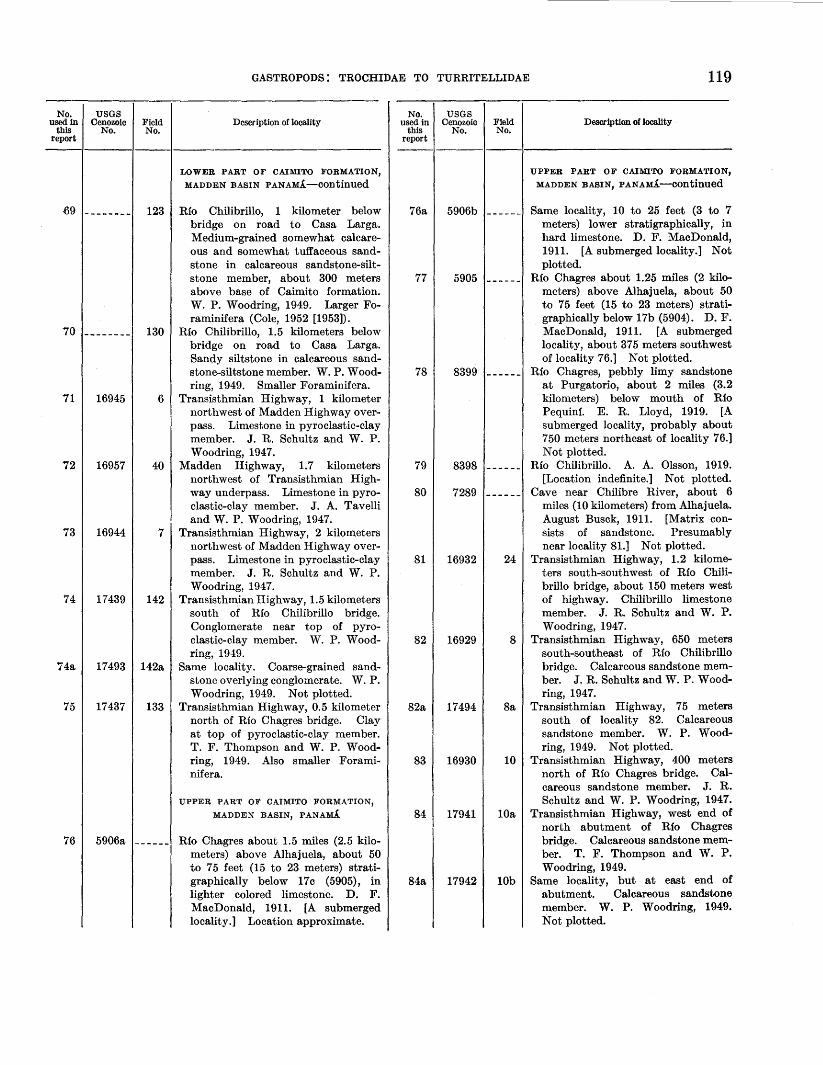
No. used in
this report
USGS Cenozoic
No. Field No.
S9 -------- 123
70 -------- 130
71 16945 6
72 16957 40
73 16944 7
74 17439 142
74a 17493 142a
75 17437 133
76 5906a ------
GASTROPODS: TROCHIDAE TO TURRITELLIDAE
Description of locality
LOWER PART OF CAIMITO FORMATION, MADDEN BASIN PANAMA-COntinued
Rio Chilibrillo, 1 kilometer below bridge on road to Casa Larga. Medium-grained somewhat calcareous and somewhat tuffaceous sandstone in calcareous sandstone-siltstone member, about 300 meters above base of Caimito formation. W. P. Woodring, 1949. Larger Foraminifera (Cole, 1952 [1953]).
Rio Chilibrillo, 1.5 kilometers below bridge on road to Casa Larga. Sandy siltstone in calcareous sandstone-siltstone member. W. P. Woodring, 1949. Smaller Foraminifera.
Transisthmian Highway, 1 kilometer northwest of Madden Highway overpass. Limestone in pyroclastic-clay member. J. R. Schultz and W. P. Woodring, 194 7.
Madden Highway, 1.7 kilometers northwest of Transisthmian Highway underpass. Limestone in pyroclastic-clay member. J. A. Tavelli and W. P. Woodring, 1947.
Transisthmian Highway, 2 kilometers northwest of Madden Highway overpass. Limestone in pyroclastic-clay member. J. R. Schultz and W. P. Woodring, 194 7.
Transisthmian Highway, 1.5 kilometers south of Rio Chilibrillo bridge. Conglomerate near top of pyroclastic-clay member. W. P. Woodring, 1949.
Same locality. Coarse-grained sandstone overlying conglomerate. W. P. Woodring, 1949. Not plotted.
Transisthmian Highway, 0.5 kilometer north of Rio Chagres bridge. Clay at top of pyroclastic-clay member. T. F. Thompson and W. P. Woodring, 1949. Also smaller Foraminifera.
UPPER PART OF CAIMITO FORMATION, MADDEN BASIN, PANAMA
Rfo Chagres about 1.5 miles (2.5 kilometers) above Alhajuela, about 50 to 75 feet (15 to 23 meters) stratigraphically below 17c (5905), in lighter colored limestone. D. F. MacDonald, 1911. [A submerged locality.] Location approximate.
No. used in
this report
76a
77
78
79
80
81
82
82a
83
84
84a
USGS Cenozoic
No. Field No.
5906b ------
5905 ------
8399 ------
8398
7289
16932 24
16929 8
17494 8a
16930 10
17941 lOa
17942 lOb
119
Description of locality
UPPER PART OF CAIMITO FORMATION, MADDEN BASIN, PANAMA-continued
Same locality, 10 to 25 feet (3 to 7 meters) lower stratigraphically, in hard limestone. D. F. MacDonald, 1911. [A submerged locality.] Not plotted.
Rio Chagres about 1.25 miles (2 kilometers) above Alhajuela, about 50 to 75 feet (15 to 23 meters) stratigraphically below 17b (5904). D. F. MacDonald, 1911. [A submerged locality, about 375 meters southwest of locality 76.] Not plotted.
Rio Chagres, pebbly limy sandstone at Purgatorio, about 2 miles (3.2 kilometers) below mouth of Rio Pequinl. E. R. Lloyd, 1919. [A submerged locality, probably about 750 meters northeast of locality 76.] Not plotted.
Rio Chilibrillo. A. A. Olsson, 1919. [Location indefinite.] Not plotted.
Cave near Chilibre River, about 6 miles (10 kilometers) from Alhajuela. August Busck, 1911. [Matrix consists of sandstone. Presumably near locality 81.] Not plotted.
Transisthmian Highway, 1.2 kilometers south-southwest of Rio Chilibrillo bridge, about 150 meters west of highway. Chilibrillo limestone member. J. R. Schultz and W. P. Woodring, 194 7.
Transisthmian Highway, 650 meters south-southeast of Rio Chilibrillo bridge. Calcareous sandstone member. J. R. Schultz and W. P. Woodring, 1947.
Transisthmian Highway, 75 meters south of locality 82. Calcareous sandstone member. W. P. Woodring, 1949. Not plotted.
Transisthmian Highway, 400 meters north of Rio Chagres bridge. Calcareous sandstone member. J. R. Schultz and W. P. Woodring, 1947.
Transisthmian Highway, west end of north abutment of Rio Chagres bridge. Calcareous sandstone member. T. F. Thompson and W. P. Woodring, 1949.
Same locality, but at east end of abutment. Calcareous sandstone member. W. P. Woodring, 1949. Not plotted.

120
No. used in
this report
85
85a
86
87
88
89
90
90a
91
92
GEOLOGY AND PALEONTOLOGY OF CANAL ZONE
USGS Cenozoic
No. Field No.
Description of locality
UPPER PART OF CAIMITO FORMATION, MADDEN BASIN, PANAMA-continued
5903 _ _ _ _ _ _ Rio Chagres, top of hill opposite Alhajuela. [Alhajuela sandstone member.] D. F. MacDonald, 1911. [For location of Alhajuela see Reeves and Ross, 1930, pl. 5.]
8385 _ _ _ _ _ _ Rio Chagres, top of hill opposite Alhajuela. [Alhajuela sandstone member.] A. A. Olsson, 1919. Same as locality 85. Not plotted.
5904 _ _ _ _ _ _ Rio Chagres, Ys to % mile (200 to 400 meters) above Alhajuela. [Alhajuela sandstone member.] D. F. MacDonald, 1911. [A submerged locality, about 400 meters north of locality 85.] Not plotted.
587 4 _ _ _ _ _ _ Rio Chagres between Alhajuela and El Vigia. [Presumably Alhajuela sandstone member.] H. Pittier, 1911. [For location of El Vigia see Reeves and Ross, 1930, pl. 5. [A submerged locality, too indefinite to plot.]
17682 143 1.6 kilometers northwest of Madden Dam, on abandoned Public Roads Administration road to powder magazine. Alhajuela sandstone member. W. P. Woodring, 1949.
16956 17 Madden Highway, 1 kilometer north-west of Madden Dam. Alhajuela sandstone member. J. R. Schultz, T. F. Thompson, and W. P. Woodring, 1947.
17683 144 1.2 kilometers south-southwest of Madden Dam, on road between Madden Highway and Transisthmian Highway. Alhajuela sandstone member. W. P. Woodring, 1949.
17684 144a 30 meters southwest of locality 90. Alhajuela sandstone member. W. P. Woodring, 1949. Not plotted.
16952 9 Transisthmian Highway, 1.3 kilome-ters southeast of Rio Chagres bridge. Alhajuela sandstone member. J. R. Schultz and W. P. Woodring, 1947.
16940 16 Madden Highway, 2 kilometers south-southeast of Madden Dam. Alhajuela sandstone member. J. R. Schultz, T. F. Thompson, and W. P. Woodring, 1947.
No. used in
this report
USGS Cenozoic
No. Field No.
93 -------- 126
94 6509 ------
94a 6510 ------
95 -------- 37
96 -------- 104
96a - - _ _ _ _ _ _ - -- - __
97 -------- 18
Description of locality
UNDIFFERENTIATED CAIMITO FORMATION, RfO CHAGRES AREA, CANAL ZONE
Trail 7 50 meters southwest of Nuevo San Juan. Coarse-grained conglomeratic pebbly sandstone. T. F. Thompson and W. P. Woodring, 1949. Larger Foraminifera.
Rio Chagres, limestone at and a little above Las Cruces. D. F. MacDonald, 1913. [A submerged locality.] Location approximate.
Rio Chagres, limestone a little below Las Cruces, on north bank of river. D. F. MacDonald, 1913. [A submerged locality a short distance south of locality 94.] Not plotted.
LOWER PART OF CAIMITO FORMATION, PACIFIC COASTAL AREA, PANAMA
Transisthmian Highway, 325 meters north of junction with Panama National Highway. Thin lens of algal limestone in tuff and tuffaceous sandstone. J. A. Tavelli and W. P. Woodring, 1947. Larger Foraminifera (Cole, 1952 [1953]).
Panama National Highway, about 175 meters northeast of junction with Transisthmian Highway. Lens of algal limestone in tuff and tuffaceous sandstone. T. F. Thompson and W. P. Woodring, 1947. Larger Foraminifera.
Borrow pit on north side of road to housing development, about 3.2 kilometers northeast of Tocumen. Fine-grained tuff. T. F. Thompson and W. P. Woodring, 1947. Larger
Foraminifera.
LOWER PART OF CAIMITO FORMATION, MADDEN HIGHWAY AREA, CANAL ZONE
Stream about 100 meters west of Madden Highway and 1.6 kilometers northeast of junction with Gaillard
High way. Limestone T. F. Thompson and W. P. Woodring, 1947. Larger Foraminifera

GASTROPODS: TROCHIDAE TO TURRITELLIDAE
No. used in
this report
98
99
99a
USGS Cenozoic
No. Field No.
16942 35a
6019 ------
6019a _____ _
Description of locality
CULEBRA FORMATION, GAILLARD CUT, CANAL ZONE
West side of Gaillard Cut, canal station 1600.5 Float from Culebra formation. T. G. Moran and W. P. Woodring, 194 7. Not plotted, same as locality 120.
Lower half of section near Las Cascades, exact horizon not known. D. F. MacDonald and T. W. Vaughan, 1911. [Presumably float near canal station 1610.] Not plotted.
Near canal station 1611. D. F. Mac-Donald and T. W. Vaughan, 1911. Also larger Foraminifera (Cole 1953a). Plotted on plate 2. [Localities 6019a to 6019g, inclusive, are located between canal stations 1606 and 1611 and are arranged in upward sequence in that order. For stratigraphic section see MacDonald, 1919, p. 537-538 and for general location see MacDonald, 1919, pl. 154. Location with reference to the canal stations are taken from manuscript structure sections prepared by MacDonald. The constructionperiod localities in Gaillard Cut presumably represent the excavated prism of rock. Those plotted are shown by the symbol for submerged localities, though many may be above the level of the canal.]
99b 6019b ______ Near canal station 1611. D. F. Mac-Donald and T. W. Vaughan, 1911. Not plotted.
99c 6019c ______ Canal station 1610. D. F. Mac-Donald and T. W. Vaughan, 1911. Not plotted.
99d 6019d ______ Canal station 1609. D. F. Mac-Donald and T. W. Vaughan, 1911. Not plotted.
99e 6019e ______ Near canal station 1608. D. F. Mac-Donald and T. W. Vaughan, 1911. Not plotted.
99f 6019f ______ Near canal station 1607. D. F. Mac-Donald and T. W. Vaughan, 1911. Also larger Foraminifera (Cole, 1953a). Not plotted.
99g 6019g ------ Canal station 1606. D. F. Mac-Donald and T. W. Vaughan, 1911. Also larger Foraminifera (Cole, 1953a). Plotted on plate 2. [Assigned by MacDonald to Emperador limestone member, but apparently represents a sandy limestone referable to the Culebra formation proper.]
• The canal stations are located along the center alinement of the canal at inter• vals of 100 feet (30.5 meters) and are numbered from the Caribbean terminus to the Pacific terminus.
No. used in
this report
99h
100
100a
100b
101
102
102a
103
104
104a
104b
105
USGS Cenozoic
No. Field No.
5857 ------
6020a _____ _
6020b ------
6020c ------
16943 34
6012a ------
6507 -------
6012b ------
16933 31
6976 ------
5863 ------
6517 ------
121
Description of locality
CULEBRA FORMATION, GAILLARD CUT, CANAL ZONE-continued
Near canal station 1610. D. F. MacDonald, 1911. Not plotted, practically same as locality 99c.
Near canal station 1614. D. F. MacDonald and T. W. Vaughan, 1911. Plotted on plate 2. [Localities 6020a to 6020c, inclusive, underlie 6019a (MacDonald, 1919, p. 538). Type locality of "Orbitolites" americana.]
Near canal station 1614. D. F. Mac. Donald and T. W. Vaughan, 1911. Not plotted.
Near canal station 1613. D. F. MacDonald and T. W. Vaughan, 1911. Also corals (Vaughan, 1919a, p. 208). Not plotted.
West side of Gaillard Cut, canal station 1619. Black clay 60 centimeters below base of limestone. T. G. Moran and W. P. Woodring, 1947. Plotted on plate 2.
Near canal station 1723. D. F. MacDonald and T. W. Vaughan, 1911. Plotted on plate 2. [For stratigraphic section including localities 6012a and 6012b see MacDonald, 1919, p. 537 and for general location see pl. 154.]
Lower part of Culebra formation about 0.25 mile (300 meters) south of Empire bridge, altitude 55 feet (17 meters). D. F. MacDonald, 1911. (Probably near canal station 1720.) Not plotted.
Near canal station 1717. D. F. MacDonald and T. W. Vaughan, 1911. Plotted on plate 2.
West side of Gaillard Cut, canal station 1730. Sandy pebble bed in almost black mudstone. T. G. Moran and W. P. Woodring, 1947. Plotted on plate 2.
Culebra (Gaillard) Cut, about midway between Empire and Culebra, about 50 feet (15 meters) below original surface. Received from George Gaillard, 1909. [Presumably near canal station 1730.] Not plotted.
Conglomerate near canal station 1731, about 0.3 mile (0.5 kilometer) below Empire bridge. D. F. MacDonald, 1911. Not plotted.
East side of canal opposite Culebra railroad station. D. F. MacDonald, 1913. [Between canal stations 1750 and 1760.] Not plotted.

122
No. used in
this report
106
107
108
108a
108b
lOSe
109
110
110a
USGS Cenozoic
No. Field No.
6012c _____ _
6012d ------
1
16951 la
4897 ------
5859
6013 ------
16886 5
6508 ------
GEOLOGY AND PALEONTOLOGY OF CANAL ZONE
Description of locality
CULEBRA FORMATION, GAILLARD CUT, CANAl, ZONE-Continued
Near canal station 1759. D. F. MacDonald and T. W. Vaughan, 1911. Plotted on place 2. [For stratigraphic sections including localities 6012a to 6012e inclusive, see MacDonald, 1919, p. 536-537 and for general locations see plate 154.]
Near canal station 1768. Calcareous sandstone. D. F. MacDonald and T. W. Vaughan, 1911. Also larger Foraminifera. [Type locality of Miogypsina cushmani.] Plotted on plate 2.
West side of Gaillard Cut, canal station 1759. Dark gray calcareous mudstone 1.5 meters above water level. See stratigraphic section, page 35 J. R. Schultz and W. P. Woodring, 1947. Smaller Foraminifera. Not plotted.
Same locality, float 7.5 meters below uppermost calcareous sandstone of Culebra formation. J. R. Schultz and W. P. Woodring, 1947. Not plotted.
East side of Culebra l Gaillard] Cut, about three-fourths mile (1.2 kilometers) northwest of Gold Hill. Sidney Paige, 1908. [Presumably near canal station 1760.] Not plotted.
West side of canal, canal station 1760 D. F. MacDonald, 1911. Not plotted.
East side of Culebra [Gaillard] Cut, opposite Culebra. Pebbly calcareous sandstone. D. F. MacDonald and T. W. Vaughan, 1911 (MacDonald, 1919, p. 536, plate 154). [Canal station 1762.] Plotted on plate 2.
East side of Gaillard Cut, canal station 17 54, about 60 meters northeast of edge of canal and about 100 meters northwest of northwest edge of Culebra Extension slide. Tuffaceous sandstone and calcareous concretions in transition zone between Culebra and Cucaracha formations. J. R. Schultz and W. P. Woodring, 1947. Plotted on plate 2.
East side of Culebra [Gaillard] Cut, canal station 1755, upper part of Culebra formation. D. F. MacDonald, 1913. Not plotted; approximately same as locality 110.
No. used in
this report
USGS Cenozoic
No. Field No.
111 -------- ------
Ill a 16887 25
lllb 16888 25a
112 16910 2
112a 16927 3
113 6011
114 5860
l.15 6505 ------
115a 6515 ------
Description of locality
CULEBRA FORMATION, GAILLARD CUT, CANAL ZONE-continued
Stanford University locality 2701, west side of Gaillard Cut, canal station 1754, altitude 140 feet (42.5 meters). T. F. Thompson, 1943. Plotted on plate 2.
West side of Gaillard Cut, canal station 17 55 and 30 meters northwestward along strike, about 45 meters southwest of edge of canal. Calcareous concretions in sandy siltstone corresponding to top of bed 13 of section on page 35. J. R. Schultz and W. P. Woodring, 1947. Not plotted; same as locality 111.
West side of Gaillard Cut, canal station 1754, from dirty sandstone brought to surface by test explosion, evidently from base of bed 13 of section on page 35. J. R. Schultz and W. P. Woodring, 1947. Not plotted; same as locality llla.
West side of Gaillard Cut, canal station 1759, about 30 meters southwest of edge of canal. Basal part of bed 13 of section on page 35. J. R. Schultz and W. P. Woodring, 1947. Plotted on plate 2.
Same locality, top of bed 13 of section on page 35. J. R. Schultz and W. P. Woodring, 1947. Not plotted.
East side of Culebra [Gaillard] Cut, near canal station 1845, between Paraiso and Gold Hill. Foraminiferal limy sandstone. D. F. MacDonald and T. W. Vaughan, 1911 (MacDonald, 1919, p. 535, pl. 154). Plotted on plate 2.
West side of Culebra [Gaillard] Cut, canal station 1847 plus 25 feet (6.2 meters). D. F. MacDonald, 1913. Plotted on plate 2.
West side of Culebra [Gaillard] Cut, near canal station 1860. Lower part of limy sandstone. D. F. MacDonald, 1913. Also larger Foraminifera: Miogypsina intermedia (Drooger, 1952, p. 36). Plotted on plate 2.
West side of Culebra [Gaillard] Cut, about one-third mile (500 meters) north [northwest] of Paraiso. D. F. MacDonald, 1913. Not plotted; apparently close to locality 115.

No. used in
this report
115b
116
117
118
118a
119
119a
GASTROPODS: TROCHIDAE TO TURRITELLIDAE 123
USGS Cenozoic
No. Field No.
Description of locality
CULEBRA FORMATION, GAILLARD CUT, CANAL ZONE-COntinued
6443 ------ A mile (1.6 kilometers) south of Culebra Cut. Ralph Arnold and D. F. MacDonald, 1913. [The locality data are indefinite, but this presumably is the collection to which MacDonald referred in a notation on his label for 6515: "Arnold took fossils from here."] Not plotted; evidently same as locality 115a.
5853 ------ West side of Culebra [Gaillard] Cut, canal station 1863. Pebbly tuffaceous sandstone about 2.5 feet (75 centimeters) thick. D. F. MacDonald, 1911. Also coral (Vaughan, 1919a, p. 208, cited as locality 5863). Plotted on plate 2.
EMPERADOR LIMESTONE MEMBER OF CULEBRA FORMATION, CANAL ZONE
6014 ------ Limestone on street near railroad at Empire, 0.25 or 0.3 mile (400 or 500 meters) north-northwest of railroad station. D. F. MacDonald and T. W.• Vaughan, 1911 (MacDonald, 1919, pl. 154). Plotted on plate 2; location approximate, based on MacDonald's plotted location.
6016 ------ Old quarry 0.3 mile (500 meters) westnorthwest of Empire. D. F. MacDonald and T. W. Vaughan, 1911 (MacDonald, 1919, pl. 154). Also corals (Vaughan, 1919a, p. 208-209). Plotted on plate 2, location approximate, based on MacDonald's plotted location.
6444 ------ Quarry at Empire. Ralph Arnold, 1913. Not plotted; presumably same as locality 118 or nearby.
5858 -- _ _ _ _ Lower part of upper limestone near tower N. Thought to be equivalent of fossil lot 6a [5856], but bed is not directly traceable. D. F. MacDonald, 1911. [Tower N was a signal tower on the original line of the Panama Railroad near Las Cascades. The right-of-way, still recognizable at some places as a low artificial ridge, immediately adjoins the left bank of the canal in the Las Cascades area. Locality 119 presumably is near locality 120.] Not plotted.
5866 ------ Upper limestone bed near tower N. Same as fossil lot 6c [5858]. D. F. MacDonald, 1911. Also larger Foraminifera (Cole, 1953a). Not plotted; same as locality 119.
No. used 1n
this report
USGS Cenozoic
No. Field No.
Description of locality
EMPERADOR LIMESTONE MEMBER OF CULEBRA FORMATION, CANAL ZONEcontinued
119b 6669 _ _ _ _ _ _ Upper bed of limestone near tower N. D. F. MacDonald, 1913. Not plotted; same as locality 119.
119c 5856 _ _ _ _ _ _ Highest limestone near tower N, be-
120 16958
tween towers M and N. D. Ji'. MacDonald, 1911. Not plotted; near locality 119.
35 West side of Gaillard Cut, canal station 1600. Calcareous siltstone and limestone. T. G. Moran and W. P. Woodring, 1947. Plotted on plate).
120a 8043 ______ Las Cascades [west side of Gaillard
121 16941
Cut, canal station 1600]. Limestone. W. P. Woodring, 1917. Not plotted; same as locality 120.
34a West side of Gaillard Cut, canal sta-tion 1619. Limestone overlying clay and siltstone. T. G. Moran and W. P. Woodring, 1947. Not plotted; same as locality 101.
CUCARACHA FORMATION, CANAL ZONE
122 6012e _ _ _ _ _ _ East side of Gaillard Cut, one-eighth
123 16955
124 --------
mile (200 meters) north of Gold Hill [near canal station 1775]. Black carbonaceous shale. D. F. MacDonald and T. W. Vaughan, 1911 (MacDonald, 1919, p. 535-536). Plotted on plate 2.
LA BO<;A MARINE MEMBER OF PANAMA FORMATION, CANAL ZONE
33 East of Gaillard Cut, 200 meters up Rio Masambi from east bank of canal. Rio Masambi enters the canal at canal station 1696. Coralliferous limestone at base of La Boca. member. T. G. Moran and W. P. Woodring, 1947. Plotted on plate 2.
32 East side of Gaillard Cut, canal station 1702. Dark, almost black mudstone. T. G. Moran and W. P. Woodring, 1947. Smaller Foraminifera. Plotted on plate 2.
125 5852 _ _ _ _ _ _ East side of Gaillard Cut near Empire bridge. [The Empire bridge was located approximately at canal station 1709.] D. F. MacDonald, 1911. Plotted on plate 2; location approxi-mate.

124
No. used in I this report
126
127
127a
127b
128
129
USGS Cenozoic
No. Field No.
6267 ------
6018 ------
6268 ------
6336 ------
16947 4
16954 14a
GEOLOGY AND PALEONTOLOGY OF CANAL ZONE
Description of locality
LA BOCA MARINE MEMBER 01!' PANAMA FORMATION, CANAL ZONE-Continued
Relocated line of Panama Railroad, a little south of station at New Culebra, about opposite Catholic church at Culebra, half a mile (750 meters) northwest of 6268. Same formation as 6268 and 6018. Yellowish spherically weathering limy sandstone. D. F. MacDonald,1912. [Possibly the unnumbered fossil locality west of 6018 on MacDonald's map (MacDonald, 1919, pl. 154)). Plotted on plate 2; location approximate.
Cut on relocated line of Panama Railroad opposite Empire, near road from Empire to Las Cascades Plantation. Tuffaceous calcareous(?) sandstone. D. F. MacDonald and T. W. Vaughan, 1911 (MacDonald, 1919, pl. 154). Plotted on plate 2; location approximate.
Relocated line of Panama Railroad, junction with track leading down to Canal between Gold Hill and Empire bridge. Yellowish spherically weathering limy sandstone. D. F. MacDonald, 1912, 1913. Not plotted; presumably near locality 127.
Relocated line of Panama Railroad, junction with track leading down to Canal between Gold Hill and Empire bridge. Light-colored tuff and kaolinitic beds overlying light gray and buff spherically weathering sandstone. Hill's Panama formation. D. F. MacDonald, 1913. Not plotted; same as locality 127a, but from overlying tuff.
Abandoned quarry on north side of Old Gaillard Highway, 230 meters southwest of New Gaillard Highway entrance to Summit Experimental Gardens. Ma.ssive calcareous sandstone. J. R. Schultz and W. P. Woodring, 1947. Plotted on plate 2.
South side of New Gaillard Highway at milepost 11, about 400 meters northwest of Madden Highway turnoff. Relatively soft yellowish coralliferous limestone with marly partings at base of La Boca marine member of Panama formation. J. R. Schultz, T. F. Thompson, and W. P. Woodring, 1947. Also corals.
No. used in
this report
129a
130
131
131a
132
USGS Cenozoic
No. Field No.
16953 14
6010 ------
6256 ------
6257 ------
16939 57
Description of locality
LA BOCA MARINE MEMBER OF PANAMA FORMATION, CANAL ZONE-Continued
South side of New Gaillard Highway, 100 meters southeast of locality 129. Hard grayish limestone overlying limestone at locality 129, but part of same unit. J. R. Schultz, T. F. Thompson and W. P. Woodring, 1947. Not plotted.
Near Canal station 1910, northwest of Pedro Miguel Locks. [About 600 meters northwest of north end of Pedro Miguel Locks. J Mudstone. D. F. MacDonald and T. W. Vaughan, 1911 (MacDonald, 1919, p. 534, pl. 154). Also smaller Foraminifera; type locality of Siphogenerina transversa. Plotted on plate 2.
One-eighth mile (200 meters) east of wagon road at Bald Hill, 1.5 miles (2.4 kilometers) south of Miraflores. Limestone. D. F. MacDonald, 1912. Corals (Vaughan, 1919a, p. 209). Presumably near locality 132. [Bald Hill is identified as the currently unnamed hill immediately northeast of Red Tank. For a section at Bald Hill see MacDonald (1919, p. 534). His manuscript on the geology of Panama includes a sketch of the strata at this locality labeled, in his writing, "Section at Bald Hill, a mile (1.6 kilometers) south [southeast] of Pedro Miguel and 100 yards (100 meters) east of the main road." The locality data just quoted approximately fit the specified identification of Bald Hill. The data in the Cenozoic register evidently are erroneous.] Not plotted.
Practically same limestone bed as 6256, but about 10 feet (3 meters) higher stratigraphically. D. F. MacDonald, 1912. Also larger Foraminifera (Cole, 1953a). Not plotted.
1.6 kilometers north-northwest of north end of Miraflores Locks, on incinerator road leading off Gaillard Highway on west side of middle arm of Miraflores Lake. Fine-grained tuff and tuffaceous siltstone. T. F. Thompson and W. P. Woodring, 1947.

No. used in
this report
132a
133
134
135
136
USGS Cenozoic
No. Field No.
6255 ------
6237 ------
17691 102
17690 101
16912 12
136a _____________ _
137 16911 26
137a _____________ _
138 16909 27
413788-57--9
GASTROPODS: TROCHIDAE TO TURRITELLIDAE 125
Description of locality
LA BOCA MARINE MEMBER OF PANAMA FORMATION, CANAL ZONE-continued
Fossiliferous limy sandstone % mile (750 meters) south of Miraflores station, on wagon road to Panama. D. F. MacDonald, 1912. Larger Foraminifera (Cole, 1953a). Type locality of Lepidocyclina miraflorensis. Apparently submerged. Not plotted.
Limestone in swamp north of Ancon Hill, about H mile ( 400 meters) south of Diablo Ridge. D. F. MacDonald, 1912. [The swamp and any outcrops in it are now covered with fill.] Not plotted.
LOWER PART OF GATUN FORMATION
Road from Sabanita to Maria Chiquita, cut on south side of ridge, 1.3 kilometers south-southwest of Maria Chiquita, Panama. Silty sandstone. W. P. Woodring, 1949.
Cut on west side of Transisthmian Highway at south edge of Sabanita, Panama. Ferrugineous concretions in sandstone interbedded with conglomerate. W. P. Woodring, 1949.
North side of Transisthmian Highway, knoll about 30 meters north of highway, 1.2 kilometers northwest of Sabanita, Panama. Silty finegrained sandstone. T. F. Thompson and W. P. Woodring, 1947.
Same locality. Stanford University locality 2611. Latitude 9°21' N., plus 1,100 feet (335 meters), longitude 79°49' W. T. F. Thompson, 1942. Not plotted.
South side of Transisthmian Highway, 1. 7 kilometers northwest of Sabanita, Panama. Soft silty fine-grained sandstone. W. P. Woodring, 1947.
Same locality. Stanford University locality 2655. Latitude 9°21' N., plus 3,000 feet (915 meters), longitude 79°49' W., plus 1,100 feet (335 meters). T. F. Thompson, 1942. Not plotted.
North and south sides of Transisthmian Highway, 1. 6 kilometers northeast of Canal Zone boundary, Panama. Soft silty fine-grained sandstone. W. P. Woodring, 1947.
No. used in
this report
USGS Cenozoic
No. Field No.
138a _____________ _
139 6667 ------
Description of locality
LOWER PART OF GATUN FORMATIONcontinued
Same locality. Stanford University locality 2656. Latitude 9°21' N., plus 5,000 feet (1,525 meters), longitude 79°50' W., plus 1,000 feet (300 meters). T. F. Thompson, 1942. Not plotted.
Steep ridge about 2.5 miles (4 kilometers) northeast [north] of Monte Lirio, overlooking and about 250 feet above Gatun Lake, Canal Zone. D. F. MacDonald, 1913. [Southern part of Zorra Island.] Location approximate.
MIDDLE PART OF GATUN FORMATION, EASTERN AREA
140 ____ .._ _________ Stanford University locality 2708.
141 16948
Latitude 9°21' N., plus 4,200 feet (1,280 meters), longitude 79°51' W., plus 800 feet (245 meters). T. F. Thompson, 1943. [500 meters northwest of intersection of Transisthmian Highway and Canal Zone boundary, Canal Zone.]
28 About 100 meters northwest of Trans-isthmian Highway, on secondary road entering Highway 600 meters west of Canal Zone boundary, Canal Zone. Medium-grained sandstone. W. P. Woodring, 1947.
142 _ _ _ _ _ _ _ _ _ _ _ _ _ _ Stanford University locality 2698. Northeast of Fort Gulick, latitude 9°20' N., longitude 79°52' W., plus 1,010 feet (310 meters). T. F. Thompson, 1943. [1.1 kilometers southeast of junction of Transisthmian Highway and road to Fort Gulick, Canal Zone.}
143 6030 _ _ _ _ _ _ Relocated Panama Railroad, 85-foot (25 meter) cut 1.5 to 2 miles (2.4 to 3.2 kilometers) east of Camp Cotton, Canal Zone. D. F. MacDonald and T. W. Vaughan, 1911 (MacDonald, 1919, p. 542, pl. 154).
144 6029a _ _ _ _ _ _ Relocated Panama Railroad, big cut H to H mile (0.6 to 0.8 kilometers) northeast of Camp Cotton, Canal Zone. D. F. MacDonald and T. W. Vaughan, 1911 (MacDonald, 1919, p. 542, pl. 154).

126 GEOLOGY AND PALEONTOLOGY OF CANAL ZONE
No. used in
this report
USGS Cenozoic
No. Field No.
Description of locality
MIDDLE PART OF GATUN FORMATION, EASTERN AREA-continued
144a 6029b ______ Same locality, from overlying 32 to 42 feet (10 to 13 meters). D. F. MacDonald and T. W. Vaughan, 1911 (MacDonald, 1919, p. 542). Not plotted.
144b 6335 ------ Relocated Panama Railroad, lowest bed in big cut about ~ mile (0.8 kilometer) east of Camp Cotton, Canal Zone. Same locality as lot 17 of 1911 [6029a]. D. F. MacDonald, 1913. Same as locality 144. Not plotted.
144c 6235 _ _ _ _ _ _ Relocated Panama Railroad, 3. 5 miles (5.6 kilometers) out from Gatun, Canal Zone. Above fuller's earth beds. D. F. MacDonald, 1912. [Apparently same as locality 144a.] Not plotted.
144d 6334 _ _ _ _ _ _ Relocated Panama Railroad, big curved cut about 1 mile (1.6 kilometers) east of Camp Cotton, Canal Zone. Above fuller's earth beds. D. F. MacDonald, 1913. (Probably close to locality 144a.] Not plotted.
145 6031 _ _ _ _ _ _ Relocated Panama Railroad, ~ mile (0.8 kilometer) west of Camp Cotton, Canal Zone. Basal part of section; conglomerate and 1 foot above conglomerate. D. F. MacDonald and T. W. Vaughan, 1911 (MacDonald, 1919, p. 543, pl. 154).
146 5845 _ _ _ _ _ _ Quebrancha Hills overlooking Gatun Lake, 1.5 miles (2.4 kilometers) northeast (east-southeast] of Gatun, Canal Zone. D. F. MacDonald, 1911. [Presumably in railroad cut.] Location approximate.
147 6033a_ ______ Panama Railroad, about 3,500 feet (1,065 meters) southeast of Gatun railroad station, Canal Zone. D. F. MacDonald and T. W. Vaughan, 1911 (MacDonald, 1919, p. 543, pl. 154).
147a 6033b ------ Same locality, from overlying 4 feet (1.2 meters). D. F. MacDonald and T. W. Vaughan, 1911 (MacDonald, 1919, p. 543). Not plotted.
147b 6033c _ _ _ _ _ _ Same locality, from overlying 15 to 20 feet (4.5 to 6 meters). D. F. MacDonald and T. W. Vaughan, 1911 (MacDonald, 1919, p. 543). Not plotted.
147c 6003 ------ Same locality and bed as locality 147. D. F. MacDonald, 1911 (MacDonald, 1919, p. 543). Not plotted.
No. used in
this report
147d
147e
147f
147g
147h
147i
147j
148
149
150
150a
151
152
USGS Cenozoic
No. Field No.
Description of locality
MIDDLE PART OF GATUN FORMATION, EASTERN AREA-continued
6004 ------ Same locality, but higher stratigraphically. D. F. MacDonald, 1911. Not plotted.
6005 _ _ _ _ _ _ Same locality, but higher stratigraphically. D. F. MacDonald, 1911. Not plotted.
6006 _ _ _ _ _ _ Same locality, but higher stratigraphically. D. F. MacDonald, 1911. Not plotted.
5899 Highest fossil-bearing beds, Que-brancha Hills, ~ mile (1.2 kilometers) out from Gatun, Canal Zone. D. F. MacDonald, 1911. Probably same as locality 147b. Not plotted.
6442 _ _ _ _ _ _ Half a mile (7 50 meters) south [southeast] of Gatun, Canal Zone. Ralph Arnold and D. F. MacDonald, 1913. [Probably at or near locality 147.] Not plotted.
8376 _ _ _ _ _ _ Panama Railroad, southeast of Gatun, station 6 plus 20, Canal Zone. A. A. Olsson, 1918. [Probably near locality 147.] Not plotted.
8379 _ _ _ _ _ _ Panama Railroad, southeast of Gatun, station 4A, Canal Zone. A. A. Olsson, 1918. [Probably near locality 147.] Not plotted.
8380 _ _ _ _ _ _ Lower Gatun along Panama Railroad between Monte Lirio and Gatun, station 4, Canal Zone. A. A. Olsson, 1918. Echinoid. Location indefinite; not plotted.
8381 _ _ _ _ _ _ Panama Railroad, southeast of Gatun, station C, Canal Zone. A. A. Olsson, 1918. Locality indefinite; not plotted.
8377 _ _ _ _ _ _ Panama Railroad, first cut south of Gatun, Canal Zone. A. A. Olsson, 1918.
10997 _ _ _ _ _ _ Panama Railroad, high cut about 0.4 mile (650 meters) southeast of Gatun railroad station, Canal Zone. W. P. Woodring, 1923. [Same as locality 150.] Not plotted.
8388 _ _ _ _ _ _ Gatun, station B, Canal Zone. Lower Gatun, lower Turritella altilira zone. A. A. Olsson, 1918. [In Gatun area, but location indefinite.] Not plotted.
8483 _ _ _ _ _ _ Gatun area, station B, Canal Zone. A. A. Olsson, 1918. Location indefinite; not plotted.

''No. used in
this1 report
153
USGS Cenozoic
No.
16950
Field No.
47
153a _ _ _ _ _ _ _ _ _ ____ _
154 16935 ------
155 -------- ------
155a 16970 _____ _
155b 16949 49
155c 16915 50
156 16928 13
GASTROPODS: TROCHIDAE TO TURRITELLIDAE 127
Description of locality
MIDDLE PART OF GATUN FORMATION, EASTERN AREA-continued
Gatun Third Locks excavation, plug at south end of excavation, Canal Zone. Unit 1 of section on p. 44; silty to marly sandstone. T. F. Thompson and W. P. Woodring, 1947.
Stanford University locality 2657. Gatun Third Locks excavation, south end of excavation, Canal Zone. Latitude 9°15' N., plus 5,600 feet (1,705 meters), longitude 79°54' W., plus 5,150 feet (1,570 meters). Unit 3 of section on p. 44; mediumgrained to very fine-grained sandstone. T. F. Thompson, 1942. 425 feet (130 meters) north of locality 153. Not plotted.
Gatun Third Locks excavation, west side of excavation 0.6 mile (1 kilometer) north of Gatun Lake, Canal Zone. Unit 10 of section on p. 44; conglomerate. T. F. Thompson and W. P. Woodring, 1947.
Stanford University locality 2653. Gatun Third Locks excavation, Canal Zone. Latitude 9°16' N., plus 4, 700 feet (1,430 meters), longitude 79°54' W., plus 5,800 feet (1,770 meters). Units 11 and 12 of section on p. 44; fine-grained sandstone and marly siltstone. T. F. Thompson, 1942.
Spoil dump of Gatun Third Locks excavation, Canal Zone. T. F. Thompson, 1945. [Essentially same stratigraphic range as locality 155.] Not plotted.
Spoil dump of Gatun Third Locks excavation, Canal Zone. T. F. Thompson and W. P. Woodring, 194 7. Essentially same stratigraphic range as locality 155. Not plotted.
Gatun Third Locks excavation, east side of excavation 1 mile (1.6 kilometers) north of Gatun Lake, Canal Zone. Turritella-bearing marly siltstone in lower part of unit 12b of section on p. 44. T. F. Thompson and W. P. Woodring, 1947. Included in stratigraphic range of locality 155. Not plotted.
Jadwin Road at crossing of Panama Railroad, northern part of Gatun, Canal Zone. Turritella-bearing marly siltstone. T. F. Thompson and W. P. Woodring, 1947.
No. used in
this report
157
158
159
159a
159b
159c
160
160a
161
161a
161b
161c
161d
USGS Cenozoic
No.
16926
2682
5211
5414
Field No.
Description of locality
MIDDLE PART OF GATUN FORMATION, EASTERN AREA-continued
56 Westernmost cut on Panama Railroad cutoff south of Fort Davis, 1.2 miles (1.9 kilometers) northeast of Gatun railroad station, Canal Zone. Siltstone and silty sandstone. W. P. Woodring, 194 7.
17 Vamos a Vamos, Canal Zone. R. T. Hill, 1895. [Locality erroneous; it apparently should be "French Canal, 10.5 kilometers from Col6n"; that is, near Gatun. See remarks under locality 173a.] Not plotted.
Lock site at Gatun, Canal Zone. W. S. Standifer, 1909. Not plotted.
Upper lock site at Gatun, Canal Zone. W. J. Ergenzinger, 1910(?). Not plotted.
6273 _ _ _ _ _ _ Lock site [at Gatun ], Canal Zone, 10 to 50 feet (3 to 15 meters) below surface. Dan St. Clair, 1912(?).
5662 Not plotted.
Near Gatun Dam site, Canal Zone. D. F. MacDonald, 1911. Not plotted.
5846 _ _ _ _ _ _ Near spillway at Gatun Dam site, Canal Zone. D. F. MacDonald, 1911.
8369 Chagres Dam spillway, station 5, Canal Zone. Just above contact with Caimito sandstone. A. A. Olsson, 1918. [At or near locality 160.] Not plotted.
MIDDLE PART OF GATUN FORMATION, WESTERN AREA
8365 _ _ _ _ _ _ Railroad cuts west of Gatun Dam, station C, Canal Zone. A. A. Olsson, 1918. Location approximate.
8395 _ _ _ _ _ _ Railroad cuts west of Gatun Dam, station D, Canal Zone. A. A. Olsson, 1918. [Near locality 161.] Not plotted.
8375 _ _ _ _ _ _ Cuts west of Gatun Dam, station 4 plus 5, Canal Zone. A. A. Olsson, 1918. [Near locality 161.] Not plotted.
8382 _ _ _ _ _ _ Railroad cuts west of Gatun Dam, station B, Canal Zone. A. A. Olsson, 1918. [Near locality 161.] Not plotted.
8366 _ _ _ _ _ _ Cuts west of Gatun Dam, station 3a, Canal Zone. A. A. Olsson, 1918. [Near locality 161.] Not plotted.

128
No. used in
this report
162
162a
163
164
165
166
167
168
169
170
170a
USGS Cenozoic
No.
8396
8359
8394
8391
8372
8357
8374
8361
8360
8368
8411
Field No.
------
------
------
------
------
------
------
------
------
------
------
GEOLOGY AND PALEONTOLOGY OF CANAL ZONE
Description of locality
MIDDLE PART OF GATUN FORMATION, WESTERN AREA-Continued
Lower trail on west side of Rio Chagres, a mile (1.6 kilometers) north [west-northwest] of Gatun Dam, Canal Zone. A. A. Olsson, 1918. Loca-tion approximate.
Lower trail on west side of Rio Chagres northwest of Gatun Dam, Canal Zone. D. D. Condit and A. A. Olsson, 1918. [Probably near lo-cality 162.] Not plotted.
Trail on east side of Rio Chagres, halfway between Gatun Dam and mouth of river, station 2, Canal Zone. A. A. Olsson, 1918. Loca-tion approximate. Represents upper part of formation.
Bluff on west side of Gatun Lake, Canal Zone. D. D. Condit, 1918. Location indefinite; not plotted.
Headwaters of Rfo Piiia, station 14b, Canal Zone. Middle Gatun. A.A. Olsson, 1918. Location approxi-mate.
Piiia triangulation station region, sta-tion 6c, Canal Zone. Base of upper Gatun .. D. F. MacDonald and A. A. Olsson, 1918. Location approxi-mate.
Tick Creek, station 56B, Canal Zone. Top of middle Gatun, oyster bed. A. A. Olsson, 1918. Location ap-proximate.
Tick Creek, station 27, Canal Zone. Base of upper Gatun. A. A. Olsson, 1918. [Downstream from locality 167.] Not plotted.
West of Gatun Lake, Tick Camp sheet, station 6c, Canal Zone. A. A. Olsson, 1918. [Probably near lo-cality 167.] Location indefinite; not plotted.
Headwaters of Quebrada Caiia [Rio Caiio Quebrado], station 4a, Panama. Base of upper Gatun. A. A. Olsson, 1918. Location approximate.
Headquarters of Quebrada Caiia [Rfo Caiio Quebrado], station 2 plus 50, Panama. A. A. Olsson, 1918. Near locality 170. Not plotted.
No. used in
this report
171
172
173
173a
174
175
176
176a
177
USGS Cenozoic
No.
--------
6035
--------
--------
2688 2690
8410
8358
8409
--------
Field No.
------
------
------
48
29 49
------
------
------
------
Description of locality
UPPER PART OF GATUN FORMATION, EASTERN AREA
Stanford University locality 2707. Drainage ditch 500 feet (150 meters) west of French Canal, Canal Zone. Latitude 9°17' N., plus 3,500 feet (1,065 meters), longitude 79°55' W., plus 4,000 feet (1,220 meters). T. F. Thompson, 1943.
Mindi Hill cut, near bottom of canal, Canal Zone. D. F. MacDonald and T. W. Vaughan, 1911 (MacDonald, 1919, p. 544, pl. 154). A submerged locality.
Stanford University locality 2654. Panama Railroad realignment [Third Locks realignment] cut about 7~ mile (1 kilometer) north of north end of Gatun Third Locks excavation, Canal Zone. Latitude 9°18' N., longitude 79°55' W., plus 200 feet (60 meters). T. F. Thompson, 1942.
[French Canal] 10.5 kilometers from Col6n, Canal Zone. R. T. Hill, 1895. [According to Dall (Hill, 1898, p. 271), Hill's no. 48 represents Hill's Monkey Hill beds. The locality record probably should read 6 kilometers from Col6n. See remarks under locality 158.] Not plotted.
Deviation [Diversion] cut south of Monkey Hill [Mount Hope], Canal Zone. R. T. Hill, 1895. Location approximate.
Cuts on north [west] side of French Canal [East Diversion], Mount Hope, Canal Zone. A. A. Olsson, 1918. Location approximate.
Road bordering French Canal [East Diversion], near Mount Hope, Canal Zone. A. A. Olsson, 1918. Location approximate.
Road on south [east] side of French Canal [East Diversion], Canal Zone. A. A. Olsson, 1918. [Probably near locality 176.] Not plotted.
Monkey Hill [Mount Hope], near Gatun, Canal Zone. J. Rowell, 1857 and possibly later. [Some specimens have early Smithsonian Institution catalog numbers, but most have later U. S. National Museum numbers.]

GASTROPODS: TROCHIDAE TO TURRITELLIDAE 129
I No. j' USGS
used in
1
Cenozoic this No.
report --------
Field No.
Description of locality
UPPER PART OF GATUN FORMATION, EASTERN AREA-Continued
177a 4895 _____ _ Mount Hope, west side of Panama Railroad, Canal Zone. Ernest Howe, 1908. [Essentially same as locality 177.] Not plotted.
177b 5854 ------ Mount Hope, west side of Panama Railroad near oil tanks, Canal Zone. D. F. MacDonald, 1911. [Essentially same as locality 177.] Not plotted.
177 c 5855 - - - - - - [West side of Panama Railroad] opposite Mount Hope Cemetery, Canal Zone. D. F. MacDonald, 1911. [Essentially same as locality 177.] Not plotted.
177d 6036 ------ Mount Hope, about Ys mile (270 meters) south of railroad station, Canal Zone. D. F. MacDonald and T. W. Vaughan, 1911 (MacDonald, 1919, p. 544, pl. 154). [Essentially same as locality 177.] Not plotted.
178 -------- ------ Stanford University locality 2672.
179
180
181
182
182a
Old quarry % mile (1 kilometer) west-southwest of junction of Transisthmian Highway and Coco Solo road, Canal Zone. Latitude 9°20' N., plus 2,000 feet (600 meters), longitude 79°53' W., plus 4,000 feet (1,200 meters). T. F. Thompson, 1943.
UPPER PART OF GATUN FORMATION, WESTERN AREA
8413 _ _ _ _ _ _ Upper edge of Chilas [ Chila] village, Rio Indios [Indio], Panama. D. D. Condit and Strohm, 1918. Plotted on figure 3.
8362 _ _ _ _ _ _ Caribbean coast 8 miles (13 kilometers) west of Rio Indios [Indio], Panama. Strohm, 1918. Plotted on figure 3.
8364 _ _ _ _ _ _ Caribbean coast 10 miles (16 kilometers) west of Rio Indios [Indio], Panama. Strohm, 1918. Between locality 180 and Rio Miguel. Not plotted.
8408 _ _ _ _ _ _ Caribbean coast east of San Miguel [Rio Miguel], station 25 plus 600 feet (150 meters), Panama. E. R. Smith, 1918. [Between locality 180 and Rio Miguel.] Not plotted.
8488 _ _ _ _ _ _ Caribbean coast east of San Miguel [Rio Miguel], station 25 plus 400 feet (120 meters), Panama. E. R. Smith, 1918. [Between locality 180 and Rio Miguel.] Not plotted.
No. used in
this report
183
184
185
186
186a
186b
USGS Cenozoic
No. Field No.
Description of locality
Ul'PER PART OF GATUN FORMATION, WESTERN AREA-Continued
8487 _ _ _ _ _ _ Caribbean coast east of Rio San Miguel [Rio Miguel], station 4 plus 40 feet (12 meters), Panama. E. R. Smith, 1918. [Between locality 180 and Rio Miguel.] Not plotted.
8363 _ _ _ _ _ _ Rio San Miguel [Rio Miguel] 4 miles (6.5 kilometers) above mouth, Panama. Strohm, 1918. Plotted on figure 3.
8383 _ _ _ _ _ _ Caribbean coast, west of Rio San Miguel [Rio Miguel], station 26 plus 100 (30 meters), Panama. E. R. Smith, 1918. Location approximate. Plotted on figure 3.
TORO LIMESTONE MEMBER OF CHAGRES SANDSTONE
60:37 _ _ _ _ _ _ Coquina limestone at Toro Point, Canal Zone. D. F. MacDonald and T. W. Vaughan, 1911 (MacDonald, 1919, p. 545).
6675 ______ Coquina rock at Toro Point, Canal Zone. D. F. MacDonald, 1913. [Same as locality 186.] Not plotted.
8440 ______ Toro Point, Canal Zone. D. F. Mac-Donald and A. A. Olsson, 1918. [Same as locality 186.] Not plotted.
187 -------- ------ Stanford University locality 2700. Be-
188 16946 51
188a 5909 _____ _
188b 6034 ------
188c 6668 _____ _
tween Limon Bay and Rio Chagres, Canal Zone. Latitude 9°18' N., plus 1,000 feet (300 meters), longitude 79°56' W. T. F. Thompson, 1943.
Rio Pifia road, 0.9 mile (1.4 kilometers) southwest of Gatun Dam spillway bridge, Canal Zone. Coquina limestone. T. F. Thompson and W. P. Woodring, 194 7.
Limestone overlying Gatun formation west of Gatun Dam, Canal Zone. D. F. MacDonald, 1911. [Approximately same as locality 188.] Not plotted.
Top of ridge at west end of Gatun Dam, Canal Zone. D. F. MacDonald and T. W. Vaughan, 1911 (MacDonald, 1919, p. 543). [Approximately same as locality 188.] Not plotted.
Coquina limestone on crest of ridge west of Gatun Dam, Canal Zone. D. F. MacDonald, 1913. [Approximately same as locality 188.] Not plotted.

130
No. used in
this report
188d
188e
189
190
191
192
193
194
195
196
197
198
USGS Cenozoic
No. Field No.
6236 ------
8442 ------
8392 ------
8402 ------
8371 ------
8404 ------
8401 ------
8373 ------
8403 ------
8405 ------
8482 ------
8484 ------
GEOLOGY AND PALEONTOLOGY OF CANAL ZONE
Description of locality
TORO LIMESTONE MEMBER OF CHAGRES SANDSTONE-continued
Borrow pit west of Gatun Dam, Canal Zone. Limestone overlying Gatun formation. D. F. MacDonald, 1912. [Approximately same as locality 188.] Not plotted.
Hill southwest of Gatun locks, Canal Zone. A. A. Olsson, 1918. [Approximately same as locality 188.] Not plotted.
Rio Indio trail from Gatun to Chagres, Canal Zone. A. A. Olsson, 1918. Location approximate.
Tick Creek, station 4H, Panama(?). Anomia zone. A. A. Olsson, 1918. [Probably downstream from locality 167.] Not plotted.
Headwaters of Rio Piiia, station 46, Canal Zone. Anomia zone. E. R. Lloyd and G. M. Bevier, 1918. Location approximate.
Piiia triangulation station region, station 0, Canal Zone. Anomia zone. D. F. MacDonald and A. A. Olsson, 1918. Location approximate.
200 feet (60 meters) below and 500 feet (150 meters) southeast of Ramos triangulation station, Canal Zone. Anomia zone. A. A. Olsson, 1918. Location approximate.
Trail from Gatun Dam to Escobal, station 28, Canal Zone. Anomia zone limestone. G. M. Bevier and A. A. Olsson, 1918. Location indefinite; not plotted.
Trail from Escobal to Lagarto, station 1, Panama. Anomia zone. A.f A. Olsson, 1918. [Possibly along Rio Arriero.] Not plotted.
Trail from Escobal to Lagarto, station 6, Panama. Anomia zone limestone. A. A. Olsson, 1918. [Possibly along Rio Arriero.] Not plotted.
CHAGRES SANDSTONE PROPER
Rio Indio area, station 4, Canal Zone. A. A. Olsson, 1918. [This Rio Indio is the minor tributary of Rio Chagres west and northwest of Gatun Dam; unnamed on plate 1.] Location approximate.
Piiia region, station 33, Canal Zone. A. A. Olsson and G. M. Bevier, 1918. [Probably along Rio Piiia.j Not plotted.
No. used in
this report
USGS Cenozoic
No. Field No.
199 8443 - - - - - -
200 8406 - - - - - -
201 8439 - - - - - -
202 8389 ------
203 8436 ------
204 8441
205 8387 ------
206 16937 52
206a _ _ _ _ _ _ _ _ _ ____ _
206b 16938 52a
207 16969 - - - - - -
208 8437 ------
Description of locality
CHAGRES SANDSTONE PROPER-COntinued
Pifia region, station 34, Canal Zone. A. A. Olsson and G. M. Bevier, 1918. [Probably along Rfo Piiia.] Not plotted.
Headwaters of Quebrada Caiia [Rio Caiio Quebrado], station 32 plus 100 feet (30 meters), Panama. A. A. Olsson, 1918. Location approximate.
Quebrada Caiia [Rio Cafio QuebradoJ region, station 2 plus 200 feet (60 meters), Panama. A. A. Olsson, 1918. [Probably along Rio Caiio Quebrado or Rio Arriero.] Not plotted.
Trail from Escobal to Lagarto, station 2 plus 100 feet (30 meters). A. A. Olsson, 1918. [Probably along Rio Caiio Quebrado or Rio Arriero.] Not plotted.
Rio Pavolina, a tributary of Rio Lagarto, station 4, Panama. A. A. Olsson, 1918. Location indefinite; not plotted.
1.5 miles (2. 4 kilometers) east [northeast] of mouth of Rio Chagres, 1,000 feet (300 meters) from ocean, Canal Zone. A. A. Olsson, 1918.
Caribbean coast between Rio Chagres and Pifia, near Piiia, Canal Zone. A. A,. Olsson, 1918. Not plotted.
Caribbean coast near mouth of Rio Pfiia· road cut on west side of river about 90 meters west of road fork, Panama. Massive fine-grained sandstone. T. F. Thompson and W. P. Woodring, 1947.
Stanford University locality 2699. Same locality. Latitude 9°16' N., plus 4,200 feet (1,280 meters), longitude 80°3' W. T. F. Thompson, 1943. Not plotted.
Caribbean coast near mouth of Rio Pifia; road cut about 90 meters west of locality 206, Panama. Massive fine-grained sandstone. T. F. Thompson and W. P. Woodring, 1947. Not plotted.
Caribbean coast; road cut on south side of Rio Lagarto about 230 meters south of Lagarto, Panama. S. M. Jones, 1947.
Caribbean coast at mouth of Rfo Indios [Indio], station 5, Panama. A. A. Olsson, 1918. Plotted on figure 3.

REFERENCES CITED 131
REFERENCES CITED
Anderson, F. M., 1929, Marine Miocene and related deposits of north Colombia: Calif. Acad. Sci. Proc., 4th ser., v. 18, no. 4, p. 73-213, pls. 8-23.
Anton, H. E., 1839, Verzeichniss der Conchylien, 110 p., Halle. Arnold, Ralph, and Anderson, Robert, 1907, Geology and oil
resources of the Santa Maria oil district, Santa Barbara County, Calif.: U. S. Geol. Survey Bull. 322, 161 p., 26 pls.
Bartsch, Paul, 1907, New mollusks of the family Vitrinellidae from the west coast of America: U. S. Natl. Mus. Proc., v. 32, p. 167-176, 11 figs.
--- 1911, Descriptions of new mollusks of the family Vitrinellidae from the west coast of America: Idem, v. 39, p. 229-234, pls. 39-40.
Bequaert, J. C., 1943, The genus Littorina in the western Atlantic: Harvard Univ., Mus. Comp. Zool., Dept. Mollusks, Johnsonia, no. 7, 28 p., 7 pls.
Bermudez, P. J., 1950, Contribucfon al estudio Cenozoico cubano: Soc. Cubana Hist. Nat. Mem., v. 19, no. 3, p. 205-375.
Berry, E. W., 1918, The fossil higher plants from the Canal Zone: U. S. Natl. Mus. Bull. 103, p. 15-44, pls. 12-18.
Bertrand, Marcel, and ZUrcher, Philippe, 1899, Etude geologique sur l'isthme de Panama: Compagnie Nouvelle du Canal de Panama, Rapport de la Commission, app. 1, p. 83-106, map, structure sections, Paris.
Blake, W. P., 1857, Geological report [Williamson's reconnaissance in California]: U. S. Pacific R. R. Expl., v. 5, pt. 2, 370 p., 11 pls., maps, sections.
Bontscheff, ---, 1896 (1897), Das Tertiarbecken von Haskovo (Bulgarien): K. k. Geol. Reichsanstalt Jahrb., Band 46, p. 309-384, pls. 3-7.
Boutan, E., 1880, Note sur la constitution geologique de l'isthme de Panama: Annales des Mines, 7th ser., t. 18, p. 5-58, 2 pls. (map and profiles).
Brown, A. P., and Pilsbry, H. A., 1911, Fauna of the Gatun formation, Isthmus of Panama: Acad. Nat. Sci. Phila. Proc., v. 63, p. 336-373, pls. 22-29.
---1913, Fauna of the Gatun formation, Isthmus of Panama; pt. 2: Idem, v. 64, p. 500-519, pls. 22-26, 5 figs.
--- 1913a, Two collections of Pleistocene fossils from the Isthmus of Panama: Idem, v. 65, p. 493-500, 3 figs.
Bush, K. J., 1897, Revision of the marine gastropods referred to Cyclostrema, Adeorbis, Vitrinella, and related genera: Connecticut Acad. Arts and Sci. Trans., v. 10, p. 97-144, pls. 22-23.
Canu, Ferdinand, and Bassler, R. S., 1918, Bryozoa of the Canal Zone and related areas: U. S. Natl. Mus. Bull. 103, p. 117-122, pl. 53.
[Chaper, ---], 1890, Description geologique des terrains traversees par le canal: Commission d'etudes institutee par le liquidateur de la compagnie universelle, Rapport 6, 30 p., Paris.
Clark, B. L., 1915, Fauna of the San Pablo group of middle California: Calif. Univ., Dept. Geol., Bull., v. 8, no. 22, p. 385-572, pls. 42-71.
Clark, B. L., and Durham, J. W., 1946, Eocene faunas from the Department of Bolivar, Colombia: Geol. Soc. America Mem. 16, 126 p., 28 pla.
Cole, W. S., 1949, Upper Eocene larger Foraminifera from the Panama Canal Zone: Jour. Paleontology, v. 23, p. 267-275, pls. 52-55.
--- 1952, Eocene and Oligocene larger Foraminifera from the Panama Canal Zone and vicinity: U. S. Geol. Survey Prof. Paper 244, 41 p., 28 pls., 2 figs. [1953].
Cole, W. S., 1953a, Some late Oligocene larger Foraminifera from Panama: Jour. Paleontology, v. 27, p. 332-337, pls. 43, 44. .
--- 1957, Late Oligocene larger Foraminifera from Barro Colorado Island, Panama Canal Zone: Bull. Am. Paleontology, v. 37, no. 163, p. 309-338, pis. 24-30.
Conrad, T. A., 1855, Report on the fossil shells collected in California by Wm. P. Blake, geologist of the expedition under the command of Lieutenant R. S. Williamson, United States Topographical Engineers; appendix to the preliminary geological report of William P. Blake: U. S. Pacific R. R. Expl., U. S. 33d Cong., 1st sess., H. Ex. Doc. 129, p. 5-20.
--- 1857, Descriptions of the fossil shells [Williamson's reconnaissance in California]: U. S. Pacific R. R. Expl., v. 5, pt. 2, app., art. 2, p. 317-329, pls. 2-9.
--- 1857a, Description of the Tertiary fossils collected on the survey [Williamson's survey in California and Oregon]: Idem, v. 6, pt. 2, p. 69-73, pls. 2-5.
--- 1857b, Report on the paleontology of the survey [Parke's survey in California]: Idem, v. 7, pt. 2, p. 189-196, pls. 1-10.
Cooke, C. W., 1919, Tertiary mollusks from the Leeward Islands and Cuba: Carnegie Inst. Washington Pub. 291, p. 103-156, 16 pls.
--- 1946, Velates vokesi, new name for Neritinaf grandis Cooke: Jour. Paleontology, v. 20, p. 295.
--- 1948, Eocene echinoids from Panama: Idem, v. 22, p. 91-93, pl. 22.
Cooke, C. W., Gardner, Julia, and Woodring, W. P., 1943, Correlation of the Cenozoic formations of the Atlantic and Gulf Coastal Plain and the Caribbean region: Geol. Soc. America Bull., v. 54, p. 1713-1723, chart.
Coryell, H. N., and Embich, J. R., 1937, The Tranquilla shale (upper Eocene) of Panama and its foraminiferal fauna: Jour. Paleontology, v. 11, p. 289-305, pls. 41-43, 1 fig.
Coryell, H. N., and Fields, Suzanne, 1937, A Gatun ostracode fauna from Cativa, Panama: Am. Mus. Novitates 956, 18 p., 47 figs.
Cossmann, M., 1895-1924, Essais de paleoconchologie comparee, 13 pts., Paris.
Cox, L. R., 1930, The fossil fauna of the Samana Range and some neighbouring areas; pt. 8, The Mollusca of the Hangu shales: Geol. Survey India, Palaeontologia Indica, n. s., v. 15, p. 129-222, pls. 17-22.
--- 1931, Contribution to the molluscan fauna of the Laki and basal Khirthar groups of the Indian Eocene: Edin.:. burgh Royal Soc. Trans., v. 57, p. 25-92, 4 pis.
Cushman, J. A., 1918, The smaller fossil Foraminifera of the Panama Canal Zone: U. S. Natl. Mus. Bull. 103, p. 45-87, pls. 19-33.
--- 1918a, The larger fossil Foraminifera of the Panama Canal Zone: Idem, p. 89-102, pls. 34-45.
Cushman, J. A., and Renz, H. H., 1948, Eocene Foraminifera of the Navet and Hospital Hill formations of Trinidad, B. W. I.: Cushman Lab. Foram. Research Spec. Pub. 24, 42 p., 8 pis.
Cushman, J. A., and Stainforth, R. M., 1945, The Foraminifera of the Cipero marl formation of Trinidad, British West Indies: Idem, Spec. Pub. 14, 91 p., 16 pls.
Dall, W. H., 1889, Report on the Mollusca (Blake Expedition); pt. 2, Gastropoda and Scaphopoda: Mus. Comp. Zool. Harvard College Bull., v. 18, 492 p., 40 pis.
--- 1890-1903, Contributions to the Tertiary fauna of Florida: Wagner Free Inst. Sci. Trans., v. 3, 6 pts., 1,654 p., 60 pis.

132 GEOLOGY AND PALEONTOLOGY OF CANAL ZONE
Dall, W. H., 1897, Notice of some new or interesting species of shells from British Columbia and the adjacent region: B. C. Nat. History Soc. Bull. 2, p. 1-18, pls. 1-2.
--- 1909, The Miocene of Astoria and Coos Bay, Oregon: U. S. Geol. Survey Prof. Paper 59, 278 p., 23 pls., 14 figs.
--- 1912, New species of fossil shells from Panama and Costa Rica: Smithsonian Misc. Coli., v. 59, no. 2, 10 p.
--- 1915, A monograph of the molluscan fauna of the Orthaulax pugnax zone of the Oligocene of Tampa, Florida: U. S. N atl. Mus. Bull. 90, 173 p., 27 pls.
--- 1919, Descriptions of new species of Mollusca from the north Pacific Ocean in the collection of the United States National Museum: U.S. Natl. Mus. Proc., v. 56, p. 293-371.
--- 1924, Notes on molluscan nomenclature: Biological Soc. Washington Proc., v. 37, p. 87-90.
Deck, Isaiah, 1855, Notes on the geological features of the Panama Railroad: Mining Mag., v. 4, p. 240-245, New York.
Douville, Henri, 1891, Sur l'age des couches traversees par le canal de Panama: A cad. Sci. Paris Compte Rendu, v. 112, p. 497-499.
--- 1898, Sur l'age des couches traversees par le canal de Panama: Soc. Geol. France Bull., 3d ser., v. 26, p. 587-600.
--- 1915, Les couches a orbitoides de l'isthme de Panama: Soc. Geol. France Compte Rendu Som., 1915, no. 16, p. 129-131.
Drooger, C. W., 1952, Study of American Miogypsinidae, 80 p., 3 pls., 14 figs., Zeist, Netherlands.
Eames, F. E., 1952, A contribution to the study of the Eocene in western Pakistan and western India; part C, Scaphopoda and Gastropoda: Roy. Soc. London, Philos. Trans., ser. B, v. 236, no. 631, 168 p., 6 pls.
Eldridge, G. H., and Arnold, Ralph, 1907, The Santa Clara Valley, Puente Hills, and Los Angeles oil districts, southern California: U. S. Geol. Survey Bull. 309, 266 p., 41 pls.
Frizzell, D. L., 1933, Terminology of types: Am. Midland Naturalist, v. 14, p. 637-688.
Gabb, W. M., 1881, Descriptions of Caribbean Miocene fossils: Acad. Nat. Sci. Phila. Jour., 2d ser., v. 8, p. 337-348, pls. 44, 45.
Gardner, Julia, 1926-47, The molluscan fauna of the Alum Bluff group of Florida: U. S. Geol. Survey Prof. Paper 142, 656 p., 62 pls.
Garella, Napoleon, 1845, Projet d'un canal de junction de l'Ocean Atlantique et de l'Ocean Pacifique a travers l'isthme de Panama, 233 p., maps, profiles, Paris.
Gordon, Mackenzie, Jr., 1939, A new subgenus and species of west coast "Alvania": Nautilus, v. 53, p. 29-33.
Gray, J. E., 1847, A list of the genera of Recent Mollusca, their synonyms and types: Zool. Soc. London Proc., p. 129-219.
Gray, M. E., 1850, Figures of molluscous animals, v. 4, 124 p., London.
Guillaume, Louis, 1924, Essai sur la classification des Turritelles, ainsi que sur leur evolution et leur migrations, depuis le debut des temps tertiaires: Soc. Geol. France Bull., 4th ser., t. 24, p. 281-311, pls. 10, 11, 33 figs.
Guppy, R. J. L., and Dall, W. H., 1896, Descriptions of Tertiary fossils from the Antillean region: U. S. Natl. Mus. Proc., v. 19, p. 303-331, pls. 27-30.
Haas, Otto, 1942, Miocene molluscs from Costa Rica: Jour. Paleontology, v. 16, p. 307-316, 7 figs.
Harris, G. D., and Palmer, K. V. W., 1946-47, The Mollusca of the Jackson Eocene of the Mississippi embayment (Sabine River to the Alabama River): Bull. Am. Paleontology, v. 30, no. 117; pt. 1, p. 1-206, pls. 1-25, 1946; pt. 2, p. 207-563, pls. 26-64, 1947.
Heilprin, Angelo, 1887, Explorations on the west coast of Florida: Wagner Free Inst. Sci. Trans., v. 1, p. 1-134, 19 pls.
Herrmannsen, A. N., 1846-52, Indicis Generum Malacozoorium, v. 1, 637 p., vol. 2, 717 p., supplement, 140 p., Cassel.
Hertlein, L. G., and Strong, A. M., 1940-51, Mollusks from the west coast of Mexico and Central America, pt. 1: N. Y. Zoological Soc., Zoologica, v. 25, p. 369-430, 2 pls., 1940; pt. 2: Idem, v. 28, p. 149-168, 1 pl., 1943; pt. 3: Idem, v. 31, p. 53-76, 1 pl., 1946; pt. 4: Idem, v. 31, p. 93-120, 1 pl., 1946; pt. 5: Idem, v. 31, p. 129-150, 1 pl., 1947; pt. 6: Idem, v. 33, p. 163-198, 2 pls., 1948; pt. 7: Idem, v. 34, p. 63-97, 1 pl., 1949; pt. 8: Idem, v. 34, p. 239-258, 1 pl., 1949; pt. 9: Idem, v. 35, p. 217-252, 2 pls., 1950; pt. 10: Idem, v. 36, p. 67-120, 11 pls., 1951.
--- 1955, Marine mollusks collected during the "Askoy" expedition to Panama, Colombia, and Ecuador in 1941: Am. Mus. Nat. History Bull., v. 107, art. 2, p. 165-317, pls. 1-3.
Hill, R. T., 1898, The geological history of the Isthmus of Panama and portions of Costa Rica; Mus. Comp. Zool. Harvard College Bull., v. 28, p. 151-285, 19 pls., 24 figs.
Hodson, Floyd, 1926, Venezuelan and Caribbean Turritellas: Bull. Am. Paleontology, v. 11, no. 45, 50 p., 30 pls.
Hodson, Floyd, and Hodson, H. K., 1931, Some Venezuelan mollusks: Idem, v. 16, no. 59, 94 p., 24 pis.
Hodson, Floyd, Hodson, H. K., and Harris, G. D., 1927, Some Venezuelan and Caribbean mollusks: Idem, v. 13, no. 49, 160 p., 40 pis.
Howe, Ernest, 1907, Report on the geology of the Canal Zone: Isthmian Canal Comm., Ann. Rept., 1907, app. E, p. 108-138, pl. 147.
--- 1907a, Isthmian geology and the Panama Canal: Econ. Geology, v. 2, p. 639-658, pl. 8.
--- 1908, The geology of the Isthmus of Panama: Am. Jour. Sci., 4th ser., v. 26, p. 212-237.
Howe, M. A., 1918, On some fossil and Recent Lithothamnieae of the Panama Canal Zone: U. S. Natl. Mus. Bull. 103, p. 1-13, pls. 1-11.
Hubbard, Bela, 1920, Tertiary Mollusca from the Lares district, Porto Rico: New York Acad. Sci., Scientific Survey of Porto Rico and Virgin Islands, v. 3, pt. 2, p. 79-164, pls. 10-25.
Iredale, Tom, 1915, A commentary on Suter's "Manual of the New Zealand Mollusca": N. Z. lnst. Trans. and Proc., v. 47, p. 417-497.
--- 1916, On two editions of Dumeril's Zoologie Analytique: Malacol. Soc. London Proc., v. 12, p. 79-84.
--- 1924, Results from Roy Bell's molluscan collections: Linnean Soc. New South Wales Proc., v. 49, p. 179-278, pls. 33-36.
--- 1939, Mollusca, pt. 1: British Mus. (Natural History), Great Barrier Reef Exped., 1928-29, Scientific Reports, v. 5, no. 6, p. 209-425, 7 pis.
Jackson, R. T., 1917, Fossil echini of the Panama Canal Zone and Costa Rica: U. S. Natl. Mus. Proc., v. 53, p. 489-501, pis. 62-68, 4 figs.
Jeffreys, J. G., 1865, British conchology, v. 3, 393 p., 8 pls. London.
Jones, S.M., 1950, Geology of Gatun Lake and vicinity, Panama: Geol. Soc. America Bull., v. 61, p. 893-922, 2 pis., 2 figs.
Jousseaume, [F. P.], 1847, Description de quelques especes nouvelles de coquilles appartenant aux genres Murex, Cypraea, et Natica: Rev. Mag. Zoologie, 3d ser., v. 2, p. 3-25, pis. 1-2.

REFERENCES CITED 133
Keen, A. M., and Thompson, T. F., 1946, Notes on the Gatun formation (Miocene), Panama Canal Zone (abstract): Geol. Soc. Am. Bull., v. 57, p. 1260.
Lamarck, J. B., 1804, Memoire sur les fossiles des environs de Paris (continued): Mus. Nat. Histoire Nat. Annales, v. 4, p. 289-298.
Lemoine, P., and Douville, R., 1904, Sur le genre Lepidocyclina Giimbel: Soc. Geol. France Mem. 32 (t. 12), p. 1-42, pls. 1-3.
Li, Chih Chang, 1930, The Miocene and Recent Mollusca of Panama Bay: Geol. Soc. China Bull., v. 9, p. 249-279, 8 pls., map.
Loel, Wayne, and Corey, W. H., 1932, The Vaqueros formation, lower Miocene of California; pt. 1, Paleontology: Calif. Univ., Dept. Geol. Sci., Bull., v. 22, no. 3, p. 31-410, pls. 4-65.
Maack, G. A., 1874, Report on the geology and natural history of the isthmuses of Choco, of Darien, and of Panama, in Selfridge, T. 0., Reports of explorations and surveys to ascertain the practicability of a ship-canal between the Atlantic and Pacific Oceans by the way of the Isthmus of Darien, p. 155-175, Washingtou.
MacDonald, D. F., 1913, Isthmian geology: Isthmian Canal Comm., Ann. Rept., 1913, app. S, p. 564-582, pis. 65-77.
--- 1913a, Geologic section of the Panama Canal Zone (abstract): Geol. Soc. America Bull., v. 24, p. 707-710.
--- 1915, Some engineering problems of the Panama Canal in their relation to geology and topography: U. S. Bur. Mines Bull. 86, 88 p., 29 pis., 9 figs.
--- 1919, The sedimentary formations of the Panama Canal Zone, with special reference to the stratigraphic relations of the fossiliferous beds: U. S. Natl. Mus. Bull. 103, p. 525-545, pls. 153, 154, figs. 26, 27.
--- 1947, Panama Canal slides: Panama Canal, Dept. Operation and Maintenance, Special Eng. Div., Third Locks Project, 73 p., 52 pis., 5 figs.
MacNeil, F. S., 1944, Oligocene stratigraphy of southeastern United States: Am. Assoc. Petroleum Geologists Bull., v. 28, p. 1,313-1,354, 1 fig.
Mansfield, W. C., 1925, Miocene gastropods and scaphopods from Trinidad, British West Indies: U. S. N atl. Mus. Proc., v. 66, art. 22, 65 p., 10 pls.
--- 1930, Miocene gastropods and scaphopods of the Choctawhatchee formation of Florida: Fla. Geol. Survey Bull. 3, 185 p., 21 pis.
--- 1935, New Miocene gastropods and scaphopods from Alaqua Creek valley, Florida: Fla. Dept. Conservation, Geol. Bull. 12, 64 p., 5 pis.
--- 1937, Mollusks of the Tampa and Suwannee limestones of Florida: Idem, Geol. Bull. 15, 334 p., 21 pls.
--- 1940, Mollusks of the Chickasawhay marl: Jour. Paleontology, v. 14, p. 171-226, pis. 25-27.
Martin, G. C., in Clark, W. B., and others, 1904, Maryland Geological Survey, Miocene, 543 p., 135 pls.
Maury, C. J., 1917, Santo Domingo type sections and fossils: Bull. Am. Paleontology, v. 5, no. 29, 251 p., 39 pis.
--- 1920, Tertiary Mollusca from Porto Rico: N. Y. Acad. Sci., Scientific Survey of Porto Rico and Virgin Islands, v. 3, pt. 1, p. 1-77, pis. 1-9.
--- 1925, A further contribution to the paleontology of Trinidad (Miocene horizons): Bull. Am. Paleontology, v. 10, no. 42, 250 p., 43 pls.
Merriam, C. W., 1941, Fossil Turritellas from the Pacific Coast region of North America: Calif. Univ. Dept. Geol. Sci., Bull., v. 26, no. 1, p. 1-214, pis. 1-41, 19 figs.
National Academy of Sciences, 1924, Report of the Committee of the National Academy of Sciences on Panama Canal Slides: Natl. Acad. Sci. Mem., v. 18, 84 p., 51 pls., 19 figs.
Nevill, Geoffrey, 1884 (1885), Hand list of Mollusca in Indian Museum, pt. 2, 306 p., Indian Museum.
Nuttall, W. L. F., 1932, Lower Oligocene Foraminifera from Mexico: Jour. Paleontology, v. 6, p. 3-35, pis. 1-9.
---1935, Upper Eocene Foraminifera from Venezuela: Idem, v. 9, p. 121-131, pis. 14, 15.
Olsson, A. A., 1922, The Miocene of northern Costa Rica: Bull. Am. Paleontology, v. 9, no. 39, 309 p., 32 pls.
--- 1928, Contributions to the Tertiary paleontology of northern Peru; pt. 1, Eocene Mollusca and Brachiopoda: Idem, v. 14, no. 52, 154 p., 26 pis.
--- 1931, Contributions to the Tertiary paleontology of northern Peru; pt. 4, the Peruvian Oligocene: Idem, v. 17, no. 63, 164 p., 21 pls.
--- 1932, Contributions to the Tertiary paleontology of northern Peru; pt. 5, the Peruvian Miocene: Idem, v. 19, no. 68, 264 p., 24 pls.
--- 1942, Tertiary deposits of northwestern South America and Panama: Eighth Am. Sci. Congress Proc., v. 4, p. 231-287.
Olsson, A. A., and Harbison, Anne, 1953, Pliocene Mollusca of southern Florida: Acad. Nat. Sci. Phila. Mon. 8, 457 p., 65 pis.
d'Orbigny, A., 1852(?), Paleontologie de l'ile de Cuba, in de la Sagra, Ramon, Histoire physique, politique, et naturelle de l'tle de Cuba, 64 p., 8 pls., Paris.
Palmer, K. V. W., 1937, The Claibornian Scaphopoda, Gastropoda, and dibranchiate Cephalopoda of the southern United States: Bull. Am. Paleontology, v. 7, no. 32, 730 p., 90 pls.
Pilsbry, H. A., 1918, Cirripedia from the Panama Canal Zone: U. S. Natl. Mus. Bull. 103, p. 185-188, pl. 67.
--- 1922, Revision of W. M. Gabb's Tertiary Mollusca of Santo Domingo: Acad. Nat. Sci. Phila. Proc., v. 73, p. 305-435, pls. 16-47.
--- 1931, The Miocene and Recent Mollusca of Panama Bay: Idem, v. 83, p. 427-440, pl. 41, 3 figs.
Pilsbry, H. A., and Brown, A. P., 1917, Oligocene fossils from the neighborhood of Cartagena, Colombia, with notes on some Haitian species: Idem, v. 69, p. 32-41, pls. 5, 6.
Pilsbry, H. A., and Lowe, H. N., 1932, West Mexican and Central American mollusks collected by H. N. Lowe, 1929-31: Idem, v. 84, p. 33-144, pls. 1-17.
Pilsbry, H. A., and McGinty, T. L., 1945-50, Cyclostrematidae and Vitrinellidae of Florida; pt. 1: Nautilus, v. 59, p. 1-13, pls. 1-2, 1945; pt. 2: Idem, p. 52-59, pl. 6, 1945; pt. 3: Idem, p. 77-83, pl. 8, 1946; pt. 4: Idem, v. 60, p. 12-18, pl. 2, 1946; pt. 5: Idem, v. 60, p. 85-87, 1950.
Pilsbry, H. A., and Olsson, A. A., 1941, A Pliocene fauna from western Ecuador: Acad. Nat. Sci. Phila. Proc., v. 93, p. 1-79, pls. 1-19.
--- 1945-1952, Vitrinellidae and similar gastropods of the Panamic region, pt. 1: Idem, v. 97, 249-278, pis. 22-30, 1945; pt. 2 (Vitrinellidae of the Panamic Province): Idem, v. 104, p. 35-88, pis. 2-13, 1952.
--- 1946, Another Pacific species of Episcynia: N au til us, v. 60, p. 11-12, pl. 1.
--- 1950, Review of Anticlimax, with new Tertiary species (Gastropoda, Vitrinellidae): Bull. Am. Paleontology, v. 33, no. 135, 22 p., 4 pls.

134 GEOLOGY AND PALEONTOLOGY OF CANAL ZONE
Powell, A. W. B., 1933, Notes on the taxonomy of the Recent Cymatiidae and Naticidae of New Zealand: N. Z. Inst. Trans. and Proc., v. 63, p. 154-170, pl. 23, 22 figs.
Rathbun, M. J., 1918, Decapod crustaceans from the Panama region: U. S. Natl. Mus. Bull. 103, p. 123-184, pls. 54-66.
Reeves, Frank, and Ross, C. P., 1930, A geologic study of the Madden Dam project, Alhajuela, Canal Zone: U. S. Geol. Survey Bull. 821, p. 11-49, pls. 4-13, figs. 1-5.
Rehder, H. A., 1943, The molluscan genus Trochita Schumacher, with a note on Bicatillus Swainson: Bioi. Soc. Washington Proc., v. 56, p. 41-46, pl. 3.
Richards, H. G., 1946, A gastropod of the genus Velates from the Florida Eocene: Acad. Nat. Sci. Philadelphia, Notulae Naturae, no. 177, 6 p., 2 pis.
Richards, H. G., and Palmer, K. V. W., 1953, Eocene mollusks from Citrus and Levy Counties, Florida: Fla. Board Conservation, Geol. Bull. 35, 95 p., 13 pis.
Risso, A., 1826, Histoire naturelle des principales productions de !'Europe meridionale, v. 4, 439 p., 12 unnumbered pis., Paris.
Roissy, Felix de, 1805 or 1806 (an. XIII), Histoire naturelle, generale et particuliere des mollusques, animaux sans vertebres et a sang blanc, v. 5, 450 p., Paris.
Rutsch, R., 1934, Die Gastropoden aus dem Neogen der Punta Gavilan in Nord-Venezuela; pt. 1: Schweizer, Palaeont. Gesell. Abh., Band 54, no. 3, p. 1-88, pls. 1-7, figs. 1-11; pt. 2: Idem, Band 55, no. 1, p. 89-169, pis. 8, 9, figs. 12-20.
--- 1942, Die Mollusken der Springvale-Schichten (Obermiocaen) von Trinidad (Britisch-West-Indien) : Naturforsch. Gesell. Basel, Verh., Band 54, p. 96-182, pis. 3-9.
Sacco, Frederico, 1891, I molluschi dei terreni terziarii del Piemonte e della Liguria, pt. 8, 91 p., 3 pis., 8 figs., Turin.
Say, Thomas, 1820, Observations on some species of zoophytes, shells, etc., principally fossil: Am. Jour. Sci., 1st ser., v. 2, p. 34-45.
Sears, J. D., 1919, Deposits of manganese ore near Boqueron River, Panama: U. S. Geol. Survey Bull. 710, p. 85-91, figs. 1-3.
Simons, F. S., in Roberts, R. J., and Irving, E. M., 1957, Mineral resources of Central America, with a section on manganese deposits of Panama: U. S. Geol. Survey Bull. 1034, p. 106-135.
Stewart, R. B., 1927, Gabb's California fossil type gastropods: Acad. Nat. Sci. Phila. Proc., v. 78, p. 287-447, pis. 20-32.
Stingley, D. V., 1952 Crepidula maculosa Conrad: Nautilus, v. 65, p. 83-85, pl. 2.
Strong, A. M., and Hertlein, L. G., 1937, New species of Recent mollusks from the coast of western North America: Calif. Acad. Sci. Proc., 4th ser., v. 22, no. 6, p. 159-178, pis. 34-35.
--- 1939, Marine mollusks from Panama collected by the Allan Hancock Expedition to the Galapagos Islands, 1931-32: Univ. Southern Calif. Pub., Hancock Pacific Exped., v. 2, no. 12, p. 177-245, pis. 18-23.
Sutton, F. A., 1946, Geology of Maracaibo basin, Venezuela: Am. Assoc. Petroleum Geologists Bull., v. 30, no. 10, p. 1621-1741, 9 pis., 11 figs.
Swainson, William, 1840, A treatise on malacology, 419 p., 130 figs., London.
Terry, R. A., 1956, A geological reconnaissance of Panama: Calif. Acad. Sci. Occasional Paper 23, 91 p., 3 pis., 8 figs.
[Thompson, T. F.J, 1943, Geology: Panama Canal, Dept. Operation and Maintenance, Special Eng. Div., Third Locks Project, pt. 2, chap. 3, 33 p., 21 figs.
[Thompson, T. F.J, 1943a, Foundations and slopes: Idem, pt. 2, chap. 5, 138 p., 6 pis., 136 figs.
Thompson, T. F., 1944, Geological explorations in the vicinity of Rfo Quebrancha for the Panama Cement Company: Panama Canal, Dept. Operation and Maintenance, Special Eng. Div., 34 p., 10 pls., 4 figs.
[Thompson, T. F.J, 1947, Geology: Panama Canal, Rept. Governor under Public Law 280, 79th Cong., 1st sess., Annex 3, 30 p., 8 figs.
--- 1947a, Geology: Idem, App. 8, 84 p., 38 figs. Thompson, T. F., 1952, Ring dikes of the continental divide
region, Panama Canal Zone (abstract) : Geol. Soc. America Bull., v. 63, p. 1346, 1952.
Toula, Franz, 1909, Eine jungtertiare Fauna von Gatun am Panama-Kanal: K. k. Geol. Reichsanstalt Jahrb., Band 58, p. 673-760, pis. 25-28, 15 figs.
--- 1911, Die jungtertiare Fauna von Gatun am PanamaKana!; pt. 2: Idem, Band 61, p. 487-530, pls. 30, 31.
Trechmann, C. T., 1923, The Yellow Limestone of Jamaica and its Mollusca: Geol. Mag., v. 60, p. 337-367, pis. 14-18.
--- 1924, The Carbonaceous Shale or Richmond formation of Jamaica: Idem, v. 61, p. 2-19, pis. 1-2.
--- 1929, Fossils from the Blue Mountains of Jamaica: Idem, v. 66, p. 481-491, pl. 18.
Vanatta, E. G., 1913, Descriptions of new species of marine shells: Acad. Nat. Sci. Philadelphia Proc., v. 65, p. 22-27, pl. 2.
Vaughan, T. W., 1919, Contributions to the geology and paleontology of the Canal Zone, Panama, and geologically related areas in Central America and the West Indies: U. S. Natl. Mus. Bull. 103, 612 p., 154 pis. 27 figs.
--- 1919a, Fossil corals from Central America, Cuba, and Porto Rico, with an account of the American Tertiary, Pleistocene, and Recent coral reefs: Idem, p. 189-524, pis. 68-152, figs. 4-25.
--- 1919b, The biologic character and geologic correlation of the sedimentary formations of Panama in their relation to the geologic history of Central America and the West Indies: Idem, p. 547-612.
--- 1926, The stratigraphic horizon of the beds containing Lepidocyclina chaperi on Haut Chagres, Panama: Natl. Acad. Sci. Proc., v. 12, p. 519-522.
Vokes, H. E., 1935, The genus Velates in the Eocene of California: Calif. Univ., Dept. Geol. Sci., Bull., v. 23, no. 12, p. 381-390, pls. 25-26.
---1938, Upper Miocene Mollusca from Springvale, Trinidad, British West Indies: Am. Mus. Novitates, no. 988, 28 p. 29 figs.
--- 1939, Molluscan faunas of the Domengine and Arroyo Hondo formations of the California Eocene: N. Y. Acad. Sci. Ann., v. 38, p. 1-246, pis. 1-22.
Wagner, Moritz, 1861, Beitrage zu einer physisch-geographischen Skizze des Isthmus von Panama: Petermanns Mitt., Erganzungsheft 5, 25 p., map.
Weisbord, N. E., 1929, Miocene Mollusca of northern Colombia: Bull. Am. Paleontology, v. 14, no. 54, 74 p., 9 pis.
Willett, George, 1937, Additions to knowledge of the fossil invertebrate fauna of California: Southern Calif. A cad. Sci. Bull., v. 36, p. 61-64, pis. 24-25.
Wood, W., 1828, Index Testaceologicus, supplement, 59 p., 8 pis., London.
Woodring, W. P., 1928, Miocene Mollusks from Bowden, Jamaica; pt. 2, Gastropods and discussion of results: Carnegie Inst. Washington Pub. 385, 564 p., 40 pis.

REFERENCES CITED 135
Woodring W. P., 1954, Caribbean land and sea through the ages: Geol. Soc. America Bull., v. 65, p. 719-732, 1 pl., 3 figs.
Woodring, W. P., and Bramlette, M. N., 1950 (1951), Geology and paleontology of the Santa Maria district, California: U. S. Geol. Survey Prof. Paper 222, 185 p., 23 pls., 9 figs.
Woodring, W. P., Brown, J. S., and Burbank, W. S., 1924, Geology of the Republic of Haiti: Republic of Haiti Geol. Survey, 631 p., 40 pls., 37 figs.
Woodring, W. P., and Thompson, T. F., 1949, Tertiary formations of Panama Canal Zone and adjoining parts of Panama: Am. Assoc. Petroleum Geologists Bull., v. 33, p. 223-247, 2 figs.
Woods, Henry, and others, Palaeontology of the Tertiary deposits, in Bosworth, T. 0., 1922, Geology of the Tertiary and Quaternary periods in the north-west part of Peru, p. 51-139, pls. 1-24, London.
Woodward, B. B., 1892, On the mode of growth and the structure of the shell in Velates conoideus Lamk., and other Neritidae: Zool. Soc. London Proc., p. 528-540, pls. 31-32.
Wrigley, Arthur, 1946, English Eocene and Oligocene ampullinids: Malac. Soc. London Proc., v. 27, p. 88-104, 31 figs.
--- 1949, English Eocene and Oligocene Naticidae: Idem, v. 28, p. 10-30, 47 figs.
Wyse, L. N. B., Reclus, Armand, and Sosa, P., 1879, Rapports sur les etudes de la commission internationale d'exploration de l'isthme americain, 294 p., 2 maps, Paris.


A Page
abbreviata,Marginulina cL____________________ 17 abrupta, Turritella _______ ---------- 48, 106-107, pl. 23
robusta____ ___ _ __ _ ___ ___ _ ___ _ ___ __ __ __ _ 106
trinitaria, Turritella_______________________ 107 Acila cf. A. isthmica___________________________ 40 Acknowledgments____________________________ 4-5 Acropora saZ.udensis_ _ ____ ____ ___ ____ ____ ___ _ __ 42 acunai, Cubanaster _ _ _ ___ _ ___ ___ _ _ __ _ ____ _ __ _ _ _ 22 acutauricularis, Saracenaria ____ . _ _ _ _ _ _ _ _ _ _ _ _ _ _ 18 acuticostata, Lagena___________________________ 17 adela, Turritella ___ ------------- _____ 24, 99, 109, pl. 15 adelinensis, Uvigerina_________________________ 19
Uvigerina cf_______________________________ 27 advena, Siphonina_____________________________ 18
Virgulina cf_______________________________ 19 Aepystoma ____________________________________ 70, 71 agglutinans, Phorus___________________________ 77 agna, Tectonatica ______________ _______ 48,88-89, pl.17 alabamensis, Hantkenina ______________________ 17,19 Alabamina cf. A. scitula_______________________ 26 Alabamina sp__________________ _____________ _ _ 16 alazanensis, Anomalina cf_____________________ 16
Bolivina _______________________ . ___________ 16, 26 Bulimina ____________________ ----------- __ 16,26 Ceratobulimina_____________ ____ ____ _______ 16 Dentalina _______________ -------- _________ . 26 Gaudryina (Pseudogaudryina)_____________ 26 Plectofrondicularia_ __ ________ __ __ ________ _ 26 Robulus cf________________________________ 27 Vaginulinopsis______________ ___________ ___ 27
alcicornis,Millepora atL_______________________ 21 Allomorphina trigona__________________________ 16 A-L-Owensi, Turritellaplebeia_________________ 107 alowensi, Turritella plebeia. -------- __________ _ 107 alternans, Pleurostomella ______________________ 18, 27
altilira, Turritella_ ----------- ___ ------------ __ 33, 37, 46, 47, 50, 101,102-104, 105, 108
Turritella aff______________________________ 102 Turritella cL _________________________ 27, 33,104 Turritella altilira__________________________ 103
(Torcula) _______________________ 31, 48, pl.15 altilira ________ _________ 48,102-104, pl. 23
altilira, Turritella_________________________ 103 (Torcula) ______________ 48,102-104, pl. 23
praecellens, Turritella _________________ 47,103,105 (Torcula) ----------- _______ 48,105, pl. 23
urumacoensis, Turritella___________________ 102 altilira subsp., Turritella ____________________ 102,105
Turritella cf. T. altilira praecellens_________ 105 ( Torcula) _ ---- ______________________ 104-105
altilirata, Turritella _____ _____________ ---------- 102 altispira, "Crepitacella" ___ ------------- ______ _ 110
"Crepitacella" n. sp. indet. aff____________ 110 Alvania___ _ _ __ _ __ ____ _ __ ___ ____ __ ____ ____ _____ 76
"Alvania" aff. "A." epulata _________________ 48, 76, 77 amaras, Turritella_____________________________ 101
(Torcula'l) _________________ 37,101-102, pl.16 Amaurellina? _______ ------------- ________ _____ 95 Amaurellina garzaensis________________________ 95
Amaurellina'l sp. ___ ------------------ 21,95-96, pl.14 "Amauropsis" burnsii meridionalis. ___________ 96,97
aff. "A." burnsii meridionalis______________ 9i fioridana _____ ____ ------------ ____ ____ ____ _ 97 jacksonensis __ ___ ------- ___________________ 96, 97 trinitatensis__ _ _ ________ ____ ____ _ __ _ ___ __ __ 97
americana," Orbitolites" --------- _____________ 36, 121 Ammospirata mexicana_________ ____ ____ _______ 26 Ampulella ____ ____ --------- ____ --------------- 95 Ampullina ______ _____________ ---------- __ __ __ _ 95 Ampullinopsis spenceri________________________ 31 Anadara ____ _________________ ---------------- _ 39
INDEX
[Italic numbers indicate descriptions] Page
Andesite______________________________________ 54 andreasi, Turritella____________________________ 99 andrium, Teinostoma (Aepystoma)_____________ 48,
7o-71, pis. 17, 18 anebus, Solariorbis (Hapalorbis) hyptius________ 48,
75-76, pl. 17 anguillana, Globularia_________________________ 95 angulatum, Teinostoma ___ ________ . _ _ _ _ _____ _ __ 70
trochalum, Teinostoma (ldioraphe) ___ 48, 70, pl.17 anguli/era, Littorina ________________________ 36, 70,71
Littorina afi. --------------- _____ 37, 38, 68, pl.16 Angulogerina sanjuanensis____________________ 16
Angulogerina SP------------------------------ 16,26 annectens, Encope_ _ _ ___ ________ _________ ____ _ 47 Annulicallus_______________ ____ ____ ___ ________ 72 annulijera, Siphonodosaria cf__________________ 18 Anomalina cf. A. alazanensis__________________ 16
pacoraensis _ _ ______ _ ___ __ _ _ __ ____ __ _ ___ __ _ 16 Anomalina sp_________________________________ 16
Anomalinoides SP----------------------------- 16 anomalum. Teinostoma________________________ 69 Anticlimax____________________________________ 72 Anticlimax s. s ________________________________ 72,73
derbyi_________ ______ ___ ____ ____ ___ _______ _ 72 hispaniolensis__ _ ____ _ __ __ __ _ _ __ _ _ _ __ _ ___ _ _ 73 schumoi____ _ _ __ __ __ _ _ ___ _ ___ _ ___ _ __ _ ___ _ _ _ 72 teleospira____ _ ___ _ __ _ ____ ___ _ _____ _ __ _ __ _ _ _ 73 tholus____ __ ____ ___ _ ___ _ ___ _ ___ _ __ _ __ __ _ _ __ 73 willettL___________________ ___ _ ___ ________ 73 (Anticlimax) gatunensis ______________ 48, 72, pl.18 (Subclimax) teleospira hystata _____ ___ 48, 73, pl. 18
teleospira____ ________ _________ ___ __ 48 Antiguan coral fauna _________________________ 27-28 antillea, Heterostegina ________________ ______ 27, 30,33
Miogypsina_ ------------------------- ____ _ 27 (Miogypsina) _ ------------------------ 30,33
Antillia cf. A. hadleyL_______________________ 21 aperta, Calyptraea____________________________ 80
Calyptraea cf _____________________________ 21,80
Aquitanian, age ______________________________ 38-39 araucana, Discorbis___________________________ 26
Archaias compressus. __ ----------------------- 27,30 arenasensis, Karreriella_______________________ 17 armiger, Schizaster _ _ _____ ____ ___ ____ ___ _ _____ _ 22 articulatus texanus, Robulus___________________ 27 asperum, Chrysalogonium_____________________ 26
Chrysalogonium cf________________________ 16 Astacolus nuttallL____________________________ 26
Astacolus SP---------------------------------- 16,26 Asterocyclina georgiana __________ -------------_ 20,61
mariannensis. __ ------------ ____ _________ _ 20 minima___________________________________ 20
asterodisca, Lepidocyclina (Lepidocyclina)______ 30 Astreopora n. sp. _____________ ----------------- 21 Astrocoenia incrustans_________________________ 21 atacta, Turritella _____________________________ 99,108
atrijormis, Hemisinus (Longiverena) n. sp., cL_ 27 attenuata,Marginulina cL____________________ 17 atwilli, Uvigerina_____________________________ 19 auricula, Crucibulum_________________________ 82 aurora, Calliostoma___________________________ 63 australis, Buccinum___________________________ 65
B
Background, historical.______________________ 2-3 Bactospira. __________________________________ 98, 101 balkanicus, Velates____________________________ 66 barbatus, Hipponix____________________________ 78 Bas Obispo formation, age____________________ 32
stratigraphy and lithology ________________ 31-32 Basalt.. ________________ ---------_____________ 54
Page Bathysiphon eocenica ___ _______________________ 16, 26 beaumonti, Natica (Stigmaulax) sulcata________ 88
Stigmaulax guppiana______________________ 88 berjadinensis cocoditana, Turritella_____________ 110
Turritella cL------------------------ 37,110 Bermudez, P. J., quoted _____ -------------- 19,26-27 Bibliography, annotated ______________________ 5--10 bierigi, Pleurostomella_________________________ 27 bifastigata, Turritella _____________ -- 48,111-112, pl. 22
cartagenensis, Turritella___________________ 111 democraciana, Turritella___________________ 111 maracaibensis, Turritella__________________ 111
bipartita spirifera, Terebra_____________________ 46 blountensis, Turritella _____ __ ----- ___ ---------- 109
gatunensis ---------------------------- 109 Bohio formation, description _________________ 24-25
fossiliferous localities ____________________ 115--116 fossils and age ______________________ 23-24,26-28 marine member __________________________ 22-24 stratigraphy and lithology __________ 22-23, 25--26 structural history_________________________ 57
bolivarensis, Neverita __________________________ 91,92 tapina, Neverita (Glossaulax) ____ 24, 91-92, pl. 15
bolivari, Episcynia____________________________ 76 Bolivina alazanensis ___________________________ 16,26
byramensis ________________________________ 16,26 gracilis _______ ------ _________________ ._____ 16 cf. B. gracilis _____________________________ 16,26 jacksonensis______ __ __ __ __ ___ _ ___ _ ___ ___ _ _ _ 16 cf. B. jacksonensis_________________________ 16 macttlata ______ __________ ---- _____ ---- __ _ _ _ 16 cf. B. maculata____________________________ 16
malkinae -------------------------------- 16 plicatella mera. __________ ------- _ ------- _ _ 26 rhomboidalis. __ • _________________ --------- 26 tectijormis ______ _________________ ---------- 26 cf. B. ventricosa___________________________ 16
Bolivina SP------------------------------------ 16,26 bolus, Natica__________________________________ 84
(Natica?). ------------------- 48,84-85, pl. 20 bondplandi, Natica____________________________ 92 bosworthi, Turritella___________________________ 98 boutakoffi, Polinices___________________________ 89 bowersi, Clypeaster____________________________ 50
Clypeaster aff_____________________________ 50
brevis," Phasianella (Eucosmia)"-------------- 66 briani, Calliostoma____________________________ 63 broderipiana, Stigmaulax _____________ --------- 87,88
Turritella ___________________________ 110,111,112 brunnea, Polinices cf._________________________ 90
(Mammila) cf_________________________ 89
brunneus, Polinices_ -------------------------- 90,91 subclausus, Polinices _____________ 48,89-90, pl. 20
Buccinum australis___________________________ 65 tritonis. ___ ----------------- _____ -------- _ 65
Bulimina alazanensis _________________________ 16,26 consanguinea ___ ·--- ____ _____ ____ ___ _ ____ _ 16 cf. B. cooperensis_________________________ 16 guayabalensis ____________________ ------ _ __ 16 cf. B. impendens__________________________ 16 jacksonensis _____ __________________________ 16, 19
cf. B. jacksonensis cuneata_________________ 16
palmerae --------------------------------- 16 cf. B. palmerae --------------------------- 16 pupoides ____ ____ --------- ____ ---- ____ ----- 16 cf. B. pyrula______________________________ 16
tuxpamensis __ ----------- ____ ------------- 16 Bulimina SP---------------------------------- 16 Buliminella SP-------------------------------- 16 bulloides, Pullenia cf._________________________ 18
burnsii, "Polinices (Amauropsis)" ------------- 97 buwaldana, Turritella ________ ----------------- 98,99
137

138
Page bgramemis, Bolivina_------------------- ______ 16,26
Guttulina____ __ _ ____ ____ ___ _ _____ ____ ___ _ _ 26
c Caimito formation, exclusive of Madden basin
and Pacific coastal area _____________________ 28-31 fossiliferous localities _____ ------ _________ 116-120 fossils and age ____________________________ 29-31
Madden Basin and Pacific coastal area •• 12, 32-34 stratigraphy and lithology __________ 28-29,32-33 structural history_________________________ 57
caleta, Turritella _________ ------------------- __ 101 Turritella cf- __________________ 24, 10G-101, pl. 15
californicus, Velates. ------------------------- _ 67 calliglgptum, Teinostoma (Climacia)___________ 72 Calliostoma. ___ ---------------------------- ___ 62, 63
Calliostoma s. s.------------------------------ 63 Calliostoma aurora____________________________ 63
briani_ ____ ________ ------------- __ __ _ _ __ _ _ _ 63 distans _____ __________ ----------- ____ ___ _ __ 63
grabauL _____________ --------------- ___ _ __ 64 mancinella ___ ______ -------------- ___ _ ___ _ _ 64 metalium. __ -------- ___ ---------- ____ ____ _ 50 saganum ______ ---------- _ ___ ___ ______ __ __ _ 64
Calliostoma1 sp. ------- _ ------------------- _ _ _ 50 Calliostoma ( Calliostoma) metalium __ _______ 63, pl. 18
(Leiotrochus) eremum ____________ 48, 63-{i4, pl. 22
Calliostomatinae. _____ --------------------- _ _ 63 Callopoma. __________________________ ------- __ 64
calgpta, Tricolia. __ ------------------ 24, 65-{i6, pl. 15 Calgptraea ___ ____________ -------- _______ ---- _ _ 80
aperta. _____________ ----------- _ _____ ____ _ 80 cr. c. aperta ______________________________ 21,80 centralia.------ ____ ---------- _____________ 48, 80 cf. C. centralis ____________________________ 37,80
centralia candeana_________________________ 80 chinensia ______ ------- ________ ------------ _ 80
"Calgptraea" diabloensis______________________ 81 Calgptraea mamillaria_________________________ 80
"Calgptraea" martini..----------------------- 81 Calgptraea SP------------------------------ 24, 31,80 Calgptraea1 sp ________ ---------------------- _ 31 Calyptraea (Trochatella) trochiformis___________ 81
(Trochita) trochiformis_____________________ 81 Calyptraeidae _______ ------------------------ _ 79 canalizonalis, Natica__________________________ 89
Polinices. ___ ------------- ____ --- 48, 89, 91, pl. 20 cancellata, Rissoina___________________________ 77 candeana, Calyptraea centralia_________________ 80 canellei, Lepidocgclina ___________ <J:l, 29, 30, 33, 36,117
(Lepidocyclina) _______________________ 30,33 canrena, Natica _______________________________ 86,87
(Naticarius) •• ----------- ___ ----- _ _ __ _ 48 caparonis, Turritella__________________________ 102 Capulus1 gatunemis__________________________ 83
Capulus1 SP---------------------------------- 83 Cardium (Fragum) gatunense_________________ 23 carinata, Turritella ___________ ---- ______ ------- 98
Turritella cf. ____________________ 21, 22, 98, pl.14 carinatum, Teinostoma________________________ 70
Teinostoma cL--------------------------- 69,70 carinicallus, Teinostoma_______________________ 72 carmenemis, Pseudocrommium. _______________ 96, 97
carolinianus, Polinices------------------------ 89 caronemis, Turritella ________ _____ ------- ____ _ _ 108
gatunensis. -------------- ____ ____ ___ __ 109 caroniense, Teinostoma________________________ 71 cartagenemis, Turritella_______________________ 111
bifastigata ________ ____ ---------------- _ 111 cascadensis, Goniopora cf._____________________ 30
Cassidulina crassa. ---------------------- ___ __ 16 havanensia ----- __ _ __ _ __ _ _ _ __ _ _ __ _ ___ _ _ _ _ _ _ 16
subglobosa. _ ---------------- ____ ------- ___ 16, 26 Cassidulina sp_ ------------------------------ _ 16 Cassidulinoides SP----------------------------- 16 castaneus, Turbo______________________________ 64
Turbo afL________________________________ 50 Turbo (Marmarostoma) aff _______ 48, 64-{i5, pl. 20
(&nectus) cL------------------------ 65 castrenoides, Natica___________________ 84
INDEX
Page Page castrensis, Natica •• _ ------------------- __ ___ __ 84 coensis, Polinices____ _ __ _ ___ _ ___ _ _ ___ _ __ _ _ ___ _ _ 91 cecinella, Teinostoma__________________________ 70 Cole, W. S., quoted ________________________ 20,30,33 centralia, Calgptraea. ___ ------------ __________ 48,80 colima, Natica________________________________ 86
Calyptraea cf----------------------------- 37,80 collazica, Turritella_____ _ ___ _ _ ___ _ ____ ___ _ _____ 98 Globorotalia __________ ------- _____ --- ______ 17, 19 TurriteUa cf ________________________ 42, 98, pl.16
Infundibulum ___________ ------------_---__ 80 collinsii, Trochita. _. -------- ___ _ ___ _ ___ __ __ __ _ 80 Ceratobulimina alazanensis____________________ 16 Collonia radiata_______________________________ 72
Cernina fluctuata .•• -------------------- _ ----- 94 Colpophgllia SP------------------------ ____ ___ 21 cerrosensis, "Circulus"------------------------ 74 communis, Dentalina cL---------------------- 16 Chagres sandstone, description _______________ 12,47 compressus, Archaias _____________ ____ --------- <J:l, 30
fossiliferous localities __________ ------- ___ 129-130 concavum, Sinum_____________________________ 94 fossils and age____________________________ 50 concavus, Clgpeaster___________________________ 31 stratigraphy and lithology ________________ 47,50 concavus?, Clypeaster__________________________ 42 structural history_________________________ 57 concentricus, Cibicides cf_______________________ 16
chagresensia, Lagenoglandulina subovata________ 17 conchgliophora, Xenophora ____________________ 77,78 chilostoma, Karreriella_________________________ 17 conica, Pseudoglandulina______________________ <J:l chaperi, Lepidocgclina _______________ 19, 20, 21, 61,112 conradi, Turritella. __ ---------- ____ ---------- _ 108
(Nephrolepidina) ----- _ _ _ _ _ ___ _ _ ___ _ __ _ 20 consanguinea, Bulimina_______________________ 16 charana, Turritella____________________________ 106 cookei, Cibicides cL--------------------------- 16 Cheilea __ ____________ ----------------------- _. 79 Plectofrondicularia ___ --- ______ ------------ 18
equestris. ________ ------------------------- 80 cooperensis, Bulimina cL--------------------- 16 princetonia ________________________________ 48,79 Dentalina cf. __ ---------------------- ____ _ 16
Chilibrlllo limestone__________________________ 32 Corals, from Caimito formation_______________ 30 Chilostomella mexicana________________________ 16 from Culebra formation___________________ 36
cf. C. ovoidea_ ---------------------------- 16 from Gatuncillo formation________________ 21 Chilostomella sp_____________ _____ ___ _ ___ ____ _ _ 16 from Panama formation__________________ 42 Chilostomelloides oviformis_____________________ 16 from Pleistocene series____________________ 50 chinensis, Calgptraea__________________________ 80 chipolana, Neritina _________________________ ·___ 68
Cornuspira olygogyra__________________________ 16
cosmius, "Circulus"-------------------------- 74 Neverita. _____ ----------- ______ ___ ___ _ _ _ _ _ 92 costata, Montastrea. _____ ---- _ ___ ___ __ _ _ _ _ _ __ _ _ 42
chipolanum, Crucibitlum______________________ 82 costellata, Trochita. _. ------------------- _ ___ _ _ 81 auricula._----------- ____ ------------- 82 crassa, Cassidulina____________________________ 16 (Crucibulum) ______________________ 82, pl.19 crassolamellata, Diploastrea n. sp., afi__________ 21
chipolanum, Sinum___________________________ 93 Crassostrea. ______ --------------------- _____ __ 39 chirana, Nodosaria____________________________ 17 crenulatoides, Turbo___________________________ 65
Uvigerina ________ -----------------------__ <J:l crenulatus, Turbo ________ ------_______________ 64
Uvigerina cf..----------------------------- 19 castaneus _________ ----- ________ ---- __ _ 65 Chrysalogonium asperum______________________ 26 Crepidula _________ ----------- _________ ------ __ 79
cf. C. asperum---------------------------- 16 forntcata. ______ -------- ___ -------------- _ _ 79 elongatum _____ __ -------- ____ ------------- _ 16 gatunensis. ---------------------- _ _ ___ ____ 79
Chrysalogonium sp ___ ------------------------- 16,26 maculosa_________________ _ _ __ _ _ _ _ _ _ __ _ _ _ __ 79
chrysostomus, Turbo. __ -------------------____ 64 cf. C.maculosa ______________________ 48,79,pl.19 Cibicides cocoanesia ______ ---- ____ ------- ____ ___ 16 nivea. __ ---------------- ____ ___ _ _ __ _ _ _ ___ _ 79
cf. C. concentricus_________________________ 16 nummaria _________________________ __ ----- 79
cf. C. cookei_______________________________ 16 plana _______________________________ 48, 79, pl.19 leoni_ ____ ___________ -------- _____ ------ ___ 16 Crepidula SP------------------------------- 37,42, 79 mexican us. ___ ----------------- ___________ 16, 26 Crepidula? SP------------------ ____ ___ _ __ __ ___ 27 perlucidus_ -------- _______ ---------------- 16, 26 Crepidulidae _____ ------------ __________ ---- _ _ 79 cf. C. perlucidus__________________________ 16 "Crepitacella" altispira__________________ ____ __ 110 cf. C. pseudoungerianus___________________ 16 n. sp. indet. afi. "0." altiapira____________ 110
Cibicides n. SPP------------------------------- 16 Cretaceous rocks •. _--------------------______ 52 Cibicides sp _______________________ ------------ 16 Cretaceous system, stratigraphy______________ 13 Cibicides spp _____________ ----------------- ____ 26 crispa, Xenophora_____________________________ 78 ciperoensia, Globigerina ________________________ 17,26 Crommium. ______ ----------------------- ____ _ 97 "Circulus" cerrosensis_________________________ 74 Crucibulum _____ _ ---------------------- _______ 8S, 83
cosmius ____ ________ ----------- _______ ----- 74 Crucibulum s. s------------------------------- 82 liriope_ -------- ____ --------------------- __ 75, 76 Crucibulum auricula __________________________ 82,83 occidentalis ______ _________________ --- _ __ _ _ _ 74 chipolanum _____________ -------- _ ---- _ 82
Circulus pentagona____________________________ 73 Crucibulum chipolanum_______________________ 82 "Circulus" pentagonus________________________ 73 dodoneum_______________________ ___ _ __ 82
trilix____ _ _ __ _ _ __ _ _ __ _ _ _ _ _ _ __ _ _ __ _ _ __ _ _ _ _ __ 74 pectinatum__________________________ _ ___ __ 83 clausa, Natica _______ ----------- ____ ------- _ __ _ 88 spinosum ___ ------------------------- ____ • 82 Clavulinoides cubemis _________________________ 16,26 Crucibulum? springvaleense___________________ 83
havanensis. _______ ---------- ____ ---- ___ _ __ 16 Crucibulum cf. C. springvaleense______________ 84 Clavulinoides sp _______ ------------------------ 16 Crucibulum SP----------------------------- 37, 50,82 Clementia dariena ___ ____ ------------- ___ _ ___ __ 46 (Crucibulum) chipolanum ___________ 48, 82, pl.19 clevei, Eupatagus ____________ __________ ------- _ 22 (Dispotaea) gatunense_____________________ 83 Climacia _________ ________ --------------------- 72 springvaleense _ _ _ _ _ _ _ _ _ _ _ _ _ _ _ 48, 83-84, pl. 19
Clypeaster bowersL--------------------------- 50 Crgpta fornicata_ ------------------------ _ _ __ _ 79 aff. C. bowersi. •••. ----------------------- 50 Crgptonatica____ _ ____ ___ ____ _______ ____ __ _ _ ___ 88
concavus __ ________ ------------------------ 31 crgptospira, Teinostoma_______________________ 70 concavusf __ ---------- ____ ----------- ______ 42 cubae, Weisbordella---------------------------- 22 gatuni. __________________ -------------·--- 42, 47 Cubanaster acunai____________________________ 22
lanceolatus ___ __ -------- _ ----------------- _ 33, 37 cubensis, Clavulinoides. -------------- ____ --- __ 16, 26 cf. C. pinaremia__________________________ 33 Fabiania------------------------------- 20, 21,23
cocleana, Natica goungi________________________ 84 Gtlmbelina ____ ---------------------- ______ 17, 26
cocoaensis, Cibicides __ ------------------------- 16 Cucaracha formation, description_____________ 39 Marginulinopsis__ ____ ________ --- _______ -- _ 17 fossiliferous localities._------------------- 123
cocoditana, Turritella berjadinensis_____________ 110 Turritella cf. T. berjadinensia _____________ 37,110
fossils and age.--------------------------- 39 mammaL._-------------------------_____ 39

Page
Cucaracha formation-Continued stratigraphy and lithology________________ 39
Culebra formation, description_______________ 34 fossiliferous localities ____________________ 121-123 fossils and age ____________________________ 3~39
mammaL __________ ------------------ ____ 37-38 stratigraphy and lithology ________________ 34--36
cuneata, Buliminajacksonensis cf______________ 16 curta, Uvigerina_______________________________ 19 curvatura, Siphonodosaria afi__________________ 18 cushmani,Miogypsina ________________________ 36,122
Valvulineria _______________ ------------ ___ 19 cuspidata, Neverita____________________________ 92 Cyclammina cf. C. deformis____________________ 26
cf. C. pacifica_____________________________ 16
Cyclammina SP------------------------------- 16 Cyclostrema pentagona __ -------------------- __ 73
quadrilineatum_____ _ _ _ _ __ ___ _ ___ _ _ __ _ ___ __ 73 Cyclostremiscus _______________________________ 73,74 Cyclostremiscus s. s ___________________________ 73,74
Cyclostremiscus glyptobasis____________________ 74
glyptomphalus_ ------------------------- __ 74 tricarinat?U. ________ _ __ _ ___ _ ____ _____ _ _ __ _ 74
(Ponocyclus) pentagonus _________ 48,73-75, pl.17 ~ylindrica, Dorothia___________________________ 17
D Dacite _______ --------------- __________________ 53, 54 dalli, Loxostoma_______________________________ 17
Weisbordella_________________ ____ ____ ____ __ 22 Dallitesta ________________ ------- ____ _ ___ _ __ _ _ _ 91 danvillense, Nonion_ ____ ___ _ _ _ _ __ __ _ _ _ __ _ ___ _ _ 18
danvillensis, Virgulina cf._____________________ 19 dariena, Clementia____________________________ 46 dariensis,Mactra (Mactrella'l)__________________ 23 dartoni, Lepidocyclina (Nephrolepidina)_______ 30 deformis, Cyclammina cL_____________________ 26 delecta, Phorus________________________________ 77
Xenophora ____________ ----------- 48,77-78, pl. 22 democraciana, Turritella bifastigata. _ _ _ _ _ _ __ _ _ _ 111 Dentalina alazanensis_________________________ ?.6
cf. D. communis___________________________ 16 cf. D. cooperensis__________________________ 16 cf. D. mucronata __________________________ 16,26
semilaevis ___ --- __ ---- ____________ -------- _ 16, 26
Dentalina SP---------------------------------- 16,26 Dentalina SPP-------------- ____ ---------- ____ _ 16 dentaliniformis, Siphonodosaria cL____________ 18 depressa, Solariellan. sp., cL__________________ 27 derbyi, Anticlimax_____________________________ 72 diabloensis, "Calyptraea" ------ _ __ _ ___ _ _ __ _ _ _ __ 81 Diaerecallus _____ ________________________ ------ 71-7.$ dibollensis, Haplaphragmoides cL_____________ 17
Virgulina cL _____________________________ 19,27
dicampylus, Robulus cL______________________ 18
Dike rocks.---------------------------------_ 54 Diorite_------------- ________ -------------- ___ 53-54 Diploastrea n. sp. afi. D. crassolamellata______ 21 Discorbis araucana____________________________ 26
Discorbis SP---- ---------------- __ ____ __ __ _____ 16 Dispotaea___ _ ___ _ ___ ____ ___ _ ___ __ __ _ _ __ __ ____ _ 8' distans, Calliostoma___________________________ 63 dodoneum, Crucibulum chipolanum____________ 82 dodonum, Pachgcrommium____________________ 97
Sinum ___ ---- _______________________ ------ 93 Dorothia cylindrica______ _ ___ ___ _ ____ ____ ______ 17
cf. D. nuttalli_____________________________ 17 Dorothia sp _____________ --.- ______________ ----- 17 douvillei, Porites cL__________________________ 42
E
Echinoids, from Caimito formation________ 31 from Chagres sandstone__________________ 50 from Culebra formation___________________ 37 from Gatun formation____________________ 47 from Gatuncillo formation________________ 22 from Panama formation__________________ 42
Echinolampas semiorbis_______________________ 37 elegans, HO(Ilundina___________________________ 17 elenae, Stigmaula;r____________________________ 87
INDEX
Ellipsoglandulina labiata ____ _________________ _ multicostata __________________ ____________ _
Page
17 17
elongatum, Chrysalogonium____________________ 16 emaciata, Siphonodosaria verneuili_____________ 18 emendorferi, Hannatoma______________________ 68
Hannatoma'! cL __________________ 21, 22, 68, pl.14 eminuloides, Polinices_________________________ 90 Emperador limestone ______________________ 34, 36, 59
Encope annectens_____________________________ 47 megatrema __ _ --------------- _ ___ ___ _ _ __ _ __ 47 platytata_________________ ___ ____ ___ _ ___ _ __ 47
Entosoleniacf. E.laevigata____________________ 17 cf. E. marginata__________________________ 17 orbignyana______________ ____ _ __ __ ____ ___ _ _ 17
Entosolenia SP-------------------------- ______ 17 eocanica, Hastigerinella________________________ 17 Eocene or Oligocene series ____________________ 22-24
Eocene series ________ ------------ _____________ 13-22 eocenica, Bathysiphon _________________________ 16,26
Episcynia _______________ ------------- ________ _ 76 bolivari__ ____________ --------------------- _ 76 megalia _____________________________ 48, 76, pl.18 naso____________ _____ __ __ __ __ ___ _ ___ _ __ _ __ 76
nicholsoni__ ______ ------------------- ______ 76 Eponides jacksonensis ____ ------ _____ _ ___ _ __ _ __ 17
cf. E. rutteni______________________________ 17 umbonatus ______________ ________ ---------- 17
multisepta ____________________________ 17,26
epulata, "Alvania" afi _____________________ 48,76-77 "Rissoa" _ _ ___ ___ _ _____ _ _ __ _ __ ___ ____ ___ _ _ 76
equestris, Cheilea ____ ___________ --------------- 80 eremum, Calliostoma (Leiotrochus) __________ 48,63-64 "Eucosmia" lurida____________________________ 66 Eulepidina fauna _____________________________ 27-28
Eupatagus clevei______________________________ 22
euryhedra, Sinum ________ ------------ 48,93-94, pl. 21 Eurytorus ______ -------- _ ____ ___ ____ ____ _____ _ 101
Euspirocrommium____________________________ 97 eximia,Marginulina cL_______________________ 17 exoleta, Turritella ___________ ___ . ------------ 101,104
F Fabiania cubensis __________________________ 20, 21,23
fasciata,Mesalia _______ ------ _____ ------- _____ _ 68 Favia cf. F. weisbordi_________________________ 21 favosa, Lepidocyclina (Eulepidina)_____________ 27 figulopicta, Neritina (Puperita)_______________ 68 finitima, Natica_______________________________ 84 jischeri, Globularia ____ --------- _______________ 94, 95
Globularia? cL___________________________ 95 Globularia (Globularia) aff._______________ 27,
31, 37, 94-95, pl. 15 fiintensis, Pseudophragmina (Proporocyclina)__ 20 fioridana, "Amauropsis" ---------------------- 97
Tectonatica____ _ _______ ______ ____ ___ _ ___ __ 88
Xenophora delecta_________________________ 78 florida nus, Velates_____ _ _____ _ ____ ___ _ ___ ___ _ _ _ 67
fioridensis, Operculinoides_____________________ 20 fiuctuata, Cernina_____________________________ 94 fiuctuatus, Turbo _______ ---------_____________ 64 fiuctuosus, Turbo_____________________________ 64 Foraminifera, from Bohio formation _______ 23, ~27
from Caimito formation ________________ 29-30,33
from Culebra formation__________________ 36 from Gatun formation____________________ 45 from Gatuncillo formation ________________ 15-21 from Panama formation __________________ 41-42
fornicata, Crepidula___________________________ 79 Crypta _____ _ --- __________ --------------- __ 79
Fossiliferous localities ____________________ 45, 112--130 Fossils, descriptions _________________________ 62--112
from Bohio formation _______________ 23-24, ~28 from Caimito formation __________________ 29-31 from Culebra formation __________________ 3~39 from Gatun formation ____________________ 45-47 from Gatuncillo formation ________________ 15-22 from Panama formation __________________ 41-42
fredeai, Turritella_ ----------------------- _____ 106 robusta __ - __ ------------- _______ ------ 106 supraconcava _____ _ ----------- ___ _ ___ __ 106
139
Page
Frondicularia tenuissima______________________ 17
G
gabbi, Sigaretus (Eunaticina)__________________ 94 Sinum __________________________ ---- 48, 94, pl. 21 Turritella____________ ____ ____ ___ _ ___ _ _ _ _ __ 102
gabrielensis, Pseudocrommium_______ ____ _ _____ 96 galvesia, Turritella_ ----- _ -------- ___ ___ _ ___ _ __ 99 Gamboa area, Gatuncillo formation __________ 15,20 gardnerae nuttalliana, Uvigerina _______________ 19,27 garzaensis, Amaurellina_______________________ 95 gasparensis, Valvulineria______________________ 19 Gastropods ______________ -----------__________ 62 Gatun formation, description _________________ 42--47
fossiliferous localities ____________________ 125-129 fossils and age ____________________________ 45-47
stratigraphy and lithology ________________ 43-45
structural history ______ ----------- __ .____ 57 Gatun Lake area, Bohio formation__ _ _ _ _ _ _ _ _ _ 25
Caimito formation________________________ 28 Gatun Lake district, oil possibilities __________ 60-61 Gatuncillo formation, description _____________ 13-14
fossiliferous localities ____________________ 112-114 fossils and age ____________________________ 15-22
stratigraphy and lithology ________________ 14--15 structural history_________________________ 57
gatunense, Cardium (Fragum)_________________ 23 Crucibulum (Dispotaea)___________________ 83 Sinum ___________________________________ _ 48,93
gatunensis, Anticlima:r (Anticlimax) _____ 48, 72, pl.18 Capulus'l ______________ . _ -------- ____ ____ _ 83 Crepidula _______ _______ ------------- _ ___ _ _ 79 Turritella _________________ 47, 99,100,108-109,110
gatunensisl', Turritella ___ --------------------- 33,50 gatunensis, Turritella cf. ____________________ 108,109
Turritella gatunensis ___ -------- 48,108-109, pl. 23 blountensis, Turritella_____________________ 109 caronensis, Turritella______________________ 109 gatunensis, Turritella __________ 48,108-109, pl. 23 lavelana, Turritella ______________________ 108,110 rhytodes, Turritella _____________ 48,109-110, pl. 23 taratarana, Turritella_____________________ 110
"gatunensis" tarataranoides, " Turritella" _ _ _ _ _ _ 110 gatunensis willistoni, Turritella________________ 110
gatuni, Clypeaster -------------------- _________ 42,47 Gaudrgina (Pseudogaudryina) alazanensis_____ 26
cf. G. jacksonensis ________________ ----- 17
Geographic names, orthography______________ 4 georgiana, Asterocyclina _______________________ 20,61
gibba, Globulina cL___________________________ 17 gigas, Lepidocyclina___________________________ Zl girardana, Gyroidinoides_______________________ 17
Gyroidinoides cL_________________________ 26 giraudi, Lepidocyclina_________________________ 27
Glandulina sp_ ------------------------------- 17,26 glauca, Natica________________________________ 92
Neverita ________________________________ . _ 92, 93
Polinices (Neverita)_______________________ 92 Globigerina ciperoensis __ ____ ------------- _____ 17,26
ouachitaensis _________________________ _____ 17,26 Globigerina sp ________________________________ 17, 26
Globigerinoides mexican us ___ -------------_____ 17 Globigerinoides sp ________ --------------------- 17 Globobulimina hannai_ ___ --------------------- 17
cf. G. hannaL____________________________ 17 Globobulimina sp______________________________ 17 Globorotalia centralia __________________________ 17,19
globosa, Triloculina cL_______________________ 19
Globotruncana_ ------------------------------- 13 Globularia ______________________ ------- _______ 94, 95 Globularia s. s ________________________________ 94,95
Globularia anguillana_________________________ 95
fischeri ______ ---- ____ ---------------- _ ----- 94, 95 Globularia'! cf. G. fischeri ---------------- _____ 95 Globularia parisiensis_________________________ 95
aigaretina_ ___ __ __ ______ __ __ __ __ _ _ ___ _ _____ 94
streptostoma _______ ------------------------ 95 (Ampulella'l) nana_ ---------------- 24,95, pl. 15 (Ampulella) sp _____________________ 24,95,pl.15
(Globularia) afi. G.fiacherL Zl,31,37,9-'-95,pl.15

140
Page Globulariinae. _ _ _ __ ___ _____ _ ___ ____ _ __ ____ __ _ 94 Globulina cf. G. gibba_________________________ 17
rotundata ________ ____________ ----------- __ 17 Globulina sp _____________________ ------------- 17 Glossaulax _____ ____ -------------------------- _ 91,92 glyptobasis, Cyclostremiscus____________________ 74 olyptomphalus, Cyclostremiscus________________ 74 Glyptostyla panamensis_ _ ____ _ _ __ __ __ _ _ __ __ ___ 23 Gold_---------------- ________________________ 58-59 Goniopora cf. G. cascadensis___________________ 30
aff. G. taberi______________________________ 21 gothica, Turritella_____________________________ 111 grabaui, Calliostoma___________________________ 64 gracilis, Bolivina______________________________ 16
Bolivina cL ______________________________ 16,26 gracillima, Siphonodosaria nuttalli. _ _ _ _ _ _ _ _ _ _ _ _ 27 orateloupi, Non ion cf____ ________ ____ __ ___ ____ _ 26 "Gratelupia?" mactropsis_______ ____ ___ _____ ___ 45 guayabalensis, Bulimina_______________________ 16
Gyroidinoides. _ _ __ ___ ____ ____ ___ _ ___ ____ __ 17
gubernacula, Lepidocyclina (Pliolepidina)______ 20 Gumbelina ____ _______________________ ------- _ _ 13
cnbensis __________________________________ 17, 26
martini. _____________ ----------------_____ 17 gunteri, Miogypsina___________________________ 27 onppiana, Natica _______ ____________ ---------- 86,87
(Stigmaulax) ________ -------- __________ 86 sulcata_____ ______ ____ ___ _ ___ _ ___ __ 86
Stigmaulax ___ ---------------- 47, 50,86-88, pl. 20 ouppyana, Natica_____________________________ 86
(Naticarius)_______________ __ ____ ___ _ _ 86 (Stigmaulax)_______________ _ _____ ____ _ 86
ouppyi, Pachycrommium ______________________ 96,97 Pachycrommium aff_______________________ 27 Pachycrommium? cf ______________ 37, 38, 97, pl.16 Rissoina. __ ------- _ _____ ___ _ _ ___ _ ____ ___ _ _ 77 Turritella______ _____ ____ ___ _ _ __ _ _ ____ _ _ __ _ 103
gurabensis, Natica sulcata_____________________ 87 Guttulina byramensis__________________________ 26
irregularis__ _ _ __ _ ___ _ ___ _ ___ _ ___ ____ _ __ _ _ _ 17
Guttulina SP---------------------------------- 26 Gyroidinoides girardana. --------- ____ ____ ___ _ _ 17
cf. G. girardana_________ ____ _____ __ __ ____ _ 26 guayabalensis___________ _________ _________ 17 soldanii octocamerata______________________ 17
Gyroidinoides sp______________________________ 17
H hadleyi, Antillia cf.___________________________ 21 hadra, Tricolia (Eulithidium)__________________ 66 hanleyana, Turritella (Haustator) aff__________ 110 hannai, Globobulimina________________________ 17
Globobulimina cf._________________________ 17 Hannatoma______________ ________ __ _ _ ____ _____ 68 Hannatoma?_______________________ ____ __ _____ 68 Hannatoma cmendorferi_______________________ 68 Hannatomaf cf. H. emendorjeri __ _ _ _ _ _ 21, 22, 68, pl. 14 hantkeni, Marginulina____________ ____ ________ _ 17
Saracenaria cf._____ _ _ ___ _ __ _ _ __ _ _ __ __ __ _ _ _ 18 Hantkenina alabamensis _______________________ 17,19
suprasuturalis ____________________________ 17,19 Hapalorbis _______ _____________________________ 75,76 Haplaphragmoides cf. H. dibollensis____________ 17 Hastigerinella eocanica________________________ 17 Hastigerinella sp_________ ________ ____ ____ _____ 17 havanensis, Cassidulina_______________________ 16
Clavulinoides_ _ _ _ __ _ _ ___ ___ __ __ __ __ _ _ __ __ _ 16 Nodogenerina cL_________________________ 26
helicoides, Natica______________________________ 92 Neverita. ----------------------- __________ 47,93
(Hypterita) __________________ 48,92-93, pl. 18 Polinices ______ ____ ----------- ________ _____ 92
Helzcolepidina spiralis _____ ________ ------------ 20,21 Helicostegina soldadensis. --------- ____________ 20,21 Heliopora sp__________________________________ 21 Hemisinus (Longiverena) n. sp., cf. H. atriformis_ 27 heterosculpta, Nodogenerina. _______________ • _ _ 17 Heterostegma antillea _______________________ 27, 30,33
israelskyi. _ __ _ __ ____ ____ ___ _ _____ ____ ___ _ _ 30 ocalana. __________________________________ 20, 61
INDEX
Page
Heterostegina antitlea-Continued panamensis______________________ ____ _ ____ 30
hexagona, Lagena cf.__________________________ 17 hilli, Pitaria (Lamelliconcha)__________________ 23 Hipponicidae____ _ ___ _ __ __ ____ _ __ _ ___ _ _ _ _ _ _ _ _ _ 78 Hipponicidae? ___ _ _ __ ____ _ _ __ _ _ __ _ ___ _ _ __ _ _ _ _ _ 78 Hipponix_________ ____ ____________ ____ ___ _ ____ 78
barbatus. _ __ _ _ __ __ __ _ _ ____ __ __ ____ ____ _ ___ 78 pilosus __________ ________ -------- ____ _ _____ 78
Hipponix SP---------------------------------- 21,78 Hipponix? SP--------------------------------- 37,78 hispaniolensis, Anticlimax_____________________ 73 hockleyensis malkinae, Textularia______________ 18 H{jglundina elegans___________________________ 17 homala, "Pseudorotella" ----------------- _____ _ 71 Homalopoma__________________________________ 66
subobsoletum________ _______________ _ ___ ___ 66 hybrida, Turritella_____________________________ 98 Hypterita __ ___________________________________ 92,93
hyptius, Solariorbis (Hapalorbis) hyptius_______ 48, 75, pl.17
anebus, Solariorbis (Hapalorbis) __ 48,75-76, pl. 17 hyptius, Solariorbis (Hapalorbis) _____ 48, 75, pl. 17
hystata, Anticlimax (Subclimax) teleospira_ _ _ _ _ 48, 78, pl.18
I ldioraphe ____________________________________ 69, 70 Igneous rocks _________________________________ 52-57 impendens, Bulimina cf.______________________ 16 imperatoris, Montastrea________________________ 42
Stylophora _______ ------------_____________ 42 imperfectum, Teinostoma______________________ 71 imperialis, Turritella____ ___ _ ____ ___ ____ _ ___ __ _ 104 incrustans, Astrocoenia__ _ ___ _ _ __ __ __ __ __ _ _ _ _ _ _ 21 inezana, T·urritella. __ _ ___ _ ___ ___ _ ___ _ _ ____ _ _ _ _ 104 Infundibulum centralis________________________ 80
trochiforme____________ ___________ ____ __ _ __ 81 intermedia, Miogypsina _______________________ 36,122 Introduction .. ____ ----------------___________ 2-10 iotus, Robulus__ _ ___ ____________ _______ _ ___ __ _ 27 iridea, "Solariella" _______ _____ __ __ __ __ _____ ___ 63 irregularis, Guttulina_____ _ __ _ ___ _ _ __ _ _ _ _ _ _ ___ _ 17 israelskyi, Heterostegina__ _ _ ______ ____ _________ 30 isthmica, Acila cf___ __ __ ________ __ ____ ________ _ 40
J
jacksonensis, "Amauropsis"------------------- 96,97 Bolivina._________________________________ 16 Bolivina cL______________________________ 16 Bulimina _________________________________ 16,19 cuneata, Bulimina cf._____________________ 16 Eponides. _ _ ___ _ _ __ _ _ __ _ ___ _ _ __ _ _ __ _____ _ _ 17
Gaudryina (Pseudogaudryina) cL_________ 17 Operculinoides ___________ _________________ 20,23
jamaicensis, Yaberinella. ___________________ 20, 21,22
K
Karreriella arenasensis________________________ 17 chilostoma. _ _ _ _ ______ __ __ ___ _ ___ _ ___ ____ _ _ 17 mexicana .. _______________________________ 17,26 cf. K. mexicana___________________________ 17
Karreriella sp_________________________________ 17 kugleri, Operculinoides _ _ _ _ __ _ ___ _ __ _ _ __ _ _ ___ __ 23
L
La Boca marine member, Panama formation__ 40-41 labiata, Ellipsoglandulina_____________________ 17 laevigata, Entosolenia cf.______________________ 17
Pseudoglandulina ____ ____ --"-------- ____ __ 18 Pseudoglandulina cf. _ __ _ _ ______ ___ _ ____ __ 18
Lagena acuticostata____________________________ 17 cf. L. hexagona____________________________ 17 striata____________________________________ 26
Lagena sp_ _ ___ __________________ ____ ____ ____ _ 17
Lagenoglandulina subovata chagresensis _ _ _ _ _ _ _ _ 17 Lagenonodosaria cf. L. sigmoidea______________ 17 Lagenonodosaria sp___________________________ 17 Zanceolatus, Clypeaster ______________________ -- 33, 37
PagE.' Las Cascadas agglomerate, age_______________ 32
stratigraphy and lithology ________________ 21-32 latijrons, Saracenaria cL______________________ 18 lavelana, Polinices subclausa__________________ 90
Turritella gatunensis ____________________ 108,110 Leiotrochus_ _ __ _ ____ _ ___ ___ _ _ __ _ _____ ____ __ __ _ 63
lens," Pseudorotella" --------------------- _____ 76 leoni, Cibicides. __ ____ ______ _ _ ____ ___ ____ _ ___ _ _ 1&
Lepidocyclina canellei. ----------- 27, 29, 30, 33, 36, 117 chaperi. _ --------- _______ ------- 19, 20, 21, 61, 112 gigas_____________________________________ 27 giraudi__ _____ _______ ------------ ____ ______ 27
macdonaldi __ • _ --------------------- ______ 21,61 mirajlorensis ______ ____ -------------- __ 36, 41,125 pancanalis _____ __________ ---- ____ ---·· ___ _ _ 117 parvula_ ___ _ _ __ _ _ __ _ _ __ __ __ __ ____ __ __ __ __ _ 42
pustulosa. _______ ---------------------- 20, 21, 23 vaughani ____________ ------------ 27, 29, 30, 33, 116 waylandvaughani__ ________________________ 27, 3& (Eulepidina) favosa. _ __ ____ __ ___ _ ___ _ ___ _ _ 27
undosa___________________________ _____ 30 (Lepidocyclina) asterodisca_________________ 30
canellei _________ ---------------- ______ 30,33 montgomeriensis____ __ ___ _ ___ _ __ _ _ __ _ _ _ 20
parvula __ _____ ------------------ ___ 27, 30,33 waylandvaughani. _________ ____________ 27,30 yurnagunensis _____________________ ___ 27,30
morganopsis _________________ ______ 27,30 (Nephrolepidina) chaperi__________________ 20
dartonL______________________________ 30 tournoueri. _ _ __ _ _ ____ __ __ __ _ _ ____ __ _ _ _ 30 vaughani__ _________________________ 27, 30,33
(Pliolepidina) gubernacula________________ 20 macdonaldi. ___ ------------- __________ 20,23 pustulosa ___________ __________________ 20,23 pustulosa toblerL _____________________ 20,23
leucostoma, Turritella_______________ ___ _ _ ___ __ Ill limacina, Natica______________________________ 86 Limestone, cement. __________________________ 59-60 limi, Polinices rapulum_______________________ 90 limula, Neverita_______________________________ 91 liriope, "Circulus" ____________________________ 75, 76
Lirophora mactropsis _____ --------------------- 45,46 Littoraria __ _________________ • ___ _ ___ ________ __ 69 Littorina ______ ___________________ ---- __ __ ___ _ _ 68
angulifera ________________________ ------ 36, 68,69 aff. L. angulifera _______________ 37, 38,68-69, pl.16
Littorinidae __ ________________________________ - 68 lloydsmithi, Turritella _______________________ 110,111 longiscata, Nodosaria __________________________ 17,26 lorenzana, Turritella variata___________________ 100 Loxostoma dalli_______________________________ 17 lubrica, • • Solariella" --------- ____ ___ __________ _ 63 Lucina? ____________________ ------------------ 39 Lupia perovata___________ _______________ ______ 96 "Lnpia" perot•ata _____________________________ 96,97
lurida, "Eucosmia" --------------------------- 66
M
macdonaldi, Lepidocyclina ______ ------- ________ 21,61 (Pliolepidina) _________________________ 20,23
Stylophora._______________________________ 42 Mactra (Mactrella?) dariensis__________________ 23 mactropsis, "Gratelupiar" __ __ ___ _ ___ _ ___ _ ___ _ _ 45
Lirophora_. _______________________________ 45,46 maculata, Bolivina____________________________ 16
Bolivina cL______________________________ 16 Quinqueloculina cf._______________________ 27
maculatum, Sinum____________________________ 94 maculosa, Crepidula___________________________ 79
Crepidula cf. _______________________ 48, 80, pl.19 Madden basin, Bohio formation______________ 26
Caimito formation________________________ 32 Gatuncillo formation __________________ 14-15,20 oil possibilities ____________________________ 61-62 structural description_____________________ 58
malkinae, Bolit•ina ___ ________________________ - 16 Textularia hockleyensis_____________________ 18
mamillaris, Calyptraea________________________ 80

Page Mammal, fossiL __________________________ 37-38,39 mancinella, Calliostoma___________ ___________ 64 Manganese_________________________________ 59
maracaibensis, Turritella bifastigata_ _ _ _ _ _ _ _ _ _ _ 111 'Margarites" ______ _ __ _ _ __ ___ _ ____ ____ ___ _ __ _ _ _ 62
"Margarites" sp_____ _ _ __ __ __ _ _ _ 48,62--63 Margaritinae______ ___ _ _ __ ___ _ ___ _ _ ___ ___ _ 62
marginata, Entosolenia cL___________ 17 marginatus, Velates balkanicus_______ 66 Marginulina cf. M. abbreviata_____ 17
cf. M. attenuata______________ 17 cf. M. eximia ____________ _ hantkeni_ __ __________ _ pseudohirsuta ________________ _ similis _______ ___________ _ cf. M. subcrassa ________ _ _ cf. M. triangularis panamensis ____________ _
Marginulina sp _____________ _
Marginulinopsis cocoaensis ___ _ Marginulinopsis sp __________ _ marialana, Planulina _______ ______________ _ mariana, Turritella. ________ _ mariannensis, Asterocyclina_ _ _ _ ___________ _ Marmarostoma ____________ _
undulata ___________________ _ undulatum _________ _____________ _
17 17 26 26 17 17 17 17 17
18,26 104 20
64 64 64
marmoratus, Turbo_________________ 64 martini,'' Calyptraea" ____ ____ ___ _ ___ ___ _ ___ _ 81
Gumbelina_________ __ _ _ _ _ _ _ _ _ __ 17
masinguiensis, Turritella_ _ _ _ 99 Matanzia? sp_______________ 17
matam.cana, Turritella__ _ _ 48,107-108, pl. 22 megalia, Episcynia__ _ ___ _ _ _ ____ 48, 76, pl. 18 megatrema, Encope__________ ___________ 47
mera, Bolivina plicatella_ _ _ 26 meridionalis, "Amauropsis" burnsii__ __________ 96,97
afl'. "Amauropsis" burnsiL_ _____________ 97 meroensis, Turritella ____________ 31,99-100, 108. pl. 15 Mesalia fasciata_ _ __ __ _ _ _ _ _ _ _ _ 68 metalium, Calliostoma_________ 50
(Calliostoma) _____________ ________ 63, pl. 18 metuloides, Phos__________ ______ ____ 46
mexicana, Ammospirata __ _ Chilostmnella _____ ____ _ Karreriella _______ ____ _ Karreriella cL __________ _ Osangularia ___ ___________________________ _ Plectofrondicularia ___ _ Rotaliatina ______ _____ _
26 16
17,26 17
18,26 26 18
mexicanus, Cibicides_______ _ ___________ 16,26 Globigerinoides_ _ _ __ _ _ _ _ __ _ _ _ _ _ _ _ _ _ 17 Vaginulinopsis_____ __ _ _ _ _ _ _ 19 VaginulinopsiscL_______ 19
Millepora afl'. M. alcicornis____ 21 millepunctata, Naticarius______ 85 millepunctatu.m, Teinostoma______ 71 milleri, Natica_ _ ________ __ _ _ _ _ _ _ _ _ __ _ ___ ___ 84
mimetes, Turritella ______ ______ 48,11o-111, 112, pl. 22 Turritella cL _ __ ____ __ _ _ _ _ ____ _ _ _ _ _ __ ___ _ _ 110
mimetes?, Turritella_____ ____ _ 50 Mineral resources, metallic________ _ _ _ _ _ _ _ _ _ _ _ _ 58-59
nonmetallic _______________________________ 59-60 minima, Asterocyclina__ __________ _ __ __ __ _____ 20 Miocene series_______ _ ___ 34-47 Miogypsina antillea_ _ _ _ _ _ _ _ _ _ 27
cushmani_____________ _ ______ 36,122 gunterL_________________ 27 intermedia ______________________________ 36, 122 panamensis___ _ _ __ ____ _ _ ____ __ _ _ _ _ ____ 42, 117 (Miogypsina) antillea ____________ _________ 30,33 (Miolepidocyclina) panamensis___ __ 30
mirajlorensis, Lepidocyclina ______________ 36, 41,125 mitchelli, Turritella. _ ------ _ _ ___ _ __ _ _ __ _ _ 102 mixta, Turritella____________ ____ _ __ _ _ __ _ _ __ _ __ 101
Mollusks, from Bohio formation________ 23-24, 27-28 from Caimito formation _______________ 30-31,33 from Chagres sandstone__________________ 50 from Culebra formation __________________ 36-37 from Gatun formation ______________ 45-47,48-49 from Gatuncillo formation ________________ 21-22
413788-57--10
INDEX
Pnge Mollusks-Continued
from Panama formation___ ______________ 42 from Pleistocene series____________________ 50 Tertiary, description ____________________ 62-112
Montastrea costata ______ ___ c _ ___ _ _ _ __ ____ ___ _ _ 42 imperatoris_____ _ _ __ __ __ _ _ __ _ _ ___ _ _ __ _ ___ __ 42
montgomeriensis, Lepidocyclina (Lepidocyc-lina)_________ ___ _ __ __ __ _ _ _ __ _ ___ __ 20
montserratensis, Turritella_______ ___ _ _ __ _ _ _____ 105 moodybranchensis, Operculinoides______________ 20 morganopsis, Lepidocyclina (Lepidocyclina)
yurnagunensis ________ -_________ 27, 30,33 morreyae, Plectofrondicularia_ _ _ __ _ _ _ _ _ _ _ _ ___ _ _ 18 mucronata, Dentalina cf. ______________________ 16,26 multicostata, Ellipsoglandulina_ _ _ __ _ _ _ 17 multilineata, Nodosaria____________ 17,26 multisepta, Eponides nmbonatus__ 17, 26
N
Nacca_ _ _ __ _ ___ ____ ____ ____ ____ _ _ _ _ _ _ _____ 85
nana, Globularia (Ampulella?) _ _ _ _ _ _ ___ 24, 95, pl. 15 naranjoensis, Plenrostomella cL _ _ ___ _ ___ ______ 27 naso, Episcynia__ _ _ _ _ _ _ _ _ _ 76 Natica__________________ ______ _ ___ 84,85 Natica s. s_____________________ _ __ 84,85 Natica s. s.? ___ _ ______________ 84 Natica bolus______________ 84
bonplandi____________ ___________ 92 canalizonalis____ ______ _ _ __ _ _ __ _ _ __ _ _ __ _ _ _ 89 canrena ______________________ _____________ 86,87 castrenoides _ _ _ ___ ___ _ __ _ _ _ _ _ _ _ _ _ _ 84 castrensis_ _ _ _ ___ ____ ___ 84 clausa_ _ __ _ _ _ ___ _ ___ ___ 88
colima ________________ -----------finitima ____ _____________________ _ glauca ______________________ -----guppiana _________________________ _ guppyana ____ ________ _ helicoides _____ _______________ _
86 84 92
--- 86,87 86 92
limacina___ _ ____ ___ _ ___ _ _ __ _ _ __ _ _ __ 86 milleri____ _ _ _ __ ____ ____ _ _ __ _ _ __ _ _ 84 patula_____ ____ ____ _____ _ __ _ _ __ _ 92 permunda______ _ ___ _ _ __ _ _ __ _ _ __ _ _ _ 85
"Natica" phasianelloides__ _______ ______ 97 Natica precanrena ________ ____________________ - 86 "Natica" pusilla___________ _ ____ ______________ 88 Natica subclausa________________ _ ____ 89
sulcata gurabensis__ _ __ _ _ __ _ _ __ _ _ __ _ 87 tectula___ __ ____ ___ _ __ __ _ _ __ _ _ __ _ _ 88 tlnz/asciata______ __ ___ __ _ _ _ _ _ _ _ __ _ ___ _ __ _ __ 84 vitellus________________ ______________ 84 youngi____ __ _____ _ ___ ___ _ __ _ _ __ __ __ _ ___ _ __ 84
youngi cocleana___________________ 84 (Natica?) bolus ___________________ 48,84-85, pl. 20 (Natica?) sp ___________________________ 24, 31,84 (Naticarius) canrena_ __ _ _ __ _ _ __ _ _ _ _ _ _ _ __ _ _ 48
guppyana______ __ __ _ _ __ _ _ _ __ _ __ _ _ ___ __ 86 stenopa _______ ____________ 48,85-86,87, pl. 20
(Naticarius) sp___________________________ 27 (Naticarius?) sp _______________________ 31, 37,85 (Polinices) cf. youngi____ _________________ 84 (Stigmanlax) guppiana____________________ 86
toulana ___________________________ 86,87 guppyana________ ____ __ _ _ ____ ____ ___ __ 86 sulcata beaumonti_ _ ___ ___ _ ___ ___ ____ __ 88
gnppiana____ ____ ___ _ ____ ___ _ ___ __ 86 Naticarius _____ _______________________________ 85,86
millepunctata_ _ __ ________ ___ _ ___ _ ___ _ __ _ _ _ 85 Naticidae_________ _ ___ _ ______ ___ _ ___ _ ___ _ __ _ _ _ 84 Naticinae_______ _ ___ _ ___ _ __ _ ____ ____ _ ___ _ __ __ _ 84 nelsoni, Polinices ____________________________ - 90 nereid is, Neverita _____ _________________________ 92,93 Neritidae_______ __ _ __ __ _____ _ __ _ ___ _ ___ _ _ __ __ _ 66 Neritina________ _ _ _ _ __ _ _ __ _ _ __ _ _ __ __ __ _ _ __ _ _ _ 67
chipolana___ ___ _ _ __ _ _ __ __ __ _ ___ __ _ __ _ _ ___ _ 68_ virginea __ _________________________________ 67, 68
Neritina sp_ ____ ___ ______ ____ __ _ _ ____ ____ __ _ __ 27
Neritina (Pnperita) figulopicta________________ 68 (Vitta?) cf. N. virginea ___________ 48,67--68,pl. 21 (Vitta?) sp .. ___________________________ 37, 67,68
141
Page Neritinae ___________ -~- _ ___ _ _ ___ ___ _ _ 66 Neverita_ _ _____ ___ _ _ _ _ _ __ _ _ __ __ _ 91
bolivarensis _______________________________ 91,92 tapina___ _ _ __ _ _ _____ _ __ ____ _ _ _ __ _ __ 91
chipolana_ _ _ _ ___ _ __ _ ____ ____ ____ _ _ _ _ _ ___ _ _ 92 cuspidata_ ___ _ _ __ _ _ ____ _ _ __ __ __ __ __ _ _ ____ _ 92 glauca ____________________________________ 92, 93 helicoides ________ __________________________ 47,93 limula_ __ __ _ _ _ _ __ _ _ _ ____ _ ___ _ ___ _ __ _ _ _ _ __ _ 91 nereidis __ _________________________________ 92,93 reclusiana ______ ________________________ 47, 91,92
xena___ ____ _ _ _ _ _ _ _ _ _ _ 91 secta_______ __ __ _ _ __ _ _ _ _ _ _ _ 91 subporcana__ _ ____ _ ___ _ __ _ _ __ _ 92 subreclusiana. ____________________________ 91,92
Neverita? sp ______________________ 21, 24, 31, 37, 42,91
Neverita (Glossaulax) bolivarensis tapina_______ 24, 91-92,pl. 15
reclusianaxena _______________ 48,92,pl. 21 (Hypterita) helicoides _ _ _ _ _ _ _ _ _ _ 48, 92-93, pl. 18
nicholsoni, Episcynia______ ____________ 76 nivea, Crepidula______________ _______________ 79 Nodipecten________________ 34 Nodogenerina cf. N. havanensis________________ 26
heterosculpta___ __ _ _ _ _ __ _ _ ___ _ __ _ _ _ _ _ _ __ __ _ 17 Nodogenerina sp__ ____ _ ____________ 17,26 Nodosaria chirana_ ___ _______________ 17
longiscata_________ _ ______ 17,26 multilineata_______ _ _________________ 17,26 obliqua_____________ _ ____ ____ ______ 26 cf. N. pyrula__________ _ ______________ 26 soluta_____ _ __ _ _ __ _ 17 cf. N. soluta______ 26
Nodosaria sp_________ _ ______ 17,26 noetlingi, Velates _ _ _ _ 67 nolani, Sinum____ _______________ 94 Nonion danvillense________ ___________ 18
cf. N. grateloupi_ _ ____ _ ___________ _______ 26 pompilioides__________ 18,26 cf. N. pompilioides ______________________ 18
Nonion sp_______ ___ _ ___ _ __ _ ____ _ __ _ _ _ 18 noyesi, Sinum_ __ ______ _ _ __ _ ___ _ _ __ __ _ _ _ _ __ 93
nummaria, Crepidula__ ____ _ _ __ _ _ __ _ _ _ _ _ _ __ 79 Nnmmulites striatoreticulatus ____ ___________ 20, 21, 23 nuttalli, Astacolus__________________________ 26
Dorothia cL________ _ __ _ _ ___ _ __ _ _ __ _ _ _ _ 17 Plectina ________________________________ . _ 18,26 Siphonodosaria cf_ _ _ ____ _ __ _ _ __ _ _ __ _ _ _ _ __ _ 18
gracillima, Siphonodosaria. _ _ _ _ _ _ _ _ _ _ _ _ _ _ _ _ _ _ _ _ 27 nuttalliana, Uvigerina gardnerae_ _ _ _ _ _ _ _ _ _ _ _ _ _ _ 19, 27
0 obliqua, Nodosaria____________ ______ ________ 26 ocalana, Heterostegina ____ _____________________ 20,61 ocalanns, Operculinoides_ ____ _____ _ ___ _ ____ ___ 20 occidentalis, "Circulns" _ _____ _______ _ __ _ ____ _ _ 74 ocoyana, Turritella ______________________ 105.106,107
octocamtrata, Gyroidinoides soldanii____________ 17 Oil possibilities, Gatun Lake district________ 6()-61
Madden basin ____________________________ 61-62
Oligocene and Miocene series _________________ 32-34 Oligocene series ____________________________ 12, 24-32 olssoni, Tnrritella _______ ________ "-- ____ ------- 101 olygogyra, Cornuspira.________________________ 16 oncera, Rissoina (Phosinella) _ _ _ _ _ _ _ _ _ _ _ _ 48, 77, pl. 23 Opercnlinoides jloridensis. _____________ ~ __ _ _ __ _ 20
jacksonensill __ ____________________________ 20,23 kugleri_______ __ _ _ __ __ __ _ _ __ _ _ ___ _ ___ _ ___ __ 23
moodybranchensis _ _ _ _ _ _ _ _ _ _ _ _ _ _ _ _ _ _ _ _ _ _ _ _ _ 20 ocalanus ____ ____________ ·--- _ __ _ _ __ _ _ __ _ __ 20 panamensis ________ ______________________ 30, 117 trinitatensis____ _ _ __ _ _ ___ _ __ _ _ _ _ _ __ _ _ __ _ __ 23 vanghani____ ____ _ ___ _ ___ _ ___ _ __ _ _ __ _ _ __ ___ 20
orbignyana, Entosolenia_______________________ 17 "Orbitolites" americana ______________________ 36, 121 oreodoxa, Turritella_ _ ____ __ _ ___ _ _ _ ___ ___ _ ___ _ _ 111 Orthomorphina cf. 0. rohri____________________ 18 Osangularia mexicana __ _______________________ 18,26 Osangularia sp ___________________________ - 18
Ostracodes from Gatun formation_----------- 47

142
Page ouachitaemia, Globigerina _______ ______________ 17,26
ovata, Paeudoglandulina_______________________ 18 oviformia, Chiloatomelloidea____________________ 16 ovoidea, Chiloatomella cf_ ________________ ·----. 16
p Pachychilua ______ _______________ . ___ . ________ . 110 Pachycrommium ______________________________ 96,97
Pachycrommiumr ----------------------------- 96,97 Pachycrommium dodonum_____________________ 97
guppyi_ ___________________________________ 96,97
aff. P. guppyi_____________________________ 27
Pachycrommiumr cf. P. guppyi__ ___ __ 37, 38, 97, pl. 16 proinum _______________________ __ 24,96-97, pl. 15
aolenaeum ___ --------------- ________ 21,96, pl.14 cf. P. trinitatemia _________________________ 96,97
cf. P.r trinitatenBia ____________ 31, 37, 96, 97, pl.16
Pachycrommium SP--------------------------- 96 Pachycrommiumr sp__________________________ 97 pachyheilua, Virgulina_________________________ 19
Vulvulina _________ ----------- ___ _ ___ _ ___ __ 27
Pacific coastal area, Bohio formation__________ 26 Caimito formation________________________ 33
pacifica, Cyclammina cL______________________ 16 pacoraemia, Anomalina_______________________ 16
Palenquilla Point, marine member of Bohio formation ___________ -------------- 23
palmerae, Bulimina___________________________ 16 palmerae, Bulimina cL_______________________ 16
Pleuroatomella cf__________________________ 18 Panama formation, description _______________ 39--40
fossiliferous localities ____________________ 123-125 fossils and age ____________________________ 41-42
stratigraphy and lithology ________________ 40-41 panamemia, GlyptoBtyla _ _ _ __ __ __ __ _ _ ___ _ ___ _ _ 23
Heteroategina_. _ ____ ___ _ _ ___ ___ _ ___ _ _ __ _ _ _ 30
Marginulina triangularis cL______________ 17 Miogypaina ______________________________ 42,117
(Miolepidocyclina) ________ ------- _ ___ __ 30 Operculinoidea __________ ---------- _______ 30, 117
Schitaater -------- ____ --------------- ____ __ 47 pancanaliB, Lepidocyclina_____________________ 117 pariBienaiB, Globularia_________________________ 95 parvicallum, Teinoatoma_______________________ 71 parvula, Lepidocyclina________________________ 42
(Lepidocyclina)_ ------------------- 27, 30,33 patula, Natica________________________________ 92 pauciatriata, Siphonodoaaria_ _ _ _ _ _ _ _ _ _ _ _ _ _ _ _ _ _ _ 18 Pecten aciBBuratua________________ ____ ________ _ 46 pectinatum, Crucibulum_______________________ 83
Pedro Miguel agglomerate member, Panama formation. ________________________ 40-41
pentaoona, Circulus.__________________________ 73 Cycloatrema______ ___ _ ____ ___ _ ___ _ _______ __ 73 Vitrinella __ ______________________ --------- 73
pentagonua, "Circulus"----------------------- 73 Cycloatremiacua (Ponocyclua) _____ 48,73-75, pl.17
perattenuata, Turritella _____________________ 101,105
praecellem, Turritella_____________________ 105 Turritella a:ff ________________________ 104,105
perlucidua, CibicideB--------------------------- 16,26 Cibicidea cf________________________________ 16
permunda, Natica_____________________________ 85 perornatua, SyBtellomphalua___________________ 75 perovata, Lupia_______________________________ 96
"Lupia" ---------------------------------- 96,97 perapectivum, Sinum__________________________ 93
perversua, Velatea ______ -------------------- 22, 66,67 peroeraua subsp.?, Velatea ____________ 21,66-67,pl.14 petrosa, Schenckiella cL_______________________ 18 Phaaianella __________________ ________ --------- 65
variegata _______ ____ ---------- __ ------ ___ __ 65 'Phaaianella (Eucosmia)" brevia_______________ 66 Phasianellidae_______ __ _________ _ __ __ _______ _ _ 65
Phasianellidae? _____________________ ---------- 66
phasianelloidea, "Natica" ---------------------- 97 Phorua agglutinans____________________________ 77
delecta________ _ ___ _ ____ ____ __ __ __ ___ _____ _ 77
Phoa metuloides _______ ------------------------ 46 Phosinella____________ ___________ ___ _ ___ ____ __ 77
INDEX
Page piloam, Hipponix_____________________________ 78 pinarensia, Clypeaater cL______ _ _ __ __ __ _ _ __ __ _ 33 Pitaria (Lamelliconcha) hillL_________________ 23 plana, Crepidula ________________________ 48, 79, pl.19
planigyrata, Turritella________________________ 111
Planularia SP------------------ _______________ 18,26 Planulina marialana __________________________ 18,26
auturata. _____ ----------- _______ -------- __ 18
cf. P. wuellerstorfi------------------------- 26 planulia, Spiroplectammina___________________ 18 platytata, Encope_____________________________ 47 plebeia, Turritella ___ -------- _____________ ----- 108
A-L-Owemi, Turritella____________________ 107 alowemi, Turritella_______________________ 107
Plectina nuttalli__ _____________________________ 18,26
Plectofrondicularia alazanemis _ __ __ _ _ _ _ _ _ _ _ _ _ _ _ 26 cookei_ ___ ____________________ ------------- 18
mexicana. --------------- ____ ------------- 26 morreyae_____ __ __ ___ _ ____ __ __ __ __ ____ ____ _ 18 vaughani__ ________________________________ 18,26
Plectojrondicularia SP------------------------- 18 Pleistocene series, fossils and age______________ 50
stratigraphy and lithology________________ 50 Pleurostomella alternam __________ _____________ 18,27
bierigi___________ _ ___ ___ _ _ __ __ __ __ ____ __ _ _ _ 27
cf. P. naranioemia________________________ 27 cf. P. palmerae____________________________ 18 cf. P. praegerontica________________________ 18
Pleurostomella sp_ --------- __ ___ _ ___ _ _______ __ 18 plicatella mera, Bolivina_______________________ 26 Pliocene series ________________________________ 47,50 Polinicea ______________ ________________________ 89, 91
boutakof!L_ _ _____ ___ ___ _ _ __ _ _ ________ ____ _ 89
cf. P. brunnea____________________________ 90 brunnea subclausa __ _________ ------------- 89 brunneua _______________________ ---------- 90, 91
subclauaus __ ----------------- 48,89-90, pl. 20 canalizonalis ______ _____ ---------- 48, 89, 91, pl. 20
carolinianus_ ----------------------------- 89 coemis ________ ___________ ----------------- 91
eminuloidea ________ ----------------------- 90 helicoidea _____ ______________________ ------- 92
nelsoni. ... -------------------------------- 90 porcellanua. -----------------------. ______ 89
rapulum limi. ---------------------------- 90 robuatua. ______ -------- ___ _ ___ _ ___ ___ _ ____ 91
apringvalemiB __________ __ ---------------- _ 90 stanislaa-meunierL ______________ 48,90-91, pl. 21
venezuelana .. ________________ ------- __ 90 aubclauaa___ _ ____ __ _ ____ _ __ __ ________ ____ _ 89
subclauaa lavelana_________________________ 90 uber ________________________ ------------- _ 90
Polinices SP----------------------------------- 27,31 Polinicesr sp _______________ ------------- 21, 24, 37,89
"Polinicea (Amauropsis)" burnsii_____________ 97
Polinicea (Mammilla) cf. brunnea______________ 89 (Neverita) glauca__________________________ 92
Polinicinae_ __ ___ _ ___ _ ____________ ___ __ __ _ _ ___ 89
politum, Teinostoma__________________________ 69 pompilioidea, Nonion _________________________ 18,26
Nonion cf_________________________________ 18
PonocycluB----------------------------------- 73,74 porcellanua, Polinicea_________________________ 89
Porites cf. P. douvilleL_______________________ 42 (Synaraea) n. sp__________________________ 21
praecellem, Turritella altilira _____________ 47,103,105 altilira subsp. cL___________________ 105
perattenuata ______ ------------------ 105 perattenuata a:ff _____________________ 104,105 (Torcula) altilira __________ _____ 48,105, pl. 23
praegerontica, Pleuroatomella cL______________ 18
precanrena, Natica____________________________ 86 precursor, Tricolia _____________________________ 65-66
princetonia, Cheilea ___________________________ 48, 79
proinum, Pachycrommium? ___________ 24,96-97, pl.15 Pseudocrommium_____________________________ 97
carmenemis _______________________________ 96,97 grabrielensia__________ __ __ ___ _ ___ _ ___ _ ___ __ 96
Page Pseudoglandulina conica______________________ 27
laevigata_ -------------- _ _ __ _ _ ___ _ ______ __ _ 18 cf. P.laevigata____________________________ 18 ovata ___________________ _____________ ------ 18 radicu1.a __________________ -------- ____ ___ __ 18
cf. P. radicula____________________________ 18
Pseudoqlandulina SP-------------------------- 18,27 pseudohirauta, Marginulina____________________ 26 pseudoinornata, Pyrgo_________________________ 18
Pseudophragmina (Proporocuclina) jlintensis... 20
Pseudodorotella. _ ---------------------------- _ 70,71 "Pseudorotella" homala_______________________ 71
lena __________________ -------------------__ 76 Pseudorotella pycna _____________ ------------ __ 71 paeudoungerianua, Cibfcidea cL_______________ 16 Pullenia cf. P. bulloidea_______________________ 18
cf. P. quinqueloba_________________________ 27 Pullenia sp_________________ ___ _ ____ _ __ _ _ ____ _ 18
puntemia, Siphonodoaaria_____________________ 18 pupoidea, Bulimina___________________________ 16 Purpose of report_____________________________ 3-4
puBilla, "Natica" _ ---------------------------- 88 Tectonatica _____ -------------------------- 89
pustulosa, Lepidocyclina ___ ---------------- 20, 21,23 (Pliolepidina) _________________________ 20,23
tobleri, Lepidocyclina (Pliolepidina) ________ 20,23 pycna, Pseudorotella__________________________ 71
pycnum, Teinoatoma (Pseudorotella) _____ 48, 71,pl.17
Pyrgo paeudoinornata. ------------------------ 18 Pyrgo SP--------------------- ---- ___ ---- _ ___ _ _ 18 pyrula, Bulimina cf___________________________ 16
Nodosaria cf._____________________________ 26
Q
quadrilineatum, Cyclostrema__ _ _ _ _ _ _ _ _ _ _ _ _ _ _ _ _ _ 73
Quartz diorite. ______ ---------------__________ 53 Que brancha syncline, Bohio formation________ 25
Caimito formation________________________ 29
description ______ -------------------______ 58 Gatuncillo formation _____________________ 14,20
quinqueloba, Pullenia cL_____________________ 27
Quinqueloculina cf. Q. maculata_______________ 27
Quinqueloculina SP---------------------------- 18 quirosana, Turritella venezuelana_ _ _ _ _ _ _ _ _ _ _ _ _ _ 106 quiroaanum, Sinum___________________________ 94
R
radians, Trochita ____________ --------- __ __ __ ___ 81 Trochua __ • _____________ ----------- _______ 81, 82
radiata, Collonia ________________ -------------- 72 Teinoatoma (Climacia)____________________ 72
radicula, Paeudoglandulina____________________ 18 Pseudoglandulina cL_____________________ 18
reclusiana, Neverita ________________________ 47, 91,92 xena, Neverita (Glossaulax) _______ ___ 48, 9~, pl. 21
recta, Siphonodoaaria__________________________ 18 Textularia cL____________________________ 18
References cited ____________________________ 131-135
Renz, H. H., quoted._-------------------- 19,26-27 rhomboidalia, Bolivina_________________________ 26 rhytodes, Turritella gatunenata ______ 48,109-110, pl. 23 Rio Aqua Salud area, Gatuncillo formation._ 14, 20 Rio Agua Sucia area, Gatuncillo formation ___ 14,20 Rio Casaya area, Gatuncillo formation.______ 15 Rio Cbagres area, Caimito formation_________ 29 Rio Frijol area, Gatuncillo formation·---c---- 15,20 Rio Mandinga area, Caimito formation_______ 29 "Rissoa" epulata______________________________ 76
Rissoidae _____ --------------- _______ -------- __ 76 Rissoina __ _ ------------------ ___ _ _______ _ ___ __ 77
cancellata _______ -------- _ --------------- _ _ 77 guppyi_______________________ __ __ ______ __ _ 77 (Phosinella) oncera __________________ 48, 77, pl. 23
(Zebinella?) SP---------------------------- 37,77 Rissoinae____________ _ _______ ___ _ ___ ____ _ _____ 76 Rissoinidae __________________________ ------- _ _ 77
Robulua cf. R. alazanensis_____________________ 27 articulatua texanua________________________ 27
cf. R. dicampyluB------------------------- 18

INDEX 143
Page Page Page Robulus cf. R. alazanensis-Continued Siphonodosaria cf. S. annuli/era-Continued subspinosa, Siphonodoaaria aff_________________ 18
iotua____________________ _____ ___ _____ ___ __ 27 aff. S. subspinosa_________________________ 18 sulcata, Stigmaulax___________________________ 87 terryi_ --------------- ___ _ ___ ____ _ _______ __ 18 verneuili____ ____ ____________ ___ _ ____ ___ ___ 18 supraconcava, Turritella_______________________ 106
Robulua sp. __ ------------------------------ __ 27 emaciata____ ____ _ ___ ____ ____ _______ ___ 18 fredeai, Turritella_________________________ 106 Robulus SPP---------------------------------- 18 robuata, Turritella___________ _____ ____ ____ _____ 106
Siphonodosaria sp __________ ------------------- 18,27 Siphotextularia sp_____________________________ 18
suprasuturalis, Hantkenina ___________________ 17,19 suturata, Planulina___________________________ 18
(Hauatator)______________________ ____ _ 106 Xenophora______ ____ ___ _ _ __ __________ __ ___ 78 abrupta, Turritella_ _ _ __ _ _ __ __ ____ ____ __ __ _ 106
Solariella_ _________ __ ____ ______ __ _ __ _ ___ _ _____ 63
Solariella n. sp., cf. S. depressa________________ 27 "Solariella" iridea____________________________ 63
sychnum, Teinostoma (Diaerecallus) _____ 48,711, pl.17
syntoma, Tricolia? _ --------------------- 48, 66, pl. 17 Systellomphalus______ __ __ ___ _ ____ ____ __ ______ _ 75
fredeai, Turritella_________________________ 106 lubrica_______ ____ ___ _ ___ ____ _ ___ _ ___ ____ __ 63 perornatus_ _ _____ __ _____ ____ _ ____ ____ _____ 75 robuatus, Polinices_ _ ___ _ _____ __ __ ____ __ __ __ ___ 91 Solariella? sp _______________ ------- __ ____ ____ _ 31 rohri, Orthomorphina cL______________________ 18 Solariorbis _____________ _________ --------- __ __ _ 75 T Rotaliatina mexicana__________________________ 18 Solariorbis s. s________________________________ 75 rotundata, Globulina__________________________ 17 Solariorbis (Hapalorbis) hyptius anebus_____ 48, taberi, Goniopora aff___________________________ 21 rutteni, Eponides cf___________________________ 17 75-76,pl.17 tapina, Neverita bolivarensis___________________ 91
hyptiua __________________ 48, 75, 76, pl.17 (Glossaulax) bolivarensis ______ 24,91-911, pl. 15 s (Solariorbis) Strongylus ______________ 48, 75, pl.17 taratarana, Turritella gatunensis_______________ 110
sagraiana, Tectonatica_________________________ 89 soldadensis, Helicostegina ___________ ----------- 20,21 tarataranoides," Turritella gatunensis" --------- 110 saltoensis, Turritella________ ________ __________ 100 soldanii octocamerata, Gyroidinoides____________ 17 tectiformis, Bolivina___________________________ 26 saludenais, Acropora__________________________ 42 solenaeum, Pachycrommium? ____________ 21, 96, pl.14 tectispira, Teinostoma_________________________ 70 samanensis, Turritella_________________________ 99 soluta, Nodosaria_____________________________ 17 Tectonatica ______________________ ____ ---------- 88, 89
Turritella cf. _____________________________ 21,98 Nodosaria cf._____________________________ 26 agna ____ ------------------------- 48,88-89, pl.17 sandomingense, Teinoatoma____________________ 70 spenceri, Ampullinopsis _____ ____ -------------- 31 floridana ________ _____ ----------- _ ___ ____ __ 88
sanjuanensis, Angulogerina____________________ 16 spermatia, Teinostoma________________________ 46 pusilla ___________ ______ -- ______ _ _ __ _____ __ 89
sapotensis, Turritella_________ ____ ____ __ __ ___ _ _ 102 (Idioraphe)_ ----------------- 48,69-70, pl.17 saoraiana _______ ________________ -------- _ _ 89
Saracenaria acutauricularis____________________ 18 spinicostata, Uvigerina ________________________ 19, 'II Tectonatica sp ..• ------ _____ -------- __________ 24, 88 cf. S. hantkeni____________________________ 18 spinosum, Crucibulum________________________ 82 tectula, Natica___ ____ ______ __________ ____ __ __ _ 88
cf. S.Zatifrons_____________________________ 18 spinulosa, Uvigerina._________________________ 19 Teinostoma ___________________________________ 69,73
cf. S. schenckL.-------------------------- 18 Uvigerina ct______________________________ 19 Teinoatoma s. S------------------------------- 69 saxosus, Turbo________________________________ 64 spiralis, Helicolepidina ________________________ 20,21 Teinostoma angulatum •.• --------------------- 70 sayanum, Calliostoma_________________________ 64 spirifera, Terebra bipartita_____________________ 46 anomalum_ ---------------------- ____ ____ _ 69 schencki, Saracenaria cf.______________________ 18 Spiroloculina texana__________________________ 27 carinatum ________ -------- ____ ------------- 70 Schenckiella cf. S. petrosa_____________________ 18 cf. S. texana______________________________ 18 cf. carinatum ______________________________ 69,70
Schenckiella SP-------------------------------- 18,27 Spiroloculina sp_ _______ ________ ___ ____ _______ 18 carinicallua. ---- _____ --------------------- 72 Schizaster armiger -------------------- __ _____ __ 22 Spiroplectammina planulis____________________ 18 caroniense ••• ----------------------------- 71
panamensis ______________ -------- ____ ___ _ _ 47 springvaleenae, Crucibulum?___________________ 83 cecineUa. _____ ----------- ___ -------------- 70 schmideliana, Velates__________________________ 66 Crucibulum cf.___________________________ 84 cryptospira _________ ------------------ _____ 70 schumoi, Anticlimax ______________ ------------- 72 Crucibulum (Dispotaea) __________ 48,83-84, pl.19 imperfectum _________________ -------- _ _____ 71
scissuratua, Pecten____________________________ 46 springvalensis, Polinices _______ _________ ------- 90 millepunctatum_ ----------------- ____ _____ 71 scitula, Alabamina cf__________________________ 26 stanislas-meunieri, Polinices __________ 48,9D-91,pl. 21 parvicallum ________ --------- _____ --------- 71 Scope of report_______________________________ 2-3 stemonium, Teinostoma (Pseudorotella) •• 48, 71, pl.17 politum___ _ __ _ _ ___ _ ___ _ _ _ ___ _ ___ _ __ _ _ __ _ _ _ 69
secta, Neverita_______ _ ___ _ ___ ________ ____ _ _____ 91 stenopa, Natica (Naticarius) _______ 48,85-86,87, pl. 20 ultimum ____________ ------------------ 69 semilaevis, Dentalina __________________________ 16,26 Stigmaulax ___ ---------------------- _______ 86, 87, 88 sandomingense. __________________________ • 70
seminuda, "Vitrinella" ------------------------ 76 broderipiana_ ·n·--- _____ ------- _ ---------- 87, 88 spermatia. _______________________________ • 46
semiorbis, Echinolampas_______________________ 37 guppiana _____________________ 47, 51,86-88, pl. 20 tectispira •• _________ ----- _ __ _ _ __ _ _ __ _ _ ___ _ _ 70 Senectua______ ____ ___ _ ______ _ ___ _ ___ ____ _ ___ _ _ 64 beaumontL ____________ --------------- 88 umbilicatum. ----------------------------- 70 seneoalensis, Xenophora_______________________ 78 elenae__ _ _ _____ _ ____ _____ _______ ____ _ ____ _ 87 vitreum.--------------------------------__ 71 sioaretina, Globularia__________________________ 94 sulcata_______ ___ ____ ____ _______ _ ___ _ ___ __ _ 87 (Aepystoma) andrium ________ 48, 7D-71, pls.17, 18
Sigaretua (Eunaticina) gabbi. _____ ------------ 94 vererugosum. _ _ _ ___ _ ___ _ ____ _________ __ ___ 87 (Climacia) calliglyptum___________________ 72 sigmoidea, Laoenonodosaria cL _ _ _ _ _ _ _ _ _ _ _ _ _ _ _ _ 17 Stirton, R. A., quoted________________________ 37 radiata ______ _________________ ------ _ _ _ 72
Sigmoilina tenuis______________________________ 18 Stratigraphic section, basal part of Gatuncillo (Diaerecallua) sychnum ______________ 48,711, pl.17
Sigmomorphina cf. S. trinitatensis.____________ 'II formation ___________ -------------_ 15 (Idioraphe) angulatum trochalum ____ 48, 70, pl.17 Sigmomorphia sp __ .___________________________ 18 marine member of Bohio formation_______ 23 spermatia ____________________ 48,69-70, pl.17
similis, Marginulina___________________________ 26 middle part of Gatun formation__________ 44 (Pseudorotella) pycnum _____________ 48, 71, pl.17 Sininae ___ ------------ _ _____ _ ___ _ ____ ___ _ ___ __ 93 upper part of Culebra formation__________ 35 stemonium ______________________ 48, 71, pl.17 Sinum________ ____ ___ _ __ _ ___ ____ _ ___ _ ___ _ _____ 93 Stratigraphy, outline _________________________ 10-13 teleospira, Antidimax_________________________ 73
chipolanum_ __ ____ _____ _ _ ___ _ ____ ___ _ _____ 93 streptostoma, Globularia_______________________ 95 (Subdimax) teleospira_________________ 48 concavum____ _____ _ __ ___ _ ___ _ __ _ _ ___ _ ___ _ _ 94 striata, Lagena________________________________ 26 hystata, Anticlimax (Subclimax) _____ 48, 73, p1.18 dodonum __________ _______ ----------------- 93 striatoreticulatus, Nummulites ______________ 20, 21,23 teleospira, Anticlimax (Subdimax).________ 48 euryhedra ________________________ 48,93-94, pl. 21 strongylus, Solariorbis (Solariorbis) ______ 48, 75, pl.17 Tellina? ____________ ------------ _____ ___ _ ___ _ _ 39
gabbi_ ____________ ------------------ 48, 94, pl. 21 Structural features ... ----------------------__ 58 tenuicarinata, Siphonina ______________________ 18,27 gatunense _______ __________________________ 48, 93 Structural history _____ ----------------------- 57-58 tenuis, Sigmoilina ________ ------- _________ ____ _ 18 maculatum______ ____ ____ ___ _ ____ _ __ _ ______ 94 Stylophora imperatoris_________________________ 42 tenuissima, Frondicularia_____________________ 17 nolani. ----------- _ ____ __ ____ ____ ___ _ ___ __ 94 macdonaldi. ___ --------- ____ _ ________ _____ 42 Terebra bipartita spirifera_____________________ 46 noyesL. _ --------------- ________ ---- ____ __ 93 Suavotrochus_____ _______ ___ _ _______ _ _ ____ ____ _ 63 terebralis, Turritella _____________ -------- _ _____ 107 perspectivum _________ ---- ___ ___ _ _ __ _ _____ _ 93 subannulata, Turritella________________________ 110 Teredo ________ -------------------------------- 35 quirosanum ____ ____ --------- ____ ____ _ ____ _ 94 subclausa, Natica_____________________________ 89 terryi, Robulua________________________________ 18
Sinum sp ______________________ 21, 24, 'II, 31, 37, 93,94 Polinices______ _ ___ _ _____ _ ___ ____ ___ _ ______ 89 Tertiary formations, correlation ______________ 50-52 Siphooenerina transversa __________________ 36, 41,124 brunnea. ______ ---------------------- _ 89 locations _____________________ -------_----- 11, 12
Siphogenerina SP------------------------------ 18 brunneus. _____________ ______ 48,89-90, pl. 20 texana, Spiroloculina__________________________ 27 Siphonina advena_____________________________ 18 Subclimax__ ___ __ ___ _ ___ _ ___ _ ___ _ _______ ______ 73 Spiroloculina cf.__________________________ 18
tenuicarinata ___________ _____ --------- _____ 18, 27 subcrassa, Marginulina cL____________________ 17 texanus, Robulus articulatus___________________ 27 Siphonodosaria cf. S. annulifera_______________ 18 subglobosa, Cassidulina ________________________ 16,26 textilina, Xenophora___________________________ 78
aff. S. curvatura___________________________ 18 subgrundifera, Turritella ____________________ 105-106 Textularia hockleyensis malkinae_______________ 18 cf. S. dentaliniformis______________________ 18 Turritella cf. _______________ 37, 38,105-106, pl.16 cf. T. recta________________________________ 18 cf. S. nuttallL____________________________ 18 subobsoletum, Homalopoma____________________ 67 Textularia? sp_ -------------- ____ ------------- 18 nuttalli gracillima __ _____ -------- ____ _____ _ 27 subovata chagresensis, Laoenoglandulina________ 17 Textulariella SP--------- ________ ------------- _ 19 paucistriata ____ ___ ------------------------ 18 subporcana, Neverita___ __ __ __ __ __ _ _ _ _ _ __ _ _ __ __ 92 Thiaridae? ___ ---------- ________ -------------- 68 puntensis •.•• ----------------------- ______ 18 subreclusiana, Neverita ________________________ 91,92 tholus, Anticlimax_____________________________ 73 recta .•..• ________ ------- _____________ ----- 18 subrotundata, Triloculina cf____________________ 19 tobleri, Lepidocydina (Pliolepidina) pustulosa. 20, 23

144
Page Torcula ________ ______________________________ 99, 101 tornata, Turritella________ ___________ ____ ______ 103
Toro limestone member of Chagres sandstone_ 47, 50 toulana, Natica (Stigmaulax) guppiana ________ 86,87 touroueri, Lepidocyclina (Nephrolepidina)______ 30 transversa, Siphogenerina _________________ _ 36, 41, 124
triangularis panamensis, Marginulina cL______ 17 tricarinatus, Cyclostremiscus___________________ 74 Tricolia _________ ______________________________ 65, 66
calypta __________________________ 24,65--66, pl. 15 precursor _________________________________ 65-66
Tricolia? syntoma _______________________ 48, 66, pl.17 Tricolia (Eulithidium) hadra__________________ 66 Tricoliidae_ ________ _ __ _ ___ _ _________ ____ ____ _ 65
trigona, Allomorphina_________________________ 16 trilix, "Cjrcul·us" ___ ____ _ ___ ____ _____ ____ ____ _ 74 Triloculina cf. T. globosa______________________ 19
cf. T. subrotundata________________________ 19 Triloculina sp_ _ _ ____ ___ _ _______ ____ ____ ___ __ _ 19
Trinidad Island, marine member of Bohio formation_________________________ 23
trinitaria, Turritella______ ____ ____ ________ _____ 107 abrupta________ __ __ __ ____ ____ ___ ____ _ _ 107
trinitatensis, "Amauropsis" ______ _ ___ ____ _ ___ _ _ 97 Operculinoides__ ___ _ _ __ _ _ __ _ _ __ _ _ __ _ _ __ _ _ _ 23
Pachycrommium? cL _________ 31, 37, 96, 97, pl.l6 Sigmomorphina cL_______________________ 27
tristis, Turritella ____________________________ 100,108 tritonis, Buccinum____________________________ 65
trochalum, Teinostoma (Idioraphe) angulatum_ 48,70 Trochatella trochiformis___ ___ _ ___ _ __ _ _ __ _ _ __ __ _ 81 Trochidae_ _ _ __ _ ___ _ _ __ _ _ _ _ _ _ _ _ __ __ _ _ _ __ _ ___ _ _ 62
trochiforme, Infundibulum_____________________ 81 trochiformis, Calyptraea (Trochatella)__________ 81
(Trochita) _ _ _ _ ______ _ ___ _ ___ _ ____ ____ _ 81
Trochatella_____ __ ____ ___ _ _ _ _ _ ___ _ ___ _____ _ 81 Trochita _____ _________________ 47, 48,81-82, pl. 19 Trochita cL ______________________________ 31,82 Trochita? cL _____________________________ 37,82 Turbo _____________________________________ 81,82
Xenophora aff____________________________ 77 Trochita ______________________________________ 80-81
collinsii ____ _ ___ ___ _ ___ _ _ __ _ _ __ _ _ ___ _ ___ _ _ 80 costellata___ __ ___ _ ___ _ ___ _ ___ _ ___ _ ___ ___ _ __ 81
radians___________________________________ 81 trochiformis ___________________ 47, 48,81-82, pl.19 cf. T. trochiformis _________________________ 31,82
Trochita'! cf. T. trochiformis ____ _______________ 37,82 Trochita sp. indet_____________________________ 80 Trochita'! sp __________________________________ 81,82 Trochus radians _______________________________ 81, 82
Turbinidae__ ____ ____ __ ________ ____ __ ____ ____ _ 64 Turbo ________________________________________ 64,65
eastaneus ______ -------- ____ __ __ __ ____ ____ _ 64 aff. T. castaneus__________________________ 51 castaneus crenulatus_______________________ 65 chrysostomus ___ __________________________ _ crenulatoides _____________________________ _
64 65
crenulatus______ ____ ____________ ____ ______ 64 fiuctuatus____ _ _ __ __ ____ _ ____ _ __ _ ___ _ _ __ _ _ _ 64
fiuctuoaus ____ ______ ----------------------- 64 marmoratus ___ ___________ ----------------- 64 saxosus___ ____ ___________ ___________ ____ __ 64 trochiformis _______________________________ 81,82
(Marmarostoma) aff. T. castaneus__________ 48, 6ft-65,pl. 20
(Senectus) cf. castaneus___________________ 65 Turbo (Senectus) sp___________________________ 65 Turritella ____ _________________________________ 97-98
abrupta _____ ___________________ 48, 106-107, pl. 23 trinitaria______ _ ____ _ _ __ _ _ __ _ _ __ __ _ _ _ _ _ 107
adela ________ ___________________ 24, 99, 109, pl.15
altilira _______ 33, 37, 46, 47, 50, 101,102-104, 105,108 aff. T. altilira_____________________________ 102 cf. T. altilira __________________________ 27,33,104
altilira altilira_____ _ ____ __ __ __ __ __ _ _ _ _ ___ _ _ 103 praecellens ____________________ c __ 47,103,105
urumacoensis_ ___ _______ __________ _ _ _ 102
altilira subsp ___________________________ 102,105
INDEX
Page
Turritella-Continued altilira subsp., cf. T. altilira praecellens___ _ 105 altilirata_ __ _ _ __ __ ___ ___ __ __ _ _ __ __ _ _ _ _ _ _ _ _ _ 102
amaras ____________ ------------------ __ __ _ 101 andreasi_ _ __ _ __ _ _ _ _ _ _ ___ ___ _ ___ _ _ __ _ _ __ _ _ _ 99 atacta ____ ________________________________ 99, 108
berjadinensis cocoditana____________________ 110 cf. T. berjadinensis cocoditana ___________ _ 37,110 bifastigata ______________________ 48,111-112, pl. 22
cartagenensis___ _ _ _ __ _ __ _ _ __ _ ___ _ _ __ _ _ _ 111 democraciana_____ ___________ ____ ____ __ 111 maracaibensis________ ____ ____ ____ ____ _ 111
blountensis_____ __ __ __________ ____ _________ 109 bosworthL _ _ _____ __ _ ___ _ _ ____ _____________ 9!S broderipiana ________________________ 110,111,112 buwaldana _____ ___________________________ 98,99 caleta_____________________________________ 101 cf. T. caleta ____________________ 24,100-101, pl. 15 caparonis____ __ _ _ ______ ____ __ ____ ____ ____ _ 102 carinata_______ _ ___ _ _ ___ _ _ __ _ _ __ __ ____ __ __ _ 98 cf. T. carinata ___________________ 21, 22, 98, pl.14 caronensis_ _ _ __ _ _ _ _ _ _ __ _ _ _ _ __ __ _ _ ___ _ ___ _ _ 108
cartagenensis___ _ _ __ _ _ __ _ _ __ _ _ __ _ _ __ _ _ __ __ _ 111 charana_____ ____ ____ ____________ ________ __ 106 collazica_ _ _ ____ ____ _____ ____ _ ______ _______ 98
cf. T. collazica ___ . ___________________ 42,98,pl.16
conradL ___________ --------------------- __ 108 exoleta ___________ _______________________ 101, 104 fredeai___ __ __ __ _ _ __ __ __ __ __ __ ____ ____ ___ _ _ 106
gabbi__ _____ ------------------------------- 102 galvesia_ _ _ _ _ __ _ ___ _ ____ _ _ ___ _ __ __ __ __ __ __ _ 99
gatunensis ________________ 47, 99,100,108-109,110 gatunensis'! _____________ ----------------- _ 33, 50 cf. T. gatunensis ________________________ 108,109 gatunensis blountensis_____________________ 109
caronensis_ _ _ _ ___ __ _ _ ____ ___ ___ _ ____ __ 109 gatunensis _____ ____________ 48, 108-109, pl. 23 lavelana _____________________________ 108,110
rhytodes ______ ______________ 48,109-110, pl. 23 taratarana_ _ _ _ _____ _ ____ ___ _ _ ___ _ __ _ _ _ 110
" Turritella gatunensis" tarataranoides _ _ _ _ _ _ _ _ _ 110
Turritella gatunensis willistoni________________ 110 gothica___ _ _ __ _ _ __ __ ____ _ ___ _ _ __ __ __ __ _ _ _ _ _ 111 guppyi___________ ________________ ____ ____ _ 103 hybrida____ _ _ _ _ ___ _ _ ___ _ ___ _ ___ _ _ __ _ _ ___ __ 98 imperialis ____ _ _ ___ _ _____ ____ ____ _ ___ _ ___ __ 104 inezana__ _ _ __ __ __ __ _ ____ ____ ____ ___ _ ____ __ 104 leucostoma_____ ____ _____________ __________ 111 lloydsmithi__ _____ _______________________ 110, 111 mariana__________________________________ 104
masinguiensis _______ --------------------- _ 99 matarucana ____________________ 48,107-108, pl.22 meroensis ___ ________________ 31,99-100,108, pl.15 mimetes ______ ______________ 48, 11D-111, 112, pl. 22 mimetes'! ____ _________ _______ ________ ______ 51
cf. T. mimetes_____________________________ 110 mitchelli_ _ _ __ _ _ __ _ _ __ _ _ __ __ _ _ ___ _ ___ _ ___ _ _ 102
mixta __ ________________ ------------------- 101 montserratensis_____ _ _ __ __ __ __ ___ _ ____ ____ _ 105 ocoyana _____ ________________________ 105, 106,107 olssonL_ __ ____ ____ _____ ____ ___ ___________ 101 oreodoxa_ _ __ _ ___ _ __ _ _ ___ _ __ _ ___ _ ___ __ __ _ _ _ 111 perattenuata ____________________________ 101,105
praecellens____ _ _ ____ __ _ _ ___ __ __ __ __ ___ 105
aff. T. per attenuata praecellens _ _ _ _ _ _ _ _ _ _ 104, 105 planigyrata_ _ __ _ _ __ ____ _ ___ _ _ __ __ _ _ __ __ __ _ 111
plebeia___ _ __ ___ __ ___ ____ _ ___ _ ___ _____ ___ _ _ 108 A-L-OwensL _ _ _____ ____ ___ _ __________ 107 alowensi___ _ ____ ____ ____ ____ __________ 107
robusta_ _ ____ ____ ______ _ _ ___ _ ___ ____ ____ __ 106 abrupta__ ____________ ___________ ______ 106 fredeai______ _____ __ __ _ _ _ _ ___ _ ___ _ ____ _ 106
saltoensis_ _ ______ _ _____ _ _ __ __ __ __ ____ __ ___ 100
samanensis__ _ _____ _ _ ___ ___ _ ___ _ ___ __ ____ _ 99
cf. T.samanensis _________________________ 21,98
sapotensis______ ___ ___ __ _ ___ _ ___ _ _ ____ ____ _ 102
subannulata ____ _________ ----------------- 110
subgrundifera ______________ ------------- 105-106 cf. T. subgrundifera _________ 37, 38,105-106, pl.16
Page
Turritella-Continued supraconcava_________ ___ ____ ____ ____ ____ __ 106
fredeai______________ _ ___ ____ __________ 106 terebralis___ _ ____ _ __ _ ___ _ _ __ _ ___ _ ____ _ __ _ _ _ 107 tornata_____ _ ____ _ ___ ____ ____ ___ _ _ __ _ _ __ _ __ 103
trinitaria _________ --------------- ____ _ ___ __ 107 tristis ___ ________________________________ 100, 108 lWasana _______ ___________________________ 99, 100 variata lorenzana___ ____ _ _ __ __ ____ ____ ___ __ 100 variegata__ _ ___ _ ____ ___ _ _ _ __ _ _ __ __ __ _ _ __ _ _ _ 111
venezuelana ___ _____________________ 37,106, pl.16 n. sp., aff. T. venezuelana_________________ 27 venezuelana quirosana__ _ _ ___ _ __ _ _ ___ _ __ __ _ 106
watkinsi_ __ _____ __ _ _ _____ _ ___ ____ _ __ _ 106 vientoensis_ _ ____________ ____ ____ ___ ______ _ 100
Turritella sp _________________________ 21, 31, 37, 98,99
(Haustator) aff. T. hanleyana_ ------------ 110 robusta_ __ _______ ____ ___ ____ ____ ____ __ 106
(Torcula) altilira ____ ________________ 31, 48, pl. 15 altilira _______ __________ 48, 102-104., pl. 23 praecellens ___ ______________ 48,105, pl. 23
altilira subsp _______________________ 104.-105
(Torcula'!) amaras _____________ 37,101-102, pl.16 Turritellidae_________________________________ 97 tuxpamensis, Bulimina________________________ 16
u uber, Polinices________________________________ 90 ultimum, Teinostoma politum__________________ 69 umbilicatum, Teinostoma______________________ 70 umbonatus, Eponides__________________________ 17
multisepta, Eponides ______________________ 17,26
undosa, Lepidocyclina (Eulepidina)____________ 30 undulata, Marmarostoma______________________ 64 undulatum, Marmarostoma____________________ 64 unifasciata, Natica____________________________ 84 urumacoensis, Turritella altilira_ _ _ _ _ _ _ _ _ _ _ _ _ _ _ 102 uvasana, Turritella ___________________________ 99,100 Uvigerina adelinensis____ ___ _ _ __ _ _ __ ____ __ ___ _ _ 19
cf. U. adelinensis_________________________ 27 cf. U. atwilli______________________________ 19 chirana __________________________ --------- 27 cf. U. chirana_____________________________ 19 curta_____________________________________ 19 gardnerae nuttalliana _____ _________________ 19,27 spinicostata ______ _________________________ 19,27 spinulosa____ ____________ ____ ____ _________ 19
cf. U. spinulosa___________________________ 19 Uvigerina sp __________________________________ 19,27
v
Vaginulina SP-------------------------------- 27 Vaginulinopsis alazanensis_ __ _ ___ _ _ ___ ___ _ _ _ __ 27
mexicanus __ ----------------------------- _ 19 cf. V. mexicanus__________________________ 19
Vaginulinopsis sp ____________________________ _ Valvulineria cushmani__ ____ __________________ _
19 19
gasparensis _________________________ . __ _ _ 19
Vamos Vamos, marine member of Bohio formation ________ ---------------- 22
variegata, Phasianella_ _ _ ___ _ _ __ __ ___ _ __ _ _ ___ __ 65 Turritella______ _ ____ ___ _ _ __ _ _ __ __ ____ ___ _ _ 111
vaughani, Lepidocyclina_ _ _ _ _ _ _ _ _ _ _ _ _ 27, 29, 30, 33, 116 (Nephrolepidina) ____ -------------- 27, 30,33
Operculinoides______ ___ _ _ __ _ _ _ _ __ __ __ ___ _ _ 20 Plectofrondicularia ___________ _____________ 18,26
Velates _______________________________________ 66, 67
balkanicus_ ------------- ____ -------------- 66 marginatus _____ ____ ------------------ 66
californicus_ ------------------------------ 67 fioridanus _______________________________ - 67 noetlingi___ _ ___ _ ___ _ ___ _ _ __ _ _ __ __ __ __ ___ _ _ 67 perversus ______________________________ 22, 66, 67
perversus subsp.? ________________ 21,66-67, pl.14 schmideliana _________________ ____ --------- 66 vokesi____ ___ ____ _ ___ _ ___ ___ _ _ __ _ _ __ __ _____ 67
venezuelana, Polin ices stanislas-meunierL _ _ _ 90 Turritella ________ __________________ 37, 106, pl. 16
Turritella n. sp., aff_______________________ 27

venezuelana-Continued quirosana, Turritella______________________ 106 watkinsi, Turritella_______________________ 106
ventricosa, Bolivina cf.________________________ 16 vererugosum, Stigmaulax. _ __ _ _ _ _ _ _ _ _ _ __ __ _ _ _ _ _ 87 verneuili, Siphonodosaria______ _ __ _ _ ____ ___ ____ 18 verneuili emaciata, Siphonodosaria _ _ _ _ _ _ _ _ _ _ _ _ _ 18 vientoensis, Turritella_ _ _ _____ ____ ___ _ ____ ___ __ 100 virginea, Neritina __ ___________________________ 67,68
(Vitta?) cL _________________ 48,67-68, pl. 21
Virgulina cf. V. advena________________________ 19 cf. V. danvillensis. ___ ____________ ________ _ 19 cf. V. dibollensis __________________________ 19,27 pachyheilus. ___ _ _ ____ ____ ____ ____ ____ ____ _ 19
Virgulina sp__________________________________ 19 vitellus, Natica ... ~------- ____ ____ ____ _ ___ ___ __ 84 vitreum, Teinostoma___________________________ 71 Vitrinella pentagona___________________________ 73 "Vitrinella" seminuda______ _ _ ____ __ _ _ __ __ __ __ _ 76 Vitrinellidae_______ _ ____ ___________ ______ ____ _ 69 Vitta _________ ________________ ------- _ ___ _ ___ _ _ 67 vokesi, Velates___ ___ __ _ _ ______ ___ _ ____ ____ ___ _ _ 67
Page
INDEX
Page
Volcanic and intrusive rocks, Cretaceous _____ 52-53 'l'ertiary, age_---------------- ____________ 56-57
chemical composition_________________ 55 dike rocks____________________________ 54 granular intrusive rocks ______________ 53-54 tuff ___________________________________ 13,54
Vulvulina pachyheilus______________ 27
w watkinsi, T·urritella venezuelana_ _ _ _ _ _ _ _ _ _ _ _ _ _ _ 106 waylandvaughani, Lepidocyclina _______________ 27, 36
(Lepidocyclina) _______________________ 27,30
Weisbordella cubae_____________________________ 22 dalli___ _____________ _ __ _ _ ___ ____ ____ ___ _ __ 22
wei&bordi, Favia cf.___________________________ 21 Wells, J. W., quoted __________________________ 21,42
willetti, Anticlimax____________________________ 73 willistoni, Turritella gatunensis________________ 110 wuellerstorfi, Planulina cL________________ 26
X xena, Neverita reclusiana___ ____ ____ __ ____ _____ 91
(Glossaulax) reclusiana _________ 48,92, pl. 21
I 145
xl ... __________ ----------------------- ~~ conchyliophora_ --------- __________________ 77, 78 crispa __ __________ --------- __ ___ _ ____ ___ __ 78 delecta ___________________________ 48,77-78, pl. 22
jloridana___ __ __ __ ____ __ ____ __ ___ _ ___ __ 7R robusta ________ -------- _ ___ _ ____ _ ____ __ _ _ _ 78 senegalensis__ __ ___ _ _____ ___ _ ___ _ ___ _______ 78
textilina ______ ____________________ -------- _ 78 aff. trochiformis___________________________ 77
Xenophora sp ______________________ ----------- 21,37 Xenophoridae___ __ _ _ _ _ ___ _ _ _ __ _ _ __ __ __ __ ____ _ 77
y
Yaberinella jamaicensis ________________ _____ 20, 21,22 youngi, Natica________________________________ 84 youngi, Natica (Polinices) cL_________________ 84 yurnagunensis, Lepidocyclina (Lepidocyclina) __ 27,30
morganopsis, Lepidocyclina (Lep·idocyclina) 27, 30,33
z Zebinella __ ____________________ -- -- __ --- _ ----- 77


PLATES 3-23


OEOLOf:ICAL SURVt~ Y PROFESS IONAL PAPER 306 l'LA'l't~ 3
FORAMINIFERAL LIMESTONE FROM GATUNCILLO FORMATION OF MADDEN BASIN, PANAMA
Nummulites striatomtimlatus represented by dark silicified specimens standing out in relief and partly silicified sections. The large partly silicified orbitoid presumably is Lepidoc,yclina clwperi. Natural size.

t:EOLOt:JCAI, RURVEY PROF ESSIOI\AL PAPER 306 PLATE 4
ECHINOID-BEARING LIMESTONE FROM GATUNCILLO FORMATION OF MADDEN BASIN, PANAMA
Cubanaster arunai. !\at ural size.

(:EOLOGICAL f\URVE Y PROFESS!OXAL PAPER 306 PLATE
BOULDER CONGLOMERATE OF BOHIO FORMATION AT SALUD POINT, BARRO COLORADO ISLA ND, CANAL ZONE
Photograph by Geological Section, Special Engineering Division, Panama Canal Company.

<:EOI,OC OICA L SU R V EY P ROF E SSI ONAL PAPE R 306 PL ATE 6
POORLY SORTED CONGLOMERATE OF BOHIO FORMATION ON TRANSISTHMIAN HIGHWAY NEAR LAS CUMBRES, JUST SOUTH OF CONTINENTAL DIVIDE, PANAMA
Pho tograph by Geological Section, Special Engineering Division, Panama Canal Compan y.

PROFESSIONAl~ PAPER 306 PLATE 7
ALHAJUELA SANDSTONE MEMBER OF CAIMITO FORMATION AT NORTH ABUTMENT OF MADDEN DAM, CANAL ZONE
Photograph by Engineering and Construction Bureau, Panama Canal Company, 1932.

(;EOLO(:JC.\L f;t'RVEY PROFESSIONAl, PAPER 306 l'LATI, 8
EMPERADOR LIMESTONE MEMBER OF CULEBRA FORMATION ON WEST BANK OF PANAMA CANAL AT CANAL STATION 16l9, CANAL 7.0NE
Photograph by Geological Section, Spe('ial Engineering Division, Panama Canal Company.

GEOLOGICAL SURVEY PROFESSIONAL PAPER 306 PLATE 9
CORALLIFEROUS LIMESTONE AT BASE OF LA BOCA MARINE MEMBER OF PANAMA FORMATION ON RIO MASAMBI 200 METERS UPSTREAM FROM EAST BANK OF PANAMA CANAL, CANAL ZONE
Photograph by Geological Section, Special Engineering Division, Panama Canal Company.

GEOLOGICAL SURVEY PROFESSIONAl, PAPER 306 PLATE 10
STRATA IN MIDDLE PART OF GATUN FORMATION ON EAST SIDE OF GATUN THIRD LOCKS EXCAVATION, CANAL ZONE
The numbered units correspond to those of the stratigraphic section. Photograph by Geological Section, Special Engineering Division, Panama Canal Company.

GEOLOGICAL SURVEY PROFESSIONAL PAPER 306 PLATE 1\
TORO LIMESTONE MEMBER OF CHAGRES SANDSTONE RESTING ON MARLY SILTSTONE IN MIDDLE PART OF GATUN FORMATION IN ROAD CUT 3 KILOMETERS SOUTHWEST OF GATUN, CANAL ZONE
The contact between the formations is at the pick point of the hammer. Photograph by Geological Section, Special Engineering Division, Panama Canal Comp1my.

GEOLOGICAL SURVEY PHU~'ESSIONAL PAPER 306 PLATE 12
TORO LIMESTONE MEMBER OF CHAGRES SANDSTONE IN ROAD CUT 3 KILOMETERS NORTH-NORTHWEST OF GATUN, CANAL ZONE Photograph by Geological Section, Special Engineering Division, Panama Canal Company.

GEOLOGICAL SURVEY PROFESSIONAl, PAPER 306 PLATE 13
CHAGRES SANDSTONE IN ROAD CUT 3 KILOMETERS SOUTH OF LAGARTO, PANAMA
Photograph by Geological Section, Special Engineering Division, Panama Canal Company.

FIGURE
PLATE 14
1. Pachycrommium'l solenaeum Woodring, n. sp. (p. 96). Type. Height (not quite complete) 32.5 mm, diameter (somewhat crushed), 22 mm. Locality 38. Gatuncillo
formation, middle Eocene. USNM 561364. 2. Turritella cf. T. carinata Lea (p. 98) .
Height (incomplete, 7+ whorls) 41.5 mm, diameter 16 mm. Locality 38. Gatuncillo formation, middle Eocene. USNM 561367.
3. Hannatoma? cf. H. emendorferi Olsson (p. 68). Height (incomplete) 35.5 mm, diameter (incomplete) 15 mm. Locality 38. Gatuncillo formation, middle Eocene.
USNM 561446. 4. Amaurellinaf sp. (p. 95).
Height (incomplete) 46 mm, diameter 38 mm. Locality 9. Gatuncillo formation, late Eocene. USNM 561363. 5-8. V elates perversus (Gmelin), subsp.? (p. 66).
Locality 38. Gatuncillo formation, middle Eocene. USNM 561329. 5, 7. Height 22.5 mm, diameter 43.7 mm. 6, 8. Height 19 mm, diameter 31.7 mm.

GEOLOGICAL SURVEY PROFESSIONAL PAPER 306 PLATE 14
1~
1 4
3
5
7 8
MIDDLE AND LATE EOCENE MOLLUSKS FROM GATUNCILLO FORMATION

PLATE 115
FIGUR~' 1, 2. Tricolia calypta Woodring, n. sp. (p. 65). Type. Height 4.8 mm, diameter 3.1 mm. Locality 40a. Marine member of Bohio(?) formation; USNM 561327.
3, 4. Globularia (Ampulellaf) nana Woodring, n. sp. (p. 95). Marine member of Bohio(?) formation.
3. Type. Height (not quite complete) 7 mm, diameter 5 mm. Locality 42. USNM 561361. 4. Height (incomplete) 7.1 mm, diameter (incomplete) 5.5 mm. Locality 41. USNM 561362.
5, 6. Turritella adela Woodring, n. sp. (p. 99). Locality 41. Marine member of Bohio(?) formation.
5. Paratype. Height (incomplete, 3 whorls) 22.5 mm, diameter 12 mm. USNM 561371. 6. Type. Height (incomplete) 25 mrn, diameter 7.5 mm, USNM 561370.
7, 8, 11. Neverita (Glossaula:r) bolivarensis tapina Woodring, n. subsp. (p. 91). Locality 40d. Marine member of Bohio(?) formation.
7, 11. Type. Height 14.5 mm, diameter 19 mm. USNM 561354. 8. Paratype. Diameter 18.5 mm. USNM 561442.
9, 17, 18. Globularia (Globularia) aff. G. fischeri (Dall) (p. 94). Locality 56. Middle member of Caimito formation.
9. Height 18.5 mm, diameter (incomplete) 15.5 mm. USNM 561359. 17, 18. Height (almost complele) 35.5 mm, diameter 31 mm. USNM 561358.
10. Turritella (Torcula) altilira Conrad, subsp. (p. 104). H eight (incomplete, 5+ whorls) 29.5 rnm, diameter 13.3 mm. Locality 56. Middle member of Caimito formation.
USNM 561382. 12. Pachycromrnium? proinum Woodring, n. sp. (p. 96).
Type. Height (incomplete) 26 mm, diameter 19 mrn . Locality 40a. Marine member of Bohio(?) formation. USNM 135200.
13. Globularia (Ampuella) sp. (p. 95). Height (incomplete) 21 mm, diameter (modified by dorso-ventral crushing) 19.3 mm. Locality 40d. Marine
member of Bohio(?) formation. USNM 561360. 14-16. Turritella cf. T. caleta Olsson (p. 100).
Marine member of Bohio(?) formation. 14. Height (incomplete, 3+ whorls) 7.9 mm, diameter 6.5 mm. Locality 40b. USNM 135166. 15. Height (incomplete, 4 whorls) 13 mm, diameter 6.5 mm. Locality 42c. USNM 561369. 16. Height (incomplete, 2+ whorls) 13.5 mm, diameter 9.5 mm. Locality 42c. USNM 561369.
19. Turritella meroensis Olsson (p. 99). Height (incomplete, 3+ whorls) 39 rnm, diameter 21 mm. Locality 56. Middle member of Caimito formation.
USNM 561372.

GEOLOGICAL SURVEY PROFESSIONAl, PAPER 306 PLATE 15
.
• L!; t ,·. ,
I ,· ..
~. ~-
••
' "\. ( .... ' '
' .• • I
2 3 4
1 5
6 Xl~
7 8
9 10
X3
14 X3 12
15 16 X3
13
LATE EOCENE OR EARLY OLIGOCENE MOLLUSKS FROM MARINE MEMBER OF BOHIO(?) FORMATION AND LATE OLIGOCENE MOLLUSKS FROM MIDDLE MEMBER OF CAIMITO FORMATION IN GATUN LAKE AREA

PLATE 16
FIGURE 1, 2. Littorina aff. L. angulifera (Lamarck) (p. 68). Height (practically complete) 12 mm, diameter 8.5 mm. Locality 110. Uppermost part of Culebra formation .
USNM 561331. 3. Turritella cf. T . subgrundifera Dall (p. 105).
Height (incomplete, 3 whorls) 18 mm, diameter 5 mm. Locality 99d. Culebra formation. USNM 561384. 4-7, 10. Turritella (Torcula?) amaras Woodring, n. sp. (p. 101).
Culebra formation. 4. Height (incomplete, 5 whorls), 23.5 rnm, diameter 10 mm. Locality 107. USNM 561374. 5. Height (incomplete, 7 whorls) 8 mrn, diameter 2.7 mm. Locality 99b. USNM 561377. 6. Height (incomplete, 3+ whorls) 43 mm, diameter 24.5 mm. Locality 98. USNM 561376. 7. Type. Height (incomplete) 47 mm, diameter 14.5 mm. Locality 116. USNM 561373. 10. Height (incomplete, 4+ whorls) 30 mm, diameter 18 mm. Locality 112. USNM 561375.
8, 9. Turritella venezuelana Hodson (p. 106). Culebra formation.
8. Height (incomplete, 2 whorls) 6.8 mm, diameter 6 mm. Locality 110. USNM 561386. 9. Height (incomplete, 6 whorls) 15.3 mm, diameter 5.4 mm. Locality 112a. USNM 561385.
11. Pachycrommium'! cf. P.? trinitatensis (Mansfield) (p. 97). Height (incomplete) 50 mm, diameter (exaggerated by crushing) 39 mm. Locality 99h. Culebra formation.
USNM 561365. 12. Pachycrommium1 cf. P. guppyi (Gabb) (p. 97).
Height (not quite complete) 27 mm, diameter 21.5 mm. Locality 115a. Culebra formation. USNM 561366. 13. Turritella cf. T. collazica Maury (p. 98).
Height (incomplete, 4+ whorls) 56 mm, diameter (exaggerated by crushing) 25 mm. Locality 123. La Boca marine member of Panama formation. USNM 561368.

GEOLOGICAL SURVEY PROFESSIONAL PAPER 306 PLATE 16
X2
1 2 3 4 5
8
10
6
7
9
11 12 13
EARLY MIOCENE MOLLUSKS FROM CULEBRA FORMATION AND LA BOCA MARINE MEMBER OF PANAMA FORMATION

PLATE 17
FIGURE 1-3. Teinostoma (Pseudorotella) stemonium Woodring, n. sp. (p. 71). Type. Height 1 mm, diameter 1.5 mm. Locality 138a. Lower part of Gatun formation, middle Miocene.
USNM 561432. 4-6. Teinostoma (Idioraphe) angulatum trochalum Woodring, n. subsp. (p. 70).
Type. Height 1 mm, diameter (incomplete) 1.7 mm. Locality 137. Lower part of Gatun formation, middle Miocene. USNM 561431.
7-15. Cyclostremiscus (Ponocyclus) pentagonus (Gabb) (p. 73). Middle part of Gatun formation, middle Miocene.
7-9. Bicarinate specimen. Height 1 mm, diamet~r 1.6 mrn. Locality 147b. USNM 561320. 10-12. Tricarinate specimen. Height 1 mm, diameter 1.8 mm. Locality 147b. USNM 561320. 13-15. Exceptionally large specimen. Height 1.1 rnrn, diameter 2.3 mm. Locality 155c. USNM 561321.
16-18. Solariorbis (Hapalorbis) hyptius hyptius Woodring, n. sp. and n. subsp. (p. 75). Type. Height 0.7 mm, diameter 1.4 mm. Locality 147b. Middle part of Gatun formation, middle Miocene.
USNM 561323. 19-24, 31-33, 37-39. Teinostoma (ldioraphe) spermatia Woodring, n. sp. (p. 69).
Locality 147b. Middle part of Gatun formation, middle Miocene. 19-21. Sculptured specimen. Height 0.8 mm, diameter 1.6 mm. USNM 561313. 22-24. Small specimen. Height 0.6 mm, diameter 1.2 mm. USNM 561313. 31-33. Large form. Height 1.1 mm, diameter 2.6 mm. USNM 561313. 37-39. Type. Height 0.7 mm, diameter 1.8 mm. USNM 561312.
25-27. Teinostoma (Pseudorotella) pycnum (Woodring). (p. 71). Height 0.8 mm, diameter 1.3 mm. Locality 147b. Middle part of Gatun formation, middle Miocene.
USNM 561317. 28-30. Teinostoma (Diaerecallus) sychnum Woodring, n. sp. (p. 72) .
Type. Height 1.1 mm, diameter 1. 7 mm. Locality 147b. Middle part of Gatun formation, middle Miocene. USNM 561316.
34-36. Solariorbis (Hapalorbis) hypti1ts anebus Woodring, n. subsp. (p. 75). Type. Height 0.9 mm, diameter 1.5 mm. Locality 185. Upper part of Gatun formation, western area,
late Miocene. USNM 561324. 40-42. Teinostoma (Aepystoma) andrium Woodring, n. sp. (p. 70).
Height 1.2 mm, di ameter 2.1 mm. Locality 137. Lower part of Gatun formation, middle Miocene. USNM 561314.
43-45. Solariorbis (Solariorbis) strongylus Woodring, n. sp. (p. 75). Type. H eight 1.3 mm, diameter 2.4 mm. Locality 138. Lower part of Gatun formation, middle Miocene.
USN M 561322. 46. Tectonatica agna Woodring, n. sp. (p. 88).
Type. Height 2.8 mm, diameter 2.4 mrn. Locality 147b. Middle part of Gatun formation, middle Miocene. USNM 561348.
47. Tricolia? syntoma Woodring, n. sp. (p. 66). Type. Height 2.2 mm, diameter 2.2 mm. Locality 170a. Middle part of Gatun formation, middle Miocene.
USNM 561328.

<:EOLOGICAL RURVEY
1
7
13
19
XlO
25
31
37
43
XlO
2 3
4
9 XlO
8 10
XlO 16
14
XlO 21
20 22
XlO
26 27 28
34 32
XlO 39
38 40
[~ I
44
XlO
XlO
XlO
XlO
0
PROFESSIONAL PAPER 306 Pl,ATE !7
5
12 11
17
23
29
35
41
46
XlO
18 XlO
XlO 24
30 XlO
36 XlO
42 XlO
MIDDLE AND LATE MIOCENE MOLLUSKS FROM GATUN FORMATION

PLATE 18
FIGURE 1-3. Anticlimax (Subclimax) teleospim hystata Woodring, n. subsp. (p. 73). Type. Height 1.5 mm, diameter (incomplete) 2.7 mm. Locality 185. Upper part of Gatun formation,
western area, late Miocene. USNM 561319. 4, 8. Episcynia megalia Woodring, n. sp. (p. 76).
Type. Height 2.7 mm, diameter 5.3 mm. Locality 138. Lower part of Gatun formation, middle Miocene. USKM 561325.
5-7. Anticlimax (Anticlimax) gatunensis Pilsbry and Olsson (p. 72) Topotype. Height 1.7 mm, diameter (incomplete) 3 mm. Locality 138. Lower part of Gatun formation,
middle Miocene. USNM 561318 9-11. Teinostoma (Aepystoma) andrium Woodring, n. sp. (p. 70).
Type. Height 2 mm, diameter 4.7 mm. Locality 137. Lower part of Gatun formation, middle Miocene. USNM 561315.
12-14. Calliostoma (Calliostoma) metaliurn Woodring, n. sp. (p. 63). Type. Height (almost complete, but crushed) 19.5 mm, diameter (incomplete) 24 mm. Locality 206a.
Chagres sandstone, early Pliocene. USNM 561430. 15, 16. Neverita (Hypterita) helicoides (Gray) (p. 92).
Height (incomplete) 16 mm, diameter (incomplete) 34 mm. Locality 155b. Middle part of Gatun formation, middle Miocene. USNM 561356.

GEOLOGICAL SURVEY PROFESSIONAL PAPER 306 PLATE 18
XlO 2
XlO 6 7
10
12
13
MIDDLE AND LATE MIOCENE MOLLUSKS FROM GATUN FORMATION AND EARLY PLIOCENE MOLLUSK FROM CHAGRES SANDSTONE

PLATE 19
FIGURE 1-3. Crepidula plana Say (p. 79). Locality 138. Lower part of Gatun formation. USNM 561334.
1. Length 17.5 mm, width 10.6 mm, height 4 mm. 2, 3. Length 15 mm, width 10.5 mm, height 2 mm.
4, 5. Crepidula cf. C. maculosa Conrad (p. 79) . Length 28.5 mm, width 17.5 mm, approximate height 10.5 mm. Locality 155c. Middle part of Gatun formation.
USNM 561333. 6, 7. Crucibulum (Crucibulum) chipolanum Dall (p. 82).
Height 16.5 mm, maximum diameter 27 mm. Locality 155/J. Middle part of Gatun formation. USNM 561336. 8--10. Crucibulum (Dispotaea) springvaleense Rutsch (p. 83).
Height 11 mm, maximum diameter 19.2 mm. Locality 155a. Middle part of Gatun formation. USNM 561337. 11-14. T1·ochita trochijormis (Born) (p. 81).
Lower part of Gatun formation. 11, 12. Height (incomplete) 10.7 mm, maximum diameter 28.8 mm. Locality 136. USNM 561335. 13, 14. Height (almost complete) 27 mm, maximum diameter 43.5 mm. Locality 136a. Stanford Univ. paleont.
coli. 8072.

C.EOLOC: ICAL SIJRYt; Y PROFE SS!O:\AL PAPER ;!Of> PLATE 19
5
11
MIDDLE MIOCENE MOLLUSKS FROM GATUN FORMATIOK

FIGURE 1-3.
PLATE 20
Natica (Natica?) bolus Brown and Pilsbry (p. 84). 1, 2. H eight 14.5 mm, diameter 15.2 mm. Locality 159. Middle part of Gatun formation. USNM 561338. 3. Height 9.7 mm, diameter 10.2 mm. Locality 175. Upper part of Gatun formation, eastern area. USNM
561330. 4-6. Natica (Naticarius) stenopa Woodring, n. sp. (p. 85) .
Upper part of Gatun formation, eastern area. 4, 5. Type. Height 15.2 mm, diameter 14.8 mm. Locality 177b. USNM 561340. 6. Paratype. Height 12 mm, diameter l1 mm. Locality 177c. L.:"SNM 561341.
7, 8. Polin ices canalizonalis (Brown and Pilsbry) (p. 89). Locality 177b. Upper part of Gatun formation, eastern area. USNM 561349.
7. Height 21 mm, diameter 18.7 mm. 8. Height 11 mm, diameter 10 mm.
9. Polinices brunneus subclausus (Sowerby) (p. 89). Height 20.3 mm, diameter 16.7 mm. Locality 155b. Middle part of Gatun formation. USNM 561350.
10. Turbo (Marmarostoma) aff. T. castaneus Gmelin (p. 64). Height (not quite complete) 20.5 mm, diam eter (incomplete) 18 mm. Locality 155b. Middle part of Gatun for
mation. USNM 561326. 11-16. Stigmaula:r guppiana (Toula) (p. 86).
11, 12. Height 22.5 mm, diameter 20.8 mm. Locality 155c. Middle part of Gatun formation. USNM 561344. 13. Length 18.5 mm, width 10.7 mm. Locality 147g. Middle part of Gatun formation . USNM 561345. 14. Length 17.5 mm, width 10 mm. Locality 147h. Middle part of Gatun format ion. USNM 561446. 15. Length 19.5 mm, width 10.9 mm. Locality 151. Middle part of Gatun formation . USNM 561347. 16. Height 33.5 mm, diameter 30.5 mm. Locality 147b. Middle part of Gatun formation. USNM 561342. 17. H eight 30.5 mm, diamet er 29 mm. Locality 177b. Upper part of Gatun formation, eastern area. USNM
561343. 18. Height 31.4 mm, diameter 28 mm. Locality 142. Middle part of Gatun formation . USNM 561428.

GEOLOGICAL RU RVP; Y PROFERSIONAL PAPER 306 I'I.AT•; 20
3
2 5 1
4
X2 6
8
7
9 10
12 X2
11 13 14 15
MIDDLE MIOCENE MOLLUSKS FROM GATUN FORMATION

PLATE 21
FrcuRE 1, 2. Neritina (Vitta?) cf. N. virginea (Linne) (p. 67). Height (incomplete), 3.6 mm, diameter 3.6 mm. Locality 161c. Middle part of Gatun formation, middle Miocene.
USNM 561330. 3, 6. Sinum gabbi (Brown and Pilsbry) (p. 94).
Height 23 mm, diameter 23 mm. Locality 155b. Middle part of Gatun formation, middle Miocene. USNM 561357.
4, 7, 10. Sinum euryhedra Woodring, n. sp. (p. 93). Type. Height (incomplete), 11 mm, diameter (incomplete) 27 mm. Locality 137a. Lower part of Gatun forma
tion, middle Miocene. USNM 561441. 5, 8, 9. Neverita (Glossaula:M) reclusiana :rena Woodring, n. subsp. (p. 92).
Lower part of Gatun formation, middle Miocene. 5, 9. Type. Height 25 mm, diameter 27 mm. Locality 137. USNM 561355. 8. Large high-spired specimen. Height 34 mm, diameter (incomplete) 35 mm. Locality 137a. USNM 561440.
11-14. Polinices stanislas-meunieri Maury (p. 90). 11. Small specimen. Height 11.5 mm, diameter 10 mm. Locality 138. Lower part of Gatun formation, middle
Miocene. USNM 561353. 12. Inflated specimen. Height 32.5 mm, diameter 28 mm. Locality 182. Upper part of Gatun formation, western
area, late Miocene. USNM 561351. 13. Large slender specimen. Height 43.5 mm, diameter 33 mm. Locality 138a. Lower part of Gatun formation,
middle Miocene. USNM 561439. 14. Slender specimen. Height 22.5 mm, diameter 16.5 mm. Locality 136. Lower part of Gatun formation,
middle Miocene. USNM 561352.

GEOLOGICAL SURVEY PROFESSIONAL PAPER 306 PLATE 21
1 2 X2
5
7
10
8
X2
11
MIDDLE AND LATE MIOCENE MOLLUSKS FROM GATUN FORMATION

PLATE 22
FIGURE 1, 2, 4. Xenophora delecta (Guppy) (p. 77). Height 25 mm, diameter (ineompleLe) 46 mm. Locality 173. Upper part of Gatun formation, eastern area,
middle Miocene. USNM 561434. 3, 5. Calliostoma (LeiotTochus) eTemum Woodring, n. sp. (p. 6::!).
Type. Height (incomplete) 17.5 mm, diameter 19 mm. Locality l55c. Middle part of Gatun formation, middle Miocene. USNM 561311.
6-9. TuTritella mimetes Brown and Pilsbry (p. 110). 6. Height (incomplete) 73 mm, diameter 17.5 mm. Locality 155b. Middle part of Gatun formation, middle
Miocene. USNM 561396. 7. Height (incomplete) 56 mm, diameter 15.3 mm. Locality 185. Upper part of Gatun formation, western
area, late Miocene. USNM 561397. 8. Height (incomplete) 45 mrn, diameter 18 mm. Locality 155a. Middle part of Gatun formation, middle
Miocene. USNM 561398. 9. Height (incomplete) 7 mm, diameter 2.4 mm. Locality 161. Middle part of Gatun formation, middle Miocene
USNM 561399. 10. TuTritella bifastiyata Nelson (p. ll1).
Height (not quite complete) 66 mm, diameler 18.5 mm. Locality 137. Lower part of Gatun formation, middle Miocene. USNM 561400.
11, 12. Turritella matarucana Hodson (p. 107). Lower part of Gatun formation, middle Miocene.
11. Height (incomplete) 23 mm, diameLer 7.5 mm. Locality 136. USNM 561391. 12. Height (incomplete) 44.5 mm, diameLer 16 mm. Locality 137. USNM 561390 .
..

GEOLO<:ICAL SURVEY I'ROFESSIO~AL PAPER 306 PLATE 22
1 2
5
X5 X1~
6 X 1 ~ 7 X 1~ 10 12
MIDDLE AND LATE MIOCENE MOLLUSKS FROM GATUN FORMATION

PLATE 23
FIGURE 1, 7, 12, 13. Turritella (Torcula) altilira altilira Conrad (p. 102). Middle part of Gatun formation.
1. Height (incomplete) 7.6 mm, diameter 1.2 mm. Locality 147b. USNM 561381. 7. Topotype. Height (incomplete) 43.5 mm, diameter 17.5 mm. Locality 150a. USNM 561378. 12. Height (incomplete) 73 mm, diameter 13 mm. Locality 155b. USNM 561379. 13. Height (incomplete) 63 mm, diameter 19 mm. Locality 159. USNM 561380.
2, 8. 'l'urritella (Torcula) altilira praecellens Pilsbry and Brown (p. 105). Locality 138. Lower part of Gatun formation. USNM 561383.
2. Height (incomplete) 30.5 mm, diameter 13 mm. 8. Height (incomplete) 42 mm, diameter 12.5 mm.
3. Rissoina (Phosinella) oncera Woodring, n. sp. (p. 77). Type. Height 4.3 mm, diameter 1.7 mm. Locality 177c. Upper part of Gatun formation, eastern area.
USNM 561332. 4, 5, (), 14. Turritella gatunensis gatunensis Conrad (p. 108).
4, 9. Locality 159. Middle part of Gatun formation. USNM 561392. 4, Height (incomplete) 31.4 mm, diameter 9 mm. 9, Height (incomplete) 42.5 mm, diamet er 15.2 mm.
5. Height (incomplete) 7.3 mm, diameter 2.5 mm. Locality 138. Lower part of Gatun formation USNM 561394
14. Height (almost complete) 58.5 mm, diameter 15 mm. Locality 138. Lower part of Gatun formation. USNM 561393.
6, 15, 16. Turritella abrupta Spieker (p. 106). Middle part of Gatun formation.
6. Height (incomplete) 8 mm, diameter 3.6 mm. Locality 161d. USNM 561388. 15. Height 1.8 mm, diameter 1 mm. Locality 170a. USNM 561389. 16. Height (incomplete) 39 mm, diameter 23 mm. Locality 144a. USNM 561387.
10, 11, 17. Turritella gatunensis rhytodes Woodring, n. subsp. (p. 109). Locality 162a. Middle part of Gatun formation.
10. Height (incomplete) 41.7 mm, diameter 13 mm. USNM 561429. 11. Height (incomplete) 38.7 mm, diameter 11.8 mm. USNM 561429. 17. Type. Height (incomplete) 66 mm, diameter 16.5 mm. USNM 561395.
~·

1
4 6
X1 ~
X5 15
13


Related Documents


