Geology and Ore Deposits of the Atacocha District ·Departamento de Pasco Peru By ROBERT F. JOHNSON, RICHARD W. LEWIS, Jr., and GUILLERMO ABELE C. GEOLOGIC INVESTIGATIONS IN THE AMERICAN REPUBLICS GEOLOGICAL SURVEY BULLETIN 975-E Prepared in cooperation with the lnstituto N acional de lnvestigacion y Fo·mento Mineros, Ministerio de Fomento y Obras Publicas under the auspices of the Foreign Operations Administration, United States Department of State UNITED STATES GOVERNMENT PRINTING OFFICE, WASHINGTON : 1955

Welcome message from author
This document is posted to help you gain knowledge. Please leave a comment to let me know what you think about it! Share it to your friends and learn new things together.
Transcript
Geology and Ore Deposits of the Atacocha District ·Departamento de Pasco Peru By ROBERT F. JOHNSON, RICHARD W. LEWIS, Jr., and GUILLERMO ABELE C.
GEOLOGIC INVESTIGATIONS IN THE AMERICAN REPUBLICS
GEOLOGICAL SURVEY BULLETIN 975-E
Prepared in cooperation with the lnstituto N acional de lnvestigacion y
Fo·mento Mineros, Ministerio de Fomento y Obras Publicas under the auspices of the Foreign Operations Administration, United States Department of State
UNITED STATES GOVERNMENT PRINTING OFFICE, WASHINGTON : 1955
UNITED STATES DEPARTMENT OF THE INTERIOR
Douglas McKay, SeCI'etary
GEOLOGICAL SURVEY
W. E. Wrather, Director
For sale by the Superintendent of Documents, U. S. Government Printing Office Washington 25, D. C. - Price $2.00 (paper cover)
CONTENTS
Abstract _________________________________________________________ _ Introduction ______________________________________________________ _
Location and access ___________________________________________ _ Physical features _______________ ~ ______________________________ _ Climate and vegetation ________________________________________ _ Previous work ________________________________________________ _ Acknowledgments ____________________________________________ _ F~ldwork ___________________________________________________ _
Descriptive Geology ______________________________________________ _ Pre-Permian rocks ____________________________________________ _ Mitu group __________________________________________________ _ Pucara formation _____________________________________________ _ Goyllarisquisga formation ______________________________________ _ Post-Goyllarisquisga bedded rocks _______________________________ _ Tertiary(?) conglomerate ______________________________________ _ U nconsolidatecl materiaL ______________________________________ _ Intrusive rocks ________________________________________________ _ Contact metamorphism _______________________________________ _
Structure ________________________________________________________ _ Folds _______________________________________________________ _ FauUs _______________________________________________________ _
Geomorphology __________________________________________________ _ Geologic history __________________________________________________ _ Ore depostts _____________________________________________________ _
Mineralogy _______________________________ - _ - - - - - - - - - - - - - - - - - -Sulfides and sulfosalts _____________________________________ _ N onsulfides ________________________________________________ _
Paragenesis __________________________________________________ _ Classification _________________________________________________ _ Structural control of ore bodies ___________________________________ _ Relation of ore deposits to district geologic features _______________ _
Mine descriptions _________________________________________________ _ ~1achcan mine ________________________________________________ _ Atacochanrlne ______________________________________________ _
Structure _______________________________________________ _ Mine workings ____________________________________________ _
-:\lilpo mine __________________________________________________ _ Literature cited __________________________________________________ _ Metric equivalents ________________________________________________ _ Index ___________________________________________________________ _
III
Page 337 338 339 340 340 341 341 342 342 343 344 345 349 351 353 353 355 356 357 357 360 361 362 365 365 365 367 369 370 371 373 374 374: 377 378 379 381 382 385 387
IV CONTENTS
ILLUSTRATIONS
[Plates are in pocket]
PLATE 23. Geologic map and structure sections of the Atacoeha district, De-partamento de Pasco, Peru.
24. Geologic map of the Machcan area. 25. Map of the principal workings at Machcan. 26. Geologic map and structure .section,., of the Atacoeha mine area. 27. Map of the 4,103 level, Atacocha mine. 28. Map of the 4,000 level, Atachocha mine. 29. Map of the 3,900 level, Atacocha mine. 30. Geologic map of the Milpo area. Page
FIGURE 45. Index map showing location of the Atacocha district, Depart-amento de Pasco, Peru_______________________________ 339
46. The Mitu and Pucara contact as seen from Machcan_ _ _ _ _ _ _ 346 47. Chert breccia__________________________________________ 349 48. Physiographic and geologic features on west side of Huallaga
canyon near Chicrin _ _ _ _ _ _ _ _ _ _ _ _ _ _ _ _ _ _ _ _ _ _ _ _ _ _ _ _ _ _ _ _ _ _ 354 49. Overturned beds in Goyllarisquisga sandstone, Milpo____ _ _ _ 359 50. Paragenesis of vein minerals____________________________ 369 51. Map of the 220 level, Milpo mine________________________ 382 52. Map of the Navarrico adit, Milpo mine____________________ 383
GEOLOGIC INVESTIGATIONS IN THE AMERICAN REPUBLICS
GEOLOGY AND ORE DEPOSITS OF THE ATACOCHA DISTRICT, DEPARTAMENTO DE PASCO, PERU
BY RoBERT F. JoHNSON, RICHARD W. LEWIS, JR., AND
GuiLLERMO ABELE C.
ABSTRACT
The Atacocha district is in central Peru between the Rio Tingo and Rio Huallaga north of Cerro de Pasco. Roads from Cerro de Pasco extend along both the Tingo and H uallaga, and all mines are accessible by road. The district lies on a ridge extending north from the high central plateau of Peru and is characterized by steep topography with more than 900 meters of relief. The district and the three producing lead-zinc mines in it were studied in 1952-53 by geologists of the Instituto Geol6gico del Peru and the U. S. Geological Survey.
Bedded rocks range in age from pre-Permian to Tertiary(?). The pre-Permian rocks are exposed only on the edges of the district. The total thickness of Permian and younger rocks is estimated at 2,420 to 3,930 meters, but no complete section is exposed owing to folding and faulting. The Mesozoic section ranges from 1,400 to 2,900 meters in thickness. The Pucara formation of Late Triassic to Ea~ly Jurassic age makes up the lower two thirds of the section, and is composed of limestone with some interbedded shale. Cretaceous rocks overlie the limestone and consist of quartz sandstone overlain by basalt flows. Cretaceous limestone is found at the top of the section in two horizons separated by basalt flows. The youngest consolidated rocks are conglomerates of probable Early Tertiary age. The sedimentary rocks are dated largely by lithologic correlation; fossils were found only in the Pucara formation.
Dacite of probable Tertiary age intrudes the bedded rocks. Dikes and sills are numerous and four small stocks were found. All but one stock and most of the dikes and sills are near the Atacocha fault, which may have formed a favorable zone for intrusion. The intrusives are most abundant between Milpo and Atacocha.
The Atacocha fault divides the district into two structural areas. East of the fault the principal structural features are simple folds. To the west of the fault, folding is more complex and the rocks are cut by a series of northwesterly-striking faults, and a fault parallel to the Atacocha fault. The Atacocha fault., a reverse fault, dips steeply eastward, the east side having moved up and to the north relative to the west side.
The history of the area between Permian and Late Cretaceous time was one of marine and continental deposition interrupted by three and perhaps four periods of uplift and erosion. No strong folding took place during this interval as the sedimentary contracts are either conformable or disconformable. Volcanic activity occurred during the Permian and again in the Cretaceous.
The Andean orogeny began in Late Cretaceous time and continued through much of the Tertiary. The rocks were folded, faulted, and intruded by dacite.
337
338 GEOLOGIC INVESTIGATIONS IN THE AMERICAN REPUBLICS
Subr.;eq uent to the iutrut5ions, lead and zinc r.;ulfides were deposited from hydrothermal solutions, possibly as a late phase of intrusive activity.
The ore deposits of the district are concentrated in three areas, Milpo, Machcan, and Atacocha. Lead and zinc are the principal metals obtained, and silver is an important byproduct. More than 90,000 tons of lead and 65,000 tons of zinc have been produced since 1940, nearly all from the Atacocha mine.
Galena and sphalerite are the principal ore minerals. They occur with small amounts of jamesonite and tetrahedrite-tennant.ite in a gangue of pyrite, calcite, clay minerals, quartz, rhodochrosite, and fluorite. Cerussite is an important lead mineral at l\1achcan where most of the workings are in the oxide zone.
Three stages of mineralization are recognized at Atacocha: a quartz-pyrite stage, a sulfide stage, and a realgar-orpiment stage. The deposits are classified as leptothermal to mesothermal.
Both replacement ore bodies and veins are found in the district. Replacement bodies are the principal source of ore at Machcan and Atacocha but are not important at Milpo. The veins at Machcan are formed by replacement, but those at Atacocha and Milpo seem to be formed by fissure filling.
The most important features in localizing the ore deposits appear to have been the porphyry intrusions, the Atacocha fault, and the contact of the Mitu and Pucara formations. Nearly all the ore is found in limestone of the Pucara formation or in the overlying sandstones of the Goyllarisquisga formation. Rocks of the Mitu group and rocks younger than the Goyllarisquisga formation seem to have been unfavorable for ore deposition.
INTRODUCTION
Geologists of the Instituto Geologico del Peru and the U. S. Geological Survey have been n1aking a study of the lead-zinc deposits of Peru since 1947. The general outlines of a lead-zinc province extending from northern Peru south into Bolivia have long been known and the large copper-lead-zinc properties of the Cerro de Pasco Corp. in central Peru arc world famous, but no systematic study of the geologie setting and mineral potential of the province as a whole has been undertaken previously. Most of the work has been of a reconnaissance nature because of the large area to be covered, but some districts, notably Hualgayoc and Sayapullo in the Departan1ento de Cajamarca, and several n1ines, such as La Florida and Quiruvilca in the Departamento de La Libertad, and Chilete in Cajamarca, have been studied in detail.
This report describes the results of 9 man-months detailed work in the Ataeoeha district in the Departan1ento de Pasco. Most of the work was done at or near the three producing mines, Ataeoeha, Milpo, and Maehcan, but sufficient regional n1apping was carried out to fit the ore deposits into the geologic picture of the district. The work was done as part of the program of Technical Cooperation (Point Four) under the auspices of the U. S. State Department and the Instituto N acional de Investigaci6n y Fmnento Min eros, of the Peruvian Ministerio de Fomento y Obras Publieas.
GEOLOGY AND ORE DEPOSITS, ATACOCHA DISTRICT, PERU 339
LOCATION AND ACCESS
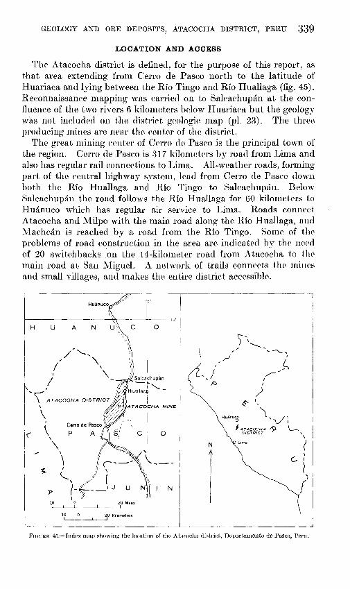
The Atacocha district is defined, for the purpose of this report, as that area extending fr01n Cerro de Pasco north to the latitude of Huariaca and lying between the Rio Tingo and Rio Huallaga (fig. 45). Reconnaissance mapping was carried on to Salcachupan at the confluence of the two rivers 6 kilometers below Huariaca but the geology was not included on the district geologic n1ap (pl. 23). The three producing mines are near the center of the district.
The great mining center of Cerro de Pasco is the principal town of the region. Cerro de Pasco is 317 kilometers by road from Lima and also has regular rail connections to Lin1a. All-weather roads, forming part of the central highway syste1n, lead from Cerro de Pasco down both the Rio Huallaga and Rio Tingo to Salcachupan. Below Salcachupan the road follows the Rio Huallaga for 60 kilometers to Huanuco which has regular air service to Lima. Roads conned Atacocha and Milpo with the main road along the Rio Huallaga, and Niachcan is reached by a road fron1 the Rio Tingo. Some of the problems of road construction in the area are indicated by the need of 20 switch backs .:on the 14-kilometer road from Atacocha to the 1nain road at San Miguel. A network of trails connects the mines and small villages, and makes the entire district accessible ..
H u A
·~ Huanuco('" I
. I '... ---r~lo· N U\ c I 0
---,
'I
\
- J 'j:::J
N
10 l 10 0 20 Kilometres
L___c________L_______;
FIGuRE 45.-lndex map showing the location of the A tacocha district, Departamento de Pasco, Peru.
340 GEOLOGIC INVESTIGATIONS IN THE AMERICAN REPUBLICS
PHYSICAL FEATURES
Cerro de Pasco is on the eastern edge of the high central plateau of Peru at an altitude of 4,350 meters above sea level. The Atacocha district is on a long ridge extending northward from the plateau between the Rio Huallaga and Rio Tingo. Peaks on the ridge have the same general altitude as the peaks on the plateau (4,400 to 4,500 meters) from the edge of the plateau to as far north as the village of Y arusyacan, where the ridge drops off abruptly to end at the junction of the two rivers at Salcachupan. Parallel ridges with peaks of about equal height extend from Milpo to Machcan; the western ridge is the watershed between the Rio Huallaga and Rio Tingo and the eastern is cut by the deep Quebrada Atacocha and Quebrada Chicrin which drain the area between the ridges. Pumaratanga, the highest peak in the district (4,560 meters) is near the north end of the western ridge and marks the point at which the watershed shifts to the eastern ridge. North of Pumaratanga the western ridge gradually dies out.
The Rio Huallaga is the principal stream. It is the largest tributary of the Rio Marafi6n, which together with the Rio U cayali form the Amazon. The headwaters of the Huallaga are in a high glaciercovered ridge east of the district, but one large tributary heads near Cerro de Pasco. This tributary has a steep gradient, dropping more than 600 meters in the 8 kilometers from its head to where it joins the main river at La Quinua. The gradient is moderate below La Quinua except for a steep stretch between Batanchaca and Chaprin. The Tingo also heads near Cerro de Pasco but has a relatively even gradient throughout its entire length. The result of this difference in stream profile is that the Huallaga canyon is deeper and more rugged than that of the Tingo. Relief in the district is considerable, more than 900 meters in places, and slopes are steep; part of the Huallaga canyon is bordered by clip slopes of 60°-70° on limestone and sandstone, and slopes of about 40° are common throughout the area.
CLIMATE AND VEGETATION
Owing to its altitude, the Andean region of Peru has a cool temperate climate in spite of its proximity to the equator. The dry season from May to October is the coldest part of the year, with frosts common above an altitude of 3,000 meters. Rainfall amounts to more than 500 millimeters (about 20 inches); January, February, and March are particularly rainy months. Snow and hail are common above 4,000 meters, but the ground is never covered for more than a day or two, probably clue as much to rapid evaporation as to melting.
There are no forests; even individual trees are scarce except along the river valleys below an altitude of 3,800 meters where eucalyptus has been introduced. The only native tree is the quinual, a small
GEOLOGY AND ORE DEPOSl'l'S, ATACOCHA DISTRICT, PERU 341
gnarled evergreen tree that grows singly or in small groves in sheltered places and is occasionally found at altitudes over 4,000 meters. The quinual is used for firewood and, to some extent, for fence-posts and farm implements; it is useless as timber. Weberbauer (1945) hsts several varieties of recumbent shrubs and many species of mosses, grasses, and herbs as growing in the high Andes. A bunch grass known as ichu is very prominent and is used for thatching and to some extent for fuel. Ichu is too coarse to be used for feeding stock although llamas browse on it during the dry season for lack of better food. The principal mine timber is eucalyptus that is brought in by truck from groves along the Rio Huallaga near_ Huanuco. 1 pome timber is brought in from the jungle areas below-Hminuco but the cost of transportation is very high.
PREVIOUS WORK
Other than a brief report on the Atacocha mine area by Diaz (1909), most geologic work in the district has been done by consultants working for the mining con1panies and has not been published. Several papers on the Cerro de Pasco area have been published, and much of the geology is pertinent to the Atacocha district as well. McLaughlin (1924) describes the stratigraphy and physiography of a large area in central Peru. The formations proposed by him are found in the Atacocha district and the same nomenclature will be used in this report, except that, following the usage of Jenks (1951), the Pucara formation will include both Upper Triassic and Lower Jurassic limestones as field separation for purposes of this report was not practicable. The district geologic map (pl. 23) overlaps Jenks' map to some extent and the structures n1apped by him have been followed to the north.
Private reports of geologic work in the Atacocha district consist of a surface reconnaissance by J. B. Stone of the Cerro de Pasco Corp. in 1928, and studies of the Atacocha mine by Otto Welter in 1929 and David Torres Vargas in 1948. Maps prepared by Stone and Torres Vargas were made available to the writers and the geology iR in general similar to that shown on the maps of this report.
ACKNOWLEDGMENTS
Mine operators in the district cooperated wholeheartedly during this study. Sr. E. Portaro, Sr. F. Bautista C., and Sr. C. Valdivieso, officials of the Compafiia Minera Atacocha, furnished living accomodations and office space for the field party in 1952 and again in 1953. Sr. A. Venegas F. and Sr. L. Caceres F., manager and superintendent of the Compafiia Minera Milpo, furnished accomodations for the field party working there. At Machcan similar help was furnished by Sr. Cipriano Proafio and Sr. J. A. Proafio, owners of the property.
342 GEOLOGIC INVESTIGATIONS IN THE AMERICAN REPUBLICS
Help fron1 the engineering staffs of Uw various properties is also gratefully acknowledged. Eleodoro Bellido and Alberto Manrique, geologists of the Instituto Geol6gico del Peru, and men1bers of the joint commission, were our associates during the field work. Manrique worked at Atacocha most of the 1952 field season and also worked at Machcan for a short time. Belliclo worked at Milpo and also at Atacocha. Dr. Jorge A. Broggi, Director of the Instituto Geol6gico del Peru, kindly placed the facilities of that organization at the s~rviee of the field parties and was helpful in many ways.
FrankS. Simons and George E. Ericksen of the Geological Survey made the necessary arrangements for the study and Sinwns kept in close contact with the field work.
FIELD WORK
Field work began in 11ay 1952 and continued with f~w interruptions until Decernber of that year. Plane-table nutvs were n1ade of the areas surrounding the three operating properties. Triangulation nets of the ruining companies were used for control at Atacocha and Milpo, but a net had to be established for the 11aehean n1ap. Most aecessible underground workings were n1apped geologically, using bnse maps provided by the companies. Brunton-eornpass and tape surveys of underground workings were rnade when necessary.
Aerial photographs of the district were taken in 1952, so the district was revisited the following year in order to rnap the regional geology and thus tie together the mineralized a.reas. About 200 square kilon1eters was n1apped geologieally. A planin1etric map (pl. 23) was prepared from the photographs using ground eontrol furnished by the Cerro de Paseo Corp. and the Con1pafiia ~1inera Ataeocha. Control was limited to the central part of the area. This limited control together with the distortion due to the steep topography detract from the accuraey of the n1ap.
The authors carried out individual studies of the three producing rnines; Lewis at Machcan, Abele at Milpo, and Johnson at Atacocha. The distriet geology was rnapped by Johnson.
DESCRIPTIVE GEOLOGY
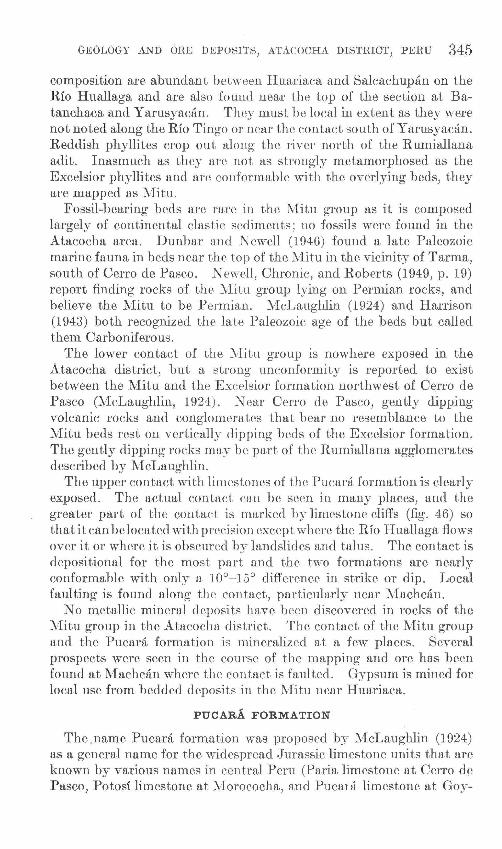
Sedimentary roeks of the area range in age fron1 middle Paleozoic to Cretaceous or early Tertiary. The bulk of the sedimentary rocks is shale and sandstone, but a thiek limestone sequence forms part of the Upper Triassic and Lower Jurassic section, and thinner limestone sequenees are found in the Cretaceous. Voleanic rocks, largely flows, are found in the Pern1ian and also in the Cretaceous. Dacite stocks and dikes of Tertiary age intrude the older rocks anci'are the youngest rocks in the area. The stratigraphy of the district is summarized in the following chart.
GEOLOGY AND ORE DEPOSI'l'S, A'rACOCHA DISTRICT, PERU 343
Stratz:graphir chart of rocks c:r.posed in the A.tacochn district
Age I Formation. and map I Thickness ,[· _________ umt (me~ers) ! _____ L-ithology and remarks
Recent. Unconsolidated mate- 'I ! Talus, slope wash, landslide material.
Tertiary('?).
Lower(?) Cretaceous.
Lower Cretaceous.
----------
Lower Jurassic to Upper Triassic.
-----------
Permian.
----------
Devonian('!). ---------
Unknown.
rial.
Conglomerate. 450 I
Chert and limestone pebbles and cobbles
I
increasing in coarseness upward. Some interbedded sandstone, shale, and limestone. Disconformable (?) on upper
, 1 limestone. 1-Diseonformity(?)--
1-----:--------------
Light-brown limestone, elastic limestone, marl, and shale; few fossils. Conformable i Upper limestone. 150--200
-----------
Upper basalt flows. 40-1\0
Disconformity.--1
Ohicrfn limestone. I 80-120
-----
Basalt flows. o-:l.so
Quartz sandstone. 100--150
I -Disconformity. I Pucm·a formation. I 1. 000-
-Disconformity.--~ 2, lOll+
I
Mltu g•oup i Goo+
-Angular unconformity.
Excelsior formation. -------~-----
i I
I
I
I
on upper basalt flows.
Basalt flows with minor amounts of red shale te at lime-
and sandstone. Local conglomera base. Disconformable on Chicrin stone.
Massive and thin-bedded brown lime stone: nonfossiliferous. Oliff forming. Con-formable on basalt flows.
Basalt flows with minor amounts of re d shale whit3
ection. and sandstone. Locally contains thin quartz sandstone bed near middle of s Conformable above and below.
Cross bedded white quartz sandstone with Red
Pucara discontinuous conglomerate at base. beds near top. Disconformable on formation.
Limestone with minor amounts of interr top
mon in Mitu
bedded shale. Shale increases ne.a Siliceous nodules and veinlets com some beds. Disconformable on group.
Red sandstone and shale with minor am ounts ocally posed
of conglomerate. Basic flows I abundant. Lower contact not ex but reporte.d unconformable.
Gray phyllite. and quartzite .. Limite d ex-posure in district.
Contorted green schists. Limited ex posure sun-in district. Relations to other rock
known.
PRE-PERMIJI~.N ROCKS
The oldest rocks of the district crop out in the northeast and southwest corners of the n1apped area. Highly contorted green schists are found in fault contact with Permian and younger rocks in the northeast corner, and gray phyllites of the Excelsior forn1ation (Devonian?) age are found near Cerro de Pasco. No attempt was rnade to date the green sehists as they were outside the area studied and seemed to have no relation to the lead-zinc ore deposits. Their area of outcrop is north of the Rio Ohinelu1n and east of the Huallaga, except for a sn1all area west of the river between Ohaprin and Huariaca. The bedding of the schists is highly contorted and often two or three folds can be observed in an ordinary hand speeirnen. A strong schistosity is superirnposed on the bedding. Quartz veins cut the schists but no sulfide mineralization was noted.
344 GEOLOGIC INVESTIGATIONS IN THE AMERICAN REPUBLICS
Gray phyllite of the Excelsior formation is found west of a fault near the Rumiallana adit of the Cerro de Pasco mine at the headwaters of the Rio Tingo. Conglomerate and interbedded volcanic rocks of unknown age unconformably overlie the phyllite and the entire sequence is intruded by a porphyry stock. Shales and sandstone of the Permian Mitu group or the overlying Triassic limestone are found east of the fault. The age of the Excelsior formation is not known other than that it is pre-Permian. McLaughlin (1924) interpreted the formation as probable Silurian, but later workers have assigned it a probable Devonian age.
MITU GROUP
The name Mitu forn1ation was first used by McLaughlin (1924) in describing the red beds and volcanic rocks of late Paleozoic age in central Peru. Various formational names have been given to these rocks in different parts of Peru but Newell, Chronic, and Roberts (1949, p. 16) conclude from their work on the upper Paleozoic rocks of Peru that only one major group of rocks is involved, and proposed the name Mitu group for all.
Rocks of the Mitu group underlie nearly half the area shown on plate 23. The contact between Mitu rocks and the overlying Pucara formation closely follows a line drawn from the Rumiallana adit northeastward to Huariaca, except for two long tongues of limestone that extend northwestward into the Mitu outcrop area, in the troughs of two synclines. Some isolated limestone masses are found west of the main contact as erosional remnants.
The thickness of the Mitu section in the Atacocha district is not known as the base is nowhere exposed. Sections described by Newell, Chronic, and Roberts (1949) show a thickness of about 500 meters at Chacayan, 20 kilometers west of the district, and 750 meters at Salipayoc, 50 kilometers to the southeast. The Rio Tingo cuts Mitu beds for nearly its entire length although its course is often close to the strike of the beds and in its upper part it flows across several folds. A sequence of sandstone and shale beds, between 500 and 600 meters thick, is cut by the river below the contact with the Pucara formation, near the Machcan road junction, and may represent the most complete section in the district.
Red and maroon shale and siltstone interbedded with sandstone and conglon1erate make up the bulk of the section along the Rio Tingo; sandstone and conglomerate are more abundant near the top of the section.'\The sandstone is usually poorly sorted and contains abundant clay and iron oxides, but at Batanchaca there is an exposure of clean crossbedded quartz sandstone.· The conglomerate contains chert and porphyry pebbles and is easily distinguished from the younger conglomerate by the lack of limestone pebbles. Volcanic rocks of bas]c
GEOLOGY AND ORE DEPOSI1rS, ATACOCHA DISTRICT, PERU 345
composition are abundant between Huariaca and Salcachupan on the Rio Huallaga and are also found near the top of the section at Batanchaca and Y arusyacan. They must be local in extent as they were not noted along the Rio Tingo or near the contact south of Yarusyacan. Reddish phyllites crop out along the river north of the Rumiallana adit. Inasmuch as they are not as strongly metamorphosed as the Excelsior phyllites and are conformable with the overlying beds, they are mapped as Niitu.
Fossil-bearing beds are rare in the 11itu group as it is composed largely of continental clastic sediments; no fossils were found in the Atacocha area. Dunbar and Newell (1946) found a late Paleozoic marine fauna in beds near the top of the Niitu in the vicinity of Tarma, south of Cerro de Pasco. Newell, Chronic, and Roberts (1949, p. 19) report finding rocks of the Nfitu group lying on Permian rocks, and believe the l\iitu to be Permian. 11cLaughlin (1924) and Harrison (1 943) both recognized the late Paleozoic age of the beds but called them Carboniferous.
The lower contact of the Mitu group is nowhere exposed in the Atacocha district, but a strong unconformity is reported to exist between the Mitu and the Excelsior formation northwest of Cerro de Pasco (11cLaughlin, 1924). Near Cerro de Pasco, gently dipping volcanic rocks and conglomerates that bear no resen1blance to the :Yiitu beds rest on vertically dipping beds of the Excelsior formation. The gently dipping rocks may be part of the Rumiallana agglomerates described by McLaughlin.
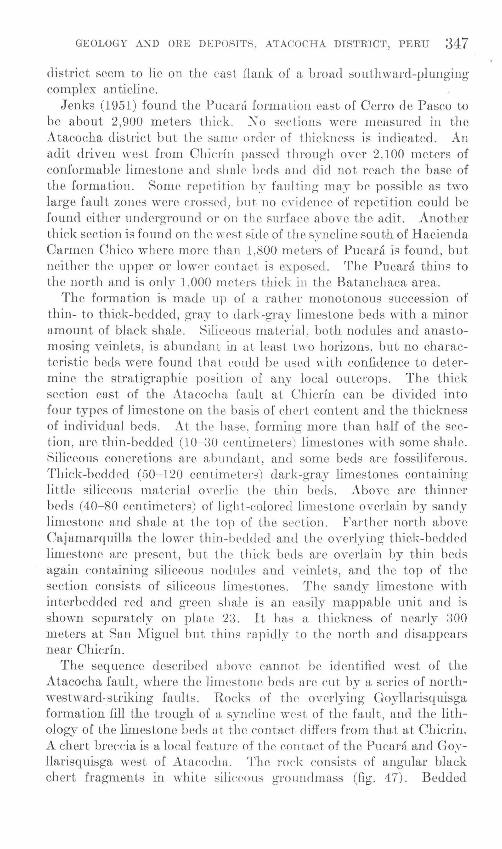
The upper contact with limestones of the Pucara formation is clearly exposed. The actual contact can be seen in n1any places, and the greater part of the contact is marked by limestone cliffs (fig. 46) so that it can be located with precision except where the Rio Hual]aga flows over it or where it is obscured by landslides and talus. The contact is depositional for the most part and the two formations are nearly conformable with only a 10°- 15° difference in strike or dip. Local faulting is found along the contact, particularly near 11achcan.
No metallic mineral deposits have been discovered in rocks of the lVIitu group in the Atacocha district. The contact of the Mitu group and the Pucara formation is n1ineralized at a few places. Several prospects were seen in the course of the mapping and ore has been found at lVfachcan where the contact is faulted. Gypsum is mined for local use from bedded deposits in the l\1itu near Huariaca.
PUCARA FORMATION
The name Pucara formation was proposed by l\1cLaughlin (1 924) as a general name for the widespread Jurassic limestone units that are known by various names in central Peru (Paria limestone at Cerro de Pasco, Potosi limestone at 1\forococha, and Pucaui limestone at Goy-

346 GEOLOGIC lNVES'l'lGATIONS IN THE AMERICAN REPUBLICS
llarisq uisga). J euks was uuablu to map separately the Jurassic and Triassic limestones at Cerro de Pasco, as they are conformable and similar in appearance, and so included both the Triassic Uliachin limestone and the J-urassic Paria limestone in the Pucara formation. Distinguishing the Jurassic and Triassic limestones in the field was not found practicable in the Atacocha district either, so Jenks' definition of the Pucara formation will be used iu this report.
Limestone underlies most of the area east of the Mitu red beds and west of the Rio Huallaga from Chaprin south to beyond the edge of the mapped area and is also found east of the river north of Batanchaca The Rio Chincluin marks the northern limit of the Pucara formation cast of the Huallaga in the mapped area. South from the Chichan the limestones form the core of a southward-plunging anticline and disappear before reaching Ticlacayan.
The contact between the Pucara formation and 11itu group has a general north-northeast strike, but two long tongues of lin1estone extend north-northwestward from the main contact along the troughs of two synclines. The western tongue lies close to the Rio Tingo and is cut by the river at one point. This tongue narrows northward and finally disappears. The eastern tongue is larger and extends beyond the Tingo to a large area of 1irnestone west of the river, comparable in size to the area underlain by limestone in the Atacocha district. In a regional sense the bulk of the limestone units in the Atacocha
FIGURE 46.- 'l'he contact of the Mitu group and the Pucara formation as seen from Machcan, looking north toward Yarusyacan. The contact is located above the trail near the bas<' of the lowermost cliffs, which are P ucara limestone.
GEOLOGY AND ORE DEPOSITS, ATACOCHA DISTRICT, PERU 347
district seem to lie on the east flank of a broad southward-pluugi11g complex anticline.
Jenks (1951) found the Pucani fonnation cast of Cerro de Pasco to be about 2,900 meters thick. X o sections were measured in the Atacocha district but the same order of thick:ness is indicated. An adit driven west from Chicrin passed through over 2,100 meters of conformable limestone and shale beds and did not reach the base of the formation. Some repetition b:~ faulting ma:r be possible as two large fault zones were crossed, but no eYidence of repetition could be found either underground or on the surface above the adit. Another thick section is found on the ''rest side of the syncline south of Hacienda Carmen Chico where more tban 1,800 meters of Pucara is found, but neither the upper or lower contact is exposed. The Pucara thins to the north and is only 1,000 meters thick in the Batanchaca area.
The formation is rnade up of a rather monotonous succession of thin- to thick-bedded, gray to dark-gray limestone beds with a minor a1nount of black shale. Siliceous material , both nodules and anastomosing veinlets, is abundant in at least t\\TO horizons, but no characteristic beds were found that could be used with confidence to determine the stra6graphic position of any local outcrops. The thick section east of the Atacocha fault at Chicrin can be divided into four types of limestone on the basis of ch('rt content and the thickness of individual beds. At the base, forming more than half of the section, are thin-bedded (10- 30 centimeters) limestones with some shale. Siliceous concretions arc abundant, and some beds are fossiliferous. Thick-bedded (50- 120 centi1neters) dark-gray limestones containing little siliceous material overlie the thin beds. Above are thinner beds ( 40-80 centimeters) of Jigh t-colored limestone overlain by sanely limestone and shale at the top of the section. Farther north above Cajamarquilla the lower thin-lwclded aud the overlying thick-bedded limestone are present, but the thiek beds are overlain by thin beds again containing siliceous nodules and \~rinlets, and the top of the section consists of siliceous limestones. Th(' sandy limestone with interbedded red and green shale is an easily mappable unit and is shown separately on plate 23. It has a thiekness of nearly 300 meters at San l'vfiguel but thins rapidly to the north and disappears near Chierin.
The sequence described above cannot be identified west of the Atacocha fault, where the limestone beds arc eut by a series of northwestward-striking faults . Rocks of the overlying Goyllarisquisga formation fill the trough of a syncline west of the fault, and the lithology of the li1nestone beds at the contact differs from that at Chicrin. A chert breecia is a local feature of the contact of the Pucara and Goyllarisquisga west of Atacoeha. The rock consists of angular black chert fragments in white siliceous groundmass (fig. 4 7). Bedded
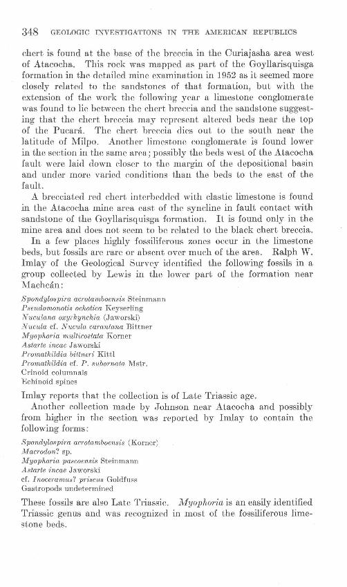
348 GEOLOGIC INVESTIGATIONS IN THE AMERICAN REPUBLICS
chert is found at the base of the breccia in the Curiaj asha area west of Atacocha. This rock was mapped as part of the Goyllarisquisga formation in the detailed mine examination in 1952 as it seemed more closely related to the sandstones of that formation, but with the extension of the work the following year a limestone conglomerate was found to lie between the chert breccia and the sandstone suggesting that the chert breccia may represent altered beds near the top of the Pucara. The chert breccia dies out to the south near the latitude of Milpo. Another limestone conglomerate is found lower in the section in the same area; possibly the beds west of the Atacocha fault were laid down closer to the margin of the depositional basin and under more varied conditions than the beds to the east of the fault.
A brecciated red chert interbedded with clastic limestone is found in the Atacocha mine area east of the syncline in fault contact with sandstone of the Goyllarisquisga formation. It is found only in the mine area and does not seem to be related to the black chert breccia.
In a few places highly fossiliferous zones occur in the limestone beds, but fossils are rare or absent over much of the area. Ralph W. Imlay of the Geological Survey identified the following fossils in a group collected by Lewis in the lower part of the formation near Mach can:
Spondylospira acrotamboensis Steinmann Pseudomonotis ochotica Keyserling Nuc·ulana oxyrhynchia (Jaworski) Nucula cf. Nucula carantana Bittner M yo phoria multicostata Korner Astarte incae Jaworski Promathildia bittneri Kittl Promathildia cf. P. subornata lVIstr. Crinoid columnals Echinoid spines
Imlay reports that the collection is of Late Triassic age. Another collection made by Johnson near Atacocha and possibly
from higher in the section was reported by Imlay to contain the following forms:
Spondylospira acrotamboensis (Korner) Macrodon? sp. M yo phoria pascoensis Steinmann Astarte incae Jaworski cf. Inoceramus? priscus Goldfuss Gastropods undetermined
These fossils are also Late Triassic. Myophoria is an easily identified Triassic genus and was recognized in most of the fossiliferous limestone beds.
GEOLOGY AND ORE DEPOSl'l' S, ATACOCHA DISTRICT, PERU 349
FIGURE 47.- Chert breccia found along the contact of the Pucara and Goyllarisquisga formations west of Atacocha.
Fossils found by Abele in the ::\1ilpo area are also Late Triassic; the fossils are from beds east of the Atacocha fault but probably low in the Pucara formation. Forms identified by Srta. Dora Gutierrez, paleontologist of the Javier Pra,do lv[useum of Natural History in Lima, include:
Spondylospira acrotamboensis (Korner) Pascoella peruviana Cox Palaeocardita peruviana Cox Myophoria sp.
Ammonites found near Chicrin in the upper part of the section close to the Goyllarisquisga contact were identified by Dr. Rosalvina Rivera of the Instituto Geologico as Arietites, an Early Jurassic form. Pentagonal crinoid stems found lower in the section near Chicrfn are also probably Early Jurassic. The limestone in which the crinoid stems were found is identical in appearance with the Triassic limestone beds, and the contact could not be located.
The limestone of the Pucara formation rests with slight angular discordance on the rocks of the l\t1itu group. The upper contact with the Goyllarisquisga formation is conformable, but probably the limestone was subjected to erosion before the sandstone was deposited, and in places conglomerate with abundant limestone pebbles and cobbles is present along the contact.
GOYLLARISQUIS GA FORMATION
The name Goyllarisquisga formation was given by ::\1cLaughlin (1924) to a series of clastic sediments overlying the Pucara formation at Goyllarisquisga, :30 kilomrters northwest of Cerro de Pasco. The
346876- 55--2
350 GEOLOGIC INVESTIGA'l' IONS IN THE AMERICAN REPUBLICS
formation is widespread in the Andean belt of Peru; Steinmann (1930, p. 99) states that it is found from the Departamento de ::\1oquegua, in southern Peru, north into Ecuador.
Rocks of the Goyllarisquisga crop out along the west side of the Rio Huallaga from south of the mapped area at La Quinua north to Toma Huanchal, where the river cuts through the sandstone near the trough of a syncline. The beds east of the river curve back to the south and then extend around the nose of the southward-plunging anticline north of Ticlacayan. The formation is also found in a syncline west of the Atacocha fault , from Atacocha to 2 kil01neters south of Milpo. These rocks crop out as parallel bands on either side of the structure at Milpo and join in the trough of the fold at Atacocha.
11cLaughlin divided the section at Goyllarisquisga into the following units:
j\lfeters
Calcareous sandstone ___ -------- - - --------------------- 180 Chontas sandstone___ _____ ___ ____ __ _____ ______ __ ______ _ 270 Bolognesi red beds, containing 3 lava flows ______________ 150-180 Upper coal series _ _ _ _ _ _ _ _ _ _ _ _ _ _ _ _ _ _ _ _ _ _ _ _ _ _ _ _ _ _ _ _ _ _ _ _ _ _ 3-7 5 11orocata sandstone _____ ___ __________________ __ ______ 30-120 Lower coal series ____ ___________ __ _____________________ 15-45 Basal conglomerate __ ______________ _ _ _ _ _ _ _ _ _ _ _ _ _ _ _ _ _ _ _ _ 2- 10
In contrast the section at Chicrin is as follows: Meters
Basalt flows with minor red beds ___ ____________ '_________ 250 Crossbedded quartz sandstone______ ___________ ___ _____ __ 140 Basal conglomerate ________ ____________________________ 8
There is no coal at Chicrin, but the lower coal series is represented in the district in local basins. Dark sandstone with abundant charred wood fragments is present below the quartz sandstone at Atacocha, and coal is reported from the same horizon near Cajamarquilla. The upper coal series seem to be absent. The thick volcanic section at Chicrin can probably be correlated with the Bolognesi red beds at Goyllarisquisga, as both sections are undoubtedly continental and seem to contain the same rocks, although in widely different proportions. The upper two divisions at Goyllarisquisga are absent in the Atacocha district, where the basalt flows are conformably overlain by limestone, 80 to 110 meters thick.
The basal conglomerate at Chicrin is discontinuous and pinches out both to the north and south. Conglomerate is locally present at the base of the section west of ::\!(ilpo but is absent at Atacocha, where bedded chert and chert breccia mark the contact with the Pucara limestones.
GEOLOGY AND ORE DEPOSITS, ATACOCHA DISTRICT, PERU 351
The white erossbeddecl quartz sandstone beds are a very distinctive part of the section, as they are resistant to erm.;ion and forn1 prominent outerops. Tlw beds are con1posecl of subangular to subrounded quartz grains in a silieeous Inatrix. The grain size ranges frmn fine to very conrse; smne beds eould be tern1ed pebble conglomN·ates. In thin seetion the sandstone is seen to contain Inore than 9.5 percent of quartz and a little interstitial sericite. Authigenic outgrowths are con1mon on the quartz grains.
The basalts are greenish black on fresh surfaces. They weather red and break clown to forn1 a red soil. Olivine and plagioclase phenocrysts can be seen in hand specinu•ns. Rome flows arc amygdular with carbonate or chlorite filling the cavities. A thin section from a typical flow showed a diabasic texture and that it eontains 45 pereent hasie plagioclase (An80± 5); 25 pereent of olivine, partly to con1pletely altered to antigorite and chlorite; 20 percent of titanaugite interstitial to the plagioclase; ancllO pPrcent of ihnenite and n1agnetite. A few beds of red sandstone and shale are interbedded with the flows. The thick11ess of this series of flows is variable. The flowf" extend to the north frmn Chicrin with only slight thinning but cli~
appear to the south; li1nestone rests directly on the quartz sandstone 11ear San Miguel. The series is Inuch thinner but is continuous jn the area west of the Ataeocha fault.
No fossils were found in the Goyllarisquisgn rocks of the Atacoeha district, but work in other areas has eRtabli~hed their age as EarJy Cretaeeous.
The forn1ation rests eonforn1ably on li1nestone or shale of the Pucara fonnation, but the prest•nce of lin1estone pebbles in the basal conglomerate of the Goyllarisquisga indieates that the lin1estone was uplifted and eroded before the deposition of the conglon1erate and sandstone. The upper contact is also conforn1able and shows an abrupt change frmn basalt flows through a few meters of limy shale to limestone. The flows seerr1 to be land laid; no pillow structures were seen and the tops of individual flows are oxidized.
POST-GOYLLARISQUISGA BEDDED ROCKS
No attempt will he made here to correlate the sediments and volcanics above the Goyllarisquisga forn1ation with roeks elsewhere in Peru. Two limestone horizons separated by about 50 n1eters of basalt flows and reel beds overlie the basalt flows of the Goyllarisquisga, and have the sa1ne distribution as the Goyllarisquisga in the Atacoeha distriet.
The lower limestone will be given the name Chicrin lin1estone, for cleseriptive purposes in this report. It is well exposed at Chicr.in where the Rio Huallaga cuts through the entire sequence. The linlestone at Chicrin crops out as a large \Yedge-shapecl mass reminiscent
352 GEOLOGIC INVESTIGATIONS IN THE AMERICAN REPUBLICS
of the flat-iron structures along the Front Range in Colorado; the east side of the outcrop is a 65° dip slope that extends up about 150 meters from the river. A similar but smaller structure is found in the same limestone at Cajamarquilla. Near Ticlacayan the limestone is well exposed where it folds around the nose of an anticline and the overlying rocks have been stripped away.
The limestone at Chicrin is 110 meters thick. The lower 25 meters consists of thin-bedded sandy limestone and shale; the remainder is dense, brown, thick-bedded limestone. Near Milpo the unit has about the same thickness although in places there is an apparent thickening due to repetition of beds as a result of small thrust faults.
Fifty meters of basalt flows and red beds lie on the Chicrin limestone with small angular unconformity. They will be called the upper basalt flows in this report, to distinguish them from the Goyllarisquisga basalts. A basal conglomerate was found east of Chicrfn but but was not seen elsewhere. The basalts are identical in appearance with those of the Goyllarisquisga formation below the Chicrin limestone. A thin section of a specimen from a flow west of Milpo shows a diabasic texture and the same minerals as the Goyllarisquisga basalts-basic plagioclase, olivine, titanaugite, ilmenite and magnetite. The titanaugite, however, forms large violet phenocrysts, as large as 4 mm in diameter, and grains interstitial to feldspar.
The upper limestones overlie the basalt flows with apparent conformity; the contact is not exposed, but dips near the contact are similar. About 200 meters of these rocks are exposed along the Rio Huallaga. West of the Atacocha fault the upper limestone is confined to isolated outcrops in the trough of the syncline near Milpo. Lithologically the beds consist of clastic crossbedded limestone, marl, and limestone. The rocks are light brown on fresh surfaces but weather nearly white. Thin bedding predominates but beds as much as 1 meter in thickness are found.
These limestones are unfossiliferous and so cannot be correlated with confidence with other limestones above the Pucara. They could be Machay limestone (Lower Cretaceous) but are not very similar lithologically to the Maehay limestone described by McLaughlin, who does not mention red beds or volcanic rocks beneath the limestone but states that it is overlain discordantly by conglomerates of the Pocobamba formation. Conglomerate that Jenks correlates with the Pocobamba formation is found above the limestone east of the Rio Huallaga.
GEOLOGY AND ORE DEPOSITS, ATACOCHA DISTRICT, J>ERU 353
TERTIARY(?) CONGLOMERATE
.A thick series of red-weathering conglomerate beds with some interbedded shale, sandstone, and limestone overlies the upper limestone with apparent conformity. The ridge east of the Rio Huallaga from La Quinua north to Hacienda .Aurora is capped by these conglomerate beds. The lower beds are con1posed of pebbles and cobbles of che.rt and limestone, with chert predominating. The pebbles are well rounded and lie in a red sandy n1atrix. Higher in the section the conglomerate becon1es coarser, and limestone cobbles are n1ore abundant; large subangular boulders of limestone are found in rnany beds, indicating that the source area was not far distant. Over 500 meters of conglomerate is exposed east of Chicrin.
No fossils were found except in the limestone cobbles, so that the age of the conglomerate is not known. They may have forn1ed during an early phase of the Andean orogeny that began in Late Cretaceous time. If so they n1ust have been deposited in the first stages of the orogeny as they are folded with the underlying rocks. Jenks (1951) correlated the conglomerate beds with the Pocobamba foemation of McLaughlin which is thought to be Tertiary in age .
.Another series of red conglomerate beds of unknown age crops out about 1 kilometer east of Laguna N ahuelpun. The conglomerate is much finer grained than that east of Chicrin, and pebble conglomerate predominates. Chert and limestone pebbles are the most abundant constituents. .About 150 meters of beds is exposed in a lenticular outcrop faulted on the west and covered on the east. The conglomerate beds definitely do not belong to the ~1itu group as they contain abundant limestone pebbles, but neither do they seem to be Tertiary as they do not overlie Goyllarisquisga rocks but seem to be isolated in the Pucara limestone. They may have been deposited in a local basin during the erosion interval between the deposition of the Pucara and Goyllarisquisga formations, but they bear little resemblanee to other rocks found along the sarne contact.
UNCONSOLIDATED MATERIAL
Moraines, alluvimn, and landslides cover the eonsolidated rocks over considerable areas, but only part of these materials are shown on the geologic map.
Moraines are well developed north of Pumaratanga and can be seen along the trail: from .Atacocha to Machcan. Unsorted gravels, of probable glacial origin, were found during excavations in Quebrada Chicrin above .Atacocha.
Alluvium in the form of slope wash, talus, and valley fill aecumulates in favorable localities. 'The talus on slopes underlain by limestone is often cemented by carbonates deposited by meteoric water. On one
354 GEOLOGIC INVESTIGA'riONS IN THE AMERICAN REPUBLICS
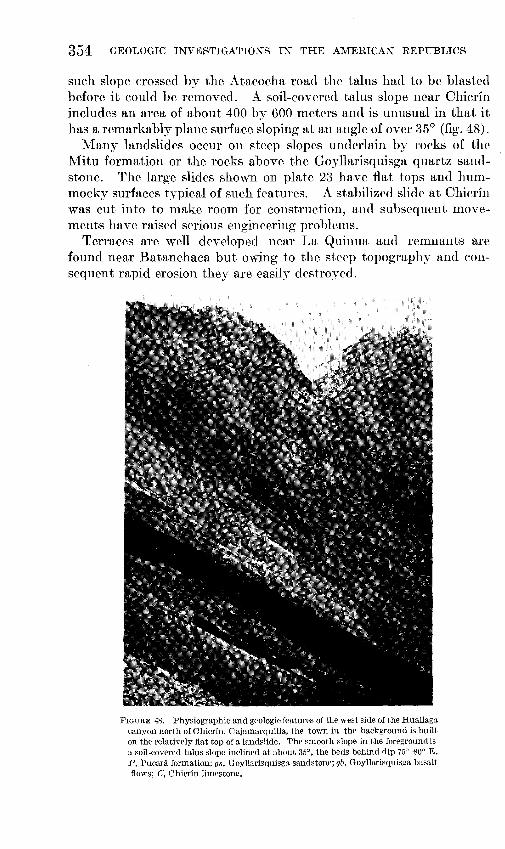
such slope crossed by the Atacocha road the talus had to be blasted before it could be rmnovecl. A soil-covered talus slope near Chicrin includes an area of about 400 by 600 meters and is unusual in that it has a remarkably plane surface sloping at an angle of over 35° (fig. 48).
Many landslides occur on steep slopes underlain by rocks of the Mitu formation or the rocks above the Goyllarisquisga quartz sandstone. The large slides shown on plate 23 have flat tops and humInocky surfaces typical of such features. A stabilized slide at Chicrin was cut into to make room for construction, and subsequent movements have raised serious engineering problmns.
Terraces are well developed near La Quinua and ren1nants are found near Batanchaca but owing to the steep topography and consequent rapid erosion they are easily destroyed.
FIGURE 48.-Physiographic and geologic fe,atures of the west side of the Huallaga canyon north of Chicrin. Cajamarquilla, the town in the background is built on the relatively fiat top of a landslide. The smooth slope in the foreground i3 a soil-covered talus slope inclined at about 35°, the beds behind dip 75°-80° E. P, Pucara formation; gs, Goyllarisquisga sandstone; gb. Goyllarisquisga basalt flows; C, Chicrin limestone.
GEOLOGY AND ORE DEPOSITS) ATACOCHA DISTRICT, PERU 355
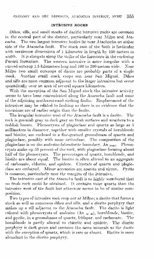
INTRUSIVE ROCKS
Dikes, sills, and Arnall stocks of dacitic intrusive rocks are cornn1on in the central part of the district, particularly near l\~1ilpo and Atacocha. The two largest intrusive bodies lie near Atachocha on either side of the Atacocha fault. The stock east of the fault is lenticular with n1aximum din1ensions of 1 kilmneter in length by 150 meters in width. It is elongate along the strike of the lin1estone in the enclosing Pucara forn1ation. The westPrn intrusive is n1ore irregular with a curved outcrop 1.5 kilometers long and 100 to 200 n1eters wide. Near _l\;filpo two small outcrops of dacite are probably parts of a single stock. Another sn1all stock crops out near San Miguel. Dikes and sills are rnost con1n1on adjacent to the larger intrusives but occur sporadically over an area of several square kilometers.
With the exeeption of the San l\Iiguel stock the intrusive activity semns to have been concentrated along the Atacochu fault and son1e of the adjoining northwestward-striking faults. EmplarenH'nt of tlw intrusives n1ay be related to faulting as thPre i8 no evidence that Uw. intrusions are of earlier origin than the faults.
The irregular intrusive west of the Atacocha fault is a dacite. The rock is greenish gray to clark gray~ on fresh surfaces and weathers to a reddish brown. Phenocrysts of plagioclase and quartz as large as 5 millirneters in dian1eter, together with sma.ller er.Yst,als of hornblende and biotite, are enelosecl in a fine-grained groundn1ass of quartz and plagioclase, possibly with son1e orthoclase. The eon1position of the plagioclase is on the andesine-labradorite boundary, An 5o±5 • Phenocrysts rnake up 50 percent of the rock, with plagioclase forn1ing about half of the phenocrysts. The percentage.s of quartz, hornblende, and biotite are about equal. The biotite is often altered to an aggregate of carbonate, chlorite, and epidot.e. Crystals of quartz and plagioclase are embayed. l\1inor accesories are apatite and zircon. Pyrite is common, particularly near the margins of the intrusive.
The intrusive east of the Atacocha fault is so highly weathered that no fresh rock eould be obtained. It contains rnore quartz than the intrusive west, of the fault but othen,~ise seems to be of similar cornposition.
Two types of intrusive rock crop out at Milpo; a dacite that forn1s a stock as well as nun1erous dikes and sills, and a diorite porphyry that n1akes up a sill adjacent to the Atacocha fault. The dacite is light colored with phenocrysts of andesine (An 34 _ 49), hornblende, biotite, and pyrite, in a groundrnass of quartz, feldspar, and carbonate. The hornblende is partly altered to chlorite and epidote. The diorite porphyry is dark green and contains the san1e n1inerals as the dacite with the exception of quartz, whieh is rare or absent. Biotite is more abundant in the diorite porphyry.
356 GEOLOGIC INVESTIGATIONS IN THE AMERICAN REPUBLICS
No direct evidence was found for closely dating the time of intrusion. The dacite stock at Atacocha intrudes the basalt flows of the Goyllarisquisga formation, and one dike west of Milpo cuts the upper basalt flows, so the intrusions are probably post-Early Cretaceous. Similar intrusions elsewhere in central Peru are Tertiary in age. The absence of dacite pebbles in the Tertiary(?) conglomerates suggests that the intrusions occurred after deposition of the conglomerate, but of course the intrusives may not have cropped out in the source area of the conglomerates. The close association of many of the intrusives with the Atacocha fault suggests that emplacement took place during the Andean orogeny after the major faulting. Dikes are offset a few meters by late faults, but there is no evidence to indicate large displacements of the porphyry.
CONTACT METAMORPHISM
The sedimentary rocks and lavas have been 1netamorphosed for various distances from their contacts with the intrusive rocks, and have been altered in different ways depending on their lithology and the size of the intrusive. The composition of the metamorphosed rocks has been changed by the addition of silica, iron, and sulfur from the intrusives.
The most intense metamorphism appears to be in the limestone beds of the Pucara formation west of the lenticular porphyry intrusion southeast of Atacocha. There the limestone beds are completely silicified and impregnated with pyrite for a maximum distance of 180 meters from the west border of the porphyry. The silicified zone is thickest adjacent to the widest part of the porphyry outcrop and tapers out toward both ends of the intrusive. The outcrop of the highly altered rock is a structureless siliceous mass with streaks of gossan and many limonite-stained cavities. Inasmuch as this stock contained more quartz phenocrysts than any other in the area, the solutions f'manating from it may also have been richer in silica, for intense silicification on such a scale is not found elsewhere in the district. Outside the zone of intense alteration is a discontinuous zone of lime silicates containing garnet, wollastonite, calcite, and pyrite. This zone is as much as 100 meters wide and has a fairly sharp contact with unaltered limestone. Alteration on the east side of the intrusive is limited to a few meters of lime silicates. Garnet and wollastonite are also abundant on one level of the Atacocha mine adjacent to porphyry dikes. Elsewhere along intrusive contacts, contact metamorphic minerals are rare or absent. At Milpo for example, the stock is surrounded by pyrite and recrystallized marble in a zone of variable width.
Quartz sandstone shows little or no alteration adjacent to porphyry, as might be expected; locally, the rock is converted to quartzite.
GEOLOGY AND ORE DEPOSITS, ATACOCHA DISTRICT, PERU 357
Basalt, on the other hand, was easily recrystallized and is found as a fine-grained dark-green rock indistinguishable in the field from the chilled margins of the porphyry. Distinction between the two rocks can sometimes be made by studying thin sections if relict calcic feldspar from the lava is present. Little or no alteration is found adjacent to the dikes or sills.
STRUCTURE
The rocks in the Atacocha district have been strongly folded, and are cut by both normal and reverse faults. In a regional sense much of the district seems to be on the east side of a southward-plunging anticline whose axis lies near the valley of the Rio Tingo. Superimposed on this structure however, are a series of smaller folds, some of considerable magnitude. A reverse fault, herein called the Atacocha fault, traced from Hacienda Carmen Chico north to near Batanchaca, has also influenced the district's structural picture. Rocks east of the fault are thrown into long slightly asymmetrical folds with minor faulting, but west of the fault the folds are sn1aller and more irregular and the rocks are broken by a series of northwesterly-striking faults. A curious feature is that these faults, which seem to be in1portant structures with large displacenwnts in the Pucara formation, die out toward the Mitu contact and only offset the eontact a few meters if at all.
FOLDS
The pre-Mitu roeks are strongly folded but were not 1napped in sufficient detail to locate any structures. Work done elsewhere in the Excelsior formation (MeLaughlin, 1924) shows that the roeks were folded before the deposition of the sedin1ents of the Mitu group, and that a pronounced angular conformity is present between the two formations. Mitu rocks, on the other hand, are nearly conformable with the overlying limestone beds and seein to have been folded with them. Some gently folded reddish phyllites north of the Rumiallana adit have been mapped therefore as belonging to the Mitu group rather than the Excelsior fonnation as shown by Jenks (1951). The tongue of lin1estone east of the Rio Tingo n1arks the aJ>.is of a syneline, with red shales and sandstone of the l\fitu formation bordering the limestone throughout its entire length. Individual beds could not be recognized with eertainty on both sides of the limestone, but there is no evidenee that the syneline erosses the contact of the Excelsior and Mitu formations as shown by Jenks.
The Mitu group and younger rocks have been compressed into a series of folds, most striking a few degrees west of north and plunging to the south. In addition, the limestone west, of the Atacocha fault is folded into many small folds that are irregular in strike and plunge.
358 GEOLOGIC INVESTIGATIONS IN THE AMERICAN REPUBLICS
An anticline and syncline were Inappecl east of the Atacoeha fault. The anticline is well exposed west of Ticlaeayan and is shown on seetion C-C (pl. 23). This fold probably extends north to the fault along the Rio Chinehan; the southern extension lies outside the mapped area. The syncline is shown on all three sections and is well defined frmn Batanehaea south nearly to La Quinua; it Inay also extend north to the fault on the Chinchan. The axis of the syneline lies close to the Rio Huallaga fron1 Batanchaca to the Hacienda Aurora but farther south the fold is found on the erest of the ridge east of the Huallaga and the axis lies just west of the ridge crest. Both folds plunge south at Ticlaeayan, but the syncline has a north plunge at its southern end and so is eanoe shaped. Both folds are slightly asyinn1etrical, with the axial planes dipping east. The asymmetry is probably due to eompression in an east-west or southeast-northwest direction that may also have eaused the reverse movement on the Atacoeha fault. Asymmetry could also be due to drag on the flank of a larger fold to the west, and some evidence for this view was found along the Rio Tingo.
Between the axis of the syncline and the Ataeocha fault, the strata generally have a consistent eastward dip, or are vertieal. The presence of Triassic fossils near the fault and Jurassic forms higher in the section to the east shows that the beds are in the normal sequence-"right side up." Small wrinkles with loeal reversals in dip are found in the rocks above the limestone on the west fla,nk of the syncline; one small fold was found in the upper limestone beds above Cajamarquilla. No complete structure was seen but this local crumpling may represent drag folding during the develop1nent of the larger folds. A syncline is found immediately west of the Ataeoeha fault and Inay have been accentuated by Inovements along the fault. The syncline is well exposed from 2 kilmneters north of Ataeocha to about 2 kilometers south of Milpo. A sin1ilar syncline is found farther north along the fault but is not as clearly defined. The syncline at Ataeocha is asy1nmetric, locally overturned to the west, a,nd plunges south. West of Milpo the fold is more sym1netrieal, but overturned dips are found along the Atacocha fault south of the n1ine (fig. 49). The two masses of Cretaceous "upper" lin1estone exposed in the trough of the fold near Milpo plunge toward eaeh other so this syncline is also canoe shaped in part. The reversal in plunge near the south end of the fold Inay be due to drag along the large cross fault that offsets the structure near Hacienda Carmen 'Chico. The syncline in the Pucara li1nestone south of the fault
' '1111. •
is probably the~same structure.
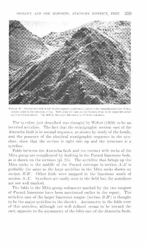
GEOLOGY A:\D OHE DT~ POSITS , ATACOCHA DISTRICT, PERU 359
J'J GU HF. 4\J. - Own UntL'd tw ds in t.ll<' (] o y lluri~qu isga sa n<btonr <ldj aeL'nt to thr c\ tucocha r,wlt nrar ~I il po.
,\rrows poin t in the d in'ct ion o( dip. Jkd s alorw tlw fatrlt an• on·rt unH' d , those in UH· lower ldt eonH'r nrc in llOI'lll<tl seq uence . The dill'~ in tile upper ll'ft cor·rtt'r nn· C iliC'rin lirnestonc.
TJH' syndine just descrilH'cl \\·as thought h.\· \Vdtl'l' (1929) to be an in\~ erte<l anticline. T he fact that tJH' s tratigraphic sectioJl east of the Ataeoelm fault is in normal sequence, as shown. by study of U1e fossils , and the presence of the identical stratigraphic sequence in the syncline, shm\~ that the srrtion is righL side up and the structure is n s.n1clim' .
Folds between the Atacocha fault and th<' contact with rocks of the ~litn group are c01nplicated b~· fnnlting in the Pucara limestoue beds) as is shown on the sections (pl. 2:3). The an ti el ine that brings up the l\[itu roeks in the n1iddle of the Pucar::l outcrops in sectiou A-A' is probably the same as the large anticline in the \[itu rocks shown on section IJ-B'. Other fold s were mapped in the llmestOlH' south of section A-A' . S.n1clines are easily sren in the firld but the anticlines are not well rnarked.
The folds in tl1c .\lit u group sechments rnatkcd by the two tongues of Pucara linH'sto ne have b(-'en mentioned earlirr in the :rPport. T l H~ anticline east. of the larger limestone tongue (srction B-lJ') is thought t.o be the major anticlinr in l!Je clistri('t. Asymmctr.\~ in the folds west of this anticliue, although not \vell d('fined , seems to be toward the east, opposite to the asymmetry of the folds east of the Atacocha fault.
360 GEOLOGIC INVES'l'IGATIO~S IN THE AMERICAN REPUBLICS
FAULTS
Many faults, both reverse and normal, are found in the rocks of the Atacocha district, and the displacen1ents along them range from a few centimeters to over 2,000 meters. Among the largest faults are those separating the green schists from the Pucara formation along the Rio Chinchan, and the Excelsior formation from the Pucara formation near Cerro de Pasco. The age of the green schists is not known, but unless they are metamorphosed rocks of the Mitu group , the displacement along the fault must be very large. The fault between the Excelsior and Pucara formations may be the northern extension of the Cerro de Pasco fault described by Jenks (1951). In any event the entire Mitu group is cut out together with parts of the Pucara and Excelsior formations.
The Atacocha fault was traced from the edge of the mapped area at Hacienda Carmen Chico north to near Batanchaca where it crossed the contact of the Mitu and Pucara formations; the fault could not be followed northward in the ~fitu rocks. The fault is well marked topographically over most of its length; drainage follows the fault zone and narrow gaps mark its location between drainage systems.
The Atacocha fault is the largest fault on which an estimate of the stratigraphic throw can be made. At Milpo this fault brings limestone beds about 2,000 meters below the top of the Pucara formation in contact with quartz sandstone of the overlying Goyllarisquisga formation , indicating a displacement of more than 2,000 meters. Displacement is at a maximum near Milpo and seems to decrease rapidly to the north. The Mitu contact near the north edge of the mapped area is displaced only 300 n1eters by the fault, but the net slip or total movement on the fault probably is much more. The Atacocha fault is interpreted as being a steep reverse fault with a considerable horizontal component; the east side moved up and to the north relative to the west side. Additional evidence for the reverse movement is the presence of a reverse fault in the Atacocha mine that has thrust Pucara limestone over quartz sandstone, and seems -to be related to movement on the larger fault.
The ore deposits of Atacocha and Milpo may be related to movements along the Atacocha fault, although the fault itself is not known to be mineralized. R elations at ~1ilpo are not clear, but the ore bodies at Atacocha are near the trough of a small cross fold forn1ed by drag along the fault.
Another large fault cuts the limestone beds about 2 kilometers west of the Atacocha fault and roughly parallel to it. This fault is entirely in Pucara limestone except for a short distance where it forms the contact between the Pucara and a small outcrop of Mitu rocks (section A- A'). The displacement cannot be determined until
GEOLOGY A:\TD ORE DEPOSITS: ATACOCHA DISTRICT, PERU 361
the stratigraphy of the lin1estone beds is better known. The fault seems to terminate to the north against a northwesterly striking fault and is probably offset by another fault about 3 kilmneters west of Milpo. 'fhe fault zone is well marked topographically by longitudinal valleys. It has an east clip and is flatter than the Atacocha fault as the trace of the fault on the surface is considerably influenced by the topography. A slip surface in the fault zone, about 2 kilometers north of where it crosses the Rio Huallaga, has a dip of 40° E., but this may be a local feature as the trace of the fault is straighter than would be expected for so lmv a dip.
A series of faults striking N. 40°--60° vV. are found ,vest of the Atacocha fault fron1 Hacienda Carmen Chico to Atacoelm. The largest of these extends northwest from the 1-Iacienda. The Goyllarisquisga rocks in the syncline west of l\1ilpo term.inate on the south against this fault, and the syncline seenlS to be offset. The north side n1oved down and to the west ·with respect to the south side, with an horizontal offset of about 600 rneters. T,he stratigraphie displacmnent is not known, but at least 600 nwters of beds above the Pucara fornlat.ion are cut out together 'vith an unknown thickness of Pucara. The fault also offsets the north-striking fault west of the Atacocha fault and rnay offset the Atacocha fault itself, but the relations were not studied. As shmvn on the geologic rnap, the fault is discontinuous and n1ay be en echelon. The west end could not be traced far into the Mitu fornmtion and the fault may die out as the tongue of limestone in line with the strike of the fault is not offset.
The n1any other faults shmvn on the geologic map are srualler features of only rninor importance. Srnall-scale faulting is in1portant in the mineralized areas and will be discussed in the description of the individual mines.
GEOMORPI-IOJ..,OGY
Land forms in the district strongly reflect the lithology of the underlying rocks. Rounded subdued ridges and sn10oth slopes of areas underlain by rocks of the ~.fitu group eontrast sharply \Vith the rugged, nearly vertieal cliffs so conmwn in the lirnestone areas. The less resistant roeks above the Goyllarisquisga. forn1ation weather to subdued surfaces sin1ilar to those on ~Titu rocks. A particularly striking contrast in resistance to erosion is shmvn by the steep-dipping Chicrin lirnestone where it, rises sharply above the overlying and underlying basalt flows. The contact of the 1\Etu and Pucara formations is marked along rnuch of its length by limestone cliffs 20 meters high, broken only by the larger gullies that eut steep canyons in the limestone and open out on entering the softer J\fitu rocks.
362 GEOLOGIC INVES'l'IGATIONS IN THE AMERICAN REPUBLICS
Most landscape features developed in the Atacocha district are the result of the dissection of an old elevated peneplain that forms a large part of the high central plateau of Peru. High points on the ridges in the district reach the same general level as the peneplain as far north as the village of Yarusyacan; Pumaratanga is probably 200 meters above the general level. Rivers are actively cutting into this peneplain on its northern and eastern margins and are superiinposed on the old structures. Both the Tingo and Huallaga are of this type, as are their major tributaries. The Huallaga particularly, although it follows the general trend of the bedding for the most part, cuts indiscriminately across beds varying in resistance to erosion. At Batanchaca, for exa1nple, the river cuts through the last of the limestone beds and enterR an area underlain by rocks of the Mitu group. The river follows the contact for a short distanee then euts baek into the more resistant limestones and flows through a speetacular gorge before finally leaving the limestone at Ohaprin.
Subsequent streams have developed on a small scale along both less resistant beds and fault zones. Their best development is along the Atacocha fault and the parallel fault zone 2 kilmneters to the west.
GEOLOGIC HISTORY
The Permian rocks of the 11itu group are reported to rest with strong unconformity on the Devonian(?) Excelsior formation but the depositional contact is not seen in the Atacoeha district. The geologie record begins with the deposition of red shales and sandstone of the Mitu group, loeally interbedded with basic lava flows. The reel beds are probably eontinental but were laid down near the sea. Bedded gypsun1 near Huariaea may represent loeal basins that became separated fron1 the sea with the subsequent deposition of evaporites.
The area was uplifted at the close of 1~fitu deposition but was not strongly folded as only a small angular discordance was found between the Mitu and the overlying li1nestone beds. The area was subject to erosion throughout nwst of the Triassic unless some of the red beds are of that age. In the absence of fossils the age of the red beds Inust remain in doubt, although Newell, Ohronie, and Roberts (1949, p. 19) report finding middle or late Permian fossils high in the section near Tarma.
Limestones of Late Triassic age were deposited directly on the clastic rocks apparently without any basal sandstone or shale. The few exposed contacts show a lensing out of the limestone beds against the red beds and a slight angular disconformity right at the contact. The sea see1ns to have advanced rather rapidly over the area.
GEOLOGY AKD ORE DEPOSITS, ATACOCHA DISTRICT, PERU 363
Tho limestou<' hpd:-; :-;<•f•.m to lw atlto<"ltUJOnou:-; in origin for Lhc mosL part, according to the classification proposed by Pettijohn (1949, p. 293). The li1nestone is nearly all recrystallized but the association with calcareous shales and the occasional presence of fossil-rich beds with articulated shells shows that much of the section forn1ed by accretion. The presence of dark limestone beds, "vhieh give off a fetid odor 'vhen struck with a hanuner, interbedded vvith black shale indicates deposition in a semistagnant basin. In general conditions seen1 to have been stable with gentle but continuous downwarping until over 2,000 1neters of limestone and shale were laid dmvn. Deposition seems to have been continuous across the Triassic-Jurassic tin1e boundary. Upper Triassic fossils are found in the greater part of the section but Lower tTurassie forms occur in the upper lin1estone and shale beds. Lithology is similar throughout the seetion exeept that shales beconw abundant near tlw top, at least along that part of the basin extending southward frcnn Chicrin. The Puca.rii fornlat.ion thins northward frmn Chicrin, possihl.\T hreausr of a high in the ~litu surface, although no overlapping of the uppPr hPds to ihL' north \Vas noted.
The area was uplifted in the Early .Jurassic awl t.fH'reaft.rr a marine environment \Vas present only during short periods. Deposition was resumed in the Early Cretaceous, when chert heels accnn1ulated in a basin west of Atacocha. The8e beds were follmvecl by fine-grained sandstone with nbmlflant ea.rhonaeeous nu1terial, 1oea11~,. containing thin coal seams. Following the filling of the low areas, a widespread series of white erossbedded quartz sandstone beds was deposited. Pure quartz sand is evidence that sta.hle shelf conditions predominated during the tin1e of accumulation. The sand was probably transported a long distance \vith opportunity for reworking and removai of less stable constituents.
The eruption of basalt flO\vs brought this period of deposition to a dose. Continental reel beds are interbedded with the early flows and a few Ineters of \Vhite quartz sandstone were deposited after basalt flows had accumulated to a thickness of over 100 n1eters. The quartz sandstone is identical in :appParance with that found below the lavas. Flows continued to accumulate near Chicrin until the.v· reached a total thickness of 250 n1eters. Chierin Inar have been near the center of lava accumulation. Only 50 meters of flows is found west of l\·Iilpo and they seem to pinch out Pntirely to the south; a slight decrease in thickness is found to the north. The flows near Chicriu n1ay have been deposited in a clownwarpiug basin as the limestones that cap the flows show only a small variation in thickness throughout the district.
The Chierin limestone overlies the lava flows and represents a short invasion by the sea. A fe,v meters of shale a.t the base of the limestone 1narks the transition from continental to n1arine deposition.
364 GEOLOGIC INVESTIGA'riONS IN THE AMERICAN REPUBLICS
After the accumulation of about 100 n1eters of limestone the area was again uplifted and tilted; a slight angular discordance is found between the limestone and the overlying reel beds and basalt.
A thin but widespread deposit of red beds and interbedded basalt flows overlies the Chicrin limestone. After deposition of these beds, the region was again downwarped and clastic limestone, shale, marl, and limestone (the "upper limestone" of this report) were deposited. No diagnostic fossils were found in either the Chicrin limestone or the upper limestone so no dating of beds younger than the Goyllarisquisga formation has been possible. The upper limestone may be the equivalent of the Machay limestone of late Early Cretaceous age but the correlation can not be made with confidence.
An erosion interval of unknown length separates the upper limestone from the overlying conglomerate. The contact is covered but may well be disconformable. The lower conglomerate beds contain abundant well-rounded chert pebbles, indicating considerable transport, but the overlying beds contain coarser chert cobbles and small subangular boulders of limestone, which probably were derived fron1 a rising land mass nearby. The age of the conglomerate beds is Late Cretaceous or early Tertiary. They n1ay have been deposited during an early phase of the Andean orogeny and folded with the underlying rocks during later compression. The conglomerate beds mark the close of the depositional history of the area, except for Quaternary alluvial deposition.
During the Andean orogeny the rocks were folded, faulted, and intruded by dacitic rocks. Folding was probably the earliest manifestation of the orogeny and was followed by the development of the north-striking faults due to compression in an east-west or southeastnorthwest direction. The northwestward-striking faults were formed later, at least in part, as some of them offset the northward-striking set. Emplacement of the porphyry bodies may have followed the faulting; the elongation of the dacite stock west of the Atacocha fault, south of Atacocha, is suggestive of intrusion along one of the faults that strike northwestward. Some time after the intrusion the rocks were altered by hydrothermal solutions and the n1etallic sulfides were deposited.
A large region in central Peru was reduced to an area of low relief by Pliocene time, according to McLaughlin (1924) and Harrison (1943), and subsequently was elevated to its present height in three stages. Evidence for or against the three-stage uplift was not found in the Atacocha district. The streams are eroding so rapidly that terraces cannot be preserved for long. Some terraces are found about 100 meters above the present river level but they are too widely spaced to correlate with confidence.
GEOLOGY AND ORE DEPOSITS, ATAC'OCHA DISTRICT, PERU 365
Glaciers were present in- the district during Quaternary time but their extent is not known. Closed basins and U-shaped valleys above 4,000 meters altitude show that glaciers extended down to that altitude, at least in sheltered locations.
ORE DEPOSITS
The presence of n1ineral deposits in the Atacocha district has probably been known since colonial tirnes because of its nearness to the great Cerro de Pasco deposit, whose rich silver-bearing oxide ores were exploited by the Spaniards. Oxidized ores, however, were relatively scarce in the Atacocha district, and the sulfides were not amenable to treatment by the priinitive recovery rnethods then in use, so production prior to the present century was probably insignificant. Figures are available only fro.m 1940 and show a production of nearly one million tons of ore, almost all frmn the Atacocha mine. This mine has produced rnore than 90,000 rnetric tons of lead and 65,000 tons of zinc from 1940 to 1953. Over 225,000 kilogran1s of silver has also been produced. ~fore than 12,000 tons of ore was shipped from ~ifilpo in the period 1949--51 and a rnill of 75 tons capacity was placed in operation in 1952. No figures are available for production at Machcan, but at the tirne of the exarnination about 30 tons of hand-sorted ore was being shipped per rnonth.
The three producing mines mark the centers of mineralization in the district. Numerous srnall workings are scattered about the part of the district underlain by Pucara lin1estone, but production seems to luive been negligible in n1ost places.
A close spatial, and probable genetic, relation exists between ore and intrusive rocks at ~filpo and Atacocha. The porphyry dikes at Machcan are not in the inunediate vicinity of the ore bodies.
MINERALOGY
The mineralogy of the ores and gangue of the three n1ines is probably similar. The sulfide rnineralogy of the J\fachcan is not known in detail as most of the workings are in the oxide zone, but the sulfides found are those common to the other mines. The following n1inerals are closely associated with the ore deposits.
SULFIDES AND SULFOSALTS
Alabandite, ~1nS-A considerable arnount of the black manganese sulfide alabandite was seen on a dun1p on the Tres ~Iosqueteros level of the Atacocha rnine. The rnineral was not seen in place.
Arsenopyrite, PeAsS--Srnall an1ounts of arsenopyrite are found intergrown with and replacing pyrite in the Atacocha ores. Arsenopyrite is replaced by sphalerite and galena. The arsenopyrite is massive and no crystal faces were noted.
346876-55--3
366 GEOLOGIC INVESTIGATIONS IN THE AMERICAN REPUBLICS
Chalcopyrite, CuzFe2S 4-Copper is a n1inor constituent of the ores and is not of economic interest. Chalcopyrite, the most abundant copper mineral, is found throughout the Atacocha mine in scattered small grains, and as blebs in sphalerite. The age relations with other sulfides were not detern1ined.
Galena, PbS-Galena is one of the principal ore 1ninerals. It usually occurs in granular masses with typical cubic cleavage, but crystals are found; the largest perfect crystals are found at Machcan and measures 2.5 em on an edge. At Machcan the galena commonly forms large masses of intergrown cubes 1.3 em on an edge. Some galena has a banded appearance due to the orientation of the cubes. Galena was deposited after most of the pyrite and contemporaneously with the sphalerite. A vein in the Atacocha mine has a galena-rich center bordered by sphalerite and pyrite, so at least some of the galena seems to have been deposited later than sphalerite. ·
The galena is probably argentiferous as the silver content of the ores varies directly with the galena content.
Jamesonite, Pb1FeSb6S14-Jainesonite was identified both at Milpo and Atacocha. The mineral is n1assive with good cleavage in one direction. Age relations at Atacocha were indeterminate but at Milpo jamesonite is found in veinlets cutting sphalerite.
Marcasite, FeS2-Marcasite from Atacocha is listed in the Catalogo Mineral6gico N acional, but none was noted during the present work.
Orpiment, As2S3-Bladed and micaceous yellow orpiment is found at Atacocha associated with realgar. Orpiment is more abundant than realgar, and most of it seeins to be an alteration product of the realgar.
Pyrite, FeS2-Pyrite is the most abundant sulfide in the district, and, with sphalerite and galena, forms the characteristic mineral assemblage in the ore. Pyrite, however is found over a much wider area than the other sulfides. Concentrations of pyrite are often present along intrusive contacts and barren pyrite veins are found in the mine. Both massive and crystalline pyrite are common. Pyrite in the ore bodies is massive or forms small striated cu hie crystals, whereas in the hydrothermally altered zones the disseminated pyrite is usually found as small pyritohedrons. Crystals over 2 centimeters in diameter are rare. Pyrite was probably the first sulfide to form and continued to be deposited throughout n1ost of the period of sulfide mineralization.
Realgar, AsS-Realgar and orpiment were found at the Atacocha mine only. They are abundant on the 4,240 level and were noted on other levels in the upper workings. They are also found in fractures in limestone between 1,200 and 1,300 meters from the portal of .the Chicrin adit, or 3,600 level, several hundred meters from any known ore. The realgar occurs as orange-colored platy masses enclosed in orpiment and as small red isolated crystals that resemble cinnabar.
GEOLOGY AND ORE DEPOSITS, A'l'ACOCHA DISTIUC'l', PERU :367
The larger renlgar-orpinlf\nt, veins are not associated with lead-zinc Ininerals, but realgar in one place is found as fill in fractures in a s1nall ore body.
Sphalerite, Zn8-Light-brown to nearly black sphalerite occurs in varying proportions with galena. It is found as a 1nassive mineral with good cleavage, as rounded grains, and as crystals, n1any showing multiple twinning. The n1ineral is found intergrown \vith galena and replacing pyrite.
Tennantite (CuFe) 12A84S13--Tennantite was observed in one polished surface of Atacocha ore. It was found replaeing pyrit,e, but its age relations to adjoining sphalerite and galena could not be determined. The mineral gave a 1nicrochernieal test for arsenic but not for antinlony.
Tetrahedrite, (OuFe) 128b48 13--Tetrahedrite is reported frmn 1filpo in veinlets, 3 to 4 cn1 wide associated \vith rhodochrosite. The mineral is gray massjve and has a red streak.
NONSULFIDES
AnglesUe, Pb804--Anglesite was noted at l\Iachean as a eoating on galena.
Aurichalc,ite, 2 (Zn, Cu )003 .:3 (Zn,Ou) (OI/)2---Light-turquoise-bl u e aurichalcite was noted at ~'Iaehean as drusy eoatings in small cavites and as fibrous bands associated with hydrozincite and cupriferous opal.
Calamine, H 2Zn8i05---Calamine was the nwst abundant secondary mineral found in the suite co1lected at 1\1achcan. It is fibrous in habit and was found in a series of n1inute lan1inae.
Calcite, CaC03---Veins of calcite are abundant in li1nestone, and smne are found in quartz sandstone where calcite is the con1mon gangue n1ineral. The calcite is ·white or crean1 colored and medium grained with rhombohedral cleavage. It is intergrown with rhodochrosite in the ore-bearing veins and coats walls of cavities. The carbonates are among the last 1ninerals to forn1; they fill the centers of veins and enclose angular fragments of sulfides. Veins of fibrous caleite arc found in the upper levels of the Atacocha 1ninc. They are definitely postn1ineralization and may be supergene.
Cer,uss?~te, Pb003---Cerussite, is the principal lead n1ineral in the oxide ores of Machean and was also found at Atacocha, although in very small amount.
Clay minerals--vVhite clay rninerals are emn1non constituents of the hydrothermally altered roel~s in the Atacoeha mine. Positive identification was not possible but the lmv hirefringenee of some of the 1naterial in thin section indicates that minPrals of the kaolin group are represented.
Fluorite, CaF~--Violet and green fluorite is found in carbonate veinlets in the upper 1uine levels at Ataeoeha, both in ore bodies and in country roek. Violet fluorite is found at ~fi1po associated with ore
368 GEOLOGIC INVESTIGATIONS IN THE AMERICAN REPUBLICS
minerals. Abundant fluorite was reported from the 3,840 level at Atacocha beneath one of the large ore bodies but the area was inaccessible at the time of this examination. Fluorite also is found in tiny fractures in porphyry and quartz sandstone. Cubes and irregular masses of fluorite with crystals as large as 2 em on an edge are found associated with late-forming calcite and rhodochrosite.
Gypsum, CaS04·2H20-Gypsum occurs as thin scaly crystals in fractures and on exposed surfaces, and as small massive granular aggregates in the alteration zones at Atacocha.
Hydrozincite, 2Zn003·3Zn(OH)2-White hydrozincite with a chalky appearance was found in a suite of secondary minerals collected at Mach can.
Limonite, 2Fe20 3·3H20-Limonite is found pseudomorphous after pyrite and as stalactitic and botryoidal forms in old workings and is a common oxidation product. Limonite and other iron oxides are very abundant at Machcan.
Malachite, Cu003·0u(OH)2-Malachite is found both in old workings and in surface exposures. It is commonly associated with the copper sulphate, chalcanthite. Rare nodules of malachite were noted in the oxidized ores at Mach min.
Mangane8e oxides--Black manganese oxides are common on the walls of some workings, and in vein outcrops in limestone. Psilomelanetype oxide is the most abundant manganese mineral in vein outcrops, and pyrolusite is present in small amounts. The manganese-bearing outcrops are not sure indicators of ore below; some of the larger outcrops have been explored with discouraging results. At Machcan psilomelane-type oxide and pyrolusite are associated with barren veinlets and lean clay streaks in the ore.
Melanterite, FeS04·7H20-Fibrous green melanterite is found in old workings.
Muscovite, H 2KAl3(Si04) 3-The variety of muscovite known as sericite is present in sheared zones in hydrothermally altered rocks but is not a common alteration product in the Atacocha mine.
Opal, Si02·nH20-Green to blue-green zinc- and copper-bearing opal were found at Machcan intergrown with calamine.
Plumbo}arosite, PbFe6 (0H) 12 (S04) 4-Plumbojarosite was observed at several places in the oxidized ores of Machcan where it forms thick crusts around galena.
Quartz, Si02-Small acicular crystals of quartz are found in vugs in the veins and ore bodies, but quartz veins are not known. Silicification of the limestone is a common feature near Atacocha.
Rhodochrosite, Mn003-Rhodochrosite is a common gangue mineral at Atacocha and Milpo. Massive rhodochrosite predominates, but a scaly form was noted lining cavities in veins. The fresh mineral is pink but becomes nearly white on exposure to air.
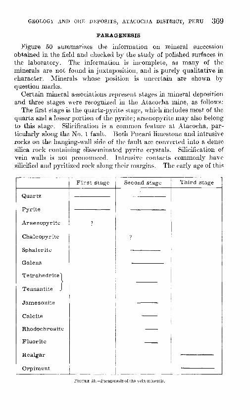
GEOLOGY AND ORE DEPOSITS, ATACOCHA DISTRICT, PERU 369
PARAGENESIS
Figure 50 summarizes the inforrnation on n1ineral succession obtained in the field and checked by the study of polished surfaces in the laboratory. The information is incomplete, as many of the minerals are not found in juxtaposition, and is purely qualitative in character. ::Vfinerals whose position is uncertain are shown by question n1arks.
Certain mineral associations represent stages in rnineral deposition and three stages were recognized in the Atacocha rnine, as follows:
The first stage is the quartz-pyrite stage, which includes n1ost of the quartz and a lesser portion of the pyrite; arsenopyrite rnay also belong to this stage. Silicification is a cmnmon feature at Atacocha, particularly along the No. 1 fault. Both Pucani lin1estone and intrusive rocks on the hanging-wall side of the fault are converted into a dense silica rock containing disseminated pyrite crystals. Silicification of vein walls is not pronounced. Intrusive contacts cmnmonly have silicified and pyritized rock along their n1argins. The early age of this
First stage Second stage Third stage
Quartz
Pyrite
Arsenopyrite ?
Chalcopyrite ?
Sphalerite
Galena
Tetrahedrite}
Tennantite :
Jamesonite i
Calcite --
Rhodochrosite --Fluorite --Realgar
Orpiment
FIGURE 50.--Paragenesis of the. vein minl'rals.
370 GEOLOGIC INVESTIGATIONS IN THE AMERICAN REPUBLICS
stage is 8hown by the presence of other sulfide n1inerals in veins or replacement bodies cutting the silicified and pyritized rock.
The second stage is the sulfide stage, during which all the ore minerals, the earbonates, and fluorite were deposited. Pyrite continued to be deposited in this stage. The relative age of chaleopyrite is not clear; it is one of the n1inor sulfides found with the pyrite-galenasphalerite association typieal of the stage. The sulfosalts jan1esonite and tennantite were also deposited with the other sulfides and were probably overlapped in time by galena and sphalerite. The earbonate gangue minerals and fluorite are deposited late, as they fill the eenters of veins and may enclose angular fragments of sulfides broken fron1 the adjoining walls. Calcite may have a longer range of deposition than either rhodochrosite or fluorite.
The third stage is the realgar-orpiment stage. Veinlets of realgar and orpiment are found cutting the earlier sulfides, but the principal oecurrenee of the arsenic minerals is in a separate vein. This deposition in separate structures is interpreted to represent two widely separated stages of deposition with the realgar and orpin1ent later as shown by the crosscutting relationships in the one area where they come in contact with the other sulfides. Their deposition could also, of course, be one of the final events of the second stage.
At Milpo early-formed pyrite is found in the veins and a light pyritization of vein walls is unaccompanied by silicification. Galena and sphalerite were deposited contemporaneously after the pyrite. Jamesonite and tetrahedrite, while younger than pyrite, eould not be definitely related in time to the galena and sphalerite. The fluorite is thought to be of the same age as the sulfides. Calcite and rhodochrosite fill late-formed fractures and form drusy eoatings in eavities.
The sulfide minerals are not exposed well enough at Maehean to allow any detern1ination of the sequenee of deposition.
CLASSIFICATION
The ore deposits of the Ataeocha district are believed to be of hydrothermal origin, that is, they were deposited from hot aqueous solutions derived from a magmatic. source. A possible magmatie souree would be that from which the adjacent porphyry intrusions originated; the intrusives then1selves are premineralization as veinlets of ore minerals eut the intrusive roeks. The assoeiation of ore deposits with intrusive roeks of intermediate composition is found throughout the lead-zinc province of Peru and is in itself suggestive of a genetic relationship between them.
Contact metamorphism of Pucara limestone with the developn1en t of lime-silicate minerals is found at Milpo and Atacoeha. Inasmuch as no ore bodies are found in the contact metamorphic zones, none of the deposits can be classified as pyrometasomatic.
GEOLOGY AKD OHE DEPOSI'l'~.' ATACOCHA DIS'l'RICT, PERU 371
1Turther subdivision of the hydrothennal classification is possible. The mineralogy of the Ataeoeha on~s indicates deposition under moderate conditions of tmnperature and pressure. Realgar and orpiment are typical epithermalininerBls but were probably deposited in a late stage of mineralization. The galena-sphalerite-pyrite association is found in all classes of hydrothermal deposits, but the association with ja1nesonite and tennantite, and particularly with the gangue n1inerals rhodochrosite and fluorite indicate moderate to low ten1perature and pressure. The deposit should probably be classified as leptothermal.
At Milpo, on the other hand, the scarcity of ja1nesonite and tetrahedrite, and the absence of realgar and orpin1ent, suggest Inesothennal conditions.
STRUCTURAL CONTROL OF ORE BODIES
The ore bodies can be classified as replacenwnt bodies and veins. Both types are found at l\1achcan and Atacocha, but replacen1ent has not been an important process at ~filpo.
Bedding replacen1ents or ''mantos'' in Pucani linwstone are co1nmon at Machcan, where nearly half of the prospect pits and s1nall adits explore manto-t,ype deposits. The majority of the deposits are small, ranging frmn .50 centimeters to 1 Ineter in thickness and from 1 to 20 meters in lateral extent; only two ore bodies more than 50 meters long were observed. The bedding replacements are always assoeiated with veins and extend out frmn the1n. The veins probably served as feeders for the ore bodies. The walls of the mantos are often sharp and delineated by sinall bedding-plane faults. Laterally the sulfide cont,ent din1inishes along the strike, changing frmn solid ore to disseminated ore,. to stringers along fractures within the bed, and finally to unaltered limestone.
Another type of replaeen1ent at ~1aehean consists of irregular replacenlent along the contact of the l\,1itu and Pucara formations. Ore emplacenwnt was controlled by the contact and by several faults that extend across it. l\1ost ore is in linwstone, but nu1sses of sandstone within a gossan area. indicate that smne sandstone was also replaced.
Large irregular replaeernent bodies in Pueara limestone have provided n1ost of the ore at the Atacocha mine. Most of the developed ore bodies of this type are found in a li1nestone sequence 50 to 60 meters thick above the No. 1 fault (pl. 26) but they are also known to occur near the chert breccia contact to the west of the syncline west of the Atacocha fault. The ore bodies wen' formed by ineornplete replaceruent of limestone by sulfides and day minerals. They vary widely in size; one of the largest, now nearly worked out, had
372 GEOLOGIC INVESTIGATIONS IN THE AMERICAN REPUBLICS
a pitch length of about 250 meters, a breadth of 40 to 70 meters, and a thickness of 4 to 10 meters. The ore bodies seem to be related to some of the larger veins, which may have served as feeders.
Veins at Machcan follow two sets of fractures. The majority of the veins follow a set of fractures that strike N. 35°-70° W. and dip 55° to 70° SW. The other set of fractures strikes N. 10° E. toN. 20° W. and dip steeply both east and west. Individual veins vary in width from 30 centimeters to 2 meters; pinching and swelling along the vein is a common feature. Gouge and stringers of clay are common both along vein walls and within the veins. The veins were formed by replacement along faults or breccia zones; fissure filling seems to be of minor importance.
Veins at Atacocha are found in all rock types but those in limestone and quartz sandstone are most important; only one vein in porphyry is being mined. Most veins strike from N. 50° W. to west and dip steeply. Veins in limestone are concentrated near the axis of a small cross fold near the Atacocha fault and have been found only in the upper mine workings. They may have filled tension fractures opened during the formation of the cross fold. Veins in quartz sandstone and chert breccia are found on all levels and are the principal source of ore in the deeper workings. Vein width is usually less than 1 meter but occasionally it increases to 3 or 4 meters The most persistent vein has been mined for a strike length of 150 meters and over a vertical extent of 300 meters. The ratio of lead to zinc in veins in sandstone or chert breccia is 5:1 or even greater, in contrast to a ratio of about 1:1 in veins in limestone. The reason for this difference was not determined. Open-space filling seems to be the most important process in vein formation at Atacocha, particularly in the veins in quartz sandstone or breccia.
Veins are the only important source of ore at Milpo, where two fracture systems are found. In the northern area, a series of steeply dipping veins strike N. 40°-60° E., whereas farther south another group of more irregular veins strike both northeast and northwest. Some veins are irregular in strike and curve from northeast to northwest. The veins are all in Pucara limestone east of the Atacocha fault; one vein crosses a small porphyry mass in limestone. The veins have formed by filling open spaces. Their width is usually less than 1 meter and they show little variation along the strike, except for the vein that crosses the porphyry; this vein narrows in the porphyry, probably because of the difference in behavior of the porphyry during fracturing. Not enough exploration has been done at Milpo to determine the lateral extent of the veins, but their vertical extent is at least 300 meters.
GEOLOGY AND ORE DEPOSI'I'S, ATACOCHA DISTRICT, PERU 373
RELATION OF ORE DEPOSITS TO DISTRICT GEOLOGIC FEATURES
The geologic features on a district-wide scale that may have been in1portant in the localization of the Atacocha ore deposits are: the porphyry intrusives; the Atacocha fault; the contact of the :Nfitu and Pucara formations; and the series of northwesterly-striking faults.
Intrusive rocks are found in or adjacent to mine workings at Milpo and Atacoeha and not far frmn mine workings at l\1achcan. All the larger intrusives have 1nineralized areas within then1 or along their margins, but this mineralization has not proved to be of economic importance. Both the Atacocha and Milpo mines are adjacent to porphyry stocks, so the search for favorable structures around the stocks may be more in1portant than exploring the stocks themselves.
An indirect relation certainly exists between the ore deposits of Atacocha and the Atacocha fault, and there may be a direct relation even though the fault itself is not n1ineralized. The fault seems to have controlled the emplacement o(some of the intrusives, as all stocks but one are located close to the fault. A close control is indicated at Atacocha, where the ore bodies are found in a cross fold apparently formed by drag along the fault and are further localized by a moderately dipping reverse fault that probably branches from the Atacocha fault. A direct relation between ore deposits and the Atacocha fault could not be found at 1\filpo and the signifieance of the veinfilled northeastward-trending fractures, not found elsewhere in the district, was not determined.
Conditions elsewhere along the Atacocha fault do not seen1 as favorable for ore deposits. No other intrusive bodies were found along it. A small structure, si1nilar in some respects to the cross fold at Atacocha, was found west of Cajan1arquilla in the. "V" between the Atacocha fault and the adjacent fault to the west, but no ore minerals were found.
Sulfide mineralization occurs along the eontact of the Mitu and Pucara formation at l\fachean where a gossan outcrop 200 n1eters long and 30 meters wide was found. A few prospect pits have been dug along the contact south of 1\fachcan, but no ore has been discovered. The intersection of faults with the contact is probably more in1portant than the contact itself. The faults Inay form channels for ascending solutions that spread out along the contact. Limestone beds above the contact are the favorable host rocks.
The importance of the series of northwesterly-striking faults, found principally between 1tfilpo and Atacocha west of the Atacocha fault, is not known. The faults then1selves are not mineralized, but the intrusive south of Atacocha and west of the Atacocha fault is elongate in a northwesterly direction parallel to this system of faults. A set of
37 4 GEOLOGIC INVESTIGATIONS IN THE AMERICAN REPUBLICS
mineralized fractures at Machcan has the same general strike and may be part of the northwesterly-trending fault system.
Other structural features seem to have little significance. No relation was found between the larger folds and ore deposits, although small folds may be important in individual mines.
The most favorable area for further prospecting, other than extension of present mine workings, is between Milpo and Atacocha close to the Atacocha fault. Small porphyry bodies are present in this area, and evidence of mineralization is abundant. No favorable structure was found that would indicate the possibility of finding large ore bodies of the Atacocha type, but veins of minable width and grade may be found. The present investigation shows that the ore deposits at Machmin are distinct from those along the Atacocha fault and no evidence exists for a favorable structure extending from Atacocha to Machm1n, so the area between the two n1ines is not one of promise for prospecting. The relation of the Atacocha fault to the large northwest-striking fault near Hacienda Carmen Chico should be studied further in order to determine whether the Atacocha fault continues to the south. If so, additional work southward along the Atacocha fault would be warranted.
MINE DESCRIPTIONS
MACHCAN MINE
The Machcan mine is the most northerly of the three producing mines in the Atacocha district. The mine is about 3 kilometers northwest of Atacocha and is reached by 35 kilometers of road from Cerro de Pasco along the Rio Tingo.
The mine is owned and operated by Cipriano Proafio and Ju.an Antonio Proaiio of Cerro de Pasco. Production in 1952 was about 30 tons of hand-sorted ore per n1onth; both oxidized and sulfide ores are produced. A 50-ton mill was under construction at the time of this examination and was scheduled to begin operation early in 1954. The bulk of the ore produced con1es from no. 1 vein in adit no. 1 (pl. 24). Some sulfide ore is Inined in the Lizandro Sur workings.
The country rock at Machcan includes the upper beds of the Mitu group and the lower limestone beds of the Pucara formation. The contact between the two formations is faulted in part, and Pucara rocks seem to have moved over the Mitu along the contact. Dikes and sills of dacite were found in the southeastern part of the area shown on plate 24, and two dikes of aphanitic andesite were noted in the southwestern part of the area. The limestone adjacent to the dacite dikes has been serpentinized.
The mine area may be divided into three structural units. The first is composed of the red beds of the Mitu group in which no structure is
GEOLOGY .AND UHE DEPOSITS, A'l'ACOCHA DIS'l'RICT, Pl!JRU 875
visible. The seeond is in the central part of the area, where the linwstones are folded into a shallow anticline and syncline which plunge to the southeast. In the southeastern part of the area the lin1estones are block faulted along two sets of faults that strike N. 5° E. and N. 70° E. The eontrolling factors in ore deposition are the contact and the faults.
The 11itu and Pucara contaet trends north in the western part of the Inappecl area. It swings northeast north of adit no. 1 and trends N. 70° E. above the Carlos Chino Viejo vvorkings. In dw north and northwest the contact clips 30° to .50° SE. A fault trending N. 60° E. cuts the contact near adit no. 1 and the contaet south of the fault is offset 200 meters to tlw WPst; the direction of nwvement on the fault is unknown.
The lin1estones in the <lrea strike north to northeastward and. dip 30°-70° E. They are folded into a shallow, sy1n1netrical syncline near adit no. 1 and into a s1nall symmetrical anticline further east; the folds plunge 30°-40° SE. ~linor folds, n1ost plunging to tl1e north, are noted throughout the area. Folding, even on a s1naH scale, is not a control in ore deposition.
The faults may be divided into three Inajor groups whieh strike N. 35°-70° vV., N 20° W. toN. 10° E._, and N. 50°-70° E., respectively. The northwesterly-striking set is the nwst strongly mineralized, and the fractures show little displacen1ent. The dadte dikes appear to have been intruded along this set of faults. The faults trending N. 20° W. to N. 10° E. are in part n1ineralized and are the 1nost nu1nerous faults of the aret1. They are :vounger than the first set. The no. 1 vein in the aclit no. 1 (pl. 2.5) was e.n1plaeed along one of these faults and the 1nany nortlnvarcl-trending cliffs in the southern part of the area are due to 1noven1ent along these faults. The faults trending N. 50°-70° E. are postn1ineralization. The offset of the contact of the red bed anclli1nestone \vest of adit no. 1 and the northern tennination of the no. 1 vein are both eaused by faults of this set, possibly the same fault.
The ore deposits of the area are replaeernenl-t,ype lead-zinc deposits found as veins, hellcling replacements or Iuantos, and irregular replacements along the eon tact of the 1Jitu and Pueftra fonnations. Only the Lizandro Sur workings are in sulfide ore; the other \vorkings are all in the oxidized zone. Oxidation is known to extend to over 1.50 meters below the outcrop on the no. 1 vein and the other deposits are probably oxidized to cornparable depths. The bottom of the oxidized zone was not observed, and so it was not possible to con1pare the metal content of the oxidized and sulfide ores to det.rrmine the extent of any possible leaching or enridunent,,
376 GEOLOGIC INVESTIGATIONS IN THE AMERICAN REPUBLICS
The ore in general contains about 50 to 60 percent of iron oxides, 10 to 20 percent of calcite and calamine, and 20 to 30 percent of lead minerals. The lead is most commonly found as cerussite and small knots of galena. Anglesite forms coatings on galena. Plumbojarosite was observed in several areas, notably in the lower stopes of adit no. 3. Several other secondary minerals were observed and are described in the section on mineralogy.
The mine workings in the area may be divided into nine more or less distinct groups, the most important of which is the adit no. 1 (pl. 25). All the ore from these workings was being extracted from the no. 1 vein which strikes N. 20° W. and dips 65° to 70° E. The vein has an average width of 1.5 meters. It dies out to the south in a breccia zone, which extends on to the south for an additional 200 meters. Ore was deposited in the breccia zone but not in minable quantities. The northern end of the vein is not reached in the mine, but on the surface it terminates against a fault trending N. 70° E., 100 meters northwest of the no. 1 shaft. The offset segment of the vein north of the fault has not been definitely located but probably lies in the Palmira area. Although the vein follows a strong fault trending N. 20° W. it is locally very irregular. Replacement has taken place along bedding planes and minor faults, and in such areas the vein attains widths of several meters. A vein branches off to the southeast from the no. 1 vein north of the no. 1 shaft. This vein was not found in the mine but the junction of the two veins might be an especially favorable target for prospecting. The no. 1 vein has been stoped for 50 meters vertically and 7 5 meters laterally and a shaft has been sunk from the surface to the level of the stopes. Several small veins and two mantos (seep. 371) have been found }n :the :mine but they :have pot been explored to date.
Adits nos. 2 and 3 are both on the same vein, which trends N. 45° W. and dips 65° to 70° SW. The vein is variable in width, ranging from 0.5 to 2 meters. Little work has been done on this vein except for some small stopes above and below adit no. 3.
The Lizandro Sur workings consist of a 15-meter shaft that follows an ore shoot and a short drift that connects with the shaft. The shoot is formed at the intersection of two veins; one strikes east and the other N. 50° W. The shoot is about 2.5 meters in diameter. Small amounts of pyrite, sphalerite, and gossan are found with the galena in this ore shoot.
Farther south is the Carmen area which contains one large and 10 small adits driven on a system of veins trending N. 60° W. and N. 10° W. The principal vein trends N. 60° W. and can be seen on a cliff east of Laguna Lulicocha. The vein dips 75° S. and has an average width of 1 meter. Several small ore shoots have been formed at vein intersections, and mantos were noted extending outward from
GEOLOGY AND ORE DEPOSITS, ATACOCHA DISTRICT, PERU 377
the main vein. A manto on the eastern edge of the area follows the bedding for 25 meters and is 1.5 meters wide. The manto strikes N. 20° E. and dips 2.5° SE.
The Precauci6n claim lies on the far western edge of the mapped area near the Mitu and Pucara contact. Several veins trending N. 70° E. and a rnanto 20 by 30~nleters in extent forn1 the ore deposits. An adit driven beneath the mineralized area from the west revealed only one of the veins and failed to locate the n1anto, indicating that the deposits are very shallow.
The Lizandro Norte workings, located southeast of adit no. 3, explore a manto that has a strike length of 40 n1eters and is 1 to 2 meters thick. The n1anto strikes N. 30° E. and dips 30° SE. Its extent down the dip is not known.
The Carlos _Chino Nuevo area includes a gossan outcrop of some 1,000 square meters along the contact of the ~fitu and Pucara formations. The cornpactness and lack of porosity of the gossan indicate that it was derived largely if not entirely from pyrite. Exploration at depth would be advisable in order to detern1ine the possible presence of other sulfides.
Above the Carlos Chino Viejo adit a series of veins and faults that trend N. 10° W. and N. 60° W. are associated with several mantos. An ore shoot formed at the junction between two of the veins warrants further exploration.
The Palmira area, south of the Carlos Chino Viejo adit, consists of a series of sn1all veins trending N. 60° W. and N. 10° "\V, and several smallrnantos. The area is not heavily m.ineralized
ATACOCHA MINE
The Atacocha mine is about 13 kilon1eters northeast of Cerro de Pasco, midway between Milpo and .:Vfachcan near the head of Quebrada Chicrin. The camp is at an altitude of about 4,000 rneters but mine workings extend from 4,300 meters down to about 3,600 meters, the altitude of the Chicrin adit.
Little is known of the early history of the property. lVIodern exploration began about 1910, but successful exploitation did not begin until 1936 when the CompafHa Yiinera. Atacocha was formed. The accompanying table shows the production since 1940 and gives an idea of the growth of the operation
Rocks of the Pucara and Goyllarisquisga formations are found in the n1ine area. They are intruded by an irregular dacite body and several dikes and sills of dacite. Plate 26 shows the surface geohgy of the mine area ..
A rock type at Atacocha not found elsewhere in the district is a brecciated red chert, interbedded with clastic limestone, that crops out in a 10- to 30-meter band over the n1ine workings. Clastic lime-
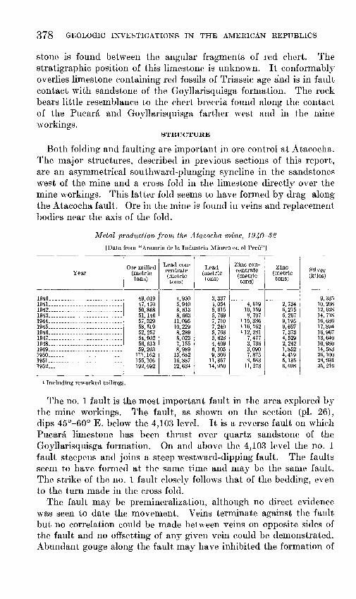
378 GEOLOGIC INVESTIGATIONS IN THE AMERICAN REPUBLICS
stone is found between the angular fragments of red ehert. The stratigraphic position of this limestone is unknown. It eonformably overlies limestone containing red fossils of Triassic age and is in fault contact with sandstone of the Goyllarisquisga formation. The rock bears little resemblanee to the ehert breeeia found along the eontaet of the Pucara and Goyllarisquisga farther west and in the mine workings.
STRUCTURE
Both folding and faulting are in1portant in ore control at Atacoeha. The major structures, described in previous sections of this report, are an asymmetrical southward-plunging syneline in the sandstones west of the Inine and a cross fold in the limestone directly over the mine workings. This latter fold seems to have formed by drag along the Atacocha fault. Ore in the Inine is found in veins and replaeement bodies near the axis of the fold.
Metal production from the A.tacocha mine, 1940-52
[Data from "Anuario de la Industria Minera en el Peru"]
Year
1940--------------------------1 1941_ _________________________ .. 1942 __________________________ _ 1943 __________________________ _ 1944 __________________________ _ 1945 __________________________ _ 1946 __________________________ _ 1947 __________________________ _ 1948 __________________________ _ 1949 ________ -------------------1950 __________________________ _ 1951_ _________________________ _ 1952 __________ ----------------
1 Including reworked tailings.
I
Ore milled ~~~r~~~-(metric (metric tons) tons)
49,019 47,470 50,868 51,146 57,329 58,519 52,257 54,902 56,613 59,263
111,162 155,106 192,692
4, 930 5,940 8, 613 8, 663
11,095 10,229 8,289 8, 023 7,155 8,989
13,682 16,887 22,634
Lead (metric tons)
3,337 4,054 5, 615 5, 769 7, 710 7,240 5, 768 5,628 4,409 6,105 9,306
11,357 14,950
Zinc con- I centrate 1
(me.trie tons)
Zinc (metric tons)
4, 619 2, 734 10, 159 6, 215 8, 707 5, 267
1 15, 336 9, 195 1 16, 162 9, 657 1 12, 281 7, 373
7, 477 4, 529 3, 736 2, 242 3, 090 1,852 7, 375 4, 419 8, 583 5,135
11' 273 6, 698
Silver (kilos)
9, 335 10,208 12,628 14,718 16,636 17,894 16,967 13,640 10,980 14,583 26,100 28,931 35,216
The no. 1 fault is the most important fault in the area explored by the mine workings. The fault, as shown on the section (pl. 26), dips 45°-60° E. below the 4,103 level. It is a reverse fault on which Pucara limestone has been thrust over quartz sandstone of the Goyllarisquisga formation. On and above the 4,103 level the no. 1 fault steepens and joins a steep westward-dipping fault. The faults seem to have formed at the same time and may be the same fault. The strike of the no. 1 fault elosely follows that of the bedding, even to the turn made in the cross fold.
The fault may be premineralization, although no direct evidence was seen to date the movement. Veins terminate against the fault but no eorrelation eould be made between veins on opposite sides of the fault and no offsetting of any given vein could be demonstrated. Abundant gouge along the fault may have inhibited the formation of
GEOLOGY AND OR!<: DJ<_JPOSITS, A'l'ACOCHA DIS'l'RIC'l', PERU 379
eontinuous struetures. .I\fineralization was reported to have been continuous across the fault at one point between the no. 1 ore body and the Veta Prin1a (main vein) whieh also suggests a. premineralization age for the fault.
MINE WORKINGS
The Inine is developed b:v about 30 kilmneters of workings on 16 levels. V ertieal spacing between levels is 2.5 to 5.5 n1eters and a total vertieal distanee of ·700 Ineters has been explored. Ore is found below the bottom level so the vertical range of ore is not yet known. Three maps of mine levels included in this report show the method of exploration and typical geologie relationships found in the upper and lower sections of the 1nine.
The 4,10~) level (pl. 27) explores the li1nestone east of the no. 1 fault and passes through the saudstone west of the fault in a few places. The dose spaeing of the veins near the axis of the cross fold (whieh is shown by the curve of the no. 1 fault) is apparent. A radial pattern is suggested by the strikes of the larger veins; this pattern Inay reflect tension eracks that developed during the cross folding and were filled later by vein material. Only the approxi1nate positions of ore bodies no. 3 and no. 4 are shown; these bodies are being mined on the leveJ below, but. their bounclnries are not known on the 4,103 level. Ore bodies no. 4 and no. 5 are dose to the no. 1 fault and are elongate along the bedding in the li1nestone. Ore body no. 3 is farther frmn the fault and may have been controlled by highly fraetured and easily replaceable limestone along the axis of the cross fold. J\fineralization diminishes south of the no. 5 ore body. The large intrusive cut by the erosscut south of the no. 5 ore body is part of the irregular porphyry body mapped on the surface. The southern end of the level lies under the San Gerardo area, vd1ich was productive closer to the surface. The prineipal working in sandstone follows the "D" vein which is about 110 n1eters long on this level
Conditions on the 4,000 level (pl. 28) differ considerably frmn those found above. The veins in li1nestone are wpaker and n1ore irregulnr. The no. 1 ore body hns the san1e relation to the no. 1 fault ns the ore bodies no. 4 nnd 5 nbove, but is the only ore body found along the fault. The lin1estone along the fault is highly nltered, pnrtieularly south of coordinate 3840 N, but it is only slightly Inineralized.
All igneous roek found on the 4,103 level seems to die out before reaehing the 4,000 level, with the exeept.l.on of the Tres Mosqueteros dike, which is barren on this level. The sandstone has been more thoroughly explored on the 4,000 level and nmnerous veinlets were cut, but little ore was found except in the "('',. a.nd "D" veins. The "D" vein is nnteh longer thnn it was on the 4,103 level, because of the east clip of the no. 1 fault, which is_ the_ eastern_li1nit of the vein.
380 GEOLOGIC INVESTIGATIONS IN THE AMERICAN REPUBLICS
The "0" vein, which is limited by the "D" vein and the no. 1 fault and thus also lengthens downward, has its apex not far above this level.
The map of the 3,900 level (pl. 29) shows conditions typical of the lower levels, which extended down an additional 125 meters at the time of this examination. Exploration in the limestone east of the no. 1 fault is confined to the vicinity of the no. 1 ore body, which continues downward another 60 meters. Workings in sandstone and chert breccia are extensive on these lower levels. The two bottom levels, 3,805 and 3,775, are entirely in sandstone and chert breccia, as the no. 1 fault lies east of the workings of those levels. The "0" and "D" veins on the 3,900 level are weaker than above and are broken by faults.
The Veta Prima is a strong vein that has been followed from above the 3,970 level to below the 3,775 level, or over 200 meters vertically. It may have been the feeder for the no. 1 ore body, as the north end of the ore body closely follows the intersection of the Veta Prima and the no. 1 fault.
No. 3 and no. 4 faults are splits from the no. 1 fault. The junction of the no. 3 and no. 1 faults nearly coincides with the intersection of Veta Prima and the no. 1 fault. This relationship is found on several levels and points to the possibility of a relation between fault splits and ore. The junction of the no. 4 and no. 1 faults is, therefore, worth investigation. The no. 2 fault is the western limit of the Veta Prima. The vein narrows and becomes pyritic on entering the fault zone, which lies parallel to a shale horizon in the sandstone, so the vein fissure may die out in the shale instead of being offset by the fault.
Workings in these lower levels have entered limestones on the western flank of the syncline, and small ore bodies have been found in the limestone near the con tact with chert breccia; some of the veins in chert breccia widen out into replacement bodies on entering the limestone.
An adit driven under the mine area from Chicrin is 175 meters below the principal mine workings. An ore body was found on the adit (3,600) level in limestone that seems to be on the western flank of the syncline, but correlation is uncertain because the altitude of beds on the adit level is not the same as on the levels above.
At Atacocha, galena and sphalerite are the only important ore minerals, and pyrite, calcite, and clay minerals form the bulk of the gangue. Jamesonite and tennantite are minor ore minerals, and rhodochrosite and fluorite are found sparingly in the gangue. Realgar and orpiment are found but may belong to a later stage of mineralization.
GEOLOGY AND ORE DEPOSITS, ATACOCHA DISTRICT, PERU 381
MILPO MINE
The Milpo mine is 10 kilometers northeast of Cerro de Pasco, and is accessible frmn the.re by a road 13 kilometers long. The mine workings are near the headwaters of Quebrada Atacocha at altitudes ranging fron1 3,900 to 4,200 meters.
The area was known t,o be mineralized for many years and the deposits have been worked sporadically. The Compafiia Mineral Milpo, S. A., was forn1ed in 1949 and has operated the property continuously since that time. Production to the end of 1951 amounted to over 12,000 tons of ore with an average grade of 8.2 percent of lead, 11.1 percent of zinc, and 376 grams of silver per ton. Production increased early in 1952 when a flotation concentrator of 60-ton capacity was placed in operation.
The sedimentary rocks in the area are limestone of the Pucara formation and quartz sandstone of the Goyllarisquisga formation (pl. 30). The sandstones crop out only in the southwest corner of the area where they are brought .into contact with the limestone along the Atacocha fault. Both the sandstone and the limestone strike N. 15°-20° W. The limestone dips steeply or is vertical, whereas the sandstone dips 10°-20° W., except near the Atacocha fault where the dip steepens to 55°.
The limestone in the eentral and north central part of the area has been intruded by two irregular dacite bodies. Extensive alluvial eover prevented eomplete mapping of the two bodies and they may actually be parts of a single stoek. Many satellite dikes and sills are assoeiated with the larger intrusive. A daeite sill, 40 meters thiek, lies along the east side of the Atacoeha fault; this dacite is similar in appearance to the dacite of the stoek, but eontains less quartz and mafie minerals. The limestone has been reerystallized to marble along the intrusive eontacts.
The limestones are eut by a series of transverse faults and by several bedding-plane faults. The transverse faults ean be grouped into two sets, a northeastward-trending set found in the northern part of the area, and a northwestward-trending set found farther south. The northeastward-trending faults range in strike from N. 60° E. to N. 80° E. and dip north 75 degrees or more and most of them lie to the east of a bedding-plane fault that extends at least 500 meters north from near the mouth of the 170 level adit. The northwestwardtrending faults strike from N. 45° W. toN. 80° W. and dip 65°-80° N.
All faults or veins are confined to the area east of the Atacocha fault. The faults of both sets cut the intrusives and offset contacts frmn 5 to 15 meters. These northeast--and northwest-striking faults are probably conjugate fractures. Ore was deposited mainly in open spaces and is restrieted to the northeast-striking fractures, with the exception of the San Carlos vein.
346876-55-4
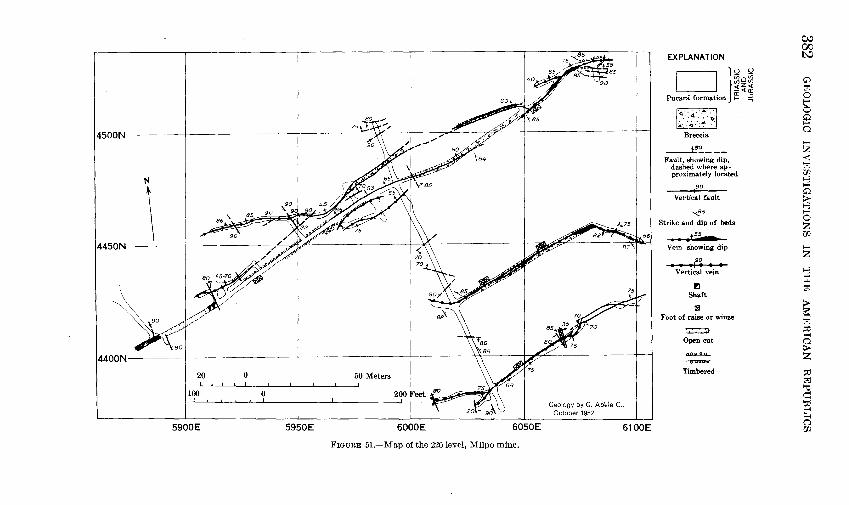
4500N lK
N
4450N \ i/ ~os>"V
4400N
20 0
5900E 5950E
I )<~
50 Meters
I as;i!ft T
Geology by G. Ab'ele C., October 1952
6000E 6050E 6100E
FIGURE 51.-Map of the 220 level, Milpo mine.
EXPLANATION
D }uu u; 0 iii
~~~ Pucara formation g: :;;
lt .. ::.· ... :··:·~j Breccia
_.1!~---Fault, showing dip,
dashed where approximately located
90
Vertical fault
'<f!S
Strike and dip of beds
• ,,ss Vein showing dip
90 I I II I I I
Vertical vein
r.J Shaft
nil Foot of raise or winze
~
Open cut
lUULJI..<L
Timbered
c,.., 00 l'-:1
0 to':! 0 t" 0 0 H 0
H
2: < to':! l/1 1-3 H 0
f:3 H 0 z l/1
z 1-3 ~ to':!
~ to':! ~ H 0
~ ~ to':!
~ txl ~ 0 l/1
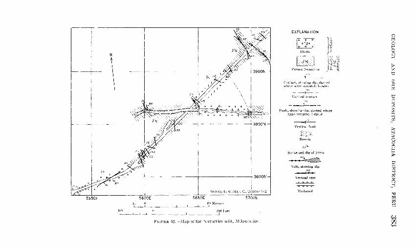
'{~,
N
\
---+3800N
I Geology by G, Abele C,, October 1952
5550E 5600E 5650E 5700E 11J 0 611 Meters
lUO II 200 Feet
FH1UHE .12.-~Iap of the \lantrrico adit, .\'filpo mine.
EXPLANATION
j+~::+l ~J
llaeite
l'ucara format lutJ
-~-_L'--~~~
}I
Contact, showing diJJ, da,-hed whert..' approximately l~~eated
,90
\'et·tical contact -s
Fault, showing clip. dashed where apprnximatel.\ located
,91
Vertical fault
·t: t~·~. B.ri.'Ccia
80--.._
Strike and dip of joints
~ Vein, showing dip
,99 -
Vertical vein
Timbered
C1 M 0 r 0 ~ ~
> :?: b
0 !Jj ~
0 :?j "0 ·~ m ,._. ~
_:,.JJ.
> 1-3 > n c 0 ;:q > b H (JJ 1-3 :::0 H ('"_)
~8
"0 trJ :::0 c;
w 00 w
384 GEOLOGIC INVESTIGATIONS IN THE AMERICAN REPUBLICS
Ore is being mined on the 120, 170, and 220 levels in the northern group of faults. The plan of the 220 level (fig. 51) shows the method of exploration. Crosscuts are driven normal to the general strike of the veins and drifts follow the veins found. The veins vary in width from 0.1 to 1 meter. In the southern group of veins the N avarrico adit (fig. 52) is the principal working. It cuts through the porphyry bodies and explores a portion of the San Carlos vein. This vein is the largest in the area, with a width of from 0.8 to 3 meters.
Mineralization consists of simple fissure filling with very minor replacement. The ore minerals galena and sphalerite, together with minor amounts of jamesonite and tetrahedrite, occur in a gangue of calcite and pyrite. Some quartz, fluorite, and rhodochrosite are also found with the gangue minerals. A pyritic body with disseminated galena and sphalerite is found on a faulted contact of porphyry and limestone extending northwest from the 170 level adit.
Angular fragments of sulfide ore in fault breccia and ground-up sulfides in gouge indicate postmineralization movement along the faults. The veins have been displaced as much as 2 meters. Faulting may have taken place near the end of the period of ore deposition, as faults that cut ore are themselves filled by ore minerals.
LITERATURE CITED
Dfaz, L. F., 1909, La regi6n minera de Atacocha: Bol. del Cuerpo de lng. de Minas del Peru, No. 74, p. 53-61.
Dunbar, C. 0., and Newell, N. D., 1946, Marine early Permian of the central Andes and its fusuline faunas; Am. Jour. Sci., v. 244, p. 377-402, 457-491.
Harrison, J. V., 1943, The geology of the central Andes in part of the province of Junin, Peru: Bol. Soc. Geol. del Peru, tomo 16, p. 55-97.
Jenks, W. F., 1951, Triassic to Tertiary stratigraphy near Cerro de Pasco, Peru: Geol. Soc. America Bull., v. 62, p. 203-220.
McLaughlin, D. H., 1924, Geology and physiography of the Peruvian Cordillera, Departments of Junin and Lima: Geol. Soc. America Bull., v. 35, p. 591-632.
Newell, N.D. Chronic, B. J., and Roberts, T. G., 1949, Upper Paleozoic of Peru, 239 p.: Univ. Service Bureau, Columbia Univerisity.
Pettijohn, F. J., 1949, Sedimentary rocks, 529 p.: Harper & Brothers. Steinmann, Gustav, 1929, Geologie von Peru, 448 p.: Heidelberg. [Spanish
translation by Jorge A. Broggi, 1930] Weberbauer, A., 1945, El mundo vegetal de los Andes Peruanos, 776 p., Lima.
METRIC EQUIVALENTS TEMPERATURE LINEAR MEASURE WEIGHTS
0 t:<1 0 ,..----.. t"'
co Fo Centi- Inches Meters Feet Kilo- Miles Kilo- Pounds Metric Long Metnc Short 0 meters meters grams (avoir.) tons tons tons tons 0
~
70-; 100 1000--r 100~ 100 100 ·110 >
150 60 901-90 z 900 3000 90 90· 200 100
t:1 60 +·140 90
0 130 :::tl
50-1-- 120 800 80 50 80 80 80 ~
2500 t:1 110 70 700 70 70 70 70 ~
40 ---1 100 150 "d
70 c 600 -t- 2000 -60 'l1
60 60 60 60- 60 H
30 --1-- 90 8 __ w. 80 50 500 50 50 50 50
30 > 20 ----1' 70 1500 100 50 8
60 40 400 40 40 40 40 40 > 0
40 0 10-+- 50 20 0
30 300 1000 30 30 30 30 ~ 40 30
0 ----[._ 30 200 20 20 50
20 20 t:1 20 H
20 500 10 w. 8
10 ----1- 10 10 100 10 10 10 10 10 10 :::tl H 0
20 _l_ 0 0 0
8 0 0 0 0 0 0 0 0 0 ~
1 em. = 0.3937 inch 1 meter = 3.2808 ft. 1 km. = 0.6214 mile 1 kg. = 2.2046 lbs. 1 metric ton = 0.9842 long ton "d
1 inch = 2.5400 em. 1 ft. = 0.3048 meter 1 mile = 1.6093 km. 1 lb. = 0.4536 kg. 1 metric ton = 1.1023 short tons t<1 :::tl
1 sq. meter = 1.20 sq. yd. 1 metric ton = 2205 lbs. q 1 hectare = 2.47 acres 1 long ton = 1.0161 metric tons 1 cu. meter= 1.31 cu. yd. 1 short ton = 0.9072 metric ton
C;..j 00 Ol

INDEX
Page Abstract_ __________________________________ 337-338 Intrusive rocks, description ___________ _
Page
355 373 356
Access to the area____________________________ 339 relation to ore bodies ____________________ _ Acknowledgments __________________________ 341-342 time of emplacement_ ___________________ _ Alabandite___________________________________ 365 Alluvium_____________________________________ 353 Jamesonite ___________________ ------ 366,369,370,371
Andean orogeny______________________________ 364 L d f Anglesite________ __ ______ ____ ____ ________ ____ _
367 an scape eatures_ _ ____ ____ ___ _ _ __ ____ ____ _ _ 362
Anticlines____________________________________ 358
Landslides___________________________________ 354
Arsenopyrite.-------------------------- 365, 369-370 Limestone, deposition oL __________________ 363-364 Atacocha fault_ _____________________ 360-361, 373-374 Limonite __ ----------------------------------- 368 At h ·
1 t·
377 Literature cited______________________________ 382
acoc a mme, oca wn______________________ Lizandro Norte workings_____________________ 377 metal production _________________ ------ 365• 378 Lizandro Sur workings _____________________ 375,376 rocks oL _______________________________ 377-378 structure_------------------------------ 378-379 Location _____________________ ----------------- 339
workings_------------------------------ 379--380 Machcan mine, description _________________ 374-377 Aurichalcite_ -- ________ --- ------ _-------- ----- 367 Malachite____________________________________ 368
B It fl t' f 363 364
Manganese oxides____________________________ 368 asa ows, erup wn ° -------------------- ' Mantos. See Replacement deposits.
Calcite_--------------------- ___________ 367,369, 370 Marcasite.-----------------------------_---__ 366 Callamine_ ___ _ ___________ _ _ _ _ _ _ _ _ _ _ _ _ _ _ __ _ __ _ 367 Melanterite_--- ------------------ __ ---- _----- 368 Carlos Chino Nuevo area_____________________ 377 Metamorphism, contact_ ______________ - 356-357,370 Carlos Chino Viejo workings _______________ 375,377 Milpo mine, description oL ___________ ----- 381-382 Carmen area _______________________________ 376-377 Mine descriptions __ ------------ _____ - ___ --- 374-382 Cerrusite_ ___ _ __ _ _ ___ ____ _ _ __ _ _ _ _ _ _ _ _ __ __ _ _ __ _ 367 Mineralogy------------------------_-------- 365---368 Chalcopyrite ___________________________ 366,369,370 Mitu group, contacts oL _______________ 345,346,373 Chert beds, deposition 0 r____________________ 363 description _________________________ 343,344-345
Chert breccia ___________________________ 347-348,349 folding of rocks oL _________ ------------ 357,359
Chicrin limestone, description __________ 343, 351-352 fossils in _____ ----------------------------- 345 Classification of ore deposits. _______________ 370-371 minerals _________ ------------------------- 345 Clay minerals________________________________ 367 origin of name __ -- ___ --- _____________ ----- 344 Climate______________________________________ 340 thickness _______________________________ 343, 344
Coal, in Goyllarisquisga formation____________ 350 Moraines ___ ---------------------------------- 353 Muscovite____________________________________ 368
Dacite, outcrops of _________________________ 355-356 Diorite porphyry, outcrops oL_______________ 355 Nahuelpun, Laguna, conglomerate beds near_ 353
Nonsulfides ________________________________ 367-368
Excelsior formation _____________________ 343,344,357 OpaL ______ ---------------------------------- 368
Faults __________________________ 360,373-374,378-379 Ore bodies, structural control of ____________ 371-372 Field work___________________________________ 342 Ore deposits, classification of _______________ 370-371 Fluorite ________________________ 367-368,369, 370,371 description of minerals __________________ 365---369 Folds _______________________________________ 357-359 relation of to geologic features_____________ 373 Fossils, in rocks of Mitu group_______________ 345 Orpiment. _________________________ 366,369,370,371
Galena _____________________________ 366,369,370,371 Palmira area_________________________________ 377 Geologic history ____________________________ 362-365 Paragenesis _________________________________ 369-370 Geomorphology ____________________________ 361-362 Physical features _____________ ---_____________ 340
Glaciers, evidence oL________________________ 365 Plumbojarosite. _____ __ _____ __ _ ____ __ _ _ ___ _ _ _ _ 368
Goyllarisquisga formation, coal deposits in____ 350 Post-Goyllarisquiga rocks, description ______ 351-352 description _____________________________ 350-351 Precaucion claim_____________________________ 377 origin of name __________ ------------ ____ 349-350 Previous work in the district_________________ 341 outcrops________________________________ 350 Pucara formation, contacts oL. ____ 346-348, 350, 373
Gutierrez, Dora, fossils identified by__________ 349 description.--------------- _________ 343,347-348 Gypsum ____________________________________ 345, 368 faults in ____________________________ 359,360-361
fossils in ________________________________ 348-349
metamorphism oL_______________________ 356 origin of name __________________________ 345---346
Hydrothermal origin of minerals ____________ 370-371 Hydrozincite_ __ _ _ _ __ _ _ __ _ _ __ _ _ _ _ ____ _ _ _ _ _ _ __ _ 368
Imlay, Ralph W., fossils identified by _______ _ 348 thickness _______________________________ 343,347 Introduction _________________________________ _ 338 Pyrite ______________________________ 366, 369-370, 371
387
388 INDEX
Page Page Q,uartz _________________________________ 368,369-370 Sulfosalts _______ ------- ____ ----------- ______ 365-367
Realgar _____________ ------- _____ 366-367,369,370,371 Synclines ___ -------------------------------- 358- 359
Replacement bodies ________________________ 371-372 T n 367 369
370 37
1 See also Mine descriptions. ennan 1 e_________________________ , , ,
Rhodochrosite ______________________ 368, 369, 370, 371 Terraces ______ -------------------------------- 354 Rivera, Rosalvina, fossils identified by_______ 349 Tetrahedrite__________________________________ 367
Sphalerite __________________________ 367,369,370,371 Unconsolidated material, description oL ___ 353-354 Stratigraphic chart of rocks___________________ 343 Structure, at the Atacocha mine ____________ 378-379 Vegetation _________________________________ 34Q-341
of the area ______________________________ 357-361 Veins, description oL_ ____ ________ _______ ____ 372
Sulfides __ ------------------·--------- _______ 365-367 Veta Prima___________________________________ 380
Related Documents