TEXAS BOARD OF WATER ENGINEERS C. S. Clark, Chairman John W. Pritchett, Member E. V. Spence, Member •''''''!Ii"''' 'iJ' :rk 'r "'.! ...• :: " .... , ....:_.. GEOLOGY AND GROUND WATER RESOURCES OF COMAl COUNTY, TEXAS PREPARED IN COOPERATION WITH THE UNITED STATES DEPARTMENT OF THE INTERIOR. C;;EOLOGICAL SURVEY FEBRUARY 1947

Welcome message from author
This document is posted to help you gain knowledge. Please leave a comment to let me know what you think about it! Share it to your friends and learn new things together.
Transcript
TEXAS BOARD OF WATER ENGINEERSC. S. Clark, Chairman
John W. Pritchett, MemberE. V. Spence, Member
•''''''!Ii"'''
'iJ'i~ :rk ~'r "'.!...•:: " .~....,....:_..
GEOLOGY AND
GROUND WATER RESOURCESOF
COMAl COUNTY, TEXAS
PREPARED IN COOPERATION WITH THE UNITED STATES
DEPARTMENT OF THE INTERIOR. C;;EOLOGICAL SURVEY
FEBRUARY 1947

TEXAS BOARD OF WATER ENGINEC:RS
C, S. Clark, ChairmanJchn W. Pritchett, Member
E. V. Spence, Member
GEOLOGY AND ("ROUND-WATER RESOUHC3SOF
COMAL COUNTY, TEXAS
By Willia~ O. George
Wi th a s!3cti.cm ,)n the chomical character cf watnrBy Warren W. Hastings
andA secti,:n On surfac-:;-water runcff'
By Seth D. Breeding
Pr8pared i.n c<.'c.peraticn with the United Stat'3SDepartment of the Inter:i0r, G8<.'logical Survey
February 1947
CONTENTS
Page
Location .\ " .• " "••• ". ~ "~'! ~ ••••••••., •• " ~ '.: •.7·." ••History of settlement .•• ; •••••. ! ••• ~ ••••••••• ,.! •••••••••••••••• ~~
Agriculture and industrial development •••••••. """ •. " ':"'! It ~", ••
Methods of investigation ~ ••.• '•••••.•••••• '! ••• ,., ••••••••••••• ~" ••
Previous investigations • ,'",,, •••• ~ .••• r"' ...... • ... ,,··· •• 0'" "." ••• " •• ,Acknowledgments .•• " .•. " '! ' , , ." , ••••• " ••••• t, '.' .. ~,' ',_'" .t '"l,~ ~ •• ~ , .,
Cl. imate •.•••••• 0: ..... , • '! •••• , , , ~~" " \10',' • ~ • 1 '" , ••• , ~ • ' • ~ ~ , ,. , ~ •• ,~ " •••• '. fI ~ ~ '.
Topography ., ~ ~ • , " "., • ~ . ~ •••• '.•.••• ', • ~ , ~ eo•••••••••General features ! •••••••••••• !!, ~ f ••••••••.~ !" ~ ••••• ~ •
DrainagE;! "'!-' .! , ••••• ~_ •••••• ~ •.••••• ~ •••••••••••••• ~ ••• t.,,-,Geology ., ~ ••• " •• ~ •••• , .. , • ', ~ •••••• ~ f' • !'.~ "~," •• ', , .~ ~ ••
Introduction •••. ! ••••• ~.: •••• ~ ••••••••• ~. ~ •• , ~ ~.: ••• ~.,. ~ ••
3
111223
34
"91012121515'151515161616171820222222242425262626262627272728282828292929
!"~.',"-'~~~"
!! ••••••••••••• , •••••••• ,.~ ••• ~ ••••
• • • • • ~ • '!' .... ~ t, •••••• , ,~ ~ • , •••••• ~ ••••
•••••••• , ..... !,.~ ••• , •••.••••••••
Comanche series . ~ ..•••• !,!., ••••• , •••••• 0 ••• ,. ~ ••• ~
•• !.• II ! " ~ • ~_ ~ ~ • ~ ••••• ! ~ • ~ ••• I' ! ! ~ r•• , ••••••Cretaceous system •• ~ ~ •• ~',' ': .... ! •••••• ~ ••• " •••• ~. " f r"."" ~
Lowe 'I' C,."taceous serl'es '- - - ! ~ ... ! • , •••••••••• ~ • ',' ••••• f , ~ • , •
Pre-Comanche rocks
Trinity group • ~ ••.•• ~ •• , ~ •••.••• , """! ,•• , ••••Travis'; Peak (Pearsall) forma t ion ••••• "Glen ROS8 limestone . ~. ,•..•• ~'" •. , •••• ~ r
Gl~n Rose limestone, lower member "Glen Rose limp-stone, upper member .,
Fr8deri cksburg group ., ~ ••• , ~ .'•.•• , ~
Walnut clay •..•. ~ ••• , • , • • • .••••• , • , •Comanche Peak limestone •..••. " ... ~ , •• ~ , : •Edwards limestone •• ! •••••••••• " •••••••••
Washi ta 'group ••••• !.!. ~ ••.. ~ , •• , ••• ,. , ~ , •• ~ i ~ ~Georgetown limestone , ~"': . " ~ ...... " ~. ~ "Grayson (Dol R~o) shale, ••••.••• , •• , ••..
Upper Cretaceous ~aries ~.~ .. , t •••••• , ••••• ,~.
Comanche series (continued) , .Washita group (continued) •••••••••••• ,.! ,.
Buda limestone •••••• , ••• , ••• , T·.' ..•..•.•Gulf s0ries .! •• ! •••••• ' ••• r ••••.•••••••••• ! •• ~ ••• ~,
Eaglo Ford shale . ~ ••.. , .• '..•••• ., ' ...•••••Austin chalk ••••••• ~ ••••• , •.••••• l' ~ • ~ ~ • ~
Anacacho limestone and Taylor marl ••.•••Tertiary (?) system ~ .•••••• ,~ •••• , ••••• ': •••••••.• ,.~.,.~ •• ~.
Plioc8De (?) 89ries ., .• ~., •• ~ ..... ~ •• ,., •••• ~ ••• , ••• , ••••Uvalde gravel ••••• o ••• ~ ~ •••••• " ••••.~ ••••••••• ~ •• io •
, ," ':, '. i ".
Qua ternary sy stem . ~ ••• ~ • , • ~ •••••••• , •••• " ...••• "!' , ... ~ ••••• ,
Pleistocene series ~ ••• ~, •• ,'~,.", •• ", •• '•. 'rr~ •••••• !.Leona formation ••••• ~ •• , • ~ •••• , , , • r • , , ••••••••• ~ ~ •
fqrmations and their water-bearing propertiesPre~Cretaceous rocks
Rock
Introduct ion •• ~ .Purpose and scope ••••••••••••.
CONTENTS
4751515153555757
29292931313232323233
343431!i363737404040
:'58
Page
..
..
.. ....
.. ~
...
• •• t •••••
t ••••• t • ~
• t •••••••
·.
• t ••••
......
• • •• 0 ••••••••••· .
..............
..
.... ~ .. ~.~' .....
.~ .....
• ! ••••••••••••••••••
to discharge and;
••• •• ' ••••••••••• t t •••• ~
......
..
........• t ••••••••• t ~ • t •
~ •• " • t ! t •••••••••••• t ••••••
• •••••••••• t ~ ••••
• •• t •••••••••••••
t ~ ~ •••••••••••• •• ' t •••••
...Structural geologyFaults .
Major faults ••Minor faults and foldsCause of faultingAge of faulting
Other structural features ' ~. ~ .San Mar cos arch . . • . . . • .. .,.Regional dips ••.•. ! •••• '~1
Sinkholes . .. .. ~ .Occurrence of ground water, with spe cial reference
source of Comal Springs .Introduction . .Ground-water discharge ~. .
Comal Springs (no. 294) ••••.••Hueco Springs (no. 400)Other springs . .. " ! .. • • 41
Discharge from wells .. . . . . . . .Ground-1JJater re charge ~ ! • .. • • .. • .. ..
Stream losses and ga ins ~ ! ••• '" .. ••••
Correlation of' precipitation with rise end fall of water levels~n wells and fluctuations in discharge of Cemal Springs ••
Fluctuations of the water table .•...••• ••Movemen t of ground we ter ,.. .. . . .. . . ~.. .. . • . .. . . . . . . .. .
Introduction!........ .. o· ! ~ ..
Rate of movament .....•.. . ~.......... ....•.•Direction of movemGnt ., ••• . •.•
Swnmary of conclusions •...•• •.Methods of water-well construction .'. , •••••
Chemical character of the water, by W. W. Hastings ••
....
• •• I • • • • •• • ••••••••••••••••
• • • ! • • •• • •••••••• ! •••••••
6162707272727274
••• t • • '••
• • It •• I ••
• ••• t t • ~ t
.....,... . .• •• • t • to •••••••••
t •••
•••••••••••••••••••••• t • , • !
..... ..". ..1 • • • •• • ••••••
•• t •• t • t •• ,
•••• ~tl •••••••••••• ~ ••
~ ....·.~ ..• t , • ~..
D. BreedingSurface-water supplies, by S.Guadalupe RiverComal Springs .,Blanco River •.Comal Creek ••Cibelo Creek •••.Simultaneous' recordsConclusions .
•••••• ~ •• t.~~ ••• t •••••• ~ ••••••••
springs
............ 75111115129....•• t •
•• t • ~
·...... ......
Woll recordsD:r'illers I logs t.
R0cords of water levels· •••••Analyses of water from wells Gnd

ILLUSTRATIONS
Page
Plate 1. A, Guadalupe HiveI' at HU8CO Springs fault; B, GuadalupeRiver at Cemal Springs (auIt about 3 mi18s northeast ofNew Braunfels ••.••.••.•.••••..•••••.•••••••••..••••..• ~ • ~ . • 11
2. A, Cavern in flcQd plain of Cibolo Creek on O. WeidnerRanch, half' a milo east of Highway 281; B,Cavern inGlen Rose limestone neal' Cibolo Creek. Rempel Ranch,4$;- miles E:ast of Highway 2.81 •••••• 00..................... 19
3. A, Rudistid limestono in Comanche Peak limestone in GuadalupeRiver canycn; B, Edwards and Comanche Peak limestones inGuadalupe lUver canyon just above Hueco Springs- -23
4, A,Comal "'prines; B, l'rivats powc,r plant below Hueco Springsusing discharge fr:~;m the West Springs .••••••• '0" ~ :. 3B
5. Gec'logic map of' Comal County, Texas, sha\liing loca"\-icm of'rec~'rded'Jb:tls"and spri,ngs,' •••••••••••••..•••••• " " •••. ;. 14:,
Figure I'. Average mc:nthly discharge cf' Guadalupe River at Ccmfort,Spring Branch, and New Braunfels' from 1939 to 1942 ••• : .• , 42
2. Map cf Cib~ Ie Creek bas in shew ing gevlcgy and stream-g"ging.statioI1S •..•...••..••.•..•...•...•••.•.••.••.•••..•• ~.... 44
3. Disch"rge of Cemel Springs, ~ltitude of water level in'Bev'orly Lodges well, San Antonio, and precipitation byl1h..'nths, 1932-45 ••.••. . ...•• '., •.••• " •. ~ ~ .. , • " •. " •• ~.' ... ~ 48
4. Daily discharge of Ccmal Springs, rise and f"ll'of waterlevol in well 263_A, and precipitatiun, 1942 •...••...•.•• 50
5. Altitude 0f water levels in wells in Edwards and Glon Roselimestones and mcnthly precipitation at New Braunfelsfrom 1936 ti..' 1916 .,.,.~ •. ~~.~!t •••• ~ ••••• ·•••••••• ".,...... 5~~
6. Altitude of water in wells in Edwards and Glen R(,'se lime-stones" July. 1-17 l 1945 ." •.••••• " ....••. ,,,., •...•.• , .•.• ', 56
7. Chemical ch"racter of grcund water' in Cemal' C0~nty 60
GEOLOGY AND GROUND-WATER RESOURCES OF COMAL COuNTY, TEXAS
By W. O. George
February 1947
INTRODUCTION
Purpose and scope.- The investigation in 'Comal County was made possiblethr0ugh cooperation between the Texas State Board of Water Engineers ahd theU. S. Geological Survey, and is,'.a,·part of a State-wide program of study of theunderground-water resources of Texas. In general the purposes of these investigations are to obtain facts regarding the thickness, depth beneath the landsurface, and areal extent of the water-bearing formations; to compute thecapaci ty of the' formations to absorb, transmit, and discharge water; and todetermine the chemical character of the ground water. In Comal County theprinCipal purpose of this investigation was to determine the source of thewater that issues frrnn Comal Springs which have the largest average flow ofany known springs in the southwestern part of the United States. The invGstigation was started in 1941 by Robert R, Bennett of the Geological Survey, andWGS taken over,'by the writer in September 1943 when Mr. Bennett was transferredto 'another State. The study was interrupted repeatedly by work relating todefense and war Projects, and was not completed until 1946.
The, investigation is, a part of the study of the discharge, recharge, andmovement of ground water along the entire Balcones fault zone, particularlyin the Edwards limestone. 'I'his fault zone which 'passes through Cornal' County isabout 250 miles long. The ground-water reservoirs in the Edwards Plateau yieldan average of about 400 million gallons of water a day to large springs alongthe Balcones fault zone at Austin. San Marcos, New Braunfels, San Antonio. and
, UVGlde.
The investigation was made under the administrative direction of O. E.MGinzer, geologist in charge of the Division of Ground Water of the U. S.Geological Survey. Mr~ Meinzer retired on December 1, 1946, and was succeededby A. N. Sayre. The field,work was done and the report was prepared under thedirect sup9rvision of Walter N. White, district engineer in charge of gro~nd
water investigations in Texas.
Location.- Comal County is in south-central Texas. The county containsabout 559 square miles and its greatest length is about 39 miles, measuredeast and west, and greatest width about 30 miles, measured north and seuth.The intersection of latitude 29 0 50' north aad longitude 9So 15 • east fallsin the central portion of the county. According to the U. S. Census Bureauthe population of Comal County ,was 12,321 in 1940.
Transportation facilitios include several paved Federal and State Highways and an extensive network of farm-to-market roads, many of which are paved.The MissoLlri Pacific and the MissJuri, Kansas, and Texas railway systems serveNew Braunfels and other smaller stations in the couhty.

- 2 -
History of settlement.- New Braunfels, the county seat and only large townin the county, had a population of 6,979 in 1940. The settlement was foundedby German immigrants in 1845, and thema~ority of the inhabitants of the countyare descendants of the's" founders. The leader of the group was Carl, Prince ofSolms-Braunfels, a cousin of ~ueen Victoria l!. In 1842 he and 20 others foundedthe Society for the Protection of German Immigrants in Taxes. A document bearingthe following inscril'tion was placed in the "Sophienburg", a fortress built atNew Braunfels for the protection of the immigrants.
"In the year of our Lord, One Thousand EightHundred and Forty-two, an association ofPrinces, COilllts and G€ntlemen, was formedin Germany, who mindful of the increasingexcess of popUlation and the poverty growir€therefrom, particularly among the lowerclasses of people, made it their ,;,bject toredress this evil by regulating the alr;"adyconsiderablcJ immigration".
The first settlers landed at Galveston in 1844 and more arrived at IndianPoint in Lavaca Bay on March 1, 1845. On Good Friday, March 21, tho immigrantscross"d the Guadalup[) and established oamp en CQmal Creok and from there thetown was laid out to which was given the name, "New Braunfols" 2/_ The campWas probably near CJmal Springs which wGS th'3n known as "Las Fontanas".
Agriculture and irulustrial devslopmsnt.- A~riculture in the more ruggedupland areas northwest Df the Balcenos escarpment is limited to th'O rais ing ofCattle, sheep, and goats, except along stream terraces where supplementaryfeed and grain crops can be raised. The upland area is well known for ~he
abundance of "white tail" deer which attract many hunter.s during the deersGason, thus adding matorially to the income of the" ranchcors.
Tha r'81ativ01y lev81 country southeast of the escarpment is used mostlyfor farmi.ng; cotton, corn, oats, maize, and ~Nheat being the principal crops.No large fields in the county are irrigated.
The early settlers of New Braunfels made use of the water power affordedby Coma1J Springs 'and the Guadalupe River to operate mills of various kinds. Atpresont, the city of San Antonio has a pow"r plant a few hundred feet below thesprings, which has a capacity of 60,000 kilowatts. This plant is operated bywater power supplemented by steam-driven turbines using natural gas as fuel.Fleur, foed, cotton textiles, gauze, childrens' garments, rnattres~es, cedar oil,dairy products, limo, rc)ad-building material, rock, '/)(lol, 10sther goods, furniture3, and has iery are manufactured" at New Braunfels. A farmers cOoperativeassociation has been established for handling and marketing farm and ranchp.2oducts.
Lal~a Park, maintained by the city at Comal Springs, is noted for itsr8cr8ational facilities, including a large swimming pool supplied by the coolwater of the springs, lakes for boating, and a golf ·course. Tho park attractsa large numper of summer vacationists nnd tourists.
i7 Solms-Braunfels, Carl, Prince of, Texas 1844-45, p. 103 (Translation)Anson Jones Press, Houston, Texas, 1936,
21 For more details of organization and settlem8nt'soe Biesele, B. F., Thehistory of German settlements in Texas, Press of Von Boeckman-Jones Co., Austin,Texas, 1930.

- 3 -
Meth.:ds of Investir;ati';'n. _ In mapping the ge01cgy of Cemal County, use wasmade d' the U. S. Ge'~lcglcal Survey geclogic m9.p of Texas. Detailed geologicinf"rmGti"n was sketched en topcgraphic sheets and m,lsaics cof aerial phct(graphsen the) scule of 2 inche.s t~ the mile. The following t~,pographlc sheets were used:Th·] Brackcn, B;)erne, New Braunfels, Leen Springs, and H~nter qundranglc;s, prepared by the Corps of Engineers cf the U. S. Army; and the Smithscn Valley quadrangle, east half .Gf the New Braunfels quadrangle, and scuthwest quarter cf theHunter qundrcngle, prepared by the Top\:lgraphic Branch of the U. S. GeologicalSurvey.
In connecticn with the investigation, current-meter measurements, ee>mmonlycalled "seep3ge measurements", were made at intervals al~ng the Guadalupe Riverand Cib~lu Creek in stretches where these streams cr2sS the outcrcps of thewDter-bearing fcrmati~:ns, in order tc' determine l·~sses by seep8ge and gains fr,-'mground-water inflow in each cf these sections. Three permanent gaging stationswere. recently established ,,'n Cibc1(.' Creek. DiSCharge measurements at th",sestatiC!ls and at ether gaging stations in the c(·unty are discussed by SethBreoding in Q lQter section of this report (pp. 6i to 74). .
Rec0rds of about 365 wells and springs, most of which were obtained byMichal Y in 1936-37 er by the writer in 1945-46, aN tabulated in the table ofwell rec0rds en pages 75 t: 110. These recJrds give infcrmaticn as tc thed'3pths and di&llleters c'f the wells, the depths tc- the water level, the ,e(,10gic1";Tmaticns from which the water .is cbtained, the use that is made of the water,"nd 0ther data. SGlIlples cf water were 'cbtained frcm m;,;st of the wells andsprings f~r c0mplete cr partial analyses. The results cf the analyses aresh._'wn in the table en pages 129 teo 142.
Frevious in,oestigatic-ns,- Rec"rds of a few of the wells .in the western p"rtcf th8 ccunty, including th", altitude of the water levels, were obt~ined byLivingstcn ±I in 1934 as a part of the study of the water.resources of theEdwards .limestcne in the vicinity (f San AntoniO.
A number of wells have been selected as ebservatic!l wells, and pericdicmeasurements have been made cf the depth to woter in these wells'. The resultsef these measurements have been published in a series cf water supply papers~f_ the U. S, Ge<:lcgical Survey entitled, "Wnter levels and artesian pressuresin th", United St",tes". The water-level measurements h:we been assembled andaro tabulated ~n p"ges 115 t~ 128 of this report.
Ackncwledgments.- In th3 ccmpilaticn ef this repcrt, the n(tes and geclcgicmaps I!i8de by Bennett, which ccvered abeut half G'f the ccunty, have been usedfreely. Alth('ugh all parts cf the county were visited by the writer, only min:rch3nges were made in Bennett's tentative delineatLn c·f ge.:·legic features. Asmall area in the Vicinity (f Bracken was mapped by A. N. Sayre 21 in ccnnecti:nwith a grcund-water i!lvestigati~n of the San Ant(ni~ area. These dota were alseused in a similar manner. Ccmplete cocperatiC'n of the Surface Water Division ofthe U. S. Ge:lugicol Survey resulted in prcmpt resp~nse tc speCific requests ferstream measurements.
Y Michal, EmU J., Recerds l'f wells end springs in C;m?l Ccunty; TexasSt3 te BGard of Water Eng.ineers, 1937. Wc:rks Prc·j ects Administra ti~'n GroundWater Survey Project 2084,
V Livingst"n, Penn, Sayre, A. N., and White, W. N., Water 'reseurces ·:f theEdwards limestcne in the San Antcnio area';' Texas: U. S. Ge,'l. Survey Water-SupplyFaper 773~B, pp. 58-113, 1936,
21 Livingstcn, .Penn, Sayre, A. N" and White, W. N., c'p, cit.

- 4 -
'['he writer thanks the farmers and ranchers in the county for their cordialcooperation in supplying information about their wells and permitting access totheir properties,' Well logs furnished by water-well drillers, particularlyE. B. Kutscher of San Marcos and J, R. "Bob" Johnson of San AntoniO, have beenhelpful in the interpretation of the geology of the area. The assistance ofWalter N. Vlhi te, district engineer in charge of ground-water Vlork in Texas, inthe planning of field Vlork and the preparation of this report is gratefullyacknowledged.
CLL'JI.ATE
The highest and lowest temperatures recorded by the U. S. Weather Bureau atNew Braunfels over a period of 60 years were 107 0 F. and 20 F., respectively.The mean montrly temperatures ar~ given in the following table: .
MonthJan.Feb.Mar.Apr.MayJune
Mean temperature(degrees Fahrenheit)
53.4 .57.068.768.476.484.0
Month·JLllyAug.Sept.Oct.Nov.Dec.
Mean temperature(degrees Fahrenheit)
85.085.681.269.165.452.8
The following table gives the dates of the last killing frost in spring andthe earliest killing frost in autumn at New Braunfels for a period of 16 years.On the basis of these figarss the average length of·the growing season was 265days.
The altitude at New Braunfels is about 640 feet, which is considerably lowerthan the averago altitade of the "qUl country" of th0 Edwards Plateau comprisingthe greater part of the county. For this reason, the average length of the growing season· in the county as a whole may be somewhat shortor than the average atNew Braunf'31s l .
Frost data for New Braunfels .for the years 1930-45, inclusive.(From pLlblicatio:Js of' U. S. Weather Bureau)
Dat8 of last killingYear193019311932i'J331',-)34193519;':-';6193719381939194019411942194319441945
frost inJan.Mar.Mar.B-'eb.Jan.Fob.Feb.Feb.Feb.Feb,Apr.Feb.Mar.)\lIar.Mar .Feb.
spring.31+
91421+
92818
3( ?) .1
261328
33
.3023
Date of first killingfrost in autumn
Nov. 25Dec. 4Nov. 12Dec. 12+Dec. 1Dec. 26Nov. 4Nov. 20Nov. 8Dec, 2.7Nov. 13Dec. 7+Nov. 12Nov. 30+Nov. 27Nov. 22
+No killing frost reported; date of ea:i'liest or latest freeZing temperaturesgiven.
- 5 -
The average annual precipitation at New Braunfels during a period of~7 yearswas 3hO,inches. 'The records show a wide variation from year to year; the lowestprecipitatioll of record waS 13.29 inches in 1917 and the highest was 60.21 inchesin 1919. During the 57 years of record, periods in which there was no rainfallduring the month have been observed 16 times. April, May and June have had somerainfall during each of the 57 years,
The following table gives the monthlY precipitation for New Braunfels with ctile) ?verage rainfall for each m0n.th of the period of record.

- 6 -Monthly precipitation, in inches, at Nevoi Braunfels, Comal County, Texas.:1889-1945j
((;ompiled by A. C. Cook, engineer, State Board of Water Engineers from U. S· WeatherBureau reports. )
Year Jan. Feb. Mar. Apr. May June July Aug. Sept. Oct. Nov. Dec. Annual1889 6.00 3.73 4.00 119~ 0.71 '1.42 2.60 6·00 7.96 0.90 4.73 T 45'; 981890 .'10 2.40 1.01 8.41 3.82 4.38 .84 1.58 6.47 2.58 .63 1.24 ,34.,06
1891 6.33 ,49 .32 6.35 2.11 2,55 3.19 1.72 2.58 i.14 .81 ''1.22 .:34;f331892 2.03 .54 1.08 1.03 3.86 1,76 2.41 4.92 1.29 2,68 1.48 4.98 28.061893 .11 .69 2.27 3.28 2.87 .55 .39 1.27 .07 0 3.35 .58 15,431894 .93 .58 1.14 3.07 3.59 . 3.45 1.03 8.12 .81 1.91 0 0 24.631895 1,38 2.'15 2.38 •32 7,51 9.39 T . 1.93 .60 1.17 4.15 1.03 32.611896 3.01 2.27 .33 3.34 .64 .12 1.10 T 4.59 6.19 0 1.90 23.491897 1.56 .14 2.43 3.10 1.75 2.93 1.19 1.91 1.24 1.72 .32 1.84 20.131898 ,90 1.16 1.31 2.40 4.60 7.60 3.02 3.18 1.83 .29 1.24 1.53 29,061899 ,31 •46 0 2.20 2.35 5.21 5.94 O. 1.17 2.43 2.8~ 4.29 2.7,251900 4.00 .'14 L,.45 11.80 3.75 T. 3.58 2.73 4.55 3.78 1;48 1.22 42.081901 .57 .69 1.40 1.30 5.25 1.99 3.16 .86 2.72 .02 .47 .81 19.241902 1.08 .66. ,63 2.40 3.35 .22 '1.89 0 7.31 2.04 '4.60 2·31 32.491903 2.73 9,87 1.38 1 •. 82 1.89 5.63 6.15 3.19 ,55 2.20 0 1.82 37.231904 .24 .71 .43 2.99 7.06 2.42 2.13 1.35 5.76 2~8<1 ,73 1. ~~7 27.931905 1.77 2.33 4.44 7.66 2.31 4.39 1.81 .26 1·11 2.57 3,94 2.39 34.981906 .39 1.31 1.70 2.84 .61 1.8·~ 3.25 3.66 1.45 1.30 1.81 3.60 23.761907 .24 .2, 2.24 2.11 - 6,24 9,28 - 20.371908 .91 3.19 1.88 3.52 3.90 .. 21 .43 3.08 3.78 3.04 1.58 3.98 29.501909 0 .47 .51 1.31 2.36 1.12 3.77 1.27 .19 4..57 2,48 1.61 19,661910 .27 1.03 .19 3.70 2.71 .39 .80 018 1.40 2~52 ,45 2.36 16.001911 .04 2.34 5.50 4.64 2.17 .29 .79 1.18 1.00 3.17 1,65 2,79 25.561912 .46 5.38 2.76 1.51 2.21 2.54 ,77 T 1~34 2.51 3,07 3.35 25.901913 1.05 ::'.36 1.48 .95 3011 5.64 1.-10 . 2'{25 4.66. 12.78 6.60 8~12 50.401914 .19 1.85 2,37 5.41 4.79 1,41 .62 7.:35 1.66 5.51 4.09 2.46 37.711915 1,23 1.98 1.62 9.75 2.78 .18 .94 3.23 2.66 .49 .63 2,47 27.961916 2.67 0 0 3011 4.99 .71 3.77 3.12 1.41 2,54 1,93 ,33 2·1.581917 1.23 1.29 .24 .64 4.51 .11 3.31 T 1.39 .57 0 0 13.291918 .fl7 1.04 1.19 2.36 3.7.2 1.39 .20 ,51 1. 79 4.55 3.4·2 1.79 25 . .'361919 '4:81 1.94 1.47 4.02 5.88 6.72 6.97 3.82 5.54 16.44 1.18 1.42 60.211920 3.64 .42 .84 1.00 3.98 3.12 .14 6.98 .88 2.02 2.68 .18 25.881921 3.11 .67 5.70 5.60 1.68 5.04 .23 .90 10.07 .98 .38 1·16 35.521982 1.36 1,72 5.08 6.81 4.02 3.32 .58 ,53 1.33 4.59 1.31 .20 30.851923 1.16 4.44 2.48 3.77 3.32 2.25 2.15 1.58 3.77 5.57 3.06 5.98 39.491924- 1.57 3.32 1. 98 4,08 5.77 2.36 T ,15 2.30 ,61 .05 2,39 24.581925 .80 .14 0 ,33 1.94 3.13 .30 2.9(1 4.28 3.70 2.09 1.11 200161926 4.37 .12 6.55 9.64 3.97 1.41 .90 .42 1.61 2.29 2.00 2,98 36.26192? 1.29 1.64 3.73 1.37 1.71 4.78 1.20 0 1.18 3.87 0 2.17 22.941 ~;28 .81 5·13 1.18 1.58 3.13 8.36 2.44 .84 4·71 1.58 3,03 3.28 36.071929 2 •.,'1;7 .35 1.69 2.59 11.39 2.02 5.37 .64 1.85 3.69 . ~,. 35 1!?4 40.151930 1.58 2.09 2,11 J..64 3.01 7.21 .30 0 1.57 5.2.4 2.28 1.68 28.7119:3J. 5.79 4,10 5.34 1.66 .93 2.41 4.34 1.77 .08 .35 .86 3.95 31.581932 4,66 2.92 1. 61 2.76 J..92 1.61 2.50 4.90 5,19 .28 .75 2.05 31.151933 1.48 2.15 1.37 ~.36 4:.98 1.29 5.69 1.38 1.80 2. 5~, .83 .89 26.75193tb 7.98 1.9t. 3.02 1.85 .92 .29 3.02 .58 ~2. ·19 .18 2.55 5.9B 30.80'1935 ~ 71:... 2.84 1.87 2.44· 11.81 4.21 3.10 .18 9.88 .9:3 ~31 3.39 41.6719:3C .80 .63 1.64 2.51 5.47 3.60 1.29 3.28 4.53 2.55 2.67 '1.44 ~)b. 411937 1 ..33 .15 4.07 .85 4.43 5.41 :53 .54 .51 3.30 1·90 6.17 29.191938 <b. 12 1.61 2.39 8.81 5.20 .75 2.22 .29 .65 .20 .97 1.11 ::28.3::;1939 . 1. ;.55 .81 ;95 .98 2.15 .90 1. 93 1.07 .67 .50. 1.32 .72 13.3519'10 .90 2.95 1.57 3.62 3.45 9.89 1. O~j, 1.00 1.43 3.74 1.50 '1.02 38.111941 2.04 3.17 3.65 8.07 6.28 6,69 1. 60 .49 3.70 ·,j,.51 1.28 1.51 '12.991942 .,16 2.92 .67 3.63 2.87 2.21 10.44 3.61 6.49 7.15 1.06 .57 42.0819,~3 1.44 .22 1.17 .58 3.30 3.32 4.73 0 9.50 1.25 2.46 1.96 29.9319'14 6.24 3.22 4.03 1.58 8.93 1. 68 .22 3.94 1.31 . ,16 6.48 5.02 4.3.14,1915 3,71 5.33 6.27 2. 'i:l .89 3.29 2,41 1.41 2.11 8.45 1.44 1.66 39,38Av'8'-\ .','. 1.,98 1. 92 2.21 3.36 3.72 3.09 2.36 1.93 2.91 3.00 2.08 2.44 31.00

- 7 -'rhe following table gives the record of precipitation at Fi~ohe1"s Store, near
the ncrth end of the county, for a period of 55 years. The annual average is aboutthe same as the average at New'Braunfels, but the monthly and yearly totals at thstwo stations differ materially;
Monthly precipitation, in inches, at Fischerts Store.Comal County, Texas, ' 1890-1945 'I
(Compil"d by A. C. Cook, engine-er, State Board of Wat8r Engineer3, from U. S. W'2atherBureau reports).
Year Jan. Feb. Mar. Apr. May June July Aug. Sept. Oct. Nov, Dec. Annual1890 1.70 1.55 .20 ·1.95 ·1.32 3.91 0 1.77 7.00 1.26 1.56 .81 ' 29.031891 5.50 .76 ;76 4.40 2.60 1.71 .80 1.65 4.30 .01 1.75 8.40 32.641892 2.00 .16 .65 .25 3,90 1.60 1.70 5.46 .28 2.05 1.16 5.05 24.261893 0 .10 2:40 .75 2.40 1.55 .25 .05 .01 0 4.85 1.25 13.611894 1.25 .50 .40 4.55 3.20 1.30 .45 7,35 1.00 1.75 0 .25 22.001895 1.25 2.45 1.35 1.85 5.20 4.90 0 1.25 2.65 1.76 3.30 .60 25.961896 '1.50 3.60 1.10 4.85 0 1.00 4.20 0 12.25 4.80 .15 2.10 38.551897 1.90 0 3.20 2.65 .85 2.10 .50 3.10 .85 2.00 0 1.10 18.251898 .75 .75 1.25 1.90 1.50 5.75 3.35 1.50 .50 .15 ,75 .25 18.401899 0 0 0 1.90 2.15 6,45 3.20 0 .50 4.48 1.50 4.00 2£1.181900 4,50 0 2.40 9.35 5.18 0 5.35 4.15 2.25 1.55 .50 .75 35.981901 0 0 .85 .50 1.52 .75 2.25 1.00 3.50 0 ,50 0 13.871902 .75 .75 1.85 2.25 4.63 1.15 6.00 0 3.95 2.00 5.05 3.50 31,881903 2,00 7.25 1.00 2.10 .50 4·00 7.00 2.65 .25 3,75 0 2.00 32.50190'1 0 ,75 4013 6.80 4.65 2.75 3.50 3.50 2.50 .25 ,75 29.581905 1.75 1.75 3,25 6.75 2.00 2 140 2.50 1.25 2.75 2.50 2.50 1,00 30.401906 0 1.00 .50 1;50 1.10 1.50 4.38 .75 3.50 0 1.00 3.5Cl 18.731907 .20 .25 1.00 2.53 7.25 1.25 1.00 0 1.50 5.50 5.25 0 2.5.731908 1.50 1';50 1'.38 ~50 5.00 • ~.. $,5 0 4.65 .50 1.50 .75 1.50 19.031909 0 0 .50 1.55 5.65 .81l /±o25 .75 1·25 2.50 3.85 1.50 22.601910 0 .50 .56 4.00 4.75 1.50 1.50 .87 .90 2.88 1. 25 3~33 22.041911 0 1.75 2.40 6.7,5 3.00 0 .50 .25 .65 1.27 2.75 2.00 21.321912 0 3.00 1. 65 3.00 .95 3.75 • :35 1.00 2t:' 3.75 2.25 1,50 21.45.."1913 .75 1.25 1.2·0 .75 2.75 5.25 0 3.35 11.25 11.75 0 8.-10 46.701914 0 .75 5.65 5.94 6.75 .75 0 16.85 1,00 2.75 2. ,10 2,00 4 t,ro841915 1.25 2,00 1.25 10.75 1.40 .30 2.63 3.00 2.25 0 .75 3.00 28.581916 3.90 0 4.15 1.15 7.35 .50 7.00 3.25 2.00 1.70 2.25 .25 33.501917 .50 .87 0 1.15 5.98 0 1.00 .75 .50 .25 1.25 0 12.251918 .60 ' 2.00 1.10 6.73 1.75 1.15 1.25 3.30 .90 2.75 3:25 6.00 30.781919 3.55 2.75 1.95 2,00 4.03 5.50 10.00 5.00 7.40 8.50 .25 .75 51.681920 4.25 .35 1.22 0 7.25 2.55 .25 4.85 1.13 2.25 2.75 0 26.851921 1.65 1.00 3.50 4.60 1. 75 5.60 1.25 0 12.00 .75 .75 0 32.851922 1.50 1.05 2.80 6.60 3.25 3.10 .25 3.15 2.00 2.50 1.40 0 27.601923 (, 5.25 2.85 3.75 1.85 1.75 1.35 1.20 7.30 3.90 3,60 4.55 37.351924 1.38 3.30 2.65 3.20 6.20 1.75 1.34 .15 3.50 0 0 1.35 24.821925 .60 0 0 2.27 1.35 .67 2.37 3.14 1.76 7.73 2.65 1.00 23.541926 4'.02 0 4.52 6.90 4.55 3.05 6.95 .90 .90 3.19 2.35 3.36 40.691927 1.28 3:02 2.45 2.36 1.40 ' 5.15 2',06 .40 .70 8,15 0 2.95 29.921928 .53 3.57 1.38 1.75 5.15 3.28 3.19 .28 3.80 .80 2,85 2~25 28,831929 2.87 0 3.00 4.70 15.15 1.40 5.70 0 1.00 1.53 3.85 1.40 40.601930 .95 1,15 1.77 1·60 8.90 2.00 1.05 .32 2.27 6.71 2.05 2.03 30.801931 4.35 4.53 3.20 5.50 .90 3.27 4.25 1.35 0 .75 1.00 3.,17 32.571932 5.21 2.12 2.47 1.00 1.52 .90 1.90 6.20 3.35 .15 .78 1,98 27.581933 3.50 2.03 ,60 1.38 2.70 1.70 4.20 5.05 1·97 1.97 .60 1. 20 26,901934 6.77 2.13 2.90 4.70 1. 10 .20 2;65 .45 ' ,70 0 3.45 3.57 28.621935 1.51 3.68 .50 .50 11.43 7.48 3.80 1.28 5.84 2.75 .20 3.:1,0 42: 071936 .·13 .85 1.18 2.25 8.03 5.85 3.83 1.95 6.65 2.60 1.95 2.29 37.861937 3.00 0 2.87 .85 3.44 1.91 1.63 1.2.2 .51 5;41 1.55 6.55 28.941938 3.80 1.43 1-.35 '5.21 3.05 2.33 2.20 .43 .70 .41 .52 1.70 23,131939 10.08 1.23 .41 2.98 1.81, .83 4.89 2.64 .32 1.10 1.82 1.39 29.531940 3.95 3.65 1. 51 2.50 1.08 2.82. 4.00 3.12 1.40 :3. ~30 4.20 5.75 37.281941 2.20 2.47 4.23 5.71 3.73 8.75 0 0 2.18 4.98 .60 1.17 36·021942 0 1.50 .96 4.64 2.38 2.20 3.14 4.62 6.40 3.48 1.23 .60 31. 1519~13 .69 ·18 2.55 1.60 5.39 1.78 3.15 1.00 2.68 .45 Idl5 2.31 22.831944 5.67 3.45 3.17 1·15 6.50 1.84 .38 4.02 2.88 1.35 5.59 5.55 41. 551945 3.33 4.22 4.55 1.38 0.73 3.68 4.10 2.60 3.41 3.40 0.80 3.10 29.28Av. 2.03 1. 60 1.84 3.21 3.89 2,53 2.57 2.30 2.76 2.59 1.76 2.29 29.37

- 8 -The following table gi"res the monthly precipitation at Boerne, in Kendall County
Monthly p.recipitation, in inches t at Boerne l Kendall County, Texas ,'1892-1945(Compiled by A.C.CooK,engineer,State Board of Water Engineers ,from U.S.Weather Bureaureports) .
Year Jan. Feb. Mar. Apr. May June July Aug. Sept. Oct., Nov. Dec. Annual1892 2.03 0.54 1.08 1.03 3.86 2.13 0.43 4.44 O.l? 4.23 2.16 4.86 211 •. 961893 .21 .98 2~lO 1.89 2.79 1.34 .91 1.05 .23 .60 3.84 1.02 ,16.961894 1:68 1.16 1.10 7.78 6.05 2.17 .13 6.87 1.97 2.72 .07 o~ 31.93• "0'-"1895 1.48 4.02 2.09 .51 6.30 4.76 .16 1.22 4.30 1.55 4.75 .81 31.951896 4.41 2.82 .83 2,.95 .98 .31' 6.71 .62 5.59 4.86 ~31 2.41 32.861897 1.56 .10 ' 4.06 3.26 1.45 2.15 1.82 4.03 3.29 2.33 .12 2.29 26.-161898 , 1.25, 1.24 1.92 3.88 2.71 6.71 1.66 1.70 2.10 3.32 2:16 2.'/7 31~42
1899 .42 .45 .03 1.77 3.10 4.96 3.29 .39 2.97 8.96 2.59 4.91 33.841900 5.31 .25 3.36 12.36 7.71 1.08 8.40 2.46 1.99 4:6~: 1.35 1.30 50.191901 ',47 1.08 1.20 1.15 3.74 1.86 6.04 1018 3.06 .74. - ',. 75 .33 21.601902 ,97 1.02 1.97 2,32 5.94 .39 2.77 .06 2.84 2.78 9.00 3.65 33.711903 3,35 8.70 2.21 2.03 2.05 6'.15 9.50 .58 1.62 1.59 T .75 38.531904· .12 1.33 ,88 4.26 8.28 1.84 1.99 4.16 8.83 2.50 .55 1.67 36.411905 1,00 1.50 3.30 9.30 .17 4.1e 1.30 1.60 3.80 2.10 4,,50 1.80 34.4'11906 .40 .90 •·15 2.40 1.20 1.0'0 7.00 1.95 5.60 1.00 1.20 3.00 26.151907 .20 1.00 1.40 2.40 7.75 .20 1.50 .60 1.70 7.95 10.40 1.50 36.601908 .40 2.10 2.00 2.40 7.60 .00 5.50 ,5.90 1.00 .45 ,2.35 .83 30.531909 :00 .30 1.57 2.10 3.89 1.05 6.90 .88 1.94 1.42 2.95 2~76 25.761910 ,05 ,68 3.70 3.38 1.91 .61 .84 T 1.43 3.11 1.34 4;41 ::n.461911 ,58 2.17 5.45 4.72 1.36 .13 1.'10 1.05 .40 1.97 2.95 2.95 25.431912 .34 3;55 3.53 2.73 1.15 3.41 .92 .86 1·73 3.47 3.84 .2.18 27.711913 1.21 1.80 .90 1.94 ~O. 85 6.05 .33 .5;3 5.6·1 16.37 8.03 5.82 52.471914 .05 1.73 1.32 6.57 15.65 .50 .84 10.00 1.56 2.52 3.80 ,2.24 '16.781915 1.68 2.90 1.69 9.94 1.30 .16 1.61 5.20 5. 3t~ 1.18 ..67 2.04 33.711916 4.35 .04, .23 6.76 7.54 51: 3.62 2.621 5.4 L j, 4. :39 .87 .25 36.66• '%
1917 1·05 1.30 .28 1.14 6.85 3.65 .58 013 3.05 .95 .79 .05 19,821918 .28 1.65 .93 3.72 1. 28 2.56 .12 1. :37 4.01 3.47 4.72 6'57!. 30.581919 4~14 2.85 i.73 3.84 4.16 5.74 6.27 7.06 13.90 10:49 1.08 1.21 62.471920 2.72 .74 .94 1.31 2.44 3.89 1.53 2.99 2.63 3.54 5.04 .22 27.991921 2.16 .87 3.35 4.81 2.35 3.87 1.02 .90 9.69 1.02 1.39 1.38 32.811922 1.42 1.54 3.18 7.59 3.22 3.15 .28 .41 1.66 2.24 1.41 .13 26.231923 .56 5.35 3.28 4.El9 1.61 1.48 3.23 1.92 9.97 7.18 4.02 4.74 48.23192'1 1.64 3.61 2.91 3.86 9.82 4.10 .00 .10 ',,06 .79 .2'1 1.66 :,2.791925 .42 .12 T 1.51 2.35 1.02 .59 ' 2.10 3.17 6.00 2,66 1. 07 21.011926 2.85 ,11 6.04 8.11 4.17 2.96 2,85 .89 .27 4.13 3.10 3.08 38.561927 1. 5~ ·1.60 2.72- 3.48 2.'72 5.58 3.17 .15 .86 1.75 .10 3.23 29.901928 .64 3.90 :68 1.70 1.01 2.64 4.07 1. 64 5.73 1.07 2.06 2.61 27.751929 1.58 .62 1.34 2. 'd:2 8.04 1.28 6.83 .64 2.02 2.86 3.17 3.26 34.061930 1.54 1,22 2.51 1. 95 5.20 4. ~~7 1.22 .94 2.01, 9';85 2.34 1.40 34.451931 6.44 5.53 2.69 7~09 1.62 1.79 3.81 1.60 017 3.78- 31. 5~~1932 4:38 3.84 3.14 3.01 1.94 1.22 5.62 40'19 501,9 .00 .47 3.35 36.65 .1933 4.13 2.51 .85 1.32 3.75 1.20 2.37 .83 2.52 .13 .48 .49 20.581934 6.01 2.33 '2.54 2.73 1.74 .55 5.17 .3f3 .91 ;14 .99 3:29 26.'181935 .42· 3.02 .77 2.~l;5 12.59 8;59 6.80 .57 10.-10 2.14 1.35 3.81 52.931936 ,70 .65 1.'74 ' .97 11017 g. (27 2.80 2.44: 11.13 2.97 1.77 1.68 47.591937 1. 98 .15 2.92 1. 60 5.94 5.50 3.24 1.49 .10 2.89 1.54 5.46 32.81193d ,1.06 1.61 2.07 4.52 2.59 1.33 1.84 .22 3.97 .16 .48 1.29 24.141939 3.54 .86 .65 10'16 ,2.58 .58 6.55 3.05 .48 3.16 2.33 .96 26.201940 .68 ' 3.69 1.59 2.24 3.45 3.90 .79 1019 1.17 4.71 3.67 5.21 32.291:941 1,'81 5.88 4.71 5.76 4.51 3.03 1.61 .55 5.00 7.02 .85 .87 41.601942 .41 1.17 .66 3.53 3.79 1.27 2.62 3.91 4. '78 5.65 1.58 1.75 31.-12194;3 .86 .07 1.71 1.27 4,26 3.57 5.16 .05 '1-.76 .39 1.59 2.64 26.331944 3.67 3.75 3.70 1.08 8.56 1.88 .87 7.56 2.'25 1.37 3.91 4.38 42.981945 3.55 2.94 1.98 1010 1.00 2.65 4.22 2.85 5.01 3.94 1.30 2.96 33.50Av. 1.83 2,02 2.04 3.52 4.32 2.71 2.98 2.08 3.62 3.33 2.36 2.39, 33.20
- 9 -
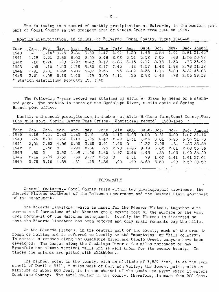
The i'o 1 lO','J ing i C' a record of monthly precipitation at Bulverde, in the .western pD .!'!.:,"'
part of COmel County in th9 drainage area of Cibolo Creek from 1940 to 1945.
Mohthly precipitation, in inches, at Bulverde, Comal County, TexaD 1940-45
Year Jan. Feb. Mar. Apr. May June July Au.~. Sept. Oct. Nov. Dec. Annual19'10 1.14* 0.79 2.84 3.69 4. L17 ili.n 1.50 1.48 2.88 4.94 5.81 31.45*1941 1.18 ,1.31 3.85 6.00 3.00 5.48 2.02 0.54 3.52 7.05 .·i8 1.54 38.9719,,12 .l;'~ 2.76 .20 3.97 2.'10 2,17 4.86 3.15 7.17 8.15 1.32 .72 36.9919'13 .55 .15 1.53 1.'78 _3.62 2.17 7.45 .12 7.57 1.42 1.98 2.78 31.121944 3.91 3 .. 81 4. .t.i:2 4.83 5.87 2,,53 .75 !, .89 2.33 1.13 5.80 5.61 45.881945 3.21 4.08 5.19 1.45 .78 3.00 1.14 .35 2.92 4.43 .78 2,06 29.39
* Station ',stablished Fehrunry 15, 1\]·10
The following 7-year record was obtained by Alvin W. Glass by means of a stand-ard gage. 'rhe station is north of the Guadalupe River, a mile south of Spr ingBranch post office.
Monthly and annual precipitation, in inch8s, at Alvin W. Glass farm, Cornal CountY,Tex,(Ono mile south SprinC( Bra neh Post Office. Unofficial record) 1939-1945
Year Jan. Feb. Mal'. Apr. May June July Aug. Sapt. Oct. Nov. Dec. Annual1939 4·16 1.04 0.63 1.60 2.51 .85 4.12 2.03 0.50 0.61 2,00 1.07 21.1219'10 .74 2.88 1.36 2010 1.24 4oll7 2.'18 1.51 1.36 3.01 3.95 6,54 31.231941 2~OO 2.63 4.86 5.59 3.25 2.91 1.45 0 1.37 7.95 .6·±- 1.23 33.881942 0 1.52 0 3.90 2.66 .75 2.70 4.83 9019 6.02 2.01 2.08 35.661943 .65 0 2.32 1.58 .. 4,.96 1.62 4.97 2.46 4. '13 .28 1.03 1.99 26.29194,1 5.1<1 3.25 3.35 .69 9.27 2.55 0 4.61 .79 1.07 4.41 1.91 37.041945 2.79 5,16 4.88 .61 .45 1.36 -.90 .79 3.68 5.52 .99 2.32 29.52
TOPOGRAPHY
General featuros.- Comal County falls within two physiographic nrovinces, theEdwords Plateau northwest of the Balcones escarpment and the Coastal Plain southeastof th'3 escarpment.
The Edwards limestone, which is named for the Edwards Plateau, together withremnants of formations of the Washita group covers most of the surface of the vastarea northw",st of the Balcones escarpment. Locally th3 Plateau is dissected sothat the Edwards limestone has been removed and only small remnants cap the ·hills.
On the Edwards Plateau, in the central p8rt of the county, much of the area isrough or rolling and is referred to locally as the "mountains" or "hill country".In certain stretches along the Guadalupe River.and Cibolo Creek, canyons have beend9veloped. The canyon alon~ the Guadalupe River a few miles northwest of NewBraunfels has almost vertical walls and is well known for its scenic beauty, Inplaces the uplands are pittod withsiJikhbJ:es,."
The highest Doint in the county, with an altitude of 1,527 feet, is at the "U':~"
surmni t of Devil's Hill, 7 miles west of S"ithson Valley; the lowest point, with analti'tude of about 600 feet, is in the channel of the Guadalupe River where it entersGuadalupe County. Th8 total relief in the county, therefore, is more than 900 feet.

- 10 -
In the western part of the county, beds of massive lime~tone alternatingwi th softer clays and shales result in steplike terraces which circle the steepslopes like contours. In this area there are sharp divides, in contrast to thefairly wide and comparatively flat mesas of the Edwards Plateau.
Drainage.- Most c.f Cernal County drains directly into the Gu~dalupe River.The northernmost part of the county is drained by the Little Blanco River andthe sOllt'hwestern part bY' Cibolo Creek and Comal Creek. These streams have widemeanders, characteristic of old streams, and have apparently held their generalcourses through the events 01' recent geOlogic history. There is much evid("nce,howevf>r, of comparativel.y recent rsjuvenation. The streams are actively degradingtheir channels within their meander belts. The chsnn8~s are barren of sedimentsexcept for large bouldel's. Rapids aro. found where major faults cross the streams(plate 1), indicating comparatively rscant mQvsment along the fault planes. .

A. Guadalupe River at Hueco Springs fault.
B. Guadalupe River at Coma I Springs faultabout 3 mi les northeast of New Braunfels.Rapids mark fauh which brings EdlHardslimestone in contact with Taylor marl.
PLATE

- 12 -
GEOLOGY
Introduct ion
Sedimnntary. rocks may b'3 seon at th'3 surface in all parts of Comal County,bllt cnly small aLl tcrops of ign'cous 1'00>:8 have been found. Basult porphyry intrudesthe Glen Rose limestone n()8r th,) K~nd81l County lins. No igneous rock has beenrS1poI'ted in the log of any w'~jll in the cQunty. M:?tamorphic rock in the form ofschist is rcpGrtc,d' in the log of th8 eil test (we.ll 395, S08 drill€'rs' log) 'on theErhard Heidrick ranch b~· mi.les VJ8St of ~ew Braunfels.
Tho sedimsntary rocks aru composed of layers ~f lim8stvn~, shala, clay, sandstonG, and sand, which for conv~niBnc8 of study and referGnee have been gr'.)uped bygoOlogists into formations and larger unit.s, usually named for the areas in whichthey wero ffrst Observed and described. '1'he limestones, sandstones, end sflndscontain the underground-water roservoirs tn Comal County. Openings ,y in thes(=rocks such as cavities in limestone caused by solution or fracturing, or spacesbotwGf1U grains' of sand , permit the movement of water from the surface downwardto the ground-vJater reservoirs and alse laterally within th", reservoirs. Clays.and shales generally transmit little or no wClter and are r9garded as barrierswhich retard or prev.ent the movement of water.
The occurrence of ground v!Ster is closely related to the geologic history ofComal C;,unty. Gradual elevation or subsidence of th'3 hmd relativo to the levelof' the sea is clefJrly shewn b~v the upward sliccessicn of' strata, marked by thefossil rGmains of animals 'c',mtained in them. Breaks in t~e continuity of sedimentsthat were deposited in the sea are indicated by the absence of strata that orok00wn to occur elsewhere in Texes. This meanS that Comal County was above thel·c,vel "f the sea while other parts of 'Texas were still b'olow sea level. in suchareas s0diments ",era still being deposited to form strata 'not found in ComalCcunty. These breaks in sedimentation are called disconformities and are mentionedlater in the descriptions of the formations.
More abrupt movements within the earth underlying Comal County hav" resultedin .the dislocation of the rock, so that in some places formations that weredeposited early in the ~eologic history are nOw found to be in contact with andat the sam" level as formations that were deposi ted much later and normally belongi.lt much higher levels. The planes of contact between these formations are calledfaults and can be traced 'at the surface in linear patterns. The major faul ts areshewn on the geologic mep, plate 5. Deformation alon3 fault lines has causAd somostrata to dip or to be inclined from their original nearly horizontal position.Th" defurmations'of strata resulting from ',earth movoments is discussed later undertha heading of structural geology.
Except for a fow isolated nl~vial deposits of Pleistocene a~e the water-bearing, rocks in ComQl. County are of Cretaceous age. The following table shows thethicknBss~s of the verious g001ogic formations and giV08 brief descriptions of thecharacter 01' the, formations, their water-bearing prop "'l'ties, and the charecteristic appearance of the land where the formations are at the surface.
§.! For a complete classification and discuss'ion of \,penirigs in rocks seeMeinzer, O. E •• The occurrence of ground water in the United States: U. S. Gaol.Survey Water-Supply Paper 489" pp. l09~148, 1923.

GEOLQ-:;·IC FOR1Jil. TIOr-·;3 IE 0(1':J~L GOUNTY, TEYJI.S
f~
\ ...;
Yields no rmtsr tov:ells in CORr.l County ..
'~Ja-
coausCrc,ta-
Tertiary( ?', ' )
i Series and I " ; Thic:kn::ss;--Charactcr-of---- r-- cfiB:r:a-ctZristic apPJ8.r-1 WaterS.vste!:l I group I Formation I (feet) J r?cks ; ancc of land surface ! supply
I Rsccnt 'I ~lluvi~~ 1 0 - 15~ ISar~, silt, clay, !LOTICst stream terraces. I No d8pandablu reservoirs." I Iand graveL J
Quaterne,ryl PlGisL'cene IL"ana, ! 0 - 50:!: Sand, _silt, and iWide flat tcrra:cs in II--Fu-'-r-n'-i-s-h-~-.s-g-o-o-d-"-J:-ct'-(.-'r--t-o-'I I formatlon ! II graveL I str~am valleys ;,0 to ma.ny wells in Guadalupe
, i I I 75 loct abov8 t"ds of Riv8r Val loy southc2stI : I 1 strs2.IT..s. Good far;!! of NCPN Braunf(Jls, andI ~ I !land. I to a few wells in pe.rts
I I I -- I -' I ..- t_o£ Cibol'?3rack VallG~-.
IPliO?2ne I Uvalde ! 0 - 15:!: Coarse flinty 'I' Caps hills 2.nd No wells arc kn,)',m to
(?) i gmvel I gmvcl. divides. draw w2.tcr from this'I I "' ;,I ~-+ .1.OrmaulOr!.
I I I Taylor i '~ Yidds' highly: ! . marl and \ 300~ Calcareous clay IRounded hills with' minoralized we.t·or to1 Upper 1 Am..~acho 'I Iand ch2.1ky r:arl. i clay"y soils. ' 'I a few shallow wells.I C . I l' . ,,-' , . ,! rQta-! . .dn~s ~i..m0",!! II
coous· I I undJ.f 18r;m., I .I ' tic.t'ed! . :-::--:--::-:--'f--------------------
! i I Austin T 150:!: -'Vlnit;] to buff chalk ILoVi roul'lded hiEs ,and I ';lells usuDlly haveI 1 I chalk 1 L B.nd 1 ime: stono !l~l2.ck lc::md !:' s():Ll s . smA.11 vi 21r1.! I I&'lglc!, !Yellow cls..y ~.nd Sli.;ht te:rrf'..c·.J3 '.,'hs!'c No wells kno:'m to, 1 I FOT-d. '1'1 5 - 20± saEdy clay. Br:>,':n i fl,,:gstC?OS arc ~,r2sc;nt. obtai.l1.W2.t.~r .!roI:!. this! : shale arenaceous flagst'Jl10S i ,.~: _ < forf;-:.atl J[l In !.;or.:ali! : Lignit c, COIT,n0n in [, .County.1--_1-- " ,·",lls " ' _I 1 Buda lime-I 2 - 70~ t SplintGry me.ssive r FDrms low ridges. II Gen:.:rally net 1fJat2r-I I stone! jlimr;stn.'1o. YC'llow to Generally broK.,-.'n f!'2.g- boaring.I I i buff. Oft8D. sj),:::'cl<;:lc:d merIt 5 or b'Julders.
; Il:Vi th darker spots. 1
-"i'" I I I; LovJ"Cl' I:11.. toe.:. •..., . .... .' '"' i. 1 , . , •I Creta- r orDup! lrY'2.yson 12u- Dv::: ! Grecnlsh-yollow c12:.Y.i dsue.lly p3.rtlc:.lly
Ice-ous I I' (Del Rio) : ' Sm'ilc hard cillcareous II cQv·:.;rc;d.. by- boulders
, shale I ; Dc:ds. !IR211 , S harD-I! from ov,-orl.ying Euci.c.
j' I Ii; (E.xogyn: ari'"ti.rl~) i limostono. CuHiviltod, I, : ! fo_s\,ils abund,O.nt. iL1 plc,ccs. I

w •
GEOLOGIC FOrC..TIONS m CO:"iA.l CCUF1'Y, TEXAS -- CONTINUED
Seri.:::s and I FOJ."l!lC.tian ITrdckn;:; 55 Character of I '3haract'3rlstlc 2.pP;)(ir~ viater supplyISystem gr:Jup (foot) rocks ance of land surfnce,
tII
-I! GGorgetown 5 - 30 Hard 1m s siV:3 liI118- Rocky slop s. ~ablo I Generally :\,LIds li t tlc
: limcst'Jno stone', Thin marl fit: lds wher.:: rrer 1 Dr no wat\Jr..~ beds in s')me pL-'lces. bc.:ds arc PI',,' sent •
Frcd-Hard white li.r.Dstone Deep canyons along strcrms.1 Yialds l"I.or~ \",r;::.1:,0r
Edwards 350 -500± with flint nodul~~s. . Uplc?.nd surface undulating I than ::my oth,.;'rer- limestona Honeyc ombed end and pitted with sinkholes Iformati1P- inicks- cavernous. Som.e --{; Cour.ty.burg chc.lky bods. --group Hard lia; slone, F:.mns part of' cany')n rJo":. ~istinguis~C'd
CorH?.nche 20 - 55 similar to Edwards along stre ams • from. Edvmrds limc,-PGak lir.lo stonG. Contrins stont~ in wf~lls.
liny;stonc no flint.
I Walnut ck.!' I - 15 Fossilif~r}us marl iJ'abl0 land in vallGys .. Small ;;ricld toCreta- Lower j ,:'ond lim: st :me Used for TQad surfacing. few f8rn woJIls.
ce3US Creta-l, . f6 ~ upper ,;.It-.:rnat.ing beds oi St0P t~rraces and rugeGd Yield usuall~r
csous f I~ ~ mcrnbe 650- hnrd limestone ~nd topOgF<:.- phy. Sinkhole s s!p.cll. SuprJlie sda~k blue Irl<?rl. and hon,~ycomb<_d rock l8rge number of .
~~ 10'.''fcr 1150:!:: Thick mass:Lvc lim\:,.- ·...hJr0 lower part of rD.nc h '1::·11:3.i Trini- d member st.on~ beds at basco formation i 5 ::xposed.I
Travi s P.:.:al Fine sand, rrt2.J.~l, Iifdddlc Caw Cre:ck IUB sLonQI Few good springstygroup f crn:c.....ti ')n 100+ and limest one. member forms canyons. in li"Jestooo.
(p ~.:a ~.sD.1l . ' Undorlytng Sycamore sand No large yieldforuation 300:!: m~mtx.. l' not expos cd. from wells.in wells)
_.~-_.:..Not oxposcd in COffinl Prcb<:.bly notHas stan ? Dark and rod
fameti ,') n shale s 2.nd s2l1d- County. 'Natcr-bec.rinz·st;)l') e •
'Prc-Creta-Schist. do.
CE:!OUS ? ? ? , do.rocks
f-'L-
- 15 -
R()ckfcrm3ti~ns and their water-bearing proparties
Pre_Cr~tacocus rocks
No rocks Glder than those of Cretace,'us agt1 crcp cut in C;,mal County'and itis believod that n·; wells in Ccmal County yield water from such f.)rmati"ns •.
After the lcng and cC'mp10x history of the Paleoz(:ic era, as shc'ilD by the rockswhich cr~p c:ut in Llanc: Ccunty and adjacent c,'unties, th8 sea retreated from central Texas and a large part :.~r Texas became a mcuntaincus land end remained abeves')a levol during tho Triassic and Jurassic pericds which followed. It is bolievedthat Paloozcic rocks underlie C"mol Ccunty at' cc:nsiderable depth bLlt Triassic GndJurassic f~r~Gti8ns are prcbably absent. The schist r~p~rted in the driller'slog ~f well 388 is pr,b6bly PG1Gczcic in age. Sellards ~/and Uddon have identifiedPalel'z;oic schists in tWl deep we.lls in the Le"n Springs Qrea, a fow miles s:uth ofthe western pert of CC'm"l C~llDty, and nt ether places nl·~ng the Bnlce·nes fault ;'.zene ~/, indicating a lnrge sub~urface nrea of these schists.
Cretacecus systemLower Cretaceous series
Pre-C';manche r'.'cks
As yet n~'t ene·ugh de"p wells have been drilled to clarify the '(eclogic histcrycf the early Cretaceous f,:rm'1tiQns in Ccmal County. Fr:m 15 to 20 miles nQrth ofthe n~rth tip cf Camal Ceunty, in Blance Ceunty along t~8 Federnales River, theTravis Peak ferm2tivn g/lies directly upon P8leczoic recks ranging in age fromOrdovician tc Carbcnifel'cus. Th0 Travis Peak i'ermati::n !Q/ has long been regardedas the oldost Cretace~us strata in central Texas.
However, Rnlph W. Imlay !d/ of the Geclogic Bronch cf the U, S. Ge,:logicalSurvay t in cocper8ti ...:n with a number;H~i' other gee log{sts ass~lciated with the -,JilindLlstry has recently presonted evidenc8 t2 indicate that the ·older bUsinwardstrata of Cretaceous age extendingfr0m.Arkansas t2 Mexicc shculd be cle;ssifiedas the llc'sst'~n, Sligc, e.nd Fe.arsc,ll f'~rmativns in ascending order; the Fenrsallbeing the subsurface eqllivalent c·f the T'r8vis Poak formetLn .. The Hosston andSligo have llc't been pC:3itively identified in C·:,m8l Ccunty wells. There is !l
pcsstbility, h0wever, that th.] 177 feet of "red beds" and bl,le lime shewn frem1,518 feet tc 1,795 feot tn the drill8rls h;g "i' well 388 m"y belong tv theH.::sstc:n fcrmati"n.
No potable water hos bean reported frcm pre-Trinity rocks in CCffiul C0unty.
11 Sellards, E. H., G8Gl~gy and mineral res0urces ~f Bexar C~unty: Uriiv.Texas Bull. 1932 pp. 19..,.21, 1920.
W Sellards, E. H.,' Rocks underlying CretacGous in B"lcenes fault zena "fCentral Texes: Am. Ass~c. Petrcleum Ge:logist Bull., vol.XV, PP' 819-827, 1931.
Q/ Cuyler .. R(,bert H., 11rnvis Peak f\.Tmati,:'.Jl. of Central Texas; Am. Ass..:.Jc.Petroleum Geole'gists Bllll., Vel. 23, pp. 625-642, 1939.
10/ Hill, RQbert T., GsographY and gGQ1Q8Y of tha Black and Grand Prairies,T8x3s: U. S. Geol. Survey, 21st Ann. Report, p. 140, 1901 ..
11/ Imlay, Relph VI., SUbsurface Lcwer Cre t8CeiJUS r''rffiaticns of South Texas:Am. AssQc. Petreleum Ge,clogists Bull., vel. 29, pp, 1416-1469, 1945.

- 16 -
C,)manche series
Trini ty group
'Iravis Pe"k (Pe"rsall) fcrm"ti::,n
The Travis Peak f,rmati.'n was divided by Hill 12( into three members, whichin asecnding crder are: the Sycam;.-re sand memb'Jr, tp.e Cc-w Greek (limestone) m~mber,
and tho Hensell s8.nd member. These members were describod from cutcrops near theTravis Peak post office in the ncrthern part cf Travis CQunty, Texas.
Rocks that are believed te' be th'J equivalents ,'f the Ccw Creek limest~n'J DndHensell scmd members cf U,e Travis Peak are' expcsed near the Guadalupe River inthe nQrthwestern part "f Cemal C<:unfy. These are the oldest 1', cks thot are expl1sedin the ccunty. They WeT" ·;-oserved by Cuyler W, whe p;'inted Gut that these twcmembers are unif0rm in thickness as c,'mpared with Hill's Syc&m,'re sand member.The Sycamcre centoins materials charooteristic ,:f the first depcsits Qf'a transgressing sea and differs in thickness acc,rding t,: the t·.pcgraphy c,f th" landsurface 0n which it was dep~sit9d.
In th8 cutcrap areas cf the Sycamcre sand memb0r in n(rth-centrel Texas thesands are c-::,urse and s .me parts cf the member are ·c:..:nglcmer8.tic, and east of the<:utcrop 8.1'82 this member ·is an important scurce cf gr~-'und w3ter for municipalitiesand industries. The Sycam;:re dces nGt crep eut in Cemal C'('unty and it is dcubtfulthat such sands are present beneath the surface. A number ,.'r wells in the Guadclupe River valley in the vicinity d' Spring Bronch (wells 106, 107, 108, 110, andethers) are deep en.. ugh t·.' hQve enc,'unter"d these sands if they were pr'esent butn(,;, such sauds hGVG been rep.:rted. Nc lNell legs f'c!r 'these wells are available, h(WJever, and ne tests have been made t(c (letermine the pr,.bable maximum yield.
ThA C~w Creek limestcn0 member conststs cf massiveoray-white f~ssilifercus
limest(;ne and hos a te·tel thickness ,;f about 75 feet. The limestune is h" neyccmb~:,d in some places 'nlcng the Qutcrcp but little is kn .. vJn reJ~3rding the permeability.0f the Ccw Creek where it is deeply buried and prctected frem surfacewenthering, In well 120, Cn tho scuth bank of the Guadalupe River near Highway281, hewever, h.'neycembed reck which yields an ample supply ,f woter for domesticand st·~ck use was enc'.'lmtered "t a depth i:f 330-380 feet. It is believed that thehoneycQmbed r~':ck 1s 8 part ~f the C::~VJ Creek member.
Rebecca Creek Spring (74), 9 miles ncrthwest ef Hunccck, which at times fl"ws(lS much as 2,000 gallens "minute, issues fr,m the l~wer part "f ths Ccw Creek.
The Hensen sand member is c:mpcsed If buff-c<:lJred argillBcecus and calca-,reouB fine-grained sand c0Dtaining silic8GUS and caloareous geodes locally knownas "KBtzenkopfe" (cat heads). There are qlsc sandy limest.one beds contDiningglauccnite which adds a greenish'tint t(· the buff celer. Within the limited Greaof exposurc::), in Comal C'Junty the c0ntact between the Gi:·n Rose Gnd th'3 Travis Peakfermat ions appears, t~ be c~nfvrmable and is sh~wn en p19te 5. It is arbitrarilyplaced Dt the ti;p of the .,;re8nish~c01{)red galuconitic limestone of the Travis Peakthat" is in c;mtrast with th,} everlying gray-white honeyc0mbed rudistid Glen Roselimeskne. The following sectien wos cbser'{ed 2.3 miles n(rtheast of th'~ SpringBronch pest office, abcve U, S. Ge .. lcgical Survey bench mark R 26 Texas, 1924;altitude 1,036 fe~t.
12/ Hill, Hebert T., c;p,. cit. PP. 141-144.1:3/ Cllyler, Hebert H., ep. cit. .
11 1058
1 2 1:047
2 1045J
7l... 10 3£210 610361036
- l? -
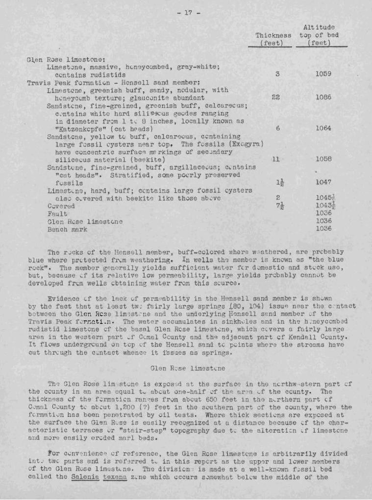
hickness(feet)
G~en Rose limest0ne:Limest~ne, massive, hen yCQmbed, ray-white;
c ntains rudistids 3Travis Peak rormati~n - Honsell send member:
Lim st ne, gree ish buff, san y, nodular, withhvneyc rob texture; glaucvnlte abundant 22
Sand stene , fine-grained, reenish buff, celcare us;c_'ntains white hnrd s' li~9("uS gecdes ra~ing
in diameter fr~m 1 t~ 8 inches, locally known as"Katzenkcpfe" (cat he ads) 6
Sandstcne, yelluw tc.: buff, calcar9QUs. ccntl.".ininglarge fossil cysters noar top. The fossils (Ex. ra)have concentric surfac"l mr'rkings of sec ..mdarysilica 'us mat~rial (be~kite)
S!indst<.:ne. fin<::;- rsinfJd. bUff, argillece0us; c.. nteins'cut heads". Stratified, some pc~rly proservedfvssils
Limest ns, ha~d. buff; ccntains large fossil oystersolse c~vered with beekit~ like those ub~ve
C-;veredFaultGlen ese lime6t~ne
Bench mark
AU itudetop of bed
( feet)
1059
1086
1064
The r cks of the Hensell merr~~r, buff-cclored ~her9 w~athered. re pr0bablyblue where prttected fr~m w~ ther1ng. In wells th~ membor i~ known as "the bluerock r • Th8 lUemb')r "'nerally yields sufficir.nt ~fltf3r f'"T d ..;mestic and st 'ck usc,but, because ,.f its re ative lO1fJ permeability, largp yields prcbably c nn~lt bedeveloped fr~m wells cbtainino water fr m this scurce.
Evidence Lf th~ lAck !.If r.erm<>sbility in the Hensell sand member is sh...wnby the fact that at least tw: f ... irly lar e sprinps .(.80, 1(4) iasu"! DeBr the c'ntsctbetween the Glen Rest:'; 1 im ;st· ne An the underlyin Fonsell send member _f theTravis Peak r 'rr:;C.tLn. The watc accumulates in sinlcrh.'lcs and in the h. neyccmb~drLldistid limestcne f the basal Glen R se limestcne, which c vers Q fairly lar egrea in the western part ~f Ctmal Ccunty and thp. adjacent part cr Kendall Ccunty.It flows u dergrcuDd on tcp (.'f the Hensell sand tc pLints w!1~r~ the stro3ms havecut thrcu h the c~ntact whence it issues as sprOng .
Glen R::se limestLne
Th9 Glen Rose lim :stvne is exp s .,d st the surface: in t 0 ncrthw,stern pert c:fthe ccurty in an Area eqLlol tv abcut one-h 1f L'f tho ~r~>[l l..f the ccunty. Thethickn~ss cf the f ... rmati"ll ran es frvm ab ut 650 eat in tho n.. rthern pr-rt fC'mal C0unty tl. ebcut 1,200 (?) feet in the s~u hern part :.:of the county, where thefcrmativn has been penetrate by eil tests. Where thick secti~ s are exposed atthe surface the Glsn R,_se is eusily r~c gnized at a lstance because d.' the characteristic terraces ~ .. "stnir-stepn topography due t .. the altoreti:::n f lime-steneOld m~r9 easily ercded rna 'I beds.
For c~nvr:nienc~ cr ref~rence, the Gl~n Rose limest,ne is arbitrarily dividedint.' tw, parts end is rof'3rred to. in this repcrt as t e upp0r ond l~wer membersof th0 Glen R;.-se lim~st De. The divisicn·; is made at a well-known f~ssil bedcalled the Salenia texllna z~ ne which t;ccurs s~mewhEl bel.:w the middle of the

- 18 -
formation. This fossil bed (see section on p. 2L ) has been studied in detail andhas been traced in an area covering several counties in central Texas by ProfessorF, L. Whitney and associates of the University of Texas. It is an excellent markerbecause it is easily recognized and several of the fossils in the bed arenQt foundelsewhere in the Glen Rose.
The locations of the outcrops of the Salen~ ~~ zO;J.e coincide with thecontact between the upper and lower members of the Glen Rose 1 imestone as shownon plate 5. The following species were collected from the Salenia texana zone ata location 2.9 miles south of the Guadalupe River on Highway 281, and have beenidentified by the members of the U. S. G~ological Survey who are listed below thetable.
1.2.3.4.5.6.7.8.9~
10.11.12.
Orbitolina texans (Roemer)SalQnia texana CrednerTetragrammaHemiaster cumanchei ClarkEnallaster texanus (Roamer)Frohinnites? sp.Leds?Panope cf P. henselli (Hill)Homomya jurafacies CraginArctica medialis (Conrad)Arctica roameri (Cragin)Cucullaea. cf C.terminalis Ccnrad
13.14.1,';).
16.17.18 ..
19.20.21.22.23.24.
Cucullaea ap.Volsella sp.Protocardia? sp.Neithea occidentalis (Conrad)Pteria sp.Trigonia crenulata Roomor
(not Lamarck)Apporrhais? sp.N8rin!:~a sp.Nerinea n. sp~
Lunatia? praegrandis RoemerTylostoma sp.Porocystis globularis' (Giebel)
The echinoids listed above were id9ntified by C. Wythe Cooke; theOrbitolina by Lloyd Henbest; all others by R. W. Imlay.
Glen ROS9 limestone, lower member.- Although alternating lim9stones and marlsare characteristic of the whole formation, the lower Glen Rose contains thicker andmore massive limestone beds and is more fossiliferous than the upper Glen Rose.With the exception of a fow small areas, the lower Glen Rose 1s exposed in ComalCounty only in the area west of the Tom Creek fault. (See geologic map, pI, 5)The basal limestones in this area are composed almost entir91y of poorly pr~served
fossils and have a total thickness of about 100 feet. In the outcrop area the rockis hDneycombed and sinkholes are common; in the northwestern part of the county andth") adjacent part of Kendall County these limestones yield a considerable volumeof water to springs. Spring Branch Spring, Honey Creek Spring, and Crane's MillSpring (S(;O nos. 104, 80, and 35, respectively, On geologic map, and in table ofwell r,3cords), and other smaller springs issue from these basal limestones. AtSpring Branch Spring, however, the water issues at tho contact between the basal:lim8stone and the underlying Travis Peak formation. Above the spring massivefossiliferous lim"lstone forms a cliff abolit 25 feet in height. Here the foss 11shave been partly dissolved from tho matrix, leaVing a honeycomb mass of moulds ofrudist ids , gastropods, and mollusks, MO'.llcls of the genius Tri"onia ar", especiallyabundant. It is believed that the springs ure fed through solutional channelsdeveloped along fractures connecting slnkhc.les. In the areas \!Jhere these limestonesare de(')ply buried beneath younger rocks, no large yields a 1'(;) roported from ilJellsthat pei18trate them, and the solutional channels are probably limited td tlte outcrop area.
In the extreme western and s"uthwestern parts of the county, particularly inthe valley of Cibolo Creek, the lower Glen Rose is cavernous (see pl. 2), and agreat deal cf surface water "lnters these rocks. (p.45 ), which does not return totlie surface as springs in the outcrop area of the Glen Rose limestone. Jilst southof tho creek, in Bexar County, and in the Leon Springs military reservation, honeycombed limsstone was reported by a well driller at a depth of 199 feet. North ofCibolo Creek in Kendall County, in the same general area, a cave which caused thedrill to drop a foot was found at a depth of 269 feet. At this depth the waterrose 60 or 70 feet in th c. drill hole.

A.
PLATE 2
Cavern in flood plainof Cibolo Creek onO. Weidner Ranch,half a mile east ofHighwoy 28 I.
Rose limestoneRanch, 4 1/2
B. Cavern in GlenCreek. Rompelof Highway. 281.
near Cibolomiles east
- 20 -
Between the basal' .limestone· and the Salenia texana zene, the al ternating bedsof limestone and marl are' characterized by casts '01' larse gastrcpods and mollusks.Fossils with criginal 'sh8n material are seldom found. Th'J casts of the largemollusks nrc known locally as "ox hearts". This part of the section yields verylittle water to wells. About 80 feet below the Salenia texana zone is a bed containing the large species of forarninifera Orbitclina whitneyi Carsey, believed bysome pa181ltologists to, be the same species 'as O. te~~ (Roemer). In some placesthis fossil occurs in such nnmbers as to form n "sand" which· yields small amountsof wcter, Oolitic sands in the .lower Glen Rese yield as much as 100 gallons aminute to wells in, the vicinity of Wimberly in Hays County, bnt no such horizonhas been found in Cemal CQunty.
The Salania texana zune is associated with some fine-grained sandy beds bothnbove and below anL! is the source of water in some wells and springs, Seep springsoccur in nearly all the valleys where this zene is exposed at the surface, althoughmest of them disappear after Ivng dry seaSOns. In the western part of the county,hcwev8r, recks in this zene are more permeable and the yield tv wells is somewhatgreater. On the Hullman ranCh, a spring (176) yields about 50 gallons D minuteduring wet seas·(J~s and some vJater is always available in any seascn~
Glen Rose limestone, upper member.- No unconformity was observed between theuppe!' and lower members of· the Glen Rose limestone. Outcrops ,1' the upper GlenHose Dpp9ar in valleys in the central part of the COLlllty, cover most of the northcentral part of the county, and are found at r91atively high altitudes in theextreme northern part of the county. The upper limestone is comparatively barrenof fossils. Orbitolina texana occurs irregUlarly at five or six horizons and afew other beds are fossiliferous, but in the upper port of the section no fossilsare found. Ripple marks, crOSS-bedding, and other manifestations of shallow-waterdeposition are COmmon. Water is found in small quantities in fine-grained sandy
. marl and sandy limllstone and in beds of fine-grained loose sand from 1 to 2 feetthick. The maximum yield for most wf1ter wells in the upp9r Glen Rose is probablyless then 3 gallons a minute.
_The following section includ0s parts of both the upper and lower members ofthe Glen Rose.'
Section measured from foot of windmill near ranch house atward to U. S. Geological Survey bench'marl on flat-topped hill.Survey bench mark 12-T; altitude 1,450 feet!.)
Glen Rose limestone, upper momber
Byler ranch north(U. S. Geological
Feet
Limestone, massive, gray, honeycombed •••.•.•••••.•...••... ~ , .•... ~. 3!'I1arl, blue-gray .•..•. . ..... ~ . > ••••• .' • O ••••••••••• I •••••••••••• ~ • • • 2Limestone, massive, honeycombed, forms prominont .terrace .•......... 8Limestone, chalky •.••...••..•••••• < .,' ~ • ,••• ~ • • • • • • • • • • • • • • • • • • • • • • • • • 6Cov:3recl; soil moist frcm seepage •.. ~ ~ . , .. " .•.•.••••••••••••.•.• ~ . . • 13Lim9stone, hard, gr~y-brown, brittle, roughly stratified;
forms terrace .... , •• _•..•...••.••.••. , ...•• ~ •••••..••..•••.. '......... 3Limestono, soft, yellow to gray, nodular',' a few fossil C8stjs
in 10\l'Je1' part •.•..•. " '.' • ~ ••.. ~,~ •• I ••••• '. • • • • • • • • •.• • • • • • • • • 24Marl, blue, weathers bUff; fossils rare , ; 12Limestone, hard,.' buff.• ,.• " •• '.' .•.' .•';••••••• '.0 ••••••••••••••• '. I ! •• , • • • • • 2Lim8st ..::.ne, earthy,. honeycombeq., grading upward into marl ...
cantaining.an abundance of casts of large and small mollusks •• ,., 16Limestone" cross-bedded, sandy; forms terrace- ..•.•.•.•.••••• """!" 2lv1a1'·1 '! •.• ,I.,~.•••• ',' •.••• '.~.'." •••.••• '1 ~ ~•••.••••••• I •••• ' ••••_0·..... ...• 5L1mest~ne, hard, brittle; forms terrace. ... ,.....•.....• .., .'. ~ .•. I ••• '" 1
. rvlarJ;. '.!, ~ •.. ~; ',,"'-' .,.•.•.• "~,, ., •..• ',' •.•.••••.• ! •.•••.•.••• " .' '••• ",' • ~ I • • • .. • .. • • • 5

.~ ~ ~ .
- 21 -
Glen Rose limeston8, upper member -- Continued
Limestone, hard, brittle; forms terrace .0 ••••• '0, to' to •••
Limestone, irregularly bedded, honeycombed .t ••••.......•.•...•..•••• ! ••
Limestone, earthy, in 6-inc,h beds ., 0- .Marl, < blue; weathers buff,.! ..... , ....•.•••.....• ,.). '., ......•. , ....••Limestone, hard, 2-inch to 4-inch flags •••••...••.• ~ .. , ...••• ., ••• , .....Marl, platy •... ~ .. t •••••• to ••••••• II •• ,' •• ! • ! •••••• '," •••••••••••••••••••• ~
Limestone, gray-brown, crystalline, composed of fossil fragments .•••• :M:arI, platy ..... ~ • ! •••••••••• , ••••• ! ••••••• ~ •••••• , ••••• , •• !. ~ • ~ ~ • ~ •••• ';
Limestone, gray-brown, crystalline J fossil fragments , •••• ~'!'" '"f •••••
Marl , ! •••• ~ ! • ~ •••••••• " , •••• ~ " •
Limestone, light gray, 2,.,;,inch flagstones ••• ~ ••••.•••• , ., ••••• ~ •• ~'!J!'!
~A:arl ••• ~ •• ~ ••••••••••••••••••.•••••••••••••••••••••••••••• •••••• ! ••• ! ••
Limestone, gray, 2-inch flagstones ••••••••.••.•••••••• , ••••• !~ •• ! •• ~ ••
Marl, platy ~ ••••• ~ •••••••• ! •••••••• ~ ••••••••••••••••••••••••••••••• ~.t
Limestone, blocky with rectangular fracture, seme thin ~lagstones •••••Marl, w"ith thin beds of l}mestone o •••••••••••••.•••••.•••••••• , •••••• ,!,Limestone with an abundance of small fossils (Lada? sp.) that lock
like wheat s8eds. Usually forms prominent terrace ..... , !"...... ", ••••
Limestone, fossiliferous, honeycombed ., •.. t •••• ~ ••••••• '! '•••••••••••••
G18n Rose limestone, lower membor
Marl, fossilifer~us, fine sandy, containing Salenia texana.Credner, Hemiaster ~" Porocystis sp., Nerinea sp.,Orbi tolina texana Rc-omer, and casts of large mollusks.S0urce of seep springs in valleys •••••••• , ••••.•••••.•••••••••• , •• ~.
Limestcne, irregularly beo,deQ., with lOn abundance of pccrlypreserVed fossils ! ••••••••••• ! •••••••••••••••••••••••••••• ! •• ~"!""
Marl, fine sandy, source of seep springs~in valleys •••••.. ,.! ..•......Limestone, pocrly stratified, porous; nodular structure •••.•......••••1IIarl '! , •• f.·','.· , .. ! f...•..... ~ !,' ~ .
Llmestone, !TI8ssive, sandy ••••••••••••• ~ ••• , , ••• ~ .. ~
Mar1 •••••• ~ ••.••••••••••••••••• , •••••• ~ ••••• '.' ~
Limestcne, hard, buff;' ferms te~race •.••. ~ ~ ! ••••• ~ •••• : •••
Marl •• ~ . ! •••••• ' ~ ••••••• ! • ~ • ,
Alternating marl and.limestcn8 with casts cf large mollusks .•..•. , ..••Limest.;,:;ne, hard, flaggy ••.•......•• ~ ••••••••••••••.•••••••••• ! •••• !.! •••
Mar1 ..•.••.•...•...••..••••.. ~....••.•••••••••••• I •••••• f ~ '.' • f ••••• '.' ••
Limesto~e; hard, buff; porcelanecms texture; forms terrace •••••. , •••.•Marl with casts I,.~f large mollunKs ("ex hearts") f.~ ••
Limestcne, hard, pcrous, fQssiJ.ii'er".cs ~ massive ,. contain.img .Orbitolina wbitneyi Carsey .. , 'O ~ .
Marl, fin0 sandy, buff and brue.; CO~:<-.2 j.liS abundance ofOrbitolina texana ••.........•..•
Cc·v'3red. Bread grassy valley •••••... , ••••••...•.••••••• ~ •. ~ •• ~ •.•••••
Foet of windmill.
Feet
142425!5
t52
5t 'l:
112
18
5
215
313
16~J2
'"5112~32
10
2J.·2
927

- 22 -
Fredericksburg gr0up
The Fredericksburg group includes ,the Walnut clay, the Comanche Peak limestone,and the Edwards limestone. The three formations are shown as a single unit on thegeologic map. 'rhe Kiamiclii formation, the uppermost member of the, group, is absentin Comal Co~nty.
Adkins l±! has offered the following opinion reg8rding the classification ofthe format ions in the Fredericksburg group.
"Although in this discussion the Fredericksburg is dividedintJ the uBu31 conventional formations, it is the writer'sopinion that all formations in this group shuuld be sup-,pressed and enly th'3 facies used. Eo";ever, a decision onthis proced,"r'" can be reached only after the zonation isbettor known and the meaning of the term 'formation'better,clarified".
Hydrologically, in Comal County, the Comanche Peak and Edwards limestones maybe regarded as a single unit.
Walnut clay
The Walnut clay, tho L"'iiest formation of the group, lies conformably on theGlen Rose limestone and !rB rks the change from the alternating marl and lim0stoneof' the Glen Rose to the thick, massive beds of the Comanche Feak limCistone andthe Edwards limestone.
The typical Walnut' clay of centre1 Texas includes a buff-colored sandy clayor marl containing a comparativ01y large fauna characterized by an abundance ofExogyra texana Roemer. In Carnal County such beds occur only in the northeasternpart of the county,near the Hays County line. Westward the formation becomesthinner and 'less fossiliferous. In most places in Comal County'it is representedby a bod of sendy marl from 3 to 5 feet in thickness, which contains small whitenodules of calcareolls material and a few scattered speciments of Exogy,'& texana,In some places the formation is only a f0w inches thick and fragments of E. texanncan b'J found only by dilig'Jnt soarching. The presence of E. texana' in the marlybeds of t he overlying Ccmanche Peak limestone makes the exact position of theWalnut clay uncertain, particularly in faulted areas. The Walnut clay may yieldsmall amounts of water tc.' some wells in Comal County whor9 the marl is sandy, butsuch occurrences aro probably rare.
Comanche Peak limestone
14/ Sellards, E. H., AJkins, W. S., and Plummer, F. B., The geology of Texas:Univ.~exas Bull. 3232, p. 323, 1932.
The Comanche Feak limestone appears to lie conformably upon the Walnut clay.The range in thickness in Comnl County is from 20 to 55 feet but the thicknessin most places is about 40 feet. It is composed chiefly of hard grny-whitemassive limestone, but in some places beds of marl containing Exogyra texana occurin t;he lower part of the form'ltion. The sLllilarity of these be,ds to the Walnutclay makos it difficult to define the lower limits of the Comanche Peak limestone,,!(,J:ong:',the Guadalupe River upstream fr'-'!l Hueco Springs, (pl. 3), the basal ComanchePeak is composed of massive, honeycombed caprinid limestone. The most distinguishing characteristic of tJle formation in Comal County is ths prc"sence of secondarycrystallin8 calcite in the form of nodules and veins. Honeycomb structure isusually associa ted with biostroms containing caprinid ane other fossils. Welldrillers do not distinRuish the Comanch~~ P8Ak from tb0 EdWQrd~..

PLA TE :3
A. Rudistid limestone inComanche Peak lime·stonein Guadalupe River canyon.
B. Edwards and ComanchePeak limestones inGuadalupe River canyonjust 0 bove Hueco Springs.Lower port of cliff isComanche Peak limestone.

- 24 -
Edwards limestone
The Edwards limestone lies conformably upon the Comanche Peak limestone. Thethickness of the Ea ••ards in Cemal County has not been accurately determined but itprobably ranges from 350 to 500 feet. The outcrop area is mostly in the southeastern part of the county. The areal distriblltion is discussed in more detailand in relation to faults under the heading of structural geology (pp. 29 te 33).The Edwards is composed almost entirely of hard, Inassive limestones that areextensively honeycombed. Th8 most distinguishing characteristic o,f the formationis the occurrence of flint nodules ranging in size from small pebbles to irregularly lenticular-shaped masses as much as a foot in diameter. Flint is not foundin any other Cretaceous strata in Comal County. l'he flint is not uniformly distributed in the Edwards bllt occurs at a number of horizons. No flint is found atthe base of tlte formation. .
Shale or clay lenses up to 40 feet thick'(see log of well 266) OCcur irregularly in the Edwards but are ext<msive enough to retard the downward movf.mentof water in some areas, so that the water table is temporarily perched in theseareas. Well 258, dllg to a depth of 90 feet in the Edwards limostone on the R, J.Haug ranch, 5 miles west of New Braunfels, overflows during wet seasons, whereaswater levels in deeper drilled wells in the same area and at approximatoly the
. same altitude are from 300 f2ct to 400 feet below th'3 land surface. Well 258 isnot in use, prObably because of failure in dry seasons. The Servtex Company reports a bed of Clay 10 feet thick at the bottom of their quarry in the Edwardslimestone, about 9 miles southw?st of New Braunfels. Some of the clay bedsreported by drillers may be old caves that have been filled with mud.
In contrast to the brittle crystalline material of most of the Edwards limestone, a white chalky limestone 15 to 20 feet thick, very similar in appearanceto the Austin chalk, occurs in the upper part of the Edwards. Samples from anoutcrop 6 miles northeast of New Braunfels were examined under the microscope byFrank E. Lozo, Jr., 12/, Th8Y contained an abundance of ostracods and reyfforming organisms but very few foraminif8ra. Chara seeds were arso rsported.
The most complete section of the Edwards limestone· compiled during the ComalCounty investigation is given in the field description of a Core test drilled hythe Corps of Engineers, U. S. Army, 5 miles no~th of New Braunfels. (Pl.5 and well401 in table of drillers' logs), No clay or shale beds are reported in thissection. Most of the limestones are porous and many cavities from 1 to 3 f,'et indepth were found.
The ·land surface in thG outcrop area of the Edwards limestone is characterizedby gentle slopes pitted by sinkholes that range in size from small openings todepressions 15 to 20 acres in' extent. In the vicinity of' the main streams. theslopes are precipitous. The Edwards, together with the Comanche Peak limestone,forms th9 "Jalls of th" Gl.ladalupe River canyonsabove Huecc Springs.
Washita group
The Washi ta group in Comal County includes the Georgetown limestone and theGrayson (Del Rio) shale of lower Cretaceous ag~ and the Buda limestone of upperCretaceous age.
£I Personal communication!

- 25-
Gaorget':..Jwn linlBst r~~ne
Present c'utcr;:;ps ~,)f G8(Tget~'wn limest~ne cccur c'nly in abel tfrcffi 3 te, 6miles wide lying between the Cemal Springs fQult and the Bat Cave fault wh'Jre theformation is exposed in an irregular pattern.
After the Edwards limestone was deposited, a part of the surface of theEdwards was elevated above the level of the sea and was subjected to erosion.During this period some of the upper part of the Edwards was removed and a partof it became honeycombed and probably cavernous as a result of solution by freshwater. When the Edwards was submerged again, the encroaching Georgetown sea firstfilled the valleys in the partially dissected surface of tho Edwards and later'covered all of the present outcrop ar'3t1 of the Edwards limestone in Comal County,At present all of the Georgetown limestone .south of the escarpment is covered byyounger formations. The extent of the disconformity between the Georgetown ann theEdwards has not. been fully determined, but it is generally recognized that on thebroad uplift known as the San Marc'os arch (see p'c:;52 ) the equivalents of theKiamichi of the Fredericksburg group and the Duck Creek, Fort Worth, Denton,. Waco,and Pawpaw formations of·the Washita group are either absent or are represented bycomparatively thin beds. The formations mentioned above are described by !i!.';· .',Adkins 121 together with provisional zonation of the fossils found in th8m.
The importance of the disconformity in relation to ground water lies in theprobability that th3 high permeability of the upper part of th" Edwards, nOw buriedbDneath succeading formations in the area south and southeast of the Balconesescarpment, may have been caused by solution durin~ the interval indicated by thedis conformity, Some drillers, particularly in the San Antonio a~ea, are carefulto cement casing in the Georgetown limestone before drilling into the Edwards.Experience in that area has shown that, if the well is drilled into the Edw'lrdsbefore attempting tc c~ment the casing, it is sometimes necessary to mix rags,'cotton hUlls, etc., with the mud to shut off th0 water long enough to allow thecement to set, As a result of this procedure a consid8rable part of the notentialyipld of the w~ll may bo permanently lost.
In the 'report en the San Antonio area by Livingston, Sayre, and White 111 'a lin'" of demarcation is shown between water of good quality andvmter of poorquality which is believed to be the gulfward limit of free circlllation of groundwater in the Ed1J:ards 'limestone_
Soluticn cavities at.unconformable c'Jntacts and their rolationship to thecirculation of ground w" ter in limestones have been recognized by Piper !!2/ inTennessee and by Nye ~ in New Mexico.
1.0' Adkins, W. S;, Tho geology of Tex"s, Vol. 1, .stratigraphy: Texas Univ.Bull. 3232, pp. 559-586, 1932.
17/ Livingston, Penn, Sayre, A. N., and White, W. N., Water resources of theEdwards limf3stone in th0 San Antonio area, TexfJs: U. S. Geol Survey Water-SupplyPaper 775, pl. 5 and p. 104, 1956.
l§/ Piper, Arthur 1.1" Ground w3ter in north-centrol Tennessee: U. S. Geol.Survey Water-Supply Paper 640, p, 74, 1952.
11/ Fiedler, Albert G., and Nye, Spence~ S" GeOlogy and ground-waterresources of the Roswell art'Gsian basin, New Mexico: U. S. Geol, Survey Water-Supply Paper 639, p. 88, 1955. .

- 26 -
The thickness of the Georgetown limestone in the outcrop area in ComalCounty seldom exceeds 15 feet, but in wells the thickness reported bydrillers is from 40 to 50 feet. This is measured as the thickness between thelast clay bed in the Grayson (Del Rio) shals and-the appearance of water,presumably in the top of the Edwards limestone. The Georgetown app9ars to beconformable with the Grayson (Del Rio) shale above it. In many places there isan abundance of well-preserved brachiopods of the species Kingena wacoensis(Ro')mer) in the thin marly beds at the top of the formation. These beds are about2 feet thick and grade downward into massive limestones that weather to a buffcolor. In som9 places the limestone has a brittle procelaneous texture sL~ilar
to sOme beds in the Buda limestone. In the lower beds the fossil oyster ofthe genus Alectryonia, an oyster recognized by the zigzag pattern on the marginof the shall, is fairly abundant, In many places however, it is difficult todistinguish the Georgetown from the Edwards.
The Georgetown limestone is not water-boaring in Comal County. It serves asone of the upper confining beds in the artesian a:ma of the Edwards limestone.
Grayson (Del Rio) shale
Lil(e the Georgetown lim>3stune, the outcrops of thG Grayson shale are confined-to the belt between thF3 COmal Springs fault and the Bat Cave, fault, in manyplaces occurring in isolated patches in depressions in'the Edwards limest0n9,Th0 Gruyson app3ars to lie conformably On the ,Georgetown limestone.
In the outcrop area the thickness of the Grayson shale ranges from a l(nafeedge to about 30 feet; in wells it is usually reported as 40-feet thicl(.
In Cumal County the GraysOn is predominantly a marl. It weu thers to a buffcolor at the 'surface but drill cuttings are usually blue, Geologists anddrillers alil(e look for the characteristic fossil Exogyra arietina (Ro~mer), anoyster having a shell shaped like a ram's horn, This fossil ~s particularlyabundant in the lower part of the formation and in some parts of the formationare cemented together to form beds of limestone 12 to 18 inches thicl(. TheGrayson is probably the ~ost L~permeable formation in Comal County and manYsurface reservoirs or "tanks" for stock use are cons tructed in the, ou tcrop areaof this formation. '
Upper Cretaceous series
C::manche serie.s (c On tinued)
Washi ta group (~')nt inued)
Buda limestone
The Buda limest:.'ne is believed to lie c~nformably upon the Grayson shalebut there ar~ few good exposures of the CJntact between tho two formations,Th9 thickness of exposed sections lying north and northwest of the Comal Springsfault does net exceed 50 feet. In wells south and southeast of the CornelSprings fault, - (see logs of wells 392 and 395) thicl(nesses of 42 feet and 70 feethave been reported, In many places in the outcrop area low brushy or woodedridges are covered by boulders of Buda limestone whlch tlxtend out on to the slopesof the underlying Grayson. The Grayson becomes more Or less plastic when wet andsmall landslides cause the overlying beds of the BUda to give way and tv breakup into boulders.

- 27 -
The greater part C'f the Bud'a as observed in Comal County is hard and brittleand has a porcelaneous texture. Its color is gray, yellow, and red and in mostplaces it is speckled with small spots of darker-colored rock reported to beoxidized glauconite. Some of the outcrops of the Buda are honeycombed but theformation is not known to yield water to wells in Comal County.
Gulf' series
The Gulf serios is represented in Comal County in ascending order by theEagle Fcrd shale, the Austin ch21k, and the Taylor marl and its prObable ageequivalent, the Anacacho limestone:
Eagle Ford shale
The Eagle Foru shale, lowest formation of the Gulf series, lies unconformablyon the Buda limesLme of the Comanche seriEls. It is fOlmd at the surface ,-'nlybetween the Comal Springs faul t anu the Bat Cave fault.
According to Stephenson SQ./, "The Upper Cretaceous or Gulf series of Texas isseoarated fr'jm the C"manche series below by an linc,:nfermity which certainly re-pr~sents a considerable; int8rval of geologic time". '
In Comal County there arpears to be no discordance in dip between the EagleFord and the Buda but in sarno places the Buda is very thin. West of the roadb'Jtween Highway 46 anu the Hueco Springs rOCid the Eagle Ford app"ars t,) restdirectly upon the Grayson, but the Buda may be ebscured 'by land slides in theGrayscn 2nd by complex faulting.
In most places in CS'ffial' County the Eagle Ferd sha le is about 30 feet thickand is composed of sandy yellow clay. The black clay or lignitic facies is notconspicious at the surface but is nearly always reported in well lo~s. Geedexposures l'f the Eagle Ford are found along the eld Austin Post Road east ',of NewBrallnfels, near the Beys County line.
The Eagle F':rd is net' a water-bearing formation in Comal Cc.unty,
Austin chalk
In Ccmal C,'unty the Aust in chalk lies unconform3bly on the Eagle Ford shale.This wide-spread unc,:nf'cTmi ty has, been described by Stephenson.
Accc;rding t<.: drillers' l(;gs, the Austin chalk is 135 to 150 feet thick intho 8r,m se,uth of the Comal Sp:::-ings fault. In the outcrop area between tho CernalSprings fault and the Bat Cave fault only thin remnants are found. Here it is'a nearly white chalky and fossiliferous limestone and i ts,:bharacteristic appearance is fairly uniform frcrn top to bottom. Remnants of' the formatioll crop outncrth of the Comal Springs fault in the vicinity of' Brack0n, aloDg Eigllway 36,6 miles nc:r.'thwl:~st of New Braunfels, and c.lsc ebst c)f New BI'8uni'els.. Svuth cfthe fault the Austin is exposed in the beds of' Cibol~ Creek and the GuadalupeRiver.
207 St~phenSf)n, Lloyd ;;;r., Unc~~nf0rrnities in the UPP,er Cretf:1ceous series cfTexas: Am. Assoc. Fetroleurn Geclogists Bull." vol. 13, pp. 1323-1334, 1929.
W, Stephensvn, Ll"yd W., op. cit., 'p.' 1328"
- 28 -
The formativn is not generally prolific as an aquifer. Eight wells recordedin Comal County are known t~ draw water from the Austin chalk. ana cf these (well346~ at Hunter, flows a small stream during wet seas~ns. S~~e cf these wellsyield water with a h,~drogen sulfide odor. In most 0f the area where the 'Austinchalk has been uncovered, surface and ground water have begun tc dissclved therc,ck. Fairly large soluti<::n cavities were observed along Cibolo Creek, just abovRthe bridge on U. S. Highway 81~
Anacacho limestone and Taylor marl
According to Stephenson ~ the Anacacho limestone and the Taylor marl are ofthe same age, and the limestone facies of the Anacachc west of San Antonio mergeswith the marl of the Taylor in Comal County. Typical exposures of Taylor marl arefound in the eastern part of the county. In the ,western part of the county theAnacacho limestone also contains marly beds but limestone beds are absent, Onlysmall nodules of lime remain.
Stephenson 23/ also states that both formations lie unconformably upon theAustin chalk andClescrihes two sections that were observed at the contact.
According to the drillers' logs of wells 395 and 419 the Taylor and Anacacho,considered as a unit, has a thickness of about 300 feet. Neither the Taylor nOrthe Anacacho is found in any part of the area north and northwest of the ComalSprings fault. Southwest Of New Braunfels, below the escarpment, a few wells arebelieved to draw water from the base of the Taylor and Anacacho, where from 0.5to 2 fecet of sandy lime or grav"l has been reported. This sand or gravel may befed through the cavernous lilwstone in the ,upper part of the Austin chalk. Thespring (no. 348) On the Altgelt farm 2i miles southwest of New Braunfels may befrom this sourCe.
Tertiary (?) system
Pliocene (?) series
Uvalde gravel
The Uvalde gravel OCCurs only in small remnants on hilltops. They areeffectivG in r8tarding,e~o8ion in the same maru18r that ballast protects a railroad track. Because of the small size and thickness of the outcrops and thetopographic position which permits the water to seep Ollt rapidly, no water isobt~::ined from wells in the Uvalde gravel.
---,;:~..,..--_.~--~._._-.--,-,.- ._-~. __.~-_.~_.- .-.?!::J St:3phensoD., L~ W" 3ljT2.t·:'grcl.-~h_~.':' r.sle...ticllls of the Austin, Taylor, and
equival"'.mt fCTmat::"ons in Te~(as~; U" S· GC01. S:.li'VIJY Prof. Pap9r 186, pp. 113-146,1937.

- 29 -
Quaternary system
Pleistocene series
Leona formation
The Leona formaticn is composed of limestone gravels, sand, and clayarranged in terraces by the present streams in their valleys. The terracesovenlie all formaticns ciDossed by the streams and the formation ranges inthickness from a knife edge to a maximum of' 65 feet (see driller's log of well420). The formation is found mainly in the valleys of the Guadalupe Riven andCibolo Creek. In the valleys above the escarpment formed by Comal· Springs fault,th8 Laona fills old abandoned meander channels and is rarely used as s source ofwater, probably because of leakage into underlying rocks and drainage into thestreams. However, ono dug well 50 foet deep (well 246), 13~· miles southwest ofNew' Braunfels and in the valley of the Cibolo, has s0rved more than 50 y'3arswith~ut failure.
Below the escarpment and between the Guadalupe River and Alligator Creek,the Leona formation overlies the relatively impervious Taylor marl and providesa dependable ground-water supply for a considerable number of families. Failuresin this area are unknown, however, attempts to pump large volumes of water forirri,'!,ation have been reported. T!le log of well 420, 3 miles northeast of NewBraunfc'ls, indicates the kind. of material encountered in the Leona. Depth-towater measurements indicate that normally not more than 10 feet of this materialis· saturated with water, Because of this fact, attempts at irrigation on alarge scale would probably. be unsuccessful.
Structural geology
Faults
I"ajor faults. - In Comal County the development of ground-water reservoirs,particularly reservoirs in the Edwards, Comanche Peak, and Glen Rose limestones,and the position of the main channels of movement of ground watcr are closelyrelated to a system of faults in the Balcones fault Zone. This ZOne is 20 mileswide in places und extends from ncar Waco southw~;st through Comal, Bexar, andMedina Counties into Uvalde County. The faults are roughly parallel, and inCarnal County the zone includes seven major faults that trend in directionsranging from S. 45 0 W. to S. 60 0 W. In the following paragraphs the major faultsare discussed in the order of their occurrence from southeast to northwest, (Seegeologic map and cross-section.)
The most conspicious faul~ "in the zone forms the l"scarpment separating theCoastal Plain from the Edwards Plateau, and is here designated the Comal Springsfaul t. The fault enters the eaetern part of the county n')ur Hunter, passesthrcu(!.h Lan'is Park at New Brau.ci81s, and continues westv\)s:rd through Bracken nearthe southwestern extremity C'f Jl~~8 C0unty. CQffi2 1 Springs issues from fi3sures : 1.along this fault. At some ]11"';';'8 along the fault the Tay}.or marl is brought inCJntact with the Edwards limestcue, indicating the possibility of a stratigraphicdisplacement of 400 to 600 feet 0 North of this fault, wate," in the Edwards limestone occurs under water-table (unconfined) conditi~ns and is of g~od chemicalquality. SQuth of tho fault the Edwards is buried to a depth of several hundredfeet; the water in it is under artesian pressure ,and is highly mineralized.

- 30 -
The second major fault, c~lled the Hueco Springs fault in this report, entersthe eastern boundary of the county about a mile north of the Comal Springs fault,crosses the Guadalupe River at Hueco Springs, ebout 2~- miles north of ComalSprings, and continues westward across the westward boundary of the county about4 miles north of Bracken. Structural relations alon~ this fault aro complex.Where the fault crosses Highway 46, between wells 227 and 390, the rocl,s at thecontact are crushed into a fuult breccia anC: secondary calcareous material fillsthe spaces between the bculders. From this point to the river the rocks dipnortheestward toward the river at the rate of about 200 feet to the mile. Onthe east side of the riv2r, opposite Rueco Springs, the fault has brQught rocksof thr:\ Ge0rgetown lim'..::stone, contuining an abundance of sp9cimGns~~ of the fossilKingena wocoensis, in contact with beds containing Exogyra texana, probably ofWalnut age. It is difficult, however, to determine the amount of displacementaloag the, fallit because of the thinning- of the displ!lc3d form~tions and theunconformitios between them. (See p. 25 ). Moreover, there is possibility that apart of the apparent displacement is due to the collapse of roofs of formercaverns in the EdW''ll'ds limsstone. (See pp.2.5r,:tc ~53). In most of the areu bot:_between the Comal Springs fallit and the Hueco Springs fault, the Edwards limestone crops out, and an adequate sllpply of good water for farm and ranch use maybe obtained from wells.
Th~ third fault, called Bat Cave faulti enters the eastern boundary of thecounty about '-2 miles north of the Comal Spr~ngs fault, crosses th<1 GuadalupeRiver about 2 miles north of HU8CO Springs, and crosses the western boundary ofthe county 51, miles northwest of Bracken in th" vicinity of Bat Cave, East ofthe Guadalupe River this fault forms the south side of a downfaulted bluck orgraben in which a nul' row wedge of younger rocks appears between outcrops ufEdwards limestone. Actually tho grabon may ba a slump or valley sink producedby the COllapse of a_ former cavern in the Edwards limostcne, which lowered theyounger rocks below the 16vel of the Edwards limestone, thus protectIng thefellen blcck from erosicn: In the western part of the county where the faultinghas brought the upper member of the Gl0n Rose limes~)no in c~ntact with theEdwards limestone, the displacement is estimated tc be alJout ~'OO feet, A holedrilled tc' u depth of 500 feet en the Di'3tz Ranch about 300 feet ncrthw8st ofwell 386 is believed tc have passed through the fault plane. Normally plenty ofwater is 'JvaHable in the Edwards at this locality, but this well failed toenccunter any water. The dry hoi') may be due to the presence of relativelyimporvious pulverized reck which was ground b~twoen the two walls of the foult inthe pr~cess c'f mevGment. Another possible explenation is that the underground ':" ,',channels at this pOint hav" berm filled Vii th mud carried in by infiltrating surface waters. The Edwards limestcne is exposed at thE! surface over most of thearea between the Huece Springs and Bat Cave faults and together with the underlying C('m~"!nche Peak lirrr'3st,."-:ne is thick encugh tc; transmit large vclwnes of VJater.Farm and ranch wells in th0 area2btain adequate supplies from the lim-2ston8s.
'rhe fcurth ('I' B'?3r Crook fault crosses the Guadalupe River about a mile8cuthw0st of Sattlor_ Fr0ffi that pcint it Can be traced more or less COntinuously sGuthwestvl8rd tc B08r Creek and thence to Cib0h' Creek at the W9Stbcundary of the ccunty, whS'ra it was ...:bservad nbcut 6 miles s~',uth af Smithsc-ntsValley. The fault has less displacement than the three Cllr8ady mentic:ned. Between the Ba t Cave and Bear Cre,,!;: faults, the thickness c'f the Edwards limestcne11<::18 been ccn[-)iderably reducGd by Brcsion; and in tho deeper valleys, the stri?amshav9 cut thrc-,ugh b0th the Edwards and Comanche Peak 1 imest"nes into the upperpart of the upper Glen R-se. The Glen Rese limestc:ne within this block isb81i~ved tc dip seutheastward and generally is at a higher level than the waterlevel in the Edwards und C,manche Peak limestones s(:utheast of the Bat Cave fault.Thus tllG "I' .und water in the Edwards lim"-sk-ne between the Bat Cave and B-ear Creekfaults tends tc' drain t,~ward the block s()utheast cf the Bat Cave fault. This is

- 31 -
indicated by the fai lure cf s ,,'me wells such 8S wells 162 and 429, t: obtain anadequ!:1te supply of \oIJQte:r for ranch use fr(;m th':':! Ed'fJards and C....:manche Peak limest~·n8s,.
'I'he fifth major, fault or Hidden Valley fault crosses 'the Guadalupe River near ,the lower end of Hidden Valley and thenoe continues scuthwestward across the countyto a point on Cibolo Creek aboat 5 miles east pf Bulverde. The average displacement or the strata along this falllt is, estimated to be about 200 faet. ,Betweenth',) B'ar Creek and HiddGn Valley faults, the Edwards limestone is still thinnerand th'2 areas of uppcn~ ffiGmbc.Jr of t·he Glen Hese limSlstonr= exposed at the surfaceare still larger than they are b,,1N!8en the Bat Cave and Bear Cre"k faults" Itis bolir3ved that most wells in this area must penetrate strata belovJ the Edwardsand C.:.:manche Peak limestones to obtain sufficient water for ranch use~
The trace cf the sixth major fault or Tom Creek fault 'passes about half amila south of Hancock, in the e8sternpurt of the -county J Bnd thence crosses thecounty, in a fairly straight line which passes nbout a quarter of a mile south ofSmithson', a Volley post off ice. Tom Creek folloVJs the trace of the foul t forabout '5 miles bet.ween Hancock and Smithson's Valley- In the area between the;
,Hidden Valley and Tem Creek faults, the upper Glen Rose limestone covers most ofthe surface ... and the Edwnrds and Comanche Peale limestones are found only as capson the higher hills. Along tho river, small areas of lowe~ Glen Rose limestoneare exposed. In this area only small yields are reported from the upper and100,,,,r members of the Glen Rose limostone, bllt satisfect"ry yiolds h[we beenobtained from deep wells (as in w8ri 921, in·:1Jhe Pearsall formation.
The seventh fault, calle<1 th8 Spring Branch fault, in this papGr, is reallytwin fUl11ts that are probably contemporaneous and are, closely related to eachother. The trace of tile first one WClS ,bsorved Clbout 3 mile north of]'ischer'sStore, and from this point' it 'extonds southwestward to the Guadalupe River. Thesecond part of the fault is about li miles north of the first and. extends in thesame general direction. abollt2~ miles each ~ay from Spring Branch post office.The maximum displacement along these faults is probably in the magnitude of' 300
"feet. In most of the ar8a between the Tom Creek Lnd Spring Branch lBUlts thelower member of the Glen Rose limestone is exposed over the greater part of thearea, the upper member occupying only the areas of high'3r altitude. The SpringBranch faults mark tho southeastern limit of' the outcrop of the Travis P"akfcr-,mation in C~nal County, North of the Travis Peak area ,the lower member of 'theGlen Rose occupies the valleys and the upper member the more elevated areas.Water ror domestic and ranch use is obtained from wells and springs in the lowermember c:f the Glen Ros" limestOne and in the Pearsall 'formation.
Minor faults end folds. - There are many minor faul t.s parallel to the trendof the major faults, 'some of which have not boen P9sitively identified becausecf the lack cf horizon markers in the area in which they occur., Other' ffinallfaillts diverge from the majcr faillts, notably east and north'east of New BraunfelsDod in the vicinity of' Bracken and Selma. Near Brac.f.:en there is eVi.dence offOlding and faUlting in a direc~ion mere or less transverse to the trend of the
.major faults_ These structuys."L i'eatures appear to have had some effect uf!cn thedirection of the movement oj' w, cor in that area. (See p. 55).
Cause of faulting. - Incli\~,_,j"'i.~~ll faults in thIJ Balcones fe-Hilt Z,Jn8 seem to bedefinitDly related to each oth,;r in orlglll because '(.~:t; the rcughly 'p~ral181 pattern'.Mont of' them are nennal faults with downthrcw to the southeast,. and they aregenerally regarded as 'having bGe.n caused by the gradual sinking of the CoastalPlain', with ref'E,renco, to'the Lla!lo uplift. Stephenscn ~ hus pointed cut, \:
24/ Stephonson, L. W., Struc'tural f'satures of the Atlantic end Gulf CoastalPlbin-,-Geol, Soc. America, Bull. Vol. 39, p. 899, 1928.

- 32 -
however, that unlift may· have occurred as well as sinking. Foley ~produced agroup of faults similar to the Balcones faults in lahoratory materials byapplying tenai6nal forces.
Age of faultin~.- The age of the faulting along the Balcones fau~t zone hasnot been accurately determined, but it is believed that faulting may have occlJrredfrom e2rly Cretaceous to Recent geologic tim". SayrD gy states that in MedinaCounty the faults are believed to be late Pliocene or early Pleistocene, thoughpossibly early Pliocene or Miocene in age. Bryan '?!lJ has presented evidence toshow that there have been three movements along the Balconos fault zone at Waco,Texas, the first during early Cretaceous, the second during Georgetown, and thethird .during very'Rocent timo.
The Comal Springs fault ex tends the 10ngth of the county, through NewBraunfels, causing a bold escarpment with an extrGmely youthful appearance.The escarpment seems to hav,o b·}en only slightly eroded as though it might havebeen form'3d very recently. This app",arance may be deceptivo, however, as muchof the Edwards limestone has be0n removed internally by solution of infiltra-ting waters instead of by external erosion. None of th3 other faults in ComalCounty retains this youthful appearance because the escarpments hav'" buen re_movGd by erosion. H9w8ver, as pr~viously stated, rapids are found in theGuadalupe River at nearly every placs that a fault cresses tho river. (3eo pl. 1).
Other structural features
San Marcos arch. - One of the older structural features of the area is thebroad San Marcos arch, which wns pointed out by Stephenson g§/ in 1928 and was'later named by Adkins~. Th", axis of this arch extends seutheastw2rd fromthe Llano uplift through San M"rcos in Hays County nnd thence follows the courceof the San Marcos Ri.ver toward Gonzales in GC)llzeles County. In Carnal County theresults of this uplift are seen in the thinning or absence of sediments thntn::mnBlly occur between the' Edwards limestone and the Taylor marl. Topographicexpression of' the arch is lacking cr is obscured by the more abrupt movem'cnts ofthe Balconos fatllt zone.
In addition to the deformotian related to faults of the Bnlcones f'"ult z·~ne,
a hugo number of small faults and steop d ips are def'ini tely related .to sinksand prubably bear n.:.' r:"lati\..:·n to d'36p-s8ated crustal movements. '
Regivnnl dips. - '£he regie nol dip of thG Cretaceous rocks en tho EdwardsPlateau is generally acc'"pted to be nbout 15 feet tc th,) mile in a southeasterlydirecticn. In the Coastal Plain the dip steepens considerably, particularly atdepths where the seaward thickening of the younger form"tions has taken place.
~ Foloy, Lyndon L., Mechanics. of Balcones and Mexia faulting:' Am. As.soc.Petre,lewn GeOlogists Bllll., vol. 10, pp. 1261-1269, 1926.
£JV Sayre ,Albi'I'j;T Nels,,;n, Geology and ground-water resources of Uvalde andMedinu CClIlnties, Texas: U. S. Geol. Survey Water-supply Paper 678, p. 29, 1936.
'?:J.I Bryan, Fr<:::nk, Recent' ffic'voment o.long the fault of the Balce'nes system,McLennan County, Texas: Am. Assoc. Petroleum Geologists Bull., vol. 17, Pl'.439-442, 1933. Seo 31so vol. 20, p. 1357, 1936.
~ St'?phenscn, L. W., Structural features cf' the Atlantic and GUlf CcastalPlain: Geol, Sec. Americn Bull., vol. 39, pp. 887-889, 1928,
~ Adkins, W. S" Geclogy of Texas, Vol. 1, Stratigraphy: Texas Univ. Bull.3232, p. 266, 1932.

- 33 -
In Carnal Ccunty, hc;:w6.ver, as a result cf crustal defcrmattc"n, there ere manydepartures frcm the regL:nal dip. In the vicinity cf faults, the dips 8re likelytc be abn':';rInelly steep. Stephens:;n?!2J. observed a percept'."ble nerthwest dip inthe Austin chalk and Tayler marl an the Guadalupe River ab~ut 2 miles svuth ofthe Cvmel Springs fault.
In addition t" these local irregubrities, in the eastern part ('f the countythere is a rather general steepening cf the dip cf the recks eastward. ForeX3Inple, the tcp Df the Glen R,.-se limestone crops cut in the smell valleys cn theeest side of tho GU8dalupG River nt an altitude ct' ab"4t 900 feet. In' u numberof wells enst of these valle:,'s, the Edwards limestl'ne is fcund in wells at Considerable denth. In well 422 a limestcne reported as Edwards limestGne (butprobably Cc'm~nche Feak) 'liDS fQund at a depth of 482 feet cr a t en altitude of 374fe'lt. This indicates an eastw'lrd dip c'f at least 526 feet .in ab.'ut 5 miles or,:more than 100 feet tc the mile.
Sinklwles • .,. The s, luti~n of limestone by ground water may result in thedev91epment "f 12rge C3verns. If' such a cavern b9c:·mes s:' large thnt the rC'l'fis nc·t eble tc support its (,Own weight, the' reef will collapse, le,wing a largehel" '-1' pit in t118 surface of the grcund. These holes may be mere ('I' less r::undc1' elongated cr irregular in shape, depending '~~n the shapo ~:f the cavern. Largesinkhcles with vertical walls were n~t fcmnd in C':mal Ccunty. A very f'ew, rangingfrc-ili 5 t:.: 15 acres in 2rea, erG circular and have gently slcping sides, suggestingthat c~118pS8 kept pace with undermining. Aft8r heavy rains they are likely tohc·ld water f~'r several weeks. Smaller and less ccnspicu~us sinkhcles are morenumer:.,.'us and d:..: !lot held watGr.
M"ny c:f the sinkhc·les in the Edwards limest"ne in C,'rnal C-:'unty ere filledwith Georgetown limestcnB and Gre.ys~~n sh'3.1e. In s ..~me places, the Ge.:..:rget,:wn iscompletely covered by the Grayson se that cnlythe Grayson appears tc be incontact with the Edwards. Becaus9 cf the lack cf cbsorvab18 bedding p18nes, thedip :f the Gr8ys:n shale inth0 sinks cculd not be determined. The Georgetownlimestc'ne g9ner8lly d ips steeply toward the c'ontor 'f t he sink. The Edwardslimsst,'ne (.n the perimeter c'·f the sink may 81so dip t:-ward the sink or may befaulted. These to ul t lines are usually curvilinear and c,ften transverse t, thetrend "f majer faults. On the basis .;:of these _bservathns it is assumed that8"me c·f the caverns c ~:ll?ps~.d after the Gel'<rget'c:wn was d?pGS i ted.
Apparontly such sinks "I' slumps are nut unusual in Texas. Dumble 31:/cbserved deep ravines in the Edwards limestone filled with Eagle Ford shale inareES west c:f the Feces River, -which he ascrib ..~d t,,: disc~~nf~:rmity. Adkins 32/believes that these valleys were coused by undergrcurid s':;lut ion and subsequentslumping.
'@ Stephens,,'n, L. W" Gtrl3.tigraphic relnticns cf the Austin, rraylcr, 8ndequivelent f~'I'mathnsin Texas, U. S. Geol. Survey Pref. Feper 186-g, p, 136,~ Dumble, E. T., The g0clcgy of east Tex~s: Univ. cf' Texes Bull. 1869,
pp. 19-20, 1918.
;52/ Adkins, W. S., 'rhe geclcgy cf Texas: Univ.' "f TexEis Bull. 3232, pp.361 and 401, 1932.
- ~H -
OCCURRENCE OF GROUND WATER, WITH SPECIAL R':lFERENCE TO DISCPARGE AND SOURCE OFCOIt,AL SPRINGS
lntreduotien
Th9 cccurrence of greund water in all cbsses ef r'~'cks and the cenditiensthat c ..'ntrel the mc'·vcment ef water from areas ef intake teviard areas ef discharge have been described by Meinzer ?!l:J and Wenzel ~/. The sectLn th~tf~110ws is limited to a bridlf rliscussicn of s.Jme of the) c':'nditions in CcmalCounty. The springs and mest of the wells in the c::unty 3re supplied withw8tor from gr0und-water reservoirs in limestone, cf which thG reservoir in theEdwurds limGstune is by for the most impertant,
The perme8bili ty '. l' mest limest"nes as depcsited is l'~w. Sm311 openingscalled primary openings are the.so that remain after cc'ns01idati::n. LimGst;.nesthat are compesed largely cf f_'ssil shells or skeletc'ns c:f sea animals, particularly c~'rals, are likely L' centain primary openings. The m(Te importantcpenings, however, Dr<:< developed after depositLn by fracturing end scluti.·nalong the fractures. Slight eorth mJv'~nents ;r shrinkagelduring ccnsolidaticncan C8use fractures in limDstone. These fr3ctures ,:r jvints generally aredeveleped in twe planes at a considerable angle frc:m c'ne anether, and, ifthey intersect, continuous openings in a zigzag puttern may dovelop. The~p0nings may be Lnly as thick as a knife blade at the surface and still narrcwerat dapth. Those are tho criginal passag8s fr~m which larger channels are laterdeveloped by sL·luth'n.
It is generally rec~gnized that 8n increase in the c2rb~'n dioxide inmetec-r~c waters increases the sclv8nt activn on lim;~st:w"n8s manyfcld. Wateracquires cGrbcn dicxido while passing through the air and thr, ugh s('ils cciltaining docaying vegetable IllBtter. As pcinted .::ut by Swinnertcn 35/, thechemical pr,:,cess is ccmplex, depending': en a number ef physicol fectors. So-me •idea of the sclvent acticn ~f' gr.. und water ;';:n the limestones in Ccmal Ccunty" imay be (,"btnined frc.m the ch'3mical character cf the lfJQtor th3t issues at C;:malSprings. The dissclved sl'lids in the water at the spring Qv,n'ages sk:ut 285parts per millicn, (Sea table cf chemical anelyses.) Tho average flew cf thesprings over a pericd ,'1' abc:ut 20 years has been 323 cubic fe'ot per sec0nd,(See p. 71 .) On this basis an averoge ,:1' m0re than 200 tc·ns ,:1' rc:ck materialis carried away daily in s~luti~n by the water that issues fr~m these springs.
Ordinarily the: dcvelopnH~nt (;f undergrcund lim?st ..'ne reserve·irs is relatedt·: surface drainage. When", thick, dense, SclLlble limest::ne, such as theEd'wards limest~ne, has been eievnted ab0ve the' lines ·::.f r8:'::;ic,nal drainage, thedevelupment of undergrcund drainage channels prcgresses much in the same mannerthat surface drainage is d·:?veloped frun sn initicl stage t,.. maturity~ This
W Meinzer, O. E., Tho. ccurrence cf gr'_,undwnter in the United States,with e discussLn ';'1'. principles: U. S. Gecl. Survey Wat8r-Supply Paper 489,1923;Outline cf gr_'und-v!atsr. hydrc12gy: U. S. Geol. Survey 'IIater-Supply Paper 494,1923; Pllys ics (;1' the eerth, part 9, Hydrclegy,' pp. 385-497, McGraw-Hill BC,(.k Cr.,lnc., New Y';:rk, 1942. .
Meinz;3r, O. E., and W9Dzi31, L~ K! I Physics cf the earth, part 9, Hydr·ohgy, pp. 444-478, McGraw-Hill Bc',;k Co., Inc., New Y,'rk, 1942.~ Wenzel, L. K., Methods f,'r determining the permeability ('1' water-bearing
ffiL1terials, with specbl ref",rence t·" discharging-well methe'Cls: U. S. Geel. SurveyWatE:r-SupplyPnper 887, 1942.
35/ Swinnert;n, Allyn C" Pllysics ~f the earth, p8rt 9, Hydrclcgy, Mc-GrawHill Beck C~., Inc., New Ycrk, pp. 658-660, 1902,

- 35 -
analcgy has been described by Davis 36/, Swinnert-:,n 37!. and Piper:2§j. Just asthe sllrfnce streams are first developed mere rapidlyal::ng main drain'ge chnnn,'lisand grc1;\1 by h9sdward 8:rusi·~n, the undergr:::und strea1]1s in limestcne are first i.~~·:'·'
larger Bnd devel(,'p mest rapidly in the vicinity cf the Jllain str',ams, and graduallywork back tC, undergr.und divides. In C.mal C2unty the n~rmal development has beenDlodified by faulting. It is believed that the main undergr,'lwd channels in theEdwards and C:manche l'eak limastc,nes that lead we ter toward Comal Springs aI'''parallel t: the line's ,f'maj<:r faulting, which are mere cr less transvorse t.' thedirectiGn cf flew ~f thG main sarface' streams·
At the cutcr·:p in C·'·mal C~unty. the EdwardslimestcnG and the C.:manche Peak1imestcne beneath it "re th·:rcughly hcncycQmbed frc'm tc,p t, b·'ttcm. In th·? legGf t,)st h,18 401 ( see table Qf· drillers' legs), drilled by the Ccrps (Of Engineers,U, S. Army, te thE: b"tt,m e.,f the Ccmanchs Peak limest..nro, nearly all '~f the 237feet ..if ffiate:riQl WeB described as pore-us; th,;:, tctal'1\.'(-t3?;O '..'f ceves was 24 feet,the' larg"st cave being 3 fCJet deep, betv1een 179 and 182 feet.
In the lcwer menlb8:r;' :}f tIle Glen R(;se liffi':;st,~'ne, the earlie·r stages i:;'f thedevelopment ~'f a lim0stune reserv,)ir in relr:ticn tc surface drainage lines ismore clearly shewn. This 'development c,;uld n,'t pr;;gr'lss rapidly until much cfthe ei, ver e'f Edwards limesLne and upper member c'f the Glen R"se limestcne hadbeen rem(..'ved, This ccndi ti ('n exists in wes tern ·C:.:,rnal C<:unty.
Althcugh thE: Gundalupeo River and Cib'~lc Cree.k have i:uthful chLr2.cteristics(P.10 ), tile wide meanders [lnd bre1 0d terraces en the Guadalupe GbOV9 Sattler aJ;d.11 the Cibe'lo ab,vG B"cckan suggest that these streams have pessed thr,'ughrnn turo stoge8 ~lnd th3t the limestones in these 31'883 have been exposed tc ercs:L'nand undGrgr;'und s,.luti:n sine'. early Pleistocene time cr possibly fer a lengerperied. Alenig the main stream the lc'Wer Glen R,:sG is h;neyc .. mbed at the surfac8anrl c'wernS have d evel"ped, perticularly alcng Cib'.,·le Creek,' where the surfacerl1n"ff' is nogligible except after very heavy rains (p. 45). H,:wever, in th~
interst,!"eam areas the l)w"r Glen He,'se limest:ne yields (.nly small "mounts .;:f
361 DaVis, W. M., Origi-n--:--~:flimest,:.ne'caverns: Gfk:l. Sec. America Bull.'1,1. 41, pp. 475-628, 19300
W SVJinnertwn, A. C., Orig.in :~'f limest'.. ne C9.verns: Gecl. s~:c. AmericaBuH. vd. 43, pp. 663-693, 1932, .
~ Piper, Arthllr A., Gr,:und water in ncrth-centrcol· Tennessee; U. S, G'3('l.Survey Water-Supply Paper 660, pp. 79-88, 1932. .
W Living-sten, Penn, Sayre, A. N., and White, W. N•• Water resources ,,1'the Edwards limestl ne in the San Ante-nie: area, Texas, U. S. Gecl.' Survey V/ater~
Supply PElper ?73-B, 1936,

- 3.6 -
Gr,:und-~J£\ tel' d ischa rge
ComalSnrings (no. 294).~ Comal Springs have the largest average dischargeof any known springs i.n t.he southwestern part' of the United States. The averageflow during the 19-year period 1928-46 was 324 second-feet Or about 210,000,000gallons a day. This is equivalent to 640 acre-feet a day or 235,000 acre-feet ayear. It is greater ohan the average surface runoff from the 1,432 square milesdrained by the Guadalupe River above the Spring Branch gaging statLn during thesame period. The lowest recorded discharge of tho springs was 215 second-feet(cubic feet a second), which was greater than the discharge of the Colorado Riverat Austin (drainage area 38,200 squar8 ~iles) during dry periods before theBuchanon and Lake Travis reservoirs were ptlt into operatifJn. For example, theaverags·duily flow of the river at Austin was less then 245 seccnd-feet forperiods of varying length aggregatin:g 98 days during the water year· from Octob'3r1929 to Septsmber 1930;
The discharge of the snrings is better stwtained than that of any other ofthe large springs ·01' the ·Balcones {alll t ZOtl9; the minimum how is about 58percent of the maximum flow und about 76 percent of the average. The minimum,maxL'1lum, and average recorded discharge of the most important springs of thefault zone, including Comal Springs, together with the ratio of the minimum discharge to the maximum and average discharge are given in the table belovi:
CumparisOn of minimum, ffi8ximwm, and average discharge of Comal Springsand other important springs of the Balcones fault zone , Texas
245 420 324 58
51 286 153 181I2 139 41 8.7
5.8 60 22 9.6
41 150 76 27
96 700-t 179 14
Y"Jin westward mc'noclinal extension of Balcones fault zone.
The weter from Comal Springs issues crystal clear at a tEmperature of about74° F. from the fcot of th~ escarpment formed by the Comal Springs fault. The'watE:3r has be(:JIl observed n.i't9r rc;latively long dry periods and after' h'3avy rains;in lnint;,er and in summer, and no trace of turbidity hUB been detected. Themaximum observed vC:-iriation in temperature is, not more than half a degree.
The water flows directly from crevices in the Edwards limestone at the sidesand bottom of an artificial pool about 10 feet in diameter. The rising waterproduces very little doming in the surface af the pool, indicating that the waterissues under very little pressure. There is nO spectacular rush of wator, nogas ,. and no· deposi tion of travertine in the vicinity of th,? pools. A part of thewater is led underground by arpipe to a large lake used for recreational purposes.· Most (,1' the water, however, is discharged into the channel of Dry ComalCreek to form Comal River which joins the Guadalupe Rivor ab;ut a mile east of' thesprings and about 40 faet bGlow thG level of the springs.

- 37 -
The facts obs8rved at Cornal Springs reveal much Of the story of ground waterin Ccmal County. In order to account for such a large and constRnt volluner ofdischarge, the conclusion' is inescapable that the 'area of intake must be of themagnitude of many hundreds of square miles. In view of the limited area withinthe county that is favoreble for rapid infiltratiun of rainfall or stream waterto the gr~und-water reservoir supplying th~ spring, th9 source of SJffiG cf thewater must be beyond the cQrporate limits Qf the county. The sources of theground wC'ter (areas of intake) are discussed on pages 40 to .47.
The iack of turbidity suggests that the water moves slowly underground andthat a part of its course is through an intricate network "f small openingsrather than through largG tubular caverns, so that the flow is retarded andsediment has an opportunity to settle out. The temperatllrG of the woter at thesprings, which is ~ degrees higher than the average air temperature cbserved bythe U. S. Weather Bureau at New Braunfels, suggests that the paths of circulationwithin the roservoir may reach depths of 300 to 500 feet below the surface.
Hueco Springs (no. 400). - Hueco Springs appear l'n the' west s ide of the Guadalllpe Iliver about 3 miles north of Comal Springs. The water issues from streamgravc.ls in two places, one about 400 and the other abcll t 200 feet west of th'Jriver~
The westernmost spring comes to the surface at on altitude of about 645 feet'and is abGut 10 feet above' the bed of the river; the other spring is nearer theriver and is abcut 4 feet higher than the stream bed. Th', springs appear torise a few feet nc1rth of a fflult having several huncll,ed. feet of displacement,the. traco of which can be s',en in the bed of the river. (See pl, 1). It issaid that in dry years the springs are dry for months at a time. From Aug;ust1944 to February 1947 a period in which the average rainfall was exceptionallyhigh, 25 discharge meusurements shewed Q runge in the flowef the springs fraT!13.2 tc 96.0 second-f·eet or abeut 7 to 6:, million gallc'ns a day (see table anddiscussicn by S. D. Breedi,ng On p. 63 ).
In contrast to Comal Springs, the temperature of Ruec,;) Springs fluctuates'as much as :3 degrEJes. In 23 Obs,)rvations made between January 22, 1944 andDecember 30, 1945, the temperature ranged from 680 in winter to 710 in summer(see table on p. 54), The water is c·rdinarily clear but becomes slightly turbidduring the first flow of water'after heavy rains, particularly after a dry period.NO gas iSSUi3S frcm the water and nc ·travertine deposits are found in the vicinityof tl1G springs. The water is used by the owner, R. W. Gode, t..; operate a smallpower plant (pl. 4). '
,Other springs.- In addition to the Comal and Huec, Springs, a number of other
springs were observed in tho county, but it is beli",vecl that their occurrence isnet rel~ted te the underground r8servoir that supplies Ccmal Springs.
Two springs (nos, 58 and 59~ issu'3 from fault crevices in the lower Glen'Rese lim'"stene in tho b'iJd .·~f';h, c>uudalupe River ubout 2 miles se,uthwGst cfHanC~ck. The sprtngs make only 2 slight bulge in the surface cf the stream andarc-: illest- ccns.pici ..,us lNhen -thE. r"~iier is muddy because the spring water is clear.The cl:mbined disch8.rge cf thes8 "Lw;.:' springs, ccmputed frcm the diffsrellco in thediSCharge cf the river ab~}VE~ 81:.(1. teloVlJ the springs, was l.{i: ssc(,;nd~feet Cr aboutM,OOO gallons a minute en Sspc'e:J"e"' 18, 1944 i>.Q!" The spring water at ;that·time was reported to be much c:;l,'i.er than the river water,
407 Surface water supplics of tbe Unit,,'d Stabs: U. S. Geol. Survey WaterSupply Paper 1008, p. 301, 1944',

A. Comol Springs
B. Private Ipower plant below Hueco Springs usingdischarge from the West Springs.
PLATE 4

- 39 -
F<.-:.rther upstrf:Zm, 3~· mil,es west cf HanCe-ok, i,;n the J. D. NixeD ranch, aspring (no. 35), calldd Big Sp:cing, is.slies fr',)ffi s':)lutLn. Ctlvities in the.1.1owermember cl' the Glen R:se limestcne nbout 10 feet abov'3 the level of' the river.Two discharge measurements W, made at pericds ':'f low f10Vl cf the riv.=.>r, indi-.cate a flow cf 3.9 ssc('n,',-fo,,,t (1,750 g8110ns " minuto} en January 18, 1928, and2.9 sec('na -feet (1,290 g:':lll(;ns 8 minute) ell Febru8ry 21, 1929. The averog') 0.'18charge ci' the sprine flay be sO!HJINhat greatHr than is i.ndicated by these mBusurements, vll11ch were mad", during pCJriods ,,1' lew r"in1'"11.
Rebecca Creek Spring (ll(). 74), 9 miles ncrthwest ,:1' Hcmc':ck, hed 611 estimateddisc!l3rge cf 1,500 tc 2,000 ,,;allons " minute On Oct~b",r 7, 1943. The temperature(~f the water l'n that, d;, te was 70 c li'. The spring issues frcm fissures and s-:.:lutic'nc8vities in the CCl,l/ Creek limestcne member cf' the Travis Peak fc·rmation.
'11h0 discharge of Spring Bra.nch, Tl\lhich enters the Guadalupe River n130r SDringBranch post cffice in the n.Jrtl1"\N5Gtern part 1.."::1' the ci.:unty, is maintained by t~\·c
springs; one nt tho head cf ttl'S braneh (nc:., 10t±") , and the ether a smaller spring(nc. 11'1), about a mile downstream. Spring 110, C·n the H. C. P1LUnly ranch, issu,,;sf'r::'Jll Q Cavern 9.t the bes"3 i..:f' tho lcwer Glen ReBe limest..:'no. Rec0rds of additicn8.ldisch~H'g() meusuI'ements shC'i\J u flow of 1~5 s0ccnd-feet en Janu:.n'y 18, 1928, and0.9 sec,·nd-foot Februilry 20, 1929. When visited by the writer en Murch 28, 1945,tho disch;;.trg8 was estimated t..:.' be lubout 11 second-f'30t cr 5,000 gallcDs 8 miButo.11he lCl'-.1er spring (nL'. lILt), visited ('In til'3 some day, issues fr,~\m a crevice inthe C-;::'iJ Creek limestl::ne member of the Travis P8Dk formDtic·n 3t an estimated rate('1' 50 gallcns 8 minute. It supplies a scheel h:;use aml u small cc·mmunity byme:ins cf c"i. hydl'uul ic rem.
·H"ney Croek Spri.ng (no. 80), on the Weidner ranch, 7 miles ncrthVl8st ofBulverde, flews 1'rCIT, e. Cevern at the base (.f' the Glen RL'se limestono, neur theccntact with th" underlying Tr.",vi" Feok f'cTmathn. On July 20, 19'14, the disch8rge cf the spring was estim,'.'.ted t, be 1,1"00 tc, 1,500 gallc'ns n minute, "nd thetemperc.tllre cf' the wa Ger was 69° ~'.
On8 spring (nc. 348) is believed tc have its s(,urce in the Austin Ch8lk,altllcugh the '!.!ater risGs thr,~ugh an opening in tho Toylor merl. lJ.1his svring, thepr",perty 0i' the Altgelt Farm AssociatL.:;-n, ,is 2% milos s(,uthw'3st cf NevJ Br:'iunfels.The Jj\rcrage disch,:1rge (;f the spring is estimated t: be ~50 gnllcns D minute.
A fault spring (nco 4:10) ,cn the se-uth side '~'f Bear Creek near the Bear Creekrcsd, issues fr:..:m the upper 01'311 R.:,:se limestcne, l}~:'t fur belJ'N the c'.:mtact withthe Edwards limest ne~ rl1he '!Nnter pr;::,;bably StS- 13PS fr~m tl~e Edw~'!l'ds limestcne int(~
the Glen R:)S8 limest;:~'ne al(;ng the fuult plane. 11he flo\/.] WelS estimHted tc be2,000 t·~ 2,500 galh'ns 8 minute :n March 28, 1945, but (nly 200 g"llons " minute':'n September ,29 J 19,AJ:5.
Eleven ether springs (!!cs. 6, 14, 21, 27, 46, 49, 172, 176, 190, 193, and203) which heve maximlUll yields c1' less than 50 gall,ns a minute, are listed inth8 tuble of w8ll ond spring rec·)rds. All of them issue t'rc'm the Glen RGselimesL'ne, genel'ally frvm thin beds.c1' fine-grain8d sandy marl. S0lJle Q1' the101','381' springs are o3s('.ci~:;ted with joint planes cr fuults with small displacementS.
i£! Surface water supply of the UnitedStntes: U. S. Ge~l. Survey WoterSupply Paper·668, p. 76, 1931; U. S. Geel. Survey Water-Supply Paper.688, p,75 J 1932.

- 40 -
Discharge fr:)ffi wells
C, mparatively little water is withdI'Gwn thrc'ugh wells frcm grC,und-waterreservc:irs in Ccmal C,.:unty. The city cf NeVi Braunfels pwnps frem 1,000,000tc 2,000,000 g31hms (,I' w2t8r :t'r,so tw;. w9lls (nos. 402 and 403) in the Edwardslimestcne in the nc:rthern part (1' tin city; and the Servtex Materials C,'mpanypwnps an average cf 1,250,000 ~:::e.l1,~ns 8 day fr..:'m a vJell (n,:;~ 381), sls(; inEdwards limestone, in the western part of the ccunty.
GHOUND-WATER RECHAHGE
Grcund w2ter is derived m1iefly fr~m wuter th't falls as rain cr sn0W. Apart .:.:f the pre~ipitQti,.n rnns otf in streams; a part is r8turned tc the D.tm(:sphere by evap(;ratL.,n Hnd by trallspirC1ti;,,:n of tl::' es and -.;-ther plants; and 3 partsinks int(,' the z ... ne .:. f s~turati;)n, in which the cpGllings in the rc.:-cks are filledwith W'lter. In a given drsina,?,e basin the prcpc:rtic.n c1' the rainfall that iscarried away directly.by t\18 str-Wlls can be accurately determined by streamgGging, but it is extNHnely difficult to cl'mpute'directly fc.r a large area theprcp"rtiun th['.t is ccnsulned by evaporatiln 'md tin pr0porti:n that sinks to theZ(.n8 cf saturntic n us recharge t( the undergrcund reser'vi.:irs. Ther0 are severa.lr""S~JlS why recharge itself is difficult tc ccmpute, the principal cnes beingthat the rate (;f recharge rang8s widely from place tCl place, even in the se,mefcrmnti:.j1, and varies with the amcunt and intensity ('1' tho rainfall, as well aswith tho changes in th" r'lt,) ,::1' l':Jss frcm 8vapcrDti('n andtranspiraticn.
In s(.~me watcr-t'Jbie 3:reas recharge t:.> sClnd and grovel aq1iif8rs can ber,'ughly estimated frcm tho rise ~f water levels in a large number of observa~
tL:;n::',wells f;.:llcwing Toins. This, hcwever J is imposs ible in limgstc'ne aquifers·because :::1' the extreme irregul:.ll'ity in the distribllthn (1' the openings in tholimest,.'ne. Fer example, thi; gr8at rise nn1subsequent decline cf water-levelsreccrded in several wells in Glen Rese lirneskne in C,'mal Ccunty was probeblydtle t,: the fact that the (:ponings in the limestcne are very small and consequently a relatively smnll amcunt c:lf IOCf}l recharge prcducGs 8. -large rise inwater levels, This undcubtedly is the 'cose in sev':'ral of the wells, 88 shownb~y th;.; fact the-t ~-} large decline in water-love Is results fr .. 'ill a small nrncunt ofpumping.
In se·me localities the increment Cif recharge fl'. m th'3 larger streams tc, tbegr,:·und-water rc.Jserv,· irs can be me8sured directly vJi th f8ir accuracy by streamgaging. F:.::r ext1Ii1ple, it has been estimated f'r.:-m str8ar:l-fl'~:'Yl rec()rds that. thec::'mbined 12sses intI.. the Edwards artesian reservcir in Uvalde and Medina Ccuntiesf'r;,;ffi the Nueces, FrL.:, Dry Frio, S(lbin21, nnd Medina Rivers and. Hc..'nd ...., Creekmay average as mtlch a3 150,000 scre-feet annually. ~y, W, the equivalent r:f accntinucus flew ('.1' 207 seccmd-feet or 13(t millicn gClllcns a d'ly, These estimatos,cf' ccurs:, did n.t take int,:.', o.cccunt th·-:· recharge in the inter-st~eam areas~
Stream lesses ond gains
Hec,"~rds 8h~;wing 1088GB fr(·.m streams and gains t( s tr03ams fr(ffi gr,,'und-waterreserv:,irs are useful, btlt in the C"mal Ccunty area c';mparisc'ns of tbe recordsof the tctal run.;,;ff fr,:m the different drainage subdivisir~ns proviries a moreadequQte basis f,.:.:r '.;;stimoting the ~"-rder ;,~'f magnitude cf the~totml grcund-w~Jter
W Sayre, A~ N_, Gellogy ;:tnd ground~'Nriter resource's of Uvalde and l'£edinaCounties, Texas: U. S. Geel. Survey Water~Dupply Paper 678, p. 83, 1936.. W.LiYingst0n, Penn -fJ., Sayre, fl. N., and Whits, W. N., Water resourcesof the Edwards limestcne in the San Antcnio area, Tex9s: U. S. Geel •. SurveyWater_Supply Paper 773-B, p. 77, 1930.

- 41 -
recharge, especially if the date are correlated with the fe.cts· regarding thegeology and 0P90rtllili ties for infiltration to the undergrolmd :;eservoir in thedifferent sections.
As shown by the secti.on on surface water. by S. D.most of C::mal County is drained by Guadalupe River andCreeks.
Breeding (pp.Cibol-o and Dry
61 to 47Cemal
) ,
Gaging stations hav8 been in operation On tho Guad81upe River at Confort,Spring Branch f and New Braunfels for many yoars. Figure 1 shows gr~:.lphically
the discharge at, the thr,)(; stations from January l-939 to December 1942. Ttwdischarge 'varied ovsr 8. 1Nide rang'3 during the period, and at all stages ex centthe very low 'st3ge of September and October l-940' it showed a fairly uniformincrE:J8Se at successiv<~ downstream statiDns.· -The loss during tbe period cf' lol'~
flow could be r(~8dily accounted for by losses from evaporation.
Above' Comfort the Ed1;:ards limostone crops out in the'.bigher parts of thsdrb inage area, 'ce,mprising ab~ ut t'l,rlJo-thirds of it ,and tt1(j Gl'3Il Rose limest(;no isexposed in the lowor parts; and a perennial floTvIJ of cons iderable magnitude ismainta'ined by sprillgs thC1t issue 'from the Edwards limestcne. The av'cffi'ce runofffrom this arGa Gf nearly 1,000 square mUgs was 110 acre-fe·t p8r y',er persqll.ar'3 mile for th,) period from 1923 to 1932, and 138 acre-feet per year persqllere milG for the period from 1939 to 1946 •
. Bl:Jtwoon the staticns at Comfort Gnd Spring Branch, tho river cuts -deeperinto the section, exposing the l01N8r Glen Rose limestone: and leaving remnDutsof' the Edwards limestcne on the hilltops_ Ne!3.r Spring Branch" the Upp81' andmiddle members of' the r.rir,~':vi$ Foak fcrma tio:l are expused in the bed of the strf)am,but tho outcrop is terminat0d by 1:.: fault about 2t miles upstrl:;e.ffi from the SpringBr~:mch· stattwn" The [-;'Vfjr1~~ge runoff from thr~ drainage nre8 ,:)f 1,452 squaremilE,S above Spring Branoh fijI' the period frem' 1923 tc 1946 was 150 "erG-feet peryear per.~quare mile.

FnTITT~-T-""n-l"lTTTrrrTl-'lTn-rl-II-'-I'F(1l1Tr"'rrl
I . ...r._-.--_...__..__...__._- --_._.]._-- -- ---.-.•..__._"..__...---_..•._--
Comfort i I . rr--- (990 sq. mi.)------··--····-· i- =L --.--.-.- ....--.-:,....1+----1I I .r- RJl-J~ i - .... - .l....r-.- U L
I 1
I I r-,L-.
1
------+-1- --+-,.--++----+~-----1Spring Branch 'ir·----- (1432 sq. mi. )-.-.-...-.----1-....... ---.-+-----.-...-
I ' I1----·----------i:-----·....·-'-·----i-R-t--j----+-~-----4
I . Ii,,-.-...... lC--'··------t -- ,-----+-------;
j r1----.----j------.--.H---/-.----j---1-f--,---jj
1000
750
500
250
0
1750
1500
1250
1000
~w 750wl1..
0 500Z0 2500wUl
0Z
w 2250C)II:<[ 2000J:0Ul 1750-0
1500
1250
,
1--------1-;------...,.,.
L-.---+--+-"='n..n'-f_ ----. --- .-- -.l) =c -,-+_......--t-J-=l..IL~ -J1J1 ~ V, ~ L..:-
~--.---;--.---j---\.----.---.t+--.----+------1I New Braunfelsr--.- (1666 Sq: mi.) ----+--++----+-------1
I---------.-I-.---~---.+---_t_.i_---+-------1
L~------._l--------++_--j---_+_------1
I-------,..-+---.~ ....-.--.--- -...--,.....- ..- ..-'---- -------11
...
~._._19_~_9__-'- 19_4_0 -'-_1_9_4-=.1 -1..._-'-,9:...4.:..:2=--_-\
FIGURE 1- AVERAGE MONTHLY DISCHARGE OF GUADALUPE RIVER
AT COMFORT, SPRING BRANCH, AND NEW' BRAUNFELSFROM 1939 TO 1942

..:. 43 -
Betwoen Spring Branch und New Braunfels the Guadalup') River crosses Sllccessiv(:")ly younger formati{)n~,boc3use of the sories ~f down-f8.ulted blocks, beginnd:qgwith the lcwer member cr. the Glen Rose limt~stone at Spring Branch stGti(in endcrossing the Ed'.ards limestone at New Br8unfels. At Nm·] Bruunfels the averagorunoff for tho years 192B-46 from the dra in"ge area <::1' 1,666 square miles was180 acre-fest per year pAr squaro mile, 8nd the average pickup between the twostations including the di.schar(';e of Hueco Springs, but not thet ('1' Comal Spr:Lngsamounted to 69,040 acre-feot a Y8~r representing an avor23e runcff <;1' 295 8cr8feat per square mile per yeur.
In additicn tv th8 discharge meesur~3ments at the r'3gular s ta tions, severe.lseries ~:'f' ml·";H}SUremGnts have been mc~do at intermedi8t~':'! points during periods oflow flew te determine tho pickup or lesses between stations. These are tabulatedin the section on surface water, by S. D. Breeding on pages 61 to 74·
The series of seepage measurements illade on January 18-19 J 1928, shO'~\led a netgain of 9.0 socond-f8r:st between the Comfcrt and Spring Brunch stations and a netgein of 4,2 second-feet between the Spring Branch station and New Breunfels. Thetct"tl net gain, therefore, ",e.s 13.2 second-feet. Tho series of February 20-22,1929, shewed a not gain of 3.0 secc'nd-feet between Comfort and Spring Branch andn net loss of' 1.4 second-f"et betwoen Spring Branch and N",,'] Braunfels. Theoverall n~t gain for the twe sections, theNifore, was 1.6 sncC'nd-feet. The d ischarf.;e of th0 GUD.dalu}j8 Rivsr at Now Braunfels above Comol River for Februery22,~.1929 vms 49 sec ..~nd-f8et, and the dischargG cf Ccme.l Springs for the s~}me dat,?was 270seccnd-f~8t.
lVatel' levels in !fil:8 t of tlF~ well~3 a long the Guodalupe River are above thelevel of the river except in tho section of the river between ths HU8CQ Spri~gs
f8ult and the Comel Springs f"nlt, where tho bed ,jf' the river is in tho Edwardslim8stcne~ Her'f:, how{~vGr, the wate'r-tcble gradient is 88stW31'.d, away frcm CcmelSprings. On th'J basic C·f' the fecrc;gcing data it is ccncluded that very lit,tle,if ony, water is lust frc'm the surface flow of the Gtwdalupc River to the gr.oundwater reservoir thut supplies Comal Springs \.:1' HU8CO Springs.
In contrast tc th" Guad"lupe River, Cibolc Creek s]1<:)ws much evidence of largelosses t,~· the underground reserve irs e.lcng most c.~f its c:;urse fr':"ffi Boerne tcSelmu, ct' which o.bout 30 milDs is in the Glen Hose limest,':ne and about 5 milesat tho lower end ('1' tho section is in the Edwards limestone.
Losses fr,m Cibclo Creek have been observed as fur upstream 3S the mouth ofBalccnos Creek. ApprcXiinately a hundred yards above the junction of tho twocreeks 2 .revice 18 inches wide cr~sses Balc~nes Creek, During peri~ds Gf' h:Lghstage, a p0rtion or the wcter from Cibolo Creek bacles upstream in the bed ofBalcones Creak and disapPGors in ths crevice, A ccncrete structure 1.'18.3 ~uil t toprevent the loss cf wnt9I', but th~.~ water succeeded in breaking through .the creviceat th;) edge (·,f' the c.::ncrete" Dcwnstrenm c.long the Cib.~lc, losses have been reported in thee vicinity ('1' tho crc,ssing cf Highway 281 and hove been observed bythe \'J.1'i tel' in e. p'(;:'~'l c"lbcut 5 miles east c1' Bulverde. Evidence ,:;.:C lesses in the1'lou1 plain G'f the CibeL' may be seen en the O. Weidne<r farm, half' ,) mile 8astr..~i' Highway 281, ;"lnd en the Rmp01 form, 4~ miles east c·f High....wy 281, in thef,Tm of small ccwes ':pening Gt t119 surface (pl. 2). In one Cave the hend limestone at the muuth (f the cove has been rounded and 8mc~thed by the abrasiveactic'n (;:1' sand v)"shed int.:· the hole (pl. 2-A).
Three g3gip~ staticns were established Gn the Cibclc in March 1945 (fig, 2),and the brief rec'.;rds (;f d ischQrge fer twc c.f these stati~ns nre giv-3n in secti'~n en surface "later, Ln page 71 (table 7). Between the mouth 0'1' Balcones Creek. ,at the west C'~Tner ('1' the ccunty, and the BlllveJI'do statiGo (f:Lg. 2) th8 bed cfthe creek is in th" lcwer Glen R;:ose limest:.me and tho l,.. ssos :in this part cf thestr'-':8IJl appear t\... be lcrg;'J. B~tween the Bulverde stoti .. n and th9 Brackgn steticn

FIGURE 2
MAP OF CIBOLO CREEK BASIN SHOWING GEOLOGY ANO STREAM GAGING STATIONS
Drainage from U.S. Army mops
Gaology from maP of Tuos, U.S. Geological Survey, 1937
29"40'
I!XPLANATION
E.SJ RoCkS younger than Edwards limestone
~ Ed'lfOrds limestone
o Rocks older than Edwords limestone
X US. Geological Survey .tream gaging.tallan
29"35 '
9 50' 9 45'
9 40'
9 40'
o 2!
9 35'
3 Miles
30
9 30'
Bracken statian~S;::;~~~~~
96" 25'
9,.
'"
I
29"
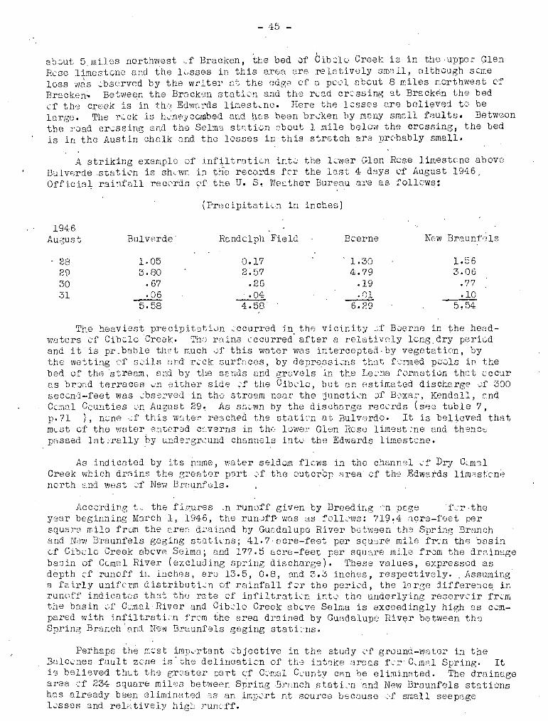
- 45 -
ab'~ut 5 rni.los n0I'thv.!.8st.~:f Bracken, the bed 0f Cibcl0 Croek is in the -UPPOl' Glen[Kse limestene and the h·sses in this area are I"21etivDly small, olthcugh scmeloss was ,~:bsorv8d by the writer nt the edg8 of 5 pc'~'l about 8 miles nQrthwest ('f
'Bracken.. Between the Br:Jck(;~n f:ltaticIl and th,:: rend cri.:'ssing at Bracken the bedcf th,:~ creek is 'in th,~:~ Edwnrds limest ... ne. Here the lesses are bolieved t::\ belarge. The r:~ ok is Ih.:neyccmbed and tics been brcken hy many 8m2ll feul ts. Betweenthe "vad cressing and tho Selma static-n obout 1 mile below the cressing, the bedis in the Austin clw.lk snd the losses in·this stretch ara prc'bably small.
A $triking ex[;!mplr~:, Df infiltratic.,n int.:: the 1(W81' Glen Rcse lirnestcne aboveBulverde .stath'n is shewn in th'E) records fer the last 4 dsys cf August 1946,Offici3~ rainfall recc'rds ("·f the U. 8'. lJJesther Bureau "~l.1~e as follcws:
(PrHcipitatLn in inches)
1946August
2829~-SO
31
BulvE1rde'
1·053.80
.67..-:.Q.£
5.58
RGndclph Field
0.172.57
.26
.044.58
Bcerne
1.304.79
.19
.016':29
Nc,w Bra lmf" Is
1.563.06
.77
.105.54
The he3vi8st p1'6cipitClti·JD -:-ccurred in the vicinl.ty ..::(' B0ern0 in the headlNuters cf Cib~lo 'CreeJ.-::. The retins cccurred" after 8 relatively lcng, dry periectand it' is pI". b,gble th'~:"t much ,;,f this water was intercepted· by vegetatic~n, bythe wetting (.'1' s-.:dls and T('ck 3urfr;cos, by depre.ssi,~:ns thCit f'.::nlled p.:.:,'ols tn thebed of tho streem, and b'y the sands Bnd gruvels in. the Le;.'na formation that cceur8.8 brQad terraces \.:n ~;ither sids ~:'f the Cibclc, but nn estimated discharge \.,;f 300soccnd-feet was -:bsol'vod in the stream near the i,juncti ...'n of BCXl:lI',- Kendall, GndCcmnl Counties ;.;n fHlgust 29.. As sfl;;,::wn by the dischorge recL',rds (S'88 tuble 7,p.71 ), n:;ne .;1' this wnte:r reached the statLn at Bulvorde. It is believed thatml...:s1:. of the water ~~ntcr0d c:::~verns in th(· l~wel' Glen Hese lim8st .'ne and thS'ncspGssed lat ~'relly ~Y undel'grt:und ch~lnI181s int\...' thl;'-; Edwards limestcne.
As indicatod by its 113me, V.Ii-:iter selde-I!1 flews in tho channr:,)l ;,.:f Dry C;..m31Creek which drains thf) greater p3rt ~',f the outcrcp area cf th':;> Edwards limc~st;cne
ncrth end WHst ~~f New Brr-;unfels.
i\cc.:::rding t,. the f'ir:ures .n runoff given by Breeding <"n pege i\~r ·theyc-:ar beginning March 1, 1946, the run-)ff... was us fOILc'vw: 719~4 fi.cr8-f'oet persquare mile fr,.:J11 the c,rec, drained by Gur;dalupe Rivor between the SprinG Brunchand New Braunfels gaging st:~lt.hns; 41.7· [Jcre-feet per squ'Jre milo frc'ffi tbe besinGf Cibclc Creek sbew, S91mn; end 177.5 bere-feet p8r squ',re mUe fr·~m the drainageba,s in of Ccmol River (excludLng spring dis charge) • rrh-9se v1:11ues, expressed 8,8depth cf runoff in inchDs, era 13.5, 0.8, (md 3.3 inch(~)s, respectively. AsswniIlga fairly unifcrm d istributi~n Df rc,in1'all f;;r the peri cd , the 19 rgo di1'ference. inrunc.f'i) ind ien tus thst the 1'8 te ::1' infi 1trat i,;,"n int ....:' the underlying reserve ir fr\.:mthe basin vf C~m81 River qnd Cibclo Creek ab~v8 Selma is exceedingly high os ccmpared with infiltratLn 1'r,:m the "rea drained by Guadalupe River between th'"Spring Branch' nne! Ne'fJ BrQunf01s gaging stati:·ns.
Perhaps the m~'sl; imp,.rtant:'bjective in th" study l'f ground-VJ"ter in theBalc..:::'nes faul t ze-ne is' 'the delinGatic::rn. of' thG intr1ke n.r8QS fer C~mnl Spring. Iti'; believed thut thl3 grcJ8tcr PDrt cf C:'ITlc11 C,'unty can be eliminated. The drainagearea cf 234 squar8 miles betweon Spring Brnnch stati~'n 'and N8VJ Braunf~Jls stationshas alr(~ady been 81iminatsU':lS an imp,-'rt nt SCUI'C8 becousc;'f small seepage1>.:.'888S and reL_'ltively higl'J Tuneff.

- 46 -
No water can reach Comal Springs from the area east of the Guadalupe Riverbecause the hydraulic gr~dient in that area is toward the ncrtheast (see p. 55and fig. 6, pi 56).' Southeast of the Comal Springs fault the Edwards limestoneyields water of poor quality having an odor and taste of hydrogen sulfide whereasthe water from Comal Springs is free from any trace of hydrogen sulfide. Itfollows that the channels throllgh which the water movss toward Comal Springs lienorthwest Of' the Comal Springs fault. This is also indicated by Livingston,Sayre, and White ~/ on the map of the San Antonio arGa showing a sharp northwardturn in the gradient of the water surface in the vicinity of Bracken.
It is believed that Hueco Springs is supplied by water that enters the outcrop area of the Edwards limestone in the csmtral part of the co~nty, north ofthe Hueco Springs fault, and that this water is separated by the fault from themain body of water moving towa":'d Comal Springs. Within the limits of ComalCounty, infiltration to the main reservoir supplying Cornel Springs, therefore,is limited to the bas ins of Cioolo Creek and Dry Comal Creek, nor;th of the CJmalSprings fault. The entire infiltration area of these two streams is about 325square miles, of which 280 square miles is in the basin of Cibolo Creek and 45s~uare miles in the basin Of Dry Comal Creek. Of th~ total area 175 squar? mileslies wi thin Comal County.
As montioned on tha preceding page simultaneous records of the runoff fromthese two basins and the basin of C~adalupe River between Spring Branch and NowBraunfels for the one year beginning March 1, 1946 showed 719.4 acre-fe'"t persquare mile for the Guadalupe River, 41.7 for Cibolo Creek, and 177.5 for DryCemal Creek. Assuming more or les3 similar distribution of rainfall and similarconditions for transpiraticn and evaporatL:m, the difference in runoff per squaremile between the Guadalupe Basin and that of the other two str"e:ns may be considered as showing the extent of infiltration inte the underground reservoir. Onthis basis the total amount of infiltration from the three basins during theyear waS assfollows:
Guadalupe besin:Cibolo basin: 719-42 = 677 a.f. per/sq.mi. xDry Carnal basin: 719-178=541 a.f.per sq.mi.x
28045
sq.mi. =sq.mi. =Total
o189,60024,300
213,900
acre,;feetacre-feetacre_feetacre-feet
This is approximately 80 percent of the discharge of Comal Springs duringthe year which was 268,840 acre-feet. However, a part of the recharge for theyoar was still in storage at the end of the period, as indicated by a high'3rrate of discharge of the springs resulting from a higher water level in the limestone reservoir. Ther(3fore, tho two basins durin" the year probably contributedmat~rially less than.SO percent of the flow of the springs.
If we use, as a basis for computation, the average rate of runoff frQ~ theGuadalupe River Basin between Spring Branch and New Braunfels gaging stationsduring the poriod 1928-46, which was 295 acre-feet per square mile per year Orabout 41 percent of the runoff in the year beginning March 1946, and assume thatthe runoff from Cibolo end Dry Comal Basins was proportionately less during the19-year poriod than in 1946, the figure for average annual recharge to the underground reservoirs from the basins of Cibclo and Dry. C.. mal Creeks is computed asfollows:
Cibolo basin:(295-17)= 278 a.f.per sq.mi. x 280DryComal basin: (295-73}~222 a. f. per sq .mi. x 45
sq. mi, =sq.mi.
77,800 acre-feet.10,000 acre-feet,87,800 acre-feet.
~ LiVingston, Penn P." Sayre, A. N. ,and White, W. N., Water resources ofthe E wards 11mestone 1n the San Antonio area, Texas: U.S.Geol. Survey Water-Supply Paper 773-B, 1936. '. '.

- 47 -
'-rhe average annual r0clwrge for the t.wo basins becoffi3s 87,800 Ell..:re ....fee't:,:;or~bQut 37 perc6nt 'of t;l~e ,1;1Y~'":l-:cagtl annuu.l· dlsch21'gG (:;.:f C,:mal' S'j]I'1n[~S, .which· ..fD::~bout~35,OOr.acre-feet.
Further simultaneous r"cords of the runoff from th') three bosins shouldthrow addi tiQnal light em the ccmoinGd rate of' recharge from Cibolo Creek, and
Dry Comal Creek Basins. HOWeVfJr, the ',eologicel information together Vlith therunuff and S(,ep8ge d'ota 81:r',ady available seem to justify the cOnclusion that arelatively largo part of the discharge of Carnal Springs c;)mes from S01...1rCeS out.;.side of Comal' County and the adjacent parts of Bexar and k,ndall Counties drainedby Ci~olo Creek.
The water is nc.t c~:)fnin:s fro.:! the north, becaus3 tho intake and trans::1issionfacilities are unfavorablr.;. in that direction; it is not cc,rning from tho GCist,beco.usc the hydraulic gradi0nt shown by thH altitude of' thQ water level in w011s(see p. ) slopes eastward frc:m tho sp:-ings; it is not coming from the 'south,bocause the route in that directi<;n is closed by the Comal Springs fault. Thore1'01'9, it must be coming fro:H the' w-::..st ond SQuthw\=3st and 8. major part of it must bec.e:llirg..... ,. from areas beyond the drainaGe bRsin of Cibolo Creek,.
Corrolotion of precipitation with riso and fall of water levelsin wells and fluct~H:1tion8 in disc,harg8 of CoITtnl Springs
H83VY rQin:i~till CUUSGS tha v.Jater levAls in w811s in the limestone rGsr-;rvoirto rise I indi'CQting 3D .'incrc:;csf:: in t118 vc·1Lune (If' ~..,18t0r in sto:t'atsf.~. As thewater in stor[~ge inCr'3·:1soS) t.hl,:!: dicchergc i'rom Com.al S~;:'inGs also incr~~asos..Figure 3 shOVJS the n~cnthJ.y precipitation nenI' the spring at New Braunf'31s andat Boerne in the upper l.![lrt, of thtj drai.Tl8ge arca of Cibolo Creek, about 35 miles,nest" of' the sprin~s. Hydrogrr::phs uf thE i'luctuQtiGns i.E the average monthlydischarge of Comal SpT'ings .fl·C]',! 1932 to 19/15, inclusiV,;), and the monthly a"erageWElter level in th'::J Beverly L6dg,:~s well at Snn Antunio ahout 28 miles sOUthV'H3Stof the springs, erG Hlso shown. rrhe BevF.l'ly Ledges \"Joll is an artesian wellin tha Edwards lim'::stone, 756 f88t deep. The hydrogTf.lph oJ' the ;,I,Iater lev·:;l inthis well is the only lonG c('~ntinLlous record available in the aroa Gnd sec~ms tcccrrelate "with the variations in the discharge 'of COJlal Sp:r.·in~;s. The waterle',el in the well during the p0riod of record hos r3ng'3d from 34 to 71 feetbe1 O','J the land. surface_
At times of 11'::·,avy g·?;neral r3ins SliGh as those of the periods M8y-July 1935,May-Sept<:3Jllb~Jr 19:3,6, and Ju1y-Sept-3mb8r 1942, . thB w5tor 18~.T81 ill th'3 Beverly?Lodges well rises qUict-lyefter each rain and fin~lly re8chss·n high 1·~vel whichmay b;:1 rTFJintained .t'rcm 1 nl0nth to 2 months after the period of h·;~8V:r precipitation.

lTllTTTTllT 11111111 ITl TITTTTTTTIT 11IIII1IIII 1111111111 r 1111111 I11I 111 I III III I II1111 r I ITT TTTTTTIllll 1111111111' 1111111 lilT TTTTTTTIIII II1I111111I '11111111111
1\
\ 1\" j7\
v .......
1
DISCHARGE, COMAL SPRINGS4U
400to-::; 515...• 350.. 0
8 325
~ 300
275
PRECIPITATION, NEW BRAUNFELSI f..---..:...-..----f------;M=QN-d..T=H..-tc.V..---+--fT---�------+---4-----+----I-----+----+----t-----+---__t--___j
IOI-.-------l----~--+---.j--++---=-_1_--___+---...;...I_--4__--_1_---::=_____+---+_~I+__+_-__;_-:-----1f------+--~----t91-----+-----+---1--++--++-_1_--___+----+-=-----+-----------I---H--_+_---+--H---t----tf--+-~-__t--___j
II
., ~.
n r
III ~
L1 , I U U'
nu
-h
-
,r
1
lr
v
1"-0 V\ 11"\ '\ II. r\ I
rr ; n
l r"\.,J
Jnr r U, Ir r - 1
r lh u II h lin n1 r
1 ru '-- ulIU ... -~
PRE.CIPITATION I BOERNEMONTHLY
12
II~---+---_+_-----+--l+_-+--_A_-U-_l___--~---.j_--_+_--_+---+---__+_-----lr----+_--_l
8
II) 1
~ 60z .5
4
3In r rn2 ... r nU11 IJU ltl 1
lr ....~
0
BEVERLY LODGES WELLMUN IttLY
680
m 675 t-----f.~----..::I'r--+_~-_+_-t--I__--_+_-------\...;+------.~\-!-----I----~f..--.-J-J.J--+"'-~~f___+_\-Y--__+_~A+___I"-----_+--l~ "/1 "-~ 7 \" I j \
~ 6701----~---+__-----\--+__--1-j-__I_--__I_--_J.__- --+-4-\-+-__--1J--__+-_l_+-_~\-."IboLI-_H,rJl_.f_-_~\~ ~ ~ \ ~ ~ y~ W\ _c 6651------l~---+-----+---+----_4__--__l-_.-_+_---!--,~/\+_-I+-----___f---+_--_+_---f___-___l
\ /
III10I:roz
IOI----_+_---+---f--H--H--+--H---J-J----+---+---___I_---f.-----_1_----+---+----+---___f----l
'f------I----4---+_-++----H--+-~+-+I---t---_+_--_+_---+_--__+_--__t_---+_--__t_--___4--_l
11-----+----+---+-+-+-++--+--J.----I-----+J----+---+_---+----f.-----_1_----+---4__--__+_-H-___f----I
11-----+----+---+-+---l::-H--+----f--!--+J----+---+_--___I_---f.------+----.......4---4__---+----H-H-___f----I
61----l------40r----4__+-U+--+----f--I-I-~ -+_--___I_-_U_-.j_--~c---1f..l_1._---4__---+----H-H-~--____l
5 t------tlnl-f-....--..+----+l---irr--+--+--J-.I.-t-~............_U__4_______l_l--_l+---_i_____I-t-___I_--____+'-U+l--....J_+__l_------J.+_+_--A--~-U--I_l___1_--__llIT
FIGURE 3- DISCHARGE OF COMAL SPRINGS, ALTITUDE OF WATER LEVEL IN BEVERLY LODGES WELL, SAN ANTONIO,
AND PREC IPITATION BY MONTHS, 1932- 45

- 49 -
IfhB increcse in th8 d isch<..:.rg9 cf the COITl'31 Springs after ra"ins follows apattern that is similc:!r in most resp f3cts to that of the rise'i.n the BeverlyLodges well, except that the rise in the water level in the w011 occurs muchscener than the incr'~:J8.se in discharge cf the springs. The lag is especiallYpronounced after a lenr, perIod of drought, but is much less during wet perieds.For example, the wcter 10V"el in th9 Beverly Lodges wl311 rose nearly 9 feet inthree steges irrUTl8diBtoly after e8ch haavy rain between October 23 and DRc0mb'.;)r13, 1940, preceded by a relatively dry periud of 30 months. In c.:ntrast te thisthe dischurq;c of CCffi81 Springs, which WEtS at an excepticn311y lov} stage, remainedpractic['J11y unc4H:1nged f:lside from slight temporary incroases throughout OctQb r3r,November, and the first, half of December, and finally had a sustained Increaseof' about 10 percent on December 18. Once 3 rise takes place, hOl'Jev8I' it islikely to be sustained for woeks or mcnths, evon through poriods of unusu;.lllylow ro.infall.
It will be obs8Tved th:1t the rise in wt:ter level and increase in the discharge of thu springs is nvt alw8Ys proportional to the <~10unt of precipitDticn.In 1935 the aV"Jr8gr;; precipitation at Be-erne and N(~w Brnunfe1s lIl8.B 47.30 inches.Heavy rains in i,iro·.y started an upward movcomontin the water level in the BeverlyLedges VJBll J culmins.t ing 682 feet <3b9ve sea level in J"uly J whereas the peak inthe disch"rge CUl've for Cam"l SprIngs did nat come until J"nuary 1937, ,when itreached 375 s8ccnd-f<2Gt. In 19tr 2, after the rel'.ltively heavIer rainfall of' 1941,the average precipitation at Boerc'" and Ne'." Br,ouni'els w"s :56.60 inches or 10.70inch'3s less than in 19:35,. yet the water level in tl1'3 well :c'os" t,) an alti tude ofnearly 681 feet and the d isclJarge cf Cem'.,l Sp!,ings at th9 er,d cf the yeur vms 418s8c0nd~feet or 43 sec ...'nd-feut (:;re:}tcl' than maximwn discharGe after the heavierrllins c·r 1935~ This is nl:"~' ::ml'pris::nf';t .however, C'..s the su;r..face runoff·) anddoubtless t:te grc·:..J.nd-vJnti)I' rcch,irn;::-, varies 1vith sev:;ral f::ct.Jrs besid'?:s th~~ tc-talrainfall.
The facts prese~tE)d in this report suggest thet Cemel Springs is a point 01'dischorge for lUI immense ground-w'.1ter reservcir which also supplies the Bev'orlyLodges well at San Antl..'..nic, Dnd that the disch8rg'.~ of the springs is proportic:nrllte' ttE' v::.lume of water in the: reserv:;irT The 13rge sizo of the; resorvoir isindicated· by its abilHy tG obscrb and .ccnt<Jin sufficient vmtor t" supply CemnlSprings fer m(,mths <..'f relativ0lydry weather withcut much chenge in the discharge.
'rile relaticnship 3lu.:ng pr(:~cipita.tiun, Welter levels, cmd the dischurge c1'CCnlcl Springs is shewn in greater detail in figure ,;1" "Nhich giV9S the d811y precipitatio.:n at Nov; Braunfels, the daily fluctlH.~ticns i.n discharge of th9 springs,and a bydl'c'graph of the cl,9.i.ly wcoter levels in well 263A f;;I' 19-12. Well 263A isabc'lIt 2~· miles west of C".'msl Spr'i:lgs,' is 242 f'G8t deep, and dravm fr('m th~)Edi;vards limest.)ne. The hydrcgrnph, obtnined by moans ·:~f a c(mtinucus :;:'ec (\Y'dor ,Sh0VJS the fluctuntiGns in water levels under' w~,lt8r-t':.bl() ccmdtti0ns,
During the first half :.':1' 194~~, theri~' \~JQG !J. steady· declin~3 in water level inthe well in I'esponse to relQti'lely low ra:i.nf'elL The declin'3 was interrupted byseveral slight rises, notably in th'J sec: ...ind vJeek af April, thG last v~leek cf'May,lind t.h8 first \veek of July. r:Ph(:; l'tSE~ 'ill b~th the water levels end the di:Jchnrgeof tho springs began 'within a dr:y c:r twc: after ttl?) rL1ins but the: genor<.';l trendsr:l8med t-.:- depend upcn the 82cklcg of ste-l'ago in the l'es8rv('~ir. In spite of thelc-w rainfall in NOVEmber and Dec8m':>e:r" the rises that occurred cd't'-3r het;)vy rainsIn September and OctQber were maintained until the end ,f the Y0er.

642
640
.......~ 638
"UJ 636o::>!:: 634.....J
'" 632
I I I
WE i 1 63-A -I~
l..-I,
. 1>., c
0..-
1-..-
I I Iv COMAL SPRINGS
50
""IA IJ
(). . .
V~
"' 4- .........C) ~ ;,
"0"'z"000~ ILl 300<1>
I I I I I I I I I I I IPRECI PITATION NEW BRAUNFELS
II
.. - . . ~
-I- - !I I" ••1 I orr Iio
5 15 25 5 15 25 5 15 25 5 15 25 5 15 25 5 15 25 5 15 25 5 15 25 5 15 25 5 '5 25 5 '5 25 5 15 UJANUARY FEBRUARY MARCH APRIL MAY JUNE JULY AUGUST SEPTEMBER OCTOBER NOVEMBER DECEMBER
6
2
<I>
~ 3oz
4
5
FIGURE 4~'DAILY DISC,HARGE OF CO MAL SPRINGS, RISE AND FALL OF WATER LEVEL IN WELL 263-A, AND PRECIPITATION, 1942

- 51 -
130trt the m,·'nth1y and daily charts sug.gest an nnalogy bet1'iCen the [;rcund- .VJ2tAr reserveir and an impounded stream. When a 12ke fermed ~Y an impoundedstr2~arn is full, there is a slight but immediate increas'J in ths discherge ('f thelake at the spillway Vlhen rain falls in thr·) vicinity cf the lak'}. 'l'his is smell,hC\,lJc:;ver, c ..'mpared with the p8~3.k dischnrge that cernes later wh8n the upper tributuries of the stream begin tc pour int~ tho lake frcm the larger drainage area~
Fluctucti~ns of the VlEter table
A number of wells in C.:mal CGunty have boen selected as pp.rmensnt cbsprv[[t10n wells in which tho depths t" wDter have been m3asllred periodically at interV2.13 ranging fr..::rn ene m,:nth to ene y'.:~ar since 1934. The rec,:rds for 38 wells,VJhich h8VE: been me8sul'ed five times Or wore, are given in the tables en pages 115tc'128. Of th'3 38 wells, three drnw water fr,m the Pearsall formation, nine fr8mthe l~~er Glen Rese limestcne, and 26 from the Edwards limest~ne.
The maximum d·ifferenc8 betv;"een highest and lc-v~\:;st levels recorded in any cfthe Pearsall wells is 54.64 feet, the minimum is 20.87 feet, Qnd the average is37.60 feet; in the l<:wer Glen Rose wells the maximum is 264.53 feet, t he minimum12.37 feet, and the av,,:rege 95.60 f"et; ane!' in the EdwClrds' limestC'ne wells thomaximum is 50.85 feet, the minimum 3.20 feet, ane! the average 16.80 feet,
Hyd.r;.::,graphs fer five .)f these wells arc sn.;·wn in figure 5. The graph fvrwell 171 shews fl range in w~t3r levels of' 49.19 feet. The well is :in the lowerG10n Hcse limestcne is 248 feet deep, and is 10cated in an intsrstream area ub~ut
3~ miles' ncrthesst ('1' Bulverde. The water level can be lc'wered several feet by.hand wj:th a bueket and r::pe evon thc,agh the lift is, at times, El$ much as 200feet. The graph feT well 118 gives the range between the maximum and minImumwater lev.els of r8ccrd as.mly 1.58 feat. This well is 9il miles ncrtheast efBulverde and cnly abcut a qUD,rt '3r r.;f a mile frl~im the Guodalupo River. It 01:30draws water fr.:;m the 1;;'~'Ner Glen Rcse lim8st 2ne, at a depth(~f 108 feet. Thewell is equipped wi tll a cylinder pump and windmill and there is nl' measurabledrawdcwn in the water level when the windmill, is turning rapidly. These twowells illustrate the d i:Cference in yield and water-levc?l 1'luctuatLn betwe'=n'VJ';!lls thot nre near the mrti!l lines of drainage F.:l.nd ViGIls in the interGtr~~am
Sreo.8 WhCH'9 scluti\.,n chD.nn~ls havo been p',,;:(:rly dGV'31r.:p'3d.
The water~level fluctu"ticns in \'!ells 263A, 221,and 271 are more "'I' lesstypic:.:ll (:f those rec(~·rded in this ar~a in Edwards limest~)ne wells in the outcrcparea of that limest~·no· Tile w911s range in d·, pth fr 1m 140 to 242 feet, and thefluctuo.ti:.:ns of w'3.ter level in them are c:f mQderate Tangs. N':'n<J of the fivewells described in this and the preceding paroGrDpb tm8 been tested 1'.:1' yield,but n,,' shcrtGge of 'Water has b8GD. reported fr\.~m ony cf thorn. ' They are ranchwells and, with the excepticn of' well 171, all could probably yield muoh morewater than is used.
MOVEMENT OF GROmm WATER
Intrc'ducti::·n. - Grcund wat,or may be classified in rbgn.rd t\. its crigin asCC~1nQte water ,,:r mete::'ric WElter. The woter that is trapped in sediments at thetime uf their depositi .. n is call'3d cC'nnate water. 'llhis water may be c. brinesiinilrJI' tc pres"ent, 3GB. waVal', er even mere cOncentrated. After the fcrmaticn husbeen exposed t:: the surface, the sea water m3Y be gredunllY 1'lushed out and re'placed by meteeric water (1'rom rain Or snc'w) that c~'ntains ·only such minerals asmny be dissolvGd frnn the r·.'ck in the pr,',cess (;f circulatic·n. F:'r example, the

970
960
950
940
930
I- 920w .wu.
930
w 910o::>I-
'::;640<[
630
620
610
600
11111111111 11111111111 111111111111111111111111111111111 I11111111111 1111111111111111111111 !1111111111 11111111111 111.11111111
--Glen Rose limeston~ A
~ /\ 1/_\
I171 \ f \ /'J \.!,
/ -1---- --------- '-J ~
Glen Rose Ii meston
118 -
Edwards Ii mestone"-......,, "
~~\"--~~I'-,
263 A ./ - i', '/ V221 ?
271 ~ I/"""'- /'""""- ",- l./'-- r--
r fl.. J n 1 11
Ulf jV In.. ...~ .JIlf fv U1.nJ" J uJ11~llrJ ~ ~ \rv---F-
1937 1938 1939 1940 1941 1942 1943 1944 1945 1946
FIGURE 5- ALTITUDE OF WATER LEVELS IN WELLS IN EDWARDS
AND GLEN ROSE LIMESTONES AND MONTHLY PRECIPITATION
AT NEW BRAUNFELS FROM 1936 TO 1946

- 53 -
Edwards limestone yields potable water to Comal Springs but contains salt water,petroleum, and gas in the oil fields of Caldwell County. Intermediate betweenthese two kinds of -/-iater is water of poor quality encountered in areas where thecirculation of meteoric water is comparatively slow as a result of structuralfeatures or because cf clay or -shale beds between beds of limestone. SOllth ofthe Comal Springs fault a number of wells (for example, nos, 395 and 428) havebeen drilled to the Edwards limestone but h've been abandoned because the water istoo highly mineralized or has a hydrogen sulfide 0:101'. TIlis is strong evidenc8that there is very little circulation of water in the Edwards south of the ComalSprings fault in Comal County. In Bexar County !!y" how'Jver, there is a largearea not defined by anyone fGult that yields potable water.
In the upper member of the Glen Rose limestone many wells yield water ofcomparatively poor quality owin" to the alternating beds of clay and shale thatpre,vent th') free circulation of meteoric watGr. In general, circulation decreaseswith depth and water obtained at great depths is likely to be of poor qualityalthough there are many exceptions to this rule. Circulation of water in limestones may be retarded by natural puddling when solution channels becom9 filledwith chq or other detrital material carried into th,) formetion by infiltratingmeteoric waters after heavy rains. Weathering within th, limestone usuallyproduces a residue of red cley, which may also be washed into previously formedcav8rns~ Beds of red clay are fOund in a number of plac"s in the Edwards limostvno. Natural puddling occurs, however, after connate wat9rs have been flush8dout of the limestone.
Rate of mcvement.- Th" lac;, Of turbidity in the water that issues from ComalSprings sugg'3sts that the water moves slowly underground and that a part of itscourse is throu~h an intricat0 network of small op0nings that retard the velocityof the water to the extent tllat sediments aro not carried along as in open streall13.Locally, howover, at som~ distanoe frQ~ the s~rings constricted openings maycause turbulent flow. The ts~mp8rature of' the water from Comal Springs ·is constant at about 740 F., whereas the mean annual temgerature of the air recordedby the U. S. Weether BUj-_eu at New Braunfels is 68 ,F, This suggests that thopaths of circulation within the reservoir may reach depths of 300 to 500 feet~
below the surface at no great distence from the spring.
The Vlater from iiueco Springs, On the other hand, b3comes slightly turbidufter heavy rains and 'thG' tempera ttlre Of·, ths .. waterl fluctuates within"a' rangefrom 3 to 6 degrees 10'f!er than t,hat of Comal Springs. These cQndi t ions, togetherwith the fact that the 8,nrings have a wide range in diseharge, suggest,that tJlesprings are supplied by a ground~water reservoir that is quite ssparate from thatsupplying Comal Springs, and that the intake area for this reservoir is smallerand closer ~~ the point of discharge than the intake area 0f the Comal bpringsreservoir. The Bueco Springs fault (see p. 30 and pl. 5) is believed to dividethe twe reservoirs, ,This is indicated by a comparison between the altitudes ofthe water levels in Edv,iards wells on either side of th~ fault' and the altitudeof Hueco Springs. On the southe3st side of th9 fault, in the vicinity of thespring the maximum altitudes of water levels on record in wells 221, 222, 226,and 398 are apprOXimately 636, 637, 641, and 636 feet, respectively (see tableof water levels), whereas the altitude of the lowest point of discharge forHueeG Springs is 645 feet. .Just ncrthwest of the fault th" "Jater level in well224 has been recorded as high as 665 feet. HuecG Springs ubviously could not befed by U reservuir having a water level lower than the pOint of discharge, sotha t the reservoir m!lst b0 northwest of the fault.' It is net proved, howover,that the fault acts as a barrier tc the movement of ground water for the entirewidth of the county.
45/ Livinr,stcn, Fenn P;, Sayre, A. N., and White , Vi. N., op. cit., p. 104,1936.-

- 54 -
Spri.ngs in the Balmorhea area of Texas are believed to be close to the intakearea and it was cbe,erved by 1Nhito, Gale and Nye ~ that an increase in dischargewas accompanied by a decrease in the temperr.ture and in ,th8 mineralization of thewater. In the fellOwing table the r"cords cf temperatures, hardness, nnd disch'JrgentB8.SUrements fo~ Huecc Springs shew nc~ direct relatiunship amung these; factors.
DateTempel's. ture L)f
spring wat','r(Degrees Fahrenheit)
Air temperature,',(Degrees Fahrenheit)
, Discharge 2,1Hardness as CqC03 af in(Parts per millionT secend-feet
326'260333294264316
279 90.3
322 92,.4288308 80.4286337 84.5254 77,7272 59.0221 ~:52~;L
336 23.3282 4G.8326 1'7,6
16.5
of chemical analyses.
35
4545454952
4434
a I For mol''' ccmplete 9.nalys'2s sec tableb/ More c~mpleta discharge data given on pagec/ About 8 hOLlrs after h"uvy rain.
1944Jan. 22 70Sept. 14 7ltOct. 9 ?lNov. 22Dec. 5 ']/ 7lDec. 7 7lDec. II 69Dec. 1" 69'0D9C. 13 69Dec. 21) 69
1945:ran: 8 69Jan. 22 69Jeln. 27 68Feb. H 68Mar. 5 681.2Mar. 23 69Aer. 1Apr. 27 69May 31 691.2'July 5, 70Aug. 9 70Sept.13 70Oct. lD 69iNov. 23 7()Dec. 20 70
Referring again tC' figures 3 and 4, the apparent lag in the incr·~;nse in discharg':.:; cf Combl Springs follcwing.h88vy rains and rises in water levels do(;s not meanthat the water actually n10Vt~S from th:;~ vicinity of San Antonio t,) Comal Springs wi thin the 1 or 2 mcntll p"Jricd indicetcd by tile lag. Only the cllang,' in head due toladded wator in the intake area and, in the ·rdservoir itself is tre.nsmitted at thisrate. Tho time required fer th8 water that f311s as ruin un the intake 81'83 VJ6st ofCornal County to reach CCInDl Springs would p1'ob.sbly be expressed in years rather thonin days c:r montllS. Much research has been directed tcw:.--rd th.;~ ra.t·3 af muv:.?;ment c,fgr'2und l-"'nter, and with cCDsidf:;rrable suCcess vJhe1':,:: the cher3cter and permenbi.l:ity cfthe materials that form the ground-vmter reservoirs 3re fairly uniform. As~.l resultcf this rgse;J.rcl1 methods have bean develo 8d by Th'iem ,17 2nd J:Pheis 4·8 by which it
'16 White, W. N., Gale, H. S .. , f:llld Nye, S. S., Gecl ..::gy and ground~wateI' resources of the Balmorllea area of western 'Texas: U.S.Gool~ Survey Water-SupplY Paper849-C, p. 10q, 1941.
?2J Tlliem, Gunter, Hydrologische Methoden, 56 pp', Leipzig, J. M. Gebllardt,1906.
~ Theis, C. V" The relnti;)U between thE' lowering .'f the piezometr:lc surf3ceand the ri.:;te and durathm cf discharge ci' a well using grCund-1":ater stcrage: Am.Geophys. Un:lon 'I'ranso: 1935. I'P~ 519-524.

- 55 -
-;.:: is possible tc ffi2.ke quanti t'--'i.tive estimstes as to th'3 p ..:ssibla yield of groundwater reservuirs. The methvds are mere generally applicable to sand and snndst;.nereserve-irs bf'CUllSO cf tho mc:re nearly unLf0rm chsracter ,.:1' such nquifers_ Thesnplicaticn of fcrmulas fer th"l determinrotLn cf' the V.'rmeobility of the limestunes in Cellisl Cc-unty w~:uld be difficult net c:,nly. because of' the irreguh:lrit iesin the character :;",1' the (.lp'.~ninr:;s in the liPl8st. ..:nes but because it is bel ievedthat tbe m;;vement cf tbe water may be under artesian c,:nditic.;ns in a part "f itsccurse and under wf--.Jt'3r-tebl'2 c.':nditicns in other parts.
Directii2n ::'If ITH.'vewent. - Figure 6 is a map cf C.,:,'mal C0unty shewing th~) lccati.".ns ('1' a number cf cbm:trvE::ti:.n wells in which th9 differences in head at thewater table fur the p8ri~d Ju.ly 1-17, 1945, are shewn by the altitude cf tbewater surface at each well. 'rbis VIES ,'btained by d'3terrni.nins the ·"11 titude of tbe18nd suri'e.ce at euch vj'311 and subtracting therefrc'm th·:! depth t..:· water in thewell.
In generel, these recc·rds shew that the water table i.n the Edvmrds liIIl'2st{:newells in C(.1ffinl County slc'pes fr,. m. the suutlll'Jest b,. un.J:.1ry .:f the county tev,lf3rd thencrtbet'st bcound8ry of' the c:unty slthcugh lCCG11y the'ln'dients may n~'t ccnfcImt,,~\ thi.s gr:~nerc.l directii..n (fig. 6). ]'rl..m this we m::=ty QGSLUU8 thE,t serne lJI1Dterenters Ccm"l C.:mnty frc,m the Edwards lim"stone ill Bexar Ccunty. Li'fingstQn,Sayre, Dnd White W sh'.'\'! the slope ,'f the artesian be"d fer Edwards limestc'newells in th·] San Ant,:.'nie a1"83 in 1934,. ThG genoI'DI directicn cf the mcvement e-fwater PI'" bably. varies but little from t~me to tim". As indicated by the cwntcurs,n th,)ir map, the gen"ral slcpe wf tlw pressure surface is s0uthf,astward but "tthe Cemal C~unty lir~-~~ t~e c:.:nt~.mrs swing rather E1burptly n('rthward indicating aneastv-!1..,,:rd slope Qr the pressure' surface. In this urea the ~"jater appears to moveOllt from under its c0nfinin,~ bed and continues nQrt.heastwnrd under water-tDblecQnditi8ns, 08 1.ndic8.tetl by tho r0lativ.~ elevD,tions -':)1' the VJater surface. shown Onthe map of the San Antonio "reC1 and in 1'igure 6 of the present report, The fC1ctthat the chemical character "f the water southeast of' the Comal Springs fault ispoor c0mpared with· t.h" quality of tbe water the,t i.ssues from Comal Surings is
I' . . , ~ ~
further proof that the main body ,,1' water flows along t.he north side of the faultunder water-table conditions rather tban on the downthrow side ::1' the fault. ThisChang01 in the dir'3ction of' movement of the Edwards water was probably caused bystructural unlHt Dnd tl'ensverse faUlting in the vicinity of Bracken (soe p, 31 ),which kay have f'orm8d:.D.,·'btl~rierdiverting the m(~v~~ment of water from its normalcoursel in the artesian area. FOllowing the generel direction of tbe slope inCarnal County, the water uppears to ffiuVG from the vicinity of Bracken toward andbeyond' Comal S1'1'i:1gs. In the Vicinity of the springs the slope is toward thesp:rings from the north, west, e,ncl south, indicating n COne of depress len causedby the discharge of the spring.
121 Livingston, l:;enn, Sayre, A~ N., and WhIte; W.· N·.l Water resources of' theEdwards limestone in the San Antonio area, ~exas; u. S. G·eol •.Survey iNn terSupply Paper 773, pl. 5, 1936.
(

ol:.X
976
N
EX PLANATION
WELL IN EDWARDS LIMESTONE
WELL IN UPPER MEMBER OF GLEN ROSE LIMESTONE
WELL IN LOWER MEMBER OF GLEN ROSE LIMESTONE
ALTITUDE OF WATER SURFACE IN FEET
,
,
\\..., /
"~
'\)
..
I··I•~"....••..,
•J•. ....' ... -. "
'!r~\\', \..) ;/
../:I
•III
",
,
,
/
FIGURE 6- ALTITUDE OF WATER IN WELLS IN EDWARDS AND GLEN ROSE LIMESTONESJULY \-17, 1945
o 2 3 MIllS

- 57 -
In wells drawing from the Glen Rose limestone the altitude of the waterlevels indicate that tIle water table slopes eastward and southeastward toward theoutcrop of the Edwsrds. On th" divide between Cibolo Creek and the GundalupeRiver, however, the Glsn Rose VieUs shOW a pronounced irr"gularity in the altitude and slope of the water table. 'fhis is charccteristic of the water ta1Dle'-'inlimsstones in which ths solution channeling is pl)()rly devnloped.
SUMMARY OF CONCLUSIONS
The discharge vf Comal Springs, which averages 323 second-feet, is maintainedby a 16rge reservoir in the Edwurds limestone, supplemented by a smaller roservoirin the lower Glen Rose limestone. The gre0t size 9f the Edwards reservoir isindicated by thee remarkably constnnt rate of discharge of the springs, the uniformtemperature and lack of turbidity of tha water, and by the relation among fluctuation in discharge, reinfnll, and rise and fell in water l-3vels in wells.
It hos been shown th3t recharge to the reservoir within Comal County islimited to parts of the drainage area of Cibolo and Camal Creeks, and that evenunder the most favorable conditions this recharge is too small to supply thesprings. It is estimated tilat the entire drainage area of Comal Creek and CiboloCreek contributes about one-third of the water that reaches Comal Springs; thebalance, therefore, must come from areas to the west, beyond these drainagebasins.
METHOD OF \'IATER~WELL CONSTHUCTIOF
l\lost of the water wcolls in Cemal County have been drilled by the cable-toolpercussion method, which is described by Fiedler.'2Q/. Ordinary farm and runchwells ure usually from 5 inches to 6 inches in diameter. Where casing is usedth,] diameter of the hole is usually red1lced slightly to prov'ide u seat for thecasingr MOst wells that start in tho Georgetown limestone or older formations,inclllCl ing in descending ord0r the Edwards limestone, the Glen Rose limestone, andtile Pearsall (Travis peak) formation, d,' not require casing tu pre'vent the caving61', the softer beds. Th"se are usually equipped with a short piece of galvanizediron -casing to prevent soil from ontl;ring the well at the surface. Many uncasedwells tha't hCive br..,en drill'3d into th,;se older forma t ions 2re more than 50 yearsold and are still giving service. Some wells are equipped with one or two jointsof wrought steel casing comented from the surface of the ground to the bottoo ofthe casing, Gllowing from 1 to 2 feet of th,) casing to protrude above the ground.1'his not only provides a seat for a water-pipe clamp but it affords better protection from p,;llution er surf',ce contamination.
Wells that penetrote the Grayson (Del Rio) shale, how'3ver, must be cGGed tosolid limestone at the time the well is drilled, Qwing t" the fact that the clayin thi.s formation will invariably cave as soon as it becomes wet.
Wells that are drilled in th," Taylor marl or Anacacho lim9stone requirecasing. NO caving beds are found in the underlying Austin chelk, but some claybeds in the Eagle Ford .sha10 may cave if no cas ins is used.
In the Pleistocene alluvial deposits, the wells hav· an average dapth ofless th,;n 60 feet. A few of the older wells hav,:; been dug by hand and are linedwith rock. Drilled wells 'obt8ining water from thE- terraces require casing'toprevent caving.
QQ/ Fiedler, A. G., The construction and protection of drilled wells, U. S.Geol. Survey, mimeographed circular 1933.
- 58 -
I,lost farm or ranch wells are equipped with a 2-inch drop pipe and cylinJerpump. The cylinder is usually 1-7/8 inches in diameter and is placed near thebottom of the 2-inch drop pipe, with a short piece of suction pipe below thecylinder. The bottom of th0 ~uction pip'2 extends almost ths full depth of thewell except in wells in which I the yield 2nd specific capacity(yield per unit ofdrawdcwn)are high" In many of these wells the cylinder is set 20 'or 25 feetbelow the water surface, depending upon the seasonal flllctuation of 'the watertable "
Windmills are extcnsi~elY used for power, but some pumps· are pOiNered byl~ to 5-horsepower gasoline en(~in0s. The wind is f~~irly d,ependable in OOffiolCounty, but emergency power or storage tanks holding 3 or 4 days' supply areneeded in Case the wind does not blow. Some ranchers eqLlip their wells witha jack and pulley SO that a tractor or automotive equipment Can be used when thewind foils t~ provide adequate power, Recently, as a result of the growth of therural electrification system, electric power is being used for pumping on severalfarms and ranches ~ Where large affiuunt:s of water are needed, such as for thepublic supply for the city of New Br'!unfe,lsl wells of larger diameter are drilledand turbine-type pumps powered by electric motors are used.
CHEMICAL CHARACTER OF'l'RE WATER
By W. W. Hastings
Purtial chemical analyses cf VJa t',er from 328 \'Iells and spriq;; s in CarnalCounty are given in th", table; of chemical analyses appended to this report.In additiOn, analyses ef 44 samples collected periodic'llly from Com"l Springs(no. 294) and Huecc Springs (no. 400) are listed to shew the pC'ssible relatiunship am·Jng the Chemical character, the -;:'ate of discharge, :::md the temperature ofthe water. The data indicate no Dppurent pronCLlnced differences in Chemical COmpositicn i,)1' temperature cf th'3 water with chan~es in the ;rate cf flow.
Most cf the water cbtain9d from w911s in' C'..::mal C0unty is acceptable forsteck and dc-mestic purpC'ses but, because the 'water-beering formaticns are largelylimestcnes, the waters are moderately hard, generally nbov8 200 parts per million.CalciLlm bicarbonate is nc'rmally the predomim,nt'f.lineral constituent in ground"Jater ef Cornal COLlnty.
The wells in the Pe8rsall (Trevis peak) fcrmnti;n yield weter that ranges inquali ty frem except ionally g .. od, as shown by the analysis ef the water frem well106, tq water that is to~ hir.r,hly mineralized fer most purpc-ses, such as the waterfrum well 110. Howe'Jer, m"st wells in the PeiJrsall (Tr"vis Peak) formatic-n yieldwater containing less th8n 500 parts per million of diss~lved solids.
Wells in the Glen RCSH lim8stono gonerally yield 'ln1tiJI' 'acceptable for domos~_~:
tic purposes. ,:rhe more highly miner31ized waters fr~;m the lower Glen Rese arehigh in sulfates and ?T8 v~ry h.ard, as sh~wn by the analyses (:1' water frcm ;;;e11863 and 130. Vlater in the upper Glen Rose in many we Ils is rather high in 8ul.L'1tesiJncl hard, but must <:,1' the' wuter hod dissulved s(,lids below 1,000 parts per millie-noAn 8xcepti'-'n is fcund in the analysis cf wn.ter fl'Uffi well 427, which is 1,200 feetdeep "nd yiolds water haVing 4,170 p"lrts per million ,,1' dissolved solids.

- 59 -
All the analyses (Ii' ",~'at'3r frcm \-118118' in the Edwards limest:ne nc·rthwest i.."fthe C',m"l Sprines fnult shew thet the water is ef geod quality; althcugh the wateris hurd, dissc'lved s~·lids "re USUEUy 10GS than 500 parts per millien.' The "1811s(402 Dnd 403) that supply the city cf New Braunfels yield water th2t hns 3n ' .. 'c"",,,·':average hsrdness cf 252 parts per millicn and dissclved solids cf 282 parts permilli-n. ~See fig, 7;) 'rhe welter supply has been a "proved by the State Beard'.'f Health fer public ccnsumptiGn.
As prevL usly st"ted, it is believ·3d that tho ,·'.;cter s e",theast ()f the Ccm,',lSprings fault is vf pe"r qllality beC3l1S9 the f"ult has prevented the free circulaticn (.f metecric vmter in the Edwards lirnestC',n'3. In the G18n R;:;se limest('nesand in the Austin chalk, circulGtir.~n is nls~', the ccntre'11ing factl.'r in the quality~~f ·water. Where svluti(.'n h9.s developed a rf:servcir with a system cf cc.:·nnectingpassages permitting the free m;::vmmen t of water churacterist 1c limest0ne VH..:tersprevail, as illustrated by wglls 184 and 402 in figure 7.
11/3. t0r fr..;m th,:;) Loclls f,~;rmati(,'n, e-f PIe ist,. cene age is high in n1trate, asin well 363, but the nitrate c'.. ntent cf the water diff9rs widely frcm 0"8 V!GIltc 8tk ther, It is frequently stated that high nitra'tes in well wat8r indicatepclluti,,'iTI irem s;:urces at cr nf.'lQr the surface, but studies of waters in v~..... ri(uspar'ts (:1' Texas indicate that Pleistcc0ne fcrm3ti'_'-ns may cvntain nitr2te vJherethere is nG pcssibility cf c·,:'ntc:min:1tL.'llt
lJ.1h8 ch9miccl c~:mpcsiti ,'n ·:f gr('und waters fr'~~m seversl e.quifers in C.:.malC~.llnty is shewn graphically in figure 7. "che heights ;;1' the several s ectLnsccrr·,;.spond t .. the qlJenti ties ..:f the icns, such as calcium, .magnesium, chlcride,etc., expressed in terms cf equi.v31ents per millicn. One equivalent per mill:i. ...:nccrresponds tc: 20 ports per mill1.c'n of cE1ciwn, 12 cf ffingnesium,23 of Godium,39 ('f pc,t3ssium, 61 c'f bicarb,nate, 48 :f stllfc,te, 35.5 cf chleride, 62 efnitrate, and 50 C'f hardness as calcimn ciJrb ..'nate. Tho;:: t-...:tal hardness .is thesum :>f the bl:>cts fer calcium Gnd ma'gnesium. As an illustrati:n, if thebicarbcnate bl:>ck extends abc,ve the magnesium bL'ck, all the hardness 'iscarbcnate hardness.; but if the top I.,~,f the bicarb)nate is lcwer than the top ofths lTlagn':1simn, part ,,'f the hardness is due t,...:.' sulfat0 J Gr eV j3n chlc-ride if thochLoride extends bel:w the tcp Gf the magnesium.
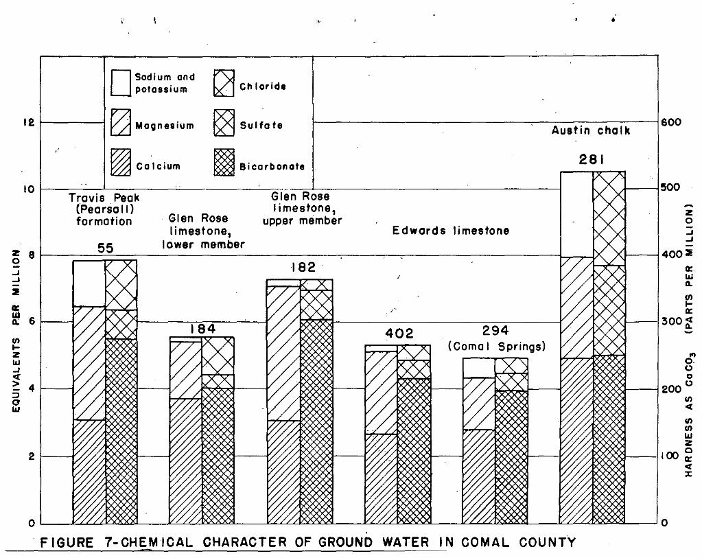
.' .
OSodium ond ~potossium ~ Chloride
12 1-------1~ MOllnesium ~ Sulfate f-----------------,,-----------j600Austin chalk
-zo.J.J
.-----;400 2
0:l&J0-
f!!0:
1---1300~-
r--j500
...o.oo
1S8~i-~ 200 0VIet
VIII)
Wz
J----lloo ~/IXXXXj of
:x:
294(Como I Springs)
Edwards limestone
402
281
182
I Bicarbonate
55
"
21---f
10 1------'-------'-'----------=-c---=-'------------------1Travis Peak Glen Rose
(Pearsa II) limestone,formation Glen Rose upper member
limestone,lower member
z 80.J.J-2ffi
611:
VI~
Zl&J.Jet> 4::J0l&J
FIGURE 7-CHEM ICAl CHARACTER OF GROUND WATER IN COMAl COUNTY

- 61 -
SURFACE-WATER SUHLr:S
By
S. D. Breeding
Apprc,ximatco1y 420 squara mil';\s ~f the 567 square miles in Coma1 Countydrains directly into Guadalupe River. About 60 square mil<3s in the northeasternpart of the county is drainGd 'by Blanco River, a tributary cf San Marcos Riverwhich entsrs the Guadalupe at Gonz81es about 60 miles bolov,: Naw ErEll nf(~ls; and astrip of about 90 square miles clong the southwestern b':,rdc;r of the county isdrained by Cib~lc Creek, a tributary of San Antonio River.
C\.'ntinth.~us rf3c0rds of th·3 discharge of these str'::Qffis lJIJ9rG being c·btained inFeburary 1947 at the following g'lging stations except the Guadalupe River at NewBr8unf"ls, below C0mal River, whioh was discontinued in 1927. All the st"tions0xcOpt the one ct Wimberley are in Cernal County.
Stati0ll
Guadalupo River n~)ar tipring BrsnchGuadalupe River abov'3 C"mal Rivor
at New BraunfelsGuaclnlllpe River st New Braunfels
(below Cemal RivGr)Cc.:mol River et N8W Braunf'31sBlanco RivGD at Wimber1~y
Cibcle· Creek !lear BulverdeCibc10 Creek dbove BrdckenCibc'l;) Creek LOt Selma
DrainaG;8 area(sq'wor; miles)
1,432
1,666
1,77094*
378
198251280
Period of r8cordJune 1922 t~
Dec'c·m bin 1927 to
January 1915 t~ Dec ,1927Dscomber 1927 toAugust 1924 t~ S-e-p~t-em~b-e-r
1926 dnd June 1928tl'
April 1946 toMarch 1946 teoMarch 1946 to ----
:~: *Measurements include flclN f'rcm Ccmal Springs tl.' which this drainage 2reGis nQt applicable.
These reccrds we're ccllected by the Surface Water Divisiun of the UnitedStates Goclogical Survey in ccoperati~n with the TI3x8S State BJarcl of WaterEngineers, a nd have been pllblishocl in G801cgioa 1 Survey Water-Supply Papers.

- 62 -
Guadalupe River
The fC'llcwing table c:mtains a few pertinent facts abeut the flow :)1'Guadalupe River as ms~sured at gaging staticns in Cemal County.
____________~T"'a,;;b~l~e;...,...:l~-_iR~t~m(;1'1' of GL18d al;;.:u=e;.....:R:;.l=.·v;..."';;."r:;-_-,_-,-_,-_-,=--..,._~_Pericd ,)f I -Averag~during AveI'ag~~ during ·1 Minimumr8c~rd I per1cd 12 consecutive 1n
(caleudsr (acre-feet W mc·nths cf lowe.st I c,nG dayY"E,rs) per dEY) flew ,(acre-f'cet)
(acre-f,yt per da )
Spring Branch . 1923-46
.N8w Brc,unfels(abc'v" Cemal River)' 1928-46
588
821
96
.127 19
New BreLunfels(bslcw Comal Riv~r) 1916-27 1,486 682 536
01' 151/ An acre-f.. ct is' the amcunt of watGr:rc:.·t and is '3quiv3Lmt tl; about 326,000
roquired tG c':over 1 acre tc the depthgallens,
P,·'ak rates ,'1' flew reccrded fer Guadalupe River lBDr Spring Branch during thepericd 1923-46 vnre 12J.,000 sec r;nd-f8et en July 3, 1932, GIld 114,000 sec'.'nd-f',eton Juno 15, 1935. Tho minimum fl;;,w r8c·.'rded was 2.2 secc.nd-t'·eet (:n July 11, 1939.Peak::: rates S'f flc!w rec':'I'ded f;:,r Guadalupe River at New Braunfels' during theperiod 1916-46 were 95,200 s'3c,,:nd-t'eot en July 3, 1932, Gnd 101,000 secc'nd-fe8t enJunG 15, 1935. Flecds of c~nsider3bly groQtGr magnitud9 occurred in 1869 and inDecembC'r 1913. Th'3 minimum flew reccrded fe'r Guadalupe River abc've Ccmal River,at New Braunfels between 1928 and 1946 was 9.6 second-feet on JUly 9-11, 1939.As the flo<,cls in July 1932 and June 1935 originated above Spring Dranch, thedecrease in the P611k rates c·f flt'w b'3tween Spring Branch and N9w Braunfels isconsidered tc be due to· tempc'rnry channel stcr"ge and te he.v8 n,' r',luti'en tcp,-ss ib 18 lQss8s t(, the gr"und-'w[{ ter re serve· ir.
T[~bl~; 2 giV('s' th',) aJinu~;l discharge '-.:f Guadalupe River at the gaging staticnsn"Jar S-pring Bl'anch and 2t> N8VJ Braunfels, ab ..:v'2. C;;offiel River, 8.nd the runc'ff fr~'m
tho 234 square miles drained by the rivor between these staticns (expressed in2CrG-fu0t and in depth ill inches), t'cw'ther with tIn 2nnu,,1 rainfall at NewBr'lunfels and Fiscl1er's Store l':'r the years 1928 tc 1946.

- 63 -
rrable 2: Discharge ~'f Gund31up8 River near SpI'ing Bl'3.nch Gnd Dt NevI Braunfels andpickup b'.3tween stat L. ns; rainfall at Fischer's Stcre and New Braunfels, Texas,
1928-46
34.7532.865.5369,040300,000AVMIAGE1928-46 230,900
Guadalupe I -Fl~~w cf Runoff betw'3en Spring Ruinfa11 in inches
Calendar Riv3r in acre-f8et
lBranch and New Braunf01s Fischer's New
year Sp~ing I N0W I SLre BraunfelsBranch , Braunf"lst Acro··feetI Del:th in inches
1928 I 45,400 64,800 1,55 28083 36·0719,4001929 1 143 ,000 208,000
I65,000 .1 5,21 40.60 40.15
1930 142,000 170,000 28,000 I 2.2,1 30·80 28,711931 1 235 ,000 336,000
I100,000 I 8·09 32.57 31.58
1932 395,000 425,000 30,000 2.4·0 27.58 31·151933 102,000 11'1,000 12,000 .96 26.90 26.751934 54,490 8'7,680 33,190 2.66 28.62 30,801935 459,800 573,700 113,900 9.13 42.07 41.671936 619,30:) 691,900 72,600 5.82 37.86 30.411937 181,200 23~5 ,400 52,200 '1.18 28.94 29.191938 l'W,800 232,400 91,600 7.34 23.13 28.321939 60,310 64,5130 4,270 .34: 29.53 13.3519'10 152,400 174,300 I 21,900 1.75 37.28 38·111%1 485,100 620,600
I135,500
1lQr.'iil66 36.02 I
42.991942 227,800 318,000 90,200 I 7'123.; 31115::' I
42.081943 98,570 136,300
I
37,730 I 2,g9? 22.83 29,931944 315,100 450,100 135,000 10.82 37.53 1 43.1419·15 302,200 420;700 Jl8,500 9.49 35.30 I 39.381946 , 228,500 ! 378,200 149,700 I 12.00 46.79 56.60
1 . ! 1 . I.,.
During ths: 19-y,:.~Err peri.·d t118 ffil111ffiUm annual runcff frum the d raillsge areabetwoen the twv stath:ns (23!± square miles) was 0.34 inch ·.r 18 acrG-feet persqu3re mile, th8 maximum run~,'ff was 12.00 . inches cr 640 8.Cre-fe9t per square milG,end th'" aV'n.'3ge was 5.53 inchos cr 295 Gcre-foet pel' squa're mile. The runcfff'r':'ffi this orca during pr.H'icds \:1' n~;rmBl an:"! 12W floiN is c-.:nsidernbly affected bythe fl.:w fr'.m several springs, of which the Hllec~ Springs are by far'the largest.Resll1ts _,f 29 current-meter meGsurements:,f tile fL,w :'f Huaco Springs, whichenter GuadDlup':; River :3 miles abc'v·:;: the gage nt NelN Brsunfels, sh\.·,w a dischargeranging fr;:'lfi 0 t;",: 96.0 sec ...:nd-feet. These measurem~~nts aro listeu in t8ble 3.
Sp b n Y
Table 3: Discharg? m'3i~:sUrGnYjnts, Hueco Springs, 3 milos n.:.:·rth ;,:·f New Braunf·:~ls,
1'{"::'~··8S'.' ..i Discharge I Discharge
Date I (s'3c(nd-feet) I Date (secc:ncl_feet)JUly 31, 19~;4
I 37.7'" NOV, 22, 1945 17.6Jan. 19, 1928 0 Dec. 20 16,5Feb. 22, 19;Z9 0 Jan. 24, 1946 38.0Oct. 8, 1937 1.5* Mar. 1 71.4Aug! 4, 1944 61,0 apr. 4 71.3Sept.1S 58.6 May 9 55.9Jan. 22, 191'r5 90.3 June 14- 5'1,4Feb, 16
I92.4 July 18 22.3
Mar. 23 80.4 I Aug. 21 13,2Apr. 27 84.5 Sept.26 93.2May 31 I 77.7 i Oct. 31 88,8July 5 I 59.0 IAug. 9 I 32.1 I Dec. 7 85.5Sept~13 23,3 Ii
Jen. 12, 1947 96.0Oct. 19 " 't G . 8 Feb. 13 88.7*West rin,7' c 1 •
- 64 -
l\,lh.~st cf th'''; ID0GSUI'8ments in the fcr'3gGing t.3 tIe VJ8r') mado in 19t1;t-4-46, whenth'3 rainf;}ll was ccnsiderobly 3bcve ave-rage. Pr'~cipitatL:n during 19/16 wDn morethan 20 inches ab ;ve the annual 8Vp..roge at N'3W Braunfels. Th01'ef~'r8, ~t is c('neluded that mest '~i' tilO Inf:8SUroments of discharge reccrdod in th'3 table werec~nsiderably Qb~vo nVGl'D.go.
rrhe fcll(}wing tables, t,l, 5, aud 6, shew discliarge measurements made todetermin9 s89page lcsses ond returns en Guadalupe River between the Ccmf~'l~t andNew Bre.unfels g8.ging stath.:ns during peri::ds of lew fli;w in 1928 and 1929 ~ Theree':;rds sh,'w a net seo]1agc> gain ('"1; fl.3 see'cnd-f,'ct in 1928 and a net S':J€,pageless ,:f 1,4 sec(:nd-feet in 1929 between tile Spring Branch and New Braun1'el_s·,statLns.
Tho seepage inv'3sti;~aticns in 1928 and +,929, 8S rec,:rded in tables 4 and 5,Slh'W tlH,t th:" 1'lew at New Braunfels was ::; t~· 4 see'cnd-feet groater than it wasat Spring Brsnch. In th('se tables the discharge ;.:1' Huec, Springs wDuld be shewnin thG Elm Creek m'~csllrem9nts, fer which discharge measurements ar'3 rccc'rded osZer(~, indicating tb3.t the spr.ings were dry during both investigati'~'ns.
In 1944 a seepage investig3ti·:n was made between the Spring Branch and NewBrl1unfels stotLns wh ich she'wed n nat gain c:f 98 sec~nd-1'e"t between SpringBrl1'1ch and New Braunfels, ,-:1' which 61 second-feet camEl 1'r.m Huee:.: Springs.TabTho 6 is Cl reccrd _f this invGstigati,:\n.

Table 4~.- Discharge mcasursmsnts to determine seepage on Gua.dalupe River frem Comf,Jrt, Texas, toNew Braunfels, 'Texas, in ,January 1928.~~ring the investigation the river ~as at a C8nstant stage and the measuranchtsrepresent the natural conditions.
u'"
+9.6
+h.8..+h.9
+11.8
+12.8
+14.h
+4.7
+h.8+ .1
.2
.5
.3
1.6•it-
58.658.7
65.4
70.9 +1+.3
68.3 -2.6I
A , I".0
71.9 I I +1.0,II1
1.5 I I.ij
!
Sheet 1 of 2
57.5
59.0
55.8
45.6
LocationrCD g '2)", Dis charge in second-feet
+,r-!''''' '". 'T'b' U' JTt1I ~ 'd .+-J ~. 'dcam , . 1'1, - I c:.ln or ? a....1.~.5 'd 1'- ltream Iutary ! 105s in ·galn orI;.:·,..,·, " I' t . 1. i 0 ~ -+-' r sec lon as s
I I ,",+,,eo: "~U)a'ci I II~'d '"' 0·, -,' '-I 't ...:r:'"O~o..., i1 --~-
At gaging station 2 miles 0.0 Ii 52.0' I I
abc'J -3 C')infort ,Il/h mile above mouth at 3.0 i 1.5 I
Cnmfort I
1/8 mile above I:1o:.lth "-"" h.8 II A", id""~o·,(t'·;o'r-'rl"e"i'···,'r Comfort I' 6 I, I. .'-'. L ........ :'._:.L..l.' 0:."_' ..1.~~o~. ~l'~"" ./.T
At ~iaring 12.2 II 2 miles above mouth :1··'ar'.'J·ari.~g 16.0 I
1/2 mile above mouth near Sisterdsle 19.7' IJust. below mouth at Siskr Cre;?k 19.7 inear Sis terdale I
At mouth 6 miles bela\': Sisterdale 29.5 IAt mouth 8 miles nort~east of Boerne 31.2Just belo",.'" mouth of Sabino -';reek at I 31.2
Ammans Crossing IAt Schil18rs Cr·:-;s sin g, 4' :.milesnort~ of Bergheim. I
1/2 ,nle above mouth, 4 rules Iabove Spring Branch I
A.t SfX'cks Cr")ssing, 2.5 milessouthwest of Spring Branc h 1
1-1/2 !?iles cibov r,.: rIlouth near !
opTing Branch Ij
River
or diver::;L:m
do.
Currys Creek
Spring Branch
Guadalupe River
Wasp CreekSabino GreekGuadalupe River
Holids] CreekGuadalupe Hiver
do.Joshua CreekSister CreekGuadalupe River
Cypress Creek
18
18
118
17
161016171717
16
nl17
Date
ii
"""19"'2"'8--r----·Jan. 16 I Guada1llpe
----r-I! Stream

Table 4.- Ccmtinucd
Totalgain or
loss
+ .1 +12.9
-5.1 + 7.8+16.6 +24.4
-5.7 +18.7
.,.1.6 +17.1
-3.9 +13.20,c'
second-feetGain or Iloss insection
.0
.0
.0
3.972.388.9
. ;------,-r----'I-'~ h "1 - . 7~ 5Drane :. b .. (I j ..
78.5 ;78.592.795.997.4 ! 83.2
103.5.103.9 i 81.6104.3 i ..1
. 108.7 i 77.7I, Ii i
. ! I Ii... I
Locati''Jn
IIAt.gaging station n'2Cir SpringAt Cranes MillJust beloN,Eig Spring) at Cranes Mill2 miles northeast of SattLerAt mouth 2 wiles belo" oattler1+ miles be 101': Sat tIer IAt mouth, 5-1/2 miles above I,j~w Bruunfcls0.4 mile above Elm Creek near He'N BrauPJc'lsAt mouth n-'ar Ne'f! BraunfelsAt new gage 1 mile abcve mouth of
Carnal River
Stream or diversi)u ..
i ----1·-·-----· ! -~.,__{---.."i~--- -----------------
1-3 ~ .~ I DischB,rge: in.e,; 's '::J I'''' I 'J' "'r~ -.:::- .~ ii'l8.J.!1 _ J,.rl,'J-
IS. 'M +' Istream I utar.yI [} ~ §.;1 !';~l.,'d H 01:<G '"u 4-l c.. !
Dakl
\-,,-k.. -j----1928iContinuedJan. :,12 Guadalupe River
i18 Big Spring118 Guadalupe Riveri18 do.'19 Jacobs Creek119 Guadalupe River119 Isaacs Creek119 Guadalune River;19 ELTi Cre~k119 Guadalup8 River
II
NOTE.- Coll..uru'18 headed II Ge.in< or 1988' in section l1 2nd "Total ffFlin or loss" show values canputed f:rom dis Cha:t'£8 ofmain stream, tributaries, and div0rsi·Jns.
Sh,:~et 2 ;)f 2

Table 5.- Discharge m()asurt..~Ille!1ts to determine: seepag(! on Guadalup8 Riv,~r from Comfort, Texas, toNm'{ Braunfels, Texas, in r-3bru::lry 1929.IJ'.lring tbe invC'stigo.tiorl th;~ !'iver was at a conste.nt stage and th€ m28StlI'cm::ntsreprCs8nt thQ natural conditicns.
+0.5
-4.3
-4.9 .s
+3.0
-1.5
+1.2
gain orloss
+1+.8
+7.r1
:'2.8
-1+.5
I
I.31
,
1.0 I
I
do.
Currys Creek
Sabino Creek
Guada}:..ipc River
20
20
191!
19 i
,--- , ,; I i .. ~rl Ii I °
1,~ ~ .~ I Discharge in sc:(;·)nd-fcct
!Stre~.m or divc::rsiO'-p- I Locat.ion f ~ ~ ~ f Ii/lain : Trib- I Gain or Total!! f'~ 5.~ istream i uta!""'".;' 1 los s in I
J I .o· +' ; I s~ct' on Ii I f-., ~ .E: c: I j • I.:;..l.. ~\ I ~ tr), 9 .r! i, \
! I !';;:;;;~8.I- i i i1929 II ,- I --r I IFeb, 18 GUi:dalupe Hiver I G:gi~g ~tati;n 2 J1'ilcs abov8 II 0 i 41.1 i I II
L~l~~ : ~
181 Cypress Creek 11/4 mile abcv8 mouth at Comfort ,').0 , f 0.2. ,18 l!olide.y Creek Il/!+ ;nile above J1'.:>Uth below Comfort 4.8 I 018! Guadalupe River San i,ntDnio and Aransas Pass Rdi1way I 6.4 42.51' I +1.2
I h" "~rt 'I .vT'lcge near lOom"') I18 I • do. IWaring I .12.2 36.1,! I -6.1191 Joshua Creek 2 J1'i1GS above: mlJUth mar ,{aring ,16.0 i.7191 ~l' ~tc'r CrMk l/? ~'1 n 0'0"'[" ~'ut;., n' or "'s' --"'ale I 19 7 !?'-' u. ~ 'V<.:';'. '- il.l..L.,;..,-, <;':";", ]' .... ~l ~_c·..... ...l.. '-''-'......... • I .'-19
1
' Guadalupe River II Just.belO,{ mouth of creek at Sisterdale" 19.7 I 45.2 i19 ~iasp Croek Mout!"r, about b mil r3s belovT Sisterdale . 2.9.5 I i 019 Guadalupe Riwr I Just above mouth elf Sabino Creek I 31.0 I L;O. 71
i al Anlffians crossing ., Ii 1/1; mile above mouth 8 miles nOT'thccast 31.2 I II ').f BoerneIUnlmown cmssi.'1g about 4 mil,;s nQrth 34.21 38.2,[ of Oberlys crossing ISc~illers ~r:)ssing h mile s· nor the ast I L~5.6 I 43.01
0" Berghelm I I I1/2 mil" ab Dve mou th, 4. mile s e.b ove 55.8 'IOrr'n~ ;;h'arC'n I I"!~ ~·6 ~" ." , I I '
i
Dat.e
SheetJl of 2

Table 5.- Continued
-1.2 I +3.0-13.1 ' -10.1
j+2.0 j -8.1 0"-""-
+9.6 ! +1.5 ()")
III
- .6 I + .9
+4.8 j +5.7I!I,
- .1 I +5 ..6,I
-4.0 I +1.6 ~,I! --"-
discharge of
.1
2.9
43.-2
39.248.8
61.773.373.578.586.2
iI ~ r-4 : Di set 81' ge in s ec",o;;.:n;:::o::::-::of~e~v~-'t,--..- _! Q) () cj ! ~~ • i T ''- r G . I T 1~ -I---J ri ",J 1 _.18 In ; r .l.'J- aln or 'I at a..lI,~·.-I+' t 't 11" ..i f':; s"'1 ; s r .....am ! u ary . 1 ass In galn, orI"f-:'~ +' i I I soction i loss~H+J2~!, 1 !10.'0 0 '.-11 ' I I,!0;;:0h9 ! I
-r'" u.,," ~iii ----t-. " 57.5'"-:;.7"1 I +3.7 ,.. . I I I
I I ' , I59.
0 i 1.9 I ii 47.4 1i 34.3 I
I
LO~d,tiQnStr,.:d.rTI. 0 r diversion
1
I II ! _·_0_
1929 continued rFcb. 20 j Guo.dalupe River II Specks cr )ssing 2.5 mil:::s
I ' sOUth':J"26't of Spring BI'8,nch20 I.spring Bra.nch ll-l!~ miles above mouth !K;2.r
, : Sprlng Branch20 ! Guadalupe River j Gaging statifJD near Spring Branch21 i do. I In Dcaij ohn Bend·'8.st of Spri ng Br2nch21 I B· ~ . 'e"" '1 I. 19 uprlng I' rnnes J~n.J.-
2l! Guadalupe River· . Below Big Spring at Cranes j~ill i21 ! do. 15 milos northwest Sattlers Stor:e ncar i
·1 Craasies gin .. I22 t do. 12 mil(~;s northeast of Satt~8rs St9re I 94.022 i Jacobs Creek t Mouth 2 ail"s bdow Sa!,tlers Store 1.95.92~ i Guadalupe River 'I !~ ::liles below Sattl':rs Stor'.: I 97 •.4 I 53.1 ,2," t Isaacs Cre8k ,dou th about 5-1/2 mllo s above I 103.5 I 0 I
i I New Braunfels I i I221 Guada1upe River ;:" miles above confluenc," of Elm 1 101,.1 I 53.0
Creek above N(:;:il. Brm.l.'ni\.:ls I' I j22 ELl1 Creek fAouth nca.r Nev.! Braunfels lOL~.3 0n! Ge,d,"e" ,"h,c I,,",c, ",i,:, ,ic"," "He'" B,~m',", I 183.'J _*"~o-' J.
~~M0an dischi:lrge 10T' 2l.-hour peri0d ~s8d because of fluctu.aticm cam12d by" Gadef,s small pQ";l.rc~r plCi-nt.nOTE.- Colunms hnadeo.. lIGain or loss in s,:-ctian ll and "Total ge.in 'Jr lossl! show values computed from" J... "b· . . " 'me.ln s ur·c~arn, trl utarl~'S, p:nd dlV'jrS2-.:>ns.
D5.tG
ShGet 2 of 2

Tab18 6.- Disc~rge nDElsure!TIents to determine ·seepage on Guadalupe:: River from Spring Branch; Tox., toNr~vi Braunf,.-:ls, Tex., in j~ugust 1944.Du:cing the invostig;-:;.tir)n th,--:; riv··~r WaS at a constant· stage cInd th2 rraS'Ln":.:m8nts r ..:pr8sont. th.:;,natural conditions.
I
'"-.0
+"<7~,
+27
+21 .-_._.---
+ 5
I
I i" 'i
-----TBl
I
92
102
, 190
I
I Disch?-r"" in sc'cond-fcct
I '!"l" n T"l"') GOl" n o~ I Tot-1~,("~~ .11.- G.~ .... I '-'-strG2ffi utary loss in gain or
section I loss
98023'00",Spring
._._.-.- _.- ---_.
Location
Lat. 29°42' 55", long. 98°06'40",at g<lging station above COITh'llRiv~r at Wsw Braunfels, T~x.
Streeffi
Hue ,>~ Spr ings
------ 'T-I
!i
4I
~c!?~upe River
I
Date
1944Aug. 3 " Guadalupe River ILat. 29°51'.40'.:." , long.
-1, at gaging station nJar
_ II Erane h, T0X.
3 do ,Lat. 29°53'35", bng. 98011,'40",I I 100 f:::'et belm',; Sorral Creel,: andI ~.11 ITliles southl:!cst of Hal!c.2.c~T~x..:....__·_ _ _
3 I do Le.t. 29°52 '10", bn;. 980U'25", 113"OJ feet below H5.cJden ValLy I I
I -+ crossing ar.d 1.8 rciles n:J:,thwcs;:~ of Sattler, Tex. i
---"3 I ·---do---- -- L~C"2:o4~'3'5"", ~Ong: 9~010140".' il':l~----' --;-r;---I -5 nulc b~Jlo" B.Ji:ir C... ee,( am 2. 1 t-'t'do ----~L~~~'~~/ot~~o~~Ut~~;~t9~;o~~ti~~:1~50x. - 1-2-4' --1-------- + 5 +--+-3""2"" .---.-
jQ.7 mile above Isaac Creek, 0.8 I Imi18 abov;: first crossipg onNr~·.? Braunfels-Sattler Road, and4.6 miles northV!0st of NeVi 1:1
~raunfcls,.Tex. ----,__ ' I .Le'. ?901.5'3 cll 10n~ o800-:~'2'''' I r ~l O-r-' .---------
~ v -.-+ .J, -0. 7 ~./, I '--'...L...
3.8 miles north of IJew Braunfels. Tex.
NOTE.- Colu.J1ms headed "Gain ·r loss in sE'ction l1 and "Total gain or lOS.51! 81107/ values COE,-putc d from d:is che.rgc of mainstr2~~ and tribut~rie3.

- 70 -
Comal Springs
A complete record of the flow of Carnal River below Comal Springs is avmilablesince 1933. During the period 1933-46, the average flow of the river was 342second-feet. Of this, it is estimated that an average of 333 second-feet Camefrom Comal Springs; and an average of 9 second-feet was surface-water runoff, representing an annual runoff of 1.3 inches fr~n the 94 square miles of drainagearea above the station. The average rainfall at New Braunfels for the period1933-46 was 35.l9 inches, which is about 4 inches above normal for that pl.ace.The fuUowing table gives the monthly and annual discharge for Comsl Springs forthe yaars 1928-46, inclusive:
\

--Jf-'
I
Table 7.- IJ-::mthly ~nd annunl discharge, in second-fel';t 11, of Carnal SIJrings c:t New Braunfels, Tex.
I I I I , 1- I 1'--: --r I 1-Year I Oct. 1 Nov •.1 Dec. I Jan. I Fe~.._l Mar. : AI' . . l1'!:L_' l.un~ i JulY Aug. p~eEt.
. 1928 i ':'320 I"3J.5 I ;'307 I 299 I '-"295 I -:'-300 298 -"295 n'-295 289 275 27419~9 1;'-283 277 I 28~ . 232 274 I 273 ~?7 ~:~75 I~:?OO ;'~2~ 310 ;'30019,)0 290 I 293 28) 273 270 I 257 "'02 "-,,,95. i -,·.295 . ,,9~' 269 2651931 '''260 260' 269 '"-280 -"316 I ;f337 ''<-330 ;f341 ! 345 ;'3.36 322 3291932 315 296! 296 "315 ,315 1"327 '''305 1'''303 I 311 ;f334 ' ;'347 ;f3351933 324 316 I 321 . 311 I 299 I 311 II 340 -"325 i 305 -::-320 306 3111934 292 299 I 309 ;f320 307 II ;f330 332 323 I 325 ;'330 325 I 2991935 309 -"287 ;'-287 296 297 294 "300 .;f310 -"330 '"-31:3 342 ;'-3351936 ;'-342 355 I 370 375 369 I 358 335 1"325 ,! ;'385 ;'-365 359 '''3601937 1366 361 I 354 348 351 ;f362 375 /;'-3:'5 1'''375 359 341 33719J5 319 315. ;'322 ;:'32:0 330 330. ;'-31+0 ! "367 'I' 366 354 342 352195:J 34D 333 I 331 324 329 320 I 3L I 304 305 270 289 3081940 287 276' 286 235 233 236 "277 I ;'264 I <:-273 287 276 2761941 '''271 -::-271 "2.37 297 313 -::-322 "31,0 I;f377 'I ;f377 358 I 361 3421042 ';-3" 34'2 3~" ~38 -"3?3 ~~" -"-~12 1_"-;13 ?'3 "-~2~ I 319 "'"5~, -" ,/4 .));)" __ __j.,J "J>-+ I "..I~ .... .i... ";J D ".J ,
1943 ;'333 405 ;'h16 h08 390 37h 356 333 1;'323 <:-323 : -:f317 ;f32219h4 307 317 311, -"333 334 "359 333 "383 I 377 355 I 328 333191.;5 325 311c ;'333 1;"344 ;'373 ::-332 1"4::-6 hlh I, 376 3h6! 3U 3351946 1'''331, 331 I 336 327 '"-312 -"333 ! 331 1-"347 ;'364 374! "356 -Y·365
. I' I
~Vt;rag~ 31~ _314 .1318 ! 320 321 ~~~_._L 3~ _ \ 330 _-.L334 ~ ~3~ i 322 I 323
;,. Partly estirne.ted.11 1 second-foot = 448.8 gallorls a minute.
Annual~9'7--'-'
23323031031731631631135835833931h280326335364344358343
324

- 72 -
Blanco River
The geging station on Blanco River at Wimberley in Hays County records therunoff from a drainage area uf 378 square miles, including 60 square miles inComal County. Simultaneous records of the discharge of the Blanco River at
·Wimberley and the Guadalupe River at Spring Branch and New Braunfels (aboveComal River) are available for the calendar years 1931-46. The average annu"lrunoff from the Blanco River basin during this period was 233 acre-feet persqu"re mile as comparnd with 321 acre-feet per square mile for th" part of theGuad"lupe Riv~r basin between the Spring Branch and New Braunfels stations (computed from the difference in the discharge recurded at the two stations).
Comal Creek
Comal Creek drains 94 square miles above Comal Springs, all of which is inComal County. Below Comal Springs the stream is called Comal River; above thesprings it is called Dry Comal Creek. Figures for the runoff of Comal Creekare obtained by subtracting the flow of Comal Springs from the diSCharge of ComalRiver.
Cibolo Creek
Cibolo Creek drains an aree of 280 square miles sbove·,the Selme gagingstation_ The Selma) Bracken, and Bulverde stations were established On theCibolo in March and April 1946 (see map, fig. :2). 'Phe unusually heavy rainfallduring the period of March 1946 to January 1947 emjlhasized the rather remarkabledifferences in runoff for the various drainage basins in Comal CCtlllty.
Simultaneous records
Simultaneous records ,,1' the discharge of Dry Comal Creek and Cibolo Creek,as well as the discharge of Guadalupe River,. are available for the 12-monthperiod March 1946 to February 1947, at the Selma, Spring Braach, and New Braunfelsstations. During this 12-month periOd the runoff of Cibolo Creek amounted to11,680 acre-feet at Selma, representing 3 depth of O.78-inch over th8 drainageurea. ~'he runoff of Comal Creek for the period was 16, 6S0 ncre-feet, representinga depth of 3.33 inches. In contrast to these low figures, the runoff of GuadalupeRiver from the drainage area b~ tWflen Spring Branch Dnd New Br:cunfels amounted to
·lG8,800 acre-feet, or a depth of 13.5 inches.
The rainfall during th." period was 44.71 inches at Boerne, 53.09 inches atBulverde, 44.62 inches at Fischer's Store, and 54.50 inches at New Braunfels. Thenermal annual r8infall for the area is ebout 30 inches.
The monthly m infall a t Boerne, Bulv'2rde, Fischer's Sture, and New Braunfelsfor March 1946 te. February 1947; the monthly runoff of Cibolc Creek near Bulvorde,May 1946 to February 1947, and at Selma, March 1946 to February 1947, of DryComal Creek at New Braunfels, and of the area tributary to Guadalupe River betweenSpring Branch and New Braupfels, March 1946 to February 1947, are given in table 8.

Tabl," 8;- Rainfall and runor'f, C,)mal County, 1'146-47
33.29
72.99
31.91 33.63
50.11 46.28
0 15.98
2.02 n.12
I --..l
57.98 70.26 w
I1.91 75.21
I18.93 113.50
1.81I
98.59
I9.57 83.21
0 I 63.29
~177 .54 I 719.35
o
24.79 I.28 .
9.14 L 9.50
7.14I8.33
I3;,47
2.60 I3.21 1
II
4.83
.h2
51+.50
.1 Rainfall - Depth in inches __~ , .Boerne I Bulv;::;rda !Fischer's NeVI Br2.un- Runoff in 2.cr2-f€\?t PGI"' squ2,r2 mile
Store fels \1 i GundcluP8 Riv8~' bo-I •
! c' Gib~l~ Creek -f Dr,v Carnal Cr(>;k) t.1.'iG8~ Spring Branchi '-Bulverdo! Se~l! Ne,'! Braunfels ! 2nd NCH Bl~2.unf~lsI Drainage arr~'a Drain~g'2 aroa ~ Drainag8 area, ! Drain2.gc:::.r(,;2..j 198 square r:1i.280 souar8"rr4~3JL3au3:.!:",?~mi-~~0J±_square 'mi.}.:..- _-'--I------+-I.-=..L"--"= . , I',
: i j
3.96 I ,c ' 0 i i 3.30 I2 02 I " ! n 'I II n• -,,- I v U
I I I5.75 I L 73 I' , 5.71 I I
I .', 10.38 0 I' .41, II 1.39 0 I 0 I
(' 1J I
36.87 '
3,6] I
I \~--Li,far. 1946 i 1.93 I h (J;j I 4.95I ~.
i:..pr., 3.94 I 3.77 2.78
k:ay 3.65 4.05 I 3.90
'\ 3.18June I 3.14 3.59
July I 2.40 .54 I :2.91
Au.g. ( {..~ 5.33 3.32o.,-,~
Sept. 9:45 12:96 6.55
Oct. 4.22 2 "'1 1.50.)~Nov. i 2.29 6.l)') 6.48"
D 2(,·I~n7 3.60GC. I .. ,)l I j.!
I 4.70Jan. 19471 4.09 4.1,2I
F,~b. I .37 .37 .25
-Totals j4h.71£3.09 44.62
Month
~,i- No r'2c:Jrd e..t Bulverde during Ivfal"ch end hpril.

- 74 -
Conclllsion
The data show that. an abllndant and dependable sllpply of water is fllrnishedby Comal Springs and the Glladnillpe River below Comal Springs, and that considerable sllpplies of surface water are available from other streams in thecounty. bllt tlmt storage will helve to be provided if a large continlll'lls sllpplyof water is to be obtained from sources other than Comal Springs.

I II I ,
! Dj.e.m- ~We,ter,:""bev:rlne:j eter t formBtion '-_'
: of:well .j(i.n.):
Dote; Depthcom-\ of
I
.ple- I wellted : (ft.)
. I ' .
'1
DrillerOvmerI\i stBncefrom
H£ncoek
8 milesnorthw'3st
1ecords of wells end springs in Cornel County, Texes1,11 wells are drilled unless noted in the remark"e column
-,-----,-
-i
well'
2 I do.
.',
5' '16 2' ml ·esnorthwest
4 5 mUesnorthwest
--5-'- do.
3 do.
.,
do.
~. ·Kcderli
RnIl Doell
H. Fisoher
220 6~--_.---- , do.,,,
E. Kecerli 1914: 265 6: do,I I, , 61Thlil Doell 1895, 300 - , do.:,, ., ,, , ,,
H. Fischer Old,
327 G~ Peersall( '2,)
formetion.'~
I.
7 R. O. Fi sehel' _- Spring: -------- ---48.Glen Rese lime-
.st .. ·ne, "lc'weI'mem'oer
do.
do.
00.
, I do~
-- ',Spring;Carroll Hall
VI. O. Fisc.herdo.
2 • - 1.'4,. nn esI ncrthwe.st
8
15
13
\ii-:-6"~F;lscher: 1922' 21S,
5 mil e s----;---rr:-:"enterm-,u-e-h 1 --:-~---- ---~:O"'l;-d"'~-275t----:--S;'----d-;-o-,--
north J : \
"'1"'0,.--i--4"'fl:',-r'--;"fl e s \- Paul Schls-m'eu s , -----~-!-.,0"'1"'d.,.....;..--..,2"'.5'·:,;;-)-'-;-~Gt'-~-d:;-0=-'.-----n~ rth :_ J__.: +
-;-1'1-:-"i4=m-7i"'les i Hugo Halm---:--_ e_--e- ---;--01" 49; 6 :-
north l : ~,,;,""-..,.,-=-..,.,;-c:'---+----- ----- -.l..-._---:--+-' .~.~---. _
12 4' miles i John 1J. Schlemcus: -- : Old ~ 220; 6:northevst ; I;: i3'2 m.i10s - Otto Treuer ---r", ~,-O-l-d-',·- .......,3"5"0"".---,6'-:--'---J::-~-----_ R. Page , do.northwest I I
-,.,..~..;.::.;..:,---_. +------,----..---+-'---'---- .~---;..,,-...,.--~-----:----..,.,"'-----~-14 do. - do.: Spring' --, -do.~,,,,
I( .,
1 . .16 22 miles
northwest17 3]: . 12 ml 'es
northeest18 2 3 - 14: ml es
northesst19 32
1 miles II
northeast
do.
w. E, Stenley
do,.
_Tom Sumners
R. pege Old 240 6: . do.•
Old , 385 ; 6- do.. _.;.-.-__-l-
Old 320, 6; - do.
Old 325: 6: ~O:.
WBS usually top of cBsing, top of pipe clBm~ or top of pum? besee./ Measuring point- or foundation ..b / Method of lift;- W. windmill; H,
rr, turbine; R,bucket; C, t:':ylinder;hand. Numher indicates horsepC'wer.
G, gesoline engine; ~~electric;

- "J -
2 0,0
;Heif~ht ofWoll; mensuri ni~,
I poi.nt,: above: ground; (ft.) 8/ :
--~ '-'_....+1 I :,,
~
: 15E).7, S
Remarks
,, ,
:Stoel cesing to 10 feet., .7
"
·1 0.7.
::Y200,,
3 G. 1
S
D,S
D,S
: Concrete curb.,,:Steel c88ing to iCl feet.
D,S
D,S
rw sing to 30 fcC' t.
c,w
C,Vi'
c, ,'J
193Gi,,,,
4,
4, 1936:1,
do,
31, 1930Dec ,.
Nov.155.6
12".5
'd! 10:-::.
iMcasuring point 0.7 foo"t bolow: lend surfece. Steel CD sing;to 20 feet. Deepened from:250 feet to 327 fost in 1908,:Wator from sEnds tone at 2EO
1 ifeet Bnd from SDr.d pt 320-327C,W .r;~D,,","""7,G-:-:J;':i~':6tim8ted r"lov; Nov. 4, ! feet.F12ws; ~ 1936, fO gellons a minuta-.---
; :"j1'/oter level epproxims:t81y 5: :feet below lend surfocc S&pt.
! ~ : 13, 1943. ''"""---T-"",---~r::::-;:--,,,,~,,,,,,",,;rc:-,,,·-;--'r:-o~T·,~::"':-:::-::-r:::-=-:;:~..,,...-,=c---,175 rec, 31, 1936: C,E, D,S :Steel cDsing to 15 feet,
11."
6
,,b--;- 0.0,,
9 0.6
10
11
-;-3 0.3L~
13 0.0
1'*
15
--:::~-------+-"7
D,S
1G 0,8 4'1,.9
-.,;:,-,....-l~O 139.1J., ,,
154,5:1.B 0.2 121.9
19 0,,1 171
Dec. 31 1 193G; C,71Sept,18, 1944 :,Sept.18, 194·1 : C,W,
Dec. 8, 1936' C,W;
,,, .:-.".--f-----------------, S
C;lJ~e of vmt~Ind,'industriDl~¥ 'i.etc,. le7el reported.
---------.---.-?, 'public supply; D, domestic; S, stock;N,notuEed,

77
'do.
PearsnllformHtion
61,,
6;Glen R~S0 lime-: ;::tCDf}'~ 1 C·WfP " 'nPMbl">'l'
6; do.I
6:,,
228 :
~25:,. ,,,125
:Old '· ,, ,,
'1902:· ,, ,, ,:1915:, ,,
N03ugcbener
,I
.---',,,
do.
Owner
H. C. Nelson
Mey. Linertz
Frenk Gunther
F're'd end RicherdScheeforkceter
__.,- ...:F:::.e::.:c::.:o::.r'-d:::::.s....:::o::.f~w::e.:lc:l:.::s:...,:;e~.n.:.:..d:...~S::JP::.r:..l:;·n~r;;".::.s...::i:.:.n.,....::C::o"m~e..:l:.....:C:::o:;u:.:.n::.t;:;yt.:-=-=C~rn:.:..::.:tinue~d _: ,.; ": ._;1 : I 1 I
, Driller ;Date; Depth :r1.nm-:WBter-beering~ : com-: of ~etor: formation
iple-i we11 i of i: ted ; (ft,) ;well l
,(. ) ;__"...-,=--,,,- -:~__.,- .-;. .;.~-.,.._-~:~l:.n:..':.!.:.J...;..,, .__ _..
D. P. Semmes ~ Spring --Olen Hcs'3 J.illie~
.,-~J.:_-~~..L.---=''';j,t''"-Qne...,,~I.r.m~TOld 1 110: 6: ao. -, :
, , ', ,
Well Distancefr0m
Ha,n<,ock,,•
21 2'- il -+~r m es
Routh""st22 do,
23 1 milesoutheast ,
24 In Hancock:
25 5 milesnorthwest ,
26 10 miles: west
..
do.
do.
PeurSf,ll\ ?)formotion
PeurSullformation
6:,6:,,,
280
184 '
100:Old,,
:Old,,
!l890! 226: 6; Pearsell;: : : formation,
Fe i 1;11 1880 :· ,, ,, ,
'J.'OP.l Adore
!Vogel end
7~._ D~ Hill
Frank Porter
I Mrs., . F. J. Remlcr'::"'~_-i-__~Est e.,::t.:::e.,...,..__.;-.
J. K. Beretta
J. M. Block
. '~11eo. Kreft
. Geo rg,e F[: to r
."
do.,
do.
do.
do.
do.
6,,,
,,6:-,
6\·G18·ri Re-se ,.lirr,fj":';stt,<n6',,,uDuer membe::.'
'6:c ,,,
6i P'8<:'~rsf)11
: f 0 r"!!lC t..i:.o:.n::..__=------;;-':,----d ..
0 1 O.,,,,
,:~-;--".-;...-- '_-.=: CIT8n-n6seIfme:"-,. .
: 'stene J l\.~wer
:membe:e
,Jesse ref!..o ;1903; 112
, ', :,;Spring:,,,
!Old 96
,:Old 240 ,
'Old 20,
:Old 50,,I
;1906; 260 ,, .,
1902: 175
Old 300
1896: 428,
Old 250
i,,,.~.,,,,,
K: derli
do.
do.
J. D. Nixon
Ed.
11. J. MonIer
, Henry Fent6r!T1:tiehl
I,. 1: i.ilrs. D. N. Fieg er,,

- 75 -
Remarks
D,S
D,S Iner'case in yield ohfPined in, 1942 by deopcmin.f( from ~,o() to
D,S : c'pseo to 20 feet •. j ~;25 fr:Jct.: Yiel d cpproximate1y one 1',6110;1
i (\ minute per roo't of drvwdavm.
,,: Use: of I
hlu:te r:: 0/ \, -,
C,Vi
None
C 'vl' .
: Method: of: lift
~
1936:,,
1936:,,4,
10,
Nov,
LEVELDote of
meesurcment
Dec,
87.2
I S Small pcrenniul spring~,1 I Seasonel fluctuation.
--'---_.=~-i..;;c""-';.c:.:.:c:..::.::.....:..:.::::..::..::::..:..::.::..:.:..::~----
11.3 , Dec. 31, 1936: C,W : D,S, "..~~=-- ' ,
128.2 ; Nov. ·-3;·193G;·C,W : D,S, ,,
Wj~ TERBelowlond ,
surf[·ce;(ft. )
,;.
ground(ft.)a/
21
22 2.1
23 0,6
24 0.8
25 0.0
2t3 0,5
-: HeftZht ';f :'-"':':':':'=.::--;-..::.::,;.::::=--~
Well: meesurin[!;. point
cbcve
29 1,1
-3QT-ci'.o,,
3r'T-'O~'··~ • I
35
38
,,,~-_.J--_-~-~.+-_._-_._----i-
36 1.3 40.9 , do. ' C,W, ," ,-T- f ...,,__~_..l._ -1-__....,,_
: d/190 r Sept" 1936~ None ,"N l Ccsod to 10 feet,1- I I I
.-~~---:--- --J.,:-=---..,..=~~..,.."';'--,=_----~---~_.-3.0 4.7 Dec, 15, 1930: YTone : N : Dug v;e11., , ,
, !
39 2.1 do. I1,H
40 1.6
A Lt.-
,,,............
78.7
41~O
O ",v
._--'-'-------_:----
43 : 0 9 G,,,,.-0[-·:--·
33 0 836.4
:Hov.Nov.
3,11,
C,Yl

- 7!l -
,,Well: Di stance
: from: Hencook, ,.
45
49
-'
do.
do.
(\6.
Pesrsallformation
Peersell(~formation
--',,
89
. ,,930
, :, ,
I Willie Rust
:Wil1ie Fisher :Old 121 --:\, ,, ,, : Old,, ,
!1940
i,,,,,,,,,,; 300 I, i, i, ,, ,
~,-,,=,;-'-.."..,--~-;;,"""'---;------: 1910: 142: 6~ do.I I : II : 1
----~--------~,..,1"9"0=rl;;.,-"'1"2"'0""'"'-~---,.;.'\----d,.o-.
, ', I
: Old 120 '(}len Rose ]~iiiie=--, I:, lStC;U8 flower ffiAmbe r
:Spring do.
T, J. Byler
Eddie Pape
C. L~ !.lesero1e
Ido1ph Preiss
do.
do.
52
54 9i 'I otto Sehwr"'pi";2 I!ll esnort h~.I\Te s t
55 5-~ miles Hugo Wunderlichv:est
56 do. do.
5~ 'I57 2 ml os -~n J:l" • V{cl1e·west
58 ~ miles stete of T6X8S12southwGst
53
,,50 l 9 miles
: north51 '7
'" 1j 2 ml es
1 n0rthwest
do.
do:
do:-----do.-- ,,
I
59 1 1 ' 1". ml 68
sou·th'!.'Gst I
'6"'O"f-,1i':fi n,.~i';l"'u'-, '-8'-'-+--t;-,'".I-'s'-.-'r"'.-.--'p'--.-'8")'0-.'e 11 Y~-"T"',-·"'""'.~-.--'O;-.V-I",,"·n:-s:---'f-,-~l· -~;t".)v"'"O""',: Ino rthv18 s t ".,,..,- .;.,""'""',;-. ~.
61 4~ miles Tem Sumner - Williems i194~ 374:northoest '
-,6"'2"'...;....,~"'~'t~-m-.i,;1,..c-..' .:.s~+----H"...~"''''',-.-·· Ni;"·s"s"1;-y:--+~--------!f-0""1-:d;-~-'i'17()"1'~------mmleo.en Ros9'''l-inle~ .08St : ntonetupper member
63 3-* mi1~:s do. ----·.,.:"E:-.-""B~ 'Kutscher; 194~ 154 ~::Gl'3D. RCS8 Ilme-I ce. st :; ~to:r:_e t 10-';.;1"1' mern.ber'?
64 4 mil,," -+------d."o-.·-----,-~---""··Schmidt !1944 101~'---5Gler; ],o's""nJii;':::--'southee.st I ;st(:llE?, upper member
85; 6~ miles ,Georgo Faber jE. B. Kutscher: 1941; 455! 6 ~ _: ........·-do.·---·_--·
sQutheest t :: _~._..._-,~_.66 do. C. B. Crewford : Old i 256 : 6 i
, ", ,,do.6'1 7 miles do. .,:Old 200. --,
is0utheest I
.....,6c:9~,.5=-mc·l:-·::-l-"e.:.s-'-'-+,.!"F.;:-_-s-s.....,C:-e-r-~..,.i-e""-:G:-,e-o-r-e:_-e.-;...--------....., "1"8"'9"'()"'·-'"1"'O"'0,-+------~:;;Gc;1-::e~n:-rRci8e lIme-. ,southeest ';s:tcne,lo,\:J6r member

so
Remerks
, ,I I
:Method: Use: of I, of I
I ,
: lift 'we ter;~ b/ : oj]1 _ l _ I
, I ,I ! !
LEVELDate of
measurement
0.445 67.5 : Nov. 3, 1936:C,W,G, : D,S :,"stimeted eapedty 3 gellonsI ',5 I I.. to"'"""-T------+--..-:-:---..., --_+.,.."-_ L._=--;'o'a~m;;]C'.n;:u:::.:'-=·7:-,-_-:;__::-----~
46 do, :F1c,vJS -: S :Small contact spring., , ', , '
: Height of :_ WNl'ERvVell:measuring; Below
: point ~ lend: above !I surface'ground : (ft.)
(ft.) 8/:
4C ,,,,Feb.
49 1.7 1Tov. 13,
50 d/1l0...J
52 ~125 Sept. 4,
54 g170
55
58
59
Ie 1'[ G' I II/t',r,l D,S I: _~ I 1
.2 l I
: c,w , S :Cylindar s.tat 70 feet.; \ iYie1d reported smell.
).944:C,W,G :sends vt 311 feet o"d 328-I : 360 feet.
8, 1944: C,W S ;First weter at 83 feet, Wetor"'0'''''''';':_''''''''''-'-'''-''''-+:f:..;.r..;o.;.m.;.,.'_'shell ro ok" v t 150 feet.
9, 1944: C,W D,S,
Dec,
Nov.
Cot, ~10,
May 19, 1. 945: C,W298.3
15r;93
41.0
V' 40
v1.90
1.,0
0,0
0.7
60
63
64
61
~ D.9S I Some w8ter at top of We'lnutI '
-;;",..,+-_"-"---+--"'."....,,.-;-~---,,.-"'C7'.+-;;---;;-~I'-'_;:;---:-:-,0-,'1:..8",,_Y. • Se 0 lOIS.6[; 0.5 119.5 Dec. 4, 1944: C;W ,. S '
,I
67
58
2,0
1,5
192.0 do. : C,W,,,: _C,H,
s
~, D 01 ,0,
Viator level orie-half footobove lend surface Dec.8.1944.

- 61 -
Pec.ords of wells and 'sprin,~s in Comel Ccunty-~Continued
Dr; 11erWell: Distence Ovmer: from; Hancock,,I
L
-"69'~ m! les"",'"o'tf;"Kiausc'- --t-rr;,nk Guntner, 4' I
: s0uthea st i 'I
"; ,
, I, ,, Date' DeethI ,.
: com-: of: ple-; we 11:ted ; (ft.), ,
:1929:= 221, ,, I,,
I
; Diem-: V·Jeter-bearing, ,: eter: form&tion: of :: well:: ~i n l
.}:
.'
70 !. 2-;-=S. rnile.tl, "; southea st
71 ;4 miles~ south
72 : _1 milos,2": northwest,
73 3];' miles: 2 .: northwc'st
74 ;9 lnilos; n0rthv;cst
75 7 milesS01..1thty..::.' s t
76 5 m:i.less01~theest
Miss ElsieLeuhlfin~
o. C. Trout'
r. C. McIvor
Willie Fis~herI1898: 102i :
Frank Gunthor :1923: 108
~prine:
--,,Ii--,
do.
do.
do.
DistBnne from
do.
?0r.rscllformation
77 i 10 miles 6:; northeest I, ', ,, ,, ,
--;;e+~1"2"""in-:"'i~1-8-s--i--~J-.~W~.~1-ie-,·-r""'d--;'"-""r-.~E""·.~0"',-v-e-n-G·--'---;"""---'2"'4~7,.1- ~--6"+b"'1-01~"Roselime-I I _." :
nor the ~ S t I --""-""""""--"'--'~""''''''-...,,,,,,.,.,.-i---.,~:;:''''t::.:,o,:!l:,:e:1•;l;;o:.,:.:,.:e;r nJ embe r'l'r."-"'''---"-,- , ,79 18 miles ,J06 S.-·Sheldon : }~. B. Kutscher:194~ 3'/14' 5: cio. ,----,, '
-,=-!-~n;o r the (l St: :80 7 mi 168 W6idner ' -~ ~Spring'
northwest .
-:-- l.a':':Il H·~is'3 llm':;-~t·:... ne, upper member~.•- .... ,.-._. -_.. ----6: Pearsel1 .
~ fcrmeticn
225
650
305
,,,,320 I,,
I
; Old:,, ,Oseer Dietz -:'1914,L8UbBC.h Bros.
81 5 milesno rthViG st
,82 do.
83 ,':--4~-n-,~i~1-e-s-' --i-.~}~1""'f"'r-0-,d~H~..-.--"'SehEJel : 1897: -- GIijl:\ ,hO$"e lim0-northy/est l: Ft.::me,upper member
84; ~~ mIles Henry Wehe I. S~heel I , :
I north I
~; '-:3~~~:':'-m:::l~'~1-o-8---i""'1"je-r-m-a-n-'''K-n-e-u-j-)-p"'e-r-+----------:..,0""1-d.---....,"""""'-t---;6"';,~".L-;c.~"n::-R=:os..e 1 ime- .nontheest I r,tcne,low8r member
'S6"T-4:r;';i:-ie-s--i H. J,. B"gby !194i 6 i ... do.northe~;st ~'~
~ milesno rtheast
Milton v..j
437 6,I,,
do.

Useof
weter!0/ ;- ,,
C,l1 D,S
,C,W D,S,,,,
~Flows S,!
, C,W S,,--.,-- '., .
~Flc,vJS D,S
C,W r,s
:C, W,G, D,S~ .1.
~
C,W D,S
,Height of,well: measuring
pointabove
ground(ft. )a/
69
70
71
72
73 ~-
74
75
7')
Di stance from77
Wf, TERBelowland
surf'sc:e(ft. )
V 57
V 78
',..,;.:'
Bulverde
LEVEL; Date Of: meesurement,,,,,,!
, ,
- 82 -
,!
:Method,: of: lift: b/, ,,,: Fl(.lINEl D,S
Remarks
!Irrigates small garden. FlovIs;about 3 gollcns e minute from'j4-inch pipe about 3 feet above;land surfece Sept. 29, 1944.,
:Weter flows from ~revioo in, .:11mestone at fault. Reported; dry in 1925. Teniperp'ture MOF
.' 1 Nrv. 10,1944.
;~e~i~et;: ~~~~~ ~~o~Os~~~l~~S': 196-220 feet; struck derk; blue rock at 220 feet.
78 C,W S
79 1.0 317.1 Sept.23, 1943 C,W D,S,
tlo ;::..,;. ~ :-,~..:.. ~.F~:us S
D,S
D S,
D,S
;Crsing: 6-inch from 140 to:180 feet.
, Recoverr"d 3.8 feet in 5: minutes after pumping one half,
hour .t 3 gallons a minute.Jilt; tude of land surface 112).3.

- e:, -
do.
do~
PeersellformatIon
Fe"r~oliform~tion
I,,••oooo,
;Glen p.c:s~ limeS:tone,lDw2'1" member,
I
6'o,I
. ,iDj am- ,'liiE te r-bee rinD'1·' ~
;eter j fOl"Infltion: of : .:1I;el1 1
((in.);, 6 I
.: I,,
240
385
300
320
747
816
1 1918;
II,,: '
Drille r
Fri tz llust
Hermon Moos
,il5~ 1'"4"0"'--'-- et- ?0crse'rr----,
: l f'ormetion---+-----------~.,;---.n~--n_i·----.~--.
I :1885; 124, 6; do.I I I 1
.. _.l.----l-- I I
~ ppring i -- ;" G1r?.n J\OS,:' :Pi.rr;e-s;tcne 'f l('';~$r. memb er
Owner
H. C. Flumly
flUe; us t Y.l Dr
Louis Forsr~ge
Vineent Leubsoh
Welter Scheeffer
9imilcs '!,southeest '
I,
3~' miloswest
ll~t milos"",'lest
l~ mi lesv:e st
7;t milesnorthoest
Distancefrom
Bulverde
94
96
88
91
98
89
gO
:97
103 :10;, miles: north
104: '11* miles, ~
north
,I,: I
-;;9.,,5,.-,.-;9;--·ffi-.,""j"1-c-s---;~-,;C"h...t'-r-;1'·0-.-s'-V"'.''''uC':G-s'''t:-·--!--Henry S-"""h-w"'e"b--i:-1911 :southeast : ;,,
II, I-~ 9m! -"'3"'6"'3--"--6+:----,d>:o--.----,,
G§' miles Richerd Hi tZfelder: ....~ ; 1935] 630 6 :Glen R-2s9 lime-
e;) s t c::;:~;-:;~_+f~""~,_~"'77'--+__-;i'srt:-.>:o-=n"e,,:'':tt'"l""i"we r 111ernb 3r, 7 miles TiBn Ed. Schmidt ,1934' 830 6: do~
I' Icast : I
10 mile s Me 1 vJ.n "\'{;:6C':S:;t:-~:-,·rC'f=,,":r-+"'.E;-.-B;O;-.-;;K~\J-:;t":s:-co;h:-e:-::r+-:'194"5;,--v"'"0"""r-;-.---5"':-----d'",-::o-.---I southcast : \ :
92 ,. 10 ;n:Lles A. J 0 Welser iRe ( Beb) ~Johnson! 19:~7;I r j I
: n;,:.o":r-it"he:0:.;":-s:.t;:...;.-__--:;-::-.----...;,'-;'= ::--1-,...,,,,';'--,.,,,,..-f-93'9 miles do. : Sen fntonio : 1941 450, .
northeust : M. & S. Co.l()~ milesSQuthGBst
Well:
99\,,,,,---'--;-r--...,,--:-102 : 12'2 miles
:. north
__ -, -;R:.;.e.:.::c.:o.:r.:d..:,s:......o::.,f:.......:w.:e..:l:.;l::.s:......":.n:.;'.:d-=s~Jl:,;r:,;':..'n:.:,,,/S.:s-:i.:n:.;..:C:.;n...:"';=..e 1 Croun ty - - ContI n u e dI,
, Do.te; Depthi ccm-l of: ple-~ well: ted: (ft.), ,I ,, .
105 11 miles Erieh Sp"cht : 1926,-'--7~ 6 do., .I north
o ,
-,-..,,+Ed. AdaIr i 1932: 412
..J--6 PGersall106 I do, do., , .
formetion' ,! '-, '~'-",
I
107,10~ ·':illi. em
,I 188S- 163 6 do.0 miles Noug:.cbeue~, 2 , 0, north
, 00

- 84 -
Pemerks
, C,W,\
239.5,
May 4, 1945: C,W282.9 , July 11, 1945:401.0 Mey ,25, 1945: 'C,W,,
89
90 -..,
91 0,5
92 0.1
93 0.1
94 0.5
95 0.5
S
S
D, S 'Heavy pumping breDks sueti on,:Altitude of lend surr8~e,.
;1143.,4 ..D,S!"]'lti tude of lend surfBco,
: 12Cj il.3.
C 11,
C,1!
C,Vi
c, w D,S 'Originally drilled to 1,240:feot end cased to 1,100 fe8~
:6~-inch eDsingperforEtod:from 260 to 320 feet, 2i.,1 neh
:-,,,-;:;;--+.....,,...,,~'_e-'-;yli.nderset at sbout 295 foot.e,Vi D,S lntitudc of land mllfaeo 976.9;
~},nitudo of IDnd surfn~e, ""'1:993.4.
'do. ,,,J~pr • 18, 1945,Mey 18, 1945,July 3' 1945:, ,Apr. 27, 1945;Mey 18, 1945;July 4, 1945:
"ley '5, 19:rs:,Mey 18, 1945',July 4, 1945:Mey 4, 1945',Mey 18, 19J 5;July 5, 1945:May 11, 19iJ-5:Mey '19, 1945Mey 24, 1915:July 5, 1945'
266.8276.3276.1
289.9
.0/100
1.0 ' 18B.7188.7208.0253.8
98
9'7
98
99
105 1.2 63.5 Nov. 20, 1936, ' C v' D,S,..61.5 Jell. 18, 1943:
106 0.6 177.3 Nov. 20, 1936~ C,Vi D,S
107 0.4 45.4 do. C,W D,S
Cased to about 325 feet.Cylinder set at 250 teet,twenty feet eest "twoll IOf'.Some v~p.ter reported fromblue eley et 69 feot.

- 2,5 -
Fecords of wells a nd springs in Cornal County-_Continued
1900: 225
: jDate ' Depth ,, ,com-~ of Iple- :well :ted : (ft'.) ,,
I
"
do.
Pearsallformation
6
6,!
,Diam-:Water-bearingeter' formationof ,
well !(in.):
120Old
;
I
DrillerOwner
D. L. Knibbe
Arno Knibbe
do.
Distancefrom
Bulverde
l~ milesnorth
lOll
109
Well
110
111
do.
do.
Alfred Jona s
Edwin Elbel
Old 280
Old 100
6 I do.I
115 10 milesnorth
112
113
114
8~ milesnortheast10 milesnorthlot milesnorth
Alvin Gass
Alfred Gass
Harry Knibbe
11l-illiam Specht
Old 78
1918: 175, ,,
I Sprln,
250
6
Pearsallformation
TI'llVl sPeakformation
Pearsallformation
116 82 mi es Fd. Barte snortheast
6,' 80,
117 9 miles Alfred B~irrle
northeast1928; 157, 6'
IPea rsall
formation118 92 miles Roland Benzeil
northeast119 do. ; Mrs~ John Stncker
1901, 108 ,,,a
6 t Glen Rose lime:stone lower member,
·'Poo:r:saformation
120 8 miles Alfred Mareknortheast
1935, 380,,,
do.
121 8 milesnorth
William Gast Old 115' 6;
Erich Specht122 9 milesnorth I
Old 200 6i Pearsallformation
do~123 5 miles Alfred Wehe A. Brown: 1901; 350north ,I
124 8~ miles Ed Kuebel ' 1916: 210 6! Glen Rose lime-,...".,;-....;n~o:..:rt~h;:e~a:..:s::..t::-;'--,. -=....,...,..~_+ ~-="'~'":_=;::-..l-_"""i-=ts:.:t:.:o:;nc.:.e....lo·Ne r membe r125 8 miles Joe E. Sheldori Old: 450 6 t Pearsall
northeast : formation
127 8~ miles A. J. Walser Old 475 6\ do.northeast I
126 ~ miles Julius Bremer 1906; 185 6 Glen Rose lime_northeast I jstone,lower membe~·
128 do. do.
,stone,lower member.6: do.
6 1I
61 Glen Rose lime-Old 620
Old 300
R., F. Holt
J. J. A rre chea
Joe E. She don
m 5~ milesnortheast
130 7 milesnortheast
129 7? milesnorthes st
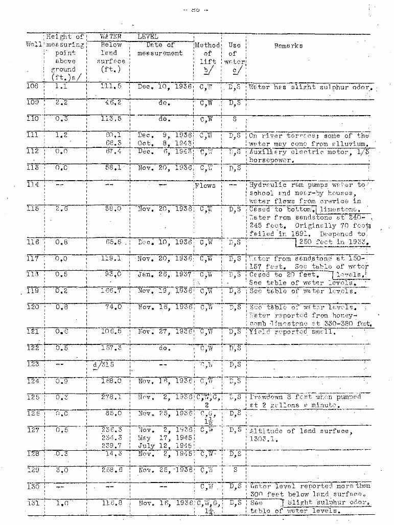
.. db .-
Dec. 10, 193~: C,~'
Rel(?")1Cof:V'ie:l.l mee suring:
point :Hbove :
ground :(ft. ) a / ;
108 1.1
Wi: l'ERBelowlend
Surf[1ce(ft.)
111.5
LEVELDnte of
measurement:Mothod,.
oflift
EI
Useof
Hemarks
sulphur odor...
0.3 do. c,w S
:On ['iver ter'';'c ce; some -of the: wf,ter mes comO from el1uvium.: Zuxili,?rY61eetri~ motor, l/~
'-,,-~,-:;:h::::o,"r.cs:.:e::..p!:'.o::v.:'.:;e.:r~.,- _D,S
D,S-! :,·;£tcr from sBnd.ston,G 8f 156=-I 157 f'c"3t.., Soe table of woter
D,S C~'sed to 20 feet. I_l,",:,~t~~ls).-,-.",."""..,See teble of w"ter le701s,
D, S : S'ee"ti,bl e of WE: te r lr:,"v.ols·;--·
C,I:;
C,Yf
C,W
do.
20 1<336'. , v I
Dc·c, 10, 1936:,
Nov, 16, 1936,I
Nov. 20,
Jan. 26, 1937; C,W,Nov, 19,-J:936'~~C,'iI
N0 v,
Nov.
,.,
85.0
58.0
58.1 .
74,0
1936:,-----!----------.:-'-----'----~--_.~._.._--.-----:-'._-----_.-
Flows : ...- I Hydrr.u1i,c· rum pumps wet6r to,', I " .. : school fnd neE',r-by housos,
,--"....".......,-=-,,-T: wDter ,~_l_c_-:~_s_·_f_E.~ cl.'evic0 inTIl.. ov. 20·, 193"-6'-',' C,'.··" D S edt b tt 1 i_' • 1,: ,lese -0 0 om~l _].mE:Si·'::'~8 •
. ; ;',eter from sandstone e-t' 240-: 245 rec:t, Ori gino lly 70 fce}1: feiled in 1891, Deepenod to
~D,S T ~fe_ct Lf1..2: 93Z "
2'18. ]
168.0
157.3
119.1
166.7 ,,, ,.-~.,..-.-._~-.. .
C,W : D,S : ~Ge tBble of wrte'r levels.I : ',:rBter rC'Jportcd from honey ....
.",,--==-~,..~~""'~,~~-i-~~_: comb -lim0strm(;, ct 330-3RO f~:et.·-'lO-6-.-5:NoT~ 27, 193G~ C.,W D,S iYiC'lcJ~·r('porh?c1 smell., ..,
~-'n- D'S; '.J, 'd ,
~_-__--"""""--":_'_'__"_'-r'-, -+-,.. - '- - ; 'r;, Y. : D, S : .
, ,"._.._,.----~---_ .._-- .._----.-...-.- ..----.....,--
Nbv. 16, 1936; O,W ' D,S I,,2, 1~936ic;1"f~~-t:,s : trFv,rdo1·vn 8 F[-et-;'vh(:;n""'pumpE;Ci--
I 2; I 6t 2 gcllons [' minut;:.'.N0Vt> 25, 1936: r';"G~'-"';"D,S--:--'-'- ....--.-..-----.---~---.,.-----
1 '.-+__.__~,.-., ..........--,_---,__ ......,l,..,_11;f.... _I'_~-~. • _
I 236.3 I Nov. 2, 1[j36; C,r~l- I D,S :J~ltitudt) of lund surfece,I -, 1, . I
1 23 /1.3 I lJIf;y 17, 1945; ': 1303.1,: 239 ,7 J1..:~Y-.J..~.LE1~_1_· .. _~. -_,._-L..... .__~~_,__..__,__. .
14,3 Nov. 2, 19'15: C,'N' ; D,S:, ,
2 ;-58 ~ 6 --f-..NoV-, 25, ·l9'36;··C;g-·r -'3"7'-------..3.0
0,3
0.5
I~o.3
,IT·--·-'·...15; 2.6
116.1
0.8,
117 0.0
113 0,5
119' 0.2
120 0,8
,,121 '; 0.'6
122 ' 0.5
123
113 0.0
,,,,: d7315, ,,
124 ' -0-:9--
114 ,
111 1,2
112 0.0
130
1,0 llG.8 Novo 10,

- 87 -
Records of wells snd springs in Coma1 County-~Continued
Well
132
Distencefrom
Bulverde
Owner Driller
,Date:Depthcom~: ofp1e- :wellted :(ft.)
,, ,: Diam-:Weter-bearing~ eter: formation: of :, ,I weIll, ,: (in.)'
136 ' 9 miles: northwest
134 61 '1: ;2 m~ es\ northwest,,
E• .A. Moos
Mrs. Emma Sau'iJr
1922; 96,,,,Old 2i8
6
6
do.
do.
138 ,9 miles: we st
137 : 10 miles; west
139 : 5 miles: west
140 5m:fleSnorthwest
do.
d'o~
do •
do •
do.
,,,"
6,
6
6
36
200
Old : 300,,
Old : 217,,
1885: 300,1885! 216,,,
18~O: 2.5•
Joseph Offer
Bruno K1ar
George Bros.
Mrs.-C~ L~'
E1'lsworth
F.Neugebauer
G. S. McFarland,
.,
0.1 . , 1iJ§" ml ,as
: west141
do.
do.
do.
do.
do.
6
6
6
6
3625
350
Old
Old
1906; 265,,1895: 235,,
1906: 236,,
- Bro'wn
•R. Schwartz;
,
do.
do.
E. A. Laubech
Aug. Scholz Est.
: Mrs. Chas. Erben,,
4 miles; west
: 4'~ miles: nortmvestII # miles, '" '
: northwest
: do.",
H7
i46
144
143
145
148
149
150
" milesnorthwest3jf milesnorthwest
4~ '14 IDl. es, north
Img; Scheel
.do~
L. 1i. Allen
,,,,,,'
1870;I,
1892;,,,,,Old '
15
318
480
,,,,do.
do.
do.
151
152
153
154
3]t mile snorth3~ miles,north
4i· milesnorth
do.
O. Wehe
do.
J. J;. Laubach
do •.
,,,,,,
Old
Old
189~,,Old t,
350
110
60
25 ,',
6
36
do.
do,
do.
do.
155
1513
5milesnortheast ,31 '1'2 m~ esnortheast
George Fronne
,Alex Licd" ,L
Old
Old
185
360
6
6 ,,
do.
do.

- 28 -
Remerks
do.
54.0210.1
133.9
VI80
, V250
2.9
136 0,,3
1 7n 0.0" I
138 1.0
i4·~ ;--
141
140
_______. "'---l . ~_
139: 0 .. 0 125,6 !
142
146
1'T5---:-··-=-':~,
147
--Rei~ht ofT-Vii'l1':jf"---LEYEL---·· ,~.' I .--.".----i',
~~Iell; mevsuring :---Pelo'?i Df;te of :Nlethod: Use,I point lEnd measurement: of : of I
: 8b n ve surf'soe ; lift :\vvter:'grouno , (ft.) :Y : :../:, (g.) vi: ' ,
1-3-2: ·----......C",-,·w t"n,s' h;'inter-lGvE11 reported more 'then._ ; ,-l,_~.;~2.()()~.:f.~~.t 1)810\1, lr'nd syr£'~~e._.~..
7, 1936 :C,,;,G,: D,S:1 I 2' I__-4--._~ :-_._~~_~J~ .. _._.._,.~~ ~_I__, .~__•• ._.__,. _
13'1 0.7 53.4 ' ["'c. 7, 1936· C,W : D,S :j,ltitude of 1ano surf"co, .52.0 M&y 16, 1945 ' :140".2.
July 12, 1945 i :De~~ 23, 193f C,W : D,S ;CBSC0 to 6-foet~
I . ;::._--'-_.------'--__-"-,-_..----,.~----------.-.-r--:----..-.--.---,-.--.--~------- ..~---12·1.6 ! do. ~ C,~:-i D,S, :Cvsed to 10 fe,,:;t. ., ,, , ,__. _-t-.__J ~__ .:...~. ."'"'-' .•___... •• _
do. : C,W : II,S :1.~·.'ell flc'l1;\J8 in wot SGfiSOnS", ,.' ,c ~J"i-r'-s;·-·--·---:~· .-'-.'--'-'-- -,- .~~'._._-_.
, .! , I, ,:-~.."-_""":"-,,,,,,,=--,,-,+-,,,,,------,=-"",,",,-,,.,,-+-c=-::,----\----"---..--..----~-.---
1.0 135,5 .DeC!.7,'1936:C,"'lV D,S:,, 1 1 •
,_",~__. _+--__--+-_~_... ~__." ._.__ ,M ••• ~·,
; C,G- ~ D,S !V';ell hr.s been pumpod 10 hour~
: :. :ct 7 e;cllons v. minute ',yith23, 1937r;-c G,-~D,S ':-----.--,.---- I trL:ctcr~
" , ---"'--.: I 3.' :
.--'--~._----~-;c--.....,= -~---~--------------_._---~-216 0 0 ~ Nov. 3(", 1936: C,Y~ i D,S ·Ces'~;d to 5 f~--;ot. ' ,
, , '·--d-O-.-'·"-·-~·c·;W ; S--~--'--"'--.-'-----'_._---_...--.-.
,d1'2 20---;- C:~Vi tD-,.,S.,-......_--~··_-_·-.--._--"_·_--_·_--_ 1 I!
Ii,--;-----_._---.-;~-~-q-+---_.._--- ,._---~.".~-._.-......-,-...._ ..._-.-I -- , C, 0" ,D, '--' I
, ', . '---"-;0', '·;r··-·~S- -"rr'ug Y,.iO"1'1";--· .-.--.--.---------
s
1'18 2..0
I~19';·-O~-7-',
150 1.0
0.7
\,,._--_._-_..._,----,----.-.._.-'---'

- 8-:1 -
6',,
DGpthl Diem-;Wster-beerjngof ot0r f~rmBti0n
vmll of 1,(ft. ): welL :,
: (1.,.,.):orcr-- '6"3;;5'+:--'-'-C':'76,,"!'G",l'v-::':::n-:·'R"c's:-:e...-,l"l'·,~",,::e---
( s~one ;loYier [Cl'::r(,b'~l'
4461 -~: do.,,,,Old
Old
,ret~,(".rm-,
o18~.~~." d ~-' - , ),
Dri llerOwner
do ...
W. E. Green
O• .A.Doeppensohmidt
do.
,..,.1. • 1 'b2 roT es 'northeast:
• 1,159
158
...,.._-:- !l,,6:;;.'C:::.;.O.rc;s of wells end sprin~s in Com81 County--Ccntinued, I, I
Welt DisteDro(3 :\ from XI Bulverde I, ,, ,: I, '
157 ' 7 miles inortheast ;
161
164
165
168
8 miles j,northeast 1,
H. Conrads
do.
B. Stepper
Ed. ldam
1933,
188Z
Old
208 :,,--' do.,
6; do.,,,6 do.,,
36~ do.
170 3 miles 1 rthur Ritzfelder 1890, 'HI,1,northe8st ,
J:71 3" miles Nlrs. Tvletti e 4-935, 248, 1,-
i·northeast Shelburne,
,172 3 miles V. F. Moos , Old 320 ,, ,
: n0rth,,
173 .... 1 miles Edger Bremer I 1890: 100,G~ ,, . ,
~ north ,174 2 miles II/Irs. M. " Rahmen Old 30, ".
~ riorthW'est , ,175 ?3 'I do. 188(\ 315: ;"'4 ml es
~ northwest,,
176 i .."l· • 1 do. :Spring~ G2 ml esi northwest ,
177 ' 3·.1.:· miles PBul Kurt Old 300, ": northwest
178,
11~,';'_ miles Hennan Laubach Dietz 1930; 750';"~2
northwest
6: do.,
8 , do.,I,
do. -----T- ,,,,8~ do.,
,6' do,,,,6: do.,,
-- ; do.,
6' do.I,,, Psprsall
fOrTnetion
1'19 2{- m:i.lesvmst
w. O. Stehl Old :'508 6 :Glen Ease· fir~G~, .~tc:na,-lo.w,eJ:'~ 'frl-3m.h.p.r.,

,nell;
Height ,of; Wi TER' LEVEL t :
meosurin[ 1 Bel CVl Dnte of' -; Method: Usev>int - 1 lend measurement I (If : of'cbove surf'oe lift lwuter'
gro und (ft.) y I .sI i~=-'_;,.(:f•.::,t:...L..)a::./'-' ~----- --+--~-,~,.."..1.,157 C,W D"S;
I
Renw rks
C,IT
C,E
1925:,I
2,
6, 1945:, C,W ;-I)
: I
31, 1945;, D,S Deepened from 383 ft. in 446 ft f,in 1944,by E.B.y\ltscher. Yield~
\ "!NUS Ln('re~se.c.;..lltjt1J.de ofl~n~
D,S: Woter level' i2.::±Irt:r"'f.:' 1247. g~I : reported mnrethen 3nn feet'
B-'---r-~; 1bf'lm~r lrnd surfof'G.I '--,....--,
---'------+-....",-.---do. I C.W \ D,S
I ' II ,
Dec •.
..tpr.
9.0
227~3
131.4
rCG I
1137 ,
165 0.6
162 0.6,
163 -:--r --
158
S ! Wel.l meyb(] drn'\r:1.ng, also fr0I!!\ Ed~l!Drds limostone,.. See toblo
C,G 1';8 i'Th,tor lovell of wDtcr levels."..,'"'"...;.. ...;..~---__-:.. -----"...".:~:l"=_-+-".'"'"=,__!:-m~,,,o:.!r,,e,,'''''+,,·,!'11.£J[;n· 30()'f00t b<:;low sur+-164 C,\'i D,S' -Do.' I fBCO N~v.21 1936.',, .,...,~."..._I 7-
11, 1936:--re;E S "TDug well.' Ovorflovm d~uring
,_,__!~~~_:,-';:N:;;0:.:'t seD s on ~~c,y:r,G~ D,S :W£t\~T l,z'vcl mor0 tht~n-300fue:t'4 '"bolo'" ourfnoe Deo. 11. 1936,'
do. -C,W -:
I,------'-
-16 • .:1 : Uev.I
'"1.,C"'1~-------'-'-.......,2,..4,...~4~_-+-i-,I
to 10 feet.
---,~--,-----
95,295.2
262.1
289.4 'Dec .. 1'5, 1936' r." D~S, : J ,.iJt
•228 .. 5 Nov. 16, 1936' ~lono N
,!~O;:_30'-,-~1-9-3".~6-''-,-C-,-V-\!--+-D-,-S-'-fYIV.t;:::t If/vel :rt:;ported 'l~,o foct", 19 19J 5' :belo'>'i l::'nn Burf'vco when dLi,ll-Inf.y .. } .,; I .
Mny 24, 1945: I ~d,Cvlindflr' loy!ercd tH.:rvcrnl\ . .";times.Wf;ter reported from. b:'ue:c1c_;y ot 680~700fo"t. IltiL,C:"
'~O~.-_-4--~":"---8~8-.-1~--'-'"N-O-V-,-.-'2~,7""',-'1""$"'3'""":.~":-;Co-,"'1""I-,~G,",-f-;D""',".s""+-:;;D"r:::eW"=1 0f 10nd surf f C(;.L~_:lJ" 3 , 4 .~; idovm more thsp200 fOGt 5t
~8 ~cllons 0 minute.
179
l~ 0/1
1'71 O~4
172 0.2
173 0.6
174 , Cl.n
175 0.5,
filS'----
1'7'1 ' , 0.5,
178 • 0 •.6
le8I
,..---i-" ~_,,,....~...,'-m'9311 ;C,W,G, D,.S ~Wf~t0r fr6m grey Sfinastone at·
3 i 338~348 feet.C~sed toro feet."'1"'e~9"";"--~--"";"~Y~-..,s-z-o----+------....;..-c---C, VI D,8 : Pump "qui ppod with :j,X'fol'
l'use ...\rj. th trr'ctor.. ':Veter fromI
I f!,n~y s£'udstonE t,t 300-320 foei;\ Trf:ctor used for pumpin~~oI

- 91 -
__ 1 do.
, ,Dpte: Depth
,Diam-:Weter-berring',
com-: of eter ,formetion,
ple-; well of,
ted,(ft, ) well, ,
, (in.);1924; 348 6,Gl'.::'1l R( [J;'/ l1m,,-
s}cr:r:: 1 L.-',',ji-'·r :l};..HTib:- r1896 360 . 6: _.. - do ;,.-
~
1896; 336 6; doW.,
Old I 375 6' do",
1914: 3'11 -'~ do.,~-,
320 6; do.
450 6' do.,
--444 6; do.
DrillerOwner
Philip Lux
Adem Meyer' EstBtq,,: otto Hi tzfelderI
,l '
Reeerds of wells end springs in Comel Coun~y-_Continued!
do,
3~ mileseest
Dist~nce
, from3ulverde
3; miles f.do1ph Kappe1mBnn iBest :,,
5 mile sI'east
187
188
,,Well:,,,,
180 It; mile swest
190
185
."-i-.,-,,.........,.,,---- '-;:-'--"--=""",' ---"-184 II miles Cherles Willig:
('lest II
189
181 1 mile Mrs, Williamsouthwest Sohal"
"1""8"2""",...,'t-!i'-m....,.i."l-e--~-....,A;-u-l':-o .-"S"'c""h[,"'1-"---7----
""-;;-~G,outhwi'_e=s=t:;_:_"f_-_;_::_::_."==---_:_---,,c_:=:_::_-+__c"':r~_;;=~-183 In' Bulverde: P.ug. Wehe -.Vogues
I
192 5 miles: eest
f§~S:f, miles, -~
_ ! e(~st
194,; 8 milesel' st
I"9"5,...c.-'1""'i mile snortheast
I,'Spring
,, "--- --:-- -'-----,""'---,r------;;;:-----I 192:; 535, ,,
191 5 ~ 'I2 ml eser:st
Tien
do,
; Wi lU.oID Zeue-her,,'Robert Heinler
,",I,,,i .,,,,
1926 178
Adclph Henne 302 '196 -do.
197 m milesnortherst
Henry
Williams 194~,,-..--,_~. ------J-_..:-;;;~-_;;..,.,;_'---_;:_+----__:;_:::_----.,-
Rompe.L : t!,. B~ Kutcher I 1939; 240,I,II,,I
198 11 mUGsncrth~ust
DistSDC8 from New2,01 12 mile 8
north'202 9;J miles
northwestH. Kanz
~- --- -,..;,' ~.
,,I
Old 290
Old 50
--
J.lluvium

9 "_ G_
----------
Remv rks
227.01;0
197
196 ,
183
i l:ieight of': 1iIPrE'R LEVEL I
Yiell-:~oa~'~ring~ 'Bolo'll»" De,te of' :Mcthcd: Use :: point : land measurement: of' : of :I ~ 1 I 1 1
I Dbov€:' I surfac0 : lift 1YJ8ter~
: I':'ound : (ft.): !i ; V,1 (ft.)e!: : :
180 .: -·;-y·-:;4"'il-.-4"-;-."N"0"V,-.-"2·1'",-1"'9"3",6""""iG".",'''X''',"'G'',-+:''r:-!,..,S",.....:"'c,..Bc-s""e"'d-"tc-·o,....,·'l"'O fee t':----I, ~ 4: :
182
t .
Dec,Dist~nce from2C1 0.5 1944i C,W D,S \isll' probibly ponetrctos pErt="".;..._;--;;-_+__..,.,;-;......+_= ;_""';-;;-;,::r-c;-n-T_-c_.;.,:o,:f:-::-':.,Jp":,,:p,,,e*r_. ..,G-:l::-:-en Ro s e 1 im c, s ton c ,202 1.2 1,2.7 Nov., "" 1936; C,H :0 Dug; v:dl in Gue.d81upC' 'River-. ,
bottoms,

- 93 -
Records of wells end springs 'in Comal County--Continued
do.
do.
do.
Edwardslimestone
Edwardslimestone
do.
6
6 iGlen Rose liJl!ss ~cnl9';upper 'member
: Edwt31 rds': limestone
6 ' do.
6 Edwards, limestone
'1""- do.
"'l"- do,
,Diem- :Weter-bearingeter: fonnation,of :
well :( . ,:tn. 1
180
pring:,,,,
475
Old
,,Date :Depthcom... ; ofole- :wellted :(ft.)
Driller
Old 325
400
1918 : 390
-- 1929: 320,:
1897: 350
,Old 425,,,1902; 402,,,Old , 300,,, ,
]',1 ex Fabien-n.915 ' 365, ,, ,,-'-- I
3001906,,,
,,,
Ed Reeh
Owner
. do.
do.
do.
Pa"l Tonne
R. Herbst
PEul Dietz
H. Conrads
B. ·Borchers
otto Ohlrioh
1J. Kebe1macher
Jerome SchumAnn·5j· mi lesnorthwest
: 13 miles: west
: 11 miles: west
; 12:i miles: west: 12 miles1 southwest
: 9 miles: northwesti 6~ miles .;northwest:
do. '
i'9fr.. milesI ;.c
: west
: 10 miles: northwestI,,n miles: northwest
i 9 milesI west .
219
211
215
210
213
214
216 6~ miles ,: Alwin Jahns 6 :
l-:,n;.:o=:r:-tnh:.;":.;T8:..::S:.;t:';_'l-'....,,...,T,..,;r--:-::"'t:::::::=-'-.;.~~~- ---~--~"*::::-rc:-:::-i-----~ _..-._-2I71 6 miles ~ H~ D. Stronberg --~ Spring: I
I northwest : :218 I 'Ii!> miles R. Wright and __ ~~:'-T 15 36 i, '
north U. HaOnnfln :::8'~ miles E. T. Lackey ~- : 1911: 500 (): Edwardsnorth-' :: limestone
n2"'2"'0+"'8~m"'i""1-e-s--~:~J\"'1;"'b'e-r"'t-'"P'''f'''e-u''f'''r"'er·~-----------·:"""O'<"1-;d""'--4·O''''O'----6''--;-'----;-do. ---northeast: :, ,, ,, ,
208
206
209
207
212
204
203
,Well: Distance
: fromI New,: Braunfels,
225 4 mil"snorthwest
224 l ,,1 ·1' , '±2 ~l, ssnorthwest
223; 3:2. mfles"I no rth1;\'(') st
221 3~ milGsnorthwest
do.
6 do.
6 do.
6 , do.,,,()
,do.,,,,
6,
do.,,,
61931 : 186,,,,
1906: 190,320
Old 251
1895: 265,
1923; 290,
:,
,,,L. S. Davis
Henry Heise
Albert Simon
W. H. HarborthRstete
William Kraft
F. D. Hutcheson
do.
4f milesnorthwest
2.22
226:,
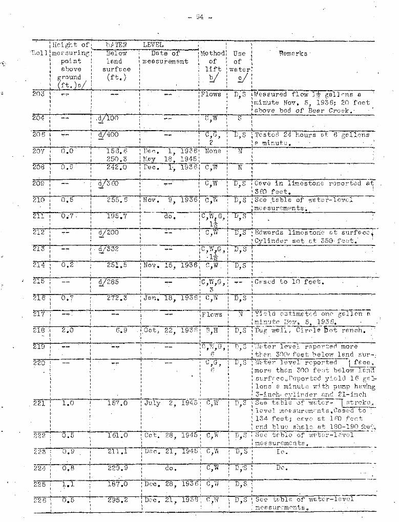
- J4 ....
:}i;; i 1';11 t 0 f : 1!,j TE 11 LEVEL ''.\011: meE' suring: ::--~B~e-'i1-:0:::,~~;-"-,--Dn;a:'1t';e:::.-=0::fo--:1 Methodl Use !
~ point ~ lend \ rr.eesurement l of ; of ~
: above surfcce I lift :weter:: ground, (ft,) v' : V:: (ft.)a! : :
llem"rks'
242.0
272.3
156, B250,3
~'332
:V200
0.5
1.0
0.5
0.9
(J,O
,,;=,.-:------ +----,
223
221
204
206
20'1
208
209
210
211
212
213
214
215
216
217
218 ,II
219I,
220
224: 0.8,,225T +,1,,---"--....,,-....;_.226; 0.5
D;S Dc.
D,S
D,S See tob1e of w£tc'r-lnve1--, mee sur~~.-mrnts0

- 95 -
Records of wells and ~prings in Comal Co~ntY--Continued
do.
do.
Edwerdslimestone?
Edwardslimest'me
do-~
Edwardslimestone
6
6
6
6
6 '
36
II
Diam-:Water-bearingeter: formation
of :. ,well :(in.) :
250
265
265
325
325Old
Old i 300
II
Date 'Depth,com-: ofple- :weI 1ted :(ft.),,
Old' :I'I
Old :I
1902 : -'S""1"3'-''-''''6..-7---Td0=-.---I,
Old i
Old
1915:II,
Dri ller
Gus Vogel
- Kopplin
otto Ohlrioh
Hi Ima)" Doehne
Krueger Bros.
Ri ch ara Ge s che
Edward Nowotny
He !man Bo rcho rs
4~ milesnorthwest
9 mileswest
8 1 'I2" ml eswest
61 'I'2 IDl eswest7 1 'I2 IDl eswest
'1 5 mileswest
'4 1 '1! ·2 ml SS l
: northwest ':229·' .do, :
I,
231
227
232
236
2$3
234
230
Well: DistanceI
: from: New: Braunfe13II
Eugene Krause
Ernest Georg :II
Willie Gt10rg :II
Edward Gerhardt:Estate :
II
do.
do,
do.
do.
Edwardslimestone
Edwardslimestone,,,,
III
. I
6
6
6
6
6
6
6
I
I,II
,II
45
326
240
288
322
295
Old '
1925:,,,
1932:
1926:,I
1901:II
Hillert :II
,FrankII
H, Blank
Herman Tonne
Elder' Dierks
13~ milessouthwest13 niile ssouthwest
12 milessouthwest
do.
11~ mile ssouthwest
10 mileswest
llmil "'s, ,southwest
241
237
240
238
242
243
244 13i milessouthwest
Lena BinzoilEstate
240 8 do.
do.
do,
do.
do.
Edwardillimestone
Leonaformation
6
6
6
6
6
36
iII
~-"""';-l--'-"""'-'----: 6 do,I
255
250
50
215
246
180
Old
Old
1910:II
Old:II
Old:II
1905:IIII
1880:II
CharlesDcnoubauer
Henry Schmidt
'Lavine Hoffman:
Schaeffer Bros,:I
~~~-~~~-~"""----'-------~-'--------~-~
A. B. Burkharit;I,
Edgar Burkhardt:II
Henry W. Simon: H. T. Schwab:I
Glen +uiilson :II
246 13t milessouthwest
2411 13 miles:. SQUthVI6st
249"I~ mile ssout h·::e st
250 11 milessouthwest
247 do.
2fil 7~ milessouthwest
245 I 14 milessouthwest

Remarks
; July,,248.8
_..:,~':.:{j~ll;.'l':.:,,:..H__-=L:;:FVc';,.;"..:"L;:.._~ ; : :Below I Dste of :Method: Use :
, , Ilend :measure.ment: of I of 1
, I
surfBce : lift ~ water:(ft~) !Y: sf:
, I! I
227 0.5
of le,nd surfe.ce,: 111 ti tude844.2.
D,S
: ;C,.W,G,: D,S:\ 6 I "j
20,0
188;7
V250
,,0.8
,1.0
244
239 0.6
241
230 0.5
234
229
236
~300 e,G D,S ;e0sed to 315 feet. Large eOT?__:- -l_----_;-,----....-__,-~--+ ..;:~r..;eJP:.:::,orted et 300 f8.;;:e;;:t~.:__--_,..242 0.3 231.0 Dec., 17, 1936: e,W S: Depth reJ;or'ted more than
~~J.,..-,~~__..;..-_"=,..."__--;..,,....,.._=___"""'=...;'-..,c-=,,-,.;-..,,..=-'f_'3720 fee t •243 0.3 306.8: Oct. 11, 1933: C,'It D,S:.Aln tude of lond surfece,
291.1 iMey 5' 1945: : 967.4.I' : .,290.5 : Mey 18
11945: ,
294.5 : ,July 4, 1945!
; Nov. 9, 1936lc,~7,G,! D,S :: ; 4: :: Jan, 27, 1937: C,W : i5-S....;:,.,D,..u-e:-w-e~l~l,--l-r-o-c~k~'-e-u--rb,.....-----'-I I I' I ~
----.L.-..,.....,.-_-i-_-.~~~---'-:~_-...,_~~=-i:-._~-:.'_.~~.;'~-_.._~--=_-...,.-_.,....-=_-_...,.237: 1.4 259,1: Oct. il, 1933: e,G \ D,S : See te.'b1e of water-level=~";" -'- "~' : 7 ~ :measurements.238 C, iN~,S :.Wcter lev'~e:..1;:.:::..!r-e-p-o-r..t-e-d.-m-o-r-e-"m,.,"'an-'
: ,200 feet below land surfBce. ': Nov. 24, 19361 C'-,-,i-r-+-:--~.,!.,6Dsed to 35 feet.Wate'r enootn-l-f~ : 1 ered in red send at 30 feet.!
"2-,4"'0-'--..,0,...-,8,....-+--",2;.9""6,..."'7·--+----d,..o-.---'-,:e-,~v,,..:-+-;D"',"'s""',:"::":"'::::"'-';IIrrig;o.tes small gerden,,,
174,3 :Dee. 17, 1936:174,&' IMey 5, 1945:165~8 !May 18, 1945:
~~4-~~-_:_-:;1~70,!.•.;,7-·_J-:~Ju=ly"-~4. 1945:245 0 , 6 151.3: De c. 17" 19 3·;;6;...::--e-,~W~·-.i--,D-,~S:-~:---~------------
I
214.1 :May 23,1945: C,W : D,S :.Altitude of land surface,n;;",--'- -'--_....:::2..;4.=l,!.:.:2:.....-.;:..:J;::u::;1::,.yr......,_,::.3.1..'_:::1,::9..;4;;:5...;:.....,,.-::-,.;.: : 894.0 •231 ' C,W : D,S lCaves reported at 80 feet
: lend 120 feet.: Jim, 25, 1937 :C;W,G,: D,s: See table of water-level
;c;=-+-~--;:-_..;..__==--:c_-..;:.....__~=-....,c""""',.:,...,..4.:'=-,...JI_=---,-+:m:::::e::e:::s::.:;urements.233 1,0 259.9 iDee. 16, 1936: e,ll! i D,S: do;'::::===----.,.-------
! It:
232
246' 1.5
248 1.0
: do. C,W D,S! Dug well; \'!Ft'3r f.rom terrece
~_-._~~__~--_-~-_l:--.--,----~-.-_.-,,;-.~_.;:-,d:;.::e£Pos i t s of Ci bo 10 ere ok.247 1.5 130,2: Dec, 17, 1936: 8,':" D,S: CDsed to 200 feet. JIltitude
129.9 \ May 5, 194-5: : of lend surfece, 800.1.130,8 :Moy 18,1945' ,
,
250
251 0.7 ~ Moy,,
e ".," D,S [Wc.ter level more thnn 242fee'f;: belo~fT Ivnd surf'f;0e.
D S ,See tBb1e of wcter-level, ,j mevsurements.

- 97 -
Pe00rds of wells end springs ,in Come) County--Continued,
Well: ristnnce,'fromNew
Breunfel s
Owner Driller f'e te ;Dep thcom- : of,1'18- :wellted :(ft.),
255 ,
256
258
259
260
261
262 ,,,. ,,,,,,
do.
do.
,8' do,
G do.
II do.
6 do,
6 do.
G do,
G do.
.6 do.
G do.
G do.
6 do.
242
305
290
152 ,,,,,,,,,,1'15
168
138
140
i936 ;
Old
, 145,,,1896 ; :nO,,,
1901'
1932:,
, 1932
Owens
,,,,
,,Wellhocff'er:
c. Conrsds,
.P.• 'SWf;tnS on
R.R. Coreth
.Alvin Kreft
Albert HentzID£lnn :C • .A. Corring 1900~,,,,Jack Kr(jt~meyor
!Hbert
4~~ miles4 .northefl.st
4 milesno rthcast
5 milosnorth(~{:st
1 _.18 mill'S
, northwest,, .
274 G mi lesnortheDst
272 ( ~1~,~- mi 185
I n0rthGBst
270
271
26G
2t38 .;1 miles '.1 nort~heust
265 2~ milos
263J>!, 31 miles W<>1 tel'we st .Kappe lme chor
-~.;..~---~---:o::,-.-"-,,..,..-.,-:,.....---~.,.,.-..,..-,,,.,.,,..,.--;-.,,....2G ll: do. Ed. Di~chinger : fi'renk I-Iillert 1925:,
.273 &.l'i miles. northcBst
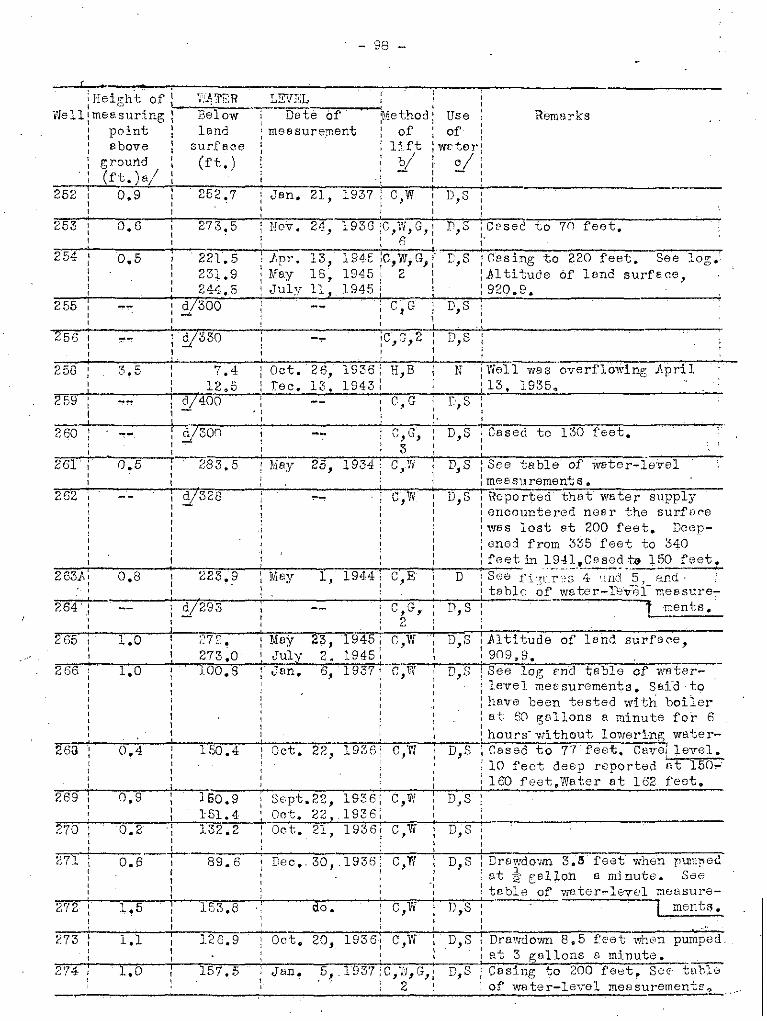
- 98 -
(
Remnrks
273,50.6253
: Height of 1)-1_~1;;-"'J,::",:T.::E.::R_ LEVEL :Well:mensuring Below Det'~e--'o-'t""'"--<:'Method: Use
: point le.nd measurement: of I of I
: above surfa,oe Ij,ft ~ wcter~
: ground (rt,) 21 i c/;: (ft.) a/-+---;=-;;--;..-;::::;:o-;;;-"O'"'C;;;-;;-+n-;;;-_:~-;-,...-:-'~__~~~~_~ _
252 0.9 252.7 Jan. 21, 1937 C,W : D,S:, ,I ,
't ..
April
194519451945
13,18,n,
.lJpr.MayJuly
221.5231,9244,5
d!300-
0.5
258
255
254
e,G : D,S,1 ,
-=."....---~7-;--r.;;;;c---i------~_;;_7;....J...- .'.,..'--------'----256 V330 !C,G,2 : D,S, 1
t 1
261
262
264
ISee log cnd table of waterlevel mepsurements. Sal-d tohave been tested with boilerat 60 gDllons a minute for 6hours- wi thout lowerlng; waterCased to 77 feet. Cavel level.10 feet deep reported ~t lS0~lE:O feet,Water at 162 feet.
: Altitude of' land surface,,,909,9.
D,S
D,S
D,S
D,S
D,SC,w
C,W
c ,"(.j
c,w "1945,1945:
6, 1937'
23,2.
Oct. 22, 1936; C,W
MayJuly
{~7~, •
273.0100.8
1S0.40.4
1.0
0.9
1.0
269
266
263
265
: 160.9 Sept.22, 1936:
="..--;--'-c,---,,,--,r;_..;1r-;S..,1;~.~4;;..' _+-'_00 t. 22,. 1 93 6 :270 0.2! 1.32.2 : Oct. 21, 1936:
-+--.,,--""::,--+--27i 0.6 1 89.6 Dec._ 30, .1936: C,W D,S Dra,;:,down 3.11 feet when pwn]'H'd
: at " gallon. a minute. See: table of water-level measure-
"2",7"'2.--7-"1'.'S,-----t:-""1"S"'3-."8-+---:a"o:O-.---:----"C',;<'W'"~---;DO;-"S;-;-'- f ment ~ •II
273
274
1.1
1,0
126.9
157. S
Oet. 20, 1936: C,Vi
Jan" ,5".. 1937 ;C,~fI,G}:, 2
D,S
D,S
Drawdovm 8 0 5 feet when pumped.at 3 gallons a minute.Casing to 200 feet, S"c· tahleof water-levol meBsurement~o
- 99 -
Records of we lIs end in Come1 County--Continued
Edwerdslimestone
do.6·,
I
I Diam~ :1f:ater-beeri>ngeter : formation
of' :well I
, en.)230'; 6:
Depthof
well(ft, )
com~:
p1e-:ted:
II
,Det";,
1901:,,
Driller
springs
Owner
Cherlie Crewf'ord
Eri eh "Rosenthal
Distenc.efromNew
Braunfels
276
275
,WeI-II
do.
do,
6 I.II
6:
6 ! -'d •
6
__ I
I• I
,3() Leonaformction
212
210 I
I!
160 II·I,
250 I
152
145
330
50
32
66
Old
189L
1830,,,1926
: OldII
,,-:.------T----:---_-mr.;._-;;,."..f---"~--~--
: ... - 36 do.
I!}llil Preusser
Trevis Tete
Cc;rl Kutscher
Hi 1ma r Doehne
0.' Eo Gruene
Williem posey
11 rthur B8 rtd s
. Phoenix LifeInsurence Ca.
Erj Ilh RcsenthGl
. R. Mitt(mdorf
9~ milesnorthesst
7 1 '18' ml osnortheast
8 milesnorthef'st5 mi lesnortheast
8-~ milf)snQrthet~st
D milesnortheast
3'2. miles'"northeast
6J milesnortheast
281
279
278
280
287
285
283
277
9 m:~les
I1erthSBst :2S"'2-i-"'1""O".'-ffin;;-s--"
northeest
284
do.
do.
do.
do.
?own I'd sliInestoTIs
do.
~dv,mrds
1imestone( ,:,)
6
6
6
65
25 36
345 8
125 --275 6
89 6
372 6
;3pring,,I
Old
1934:
1925:
1912. 85
I,,I
---.--+-:.---ri---=::-~--;...- --;".,.--.,----, Old, 80 6 Edwards, ,: limestone
Gunther
-,---~---.;._.-:--
~. R, Coreth
Max Linnert!;
TW8n \~Gl1hoefer
ivVi 11iem r .. Wiemers,
2-~ milesnor't~heBst
l~ milesnorthe:: s t2 mi 1 e s -~,-.-""B-r-u-n-o~pO:-r--e-'ic.-s snortheDst :,
289
299 6 miles '/H lliem }'--'eJr P. Schumann Oldsouthwest
300 4'2 miles Kolr,nd Welsch do~ 1934;.SQuth1vest
293
?98 I 4 " . 1.~ :4" ID1 e sl ~;'lest
291
288
292 2 milo snorth1;:: miles
nAr thwest =---+-------r---~,,_---,----l----+_--~-----"'2~"'.47. -+-1 mfle City of -New Spring do.
nOTthwest nrDunfels t
'32"9~5r,,---'ci'_~m-:::l'·"1-;e~c..c-;.;~;:;'ft':r:::s::-.-;;-M"et8. p!;cn-s--1C'1-o-r-n-"---'" ,~'rest I
"2"'8"'6"";--"'2:-ii1; mi 1es-;--j'"',I-e-x' 1IltgeltI \vest I
~---;r:r-::"1 297: 4-·~miles
: southwest

:IIei~ht of; '"
Well :meFsuri.ngI point
eboveg,round(ft. )e/
275
- lCO -
RemC'rks
27G
279
284
285
0.0
0.9 9'1.2
0,6 27.5
0.3 114.1
2.1 ~? ..,J.~.J.
0,9
0.0
Oct. 20,
Oct. 21,
I Jfin. co', 0,,,i~ do.,,,
Oct. 21,
S
D,S Blue clrv reported; to bottrm.
£'rom top

~ 101 -
Fecords of wells end springs in Ccmel County--Continued
do.
do.
7.dw8rd815.mfJ8tone
6,
6
- .
,, ':Diam-iweter-oearjng" .leter : formation~ of,:well, ( . )'I In. !
360
360
160
Dete:Depth~om-: ofple-\wellted : (ft.),,1895:,
1
DrillerOwner
New ,,Br8unfels;
l:ist,ncefrom
,,,,,,,,,,,,2. -'-=-...,...--",...,...- .__..1..- --+
~505 t 78- mIles : Joseph Friesen~ehn ~SOld;hw(3St: -.
306 I 8 miles: Oscar Jones; ~"outh~,vest;---1- t I
30-7 : 8 2 miles I -.A,dolph 1.hwl18r 1911jSQuthW6 st: :
30iJo-f--....C-d:co=""'.c.c.;"-'-i-;¥u.,~:-:s:-Ott:'l"(::·y-::--';H"i;-:':-:T:;:h:-:0'-';l-z:-:e::r+--------'-"'O""l'd"";'-"'1"'1"''7-:---"''6'';'''--~do-. ---
Well
,"""'--:--,,,.....,'""'"'::-:--'-_.,,--,.~--309 9 miles, Scrvtex Bnd
sOllthv.J0st: Metal COl)3-:-1-:-1"';'--O:lO-~ miles :::lobort Hierholzer
southw()st i
11 1- 1 I f' P S h . d:~' ml es I '(.'. C nel er
southwest;
312
313
314
31p
c-16
11 miles 1
southwest:
11 Ildles :scuthllJ8S-t :12 milf.~s I,southwest ~
13~miles ;southwest i,,
otto Klaerner
- Rogers
Herbert Riedel
Joe· Glei t:
125
T
Old, 130
Old 109
1928, 192,:
1925: 225I,
Old 306
310
6
6
6
6
6
5
6
0.0.
do,
do.
do.
do.
do.
do.
317 do. do. Old 200 6 Austinchalk!?)
3'I81J:I~ miles 1':slter MuelJ.e r 1910: 475 G-'42'! T<;dwards, ", southwest I limestone,319 8 1 miles Percy Hsnsman 350 6 do.' ,;:>,
southwest320
I -_Jack lIes ci Old 400 6 do.9-'2' IDlles
southwest322 , 7~ miles Fred Schwab 3'8 36 Teylc~ morn ?f
southwost--+---_.}~lbert Reohner 1911: 130 6 h\;3tin323 , do,,, chelk
325 I 1 miles BrunI) SChi\'cb , 1916: 150 6 , do.,SQuthVJ8st ,
326 do!, William Schaeffer 300 4 ,! ~dv"8rdslimestone
328 G~ 'miles Alvin Scheeffer 1900 : 360 6 do.southwest
329 7 miles Gus KIBener 1914: 131 6 LustinSOUthVl8st chalk
m"'T6 mile s Ben JBhn Old 395 6 ~d7,!ards
sOUthvi8St; limestone. ,
~3 'do. O. Penshorn , Old 428 6 do., ,,,336
1 • . A. W. Feick \paul Sohumsnn Old 700 6 do.5'2' mJ.lossouthwest

- 102 -
Renerks
,, ,;Method: Use :
of : of :lift i water:.y; VI
, \56,10.0
0.7
ground(ft.)a!
308
"Hal gh t of: _,:;W::I.;T.:::E::.:H_---:L~EVELVvell~me8suring: ·Below Date of
point : lend. : me8surementabove : surface,
, (ft. )
Dec. 18, 1936:C,W;G,: D,S iCesed to 40 feet, cylinder";"'-;:-~----_-'.._---o::_.....1-_--,-.__-,+i-,.::2:..-•.-;.: ;.:'s:::e~t e t 125 fe et •306 1.2 67.2 do. i C,W D :cylinder set et 130 feet.
=.,.-+--..,,--=---i-- _-,=,,,,,,_-:'~__,,,,,,,_,,",,=",,'_~__,_+-=~-t;'P",UIn="pe-b;:.:..r;:.e::;8::.k..:s...,...::sc::u:;c:.:t::.i;.:0:on:....;.8::,t high307 0.9 86.8: De~. 18, 1936: C;H D,S :No sulphur te.ste or I speed.
94.3 : Dec .. 21, 19431 ;odor ..
305
None0.0
1.0312
309 19.4 ,Dec'. '19, 19361, ,=~-,-_~~__+-_~8::.7~.7;,.-_: De:_c:..~2;.;1;;....!-;1;.;9<,4;.:3,,";:-'..."..=--+-.,,,-,,,..,.:1------------311 0.7 125.0: Dec. 19, 1936; C,W D,S
I ',
314 0.2 133.0
316 1.5 100 0 2
319
:nec. 1, 1936 [ r.,W D,S ~GDsing to 50 fect.I , ,1 1, . ...1---. ,,,..-=_-,-_-;;-:;-,,.-:-;__\ do. ;C,W,G,l D,S leasing to 20 foet .. Slig~t
: 4: :sulphl.lr odor.
68.6
16.01,0
0.7~S23
325
326 1.1 35.1 :M"y 24, 19Z4; C,Yc' : S ;S8C tonl" of wf,ter-lov01==--:. -'--_-: ..,,-_--:.:-;-_·_-,c-::_7'":=~'-,:-_-1:--:----1m_e_8 ~y lament s. S1. i ght s;; 1phu r:528 0,4 31.9 :·Dcr>. 16, 1936~ C,W D,S :Sulphur odor. lodor.
S
332
1.1
1.1
46.7
79.d
i Doc.,,I
, I,Dc.
~:J36 0.'7
- 103 -Rocords of wells and springs in Comal County--Continue
I I, , I,
I ' ,Well: Distance , Owner , Dri ller Date: repth : Diam- Water-bearingI ,
from \, com-: of ~ eter formation
I, ,
New I,
ple- :wo11,
of, I ,Braunfels , \ I ted : (ft.)
,well, I ,
I, ,
(in.), I,,. miles I William Strateman
, ,Old337 "
, --southwest
\I,
otto Reinartz Old339 4 miles , ;463 EdwardsIsouthwest , ,
limestone,342 .:1..0.. miles I W. E. F. Eilers Old : 240 6 do.... " \
southvrest I" ,
346 21 . 1 A. n. Werner 1900: 148 6 AustinB InJ, essouthwest cholkl ?)
347 3 miles Paul Schneider , Old :503 6 Edwards,southwest I I limestone, ,
348 2{- miles j,ltgclt Farm ,spring Austin,
southwest Association, ,
chalk{'?), ,, ,, ,Max Vial ther I
,349 2 miles , 1898: 31 35 Taylor
southwest I ,marl('?)'"
352 2 miles Erwin Soefje I Old :427 6 EdwardsI
se.st, , limestone, ,
355 2 miles J.d, Tausch,
Old I 36I , Leonanortheast I
,formation:
355 2)' miles :A ~ 'R. Hoffer -- 1915; 24 36 do...northeast
359 3" miles J.lbert Soefje 1895: 57 36 do.northeest
,,360 5~ miles H. Kickeri tz 1933: 36 6 Taylnr,
ma"rl'( ?)northaast361 4~ miles m'Tla Rose , 32 60 Leona
northeast,
formation,,,362 4 miles R. Kraft Old 40 36 do.
eest363 3"20. miles P.ugust Timmerman Old 50 36 do.
east364 do~ E. w. Mueller 1918: 35 36 do.
I,2~ miles
,367 Mrs. n. Oelkers , ,
Old 40 36 do., ,southeast , ,,2~ miles
,368 D. TIernE:lr "' Old 30 60 00.,
southeest I
372 3 miles , Ernst Voight - i:"898: 510 6 , Edwards, ,southwest , I
" ,limestone,
: 485373 ~1 01 , . L. Jentsch Old 6 de •'""2 rnl assouthwest :,
374 3:i miles Gus P.oinerz . :500 6 do...so uthwest
375 do. F. A. Burket Old ' 450 6 do.,,,377 42 miles Erwin R. Goebel 1924:498 6 do.
southwest ,,378 3~ miles Hanna Welsch Old :542 6 do.
southwest,,
- 104 -
Fem8rks
339 0.0 -r5.9
Oct. 27,
:Well flows 8S much as 3 feet:!above grrund in wet se8S0ns.1 • •
:Slight sulphur odor.,I
S:Flows
Dec.0.1346 2.1
317: 0,7,348 !----.\-----+-- ,Estimftedaver8~e flow 50
: :gall?ns a minute. 'Hns been
.~""-~~~_-l-__= __-,-~~-",=_,,",,,=.;:-=-,,.~-'--=-~-.1;:p,,"u..:rn;c.pc.'e,,-d~'.;::a.::.t-,700gallons 8 rnin-:37,9 0,5 28.4 Oct. 27, 1936: C,W D.• S :Dug well, ! ute for irrii'.etion,
I II
:Dug well, rock-cu'rb.I
:Strong odor of sulphur,,I
N
b,S
None
C,W1936 ;,
7,1936, C,WII
1, 1943:,
do.
Oct ..
Jell.
Nov. 18,
'Deco30.S
21.2
33.7
0,7
0.2
364
352 0.0
356
361
34.1~,......_~ ~ .:;:.;30. 2368 6.5 25'.6
D,S ,bu!" well, brick curb;' W8ter--!from grevel e.t 23-24 fct':";t.
~3~5~9""';--~O-,-4--:·~5~2-.-'1-"";~O-c~t-,~2~0~,~1~9~3"6"..J.:-c~.-,'~i'I--i--D~,-,S~-':""'D':'u":g=,-veS;l";'l":,'::":r:'o-c::'kc-",,::c":u-r~b::',:"";:'·"'.V·a,.c;t"'ec.r--
~=-i-_-=~__':':__..:5:~2:..:..~3_-,-,"D:::e", ,~3:J';.....:1::;9:;.A;.;;3-!:"",.............;._=- I from P; reve 1 6t 55-57 feet,360 0.2 28,0 No-V;-18; 1936\'C,H N :Vieter from yellow chy at 36
: :feet, Supnly feils in dry: C,W D,S :Dug woll, brick [sersons.1 ;ourb to 8 feet. Y~eter from
=.-+__=--=-_..;,. --,._.__-+:,_", :i':revel at 30-32 feet.Seo log.362 3.2 34.7 do.; B,H D,S ';Du'e; well, conC'rete curb~----
I I '
....;..--~~---'---~~--+~---~~-~,~~':-.,---'-----.;.-- --.....,----,--3C3 3.1 41.1 Nov~ 18, 19~B; C,-rl : D,q :Dug well, ro('k curb.
__4:..:.:1.;•.:c5:.....--:-:.:Nov. :30, 19~!-:3: \ 'r- 34 .. 5 Oct,. 10, 1936 ( C,Vr";'D,S ";::nug V'rell~ Irrigetes g;erd€:ln.
I II I
2,2 ;Sulphur odor,I .
373
375
377
3'18
0,0 52 .. 3
113.7
Dec. 4, 1936:I
I\I
do •.
26, 1936:I
6, 1931:II
do.
C,Vi
C,Vi
9,W
C,G
C,VI
S
S
sS
D,S
!Sulphur odor. ::<:stiJ"vted ;rielS.11 gFllon B minute. See tableI
;0£ wuter-leTel m8Bsuroments.~SulFhur odo!_II
iCBSea to 450 feet. Sulphur:\ odor ¢
\ ':Sulphur odor.II
Do.

- 105 -
Records of vlells and springs in Comel:County--Continued, ,
Well: Di stfdlc:e O..-mer Dri ller De te: Depth: D' '1' t ', ~em-: rB er-he~rlng
frem r'om-\ of eter formetionNew ple-: well of
'3raunfels , ted : (ft.) well,(in.):, ,, ,
379 13 miles Missouri & McM8sters end i 1900: 292 8; .8dwards,southwest Pecific Pomeroy
, ,limestoneR. R. , ,, ,, ,, ,
II,,
380 14 mile. Paul J. Marbach Valentine cnd,
1920 185 6; do.I
southwest Friesenhahn,,I ,I
I
381 ~1. miles Servtex -und Ed. Gerfers : 1941 160 30~ do.,,-:.2 • ,southvlGst Moterials Co. , 15;,,,,,
-miles Wehe, ;383 4 Charle s Mergele Edmund 611 , 5 do,, .
southwest I,384 Z.,-. '1 Harry Dove'r 300 do.'2 ml es
southwest385 '1..1- miles H. v' Dietz Doehue Bros, ; 1900: 306 6' do.I r~ " . I , ,, no r thvm s t , I ,
I , II
I,
386 do. do. Frenk Hillert :1926; 314 6 do,l
,I
,l
,I
,, I
:'(Uen. Rose"387 8 miles E. J. Heid riok : Old, 350 6 lime-'-I
northwest , ,~tbne ;'upper, ,, ,, , , :memher---'- 6i mil es Johnson ; 1937 :1 R1'7388 , do. H. , I , . -
northwest ,I ,
~
389 do. do. E. B. Kutscher:1938 405 6 Edwards, limestone,,- I
390 6 miles Hemy Hehe i 6 do.I
northwest II,I
393 walter i,
502 6 do.2 miles ,. Sippel , 'OldI I
,southwest , I, ,, ,
I I, ,,i
394 do~ , .Arthur Bergfeld , peul Schuman ,1927 Edwards, , , " \I , limestone'I , ~ ; J
395 .. 1. '1 W. S. Suttle ; E. B. Kutschor :1935 610 6 Edvl&rdsc;-.r ffil. GS
southwest, ,
~imestone,I
Z,9G 2 mi10s Al tgelt ForT. do. 11939 335 6 d0.,west }.ss0ci&tion ,,
Ii
6 do.397 l·t mi les Morvin SGheel :1938 220Yfest
398 4 miles R. W. Gode 90 -- , Bdwordsnorth limestone(~?)

- 10'i -
'Eeight of' Vii TER LEVEL ,, '--'------~._.._.. .,,---"" ,Well:me8suring: Below: Dote of :Mothnd: US8
\ . po:i.n~ l lond ; mel:: surement ~ of " of: abOTe : surface' : lift ; ywter: ground : (ft.) : ~: I
: (ft.) HI : : : :
Remerks
383 63.9
ij 51
Jug. 20, 1940 C,E,3'4
385 of land surface,
386 0,5
388
389 0.5 302'. (i:
303.0HeyJuly
19,I]. J
19£1·51945
None
c,w
I N :LC!"J;E'. supply of \vctcr rGport"7I :od 8t 800-1,ono feot.SoD l·'"'.r;~
s
0.7
1.0
0.5
397 I,,,,,398
396
394
390 I 274,6 [pr:. 13·, 1945 C,G, S ;Jlt1.tude r:f land surfc~e,
~ 289,8 Mt?y 16, 191·5 2 i~)6G.41j.•
=~-'-__~-=-_.,.-4: 2:::;9.c7~•.~9~-i._,J~u~1f..y.....,.~~,-;1~9;;.'j.;;5 .....-;;-...".,---+-.",-,,.....'"-' __.,-_'-:'-:__-.,._-,-~_-=,,-__393 0.5 : 16.0 Doc, 20, 19 /;3 C,~N D,S :Drowdown. 8pproximr,tely 20
: 6.6 Mey' 30, 19·j5 :feet whon pumped "t 2 to 3: 7,0 ,July I), 19.~5 : gel1"ns e minub~. Sli ght odorI 9.0 July 13, HH5 : of su1phur •.Alt~:b'de of 1e.:!.G! ij 20 C, G : Ind ;For-ncrlv Bupp1j od i'iurface 04S"Z
=~--i- . +:_ .__--;. -'-;.-,,-_ ..:: ;.:;l:~~. ~~~lll_<)SJ!.2. ht ~~1_~M2::..:.,ud;<;n;.395 : g--go- NeTIC : N ; Fe rmr::rly suppliod suburbf.. n
\ I ~ : ("0mlm~nity. straTIP', sulphur--l-. __--1....____ _I d/15 : T,E, D,S :F'irst wFtc'r t't ooor.Soo lD£,.: - 1.Js-: 282. f0et;str0np'e~' flClN" flt 326-, -: I :3~:iO feet"Ces.lng;:287 feet of5-: 20':;.7 Dec. 20, 194-3 C,W D,S, lj·TIch.l:.J.:t..· of Innc ::m:il-....crcr~~J3I I I It t, 200.9 MI?Y 17, 19,,5 , :1, i ude of land surfece,: 2Cl 2 "2 July 2 , 19" 5 : :8 43 • 5::.:.-,-_~~_--:-_-:,- _: 38')8 p,pr. 13, ID<:l5 t C',::;:: D,S U\ltitude of Is.nd surface,: 36.8 Mcy 16, 19~5 ' :675.5." 37 2 I· 2" 1945:, :• 'liry '-',
__:- :'-__3:.8~.:::8_.;._.::J.::u,l;;"y'--'2:J,;_,,1,;:.9,2,1:;5..,::_· .'-- _

- 107 -
Records of wells end sprin~ in Cornel
Ed1verdslimestl"':'1e,,,,
•••, .
6:
,,I Diam- :Weter-~e8ring
eter ' formetionof
: we 11: (in.)
181
:Spring,,,
•• •:1893:, .,
, ., .:De te; Depth; c('m-: nf· ,;ple-! well:ted ; (ft.)
C01m ty--Continued
DrillerOwner
R. W. 'Gode
John Kerbech
•}Jew ;
Breunfels;
Distvn0efrom
A ~, • 1~ 1711 esnnrth
4 milesnorth
4no
399
Well
,,=-o--:-"""'-'''''''---+---~--,--o--,---,-i----,-----''':-' , --;:-;=-~---:-:---="""-""7---401 5 mi los • ,-.,. Brotzke :1938: 237 4: Edwerds
. I I I
northwest I ;: I limestone•,,
402 1~ milesnorth
City cf NewBr~unfolB '
1".0 12 do,!,
do.
do.
do.
Leonaformation
:'·G1Gn·:!ic~3fJ··l'imestone,uPPG:T;riRmhf'r
,,
•,
:1941' "102,,,,
:1938; 27, ,, ,1939,2,350, ,,
•.,,
:1937;· ,"
Kuts0her ;1944, 297, ,,
do.
do.
Killem endHicks
: ;do.
............---;::::r-'.':. 6 ~ Edvwrds,1937. 440, .
limos tone,do. ;1937: 33ej , 6 <lo., - •· , I'
•:1'10. • 640 I, G do.,
E. B. Kutscher 440 6: do.
E.
:Old-:_.. 65 36 Leone, ,
:-___,_--------'----_,_----,.-_:-:c-'--.:::-:=-.-----.-. format ionOld 280 03\ 'Edwar~8
limestone
, ,,
403 do. do.
410 0;:' miles Boer Crook Rench"northwest i\Mocietion
411 l Fred R. LothB-2" milesnorthwest
413 8 miles Udo Hee.rmanngrth and R. Wri,;ht
414 72 miles do.north
415 91 miles 0.0.8"north
410 101' niles I do.•northo8st:
417 7 milcs Edward Leckeynorth
418 1 \~ mile::i Vi' • G. ster,tz'.south-419 y~ mile s
•Mrs. B. Gruene
north"n.t: Estate
420 do. Mr8. Lydh Ki rmse
421 9 miles Jesse Poseyno,.theost

- 108 -
'Hi"'t fi HiT': lEV
Remarks
Ci rele Dot I'LDCh nc. 1 HC'adqurrters well. Prob'bly bedr5_11ed into Glen Rose limeeirel:.3 Det rt'ineh :no. I stone o
2 probably drilled into GlenRose limestone ... - Bottom ofsuction pipe sot at 400 feet •
S
c,w S
c~ D,s
C,VI
I
III
C W--,,
c,w S
Nov. 30, 1943 , C,'W D,S, Due .-";;011; used et slaughter'IInd house",
.None N DE tost;, PHi tude of lendsurfr; r,e 688 feet, reT;Jorted..".by Ki 11 em end Hicks. see 10'/':.
Dee:. 3, 19'13 : C "r~ D,S Dug well, rOf'k curb. Y'[eterI ,10.I from r:revel et 58-65 feet,I
C, W D,S Soo 101-\.
Dec. 15,1945:
I,I
360+
Y255
~l 60
.~..
41"7 ,,-
418 1.0
419
420. 2.0
421 0.0
413 0,5
410
400
414
416
: i Flows: Power: RUGao S1?rings J also spelled: j ' ::'Vaco and Rusao .. ':\.".0 openings,\ \ 131 t1 tudes of Ie,nd surfe.'ces,~ \ C157 .9 Bnd A52. 2. Tempe r!:"t urcI ;vrriGs from 6SoF in winter toI I l .1 \ 71"2°}i" in summar. Sea P~54 fo!",
~4"'0~1""'~-----+------<'~---------'---: u. s. Irmyj flow mOl:: surcrn~~Dt~i..
1 Engineers test well. Cored', , 1
from ton to bottom; 21;-i1'.ohcore. Sea log, i1titudo of
~,02'-;------T------t--------71-;;l''',''E'''',-'I---';'';P'','"i,b'"'lIT-i":--1 1 end surf ceo 894.~
100, supply, City of New Breunfelp75 No,l, 30 feet south cf No.2,,:
Ccsing:12-inch to 58 feet; "Cemont "d by He: llburton Oil',~el1 Ccmcnti,ng Co~oDcn holo,58 feet to bottom.Drcwdo~n 7feet Eftar pumpin!< 12 hourset 2,300 g8110TIS a·m)nute
+__---,...----'--'--~---,---+_;;:...",.........--.-;_;,w,.·i,t.;,hM_.;2-c...,p-,n:;'.;t",rj fUp::81 pumps.Soo403 1';E,. -" Public supplY,Gi ty ofNGw, 10i';.
100, Braunfels No,2.CesinG:8~inch
40 to 58 feet, open hole to ':>attom'.Jl;lows S F.stimctod flow 2no g,cl1ons ~
~ m:i.nu"tc,S0pt.29,1943;2,OOO-0"2".,,.,.?O!: grllons (' minn-to ,Marolt--'-c,vi--v;s Esti-J28.l9'J5. F"ult Sprinf';.
mr;t()d yield 500 gcllons u de,,]bottom of suction pIp" set 285C": relo Dot re,ncb well 3. r feet.Frohcbl' drilled into Glrn-C:lr(!le Dot Rose lim(1stone.rf'Ylch No.4.

H9-
do.
,:Weter-bo£lring
formation
6
Diameterof
422;1943;,,,,
do •.
Driller
E. R. Kutscher 193~
, ,, ,DBtEj Depth :com"" of :pIc"": well ;ted: (ft.) : well
: : (in.,) I
,--+-------;.,1"'8·90 -"'38"'0,,--;....;.:='-'4,-;:-·--,B"',d"-,--la--r-d"s--I : limestone+-_.--'-,._--------
do.
Records of wells end spri ngs in Comel County--Continued
VIGIl: Di stonce OwnerfromNow
Braunfels
422 ll~ miles R. Wegnernortheest
423 9 miles J1fred Pentel-muhlnorth
424 11 miles P. R. Williamsnortheest
426 M '1"2 m~ esnortheast
Missouri &:Pecific R. R.
do. :1944;, ,, ,, ,, ,, ,, ,",
140 6 lust inch91k
:1('9p:. .,•
55 36 Leoneformetion
E. B. Kutscher :1930;,, ,,,,,,do.
920
601
:: Gl"n Re'se. liffiGstone(?)I(",';L'-]' m;,;mhtI.
i F~dvrards
limestone
6 !:~~~;&:~f~i1;:;~m8-I member
Moesuring point wes usuelly top of 0csing, top of pipe clomp or top of pump b"Aeor foundE-ti("'n.Method of lift: T, turbjne; B, "bucket; C, cylinder; G, gesC'line engine; E,eloctric; W, windmill; H, hend~ Number Indicates horsepower.
- 110 -
Rema ric s
fltitude of lend surfp0e,942.5.Weter level more than 340feet below surface D80J.4~4.
,Use ;
of :wBter:
0/ :- ,
M'rr .. 11, 1943 None lJ
C w SJ ,I
Cw S,
~37.8
426 ,0/ '19 c.,V! D,S
,,, ,,.
i427 ., , Flows N,,428 V 90 None N
423
422 13.3
424
Est1meted flow 100 gellonsB minute in 19'11. .
----+.,,;:,:::-::-,;....-;;'-t-"""Sr·In0 v:-'etcr reported from,Austin chalk. Sulphur W8terfrom gd"-r;B rds lime stone £It912 feet.
: Height of~ Wi 'ffiH L}NELWe 11 : me 8 s uri ng: -;;B':e:-il:':~:::.w=:--"'::::':'D~,C;t;:'·e::-O:o"f...--ci·Me thod
: point Ian';' meesurement of: above surfB~e lift
ground (ft.) "!!(ft.),,/
~ell penetretes upper pert i
of Glen Hose limestn ne.S8elog.1.~ratGr level' 8ppr(',xirnatew370 feet belove' SU~'fe0e Doc ~:1,1943.Estimrted yield 3 gBl~
'1'"2''5'''-;-------"-----~-~---:D,.e-, ..'c~·-•.,2'f".-,'"'"'1..,9'4.,.4.,..+-]"';,"'1-0-·1'-IS·-;'l-"D:--+-"'C"i:..-'sini ~ 18 110TIS e' minute.C,H ' feet of a-in ch cemented in
Justin chalk. Supplios rsiln""led ('or:lITiuni ty.. Estimatedflow De~. 25, 1944,3 ~Bllo~s
a minute. Does not flow inDug vml 1, ,I dry seasons.brick curo. Res supplied "eight families at one time.
Reported yield 15 gallons .~
minute from sand at 585-601feet. Walnut clay reportedat 3105 feet.
D,Sc;w0.5429
STu~ e-o"'f'C""'-m-,,"'t-,e-r-'-:-::I-n-dT-,~i-n-dT'''~'''s'it-r-'i;-e::-''l-,-;P'-~""':p::-u-'hc-~l"i::-(':""'-'s::-u=p'::""'l':y-,""""D:-,-d om est i c; S, s t 0 ck; N, no t - ,"uS8d.
V Water level roported~

- ill -
Table of drillers' logsf Carnal Oounty. Texas
72
172.~
50
.152
270280330
2Q80
120128132148
74103
135210228240
5605715956007fJO735747
285240
tl4
16
222
29
32751812
178
25
2701050
Well 266
7f?: miles V1GSt. of Ne1o\'
l~ miles northwest of Newi!1I.. Swanson,!Braunfels.I '
iGravel end red cl.ayHard limestoneRcd cley
tHFrd limestonoICoarse honoycomb(watcr)
\Hard limestoneVery eoorse honeyco~bedI l'imest?ne, wat'or
1
53
1030
420
330LI-15
230
13°
15°
2°5250
Depth(:ree t)
1
20
102023
100::35
121
205
J.5 155 ,,0
"bluo I'; 0'1';-' ,~ -'
5 ")0
2.0 505 55
10 65)0 956 101
196 297
'll~i cl:ne s s(foot)
7.'011 32
Woll 7'5
\Voll 65
GJ·· 2:1ilos southeast. of8
limostono
Surf:-.co:Bro~:l)!i. limDstono ["Xl-d.
el:::',;)'"BIu-) lir;lo,:;tm-~o
Bluo E.:r:1Y 6"':.;",11:: ~:rnd
lin~()stonc
Eluc; chLlk ::tYlC.1 ii;,C stone
Grt'.::,r lir.1oG:;Ol:OOh[.1_1<;,- limos t.o:t~O
c·.nd c 1 r:~.~/
A. J. TI",::',lscr r 10 r1iJ.cG nortJ."loc.st ofHc·,ncoc1::.
Earei ~'rol101.'l lir!108tonoElue Bt),rlClnJ~ [.~ild. mr'.I'l l Ij f.;Il·cLi,Z.b.t C1"8-'"";/ soft
lime·stoneLight· blue; clc.;{E:"l.rd "'.7hi to limcBt :)noSlightl~l' pin}: limc:-
:::;tO~l:)
Light t.~rC'.:t ffiC'-rlD,'r]: blue TnD,r1Al tcrnD.tinf~ 'u~:\d8 of
limostone ;\1.,,:1. J,1:J.~~~1,
w~tor ~t 287 fGot
George Fa"OOl',
I-Ie,llc oel::.
l-\~. J. 1i'1oni(~1', 7 mili~:G sO"'J.th':rcst ofHancock.
DobioBoulclal' Co
Rocl bOl.llclor 8
Yoll~7 cl~Y(W&t8r
Qt 87 fOGt):EllUL) cla;r and.
1 i:-i1o stonGYollo·,'/ cloy ",!Cd
limostone:Bl'~c {;"l'L'.y li:~1cstonc
Gr2,y 8.no. 01uo
l'I '_'th-''i""C-',l.-''n_0.t.."_"_-'D(-'Cf'_~..:.,~,h!1_(foct) ~_
Well S2--Continued
IStiCky groy shele withI ?sds of limestone 140,StIcky cley 11'I'~l~e limestone 24,otlcky shele 5
!IYellOW limestone 100,Grey shells 35
! [BleCk end white sendstone 12
I I 'II Well 197
j:1Henry ' Rompel, 11~' miles northeast of
IBulverde.
455 I__________________ i ,Soil
i !,30uldersi IHoulders end cleyI ISendy cloy, hord,\ 1 seep wpterI 'i iCRve, IHerd limestone! IRord white rock, enol;ghI I' vmter for drilling;I yellow clay
'I' IBl ue c1 oy. ISHnd
, i
11'--'---.,...--------I ' Well 255
lIIRubin Moell 6 r,
I, i RrHunfels.
iII ILim9stone
I!Y:'110W cl,ey_____________________ ! ,11 mQston~
I,' 1-------,-------I
Ii
i
\

- 112 -
Table of drillers' logs, Carnal County--Continued
10.8
60,305455470540580600610
17661771179518151867
Co ri?8
2.2 13.0
0.5 13.5
0.5 16.05.0 21.01.0 22.0
3.6 ~5.6
2.4 28.01.4 29.4
2.1 . 31.5
0.7
52
24
66
20
.5
60255150
15704020
5
northwost of Newtest, U. S. }rmy,
Well 4010
i1 Bretzke, 5 milesIBraunfels; CorelOf Engineers.
ILiTI'.i~str,nG, lower 4.0 feet <."~ ..
i soft 6\ Limast0rio; slightly porou8 '0.5\ LimestonG wi th chort
I! inclusi.onsi !Whi t? chelky limestone,I i sll".htly porousI 1 1Nhi te porous limestone,i i pores coated w:i. th iron'I I oxide, smell chort inII elusions at 12.2
IIron stained, brown lime
stoneLight grey limestone, small
c8vi ty ot 16.0Porous limestoneLight grey porous limestoneGr"y porous limestone, pores
! colored by iron oxide
IGray limestone, non-porousPorous limestono
! Gray limestone, slightlyporous
(Continued on next pege)
328.'3032
Depth I ; ------------Th=i'c-;kn=e=-'s-s'--'D"",e-p""'t"'h-
(fcet)!I___ (feet) (feet)
I f Well 388--Continued
iILimestoneI 'i I Red bedi !Blue limestone
I'i Ble,ck limestcnei \ Schist
11'------,-----II Well 395
I! W. S. Suttle, 2'~' miles southwest of New!Braunfels,
I I
i !Yellow clay! i Blue clayI i Joustin chr:lkIE8f':lc Fordi DudeIDel Rioi Geo rgctownIEdwardsi ~
ii
1363151615181700
212141620283456606395
105115117120140144 •155160164180190295320395656893978
10631162117812801342
of New
2
2
325
22
210
22486
224
,3321010
21153
320
411
54
1610
1052575
26123'7
85859916
10262
182
Thicknoss(foet)
6~ miles northwest 'of
Well 388
Well 361
SurfaceHard lim8ston< J Ed~,',:8rds
/lord bouldorRed clayBoulder, herdDobieBoulder,1 herdDo bieRock, hardCave, no returnsLimt-Jst 0 w.::Hard rockDry s,mdHard rockHoneycomb rockHe rd 1 imest:('':l~:
Re;d cloyPink limoRed clayRed dobieRec', clayCSYG
Jno reh:rns
Whi te limcil:tcnoB1 U 8 1ime-s-to..u.o.-"Y~,110vJ" elayBlue limestoneGlen I~osc
'Blue Dnel grey limestoneBrocm limcstone(go,s)Trbi ty?Bl ue mu('lBlue limestoneBlue mUd, weter srndGrey limestone(sul»hur
woter &t 13eS feet)Green shaleGrey limestoneRed bed
Top soilYellow clayBl ue shaloGrovel
Emma Rose, 4t mile, northeastBraunfols.
E. J. Heidrick,NelY Brau~fels.

- ..l-.J..'-' -
Table of drillers' ,logs, Comal County--Continuod
Thicknes~
(feet)Dopth-II Thickness DWlth(fee t 2..1 1-,. ._-,(""f..:.ee,,-t:.t.)__ ~(..::.f'..:.eP-,t:.<.)_
Wall 401w.--Continued Well 401*--CGntinued
0.9
1.0
0.14.0
185.3186.1
237.0
193.6194.0197.0199.0203.0203.7
232.0232.9234.0235.0
216.0218.0216.9224.122/~.6
204.0206.1207.5210.0211.4213.0
172.0172.7174.0174.9176.0179.0180.0180.7
15().~
152.0153.0155.0156.0158.0159.0160.0leo.O165.0166.0169.0170.0
3,02.00.95.20.5
7. Jj,
0.91.11.0
1.6
0,32.11.42.51.4·
7.50.43.02.04.00,7
0.81.21.02.01.02.01.01.00.04.21.03.01.0
.2.0
Icovi ty(Grey porous limestone
33~ iCevi ty34,~IGrey porous limestone35 •Oil Cevi ty
!'Porous limestone~7 ,ol\cnvi ty44.0:
1
' Porous limestono[Ccvity
45.0iVery porous limestono
I,C"vi tv57.0, Gr"ey porous limostono
! Cevi tyI Brown ond grry porous
78.0
1
1j l~mestone 2.087.0!Crvlty 0.789.'ii!Gr£'Y porous limestone 1.390,o:ICevity 0.993.0iiVory porous lim'3stone 1.193.SI\crvi ty 3.096.01 Brovm,7cry porous lime~tonol.O97 ,O! ICBVity - 0.798,o!lporous limestone, steinod99.011 with iron oxi.de 1.3
107.01 [Brown, v8 ry porous 1 imeft,I
107.81\ stone, cherty110 •OilC evity
I11l.8i iBrmm porous 1imestnnc!I with chert
112.e!lccvityipr8Y porous limestone
119.6,ICl:vity121.2!!Br07m porous limestone1220!'Cfvity
• IlkirBY porous lim,cstono,125.0, i ch"rt inclusions129 :li ~!'fy porous limestone129.5; prc,y limestono131.0::Bro"m porous limostono
iIGre,y limos tone133.6ii?orous grey limestono
lllPorous crystLllinG limG..,..II stone
137.0, ,Porous limestone137 ,lllc£vi ty140 .1\ IGro~ porous limo stone
t ICevl tyI,:;Bro"/ffi porous limf3stone,
141.0!1 l:-rge calcite crysh1s: iCevlty
141.1l; ,Brovm porous lim('swne150.0: icevity
Grey,porous, broken,Engnr. oho~ty limestone
3.0'1.10.40.5
6.81.60.8
2.07.I!J
1.51.40.6
?1.09.02.70,33.00.82;21.01.01.08.00.82.21.8
Porous light ~r8Y limostone, pores stsinedwi th iron oxi de
Gr"y limes,toneGray porous limostoneBrovm-groy limestone,
chert et 37.0Gray 1 ime stoneCavity portially filled
w.i th reo cley 1.0Gray, very porous limestone,
slightly cavernous 12.0Porous limestone with
c8vitics 2 ~nd 3 inchesd8CP
Gr£iy porous lim8stoneGrey limestone, non-porousCc,vi tyPorous gray lim,:;;si:onecavityFaraus grey limestoneC8vi tyPorous limestoneCLvi tyGrEy porous limt::f to~-,e
C"vi t:yGrGy porous limestonoCvvi tyPorous limc,s1;oTI::;, CBvern
CT'jstcl sPorous gray limestone,
Of-vGrn erystt,lsGrey limestonePorous limestonuGrey sli g',tly porous
limestoneGrey limestoneGrsy porous limestoneGl'By 11m-est.eneGroy slightly porous lime
stono, chert at 131.3DBrk Grey porous lime~ton9,
pores steined vlith ironox.ido
ChertCuvi tyDcrk grey, crystdlino,
porous" limoston':j J chertseems 'v.t l'±l.O
Gray cry.s tGlliu" limestone,slightly porous
Gray porous lirneotone
*published' wi. th permi,don of District

- 114 -
Teble of drillers' legs, Comel County--Continued
Thickness(feet)
Depth(feet)
Thickness(feet)
Depth(feet )
'/Iell 402 Well 420
5 52 7
58 65
northesst ofMrs. Lydie Kinnse, 3~ milesNO"'J" BrGunfels.SendGrBvel, hardSend, c ley ,.nd
gravel
915285B
11658
~6
1330
-----Ii miles north of "
I
Ci ty of Now Brsunfels,New Braunfels.Surff'ce rockRed clryGrcvel(weter)GeorgGto~~ limestoneEdwerds limestone
7fell 424'11011 419 • partial log
292 292193 485
20 50535 54040 58020 600
451:1 1059? ?
2350
northc,st of
220 22040 26010 270
25 29515 31040 350
Mrs. B. GruenE:~ Est., 3'~;:- miles northof<stof Nev" Breunfcls.Tsylor mr. rll.us tin ohe lkEr;glc Ford shE:leBudf limestoneGnyson(Del Rio) shelc"Gcorgoto1Jvn limestoneEdwerds end Cemfl1oho
Pe"k limestonesGlen Rose limestoneTOTiL DEPTH
R. R. Willicms, 11 milosNew Brrunfols.
I Edv.mrds lime steneCeves-red-no wsterWhi to rookYellow OlDy end
mudWhite limestone(hrrd)Yellov! merlBlue shsle fnd blue
I limestone, vntor DtI 200, 3 65, 'loO snd
I I 420 feet 70 420

- J.15 -
records of TInter levels in observation wells in Comal County" Texas" ,
Altitudes of woter levels Dre referred to mean see level, U. S.Geodetic Survey datum.
117,-.-
Coost and,
Alfred Beierle, 9 miles northeest o('Bulverde. Measuring point, top ofcasinc, altitude 1006.57 feet, level with lend-surfaco datum.
Weter level ~~'e te r levelin feet in feet
Dete below J\l ti tude Date below 1> 1 ti tudo
land of water lend of VIr; tersurfl.lce level surface lsvel
1936, r~Ov • 20 119.10 887.47 ,1940, Sept.2? 126.72 879.8.5
1939,. Oct. 11 J.:2.4.98 '881.59 Oct. 29 125.77 880.80De·r. :' 19 132.68 873.89 Dee. 5 131. 2 5 87 5. ~)2
1940. Jru. 29 lZA.07 872.50 1941, JE.'n. 24 131.77 814.80Feb. 27 13~).()6 871, 51 19,1-2, Ipr. 3 129.~,:: 57? .. 24,
M[r~ 26 130 .. 88 875.69 1943, Sept.lO 12:.':,.24 883 .. 3~5Jpr. 30 12',1. 3D 875.18 Ij6 ('- .. 20 122.87 8e,;,70M8.~,r 2 " 130.80 875.77 1945, Mp-;r .17 95,30 9J.1 .. 27,0
July 1 13~:'.26 873.31 July 12 102.:: D04 .. 57July ~~ 6 :~/J7.9t) 358.63 1946, ~.:iEr • 2n 120.46 88".11PUs_ ::8 12e.9S 877.61
Rolrnd Benzeil, 9 •.5 mi leB n~rthevS 1061' Bulverde. Mer surin,g point, top ~f ironpipe clemp, eltitude 1016.G5 feet, 0.8 foot ch~ve 1rnd-surfF~e d~tum.
1937, IJcn. 26 ~)2. 70 923,15 19H, ~nr.r. ~" 92. (:;1 923,24l ... , ...
1,139, Oct. H 92.70 923.15 J1ry 22 92.08 92,3.77Dec. 19 92.72 923.13 Nov. 18 92. G6 923.19
19~(), Jen. 29 92,69 923.16 1912, fpr. 3 92.73 923.12Feb. 27 92.72 923.13 Lug. 7 92.68 923!17Mer. 26 92. [;9 923.16 De~ • 8 92.13" 92.3.21I pr. 30 92.69 923.16 19,1-3, Jpr. 19 92. A5 923.20NilJY, 29 92.69 923.H Sept.lO 92.60 92:.'.19Jul'l 1 ~:'2. 71 923.14. De~, 20 92.67 • 923. 1SJuly 26 92,74 923.11 1944, r..~ c-y 2 91.16 92~, 69Jug. 28 92.67 :J23.18 [up;. ~. 92.63 923.22£,.':1-
Sept.27 92. E;S 92Z.17 Dec. lS 92-.63 92:5.22Oct. 29 92.68 923.17 19'15, M',y 17 93.00 922,.85Dec. 5 92.69 923.16 July 12 92.63 923.22
1941, JDn! 21 92. 66 923.19 19'16, M2·r. 20 92.61 92:5.2·1
11,9
Mrs. John Stricker, 9.5 miles nor"l;!~e8st of Bulverde.. Me:::tsurinc: point, top ofC0ncrote block, cltitud'o 1031.88 fe"t, 0.2 fo('t obov8 1rnd-surfcce drtum.
1936, Nov! 19 H6.70 894.98 1940, lpr. 30 173.67 858.011939, Oct. H 172.'.:7 859.21 Hey 23 173.7 l1 857.94
Dec. 19 173.13 858.55 ,Junc 27 173.86 857.821940, Jen. 29 173.35 858.33 July 25 173.92 857.76
Feb. ';>,7 173.33 858.35 Jug. 27 173,93 857.75Mpr. 26 173,68 858,02 Sept,26 17".04 857. Bet
(continued on next pCi",e)

- ~Ut -
Records of water levels in observation wells in Cr-mal County--C"ntJ.nued
119(continued)
8G3.83860.79860.318G4.86876,13870.39893.28802,88868.93
11ti tudeof water
lGvol
J'vg:. 7rec. 8
Dec.Jan.Mar.lADyNov.l:pr·~
Dote
1940, Oct. 285
24252218
31942
1941,
---------,'''''ic-,t"'e-r-l::e::v:::e:"1-----------------1"''i-et:;-e-r-".lc"O"v-C-""'"1--------
in feet in feetbelow Altitude Date belowland of wD.ter land
surface level surfece173.79 857.89 1943, Apr. 19 16'1.85174.13 857.55 Sept.l0 170.89173.94 857.74 roc. 20 171.37172.27 859.41 1944 1.!>lY 2 IG(".82167.18 864.50 Aug. 24 155.55162.92 868.76 Dcc".18 161.29168.48 f363.20 1,)45 l!ey 17 138.40171.46 860.22 .July 12 138.8nIG5.72 865.96 1946 ~"Br. 2n lf32.75
--~~-_.
120llbort Marel:, 8 mjles n'orthG8st of !Julvcrdc. Me-r:suri.ng p0int, h"'1(; in bottom
of pip" clomp,' reJ,sec 0;2 foot in November HJ4J '"no is now 1.0 foot .bove l'''ldsurfeo·:.; ostum end ):030.34 fDot nbove mean s·:~e levc1.
1936, Nov. 161939, Oct. 29
Dec. 191940, Jan. 29
I'eb. 28Her. 26Apr. 30Moy 23June 27July 25Jug;. 27lug. 28Sept,26
'14.1077.'1778.1377.8079.5180.1580.0880.2085.3382.0587.9083.2681.87
955,24951. 579f.l,21951.5 t,
949.83949.19949.28949.14;1'14.01947.29941.14946.08947.37
1940, Oct. 29Dec. 5
1941, M~y 22Nov. 18
1842, p.pr. 3Lec. 8
1913, J:pr. 19Sept.lODec. 20
1944, Dec. 18194.5, MOy 17
,July 1219·16 Mtor. 20
8:'.4n'{.".OR67 .0375.1579.887:~.33
76,1975.837 G. 3172.9672.9076.1072.6,,1
9t,5.9~9::;4.289(',2.31J5~. 399s,,9.(;fl9G6.21953.35952',.71953.03956.389tl~5. ~'1
951.91,956.70
131
J. J. 1:rrecheB, 5.5 miles nC'lrtheBst or Bulvorde. HS8surinl; pr:.int; top of ir0npipe clomp, fltltuce 1205.97 feet, 1.5 feet [,hOV8 lend-surf'r"c .dntum.
1936, Nov. g"19:,9, Oct. 121940, Jen. 29
Feb. 27r./itl r. 26),pr, 30IvIey 29June 27July 25lug. 27Sont,27Oct. 29De0. [)
116.;,0117.76118"a
. 118.61118.84119,08119.26119,32119.33119.4.8119.'11119.87120.02
1088.1'11086.71W86.06In85.861085. 631085.391085.211085.151085,11108·j.99108-1,761084,60108 f !, .45
19'~1, Jen. 2,"1Mer. 25Nov. 18
19/~2, J.pr, 3Ing. 'I[\C0. 8
1943, j,pr. 196cpt.1ODec. 20
194,j, lug. 24Dce. 18
1945, July 121946, Mnr. 20
119.23116.00109.80112.5311-1.39109.58111.98115.5811 6.19106,82109.88101,88108.68
1085.24InG8. ';7109'!.6?1091.9",11190.081094.911092.':91088.891088.28Inn.651()9<;.591102.591095.79

~ecords ef water levels in observetien wells in Carnal County--Cnntinued
155
. George Fronne, 5 miles northcast of «uivcrde. Measuring point, top of woodpipe clamp, altitude 1242.14 feet, 0.7 foot obevs lend-surfeo8 datum.
- ..-----,;,="'--;-=0;---------
H. Conrads, 10 miles northeBst of Bulverde. Measurinf. point, top of pipeclemp, al ti tud6 1171.66 feet, 0.6 foot ahove land-surface ctrtum,
Dec ..lug.
}pr.
Ml1YJulyMar.
1940,
1941,
J£Jll. 29Feb, 27Ma r. 26j,pr. 29May 23July 1Aug. 27Sept,27Oot. 28Jan. 29Mar. 25
139,11139.25139.18139.41139.39137.791-18.4-1139.91139.45138,39132.11
1034.951034.811034.581034.651034.671036~27
1025.621034.151034.611035.671041.95
1911 ,.
19'.'2,19" 3,
1944,
1945,
1946,
May 22Nov. 18Dec. 8Apr. 19Nov. 29
2418
617
519
132,80138.20136.5138.68141.32138,59136.62131.40137.40139.50~
134.4
10'il.2610:55: 861037,561035.381032.7';1035.'171036.9'11042;661036.661034 .. 561039.66
Mrs, Mettie Shelburne, 3.75 miles ncrtheast of Bulverde. Measuring point,top of 8-inch casing, altitude 1157.14 feet, (l.5 foot ahove land_surface datum.
1936, Nov. 161939, Oct. 12
Deo. 191940, Jon. 29
Feb. 28Me r. 26Ipr. 30Mc.y 23June 27July 25Aug, 27Sept.26Oct. 28
.... Dec.. 51941,.J"n~ 24
228.4238.16238.44238.53238.61238.95238.97239.01239.21239.19239.33239.69239.10238.8,S237.56
92B.5191B.7891B.50918.41918.33917.99917,97917.90917.71)917.75917.61917.25917.5'11l1 R,09919.38
1941, Ma)'. 25!>f,ey 22'Nov. 19
19'-i2, Ipr. 311..H[.. 7I'er" ~ 8
19.j3, Ipr. 19Sept .11Dec. 20
194·1, lug. 24Dec. 18
1945, Hay 18July 5
1946, Mer. 29
226,60204.00226.16232.41233.86217.51229.41236.03234.50220.27223.78190.50207.7.S?24.65
930.34952.9 lJ
930 ;'1-8924~53
923.08939,,10927.53920,91922>:I·";936.67933.16966. '149'~9.19
932.~0
)

- us -
Fe~ol"ds of vwter levels in obserJfJticn wells in Com,·l County, Texes
183
1:ug. lJ'Yehe, in Bl;lverdo. Me~~suring point, top of woC'd pipo, elemp, t11titude1096.71 feet, 0.5 foct obove lend-surface de tum.
We-Iter level ~:.DtGr levelin feet in feet
Date below i,lti tude Drte below J 1 titudel£md of weter lend of wt:te r
surf£ce level surfS00 le1!cl1936, Nov. 12 217.50 87B.71 1941, l&ey 22 44.40 1051.811939, Onto 11 286.04 810.17 1943, Sept.ll 265.31 830.901940, Jcn. 29 231.02 815.19 Dec. 20 2.71.17 825.04
F0b. 27 278,21 818,00 1945, ;..roy 13 121.80 974.1,1Mey 23 278. L17 817.74 July 5 21l; 90 884.31July 1 276.91 819.27 1946, Mor, 20 217.14 f379.07lug. 27 282.55 813.66
----------------_._-------------184
Cherlcs Willig, 1.75 miles oast of Bu1v(·rdo.• Moesurin'g point, top of ir~n
pipe clomp, eltitude 1053.40 feet, 1.0 foot "h"ve Ivnd-surfc0e d£tum,
1936, Nov. 12 213.10 839.30 1941, HEr, 25 83,28 969.121D39, Oct, 11 322.09 730.31 ~:Ie r • 25 83.4 969.00
'DeC!. 19 322.35 no .05 J',T By 22 60,47 991. 931940, Jen, 30 325.00 727.~0 1943, j\"!1r. 19 270.00 782.',0
Fob. 27 322,17 '730.23 Sept .11 286.24 7(;f,:16
June 27 323,1:; 728.96 1944, Dec. 18 136; 94 815,1],6
July 25 322.41 729.99 18Li-5, Mcy 4 79.no 973.00o~t. 29 322.25 130,15 !.\ly 18 111,00 9-::'tl .'1.0
19'11 , Jen. 29 298.35 75';.05 1946, }:1c r. 20 :).83.4- 869,00
193
- Ticn, 6.5 milos eest of Bulvorde. Mer-suring point, top of ccsing, eltitudc956.1'; feet, 0.2 foot r:.bove lr:nd-surfcne df'.tum.
19.36, Nov. 12 153.7 802. 2·~ 1940, J!ug. 27. 224,68 730.131939, Oct. 12 220.;55 '729,39 Sept,26 225.81 730.13
Dec. 19 221,.'75 731.19 O~t'. 29 225.7't. 730,1719·)0 , Jrn. 30 225.1':::· 730,81 Dec. -'S 21 G" 92 739.02
, Feb. 28 22-1.61 731,43 1941, Jun. 24 201.11 'T54.8~
l!pr. 30 225.11 730.83 Me r. 25 7~).86 876,08
I':1PY 23 22~1. 57 731.37 T\1f':Y 22 .~g" 30 906.f.4
June 27 223.55 732.39 Nov" 19 180.03 775.91
July 2,5 225.61 730.33 19 /.12, lfn' " 3 213.30 742.64(continued on next prge)

- 119 -
Records of wf,i;er levels in observotion well' in Com",l County--Continued
. 193(continued)
Vlete r level Water levelin foet in feet
Date below HtHude. Dete. below Iltitudel~nd of W!1te r lEnd of Vleter
Burfo ce level surfnce level1~42 ) _Aug, 7 216:24- '138:70 1943, Sept ,11 208.14 747,80
Dec, 8 100.07 85.5,87 Dec. 20 220,04 735,90194·3, ;/:pr. 19 2()1.~7 'T54.~1-7
195
Hobert Heimer, 11 miles ncrthGDst of Bulverd~. Mcvsuring point, top of ironpipe clomp, eltitudc 1091,03 fect, 0,7 fent sbovo lend-surfece detu.'ll,
1940, J en, 29,'"b, 27Apr, 29June 27Sopt,26Sopt,27
49,3049.35,49,3549,2761.4849,36
1041,031040,981040,981041,061028,8510 t O.97
1940, Oc.t, 29- ---49,35---Doc. 6 49,28
1943, Sopt,10 49,111945, May 19 49,70
July 5 49,32
210
1040,9810,a .0510'11,22l010,S310'i1,01
Foul Tonno, 9,5 miles we'st of New Rr"unfcls, Meosurinr; point, top of ironpipe clew?, altitude 951.56 foot, 0.5 foot £bove lend-surfocc datum,
1936, Nov, 91937, JE;n. 101945, May 4
255,64·2 51}, 87246,00
698,'12699,19708.06
221
19.;:5, Mey 18July 11
25 /1.10266.90
699,86687.16
llbcrt Simon, 3.5 miles northvtest of N8\'f Brcunf01s. Mer suring. poi.nt, topof iron 'pipe c:lemp, e1.titude 793.99 feet, 1.0 foot CbOV8 lend .... sur,fcf'.0 drtum.
1936, Nov. 3 170 622,99 1942, Dec. 7 157,73 635.2G1939, Dec. 19 169,46 623.53 191:3, fepr, 19 161,09 6~;1 ,901940, -Jon, 29 169,71 623,28 Sept.10 162,99 630,00
MElr. 26 169,89 623;10 Def' • 20 165,00 621.99.P.pr. 29 169,73 623,26 19'11, fPI' • 30 165.90 627.09May. 21 169,96 623.03 J\ug. 23 159.19 633,80Aur;· 28 169,6~- 623.35 I",ec: • 18 161.04 631.95Sopt,23 170,20 622.79 1945, MB',! 23 155.72 6~;7 , 27
19"1, Aug. 15 161,33 631. 66 July 2 157.05 635.9'11942, Lpr. 9 163,91 629.08 19~ 6, Mer. 19 161. 9·J 631,05
.Aug. 7 163,09 629,90

- 1~,0 -
Hecords of \,[<?ltcr levc·la in obsc:rvetiC'n wells in Comnl C"-unty--C0nti.nucd
222
Ylillie:r. Kraft, 3.5 miles northwest of [·rew Brt'unfels. r',~eeSllring potnt, top ofpipe clamp, altItude 807.00 feet, 0.5 foot "hove IGnd-surfcco d"tum,
Water levd Watur lovel--in fuet In foot
Date below 1,1 ti tude Dote below 1:1 ti tudolond of water le"d of 'Netor
surf£lce loyal surfpf'c lovel1939, DGc. 19 182.50 624, no 1941, Nov, 19 174.41 632,091940, Jan, 29 182.71 623.79 1942, Mar. 6 1?6.72 629 0 713
Feb. 27 182.82 623.68 Apr, 9 177.24 629.26Mar. 26 182.99 623.51 P.ug, 0' 176.73 629.77,Apr. 29 182.87 623.63 Dec. ., 170,45 635.04May 24 183.04 623,'16 1943, Apr. 19 174.58 .631,92July 1 181.96 624.54: Sept,10 175~75 629,74July 29 181.99 524.51 Dec~ 20 178.59 627.91l:ug. 28 182.79 623.71 194'<, lipr. 30 173.10 633.40Sert • 23 183.28 523,22 j\ug." 23 172,50 63', .00Oct, 29 183.52 522.88 Dec, 18 17~}_.58 631,92
1941, Jan. 24 181.50 G25.00 19<5, Apr, 23 168.6g 637,82MTr. 28 178.4;:; 628.07 July 3 170.50 636.00May 23 172.5;) :333,97 1946, Mar. 19 175.30 631,20
----_._---_.,223
L, S. Davis, 3,75 l!lilGS northwest of New Frt:lunfolt;; ':" MCPflurj.ng point, top "firon pipe clp..mp, 01 ti tude 8".0,97 feet, 0,9 foot oboVG Ifnd~surf'8('e cetum.
1936, Der:. 21 211 u 08 628.99 19"1, Jen. 29 212.99 627.061939, Dec. 19 214,03 626.0·1 iIug. 15 203,(;5 63 7 .021940, Jon. 29 21'1..33 625.71 Nov. HI 20(,75 635.32
Feb. 27 215.66 62.::',. ·'.1-1 19'~2, Mer. 6 207,<11 632.66?,Ilnr. 26 215.33 62·'. '11 Jpr. 9 208.04 632.03];pr. 29 21 ,~. 72 625.3.'; }:uf-.o '7 206.21 633.86!'.Jfy 24 2H,84 625.23 De~. 7 199,47 640,60July 1 214.07 626.00 1943, Sept,10 206.92 633.15July 26 213.48 626,59 194-4 ; Doc. 18 209.e9 030.18Lug, 28 214.30 625.77 1945, Ppr! 23 197.55 642.52Oct, 29 215,19 624,88 July 8 199,18 6·jO.8QDec. 5 215.06 625.01 19',6, lJ1e.r. 19 209.08 630.99
224
F, D. Hutchesc:n, 4,S miles nortlwlGst of New Breunf81s, Hopsuring point, top ofwooq pipe clempo, nltit\.l.Go 849,87 feet, 0.7 foot ObOV0 If'nd-snrf8.cG dBtum,
1936, DGc, 31 229,98 619,19 1945, May 23 183.50 655,6'7
1937, Dec, 18 212,36 636.81 July 3 190,00 659,17194.5, P.pr, 13 179,ln 670.07

- 121 -
Reoords of water levels in bbBervetion wells in Comal County--Continued
ironHenry Heise, 4,5 miles' northwest of New Braunfels, Measuring point, top ofpiPs'clamp, altitude 879,09 feet, 0,5 foot sbove land-surfece datum,
Yfetor level water lovelin feet in feot
Date below Altitude Dato bcl ..... ~N· Al titudeland of weter lend of wat,or
surfacs lovel surfecc level1936, Doc" 21 259,2 619,39 1940, July ° 1 249.68 628,911939, Oct. 9 . 261.40 617.19 Oct, 29 251,25 627,34
Dec, 18 249,58 629,01 'Dec. 5 251,31 627.281940, Jan; 29 250.07 628,52 1941, .May 23 236.89 .641,70
Feb. 27 250.32 628.27 Aug;. 15 236,64 641,95Mar. 26 250.57 628,02 1942, .Apr. 9 242,21 636,38
232
Krueger Brothers, 6,5 miles west of New Breunfels, Moasuring point, top ofiron pipe clamp; altitude 942,19 feet, 0,4 foot abov8 lend-surfece datum,
1937, Jan, 25 188,75 753-:04 1941, N('v. 18 177.36 764,43193 g,. Oot, 10 171; 89 769.90 1942, Me.r • 6 172,81 768.981940, Jen, 29 179.90 761,89 Apr. 3 180.42 761.37
Fob. 27 175.49 766.30 Au? 7 17 6,62 765.17J,pr, 29 177 .54 764,25 Dec. 8 177.21 764,58J\'1ny 23 180.37 761.42 .19<;3, l1pr. 19 167.92 773,87June 27 180,93 760.86 Sept.l0 167.70 771.09July 26 182.46 759.33 Dec, 20 171.36 767.,,3l~ug. 27 178.43 763,36 19>1./j, May 1 177,03 764.76Sept.26 176.87 764.92 Aug;. 24 175.19 766,60Oot, 28 184.91 75(3,88 Doc. 18 176.28 765.51Dec, 5 187.22 754.57 1915, May 18 182,40 759.39
1941, Jan. 24 175.16 766.63 July 4 181.48 760.31Mar. 25 170.54 771,25 1946, Mar. 19 168.00 773.79May 22 168.19 773,60
233
Richerd Gesche, 7.5 miles :vest of Now Braunfels. MeasurinG point, top ofcbsing, altitude 917.65 fect, 1.0 foot above land-surfaoe datum,
1933, Clct. 111936, Dco. 16
267.35259,82
6£19.30656.83
237
1945, May 24July 3
.233.00240,48
683.65676.17
Eugene Krause, 10 miles west of NOt'! Breunfels .• H08suring point, top ofconcreto block, altitude 905.07 feet, 0.8 font above lend-snrfe'co detum.
1933, Oot, 111936, May 25
6,14.56648.73
1945, Mey 25July 3
229.80232,05
674-.'17672,22

- 122 -
Ree-ords of water levels in observation wells in Comal County--Continued
251
Schaeffer Brothers, 7,5 miles southwest of New Braunfels, Measuring point,top of pipe clamr, altitude 886,80 feet, 0,66 foot above land-surface datum, '
Water level We ta r- levelin feet in feet
Dote below Hti.tude Date below Al titudeland of woter lond of woter
surface· level surfec:e level1934, May 28 241,69 644,45 1945, May 25 231,84 654,301936, Dec. 18 243,50 642.64 , July 13 234,74 651,40
261
0, C, Brehmer, 5 milos west of Now Braunfels, Measuring point, top of steelcasing, altitude 917,33 feet, 0,46 foot above land-surfa0e datum,
1934, May 25 283,63 633,24 1945, May 23, 262,14 054 :.731936, Dec'. 1 278.53 638,34 July 13 265,04.- 651,831937, Jan. 10 278,37 638,50
263A
Wolter Kappelmacher, 3,5 miles west of New Braunfels, Measuring point, top of8t-inch casing, altitude 862,38 feet, 0,7 foot above land-surface datum,
1939, Oct,' 10 233.09 628.59 1941, Jug, 1'1 223.22 638.46Dec. 18 2::'3.80' 627,88 Nov. 19 225,51l E?36,1O
1940, Jen. 29 234,05 627,63 1942, Jen. 14 226,90 634.78Feb, 28 234,19 627,49 Mar. 6 227,92 633.76Mar. 26 234,42 627,26 Apr, 3 228,50 633,18f..pr, 29 234,42 627,26 Aug, 7 228,82 632,86May 23 234,28 627,40 Dec. 7 220,56 640,83June 27 233,48 628,20 Dec. 8 220,86 640,82J'~ly 26 233,84 1943, Apr, 19 224,61- 637.07
,627,84
Aug, 27 234-.41 627.27 Apr, 29 224,91 636,77Sept.23 234,85 626,83 Sept,lO 227,85 633,83Oct, 29 235,27 626,41 1944, Moy 1 223,98 637.70De"c. 5 235,30 626,38 1945, May 2/.1- 217,30 6~13.88
1941, Jan. 24 233.64 628,04, ,July 3 219,10 643,58Mar. 28 229.87 631. 81 1946, May 119 225,1 636. EH
266
.A, Swanson, 1.5 miles northwest of' lIeVi Braunfels, Measuring point, top ofiron pipe clamp, altitude 737,05 feet, l,n foot above land-surfa0" 'datum. '
1937, Jan. 61945, J.pr. 13
May 19
100.80110,09nO,06
635,25625,96625,99
1945, !lay 24July 2
nO.34110,85
625,7162'5,20

- 123 -
Records of wcter levels in observction wells in Com' 1 County--Continuod
271
I1bert Wr:llh(}efer, 4- miles northe::st of HEmr Brrunfels. lt~ersu J' n 't t", r, g p01n', opof wood pipe clrmp, t'ltituds '101.24 feet, 0.64 foot ,'bOV8 lend-surfec" d"tum.
Wr.-ter level Water 10'1(,1
in foet in foetDcte belen..'! lltitudo Data below 11ti tude
hnd of \wter land of wctorsurfoce lev(: 1 surface level
1936, Dec.. 30 89.60 611.00 lfJ40, Mny 29 92.36 608.24--1937, Dec. 15 90.11 610.49 June 27 92.01 608.59
1938, J(~n • 22 89.51 611.09 July 29 91.86 608.74
Fob. 2 88.23 612.37 ~ug. 27 92.31 608.29
Mer. ~jO 88.36 512.24 Sept.27 92.68 e07 • 92
Apr. 22 88. :;';6 612.0-1 ' Oct. 29 92.79 '607 • 81
May 18 86. ,}O 514.20 Dac. 5 92.13 608.'WJune 22 86.86 613.74 1941, Jon. 24 90.58 610.02July 20 87.4'1 G13.16 ::ley 23 85.19 615. ·1·1Sopt.29 88.98 611.62 .A ug:. 8 85.92 614.68
Nov. :2 89.38 61J:.22 Nov. 18 87.84 612.76
DGc~ 13 90.76 609.84 19"'2, },'l~r. 6 89.31 611.29
1939, Jen. 24 90.09 610.51 }pr. 3' 89.56 611.04Fob. 28 90.16 610.44 P.ug. 7 . 89.41 611.19l';lar. 28, 90.1.8 !310.42 Doc. '1 85.23 615.37
J,pr. 23 DO. in 610.19 194-3, Jlpr. 19 88.23 612.37
II'Iey 26 90.91 609.69 Sept .10 88.81 611.79
July 3 90.7·1 609.86 ro(',. 20 gn.07 610.53
Oct. 4 92.57 608.03 19/;/~., Apr. 30 86.57 614.03
DeC':.- 18 91, '18 608.82 Aug. 23 86.50 614.10
1940, Jen. ,23 92.2:' 608.38 rce. 18 87. 'f6 612.8'1
Fob. 27 92.10 608.20 1945, !"iay 22 83.64 616.9G
1':lr: r. 22 92.'±8 608.12 July 6 85.23 615.37
.Apr. 27 92.38 1308.22 19tJ6, TUlr. 20 88.48 612.12
27',
Cherles Scechting, 6 miles northeast of Nevr Braunfels. Measuring point, top
of stool c6sint;, tilti tude 759.31 feet, 1.0 foot ebove lrnd-surfr;c2 drtum.
1937, JFn. 5 157.53 '3nO.78 1939, Jon. 24 151,83 60 f.. ,j,8
Dc;c. 15 151.19 606.82 Fob. 28 15:1.21 60', .10
1938, ..Ten. 21 149.81 eGa. 50 Mar. 28 152.91 605.,10
Feb. ·2 151.49 606.82,. J\pr. 23 152.75 605.56
MEl r. 30 149.06 609.25 Hoy 26 152.86 605.45
i~pr• 22 149.29 609.02. July 3 152.50 605.81
l..lay 18 116.67 611.64 ' Oct. 4 153.73 604.58
June 22 146.78 611.53 Doc. 18 156.02 602.29
July 20 148.13 610.18 1940, Jon._ 23 155.10 603.21
rug. 26 150.50 607.81 Feb •. 27 154.91 603.'iO
Scpt,28 1',9.12 609.19 Har. 22 155.17 603.H
Nov. 2 150.79 G07.52 I.pr. 29 154.52 603.79
DCle. 13 151.20 607.11 June 27 154-.82 603.49
( continued on nex~ J?~cl._~-

- 124 -
Reccrcs of water levels in observeti~n wells in Cornel County--Continue;d
274(ccntinued)
Weter le,Te1 VEe ter levelin feet in feet
!Jete below Al ti tude DetG below Al ti. tudeland of weter lend "f wDter
surfe.C:G levol surface level1940, Aug. 27 154.45 603.86 1943, Sept.l0 119.72 608.59
Oct, . 30 155,71 602.60 De~. 20 151.36 E)()6.95
1941, Jf'n. "., 152.22 sn6.09 194.1 , kpr. 30 116. ,,0 611 .91,- "
Mar. 27 149.85 608.46 l!.Ufj • ?~ H6.65 rll.66I~'.,i
Nov. 18 148.23 610 .08 Dc {'.• 18 148.51 609.801942, Me. r. 6 150.33 607,98 19'_;.5, May 23 144.08 614.23
l.pr. 9 150.94 607.37 July 6 145.60 612.711mg. 7 150.81 G07.50 19/,6, Mer. 20 149.42 .60S.59Doc. 4 145.32 312.99
~~~ ..) ,
O. 3, Gruene, 7,5 miles northGcst of New Br£unfels, Mo&suring point, top ofsteel ccsing, "lti tude 753.31 feot, 0.61 foot c.bove 1c.nd-surfc0E detum.
1936,1937,1')38,
1939,
1940,
Oct. 20Dec. 6Jen, 21Fob~ 2Mar, 30Apr. 22Mc.y 18June 22J"ly 20Scpt,28Nov, 2D0C. 13JL'n. 24Feb. 28Mo r. 22lIpr, 22MDy 26July 3Oot. 5Jan. 23Feb, 27Mer. 22Apr. 29
146.63149,04148,151'16~34
1'16.62·1'16.77
• 113.89144.4611>5.46148.'131/~8.00
118.50148.99148.99119.41149.68149.99150.37151.33151; 97152.08152.23152.32
m6.07G03.66601.55606.36COG.OS605.93COS ,81e08.21607.2460-1.2760'1.70f'01,20603 <: 71G03.71603.29(303.02CD2.71C02.33601,37GOO,73GOO.62con.47mO.38
19 1jO,
1941,
19/i2,
1943,
1944,
1915,
1946,
Mcy 24July 1July 27lluf.:. 27Sopt.27Oct. 29Doc. 5tJc.n. 24Mer. 27Mcy. 23Nov. 18Mnr. 6Jlpr. 3Apr. 19Sept.l0Dec. 20Apr. 30lug. 23Dec. 18May 22July 6Mar. 20
152.2·1151.34151.21151.89152.56152.'1'6151, 50149,19H6.55142.35145.86147.7514S.25146.51147.16148.71'144 .. 03l/±ll.01145.63111.0114.3.25146.93
600.46601.36601. {9600.81600,14599.9·16!'1.20603.51606.15610.35
.606.84604· .. 95 .604,. 'J5606.19605,54603.99CDS. 67608.69(307,07611.69009.15605.77
._--_.~. __.
291
Bruno Prei/?s, 2 r.d lcs northe13st of Ne1'.,. Br6u~fels, Mc:csuring point, top ofst:Gel pipe clamp, altitude .673.32 feet, 1.15 feet above lond-surfece datum.
1936, Oct. 21 51» 520.94 1938, Feb. 2 51.43 620.7419:)7, Dec. 6 52.93 (319.24 Mar. 30 51.53 620.641~j~~8, Jen. 21 ,'52.39 619.78 Mey 18 49.76 622.,n
(co ntinueoi. on next ""ge)

- 125 -Records of water levels in observation v;ells in Cemel County--Continued
291(continued)
V;eter'level i,\etcr levelin feet in feet
Date belcw Altitude Date below Al ti tudeland of water lend of water
surf1:ce level surff'ce level1938, July 19 51.23 620.94 1940, Sept.23 55.42 616.75
f.ug;. 26 51.80 620.37 Oct. 28 55.43 616.74Sept.28 52.22 619.95 I:eC",. 5 54.l10 617.37No,v. 2 52.5'1 619.60 1941, JeD. 24 53.76 618.41Dec, 12 52.77 619.40 }11ar. 28 ,52.18 619.99
1939, Jan. 24 53,02 619.15 May 23 49.47 622.70Feb. 28 r:~ ?" 618.91 Aug. 8 50.44 621.73u.... • ~, t)
Mer. 28 53.37 618.80 Nov •. 14 51,41 620.76l·.pr. 23 53.64 618.53 1912, f;'!er. 6 52. '16 619.71May 26 53.89 618.28 Apr. 3 52.73 619.44July 3 55.01 617.16 Au{!,. - 52.71 619,,16,,Oct. 5 54.65 617.52 Dec, 4 49,57 622.60De~. 18 54.78 617.39 1943, !,pr, 19 51.77 620.40
19,10, .Jen, 24 54.85 617.32 Sept.lO 62.49 619.68Feb. 27 54-.95 617.22 ee~. 20 5f,. 8 2 616.35Mar, 22 55.04 617.13 19'1,4, ,I'DI'. :::0 50.93 621.24Apr. 27 54.99 61 7,18 Lug. 23 51.2 E 620.91JunPl 27 5ol· • 53 6n .64 Dec. 19 51.51 620.66
'July 29 54,72 617.4li 1945, !.Iey 23 IJ9.97 622.20.Aug. 27 55.18 616.99 July 6 50,09 622.08
19',6, Mar. 20 51.96 62(;.21
293
Dean Word, 1.25 Toi les northwest of New Breunfels. Mepsuring point, top ofiron pipe clemp, altitude 718,93 feet, 1.1 feet above 18nd-surf8~e detum.
i.9~7, Jon. 61945, !opr. 13
!I,1Sy 19
119.55121.90122.10
628.28625.93625.73
19/;~,5, May 24July 2
319
122., ~)O·122.75
625.53625.08
Per-.cY Heil"£;me.n, 8".5 nlj les 8outh1'W~t of He".'," Brrunfels. M(;csuring point; top of'wood blecks, sltitude ~87.78 feet, 1.25 feet sbove Ipnd-surfrce detum,
1934, May 241936, Dec. 3
133.93127.~56
622.60659.17
1937, Jan. 7
326
128.88 657.65
William Sheeffer, 7 milos southwest of N~w i3rsunfcJ.s.wood pipe clemI', raised 0.~4 foot Jvnuery 30, 1940 end islend-surfEice ond 635.99 feet above mean sea level.
,it8asuring poi~t, top ofriow 1.54 foet above
,ccntinued on ll0xt pcg;C)

- 19 " -,-.0
Records of water levels in observetion wells in Cornel County--Continued
326(cbJitinued)
Vie ter level -';£1 te r leeve 1in feet in feet
Dete below Altitude Vete bolow Al tiioudelrilld of w~ter land of water
surfecG level surface l~vel1934, May 24 31;~- 649.97 1"94(r. June-;rr-·~8.n . 61~6~33-1;J~'7 ,- ~ en. 7 %(j.4-tj t5bb.~·! - JulY<b vo.0tf fY:i.'t":';-lI -.1938, .Jon, 21 30.41 654.04 Jug. 28 40.34 644.11
Feb. 2 29.00 655,45 Sopt.24 40.54 643.91Mer. 30 29.37 055.08 Oct: 29 39. '76 644.69Apr. 22 29.61 654.84 Doc" 4 38.48 64-5,,97May 19 27,47 656.98 1941, Jen" 29 36.64 647.81Juno 23 29.44 655.01 MEr. 25 31,93 652: 52J;lly 20 30.93 653,52 May 23 27.38 657.07fug. 25 33.00 651.45 J,ug. 7 30.52 653.93Sept .. 28 32.45 652,00 NDv. 14 30.10 654,05
1939, ~£.n. 24 33.45 651,00 1942, Mer, 6 31,66 652,79Feb" 28 3 ii.88 649,57 ii-pr. 9 32.27 652.18MDr. 28 31.29 650.1 (l lug. -7 33,94 650 .. 51Jpr~ 23 35.67 648,78 1943, Apr, 20 31.26 653,19.May 26 36,78 647.67 Sept,10 34,24 650.21July 3 38,65 645,80 Dec. 21 35.r,6 649,39Oct, -5 38,57 645.88 19'~:i1 , .Aug. 2,1 35,19 649.26
1940, Jf,n. 30 37,37 64.7,08 Dec. 19. 31,97 652.18Feb, 20 ~)7 • 53 646,92 1945, Mny 23 28,32 656,13:Mpr. 22 38 .. t12 646.03 July 4: 30.90 653.55Ipr, 26 38 e 8 tl 645.61 1946, I,.{nr .. 19 32,94 651,51May 23 38.95 645.50
332
Ben Jehn, 6 miles southvlGst of N(~w Breunfcls. IVro8.suring point, top of pipocle.mp, vIti tude 729.63 feet" 1,0 fnnt ebove lend-surfecG detum,.
i934, MHy.28 82.86 64.5.77 1935, Nov. 2177~14 651.49Oct. 8 85'.2'4 643,39 1936, lJen. 19 78t}21 650.42
1935, J>_ug, 9 73.63 655.00 Dec-. 18 79,61 649.02
333
o. Perishorn, 6 miles southwest of New Breunfels. Mecsuring point, top of ironpipe clamp, raised 0.85 feat Dec. 1936 flnd is now 0.85 Toot· abo~re lr::nd surtt'J(~f3 and695,52 fGet above mean sea level,
1934, May 28 53,00 M1.67 1936, Jan. 19- 31,,92 . 662.75Oct. 9 43.25 651.42 D8~. 3 29 .. 49 . 665.18,.
1935, ].ug. 10 35.50 659.17 1937, J:an. " 36.,58 658 0 09,Nov. 21 30.96 663.71 1945, July 13 34" 58 660.09

- 127 -
Records of weter levels in 0bservftion wells in Cornel County~-Continued
336
•E. W. Feick, 5.5 miles southwest of !Jew !1rfunfels. Iteasuring point, t",p of
steel cesing;, eltitude 728.87 feet, 0.74 font above lend-surfece datum.
Dete
1934,1936,1937,1938,
1939,
Mey 28Oct. 26De c. 15Jan. 21Feb, 2Mer. 30hpr. 22May 19June 23July 20Jug,. 25Scpt.28Dec. 12Jen. 24Feb. 28Mar. 28.Apr. 22I.\ey 26July :3Oct. 5Lee. 19Jan. 30Feb. 20Mar. 22
Weter levelin feet
belowlend
surfece69.9477.0880.5279.4377 .8578.1378.8776.8378.1680.0080.7682.6682.1883.2082.6683.268'~.18
, 84.9486.9686.6086.0585.7285.()786,74
Jl ti tudeof weterlevel658.19651.05647. i51648.70650.28650.(',0649.26651.30649.97648.13647.37645.47645.95644·.93645. <J.764~·.87
643.95613,19641.1761,1. 536'12.08612.41602.06641.39
339
Dete
1940,
1941,
1942,
19·i-6,
j pr. 301,Iey 23June 21July 25Lug. 28Sept. 2 6Oct. 29Doc. 4Jan. 29T\'ior. 25Mey ,ll3llug. 7Nov. 14Mer. 6PT}r. 9J,ug~ 6Doc, 3i.pr. 20Sept.InDef', 21J:ur;.. 24DeC'. 19May 23July 4·~,'!flr. 19
Vifter levelin feet
belowlend
surfcce86.9487.4686.9786.8188.4088.7588.6387.3185.3781.7878.1479.7279.7781.1981.6982~61
'f 6. 7080.6781,1184.1983.9'f81.8'f78.4480.0583.66
Llti tudeof waterlavel641.19640.67641.16641.32639.73639.38639.50640.82642.76616.35649.99648.41648.36646.946-16, 4~~
645,52GSl ~ 4 36(7.466,].1.02643.9';6<j.Lj ,16E>16.2G649.696';8.0864<':1.• 47
Otto Reinertz, 4 miles southwest of !Jew Drfunfels.surfece, e Ititude 666.77 feet.
,;'·1cEsuring: point, lend
19:\4, ){ey 24 15,90 650.87 1935, Jug. 10 15.00Oct. S 19.07 647.70 1936, Dec'.' 3 9.41
1935, J..ug. 6 15.90 6W.87
373
651. 77657.36
L. Jentsch, 3.5 miles southwGst of New Brcunfel.. Mcr'suring point, top pfcEs:ing:, 11ltitudo 682.95 feet, 1.5 feet Dbove lend-surfoce detum,
---"._-1936, Dec. 4 16,.'].4 61,5.01 1938, Mar, 30 18.33 643,lZ1937; Dec. 15 19.99 641.46 .Apr. 22 18.95 642.501938, Jr-n. 21 19.46 641. 99 May 19 17.25 6H':!20
Feb. 2 18,27 613.18 1939, Jan, 25 21.87 639..58(cnnt j.nucd on next pc ge )

- 128 -
Hecords of water levels in observation wells in Cumal County--Continued
373 (continued)
Water level Water level'in feet in feetbelow Alti tude below Altitude
Dote land of water Date land of watersurface level surface level
1939, Apr. 23 23.41 638.04 1941, Nov. 14 19.81 641.64·May 26 23.90 637.55 1942, Mar. 6 21.10 640.35July 3 24.65 636.80 Apr_ 9 20.34 641.11Oct. 5 :.25,13 636.32 Aug. 7 22.19 639.26
1940, Mar. 22 25.41 636.04 Dec. 3 16.82 644.63A1)r. 26 ?4.94 636.51 1943, Apr. 20 20.36 641.09May 23 26.00 635.45 Dec, 21 23.11 638.34Sept.24 27.02 ~34.43 1944, Aug. 24 22.98 638.47Oot. 29 27.06 634.39 Dec. 19 21.61 639.84
1941, Jan. 29 24.45 637.00 1945, May 23 18.83 ·642.62Mar. 25 21.39 640.06 July 13 . 20 .14 641.31May 23 17.33 643.12 1946, Mar. 19 22.24 639.21Aug. 11 19.76 641.69
399
John Karbach, 4 miles n"" th of New Braunfels. Measuring point, top of steelpipe clamp, al ti tude 784.57 f,et, 0.8 foot above land-surface datum.
1937, Dec. 20 173.32 610.45 1940, May 28 176.18 607.591938, Jan. 22 172.50 611.27 June 25 175.78 607.99
Feb. 2 170.90 612.87 July 29 175.47 608.30Mar. 30 171.14 612.63 Aug. 27 176.01 60'1.76Apr. 22 171.46 612.31 Sept.23 176.50 607.27May 19 168.76 615.01 Oct. 28 176.74 607.03June 23 169.39 614.38 Dec. 6 175.88 607.89July 20 169.93 613.84 1941, Jan. 29 173.85 609.92Aug. 30 171.20 612.57 Mar. 27 171.80 611.97Sept.28 176.52 607.25 May 23 167.33 616.44Dec. 12 172.21 611,56 Aug. 8 168.18 615.59
1939, Jan. 25 173.29 610.48 Nov. 19 170.12 613.65Apr. 22 173.98 609.79 1942, Mar. 6 1'12.30 611.47May 26 174.;,6 609.51 Ap.r. 9 172.68 611.09July 3 174.68 609.09 Aug. 3 In.45 611.32Dec •. 20 1'16.04 60'1.73 Dec. '1 16'1.36 616.41
1940, Jan. 24 176.19 607.58 1943, Apr. 19 171.01 612.76Feb. 28 176.97· 606.80 Dec. 20 173.22 610.55Mar. C';2 176.35 607.42 1944, Dec. 19 170.37 613.40Apr. 30 176.19 607.58 1945, May 2~, 165.71 618.06
194:6, Mar. 20 171.42 612.35

Partial analyses of weter fr,)m wdls and springs in Comal County, 'Texas
TotaIhardnessas CaC03(cal e .)
Nitra t"( NO})
,)VffiRrWell
Analyzed at The Univ"rsity of Texas under the dir"ctionof W. W. Hastings, Chemist, U. ,so Department of the Interior,G801ogiGal Survey, and Dr. E. F. Schoch, Dir~ctor of the Bureau of Industrial Chemistry. Results are in parts permillion. Well numb',rs c',rrp pono to numbc'rs in table ·of well records.
i I Depth I I" iSodium andl---~I---l !
Ii of Date of : Total ICal-1 1!agn8- fotassium i Bicar- iSul- i Chlo- IFluor-. well collection I dissolvpd lciuml sium j (Na + K) ! hemat e Ifate I ride I idei (ft.) I soli"s i(Ca)i (Mg) I (cal~. LUHCO~L(SOi)i (cl) I (F)
P~ar~a'll ('r~'::;'11'S F.;>r-k1 f',r>.-rrr.atl" '-'n~ ,.' ,---, . ~ .--.'- ..._r, -j .... oJ:;''''''''==''~.__''7=_'
178 - -- - 146
329
504394589457
329168360196193
1,557504
r"rvcD
321
2991;69
165
412£/246
406322390394
308£/201.tY258
49797
pj
o
oo
o 2081.0/ 155- 3S0
classificationsame wells.
1.80 .. 2
132li2
1.03.81.8
192')
3'5 55 311 42 2024 6 122 23 2716 1 470 16 11
153 28 2024 14 183 20 13
317 870 4157 32 37'5 13'3 19
129 e/60 3932 37 U8 y60 5740 32 322 c/36 6425' 55 ~355 c/28 59
"~2 - I h "0"-'1- -SJ v jO
324 146 20. 24 11 352 sin 16
271 :J 9 13328 c)210 17116 - 26 27 ~
19 - 317 47 4712 5 92 0 23
44535 1926 66 214 93 137
un 103 2871 325 171 237 56047 108 171 138 171dj Hardness dctel~ined·~.~b-y--s-oa-p--m-e~t~h-od~.-------------·
* Ast'Jrisk indfcgtss d-Jubtful gCDlogical+ May include Comanch~; Peak limest;;ne in
84
7143
'55
27
72
2123
16820
liO63
115
118
174437105445512340
1,34859'3
(b H. Fischer--- 327 Nov. -4;'193b30 Mrs.P.J.Remler
Est. 184 Dec. 9, 193631 J. K. Baretta 2'30 do.32 J. If. Hearo 100 do.33 W. D. Hill 120 do.34 17". Kaoprli 112 00.42 Henry Fantermu8hl 300 Nov. '4, 193643 Th·o. Kraft' '428 Nov. 3, 193653 T. J. Byler 930 Oct. 10, 194454 otto Schwopc 300 Oct. 7, 194355 Hugo ~~lnderlich 142 Oct. 6, 194356 do. 120 do.56 d·). 120 j,[ay 3, 194373 Willard Hill 410 J'n. 20, 194474 H.B.Thompson Spring Oct. 7, 194374 do. Spring Mar. 28; 19458'3 "ialt0r Schaeffer 816 Jan. 22, 1%5
102 Ed Gass 140 Dec. 9, 1936103 Arno Knibbe 124 Dec. 10, 1936106 Frieh Specht 412 Nov. 20, 1936107 Wm,Neugebauer 163 .do.vJ8 Arno Knibbe 225 Dec. 10, 1936109 D. 1. Knibbe 120 do.110 Alfred JJnas 2~0 do.113 Alfred Gass 175 Nov. 20, 1936
i:J Sulfate less than 10 pa rts p0r m7"U"'l"'i:-Q-n-.----.y Nitrc.te less than' 20 parts p'-'r milli·:m ..ij Turbidity.

Totalhardnessas CaC03(calc.) .
Nitrate
O'n3)
Date ofcollection
Depthof
well(ft. )
partial analys",s of water from w'211s and snrings in Comal County -- Continue,,rUR''''''''11t 2 ~rr. l" n o~t,... r.:E. ';l]-i~ ~\_..l.!:,;--~U~.CJ--' '--'". ~ po~ ..:; f T m-'---=-r:~L . --,..'
, i j i S,.')di USD af!d·j l j f
\ Tota~ !cal- ! Marne-\ Potassi lLrn iSiC8' r- jSul- i Chlo-j1i'luor-i dissolv,'·d ICiilmj si;W ! (Na + K) ibonate ifatel ride I ideJ__sOlidS lCa) i (Mg) . (calc, ) i(fIC03) !(~04) li.Cl) j (1')
O'li,.rnerV/~li
I
I!
I-'-----'--
I-"
'"<»
30230326247257
389491
125301
£/
o
()
21
47
___• k • "~.
1i..C u 1]1';0 35 41323 28 20134 0 20268 0 16403 0 9262 71 63
98 35 64220 0 15226 209 30388 121 47
5068
60
2626
125
9442e
7149
39li6
1151
1152770
P88rsaU" (Trevis Peak) r:H·mr.'_t=-'~':l136 ---2J-··-I?-----r24S 52 1,2.336148230339394237203486724
3), 1931)do.10,193620,,193619, 193616, 19362'7, 193621, 19362, 1936
30, 193611, 1945
Nov.
Dec.Nov.Nov.Nov.Nov.Nov.Nov.Nov.May
Spring250
80157200380200
.350450750750
114 Harry Knibbeli5 Wm. Spech:t
*116 Ed. Bartels117 Alfr"d Bderlc119 Mrs.John Stricker120 Alb"rt Marek122 Erich Specht123 Alfrf'd 1/',"",h",
*125 Joe E. Sh"1don17~ Herman Laubach178 do.
385140238213
291
2bO237
3/294
406
o
0.2o
o
o
o!21
1515101437251718131935181520
oo
213o
18112oo
3971
li416o
16
2902933}~
2"";v381134342323244195230159256256
oli
67
6
15o
17
37
9
579
1314
lime'stone1724
227612 102166301 101293276290389 60177 41228 74258 65
1944193619431936
-,31,do.do.
4, 1"368, 19364, 1936
31, 19364, 1936
do.-
Nov.Dec.D,,,c.Dec.Nov.
Lower G1Bn Eos2--l=-C::-.-=L-.-"1,l:-,,-s-ero--'l:-e-.~--"::5' --'t""lo-v-.-"'1""=3-,-1::-9::-3::-6;---..::: 251 76
2 do. 217· do. 250 562 do. 217 D',c. 14,3 do. 220 Nov. 13,4 E. Kad8rli 265 Oct.5 Emil D0011 300 Dec.7 R. O. Fischer Spring8 W. O. Fischer 2189 H.·Cantermuer~ 275
12 John A. Schlameus 22013 Otto rreuer 35014 do. Spring15 Carroll Hall Spring16 do. 240
i7 Sulfat8 18;8 than 10 parts per million..§! Nitrate less than 20 parts per million.2J Turbidi ty.
3/ Hardness determined by soap method •* Asterisk indic8tps·dJubtful geological classificati0n.+ May include Comanche Peak limestone in some wells.

Partial analyses of watpr ft0m wAlls and springs in COillal County -- Continued(Results ar'o i.n parts per million)
!Wsl1!, (Y,mer
, DC'pth !
I ofI welli' (ft.)
Dat0 ofcoll'ction
.._-- --1--- --- Sodium and \ - --i- --- -: ~
,Total \Cal- Magne- Potas~ium jBicar- Sul- ir;hlo- !FlUOI'l'dissolved :cium sium (Na + K) ibonate fat', Iride i ide
solie's ilea) (Mg) (C?~c.) :(Hco3) (so,) I(Cl) i (F) iI I 4-1! ~
Low;~r G10n Rose lim-""st0ne17 "I. H. stanley 3'35 D"c. 31, 1936 295 32 42 22 275 42 22 - ° 25118 d·') • 320 Dpc. 3, 1936 431 63 55 21 ~178 8' 23 - 0 33419 Tom Swnw'rs 325 do. 455 42 73 18 32:9 133 22 - 0 40623 :Max Linartz 228' Nov, 3, 1936 446 68 49 27 329 103 37 - - 37024 Frank Gunther 169 Nov. 4, 1936 166 25 23 7 165 16 14 - - 15525 H. C. N~ls,)n 300 Nov. 13, 1936 176 46 10 10 183 0 20 - - 15725 do. 325 Oct. --, 1943 287 66 32 4.1 349 V l 12 - 0.2 29627 Fred and Richard
Schaefprkoiter Spring D8C. 10, 1936 141 36 10 6 146 0 17 - !21 13235 J. D. Nixon Spring Nov. 13, 1936 323 94 19 9 372 0 18 - 0 31237 A. J., 1!om2r 240 Dsc. 15, 1936
,335 - 329 26 13 0 I- - - -
33 do. 20 do. 154 - li,6 0 22 r- - - - - '"39 do. 50 do .. 289 311 0 22 r- - -40 Mrs.D.N.Riegler 260 Nov. 13,. 1936 338 - - - 372 0 2141 J. l.!. B1sck 175 Dec.: 31, 1936 144 - - - 92 20 2646 M. kaghling Spring Nov. 5, 1936 174 - - - 165 10 1648 H.Y!.Kraft Est. 69 Nov. 13, l'7.36 218 - - - 232 0 1849 do. Spring Nov. 16, 1936 265 70 19 7 275 16 18 - 0 25250 Adolph Preiss 121 Oct. 4, 1944 - - - - 148 c/ 7 12 - - 9124951 ~ddi(:,; Pape 89 Oct. 10,1944 - - - ~ 169 ~/11 11 - - £/27358 Stat" 'of T,xas Spring Aug. --, 1944 33'\ 93 16 9.0 340 £/u 16 - 18 31060 Mrs.T.P,Sh811y 350 Nov. 9, 1944 483 38 41 9.0 390 ,66 lie - 0 38861 Tom Swnner 374 Oct. 30, 1944 820 77 106 26 420 305 16 - 0 623
*63 H. E. Nessly 154 D~c. 3,'1944 2,140. 326 220 17 . 360 1,330 17 - 0 1,72068 Miss Carrie Georg0 100 d0. - - - - 277 ,,/350.:: 13 - - 911,13069 Otto Krause 221 Sept.29, 1944 - - - ,- 245 02,200:': 10 - 0.'270 l\iiss Vlsip
Lpuhlfing 102 Jan. 31 r 1945 322 - - - 314 c/ 10 10 - - 30471 o. '~. Trout 108 F--::.b. 1, 1945 333 - - - 313 £/ 20 9.0 - 1.2 314~ Sulfat~ less than 10 par~s ppr, million •. rY Hardness d"termined by soap ~ethod.WNitrat p Ipss than 20 parts p"r mi 11ion. * As'te'risk indicat,·,s dDubtful geologi cal ele.ssificathn.ij 'Turbidity•. + May includp CDmanchp Peak limest-Jn8 in some wells.

I"Islli
I
Owner
Partied
D'"pth, of'
I well II (ft.),
-
Lower Glen Rose limestone72 D. C. }:Iclver Spring Nov. 10, 1944 274 72 II 2.8 239 II 14 - 4.6 22475 A. J •. Monier 297 De c. 21, 1944 - - - - 324 ,£/14 12 - - 3126478 J. VI. Hesrd 244 do. - - - - 284 Yll 18 - - 3/2/+679 Joe S. SheldQn 344 Sept.23, 1943 355 72 39 8.5 353 c/36 17 - 9.0 34080 - Weidner Spring July 19" 1944 322 107 7.8 9 " 352
-, ' 16 ,4.5 299.V S' 4 -87 ~liltm Y. Jonss 437 Hay 30, 1945 - - - - 335 y'l 10 - - 3119589 Richard
Hitzfelder 630 Jw. 22, 1945 - - - - 334 .£I 3 10 - - d/26490- Tian 630 F',b. 28, 1945 - - - - 314 .£128 97 - 0 !V43591 ;.le1vin 'Yf'ste'rfpr 507 Sept.19, 191,4 - - - - 282.£/1,400,,: 12 - 0
104 H. C. Plumly Spring Nov. 20, 1936 121 26 12 6 122 0 17 - 0 112104 do, Spring 'claro 28, 1945 - - - - 308 .£19 14 - 8.2 31212 r.-105 "rich Specht 75 Nov. 20, 1936 110 - - - 98 0 19 - - - C>1
""11l l'dwin E1b~1 100 Dpc. 9, 1936 190 - - - 165 16 21.11'3 Ro1fmd 3enzc:i1 108 Jan. 26, 1937 323 - - - 250 24 54
*121 :Ym. Gast 11S Nov. 27, 1936 102 - - - 92 0 17124 fd. Kuc bel 210 Nov. 16, 1936 194 - - - 10 <; 0 22u
126 Julius Bremer 185 Nov. 25, 1936 302 54 49 - 372 0 16 - 0 335128 A.~J. Walser 85 Nov. 2, 1936 224 - - - 183 24 26
*130 R.1'. Holt 620 D(·c. 11, 1936 2,608 346 201 179 232 1,642 126 - 0 1,M9131 J. J. Arrcch'.a 300 Nov. 16, 1936 214 66 7 10 244 0 II - - 194132 Alex P. Scheel 350 n'e. 7, 1936 293 83 23 1 342 0 1'3 - 0 301,133 Fugcne Sch2s1 230 d'l, 1,31 - - - 122 0 20 - 0134 E. A. '·,Ioos 96 do. 391 - - - 415 12 22136 \~rs. Emma Sauer 218 Dec. 23, 1936 222 - - - 226 12 13 - 0137 G. S •. ~lIcT<:C;_rland 300 do. 261 51 21, 18 275 20 '13 - 0 225138 Bruno KIaI' 25 do. 313 - - - 354 0 15139 Jos0ph Offer 200 d'l .. 357 '35 26 17 366 32 17 - 0 321lL~O F .Neugebau,=~r 300 D'-.-e. 7,~1936 ISS 19 23 10 159 12 16 - - 144141 G80rge Bros, 216 D<c. 23, 1936 32'6' - - - 354 8 17 - 0
i7 Sulfate less than 10 parts per million. 31 Hardness clete cmined by soaD methDd.y Nitrate less than 20 parts per million. * Asterisk indicates doubtful geological classification.Y Turbidity. + May include Comanche Peak limestone in some wells.

Partial analyses of "Iater from wells and springs in Comal County--C:mtinued(Results ara in---E":rts per million)
I I Depth i --·----1-- -, I! !Sodium-and I I i'-I i Total
weIll CAmeI' of Dat', of i Total ICal- i Magne- !PotassiLu:l Bicar-Isul- IChlo- ,F'luor-:, Ni- [hardnes.
I wel1,1 collection I disso~ved IC~um I sium I (Na + K) ,bonate l.f~"te \ride I ide I trate las CaCO]I (ft,) I ! sohds ie,a) I (Hg) I (calc. ) I(HC0 3) !(~jJ4) [(>'01) I (F) ! (N0 3) [(calc.)I
Lo;·;rer Glen Hose limestone1.42 Mrs.C.L."llSV,IO rth 217 D ~3 '1"'3' 151 134 16 .12 0ec. ':'., '1 Q - - - -143 Aug •. Scholz "st. 236 Nov. 30, 1936 16'5 - - - 177 0 13 - 0144 do. 265 do. 226 32 31 12 238 20 14 - - 289145 ."'rs. >Chas. Erben 235 D8C. 7, 1936 200 - - - 171 26 1.5 - 0146 E. A. Laubach 350 do. 164 24 26 ~ 171 12 15 - 0 166j
147 do. 25 do. 139 - - - 92 24 19148 Aug. Scheel 15 do. 385 - - - 390 21; 20+49 d;. 318 do, 360 - - - 342 28 26 - £!ISO L. A. Allen 480 Nov. a, 1936 173 45 18 - 85 24 44 - Y 186151 O. Wehe 350 Nov. 27, 1936 142 12 18 21 153 0 16 - - 101152 do. no do. 112 - - - 110 0 14 - - - I153 J. A. Laubach 60 do. 298 - - - 232 2'1 41, - - - I-'154 do. 25 do. 217 - - - 238 0 14 - - - 01
C,:;i155 George Fronne 185 Dec. 10, 1936 '-'.i. ':J. - - - 220 '(':" 24&: -) j f
156 Alex Licata 360 Dt?c. 11, 1936 200 62 18 0 220 0 12 - "0 232157 W. F. Gre8n 635 d:). 314 77 24 1~ 336 2L", 12 0 290L -158 0.A.Do8pp'nschmidt 446 Jan. 26, 1937 368 52 57 8 378 53 12 - e 365159 do. 615 " 2, 1936 742 151 62 11 336 323 15 - - 633~~ov •166 "'d. Adam' 600 Dec. 11, 1936 4'n 97 45 10 329 150 17 - 0 428167 Clemens Scholz 245 do. 219 18 36 16 220 28 IJ - 0 192168 G. 1iV. Kurz 348 do. 138
,,~
13 7 146 0 16 0 128)U -169 Benno Bose 348 do. 235 69 17 1 2M 0 16 - 0 240170 Arthur Hitzfelder 41 ' Dec. 15, 1936 312 - - - 281 36 20 - 0~4
171 HI'S. J,iattieSheH'urne 248 Nov. 16, 1936 302 - - .- 342 0 14
172 V. F. Moos 320 Nov. 27, 1936 2'11 78 13 14 293 20 12 - - 248'173 'dgar Nremer 100 Nov. 21, 1936 111 - - - 98 0 20171, Mrs .M.K •Hohman 30 Nov. 30, 1936 113 - - - 110 0 15175 do. 315 do. 240 36 30 13 226 36 14 - - 213176 do. Spring do. 265 86 10 6 305 0 " - o· 256~~
!!J SuHate.less than 10 p9.rts per million.------------ .-£/ Hardness determired by soap method.
E! Nitrate less than 20 parts per mil1i~n. * Asterisk indicates doubtful gCDlogical classificati0n.y Turbidity. + May include Comanch Peak 1im'ostne in some wells.

Partiel an alyse s(Results-,--
of water fr;)P.1 wells a'10 springs in Cc,iual C,:)unty-Continued"re in par-ts per m",il",l",l=.·o;:.:n=.)o.-_-,-,.--:--:-__-:-__-,- -- -.,.....-,-_-::-__,: I !Sodium andii, I . 'I Totd
II Tot al :Cal- I Magne-Ipotassi urn 'I:Bicor- ISul- iChlq- Fluc>r~. Ni- hardness,dissolved lcium Isiurn I (Na + K) ,bonab !fat8 Iride ide I tra te as CaC03i solids I(Ca) !(Mg) I (calc. )1(H~)3) !(S'\) I(Cl) (F) t (lD3) (calc.)
Lower Glcm Rose limestone177 Paul Kurz 300 Nov. 30, 1936 334 - - - 336 24 16 - ,~
" -c
1'32 Aug. Schllz 336 Nov. 27, 1936 278 74 21 3 2/+4 19 41 - 0 272183 Aug. Weh e 375 Nov. 12, 19J6 357 - - - 3D5 39 33184 Chas. Willig 371 0::;. 5'34 91 72 15 471 185 14 - - 52418" Mrs. Anita Lux 3.20 Dec. 15, 1936 169 - - - 140 24 13 - 018'" "amer Kleck 450 do. 574 117 h6 19 348 195 2?· - 0v
*427 - 1,200 Aug. 20, l'J41 4;170 '390 220 737 319 1,467 1,200 - - 1,878
--'- ----_..
!!pp.er Glen Pose limcestons21 D. R. Semmc's Spring Dec. 31, 193~· 187 30' 21- 13 --lCF?--~16 Ih - 0 16322 do. no do. 223 55 24 0 256 0 18 - - 235 ....
'"44 G~0rgE' Faber- 250 Dec. 8, 1936 227 34 36 - 207 40 15 - 0 232 ""45 V.and C.D.Prass"l 170 Nov. 3, 1936 777 - - - 293 366 1262 H. F. N8ss1~ 101 D.c c. , 8, 1944 372
;- 50 3.lt 37,J h3 12 0.2 35801- -* 64 do. 101 Nov. e:, 19h4 - - - - 338 .s!320 14 - - 2/606
65 George Faber 455 Nov. 26, 1944 - - - - 336 .s! 24 10 - - S!17266 C.B. ·::rawford 256 Dec. 14, 1'144 - - - - 242 Y 12 15 - - S!31267 cb. 200 do. - - - - 250 EI 55 10 - - 2/29476 E.S.Schroeaer 60 Nov. 2;:>, 1944 - - - - 380 £/ 28 16 - - §l246
161 O~A.D0eppe~schmidt - Nov. 2, 1936 394 - - - 390 23 22162 H. C0m"ads 203 J,n. 26, 1937 400 72 49 12 390 55 20 - !21 380162 do. 208 Apr. 6, 1945 299 59 33 ..' ') 330 ,- / 7 12 1.5 282C._of:- :::.; -164 B. St appEr 480 Nov. .2, 1936 "·)34 98 75 7 237 299 14 - - )51167 CleII!ens Sqh)lz 245 D"c. 11, 1936 219 13 36 16 220 23 13 - 0 192188 Adam ~yer Est. 90 Nov. 15, 1936 31,8 144 4 - 268 0 63 - !21 378189 8tto Hitzfelder F Nov. 11, 1936 180 - - - 171 12 15190 do. Spring }bv. 15, 1936 297 95 10 9 342 0 15 - ° 281191 do. rl ~jov. 12. ,. 1"736 911 - - - 67 590 13~Sulfate less than 10 parts peer mill'i·:;-;;:--· _.-- SV Hardness det::;rm:i.I1ed by soap-;Q'thod.!21 Nitrate less than 20 ,parts pe,r million. * Asterisk indicat::os d ;ubtful ,geolog ieal c l~-;isiitifice_ti')n.
:J Turbidity. + May include Comanche Peak limest',ne in some wells.

--r--' 'Tutalhardn2ssas ::;a/~03
(calc.)
IChlO.-\.Fluor- N~ride ,ide trat"(el) i (F) ,(N03)
Sulf"t~,
(S0:4)
Par~t:Lc.l analysps )1 wat~"r from vlPlls and springs in Comal County--Continw::d(?,psults arc.; in Darts per millio."n..LJ_-,-,_
: Dr:'!Jth ;----- 1 . ~. fS:)dilLlJ. a"1diof I D&te' 'Jf I Total ISal- i ?~fagnc-1Potassium IBicar-
w~ll I co11"ction Idissolv~d lcium I sium I (Ila + K) !bonate(ft.) i \ so~ids I(Ca) I (Mg) i, (calc. ) I(Heo3)
JW11er'
I
." 111'1,0 I
j
y' 2 19y' 23.0 -
12 9.0,-
sY/30~.)
£/234-!:i 281
192.-- Tian193' do.194 '!"m. Ze.ue'h'T195 Robert Heim~r
204 H. Cmrads206 ;.•Kab·lmacher212 E. Herbst230 Hilmar Doehne337 Y. J. Heidrick
*413 Udo Haarman andR. "Tright
415 do.429 o. C. Brehmer
Spri.ng Nov.200+535178 Nov.180 Jan.475 Nov.425 ,Tan.265 Jan.350 Apr.
1+40 Dec.640 Dec.601 - Feb.
12, 1936d'J.d,~ •2, 1936
26, 19379, 1936
25, 193718, 193728, 1945
15, 194414, 1944hJ:947
Upe.:'.:!:143
1,2775932304142222641801+63
291
Gldl Eose lin'" btDne51 10
122 4858 23
56 30.35 15
~. 32
102
513
1.1+
159299"":-?4. j-,
281384189237171233
280264316
o7162::'0
o2335132066
411
99
3311141323
w
oo77
171
501239
2631 "'·"./ ,-"
354
I
r-'('1
~"
£;: Hard~r~s; d(;te~lneQ by soap met.hOd.
* L\steT'i~ ~k indCl cat 0 s doubtful. gR01ogic~tl cl'1ssi.ficHtion._+ '.{ay ncIude oma.nche Pc:ak 11m'stone In som~ 1'1Plls.
259272
371,
208
215643
216237281
£/
£/oo
£/o
83
10
351215251111432110111214
1312
314 Yb305 24201 0
12 0153 0281 0329 295133 0293 0317 0232 0275 0281 0329 0305 12
2
5
2.8
14
1333
17~ot:.. /
26
312321251918
27
5261t
431,56483
59212
Edwards limestone4'30 -----'-117 20
303172
4q1422397411832372611952322342Ti2q6
95 Chas. Wuest, -320 1{e,y-10,1945201 C.B •.Crm~jford 290 Nov. 3,- 1936203 H. Conrads Spring Nov. 5, 1936207 Ed Reeh 325 Dec'- 1, 1936209 do ~ 390 do.210 Paul Tonne 320 Nov., 9, 1936211 Otto Ohlrich 350 do.213 B. Borchers 402 Nov. 2, 1936214 Paul Di etz 300 Nov. 5, 1936215 J,erome Schumann 365 Jan, 18, 1('37216 Hwin Jahns 300 do.
·217 H.D.Str')nb·,rg Spring Nov. 5, 1936~19 4'. T. L2,~k2Y 500 Nov. '3, 19 ::'6220 /'.lbert Pf8uff·~r 400 d .'.221 i.1b"rt Simon 186 D~c.::>1, 1936
y ',ulfat'- less than 10i:arts p.T milli,on.$!; Nitrate l~ss than 20 parts p~r mi11i0n.rf/ Turbidi ty •

TTotE,lF1uor- Ni- ihardnesside tra te 128 CaC03(F) (NJ3) :(calc .)
-'----
Ch1orid·?( C1)
Sulfate(3,)1,)
Partial
Owner-weni
I
analyses of '.'later from YlF.' lIs a.nd springs in Cc:.'TIal County-Continued(Results a~: ~n parts p,:;r mill:lDn')
--.,.--------:--:D:""e-p--:t7h-- , i i! ='---"v-oo-d-'i'-w-'m-- and iof Date of I Tota1lCal- F;!agne- !potassium IBicar-
well collectio:l . diss')~vsd :Cimll lsium I (Na + K) ,bonate(ft.)', s'Jlids I(Ca) I(Mg) , (calc.) !'cHeo3)
~,
t;C!'
103
298o 295
21,6o 215o 236o 2'12E! 391
o 275
o
oo
o 321,o 229oo 320E! 305
300o 226
c1 assifi ce.t 1. ':m.serne wells.
10'3
1014
26
"00
1016
1136
1,910
15
251510
3
6
o
77
17
108
33
275 0281 011~6 0293 8299 l~~
293 a323 75372 021,1, 0214 0390 I)
73 51233 0500 35
'!1 21, 13 317 31I,7 26 13 2i,1. 32
Q/ Hardnsss detsrmined by soap method.* Asterisk indic.?,~t--:;8 G'::m.ttful g("Jlogi ~~ll+ May incl ude COITlsDGhe Peak lirr£; st one in
III119
11'180
2782'"0/
1,1,83B;235198329230212'5163312531936
19361936
19'36193619361c;36193719361937
Edw2,r-ds limes t'Jne:Oct. 23,--::-1""9"'36'---"-"2S-6--'DU - 268 12 21, - .sl 270Dec,' 21, 1935 206 - \ - - 207 12 12 - E!
do. 291 - - - 311 12 12 - 028, 1936 1,21 36 20 35 207 130 1,321, 1936 301, 91 16 6 336 12 Ii,28, 1936 223 69 18 - 256 0 1522, 1936 21,0 59 16 12 250 16 II,do, , 235 35 18 1 311 16 12
Jan. 25, 1937 296 94 11 I, 231 22 27Dsc. 16, 1936 31,5 11,1 9 - 329 0 33Nov. 9, 1936 293 - - - 31,3 0 8Oc:t. 26, 1936 130 34 6 5 79 31 15D"c; 17, 19'36 11,3 - - - 159 0 8
do. 21,1do. 21,3d'). 136do. 266
Od, 26,N8V ~ .'24,Dpc. 19,D....;r;. IS),]2.rl. ~1,
Nov~ -:'4)Jan. ;'1,
do.Nnv. 9,Oct. 27,
do.Dec. 22,
2',-;0
3262402152LS
190320251265 Oct.290 Dec.300' aet.325 Dec.3252503132652'18
180
2553~O
300375330390
501,201,50
222 Wm. Kraft223 L. S. Davis224 F.D.HutchcsJn225 W.H.Harborth Est.226 Hanry Heise227 Herman Borcher229 Edward Nowothy231 Gus Vogel232 Krueger Bros.233 Rich2rd Gesche234 Otto Ohlrich
~~237 Eugene Krause21,2 Ernst G-,org'243 Edw.Gnrhardt Est.21,1, Lpna Binzpi1 rst.245 LavinA H~ffman
21,7 Henry';,. Sim,)n248 ;, .D. Burkhardt2h9 v.dgB.r Burkhardt250 Glen Wilson2S1 Schaeff~r Bros_252 Hprman Vagnl253 Hprhert Krcus12r?SI, Henry Ludwig2 <; 5 Rubin Moell',r256 drs.Wm.Hill~rt
258 R. J. Haug25' do.260 Hilmar Staats
y 3u1f3.tp 1"88 than 10 parts p"r mi1li'on •.!21 Nitr2-.te less t:Jan 20 pD_rts p,-:'r million.S:! Turbidity.

in° I Q 1,"lcar- I uU - '\
'oon"t p , I' f'~\':'-;o.C. " .... C lJl._ I
(HC0 3) I (S:)d \
Total, ,Fluor-! Ni- :hardness"Hr:~ll' Gym,:,!",
Partial Fil181vses of ~later from ~'f'lls end springs in Cornel C'Junty--C;ontinuGd~ (i':sulbs ar'- in parts PC' I' milli),,)
I D- th I I "IS j' d, -,p, I I I, 1,0" lum an
\of , ,Date, Df \' TotQl ISQ1- i ;,!"gric.',-!Potassi U'!l
w~ll \ collection disSc')lv',d ,dum r sium i (Ni' + K)I (ft.) I i solie's I(Ca) 1 Ulg) i (cClle.)
ChlorideC~l)
ine(F)
trtite! as CaG03(NO,) iCealc.)
"
f-"
'"--J521424
285
150282227
202241,264250309292
120
219257227
oo 173
234
4.4h.C5·55.5
oo 278o
5.03.7
73 Q!420o
-0.4
0.10.1
lL13151616171718783019
202119
7321419
1713121112121312
£/1320162020302635
2136532
307197162326
32
262323
£/2324222323-
244266272272264274280270
116 ° 28 _. 21122 0 . Ib - .2/
330311153317256293293311354305287159311268201268
2811
5.59.2
61012
153.3
18
15
38
9894
23921
8
21
25
5955
171919
2915
191717
171717162322
H;;..rdness d,:~'termi -''''d bv S02D--m::7tSod.- -hsterisk indicetes d,hbt.ful geologic"l cL'ssification.
+ ~1bY incl ud':' Coman che Pe2k lim,;st'Jnc in Some wells.¥
35
73
76
73707874S681
567563
2468
33'1260
11279
2002832'3028'1
253267271
304162303253309303319714380310856697564981287
193619361937
~dw&rds lim~~t0ne:--~=----::--=---"-"=,
304 Dec.. 1,. 1936 139340 Oct. 27, 1936 120
261 O. C. Brehmer262 Ed.G •.Heidrich263,i Walter
Kappelmach?r 2/.,2 ' Snpt.15, 1944265 R. E. C)reth 290 Dec. 16, 1936268 Rloert Hantzm~nn 175 Oct. 22,,1936269 Jack Kretzmeyer '16~ do.270 Alvin Kraft 13~ Oct. 21, 1936271 Albert Wal1hoeffer 140 Dec. 30, 1936272 Brund Eaabe - do.273 c•. Cm,rads 145 Oct. 20" 1936274 Ch"s.Soeshtin~ 210 Jan. 5, 1937275 Erlch Eosenthal 230 do.277~. 2U do.27'3 O. F:. Gruene 210 Oct. 20,279 IV'll. Posey 160 Oct:. 2l,280 Hilmar Doehn8r 250 Jen. 5,283 F1rril Preusser 330 do.289 Wm.D."':i:e'llers 80 D~c. 30, 1936294Sity)f New
Braunfels Spring Oct. 27, 1936294 do. Spring Apr. I'), 1938294 do. Spring June 24, 1941294 d,). Spring Aug. 13, P41294 co. Spring S~pt.16, 1941~q' d'S'n' 2 1~42L,4 o. pr~ g r.pr. _, '}294 dC). Sprlng Jan. 10,. 1944294 do. Spring hn. 22, l Q44291. do. Spring S8P t.H, 1944294 do. Spri.ng !lct. 11, 191;1+
MSulfate 1<> ss than 10parts-D3r million.'W, Hitre.te less than 20 v·rts rr r million.y Turbidity.
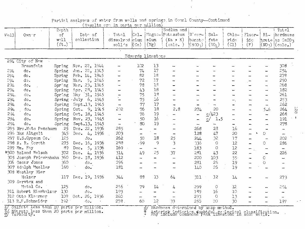
O\,vn"rwon\
\
Partic::l anelysC?s 'J!- vfatr'r fr:Jffi wc:ol1s and springs in Cf)lncl C')unty-Cont inued. (R~~sults e,r,o in p::,.rts ce.r rn:Lllion)
---~---=D-,o~p-t'ch-'i-- ! i t !Sodium ond! \ Tot?lof \ Date' of I Tot",l jcc,.l_ il!"gn"- !p,otcssium iE' ccor- Su1- Chlo- Flu,)r- i Ni- h,.rdness
wdl \ collection i dissolvsd icium i sium 'j (Na + K) ibonok fete ride ide !trate as c;aC03(ft.)..i ! soJ.i~s !(Ca) i('fog) (calc.) i~H'c;O) (S04) (Cl) (F) j(N03) kllc.)
Edw2rds limest,ne294 City of N-ew
Braunfels Spring Nov. 22,. 1944 - 102 J..3 - - - - - - 308294 do. Spring J"n. 22, 19/,5 - 74 17 - - - - - - 254294 do. Spring Feb. 14, 19!.c5 - 82 18 - - - - - - 278294 d" , Spring Mar. 5, 1945 - 72 17 - - - - - - 250294 do. Spr'.ng ,'b r. 23, 1945 - 78 IS - - - - - - 268294 do. Spring- tpr. 2Q, 1945 - 43 18 - - - - - - 1822%. do. Spring :',12y 31, 1945 - 75 18 - - - - - - '261294 do. Spring . July 6, 1945 - 75 1 ' - - - - - 2:)3~O -294 do. Spring Sept.J. 3, 1945 - 77 17 - - - - - - 262294 do. Spring Oct •. 9, 1945 292 76 18 2.8 274 20 5..6 264 i-'- - '"294 do. Spring Oct. 18, 1945 76 19 c/423 268 <))- - - - - -294 do. Spring Nov. 23, 1945 50 16 -/
191- - - 2/ 1.5 - - -294 do. Spring Sept.13, 1945 - 80 19 - - - - - - 278295 Mrs.Meta Penshorn 25 Dec. 22,.1936 285 - - - 268 23 16296 ',le.x Altgelt 345 D8C. 4, 1936 203 - - - 128 47 20 - • 0297 U.S.Gypsum Co. 125 do. 262 50 18 25 2/;1. 32 17 - - 202298 R. R. ~oreth 275 Dec. 16, 1936 2'Vl -99 9 3 .336 0 12 - 0 286299 Wm. Fey 89 Dec. 5, 1936 169 - - - 183 0 12
'<300 Roland Welsch 372 Dec. 4, 1936 314 49 25 37 281 43 22 - - 226305 Joseph Friesenhahn 360 Dc<c. 18, 1936 412 - - - 200 103 55 - 030S OSCE.r Jan"s 360 do. 296 - - - 281 21, 19 - °307 i\r101ph 'fueller 160 do. 181 140 0' 19- - - .;::-0
308 Westley HierHolzer 117 D8C. 19, 1936 344 88 13 64 311 12 14 - - 273
309 S"rvtex and"ht'a1 Co. 125 do. 21)6 79 14 4 299 0 12 - - 2~4
311 Robert Hierholz~r 13C do •. 193 - - - 1'39 16 10312 Ott,) Kla'erner D9 Oct. 26; 193,6 260 - - - 293 0 13313 R.P.Schneider 192 do. 278 60 12 33 250 :<0 30 - - 197
Y SuITetp. .less th,m 10 pans pc7!, ffiJ.IFon-.- W-Hardness d,:::tnrmined by SOE'.p method ..~ Nitr".fu' less than 20 parts pc.r million. * .Lj.sterisj< ~nd~cFtcshcl0rbtt:Ul' Rico 'j,.o!\ic"cl cl"ssifli"tbn."C' Turbl ty. . .+ J'lay lnc' u e omanc. e Ra l._8S v O e In some we ,8.

Particl analys~s of w~t2r from wells and springs in Comd Cflunty--Continued.~__~ .__. U:~£~ults are in p"rts p'~'11illion) _; n th ' , I I co ". d Ii .!J"?P _ !! i.-:Y)Ul.U:n 2,.Il i
Welll Ownsr I of : Date c:f ! .T"t2.1 C~l- i '"~gn'.- '\PotaSS:l:m' . Bic~r- Sul- :
I ,well I collectun i dlss"lved cUEn· 1S lUlU (Na + K) bonpt,o fate I
I I (ft.) I J solids (Ca) I (Hg) I (calc.) (HG)3) (S)4)!
iChlo-/
(~i) IFluor-i Niide Itr~te
.,(F) 1(;1103)
T'JtalhC1rdness8S CaCO](calc.)
Edwards lim<;:,stone314 -- HJg,ers 225 Dec. 17, 1936 336 - - - 232--- 49 1,9 - 'i!315 Herbp,rt Riedpl ]')6 do. 321 '35 lS 16 281 40 27 - 0 ~75316 Joe Sldtz 310 Dr:;c. 12, 1936 298 - - - 232 42 31 - 0318 'daltnr l-.'Iueller 476 Nov. 24, 1936 -194 30 19 14 122 51 20 - - 152319 Percy Hans~~n 350 Ds,~. 3, 1936 617 72 57 85 439 63 124 - - 416320 Jack Alesci 400 Nov. 24, 1936 305 102 7 3 232 31 1+3 - - 284326 '-'1m. Schaeffer 300 Dec. 3, 1936 233 33 28 . 16 195 32 28 - - 198328 ~lv:ln Schaeffer 360 D~c. 16, 1936 758 58 66 136 360 99 222 - 0 416332 Ben Jalm 395 Dec. 18, 1936 1,020 82 75 190 378 197 290 - 0 512333 O. Penshorn 428 Dec .. 3, 1936 2,o,n 339 84 223 79 971 425 - - 1,192336 A. iN. Feick 7('0 Oct. 26, 1936 425 58 36 54 293 47 86 - - 292337 ~m. Strateman - Jen .. 6, 1937 1,576 - - - 226 375 550
I-'339 Ott) Reinartz 463 Dec. '3, 1936 101 29 2 9 no 0 7 - - 81 ",'D342 W.F..F.Eilers 240 Oct. 27, 1936 302 " 24 73 299 24 18 - - 125.U
347 Paul Schneider 503 Dec. 4, 1936 368 27 38 57 220 75 63 - - 224352 Fdwin Soefje 427 J2n. 6, 1937 3,852 334 209 701 207 1~306 1,200 - b j 1,69402355 I,d. Tausch -' do. 281 - - - 262 32 13356 A. H. Hoffer 24 Nov. 18, 1936 234 268 ,', 9- - - u359 ~lbert Socfje 57 Oct. 20, 1936 3R6 - - - 403 0 36372 ~rnst Voight 510 Oct.· 26, 1936 1,148 119 72 194 354 2'37 302 - - 594373 L. Jentsch 485 D'~r> 4, 1936 1,647 114 107 J22 207 422 580 - - 726'._"-,.374 Gus Reinerz 500 do. 1,983 156 117 387 281 505 680 - - 372375 7. A. Burket 450 Oct. 26, 1936 1,957 166 no 380 343 500 630 - - 868377 Erwin R. Goebel 498 Jen. 6, 1'!37 2,.300 236 136 390 293 574 820 - Y 1,11,837 Q Hanna W81s~h 542 do. 1,019 132 33 193 348 245 245 - 0 466J;31 Sorvtcx and
~"fat'''ri!~,ls Co. 160 Sppt.19, 1944 232 82 12 r::. .~ 2"90 . 7.7 11 - b.g 254." .
3'33 eharl "s ;"",rg c·1 e 6n Sept.lb, 1941 540 43 26 109 2'38 94 . '33 0.5 0 214-383 d0. 611 D,""C'. -, 19l1h ~',",,,"", £/'35 31,5 d/260- - - - ),~,.(. - -384 Eo rry D,m,;r 300 Dpc. 6, 1944 218 cll,C) 15 -'I- - - - 02 • - - ~249
iI Sulfat'C h,ss'th,n 10 p2.rL, psr mi_::'li m. 3/ Hardnc:ss G,ct,ermi';pd by s:",.p ffi:2thod.y Nitrate h,ss than 20 pa.rts per mi11i.~n., * Asterisk indic3,t'?S dQubtful geol(Jgicc~_l cl?ssificBti;)n .•:J Turbiriity. + 1;-fay- incllK.L? GOillcmche P'~'ak limestone in some WE-lIs.

f-'
""o
252252
254287
296276'00'~,o
31232626033329426h316279322288Y,8236337254272221336282267326
12
3.29.8
1,5
1240.20.5
0.2 5.8'J.2 5.5
0.2 12128.0
classification.some well s ..
10
215456
11
141612131312
14.J.J
:J45859
2424
:Jll:J8S!3.0
:J2
y2211
:JllI"j
:J96.7
26633433'"334358282
294
263261
260256262
2 .. 8
6.75.5
1,62.50.7
3.913
233327
1711
1717
1413
9.816121816
9.6121'010101414141520121116
7373r Hardness GF'termln8C t";y SOEP meT,ncxl ~
Asterisk indicates doubtful geological+ May incl ude Comanche Peak lim8str~me in
7497
798664
1029389
104
1 1 '"~.v.
limestone106 76
56 3366 32
102109
88107
9876
10096
10999
10798
317
2812S3
320335291
Dec. 20, 1943June 24, 1941Aug. 13, 19USept .16, 1941Jan. 22, 1944S"pt .14, 191'4Oct. 9, 1944Nov. 22, 1944Dec. 5, 1944Dpc. 7, 1944Jan. ~2 ,. 1945~"b. 14, 1945Mar. 5, 1945Mar. 23, 1945Apr. ,1, 1945Apr. 27, 1945May 31, 1%5July 5, 1945July 9, 1945S"pt .13. 1945Oct. 19, 1945
do..-Nov .. 23,. 1945
analyses
Edwards31li bec. 4, 1944'--4U:--502 . Jan. 22, 1944 360
Dec. 3, 1943 370
265322
116 Dec. 4, 1943102 do.
10 parts per mil1L,cn.20 parts per million.
335SpringSpringSpringSpringSpringSpringSpringSpringSpring" .<.Jpr1.ngSpringSpring" .vprl.ngSpringSpringSpringSpringSpringSprJ.ngSpringSpringSpring
Partial ,=,If water fn:n '~'tJells and springs in Carnal CountJT--Continued(Eesults are in PErts per milli'Jn)
-, -:::D"'e-p"'t"'h"'!---~--'-'C::;:, +---~---r----lsodlumBnd; . -I j-- I _! Total
II of !I Date of I Total kal- IMagne-IPotassi illIl 12icar- i Sul- I Chlo- IFluOl~ 1 Ni- hardnesswell collection I dissolved lcium i sium '. (Na + K) ,bonate I' fate I ride I· ide [trate as Ca':,J?!; '. I _ I t j ../I (ft.) I, \ sohas \(ca) I (Mg) ..JJ.:::lc·_)_1(He03) b (SOL,)! (el) (F) \(N03) (c&lc.)
O-,,\fner
38b
-386H. W. Dietz393 '!Jolter Sip',el394 Ai"thur Bergfeld396 Altgelt Farm
Ass ~cic. tiJD400 R. W. Gade400 do •.400 do.400 do.400 do.4CJ do.400 do.400 do.400 do.400 do.400 do.400 do.400 do.400 do.400 do.LOO do.400 do.400 do.400 do.400 dD.
. 4JD do.400 do •.402 City of NeVi
Braunfels403 do.
§J Sulfate le~tl:tan~ Nitrate ,less than-g Turbidity.
Wen

Totalhardnes3as CaCO?(calc.)"
Nitrate
. (N0 3)
Fluoride?(F)
Chloride(Cl)
analyses of,wuter" from wells anj springs in Camal County~-C0ntinued
(Hesults are in oarts p'::r mir! i,)n)" -_.-.--,' _. ,.---'--j S· rl"i-'---'-;:;-r! _ I j ~ I - ou.~um. an ... L",. _ , .
Date of I Total 'ICal- I kagne-i Pot as Slum )i:Jlcar- Sulcollection i dbsolved ,ciurn i sium I (Na + K) !bonate fate
i solie's ((Ca) I, (Mg) : (calc. ) i(HCO,) (501,)---,--"---'--._-,---",:,-,-._--",:,-
, Depth
I 0'
, well\ (ft.)
PartiCll
Ownerwelll
II
EdwarcB-limsstone _410 B"ar Creek Ranch
Associati~n $pring414 Vao Raarman aPfl
R. Wright 333417 "dward Laek"y 440421 Jesse Posey 280
Sept.29, 1943
Dec. 15, 1944do •.do •.
294
...,
80 21 5.8 325 .2/3248 c/ 42.!~2 513172 y65
li,
101211
5.2 286
£!282SV294d/228
Austin chalk281 Travis Tatp '152 Jan. 6, 1937 573 99 37 58 305 130 99 - 0 398282 Phopnix Life I
Insurance Co., 145 Oct. 21, 1936 648 111 32 77 275 169 124 .- - no f-'
""-"'317 Joe Gldtz 200 Delc. 12, 1936 225 - - . - 165 39 22 - 0 - f-'
323 hlbert Richner 130 De;e. 1, 1936 547 - - - 85 170 151325 Brand Schwab .150 Dec. 18, 1936 368 - - - 287 40 49329 Gus Klaener 131 Dpc •. 4, 1936 2,220 -' - - 128 G08 530
·'f.346 I...- H. \iiJGrnsr lLvS" d·::;.. 553 - - - 329 130 63*348 Altgelt Farm
,
J",ss:Jc-iati-JY1 Soring. do. 270 - - - 171 71 19348 d,). Spr:i.!1g Aug. 20, 1941 298 72 19 30 269 27 15 - 3:0 20g348 do. Spring Dec. 20, 1943 260 72 18 3 " 268 y17 15 - 2.8 254.~
425 MissouriPacific R.R·. ]40 Dec. 22, 1944 394 109 11 - 319 35 20 - 17 317
..f}) Sl<lfate less than 10 pa.rts per million. £! Hardness dct,erm:i.ned byscap method.~ Nitra.te less than 20 parts pe~ million. ~(o Asterisk indicates doubtful .c'eological classification.~ TU~bidity . + May include Comanche Pe9k limestone in s~me WGlls.

P2.rtie:l cnalys'?s or-W2ter from wells art.1 springs in COrE21 County-Continued(R,:;:sults 2T"; -1n DC~rt tx~r mill Lon)
i De-_D--,t'"',h-,--------=='"!=-": iSodi::u=-m-=Pill::"3diTI ---,---.,.-----.,.-----r-.,.---"'T"'e-t;-o-·,""l-I • I I _ I I
We:lli Owner of Dat c of l Tot al I.Cc.l- 1Iagns-l Pate. 8si UIn IIBiear~ SP.,l- ChJo- Fluor~ Ni- h2.rdnessi well collection! dissolved !cium siu.'l1 I (Na + K) bonate fete ride ide trate as GaG03i (ft.) i solids I(Ce) (Mg) i (calc. ) -1(:1:::0,) ( S04) (Gl) (2) om3) (calc.)
Te.y1 3r m?TlJ}284 Ce.rl Kutscher Fst. 50 Oct. 21, 1936 6'10 - - - 4'r< - 98 106J.-
*322 FrEd Schwab 38 Dec. 16, 1936 604 91 ') ') 106 390 li3 75 - - 319'-~.
*349 ;:.r'U<: Walthsr 31 Oct. 27, 1936.
329 .323 24 19- - . --Y.-360 fl, Kickeritz 36 Nov. 13, 1936 792 132 33 104 354 248 101 - - 460
Lot:ma fonm ti:)n246Henrj schnildt ~-5() 152c.17; 1936 207 °3 2 - 14b 'J; 32 - 'El--241 -285 H. nttrndorf 32 o·,t. 2i, 1936 228 78 6 5 "1~1 0 13 - - 218.... ...,-0
287 Arthur Sartpls 65 Oct. 22, 1936 352 - - - 256 0 91238 Iwan 'YalihoGfnr Spring Dec .,0, 1936 260 94 7 - 232 24 21 - & 264355 Ad •. TFJ.useh J~n •
,1937 2'11 262 32 1< ~- :), - - -- - - -
356 A. H. Heffel' 24 Nov. 18, 1016 234 - - - 268 0 9 - - - 'v
359 Albert S0pfji 57 'Jet. 20, 1943 3qfJ - - - 403 0 36359 do. )7 D<e c- •. 3, 1943 - - - - 270 :J4 72 -. 165361 "!]1JIla Rose 32 Nov. 18, 1936 519 - - - 268 59 138362 R. Kraft 1+0 do. 239 - - - 250 0 0363 August Timmermcn 50 do. 233 - - - 256 0 0363 do. 50 Dr~ C" .. 3, 1943 - - - - 240 :JIO 21 - 9036~. E. V{. ~,~u::'112r 35 Oct. 10, 1936 163 - - - 134 0 34367 Mrs. H. 021ksrs 40 rb. 257 - - - 250 0 33368 D. ii:'{~rner '1.() do. 291 106 6 - 244 35 24 - Sf 288,-41S W. G. Startz 27 D;:;;c. 3, 1943 - - - - . 272 :J20 15 - .132420 Mrs .Lidb Kirmse 65 do. 1.+67 112 10 40 302 V 8 52 - 96 320
,i} Sulfc;t~- less than 10 p<,:,.rts per' f:1illi-:)~. £/ Hardness d'-.;termincd by SO[~P rrEthod ..If r·Jitn:;te. 183s thr::n 2. pe.rts per- million.~ * Asterisk indi(;H~SS- doubtful gEol.,gicr.l clE.ssific·c:tion.
Y Turbidity.· + :.,fe.y incl ude COill2.nche F ~:,:tk 1 i.rn3 st)ne in som:: 1'lf-311s.

GEOLOGIC MAPSHOWING LOCATION
PLATE 5
the'led from maps byBas~, ~om~~OIOgiCOI Survey
and U, S, Army
,
,
,/ ,/' '-"'~~'
.0-
416
"7424.0-
\..."
N
d of Wator EngineersTexas Boar t'on with the
in coopero I
U.S, Geological Survey
,
Kf
4 Milo.
COUNTY, TEXASWELLS AND SPRINGS
3
III::>oUJo~UJa:o
2
COMALRECORDED
o
OFOF
E3E3
~~Washita group
I
cou NT Y
EXPLANAT ION
r""" '...~:".:Q V:.'L e~~~ formation
t\~~nd AnacachoTaylor marl a d' 'ded
limestone, un IVI
l@=2BAustin cholk-Eagl e Ford shale
I Kf
Fredericksburg group
~~r~Upper member
f7 77)t:..~~g~I'LJ
Lower member
[;irrp~, Peak (Pearsall)
Travlsformation
o downthrow)Fault (U, upthrow, ,
or small power pumpWell with windmill
plant-5 horsepowerWell with pumpingor larger
Flowing we II
bucket or bailerWell wi th hand pump.
t for oil or gasWell drilled to tee
Spri ng
Unused well
stationStream-gaging