Geology and Assessment of Undiscovered Oil and Gas Resources of the Chukchi Borderland Province, 2008 Chapter C of The 2008 Circum-Arctic Resource Appraisal Professional Paper 1824 U.S. Department of the Interior U.S. Geological Survey

Welcome message from author
This document is posted to help you gain knowledge. Please leave a comment to let me know what you think about it! Share it to your friends and learn new things together.
Transcript
Geology and Assessment of Undiscovered Oil and Gas Resources of the Chukchi Borderland Province, 2008
Chapter C ofThe 2008 Circum-Arctic Resource Appraisal
Professional Paper 1824
U.S. Department of the InteriorU.S. Geological Survey

COVERNorthwestward view across the southern foothills of the Brooks Range along Akmagolik Creek, approximately 150 miles southwest of Prudhoe Bay, Alaska. Exposed rocks are part of the Mississippian–Pennsylvanian Lisburne Group and include a thrust-fault ramp at left. Photo includes two helicopters for scale, a blue-and-white one near the center and a red one at center-right at creek level. U.S. Geological Survey photograph by David Houseknecht.

Geology and Assessment of Undiscovered Oil and Gas Resources of the Chukchi Borderland Province, 2008
By Kenneth J. Bird and David W. Houseknecht
Chapter C ofThe 2008 Circum-Arctic Resource Appraisal Edited by T.E. Moore and D.L. Gautier
Professional Paper 1824
U.S. Department of the InteriorU.S. Geological Survey
U.S. Department of the InteriorRYAN K. ZINKE, Secretary
U.S. Geological SurveyWilliam H. Werkheiser, Acting Director
U.S. Geological Survey, Reston, Virginia: 2017
For more information on the USGS—the Federal source for science about the Earth, its natural and living resources, natural hazards, and the environment—visit https://www.usgs.gov or call 1–888–ASK–USGS.
For an overview of USGS information products, including maps, imagery, and publications, visit https://store.usgs.gov.
Any use of trade, firm, or product names is for descriptive purposes only and does not imply endorsement by the U.S. Government.
Although this information product, for the most part, is in the public domain, it also may contain copyrighted materials as noted in the text. Permission to reproduce copyrighted items must be secured from the copyright owner.
Suggested citation:Bird, K.J., and Houseknecht, D.W., 2017, Geology and assessment of undiscovered oil and gas resources of the Chukchi Borderland Province, 2008, chap. C of Moore, T.E., and Gautier, D.L., eds., The 2008 Circum-Arctic Resource Appraisal: U.S. Geological Survey Professional Paper 1824, https://doi.org/10.3133/pp1824C.
ISSN 2330-7102 (online)
iii
The 2008 Circum-Arctic Resource Appraisal
Chapters
A. Introduction to the 2008 Circum-Arctic Resource Appraisal (CARA) Professional Paper By Donald L. Gautier and Thomas E. Moore
B. Methodology for Assessment of Undiscovered Oil and Gas Resources for the 2008 Circum-Arctic Resource Appraisal
By Ronald R. Charpentier
North America
C. Geology and Assessment of Undiscovered Oil and Gas Resources of the Chukchi Borderland Province, 2008
By Kenneth J. Bird and David W. Houseknecht
D. Geology and Assessment of Undiscovered Oil and Gas Resources of the Hope Basin Province, 2008
By Kenneth J. Bird, David W. Houseknecht, and Janet K. Pitman
E. Geology and Assessment of Undiscovered Oil and Gas Resources of the Arctic Alaska Petroleum Province, 2008 By David W. Houseknecht, Kenneth J. Bird, and Christopher P. Garrity
F. Geology and Assessment of Undiscovered Oil and Gas Resources of the Yukon Flats Basin Province, 2008
By Kenneth J. Bird and Richard G. Stanley
G. Geology and Assessment of Undiscovered Oil and Gas Resources of the Northwest Canada Interior Basins Province, Arctic Canada, 2008
By Marilyn E. Tennyson and Janet K. Pitman
H. Geology and Assessment of Undiscovered Oil and Gas Resources of the Franklinian Shelf Province, Arctic Canada and North Greenland, 2008
By Marilyn E. Tennyson and Janet K. Pitman
I. Geology and Assessment of Undiscovered Oil and Gas Resources of the Sverdrup Basin Province, Arctic Canada, 2008
By Marilyn E. Tennyson and Janet K. Pitman
Greenland
J. Geology and Assessment of Undiscovered Oil and Gas Resources of the West Greenland- East Canada Province, 2008
By Christopher J. Schenk

iv
K. Geology and Assessment of Undiscovered Oil and Gas Resources of the East Greenland Rift Basins Province, 2008
By Donald L. Gautier
North Atlantic Ocean
L. Geology and Assessment of Undiscovered Oil and Gas Resources of the Jan Mayen Microcontinent Province, 2008
By Thomas E. Moore and Janet K. Pitman
Eurasia
M. Geology and Assessment of Undiscovered Oil and Gas Resources of the Mezen’ Basin Province, 2008
By Timothy R. Klett and Janet K. Pitman
N. Geology and Assessment of Undiscovered Oil and Gas Resources of the Timan-Pechora Basin Province, Russia, 2008
By Christopher J. Schenk
O. Geology and Assessment of Undiscovered Oil and Gas Resources of the East Barents Basins Province and the Novaya Zemlya Basins and Admiralty Arch Province
By Timothy R. Klett
P. Geology and Assessment of Undiscovered Oil and Gas Resources of the North Kara Basins and Platforms Province, 2008
By Timothy R. Klett and Janet K. Pitman
Q. Geology and Assessment of Undiscovered Oil and Gas Resources of the Northern West Siberian Mesozoic Composite Total Petroleum System of the West Siberian Basin Province, Russia, 2008
By Christopher J. Schenk
R. Geology and Assessment of Undiscovered Oil and Gas Resources of the Yenisey-Khatanga Basin Province, 2008
By Timothy R. Klett and Janet K. Pitman
S. Geology and Assessment of Undiscovered Oil and Gas Resources of the Northwest Laptev Sea Shelf Province, 2008
By Timothy R. Klett and Janet K. Pitman
T. Geology and Assessment of Undiscovered Oil and Gas Resources of the Lena-Anabar Basin Province, 2008
By Timothy R. Klett and Janet K. Pitman

v
U. Geology and Assessment of Undiscovered Oil and Gas Resources of the Tunguska Basin Province, 2008
By Christopher J. Wandrey and Timothy R. Klett
V. Geology and Assessment of Undiscovered Oil and Gas Resources of the Lena-Vilyui Basin Province, 2008
By Timothy R. Klett and Janet K. Pitman
W. Geology and Assessment of Undiscovered Oil and Gas Resources of the Laptev Sea Shelf Province, 2008
By Timothy R. Klett and Janet K. Pitman
X. Geology and Assessment of Undiscovered Oil and Gas Resources of the Zyryanka Basin Province, 2008
By Timothy R. Klett and Janet K. Pitman
Y. Geology and Assessment of Undiscovered Oil and Gas Resources of the East Siberian Sea Basin Province, 2008
By Kenneth J. Bird, David W. Houseknecht, and Janet K. Pitman
Z. Geology and Assessment of Undiscovered Oil and Gas Resources of the Vilkitskii Basin Province, 2008
By Kenneth J. Bird, David W. Houseknecht, and Janet K. Pitman
AA. Geology and Assessment of Undiscovered Oil and Gas Resources of the Long Strait Province, Russian High Arctic, 2008
By Kenneth J. Bird, David W. Houseknecht, and Janet K. Pitman
Arctic Ocean
BB. Geology and Assessment of Undiscovered Oil and Gas Resources of the Amerasia Basin Petroleum Province, 2008 By David W. Houseknecht, Kenneth J. Bird, and Christopher P. Garrity
CC. Geology and Assessment of Undiscovered Oil and Gas Resources of the Lomonosov- Makarov Province, Central Arctic Ocean, 2008
By Thomas E. Moore, Kenneth J. Bird, and Janet K. Pitman
DD. Geology and Assessment of Undiscovered Oil and Gas Resources of the Eurasia Basin Province, Eastern Arctic Ocean, 2008
By Thomas E. Moore and Janet K. Pitman

vi
Figures
1. Perspective view from the North Pole southward across the Amerasia Basin toward the Canadian and northern Alaska margin .....................................................................................1
2. Index map showing location of Chukchi Borderland Province in relation to adjacent prov-inces defined in the Circum-Arctic Resource Assessment ...................................................2
3. Index map showing location, bathymetry, and main physiographic features of the Chukchi Borderland Province ....................................................................................................................3
4. Regional composite seismic section across part of the Chukchi Borderland Province ............45. Schematic diagram of the geologic evolution of Chukchi Borderland from the Late
Triassic to the present, assuming counterclockwise rotational origin from the Canadian margin ...........................................................................................................................5
6. Burial history model of a pseudowell located in the deepest graben identified on seismic line crossing the Northwind Basin ............................................................................................7
1. Input data for the Chukchi Borderland Assessment Unit.
Appendix[Available for download at https://doi.org/10.3133/pp1824C]
ContentsAbstract ...........................................................................................................................................................1Introduction.....................................................................................................................................................1Geologic Setting and Stratigraphy ..............................................................................................................4Petroleum Systems ........................................................................................................................................6Chukchi Borderland Assessment Unit ......................................................................................................6Acknowledgments .........................................................................................................................................8References Cited............................................................................................................................................8Appendix..........................................................................................................................................................9
Chapter C
The 2008 Circum-Arctic Resource AppraisalEdited by T.E. Moore and D.L. GautierU.S. Geological Survey Professional Paper 1824
Geology and Assessment of Undiscovered Oil and Gas Resources of the Chukchi Borderland Province, 2008
By Kenneth J. Bird and David W. Houseknecht
AbstractThe Chukchi Borderland is both a stand-alone petroleum
province and assessment unit (AU) that lies north of the Chuk-chi Sea. It is a bathymetrically high-standing block of conti-nental crust that was probably rifted from the Canadian conti-nental margin. The sum of our knowledge of this province is based upon geophysical data (seismic, gravity, and magnetic) and a limited number of seafloor core and dredge samples.
As expected from the limited data set, the basin’s petro-leum potential is poorly known. A single assessment unit, the Chukchi Borderland AU, was defined and assigned an overall probability of about a 5 percent chance of at least one petroleum accumulation >50 million barrels of oil equivalent (MMBOE). No quantitative assessment of sizes and numbers of petroleum accumulations was conducted for this AU.
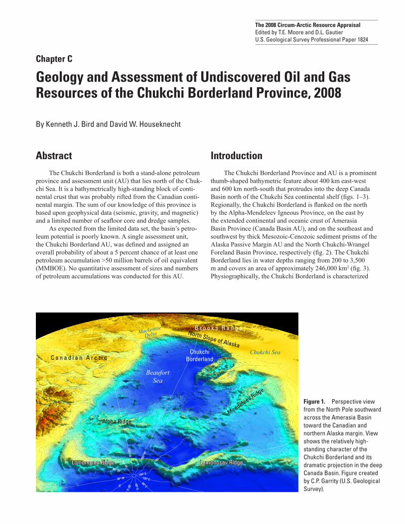
IntroductionThe Chukchi Borderland Province and AU is a prominent
thumb-shaped bathymetric feature about 400 km east-west and 600 km north-south that protrudes into the deep Canada Basin north of the Chukchi Sea continental shelf (figs. 1–3). Regionally, the Chukchi Borderland is flanked on the north by the Alpha-Mendeleev Igneous Province, on the east by the extended continental and oceanic crust of Amerasia Basin Province (Canada Basin AU), and on the southeast and southwest by thick Mesozoic-Cenozoic sediment prisms of the Alaska Passive Margin AU and the North Chukchi-Wrangel Foreland Basin Province, respectively (fig. 2). The Chukchi Borderland lies in water depths ranging from 200 to 3,500 m and covers an area of approximately 246,000 km2 (fig. 3). Physiographically, the Chukchi Borderland is characterized
Alpha Ridge
ChukchiBorderlandC a n a d i a n A r c t i c
B r o o k s R a n g eNorth Slope of Alaska
Chukchi Sea
MackenzieDelta
Mendeleev Ridge
Lomonosov Ridge Lomonosov RidgeLomonosov Ridge Lomonosov Ridge
BeaufortSea
150°
W
180°
0°
150° E120° E90° E
60° E
30° E
90° W
60° W
30° W
120° W
Figure 1
Figure 1. Perspective view from the North Pole southward across the Amerasia Basin toward the Canadian and northern Alaska margin. View shows the relatively high-standing character of the Chukchi Borderland and its dramatic projection in the deep Canada Basin. Figure created by C.P. Garrity (U.S. Geological Survey).

2 The 2008 Circum-Arctic Resource Appraisal
ARCTIC CIRCLE
ARCTIC CIRCLE
80° W90° W150° E
100°
W160° E
110° W
180°
130° W120° W
170° W
170° E
140° W160° W 150° W
80° N
75° N
70° N
Arctic AlaskaProvince
Hope BasinProvince
North Chukchi-WrangelForeland
BasinProvince
ChukchiBorderland
Province
Northwest CanadaInterior Basin
Province
FranklinianShelf Province
SverdrupBasin
ProvinceA l p h a - M e n d e l e e v I g n e o u s P r o v i n c e
Amerasia BasinProvince
Cana
da B
asin
AU
Alaska Passive Margin AU
CA
NA
DA
U.S.A
.
RU
SSIA
U.S
.A.
0 100
0 100
200 300 400 500
300 400 500MILES
KILOMETERS
Figure 2
Figure by C.P. Garrity, U.S. Geological Survey. Base from Esri, 2007, used herein under license.
Figure 2. Index map showing location of Chukchi Borderland Province in relation to adjacent provinces defined in the Circum-Arctic Resource Assessment. AU, assessment unit.
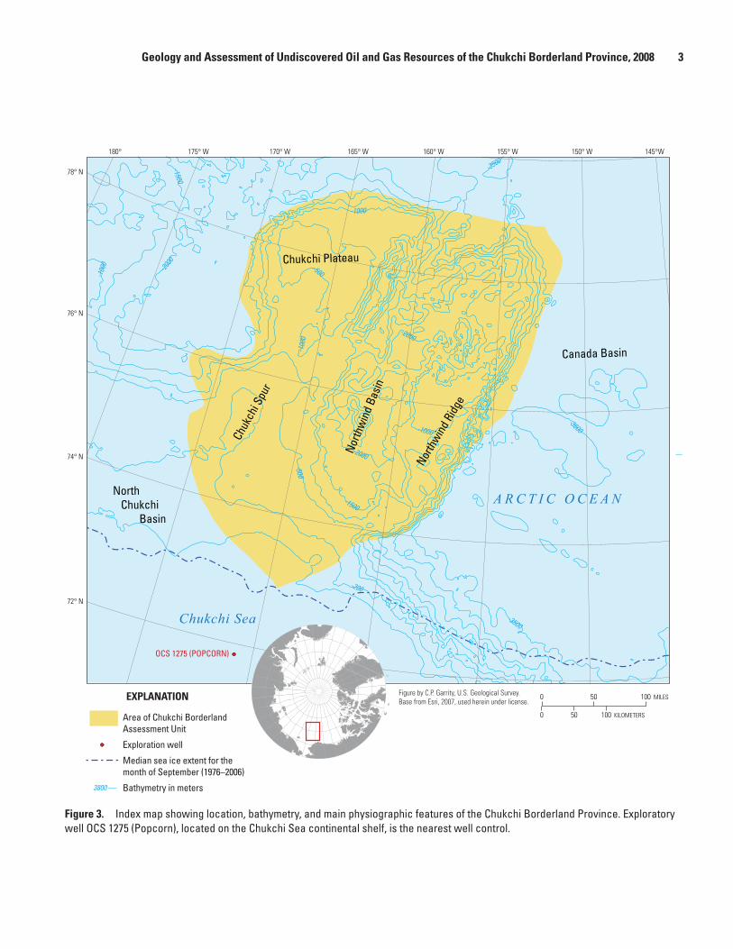
Geology and Assessment of Undiscovered Oil and Gas Resources of the Chukchi Borderland Province, 2008 3
0
0 50 100
50 100
KILOMETERS
MILES
175° W180° 170° W 165° W 160° W 155° W 150° W 145°W
72° N
74° N
76° N
78° N
-1500
-200
-2000
-1500
-1000
-100
0
-100
0
-3500
-500
-500
-1000
-2000
-3800
-3500
-2000
North
win
d Ba
sin
North
wind R
idge
Chuk
chi S
pur
Chukchi Plateau
Canada Basin
North Chukchi Basin
OCS 1275 (POPCORN)
Figure 3
Chukchi Sea
A R C T I C O C E A N
Area of Chukchi Borderland Assessment Unit
Exploration well
Median sea ice extent for the month of September (1976–2006)
Bathymetry in meters3800
EXPLANATION Figure by C.P. Garrity, U.S. Geological Survey. Base from Esri, 2007, used herein under license.
Figure 3. Index map showing location, bathymetry, and main physiographic features of the Chukchi Borderland Province. Exploratory well OCS 1275 (Popcorn), located on the Chukchi Sea continental shelf, is the nearest well control.

4 The 2008 Circum-Arctic Resource Appraisal
by a central north-trending trough (Northwind Basin) that dis-plays basin and range-like topography. The floor of the trough lies more than 1000 m below the bordering Chukchi Spur–Chukchi Plateau on the west and Northwind Ridge on the east.
Geologic Setting and StratigraphyThe Chukchi Borderland is interpreted as a fragment
of continental crust based on its high-standing character and distinct gravity and magnetic signatures. Core data show that it is composed of Paleozoic to recent sedimentary strata with similarities to rocks in Sverdrup Basin and northern Alaska. Extensional deformation is a characteristic feature on seis-mic records. Widely scattered seismic lines with confirming seafloor cores and dredge samples show that the Chukchi Bor-derland AU is mantled by Cretaceous and Cenozoic pelagic sediments and air-fall volcanic ash deposits above a prominent unconformity (Grantz and others, 1998). The unconformity may represent the regional Lower Cretaceous break-up uncon-formity of northern Alaska. On seismic records, these man-tling deposits display thicknesses of less than 1,000 m over the ridges and plateaus and as much as 3,500 m in grabens and half-grabens of Northwind Basin (fig. 4). Cores on the east flank of Northwind Ridge from a position beneath the uncon-formity reveal the presence of carbonate and clastic sedimen-tary strata of Cambrian, Ordovician, Carboniferous, Perm-ian, Triassic, and Jurassic ages. Some of these strata display
lithologic and (or) paleontologic affinities to strata in Sverdrup Basin and northern Alaska. On seismic records, these rocks are generally designated as acoustic basement, but in some areas discontinuous reflections are observed and show a moderate angular relationship to the unconformity.
The geologic evolution of Chukchi Borderland is a mat-ter of debate with many different hypotheses (for example, Lawver and Scotese, 1990), but rifting is common to all. Most interpretations of the origin of the Chukchi Borderland were made early on, without benefit of the results of coring and dredging on Northwind Ridge by Grantz and others (1998). Lithologic and paleontologic details from the Northwind Ridge cores tend to support the so-called rotational hypothesis. The most recent version of the rotational hypothesis (Grantz and others, 2011) was followed here and is summarized in a set of schematic cross sections (fig. 5). In this interpretation, the Chukchi Borderland was originally a part of the Arctic Alaska-Chukotka Microplate located adjacent to the Canadian continental margin (Sverdrup Rim) that rifted and rotated counterclockwise about a pivot in the Mackenzie Delta in Jurassic and early Cretaceous time forming the Canada Basin. At about the same time, the Borderland itself, as a separate block, rifted and rotated in a relatively clockwise direction away from the Arctic Alaska-Chukotka microplate leaving the North Chukchi Basin in its wake. As there seems to be little evidence of compression along the boundary between the Chukchi Borderland and the Canada Basin, the Chukchi Bor-derland may have been fixed relative to Canada Basin while
Figure 4
Two-
way
trav
el ti
me,
in s
econ
ds
2
6
8
4
0WEST EAST
LOCATION
75°
170°
Figure 6
2
6
8
4
0
A
B
Northwind Basin
~180 miles (300 km)
Canada Basin Chukchi Spur
Vertical exaggeration~ 8x at seafloor
Vertical exaggeration~ 8x at seafloor
Northwind Ridge
Figure 4. Regional composite seismic section across part of the Chukchi Borderland Province. A, Uninterpreted section. B, Interpreted section. Red lines mark a regional unconformity interpreted as the break-up unconformity equivalent to the Lower Cretaceous unconformity of northern Alaska. Seismic line segments compiled from Grantz, and others (2004). Red box outlines graben in which burial history modeling was conducted (see figure 6). Yellow line in inset map denotes location of cross section.

Geology and Assessment of Undiscovered Oil and Gas Resources of the Chukchi Borderland Province, 2008 5
Paleo-Pacific oceanic crust
Brooks Range-Herald Arch-Chukotka orogenic belt
Continental Crust
Sverdrup Basin
Canada BasinCollision
NorthChukchi Basin
NorthChukchi Basin
NorthChukchi Basin
Chukchi Borderland
Chukchi Borderland
Border landChukchi
Canada Basin
Canada BasinCanada passive margin
Future sites of rifting
(Canada Basin)(North Chukchi Basin)
NorthwindBasinChukchi
PlateauNorthwind Ridge
End Triassic (prerift)
Jurassic–Early Cretaceous (extension)
Early Cretaceous (seafloor spreading)
Present
Figure 5
0
0 250 500
250 500
KILOMETERS
MILES
Pole of rotationALASKA
BanksIsland
WrangelIsland
Hanna
Sverd
rup
Basi
nax
is
Trough
52°
Arctic Alaska
Postion after rotation
Appro ximate location of ultim
ate rift margin
Lomonosov
Ridge
Ellesmere Island
(restored(prior toextension)
ChukchiBorderland
Figure 5. Schematic diagram of the geologic evolution of Chukchi Borderland from the Late Triassic to the present, assuming counterclockwise rotational origin from the Canadian margin (shown in location map at top by dashed gray arrow). Red squares show approximate end points of the “Present” schematic cross section below.

6 The 2008 Circum-Arctic Resource Appraisal
the Arctic Alaska-Chukotka microplate continued to rotate. A later episode of extension of postulated Paleogene age, and perhaps related to the Hanna Wrench-Fault Zone on the Chuk-chi shelf (Lothamer, 1994), extended the Chukchi Borderland crust producing the basin-and-range-like Northwind Basin (fig. 4).
Petroleum SystemsThere is no direct evidence of an active petroleum system
in the Chukchi Borderland. Source rocks may occur above or below the regional Lower Cretaceous unconformity. Triassic and Jurassic mudstones are present in cores taken on North-wind Ridge from a position beneath the regional unconformity and similar age strata are known source rocks in the Sverdrup Basin and northern Alaska. But their general character and areal extent in the Borderland are unknown. Maturity mea-surements in pre-Cretaceous rocks from Northwind Ridge show a range of values from immature to post-mature with highest values in Triassic rocks and lower values in Paleozoic rocks (Grantz and others, 1998). As these rocks are currently outcropping on the seafloor, the observed maturity pattern suggests different pre-Cretaceous burial histories for different parts of Northwind Ridge.
Source rocks above the regional unconformity may include Early Cretaceous (pebble shale unit, Hue Shale gamma-ray zone, and lower Torok Formation equivalents), mid-Cretaceous (Seabee Formation equivalents), and Eocene (Azolla) intervals (see Houseknecht and Bird, 2006). Burial history modeling in the deepest graben identified on the seismic section (fig. 6) shows that these rocks may be buried to depths adequate for early maturity (vitrinite reflectance values of 0.5–0.7 percent Ro). Based on this modeling, post-unconformity sediment thicknesses are deemed insufficient to mature any source rocks except within Northwind Basin beneath local grabens and half-grabens. Preservation of oil generated from Triassic and Jurassic source rocks in pre-Cre-taceous time is considered unlikely given the inferred history of Mesozoic rifting, uplift and erosion, and later Cenozoic extension and burial.
Chukchi Borderland Assessment Unit AU Description.—The Chukchi Borderland AU includes
the entire province covering an area of approximately 246,000 km2 located in water depths ranging from 200 to 3,500 m. The AU is flanked east and west by relatively high-standing ridges or plateaus mantled by less than 1000 m of seismically reflective strata above acoustic basement. Cores indicate the mantling strata are Cretaceous and Cenozoic pelagic and air-fall tuff deposits while the acoustic basement includes carbon-ate and clastic sedimentary strata of Cambrian, Ordovician,
Carboniferous, Permian, Triassic, and Jurassic ages. A north-trending trough that displays basin and range topogra-phy bisects the Chukchi Borderland AU opening northward into the deep Canada basin and grading southward into the Chukchi continental shelf. Seismic reflection records shows as much as 3,500 m of inferred Cretaceous and Cenozoic strata in some grabens.
Geological Analysis of Assessment Unit Probability.— The likelihood that the Chukchi Borderland AU contains at least one undiscovered accumulation >50 million barrels of oil equivalent (MMBOE) is considered to be about 5 percent on the basis of its postulated tectonic history and limited petro-leum geologic information. This probability falls below the 10-percent minimum necessary for a full quantitative assess-ment of the AU, and so no assessment of sizes and numbers of petroleum accumulations was conducted. Petroleum system characteristics that led to the low probability estimate are sum-marized below.
Charge.— Although there is no direct evidence of an active petroleum system in the Chukchi Borderland AU, source rocks of Cretaceous and Paleogene age are postulated to occur throughout the province above the observed regional unconformity. Potential source rocks of Jurassic and Trias-sic age are known to occur below the unconformity, but their distribution is unknown. Burial history modeling shows that these source rocks may be buried to depths adequate for early maturity (vitrinite reflectance values of 0.5–0.7 percent Ro) only in grabens with >2,300 m of sediment fill. Uncertainty about the presence, character, and distribution of potential source rocks resulted in a probability value of 0.3 assigned to charge in the AU.
Rocks.— Reservoir rocks in the Chukchi Borderland AU may consist of Paleozoic carbonate rocks and Mesozoic sandstones beneath the regional unconformity but the char-acter, distribution and thickness of these rocks, as well as possible seals, are unknown. Above the regional unconformity, Cretaceous and Tertiary rocks are likely to be mostly pelagic deposits with the possibility of a transgressive marine sand-stone directly above the unconformity and perhaps talus and rubble associated with graben-bounding faults. The adjacent North Chukchi Basin and Alaska passive margin are inferred to have acted as traps for northward prograding sediments shed from the highlands of the Brooks Range-Herald Arch orogenic belt, thus reducing the potential for Cretaceous and Cenozoic sandstone reservoirs in the Borderland. Reservoir presence is considered the greatest risk in this AU and was assigned a probability value of 0.2.
Timing and Preservation.— Preservation of oil generated from pre-Cretaceous source rocks prior to rifting is considered unlikely. Oil generation by Cretaceous or Paleogene source rocks could occur only in the deeper grabens of Northwind Basin at the time of maximum burial (Neogene). For this latter scenario, timing and preservation were judged to be relatively favorable resulting in assignment of a probability value of 0.9.

Geology and Assessment of Undiscovered Oil and Gas Resources of the Chukchi Borderland Province, 2008 7
Figure 6
150 100 50
Jurassic Cretaceous Paleocene N
0
SourceReservoir
SealOverburden
Trap formationGeneration, migration, accumulation
Age, in millions of years ago
Dept
h, in
feet
Pseudowell
Northwind Basin pseudowell
Polar Star Line 90-9
LOCATION
75° N
170° W
QuaternaryFormation
0
2,000
4,000
6,000
8,000
10,000
Azolla
Pliocene
Miocene
Oligocene
Eocene
Early mature(0.5–0.7%)
VR windowsPaleocene
Lower Cretaceousbasement
2.5 seconds two-way travel time (~3,500 meters sediment thickness)
A B
C
Figure 6. Burial history model of a pseudowell located in the deepest graben identified on seismic line crossing the Northwind Basin (fig. 4). A, Location of pseudowell (black line) shown in an expanded view of seismic profile (see fig. 4). B, Location of pseudowell and composite seismic profile (segmented yellow line; fig. 4) shown on shaded-relief bathymetric map. C, Model shows the onset of petroleum generation at burial depths below 2,300 meters at 30–25 million years ago. A constant heat flow of 55 milliwatts per square meter was used, similar to that calculated for the OCS 1275 (Popcorn) well on the Chukchi Shelf located 500 kilometers to the south (fig. 3). N, Neogene; VR, vitrinite reflectance, in percent (%).
8 The 2008 Circum-Arctic Resource Appraisal
AcknowledgmentsThis report has been improved by the technical reviews
and comments of Naresh Kumar and Larry Phillips.
References Cited
Grantz, A., Clark, D.L., Phillips, R.L., and Srivastava, S.P., 1998, Phanerozoic stratigraphy of Northwind Ridge, magnetic anomalies in the Canada basin, and the geometry and timing of rifting in the Amerasia basin, Arctic Ocean: Geological Society of America Bulletin, v. 110, no. 6, p. 801–820.
Grantz, A., Hart, P.E., and May, S.D., 2004, Seismic reflec-tion and refraction data acquired in Canada Basin, North-wind Ridge and Northwind Basin, Arctic Ocean in 1988, 1992, and 1993: U.S. Geological Survey Open-File Report 2004–1243. [Also available online at http://pubs.usgs.gov/of/2004/1243/.]
Grantz, A., Hart, P.E., and Childers, V.A., 2011, Geology and tectonic development of the Amerasia and Canada basins, Arctic Ocean, in Spencer, A.M., Embry, A.F., Gautier, D.L., Stoupakova, A.V., and Sorensen, K., eds., Arctic petroleum geology: Geological Society of London Memoir 35, p. 771-799.
Houseknecht, D.W., and Bird, K.J., 2006, Oil and gas resources of the Arctic Alaska Petroleum Province: U.S. Geological Survey Professional Paper 1732-A, 11 p., [Also available online at http://pubs.usgs.gov/pp/pp1732a/.]
Lawver, L.A., and Scotese, C.R., 1990, A review of tectonic models for the evolution of the Canada basin, in Grantz, A., Johnson, G.L., and Sweeney, J.F., eds., The Arctic Ocean region: Geological Society of America, DNAG, The Geol-ogy of North America, v. L, p. 593–618.
Lothamer, R.T., 1994, Early Tertiary wrench faulting in the North Chukchi Basin, Chukchi Sea, Alaska, in Thurston, D.K., and Fujita, K., eds., Proceedings of the first interna-tional conference on Arctic margins (1992): U.S. Miner-als Management Service OCS Study, MMS 94-0040, p. 251–256.

Geology and Assessment of Undiscovered Oil and Gas Resources of the Chukchi Borderland Province, 2008 9
Appendix
Appendixes are available online only, and may be accessed at https://doi.org/10.3133/pp1824C
Appendix 1. Input data for the Chukchi Borderland Assessment Unit.
Menlo Park Publishing Service Center, California Manuscript approved for publication April 28, 2017Edited by Larry J. Slack and Claire Landowski Layout and design by Vivian Nguyen

Bird and Houseknecht—G
eology and Assessm
ent of Undiscovered O
il and Gas Resources of the Chukchi B
orderland Province, 2008—Professional Paper 1824 Chapter C
ISSN 2330-7102 (online)https://doi.org/10.3133/pp1824C
Related Documents