GEOLOGICAL SUMMARY REPORT NUGGET PROPERTY. SHEEP CREEK AREA NELSON MINING DIVISION, B.C. (Lat: 49 10 NI Long 117 07 W.) Mapsheet 82 F 3 for: GUNSTEEL RESOURCES INC. 501 - 850 West Hastings Street Vancouver, B.C. V6C 1E1 681-0194 by: Barry J.P r ice, M.Sc., F.G.A.C. Consulting Geologist Rapitan Resources Inc. 3447 West 7th Avenue, Vancouver, B.C. V6R 1W2 733-6902 March 20, 1988

Welcome message from author
This document is posted to help you gain knowledge. Please leave a comment to let me know what you think about it! Share it to your friends and learn new things together.
Transcript

GEOLOGICAL SUMMARY REPORT
NUGGET PROPERTY. SHEEP CREEK AREA NELSON MINING DIVISION, B.C.
(Lat: 49 10 NI Long 117 07 W.) Mapsheet 82 F 3
for:
GUNSTEEL RESOURCES INC.
501 - 850 West Hastings Street Vancouver, B.C.
V6C 1E1 681-0194
by:
Barry J.P r ice, M.Sc., F.G.A.C.
Consulting Geologist Rapitan Resources Inc.
3447 West 7th Avenue, Vancouver, B.C. V6R 1W2 733-6902
March 20, 1988

GEOLOGICAL SUMMARY REPORT
NUGGET PROPERTY. SHEEP CREEK AREA NELSON MINING DIVISION, B.C.
GUNSTEEL RESOURCES INC.
SUMMARY
Gunsteel Resources Incorporated holds a joint venture exploration agreement with Nugget Mines Ltd., owners of a gold property comprising 120 claims or units in the Sheep Creek mining camp near Salmo, B.C. in southeastern British Columbia. The Sheep Creek camp ranks sixth in the province in terms of gross gold production - 741,515 ounces from 1,715,875 tons of ore.
The Nugget Mines property is situated 39 km south of Nelson, 45 km east of Trail and 12 km southeast of Salmo. Access is by road, about an hour's drive from Salmo to the principal workings. The property is coriveniently situated near a custom mill on Sheep Creek, and Cominco's smelter in Trail.
The Sheep Creek camp is underlain by late Proterozoic to Cambrian argillite, argillaceous quartzite and limestone that have been folded into two tight northerly trending anticlines with an intervening syncline. Gold-quartz veins with minor sulphides occur in northeasterly-trending faults where they intersect certain stratigraphic units (notably Upper Navada and Upper Nugget quartzite) near the crest of the western anticline and western limb of the eastern anticline.
At least 23 veins are known on the Nugget Mines property. Past production, from 1896 to 1950, of 427,000 tons of ore containing 230,590 ounces of gold, was mainly from three veins in the Reno, Nugget and Motherlode Mines, which accounts for 32% of the recorded gold production of the Sheep Creek camp.
In 1982, a program of underground rehabilitation and sampling, 1278 feet of surface diamond drilling in two holes, road construction and preliminary geochemical sampling was carried out by Carl Creek Resources Ltd. on the Nugget Mines property.
In 1986, Gunsteel Resources Inc. started an extensive program of underground exploration, sampling, diamond drilling and surface exploration. The purpose of the program was to outline further ore reserves. Previous reserve assessment indicated proven and probable reserves of 17,000 tons grading 0.35 oz/ton Au and possible reserves of 20,000 tons grading 0.33 oz/ton Au. 1987 reserves in all categories on the Nugget property were estimated to be 73,500 tons grading .446 oz/ton gold.
Work done during 1987 and early 1988, consisting of underground rehabilitation, drifting, sampling and diamond drilling and surface trenching and diamond drilling involved expenditures of $1,843,977.00

The drifting and sampling program in the Nugget mine has increased in situ geological reserves in the Nugget and Calhoun veins. Underground diamond drilling in the Fawn< vein discovered additional possible reserves below the acce~s level, and a long cross cut at the 1650 level of the Motherlode mine is advancing northward to test the Fawn vein at depth. ,_
.. ... A detailed review of mine plans and stope sections for the Motherlode
and Reno veins has outlined a very significant reserve of mineralized vein material which has increased in-situ geologic reserves dramatically.
The 1987 goal of 75,000 tons of reserves has been surpassed; recently calculated in-situ geologic reserves outlined by the mine staff total 229,000 tons in all categories (Proven, Probable, Possible and Marginal) with average grade '0.324 ounces gold per ton. Of this total, "proven and probable .. reserves comprise 75,000 tons averaging 0.455 oz/ton gold , and 154,000 tons of "possible and marginal" reserves average 0.261 oz/ton gold.
Extensive sections of the vein systems remain untested. The goal of 1988 exploration programs is to substantiate the reserve figures, and upgrade reserve blocks to higher categories, as well as to explore veins which could provide further reserves. Concurrently, an in-house feasibility study has been recommended, along with metallurgical testing and initiation of the environmental permitting process. A budget for the exploration and development program has been set at $1,740,000.00.
Respectfully submitted
Barry Price, M.Sc.,FGAC. Consulting Geologist, Rapitan Resources Inc. March 20, 1988.

GEOLOGICAL SUMMARY REPORT
NUGGET PROPERTY. SHEEP CREEK AREA NELSON MINING DIVISION, B.C.
SUMMARY INTRODUCTION LOCATION AND ACCESS MINING LOGISTICS PROPERTY OWNERSHIP
TABLE OF CONTENTS
HISTORY OF THE SHEEP CREEK AREA HISTORY OF THE NUGGET AND ADJACENT MINES REGIONAL GEOLOGY GEOLOGY OF THE SHEEP CREEK GOLD CAMP
Stratigraphy Intrusive Rocks Structure Mineralization Ore Controls
1986-88 WORK PROGRAM VEIN DESCRIPTIONS
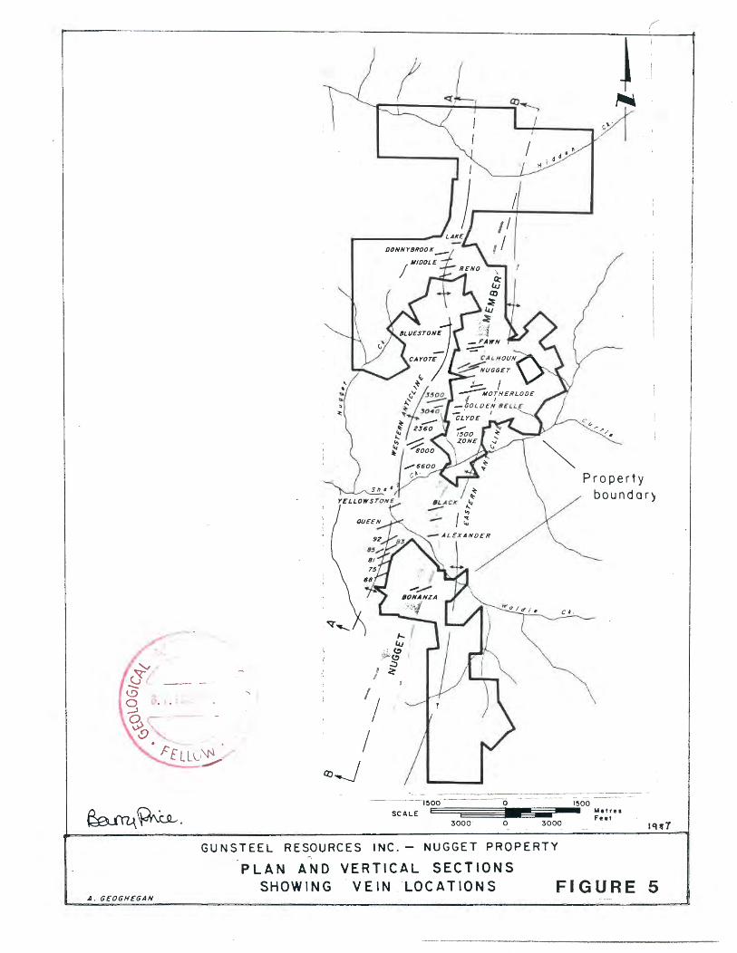
Nugget Vein Calhoun Vein 0,Donnell Vein Fawn Veins Ridge Vein Motherlode Vein North Motherlode Vein Golden Belle Vein Clyde Vein Bonanza Vein Reno Vein Middle Vein Donnybrook Vein Other Veins Mine Dumps Additional Targets
REVIEW OF IN-SITU GEOLOGIC RESERVES Reserves Dilution Comparison
CONCLUSIONS RECOMMENDATIONS
Phase 1 Phase 2
SUGGESTED EXPLORATION BUDGET DEVELOPMENT BUDGET BIBLIOGRAPHY
CERTIFICATE LETTER OF RELEASE
1 1 1 3 3 7 8 8 9
10 10 11 11 11 12 12 13 14 16 17 16 18 18 20 20 21 22 22 22 22 23 24 24 26 26 28 29 32 34 36 36 37
38 39

LI§T OF FIGURE§
FIGURE 1A. LOCATION MAP - B.C. FIGURE 18. LOCATION - SALMO AND SHEEP CREEK AREA FIGURE 2 • . CLAIM MAP.
FIGURE 3. REGIONAL ·GEOlOGY - SHEEP CREEK GOLD .CAMP FIGURE 4A. GEOLOGY, NUGGET - MOTHERLODE - RENO AREAS FIGURE 4B. GEOLOGY, BONANZA MINE AREA FIGURE 4C. STRATIGRAPHIC COLUMN
FIGURE 5. SHEEP CREEK GOLD CAMP - VEIN LOCATIONS
FIGURE 6A. SURFACE GEOLOGY~ NUGGET - FAWN MINE AREA FIGURE 6B. SUBSURFACE PLAN, NUGGET - FAWN MINE AREA FIGURE 6C. NUGGET VEIN, LONG. SECTION FIGURE 6D. NUGGET VEIN, LONG SECTION WITH ASSAY INTERVALS FIGURE 6E. CALHOUN VEIN, LONG. SECTION
FIGURE 7A. SURFACE GEOLOGY - MOTHERLODE VEIN AREA FIGURE 7B. SUBSURFACE GEOLOGY - MOTHERLODE VEIN AREA FIGURE 7C. MOTHERLODE VEIN - LONGITUDINAL SECTION.
FIGURE BA. DRILL SECTION - GOLDEN BELLE VEIN FIGURE 88. LONG. SECTION - GOLDEN BELLE VEIN.
FIGUR~ 9A. PLAN - FAWN WORKINGS. ( FIGURE ·gs. LONG. SECTION, FAWN N0.1 VEIN.
FIGURE 9C. RESERVES - FAWN NO. 1 VEIN.
FIGURE 10A. SURFACE GEOLOGY., RENO MINE AREA. FIGURE 10B. SUBSURFACE GEOLOGY, RENO MINE. FIGURE 10C. LONG SECTION, RENO VEIN.
FIGURE 11A. SURFACE GEOLOGY, BONANZA VEIN. FIGURE 118. SUBSURFACE GEOLOGY, BONANZA VEINS. FIGURE 11C. LONG. SECTION , BONANZA VEINS.
FIGURE 12. TONNAGE/GRADE RELATIONSHIPS, B.C.GOLO MINES •
. LI§I OF TABLES
TABLE 1. TABLE 2 ... TABLE 3. TABLE 4. TABLE- 5. TABLE 6. TABLE 7. TABLE 8. TABLE 9. TABLE 10. TABLE 1 L TABLE 12. TABLE 13. TABLE 14.
CLAIM DATA, NUGGET MINE PROPERTY PRODUCTION FROM SHEEP CREEK GOLD CAMP. IN-SITU GEOLOGICAL RESERVES - NUGGET VEIN IN-SITU GEOLOGICAL RESERVES -· CALHOUN VEIN (1987) 1988 IN-SITU GEOLOGICAL RESERVES - CALHOUN VEIN. 1987 DRILL HOLES - FAWN N0.1 VEIN. IN-SITU GEOLOGICAL RESERVES - MOTHERLODE VEIN GOLDEN BEL;LE AREA DIAMOND DRILL HOLES. IN-SITU GEOLOGIC RESERVES - RENO VEIN. TOTAL 1985 IN-SITU GEOLOGIC RESERVES - NUGGET PROPERTY TOTAL 1987 IN-SITU GEOLOGIC RESERVES - NUGGET PROPERTY TOTAL 1988 IN-SITU GEOLOGIC RESERVES - NUGGET PROPERTY TONNAGE, GRADE AND GROSS METAL VALUE, B.C. GOLD MINES. SUGGESTED 1988 BUDGET.

INTRODUCTION:
GEOLOGICAL SUMMARY REPORT NUGGET PROPERTY. SHEEP CREEK AREA
GUNSTEEL RESOURCES INC.
[ -1- ]
In June 1987, at the request of the directors of Gunsteel Resources Inc., the writer prepared a summary of past and current work on the Nugget lode gold deposit in the Sheep Creek gold camp near Salmo B.C. This report is an update, incorporating exploration and development data from the 1987 exploration season. The writer has relied greatly on reports by D.G.Allen, P.Eng. ,(December 1985), and Gary Allen, P.Eng., Mine Engineer. Several visits to the property have been made in the company of S. Endersby, P.Eng., President of Gunsteel Resources Inc., and D.G.Allen, Director, in December 1986, June 2, 1987, and March 16-17, 1988.
LOCATION AND ACCESS:
The property is situated between elevations 3,700 feet and 7,726 feet, north of Sheep Creek and east of Fawn Creek, 12 km. southeast of Salmo, B.C., 39 km. south of Nelson, B.C., and 45 km. east of Trail, B.C. (Figures 1 and 2).
Access is by paved highways 3 and 6 to Sheep Creek, from which point good gravel roads extend up Sheep Creek, and from Sheep Creek up Fawn Creek. The Nugget No.4 level, Motherlode No.5 Level, and Reno No. 5 Levels are accessible by 2 wheel drive vehicle in summer although 4 wheel drive vehicles are recommended for winter access. The Bonanza claim group lies on the opposite side of Sheep Creek, between 3,000 ft and 6,000 ft. elevations on the southeast side of Waldie Creek, and are reached by a rough road from the main Sheep Creek access road.
MINING LOGISTICS:
Logistics for mining are more favorable than for most other mining areas of the province. Most supplies and services are availabl e in Salmo, Nelson or Trail, and for delivery of parts, equipment or personnel, Castlegar airport, 35 km. from Salmo, is serviced by several daily flights from Vancouver.
Mine Office and Service Site:
A modern and comfortable office and service site 4 miles south of Salmo was purchased from Louisianna Pacific Ltd., who formerly operated a logging company in the area. The office comprises 2,800 square feet of work space for mine engineer, mine geologist, and other staff.
The service site comprises 322 acres (130 hectares) of flat ground partly paved, with several large sheds suitable for servicing equipment. The site would be suitable for ore storage and sorting, and is large enough to house a small mill. The area is fenced and could be suitable for one or more small tailings ponds, leach pads etc. Power: Powerlines extend up Sheep Creek to within 12 km of the Nugget Mine. The mine is serviced by a 25 KVa diesel powered generator, with a stand-by 8 KvA gas generator.

w., (:> ~ ~ ------------,
' '
BRITISH
COLUMBIA
~
' ' ' ' '
PROPERTY FIGURE 1A
GUNSTEEL RESOURCES INC.
LOCATION MAP
~ · NUGGET GOLD PROPERTY, SALMO, B.C.
Barry Price, M.Sc. June 1987

-,.~~ \ . •. ' J
0 I b---d==i: I H HI 5 0
_/ GUNSTEEL RESOURCES
ACCESS INCORPERATED
MAP N.T.S. 82 F
NUGGET MINES PROPERTY
Nelson Mining Division British Columbia
FIGURE 18

-2-
Mine Buildings and Facilities:
A service shop, buildings housing power plant and ventilation equipment, and a "dry" for the miners are present at the Nugget Mine-site. The property includes other old mine buildings and materials , some of which could be re-used. Mine timbers are obtained from local sawmills. Large logs suitable for construction of dumping facilities are obtained from the property.
Mining Equipment:
Considerable underground m1n1ng equipment is owned by Nugget Mines Ltd., a~d leased by Gunsteel Resources Ltd., including 3 mucking machines, 2 battery-powered and 1 diesel locomotives, mine-cars, underground drills, a stoper, three air compressors, and four fans.
Surface equipment includes a 5-ton dump-truck, three pick-up 1+3/4 cubic-yard loader, and miscellaneous equipment including generators.
trucvs, a pumps and
Mme Staff:
Exp'. oration and deve 1 opment are done by a c re·'(( of 18, supe rv i sad by E.Lawrence, Mine Manager, Paul Thomas, Mine Engineer, and M.Cook, Mine Geologist, and G.Allen, P.Eng. in the Vancouver office. The unaerground development crew is well experienced; there has been only one lost time accident, and the operations are visited regularly by the District Mine Inspector.
All mine personnel live locally and commute by road to the mine.
Contract 1-'Jork:
Underground diamond drilling is done by Kalmikoff Diamond Drilling, Ltd., a local firm.
Ore Stocko1les:
Dumping facilities are Nugget No 4 Level, and gold stockpiled. A stockpile of site near the Mine office.
Smelter:
present at the Motherlode No.5 level and the bearing muck from the drifts is currently being approximately 1,300 tons exists at the service
The Nugget Mine is approximately 35 m1 tes by road from the Cominco smelter at Trail: B.C., where in the past, low grade siliceous material from the mine has been shipped as smelter flux, with silica payments offsetting smelter charges and payment of 93% of the gold content to the company. The silica flux is defined by the "Lead Smelter schedule"; currently, a flux purc~asing restriction of 500 tons per month exists. Gunsteel is currently investigating the possibility of shipping stockpiled material.
[ -3- ] Milling Facilities:
A serviceable mill owned by Nor-Quest Resources Ltd., with capacity 1,100 tons per day (lead-zinc-silver circuit), and a 100 ton per day gold cyanidation circuit is situated on Sheep Creek, approximately 8 miles from the Nugget-Motherlode mine. The mill is currently on a care and maintainance basis awaiting developments by Nor Quest. The mill has all necessary permits for operation.
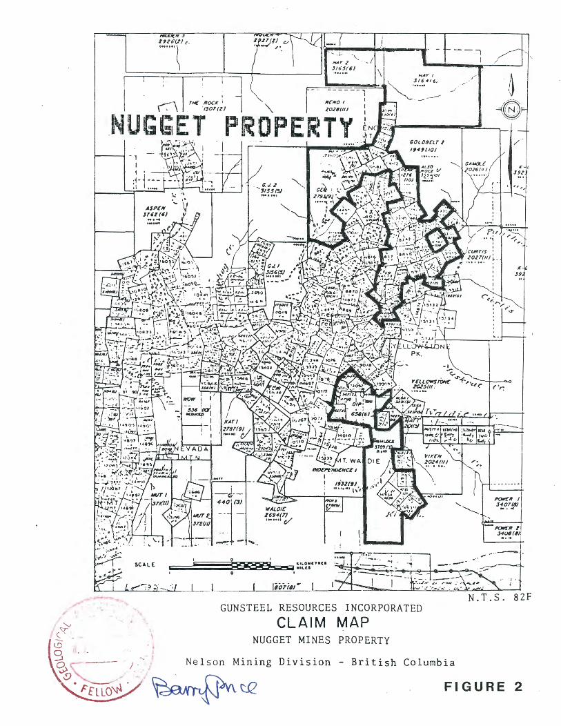
PROPERTY OWNERSHIP:
The property comprises 120 claims or units, administered in the Nelson Mining Division. Ownership is held by Nugget Mines Ltd. Gunsteel Resources Inc. has an option to earn a 50% interest in the Nugget Mines Ltd. property by making yearly option payments totalling $135,000 by December 31, 1990 and expending $2,000,000 in exploration funds by the same date. Currently $1,843,977.00 HAS been expended in exploration.
The writer has made no attempt to verify claim data in the field, but all information was checked with the Gold Commissioner's Office and corporate records of Gunsteel Resources Inc. The claims are in 3 groups.
Assessment work filed in 1987 allowed forwarding most expiry dates to 1997 or 1998, and claim expiry dates are currently as follows, (see Table 1).
HISTORY OF THE SHEEP CREEK AREA:
The discovery of the Sheep Creek gold m1n1ng camp is credited to well-known prospector Thomas Bennett, who staked the Yellowstone and Queen veins in 1896, at least 40 years after discovery of placer gold in the Pend D'Oreille River, nearby.
Considerable prospecting followed but it was not until 1904 and 1905 that major discoveries were made. Production began from the Kootenay Belle Mine between 1904 and 1911. The Nugget vein was discovered in 1905. The Motherlode Mine began production and milling at 100 tons per day in 1911. The Reno vein was not discovered until 1912. Three main mines produced about $2.5 million up to the middle of World War I, after which underground exploration and development ceased for a while. From 1922 to 1932 most activity centered on the Nugget Mine. From 1932 to 1934, an increase in the price of gold and success at the Reno Mine stimulated interest in the camp and several of the old mines were re-opened. In 1932, Gold Belt Mining Company Ltd. was formed and started exploration adjacent to the Nugget Mine, which led to the construction of a 150 ton per day mill which operated from 1938 to 1943.
In 1934, Sheep Creek Gold Mines several previously worked properties; cyanide mill from 1935 to 1950.
Total production from 1900 to 1951 (Mathews, 1953) from the following mines page:
Ltd. was formed by amalgamation of this company operated a 150 tpd.
for the camp was 741,515 ounces. and veins listed on the following
-----\ TH£ .ROCK l \ '- ·1,0T(ZJ "'
/llENO f
ZO~IJ(ll/
NUGGET PROPERTY
ASPCN JUl(6/
I
--tit/~ "·-. .......
\·
1-/A'I' I J/6 4f 6,
~OLOBEl.f ~
l,4UIOJ
---, I /
(' r.
I( (
J9l
K· .J9
-l'<MC°R I .J4()6((JJ ....
· : .
__ __..______,..__~.o.i.._==-"'--__J~-1~~~--'~--"''~o~;~~='-·~_,__~__.'--..._ _ __;:....--~~..i.c:.....::.....:.t!:.~.:....£...:..A~~__;:~-; -' N.T.S. 82F
GUNSTEEL RESOURCES INCORPORATED
CLAIM MAP NUGGET MINES PROPERTY
Nelson Mining Division British Columbia
FIGURE 2

( -4- ] TABLE 1
CLAIM DATA - NUGGET MINE PROPERTY
CROWN GRANTED CLAIMS
CLAIM LOT. NO. UNITS EXPIRY DATE ------------------------------------------------------------------- --------------------------------------------------------- ----NUGGET L.8341 1 Not Applicable. BONANZA L.8342 1 N.A. INDEPENDENCE L.8817 1 N.A. MOTHERLODE L.8818 1 N.A. GOLDEN BELLE L. 9917 1 N.A. NUGGET FR. L.10406 1 N.A. MINORU L.12073 1 N.A. GOLDEN FAWN L.12493 1 N.A. MINT L.12495 1 N.A. LATHAM L.12683 1 N.A. RENO L.12684 1 N.A. ==============================================================
Subtotal 11
* Crown-Granted claims are taxed on acreage yearly but do not require assessment work.
MODIFIED GRID CLAIMS
CLAIM REC. NO. UNITS EXPIRY DATE ----------------------------------------------------------------------------------------------------------------------------DIP PEAK GEM HAY #1 HAY #2 TROJAN
658 1276 2793 3164 3165 4100
4 2
15 20
6 16
JUN. 5, 1997 OCT. 1, 1998 SEP. 28, 1998 JUN. 6, 1998 JUN. 6, 1998 MAY 28, 1997
----------------------------------------------------------------------------------------------------------------------------Subtotal 63
2-POST CLAIMS AND FRACTIONS
CLAIM REC. NO. UNITS EXPIRY DATE --------------------------------------------------------------------------------------- -------------------------------------CEDAR FR. 657 1 MAY 25, 1997 BUCK 1225 1 SEP. 13' 1998 GLIDE 1 pending 1 FEB 25, 1989 GLIDE 2 pending 1 FEB 25, 1989 GLIDE 3 pending 1 FEB 25, 1989 GLIDE 4 pending 1 FEB 25, 1989 GLIDE 5 pending 1 FEB 25, 1989 ----------------------------------------------------------------------------------------------------------------------------
Subtotal 7 (5 NEW 1988)

[ -5- ] TABLE I (Continued)
CLAIM DATA - NUGGET MINE PROPERTY REVERTED CROWN GRANTS (INCLUDING FRACTIONS)
CLAIM REC. NO. UNITS EXPIRY DATE ============================================================== MOUNTAIN VIEW 486 1 AUG. 2' 1998 EMPRESS 487 1 AUG. 2, 1998 GOLDEN BELLE FR. 490 1 AUG. 4, 1997 CALEDONIAN FR. 491 1 AUG. 4, 1997 RIVERSIDE FR. 492 1 AUG. 4, 1997 GOLDEN EAGLE 493 1 AUG. 4, 1998 SEARCHLIGHT 494 1 AUG. 4, 1998 DONNYBROOK 495 1 AUG. 4, 1998 CLARENCE FR. 496 1 AUG. 4, 1998 CLARENCE 497 1 AUG. 4, 1998 DAISY 512 1 AUG. 25, 1997 RED ROCK 571 1 FEB. 17' 1998 GARTAN 572 1 FEB. 17' 1998 TRIUNE 573 1 FEB. 17' 1998 CEDAR FRACTION 657 1 MAY. 25, 1997 TEAPOT 771 1 AUG. 28, 1997 SNOWSTORM 965 1 FEB. 19, 1997 DOME FR. 966 1 FEB. 19' 1997 TEAPOT NO. 2 FR. 967 1 FEB. 19, 1997 SUNSHINE FR. 1259 1 SEP. 11 ' 1997 LYNX 1260 1 SEP. 11 ' 1998 UTAH 1620 1 APR. 29, 1998 LONE STAR 1621 1 APR. 29, 1998 MARIE 1622 1 APR. 29, 1998 BUCK FR. 2736 1 SEP. 10, 1998 PEAK FR. 2737 1 SEP. 28, 1998 DIP FR. 2871 1 NOV. 4, 1997 RIVERSIDE 3678 1 MAR. 28, 1997 HILLSIDE 3679 1 MAR. 28, 1997 GEM FR. 3941 1 NOV. 8, 1998 ELDORADO 4029 1 FEB. 13, 1997 VIRGINIA 4030 1 FEB. 13, 1997 LODESTONE 4031 1 FEB. 13' 1997 BEAVER 4032 1 FEB. 13, 1997 DAISY FR. 4033 1 FEB. 13' 1997 KING 4034 1 FEB. 13' 1997 KING FR. 4035 1 FEB. 13' 1997 EMPEROR 4036 1 FEB. 13' 1997 PRESIDENT 4037 1 FEB. 13' 1997 MOTHERLODE FR. 4042 1 FEB. 14, 1997 ALTURAS 4043 1 FEB. 14, 1997 KING NO. 1 4044 1 FEB. 20, 1997 MAG FR. 4053 1 APR. 15, 1997 JIG FR. 4054 1 APR. 15' 1997 SILVER BELL 4509 1 NOV. 26, 1998 KING NO 3 4561 1 FEB. 18, 1997 NUG FRACTION 4892 1 NOV. 24, 1998 STARLIGHT 4912 1 NQV. 131 1988
Subtotal 48 GRAND TOTAL ALL CATEGORIES 129 CLAIMS/UNITS.

[ -6- ] TABLE 2.
PRODUCTION FROM SHEEP CREEK GOLD CAMP
COMPANY / VEIN TONS OUNCES GOLD REC. GRADE GOLD =================================================================
SHEEP CREEK GOLD MINES LTD ORE HILL 3,500 t 2,850 oz. 0.81 oz/t 57 15,500 5,275 0.34 64 2,000 700 0.35 68 16,000 5,450 0.34 75 30,500 12,275 0.40 76 6,500 1,700 0.26 81 167,500 80,700 0.48 83 56,000 19,850 0.35 85 6,000 1'575 0.26 92 180,500 86,275 0.48 QUEEN 234,500 93,725 0.40 YELLOWSTONE 17 '000 5,600 0 .33 BONANZA NIL NIL na ALEXANDRA 3,000 540 0. 18 VANCOUVER 350 960 2.74
GOLD BELTLKOOTENAY BELLE DIXIE-6600 33,500 11,725 0.35
KOOTENAY BELLE GOLD MINES LTD. BLACK 45,000 15,475 0.34 B 32,000 9,150 0.29 A 204,000 84,300 0.41
GOLD BELT MINING COMPANY LTD 8000 59,500 17 '075 0.29 8200-COLUMBIA 41,000 10' 050 0.25 2360 47,000 11,900 0.25 2590 150 60 0.40 3040 18,000 6,650 0.37 3050 300 650 2.16 3500 47,000 18,625 0.40 3900 17 '500 5, 175 0.30
RENO GOLD MINES LTD. BLUESTONE 3,500 1,300 0.37 RENO 261,500 146,725 0.56 MOTHERLODE 108,000 51,475 0.48 NUGGET 57,500 32,250 0.56
MISCELLANEOUS SUM IT 1,500 875 0.58 FAWN 75 130 1. 73
================================================================== TOTALS 1,715,875 t 741,515 oz. 0.43 oz/t

[ -7- ] HISTORY OF THE NUGGET AND ADJACENT MINES:
The history of the Nugget Mine began with discovery of rich
ore in outcrop between 1905 and 1907. Development history is
briefly summarized below:
1906 - First shipment from the Motherlode Mine. Produced steadily to 1915.
1906 - Fawn vein staked
1907 - First shipment from the Nugget Mine
1908 - Equipped with small mill of four stamps and two Frue vanners. (Tailings loss about $5/ton (0.25 oz./ton ?).
1911 - Production ceased from the Nugget Mine, pending driving of a lower crosscut and installation of new milling facilities.
1911 - 100 ton per day mill built for Motherlode Mine.
1912 - Reno vein discovered.
1919 - The Nugget Mine was amalgamated with the Motherlode mine and workings connected. A small amount of stoping was done above the 500 level on the Nugget vein.
1922 - Production from 1907-1922 amounted to 36,665 tons of ore containing 21,409 oz. gold and 4,836 oz. silver. The Nugget mill closed November 1922, and for several years only limited exploration and development was done.
1928 - Two ore bodies outlined on the Reno property.
1929 - A 30 ton per day cyanide mill was built for the Reno mine; this operated to 1932 when it was destroyed by fire.
1932 - Reno Gold Mines Ltd. acquired the Nugget and Motherlode Mines and the Motherlode Mill was remodeled with a capacity of 100 tons per day, treating Reno ore until that mine was exhausted in 1939.
1938 - Geophysical exploration between the Nugget and Reno Mines by Hans Lundberg is credited with discovery of the Bluestone Vein, which did not outcrop. A.Endersby leased the Nugget and Motherlode veins
1939 - The Motherlode Mill was reopened to treat ore from lower levels of the Motherlode Mine and also the Bluestone Vein.

[ -8- ]
1941 - The Motherlode Mill operated mainly on ore from the Nugget Mine between the 4900 level and the older workings at higher elevation. The Mill was finally shut down late in 1941. A.Endersby purchased the Nugget, Motherlode and Reno Mines.
1951 - Total production from Nugget, Motherlode and Reno Mines was 429,667 tons of ore from which 231,932 oz. gold and 184,502 oz. silver were recovered. This accounts for a substantial proportion of the total production of 736,015 oz. gold credited to the whole camp.
1938 - 1958 - The Endersby family continued maintaining the Nugget, Motherlode and Reno Mines. Small shipments have been made to the Trail smelter with credits for gold, silver, and silica.
1970-73 - Exploration, rehabilitation and development work done by the Endersby family, financed by shipping silica flux with low grade gold values from the dumps. (About 5,000 tons)
1980-85 - Continued exploration, development and rehabilitation. In 1982, Carl Creek Resources funded geological, geophysical and geochemical surveys, some underground rehabilitation, and 1,728 feet of surface diamond drilling.
1984-85 - About 2,000 tons of silica flux was shipped to the Trail smelter from an exploration raise on the Calhoun Vein and broken muck from the stopes
1986 - Gunsteel Resources Inc. was formed to continue exploration, development and rehabilitation of the mines.
REGIONAL GEOLOGY: (Figure 3).
The Sheep Creek gold camp is situated in the "Kootenay Arc", a northerly trending arcuate structural zone involving Hadrynian (Proterozoic) to Ordovician sedimentary rocks, and unconformably overlying Mississippian to Mesozoic sedimentary and volcanic rocks. The belt is characterized by open to isoclinal north-trending folds in the oldest sedimentary roc ks which contain stratiform zinc-lead-silver deposits in Cambrian limestones and dolomites and gold deposits in quartz veins filling late cross-faults. The Kootenay Arc extends from northern Washington to well north of Revelstoke, a distance of several hundred miles.
GEOLOGY OF THE SHEEP CREEK GOLD CAMP.
The Sheep Creek gold camp occupies a portion of the Kootenay Arc in which geology is well documented by Walker (1934), and Mathews, (1953). A brief discussion of the main geological features pertinent to the gold deposits follows, largely derived from their excellent work:
Stratigraphy: (See accompanying Stratigraphic Table).
Three Sisters Formation: The oldest rocks exposed in the Sheep Creek area are grits and quartzites of the Three Sisters Formation, seen only in the core of the prominent "Eastern" or Sheep Creek Anticline. No gold-bearing veins are known in the Formation, although no underground workings cross the rock unit.
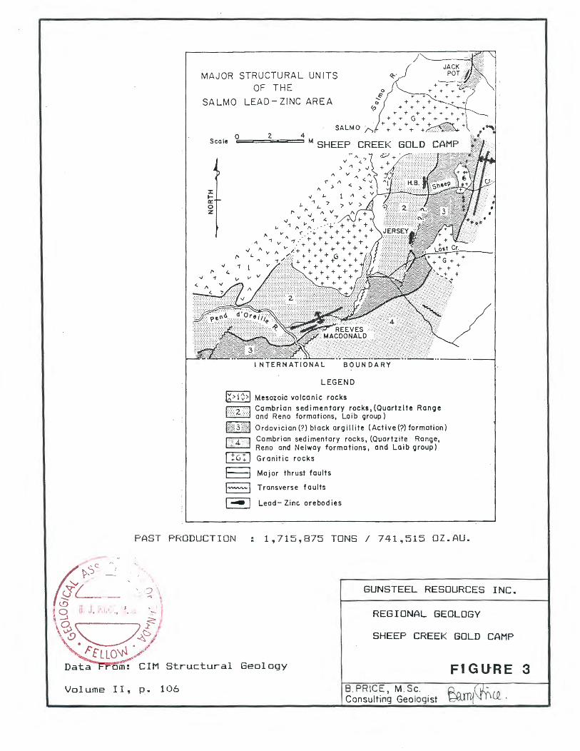
MAJOR STRUCTURAL UNITS OF THE
SALMO LEAD- ZINC AREA
BOUNDARY
LEGEND
IX> 1 >I Mesozoic volcanic rocks
J
~ Cambrian sedimentary rocks, (Quartzite Ranoe ~ and Reno formations, Laib group)
~Ordovician{?) black argillite (Active{?) formation)
IY\4 :y] ~~:br~~~ ~~~~:~n~~~~~~i~knss', (~~~rt~~ti~ 0~~~~)' lliIJ Granitic rocks
I I Major thrust faults
l"""""'-l Transverse f au Its
I~ I Lead- Zinc. orebodies
PAST PRODUCTION 1,715,875 TONS I 741,515 OZ.AU.
Structural Geology
Volume II, p. 106
GUNSTEEL RESOURCES INC.
REGIONAL GEOLOGY
SHEEP CREEK GOLD CAMP
FIGURE 3 8. PRICE, M.Sc. ~.r\vn• Consulting Geologist ~1~ (Q.

[ -9- ]
Quartzite Range Formation: This Formation, covering much of the Nugget Property area, is an economically important host for many of the veins of the Sheep Creek camp. Several members are present.
The lowest Motherlode Member, 1,000 to 1,100 feet thick, is composed mainly of massive homogeneous white quartzites with a central zone of argillite, grit and green schist, and is exposed only in the axial region of the Eastern Anticline. Relatively competent, the unit hosts ore deposits only seen in the Motherlode Mine.
The Lower Nugget Member, consisting of argillites and dark argillaceous quartzites, is 150 to 225 feet thick. The unit is incompetent, and no vein is known to contain oreshoots within it.
The Middle Nugget Member, 175 to 300 feet thick, comprises mixed quartzites, argillaceous quartzites and argillites, and is moderately competent. Generally the unit contains no quartz veins or has quartz with sub-economic gold values, (Mathews, 1953), however, a quartzite bed at the base of the unit contains a significant oreshoot in the Motherlode Mine.
The Upper Nugget Member averages 250 feet thick, and is composed mainly of massive white quartzite, the most competent structural unit in the camp, and hence an important host for gold-bearing quartz veins ( about half the production of the camp occurs in this unit).
The Lower Navada Member, contains dark, thin-bedded and argillaceous quartzites.
The Uooer Navada Member is composed of massive white quartzite, and has been a favorable host rock in a number of different mines.
Reno Formation:
The Reno Formation is argillaceous at its base, but higher in the Formation, argillaceous quartzite becomes more common, and the uppermost part contains impure quartzites and grits. In most areas, the Reno formation is incompetent, but in the Reno Mine area, contact metamorphism prior to faulting created relatively brittle spotted schists and hornfels, which i~ host to ore in two of the veins.
Laib Group:
The Cambrian Laib Group, previously described by Walker as the Pend D'Oreille Group comprises interbedded limy and argillaceous members, with a basal limestone unit. As yet, the Laib Group, comprising incompetent argillites and limestone units, is host for gold-bearing silver-lead-zinc mineralization in some areas.
INTRUSIVE ROCKS:
Within the portion of the Sheep Creek gold camp discussed i n thi s report, the most important igneous intrusive body is an ellipt i ca l granitic stock centered west of Fawn Creek and mostly north of Sheep Creek. Fine-grained granite, porphyritic granite and hornblende granodiorite phases

PROPERTY GEOLOGY
NUGGET ~MOTHERLODE ,-RENO
FIGURE
AREAS
FIGURE 4A

Leqend - on foll wing page.
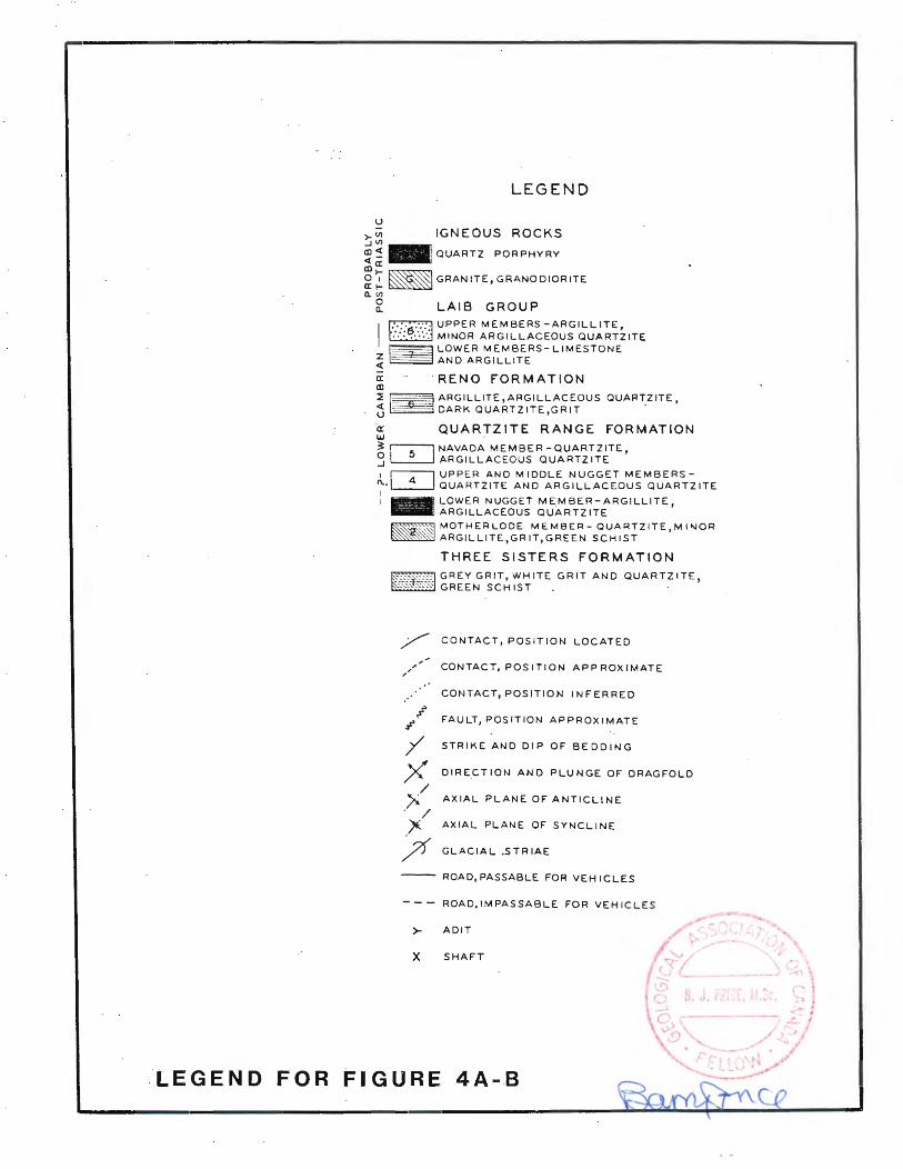
LEGEND
IGNEOUS ROCKS >- Vl _J Vl
al~ - QUARTZ PORPHYRY <t a: Q)l-mJ 0 1 GRANITE, GRANO DIOR ITE a: l-a. Vl
0 a. LAIB GROUP
I ~UPPER MEMBERS-ARGILLITE ~MINOR ARGILLACEOUS QUARTilTE ~LOWER MEMBERS-LIMESTONE ~~ANO ARGILLITE
a: RENO FORMATION Q)
~ ~ ARGILLITE ,ARGILLACEOUS QUART_ZITE, j ~DARK QUARTZITE,GRIT
a: QUARTZITE RANGE FORMATION w ~ i51 NAVADA MEMBER-QUARTZITE, 3 ~ ARGILLACEOUS QUARTZITE
1 ~UPPER ANO MIDDLE NUGGET MEMBERSC\..~ QUARTZITE ANO ARGILLACEOUS QUARTZITE I 1 - LOWER NUGGET MEMBER-ARGILLITE,
ARGILLACEOUS QUARTZITE
~ MOTHERLODE MEMBER- QUARTZITE,MlllJOR ~ ARGILLITE,GRIT,GREEN SCHIST
THREE SISTERS FORMATION
~GREY GRIT, WHITE GRIT AND QUARTZITE, ~GREEN SCHIST . ·
/ CONTACT, POSITION LOCATED
,/' CONTACT, POSITION APPROXIMATE
CONTACT, POSITION INFERRED
FAULT, POSITION APPROXIMATE
STRIKE ANO DIP OF BEDDING
DIRECTION AND PLUNGE OF DRAGFOLD
AXIAL PLANE OF ANTICLINE
AXIAL PLANE OF SYNCLINE
GLACIAL .STRIAE
ROAD, PASSABLE FOR VEHICLES
ROAO,IMPASSABLE FOR VEHICLES
r ADIT
X SHAFT
LEG E N D .F 0 R FI G U RE 4 A ... . B
, ....... l - : I
.-·:- ; _t:_ '

--·c::rcuu ccccc:iccc ccccc::iccc TH1ct<.N~ss
STRRTJGRRPHJC COLUMN
Qc::Jt:lc::IQCCC
§ § g ~ g g § 1 ) 0 (i 0 + L ~ I 8 F 0 ~: M R T I 0 N L i ffi e s t o r1 e ) ~I r 9 i 11 i t e C Ct:! 0 C Cl Q Cl cccccccc c c 0 c c:I c c:J 1:1 c:i1:1ccci::n:1c:i
bA
b8 450 I I I I 1"""7""'7"'
: : : : : ~ ~ : : : ; : : ,., i-1 1 l'. t1 : ; : : : P: : : : : : : : ; ' ~~ - Cd~
Ss 10(1-140
4s 175-3(1(1
3 15(1-22~;
! i ) 12 k ;:; ~ ; 3 7 ti -4 5 ti 1~ 1 1 1 1 ' •'•'•'
UPPER RENO Imp~re Quartzite
LOWER RENO ~rgllllte .
l.11 F'F' E~. tJR1
•11 noR n t · t ~ ~ ~ l"1 '·'~ u a r . z i . e
LOWER NEV~O~ ~rgilliteJ Quartzite
UPPER NUGGET Quartzite
MIDDLE NUGGET QuartziteJ ~rglllit~
LGWER NUGGET ~roillite, Quartzite • I
UPPER MOTHERLOOE Quartzite
2s 50 MIDDLE MOTHERLO~E ~rgillite) Sc~ist ...,...,...,..._,..,...,
!i!i!:$Ui!i: 5f1(1-m LOIJIER MOTHEF:LODE G!1..ar 1zi1 e ,_ ........ ..., ... d I 1 ,
I I I I I I I I I I I I I I I I I
:·:·:·1·:·:·:·:1 ~·d·,•,',',','J
500+ TH REE SISTERS FM Grit) sc~ists
. FIGURE 4C
A. GEOGHEGAN
(
Property boundaq
506 0 1500 E=:==;EEE~-~-(:11-lil Met res SCALE
3000" 0 3000
GUNSTEEL RESOURCES INC. - NUGGET PROPERTY
PLAN AND VERTICAL SECTIONS
Feet
SHOWING VEIN LOCATIONS FIGURE 5
- ----------------

[ -10- ]
are present. The contact with limy and argillaceous rocks of the Laib Group are sharp and relatively straight. Contact metamorphism extends 3,300 feet east and north from the intrusive margin; this is manifested as "spotted" rocks, white to grey lustrous schists, andalusite in argillaceous sediments and tremolite in calcareous sediments, garnet, and in places amphibolite.
Quartz porphyry occurs as a swarm of sills along the east limb of the Central Syncline, trending northward from Mt.Waldie through the Nugget Mine and Reno Mountain. In most areas the porphyry is extremely finely crystalline. The sills may be parallel or en echelon, or in some cases, composite, and in width the swarm may reach 150 feet. (Mathews, 1953). The sills intruded after the folding of the sediments and after the northeast vein faults, although probably before sulfide mineralization.
In addition, pre-vein basic dykes and post-vein basic dykes occur in the mine workings. Many of the post-vein dykes are lamprophyres, and are reported to be chemically similar to the Salmon River monzonite stock, 5 miles west of Mt. Waldie.
Other miscellaneous pegmatite, feldspar porphyry, hornblende porphyry and diorite porphyry dykes occur.
STRUCTURE:
The structure of the Sheep Creek camp is relatively straight forward; a major northerly-trending anticline is paralleled on the west by a smaller anticline, with an intervening tight syncline. (Mathews, 1953). The axial plane of the main (Eastern) anticline strikes north 10 to 15 degrees east and dips 55 to 80 degrees eastward. Drag folding is common on the western anticline in incompetent members.
Four well-defined sets of faults were described by Mathews; of these the northeasterly trending faults are most important, as these carry all the economic gold-bearing veins. These occur at intervals of less than 500 feet, strike from 50 to 90 degrees east, with average dip of 85 degrees south. Right lateral offset is generally 10 to 80 feet, but up to 210 feet. Veins are strongest where the vein faults have the greatest net slip, in the more competent quartzites.
Structural history appears to have been as follows:
1). Major folding. 2). Intrusion of granite. 3). Metamorphism of sediments. 4). Northeast (vein) faults and northwest faults (conjugate). 5). Development of pre-vein basic dykes before faulting ends. 6). Renewed movement on N.E.Faults. 7). Quartz introduced into vein fractures. 8). Additional movement on faults. 9). Intrusion of quartz-porphyry sills and lamprophyre dykes.
10). Flat-lying faults. 11). Normal faulting. 12). Oxidation of the upper levels of the veins

[ -11- ]
MINERALIZATION:
Vein material consists dominantly of milky white quartz with minor amounts of pyrrhotite, pyrite, sphalerite, galena, scheelite, chalcopyrite and rare visible gold. The vein quartz is in places, difficult to distinguish from enclosing quartzite, but one wall of the vein is usually well defined by a fault surface. Veins range in width from just a fracture to 1 meter or more. Laterally from a stope, a vein may become narrow, inconspicuous, and difficult to recognize. Branching veins are common in the camp; (the Reno and Nugget-Calhoun veins are good examples). En echelon veins are known in the lower Nugget workings, and may occur elsewhere on the property.
The vertical range through which the meters (4,700 feet) and individual veins meters (2,000 feet).
vein fractures occur exceeds 1400 extend to depths of up to 600
ORE CONTROLS:
Gold mineralization in the Sheep Creek Camp is concentrated in quartz veins occupying northeasterly trending, steeply-dipping faults. They are productive where they cross the axis of two anticlines, and particularly where they coincide with quartzitic members (notably the Upper Nugget and Upper Navada members and locally in the Motherlode member). Although the Reno formation is dominantly argillaceous, it carries ore in the Reno Mine where it is conspicuously metamorphosed.
On branching veins, both branches may contain ore but those with a more easterly trend tend to carry the best ore. Although the proportion of the ore to total vein material decreases with depth, the vein fissures remain strong and vein widths are reported to be as great as in higher levels. The productive vein zone appears to decrease in elevation from north to south, for reasons not yet understood.
1986-87 WORK PROGRAM:
Expenditures on exploration and underground development on the Nugget Property since July 1986 total approximately $1,843,977.00 Efforts have concentrated on the rehabilitation, exploration and development of the Nugget and Motherlode mine workings in the central part of the property (Figure 6A), which includes the Nugget and Calhoun veins, the adjacent Fawn workings, and the Motherlode workings, which are joined to the Nugget mine workings, as shown in the accompanying figures.
Work done includes rehabilitation of workings, including cross-cuts, drifts and raises, building and refurbishing dumping facilities; drifting on the Nugget, Calhoun, North Motherlode and O'Donnel veins; surface and undergound diamond drilling, surface trenching; geochemical and geophysical surveys; sampling new headings and resampling veins in older workings, review of old exploration data, and preparation of new plans and sections for many of the workings.
The extensive flow-through share explo ration program
work program placements, has been
has been funded by private placements, and government FAME grants. Goal of the
to augment the known geological reserves,

[ -12- ] develop new reserves and explore for new veins, all with a view to develop sufficient mineable ore reserves for eventual production. Individual veins and the work progress on each are described on the following pages:
VEIN DESCRIPTIONS:
A total of 23 veins are known on the Nugget Mines property, as shown in the accompanying Figure 5.
The Nugget, Calhoun, O'Donnell, Ridge, Fawn 1-4, Motherlode, North Motherlode, Golden Belle, Bonanza, Clyde and 1500 Zone veins occur in the Eastern Anticline, and the Lake, Donnybrook, Middle, Reno, Crescent and Clarence veins occur in the western anticline. The Bonanza veins are situated south of Waldie Creek, separate from all the other veins. The recent exploration and development and exploration potential for each vein are briefly discussed below:
Nugget Vein:
The Nugget vein has been the focus of considerable exploration and development work since 1986. Past production from the Nugget vein amounted to 32,250 oz of gold from 57,500 tons of material (0.56 oz/ton Au) up to December 31, 1950.
In 1986, the No.4 level portal and workings were rehabilitated and sampling, diamond drilling and drifting have continued into 1988 on the 100 and 200 sublevels, as shown on the accompanying plan and longitudinal section; (Figures 6C to 60).
Drifting on the 100 sublevel confirmed the down dip extension of the material mined previously from surface down to the No. 4 level. Face samples in 1987 on the 100 sublevel averaged 1.141 oz/ton Au. over a length of 26.2 meters (86 feet) and width of 0.88 meters (2.89 feet). Dilution to a 3.28foot, (1 meter) mining width would reduce the grade to 1.004 oz./ton. The drift has been extended, and the sampling indicates approximately 0.536 oz/ton over 63 meters.
On the 200 sublevel, 23 samples taken to May 21, 1987 had an average grade of 0.33 oz./ton over a length of 47 meters (154 feet) and width of 0.72 meters, (2.36 feet). Recent work has extended the zone to the west, and the entire length of 68 meters averages 0.281 oz/ton (undiluted).
The vein was mined previously on the 400 sublevel and below to the 500 level. Below this, the lower levels of the Nugget vein, at present inaccessible, were mined from the 6 to the 8 Level, and accessed by a cross-cut on Level 10, (also called the 4900 level, and now, in metric measure, referred to as the 1650 level).
Geological reserves calculated in 1987 by D.G.Allen, P.Eng., were 27,085 tons proven, with uncut, undiluted grade of 0.464 oz./ton, 3,600 tons probable, with 0.65 oz./ton grade, and 2,486 tons possible, with grade 0.34 oz./ton.

---
LEGEND INTRUSIVE ROCKS
Q Quartz porphyry.
Gr Granite, granod iorite.
LAIB GROUP 8 Upper members - argillite ,minor argillaceous quartzite.
7 Lower members - I imestone and arg i 11 ite.
RENO FORM AT ION 6 Argillite,argillaceous quartzite ,dark quartzite, grit.
5
4
QUARTZITE RANGE FORMATION NAVADA MEMBER -Quartzite,argillaceous quartzite . 5a lower Navada,5b upper Navada .
NUGGET MEMBERS - Quartzite,argillaceous quartzite. 4a middle Nugget, 4b upper Nugget.
3 Lower NUGGET MEMBER - Argillite ,argillaceous quartzite.
2 MOTHERLODE MEMBER - Quartzite,minor argillite,grit, green schist.
THREE SISTERS FORMATION Grey grit, white grit and quartzite, green schist.
SYMBOLS Geological contact • defined, approximate, inferred .
,,_/"..r-'_,...,,... Fault.
~ Strike and dip of bedding .
X ~ Fold axes anticline, syncline.
-::::::=- Road .
FAWN ~~ Mine work ings,vein name or number . .,.,,
~ Claim boundaries.
~ Nugget Mines Ltd. property boundary.
I 1 ~.,
~ I/

SCALE
4
LEGEND
I/' /•f''I QUARTZ PORPHYRY SILLS
12:§ LAIB GROUP
~RENO FORMATION
QUARTZITE RANGE FORMAT ION
~UPPER NAVADA
~LOWER NAVADA
~UPPER NUGGET
~MIDDLE NUGGET
CD LOWER NUGGET
~UPPER MOTHERLODE
~MIDDLE MOTHERLODE
~LOWER MOTHERLODE
1~J'o 1 :o:j THREE SISTERS FORMATION
.• ·,,.<Jc.· · ZON E O F INTENSE ARGJLLIC .o..,.. ALTERATION
x.~- FOLD AXES
"""-"""' FAULT
~MINE WORKING
GUNSTEEL AES_OUACES INC.
I ~.GET - F Av~ N I I N [ . .::. RE. ("
FIGURE 68 8.J.PRICE, M.Sc 1988

SE.
4 LEVEL
26M X 1.14 OZ/T \
I \
\ I
\
\ \
\
' \
\ \ \ \
\ \ \ \
\ \ \ \
\ \ \ \
\ \ \ \
\ \
LC
\ \ \ \
UPPER MOTHER LODE \ \
\ \
' ' \ \
OZ/T AU \
\ \
\ \
\ \ I
I \ \ 49M x 0.21 OZ/T AU
\ \ \
\ ' SUB LEVEL
\ \
\ \
\
\
\ \
\ \ \
5 LEVEL \
\ \
\
NAVA DA \
' \ \
\ \ \
7LEVEL \
\
\ \
\
LEVEL
\
' 9LE VEL\
\ ' \ \ \
IOLEVEL
Data From: G.Allen, P.Eng., June 1987.
Cross-Section: Mathews, 1951.
LEGEND
,,~ '\ \ COMPUTED NET SLIP
~STOPE
100 200 300 400 500 FEET
\ \
\ \
\ \
\ \
\ \
' \
\ \ \
\ \ \
\ LOWER \
NUGGET \ NUGGET \
1'+-2f
GUNSTEEL RESOURCES INC.
Long. Section - Nugget Vein
Assays and Reserve Areas
FIGURE 6C 8. PR IC E , M. Sc. Pv.. ~"" . ~":. Consulting Geologist ~CPJ' 1 L\ \-\ ""-L

\
\ \ \ \
\ \ \
\ "-------i,.----\ 1800 1.900 ""
!:; . oss '! 2.os" . 107 " .0.93 \ .05 1
1840
1"180
\ \ \\
\\
Z3m ><. J22 45M )( . 363.
\ \ \
-=-68t--\ x 1740
\ \ \ \
\
c::.
\ \ 1650 \
\!)
}
Ill
~ .,
\
X- CUT
\ \ \
\\ I ' 1000
O 100 300 500 mtlro s B. J. I ••
~-~
\ \
1850 \
\ \
\ ~
\ \ \
!BOO""
\
\
\
/ 7 00M
1600""
FIGURE 60
GUNSTEE.L RESOURCES IN C.
NUGGET VE IN
LONG I TUD I NAL SECT ION W ITH ASSAY I NTERVA LS
( F AC/ NG NORTH )
A f l1 r Al. Cook, m i ne 9 # 0/091sl FIGURE:
B.J.PRICE, M. Sc MAR CH 1988
[ -13- ]
A recent compilation of samp l ing results by mine staff, unde r the direction of Mine Manager, Ed.Lawrence, P. Eng. are shown in Figu re 60. From this data , the writer has estimated i n-s i t u geologic reserves, uncut, but dil uted to a 1 meter mining widt h, as 31,893 tons with an average grade of 0.384 bz . per ton gold. This reserve is contained solely in t he b~oc ks immediatel y adjacent to the newly sampled drifts.
I n-Situ rese rves for the entire Nugget vein system are esti1 ated as f ollows :
CATEGORY
TABLE 3. In-Situ Geological Reserves - Nugget Vei n
(Calculated by t he wr i te r , March 1988)
TONS GRADE (oz/ton ) OUNCES ---- -----------------------------------------------------------·------------------------------------------------------------ -----------
PROVEN PROBABLE POSSIB LE MARGINAL
TOTAL
6,802 5,438
40, 631 5,423
58,294
0. 553 0.469 0.357 0. 192
0.375
(Assumes 1.0 m. mining wi dth ) .
3 ,7 62 21550
14,505 1,041
21,858
It should be re-iterated that these figures represent ''I n-s i t u geological reserves ''; no estimate of mineable ore rese rves is made at this
·time as work is in progress to dete rmine economic cut-off grades, efurther define t he reserve figure and if possible , augment and upg rade the reserves .
Additional dr ifting to the west of the raise on 100 and 200 , and 400 sublevels is required t o further def i ne the limits of the Nugget ve in and search for additional areas which might prove economic.
Calhoun Vein:
The Calhoun ve in is an offshoot f rom the Nugget ve'n and i s accessed f rom the Nugget No. 4 evel , (renamed 1840 leve l). Past mining concent rated on the No. 2 and 3 level s ; on ly a small t onnage was produced in the past . In 1981, 274 tons mined from the 1840 leve l averaged 0.42 oz./ton gold. Sampling t o 1986 (All en, 1986) indi cated consi derabl e rese rves in this vei n; 12,870 t ons in all categories were estimated, with a grade of 0.29 oz./ton.
Drifting and sampl i ng has been compl eted on the (1840) le el on the Ca lhoun vein, which averaged 0.56 oz/ton gold over 2. 7 feet average ve in width along a 60 foot section of the ve in. Th is zone correlates with an ore zone 160 feet above (No.3 Leve l) which averages 0.38 oz. / t on gold over a length of 290 feet and average width of 2.8 feet .
Diamond drilling from the 1840 level intercepted similar grade material on the Calhoun vei n 100 feet ' below the 1840 leve l and a sub-level (400 sub-level ) 425 f eet below t he 1840 level was advanced which encountered

SW ,_~----T----13M x 0.38 OZ/T AU NE
30M X 0.25 OZ/T
\ \
\
200
\ \
\ 2NA 84
\
,, ,, ,, ,, " . ,, I I I I
400 SUB LEVEL ::= = ='= = = = ~:'.:>-.,
\ \ \
MIDDLE NUGGET
. ..
\
\
\
\ \ \
\ \
\
---------40 M X 0.56 OZ/T AU .
\
' \ \
' \
' LOWER ' UPPER \ NUGGET ' MOTHERLODE
\ \
· ~ 7 race of Nugge1 - Calhoun split .
May 1987
9,948 TONS @
3.,703 TONS @
3.,089 TONS @
0
= 0
RESERVES:
0.554 PROVEN
0.335 PROBABLE
0.250 POSSIBLE
100
300
METRES FEET
7
..
Data From: G.Allen, P.Eng., June 1987.
Cross-Section: Mathews, 1951.
. ·. . . ' . . . . . .
GUNSTEEL RESOURCES INC.
Long. Section - Calhoun Vein.
Assays and Reserve Areas
FIGURE 6E 8. PRICE, M. Sc. Consulting Geologist


0 300 600 900 1200 ~~~~.;_;;m;;;l~~~----~ FEET
I I
I
I I
I
I I
I
I I
I I
I I
I I
I
I I
I
I
I
5 I I
I I
I
\,]t..\~ /
I I
I I
I I
I
4
I I
I I
I
I I
I
I I
I
I
I I
I
I
LEGEND
I/' /'f'I QUARTZ PORPHYRY SILLS
ETI3 LAIB GROUP
~RENO FORMATION
QUARTZITE RANGE FORMATION
~UPPER NAVADA
~LOWER NAVADA
~UPPER NUGGET
CD MIDDLE NUGGET
co LOWER NUGGET
Q=:J UPPER MOTHERLODE
~MIDDLE MOTHERLODE
~LOWER MOTHERLODE
j~J'0 1:0 :J THREE SISTERS FORMATION
.. ;,.·g_"'.C!_. ;~~~Ro:Tll~~ENSE ARGILLIC
)(':;.,( FOLD AXES
"""'°""' FAULT
~MINE WORKING
GUNSTEEL RES_OURCES INC.
'Jc DE E M: 3
FIGURE 78
B.J.PRICE, M.Sc 1988

UPPER
NUGGET MIDDLE NUGGET
LOWER UPPER
MOTHER LODE -----:---
\ \ \ \
\ \
\
3 LEVEL
1, ··---~'
AREA WITH EXPLORATION
POTENTIAL
~000
10 LEVEL
100 200 300 400 soo FEET
PAST PRODUCTION 108,000 TONS @ 0.480 oz/T Au
RESERVES: 3,475 TONS @ 0.350 oz/t Au POSSIBLE
LEGEND ,45~ ~ "-.COMPUTED NET SLIP -........ --...._AXIAL PLANE OF FOLD
~STOPE l'VV'V fVV'w FA U LT
<:::::A::; Re:sart.\Je:
Data From: G.Allen, P.Eng., June 1987.
Cross-Section: Mathews, 1951.
GUNSTEEL RESOURCES INC.
Long. Section
Motherlode Vein
FIGURE 8.PRICE, M.Sc. Consulting Geologist
7C


CUT No4-
NO 1 VE\N
NO 5 TUNNE L.
\ \
FIGURE 9A

<==~~2NA c::==:;~~ 71 0 .02
0.06to oh. -0 .1 to0 .8
' \ I c:==::====:::::l
70 ~ \ \\ 1.60 c-:.(T A.., . \ ~
lVei\ material on 4u111p\ \\
\ NAVADA \ UPPER \ \\ NUGGET
RENO ' \f\
' \ =-=e 137
\ 0 .002
\ \
\ \
MIDDLE
NUGGET \ LOWER
NE
\ .· .... \\ ,-\ • '.> • 1\ I / 21m-0.42nt-O.O~oi/TAu .
• • • \ t h'' \ \ NUGGET 60001
\
\ \
\ \
: \ ·.~ '
\
Hioh or~de pod
0 .20 to 0 . 27m
\
'
\.3 \ \ .- I
._.__
AREA WITH EXPLORATION
POTENTIAL
\ \
\ \
\ \
\ \
55001
0 100
~-~=~;;~~~~~! MET RES ~ I FEET 0 300
May 1987 RESERVES: 1,923 TONS @ 0.865 oz/t Au PROVEN.
2,357 TONS@ 0.796 oz/T Au POSSIBLE
LEGEND
ST OPE
ROCK SAMPLE SITE, SAMPLE NUMBER
Data From: G.Allen, P.Eng., June 1987.
GUNSTEEL RESOURCES INC.
Long. Section - Fawn Vein
FIGURE 98 8. PRICE, M.Sc. Consulting Geologist
X- CUT
\ DDHB7-7 5~ ~ }\ ~~ · /\ ~
\ Q 3 .2 ' <0.i3 Z oz_/ T
DDHB7-5. I \ 23 ' •0.42 o z_ / t
\ A ) '-- - /
-· ~ C O t ~ n s ~ , _ • 2 - o I-' t., •
- 1~0 oz. /Li.
DDH 8 7- 11
0 08« 0 .0 3b OZ / T
DDH 8 7- 13 0
DOH 87-~ 0 1. 5 ' .. 0 .03, 0 1- / f
S CALE
\oo~1s- \ (- 1/05 J 9 3 ' • O 1'17 oz_/ t
\ \
\ \ \ B \
\ \
\ \ D D H 87- 1~~ \
\
(-32.Z) 3'•0.28 o-.. / t
- _J L---- -
5 LE V EL
··i~oo t = 500 J::.
.~ '
GUNSTEE L RESOURCES INC.
LONGITUDINA L SECTION -VEIN # I
( F AC ING NORTHWAR D )
FIGURE 9C B.J.PRICE, M.Sc 1988

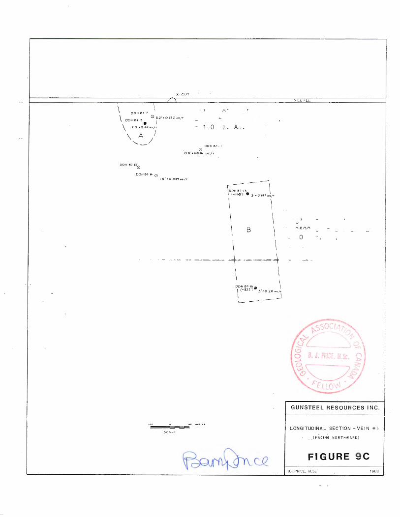
[ -H- ] An additional drillhole, DOH 87-17 encountered no significant values.
Figures 9A to 90 illustrate surface geology, undergound geology, drill hole locations and a longitudinal section of drill holes in the Fawn vein area. Considerable geological work including additional compilation, mapping, sampling, diamond drilling, and drifting is recommended for this area in 1988.
Ridge Vein :
The Ridge vein is partly exposed in a trench on the ridge between the Motherlode and Nugget veins. The trench is now filled with rubble, but pieces of vein material lying in and around the trench were sampled and found to grade 0.56 oz/ton gold. Records of Reno Gold Mines indicate that a 6 to 8 inch vein was present in this area.
No exploration was done in 1987 on the Ridge Vein; surface work and diamond drilling is planned for 1988.
Trenching, three to four surface diamond drill holes, and underground diamond drilling are recommended to test this vein where it cuts favorable quartzite horizons.
Motherlode Vein:
The Motherlode mine is situated on the north side of Sheep Creek, on the opposite side of the ridge from the Nugget Mine, and somewhat below it. Considerable mining was done, from 12 levels of underground workings on the Motherlode vein, which had been exposed for 1,500 feet on surface by pits and stripping. To 1950, 108,000 tons of ore were produced at a grade of 0.48 oz. gold per ton. Some of the stopes were very rich, with values of 1-2 ounces gold per ton common over tens of meters along the vein, roughly one meter wide.
The No portal, and
5 level cross cut intersects the vein at 690 feet from the a cross-cut 1,280 feet long extends to the Nugget mine.
Rehabilitation of the Motherlode No. 5 level has allowed access to the lower levels of the Nugget mine, and it is from this location that the cross cut is being advanced roughly 900 feet to intersect the Fawn veins. Up to the present, A relatively small amount of ore in various categories has been designated as in situ geologic reserves in the Motherlode vein; 3,162 tons of unknown grade was estimated by G.Allen, mining engineer, in 1987. A recent compilation of old data has increased the in-situ reserves, as is hown in the table on page 18.
Some additional clearing of caved areas in the Motherlode vein is necessary prior to exploration of several promising areas. One promising area between levels 5 and 8 was evaluated in 1987. Diamond drillholes UG 87-18 to 87-21 intersected numerous quartz vein zones, believed to be a number of separate "strands" of the Motherlode structure; although widths were good, assays were disappointingly low, (maximum 0.055 oz/ton).


Portal •• I I I I I I I I I I I
GOLDEN BELLE DRIFT
" ( PROJECTED) 2 . 1 m x 100 ppb .
: \ s 67-3
I 1----- /. 6 m . x 0 . 78 9rams / tonn<!
" I I ~~ m l~~~~~~~~~~~~~---,,z_~~~~~~~~~~~~~~~~~~~~~~~~:·-4~~~~~~~~~~~~~~~~~~~~~~~~~~~~~~~
15 85 m . Ele".
DDH 587-2
3rn X 0 . 261ram,./tbnne
( PROJECTED)
i I I I I I I I I I
3rn >< "')Oppb •
( PROJECTION UNCERTAIN) :
( G o l eno disscm . ) I
• I I I I I I I I I I
i I I I I I I
I I I I I I I !
I I I I I I I I I I I I I I I I I I I I I I I I I
I I I I I I I I I I I I I I
i I I I
s 67-4
I' Im. X 2 .6b 9rom5 /tonne
fl~O 45m >< 0 +I •voms/ton"e
I I I I I I I • : 134 2 m
I I I I I I
I I I I I I I I I I I I I
1.2 m x 40ppb (PROJECTION INEXACT)
153 . 2 rn .
I I I I
I I I I I I I I I I I I I I I •
I 500 0 2 5 r--_____ .......,
S CA LE
.(_Q_
1550m.
1500m.
14-SOm
FIGURE SA
GUNSTEEL RESOURCES INC.
GOLDEN BELLE DRILL HOLES
VERTICAL CROSS - SECTION ( FACING WESTWARD)
(VEINS PROJECTED TO ONE PLANE)
8. Pnce from doto by M . Wood, Mar. 1988
8.J.PRICE, M.Sc 1988
Z4 m - 0.51• - 0.5 ( 1933 M.Mlnnl
Pr1 e o.e ..... ,~,7 o., }~/(. / .O
S-'l'l'S" /.0 )W'I- o. 7
"J'1'-Z8
5'1-27 5''1-.l.6 :1"1'J9 r.o 0,060
.Y'f·]' o. 7 o.o~
.fl'~ 0.7 o,$t'f-Slf-.,..1 o.7 o. ,J •
. tt'2.f o,S" o.27" 511-2~ o. i' o.oez :1"°"'1'~ /.0 0 , t'f-Z
> ~i'J o.~ 0 . 622 )"\l"' 1.0 0.0'36
LEGEND
e ! .~) STOPE . ORE RESERVE BLOCK
e2NA 75 ROCK SAMPLE SITE, SAMPLE NUMBER
O DRILL HOLE INTERSECTION
j""c,i.'J I / . (;> '" o . o'l'S $"'tSO ., .119 5Y.Z, 0.7 O.Ol<f.
1""'.1t mvek. 0 , 07'-
5''1'2.' 0 .7 0. 1%.0 6000
1 ~y.z2. o.'- o.ooS' 5Y-Z.I 0 .¥- 0.008
o.<J 0.004
(1911 M.MlnH)
\ \ ~s~~7-3 \
PP E 'R ) s- a 7 - 4'\ NUG&ET \ " \
\ \
\
\
\
MIDDLE NUGGET
\
\ \
\ S-87-1
0 \ \
'\ '\
" '\. ssoo'
\\ \\\ \ \__ >¥",j"s:s;:;. , \ '-· --- S-)'-~:f0 o.G. O.o,,c.
'------- s.,..rt:. 1.0 o.o31'-S".,..J7 o., o. o~Z
( July I 1982)
0
M ETRE'S FEET·
GUNSTEEL RES_OURCES INC.
NUGGET MINES PROPERTY SHEEP CREEK GOLD CAMP
HELSO" '""l"G DIVISION • BRITISH COLUMBIA
LONGITUDINAL SECTION OF THE
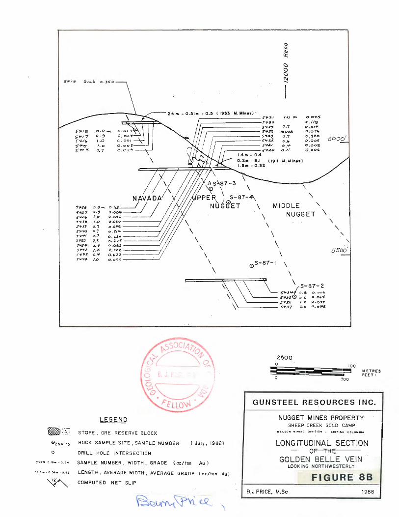
,.,.ze o.ih -0.54 SAMPLE NUMBER, WIDTH, GRADE (oz/ton Au) GOLDEN BELLE VEIN LOOKING NORTHWESTERLY
36 5• -o . 36M -o . 9z LENGTH , AVERAGE WIDTH, AVERAGE GRADE (oz/ton Au)
"-'2A y "' COMPUTED NET SLIP Fl G"URE· 88
B.J.PRICE, M.Sc 1988
\
'
'

"' \ \ \
l9, B50 N
I · 250
o s 10 .... ,,..
~-__, SCALE
.-----
.................
............. --· ................................ ________ _
....... ----------------
---
GUNSTEEL RESOURCES INC.
PLAN-NORTH MOTHERLODE DRIFTS
PROPOSED DRILL HOLES
~fl#f M Coo• , lll1tr t: ll 4 , 1988 FIGURE:
8.J.PRICE, M.Sc 1~88
FIGURE SC

[ -19- ] Trail smelter, assayed 1.3 oz./ton gold. Sampling in the upper tunnel in 1933 over an 80 foot length and 20 inch width was reported to have averaged 0.5 oz/ton gold.
The upper two adits were rehabilitated in 1982 and sampled. Results confirmed the presence of an ore shoot near the junction of two vein structures. A limited tonnage in the probable and possible categories was calculated by D.Allen in 1986.
Diamond drilling was recommended in 1987 to test the downward projection of this ore shoot. Later in the year, 4 diamond drill holes totalling 415.3 meters were completed. Figure BA shows location and orientation of the drill holes, and Figure 8B is a drill section, with the four holes projected to one plane.
TABLE 8. GOLDEN BELLE DIAMOND DRILL HOLES
Drillhole Location
S-87-1 S-87-2 S-87-3 S-87-4
G.B.Portal G.B.Portal
Azimuth
348 deg. 018 278 007
Inclination
-37 deg. -50 -41 -73
Depth.
131.4 m 153.2 71.6 59.1
================================================================== 4 Holes (1,362 ft) 415.3 m.
The two initial drillholes (S-87-1,2) were drilled from the same set up below the Motherlode Portal access road and east of the Golden Belle Portal. In 87-1, the vein was intersected from 106.2 to 107.2 meters, (1 meter wide), and assayed 2860 ppb (= 2.86 grams/tonne or 0.083 oz/ton). This intersection of near economic grade is considered very encouraging. An additional vein intersected at 111.8 meters and 0.45 meters wide assayed 410 ppb, and perhaps represents a split from the Golden Belle vein.
The second drill hole, 87-2, intersected a 3 meter section, from 54.6 meters to 57.6 meters anomalous in gold, (260 ppb gold = 0.007 oz/ton)J and a second section, from 118.6 to 121.6 meters, though mineralized with galena, a generally favorable sign, returned only 90 ppb. A third vein from 138.3 to 139.5 meters has 40 ppb gold. It is possible that poor recovery has diminished values to some extent in many of the drill holes.
Two drill holes, S-87-3 and 87-4, drilled from near the Golden Belle access portal, intersected the Golden Belle vein, but values were not overly encouraging. In S-87-3, a 2.1 meter section from 37.5 to 39.6 assayed 100 ppb. gold. In S-87-4, drilled steeply northward, intersected the vein in a strongly fractured zone with poor recovery. The interval 31.1-32.9m (1.8 meters) averaged 780 ppb gold (0.023 oz/ton).
D.Allen, (1983), inferred, from sample data from the main access level, that an oreshoot of about 5,000 tonnes (5,495 tons) grading O.~ to 0.4 ounces gold per ton could be present adjacent to a small stoped area. Samples from the vein outcrop assayed 0.185 oz/ton, 0.690 oz/ton and 0.350 oz/ton in grab samples. Muck from a caved manway several feet past the first crosscut at road level assayed 0.15 oz/ton.

[ -20- ]
From the sampling plan it appears that the reported 24 meters averaging 0.5 oz/ton in the upper working, (1933 Minister of Mines Ann. Rept.) does not exist. Of five samples taken by D.Allen in 1983, the highest assay was 0.029 oz/ton gold over 0.7 meters.
Sampling on the 5900' (1800 m) level, a section approximately 25 meters long averaged 0.21 oz/ton gold. (approx 0.147 over 1 meter). A zone interpreted to be 90 meters long by average 20 meters wide and 1 meter thick would give 4,680 tonnes (5143 tons).
If core assays are taken as exactly correct, then the possibility of an oreshoot in this position is decreased. However, poor recovery may have diminished the real grade of the intersections, and the DOH 87-4 had near economic grade (2.86 grams/tonne = 0.092 oz/ton). Strongly anomalous samples from the 5475 ft level suggest that further sampling and test raising may be warranted.
Although further drilling on the vein is warranted, larger diameter core drilling is recommended to improve recoveries and test a larger volume of the vein to reduce the "Nugget Effect", common in veins with native gold.
Clyde Vein:
The Clyde vein, situated a short distance south of the Golden Belle Vein, is accessible by two adits. Results of preliminary sampling were not encouraging, but additional sampling is warranted. The 1910 B.C. Minister of Mines Annual Report mentions gold in "payable quantities" across 24 inches of this vein, and this must be investigated by further sampling
No work was done on this prospect in 1987, it remains a target for exploration in 1988.
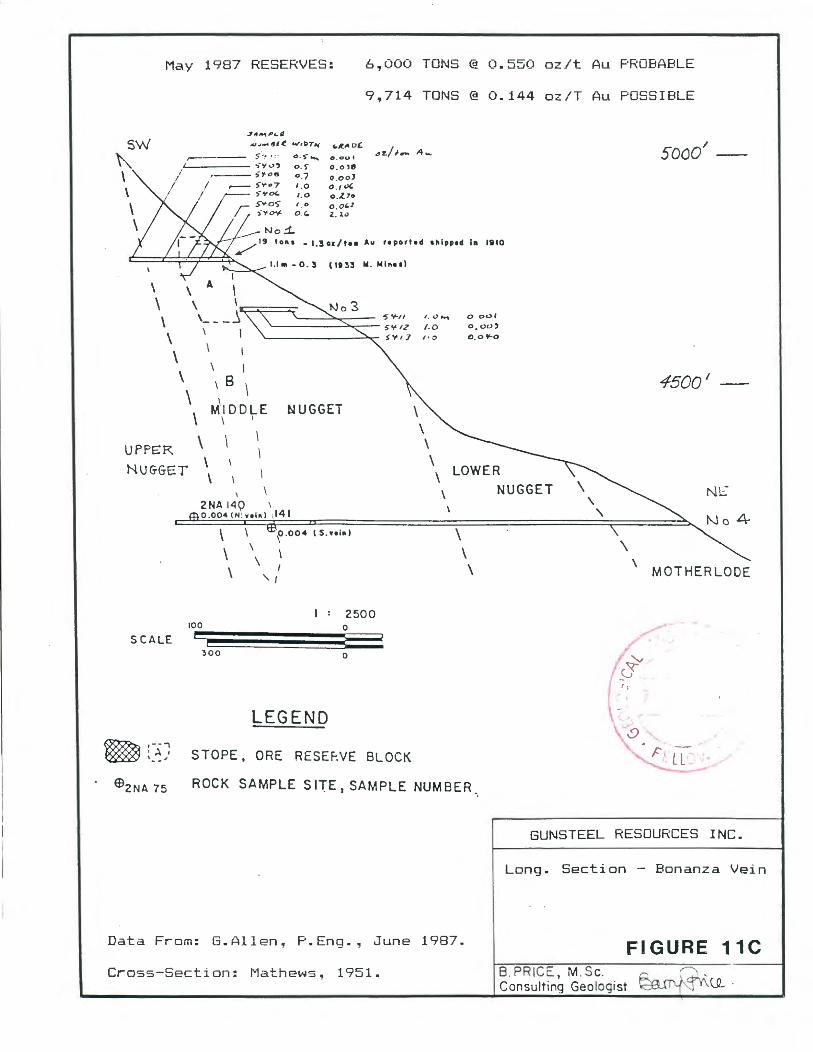
Bonanza Vein:
The Bonanza north and south veins on the southwest side of Waldie Creek, are developed by four adits, three of which are in good condition (Figures 11A to 11C). The property covers a vertical range of 2,000 feet. The drifts cut the Lower and Middle Nugget and Motherlode members only, with best values in the Middle Nugget member. The general strike of the veins are North 76 to 84 degrees east, with steep dips (up to 80 degrees) to the southeast, (B.C.Min.Mines 1933). The uppermost tunnel was caved in 1933.
It is reported that 19 tons of ore averaging 1.3 oz./ton gold was shipped from a small stope in the No. 2 Level adit in 1910, (Allen, D, 1986). Visible gold was present near the portal of this drift. The oxidized material containing the higher grade ore was 35 feet in length
Results of preliminary sampling in 1982 by D.Allen, P.Eng., and in 1987, by G.Allen, P.Eng., confirmed grades reported in previous government reports and indicate an ore shoot exists above and below the 2 level on the north vein, and extending down to and below the Main adit.

[ -21- ]
In-situ geological reserves calculated by G.Allen, P.Eng. are 6,000 tons "probable", above and below the No 2. drift, and an additional 9,714 tons probable, below the No 3 Drift, with estimated grade of 0.144 oz./ton (diluted to 1 meter mining width).
No new work was done in 1987 on the Bonanza area. Further potential is suggested at depth as the Bonanza veins are well above the elevations of the known oreshoots in the comparable part of the Western anticline. The movement along the Bonanza veins is large and because of this they can be expected to extend to considerable depth, possibly well into the productive zone as projected from the other workings to the north. Considerable potential exists for the veins in the Upper Nugget member, which has not been adequately tested by the old exploration drifts.
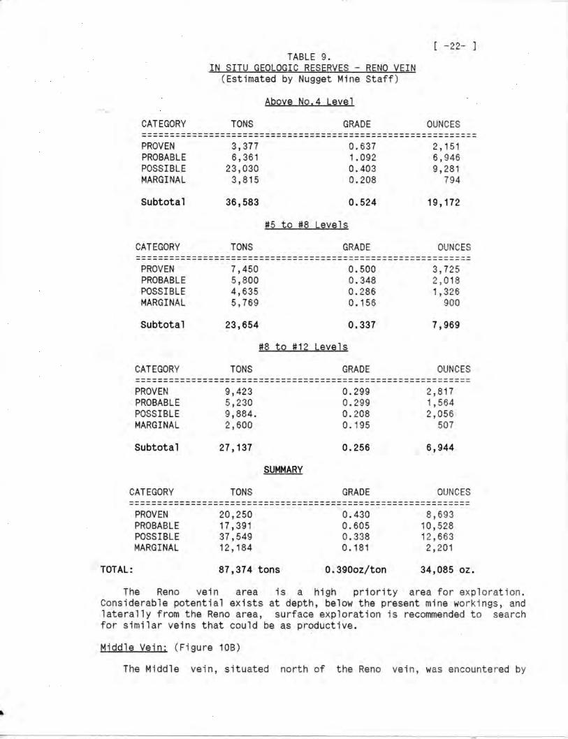
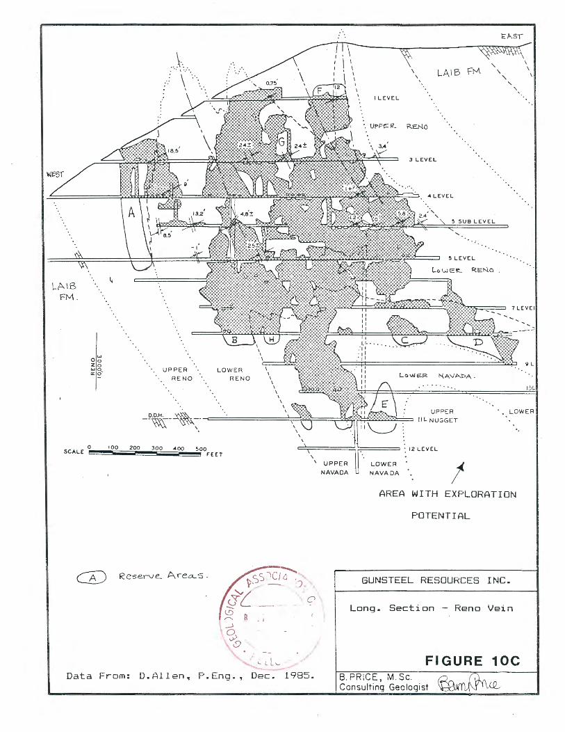
Reno Vein: (Figures 10A to 10C)
The Reno Mine is situated at the head of Fawn Creek about 6,000 feet northwest of the Nugget mine. Production began in 1929 and to 1939 produced 261,000 tons of ore grading 0.56 oz./ton gold. The main portal, the No.5 level, accessible by road, is collared in limy units of the Laib Group. One main vein is explored by 12 levels of underground workings. Host rocks are strongly hornfelsed Upper and Lower Reno and Navada members, not normally favorable host rocks.
Except for scattered blocks of low grade and relatively inaccessible ore, the Reno Mine at present has little that can be defined as "mineable reserves." although considerable in situ "geologic" reserves are present.
A review of old mine plans in 1986 by D.Allen, P.Eng., indicated that scattered areas with narrow and erratic, but high grade vein material exist above the main access (No.5) level. At that time an in-situ geologic reserve was calculated as a total of 6380 tons of material grading 0.14 oz/ton Au (Block A).
The writer, based on the same data, arrived at similar estimates; uncut, undiluted in-situ geologic reserves in three blocks, A, G, and F, between Levels 1 and 5 comprise 1,510 tons grading 0.69 oz/ton (over widths from 0.13 to 0.52 meters). Diluting this material to a 1 meter mining width would give reserves of 5,450 tons grading 0.18 oz/ton gold. Similar calculations for scattered blocks below the #5 level result in in-situ geologic reserves of 2,849 tons (uncut, undiluted), in 5 blocks, with avergae grade of 0.42 oz/ton gold. Expanded to a 1 meter mining width, reserves become 4,650 tons grading 0.26 oz/ton gold, giving a total of 10,100 tons with average grade 0.217 oz/ton gold.
A voluminous amount of assay data for stopes, stope walls and drifts has recently been reviewed by E.Lawrence, P.Eng., mine engineer. Projecting stope wall assays a maximum of 10 meters, and assigning lower grades to another ten meter adjacent block, considerable in-situ reserves ~ave been estimated as tabulated on the following page. As with other reserve estimates, the figures do not assume that the material can be mined at a profit.

I . . . .. • . • . , ' ; , . • . . , ~' . . . - . . • • • • • • • ! • • • • • • • • • • • • • • • • • • ~ ;,
GUNSTEEL RES_OUACES INC. 0 300 600 900
GtJB 011 f"-ACE JEO:...CGY
PEt\O ~·,n·:: AR'.:.:,..\
Fl GURE 108
......
......
...... ...... ...... ...... ...... ......
...... .... . . ......
...... ......
...... ·-- .. ·-----...... . . . -. ·-.!11lJl JJ.!.!!l !.!.!!!! t t t t t I -----...... ...... . . . . . .
c,, /'...., 1 QUARTZ PORPHYRY SILLS
§2§ LAIB GROUP
~RENO FORMATION
QUARTZITE: RANGE: FORMATION
~UPPER NAVAOA
~LOWER NAVA DA
~UPPER NUGGET
Q=:J MIDDLE NUGGET
G=:J LOWER NUGGET
~UPPER MOTHERLDDE
. ~MIDDLE MOTHERLODE
QJ LOWER MOTHERLODE
1::.1:·:1 THREE: SISTERS FORMATION
..• :r· ;.~~~R°.:Tll~~ENSE ARGILLIC
X.x' ~OLD AXES
~ MIN[ WORKING
..................... . • I I t t t I I t t I I t t t I I t I I t
t I t t t t t I • t I t t I I I I I I I I
t I t t I I t I t t t t I I I I t I I t t ......... . .......... ......... . ..........
·················B I I I I t • • t t t • I ' I t I • • ' ---·---................... . . . . . . . . . . . . . . . . . . ' : : : : : : : : : : : : : : : : : J ................. . . . . . . . . . . . . . . . . . I ••• e I I I I I I • I I I • I . ..... . .......... • • I I I I • I I I I I I I I I ................ : : : : : : : : : : : : : : : _-1 ............... / t t I I I f I I I t I t t e I
.............. ••••••••• • •• i ............. . . . . . . . . . . . . . . . . . . . . . . . . . ·········q t I t •• I • I I I I ...........
: : : : : : ·s : : LE V E L : RE. N o7 M' N _E __ __
~ d ~ ±1
1 1
B.J.PRICE, M.Sc
10 I I 9 I
/ / / ' 1+ I
I I I t. __../I I
LP-~.__\ I 1' I ~t.'\~ I I I
I I I . I// I I I I J I I I I
I// ,__.,,,.
' I
1988
I 0 ·.\_
v £. \ ~ O OLS~_.._, "" \
~ I v E .:.-' N _____ ,.___ ___
I
EL.6120
LA\B ~
FM.
w Oo Zo WO a:: 0-
0 100 200 SCALE
··.\.: ... .. \
\
UPPER RENO
D.D.H. ' --~- -~-
300 400 ~00
B
LOWER RENO
fEE:T
CA) Reserve.. Are~'5 ·
Data From: D.Allen, P.Eng.
~
-~
H \ \ I \
\ I \ \ \ \ \ \
\ \
I LEVEL
\ \
LAIB FM
·. UPPt: R. R.E.NO
\ 3.·• 3 LEVEL
4 LEVEL
~LEVEL
LowE~ R=::Na .
UPPER !IL NUGGET
\ \
'
7 LEVEi
9L
Jot.
LOWER
-.
~:;:::=:====:::! ::==== : 12 LEVEL \
' UPPER NAVA DA
"/ "/
LOWER NAVA DA !
AREA WITH EXPLORATION
POTENTIAL
GUNSTEEL RESOURCES INC.
Long. Section - Reno Vein
FIGURE 10C Dec. 1985. 8. PRICE, M.Sc.
Consulting Geologist

9' e I I I I I
0 300
/A
I !> / ~ I / 8 I I
: .J
/. . J~ ,l.r ,.rv I
,..rY I ~ I ~
~ /~~\ ~,~-
600
5
/ I I I I I
I I
GUNSTEEL
SLBSU
4
, EL.4200
RESOURCES I NC.
FP,CE GEOLOGY
BOt·; 1ZA v'iINE l·R:.
FIGURE 11 B 8.J.PRICE, M.Sc 1988
May 1987 RESERVES: 6.,000 TONS @ 0.550 oz/t Au PROBABLE
9.,714 TONS@ 0.144 oz/T Au POSSIBLE
,,.,.,.p._. -u.1- lfl /! W1PTlo(
5 ~ .. . ,. o.s- ..... .___ ___ .,-y..,, o.f
0.7 1 . 0 1.0
1 . 0
o_"
o . oul o.ole Q.ooJ 0 .1"' o .Z.7o 0 , 0,1 z. i"
sooo' -
/19 to11a • 1.30&/t•• Au reportad llllpped In 1110
C::===~:;=:::::;t:~~ I.I"'· 0. 3 ( 1133 N. Min .. )
\ \ \ \ \ \
\ \
UPPE:R
NUGGET
\
I
\ I
\ B \
MIDD~E \
\ \
\ ' \
I
NUGGET
2NA 14~ ' 0.004(N . v1l11) 1141
\ \ \
\
\
f .004 ( S.ni11)
I
' I
100 2500
0
SCALE
,--· I ~ I
' ... -,
'300 0
LEGEND
STOPE. ORE R£SE~VE BLOCK
\
o ool
o.oo) 0.0t'-0
LOWER NUGGET
\ \ \
4500 1
N~
4
\ \
MOTHER LODE
ROCK SAMPLE S 11E, SAMPLE NUMBER
GUNSTEEL RESOURCES INC.
Long. Section - Bonanza Vein
Data From: G.Allen., P.Eng . ., June 1987. FIGURE 11C
Cross-Section: Mathews, 1951. B. PRICE, M.Sc. Consulting Geologist

[ -23- J Reno Mines while driving a cross-cut from the Reno 4 level to the Donnybrook vein. Drifting on the vein over a length of 350 meters indicated erratic gt~ades and narrow vein widths. However, no testing has been undertaken at lower elevations, and some exploratory work on this vein is justified.
Donnvbrook Vein: (Figure 108)
The Donnybrook vein, north of the Middle vein, was explored from the surface, by dr1lling and drifting and by a raise from the 5 level of the Reno Mine. Allen (1986) reports t~at grades are interesting althougt tne vein, where intersected, is narrow (0.3 meters or less). However, additional exploration on the vein may be worthwhile, in areas of favorable host rocks.
Other Veins:
The Crescent vein is reported by O'Grady '1927) to lie 400 feet to Lhe south of the Reno vein. Stripping and trenching is reported to have revealed similar vein filling and mineralization. O'Grady reports the presence of "rich float" over a considerable area south of the Crescent vein, indicating the presence of another vein or Jeins.
References to the Lake. Clarence, 1500 vein and Golden West vein are found in Reno Gold Mines and B.C. Ministe nf Mines reports but n· data 1s available. Efforts should be made, subject to time and budget priorities to locate and explore the:~ veins on the surface.
Mine Dumps:
The Nugget Mines property grade material. Considerable the Endersby family.
has numerous waste dumps whicn contain ore dump material has been shipped previously by
The only dump for which any appreciable sampling dat3 -a _vailable is the No.4 Reno dump, which was sampled by S.Endersby, P.Eng., in 1981.
The writer reviewed sampling plans and assay results for this dump; four separate lobes are present, the largest of which is estimated by measurement and sample holes to contain 3,600 tons of siliceous material, suitable fer shipment to Trail as flux.
Grades from 14 large samples from tna la~gest lobe, sent to David Minerals Ltd. in 1981 for assa; averaged 0.179 oz/ton gold. An additional 7 samples submitted to Can-Test Laooratories averaged 0.190 oz/~on g~1d.
Grades of material in the other three lobes of the dump are less certain. Assays ·were: 0.14 oz/ton in one sample from ".;·· lobe, O.OE oz/ton and 0.94 cz/ton in two samples from "B" lobe, ana 0.26 oz/ton in one sample from "C" lobe.
Total resarve for the entire dump was estimated by S.Endersby to be 5,5EO tons. For the purpose~ of this report, the writer will use · a figure of 4,000 tons cf 0.18 oz/ton, and, because the ma~erial could be shipped at a profit, (from previous experience) 1 the material is classified a2 "Proven" reserves.
-:..4- ]
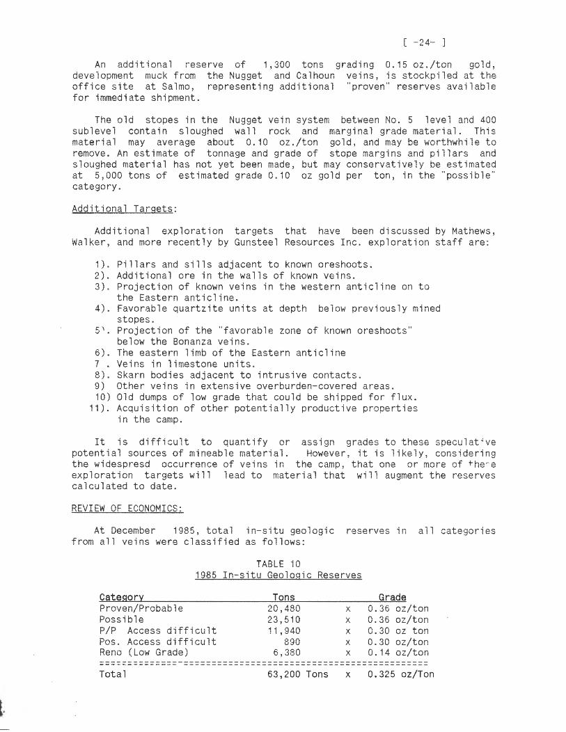
An additional reser re of 1,300 t ons grad ng 0. 15 oz . /ton gold, development m1 ck from the Nugget and Calhoun veins, is stockpiled at the o+fice site at Salmo~ representing additional "pro 1en" reserves available for immediate st ipment.
The old stopes in the Nugget 1e'n system between No. 5 level and 400 sJble ·el ccntain sloughed wall rock and marginal grade material . This material may average about 0. 10 oz./ton gold, and may be worthw~ile to remo 'e. An estim~te of tonnage and grade of stope margins and pillars and sloughed material has not yet been made, but may conservatively be estimated at 5,000 tons of estimated grade 0 . 10 oz gold per ton in the "pcs8ible" categor;.
Additional Targets:
Add' ional exploration targets that have been discussed by ~athe~~,
v 1 ~lker, and more recently uY Gunsteel Resources Inc. exploration staff are:
1). ~illars and sills adjacent to known oreshoots. 2). Additional ore in the walls of known veins. 3,. ProJection of known 1eins in the wester ant'cline on t~
the Ea~tern antisline. ~). Favorable quartzite units at depth below pre 1 'ously mined
stopes. r: '\ -.) I• PrGjection of the "~avorable zone of known oreshoot-:-"
below the Bonanza veins. 6). 7,. 0 'JI •
The easte~n limb of the Eastern anticline Veins in lime:tone units . Skar bodies adJace1t to intrusive contacts.
9) iO)
1 ) .
\,,ther veins in extensi 1e o 1erburden-cc 'ered are,,s. Old dumps of low g~ade that could be shipped for flux. Acquisition of other potentially productive properties in tte camp.
It is difficult to quantify or assign grades ta ~hese spe:ulat~ve p~tential sources of mineable material . Howe 1er, it is likely, considering the widespresd occurrence of veins in the camp, that one or more of tbe~e exp 1 or at i ori targets ·il 1 1 ead to ma ten a 1 that wi 11 augment the reser .:es calcu 1 ated to date.
REVI t' I ')F ECONOMICS:
At December 1985 total in-si~u geologi: reserves n all -~tegories
from a 1 i "ei '.ls ·ere c 1 ass if i ed a2 -o 11 ow~:
TABLE iO 1985 In-situ Geologic Reser:es
Category Tons Grade Proven/Probable 20 , 480 x 0.36 oz/ton Pcssible 23,510 " 0 . 0 6 o:/ton ,·,
P/P Access difficult 1 i 940 x 0 . 30 oz/ten Pos. .Ac::ess difficult 890 x 0.30 oz/ton Reno (Low Grade) 6,380 x 0. 14 oz/ton
Total 63,200 Tons x 0.325 oz/Ton


[ -27- ]
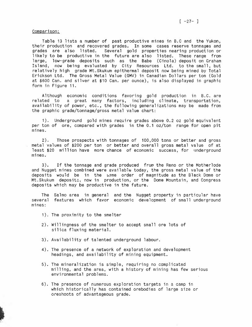
Comparison:
Table 13 lists a number of past productive mines in B.C and the Yukon, their production and recovered grades. In some cases reserve tonnages and grades are also listed. Several gold properties nearing production or likely to be productive in the future are also listed. These range from large, low-grade deposits such as the Babe (Cinola) deposit on Graham Island, now being evaluated by City Resources Ltd. to the small, but relatively high grade Mt.Skukum epithermal deposit now being mined by Total Erickson Ltd. The Gross Metal Value (GMV) in Canadian Dollars per ton (Gold at $600 Can. and silver at $10 Can. per ounce), is also displayed in graphic form in Figure 11 .
Although economic conditions favoring gold production in B.C. are related to a great many factors, including climate, transportation, availability of power, etc., the following generalizations may be made from the graphic grade/tonnage/gross metal value chart:
1). Underground gold mines require grades above 0.2 oz gold equivalent per ton of ore, compared with grades in the 0.1 oz/ton range for open pit mines.
2). Those prospects with tonnages of 100,000 tons or better and gross metal values of $200 per ton or better and overall gross metal value of at least $20 million have more chance of economic success, for 11nderground mines.
3). If the tonnage and grade produced fro~ the Reno or the Motherlode and Nugget mines combined were available today, the gross metal value of the deposits would be in the s~me order of magnitude as the Black Dome or Mt.Skukum deposit:~ now in production, or the Dome Mountain, and Congress deposits which may be productive in the future.
The several mines:
Salmo area in general features which favor
and the Nugget property in particular have economic development of small underground
1). The proximity to the smelter
2). Willingness of the smelter to accept small ore lots of silica fluxing material.
3). Availability of talented underground labour.
4). The presence of a network of exploration and development headings, and availability of mining equipment.
5). The mineralization is simple, requiring no complicated milling, and the area, with a history of mining has few serious environmental problems.
6). The presence of numerous exploration targets in a camp in which historically has contained orebodies of large size or oreshoots of advantageous grade.

NAME
TABLE TONNAGE, GRADE AND GROSS METAL VALUES
~~~~=-Y~tQ~_§Q~Q_QsEQ~lI§
RESERVES/ PRODUCTION
AU (OZ/T) AG OZ/T ( F~ECO\iERED)
GMV,./TON <CAN$)
================================================================== SURF INLET
SURF POINT + EDYE PASS
BLACI< DOME
DUSTY MAC
HORN SILVER
BANBURY GOLD
NORTHAIR
CARIBOO HUDSON
EUREKA
DORATHA MORTON
BETTER <MT.WASH)
TEL
BOB
KIM
DI SCO'-v'ERY
WILLA
BABE <Cinola)
MASCOT
1,012,060P 47,,250R
67,870R 248,600R
207,200R
58,700P
483,614P
237,241R
345,700P 65, 121R
52,000R 13,400P
20,000,oooR
10,250P 20,000R
194,?00R 41, 700R
323,940R
50,000R
1,,100,,000R
100,000R
606 .. 000R
44,000,000
8,300,000
Oa38 0.33
0 .. 30 0.26
0.79
0 .. 33
0.022
0.277
0.48 0.265
0.38 0.39
0.06
0.448 0.25
0.23 0 .. 21
0.69
1. 17
0.072
0.46
0.22
1.98 0.28
3.40 0.16
.::. .• 76
5.78
8.45
NA
2.45 0.78
.18? 0.19
N.A.
1. 04 0.50
0.99 1. 90
NA
NA
N. A ..
N.A.
0.28
$247.80 $200.80
$214.00 $157.60
$477.76
$255.80
$ 97 .. 70
$166 .. 20
$312.50 $166.80
$229.80 $235:a 9<)
$36.00
$279.20 $155 .. 00
$147,.90 $145.00
$414. (H)
$702.00
$43.20
$276.00
154. 3(Ht·
+ 1% Cu = 0.257 Au Equiv.
0.058 $34.80
0. 14 N.A. $84.00
=================================================================== Sources: Can Mines Handbook, Stockwatch, Northern Miner NOTE: Only Gold and Silver values calculated at $600 Can/Oz Au
and $10/oz. Ag respectively
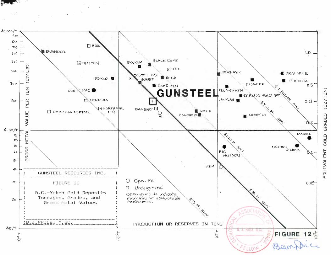
;.4 .Q, , ..
Sl1000/T ---~~~~~~~~~~~~~---~~~~~~~~~~~~~~~~~~--.~~~~~-.~~~~~~~~~~~~~~~~~~~--,
qoo
~oo
-ro-o
5oO
400
300
too
$ 100/T
Cjt>
n>
io
40
3()
I'll"" 0
, I
I
. z r.I u
z 0 1-
cr.:: LJJ 0..
w ::i _J r.:r :>
GJ Tl LL\ CtJM
81\KER •
5K\JKUM BL/\CK Oor-l'IE
• co TT IE CR).
NlJGGt=:r ENO
• DN\E M
TEE
,\.,JfLL..A
CONeREss•
• • P\ ONE.ER
lS\...ANl> !'-\TN
.(A L /:\\JYf:RS .•
•
l.O
• BRALORNE
• PREH!~R.. o.s
0.33
a. _J ~~~~~~~~~~~~~~~~~~~~~~~~~~~~~~~~~~~--------.....,;:;~--------------------------..,..~---t./\-A~SC'.:"""":'O:t.~. _, r.:r ~ I- % • w ~ E -r
f.D (J) 0 a::: r..!J
GUNSTEEL RESOURCES INC.
FIGURE 11
B.C. -Yukon Gold Deposits Tonnages, Grades~ and
Gross Metal Values
----------- - -- ---- ~- ---------- --- ------- ----- ---- ---·-
0 Op<?n Pit
D Un::lerground .
Ope1r1 -sy rnb() ls 1V'ld1cute. ma_"C! 11'"\c.J c:i r u 0+'0-\fo ro..b)z <2LOhOM\CS .
• BIG Mt~SCHJRI
•
0.6
.L~ !_J ~. E:BI ~~ ~ ___ t1~_. §G -~-----· --·------· ---- _______ ____ __ _ L
z 0 I-....... r--1 0
f.D w Q r.:r a::: (.!]
0 _J 0 r.D
1-z w _J r.:r :> H
:::J 0 w


[ -31- ] When access is gained to the old workings, several areas of interest
must be re-sampled and mapped. Some raising would be worthwhile between 4 and 5 levels to prove grades of some "geologic" reserves at the westernmost limit of the Reno workings. The main goal of working in the Reno mine must be the verification and upgrading of in-situ reserves described in this report.
Sampling:
With free gold occasionally seen in the veins, it is likely that sampling is affected by "nugget effect''. Sampling procedures which will help to alleviate this are:
1). Taking larger samples. Where practical, samples could be taken using an impact hammer or "Cut Quik" sampling saw.
2). Taking samples on a smaller spacing along drifts and raises. Probably a 1-2 meter spacing is satisfactory.
3). Taking more than one split of samples at the laboratory.
4). Checking samples for "metal 1 ics" during after crushing and pulverizing.
5). On a routine basis, samples which are marginally economic, (i.e. those in the 0.05 0.1 oz/ton range), should be re-assayed, with one or more splits.
Environmental Aspects:
Although there are currently no known aspects of the surface environment that would inhibit initiation of a mining-milling operation in the Sheep Creek area, (several large and small mines operated in the area up to the 1950's), baseline environmental studies should be started this year as part of the "in-house" feasibility study. Although much of the initial research could be done by engineering and supervisory staff of Gunsteel Resources Ltd and Nugget Mines Ltd., an environmental consultant should be contracted to supervise water sampling and to provide an environmental report to satisfy the various staged requirements of the permitting process.
A number of mines in the area are known to have a relatively high radon content in underground workings. The mine staff have been aware of this problem and have worked in conjunction with the local Mining Inspector to ensure that mine ventillation is adequate.
A two phase exploration program is recommended to evaluate targets on the Gunsteel Resources Inc. Nugget Mines property. Phase I will explore and verify known targets which have the highest possibility of becoming economically mineable reserves.
Phase II will be contingent upon results of Phase I, and will also concentrate on demonstrating economic potential of reserve blocks, but will also explore for and evaluate new targets.

L
[ -32- ]
Specific goals and recommendations as made by Gary Allen, P.Eng., Mine Engineer are as follows:
The Phase I program should include:
1. Rehabilitation of the Motherlode 4900 Level portal and crosscut. Work on this level will involve surface roadwork and some rockwork. With access to the 4900 level mapping, sampling and diamond drilling can be carried out. Access to the east cross-cut off the No. 5 level of the Motherlode Vein should be considered to provide an opportunity to check the extensions of the Calhoun vein at depth.
1. Opening up the Reno No. 5 Level, to allow geological mapping and sampling as well as diamond drilling and possibly raising, to evaluate reserve blocks outlined by the mine staff.
2. Further drifting and sampling on the 200 and 400 sublevels of the Nugget and Calhoun vein system.
3. Diamond drilling on the Nugget and Motherlode veins to test for possible underground structures such as the O'Donnell and Ridge veins.
4. Surface diamond drilling to test the Ridge vein and the Golden Belle veins.
5. Mapping surface outcrops and float and continued geochemical sampling and geophysical surveying to further define potential surface drill targets. ( Open up new ground for exploration potential).
6. Continue driving the 1650 level cross-cut to intersect the Fawn vein at depth below the reserve blocks outlined by diamond drilling.
7. Look for alternative working areas during breakup, for example the Bonanza and Reno areas. Prepare for spring breakup by hauling rock for road maintainance where needed. (Transportation is occasionally a problem when roads are soft) ..
8. Move core from the Reno area to the Office-Plant area, where it can be examined.
9. Remove hoist from the Motherlode 1460 Level.
10. Check Mine dumps at the Reno Mine for volume and Grade and Silica content.
11. Prepare orthophoto maps. Survey in hubs, workings and landmarks to a common mine grid.
12 Initiation of enviromental and vat-leach testing. Evaluate stockpiled vein material.
baseline studies, metallurgical testing, smelting costs and recoveries by shipping
13. Begin an in-house feasibility study.


r
[ -35- ] BIBLIOGRAPHY
ALLEN, D.G., (1982); Geological Report on the Nugget Mines Property, (Nugget Joint Venture), Nelson Mining Division, B.C., Private Report for Carl Creek Resources Ltd., August 1982.
ALLEN, D.G., (1985); Summary Report on the Nugget Mines Property, (Nugget Joint Venture), Nelson Mining Division, B.C., Report for Prospectus dated December, 1985.
ALLEN, GARY, (1987); Nugget Review of Work in progress. 29, 1987.
Mines Property, Nelson Mining Division, B.C., Private report to Gunsteel Resources Inc., May
ALLEN, GARY, (1987); Personal Communication.
FYLES, JAMES T., AND HEWLETT, C.G., (1959). Stratigraphy and Structure of the Salmo Lead Zinc Area. B.C.Department of Mines Bulletin No. 41.
LAWRENCE, EDWARD, (1988); Personal Communication
MATHEWS, W.H., (1953); Geology of the Sheep Creek Camp. B.C.Department of Mines Bulletin 31.
PRICE, B.J. (1987); Summary Geological report. Nugget Property. Private Report for Gunsteel Resources Ltd. dated June 1, 1987.
WALKER, J.F., (1934); Geology and Mineral Deposits of Salmo Map Area. Geological Survey of Canada, Memoir 172.
[ -36- ] CERTIFICATE
I, Barry J.Price, with business address at 3447 W.7th Avenue, Vancouver, B.C. do hereby certify that:
1) I am a Consulting Geologist registered with the Geological Association of Canada as a Fellow and I am entitled to use their seal, which has been affixed to this report. I am a member of the Canadian Institute of Mining, and the Society of Exploration Geologists.
2) I hold a B.Sc. (Honors) Degree in Geology (1965) and a M.Sc. in Geology (1972), both from the University of British Columbia., Vancouver, B.C.
3) I have practised my profession as a geologist continuously since 1965, having worked in Canada, The United States of America, Mexico, and the Republic of the Phillipines, for a number of large and small companies and consulting firms, including Manex Mining Ltd., J.R.Woodcock and Associates, Archer Cathro and Associates and P.A.Christopher and Associates.
4) I have based this report on a property inspection in December, 1986, May 1987, and March 1988, on available geological data on the property and adjacent properties and mineral deposits from the literature and internal reports provided by Gunsteel Resources Ltd., on personal consultation with mine and supervisory staff of Gunsteel Resources Inc., , and on my personal knowledge of the property and the area, accumulated since 1983.
5) I have reviewed data and calculations concerning in-situ geologic reserves with the mine staff and consider their methods and results to provide a reasonable estimate of reserves. The reserves described do not imply economic feasibility, which would have to be determined by normal engineering examination of mining and metallurgical costs.
5) I have no interest in the property described in the report nor in any m1n1ng claims within 10 kilometers of the property, and will receive only normal consulting fees for the preparation of this report.
6) I am the owner of 5,500 shares of Gunsteel Resources Ltd., purchased as an investment in 1987, prior to the request by directors of the company to write this summary report.
7) I consent to the use of this report by Gunsteel Resources Ltd. for whatever purposes they deem necessary.
Barry James Price,M.Sc.,F.G.A.C., Consulting Geologist. March 20, 1988.
[ -37- ] LETTER OF RELEASE
GUNSTEEL RESOURCES INC., 501-850 West Hastings St., Vancouver, B.C., V6C 1E1.
Gentlemen,
Rapitan Resources Inc., 3447 W.7th. Avenue, Vancouver, B.C., V6R 1W2
I, Barry James Price, M.Sc., F.G.A.C. hereby consent to the use of my geological report on the Nugget gold property in the vicinity of Sheep Creek, near Salmo, B.C., Nelson Mining Division, , dated March 20,1988 in any Filing Statement, Statement of Material Facts, or Prospectus to be issued by your company.
Dated at Vancouver, B.C. this 20th day of March 1988.
Barry James Price, M.Sc. ,F.G.A.C. Consulting Geologist March 20, 1988
Related Documents