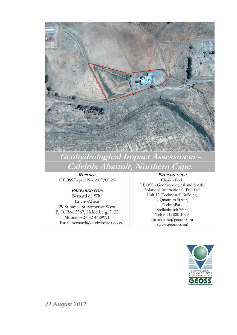
Geohydrological Impact Assessment - Calvinia Abattoir, Northern Cape. REPORT: GEOSS Report No: 2017/08-25 PREPARED FOR: Bernard de Witt EnviroAfrica 29 St James St, Somerset West P. O. Box 5367, Helderberg, 7135 Mobile: +27 82 4489991 Email:[email protected] PREPARED BY: Charles Peek GEOSS - Geohydrological and Spatial Solutions International (Pty) Ltd Unit 12, Technostell Building, 9 Quantum Street, TechnoPark Stellenbosch 7600 Tel: (021) 880-1079 Email: [email protected] (www.geoss.co.za) 21 August 2017

Welcome message from author
This document is posted to help you gain knowledge. Please leave a comment to let me know what you think about it! Share it to your friends and learn new things together.
Transcript
Geohydrological Impact Assessment - Calvinia Abattoir, Northern Cape.
REPORT: GEOSS Report No: 2017/08-25
PREPARED FOR: Bernard de Witt
EnviroAfrica 29 St James St, Somerset West
P. O. Box 5367, Helderberg, 7135 Mobile: +27 82 4489991
Email:[email protected]
PREPARED BY: Charles Peek
GEOSS - Geohydrological and Spatial Solutions International (Pty) Ltd Unit 12, Technostell Building,
9 Quantum Street, TechnoPark
Stellenbosch 7600 Tel: (021) 880-1079
Email: [email protected] (www.geoss.co.za)
21 August 2017

Geohydrological Impact Assessment - Calvinia Abattoir, Northern Cape.
i
GEOSS Report No. 2017/08-25 21 August 2017
EXECUTIVE SUMMARY Enviro Africa appointed GEOSS to complete a geohydrological impact assessment of
Calvinia Abattoir in the town of Calvinia, Northern Cape Province. The abattoir is seeking
to increase its production from 600 to 1000 sheep on site. Therefore it is required that a
geohydrological assessment of the immediate area surrounding the abattoir be carried out.
The bedrock underlying the Abattoir comprises of the Tierberg formation. The Tierberg
Shale consists of grey shales. The dolerite intrusions (Jurassic age) are subdivided into
dykes and sills within Calvinia. Dykes are vertical or near vertical dolerite intrusions and
sills are horizontal or near horizontal dolerite intrusions. The depth of the lower sills
underlying Calvinia abattoir are unknown. The site is located on a fractured aquifer with a
yield potential of 0.5 – 2 L/s. The regional groundwater quality has been classified as
moderate with an Electrical conductivity of 70 – 300 mS/m.
Calvinia receives approximately 216 mm of rainfall per year and because it receives most of
its rainfall during winter it has a Mediterranean climate. It receives the lowest rainfall in
January and the highest in June. The monthly distribution of average daily maximum
temperatures shows that the hottest time of the year in the area is during the months of
January and February. The region is the coldest during June and July.
Calvinia Abattoir encloses and stores all effluent water on site which is then transferred via
pipeline to the Waste Water Treatment Works. The groundwater is treated on site with
chlorine to disinfect. It is highly unlikely that if the abattoir expands it production from 600
to 1000 sheep, that there will be any impact on groundwater quality or groundwater users
in the area surrounding the site.
Ooooo OOO ooooO

Geohydrological Impact Assessment - Nieuwoudtville Solid Waste Site
GEOSS Report No. 2017/08-25 21 August 2017 ii
TABLE OF CONTENTS
1. INTRODUCTION ................................................................................................ 1
2. SCOPE OF WORKS AND METHODOLOGY .................................................... 1
3. BACKGROUND INFORMATION ...................................................................... 1
4. SITE GEOLOGY AND GEOHYDROLOGY ...................................................... 3 4.1 Geology ............................................................................................................................... 3
4.2 Geohydrology ..................................................................................................................... 3
5. FIELD PROCEDURE .......................................................................................... 4
6. RESULTS AND ANALYSES................................................................................ 7
7. DISCUSSION ....................................................................................................... 12 7.1 Assumptions ..................................................................................................................... 12
7.2 Gaps in knowledge .......................................................................................................... 12
7.3 Current geohydrological conditions .............................................................................. 13
8. CONCLUSION .................................................................................................... 13
9. REFERENCES .................................................................................................... 13
LIST OF TABLES Table 1: Geological setting summary. ........................................................................................... 3 Table 2: Calvinia Abattoir hydrocensus borehole details ........................................................... 4 Table 3: Classification table for specific limits .............................................................................. 7 Table 4: Production borehole results classified according the SANS241-1:2015 ................... 8 Table 5: Classification table for the surface water and groundwater results (DWAF, 1998) 9 Table 6: Classified production borehole results .......................................................................... 10
LIST OF FIGURES AND MAPS Figure 1: Average monthly rainfall Calvinia ................................................................................. 2 Figure 2: Average monthly temperature for Calvinia ................................................................. 2 Figure 3: Piper diagram of the production borehole groundwater samples .......................... 11 Figure 4: Stiff diagram of the production borehole groundwater samples............................ 12
Map 1: Location of the study area (Calvinia Abattoir) within a regional setting .................. 15 Map 2: Calvinia Abattoir with hydrocensus boreholes superimposed on a topocadastral
map. ........................................................................................................................................ 16 Map 3: Calvinia Abattoir with hydrocensus boreholes superimposed on an aerial
photograph of the area. ....................................................................................................... 17 Map 4: Geological setting of the Calvinia Abattoir (Council for Geoscience 1: 250 000
Geological Sheet, 3118 Calvinia) ........................................................................................ 18 Map 5: Aquifer type and yield of the region with hydrocensus boreholes (Department of
Water Affairs and Forestry 1: 500 000 Hydrogeological map sheets, 3117 Calvinia) 19 Map 6: Groundwater quality of the region, as indicated by EC, with hydrocensus
boreholes (Department of Water Affairs and Forestry 1: 500 000 Hydrogeological map sheets, 3117 Calvinia) .................................................................................................. 20
Map 7: Regional groundwater vulnerability (calculated according to the DRASTIC methodology) and boreholes (DWAF, 2005). .................................................................. 21
Geohydrological Impact Assessment - Nieuwoudtville Solid Waste Site
GEOSS Report No. 2017/08-25 21 August 2017 iii
ABBREVIATIONS m metres mamsl metres above mean sea level mbch metres below collar height mbgl metres below ground level mS/m milliSiemens per meter mg/l milligrams per litre WGS84 Since the 1st January 1999, the official co-ordinate system for South Africa is based on the World Geodetic System 1984 ellipsoid, commonly known as WGS84, with the ITRF91 (epoch 1994.0) co-ordinates of the Hartebeesthoek Radio Astronomy Telescope used as the origin of this system. This new system is known as the Hartebeesthoek94 Datum.
GLOSSARY OF TERMS Aquifer: a geological formation, which has structures or textures that hold water or permit
appreciable water movement through them [from National Water Act (Act No. 36 of 1998)].
Borehole: includes a well, excavation, or any other artificially constructed or improved groundwater cavity which can be used for the purpose of intercepting, collecting or storing water from an aquifer; observing or collecting data and information on water in an aquifer; or recharging an aquifer [from National Water Act (Act No. 36 of 1998)].
Fractured aquifer: This is an aquifer setting in which the groundwater occurs within fine fractures within a hard rock matrix. It is also known as a secondary aquifer.
Groundwater: water found in the subsurface in the saturated zone below the water table or piezometric surface i.e. the water table marks the upper surface of groundwater systems.
Suggested reference for this report: GEOSS (2017 Geohydrological Impact Assessment - Calvinia Abattoir, Northern Cape.
GEOSS Report Number: 2017/08-25. GEOSS - Geohydrological & Spatial Solutions International (Pty) Ltd. Stellenbosch, South Africa.
Cover photo: Site overlaid onto Google Earth image Reviewed by: J Conrad 23 August 2017 GEOSS project number:
2017_03-2015.

Geohydrological Impact Assessment – Calvinia Abattoir Site
GEOSS Report No. 2017/08-25 21 August 2017 1
1. INTRODUCTION
Enviro Africa appointed GEOSS (Geohydrological & Spatial Solutions International (Pty)
Ltd) to complete a geohydrological impact assessment of Calvinia Abattoir in the town of
Calvinia, Northern Cape Province. The abattoir is seeking to increase its production from
600 to 1000 sheep on site. Therefore it is required that a geohydrological assessment of the
immediate area surrounding the abattoir be carried out.
A site visit was completed and the findings regarding groundwater use, vulnerability and
importance are documented in this report.
2. SCOPE OF WORKS AND METHODOLOGY
The project scope of works was to complete a Geohydrological Impact Assessment of the
Abattoir Site in the town of Calvinia stating if there are groundwater issues and how they
should be managed.
The site is relatively small and therefore the geohydrological assessment was based on
existing geohydrological information and a hydrocensus in the vicinity of the abattoir. As
Calvinia depends on groundwater as a source of water and has been subject to
geohydrological investigations previously, it was expected sufficient information was
available and sourced so that site specific borehole drilling and testing was considered not
to be necessary.
As much existing geohydrological information as possible, including information from
existing reports and the National Groundwater Archive (NGA), was obtained. After
analysing the gathered data and aerial photographs, a site visit was undertaken to assess
conditions on the ground and conduct a hydrocensus within 1 km of the abattoir. The data
was then analysed in terms of the nature and extent of groundwater resources, the degree
and position of existing groundwater users and the threat posed by the landfill.
3. BACKGROUND INFORMATION
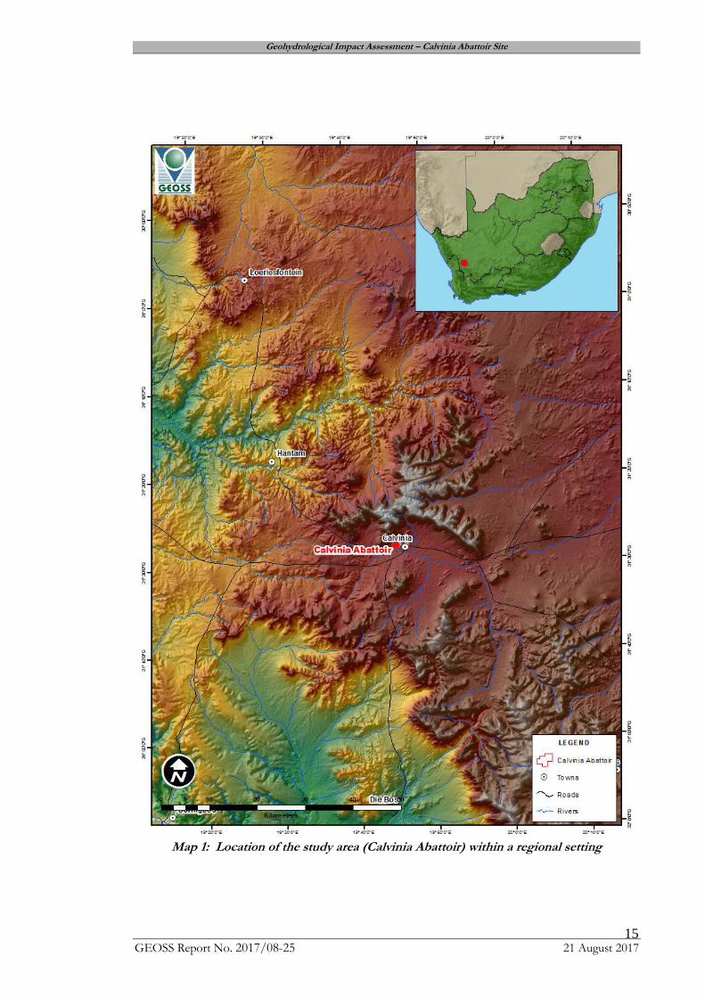
Calvinia is a small town in the Northern Cape province of South Africa, located 380 km
north-east of Cape Town in the Namakwa District (Map 1, Appendix A).
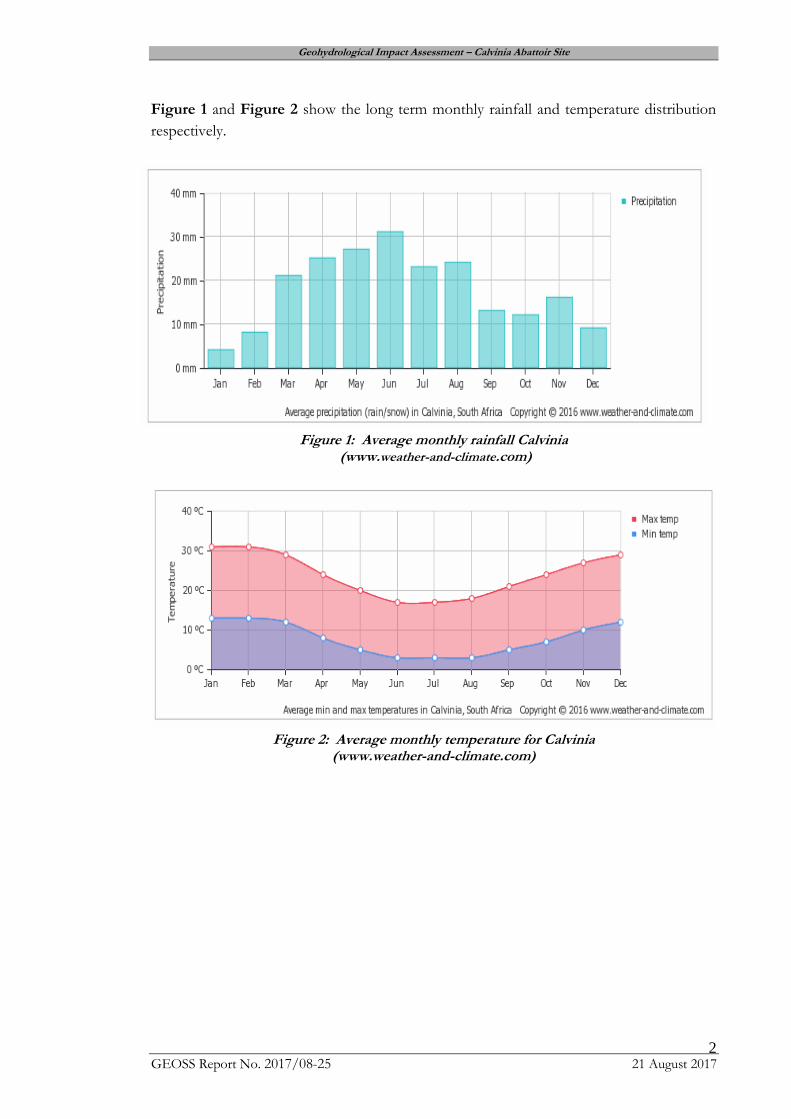
Calvinia receives approximately 216 mm of rainfall per year and because it receives most of
its rainfall during winter it has a Mediterranean climate. It receives the lowest rainfall in
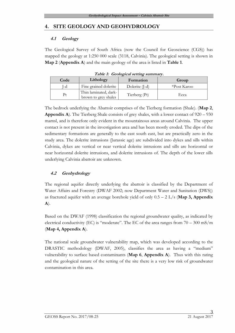
January and the highest in June. The monthly distribution of average daily maximum
temperatures shows that the hottest time of the year in the area is during the months of
January and February. The region is the coldest during June and July. The implication of
the highest rainfall occurring during the winter time of the year is that more of the rainfall
will become groundwater recharge due to the lower evaporation rates.
Geohydrological Impact Assessment – Calvinia Abattoir Site
GEOSS Report No. 2017/08-25 21 August 2017 2
Figure 1 and Figure 2 show the long term monthly rainfall and temperature distribution
respectively.
Figure 1: Average monthly rainfall Calvinia
(www.weather-and-climate.com)
Figure 2: Average monthly temperature for Calvinia
(www.weather-and-climate.com)
Geohydrological Impact Assessment – Calvinia Abattoir Site
GEOSS Report No. 2017/08-25 21 August 2017 3
4. SITE GEOLOGY AND GEOHYDROLOGY
4.1 Geology
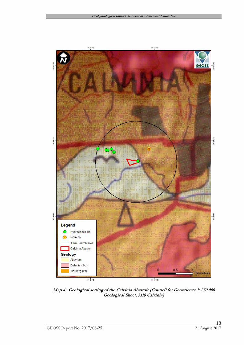
The Geological Survey of South Africa (now the Council for Geoscience (CGS)) has
mapped the geology at 1:250 000 scale (3118, Calvinia). The geological setting is shown in
Map 2 (Appendix A) and the main geology of the area is listed in Table 1.
Table 1: Geological setting summary.
Code Lithology Formation Group
J-d Fine grained dolerite Dolerite (J-d) *Post Karoo
Pt Thin laminated, dark-brown to grey shales
Tierberg (Pt) Ecca
The bedrock underlying the Abattoir comprises of the Tierberg formation (Shale). (Map 2,
Appendix A). The Tierberg Shale consists of grey shales, with a lower contact of 920 – 930
mamsl, and is therefore only evident in the mountainous areas around Calvinia. The upper
contact is not present in the investigation area and has been mostly eroded. The dips of the
sedimentary formations are generally to the east south east, but are practically zero in the
study area. The dolerite intrusions (Jurassic age) are subdivided into dykes and sills within
Calvinia, dykes are vertical or near vertical dolerite intrusions and sills are horizontal or
near horizontal dolerite intrusions, and dolerite intrusions of. The depth of the lower sills
underlying Calvinia abattoir are unknown.
4.2 Geohydrology
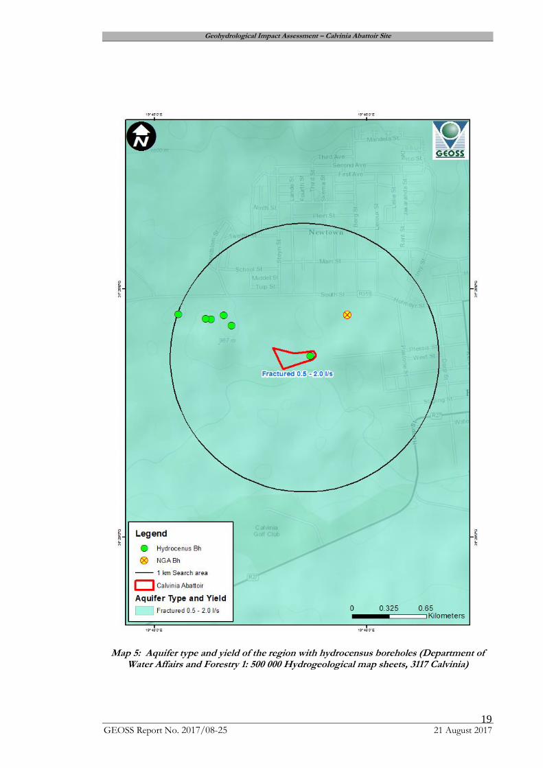
The regional aquifer directly underlying the abattoir is classified by the Department of
Water Affairs and Forestry (DWAF 2002; now Department Water and Sanitation (DWS))
as fractured aquifer with an average borehole yield of only 0.5 – 2 L/s (Map 3, Appendix
A).
Based on the DWAF (1998) classification the regional groundwater quality, as indicated by
electrical conductivity (EC) is “moderate”. The EC of the area ranges from 70 – 300 mS/m
(Map 4, Appendix A).
The national scale groundwater vulnerability map, which was developed according to the
DRASTIC methodology (DWAF, 2005), classifies the area as having a “medium”
vulnerability to surface based contaminants (Map 6, Appendix A). Thus with this rating
and the geological nature of the setting of the site there is a very low risk of groundwater
contamination in this area.
Geohydrological Impact Assessment – Calvinia Abattoir Site
GEOSS Report No. 2017/08-25 21 August 2017 4
The DRASTIC method takes into account the following factors:
D = depth to groundwater (5)
R = recharge (4)
A = aquifer media (3)
S = soil type (2)
T = topography (1)
I = impact of the vadose zone (5)
C = conductivity (hydraulic) (3)
The number indicated in parenthesis at the end of each factor description is the weighting
or relative importance at that factor.
5. FIELD PROCEDURE
As the geohydrological information mentioned above is of a very regional scale it is
important to verify this information, if possible, in the field. A site visit was completed on
19th July 2017 by Mr C. Peek of GEOSS.
There were Three NGA boreholes within the one kilometre search radius surrounding the
Abattoir site. None of the NGA sites could be located during the field visit as they do not
exist or have been destroyed.
Five additional boreholes were located in and within the 1 km search area. The boreholes
are used for domestic purposes and livestock. The borehole details are provided in Table 2
Site photographs are presented in Appendix B.
Table 2: Calvinia Abattoir hydrocensus borehole details Parameter Description
Borehole Number BH_CA_P1 (GEOSS) Production Borehole
Co-ordinates 31.46840 S
19.75577 E
975 mamsl
Borehole Depth (mbgl) ?
WL (mbgl) Covered by base plate
Comments Low yield 1000 L/hr
Water pumped into collection JoJo Tanks and used for
cleaning
Equipped with pump
Geohydrological Impact Assessment – Calvinia Abattoir Site
GEOSS Report No. 2017/08-25 21 August 2017 5
Parameter Description
Borehole Number BH_CA1(GEOSS) Abandoned Borehole
Co-ordinates 31.468661S
19.754416E
973 mamsl
Borehole Depth (mbgl) ?
WL (mbgl) 7.15
Quality EC: 365 mS/m
TDS: 2229 mg/L
pH: 7
Comments Not in use
Assumed to be an old windpump
Parameter Description
Borehole Number BH_CA_P2 (GEOSS) Newly drilled (2017)
Co-ordinates 31.46868 S
19.75409 E
973 mamsl
Borehole Depth (mbgl) ?
WL (mbgl) Covered by base plate
Comments Equipped with pump but now power supply present.
Reported as very low yielding according to property
owner
Drilled in Shale
Parameter Description
Borehole Number BH_CA2 (GEOSS) Production Borehole
Co-ordinates 31.46862 S
19.75409 E
968 mamsl
Borehole Depth (mbgl) ?
WL (mbgl) Borehole is buried underground
Quality EC: 365 mS/m
TDS: 2336 mg/L
pH: 7.5
Comments Borehole is used for cleaning the factory floors
Drinking water for livestock
Waste water is channelled into drains which feed a
storage tank
Waste water is pumped to WWTW
Geohydrological Impact Assessment – Calvinia Abattoir Site
GEOSS Report No. 2017/08-25 21 August 2017 6
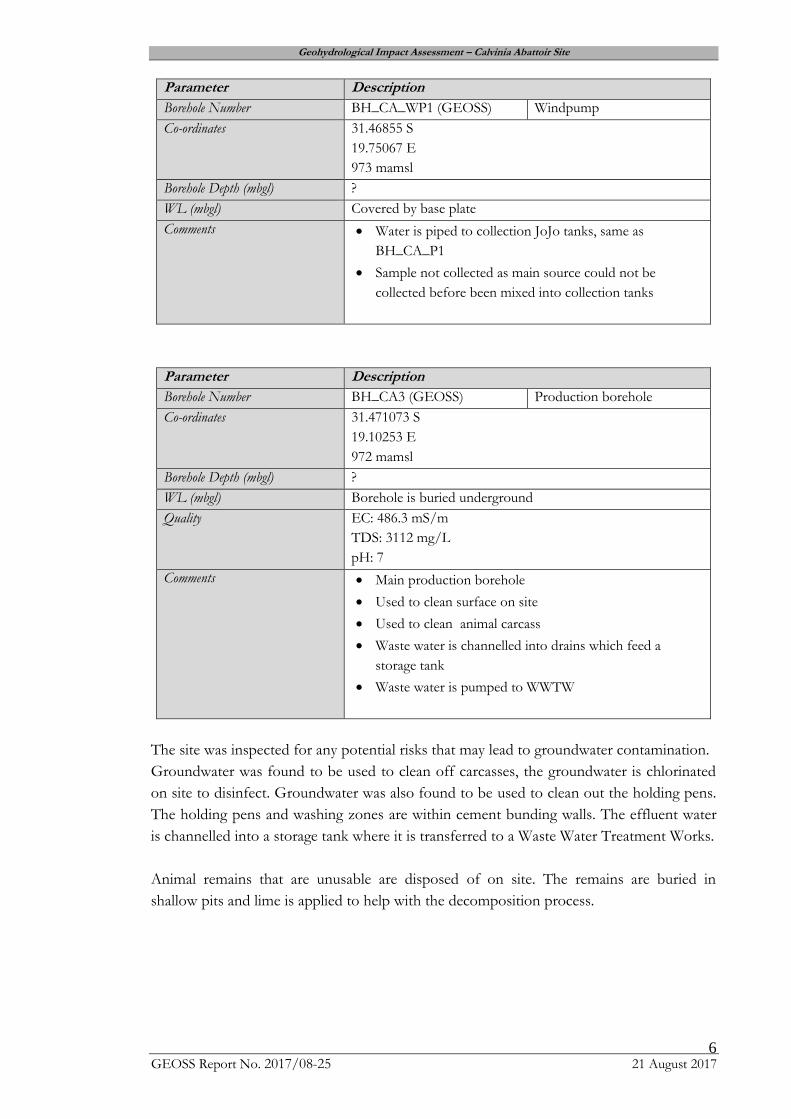
Parameter Description
Borehole Number BH_CA_WP1 (GEOSS) Windpump
Co-ordinates 31.46855 S
19.75067 E
973 mamsl
Borehole Depth (mbgl) ?
WL (mbgl) Covered by base plate
Comments Water is piped to collection JoJo tanks, same as
BH_CA_P1
Sample not collected as main source could not be
collected before been mixed into collection tanks
Parameter Description
Borehole Number BH_CA3 (GEOSS) Production borehole
Co-ordinates 31.471073 S
19.10253 E
972 mamsl
Borehole Depth (mbgl) ?
WL (mbgl) Borehole is buried underground
Quality EC: 486.3 mS/m
TDS: 3112 mg/L
pH: 7
Comments Main production borehole
Used to clean surface on site
Used to clean animal carcass
Waste water is channelled into drains which feed a
storage tank
Waste water is pumped to WWTW
The site was inspected for any potential risks that may lead to groundwater contamination.
Groundwater was found to be used to clean off carcasses, the groundwater is chlorinated
on site to disinfect. Groundwater was also found to be used to clean out the holding pens.
The holding pens and washing zones are within cement bunding walls. The effluent water
is channelled into a storage tank where it is transferred to a Waste Water Treatment Works.
Animal remains that are unusable are disposed of on site. The remains are buried in
shallow pits and lime is applied to help with the decomposition process.
Geohydrological Impact Assessment – Calvinia Abattoir Site
GEOSS Report No. 2017/08-25 21 August 2017 7
6. RESULTS AND ANALYSES
Prior to the site visit, all relevant data was obtained from the Department of Water Affairs
National Groundwater Archive (NGA). The borehole positions were plotted and there are
no NGA sites within 1 km of the landfill site. During the site visit only one hydrocensus
site was located. The borehole is however destroyed and no longer in use.
However it is important to take groundwater into consideration as the regional area is
classified as a fractured aquifer with a typical borehole range of 0.5 – 2 L/s. In addition,
the town is dependent on groundwater.
Groundwater samples were collected and submitted for inorganic chemical analysis to a
SANAS accredited laboratory (Bemlab) in the Western Cape. The certificate of analysis for
all the samples is presented in Appendix B.
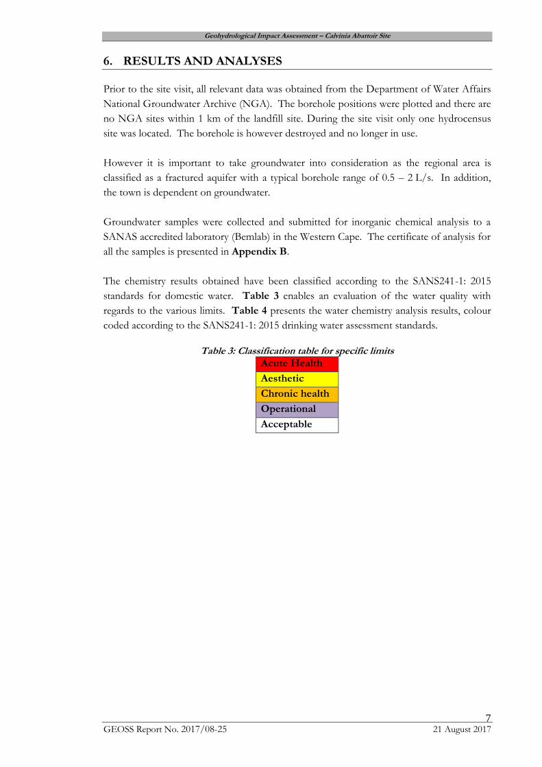
The chemistry results obtained have been classified according to the SANS241-1: 2015
standards for domestic water. Table 3 enables an evaluation of the water quality with
regards to the various limits. Table 4 presents the water chemistry analysis results, colour
coded according to the SANS241-1: 2015 drinking water assessment standards.
Table 3: Classification table for specific limits
Acute Health
Aesthetic
Chronic health
Operational
Acceptable

Geohydrological Impact Assessment – Calvinia Abattoir Site
GEOSS Report No. 2017/08-25 21 August 2017 8
Table 4: Production borehole results classified according the SANS241-1:2015
Analyses BH-CA1 BH-CA2 BH-CA3 SANS 241-1:2015
pH (at 25 ºC) 7 7,5 7 ≥5 - ≤9.7 Operational
Conductivity (mS/m) (at 25 ºC) 348,3 365 486,3 ≤170 Aesthetic
Total Dissolved Solids (mg/l) 2229 2336 3112 ≤1200 Aesthetic
Sodium (mg/l as Na) 289,4 269,6 595,1 ≤200 Aesthetic
Potassium (mg/l as K) 1,6 1,6 4,3 N/A
Magnesium (mg/l as Mg) 86,8 95,2 82,3 N/A
Calcium (mg/l as Ca) 263,4 276,6 242,2 N/A
Chloride (mg/l as Cl) 770 758,4 1440 ≤300 Aesthetic
Sulphate (mg/l as SO4) 225 272 266 ≤250 Aesthetic ≤500 Acute Health
Nitrate Nitrogen (mg/l as N) 8,7 9,2 <0,36 ≤11 Acute Health
Ammonia Nitrogen (mg/l as N) <0,28 <0,28 1,87 ≤1.5 Aesthetic
Total Alkalinity (mg/l as CaCO3) 606 513 136 N/A
Fluoride (mg/l as F) 0,8 0,7 1,4 ≤1.5 Chronic Health
Manganese (mg/l as Mn) <0,03 <0,03 0,37 ≤0.1 Aesthetic ≤0.4 Chronic Health
Iron (mg/l as Fe) 0,2 0,1 0,2 ≤0.3 Aesthetic ≤2 Chronic Health
Copper (mg/l as Cu) <0,02 <0,02 <0,02 ≤2 Chronic Health
Zinc (mg/l as Zn) 0,11 <0,03 <0,03 ≤5 Aesthetic

Geohydrological Impact Assessment – Calvinia Abattoir Site
GEOSS Report No. 2017/08-25 21 August 2017 9
The chemistry results obtained have been classified according to the DWAF (1998) standards for domestic
water. Table 5 enables an evaluation of the water quality with regards to the various parameters measured
(DWAF, 1998). Table 6 presents the water chemistry analysis results colour coded according to the
DWAF drinking water assessment standards.
Table 5: Classification table for the surface water and groundwater results (DWAF, 1998) Blue (Class 0) Ideal water quality - suitable for lifetime use.
Green (Class I) Good water quality - suitable for use, rare instances of negative effects.
Yellow (Class II) Marginal water quality - conditionally acceptable. Negative effects may occur.
Red (Class III) Poor water quality - unsuitable for use without treatment. Chronic effects may occur.
Purple (Class IV) Dangerous water quality - totally unsuitable for use. Acute effects may occur.

Geohydrological Impact Assessment – Calvinia Abattoir Site
GEOSS Report No. 2017/08-25 21 August 2017 10
Table 6: Classified production borehole results
Geohydrological Impact Assessment – Calvinia Abattoir Site
GEOSS Report No. 2017/08-25 21 August 2017 11
From the chemical results presented in Table 4 and Table 6 it is clear that the
groundwater from the boreholes is poor quality in terms of dissolved mineral
concentrations (very high dissolved mineral concentration). It is not recommended to
use the groundwater for direct human consumption without prior treatment.
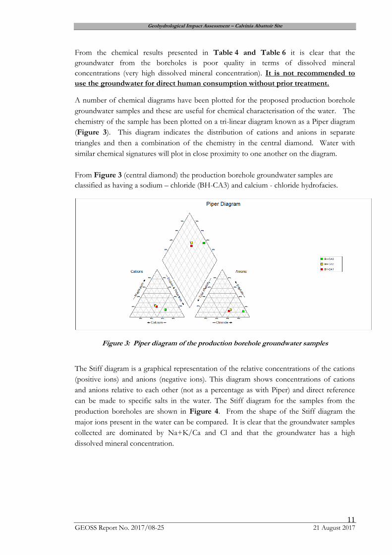
A number of chemical diagrams have been plotted for the proposed production borehole
groundwater samples and these are useful for chemical characterisation of the water. The
chemistry of the sample has been plotted on a tri-linear diagram known as a Piper diagram
(Figure 3). This diagram indicates the distribution of cations and anions in separate
triangles and then a combination of the chemistry in the central diamond. Water with
similar chemical signatures will plot in close proximity to one another on the diagram.
From Figure 3 (central diamond) the production borehole groundwater samples are
classified as having a sodium – chloride (BH-CA3) and calcium - chloride hydrofacies.
Figure 3: Piper diagram of the production borehole groundwater samples
The Stiff diagram is a graphical representation of the relative concentrations of the cations
(positive ions) and anions (negative ions). This diagram shows concentrations of cations
and anions relative to each other (not as a percentage as with Piper) and direct reference
can be made to specific salts in the water. The Stiff diagram for the samples from the
production boreholes are shown in Figure 4. From the shape of the Stiff diagram the
major ions present in the water can be compared. It is clear that the groundwater samples
collected are dominated by Na+K/Ca and Cl and that the groundwater has a high
dissolved mineral concentration.

Geohydrological Impact Assessment – Calvinia Abattoir Site
GEOSS Report No. 2017/08-25 21 August 2017 12
Figure 4: Stiff diagram of the production borehole groundwater samples
Microbiological samples were collected for three boreholes. In terms of the microbiological
analysis the groundwater had no detectable E.coli and low counts of total coliform
bacteria. The total bacteria count is elevated and above the recommended limit. It is not
uncommon for groundwater to have natural bacteria present. It can be concluded that the
source of the bacteria is not likely to be from any faecal contamination due to the low total
coliform bacteria count and the groundwater had no detectable E.coli.
7. DISCUSSION
7.1 Assumptions
No new boreholes were drilled as part of this study, so existing boreholes and maps were
used to obtain an understanding of the groundwater in the area. The geological conditions
on site were assessed and they are heterogeneous across the study area. The Calvinia
Abattoir Site is situated on rocks from the Ecca Group which is generally known to be
associated with poor groundwater conditions in terms of yield and quality.
Although the groundwater occurs in a fractured aquifer setting, it is assumed that within
this fracture network the groundwater depths and quality are relatively homogeneous at the
study site. It is assumed there is no groundwater contribution to surface water flows.
7.2 Gaps in knowledge
As this study did not include the drilling of new boreholes and pumping test on existing
borehole, the groundwater conditions and aquifer characteristics exactly at the site are not
known. The exact depth to groundwater and quality is not known beneath and immediately
adjacent to the site as the production borehole was covered and no water level could be
obtained. However, these issue do not prevent the reaching of a sound recommendation.

Geohydrological Impact Assessment – Calvinia Abattoir Site
GEOSS Report No. 2017/08-25 21 August 2017 13
7.3 Current geohydrological conditions
The nature of the geology and the relatively low rainfall and recharge rates; result in it being
highly unlikely that any surface-based contamination will reach the groundwater.
The national groundwater vulnerability index indicates that the area has a “medium”
vulnerability to surface based contaminants. Thus with this rating and the geological nature
of the setting of the site there is a very low risk of groundwater contamination in this area.
The results obtained are meaningful and enable the reaching of a high confidence
recommendation with regard to the potential impact of the landfill on the groundwater of
the area.
8. CONCLUSION
The Calvinia abattoir upgrade will not have any impact in the groundwater resources in the
area and it will not impact on the groundwater quality of the production borehole on site
or neighbouring farms. A high level of confidence is associated with this conclusion.
9. REFERENCES
DWAF, 1998. Quality of domestic water supplies, Volume 1: Assessment guide.
Department of Water Affairs and Forestry, Department of Health, Water Research
Commission, 1998.
DWAF, 2005. Groundwater Resource Assessment – Phase II (GRAII). Department of
Water Affairs and Forestry. Pretoria.
National Water Act, 1998. The National Water Act, No 36. Department of Water Affair
and Forestry. Pretoria.
Geohydrological Impact Assessment – Calvinia Abattoir Site
GEOSS Report No. 2017/08-25 21 August 2017 14
APPENDIX A: MAPS
Geohydrological Impact Assessment – Calvinia Abattoir Site
GEOSS Report No. 2017/08-25 21 August 2017 15
Map 1: Location of the study area (Calvinia Abattoir) within a regional setting

Geohydrological Impact Assessment – Calvinia Abattoir Site
GEOSS Report No. 2017/08-25 21 August 2017 16
Map 2: Calvinia Abattoir with hydrocensus boreholes superimposed on a topocadastral
map.

Geohydrological Impact Assessment – Calvinia Abattoir Site
GEOSS Report No. 2017/08-25 21 August 2017 17
Map 3: Calvinia Abattoir with hydrocensus boreholes superimposed on an aerial
photograph of the area.
Geohydrological Impact Assessment – Calvinia Abattoir Site
GEOSS Report No. 2017/08-25 21 August 2017 18
Map 4: Geological setting of the Calvinia Abattoir (Council for Geoscience 1: 250 000
Geological Sheet, 3118 Calvinia)
Geohydrological Impact Assessment – Calvinia Abattoir Site
GEOSS Report No. 2017/08-25 21 August 2017 19
Map 5: Aquifer type and yield of the region with hydrocensus boreholes (Department of
Water Affairs and Forestry 1: 500 000 Hydrogeological map sheets, 3117 Calvinia)

Geohydrological Impact Assessment – Calvinia Abattoir Site
GEOSS Report No. 2017/08-25 21 August 2017 20
Map 6: Groundwater quality of the region, as indicated by EC, with hydrocensus boreholes
(Department of Water Affairs and Forestry 1: 500 000 Hydrogeological map sheets, 3117 Calvinia)

Geohydrological Impact Assessment – Calvinia Abattoir Site
GEOSS Report No. 2017/08-25 21 August 2017 21
Map 7: Regional groundwater vulnerability (calculated according to the DRASTIC
methodology) and boreholes (DWAF, 2005).

Geohydrological Impact Assessment – Calvinia Abattoir Site
GEOSS Report No. 2017/08-25 21 August 2017 22
APPENDIX B: PHOTO GALLERY
Geohydrological Impact Assessment – Calvinia Abattoir Site
GEOSS Report No. 2017/08-25 21 August 2017 23
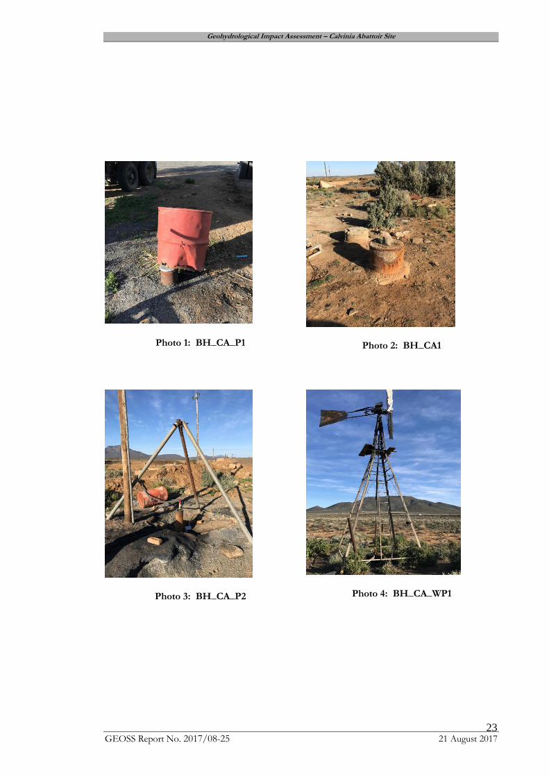
Photo 1: BH_CA_P1
Photo 2: BH_CA1
Photo 3: BH_CA_P2
Photo 4: BH_CA_WP1

Geohydrological Impact Assessment – Calvinia Abattoir Site
GEOSS Report No. 2017/08-25 21 August 2017 24
Photo 5: BH_CA2, Buried underground
Photo 6: Collection JoJo tanks
Photo 7: NGA site, no borehole
Photo 8: BH_CA3, Buried underground and
sampled at tap.
Geohydrological Impact Assessment – Calvinia Abattoir Site
GEOSS Report No. 2017/08-25 21 August 2017 25
APPENDIX C: GROUNDWATER QUALITY RESULTS

Geohydrological Impact Assessment – Calvinia Abattoir Site
GEOSS Report No. 2017/08-25 21 August 2017 26
Geohydrological Impact Assessment – Calvinia Abattoir Site
GEOSS Report No. 2017/08-25 21 August 2017 27

Geohydrological Impact Assessment – Calvinia Abattoir Site
GEOSS Report No. 2017/08-25 21 August 2017 28
Geohydrological Impact Assessment – Calvinia Abattoir Site
GEOSS Report No. 2017/08-25 21 August 2017 29
(last page)
Related Documents