Welcome message from author
This document is posted to help you gain knowledge. Please leave a comment to let me know what you think about it! Share it to your friends and learn new things together.
Transcript


The relationship between ground shear strain on the shore characteristics and abrasion at the west shore province of
Bengkulu- Indonesia
Muhammad Farid2,1, KIRBANI SRI BROTOPUSPITO2, WAHYUDI2 SUNARTO3, WIWIT SURYANTO2
1. Physics Dept., Bengkulu University, Bengkulu-Indonesia. 2. Geophysics Lab., Gadjah Mada University, Yogyakarta-Indonesia ([email protected]) 3. Physics Geographics Dept., Geographics Faculty, Gadjah Mada University,
Yogyakarta-Indonesia
Abstract
This research aims to study the characteristics of shore type with the variety of geological conditions, based on the Ground-Shear Strain (GSS) as an indicator of the rate of abrasion at the west coast of Bengkulu province, Indonesia. At each shore type, the ground motions was acquired using short period seismograph. The ratio of the horizontal to vertical spectral value (HVSR) produced the dominant frequency (fo) and peak amplitude of HVSR spectrum (A). Thus, the value of the seismic vulnerability index (Kg) can be calculated using empirical formula. The Ground-Shear Strain (GSS) was obtained by multiplying the Seismic Vulneribility Index (Kg) with Peak Ground Acceleration (α), where α is calculated by using the Kanai empirical attenuation reletionship. The results show that the GSS value at the western coast of Bengkulu province are characterized into eight types of shore, with the values ranging from GSS 1.6 x 10⁻⁴ - 78.3 x 10⁻⁴. Key words: Ground Shear Strain, Bengkulu Province, HVSR, and Abrasion.
1. Introduction
Bengkulu province is located at 101° 1' - 103° 46' E and 2° 16'- 5° 13' S directly facing the Indian Ocean with a coastline length about 525 km. The area is located at East side of Indo-Australian and the Eurasia subduction zone and thus very active seismically (Fig. 1). Based on the histirical seismicity, the province is an earthquake-prone areas, and about 95% of earthquake’s hypocenter was located under the Indian Ocean [1]. Bird (1984) divided the characteristic of shore into two types, shore and coast [2]. To define the term shore, Sullivan (2001) stated that shore is an area on the seafront, which consists of a mixture between gravel and sand when the waves are not strong enough to carry ther away [3]. Furthermore, Hantoro (2009) explain that there are two characteristics of the coast, gently sloping sandy shore and steep rocky shore [4]. In this paper, we study the shore types in Bengkulu province and classifiess the characteristics of the coast into 8 types, namely: (1) fine sandy flat shore, (2) flat rocky shore, (3) flat muddy shore, (4) coarse sandy flat shore , (5) rugged cliff shore, (6) the cliff shore alluvial clay, (7) the cliff shore tuffa clay rocks; (8) the cliff shore tufff stone sandy. Determination of the shore types was based on the type of coastal geology and morphology in the coastal region. All the eight types’s value will be used to calculate the Ground-Shear Strain (GSS) based on microseismic measurement data. Information through the GSS is the characteristic of the 8 types of coast that can be known quantitatively. The type of coast is based on the geological condition and the morphology on that beach.

Figure 1. Bengkulu province, located at east side of Indo-Australia –Eurasia subduction zone.
Basically the coastal erosion is caused by external factors, especially the strength of the waves beating against the shore. However, in this study because of coastal erosion due to internal factors, namely the seismic vulnerability of the coast which is often caused by earthquakes. The Seismic Vulnerability Index (Kg) describing the level of susceptibility of the surface soil layers to deform during earthquakes. 2. THE THEORY Seismic vulnerability index is obtained by squaring the HVSR spectrum devided by the peak value of the predominant frequency [5] and is defined as:
(1)
where the seismic vulnerability index, is index of HVSR spectral peaks and is
predominant frequency. The seismic vulnerability index is also related to geomorphological conditions. Nakamura et al (2007) in Kobe, Japan showed that the high seismic vulnerability index that in coastal areas were composed by alluvium material [6]. Gurler et al (2000) performed a study in the Mexico City and found that the high seismic vulnerability scattered in the former zone of swamps and reclaimed areas, whereas in the transition region (between the alluvial plains and hills) showed relatively low seismic vulnerability index. Furthermore, in the hill area, seismic vulnerability index showed a very low value [7]. In Intramuros, Philippines, Seita (2004) reported that the high seismic vulnerability indicated containing in the reclamation area [8]. In a study in the Marina district, San Francisco, it also found that the relationship between seismic vulnerability index with geomorphological conditions in the area [9]. The study results showed that in hilly areas it had a low seismic vulnerability index, whereas in coastal alluvium was composed of material having a high seismic vulnerability index.
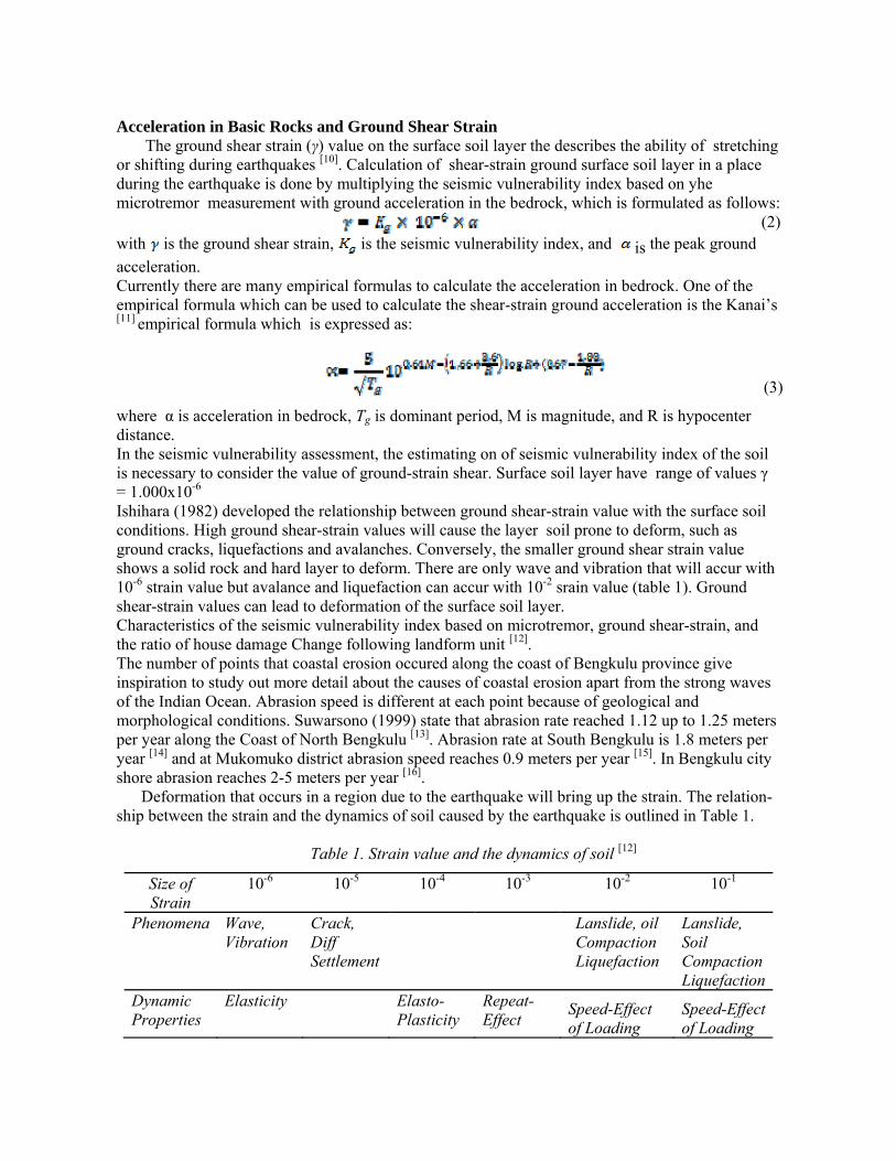
Acceleration in Basic Rocks and Ground Shear Strain The ground shear strain (γ) value on the surface soil layer the describes the ability of stretching or shifting during earthquakes [10]. Calculation of shear-strain ground surface soil layer in a place during the earthquake is done by multiplying the seismic vulnerability index based on yhe microtremor measurement with ground acceleration in the bedrock, which is formulated as follows: (2)with is the ground shear strain, is the seismic vulnerability index, and is the peak ground
acceleration. Currently there are many empirical formulas to calculate the acceleration in bedrock. One of the empirical formula which can be used to calculate the shear-strain ground acceleration is the Kanai’s [11] empirical formula which is expressed as:
(3)
where α is acceleration in bedrock, Tg is dominant period, M is magnitude, and R is hypocenter distance. In the seismic vulnerability assessment, the estimating on of seismic vulnerability index of the soil is necessary to consider the value of ground-strain shear. Surface soil layer have range of values γ = 1.000x10⁻⁶ Ishihara (1982) developed the relationship between ground shear-strain value with the surface soil conditions. High ground shear-strain values will cause the layer soil prone to deform, such as ground cracks, liquefactions and avalanches. Conversely, the smaller ground shear strain value shows a solid rock and hard layer to deform. There are only wave and vibration that will accur with 10-6 strain value but avalance and liquefaction can accur with 10-2 srain value (table 1). Ground shear-strain values can lead to deformation of the surface soil layer. Characteristics of the seismic vulnerability index based on microtremor, ground shear-strain, and the ratio of house damage Change following landform unit [12]. The number of points that coastal erosion occured along the coast of Bengkulu province give inspiration to study out more detail about the causes of coastal erosion apart from the strong waves of the Indian Ocean. Abrasion speed is different at each point because of geological and morphological conditions. Suwarsono (1999) state that abrasion rate reached 1.12 up to 1.25 meters per year along the Coast of North Bengkulu [13]. Abrasion rate at South Bengkulu is 1.8 meters per year [14] and at Mukomuko district abrasion speed reaches 0.9 meters per year [15]. In Bengkulu city shore abrasion reaches 2-5 meters per year [16]. Deformation that occurs in a region due to the earthquake will bring up the strain. The relation-ship between the strain and the dynamics of soil caused by the earthquake is outlined in Table 1.
Table 1. Strain value and the dynamics of soil [12]
Size of Strain
10-6 10-5 10-4 10-3 10-2 10-1
Phenomena Wave, Vibration
Crack, Diff Settlement
Lanslide, oil Compaction Liquefaction
Lanslide, Soil Compaction Liquefaction
Dynamic Properties
Elasticity Elasto- Plasticity
Repeat-Effect
Speed-Effect of Loading
Speed-Effect of Loading

3. DATA
Microtremor data acquisition process performed during one month from October 5 to November 4, 2011 by using the short period seismometers (velocity sensitive sensor, three components) sampling frequency 100 Hz, digitizer, solar cell panel, GPS, UPS, and laptop. The result of data aquisition is processed in the ASCII format using Datapro software. For HVSR prosess used Geopsy software. To create a map ArcGIS is used for map-making software and Surfer software for contour information.Data hasil akuisisi diproses used the ArcGIS sotware and Surfer software to make a conture.
4. Result of Research The results of microtremor data analysis using HVSR method in all types of shores produce 8 microtremor spectrum. Based on the observation of the entire microtremor spectrum on every type of shore, there was a tendency that the spectral shapes change with the type of shore. Shape of the spectrum, dominant frequency (fo), the peak of the spectrum (A), Seismic Vulnerability Index (Kg), Peak Ground Acceleration (PGA) and Ground-Shear Strain (GSS) of each type of shore can be seen in Table 2.
Table 2. Characteristics in the Coastal Region Earthquake Beach Type
Spectrum GSS Map Data Quantity
Fine Sand Beach
1
fo = 0.7 A = 1.05 Kg = 1.6 PGA = 261.4 GSS = 4.1x 10⁻⁴
Rocky beach
fo = 5.1 A = 1.55 Kg = 0.5 PGA = 352.8 GSS = 1.7x 10⁻⁴
Muddy beach
fo = 1.7 A = 3.59 Kg = 7.6 PGA = 239.2 GSS = 1.2x 10⁻³

Sandy rough beach
fo = 10.8 A = 1.78 Kg = 0.3 PGA = 723.4 GSS = 2.1x 10⁻⁴
Cliff rugged beach
fo = 12.1 A = 9.98 Kg = 1.3 PGA = 731.5 GSS =9.6x 10⁻⁴ Abrasion
Rugged coastal alluvial clay
fo = 3.0 A = 6.95 Kg = 16.1 PGA = 486.4 GSS = 7.8x 10⁻³ Abrasion
Stone clay rugged coast tuffaan
fo = 3.3 A = 3.71 Kg = 4.2 PGA = 521.0 GSS= 2.2x10⁻³ Abrasion
Stone tuff rugged coast sand
fo = 2.6 A = 2.71 Kg = 2.8 PGA = 462.7 GSS = 1.3x 10⁻³ Abrasion

The eight types of beach has different characteristics, especially in the ground shear strain value. The hard shore type has lowest result of the ground shear strain, and fine shore type has higher ground shear strain. The shore, with abrasion occur has very high ground shear strain.
5. Discussion The discussion focused on assessing the factors that influence the variation of seismic vulnerability index and the spatial distribution of seismic vulnerability index in every type of shore. That type of shore will give an idea of the seismic vulnerability, since the level of seismic vulnerability is mostly determined by the condition of coastal lithology. All factors affecting the level of seismic vulnerability in every type of shore is static because it is a factor in the origin of the shore itself. There are 8 variations of seismic vulnerability of the unit value index (Kg) for eight types of shore, which are 1.6 is for smooth sandy shore, 0.5 for rocky shore, 7.6 for muddy coast, 0.48 to coarse sandy shores, 1.31 for rugged coast, 16.1 for rugged coastal alluvial, 4.2 for the rugged rock shore tuffa clay and 2.8 for the rugged coast sandy tuffa stone.
There is a tendency that the greater Kg value the more susceptible the soil conditions at the shore. In addition, the muddy shore that is higly unstable, whereas alluvial rugged coast has the greatest vulnerability index (16.1). As shown in Table 2, the condition of this type of coast exposed to a very strong abrasion and tends to slide from the top, as well as rugged shores which are composed by volcanic sediments that have a 4.2 value, its condition is affected by the seismic vulnerability of abrasion. Seeing this condition, the higher tendency of seismic vulnerability index of a shore is the more succeptible to abrasion. And the shore tends to stabilize the condition of fine sandy shores, coarse sand and gravel.
Peak Ground Acceleration (PGA) of each shore has a value of 261.4 gal at fine sandy shores, rocky shores with 352.8 gal, 239.2 gal for muddy coast, sandy shores to rugged with 723.4 gal, 731.5 gal for the rugged coast hard, 486.4 gal for the shore alluvial rugged, 521.0 gal for the rugged coast of clay stone tuffaan 462.7 gal for the rugged coast sandy tufa stone. PGA values do not always have an impact on coastal rock deformation. It is found on the muddy shore types that have low PGA (239.2 gal), and in the hard cliff coast that have a high PGA (731.5). Calculation of the Ground-Shear Strain (GSS) on the microtremor data indicates a different value for every type of shore that is selected in this study. Fine sandy shore has a GSS value 1.4 x 10⁻⁴ . The rocky coast has a GSS value 1.7 x 10⁻⁴, muddy shore has a GSS value 8.1 x 10⁻³, the coarse sandy shore has a GSS value 2.1 x 10⁻⁴ , the tough rugged coast has a GSS value 6.9 x 10⁻⁴ , the rugged coast of alluvial type has a GSS value 7.8 x 10⁻³, the the rugged coast of tufa stone sandy has a GSS value 1.3 x 10⁻³, and the rugged coastal rock clays tufaan has GSS value 2.2 x 10⁻³. GSS value is very important to provide clear information about the shore rock stability (wheather rock is deformed or not). For fine sandy shores, rocky coastline and sandy shores have rough order of 10-4 (elasto-plastic) which is relatively stable (Table 1). For the rugged coast and alluvial mud, rugged rocks and rugged tufa stone sandy tufaan clay tends to deform with the order of 10-3 (to have an impact on the dynamic properties 'Repeat-Effect'). Shape deformation is easily affected by coastal abrasion. The harsh condition of rugged coast is still stable even though it approaching the limit of the region which will deform. The dynamics of the shore seems to provide more GSS information and is more accurate than the seismic vulnerability index and the PGA.

6. Conclusion
Based on the results of the spectral analysis of the eight types of beach, it can be sumarized as follow :
The microtremor spectrum characteristic will changes according to the type of shore, the shores exposed to abrasion conditions tend to have a lower index of seismic vulnerability, and greater ground-shear strain than a stable shore. The shore will experience the abrasion in the order of magnitude of the Ground-Strain Shear about 10-3.
7. References
[1 ] BMKG Bengkulu, 2009, Bengkulu Earthquake History from 1800 [2 ] BIRD, E. C. F. 1984. “An Introduction To Coastal Geomorphology” . Third Edition [3 ] SULLIVAN, DR. DONALD. 2001. Coastal Geological Materials . National Park Service,
Additional image courtesy of, University of Denver. [4 ] HANTORO, W.S, 2009, Effect of Marine and Coastal Characteristics
The development of the City Shore Area, Research Center for Geotechnology-LIPI Indonesia,
[5 ] NAKAMURA, Y. 2000. Clear Identification of Fundamental Idea of Nakamura’s Technique and Its Application. World Conference of Earthquake Engineering.
[6] Nakamura, Y. 2007. Development of vulnerability assessment for ground and structures using Microtremor. System and Data Research Co., Ltd.
[ 7] GURLER, E.D., NAKAMURA, Y., SAITA, J.,SATO, T. 2000. Local site effect of Mexico
City based on microtremor measurement. 6th
International Conference on Seismic Zonation, Palm Spring Riviera Resort, California, USA, pp.65.
[8] SAITA, J., BAUTISTA, M.L.P. AND NAKAMURA, Y. 2004.On Relationship Between The Estimated Strong Motion Characteristic of Surface Layer and The Earthquake Damage:
Case Study at Intramuros, Metro Manila-. 13th
World Conference on Earthquake Engineering, Paper No. 905, Vancouver, B.C., Canada.
[9] NAKAMURA, Y. 2008. On The H/V Spectrum. The 14th World Conference on Earthquake Engineering, Beijing, China.
[10] KANAI, K. (1951). “Relation Between the Nature of Surface Layer and the Amplitude of Earthquake Motions,” Bulletin Tokyo Earthquake Research Institute.
[11] ISHIHARA, K. 1982. Introduction to Dynamic Soil Mechanism. Japan. [12] DARYONO, 2011, Seismic Vulnerability Index Based Mikrotremor Each unit on
landforms in Bantul Graben Zone Special Region Yogyakarta, Dissertation, Graduate School of Geography University of Gadjah Mada University in Yogyakarta
[13] SUWARSONO dan Junaidi F, 1999, Sea wave energy swash as the basis Determination of Abrasion speed, Thesis Prodi Unib Physics.
[14] Junaidi F, 2000, Abrasion Market Conditions Under the South Bengkulu city Manna, Bachelor Thesis Unib Physics.
[15] OKTARIA R, 2008. Bachelor Thesis Department of Physics University of Bengkulu in 2008
[16] KESUMAJAYA E, 2006, Sedimentation and Erosion Studies Gulf Coast Segara Bengkulu District, Thesis Faculty of Civil Engineering and Planning ITB.


Related Documents