GEOGRAPHY REVISION GUIDE GRADE 12

Welcome message from author
This document is posted to help you gain knowledge. Please leave a comment to let me know what you think about it! Share it to your friends and learn new things together.
Transcript

GEOGRAPHY
REVISION
GUIDE
GRADE 12

Geography Revision Guide Gr 12/2018
2
Module 1 Climate & Weather

Geography Revision Guide Gr 12/2018
3
1. Mid-latitude Cyclones
Origin:
o Polar front (60 N/S)
o Cold polar easterlies meet warm westerlies and move parallel but do not mix.
Alternate names:
o Extra tropical cyclone
o frontal depression
o temperate cyclone
General characteristics:
o Forms between 30-60 N/S
o Moves eastward
o Has two fronts (warm and cold)
o Large diameter
o Lasts between 4-14 days
o Steered by westerlies
o Affects SA in winter
Conditions for formation:
o Frictional drag caused by difference in temperature and speed of the two air masses.
o Air masses must move opposite to each other and parallel.
o Warm subtropical air must meet cold polar air at the polar front.
Stages in formation:
o Initial:
• Cold polar air and warm tropical air move parallel to each other but in opposite directions
at the polar front.
o Wave formation:
• Frictional drag takes place.
• Warm air becomes uplifted.
• Fronts begin to form as air converges to the centre low pressure.
o Mature:
• Wave deepens.
• Cold and warm sectors and fronts fully developed.
• Warm air moves up steep pressure gradient of cold front to form towering cumulonimbus
clouds. (heavy rain over a small area)
• Warm air moves up gentle pressure gradient of warm front to form a broad band of
stratus clouds. (light rain over a large area)
o Occlusion:
• Cold front catches up to the warm front at the apex. (apex is the shortest distance between
the fronts)
• Cold front occlusion: warm air moves up the cold front. (cold front on the ground)
• Warm front occlusion: cold air moves up the warm front. (warm front on the ground)

Geography Revision Guide Gr 12/2018
4
Cross section through a mid-latitude cyclone:
Weather associated with Mid-latitude cyclones:
o Cold front weather:
• Low air temperature
• Thunderstorms and hail
• Rise in air pressure
• Low humidity
o Warm front weather:
• Rising air temperature
• Soft rains
• Drop in air pressure
• High humidity
Cyclone families:
o Mid-latitude cyclones form in groups.
o Up to 5 can pass through a certain area in quick succession.
Impact of mid-latitude cyclones:
o Rain:
✓ Water for vineyards and deciduous fruits
Flooding
o Snow:
✓ Tourist attraction
Crop damage
o Storms:
A threat to fishermen at sea
Precautionary and management strategies:
o Build high
o Efficient drainage systems
o Enclose livestock
o Sufficient grain
o Update weather systems
o Secure boats

Geography Revision Guide Gr 12/2018
5
2. Tropical Cyclones
Origin:
o Warm oceans
o Between 5-25 N/S where the Coriolis force is strong enough to form a vortex.
Alternate names:
o Hurricanes
o Willy Willies
o Typhoons
o Cyclones
General Characteristics:
o Shown by circular isobars enclosing intense low pressure
o Moves westwards
o Steered by tropical easterlies
o Diameter: 300-500 km
o Follows erratic paths; unpredictable
Conditions for formation:
o Temperature above 27C (For high evaporation)
o Warm air rising; unstable atmospheric conditions (For convection)
o Latitude between 5-25 N/S (Coriolis force is strong)
o Calm conditions (Wind will not allow vortex to form
o Upper air divergence (To maintain LP centre)
Stages in formation:
o Initial
• Centre pressure above 1000 mb
• Isobars far apart
• Gale force winds
• Cirrus and cumulous clouds
o Immature
• Pressure drops below 1000 mb
• Eye forms
• Wind reaches hurricane strength
• Diameter 100 km
• Cumulonimbus clouds around the eye
o Mature
• Centre pressure well below 1000 mb
• Isobars very close together
• Diameter between 300-500 km
• Dangerous semicircle: effects of intense winds combine with force of cyclone moving
forward (bottom left).
o Dissipating
• Centre pressure rises above 1000 mb
• Occurs when cyclone: Encounters land
Moves over cold oceans

Geography Revision Guide Gr 12/2018
6
Cross section through a tropical cyclone:
Weather associated with tropical cyclones:
o As storm approaches:
• Cumulous clouds
• rain
• windy
• cumulonimbus clouds
• dangerous semicircle: torrential rain and hurricane winds
o Eye:
• Calm
• Cool
• Clear
Impact of tropical cyclones:
o Flooding
o Storm surges
o Crop losses
o Transport disrupted
o Silt in dams
o Ecosystems disrupted
Precautionary and management strategies:
o Stock up water and canned food
o Keep first aid kit
o Keep livestock on higher ground
o Sandbags on river banks
o Evacuation plans
o Early warning systems

Geography Revision Guide Gr 12/2018
7
3. Factors influencing the weather of South Africa
Influence of the plateau
During summer:
o Kalahari high is weakly developed
o Subsidence is low
o Inversion layer forms above the escarpment
o Moist air ridging in from over the Indian ocean is carried over the plateau
o Cloud formation occurs
o Widespread rain
During winter:
o Kalahari high is well developed
o Subsidence is high
o Inversion layer forms below the escarpment
o Moist air ridging in from over the Indian ocean is prevented from reaching the plateau
o Clear weather
Influence of the oceans
Warm Mozambique current:
o East coast
o Raises temperatures
o High rainfall
Cold Benguella current:
o Decreases temperatures
o Dry weather
4. High pressure systems over South Africa
South Atlantic High
o West coast
o Dry, clear, stable weather conditions
o Winds that diverge are dry over the cold ocean
o Fog and mist produced
Ridging of SAH:
o In summer
o Diverts moist air from Indian Ocean onto the land
o Rain on south east coast and eastern plateau
South Indian High
o East coast
o Brings rainfall in summer
o If it lies in the path of a mid-latitude cyclone, SIH is known as blocking high
Kalahari High
o On the interior
o Dominates land in winter
o Interacts with SIH to influence climate of SA differently in summer and winter

Geography Revision Guide Gr 12/2018
8
Resultant weather of high pressure cells
Moisture front: a zone between two air masses with different moisture content.
Line thunderstorms:
o Forms over the interior
o Cold air mass over the Atlantic Ocean meets the warm air mass over the Indian Ocean but
does not mix.
o Cold, dry air sinks below the warm moist air
o Cumulonimbus cloud formation occurs
o Flash floods occur on the right of the front
Impact of line thunderstorms:
o Torrential rain causes damage
o Soil erosion
o Gale force winds destroy infrastructure
o Fills dams
5. Low pressure systems over South Africa
Thermal low
o Occurs in summer
o Causes convective thunderstorms over the interior
o Usually more than one over the interior
Cut-off low
o Ridging of SAH and SIH prevents the mid-latitude cyclone from moving east
o Cold front is cut off from the cyclone and extends over the land.
o Moist air is then drawn onto the land resulting in rainfall for several days
Resultant weather of low pressure cells
Berg winds:
o Hot gusty winds that blow from interior to coast
o Air moves from Kalahari high to coastal low
o Diverging air warms at DALR
Effects of berg winds:
o Forest fires
o Livestock death
o Lethargic workers
o Respiratory problems
6. Synoptic weather maps
Isobaric patterns
Ridge- high pressure
Trough- low pressure
Saddle- between two high pressures or two low pressures
Weather stations
wind speed and direction
temperature (air and dew point)
precipitation and cloud cover

Geography Revision Guide Gr 12/2018
9
7. Valley climate
Slope aspect:
o The direction in which a slope faces
o Slopes facing the equator are warmer since they receive direct sunlight
o Shadow zones do not receive sunlight due to blocking relief
Influence of aspect:
o Economic:
• Pole-facing slopes for forestry
• Equator-facing slopes for fruit farming
• Pole-facing for citrus fruit farming
o Settlement:
• Warmer north facing slopes have higher value
• Middle of slopes usually used
o Vegetation:
• South facing- cool and moist- densely vegetated
• North facing- warm and dry- sparsely vegetated
Katabatic winds:
o Downslope movement of air in a valley
o Occur at night
o Cold air sinks to the bottom and warm air is pushed up
o Results in temperature inversion within the valley
o Zone of accumulated warm air- thermal belt
o When valley air cools to below dew point temperature- radiation fog is formed
o Influence on:
• Farming:
citrus farms on valley floor for maturation of fruit and insect resistance
deciduous fruit planted on middle slope (warm), ideal for ripening
frost resistant crops on valley floor
• Settlement:
Land value at middle slope is high since it is located within the thermal belt
Land value on valley floor is low since winds trap pollutants here
• Transport:
Fog may reduce driver visibility which increases the chance of vehicular accidents
Anabatic winds:
o Upslope winds
o Occurs during the day when slopes are heated causing warm air to rise
o Significance: smoke released during the day is carried away by anabatic winds

Geography Revision Guide Gr 12/2018
10
8. Urban climate
Reasons for differences between urban and rural climates:
o Cloud cover:
• More in urban area
• Pollutants act as condensation nuclei
o Precipitation:
• More in urban area
• More clouds result in more rainfall
o Humidity:
• More in rural area
• More vegetation and water bodies (surface water) encourages evaporation
o Wind speed:
• Higher in rural area
• In urban areas, tall buildings obstruct air flow
o Temperature:
• Higher in urban area
• Higher population- more use of geysers, stoves, heaters and more carbon dioxide
• Artificial substances- concrete and metal absorbs heat and glass reflects heat
• Geometric shapes of buildings- reflects and absorbs heat
• Urban activities- generates heat and pollution
• Building density- less air flow to distribute heat
• Efficient drainage- less surface water for evaporation (atmosphere remains hot)
Heat island:
o Occurs during the day
o Region of higher temperature in an urban area surrounded by lower temperatures in rural
areas
o Isotherms: lines joining places with the same temperature
o Factors influencing heat islands:
• Decentralisation
• Clusters of tall buildings
• Rivers and dams
Pollution dome:
o dominant at night
o subsiding cold air traps pollutants and compresses it over the city
o strongly developed in winter months
o can be dispersed by strong winds
Effects of heat island and pollution dome:
o Smog and fog
o Visibility reduced
o Acid rain
o Quality of life reduced
o Respiratory problems
o Global warming

Geography Revision Guide Gr 12/2018
11
Strategies to reduce the effects of heat island and pollution dome:
o Plant trees
o Rooftop gardens
o Reflective paints
o Decentralisation
9. Interpretation of synoptic weather maps
Weather symbols:
Comparison between synoptic weather map and satellite image:

Geography Revision Guide Gr 12/2018
12
Module 2 Geomorphology
Geography Revision Guide Gr 12/2018
13
1. Drainage systems in South Africa
Concepts:
o Drainage basin: area drained by a river and its tributaries
o Catchment area: upper reaches of a drainage basin which supplies a river with water
o River system: the main river and its tributaries
o Tributary: smaller streams that join the main river
o Confluence: point where two or more rivers join
o Watershed: high lying area separating two different drainage basins
o Interfluve: land that separates streams in the same drainage basin
o Source: starting point of a river
o River mouth: point where the river enters the sea
o Surface runoff: water that flows on the surface after it rains
o Ground water: water found within the earth’s surface
o Water table: the upper limit of water that is found underground
Types of rivers:
o Permanent (perennial)
• Flows all year
• Associated with high rainfall areas
o Periodic (seasonal)
• Flows only in rainy season
• Associated with semiarid and arid areas
o Episodic
• Flows only after heavy rain
• Lasts for a few hours
o Exotic
• Originates in high rainfall area but flows through dry areas
Stream ordering:
o Fingertip streams are stream order 1
o Confluence of two stream order 1 streams results in stream order 2
o Confluence of two stream order 2 streams results in stream order 3
o The system continues until the main stream is reached
o When a lower order stream meets a higher order stream, the resultant stream is the same as
the higher order stream

Geography Revision Guide Gr 12/2018
14
Types of drainage patterns:
o Dendritic
• Resembles branches of tree; tributaries join at acute angles
• Uniform erosion of horizontal sedimentary and massive igneous rocks
o Rectangular
• Main stream has 90 bends and tributaries join at 90
• Forms on igneous rock that has many joints and faulted sedimentary rock
o Radial centrifugal
• River flows away from a central point
• Forms over domes or volcanoes and is associated with massive igneous rock
o Radial centripetal
• River flows towards a central point
• Associated with massive igneous rocks
o Deranged
• Haphazard pattern with many lakes
• Forms over geologically young areas
o Trellis
• Main streams are parallel and short tributaries join at 90
• Forms on rocks that have varying resistance to erosion
• Associated with alternating hard and soft sedimentary rock
• Found in mountainous areas
o Parallel
• Tributary streams stretch out as if parallel
• Occurs in areas of major faults and steeply folded bedrock
Drainage density:
o A measure of the total length of streams per unit area.
Factors affecting drainage density:
o Vegetation- more vegetation → lower drainage density
o Amount of rainfall- more rainfall → higher drainage density
o Gradient- steeper gradient → higher drainage density
o Soil moisture- higher soil moisture → higher drainage density
o Porosity- higher rock porosity → lower drainage density
o Permeability- higher rock permeability → lower drainage density
River discharge
o Downslope flow of water in a river due to gravity
o Laminar flow:
• No obstacles
• Low rate of erosion
• Riverbed even
o Turbulent flow:
• High rate of erosion
• Obstacles present
• Uneven riverbed
o Removal of vegetation, concreting and tarring of surfaces and dams influence stream flow

Geography Revision Guide Gr 12/2018
15
2. Fluvial processes
A: River profiles
Cross profile:
o Bank to bank
o Shows depth and width of river
Longitudinal profile:
o From source to mouth
o Shows gradient and length
Relationship of profiles with stages of river and characteristics:
o Upper course:
• V- shaped valley
• Turbulent flow
• Low volume
• Vertical erosion
• Waterfalls and rapids
o Middle course:
• Open V-shape (gentler slopes)
• Less turbulent, becoming laminar
• Volume and load increases
• More lateral erosion
• River begins to meander
o Lower course:
• U- shape valley
• Laminar flow
• Large volume
• Lateral erosion
• Meanders, oxbow lakes, floodplains, braided streams, levees
B: River grading
Graded profile:
o Smooth concave profile
o Rate of erosion and deposition are equal
o Laminar flow
Ungraded profile:
o Has many obstacles
o Young river
o Turbulent flow
Base levels of erosion:
o Temporary: features that prevent a river from further vertical erosion
o Permanent: the lowest level to which a river can erode (sea level)

Geography Revision Guide Gr 12/2018
16
C: River rejuvenation
The process whereby a river which has reached a base level, regains energy and begins to erode
vertically once again
Reasons for rejuvenation:
o Uplift of land
o Increase in volume of water by river capture or high rainfall
o Drop in sea level
Features of rejuvenation
o Knick point: A sharp change in slope of a river
o Terraces: old valley floor forms a terrace on either side of the river due to down cutting
o Valley in a valley: new valley is carved into old valley
o Entrenched meander: meander formed that cut a deep valley into the bedrock
D: Fluvial landforms
Meander:
o Lower course
o A curve or bend along the course of a river
o Outer bank → undercut slope → rapid water flow → high rate of erosion → concave
o Inner bank→slip-off slope→slower moving water→ high rate of deposition→ convex
Ox-bow lake:
o Form from meanders
o Meander neck becomes narrow over time
o During periods of high rainfall, water flows straight, avoiding the meander
o Meander scar: dried up ox-bow lake due to no water supply
Braided stream:
o Seasonal river with abundant bed-load deposited in the lower course
o Gentle gradient and decreased river flow forces deposition of sand islands
o Sand islands obstruct the river’s own path and branches into distributaries
Flood plain:
o Flat land on banks of river made up of layers of silt

Geography Revision Guide Gr 12/2018
17
Natural levees:
o Forms on riverbanks subjected to repeated flooding
o After water recedes, a raised bank is left behind (higher than flood plain)
o Yazoo streams: tributaries that cannot join the main river due to the obstruction of levees
Waterfalls:
o Upper course of river
o Hard rock overlies soft rock
o Plunge pool forms base of waterfall
Rapids:
o Sections of turbulent water
o Upper course
o Alternating hard and soft rock causes riverbed to become uneven resulting in turbulent flow
Delta:
o River enters the sea and deposits its load
o Sediments are kept in suspension in fresh water but flocculate in salt water
o Conditions for formation:
• Weak ocean currents
• Large amounts of sediment
• Shallow river mouth
Use of landforms:
o Flood plain:
• Fertile soil for farming
• Flat land allows for use of machinery
• Good water supply for farming
o Waterfalls:
• Tourist attraction
• Generation of hydroelectric power
o Rapids:
• Tourist attraction
o Delta:
• Fertile land for farming
• Fishing
• Drinking water
• Domestic use of water
• Tourist attraction
• Transport
Disadvantages of landforms:
o Floodplain: difficult for construction
o Waterfalls and rapids: dangerous due to fast flowing water
o Deltas:
• Water is dirty and polluted and attracts mosquitoes
• Vulnerable to see levels

Geography Revision Guide Gr 12/2018
18
E: River Capture
o Abstraction:
• process whereby watershed changes its position due to uneven steepness on either side.
o River capture:
• one river captures the headwater of another river thereby increasing the size of its own
drainage basin.
Features:
o Captor stream:
• River that has captured the headwater of another river
o Captured stream:
• River that has its water diverted into another river
o Misfit stream:
• Stream that has too little water for the valley in which it flows
o Elbow of capture:
• Right angle bend indicating the point where one river captures the water of another
o Wind gap:
• Dry river valley found immediately after the elbow of capture
Conditions for river capture:
o Difference in gradients of rivers
o One river must receive higher rainfall
o One river must flow down softer rock
Impact of river capture:
o Captor stream:
• Drainage basin increases
• Volume increases
• Flows faster
• Erosive ability increases
• River could be rejuvenated
o Captured stream: opposite to captor stream
Implications of river capture:
o Captured stream:
• Less water for agriculture
• Hydroelectric power cannot be sustained
• Less water for domestic and industrial use
• Water quality will decrease
• Aquatic organisms die resulting in disrupted food chains
o Captor stream: opposite to captured stream
o Superimposed: young river forms on old landform
o Antecedent: new landform found under an old river

Geography Revision Guide Gr 12/2018
19
F: Catchment and River Management
Importance:
o Transport of goods using rivers
o Hydroelectric power needs rivers
o Ecosystems in rivers
o Flood control
o Farming uses rivers
o Leisure activities in rivers
o Sustainable use of water from rivers
o Tourist attraction
o Domestic and industrial use of rivers
Impact of people on drainage basins: (www.idome.au)
o Waste disposal- pollution affects water quality
o Wetlands- being destroyed by human activities (farming, alienation, pollution)
o Water transfer schemes- affect river flow and aquatic ecosystems
o Irrigation- reduces water downstream
o Dams- affects river flow
o Overgrazing- removal of vegetation reduces infiltration
o Mining- acid level in water increases
o Embankment- holds back sediment which prevents delta formation
o Afforestation- reduces stream discharge and encourages infiltration
o Urbanisation- artificial substances encourage runoff
o River pollution:
• Domestic sewage
• Agricultural wastes (herbicides and pesticides)
• Industrial wastes (including heated water)
o Impact of river pollution:
• Loss of oxygen in rivers due to excessive decomposition of pollution
• Eutrophication
Management strategies:
o Buffer zones
o Awareness campaigns
o Recycling
o Fines
o Testing of water quality
o Vegetate
o Educate farmers
o Wetlands must be conserved

Geography Revision Guide Gr 12/2018
20
Module 3 Rural & Urban Settlements
Geography Revision Guide Gr 12/2018
21
1. Study of Settlements
o Settlement: a place where people live which includes buildings, economic activities and
transport networks
o Site: the exact physical land on which a settlement is placed
o Situation: the location of a settlement in relation to its surrounding area
o Rural: farmsteads, villages or hamlets where there is limited development and technology
o Urban: densely populated settlements with a lot of manmade structures and a few open
spaces such as towns or cities
o Site factors:
• Water
• Relief
• Soil
• Climate
• Accessibility
• Tradition
• Natural resources
o Situation factors:
• Transport and accessibility
2. Rural Settlements
Influence of site and situation on rural settlements:
o Wet point settlement:
• found where there is a shortage of water
• located near a water source
o dry point settlement:
• found where water is a threat
• located on higher ground to avoid flooding
o defence:
• located on high ground or in meander loop or between mountains
• for safety reasons
o accessibility:
• bridging point: located near the shallow point of a river for easy crossing
• gateway: in gap hills
Classification of rural settlements according to pattern:
o dispersed
• houses or farms are far apart or scattered and isolated
• advantages:
✓ farmers can experiment with new machinery
✓ larger profit capability
✓ privacy
• disadvantages:
lack of social life
easy target for criminals
services far

Geography Revision Guide Gr 12/2018
22
o nucleated
• houses or farms found close together
• advantages:
✓ ability to share equipment
✓ social advantages
✓ safety higher
• disadvantages:
lack of privacy
small profits
smaller plots of land
o linear/ ribbon
• houses located in a line along a road, narrow valley or river
o planned
• houses are grouped around a specific feature e.g. Market
o crossroads
• accessibility to transport causes settlements to develop along meeting roads
o semi-circular
• settlement found along the coast
• sea acts as a physical barrier
Classification of rural settlements according to function:
o rural areas are uni-functional
o associated with primary activities
o dispersed or nucleated
o farmsteads, hamlets or villages
Land use in rural areas:
o subsistence farming
• farmer grows crops to meet his family’s needs
• small scale and traditional methods
• variety of crops planted in small quantities
• no contribution to economy
o commercial farming
• large farms that are capital intensive
• main purpose is to make profits
• one main crop planted on a large scale
• uses modern equipment and farming methods
o intensive farming
• every available piece of land is used for farming
• high yield per hectare
• labour and capital intensive
o extensive farming
• occurs over a large area
• yield per hectare is comparatively lower
• occurs where land is less fertile
Geography Revision Guide Gr 12/2018
23
3. Rural Settlement Issues
o rural-urban migration: movement of people from farms to urban areas
o rural depopulation: decreasing number of people that live in rural areas due to rural-urban
migration
causes of rural depopulation:
o people leave rural areas because:
• hard work, long hours and low pay
• poor quality housing
• basic services are far away
o people want to move to cities because of:
• greater variety of jobs and higher pay
• improved housing and services
• access to basic services
• efficient transportation
• food security
consequences of rural depopulation
o in rural areas:
• basic services will close down
• production in rural areas decreases
• arising of ghost settlements
• brain drain
• resources under-utilised
o in urban areas:
• growth of informal settlements
• crime increases
• traffic congestion
• insufficient services
• waste management uncontrollable
• diseases spread as hygiene decreases
strategies to address rural depopulation:
o improve roads and transport facilities
o create more job opportunities through decentralisation
o improve salaries and working conditions
o improve basic services
o increase capital for farmers
o provide training courses
reasons to manage rural depopulation:
o rural areas provide food for the country
o rural areas influence GDP
o rural areas provide the country with raw materials
o employment can be found in rural areas
Geography Revision Guide Gr 12/2018
24
Social Justice Issues in Rural Areas
access to resources:
Water
o reasons for water shortages
• low rainfall
• few lakes
• rivers are non-perennial
• high evaporation
• dams dry up
• domestic wastage
• pollution of clean water
o conserving water
• farmers should use drip irrigation
• mix fertilisers with water
• use treated wastewater
• use tanks to catch and store rainwater
• use boreholes
Soil
o reasons for soil erosion
• deforestation
• overgrazing
• over-cropping and monoculture
• high rainfall
o soil management strategies
• afforestation on steep slopes
• terracing
• contour ploughing
• use of natural manure
Land reform:
o land restitution:
• compensating people for the land they lost due to forced removals
• compensation by money or land
o land tenure reform:
• provides security to South Africans regarding land ownership
• prevents unfair eviction
o land redistribution:
• providing land to previously disadvantaged people for housing or farming
purpose of land reform:
o redresses injustice of apartheid
o promotes economic growth and alleviates poverty
challenges with land reform:
o willing buyer/seller clause delays negotiating prices
o costly
o lack of training given to new owners

Geography Revision Guide Gr 12/2018
25
4. Urban settlements
o urbanisation: process whereby an increased percentage of people live in urban areas
o urban growth: increase in the absolute number of people in urban areas
o urban expansion: the physical growth of an urban settlement
o urban sprawl: formless uncontrolled growth of urban areas
o rate of urbanisation: percentage by which an urban population increases
o level of urbanisation: percentage of people that live in urban areas
Classification of urban settlements (according to function):
o central places
• provide goods and services to the surrounding rural population
o trade and transport towns (develop where transport routes meet)
• break-of-bulk points- goods transferred from one form of transport to another
• gap/gateway towns- originate due to physical barriers; transport routes converge
• junction towns- located at transport junctions
o specialised towns
• settlements with one dominant function
5. Urban Hierarchies
Urban hierarchy:
o hierarchy refers to the arrangement of settlements in an area from smallest to largest
o based on population, range and number of offered services and sphere of influence
Central place:
o refers to a settlement that provides goods and services to the surrounding rural population
o central place theory explains the relative size and spacing of settlements
Threshold population:
o the minimum number of customers needed to make a business profitable
Sphere of influence:
o the market area from where an urban settlement draws its customers
o dependent on the size and number of functions offered by the centre
range of goods:
o maximum distance that people are willing to travel to buy goods or services
megalopolis
conurbation
metropolis
city
town
village
hamlet
farmstead

Geography Revision Guide Gr 12/2018
26
low order goods and services:
o goods used daily
o have a small range
o have a small sphere of influence
low order centres:
o offer low order services or functions
o small threshold population
high order goods and services:
o goods and services that are required infrequently
o have a large range
o have a large sphere of influence
high order centres:
o variety of services or functions offered
o large threshold population
6. Urban Structure and Patterns
A: Street Patterns
o grid iron/rectangular
• streets intersect at right angles
• found on land that is flat
• hampers traffic flow
• does not work on steep land
o radial
• roads radiate away from central point
• joined by ring roads
• traffic congestion at the centre
• ring roads allow for traffic bypass
o unplanned/irregular
• maze of streets with no order
• associated with broken relief
o planned irregular
• new urban developments
• ensures a smooth flow of traffic
• hilly relief
B: Building Density
o number of buildings per unit area
o density decreases from city centre outwards
o due to high land values in the city centre, buildings are close together and tall
C: Urban Profile
o the side view of a city showing building density and building height
o land value influences the shape of an urban profile
o building density and height is greatest where land value is highest

Geography Revision Guide Gr 12/2018
27
D: Land Use Zones
Factors influencing location of urban land use zones:
o accessibility:
• the ease with which a place can be reached
• CBD has greatest accessibility
• Heavy industries locate near transport routes
o Compatibility:
• Degree to which functions attract each other
• Recreational areas are found near residential areas- high compatibility
o Specialised requirements:
• Some land use zones require special features to develop e.g. a water source
o Land values
o Centrifugal force (push factors)
o Centripetal forces (pull factors):
• Functional magnetism: functions that benefit each other
• Functional convenience: CBD highly convenient since close to work
• Functional prestige: a certain area becomes well known for a specific function offered
Urban land use zones:
1. CBD (central business district)
o Found in city centre
o High degree of accessibility
o Tallest buildings and highest building density
o Combination of high and low order goods offered
o Grid iron street pattern
o High traffic congestion
o Commercial decentralisation:
• City is invaded by illegal immigrants, becomes dilapidated
• Forms:
Isolated store cluster (low order centre)
Commercial ribbon development (along main roads)
Outlying business centres (high and low order centre located in densely populated
area)
Planned neighbourhood shopping centre (found in residential area)
Planned regional shopping centre
Informal trading (low order goods sold by unlicensed businesses)
2. Transition Zone
o Located on the edge of CBD
o Mixed land use zone
o Buildings are old and dilapidated
o Characteristics:
• Informal traders on pavements
• Lots of street children
• Many foreigners
• High crime rate
Geography Revision Guide Gr 12/2018
28
3. Residential Zone
o Occupies the most amount of urban land
o Wealth segregates this zone:
• High income residential
Away from CBD and heavy industries
Good views
Well maintained
High land value
Many recreational facilities
• Middle income residential
Medium size houses
Location varies, but approximately 15-20min from CBD
Mostly occupied by government workers
• Low income residential
Located near industrial areas
Close to CBD
Small houses found close together
Little to no recreational facilities
Houses are old and neglected
Informal settlements found in LEDC
▪ Unplanned, built with various materials, lack of basic services, no proper
roads and poor hygiene
Ghettos or slums found in MEDC
▪ Found in transition zone
▪ Old and densely populated buildings
4. Industrial Zone
o Heavy industrial zones
• Pollution
• Far from high income residential zones
• Found on outskirts of urban areas due to requirement of large spaces
• Close to transport facilities
• Produce heavy goods
o Light industrial zones
• Occupies small spaces
• Little pollution
• Locate near to customers
• Produce small and comparatively lighter goods
5. Green Belts
o Piece of land found within a city that has natural vegetation
o Protects natural environments
o Improves air quality
6. Rural-urban Fringe
o Outskirts of city
o Mixture of rural and urban functions
o Land here is cheap
o Sewage, cemeteries, airports etc. found here
Geography Revision Guide Gr 12/2018
29
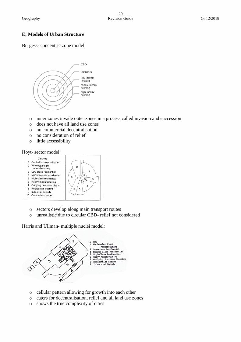
E: Models of Urban Structure
Burgess- concentric zone model:
o inner zones invade outer zones in a process called invasion and succession
o does not have all land use zones
o no commercial decentralisation
o no consideration of relief
o little accessibility
Hoyt- sector model:
o sectors develop along main transport routes
o unrealistic due to circular CBD- relief not considered
Harris and Ullman- multiple nuclei model:
o cellular pattern allowing for growth into each other
o caters for decentralisation, relief and all land use zones
o shows the true complexity of cities
CBD
industries
low income housing
middle income housing
high income housing

Geography Revision Guide Gr 12/2018
30
Modern American-western city:
o multi-centred
o CBD called downtown
o High level of commuting
o Decentralisation
o Sharply defined land use zones
Third world city:
o Land use zones are mixed
o Lots of informal trading
o City centres are compact
o Poor infrastructure
o Social problems in excess
South African city:
o Influenced by colonialism and apartheid
o Land use zones influenced by group areas act
o Post-apartheid- income determines where people live, not race
7. Urban Settlement Issues
A: Urban issues related to rapid urbanisation
Inner-city problems:
o Rise of squatter settlements
o Industrial expansion is slower than the rate of urbanisation
o Unequal provision of services
o Poverty and unemployment
o Environmental pollution
o Crime and violence
Urban blight:
o Deterioration of parts of an urban area
o Area of decay is transition zone
o Owners do not maintain buildings in this area
o Solutions:
• Slum clearance- demolishing old buildings and starting from scratch. Housing provided
for residents
• Regeneration- improving physical environment by renovating old buildings, creating
employment and improve quality of life
• Invasion and succession- replacing the original function with a new function
• Gentrification- low cost housing bought by wealthy people and are modernised
• Façadism- front of building preserved for heritage remembrance but the rest of the
building is renovated
Lack of planning:
o Low income residential areas found on outskirts
o Results in high rate of commuting putting pressure on transport
o Poor service provision results in protests
Geography Revision Guide Gr 12/2018
31
Traffic congestion:
o Build-up of vehicles on roads occurring mostly during peak hours
o Causes:
• People live far from work
• Inefficient public transport
• Poor road safety
• Excessive use of private vehicles
• Expensive parking
• Grid iron street patterns
o Solutions:
• Monitoring of public transport
• Introduce rapid and safe transport
• Decentralisation
• Cycle lanes
• Ring roads
• Park and ride facilities
• Multi-storey parking bays
Overcrowding and housing shortages:
o Shortage of living space due to rapid urbanisation
Service provision:
o Municipalities are struggling to provide basic services due to rapid urbanisation
o Resulting in protests for better service delivery
B: Informal Settlements
• Illegally built settlements due to lack of housing by poor people
• Lack basic services
• Mostly found in LEDCs
• Problems:
Vulnerable to elements
Susceptible to wild fires
Spread of diseases
Crime, drugs, poverty
Unhygienic
• Solutions:
Relocation
Self-help schemes
Provision of basic services
C: Justice Issues in Urban Areas
Social injustices:
o Causes of unequal access to resources and services
• Greed and corruption
• Nepotism
• Lack of public participation

Geography Revision Guide Gr 12/2018
32
o Impact
• Xenophobia
• Violent protests
• Crime
Economic injustices:
o Poverty
• Causes
Lack of education
Wages in primary sector too low
Unemployment
• Solutions
Basic income grant
Increase support to farmers
Skills programmes
• Impact
Increased crime
Malnutrition
Increased illness
Low standard of living
o Poor public transport
• Impact
Frequent accidents
Pollution
Traffic congestion
• Solutions
Improve bus routing
Upgrade taxi ranks
Dedicated public transport lanes
Introduce eco-friendly transport systems
Subsidies for public transport improvement
Environmental injustices:
Type cause effect solution
Air pollution
o CO
o Sulphur
o Power stations
o Domestic
activities
o Health problems
o Acid rain
o Destruction of
ecosystems
o Global warming
o Electricity saving
campaigns
o Strict control of
pollution by
government
o Use ozone
friendly products
o Extend green belts
Noise pollution
o Industries
o Airplanes
o Traffic
o Fire crackers
o Hypertension and
hearing loss
o Reduces quality
of life
o Noise barriers
o Altering flight
paths
o Restrict times of
day for certain
noise levels
Destruction of
ecosystems
o Population growth
o Settlement
expansion
o Soil erosion
o Pollution of
freshwater
o Legislation
o Education
Geography Revision Guide Gr 12/2018
33
Module 4 Economic Geography

Geography Revision Guide Gr 12/2018
34
1. Structure of the Economy
Primary sector:
o Concerned with extraction of raw materials from the environment
o E.g. farming, fishing, forestry, mining
Secondary sector:
o Activities that process raw materials into useful goods
o E.g. steel making, food canning, construction
Tertiary sector:
o Provision of services
o E.g. doctors, accountants, teachers, lawyers
Quaternary sector:
o Hi-tech sector linked to research and development
o E.g. scientists and researchers
GDP- total goods and services produced in a country in one year
GNP- total goods and services produced in a country by the permanent inhabitants in one year
2. Agriculture
Contribution to SA economy:
o Food production- sufficient to meet demand rids need of imports
o Earner of foreign exchange- 10% of exports
o Contribution to GDP- farmers pay taxes
o Job creation- 10% of labour force employed
o Industrial development- stimulation of industries by high volume of raw materials
Role of small-scale and large-scale farmers:
Small-scale farmers Large-scale farmers
Description Small but economically viable piece
of land used with the purpose of
making a profit.
Production of crops for local and
overseas markets to make a profit
Inputs
o Limited fertiliser
o Manual labour
o Some capital
o Intensive farming
o Fertilisers
o Machinery
o Large amounts of capital
o Paid labour
o GM seeds
Farm size
o Small plots of intensive
farming
o Irrigation: weirs, small dams
and pipes
o Large plots of extensive
farming
o Irrigation schemes
o Highly mechanised
Yield o High per hectare
o Monoculture
o Medium per hectare
o Variety of crops
Importance
o To reduce poverty in rural
areas
o To provide employment
o Promotes food security
o To produce large quantities
of food for local and
international markets
o To provide employment
Problems o Poor infrastructure
o Poorly financed
o Lack of trained farmers
o Climate change
o Increasing cost of labour
o Lack of subsidies

Geography Revision Guide Gr 12/2018
35
Main products produced:
o Cattle:
• EC, FS, KZN, LP and NC
• Problems:
Foot and mouth disease and tick problems
Variable price of beef
Limited grazing due to SA’s hot conditions
o Maize:
• Highveld
• Staple food of population
• Earner of foreign exchange
• Creates job opportunities
o Sugarcane:
• Provides employment
• Hulett, Illovo, TSB
• Ideal growing conditions:
Long, warm growing season
Lots of sunlight and moisture
Dry, sunny and cool conditions for ripening
Factors favouring agriculture:
o Trade opportunities (well-developed
transport infrastructure)
o Research
o Climatic variation
o Available labour supply
o Government support
Factors hindering agriculture:
o Climate change (effects on soil, water
and temperature)
o Droughts and floods
o Diseases and pests
o Fluctuating prices
o Wild fires
o Crime
o Labour strikes
o Lack of funding and training
Food security:
o When enough nutritious food is produced to meet the needs of people
o Famine: lack of food, giving rise to starvation and malnutrition
o Importance:
• Needed to maintain good health of people
• Prevents social uprising
• Prevents hunger and famine
• Malnutrition can be prevented
o Factors affecting food security:
Negatively Positively o Thin and infertile soils, soil erosion
o Droughts and floods
o Pests and diseases
o Deforestation
o Lack of capital
o Poor infrastructure in rural areas
o HIV infected workers
o Greater variety of crops due to climatic
variation
o Government incentives
o GM seeds

Geography Revision Guide Gr 12/2018
36
3. Mining
Contribution to SA economy:
o Earner of foreign exchange- export of minerals
o Contribution to GDP- mining companies pay tax
o Job creation
o Industrial development- demand for tools and machinery stimulates industries
Significance of mining to development of SA:
o Discovery of diamonds started the mining industry
o Contributed to rapid urbanisation
o Established the JSE
o Led to development of secondary and tertiary industries as well as infrastructure
Main products produced:
Coal mining:
o Most of SA’s
electricity is coal
generated
o Used by Mittal,
SASOL and is exported
o Challenges:
• Labour strikes
• Limited resource
• Environmental
issues
Platinum:
o Large contribution to
GDP
o Labour strikes said to
impact contribution to
GDP
o Challenges:
• Declining
competitiveness
• Labour strikes
• Union disputes
• Hesitant investors
Gold:
o Largest foreign income
earner
o Challenges:
• Labour strikes
• Diseases spreading
in workforce due to
mine conditions
• Poor working
conditions
• Environmental
problems
Ways to reduce mine strikes:
o Profit sharing
o Communication improvement between management and workforce
o Improve working conditions
o Skills development programmes
Factors favouring mining
o Variety of minerals
o Large mineral reserves
o Low production costs of surface
minerals
o Lower rock temperatures allow for
deeper mining
o Access to cheap labour
o Government assistance
Factors hindering mining
o Strikes and protests
o Minimum wage increase
o Transport costs
o Fluctuating prices due to foreign
exchange
o Mine disasters
o Distance to markets
Geography Revision Guide Gr 12/2018
37
4. Secondary Sector
A: Contribution to SA economy
o Contribution to GDP- money is generated in the form of taxes
o foreign exchange- money from exports are used on imports for development of the country
o job creation- increases purchasing power of people and improves life quality
B: Types of industries
Heavy industries:
o large scale
o generates pollution
o outskirts of settlement
o close to bulk transport facilities
o uses lots of raw materials and energy
o e.g. Iscor (steel), oil refining, engineering
Light industries:
o small products manufactured
o close to CBD
o small areas used
o little pollution generated
o road transport used
o e.g. clothing manufacturers
Raw material orientated industries:
o locate close to source of raw materials since they are bulky and expensive to transport
o e.g. sugar mill
Market orientated:
o locate close to market/customers since goods produced are perishable
o e.g. cheese industry
Footloose industries:
o location not dictated by access to materials or markets
o service orientated
o no pollution generated
o highly skilled
o e.g. research companies
Ubiquitous industries:
o can locate anywhere
o fulltime services offered
o e.g. telecommunication services
Break-of-bulk industries:
o located between source of raw materials and customers, where transport type changes
o e.g. sugar refineries

Geography Revision Guide Gr 12/2018
38
C: Factors favouring industrial development in SA
Raw materials:
o wide range available in abundance
Labour supply:
o access to skilled and semiskilled labour
o access to tertiary education to skill labour force
water supply:
o close to water supply for industrial use (manufacturing or cooling machinery)
o water transfer schemes supplement water supply
Energy supply:
o large coal reserves for electricity generation
o industries locate close to source of energy
transport:
o well established transport infrastructure
o 8 seaports and 4 international airports
Political intervention:
o Government policies in place to support local industries
o Incentives given to industries
Competition and trade:
o International trade facilitated by harbours and airports
o No trade barriers
o Access to local and international markets promotes competition and trade
D: Factors hindering industrial development in SA
Over-concentration:
o Traffic congestion
o Higher rentals due to demand for land- lower profits
o Higher salary demands
Transport:
o Unreliable
o Repair of roads and railways is costly
o Markets are far away
o Isolated from most world markets
o High export costs make it hard for local industries to compete with industries close to large
international markets
Labour supply:
o Brain drain results in loss of skilled workers, making it necessary to employ foreigners at
high costs
o Lack of funding to uplift education results in lack of skilled labour force
o Workers demand higher pay by striking which hinders production
Geography Revision Guide Gr 12/2018
39
Air pollution:
o Industries have the responsibility to reduce air pollution since it is the main contributor.
o Effects of industrial pollution:
• Negative impact on human health
• Kills animals and plants
• Causes imbalance in ecosystems
• Degrades air quality
• Damages buildings
• Reduces quality of life
o Causes of air pollution:
• Lack of policies to control air pollution:
Allows industries to bypass laws
• Unplanned industrial growth:
In industrial towns, pollution level increases above norm
• Use of outdated technology:
Industries rely on old technology that generates large amounts of waste
• May small scale industries:
Escape environmental regulations and release more pollution than normal
Water supply:
o Water is scarce in SA
o Large companies forced to recycle water
o Pollution is dumped into usable water
o Solutions:
• Recycling and reusing water
• Lowering toxicity in operations involving water
• Make production process more water efficient
Raw materials:
o Use of imported raw materials increases production costs
o Cost of imports fluctuates with foreign exchange rate
Competition and trade:
o Local industries cannot compete with imported goods from china
o Fluctuating rand value creates instability

Geography Revision Guide Gr 12/2018
40
E: Four Core Industrial Areas of South Africa
PWV- Pretoria Witwatersrand Vereeniging (Gauteng): Factors favouring location Factors hindering development Main industrial activities
o Market
• Dense population
resulting in high
demand for goods
• High buying power
o Transport
• Dense network of roads
and railways
o Labour
• Dense population-
larger labor force
o Raw materials
• Gold
• Iron ore
• Maize
• Platinum
o Water
• Eastern half- receives
adequate rainfall
• Vaal river water
supplemented by
TUVA water transfer
scheme
o Electricity
• Cheap since coal is
mined here
• Short distance from
source
o Relief
• On Highveld where
land is flat
o Overuse of water from Vaal
river
o Pollution
o Great distance from ports
o Chemical
o Iron and steel
o Metal processing
o Explosives
Port Elizabeth- Uitenhage Factors favouring location Factors hindering development Main industrial activities
o market
• import and export of
goods made easy by
harbour
o transport
• good links with the rest
of SA
• harbour
o raw materials
• wool
• subtropical fruit
• cotton
o relief
• flat land
o periodic drought
o no coal fields so electricity
is expensive
o expensive labour and
frequent strikes
o Car assembly
o Leather goods
o textiles

Geography Revision Guide Gr 12/2018
41
Durban-Pinetown (eThekwini) Factors favouring location Factors hindering development Main industrial activities
o Market
• Densely populated
• High demand for
manufactured goods o Transport
• Harbour
• Many links to rest of
the country
o Labour
• Large labour force due
to large population
o Raw materials
• Sugarcane
• Dairy
• Meat
• Subtropical fruit
o Water
• Abundant rain
• Presence of perennial
rivers (Tugela &
Umgeni)
o Capacity of harbour is
limited o Hilly topography restricts
growth of harbour
o Oil and sugar refining
o Ship building
o Food and drink
o Textiles
o Footwear
o Soap making
South Western Cape Factors favouring location Factors hindering development Main industrial activities
o Market
• High purchasing power
• Coastal- access to large
overseas markets
o Transport
• Table bay for overseas
trade
• Dense railway network
for local links
o Labour:
• Dense population of
skilled and unskilled
o Raw materials:
• Deciduous fruit
• Grape
• Fish
o Relief:
• Flat land
o Electricity is expensive
since coal fields are far
away
o Water shortages- located on
the western half that
receives less rainfall
o Few mineral resources
o Food processing
o Textiles
o Fish and fruit canning
o Wine
o Petrol refineries
Geography Revision Guide Gr 12/2018
42
F: Strategies for industrial development in SA
Overview of apartheid industrial development strategies
o Good hope plan
• To spread economic wealth in SA
• Lead to the regions making up the 9 provinces
• De-concentration points created
• Isolated industrial development points
• Tax incentives to encourage industrial growth
• Border industries created on homelands
Overview of post-apartheid industrial development strategies
o Reconstruction and Development Programme (RDP)
• Improved quality of life
• Redistribution of wealth, healthcare, jobs, and basic services
• Aimed at local development
o Growth, Employment and Redistribution (GEAR)
• Macro-economy policy
• Focuses on redistribution of wealth to eliminate poverty
• Attracts foreign investment
• Focuses on country as a whole by:
Creating jobs
Increasing exports
Developing infrastructure
o Accelerated and shared growth in SA
o National development plan
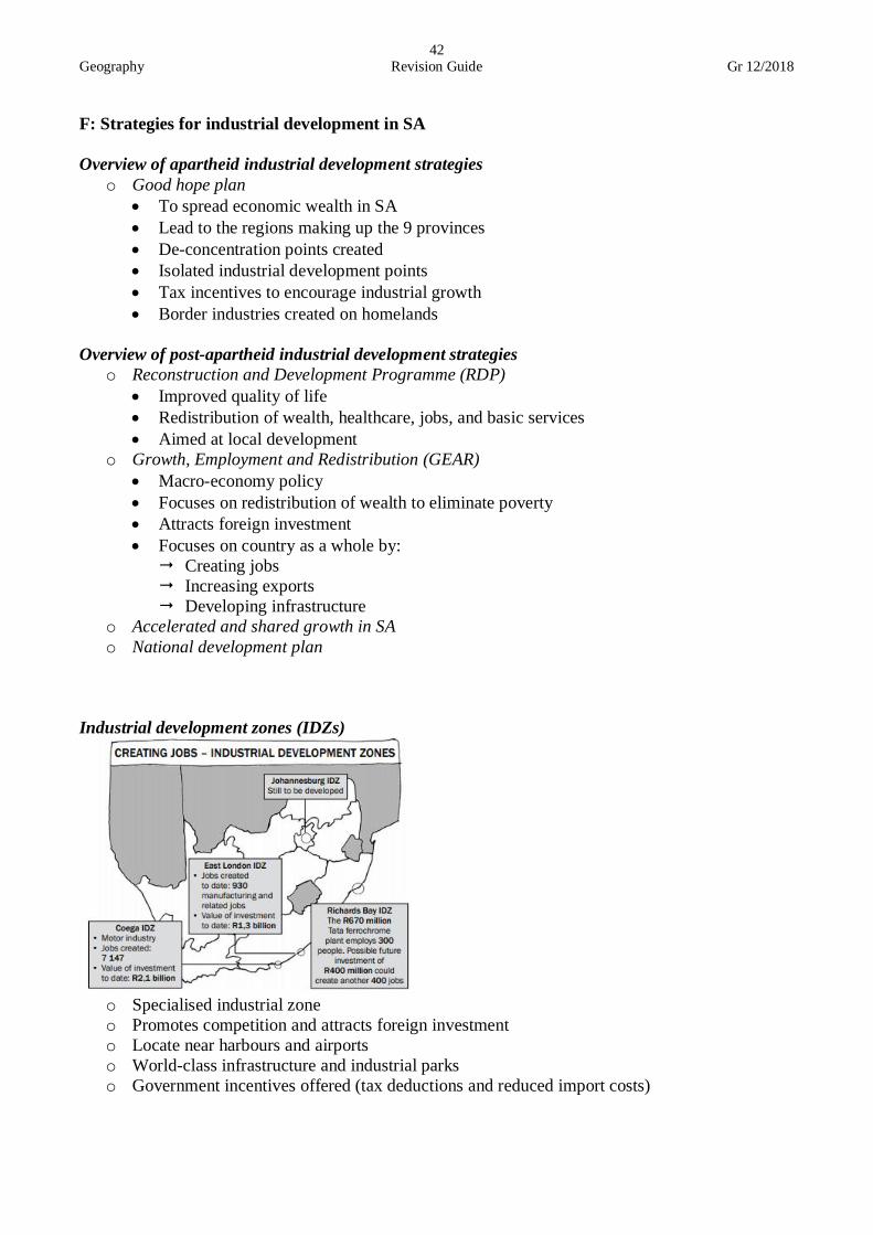
Industrial development zones (IDZs)
o Specialised industrial zone
o Promotes competition and attracts foreign investment
o Locate near harbours and airports
o World-class infrastructure and industrial parks
o Government incentives offered (tax deductions and reduced import costs)

Geography Revision Guide Gr 12/2018
43
o East London IDZ:
Industry types
o Automotive
o Marine aquaculture
o Agro-processing
o Pharmaceuticals
o ICT & electronics and business processes
Advantages of location
o Excellent transport
o Automotive industry provides economic growth
o Clustered industries reduce logistics cost
o Close to ports
Incentives
o Duty free imports for goods used in manufacturing
o Zero VAT on supplies used to manufacture export goods
o Discounted utility services and affordable land prices
Flaws
o Lack of skilled labour
o Poor harbour facilities o Limited electricity supply
o High demand for water
Spatial development initiatives (SDIs)
o Development corridor: development along a major transport route
o Links IDZs
o Provides communities with opportunities to participate in economic activities
o Promotes job creation
o Promotes use of local resources to generate economic growth
Geography Revision Guide Gr 12/2018
44
o Phalaborwa SDI
Location
o Limpopo
o Favourably situated for economic links with other countries
o Runs through Great North Road
Resources
o Platinum, iron ore, coal, diamonds
o Wood
o Mangoes, papayas, avocados, potatoes
Objectives
o Use underutilised resources sustainably
o Develop small-scale mining
o Integrate urban and rural areas
o Promote tourism
Challenges
o Poverty and unemployment
o Unmaintained roads
o Poor infrastructure
o Lack of clean water
o West Coast SDI Location o Stretches from Cape Town to Northern Cape border
Resources
o Rich in avian resources- Lambert’s Bay Waterfront
o Cultural heritage
o Fish
o Rich in biodiversity
o fruit
Objectives
o protect west coast environment
o promote job opportunities and economic growth
o develop social well-being of people
o promote infrastructure development
Challenges
o lack of technical skills
o inadequate marketing
o growing informal settlements
o xenophobia
o sand mining decreases tourism
G: Industrial centralisation and decentralisation
Advantages of centralisation Disadvantages of centralisation
o 4 core areas highly developed
o Clustering of similar industries
o Infrastructure and service network
establishment
o Good market
o Large labour force
o Uneven spread of wealth
o Peripheral areas remain underdeveloped
o Congestion and pollution
o Social problems
o Labour issues due to poor living conditions
o Demand for housing
o Declination of rural towns
Decentralisation
Reasons to move out of
urban areas
Effects Reasons to move into rural
areas
Effects
o Depletion of
primary resources
o Decreased demand
o Functional magnetism
o Job losses
o New office parks
o Urban blight
o Available land
o Cheaper land
o Closer to market
o Improved
infrastructure
o Improved services
o Job creation

Geography Revision Guide Gr 12/2018
45
5. Tertiary sector
o Involve selling of goods and provision of services
o Hairdressers, doctors, internet cafes, repair companies
Contribution to SA economy:
o Provides employment to skilled population
o Contributes to GDP via tax
o Provides population with higher incomes and better standard of living
o Encourages growth of financial and business services
The role of international trade in economic development:
o Benefits of international trade
• Access to foreign currency
• Variety of goods for consumers
• Promotes competition
• Better international relations
• Exchange of technical knowhow
• Increases sales and profits
o Disadvantages of international trade:
• Local production suffers
• Rich countries influence poorer nations and take control
The role of transport in economic development:
o Dense transport infrastructure results in high level of development
o Better accessibility to markets
o Efficient transport reduces costs
o Provides employment
o Encourages domestic and international trade
6. Informal sector
o Definition: unregistered workers
o Characteristics
• Self-employed workers
• Casual labour
• Unskilled or semiskilled workers
o Importance:
• Provides income and reduces unemployment
• Consumers can buy goods in small quantity cheaply
• Allows for people to grow entrepreneurial skill
o Reasons for development:
• Large scale job losses due to mechanisation
• Many people lack formal qualifications and they cannot get jobs in formal sector
• Immigrants cannot find legal employment

Geography Revision Guide Gr 12/2018
46
o Problems faced:
• Traders harassed by authorities
• Traders lack assess to proper trading facilities
• Unreliable income
• Banks do not grant loans to traders
o Measures to improve informal sector:
• Introduce licensing requirements
• Dedicate areas for informal trading
• Provide infrastructure for traders
• Provide easier access to bank loans
Written by Zaid Ganie, in accordance with The Department of Basic Education, Geography Examination Guidelines,
Grade 12, 2017.
Related Documents