TATA McGRAW-HILL'S SERIES •

Welcome message from author
This document is posted to help you gain knowledge. Please leave a comment to let me know what you think about it! Share it to your friends and learn new things together.
Transcript
~,~Nrl\f
TATA McGRAW-HILL'S ~ SERIES
•
•
m Tata McGraw-Hill
Published by Tala McGraw Hill Education Private Limited. 7 West Patel Nagar. New Delhi 110 008
Geography of India
Due care has been taken to t:nswe that the information provided in the book including the maps is correct. Howevt.-r. the publisher bear no responsibi lity for any dallll!gc resulting from any inadvertent omission or in~ccurucy in the book
Copyright ~ 2008. by Tata McGraw Hill Education Private Limited
Second reprint 2009 RQXLCDRFRQLAC
No p~\11 of this publication may be reproduced or distributed in any fonn or by any means, electronic, mechanical. photocopying. recording. or otherwise or stored in a database or retrieval system without the prior written permis..~ion of the publishers. The program listings (if any) may be entered. stored and executed in a computer system, but they may not be reproduced for publication
Thi~ edilion can be exported from India only by the publishers, T<~ta McGraw Hill Education Private Limited
ISBN (13 digits): 978-0-07-066772-3 ISBN ( 10 digi ts): 0-07-066772-1
Managing Director: A jay Shukla Genernl Manager- Publishing (B&E/HSSL and School): V Biju Kumar Sponsoring Editor: K N Prakash Assistant Sponsoring Editor: Abhishek Sharma Senior Copy Editor: Anupma Rai Senior Production Executive: Medl1a Arora Gener-al Manager-Marketing (Higher Education & School): Michael J Cruz Asst. Product Manager: Vija.\1 Sarathi JagamWlhan Controller- Production: Rajender P Ghansew Asst. General Manager-Production: B L Dogra
lnfonnation contained in this work has been obtained by Tala McGraw-Hill. from sources believed to be reliable. However. neither Tala McGraw-Hill nor its authors guarantee the accuracy or completeness of any information published herein. and neither Tata McGruw-Hill nor its authon; shall be responsible for any errors, omis.~ions, or damages arising out of use of this information. This work is published with the understanding that Tata McGraw-Hill ru1d its authors are supplying infomation but are not attempting to render engineering or other profes.<>ional services. If such services arc required. the assistance of an appropriate professional should be r.ought
Typeset at The Composers, 260, C.A. Apl.. Paschim Vthar, New Delhi 110 063, and printed at Pashupati Printers Pvt. Ltd., Delhi I 10 095
Cover Design: K Anoop
Cover printed at SDR Printers
The McGraw· Hill Campames : .J~~t -~
CONTENTS.
Preface Acknow ledg eme11ts Tribute
1. Structure oflndia Introduction /./ l. The Archaean Formations (Pre-Cambrian) 1. I 2. Dharwar System (Proterozoic Formations) 1.3 3. The Cuddapah System (The Purana Group) J .6 4. The Vindhyan System 1.8 5. The Palaeozoic Group (Cambrian to Carboniferous Period) / .9 6 . The Mesozoic Era (The Gondwana System) 1.9 7. The Cretaceous System (The Deccan Trap) 1.11 8. The Tertiary System (The Cenozoic Era) 1.12 9. The Quaternary Period (The Pleistocene and Recent Formations) 1.13 References 1.15
2. Physiography Introduction 2. / Origin and Physiography of the Peninsular India 2. I The Himalayas 2.10 The Great Plains of India 2.29 The Coastal Plains 2.39 Earthquakes in India 2.42 Vulcanicity 2.44 References 2.46
3. Drainage The Drainage System 3.1 Drainage Pattern 3.1 River Basins of India 3.6 The Multiple River Theory 3.10 River Systems of the Himalayan Drainage 3.11
.. VII . u: .
XI
1.1
2.1
3.1
~ ~;=1~----------------------~~re~n~~----------------------, . . I Main Rivers of Peninsular India 1.19 Easterly Rivers of the Peninsular Region 3.21 River Regimes 3.23 Shifting Courses of the Rivers 3.25 Types of Lakes 3.27 Main Lakes of India U8 Water Re~oncces of India 1 12
The Inter-State Water Disputes 3.37 International Agreements for Surface Water Resources 3.37 National Water Grid t 18 Ground Water Resources of lndia 141
The National Water Policy 3.43 Main Waterfalls of India 3.44 References 3.47
4. Climate 4.1 Introduction 4. I
Indian Monsoon: Classical Theory or Thermal Concepts by Halley 4. I Indian Monsoons and the Tibet Plateau 4.6 Jet Stream and Indian Monsoon~\ 4.9 El-Nino and the Indian Monsoon 4 10
Burst of Monsoon 4.12 Breaks in the Monsoons 4 I i Seasons in India 4 15 Rainfall Distrihllfion 4 25 Variabilily of Rainfall 4.27 Climatic Regions of India 4.28 Koppen's Classification of Indian Climate 4. 29 Climatic Divisions by Stamp and Kendrew 4.31 Trewaaba's Classification of Indian Climate 4 34 Climatic Divisions of India by R.L. Singh (1971) 4.36 Droughts 4.38 Floods 4.41 References 4.46
S. Natural Vegetation and National Parks Introduction 5 I
Floristic Regions of India 5.2 Spatia.! Distribution of Forests in India 5.4 Classification o f Forests 5 7 lmponant Species of Trees and their Utility 5. 11 Forest Products and their Utility 5.14 Problems of Indian Forestry 5. 17 The National Forest Policy 5. I 8 Social Forestry 5.19 Existing Position of Forest Ecosystems 5.21
5.1
Forest Conservation 5 22 Wildl.ife 5 U References 5.27
6. Soils Introduction 6.1 Characteristics of S<>il 6,1 Classification of Soils of India 6.4 Problems of Indian Soils 6 10 Consequences of Soil Erosion 6.16 Soil Conservation 6.17 References 6.19
7. Resources Natural Resources Z I Mineral Resomces 7 2 Biotic Resources Z25 References 7.28
8. Energy Resources Sources of Conventional Energy 8.1 Non-Conventional Energy 8.26 Energy Crisis 8.29 Energy Conservation 8.30 References 8.30
Contents
6.1
7.1 •
8.1
9. Agriculture 9.1 I .and Utilisation 2. / Characteristics and Problems of Inruan Agriculture 9.5 Determinants of Agriculture 9.11 Land Reforms 9. 15 Infrastructure and Agricultural Inputs 9.19 Second Green Revolution 9.47 White Revolution 9. 48 Blue Revolution 2.52 Aquaculture 9.55 Apiculture (Beekeeping) 9.57 Sericulture 9.59 Poultry Farming 9.60 Horticulrure 9.61 Dry Farming 9.63 Agribusiness 9.66 National Commission on Farmers 9.67 References 9.67
10. Spatial Organisation of Agriculture Cropping Patterns 10.1 Crop Concentration 10.3 Agricultural Productivity 10.5
10.1
contents
Agricultural Intensity 10.8 Crop Combinations 10.8 Land Capability IO.ll Conttact Farming 10.13 Agricultural Regionalisation 10.13 Agro-Ciimatic Regions of India 10.19 Agro-Ecological Regions of India 10.25 References 10.27
11. Jndust[ies 1 1.1 Evolmion of Industries II./ [ndustrial Development During the Five Year Plans 11.2 Industrial Policy 11.4 Cotton Textile Industry I 1.5 JuteTcxtilc 11./J Woollen Textiles II 15
Silk Textile I J.J5 Iron and Steel Industry 11. 18 Aluminium Industry 11.24 Automobile industry 11.28 fertiliser Industry I 1.30 Paper Industry 11.33 Pharmaceutical lnduslry 11.37 Cottage Industries I 1.39 tn<luMrial Regions of India 11.40 Multjoarjooals II 47
Liberalisation 11.48 Industrial Problems of India J J. 50 Special Economic Zone (SEZ) 11.51 Public Sector Undcrlaking 11.53 Tourism II 55 Eco-Tourism 11.60
Industrial Houses in India I I .64
Industrial Complexes 11.69 References 11.70
12. Transport, Communications, and Trade Transport / 2. / Communications 12.26 International Trade 12 28 .Balance of Trade and Balance of Payment 12.32 Trade Policy 12.34 India-Space Programme 12.35 l?e(erence.l' I 2.38
13. Cultural Setting Origin of Mankind 13. 1 Historical Perspective of Indian Society 13.2
12.1
13.1
Contents
The Caste System 13.3 Racial and Ethnic Diversity in India /3.5 Scheduled Tribes 13.11 Scheduled Castes (16.20% of the Total Population) 13.25 Cultunll Regions 13.28 Demographic Characteristics of Indian Population I 3.4 / Literacy 13.58 Age Composition 13.62 Migration 13.63 Population Problems 13.73 Heath Indicators /3.76 Human Development Tnde.x in India 13.77 References 13.79
14. Settlements 14.1 Introduction 14. I Classification of Settlements 14. J City Region and Planning 14.41 Slums and Associated Problems J 4.42 Problems of Urbanisation 14.46 Town Planning in lndia 14.48 References 14.52
lS. Regional Development and Planning 15.1 Planning in India 15. I Five Year Plans /5.2 Regional Planning in India 15.5 Integrated Area Development 15.8 Integrated Rural Development Programme (IRDP) 15.9 Development of Backward Areas I 5. I I Command Area Development I 5. 12 Watershed Management 15.14 Area Development Programmes J 5.14 Multi-Level Planning 15.23 The Damodar Valley Corporation 15.27 The National Capital Region (NCR) 15.32 Poveny in India 15.39 Geography and Regional Planning 15.39 Regional Planning and Development of Island Territories J 5.42 References 15.45
16. lndla-PoliticaJ Aspects Political Geography 16. I Structure of Indian federa1 ion 16.6 Regional Consciousness and National Integration 16. /0 National Integration in India /6.13 Nationalism 16 14 International Boundaries of lndia 16.16
16.1
xvill ~-------------Co;_;;_nt.;..:en_ts.:..;,_ ____________ ___,
( >CC IfJ 27
India's Role in World Affairs 16 30
Geopolitics of South Asia 16.31 India and the Geo=Politics of the India OC!lan 16.33
References 16.41
17. Contemporary Issues 17.1 Enyjronmeotal Hazards 1 Z 1 Natural Disasters I Z1 Environmental Pollution /7 17 Environmental Awareness 17 20
Changes in Patterns of Land Use 17.21 Environmental Impact Assessment (EIA) 17.22 Environmental Management !7.23 Population Explosion and Food Security 17.23 Environmental Degradation 17.27 Problems of Agrarian Unrest 17.31 Industria.! Unrest 17.33 Regional Disparities in Economic Development 17.34 Relationship between Population and Development 17.38 Sustainable Growth and Development 17.39 Globalisation and Indian Economy 17.43 Agriculture and Globalisation 17.45 References 17.48
Appendices
•
A.l-A.l4
STRUCTURE OF INDIA
INTRODUCTION
The geological structure of a country helps in understanding the types and character of rocks and slopes, the physical and chemical properties of soils, the availability of minerals1 and the surface and underground water resources. All these resources have a direct impact on the socio-economic development of the people of a country, or region.
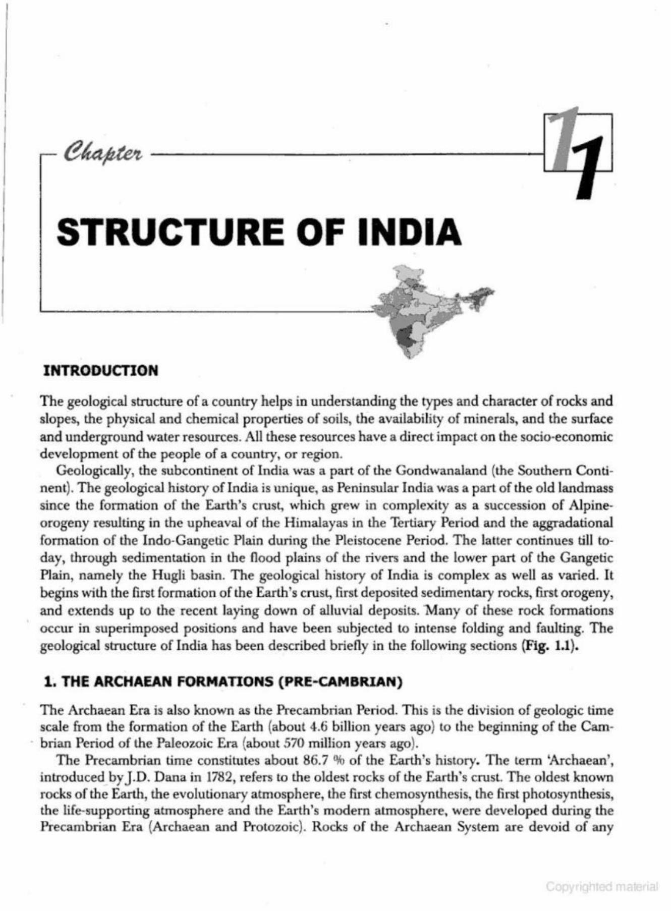
GeologicaUy, the subcontinent of India was a part of the Gondwanaland (the Southern Continent). The geological history of India is unique, as Peninsular India was a part of the old landmass since the formation of the Earth's crust, which grew in complexity as a succession of Alpineorogeny resulting in the upheaval of the Himalayas in the Tertiary Period and the aggradational formation of the Indo-Gangetic Plain during the Pleistocene Period. The latter continues till to~ day, through sedim entation in the flood plains of the rivers and the lower part of the Gangetic Plain, namely the HugH basin. The geological history of India is complex as well as varied. It begins with the first formation of the Earth's crust, first deposited sedimentary rocks, first orogeny, and extends up to the recent laying down of alluvial deposits. Many of these rock formations occur in superimposed positions and have been subjected to intense folding and faulting. The geological structure of India has been described briefly in the following sections (Fig. 1.1).
1. THE ARCHAEAN FORMATIONS (PRE-CAMBRIAN)
The Archaean Era is also known as the Precambrian Period. This is the division of geologic time scale from the formation of the Earth (about 4.6 billion years ago) to the beginning of the Cam
. brian Period of the Paleozoic Era (about 570 million years ago}. The Precambrian time constitutes about 86.7 % of the Earth's history. The term 'Archaean',
introduced by J.D. Dana in 1782, refers to the oldest rocks of the Earth's crust. The oldest known rocks of the Earth, the evolutionary atmosphere, the first chemosynthesis, the first photosynthesis, the life-supporting atmosphere and the Earth's modem atmosphere, were developed during the Precambrian Era (Archaean and Protozoic). Rocks of the Archaean System are devoid of any
l
.. · Geography of India ,, 1.2 11-------------"'---'--'-----------------,
."--r-2~
• • • • • • • • 0 •
• • • • • • • • 0 ... • •
• • • • • • • • • 0 0 ••• • ' •
• • • • • 0
.-~.,_ .,... ... -r "' ..,. "'" •
+ + '~- -t T .....-.n. "' .. .. + . "" . ... ...
• • • . . . Quaternary-Recent
~~~ Tertiary
+ ..,. Creraceous-Deccan Trap
~~
Mesozoic
Gondwana
Lower Palaezoic
Vindhyan
Cuddapah and Dharwar
Archaean
200 l
0 l
200 400 l 1 Kms
Fig. 1.1 Geological Systems
form of life . In other words, the Archaean rocks are all azoic or unfossiliferous. They are thor· oughl y crystalline, extremely contorted and faulted, and practically devoid of any sediment. They are largely intruded by plutonic intrusions and generally have a well-defined foliated structure. These rocks are known as the basement complex or fundamenJal gneisses. Thus, all over the
Structure of India
world. the Archaean rocks are the foundation of all the great anciem plateallX, and they form the core of all the great folded mountain ranges of lhe world.
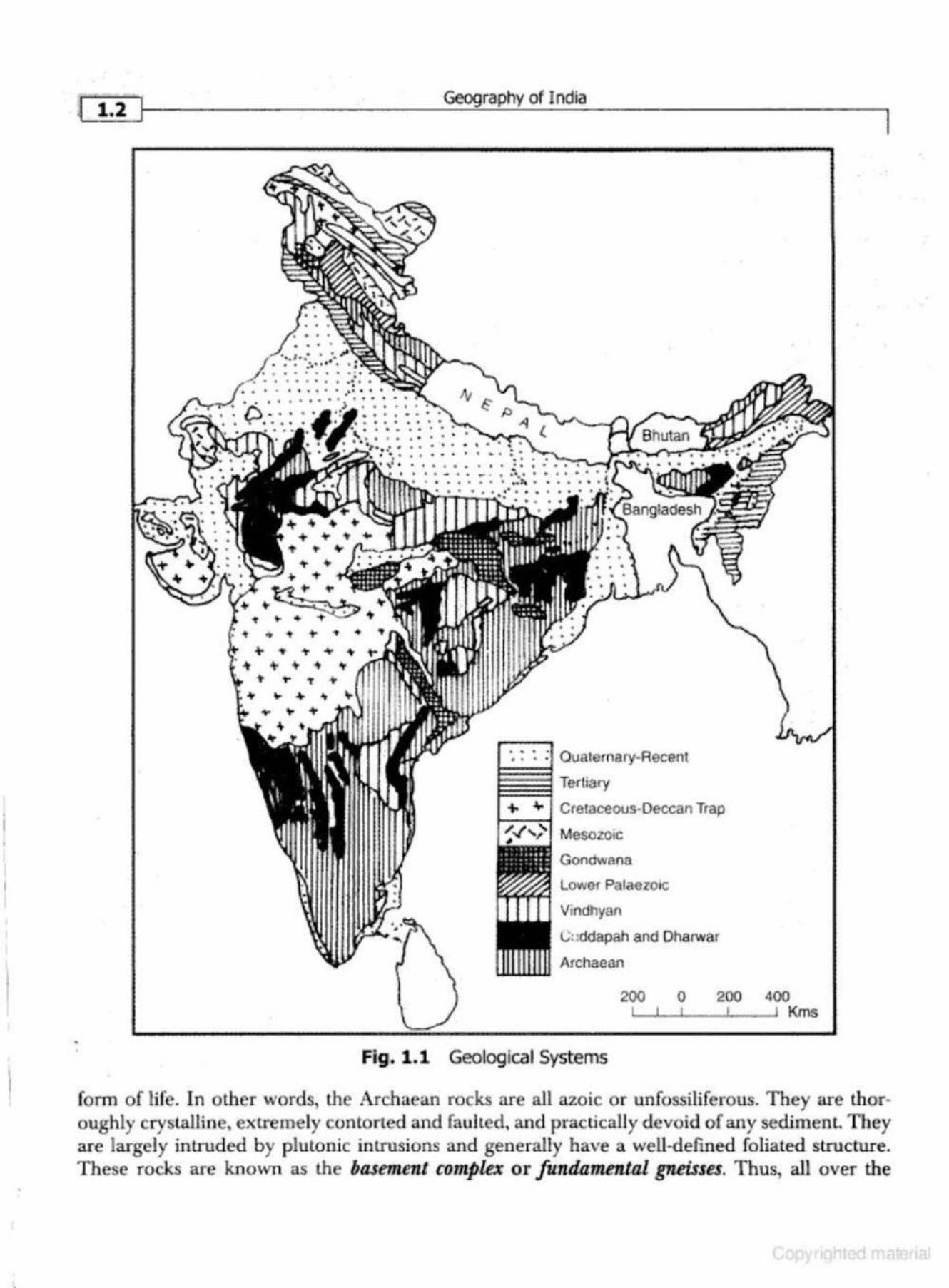
In the Indian Geological Time Scale, advocated by T.S. Holland, the Pre-Cambrian Era is known as lhe Pu.rana. The Archean System includes the Aravalli, Dharwar, Cuddapa.h, Vindhyan, Meghalaya Plateau and Mikir Hills. These are also called the Archean gneiss. The Archaean rocks cover two-thirds of Peninsular India. They also occur in the roots of the mountain peaks aU along r.he Greater Himalayas from the western most part of Kashmir to the eastern-most part of Arunachal
r Pradesh as well as in the Trans-Himalayan ra.nges ofZaskar (Zanskar), Ladakh and the Karakoram (Fig. 1.1 and Ftg. 1.2}.
The Archaean rocks cover two-thirds of Peninsular India. In the Peninsular region, the Archaean rocks are known to be of three well-defined types:
(i) The Bengal Gneiss
The Bengal Gneiss which occurs in the Eastern Ghats, Orissa (known as Khodoliles after Khond tribes in Koraput and Bolangir districts), stretching over Manbhum and Hazaribagh districts of
Jharkhand, Nellore district of Andhra Pradesh and Salem district of Tamil Nadu. They also occur in the Son Valley, Meghalaya Plateau and Mikir HiUs.These formations are very thinly foliated. For the first time these rocks were identified in the Midnapur district of West Bengal.
(ii) The Bundelkhand Gneiss
The Bundelkhand Gneiss forms the second group of fundamenlal gneiss of the Archaean age. It occurs in Bundelkhand (U.P.), Baghelkhand (M.P.), Maharashtra, Rajasthan, Andhra Pradesh and Tamil Nadu. It is a coarse grained gneiss which looks like granite. The Bundelkhand &rneiss is conspicuously criss-crossed and characterised by quartz veins.
(iii) The Nllgiti Gneiss
The name being given in honour of job Charnock whose tombstone in Kolkata was made of this rock. The Nilgiti gneiss is bluish-grey to dark coloured rock, medium to coarse grained in texture. This is plutonic gneiss intruding into the other Archaean rock masses. Ni lgiri gneiss is popularly recognised as belonging to the Chamockite series. It is widely found in South Arcot, Palni Hills, Shevaroy Hills and NiJgiri in Tamil Nadu, Nellore in Andhra Pradesh, Balasore in Orissa, Kamataka, Kerala, Malabar,Jharkhand, Chhattisgarh and Aravallis (Rajasthan).
The Archaean rocks are the repositories of the mineral wealth oflndia. These rocks are rich in ferrous and non-ferrous minerals like iron ore, copper, manganese, mica, dolomite, lead, zinc, silver and gold.
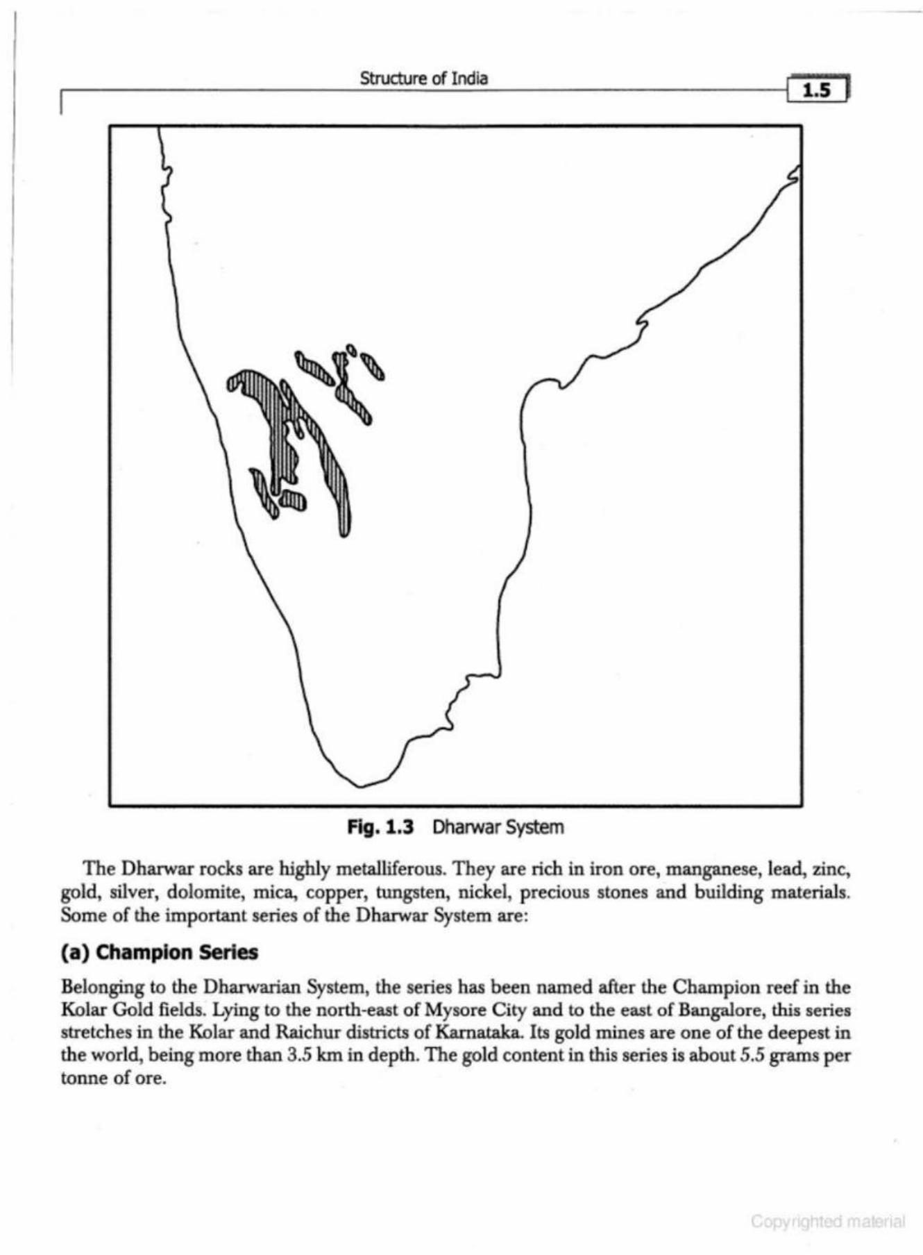
2. DHARWAR SYSTEM (PROTfROZOIC FORMATIONS)
This geologic time extends from 2500 million years ago to 1800 million years ago. These are the first metamorphosed sedimentary rock systems known as the Dhatwar System in the Indian Geological Time Scale. In India, these rocks were studied for the first time in the Dharwar distl'ict of Kamataka. They are composed largely of igneous debris, schists and gneisses. The Dharwar rocks occur in scattered patches in (i} Dharwar and Bellary districts of Kamataka and extend up to the
I 1.4
36°N
28' N
20"N
72•E
Geography of India
88' E 96' E
Minerals : Gold, Silver, Iron, Copper, Lead, Zinc, Chromlte, Mica, Manganese, Tin, Tungston, Asbestos. Diamond, Kyanite Graphite, SiUimanite.
Fig. 1.2 Archaean Formations (Pre-2500 Million Years)
Nilgiris and Madurai districts of Tamil Nadu, (ii) Central and eastern parts of the Chotanagpur Plateau, Meghalaya Plateau and Mikir Hills, and (iii) the Aravallis, Rialo (Delhi series), from Delhi to the south of Alwar and the Himalayan region (Fig. 1.3).
Struct\Jre of India I 1.s J
Fig. 1.3 Dharwar System
The Dharwar rocks are highly metalliferous. They are rich in iron ore, manganese, lead, zinc, gold, silver, dolomite, mica, copper, tungsten, nickel, precious stones and building materials. Some of the important series of the Dharwar System are:
(a) Champion Series
Belonging to the Dharwarian System, the series has been named after the Champion reef in the Kolar Gold fields. Lying to the north-east of Mysore City and to the east of Bangalore, this series stretches in the Kolar and Raichur districts of Kamataka. Its gold mines are one of the deepest in the world, being more than 3.5 km in depth. The gold content in this series is about 5.5 grams per tonne of ore.
-
~ i & J~------------Geog---=-_ra.:._ph--'-y-of_I_nd_la __________ ____,
(b) Champaner Series
It is an outlier of the AravalH system in the vicinity ofVadodra. Jt consists of quartzites, conglomerates, phyllites, slates and marbles. An attractive green variety of marble is obtained from this series.
{c) Closepet Series
Stretching over the BaJaghat and Chhindwara. districts of Madhya Pradesh, it is a Dharwarian formation. The series consists of quartzite, copper pyrite, and magniferous rocks. The Malanjkhand Copper Plant gets its ore from the Closepet series.
(d) Chllpi Series
It occupies parts of Balaghat and Chhindwara districts of Madhya Pradesh. The series consists of grit, phyllite, quartzites, green stones and magniferous rocks.
(e) Iron-Ore Series
It occurs in Singhbhum, Bonai, Mayurbhanj and Keonjhar in the form of a range. The iron-ore series is about 65 kilometres in length and reserves about three thousand million tons of iron-ore.
(f) Khondolite Series
ll occupies a large area in the Eastern Ghats from the northern extremiry to the valley of Krishna. The principal rock types in this series are khondolltes, kodurites, chamockites and gneisses.
(g) Rialo Series
AJso known as the Delhi series, it extends from Delhi (Majnu-Ka-Tila) to AJwar, Rajasthan in a north-east to south-west direction. This series is ti ch in marbles. The Makrana, and Bhagwanpur known for high quality of marble belong to this series .
. (h) Sakoli Series
Stretching over J abalpu.r and Rewa districts , this series belongs to the Dharwarian fo rmation. It is rich in mica, dolomite, schist and marble. The marble of this series is of superior quality.
( i) Sausar series
This series spreads over Nagpur, Bhandara districts of Maharashtra, and Chindwara district of Madhya Pradesh. It belongs to the Dbarwarian group and is rich in quartzite, mica chist, marble an.d magniferous rocks.
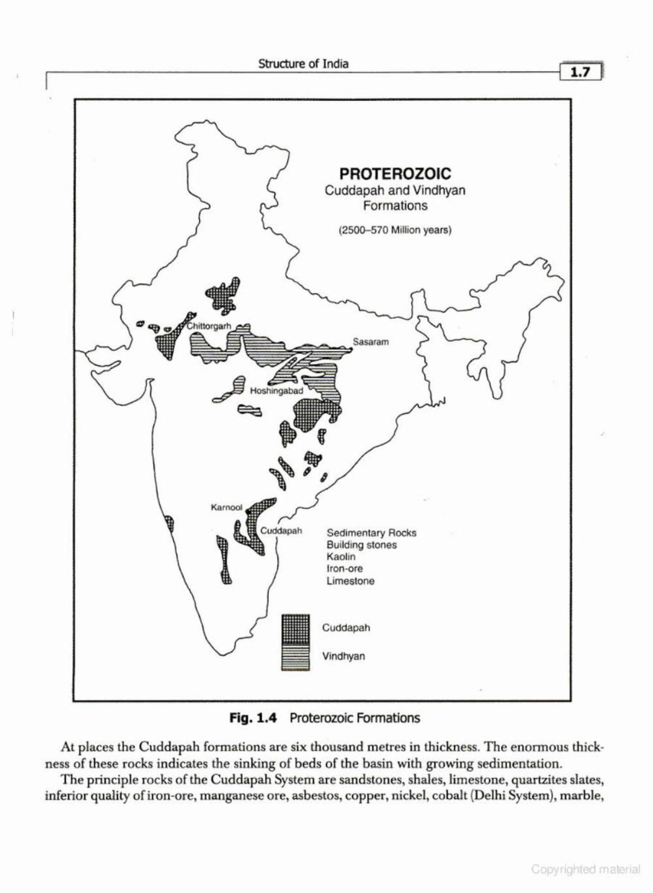
3. THE CUDDAPAH SYSTEM (THE PURANA GROUP)
The Cuddapah formations, named after the district of Cuddapah in Andhra Pradesh, are sedimentary-metamorphic formations. The Cuddapah System occurs in the (i) Cuddapah and Kumool districts of Andbra Pradesh, (ii) Chhatt.isgarh, (iii) Rajasthan-Delhi to the south of Alwar, and (iv) the Lesser Himalayas in the extra-Peninsular region. {Fig. 1.4)
Structure of India
PROTEROZOIC Cuddapah and Vindhyan
Formations
(250Q-570 Million years)
Sedimentary Rocks Bui lding stones Kaolin Iron-ore Limestone
Cuddapah
Vindhyan
Fig. 1.4 Proterozoic Formations
At places the Cuddapah formations are six thousand metres in thickness. The enormous thickness of these rocks indicates the sinking of beds of the basin with growing sedimentation.
The principle rocks of the Cuddapah System are sandstones, shales, limestone, quartzites slates, inferior quality of iron-ore, manganese ore, asbestos, copper, nickel, cobalt (Delhi System), marble,
r 1.a 1 Geography of India
jasper, building material and stones for interior decoration. The metallic contents in the ores of Cuddapah rocks are, however, low and at places uneconomical for extraction.
Papaghaniseries
The series has been named after the Papaghani river (And.hra Pradesh), in the valley of which these rocks have been exposed. It consists of quartzites, sandstones, shales, slates, limestones and marbles. The series is intruded by magma in the form of dykes and sills which have metamor· phased limestone into marble, talc, slate, and serpentine.
4. THE VINDHY AN SYSTEM
The Vindhyan System derives its name from the Vindhyan Mountain. This mountain forms a dividing line between the Ganga Plain and the Deccan Plateau . The system covers an extensive area of 103,600 sq km from Chittorgarh in Rajasthan to Sasaram in Bihar. It has enormous sedimentary deposits and at places their depth is more than 4000 metres. In some tracts, the Vindhyan rocks are buried under Deccan lava. The Great Boundary Fault (GBF) separates the Vindhyan System from the Aravallls for a distance of about eight hundred km (Fig. 1.4).
The Vindhyan system is well known for red-sandstone, sandstone, building material, ornamental stone, conglomerates, diamondiferous and raw materials for cement, lime, glass and chemical industries. In certain places these rocks yield inferior,qtlality of iron ore and manganese. The well known diamond mines of Panna and Golconda lie 1n the Vindhyan System . The historical buildings of Qutab Minar, Humayun's Tomb, Fatehpur Sikri, Agra Fort, Red Fort,J ama-Masjid, Birla Mandir, the Buddhist Stupa of Sanchi, etc. have been constructed from the red -sandstone ob· tained from the Vindhyan Ranges. Coarser sandstones have been used as grindstones and millstones.
Bhander Series
This series spreads over the western parts of the Vindhyan formation. The main rocks of the series are sands tones, shales and limestone. The series provides good quality of building maLerial besides diamonds and precious stones.
Bijwar Series
Stretching over the districts ofChhatarpur and Panna, this series belongs to the Vindhyan system. It is composed of sandstone, red-sandstone, and quartzite. It has basaltic intrusions whose dykes are rich in diamonds.
•
Kaimur Series
T his series sprawls over Bundelkhand (U.P.) and Baghelkhand (M.P.). The main rocks in this series are sandstone, conglomerate and shale. It is also rich in red sandstone used in historical monuments.
.---------------Stru__;_ctu....:.;__r...;;.e....;;o.:..f .:..In.....;.d.;.;.ia ____________ --i['""i".9•J
5. THE PALAEOZOIC GROUP(CAMBRJAN TO CARBONIJ=EROUS PERIOD)
The Palaeozoic Era includes the O rdovician, Silurian, Devonian, Carboniferous and the Permian periods of the Standard Geological Time Scale. This is known as the Dravidian Era in the Indian Geological Time Scale.
The Palaeozoic Era extends from 570 million years ago to 24.5 million years ago. It marks the beginning of life on the Earth's surface. The formations of this period are almost absent in the Peninsular India except near Umaria in Rewa. These formations exist in the Pir-Panjal, Handwara, Lidder-Valley, AnantnagofKashmir Uammu & Kashmir), Spiti, Kangra, Shimla region (Himachal Pradesh), and Garhwal and Kumaun (Uttarakhand). It was during this period that the Pangaea was broken and the Tethys Sea came into existence. The Cambrian rocks include shales, sandstones, clays, quartzites slates, salts, marble, etc.
Palaeozoic System in the Indian Geologic nme Scale
The Gondwana formations are fluviatile and lacustrine in character. They were deposited in the river basins and lakes during the Upper Carboniferous Period. These basins later subsided along the trough faults amidst ancient rocks of the great southern continent called the Gondwanaland. These rocks were formed during the Upper Carboniferous and the J urassic Periods (Mescn;oic Era).
6. THE MESOZOIC ERA (THE GONDWANA. SYSTEM)
'Mesozoic' means middle life. T he term is used for a period of geologic time in which the presence of fossil invertebrates dominated the rocks. The Mesozoic Era includes three periods: Triassic, Jurassic, and Cretaceous. In the Indian Geological Time Scale, these periods extend from the Upper Carboniferous up to the beginning of the Cenozoic Era or the Aryan Era.
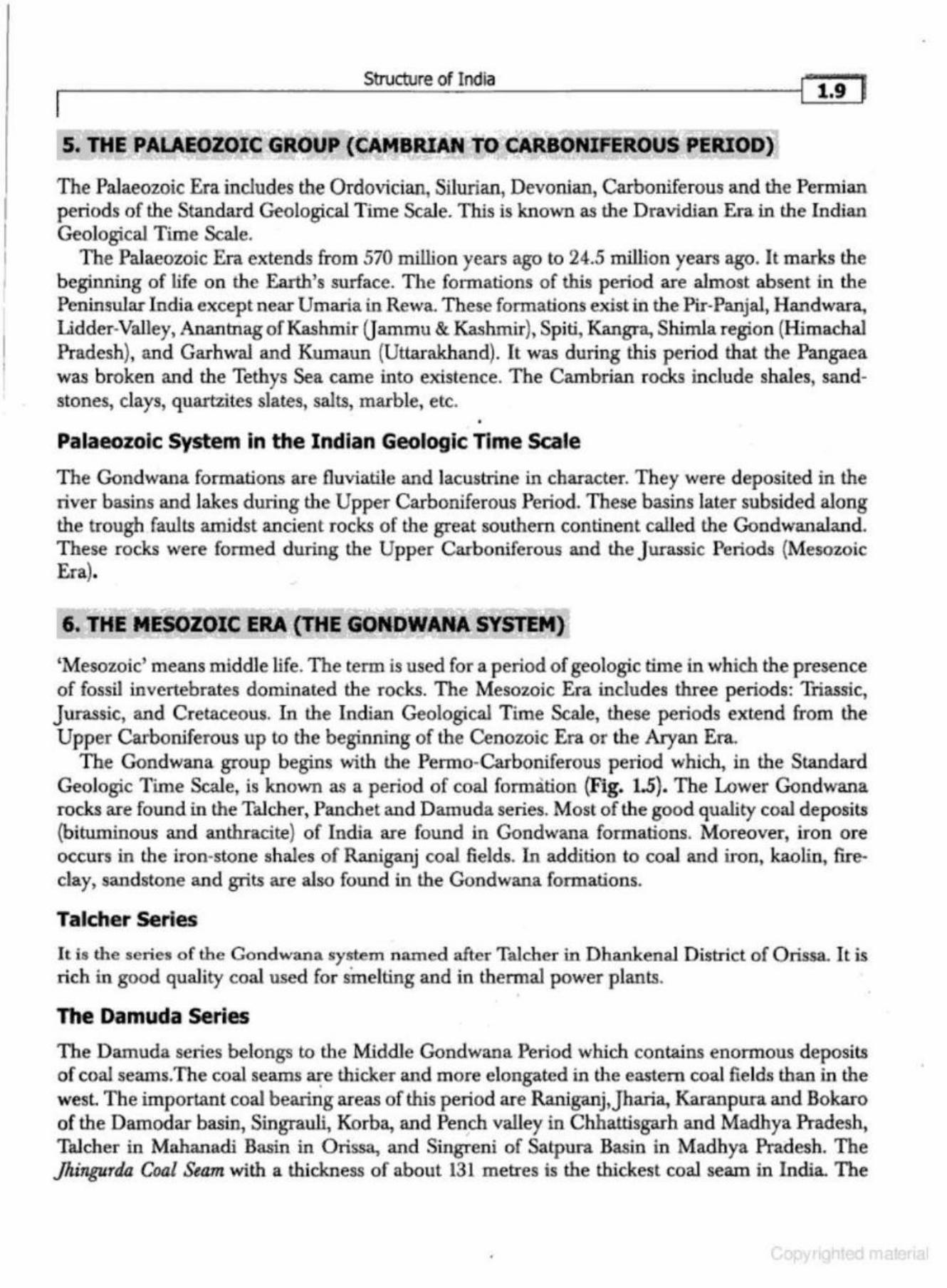
The Gondwana group begins with the Permo-Carboniferous period which, in the Standard Geologic Time Scale, is known as a period of coal formation (Fig. 1.5}. The Lower Gondwana rocks are found in the Talcher, Panchet and Damuda series. Most of the good quality coal deposits (bituminous and anthracite) of India are found in Gondwana formations. Moreover, iron ore occurs in the iron-stone shales of Raniganj coal fields. In addition t.o coal and iron, kaolin, fireclay, sandstone and grits are also found in the Gondwana formations.
Talcher Series
It is the series o f the Gondwana system named after Talcber in DhankenaJ District of Orissa. It is rich in good quality coal used for smelting and in thermal power plants.
•
The Damuda series
The Damuda series belongs to the Middle Gondwana Period which contains enormous deposits of coal seams.The coal seams a~e thicker and more elongated in the eastern coal fie lds than in the west The important coal bearing areas of this period are Raniganj,Jharia, Karanpura and Bokaro of the Damodar basin, Singrauli, Korba, and Pe~ch valley in Chhattisgarh and Madhya Pradesh, TaJcher in Mahanadi Basin in Orissa, and Si.ngreni of Satpura Basin in. Madhya Pradesh. The ]hingurda Coal Seam with a thickness of about 131 metres is the thickest. coal seam in India. The
11•10 Jr------------Geog---"-r-'ap'-h-'-y_of_I_nd_ia __________ ____,
Mumbai
ARABIAN
SEA
Bhopal
• d1tiillJP Sohagpur
Nagpur •
Godavari valley
• Hyderabad
• Bangalore
Daltenganj
I Hutar coalfield
Channa•
Fig. 1.5 Gondwana System
..ctllb /Talcher
BAY
OF
BENGAL
Existing Gondwana Exposures
0 300km
Gondwana rocks are also found in Himalayas from Kashmir lo Arunachal Pradesh and Poorvanchal. The coal seams of these areas are metamorphosed. They are also found in Saurashtra, Kachchh, western Rajasthan, Coromandal Coast, and Rajmahal H ills (Fig. 1.5).
Panchet Series
l l is the youngest series of the Lower Gondwana System, which derives its name from the hill of that name south of Raniganj. The series consists of greenish-sandstone and shales. It is, however, devoid of coal-seams.
The iron-ore shales of the Lower Gondwana System are particularly well developed in the Raniganj coalfield of West Bengal. H owever, they contain inferior quality iron ore, i.e. siderite and limonite. Being inferior in quality, they are generally not mined for iron. The Gondwana System of rocks provides over 95% of the coal of India. Moreover, it provides iron-ore, limestone, sandstone and raw material for ceramic industry.
India's best and largest coal deposits are found in the Gondwana System-mainly in the Damodar Valley of West Bengal,Jharkhand, the Mahanadi valley of Orissa and Chhattisgarh, the Godavari valley of Andhra Pradesh and the Satpura basin of Madhya Pradesh (Fig. 1.5).
--------------------------
Structure of India
As stated above, the beginning of the Upper C arboniferous Period is known as the Aryan pe1iod. The salient features of the Aryan formations are:
{i) During the Upper Carboniferous Period, the Himalayan region was occupied by a vast geosyncline which was connected lo tht: Pacific O cean in the east through C hina and the Atlantic O<:ean in the west through Afghanistan, Iran, Asia Minor and the present Mediterranean Sea. This was called the Tethys Sea.
(ii) The area of the Kashmir Himalayas (from Pir Panjal lo Hazara in the north-west and Ladakh in the north-east) witnessed violent volcanic activity.
(iii) The Upper continent of Gondwanaland developed fissures and its broken parts started drifting away from each other. The Subcontinent of India drifted towards north and northeast to collide with the Asian land mass (Eurasian Plate).
(iv) There was large scale eruption of lava in the Deccan Trap. (v) The development and expansion of the Arabian Sea and the Bay of Bengal. (vi) The Tertiary mountain building gave birth to H imalayas.
(vii) The Subcontinent of India assumed i ts present shape. (viii) The beginning of lee Age, belonging to Lhe Pleistocene Period, covering large parts of the
earth under ice-sheet. (ix) Evolution and spread of man in different p arts of the world.
7 . THE CRETACEOUS SYSTEM (THE DECCAN TRAP)
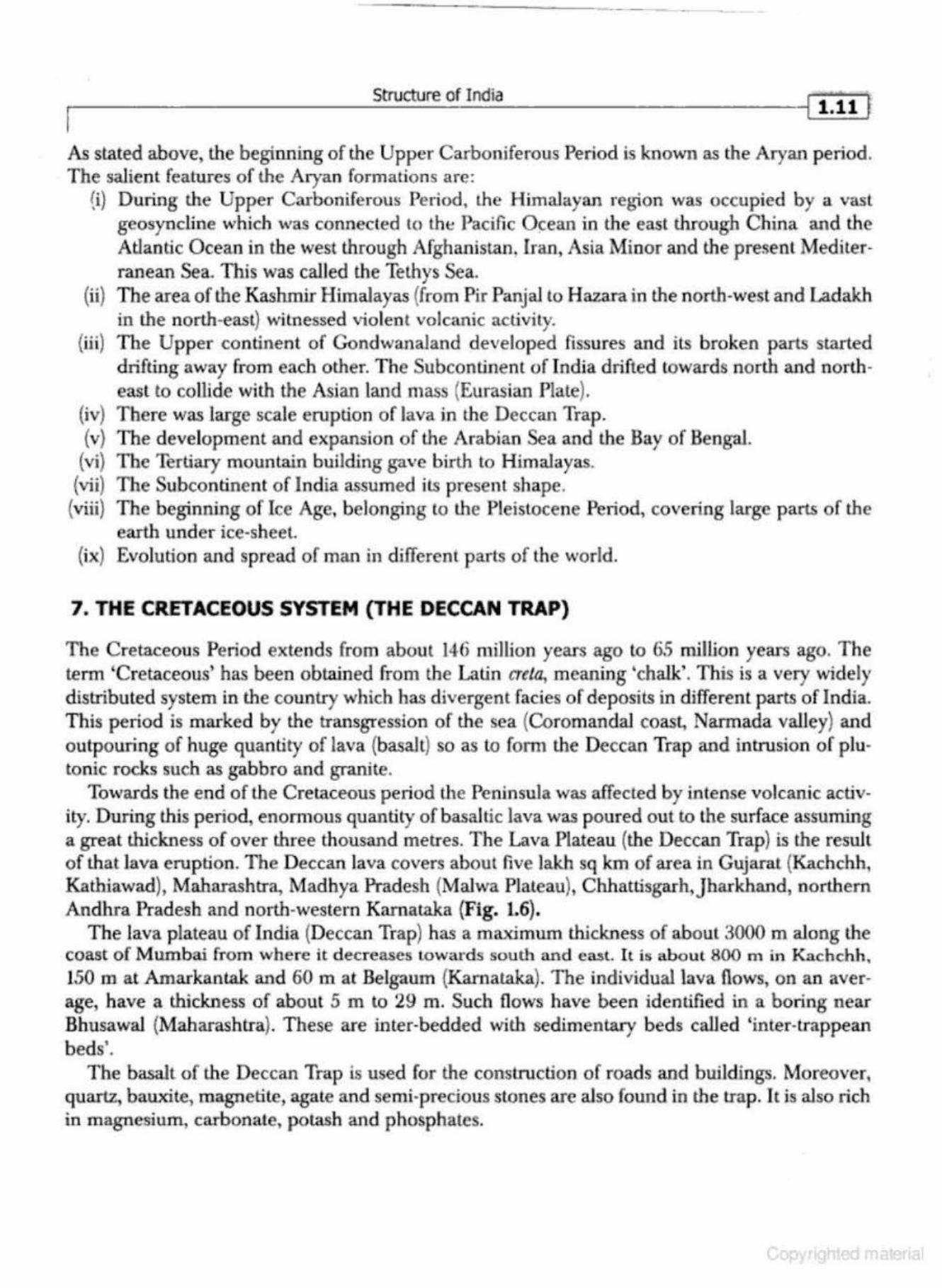
The Cretaceous Period extends from about 146 million years ago lo 65 million years ago. The term 'Cretaceous' has been obtained from the Latin creta, meaning 'chalk'. This is a very widely distributed system in the country which has divergent facies of deposits in d ifferent parts of India. This period is marked by the transgression of the sea (CoromandaJ coast, Narmada valley) and outpouring of huge quantity of lava (basalt) so as to form the Deccan Trap and intrusion of plutonic rocks such as gabbro and granite.
To·wards the end of the Cretaceous period the Peninsula was affected by intense volcanic activity. During this period, enormous quantity of basaltic lava was poured out to the surface assuming a great thickness of over three thousand metres. The Lava Plateau (the Deccan Trap) is the result of that lava eruption . The Deccan lava covers about five lakh sq km of area in Gujarat (Kachchh, Kathiawad), Maha.rashtra, Madhya Pradesh (Malwa Plateau), Chhattisgarh,Jharkhand, northern Andhra Pradesh and north-western Karnataka (Fig. 1.6).
The Java plateau of India (Deccan Trap) has a maximum thickness of about 3000 m along the coast of Mumbai from where it decreases towards south and ea.sL It is about 800 m in Kachchh, 150 m at Amarkantak and 60 m at Belgaum (Karnata.ka). The individual lava flows , on an average, have a thickness of about 5 m to 29 m. Such fl ows have been identified in a boring near Bhusawal (Maharashtra). These are inter-bedded with sedimentary beds called 'inter-trappean beds'.
The basalt of the Deccan Trap is used for the construction of roads and buildings. Moreover, qu artz, bauxite, magnetite, agate and semi-precious stones are also found in the trap. It is also rich in magnesium, carbona.te, potash and phosphates.
l 1.12 I Geography of India
. . ~ . .. . . ~ . . . -· · · ··~ ····· · ·........-~ . . . . . . . . . . . . .. .. . ........ , . . . . .. - . .. . . . . . .
o '" 0 o o o 0 • o ' o I 6
--
Fig. 1.6 The Cretaceous System (The Deccan Trap)
8. THE tERTIARY SYST£M (THE CENOZOIC ERA)
Cenozoic means recent life. The beginning of the Tertiary Period is about 66 million years ago. Fossils in these rocks include many types, closely related to modem forms, including mammals, plants and invertebrates. The Cenozoic Era has two periods: The Tertiary and the Quaternary.
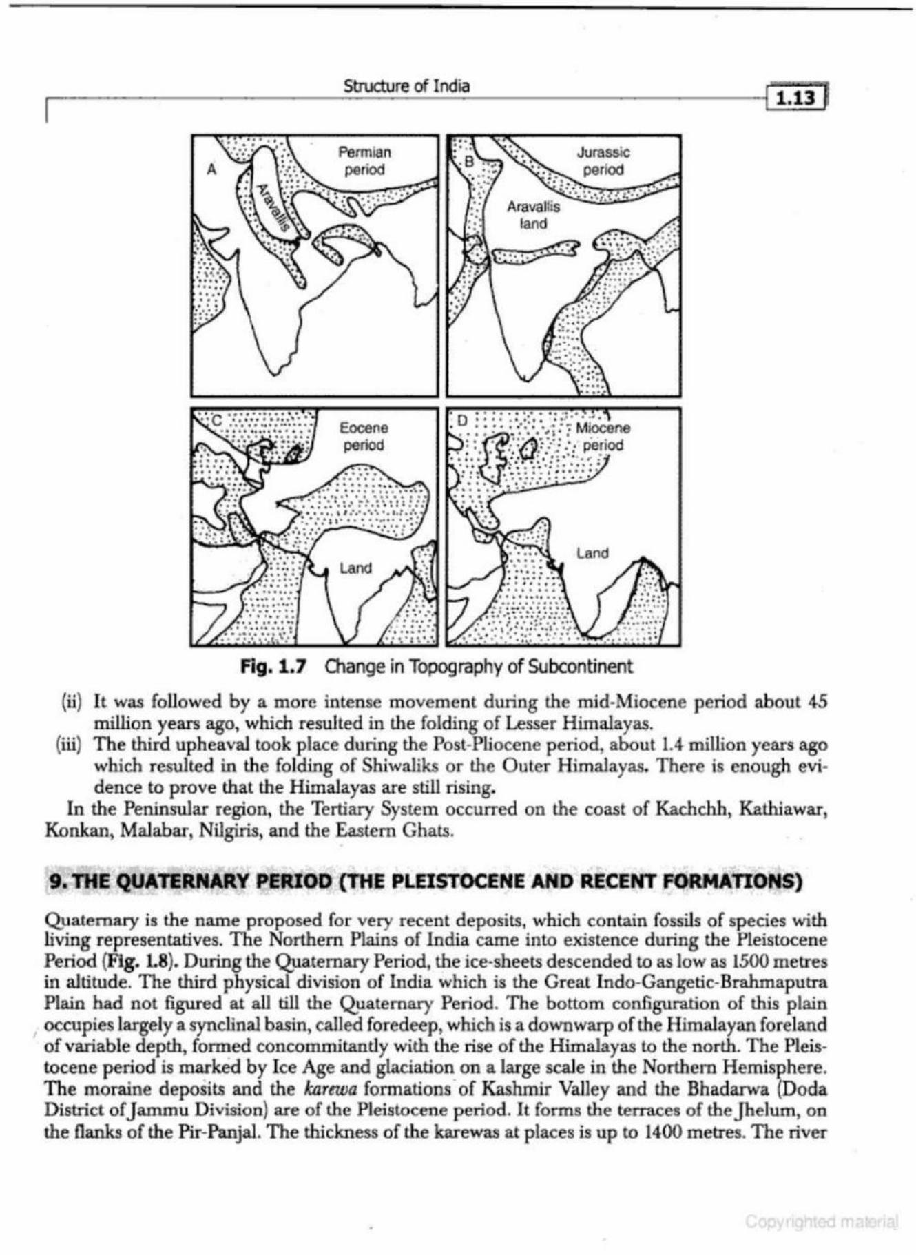
The two great events that occurred during the Tertiary Period include: (i) the final beaking-up of the old Gondwana continent, and (ii) the uplift of the Tethys geosyncline in the form of the Himalayas. During the early Tertiary Period, as India collided with Tibet, the sediments which had been accumulating in the Tethys basin had begun to rise by a slow rise of ocean bottom. The upheaval of the Himalayas altered the old topography of the subcontinent (Fig. L7).
Three phases of the upheaval of the Himalayas have been distinguished: (i) During the first upheaval (Eocene-about 65 million years ago), whkh culminated in the
Oligocene, and resulted in the upheaval of the Greater Himalayas.
~--------------------s~mocru~~re~o~f_Ioo~ia ____________________ -4lil.Jl]
A Permian period
Eocene period
Land
~ . ..... .. ~ • • • 0 • . . .. .. . .. . . . . . . . • --· • • • 0 • • : • . . .. .. . . ... ~ . ~ . . . . . . . ..
• • •• ' , .. . ....... ' -I'
Land
• • • • • 0 • • 0 • • • • 0 ••
•• 0 ~ . • 0 •• 0 • • • • • • • • •
Fig. 1.7 01ange in Topography of Subcontinent
(ii) It was followed by a more intense movemen t during the mid-Miocene period about 45 million years ago, which resulted in the folding of Lesser Himalayas.
(iii) The third uph eaval took place during the Post-Pliocene period, about 1.4 million years ago which resulted in the folding of Shiwaliks or the Outer Himalayas. There is enough evidence to prove that the Himalayas are still rising.
In the Peninsular region, the Tertiary System occurred on the coast of Kachchh, Kathiawar, Konkan, Malabar, Nilgiris, and the Eastern Ghats . .
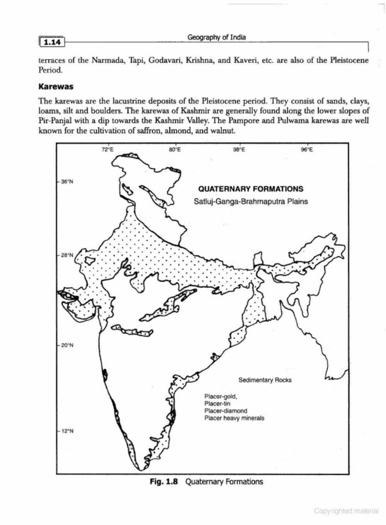
. 9. THE QUATERNARY PERJOO {lltE PLEISTOCENE AND RECENT FORMAnONS)
Quaternary is the name proposed for very recent deposits, which contain fossils of species with living representatives. The Northern Plains of India carne into existence during the Pleistocene Period (Fig. L8). During the Q}laternary Period, the ice-sheets descended to as low as 1500 metres in altitude. T he third physical division of India which is the Great Indo-Gangetic-Brahmaputra Plain had not figured at all till the Quaternary Periocl The bottom configunilion of this plain
, occupies largely a synclinal basin, called foredeep , which is a downwarp of the Himalayan foreland of variable depth, formed concommitandy with the rise of the Himalayas to the north. The Pleistocene period is marked by Ice Age and glaciation on a large scaJe in the Northern Hemisphere. The moraine deposits and the lwrewa formations · of Kashmir Valley and the Bhadarwa (Doda District of J ammu Division) are of the Pleistocene period. It forms the terraces of theJhelum, on the flanks of the Pir-Panjal. The thickness of the karewas at places is up to 1400 metres. The river
Geography of India
I terraces of th e Nam1ada, Tapi, Godavari, Krishna, and Kaveri, etc. are also of the Pleistocene Period.
Karewas
The karewas are the lacustrine deposits of the Pleistocene period. They consist of sands, days, loams, silt and boulders. The karewas of Kashmir are generally foWld along the lower slopes of Pir-Panjal with a dip towards the Kashmir Valley. The Pampore and Pulwama karewas are well known for the cultivation of saffron, almond, and walnut
36°N
20•N
12"N
SO" IE 98"E ge•E
•
QUATERNARY FORMATlONS
Satluj·Ganga-Brahmaputra Plains
•
Sedimentary Rooks
Placer-gold, Placer-tin Placer-diamond Placer heavy mineraJs
Fig. 1.8 Quatemary Formations
Structure of India
Ahmad, E., 1962, 'Geomorphic Regions of Peninsular India' ,Journal ofRaruhi University, Voi.T, No.1, pp. 1-29.
Burrard, S.C., 1933, A Sketch oftlu Geology and Geography oftl&e Himalaya MoanlaiJU and TiUt, Govt. of India, Dellii, second edition.
Chattetji, S.P.1940, 'Gneissisic Topography of the Ranchi Plateau', GeiJgrajJ/tico.l Rmew, Calcutta. No.1, pp.45-48.
Chugh, R.S. andj.C. Bhattachruji, 1974: Study of Isostasy in 1M Himalayan &gion, Himalayan Geology, Wadia Institute of Himalayan Geology, Delhi, Vol. IV pp. 453-464.
Dey, A.K., 1968, Geology of India, National Book Trust, New Delhi. Gansser, A., 1964, Geology of Himalayas,] ohn Wiley & Sons, London. Holmes, A., 1965, Physical Geology, Nelson, India. Jhingran, A.G., 1981, (;e()logy oftlu Himalayas, Oxford University Press. Krishnan, M.S., 1982, Geology of India and Burma, CBS Publishers, Delhi, 6th ed. Mathur, S.M., 1978, Physical GefJ/ogy of ItU!.ia, National Book Trust of India, New Delhi. Muketji, A.B., 1964, 'Alluvial Morphology of the Upper Ganga Yamuna Doab' , Deccan Geographer, -126,
Vol. 2, No.2, pp.l00-126. Nag, P. and S. Sengupta, Ge!Jgraphy of India, Concept Publishjng Co., New Delhi. Raza., M. and Ahmad, A., 1978, General Geography of India, N .C.E.R.T, New Delhi. Singh, R.L., 1971, I'lflliiJ- A &gional Geography, The National Geographical Society of India, Varanasi. Singh, Savindra, 1998, Geomorpholf:Jgy, Prayag Pu.stak Bhawan, Allahabad. Spate, O.H.K, and Learmonth, A.T.A., 1967, Indio. anti Pakistan- A General and &gional Geography,
Methuen & Co. Ltd., London. Wadia, D.N., 1975, Geolot:! of/JUlia, Tata McGraw-Hill Publishing Co., New Delhi.

•
e~fe!t ----------------~--
PHYSIOGRAPHY
INTRODUCflON
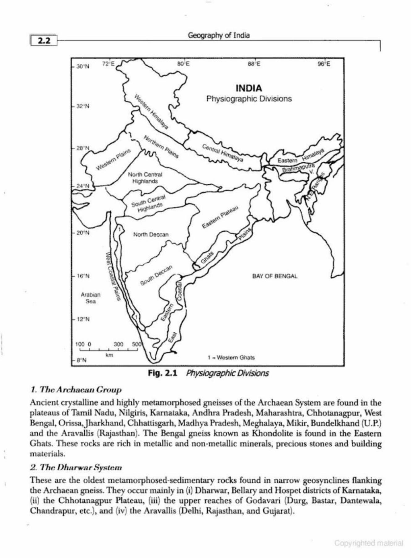
Physiography deals with the study of the surface features and landforms of the Earth. On the basis of tectonic history, stratigraphy and physiography, India may be divided into the following four physiographic divisions (Fig. 2.1):
1. The elevated Peninsular region 2. The mighty Himalayas and their associated young folded mountains 3. The Indo-Gangetic-Brahmaputra Plains 4. The Coastal Plains and Islands.
ORIGIN AND PHYSIOGRAPHY OF THE PENINSULAR INDIA
The origin of rocks of Peninsular India is more than 3600 million years old . Before the Carboniferous period, it was a part of the Gondwanaland. In the opinion of geologists, during the Archaean Period, the India Peninsula never subsided under the sea permanently. It was more rigid, stable and had remained almosl unaffected by the mountain building forces. However, it experienced block fauJling and displacement during the subsequent periods as evidenced by the Dharwar and Gondwana formations and the fault valleys of the Narmada, Tapi and Son rivers.
It was during the Carboniferous Period that coal was formed in the Damodar, Son, Mahanadi and Godavari basins. During the Cretaceous Period, large scale vulcanicity produced the Deccan Trap (the Lava Plateau of India), comprising lava sheets of several thousand metres in depth. T he Deccan Trap originated abou t 146 million years back when the magma flowed from th~ depth of about 4-0 km below the crust.
Major Geological Formations of the Peninsular India (about 3600 million years ago)
The plateau of Peninsular India exhibits a complex system of geological structures. It has some of the oldest rocks of the world from the Precambrian period (Archaean) and the youngest rocks of the Holocene epoch (Quaternary/Recent period). The major rock systems found in the Peninsular India have been described blietly in the following section:
l
I' 2.2
30'N
32'N
20•N
16' N
Arabtan Sea
12""N
100 0
a·N
300
km
1. ThcArchacaLI Group
North Deccan
•
Geography of India
80' E 88' £
INDIA Physiographic Divisions
BAY OF BENGAL
1 2 Westom Ghats
Fig. 2.1 Physiographic Divisions
96'E
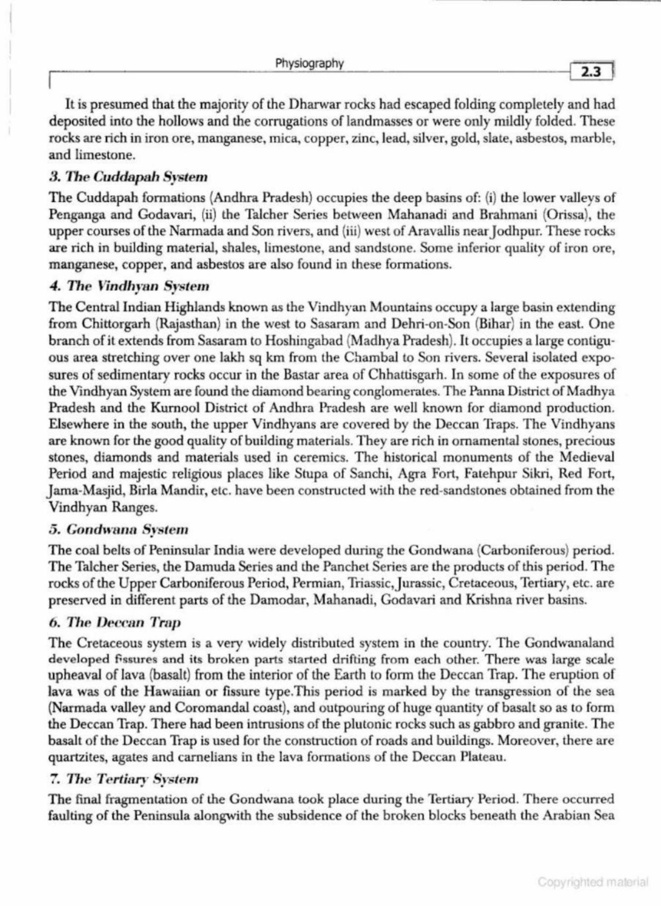
Ancient crystaJiine and highly metamorphos€d gneisses of the Archaean System are found in the plateaus of Tamil Nadu, Nilgiris, Karnataka, Andhra Pradesh, Maharashtra, Chhot:anagpur, West Bengal, Orissa,Jharkhand, Chhattisgarh, Madhya Pradesh, Meghalaya, Mikir, Bundelkhand (UP.) and the Aravallis (Rajasthan). The Bengal gneiss known as Khondolite is found in the Eastern Ghats. These rocks are rich in metallic and non-metallic minerals, precious stones and building m ale rials.
2. The Dlu1rw8r System
These are the oldest metamorphosed-sedimentary roc'ks found in narrow geosynclines flanking the Archaean gneiss. They occur mainly in (i) Dharwar, Bellary and Hospet districts ofK.amataka, (ii) the Chhotanagpur Plateau, (iii) the upper reaches of Godavari (Durg, Bastar, Oantewala, Chandrapur, etc.), and (iv) the Aravallis (Delhi, Rajasthan, and Gujarat).
Physiography I 2.3 ~
It is presumed that the majority of the Dharwar rocks had escaped folding completely and had deposited into the hollows and the corrugations of landmasses or were only mildly folded. These rocks are rich in iron ore, manganese, mica, copper, zinc, lead, silver, gold, slate, asbestos, marble, and limestone.
3. The Cuddapah System
The Cuddapah formations (Andhra Pradesh) occupies the deep basins of: (i) the lower valleys of Penganga and Godavari, (ii) the Talcher Series bet\,yeen Mahanadi and Brahmani (Orissa), the upper courses of the Nannada and Son rivers, and (iii) west of Aravallis near Jodhpur. These rocks are rich in building material, shales, limestone, and sandstone. Some inferior quality of iron ore, manganese, copper, and asbestos are also found in these formations.
4. Tile J!indh,ran System
The Central Indian Highlands known as the Vindhyan Mountains occupy a large basin extending from Chittorgarh (Rajasthan) in the west to Sasaram and Dehri-on-Son (Bihar) in the east. One branch of it extends from Sasaram to Hoshingabnd {Madhya Pradesh). It occupies a large contiguous area stretching over one lakh sq km from the C'hambaJ to Son rivers. Several isolated exposures of sedimentary rocks occur in the Bastar area of Chhattisgarh. [n some of the exposures of lhe Vindhyan System are found the wamond bearing conglome1-ales. The Panna District of Madhya Pradesh and the Kurnool D istrict of Andh1·a Pradesh are well known for diamond production. Elsewhere in the south, the upper Vindhyans are covered by the Deccan Traps. The Vindhyam are known for the good quality of building materials. They are rich in ornamental stones, precious stones, diamonds and materials used in ceremics. The historical monuments of the Medieval Period and majestic religious places like Stupa of Sanchi, Agra Fort, Fatehpur Sikri, Red Fort, Jama-Masjid, Birla Mandir, etc. have been constructed with the red-sandstones obtained from the Vindhyan Ranges.
5. Gondwarw Sl 'Sfem . The coal belts of Peninsular India were developed dUling the Gondwana {Carboniferous) period. The Talcher Series, the Damuda Series and the Panchet Series are the products of this period. The rocks of the Upper Carboniferous Period., Permian, lliassic,Jurassic, Cretaceous, Terliary, etc. are preserved in different parts of the Damodar, Mahanadi, Godavari and Krishna river basins.
6. ThP, Dece~.m Trc1p The Cretaceous system is a very widely clistributed system in the country. The Gondwanaland developed fissures and its broken parts started drifting from each other. There was large scale upheaval of Java (basalt) from the interior of the Earth to fonn the Deccan Trap. The eruption of lava was of lhe Hawaiian or fissure type.This period is marked by the transgression of the sea (Narmada valley and Coromandal coast), and outpouring of huge quantity of basalt so as to form the Deccan Trap. There had been intrusions of the plutonic rocks such as gabbro and granite. The basalt of the Deccan Trap is used for the construction of roads and buildings. Moreover, there are quartzites, agates and carnelians in the lava formations of th e Deccan Plateau.
7. The 1'ertiaJT Srstem • • The fmal fragmentation of the Gondwana took place during the Tertiary Period. There occurred faulting of the Peninsula alongwith the subsidence of the broken blocks beneath the Arabian Sea
------ --------------
[ ~4 · ]~--------------------~G~~gr~ap~h~y ~of~I~~~ia ____________________ ~
and the Bay of Bengal. The Tertiary rocks are found in Kathiawar, Kachchh (Gujaral), Laki Series (Rajasthan), and along the Coromandal and Malabar coasts. In north-easl, they a re found in the . Meghalaya Plateau; the J aintia Series.
8. Tt1e 1"/eistO('Cnl:' J'l:'riod
The Pleistocene deposits are found in the lower reaches and del tas ofMahanadi, Godavari, Krishna and Kaveri and the western coastal plains of G ujarat, Konkan and Malabar. These deposits are, however, m ore p ronounced aJong the eastern coast of India.
Physiography and Relief Features of Peninsular India
Covering an area of aboul l() lakh sq km, the peninsular upland forms the largest physiographic d ivision of India. With a general elevation between 600-900 metres, the region constitutes an irregular triangle with its base lying between the Delhi Ridge and the Rajmahal Hills and the apex formed by Kanyakumari. ll is bounded by the Aravallis in the north-west, Maika! Range in the no rth, Hazaribagh and R<y mahal H ills in the northeast, the Western Gh ats {Sahayadri Mountains.) in Lhe west and the Eastern Ghats in the east (Fig. 2.1). The highest peak of Peninsular India-Anai-Mudi (Nilgiris), is 2695 metres above sea level. According to Prof. S.P C hatterji (1964), the Peninsular Uplands can be divided into the following eight macro-physiographic units (Ta.ble 2.1 ).
Table 2.1 The Physiographic Regions of Peninsular India
Meso-RegiQn.s . I i r-----------------------------------_,1
l. Th~ North Central Highlands 2. The South Central H ighlands 3. The Eastern Plateau 4. The Me~;·halaya-Mikir Uplands 5. The North Deccan 6. The South Deccan 7. The Western Ghats or Sahayadri 8. The Eastern Ghats
' li ' I
~< . • .•
So/Jrce: S.P. Cha.t.terji, 1964, National Atlas Organisation, Kolkata.
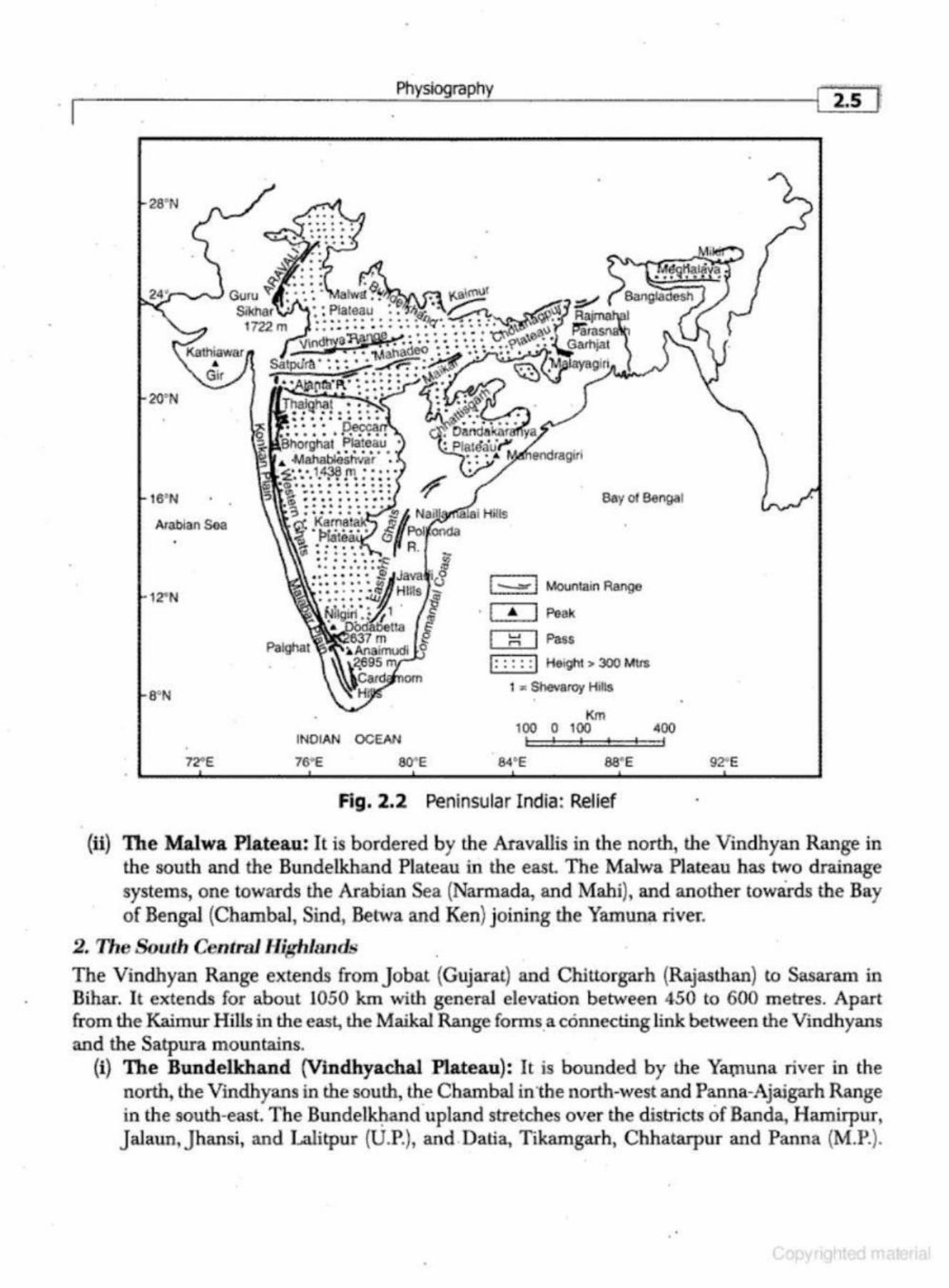
' · Th11 North Ccntralllig hlunds
The central highlands of peninsular India include the Aravallis, the Malwa Plateau, and the Vindhyan Range (Fig. 2.2).
(i) The Aravallis: It is a range that runs from north-east to south-west for about 800 krn between Delhi to Palanpur (Gujarat). I t is one of the oldest folded mountain s of the world. Being highly denude~ its highest peak- Guru-Sikhar-is only 1722 metres in height. The Aravillis are mainly composed of quartzites, gneisses and schists o f the Precambrian period. Northwest of U daipur, the Aravallis are calledjarga Hills (1431 m ). The Goranghai Pass separates G urushikar from Mount Abu. The Great Boundary Fault (GBF) separates the Aravallis from the Vindhyan Mountains.
20' N
16' N
Arabian S!la
72"E
Physiography
INOIAN OCEAN
Bay of Bengal
( --=] Mountain ABilfJB
· I & ] Peak
I ~ I Pas.s
(: :: ::I Height > 300 MlrS
1 .. Shevaroy Hills •
Km 100 0 100 400
84°E 88' E
Fig. 2.2 Peninsular India: Relief
92<E
{ti) The Malwa Plateau: It is bordered by the Aravallis in the north, the Vind.hyan Range in the south and the Bundelkhand Plateau in the east. The Malwa Plateau has two drainage systems, one towards the Arabian Sea (Narmada, and Mahi), and another towards the Bay of Bengal (Charnbal, Sind, Be twa and Ken) joining the Yamuna river.
2. The South Central Highlands The Vindhyan Range extends from Jobat (Gujarat) and Chittorgarh (Rajasthan) to Sasaram in Bihar. I t extends for about 1050 km with general elevation between 450 to 600 metres. Apart from the Kaimur Hills in the east. the Maika! Range fonns.a connecting link between the Vindhyans and the Satpura mountains.
(i) The Bundelkhand (Vmdhyachal Plateau): It is bounded by the Ya:tnuna river in the no~ the Vindhyans in the south., the Chambal in the north-west and Panna-Ajaigarh Range in the south-east The Bundel~and upland stretches over the districts of Banda, Hamirpur, Jalaun,Jhansi, and Lalitpur (U.P.}, and Datia, Tikamgarh, Chhatarpur and Panna (M.P.) .
•
~ 2.6 Geography of India
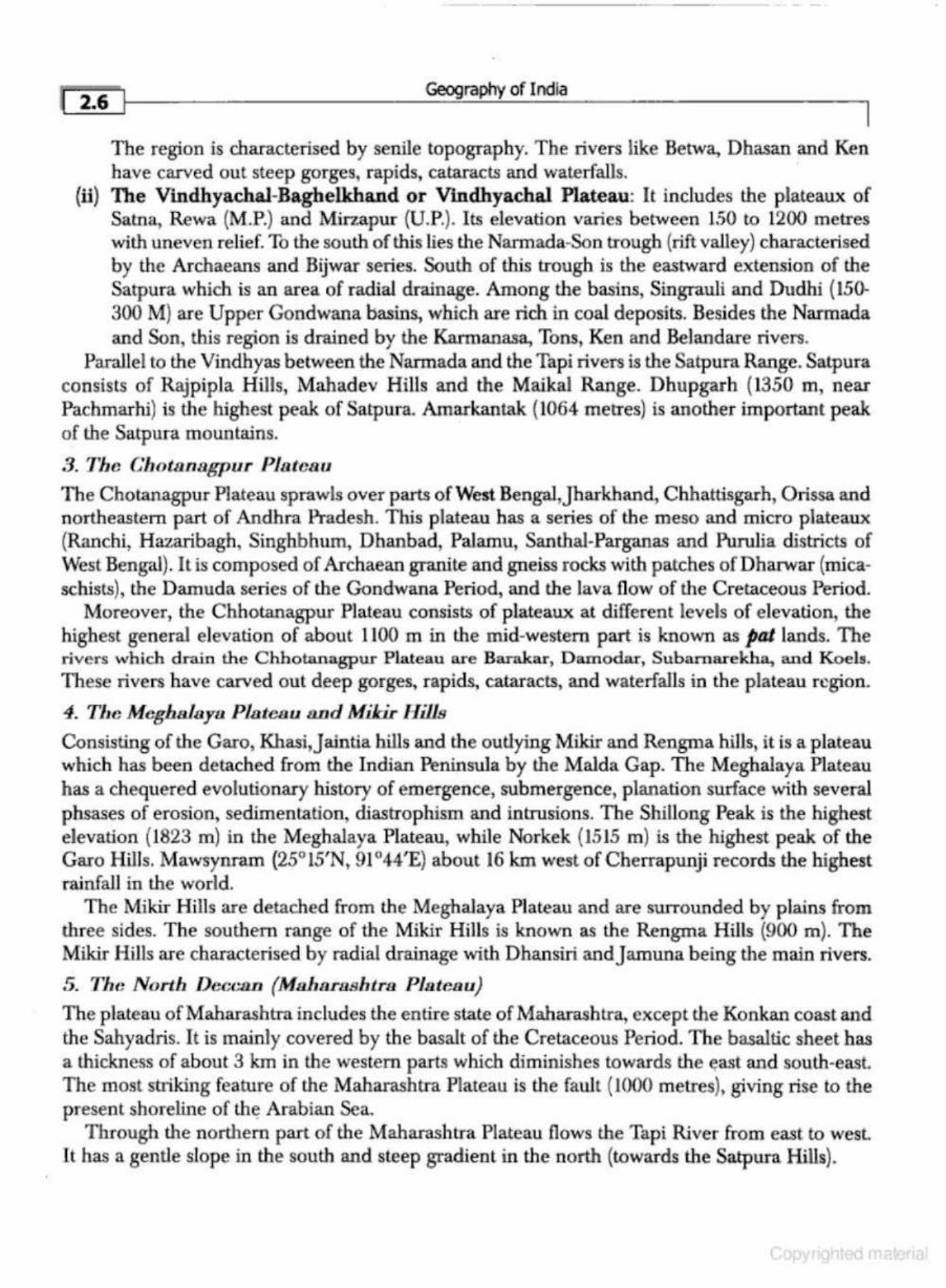
The region is characterised by senile topography. The rivers like Betwa, Dhasan and Ken have carved out steep gorges, rapids, cataracts and waterfalls.
{ii) The Vindhya.chal-Baghelkhand or Vindhyachal Plateau: It includes the plateaux of Satna, Rewa (M.P.) and Mirzapur {U.P.). Its elevation varies between 150 to 1200 metres with uneven relief. To the south of this lies the Narmada-Son trough (rift valley} characterised by the Archaeans and Bijwar series. South of this trough is the eastward extension of the Satpura which is an area of radial drainage. Among the basins, Singrauli and Dudhi (150-300 M) are Upper Gondwana basins, which are rich in coal deposits. Besides the Narmada and Son, this region is drained by the Karmanasa, Tons, Ken and Belandare rivers.
Parallel to the Vindbyas between the Narmada and the Tapi rivers is the Satpura Range. Satpura consists of Rajpipla Hills, Mahadev Hills and the Maikal Range. Dhupgarh (1350 m, near Pachmarhi) is the highest peak of Satpura. Amarkantak {1064 metres) is another important peak of the Satpura mountains.
3. Tlw G'hotanabrpur Plateau
The Chotanagpur Plateau sprawls over parts of West Bengai,Jharkhand, Chhattisgarh, Orissa and northeastern part of Andhra Pradesh. This plateau has a series of the meso and micro plateaux (Ranchi, Hazaribagh, Singhbhum, Dhanbad, Palamu, Santhai-Parganas and Purulia districts of West Bengal). It is composed of Archaean granite and gneiss rocks ·with patches of Dharwar (micaschists), the Damuda series of the Gondwana Period, and the lava flow of the Cretaceous Period.
Moreover, the Chhotanagpur Plateau consists of plateaux at different levels of elevation, the highest general elevation of about 1100 m in the mid-western part is known as pat lands. The rivers which drain the Chhotanagpur Plateau are Barakar, Damodar, Subarnarekha, and Koels. These rivers have carved out deep gorges, rapids, cataracts, and waterfalls in the plateau r~gion.
4. Tlu~ Meghalayu Plateau tJ.Dd Miki.r Hills
Consisting of the Garo, Khasi,Jaintia hills and the outlying Mikir and Rengma hills, it is a plateau which has been detached from the Indian Peninsula by the Malda Gap. The Meghalaya Plateau has a chequered evolutionary history of emergence, submergence, planation surface with several phsases of erosion, sedimentation, diastrophism and intrusions. The Shillong Peak is the highest elevation (1823 m) in the Meghalaya Plateau, while Norkek (1515 m) is the highest peak of the Garo Hills . .Mawsynram (25° 15'N, 91 °44'E} about 16 km west of Cherrapunji records the highest rainfall in the world.
The Mikir Hills are detached from the MeghaJaya Plateau and are surrounded by plains from three sides. The southern range of the Mikir Hills is known as the Rengma Hills (900 m). The Mikir Hills are characterised by radial drainage with Dhansiri andjamuna being the main rivers.
5. The Nortl1 Deccan (Ma.harashtra Plateau)
The plateau ofMaharashtra includes the entire state of Maharashtra, except the Konkan coast and the Sahyadris. It is mainly covered by the basalt of the Cretaceous Period. The basaltic sheet has a thickness of about 3 km in the western parts which diminishes towards the ~ast and south-east. The most striking feature of the Maharashtra Plateau is the fault (1000 metres), giving rise to the present shoreline of lh~ Arabian Sea.
Through the northern part of the Maharashtra Plateau flows the Tapi River from east to west. lt ha.~ a gentle slope in the south and steep gradient in the north (towards the Satpura Hills).
Physiography I 2.7 .,
(i) The Mahanadi Basin: Sprawling over the districts of Raipur, Bilaspur, Durg and Rajgarh, the Mahanadi basin is also known as the Chhanisgarh Plain. The region is largely dorni· nated by the Archaean and Cuddapah formations. The Mahanadi river and its tributaries like Seonat.h, Hasdeo and Mana drain this plain.
(ii) The Chhattisgarh Plain: It is bordered by a series of hills and plateaux. The northern boundary is formed by the Lomari Plateau, Pendra Plateau, the Chhuri and the Raigarh Hills. The Korba coalfields of Chhattisgarh lie in this basin. The Gondwana formations are rich in bituminous coal which is supplied to the Bhilai Steel Plant. The western rirnland includes the Maika! Range with crest line of 700-900 metres. The southern rimland includes the Dhalli-Rajhara Hills in southern Durg district and the Raipur uplands in the south-eastern Raipur districl The Rajhara H ill contains Dharwarian rocks in which iron ore of haematite type is found. The iron ore from the Dhalli-Rajahara mines is supplied to the Bhilai Steel Plant
(ill) Garhjat Hills: The Garhjai Hills are also known as the Orissa Highlands. It is bordered by the Chotanagpur Plateau in the north, Mahanadi basin in the west, Eastern Ghats in the south and Utkal plains in the east The region is m<Unly composed of Archaean rocks like granite, gneisses and magmatic rocks. The Gondwana, Talcher, Barakar and Kamathi series are also located in this region.
(iv} Dandakaranya : Sprawling over the Koraput and Kalahandi districts of Orissa, Bastar Dis· trict of Chhattisgarh and East Godavari, Vishakhapatnam and Srikakulam districts of Andhra Pt-cLdesh, Dandakaraoya is an undulating plateau. Its Abujhmar Hills prov]de one of the richest iron-ore deposits at Bailadila Range. It is drained by the Tel and Udantj ; tributaries of Mahanadi, and the Sabari and Sileru; tributaries of Godavari rivers.
6. The South Deccan
The south Deccan consists of several plateaux: (i) Kamataka Plateau: This plateau spans in the slate of Kamataka and the Cannan ore and
Kozhikode districts of Kerala. It shows dominance of Archaean and Dharwar formations. This plateau has an average elevation of 600- 900 metres. Mulangiri (1913 metres) is the highest peak in Baba-Budan Hills, followed by the Kudermukh (1892 metres) peak.
The northern upland of the Kamataka plaLeau is known as Malnad, while the soulhern pan is called a Maidan. It is drained by the Kaveri and the Tungbhadra rivers. The Nandi valley is a summer resort in this region.
(ii) The Telengana Plateau: The plateau of Telengana consists of Dharwar and Cuddapah formations.
(ill) The Tamil Nadu Uplands; This uphmd lies between the South Sahyadri and Tamil Na.du coastal plains. It is largely covered by the Archaean rocks. The charnockites are found in Javadi and Shevaroy hills. Moreover, there are Cuddapah and alluv]al formations . Between Coimbatore and Anaimalais, there is a broad gap, known as Palakkad Gap (Palghat), about 24 km wide, through which flows the Gayitri river from east to west joining Tamil Nadu with the coast of Kerala.
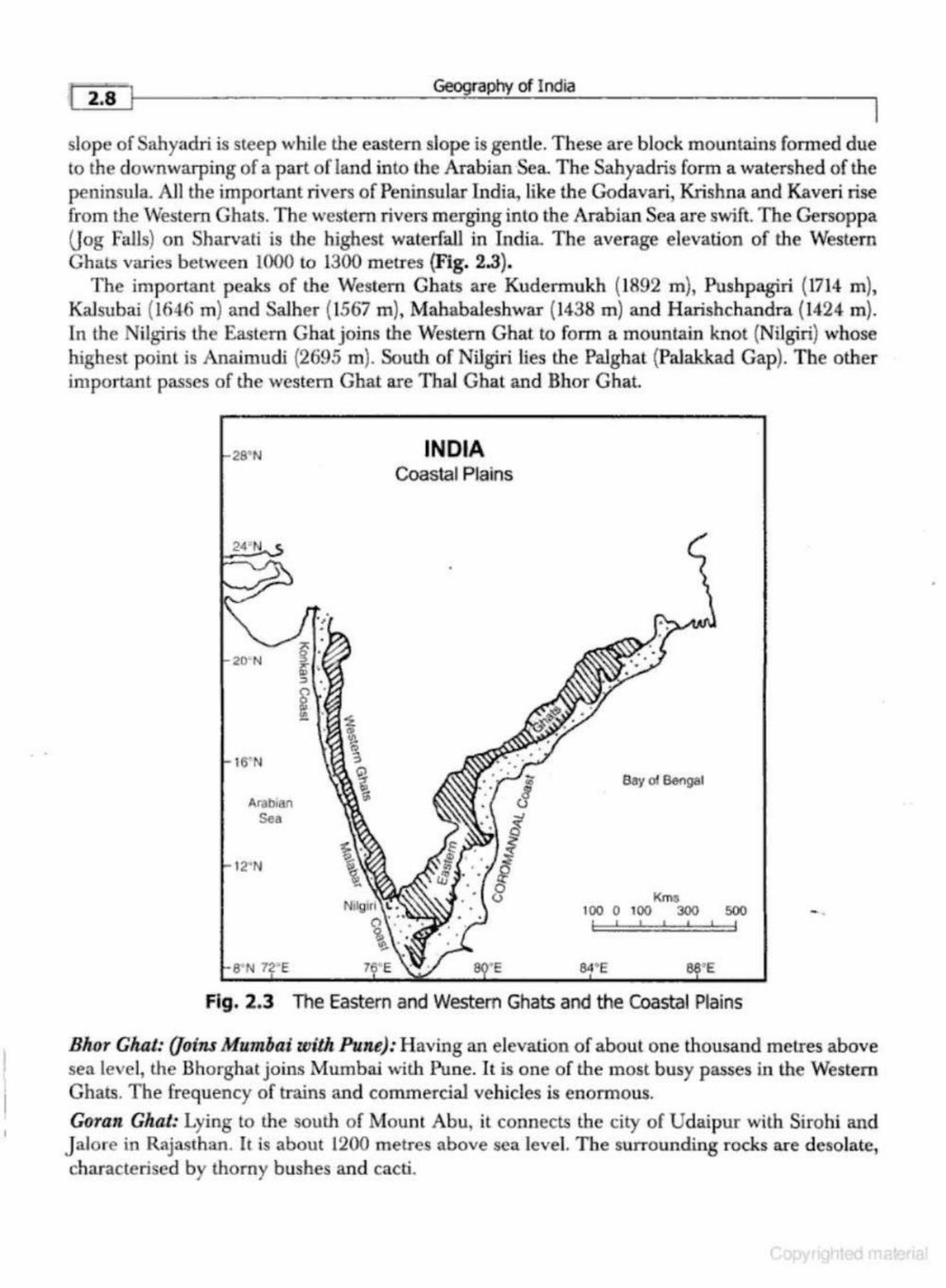
7. The Western Clults
The Western Ghats or Sahyadris run parallel to the western coast for about 1600 km in the north south direction from the mouth of the Tapi river to Kanya.kumari (Cape Camorin). The western
I
I 2.8 l Geography of India
slop e of Sahyadri is steep while the eastern slope is gentle. These are block mountains formed due to the down warping of a part of land into the Arabian Sea. The Sahyadris form a watershed of the peninsula. AJI the important rivers of Peninsular India, like the GJdavari, Krishna and Kaveri rise from the Western Ghats. The western rivers m erging into the Arabian Sea are swift The Gersoppa (Jog falls) on Sharvati is the highest waterfall in India. The average elevation of the Western Ghats varies between 1000 to 1300 metres {Fig. 2.3).
The important peaks of the Western Ghats are Kudermukh (1892 m), Pushpagiri {1714 m), KaJsubai (1646 m) and SaJher (1567 m), Mahabaleshwar (1438 m) and Harishchandra (1424 m}. In the Nilgiris the Eastern Ghat joins the Western Ghat to form a mountain knot (Nilgiri} whose highest p oint is Anaimudi (2695 m). South of Nilgiri lies the Palghat (Palak.kad Gap). The other important passes of the western Ghat are Thai Ghat and Bhor Ghat.
28'N
16' N
Ar~bian Sea
6' N 72' E
INDIA Coastal Plains
Km8 100 0 100 300 500 - . ! '•• • I
e ·e
Fig. 2.3 The Eastern and Western Ghats and the Coastal Plains
Blwr Ghat: (Joins Murnbai with. Pune): H aving an elevation of about one thousand metres above sea level, the Bhorghat joins Mumbai with Pune. I t is one of the most busy passes in the Western Ghats. The frequency of trains and commercial vehicles is enormous.
Goran Ghat: Lying to the south of MounL Abu, it connects the city of Udaipur with Sirohi and J alore in Rajasthan. lt is about 1200 metres above sea level. The surrounding rocks are desolate, characterised by thorny bushes and cacti.
.-----------___;P..:...h!..:ys~iog~ra~p~h;.:..Y ____________ -l[_ 2_9 J
Haldighal: It is a mountain pass in the Aravalli range of Rajasthan. Situated about 40 kilometres from Udaipur, it connects Rajsamand and Pali district. The name is believed to have come from the turmeric-coloured yellow soil. The m ountain pass is h istorically important as the location of the historic battle of Haldighat which took p lace in 1576 between Rana Pratap Singh of Mewar and Raja Mansingh of Amber, General of the Mughal Emperor-Akbar the Great.
HariJhckandra: The H arishchandra m ountain ranges in the southern parts of MaharashtTa from north-west to south-east. It stretches in the d istricts of Pune and Osmana bad. It is covered by degraded forests. jog Falls: T he short westward flowing Sbaravati river pours do wn the Western Ghats, forming one of the highest waterfalls in the world at 250 m .
Kalsubat: Situated in the state of Maharasbtra, it is one of the highest peaks of Western Ghats. It is 1646 m etres above sea level. Inhabited by tribal people, its forest wealth has diminished due to deforestatio n.
Kudarmukh.: Situated in the state of Kamataka, the Kudarmukh range ( 1892 m) is rich in iron o re. The iron·ore is of ha.ematite and magnetite type. Iron ore from here is exported lo iran through the port at Mangalore.
Mahabakshwar: Having an elevation of 1438 metres, Mahabaleshwar is one of the im portant peaks of the Western Ghats. It is a religious and cultural tourist attraction for domestic and inter· national tourists.
The Nilgiri Hills: The Nilgiri Hills in the Western Ghats cover an area of aboul 2500 sq km and rise over 2500 m . Udhagamandala.m, one of southern India's most famous hill resorts, is located here. Palghat (Western Ghats,•j oins Coimbarore with KoclU and K.ozh.t.kode): Also known as the Palakkad Gap, it lies to the south ofNilgiri Hills. It has an elevation ranging from 75 to 300m above the sea level. The width of this gap is ab out 25 km. It joins the state of Tamil Nadu with the seaports of Kerala. The river Gayitri flows through it from east to west.
Pushpagiri: This is one of the highest peaks of the Western Ghats. Its elevation is 1714 metres above the sea level. It is the abode of Dravidian tribes. The forests are however, degraded and soil erosion is the main problem .
Salher: Having an elevation of 1567 metres above sea level, the Sather peak lies between Malet,'<lOil and Nashik. It is inhabited by tribal people. Heavy deforestation has reduced its aesthetic beauty and created numerous ecological problem s.
Tlr.al Ghat (Uatem Ghau,- jmns Nashlk wtllt Murnbai.) : Located in th e Sahyadri Ranges, Thai Ghat is over one thousand metres above sea level. The National Highway No. 3 and the BhopalIndore Railway Line pass through the Thai Ghat.
8. The E-ttstern Ghats
The Eastetrn Ghats form the eastern boundary of the Deccan Plateau. It is a massive o utlying block of hills. The average height of the Eastern Ghats is about 600 m . The Eastem Ghat is a series of the detached hills of heterogeneous composition which are called by various local names. Benveen Mahanadi and Godavari, the average elevatio n of the Eastern Ghats is about I 100 metres (Fig. 2.3). The peak of Singaraju (Orissa) with an elevation of 1516 metres is the highest peak of
. -.
Geography of India
the Eastern Ghats. Among other peaks Nimalgiri ( 1515 m) in the Koraput District and Mahendragiri (1501 m) in Ganjam District are the other important peaks. The predominant rocks of the Eastern Ghats are khondalites, metamorphosed-sedimentary, and chamokites (intrusive rocks being granite). Between the Krishna river and Chinnai are the Kondavidu, Nallarnalai, Velikonds, Palkonda, and Erramala Ranges. Their continuation can be seen in the Seshachalam (Cuddapah and Anantapur dislricts),J avadi, Shevaroy, Panchaimalai, Sirumalai, and Varushnad Hills south west of Madurai (Tamil Nadu).
Significance of the Peninsular Plateau
Richly endowed with natural resources, Peninsular India has an important role in the economic development of the country. The importance of Peninsular India is mainly because of the following benefits from its location and rock formations:
(i) The Peninsular region of India is rich in both the metallic and non-metallic minerals. Mineral ores like iron, manganese, copper, bauxite, chromium, m ica, gold, silver, zinc, lead, mercury, coal, diamond, precious stones, marble, building materials and decorative stones are found in abundance in this physiographic region. About 98 per cent of the Gondwana coal deposits of India are also found in the Peninsular region.
(ii) A substantial part of the Peninsular India is covered by black earth (Regur soil). The regur soil is conducive for the successful cultivation of cotton, millets, mai~e. pulses, oranges and citrus fruits. Some areas of south Peninsular India are suitable for the cultivation of tea, coffee, rubber, cashew, spices, tobacco, groundnut and oilseeds.
(iii) On the southern and eastern parts of Peninsular India are large stretches of Archaean, Dharwar, Cuddapah and Vindhyan formations in which red, brown and laterite soils have developed over time. These soils are the bases of rural economy.
(iv) The Western Ghats, Nilgiris and the Eastern Ghats are covered by thick tropical moist deciduous and semi-evergreen forests. These forests provide teak, sal, sandalwood, ebony, mahogany, bamboo, cane, rosewood, iron-wood, and Iogwood as well as a large variety of forest products.
{v) The rivers flowing eastward inlo the Bay of Bengal make several gorges, waterfalls, rapids and cataracts, which have been harnessed for the generation of hydro-electricity. The rivers originating from the Western Ghats offer great opportunity for the generation of hyde] power and irrigation of agricultural crops and orchards.
(vi) There are numerous hill stations and hill resorts, of which O oty, Udhagamandalam, Kodaikonal, Mahabaleshwar, Khandala, Metheron, Pachmarhi, and Mount Abu are the most important.
{vii) Apart from teak and fuelwood, the forests of Western and Eastern Ghats are rich in medicinal plants.
(viii) The hilly and mountainous areas of the Peninsula are the abodes of many scheduled tribes. South of lhe Vindhyans is a predominance of Dravidian culture.
THE HIMALAYAS
The Himalayas consist of four lithotectonic mountain ranges, namely (i) the Trans-Himalaya or the Tethys Himalaya, (ii) the Greater Himalaya, (iii) the Lesser Himalaya, and {iv) lhe Shiwalik or
. . •

Physiography
the Outer Himalaya. The Indian Himalayas extend from the eastern boundary of Pakistan to the border of Myanmar for about 2500 km with a varying width of about 500 km in the west and about 320 km in the east. They lie to the north of the Ganga- Brahmaputra Plains and are separated from the plains by the Himalayan Front Fault (HFF). They include parts of Jammu and Kashmir, Himachal Pradesh, Uttarakhand, Nepal, Sikkim, Bhutan and Arunachal Pradesh. Their offshoots run in a north-south direction along the India- Myanmar boundary through NagaJand, Manipur, and Mizoram.
Origin of the Himalayas
The origin of the Himalayas has been a point of contention among the geologists and geomorphologists. I t is a complex mountain system having rocks from the Pre-Cambrian and Eocene periods. Mostly formed of sedimentary and metamorphic rocks, it has been subjected to intense folding and faulting. The main theories about the origin of the Himalays are as under:
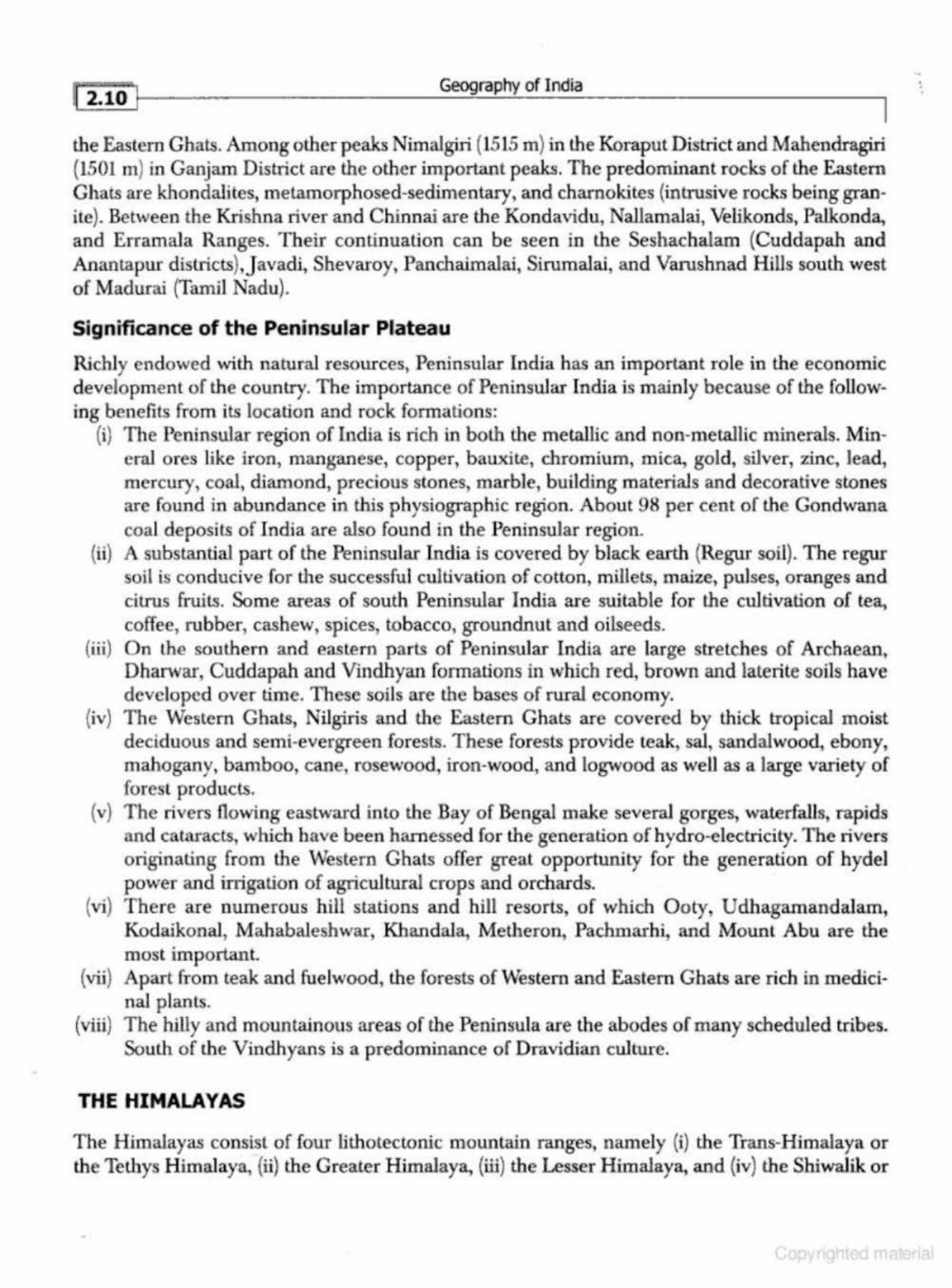
(i) The Geosynclinal Origin The main supporters of the geosynclinal origin of the Himalayas are Argand, Kober and Suess. According to these geologists, the disintegration of Pangaea, about 200 million years back, led to the formation of a long Tethys Sea between the Lauratian Shield (Angaraland) of the north and the Gondwanaland of the south. This sea was occupying the region of Himalayas during the Mesozoic Era (l80 m years ago). At the end of the Palaeozoic and beginning of the Mesozoic Eras, the Tethys almost girdled the whole Earth running from Europe in the west to China in the east Eroded material from the two land masses (Eurasian Shield - Angaraland and Gondwanaland) was deposited in the Tethys Sea and assumed considerable thickness due to the sinking nature of the sea bed (Fig. 2.4 and Fig. 2.5). During the Cretaceous Period, the bed of the sea started rising which led to the folding of three successive ranges of the Himalayas. The first upheaval led to the formation of the Greater Himalayas during the Eocene Period (about 65 m years back). Similarly,
(a) 40 million years ago
0 '.CHINA'~~ " ' ' ·~re ::X '
" ,_
~ -.. NW
flllJ Indo-Gangetic Moi9S!ie F<><edoop
0 Tethyan Sedirnen!f>
D ~ Mocotote Plulons
• Oph10hte MellnQe
SE
(b) 15 million years ago
tO km
-50 NW
CHINA PLATE
5E
t:iJ Neogene TourmaHile Grnnth!
~ MetamO<pl'k FoNetion
HF~ Himalayan Fror>Cl11 Fold
tA8T- Matn 8oonGa"' Thru$1
Fig. 2.4 Origin of the Himalayas
(c) 15 million years to present
10 km .... HFF
CHINA ~ •. ~ \J'.N SHIE.LO . PLATE ""\.: ~~~ MBT , , --, - - ,
-so ASTHENOSPtiERE NW SE
[iii! Geography of India
I
Fig. 2.5 Formation of the Himalayas
the second upheaval took p lace during the Miocene Period (about 45 million years back) resulting in the formation of lhe Lesser Himalayas, and the third upheaval started in the Pliocene period (about 1.4 mi llion years back) resulting in the formation of the Shiwaliks or the Outer Himalayas.
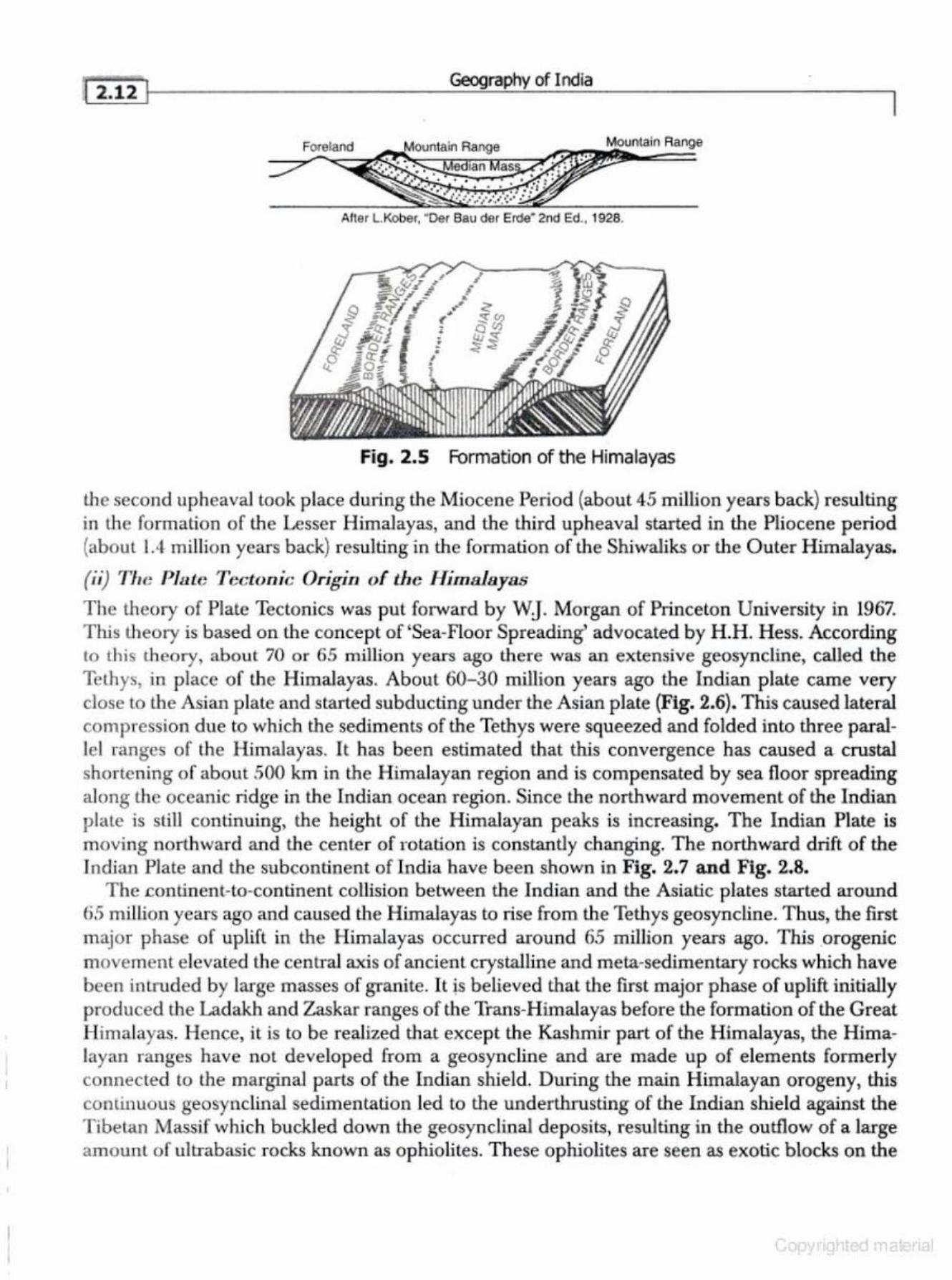
(ii) Tlw Plate Tectonic Origin of the Himalayas
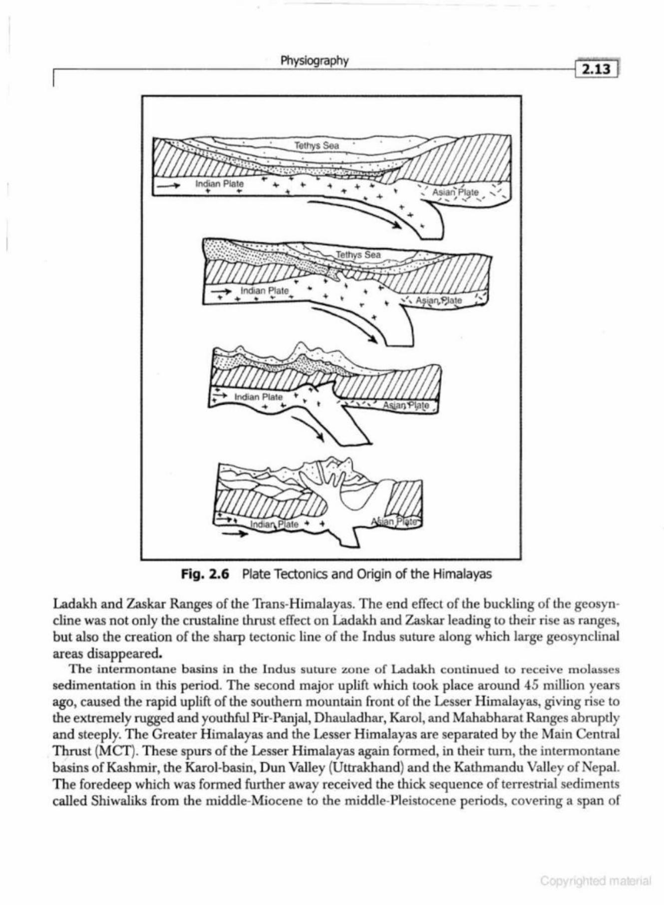
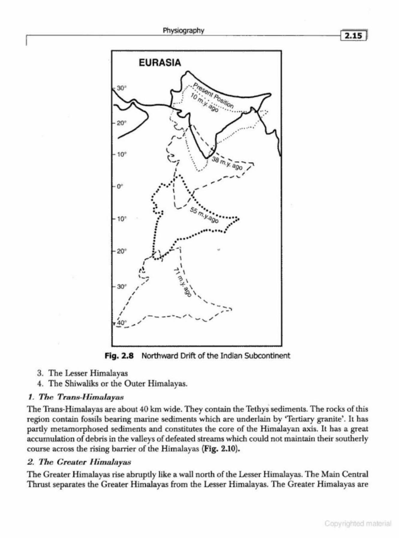
The theory of Plate Tectonics was put forward by WJ Morgan of Princeton University in 1967. This theory is based on the concept of 'Sea-Floor Spreading' advocated by H . H. Hess. According to this th eory, about 70 or 65 million years ago there was an extensive geosyncline, called the Tethys, in place of the Himalayas. About 60-30 million years ago the Indian plate came very close to the Asian plate and started subducting under the Asian plate (Fig. 2.6). This caused lateral co mpression due to which the sediments of the Tethys were squeezed and folded into three paralle l ranges of the H imalayas. It h as been estim ated that this convergence has caused a crustal shortening of about 500 km in the Himalayan region and is comp ensated by sea floor spreading along the oceanic ridge in the Indian ocean region. Since the northward movement of the Indian vlale is sti!J continuing, the height of the Himalayan peaks is increasing. The Indian Plate is moving northward and the center of rotation is constantly changing. The northward drift of the Tndian Plate and the subcontinent of Indja have been shown in Fig. 2.7 and Fig. 2.8.
T he .continent-to-continent collision between the Indian and the Asiatic plates started around fi .S million years ago and caused the Himalayas to rise from the Tethys geosyncline. T hus, the first major phase of uplift in the Himalayas occurred around 65 million years ago. This .orogenic movement elevated the central axis of ancient crystalline and meta-sedimentary rocks which have been intruded by large masses of granite. It is believed that the ftrst major phase of uplift initially p roduced the Ladakh and Zaskar ranges of the Trans-Himalayas before the formation of the Great H imalayas. Hence, it is to be realized that except the Kashmir part of the Himalayas, the Himalayan ranges have not developed from a geosyncline and are made up of elements formerly connected to the marginal parts of the Indian shield. During the main Himalayan orogeny, this continuous geosynclinal sedimentation led to the underthrusting of the Indian shield against the Tibetan Massif which buckled down the geosynclinal deposits, resulting in the outflow of a large amounl of ultrabasic rocks known as ophiolites. These ophiolites are seen as exotic blocks on the
Physiography
Tethys Sea ·
Fig. 2.6 Plate Tectonics and Origin of the Himalayas
Ladakh and Zaskar Ranges of the Trans-Himalayas. The end effect of the buckling of the geosyn· cline was not only the crustaline thrust effect on Ladakh and Zaskar leading to their rise as ranges, but also the creation of the sharp tectonic line of the Indus suture along which large geosynclinal areas disappeared.
The intermontane basins in the Indus suture zone of Ladakh continued to receive molasses sedimentation in this period. The second major uplift which took place around 45 million years ago, caused the rapid uplift of the southern mountain front of the Lesser Himalayas, giving rise to the extremely rugged and youthful Pir-Panjal, Dhauladhar, Karol, and Mahabharat Ranges abruptly and steeply. The Greater Himalayas and the Lesser H imalayas are separated by the Main Central Thrust (MCT). These spurs of the Lesser Himalayas again formed, in their tum, the intermontane basins of Kashmir, the Karol-basin, Dun Valley (Uttrakhand) and the Kathmandu Valley of Nepal. The foredeep which was formed further away received the thick sequence of terrestrial sedim ents called Shiwaliks from the middle-Miocene to the middle-Pleistocene periods, covering a span of
-.
Geography of India
- --- Postulated plate boundary =:::_ Extentional boundary ·•· • 1 Consuming boundary --Transform boundary
Indian Ocean
"' " ;
Peninsular India
China
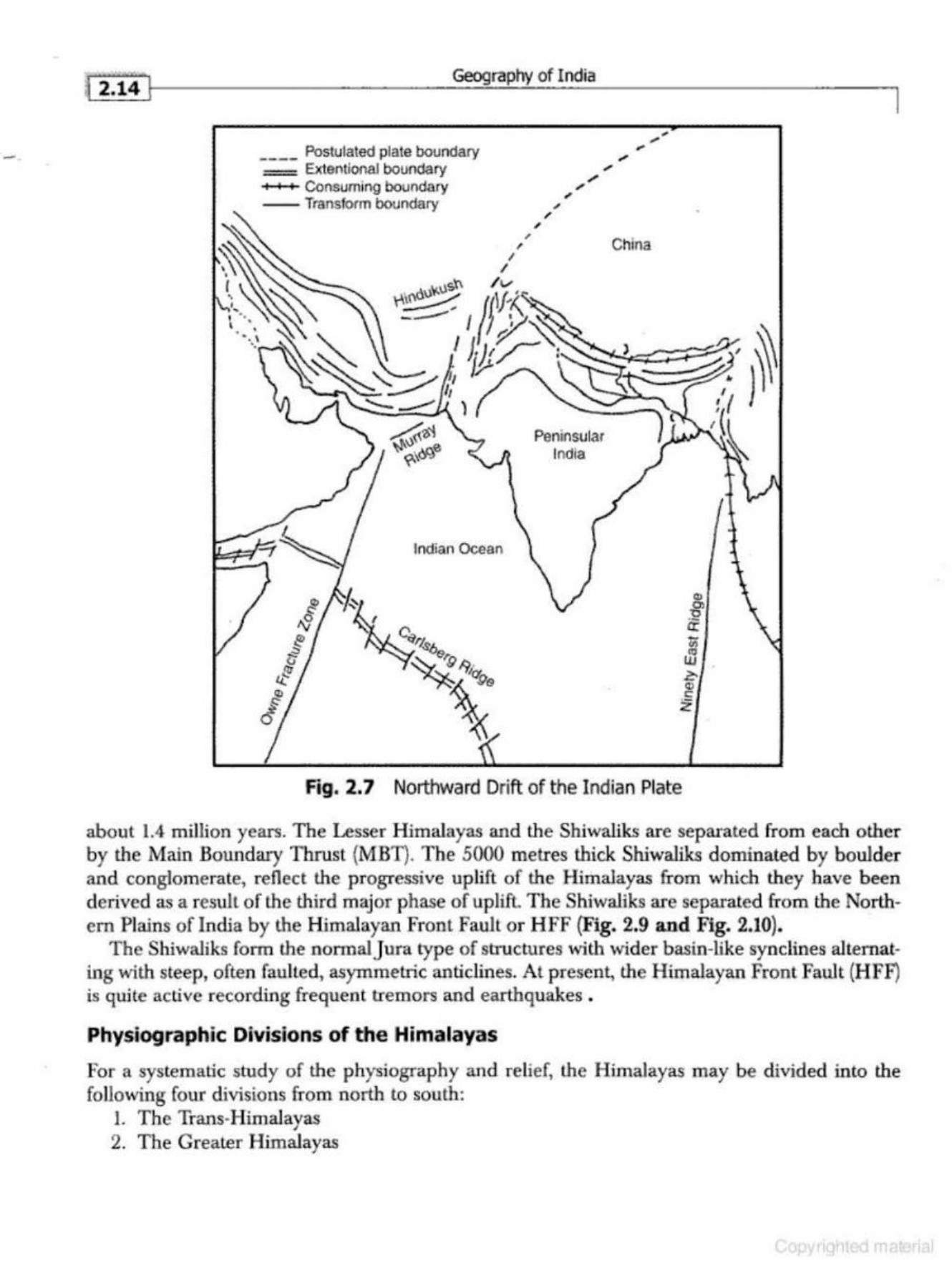
Fig. 2.7 Northward Drift of the Indian Plate
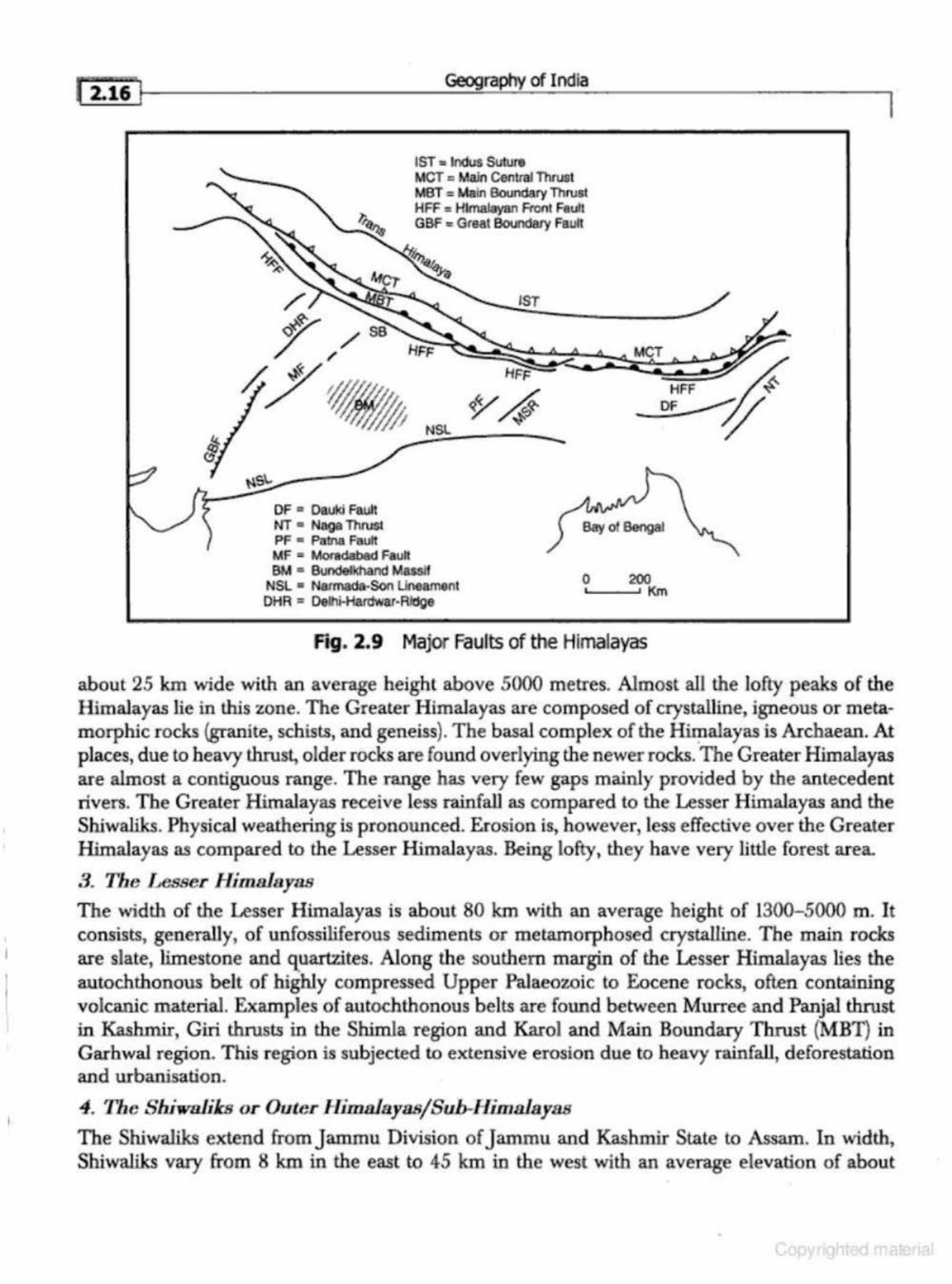
about 1.4 million years. The Lesser Himalayas and the Sbiwaliks are separated from each other by the Main Boundary Thrust {MBT). The 5000 metres thick Shiwaliks dominated by bouJder and conglomerate, reflect the progressive uplift of the Himalayas from which they have been derived as a result of the third major phase of uplift. The Shiwaliks are separated from the Northern Plains of India by the Himalayan Front Fault or H FF {Fig. 2.9 and Fig. 2.10).
The Shiwaliks form the normal j ura type of structures with wider basin-like synclines alternating with steep, often faul ted, asymmetric anticlines. At present, the H imalayan Front Fault (HFF) is quite active recording frequent tremors and earthquakes .
Physiographic Dhrislons of the Himalayas
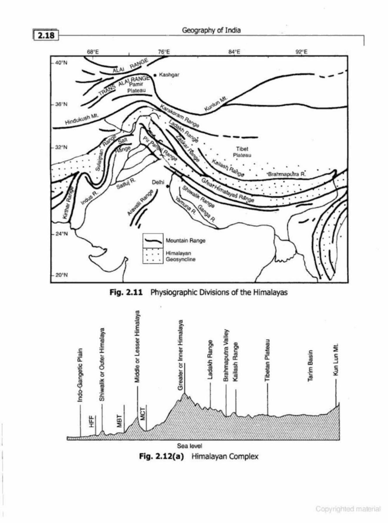
For a systematic study of the physiography and relief, the Himalayas may be divided into the following four divisions from north to south:
I. The Trans-Himalayas 2. The Greater Himalayas
10"
Physiography
EURASIA
.' .
'· ~ . I f. r- ·
/ ~ •
1.. ·• t:.-:~
I I
• . '
.. • . ' .~ ... ..
·.. . J8;;. .... • • ~,, Ll - ........... ·. .- ., . a,.,0 / ..... ~
I • .- _.,"'' •••
10°
. . , ., •• • I • -. . . ,.
, I • -{ ' ;~. •. \ .; · .. •• ._,. ss ••• •• • : 1"h
•• "' l. t,~···· ,,.,.,,., ..... • ~o ~ • •• • • . . ....... . • • • • • •• • • ••• •
20" : •·· .... • ' ... l ,...X..)( I
I
r~ , __ " 30. / ,
/ I
I I - -I ,~
1. /-----.._, , _ // 40° , '-__ ...
Fig. 2.8 Northward Drift of the Indian Subcontinent
3. The Lesser Himalayas 4. The Shiwaliks or the Outer Himalayas.
1. The Trans-Himalayas
I 2.1s f
The Trans-Himalayas are about 40 km wide. They contain the Tethys sediments. The rocks of this region contain fossils bearing marine sediments which are underlain by 'Tertiary granite'. It has partly metamorphosed sediments and constitutes the core of the Himalayan axis. It has a great accumulation of debris in the valleys of defeated streams which could not maintain their southerly course across the rising barrier of the Himalayas (Fig. 2.10).
2. The Greater lli1D.Hiayas
The Greater Himalayas rise abruptly like a wall north of the Lesser Himalayas. The Main Central Thrust separates the Greater Himalayas from the Lesser Himalayas. The Greater Himalayas are
l
r·-.rse===? 2.16 1
/
~ ss
Geography of India
1ST ,. Indus Suture MCT = Main Cenlmf Thrust M8T = Main Boundary Thrust HFF : Himalayan Front Fault GBF "'Great Boundasy Fault
1ST
~ NSL
MCT
OF • Oaukl Fault l>lT • Naga Thrust PF • Palna Fault
Bay of Bengal
MF "' MO!ada.bad Faun BM .. 6iln<lelkhand Massif
NSL • Narmada-Son Uneamant OHR " Oelhi-Hardwar·Ridge
0 200 '-----' Km
F"~g. 2.9 Major Faults of the Himalayas
I
about 25 km wide with an average height above 5000 metres. Almost all the lofty peaks of the Himalayas lie in this zone. The Great.er Himalayas are composed of crystalline, igneous or metamorphic rocks (granite, schists, and geneiss). The basal complex of the Himalayas is Archaean. At places, due to heavy thrust, older rocks are found overlying the newer rocks. The Greater Himalayas are almost a contiguous range. The range has very few gaps mainly provided by the antecedent rivers. The Greater Himalayas receive less rainfall as compared to the Lesser H imalayas and the Shiwaliks. Physical weathering is pronounced. Erosion is, however,less effective over the Greater Himalayas as compared to the Lesser Himalayas. Being lofty, they have very little forest area.
3. The Lesser Himalayas The width of the Lesser Himalayas is about 80 km with an average height of 1300-5000 m. It consists, generally, of unfossiliferous sediments or metamorphosed crystalline. The main rocks are slate, limestone and q_uartzites. Along the southern margin of the Lesser Himalayas lies the autochthonous belt of highly compressed Upper Palaeozoic to Eocene rocks, often containing volcanic material. Examples of autochthonous belts are found between Murree and Panjal thrust in Kashmir, Giri thrusts in the Shimla region and Karol and Main Boundary Thrust (MBT) in Garhwal region. This region is subjected to extensive erosion due to heavy rainfall, deforestation and urbanisation.
4. The Shiwolilcs or Outer HimafayasfSub-Himalayas
The Shiwaliks extend fromjammu Division ofj ammu and Kashmir State to Assam. In width, Shiwaliks vary from 8 km in the east to 45 km in the west with an average elevation of about
•
I I Physiography
1ST = Indus Suture
MCT = Main Central Thrust
MBT " Main Boundary Thrust
HFF = Himalayan Front Fault
'Sr
200 0 200 400 km l i iiJI I
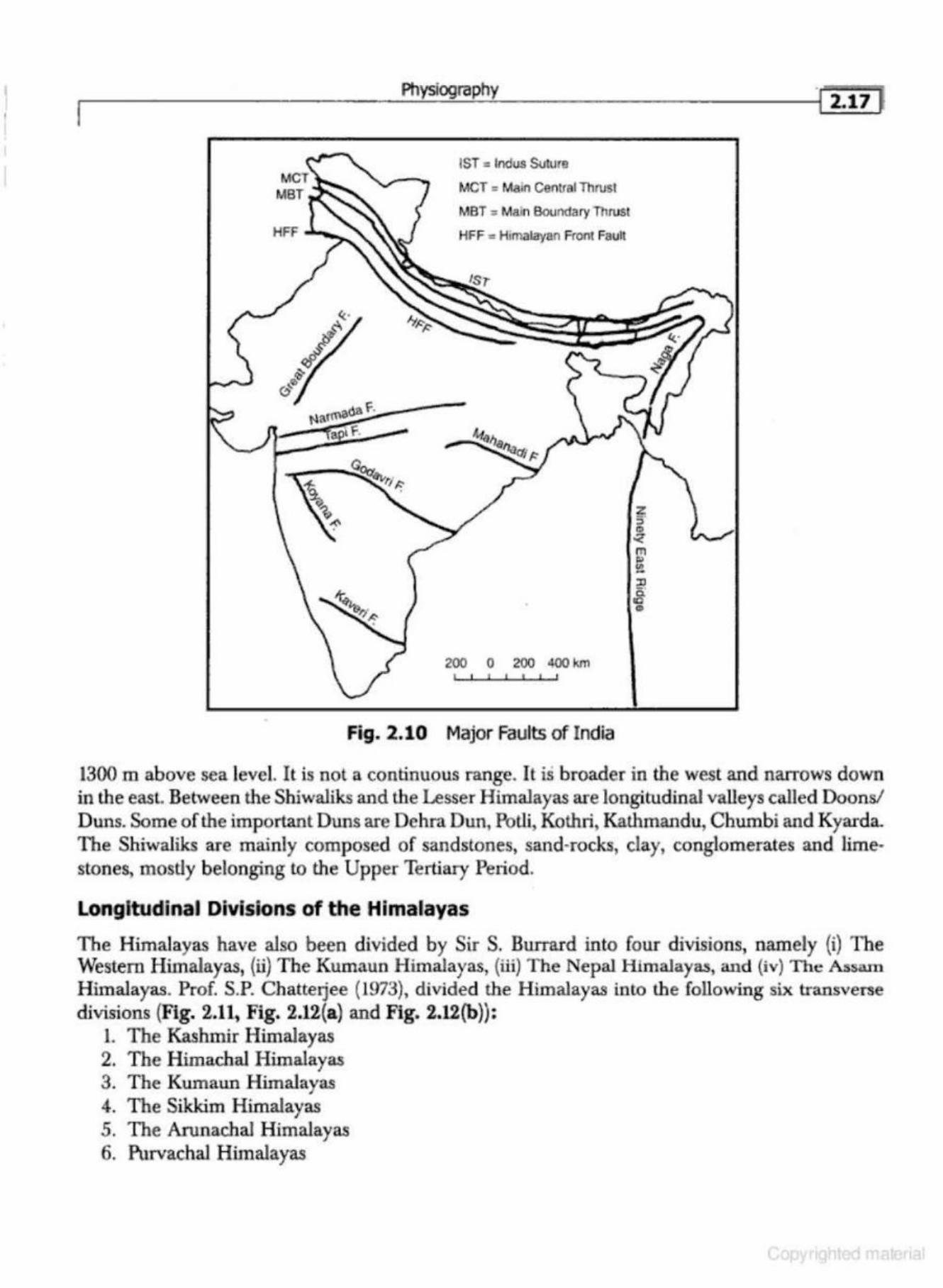
Fig. 2.10 Major Faults of India
l il7 J
1300 m above sea level. It is not a continuous range. It is broader in the west and narrows down in the easl. Between the Shiwaliks and the Lesser Himalayas are longitudinal valleys called Doons/ Duns. Some of the important Duns are Dehra Dun, Potli, Kothri, Kathmandu, Chumbi and Kyarda. The Shiwaliks are mainly composed of sandstones, sand·rocks, clay, conglomerates and hme· stones, mostly belonging to the Upper Tertiary Period.
Longitudinal Divisions of the Himalayas
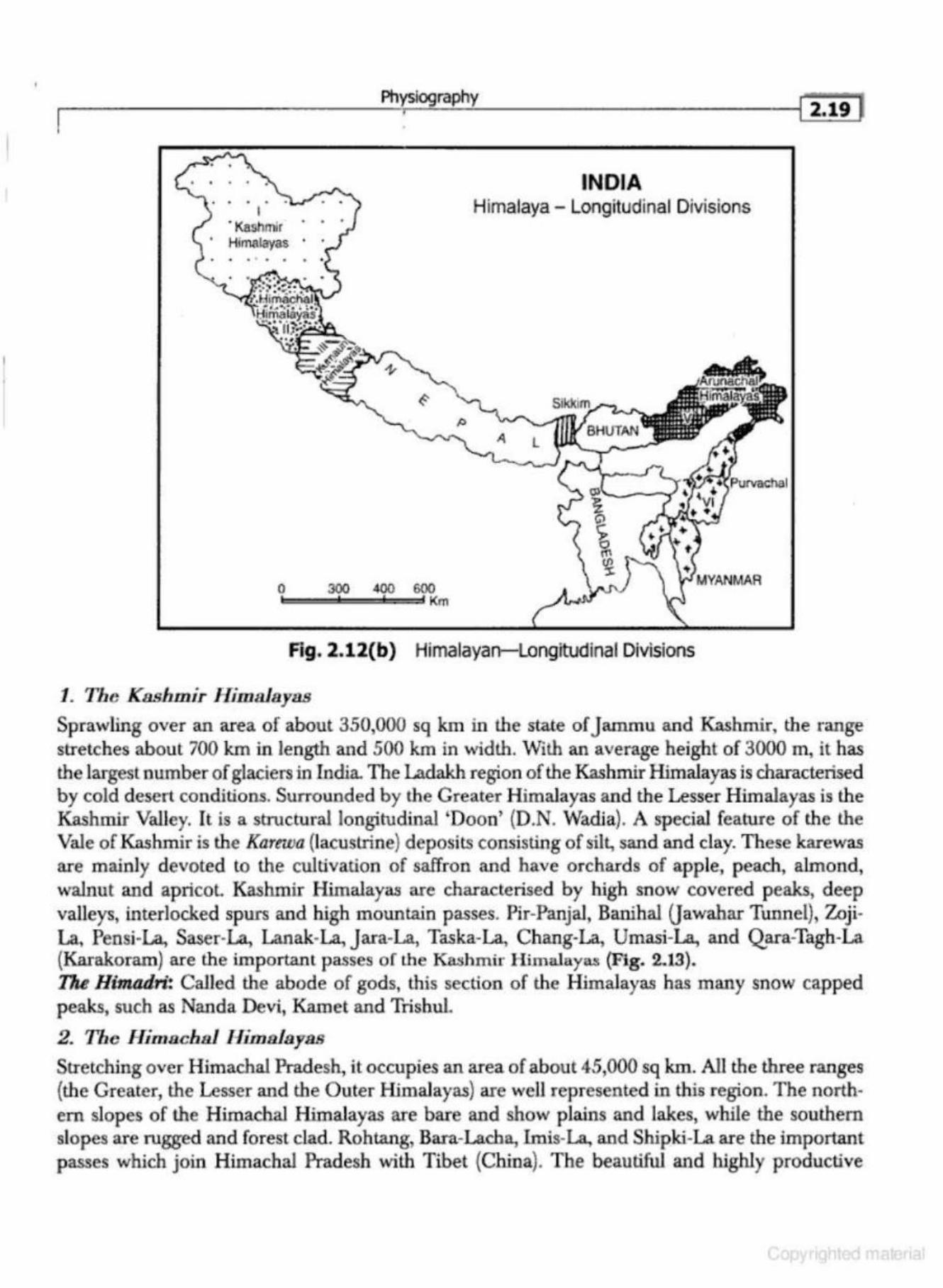
The Himalayas have also been divided by Sir S. Burrard into four divisions, namely (i) The Western Himalayas, (ii) The Kumaun Himalayas, {iii) The Nepal Himalayas, and (iv) The Assam Himalayas. Prof. S.P. Chatterjee (1973), divided the Himalayas into the following six transverse divisions (Fig. 2..11, Fig. 2.12(a) and Fig. 2.12(b)):
1. The Kashmir Himalayas 2. The Himachal Himalayas 3. The KumalUl Himalayas 4. The Sikkim Himalayas 5. The Arunachal Himalayas 6. Purva{;ha] Himalayas
r2.is1 ea·e
40'N
...
J6' N
32' N
• • •
24'N
20"N
Geography of India
76' E 84' E 92"E
~~-------- ---
----•
• • • ·srahmapo"tra R. ' Delhi
\ -.... • • • . . • •
Mountain Range
Himalayan Geosyncline
• • . . . . .. . . . • • . . . . ..
• • •
Fig. 2.11 Physiographic Divisions of the Himalayas
Ill ~
~ J: .. CD c: c:
0 ... CD
~ .. 0
Sea level
Fig. 2.12(a) Himalayan Complex
•
.s 0 CD
CD
E ';:; {E.
•
•
Physiography
•
I ·Kashmir Himalayas
0 ' • • •
I
0 300 400 600 l:::::::=::::ic::==l::::::=d Km
INDIA Himalaya - Longitudinal Divisions
A l
Fig. 2.12(b) Himalayan-Longitudinal Divisions
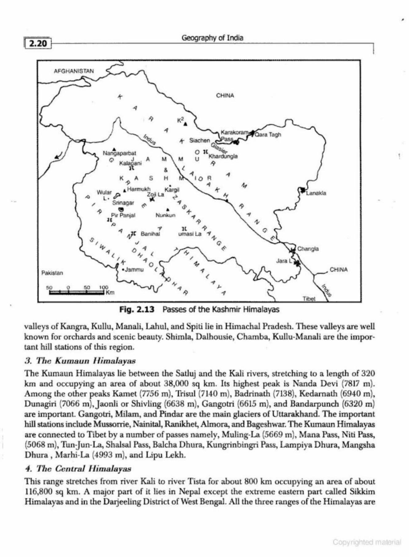
1. The Kashmir Himalayas
~ 2.19 ~
Sprawling over an area of about 350,000 sq km in the state of jammu and Kashmir, the range stretches about 700 km in length and 500 km in width. With an average height of 3000 m, it has the largest number of glaciers in India. The Ladakh region of the Kashmir Himalayas is characterised by cold desert conditions. Surrounded by the Greater Himalayas and the Lesser Himalayas is the Kashmir Valley. It is a structural longitudinal 'Doon' (D.N. Wad.ia). A special featu.re of the the Vale of Kashmir is the Karewa (lacustrine) deposits consisting of silt, sand and clay. These karewas are mainly devoted to the cultivation of saffron and have orchards of apple, peach, almond, walnut and apricot Kashmir Himalayas are characterised by high snow covered peaks, deep valleys, interlocked spurs and high mountain passes. Pir-Panjal, Banihal Oawahar Tunnel), Zoji· La, Pensi-La, Saser-La, Lanak-La, Jara-La, Taska-La, Chang-La, Umasi-La., and Qara-Tagh-La (Karakoram) are the important passes of the ~hmir Hima.laya.s (Fig. 2.13). 17u Himadri! Called the abode of gods, this section of the Himalayas has many snow capped peaks, such as Nanda Devi, Kamet and Trishul.
2. The Himacbsl Himsla yas
Stretching over Himachal Pradesh, it occupies an area of about 45,000 sq km. All the three ranges (the Greater, the Lesser and the Outer Himalayas) are well represented in this region. The northem slopes of the Himachal Himalayas are bare and show plains and lakes, while the southern slopes are rugged and forest clad. Rohtang, Bara.-Lacha, lmis-La, and Shipki-La are the important passes which join Himachal Pradesh with Tibet {China). The beautiful and highly productive
·-
•
Geography of India
I
CHINA
K2 • ~
-t ...
Nanga parbat Q Kal~ni A
M
&
Paltistan
50 0 so 100 -- - Km
Fig . 2.13 Passes of the Kashmir Himalayas
valleys of Kangra, Kullu, Manali, Lahul, and Spiti lie in Himachal Pradesh. These valleys are well known for orchards and scenic beauty. Shim Ia, Dalhousie, Chamba, Kullu-Manali are the important hill stations of this region.
3. The Kumaun Himalayas
The Kumaun Himalayas lie between the SatJuj and the Kali rivers, stretching to a length of 320 km and occupying an area of about 38,000 sq Jan. Its highest peak is Nanda Devi (7817 m). Among the other peaks Kamet (7756 m), Trisul (7140 m), Badrinath (7138), Kedarnath (6940 rn), Dunagiri (7066 m),jaonli or Shivling (6638 m), Gangotri {6615 m), and Bandarpunch (6320 m) are importanl Gangotri, Milam, and Pindar are the main glaciers of Uttarakhand. The important hill stations include Mussorrie, Nainit.al, Ranikhet, Almora, and Bageshwar. The Kumaun Himalayas are connected to Tibet by a number of passes namely, Muling-La (5669 m), Mana Pass, Niti Pass, (5068 m), Tun:Jun-La, Shalsal Pass, Balcha Dhu.ra. Kungrinbingri Pass, Lampiya Dhura, Mangsha Dhura, Marhi-La (4993 m), and Lipu Lekh.
4. The Central Himalayas
This range stretches from river Kali to river Tista for about 800 km occupying an area of about 116,800 sq km. A major part of it lies in Nepal except the extreme eastern part called Sikkim Himalayas and in the Darjeeling D istrict of West Bengal. All the three ranges of the Himalayas are
,
t •
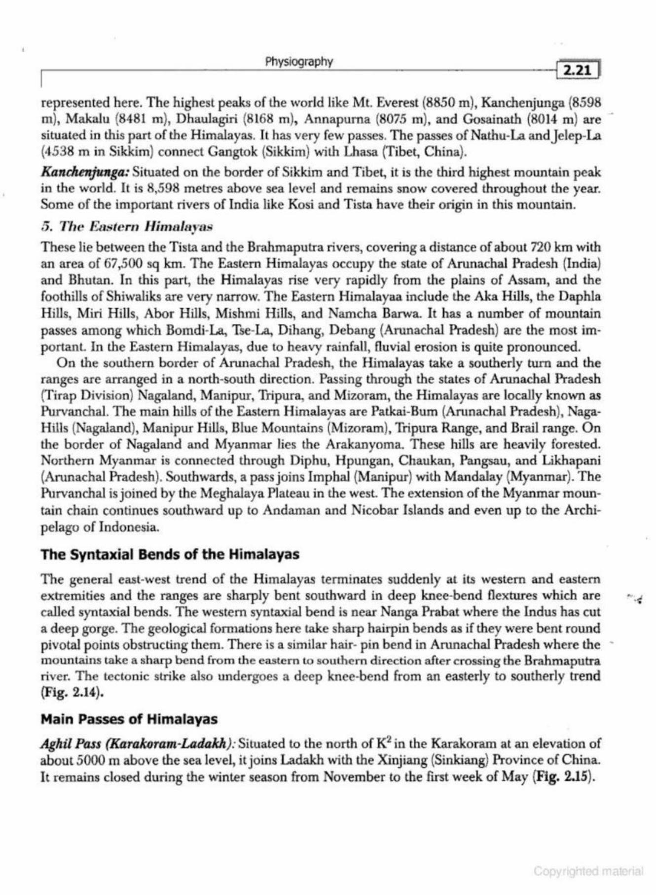
~----------------------P_hy~s~io~grn~p~h~y----------------------~! 2•21 1
represented here. The highest peaks of the world like Mt. Everest (8850 m), Kanchenjunga (8598 m), Makalu {8481 m), Dhaulagiri (8168 m), Annapuma (8075 m), and Gosainath (8014 m) are situated in this part of the Himalayas. Jt has very few passes. The passes of Nathu-La and Jelep-La (4538 m in Sikkim) connect Gangtok (Sik.kim) with Lhasa {Tibet, China).
Kanchenjunga: Situated on the border of Sikkim and Tibet, it is the thixd highest mountain peak in the world. It is 8,598 metres above sea level and remains snow covered throughout the year. Some of the important rivers of India like Kosi and Tista have their origin in this mountain.
5. The Eastern Himalayas •
These lie between the Tista and the .Brahmaputra rivers, covering a distance of about 720 km with an area of 67,500 sq krn. The Eastern Himalayas occupy the state of Arunachal Pradesh (India) and Bhutan. In this part, the Himalayas rise very rapidly from the plains of Assam, and the foothills of Shiwaliks are very narrow. The Eastern Himalayaa include the Aka Hills, the Daphla Hills, Miri Hills, Abor Hills, Mishmi Hills, and Namcha Barwa. It has a number of mountain passes among which Bomdi-La, Tse-La, Dihang, Debang (Arunachal Pradesh) are the most importanL In the Eastern Himalayas, due to heavy rainfall, fluvial erosion is quite pronounced.
On the southern border of Arunachal Pradesh, the Himalayas take a southerly tum and the ranges are arranged in a north-south direction. Passing through the states of Arunachal Pradesh (T irap D ivision} Nagaland, Manipur, Tripura, and Miz.oram, the Himalayas are locally known as Pw-vanchal. Th e main hills of the Eastern H imalayas are Patkai-Bum (Arunachal Pradesh), NagaHills (Nagaland), Manipur Hills, Blue Mountains (Mizoram). Tripura Range, and Brail range. O n the border of Nagaland and Myanmar lies the Arakanyoma. These hills are heavily forested. Northern Myanmar is connected through Diphu, Hpungan, Chaukan, Pangsau, and Likhapani (Arunachal Pradesh). Southwards, a pass joins Imphal (Manipur) with Mandalay (Myanmar). The Purvaochal is joined by the Meghalaya Plateau in the west. The extension of the Myanmar mountain chain continues southward up to Andaman and Nicobar Islands and even up to the Archipelago of Indonesia.
The Syntaxial Bends of the Himalayas
The general east-west trend of the Himalayas terminates suddenly at its western and eastern extremities and the ranges are sharply bent southward in deep knee-bend flextures which are •· . .; called syntaxial bends. The western syntaxial bend is near Nanga Prabat where the Indus has cut a deep gorge. The geological fomtatioru here take sharp hairpin bends as if they were bent round pivotal points obstructing them. There is a similar hair- pin bend in Arunachal Pradesh where the -mountains take a sharp bend from the eastern Lo southern direction after crossing the Brahmaputra river. The tectonic strike also undergoes a deep k-nee-bend from an easterly to southerly trend (Fig. 2.14).
Main Passes of Himalayas
Aghil Pass (KIJrakoram-Ladakh): Situated to the north of K2 in the Karakoram at an elevation of about 5000 m above the sea level, it joins Ladakh with the Xinjiang (Sinkiang) Province of China. It remains closed during the winter season from November to the first week of May (Fig. 2.15).
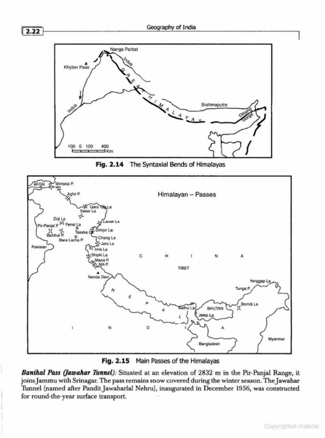
Geography of India ~ 2.ii I l
100 0 100 400 I c • • h<m I
Fig. 2.14 The Syntaxial Bends of Himalayas
Himalayan - Passes
c H N A
TlBET
N 0 A
My.mmat
Fig. 2.15 Main Passes of the Himalayas
Banihal Pass (/aUJalun 'lhmtel): Situated at an elevation of 2832 min the Pir-Panjal Range, it joinsJammu with Srinagar. The pass remains snow coveredduringthewinter season. Thejawahar 1Unnel {named after PanditJawaharlal Nehru), inaugurated in December 1956, was constructed for round-the-year surface transport.
Physiography
Bara Ladta (Himachal Pradesh UJith Leh-Ladalch): Situated in the state of jammu and Kashmir at an altitude of 5045 m. It is on the National Highway connecting Manali and Leh. Being a high mountain pass, it remains snow covered from November to mid-May.
Bomdi La (4331 m, Aruruu:lull Praduh) : Situated to the east of Bhutan in the Greater Himalayas in Arunachal Pradesh at an altitude of about 2600 m above sea level, it connects Arunachal Pradesh with Lhasa, the capital of Tibet. It remains closed in the winter season owing to snowfall and adverse weather.
Bunail Pass (Srinagar with Kishan-Ganga Valley): Situated at an altitude of more than five thousand feet above sea leve~ this pass connects Ladakh with China. Being snow covered during the winter season it remains closed for trade and transsport.
Chang-La (Ladakh U1iJA Ti!Jet): Situated at an elevation of over 5270 m, it is a high mountain pass in the Greater Himalayas. The road after Chang-Ia is extremely steep, leading to the small town of tangtse. The pass has a temple dedicated to Chang-la Baba after whom the pass has been named. Being snow-covered, it remains closed during the ·winter season.
Dehsa Pass: Situated at an elevation of 5270 m above sea level, it is a high mountain pass in Greater Himalayas between the Kullu and Spiti districts of Himachal Pradesh. This pass provides an easier and shorler alternative to lhe traditional Pin-Parbati Pass route between Kullu and Spiti.
Di1umg Pass: Situated in the state of Arunachal Pradesh at an elevation of about 4000 feet this pass connects Arunachal Pradesh with Mandalay (Myanmar}.
Diplw Pass (Arunadud Praduk with Mandalay in Myanmar): Situated in the eastern part of Arunachal Pradesh, Diphu Pass provides an easy and shortesl access to Mandalay a {Myanmar). It is a traditional pass between India and Myanmar which remains open throughout the year for transportation and trade. lmis La: Situated at an elevation of over 4500 m, this pass provides an easy access between Ladakh and Tibet (China). It has a difficult terrain, steep slopes, and remains closed during the winter season. Khardu.ng La: Situaled at an elevation of more than six thousand m above sea level, it is the highest motorable pass in the country. The road, however, remains closed during the winter season.
Khunjerab Pass (Karakoram): Situated at an altitude of more than five thousand feet in the Karakoram Mountains, it is a traditional pass between Ladakh and the Sinkiang Province of China. It remains snow covered during the winter season from November to mid-May.
Jekp La (4538 m): Situated at an elevation of 4538 m above sea level, this pass connects Sik.kim with Lhasa. It passes through the Chumbi Valley. Lanak La: Situated at an altitude of about five thousand metres in the Aksai-Chin (Ladakh), it connects Ladakh with Lhasa. The Chinese have constructed a road to connect the Xinjiang (Sinkiang) Province of China with Tibet.
Likhapani (Arunachal Pradesh) : Situated at an altitude of more than four thousand metres above sea level, the Likhapani Pass joins Arunachal Pradesh with Myanmar. For trade and lransport, it remains open throughout the year.
•
[2
•24
-t--l ___________ Geog---=_ra.:....ph..:.y_o_fl_nd_la __________ __
Lipu Lalck (UttaraMand) : Situated in the Pithoragarh District, it connects Uttarakhand with Tibet The pilgrims for Mansarovar Lake travel through this pass. Landslides in the rainy season and avalanches in winter create great problems for movement and transportation.
Mana Pass: Situated at an elevation of .5611 m above sea level in the Greater Himalayas, it connects Uttarakhand with Tibet. It remains snow covered for about six months during the winter season.
Mangsha Dhura Pass: Situated at an elevation of more than five thousand metres in the district of Pithoragarh, the Mangsha Dhura Pass connects Uttarakhand with Tibet. The pilgrims for Mansarovar cross this pass. Landslides create great problems for tourists and pilgrims ..
Multng La {Uthzrakkand): Situated north of Gangotri, this seasonal pass joins Uttarakhand with Tibet. It remains snow covered during the winter season.
Nalku La (Sikkim,): Nathu La is located on the Indo-China border. The pass, at 4310 m above sea leveL forms part of an offshoot of the ancient Silk Road. Nathu-La is one of the three trading border posts between India and China. After the 1962 war it was reopened in 2006 .
•
Niti Pass: Situated at an altitude of 5068 m above sea level, the Niti Pass joins Uttarakhand with Tibet It remains snow covered during the winter season between November and mid-May.
Pangsan Pass (Arunachal Pardesh): Situated at an elevation of more than four tho~and metres above sea level, this pass connects Arunachal Pradesh with Mandalaya (Myanmar).
Penn La: Situated in the Greater Himalayas at an elevation of more than five thousand metres above sea level to the east ofZoji La, this pass connects ~e Valley of Kashmir with Kargil (Ladakh). It remains snow covered from November to mid-May.
Pir-Panjal Pass: The traditional pass from jammu to Srinagar, this pass lies on the Mughal Road. After partition of the Subcontinent, the pass was closed down. It provides the shortest and easiest metalled road access from J ammu to the Valley of Kashmir.
Qara 'Rlgh Pass: Located in the Karakoram Mmmtains at an elevation of more than six thousand feet above sea level, this p ass was an offshool of the Great Silk Road. It remains snow covered during the \vinter season.
Rohtang Pass: Located at an elevation of 3979 m above sea level, this pass connects the Kullu, the Lahul and Spiti valleys of Himachal Pradesh. It has excellent road access, constructed by the Border Road Organisation (BRO). Traffic jams are common occurrences caused by the heavy movement of military vehicles, buses, taxis, trucks and goods carriers.
Shipki La: Loca ted at an altitude of more than 6000 m above sea level·through the Satluj Gorge, the Shipki-La joins Himachal Pradesh with Tibet. It remains snow covered during the winter season.
Thang La (Ladakh): Located at an elevation of 5359 m above sea level, it is a mountain pass in Ladakh (J & K}. It .Is the second highest .motora'ble mountain pass in India after Khardung La. 1tatll's Pass: Located at an elevation of 5212 m above sea level in the Pithoragarh and Bageshwar disb.icts .of Uttarakhand, it is situated at the end of the Pindari Glacier and links Pindari Valley to Milam Valley. Being steep and rugged, this pass is very difficult to cross.
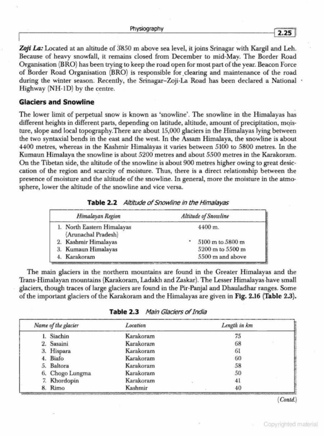
. Physiography
1 2.2~ · r 7hji La: Located at an altitude of 3'850 m above sea level, it joins Srinagar with Kargil and Leh. Because of heavy snowfall, it remains closed from December to mid-May. The Border Road Organisation (B RO) has been trying to keep the road open for most part of the year. Beacon Force of Border Road Organisation (BRO) is responsible for clearing and maintenance of the road during the winter season. Recently, the Srinagar- Zoji-La Road has been declared a National · Highway (NH-l D) by the centre.
Gladers and Snowline
The lower limit of perpetual snow is known as 'snowline'. The snowline in the Himalayas has differem heights in different parts, depending on latitude, altitude, amount of precipitation, mqisture, slope and local topography.There are about 15,000 glaciers in the Himalayas lying between the Mo syntaxial bends in the east and the west. In the Assam Himalaya, the snowline is about 4400 metres, whereas in the Kashmir Himalayas it varies bet\Veen 5100 to 5800 metres. In the Kumaun Himalaya the snowline is about 5200 metres and about 5500 metres in the Karakoram. On the Tibetan side, the altitude of the snowline is about 900 metres higher owing to great desiccation of the region and scarcity of moisture. Thus, there is a direct relationship between the presence of moisture and the altitude of the snowline. In general, more the moisture in the atmosphere, lower the altitude of the snowline and vice versa.
Table 2.2 Altitude of Snowline in the Himalayas
Himalayan Hegirm
I. North Eastern Himalayas (Arunachal Pradesh)
2. Kashmir Himalayas 3. Kumaun Himalayas 4. Karakoram
Altitude of Snowline
4400 m.
• 5100 rn to.5800 m 5200 m to 5500 m 5500 m and above
The main glaciers in the northern mountains are found in the Greater Himalayas and the Trans-Himalayan mountains (Karakoram, Ladakh and Zaskar). The Lesser Himalayas ·have small glaciers, though traces of large glaciers are found in the Pir-Panjal and Dhauladhar ranges. Some of the important glaciers of the Karakoram and the Himalayas are given in Fig. 2.16 (Table 2.3).
Name of the glacier
L Siachin 2. Sasaini 3. Hispara 4. Biafo 5. Bait ora 6. Chogo Lungma 7. Khordopin 8. Rimo
--~·-·-., .,.
Table 2.3 Main Gladers of India
Location
Karakoram Karakoram Karakoram Karakoram Karakoram Karakoram Karakoram Kashmir - ... ............. - .,. ___ , ... ....,_
•
Length inkm
75 68 61 60 58 50 41 40
I
• .
1 '
( Crmul.)
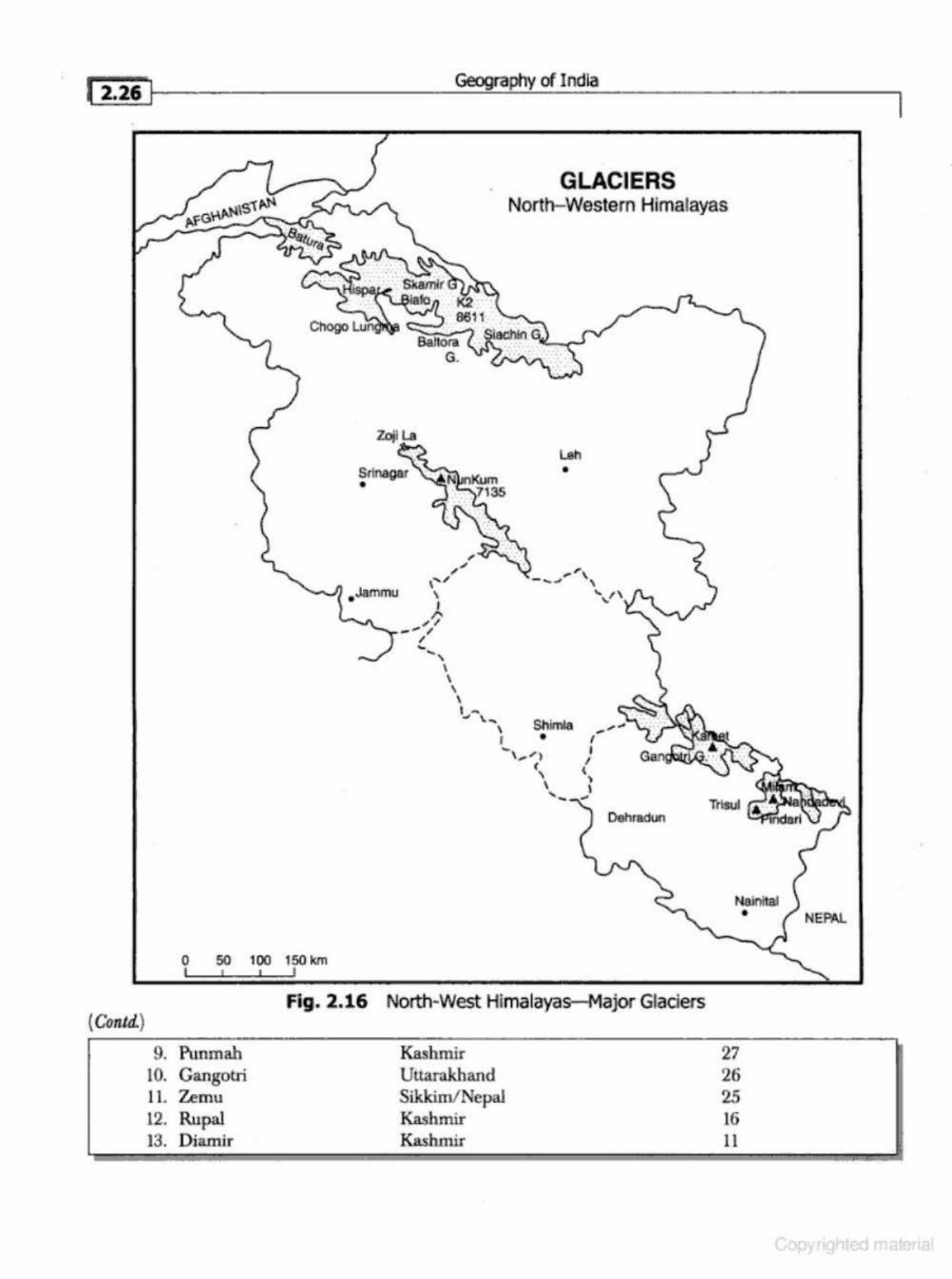
1 2.~~ l Geography of India
( Conld.)
Zojl l.a
--...,1 . Jammu
0 50 100 150 km I I I J
E>altora G.
--, I \
' \ ,_ J \~
\ I
GLACIERS North-Western Himalayas
Shlmla •
Dehradun
Fig. 2.16 North-West Himalayas-Major GlacieiS
9. Punmah 10. Cangotri lL Zemu 12. Rupal 13. Diamir
Kashmir Uttarakhand Sikkim/Nepal Kashmir Kashmir
27 26 25 16 11
Physiography [ 2.27 i
Most of the glaciers of the Lesser Himalayas are smaller in size, ranging from 3 to 5 km in length. There are, however, some larger-sized glaciers also in Karakoram and the Greater Himalayas. Some of the important glaciers are Siachen {75 km), Sasajni (68 km), Hispara (61 km), Biafo (60 krn), Baltora (58 km) (Karakoram mount.ams).The Chogo Lungma Glacier (50 km) terminates at an altitude of 2070 m, the lowest recorded in the Himalayas (Fig. 2.16). In Uttrakhand, Gangotri, Milam and Pind.ari are the main glaciers. The glaciers of Karakoram are the remnants of the Pleistocene Age. The diurnal rate of movement of these glaciers is between 8 to 15 em at the side and 20 to 30 em in the middle. The glaciers of the Pir-Panjal are less numerous and smaller in size as compared to those of the Karakoram and the Greater Himalayan ranges. The longest glacier of the Pir-Panjal is Sonapani glacier in the Chandr-c~. Valley of Lahul and Spiti region. Its length is about 15 km at an altitude of about 4{)00 m near the Rohtang Pass. The largest glacier in the NunKun peak is the Gangri Glacier which is about 13 km in length. The glaciers of the Nanga Parbat Massif are small in size and are moving fast due to a steep slope. The Chungphar, Rakhiot, Buzhi and Tashan are the other important glaciers of the Pir-Panjal Range. The glaciers are not only the source of Himalayan rivers, but also maintain a regular supply of water in these rivers during offmonsoon period. The Himalayan glaciers are, however, receding.
Ice Ages In India
The subcontinent of India recorded several ice ages. A brief description of the Indian Ice Ages has been given in the following section:
1. The Dha.rwar lee Age
The m oraine deposits and other glaciated topographical features observed in the Dharwar District of Kamataka indicate an ice age during the Dharwadian Period, i.e. abou t 700 million years ago.
2. The Gondwana lee Age The Telcher Series (Orissa) of the Gondwana System provides a good proof of the glaciation during the Gondwana Period.
3. The Pleistocene Ice Age During the Pleistocene Period the effect of ice age was noticed in the Himalayas, especially in the Karakoram and the Greater Himalayan ranges. The erratic rocks, boulders, cirques, eskers, rock polishing, buff-coloured sands, and luminated clays inter-stratified among the karewas deposits of Kashmir, Bhadarwa {Doda), and Ladakh give enough proof of the Pleistocene glaciation. The Pleistocene glaciation also led to the formation of a number of high altitud~ glacial lakes of the Himalayas. The Kailash-Kund, the Sanasar Lake near Batote, the Gulmarg-basin, the Sbeshnag, and the Gangabal Lake are some of the examples of this type of lakes. The Peninsular part of India has no evidence of Pleistocene glaciation.
The Significance of the Himalayas
T he mighty Himalayas are the most pronounced and dominating physiographic feature of the subcontinent of India. It has often been said that the Himalayas are the body and soul of India. The significance of the Himalayas has been given briefly in the following lines;
Geography of India
1. Climatic lnfluem .. -e
The impact of the Himalayas on the climate, especially on the distribution of precipitation and temperature, is quite significant. The altitude of the Himalayas, their sprawl and extension intercept the summer monsoon coming from the Bay of Bengal and the Arabian Sea. They also prevent the cold Siberian air masses from entering into Jndia. Had there been no Himalayas, the whole of northern India would have been a desert. According to the latest meteorological studies, the Himalayas are respo nsible for the splitting of the jet streams into two branches, and these i.n tum, play an important role in the arrival, success and failure of the monsoons in India.
2. Defence
Throughout history, the fo reign invaders never entered India from the northern side. Despite modem technology of warfare, the Himalayas have great defence value. At present, a network of highways has been developed up to China, Tibet, Nepal, and Bhutan borders .
• :J. Source of Perenniw Rivers Most of the perennial rivers of northern India have their origin in the glaciers, lakes, and springs of the Himalayas. These rivers sustain the teeming millions of the India population.
4. Source of Fertile Soils
The perennial rivers and their tributaries carry enormous quantities of alluvial soils. In fact, the Great Plains of India are covered by the fertile alluvial soils deposited by the rivers coming down from the Himalayas.
5. Generation of Hydroelectricity
The H imalayan Mountains offer numerous sites suitable for the generation of hyde! power. The Bhak.ra-Nangal Dam, Silal, Dulhasti Projects, Tehri Dam, etc., are some of the important hydelpower generating multi-purpose projects located in lhe Himalayas.
6. Forest Wealth
The Himalayan ranges are very rich in forest resources. There is horizontal zonation of vegetation in the Himalayas. The natural vegetation in the Himalayas varies from the humid tropical to the conifers and alpine pastures. These forests provide fuelwood, timber, gum, resins, lac, medicinal herbs, and a variety of materials for the industries. At the higher altitudes are the alpine pastures (mergs) used by the tribals for grazing cattle during the summer season.
7. Orchards
The Himalayas are known for the apple, peach, cherry, pear, mulberry, walnut, almond, and apricot orchards.
8. Minerals
The Himalayas are rich in many metallic and non-metallic minerals. Coal is found in J ammu Division ofjammu and Kashmir. Copper, lead, zinc, nickel, cobalt, gold, silver, antimony, tungsten, magnesite, limestone, semi-precious, and precious stones are found in the states of J ammu and Kashmir, Himachal Pradesh, Uttarakhand, Sikkim and Arunachal Pradesh. The poor accessibility is however, a barrier in the exploitation of the mineral wealth of the Himalayas.
-- ----
Physiography
9. Tourism •
The Himalayas are known for their scenic and aesthetic beauty all over the world. The Himalayas offer cool, invigorating climate when the neighbouring plains are in the grip of scorching heat of the summer season. Millions of national and international tourists visit the hill stations in the Himalayas. The famous tourist centres in the Himalayas are Srinagar, Pahalgam, Gulmarg, Sonmarg, Yushmarg, Wu1ar-round, Chamba, Dalhousie, Dharamshala, Shimla, Solan, Kangra, Kullu, Manali, Mussoorie, Nainital, Ranikhet, Almora, and Datjeeling.
10. Pilgrimage
Apart from places of tourist interest, the H imalayas have numerous shrines and pilgrimage centres. Some of the important shrines in the Himalayas are the Amarnath, Hazratbal (Srinagar}, Kailash, Vaishno Devi, Kedarnath, Badrinath, Gangotri, Yamunotri,Jwalaji, etc.
THE GREAT PlAINS OF INDIA
The Great Plains of India lie to the south of the Shiwalik separated by th e Himalayan Front Fault (H FF). It is a transitional zone bel ween the Himalayas of the north and Peninsular India of the south. It is an aggradational plain formed by the alluvial deposits of the Indus, Ganga, Brahmaputra and their tributaries. The plain stretches for aboul 2400 km from west to east. It has varying width; 90-100 km in Assam, 160 km near Rajmahal Uharkhand), 200 km in Bihar, 280 km near Allahabad and 500 km in Punjab. In general, the width of the plain increases from east lo west (Fig. 2.17).
The Great Plains of India consist la rgely of allu vial deposits brought down by the r ivers originating in the Himalayan and the Peninsular region. The exact depth of alluvium has not yet been fully determined . According to recent estimates the average depth of a.lluvium in the southern side of the plain (north of Bundelkhand) varies between 1300 to 1400 metres, while towards lhe Shiwaliks, the depth of alluvium increases. The maximum depth of over 8000 metres has been reached near Ambala, Yamunanagar andjagadhri (H aryana).
The Great plains are remarkably homogeneous with littJe variation in relief features for hundreds of kilometers. The monotony of the physical landscape is broken at micro-level by the river bluffs, Bhurs, levees, dead-arms of river channels, the ravines and kiwis. Changing river courses in the areas of frequent flood s is a llnique geomorphic process in lhe plains. The frequent floods, although a cause of immense damage to life and property, lay down fresh layer of sil ts in the flood-plains every year, providing rich fertile soils.
Origin of the Great Plains of India
There is no unanimity amongst the geologists about the origin of the Great Plains of India. The puzzling questions are related to the enormous thickness of the alluvium, nature of the depression, mode of its formation, subterranean rock-beds and the underlying geological structure. Some of the important views about the origin of the Northern Plains of India have been presented briefly in the following section:
.1. Alluviation of the Foredeep
According to Edward Suess, an eminent Austrian geologist, a 'foredeep' was formed in front of the high crust-waves of the Himalayas as they were checked in their southward advance by the more
•
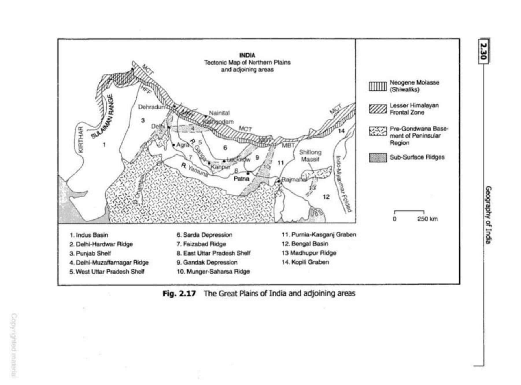
1. 1ndus Basin 2. Delhi-Hardwar Ridge
3. Punjab Shelf
4. Delhi-Muzaflarnagar Ridge
5 . West Uttar Pradesh Shelf
INDIA Tectonic Map of Northern Plains
and adjoining areas
6. Sarda Depression
7. Faizabad Ridge
8. East Uttar Pradesh Shelf
9. Gandak Depresslon 1 o. Munger-Saha.rsa Ridge
::> 0.
! 12 ' o>
~
-t\ Ch~ ().
11. Pumia-Kasganj Graben
12. Bengal Basin
13 Madhupur Ridge
14. Koplli Graben
Fig. 2.17 The Great Plains of India and adjoining areas
•
ITIIIlii
~
~ li.:0..:;;J
Neogene Molasse (Shiwaliks}
Lasser Himalayan Frontal Zone
Pr!t-'Gondwana Basement of Peninsular A eglon
Sub-Surface Ridges
0 250 km
..., • ~
N iil "0 ~ g, -::s c. Qi
1 23i'~r----------------------~-=r_ap~h~y_m_I_nd_ia ____________________ ___
B. Rece."l8ion of the Sea
In the opinion of Blandford, during the Eocene Period, Peninsular India was joined together with Africa. During that period, there was one sea extending from Assam Valley to the Irrawaddy river (Myanmar} in the east and another from Iran and Baluchistan to Ladakh (Indus Valley) in the west During the last part of the Eocen e Period, arms of the Western Sea extended up to Punjab. Due to the rise of the Himalayas during the Miocene Period, these seas started receding by gradual deposits of sediments from the Himalayan rivers. After a prolonged period of sedimentation and subsidence, these gulfs (Gulf of Sind in the west and the Eastern Gulf up t.o the Shillong Plateau) were filled up, resulting in the fonnation of the Northern Plains of India.
The evidences cited in favour of the recession of the sea include: (i) the occurrence oflimestone rocks in Kumaun-Garhwal region ofUttarakhand, (ii) the presence of saline water lakes in Rajasth~ (iii) the joining of the islands of the Gulf of Kachchh with the mainland, (iv) the seaward extension of the Sundarban Delta, (v) the emergence of new islands near Bangladesh coast, and (vi) the presence of marine fossils in the sediments of the Northern Plains of India. The theory, however , fails to give convincing arguments so far as the region of the central portion of the plain is concerned.
4. Remnant of the Tethys
Some of the geologists and geomorphologists opine that the Great Plains of India are a remnant of the Tethys Sea. According to them, after the upheavaJ. of the Shiwaliks, the remaining part of the Tethys was left as a large trough which was joined to the Bay of Bengal in the east and the Arabian Sea in the west Rivers from t4e Himalayas deposited their load in the trough. Because the Himalayas were rising during that period, rivers experienced rejuvenation and greater quantity of eroded material which increased the thickness of the alluviums. Due to infilling of the central part of the trough the seas located in the east and the west started receding, and the Great Plains of India came into existence.
5. R eoent Views
According to the recent views, the Northern Plains of India represent a sag in the crust fom1ed benveen lhe northward drifting of the Indian Subcontinent and the comparatively soft sediments accumulated in the Tethyan basin when the latter were crumpled and lifted up into a mountain system. Snbsequently, it was filled up by the river deposits.
Physiographic Divisions of the. Great Plains of India
The Great Plains of India are a remarkably homogeneous surface with an imperceptible slope. In fact, tl1ey are a featureless ailuvial fertile plains formed mostly by the depositional process of the Himalayan and Vindhyan rivers. These rivers deposit enormous quantity of sediments along the foothills. Beyond the foothills, the rivers deposit the alluvium in their flood plains. The Northern Plains of India may be divided into the following sub-regions:
1. The 8babar Plain
It lies to the south of the Shiwalik from west to east Oammu Division to Assam). Its width is however, more in the western plains than in the eastern plains of Assam. In width, the Bhabar tract is generally 8 to 15 km, consisting of gravel and unassorted sediments deposited by the rivers
~----------Ph.....!VSI..:_.og--=--.:.ra.!,_ph...:....Y __________ -l[ 2.37 J
Sr.mdarlHzru: The largest mangrove swamp in the world, the Sundarbans, or the beautiful forest., gets its name from the Sundari tl:ee which grows well in marshland. It is home to d1e Royal Tiger and crocodiles.
4. The Brahmaputra Plain
Stretching over an area of about 56,275 sq km, it is ilie eastern part of the Great Plains of India. It is about 720 km long and about 80 km wide. The region is surrounded by high mountains on all sides, except on the west It is a depositional plain. The general altitude of the Brahmaputra Plain varies between 130 m in the east to only 30 m in the west (Fig. 2.21). The Assam Valley is characterised by a steep slope along its northern margin but the southern side has a gradual fall from the Meghalaya Plateau. The whole length of dle plain is traversed by the Brahmaputra. Due to the low gradient, the Brahmaputra is a highly braided river having numerous islands. Majuli
Brahmaputra Valley
Bhutan
~ ~:ffi1H1l~ < }
• • • •
Arunaoha Pradeoh ..__
Nagatand
. ~·:
--" ~( ((~J,.I..J.Io..~, .. · lJ"~' . ., . .. . ..... ,... . . · ... \ .· ... . ..
BANGLAD ES H
O km IOOkm
c.. •
. . . . _ .. _ . ' l
l i .
:
- i . . ~ . .. ....
Manipur
, I '
')\' , l ........ "-,......,_,"'-'
Trlpura i Mtzoram
o miles 100M
Fig. 2.21 Brahmaputra Valley
•
I
Geography of India
The Andaman Islands are thickly forested and have a rich marine life among the reefs. The islands are a birdwatcher's paradise with 242 species recorded. The entire region falls in a major earthquake zone. The Barren Island in the Andamans has an active volcano.
In the Bay of Bengal, there are two volcanic islands {BaiTen and Narcondam) situated within 80 km east of the Andaman Islands. The Andaman Islands have been formed by the extension of the Tertiary mountain chain of Arakanyoma. The main rocks of these islands are sandstone, lime· stone and shale. The Nicobar group of islands comprise 18 islands of which only 11 are inhabited. The physiography of the Nicobar islands is mainly of coral origin.
Rice is the main crop in Andaman and Nicobar Islands. Coconut and arecanut are the main cash crops of Nicobar. Tropical fruits like pineapple, a variety of bananas, sweet papaya and mango grow on a smaller scale in the An dam an group of islands.
The Tribal population in the Andaman Islands is fast dwindling. Most of its present inhabitants are migrants from Bangladesh, Myanmar, and India and Tamils from Sri Lanka. Some of the well known surviving tribes of the Andamans and Nicobar are the Onges,Jarawas and Sentinelese.
One of the largest and also the rarest crabs in the world, the Giant Robber Crab, can be found in the Wandoor Marine Biosphere Resrve in south Andaman and Great Nicobar Islands. I ts powerful claws help it to climb the coconut tree and break the hard shell of its fruit.
The Arabian Sea Islands
There are 43 islands in the Arabian Sea, out of which only 10 are inhabited. The shortest distance from the mainland {Calicut) is about 109 km. Kavaratti, located on the island of this name is the capital of Lakshadweep. Lakshadweep islands are separated from the Maldive Islands by the Eight Degree Channel. Hills and streams are absent on these islands. The Mi.oicoy is the largest (4 . .5 sq km} and has a light house and a weather observatory. Fishing is the main occupation of the people of Lakshadweep. In Lakshadweep coconut is the only major crop, although pulses and vegetables are also gro .... m. The sea around the island is rich in marine life (Fig. 2.23).
Offshore Islands
There are numerous islands in the delta region of Ganga and in the Gulf of Mannar. Among the Western coast islands Piram, Bhaisala (Kathiawar}, Diu, Vaida, Nora, Pirtan, Karunbhar (Kachchh coast), .Khadiahet, Aliabet (Narmada·Tapi mouths), Butchers, Elephanta, Karanja, Cross (near Mumbai), Bhatkal, Pegioncock, St. Mary {Mangalore coast), A.rljidiv (GQa coast), Vypin near Kochi, Pam ban, Crocodile, Adunda (Gulf of Mannar), Sri Harik.ota (mouth of Pulicat Lake, Pairkud (mouth of Chilka Lake), Short, Wheeler (Mahanadi·Brahmani mouth), and New Moore, and Ganga-Sagar and Sagar (Ganga Delta). Many of these islands are uninhabited and administered by the adjacent states.
EARTHQUAKES IN INDIA
Earthquakes are vibrations of the Earth caused by ruptures and sudden movements of rocks that have been strained beyond their' elastic limits. In other words, earthquakes are movements within the earth caused by natural or man-made stresses. Earthquakes are casued by (i) volcanic eruptions, (ii) ruptures and sudden movements of rocks (folding and faulting), (iii) movement of plates (plate tectonics), and (iv) anthropogenic factors .
DRAINAGE
THE DRAINAGE SYSTEM
The drainage system is an integrated system of tributaries and a bunk stream which collect and funnel surface water to the sea, lake or some other body of water. The total area that contributes water to a single drainage system is known as a drainage basin. This is a basic spatial geomorphic unit of a river system, distinguished from a neighbouring basin by ridges and highlands that form divides. Thus, river basins are natural units of land. They are regarded as the fundamental geom orphic as well as hydrological units for a systematic study of the river basins, mainly due to the following three reasons:
(i) They can be placed in an orderly hierarchy, (ii) They are areal wlits whose geomorphological and hydroloica! characteristics can be mea
sured quantitatively, and (iii} They can be treated as working systems with energy inputs of climatological variables like
temperature and rainfall and output of river discharge as runoff. The Committee on Runoff of the American Geophysical Unjon treats the micro-unit within a
river basin as the watershed, while the sum of all the micro, meso and macro bibutaries of a river is known as a n'ver basin.
DRAINAGE PATTERN
A geometric arrangement of streams in a region; determined by slope, differing rock resistance to weathering and erosion. climate, hydrologic variability, and structural controls of the landscape is known as a drainage pattern . In other words, drainage pattern refers to a design which a river and its tributaries fonn together, from its source to its mouth. The factors controlling the pattern of drainage in a region include the topography, slope, structural control, nature of rocks, tectonic activities, supply of water, and above all, the geological history of that region. In India, the follow· ing type of drainage patterns are found:
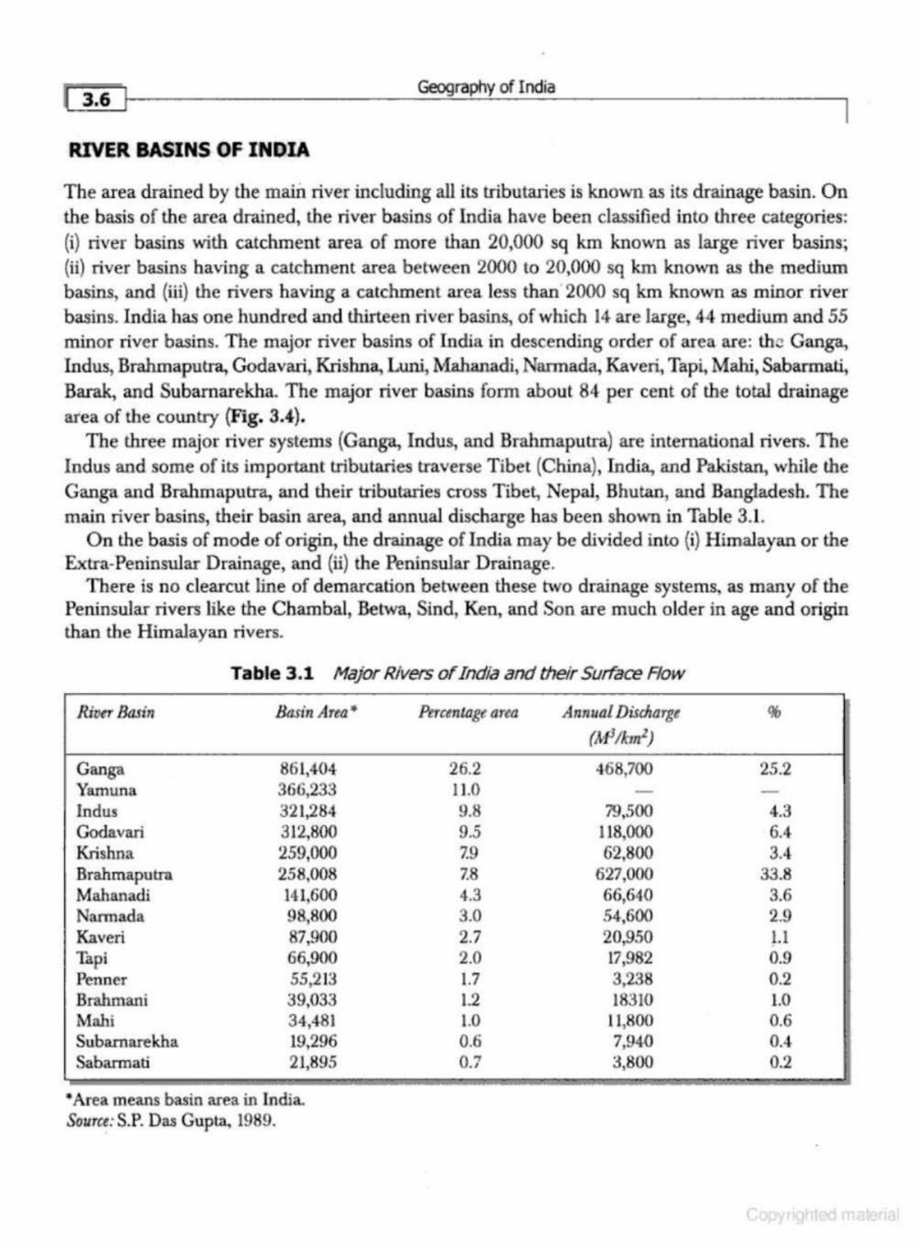
I i 6 I Geography of India
I RIVER BASINS OF INDIA
The area drained by the maiD. river including all its tributaries is known as its drainage basin. On the basis of the area drained, the river basins of India have been classif'ied into three categories: (i) river basins with catchment area of more than 20,000 sq km known as large river basins; (ii) river basins having a catchment area between 2000 to 20,000 sq km known as the medium basins, and (iii) the rivers having a catchment area less than 2000 sq km known as minor river basins. India has one hundred and thirteen river basins, of which 14 are large, 44 medium and 55 minor river basins. The m ajor river basins of India in descending order of area are: the Ganga, Indus, Brahmaputra, Godavari, Krishna, Lwli, Mahanadi, Narmada, Kaveri, Tapi, Mahi, Sabarmati, Barak, and Subarnarekha. The major river basins form about 84 per cent of the total drainage area of the country (Fig. 3.4.).
The three major river systems (Ganga., Indus, and Brahmaputra) are international rivers. The Indus and some of its important tributaries traverse Tibet (China), India, and Pakistan. while the Ganga and Brahmaputra, and their tributaries cross Tibet, Nepal, Bhutan, and Bangladesh. The main river basins, their basin area, and annual discharge has been shown in Table 3.1.
On the basis of mode of origin, the drainage of India may be divided into {i) Himalayan or the Extra-Peninsular Drainage, and {ii) the Peninsular Drainage.
There is no clearcut line of demarcation between these two drainage systems, as many of the Peninsular rivers like the Chambal, Betwa, Sind, Ken, and Son are much older in age and origin than the Himalayan rivers.
Table 3.1 Major Rivers of India and their Surface Row
River Basin Basin Area,.
Ganga 861,404 Yamuna 366,233 Indus 321284 ' Godavari 312,800 Krishna 259,000 Brahmaputra 258,008 Mahanadi 141,600 Narmada 98,800 Kaveri 87,900 Thpi 66,900 Penner 55 213
' Brahmani 39,033 Mahi 34,481 Sttbamarekha 19,296 Sabarmati 21,895
*Area means basin area in India. Source: S.P. Das Gupta, 1989.
Percentage area Annual Discharge (Ml!km1)
26.2 468,700 11.0 -9.8 79,500 9.5 118,000 7.9 62,800 7.8 627,000 4.3 66,640 3.0 S4,600 2.7 20,950 2.0 17,982 1.7 3238 ' 1.2 18310 1.0 11,800 0.6 7 940 1
0.7 3,800
%
25.2 -4.3 6.4 3.4
33.8 3.6 2.9 1.1 0.9 0.2 1.0 0.6 0.4 0.2
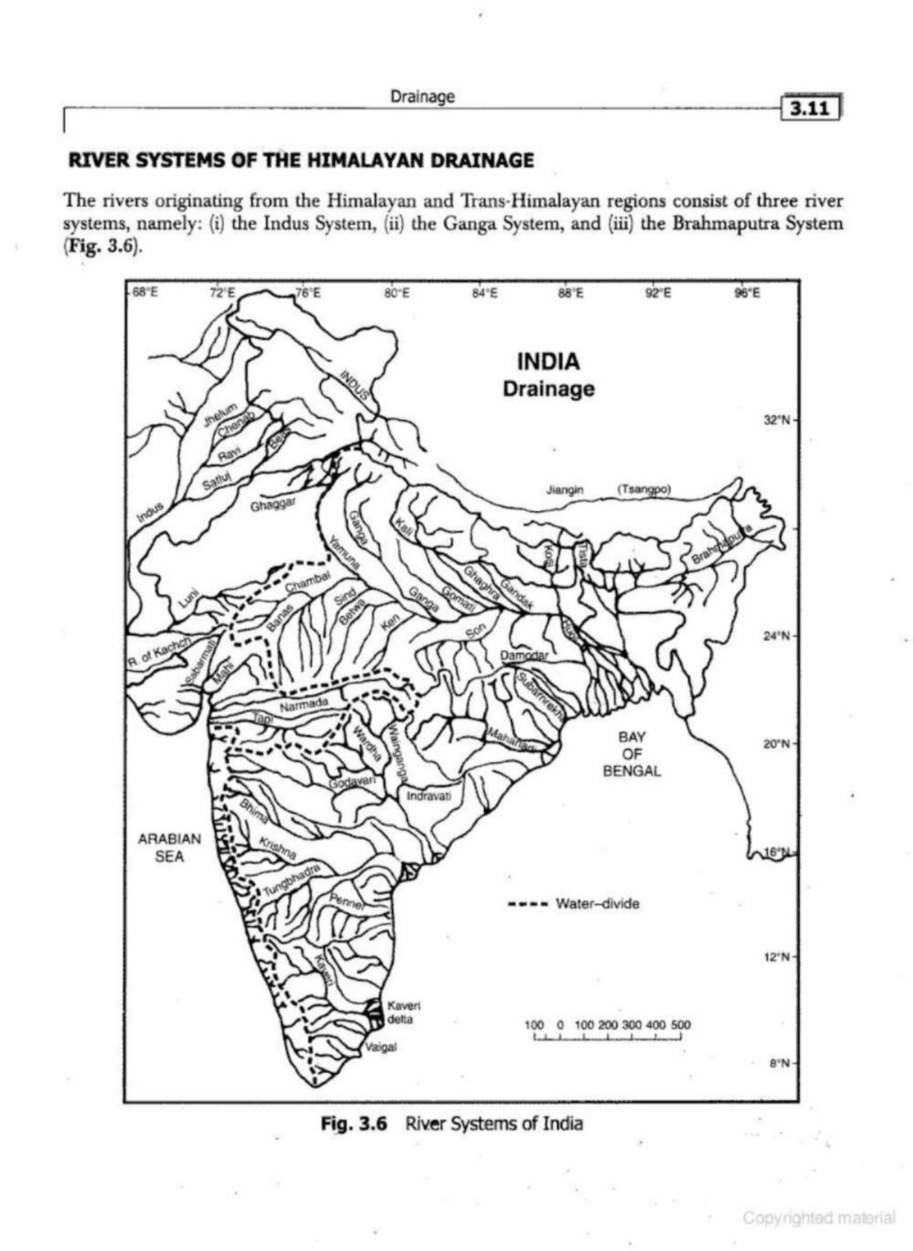
Drainage r 3.11 ~
RIVER SYSTEMS OF THE HIMALAYAN DRAINAGE
The rivers originating from lhe Himalayan and Trans-Himalayan regions consist of three river systems, namely: (i) the Indus System, (i.i) the Ganga System, and (iii) the Brahmaputra System (Fig. 3.6) . .
AR.ABIAN SEA
84' E
INDIA Drainage
BAY OF
BENGAL
• • • • Water--<livlde
100 0 tOO 200 300 400 500
Fig. 3.6 Riv.er Systems of India
•
J2•N
24'N
20"N
[fi6] Geography of India
many great cities on i ts banks. The maintenance of this sacred river is imperative from sociocultunu and ecological point of view.
'rh(~ \'imwnu Rin~r (length "1.380 km.)
This is the longest and the western-most tributary of the Ganga. Its source lies in the Yamunotri Glacier on the western slopes of Banderpunch {6316 m). Downwards, it is joined by Tons river behind the Mussoorie Range (Uttarakhand). From the Mussoorie Range, it debouches into the plains where it flows in a broad curve. Making a boundary between Haryana and Uttar Pradesh, it passes Delhi, Mathura, Agra and flows southward until it joins the Ganga at AJlahabad. The important tributaries of the Yamuna are mostly the right bank tributruies, originating from the Aravallis (Rajasthan), Vmdhyan Range, and the Malwa Plateau of Madhya Pradesh. The Chambal, Sind, Behva, Ken and Tons are the main righ thand tributaries of the Yamuna River.
It is believed that during the Vedic period, the River Yamuna might have flowed towards south and southwest through Bikaner in Rajasthan, and shared its water with the legendary River Saraswati.
The Clmmbal (le llb'ih 960 km)
The Cha.mbal River rises near Mhow-south-west of Indore in Malwa Plateau from the Vindhyan Range-and flows towards the north in a gorge upto the city of Kota. Below Kota, it turns to the north-east, and after passing Bundi, Sawai-Madhopur and Dholpur, it fmally joins the Yamuna about 40 km to the west ofEtawah. The Banas river, rising from the Aravalli Range is its main left b ank tributary. Kali Sind and Parbati originating from the Malwa Plateau are the right bank tributaries of Chambal. The Chambal River is famous for its extensive ravines which it has carved aU along in the Lower Chambal Valley- The ravines of the Chambal Basin are attributed to a slight uplift during the recent geological times, and they merge into the Yamuna alluvial plain where the landscape is extensively etched out by other tributaries of the Yamuna to the east and west of Chambal. Multipurpose projects have been constructed across the river_ The main dams across the river are Gandhi Sagar, Rana Pratap Sagar (Rawatbhata} andJawahar Sagar.
CIJUJJJbal Hul "ines
A maze of ravines, valleys and saw-toothed ridges dissect the plateau. These ravines are found in Rajasthan, Madhya Pradesh and Uttar Pradesh in the lower course of the Chambal River- Infested with dacoits, the ravines are being reclaimed for agriculture, pastures, and social forestry.
The Rnmg11.ngo This is a comparatively small river whkh rises in the Kumaun Himalayas. T he river is deflected to the south-west by the Shiwalik, which it cuts through., before emerging at the Ganga Plain in Najibabad, It joins the River Ganga in Hardoi district opposite to Kannauj.
Th e Shardn
This river rises from the Milam Glacier in the Nepal H imalayas where il is known as the Goriganga. It is known by various names, such as the Kali, when it turns along the Indo-Nepal border, and the Chauka, before it joins the righ t bank of Ghagra near Barabanki.
Th e Karnali
The Karnali is known as K.auriaJa in the Nepal H imalayas and as Ghagra in the Ganga Plain. The
.------------------------~~i~na~g~e ------------------------4l l.21 l
Narmada (Length 1300 km, drainage basin 98,800 sq km}
The Narmada River rises from the plateau of Amarkantak of the Maikal Hills of Chhattisgarh. Moving north-westward, it passes through a complex course near J abal pur, through some impressive marble gorges, the most spectular being Dhunwadhar Waterfalls (10m high) near Jabalpur. Moving westward from Jabalpur, it flows through a rift valley between the Vindhyan and the Satpura ranges. It has rich alluvial deposits in its valley. Finally, it widens below Bharuch and makes a 27 km wide estuary to enter the Gulf of Khambat (Arabian Sea).
Tapi
Having a length of 700 km. and a basin area of 66,900 sq km, the river Tapi rises from the Satpura Range and flows westward almost parallel to Satpura. At Khandwa-Burhanpur Gap, the Narmada and Tapi come close to each other. Below Jalgaon , the river, Like the Narmada, flows in a rift valley but in a much constricted form between the Satpura Range to the north and the Ajanta Range to the south. Below the city of Surat, it makes an estuary and merges into the Gulf of Khambat.
EASTERLY RIVERS OF THE PENINSULAR REGION
There are a number of rivers originating from the Chotanagpur Plateau and merging into the Bay of Bengal, of which the Brahm ani is the most important.
Subernrekha (length 400 km, basin 28,000 sq km}
The Subemrekha rises a little to the southwest of Ranchi where it has a number of waterfalls. In a general easterly direction, it passes through Jamshedpur and flows to the Bay of Bengal near Balasore.
The Brahmani (Length 420 km)
The Brahmani river is formed by the confluence of the Kosi and Sankh rivers. They join together at Rourkela and drain the western parts of the Garhjat Hills. Flo"ting through Bonai, Talcher and Balsore districts, it merges into the Bay of Bengal above the Paradvvip-port. With the Baitarani river lo its north, a delta complex forms below Bhadrak.
The Mahanadi (length 885 km, basin 141,600 sq km)
The Mahanadi is the most important river of Orissa as well as that of Chhattisgarh. This river rises in the Chhattisgarh basin, draining the western and eastern parts of Raipur. In the initial stage, it flows towards the north-east, and after receiving a number of streams such as Seonath and Sandur on both its flanks at heights between 200 m and 700 m, the combined water gets a natural exit towards the east through a gorge which has been impounded to create the Hirakud Dam. A little below the dam at Sambalpur, the river turns eastward and flows through the Eastern Ghats
Geography of India
ilie tendencies of river captming. Rjver capturing is mainly caused by the headward erosion of the river. ln the plain areas, generally, the rivers form meanders in their courses. During floods, due to increased quantity of water, the streaJns try to stra.igthen their courses. Earth movements do have their role in affecting these processes. Some of the important river captures are as under:
The ancient Saraswati River, which provided an abode for early Aryan settlers, presents a typical example of shifting courses and river capturing. Descending from the Himalayan ranges, its initial course during the pre-historic period was passing near Churu (about 2000 to 3000 BC), and the Luni river was one of its tributaries. It gradually shifted towards west till it joined the Saduj near Ahmad pur. Later on, the water of its upper course was captured by a tributary of the Ganga River as a result of which its lower course became dry. This gave birth to Yamuna River, an important uibutary of the Ganga System. Even today the dry valley of the Saraswati River is found in Rajasthan area in the form of Ghaggar valley. Similar shifting has also been observed in the rivers of the Punjab during the historical past The records of the third century BC show that the Indus flowed more than 130 km east of its present course, through the now practically dry beds of the deserted channel, to the Rann of Kachchh which was then a gulf of the Arabian Sea. Later on, it gradually sh ifted towards the west and occupied its present p<JSition. During the reign of Akbar the Great, the Chenab andjhelum rivers joined the Indus near Uch (Pakistan), but their present confluence lies near Mithankot about 100 km downstream of the old place of confluence. Similarly, Multan was formerly located along the Ravi River, but today it is situated about 60 km south of its confluence with the Chenab. About 250 years ago t11e Beas river changed its old course, traces of which are still found between Montgomery and Multan, and joined the Saduj river near Sultan pur. In the early part of the Christian Era the Satluj had more easterly course and indep(>ndcntly discharged its water into the Arnhian Sea.
About 250 years ago, the Brahmaputra tlowing through Mymensingh was discharging its waters into the Megbna River. ln due course of time, it straightened its course and joined the Ganga (Padma) River forming a new stream calledjamuna. A feeble chanr1el of the Brahmaputra is still flowing along the same old course and retains the old name. This change in the course was associated with 30 m rise in Madhopur forest area between 1720-1830 A.D. Even the en by of the Brahmaputra to the plains of Assam is also the outcome of the process of river capturing. According to geologists, during early days, the Tsangpo river of T ibet taking an easterly course used to join the Irrawaddy River (Myanmar) through the C hindwin, which was then a large river, transporting huge quanti ty of water. Later on, a small river Oowing along the southern slopes of the Himalayas through its headwarcl erosion captured the water of the Tsangpo River and, thus, helped in the evolution of the stream of Brahmaputra.
Similarly, Kapili, a tributary of the Brahmaput:ra, has captured the waters of the Meghna river of Bangladesh. In old days, the Meghna originated from the Bra.il Ranges (between Meghalaya and Manipur) and flowing southward, emptied its waters in the eastern part of the Bay of Bengal. Rut Kapili, through headward erosion, captured its northern course. The Lumding-Halflong Pass is an evidence of this abandoned valley. In a similar way, the Dbansiri River capturing the water of a tributary, Kapili River has helped in the formation of a new river called J umna.
There can be numerous causes responsible for the shifting of river courses. These include the shifting gentle slope of the Great Plains of India, meandering courses of the rivers, straightening of the river courses during floods, upliftment o f the Potwar Plateau (Delhi-Sirhind Plateau), downwarping of the Maida Gap, rise in the Madhopur forest area and uplift of the Barind area.
•
Drainage 13.31 '
when a dam was built across the headwaters of the Luni River. Thousands of pilgrims come to bathe in the waters of the lake during the festival of Kartika Poornima in November.
Renuka Lake
Situated in the Siannaur District of Himachal Pradesh, this lake bas been named after the goddess Renuka. A Lion Safari and a 1.00 are major attractions at Renuka. It is a site for lhe annual fair in the mont11 of November.
Roopkund
Situated in Uttarakhand, it is a lake around which 600 skeletons were found at the edge of the Jake. The location is uninhabited and is located at an altitude of about 50:10 m. The skeletons were discovered in 1942. Radio-carbon dating suggest that these people died in an epidemic.
Sambhar Lake
Situated about 70 km to the west ofJaipur city, it is the largest sal t lake of India. On the eastern end, the lake is divided by a 5 km long dam made of stones. To the east of the dam are salt evaporation ponds where salt is being produced for more than a thousand years. The water depth varies from a few em during the dry season to about 3 m aJter the monsoon rains. Sambhar has been designated a Ramsar site (recognised wetland) of international importance. Thousands of Siberian birds reach lhe lake during the winter season.
Sasthamkotta Lake
It is a large fresh water lake in Kerala state. It is located near Sastharnkotta in Kollam District, about 30 km from Kollam. It is a great attraction for the tourists.
Satta or Sat Tal
It is the calm, quiet group of seven lakes near Bhimtal town of the Kumaun Division of Uttarakhand. These lakes are situated at an altitude of 1370 m above mean sea level. These lakes are a paradise for migratory birds.
Suraj Tal
Located below the summit of the Bara.lacha Pass, il is a high altitude lake, 4980 m above sea level. This lake is the source of the Bhaga River, one of the main branches of the Chenab River.
Tawa Reservoir
Located in Hoshingabad on the River Narmada (M .P.), it was created as a result of the Tawa Dam. It fonns the western boundary of Satpura National Park and Bori Wild Life Sanctuary.
Tsongmo Lake
Situated in the state of Sikkim, about 40 km away from Gangtok, it is a glaciated tarn lake. It is oval shaped. Being situated at an altitude of about 3780 m, it remains frozen during the winter season . It is a sacred lake for the Buddhists and the Hindus.
~ 3.36 ., Geography of India
Government Slnltegy
The total renewable water resources of India are estimated at about 1900 sq km per annum. It is predicted that by 2025 large parts of India will join countries or regions having absolute \Yater scarcity.
The following steps bave b~o taken by the government to implement the water harvesting programme:
I. Since sustainability of drinking water-source is of paramount importance for smooth func· tioning of rural water supply, 25 per cent out of 20 per cent of the allocation under Accelerated Rural Water Supply Programme {ARWSP) has been earmarked exclusively for water harvesting schemes to make implementation of such schemes mandatory.
2. Similarly, 25 per cent out of the allocation under Prime Minister's Gramodaya i&jaruz has also been earmarked for funding schemes under submission on sustainability.
3. MPs are requested to utilise Local Area Development Fund in their respective constituencies lo take up water harvesting schemes.
4. Preparation of pilot projects on water harvesting in selected states have already been undertaken.
5. Further, preparation of user-friendly atlas type of document on traditional water-harvesting structures in various parts of the country has been initiated for popularising the concept of water harvesting amongst all concerned, including the community.
By adopting watershed as a unit, different location-specific measures are adopted and executed carefully in each of the topo-sequences according to capability. Considering the fact that the rainfed area in India is about 60 per cent of the country's net sown area., and the vast area should not suffer from neglect and poverty, investment in watershed management for wa.t.er·sca.rce regions {receiving rainfall below 75 em) of India is an appropriate development intervention which warrants top priority from the point of social justice and containing the widening spatial imbalance between irrigated wet farming and dryland fanning systems.
In brief, watershed development approach being an intensive one, appears to be infmitely expensive in a relative sense over the seed and fertilizer approach, but economic evaluation conducted at the Central Soil and J#lter Conservation Research. Institute at Debra Dun shows that this is not so. On the other hand, the realisation that a crop-based approach, or an approach which trea,ts the coun try as a single unit, would not address the major issue for agricultural development in different location-specific conditions, watershed management (or alternative drainage, flood control and conjunctive uses of wa.ter of different sources, or ag-d.in, a more appropriate management of bill and forest-based agriculture) are alternative regimes, each having a different investment and policy support strategy.
There are a number of successful watershed management experiences like Sukhomajr~ near Kalka and Pani-Panchayats {water collectives) at Ralegaon Sidhi in Mabarashtra, where the basic problems of food and fuel wood requirements of poor rural communities have been largely solved by water harvesting.
It is being suggested that in many rural or agricultural situations in our country, we require community participation interfaced with institutional support at the level of, say, 'watershed' land and water managements in difficu It ecological regimes to develop the slender resource base of the areas. The replication of successes like Suklzomajri would be for the better.
Studies to develop a baseline data for betler undersl.:wding of the existing and em erging situa· tions need to be undertaken. Recycling of water and water conservation will be a critical compo· nent of our daily lives in the new millennium. As far as possible, the technologies should be indigenously developed so as to make them socially acceptable and economically viable.
Drainage 13.41 I
months. Hence, the diversion of excess water from the Brahmaputra to the Ganga may meet this water deficit, which shall help in the economic development of the region.
The Brahmaputra-Ganga Link Canal Project involves the construction of a diversion barrage at Dhub1i (Lower Assam), and a 320 km long feeder canal linking the Dhubri Barrage to the Farakka Ban-age. A portion of this feeder canal will lie in Bangladesh for which an intereoational agreement between India and Bangladesh has to be signed . This canal wiJl provide irrigatioin water to Bangladesh also. The canal may augment the flow of level in the Padma River (Ganga in Bangladesh) during the lean m onths of the year. Besides, the link canal would provide cheap inland navigation facility to both the countries. Due to lack of concurrence from Bangladesh and involvement of huge financial expenditure, the scheme has not yet been started.
3. The Narmada Link canal to Gujarat and Rajasthan
Under the Sardar Sarovar Project, there is a proposal to build a terminal storage dam across the Narmada River near Navagaro, and a diversion canal linking the place to regions of Kachchh {Gujarat) and western Rajasthan. This link canal will be of immense help to the drought prone areas of Gujarat and western Rajasthan.
4. The Chambal link Canal
A canal of about 500 km connecting the Chambal River with the Indira Ga.ndhl Canal has also been proposed. The canal would provide water to the central parts of Rajasthan. It will involve a lift of 200 to 250 m .
S. Links between the RJvers of the Western Ghats to the East
The rivers of the Western Ghats carry enonnous quantity of water during the rainy season. Due to steep gradient and the narrow coastal plains much of the water goes to the Arabian Sea as waste. This water may be diverted to the rain-shadow areas of the Western Ghats through the diversion canals where it can be utilised for irrigation. The Periyar Diversion Scheme, constructed several years ago, is such a type of model scheme where the surplus water of the west-flowing Periyar river has been collected in a barrage and diverted through a tunnel across the Sayadri, so as to meet the water needs of the drought prone areas ofTamil Nadu in the east. Similar schemes may also be executed in case of other rivers of the Western Ghats.
GROUND WATER RESOURCES OF INDIA
India is rich in underground water. Its spatial disttibution, however, is most uneven. For example, the average annual rainfall in India is about 110 em. While Mawsynram and Cherrapunji receive more than 1000 em rainfall annually, the average annual rainfall in Ganganagar is only about 20 em.
Tbe underground water resource is a function of geological structure, topography, slope, precipitation, runoff, soils and hydrological conditions of a region. In the opinion of Prof. R.L. Singh (1971), India may be divided into eight ground water provinces (Fig. 3.12). A brief account of these provinces has beeu given in the following section:
~ 3.46 I Geography of India
Slruvani Waterfall
It is situated at the Siruvani River at a distance of about 40 km from Coimbatore in the Western Ghats. It is one of the main water sources of Coimbatore city. The panoramic view of the dam and the falls is enchanting.
ThaJaiyar Watelfall (Rattail)
AJso known as Rat-tail, it is located near Kodaikanal in Tamil Nadu. With an elevation of 297 m, it is the highest waterfall in Tamil Nadu State. The waterfall is, however, not connected by road and the approach is tiresome.
Vattaparai Waterfall
Located at the Pazhayar River in the Kanyakumari District of Tamil Nadu, it is a great attraction for tourists. The surrounding area is proposed to be developed into a Wildlife Sanctuary.
Vazhachal Falls
Located in the Thrissur District of Kerala, these are one of the best waterfalls in India. They are a great attraction for the domestic and international tourists.
SOme of the other important Waterfalls in India
Chhattisgarh Tterathgarlz.
Madhya Pr8desb
Dhunwadluzr {Narmada River, near J abalpur).
Himachal Pradesh
Bundlll and Palani falls.
Jha.rk.hand
Ghaghri, Hundru and]ohna falls.
KartJa.taia
Abbey Falls, Arisinil Gundi Fall.s, Hebbe Fall.s, Irupu Falls, Kalhatti Falls, Keppa Fall.s, Koosalli Falls, Kudumari Falls Kunchikal Falls, Magod Falls, MekedoAtu Falls, Muthyafil Fall.s, Sathodi Fall.s, Simsa Falls, Chunchi Falls, Unclw.,lli Falls.
Kerala
Ath.irappiUy Fall.s, Meenmutty Fall.s, Palilruvi Falls, Soochipara Falls, Thushara.giri Falls.
Maharashtra
Clu:hai Falls, Gatha Falls, K£oti .Falls, &jat Pratilp Falls (M.P.), Kun.e Falls, Marleshwar Falls, Pandavgat Fall.
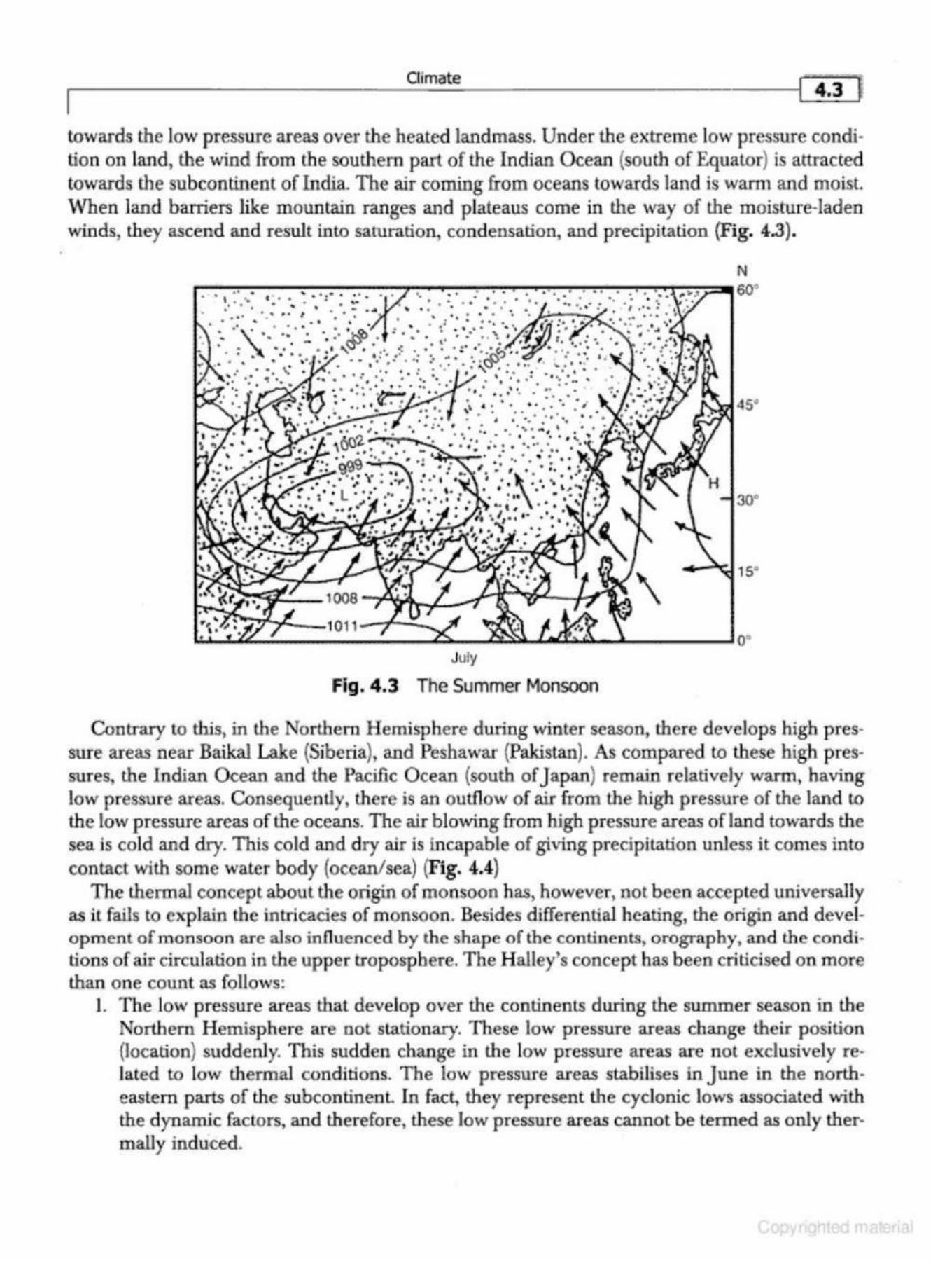
Oimate .. ,,., '"l I 4.3
towacds the low pressure areas over the heated landmass. Under the extreme low pressure condition on land, the wind from the southern part of the Indian Ocean (south of Equator) is attracted towards the subcontinent of India. The air corning from oceans towards land is wam1 and moist. When land barriers like mountain ranges and plateaus come in the way of the moisture-laden winds, they ascend and result into saturation, condensation, and precipitation (Fig. 4.3).
N
45.
30°
July
Fig. 4.3 The Summer Monsoon
Contrary to this, in the Nortbern Hemisphere during winter season, there develops high pressure areas neac Baikal Lake (Siberia), and Peshawar {Pakistan). As compared to these high pressures, the Indian Ocean and the Pacific Ocean {south of J apan) remain relatively warm, having low pressure areas. Consequently, there is an outflow of air from the high pressure of the land to
the low pressure areas of the oceans. The air blowing from high pressure areas of land towards the sea is cold and dry. This cold and dry air is incapable of giving precipitation unless it comes into contact with some water body (ocean/sea) (Fig. 4.4)
The thermal concept about the origin of monsoon has, however, not b een accepted universally as it fails to explain the intricacies of monsoon . Besides differential heating, the origin and development of m onsoon are also influenced by the shape of the contin ents, orography, and the conditions of air circulation in the upper troposphere. The Halley's concept has been criticised on more than on e count as follows:
l. The low pressure areas that develop over the continents during the summer season in the Northern Hemisphere are not stationary. These low pressure areas change their position {location) suddenly. This sudden change in the low pressure areas are not exclusively related to low thermal conditions. The low pressure areas stabillses in June in the northeastern parts of the subcontinenl In fact, they represent the cyclonic lows associated with the dynamic factors, and therefore, these low pressure areas cannot be termed as only thermally induced.
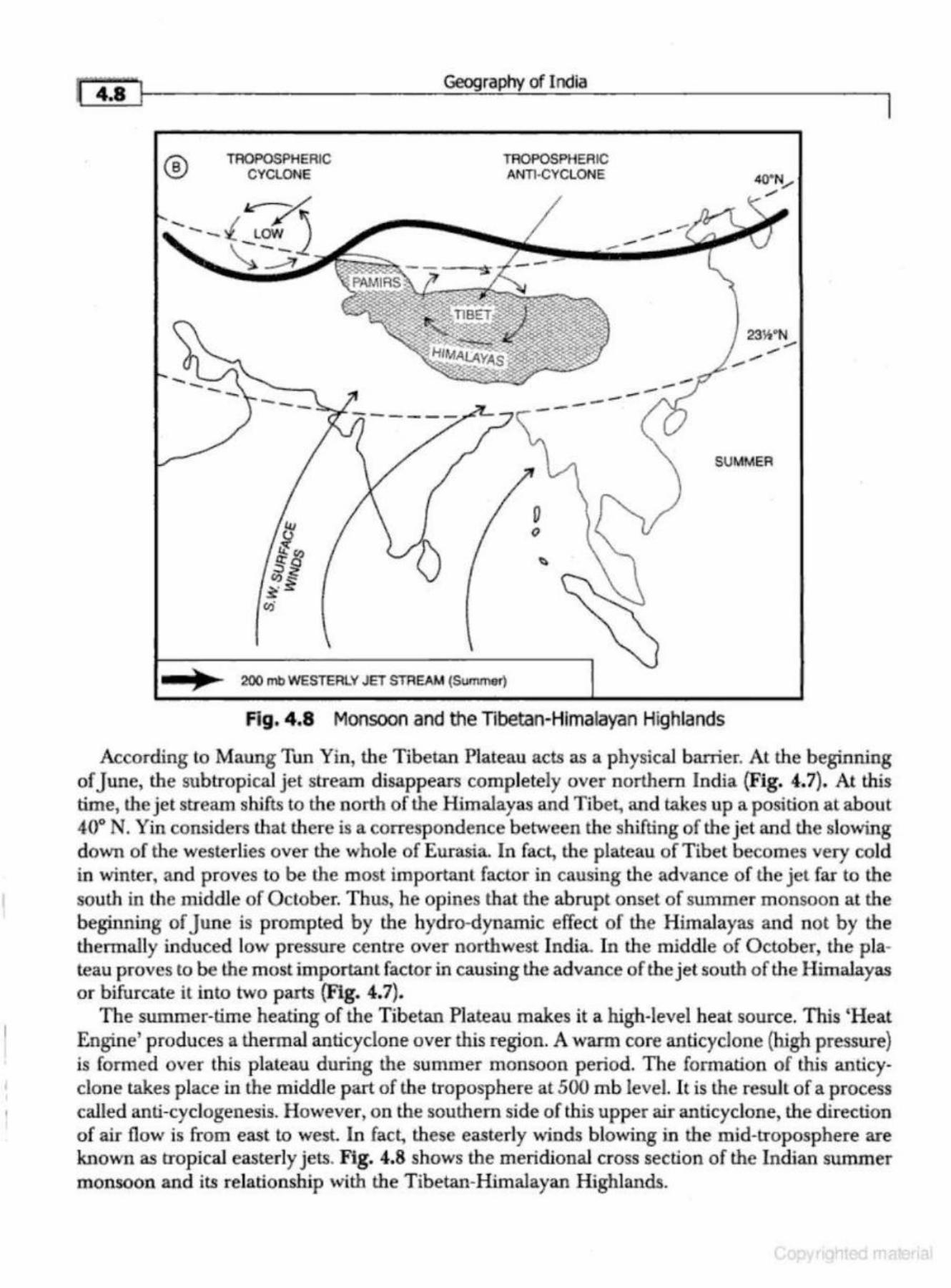
I
I
~ 4:~!~----------------------~-=r_a~p~~m_I_nd_ia ____________________ ~
® TROPOSPHERIC CYCLONE
TROPOSPHERIC ANTI·CYCLONE
---
)I 200mb WESTERl Y JET STREAM (Summer)
--23W'N
SUMMER
Fig. 4.8 Monsoon and the Tibetan-Himalayan Highlands
According to Maung Tun Yin, the Tibetan Plateau acts as a physical barrier. At the beginning of June, the subtropical jet stream cljsappears completely over northern India {Fig. 4.7). At this time, the jet stream shifts to the north of the Himalayas and Tibet, and takes up a position at about 40° N. Yin considers l.hal there is a correspondence between the shifting of the jet and the slowing down of the westerlies over the whole of Eurasia. In fact, the plateau of Tibet becomes very cold in winter, and proves to be the most important factor in causing the advance of the jet far to the south in the middle of O ctober. Thus, he opines that the abrupt onset of summer monsoon at the beginning of June is prompted by the hydro-dynamic effect of the Himalayas and not by the thermally induced low pressure centre over northwest India. In the middle of October, the plateau proves to be the most important factor in causing the advance of the jet south of the Himalayas or bifurcate it into two parts (Fig. 4.7).
The summer-time heating of the Tibetan Plateau makes it a high-level heat source. This 'Heat Engine' produces a thermal anticyclone over this region. A warm core anticyclone (high pressure) is formed over this plateau during the summer monsoon period. The formation of this anticyclone takes place in the middle part of the troposphere at 500mb level. It is the result of a process called anti-cyclogenesis. However, on the southern side of this upper air anticyclone, the direction of air flow is from east to west. In fact, these easterly winds blowing in the mid-troposphere are known as trop ical easterly jets. Fig. 4.8 shows the meridional cross section of the Indian summer monsoon and its relationship with the Tibetan-Himalayan Highlands.
Oimate
I The abrupt arrival of monsoon is of great climatic and social significance to the people of the
subcontinent of India. The onset of monsoon puts an end to the scorching weather and the local hot winds (loo) in. the northern plains of India. The relative humidity increases in the atmosphere tremendously. The arrival of monsoon is also the beginning of agricultural operations for the kharif crops in the rain-fed areas. The high temperature and high relative humidity are, however, oppressive and injurious to health . It is in the season of general rains Uuly to September) that people suffer from many diseases and epidemics.
BREAKS IN THE MONSOONS
The migration of the monsoon rainfall zone is one of the major sub-seasonal variations of the summer (or south-westerly) monsoon. Thus, the monsoon is not a continual deluge of a number of months, duration, but has inter-seasonal variability; being made of a series of discrete events, both pluvial and dry. Viewed locally, these are the active and break monsoons respectively which exist on a time scale ranging from a few days to few weeks. Thus, while the monsoon appears to have a well-defined annual cycle, closer examination shows that the monsoon has substantial variability which be<:omes evident as the intensity of monsoon rains wax and wane through the wet season. Periods during which there is a rapid succession of weather disturbances or storms lasting a few days are referred to as active periods of the monsoon. Periods during which there is no rainfall for few days are the break periods of the m onsoon. During an active phase, the Tropical Easterly Jet Stream (TEJ} remains very strong in the upper troposphere indicating strong convection and latent heating. But, when the maximum cloudiness remains locked up in the foothills of the Himalayas and the monsoon rainfall zone moves in this direction, subsidence occurs to produce a weak easterly flow in the upper troposphere. This creates the condition of break in monsoons.
In break monsoon condition, there is a general rise of pressure (as well as temperature) over the country and the isobars show marked refraction along the wesl coasL Cloudiness decreases and the south-easterlies at the surface levels over northern India are replaced by hot westerly air which blows over the plains, since the broad-scale surface pressure (the monsoon trough) shifts to the H imalayas and the rainfall practically ceases over the country outside the Himalayan regions and the southern slopes of the Himalayas, leading to high floods in lhe plains of these Himalayan rivers. Thus, though there is no rain over the plains, all the major northern and eastern Indian rivers rise and floods ensue.
Under weak monsoon conditions and in the years when the eastern end of the axis of the monsoon trough is oriented southward in Orissa,Jharkhand, Chhattisgarh and Madhya Pradesh, a low valley trough develops over the Assam Plain aligned along river Brahmaputra between the eastern Himalayas and the Shillong Plateau. The vertical extent of this low valley trough is 2 to 3 kilometres with the south west Monsoon lying to the south of the trough, remaining independent of the main monsoon trough. But, when the latter moves northwards and extends to the Himalayas, it joins the trough over the Assam Plain to cause heavy rainfall there.
The break in monsoon conditions generally occurs in the peak months of July and August, and lasts for at least 3 to 5 days over 500 to 1000 kilometres length in these mon ths. The breaks occur
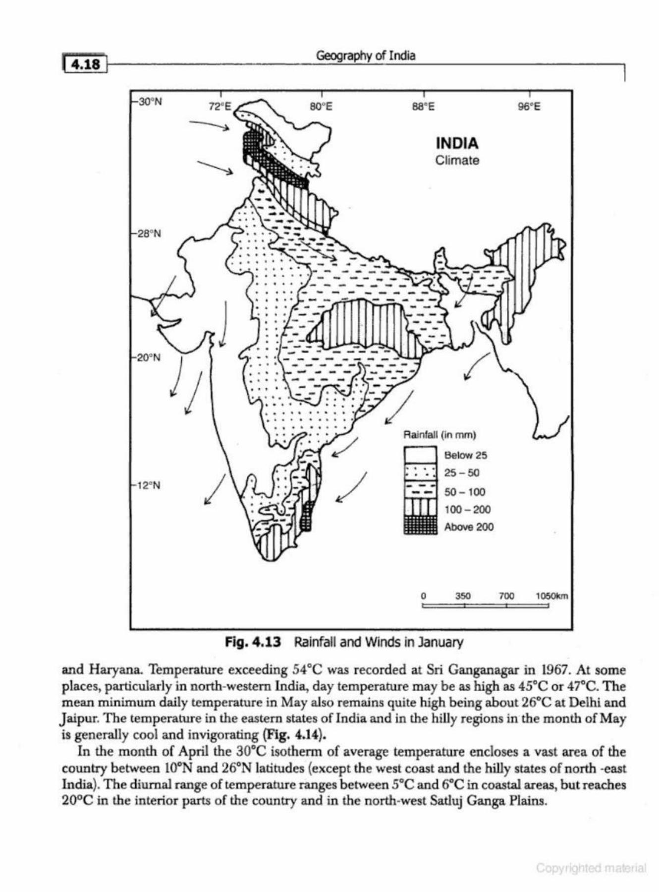
( 4.18 1
~28"N
2"N
Geography of India
so·e ss•e
INDIA Climate
Rainfall (In mm)
Below 25 1----t
: ·. 25-50
1-r!M"'f 50 - 1 00 100 - 200
Above 200
0 350
Fig. 4.13 Rainfall and Winds in January
96"E
700 1060km
and Harya.na. Temperature exceeding 54°C was recorded at Sri Ganganagar in 1967. At some places, particularly in north-western India, day temperature may be as high as 45°C or 47"C. The mean minimum daily tempe.-ature in May also remains quite high being about 26°C at Delhi and Jaipur. The temperature in the eastern states of India and in the hilly regions in the month of May is generally cool and invigorating (Fig. 4.14}.
In the m onth of April the 30°C isotherm of average temperature encloses a vast area of the country between 10~ and 26°N latitudes (except the west coast and the hilly states of north -east India). The diurnal range of temperature ranges between 5°C and 6°C in coastal areas, but reaches 20°C in the interior parts of the country and in the north-west Satluj Ganga Plains.
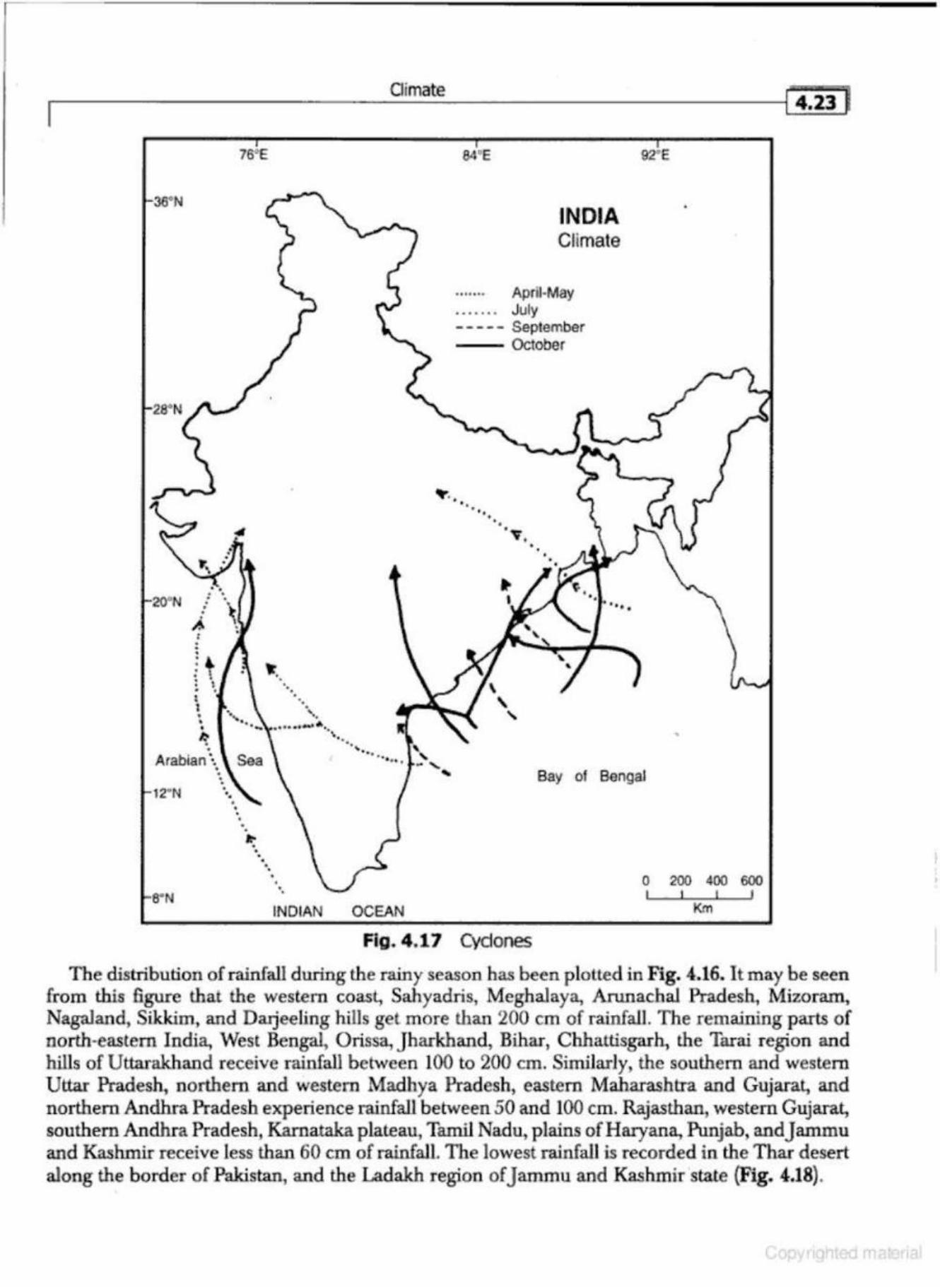
.-I ___________ CI_im_at __ e -----------1Ci.iil
. • • • • •
A-' . . 0
' • 0
0
• • I I • • • ~ • •
76•E
•• • . 0
• 0 · ....
·-\-·······-··· .. Arabian \ Sea
12"N
• • 0
• 0 . 0
•
.. ., 0 • •
INDIA Cllmate
....... April-May • . . . . . . July - - -- - September -- October
~-. • • . ''
• ·v • •
•
Bay of Bengal
0 200 400 600 I I
INDIAN OCEAN Km
Fig. 4 .17 Cydones
The distribution of rainfall during the rainy season has been p lotted in Fig. 4.16. It may be seen from this figure that the western coast, Sahyadris, Meghalaya, Anmachal Pradesh, Mizoram, Nagaland, Sikkim, and Da.tjeeling hiUs get more than 200 em of rainfall. The remaining parts of north,eastem India, West Bengal, Orissa, Jharkhand, Bihar, Chhattisgarh, the Tarai region and hills of Uttarakhand receive rainfall between 100 to 200 em. Similarly, the southern and western Uttar Pradesh, northern and western Madhya Pradesh, eastern Maharashtra and Gujarat, and northern Andhra Pradesh experience rainfall between 50 and 100 em. Rajasthan, western Gujarat, southern Andhra Pradesh, Karnataka plateau, Tamil Nadu, plains ofHaryana., Punjab, and Jammu and Kashmir receive less than 60 em of rainfall. The lowest rainfall is recorded in the Thar d esert along the border of Pakistan, and the Ladakh region of J ammu and Kashmir "state (Fig. 4.18).
'
14.28 I Geography of India
It may be noted from Fig. 4.20 lhat the highest variability is found in the areas where the average an.nuaJ rainfall is the lowest. For example, the desert areas of Banner, Ganganagar, JaisaJmer,J odhpur, etc. have less than 20 em of average annual rainfall. In these areas the variability of rainfall is around 60 per cent. Contrary to this, in the areas where the average annual rainfall is over 200 em (Mawsynram and Cherrapunji, M egbaJaya Plateau), the annual variability of rainfall is less than lO per cent. The Western slopes of Western Ghats, the Lesser Himalayas, the Shiwaliks and the Tarai belt also record between 100-200 em of average annual rainfall. The variability of rainfall in these regions is around 10 to 20 per cent. Thus, there is an inverse relationship between the average annual rainfall and variability in rainfall.
The variability of rainfall has a significant role in the agricultural operations and other economic activities of the country. The areas showing high variability of rainfall have chronic deficiency of water. Such regions are highly prone to droughts, floods and famines, while the areas with high average annual rainfall a re less affected by droughts; though flood is a regular feature in flood prone areas.
CUMATIC REGIONS OF INDIA
India is often referred to as a country with tropical monsoon type of climate. The large size of India, its latitudinal extent, the presence of the Himalayas in the north, and the Indian Ocean, Arabian Sea and Bay of Bengal in lhe south have resulted in great variations in the distribution of temperature and precipitation in the subcontinent of India.
A number of atterr1pts have been made by climatologists, geographers and experts of agriculture to divide India into climatic regions. Wbile some of these classifications have been suggested for world climates, others are exclusively applied to Indian conditions. Some of the important climatic divisions of India were made by the following experts:
1. H.E. Blandford, 1889 2. W. Koppen, 1918, 1931, 1936 3. C.W Thomthwaite 1931,1933, 1948 4. L.D. Stamp and WG. Kendrew, 1953 5. S.P. Chatterji, 1953 6. G.T. Trewartha, 1954 7. V.P. Subramanyam, 1956 8. B.L.C .Johnson, l969 9. K.L Rao, et.al., 1971
10. R .L. Singh, 1971 A systematic study of the climatic divisions of India was attempted for the first time by H.E.
Blandford- the first Director General of the Indian Meteorological Department-in 1889, who discovered that all types of climates found in the world are present within the subcontinent of India. This classification based on temperature and rainfall of a few selected stations of India was almost an overgeneralisation. A brief description of some of the important classifications of Indian climate has been given in the following:
.-------------C_Iim_a_te ___________ ---1!"4.33"f
:.). The Tn.msilionnl Zone
This climate is found in Eastern Uttar Pradesh, western and north-western Bihar, and northwestemJharkhand. The average annual rainfall in this zone varies between 100 to 150 em. Over 90 per cent of the total annual rainfall is recorded during the season of general rains from the Bay of Bengal stream of the South-West Monsoon. The mean January temperature reads about l5°C while the mean maximum in the month of july reads over 40°C.
B. Tropical India
1. Regioll of Vcty llemy R8infu/J
This climatic divison stretches over Assam, Meghalaya, Nagai and, Manipur, T ripura and Mizoram. The average annual rainfall in these areas is over 200 em. The heaviest rainfall in the world is recorded in this region at the stations of Mawsynram and Cherrapunji. Over 90 per cent of the average annual rainfall is recorded during the season of the South-West Monsoon. There are significant variations in the mean monthly temperature of january and J uly owing to undulating and mountainous topography.
2. !legion of Het:nry Rainfall
This region covers West-Bengal, Orissa, Jharkhand and eastern parts of And.hra Pradesh. The average annual rainfall in this region varies between 100- 200 em. There is a general decrease in the amount of rainfall from east to wesl The mean January temperature is over l8°C, while about 30°C is recorded during the months of june andJuly.
3. RegiorJ of !U oderate Rainfall
This region lies to the east of the Western Ghats and includs Gujarat, south-western Madhya Pradesh, Maharashtra, Karnalaka and greater parts of Andhra Pradesh. Being in the rain-shadow area of the Western Ghats, this region receives relatively less rainfall of about 75 em. The average temperature in the months of january andjuly is about l8°C and 32°C respectively.
4. 1'he Konlum Coast
It stretches from the mouth of Tapi river to Goa. The average annual rainfall is more than 200 em, of which over 90 per cent is recorded from the Arabian stream of the South-West Monsoon. The meanjanuary temperature remains around 24°C while the mean j uly temperature reads about 27°C. The average annual range of temperature varies between 3°C to 6°C depending on the distance from the coast and the equator. ln gener.U, the annual range of temperature increases from south to north. 5 . 1"he Mulubur Goust
This Climatic division lies between Goa and Cape Camorin (Kanniyakumari). The Malabar coast records over 250 em of rainfall. The average annual temperature reads around 27°C with 3°C being the annual range of temperature. Kochi is a typical example of this region.
6. 'J.ne Tamil Nadu Co«St
This region includes the greater parts of the stare of Tamil Nadu and the Coromaodal Coast The average annual rainfall varies b€tween 100-150 em. Most of the rainfall is recorded during the season of retreating monsoon (October to December). The average temperature for the month of January is 24°C, while the july temperature reads around 30°C.
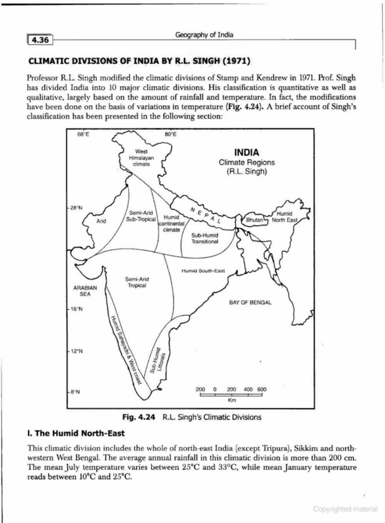
Geography of India
CLIMATIC DIVISIONS OF INDIA BY R.L SINGH (1971)
Professor R.L. Singh modified the climatic divisions of Stamp and Kendrew in 1971. Prof. Singh has divided India into 10 major climatic divisions. His classification is quantitative as well as qualitative, largely based on the amount of rainfall and temperature. In fact, the modifications have been done on the basis of variations in temperature (Fig. 4.24). A brief account of Singh's classification has been presented in the following section :
ARABIAN SEA
16' N
12' N
S' N
West Himalayan
dimate
Semi-Arid
80' E
Sob-Tropical Humid continental
climate
Semi·Aiid Tropical
Sub-Humid ll'ansitiona.l
INDIA Climate Regions
(R.L. Singh)
BAY OF BENGAL
200 0 200 400 600
Km
Fig. 4.24 R.L. Singh's Oimatic Divisions
I. The Humid North-East
This climatic division includes the whole of north-east India (except Tripura), Sikkim and northwestern West Bengal. The average annual rainfall in this climatic division is more than 200 em. The mean July temperature varies between 25°C and 33°C, while mean January temperature reads between 10°C and 25°C.
r-----------------------C_Iim_a_re ______________________ ~l4.4i}
(i) to make judicious and scientific utilisation of agricultural land, water and livestock resources, {ii) to enhance and stabilise the income of the people of drought prone areas, particularly of the
weaker section of society, and (ill) restoration of ecological balance.
Some of the important e lements of the progratnme include: (a} Integrated watershed management and management of water resources. (b) Soil and moisture conservation measures. (c} Afforestation with special emphasis on social and agro-forestry. (d) Development of pasture lands and forest range management in conjunction with develop-
ment of sheep husbandry. (e) Livestock development and dairy development. (f) Restructuring of cropping patterns and changes in agronomic practices. (g} Adoption of scientific rotation of crops with an emphasis on the legumin ous (pulses) crops. (h) Development of subsidiary occupations. (i) Water harvesting. 0) Development of minor irrigation projects. (k) Constluction of underground canals and lined canals. (1) Desalination of sea-water for irrigation and domestic use.
{m) Diversification of agriculture. (n) Development of cottage and household industries. (o) Development of alternate sources of energy (solar, wind and biogas) for domestic and in
dustrial purposes. (p) More research is required to increase agricultural productivity in the dry fcuming regions. These steps, if laken together, can go a long way in minimising the miseries of people living in
the drought prone areas of the county. Some of the important achievements of the Drought Prone Area Programme include the Indira
Gandhi Canal Project, Sardar Sarovar Project (Narmada}, and the Central Arid Research Institute,Jodhpur to promote drought resistant plants, trees and crops.
FLOODS
Floods occur when peak discharge exceeds channel capacity, and this may be brought about naturally by intense precipitation, snow and ice-melt., storm surges in coastal regions, and lhe rifting of barriers, such as ice-dams, or by lhe failure of man-made structures, by deforestation, urbanisations, (which reduce infiltration and interception), and by engineering works such as land dralnage or the straightening of embankments of rivers.
Flood has also been defmed as a state of high water level along a river channel or coast that leads to inundation of land which is normally submerged. Flood is an important component of hydrological cycle of a drainage basin. In fact, droughts and floods are the two extremes of the hydrological cycle. While droughts occur due to the failure of rainfall; floods generally occur in the event of excessive rainfall. Thus, flood is a natural hazard which occurs in response to heavy rains and it becomes a disaster when it inflicts heavy loss to life and property.
causes of Floods
The main factors responsible for the occurrence of floods are: (i) Meteorological, {ii) Geomorphic, and (iii} Anthropogenic.
Geography of India
Construction of buildings, factories, etc. in the zone adjacent to the river channels should be prohibited. The areas occasionally flooded after a few years should be under green-belts in which social forestry is a priority~
7. Other Measures
The following additional measures are suggested by the Flood Control Commission: (i) restriction on indiscriminate felling of trees in hilly regions, (ii) protecting one kilometre tract along the major rivers for massive afforestation, where agriculture and house construction prohibited, (iii) Regular dredging of river beds, (iv) formation of National Water Grid through which flood waters could be diverted to dry areas through diversion channels or could be stored in reservoirs, (v) to develop suitable drainage channels in water-logged areas, and (vi) engineering effective methods to protect the coastal areas from tides and sea-surges.
Flood Control Programme and Strategies
The National Flood Control Programme was launched in India after the devastating flood of 1954. The programme consists of three phases which have been briefly described in the following section:
•
1. The Immediate Phase: This p hase extends over two years and includes the collection of basic hydrological data and execution of immediate flood protection measures like construction of embankments, improvement of river channels and raising the vulnerable villages above the flood level.
2. The Short-Term Phase: This phase lasts for the next five years. In this phase there is emphasis on improvement of surface drainage, establishment of effective flood warning system, shifting or raising of villages above flood level, construction of diversion channels, construction of embankments and raised platforms to be used during the period of floods.
3. The Long-Thrm Phase: T he long-term phase includes construction of dams and storage reservoirs, digging large diversion channels, taking suitable steps for land-use improvement, and soil conservation in the catchment area of the main river and its tributaries.
In order to overcome the problem of floods in the country, the Government of India has set up a National Flood Commission (Rtuhtrl.yaBarh.A.yog). This Commission has taken a holistic view of the .flood problem. Many multi-purpose projects and large dams have been constructed to overcome this problem. Recently, the Brahmaputra River Board has been constituted to control floods in the Brahmaputra Valley.
Blandford, W.T., 1876, 'Physical Geography or Indian Desert' ,JOUTJI.al of Asi4tic Society of Bengal. Chang, C.P., and Krishnamurti, T.N. 1987, Monsoon Mmorology, Oxford University Press, Oxford. Chatterji, A.K, (1992), MOJUOons, Cyelorw 41UI FlofJds in India, Birla Economic Research Foundation,
New Delhi, Radiant Publishers. Das, P.K, (1968}, Tlu Monsoon, National Book Trust, New Delhi. Deshpande, C.D., 1987, 1111114: A Regttnud /nUrjiretaliqn, Indian Council of Social Science Research and
Northern Book Centre, New Delhi.
•
~ 5.4 Geography of India
and West Bengal are the representative species of the pd mordial vegetation. T he vegetation of Uttar Pradesh is mainly dry deciduous type which changes to moist deciduous type, in Bihar and West Bengal. Sheesham, neem, mahuwa, jamun, acacia, ber, bel, etc. are the examples of this type of vegetation. In addition to these, there are numerous types of grasses found in the Gangetic Plain.
5. The Indus Plain
This floristic region spreads over Punjab, Haryana, Rajasthan, west of the Aravallis, Kuchchh, and north-western parts of GujaraL In this region the average annual rdinfall is less than 75 em . Consequently, its vegetation is of the type which can bear the arid and severe drought conditions. Acacias, cacti, wild-palms, khejra, and palas, etc. are the main trees of this region. During the rainy season, numerous grasses develop which wither during the dry season.
6. The Deccan Region
This region covers the greater parts of PeninsuJar India. This region has teak, tendu, sal, palm, and thorny shrubs.
7. The Malabar Region
This region stretches all along the western coast from the Gulf of Khambat (Cambay) to cape Camorin (Kanniyakumari). Here, the vegetation type ranges from moist tropical evergreen to broad leafed mixed and monsoon deciduous type. The Nilgiri hills show temperate forests at higher altitudes. The region also contains several species of plants of the Malay origin.
8. Andaman and Nicobar
The Andaman and Nicobar Islands are covered by the equatorial evergreen forests of heavy wood.
SPATIAL DISTRIBUTION Of FORESt'S IN INDIA
The total geographical area of India is 32,87,263 sq km, of which about 6,75,500 sq km-equal to 22.50 percent- is under forests. According to the National Forest Policy ( 1952) about 33 per cent of the geographical area should be under forest. However, the existing forest area is much below the desired level. The areas under forest cover in India have been shown in Fig. 5.2. It may be observed from Fig. 5.2 lhat the Himalayan mountains, Bhabhar and Tarai, Western Ghats, Eastem Ghats, Bundelkhand, Baghelkhand, Chotanagpur Plateau, Nilgiris, and the hills of Peninsular India are the main areas of Indian forests . Unfortunately, about 5 to 6 per cent of the total forest area of the country is under the category of degraded forests.
The forest area in India is much below the world average of :i4 . .5 per cenl and that of Brazil (57 per cent), Sweden (58 per cent), USA (42 per cenl), Germany (41 per cent), and Canada (36 per ceol). Similarly, the per head forest area in India is only 0.07 hectare as against the world average of 1.10 he<:tares, Canada at 23 he<:tares, Brazil 8.6 hectares, Australia 5 hectares, Sweden 4 hect· ares, and USA 3.5 hectares per head of population.
Natural Vegetation and National Parks
2. The Tropical Moist Deciduous: These are typical monsoon forests with teak (Tectona grandis) and sal (Shorea robusta) as the dominant species. They form the natural vegetation all over lhe country where the average annual rainfall ranges between 100- 200 em. The b·opi· cal moist deciduous forests are fou nd in Sahyad1i s, the north-eastern parts of the peninsula and along the foothills of the Himalayas (Fig. 5.3). These forests on the whole have gregari· ous species. The typical landscape consists of tall leak trees with sal, bamboos, and shrubs growing fairly close together to form thickets. Both teak and sal are economically impo1tan t and so are the Sandalwood (Sant.alum album} Shisham (Dalhergia sissoo}, H una (Te-rminalia dtebttla), and Khair (Acacia catechu}.
3. The 'fropical Thorny Forests: The tropical thorny forest is a degraded version of the moist deciduous forest. They are found in the average annual rainfall varies between 75 and 100 em and the average atmual temperature between l6°C and 22.5°C. These forests are found in peninsular India, Rajasthan, H aryana., Punjab, western Uttar Pradesh , Kachchh, Madhya Pradesh and the foothills of the Himalayas (Fig . 5..3). The im portant trees of these forests are acacia, wild-palms, euphorbias, j had., tamarix, khair, kokko, dhaman., erunjha, cacti, kaoju, and palas.
4. The Subtropical Montane Forests: These forests are found in areas where the average annual rainfall varies between 100 to 200 em and the temperature varies between 15° and 22°C. These forests are fo und in the north-western Himalayas (excepr in Ladakh and Kashmir), Himachal Pradesh, Uttarakhand, Arunachal Pradesh and on the slopes of north-eastem hill states (Fig. 5.3). Chir (pine) is the main tree but broad leaved trees are also found in these areas. Oak, jaroun, and rhododendron are the other varieties in these forests .
5. The Dry Deciduous Forests: These forests are found in areas where the average annual rainfall ranges between 100-150 em. These forests are characterised by closed and rather uneven canopies. Enough light reaches the ground to permit the growth of grasses and climbers. A.ca.cia, jamun, modesta, and pistacia are the main trees. Grasses and shrubs appear during the season of general rains.
6. The Himalayan Moist Forests: These forests are found in Jammu and Kashmir, Himachal Pradesh, Uttarakhand, and northern hilly parts of North Bengal (Fig . 5.3). The wet temper· ate type is found in a belt where the altitude varies between 1000 and 2000 metres. They occur largely as bands of crested dark green landscape of coniferous varieties. The impor· tant varieties are oak, chestnut, chir, sal, sb rubs, and nubitious grasses.
7. The Himalayan Dry Temp erate Forests: These forests are found in j ammu and Kashmir, Lahul, Chamba, Kinnaur (Himachal Pradesh), and Sikkim (Fig. 5.3). These are predomi· nantly coniferous forests with shrubs. The important varieties of trees are deodar, oak, chilgoza, ash, maple, olive, mulberry, will ow, celtis, and parrotia.
8. Montane Wet Temperate Forests: These forests are found in the entire Himalayas from J ammu and Kashmir to Arunachal Pradesh between the altitudes of 1500 m to 3300 m where the temperatttre varies between l2°C to l5°C, and the mean annual rainfall is between 100 to 250 em. Oak, fir, spruce Picea, deodar, (Cedrus dtodtlra), magnolia (Magnolia glo.ndifora) celtis, chestnut, cedar ( Cltamaecypa'l'ii} and maple, spruce, deodar, silver-fir (Abies alba), kail, and yew are fo und here. These forests also contain scrubs, creepers, and ferns. The woods of these forests are durable.
( 5.14 II Geography of India
(i) Chir (Pinus Lofibrilolia)
Chir occurs in the Himalayas between 900 m and 1800 m, fromJammu to Arunachal Pradesh. The wood is light and reddish brown in colom and is moderately hard. It is used for furniture, for making tea-boxes, match industry, and railway sl~pers. It yields resins, gums, and turpentine oils:
(ii) Deodar (Cednu; Deodara)
It grows in the north-western Himalayas in the states of Jammu and Kashmir, Himachal Pradesh, and Uttarakhand, between the heights of 1500 m and 2500 m; Its wood is of light brown to yellow colour: Its wood is very sturdy and duarable. I t is also an easy timber to saw and work to smooth finish. The timber is used for construction-work, and for railway sleepers. It is also suitable for beams, floor-boards, ports, doors, window frames, light furniture, and shingles.
(iii) Blue-Pine (Pinus Excelsa)
It grows along the entire length of the Himalayas from Chumbi Valley to Sikkim between the elevation of 1800 m and 3600 m. The wood is pink in colour, moderately hard and of good quality. It is used for making doors, windows, fwniture, and railway sleepers. It also yields resins and turpentine:
(iv) Silver~nr (Abies)
It is found in the north-western and north-eastern Himalayas between 2200 m and 3000 m . The food is soft but not very durable. I t is mostly used for planking, packing b oxes, containers, woodpulp, paper, and match sticks.
M Spruce (Picea Mithiana) It is fou nd in the western H imalayas between 2100 m and :i600 m . Its soft white wood is used for construction of houses, railway sleepers, cabinets, packing, and pulp making.
(vi) Walnut (.Juglan s Regia)
It is found in Kashmir, H imachal Pradesh, Uttarakhand, and Khasi hills. It is a relatively light wood on which work can be done easily and the finish is fine and attractive. Once dried it does not shrink, swell or split The wood is used for musical instruments, gun-butts, and cabinet works.
(lii) White \-Vdlow (Salix Alba)
It is a small tree found in north-western Himalayas including the Kashmir Valley. Its twigs are used for making baskets. The wood is used for making cricket bats and other sports goods.
(viii) hHJian Birch
It is obtained from the higher slopes of the Himalayas. The wo<ld is grayish in colour, even textured and straight grained. It is largely used for the making of furniture, plywood, and radio cabinets.
(ix) Cypress
It mostly occurs in Uttarakhand, Himachal Pradesh and jammu & Kashmir. Its wood is durable and used for making furniture.
FOREST PRODUCIS AND THEIR UTILITY
In addition to fuel-wood, timber, and charcoal, the forests provide a number of other products.
Natural V~etation and National Parks
The National Forest Policy 1952 lays emphasis on : (i) Weaning the tribal people by persuasion to desist from shifting cultivation.
{ii) Implementation of forest laws more effectively. (iii) To provide adequate facilities for the management of forest resources. (iv} To control grazing of cattle, sh eep and goats in forest areas. (v) Providing fuel-wood to rural areas.,
(vi) To improve the availability of timber wood for industrial purposes. (vii) To increase the area under social forestry.
(viii) To promote research in forestry . .
The National Forest Policy 1988
15.19 1
The main emphasis of the National Forest Policy 1988 is on the protection, conservation, regeneration and development of forests. The main points of the National Forest Policy 1988 are:
(a) Maintenance of environmental stability through the preservation and restoration of eco· logical balance.
{b) Conservation of forests as a national heritage with vast varieties of flora and fauna. {c) Control of soil erosion and denudation in catchment areas of rivers, lakes and reservoirs. (d) C heck on the extension of sand-dunes in desert areas of Rajasthan and along sea-coasts. (e) Substantial increase in forest cover through massive afforestation and social forestry
programmes. (0 To meet the needs of fuel-wood, fodder and minor fo rest products for the rural and tribal
people. (g) Augment the productivity of the forests to meet national needs. (h) Encouragement of efficient utilisation of forest prod uce and optimum substitution of wood. (i} Steps to create massive movement of p eople with the involvement of women folk to achieve
these objectives and to minimise pressure on existing forests. (j) Involvement of p eople in forest managemen t under joint forest managemenL
SOCIAL FORESTRY
Social forestry refers to the forests (trees} planted by the people of a society. It has been defined as ' the forestry of the peopk, for the people by the people~ The significance of social forestry has been emphasised in the National Forest Policy 1952 and 1988. The main obj ective of social forestry is to reduce pressure on traditional forests by p lantation of fuel-wood, fodder, timber, and grasses. The two types of social forestry include:
Agro-forestry which includes community forestry and agro-forestry (commercial and non-commercial farm forestry).
Community Forestry
Community forestry is a part of social forestry. It involves the raising of trees on community lands with the set objective to provide benefits to the community as a whole. Although the plants and seedlings are provided by the forest departments, the protection of planted trees is primatily the responsibility of the community as a whole.
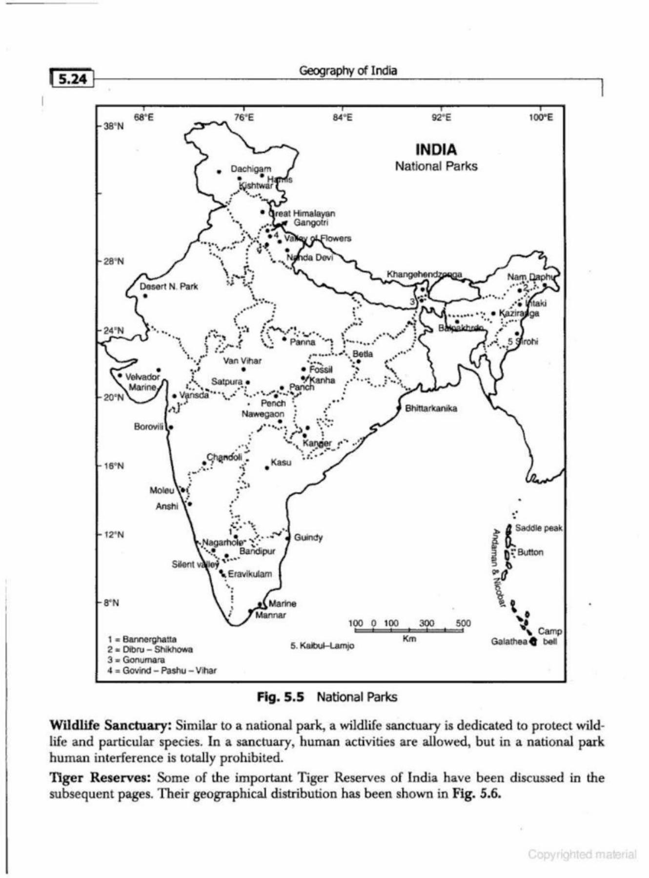
l s.24 1 Geography of India
68' E 84"E 92' E 38' N
INDIA National Parks
28'N
• real Himalayan ''1 .,.. Gangotri
' ' . ·, \. ,; • 4 Va rers
··~·· ,tN'"' •"''• .. • . . , . . . ., ... . . . . ... . ... • ·• "~lll "• • • 1"111: \ .. . .....
' r,. ... ........ I ),1. :--..
• ~. .. .. . ......
••• • . . . •• • • t ,. • · ... '-• • ~- ~f ... , • "'\A_ ., • \
..... .- , :-,~ . · ~· · ,.· __ ...... , ... • 0
• ..,. ,. ~\ I !. ' e • ·, ., . -.• • : .·. . r • ·. Pa>nna .... ~ t .._ • • • •• • : \ "t • ,,... •• ,.. • • ..:· • • .. '• .,1 Betla · .. l , ..... ,.. ........ • •• •
· l VanVihar . .• "" ·· • ~·· ~·' • • Fossil ~~ ' ' ·' Satpura • ~'.1: nha . •• · • ·: :·-·:. ' . .. . • . • . . . \,.. Jt..,.l.,.,."" ... ... - .. . . . . .. ,. • ~~~n.,;·· "" ... : -.... ... ...; . ... : ... .,. ._ ·.r--- '· o.... ......... .. • • •
-J• • • r vn"rr ' •. • •• ' Naw&gaon .: ••
• .. !"··-Boroviti • tl .. ..•.. ~ ~ • \ ...
• • .: I • l : '-· KanAer r'"'• •. • .... '· W:··--'
16' N
12' N
8"N
. " . . . ~r~d'oll • ~ t . • -
-~· ! .. ·.: • Kasu : - • I • • . . " . ··' • • , • .
• • . ~ • . .. . '• .... . , 1 • • • . ...,
,Nagar~e· ·(·· ·• ···• Bandipur ...... . ....
Silent lej ' " \. Eravlkulam
' · •
Guindy
100 0 100
1 • Bannergllatta 2 e Olbru - Shlkhowa 3 " Gol1umaro
5. Kalbul-lamjo
4 : Govind - Pashu - Vihar
Fig. 5.5 National Parks
300 500
Km
• • . •
100"E
I
•
Wildlife Sanctuary: Similar to a national park, a wildlife sanctuary is dedicated to protect wiJdhfe and particular species. In a sanctuary, human activities are allowed, but in a national park human interference is totally prohibited.
Tiger Reserves: Some of the important Tiger Reserves of India have been discussed in the subsequent pages. Their geographical distribution has been shown in Fig. 5.6.
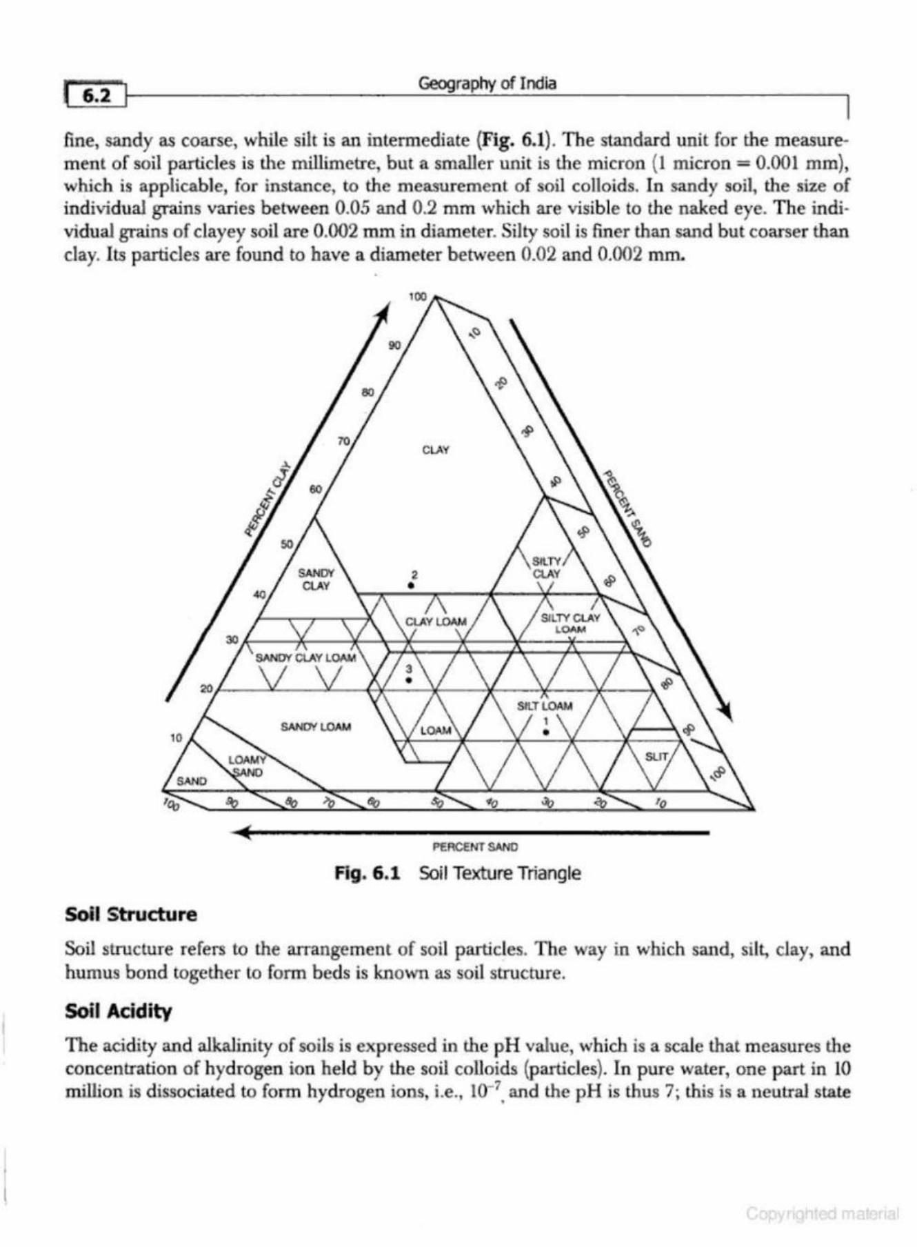
Geography of India
fine, sandy as coarse, while silt is an intermediate (Fig. 6.1). The standard unit for the measurement of soil particles is the millimetre, but a smaller unit is the micron (l micron= 0.001 mm), which is applicable, for instance, to the measurement of soil colloids. In sandy soiJ, the size of individual gr-ains varies between 0.05 and 0.2 mm which are visible to the naked eye. The indi· vidual grains of clayey soil are 0.002 mm in diameter. Silty soil is finer than sand but coarser than clay. Its particles are found to have a diameter between 0.02 and 0.002 IIlliL
CLAY
SAIIIOf LOAM
PERCENT SAND
Ag. 6 .1 Soil Texture Triangle
Soil Structure
Soil structure refers to the arrangement of soil particles. The way in which sand, silt, clay, and humus bond together to form beds is known as soil structure.
Soil Acidity
The acidity and alkalinity of soils is expressed in the pH value, which is a scale that measures the concenb:ation of hydrogen ion held by the soil colloids (particles). In pure water, one part in 10 million is dissociated to form hydrogen ions, i.e., w-7• and the pH is thus 7; lhis is a neutral state
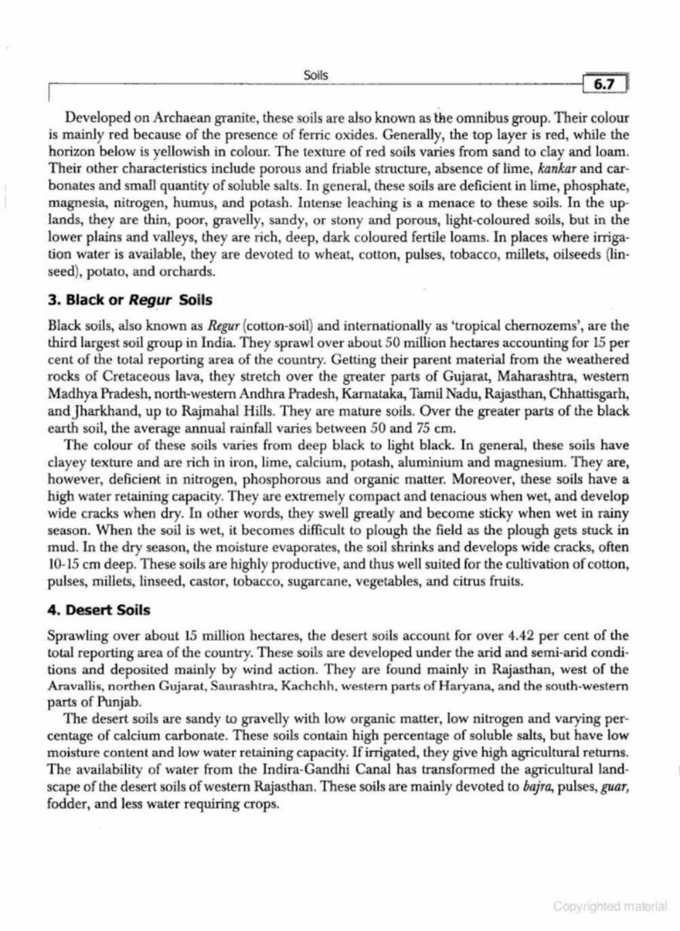
Soils
' Developed on Archaean granite, these soils are also known as the omnibus group. Their colour
is mainly red because of the presence of ferric oxides. Generally, the top layer is red, while the horizon below is yellowish in colour. The texture of red soils varies from sand to clay and loam. Their other characteristics include porous and friable structure, absence of lime, kankar and carbonates and small quantity of soluble salts. In general, these soils are deficient in lime, phosphate, magnesia, nitrogen, humus, and potash. Intense leaching is a menace to these soils. In the uplands, they are thin, poor, gravelly, sandy, or stony and porous, light-coloured soils, but in the lower plains and valleys, they are rich, deep, dark coloured fertile loams. ln places where irrigation water is available, they are devoted to wheat, colton, pulses, tobacco, millets, oilseeds (linseed), potato, and orchards.
3. Black or Regur Soils
Black soils, also known as Regur (cotton-soil} and internationally as 'tropical chernozems', are the third largest soil group in India. They sprawl over about 50 million hectares accounting for 15 per cent of the total reporting area of the country. Getting their parent material from the weathered rocks of Cretaceous lava, they stretch over the greater parts of Gujarat, Maharashtra, western Madhya Pradesh, north-western Andhra Pradesh, Karna.taka, Tamil Nadu, Rajasthan, Cbhattisgarh, and]harkhand, up to Rajmahal Hills. They are mature soils. Over the greater parts of the black earth soil, the average annual rainfall varies between 50 and 75 em.
The colour of these soils varies from deep black to light black. In general, these soils have clayey texture and are rich in iron, lime, calcium, potash, aluminium and magnesium. They are, however, deficient in nitrogen, phosphorous and organic matter. Moreover, these soils have a high water retruning capacity. They are extremely compact and tenacious when wet, and develop wide cracks when dry. In other words, they swell greatly and become sticky when wet in rainy season. When the soil is wet, it becomes difficult to plough the field as the plough gets stuck in mud. In the dry season, the moisture evaporates, the soil shrinks and develops wide cracks, often 10-15 em deep. These soils are highly productive, and thus well suited for the cultivation of cotton, pulses, millets, linseed, castor, tobacco, sugarcane, vegetables, and citrus fruits.
4 . Desert Soils
Sprawling over about 15 million hectares, the desert soils account for over 4.42 per cent of lhe total reporting area of the country. These soils are developed under the arid and semi-arid conditions and deposited mainly by wind action. T hey are found mainly in Rajasthan, west of the Aravallis, northen Gujarat, Saurashtra. I<achchh. west.t>m parts of H aryana, and the south-western parts of Punjab.
The deserl soils are sandy to gravelly with low organic matter, low nitrogen and varying percentage of calcium carbonate. These soils contain high percentage of soluble salts, but have low moisture content and low water retaining capacity. If irrigated, they give high agricultural returns. The availability of waler from the Indira-Gandhi Canal has transformed the agricultural landscap e of the desert soils of western Rajasthan. These soils are mrunly devoted to bajra, pulses,guar, fodder, and less water requiring cr ops.
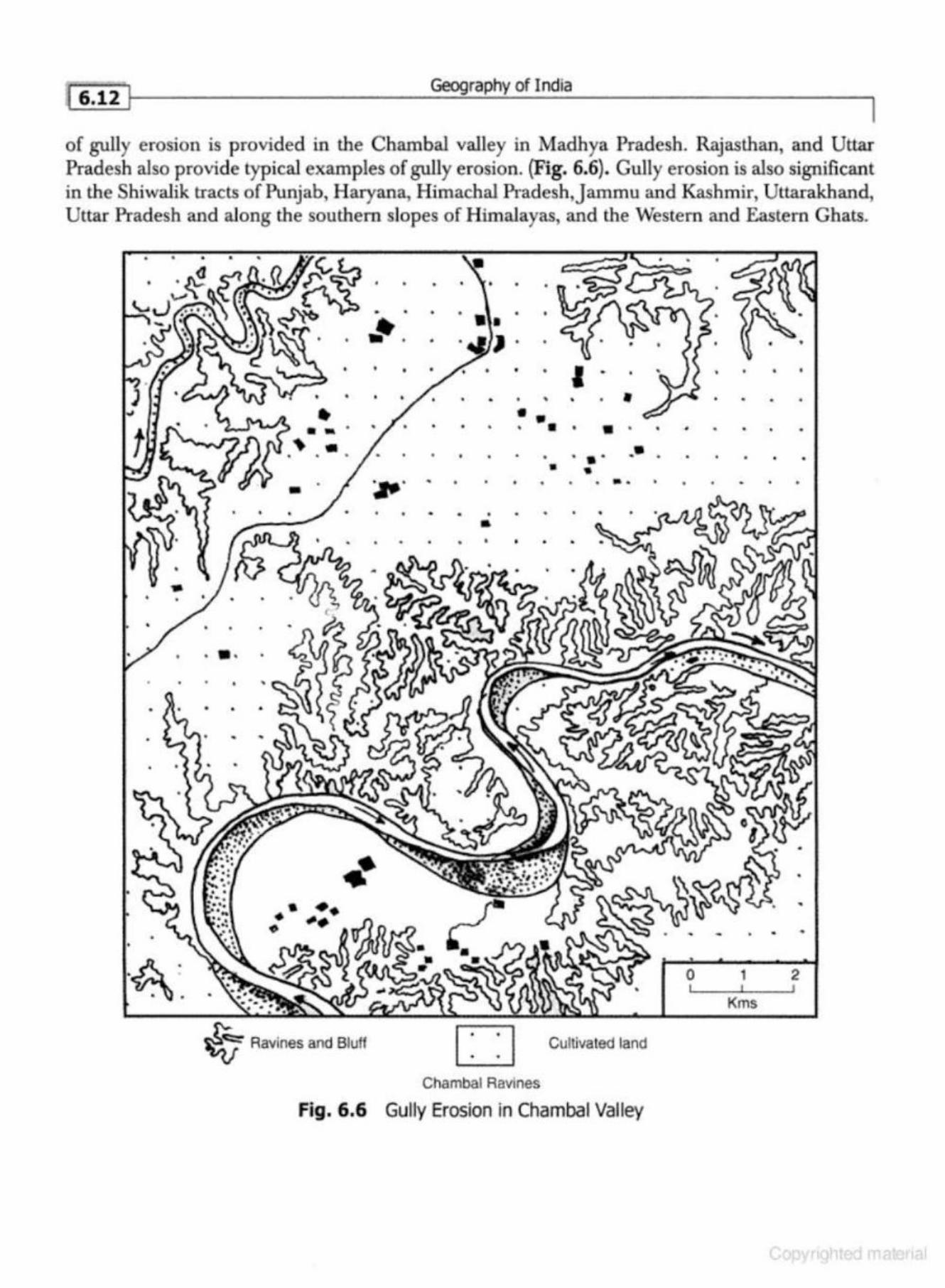
'f 6.12 I Geography of India
of gully erosion is provided in the Chambal valley in Madhya Pradesh. Rajasthan, and Uttar Pradesh also provide typ ical examples of gully erosion. (Fig. 6.6). Gully erosion is also significant in the Shiwalik tracts of Punjab, Haryana, Himachal Pradesh, jammu and Kashmir, Uttarakhand, Uttar Pradesh and along the southern slopes of Himalayas, and the Western and Eastern Ghats .
•
• • • • • •
• • • • •
• •• • • •
•
• •
•
• • • • • • • • • •
• • • • • • • • •
• • • • • ... . • • • t • ' • • ~ .
• • • • • • • • • •• • • • • • • • • • • • • • • • - • ~· . •
• • • • • • • •
• • • • • •
• • - •
• •
• • · •
• • •
• • • •
• •
•
•
ttl •
•• •• • ~-~ • •
0 1 2
Kms
~ Ravines and Bluff D . Cultivated land
Chambal Ravines
Fig. 6.6 Gully Erosion in Chambal Valley
'[ _ _______ ___ So_lls _________ _ ----t( '6.17.J
(i) Loss of fertile top soil from the top layer leading to gradual loss of soil-fertility and agricul-tural productivity.
(ii) Loss of important nutrients from soil through leaching and water-logging. {iii) Lowering of the underground water-table and decrease in soil moisture. (iv) Drying of vegetation and extension of arid lands. (v) Increase in the frequency of droughts and floods.
(vi) Silting of rivers and canal beds. {vii) Recurrence of land slides.
(viii} Adverse effect on economy which retards cultural development. (i.x) Increase in crimes and anti-social activities through the formation of natural hideouts for
criminal.s and dacoits. · (x) Burden on the exchequer to reclaim the bad lands. There is no uniform strategy to recla.im all the wasteland and degraded soils of different types.
Some strategies that might help are given below: (i) All the degraded forest lands should be planted with trees. Marginal lands which are not
suitable for agriculture should be brought under social forestry and agro-forestry. (ii) Degraded soils and degraded lands can be red aimed with the help of watershed programmes.
(iii) Rainwater harvesting and conservation should be the focus of development planning. A series of small projects of water harvesting in the watershed areas should be undertaken to maximise benefits from watershed projects.
(iv) Soil conservation praGtices should be adopted which have been briefly described in the following pages.
SOILOONSERVATDON
Looking at the importance of soil resources for a country of over a billion people, a judicious utilisation and conservation of soil is of parmount importance.
The fanners in the drier parts of Gujarat, Haryana, Rajasthan, and western Madhya Pradesh have successfully protecte<i their fields from soil erosion by planting rows of trees to reduce the velocity of winds which continually erode soil cover. Soil conservation includes reduction in soil erosion, afforestation, rational utilisation of soils and ways to enhance their sustainability. Some of the important steps which can go a long way in the conservation of soils are as under:
1. Afforestation
Tree plantation helps in the reduction of soil erosion. Trees reduce the intensity of runoff and increase the seepage of water to the underground water-table. Social forestry can be developed along the banks of rivers, canals, lakes, roa<ds, and railway tracks.
2. Restriction on the Felling of Trees
Apart from afforestation, it is equally important to check the indiscriminate felling of trees. People's awareness that resulted in the launch of the Chipko Movement can help in achieving this objective.
3. Contour Ptoughing and Strip Cultivation
In the hilly and mountainous areas, ploughing should be done according to the contours and not
17.2 ~f----------------------~~~~~P~~o_fi_nd_ia ____________________ ~l
formation is extremely slow, they can not be replenished wilhin a time frame meaningful to human-beings. Though these resources are normally found in large quantities, they are distributed most unevenly. Their economic use is viable only when they are found in sufficiently large concentrations and are extractable. Some of these resources like gold, silver and iron are recyclable in nature. It means that the metal content obtained from the ore may be used again and again after necessary processing. Fossil fuels such as coal, mineral oil and natural gas get exhausted. H ence, they are non-recyclable.
MINERAL RESOURCES
A mineral is an aggreg-ate of two or more than two elements. A mineral has a definite chemical composition, atomic sll-ucture and is formed by inorganic processes. In economic geography, the term mineral is used for any naturally occurring material that is mined and is of economic value.
Minerals generally occur in the earth's crust in the form of ore. It is extracted, processed and utilised for the economic benefits of society. The availability and per capita consumption of minerals is taken as an important indicator to assess the economic development of a country.
India is fairly rich in mineral resources but their distribution is highly uneven. The distribution of minerals in India has been described in the following section:
Distribution of Minerals
The mineral wealth of India is largely confmed to the igneous and metamorphic rocks of Peninsular India, while the Great Plains of India and the Himalayan region are almost devoid of the metallic minerals. The states which are rich in the metallic and non-metallic minerals arejharkhand, Chhattisgarh, O rissa, Bihar, West Bengal, Madhya Pradesh, Karnataka, Maharashtra, Tamil Nadu, Gujarat, Uttara.khand, Andhra Pradesh, and Assam. The states of Uttar Pradesh, Haryana, Punjab, Himachal Pradesb,Jammu and Kashmir, and Gangetic West Bengal are, however, poor in min· eral resources.
M ir1eral Belts of IL1dia
The following mineral belts may be identified in India {Fig. 7.1):
1. The Chotaoagpur Belt This belt stretches over, Jharkhand, Chhattisgarh, Orissa, Bihar and West Bengal. This region is rich in coal, mica, manganese, chromite, ilmenite, bauxite, iron, phosphate, copper, dolomite, china-clay, and limestone. The important mineral producing districts are Dhanbad, Haz.a.ribagh, Palamu, Ranchi, Santhal, Pargana, and Singhbhum in]harkhand; Cuttack, Dhankenal, Keonjhar, Koraput, Mayurbhanj, Sambhalpur, and Sundargarh in Orissa; and Bankura, Birbhum, Medinipur and Purulia in West Bengal. Cuttack region contains almost 100% ofkyanite reserves, 93% of iron ore, 84% coal, and 700/o of chromite of the country.
2 . The Mid land Belt This belt sprawls over the states of Chhattisgarh, Madhya Pradesh, Andhra Pradesh, and Maharashtra. This belt is rich in manganese ore, bauxite, mica, copper, graphite, limestone, lignite, marble, and limestone.
3. The Southern Belt It stretches over the states of Andhra Pradesh, Karnataka and Tamil Nadu. This belt is rich in gold, iron ore, chromite, manganese, lignite, mica, bauxite, gypsum, asbestos, dolomite, ilmenite, china-day, and limestone.
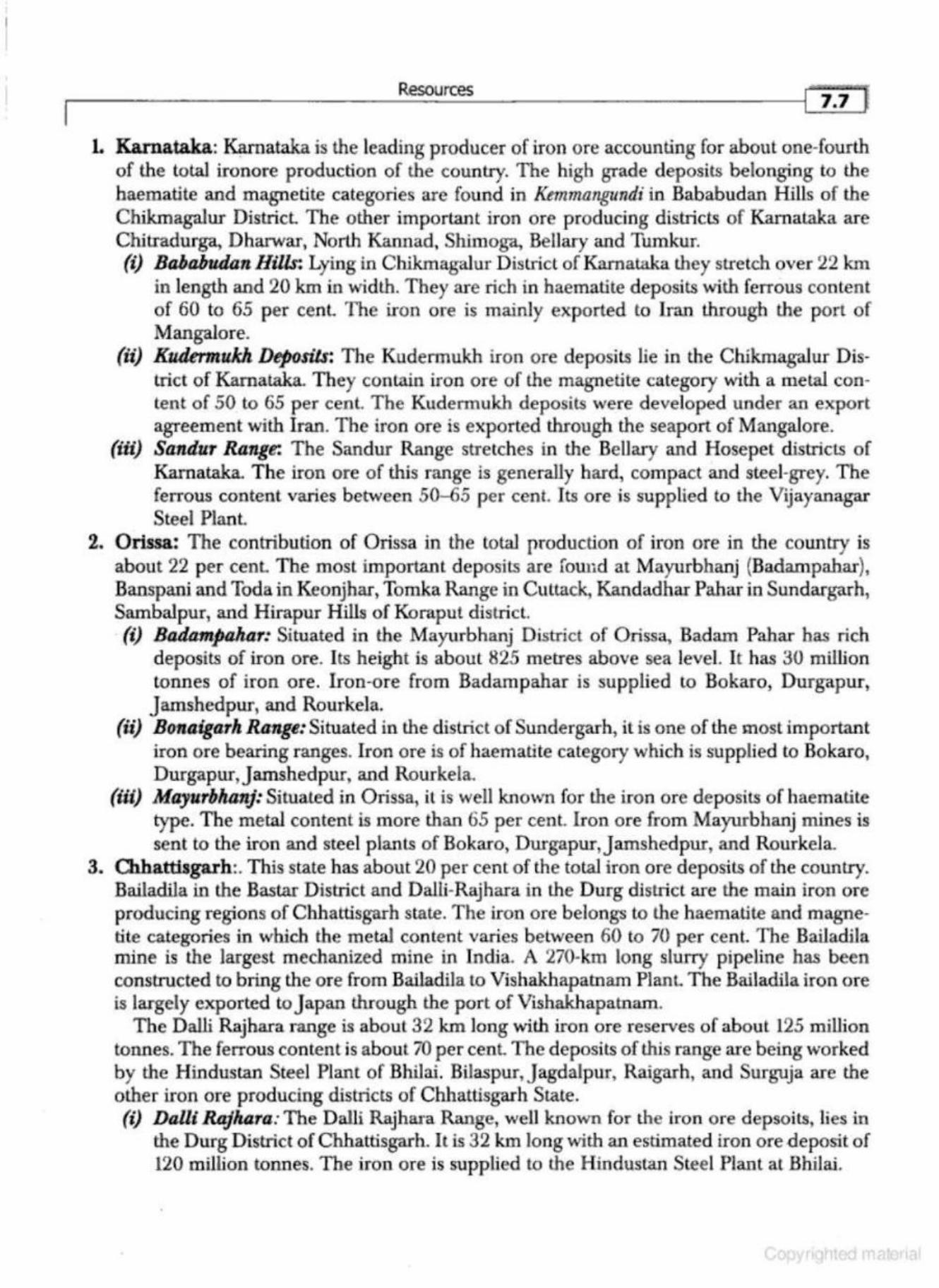
Resources ... , • * 1 I 1.1
L Karnataka: ~ataka is the leading producer of iron ore accounting for about one-fourth of the total ironore production of the country. The high grade deposits belonging to the haematite and magnetite categories are found in Kemmangundi in Bababudan Hills of the Chikmagalur District. The other important iron ore producing districts of Kamataka a re Chitradurga, Dharwar, Norlh Kanuacl, Shimoga, Be!Jary and Tumkur. (i) Bababudan Hills: Lying in C hikmagalur District of Karnataka they stretch over 22 km
in length and 20 km in width. They are rich in haematite deposits with ferrous content of 60 to 65 per cent. The iron ore is mainly exp orted to Iran through the port of Mangalore.
(ii) KudermulcA Deposils: The Kuderrnukh iron ore deposits lie in the C hikmagalur District of Karnataka. They contain iron ore of the magnetite category with a metal content of 50 to 65 per cenl. The Kudermukh deposits were developed under an export agreement with Iran. The iron ore is expor ted through the seaport of Mangalore.
(iii) Sandur Range: The Sandur Range stretches in the Bellat-y and Hosepet d istricts of Karnataka. The iron ore of this range is generally bard, compact and steel-grey. The ferrous content varies between 50-65 per cent. Its o re is supplied to the Vijayanagar Steel Plant.
2. Orissa: The contribution of Orissa in the total production of iron ore in the country is about 22 per cenL The most important deposits are found at Mayurbhauj (Badampahar}, Banspani and Toda in Keonjhar, Tomka Range in Cuttack, Kandadhar Pahar in Sundargarh, Sambalpur, and Hirapur Hills of Koraput district (i) Badampahar: Situated in the Mayurbhanj District of Orissa, Badam Pahar has rich
deposits of iron ore. Its height is aboul 825 metres above sea leveL It has 30 milljon tonnes of iron ore. Iron-ore from Badampahar is supplied to Bokaro, Durgapur,
J amshedpur, and Rourkela. (ii) Bonaigarh Range: Situated in tl1e district of Sundergarh, it is one of the most important
iron ore bearing ranges. Iron ore is of haematite category which is supplied to Bokaro, Durgapur,Jamshedpur, and Rourkela.
(iii) Mayurbhanj: Situated in Orissa, it is well known for the iron ore deposits of haematite type. The metal content is more than 65 per cent. Iron ore from Mayurbhanj mines is sent to the iron and steel plants of Bokaro, D w·gapur,Jamshedpur, and Rourkela .
3. Olh.a.ttisgarh:. This state has about 20 per cent of the total iron ore deposits of the country. BailadUa in the Bastar District and DalH-Rajhara in the Durg district are the main iron ore producing regions of Cbhattisgarh state. The iron ore belonbts to th e haematite and magnetite categories in which the metal content varies between 60 to 70 per cent. The Bailadila mine is the largest mechanized mine in India. A 270-km long slurry pipe line has been constructed to bring the ore from Ba.iladila to Vishak.hapatnam Plant. The Bailadila iron o re is largely exported to J apan through the port of Vishakhapatnam.
The D alli Rajha.ra range is about 32 lun long with iron ore reserves of about 125 million tonnes. The ferrous content is about 70 per cent The deposits of this range are being worked by the Hinduslan Steel Plant of Bhilai. Bilaspur,Jagdalpur, Raigarh, and Surguja are the other iron ore producing districts of Chbattisgarh State. (i) Dalll Rajhara: The Dalli Rajhara Range, well known for the iron ore depsoits, lies in
the Durg District of Chhattisgarh. It is 32 km long witl1 an estimated iron ore deposit of 120 million tonnes. The iron ore is supplied to the H industan Steel Plant at Bhilai.
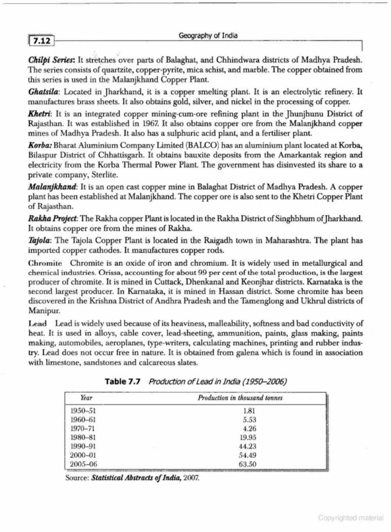
~ 1.12 I Geography of I ndia
. ' Clzilpt Series: It stret_ches over parts of Balaghat, and Chhindwara districts of Madhya Pradesh. The series consists of quartzite, copper-pyrite, mica schist, and marble. The copper obtained from this series is used in the Malanjkhand Copper Plant.
Gluztsihl: Located in Jharkhand, it is a copper smelting plant It is an electrolytic refinery. It manufactures brass shet'!ls. It also obtains gold, silver, and nickel in the processing of copper.
Khetri: It is an integrated copper mining-cum-ore refining plant in the Jhunjhunu District of Rajasthan. It was established in 1967. It also obtains copper ore from the Malanjkhand copper mines of Madhya Pradesh . It also has a sulphuric acid plant, and a fertiliser plant.
Korba: Bharat Aluminium Company Limited (BALCO) has an aluminium plant located at Korba, Bilaspur District of Chbattisga.rh. It obtains bauxite deposits from the Amarkantak region and electricity from the Korba Thermal Power Plant. The government has disinvested its share to a private company, Sterlite.
Mahlnjkhand: It is an open cast copper mine in Balaghat D istrict of Madhya Pradesh. A copper plant has been established at Malanjkhand. The copper ore is also sent to the Khetri Copper Plant of Rajasthan.
Rakha Project: The Rakha copper Plant is located in the Rakha District of Singhbhum of Jharkhand I t obtains copper ore from the mines of Rakha.
Tajola: The Tajola Copper Plant is located in the Raigadh town in Maharashtra. The plant has imported copper cathodes. It manufactures copper rods.
Chromitc Chromite is an oxide of iron and chromium. It is widely used in metallurgical and chemical i:ndustries. Orissa, accounting for about 99 per cent of the tot.a.l prodl•ction, is the largest producer of chromite. It is mined in Cuttack, DhenkanaJ and Keonjhar districts. Karnataka is the second largest producer. In Kamataka, it is mined in Hassan district. Some chrornite has been discovered in the Krishna District of Andhra Pradesh and the Tamenglong and Ukhrul districts of Manipur.
Lt~ad Lead is widely used because of its heaviness, malleability, softness and bad conductivity of heat. It is used in alloys, cable cover, lead-sheeting, ammunition, paints, glass making, paints making, automobiles, aeroplanes, type-writers, calculating m achines, printing and rubber indus· try. Lead does nol occur free in nature. It is obtained from galena which is found in association with limestone, sandstones and calcareous slates.
~or
1950-51 1960-61 1970-71 1980-81 1990-91 2000-01 200.S-06
Table 7.7 Production of Lead in India (1950-2006)
Production in thousand l.011ntS
1.81 5.53 4.26
19.95 44.23 54.49 63.50
Source: Statistical Abstracts of India, 2007.
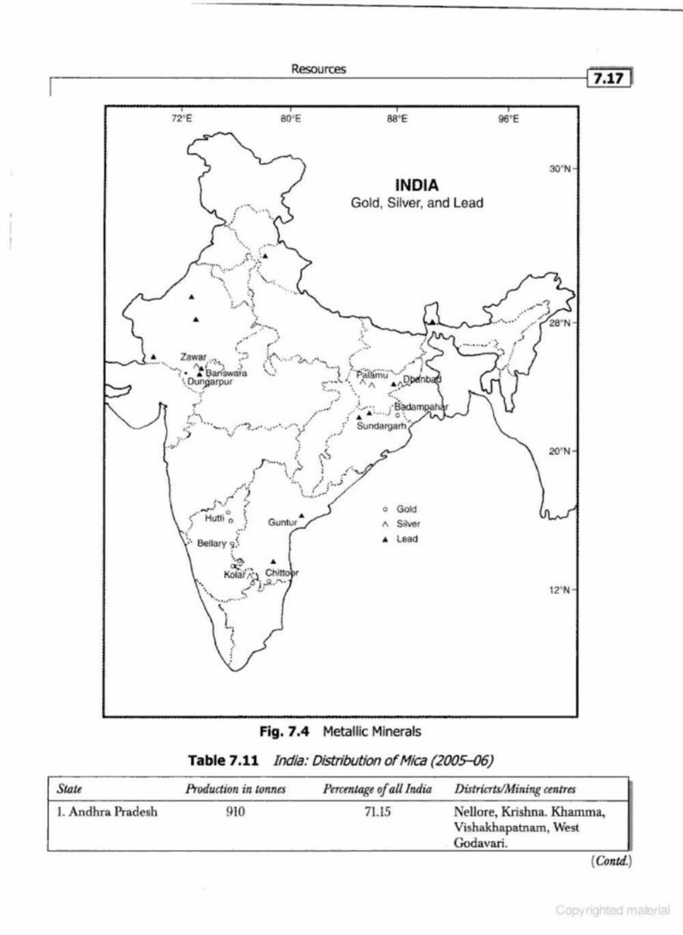
I r ______________________ R~ __ u_r~----------------------~lhi17]
Sliltt
72'E
•
........ : "· .....
... \ · . ..
. r: .. '• .-....... ···' ;"':.
'·
: • ..... · ,. f \. .... : ~ \ ..... '· : .. :
... ~) . . ! ••• , ·, ·- ' ! . ,
,"-.. ...._ . '
80'E 88'E
INDIA Gold, Silver, and Lead
..
96'E
... ..
•• _.. . '... . .... • r ,., ,."' , \ . . .. ·-· '\.
., .• -· , ........ "",.· •' ·... : • Zawnr .. ·.~ t,.,., .... ... -~
9 ' ·'· • .•• ,; _,_ ,'1., ~
__ .....,_, •· ~--""""""''"' ··. J\al" {"l'\ :; t '· ...... ..... "\_. \ , -·-· ;
.... ? • • l;iarfsw·dia '·fl1 l /''Pi\iirT\U"'·.~· ·· . .r_.,.~ '·.!)un~arpur ,..-·--'- '·. A A .~ll!f•• .. -· . .... .. ... .. ··. . ..
I ·· .. . -·· ...... ~-"""~" '·' • • DCILJ('Io ' J}!:_'UI t ,·· A 0
•• 0 ol O 'o lr\.J"-'-: . -.,
•· Sundargarh · . . i
"('! , ...
~ , ..... ~ r'•\ ,• . . . --~- 0 •• ~·""' • •••• ••
::; ..... , , , ,• l f.,,o•' '•f' 0 0 o' v .I v· ~
-~·-· ~ • e.o-
l r ··-···\ \_ !.. : ....
• • . ·:.. ,: . • . ,.-.,_:· \ , .•. J
-' ) '; :,) ~- •,,,,,,, ,, " ~~
: ·' ~ , #10#'' 0 )
>:' Hl1tli o '· . . .. 1 . . ..
~ ·. ·: . Bellary </ .
·-~ . Kojjir~..1 Chitto
~· ...R .-.. • .., J: . . -· ''~. ······· .~
o Gold
A Silvsr
" Lead
Fig. 7.4 Metallic Minerals
Table 7.11 India: Distribution ofl.fica (2005-06)
.
30'N
20"N
12•N
Production itl t01111es Perr:rotage of all Inditl Districrts/Mining cmtres
1. Andhra Pradesh 910 71.15 Nellore, Krishna. Khamma, Vishakhapa.tnam, West Godavari.
(Cmtd.}
Geography of India
As bestos: Asbestos has great commercial value due to its fibrous structure, and its resistance to fire . It is widely used for making fire-proof clothes, rope, paper, sheeting, belt, fireproof safes, insulators, felts, aprons, gloves, curtains, brake linings in automobiles, and insulating mats. Asbestos cement products like sheets, slates, pipes and tiles are used for building purposes. Mixed with magnesia, it is used for making 'magnesia bricks' used for heat insulation.
Rajasthan is the leading producer accounting for about 95 per cent of the total asbestos production of India. It is mined in Ajmer, Alwar, Dunga.rpur, Pali and Udaipur districts. Andhra Pradesh is the second largest producer. ft is produced in Cuddapah D istrict. It is also mined in Karnataka, Jharkhand, Madhya Pradesh, Chhattisgarh, Tamil Nadu, Uttarakhand, and Nagaland.
Magnesite: Magnesite is used for manufacturing refractory bricks, special type of cement, tiles, fire-proof flooring and for extraction of the metal magnesium, and in steel industry. Its major deposits are found in Uttarakhand, Tamil Nadu, and Rajasthan. Its deposits have also been found in j ammu and Kashmir, Karnataka, Himachal Pradesh, and Kerala.
Tamil Nadu is the largest producer accounting for over 74 per cent of the total magnesite production, followed by Utt.arakhand (20 per cent) and Karnat.aka (6 per cent).
Kyaoite: Found in the metamorphic rocks, kyanite is used in metallurgical, ceramic, refractory, glass and electrical industries. India is the largest producer of kyanite in the world. Kyanite deposits are located in Jharkhand, Maharashtra, and Karna.taka. T hese three states contribute almost the whole production of kyanile of the country.
Gypsum: Gypsum is a hydrated sulphate of calcium which occurs as a white opaque mineral in beds of bands of sedimentary rocks like limestone, sandstone and shale. It is mainly used in making ammonia sulphate, fertilisers and in cement indus lry. It is a lso used in making plasl.er of Paris, ceramic industry, nitrogen-chalk, partition-blocks, sheets, tiles, and plastics.
Rajasthan is the leading producer of gypsum accounting for about 99 per cent of the total production of the country. It is obtained mainly from the districts of Barmer, Bik.aner, Churu, Ganganagar,Jaisalmer,Jodbpur, Nag-aur, and PaH. The remaining one per cent is mined in Tamil nadu, Jammu and Kashmir, Gujarat, and Uttarakhand, Andhra Pradesh, Himachal Pradesh, Karnataka, and Madhya Pradesh.
Sillimanite: Sillimanite is used is ceramics, metallurgy, glass, refractory, automobiles and cement manufacturing industries. Its main characteristic is that it can withstand high temperatures.
Orissa, contributing about 57 per cent of the total production, is the largest producer of sillimanite in lndja. Kerala is the second largest producer accounting for about 33 per cent of the total production. It is also produced in Maharashtra, Rajasthan, Meghalaya, Assam (Karbi-Anglong}, Madhya Pradesh, (Sidhi), West Bengal (Datjeeling, Bankura and Purulia), and Tamil Nadu (Kanniyakumari, Tirunelveli, and Tiruchirappalli).
Diamond: Diamond is a precious stone. It is known for its brilliance, luster, transparency and hardness. Diamond is mainly found in the Vindhyan formations of Bundelkhand, {M .P.), Andhra Pradesh (Anantapur), and Kamataka (Raichw-). Panna District of Madhya Pradesh is the main diamond producing district in India.
Cutting and polishing of diamond is mainly carried on in Surat, Ahmedabad, Navasari, PaJanpur, Bhavnagar, Murnbai, Khambat,Jaipur, Trichur, and Goa.
Resources
I Saanen and Angora (Turkey) have been used for cross-breeding with the indigenous breeds so as to improve the quantity of milk and meat production.
Sheep Rearing
India has about 4 per cent of the total population of sheep in the world. They are an important source of mutton, wool and hide in the country. There were about 39 million sheep in the country in 1951 which increased to 55 million in 2005-06. The total production of raw wool in 2005-06 was 45 thousand tormes.
Sheep rearing in India is done mainly in Rajasthan (25%), follwed by Andhra Pradesh (16%), Tamil Nadu {12%}, Karnataka (11%), and Maharashtra (6%) of the total sheep of the country. The important breeds of sheep are Loki~ Kutchi, Bikaneri, MaTW!.lri, KathiawariJaisalmeri, Sonad~ Malpuri, Magra, Shekho.wati, Pugal, Deccani, Nellmi, Bellnry, Gurejr~ &T'TUI, BakMrwa~ Gaddi. The Indian wool is, however, inferior to that of Australia and South Africa in quality and is called the coarse carpet wool. India exports wool to USA and UK
The sheep breeds in India are generally poor. Efforts are being made to improve sheep breeds by crossing local breeds with the imported quality breeds like Australian Merino, Russian Merino, Spanish Merino, Cheviot, Leicester, and Lincoln (UK).
Poultry Farming
Poultry includes domestic fowls like chickens, ducks, geese, and turkey. These are kept to obtain meat, eggs, and feathers. Poultry farming requires small capital investment and provides good additional income and job opportunity to the rural population. There are over 300 million hens in the country which laid 32 billion eggs in 2005-Q6.
The poultry sector, with a total value of output exceeding Rs.l5,000 crore and providing direct and indirect employment to over three million people, produced around 1.9 million tonnes of chicken m eat in 2005.
Andhra Pradesh has the largest number of poultry population follwed by Bihar, West Bengal, Tamil Nadu, Assam, Maharashtra, Kama taka, Kerala, Orissa, Madhya Pradesh, and Uttar Pradesh. Poultry fanns have been developed around almost all the important urban centres like Mumbai, Kol.kata, Delhi, Chennai, Hyderabad, Pune, Bangalore, Nagpur, Bhubaneswar, Shimla, and Ajmer.
The Indian fowls belong to two categories: (i) Desi, and (ii) Exotic or imported. The Desi breed include Chittagong, Punjabi, Brown, Cbagas, Lolab, Naked-neck, Titre, Bursa, Tillicherry, etc. The imported breeds include White Leghorn, Rhode Island Red, Black Minorca, Plymouth Rock, New Hampshire, Light Sussex, Brown Leghorn and Australorp, etc.
The Central Poultry Farms are located at Mumbai, Hassarghatta (near Bangalore), Chancligarh and Bhubaneswar. These farms are established to improve poultry breed to produce more eggs.
Export of products such as live poultry, eggs, hatching eggs, frozen eggs, egg-powder, and poultry meat are made to Bangladesh, Sri Lanka, South West Asian countries, j apan, Denmark, Poland, USA, and Angola.
The bird influenza has created numerous problems for poultry development in India. The first outbreak was in 2006 in a small area in Maharashtra. The bird-flu adversely affected the poultry farms in 2007, especially those of West Bengal, Orissa, Assam, Maharashtra and Tripura. The second outbreak was also reported from Maharashtra a few months later. In order to overcome
n-.. -- ·-_jl.4 I ( Crmtd.)
11. Bihar 12. Arunachal Pradesh 13- Nagaland Total - ~ - ~- •
Geography of India
178 95 22
250,795 .... __ ._ == '--~- -- --
Source: Statisticol AbstTo.ct of India, 2007.
0.07 0.02 0.01
100.00
The major states having large proportion of the coal reserves of the country are Jharkhand, Orissa, Chhaltisgarh, West-Bengal, Madhya Pradesh and Andhra Pradesh (Fig. 8.2). A brief account of coal reserves in these states has been given in the following:
(i) Jharkhand The state ofjharkhand, accounting for about29 per cent, has the first rank in coal reserves and its production. Most of the coal belongs to the Gondwana period. The districts of Dhanbad, Dumka, Hazaribagh, and Palamu are very rich in coal deposits. The main coaJ mining centres are Auranga, Bokaro, Daltenganj Giridih, Hutar, Jharia, Karanpur, and Ramgarh (Fig. 8.3).
(a) The /haria Coalfield Out of all the coal mines ofjharkhand ,Jharia is the largest and most important coal producing mine, which sprawls over an area of about 460 sq km. It contains the best metallurgical coal (bituminous). Nearly 90 per cent of the coking coal is produced from the Jharia mine. Its coal is mainly supplied to the iron and steel plants of Asansol andjamshedpur.
(b) The Boknro Coalfield This coalfield stretches in the valley of Bokaro river in Hazaribagh dislrict, about 32 km to the west of J haria. The Kargali seam (37 metres) of the Bokaro coalfield is one of the thickest of the Gondwana period in (I ndia). Its coal is mainly supplied to the iron and steel plant of Bokaro_
(<;) The Ciridih or KDrharbari Coalfield The Giridih coalfield stretches in the district of Hazaribagh. Its seams are very close to the surface. It provides one of the finest quality of bituminous coal used for the metallurgical industry. Its coal is supplied to the Bokaro andjamshedpur steel plants.
(d) The Kanwpur Coalfield The Karanpur coalfield is divisible into the North and the South Karanpur coalfields. It lies only about 30 km to the west of Bokaro. The thickness of its seam is about 25 metres. Much of the coal is, however, non-coking.
(e) The Ramgar.h Coalfield Stretching over an area of about 100 sq km, the Rambrarh coalfield is only about 9 km to the west of the Bokaro coalfield. The coal of Ramgarh is of relatively inferior quality containing a high proportion of ash (about 30%} and carbon 35 per cent.
(f) The Hutar CmJfitJitJ Stretching over about 200 sq km the Hutar coalfield lies in the Palamau district Its seams are however, thin and the coal is of inferior quality containing about 50 per cent carbon1 30 per cent volatile matter and 20 per cent ash.
(g) Tlle Daltenganj Coalfield Sprawling over 55 sq km, this coalfield lies in the PaJamau district Its coal is either semi-anthracite or non-coking, of inferior quality which can not be used in metellaurgical industries.
(h) Dl-"'Ogarh CmJFiclds This coalfield lies in the Dumka district and slretches over an area of about 20 sq km_ The coal is of inferior quality containing about 40 per cent carbon, 25 per cent volatile matter and 35 per cent ash content Its coal is mainly used in the brick kilns.
Energy Resources
2. Poor Quality of Coal Most of the mines of India are producing non-coking coal which can not be utilised for metallurgical industries.
3. Less Efficien t T ransport Syslem Most of the coal in India is transported by trains. Adequate number of wagons are not available and railway system is not efficient enough to deliver the coal at d istant places in a short time. ·
4 . Obsolete Method of Mining The mining technology is outdated and the per worker production is low. The per tonne cost of production is high.
5 . Shortagt: of Power Su pply The shortage of power supply is a big barrier in the mining of coal.
6. Firt.-s and Water-loggi ng There occur heavy losses of coal because of fires and waterlogging in the mines and at the pit-heads.
Conservation of Coni
Coal is an exhaustible resource. It needs to be utilised judiciously. The following steps can go a long way in the conservation of coal in the country.
1. The coking and good quality coal should be reserved only for metallurgical industry. 2. Low grade coal should b e washed and impurities removed b y modem techniques. 3. Selective mining should be stopped by an act of law. All possible grades of coal should be
obtained from all the mines. 4. Environmental safety Jaws should be effective ly implemented. 5. The thennal power plants should be located at the pit-beads to enhance power genera tion. 6. The pilferages and theft of electricity should be minimised. Z New reserves should be discovered. 8. The non-conventional sources of energy should be popularised .
Petroleum
Petroleum is an impo rtant source of energy which is much in demand to accelerate the economic development Apart from an important fuel resource, it provides lubricants and raw materials for a number of industries. Its products i.nclude kerosene, cUesel, petrol, aviation-fuel, synthetic rubber, synthetic-fibre, thermoplastic resins, benzene-methansol, polystertene, acrylates, detergents, aromatics, gasoline, carbon-black, dyes, colours, food-colours, pigments, explosives, printing ink, film-photography, greases, cosmetics, paints, lubricant oils, paraffin, and wax.
Crude oil is obtained mainly from the sedimentary rocks of marine origin . In India, crude oiJ is found in the sedimentary rocks of the Tertiary period (Fig . 8.4). Normally it does not occur at its place offormation. Being lighter than water, crude oil overlain with gas, gets accwnulated in the anticlines above the water surface. The geologists propounded two theories about the origin of cntde oil. Origin: The origin of petroleum and natural gas is considered to be organic. According to organic origin, the living organisms (marine life , like fish) and vegetal matter got buried under the accumulated sediments of mud, silL and sand, etc. Due to pressure and heat, this undergoes chemical changes so as to form crude oil and natural gas after millions of years.
Oil in India was discovered near Marghetita (Upper Assam); for the first time in 1860 by the Assam railway and Trading Company. Subsequently, oil was discovered at Digboi in 1889. In the beginning of the 20th century { 1917), oil was discovered at Badarpur {Assam). In 1954, production
•
1"8.14 } Geography of India
Pipelines
Crude oil from oil-wells and finish ed products from refineries are generally transported through pipelines. Transportation of oil and petroleum through pipelines is cheap, effective and considered to be safe. Looking at these advantages, a network of pipelines has been developed in India. Some of the important pipelines are as under:
1. Pipclinc!:i of North-East India (i) Noonmati-Siliguri-Pipeline to transport petroleum products from Noonmati to Siliguri.
(ii) Lakwa-Rudrasagar-Barauni Pipeline, completed in 1968 to transport crude-oil from Lakwa and Rudrasagar (Sibsagar D islrict, Assam) to Barauni Oil Refinery (Bihar).
(iii) Barauni-Haldia Pipeline: This pipeline was laid down in 1966 to carry refmed petroleum products to Haldia port and bring back imported crude-oil to Barauni refipery.
(iv) Barauni-Kanpur Pipeline: This pipeline was completed in 1966 to transport refined petroleum products to Kanpur city.
(v} Noonmati-Boogaigaoo Pipeline: This pipeline was constructed to transport crude-oil to Bongaigaon petro-chemical complex.
(vi) Haldia-Maurigram-Rajbandh Pipeline: This pipeline was completed in 1998.
2. Pipeline~; of Wc!ltern In diu Bombay-High Mumbai-Ankleshwar-Koyali Pipeline: This pipeline connects th e oilfields of
Bombay High and Gujaral with the Koyali refinery of Gujarat. The city of Mumbai has been connected with a pipe line of 210 km length double pipeline to Bombay High to transport crude oil and natural gas. The AnkJeshwar-Koyali pipeline was completed in 1965 to transport crude oil to Koyali refinery.
3. Th e Salnya-Koyali-Mathura Pipeli ne This pipeline, 1075 km in length was laid dovm from Salaya (Gulf ofKachchh} toKoyali and Mathura via Viramgram to supply crude oil to lhe Mathura refinery. It has an ofTshore tenninal and the Sayala-Koyali sector of the pipeline was completed in 1978, while the Viramgram-Mathura sector was completed in 1981.
4. The} Muthura-Dclhi-1\mhalu-Jalnndhar Pipeline This 513 km long pipeline was constructed to transport refinery products of Mathura to the main cities of north and north-west India.
5. Pipc li ncN of G uja rul ln Gujarat. there are a number of short distance pipelines to transport crude-oil and natural gas to the refmeries and the refined products to the market These include the Kalol-Sabarma li Cmde Pipeline, the Nwagam-Kalol-Koyali Pipeline, the Cambay-Dhuravan Gas Pipel ine, the Ankleshwar-Utiran Gas Pipeline, the Ankleshwar-Vadodara Gas Pipeline, and the Koyali-Ahmadabad products Pipeline (Fig. 8.4).
6 . Mumbui P ip{)lin r.s From Mumbai, pip elines have b een laid up to Pune aod Marunad to distribute petroleum products.
7. The l l alrlia-Kolkata Pipdinc Through this pipeline, the Haldia products are sent to Kolkata and neighbouring urban places.
• I
, .
.------------En....;..er..::.g.:....y R...;..eso..;,.;..;..u....;.rces..;.;;._ _________ --l[ !1.lg J
Table 8.9 state-wise Main Hydro-Eiect/ic Power Plants ..
1. And.hra Pradesh 2. Bihar 3. Gujarat 4.Jammu & Kashmir 5.Jharkhand 6 . Ka.mataka
7. Kerala
8. Madhya Pradesh 9. Maharashtra
10. North-eastern States
11. Orissa 12. Punjab and Himachal Pradesh
13. Rajasthan 14. Tamil Nadu l5 . Uttara..kband 16. Uttar Pradesh 17. West Bengal
Names of the Hydro· ElecJ.ric Power Plants
Mach.ku.nd, Nagatjun-Sagar, Nizam -Sagar, Silent, Srisalcm Kosi Ukai {Ma.h.i} Dool· Hasti, Lower Jheluro, Salal Maithon, Panchet, Tilaiya ( all three under DVC) Mahatma·Gandhi Qog Falls), Sivasamudram (Kaveri), Bhadra, Munirabad, Saravati, Tungbhad.ra Id.ik.ki (Periyar), Kallada, Kuttiaddy, Pallivasal, Parambikulam, Poringal, Panniar, Sabarigiri J awaharsagar and Pratap-sagar on Chambal Bhola., Bhatnagar-Beed, Khopali, Koyna, Puma, Paithon, Vaite.ma Dikhu, Doyan (both in Nagaland), Gomuti (Tripura), Loktak . (Manipur), Kopali (Assam), Khandong and Kyrdcmkulai · (Meghalaya), Sirlui and Barabi (Mizoram), Ranganadi (Arunachal h Pradesh) ~j Hirakud (Mahanadi), Balirnela li Bhakra-Nangal on Sutlej, Dehar on Beas, Giri·Bata., Binwa, · Andhra, Chamera, Pong, Siul , Bassi Ranapratap Sag<1.r andjawahar Sagar on Chambal river Mettur, Periyar, Aliayar, Kodayar, Moyar, Suruliyar, Papnasam ~
Tehri-dam on Bhagira.thi · Rihand, Rarnga.nga, Chibro on Tons Panchet
' ' "·"-,,.......c _ , • •. -
1. Bhakra Nanga! Projccl Constructed across the Satluj river near Bhakra gorge, il is the highest slrclightway gravity dam in the world. The dam is 5 18 m long and 226 m high. Its reservoir is known as the Gobind Sagar (named after Sikh Guru Go bind Singh, the tenth Guru of Sil<hs). It is a m ultipurpose project funded by the Cen tral Government, built Lo generate electricity, p rovide irrigation, flood control, soil conservation, silt control, recreation, navigation, pisci-culture, preserving wild-life, and cattle rearing.
2 . Damodar Valley P roject The Damodar River is a tributary of the HugH River. Tt used to be called the 'Sorrow of Bengal'. T he D amodar Oows through Jharkhand and West Bengal. The Damodar Valley Corporation was established on February 18, 1948. Under th is project, fo ur dams were construcled namely, Tilaiya, .Maltbon, Konar, and Panchet Dams.
(i) TilJJ.iyn Dum The Tilaiya dam has b.een constructe<:! across the Barakar river. It is the only concrete dam in the area. Two power st.ations of 2000 kW each have been set-up here. The dam provides irrigation to for ty thousand hectares ofl and. It has helped in the reduction of floods . This dam was completed in 1953. I ts undergroWld p ower station with installed capacit)' of 60,000 kW provides cheap power to the mica mines of Kodaxm a and H azaribagh.
(ii) Konar Dam The Konar dam has been constructed across the Konar river- a tributary of the Damodar River in the Haza rib agh District. I t was completed in 1955. It is an earthen dam with
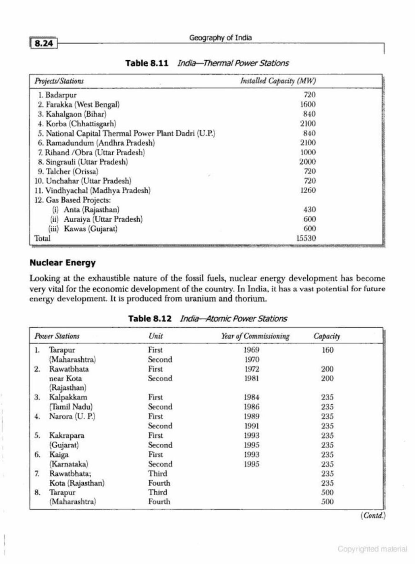
~ 8.24 I Geography of India
Table 8.11 India-Thennal Power Stations
Projtetsl Sto.ti ons Installed Capacity (MHQ
l. Badarpur 2. Farakka (West Bengal) 3. Kahalgaon {Bihar} 4. Korba (Chhattisgarh) 5. National Capilal Thermal Power Planl Dadri (U.P.) 6. Ramadundum (Andhra Pradesh) 7. Riband / Obra (Uttar Pradesh} 8. Singrauli (Uttar Pradesh) 9. Talcher (Orissa}
10. Unchahar (Uttar Pradesh} 11. Vindhyachal (Madhya Pradesh) 12. Gas Based Projects:
(i) Anta (Rajasthan) (ti) Auraiya (Uttar Pradesh) (iii) K.awas (Gujarat)
Tolal
Nuclear Energy
'
720 1600 840
2100 840
2100 1000 2000
720 710
1260
430 600 600
15530
•
~ • > I
Looking at the exhaustible nature of the fossil fuels, nuclear energy development has become very vital for the economic development of the country. In India, it has a vast potential for future energy development 1t is produced from uranium and thorium.
Table 8.12 India-Atomic Power Stations
Powtr Stations Unit Yt:ar of Commissioning Cu.pacit)'
1. Tara pur First 1969 160 (Maharashtra) Second 1970
2. Rawatbhata First 1972 200 near Kot.a Second 1981 200 (Rajasthan)
3. IWpakkam First 1984 235 {'Tamil Nadu) Second 1986 235
4. Narora (U. P.) First 1989 235 Second 1991 2~-J.'j
S. Kakrapara First 1993 235 (Gujarat) Second 1995 235
6. Kaiga First 199~-J
(Karnataka) Second 1995 235
' . 235
~
I . Rawatbhata; Third 235 Kota (Rajasthan) Fourth 235
8. Tarapur Third 500 (Maharashtra) Fourth 500
( Contd.)

..------------E_ner-'g~y_R_:_eso:_:__u r_ces:_:__ __________ --l[·a·.29'l
Geothermal Energy
India has very limited potential of geothermal energy. According to one estimate, the total geothermal energy is about 600 MW. There are 115 hot water springs in the country and 350 sites from which geothermal energy can be produced. The Puga Valley in Jammu and Kashmir, the Manikaran area in Himachal Pradesh, the western slopes of the Western Ghats in Maharashtra and Gujarat, the Narmada-Son Valley, and the Damodar Valley are the main areas which have potential for the generation of thermal energy.
Bio-Energy
Bio-energy is a clean source of energy which improves sanitation, hygiene and the living style of the IUI""ctl population. The technique is based on the decomposition of organic matter in the absence of air to produce gas. Bio-gas is used for cooking, and lighting fuel in specially designed stove and lamps respectively. According to one estimate, India has a capacity to produce bio-gas to the extent of 25,000 million cubic metres. The left over digested slurry serves as manure. This can meet 50 per cent of the rural domestic fuel requirements. Moreover, it can produce 7 million tonnes to nitrogen, 3 million tonnes phosphate and 5 million tonnes of potassium, and over 50 million tonnes of compost manure.
Table 8 .14 Bio-Gas Development in Major Selected States of Jndia-2005-()6
Statt
1. Uttar Pradesh 2. Madhya Pradesh 3. Andhra Pradesh 4. Bihar 5. Rajasthan 6. Maharashtra 7. West Bengal 8. Kamataka 9. Tamil Nadu m Gujarat I I. Orissa
Estimated Potential
2,02.1,000 1,491,000 1,065,600
939,900 915,300 897,000
2 021 000 , . 680,000 6 L.5,ROO 554,000 605,500
_,..-~···- ... ...._ ....... ···s.-······ ··_.__ ~
Source: Ministry of Non -CorwentWnal Energy. ' .
Production Permuage of estimated potential
356,300 18 192,950 13 308,520 29
119,1 JO 13 66,025 7
662,120 74 ~iS6,:iiO 18 306,845 45 187,265 27 343,700 62 171,760 28
' . . _,., <';',. _.. , . . - ........ ' . . ~- '
'
It may be seen from Table 8.14 that Uttar Pradesh has the high est potential in bio-gas, followed by Madhya Pradesh, Andhra Pradesh, and Bihar. The highest production of bio-gas is, however, in the sta te of Maharashtra (74%) followed by Gujarat (62%) and Kamataka {45%).
The development of bio-gas is adversely affected because of the non-availability of cattle dung, water, labour, space, and low temperatures in certain parts of the country, especially during the winter season.
ENERGY CRISIS
With the rapid growth of population and increase in the per capita income, there is an increasing
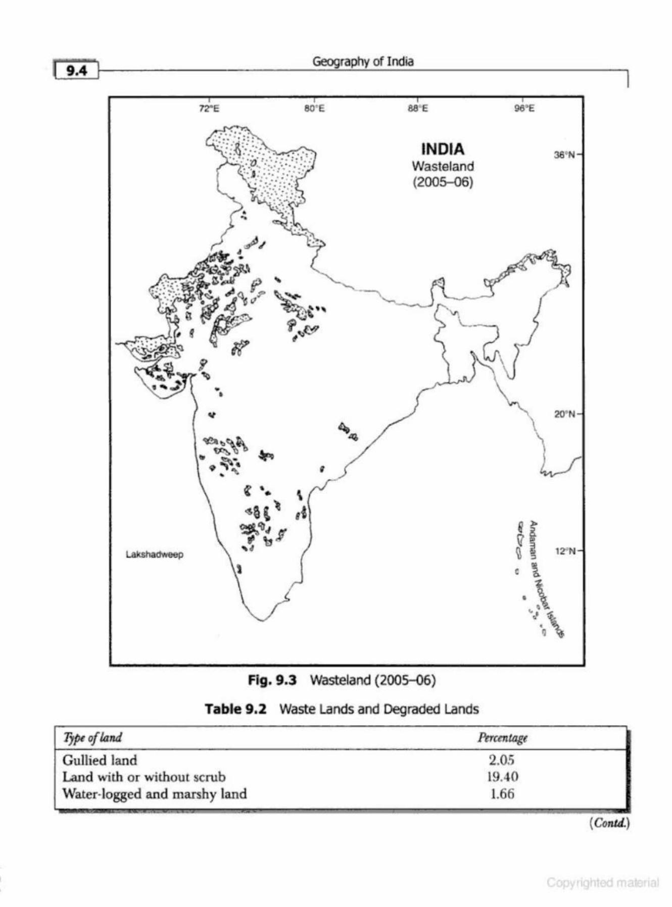
r '~i'.4 ... 1f--_ _ _________ Geog--=_ra..:....ph....:..y_o_fl_nd_ia __________ _,
72-"E
.,
Lakshadweep
80' E 88'E
INDIA Wasteland (2005-06)
Fig. 9.3 Wasteland (2005-06)
Table 9.2 Waste Lands and Degraded Lands
Type oflarui
Gullied land Land with or without scrub Water-logged and marshy land
Percentage
2.05 19.40 1.66
36•N
20"N
\ u
12"N
(Conkl)
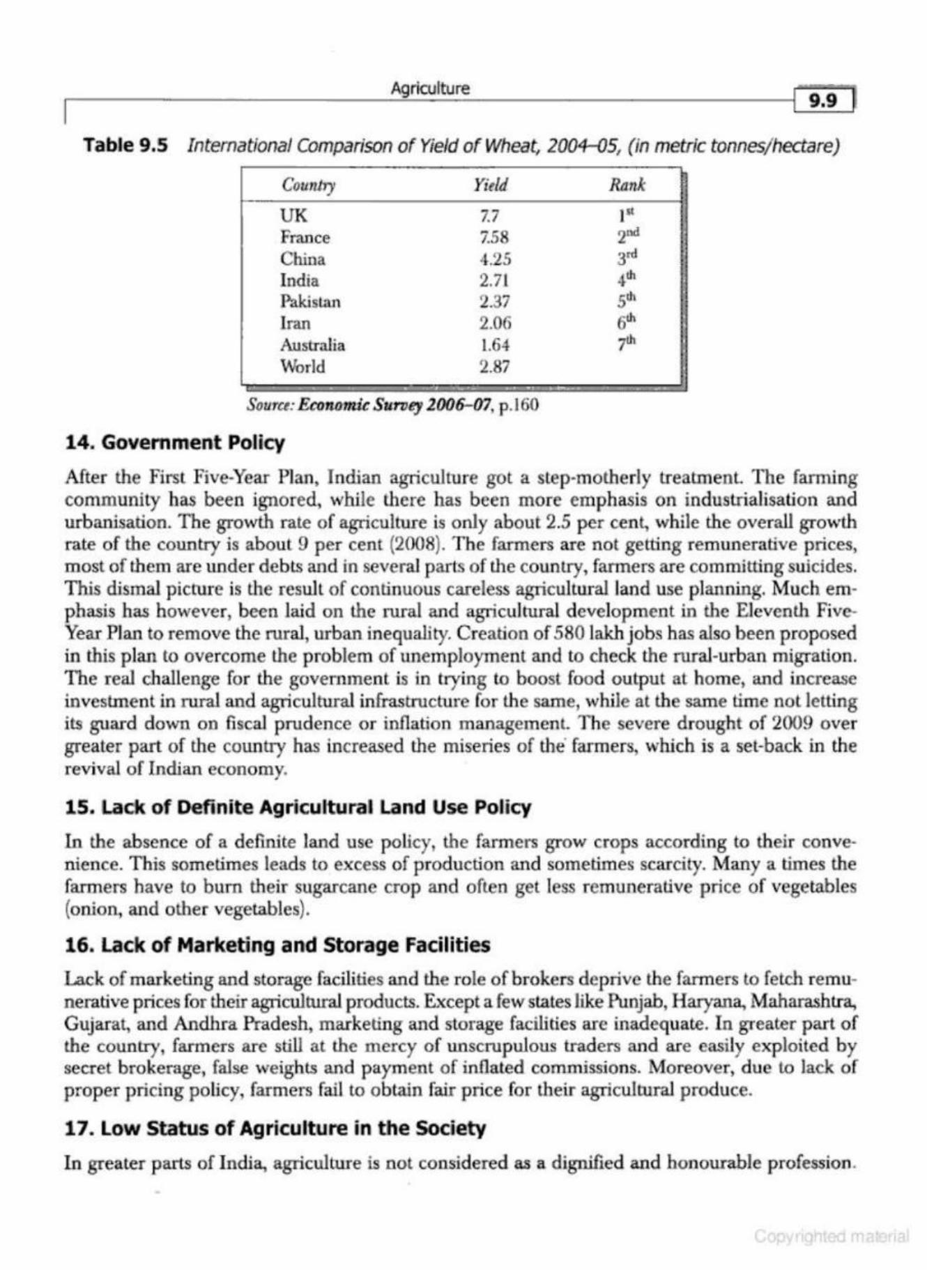
Agriculture
Table 9.5 International Comparison of Yield of Wheat, 2004-05, (in metric tonnes/ hectare)
Country Yitld
UK 7.7 France 7.58 China 4.25 India 2.71 Pakislan 2.37
Iran 2.06 Australia 1.64 World 2.87
' . - . Souru: Ecorwm.ic Suroey 2006-(}7, p.J60
14. Government Policy
Rank pt 2nd 3rd 4th slh 6th 7th
After the First Five-Year Plan, Indian agriculture got a step-motherly treatment. The farming community has been ignored, while there has been more emphasis on industrialisation and urbanisation. The growth rate of agriculture is only about 2.5 per cent, while the overall growth rate of the country is about 9 per cent (2008). The farmers are not getting remunerative prices, m ost of them are under debts and in several parts of the country, fanners are committing suicides. This dismal picture is the result of continuous careless agricultural land use planning. Much emphasis has however, been laid on the rural and agricultural developmen t in the Eleventh FiveYear Plan to remove the rural, urban inequality. Creation of 580 lakh jobs has also been proposed in this plan to overcome the problem of unemployment and to check the rural-urban migration. The real challenge for the government is in trying to boost food output at home, and increase investment in rural and agricultural infrastructure for lhe same, while at the same time not letting its guard down on fi scal prudence or inflation management The severe drought of 2009 over greater part of the country has increased the miseries of the farmers, which is a set-back in the revival of Indian economy.
15. Lack of Definite Agricultural Land Use Policy
In the absence of a definite land use policy, the farmers grow crops according to their convenience. This sometimes leads to excess of production and sometimes scarcity. Many a times the farmers have to bum their sugarcane crop and often get less remunerative price of vegetables (onion, and other vegetables).
16. Lack of Marketing and Storage Facilities
Lack of marketing and storage facilities and the role of brokers deprive the farmers to fetch remunerative prices for their agricultural products. Except a few states like Punjab, Haryana, Maharashtra, Gujarat, and Andhra Pradesh, marketing and storage facilities are inadequate. In greater part of the country, farmers are still at the mercy of nnscrupulous traders and are easily exploited by secret brokerage, false weights and payment of inflated commissions. Moreover, due to lack of proper pricing policy, farmers fail to obtain fair price for their agricultural p roduce.
17. Low Status of Agriculture in the Society
In greater parts of India, agriculture is not considered as a dignified and honourable profession.
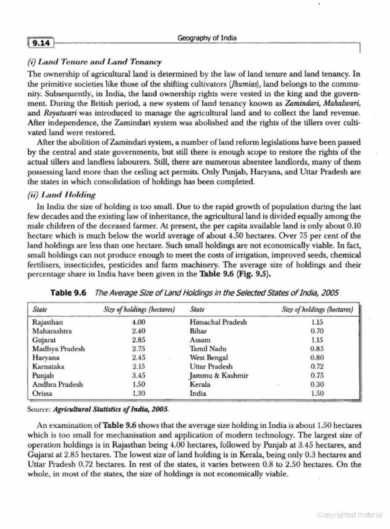
{9'141 Geography of India
(i) Land Tenure and Land Tenilncy
The ownership of agricultural land is determined by the law of land tenure and land tenancy. ln the primitive societies like those of the shifting cultivators (/humias), land belongs to the community. Subsequently, in India, the land ownership rights were vested in the king and the governmenL During the British period, a new system of land tenancy known as Zamindari, Malwlwari, and Royatwari was introduced to manage the agricultural land and to collect the land revenue. After independence, the Zamindari system was abolished and the rights of tbe tillers over cultivated land were restored.
After the abolition ofZamindari system, a number of land reform legislations have been passed by the central and state governments, but still there is enough scope to restore the rights of the actual tillers and landless labourers. Still, there are numerous absentee landlords, many of them possessing land more than the ceiling act permits. Only Punjab, Haryana, and Uttar Pradesh are the states in which consolidation of holdings has been completed.
(ii) Land H olding In India the si.ze of h olding is too small. Due to the rapid growth of population during the last
few decades and the existing law of inhelitance, the agricultural land is divided equally among the male children of the deceased farmer. At present, the per capita available land is only about 0.10 hectare which is much below the world average of about 4.50 hectares. Over 75 per cent of the land holdings are less than one hectare. Such small holdings are not economically viable. In fact, small holdings can not produce enough to meet the costs of irrigation, improved seeds, chemical fertilisers, insecticides, pesticides and fann machinery. The average size of holdings and their percentage share in India have been given in the Table 9.6 (Fig. 9.5}.
Table 9.6 The Average Size of Land Holdings in the Selected States of India, 2005
State
Rajasthan Maharashtra Gujaral Madhya Pradesh Haryana Karnataka Punjab Andhra Pradesh Orissa
Sir_e of holdings (hectares) State
4.00 Himachal Pradesh 2.40 Bihar 2.85 Assam 2.75 Tamil Nadu 2.45 West Bengal 2.15 Uttar Pradesh :1.45 Jammu & Kashmir 1.50 Kerala 1.30 India
.. . ., . .. . . . -Source: A.gricullural Statistics of India, 2005.
Size of holdings (heaare.s)
1.15 0.70 1.15 0.85 0.80 0.72 0.75 0.30 1.50
--~
An examination of Table 9.6 shows that the average size holding in India is about 1.50 hectares which is too small for mechanisation and application of modern technology. The largest size of operation holdings is in Rajasthan being 4.00 hectares, followed by Punjab at 3.45 hectares, and Gujarat at 2.85 hectares. The lowest size of land holding is in Kerala, being only 0.3 hectares and Uttar Pradesh 0. 7'2 hectares. In rest of the states, it varies between 0.8 to 2.50 hectares. On the whole, in most of the states, the size of holdings is not economically viable.
,.-------------A.::..gn_·cu_ltu_ re ___ ________ ~l g"jg-'f
the states of the country. There are many hurdles in the implementation of consolidation of holdings in some of the states. Some points which are coming in the way of implementation of consoli· dation of holdings are as under.
l . Farmers are emotionally attaehed to their ancestral land, and therefore, they are not v.ri.lling to take advantage of the scheme of consolidation of holding.
2. Those farmers who own good quality of land do not like the scheme for fear of getting the inferior and poor quality of land after the consolidation.
3. Consolidation of holdings is a cumbersome process. The government officials who implement the scheme are gen erally slow and often conupt.
4. In general, the scheme did not receive the desired support and co-operation from the farmers.
5. The scheme has paved way for litigation and court cases, many of which are pending in different courts for a long time. This vitiates the serene atmosphere of the rural a reas.
6. Under the existing law of inheritance, the fields continue to be smaller and fragmented. 7. In every consolidation, about 5 to 10 per cent of the viUage land is taken out for providing
house sites to the weaker sections of society, approach roads (chak-roadij and viUage utility services. Hence, if the process is repeated three or four times, a sizable portion of the agri· cultural land would go out of agriculture.
8. The cost of consolidation is realised from the farmers which has adverse effect on their resources and economy.
9. It has been observed that the small farmers are generally allotted inferior quality of land, and due to lack of money power, they are neither able to please the officials nor get justice in the court.
Looking at these drawbacks, efforts should be made to remove these barriers and pitfalls in the scheme of consolidation of holdings to m odernise the system of keeping revenue records. In the Seventh Five-Year Plan emphasis was laid on (i) scientific survey of the un-surveyed land, (ii) registering the name of tenant and share cropper in land records, {iii) strengthening the revenue system at the lowest level, and (iv) providing training facility to revenue officials to improve their efficiency. During the Eighth Five-Year Plan, it was d ecided to use computer and new techniques for keeping and maintaining revenue records.
Thus, a number oflegislations have been enacted in the country for land reforms after independence, but due to socioeconomic and culturaJ complexities, loopholes in the land reform laws, laxity in implementation, and political and legal intetference, these land refonns have not been able to achieve the desired success.
INFRASTRUCTURE AND AGRICULTURAL INPUTS
Provision of quality and efficient infrastructure is essential to realise the full potential of agriculture. In other words, infrastructural development is imperative for the agricultural development of a country/ region. Infrastructure includes the facilities of irrigation, availability of electricity, roads, marketing credit facilities and crop insurance.
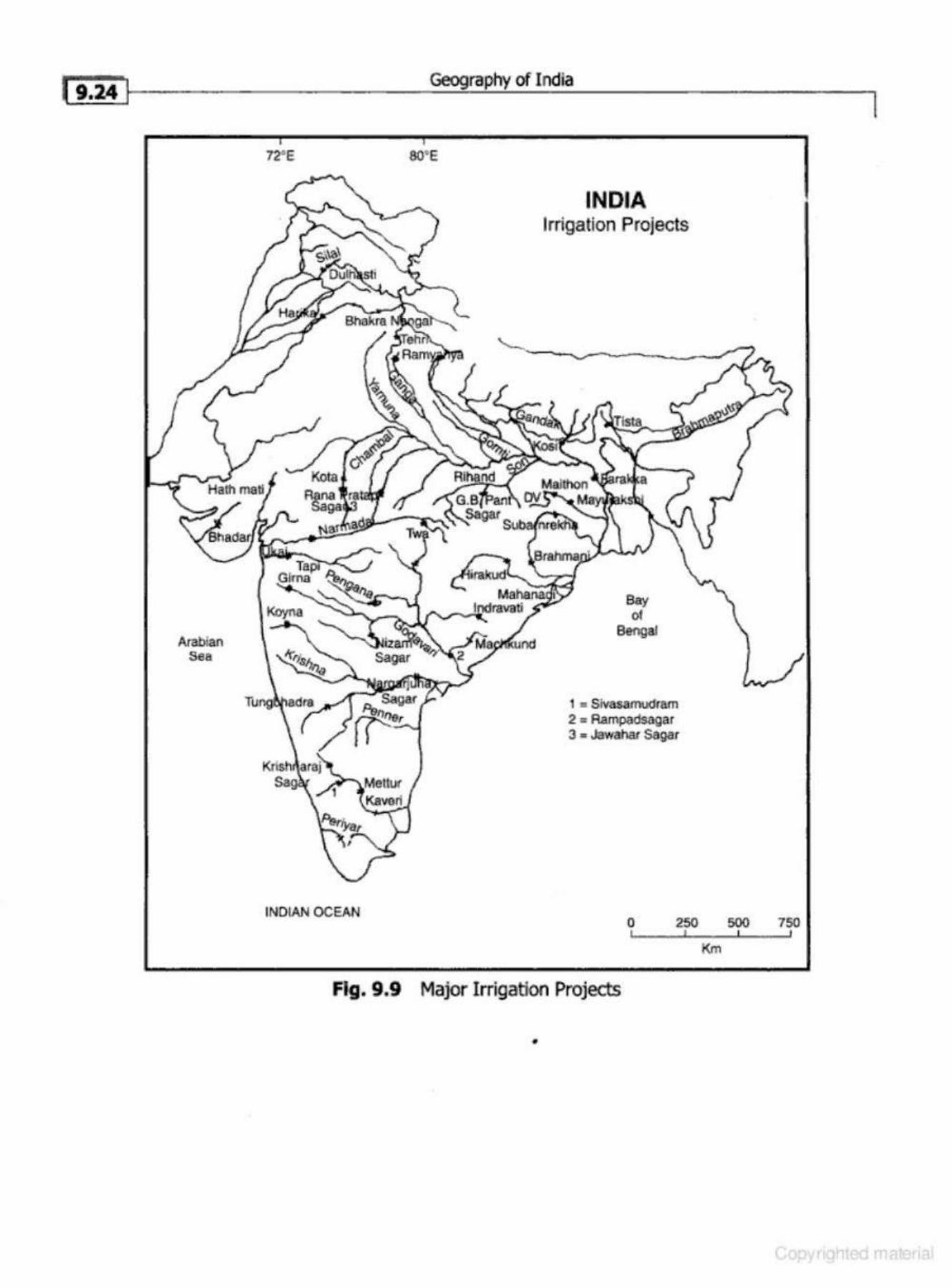
f g,~ Jr-------------------~--~rn~p~~~o_fi_nd_la __________________ ~l
Arabian Sea
72"E 80' E
INDIAN OCEAN
INDIA Irrigation Projects
Bay of
Bengal
1 • Slvasamtxlram 2 • Rampadsagar J • Jawallar Sa{IBr
0 250 500 750
Km
Fig. 9 .9 Major Irrigation Projects
•
Agriculture
I 19.29]
2. A vailahility of Chemical Fertilisers
The natural fertility of the soil decreases with the passage of time. In a region like the Great Plains of India, in which agriculture is being carried out for the last five thousand years, the soils are generally depleted and are increasingly losing their resilient characteristics. For the recuperation of fertility, the soils need to be rested in the fonn of fallowing or they have to be enriched by applying manures (cowdung, compost, and green) and chemical fertilisers.
The High Yielding Varieties give rise to short stemmed, stiff-straw plants that respond well to heavy doses of fertilisers. These dwarf varieties are known as the hungry varieties which need more energy in the form of chemical fertilisers. Contrary to this, the traditional varieties, if given heavy doses of fertilisers, get lodged at the occurrence of rains. The lodging of the crop reduces the yield per unit area.
In the areas of controlled irrigation, the reco.mmended dose of chemical fertiliser for the new seeds of wheat and rice in terms of NPK is 90-45-45 kg. per hectare. Some of the well off farmers of Punjab, Haryana, and western Uttar Pradesh are applying the chemical fe1tilisers to the crop in the prescribed quantity.
3. Plant Protectio11 Chemicals
The new seeds are very delicate and highly susceptible to pests and diseases. The irrigated fields enriched with heavy energy input (fertilisers-NPK) create a micro climate (hot and humid) in the field which helps in the fast growth of plants. The same environment is conducive for the fast growth and multiplication of insects and pests. These insects and pests attack the crop, hamper their growth and reduce the yield substantially. The danger of pests and .insC{;ts may be reduced by using plant protection chemicals. The problem may be tackled either by developing the disease resistant seeds or by spraying insecticides and pesticides at the appropriate time prescribed or advised for different crops.
The problems of crop disease and pests may also be tackled by timely application of insecticides and pesticides. Thus, the farmer must have adequate knowledge of plant disease and their controlling chemicals. At the outbreak of a disease in the crop, the entire area should be sprayed. U the timely spray of the insecticides and pesticides is not done, the crop of the entire village/ region may vanish. Since the plant pro tection chemicals are quite expensive, they are generally out of reach of the small and marginal farmers. And if the crops by small and marginal farmers are not sprayed, the insects may creep in the neighbouring fields and the disease may adversely affect the larger area.
4. Capital ConBl.raint
Availability of capital is also a vital constraint in the adoption and successful cultivation of the High Yielding Varieties. The farmer must have sufficient capital for d1e purchase of seeds, installation of tube-wells, drilling of pumping sets, chemical fertilisers, plant protedion chemicals, tractors, harvesters, threshers, sprayers, and other accessories of agriculture. In case the farmer does not possess the operational capital, he should have an easy access to credil In India, most of the farmers have no surplus over comntmption, and therefore, no saving or operational capital at their disposal. The agr-d.rian institutions Uke banks and co-operative credit societies have great responsibilities. They should advance loans to the farmers at a reasonable r<~.te of interesl Unfortunately, the credit agencies in India, generally, serve the big farmers who are economically well off and
.~""' , . \ ~- .,.·· . .. .
·~ \ :.1 . . 1 . ,
: ,; J·-" : .-:,.,. "' . . . . • ... . ~ ·. I • ... ....... ...,., .... ~ .: \. ........... .....
·~
• :,. . ' • ,.:
t · .•..
• • • ·!'! •• •• • ..
• ,. .. ·· ,.
Geography of India
INDIA Rice Concentration
(196CHl1)
Fig. 9.10 Rice Concentration (196Q-61) Table 9.10 Ovpping Pattern in 200~6
Crops A rea in m illi an htctom PerctnJage
Rice 45.0 26.43 Wheat 2Z4 16.10
J owar 10.4 6.1 1 Bajra 8.8 5.16 Maize 6.4 3.76 Gram 6.3 3.70 Pulses 21.1 12.40
~ .. ~ ....
Source: Gouermn.ent of India, Ministry of blformalion: Protbu:tion DilliJWn, India {2007), New Delhi, pp. 388-389.
I
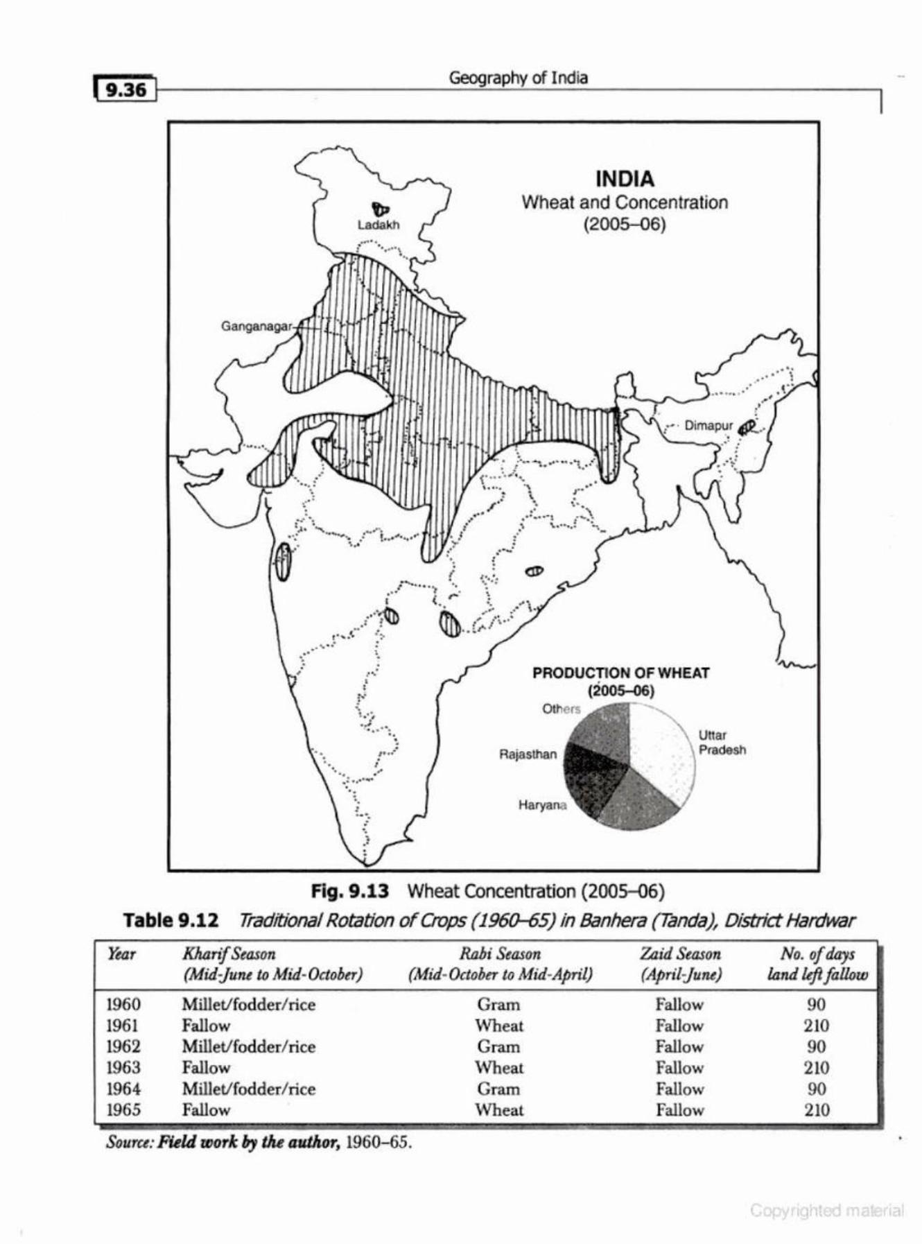
( 9 ,36 Ji-------------=-Geog.:..: . .:.:r....:::ap~h:.!.,.y ....;_of;,_:I..:..;.nd;;..;ia;;__ _________ __,
~ Ladakh ........ l •••. • ,
.
:
··..-.-
INDIA Wheat and Concentration
(2005-06)
. .
": . -~ -~ ... ·. ..
• . , ..... · i
.. ·"" _: ·~· ··-. . . .
Fig. 9.13
J. ,- · Dimap~.r Q_.. '--~...,. .. . . • . .
PRODUCTION OF WHEAT . (2005-06)
Rajas Ulan
Wheat Concentration (2005-06)
unar Ptad&Sh
Table 9.12 Traditional Rotation of Crops (1960-65) in Banhera (Tanda}, District Hardwar
~.zr Kharif Season Rahi Season Zaid Season No. ofdays (Mid-june to Mid-October) (Mid-October to Mid-April} (April-june) land left follow
1960 Millet/fodder/ rice Gram Fallow 90 1961 Fallow Wheat Fallow 210 1962 Millet/fodder/ rice Gram Fallow 90 1963 Fallow Wheat Fallow 210 1964 Millet/fodder/ rice Gram Fallow 90 1965 Fallow Wheat Fallow 210
Souru: Field wor/c fly the author, 1960-65.
~I ----------------------~~-"c_u,_w_re ____________________ ~fi.sil
Some of the important achievements of the White Revolution are as under: l. The White Revolution made a sound impact on rural masses and encouraged them to take
up dairying as a. subsidiary occupation. 2. India has become the leading producer of the world. The milk production that was about 17
million tonnes in 1950-51 rose to over 95 million tonnes in 2006-07. The production of milk has gone up by more than six times when compared with that of the Pre-Independence situation.
3. The per capita availability of milk per day a t present is about 200 gm as against 100 grams before the White Revolution.
4. The import of milk and milk production has been reduced substantially. 5. The small and marginal farmers and the landless labourers have been especially benefited
from the White Revolution. 6. To ensure the success of Operation Flood Programme, research centres have been set up at
Anand, Mehsana, and Palanpur {Banaskantha). Moreover, three regional centres are functioning at Siliguri,Jalandhar, and Erode. Presently, there are metro dairies in JO metropolitan citit:s of the country, beside 40 plants with capa.city to handle more than one lakh litres of milk.
7. Livestock Insurance Scheme was approved in February 200(j and in 2006- 07 on a pilot basis in 100 selected districts across the country. The scheme aims at protecting the farmers against losses due to untimely death of animals.
The All India Summary Reports of the 17th Livestock Census released in july 2006 poin ts out that India possesses the largest livestock population in the world after Brazil. ll acCOWlts for about 56 per cent of the cattle population of the world's buffalo population and 14 per cent of the cattle population. It ranks first in respect of buffalo and second in resp ect of cattle population, second in goat population and third in respect of sheep in the world.
Problems and Prospects
Some of the impor tant problems of the White Revolution are as under: 1. Collection of milk from the remote areas is expensive, time consuming, and nol viable
economical} y. 2. In most of the villages the cattle are kept under unhygienic conditions. 3. There are inadequate marketing facilities. The marketing infrastructure needs much im-
provem ent. 4. The breeds of cattle is generally inferior. 5. The extension service programme is not effective . In India, dairy development has a great future. I t should take the advantage of liberalisation in
the global trade and should try to capture international market. Many corporate sector firms like lndana (p lants at Nagpur, Hyderabad, and Bangalore), The Sheel International and Milk and Food, and the Arnrut Industries are taking advantage of the existing siruation of liberalisation and globalisation. The government has constituted Technology Mission for dairy development and Amul Model Co-operatives are being p rom oted to cover about 60 per cent of the total area of the country.
[ 9.s& I Geography of India
I Growth and Development of Aquaculture
Aquaculture bas been used in China since circa 2500 BC. The practice of aquaculture gained prevalence in Europe during theMiddle Ages since fish were scarce and thus expensive.Am.ericans were rarely involved in aquaculture until the la.te 20th century but California residents harvested wild kelp and made legal efforts to manage the supply starting circa L900, later even producing it as a wartime resource.ln contrast to agriculture, the rise of aquaculture is a contemporary phenomenon.
Types of Aquaculture
1. Algaculturc
Algaculture is a form of aquaculture involving the farming of species of algae.The majority of algae that are intentionally cultivated fall into the category of microalgae, also referred to as phytoplankton, microphytes, or planktonic algae.
Macroalgae, commonly known as seaweed, also have many commercial and industrial uses, but due to their size and the specific requirements of the environment in which they nei:!d to grow, they do not lend themselves as readily to cultivation on a large scale as microalgae and are most often harvested wild from the ocean.
2 . Fish Farmir.1g
Fish farming is the principal form of aquaculture, while other methods may fall under mariculture. It involves raising fish commercially in tanks or enclosures, usually for food. Fish spe<:ies raised by fish farms include salmon, catfish, tilapia, cod, carp, trout, and others.
Increasing demands on wild fisheries by commercial fishing operations have caused widespread overfishing. Fish farming offers an alternative solution to the increasing market demand for fish and fish protein.
3. Fresh water Prawr1 Farming
A freshwater prawn farm is an aquaculture business designed to raise and produce freshwater prawn or shrimp for human consumption. Freshwater prawn farming shares many characteristics with, and many of the same problems as, marine shrimp fanning. Unique problems are introduced by the development life cycle of the main species (the giant river prawn, Macrobradzium rosetzbergit).
4. Integrated Mulo"-Tropbic Aquaculture
Integrated Multi-Trophic Aquaculture (IMTA) is a practice in which the by- products (wastes) from one species are recycled to become inputs ( fertilisers, food) for another. Fed aquaculture (e.g. fish, shrimp) is combined with inorganic extractive (e.g. seaweed) and organic extractive {e.g. shellfish) aquaculture to create balanced systems for environmental sustainability (biornitigation}, economic stability (product diversification and risk reduction), and social acceptability (better management practices).
5 . MariculttJf'e
Mariculture is a specialised branch of aquaculture involving the cultivation of marine organisms for food and other products in the open ocean, an enclosed section of the ocean, or in tanks, ponds or raceways which are filled with seawater. An example of the latter is the farming of
Agriculture
While India's share of world trade in the poultry and poultry production continues to be very small in the last decade the value of such exports has increased from 11 crore in 1990-91 to Rs. 326 crore in 2005-06. Exports of products such as live poultry, eggs, hatching eggs, frozen eggs, egg powder, and poultry meat to countries including Bangladesh, Sri Lanka, South West Asia, Japan, Denmark, Poland, USA, and Angola augurs well for industry. The value of output from poultry sector is nearly Rs. 20,000 crore.
In India, there are over 250 million hens in the country which laid down about 30 billion eggs during 2005-06. The largest number of poultry population is in Andhra Pradesh followed by Bihar, West Bengal, Tamil Nadu, Maharasht.ra, Assam, Kamataka, Kerala, Orissa, Madhya Pradesh, Uttar Pradesh, Punjab, and Haryana. Most of the important poultry farms are being developed around almost all the important urban centres like Mumbai, Kol.kata, Delhi, Chennai, Hyderabad, Pune, Nagpur, Shimla, Bhubaneshwar, Ajmer, Chandigarh, and Bhopal.
Uninterrupted supplies of feed as well as avian influer-,z.a are critical for the continued robust growth of the poultry sector.
The Central Poultry Development Organisation has been playing a pivotal role in the implementation of the policies of the Government with respect to poultry as a tool for alleviating nutritional hunger and palliating the impecuniosities of the resource· poor farmers, especially the women. The mandate of the Central Poultrey Development Organisation has been specifically revised, by restructuring all poultry units of this Department to focus on improved indigenous birds, which lay on an average 180- 200 eggs per annum and have a vastly improved FCR ratio in terms of feed consumption and weight gain. The Central Poultry Development Organisations have been entrusted with the responsibility of producing excellent germ plasm in the form of day· old chicks and hatching eggs of these varieties like Nierbheek, Hitkari, Vanaraja, Shyama, Cari, Chabro, etc. Besides, these organisations are also playing a crucial role in analysing feed samples.
These Organisations, besides conducting the activities stated above, also work for scaling-up of diversification of other avian species Like Ducks/Turkeys/ Guinea fowl/japanese Quail, and upgrading of 'fraining Unit into International Tropical Avian Management Institules in which private-public partnership is envisaged. Presently these Organisations are also supporting and hand-holding the Centrally-sponsored Schemes related to assistance to state poultry farms.
A new Centrally-sponsored scheme called Assistance lo State Poultry, is being implemented during the Tenth Plan where one time as~istance is provided lo suitably strengthen the facms in terms of hatching, brooding, and rearing of birds with provision for feed mill and their quality monitoring and in-house disease diagnostic facilities.
A new scheme, Dairy/ Poultry Venture Capital Fund, has been launched during the 2004-05, wherein there is a provision to grant subsidy on interest payment. The nodal agency for the implementation of this scheme is NABARD through nationalised comm ercial bank. In 2005-06, a total of 49 poultry units involving 2.17 crore was approved.
HORTICUL TORE
India is bestowed with varied agro-climates, which is highly favourable for growing large number of horticultural crops such as fruits, vegetables, root tuber, ornamental, aromatic plants, medicinal species and plantation crops like coconut, arecanut, cashew and cocoa. Presently, horticulture crops occupy about 10 per cent of the gross cropped area of the country, producing about
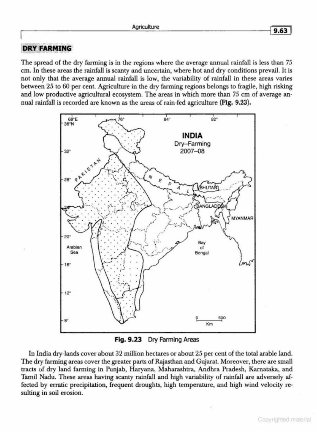
Agriculture ( 9.63 1 I
DRY FARMING
The spread of the dry farming is in the regions where the average annual rainfall is less than 75 em. In these areas the rainfall is scanty and uncertain, where hot and dry conditions prevail. It is not only that the average annual rainfall is low, the variability of rainfall in these areas varies between 25 to 60 per cenl Agriculture in the dry farming regions belongs to fragile, high risking and low productive agricultural ecosystem. The areas in which more than 75 em of average annual rainfall is recorded are known as the areas of rain-fed agriculture (Fig. 9.23).
68' E 36"N
20"
Arabian Sea
16"
126
a·
. •
INDIA Dry- Farming
2007-QS
Bay of
Boogal
Fig. 9.23 Dry Farming Areas
92'
In India dry-lands cover about 32 million hectares or about 25 per cent of the tota.l arable land. The dry farming areas cover the greater parts of Rajasthan and GujaraL Moreover, there are small tracts of dry ·land farming in Punjab, Haryana, Maharashtra., Andhra Pradesh, Kamataka, and Tamil Nadu. These areas having scanty rainfall and high variability of rainfall are adversely affected by erratic precipitation, frequent droughts, high temperature, and high wind velocity resulting in soil erosion.
•
Geography of India 9.68 1 I Griffin, Keith B., 1974, The Pvlitical Erontmty of Agrarian Cluznge-An Essay on tAe Grten RnJolaltitnl,
Harvard University Press. Johnston, RJ ., 1985, A Dictibnary of Human Geography, Basil and Blackwell. Khusro, A.M., 1973, T'he Economics of lAruJ Reforms and Farm.s Size in lruJUJ, Madras, Macmillan. Husain, M., 2007, SystematicAgriaAlbmd Geography,Jaipur, Rawat Publications. Pobeketr, G.S., 1970, Studies in Green Revolution, United Asia Publication. Sen, B. 1974, The Green .Rn1olution in /tulia: A Perspectlve., New Delhi, Wiley Easten1. Shafi, M., 2006, Agricultnral Geography, Delhi, Pearson & Education. Singh,]., 1974, 1984, .A.griadb.cral Geography, New Delhi, Tata McGraw-Hill Pub. Symons, L., 1968, Agrladlural Geography, London. Tlut New Eru;yd~Jpt4i4 Britannica, Vol.I, London, pp. 153- 154. Tiwari, R.C., 2003, Geography of/Niia, Allahabad, Prayag Pustak Bhavan.
r------------~Spa:....__ti_al_o_rg=--a_n....:.isa..:..tio......:. _n....:o_f_Ag=--r....:ic....:.ul....:.tu_re.:.._. ________ ~l-iG:'s]
AGRICULTURAL PRODUC fiYITY
Agricultural productivity is a synonym for agricultural efficiency. The yield per unit area is known as agricultural productivity. AgricuJtural productivity is generally the result of the physkal, socioeconomic, and cultural factors. It is also affected by the managerial skill of the farmer. Agricultural productivity, however, is a dynamic concept which changes in space and time.
Agricultural productivity of a region is closely influenced by a number of physical (physiography, terrain, climate, soils, and water), socioeconomic, institutional, and organisational factors. Agricultural productivity also depends on the managerial skill of the fanner, his attitude, and aspirations for the better standard of living.
The delineation of agricultural productivity has great significance in the planning of agticulture of a region . The main advantages are:
(i) It helps in ascertaining the relative productivity of the component areal units of a region. (ii) It helps in identifying the weaker areas which are lagging behind in agricultural productiv
ity. {iii} The existing patterns of agricultural productivity is a reliable index to assess the agricultural
development of the past. (iv) It provides a sound base for the agricultural development planning.
Agricultural geographers and economists have developed a number of methods for the measurement of agricultural productivity. Some of the important methods used by the geographers are given as under:
1. Output per unit area. 2. Production per unit of farm labour. 3. Agricultural production as grain equivalent {Buck, 1967). 4. Input-output ratio (Khusro, 19G4). 5. Ranking Coefficient Method (Kendall, 1939, Stamp, 1960). 6. Carrying capacity of land in terms of population (Stamp 1958). Z Determining a productivity index on the basis of area and yield (Enyedi, 1964, Shafi 1972). 8. Determining an index of productivity with the help of area and production under various
crops in the areal units and converting them in a uniform scale. 9 . Converting total production in terms of m oney {Husain, 1976)
10. To assess the net income in Rupees per hectare of the cropped area (Jasbir Singh, 1985). 11. Assessing net income (farm business income) in Rupees per hectare of cropped area or per
adult male unit of farm work-force (Tiwari, Roy, and Srivastava, 1997). Each of the methods and techniques adopted by the agricultural geographers hru; its own merits
and demerits. None of the techniques, however, gives satisfactory results at the national and/or global level. Some of the techniques are cumbersome and time-consuming to apply for the delineation of agricultural productivity regions. The Kendall's technique of ranking coefficient used by m any of the leading geographers for the demarcation of agricultural productivity regions has been illustrated below.
Ranking Coefficient Method of Agricuttural Productivity
The ranking coefficient method adopted by Kendall is quite simple and easy to apply. [n this technique, the component areal units are ranked according to the per hectare yield of crops and
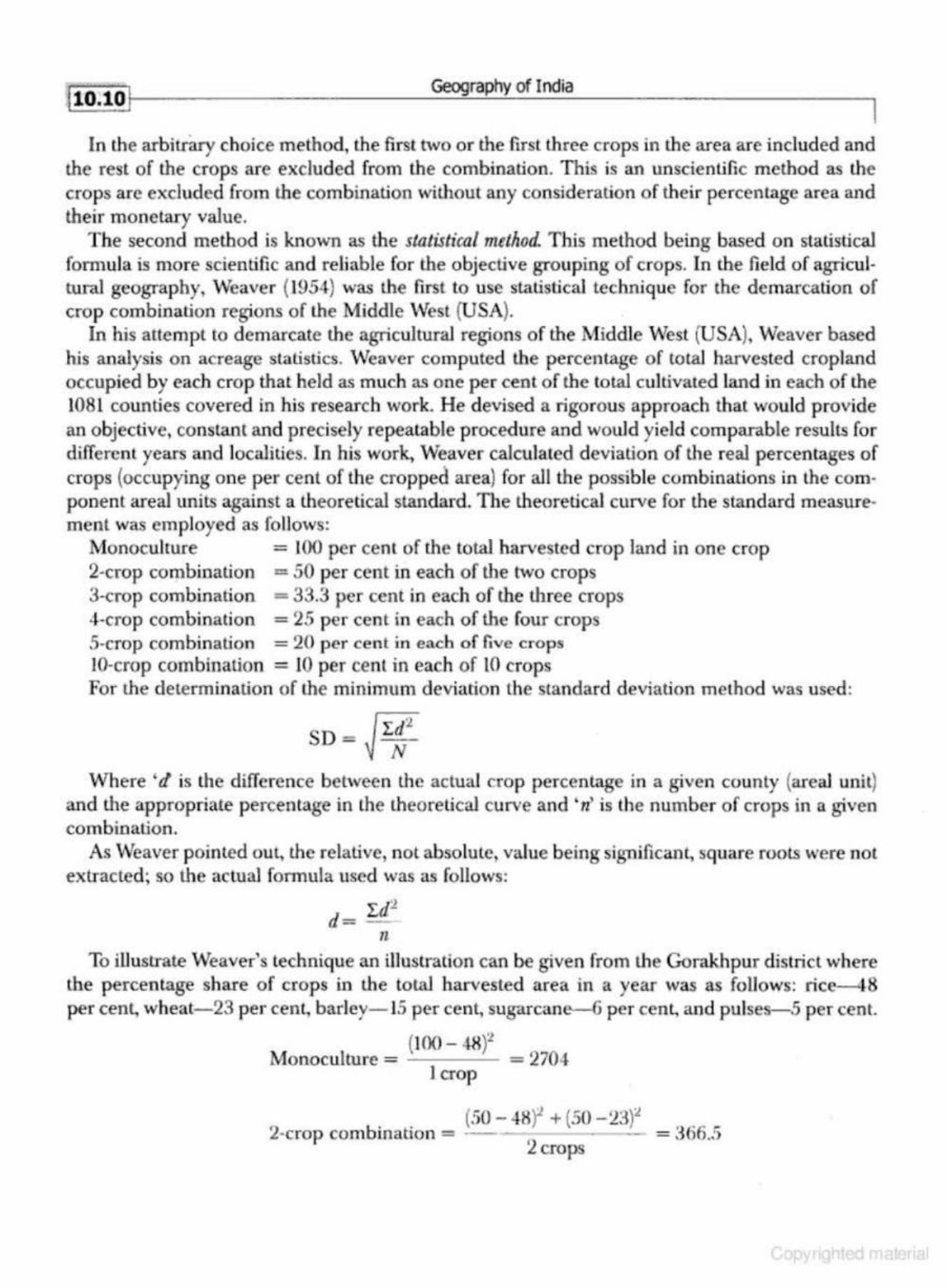
110.101 Geography of India
In the arbitrary choice method, the first two or the frrst three crops in the area are included and the rest of the crops are excluded from the combination. This is an unscientific method as the crops are excluded from the combination without any consideration of their percentage area and their monetary value.
The second method is known as the sto.tistical method. This method being based on statistical formula is more scientific and reliable for the objective grouping of crops. In the fie ld of agricultural geography, Weaver (1954) was the fi rst to use statistical technique for the demarcation of crop combination regions of the Middle West (USA).
In his attempt to demarcate the agricultural regions of the Middle West (USA), Weaver based his analysis on acreage statistics. Weaver computed the percentage of total harvested cropland occupied by each crop that held as much as one per cent of the total cultivated land in each of the 1081 counties covered in his research work. He devised a rigorou s approach that would provide an objective, constant and precisely repealable procedure and would yield comparable results for differcnl years and localities. In his work, Weaver cakulaled deviation of th e real percentages of crops (occupying one per cent of the cropped area) for all the possible combinations in the component areal units against a theoretical standard. The theoretical curve for the standard measurement was employed as follows:
Monoculrure = 100 per cent of tl1e total harvested crop land in one crop 2-crop combination = 50 per cent in each of the two crops 3-crop combination = 33.3 per cent in each of the three crops 4-crop combination = 25 per cent in each of the four crops 5-crop combination = 20 per cent in each of five crops 10-crop combination = 10 per cent in each of lO crops For the determination of the minimum deviation the standard deviation method was used :
SD = ~ r~:t vVhere ' r! is the difference between the actual crop percentage in a given county {areal unit)
and the appropriate percentage in the lheoretical curve and 'rz' is the number of crops in a given combination .
As Weaver pointed out, the relative, not absolute, value being significant, square roots were not extracted; so the actual formula used was as follows:
'LdJ. d= --
n To illustrate Weaver's technique an illustration can be given from the Gorakhpur district where
the percentage share of crops in the total harvested area in a year was as follows: rice-~8 per cent, wheat-23 per cent, barley-15 per cent, sugarcane--6 p er cent, and pulses-5 per cent.
(100- 48f Monoculture = = 2704
lcrop
. . (50 - 4X)1 + {50 - 23)"' 2·crop combmabon = ---- ~ -- = ::1 66.5
2crops
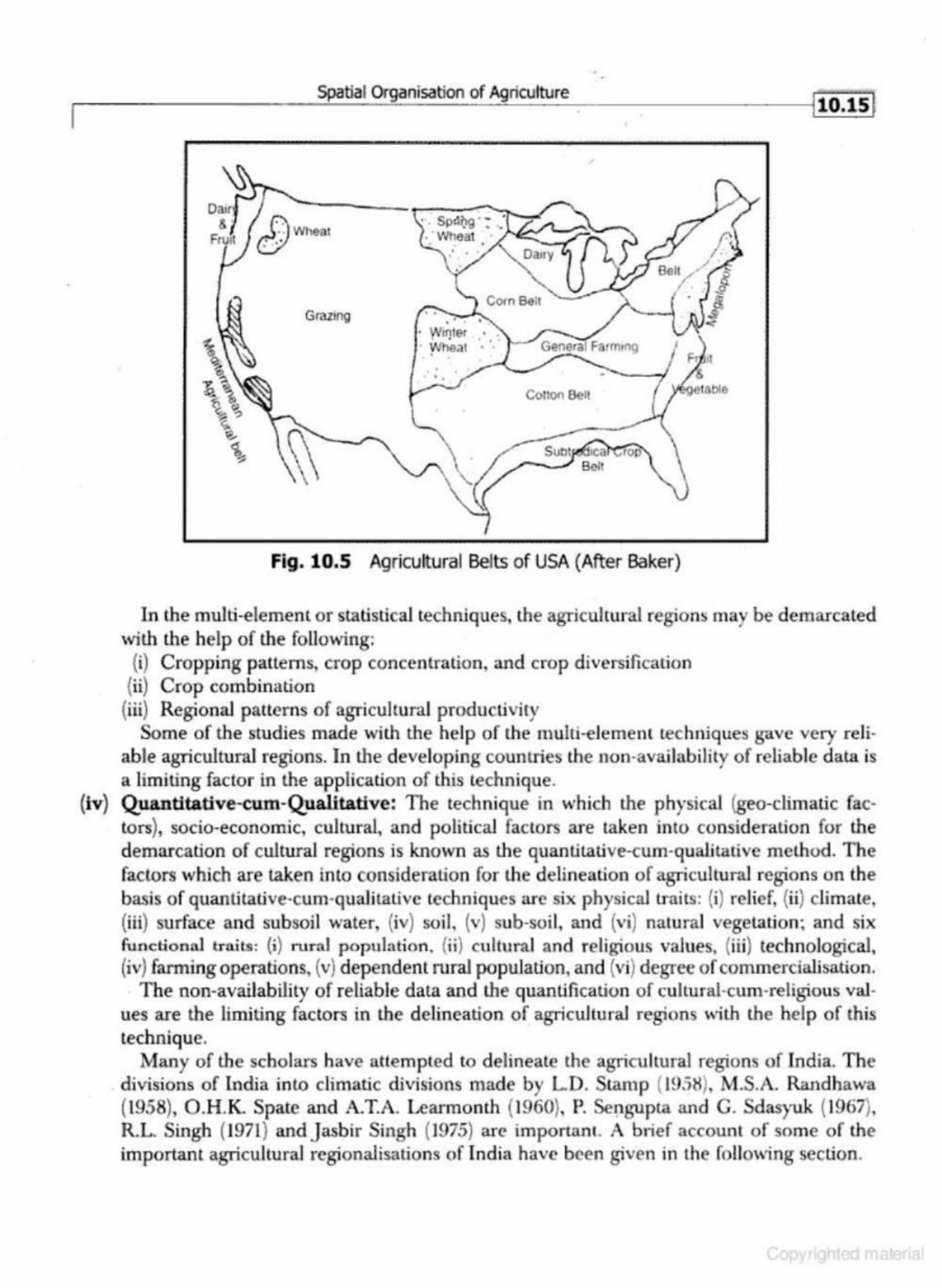
r-------------------~Sp~a~ti~ai~O~~~a~n~i~~ti~·o~n~o~f~Ag~n~·c~ut~tu~~~-----------------~jlO.lSI
Grazing . • 'tJi1)ler · Wheat
•
Co1to11 Belt
Fig. 10.5 Agricultural Belts of USA {After Baker)
In the multi-element or statistical techniques, the agricultural regions may be demarcated with the help of tl1e following: {i) Cropping patterns, crop concentration, and crop diversification (ii) Crop combination
(iii) Regional patterns of agricultural producliviry Some of the studies made with the help of the multi-e lemenl techniques g-<~.ve very reli
able agricultural regions. In the developing countries the non-availability of reliable data is a limiting factor in the application of this technique.
(iv) Quantitative-cum-Qualitative: The technique in which the physical (geo-climatic factors), socio-economic, cultural, and political factors are taken into consideration for the demarcation of cultural regions is known as the quantitative-cum-quaJjtarive method. The factors which are taken inlo consideration for the delineation of agricultural regions on the basis of quantitative-cum-qualitative r.echniques are six physical traits: (i) relief, (ii) climate, (iii) surface and subsoil water, (iv) soil, (v) sub-soil, and (vi) natural vegetation; and six functional traits: {i) rural population. (ii} cultural and religious values, (iii) technological, (iv) farming operations, (v) dependent rural population, and (vi) degree of commercialisation.
T he non-avaiJability of reliable data and the quantification of cultural·cum·religious values are the limiting factors in the delineation of agJicultural regions with the help of this technique.
Many of the scholars have attempted to delineate the agricu ltural regions of India. The divisions of India into climatic divisions made by LD. Stamp ( 1958), M.S.A. Randhawa (1958), O.H .K Spate and A. T.A. Learmonth (1960}, P. Sengupta and G. Sdasyuk (1967), R.L Singh (1971} andjasbir Singh (1975) are importan t. A brief accoun t of some of the important agricultural regionalisations of India have been given in the foiJo,~ing section.
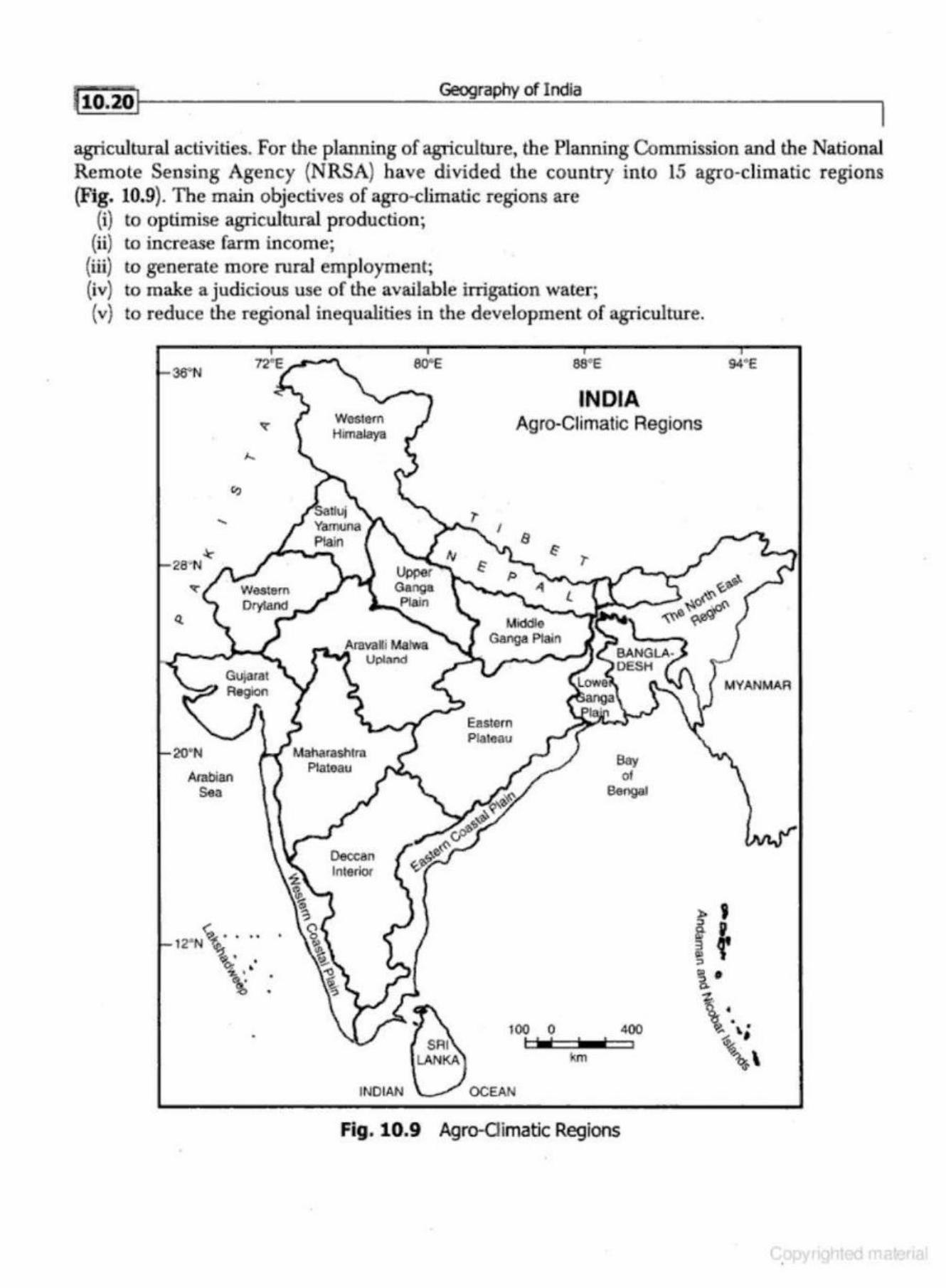
Geography of India
agricultural activities. For the planning of agriculture, the Planning Commission and the National Remote Sensing Agency {NRSA) have divided the country into 15 agro-climatic regions {Fig. 10.9). The main objectives of agro-dimatic regions are
(i) to optimise agricultural production; (ii) to increase farm income;
(iii) to generate more rural employment; (iv) to make a judicious use of the available irrigation water; (v) to reduce the regional inequalities in the development of agriculture.
36•N
20'N
Arabian Sea
•
Western Himalaya
Maharashtm Plateau
INDIAN
ewe
Eastern Plateau
aa•e
INDIA Agro-Ciimatic Regions
Bay of
Bengal
100 0 400
km
Fig. 10.9 Agro-<Jimatic Regions
94•e
MYANMAR
Spatial Organisation of Agriculture
14. The Western Region
This region stretches over Rajasthan west of the Aravalli moWJtains, and northern Gujarat. The mean July and January temperatures vary between 4.5°C and 10°C respectively. The mean annual rainfaiJ is less than 25 em.
Bajra, pulses, and fodder are the main crops. Livestock contributes gTeatly to the desert ecology. Rain water harvesting horticulture of date-palm, waler·melon, and plums deserve more attention.
15. The Islands Region
This region includes Andaman-Nicobar, and Lakshadweep which have marine equatorial climates. At Port Blair, the mean July and january temperatures read 30°C and 25°C, respectively. Rice, maize, millets, bajra, pulses, arecanut, turmeric, and cassava are the main crops. The main thrust in the development of agriculture should be on crop improvement, water management, and fisheries. Brackish water prawn culture should be promoted in the coastal areas.
AGRO~ECOLOGICAL REGIONS OF INDIA
The concept of 'agro-ecological region' is a modification and improvement on agroclimatic regions. The concept of agro~ecological region is perhaps hazy to our scientific conununities. People generally confuse these two terms (agroclimatic and agro-ecological) and use them in more or less the same way. But there is a distinct difference between these tWo tenns. According to FAO {1983), agro-climatic region is a land unit in terms of major bioclimate and length of growing period and which is climatically suitable for certain range of crop cultivation. But agroecological region is the land unit carved out of agro-climatic region when superimposed on land form and soil condition that acts as modifier of the length of growing period. Therefore, ·within an agro-climatic region there may be a few agro-ecological regions depending on soil condition. This approach has been used in delineating agro-ecological regions of India.
Methodology
The methodology used in the delineation Qf agro-ecological region is shown in Fig. 10.10 In order to p repare an agro-ecological region map, the soil-scap (soil-map) was superimposed on bioclimatic map. On. the resultant map, the growing period was incorpDrated, using GIS technology.
ln the demarcation of agro-ecological regions of India, the agro-climatic regions of India have been sub-divided on the b asis of soil type. T n the meso-regions thus obtained, the length of growing period (LGP) has been superimposed. This method has resulted into 20 agro-ecological regions and 60 agro-ecological sub-regions. The 20 agro-ecological regions of India have been plotted in Fig. 10.10.
The agro·ecological regions of India are: 1. Western Himalayas, cold arid eco-region with shallow soil and lenglh of growing period
less than 90 days. 2. Western Plain, Kachchh., an d part of Kathiwara Peninsula, hot and arid ecoregion ·with
desert and saline soils and growing period less than 90 days.
Geography of India
industrial products, lack of capital, po litical unrest, transport bottlenecks, and labour strikes. 'The partition of the COWltry in 1947 gave a severe blow to jute and cotton textiles as the raw m aterial producing areas of jute and good quality cotton went to Pakistan.
As stated above, the Post Second World War period was characterised by industrial turmoil. Production in most of the industries declined. The condition of cotton textiles, cem ent, paper, iron and steel industries, and consumer goods was worst due to the non-availability of raw material.
After Independence, the Government of India realised the importance of an appropriate industrial policy, which led to the Industrial Policy Resolution, 1948. Accordjng to this policy, the concept of mixed economy was introduced in which the state and the private enterprise were allowed to co-exist and co-prosper in the fields demarcated for them. This resolution divided the industries between public and private sectors.
INDUSTRIAL DEVELOPMENT DURING THE FIVE·YEAR PLANS
The real growth and development of the industrial sector in India started during the period of Five-Year Plans.
First Five-Year Plan (1951-56)
The main thrust of the First Five-Year Plan was on agricultural development Therefore, the emphasis was on increasing capacity of the then existing industries rather than the establishment of new industries. Couon, woollen and jute textiles, cement, paper, newsprint, power-looms1 medicine, paints, sugar, Danaspa6. (vegetable oil}, chemical and engineering goods, and transport equipments showed som e progress.
The Second Five-Year Plan (1956-61)
Greal emphasis was laid on the establishment of heavy industries during the Second Five-Year Plan. The second industrial policy was announced in 1956. The main thrust of industrial development was on iron and steel, heavy engineering, lignite projects, and fertiliser industries. Moreover, there was emphasis on the expansion of existing steel plants, likejamshedpur, Kulti-Bumpur, and Bha.dravati. Three new iron and steel plants were located at Bhilai, Durgapur, and Rourkela. The C hittranjan Locomotive Workshop, the Hinduslan Ship-building Yard (Vishakhapatruun}, the Sindri Fertlliser Factory, and Hindustan Machine Tools Ltd. (HMT) a t Bangalore were expanded. Many of the targets, however, could not be achieved because of the war with China in 1962 and the fcJlure of monsoon over greater parts of the country.
The Third Five-Year Plan (1961-66)
There was emphasis on the expansion of basic industries like iron and steel, fossil-fuel, power, and machine building. The Ranch Machine Tool and three more HMT units were established . M achine building, locomotive and railway coach m aking, ship-building, air-craft manufacturing, chemicals, drugs, and fertiliser indusb.ies also made steady progress.
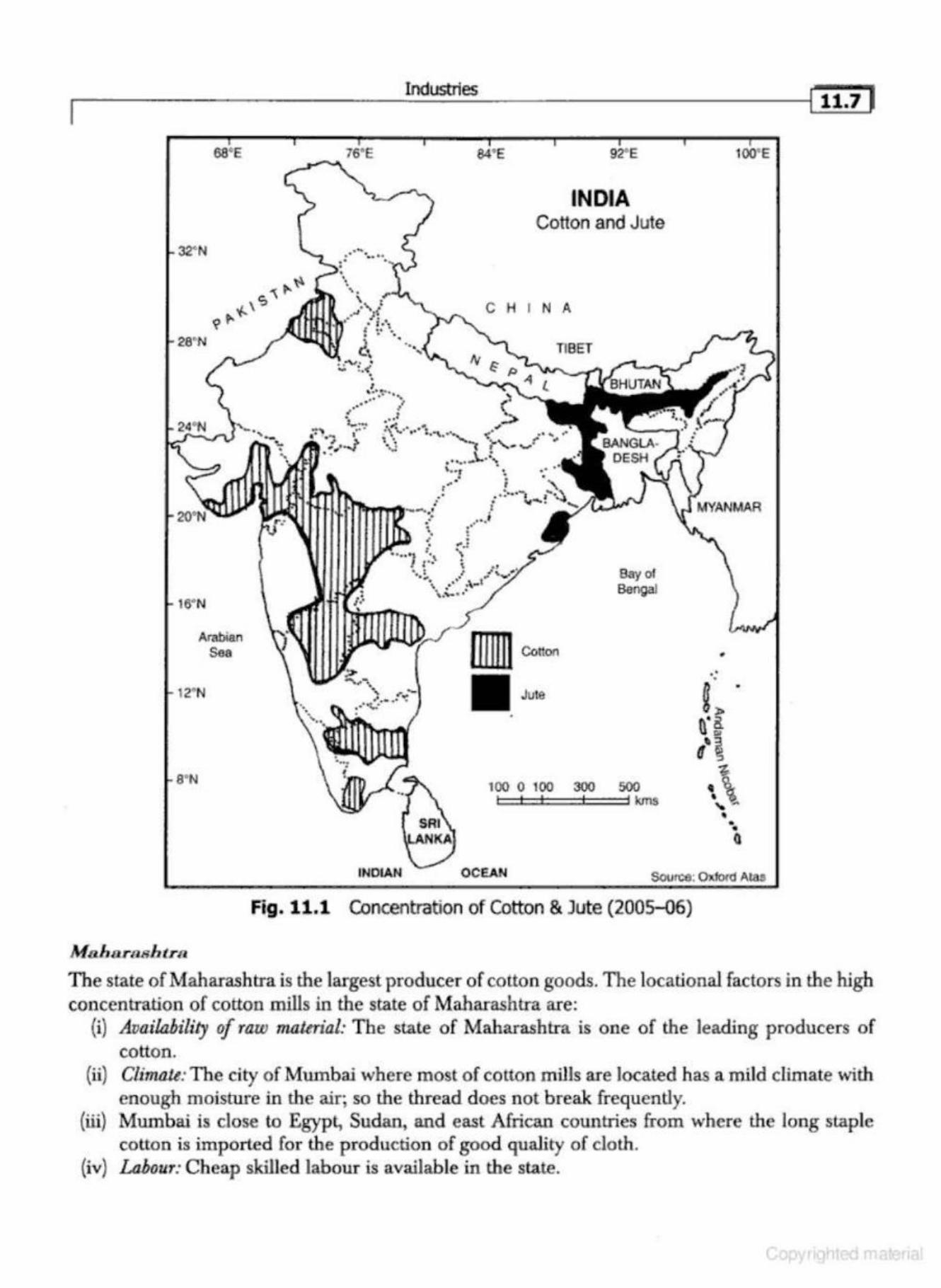
28' N
8'N
M o h arasb tra
Arabian Sea
76' E
Industries
~ ¥ . .. .
84' E
INDIA Cotton and Jute
C H I N A
T18ET
. ; . • ......... . : . " .... ..
•. ·• . .I t
Say of Bengal
100 0 100 300 500 l=:!::::::l==!::=:::l kms
•
100' E
• • Q
INDIAN OCEAN SCvroe: Oxford Alas
Fig. 11.1 Concentration of Cotton & Jute (200S-Q6)
l tt.7 1
The state of Maharashtra is the largest producer of cotton goods. The locational factors in the high concentration of cotton mills in the state of Maharashtra are:
(i) Availability of raw ma.tmal: The state of Maharashtra is one of the leading p roducers of cotton.
(ii) Climate: The city of Mumbai where most of cotton mills are located has a mild climate with enough moisture in tl1e air; so the thread does not break frequently.
(iii) Mumbai is close to Egypt, Sudan, and east African countries from where the long staple cotton is imported fo r the production of good quality of cloth.
(iv) Labour: Cheap skilled lab<Jur is available in the state.

32' N
16' N
12"N
8' N
Industries
94•e 92' E
INDIA Jute- Textile
·, ' ,~ ' l .,.,_,
• • '1""' ·to', .• .,... • •. 1 •... . , ' , .. .. \ t.\. · .... ' . ~: ! -... ~ • •
C H I N A
TIBET
,!, - . KanJ)Ul ... .... ...... . ' .. ' ( ~·· l • r.
-., ·'-::" i·:: .. .•. ·"G~ya ~afill • • ·,~ "' , .. .. ..... ... , 't! "' ,. .... • •
I" •"" ~ • r J " • , > ' .. ..... ,., • .. . :- ~;~-., '~: \ f ........ "' •
, ~) · · ...... _\... :~ Be~ibetla .<\.o.. \,...., • •• . ,: .• ; ~tS.h11a • • ,~ ! ""t, ~~· • (kala ..._ . . .. ~· . .r·, .· -. ,· -· .... .._ ..... •"1 .. • , . ·-.. .. · .... , ....... _....... .
' ' · . ~ r • •· ..... 6 ' ' ••
.... • t ' . .. . :' ;-\.: ~ .... ., ., .
.... ~ t •• \ J' . ; ,1 , ,,.., • .... ~ ",.... ...·· .'"1. N arla
• • • • • ·~· : \.~ .. · • Ch't"•·elsa r• .. ..: ': EJuru ""''
.. ···- . ~·· { Guntur • . • -·
, • •
• ~ •
';> ........... ' ,.,. ... ... .. .... ... . .. ... -• • ' ·· .. , ·~· .... · •• • • "" }
·~.
Bay of Bengal
100 0 100 300 500 kmS I I I t I
INDIAN OCEAN
Fig. 11.4 Jute Industrial Centres
1. Shortage of Raw Material
• • •
•
i OO"E
Despite expansion of jute growing area and intensification of its cultivation, IncGa is not selfsufficient in the supply of raw material. To meet the growing need of the industry, raw material is imported from Bangladesh, Brazil, and Philippines.
2. Obsolete Machinery
Most of the machinery in jute mills is more than 25 years old. These machinery are outdated and lead to low-production.
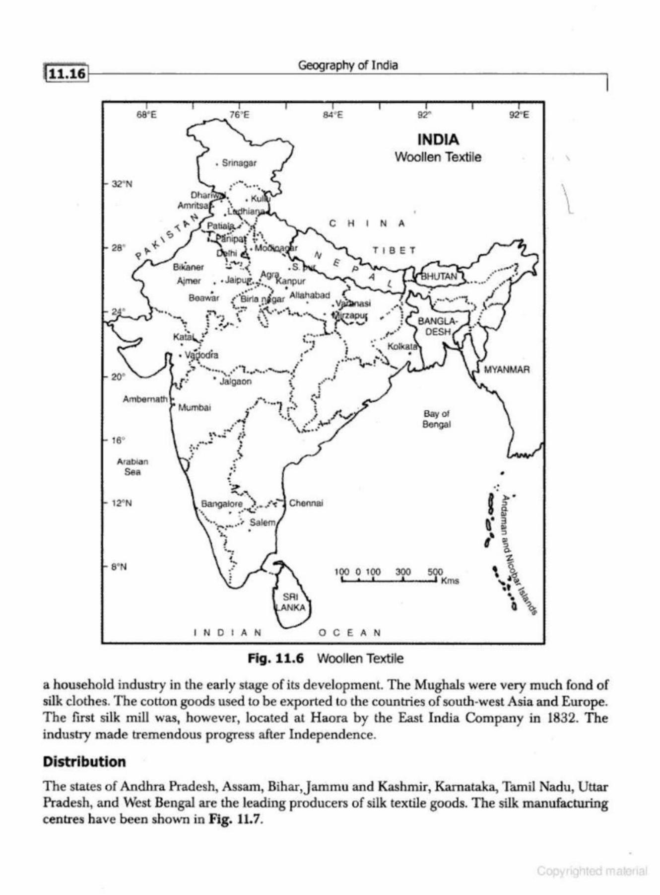
ft 11.16]
68'E
32"N
16°
Arat>lan See
12°N
• Srlnagar
IN DIA N
Geography of India
84' E 92"
INDIA Woollen Textile
C H I N A
T I 6 E T
0 C E A N
Bayot Bengal
Fig. 11.6 Woollen Textile
92"E
MYANMAR
•
\
\ l
l
a household industry in the early stage of its development. The Mughals were very much fond of silk clothes. The cotton goods used to be exported to the countries of south-west Asia and Europe. The first silk mill was, however, located at H aora by the East India Company in 1832. The industry made tremendous progress after Independence.
Distribution
The states of Andhra Pradesh, Assam, Bihar,Jammu and Kaslunir, Karnataka, Tamil Nadu, Uttar Pradesh, and West Bengal are the leading producers of silk textile goods. The silk manufacturing centres have been shovm in Fig. 11.7.
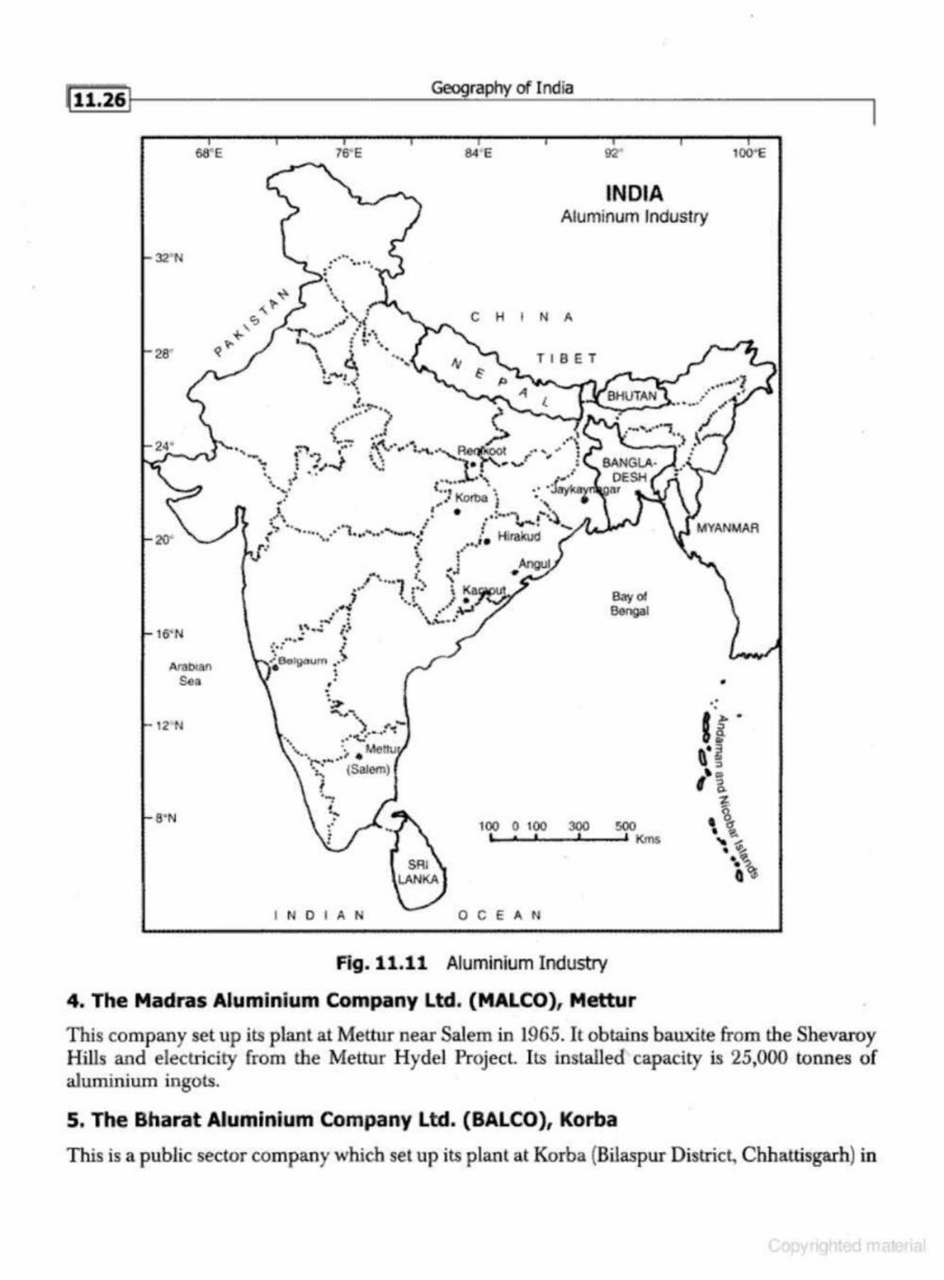
28'
20.
16' N
a·N
Geography of India
76"E 84 ' E 92''
INDIA Aluminum Industry
.~ . . · .... . . . . ..~
• •• • '· '\' I .• 1 :f ...._ . . ..
I· - , ,,_. • ,1 .. -,.
" ft+\. \ 0. ·~ . . . -- z ..# - ..• ,
• I
C H I N A
T I BET
.... ..... ~ " .. • " (' ~--.} ... 4 ~·· , • . .z .:::. I ) . ..,.,.-;" ~ <1"1 o• o'\ ,- .·~
.... - 4"':"! .. ..,. • ··\' .. """""· ·~9fllkoo.t .... ..... .. t '";.,. .. , ,. '· ~ r, . • t •.I"'' '\,..: • r ,, "" • •. ~ • • t • ·'
\, .... ........... , ~
•. • ---· • • .•• ,. JYII8.',..Q. ......... \.,. .. , _ .. • .H; . • Ko-- • •
.,. ,.-. · IUO I ., ..... , .. . • .. !-·... .~.~ •._. •• ... -. I I .,....._, ...... ., . .... ••••• • , ............... _......... I H' ... . .. ' '• , i • lfS,w ,.,. .· ...... ' ,. • ' •~·I
oA ~ ".l •'""'~ # '\.. . .. • .. , '
, .,.• I r•· \ Kaf;ll)lll ... } ··.~, ... / ;:.,'~
• • • ....... . "-""-• .· \' ' .. .. . .... , .. . ..... '
~.: ; • <
~Bo...,.,u•n •. > . I
• • .
Bayol Bengal
100 0 100 300 500 ,,,& I ' KJns
I NDIAN 0 C E A N
Fig. 11.11 Aluminium Industry
4. The Madras Aluminium Company Ltd. (MALCO), Mettur
100' E
•
This company set up its plant at Mettur near Salem in 1965. It obtains bauxite from the Shevaroy Hills and electricity from the Mettur Hyde! Project. Its installed capacity is 25,000 tonnes of aluminium ingots.
5. The Bharat Aluminium C.ompany Ltd. (BALCO), Korba
This is a public sector company which set up its plant at Korba (Bilaspur District, Chhattisgarh) in
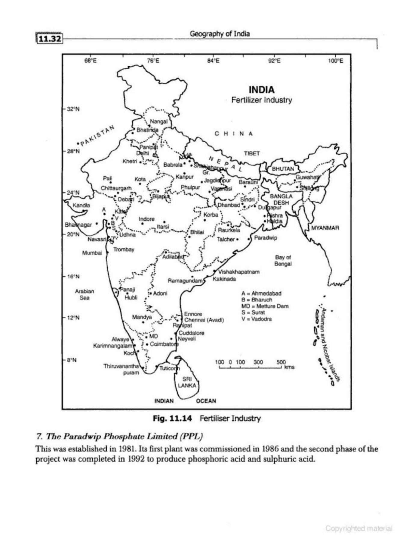
ae•E
3~N
Mumbal
16' N
Arabian Sea
12' 'N
Geography of India
Trombay
• • •
76"E
.. • !• Adonl
' ;> ..........
84'E 92"E
INDIA Fertilizer Industry
C H I N A
TIBET
Bay ol Bengal
A = Ahmedabad e ~ enarucn MD = Metture Dam S "'Sural Mand ·) • - Enn<lfe
• ya •• • .•• .: 0:. Chennai (Avadi) •••. : -:,.; A pat
Vc Vadodra
........ .. .. ·..,. ... •• • Co<tdalore · .... · . MD Atwaye ... • Neyveli
Karimnangalam f • Coimb,ato!1l ·-s·N
KocN .. ; ... • .. 100 0 100 300 500
! ,___.__._ _ __..__ _ __. kms .
INDIAN
Fig . 11.14 Fertiliser Industry
7. The Paradwip Phosphate Limited (PPL)
1WE
•
This was established in l981. Its first plant was commissioned in 1986 and the second phase of the project was completed in 1992 to produce phosphoric acid and sulphuric acid.
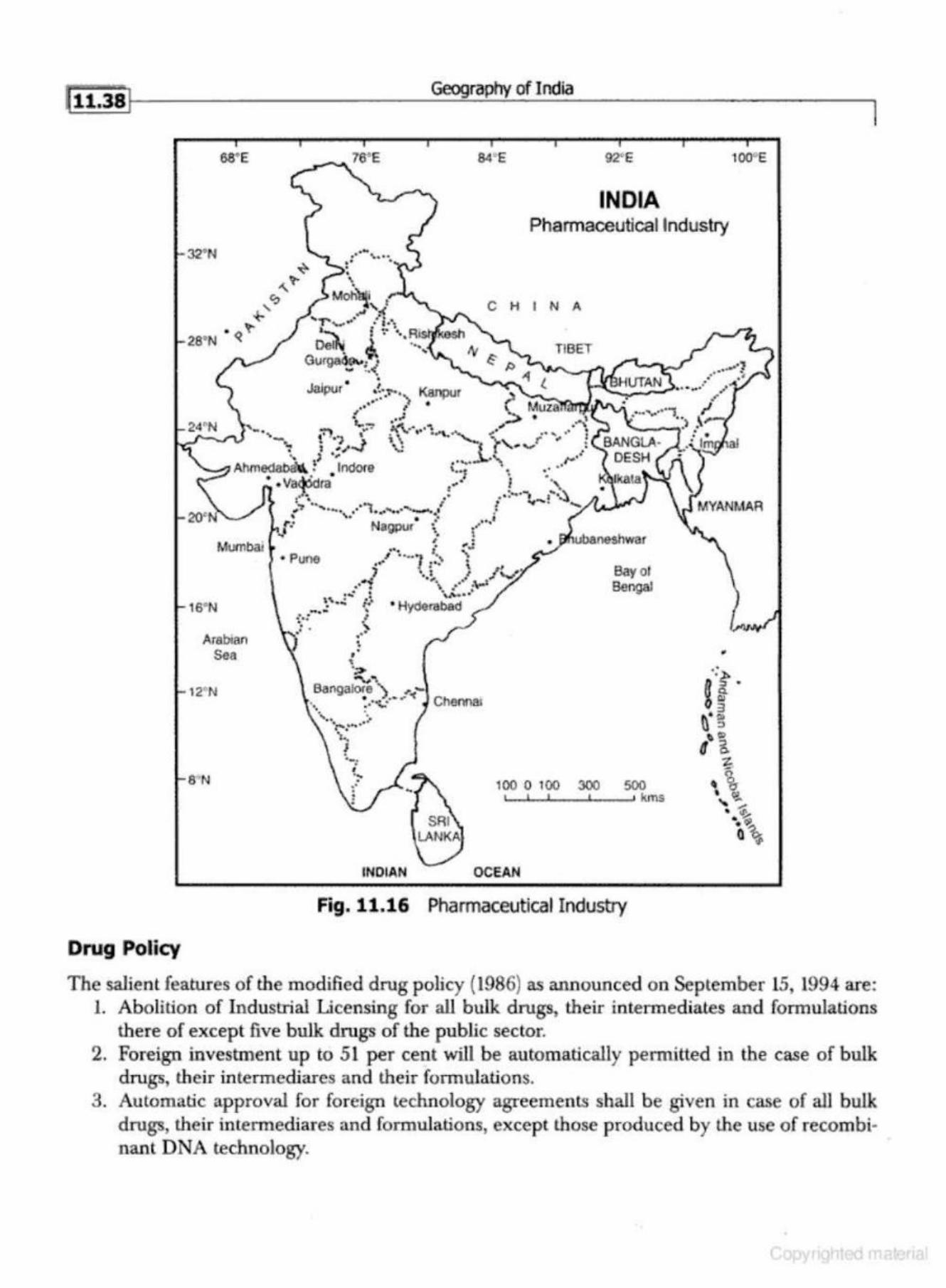
Drug Policy
as•e
32'N
Mumbai
16"N
Arabian Sea
12' N
8' N
• Puoe
. .: ' "' • !"~. . .... ~ _a.., ., ..
, ~ . . . •
• '
( .. • '
";>
""'""'
Geography of India
92' E
INDIA Pharmaceutical Industry
C H I N A
TIBET
Bay of Bengal
•
B6ngalore ) ,.~-• • •a: ..... " Chennru 't, • • ..... . . '·. .:· ........... ., __
' • ·-:
INDIAN
100 0 100 300 500 ..._..._,____, _ __. kms
OCEAN
Fig. 11.16 Pharmaceutical Industry
100°E
The salient featu res of the modified drug policy (1986) as announced on September 15, 1994 are: 1. Abolition of Industrial Licensing for all bulk drugs, their intermediates and formulations
there of except five bulk drugs of the public sector. 2. Foreign investment up to 51 per cent will be automatically petmitted in the case of bulk
drugs, their intermediares and their formulations. 3. Automatic approval for foreign technology agreements shall be given in case of all bulk
drugs, their intennediares and formulations, except those produced by the use of recom binant DNA technology.
fii:sol Geography of India
11. Investment in Selected Industries: Most of the foreign investment comes to white-goods and not to wage-good sedor. Hence, it may be fruitful in improving the high p riority sector and bringing in the latest technology. This will be counter productive.
12. Economic and Political Freed oms are at Stake: The over-enthusiasm ofliberalisation to attract more investors and foreign exd1ange might lead to gradual handling over of the whole economy to the multinationals. This will affect adversely our economic and politicaJ freedom.
13. Inflation: Since the new industrial policy and liberalisations, the rate of inflation is continuously increasing. A section of the society is becoming more rich and adopting the life-style of consumerism. As opposed to this, the absolute number below the poverty line is also increasing. The gulf between the rich and the poor may be the cause of numerous social problems resulting in social tension.
INDUSTRIAL PROBLEMS OF INDIA
India has made tremendous progress during the plan period and the industrial sector and service sectors have made si~:,'llificant progress. Despite industrial progress, India is not self sufficient in the matter of industrial products. Moreover, the quality of the products are not at par with the products of the developed countries. The main problems of the Indian industries have been briefly described here:
1. Inadequacy of Industrial Structure: Despite over fifty-five years of planning, India is not self sufficien t in tJ,c production o f transport equipment:~, clcclricnl and non-electrical ma·
chinery, iron and steel, paper, fertilisers, drugs and pharmaceuticals, and plastic materials. 2. Low Demand of Ind ustrial Products: The purchasing power and poor standard of living
of a greater section of the India population (about 85 per cent) has resulteC. in low demand of industrial products.
3. Regional Concentration of Industries: Most of the industries of India are located in and around Mumbai, Kolkata, Ahmedabad, Delhi, and Chennai. This is leading to unequal industrial development. Most of the industries are in Maharashtra, Gujarctt, Kamataka, Andhra Pradesh, WesL Bengal, and around Delhi. This has not only created regional disparities but encouraged political unrest, violence, and terrorism.
4. Industrial Sickness: In the private sector after the policy of liberalisation, the small and medjum as well as some of the large industries are becoming sick. The reasons for industrial sickness may be poor management, obsolete technology, and international competition. Many a times, the government takes over the sick industrial units which further worsen the problems.
5. Loss in Public Sector: Most of the public undertakings are running at loss. The reasons may be poot· efficiency of the management and workers, strained labour and management relalions, and obsolete tedmology. Every year the governmen t has to incur huge expenditure to cover up this loss and to meet the obligations of paying salaries and wages to the employees. To avoid this burden on exchequer, the government is promoting p rivatisation and disinvestment of shares of public sector undertakings.
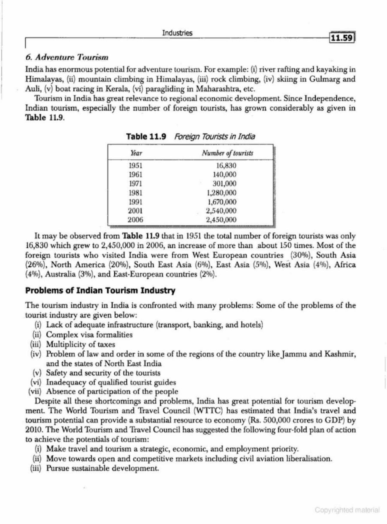
Industries
6. Adventure J'ourism India has enormous potential for adventure tourism. For example: (i) river rafting and kayaking in Himalayas, (ii) mountain climbing in Himalayas, (iii) rock climbing, (iv) skiing in Gulmarg and Auli, (v) boat racing in Kerala, (vi) paragliding in Maharashtra, etc.
Tourism in India has great relevance to regional economic developmenl Since Independence, Indian tourism, especially the number of foreign tourists, has grown considerably as given in Table 11.9.
Table 11.9 For&gn Tourists in India
~ar
1951 1961 1971 1981 1991 2001 2006
Number of tourists
16,830 14(),000
301,000 1,280,000 1,670,000
2,540,000 2,450,000
It may be observed from Table 11.9 that in 1951 the total number of foreign tourists was only 16,830 which grew to 2,450,000 in 2006, an increase of more than ,about 150 times. Most of the foreign tourists who visited India were from West European countries (30%), South Asia (26%), North America (20%), South East Asia (60Jo), East Asia (5%), West Asia (4%), Africa (4%), Australia (3%), and East-European countries (2%).
Problems of Indian Tourism Industry
The tourism industry in India is confronted with many problems: Some of the problems of the tourist industry are given below:
(i) Lack of adequate infrastructure (transport, banking, and hotels) (ii) Complex visa formalities
(iii) Multiplicity of taxes (iv) Problem of law and order in some of the regions of the country like J ammu and Kashmir,
and the states of North East India (v) Safety and security of the tourists
(vi} Inadequacy of qualified tourist hruides (vii) Absence of participation of the people
Despite all these shortcomings and problems, India has great potential for tourism development The World Tourism and Travel Council (WITC) has estimated that India's travel and tourism potential can provide a substantial resource to economy (Rs. 500,000 crores to GDP) by 2010. The World Tourism and Travel Council has suggested the following four-fold plan of action to achieve the potentials of tourism:
(i) Make travel and tourism a strategic, economic, and employment priority. (ii) Move towards open and competitive markets including civil aviation liberalisation.
(iii) Pursue sustainable development
.---------=---- --I:....n.:..:du:..:..:stri:....·es=---------------;l i1·.6s t
1. The Tata
Being one amongst the oldest industrial houses in India this industrial house has iron and steel as well as automobile (heavy) as i ts traditional areas of interest. But in the coming times it has diversified in a great many areas/sectors such as phannaceuticals, cement, publishing, power, finance, hotel, insurance, software, refrigeration, air-conditioning, telecommunication, soft drinks, con· sumer non-durables, e tc. After its recent acquisition of the Chorus iron & sleel company, it has catapulted on international horizon overnight. Its Tata Consultancy Services, a software development and export company, is the largest software services companies in the country. Its recent foray into the four-wheel segment has been able to make a historic news around the world with the launching of the $ 2500 car- the Nano.
2. The Birta
The Birlas, though they have gone for divisions, are among the oldest industrial houses in lndia like the Tatas. Their traditional areas of activities have been textile, paper, paraffin, cement, aluminium, and automobiles. In the last few decades, they have diversified in other areas too su ch as machine tools, pharmaceuticals, telecommWlications, consumer durables and non-durables, etc.
3. The Singhania
Among the oldest industrial houses of India, lhis has business interests in the areas of textile, pharmaceuticals, tyres and tubes, and consumer durables and non-durables.
4. The Goenka
One among the oldest industrial houses of the country, this has business interests in the areas such as power generation and distribution, textile, pharmaceuticals, machine tools, entertainment, etc.
5. The Modi
T he Modis have been among the oldest of the industrial houses in the country with their industrial interests in the areas such as textiles, garments, carpets, tyres & tubes, hospitality, pharn1aceuticals, etc.
6. The Bajaj
Among the oldest business families of India, they are known around the world for their com· mendable product the Bajaj Scooter, which is competent enough to fight out the international competition in the segment. Of late, they diversified into the areas of bikes also. Their areas of activity expands to electric and home appliances, entertainment, etc. Recently, they announced their intentions of entering the automobile sector with one of the cheapest cars in the world (after the Tata's Nano).
7. The Sriram
Among the oldest industrial houses of India, the interest of this house runs across a broad spectrum of industries- textiles, garments, fertilisers, electric and home appliances, generator sets, hospitality, pharmaceuticals, etc.
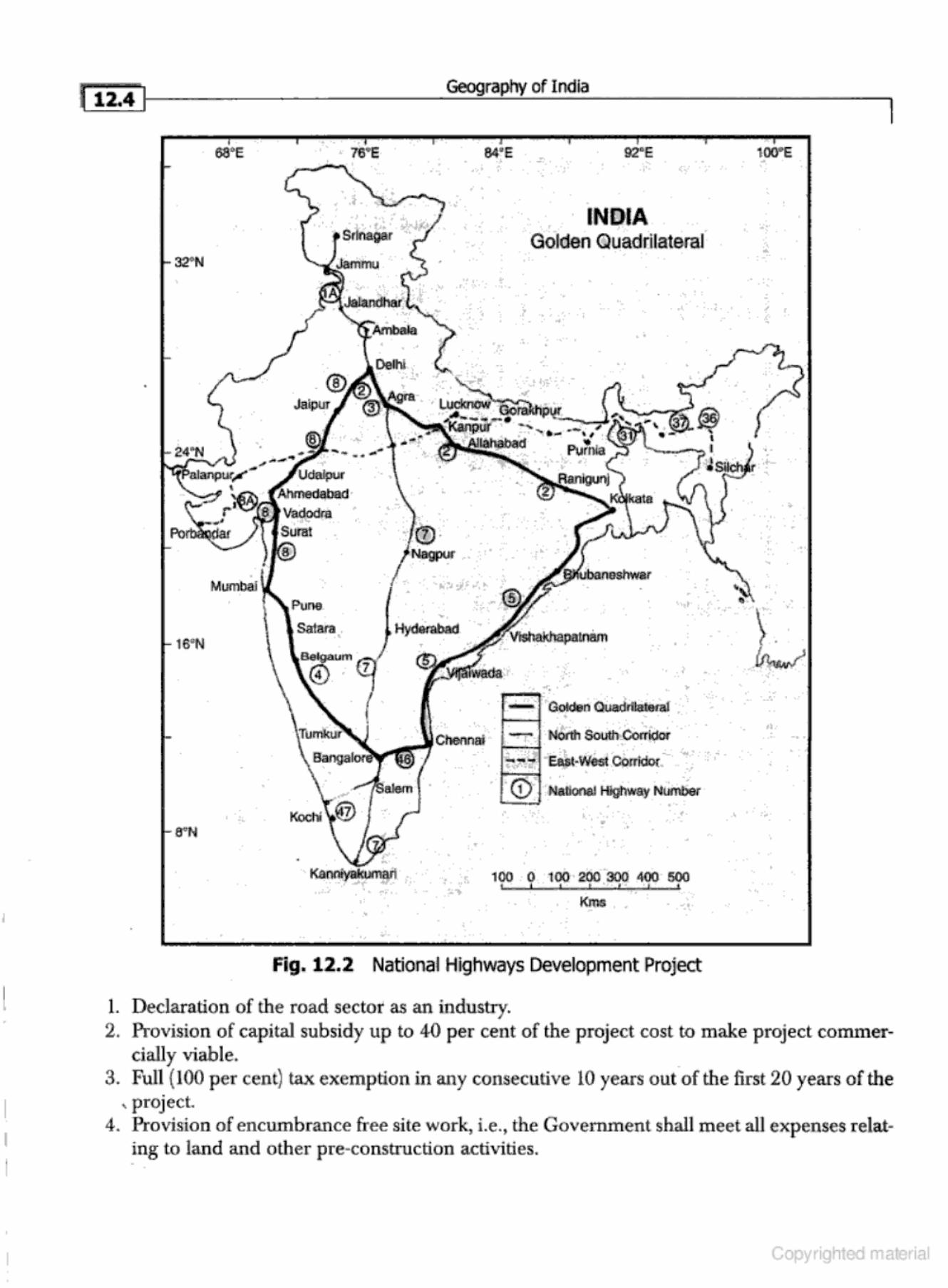
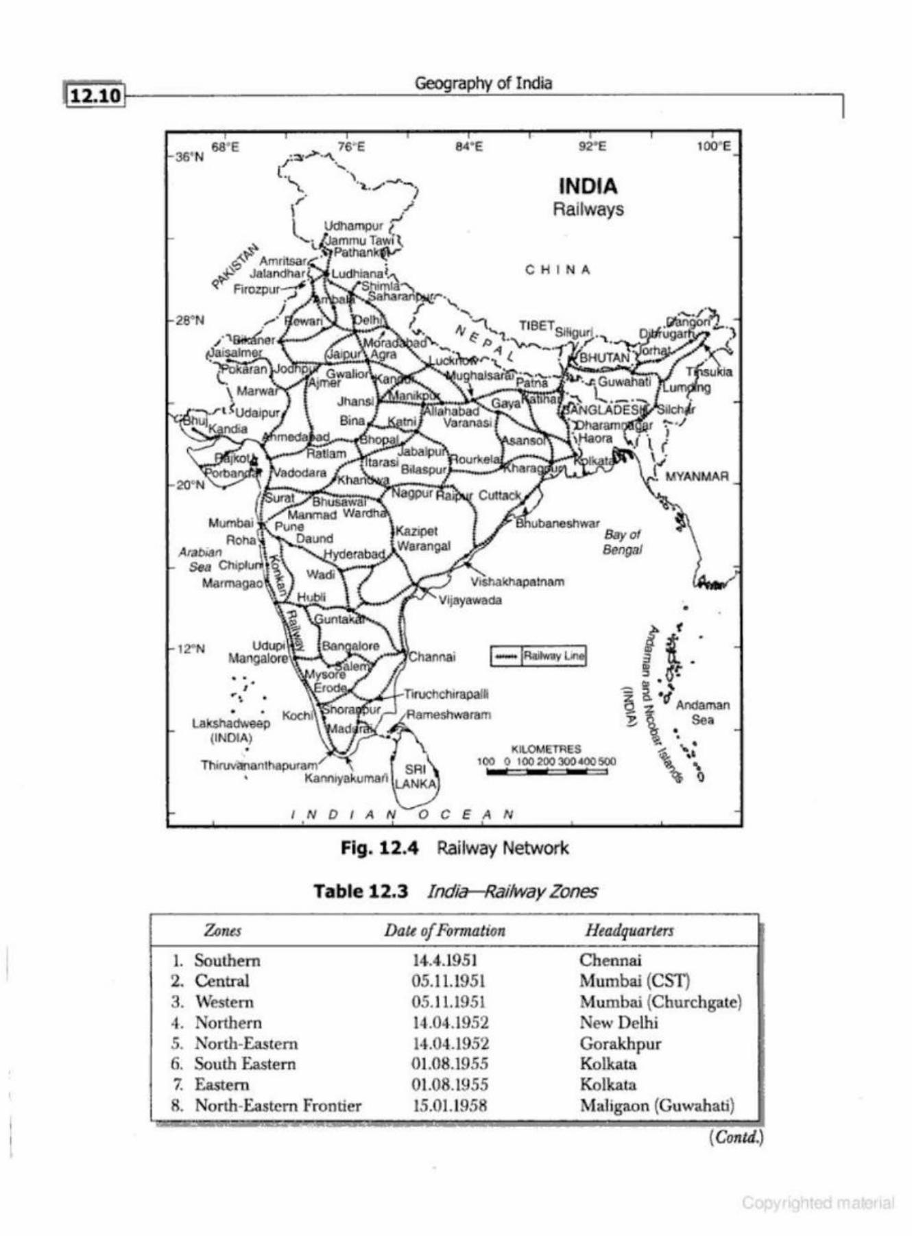
l
N 6a' E 76''E
...,-t' .p'?
q't'
Geography of India
84' E 92' E
INDIA Railways
CHI N A
Bay of Bengal
100' E
•
12•N 1-IRrutHav Lin~ ft .·
1. 2. 3. 4-. 5. 6. 7. 8.
• • • J •• • • • •
Lakshad\veep (INDIA)
•
I N D I A 0 C E
- ~ .' - !. "d ~ 74 Andaman
E. \ •• Sea - ' . ~ .._,.
'\ llll.OMETRES
100 0 I 00 200 300 tOO 500
N
Fig. 12.4 Railway Network
Table 12.3 India-Railway Zones
Ztmes Datt of Formation Headquo,rttrs
Southern 14.4.1951 Chennai Central 05.11.1951 Mumbai (CST) Western 05.11.1951 Mumbai (Chu.rchg-.ue) Northern 14.04.1952 New Delhi North-Eastern 14.04.1952 Gorakhpur South Eastern 01.08.1955 Kolkata Eastern 01.08.1955 Kolkat.a North-Eastern Frontier 15.01.1958 Maligaon (Guw-.lhati)
( Contd.)
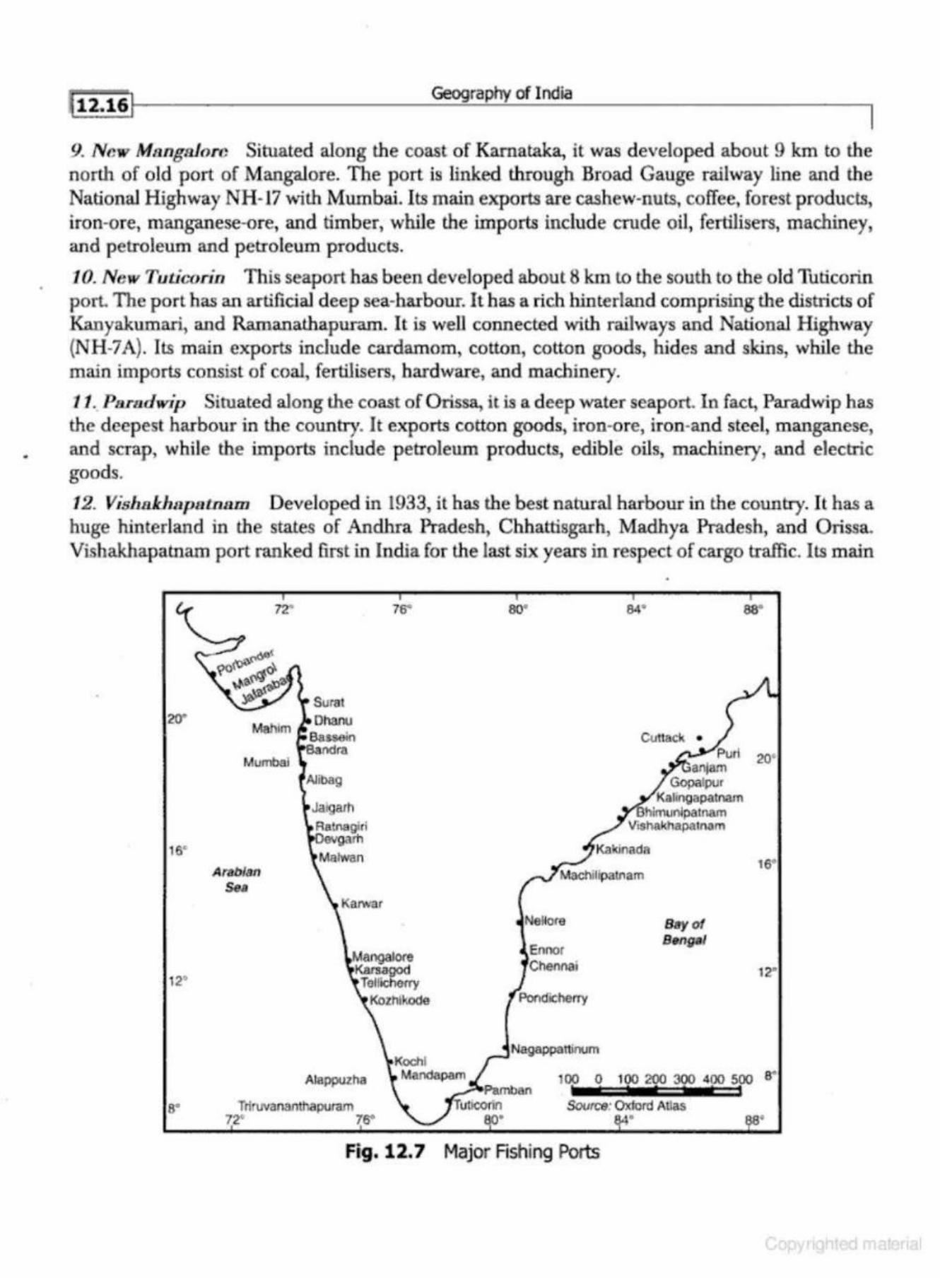
•
l t2.1&1 Geography of India
9. New Ms.ngsloro Situated along the coast of Karnataka, it was developed about 9 km to the north of old po.rt of Mangalore. The port is linked through Broad. Gauge railway line and the National Highway NH-17 with Mumbai. Its main exports are cashew-nuts, coffee, forest products, iron-ore, manganese-ore, and timber, while the imports include crude oil, fertilisers, machiney, and petroleum and petroleum products.
10. New TuticoriiJ This seaport has been developed about 8 km to the south to the old Tuticorin port. The port has an artificial deep sea-harbour. It has a rich hinterland comp1ising the districts of Kanyakumari, and Ramanathapuram. It is well connected with railways and National Highway (NH-7 A). Its main exports include cardamom, cotton, cotton goods, hides and skins, while the main imports consist of coal, fertilisers, hardware, and machinery.
11. Paradwip Situated along the coast of Orissa, it is a deep ·water seaport. In fact, Paradwip has the deepest harbour in the country. It exports cotton goods, iron-ore, iron-and steel, m anganese, and scrap, while the imports include petroleum products, edible oils, machinery, and electric goods.
12. Vishnk.hupatna.m Developed in 1933, it has the best natural harbour in the country. It has a huge hinterland in the states of Andhra Pradesh, Chhattisgarh, Madhya Pradesh, and Orissa. Vishakhapatnam port ranked first in India for the last six years in respect of cargo traffic. Its m ain
20"
16"
12'
8'
Surat
Mahim Ohanu
Bassein Sandra
Mumbai Alibag
Ja)garh
Aetnsgiri garh
AraO/an Sea
Alappuzh.a
TriruvananthapuJam 72• 76"
76"
. Koohi Mandapam
•
so• sa·
Cuttack • Purl
an jam 20'
Gopalpur Kalinga~tnam
hlmu~patnam Vishakhapatnam
16°
Nellore Bay of
Ennor B11ngal
Chennai 12"
Pondicharry
Nagappatlinum
100 o 100 200 300 400 soo a•
Source: Oxiord Atlas • 8'
Fig. 12.7 Major Rshing Ports
112.261 Geography of India
7. Infrastructure The social amenities at the railway stations, bus-stands, and airports need a substantial improvement.
8. New Technology The new technology of transport is to be taken at a preferential bases.
9.lnvolvemeutof Privat e Sector For the generation of funds there should be more involvement of the private sector in the transport industry.
COMMUNICAnONS
Postal System
The establishment of modem postal system in India can be traced back to the second half of the 18th century. This postal system, established by Lord Clive in the year 1766, was further developed by Warren Hastings by establishing the Calcutta ~neral Post Office (GPO) under the Post Master General in the year 1774. In the other Presidencies of Bombay and Madras, the General Post Office came into existence in 1786 and 1793 respectively. The Act of 1873 first regulated the Post Office on a uniform basis to unite the post office orhranisation throughout the three presidencies into one All India Service. The Post Office Act 1854 reformed the entire fabric of the Postal System, and Post Office of India was placed on the present administrative footing about one hundred and fifty years ago on October 1, 1854. The statute presently governing the postal services in the country is the Indian Post Office Act, 1898.
Besides providing postal communication facilities, the post office network has also provided facilities for remittance of funds, banking and insurance services from the latter half of the 19th century.
Postal Network
At the time of Independence there were 23,344 post offices throughout the country. In April 2005, the country has 1,55,516 post offices, of which 1,39,120 are in the rural areas and 16,396 in the urban areas. As a result of this seven-fold growth, today India has the largest postal network in the world.
The postal network consists of four categories of post offices, viz., (i) Head Post Office, (ii) SubPost Offices, (tii) Extra Departmental Sub Post Offices, and (iv) Extra Departmental Branch Post Offices. All the categories of Post Offices retain similar postal services, while delivery function is restricted to specified offices. In terms of management control, accounts are consolidated progressively from Branch Post Offices to Sub Post Offices and finally in Head Post Offices.
The Department has about 2.47 lakh departmental employees and about 2.93 lakh Grarnin Dal Sevaks as on March 31, 2005.
Mail System
First class mail, viz., post cards, inland letters, and envelops are given airlift wherever found advanlageous, without any surcharge, between stations connected by air. Second class mail, viz., book packets, registered newspapers, and periodicals are carried by surface transport, i.e. trains and road transport
foternational Mails India is a member of the Universal Postal Union (UPU) since 1876 and of d1e Asian Pacific Postal Union (~PU) since 1964. These organisations aim at extending, facilitating, and improving
I
Transport Communications, and Trade
(viii) Upgrading our infrastructural network, both physical and virtual, t·elated to the entire foreign trade chain, to international standard.
(ix) Revitalising the Board of Trade by redefining its role, giving it due recognition and inducting experts on Trade Policy.
(x) Activating our Embassies as key players in our export strategy and linking our Commercial Wings abroad through an eleclronic platform for real time trade intelligence .
. INDIA-5PACE PROGRAMME
History: India's experience in rocketery began in ancient times when fireworks were first used in the country, a technolot,ry invented in neighbouring China., and which had an extensive two-way exchange of ideas and goods with India, connected by the Silk Road. Military use of rockets by Indians during the Mysore War against the British inspired William Congreve to invent the Congreve rocket, predecessor of modern artillery rockets, in 1804. After India gained Indepenedence from British occupation in 1947, Indian scientists and politicians recognised the potential of rocket technology in both defence applications, and for research development. Recognising the fact that a country as demographically large as India would require its own independent space capabilities, and recognising the early potential of satellites in the fields of remote sensing and communication, these visionaries set about establishing a space research organisation.
Phase I: 196G-70
Dr. Vikram Sarabhai was the founding father of the Indian space programme, and is considered not only a scientific visionary by many but also a national hero. After the launch of Sputnik in 1957, he recognised the potential that satellites provided. India's first Prime Minister, Pt. J awaharlal Nehru, who saw scientific development as an essential part of India's future, placed space re· search under the jurisdiction of the Department of Atomic Evergy in 1961. The DAE Director Homi Bhabha, who is regarded as the father of India's atomic programme, then established the Indian National Committee for Space Research (IN COS PAR) with Dr. Sarabhai as Chairman in 1962.
From its establishment in 1962, the Indian space programme began establishing itself with the launch of soWlding rockets, which was complemented by India's geographical proximity to the equator. These were established from the newly-establishC!d Thumbn Equatorial Rockt>t I ~'<Hnching Station (TERLS}, built near Thiruvananthapuram in south Kerala. Subsequently, India developed indigenous technology of sounding rockets called Rohini Family of sounding rockets.
Recognising the need for indigenous technology, and possibiJity of future insrability in the supply of parts and technology, the Indian space programme endeavoured to indigenise every material supply route, mechanism, and technology. As the Indian Rohini Programme continued to launch sounding rockets of greater size and complexity, the space programme expanded and was eventually given its own government department, separate from the department of Atomic Energy. In 1969, the India Space Research Organisation (ISRO) was created and finally the Department of Space was established in 1972.
•
l 1:f4., Geography of India
I Main Features of Castes
The main featu res of caste prevailing through the past centuries may be described under nine heads: hierarchy, endogamy, and hypergamy; occupational association; distinction in custom, dress, and speech; pollution; ritual, othe r privileges, and disabilities; and caste organisation and castE' mobility.
Caste and Village Community
The caste living in a village or a group of neighbouring villages, are bound together by economic ties. Generally peasant castes are numerically predominant in villages and they need carpenter, blacksmith, barber, and leather worker castes to p erform agriculturai work. Servicing castes such as priest (Brahmin as well as non- Brahmin), barber, washerman, and water carrier cater to the needs of everyone except Harijans. Artisan castes produce goods which are wanted by everyone. Most lnruan villages do not have more than a few of the essential castes and depend on neighbouring villages for certain services, skills, and goods.
[n rural India, with its largely subsistent econom y, the relationship between the different caste groups in a viUage takes a particular form. The essential artisan and servicing castes are paid annually in grain at harvest [n some parts of India, the artisan and servicing castes are also provirled with free food, clothing, fodder, and residential site. On such occasions as birth, marriage, and death, these castes perform extra duties for which they are paid a customary sum of money and some gifts in kind. This type of relationship is found all over India and is called by different names:]ajmani in the North, Mirasi in Madras, Bara Balute in Maharashtra, and .Adade in Mysore. The relationship between the]ajman and his Kamin is unequal, since the latter is regarded as inferior. The righl lo serve is hereditary, transferable, saleable, mortgageable, and partible.
The J ajmani system bound together the different castes living in a village or a group of neighbouring villages. The caste-wi.se d ivision of labour and the consequent linking up of different castes in enduring and p~rvasive re lationships provided a pattern of alliances which cut across the ties of caste. The modern 'caste problem' is to some extent the result of the weakening, in the last sixty years or more, of these vertical and local ties and consequent strengthening of horizontal ties over whole area.
The relationship between landowner and tenant, master and servant, creditor and debtor, may all be subsumed under a single category-patron and client. This relationship is widespread and crucial to the understanding of rural Inrua. Voting at elections, local and general, is influenced by the patron·client tie.
Ritual occasions like life-cycle ceremonies, festivals and fairs, require the co-operation of several castes. Certain rituals which are common fo r all the castes occur at birth, girls puberty, marriage, and death. Several castes are also required to cooperate in the performance of calender, festivals, and festivals of village deities.
The functioning of the village as a political and social entity brought together members from different castes. Every village had a h eadman usually belonging to the dominant caste. The accountant was always Brahmin in South India. Every village had a watchman and messengers. In
• the irrigated areas, there was always a man to look after and regulate the flow of water in the canals feeding lhe fields. The headman and acc.ounLant collected the land taxes with the aid of Harijan village servants.
The village council performed a variety of tasks, including the maintenance of law and order, settling of disputes, celebrations of festivals and construction of roads, bridges, and tanks.
32"N
16"
Arabian Sea
N
I N DI AN
Geography of India
INDIA Scheduled Tribes
2001
C H I N A
.. . .. . .
22.13
Bay of Bengal
Percentage of total Population of the Sta1e [ :: ·. ] Below 10%
E-: ] 10.1- 20%
~ 20.1-30%
D 30.1-40%
AboVe40%
National Average 8.20%
top ~ 1(('0 3qD snms 0 C E AN
•
• • G
Fig . 13.5 Density of Scheduled Tribes, 2001
Table 13.3 India: Growth of Scheduled Tribe Population, 1951-2001
~ar
1951 1961 1971 1981 1991 2001
Total R>pulation of Scltedukd Tribes in Lakh.s
22.5 302 380 538 678 843
Percenwge of Scheduled Tribes lo Towl Population
6.23 6.87 6.94 6.94 8.08 8.20
- • • ' . . - -· · - - .. . ---- -~ -- . .. ·r .. - -- - - -- . -
Source: Cnuru of huii.a, 2001.
.(ii22l
28"N
20"
16°
Arabian Sea
12"N
s·N
... . . : .. . '· '\
. i > . C•
\ ""U· ~ !.; : • .(
• • • .... ~ .. .... ) •• • :.. . . -- ... - ... • , .. _ , . "! •• ., '
i,"\, .• ... .. , ,. ~ : ,.,....., •.. ..; ... ~ . .....
• • ' \ '.:
. ' ..,. . ,·
I . .... , .. . • • l ••. •
~ ; . . . .. ..... . ..,,
• 0 ••
Geography of India
84"E 92°
INDIA Santhal Tribe
C H I N A
TIBET
.... . \ . .. . .. Bay of Bengal
·. ..... ,; . ..... ... '\
{ ... • •
• • •
.·· t . ·~ ................
'\. .. . .• ...... ~ .. · .;;,.: • ·. .~ : ....... . · . . ,
J
I NDIAN 0 C E AN
5~ Kms
Fig. 13.9 Distribution of Santhals (2001)
100"E
The Santhals are basically agriculturists (68%). They own landed property and hardly any Santhali is landless. Their subsidiary occupations include hunting, ftshing, and collecting forest products. With increasing literacy and cultural contacts, they are also engaged in service, trade and contracting business. Their demand is for a Greater Jhark.hand which extends over the Santhal areas in West Bengal and Orissa.
The Santhals have a great cultural heritage and haye a well defined social order. Widow remarriage is permissible. The Santhal society is patriarchal. The Santhal wom an is deemed a strong labour force and contributes to the family income. She participates in the agricultural operations and de<:orates her house before the Bandana festival
~tii:i~l ---------------------~-·~rn~ph~y_o_fi_oo_la ____________________ ~
Marathi stands fourth in numerical strength. Its linguistic core lies in Maharasht:ra (930/o) with speakers also in Ka.rnataka, Madhya Pradesh, Gujarat, and Goa. Konkani, spoken in the Kon.kan coastal areas and Goa, is an offshoot of Marathi.
Tamil occupies the fifth r-o:IJ1k in nwnericaJ strength, but best represents the Old Dravidian script. It has rich literature commencing "vith the beginning of the Christian Era. Its linguistic core lies in Tamil Nadu (92%), but it extends its influence in Kamataka, Andhra Pradesh, and Pondicheny.
Gujarati has its core area in Gujarat and has carved out its influence in Maharashtra and Rajasthan. Kannada stands next to Gujarati. Its linguistic core lies in Kamataka (91 %) and it has its extension in Tamil Nadu, Maharashtra, and Andhra Pradesh.
Among the Dravidian languages, Malayala.rn has the smallest number of speakers. Its hnguistic core lies in Kerala {92%) and extends in Tamil Nadu, Kamataka, and Mabarashtra.
Oriya has a distinctive character as it is the old Apabhramsa and has enriched itself with Sanskrit.
Assamese has its distinctive pronunciation and grammar, but is often included in the Bengal Assam group.
Religion liB 11 Determinant o f Cultural R egion
Religion has been defined differently by different scholars. Friedrich Schleimacher defined religion as 'feeling of absolute dependence'. According to William james, 'religion is the enthusiastic temper of expousal~ Otto defines the essence of religious awareness as awe, a unique blend of fear and fascination before the divine. The main characteristics of religious life are: (i} traditionalism, (ii) myth and symbol, (iii) concept of salvation, (iv) sacred places and objects, (v) sacred actions (rituals), (vi) sacred writings, (vii) the sacred community (mo nastic order), and (viii) the sacred experience.
Religion, like language, is a symbol of group identity and a cultural rallying point. All societies have value systems, common beliefs, understandings, and expectations which unite their people. Religion plays a crucial role in the socioeconomic life of the people and even their utilisation of natural resources is closely controlled by the religion of the people. Geographers are concerned with the interaction between religion and landscape (resources). Thus, religion provides a good basis for the demarcation of cultural regions.
India is a multi-religion country. It is the birth place of Hinduism, Buddhism, Jain.ism, and Sikhism. Subsequently, the successive waves of people of other religious faiths came to India. They maintained their religious identity. For example, the Syrian Christians appeared on the west coast of India in the first century AD. They are still found in Kerala. The Muslims came to India from South-West Asia and Central Asia and maintained their religious identity.
Concentration of Religious Groups
Hindus According to the Census 2001, over 82 per cent of the total population of India is Hindu by faith. They are predominantly distributed throughout the country, but in a few areas, like the Kashmir Valley, Punjab, Mizoram, Meghalaya, Nagaland, and parts ofKerala, they are in minority (Fig. 13.14).
Hinduism is one of the oldest religions of the world. It is a polytheistic (multiplicity of gods and goddesses) religion. The proportion of Hindu population is the highest in Himachal Pradesh (96<¥o) and lowest in Mizoram (5%). It is higher than the national average in Andhra Pradesh,
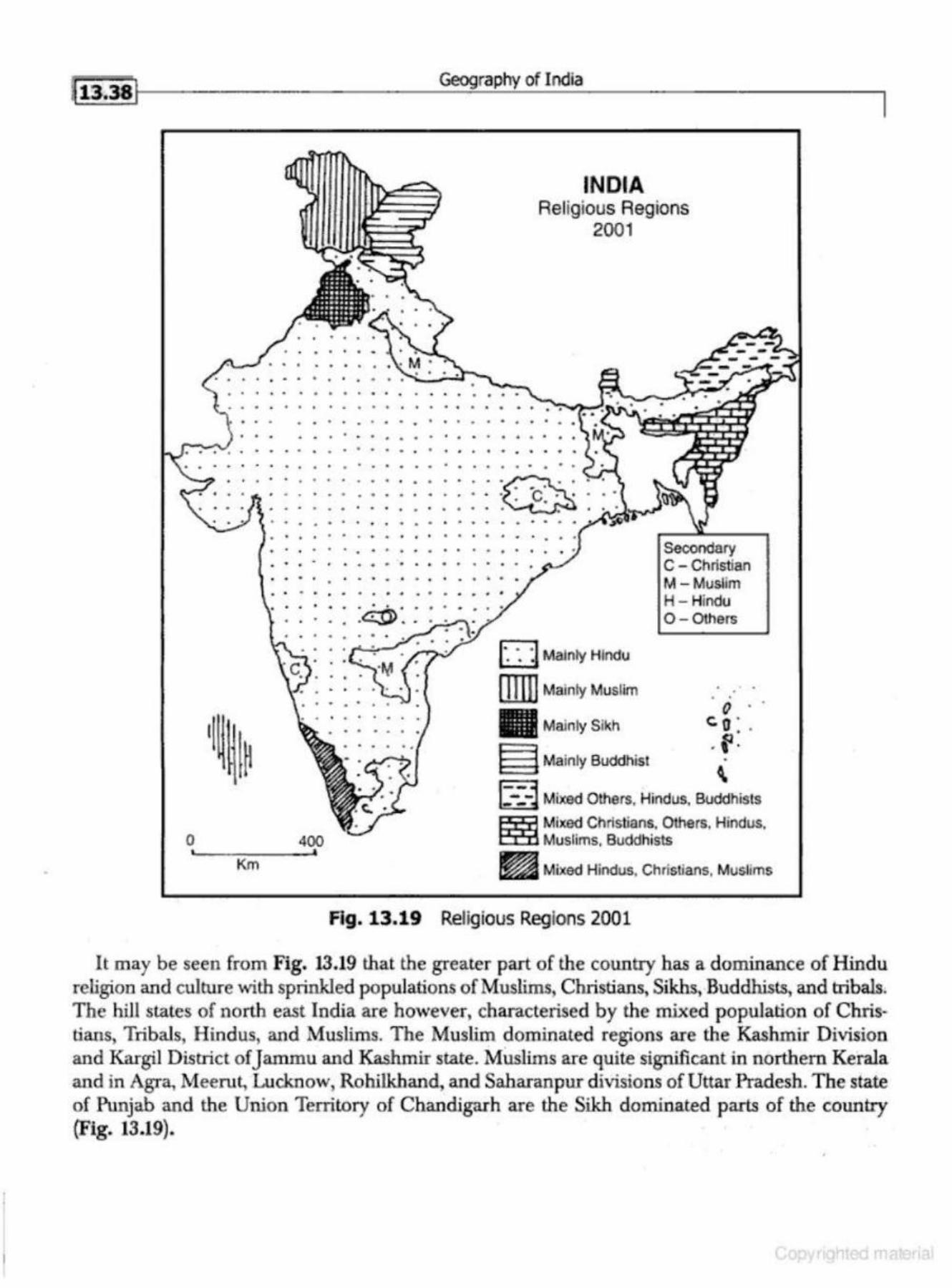
•
0
. .. . . -
. . . . .
Geography of India
INDIA Religious Regions
2001
. . .. . . . . . . • • • • 0 • • • • • • • 0 • • • • •
• • 0 0 • • • • • 0 • • .. • • • •
• • • • • 0 • • • • • • 0 • • .. • • .. •
Km
. . . .. . .. . • • • • • .. 0 • • ..
0 • 0 • • • • • .. • • - • • • • •
.. • • • • • 0 • • • 0 • • • 0 0 • • • .. •
• • • 0 · • • • • •
. . . . .. . . . . .. .. .
. . . . . . . • • • • • • • .. • • 0 0 • - • • • • .. .. . . . • • • 0 • • • • • • • • .. • • • • • • 0 • - • • • • • .. • • •
• • • 0 .. .. • 0 • • • • • •
. . .. . . . . . . .. . . .. .. .. .. .. . . . . . . . . . . . . . .
0 Mainly Hindu
lliiiJ Mainly Mu-slim
Secondary c - Christian M - Muslim H - Hindu 0 - 0 thers
. . ()
Mainly Sikh <:. 0 : . E3 .f.
• • • 0 • .. •
.. . . - . .
400
E3 Mainly Buddhist \
[:-:-J Mixed Otl"iers. Hindus, Buddhists
1:553 Mixed Christians. Others. Hindus. E03 Muslims. Buddhists
~ Mixed Hindus. Christians, Muslims
Fig. 13.19 Religious Regions 2001
It may be seen from Fig. 13.19 that the greater part of the country has a dominance of Hindu religion and culture with sprinkled populations of Muslims, Christians, Sikhs, Buddhists, and tribals. The hill st.ates of north east India are however, charactetised by the mixed population of Christians, Tribals, Hindus, and Muslims. The Muslim dominated regions are the Kashmir Division and Kargil District of Jammu and Kashmir state. Muslims are quite significant in northern Kerala and in Agra, Meerut, Lucknow, Rohilkhand, and Saharan pur divisions of Uttar Pradesh. The state of Punjab and the Union Territory of Chandigarh are the Sikh dominated parts of the country (Fig. 13.19).
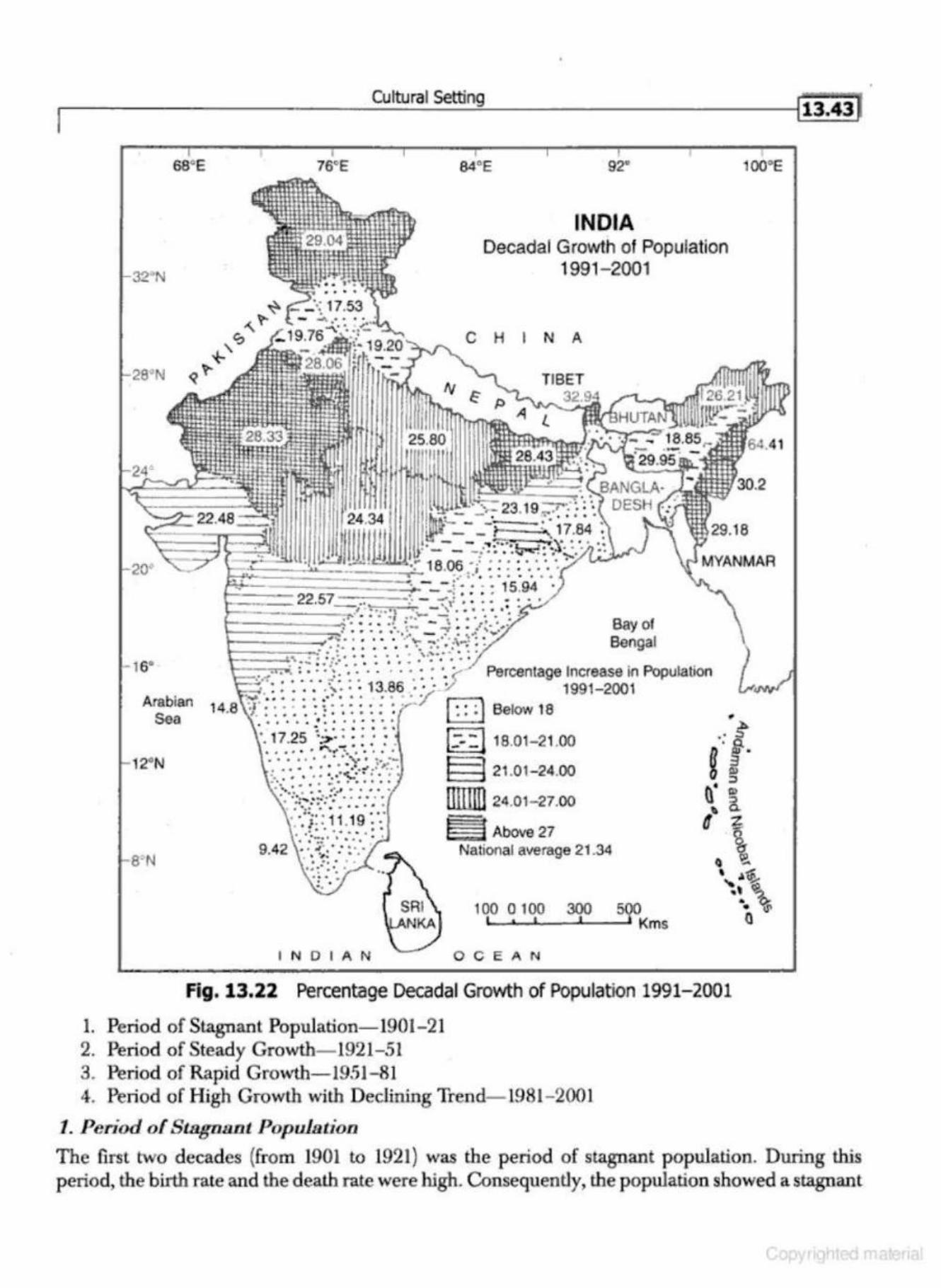
I Cultural Setting
ss•E
16°
Arabian Sea
1~N
22.48
76•E
22.57
INDIAN
• 84"E 92"
INDIA Decadal Growth of Population
1991- 2001
C H I N A
Bay of Bengal
Percentage Increase in Population 1991-2001
Q Below 18
[:"-:118.01-21.00
§ 21.01- 24.00
UllJli]24.01- 27.00
~ Above27 National average 21 .34
10~~-o •. _'o~,o---~~·---s~~Kms
OCEAN
Fig. 13.22 Percentage Decadal Growth of Population 1991-2001
1. Period of Stagnant Population- 1901-21 2. Period of Steady Growth- 1921-51 3. Period of Rapid Growth-1951-81 4. Period of High Growth with Declining Ttend- 1981- 2001
1. Period of S lBgaa.nt Population
l13.4i)
100"E
The first t\'110 decades (from 1901 to 1921) was the period of stagnant population. During this period, the birth rate and the death rate were high. Consequently, the population showed a stagnant
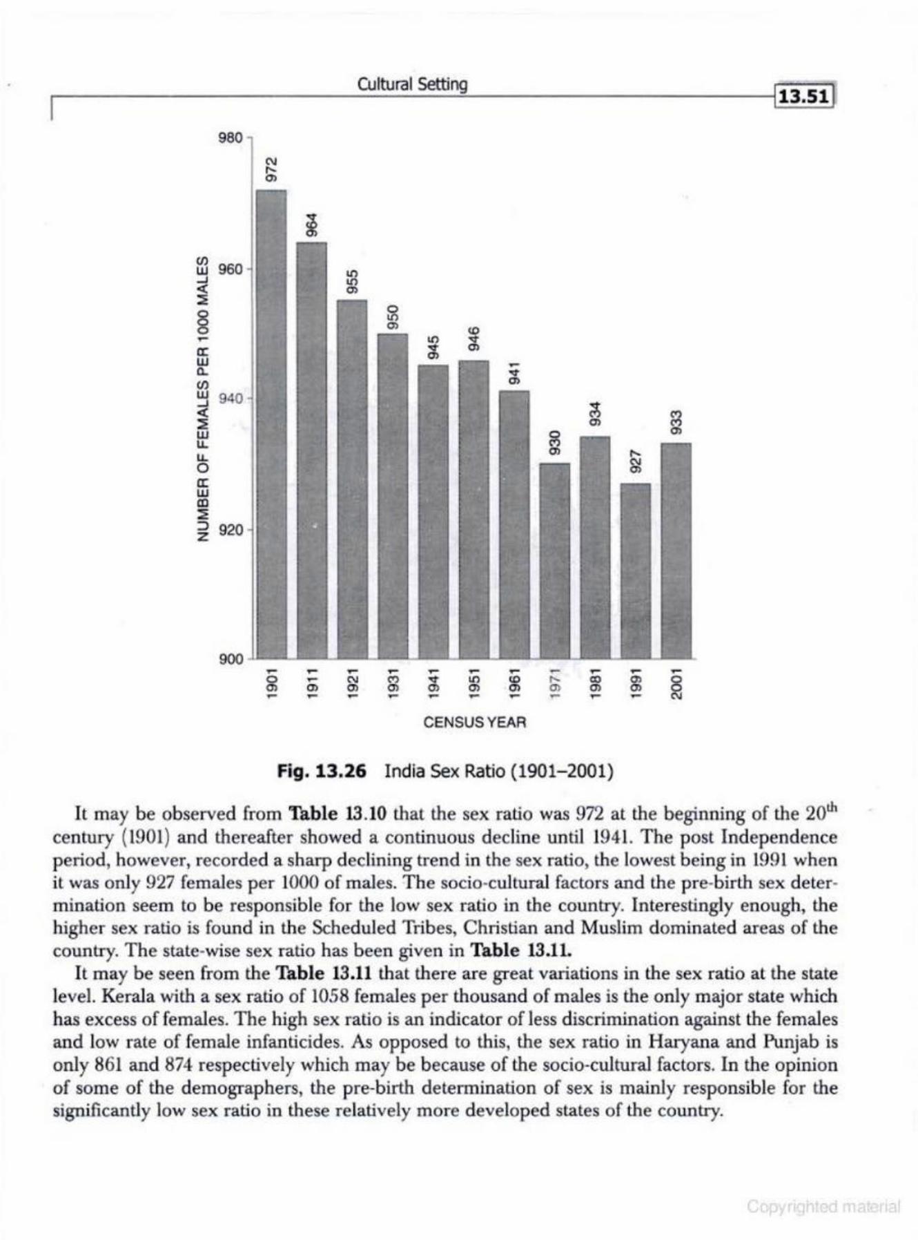
• ~--------------------~cu~lru~~~~s~ew~·~~~--------------------~! 13.51 1 980
~ 960 ...J <(
~
§ .-a: w a. (/)
~ 940 <(
~ u.. 0 a: w co ~ ::> 920 z
900 .-0 01 ,....
~ ~ ~ ~ ~ ~ ~ .- ~ .-~ N (") " 1.0 co .... CD 01 0 Ol Ol 01 01 01 01 Ol Ol Ol ~ - - - - - ~ - ,.... -
CENSUS YEAR
Fig. 13.26 India Sex Ratio (1901-2001)
It may be observed from Thble 13.10 that the sex ratio was 972 at the beginning of the 20th century (1901) and thereafter showed a continuous decline until 1941. The post Independence period, however, recorded a sharp declin ing trend in the sex ratio, the lowest being in L991 when it was onl y 927 females per 1000 of males. The socio-cultural factors and the pre-birth sex deter· mination seem to be responsible for the low sex ratio in the country. Interestingly enough, the higher sex ratio is found in the Scheduled Tribes, Christian and Muslim dominated areas of the country. The stale-wise sex ratio has been given in Table 13.11.
I t may be seen from the Table 13 .11 that there are great variations in the sex ratio at the state leveL Kerala with a sex ratio of 1058 females per thousand of males is the only major state which has excess of females. The high sex ratio is an indicator of less discrimination against the females and low rate of female infanticides. As opposed to this, the sex ratio in Haryana and Punjab is only 861 and 874 respectively which may be because of the socio~cuJtural factors. In the opinion of some of the demographers, the pre-birth determination of sex is mainly responsible for the significantly low sex ratio in these relatively more developed states of the country.
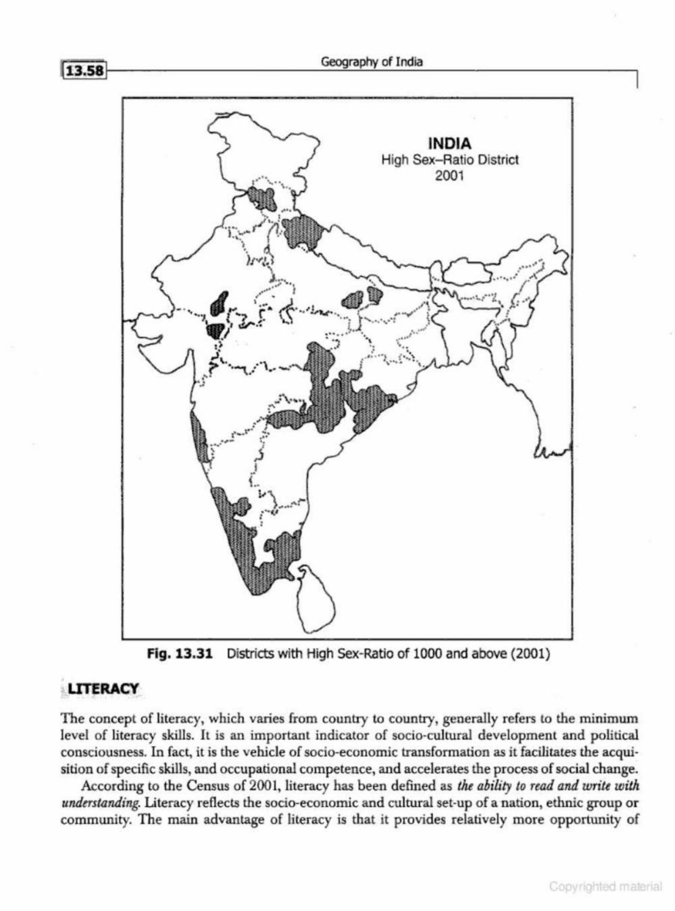
li3.sil
UIERACY
Geography of I ndia
INDIA High Sex-Ratio District
2001
,1'\ •• • ,-~v ..
~·.
Fig. 13.31 Districts with High Sex-Ratio of 1000 and above (2001)
•
The concept of li teracy, which varies from country to country, generally refers to the minimum level of li teracy skills. It is an important indicator of socio-cultural development and political consciousness. In fact, it is the vehicle of socio-economic transformation as it facilitates the acquisition of specific skills, and occupational competence, and accelerates the process of social change.
According to the Census of 2001, literacy has been defined as the ahility to read and write wilh understanding. Literacy reflects the socio-economic and cultural set-up of a nation, ethnic group or community. The main advantage of literacy is that it provides relatively more opportunity of
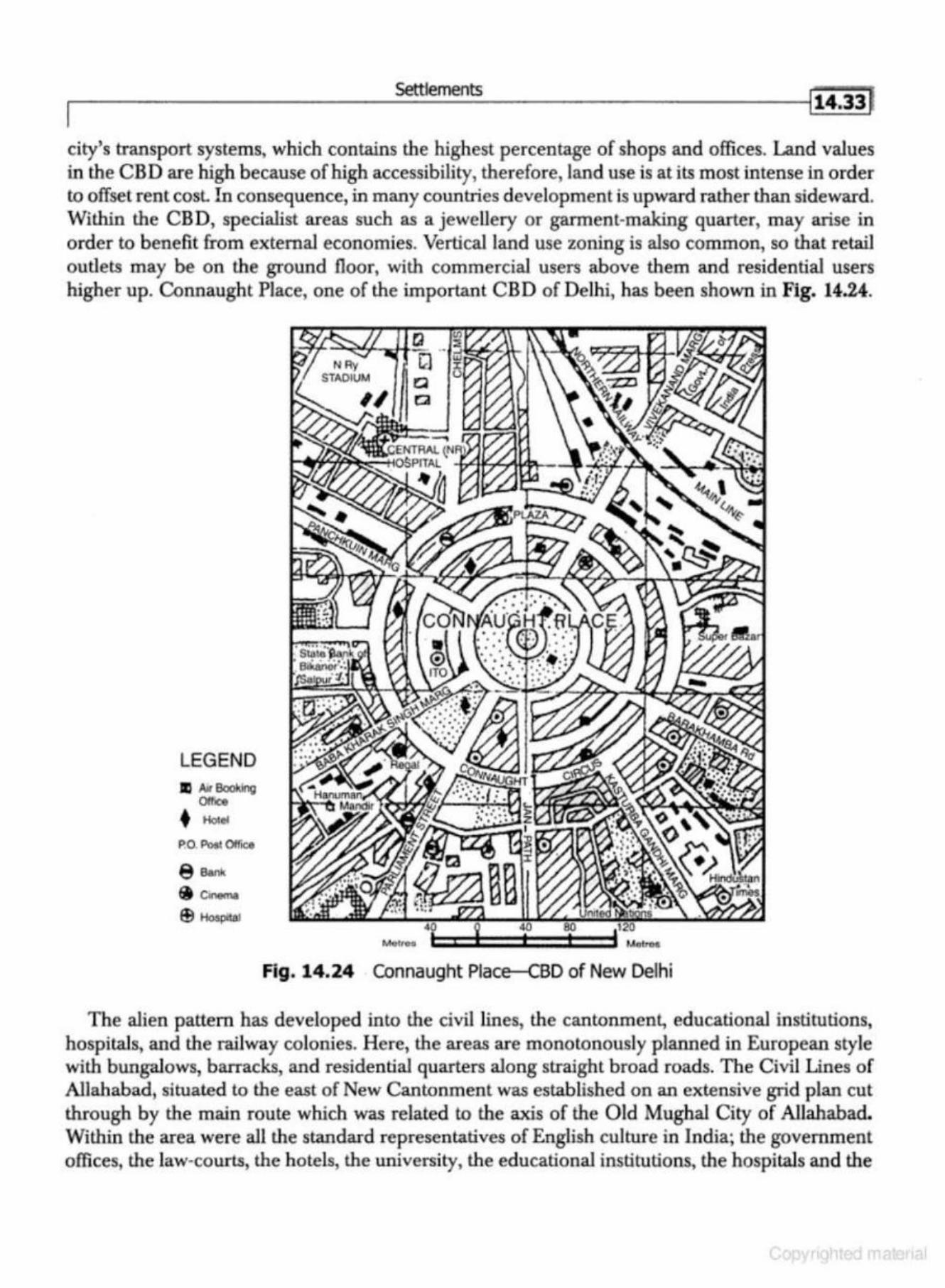
.....------------Settl_ e_me_n_ts __________ ---ll t4•33 ~
city's transport systems, which contains the highest percentage of shops and offices. Land values in the CBD are high because of high accessibility, therefore, land use is at its most intense in order to offset rent cosl. In consequence, in many countries development is upward rather than sideward. Within the CBD, specialist areas such as a jewellery or garment-making quarter, may arise in order to benefit from external economies. Vertical land use zoning is also common, so that retail outlets may be on the ground floor, with commercial users above them and residential users higher up. Connaugh t Place, one of the important C BD of Delhi, has been shown in Fig. 14.24.
LEGEND II Ail Booking
Olface • Hotel
P.O. Po5t OffiGO
Mot roo
Fig. 14.24 Connaught Place--CBD of New Delhi
The alien pattern has developed into the civil lines, the cantonment., educational institutions, hospitals, and the railway colonies. Here, the areas are monotonously planned in European style with bungalows, barracks, and residential quarters along straight broad roads. The Civil Lines of Allahabad, situated to the east of New Cantonment was established on an extensive grid plan cut through by the main route which was related to the axis of the Old Mughal City of Allahabad. Within the area were all the standard representatives of English culture in India; the government offices, the law-courts, the hotels, the university, the educational institutions, the hospitals and the
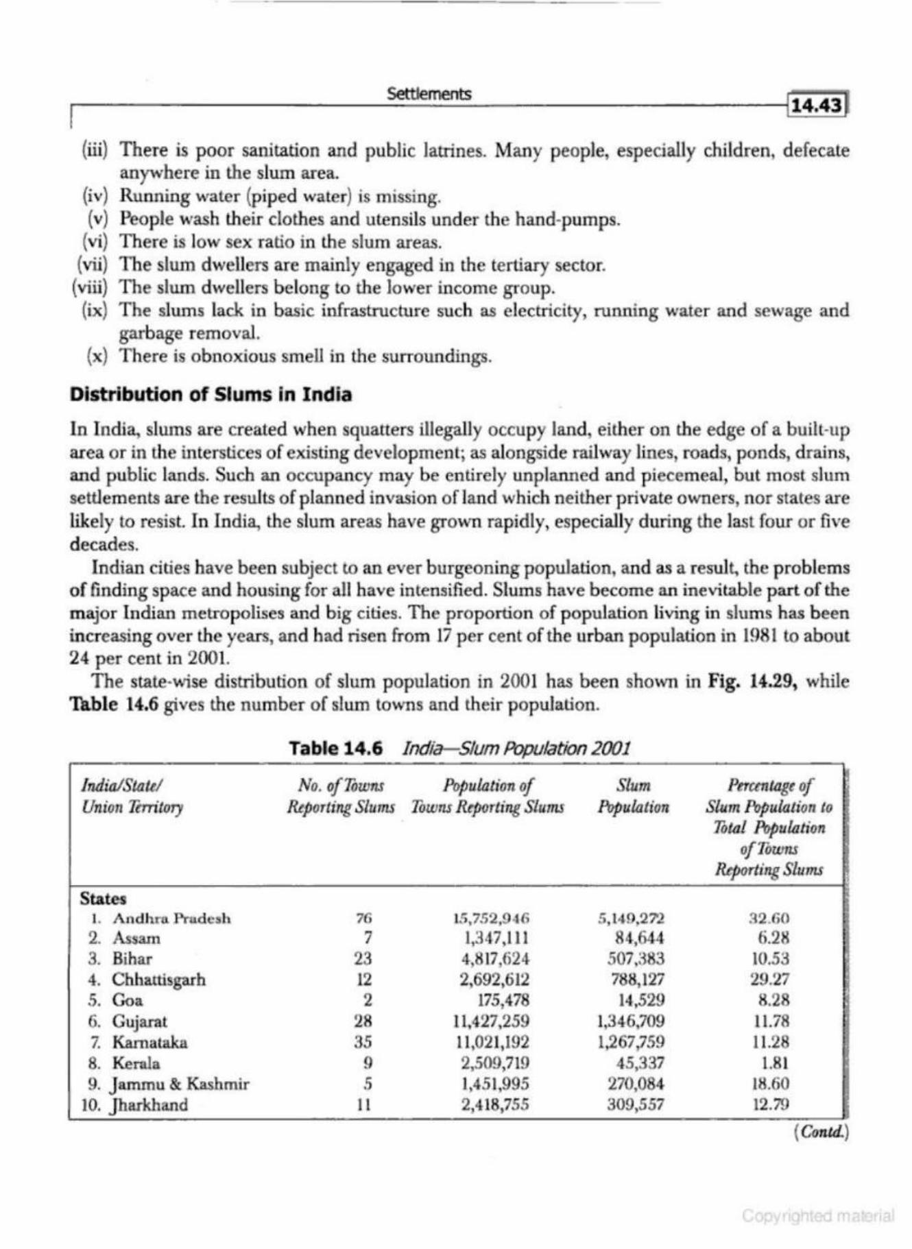
f ,--------------------~~==m~e~nG~-------------------4It4.~J
(iii) There is poor sanitation and public latrines. Many people, especially children, defecate anywhere in the slum area.
(iv) Running water (piped water) is missing. (v) Pe<lple wash lheir clothes and utensils under the hand-pumps.
(vi) There is low sex ratio in the slum areas. (vii) The slum dwellers are mainly engaged in the tertiary sector.
(viii) The slum dwellers belong to the lower income group. (ix) The slums lack in basic infrastructure such as electricity, running water and sewage and
garbage removal. (x) There is obnoxious smell in the surroundings.
Distribution of Slums in India
In India, slums are created when squatters illegally occupy land, either on the edge of a built-up area or in the interstices of existing development; as alongside railway lines, roads, ponds, drains, and public lands. Such an. occupancy may be entirely unplanned and piecemeal, but most slum settlements are the results of planned invasion ofland which neither private owners, nor states are likely to resist. In India, the slum areas have grown rapidly, especially during the last four or five decades.
Indian cities have been subject to an ever burgeoning population, and as a result, the problems of finding space and housing for all have intensified. Slums have become an inevitable part of the major Indian metropolises and big cities. The proportion of population living in slums h as been increasing over the years, and had risen from 17 per cent of the urban population in 1981 to about 24 per cent in 2001.
The state-wise distribution of slum population in 2001 has been shown in Fig. 14.29, while Table 14.6 gives the number of slum towns and their population.
Table 14.6 India-Slum Population 2001
India/State/ No. ofTowns Population of Slum Peruntage of Unio11 TtrrUory Reporting Slums Towns Rtpo·rting Slums P&pulalion Slum Population to
.Total Populalion ofToums
&porting Slums
States 1. Andhra. FTudcsh 7G 15, 7.'>2,946 5, 14.9,27'2 ::\2 .60 2. Assam 7 1,347,111 84,644 6.28 3. Bibar 23 4,817,624 507,383 10.53 4. Cbhattisgarh 12 2,692,612 788,127 29.27 .5. G<>a 2 175,478 14,529 8.28 6. Gujarat 28 11,427,259 1,346,709 11.78 7. Kama taka 35 11,021,192 1,267,759 11.28 8. Kerala 9 2,509,719 45,337 1.81 9. J ammu & Kashmir .5 1,451,995 270,084 18.60
10. jhaJ"khand 11 2,418,755 309,557 12.79
{ Contd.)

Settlements
accommodation in new planned colonies free of cost or a t h ighly concessional rates. Wherever such slum clearance is not possible, basic civic amenities like drinking water, electricity, garbage disposal, sewerage, roads, etc. are provided to improve the environmental conditions of the slums.
7. Rdmbilitation versus Redevelopm ent
This principle is applied for improving the housing conditions in the old cities. It may involve improvement in old buildings or construction of new ones at their place after demolition.
8. Traffic Segregation
T his principle is applied to remove transport bottlenecks and to improve urban traffic. It offers various solutions, like wi dening of roads, construction of flyovers and subways, bridges, metros, underground railways and parking facilities.
9. City Centre Developmen t Under this principle attention is focused on the improvem ent of Central Business District (CBD).
10. Planning for Future Citic.s
This principle focuses attention on new towns and cities keeping in mind the future needs of the city region. Thjs may be done through developm ent of sa tellite towns, linear cities, dispersed cities or radial cities (Fig. 14.31).
ALWAR
• Uttarakhand
1
U.P
Fig. 14.31 The National capital Region (NCR)
I Regional Development and Planning I ts.31
1967, to 1968-69) were described as the 'PlaTZ Holiday~ These annul plans were implemented within the framework of the draft outline of the Fourth Five-Year Plan.
Fourth Five-Year Plan (1969-74)
The Fourth Plan was aimed at accelerating the tempo of development and reducing fluctuation in agricultural production as weU as the impact of uncertainties of foreign aid. The main objectives of this plan were: (i) growth with stability, and (ii) progressive achievement of self reliance. It laid especial emphasis improving the condition of the less privileged and weaker sections of society through the provisions of employment and education. The average annual growth rate during the Fourth Plan was 3.4 per cent against tbe target of 5.7 per cent.
Fifth Five-Year Plan (1974-79)
The Fifth Five-Year Plan was formulated against the backdrop of severe inflationary pressure. The plan proposed to achieve two main objectives: (i) removal of poverty, and (ii) attainment of self reliance through promotion of higher rate of growth, better distribution of income and very significant step-up in the domestic rate of saving. The plan targeted an annual growth rate of 5.5 per cent in national income while the actuaJ achievement was only 5 per cent.
Sixth Five-Year Plan (1978-83)
There were two Sixth Five-Year Plans. Thejanta Party Sixth Pian (1978-83) sought to reconcile the objectives of higher production with greater opportunity for employment. The focus of the plan was enlargement of employment opportunities in agriculture and allied activities, encouragement to household and small industries producing consumer goods for mass consumption, and to raise the incomes of the lowest classes through minimum needs programme.
The new Sixth Five-Year Pian (1980-85) was launched by the Congress {I) '¥ith the prime objective of direct attack on the problem of poverty by creating conditions for an expanding e<:onomy.
The strategy adopted for the plan was to strengthen infrastructure for both agriculture and industry. Stress was laid on dealing with inter-related problems through a system approach rather than in separate compartments, greater management, efficiency and intensive monitoring, and active involvement of people. The targeted annual growth was 5.2 per cent and the achieved growth rate was 5.4 per cent.
Seventh Five- Year Plan (1985-90)
The Seventh Five-Year Plan emphasised policies and programmes which aimed at a rapid growth in food-grain production, increase in employment opportunities and productivity. The foodgrain production during the Plan grew by 3.23 per cent. To reduce unemployment and the incidence of poverty, special programmes likejawahar Rozgar Yojno. were initiated in addition to the already existing programm es. During the Plan period, the Gross Domestic Product (GDP) grew at an aven1ge rate of 5.6 per cent exceeding the targeted growth rate by 0.6 per cent.
Annual Plans
The Eighth Five-Year Plan could not take off due to the fast changing political situation at the
I i s.i J1-----------~Geo9:....:....:..::._:ra:..!:._ph2y-=-o~f I~nd:..._:ia _________ ---,
3. The Principle of Space~time Continuum
This principle implies tha.t spatial reality is four dimensional consistin g of three dimensions of space and one dimension of time, and the two, i.e., space and lime; are inseparable. This is considered as an integral part of space. A region is a living dynamic entity that operates simultaneously in the past, present., and future like the human body's DNA. The regional planner must, therefore, recognise the fact that regional space is a contin uously growing organic whole. The regional planner has to be conscious of the fact that while he is planning in space, he is also planning in time.
4. Tbe Priuciplc of Comprehensive Dovclopmcnt
Comprehensive development means that the regional planning seeks to achieve the comprehensive development of the entire regional space; the regional system in its entirety. It seeks the development of all sectors of economy along with advancement of all segments of society.
/>. The Principle of Community Dlwelopnwnt
The principle of community development is the principle of equal opportunities to all for self development. The entire commw1ity is considered as an organic whole. It is only through equal opportunities to each individual (education, h ealth and employment) that the whole society can be developed in to community with the sense of belonging lo each other. The regional planning, therefore, should be to create socially harmonious communities.
6. 'fhc Principle of Equilibrivm between Social JJc . .<;irability and Economic Viability
This principle implies that while planning for comprehensive development of all regions. the regional planner h as to maintain a balance between what is socially desirable and what is economically viable. The reb>ional plans should not only be good intentioned, but also be economically viable.
7. The Principle of Ecological Equilibrium
The regional planning should make the ecology and environment sustainable. I t means that a regional planner has to develop the regional space at his disposal only within the framework of ecological equilibrium. In other words, all developments in a region should be carried out without disturbing the ecological balance.
To sum up, regional planning can be successful in its operation and practice only when it is guided by the seven basic principles of (i) vertical unity of phenomena, (ii) horizontal spatial unity, (iii) space time continuum, (iv) comprehensive development, (v) community development, (vi) equilibrium between social desirability and economic viabili ty, and (vii) ecological equilib~ rium. A strict adherence to these basic principles is the only way for creating habitability.
INTEGRATED AREA DEVELOPMENT
The concept of in tegrated area development is difficult lo define. It has different meanings and interpretations at different points of time. In fact, it is diffi cult lo decide what type of integration should be sought and what ways should be adopted to accomplish it. In general, four aspects of integration can be differentiated.
Geography of India
(ii) Identification of socio-cultural barriers and promoters of change and development (iii) Assessment of potentialities, speciaJ problems, and felt-needs of the tribal areas. (iv) Assessment of the resources available for the tribal sub-plan from the normal plan funds,
special Central assistance and institutional sources. (v) Formulation of sectoral programmes. (vi) Developing a suitable administrative set-up. The structure of planning proposed in a tribal sub-plan is a three tier structure involving micro,
meso, and macro levels of planning. The micro region will be coterminous with a development block, the meso region will be contiguous in the development block involving 3 to 5 lakh people having comparable levels of socio-economic development. and the macro region will be formed of bigger tribal belts for planning of tribal development. The functions at the micro, meso, and macro levels have been visualised as follows:
Micro Level: At the micro level. the functions included are: (a) education up to higher secondary level, (b) elementary health services, {c) agricultural exten· sion, (d) supply of agricultural inputs, (e) minor irrigation schemes, (0 elementary veterinary services, (g) multi-purpose co-operatives, (h) local panchayat. (i) household industry, and U) village approach roads.
Meso Level: At the meso level, the functions included are:
(a) higher general education, (b) technical and vocational training, (c) manpower planning and employment services, (d) advanced health services vvith referral facilities, (e) agricultural research extension, (0 seed multiplication farms, (g) soil conservation and land management. (h) apex integrated credit marketing structure with adequate storage and buffer stock facilities, {i) develop· ment of road and communication infrastructure connecting market with state/ district highways, m d.istribution of network of power, rural electrification, etc. (k) local resource based industries with adequate market linkages, (l) forest management, (m) horticulture development, (n) complementary development programme in hinterland and bigger industries, (o) medium irrigation projects, and (p) research statistics and evaluation.
Macro Level : At the macro level, the functions include: (a) co-ordination of activities in tribal development projects, (b) agricultural research on regional basis, (c) direction of the various sectoral programmes in the project, (d) major irrigation projects, (e) river valley development, (f) industrial and mineral development of the region to ensure complementarity of the project level development programme, (g) marketing support projects, and (h) evaluation.
The idea behind the inte~:,rrated area planning is to ensure a collective utilisation of the resources of a particular area keeping in view the problems and needs of development of that area. The spectrum of the problems of development that still await solution in tribal areas include the following:
1. land alienation, 2. indebtedness and exploitation, 3 . bonded labour, 4. low educational standard, 5. low agricultural production and productivity, 6. inadequate supply of essential consumer goods,
.--------------------R~~~~o~n~a~I~De~v~e~lo~p~~~t~a~n~d~P~Ia~n~ni~n~g __________________ _,lis.27J
welfare, {v} maintaining common grazing grounds, (vi) village roads, tanks; wells, (vii} sanitation, and execution of other socio-economic development programmes. The Paruhayats have also been authorised to identify the beneficiaries in anti-poverty programmes.
After the Constitution Amendment of 1992, the new status accorded to the Panchayats by the Constitution has raised high hopes arid expectations among the elected representatives and the rural folk at large. But owing to the political complexions of t11e governments in indian states, the reluctance of the state-level political and administrative functionaries to part with power and authority, and some genuine financial and economic difficulties, the progress in the implementation h as been somewhat slow. It has been found that the elected representatives of Panchayat Raj Institution are Largely unaware of the political and economic dimensions of development issues and lack of planning and managerial skill. This is particularly true of e lected women representatives, wh o are performing th eir duties under some severe constraints of different kind.
THE DAMODAR VALLEY CORPORATION
Flowing through the states of Jbarkhand and West Bengal, the Da.moda.r river is 541 km {336 miles) long. The river is also known as Deonadi in its upper reaches. It rises in westemJharkhand in the hills of Chotan agpur and drains areas in the Ra.n:hi, Ha.zaribagh, Dhanbad and Santhal Parganas districts of Jharkhand, and Bankura and Burdwa.o districts of West Bengal. After its confluence with the Barakar river, it enters West Bengal. Flowing through Bankura and Burdwa.o, it finally merges into the Hugli River opposite Falk'l, approximately SO km north of Kolkata. The river has a total catchment area of 25,820 sq km (Fig. 15.1).
The upper reaches of the Da.modar presents a highly denuded and desolate topography characterised with gorges and barren rocks, while the lower part in West Bengal is a flat, fertile stretch of thick alluvial soil. It is known fo r lush green fields of paddy crop. The catchment area of Damodar receives about 125 em average annual rainfall which occurs mainly in the months of July, August and September. In its upper reaches it runs rapidly, eroding land and collecting silt on large scale. In its lower reaches it runs too sluggishly, discharging silt all along its banks through flooding.
The river basin had great natural endowment in the form of fertile soils, huge water resources, forest wealth, great variety of good reserves of minerals. Il is rich in coal, iron o re, bauxite, mica, fire-clay, limestone, lead, silver , antimony, quartz, chromite, kyanite, etc. (Fig. 15.2). Moreover, the uppe r part of the basin was the home of several aboriginal tribes including Oraons, Hos, Santhals; and Muodas.
The Damoda.r River, often called 'The Sorrow of Bengal', is n otorious and u known fo,· its
erratic character. During the last one hundred years it recorded serious floods in 1901, 1905, 1907, 1913, 1916, 1923, 1935, and 1943. During these years th e countryside was inundated, crops and cattle were washed away, and transportation and communications seriously disturbed. Between 1862 and 1872 floods i,n the Damodar River caused a malaria epidemic and almost one third of the population on the left bank of the river died of what came to be known as 'Burdwan Fever~ The 1943 flood was even more devastating in which the countryside south of Burdwan was submerged and inundated in some areas to a depth of six or seven feet, villages were swept away, rice fields were devastated, rail traffic was seriously disrupted since railway bridges were washed away, the grand trunk road was breached, and for a time, even the cities of Burdwan and Calcutta were in danger.
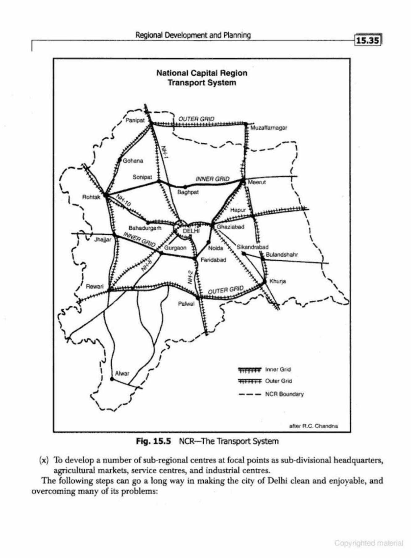
rl -----------------~~ioo~al_~~~~~~m~e~n~ta~n~d_P~_n~n_ln~g----------------~liiis l
"'? I
I .... ~ ,...,
,...... / PMipat
\ J Gohana
/ Rewari
National Capital Region Transport System
'"
OUTER
-- , ..._ ""' .,""'"- , --...... ,.-___ \
Farld&bad
J (
(
h 11 ,j 1 Inner Grid
II HI 1J Oulor Grid
--- NCR Boundaf)'
\ I
' "
aller R.C. Chandna
Fig. 15.5 NCR-The Transport System
{x) To develop a number of sub-regional centres at focal points as sub-divisional headquarters, agricultural markets, service centres, and industrial centres.
The following steps can go a long way in making the city of Delhi clean and enjoyable, and overcoming many of its problems:
116.2"1 Geography of India
administrative authority is vested in the Central Government; the local and regional governments function at the discretion of the cent.ra.l authority.
Federal States
The term <jederal' has its origin in the Latin 'foederis'meaning league. In a federal state, the government authority is' layered' at different levels. Its implication is one of alliance, contract and coexistence of the state's internal diverse regions and peoples. Under the federal system, the rights and responsibilities of local governments are protected by constitution. Here the central authority cannot simply assume the functions of local governments temporarily to relinquish them when the demands have been met The individual regions of the state possess a certain degree of autonomy which is protected, and there is a constant watch against over-centralisation. This is what permits diverse peoples and even cultures to join a single state. Their first allegiance may be to theiJ· own region, but their ultimate loyalty is towards the state.
A fedet·al government has a written constitution that cannot be 1.lllilaterally altered. There is division of power between the central government and the component states/provinces. The federal govemment is generally formed in the countries where the people belong to different racial, ethnic, cultural groups; speak differen t lartguages; follow different religions; and have different customs and traditions.
In a federal set-up, local govenunents derive their authority from the regional governments, which themselves possess constitutionally guaranteed autonomy in specified matters of importance. Thus, the regional or state governments do not depend on the discretion of the centre.
A federation differs from a unitary government in the sense that in the unitary polity 'states', if any, exjst at the mercy of the central government. As opposed to this, in a federation each level of government is, in theory, autonomous within its allocated sphere of competence, and is free from any non-agreed intervention from the other, except in emergency, if the constitution so provides. Thus, what distinguishes federalism from a unitary government is guaranteed constitutional autcmomy, not the formal division of powers.
Federalism is, thus, essentially a compromise between centripetal and centrifugal forces that are operative at the same time. A federal system of government is one in which there is a division of powers between one general and several regional authorities, each of which, in its own sphere, is coordinate with the others, and each of which acts directly on the people through its own administrative agencies (Birch, 1955).
India is the largest democracy in the world. It has adopted the democratic form of government for its administration. Its political structure is federal in concept but unitary in functioning.
Indian Federalism
India, a Union of States, is a Sovereign S<Jcialist Secular Denwcratic Republic with a parliament-ary system of government. The republic is governed in terms of the Constitution, which was adopted by the Constituent Assembly on November 26, 1949 and came into force on january 26, 1950.
The Constitution which envisages parliamentary form of government is federal in structure \'lith unitary features. The President of India is the constitutional head of executive of the Union. Article 74(1) of the Constitution provides that there shall be a Council of Ministers with the Prime Minister as head to rud and advise the President who shall in exercise of his functions, act in accordance with such advice. The real exeGutive power, thus, vests in Council of Ministers with
.------------I_n_di_a-_Po_liti_·c_ai_As--=.pects ___________ ----il 16.9 I'
The Commission submitted its report on September 30, 1955, recommending reorganisation of India into 16 Slates and 3 Territories. The Government of India examined the report in detail and proposed the reorganisation of India into 1.5 States and 7 Territories. Finally, the Parliament passed the States Reorganisation Act, 1956 reorganising India into 14 States and 6 Union Territo· ries from November l, 1956.
As a result of reorganisation, a very large area and population was brought under a similar administrative pattern. All the states, covering 98 per cent of area and. population of India, now had a similar legislative, executive and judicial structure as chief components of the Republic. Only a small portion as the Union Territories was left under the Central guidance. The anomaly of the institution of &jpramukh was removed, ending the last hereditary and feudal association with the administration as bead of the state. The territorial contiguity was another major achievement. Various blocks of terriLories, existing as enclaves and exclaves, even after the integration of states were merged v.rith the contiguous units; excepting the one anomaly in respect of Himachal Pradesh which was still left in two major blocks. Most of the reorganised states were larger in area and population than before. Madras and Bihar lost some areas, while Assam, Orissa, Uttar Pradesh, and jammu and Kashmir underwent no change. Certain former states like H yderabad, Coorg, Bhopa~ Saurashtra, Kachchh, Madhya Bharat, Vindhya Pradesh, Ajmer, Mewar, and PEPSU lost their identities as such. There were little boundary changes, old boundaries of different levels had been maintained . The number of states, as reorganised, was less than recommended by the Commission or proposed by the government
Post-Reorganisation Changes
The reorganisation of sta.tes could not satisfy all opinions. It did not mark the end of the process. On linguistic, ethnic, or cultural grounds, pressing demands have been made for readjustment of politico-territorial units. In the years that followed, the territorial changes have been more towards division and fragmentation. Consequently, there was an increase in the number of units and also certain variations in the administrative set-up.
Although language was made an open issue in the reorganisation, it is evident that 'communalism' played a vital role in the partitioning of Bombay into Maharashtra and Gujarat (May l, 1960), and Punjab (November 1, 1966) into Punjab and Haryana. The Sikhs felt themselves to be a different community from the Hindus in the Punjab and so did the Marathas from Gujaratis in Bombay (Mumbai). Communalism, thus, in the pre-independent India was responsible for the partition of the subcontinent and in the post-Independence India was responsible for creating further territorial divisions (Rai, Satya, 1965, and Singh, G.S. 1966). The Slates Reorganisation Commission had recommended one greater Punjab compt;sing the then East Punjab and Himachal Pradesh including PEPSU and Bila.spur. Various forces have succeeded in getting this region divided into four units as at present: the states of Punjab, H aryana, Himachal Pradesh, and the U nion Territory of Chandigarh.
The other region of large territorial changes lies in the North-East. The internal administration of this area was organised and based on traditional tribal ways oflife and social customs. Nagaland (December 1, 1963), and Meghalaya (April2,1970) were carved out from Assam, while Manipur {1971 ), Tripura (1971), Mizoram (December 8, 1986), and Arunachal. Pradesh (December 8, 1986) were upgraded from the status of union territories to the status of full-fl edged states. In fact, the

I Indra--Political Aspects
TRANS~KARAKORAM 1 TRACT
POK
•
' . .. ·. .... . . I " . • • 0.
LOC
~ 0 • • ••••• •
.. . .. . . ~ .
I N 0 I A
CHIN A
1. Trans-Karakoram Tract
Pakistan handed over this area to China as part of an agreement in 1 963. But India said the Trans-Karakoram Tract was part of J&K
Karakoram Pass
• • • •
. • •
. . . :[I] . : AKSAI CHIN
Ladakh
•
Arunanchal Pradesh
Assam
2. Aksai Chin
India accuses China of occupying 8000 Sq. Km. in this region. Nooh·east of Ladakh. Aksai Chtn is almost uninhabited.
• • •
•
•
CH I N A
3. Arunanchal Pradesh
China claims 90.000 Sq Km of wtlat they call ·sou1h Tibet" as their territory, that Is almost the whole of Arunanchal Pradesh.
Fig. 16.1 Three Unresolved Territorial Disputes between India and China
rrzsz--am -
[16.171
In 1954, India gave up its extra-territorial rights on Tibet, exercised by the British Raj on the basis of the Anglo-Tibetan Trade Agreement ofj uJy 1914. India formally recognised the Chinese Sovereignty over Tibet and, as a consequence, for the first time in several centuries Tibet came under the direct control of a strong military power with an active and aggressive policy. The geostrategic value of the entire Himalayan front was drastically changed. TI1e buffer zone of Tibet disappeared and sharp boundary between India and China was established.
Indla-Polltlcal Aspects !1& .25~
between British India and Nepal was decided, is given in the resolution of j une 1882. The resolution directed that 'except where natural obstacle intervenes the line from pillar to pillar may be re&'ilrded as straight ' The present Indo-Nepal boundary is peaceful and there is no boundary dispute between the two countries.
India-Bhutan Boundary
India Bhutan boundary is the outcome of long history of border conflict between the British and the Bhutanese since 1775. A treaty was signed at Sanchula in 1865 between Bhutan and Great Britain. The British annexed Bhutanese territory along Bengal, Koch-Bihar, and Assam border. Through this treaty, Bhutan was awarded Rs. 50,000 per annum as a British subsidy to Bhutan which was raised to Rupees one lakh in j une l9ll.
India's friendly relation with Bhutan are based on the Treaty of 1949 which provides a sound framework to ensure 'perpetual peace and friendship'. Under the b:eaty, India has got the rights to protect Bhutan's sovereignty and defend its borders. Indian army unjts are permanently stationed all along the Bhutan-Tjbet border.
lndia-Myanmar Boundary
The boundary between India and Myanmar is 1458 km. long which runs from India-ChinaMyanmar tri·junction in the north to the southern tip of Mizoram (Fig. 16.5). This boundary runs roughly along the watershed between the Brahmaputra and Ayeyarwady (Irrawaddy). This border passes through the thickly forested hills along the borders of Mizoram, Manipur, Nagaland and Arunachal Pradesh. The boundary was delimited precisely by a bilateral treaty signed on March 10, 1967. Some difficulty came near Diphu Pass, the tri-junction between India, Myanmar, and China. India's claim has been that the Dipuh Pass is not the t:ri-junction but ratller a few kilometers south of iL
Insurgency and smuggling are the main problems along the India- Myanmar border. On the Myanmar side, the Communist supported rebels are pia ying a significant role in instigating Karnes, Kachins and Sha.ns to fight for their independence from Myanamar. Similarly, on the Indian side, the Nagas and Mizos, etc. are receiving aid and encouragement from the Chinese and Burmese Communists. Moreover, a lot of smuggling of drugs and narcotics is going on along this border. Barring a few minor incidents, the Indo-Myanmar border has remained peaceful.
India--Sri Lanka Boundary
India Sri-Lanka boundary is a maritime boundary. It is separated by a 30 km wide shallow sea caJJed the Palk Strait (Fig. 16.6). The nearest points of the h¥0 countries are Dhanushkodi in Tamil, Nadu (India) and Talai Mannar injaffna (Sri Lanka).
Historically, the India-Sri Lanka boundary has remained generally peaceful. Some bitterness was, however, created over the ownership of Kachchitevu Island (area 1.92 sq. km) in the Palk Strait which was given to Sri Lanka by India in 1974. The maritime boundary has become lively with the insurgent activity of LTIE which is demanding a separate homeland for Sri Lanka Tamils.
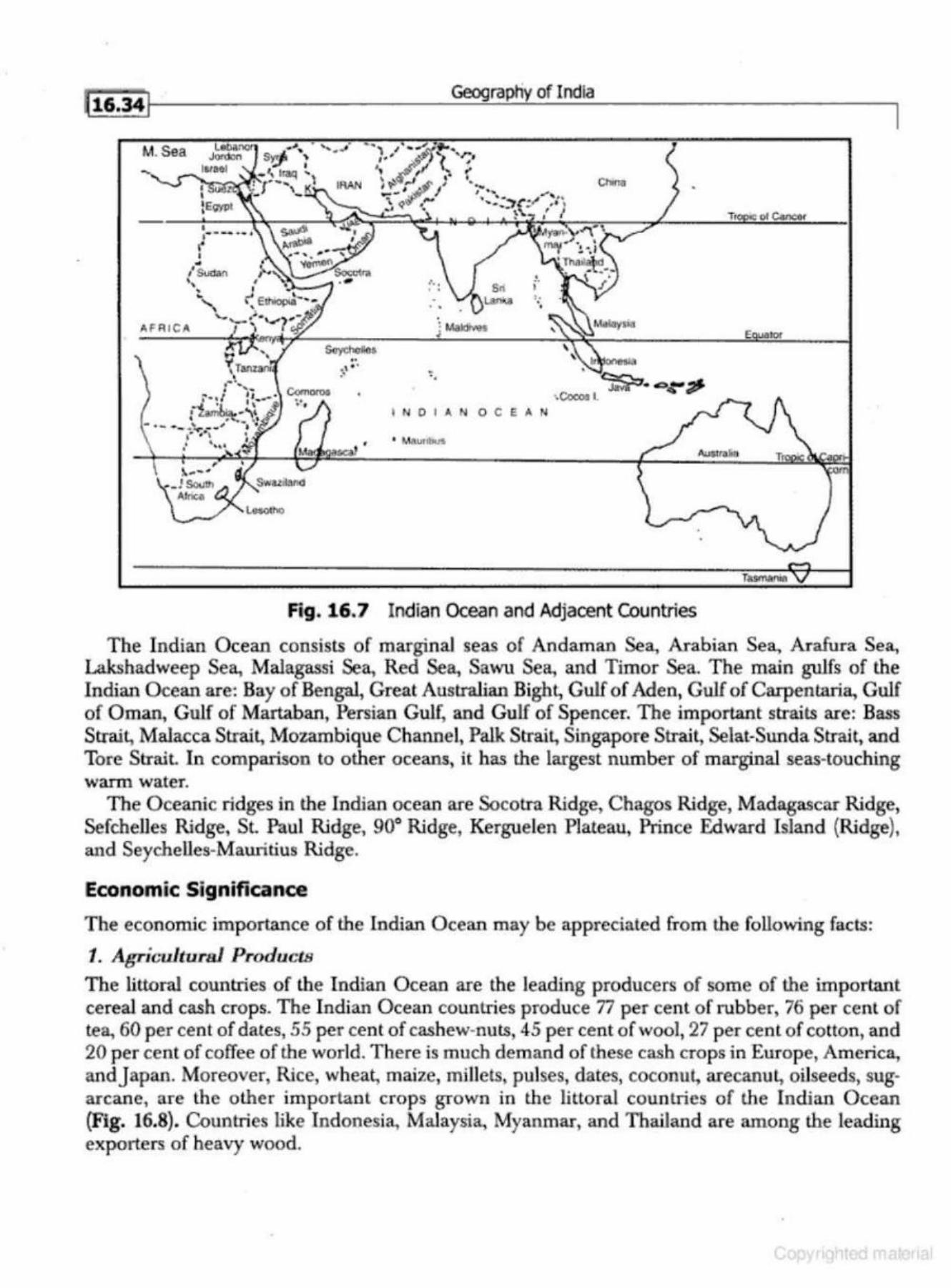
~ 16.34/
M.Sea
A FRICA
•• \ ..
;
Geograptiy of India
Ct>rm
I N OIA NO CEA N
Fig. 16.7 Indian Ocean and Adjacent Countries
The Indian Ocean consists of marginal seas of Andaman Sea, Arabian Sea, Arafura Sea, Lakshadweep Sea, Malagassi Sea, Red Sea, Sawu Sea, and Timor Sea. The main gulfs of the Indian Ocean are: Bay of Bengal, Great Australian Bight, Gulf of Aden, Gulf of Carpentaria, Gulf of Oman, Gulf of Martaban, Persian Gulf, and Gulf of Spencer. The important straits are: Bass Strait, Malacca Strait., Mozambique Channel, Palk Strait, Singapore Strait, Selat-Sunda Strait, and Tore Strait In comparison to other oceans, it has the largest number of marginal seas-touching warm water.
The Oceanic ridges in the Indian ocean are Socotra Ridge, Chagos Ridge, Madagascar Ridge, Sefchelles Ridge, St. Paul Ridge, 90° Ridge, Kerguelen Plateau, Prince Edward Island (Ridge), and Seychelles-Mauritius Ridge.
Economic Significance
The economic importance of the Indian Ocean may be appreciated from the following facts:
t. Agrit.;ultural .ProductiJ
The littoral countries of the Indian Ocean are the leading producers of some of the important cereal and cash crops. The Indian Ocean countries produce 77 per cent of rubber, 76 per cent of tea, 60 per cent of dates, 55 per cent of cashew-nuts, 45 per cent of woo~ 27 per cent of cotton, and 20 per cent of coffee of the world. There is much demand of these cash crops in Europe, America, andjapan. Moreover, Rice, wheat, maize, millets, pulses, dates, coconut, arecanut, oilseeds, sugarcane, are the other important crops grown in the lit toral countries of the Indian Ocean (Fig. 16.8). Countries like Indonesia, Malaysia, Myanmar, and Thailand are among the leading exporters of heavy wood.
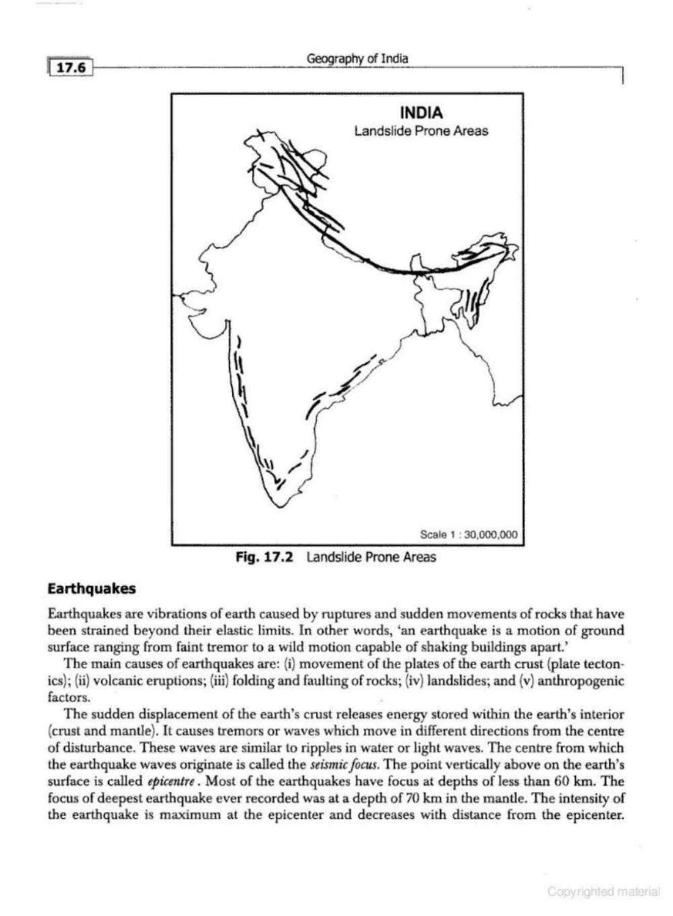
l 11.6 I
Earthquakes
Geography of India
INDIA Landslide Prone Areas
Scale 1 : 30.000.000
Fig. 17.2 Landslide Prone Areas
Earthquakes are vibrations of earth caused by ruptures and sudden movements of rocks that have been strained b eyond their e lastic limits. In other words, 'an earthquake is a motion of ground surface ranging from faint tremor to a wild motion capable of shaking buildings apart. '
The main causes of earthquakes are: (i) movement of the plates of the earth crust (plate tectonics); (ii) volcanic eruptions; (iii) folding and faulting of rocks; (iv) landslides; and (v) anthropogenic factors.
The sudden displacement of the earth's crust re leases energy stored within the earth's interior {crust and mantle). It causes tremors or waves which move in different directions from the centre of disturbance. These waves are similar to ripples in water or lighl waves. The centre from which the earthquake waves originate is called the seismic focus. The point vertically above on the earlh's surface is called epiccntra . Most of the earlhquakes have focus at depths of less than 60 km. The focus of deepest earthquake ever recorded was at a depth of 70 km in the mantle. The intensity of the earthquake is maximum at lhe epicenter and decreases with dislance from the epicenter.
~, _______________________ c_on_re_m~~--~~~~~-s_u_es ______________ ~------~!17• 17}
Epidemics
The term epidemic originally denotes a sudden excessive prevalence of disease in a population. Epidemic means 'upon the people~ Historically, epidemic was applied to infectious disease, but in more r-ecent times, it also includes major non-infectious diseases, such as AIDS, and cancer, too.
Transmission
Epidemic diseases are transmitted in many ways. Some of the ways of their transmission are as under:
1. By direct contact, for example, droplets sprayed about when a patient coughs or sneezes 2. By contaminated food and water. . 3. By arthropods-filth associated flies-of various types that may serve as mechanical carri
e rs of disease germs as in dysentery and cholera. Blood -sucking arthropods Like mosquitoes are more effective transmitters.
Factors Affecting Incidence
Apart from weather and climate, there are many factors which influence the spread and intensity of epidemics. Some of the factors are:
(i) ethnicity, (ii) age and sex composition,
(iii) literacy and education, (iv) occupation and lifestyle, (v) standard of living,
(vi) size of family and degree of crowding, (vii) residential I ocality,
(viii) food habits, {ix) smoking and consumption of liquer, and (x) association with animals and birds.
lncirfen c.e Curv(:
Incidence curve of different epidemic diseases are similar in that the rise in number of cases in an epidemic is usually more rapid than its fall .
ENVIRONMENTAL POLLUTION
A substance which causes an undesirable change in the physicaJ, chemical1 or biological characteristics of natural environment is known as pollution. Although there are some natural pollutants such as volcanoes, pollution generally occurs because of human activity. Biodegradable pollutants, like sewage, cause no pem1anent damage if they are adequately dispersed, but non-biodegradable pollutants, such as lead, may be concentrated as they move up the food chain. At present, air pollution-associated with basic industries such as oil refining, chemicals, iron and stee l, and coal, as well as with internal combustion engine-is probably the principal offender, followed by water, and land pollution. Other forms of environmental pollution include noise and the emission of heat into waterways, which may damage aquatic life. Present day problems of pollution include acid rain and the burning of fossil fuels to produce excessive carbon dioxide.
..
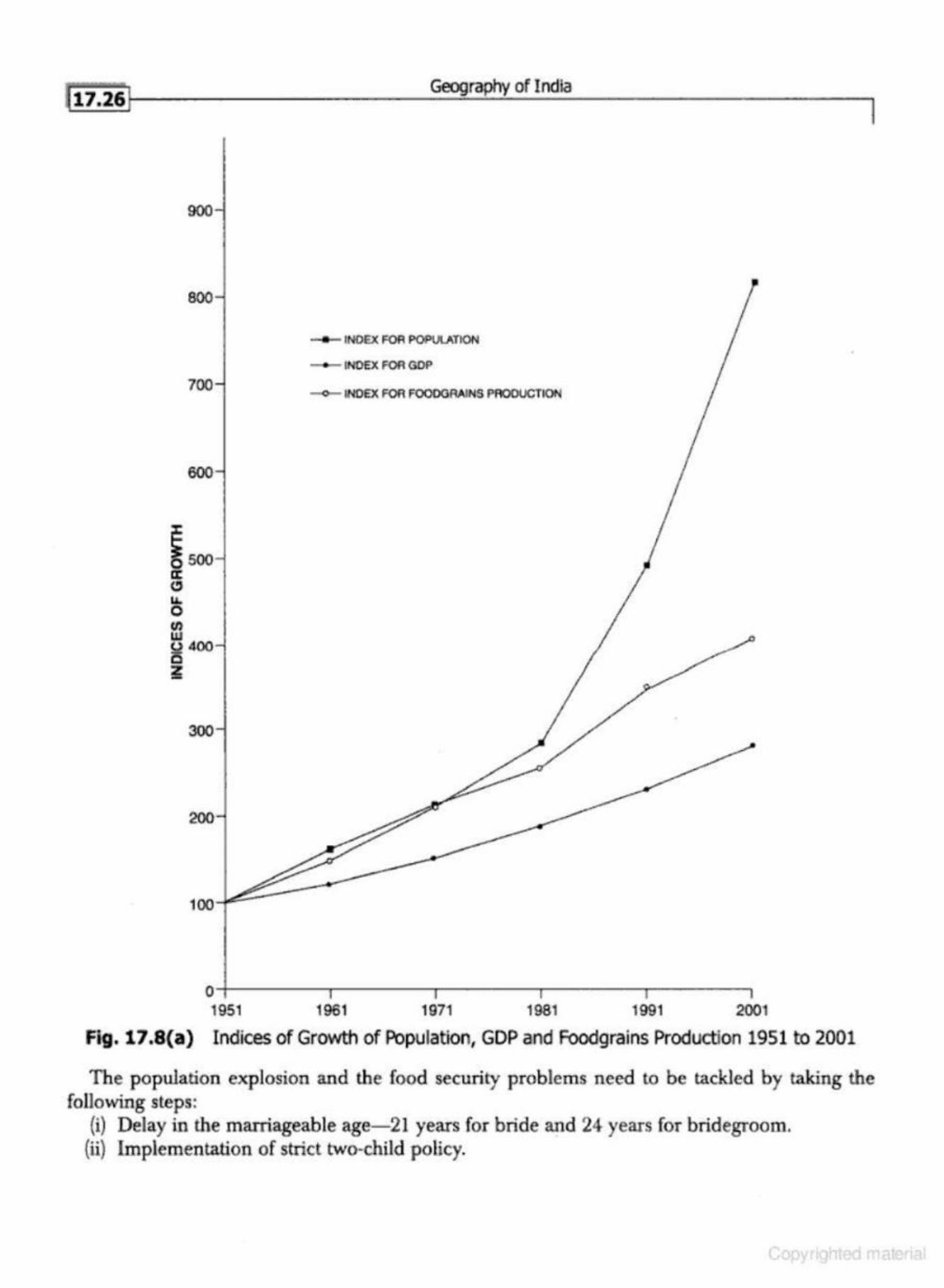
h7.26II--- ----- ----G_eog-=--ra.:.....ph...:..y_of_I_nd_la __________ __,
900
800
700
600
~ 500 a: (!) La. 0 C/1 w (.)400 i5 ~
300
200
100
• INOEX F<lA POP\A.ATION
- lNOEX F<lA GOP
-<>- lNOEX F<lA FOODGAAINS PROOtiCTION
o;--------.--------.--------.--------~-------,
1951 1961 1971 1981 1991 2001
Fig. 17 .8(a) Indices of Growth of Population, GDP and Foodgrains Production 1951 to 2001
The population explosion and the food security problems need to be tackled by taking the following steps:
(i) Delay in the marriageable age- 21 years for bride and 24 years for b ridegroom. {ii) Implementation of strict two-child policy.
I
1 r . Ge~~,ehy of India
4. /)iHpnrity in lmlwttriJJi GNJwth As taled above, the lnltiul distribution of induHtries was det.ermined by Lhe historical pr<>cesses reflected in the development of trun11port facilities and the interest of the British mlerR.
Thus. at th() time of Indt!pendence, we inherited a lopsided paltern of industrial dcvelopmcnl with mosl of the industries concentrated nl a few centres. Afier lndependencc, most of the indus· tries remained concentrated in Gujarcu and Maharll!lhtra.
The states of Punjab Md Ha.rya.nd. made tr(lmendous progr~~~~ in the agro-based industries afler Independence. The per capita consurnptlon of electricity was highest in Punjab, followed by Maharashtra and Gujarat. The under·developed !!tnleti of Blhnr, Madhya Pradesh, RnjilBlhan, and Uttar Fradesh remained way behind these states in industrial consumption of eleclriclty.
,r;, OiHfULrititi.H in 1\gritJulturu/ Cruwtb /Jtul DtJvtdopmtmt
After the introductinn of High Yielding Vnrietie!l of whenl and rice, the production and producllvily hali substant.lnlly Increased in Punjab, Haryana, western Uttar Prn,desh, Cujn.-nl, and Tumil Nudu. The perf<lrmance of agriculture is, however, much below in Bihar, Chhattisgarh,.Jha.rkhund, Madhya Pradesh, Orissa, and Rajaslhnn. The erratic and low performance of agriculture is aliecling the sumdurd of living of the people adversely.
6. IJi11pnriticN in l 'rivmo lnvostnwnts The flow of privu.Le lnve!ltment , both domestic and foreign, has been extremely biased in fnvour of the more developed regions/states of the country b~H:a.use these regions were having better infnulructuraJ facll!ues. The backward regions of the country, whlch were unable to attract rmy signifi cant private Investment flows, experienced decelert\tcd economic growlh during the po~Jt lndcpcndence period. The poor infrW!tructure and the poor law 11t1d order in the batkward stat~s dbcout'aged the private Investors.
If the post· Independence trend of socio·economic development continues, India will be highly uneven nation in terms of quality of life. Income nnd standard of llv!ng will vary considerably ncross the country. People in most of the southern rmd western parts of the country will be enjoying fairly high per capita incomell, which mny be comparnhle to those of middle income devel· oped countries toclny. The literacy rate will be high and the gender ditTereoce will d!sapper~r. The situation will be just Lhe reverse in the backward states.
Proflle of Regional Dl1paritJu for Different Growth Scenarios-2025
The historical nnd the post Independence trend11 show that dispnrilies are bound lo increru~e in the coming decades. The backward regions have very weak growth impulses. The backward stutes like Bihar, Madhya Pradesh, Orlt~sn , Rajasthan, and Uttar Pradesh have the demographic disnd· vnnmge. Because of fnsl growth of population in the backward 11tates, employment opportunities, social sector investments, nnd the overall development can be very slow.
RI!LAnONSHIP BI!TW!EN POPULATION AND D!V!LOPM!NT
Population and development are closely interrelated. Thet·e are a number of population traits that lnfl~lence developmenlal is.sue!i. In lhe same way, the developmental issues also affect the different traits of population. The wnys by which population issues are affected also vary from region to
..
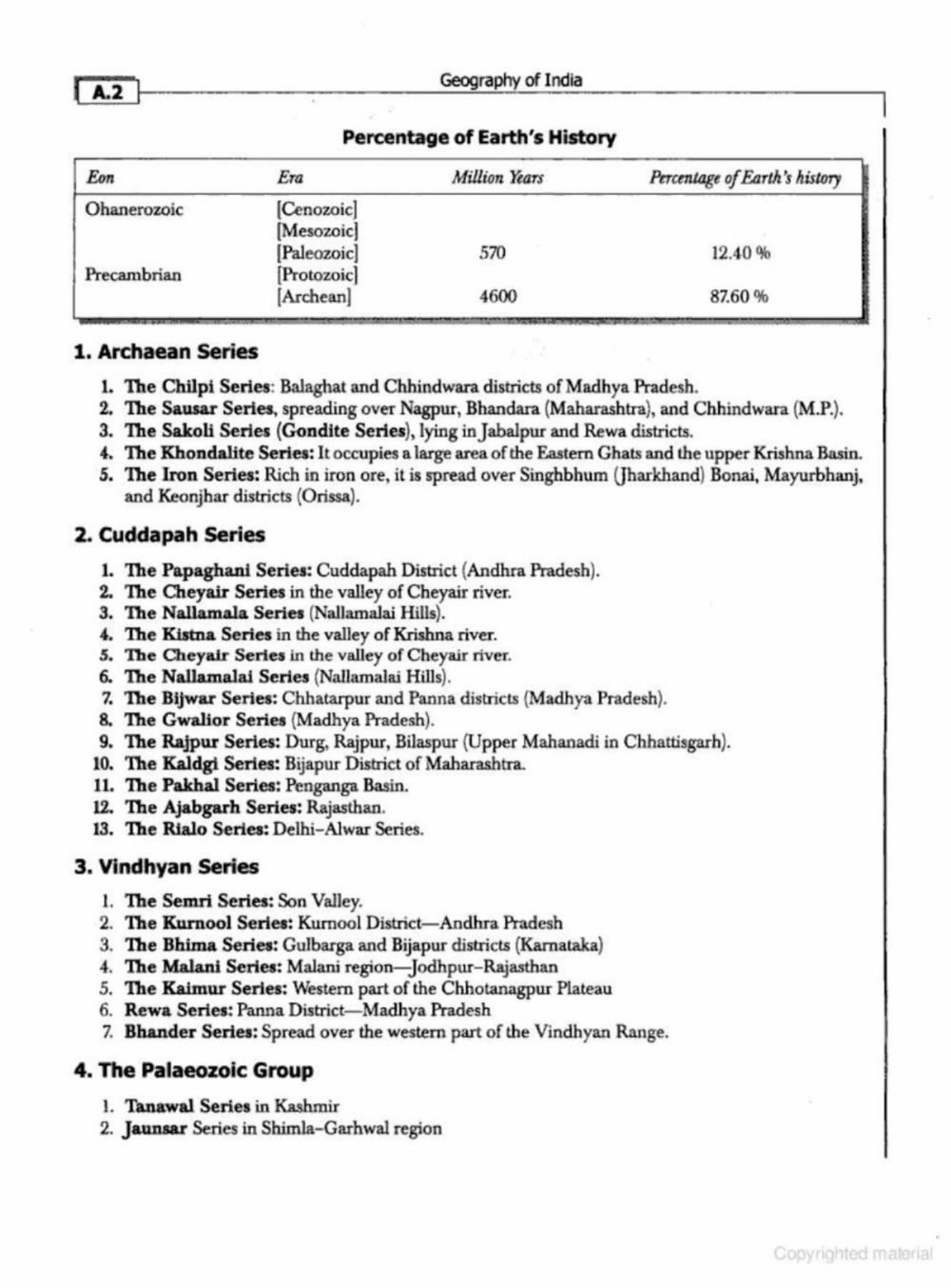
I A..2 Geography of India
Percentage of Earth's History
&m Era MiJJion Yean- Percentage of Earth's IUsJory
Ohanerozoic (Cenozoic) (Mesozoic] [P-aleozoic] 570 12.40 %
Pr-ecambrian (Pr-otozoic] [Archean] 4600 87.60 %
1. Archaean Series
1. The Chilpi Series: BaJaghat and Chhindwara districts of Madhya Pradesh. 2. The Sauaar Series, spreading over Nagpur, Bhandara {Maharashtra), and Chhindwara (M.P.). 3. The Sakoll Series (Gondlte Series}, lying inJabalpur and Rewa districts. 4. The Khondalite Series: It occupies a large area of the Eastem Ghats and the upper Krishna Basin. 5. The Iron Series: Rich in iron ore, it is spread over Singhbhum Qharkhand) Bonai, Mayurbhanj,
and Keonjhar districts (Orissa).
2. Cuddapah Series
1. The Papaghani Series: Cuddapah District {Andhra Pradesh). 2. The Cheyair Series in the valley of Cheyair river. S. The Nallamala Series (Nallamalai Hills). 4-. The Kbtna. Series in lhe valley of Krishna river. 5. The Cheyalr Series in the valley of Cheyair river. 6. The Nallamalal Series (Nallamalai Hills). 7. The Bijwar Series: Chhatarpur and Panna districts (Madhya Pradesh). 8. The Gwalior Series {Madhya Pr-adesh). 9. The Rajpu.r Series: Durg, Rajpur, Bilaspur (Upper Mahanadi in Chhattisgarh).
10. The Kaldgi Series: Bijapur District of Maharashtra. 11. The Pakha.J. Series~ Penganga. Basin. 12. The Ajabgarb Series: Rajasthan. 13. The Rlalo Series: Delhi- Alwar Series.
3. Vlndhyan Series
1. The Sem.ri Series: Son Valley. 2. The Kurnool Series: Kumool District-Andhra Pradesh 3. The Bhima Series: Gulbarga and Bijapur districts (Kamat.aka) 4. The Malani Series: Malam region-Jodhpur- Rajasthan 5. The Kaimu.r Series: Western part of the Chhotanagpur Plateau 6. Rewa Series: Panna District- Madhya Pradesh 7. Bhander Series: Spread over the western part of the Vindhyan Range.
4. The Palaeozoic Group
l. Tanawal Series in Kashmir 2. J allDsar Series in Shimla-Garhwal region
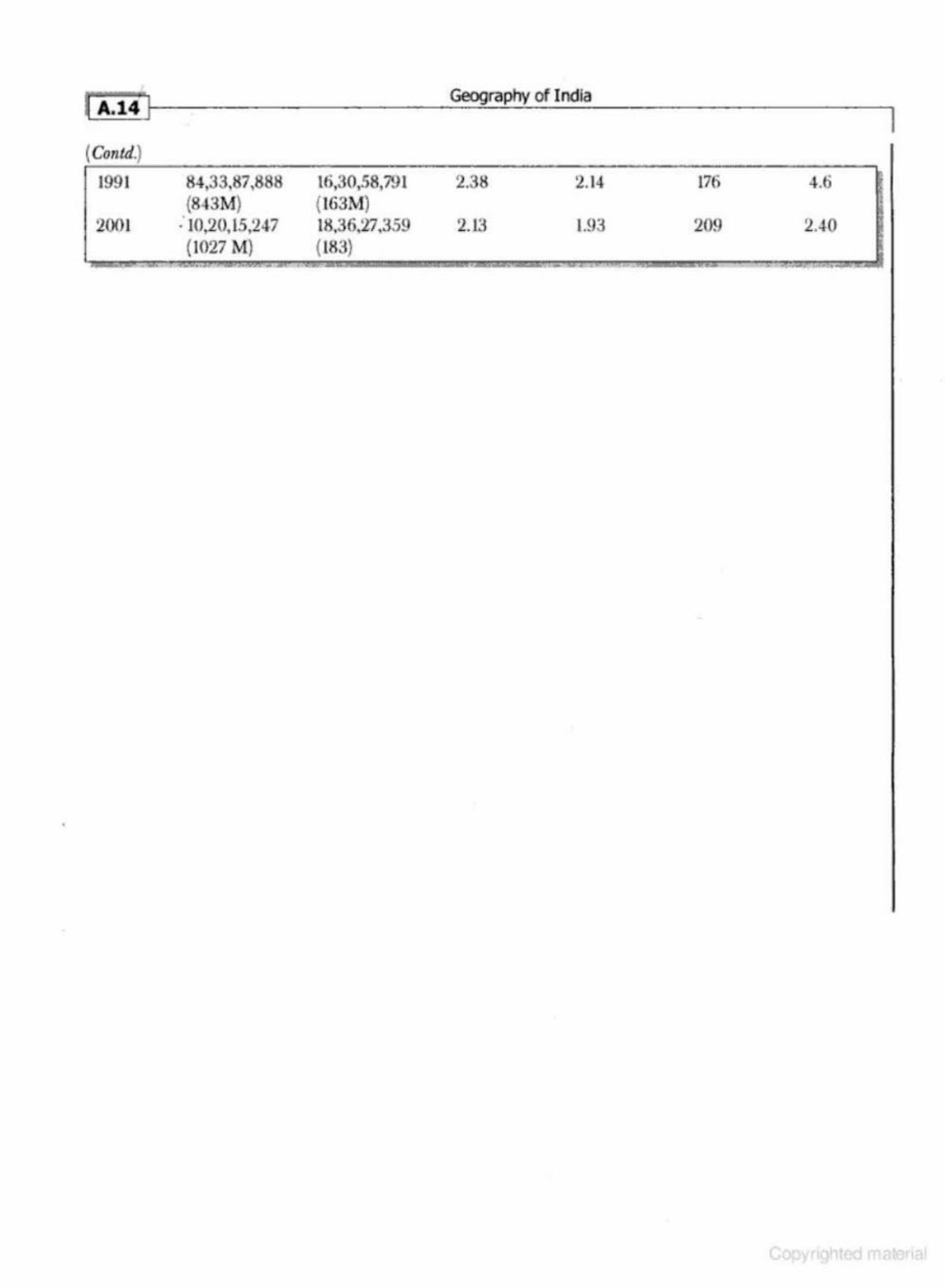
(Contd.)
1991
2001
84,33.87,888 (843M)
: 10,20,15,247 (1027 M) - .
l6,30,.S8,791 (163M) 18.36.27,359 (183)
Geography of I ndia
2.38 2.14 176 4.6
2.13 l.93 209 2.40
' .
I Written by a distinguished scholar and academician, with decades of teaching and writing experience, the book provides an insightful analysis of the geographical aspects of India. Replete with neatly drawn maps, tables and diagrams, the book is a comprehensive manual on geography of India that will be useful for graduates, postgraduates and aspirants appearing for the civil services examinations all over the country.
ISBN- 13: 976- 0- 07- 066772-3 ISBN-~0: 0-07-066772-1
Related Documents


