Geographic Information Geographic Information Systems Systems TIGER Data TIGER Data

Geographic Information Systems TIGER Data. 1 Street Unit ► Street segment ► Street segment - The range of addresses that run along a street from one intersection.
Dec 16, 2015
Welcome message from author
This document is posted to help you gain knowledge. Please leave a comment to let me know what you think about it! Share it to your friends and learn new things together.
Transcript

Geographic Information Geographic Information SystemsSystems
TIGER DataTIGER Data

1 Street Unit1 Street Unit► Street segment Street segment
- The range of addresses that run - The range of addresses that run along a street from one intersection along a street from one intersection to the next intersectionto the next intersection
► Address range Address range
- The range between the lowest - The range between the lowest possible house number at one possible house number at one intersection and the highest possible intersection and the highest possible house number at the other intersectionhouse number at the other intersection

2 Census Units2 Census Units
► Census tracts Census tracts ► Block groups Block groups ► Blocks Blocks
2 (1) Census Tracts2 (1) Census Tracts
► Defined by the U.S. Census Bureau for Defined by the U.S. Census Bureau for statistical reporting of demographic, statistical reporting of demographic, economic, and other data economic, and other data
► The boundaries follow major streets or The boundaries follow major streets or natural features natural features
► Population in each tract is Population in each tract is approximately approximately 4,0004,000 regardless of its regardless of its size size
► Census tracts are numbered consecutively Census tracts are numbered consecutively and unique within the jurisdictionand unique within the jurisdiction

2 Census Units2 Census Units ► Census tracts Census tracts

2 (2) Block Groups2 (2) Block Groups
► Comprise a population of Comprise a population of approximately approximately 1,5001,500
► Boundaries coterminous with census Boundaries coterminous with census tract boundariestract boundaries

Block groupsBlock groups
R Brancoto, SUNY BuffaloR Brancoto, SUNY Buffalo

2 (3) Blocks2 (3) Blocks
► Smallest geographic area formed by Smallest geographic area formed by streetstreet segmentssegments
► Coded by a Coded by a 4-digit4-digit number number
- The first one represents the block - The first one represents the block groupgroup
- The last three are consecutive and - The last three are consecutive and unique within a block group unique within a block group

Census Units ..Census Units ..
County
Census tract Block
group
Block
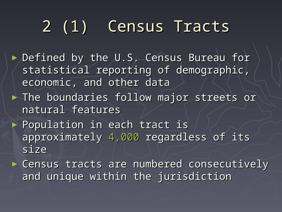
3. GBF/DIME Files3. GBF/DIME Files ► Geographic Base Files (GBF) Geographic Base Files (GBF) ► Dual Independent Map Encoding System Dual Independent Map Encoding System (DIME) (DIME) - A data format used by the U.S. Census A data format used by the U.S. Census Bureau to encode street network and Bureau to encode street network and related data for the 1980 Census. related data for the 1980 Census.
- It covers only the metropolitan areasIt covers only the metropolitan areas
- DIME was replaced by TIGER in 1990 - DIME was replaced by TIGER in 1990 censuscensus
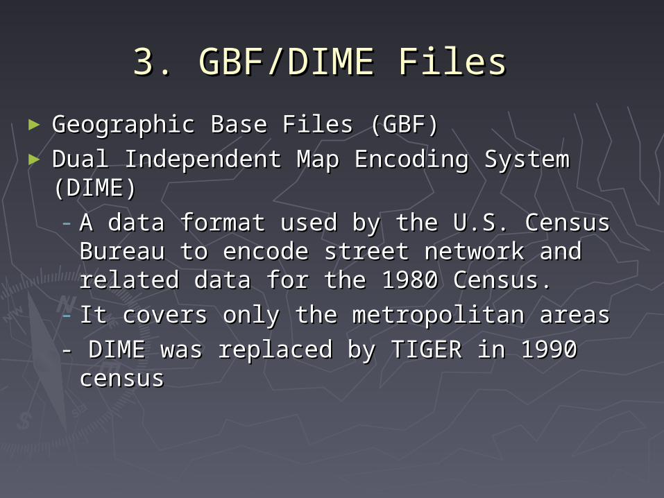
4 Vector (1) Non-Topological 4 Vector (1) Non-Topological StructureStructure
Storing coordinates of Storing coordinates of
two polygons: and two polygons: and
Polygon Polygon
xx11, y, y11; x; x22,y,y22;; xx33,y,y33; x; x44,y,y44; x; x55,y,y55; x; x11,y,y11..
PolygonPolygon
xx11, y, y11; x; x66,y,y66; x; x77,y,y77; ; xx22,y,y22;; xx11,y,y11..
(x1, y1) (x1, y1)
(x2, y2) (x2, y2)
A
B
1 2
1 2
1
2

4 Vector (2) Topological 4 Vector (2) Topological StructureStructure
Storing coordinates of two polygons: and Storing coordinates of two polygons: and
Line 1Line 1
xx11, y, y11; x; x22,y,y22; x; x33, y, y33; x; x44, y, y44; x; x55,y,y55; ; Line 2Line 2
xx11, y, y11; x; x55,y,y55; ; Line 3Line 3
xx55, y, y55; x; x66,y,y66; x; x77, y, y77; x; x11, y, y11;;
Polygon Line 1, Line 2Polygon Line 1, Line 2Polygon Line 2, Line 3Polygon Line 2, Line 3
(x1, y1) (x1, y1)
(x5, y5) (x5, y5)
1 2
1 2
1
2
Line 1
Line 2
Line 3


4. TIGER4. TIGER► Topologically Integrated Geographic Topologically Integrated Geographic Encoding and Referencing Files Encoding and Referencing Files (TIGER)(TIGER)
► Developed by the U.S. Census Bureau Developed by the U.S. Census Bureau for 1990 censusfor 1990 census
► The spatial and attribute processes The spatial and attribute processes were combined into one systemwere combined into one system
► A single seamless data set that A single seamless data set that covers the entire country covers the entire country
► Topologically structuredTopologically structured

TIGER Geographic FeaturesTIGER Geographic Features
► A combination of DIME and 1:100,000 Digital A combination of DIME and 1:100,000 Digital Line Graph Line Graph
► Uses Uses geographic coordinate systemgeographic coordinate system► Two types of data:Two types of data:
- a tabular form of demographic, social, - a tabular form of demographic, social, economic economic
statisticsstatistics
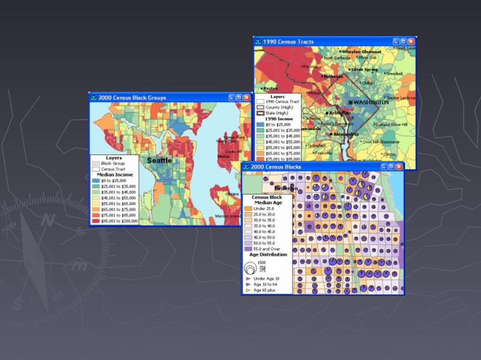
- a GIS form- a GIS form► Aggregated informationAggregated information is available is available at the at the block group level, few at the block levelblock group level, few at the block level

TIGER Geographic TIGER Geographic Features ..Features ..
► GIS data are available as both GIS data are available as both polygon data and line datapolygon data and line data
► The polygon data contain the The polygon data contain the population information in tracts, population information in tracts, block groups, and blocksblock groups, and blocks
► The line data contain streets and The line data contain streets and utility lines informationutility lines information
► The data have spatial locations, The data have spatial locations, attributes, and topologyattributes, and topology

TIGER ..TIGER ..
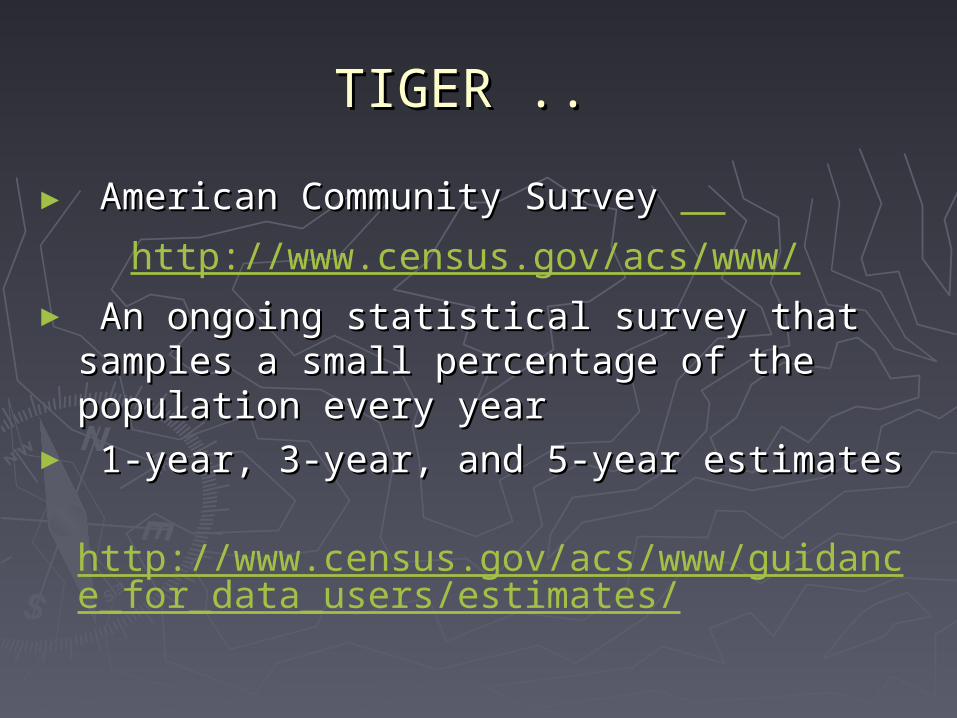
TIGER ..TIGER ..
► American Community Survey American Community Survey
http://www.census.gov/acs/www/► An ongoing statistical survey that An ongoing statistical survey that samples a small percentage of the samples a small percentage of the population every year population every year
► 1-year, 3-year, and 5-year estimates 1-year, 3-year, and 5-year estimates
http://www.census.gov/acs/www/guidance_for_data_users/estimates/

5. Applications of TIGER 5. Applications of TIGER Data Data
► Address matchingAddress matching► Network analysis Network analysis ► District delineation District delineation

Address Matching (line Address Matching (line data)data)

Address Matching ..Address Matching ..
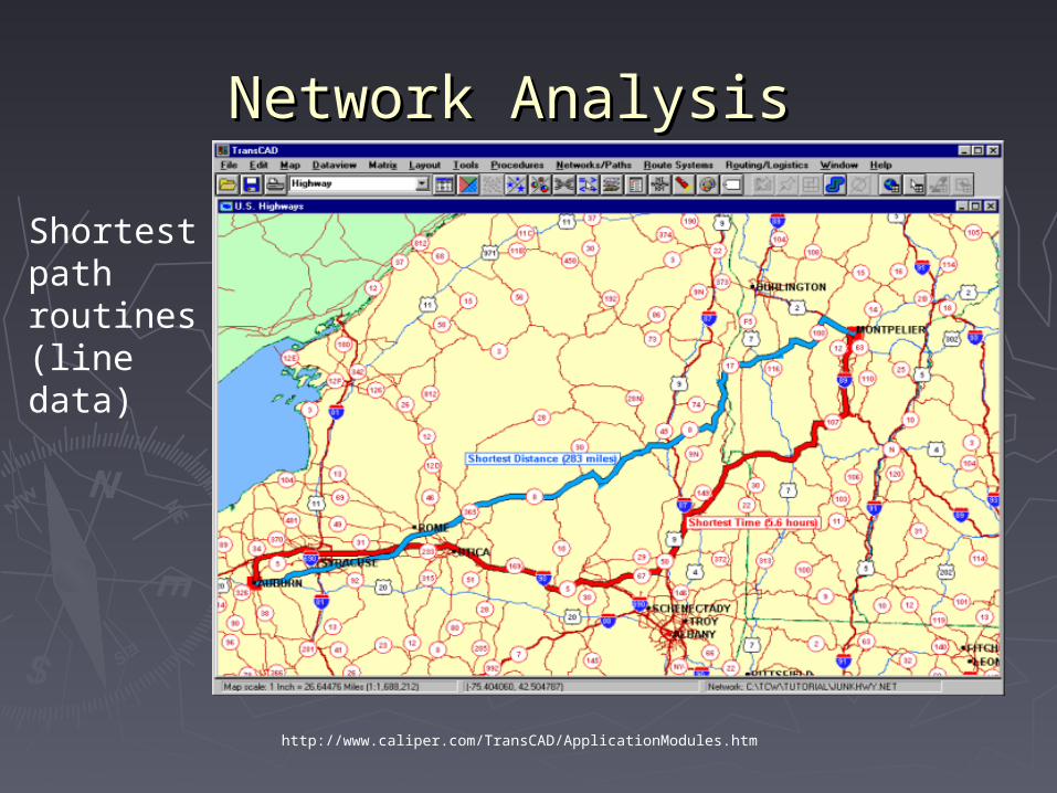
Network AnalysisNetwork Analysis
Shortest path routines(line data)
http://www.caliper.com/TransCAD/ApplicationModules.htm

Network Analysis ..Network Analysis ..
SalespersonProblem(line data)
http://www.caliper.com/TransCAD/ApplicationModules.htm

Network Analysis ..Network Analysis ..
Location allocation(Line and polygon data)
http://www.caliper.com/TransCAD/ApplicationModules.htm

Districting DelineationDistricting Delineation
Political redistricting (polygon data)

ReadingsReadings
► Chapter 3Chapter 3
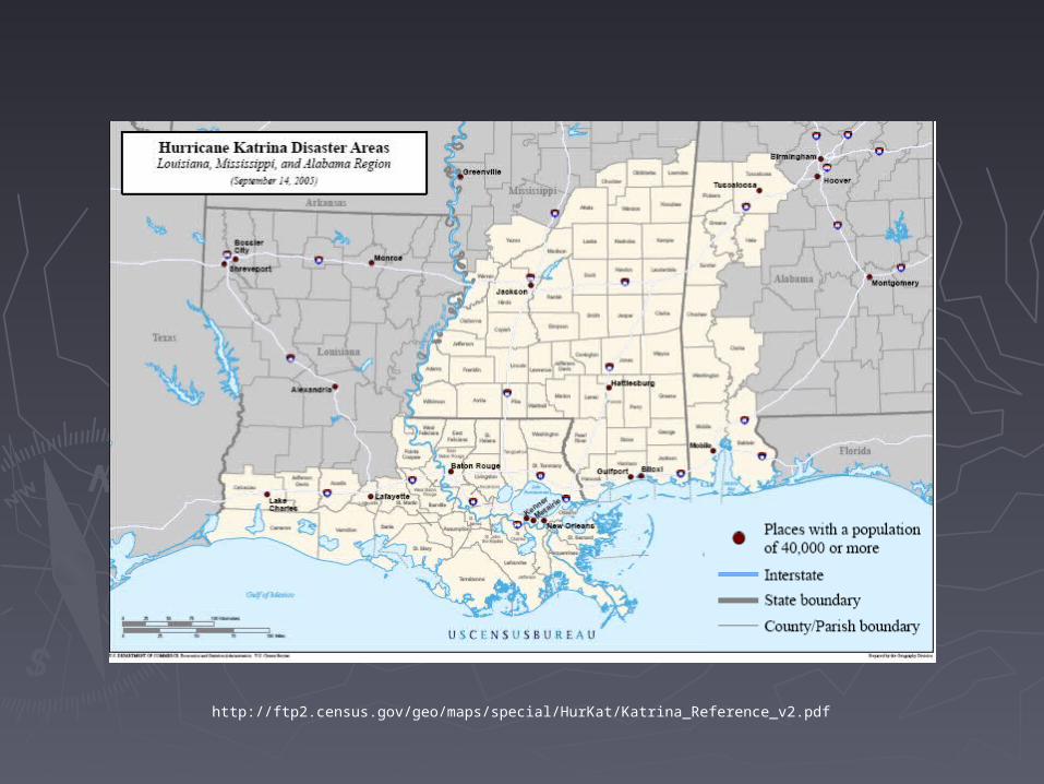
http://ftp2.census.gov/geo/maps/special/HurKat/Katrina_Reference_v2.pdf

4. TIGER4. TIGER
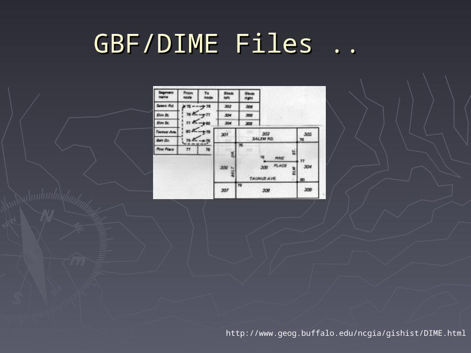
GBF/DIME Files ..GBF/DIME Files ..
http://www.geog.buffalo.edu/ncgia/gishist/DIME.html
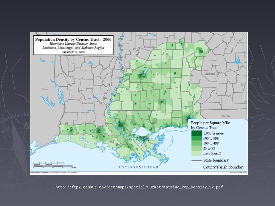
http://ftp2.census.gov/geo/maps/special/HurKat/Katrina_Pop_Density_v2.pdf

http://ftp2.census.gov/geo/maps/special/HurKat/Katrina_Housing_Units_v2.pdf

http://ftp2.census.gov/geo/maps/special/HurKat/Katrina_Poverty_Rate_v2.pdf

http://ftp2.census.gov/geo/maps/special/HurKat/Katrina_Pop_Under_18_v2.pdf
Related Documents