www.fando.com Creating Works of Life Inastructure A geographic information system (GIS) provides the base for accurate integration of data. It is used to gather, manage, and analyze data based on geographical location. This data is analyzed, revealing relationships that lead to informed and sound engineering decisions. Our teams utilize GIS for a host of services, including transportation, brownfields remediation, stormwater planning, utilities, water/wastewater, site planning, land assessment, watershed management, and land survey. Application of GIS is widespread. Harnessing the power of this tool helps our multidisciplinary teams develop a complete operational picture in the early stages of a project - saving time and money on the back end of the project. GIS provides pinpoint graphical representations of sites, denoting site features including roads, rivers, and utilities, as well as abstract features such as political boundaries or service areas. en, data is organized based on location, and this organization is transformed into a map, displaying spatial relationships and influences not typically presented via traditional methods. Utility Projects - New England • Prepared GIS mapping for optical ground wire replacement to comply with MESA requirements. • Prepared GIS mapping for storm hardening of structures. • Utilized GIS mapping to depict identified species for NHESP reporting. • Provided GIS mapping for linear resiliency projects. Campus Projects - Connecticut • Developed GIS standards for operations/facilities department and developed a GIS needs assessment and implementation plan at University of Hartford. • Compiled/hosted GIS information, provided on-call services for mapping tasks, provided GIS aerial and control survey, and provided GIS training to UConn. Geographic Information System (GIS) Experience RELEVANT GIS PROJECTS Environment Community HOSTING WEB APPS DASHBOARDS DATA COLLECTION Our proprietary databases can provide clients and contractors data they can view and edit. Provides location-aware data visualization and analytics for a real-time operational view. View activities and key performance indicators most vital to meeting your organization’s objectives. We can collect data for you or provide you with a mobile app to efficiently obtain vital data.

Welcome message from author
This document is posted to help you gain knowledge. Please leave a comment to let me know what you think about it! Share it to your friends and learn new things together.
Transcript

www.fando.com
Creating Works of Life
Infrastructure
A geographic information system (GIS) provides the base for accurate integration of data. It is used to gather, manage, and analyze data based on geographical location. This data is analyzed, revealing relationships that lead to informed and sound engineering decisions. Our teams utilize GIS for a host of services, including transportation, brownfields remediation, stormwater planning, utilities, water/wastewater, site planning, land assessment, watershed management, and land survey.
Application of GIS is widespread. Harnessing the power of this tool helps our multidisciplinary teams develop a complete operational picture in the early stages of a project - saving time and money on the back end of the project. GIS provides pinpoint graphical representations of sites, denoting site features including roads, rivers, and utilities, as well as abstract features such as political boundaries or service areas. Then, data is organized based on location, and this organization is transformed into a map, displaying spatial relationships and influences not typically presented via traditional methods.
Utility Projects - New England• Prepared GIS mapping for optical ground wire
replacement to comply with MESA requirements.
• Prepared GIS mapping for storm hardening of structures.
• Utilized GIS mapping to depict identified species for
NHESP reporting.
• Provided GIS mapping for linear resiliency projects.
Campus Projects - Connecticut• Developed GIS standards for operations/facilities
department and developed a GIS needs assessment and
implementation plan at University of Hartford.
• Compiled/hosted GIS information, provided on-call
services for mapping tasks, provided GIS aerial and
control survey, and provided GIS training to UConn.
Geographic Information System (GIS) Experience
RELEVANT GIS PROJECTS
Environm
ent
Com
munity
HOSTING WEB APPS DASHBOARDS DATA COLLECTION
Our proprietary databases can provide clients and contractors data they can view and edit.
Provides location-aware data visualization and analytics for a real-time operational view. View activities and key performance indicators most vital to meeting your organization’s objectives.
We can collect data for you or provide you with a mobile app to efficiently obtain vital data.
www.fando.com
Creating Works of Life
Brownfields Projects - Rhode Island• Used GIS-based data to develop a comprehensive
brownfields inventory dataset that was integrated into
the Woonsocket’s GIS database.
• Compiled GIS-based inventory of potential brownfields
sites for Cranston.
• Created GIS-based data mapping for sites via RIDEM
brownfields on-call contract.
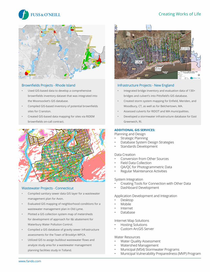
Infrastructure Projects - New England• Integrated bridge inventory and evaluation data of 130+
bridges and culvert’s into Pittsfield’s GIS database.
• Created storm system mapping for Enfield, Meriden, and
Woodbury, CT, as well as for Belchertown, MA.
• Assessed culverts for RIDOT and MA municipalities.
• Developed a stormwater infrastructure database for East
Greenwich, RI.
Wastewater Projects - Connecticut• Compiled sanitary sewer data GIS layer for a wastewater
management plan for Avon.
• Evaluated GIS mapping of neighborhood conditions for a
wastewater management plan in Old Lyme.
• Plotted a GIS collection system map of metersheds
for development of approach for I&I abatement for
Waterbury Water Pollution Control.
• Compiled a GIS database of gravity sewer infrastructure
assessments for the Town of Brooklyn WPCA.
• Utilized GIS to assign buildout wastewater flows and
analyze study area for a wastewater management
planning facilities study in Tolland.
ADDITIONAL GIS SERVICES:Planning and Design• Strategic Planning• Database System Design Strategies• Standards Development
Data Creation• Conversion from Other Sources• Field Data Collection• QA/QC for Photogrammetric Data• Regular Maintenance Activities
System Integration• Creating Tools for Connection with Other Data• Dashboard Development
Application Development and Integration• Desktop• Mobile• Internet• Database
Internet Map Solutions• Hosting Solutions• Custom ArcGIS Server
Water Resources• Water Quality Assessment• Watershed Management• Municipal (MS4) Stormwater Programs• Municipal Vulnerability Preparedness (MVP) Program
Related Documents
![Geographic Information System [GIS]](https://static.cupdf.com/doc/110x72/56813e57550346895da84a4e/geographic-information-system-gis-568e78fe5e678.jpg)