1 GEOGRAPHIC INFORMATION MANAGEMENT SYSTEM FOR REVIEW AND REPORTING OF ECOLOGICAL RISKS TO THE ENVIRONMENT Davorin Bajic, Goran Trbic, Dragan Matic, Igor Lastric, Marko Ivanisevic Corresponding author: Davorin Bajic, PhD. University of Banja Luka, Faculty of Science. Mladena Stojanovica 2, 78 000 Banja Luka, Bosnia and Herzegovina. [email protected] Goran Trbic, PhD. University of Banja Luka, Faculty of Science. Mladena Stojanovica 2, 78 000 Banja Luka, Bosnia and Herzegovina. [email protected] Dragan Matic, PhD. University of Banja Luka, Faculty of Science. Mladena Stojanovica 2, 78 000 Banja Luka, Bosnia and Herzegovina. [email protected] Igor Lastric, B. Sc. Software Solution d.o.o. Bul. Desanke Maksimovic 10, 78000 B. Luka, Bosnia and Herzegovina. [email protected] Marko Ivanisevic, B. Sc. University of Banja Luka, Faculty of Science. Mladena Stojanovica 2, 78 000 Banja Luka, Bosnia and Herzegovina. [email protected] Abstract: This paper outlines the progression of the Geographic Information Management System (GIMS) project that is currently implemented in the Republic of Srpska (Bosnia and Herzegovina) for the review and reporting of ecological risks to the environment. The project has been implemented under the name REeko. The primary role of REeko is improving systems for reporting, monitoring and managing ecological risks. It is particularly concerned with the illegal disposal of waste that poses a large environmental threat in Bosnia and Herzegovina. REeko is an organizational and informational system. In the organizational sense, the project includes the public institutions: The Environmental Protection and Energy Efficiency Fund of the Republic of Srpska (the central institution of the REeko system) and the municipalities of the Republic of Srpska (the final institution involved in the REeko system). In the informational sense, REeko is developed as a centralized WEB platform that allows for a simple and efficient means of use. The general public and authorized institutions are the two predominant users of the REeko system. REeko assists the public by providing an easy means for reporting ecological risks within their local environment. It also assists authorized institutions in monitoring and managing these risks. Key Words: GIS, GIMS, REeko, environment, ecological risk, Republic of Srpska.

Welcome message from author
This document is posted to help you gain knowledge. Please leave a comment to let me know what you think about it! Share it to your friends and learn new things together.
Transcript
1
GEOGRAPHIC INFORMATION MANAGEMENT SYSTEM FOR REVIEW AND
REPORTING OF ECOLOGICAL RISKS TO THE ENVIRONMENT
Davorin Bajic, Goran Trbic, Dragan Matic, Igor Lastric, Marko Ivanisevic
Corresponding author: Davorin Bajic, PhD. University of Banja Luka, Faculty of Science. Mladena
Stojanovica 2, 78 000 Banja Luka, Bosnia and Herzegovina. [email protected]
Goran Trbic, PhD. University of Banja Luka, Faculty of Science. Mladena Stojanovica 2, 78 000
Banja Luka, Bosnia and Herzegovina. [email protected]
Dragan Matic, PhD. University of Banja Luka, Faculty of Science. Mladena Stojanovica 2, 78 000
Banja Luka, Bosnia and Herzegovina. [email protected]
Igor Lastric, B. Sc. Software Solution d.o.o. Bul. Desanke Maksimovic 10, 78000 B. Luka, Bosnia
and Herzegovina. [email protected]
Marko Ivanisevic, B. Sc. University of Banja Luka, Faculty of Science. Mladena Stojanovica 2, 78
000 Banja Luka, Bosnia and Herzegovina. [email protected]
Abstract: This paper outlines the progression of the Geographic Information Management System
(GIMS) project that is currently implemented in the Republic of Srpska (Bosnia and Herzegovina) for
the review and reporting of ecological risks to the environment. The project has been implemented
under the name REeko. The primary role of REeko is improving systems for reporting, monitoring and
managing ecological risks. It is particularly concerned with the illegal disposal of waste that poses a
large environmental threat in Bosnia and Herzegovina. REeko is an organizational and informational
system. In the organizational sense, the project includes the public institutions: The Environmental
Protection and Energy Efficiency Fund of the Republic of Srpska (the central institution of the REeko
system) and the municipalities of the Republic of Srpska (the final institution involved in the REeko
system). In the informational sense, REeko is developed as a centralized WEB platform that allows for
a simple and efficient means of use. The general public and authorized institutions are the two
predominant users of the REeko system. REeko assists the public by providing an easy means for
reporting ecological risks within their local environment. It also assists authorized institutions in
monitoring and managing these risks.
Key Words: GIS, GIMS, REeko, environment, ecological risk, Republic of Srpska.

2
Introduction
The use of information and communication technology (ICT) has an immense impact on the
environment. In today’s technological, economically and socially progressive world, environmental
data collection, risk management, decision making and reporting would not be possible without the use
of ICT. The evolution of ICT has lead to the emergence of informational systems (IS) that are
customized for environmental management, referred to as Environmental management information
systems (EMIS). EMIS can be defined as an “organizational technological system for the systematic
collection, processing and distribution of relevant information about the environment " (El-Gayar &
Fritz 2006).
In recent times a lot of attention has been focused on the use of geographic information systems (GIS)
in the field of environmental management. GIS can be defined as an informational system designed for
collection, distribution, processing, analysis, management and presentation of geographic information
(Foote & Lynch 1995). Environmental management is in large part a local operation (Berry 1999). In
addition to determining the phisical, chemical or biological properties of the phenomnon which are
observed in the enviroment, it is also vital to establish the location of the described and observed
occurance during the management processes. The collection, processing, analysis and distribution of
spatial information regarding envirmontal developments is essential in the process of environmental
management as it allows for grater managment efficency. It promotes timely and relevant decision
making concerning the improvement and conservation of the enviroment. In the area of enviromental
management, GIS technolgy has shown to be a powerful tool. The significance of GIS and its practical
models of application in enviromental managment are described in a large number of recent reports
(Brown et al. 2002, Kubásek 2013, Morita & Takagishi 2002, Tasaki et al. 2007, Kubásek & Hřebíček
2013).
Although it is not yet defined in scientific works, the use of the term Geographic Informational
Management System (GIMS) has emerged in recent times.
It has arisen from basic characteristics and definitions of Management Information Systems (MIS),
such as:
MIS is an information system that improves management by providing reports in appropriate
and systematic manner (Kroneke & Hatch 1994).
MIS is a system that supports management in functional fields (Brown 2002).
MIS is often used in place of the term System for Decision Support (Veljković 2008).
MIS can be defined as an information system that provides information for users with similar
needs. The main purpose of the Management Information Systems is to provide managers
with the information they need to make decisions and solve problems. Management
Information Systems are supported by corporate databases, which include data generated by
transaction processing (Alcamí & Carañana 2012).
Hence, taking into account the basic properties of GIS, the term GIMS can be characterized as:
A system that manipulates spatial information.

3
A system that is improving processes of management and decision-making in areas concerned
with research, use and protection of resources that have physical signs.
The Information-Communicational set of procedures is used for the collection, storage,
processing, analysis and distribution of spatial information. It shouldprovide analysts,
managers and institutions accesses to relevant decision making information in a fast,
understandable and consistent way. It should also provide information regarding predictions
in the field of management and the use and conservation of spatial recourses.
It can be concluded that the term GIMS can be used to emphasize the role of GIS in the management
and decision-making processes.
It is appropriate to apply GIMS to the environmental field. The effectiveness of monitoring and
management of the environment is in a large part dependent on the availability and quality of
information used in the management and decision-making process. Thus GIMS can provide efficient
collection of and rapid access to relevant information.
This paper presents a review of the GIMS, which is intended for the centralized collection of
information on environmental risks (illegal waste dumps, illegal wastewater discharge and natural
hazard such as landslides etc.). This is done in the form of public reports and the forwarding of this
information to relevant departments. The GIMS discussed in this report is has been implemented as a
pilot project but it should become the official system for collecting information regarding
environmental risks in the Republic of Srpska. (the administrative-territorial organization of Bosnia
and Herzegovina consists of Republic of Srpska, the Federation of Bosnia and Herzegovina and the
district of Brcko).
Bosnia and Herzegovina is confronted with a large number of environmental risks. Primarily, a large
number of illegal waste dumps of various sorts (construction, industrial, organic, household waste,
etc.). Preliminary research (creating a GIS database and mapping polluters along the Vrbas river-
http://gis.pmfbl.org/vrbas/) found a large number of potential high-risk locations. Specifically, along
the 235 km stretch of the Vrbas River, 307 high-risk locations were identified; of which 115 were
illegal waste dumps and 192 were illegal waste water discharge locations. The intensity and type of
waste that has been observed as well as the emergence of new ‘hot-spots’ indicates a significant
environmental risk. This poses considerable degrading effects on the environment in the Republic of
Srpska and Bosnia and Herzegovina. Addressing the identified problem is a priority. Finding a solution
to this issue would result in environmental improvements as well as generate potential for the use of
recycled waste as a resource.
The factors that lead to environmental risk locations in Bosnia and Herzegovina include: poor
municipal collection systems and waste disposal, poor financial state of the local council in charge of
waste management, a lack of control over inspectional organizations, a lack of awareness among the
population about the need for proper waste disposal, a lack of recycling systems etc. These issues are
in part due to the absence of a system for reviewing, reporting and monitoring environmental risks. As
previously outlined, REeko is a system within the GIMS that is concerned with reviewing and

4
reporting ecological risks in the environment (REeko). REeko has developed from the Environmental
Protection and Energy Efficiency Fund of the Republic of Srpska (EPEEF). The system was developed
as a pilot project and is currently in a test phase. It is a unique system as it is fully adapted to monitor
and manage environmental risks. The development of the REeko system was launched in early 2013
and implemented in early 2014 when the website was established (http://reeko.ekofondrs.org).
Method
The development of the REeko system is based on the general developmental methodology of IS. The
‘Waterfall’ model of the ‘Life Cycle’ methodology is utilized (Isaias & Issa 2015). Figure 1 displays
the initial developmental steps of IS based on the ‘Waterfall’ model. This model provides a step-by-
step analysis of IS development, from the identification of needs to the implementation of solutions.
Figure 1. Life Cycle - Waterfall model development of IS
The first step of the development of the REeko system was problem identification (Fig. 1). As
previously outlined in preliminary research, the illegal waste disposal and water discharge by citizens
has been a major problem in Bosnia and Herzegovina. On the other hand, interviews have been
conducted with representatives of relevant authority organizations involved in the environmental field
(EPEEF, mayors, inspection services and municipal utilities). The interviews identified a need for
establishing a more efficient system for reporting, reviewing and monitoring ecological risks to the
environment. Thus it was concluded that the relevant municipal departments do not have an effective
system of identifying ecological-risk areas in the environment. The problem is particularly concerning
due to the vapidly escalating emergence of new ecological risk location. The interviews have resulted
in an agreement to launch the development of GIMS for the review and reporting of environmental
risks.
The second step (Fig. 1) involved designing the REeko GIMS by defining its structure. The users of
the system were first identified. REeko has two groups of users, the public and administrative
institutions. REeko provides the public with an easy method of reporting and reviewing ecological risk
in the environment and offers them feedback in response to their complaints from relevant services

5
(EPEEF, municipal services). REeko provides administrative services with an inventory of ecological
risk locations, allowing them to monitor the dynamics of their formation. This enables a timely
response to and elimination of the problem. The administrative sector is divided into two sections, the
central institution (EPEEF) and the municipalities. The REeko system is primarily designed for citizens
and local services in order to enable environmental improvement within their communities. Due to the
large number of municipalities, it would be organizationally complex and economically unjustified to
develop GIMS in them all. Therefor, EPEEF is legally responsible for environmental data collection in
the Republic of Srpska. In occurrence with the reasons listed above, the decision was made to improve
the development of a centralized GIMS, with EPEEF acting as the central institution and the
municipality acting as the final authority in the process.
Following the identification of system users, the next step is determining the functions of the system
that are necessary in order to satisfy the needs of the users. It was established that the REeko system is
required to fulfill the following needs:
Provide the public with a simple means for reporting ecological risk in the environment via
the Internet and mobile applications.
Provide the public with a simple investigation and review ,with the possibility of monitoring
the status of each application, in terms of activity and the level of implementation by the
relevant services.
Enable relevant departments to efficiently analyze and processes reports via specially
designed administrative tools.
Allows relevant departments to easily locate registered areas.
Enable reports to be collected in a centralized database.
Due to the large number of users, the system should be based on the WEB in order to allow
easy access and use.
The system structure has been designed based on the identified users and functions of the REeko
system. REeko is defined as an organizational-informational system, which means that is it has an
organizational and informational structure.
In an organizational sense the users of the system are; the central institution (the ‘heart’ of the system)
that receives and forwards reports and the relevant municipal services that react to these reports and
forwards them to the central system (Fig. 2). In organizational sense there is an established and
precisely defined procedure that is used for processing all reports. This is done in order maintain the
competence of all segments within the organizational system.
All reports that are made by the public are reviewed by administrators within the central institution
(EPEEF). If a report is validated, it is then forwarded to a relevant municipality. After reports are
forwarded from the central institution, they become visible on the administrative interfaces in the
areas where the applications were sent. The administrators are then required to print the reports and
forward them to appropriate environmental services (inspection and utility services). The services that
receive the reports are required to visit the area in question, establish facts and initiate proceedings that

6
aimed at resolving the issue. Following this, municipal authorities return the report to the
administrators in the municipality who then input the information into the REeko system.
Figure 2. The organizational structure of the REeko system
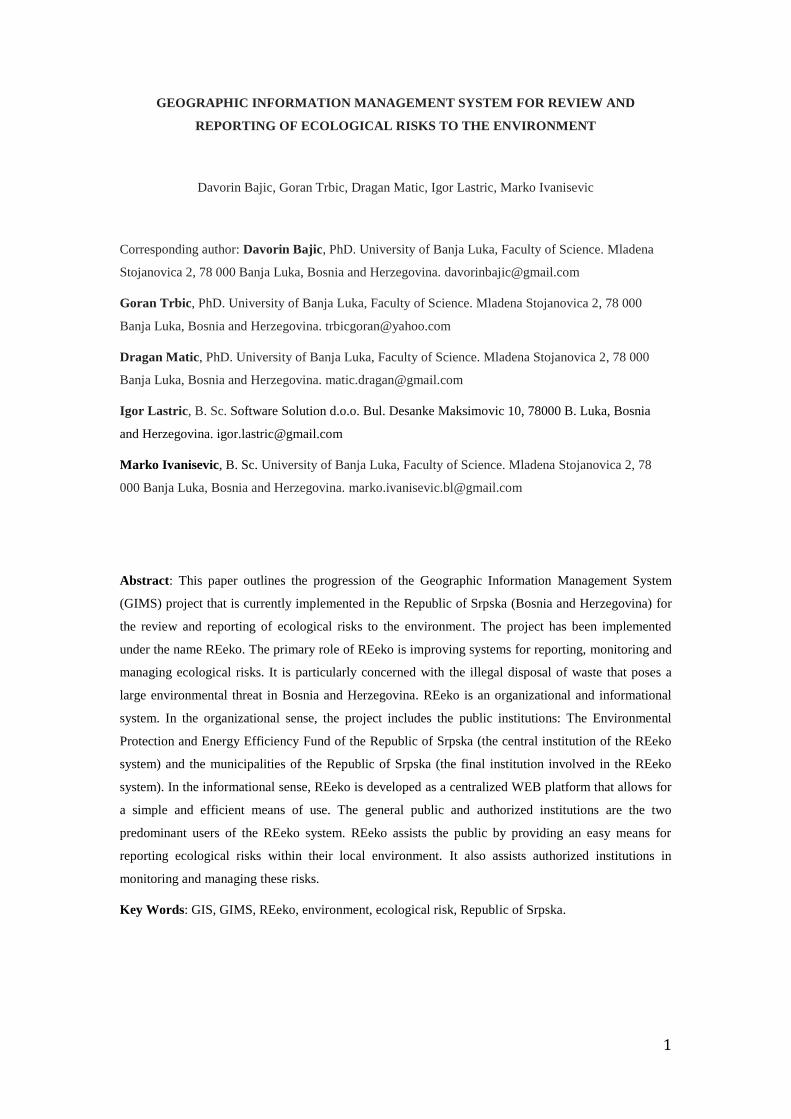
The informational structure (Fig. 3) is designed in accordance with the defined organizational structure
and the necessary functions of the system. In regards to the ICT, REeko is fully developed as a web
platform that also has the support of mobile devices such as native Android applications. ICTs focus on
WEB and mobile application provides the public and relevant institutions with a simple and functional
means of use. The WEB based structure of the system enables the development of a centralized system,
which was an initial aim. The complete system has been developed on a separate server in EPEEF.
The informational structure of the REeko system has caracter 2-tier architecture (Fig. 3) that consists
of: database layer and application layer.
The database layer is designed to enable the implementation of all the defined functions of the system.
This layer consists of six separate entities/tables (Reports, Spatial Information, Security, Users,
Administration and News), connected to a single database via the Database Management System
(DBMS).
Public reports are stored in the Reports table. For each report, the following data is generated: Type
(the type of ecological risk - waste dumps, waste water, other), Photo (Photograph of location)
Description (Description of perceived risk), Date (date of report), Municipality (Municipality of the
registered location), Geometry (the geographic coordinates of the registered location), Status (the status
of the report – in process, verified, forwarded, completed) and Remark (notices regarding the
processing of reports). Type, Photo and Description are forms that are filled out by public users. Date,
7
Municipality and Geometry are automatically generated. Status and Remark are forms that are filled
out or altered by administrators depending on the status of the report.
Figure 3. The informational structure of the REeko system
Spatial information tables contain the borders of municipalities in the REeko system, stored in the form
of geometric data types (multipolygon). The function of this table is two-fold. It prevents reports from
areas that are not included in the REeko system. It alsoenables the identification of reported locations
and determines the municipality to which they belong.

8
The application level generates data regarding the location from which all WEB and mobile reports are
sent. The application then sends this information to the Spatial Information table, which determines the
municipality that corresponds with the location from which the report was sent. This is done by means
of "point in polygon". If the report is received from within borders covered by the REeko system, it is
then sent to the Report table, where on the basis of prior identification (belonging to a given
polygon/municipality) the municipality to which the report location belongs is automatically generated.
The Security component of DBMS is involved in anti-SPAM protection systems and blocking
unauthorized accounts from which fraudulent reports could be sent.
Users and Administration are separate databases where information about user reports and their
authenticity are stored.
News is an entity that records news and information related to the REeko system.
The application layer consists of two parts that are dependent on the type of application: WEB services
or mobile applications (Native Android Application). The user level is divided into: user service and
administrator service. Administrator services can be differentiated by: Administrator services in the
central institution and administrator services that are used by municipalities. Each of mentioned
services are tailored to the specific needs of individual user groups.
The third step (Fig. 2) initiates the development of GIMS. In the developmental stage, two actions are
carried out: configuring the database and writing the code for the application section of the system. The
complete REeko system was developed on open-source tools as well as on the Linux distribution open-
source operating system (Debian - https://www.debian.org/). The software support used for the
development of DBSM is based on the MySQL underlying database (https://www.mysql.com/). The
Apache system is used as the WEB server software (http://www.apache.org/). The communication
service application layer and the database layer are coded in PHP programming language
(http://php.net/). The application layer is developed in the following programming languages:
Javascript, JQuery, CSS, HTML.
Following the implementation of the previously mentioned steps, the REeko system testing processes
begins. Tests were conducted on all system components such as the organizational and informational
systems. Since there were no significant deficiencies observed, the implementation and public
promotion of the REeko system was initiated.
Results and discussions
An organization-information system was developed based on the described methodology. This system
enables the collection, recording, storage, transfer and analysis of information. It also enables
monitoring and management of ecological risks in the environment. Conceptually, REeko is based on
the principles of the geographic information systems. Determining all spatial information that enters
the REeko system resulted in the initiation of all software applications that are in accordance with GIS

9
principals. Given the purpose and functions of the system as well as its base in GIS, this developed
system can be characterized as a GIMS.
The overall results that have emerged from the development of the REeko system are:
An improved system for the collection of information on environmental risks;
An improved system for monitoring and managing environmental risks;
An efficient method of raising public awareness regarding the consequences that irresponsible
behavior can have on the environment;
A centralized database for ecological risks.
Specific results that have been derived from the implantation of the REeko system can be dived into
the applicative nature of desktop and mobile applications.
Desktop applications
Following the launch of the REecko desktop application, five basic options are provided: review and
report, analytical maps, Administration, REeko and REekoAndroid (http://reeko.ekofondrs.org/).
‘Review and report’ are a groups of tools available to all users of the system that serve to review and
report ecological risks in the environment. In order to utilize all functions of the REeko system
available to the public, it is necessary for users to register an account on the system. Notifications are
sent to users upon registration. Five options are given to users following their registration: Map, All
reports, My Reports, Instructions and News. The ‘Map’ option allows users to review existing reports
and create new ones. Right clicking on the marker (reports in the database) provides users with basic
information about a particular report. The ‘find location’ option allows users to locate areas on the
map, which is a necessary step when filling a new report. Right clicking on a location opens a report
form. All required areas must ben filled out in the report. These include: a short description of the
problem, the type of problem and a photograph of the location. The ‘All Reports’ option provides an
overview table of all reports in the REeko database. Reports can be filtered by: ID, municipality, status
and type. Filtering criteria can also be combined. The ‘show on map’ option displays the map location
of the selected report. The ‘My Reports’ option provides an overview of the logged on users own
reports and allows users to monitor their status and progress. The ‘Instructions’ option provides basic
instruction on how to use the REeko system. The ‘News’ option provides recent news regarding the
Reeko system.
The ‘Analitical map’ is a WEB-GIS application that provides a more advanced review and analysis of
information in the REeko system. By combining established layers (roads, land use, relief, satellite
imagery, reported location, roads and streets, waterways, location border, municipal borders,
toponyms) maps can be established that suit the users needs. This can be used to determine the basic
spatial elements near the identified site and analyze the effects that individual locations have on the
environment. Under the option ‘Analytical map’ several analytical tools are developed. The most
important of these tools are: a multi-functional tool used for searching for and creating inquiries and
10
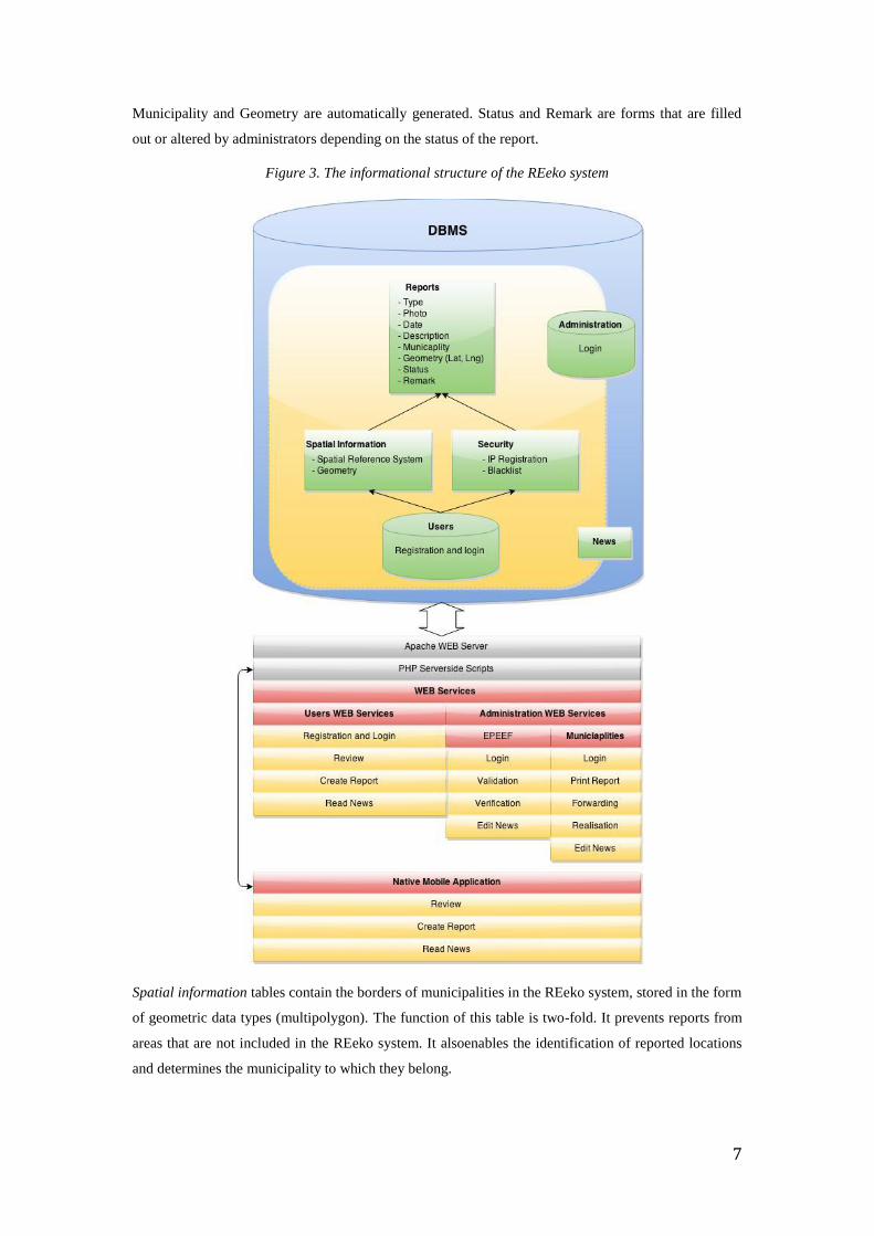
also the tools used for downloading selected reports. The multi-functional tool allows users to make
several various inquiries (using SQL operator). This enables the data analyses of reports to be
combined with other layers of data in the application. Inquiry results can be downloaded to a desktop
computer in a variety of formats (Excel, Shapefile etc.). The other tools in the toolbar are common and
suggestively indicate their purpose. The tools listed under the ‘Administration’ group are exclusively
intended for the use of administrators in the relevant departments of the REeko system. Selecting the
‘Administration’ option opens the option to select the administrator type (EPEFF, municipality).
Logging into the EPEEF administrator opens an application that contains six options: New report,
Verified, Forwarded, Completed, All reports, News. The ‘New reports’ option displays all new reports
that are being processed. All reports under the ‘New reports’ option must be reviewed by a person in
charge of the EPEEF then verified and forwarded to the relevant municipality. The ‘Verified’,
‘Forwarded’ and ‘Completed’ options contain all reports that have been given those corresponding
statuses. The ‘All reports’ option contains all reports in every status category within the REeko system.
These reports can be located by their set criteria. The ‘News’options provides an overview of current
news and editing options (erasing, write new). EPEEF administrators have the ability to edit any report
within any option. Logging into the municipal administrator interface opens an application with five
options that include: New reports, Forwarded, Completed, All reports and News. The ‘New reports’
option contains new reports that have a ‘verified’ status. This option contains all reports that have been
verified and forwarded by an EPEEF administrator. All reports within this option must be reviewed by
a municipal administrator, printed and forwarded to the relevant municipal services. The options
‘Forwarded’ and ‘Completed’ contain all reports that have been given these statuses under municipal
jurisdiction. The ‘All reports’ option contains all reports in the REekosystem; reports of all statuses
given under municipal jurisdiction and that can be located by their set criteria. The ‘News’ option
provides an overview of existing news and allows editing (erasing, writing new).
The ‘REeko’ option contains the central information regarding the REeko system. Alternatively the
‘REeko Android’ option contains central information concerning android applications and download
links.
REeko Mobile
REeko mobile is a native android application
(https://play.google.com/store/apps/details?id=org.ekofondrs.reeko) that is a part of the REeko
informational system. It has been developed for the Android 4+ platform through the use of Java ADT.
It has been optimized for a 4+ inch diagonal screen but due to its customizable user interface, the
application can run seamlessly on smaller diagonals. The application assists the public to submit
reports ands also aids inspectional services to locate identified areas. Entering the report location ID
into the search system of the application simplifies area identification by displaying the search location
as well as the current location of the user.
Upon starting the application, the user is provided with a map of their current location. The color of the
pins signifies the type of ecological risk and the label on the pin identifies the status of the risk. User
11
interactions and applications are found under ‘options’ at the top of the window and in side sliding
menu. Touching the pin on the map provides users with a detailed overview of the situation of that
location. While the map is opened location services are activated. These services are deactivated when
the user exits the screens that require these services. This is a means of energy conservation. The
application is configured to seek out all information that is needed in order to precisely determine user
locations (3G networks, WiFi signals and GPS locations).
In addition to viewing the ecological risks on the map, it is also possible to review the list of reports.
Information that is displayed is automatically updated. Every row on the list represents a report with all
relevant data (date of report, Individual Identification number, locality, status, type, description and a
photograph).
Users can add new reports at any time as long as there location services are activated. The application
notifies the users if their location service is turned off. The processes of adding a new report involves
tapping the corresponding button on the screen, which then opens the form that is required to be filled
out. The form requires users to first identify the type of ecological risk on the reported location.
Selecting the type of environmental risk also changes the color of the send button. Users are then
required to enter a short text description of the risk (up to 255 characters) and provide a photograph of
the location. Reports are sent via 3G or WiFi networks. If Internet connections are not available the
transfers will be made as soon as possible in the order in which they were sent. Location data is directly
linked to the image and the report. Therefor it is not possible to submit a report on one location and
provide a photograph of another. After a report has been sent, photos can not be accessed, added to or
replaced. Each image has a digital signature. Information on the location, date, time and user as well as
the electronic signature of images is stored along with the senders ‘Device ID’. The mobile application
offers the ability to search for reports based on different criteria such as: municipality, ID, status and
type. In addition to these functions, the mobile application also offers options such as: my reports,
review of news and general information about the application and the REeko system.
Conclusions
There are a large number of evident ecological risks across the territory of Bosnia and Herzegovina.
Illegal waste dumps and water discharges are of particular concern. The problems are to some extent
due to insufficient development and capacity of institutions, a lack of organizational efficiency of
particular initiations responsible for the environment and a generally chronic lack of funds and
investments into the environment. This problem is further accentuated by the lack of a centralized
database as well as the lack of an efficient system for reporting, reviewing and monitoring
environmental risks.
Based on the identified problems, a geographic information management system (GIMS) for reporting
and reviewing environmental risks was created. This system called REeko was created within the
Environmental Protection and Energy Efficiency Fund of the Republic of Srpska. The system aimed to
create a centralized data collection system on a nation level and simultaneously increase the efficiency
12
of response of utility services at a local level. This system is of particular value as it allows for the
direct communication between the public and relevant institutions and services and thus speeds up the
reporting and responding processes. The practical value of the REeko system is evident in the simple
method of reviewing, reporting and monitoring of ecological risks and thus creating the prerequisites
for improving the overall state of the environment. Whether citizens submit reports due to feelings of
personal threat or an increased awareness of environmental risks, they automatically become
contributors to the system. Feelings of satisfaction and acceptance encourage members of the public to
use the system. This can further broaden environmental awareness within the social groups of users.
The implementation of the GIMS REeko will be of great use to institutions and environmental services
as it allows for the simple processing and analysis of completed reports. It will be of particular use to
local inspectors and utility services. In addition to the direct beneficiaries of the REeko system,
researches can also benefit by using the information provided regarding environmental risks in order to
produce scientific papers, studies and analysis. The results of such studies can directly or indirectly
influence the environmental field.
The introduction of the GIMS Reko system in institutions at local and higher levels may initiate
incentives for the development of GIMS in other areas (eg. the management of communal
infrastructure).
References
1. Alcamí, L., & Carañana, D. (2012) Introduction to Management Information Systems.
Publicacions de la Universitat Jaume I., Castellón de la Plana, España
2. Berry, J. (1999) GIS Technology in Environmental Management: A Brief History, Trends and
Probable Future. In: Soden, D., & Steel, B. (eds): Handbook of Global Environmental Policy
and Administration. Public Administration and Public Policy, 74, 49-81
3. Brown, S.C., Romeo, V., & Stuver, S.K. (2002) A GIS Model for Predicting Occurrences of
Illegal Dumping. Proceedings of the 22nd Annual ESRI International Users Conference, San
Diego, 8-12 July
4. El-Gayar, O., & Fritz, B. (2006) Environmental Management Information Systems (EMIS) for
Sustainable Development: A Conceptual Overview. Communications of the Association for
Information Systems, Vol. 17, Article 34.
5. Foote, K., & Lynch, M. (1995) Geographic Information Systems as an Integrating
Technology: Context, Concepts, and Definitions. The Geographer's Craft Project, The
University of Colorado at Boulder, Department of Geography, USA
6. Isaias, P., & Issa, T. (2015) High Level Models and Methodologies for Information Systems.
Springer-Verlag, New York, USA

13
7. Kroneke, D., & Hatch, R. (1994). Management Information System, pp. 51. McGraw Hill,
New York, USA
8. Kubásek, M. (2013) Mapping of Illegal Dumps in the Czech Republic - Using a Crowd-
Sourcing Approach. In: Hřebíček, J., Schimak, G., Kubásek, M. & A.E. Rizzoli (eds.):
Environmental Software Systems. Fostering Information Sharing, pp.177-187. Springer Berlin
Heidelberg
9. Kubásek, M., & Hřebíček, J. (2013) Crowdsource Approach for Mapping of Illegal Dumps in
the Czech Republic, International Journal of Spatial Data Infrastructures Research, Vol.8,
144-157
10. Morita, A., & Takagishi S. (2002) GIS-based Support Systems for the Reduction of Illegal
Dumping. Proceedings of the 22nd Annual ESRI International Users Conference, San Diego,
8-12 July
11. Tasaki,T., Kawahata, T., Osako, M., Matsui, Y., Takagishi, S., Morita, A. & S. Akishima
(2007) A GIS-Based Zoning of Illegal Dumping Potential for Efficient Surveillance, Waste
Management, 27, 256-267
12. Turban, E., McLean, E., Wetherbe, J. (1996). Information Technology for Management, pp.
49. John Wiley, New York, USA
13. Veljković, A., Radojičić, M., & Vesić, J. (2008) Menadžment informacioni sistemi
(Managment Information Systems). Tehnički fakultet Čačak, Čačak, Srbija
Related Documents