CHAPTER 2 REGIONAL GEOLOGY AND TECTONIC HISTORY 2.l. Introduction The seafloor created by spreading processes and aseismic ridges originating by mantle plumes from the Early Cretaceous to the Present document the tectonic history of break up of eastem Gondwanaland, major plate reorganizations, directions and rates of plate motions; interactions of hotspots with spreading centers, intra plate deformation and collision history of lndian plate with Eurasia and Himalayan orogeny (Krishna et al., I995). The active tectonics of central eastern Asia exhibits a varied and complicated combination of styles of deformation. Much of this region appears to experience shortening in N-S direction, but both normal faulting associated with E-W or NW-SE crustal extension, and strike-slip faulting on major faults appear to play a key role in the overall deformation of Asia (Deng et al., I979; Molnar and Tapponnier. I975. I978; Tapponnier and Molnar, 1977, I979). These observations led to the suggestion that Asia deforms in response to the collision and subsequent Penetration of lndia into Eurasia and that much of China is pushed eastward out ofthe way of the impinging continents (Molnar and Tapponnier, I975, 1978; Tapponnier 3"“ M°'"=1r» I977, 1979). T ' . . . . he island arcs, trenches and marginal basins associated with Sunda arc form “"9 9" lhe most tect Detrick. l9 . _ 73). Stretching from Burmese arc nearly to Timor, the Sunda lsland Arc d€lll1€8i€5 3 Subdu onically active and complex regions of the world (Purdy and ction zone separating the lndian-Australian plate from the l3

Welcome message from author
This document is posted to help you gain knowledge. Please leave a comment to let me know what you think about it! Share it to your friends and learn new things together.
Transcript
CHAPTER 2
REGIONAL GEOLOGY AND TECTONIC HISTORY
2.l. Introduction
The seafloor created by spreading processes and aseismic ridges originating
by mantle plumes from the Early Cretaceous to the Present document the tectonic
history of break up of eastem Gondwanaland, major plate reorganizations, directions
and rates of plate motions; interactions of hotspots with spreading centers, intra plate
deformation and collision history of lndian plate with Eurasia and Himalayan orogeny
(Krishna et al., I995). The active tectonics of central eastern Asia exhibits a varied
and complicated combination of styles of deformation. Much of this region appears to
experience shortening in N-S direction, but both normal faulting associated with E-W
or NW-SE crustal extension, and strike-slip faulting on major faults appear to play a
key role in the overall deformation of Asia (Deng et al., I979; Molnar and
Tapponnier. I975. I978; Tapponnier and Molnar, 1977, I979). These observations led
to the suggestion that Asia deforms in response to the collision and subsequent
Penetration of lndia into Eurasia and that much of China is pushed eastward out ofthe
way of the impinging continents (Molnar and Tapponnier, I975, 1978; Tapponnier
3"“ M°'"=1r» I977, 1979).T ' . . . .he island arcs, trenches and marginal basins associated with Sunda arc form
“"9 9" lhe most tectDetrick. l9 .
_ 73). Stretching from Burmese arc nearly to Timor, the Sunda lsland Arcd€lll1€8i€5 3 Subdu
onically active and complex regions of the world (Purdy and
ction zone separating the lndian-Australian plate from the
l3
Chapter 2
southward projection of the Eurasian plate. The Sunda Island arc, displays the
characteristic relationship of a deep trench, a sedimentary arc, and a gravity minimum
inside the trench, earthquake hypocenters along a dipping Benioff zone, and a
volcanic arc above the Benioff zone. lt continues to be an area of high interest for
studies of the complexities created in a zone of plate convergence (Curray et al.,
I977)
2.1. Regional geotectonic setting
The island arc extends over some 5600 km and separates the lndo-Australian
plate and the Eurasian plate. This sector of the subduction systemghas been active
since middle Tertiary time, as inferred from dating of the Sunda system volcanism by
Hamilton (1988). Hamilton suggests that along the arc, the collision system changes
from oceanic-continental in Sumatra through transitional in Java to intra-Oceanic in
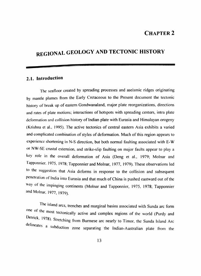
Bali. A morphological map of the study area is shown in Figure 2.]
On the northeastem side of the study area, the slow slipping Red River Fault
of Vietnam and Southem China separates the Southeast Asian plate and the Eurasian
plate. The Bumrese-Andaman arc system fonns an important transitional tectonic link
between the Himalayas in the north and the Sunda arc in the south (Hamilton, 1979).
Towards north, the Burmese arc meets the Himalayan arc at the syntaxis zone along
the Mishmi hills block fonning a major thrust zone. The Burmese arc is bounded on
its west by the tectonically active belts of northeast lndia wherein, currently uplifting
Shillong plateau is the most important tectonic feature. The Burma plate covering th6
Burmese plains, the Andaman and north Sumatra basins separate the lndian plate and
the Eurasian plates. The eastem periphery of this Burma plate lies, the relatively high
standing areas that include the Shan plateau, the Malay Peninsula and its western
shelf, the Malacca strait and Sumatra. The Shan-Sagaing fault is a major right lateral
Regional Geology and Tectonic History
fault along the eastern edge of the Burmese arc where the western Burma seems to
slide past the rest of lndo-China (LeDain et al., 1984).
4*
11D0
-1000
-2000
-3000
-4000
-5000
-6000
-7000
F.‘gum 2' 1' M°1'Ph0l0gy map of the Andaman-Sumatra-Java trench-arc system.Th A - . . . . . . .e fldflman basm 1s an extensional basm spreadmg 1n a NW-SE directlonmarking d _ _e e 86 between the El1I'3Sl3 and Burma plates 1n the north to Indonesia in
the south ‘mi S1 amd between 6 N and l4°N and 9l°E and 94°E. Win Swe (1972)nferred that the Sagaillg fault turns southward into the spreading axis of Andaman
Sea. This back arc-Spreading center in the Andaman Sea is transformed southward

Chapter 2 7into the Sumatra fault system that cuts the entire length of Sumatra (Curray et a]_,
1977). The westem side of the Burmese and Andaman trench-arc region is bordered
by Bay of Bengal and Ninety East Ridge. The Andaman basin comprising of
Andaman Sea in the back-arc extends nearly 1200 km from Burma to Sumatra in the
N—S and around 650 km from the Malay Peninsula to the Andaman and Nicobar
Islands in the E—W. The central Andaman Sea is marked by steep and elongate sea
valleys and seamounts such as the Nicobar Deep, Barren—Narcondam volcanic
islands, hwisible bank, Alcock and Sewell seamounts (Rodolfo, 1969). Curray et al,
(1982) suggested that the Andaman Sea and the central lowlands of Burma are parts
of a single structural province.
Towards south, the Sumatra fault system extends for 1900 km along the volcanic
chain of westem Sumatra from 10°N to 7°S (Sieh and Natawidjaja, 2000). In the
southwestem part, there is a 300 km wide strip of lithosphere between the Sumatran
fault and the Sumatran deformation front called the Sumatran fore arc sliver plate. The
SFZ is also considered as the limit between the Eurasian plate and the fore arc sliver
plate. The fore arc ridge (outer arc high) is characterized by islands such as Enggano,
Pagai, Siberut, and Nias that provide considerable geological information.
Java (8° S ,ll0° E) is part of the Sunda Island Arc, which includes Sumatra to thfi
North West and Bali to the East. It is the world's 13 ‘I’ largest island formed mostly 85
the result of volcanic events. Java Sea and Borneo lies to the north and Indian Ocean
to the south of Java. Its southem edge is marked by the presence of the Wharton Basil‘
and the north Australian Basin. (Figure 2.2).
Since this area is associated with strong earthquake activity and volcanism, it is
important to understand the tectonics, geological history as well as the ong0in3
geodynamic processes in order to assess the future hazards.

Regional Geology and Tectonic History
The
2.3.
e eastern lndian Ocean is 8
d evolution of the Andamie Framework anh Eastern Indian OceanGeotecton _
h are system III t eSumatra Java trenc S matra-Javavergent margin a ongzone of active con
' uite complex and interesting in v'eodynamically q
I the Andaman — u
A A Subduction zone
BUFQG
w=
15»,CI3’ ,
El-Jlue
U
M <2,-5 O__nI
M T
ll.JD.
IS!
ZS.
2.:
Q>.&” 21r:...21'/.
5*»
10*
.20i|rzu
JTB
‘Q:
0
2i
24
Q
QLL
ZQ
70
TT:
Ti
2TB
FTo
AR
v
‘:8‘DR
“Ha11
W
FF
ET4
-KTe
527
F
W
I ,'/'V/1/
'1
I €
laI a '217-; _‘___.»‘h M. ‘__-__R'd e °G\' . __ ’ \_'fi\_-- -=t...__ Q , ~/ ;¢57'"m/ $6 *6 O A D . ' I -'-‘ yr 0;, Q F _ lg
-N56 q, 0% '9 ¢_{i>><*°g ..-'0 ~§O\y §~°5\ ‘ ‘V ‘Q42 6*“. .;:-'O \ \ Y,‘ Q _ _? 2' :.|"'¢~> s .a <> “Q \%\ ‘ 4 " .5:-_ Q. . :2 -. "I...
, ._,'- 1 1 -'-.. \ £Q \
3', / / <9
('4'.
9
0 /2
=--!.r.I_v.s.§_'_:_= £9 r
“°%A§
_H.Z1.29.t l Nt D
iii;
I \_’ a' A
{"1‘ i~» » *1; t .. 1‘ w "_:-;:: _.._:._:. .5 ._._. I
e/-a " " *0»‘ - ‘4‘$00
QCEAN /' l 115 120
-Y" E 1'5‘ ,_E_ Accretionary prism
-"~""5‘-"“.~ Seamount, ridge or plateauJ’Sedimentary isopachs in Kms
M11 22 Magnetic anomaly numbers
L, Andaman spreading centreRidge axisso . .
M Direction and rate of moveI I Volcanoes
ment
S
'_.l'
Borneo ~_'_~’
- '3 Java Sea,' 4 '_4.. 1~_-. \‘ .._ -._>_ _~, ., -_'~ ""‘.._4__
.100 ‘.-' 'R0/yr I‘ " loo d|-Ombok mg
95¢
Basin ,9vk/' :1\
$9’ \". \\'y$2“ At» >'*‘\{\§ Normal‘V ‘A/\‘ E $19 SubducfiiigI A N vthy‘ v\>’ E ‘~‘$v19 ‘A7
‘\ \v~\'!f
430
3]]
arc
ICW
i
. H’4, ‘NV?so
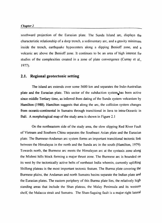
Figure 2.2. Generalised tectonic map oand 2ld_|2lC€flI regions.
K J~95 150 105 110
f the Andaman-Sumatra-Java trench
I 7
Chapter 2
of wide variation in subduction geometry, morphology and stress field in both along
and across the arc and the presence of active back-arc spreading in the Andaman Sea
Major tectonic features in the eastern Indian Ocean were inherited from the
break-up of the eastern Gondwanaland and subsequent spreading of the Indian Ocean
floor. Some of these features which are important in the evolutionary history of the
region (see Fig. I.3- generalized tectonic map) are: (I) the large sediment filled basin
called the Bengal fan in the Bay of Bengal, 2) the Ninety East ridge, a 4500 km long
aseismic ridge trending N—S along the 90° E meridian (3) The fold mountain belt of
Andaman and lndo-Burman ranges formed by eastward subduction and motion along
the Shan-Sagaing transform and the Neogene back-arc spreading in the Andaman Sea
(4) the Sumatran Fault Zone (SFZ), a northwest trending active strike-slip fault that
cuts the entire length of Sumatra and Indonesia (5) Java onshore region termed as Java
Fault Zone (J FZ) (6) Sumatran fore arc sliver plate consisting of Mentawai fault zone
(MFZ) (7) The offshore Java fore arc region, which is characterized by typical fore arc
basins and (8) The Sunda strait, which is considered as a transition zone between the
normal subduction in front of Java to the east and oblique subduction to the west.
Most of these features came into existence during the northward flight of India since
the late Cretaceous. McKenzie and Sclater (I971) studied the evolution of the Indian
Ocean since the Late Cretaceous based on magnetic anomaly identifications and
concluded that during 75-35 m.y., the movement of the Indian plate was very rapid
(I8 cm/yr) mostly in northward direction. They infer that this movement was taken up
by the Chagos-Laccadive transform fault on the West and by the Ninety East Ridge 0"
the East. Johnson et al. (I976) have studied the spreading history of the eastem Indian
Ocean, where the oldest magnetic anomalies are aligned sub-parallel to the East Coafil
of India corresponding to about 2 km isobath. A schematic illustration of age and
history of oceanic crust in the eastem Indian Ocean (Figure 2.3) is given by Hamilton
(I979).

Regional Geology and Tectonic History
The details on various prominent stages of geological evolution and resultant
formation of majo
understanding of present day geodynamics of the region.
i-LL Active Siibdtiction rune
so
_ 1 .-\cti\‘c Spreading axis- '_ ° , : - = ' " »_ _ lniietive Spreading axisi i:_ . 3:, " ii 45 showing age in ;\lY.20... _ ._ : Bav -. \----- Rifted plate boundary' _ . I ~ '1 i showing age in MY.\ . I I of V - ___ Major trantorm fault\ - ‘ _ Bgn al . " “ - ' * Minor transform fault\ _, 't'_. _; , _ 11> Direction of Spreading, ii '_ ‘l Tia. l\ ‘ ' I '.l ll M 2'.‘ fiti—"I**fi ' * ee
10*
<\\°Y‘ / . _ ./,0 g -> 54-»\i i ' ' i /é\\;9'\\.‘)/ /_ _ U1 Q \ 1
I
E a s t e 1 Q’ I‘01 -9 . O .I. Pp.?_:‘.\&°._;.‘~'“‘ ; Ifiéfix6 Q ‘ah’. \ t '1
'4u '- -.8 ~ ". '-. H‘ 1 01‘/‘a//8 ‘I 5.
O‘ -15 ii i '-'-Borneo-" 1"" ’ *.~ V.‘ -. »..- _. .4 "' I - u I ;. °:
MIDINDIAN I jg l g ; l L 7BA$'“ t or 4' ‘LE 75a .e‘ __ _| » g I_-1()_ t | ~WHARTON BASIN , i\ V / (0\ I_ /\\ 1 1' 75' “ /' I ’-20.; \ \ '3 I / g J\ 50 _ I \ ~I \\ e ,’ /
‘D \\ A 502 // qt) e ‘I6* \ , ’ “Q i-30- 0 " 85' J” * N \\go \ Broken Rid9e\\ \ l0 ‘ ~ ~ 1~ ~ _ - - _ A A I [\/. South _ ALl‘$0.,_’ \ ’ 7_ ‘ § _ Q \ :a- "'
-40-T / 1 * it » f Bias”) ra/IanI i7° 80 90 100 110 120Figure 2 3 - - .
- - Schematic illustration of age and hlSIOl'y of oceanic crustin the eastem Indian Ocean as given by Hamilton (I979).
I9
r tectonic/structural elements are discussed here for better

Chapter 2
2.3.1. Geologic Evolution of the Eastern Indian Ocean
Break up of eastem Gondwanaland during the Early Cretaceous resulted in
the evolution of the lndian Ocean. The plate tectonic theory has been used for the
eastem Gondwana reconstruction to unravel the evolutionary history of the Indian
Ocean (McKenzie and Sclater, I97]; Sclater and Fisher, I974; Johnson et al., I976;
Duncan, 1978; Norton and Sclater, I979; Powell et al., I988; Royer and Sandwell,
I989; among many others). Magnetic data constrained by DSDP and ODP drilling
results revealed that the seafloor spreading between lndia, Australia and Antarctica
occurred in three main phases with two major plate reorganizations from late Jurassic
to present (Royer and Sandwell, 1989). The reorganizations are evidenced by ridge
jumps, changes in direction and varied rates of spreading. Geological evidences reveal
that an overall compressive tectonic regime along the convergent margin in the
eastem Indian Ocean prevailed since Late Cretaceous.
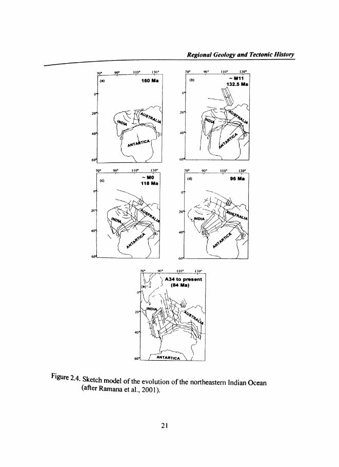
Figure 2.4 describes the evolutionary history of the Indian Ocean in general.
The first phase of spreading started in northwest-southeast direction and resulted in
lndia’s movement away from Antarctica-Australia during early Cretaceous. This
resulted in the formation of the Mesozoic basins along the westem Australian margin
(Markl l974a,b, 1978; Larson et al., I979; Veevers et al., I985), and the eastem
lndian margin (Ramana et al., l974a,b, l997a) as evidenced by the Mesozoic anomaly
sequences Ml l through MO. During Middle Cretaceous, the lndian plate rotated from
its early NW-SE to N-S direction and moved at a slow spreading rate. During thiS
period, the Cretaceous quiet/smooth zone (I18-84 m.y) crust evolved in the distal
Bengal Fan. Northward movement of lndian plate away from Antarctica took plaC6
during Middle Cretaceous to Middle Eocene. The first major reorganization of thfi
plates took place during Middle Cretaceous time, evidenced by the change in lndia’S
motion from NW-SE to N-S (McKenzie and Sclater, I97]; Norton and Sclater, I979;
Regional Geology and Tectonic History/f70, 99¢ | E00 |;:,0° 70° 9'0 I l|0° l3'0°
(II)
401 40°‘j »60°
Av"
1eo Ma <b> " “"1
/'\/"\§ L “WW95 404
Goa 060°‘
132.5 Ma
X
19 1;" ‘S./3"
oar s_ /(<1)
20% 1 '
60‘! (
~ "'0 an as Ma11a Ma01 0.,
<\°44" /v_\\
‘1(Q
, 40*
70° 99° I 50° 130° 10° 90 1 10° 130°I l I&
20
/ '1 .*%\=_,'
., 15?»/ v
A
Figure 2.4. Sketc
0
L )0“
\iifib/ "4u4
\
1+)
1?’)
\ o
.$NO0 '00
\70 9.0 ‘I nioV j A34 to present<.,~ U /, (B4 Ma)
ZOJWDI - K’\ ’°~<40* X "”
60:1 K
(after Ramana et al., 200]).
2|
h model of the evolution of the northeastem Indian Ocean
Chapter 2
Powell et al., I988; Cande and Mutter, I982; Veevers et al., I986; Scotese et al.,
I988). The second phase of spreading started in the N-S direction and continued up to
formation of anomaly I9 (about 24 m.y) in the central Indian Ocean. During this
period, India drifted in the N-S direction from Antarctica with a rapid speed of I I to 7
cm/yr. The magnetic Iineations 34 through I9 have evolved in the east-west direction
with large lateral offsets, giving rise to the major fracture zones. During this phase of
drifting, major parts of the central Indian and Crozet basins have evolved (McKenzie
and Sclater, l97I; Schlich, I975, I982). The initiation of seafloor spreading between
Australia and Antarctica (Cande and Mutter, I982) and the opening of Wharton basin
(Sclater and Fisher, I974; Liu et al., I983) also took place during this period. The
second major plate reorganization occurred in the middle Eocene time when Indian
and Australian plates merged and formed as a Single lndo-Australian plate (magnetic
anomaly 20 to I8) (Liu et al., I983; Royer et al., I989a; Krishna et aI., I995). The
third phase of spreading initiated in northeast-southwest direction in the middle
Eocene and appears to continue since then. The Australian and Antarctica basins
(Weissel and Hayes, I972) were formed along the SE Indian ridge (SEIR) in the third
phase.
2.3.2. Tectonics
The 2004 and 2005 witnessed two mega earthquakes that have ruptured the
boundary between the lndo-Australian plate, which moves generally northward at 40
50 mm/yr, and the southeastem portion of Eurasian plate, which is segmented into thfi
Burma and Sunda sub plates. East of Himalayas, the plate boundary trends southward
through Myanmar, continuing offshore as a subduction zone along the Andaman‘
Nicobar islands and further south to Sumatra, where it tums eastward along the Java
trench. This zone of convergence is characterized by the occurrence of numerou5
earthquakes, both shallow and deep (Figure 2.5). The area is a classical example ofa

Regional Geology and Tectomc History—_<j/1
subduction Systemr comp
Sumatra-Java trench. an 36
(Pubellier et al., 1992; Samuel and Harbury, 1996), the Bengkulu - Mentawai fore
90 95 1 Q0* I : '15 ’ .0?‘ .'. O: 5%
‘fr f. "
3
Ira‘-' ". Q ¢§‘:.
I . Q
803
-5 " _ ,.' OaiP. . \ . ‘5 9 '.- " _ '
O .¢ ;t'_,F~7"
. . . ‘*1:' gin 0_-.~: 0 ¢ .9!" 5"»r- 'I- '*~'._I>..
é
5
0
' .' 0 00,0. ' 0 %._?:'. .“OI
I\
' Q‘a . ? . ' ,0 . . .. .:’ 8 \\.'O 0 0 ..~.‘¢"&. ‘ .
osed of the down going Indo-Australian slab along
cretionary wedge, the outer arc ridge forming the bac s
7.5<7 to7.56 to 75 to 6
-3 ' 115\ \I . .
.5‘.5. Q . ' "' - . 0. ¢-. ,' .-.8..~,..'._.". '._. 0,‘:t ‘g
. _-:\=_",€ 3,-10 - .' 4' .. l:.¥.:.-fir ;
-15 '
Figure 2.5. s ~ - e;i'CSén1¢1tY "lap of the Andaman - Sumatra — Java are region showi
n ers with magnitude Z 5.0. Both shallow upper plate and deeperB ‘ . .enioff zone events have been lncluded 1n the map.
Chapter 2 7basin off Sumatra and Java fore arc basin in front of the Volcanic arc (Schluter et 3]“
2002). The Andaman-Sumatra-Java arc system has evolved through mainlysubduction related processes responding kinematically to the plate reorganizations and
other tectonic adjustments taking place during the evolution of the Indian Ocean as
well as the Philippine Sea region.
The geometry of the subduction plate varies as it comes from Andaman to Java as the
sediment thickness of the subducted plate decreases. Off Java, it is covered by only
few hundred meters of sediments, whereas, off Sumatra it exceeds 1 km and at the
head of the Bay of Bengal the sediments are thicker by an average of 10 km (Curray er
al., 1977). West of the Andaman arc, the Ninety East ridge continues subsurface
below the Bay of Bengal sediments up to l7°N (Curray et al., 1982). Geophysical
studies indicate that the ridge could be a hot spot trace (Curray et al., 1982;
Mukhopadhyay and Krishna, 1995) Refraction data suggests that off Southern
Sumatra, in the arc region, the basement is continental whereas, off westem Java it
changes to oceanic (Kopp et al., 2001,2002). The outer high, which represents the
fossil part of the accretionary wedge, is of Eocene-Oligocene age (Pubellier et al.,
1992; Samuel and Harbury, 1996). The Andaman—Nicobar ridge is believed to have
formed in Oligocene—Miocene times due to E-W compression of sediments derived
from the Malayan shelf (Rodolfo, 1969). Lay et al. (2005) observed that age and
thickness of the subducted oceanic crust and the convergence rate increase fr0I11
Andaman towards Java along the arc. The increasing dip and depth of penetration 0f
the Benioff zone reflects this change as well as changes in slab geometry. Oblique, bu‘
predominantly thrust motion occurs in the Andaman trench with a convergence rate of
about 1.4 cm/yr (Lay et al., 2005). The Andaman back-arc spreading ridge-transform
system accormnodates the remaining plate motion, joining with the Sumatra fault to
the south. The subducting oceanic crust off Sumatra is 46-60 m.y old and hfl53
present convergence rate of 6.8lcm/ yr, while the crust off Java with an age ranging
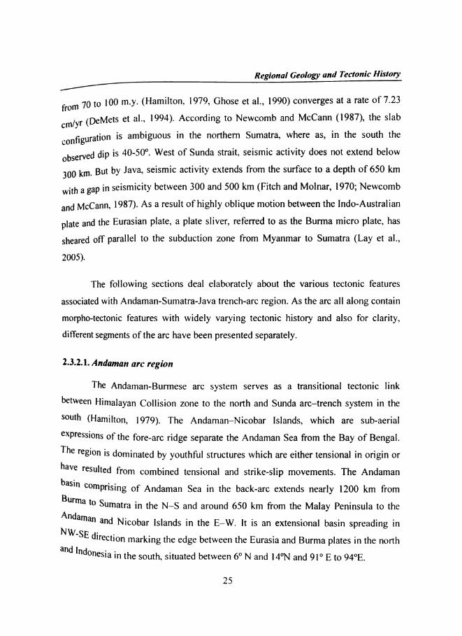
Regional Geology and Tectonic History/7f m 7Q {Q I00 m.y. (Hamilton, 1979, Ghose et al., I990) converges at a rate of 7.23ro
m/yr ([)@Mets et al., I994). According to Newcomb and McCann (I987), the slabc
Onfiguration is ambiguous in the noithem Sumatra, where as, in the south thec
observed dip is 40-50°. West of Sunda strait, seismic activity does not extend below
300 km But by Java, seismic activity extends from the surface to a depth of 650 km
with a gap in seismicity between 300 and 500 km (Fitch and Molnar, 1970; Newcomb
and McCann, 1987). As a result of highly oblique motion between the lndo-Australian
P
sheared off parallel to the subduction zone from Myanmar to Sumatra (Lay et al.,
late and the Eurasian plate, a plate sliver, referred to as the Burma micro plate, has
2005).
The following sections deal elaborately about the various tectonic features
associated with Andaman-Sumatra-Java trench-arc region. As the arc all along contain
morpho-tectonic features with widely varying tectonic history and also for clarity,
different segments of the arc have been presented separately.
2.3.2.1. Andaman arc region
The Andaman-Burmese arc system serves as a transitional tectonic link
between Himalayan Collision zone to the north and Sunda arc—trench system in the
S°“lh (Hamilton, 1979). The Andaman-Nicobar lslands, which are sub-aerial
¢Xpressions of the fore-arc ridge separate the Andaman Sea from the Bay of Bengal.
The region is dominated by youthful structures which are either tensional in origin or
have resulted from combined tensional and strike-slip movements. The Andaman
basin °°mPYiSirig of Andaman Sea in the back-arc extends nearly 1200 km from
Burma t° Sumatra in the N—S and around 650 km from the Malay Peninsula to the
:1$_aS"}‘3a".afid.Nicobar Islands in the E—W. lt is an extensional basin spreading indirection marking the edge between the Eurasia and Burma plates in the northand l . . ,
"d°fl€sia in the south, situated between 6° N and I4°N and 91° E to 94°E.
25

Chapter 2
The lndo-Burman ranges and the Andaman—Nicobar ridges are a northward
continuation of the Mentawai ridge of the Sumatran subduction zone. Rodolfo (I969)
suggested that the east-west compression of sediments derived from the Malayan shelf
resulted in the formation of the Andaman—Nicobar ridge in Oligocene—Miocene age,
The central Andaman Sea is marked by steep and elongate sea valleys and seamounts
such as the Nicobar Deep, Barren—Narcondam volcanic islands, lnvisible bank,
Alcock and Sewell seamounts (Rodolfo, I969). Curray et al. (I982) inferred that the
formation of the Andaman Sea has a definite genetic linkage with the evolution of the
Bay of Bengal. During this evolution, modifications to the subduction zone geometry
have produced considerable mass anomalies at depth. The rock types in the Andaman
—Nicobar islands mainly constitute: Cretaceous serpentinites, ophiolites with
radiolarian cherts, Cretaceous to Eocene cherty pelagic limestone and a thick section
of Eo-Oligocene flysch overlain by Neogene shallow water sediments (Chatterjee,
1967; Eremenko and Sastri, 1977; Roy, 1983). The western base of the Andaman
Nicobar ridge is marked by the trench that is filled with the sediments of the Bay of
Bengal (Curray et al., l979). The structure along the arc in the Andaman—Nicobar
ridge region is dominated by east dipping nappes having gentle folding, while tighter
folding and intense deformation is observed off Sumatra (Weeks et al., I967; Moore
and Curray, I980). Eremenko and Sastri (I977) observed that the deformation is more
intense in Cretaceous—Oligocene sequences than the younger sequences. Several north
—south faults and thrusts have been observed in the Andaman—Nicobar ridge and the
adjacent offshore areas, among them, the most significant are the Janva thrust
developed on the main islands (Roy, 1983) and the West Andaman fault, east of the
Andaman—Nicobar ridge (Curray et al., I979). Mukhopadhyay (l984) observed that
some of these faults/thrusts are seismically active. Curray et al. (I982) suggested 8
relation between thickness of sediments on the subducting plate and height and
volume of the outer sedimentary arc or non—volcanic ridge of the arc. Curray et al
26
Regional Geology and Tectonic History
U932) inferred that the Andaman Sea and the central lowlands of Burma are parts of a
Single structural province.
The Andaman Sea is a complex back arc extensional basin that differs from
most other such basins in that it is west facing and that it was formed by transtension
(Curray, 2005). It lies along a highly oblique convergent margin between thenortheastem moving lndo-Australian plate and nearly stationary Eurasian plate.
Uveda and Kanamori (I979) related the back-arc spreading activity in the Andaman
Sea to leaky transform tectonics. Eguchi et al. (1979) inferred collision of the Ninety
East ridge with the Sunda trench in the middle or late Miocene which transmitted
compressional stresses into the back-arc area and at the same time the drag exerted by
the collision of India with Eurasia caused opening of the Andaman Sea, whereas,
C urray (2005) is of the opinion that as the greater Indian continental mass converged
on the SE Asian margin, it caused clockwise rotation of the subduction zone and
increase in obliquity to the point that transtension along a sliver plate has resulted in
oblique rhombo chasm like opening of the Andaman Sea during the Neogene. General
structure in the Mergui north Sumatra basin consists of a series of horsts and grabens.
Seismic refraction studies by Kieckhefer (1978) indicate that a thin continental crust
underlies the basin. Structures in the basin are suggestive of rotated fault blocks
mdicatlng rifting of an older sedimentary section during the opening of this part of the
Andaman Sea. The identified magnetic anomalies in the central Andaman Sea indicate
8 Spreading rate of 3.72 cm/yr with opening started about l3 m.y. or in Middle
Miocene (Curray et al., 1979). Total opening since that time has been 460 km (Curray
e‘ 3"’ I932) Raju et al. (2004) has arrived at a conclusion that the present full rate
iliiidgfgg in the central Andaman Basin is about 38 mm/yr and that it has opened 1 l8
win SW5?‘ ghjzlflet 4 m.y, which agrees with the recent observation of Curray (2005).) inferred that this spreading axis IS in turn transformed northward
Onto um Sagaiflg fault. Curray et al. (I977) proposed that opening of the Andaman
27

Chapter 2
Sea is transformed southward into the Sumatra fault system. ln the geologic past,
some of the motion of this opening may possibly have been taken up by a southern
continuation ofthe West Andaman Fault.
Curray(2005) excellently synthesized all available geological and geophysical
data and proposed different stages of opening of the Andaman Sea region. His
reconstruction involves separation of lndia from Australia and Antarctica in the
eastem Gondwanaland and its northward flight since the Cretaceous. Some salient
aspects of the reconstruction history (Figure 2.6) have been presented below; as
outlined in Curray (2005).
1 Before the departure of lndia from Australia and Antarctica, the South Tibet,
Burma and SIBUMASU Blocks had already spun off northward and had docked
against Asia. Prior to initiation of the subduction system, this could have been a
passive continental margin, the source of some of the older sediments found in
Myanmar and the Andaman-Nicobar Ridge.
0 The northeastem comer of ‘Greater lndia‘ hit this subduction zone at about 59 Ma
(Klootwijk et al., I992), the so-called ‘soft collision‘, and lndia underwent some
counter clockwise rotation from about 59 to 55 Ma, at which time the suture was
completely closed. During this time and until about 44 Ma, lndia was indenting
the Asian margin and rotating the subduction zone in a clockwise direction. With
this rotation the direction of convergence became increasingly more oblique
Finally, probably in the middle to late Eocene, about 44 Ma, a sliver fault formed,
the forerunner of the Old West Andaman and Sagaing Fault systems. Right-lateral
motion started on the Khlong Marui and Ranong Faults at about this same timfi
(Lee and Lawver, I995) prior to the opening of the Mergui Basin during the
Oligocene. The northern strand of the Mergui fault may have crossed the Mergui

Regional Geology and Tectonic History
Ridge 35 a splay of the Sagaing Fault (Figure 2.6a). The Mergui Ridge was
probably part of the original volcanic arc.
l\. 32 Ma ~\ 23 Ma‘iarly Ologocono ‘ ' ' ‘\ Early MlooonoTqctonics 32~23Ma ‘lloctonlcs 3-‘ISM
7 §/ ./ ,o\“o ‘QQM ‘O0 ‘g.,u \>\9*‘ 0 6‘0 ,
' ' ' . <>:\\>9&y
Z8 Quqq p9u_m5gv
\ \Z 5‘ 089'”w. /’ »\“\ (II
. * ’ ' ' §@<>v\‘°J9
"W 9t I-WON Dflunity
~~I \
\/‘
%'6o°°\'
/vf
\\
BW
II\"' \ H‘~ Q,\ M_F ° ‘.\\ M Q q\\ ‘"3I R\ \
\ \'\\v -Y \(9) \ K (b) :Qpening B \ opwflng 'Qso km at 310° ‘kqp \_ 7mm,yr_ -120 km at 32 \~ 15mmlyr. \\ §
Z‘
~
’¢
\ \
“ ‘~ - 15 Ma\ \ ‘\ 2 ‘f End Early MIOOOHI
-s 5 bonics 16-4Ma WU \‘ ‘ ‘ .. I‘, ,‘\\' ~ 4Ma .,, C03I“ EarIyPlioc0nQ Q :11’ootonics4-0 a
< i.~(<1 ‘ M(C) OQ Qp, mg 8\\1 “_-*‘ ._ oopening \ ‘L \:__ 138 km t335-100 km at 335 -7* ~_ ~ 30mm r. \
A ‘ 9mmIyr_
-'1
$60 ,0,2'/ ' >»;I: _ F\\ _-—"‘
OD M’
/4' Q_-¢--..___-9
O
‘ J‘Z’
€> ._
ek
J ai-yd
“v09 \\:‘BIN 9 LIUON peu nggv
Q _ ca
O Q cgL’?
:9_LBIN v qu0N' égw
F'gUre 2 6 . .- - Sketch rnodel of the reconstruction history showing different stages
of Opening of the Andaman Sea region (afier Curray, 2005).
29
Chapter 2
0 By early Miocene, about 23 Ma (Figure 2.6b) , the plate convergence was oblique
enough that extension and back arc sea floor spreading moved westward to the
sliver fault running approximately along the magmatic arc, which had by that time
migrated westward. The sea floor spreading and creation of oceanic crust formed
the rock masses comprising of Alcock and Sewell Rises. The rocks from Alcock
are early Miocene. With abandonment of extension in the Mergui Basin area,
rapid subsidence occurred and the shallow water deposits of the late Oligocene
were buried by deeper water facies.
0 At the end of early Miocene, about 15-I6 Ma (Figure 2.6c), a major change
occurred in the Mergui Basin with an unconfom1ity and deposition of dark gray to
black shales of the Baong, Trang and Surin Formations over the carbonate
sediments of the Peutu, Tai, Katang and Payang formations. At this time the
conjoined Alcock and Sewell Rises started rifting away from the edge of
continental crust forming East Basin. And finally at about 4 Ma (Figure 2.6d), the
plate edge migrated again to cut Alcock and Sewell apart, and the present plate
edge between the Southeast Asian and the Burma Sliver Blocks was formed.
2.3.2.2. Sumatra arc region
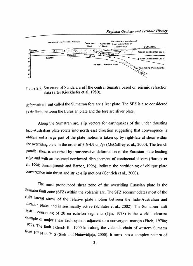
Structure of the Sunda arc off central Sumatra was studied by Kieckhefer et
al. (I980), using seismic refraction data and interpreted that Sumatra is underlain by
older, Paleozoic continental crust (Figure 2.7). Northem Sumatra is also characterized
by Paleozoic sedimentary rocks and Mesozoic granites (Katili, I962). The Sumatran
fault Zone (SF Z), a northwest trending fault that cuts the entire length of Sumatra and
Indonesia is a major dextral active strike-slip fault zone. ln the southwestem pan»
there is a 300 km wide strip of lithosphere between the Sumatran fault and the
Regional Geology and Tectonic History/7Gravnahonm flow mbflcages mglangg Pie-subduction slrala beneath
outer arc _ Oi-"97 37¢ basin sedments lie on7 _ _ rigdgeg g B355" oceanic crust _ SUMATRA é
0 _ < . __ \~‘*A»-‘»“ \\ \ \‘ \ 11*? ‘<1 \* ‘I 4~a " ifL/'.’* - = ~~ _. \ ‘—"—— ‘ W‘ Q __, \§~> §~ \ .\\ \ \\ J Upper Continental Crust'0 * - ‘ aflic CrustOceanic —- _ _ _CrustManfle i'\.\ L \" ower Continental Crust
3B
. 07/.Phase-Transition zone /~,_
g Plate Mantle$0,O9/(Q
Figure 2.7. Structure of Sunda arc off the central Sumatra based on seismic refractiondata (after Kieckhefer et al, 1980).
B3
deformation front called the Sumatran fore arc sliver plate. The SFZ is also considered
as the limit between the Eurasian plate and the fore arc sliver plate.
Along the Sumatran arc, slip vectors for earthquakes of the under thrusting
lndo-Australian plate rotate into north east direction suggesting that convergence is
oblique and a large part of the plate motion is taken up by right-lateral shear within
the overriding plate in the order of 3.6-4.9 cm/yr (McCaffrey et al., 2000). The trench
parallel shear is absorbed by transpressive deformation of the Eurasian plate leading
Qdge and with an assumed northward displacement of continental slivers (Baroux et
3|-» |993; Simandjuntak and Barber, 1996), indicate the partitioning of oblique plate
convergence into thrust and strike-slip motions (Genrich et al., 2000).
The most pronounced shear zone of the overriding Eurasian plate is the
Soumatra fault zone (SFZ) within the volcanic arc. The SFZ accommodates most of the
"ght lateral stress of the relative plate motion between the lndo-Australian and
Eurasia" Plates and is seismically active (Schluter et al., 2002). The Sumatran fault
System Consisting of 20 en echelon segments (Tjia, 1978) is the world’s clearest
T:;';)pl‘;':f major shear fault system adjacent to a convergent margin (Fitch, l970a;- 6 fault extends for 1900 km along the volcanic chain of westem Sumatraf|'() 0 _ _m IO N I0 7° S (Sleh and Natawidjaja, 2000). lt turns into a complex pattem of
31

Chapter 2
extensional faults in the fore arc south of Sumatra. North of Sumatra, the SFZ seen to
be continuing into the Andaman Sea and joins with the fracture zones of back arc
spreading center (Curray et al., 1978). The oblique subduction beneath Sumatra
results in partitioning of the convergent motion. The variation of slip rates along the
various segments of SFZ ranging from l.lcm/yr to 2.8cm/ yr (Baroux et al., l998)
was accommodated by fore arc sliver deformation (Diament et al., I992; McCaffrey,
1992). Slip rates as determined by SPOT images along stream offsets along the fault
infer movements of 0.6 cm/yr in the south to 2.3 cm/yr in the north (Bellier and
Sebrier, 1995). According to Malod and Kermel (I996), the right lateral slip is not
only taken up by SFZ with a rate of 2 cm/yr, but also, by the Mentawai fault zone
(MFZ) identified by Diament et al. (1992) in the fore arc basin. The MFZ give rise to
a slip rate of up to l.l cm/yr off Nias lsland. The northem part of the MFZ seems to
be connected to SFZ by the Batee fault and terminates within the accretionary wedge,
indicating two slivers (Mentawai and Aceh slivers) on top of which the fore arc basin
has developed. lf this is correct, the accretionary wedge and the outer arc high with
the islands of Enggano and Nias must be a separate northward moving feature along
the Mentawai fault (Malod et al., 1995; Van der weff, I996). The shape and location
of the Sumatran fault and the active volcanic arc are highly correlated with the shape
and character of the underlying subducting lithosphere (Sieh and Natawidjaj a, 2000).
Arc-normal extension is known to be an important mechanism in bringing
high pressure, low temperature metamorphic rocks to shallow levels in accretionary
wedges (Platt, I986). Arc-parallel extension is also important because the estimated
strain parallel to the Sumatran fore arc implies thinning of the fore arc at l-2 mm/yf,
which could result in rapid rise of rocks from deep in the accretionary wedge
(McCaffrey, l99l).
Regional Geology and Tectonic History
/'7 A grid of multi channel seismic profiles and well data from the Sumatra fore
arc basin revealed stratigraphic framework for the northern and central basins
(Beaudry and Moore, l98l, l985; lzart et al., 1994; Malod et al., l995). According tota a wide spread uplift and erosion occurred during the Paleogene followed byihese da
fore arc subsidence since the latest Oligocene-earliest Miocene as evidenced by two
transgressive- regressive sequences of limestone and shale due to eustatic changes and
tectonism. During Pliocene-Paleocene, two more sequences of deltaic, clastic and clay
mineral were shed from the Sumatra margin into the subsiding basin segmented by
traverse ridges into several sub basins (Natawidjaja and Sieh, I994; Genrich et al.,
2000). According to Dickinson (1995), these basins were formed in the Oligocene.
However, older basin sediment (Early Eocene) is found on some islands (Pubellier et
al., I992; Schluter et al., 2002)
The fore arc ridge (outer arc high) is characterized by islands such as
Enggano, Pagai, Siberut, and Nias provide considerable geological information.
During Eocene and Oligocene an increase in the subduction rate led to the formation
of mélange (Karig et al., I980), containing ultrabasic oceanic components. Early
Miocene sediments were initially deposited in deep water and since the Middle
Miocene shallow water clastic and carbonate sequences dominate. On EngganoIsland,
2002)late Paleogene to Pliocene successions are folded and thrusted (Schluter et al.,
2.3.2.3. Sunda Strait
The Sunda strait is historically famous due to the explosion of the KrakatauVOICQQQ
the We
Sllmat C '3 relative to Java with the rotation axis close to the strait during the latee"0z ' . . .
oic (Zen, I983; Ninkovich, l99l) or as an extensional feature (Huchon and Le
33
Ii I883 and is an important area to understand the geodynamic evolution of
Slem Indonesia. The Sunda strait is interpreted either as related to rotation of

Chapter 2
Pichon, l984; Harjono et al., I992) resulting from the northwestward displacement of
the southem block along the SFZ as a consequence of oblique subduction in Sumatra.
Schluter et al (2002) suggest that the initial transtension and the formation of pull
apart basins of the Sunda strait are due to a clockwise rotation of Sumatra with l‘€Spe¢1
to Java since the lower Miocene. The southeastem part of the SFZ, the Semangko
fault, ends in the Sunda strait in a complex pattem of dominantly normal faults
associated with subsidence, seismicity and volcanism (Huchon and Le Pichon, I984),
The Sunda strait is mostly covered by quatemary volcanic products (Harjono et al.,
1991; Nishimura et al., 1986). The amount of extension of the Sunda strait is
estimated to 50-70 km (Malod and Kemel, 1996) and presumably occurred during
Pliocene (Diament et al, 1992). The region south of the Sunda strait is a transition
zone between two steady state tectonic regimes: to the east, normal subduction in
front of Java with well developed fore arc basins, and to the west, oblique subduction
with sliver plates and strike slip faults accommodating the lateral component of the
oblique subduction (Malod, I995). Fitch (1972) proposed the Sunda strait as a
tectonic as well as physiographic break in the arc. Within the Sunda strait, a typical
pull-apart basin, that widens to the south, was initiated during the early Miocene
along the southem part of the Sumatran fault (Diament et al., 1990; Huchon and Le
Pichon, l984; Lassal et al., I989). Huchon and Le Pichon (I984) estimated that the
subduction in the Sunda strait started at 13 Ma, whereas, according to Harjonc
and Suparka (I992) initiation of subduction is around 7-10 Ma.
2.3.2.4. Java arc region
Formed mostly as the result of volcanic events, Java is the l3"‘ largest island
in the world and the fifth largest island of Indonesia. Curray et al. (1977) examincd
the structure of central Java from seismic refraction data and interpreted that the
apparently normal oceanic crust of the Wharton basin is being subducted beneath
central Java. The fore arc basin is underlain by either thickened oceanic crust (Figure
14

Regional Geologv and Tectonic History
., 83 and b) or thinned continental crust with slightly anomalous velocities. Java is
undeflain by a thin young continental crust formed during the Tertiary as the roots of
the tic arc. The current subduction system, located offshore south of presentmagma
day Java began in Late Oligocene (Hamilton, I979). Along the central Java, the
Qce
pproximately orthogonal to the trench. At present, 135 m.y old oceanic crust subduct8
O
anic crust converges at a rate of 6-7cm/yr in a direction Nll°E and is
ff eastem Java and crustal ages decreases to 96 m.y off westem Java.
soo 200 100 0 100 200 3008L'
2
20 M
so
| (9)4o
J , " LOMBOK STRAIT10 3 23
,Km
SL 3°° 200 100 o 100 200Q J *T?-'2 ;|AvA¥ ’ I \ _. \ \\ > H __ _’ /xx _-1o L 4 é .\ \ J 23 ‘ ‘ \ "\ \ \A J '. Q‘ \ 3E20 Mx J ‘Q \
.,,./—-—’"fl30 J L M(b) __ \. _4o \x f\
'\I
C ructure of central Java and Bali from seismic refraction data (afier"Fray et al., I977).

Chapter 2 gTectonic stress and extension, resulting from northward movement of the
Australian and lndian plates and rotation of Borneo, formed rifts or half graben
complexes along much of the southem margin of the Sunda shelf plate (now Sumatra
and Java) in Eocene to Oligocene time (Hall, l977a,b; Longley, I997; Sudarmono and
others, I977). These complexes are aligned north-south and are separated by faulted
plateaus. The normal subduction below Java is characterized by the development of
typical fore arc basins. lt has been proposed that the transition between the two
regimes of subduction zones occurs south west of Java, raising the question of
continuation of the Sumatra and Mentawai faults into the accretionary prism and their
connection with the structures of westem Java, whereas, a survey of the active plate
margin south of west Java by Arifin et al. (1987) shows that the fore arc basin is
poorly developed. This was interpreted as the effect of continuation of the Sumatra
fault within the active margin. A continuous accretionary wedge, outer arc high and
fore arc basin are recognized along off Sumatra and westem Java, but are not
developed further east in off central Java. A large scale uplifts and segmentation of the
fore arc due to subduction of oceanic basement relief leads to isolated bathymetric
highs reaching water depths of only l000 m compared to 2000 m in the westem pan
of Java (Wittwer et al., 2006).
On land, a large fault zone known as the Cimandiri fault is interpreted as 8
large sinistral strike slip fault initiated during the Miocene (Dardji et al., I994). N0
shear faulting of regional extent similar to that of SFZ exists in Java (Newcomb and
McCann, I987). The spatial variations in the slip vector azimuths at the Java trentlh
suggest that arc parallel stretching of the fore arc occurs (McCaffrey, l99l ).
Related Documents


![Forecasting the effects of the Andaman Islands - Sumatra ...2.2 Andaman Islands - Sumatra earthquakes’ source processes Accordingly to Selva et al. [18], for the 2005 Sumatrian](https://static.cupdf.com/doc/110x72/60488d4185125b6671662a0c/forecasting-the-eiects-of-the-andaman-islands-sumatra-22-andaman-islands.jpg)