Spectrum Technology Platform Version 9.0 Geocoding Guide for United States

Welcome message from author
This document is posted to help you gain knowledge. Please leave a comment to let me know what you think about it! Share it to your friends and learn new things together.
Transcript

Spectrum Technology PlatformVersion 9.0
Geocoding Guide for United States


Contents
Chapter 1: Geocode US Address.......................................................................5Input........................................................................................................................6
How Geocode US Address Processes Addresses.......................................7Address Range Matching.............................................................................8
Options...................................................................................................................9Geocoding Options.......................................................................................9Matching Options........................................................................................13Output Format............................................................................................18Output Data................................................................................................18
Output...................................................................................................................19Auxiliary......................................................................................................19Block Address.............................................................................................20Census.......................................................................................................21Centerline Projection..................................................................................24Default Output............................................................................................26DPV............................................................................................................29Geoconfidence...........................................................................................30Latitude/Longitude......................................................................................31Parsed Elements........................................................................................31Postal Data.................................................................................................32Qualifiers....................................................................................................35Range.........................................................................................................37Segment.....................................................................................................38
Reports.................................................................................................................40Geocode US Address Summary Report.....................................................40
Chapter 2: Reverse APN Lookup.....................................................................45Input......................................................................................................................46Options.................................................................................................................46Output...................................................................................................................47
Census.......................................................................................................48Default Output............................................................................................48Latitude/Longitude......................................................................................50Parsed Elements........................................................................................51Qualifiers....................................................................................................52

Range.........................................................................................................53Segment.....................................................................................................54
Chapter 3: Reverse Geocode US Location.....................................................57Input......................................................................................................................59Options.................................................................................................................59
Configuration Options.................................................................................59Output Format............................................................................................61Output Data................................................................................................62
Output...................................................................................................................62Census.......................................................................................................63Default Output............................................................................................64Latitude/Longitude......................................................................................65Parsed Elements........................................................................................66Qualifiers....................................................................................................66Range.........................................................................................................68Segment.....................................................................................................69
Chapter 4: Geocode US Address Auxiliary Files...........................................71Auxiliary File Overview.......................................................................................72Matching to Auxiliary Files.................................................................................72
Record Type Matching Rules.....................................................................73Unavailable Features and Functions..........................................................73
Auxiliary Match Output.......................................................................................73Auxiliary File Layout...........................................................................................74
Chapter 5: Location and Match Codes for U.S. Geocoding..........................79Address Location Codes....................................................................................80Street Centroid Location Codes........................................................................86ZIP + 4 Centroid Location Codes.......................................................................87Geographic Centroid Location Codes...............................................................91Address Unavailable...........................................................................................92Geocoding Match Codes....................................................................................93
Chapter 6: Encountering False Positives.......................................................99What is a False-Positive?.................................................................................100Reporting DPV False-Positive Violations........................................................100
DPV False Positive Header File Layout...................................................100Reporting LACS/Link False-Positive Violations.............................................101
Spectrum Technology Platform 9.04

1Geocode US Address
Geocode US Address takes an address and returns latitude/longitude coordinates.Geocode US Address also standardizes and validates addresses using data fromthe U.S. Postal Service.
Geocode USAddress can also geocode intersections. Instead of entering amailingaddress, you can enter and intersection such as "Pearl St. and 28th" and obtainthe coordinates of the intersection.
Geocode US Address is part of the Enterprise Geocoding Module. For moreinformation on the Enterprise Geocoding Module, including a listing of othercomponents included with it, see What is the Enterprise Geocoding Module?.
In this section:
• Input . . . . . . . . . . . . . . . . . . . . . . . . . . . . . . . . . . . . . . . . . . . .6• Options . . . . . . . . . . . . . . . . . . . . . . . . . . . . . . . . . . . . . . . . .9• Output . . . . . . . . . . . . . . . . . . . . . . . . . . . . . . . . . . . . . . . . .19• Reports . . . . . . . . . . . . . . . . . . . . . . . . . . . . . . . . . . . . . . . .40

InputGeocode US Address takes an address as input. To obtain the best performance with Geocode USAddress and the most possible matches, your input address should be as complete as possible and freeof misspellings and incomplete information. Input addresses should be as close to USPS standards aspossible for the highest match rate. For information on USPS standards, see the USPS websitehttp://www.usps.com .
NAVTEQ data is available for United States. For NAVTEQ data, note the following:
Data © 2013 NAVTEQ North America, LLC
Input addresses should contain a street address line and a lastline, or a single line with both addressand lastline elements. This helps Geocode US Address accurately identify an area in which to searchfor a match candidate, based on the city, state, and ZIP Code.
Geocode US Address also accepts a street address line with individual city, state, and ZIP Code linesinstead of a last line. You should only use this type of input if you are confident that the input address isfree of misspellings and incomplete information.
If you are using Geocode US Address for address standardization, input addresses must have at leasta street name, and either a city and state or a ZIP Code to obtain a match. If you are using GeocodeUS Address to obtain geocoding information, input addresses only need to contain a ZIP + 4 Code toreceive geocoding information.
The following table provides information on the format and layout of Geocode US Address input.
Table 1: Geocode US Address Input Data
DescriptionFormatField Name
The first address line or a street intersection.StringAddressLine1
To specify a street intersection, use and, &, at, or @. Forexample, PEARL & 28th. Geocode US Address does notmatch intersections when processing in CASS mode.
You may enter an address range instead of an individualaddress number. For example, 10-12 FRONT ST. Foradditional information, see Address Range Matching onpage 8.
The second address line or a street intersection.StringAddressLine2
To specify a street intersection, use and, &, at, or @. Forexample, PEARL & 28th.L Geocode US Address does notmatch intersections when processing in CASS mode.
Third address line.StringAddressLine3
Fourth address line.StringAddressLine4
Fifth address line.StringAddressLine5
Sixth address line.StringAddressLine6
The name of the municipality, such as a city or town.StringCity
If there is any data in the input fields AddressLine3,AddressLine4, AddressLine5, or AddressLine6,
Note:
Spectrum Technology Platform 9.06
Input

DescriptionFormatField Name
Geocode US Address will ignore data in the City inputfield.
The name of a business. Geocode US Address attempts tomatch the input firm name to the recognized firm names in
StringFirmName
the USPS data for a higher quality match. If the firm name isnot in the USPS data, Geocode US Address ignores the firmname when matching and returns the firm name with theoutput.
The last line of an address containing the city, state, and ZIPCode.
StringLastLine
The 5-digit ZIP Code or the 9-digit ZIP + 4 code.StringPostalCode
If there is any data in the input fields AddressLine3,AddressLine4, AddressLine5, or AddressLine6,
Note:
Geocode US Address will ignore data in thePostalCode input field.
The name or abbreviation of the state.StringStateProvince
If there is any data in the input fields AddressLine3,AddressLine4, AddressLine5, or AddressLine6,
Note:
Geocode US Address will ignore data in theStateProvince input field.
How Geocode US Address Processes AddressesGeocode US Address processes addresses in the following order:
1. Parses the address elements.
Geocode US Address parses input address data into single elements. Parsing occurs on data in theorder in which you load the data. Even if a valid address is missing an element, Geocode US Addresscan find a match. Some elements, such as predirectionals, may not be critical elements of someaddresses. By comparing an address as input against all known addresses in a search area, GeocodeUS Address can usually determine if any of these elements are missing or incorrect.
2. Finds possible matches within the search area.
Geocode US Address uses the last line elements of an address to determine a search area. Youcan specify if you want the search area based on a finance area or on an area defined by the city,state, and ZIP Code. (A Finance Area is a collection of ZIP Codes within a contiguous geographicregion.) If the city and state are not in the ZIP Code, Geocode US Address performs separate searchesfor the ZIP Code and city.
After Geocode US Address has determined the search area, it tries to match the elements from thestreet address line to the records in the standardized data files and does the following:
• Checks input address ranges for missing or misplaced hyphens, and alpha-numeric ranges forproper sequence.
• Searches for any misspellings and standard abbreviations. For example, the Geocode US Addresscan recognize Mane for Main and KC for Kansas City.
• Searches for any alias matches to the USPS and Spatial data (TIGER and TomTom). For example,Geocode US Address recognizes that in Boulder, CO Highway 36 is know as 28th Street.
• Searches for any USPS recognized firm names for additional match verification.• Searches for street intersection matches. Matching to an intersection is extremely useful when youare using address matching to obtain a geocode.
7Geocoding Guide for United States
Chapter 1: Geocode US Address

• Searches for addresses lines that contain a house number and unit number as the same element.For example, Geocode US Address recognizes the input 4750-200 Walnut Street and performsrecombination to output 4750 WALNUT ST STE 200.
The USPS does not consider intersections valid addresses for postal delivery. Therefore, theGeocode US Address does not match intersections when processing in CASS mode.
Note:
3. Scores each possible match against the parsed input.
Geocode US Address compares each element in the input address to the corresponding element inthe match candidates, and assigns a confidence level. Geocode US Address weighs the confidencelevel for all of the elements within a match candidate, and assigns a final score to the sum.
Geocode US Address uses a penalty scoring system. If an element does not exactly matchan element in the match candidate, the Geocode US Address adds a penalty to the score ofthe match candidate. Therefore, scores with lower numbers are better matches.
Note:
4. Determines the match.
Geocode US Address prioritizes each match candidate based on the assigned confidence score andreturns as a match the candidate that has the lowest score.
The match mode you choose determines the range that Geocode US Address allows for a match.Geocode US Address only returns a match if the score of the target address falls within the rangedesignated by the selected match mode.
In some cases, more than one match candidate may have the lowest score. In this instance, GeocodeUS Address cannot determine on its own which record is correct, and returns a status indicatingmultiple matches.
If you have enabled Delivery Point Validation (DPV) processing, Geocode US Addressautomatically attempts to resolve multiple matches using DPV.
Note:
Along with a standardized address, Geocode US Address also returns the following:
• Geocode—Longitude and latitude for the address• Match code—Information about the match of the input address to the reference data• Location code—Precision level of a geocode• Parity—The side of the street on which the match resides.
Geocode US Address does not return parity when processing in relaxed mode. For more informationon Geocode US Address output, see Output on page 19.
Address Range MatchingSome business locations are identified by address ranges. For example, a shopping plaza could beaddressed as 10-12 Front St. This is how business mail is typically addressed to such a business location.These address ranges can be geocoded to the interpolated mid-point of the range.
Address ranges are different from hyphenated (dashed) addresses that occur in some metropolitanareas. For example, a hyphenated address in Queens County (New York City) could be 243-20 147Ave. This represents a single residence (rather than an address range) and is geocoded as a singleaddress. If a hyphenated address returns as an exact match, Geocode US Address does not attemptto obtain an address range match.
Address range matching is not available in Exact or CASS modes, since an address range is not anactual, mailable USPS® address. The following fields are not returned by address range geocoding:
• ZIP + 4® (in multiple segment cases)• Delivery point• Check digit• Carrier route• Record type• Multi-unit• Default flag
Spectrum Technology Platform 9.08
Input

Address range matching works within the following guidelines:
• There must be two numbers separated by a hyphen.• The first number must be lower than the second number.• Both numbers must be of the same parity (odd or even) unless the address range itself has mixed oddand even addresses.
• Numbers can be on the same street segment or can be on two different segments. The segments donot have to be contiguous.
• If both numbers are on the same street segment, the geocoded point is interpolated to the approximatemid-point of the range.
• If the numbers are on two different segments, the geocoded point is based on the last valid housenumber of the first segment. The ZIP Code and FIPS Code are based on the first segment.
• In all cases, odd/even parity is evaluated to place the point on the correct side of the street.
Options
Geocoding Options
Table 2: Geocode US Address Geocoding Options
DescriptionOption Name
The name of the database resource that contains the data to use in the searchprocess. Use the database name specified in the Management Console's
Database
Database Resources tool. For more information, see the Spectrum™
Technology Platform Administration Guide.
Specifies the offset distance from the street segments, in feet. The range is0 to 5280. The default value is 50.
Offset
The offset distance is used in street-level geocoding to prevent the geocodefrom being in the middle of a street. It compensates for the fact that street-levelgeocoding returns a latitude and longitude point in the center of the streetwhere the address is located. Since the building represented by an addressis not on the street itself, you do not want the geocode for an address to bea point on the street. Instead, you want the geocode to represent the locationof the building which sits next to the street. For example, an offset of 50 feetmeans that the geocode will represent a point 50 feet back from the centerof the street. The distance is calculated perpendicular to the portion of thestreet segment for the address. Offset is also used to prevent addressesacross the street from each other from being given the same point. Thefollowing diagram shows an offset point in relation to the original point.
9Geocoding Guide for United States
Chapter 1: Geocode US Address

DescriptionOption Name
Street coordinates are accurate to 10,000ths of a degree and interpolatedpoints are accurate to the millionths of a degree.
Specifies the distance, in feet, to move the street segment end points towardthe middle of the segment. Squeeze is used in street-level matching. Use
Squeeze
the squeeze setting to prevent address points from residing in an intersectionor too close to the end of a street.
The range is 0 to 2147483647. The default value is 50.
The following diagram compares the end points of a street to squeezed endpoints.
Squeezing the street segment endpoints affects street-level matching byreducing the length of a street segment, thereby reducing the spacing betweenaddress points along the segment. For example, if the length of a streetsegment is 1,000 feet and there are 10 addresses along the segent,street-level matching would result in each address being spaced 100 feetapart (1,000 ÷ 10). If you were to set a squeeze value of 100 feet, movingeach street segment endpoint 100 feet torward the center of the streetsegment, the length of the street segment would be reduced to 800 feet(reduced by 100 feet on each end). Street-level matching would then resultin addresses beging spaced 80 feet apart (800 ÷ 10).
Specifies the format of the latitude/longitude returned by Geocode USAddress.
Latitude/Longitudeformat
The latitude/longitude is returned in decimal format(default). For example: 90.000000-180.000000
Decimal
The latitude/longitude is returned in integer format. Forexample: 90000000-180000000
Integer
Determines the type of centroids returned by Geocode USAddress. A centroidis the center of an area. The centroid coordinates are the average of the setsof coordinates that describe the area.
Centroid preference
Do not return centroids. If an address-level geocodecannot be determined, do not attempt to determinea centroid.
No Centroids
Return ZIP Code centroids only. If you select thisoption, address-level geocodes will not be returned.
Return ZIP Codecentroids
Attempt to determine a centroid when anaddress-level geocode cannot be determined. Thecentroid options are described below.
Fallback centroids
Specifies whether to attempt to return a street centroid when an address-levelgeocode cannot be determined. To determine a street centroid, Geocode US
Street centroid
Spectrum Technology Platform 9.010
Options

DescriptionOption Name
Address searches the input ZIP Code or city for the closest match. If GeocodeUS Address is able to locate the street, it returns a geocode along thematchedstreet segment.
For example, if the input address is 5000 Walnut Street, Boulder 80301, andthere is no 5000Walnut Street, Geocode US Address searches for the closestmatch to that address within the ZIP Code 80301. If there were no input ZIPCode, Geocode US Address would search for the closest match to the inputaddress within Boulder.
If the input address is Walnut Street, Boulder 80301, since there is no housenumber, Geocode US Address searches for the street within the input ZIPCode.
Street centroid geocodes are indicated by value in the LocationCode outputfield that begins with "C". For more information, see Street Centroid LocationCodes on page 86.
This option is not available if you set Match mode to CASS.Note:
Specifies whether to attempt to return a ZIP Code centroid when anaddress-level geocode cannot be determined.
ZIP Code centroid
ZIP Code centroid geocodes are indicated by value in the LocationCodeoutput field that begins with "Z". For more information, see ZIP + 4 CentroidLocation Codes on page 87.
This option is not available if you set Match mode to CASS.Note:
Specifies whether to attempt to return a city, county, or state centroid whenan address-level geocode cannot be determined. The geocoder returns the
Geographic centroid
most precise geographic centroid that it can based on the input. For example,if the input contains a valid city and state, a city centroid would be returned.
There are approximately 300 major cities that can be geocoded toa city centroid level even if a valid state is not provided in the input.
Note:
Geographic centroid geocodes are indicated by value in the LocationCodeoutput field that begins with "G". For more information, see GeographicCentroid Location Codes on page 91.
This option is not available if you set Match mode to CASS.Note:
Determines the North American Datum to use when geocoding datum on theinput value. Datum is the mathematical model of the Earth used to calculatethe coordinates on any map, chart, or survey system.
Return coordinates in
This datum does not include the Alaskan Islands or Hawaii.Latitudes and longitudes that are surveyed in the NAD27 system
NAD27
are valid only in reference to NAD27 and are not valid for mapsoutside the U.S.
This datum is earth-centered and defined with satellite andterrestrial data. NAD83 is compatible with the World Geodetic
NAD83
System 1984 (WGS84), which is the terrestrial reference frameassociated with the NAVSTARGlobal Positioning System (GPS)used extensively for navigation and surveying. This is the defaultsetting.
11Geocoding Guide for United States
Chapter 1: Geocode US Address

DescriptionOption Name
The offset distance, in feet, used to calculate the street centerline coordinates.The default is 0.
Centerline offset
If you specify a value other than 0, Geocode US Address calculates the streetcenterline coordinates by offsetting the centerline point by the distance youspecify in the direction of the parcel centroid.
In an interpolated match, the centerline offset cannot be greater than thedistance from the centerline to the interpolated address point. If you specifya centerline offset distance that is greater than this distance, the offset willbe limited to the distance to the interpolated point. In effect, the centerlinecoordinates would be the same as the coordinates for the interpolated point.
Specifies whether Geocode US Address returns the elevation of the address.Elevation is the distance above or below sea level of a given location. The
Determine elevation
elevation is returned in the Elevation output field, which is part of theLatitude/Longitude output group.
This option requires that you have licensed and installed the CentrusPremium Points database. Elevation data is not available for alladdresses. See the coveragemap included with the points database.
Note:
Specifies whether to perform address point interpolation when an exact matchfor the address cannot be found in the geocoding database. Address point
Address pointinterpolation
interpolation is a patented process that results in a more accurate interpolatedpoint. It improves upon regular street segment interpolation by using pointdata in the interpolation process, as opposed to using street segments alone.
Address point interpolation is only available when using a point-levelgeocoding database. It is not available when using point addressesin an auxiliary file.
Note:
The following illustration shows how address point interpolation works. In theexample, the input house number is 71. The geocoding database containsaddress points for 67 and 77. The street segment has a range of 11 to 501.With address point interpolation, Geocode US Address performs theinterpolation for the input house number 71 using the points of 67 and 77.Without address point interpolation, Geocode US Address performs theinterpolation with the street segment end points of 11 and 501, resulting ina far less accurate result.
Spectrum Technology Platform 9.012
Options

DescriptionOption Name
Matching Options
Table 3: Geocode US Address Matching Options
DescriptionOption Name
Determines which address to use when more than one address ispresent in the address block.
Address preference
Uses the second line entered (default). Youmust select this value if you select CASSin the Match mode field.
Prefer 2nd line
Uses the P.O Box.Prefer P.O. Box
Uses the street address.Prefer Street Address
Specifies whether Geocode US Address should use firm namematchinglogic to enhance address matching. Firm matching logic matches a
Firm name search
business name in the input to recognized business names. The inputfirm name does not need to be spelled correctly to obtain a match.Geocode US Address uses a soundex algorithm to match the firm name.A suite or unit number is not required to make the match.
This type of match is not available when processing in CASSmode.
Note:
One of the following:
Do not use firm matching (default). Note thatGeocode US Address may correct the firm name
Never attempt
even if you specify Never attempt if it can finda match using the address line data.
Use firm matching only if a match cannot bedetermined using address matching.
Attempt if addressline matching fails
Always attempt to match using firm namematching. If firm name matching fails, attempt tomatch using address matching.
Always attempt
Specifies whether to look for the correct first letter of a street name ifthe first letter is missing or incorrect. If enabled, Geocode US Address
Perform first letter search
searches through the alphabet looking for the correct first letter tocomplete the street address.
This option is not available if the match mode is set to exact.Note:
13Geocoding Guide for United States
Chapter 1: Geocode US Address

DescriptionOption Name
This example includes an incorrect first letter:
Input: 4750 nalnut boulder co 80301Output: 4750 Walnut St Boulder CO 80301-2532
This example excludes a first letter:
Input: 4750 alnut boulder co 80301Output: 4750 Walnut St Boulder CO 80301-2532
This example includes an extra first letter:
Input: 4750 wwalnut boulder co 80301Output: 4750 Walnut St Boulder CO 80301-2532
Specifies whether Geocode US Address attempts to obtain a streetaddress when the input address contains a building name with no suiteor unit number.
Perform building search
When this option is disabled, Geocode US Address is able to match tobuilding names only if there is a unit number in the input. For example,if the building search option were disabled and you entered this input:
5001 Chrysler BldgNew York, NY 10174
Geocode US Address would successfully return the street address:
405 Lexington AveRM 5001New York, NY 10174-5002
With this option enabled, Geocode US Address is also able to obtain astreet address when only a building name with no unit number isprovided. For example, if you enable this option and provide this address:
Chrysler BldgNew York, NY 10174
You will get the street address:
405 Lexington AveNew York, NY 10174-00
This type of match is not available when processing in CASSmode.
Note:
Specifies whether Geocode US Address should determine the address'sAPN (assessor's parcel number). The APN is an ID number assigned
Determine Assessor's ParcelNumber
to a property by the local property tax authority. The APN is returned inthe APN output field, which is part of the Census output group.
This option requires that you have licensed and installed theCenrus Enhanced Points or Centrus Premium Points database.
Note:
APN data is not available for all addresses. See the coveragemap included with the points database.
Specifies whether Geocode US Address should process addressesusing Delivery Point Validation (DPV). DPV is a United States Postal
Perform Delivery PointValidation (DPV)
Service (USPS) technology that validates the accuracy of address
Spectrum Technology Platform 9.014
Options

DescriptionOption Name
information down to the physical delivery point. You must have licensedthe optional DPV processing option to use this feature. You must alsoinstall the DPV database.
If you use DPV, Geocode US Address automatically resolves multiplematches.
False-positive addresses, also known as seed records, are addressesthe USPSmonitors to ensure users are not attempting to create amailinglist from the DPV data. If Geocode US Address matches an address inyour input data to a false-positive address, you receive a messageindicating you have encountered a false-positive address. Processingcontinues to the end of your job, but DPV processing is not availablefor this job and subsequent jobs until you have reported the false-positiveaddress encounter to technical support and have received a new securitykey.
Specifies whether Geocode US Address should process addressesusing LACSLink.
Perform LACS/Linkconversion
If you use LACSLink, be sure to choose to choose Postal Data andQualifiers in the Include data field so that the fields USLACS,USLACS.ReturnCode, and LACSADDRESS are included in the output.
For more information, see Locatable Address Conversion System(LACS).
Specifies whether to prefer candidates that match the input ZIP overcandidates that match to input city.
Prefer ZIP Code over city
This option is not available when processing in CASS mode.Note:
For example, consider this input address:
301 BRYANT STSAN FRANCISCO CA 94301
Without this option enabled, the best match would be the one thatmatches the input city name:
301 BRYANT STSAN FRANCISCO CA 94107-4167
With this option enabled, the best match would be the one that matchesthe input ZIP Code:
301 BRYANT STPALO ALTO CA 94301-1408
Select this option if you want to have only the best match returned. Ifthe match attempt results in an ambiguous match no addresses are
Do not return candidates
returned. If the match attempt results in a match to a single address,just that address is returned.
The best match is not necessarily a high-quality match. Youshould always check the values in the output fields MatchCodeand LocationCode to determine the quality of the match.
Note:
15Geocoding Guide for United States
Chapter 1: Geocode US Address

DescriptionOption Name
Select this option to return the list of possible matches when GeocodeUS Address finds more than one possible match for the input addressand cannot identify a single best match.
Return ambiguous matches
Select this option to return candidate addresses whenever the matchattempt produces candidates. If you enable this option, the geocoder
Return all candidates
will return candidates both when the input address matches to a singleaddress and when the input address matches multiple addresses.
This option differs fromReturn ambiguous matches in that theReturnambiguous matches option does not return candidates if the inputaddress matches to a single address.
If you specify choose Return all candidates you can choose to returnjust those candidates that are considered to be a close match. The
Close matches only
criteria used to determine whether a candidate is a close match arethose you specify in the Match mode option.
A close match does not necessarily indicate a high-qualitymatch. You should always check the values in the output fields
Note:
MatchCode and LocationCode to determine the quality of thematch.
Determines the leniency used to find a match. One of the following:Match mode
Allows you to select the specific criteria to use whenmatchingthe input address to an address in the postal database.
Custom
Requires a very tight match. This is a restrictive mode thatgenerates the fewest number of match candidates to search,
Exact
which decreases the time to obtain a match. When usingthis mode, ensure that your input address list is very clean;free of misspellings and incomplete addresses.
Requires a moderately confident match. Generates amoderate number of match candidates.
Close
Default. This is the loosest match mode and generates themost match candidates, which increases the processing time
Relaxed
and results in more multiple matches. Use this mode if youraddress list may contain misspellings and incompleteaddresses. This is the only mode that does not respect thestreet parity for an address match.
Imposes additional rules to ensure compliance with the USPSregulations for CASS. The purpose of this mode is to create
CASS
a list of mailable addresses. This mode generates a largenumber of match candidates. This mode deviates from theother modes in its processing. This mode does not performintersection, building name, or spatial alias (TIGER andTomTom street name alias) matches. It also does not matchto candidates from data sources that do not have USPSequivalent records. This mode recognizes and parses twounit numbers on the same address line, for example abuilding and unit number.
Spectrum Technology Platform 9.016
Options

DescriptionOption Name
Specifies whether candidates must match all non-blank input fields. Forexample, if an input address contains a city and postal code, thencandidates for this address must match the city and postal code.
All input
Specifies whether candidates must match the house number. If the inputhouse number is not within a range from the street, Geocode USAddress
House number
selects the nearest range on the street which has the same parity (evenor odd house number) as the input address number. Geocode USAddress returns one or more of the closest matches inside this rangethat preserves street parity. This requires Geocode US Address tochange the house number. The new house number is equal to one ofthe range's endpoints, possibly plus or minus one to preserve streetparity.
Even when this option is disabled and an inexact match on thehouse number is found, Geocode US Address still returns anerror code.
Note:
When this option is disabled and no exact matching house number isfound, a match code of either E029 (no matching range, single streetsegment found), or E030 (no matching range, multiple street segment)is returned.
Geocode US Address does not change the house number on the outputaddress. In order to access the inexact address number candidates,you must enable theKeep multiple matches option. If there are inexacthouse number candidates returned, the corresponding match codesbegin with the letter 'H' indicating that the house number was notmatched.
Additionally, even when one or more exact candidates are found, inexactmatches to the house number are still on the list of possible candidates,and these can be differentiated from the others by their Hxx matchcodes. For more information on match codes, see Geocoding MatchCodes on page 93.
Specifies whether candidates must match the street name.Street
Specifies whether candidates must match the city. If you do not requireexact matches on city, the geocoder searches on the street address
City
matched to the particular postal code, and considers other cities thatdo not match the name, but do match the postal code.
Specifies whether candidates must match the state.State/Province
Specifies whether candidates must match the postal code. If you do notrequire exact match on postal codes, the geocoder searches a wider
Postal code
area for a match. While this results in slower performance, the matchrate is higher because the request does not need to match exactly whenit compares match candidates.
Difference Between Match Criteria for U.S. and Non-U.S. Geocoding
The "must match criteria" used in the custom match mode of Geocode US Address work differently thanthe "close match criteria" in non-U.S. geocoders. For Geocode US Address, the custom match criteriaspecify which address elements must match the reference database in order for the match to be returnedas a candidate. All candidates returned by Geocode US Address will match the elements you specify
17Geocoding Guide for United States
Chapter 1: Geocode US Address

as long as those elements are available in the reference database. However, in non-U.S. geocoders,the "close match" criteria are used to determine which candidates are close matches and which arenon-close matches. Non U.S. geocoders can return both close candidates and non-close candidates,depending on whether you enable theClose matches only option. In summary, the "must match" criteriaused by Geocode US Address automatically limit the candidates returned, whereas the "close matchcriteria" used by non-U.S. geocoders do not limit the candidates returned.
Output FormatThe following table lists the Geocode US Address options that control the format of the output.
Table 4: Geocode US Address Output Format Options
DescriptionOption Name
Specifies the casing of the output data. One of the following:Casing
The output in mixed case (default). For example:
123 Main StMytown FL 12345
Mixed
The output in upper case. For example:
123 MAIN STMYTOWN FL 12345
Upper
Specifies whether Geocode US Address normalizes an addresses that failto match, and addresses that are unchanged. Normalization formats anaddress to the USPS guidelines without validating the address.
Output formatted on fail
Specifies whether Geocode US Address should include the dash in full postalcode output.
Output postal codeseparator
Specifies whether Geocode US Address provides an additional descriptionfield as output. These fields provide the text equivalent to a field represented
Return descriptions inoutput
by a code. For example, LocationCode returns a code that indicates theaccuracy (quality) of the assigned geocode. LocationCode.Descriptionprovides the description for the code returned.
Output DataThe following table shows the Geocode US Address options that control which data Geocode US Addressreturns in the output.
Table 5: Geocode US Address Output Data Options
DescriptionOption Name
Specifies optional data to include in the output. Note that Geocode USAddress always returns the default data listed in Default Output on page26. The data you select here is returned with the default output data.
Include data
• Auxiliary• Block Address
Spectrum Technology Platform 9.018
Options

DescriptionOption Name
• Census• Centerline Projection• DPV (The DPV field group is disabled unless you select Perform Delivery
Point Validation (DPV) on the Configuration Options tab.)• Geoconfidence• Latitude/Longitude• Parsed Elements• Postal Data• Qualifiers• Range• Segment
For a description of the fields in each output group, see Output on page 19.
If you do not want all of the fields in a particular category returned, do notselect the check box, and list only those fields you want returned in Includeextra fields.
Specifies the individual output fields you want returned. List fields with a pipe( | ) between each field. You can use this option instead of the Include dataoption to limit the output to those fields that are important to your data needs.
Include extra fields
By default, these are the address fields returned:AddressLine1|LastLine|Longitude|Latitude|MatchCode|LocationCode
For a list of all the fields included in each data field, see Output on page 19.
OutputGeocode US Address always returns a default set of output fields that contain the latitude/longitude,standardized address, and result indicators. For information on these fields, see Default Output on page26. You can also choose to include the following optional categories of output data:
If you are using the API, the output returned is in the DataTable class. For information on theDataTable class, see the "API Fundamentals" section of the Spectrum™ Technology PlatformAPI Guide.
Note:
AuxiliaryAuxiliary data output fields contain information on the an auxiliary file match. For more information onusing an auxiliary file, see Auxiliary File Overview on page 72. Geocode US Address only returnsvalues when matching against an auxiliary file. To include segment data fields in the output, select theAuxiliary check box under Include data.
Table 6: Auxiliary Data Output Fields
DescriptionField Name
The user data field in an auxiliary file match.AuxiliaryData
19Geocoding Guide for United States
Chapter 1: Geocode US Address

DescriptionField Name
Geocode US Address does not process this information. Itsimply includes the user data contained in the auxiliary file.
Note:
The Minor Civil Division (MCD) code. A Minor Civil Division is asubdivision of a county, such as a township. There are Minor Civil
MCDCode
Divisions in 28 states, the District of Columbia, Puerto Rico, and IslandAreas. Minor Civil Divisions are defined by U.S. Census Bureau.
The Minor Civil Division (MCD) name. A Minor Civil Division is asubdivision of a county, such as a township. There are Minor Civil
MCDName
Divisions in 28 states, the District of Columbia, Puerto Rico, and IslandAreas. Minor Civil Divisions are defined by U.S. Census Bureau.
Block AddressBlock data output fields contain extraneous information from the input address that Geocode US Addresscould not process. To include block data in the output, select the Block Data check box under Includedata.
If there are any empty lines in the input fields AddressLine1 through AddressLine6, Geocode US Addressmoves the output lines to the first empty BlockLine output field, eliminating the blank lines. For example:
Output DataOutput FieldInput DataInput Field
4750 Walnut St Ste 200AddressLine1
Boulder, CO 80301-2532LastLine
Pitney BowesBlockLine1Pitney BowesAddressLine1
BlockLine24750 WalnutAddressLine2
BlockLine3AddressLine3
Data.AddressLine3
Dept ABCBlockLine4Ste 200AddressLine4
Moved up oneline from the
Note:
inputAddressLine5.
BlockLine5Dept ABCAddressLine5
BlockLine680301AddressLine6
Data.AddressLine6
Table 7: Block Data Output Fields
DescriptionField Name
Returns input address information Geocode US Address could notprocess.
BlockLine1
Spectrum Technology Platform 9.020
Output

DescriptionField Name
Returns input address information Geocode US Address could notprocess.
BlockLine2
Returns input address information Geocode US Address could notprocess.
BlockLine3
Returns input address information Geocode US Address could notprocess.
BlockLine4
Returns input address information Geocode US Address could notprocess.
BlockLine5
Returns input address information Geocode US Address could notprocess.
BlockLine6
CensusCensus output fields contain U.S. Census information about the address. To include census data in theoutput, select the Census check box under Include data.
Table 8: Census Data Output Fields
DescriptionField Name
The assessor's parcel number of the property. The assessor's parcelnumber is an ID number assigned to a property by the local propertytax authority.
APN
The block suffix for the Census block in which the address is located.BlockSuffix
A block suffix is a single character assigned to subsections of U.S.Census blocks that are split by a higher-level boundary, such as amunicipal boundary. A block suffix is either "A" or "B". For informationabout U.S. Census block suffixes, see theGeographic Areas ReferenceManual, available at the U.S. Census Bureau website:
www.census.gov/geo/www/garm.html
Block suffixes are only available if you are using Centrus Enhanceddata.
The code for the Core Based Statistical Area (CBSA) in which theaddress is located.
CBSACode
A CBSA is a collective term that refers to both metropolitan andmicropolitan areas. A metropolitan area has a population of more than50,000, and a micropolitan area has a population between 10,000 and49,999. For more information, see Metropolitan and MicropolitanStatistical Areas section of the U.S. Census Bureau website:
www.census.gov/population/www/metroareas/metroarea.html
The code of the Core Based Statistical Area (CBSA) division in whichthe address is located.
CBSADivisionCode
A CBSA division is a metropolitan statistical area with a population ofat least 2.5 million that has been subdivided to form smaller groupings
21Geocoding Guide for United States
Chapter 1: Geocode US Address

DescriptionField Name
of counties referred to as "metropolitan divisions." For more information,see Metropolitan and Micropolitan Statistical Areas section of the U.S.Census Bureau website:
www.census.gov/population/www/metroareas/metroarea.html
The name of the Core Based Statistical Area (CBSA) division in whichthe address is located.
CBSADivisionName
A CBSA division is a metropolitan statistical area with a population ofat least 2.5 million that has been subdivided to form smaller groupingsof counties referred to as "metropolitan divisions." For more information,see Metropolitan and Micropolitan Statistical Areas section of the U.S.Census Bureau website:
www.census.gov/population/www/metroareas/metroarea.html
The CBSA division name is only returned if you enable the Returndescriptions in output option on the Output Format tab.
Indicates whether the core based statistical area (CBSA) in which theaddress is located is a metropolitan area or a micropolitan area. Oneof the following:
CBSAMetro
Yes, the address is located in a metropolitan statistical area.Metropolitan areas have a population greater than 50,000.
Y
No, the address is not located in a metropolitan area. It islocated in a micropolitan area. Micropolitan areas have apopulation between 10,000 and 49,999.
N
There is no data available to determine whether the addressis in a metropolitan or micropolitan area.
null
A CBSA is a collective term that refers to both metropolitan andmicropolitan areas. A metropolitan area has a population of more than50,000, and a micropolitan area has a population between 10,000 and49,999. For more information, see Metropolitan and MicropolitanStatistical Areas section of the U.S. Census Bureau website:
www.census.gov/population/www/metroareas/metroarea.html
The name of the core based statistical area (CBSA) in which the addressis located. The CBSA division name is only returned if you enable theReturn descriptions in output option on the Output Format tab.
CBSAName
A CBSA is a collective term that refers to both metropolitan andmicropolitan areas. A metropolitan area has a population of more than50,000, and a micropolitan area has a population between 10,000 and49,999. For more information, see Metropolitan and MicropolitanStatistical Areas section of the U.S. Census Bureau website:
www.census.gov/population/www/metroareas/metroarea.html
The 15-digit identification number of the census block in which theaddress is located. Census blocks are the smallest geographic area for
CensusBlockID
which the Bureau of the Census collects and tabulates decennial censusdata. Census blocks are formed by streets, roads, railroads, streamsand other bodies of water, other visible physical and cultural features,and the legal boundaries shown on Census Bureau maps. For more
Spectrum Technology Platform 9.022
Output

DescriptionField Name
information about U.S. Census blocks, see the Geographic AreasReference Manual, available at the U.S. Census Bureau website:
www.census.gov/geo/www/garm.html
The Census block ID is in the format:
sscccttttttgbbb
Where:
The two-digit state FIPS code.ss
The three-digit county FIPS code.ccc
The six-digit Census tract FIPS code.tttttt
The single-digit block group FIPS code.g
The block FIPS code.bbb
Geocode US Address does not return a period for the Centrustract FIPS code. This may deviate from the industry standard.
Note:
The six-digit ID of the Census tract in which the address is located.Census tracts are small, relatively permanent geographic entities within
CensusTract
counties (or the statistical equivalents of counties). Generally, censustracts have between 2,500 and 8,000 residents and boundaries thatfollow visible features. For more information about U.S. Census tracts,see the Geographic Areas Reference Manual, available at the U.S.Census Bureau website:
www.census.gov/geo/www/garm.html
Denotes the code for a geographic entity that consists of 2 or moreadjacent CBSAs with employment interchange measures of at least 15.
CSACode
The name of the combined statistical area (CSA) in which the addressis located.
CSAName
A CSA is a combination of two or more adjacent Core Based StatisticalAreas (CBSAs) with a high employment interchange measure. Theemployment interchange measure is the sum of the percentage ofemployed residents of the smaller entity who work in the larger entityand the percentage of the employment in the smaller entity that isaccounted for by workers who reside in the larger entity. Pairs of CBSAswith employment interchange measures of at least 25% combineautomatically. Pairs of CBSAs with employment interchange measuresof at least 15%, but less than 25%, may combine if local opinion in bothareas favors combination.
The CSA name is only returned if you enable the Return descriptionsin output option on the Output Format tab.
The name of the county or parish in which the address is located. Thecounty/parish name is only returned if you enable the Returndescriptions in output option on the Output Format tab.
USCountyName
The three-digit FIPS county code of the county in which the address islocated.
USFIPSCountyNumber
The two-digit FIPS state code of the state in which the address is located.USFIPSStateCode
23Geocoding Guide for United States
Chapter 1: Geocode US Address

DescriptionField Name
The five-digit FIPS code for the state and county in which the addressis located.
USFIPSStateCountyCode
Centerline ProjectionCenterline projection output fields contain information specific to a centerline match. To include centerlineprojection fields in the output, select the Centerline Projection check box under Include data.
Table 9: Centerline Projection Output Fields
DescriptionField Name
The compass direction, in decimal degrees, from the point data matchto the street centerline match. The compass direction is measured
CenterlineBearing
clockwise from 0 degrees north. For example, if the centerline match isdirectly north of the point match, the centerline bearing would be 0.
The Census FIPS Code that indicates the address is on the left side ofthe street.
CenterlineBlockLeft
The Census FIPS Code that indicates the address is on the right sideof the street.
CenterlineBlockRight
The block suffix of the block on the left side of the street.CenterlineBlockSuffixLeft
A block suffix is a single character assigned to subsections of U.S.Census blocks that are split by a higher-level boundary, such as amunicipal boundary. A block suffix is either "A" or "B". For informationabout U.S. Census block suffixes, see theGeographic Areas ReferenceManual, available at the U.S. Census Bureau website:
www.census.gov/geo/www/garm.html
Block suffixes are only available if you are using Centrus Enhanceddata.
The block suffix of the block on the right side of the street.CenterlineBlockSuffixRight
A block suffix is a single character assigned to subsections of U.S.Census blocks that are split by a higher-level boundary, such as amunicipal boundary. A block suffix is either "A" or "B". For informationabout U.S. Census block suffixes, see theGeographic Areas ReferenceManual, available at the U.S. Census Bureau website:
www.census.gov/geo/www/garm.html
Block suffixes are only available if you are using Centrus Enhanceddata.
Indicates the data used to obtain a centerline match for the address.One of the following:
CenterlineDataCode
USPS data in either the Centrus Enhanced, CentrusTomTom, or Centrus NAVTEQ database.
0
TIGER data in the Centrus Enhanced database.1
TomTom data in the Centrus TomTom database.2
Spectrum Technology Platform 9.024
Output

DescriptionField Name
NAVTEQ data in the Centrus NAVTEQ database.6
TomTom point-level data in the Centrus TomTom Pointsdatabase.
7
Point-level data from the Centrus Points database.8
Auxiliary file data.9
For more information about these databases, see EnterpriseGeocoding Databases
Indicates the order of numbers on a segment for a centerline match.CenterlineDirection
ForwardF
ReversedR
BothB
UndeterminedU
Distance, in feet, from the point-level match to the centerline match.CenterlineDistance
The highest address number in the range of addresses on the streetsegment. For example, if the address range for the street segment is1000 to 2000, the CenterlineHouseNumberHigh would be 2000.
CenterlineHouseNumberHigh
The lowest address number in the range of addresses on the streetsegment. For example, if the address range for the street segment is1000 to 2000, the CenterlineHouseNumberLow would be 1000.
CenterlineHouseNumberLow
Three characters indicating that Geocode US Address located acenterline match by an index alias. The first is an N for normal street
CenterlineIsAlias
match or A for alias match (including buildings, aliases, firms, etc.). Thenext two characters are:
Basic index (normal address match)01
USPS street name alias index02
USPS building index03
USPS firm name index04
Statewide intersection alias match (when using theUsw.gsi or Use.gsi file)
05
Spatial data street name alias (when using, theUs_pw.gsi, Us_pe.gsi, Us_psw.gsi, or Us_pse.gsi file isrequired)
06
Alternate index (when using Zip9.gsu, Zip9e.gsu, andZip9w.gsu)
07
LACSLink08
A seven-digit number in degrees and calculated to four decimal placesfor a centerline match. This field is only returned ifDetermine streetcenterline coordinates is checked.
CenterlineLatitude
The street directional that precedes the street name for a centerlinematch. For example, the N in 138 N Main Street.
CenterlineLeadingDirectional
25Geocoding Guide for United States
Chapter 1: Geocode US Address

DescriptionField Name
7-digit number in degrees and calculated to 4 decimal places (in theformat specified) for a centerline match. This field is only returnedifDetermine street centerline coordinates is checked.
CenterlineLongitude
Indicates which side of the street has odd numbers for a centerlinematch.
CenterlineParity
The left side of the street has odd numbers.L
The right side of the street has odd numbers.R
Both sides of the street have odd numbers.B
Undetermined.U
The type of road for a centerline match:CenterlineRoadClass
Major1
Minor2
The unique 10-digit street segment ID assigned by the street networkdata provider.
CenterlineSegmentCode
The name of the street.CenterlineStreetName
The street type of the matched centerline location. For example, AVEin "Washington AVE".
CenterlineStreetSuffix
The street directional that follows the street name. For example, the Nin 456 Washington AVE N.
CenterlineTrailingDirectional
Default OutputGeocode US Address always returns fields that contain the latitude/longitude, standardized address,and result indicators. Result indicators describe how well Geocode US Address matched the inputaddress to a known address and assigned a location. They also describes the overall status of a matchattempt.
Table 10: Default Output Fields
DescriptionField Name
The first line of the address. For example:AddressLine1
1 Global ViewTroy, NY 12180-8371
The second line of the address. For example:AddressLine2
4200 Parliament PlSTE 600Lanham, MD 20706-1882
The municipality name.City
Spectrum Technology Platform 9.026
Output

DescriptionField Name
Indicates the confidence in the output provided, from 0 to 100. Thehigher the score, the higher the probability that the match is correct. If
Confidence
the match is exact, the confidence score is 100. For all other matches,Geocode US Address calculates the confidence score by subtractingvalues from 100 as follows:
• If Geocode US Address changed the state to obtain a match:
• Added the state -3.75• No state -7.5
• If Geocode US Address changed the city to obtain a match:
• Added city -2.5• No city -5.0
• If Geocode US Address change the house number to obtain a match:
• Added house number -3.75• No house number -7.5
• If Geocode US Address changed the street name to obtain a match:
• Added street name -3.75• No street name -7.5
• If Geocode US Address changed the trailing directional to obtain amatch:
• Added trailing directional -1.25• No trailing directional -2.5
• If Geocode US Address changed the leading directional to obtain amatch:
• Added leading directional -1.25• No leading directional -2.5
• If Geocode US Address changed the street suffix to obtain a match:
• Added street suffix -1.25• No street suffix -2.5
• If Geocode US Address changed the postal code to obtain a match:-11.25
If you have enabled the option to return centroids, the confidence valueindicates the type of centroid returned:
• 60 for a street centroid• 50 for a postal code centroid• 35 for a city centroid• 30 for a county centroid• 25 for a state centroid
The name of the country. Since Geocode US Address only works forU.S. locations, this field will always contain United States of America.
Country
The name of the business if the address is a business address.FirmName
27Geocoding Guide for United States
Chapter 1: Geocode US Address

DescriptionField Name
The complete last address line (city, state, and postal code).LastLine
Seven-digit number in degrees and calculated to four decimal places(in the format specified).
Latitude
A value indicating the accuracy (quality) of the assigned geocode.LocationCode
For more information, see Address Location Codes on page 80.
Seven-digit number in degrees and calculated to four decimal places(in the format specified).
Longitude
Indicates the portions of the address that matched to the directory file.MatchCode
For more information, see Geocoding Match Codes on page 93.
Nine-digit ZIP Code with or without a hyphen.PostalCode
Four-digit ZIP Code extensionPostalCode.AddOn
Five-digit ZIP Code.PostalCode.Base
The underlying software that processed the request.EnterpriseGeocoding for Geocode US Address.
ProcessedBy
Two-character state abbreviation.StateProvince
Reports the success or failure of the match attemptStatus
Successnull
FailureF
If Geocode US Address could not process the address, this field willshow the reason.
Status.Code
• Internal System Error• No Geocode Found• Insufficient Input Data
If Geocode US Address could not process the address, this field willshow a description of the failure.
Status.Description
Returned when Status.Code = InternalSystem Error.
Problem + explanation
Returned when Status.code = NoGeocode Found.
Geocoding Failed
Returned when Status.code = NoGeocode Found.
No location returned
The data set Geocode US Address attempted to match against.StreetDataType
Indicates the side of the street the range occupies. One of the following:StreetSide
The range occupies the left side of the street.L
The range occupies the right side of the street.R
The range occupies both sides of the street.B
Undetermined.U
Spectrum Technology Platform 9.028
Output

DescriptionField Name
Urbanization name. Used for addresses in Puerto Rico.USUrbanName
DPVDPV data output fields contain information about a match made using DPV data. Geocode US Addressonly returns values when matching against DPV data. To include DPV data in the output, select the DPVData check box under Include data.
Table 11: DPV Data Output Fields
DescriptionField Name
Indicates whether the address is for a Commercial Mail Receiving Agent(CMRA). A CMRA is a private company that rents out mailboxes. A
CMRA
customer of a commercial mail receiving agency can receive mail andother deliveries at the street address of the CMRA rather than thecustomer's own street address. Depending on the agreement betweenthe customer and the CMRA, the CMRA can forward the mail to thecustomer or hold it for pickup.
Yes, the address is a CMRA.Y
No, the address is not a CMRA.N
DPV data is not available. DPV data is required todetermine if an address is a CMRA.
null
Indicates whether the address is confirmed to be a deliverable addressby USPS Delivery Point Validation (DPV).
DPV
Nothing confirmedN
Everything confirmed (ZIP+4, primary, and secondary)Y
ZIP+4 and primary (house number) confirmedS
ZIP+4 and primary (house number) confirmed and a defaultmatch
D
Non-matched input address to USPS ZIP+4 data, or DPVdata not loaded
U
Contains detailed information about the address. The DPV footnotecodes are combined together consecutively.
DPVFootnote
DPV footnotes include the following:
• FOOTNOTE1 provides information about matched DPV records.
• AA—ZIP+4 matched record• A1—Failure to match a ZIP+4 record• null—Address not presented to hash table or DPV data not loaded
• FOOTNOTE2 provides information about matched DPV records.
• BB—All DPV categories matched• CC—Matched primary/house number, where the secondary/unitnumber did not match (present but invalid)
29Geocoding Guide for United States
Chapter 1: Geocode US Address

DescriptionField Name
• M1—Missing primary/house number• M3—Invalid primary/house number• N1—Matched primary/house number, with a missing highrisesecondary number
• P1—Missing PS, RR, or HC Box number• P3—Invalid PS, RR or HC Box number• F1—All military addresses• G1—All general delivery addresses• U1—All unique ZIP Code addresses• null—Address not presented to hash table or DPV data not loaded
• FOOTNOTE3 provides information about matched DPV records.
• R1—Matched CMRA, without a present secondary/unit number• RR—Matched CMRA• null—Address not presented to hash table or DPV data not loaded
A unique ZIP Code is a ZIP Code assigned to a company,agency, or entity with sufficient mail volume to receive its ownZIP Code.
Note:
GeoconfidenceGeoconfidence data output fields contain information about the type of geoconfidence polygon returned.To include geoconfidence fields in the output, select the Geo Confidence check box under Includedata.
DescriptionField Name
Response Element
The value returned in this field indicates whichgeoconfidence surface type has been returned.
GeoConfidenceCode
Possible values are:
A geocode point for the intersectionof two streets.
INTERSECTION
An array of street segment pointsrepresenting the street segmentwhere the address is located.
ADDRESS
If the geocoder was able to match theaddress using point data, the point
POINT
geometry where the address islocated.
A geocode point for the ZIP centroid.POSTAL1
An array of points for all streetsegments in the ZIP + 2 in which theaddress is located.
POSTAL2
Spectrum Technology Platform 9.030
Output

DescriptionField Name
Response Element
An array of points for street segmentsin the ZIP + 4 in which the address islocated.
POSTAL3
An error has occurred.ERROR
An array of latitude/longitude values that represent thestreet segment points.
StreetSegmentPoints
This field contains values only if theGeoConfidenceCode field returns a value ofADDRESS, POSTAL2, or POSTAL3.
Note:
The latitude of the centroid of the geoconfidencepolygon.
GeoConfidenceCentroidLatitude
The longitude of the centroid of the geoconfidencepolygon.
GeoConfidenceCentroidLongitude
Latitude/LongitudeThe latitude/longitude output fields contain the geographic coordinates of the address. To includelatitude/longitude output fields in the output, select the Latitude/Longitude check box under Includedata.
Table 12: Latitude/Longitude Output Fields
DescriptionField Name
The location's elevation in feet above or below sea level.Elevation
The latitude of the address. The latitude is a seven-digit number indegrees, calculated to six decimal places.
Latitude
The longitude of the address. The longitude is a seven-digit number indegrees, calculated to six decimal places.
Longitude
Parsed ElementsThe parsed elements output fields contain standard address information as individual units, such asstreet suffixes (for example AVE, ST, or RD) and leading directionals (for example N and SE). To includeparsed elements in the output, select the Parsed Elements check box under Include data.
Table 13: Parsed Elements Output Fields
DescriptionField Name
The type of unit, such as apartment, suite, or lot.ApartmentLabel
31Geocoding Guide for United States
Chapter 1: Geocode US Address

DescriptionField Name
The type of unit, such as apartment, suite, or lot, for addresses thatcontain two units, such as: 123 E Main St APT 3, 4th Floor .
ApartmentLabel2
Apartment number. For example: 123 E Main St APT 3ApartmentNumber
Secondary apartment number. For example: 123 E Main St APT 3, 4thFloor
ApartmentNumber2
Leading directional, for example: 123 E Main St Apt 3CrossStreetLeadingDirectional1
Name of cross street.CrossStreetName
Street suffix, for example: 123 E Main St Apt 3CrossStreetSuffix1
Trailing directional, for example: 123 Pennsylvania Ave NWCrossStreetTrailingDirectional1
Building number for the address.HouseNumber
If an address consists of a range of house numbers, this field containsthe second house number. The HouseNumber field contains the firstnumber. For example, given this address:
HouseNumber2
5-7 Maple Ave.
The HouseNumber field would contain "5" and the HouseNumber2 fieldwould contain "7".
Leading directional, for example: 123 E Main St Apt 3LeadingDirectional
Private mailbox. Not returned for multiline input.PrivateMailbox
Private mailbox description. Not returned for multiline input.PrivateMailbox.Designator
Rural Route/Highway Contract portion of the address.RRHC
Street name.StreetName
The street type of the matched location. For example, AVE for Avenue.StreetSuffix
Street directional that follows the street name. For example, the N in456 Washington N.
TrailingDirectional
Postal DataPostal data output fields contain detailed postal information for the address, such as the preferred cityname and the US carrier route. To include postal data fields in the output, select the Postal Data checkbox under Include data.
Table 14: Postal Data Output Fields
DescriptionField Name
The USPS® preferred city name for the ZIP Code of the address.CityPreferredName
1 Geocode US Address only returns Cross street outputs if you entered an intersection as an address.For example, entering Pearl and 28th, Boulder, CO returns cross street information. Entering 2800 Pearl,Boulder, CO does NOT return cross street information.
Spectrum Technology Platform 9.032
Output

DescriptionField Name
The USPS®-approved abbreviation for the city, if there is one. TheUSPS® provides abbreviations for city names that are 14 characters
CityShortName
long or longer. City abbreviations are 13 characters or less and can beused when there is limited space on the mailing label. If there is no shortcity name for the city, then the full city name is returned.
USPS® city state city name.CityStateRecordName
Two-digit delivery point bar code.DeliveryPointCode
Indicates if a building is used by the city, state, or federal government.GovernmentBuilding
City government buildingA
Federal government buildingB
State government buildingC
Firm onlyD
City government building and firm onlyE
Federal government building and firm onlyF
State government building and firm onlyG
The values A, B, C, E, F, and G are valid for Alternate records only. Thevalue D is valid for both base and alternate records.
Six-digit combination of ZIP+4 Code and the delivery point bar code.PostalBarCode
ZIP Classification code.PostalCodeClass
Standard ZIP Codenull
Military ZIP CodeM
ZIP Code has P.O. boxes onlyP
Unique ZIP Code (ZIP Code assigned to a singleorganization)
U
Indicates if the ZIP Code is a unique ZIP Code assigned to an individualcompany or agency.
PostalCodeUnique
Unique ZIP nameY
No unique ZIP namenull
USPS City State Name Facility code.PostalFacility
Airport Mail Facility (AMF)A
BranchB
Community Post Office (CPO)C
Area Distribution Center (ADC)D
Sectional Center Facility (SCF)E
Delivery Distribution Center (DDC)F
General Mail Facility (GMF)G
Bulk Mail Center (BMC)K
33Geocoding Guide for United States
Chapter 1: Geocode US Address

DescriptionField Name
Money Order UnitM
Non-Postal Community Name, Former Postal Facility,or Place Name
N
Post OfficeP
StationS
UrbanizationU
Check-digit for delivery point bar code.USBCCheckDigit
Carrier Route code.USCarrierRouteCode
Indicates if the USPS uses a carrier route sort, and what type of sortthe USPS allows.
USCarrierRouteSort
Automation cart allowed, optional cart merging allowedA
Automation cart allowed, no optional cart merging allowedB
No automation cart allowed, optional cart merging allowedC
No automation cart allowed, no optional cart merging allowedD
Indicates if has city-delivery carrier routes.USCityDelivery
Has city-delivery carrier routesY
Does not have city-delivery carrier routes.N
Indicates if LACSLink match occurred.USLACS
Matched LACSLink recordY
LACSLink match not foundN
False-positive LACSLink recordF
Secondary information (unit number) removed to makea LACSLink match
S
Records not processed through LACSLinknull
For more information, see Locatable Address Conversion System(LACS).
Indicates LACSLink results.USLACS.ReturnCode
Matched LACSLink recordA
LACSLink match was not found00
Matched to highrise default, but noLACSLink conversion09
Found LACSLink match, but no LACSLink conversion14
Secondary information (unit number) was removed tomake a LACSLink match
92
Records not processed through LACSLinknull
For more information, see Locatable Address Conversion System(LACS).
Spectrum Technology Platform 9.034
Output

DescriptionField Name
A combination of the 4-digit Line of Travel (LOT) Code and the ascending(A) or descending (D) indicator.
USLOTCode
QualifiersQualifier output fields contain qualification information on the match, such as the location code and thematch code. To include postal data fields in the output, select the Qualifiers check box under Includedata.
Table 15: Qualifier Output Fields
DescriptionField Name
For two-line addresses, indicates which address line was used to obtainthe match. One of the following:
AddressLineResolved
The address could not be matched, or the address matchedto multiple addresses.
0
AddressLine1 was used to obtain the match.1
AddressLine2 was used to obtain the match.2
Both address lines were used in their original order.3
Both address lines were used but the order of the lines wasswitched to obtain the match.
4
The input address was a one line address.5
The category of postal data available. Always returns A in Geocode USAddress—Validates, corrects, and provides missing postal code, cityname, state/county name, street address elements, and country name.
CountryLevel
USPS publish date, in the format Month Year.DatabaseVersion
Indicates if Geocode US Address denied a match because of the inputaddress matched an address in the Early Warning System (EWS) data.
EWSMatch
The address matched to an address in the EWS data sothe match was denied.
Y
The address did not match to an address in the EWS data.null
Date the database expires, in the format MM/DD/YY.ExpirationDate
Indicates how closely the input address matches the candidate address.Geocoder.MatchCode
The match codes returned in this field are different from thematch codes described in Geocoding Match Codes on page
Note:
93. Instead, the match codes returned in this field are takenfrom a set of match codes that are compatible with all othercountry geocoders. For more information, see Result Codesfor International Geocoding.
Record matching score (for multimatches only).GeoStanMatchScore
35Geocoding Guide for United States
Chapter 1: Geocode US Address

DescriptionField Name
Indicates if Geocode US Address found a cross-street match.Intersection
TrueT
FalseF
Geocode US Address located a match by an index alias. Returns 3characters. The first is an N for normal street match or A for alias match(including buildings, aliases, firms, etc.). The next 2 characters are:
IsAlias
Basic index (normal address match)01
USPS street name alias index02
USPS building index03
USPS firm name index04
Statewide intersection alias match05
Spatial data street name alias06
Alternate index07
LACSLink08
Indicates whether or not the address was a unique match or if therewere candidate addresses.
IsCloseMatch
Yes, the address is a close match. This field always contains"Y" if there is only one match.
Y
No, the address is not a close match. The record is acandidate.
N
Indicates if Geocode US Address converted an address due to theLocatable Address Conversion System (LACS)
LACSAddress
ConvertedL
Not convertednull
LocationCode converted to text. Only returned when you set theconfiguration options to return additional descriptions (verbose).
LocationCode.Description
MatchCode converted to text. Only returned when you set theconfiguration options to return additional descriptions (verbose).
MatchCode.Description
Indicates the record type:RecordType
• GeneralDelivery• HighRise• FirmRecord• Normal• PostOfficeBox• RRHighwayContract• Geographic (non USPS TIGER match)• Auxiliary (match to an auxiliary file)
Indicates type of match that occurred for the record type HighRise orRRHighwayContract:
RecordType.Default
Spectrum Technology Platform 9.036
Output

DescriptionField Name
Default matchY
Exact matchN
Not matchedU
Indicates the data used to geocode the address. One of the following:StreetDataCode
USPS data in either the Centrus Enhanced, CentrusTomTom, or Centrus NAVTEQ database.
0
TIGER data in the Centrus Enhanced database.1
TomTom data in the Centrus TomTom database.2
NAVTEQ data in the Centrus NAVTEQ database.6
TomTom point-level data in the Centrus TomTom Pointsdatabase.
7
Point-level data from the Centrus Points database.8
Auxiliary file data.9
For more information about these databases, see EnterpriseGeocoding Databases.
Indicates the data initially used for the match attempt. Note that theoutput field StreetDataCode shows which data was actually used toobtain the match.
StreetDataType
The data indicated in StreetDataType may be different from that inStreetDataCode if a match cannot be made in the initial match attempt.For example, if a points database is loaded, Geocode US Address willfirst attempt a match to the point data because this is the most accuratetype of match. If a point-level match cannot be made, Geocode USAddress will attempt to match to street data. If the match is made usingstreet data, then the SreetDataType would indicate the point-level dataand the StreetDataCode would indicate the street data.
For more information, see How Geocode US Address ProcessesAddresses on page 7.
RangeRange output fields contain information on the street range, such as the high and low unit numbers. Toinclude range data fields in the output, select the Range check box under Include data.
Table 16: Range Data Output Fields
DescriptionField Name
USPS code that specifies whether a record is a base or alternate record.Alternate
Base record. Base records can represent a range of addressesor an individual address, such as a firm record.
B
Alternate record. Alternate records are individual deliverypoints.
A
37Geocoding Guide for United States
Chapter 1: Geocode US Address

DescriptionField Name
The highest house number in the range.HouseNumberHigh
The lowest house number in the range.HouseNumberLow
Indicates if the house number range contains even or odd numbers.HouseNumberParity
EvenE
OddO
BothB
The highest four-digit ZIP Code extension in the range. The ZIP Codeextension is the four digits at the end of the ZIP Code. For example:60510-1134.
PostalCodeExtensionHigh
The lowest four-digit ZIP Code extension in the range. The ZIP Codeextension is the four digits at the end of the ZIP Code. For example:60510-1134.
PostalCodeExtensionLow
The highest unit number in the range.UnitNumberHigh
The lowest unit number in the range.UnitNumberLow
Indicates if the unit number range contains even or odd numbers.UnitNumberParity
EvenE
OddO
BothB
SegmentSegment output fields contain information on the street segment identified by the data provider. Toinclude segment data fields in the output, select the Segment check box under Include data.
Table 17: Segment Data Output Fields
DescriptionField Name
The Census FIPS Code that indicates the address is on the left side ofthe street.
BlockLeft
The Census FIPS Code that indicates the address is on the right sideof the street.
BlockRight
The block suffix of the block on the left side of the street.BlockSuffixLeft
A block suffix is a single character assigned to subsections of U.S.Census blocks that are split by a higher-level boundary, such as amunicipal boundary. A block suffix is either "A" or "B". For informationabout U.S. Census block suffixes, see theGeographic Areas ReferenceManual, available at the U.S. Census Bureau website:
www.census.gov/geo/www/garm.html
Block suffixes are only available if you are using Centrus Enhanceddata.
Spectrum Technology Platform 9.038
Output

DescriptionField Name
The block suffix of the block on the right side of the street.BlockSuffixRight
A block suffix is a single character assigned to subsections of U.S.Census blocks that are split by a higher-level boundary, such as amunicipal boundary. A block suffix is either "A" or "B". For informationabout U.S. Census block suffixes, see theGeographic Areas ReferenceManual, available at the U.S. Census Bureau website:
www.census.gov/geo/www/garm.html
Block suffixes are only available if you are using Centrus Enhanceddata.
The type of road:RoadClass
Major1
Minor2
The unique 10-digit street segment ID assigned by the street networkdata provider.
SegmentCode
Indicates the order of numbers on a segment.SegmentDirection
ForwardF
ReversedR
BothB
UndeterminedU
The highest house number in the segment.SegmentHouseNumberHigh
The lowest house number in the segment.SegmentHouseNumberLow
The length, in feet, of a block segment.SegmentLength
Indicates which side of the street has odd numbers.SegmentParity
Left side of the streetL
Right side of the streetR
Both sides of the streetB
UndeterminedU
Indicates which side of the street the address is located on. The valuein this field is determined by using the NAVTEQ reference nodes for the
StreetSide.NAVTEQ
street segment. A street segment represents part of a street. Eachsegment has a node at each end: the reference node and thenon-reference node. The reference node is the node with the lowerlatitude (southernmost). If the latitudes of both nodes are identical, thereference node is the end node with the lower longitude (westernmost).The street side corresponds to the street sides you would see if youwere standing at the reference node and looking at the non-referencenode.
One of the follwoing:
The address is on the left side of the street.L
The address is on the right side of the street.R
39Geocoding Guide for United States
Chapter 1: Geocode US Address

DescriptionField Name
The address occupies both sides of the street.B
The street side is unknown.U
NAVTEQ data was not used, or segment output data wasnot selected, or the address did not match a street segment(for example, the address was geocoded to a centroid).
null
ReportsThere is one report available with Geocode US Address: the Geocode US Address Summary Report.To create the report, in Enterprise Designer, drag the Geocode US Address Summary Report icon tothe canvas. You do not need to draw a connector to the report.
Geocode US Address Summary ReportThe Geocode US Address Summary Report contains information about the job, such as the settings,number of records processed, performance statistics, and the database used, as well as detailedinformation about the geocoding and address matching results. This report contains the following sections.
Address Matching Summary
This section shows the number of records processed and the number of matches obtained.
• Total Records in File—The total number of records in the input file used by this job.• Records Processed—The number of input records minus those records that were skipped.• Addresses Matched—The number of addresses that were successfully standardized and validated.This count includes all the Standardized addresses listed under the Matched Address Records sectionplus those with match codes beginning with G (auxiliary file), T (geographic data only), and X(intersections).
• Unmatched—The number of records that could not be validated.
Matched Address Records
This section contains information about the addresses that were successfully matched.
• Standardized—The number of addresses that match to USPS-relevant records. These addresseshave match codes beginning with A (alias), D (small town), Q (unique ZIP), S (street), and U (rare).Only these types of matches are counted as Standardized.
• Auxiliary File—The number of records that were matched to a user-defined file. These records havea MatchCode beginning with G.
• Intersections—The number of records that were matched to an intersection. These records have aMatchCode beginning with X.
• Non-USPS—The number of records that were matched to non-USPS data.
Unmatched Address Records
This section lists the number of unmatched addressees and the reasons why the addresses were notmatched. For information on these codes, see Geocoding Match Codes on page 93.
Spectrum Technology Platform 9.040
Reports

Standardized Address Quality
This section describes the changes that Geocode US Address made to addresses in order to validatethem.
• Original address unchanged—None of the address elements were changed to obtain a match.• Original last line unchanged—The last line (city, state, ZIP Code) was unchanged but other elementswere changed to obtain a match.
• Corrected predirectional—The predirectional of a street name was changed to obtain a match. Forexample, E MAIN ST changed to W MAIN ST.
• Corrected street name—The name of the street was changed to obtain a match. For example, MAINST changed to MAINE ST.
• Corrected street suffix—The street suffix was changed to obtain a match. For example, MAIN STchanged to MAIN AVE.
• Corrected postdirectional—The postdirectional of a street was changed to obtain a match. Forexample, MAIN ST NW changed to MAIN ST SW.
• Corrected city name—The name of the city was corrected to obtain a match. For example, LOSANGLES changed to LOS ANGELES.
• Corrected state abbreviation—The state abbreviation was corrected to obtain a match. For example,ROCHESTER NY changed to ROCHESTER MN.
• Corrected ZIP Code—The ZIP Code as corrected to obtain a match. For example: 1071 MAPLE LNBATAVIA IL 49423 Changed to: 1071 MAPLE LN BATAVIA IL 60510
• Corrected ZIP + 4 add on—The four digits that appear after the "-" in a ZIP + 4 were corrected toobtain a match. For example, 60510 changed to 60510-1135.
Geocode Matching Levels
This section describes the level of accuracy for the geocodes returned by Geocode US Address.
• Geocodes Assigned—The number of records to which Geocode US Address assigned a geocode.This is the cumulative count of the following fields:
• Address Match—Address geocodes indicate a geocode made directly to a street network segment(or two segments, in the case of an intersection). Addresses included in this count have a value thatbegins with A in the LocationCode output field.
• Auxiliary Match—The geocode was determined using the Auxiliary File. Addresses included in thiscount have a value that begins with AG in the LocationCode output field. For more information, seeAuxiliary Match Details on page 41.
• Point Match—The geocode was determined using a points database, which means the geocoderepresents the center of a building or parcel. Addresses included in this count have a value that beginswith AP in the LocationCode output field. For more information, see Point Matching Details on page42.
• ZIP Centroids Match—The address could not be matched, so the geocode is the center of theaddress's ZIP Code. This is the least accurate geocode for a given address. Addresses included inthis count have a value that begins with Z in the LocationCode output field. For more information,see ZIP Centroid Matching Details on page 42.
Auxiliary Match Details
This section describes the level of accuracy for the geocodes returned by Geocode US Address thatwere obtained from the Auxiliary File. For more information, see Auxiliary File Overview on page 72.
These fields are ordered from the most accurate type of geocode to the least.
• Point—The geocode represents the center of a building or parcel. Addresses included in this counthave a value of AG0 in the LocationCode output field.
• Centerline—The geocode represents the location of an address along a street segment. Addressesincluded in this count have a value of AG1 in the LocationCode output field.
41Geocoding Guide for United States
Chapter 1: Geocode US Address

• Centerline with unknown street side—The geocode represents the location of an address along astreet segment but the side of the street where the address resides could not be determined. Addressesincluded in this count have a value of AG2 in the LocationCode output field.
• Midpoint—The geocode represents the midpoint of the street segment where the address resides.Geocode US Address could not determine where on the street segment the address is located.Addresses included in this count have a value of AG3 in the LocationCode output field.
Point Matching Details
This section describes the types of point-level geocodes returned by Geocode US Address. Point-levelgeocodes represent the center of a parcel or building.
• Parcel Centroid—The geocode represents the center of a parcel. Addresses included in this counthave a value of AP02 in the LocationCode output field.
• Field-collected GPS—The geocode is determined using data collected by teams of field verificationspecialists who drive the roads of selected areas to verify and update the data. Addresses includedin this count have a value of AP04 in the LocationCode output field.
• Structure Centroid—The geocode represents the center of an addressable building footprint. Anaddressable structure is typically a structure that receives mail or has telephone service. Addressesincluded in this count have a value of AP05 in the LocationCode output field.
• Manual Frontage Midpoint—The geocode represents the center of a the parcel's boundary with thestreet. These points are offset at a specific distance from the street centerline near the center of theside of the parcel that fronts the street segment. Street frontage points estimate address locationsmore accurately than do interpolated ranges. Addresses included in this count have a value of AP07in the LocationCode output field.
• Unknown Point-Level Geocode—The type of geocode is not known.
ZIP Centroid Matching Details
This section describes the types of ZIP Code centroids and census centroids returned by Geocode USAddress.
• Location Accuracy—These fields describe the accuracy of the ZIP Code centroids.• ZIP + 4—The centroid indicates the center of a ZIP + 4 code. This is the most accurate type of ZIPcentroid. Addresses included in this count have a value of 9 in the third character of the value in theLocationCode output field.
• ZIP + 2—The centroid represents the center of a ZIP + 2 code. Addresses included in this count havea value of 7 in the third character of the value in the LocationCode output field.
• ZIP Code—The centroid represents the center of a five-digit ZIP Code. This is the least accurate typeof ZIP centroid. Addresses included in this count have a value of 5 in the third character of the valuein the LocationCode output field.
• Census Accuracy—These fields describe the accuracy of the census centroids.• Block Group—The centroid represents the center of a block group. This is the most accurate type ofcensus centroid. Addresses included in this count have a value of that begins with ZB in theLocationCode output field.
• Census Tract—The centroid represents the center of a census tract. Addresses included in this counthave a value of that begins with ZT in the LocationCode output field.
• County—The centroid represents the center of a county. This is the least accurate type of censuscentroid. Addresses included in this count have a value of that begins with ZC in the LocationCodeoutput field.
LACS/Link Statistics
This section describes the results of LACS/Link address processing. For information on LACS/Link, seeLocatable Address Conversion System (LACS).
• Records processed by LACS/Link—Addresses that were processed using LACS/Link.• LACS/Link Matched—Addresses that were matched to addresses in the LACS/Link database.
Spectrum Technology Platform 9.042
Reports

• LACS/Link Matched w/ dropped unit info—Addresses whose secondary address information wasremoved in order to obtain a LACSLink match.
• Not LACS/Link Matched—Addresses that Geocode US Address attempted to match to LACSLink butwere not found in the LACSLink database.
• Not LACS/Link Converted—The address matched a LACSLink record but was not converted.• Not LACS/Link Converted - highrise default—The address matched a highrise default record butwas not converted.
• Last LACS/Link false positive record—This is the record number within the input file of the lastaddress to result in a false positive. For example, if the 5th record in the file was a LACSLink falsepositive, this field would contain "5". For more information on false positives, see Encountering FalsePositives on page 99.
Delivery Point Validation
This section describes the results of DPV address processing. For information on DPV, see DeliveryPoint Validation (DPV).
• Records processed by DPV—The number of addresses that were processed using DPV.• DPV Records with ZIP + 4—Addresses that contained a ZIP + 4 code and were processed by DPV.• DPV Confirmed—The number of addresses that were verified as deliverable addresses.• Primary Confirmed, Secondary Missing—The primary portion of the address (the house numberand street) was verified. The address requires a secondary element (for example, a suite or apartmentnumber) to be a deliverable address, and the secondary information was missing from the inputaddress.
• Primary Confirmed, Secondary Incorrect—The primary portion of the address (the house numberand street) were verified. The address requires a secondary element (for example, a suite or apartmentnumber) to be a deliverable address, and the secondary information in the input address was incorrect.
• DPV CMRA Confirmed—Commercial Mail Receiving Agency (CMRA) addresses confirmed by DPV.• DPV Not Confirmed—Addresses that could not be verified as deliverable.• USPS Street Records Confirmed—Street addresses that were confirmed by DPV.• USPS General Delivery Records Confirmed—DPV processing confirmed that the address acceptsgeneral delivery mail.
• Records with confirmed CMRA—Commercial Mail Receiving Agency (CMRA) addresses that wereconfirmed with DPV.
• Records not confirmed CMRA—Commercial Mail Receiving Agency (CMRA) addresses that couldnot be confirmed with DPV.
• DPV False Positive Seed table hits—Addresses that matched to DPV false positive records. Formore information, see Encountering False Positives on page 99.
Records with DPV Footnote
This section lists the DPV footnote codes that were returned for the job. For an explanation of the DPVfootnote codes, see DPV on page 29.
USPS Firm Records
This section describes the results of address validation for firm (business) addresses.
• Confirmed—Geocode US Address confirmed that the address is a business address.• Confirmed with PMB presented—Geocode US Address confirmed that the address is a businessaddress, and the business address contains a private mailbox (PMB).
• Failed primary house number—Business addresses that contained a primary house number whichcould not be confirmed.
• Failed secondary unit number—Business addresses that contained a secondary unit number whichcould not be confirmed.
43Geocoding Guide for United States
Chapter 1: Geocode US Address

USPS Highrise Records
This section describes the results of DPV processing for highrise addresses.
• Confirmed—Highrise addresses that were confirmed by DPV.• Confirmed with PMB presented—Highrise addresses that contain a Private Mailbox (PMB) and wereconfirmed by DPV.
• Conf. CMRA with/without PMB—Highrise addresses that are also CMRA addresses, and that didor did not contain a Private Mailbox (PMB) address element.
• Failed primary house number—Highrise addresses that contained a primary house number whichcould not be confirmed.
• Failed secondary unit number—Highrise addresses that contained a secondary unit number whichcould not be confirmed.
USPS PO Box Records
This section describes the results of DPV processing for PO box addresses.
• Confirmed—PO Box addresses that were confirmed by DPV.• Failed primary box number—PO Box addresses that contained a primary box number which couldnot be confirmed.
USPS Rural Route Records
This section describes the results of DPV processing for rural route addresses.
• Confirmed—Rural Route addresses that were confirmed by DPV.• Conf. CMRA with/without PMB—Rural Route addresses that were also CMRA addresses, and thatdid or did not contain a Private Mailbox (PMB) address element.
• PMB Presented—Rural Route addresses that contained a Private Mailbox (PMB) address element.• Failed primary house number—Rural Route addresses that contained a primary house numberwhich could not be validated.
USPS Street Records
This section describes the results of DPV processing for street addresses.
• Confirmed—Street addresses that were confirmed by DPV.• Confirmed with PMB presented—Street addresses that contained a Private Mailbox (PMB) andwere confirmed by DPV.
• Conf. CMRA with/without PMB—Street addresses that were also CMRA addresses, and that did ordid not contain a Private Mailbox (PMB) address element.
• Failed primary house number—Street addresses that contained a primary house number whichcould not be confirmed.
• Failed secondary unit number—Street addresses that contained a secondary unit number whichcould not be confirmed.
Spectrum Technology Platform 9.044
Reports

2Reverse APN Lookup
Reverse APN Lookup allows you to look up an address using:
• An Assessor's Parcel Number (APN). An APN is an ID number assigned to apiece of land by a county assessor. An APN is unique only within a county.
• A FIPS county code. A Federal Information Processing Standard (FIPS) codeis an ID number assigned to a county by the U.S. Federal government.
• A FIPS state code. A FIPS state code is an ID number assigned to each stateby the U.S. Federal government.
These three pieces of information, used together, can uniquely identify a specificparcel. You must use all three pieces of information to perform a lookup usingReverse APN Lookup.
Reverse APN Lookup only works for U.S. addresses for which APN datais available. See the coverage map included with the points database formore information.
Note:
Reverse APN Lookup is part of the Enterprise Geocoding Module. For moreinformation on the Enterprise Geocoding Module, including a listing of othercomponents included with it, see What is the Enterprise Geocoding Module?.
In this section:
• Input . . . . . . . . . . . . . . . . . . . . . . . . . . . . . . . . . . . . . . . . . . .46• Options . . . . . . . . . . . . . . . . . . . . . . . . . . . . . . . . . . . . . . . .46• Output . . . . . . . . . . . . . . . . . . . . . . . . . . . . . . . . . . . . . . . . .47

InputReverse APN Lookup takes an APN, FIPS county code, and FIPS state code as input. The followingtable provides information on the format and layout of the input.
Table 18: Reverse APN Lookup Input Data
DescriptionFormatField Name
The assessor's parcel number (APN) for the property youwant to look up.
String[45]
APN
User-defined data, such as a record ID or source code.StringInputKeyValue
The FIPS county code for the county in which the propertyresides.
String [5]USFIPSCountyNumber
The FIPS state code for the state in which the propertyresides.
String [2]USFIPSStateCode
OptionsThe following table lists the options that control Reverse APN Lookup processing.
Table 19: Reverse APN Lookup Options
DescriptionOption Name
Specifies the database to use to look up the parcel. Use the databasename specified in the Management Console's Database Resources
Database
tool. For more information, see the Spectrum™ Technology PlatformAdministration Guide.
Specifies the format for returned latitude/longitude.Latitude and longitude format
(90.000000-180.000000) Default.Decimal
(90000000-180000000)Integer
Specifies whether or not Reverse APN Lookup returns the elevation ofthe address. Elevation is the distance above or below sea level of a
Determine elevation
given location. The elevation is returned in the Elevation output field,which is part of the Latitude/Longitude output group.
This option requires that you have licensed and installed theCentrus Premium Points database. Elevation data is not
Note:
available for all addresses. See the coverage map includedwith the points database.
Specifies the casing of the output data. One of the following:Casing
Spectrum Technology Platform 9.046
Input

DescriptionOption Name
The output in mixed case (default). For example:
123 Main StMytown FL 12345
Mixed
The output in upper case. For example:
123 MAIN STMYTOWN FL 12345
Upper
Specifies whether or not Reverse APN Lookup provides an additionaldescription field as output. This field provides the text equivalent to a
Return descriptions in output
field represented by a code. For example, LocationCode returns a codethat indicates the accuracy (quality) of the assigned geocode.LocationCode.Description provides the description for the code returned.
Specifies optional data to include in the output. Note that Reverse APNLookup always returns the default data listed inDefault Output on page48. The data you select here is returned with the default output data.
Include data
• Census• Latitude/Longitude• Parsed Elements• Qualifiers• Range• Segment
For a list of fields included in each record type, see Output on page 47.
If you do not want all of the fields in a group returned, do not select thegroup, and instead list only those fields you want returned in Includeextra fields.
Indicate the individual output fields you want returned. List fields with apipe ( | ) between each field. You can use this field instead of the Includedata field to limit the output to the specific fields you want.
Include extra fields
Default list:AddressLine1|LastLine|Longitude|Latitude|MatchCode|LocationCode
OutputReverse APN Lookup returns the following categories of data:
• Census on page 48• Default Output on page 48• Latitude/Longitude on page 50• Parsed Elements on page 51• Qualifiers on page 52• Range on page 53• Segment on page 54
47Geocoding Guide for United States
Chapter 2: Reverse APN Lookup

CensusThe Census output fields contain census information from the U.S. 2000 Census. To include censusdata in the output, select the Census check box under Include data.
Table 20: Census Output Fields
DescriptionField Name
Single character block suffix for split Census blocks. Returns A or B.Only available in Centrus Enhanced data.
BlockSuffix
Indicates Core Based Statistical Area (CBSA).CBSACode
Denotes a subdivision of a CBSA.CBSADivisionCode
Describes a subdivision of a CBSA. Only returned when you set theconfiguration options to return additional descriptions (verbose).
CBSADivisionName
Metropolitan Statistical Area. Valid values include:CBSAMetro
Metro statistical areaY
Micro statistical areaN
Data unavailablenull
Describes CBSA. Only returned when you set the configuration optionsto return additional descriptions (verbose).
CBSAName
The ID of the Census Federal Information Processing Standard (FIPS)code.
CensusBlockID
Six digits extracted from the CensusBlockID.CensusTract
Denotes the code for a geographic entity that consists of 2 or moreadjacent CBSAs with employment interchange measures of at least 15.
CSACode
Describes the name for a geographic entity that consists of 2 or moreadjacent CBSAs with employment interchange measures of at least 15.
CSAName
Only returned when you set the configuration options to return additionaldescriptions (verbose).
Name of the county, including the text "County" or "Parish." Only returnedwhen you set the configuration options to return additional descriptions(verbose).
USCountyName
Five-digit FIPS code for state and county extracted from theCensusBlockID.
USFIPSStateCountyCode
Default OutputReverse APN Lookup always returns the address, geocode, and result indicators.
Spectrum Technology Platform 9.048
Output

Table 21: Default Output Fields
DescriptionField Name
Mailstop, attention line, or deliver instructions as included in the inputdata. This field is always null.
AdditionalInputData
Reverse APN Lookup does not process this information. Itsimply includes the information as entered in the input data.
Note:
First line of the address.AddressLine1
Second line of the address.AddressLine2
The Assessor's Parcel Number that was specified in the input.APN
Municipality name.City
Indicates the confidence in the output provided. The range is from 0(zero) to 100, with 0 being no match and 100 being an exact match.
Confidence
The name of the country. Since Reverse APN Lookup only works forU.S. locations, this field will always contain United States of America.
Country
The distance, in feet, of the dwelling along the segment.Distance
The distance in feet above or below sea level of the parcel.Elevation
Name of the company.FirmName
Complete last address line (municipality, state, and postal code).LastLine
Seven-digit number in degrees and calculated to 4 decimal places (inthe format specified).
Latitude
Indicates the accuracy (quality) of the assigned geocode.LocationCode
For more information, see Address Location Codes on page 80.
Seven-digit number in degrees and calculated to 4 decimal places (inthe format specified).
Longitude
Indicates the portions of the address that matched to the directory file.MatchCode
For more information, see Geocoding Match Codes on page 93.
The percent along the street segment that matches the geocode. Forexample, if the returned geocode falls 1/3 along the way of the entirestreet segment, the percent is 33.000.
PercentGeocode
This value is always 0.0 for matches to point-level data andintersections.
Note:
Nine-digit ZIP Code with or without a hyphen.PostalCode
Four-digit ZIP Code extension.PostalCode.AddOn
Five-digit ZIP Code.PostalCode.Base
The feature code for the stage that processed the request. The valueis EnterpriseGeocoding for Reverse APN Lookup.
ProcessedBy
Two-character state abbreviation.StateProvince
49Geocoding Guide for United States
Chapter 2: Reverse APN Lookup

DescriptionField Name
Reports the success or failure of the match attemptStatus
Successnull
FailureF
Reason for failure:Status.Code
• Internal System Error• No Address Found• Insufficient Input Data
Description of the problem:Status.Description
Returned when Status.Code = InternalSystem Error.
Problem + explanation
Returned when Status.code = No AddressFound)
Geocoding Failed
Returned when Status.code = No AddressFound.
No location returned
The data set that Reverse APN Lookup attempted to match against.StreetDataType
Indicates the side of the street for the range.StreetSide
Left side of the street.LEFT
Right side of the street.RIGHT
Both sides of the street.BOTH
Three-digit FIPS county code specified in the input.USFIPSCountyNumber
Two-digit FIPS state code specified in the input.USFIPSStateCode
USPS® urbanization name. Puerto Rican addresses only.USUrbanName
Latitude/LongitudeThe latitude/longitude output fields contain the geographic coordinates of the location. To includelatitude/longitude output fields in the output, select the Latitude/Longitude check box under Includedata.
Table 22: Latitude/Longitude Output Fields
DescriptionField Name
7-digit number in degrees and calculated to 4 decimal places (in theformat specified).
Latitude
7-digit number in degrees and calculated to 4 decimal places (in theformat specified).
Longitude
Spectrum Technology Platform 9.050
Output

Parsed ElementsThe Parsed Elements output fields contain standard address information as individual units, such asstreet suffixes (AVE) and leading directionals (N and SE). To include parsed elements in the output,select the Parsed Elements check box under Include data.
Table 23: Parsed Elements Output Fields
DescriptionField Name
Apartment designator (such as STE or APT), for example: 123 E MainSt. APT 3
ApartmentLabel
Secondary apartment designator, for example: 123 E Main St. APT 3,4th Floor
ApartmentLabel2
Apartment number, for example: 123 E Main St. APT 3ApartmentNumber
Secondary apartment number, for example: 123 E Main St. APT 3, 4thFloor
ApartmentNumber2
Municipality name.City
Leading directional, for example: 123 E Main St. Apt 3CrossStreetLeadingDirectional
Cross street name, for example: 123 E Main St. Apt 3CrossStreetName2
Cross street suffix, for example: 123 E Main St. Apt 3CrossStreetSuffix
Cross street trailing directional, for example: 123 Pennsylvania Ave NWCrossStreetTrailingDirectional
Building number, for example: 123 E Main St. Apt 3HouseNumber
This is an approximate building number based on the APN,FIPS county code, and FIPS state code provided. This
Note:
approximate address may not exist or may not accept maildelivery.
Leading directional, for example: 123 E Main St. Apt 3LeadingDirectional
Private mailbox indicator. Not output for multiline input.PrivateMailbox
The type of private mailbox. Possible values include:PrivateMailbox.Designator
• Standard• Non-Standard
Rural Route/Highway Contract indicator.RRHC
Street name, for example: 123 E Main St. Apt 3StreetName
Street suffix, for example: 123 E Main St. Apt 3StreetSuffix
Trailing directional, for example: 123 Pennsylvania Ave NWTrailingDirectional
2 Reverse APN Lookup only returns Cross street outputs if you entered an intersection as an address.For example, entering Pearl and 28th, Boulder, CO returns cross street information. Entering 2800 Pearl,Boulder, CO does NOT return cross street information.
51Geocoding Guide for United States
Chapter 2: Reverse APN Lookup

QualifiersThe qualifiers output fields contain qualification information on the match, such as the location code andthe match code. To include qualifier output fields in the output, select the Qualifiers check box underInclude data.
Table 24: Qualifiers Output Fields
DescriptionField Name
The category of postal data available. Always returns A in Reverse APNLookup—Validates, corrects, and provides missing postal code, cityname, state/county name, street address elements, and country name.
CountryLevel
USPS publish date, in the format Month Year.DatabaseVersion
Indicates if Reverse APN Lookup denied a match because of EarlyWarning System (EWS) data.
EWSMatch
EWS denied a match.Y
EWS did not deny a match.null
For more information on EWS, see Early Warning System (EWS).
Date the database expires, in the format MM/DD/YY.ExpirationDate
Record matching score (for multimatches only).GeoStanMatchScore
Indicates if Reverse APN Lookup found a cross-street match.Intersection
True, a cross-street match was found.T
False, a cross-street match was not found.F
Reverse APN Lookup located a matched record by an index alias.Returns 3 characters. The first is an N for normal street match or A for
IsAlias
alias match (including buildings, aliases, firms, etc.). The next 2characters are:
Basic index (normal address match)01
USPS street name alias index02
USPS building index03
USPS firm name index04
Statewide intersection alias match (when using theUsw.gsi or Use.gsi file)
05
Spatial data street name alias (when using theUs_pw.gsi, Us_pe.gsi, Us_psw.gsi, or Us_pse.gsi file)
06
Alternate index (when using Zip9.gsu, Zip9e.gsu, andZip9w.gsu)
07
LACSLink08
Indicates if Reverse APN Lookup converted an address due to theLocatable Address Conversion System (LACS).
LACSAddress
ConvertedL
Spectrum Technology Platform 9.052
Output

DescriptionField Name
Not convertednull
For more information on LACS, see Locatable Address ConversionSystem (LACS).
LocationCode converted to text. Only returned when you set theconfiguration options to return additional descriptions (verbose).
LocationCode.Description
MatchCode converted to text. Only returned when you set theconfiguration options to return additional descriptions (verbose).
MatchCode.Description
Indicates the record type:RecordType
• GeneralDelivery• HighRise• FirmRecord• Normal• PostOfficeBox• RRHighwayContract
Indicates type of match that occurred for the record type HighRise orRRHighwayContract:
RecordType.Default
Default matchY
Exact matchN
Not matchedU
Indicates the data used to obtain a match.StreetDataCode
USPS data in either the Centrus Enhanced, CentrusTomTom, or Centrus NAVTEQ database.
0
TIGER data in the Centrus Enhanced database.1
TomTom data in the Cenrus TomTom database.2
NAVTEQ data in the Centrus NAVTEQ database.6
TomTom point-level data in the Centrus TomTom Pointsdatabase.
7
Point-level data from the Centrus Points database.8
Auxiliary file data9
RangeThe range output fields contain information on the street range, such as the high and low unit numbers.To include range data fields in the output, select the Range check box under Include data.
Table 25: Range Output Fields
DescriptionField Name
USPS code that specifies whether a record is a base or alternate record.Alternate
53Geocoding Guide for United States
Chapter 2: Reverse APN Lookup

DescriptionField Name
Base record. Base records can represent a range of addressesor an individual address, such as a firm record.
B
Alternate record. Alternate records are individual deliverypoints.
A
House number high.HouseNumberHigh
House number low.HouseNumberLow
Indicates if the house number range contains even or odd numbers.HouseNumberParity
EvenE
OddO
BothB
4-digit ZIP Code extension high.PostalCodeExtensionHigh
4-digit Zip Code extension low.PostalCodeExtensionLow
Unit number high.UnitNumberHigh
Unit number low.UnitNumberLow
Indicates if the unit number range contains even or odd numbers.UnitNumberParity
EvenE
OddO
BothB
SegmentThe segment output fields contain information on the street segment identified by the data provider. Toinclude segment data fields in the output, select the Segment check box under Include data.
Table 26: Segment Output Fields
DescriptionField Name
Provides the Census FIPS Code that indicates the address is on theleft side of the street.
BlockLeft
Provides the Census FIPS Code that indicates the address is on theright side of the street.
BlockRight
Current left Block suffix for Census 2000 Geography. Returns A or B.Only available in Centrus Enhanced data.
BlockSuffixLeft
Current right Block suffix for Census 2000 Geography. Returns A or B.Only available in Centrus Enhanced data.
BlockSuffixRight
The type of road:RoadClass
The road is a major road.1
Spectrum Technology Platform 9.054
Output

DescriptionField Name
The road is a minor road.2
Unique point ID assigned by the data provider. This field is blank if thematched record is not from point-level data.
PointCode
Unique 10-digit segment ID assigned by the street network provider.SegmentCode
Indicates the order of numbers on a segment.SegmentDirection
ForwardF
ReversedR
BothB
UndeterminedU
A high range number in the segment.SegmentHouseNumberHigh
A low range number in the segment.SegmentHouseNumberLow
The length, in feet, of a block segment.SegmentLength
Indicates which side of the street has odd numbers.SegmentParity
Left side of the streetL
Right side of the streetR
Both sides of the streetB
UndeterminedU
55Geocoding Guide for United States
Chapter 2: Reverse APN Lookup


3Reverse Geocode USLocation
Reverse Geocode US Location takes a latitude and longitude point as input andreturns the address that is the best match for that point. For example, you couldenter the following information:
Longitude: -105239771 Latitude: 40018912 Search Distance: 150 feet
This input would result in the following output:
4750 WALNUT ST BOULDER, CO 80301-2538MatchCode = NS0LocCode = AS0Lon = -105239773Lat = 40018911Distances:Search = 150Offset = 50Squeeze = 50Nearest = 50.0Pct Geocode = 94.0SegID = 472881795PtID = GDTBlock = 080130122032066County Name = BOULDER COUNTYDPBC = 50
The address returned is an approximate address based on the latitudeand longitude provided. This approximate address may not exist or maynot accept mail delivery.
Note:
Reverse Geocode US Location is part of the Enterprise Geocoding Module. Formore information on the Enterprise Geocoding Module, including a listing of othercomponents included with it, see What is the Enterprise Geocoding Module?.
Reverse Geocode US Location processes geocodes in the following order:
1. Reverse Geocode US Location defines a small rectangle based on your inputgeocode and search distance.
2. Reverse Geocode US Location computes the distance between each streetsegment and the input location.
3. If one segment is closest, Reverse Geocode US Location finds the offset andinterpolated percentage (using the squeeze factor) and the street side. It thencomputes an approximate house number based on this information.
If there is more than one segment that is equally close to the input location,a multi-match occurs. Reverse Geocode US Location returns the informationfor all of the equally close segments so that you can determine which segmentis applicable.

4. ReverseGeocodeUS Location returns the address information, including the segment range, the approximatehouse number, and the parity of the range along with other standard address information.
Althoughmany of the standard address matching outputs apply to the reverse geocoding option, severaloutputs are unavailable (such as LACSLink information and unit numbers). Reverse Geocode US
Note:
Location returns these outputs as blank. Reverse Geocode US Location also has outputs specific toreverse geocode processing, such as specific match codes and the distance from the input location tothe matched segment.
To use Reverse Geocode US Location, you need additional data files, called GSX files. There is an option toinstall these files when you install the geocoding database. The GSX files must be installed the GSX subdirectoryof the geocoding database. If you install the Centrus Enhanced Points, Centrus Premium Points, or CentrusTomTom Points database, you must recreate the GSX files. Consult with Pitney Bowes Software TechnicalSupport if you need more information on GSX files.
In this section:
• Input . . . . . . . . . . . . . . . . . . . . . . . . . . . . . . . . . . . . . . . . . . . . . . . . . . . . . . . . . . . . . . . .59• Options . . . . . . . . . . . . . . . . . . . . . . . . . . . . . . . . . . . . . . . . . . . . . . . . . . . . . . . . . . . . .59• Output . . . . . . . . . . . . . . . . . . . . . . . . . . . . . . . . . . . . . . . . . . . . . . . . . . . . . . . . . . . . . .62
Spectrum Technology Platform 9.058
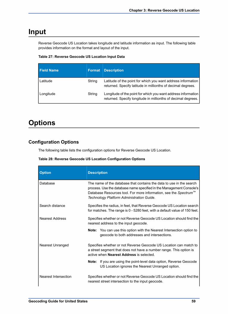
InputReverse Geocode US Location takes longitude and latitude information as input. The following tableprovides information on the format and layout of the input.
Table 27: Reverse Geocode US Location Input Data
DescriptionFormatField Name
Latitude of the point for which you want address informationreturned. Specify latitude in millionths of decimal degrees.
StringLatitude
Longitude of the point for which you want address informationreturned. Specify longitude in millionths of decimal degrees.
StringLongitude
Options
Configuration OptionsThe following table lists the configuration options for Reverse Geocode US Location.
Table 28: Reverse Geocode US Location Configuration Options
DescriptionOption
The name of the database that contains the data to use in the searchprocess. Use the database name specified in theManagement Console's
Database
Database Resources tool. For more information, see the Spectrum™
Technology Platform Administration Guide.
Specifies the radius, in feet, that Reverse Geocode US Location searchfor matches. The range is 0 - 5280 feet, with a default value of 150 feet.
Search distance
Specifies whether or not Reverse Geocode US Location should find thenearest address to the input geocode.
Nearest Address
You can use this option with the Nearest Intersection option togeocode to both addresses and intersections.
Note:
Specifies whether or not Reverse Geocode US Location can match toa street segment that does not have a number range. This option isactive when Nearest Address is selected.
Nearest Unranged
If you are using the point-level data option, Reverse GeocodeUS Location ignores the Nearest Unranged option.
Note:
Specifies whether or not Reverse Geocode US Location should find thenearest street intersection to the input geocode.
Nearest Intersection
59Geocoding Guide for United States
Chapter 3: Reverse Geocode US Location

DescriptionOption
You can use this option with the Nearest address option togeocode to both addresses and intersections.
Note:
Specifies whether or not Reverse Geocode US Location shoulddetermine the address's APN (assessor's parcel number). The APN is
Determine Assessor's ParcelNumber
an ID number assigned to a property by the local property tax authority.The APN is returned in theAPN output field, which is part of the Censusoutput group.
This option requires that you have licensed and installed theCenrus Enhanced Points or Centrus Premium Points database.
Note:
APN data is not available for all addresses. See the coveragemap included with the points database.
Specifies the offset distance from the street segments. The range is 0- 5280 feet, with the default value of 50 feet.
Offset
The offset distance is used in street-level geocoding to prevent thegeocode from being in the middle of a street. It compensates for thefact that street-level geocoding returns a latitude and longitude point inthe center of the street where the address is located. Since the buildingrepresented by an address is not on the street itself, you do not wantthe geocode for an address to be a point on the street. Instead, youwant the geocode to represent the location of the building which sitsnext to the street. For example, an offset of 50 feet means that thegeocode will represent a point 50 feet back from the center of the street.The distance is calculated perpendicular to the portion of the streetsegment for the address. Offset is also used to prevent addresses acrossthe street from each other from being given the same point. The followingdiagram shows an offset point in relation to the original point.
Street coordinates are accurate to 1/10,000th of a degree andinterpolated points are accurate to 1/1,000,000th of a degree.
Specifies the distance, in feet, to squeeze the street end points instreet-level geocoding. The range is 0 -2147483647 feet, with the default
Squeeze
value of 50 feet. The following diagram compares the end points of astreet to squeezed end points.
Spectrum Technology Platform 9.060
Options

DescriptionOption
Specifies the format to use for returned latitude/longitude.Output Latitude/Longitudeformat The format is 90.000000-180.000000. Default.Decimal
The format is 90000000-180000000.Integer
Specifies the format to use for input latitude/longitude.Input Latitude/Longitudeformat The format is 90.000000-180.000000. Default.Decimal
The format is 90000000-180000000.Integer
Specifies whether or not Reverse Geocode US Location returns theelevation of the address. Elevation is the distance above or below sea
Determine elevation
level of a given location. The elevation is returned in the Elevationoutput field, which is part of the Latitude/Longitude output group.
This option requires that you have licensed and installed theCentrus Premium Points database. Elevation data is not
Note:
available for all addresses. See the coverage map includedwith the points database.
Output FormatThe following table lists the options that control the format of the output .
Table 29: Reverse Geocode US Location Output Format Options
DescriptionOption
Specifies the casing of the output data. One of the following:Casing
The output in mixed case (default). For example:
123 Main StMytown FL 12345
Mixed
The output in upper case. For example:
123 MAIN STMYTOWN FL 12345
Upper
Specifies whether or not Reverse Geocode US Location provides anadditional description field as output. This field provides the text
Return descriptions in output
equivalent to a field represented by a code. For example, LocationCodereturns a code that indicates the accuracy (quality) of the assigned
61Geocoding Guide for United States
Chapter 3: Reverse Geocode US Location

DescriptionOption
geocode. LocationCode.Description provides the description for thecode returned.
Output DataThe following table lists the options that control which data is returned by Reverse Geocode US Location.
Table 30: Reverse Geocode US Location Output Data Options
DescriptionOption
Specifies the optional data to include in the output. Note that ReverseGeocode US Location always returns the data listed in Default Output
Include data
on page 64. The data you select here is returned with the default outputdata.
• Census• Latitude/Longitude• Parsed Elements• Qualifiers• Range• Segment
For a list of the fields included in each data type, see Output on page62.
If you do not want all of the fields in a record type returned, do not selectthe check box. Instead, list only those fields you want returned in Includeextra fields.
Specifies the individual output fields you want returned. List fields witha pipe ( | ) between each field. You can use this field instead of the
Include extra fields
Output Record Type to limit the output to those fields that are importantto your data needs.
Default list:AddressLine1|LastLine|Longitude|Latitude|MatchCode|LocationCode
OutputReverse Geocode US Location returns the following categories of data:
• Census on page 63• Default Output on page 64• Latitude/Longitude on page 65• Parsed Elements on page 66• Qualifiers on page 66• Range on page 68• Segment on page 69
Spectrum Technology Platform 9.062
Output

If you are using the API, the output returned is in the DataTable class. For information on theDataTable class, see the "API Fundamentals" section of the Spectrum™ Technology PlatformAPI Guide.
Note:
CensusThe Census output record type contains census information from the U.S. 2000 Census. To includecensus data in the output, select the Census check box under Output Record Type.
Table 31: Census Output Fields
DescriptionField Name
The assessor's parcel number of the property. The assessor's parcelnumber is an ID number assigned to a property by the local propertytax authority.
APN
Single character block suffix for split Census blocks. Returns A or B.Only available in Centrus Enhanced data.
BlockSuffix
Indicates Core Based Statistical Area (CBSA).CBSACode
Denotes a subdivision of a CBSA.CBSADivisionCode
Describes a subdivision of a CBSA. Only returned when you set theconfiguration options to return additional descriptions (verbose).
CBSADivisionName
Metropolitan Statistical Area. Valid values include:CBSAMetro
Metro statistical area.Y
Micro statistical area.N
Data unavailable.null
Describes CBSA. Only returned when you set the configuration optionsto return additional descriptions (verbose).
CBSAName
The ID of the Census Federal Information Processing Standard (FIPS)code.
CensusBlockID
6-digits extracted from the CensusBlockID.CensusTract
Denotes the code for a geographic entity that consists of 2 or moreadjacent CBSAs with employment interchange measures of at least 15.
CSACode
Describes the name for a geographic entity that consists of 2 or moreadjacent CBSAs with employment interchange measures of at least 15.
CSAName
Only returned when you set the configuration options to return additionaldescriptions (verbose).
Name of the county, including the text "County" or "Parish." Only returnedwhen you set the configuration options to return additional descriptions(verbose).
USCountyName
3-digit FIPS county code extracted from the CensusBlockID.USFIPSCountyNumber
2-digit FIPS state code extracted from the CensusBlockID.USFIPSStateCode
5-digit FIPS code for state and county extracted from the CensusBlockID.USFIPSStateCountyCode
63Geocoding Guide for United States
Chapter 3: Reverse Geocode US Location

Default OutputReverse Geocode US Address always includes the following fields in the output.
Table 32: Default Output Fields
DescriptionField Name
Mailstop, attention line, or deliver instructions as included in the inputdata.
AdditionalInputData
Reverse Geocode US Location does not process thisinformation. It simply includes the information as entered in theinput data.
Note:
First line of the address.AddressLine1
Second line of the address.AddressLine2
Municipality name.City
Indicates the confidence in the output provided. The range is from 0(zero) to 100, with 0 being no match and 100 being an exact match.
Confidence
Country name.Country
The distance, in feet, of the dwelling along the segment.Distance
The location's elevation in feet above or below sea level.Elevation
Name of the company.FirmName
Complete last address line (municipality, state, and postal code).LastLine
7-digit number in degrees and calculated to 4 decimal places (in theformat specified).
Latitude
Indicate the accuracy (quality) of the assigned geocode.LocationCode
For more information, see Address Location Codes on page 80.
7-digit number in degrees and calculated to 4 decimal places (in theformat specified).
Longitude
Indicates the portions of the address that matched to the directory file.MatchCode
For more information, see Geocoding Match Codes on page 93.
The percent along the street segment that matches the geocode. Forexample, if the returned geocode falls 1/3 along the way of the entirestreet segment, the percent is 33.000.
PercentGeocode
This value is always 0.0 for matches to point-level data andintersections.
Note:
9-digit ZIP Code with or without a hyphen.PostalCode
4-digit ZIP Code extension.PostalCode.AddOn
5-digit ZIP Code.PostalCode.Base
Spectrum Technology Platform 9.064
Output

DescriptionField Name
The underlying software that processed the request. KGR for ReverseGeocode US Location.
ProcessedBy
Rural Route Highway Contract (RRHC). This field is null if the addressnot a RRHC.
RRHC
2-character state abbreviation.StateProvince
Reports the success or failure of the match attemptStatus
Successnull
FailureF
Reason for failure:Status.Code
• Internal System Error• No Geocode Found• Insufficient Input Data
Description of the problem:Status.Description
Returned when Status.Code contains"Internal System Error."
Problem + explanation
Returned when Status.code contains "NoGeocode Found".
Geocoding Failed
Returned when Status.code contains "NoGeocode Found."
No location returned
The data set that Reverse Geocode US Location attempted to matchagainst.
StreetDataType
Indicates the side of the street for the range.StreetSide
Left side of the streetLEFT
Right side of the streetRIGHT
Both sides of the streetBOTH
Urbanization name. Puerto Rico addresses only.USUrbanName
Latitude/LongitudeThe latitude/longitude output fields contain the geographic coordinates of the location. To includelatitude/longitude output fields in the output, select the Latitude/Longitude check box under OutputRecord Type.
Table 33: Latitude/Longitude Output Fields
DescriptionField Name
The location's elevation in feet above or below sea level.Elevation
7-digit number in degrees and calculated to 4 decimal places (in theformat specified).
Latitude
65Geocoding Guide for United States
Chapter 3: Reverse Geocode US Location

DescriptionField Name
7-digit number in degrees and calculated to 4 decimal places (in theformat specified).
Longitude
Parsed ElementsThe Parsed Elements output record type contains standard address information as individual units, suchas street suffixes (AVE) and leading directionals (N and SE). To include parsed elements in the output,select the Parsed Elements check box under Output Record Type.
Table 34: Parsed Elements Output Fields
DescriptionField Name
Unit, such as apartment, suite, or lot.ApartmentLabel
Unit, such as apartment, suite, or lot.ApartmentLabel2
Unit number.ApartmentNumber
Unit number.ApartmentNumber2
Prefix for cross street.CrossStreetLeadingDirectional
Name of cross street.CrossStreetName
Cross street suffix.CrossStreetSuffix
Postfix for cross street.CrossStreetTrailingDirectional
Building number for the matched location.HouseNumber
This is an approximate building number based on the latitudeand longitude provided. This approximate address may notexist or may not accept mail delivery.
Note:
Street directional that precedes the street name. For example, the N in138 N Main Street.
LeadingDirectional
Private mailbox. Not output for multiline input.PrivateMailbox
Private mailbox description. Not output for multiline input.PrivateMailbox.Designator
Street name.StreetName
The street type of the matched location. For example, AVE for Avenue.StreetSuffix
Street directional that follows the street name. For example, the N in456 Washington N.
TrailingDirectional
QualifiersThe qualifiers output record type contains qualification information on the match, such as the locationcode and the match code. To include latitude/longitude output fields in the output, select the Qualifierscheck box under Output Record Type.
Spectrum Technology Platform 9.066
Output

Table 35: Qualifiers Output Fields
DescriptionField Name
The category of postal data available. Always returns A in ReverseGeocode US Location—Validates, corrects, and provides missing postal
CountryLevel
code, city name, state/county name, street address elements, andcountry name.
USPS publish date, in the format Month Year.DatabaseVersion
Indicates if Reverse Geocode US Location denied a match because ofEarly Warning System (EWS) data.
EWSMatch
EWS denied a match.Y
EWS did not deny a match.null
For more information on EWS, see Early Warning System (EWS).
Date the database expires, in the format MM/DD/YY.ExpirationDate
Record matching score (for multimatches only).GeoStanMatchScore
Indicates if Reverse Geocode US Location found a cross-street match.Intersection
True, a cross-street match was found.T
False, a cross-street match was not found.F
Reverse Geocode US Location located a matched record by an indexalias. Returns 3 characters. The first is an N for normal street match or
IsAlias
A for alias match (including buildings, aliases, firms, etc.). The next 2characters are:
Basic index (normal address match)01
USPS street name alias index02
USPS building index03
USPS firm name index04
Statewide intersection alias match (when using theUsw.gsi or Use.gsi file)
05
Spatial data street name alias (when using, theUs_pw.gsi, Us_pe.gsi, Us_psw.gsi, or Us_pse.gsi file isrequired)
06
Alternate index (when using Zip9.gsu, Zip9e.gsu, andZip9w.gsu)
07
LACSLink08
Indicates if Reverse Geocode US Location converted an address dueto the Locatable Address Conversion System (LACS).
LACSAddress
ConvertedL
Not converted.null
For more information on LACS, see Locatable Address ConversionSystem (LACS).
67Geocoding Guide for United States
Chapter 3: Reverse Geocode US Location

DescriptionField Name
LocationCode converted to text. Only returned when you set theconfiguration options to return additional descriptions (verbose).
LocationCode.Description
MatchCode converted to text. Only returned when you set theconfiguration options to return additional descriptions (verbose).
MatchCode.Description
Indicates the record type:RecordType
• GeneralDelivery• HighRise• FirmRecord• Normal• PostOfficeBox• RRHighwayContract
Indicates type of match that occurred for the record type HighRise orRRHighwayContract:
RecordType.Default
Default match.Y
Exact match.N
Not matched.U
Indicates the data used to obtain a match.StreetDataCode
USPS data in either the Centrus Enhanced, CentrusTomTom, or Centrus NAVTEQ database.
0
TIGER data in the Centrus Enhanced database.1
TomTom data in the Centrus TomTom database.2
NAVTEQ data in the Centrus NAVTEQ database.6
TomTom point-level data in the Centrus TomTom Pointsdatabase.
7
Point-level data from the Centrus Points database.8
Auxiliary file data.9
Indicates the data first used to attempt a match.StreetDataType
RangeThe range output record type contains information on the street range, such as the high and low unitnumbers. To include range data fields in the output, select the Range check box under Output RecordType.
Table 36: Range Output Fields
DescriptionField Name
USPS code that specifies whether a record is a base or alternate record.Alternate
Base record. Base records can represent a range of addressesor an individual address, such as a firm record.
B
Spectrum Technology Platform 9.068
Output

DescriptionField Name
Alternate record. Alternate records are individual deliverypoints.
A
House number high.HouseNumberHigh
House number low.HouseNumberLow
Indicates if the house number range contains even or odd numbers.HouseNumberParity
EvenE
OddO
BothB
4-digit ZIP Code extension high.PostalCodeExtensionHigh
4-digit Zip Code extension low.PostalCodeExtensionLow
Unit number high.UnitNumberHigh
Unit number low.UnitNumberLow
Indicates if the unit number range contains even or odd numbers.UnitNumberParity
EvenE
OddO
BothB
SegmentThe segment output record type contains information on the street segment identified by the data provider.To include segment data fields in the output, select the Segment check box under Output Record Type.
Table 37: Segment Output Fields
DescriptionField Name
Provides the Census FIPS Code that indicates the address is on theleft side of the street.
BlockLeft
Provides the Census FIPS Code that indicates the address is on theright side of the street.
BlockRight
Current left Block suffix for Census 2000 Geography. Returns A or B.Only available in Centrus Enhanced data.
BlockSuffixLeft
Current right Block suffix for Census 2000 Geography. Returns A or B.Only available in Centrus Enhanced data.
BlockSuffixRight
The type of road:RoadClass
Major1
Minor2
Unique 10-digit segment ID assigned by the street network provider.SegmentCode
69Geocoding Guide for United States
Chapter 3: Reverse Geocode US Location

DescriptionField Name
Indicates the order of numbers on a segment.SegmentDirection
ForwardF
ReversedR
BothB
UndeterminedU
A high range number in the segment.SegmentHouseNumberHigh
A low range number in the segment.SegmentHouseNumberLow
The length, in feet, of a block segment.SegmentLength
Indicates which side of the street has odd numbers.SegmentParity
Left side of the streetL
Right side of the streetR
Both sides of the streetB
UndeterminedU
Spectrum Technology Platform 9.070
Output

4Geocode US AddressAuxiliary Files
In this section:
• Auxiliary File Overview . . . . . . . . . . . . . . . . . . . . . . . . . . . .72• Matching to Auxiliary Files . . . . . . . . . . . . . . . . . . . . . . . .72• Auxiliary Match Output . . . . . . . . . . . . . . . . . . . . . . . . . . . .73• Auxiliary File Layout . . . . . . . . . . . . . . . . . . . . . . . . . . . . . .74

Auxiliary File OverviewUse auxiliary files to match against special data that is not included in the Geocode US Address database.
The Geocode US Address database is updated regularly to incorporate changes made by the USPSand third-party data vendors. You may have newer information that has not yet been incorporated.Auxiliary files provide a way for you to process your input records against a file that includes thesechanges.
Reverse Geocode US Address does not support auxiliary files.Note:
There are two types of auxiliary file records:
• Street Records—Contains a range of one or more addresses on a street. For required fields, seeAuxiliary File Layout on page 74. A street record must not have secondary address informationmailstops, Private mail boxes (PMBs), and PO Boxes.
• Landmark Records—Represents a single site. For required fields, see Auxiliary File Layout onpage 74. A landmark record must not have street type abbreviations, predirectional and postdirectionalabbreviations, or low and high house numbers.
You cannot update the auxiliary file while Geocode US Address is running. If you want to updatethe auxiliary file, stop Geocode US Address before attempting to replace or edit the file.
Note:
Matching to Auxiliary FilesGeocode US Address matches an input address to an auxiliary file as follows:
1. Geocode US Address determines if there is an auxiliary file present.
If you have an auxiliary file in the dataset directory, Geocode US Address automatically loads andattempts to match to the auxiliary file. You can verify that Geocode US Address found an auxiliaryfile by looking at the version information page in the Management Console. One of the followingstatuses display:
• Loaded—An auxiliary file is loaded• None—An auxiliary file has not been found or loaded• Invalid—An auxiliary file was found, but failed to successfully load
Geocode US Address only accepts one auxiliary file. If more than one auxiliary files is present,Geocode US Address attempts to match against the first file. Geocode US Address ignores anyadditional auxiliary files for matching, regardless if Geocode US Address found a match to the firstauxiliary file.
If a record in the auxiliary files is invalid, Geocode US Address returns a invalid record message.Geocode US Address continues to match input addresses with the auxiliary file, but will not matchto the invalid auxiliary file record.
2. If an auxiliary file is present, Geocode US Address attempts to match to the auxiliary file.
Geocode US Address assumes that the auxiliary file is the most accurate data set and attempts tofind a match to the input address in the auxiliary file. If Geocode US Address cannot find a match inthe auxiliary file, it matches the input address with the other Enterprise Geocoding Module databases.
Geocode US Address only matches input address lists to auxiliary files if there is an exactmatch. Your input address list should be free of misspellings and incomplete addresses.
Note:
3. If Geocode US Address finds an exact record match to the auxiliary file, it standardizes the matchto USPS regulations and returns the output of the auxiliary file match.
Geocode US Address uses the following defaults if you do not include the values in the auxiliary file:
• House number parity = B (both odds and evens)
Spectrum Technology Platform 9.072
Auxiliary File Overview

• Segment direction = A (ascending)• Side of street = U (unknown)
Record Type Matching RulesWhen matching against an auxiliary file, Geocode US Address uses the following rules:
Street record match
• The input house number must fall within or be equal to the low and high house number values of theauxiliary record.
• The input house number must agree with the parity of the auxiliary record.• The input ZIP Code must exactly match the ZIP Code of the auxiliary record.
Landmark record match
• The input data must contain a ZIP Code and address line, and the values must exactly match thevalues on the auxiliary record.
• The input address cannot have any other data, such as a house number, unit number, or Private MailBox (PMB).
Geocode US Address only matches the ZIP Code against the auxiliary file. Geocode US Addressdoes not verify that the ZIP Code of the input address record is correct for the city and state.Validate this information in your input lists before processing against the auxiliary file.
Note:
Unavailable Features and FunctionsThe following features and functions do not apply when Geocode US Address makes an auxiliary filematch.
• Geocode US Address does not match to• two-line addresses• multi-line addresses• intersection addresses• dual addresses• Geocode US Address does not perform EWS, ZIPMove, LACSLink, or DPV processing on auxiliarymatches
• You can only access the auxiliary file with processing through the Find function. You cannot accessthe auxiliary file through the Find First/Next or MBR functions
• You can only access the auxiliary file logic using the address code option of the Find function, not thegeocode option.
Auxiliary Match OutputGeocode US Address provides special data type, match codes, and location code values for auxiliarymatches. When Geocode US Address finds a match to an auxiliary file, the default output follows theseconventions:
• Geocode US Address formats the auxiliary file match as a street-style address for output. This excludesPO Boxes, Rural Routes, General Delivery, etc.
• Geocode US Address follows the case setting you indicate (by default, upper case) by the casingfunction. Geocode US Address does not maintain the casing in the auxiliary file for mixed casingvalues. For example, Geocode US Address returns O'Donnell as ODONNELL or Odonnell dependingon the setting of the casing function.
Geocode US Address does not change the casing for the User Data field.Note:
73Geocoding Guide for United States
Chapter 4: Geocode US Address Auxiliary Files

• Geocode US Address removes spaces at the beginning and ending of fields in the auxiliary file.
Geocode US Address does not remove spaces for the User Data field.Note:
Auxiliary File LayoutYou must comply with the following organizational rules when you create auxiliary file:
• Files are fixed-width text files with a .gax extension• Files can contain up to 500,000 records.• Use semicolons in the first column to indicate a row is a comment, not a data record; Geocode USAddress ignores rows that begin with a semicolon.
• For optimal performance, order the records within the file by descending ZIP Code, and then descendingstreet name.
• Records must represent only one side of a street. To represent both sides of a street, create a recordfor each side of the street.
• Records must represent segments that are straight lines.• House numbers must follow USPS rules documented in Publication 28.• Numeric fields, such as ZIP Codes, must contain only numbers.• If house numbers are present in the record, the house number range must be valid according to USPSrules documented in Publication 28, Appendix E.
• Latitude and Longitude values must be in millionths of decimal degrees.• Records cannot contain PO Box addresses.
The following table shows auxiliary file layout.
Table 38: Auxiliary File Layout
PositionLengthExactMatchRequiredifPresent
RequiredforLandmarkMatch
RequiredforStreetSegmentMatch
RequiredDescriptionField
1-55XXXX5-digit ZIP Code.ZIP Code
6-3530XXXXName of the street orlandmark.
Street name
36-394XStreet type. Also calledstreet suffix.
Street typeabbreviation
See the USPSPublication 28,Appendix C for acomplete list ofsupported street types.
40-412XUSPS street namepredirectional
Predirectional
abbreviation.Supported values areN, E, S, W, NE, NW,SE, and SW.
Spectrum Technology Platform 9.074
Auxiliary File Layout

PositionLengthExactMatchRequiredifPresent
RequiredforLandmarkMatch
RequiredforStreetSegmentMatch
RequiredDescriptionField
42-432XUSPS street namepostdirectional
Postdirectional
abbreviations.Supported values areN, E, S, W, NE, NW,SE, and SW.
44-474RESERVEDRESERVED
48-5811XXLow house number ofthe address range.
Low housenumber
59-6911XXHigh house number ofthe address range.
High housenumber
701Indicates the parity ofthe house number inthe range.
House numberparity
E - Even
O - Odd
B - Both
711Direction the housenumbers progressalong the segment:
Segmentdirection
F - Forward (default)
R - Reverse
721RESERVEDRESERVED
73-742US government FIPSstate code.
FIPS state
75-773US government FIPScounty code.
FIPS county
78-836US Census tractnumber.
Census tract
841US Census blockgroup number.
Census blockgroup
85-873US Census block IDnumber.
Census blockID
88-925RESERVEDRESERVED
93-942USPS stateabbreviation.
Stateabbreviation
95-11925Name of the county.County name
75Geocoding Guide for United States
Chapter 4: Geocode US Address Auxiliary Files

PositionLengthExactMatchRequiredifPresent
RequiredforLandmarkMatch
RequiredforStreetSegmentMatch
RequiredDescriptionField
120-1245Minor Civil Divisioncode.
MCD code
125-16440Minor Civil Divisionname.
MCD name
165-1695Core Based StatisticalArea code.
CBSA code
170-21849Core Based StatisticalArea name.
CBSA name
219-2235RESERVEDRESERVED
224-26340City name. Overridesthe city/state preferred
City Name
city name upon areturn.
264-500237RESERVEDRESERVED
501-800300User-defined data.User-defineddata
801-81010User-defined uniquerecord identifier.
Record IDNumber
8111Side of the street forthe address:
Side of street
L - Left side
R - Right side
B - Both sides
U - Unknown side(default)
This is relative to thesegment endpointsand the segmentdirection.
812-82211XXXBeginning longitude ofthe street segment inmillionths of degrees.
Beginninglongitude
823-83210XXXBeginning latitude ofthe street segment inmillionths of degrees.
Beginninglatitude
833-84311Ending longitude of thestreet segment inmillionths of degrees.
Endinglongitude
Spectrum Technology Platform 9.076
Auxiliary File Layout

PositionLengthExactMatchRequiredifPresent
RequiredforLandmarkMatch
RequiredforStreetSegmentMatch
RequiredDescriptionField
844-85310Ending latitude of thestreet segment inmillionths of degrees.
Ending latitude
77Geocoding Guide for United States
Chapter 4: Geocode US Address Auxiliary Files


5Location and Match Codesfor U.S. Geocoding
In this section:
• Address Location Codes . . . . . . . . . . . . . . . . . . . . . . . . . .80• Street Centroid Location Codes . . . . . . . . . . . . . . . . . . . .86• ZIP + 4 Centroid Location Codes . . . . . . . . . . . . . . . . . . .87• Geographic Centroid Location Codes . . . . . . . . . . . . . . .91• Address Unavailable . . . . . . . . . . . . . . . . . . . . . . . . . . . . . .92• Geocoding Match Codes . . . . . . . . . . . . . . . . . . . . . . . . . .93

Address Location CodesLocation codes that begin with an "A" are address location codes. Address location codes indicate ageocode made directly to a street network segment (or two segments, in the case of an intersection).
An address location code has the following characters.
Always an A indicating an address location.1st character
May be one of the following2nd character
Interpolated address pointlocation
C
Auxiliary file data locationG
Application infers the correctsegment from the candidaterecords
I
Point-level data locationP
Location represents a rangedaddress
R
Location on a street rangeS
Location on an intersection of twostreets
X
Digit indicating other qualities about the location.3rd and 4th character
Table 39: Address Location Codes
DescriptionCode
Indicates an auxiliary file for ageocode match where n is one ofthe following values:
AGn
The geocode represents thecenter of a parcel or building.
n = 0
The geocode is an interpolatedaddress along a segment.
n = 1
The geocode is an interpolatedaddress along a segment, and
n = 2
the side of the street cannot bedetermined from the dataprovided in the auxiliary filerecord.
The geocode is the midpoint ofthe street segment.
n = 3
Indicates a point-level geocodematch representing the center of
APnn
Spectrum Technology Platform 9.080
Address Location Codes

DescriptionCode
a parcel or building, where nn isone of the following values:
Parcel centroidnn = 02
Indicates the center of anaccessor's parcel (tract or lot)polygon. When the center of anirregularly shaped parcel fallsoutside of its polygon, thecentroid is manually repositionedto fall inside the polygon asclosely as possible to the actualcenter.
Address pointsnn = 04
Represents field-collected GPSpoints with field-collected addressdata.
Structure centroidnn = 05
Indicates the center of a buildingfootprint polygon, where thebuilding receives mail or hastelephone service.
Usually a residential addressconsists of a single building. Forhouses with outbuildings(detached garages, shed, barns,etc.), only the residences have astructure point. Condominiumsand duplexes havemultiple pointsfor each building. Largerbuildings, such as apartmentcomplexes, typically receive mailat one address for each buildingand therefore individualapartments are not representedas discrete structure points.
Shopping malls, industrialcomplexes, and academic ormedical center campuses whereone building accepts mail for theentire complex are representedas one point. When addressesare assigned to multiple buildingswithin one complex, eachaddressed structure isrepresented by a point.
If the center of a structure fallsoutside of its polygon, the centeris manually repositioned to fallinside the polygon.
81Geocoding Guide for United States
Chapter 5: Location and Match Codes for U.S. Geocoding

DescriptionCode
Manually placednn = 07
Address points are manuallyplaced to coincide with themidpoint of a parcel's streetfrontage at a distance from thecenter line.
Front door pointnn = 08
Represents the designatedprimary entrance to a building. Ifa building has multiple entrancesand there is no designatedprimary entrance or the primaryentrance cannot readily bedetermined, the primary entranceis chosen based on proximity tothe main access street andavailability of parking.
Driveway offset pointnn = 09
Represents a point located on theprimary access road (mostcommonly a driveway) at aperpendicular distance ofbetween 33-98 feet (10-30meters) from the main roadway.
Street access pointnn = 10
Represents the primary point ofaccess from the street network.This address point type is locatedwhere the driveway or otheraccess road intersects the mainroadway.
Base parcel pointnn=21
When unable to match to an inputunit number, or when the unitnumber is missing from anaddress location with multipleunits, the "base" parcelinformation is returned, theaddress is not standardized to aunit number, and additionalinformation, such as anAssessor's Parcel Number, is notreturned.
The correct segment is inferredfrom the candidate records atmatch time.
AIn
Spectrum Technology Platform 9.082
Address Location Codes
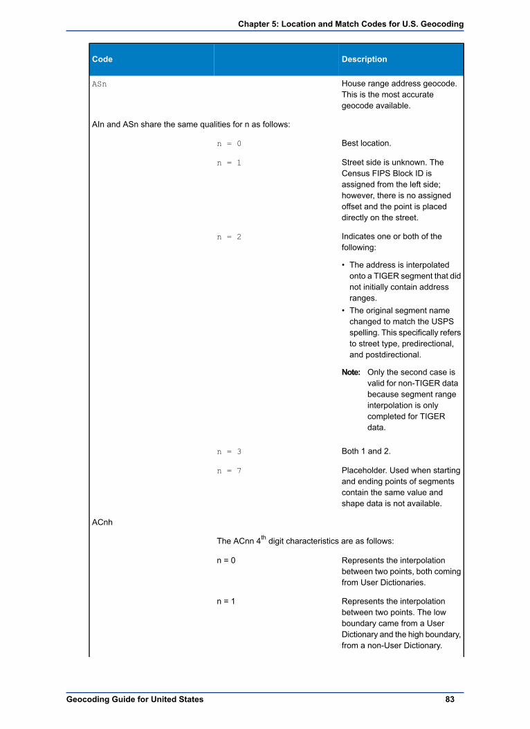
DescriptionCode
House range address geocode.This is the most accurategeocode available.
ASn
AIn and ASn share the same qualities for n as follows:
Best location.n = 0
Street side is unknown. TheCensus FIPS Block ID is
n = 1
assigned from the left side;however, there is no assignedoffset and the point is placeddirectly on the street.
Indicates one or both of thefollowing:
n = 2
• The address is interpolatedonto a TIGER segment that didnot initially contain addressranges.
• The original segment namechanged to match the USPSspelling. This specifically refersto street type, predirectional,and postdirectional.
Only the second case isvalid for non-TIGER data
Note:
because segment rangeinterpolation is onlycompleted for TIGERdata.
Both 1 and 2.n = 3
Placeholder. Used when startingand ending points of segments
n = 7
contain the same value andshape data is not available.
ACnh
The ACnn 4th digit characteristics are as follows:
Represents the interpolationbetween two points, both comingfrom User Dictionaries.
n = 0
Represents the interpolationbetween two points. The low
n = 1
boundary came from a UserDictionary and the high boundary,from a non-User Dictionary.
83Geocoding Guide for United States
Chapter 5: Location and Match Codes for U.S. Geocoding

DescriptionCode
Represents the interpolationbetween one point and one street
n = 2
segment end point, both comingfrom User Dictionaries.
Represents the interpolationbetween one point (low boundary)
n = 3
and one street segment end point(high boundary). The lowboundary came from a UserDictionary and the high boundaryfrom a non-User Dictionary.
Represents the interpolationbetween two points. The low
n = 4
boundary came from a non-UserDictionary and the high boundaryfrom a User Dictionary.
Represents the interpolationbetween two points, both comingfrom non-User Dictionaries.
n = 5
Represents the interpolationbetween one point (low boundary)
n = 6
and one street segment end point(high boundary). The lowboundary came from a non-UserDictionary and the high boundaryfrom a User Dictionary.
Represents the interpolationbetween one point and one street
n = 7
segment end point and both camefrom non-User Dictionaries.
Represents the interpolationbetween one street segment end
n = 8
point andone point, both comingfrom User Dictionaries.
Represents the interpolationbetween one street segment end
n = 9
point (low boundary) andone point(high boundary). The lowboundary came from a UserDictionary and the high boundaryfrom a non-User Dictionary.
Represents the interpolationbetween two street segment end
n = A
points, both coming from UserDictionaries.
Represents the interpolationbetween two street segment end
n = B
points. The low boundary came
Spectrum Technology Platform 9.084
Address Location Codes

DescriptionCode
from a User Dictionary and thehigh boundary from a non-UserDictionary.
Represents the interpolationbetween one street segment end
n = C
point (low boundary) and onepoint (high boundary). The lowboundary came from a non-UserDictionary and the high boundaryfrom a User Dictionary.
Represents the interpolationbetween one street segment end
n = D
point and one point, both comingfrom non-User Dictionary.
Represents the interpolationbetween two street segment end
n = E
points. The low boundary camefrom a non-User Dictionary andthe high boundary from a UserDictionary.
Represents the interpolationbetween two street segment end
n = F
points, both coming fromnon-User Dictionaries.
Ranged address geocode, wheren is one of the following:
ARn
The geocode is placed along asingle street segment, midway
n = 1
between the interpolated locationof the first and second inputhouse numbers in the range.
The geocode is placed along asingle street segment, midway
n = 2
between the interpolated locationof the first and second inputhouse numbers in the range, andthe side of the street is unknown.The Census FIPS Block ID isassigned from the left side;however, there is no assignedoffset and the point is placeddirectly on the street.
The input range spans multipleUSPS segments. The geocode is
n = 4
placed on the endpoint of thesegment which corresponds tothe first input house number,
85Geocoding Guide for United States
Chapter 5: Location and Match Codes for U.S. Geocoding

DescriptionCode
closest to the end nearest thesecond input house number.
Placeholder. Used when thestarting and ending points of the
n = 7
matched segment contain thesame value and shape data is notavailable.
Intersection geocode, where n isone of the following:
AXn
Standard single-point intersectioncomputed from the center linesof street segments.
n = 3
Interpolated (divided-road)intersection geocode. Attempts
n = 8
to return a centroid for theintersection.
Street Centroid Location CodesLocation codes that begin with "C" are street centroid location codes. Street centroid location codesindicate the Census ID accuracy and the position of the geocode on the returned street segment. Streetcentroids may be returned if the street centroid fallback option is enabled and an address-level geocodecould not be determined.
A street centroid location code has the following characters.
Always C indicating a location derived from a streetsegment.
1st character
Census ID accuracy based on the search area usedto obtain matching Street Segment.
2nd character
Location of geocode on the returned streetsegment.
3rd character
The following table contains the values and descriptions for the location codes.
DescriptionCodeCharacter position
2nd Character
Block Group accuracy (mostaccurate). Based on input ZIPCode.
B
Census Tract accuracy. Basedon input ZIP Code.
T
Spectrum Technology Platform 9.086
Street Centroid Location Codes

DescriptionCodeCharacter position
Unclassified Census accuracy.Normally accurate to at least the
C
County level. Based on input ZIPCode.
Unknown Census accuracy.Based on Finance area.
F
Unknown Census accuracy.Based on input City.
P
3rd Character
Segment Centroid.C
Segment low-range end point.L
Segment high-range end point.H
ZIP + 4 Centroid Location CodesLocation codes that begin with a "Z" are ZIP + 4 centroid location codes. ZIP + 4 centroids indicate ageocode could not be determined for the address, so the location of the center of the address's ZIP + 4was returned instead. ZIP + 4 centroid location codes indicate the quality of two location attributes:Census ID accuracy and positional accuracy.
A ZIP + 4 centroid location code has the following characters.
Always Z indicating a location derived from a ZIPcentroid.
1st character
Census ID accuracy.2nd character
Location type.3rd character
How the location and Census ID was defined.Provided for completeness, but may not be usefulfor most applications.
4th character
Table 40: ZIP + 4 Centroid Location Codes
DescriptionCodeCharacter Position
2nd Character
Block Group accuracy (mostaccurate).
B
Census Tract accuracy.T
Unclassified Census accuracy.Normally accurate to at least theCounty level.
C
87Geocoding Guide for United States
Chapter 5: Location and Match Codes for U.S. Geocoding

DescriptionCodeCharacter Position
3rd Character
Location of the Post Office thatdelivers mail to the address, a
5
5-digit ZIP Code centroid, or alocation based upon locale (city).See the 4th character for aprecise indication of locationalaccuracy.
Location based upon a ZIP + 2centroid. These locations can
7
represent a multiple block area inurban locations, or a slightlylarger area in rural settings.
Location based upon a ZIP + 4centroid. These are the most
9
accurate centroids and normallyplace the location on the correctblock face. For a small number ofrecords, the location may be themiddle of the entire street onwhich the ZIP + 4 falls. See the4th character for a preciseindication of locational accuracy.
4th Character
Address matched to a singlesegment. Location assigned in
A
the middle of the matched streetsegment, offset to the proper sideof the street.
Address matched to a singlesegment, but the correct side of
a
the street is unknown. Locationassigned in the middle of thematched street segment, offsetto the left side of the street, asaddress ranges increase.
Address matched to multiplesegments, all segments have the
B
same Block Group. Locationassigned to the middle of thematched street segment with themost house number ranges withinthis ZIP + 4. Location offset to theproper side of the street.
Same as methodology B exceptthe correct side of the street is
b
unknown. Location assigned inthe middle of the matched street
Spectrum Technology Platform 9.088
ZIP + 4 Centroid Location Codes

DescriptionCodeCharacter Position
segment, offset to the left side ofthe street, as address rangesincrease.
Address matched to multiplesegments, with all segments
C
having the same Census Tract.Returns the Block Grouprepresenting themost householdsin this ZIP + 4. Location assignedto t he middle of the matchedstreet segment with the mosthouse number ranges within thisZIP + 4. Location offset to theproper side of the street.
Same as methodology C exceptthe correct side of the street is
c
unknown. Location assigned inthe middle of the matched streetsegment, offset to the left side ofthe street, as address rangesincrease.
Address matched to multiplesegments, with all segments
D
having the same County. Returnsthe Block Group representing themost households in this ZIP + 4.Location assigned to the middleof the matched street segmentwith the most house numberranges within this ZIP + 4.Location offset to the proper sideof the street.
Same as methodology D exceptthe correct side of the street is
d
unknown. Location assigned inthe middle of the matched streetsegment, offset to the left side ofthe street, as address rangesincrease.
Street name matched; no houseranges available. All matched
E
segments have the same BlockGroup. Location placed on thesegment closest to the center ofthe matched segments. In mostcases, this is on the mid-point ofthe entire street.
Street name matched; no houseranges available. All matched
F
segments have the sameCensus
89Geocoding Guide for United States
Chapter 5: Location and Match Codes for U.S. Geocoding

DescriptionCodeCharacter Position
Tract. Location placed on thesegment closest to the center ofthe matched segments. In mostcases, this is on the mid-point ofthe entire street.
Street name matched (no houseranges available). All matched
G
segments have the same County.Location placed on the segmentclosest to the center of thematched segments. In mostcases, this is on the mid-point ofthe entire street.
Same as methodology G, butsome segments are not in the
H
same County. Used for less than.05% of the centroids.
Created ZIP + 2 cluster centroidas defined by methodologies A,
I
a, B, and b. All centroids in thisZIP + 2 cluster have the sameBlock Group. Location assignedto the ZIP + 2 centroid.
Created ZIP + 2 cluster centroidas defined by methodologies A,
J
a, B, b, C, and c. All centroids inthis ZIP + 2 cluster have thesame Census Tract. Locationassigned to the ZIP + 2 centroid.
Created ZIP + 2 cluster centroidas defined by methodologies A,
K
a, B, b, C, c, D, and d. Locationassigned to the ZIP + 2 centroid.
Created ZIP + 2 cluster centroidas defined by methodology E. All
L
centroids in this ZIP + 2 clusterhave the same Block Group.Location assigned to the ZIP + 2centroid.
Created ZIP+2 cluster centroid asdefined by methodology E and F.
M
All centroids in this ZIP + 2 clusterhave the same Census Tract.Location assigned to the ZIP + 2centroid.
Created ZIP + 2 cluster centroidas defined by methodology E, F,
N
Spectrum Technology Platform 9.090
ZIP + 4 Centroid Location Codes

DescriptionCodeCharacter Position
G, and H. Location assigned tothe ZIP + 2 centroid.
Over 95% of addresses in thisZIP Code are in a single Census
V
Tract. Location assigned to theZIP Code centroid.
Over 80% of addresses in thisZIP Code are in a single Census
W
Tract. Reasonable Census Tractaccuracy. Location assigned tothe ZIP Code centroid.
Less than 80% of addresses inthis ZIP Code are in a single
X
Census Tract. Census ID isuncertain. Location assigned tothe ZIP Code centroid.
Rural or sparsely populated area.Census code is uncertain.
Y
Location based upon the USGSplaces file.
P.O. Box or General Deliveryaddresses. Census code is
Z
uncertain. Location based uponthe Post Office location thatdelivers the mail to that address.
Geographic Centroid Location CodesLocation codes that begin with "G" are geographic centroid location codes. Geographic centroids maybe returned if the street centroid fallback option is enabled and an address-level geocode could not bedetermined. Geographic centroid location codes indicate the quality a city, county, or state centroid.
A geographic centroid location code has the following characters.
Always G indicating a location derived from ageographic centroid.
1st character
Geographic area type. One of the following:2nd character
Municipality (for example, a city)M
CountyC
StateS
91Geocoding Guide for United States
Chapter 5: Location and Match Codes for U.S. Geocoding

Address UnavailableLocation codes that begin with "E" indicate that neither an address location nor a ZIP + 4 centroid couldbe determined. This usually occurs when you have requested ZIP Code centroids of a high quality, andone is not available for that match.
An unavailable address code has the following characters.
Table 41: Match Codes for No Match
DescriptionCode
Indicates an error, or no match.This can occur when the address
Ennn
entered does not exist in thedatabase, or the address is badlyformed and cannot be parsedcorrectly. The last three digits ofan error code indicate which partsof an address the applicationcould not match to the database.
No match made.nnn = 000
Low level error.nnn = 001
Could not find data file.nnn = 002
Incorrect GSD file signature orversion ID.
nnn = 003
GSD file out of date. Only occursin CASS mode.
nnn = 004
No city and state or ZIP Codefound.
nnn = 010
Input ZIP not in the directory.nnn = 011
Input city not in the directory.nnn = 012
Input city not unique in thedirectory.
nnn = 013
Out of licensed area. Only occursif using Pitney Bowes Softwarelicensing technology.
nnn = 014
Record count is depleted andlicense has expired.
nnn = 015
No matching streets found indirectory.
nnn = 020
No matching cross streets for anintersection match.
nnn = 021
No matching segments.nnn = 022
Spectrum Technology Platform 9.092
Address Unavailable

DescriptionCode
Unresolved match.nnn = 023
No matching segments. (Sameas 022.)
nnn = 024
Too many possible cross streetsfor intersection matching.
nnn = 025
No address found whenattempting a multiline match.
nnn = 026
Invalid directional attempted.nnn = 027
Record also matched EWS data,therefore the application deniedthe match.
nnn = 028
No matching range, single streetsegment found.
nnn = 029
No matching range, multiplestreet segments found.
nnn = 030
Geocoding Match CodesGeocoding components return match codes indicating the address portions that matched or did notmatch to the database. If the geocoder cannot make a match, the match code begins with E and theremaining digits indicate why the address did not match. The digits do not specifically refer to whichaddress elements did not match, but rather why the address did not match.
Table 42: Match Codes
DescriptionCode
Same as Shh, but indicates match to an alias namerecord or an alternate record.
Ahh
The street address did not match, but the geocoderlocated a street segment based on the input ZIPCode or city
Chh
.
Matched to a small town with P.O. Box or GeneralDelivery only.
D00
Matched to an auxiliary file.Gxx
The house number was changed.Hhh
Matched to a user-defined dictionary.Jhh
Matched to the nearest address. Used with reversegeocoding. The following are the only values for N:
Nxx
93Geocoding Guide for United States
Chapter 5: Location and Match Codes for U.S. Geocoding

DescriptionCode
Nearest street center match(nearest street segmentinterpolated)
NSO
Nearest unranged street segmentNS1
Nearest point addressNP0
Nearest intersectionNX0
Successful reverse APN lookup.P
Matched to USPS range records with unique ZIPCodes. CASS rules prohibit altering an input ZIP ifit matches a unique ZIP Code value.
Qhh
Matched to a ranged address.Rhh
Matched to USPS data. This is considered the bestaddress match, because it matched directly against
Shh
the USPS list of addresses. S is returned for a smallnumber of addresses when the matched addresshas a blank ZIP + 4.
Matched to a street segment record. Streetsegment records do not contain ZIP Code
Thh
information. If you enter a ZIP Code, the applicationreturns the ZIP Code you entered. If the input cityand state has only one ZIP Code, the applicationreturns that ZIP Code.
Matched to USPS data but cannot resolve the ZIP+ 4 code without the firm name or other information.
Uhh
CASSmode returns an E023 (multiple match) errorcode.
Matched to an intersection of two streets, forexample, "Clay St & Michigan Ave." The first hex
Xhhh
digit refers to the last line information, the secondhex digit refers to the first street in the intersection,and the third hex digit refers to the second streetin the intersection.
The USPS does not allow intersections asa valid deliverable address.
Note:
Same as Xhhh, but an alias name record was usedfor one or both streets.
Yhhh
No address given, but verified the provided ZIPCode .
Z
The following table contains the description of the hex digits for the match code values.
Spectrum Technology Platform 9.094
Geocoding Match Codes

Table 43: Description of Hex Digits
In second and third hexposition means:
In first hex position means:Code
No change in address line.No change in last line.0
Street type changed.ZIP Code changed.1
Predirectional changed.City changed.2
Street type and predirectionalchanged.
City and ZIP Code changed.3
Postdirectional changed.State changed.4
Street type and postdirectionalchanged.
State and ZIP Code changed.5
Predirectional and postdirectionalchanged.
State and City changed.6
Street type, predirectional, andpostdirectional changed.
State, City, and ZIP Codechanged.
7
Street name changed.ZIP + 4 changed.8
Street name and street typechanged.
ZIP and ZIP + 4 changed.9
Street name and predirectionalchanged.
City and ZIP + 4 changed.A
Street name, street type, andpredirectional changed.
City, ZIP, and ZIP + 4 changed.B
Street name and postdirectionalchanged.
State and ZIP + 4 changed.C
Street name, street type, andpostdirectional changed.
State, ZIP, and ZIP + 4 changed.D
Street name, predirectional, andpostdirectional changed.
State, City, and ZIP + 4 changed.E
Street name, street type,predirectional, and postdirectionalchanged.
State, City, ZIP, and ZIP + 4changed.
F
If neither an address location nor a ZIP + 4 centroid can be determined, the location code will start with"E". This occurs infrequently when the component does not have a 5-digit centroid location. EnterpriseGeocoding Module components can also return an E location code type when it cannot standardize aninput address and there is no input ZIP Code. In this case, do not assume the ZIP Code returned withthe non-standardized address is the correct ZIP Code because the component did not standardize theaddress; therefore, the component does not return geocoding or Census Block information.
95Geocoding Guide for United States
Chapter 5: Location and Match Codes for U.S. Geocoding

Table 44: Match Codes for No Match
DescriptionCode
Indicates an error, or no match.This can occur when the address
Ennn
entered does not exist in thedatabase, or the address is badlyformed and cannot be parsedcorrectly. The last three digits ofan error code indicate which partsof an address the applicationcould not match to the database.
No match made.nnn = 000
Low level error.nnn = 001
Could not find data file.nnn = 002
Incorrect GSD file signature orversion ID.
nnn = 003
GSD file out of date. Only occursin CASS mode.
nnn = 004
No city and state or ZIP Codefound.
nnn = 010
Input ZIP not in the directory.nnn = 011
Input city not in the directory.nnn = 012
Input city not unique in thedirectory.
nnn = 013
Out of licensed area. Only occursif using Pitney Bowes Softwarelicensing technology.
nnn = 014
Record count is depleted andlicense has expired.
nnn = 015
No matching streets found indirectory.
nnn = 020
No matching cross streets for anintersection match.
nnn = 021
No matching segments.nnn = 022
Unresolved match.nnn = 023
No matching segments. (Sameas 022.)
nnn = 024
Too many possible cross streetsfor intersection matching.
nnn = 025
No address found whenattempting a multiline match.
nnn = 026
Spectrum Technology Platform 9.096
Geocoding Match Codes

DescriptionCode
Invalid directional attempted.nnn = 027
Record also matched EWS data,therefore the application deniedthe match.
nnn = 028
No matching range, single streetsegment found.
nnn = 029
No matching range, multiplestreet segments found.
nnn = 030
97Geocoding Guide for United States
Chapter 5: Location and Match Codes for U.S. Geocoding


6Encountering FalsePositives
In this section:
• What is a False-Positive? . . . . . . . . . . . . . . . . . . . . . . . . .100• Reporting DPV False-Positive Violations . . . . . . . . . . . .100• Reporting LACS/Link False-Positive Violations . . . . . .101

What is a False-Positive?To prevent the generation of address lists, the DPV and LACSLink databases include false-positiverecords. False-positive records are artificially manufactured addresses that reside in a false-positivetable. For each negative response that occurs in a DPV or LACSLink query, a query is made to thefalse-positive table. A match to this table (called a false-positive match) disables your DPV or LACSLink
key. In batch processing the job that contains the violation will complete successfully but you will not beable to run any subsequent jobs that use DPV or LACSLink until you report the violation and obtain a keyto reactivate DPV or LACSLink.
The term "seed record violation" is also used to refer to encountering false positive records. Thetwo terms mean the same thing.
Note:
Reporting DPV False-Positive ViolationsSpectrum™ Technology Platform indicates a false-positive match via messages in the server log.
During batch processing, if you encounter a false positive record the job will continue. After the jobcompletes you will not be able to run any other jobs using DPV because your DPV key is disabled. Whena DPV false positive record violation occurs, the following text is displayed in the Execution History:
DPV Seed Record Violation. Seed Code S<ZIP, ZIP+4, Address, Unit>
You can report the violation and obtain a restart key by following these steps.
1. In your browser, go to http://<yourserver>:<port>/<product code>/dpv.jsp. For example,http://localhost:8080/unc/dpv.jsp for the Universal Addressing Module andhttp://localhost:8080/geostan/dpv.jsp for the Enterprise Geocoding Module.
2. Enter the mailer's information into each field. The number in parentheses after each field nameindicates the maximum length of the field.
3. Click Submit when you're done. A File Download dialog will appear.4. Click Save to save the file to your computer. A Save As dialog will appear.5. Specify a file name and location on your local hard drive (for example c:\DPVSeedFile.txt) and
click Save.6. Go to www.g1.com/support and log in.7. Click DPV & LACSLink False Positive.8. Follow the on-screen instructions to attach your seed file and obtain a restart key.
DPV False Positive Header File LayoutThe USPS® has determined the required layout of the DPV false-positive header file, which is currentlydefined as a fixed-length file containing two or more 180-byte records. The first record must always bethe header record, whose layout is shown below.
Table 45: DPV False-Positive Header Record Layout
FormatDescriptionLengthPosition
AlphanumericMailer's company name401-40
AlphanumericMailer's address line5841-98
Spectrum Technology Platform 9.0100
What is a False-Positive?

FormatDescriptionLengthPosition
AlphanumericMailer's city name2899-126
AlphabeticMailer's state abbreviation2127-128
NumericMailer's 9-digit ZIP Code9129-137
NumericTotal Records Processed9138-146
NumericTotal Records DPV Matched9147-155
NumericPercent Match Rate to DSF9156-164
NumericPercent Match Rate to ZIP + 4®9165-173
NumericNumber of ZIP Codes on file5174-178
NumericNumber of False-Positives2179-180
The trailer record contains information regarding the DPV false-positive match. There must be one trailerrecord added to the false-positive file for every DPV false-positive match. The layout is shown below.
Table 46: DPV False-Positive Trailer Record Layout
FormatDescriptionLengthPosition
AlphanumericStreet predirectional21-2
AlphanumericStreet name283-30
AlphanumericStreet suffix abbreviation431-34
AlphanumericStreet postdirectional235-36
AlphanumericAddress primary number1037-46
AlphanumericAddress secondary abbreviation447-50
NumericAddress secondary number851-58
NumericMatched ZIP Code559-63
NumericMatched ZIP + 4®464-67
SpacesFiller11368-180
Reporting LACS/Link False-Positive ViolationsSpectrum™ Technology Platform indicates a false-positive match via messages in the server log. Batchjobs will fail if a false-positive match occurs and client/server calls will throw an exception.
The term "seed record violation" is also used to refer to encountering false positive records. Thetwo terms mean the same thing.
Note:
101Geocoding Guide for United States
Chapter 6: Encountering False Positives

When a false positive record is encountered, the server log will say:
2005-05-19 09:40:10,758 WARN [com.g1.dcg.component.Log] Seed recordviolation for RR 1 R74039 29242005-05-19 09:40:10,774 ERROR [com.g1.dcg.component.Log] Feature Disabled:LLB: LACS Seed Record Violation. Seed Code: R74039 29242005-05-19 09:40:10,867 ERROR [com.g1.dcg.job.server.stages.JobRunnerStages]Error executing jobcom.g1.dcg.stage.StageException: com.g1.dcg.component.ComponentException:Feature Disabled: LLB
1. In your browser, go to http://<ServerName>:<port>/<product code>/lacslink.jsp. For example,http://localhost:8080/unc/lacslink.jsp for the Universal Addressing Module andhttp://localhost:8080/geostan/lacslink.jsp for the Enterprise Geocoding Module.
2. Enter the mailer's information into each field. The number in parentheses after the field name indicatesthe maximum length of the field. Click Submitwhen you're done. A File Download dialog will appear.
3. Click Save to save the file to your computer. A Save As dialog will appear.4. Specify a file name and location on your local hard drive (for example c:\lacslink.txt) and click
Save.5. Go to www.g1.com/support and log in.6. Click DPV & LACSLink False Positive.7. Follow the on-screen instructions to attach your seed file and obtain a restart key.
Spectrum Technology Platform 9.0102
Reporting LACS/Link False-Positive Violations

Notices

© 2013 Pitney Bowes Software Inc. All rights reserved. MapInfo and Group 1 Software are trademarksof Pitney Bowes Software Inc. All other marks and trademarks are property of their respective holders.
USPS® Notices
Pitney Bowes Inc. holds a non-exclusive license to publish and sell ZIP + 4® databases on optical andmagnetic media. The following trademarks are owned by the United States Postal Service: CASS, CASSCertified, DPV, eLOT, FASTforward, First-Class Mail, Intelligent Mail, LACSLink, NCOALink, PAVE,PLANET Code, Postal Service, POSTNET, Post Office, RDI, SuiteLink , United States Postal Service,Standard Mail, United States Post Office, USPS, ZIP Code, and ZIP + 4. This list is not exhaustive ofthe trademarks belonging to the Postal Service.
Pitney Bowes Inc. is a non-exclusive licensee of USPS® for NCOALink® processing.
Prices for Pitney Bowes Software's products, options, and services are not established, controlled, orapproved by USPS® or United States Government. When utilizing RDI™ data to determine parcel-shippingcosts, the business decision on which parcel delivery company to use is not made by the USPS® orUnited States Government.
Data Provider and Related Notices
Data Products contained on this media and used within Pitney Bowes Software applications are protectedby various trademarks and by one or more of the following copyrights:
© Copyright United States Postal Service. All rights reserved.
© 2013 TomTom. All rights reserved. TomTom and the TomTom logo are registered trademarks ofTomTom N.V.
© Copyright NAVTEQ. All rights reserved
Data © 2013 NAVTEQ North America, LLC
Fuente: INEGI (Instituto Nacional de Estadística y Geografía)
Based upon electronic data © National Land Survey Sweden.
© Copyright United States Census Bureau
© Copyright Nova Marketing Group, Inc.
Portions of this program are © Copyright 1993-2007 by Nova Marketing Group Inc. All Rights Reserved
© Copyright Canada Post Corporation
This CD-ROM contains data from a compilation in which Canada Post Corporation is the copyright owner.
© 2007 Claritas, Inc.
The Geocode Address World data set contains data licensed from the GeoNames Project(www.geonames.org) provided under the Creative Commons Attribution License ("Attribution License")located at http://creativecommons.org/licenses/by/3.0/legalcode. Your use of the GeoNames data(described in the Spectrum™ Technology PlatformUser Manual) is governed by the terms of the AttributionLicense, and any conflict between your agreement with Pitney Bowes Software, Inc. and the AttributionLicense will be resolved in favor of the Attribution License solely as it relates to your use of the GeoNamesdata.
ICU Notices
Copyright © 1995-2011 International Business Machines Corporation and others.
All rights reserved.
Permission is hereby granted, free of charge, to any person obtaining a copy of this software andassociated documentation files (the "Software"), to deal in the Software without restriction, includingwithout limitation the rights to use, copy, modify, merge, publish, distribute, and/or sell copies of theSoftware, and to permit persons to whom the Software is furnished to do so, provided that the above
Spectrum Technology Platform 9.0104

copyright notice(s) and this permission notice appear in all copies of the Software and that both theabove copyright notice(s) and this permission notice appear in supporting documentation.
THE SOFTWARE IS PROVIDED "AS IS", WITHOUT WARRANTY OF ANY KIND, EXPRESS ORIMPLIED, INCLUDING BUT NOT LIMITED TO THEWARRANTIES OF MERCHANTABILITY, FITNESSFOR A PARTICULAR PURPOSE AND NONINFRINGEMENT OF THIRD PARTY RIGHTS. IN NOEVENT SHALL THE COPYRIGHT HOLDER OR HOLDERS INCLUDED IN THIS NOTICE BE LIABLEFORANYCLAIM,ORANYSPECIAL INDIRECTORCONSEQUENTIALDAMAGES,ORANYDAMAGESWHATSOEVER RESULTING FROM LOSS OF USE, DATA OR PROFITS, WHETHER IN AN ACTIONOF CONTRACT, NEGLIGENCE OR OTHER TORTIOUS ACTION, ARISING OUT OF OR INCONNECTION WITH THE USE OR PERFORMANCE OF THIS SOFTWARE.
Except as contained in this notice, the name of a copyright holder shall not be used in advertising orotherwise to promote the sale, use or other dealings in this Software without prior written authorizationof the copyright holder.
105Geocoding Guide for United States
Copyright

Related Documents