Geocoding and Census Mapping: Conceptual Framework and Different Approaches Lisa Jordan Florida State University Department of Geography, Center for Demography and Population Health

Welcome message from author
This document is posted to help you gain knowledge. Please leave a comment to let me know what you think about it! Share it to your friends and learn new things together.
Transcript

Geocoding and Census Mapping:Conceptual Framework and Different Approaches
Lisa JordanFlorida State University
Department of Geography, Center for Demography and Population Health

Geographic census data are valuable Planning of social and educational services, poverty analysis, utility service
planning, labor force analysis, marketing analysis, voting district delineation, emergency planning, epidemiology analysis, flood plain analysis, and agriculture (including famine early warning systems)
Planning of social and educational services, poverty analysis, utility service planning, labor force analysis, marketing analysis, voting district delineation, emergency planning, epidemiology analysis, flood plain analysis, and agriculture (including famine early warning systems)
Planning of social and educational services, poverty analysis, utility service planning, labor force analysis, marketing analysis, voting district delineation, emergency planning, epidemiology analysis, flood plain analysis, and agriculture (including famine early warning systems)
Planning of social and educational services, poverty analysis, utility service planning, labor force analysis, marketing analysis, voting district delineation, emergency planning, epidemiology analysis, flood plain analysis, and agriculture (including famine early warning systems)
Planning of social and educational services, poverty analysis, utility service planning, labor force analysis, marketing analysis, voting district delineation, emergency planning, epidemiology analysis, flood plain analysis, and agriculture (including famine early warning systems)

Types of Interpolation Source(s) for Interpolation
Simple Interpolation: Gridded Population of
the World (GPW) Data
Set
Population Census Estimates
Smart Interpolation: Land-use:
Roads:
City Lights:
IKONOS, LANDSAT
TIGER
DMPS-OLS
Advanced Interpolation: LandScan:
Surface Modelling of
Population Distribution
(SMPD):
Gridded Rural-Urban
Mapping Project
(GRUMP):
Land-use, roads, slope, elevation
Land-use, Net Primary Productivity (NPP), elevation, city distribution, transportation infrastructure
Human settlement data, night-time lights, defense population databases
GPWLand-use: IKONOSLand-use: LandsatLand-use: LandsatRoads
Reibel and Bufalino,
2005
LandScan:Nighttime Lights:GRUMP:Surface Modeling: citiesrailwaysroadsland-useNPPelevation

Growing Open Source and Public Application of Census Information
Public, web-based geocoding and GIS, batchgeocode.com

gCensus, by Imran Haque, gCensus – GT, allows import of raster files, GeoTiffs, for example
Growing Open Source and Public Application of Census Information
San Francisco, population, census block groups San Francisco, population, interpolated
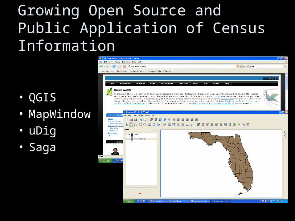
Growing Open Source and Public Application of Census Information
• QGIS• MapWindow• uDig• Saga

Geocoding Concepts
• Address Matching
• Assignment to Enumeration Areas

Geocoding Concepts
Census Hierarchy Address Hierarchy

Geocoding Concepts
pre-enumeration enumeration post-enumeration
Applications and Limitations

Suggested Updates to the Handbook
• Updates on software/hardware discussion - mentioning the potential advantages of
investing in open source GIS• Include suggestions for assessing data quality,
such as the geocoding certainty indicator (GCI) (Davis and Fonseca 2007)
• More and updated case studies (as presented here this week)
• Perhaps mention the valuable role of the United Nations in facilitating an international spatial data infrastructure that brings disparate national information together
Related Documents