General Management Plan National Park Service U.S. Department of the Interior Lake Mead National Recreation Area Nevada/Arizona September 2005 General Management Plan Amendment/ Environmental Assessment

Welcome message from author
This document is posted to help you gain knowledge. Please leave a comment to let me know what you think about it! Share it to your friends and learn new things together.
Transcript
General Management Plan
National Park ServiceU.S. Department of the Interior
Lake Mead National Recreation Area Nevada/Arizona
September 2005
General Management Plan Amendment/Environmental Assessment
Lake Mead
Natio
nal R
ecreation
Area
United States Department of the Interior • National Park Service
Septem
ber 2005
Gen
eral Man
agem
ent Plan
Am
end
men
t/Enviro
nm
ental A
ssessmen
t

iii
SUMMARY
The purpose of this General Management Plan Amendment / Environmental Asses-sment is to provide guidance on a long-term strategy for addressing low water conditions on Lake Mead that affect lake access. The park has been operating under the 1986 General Management Plan / Development Concept Plans / Environ-mental Impact Statement. Tiering from the 1986 General Management Plan, a Lake Management Plan / Environmental Impact Statement was prepared in 2003 to provide additional and more specific guidance for the long-term management of Lakes Mead and Mohave. In an effort to ensure the protection of park resources while allow-ing a range of recreational opportunities, the plan provides for an increase in boat-ing capacity targeted at areas where growth can be accommodated within the physical, environmental, and social carrying capacity of the lakes. Although most of the 1986 and 2003 plans are still applicable, they did not foresee the current and predicted drought conditions and did not fully consider the effects of greater fluctuations in the lake’s water levels.
ALTERNATIVES All of the alternatives considered in this general management plan amendment are consistent with and contribute to fulfilling the management intent and direction established in the 1986 General Manage-ment Plan and 2003 Lake Management Plan to the extent practicable. The identi-fied recreational opportunities and types and capacities of commercial marina services and public launch ramps were used to guide development of the alternatives presented below. The amendment identifies alternative locations for lake access facilities in
accordance with the carrying capacities and water management zones set in the Lake Management Plan; the number of boats within the lake basins and general distribution of boats would remain consistent with the plan. A range of alternatives for managing public and commercial lake access facilities on Lake Mead down to a lake level of 1,050 feet are presented. The alternatives are organized by area: Lower Boulder Basin, Upper Boulder Basin, Overton Arm, and Arizona. The alternatives address low-water conditions that affect public access provided by launch ramps, marina, and backcountry roads that access the shoreline. Alternative A – No Action Under alternative A launch ramps would be extended and marina operations would be reconfigured and/or moved farther into the lake as site conditions allowed at their existing locations on the lake. Use of facilities would be discontinued when site conditions resulted in insufficient water depth for marinas to operate or insuf-ficient ramp grades for boat launching. Four launch ramps would be extended at Callville Bay, Temple Bar, South Cove, and Hemenway Harbor. Only Temple Bar and Hemenway Harbor ramps would be operational below a water elevation of 1,085 feet. All seven marinas on Lake Mead would continue to move out to follow the receding water levels. Below an elevation of approximately 1,100 feet there would be insufficient water depths in which to operate the Overton marina at this location.
SUMMARY
iv
Backcountry roads would be extended to maintain access to the lake shoreline based on the existing classification priority system. Where roads were extended, additional management actions would be undertaken to direct traffic and discourage vehicle use outside the designated road corridors.
Alternative B – Preferred Alternative Under alternative B launch ramps would be extended or relocated to areas where there would be adequate site conditions for boat launching. Four launch ramps would be extended at their existing locations at Hemenway Harbor, Callville Bay, South Cove, and Temple Bar. Topographic conditions at Callville Bay and South Cove do not permit extending existing ramps to elevation 1,050. To support boat launching to a water elevation of 1,050 feet six new low-water launch ramps would be constructed and access provided at Stewarts Point, Echo Bay, South Cove, Boulder Harbor, Government Wash, and Callville Bay. Six marinas would continue to move out to follow the receding water levels. The Overton Beach marina operation would no longer be able to operate below an elevation of approximately 1,100 feet. Authorized boating capacity and marina services would be increased at Echo Bay to allow the overall boating capacity on the Overton Arm to be maintained. When water elevations at Overton Beach returned to and were projected to maintain a sufficient depth in which to safely operate the marina, marina operations could be relocated back to Overton Beach. The Lake Mead marina would continue to operate in Boulder Harbor during higher water levels. Below 1,112 feet, Dock “C” of the marina would be moved to Hemenway Harbor, while the
remainder of the main marina facility would continue to move out beyond the Boulder Harbor area following the receding water levels. When water elevations in Boulder Harbor returned to and were projected to maintain a sufficient depth in which to safely operate the entire marina operation within Boulder Harbor, Dock “C” would be relocated back to Boulder Harbor. Similar to alternative A, backcountry roads would be extended to maintain access to the lake shoreline and additional manage-ment actions would be undertaken to direct traffic and discourage vehicle use outside the designated road corridors.
Alternative C Under alternative C launch ramps would also be extended or relocated to areas where there would be adequate site conditions for boat launching. Three launch ramps would be extended at Callville Bay, South Cove, and Temple Bar. Nine new low-water launch ramps would be constructed and access provided at Stewarts Point, Echo Bay, South Cove, Boulder Beach, Hemenway Harbor, Las Vegas Bay, Government Wash, Callville Bay, and Pearce Ferry. Four marinas would continue to move out to follow the receding water levels. The Lake Mead Cruises Dock would be relocated back to Boulder Harbor when sufficient water depth allowed for safe operations. The marina operation at Overton Beach would be eliminated. Authorized boating capacity and marina services would be increased at Echo Bay to include those formerly allowed at Overton Beach. The Lake Mead marina would continue to operate in Boulder Harbor during higher water levels. Below 1,112 feet portions of the marina would be
Summary
v
moved to Hemenway Harbor until the marina was entirely relocated. When water elevations in Boulder Harbor returned to and were projected to maintain a sufficient depth in which to safely operate the marina operation, the facility would be relocated back to Boulder Harbor. Similar to alternative A, backcountry roads would be extended to maintain access to the lake shoreline and additional manage-ment actions would be undertaken to direct traffic and discourage vehicle use outside the designated road corridors. ENVIRONMENTAL IMPACTS Alternative A – No Action Adverse impacts to Mojave Desert vegetation and soils, wildlife habitat, and air and water quality from construction and marina operations would be long term and negligible to minor. Approximately 37 acres of recently exposed lands below the high waterline and 5 acres of primarily previously disturbed lands above the high waterline would be affected. Some local-ized, minor to moderate benefits to resources would result from better backcountry road management and suspension of the Overton marina operation. The desert tortoise is likely to be adversely affected by actions that would occur in areas above the line at Boulder Beach. The continued movement of the Echo Bay marina farther out to follow the receding waterline would not create any additional potential for adverse impacts to razor-backs beyond that of current operations. Mitigation measures to reduce the poten-tial for impacts to desert tortoise and razorback suckers would be implemented. This alternative would not be likely to
adversely affect bald eagles. There would be no effect on the southwestern willow flycatcher or relict leopard frog. Avoidance of national register eligible or listed archeological resources and historic structures would result in no adverse impacts. If resources could not be avoided, a memorandum of agreement would be negotiated between the park and state historic preservation officer to stipulate how adverse effects would be mitigated. Closure of most launch ramps and lost recreational opportunities would result in moderate to major effects on most recrea-tional boaters. With the increase in visitation and congestion at the operational launch ramps, the continued need to manage visitors at closed ramps, and additional operational requirements under this alternative, there could be minor to moderate adverse impacts on park staff and operations. Minor to moderate beneficial impacts would result from better management of backcountry access roads and fewer launch ramps to maintain and manage at low water levels. Increased operating costs and loss of revenues would result in a minor to major short- and long-term adverse impacts for concession-operated facilities and commercial operators that run Colorado River raft trips. Effects on the overall economy of nearby communities and the region would be minor because the park is a small part of the overall relatively large regional economy. Alternative B – Preferred Alternative Adverse impacts to Mojave Desert vegetation and soils, wildlife habitat, and air and water quality from construction and marina operations would be long term
SUMMARY
vi
and minor to moderate. Approximately 102 acres of recently exposed lands below the high waterline and 24 acres of primarily previously disturbed lands above the high waterline would be affected. Some localized, minor to moderate benefits to resources would result from better backcountry road management and suspension of the Overton marina operation. The desert tortoise would likely be adversely affected by actions that would occur in areas above the high waterline at Boulder Beach, Government Wash, and Stewarts Point. The expansion of marina slips at Echo Bay marina would increase boating and marina activities that could likely adversely affect razorback suckers. The relict leopard frog would likely be adversely affected by increased traffic of the Stewarts Point Road. Mitigation measures to reduce the potential for impacts to these species would be implemented. The alternative would not be likely to adversely affect bald eagles. There would be no effect on the southwestern willow flycatcher. Avoidance of national register eligible or listed archeological resources and historic structures would result in no adverse impacts. If resources could not be avoided, a memorandum of agreement would be negotiated between the park and state historic preservation officer to stipulate how adverse effects would be mitigated. New low-water launch ramps would provide for continued recreational boating. This would be a major beneficial long-term impact on the visitor experi-ence. There would be a temporary minor to moderate adverse impact on recrea-tional users at Hemenway Harbor, Echo Bay, and Stewarts Point due to increased use in these areas and for Colorado River
rafters displaced from Pearce Ferry to South Cove during low water. With the increase in operational require-ments and shift in staffing locations under this alternative, there could be minor to moderate adverse impacts on park staff and operations. Minor to moderate bene-ficial impacts would result from better management of backcountry access roads. Impacts to concession-operated facilities and commercial operators would be the same as alternative A, however, commer-cial operators who run Colorado River raft trips would benefit from maintaining South Cove as a takeout. Alternative C Adverse impacts to Mojave Desert vegetation and soils, wildlife habitat, and air and water quality from construction and marina operations would be long term and minor to moderate. Approximately 117 acres of recently exposed lands below the high waterline and 26 acres of pri-marily previously disturbed lands above the high waterline would be affected. Some localized, minor to moderate bene-fits to resources would result from better backcountry road management and suspension of the Overton marina operation. Threatened and endangered species would be affected the same as under alternative B, however, alternative C would not be likely to adversely affect southwestern willow flycatchers. Cultural resources would be affected the same as described under alternatives A and B. New low-water launch ramps would provide for continued recreational boating. This would be a major beneficial
Summary
vii
long-term impact on the visitor experi-ence. There would be a temporary minor to moderate adverse impact on recrea-tional users at Echo Bay and Stewarts Point due to increased use in these areas. Maintaining the river takeout for Colo-rado River rafters at Pearce Ferry would be a minor to moderate benefit for those visitors. With the increase in operational require-ments and shift in staffing locations under this alternative, there could be minor to moderate adverse impacts on park staff and operations. Minor to moderate
beneficial impacts would result from better management of backcountry access roads and consolidation of marina facilities at one location at Hemenway Harbor at lower water levels. Impacts to concession-operated facilities and commercial operators would be the same as alternative A, however, main-taining the river takeout at Pearce Ferry would be a minor to major benefit for commercial operators that run Colorado River raft trips, particularly day-trip operators.

ix
CONTENTS
PURPOSE AND NEED FOR THE PLAN 1 Introduction 3
Project Setting and Background 3 Purpose and Need 5 Planning Issues and Impact Topics 6 Impact Topics Considered and Dismissed from Further Consideration 8
Planning Direction And Guidance 11 Applicable Laws and Policies 11 Relationship with Other Plans and Management Actions 12
ALTERNATIVES, INCLUDING THE PREFERRED ALTERNATIVE 19 Introduction 21
Development of the Alternatives 21 Elements Common to All Alternatives 23
Lower Boulder Basin Alternatives 28 Upper Boulder Basin Alternatives 34 Overton Arm Alternatives 39 Arizona Facilities Alternatives 43 Estimated Costs 48 Alternatives Dismissed from Further Consideration 50 Identification of the Preferred Alternative 51 Environmentally Preferable Alternative 54 AFFECTED ENVIRONMENT 61 Introduction 63 Location and General Description 64 Natural Resources 65 Cultural Resources 70 Recreational Use and Lake Access 71 Socioeconomic Resources 77 ENVIRONMENTAL CONSEQUENCES 79 Introduction 81
Cumulative Impacts 81 Impairment of Park Resources Or Values 83 Criteria and Thresholds for Impact Analysis 84
Impacts of Alternative A – No Action 94 Impacts of Alternative B — Preferred Alternative 106 Impacts of Alternative C 120 CONSULTATION AND COORDINATION 133 APPENDIXES, BIBLIOGRAPHY, PREPARERS 137 Appendix A: Legislation 139 Appendix B: Summary of Conservation Actions and Reasonable and Prudent Measures For Razorback Sucker And Desert Tortoise 143 References 146 Preparers and Consultants 148 Index 149
CONTENTS
x
Maps
Location 4 Backcountry Road 25 Lower Boulder Basin Alternatives Alternative A 30 Alternative B 31 Alternative C 32 Upper Boulder Basin Alternatives Alternative A 36 Alternative B 37 Alternative C 38 Overton Arm Alternatives Alternative A 41 Alternatives B and C 42 Arizona Facilities Alternatives Alternative A 45 Alternative B 46 Alternative C 47
Tables
1: Cost Estimates 49 2: Summary of Advantages of Alternatives 52 3: Summary of Alternatives 55 4: Summary of Impacts 59 5: Commercial Marina Services at Lake Mead 75 6: Public Launch Facilities at Lake Mead 76
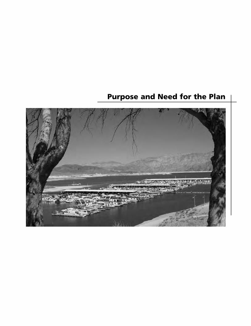
Purpose and Need for the Plan

3
INTRODUCTION
This chapter describes why the National Park Service (NPS) has prepared this General Management Plan Amendment / Environmental Assessment for Lake Mead National Recreation Area and the amendment’s intent. It includes planning direction and guidance and identifies the issues and impact topics that were considered or dismissed.
PROJECT SETTING AND BACKGROUND
Lake Mead National Recreation Area contains two reservoirs (lakes Mead and Mohave) along 140 miles of the former Colorado River from the southern tip of Nevada to the northwest corner of Arizona. The levels of both lakes are controlled by the U.S. Bureau of Reclamation (through Hoover Dam on Lake Mead and Davis Dam on Lake Mohave) for the purposes of irrigation, drinking water, and power generation for communities in Arizona, Nevada, and Southern California. Lake Mohave is primarily a pass-through reservoir with a maximum fluctuation zone of approxi-mately 15 feet. Lake Mead, however, is a major flood control reservoir with hundreds of feet in potential lake fluctuation. The area surrounding Lake Mead is rugged with deep canyons, dry washes, sheer cliffs, and mountains. Backcountry roads provide access to the lakeshore in a number of locations. Improved access to the shore of the lake is limited. There are six marinas and one tour boat landing on Lake Mead, located at Boulder Beach (two marinas and tour boat landing), Callville Bay, Echo Bay, Overton Beach, and Temple Bar. There are nine paved public launch ramps in the above areas as well as at Government Wash, South Cove, and
Las Vegas Bay. Pearce Ferry has no developed boat ramp but is used as a take-out for private and commercial boaters using kayaks and rafts at water elevations down to 1,175 feet above mean sea level. At elevations below 1,175 feet, launch and retrieval operations are provided at the South Cove facility. Lake Mead is typically at its highest yearly elevation in the late fall and early spring months. The lake begins to drop in elevation in the late spring and early summer when the desert heats up and causes a higher demand for agricultural water in the Imperial Valley of southern California, and for agricultural and municipal water needed in the Las Vegas Valley, Arizona, and Mexico. Some years, the drop is greater than others, depending on how much difference there is between inflow and outflow. If there are several consecutive years where outflow exceeds inflow, Lake Mead begins each year with lower water levels, and the elevation continues to drop until a “wet year” occurs in the Colorado River Basin. Then, Lake Mead typically receives more water than it releases, and the lake again returns to higher elevations. The future projections for Lake Mead call for generally lower lake levels and more extreme annual fluctuations than have been experienced in the past. On Lake Mead, the average daily elevation for the last 10 years (1992 through 2002) was 1,193.9 feet above mean sea level. The elevation of 1,221.4 feet represents the elevation at the top of the spillway gates. On July 24, 1983, a maximum water sur-face elevation of 1,225.85 feet was reached on Lake Mead. The Bureau of Reclama-tion considered elevation 1,229 as “full pool” for Lake Mead. The theoretical
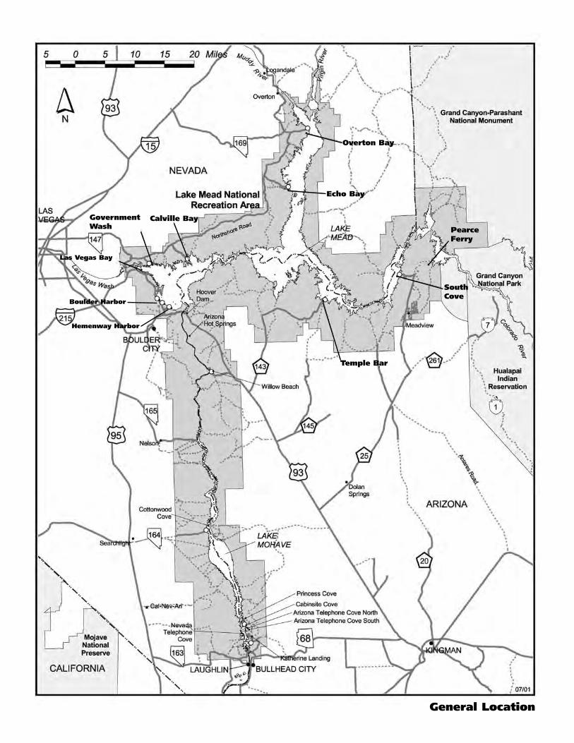
Overton Bay
Calville Bay
General Location
Las Vegas Bay
Boulder Harbor
Hemenway Harbor
GovernmentWash
SouthCove
PearceFerry
Temple Bar
Echo Bay
Introduction
5
minimum elevation, which is also required to generate power, is 1,050 feet, the minimum elevation required for the operation of the Southern Nevada Water Authority's original intake facility. Drought conditions in the west and lower than normal snow pack in the Rocky Mountains for the last several years caused lake levels to drop significantly. For example, in 2000 runoff into Lake Mead was only 56% of normal. The drought caused Lake Mead to drop to its lowest level in 40 years. More recently the wet winter of 2004-2005 have contributed snowmelt to Lake Mead, resulting in an increased lake water level. As of March 2005, the elevation of Lake Mead was 1,147 feet AMSL. Low water conditions have resulted in substantial and costly impacts to park and commercially operated lake access facilities on Lake Mead. The Las Vegas Boat Harbor marina and Lake Mead Cruises have temporarily relocated to areas where there is sufficient water depth to operate. Other marinas have reconfig-ured and/or moved out farther from the advancing shoreline. The launch ramps at Government Wash, Las Vegas Bay, and Pearce Ferry have been closed and backcountry lake access roads no longer extend to the lake shore. More frequent and dramatic lake level fluctuations are predicted to occur. These predictions could fluctuate based on the level of precipitation and other factors such as water user demand.
PURPOSE AND NEED The purpose of this General Management Plan Amendment / Environmental Assessment is to provide guidance on a long-term strategy for addressing low
water conditions on Lake Mead that affect lake access. The park has been operating under the 1986 General Management Plan / Development Concept Plans / Environ-mental Impact Statement. Tiering from the 1986 General Manage-ment Plan, a Lake Management Plan / Environmental Impact Statement was prepared in 2003 to provide additional and more specific guidance for the long-term management of Lakes Mead and Mohave. In an effort to ensure the protection of park resources while allowing a range of recreational opportunities, the plan provides for an increase in boating capacity targeted at areas where growth can be accommodated within the physical, environmental, and social carrying capacity of the lakes. Although most of the 1986 and 2003 plans are still applicable, they did not foresee the current and predicted drought conditions and did not fully consider the effects of greater fluctuations in the lake’s water levels. Lake level conditions have changed sub-stantially since both plans were approved. For most of the last 50 years the lake has generally operated within a 40-foot fluctu-ation range, between approximately 1,220 and 1,180 feet. Recreational facilities were able to expand and operate within the 40-foot fluctuation zone. However, the past five years of drought conditions experienced in the Colorado River Basin has resulted in the dramatic decline in Lake Mead waters. In 2004 lake elevations dropped to 1,125 feet and could potentially drop much farther. The normal ability of launch ramps and marinas to operate within the water fluctuation zone is limited by the water elevations, under-water and shoreline topography, and/or the availability of infrastructure such as utilities and parking. The lakeshore is also
PURPOSE AND NEED FOR THE PLAN
6
accessible by the backcountry road system approved in the 1986 General Management Plan. With lowering lake levels, these roads no longer extend to the shoreline. This not only creates confusion for visitors as to where to safely access the shoreline but also presents resource concerns due to the dispersion of vehicles from where the existing roads end. The 1986 plan did not anticipate and therefore did not address the operational viability of public and commercial lake access facilities should greater water level fluctuations occur. Another major change in conditions that has occurred since completion of the 1986 plan has been the rapid formation of an expansive delta generated from erosion in Las Vegas Wash. Increasing flows in the wash have contributed to higher sediment flows being discharged into Las Vegas Bay. The dropping lake surface elevations have exposed approximately 1 mile of delta sediments which, along with daily wash flows, are contributing to the rapid move-ment of the delta. Operation of the marina at Las Vegas Bay became increasingly dangerous and necessitated the emergency relocation of the marina to Hemenway Harbor in October 2002. These changes have implications on how visitors access Lake Mead, the facilities needed to provide that access, and how the National Park Service and commercial operators manage their operations. This General Management Plan Amendment / Environmental Assessment primarily focuses on addressing low-water condi-tions that affect lake access provided by launch ramps, marinas, and backcountry roads. There are also several other resource, recreational, and operational issues that are related to low-water conditions: contamination of Las Vegas Valley drinking water, threats to air and water quality from exposed lake bed, insu-
fficient water levels to dilute pollutants, exotic plant invasion, exposure of sub-merged cultural resources, increased navigational hazards, and lake carrying capacity and recreational opportunities. Other previous and ongoing planning and management efforts will provide specific direction, strategies, and actions to address these other low-water issues not related to access (see “Relationship with Other Plans and Actions” section). It is important to recognize that lower water levels only affect Lake Mead and have no bearing on the water levels of Lake Mohave. On Lake Mohave there is a maximum 15-foot water fluctuation zone. Therefore the General Management Plan Amendment /Environmental Assessment only addresses conditions on Lake Mead.
PLANNING ISSUES AND IMPACT TOPICS
Lake Access Several issues and concerns were raised by the public, other agencies, and commercial operators in meetings and newsletter responses (see “Consultation and Coordi-nation” section). The alternatives pre-sented in this document address low-water conditions that affect public access provided by launch ramps, marinas, and backcountry roads that access the shore-line. Impact topics were selected for analysis based on this issue; values or concerns identified in the planning process; NPS knowledge of limited or easily impacted resources; as well as applicable laws, regulations, and National Park Service Management Policies 2001. Following is a summary of the issues and impact topics related to lake access. Natural and Cultural Resources. Lake Mead and surrounding terrestrial areas contain many natural and cultural resources, such as sensitive and rare plant
Introduction
7
and wildlife species and historic and prehistoric resources. For instance Echo Bay supports a spawning area for the endangered razorback sucker. Submerged resources associated with the construction of Hoover Dam are offshore of Boulder Beach. Maintaining lake access, including possible relocation of marina and launch ramp facilities, may damage or degrade sensitive natural and cultural resources unless access facilities and locations are balanced with resource preservation. Backcountry roads no longer extend to the shoreline. This creates confusion for visitors as to where to access the shoreline. It also poses a resource issue. Off-road vehicle use leads to disturbance of sensitive soils and plant species. Natural resource impact topics include vegetation; soils; threatened and ending-ered species (razorback sucker, desert tortoise, southwestern willow flycatcher, relict leopard frog, and bald eagle); wildlife and wildlife habitat; water quality; and air quality. Cultural resource impact topics are historic and archeological resources. Visitor Use and Experience. Lake Mead National Recreation Area is considered one of the premier water-based recreation areas in the nation. Many of the visitors to Lake Mead are involved in water-based recreational activities, which are sup-ported at the marina and launch ramp areas. Some recreational users could be displaced or inconvenienced by changes in the location of access facilities. Conflicts between boaters and shoreline users could also develop, particularly in the Boulder Basin area where numerous users and recreational activities take place along the shoreline. The visitor use and experience impact topic covers different aspects of visitation
and enjoyment, including recreational access and opportunities and safety. Park Operations. Actions in the alterna-tives could adversely or beneficially affect park operations. For example, the increase or decrease in lake access opportunities would affect the need for maintenance, law enforcement, and resource management staff in some areas.
Socioeconomic Environment. Facilities at Lake Mead were designed to operate most effectively between the elevations of 1,180 and 1,210 feet above mean sea level. Below a lake level of 1,180 feet above mean sea level, facilities must be reconfigured or possibly relocated to keep them opera-tional. This includes economic implica-tions on commercial operations within the park to support such actions as extending utility systems (water, power, and sewer), moving anchoring systems at marinas, or extending walkways and reconfiguring marinas. Other economic implications include possible increased competition between commercial operations, depend-ing on if and where marina facilities are relocated. The socioeconomic environment impact topics include commercial operations within the park as well as effects on the local and regional economy.
Other Low Water Issues There are several other resource and operational issues related to low-water conditions that were raised during the public scoping process that are of concern to park managers and visitors. These issues included concerns about contamination of Las Vegas Valley drinking water, threats to air and water quality from the exposed lake bed, insufficient water levels to dilute pollutants, exotic plant invasion, exposure
PURPOSE AND NEED FOR THE PLAN
8
of submerged cultural resources, increased navigational hazards, and reduced carry-ing capacity and recreational oppor-tunities. Other approved and ongoing planning and management efforts will provide specific direction and actions to address these other low water issues not related directly to access. These issues are outside the scope of this general manage-ment plan amendment. These issues and the associated planning efforts are further discussed in the “Relationship with Other Plans and Actions” section of this document.
IMPACT TOPICS CONSIDERED AND DISMISSED FROM FURTHER CONSIDERATION Potential impact topics were dismissed from further analysis because they would not be affected, or the potential for im-pacts under all the alternatives would be negligible. The topics are listed below with an explanation of why they were not considered. Floodplains and Wetlands The alternatives are all functionally dependent upon being located in the floodplain of Lake Mead and non-floodplain locations are not practicable. However, no permanent support facilities would be placed below the high-water elevation, and any potential adverse impacts on the natural resources and functions of the lake’s floodplain would be negligible. Flood mitigation for the developed areas was identified and approved in the 1986 GMP and ac-companying floodplains statement of findings and is still applicable. No wet-lands occur within areas that would be affected by the alternatives.
Special Status Species. The following threatened, endangered, or species of special concern have been dismissed from consideration. The humpback chub (Gila cypha) and the Colorado squawfish (Ptychocheilus lucius) are federally endangered species that could possibly occur within Lake Mead, however, it is believed these species no longer exist within the recreation area. Although the following species or potential habitat for them are found in the recreation area, they are either not associated with Lake Mead or within any areas that would be affected by actions of any of the alternatives of the GMP Amendment.
Bonytail chub (Gila elegans) Virgin River chub (Gila seminuda) Woundfin (Plagopterus argentissimus) Yuma clapper rail (Rallus longirostris yumanensis)
Ethnographic Resources An ethnographic resource is defined as any site, structure, object, landscape, or natural resource feature assigned tradi-tional legendary, religious, subsistence, or other significance in the cultural system of a group traditionally associated with it. Ethnographic (Ruppert 1976) and arche-ological (McClellan, Phillips and Belshaw 1980) overview and assessments of Lake Mead National Recreation Area recog-nized only Native American groups as traditionally affiliated peoples of the area. Thirty years of consultation have identi-fied the Mohave, Hualapai, Chemehuevi, Paiute, Havasupai, Yavapai, Maricopa, Ak-Chin, Quechan, Pai Pai, Hopi, and Zuni as having and continue to have cultural ties to the park. Though the nontribal group of Mormons settled in the area to utilize the Colorado River for agriculture and trans-portation of goods in maintaining Mor-mon settlement and the spread of their
Introduction
9
religion throughout the West, their use of the area was sporadic and short-lived. The recreation area contains a variety of traditional cultural areas and sacred sites, that when documented, are referred to as a traditional cultural property. These include the Spirit Mountain and Gold-strike Canyon/ Sugarloaf Mountain traditional cultural properties. No ethnographic resources have been identified in or in the proximity of the areas affected by the alternatives. Copies of this document will be transmitted to each affiliated tribe for review and comment. If the tribes subsequently identify the presence of ethnographic resources, appropriate mitigation measures would be undertaken in consultation with the tribes. Museum Collections None of the alternatives would affect the protection, preservation, and curation of museum objects and materials. There are no museum collection facilities in the project areas. Cultural Landscapes No cultural landscapes have been identified in the project area therefore there would be no impacts. Indian Trust Resources The lands comprising Lake Mead National Recreation Area are not held in trust by the secretary of the interior for the benefit of Indians due to their status as Indians. Therefore, there would be no effect on Indian trust resources.
Wilderness Resources and Values The project areas would all occur within existing developed areas or lake access sites, which are not within or adjacent to any wilderness areas. None of the alterna-tives being considered would impact wilderness areas within the recreation area. Prime and Unique Agricultural Lands The alternatives would not affect any prime or unique farmlands because there are no such lands in the project areas. Ecologically Critical Areas, Wild and Scenic Rivers, or Other Unique Natural Resources No impacts would occur on these resources because none of these resources are within areas affected by the alternatives. Conflicts with Land Use Plans There are no potential conflicts between the alternatives and land use plans, policies, or controls (including state, local, or Native American) for the project areas. Energy Requirements and Conservation Potential The Park Service would pursue sustainable practices whenever possible in all deci-sions regarding national park operations, facilities management, and development in the recreation area. Whenever possible, the Park Service would use energy conser-vation technologies and renewable energy sources. Consequently, the alternatives would have a negligible affect on energy consumption compared to current conditions.
PURPOSE AND NEED FOR THE PLAN
10
Lightscape National Park Service Management Policies (2001) state that the National Park Service will preserve, to the greatest extent possible, the natural lightscapes of parks, including natural darkness. The agency strives to minimize the intrusion of artificial light into the night scene by limiting the use of artificial outdoor lighting to basic safety requirements, shielding the lights when possible, and using minimal impact lighting techniques. The actions proposed in the alternatives could result in new locations of some facilities, some of which could necessitate night-time lighting. However, the effects of this lighting would be localized and minimized by the mitigation techniques described above. Only a small area would be affected by the facilities. It is expected that these few developments would have a negligible impact on the night sky. Thus, lightscape was dismissed as an impact topic.
Paleontological Resources There are no known or recorded paleontological resources within the areas of potential effect. Environmental Justice Executive Order 12898, “General Actions to Address Environmental Justice in Minority Populations and Low-Income Populations,” requires all federal agencies to incorporate environmental justice into their missions by identifying and addres-sing disproportionately high and adverse human health or environmental effects of their programs and policies on minorities and low-income populations and com-munities. None of the actions in the alternative, such as extension of launch ramps and movement of marinas, would have health or environmental effects on minorities (including American Indian tribes) or low-income populations or communities as defined in the Environ-mental Protection Agency’s Environmental Justice Guidance (1998).
11
PLANNING DIRECTION AND GUIDANCE
Management of Lake Mead National Recreation Area is guided by a number of laws and policies, some of which are applicable specifically to Lake Mead National Recreation Area, and many others that are applicable to all units of the national park system. There are also a number of other current plans and commitments that affect management of the national recreation area. These laws, policies, and other plans would continue to help guide management of the national recreation area under all of the alternatives described in this document.
APPLICABLE LAWS AND POLICIES Lake Mead National Recreation Area was established in 1964 (PL 88-639), “for the general purposes of public recreation, benefit, and use, and in a manner that will reserve, develop and enhance, so far as practicable, the recreation potential, and in a manner that will preserve the scenic, historic, scientific, and other important features of the area, consistent with applicable reservations and limitations relating to such area and with other authorized uses of the lands and prop-erties within such area.” The secretary of the interior was authorized under the act to provide for general recreational use. General recreational use was defined within section 4(b) of this legislation and included bathing, boating, camping, and picnicking. Some laws and executive orders are applicable solely or primarily to units of the National Park Service. These include the 1916 Organic Act creating the National Park Service, the General Authorities Act of 1970, and the act of March 27, 1978, relating to the management of the national park system. Others have much broader
application, such as the Endangered Species Act, the National Historic Preservation Act, and Executive Order 11990. Those most directly related to this general management plan amendment planning process are identified below. The NPS Organic Act (16 U.S.C. § 1) provides the fundamental management direction for all units of the national park system: promote and regulate the use of the Federal areas known as national parks, monuments, and reservations…by such means and measures as conform to the fundamental purpose of said parks, monu-ments and reservations, which purpose is to conserve the scenery and the natural and historic objects and the wildlife therein and to provide for the enjoyment of the same in such manner and by such means as will leave them unimpaired for the enjoyment of future generations. The National Park System General Authorities Act (16 U.S.C. § 1a-1 et seq.) affirms that while all national park system units remain “distinct in character,” they are “united through their interrelated purposes and resource into one national park system as cumulative expressions of a single national heritage.” The act makes it clear that the NPS Organic Act and other protective mandates apply equally to all units of the system. Further, amendments state that NPS management of park units should not “derogat[e]…the purposes and values for which these various areas have been established.” The NPS Organic Act and the General Authorities Act prohibits any impairment of park resources. NPS 2001 Management Policies (Section 1.4 et seq.) state that an impact would be more likely to constitute an impairment to the extent that it affects a
PURPOSE AND NEED FOR THE PLAN
12
resource or value whose conservation is: (1) necessary to fulfill a specific purpose identified in the establishing legislation or proclamation of the park; (2) key to the natural or cultural integrity of the park or to opportunities for enjoyment of the park; or (3) identified as a goal in the park’s general management plan or other relevant NPS planning documents. National Park Service Management Polices 2001 identify and explain NPS policies for all units under its stewardship. The alternatives considered in this docu-ment incorporate and comply with the provisions of these mandates and policies. The National Park Service Concessions Management Improvement Act of 1998 (PL 105- 391) established the legislation under which the National Park Service is to manage concession operations within units of the national park system. This act requires the National Park Service to pro-vide a reasonable opportunity for profit to authorized concession operations. This act also provides for protection of conces-sioner investment and states that, “A concessioner shall have a leasehold surrender interest in each capital improve-ment constructed by a concessioner under a concessions contract, consisting solely of a right to compensation for the capital improvement.” Leasehold surrender interest “shall not be extinguished by the expiration or other termination of a concessions contract and may not be taken for public use except on payment of just compensation.”
RELATIONSHIP WITH OTHER PLANS AND MANAGEMENT ACTIONS 1986 General Management Plan The 1986 General Management Plan for Lake Mead National Recreation Area provides the overall management direction for the recreation area. The plan empha-sizes long-term protection of park re-sources while accommodating increasing visitor use. It allows for increasing use through a combination of providing new developed areas, improved access points, and acceptable levels of expansion in existing developed areas. It establishes land-based management zones and strategies for meeting the goals and general purposes of the recreation area. Although much of the 1986 plan is still applicable, the General Management Plan Amendment/ Environmental Assessment reevaluates the marina and launch ramp locations on Lake Mead in light of low-water conditions not accounted for in the 1986 plan. 2003 Lake Management Plan The Lake Management Plan tiers from the 1986 General Management Plan. It provides additional and more specific guidance for the long-term management of Lakes Mead and Mohave, the associated shoreline, and the development areas within Lake Mead National Recreation Area to ensure the protection of park resources while allowing a range of recreational opportunities. The plan provides for an increase in boating capacity targeted at areas where growth can be accommodated within the physical, environmental, and social carrying capacity of the lakes. It identifies facility improvements, capacities, locations, and expansions for the developments that control access on Lake Mead, with facility
Planning Direction and Guidance
13
development based on the lake’s carrying capacity. The plan calls for the continued operation of the six existing marinas on Lake Mead, with authorized expansion of facilities at Callville Bay, Echo Bay, Over-ton Beach, and Temple Bar. The plan also identifies the continued operation of the nine existing public boat launch ramps and approved the addition of another public boat ramp at Stewarts Point. All the alternatives considered in this General Management Plan Amendment are consistent with and contribute to fulfilling the management intent and direction established in the 2003 Lake Management Plan to the extent practicable. The identified recreational opportunities and types and capacities of commercial marina services and public launch ramps were used to guide the development of the alternatives presented in this amendment. The amendment identifies alternative locations for lake access facilities in accord with the carrying capacities and water management zones set in the Lake Management Plan; the number of boats within the lake basins and general distribution of boats would remain consistent with the plan. With lowering water levels there would be a shrinking area of water surface to accommodate boaters. Public scoping comments included those that noted that Lake Mead is still huge and talk of limiting use is premature and also comments that concentration of boats on a shrinking area of water surface could increase conflicts between boaters. The 2003 Lake Manage-ment Plan set a boating capacity for Lake Mead based on the limiting factors for safety, shoreline accessibility, and social carrying capacity. A boating capacity of 3,295 boats at any one time was allotted to Lake Mead. The carrying capacity analysis for the Lake Management Plan determined
that the physical carrying capacity on Lake Mead, which factors in the lake surface area, was not a limiting factor. Thus even at lower water levels the boating capacity is still considered valid. There was also a public concern that as the water level drops, it is likely that less of the lake’s surface area will be free of personal watercraft and that the Park Service should redesignate the personal watercraft free area identified in the Lake Manage-ment Plan to include current and projected water levels. The 2003 plan also designated 5% of Lake Mead as primitive or semiprimitive management zones, which prohibit personal watercraft use. This percentage was based on an average lake elevation of 1,180 feet. Thus, fluctuations in the lake’s water levels would likely result in the percentage of the lake zoned as primitive or semiprimitive to vary between approximately 6-3%. These zones were established on certain bays and inflow areas to protect sensitive aquatic resources as well as to provide areas where visitors could find opportunities to experience a sense of solitude and quiet. As lake levels fluctuated, these goals would continue to be met. Dropping lake levels are exposing pre-viously submerged lakebeds, including the rapidly forming delta at Las Vegas Wash. Concerns were raised by the public about the potential threat to air and water quality from exposed sediments that may be contaminated from boat pollutants, particularly in areas of high boat traffic such as marinas and boat launches. There was also a concern regarding insufficient water levels to dilute pollutants. Improving water quality within the recreation area is an important goal of the Lake Management Plan. As identified in that plan, chemical pollutant monitoring will be instituted in order to protect the high water quality
PURPOSE AND NEED FOR THE PLAN
14
standards for recreation. If monitoring determines that water quality standards are being violated, specific areas in the recreation area could require temporal closures. A draft monitoring plan that covers sampling of the water column lakewide, suspended sediment or bottom sediments, and biota has been prepared. A final monitoring plan is expected in 2005. In 2004 Southern Nevada Water Authority monitored the Las Vegas Wash delta for contaminants and did not find reporting levels of contaminants. 2001 Strategic Plan The 1993 Lake Mead National Recreation Area Statement for Management (NPS 1993) and the 1998 Lake Mead National Recreation Area Strategic Plan (NPS 1998) established goals relating to resource protection, public enjoyment and visitor satisfaction. The 2001 Strategic Plan (NPS 2001) has reaffirmed these goals. 2003 Commercial Services Plan and Concessions Contracts The commercial services plan for the national recreation area provides guidelines for assessing the changing conditions and increasing pressures of visitor needs and adopting a strategy that balances visitor needs with the purposes and values of the recreation area. The Commercial Services Plan evaluates the existing management strategy and ensures that, under the proposed alternatives, a range of visitor services would be pro-vided, and that natural and cultural resources would be protected. Concession contracts are agreement(s) between the secretary of the interior, or authorized delegates, and a concessioner, whereby the concessioner is required and
authorized to provide certain necessary and appropriate visitor accommodations, facilities, or services within a park unit under administration of the secretary. The secretary authorizes concession opera-tions by both contracts and permits. Concession contracts are issued via competitive bid, and it is anticipated that within the next three years, prospectuses will be released for new contracts for all park concession operations. Execution of new concession contracts will implement and authorize concession projects proposed in this general management plan amendment. The concessions contracts between the National Park Service and commercial marina operators also recognize that the establishment and maintenance of conces-sioner facilities and services “involve a substantial investment of capital and the assumption of the risk of operating loss, and it is therefore proper, in consideration of the obligations assumed hereunder and as an inducement to capital, that the concessioner be given assurance of security of such investment and of a reasonable opportunity to make a fair profit.” In addition, the concessions contract specifically states, “it is the intention of the parties that any acts, policies, or decisions of the Secretary under this contract will be consistent with reasonable protection to the concessioner against loss of its investment and against substantial increase in costs, hazards, and difficulties of its operations.” Invasive Plant Management Plan The invasion of National Park Service areas by exotic species of plants (also called alien, nonindigenous, nonnative, or weeds) is a well-recognized ecological problem. Lake Mead National Recreation
Planning Direction and Guidance
15
Area has been, until now, relatively spared of heavy alien plant invasions, however, in recent years it has become obvious that the recreation area has more invasive plant and incipient invasive plant problems than had been previously recognized. Further-more, the fluctuating water levels in Lake Mead have created a habitat for certain invasive plants that may spread from the recreation area to the riparian corridors associated with the Colorado River. Invasive plants can alter or destroy intact natural ecosystems, resulting in an irreversible loss of biodiversity. Heavily invaded systems can be permanently altered and may never fully recover. Executive Order 13112 (1999) states that federal agencies whose actions may affect the status of invasive species shall prevent the introduction of invasive species, detect and respond rapidly to and control popu-lations of such species in a cost-effective and environmentally sound manner, and not authorize, fund or carry out actions that it believes are likely to cause or pro-mote the introduction or spread of inva-sive species. NPS Management Policies (2001) state that “Exotic species will not be allowed to displace native species if displacement can be prevented.” They direct managers to give high priority to managing exotic species that have, or potentially have, a substantial impact on park resources, and that can reasonably be expected to be successfully controlled. The Strategic Plan for Lake Mead NRA (2001) established goals for alien plant species management. One of the goals was to establish annual tasks related to exotic plant species man-agement, and to prepare an exotic plant management plan including the top ten species to control, associated control strategies, data management, project
implementation and maintenance, and inventory and monitoring. The National Park Service is developing an invasive species management plan that will provide a framework for evaluating and controlling known invasive plants and incipient invasives. The plan will establish the priorities and determine the methods and procedures for preventing the intro-duction and reducing and/or eliminating the spread of invasive vegetation within the recreation area. Submerged Cultural Resources Management Plan Lowering lake levels have increasingly exposed cultural resources such as the remnants of the community of St. Thomas, and archeological sites that were once covered by Lake Mead waters. Visitation to these areas, including the increased risk of looting or vandalism, could affect the integrity of these sites. The National Park Service is mandated to preserve and protect its cultural resources through the Organic Act and through specific legisla-tion such as the Archeological Resources Protection Act, The National Historic Preservation Act, and the Secretary of the Interior’s Standards and Guidelines for Archeology and Historic Preservation, as well as NPS Management Policies (2001). The National Park Service is developing a submerged cultural resources manage-ment plan to address protection of submerged cultural resources. The suitability of documented sites for public visitation or interpretation would be assessed. Resource protection strategies and actions for protection of sites would be identified. Additional protection and preservation needs such as surveys, monitoring, preservation, or stabilization would also be evaluated.

PURPOSE AND NEED FOR THE PLAN
16
Management of Navigational Aids When lake levels drop below 1,170 feet above mean sea level, the upper arms of the lake and inflow areas pose a risk to boaters due to exposed sediment and the lack of a defined river channel. Lower lake levels also create hazards to boaters by exposing more reefs, rocks, and other submerged objects. Lake Mead NRA is responsible through a mutual aid agreement with the U.S. Coast Guard to install, maintain and repair all navigational aids on Lakes Mead and Mohave. Lake Mead NRA will continue to provide navigational aids, buoys, lighting systems, and reef markers to safely direct boaters to their destination, and away from hazards in the water. All markings, signs, and navigational aids will be current, accurate, and maintained to meet the United States Coast Guard standards. The Park Service will continue to provide notice to mariners about lake conditions; navigational hazards such as emerging reefs, sandbars, and other hazards; and changes in aids to navigation on Lake Mead. 2000 Colorado River Interim Surplus Criteria Environmental Impact Statement In December 2000, the secretary of the interior, acting through the Bureau of Reclamation, adopted interim criteria under which surplus water conditions may be declared in the lower Colorado River Basin during a 15-year period that would extend through 2016. Beginning in 2002, the interim surplus criteria were initiated. The lake level projections in the EIS indicate that water levels are predicted to decrease over the 15-year period, and it is likely that the lake elevation will not
exceed 1,190 feet during most of that period. Management Strategies for Lake Powell and Lake Mead under Low Reservoir Conditions In May 2005 the secretary of the interior directed the Bureau of Reclamation to convene a meeting of the Colorado River Management Work Group for the purpose of consulting with the Colorado River Basin states and the public on the most appropriate processes and mechanisms for developing Lower Basin Shortage Guidelines and Conjunctive Management Guidelines for Lake Powell and Lake Mead. Public meetings were held during last July to solicit comments on the content, format, mechanism and analysis the Bureau of Reclamation should consider during the development of these management strategies for Lake Powell and Lake Mead under low reservoir conditions. The public comment period was open through the end of August 2005. Extension of the Southern Nevada Water Authority Water Intake The Southern Nevada Water Authority (SNWA) operates two intakes in Lake Mead, which draw Colorado River water for treatment and distribution to the Las Vegas Valley. Both intakes are on the east side of Saddle Island near the Alfred Merritt Smith Water Treatment Facility. Intake No. 1 was constructed in the early 1970s and has an opening elevation of approximately 1,042 feet above mean sea level. A second intake completed in 2000 has an opening elevation of approximately 992 feet above mean sea level. The lake surface has usually been above 1,180 feet,
Planning Direction and Guidance
17
putting the intakes at a depth of 130 feet or more. A thermocline occurs at a depth varying from 30 to 55 feet below the lake surface and represents the bottom of the mixing zone. Above this layer, the entire column of lake water has a similar temperature and can mix freely. As lake levels have declined over the past few years, the water above the thermocline has approached the depth of Intake No. 1. Because of the lowered water levels, filters clog more quickly and more frequently, and more advanced treatment processes are required. Although the treatment processes are able to deal with the changed water quality and the finished drinking water meets all applicable standards, the costs for treatment are higher and the finished product may decrease in quality. Consequently, SNWA has extended the inlet of Intake No. 1 approximately 150 feet farther down the eastern scarp of Saddle Island to establish a new intake elevation of approximately 975 feet. The intake extension is designed to allow for water to be drawn from the original intake elevation and the deeper lake level. Systems Conveyance and Operations Program The U.S. Bureau of Reclamation and the National Park Service are preparing an environmental impact statement (EIS) that evaluates alternatives for the improved
treatment and ultimate discharge of municipal wastewater from the entities that comprise the Clean Water Coalition (CWC). The CWC is made up of the agencies responsible for wastewater treatment in the Las Vegas Valley, including the Clark County Water Reclamation District, City of Las Vegas, and the City of Henderson. The CWC has initiated the Systems Conveyance and Operations Program (SCOP) which is formulating the alternatives that will be considered in the EIS for discharge of the wastewater back into the Colorado River system. Currently, the wastewater from the CWC is discharged into Las Vegas Wash at various points, from which it flows into Lake Mead at Las Vegas Bay. Alternatives for the return of wastewater that have been developed by SCOP and that will be evaluated in the EIS include the construction and use of an effluent interceptor that would eliminate the discharge of wastewater into Las Vegas Wash, but rather transport it to one or more of the following sites for discharge into Lake Mead: Las Vegas Bay, Callville Bay, near the Boulder Islands, and/or Promitory Point. Continuation of the existing discharge through Las Vegas Wash is also being considered and would include construction of wetlands on the wash to facilitate final treatment and use of the wastewater.

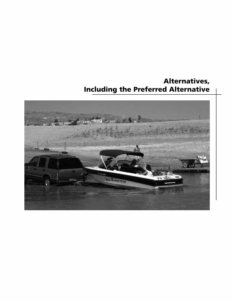
Alternatives, Including the Preferred Alternative

21
INTRODUCTION
This chapter presents the range of alterna-tives for managing public and commercial lake access facilities on Lake Mead. All of the alternatives considered in this General Management Plan Amendment are consistent with and contribute to fulfilling the management intent and direction established in the 1986 General Manage-ment Plan and 2003 Lake Management Plan to the extent practicable. The identified recreational opportunities and types and capacities of commercial marina services and public launch ramps were used to guide development of the alterna-tives presented in this amendment. The amendment identifies alternative locations for lake access facilities in accord with the carrying capacities and water management zones set in the Lake Management Plan; the number of boats within the lake basins and general distribution of boats would remain consistent with the plan. The alternatives are organized by area — Lower Boulder Basin, Upper Boulder Basin, Overton Arm, and Arizona. For each of these four areas, alternatives are presented for the public launch ramps and marinas on Lake Mead. An alternatives comparison table follows the alternative text. It should be noted that the elevations cited in the alternatives are approximate and assume that approximately 5 feet of water depth is needed for launching and approximately 10 feet is needed for marina operation. A no-action alternative is presented for all the access facilities. An examination of the no-action alternative for each facility is useful in understanding why certain
changes may or may not be needed or advisable. The no-action alternative describes a continuation of the existing management direction and actions. Marina operations would be reconfigured and/or moved farther into the lake, and launch ramps would be extended as site conditions allowed at their existing locations on the lake. For the purpose of defining the no-action alternative, it was assumed that no further relocation of lake access facilities would be authorized. Closure of facilities would occur when site conditions resulted in insufficient water depth for marinas to operate or insuf-ficient ramp grades for boat launching. The chapter also describes the factors and assumptions used in developing the alter-natives; the actions that would be common to all alternatives; the alternatives con-sidered but eliminated from further con-sideration and the rationale for dismissal; and the environmentally preferred alterna-tive. The table at the end of the chapter summarizes the key differences in the impacts that would result from imple-menting each alternative.
DEVELOPMENT OF THE ALTERNATIVES The alternatives were developed based on a number of factors. An evaluation of site conditions included water levels and underwater gradients, availability of utilities, access to the site, amount of available space on the land and water,
ALTERNATIVES, INCLUDING THE PREFERRED ALTERNATIVE
22
PLANNING PARAMETERS
These parameters are considered to be “givens” which define the scope and thus the range of alternatives in the amendment.
• The alternatives are focused on addressing low water conditions on Lake Mead that affect lake access.
• Locations for public launch ramps and marinas recognize the desired goals of the Lake Management Plan. Alternatives are consistent with the desired outcomes of that plan for carrying capacity and zoning.
• Locations for public launch ramps and marina facilities are evaluated based on their operational viability down to an elevation of 1,050 feet.
potential flood risk, exposure to wind and wave action, and the level of land-based construction and site preparation that would be necessary to accommodate the facility. Other considerations included the range of public expectations and concerns identified during scoping and the results of resource data analysis. The Bureau of Reclamation has only recently been directed by the secretary of interior to establish strategies for manag-ing water deliveries during low water con-ditions in the Colorado Basin. They are in the early stage of consultations with the Colorado River Basin states and the public; therefore, there are no established shortage criteria or low water guidelines for the operation of Lake Mead at this time. Without specific shortage guidelines some modeling assumptions were made about shortage criteria. Currently, the Bureau of Reclamation runs two scenarios using different shortage assumptions. The
first of those scenarios provides approximately an 80% assurance that Lake Mead’s water elevation in future years will be at or above 1,083 feet, given the hydrologic sequences that have been observed in the past. The second scenario provides approximately an 80% assurance that Lake Mead water elevation in future years will be at or above 1,050 feet (the approximate elevation of Southern Nevada Water Authority’s upper water intake). Model results for Lake Mead elevations will differ under these two modeling scenarios and yield a reasonable range of possibilities, given there are no established shortage guidelines (BOR 2004). Under either shortage scenario, it can reasonably be predicted that Lake Mead elevations, on average, will be lower in the future than what they have been in the past, due to future anticipated development in the Upper Basin. Specifically, under the “protect the minimum power generation elevation” scenario, the probability of Lake Mead’s elevation being below 1,050 feet is relatively small in the next several years (1% to 2% chance). That probability increases to about a 24% chance by the year 2025, again primarily due to anticipated development in the Upper Basin. The probabilities for the second modeling scenario are approximately 1-3 % higher in any given year (BOR 2004). For planning purposes, existing and alternative locations for facilities were evaluated based on their operational viability down to the elevation of 1,050 feet above mean sea level. Impending decisions on marina and launch relocations would need to occur before this elevation was reached.
Introduction
23
ELEMENTS COMMON TO ALL ALTERNATIVES
Marinas and Launch Ramps
Several management actions are integral to the effective and safe operation of lake access facilities to address fluctuating water levels. Examples of these actions are: • Move anchoring systems, extend
walkways, extend courtesy docks, and reconfigure and adjust marina positions
• Reconfigure or add breakwaters for protection
• Provide government boat docks at each of the developed areas
• Provide fire suppression capabilities for all floating facilities
• Conduct ramp inspections with clean-up or repairs made on a continuous basis.
• Where site conditions would accommodate extension of existing launch ramps, the ramps would be extended and paved to the waterline as lake elevations fell, although paved portions of the ramps would not be operational until water levels began rising and provided adequate water depths for launching. Placement of temporary structures or surfaces such as concrete planks, rock and gravel, or pipe sections beyond the base of the pavement would be used to extend the use of existing launch ramps where feasible (i.e., where adequate launch grades can be achieved). Temporary coffer dams may also be used to allow extension of ramps below the waterline.
Parking and Traffic Circulation
Many of the lake access facilities depend on graded areas for circulation and park-ing. These areas would be maintained. Parking, access roads, and circulation for launch ramps and marinas would be
adjusted as water levels fell. Areas below the high waterline would continue to be graded to provide parking closer to the access facilities where practicable. If lakebed soil conditions are unsuitable to support traffic and parking, a stabilizing base material may be imported and placed if needed. Marina and boat launch ramp access roads would be extended and paved.
Accessible parking would continue to be provided at developed areas throughout the park and near the launch ramps. It would be neither practical nor safe to authorize parking on the launch ramps because the 9% to 14% grades make it difficult to exit a vehicle and open and close doors. Additional actions such as grading and paving of walkways, walkway entrances, and bus and individual vehicle pads would be undertaken to ensure that ramps and marinas were accessible for all visitors. All new recreational facilities would be developed in accordance with the Americans with Disabilities Act Accessibility Guidelines (Recreation Facilities, 36 CFR, part 1191).
Utilities
Utilities (i.e., water, sewer, power, tele-phone, cable, fuel service) would be extended below the high waterline as lake levels receded to maintain service at each marina. All extended utilities would be underground. The National Park Service would be responsible for providing utilities to the high waterline at each marina. The concessioner would be responsible for the construction and operation of utility systems below the high waterline. Natural and logistical con-straints, such as elevation thresholds, topography, or distance, would be encountered at some marina locations at certain lake level thresholds that would require modification or reconfiguration of
ALTERNATIVES, INCLUDING THE PREFERRED ALTERNATIVE
24
utility system designs such as the addition of sewage lift stations or upgrade of trans-formers. Floating water intake barges would be periodically relocated farther into deeper water. Fuel docks would be maintained and fuel lines extended or fuel would be provided by tanker truck operations.
Other Shoreline Facilities
No permanent facilities that can be dam-aged by reservoir flooding are located below the high-water elevation. With greater fluctuations in the lake water levels, visitor facilities can become increas-ingly removed from the high-water eleva-tion. In order to enhance the availability of facilities to visitors along the shoreline, portable shoreline amenities at each developed area (e.g., restrooms, shade shelters, picnic facilities, fish cleaning stations, informational kiosks) will be provided as needed.
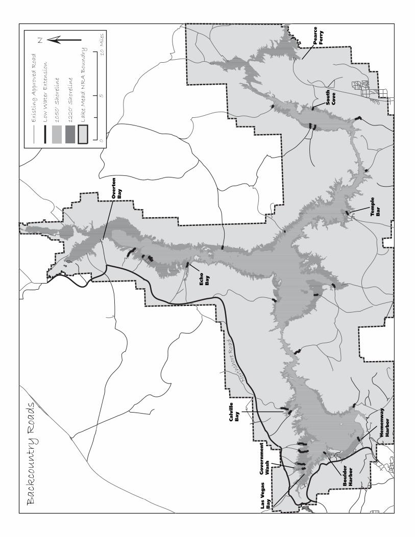
Backcountry Road Access
Lake Mead NRA has over 800 miles of approved backcountry roads. Most roads are approved for public use, while a few are only for management purposes. These backcountry roads are classified into class I, class II, and class III and would continue to be maintained on the following basis as funding and personnel allowed. Class I roads would be maintained at least twice per year. Class II roads would be main-tained at least once per year. Class III roads would consist of the balance of all approved dirt roads not listed in the class I and class II list and maintained only when the road became impassable due to floods, slides, or other events. These roads are usually posted “Recommended 4x4 only” where applicable. Extension of back-country roads to maintain access to the lake shoreline would continue to be based on this classification priority system.
Where roads were extended, additional management actions (e.g., roadway grad-ing, signing, and barricades) would be undertaken to direct traffic and discourage vehicle use outside the designated road corridors to enhance visitor safety and resource protection.
Mitigating Measures Mitigation measures are specific actions designed to minimize, reduce, or eliminate impacts of alternatives and to protect national recreation area resources and visitors. The following mitigation related to construction activities and facility operation would be implemented under each alternative and are assumed in the analysis of effects for each alternative. Soils, Vegetation, and Wildlife. Any new or relocated facilities sited above the high waterline would use previously disturbed sites to the extent practicable. Construc-tion limits would be delineated for all construction, such as road grading or utility extension, in any undisturbed habitats. Best management practices for controlling soil erosion, such as placement of silt fences, retention and replacement of topsoil, seed or plant salvage, and revege-tation of sites with native species would be taken to reduce runoff and soil loss from construction sites and reestablish native vegetation. Necessary measures would be determined by the park resource manage-ment restoration specialist.
Special Status Species. Lake Mead is designated critical habitat for the razor-back sucker. There are known spawning areas in Echo Bay and Las Vegas Bay. Management practices to protect the razorback sucker and its spawning habitat would continue to be implemented, including clearly marking mooring and boating areas from adjoining spawning
10
Overt
on
Bay
Ech
o
Bay
Calv
ille
B
ay
Govern
ment
Wash
Bould
er
Harb
or
Hem
enw
ay
Harb
or
Las
Vegas
Bay
Pearc
eFerr
ySouth
Cove
Tem
ple
Bar
Bac
kco
un
try
Roa
ds
ALTERNATIVES, INCLUDING THE PREFERRED ALTERNATIVE
26
areas via buoys and signing, maintaining a public awareness campaign, and main-taining a flat-wake zone near spawning areas and requiring the implementation of best management practices at marinas to protect water quality. Monitoring of spawning areas would continue, and temporary closures of areas used for spawning would be implemented if determined necessary. Potential habitat for the desert tortoise occurs throughout the recreation area. Generally, the shoreline areas below the high waterline (i.e., maximum pool elevation) are considered unsuitable habitat for the desert tortoise. Areas below the high waterline are typically composed of bare ground, rock, or nonnative tamarisk. Upland areas and desert washes provide better habitat. Any development proposed outside previously disturbed areas above the high waterline would be surveyed prior to construction for desert tortoises and burrows. The National Park Service has worked with the U.S. Fish and Wildlife Service to develop mitigation to reduce or eliminate potential adverse impacts on desert tortoise from construc-tion activities. Examples of such mitigation include clearly marking construction limits, surveying construction areas, relocation of tortoises outside of the construction area, education of construc-tion personnel about tortoises, instituting a litter control program, and surveying or handling of tortoises by a qualified biologist. Formal consultation with the U.S. Fish and Wildlife Service was undertaken to determine what actions would need to be taken to ensure the conservation of the federally listed desert tortoise and razorback sucker. The conservation measures and reasonable and prudent measures are summarized in appendix B
and fully described in the biological opinion (USFWS 2005). The Las Vegas bearpoppy is a species of concern in the recreation area. Again, in general, areas below the high waterline are typically unsuitable habitat for these species. Any suitable habitat above the high waterline would be surveyed for these species prior to any construction; areas containing the species would be avoided to the extent possible. The relict leopard frog is also a species of concern. A cooperative interagency conservation strategy and agreement to protect and conserve this species is currently being developed, including mitigation protocol to minimize effects of proposed projects on the relict leopard frog and its habitat. This protocol addres-ses a wide variety of measures, such as a survey of the project site prior to construc-tion, location of projects outside of occu-pied relict leopard frog habitat, clear designation of project work limits, desig-nation of a biological monitor, and a worker education program. The objective of mitigation would be no net loss of frog habitat quantity and quality, and mainte-nance or enhancement of movement corridors among populations and future reestablishment sites. The NPS would incorporate the mitigation protocol measures into all projects where applic-able. Water and Air Resources. Best management practices, such as the use of silt fences, would be implemented to ensure that construction related effects were minimal and to prevent long-term impacts on water quality and aquatic species. Best management practices would be incorporated into all marina operations. Any activities involving dredging or the placement of fill material below the
Introduction
27
ordinary high waterline of the lake would comply with requirements of sections 404 and 401 of the Clean Water Act and with other applicable state permit programs. Dust control measures would include watering the road and parking areas during grading operations and could include applying a dust palliative to control dust. Low sulfur fuel (0.05% by weight) would be used when available, and construction equipment would be properly tuned. The concessioner and the National Park Service would consult with the Nevada Division of Environmental Protection (NDEP) to determine wastewater requirements and provisions. The concessioner and the National Park Service would work with the Nevada State Health Division for the waterline requirements. Cultural Resources. All activities, including ground or offshore disturb-ances, would be assessed for potential disturbance to archeological or historic resources. If significant resources were identified and determined eligible for the National Register of Historic Places, all necessary steps would be taken to avoid them during project activities. If resources could not be avoided, the National Park Service would consult with the Nevada or Arizona State Historic Preservation Officers to develop a plan to mitigate any adverse effects. The National Park Service will consult with the appropriate Native American groups as required by laws, regulations, and executive orders. Should unknown
cultural resources be uncovered during construction, work would be halted in the discovery area, the site would be secured, and the Park Service would consult ac-cording to 36 CFR 800.13 and, as appro-priate, provisions of the Native American Graves Protection and Repatriation Act of 1990. In compliance with the Native American Graves Protection and Repatriation Act of 1990, the National Park Service would also notify and consult concerned tribal representatives for the proper treatment of human remains, funerary objects, and sacred objects should these be discovered during the project. Visitor Use and Experience. Whenever possible, the National Park Service would adjust work schedules, particularly the timing of construction activities, to mini-mize impacts on park visitors. Facility construction would be prioritized and phased wherever possible to minimize disruption of park and concession operations and visitor use. Navigational markers and no-wake areas would be established around lake access facilities if they are extended or relocated. Security, public notification, and a park ranger would assist with the actual move of any facilities to protect the public. Facilities would be accessible to visitors, including those with disabilities, in compliance with federal standards.
28
HEMENWAY HARBOR
The Hemenway Harbor public launch ramp is on one of the old roads used to access the river for the construction of Hoover Dam. It was widened and upgraded for boat launching in 1965. It is uncertain to what depth this ramp extends to, although it may extend to a depth of 1,080 similar to the low water ramp at Boulder Harbor. It is believed that the old access road continues at a narrow width of 20 feet. The Las Vegas Boat Harbor marina was originally at the inflow of Las Vegas Wash in the upper Boulder Basin before its emergency relocation in 2002 to its current location in Hemenway Harbor. The Lake Mead Cruises tour boat landing was origin-ally in the ungraded northwest portion of Boulder Harbor north of Lake Mead Marina, before its emergency relocation in 2003 to its current location in Hemenway Harbor.
BOULDER HARBOR
Boulder Harbor was previously dredged to an elevation of 1,080 feet. There are two separate public launch ramps in the harbor. The higher elevation ramp extends from 1,225 to 1,150 feet using side launch design. The second ramp extends to a depth of 1,080 feet. Two formerly used launch ramps are at Boulder Beach.
LOWER BOULDER BASIN ALTERNATIVES
ALTERNATIVE A – NO-ACTION ALTERNATIVE
Hemenway Harbor The launch ramp would be maintained and extended to an elevation of 1,050 feet as lake levels receded. As lake levels receded, the Las Vegas Boat Harbor marina would be moved and utilities extended farther out into the lake to where there would be sufficient water depth to operate. The concession maintenance area at Las Vegas Wash would be relocated to a previously disturbed area at Boulder Beach to support the marina operation at Hemenway Harbor. Dry boat storage and the land-based fuel operation would remain at Las Vegas Bay. The landing for the Lake Mead Cruises tourboat service would also continue to operate at Hemenway Harbor and as water levels receded, would be moved farther out into the lake to where there would be sufficient water depth to operate. Grading of parking areas below the high- water mark would continue to provide parking for the marina and tour boat operations at Hemenway Harbor during periods of lower water levels. In the future, should lake levels approach high water, parking areas above the high-water mark would be designated and graded to accommodate approximately 335 spaces plus bus parking. Previously disturbed lands (e.g., former campground, gravel pit) would be used to the extent practicable.
Boulder Beach Lake Mead Resort marina would be main-tained at Boulder Harbor and the marina moved and utilities extended farther out as the water level receded.
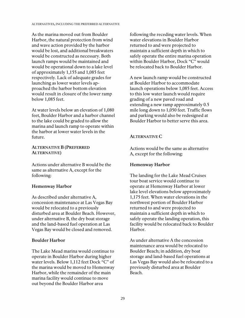
ALTERNATIVES, INCLUDING THE PREFERRED ALTERNATIVE
29
As the marina moved out from Boulder Harbor, the natural protection from wind and wave action provided by the harbor would be lost, and additional breakwaters would be constructed as necessary. Both launch ramps would be maintained and would be operational down to a lake level of approximately 1,155 and 1,085 feet respectively. Lack of adequate grades for launching as lower water levels ap-proached the harbor bottom elevation would result in closure of the lower ramp below 1,085 feet. At water levels below an elevation of 1,080 feet, Boulder Harbor and a harbor channel to the lake could be graded to allow the marina and launch ramp to operate within the harbor at lower water levels in the future.
ALTERNATIVE B (PREFERRED ALTERNATIVE) Actions under alternative B would be the same as alternative A, except for the following: Hemenway Harbor As described under alternative A, concession maintenance at Las Vegas Bay would be relocated to a previously disturbed area at Boulder Beach. However, under alternative B, the dry boat storage and the land-based fuel operation at Las Vegas Bay would be closed and removed. Boulder Harbor The Lake Mead marina would continue to operate in Boulder Harbor during higher water levels. Below 1,112 feet Dock “C” of the marina would be moved to Hemenway Harbor, while the remainder of the main marina facility would continue to move out beyond the Boulder Harbor area
following the receding water levels. When water elevations in Boulder Harbor returned to and were projected to maintain a sufficient depth in which to safely operate the entire marina operation within Boulder Harbor, Dock “C” would be relocated back to Boulder Harbor. A new launch ramp would be constructed at Boulder Harbor to accommodate launch operations below 1,085 feet. Access to this low water launch would require grading of a new paved road and extending a new ramp approximately 0.5 mile long down to 1,050 feet. Traffic flows and parking would also be redesigned at Boulder Harbor to better serve this area.
ALTERNATIVE C Actions would be the same as alternative A, except for the following: Hemenway Harbor The landing for the Lake Mead Cruises tour boat service would continue to operate at Hemenway Harbor at lower lake level elevations below approximately 1,175 feet. When water elevations in the northwest portion of Boulder Harbor returned to and were projected to maintain a sufficient depth in which to safely operate the landing operation, this facility would be relocated back to Boulder Harbor. As under alternative A the concession maintenance area would be relocated to Boulder Beach; in addition, dry boat storage and land-based fuel operations at Las Vegas Bay would also be relocated to a previously disturbed area at Boulder Beach.
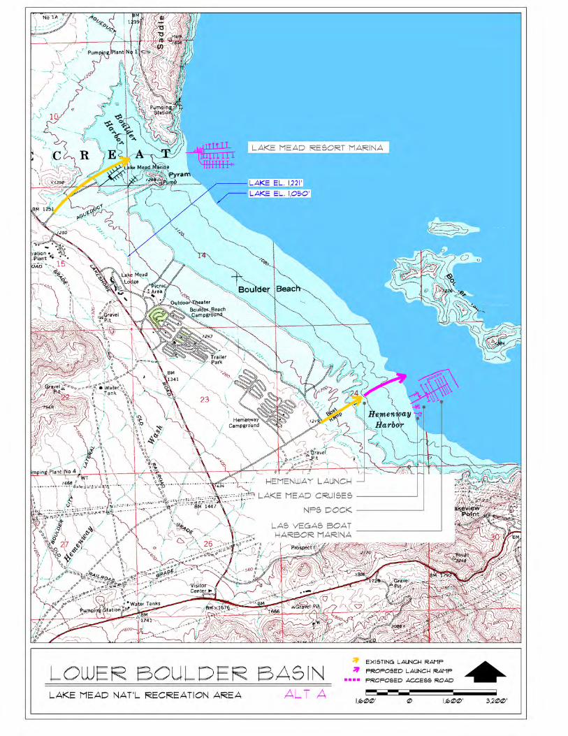
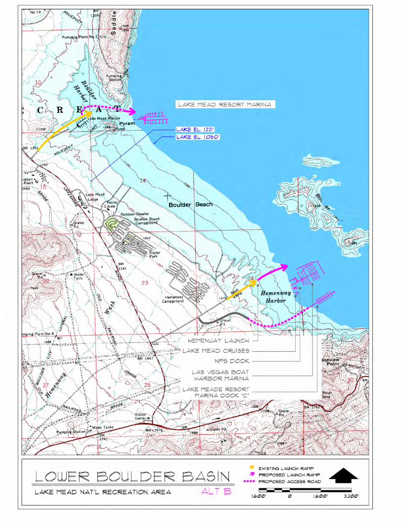
ALTERNATIVES, INCLUDING THE PREFERRED ALTERNATIVE
33
The launch ramp would not be extended and would be operational down to pos-sibly 1,085 feet. For boat launching below the existing launch ramp elevation, a new launch ramp would be constructed on the south end of Hemenway Harbor where grades would allow for a deep water launch. Access to the low water launch would require paving of a new road ap-proximately 0.6 mile long and extending the ramp approximately 440 feet. An area would be graded for parking near the launch ramp. Boulder Harbor The former Boulder Beach launch ramp would be improved and extended ap-proximately 0.3 mile to accommodate launching below 1,085 feet. An area would
be graded below the high waterline near the launch ramp for parking. Lake Mead Resort marina operations would be maintained at Boulder Harbor at higher lake level elevations above approxi-mately 1,112 feet. When the lake elevation receded to that level, sections of the mari-na would be relocated to Hemenway Har-bor, with the entire marina operation eventually being relocated if the water levels continued to fall. When water elevations at Boulder Harbor returned to and were projected to maintain a sufficient depth in which to safely operate the mari-na operation, this facility would be re-located back to Boulder Harbor.
34
LAS VEGAS BAY
Two public launch ramps are in Las Vegas Bay. The main ramp extends to a depth of 1,104 feet and uses side launch technology. This ramp was closed in December 2003 due to lowering water levels and the rapid movement of an expansive delta generated from erosion in the Las Vegas Wash. A second launch ramp begins to be exposed at an elevation of 1,116 feet. The access road to this ramp extends from the main ramp and begins to be exposed at an elevation of 1,130 feet. This ramp extends to a harbor area that was previously graded to an elevation of 1,080 feet in the 1960s.
GOVERNMENT WASH The Government Wash launch ramp extends from elevations 1,230 to 1,152 feet. Potential extension of this ramp below this elevation is limited by the topography in the area.
CALLVILLE BAY The Callville Bay launch ramp extends to a depth of 1,124 feet. Potential extension of the launch ramp below an elevation of 1,100 is limited by the topography in the area.
UPPER BOULDER BASIN ALTERNATIVES
ALTERNATIVE A – NO ACTION Las Vegas Bay The main launch ramp would be maintained and would be operational down to approximately 1,140 feet. However, use of this ramp could be discontinued at increasingly higher elevations due to expansion of the delta below Las Vegas Wash. The second lower launch ramp would be maintained and would be operational between approximately 1,116 and 1,085 feet. There would be a temporary loss of launch capability between the closure of the main ramp at 1,140 and the opening of the second ramp at 1,116 feet. Like the main ramp, use of the second ramp could be discontinued at increasingly higher elevations due to continued expansion of the delta below Las Vegas Wash, although the ramp is farther down lake from the Las Vegas Wash. Government Wash The launch ramp would be maintained and would be operational down to approximately 1,157 feet.
Callville Bay
The marina would continue to operate in this area and as water levels receded, would be moved and utilities extended farther downwash where there would be sufficient water depth for the marina to operate.
The launch ramp would be maintained and extended approximately 250 feet to
an elevation of 1,100 feet as lake levels receded. Lack of adequate grades for launching below this elevation would prohibit use of the ramp at approximately 1,105 feet.
Upper Boulder Basin Alternatives
35
ALTERNATIVE B (PREFERRED ALTERNATIVE)
Actions under alternative B would be the same as alternative A, except for the following: Las Vegas Bay The main launch ramp would be maintained and would be operational down to 1,140 feet. Launch operations at Las Vegas Bay would be discontinued below 1,140 feet. The new Government Wash low water ramp would be available for boat launching below 1,140 feet. The capacity of the new ramp at Government Wash would be expanded to accom-modate the launching capacity displaced with the loss of the Las Vegas Bay ramp. Government Wash A new low-water launch ramp would be constructed at a site south of the existing ramp to accommodate launching below 1,157 feet. The access road would be paved and follow an existing backcountry road alignment for approximately 0.9 mile. The new ramp would extend approxi-mately 0.25 mile to 1,050 feet. An area would be graded for parking near the launch ramp. Callville Bay A new launch ramp and paved access road would be constructed to accommodate launch operations below 1,105 feet. The new 0.4-mile-long access road would
follow a southern route along the southern side of the bay. The new ramp would extend approximately 550 feet to 1,050 feet.
ALTERNATIVE C
Actions would be the same as alternative A, except for the following: Las Vegas Bay The second lower launch ramp would be maintained and would be operational down to 1,085 feet. To avoid the tempo-rary loss of launching capability between the closure of the main ramp at 1,140 and the opening of the second ramp at 1,116 feet, the access road to the second ramp would be realigned and the second ramp would be extended above 1,040 feet to overlap the lowest launch elevation of the main ramp. A new 1-mile-long paved access road and low water ramps would be constructed to the east to accommodate launch operations below 1,085 feet. Graded parking areas would be staged along the access road. Callville Bay A new launch ramp and paved access road would be constructed to accommodate launch operations below 1,105 feet. The new 1-mile-long access road would follow a northern route and would follow por-tions of an old road. The new ramp would extend approximately 550 feet to 1,050 feet.
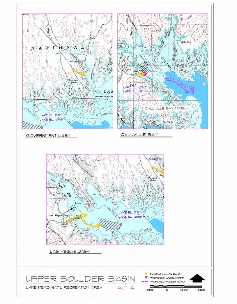

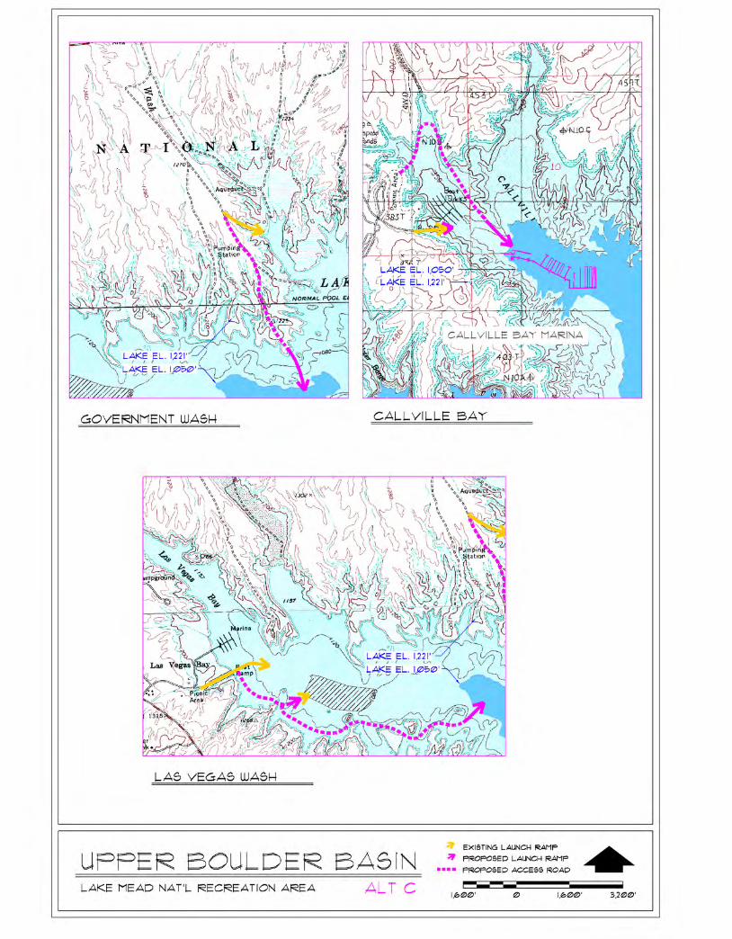
39
OVERTON BEACH
There are two public launch ramps at Overton Beach. The main ramp extends to a depth of 1,104 feet using slide launch design. A second ramp approximately 1 mile south of the main ramp extends from 1,120 to 1,090 feet. Continued operation of the marina below an elevation of 1,120 feet is limited by a lake bottom elevation in the Overton Beach area of approximately 1,110 feet.
STEWARTS POINT The 2002 Lake Management Plan approved a new, as yet to be constructed, public launch ramp at Stewarts Point.
ECHO BAY
The Echo Bay harbor was previously dredged in 1964 to an elevation of 1,080 feet. The public launch ramp at Echo Bay extends down to an elevation of 1,080 feet. Potential extension of this ramp below an elevation of 1,080 feet is limited by the harbor bottom topography.
OVERTON ARM ALTERNATIVES
ALTERNATIVE A – NO ACTION
Overton Beach The marina would be moved farther out into the Overton Arm as water levels receded down to approximately 1,120 feet. Below this lake elevation, the marina could move approximately 1 mile south to an area near the end of the second access ramp. Below an elevation of approximately 1,100 feet there would be insufficient water depths in which to operate the marina at this location. Other commercial facilities (i.e., trailer village, RV park, store, gas station, and concession housing and maintenance) would remain in operation at Overton Beach based on NPS evaluation of visitor demand and financial feasibility. Both launch ramps would be maintained and would be operational down to a lake level of approximately 1,109 and 1,095 feet respectively.
Echo Bay The marina would continue to operate in this area and as water levels receded, would be moved and utilities would be extended downwash where there would be sufficient water depth to operate. The launch ramp would be maintained and would be operational down to approximately 1,085 feet. Boat launching would be discontinued below approximately 1,085 feet.
ALTERNATIVE B (PREFERRED ALTERNATIVE)
Actions would be the same as alternative A, except for the following: Overton Beach The marina would be moved farther out into the Overton Arm as water levels receded down to approximately 1,120 feet. Below this lake elevation, the marina operation would no longer be able to
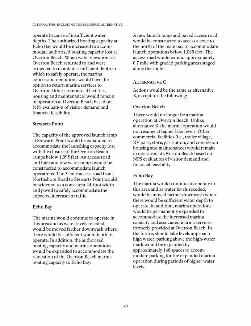
ALTERNATIVES, INCLUDING THE PREFERRED ALTERNATIVE
40
operate because of insufficient water depths. The authorized boating capacity at Echo Bay would be increased to accom-modate authorized boating capacity lost at Overton Beach. When water elevations at Overton Beach returned to and were projected to maintain a sufficient depth in which to safely operate, the marina concession operations would have the option to return marina services to Overton. Other commercial facilities housing and maintenance) would remain in operation at Overton Beach based on NPS evaluation of visitor demand and financial feasibility. Stewarts Point The capacity of the approved launch ramp at Stewarts Point would be expanded to accommodate the launching capacity lost with the closure of the Overton Beach ramps below 1,095 feet. An access road and high and low water ramps would be constructed to accommodate launch operations. The 3-mile access road from Northshore Road to Stewarts Point would be widened to a consistent 24-foot width and paved to safely accommodate the expected increase in traffic. Echo Bay The marina would continue to operate in this area and as water levels receded, would be moved farther downwash where there would be sufficient water depth to operate. In addition, the authorized boating capacity and marina operations would be expanded to accommodate the relocation of the Overton Beach marina boating capacity to Echo Bay.
A new launch ramp and paved access road would be constructed to access a cove to the north of the main bay to accommodate launch operations below 1,085 feet. The access road would extend approximately 0.7 mile with graded parking areas staged along the route.
ALTERNATIVE C
Actions would be the same as alternative B, except for the following: Overton Beach
There would no longer be a marina operation at Overton Beach. Unlike alternative B, the marina operation would not resume at higher lake levels. Other commercial facilities (i.e., trailer village, RV park, store, gas station, and concession housing and maintenance) would remain in operation at Overton Beach based on NPS evaluation of visitor demand and financial feasibility. Echo Bay
The marina would continue to operate in this area and as water levels receded, would be moved farther downwash where there would be sufficient water depth to operate. In addition, marina operations would be permanently expanded to accommodate the increased marina capacity and associated marina services formerly provided at Overton Beach. In the future, should lake levels approach high water, parking above the high-water mark would be expanded by approximately 140 spaces to accom-modate parking for the expanded marina operation during periods of higher water levels.
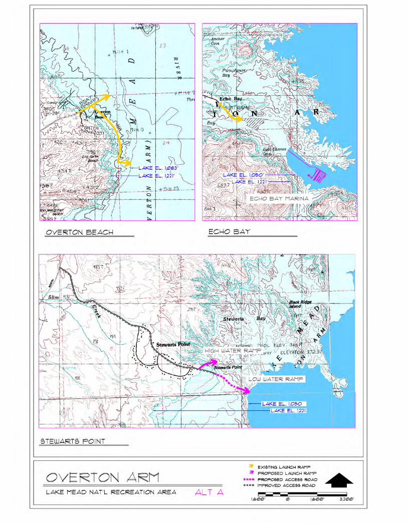

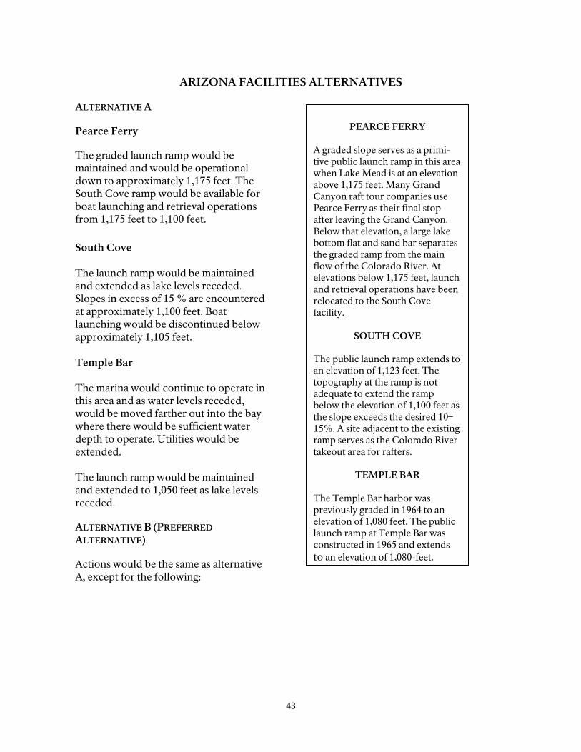
43
PEARCE FERRY
A graded slope serves as a primi-tive public launch ramp in this area when Lake Mead is at an elevation above 1,175 feet. Many Grand Canyon raft tour companies use Pearce Ferry as their final stop after leaving the Grand Canyon. Below that elevation, a large lake bottom flat and sand bar separates the graded ramp from the main flow of the Colorado River. At elevations below 1,175 feet, launch and retrieval operations have been relocated to the South Cove facility.
SOUTH COVE
The public launch ramp extends to an elevation of 1,123 feet. The topography at the ramp is not adequate to extend the ramp below the elevation of 1,100 feet as the slope exceeds the desired 10–15%. A site adjacent to the existing ramp serves as the Colorado River takeout area for rafters.
TEMPLE BAR
The Temple Bar harbor was previously graded in 1964 to an elevation of 1,080 feet. The public launch ramp at Temple Bar was constructed in 1965 and extends to an elevation of 1,080-feet.
ARIZONA FACILITIES ALTERNATIVES
ALTERNATIVE A
Pearce Ferry
The graded launch ramp would be maintained and would be operational down to approximately 1,175 feet. The South Cove ramp would be available for boat launching and retrieval operations from 1,175 feet to 1,100 feet. South Cove The launch ramp would be maintained and extended as lake levels receded. Slopes in excess of 15 % are encountered at approximately 1,100 feet. Boat launching would be discontinued below approximately 1,105 feet. Temple Bar The marina would continue to operate in this area and as water levels receded, would be moved farther out into the bay where there would be sufficient water depth to operate. Utilities would be extended. The launch ramp would be maintained and extended to 1,050 feet as lake levels receded.
ALTERNATIVE B (PREFERRED ALTERNATIVE)
Actions would be the same as alternative A, except for the following:
ALTERNATIVES, INCLUDING THE PREFERRED ALTERNATIVE
44
South Cove Similar to alternative A, the existing ramp would be extended to 1,100 feet. In addition, a new low water launch ramp would be constructed at a site approxi-mately ½ mile south of the existing ramp where the natural slope would be adequate for construction of a launch ramp that could operate down to lake elevations of 1,050 feet. Access to the low water launch and takeout area would require grading of a new paved road approximately 24 feet wide and 1 mile long. The Colorado River takeout area would also shift from the site adjacent to the existing ramp to an area adjacent to the ramp at the new location. A parking area for 100 pull-through spaces would be graded to support the public launch ramp and an approximate 0.2 acre turnaround and parking area would be graded to support the river takeout operations.
ALTERNATIVE C Actions under alternative C would be the same as alternative B, except for the following: Pearce Ferry River access below 1,150 feet would be provided by grading a new access road out to the river. The route would extend approximately 1.7 miles following the lakeshore to the south to the takeout point. Approximately 0.3 – 0.5 mile of this route would cross the clayey lake bottom. Material excavated from the lakeshore could be placed in the lake bottom to construct the road. An approximate 0.2- acre parking area would be graded near the new launch area. Launching capacity would be lost between 1,175 feet and 1,150 feet due to an inadequate space for parking and turnaround areas.

48
ESTIMATED COSTS
Relative costs for the alternatives are in 2005 dollars and are general estimates for the cost of constructing and moving facilities to provide access to an elevation of approximately 1,050 feet. These estimates are general and are intended for use in comparing the alternatives and are not intended to replace more detailed consideration of costs for construction or moving/ reconfiguring of marinas. The marina facilities of Lake Mead National Recreation Area are wholly owned by concessionaires under contract with the National Park Service, therefore the following cost estimate table is broken out between anticipated NPS costs and private costs to commercial operators. Major private investments include extend-ing and/or relocating commercially oper-ated marinas and extending utility systems below an elevation of 1,221 feet (high water mark). Major NPS investments include extending and constructing public boat launch ramps, extending back country roads, extending water intake barges, and upgrading utility systems above an elevation of 1,221 feet (high water mark). The actual costs to the National Park Service would vary depending on con-tributions through partnerships. In addition to the standard NPS funding sources, such as line-item construction and fee demonstration funding, past facility construction (including improve-ments to launch ramps, parking areas, access roads, and utilities related to low water levels) has been funded from revenues generated by the Southern Nevada Public Land Management Act of 1998 and through the Boating Access Program in Arizona and the Sportfish Restoration Program in Nevada.
The Southern Nevada Public Lands Management Act of 1998 provides funding for federal land management agencies in Clark County, Nevada, for capital improvement projects on federal lands. Lake Mead National Recreation Area has received funding to address issues result-ing from low water conditions over the last four years. Projects funded through this partnership source have included basic infrastructure such as roads, parking, and utilities to support marina facilities previously relocated to new areas such as Las Vegas Bay Marina and the Lake Mead Ferry Service. This funding source has also supported the purchase and installation of new navigational aids and breakwaters to protect launching facilities as well as a number of other smaller-scale projects needed to respond to the lowering lake levels. It is anticipated that this partnership funding source may be available to support some of the future improvements outlined under this plan. Life cycle costs for both action alternatives will be higher than the no action alterna-tive, primarily because additional infra-structure would be required to maintain marina services and public access at lower lake levels. Increases in maintenance costs are also expected to follow. The trade off, however, in the increase of expenses to NPS and commercial operators is the continuation of marina services and public access to the lake. Without this invest-ment closures would be required at lower lake levels. Of the two action alternatives, Alternative C would have a higher life cycle cost primarily associated with the initial construction and maintenance of the extended Pearce Ferry access road and new landing.
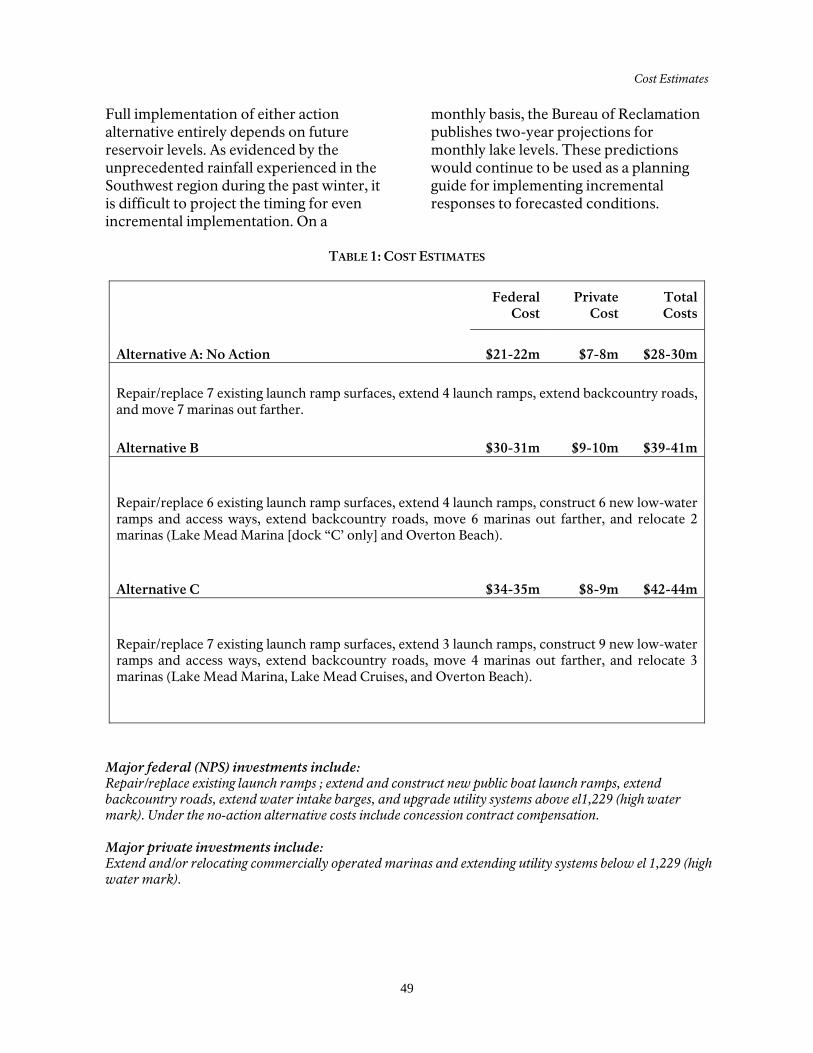
Cost Estimates
49
Full implementation of either action alternative entirely depends on future reservoir levels. As evidenced by the unprecedented rainfall experienced in the Southwest region during the past winter, it is difficult to project the timing for even incremental implementation. On a
monthly basis, the Bureau of Reclamation publishes two-year projections for monthly lake levels. These predictions would continue to be used as a planning guide for implementing incremental responses to forecasted conditions.
TABLE 1: COST ESTIMATES
Federal
Cost Private
Cost TotalCosts
Alternative A: No Action $21-22m $7-8m $28-30m
Repair/replace 7 existing launch ramp surfaces, extend 4 launch ramps, extend backcountry roads, and move 7 marinas out farther.
Alternative B $30-31m $9-10m $39-41m
Repair/replace 6 existing launch ramp surfaces, extend 4 launch ramps, construct 6 new low-water ramps and access ways, extend backcountry roads, move 6 marinas out farther, and relocate 2 marinas (Lake Mead Marina [dock “C’ only] and Overton Beach).
Alternative C $34-35m $8-9m $42-44m
Repair/replace 7 existing launch ramp surfaces, extend 3 launch ramps, construct 9 new low-water ramps and access ways, extend backcountry roads, move 4 marinas out farther, and relocate 3 marinas (Lake Mead Marina, Lake Mead Cruises, and Overton Beach).
Major federal (NPS) investments include: Repair/replace existing launch ramps ; extend and construct new public boat launch ramps, extend backcountry roads, extend water intake barges, and upgrade utility systems above el1,229 (high water mark). Under the no-action alternative costs include concession contract compensation. Major private investments include: Extend and/or relocating commercially operated marinas and extending utility systems below el 1,229 (high water mark).
50
ALTERNATIVES DISMISSED FROM FURTHER CONSIDERATION Several sites were considered when evaluating other potential locations for marina and launch ramp facilities. The relocation of a marina facility back to Las Vegas Bay was eliminated from consid-eration. This area would continue to be at risk due to the delta formation and lack of adequate space for marina operations at lower lake levels. Construction of new developed areas in the upper Boulder Basin and Overton Arm to accommodate marinas displaced from Las Vegas Bay and Overton Beach were also considered and dismissed. Potential locations, such as Boxcar Cove and Stewarts Point, were considered unsuitable based on many of the site condition factors considered in identifying access locations, including extent of new construction, resource impacts, lack of existing utilities, flood-plain concerns, lack of natural protection
from wind and wave action, and overall initial and recurring costs associated with a new development. Stewarts Point is also at the edge of the 1,050 lake elevation. Given the other viable options for utilizing other existing developed area locations that could operate throughout the range of water levels, constructing new developed areas was not considered practical. Two access road and launch ramp align-ments that would provide access at Pearce Ferry were dismissed. Compared to the alternative access road and ramp align-ment being considered in the alternatives, these other routes would have required a greater amount of earthwork and would have been more costly. Consequently, these alignments were dismissed because they were most costly and would result in more extensive impacts.
51
IDENTIFICATION OF THE PREFERRED ALTERNATIVE
In order to develop the preferred alter-native, all of the alternatives were eval-uated. To minimize the influence of in-dividual biases and opinions, the planning team used an objective analysis process called “Choosing by Advantages” (CBA). This process, which has been used ex-tensively by government agencies and the private sector, evaluates different alterna-tives by identifying and comparing the relative advantages of each according to a set of criteria.
One of the greatest strengths of the CBA system is its fundamental philosophy: de-cisions must be anchored in relevant facts. For example, the question “Is it more im-portant to protect natural resources or cultural resources?” is “unanchored,” because it has no relevant facts on which to make a decision. Without such facts, it is impossible to make a defensible deci-sion.
The CBA process instead asks which alter-native gives the greatest advantage. To answer this question, relevant facts were used to determine the advantages the alternatives provide. To ensure a logical and trackable process, the criteria used to evaluate the alternatives were derived from the impact topics in the EIS. Alter-natives were evaluated to see how well they would
• maximize protection of cultural resources (archeological resources, ethnographic resources, historic structures/buildings, cultural landscapes, and museum collec-tions) this factor fell out of the evaluation matrix because there were no tangible differences, hence advantages, between each alterna-tive related to cultural resource protection
• maximize protection of natural resources (biotic communities, threatened and endangered species, water resources and, air quality)
• provide visitor experience (diversity of visitor activities, interpretation and orientation, visitor facilities and services, and visitor experience values)
• improve operational efficiency (staffing, infrastructure, visitor facilities and services, and the role of commercial operators)
Alternatives were rated on the attributes of the factors just listed. Then the advantages of the attributes were compared.
Costs are also a consideration in the selec-tion of a preferred alternative. A GMP provides a framework for proactive decision making, including decisions on visitor use, natural and cultural resource management, and park development. The plan prescribes resource conditions and visitor experiences that are to be achieved and maintained over time. Park develop-ment is considered in general needs rather than in specifics. For the purposes of cost estimating, general assumptions were made regarding amounts and sizes of development and facilities. These assump-tions are then carried across to all alterna-tives so that comparable costs can be considered for each alternative.
Costs identified in the GMP are not in-tended to replace a more detailed consid-eration of needs, sizes, and amounts of future development. They should not be used as a basis for money requests until further analysis has been completed.
Table 2 presents the factors and impor-tance scores arrived at for the advantages, and the costs of the alternatives.
ALTERNATIVES, INCLUDING THE PREFERRED ALTERNATIVE
52
TABLE 2: SUMMARY OF ADVANTAGES OF ALTERNATIVES
OVERTON ARM Factor Alternative A Alternative B
(Preferred Alternative)
Alternative C
Authorized Lake Boating Capacity 0 100 100 Marina visitor experience–boat traffic and no-wake zone
20 70 0
Boat launch visitor experience 0 100 100 Stewarts Point – Land-based and shoreline visitor experience (visitor use levels, density, and conflicts)
30 0 0
T&E Species (razorback sucker, desert tortoise)
90 0
Operational efficiency and infrastructure-concessioner
60 60 0
Operational efficiency and infrastructure – NPS
50 0 40
Flexibility 0 80 0 Subtotal Advantages 250 410 240
ARIZONA Factors Alternative A Alternative B
(Preferred Alternative)
Alternative C
Southwest willow flycatcher potential habitat 60 60 0 Visitor experience 0 90 100 Operational efficiency 20 80 0 Commercial Operations 0 60 70 Subtotal Advantages 80 290 170
UPPER BOULDER BASIN – LAS VEGAS BAY Factor Alternative A Alternative B
(Preferred Alternative)
Alternative C
Authorized Lake Boating Capacity 0 90 90 Risk 0 80 0 Visitor Experience 0 100 80 Operational Efficiency – NPS 40 30 0 Operational efficiency – Concession 0 40 60 Dry Boat Storage, Fuel sales 30 70 0 Subtotal Advantages 70 410 230
UPPER BOULDER BASIN – CALLVILLE BAY Factors Alternative A Alternative B
(Preferred Alternative)
Alternative C
Authorized Lake Boating Capacity 0 100 100 Visitor Experience 0 80 60 Operational Efficiency 20 60 0 Subtotal Advantages 20 240 160
Identification of Preferred Alternative
53
LOWER BOULDER BASIN
Factor Alternative A Alternative B (Preferred
Alternative)
Alternative C
Authorized Lake Boating Capacity
0 100 100
Hemenway Harbor: marina visitor experience – boat traffic and no-wake zone
40 0 20
Boat launch visitor experience 0 70 80 Hemenway Harbor: shoreline and other nonmarina visitor experience (visitor use levels, density, and conflicts)
40 0 40
Boulder Beach: shoreline visitor experience 60 60 0 Operational efficiency and infrastructure (NPS)
0 40 20
Operational efficiency and infrastructure (concessioner)
20 0 20
Concession use 60 60 0 Harbor Protection 0 95 0 Subtotal Advantages 220 425 280 Total Advantages All Areas 640 1,775 1,080 Total Costs for All Areas $28-30M $39-41M $42-44M
The results of the “Choosing by Advantages” process identified alternative B as the recommended preferred alternative based on this alternative’s ability to maintain Lake Mead’s authorized boating capacity, continue
marina services and boat access, provide efficient NPS operations, flexibility in adjusting marina operations to changing lake levels, and avoidance of impacting potential habitat for the southwestern willow catcher.
54
ENVIRONMENTALLY PREFERABLE ALTERNATIVE
The environmentally preferable alternative is the alternative that will promote the national environmental policy as expressed in section 101 of the National Environmental Policy Act. This alternative would satisfy the following requirements:
Fulfill the responsibilities of each generation as trustee of the environment for succeeding generations. Ensure for all Americans safe, healthful, productive, and aesthetically and culturally pleasing surroundings. Attain the widest range of beneficial uses of the environment without degradation, risk of health or safety, or other undesirable and unintended consequences. Preserve important historic, cultural, and natural aspects of our national heritage, and, wherever possible, maintain an environment that supports diversity and variety of individual choice. Achieve a balance between population and resource use that would permit
high standards of living and a wide sharing of life’s amenities. Enhance the quality of renewable resources and approach the maximum attainable recycling of depletable resources.
Taken as a whole, alternative B would best satisfy the above goals and is the environmentally preferred alternative. Alternative B would maintain the park’s ability to carry out its visitor use and recreational mission while limiting the intensity of new environmental impacts associated with extending or moving lake access facilities. Alternative A, the no-action alternative, would have limited new environmental impacts but would result in adverse effects on the majority of recreational users due to successive closure of most launch ramps and lost recreational opportunities. Alternative C would also maintain the park’s ability to carry out its visitor use and recreational mission, including providing greater access at Pearce Ferry. However, access opportunities on the Overton Arm would be more limited and there would be somewhat greater environmental impacts than under alternative B.
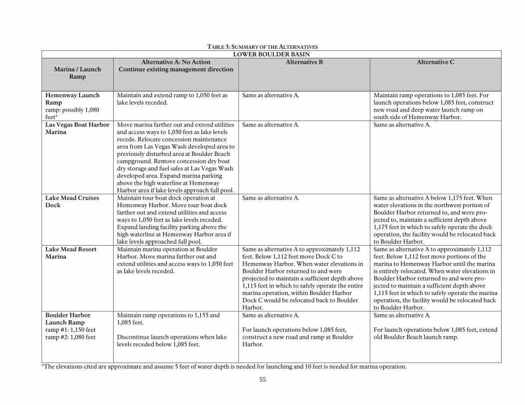
55
TABLE 3: SUMMARY OF THE ALTERNATIVES LOWER BOULDER BASIN
Marina / Launch
Ramp
Alternative A: No Action Continue existing management direction
Alternative B
Alternative C
Hemenway Launch Ramp ramp: possibly 1,080 feet*
Maintain and extend ramp to 1,050 feet as lake levels receded.
Same as alternative A. Maintain ramp operations to 1,085 feet. For launch operations below 1,085 feet, construct new road and deep water launch ramp on south side of Hemenway Harbor.
Las Vegas Boat Harbor Marina
Move marina farther out and extend utilities and access ways to 1,050 feet as lake levels recede. Relocate concession maintenance area from Las Vegas Wash developed area to previously disturbed area at Boulder Beach campground. Remove concession dry boat dry storage and fuel sales at Las Vegas Wash developed area. Expand marina parking above the high waterline at Hemenway Harbor area if lake levels approach full pool.
Same as alternative A. Same as alternative A.
Lake Mead Cruises Dock
Maintain tour boat dock operation at Hemenway Harbor. Move tour boat dock farther out and extend utilities and access ways to 1,050 feet as lake levels receded. Expand landing facility parking above the high waterline at Hemenway Harbor area if lake levels approached full pool.
Same as alternative A. Same as alternative A below 1,175 feet. When water elevations in the northwest portion of Boulder Harbor returned to, and were pro-jected to, maintain a sufficient depth above 1,175 feet in which to safely operate the dock operation, the facility would be relocated back to Boulder Harbor.
Lake Mead Resort Marina
Maintain marina operation at Boulder Harbor. Move marina farther out and extend utilities and access ways to 1,050 feet as lake levels receded.
Same as alternative A to approximately 1,112 feet. Below 1,112 feet move Dock C to Hemenway Harbor. When water elevations in Boulder Harbor returned to and were projected to maintain a sufficient depth above 1,115 feet in which to safely operate the entire marina operation, within Boulder Harbor Dock C would be relocated back to Boulder Harbor.
Same as alternative A to approximately 1,112 feet. Below 1,112 feet move portions of the marina to Hemenway Harbor until the marina is entirely relocated. When water elevations in Boulder Harbor returned to and were pro-jected to maintain a sufficient depth above 1,115 feet in which to safely operate the marina operation, the facility would be relocated back to Boulder Harbor.
Boulder Harbor Launch Ramp ramp #1: 1,150 feet ramp #2: 1,080 feet
Maintain ramp operations to 1,155 and 1,085 feet. Discontinue launch operations when lake levels receded below 1,085 feet.
Same as alternative A. For launch operations below 1,085 feet, construct a new road and ramp at Boulder Harbor.
Same as alternative A. For launch operations below 1,085 feet, extend old Boulder Beach launch ramp.
*The elevations cited are approximate and assume 5 feet of water depth is needed for launching and 10 feet is needed for marina operation.
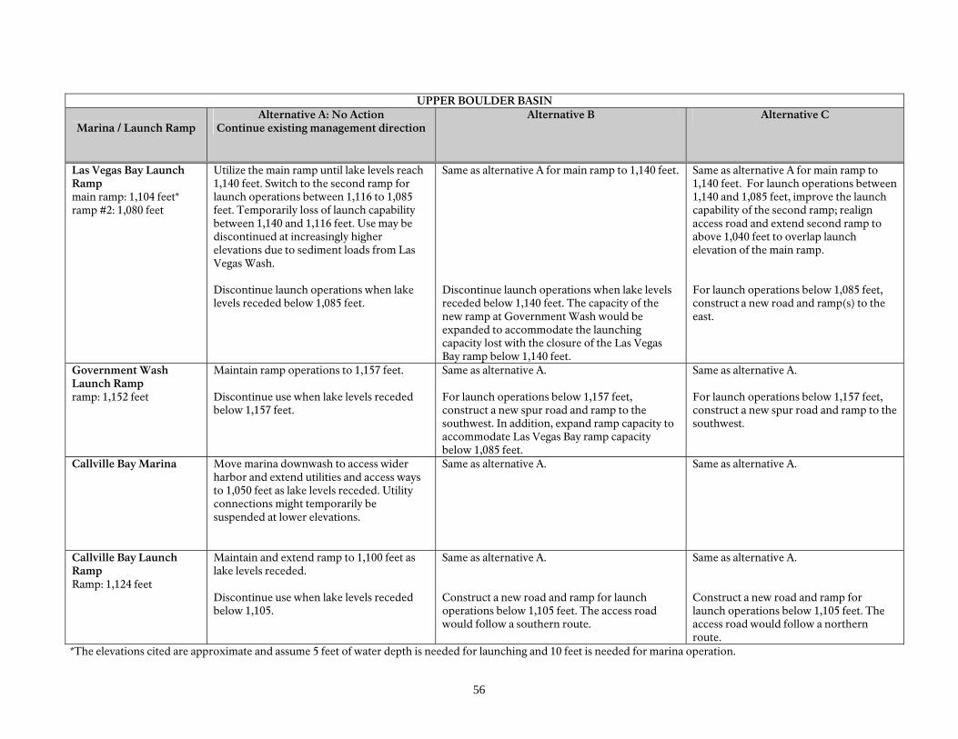
56
UPPER BOULDER BASIN
Marina / Launch Ramp
Alternative A: No Action Continue existing management direction
Alternative B Alternative C
Las Vegas Bay Launch Ramp main ramp: 1,104 feet* ramp #2: 1,080 feet
Utilize the main ramp until lake levels reach 1,140 feet. Switch to the second ramp for launch operations between 1,116 to 1,085 feet. Temporarily loss of launch capability between 1,140 and 1,116 feet. Use may be discontinued at increasingly higher elevations due to sediment loads from Las Vegas Wash. Discontinue launch operations when lake levels receded below 1,085 feet.
Same as alternative A for main ramp to 1,140 feet. Discontinue launch operations when lake levels receded below 1,140 feet. The capacity of the new ramp at Government Wash would be expanded to accommodate the launching capacity lost with the closure of the Las Vegas Bay ramp below 1,140 feet.
Same as alternative A for main ramp to 1,140 feet. For launch operations between 1,140 and 1,085 feet, improve the launch capability of the second ramp; realign access road and extend second ramp to above 1,040 feet to overlap launch elevation of the main ramp. For launch operations below 1,085 feet, construct a new road and ramp(s) to the east.
Government Wash Launch Ramp ramp: 1,152 feet
Maintain ramp operations to 1,157 feet. Discontinue use when lake levels receded below 1,157 feet.
Same as alternative A. For launch operations below 1,157 feet, construct a new spur road and ramp to the southwest. In addition, expand ramp capacity to accommodate Las Vegas Bay ramp capacity below 1,085 feet.
Same as alternative A. For launch operations below 1,157 feet, construct a new spur road and ramp to the southwest.
Callville Bay Marina Move marina downwash to access wider harbor and extend utilities and access ways to 1,050 feet as lake levels receded. Utility connections might temporarily be suspended at lower elevations.
Same as alternative A. Same as alternative A.
Callville Bay Launch Ramp Ramp: 1,124 feet
Maintain and extend ramp to 1,100 feet as lake levels receded. Discontinue use when lake levels receded below 1,105.
Same as alternative A. Construct a new road and ramp for launch operations below 1,105 feet. The access road would follow a southern route.
Same as alternative A. Construct a new road and ramp for launch operations below 1,105 feet. The access road would follow a northern route.
*The elevations cited are approximate and assume 5 feet of water depth is needed for launching and 10 feet is needed for marina operation.
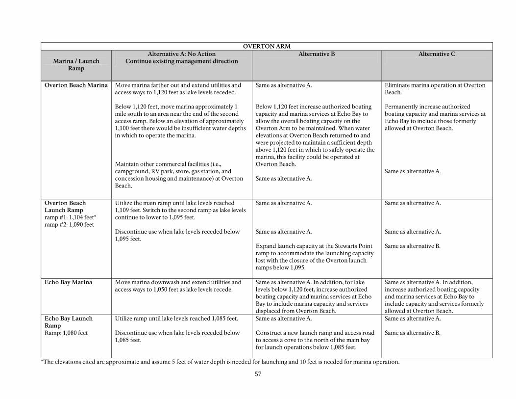
57
OVERTON ARM
Marina / Launch Ramp
Alternative A: No Action Continue existing management direction
Alternative B
Alternative C
Overton Beach Marina Move marina farther out and extend utilities and access ways to 1,120 feet as lake levels receded. Below 1,120 feet, move marina approximately 1 mile south to an area near the end of the second access ramp. Below an elevation of approximately 1,100 feet there would be insufficient water depths in which to operate the marina. Maintain other commercial facilities (i.e., campground, RV park, store, gas station, and concession housing and maintenance) at Overton Beach.
Same as alternative A. Below 1,120 feet increase authorized boating capacity and marina services at Echo Bay to allow the overall boating capacity on the Overton Arm to be maintained. When water elevations at Overton Beach returned to and were projected to maintain a sufficient depth above 1,120 feet in which to safely operate the marina, this facility could be operated at Overton Beach. Same as alternative A.
Eliminate marina operation at Overton Beach. Permanently increase authorized boating capacity and marina services at Echo Bay to include those formerly allowed at Overton Beach. Same as alternative A.
Overton Beach Launch Ramp ramp #1: 1,104 feet* ramp #2: 1,090 feet
Utilize the main ramp until lake levels reached 1,109 feet. Switch to the second ramp as lake levels continue to lower to 1,095 feet. Discontinue use when lake levels receded below 1,095 feet.
Same as alternative A. Same as alternative A. Expand launch capacity at the Stewarts Point ramp to accommodate the launching capacity lost with the closure of the Overton launch ramps below 1,095.
Same as alternative A. Same as alternative A. Same as alternative B.
Echo Bay Marina Move marina downwash and extend utilities and access ways to 1,050 feet as lake levels recede.
Same as alternative A. In addition, for lake levels below 1,120 feet, increase authorized boating capacity and marina services at Echo Bay to include marina capacity and services displaced from Overton Beach.
Same as alternative A. In addition, increase authorized boating capacity and marina services at Echo Bay to include capacity and services formerly allowed at Overton Beach.
Echo Bay Launch Ramp Ramp: 1,080 feet
Utilize ramp until lake levels reached 1,085 feet. Discontinue use when lake levels receded below 1,085 feet.
Same as alternative A. Construct a new launch ramp and access road to access a cove to the north of the main bay for launch operations below 1,085 feet.
Same as alternative A. Same as alternative B.
*The elevations cited are approximate and assume 5 feet of water depth is needed for launching and 10 feet is needed for marina operation.
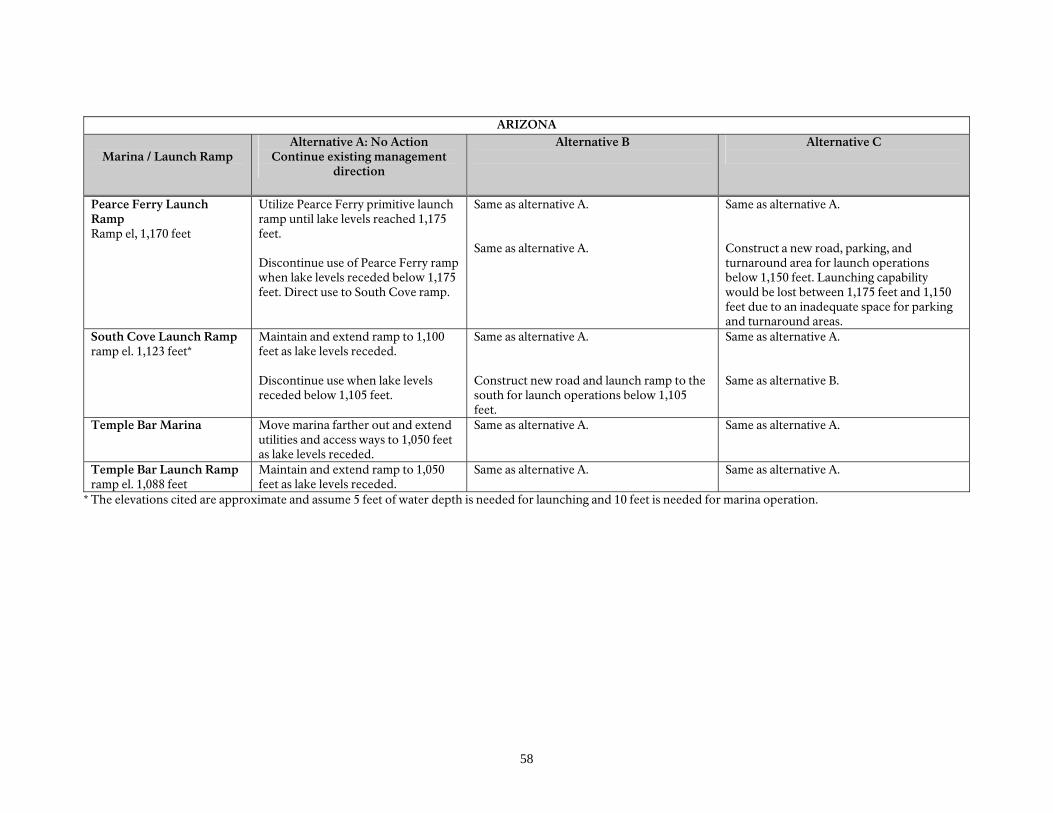
58
ARIZONA
Marina / Launch Ramp Alternative A: No Action
Continue existing management direction
Alternative B
Alternative C
Pearce Ferry Launch Ramp Ramp el, 1,170 feet
Utilize Pearce Ferry primitive launch ramp until lake levels reached 1,175 feet. Discontinue use of Pearce Ferry ramp when lake levels receded below 1,175 feet. Direct use to South Cove ramp.
Same as alternative A. Same as alternative A.
Same as alternative A. Construct a new road, parking, and turnaround area for launch operations below 1,150 feet. Launching capability would be lost between 1,175 feet and 1,150 feet due to an inadequate space for parking and turnaround areas.
South Cove Launch Ramp ramp el. 1,123 feet*
Maintain and extend ramp to 1,100 feet as lake levels receded. Discontinue use when lake levels receded below 1,105 feet.
Same as alternative A. Construct new road and launch ramp to the south for launch operations below 1,105 feet.
Same as alternative A. Same as alternative B.
Temple Bar Marina Move marina farther out and extend utilities and access ways to 1,050 feet as lake levels receded.
Same as alternative A.
Same as alternative A.
Temple Bar Launch Ramp ramp el. 1,088 feet
Maintain and extend ramp to 1,050 feet as lake levels receded.
Same as alternative A.
Same as alternative A.
* The elevations cited are approximate and assume 5 feet of water depth is needed for launching and 10 feet is needed for marina operation.
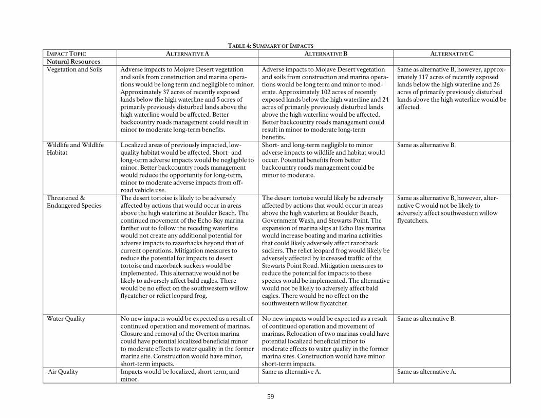
59
TABLE 4: SUMMARY OF IMPACTS IMPACT TOPIC ALTERNATIVE A ALTERNATIVE B ALTERNATIVE C Natural Resources Vegetation and Soils Adverse impacts to Mojave Desert vegetation
and soils from construction and marina opera-tions would be long term and negligible to minor. Approximately 37 acres of recently exposed lands below the high waterline and 5 acres of primarily previously disturbed lands above the high waterline would be affected. Better backcountry roads management could result in minor to moderate long-term benefits.
Adverse impacts to Mojave Desert vegetation and soils from construction and marina opera-tions would be long term and minor to mod-erate. Approximately 102 acres of recently exposed lands below the high waterline and 24 acres of primarily previously disturbed lands above the high waterline would be affected. Better backcountry roads management could result in minor to moderate long-term benefits.
Same as alternative B, however, approx-imately 117 acres of recently exposed lands below the high waterline and 26 acres of primarily previously disturbed lands above the high waterline would be affected.
Wildlife and Wildlife Habitat
Localized areas of previously impacted, low-quality habitat would be affected. Short- and long-term adverse impacts would be negligible to minor. Better backcountry roads management would reduce the opportunity for long-term, minor to moderate adverse impacts from off-road vehicle use.
Short- and long-term negligible to minor adverse impacts to wildlife and habitat would occur. Potential benefits from better backcountry roads management could be minor to moderate.
Same as alternative B.
Threatened & Endangered Species
The desert tortoise is likely to be adversely affected by actions that would occur in areas above the high waterline at Boulder Beach. The continued movement of the Echo Bay marina farther out to follow the receding waterline would not create any additional potential for adverse impacts to razorbacks beyond that of current operations. Mitigation measures to reduce the potential for impacts to desert tortoise and razorback suckers would be implemented. This alternative would not be likely to adversely affect bald eagles. There would be no effect on the southwestern willow flycatcher or relict leopard frog.
The desert tortoise would likely be adversely affected by actions that would occur in areas above the high waterline at Boulder Beach, Government Wash, and Stewarts Point. The expansion of marina slips at Echo Bay marina would increase boating and marina activities that could likely adversely affect razorback suckers. The relict leopard frog would likely be adversely affected by increased traffic of the Stewarts Point Road. Mitigation measures to reduce the potential for impacts to these species would be implemented. The alternative would not be likely to adversely affect bald eagles. There would be no effect on the southwestern willow flycatcher.
Same as alternative B, however, alter-native C would not be likely to adversely affect southwestern willow flycatchers.
Water Quality No new impacts would be expected as a result of continued operation and movement of marinas. Closure and removal of the Overton marina could have potential localized beneficial minor to moderate effects to water quality in the former marina site. Construction would have minor, short-term impacts.
No new impacts would be expected as a result of continued operation and movement of marinas. Relocation of two marinas could have potential localized beneficial minor to moderate effects to water quality in the former marina sites. Construction would have minor short-term impacts.
Same as alternative B.
Air Quality Impacts would be localized, short term, and minor.
Same as alternative A. Same as alternative A.
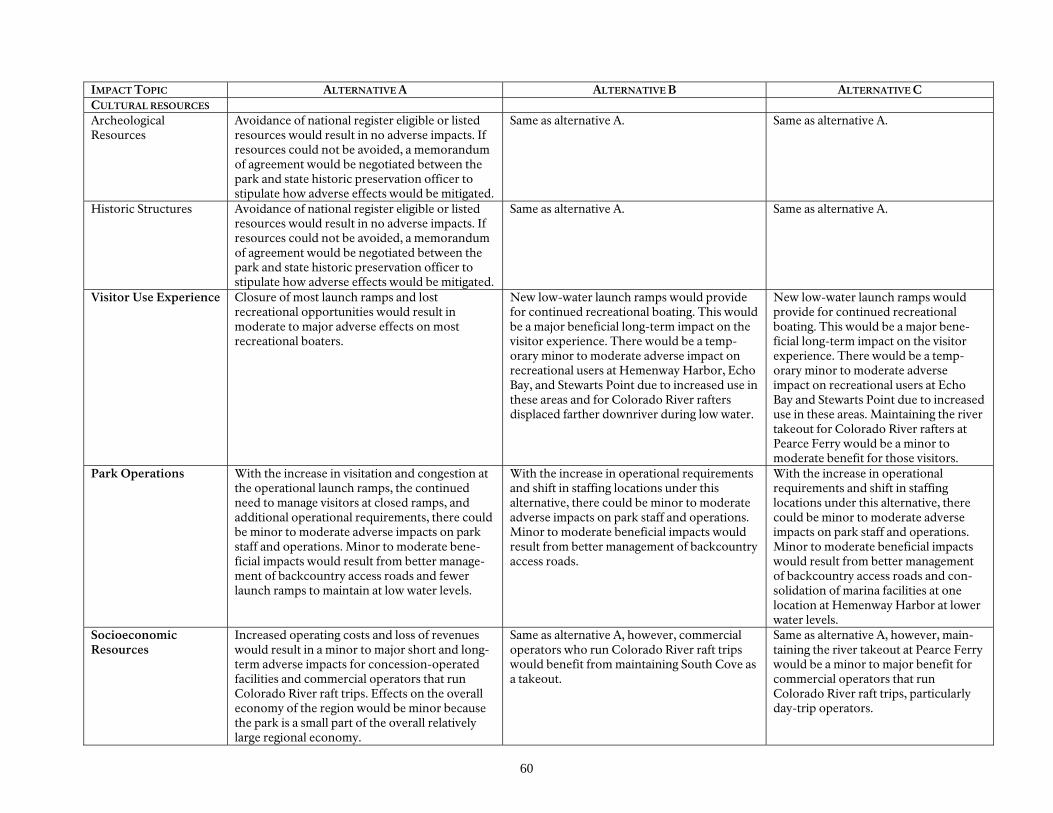
60
IMPACT TOPIC ALTERNATIVE A ALTERNATIVE B ALTERNATIVE C CULTURAL RESOURCES Archeological Resources
Avoidance of national register eligible or listed resources would result in no adverse impacts. If resources could not be avoided, a memorandum of agreement would be negotiated between the park and state historic preservation officer to stipulate how adverse effects would be mitigated.
Same as alternative A. Same as alternative A.
Historic Structures Avoidance of national register eligible or listed resources would result in no adverse impacts. If resources could not be avoided, a memorandum of agreement would be negotiated between the park and state historic preservation officer to stipulate how adverse effects would be mitigated.
Same as alternative A. Same as alternative A.
Visitor Use Experience Closure of most launch ramps and lost recreational opportunities would result in moderate to major adverse effects on most recreational boaters.
New low-water launch ramps would provide for continued recreational boating. This would be a major beneficial long-term impact on the visitor experience. There would be a temp-orary minor to moderate adverse impact on recreational users at Hemenway Harbor, Echo Bay, and Stewarts Point due to increased use in these areas and for Colorado River rafters displaced farther downriver during low water.
New low-water launch ramps would provide for continued recreational boating. This would be a major bene-ficial long-term impact on the visitor experience. There would be a temp-orary minor to moderate adverse impact on recreational users at Echo Bay and Stewarts Point due to increased use in these areas. Maintaining the river takeout for Colorado River rafters at Pearce Ferry would be a minor to moderate benefit for those visitors.
Park Operations With the increase in visitation and congestion at the operational launch ramps, the continued need to manage visitors at closed ramps, and additional operational requirements, there could be minor to moderate adverse impacts on park staff and operations. Minor to moderate bene-ficial impacts would result from better manage-ment of backcountry access roads and fewer launch ramps to maintain at low water levels.
With the increase in operational requirements and shift in staffing locations under this alternative, there could be minor to moderate adverse impacts on park staff and operations. Minor to moderate beneficial impacts would result from better management of backcountry access roads.
With the increase in operational requirements and shift in staffing locations under this alternative, there could be minor to moderate adverse impacts on park staff and operations. Minor to moderate beneficial impacts would result from better management of backcountry access roads and con-solidation of marina facilities at one location at Hemenway Harbor at lower water levels.
Socioeconomic Resources
Increased operating costs and loss of revenues would result in a minor to major short and long-term adverse impacts for concession-operated facilities and commercial operators that run Colorado River raft trips. Effects on the overall economy of the region would be minor because the park is a small part of the overall relatively large regional economy.
Same as alternative A, however, commercial operators who run Colorado River raft trips would benefit from maintaining South Cove as a takeout.
Same as alternative A, however, main-taining the river takeout at Pearce Ferry would be a minor to major benefit for commercial operators that run Colorado River raft trips, particularly day-trip operators.
Affected Environment

63
INTRODUCTION
This chapter provides a description of the existing environment that may be affected by the alternatives under consideration. This chapter includes the specific topics that are analyzed to determine the environmental impacts of the alternatives. These topics were selected based on federal law, regulations, executive orders, NPS expertise, and concerns expressed by other agencies or members of the public during scoping. The conditions described established the baseline for the analyses of effects found in the chapter on “Environmental Consequences.”
A complete and detailed description of the environment and existing uses at Lake Mead NRA can be found in the Lake Mead National Recreation Area Lake Manage-ment Plan Final Environmental Impact Statement (2002), “Lake Mead National Recreation Area Resource Management Plan” (NPS 2000), and the Lake Mead National Recreation Area General Management Plan (NPS 1986).
64
LOCATION AND GENERAL DESCRIPTION
Lake Mead National Recreation Area (NRA) encompasses 142 miles of the Colorado River in Northwestern Arizona (Mohave County) and Southern Nevada (Clark County). Lake Mead, created by Hoover Dam, is 76 miles long. Lake Mead has four large subbasins, including Boulder, Virgin, Temple, and Gregg’s Basin. The shoreline area includes several larger bays, including Grand Wash, Las Vegas, and Bonelli. At full pool (1,229 feet above mean sea level), Lake Mead has a surface area of 157,900 acres with over 700 miles of shoreline. Minimum pool at Lake Mead results in a surface area of 112,890 acres and a volume of 16,440,000 acre-feet. Portions of the recreation area, including a 300-foot zone around the shoreline of the lake, are jointly administered by the National Park Service for recreation and resource protection and by the Bureau of Reclamation for project purposes and the security areas at and around Hoover Dam. The Bureau of Reclamation manages the lake level. Three of America’s four desert ecosys-tems, the Mojave, the Great Basin, and the
Sonoran Deserts, meet in Lake Mead NRA. The area is characteristic of the Mojave Desert, with low precipitation (averaging 8 to 23 centimeters per year [3 to 9 inches per year]), low humidity, and wide extremes in daily temperatures. Winters are relatively short and mild, and summers are long and hot. The prevailing wind direction is from the south. The area surrounding Lakes Mead and Mohave is rugged with deep canyons, dry washes, sheer cliffs, and mountains. Improved access to the shore of the lakes is limited. Northshore Road provides access to the Callville Bay, Echo Bay, and Overton Beach developed areas along the western edge of Lake Mead. Lakeshore Road is the most heavily used road in the park and provides access to Boulder Beach and Las Vegas Bay developed areas on the southwestern portion of Lake Mead. U.S. Highway 93 provides the main transportation link with spur roads leading to Temple Bar, South Cove, and Pearce Ferry on the eastern portion of Lake Mead and the western edge of Grand Canyon National Park.
65
NATURAL RESOURCES VEGETATION AND SOILS The majority of Lake Mead NRA is characterized by generally north-south trending mountain ranges separated by broad, shallow valleys. The lakeshore areas are generally characterized by flat, broad slopes with numerous desert washes leading to various points into Lake Mead. Washes are typically dry, but they occasionally experience flash flooding during thunderstorms in July, August, and early September. Many desert soils are fragile and take a long time to recover if disturbed. Darker surfaces that crumble easily indicate cryptogamic soils. Here mosses, lichens, and bacteria bind the soil surface, forming a crust that serves to prevent wind and water erosion. Gypsum soils are often marked by lightcolored barren areas and support Las Vegas bearpoppy, a species of concern described in the next section. Desert creosote-bursage shrub communi-ties and desert wash communities typically surround the developed areas along the lakeshore. However, the majority of the shoreline in the recreation area contains nonnative salt cedar (Tamarix spp.), with relatively few areas supporting native vegetation due to fluctuating water levels along the shoreline. Recently exposed lands well below the high waterline eleva-tion are characterized by bare ground, rock, and nonnative tamarisk.
THREATENED AND ENDANGERED SPECIES
Razorback Sucker The razorback sucker (Xyrauchen texanus) is listed as a federally endangered species, and Lake Mead has been designated as critical habitat for this species. Biologists working with the Native Fish Work Group and the Southern Nevada Water Authority have conducted surveys on Lake Mead. These surveys identified two known locations for razorback spawning activi-ties, an area in Las Vegas Bay and an area in Echo Bay. No spawning activities have been reported in other areas along the shoreline that may be affected by the alternatives. From 1997 to 2001, razorback suckers spawned near a cliff site at the back of the Echo Bay. Due to the declining lake elevation, this site was dry in 2002, and the fish spawned on a gravelly point on the bay’s south shore approximately 0.25 miles east of the previous location. As the lake elevation has continued to drop, the fish have moved outward and found alternate spawning sites closer to the mouth of the bay. In 2004, the spawning area was located 250 meters to the east of the 2003 spawning area. This indicates that razorback suckers in Lake Mead exhibit spawning site fidelity but are also flexible enough to utilize alternate sites when the preferred location is not available. However, the number of larvae collected at Echo Bay has been declining. There were 207 larvae collected in 2004, compared with 552 in 2003 and 1,022 in 2002. Although there is no definite explanation for this trend, it may be that the declining lake elevation has reduced the available spawning area and forced
AFFECTED ENVIRONMENT
66
some fish to use other areas that have not yet been identified. Lake levels are predicted to decline even farther, and it is assumed that as fewer fish are able to move into the traditional spawning areas, there will be more movement of fish into other areas of the lake. Las Vegas Bay is the other site on Lake Mead, which razorback suckers are known to occupy. This area, which receives effluent from Las Vegas Wash, has also undergone changes in recent years. In addition to the declining lake level, increased sedimentation from the wash and the subsequent extension of the delta has changed the area’s geomorphic configuration. The razorback spawning area appears to be near Blackbird Point, and razorbacks have used this area con-sistently throughout the duration of BIO-WEST’s study, with declining lake levels reducing the depth at which spawning occurs. As lake levels continue to decline and the delta moves farther out into Las Vegas Bay, this area could either become dry or inundated with sediment. Desert Tortoise The recreation area provides important habitat for the federally listed as threat-ened desert tortoise (Gopherus agassizii). Desert tortoise habitat generally occurs in the desert scrub away from the shoreline areas. Desert tortoises have a patchy distribution at Lake Mead and throughout its range. Most of the park supports low densities of tortoises with a few hot spots of higher densities. Although monitoring plots and sign transects have helped identify areas of concern, it has not been possible to calculate accurate numeric densities for any area in the park. Method-ologies for determining tortoise density have been debated for years and are still a major focus of discussion among biologists
and land managers. Developed areas, parking lots, and boat launch areas are in marginal habitat with low tortoise densities, and management of these facilities poses little threat to the species. Access roads typically run through more suitable habitat, where the chance of tor-toise impacts increases. Tortoise density is low near the access road to Stewarts Point. The Mojave population of the desert tortoise is threatened by loss and degra-dation of habitat due to construction activities (roads, pipelines, powerlines, housing developments, energy devel-opments, etc.), mining, grazing, and off-road vehicle use. Additional threats include an upper respiratory disease, predation of juveniles by common ravens, illegal collection, and vandalism. Tortoises are generally active in the spring and fall when annual plants are most abundant, and they must consume their forage requirement during this active period. Tortoises usually spend the remainder of the year in burrows or dens, out of the -extreme weather conditions of the desert. Burrows may be under or between bushes, in the banks or beds of washes, in rock outcrops, or in caliche caves. Bald Eagle The bald eagle (Haliaeetus leucocephalus) is federally listed as threatened. Bald eagles overwinter at Lake Mead, roosting on bluffs and ledges around the lake from which they can hunt for fish. Eagles are common in the Overton Arm of Lake Mead from November to March, although they rarely occupy areas that are heavily used by humans.
Natural Resources
67
Southwestern Willow Flycatcher The southwestern willow flycatcher (Empidonax traillii extimus) is a small passerine bird that was federally listed as endangered in 1995. The willow fly-catcher is a neotropical migrant, and while the species is widely distributed, the endangered subspecies’ breeding range is restricted to southern California (from the Santa Ynez River south), Arizona, New Mexico, extreme southern portions of Nevada and Utah, extreme southwest Colorado, and western Texas. The species occupy dense riparian habitats along rivers, streams, or other wetlands. The vegetation is typically composed of dense stands of willows and other riparian species, and the birds are known to use habitat dominated by exotic tamarisk. An overstory of cottonwood or tamarisk may or may not be present. Dense growth at all vegetation layers appears to be an impor-tant habitat component, as is the presence of water or saturated soil. Birds typically arrive on their breeding grounds in late April or May, with the nesting season extending to late July or early August. Extensive population reductions of south-western willow flycatchers have been attributed primarily to habitat loss, specif-ically the conversion or destruction of native riparian habitats due to agricultural and urban development. Nest predation and brown-headed cowbird parasitism are commonly cited as additional threats. Las Vegas Bearpoppy The Las Vegas bearpoppy (Arctomecon californica) is a sensitive plant species that has been found along the shoreline near Overton Beach, Stewarts Point, and Echo Bay. This plant is typically found on gyp-siferous soils in desert shrub communities.
The park is working with the Bureau of Land Management (BLM), Fish and Wildlife Service (FWS), and the Nature Conservancy for a regional conservation plan for the Las Vegas bearpoppy. The recreation area maintains the largest stands of this species. The National Park Service, in conjunction with the Bureau of Land Management, has established a monitoring program for the Las Vegas bearpoppy. The park initiated an inven-tory and GIS database of bearpoppy stands in 1998. The bearpoppy is categorized as critically endangered by the state of Nevada. Relict Leopard Frog The relict leopard frog (Rana onca) is a species of concern in the recreation area. This species is a member of the leopard frog complex, which consists of numerous species in North and Central America. The species was believed to be extinct for over 40 years until it was rediscovered at two springs in Lake Mead National Recre-ation Area in 1991. Morphological and genetic studies conducted since 1991 have confirmed the validity of this taxon. Habitat requirements are not well under-stood, but for other leopard frog species, shallow water with emergent and perim-eter vegetation provides foraging and basking habitat, and deep water, root masses, undercut banks, and debris piles provide potential hibernacula and refuge from predators. Extant relict leopard frog populations are restricted to narrow hab-itat corridors (<0.5 - 20 m; 1 - 3 m in most places), with a sharply defined boundary between riparian corridor and desert. Relict leopard frogs are active year-round and are most often observed in shallow water along channel or pool margins. Relict leopard frogs have been reduced to as few as six occupied sites in two general
AFFECTED ENVIRONMENT
68
areas, the Overton Arm of Lake Mead, Nevada, and Black Canyon below Hoover Dam along Lake Mohave, Nevada. These two areas, encompassing maximum linear extents of only 3.6 and 5.1 km, respect-ively, comprise a small fraction of the original distribution of the species. The causes for the population declines of this species are not entirely clear, but several factors have been implicated for declines of other amphibians in the West and have likely had an effect on the relict leopard frog as well. These include the alteration and degradation of habitat and the introduction of exotic predators and competitors. Immediate conservation actions are needed to reduce threats to the species, increase the size and number of populations, and maintain associated riparian and wetland habitats.
WILDLIFE AND WILDLIFE HABITAT The shoreline areas of Lake Mead generally provide only low-quality habitat for wildlife due to the lack of vegetative cover, forage, and food sources. Small mammals, reptiles, and coyotes generally will use these areas for water sources. If vegetation is present, birds, such as Gambel quail, rock doves, and ravens, use the areas. Ravens and coyotes frequent the developed areas of the recreation area due to the presence of humans and food sources. Waterfowl, such as mallards and coots, generally can be found on the lake around developed areas. A number of fish species occupy Lake Mead, including game, nongame, and endemic fish species. Nongame species, such as carp, and game fish species, including largemouth bass, striped bass, catfish, crappie, and blue gill inhabit the waters of Lake Mead. Rainbow trout are stocked in selective areas of Lake Mead,
including in the Boulder Basin area. Base productivity of Lake Mead is low. Game fish species depend on the production of the threadfin shad. Rainbow trout are becoming increasingly important as prey species for striped bass. WATER RESOURCES
Lake Mead and Lake Mohave are the primary water resources in the region. The major rivers supplying water to the reservoirs are the Colorado and the Virgin and Muddy Rivers on the north end of Overton Arm. Las Vegas Wash, which flows year-round into Lake Mead, is the outflow for the treated municipal and industrial wastewater from Las Vegas. It provides the second highest inflow into Lake Mead at 155,000 acre-feet annually. Post-impoundment sediments in Lake Mead are not uniformly distributed throughout the lake. They are concentrated in the deepest parts of the lake along the valleys cut by rivers that originally flowed through this area. Sediment filling the original Colorado River valley is thickest to the east at the mouth of the Colorado River. The distribution of sediment in Lake Mead indicates that the Colorado River is the primary source of sediment to the lake. Here sediment is nearly 70 m thick. It thins to 15-25 m in the central third of the lake, and then gradually increases in thickness in the western third of the lake. Near the Hoover Dam, sediment reaches 30 m in thickness. In the Overton Arm, sediment covers the floor of the original Virgin River channel, but here the sediment is only 1-4 m thick. The thinner sediment cover reflects the smaller sediment load carried by the Virgin River in comparison to the Colorado River. (USGS 2004)
Fluctuations in the level of Lake Mead have occurred throughout the reservoir’s
Natural Resources
69
nearly 70-year history. The lake level is a function of how much water is received from the upper Colorado River basin, which varies considerably depending on weather conditions, and how much is released from the basin for human use, which is more predictable. In July of 1983, the lake reached its highest level of 1,225.85 feet above mean sea level. From 1992 to 2002, Lake Mead operated between water surface elevations of 1,173.39 and 1,215.89 feet, with an average daily elevation of 1,193.9 feet. Drought conditions in the west and lower than normal snow pack in the Rocky Moun-tains for the last several years have caused lake levels to drop significantly. In 2000, for example, runoff into Lake Mead was only 56% of normal. The drought has caused Lake Mead to drop to its lowest level in 40 years. As of September 2004, the elevation of Lake Mead was 1,126 feet and current predictions indicate an elevation of 1,098 feet by July of 2006. Lake Mead is the source of drinking water for millions of people living in Arizona, Nevada, and California. The lake also
provides an environment for aquatic life, and for human recreation uses such as swimming, water skiing, windsurfing, fishing, and boating. The water of Lake Mead typically meets state drinking quality standards, although there is occasional degradation near harbors, high-use coves, and where perennial streams enter the lake.
AIR QUALITY Lake Mead NRA is designated a class II air quality area under the Clean Air Act. Air pollutants primarily originate from outside Lake Mead NRA and tend to concentrate during periods of atmospheric inversion. Major sources of air pollutants within or adjacent to the recreation area include: the Mohave power generating plant near Laughlin, Nevada, as well as other power generating plants in the region; emissions from motor vehicles from the Las Vegas valley and other urban areas; particulates from gravel and gypsum quarries; and fugitive dust from disturbed lands and construction activities.
70
CULTURAL RESOURCES
ARCHEOLOGICAL RESOURCES
Only a small portion of the recreation area has been archeologically surveyed. Despite the lack of information, significant prehistoric and historic resources are known to occur in the park. Over 1,200 known archeological sites are in the recreation area. Most of these sites are unevaluated and are considered eligible for the National Register of Historic Places (NRHP). Recent archeological investigations carried out to current professional standards have focused on the developed areas. Most of the archaeological sites located during these surveys are related to the making of stone tools. One site located near the high water- line near Hemenway Harbor is associated with turquoise mining. Much of the land submerged beneath the waters of the lake has not been surveyed, and additional submerged sites may potentially exist.
HISTORIC STRUCTURES Historic resources related to settlement, ranching, mining, exploration, and the construction of Hoover Dam are in the recreation area. More than 55 structures are on seven sites throughout the recre-ation area. These structures are on the park’s List of Classified Structures. Known historic structures occur in the vicinity of the project areas at Boulder Beach and Callville Bay. Submerged historic resources at Boulder Beach include the railroad grade and aggregate facility associated with the construction of Hoover Dam. These structures are west of the Boulder Islands offshore from Hemenway Harbor. Potentially, a spur line off the main railroad grade lies offshore from the Boulder swim beach. A historic road to Fort Callville potentially exists in the project area of Callville Bay, although the specific route is unknown.
71
RECREATIONAL USE AND LAKE ACCESS
Lake Mead National Recreation Area is in one of the fastest growing regions of the United States. Los Angeles, San Diego, and San Bernardino, California, are within a half-day drive, as is Phoenix, Arizona’s largest metropolitan area. Many of Lake Mead’s visitors reside in southern Nevada, Arizona, southern California, and south-ern Utah. However, nearby Las Vegas draws national and international visitors; many visit Lake Mead NRA area while they are in the vicinity. The recreation area is considered one of the premier water-based recreation areas in the nation. Many of the 8 to 10 million yearly visitors to the recreation area visi-tors are involved in water-based recrea-tional activities, primarily between May and September, which are supported at the developed marina and launch ramp areas. These activities include motor boating, houseboating, sailboarding and sailing, canoeing, kayaking, rafting, waterskiing, wakeboarding, fishing, swimming, diving, use of personal watercraft, picnicking, boat touring, nature study, and camping along the lakeshore. The Boulder Beach developed area, which is one of the most heavily visited portions of the recreation area, includes special use areas for sailing, scuba, and personal watercraft use. Primary activities on the lake by percent-age of users include cruising/ sailing 41.4%, personal watercraft usage 17.5 %, waterskiing 16.9 %, fishing 14.2%, swimming 6.7%, and other 3.3% (NPS 2002). Concession-operated facilities at the developed areas provide numerous services to visitors such as boat rentals, marina slips rentals, dry boat storage, fuel, general store merchandise, restaurants or snack bars, campgrounds, and lodging
facilities. NPS visitor facilities include campgrounds, picnic areas, fish-cleaning stations, restrooms, and ranger/visitor contact facilities. Six marinas and nine paved launch ramps are part of the developed areas on Lake Mead. The marinas are Boulder Harbor, Hemenway Harbor, Callville Bay, Echo Bay, Overton Beach, and Temple Bar. The boat ramps are at these same areas as well as at Las Vegas Bay, Government Wash, and South Cove. Pearce Ferry has a graded launch area. Tables 4 and 5 show the number of existing and authorized commercial marina services and public launch facilities on Lake Mead. BOULDER HARBOR There are two separate public launch ramps in the Boulder Harbor. The higher elevation ramp extends from 1,225 to l,l50 feet using side launch design. The second ramp was originally constructed in 1964 and measures 135 feet in width with a slope of 7%. The ramp extends to a depth of 1,080 feet with the lower 80 feet constructed with concrete while the remainder is asphalt. Both ramps are scheduled to be upgraded to concrete surfaces in 2003-2004. Available marina facilities and services include rental slips, boat rentals, boat gas, personal watercraft rentals, a restaurant/lounge. Other commercially operated visitor facilities and services include a general store, motel, trailer village, showers/laundry, dry boat storage, and limited boat/motor repairs.
AFFECTED ENVIRONMENT
72
HEMENWAY HARBOR The Hemenway Harbor public launch ramp is on one of the old roads used to access the river for the construction of Hoover Dam. It was widened and upgraded for boat launching in 1965 and extends to a depth below 1,123 feet. The actual length of the ramp is unknown, but it may extend to 1,080 feet similar to the Boulder Harbor ramp. In 2000, the asphalt was replaced with concrete from 1,217 to 1,195 feet. Below 1,123 feet, it is believed the old road continues at a narrow width of 20 feet. Concrete was extended from 1,195 feet to 1,145 feet in 2004. Lake Mead Cruises was relocated in 2003 from Boulder Harbor to its current location at Hemenway Harbor. This operation provides sightseeing tour boat service to and from Hoover Dam, breakfast and dinner cruises, and charter boat service. The Las Vegas Bay Boat Harbor marina was located at the inflow of Las Vegas Wash before its emergency relocation to its current location in Hemenway Harbor in 2002. Available marina facilities and services include rental slips, boat and personal watercraft rentals, floating gas dock, boat/motor repairs, store, and restaurant. LAS VEGAS BAY There are two public launch ramps in Las Vegas Bay. The main ramp extends to a depth of 1,104 feet and utilizes side launch technology. A second launch ramp begins to be exposed at an elevation of 1,116 feet. The access road to this ramp extends from the main ramp and begins to be exposed at an elevation of 1,130 feet. This second ramp is approximately 90 feet in width with a 9% slope. It extends to an elevation
of 1,080 feet with the lower 80 feet constructed with concrete. The asphalt main ramp was replaced with concrete in 2004. Although the marina was relocated, the Las Vegas Boat Harbor concession still provides dry boat storage and fuel service and operates its maintenance area in Las Vegas Wash. GOVERNMENT WASH In 1990, the Government Wash launch ramp was constructed down to 1,190 feet. This is a 100-foot-wide concrete launch ramp. This ramp was extended to an elevation of 1,175 feet in 1991 and down to 1,157 feet in 2004. CALLVILLE BAY The current launch ramp was constructed in 1966 measuring 170 feet wide and 1,124 feet deep. The ramp holds a 10% slope. The original construction included the placement of concrete from an elevation of 1,140 to 1,124 feet. In 2003, the asphalt portion of the ramp was replaced with concrete from an elevation of 1,189 to 1,143 feet. This leaves a narrow portion (1,143 – 1,140-feet) where the asphalt has not been replaced. The Callville Bay marina includes rental slips; boat, houseboat, and personal watercraft rentals; and fuel. Other commercially operated visitor facilities and services include boat and motor repair, a trailer village, recreational vehicle sites, cafe/ lounge, shower/ laundry, auto and boat gas, dry boat storage, and a general store.
Recreational Use and Lake Access
73
STEWARTS POINT Stewart’s Point, approximately 7 miles north of Echo Bay, provides additional lake access but no commercial facilities. The shoreline at Stewarts Point is a popular summertime weekend destination for visitors. The area is also a vacation cabin site area. These cabin sites are on federal land and leased to private site renters. The cabin sites are only allowed to be used for intermittent, noncommercial, recreational purposes. The 2003 Lake Management Plan approved the future construction of a public boat launch at this location. OVERTON BEACH Overton Beach is within the Overton Arm of Lake Mead, south of the communities of Overton and Logandale. There are two public launch ramps at Overton Beach. The main ramp is 45 feet wide and extends to a depth of 1,104 feet using slide launch design. A second asphalt ramp located approximately 1 mile south of the main ramp is approximately 30 feet wide and extends from 1,120 to 1,090 feet. The slope on the lower ramp is 9%. Available facilities and services at the Overton Beach marina include covered rental slips, boat and personal watercraft rentals, small boat repair, fuel dock, and snack bar. Land based commercial visitor facilities include a store, shower/ laundry, recreational vehicle campground, a trailer village, and dry boat storage. ECHO BAY The public launch ramp at Echo Bay was constructed in 1965 and measures 100 feet in width. The ramp was originally con-structed with asphalt down to an elevation of 1,090 feet then with concrete from 1,090
to 1,080 feet. The ramp holds an 8% slope. In 2002 and 2003, the asphalt was replaced down to an elevation of 1,143 feet. Available concession operated marina facilities include boat, houseboat, and personal watercraft rentals, slip rentals, and fuel. Other commercially operated visitor facilities and services include a restaurant, motel, trailer village, recreational vehicle sites, dry boat storage, store, shower/laundry, boat/motor repairs, and auto/boat gas. TEMPLE BAR The pubic launch ramp at Temple Bar was constructed in 1965 and is 140 feet wide and extends to an elevation of 1,080 feet. It supports only a 5% slope. It was origin-ally constructed with asphalt but down to 1,090 feet with the last 10 vertical feet constructed of concrete. In 2003 the asphalt was replaced with concrete from 1,168 feet down to an elevation of 1,143 feet. Available concession-operated marina facilities include boat, houseboat, and personal watercraft rentals, slip rentals, and fuel. Other commercially operated visitor facilities and services include a restaurant/lounge, motel, cabin rentals, trailer village, RV sites, dry boat storage, store, shower/laundry, boat/motor repairs, and auto/boat gas. SOUTH COVE South Cove is about 15 miles downriver of Pearce Ferry and provides access to one of the best sand beach areas along the lake. The area is currently serving as the retriev-al location for Grand Canyon river run-ners. The public launch ramp was con-structed in 1964 to a width of 85 feet, extending to an elevation of 1,123 feet
AFFECTED ENVIRONMENT
74
with a slope of approximate 9%. In 2003 the asphalt surface was replaced with concrete from an elevation of 1,181 to an elevation of 1,143 feet. Other public facilities include a picnic area and restrooms. PEARCE FERRY Pearce Ferry is on the western extreme of Lake Mead NRA near its boundary with Grand Canyon National Park. A graded slope serves as a primitive public launch ramp in this area when Lake Mead is at an elevation above 1,175 feet. Many Grand Canyon raft tour companies use Pearce Ferry as their final stop after leaving the Grand Canyon. Below that elevation, the lake bottom and large sand bar separate the graded ramp from the main flow of the
Colorado River. At elevations below 1,175 feet, launch and retrieval operations are provided at the South Cove facility. Lake Mead NRA has over 600 miles of approved backcountry roads. Most roads are approved for public use, while a few are only for management purposes. A small percentage of the users of the approved roads system leave the approved roads and illegally create new tracks and trails. Park staff has been managing the approved roads system to reduce illegal vehicle use by installing strategic barriers, promoting public education, increasing law enforcement activities, establishing a new administrative climate with entrance stations, and implementing enhanced road and habitat restoration projects.
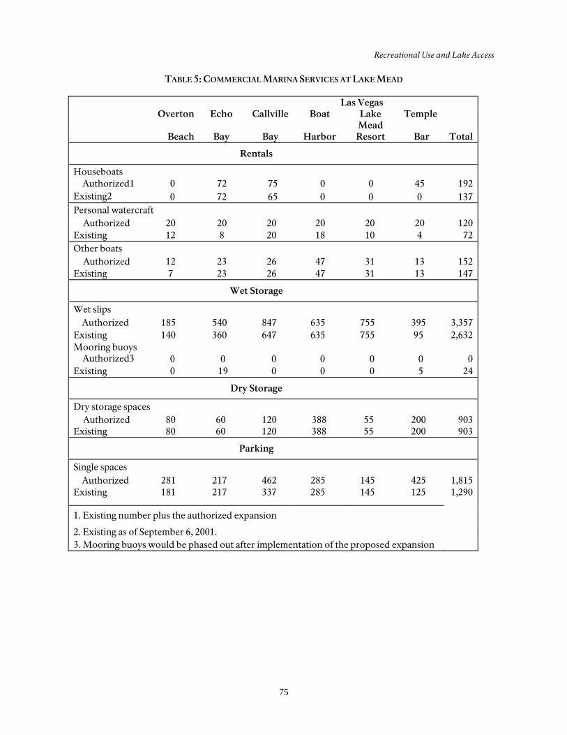
Recreational Use and Lake Access
75
TABLE 5: COMMERCIAL MARINA SERVICES AT LAKE MEAD
Las Vegas Overton Echo Callville Boat Lake
Mead Temple
Beach Bay Bay Harbor Resort Bar Total
Rentals
Houseboats Authorized1 0 72 75 0 0 45 192
Existing2 0 72 65 0 0 0 137 Personal watercraft
Authorized 20 20 20 20 20 20 120 Existing 12 8 20 18 10 4 72 Other boats
Authorized 12 23 26 47 31 13 152 Existing 7 23 26 47 31 13 147
Wet Storage
Wet slips
Authorized 185 540 847 635 755 395 3,357 Existing 140 360 647 635 755 95 2,632 Mooring buoys
Authorized3 0 0 0 0 0 0 0 Existing 0 19 0 0 0 5 24
Dry Storage
Dry storage spaces
Authorized 80 60 120 388 55 200 903 Existing 80 60 120 388 55 200 903
Parking
Single spaces
Authorized 281 217 462 285 145 425 1,815 Existing 181 217 337 285 145 125 1,290
1. Existing number plus the authorized expansion
2. Existing as of September 6, 2001. 3. Mooring buoys would be phased out after implementation of the proposed expansion
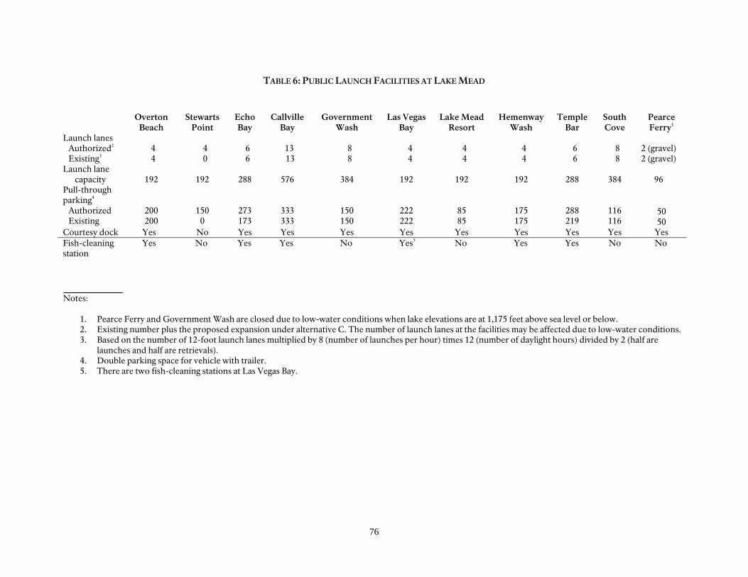
76
TABLE 6: PUBLIC LAUNCH FACILITIES AT LAKE MEAD
Overton Beach
Stewarts Point
Echo Bay
Callville Bay
Government Wash
Las Vegas Bay
Lake Mead Resort
Hemenway Wash
Temple Bar
South Cove
Pearce Ferry1
Launch lanes Authorized2 Existing3 Launch lane
capacity
4 4
192
4 0
192
6 6
288
13 13
576
8 8
384
4 4
192
4 4
192
4 4
192
6 6
288
8 8
384
2 (gravel) 2 (gravel) 96
Pull-through parking4 Authorized Existing
200 200
150 0
273 173
333 333
150 150
222 222
85 85
175 175
288 219
116 116
50 50
Courtesy dock Yes No Yes Yes Yes Yes Yes Yes Yes Yes Yes Fish-cleaning station
Yes No Yes Yes No Yes5 No Yes Yes No No
Notes:
1. Pearce Ferry and Government Wash are closed due to low-water conditions when lake elevations are at 1,175 feet above sea level or below. 2. Existing number plus the proposed expansion under alternative C. The number of launch lanes at the facilities may be affected due to low-water conditions. 3. Based on the number of 12-foot launch lanes multiplied by 8 (number of launches per hour) times 12 (number of daylight hours) divided by 2 (half are
launches and half are retrievals). 4. Double parking space for vehicle with trailer. 5. There are two fish-cleaning stations at Las Vegas Bay.
77
SOCIOECONOMIC RESOURCES
Lake Mead National Recreation Area is in Clark County, Nevada, and Mohave County, Arizona. Communities adjacent to the recreation area include the greater Las Vegas area, which comprises the cities of Las Vegas, North Las Vegas, Henderson, and Boulder City. South of the recreation area are the cities of Laughlin, Nevada, and Bullhead City, Arizona. There is also a substantial portion of the land in Clark County that is managed by the county and is referred to as Unincorporated Clark County. According to the U.S. Census Bureau (2000), the population of the greater Las Vegas area was estimated at just over 1.4 million, with an average growth of nearly 7,000 new residents per year. This high growth rate makes Clark County one of the fastest growing regions in the nation. In 1999 the average per capita income in the metropolitan area of Las Vegas was $29,000. The largest employment sector in Clark County in 1992 was the service industry, followed by administrative support and retail/sales. The population of Mohave County in 1999 was just over 134,000 residents, with a median income of $20,000 (U.S. Census Bureau 2000). The largest employment sector in Mohave County in 1992 was retail, followed by service and manufacturing. Tourism is an important component of the region surrounding Lake Mead National Recreation Area, and much of the tourism revolves around the gaming industry. The recreation area provides a valuable re-source to the area, contributing to the local economy through the sale and rental of boats and other water-related equip-ment, camping equipment, and other recreational equipment, as well as services
and maintenance, hotels, restaurants, and travel-related services. While it is difficult to accurately isolate and quantify the impacts of Lake Mead National Recreation Area on the economy, it is estimated that the total annual impact of the recreation area on the gateway communities and region is in the millions of dollars. The in-park concession opera-tions at Lake Mead National Recreation Area collectively gross $45 million (NPS 2002b). Six concession-run marinas and one tour boat service operate on Lake Mead. Seven Crown Resorts, Inc. runs facilities at Lake Mead Marina, Temple Bar, and Echo Bay. Forever Resorts runs facilities at Callville Bay. Overton Beach Marina, Inc. runs facilities at Overton Beach. Las Vegas Boat Harbor runs facilities at Hemenway Harbor and their former marina location at Las Vegas Wash. Lake Mead Ferry Service Inc., operates the tour boat service out of Hemenway Harbor and was formerly located at Boulder Harbor. There are 16 river runner concessions that offer Colorado River trips through Grand Canyon National Park and which have the option to take out at Pearce Ferry. Gener-ally speaking for those trips that terminate in the recreation area, the white water river trips end when the rafts pass through the rapids at Separation Canyon. At high water levels, river passengers are picked up at Separation Canyon by jetboats and taken down stream to a takeout site. At lake levels above 1,175-feet, takeouts for Colorado River trips would continue to occur at Pearce Ferry. At lake levels below 1,175 feet, takeouts would be displaced 15 miles downstream of Pearce Ferry, to South Cove. The Hualapai Nation offers

78
one-day river trips from Diamond Creek (River Mile 225) to Pearce Ferry (River Mile 277). These are motorized trips that originate in Peach Springs where passen-gers are bused down
to the river, board rafts, and travel to Pearce Ferry where they again board a bus for the trip back to Peach Springs. When lake elevations are 1,175 feet and below, the takeout is relocated to South Cove.
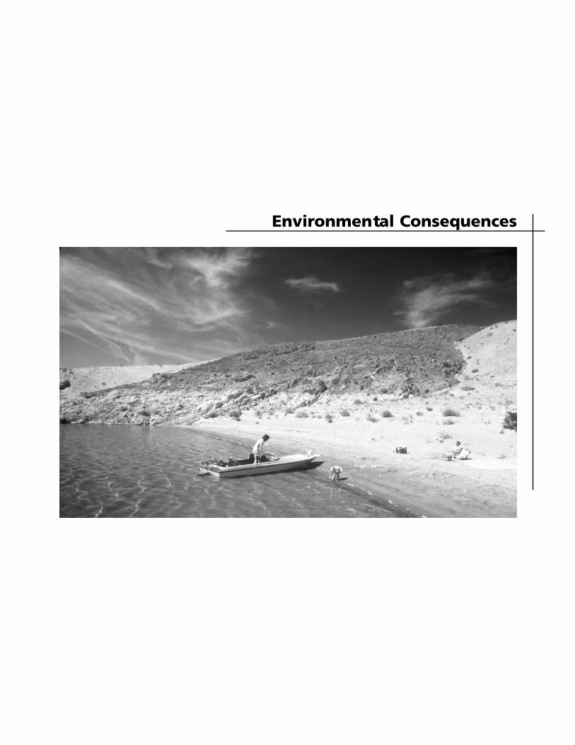
Environmental Consequences

81
INTRODUCTION
The National Environmental Policy Act (NEPA) requires that environmental documents discuss the environmental impacts of a proposed federal action, feasible alternatives to that action, and any adverse environmental effects that cannot be avoided if a proposed action is implemented. In addition, the effects on historic properties are considered in accordance with the National Historic Preservation Act (NHPA). The following portion of this document analyzes the environmental impacts of the alternatives on natural resources, cultural resources, the visitor experience, national recreation area operations, and the socioeconomic environment. The analysis is the basis for comparing the beneficial and adverse effects of implementing the alternatives. This chapter begins with a description of the methods and assumptions for each topic. Impact analysis discussions are organized by alternative and then by impact topic under each alternative. Each alternative discussion also details cumula-tive impacts and presents a conclusion. The NPS National Environmental Policy Act guideline (Director’s Order 12) presents an approach to identifying the duration (short term or long term), type (adverse or beneficial) and intensity or magnitude (negligible, minor, moderate, or major) of the impact(s). That approach has been used in this document. Short-term impacts would last less than one year, normally during construction. Long-term impacts would last more than one year, normally from operations. The duration of long-term impacts would depend on water levels and would not be expected to be permanent. Impact intensity is the degree to which a resource would be beneficially or adversely affected. The criteria that
were used to rate the intensity of the impacts for each resource topic is presented later in this section under each topic heading. Direct and indirect effects caused by an action were also analyzed. Direct effects are caused by an action and occur at the same time and place as the action. Indirect effects are caused by the action and occur later in time or farther removed from the place, but are still reasonably foreseeable. Impact analysis and conclusions are based on NPS staff knowledge of resources and effects from past similar activities, current regulations, review of existing literature, studies, and other available information, and professional judgment. Mitigating actions would be taken during imple-mentation of the alternatives. All impacts have been assessed assuming that mitigat-ing measures have already been imple-mented.
CUMULATIVE IMPACTS A cumulative impact is described in the Council on Environmental Quality’s regulation 1508.7 as follows: “Cumulative impacts are incremental impacts of the action when added to other past, present, and reasonably foreseeable future actions, regardless of what agency (federal or nonfederal) or person undertakes such other action.” Cumulative impacts can result from individually minor, but collectively significant, actions taking place over a period of time. Cumulative impacts were determined by combining the impacts of each alternative with impacts of other past, present, and reasonably foreseeable future actions within the national recreation area and surrounding lands.
ENVIRONMENTAL CONSEQUENCES
82
Specific projects and plans with the potential to cumulatively affect the resources (impact topics) are identified below. Some impact topics would be affected by several or all of the described activities, while others could be affected very little or not at all. How each alternative would incrementally contribute to potential impacts for a resource is included in the cumulative effects discussion for each impact topic. The following actions are based on the 2003 Lake Management Plan: • Echo Bay, Overton, Callville Bay, and
Temple Bar marinas are authorized to expand their marina services. However, marina expansion is unlikely to occur in the foreseeable future given the current drought conditions and projections for continued dropping lake levels.
• Construction of a public launch ramp and parking at Stewarts Point.
• Expansion of parking above the high waterline at Echo Bay by 100 pull-through spaces. Expanded parking would be located adjacent to existing launch parking area.
• Reduced use of carbureted two-stroke engines until they are banned from the recreation area after 2012. Other specific actions to improve conditions related to shoreline and boating conflicts, litter and sanitation, sensitive wildlife habitat, and water quality.
An environmental assessment is pending release for public comment concerning a proposal to expand parking at Echo Bay to the authorized capacity of 600 paved parking spaces. Additional amenities such as restroom facilities are included. On Lake Mead, the average daily Water Surface Elevation (WSE) for the last 10 years (1994 through 2004) has averaged 1,194 feet above Mean Sea Level (MSL).
However, the drought conditions experi-enced over the last five years along the Colorado River Basin have resulted in some of the lowest lake elevations recorded for Lake Mead in over 40 years. Between 2000 and the end of 2004, Lake Mead’s surface elevation has dropped more than 100 feet to elevation 1,125. As of August 2005, the Bureau of Reclama-tion’s two year projected reservoir opera-tion levels for Lake Mead by the end of 2005 will drop farther to elevation 1,110 and by the end of 2006, lake levels will continue to lower to elevation 1,098. These projections are updated monthly. Currently, treated effluent and urban run-off from the Las Vegas Valley is discharged into Las Vegas Wash at various points, from which it flows into Lake Mead at Las Vegas Bay. The Clean Water Coalition has developed the Systems Conveyance and Operations Program (SCOP) to create an alternate discharge location in the Boulder Basin to alleviate some of the problems associated with increased runoff and decreasing water quality. The U.S. Bureau of Reclamation and the National Park Service are preparing an environmental impact statement (EIS) that evaluates alternatives for the improved treatment and ultimate discharge of municipal wastewater from the entities that comprise the CWC. Lowering water levels at Lake Mead exposed sections of ramps that were under water for almost 40 years. This caused crumbling and deterioration of the as-phalt. Visitors needed to show caution at all launch ramps, being alert for holes, mud, silt, and debris. A large-scale launch ramp improvement project involving the lower section of ramps down to the water was initiated in the summer of 2003. Work on the launch ramps significantly im-proved conditions for boaters using these
Introduction
83
Lake Mead facilities. The work at the ramps included removal of the existing asphalt surface and replacement with a 6-inch v-groove concrete surface for im-proved traction. Park service staff will continue to conduct ramp inspections with clean-up or repairs made on a continuous basis. The park will rehabilitate the old and deteriorated water and wastewater systems at all the developed areas with the park. Based on the 1999 Lake Mead National Recreation Area Business Plan interviews with recreation area management staff and personnel audits conducted at Lake Mead NRA, the park is operating 105 positions below what is necessary to effectively manage the fifth most visited unit of the national park system. Development related impacts such as the construction, rehabilitation, and mainte-nance of roads, parking areas, buildings, utility corridors have disturbed park resources. Past and current activities such as mining, grazing, feral burros and illegal off-road vehicle use have also disturbed areas of the park, including soils, vegeta-tion, and cultural sites. The priority for natural resource protection is to inten-sively manage these activities to prevent further disturbance, or to limit disturbance from authorized activities to the extent possible. The populations of Las Vegas, Laughlin, and Bullhead City have grown expo-nentially in the past 10 years. In addition, population centers in Los Angeles, Phoenix, and Salt Lake City have led the nation in growth over recent years. This growth has influenced Lake Mead National Recreation Area in many ways, including increased visitation, pressure
and development along the recreation boundaries, urban runoff and inflow from the Las Vegas Valley, and increased air pollution. The Clark County Multiple Species Habitat Conservation Plan was completed in 2000 and identified protection strategies for sensitive, threatened, and endangered plant and animal species in southern Nevada. This provided the park with support for the active preservation of these species and their habitat or potential habitat. The Native Fish Work Group is working to preserve endemic fish species and their habitat within Lakes Mead and Mohave. In addition, the Colorado River Multiple Species Habitat Conservation Plan is currently in draft form and will supply additional support for the protection of sensitive, threatened, and endangered species along the Colorado River corridor.
IMPAIRMENT OF PARK RESOURCES OR VALUES In addition to determining the environ-mental consequences of the preferred and other alternatives, NPS policy (NPS 2001: Management Policies, section 4.1) requires analysis of potential effects to determine whether or not actions would impair resources of the unit. The fundamental purpose of the National Park System, established by the Organic Act and reaffirmed by the General Authorities Act, as amended, begins with a mandate to conserve park resources and values. NPS managers must always seek ways to avoid or minimize to the greatest degree practicable adverse impacts on park resources and values. However, the laws do give the NPS management discre-tion to allow impacts to park resources and values when necessary and appro-priate to fulfill the purposes of a park, as
ENVIRONMENTAL CONSEQUENCES
84
long as the impact does not constitute impairment of the affected resources and values. Although Congress has given the NPS management discretion to allow certain impacts within parks, that discretion is limited by the statutory requirement that the NPS must leave park resources and values unimpaired, unless a particular law directly and specifically provides otherwise. The prohibited impairment is an impact that, in the professional judgment of the responsible NPS manager, would harm the integrity of park resources or values, including opportunities that otherwise would be present for the enjoyment of those resources or values. An impact to any park resource or value may constitute an impairment. However, an impact would more likely constitute an impairment to the extent it affects a resource or value whose conservation is: • necessary to fulfill specific purposes
identified in the establishing legislation or proclamation of the park
• key to the natural or cultural integrity of the park or to opportunities for enjoyment of the park, or
• identified as a goal in the Park’s General Management Plan or other relevant NPS planning documents
Impairment may result from NPS activities in managing the park, visitor activities, or activities undertaken by concessionaires, contractors, and others operating in the park. A determination of impairment is made in the “Environmental Conse-quences” section in the conclusion section for each resource impact topic.
CRITERIA AND THRESHOLDS FOR IMPACT ANALYSIS
Soils and Vegetation Related Laws, Regulations, and Policies Soil resources would be protected by preventing or minimizing adverse potentially irreversible impacts on soils, in accordance with National Park Service Management Policies. NPS-77 specified objectives for each management zone for soil resources management. These management objectives are defined as: (1) natural zone: preserve natural soils and the processes of soil genesis in a condition undisturbed by humans; (2) cultural zone: conserve soil resources to the extent possible consistent with maintenance of the historic and cultural scene and prevent soil erosion wherever possible; (3) park development zone: ensure that developments and their management are consistent with soil limitations and soil conservation practices; and, (4) special use zone: minimize soil loss and disturbance caused by special use activities, and ensure that soils retain their productivity and potential for reclamation. The National Park Service Organic Act directs the park to conserve the scenery and the natural objects unimpaired for future generations. National Park Service 2001 Management Policies defines the general principles for managing biological resources as maintaining all native plants and animals as part of the natural ecosys-tem. When National Park Service manage-ment actions cause native vegetation to be removed, then the National Park Service will seek to ensure that such removals will not cause unacceptable impacts to native resource, natural process, or other park resources.
Introduction
85
Exotic species, also referred to as non-native or alien, are not a natural com-ponent of the ecosystem. They are managed, up to and including eradication, under the criteria specified in Management Policies and NPS-77. Impact Intensity The impacts to vegetation were evaluated in terms of impacts to native vegetation and nonnative vegetation. The following were used in interpreting the level of impact to vegetation and soils under the various alternatives.
Negligible impacts: Impacts have no measurable or perceptible changes in soil structure and occur in a relatively small area. Impacts have no measurable or perceptible changes in plant community size, integrity, or continuity.
Minor impacts: Impacts are
measurable or perceptible, but localized in a relatively small area. The overall soil structure would not be affected. The overall viability of the plant community would not be affected and, if left alone, would recover.
Moderate impacts: Impacts would
be localized and small in size but would cause a permanent change in the soil structure in that particular area. Impacts would cause a change in the plant community (e.g., abundance, distribution, quantity, or quality); however, the impact would remain localized.
Major impacts: Impact to the soil
structure would be substantial, highly noticeable, and permanent.
Impacts to the plant community would be substantial, highly noticeable, and permanent.
Wildlife and Wildlife Habitat Laws, Regulations, and Policies The National Park Service Organic Act, which directs parks to conserve wildlife unimpaired for future generations, is interpreted by the National Park Service to mean native animal life should be pro-tected and perpetuated as part of the recreation area’s natural ecosystem. Natural processes are relied on to control populations of native species to the greatest extent possible. The restoration of native species is a high priority. Manage-ment goals for wildlife include maintaining components and processes of naturally evolving park ecosystems, including natural abundance, diversity, and eco-logical integrity of plants and animals. The recreation area also manages and monitors wildlife cooperatively with the Arizona Game and Fish department and the Nevada Division of Wildlife. Impact Intensity The impacts of wildlife were evaluated in terms of impacts to individual animals and wildlife habitat. The following were used by the National Park Service in interpreting the level of impact to wildlife.
Negligible impacts: No species of concern is present; impacts would not be measureable.
Minor impacts: Nonbreeding
animals of concern are present, but only in low numbers. Habitat is not critical for survival; other habitat is available nearby. Occasional flight responses by wildlife are expected,
ENVIRONMENTAL CONSEQUENCES
86
but without interference with feeding, reproduction, or other activities necessary for survival.
Moderate impacts: Breeding
animals of concern are present; animals are present during particularly vulnerable life-stages, such as migration or winter; mortality or interference with activities necessary for survival expected on an occasional basis, but not expected to threaten the continued existence of the species in the park.
Major impacts: Breeding animals
are present in relatively high numbers, and/or wildlife is present during particularly vulnerable life stages. Habitat targeted by actions has a history of use by wildlife during critical periods, but there is suitable habitat for use nearby. Few incidents of mortality could occur, but the continued survival of the species is not at risk.
Threatened and Endangered Species Laws, Regulations, and Policies Section 7 of the Endangered Species Act mandates all federal agencies determine how to use their existing authorities to further the purposes of the Act to aid in recovering listed species, and to address existing and potential conservation issues. Section 7(a)(2) states that each federal agency shall, in consultation with the Secretary of the Interior, insure that any action they authorize, fund, or carry out is not likely to jeopardize the continued existence of a listed species or result in the destruction or adverse modification of designated critical habitat.
Management policies direct the parks to survey for, protect, and strive to recover all species native to national park system units that are listed under the Endangered Species Act (4.4.2.3). It sets the direction to meet the obligations of the Act. Manage-ment policies also direct the National Park Service to inventory, monitor, and manage state and locally listed species, and other native species that are of special manage-ment concern to the parks, to maintain their natural distribution and abundance. Impact Intensity The Endangered Species Act defines the terminology used to assess impacts to listed species as follows:
No effect: The appropriate conclu-sion when the action agency deter-mines that its proposed action would not affect a listed species or designated critical habitat.
Is not likely to adversely affect: The
appropriate conclusion when ef-fects on listed species are expected to be discountable, insignificant, or completely beneficial. Beneficial effects are contemporaneous posi-tive effects without any adverse effects to the species. Insignificant effects relate to the size of the impact and should never reach the scale where take occurs. Discount-able effects are those extremely unlikely to occur. Based on the best judgment, a person would not: (1) be able to meaningfully measure, detect, or evaluate insignificant effects; or (2) expect discountable effects to occur.
Is likely to adversely affect: The
appropriate finding if any adverse effect to listed species may occur as
Introduction
87
a direct or indirect result of the proposed action or its interrelated or interdependent actions, and the effect is not: discountable, insigni-ficant, or beneficial. In the effect the overall effect of the proposed action is beneficial to the listed species, but is also likely to cause some adverse effects, then the proposed action “is likely to ad-versely affect” the listed species. If incidental take is anticipated to occur as a result of the proposed action, an “is likely to adversely affect” determination should be made.
Is likely to jeopardize proposed
species/adversely modify proposed critical habitat – (Impairment): The appropriate conclusion when the action agency or the U.S. Fish and Wildlife Service identify situations in which the proposed action is likely to jeopardize the continued existence of a proposed species or adversely modify the proposed critical habitat.
Water Quality Laws, Regulations, and Policies The Clean Water Act, and supporting criteria and standards promulgated by the Environmental Protection Agency (EPA), the Nevada Department of Environmental Protection (NDEP), and the Arizona Department of Environmental Quality (ADEQ) are used at Lake Mead NRA to protect the beneficial uses of water quality, including human health, health of the aquatic ecosystem, and recreational use. A primary means for protecting water quality under the Clean Water Act is the establishment, implementation, and
enforcement of water quality standards. Generally, the federal government has delegated the development of standards to the individual states subject to EPA approval. Water quality standards consists of three components: (1) the designated beneficial uses of a water body, such aquatic life, cold water fishery, or body contact recreation (i.e. swimming or wading); (2) the numerical or narrative criteria that define the limits of physical, chemical, and biological characteristics of water that are sufficient to protect the beneficial uses; and (3) an antidegradation provision to protect the existing uses and quality of water. Water quality criteria developed to protect specific uses are updated periodically by the Environmental Protection Agency. New and revised criteria are published in the Federal Register, and summarized periodically in Quality Criteria for Water (U.S. Environmental Protection Agency 1986). Quality Criteria for Water, also known as "the Gold Book," recommends criteria for a state's Water Quality Standards. The criteria are almost always adopted by states as a portion of their standards, and they represent the “minimum” level of protection afforded to the waterbodies of a state. Water quality in Lake Mead in Nevada is regulated by NDEP under water quality standards and regulations that are promul-gated in the Nevada Administrative Code (NAC, Chapter 445A.119-445A.225). Consistent with federal regulations, Nevada has established numerical and narrative standards that protects existing and designated uses of the State’s waters, and implements the anti-degradation requirements by establishing “require-ments to maintain existing higher quality.” Compliance with the numerical standards
ENVIRONMENTAL CONSEQUENCES
88
for water quality is determined at control points that are specified in the regulations. Title 18, chapter 11 of the Arizona Administrative Code lists the Arizona Department of Environmental Quality water quality standards. The standards establish water quality criteria for the waters of Arizona and designated uses for surface waters, including Lake Mead. The designated uses are aquatic and wildlife, full body contact, domestic water source, fish consumption, agricultural irrigation, and livestock watering. Impact Intensity The following impact thresholds were established in order to describe the relative changes in water quality under the various alternatives.
Negligible impacts: Impacts are
effects that are not detectable, well below water quality standards and/or historical ambient or desired water quality conditions.
Minor impacts: Impacts are effects
that are detectable and well within or below water quality standards and/or historical ambient or desired water quality conditions.
Moderate impacts: Impacts are
effects that are detectable and within or below water quality standards, but historical baseline or desired water quality conditions are being altered on a short-term basis.
Major impacts: Impacts are effects
that are detectable and significantly and persistently alter historical baseline or desired water quality conditions. Water quality
standards are locally approached, equaled, or slightly singularly exceeded on a short term and temporary basis.
Air Quality Laws, Regulations, and Policies Air pollution sources within parks must comply with all federal, state, and local regulations. The regulations and policies that govern pollutants of concern are discussed briefly below. Lake Mead NRA is designated as a Class II Air Quality area under the Clean Air Act. The main purpose of this act is to protect and enhance the nation’s air quality to promote the public health and welfare. The act establishes specific programs to provide protection for air resources and values, including the program to prevent significant deterioration of air quality in clean air regions of the country. Although Lake Mead NRA is designated as a Class II Air Quality area, the park strives to maintain the highest air quality standards, and project work within the recreation area is completed in accordance with regional standards. However, the recreation area does not possess sufficient autonomous authority to address issues of air quality improvements when air pollution originates outside the boundaries. National Park Service Management Policies direct parks to seek to perpetuate the best possible air quality to preserve natural and cultural resources, sustain visitor enjoyment, human health, and preserve scenic vistas (4.7). Parks are directed to comply with all federal, state, and local air quality regulations and permitting requirements. In cases of doubt as to the impacts of existing or potential air
Introduction
89
pollution on park resources, the National Park Service “will err on the side of protecting air quality and related values for future generations.” Impact Intensity The following impact thresholds were established in order to describe the relative changes in water quality under the various alternatives.
Negligible impacts: The impact is at the lower levels of detection or not measurable. There is no smell of exhaust and no visible smoke. Dust from construction activities can be controlled by mitigation.
Minor impacts: The impact results
in slight, localized effect on air quality or visibility. There is a slight smell of exhaust and smoke is visible during brief periods of time. Dust from construction activities is visible only during the work period, but most can be controlled by mitigation.
Moderate impacts: The impact
would have clearly detectable although localized effects on air quality or visibility. There is a smell of gasoline fumes and exhaust in high-use areas. Smoke is visible during periods of high use. Dust from construction activities is visible for an extended area for an extended period, but is reduced by mitigation.
Major impacts: The impact would
have severely adverse or excep-tionally beneficial effects on air quality or visibility and potentially would affect the regional air shed. Smoke and gasoline fumes are
easily detectable for extended periods of time in a large area. Dust from construction activities is visible for an extended period for an extended amount of time, and mitigation is unable to alleviate the conditions.
Cultural Resources Laws, Regulations, and Policies Numerous legislative acts, regulations, and National Park Service policies provide direction for the protection, preservation, and management of cultural resources on public lands. Further, these laws and policies establish what must be considered in general management planning and how cultural resources must be managed in future undertakings resulting from the approved plan regardless of the final alternative chosen. Applicable laws and regulations include the National Park Service Organic Act (1916), the Antiquities Act of 1906, the National Historic Preservation Act of 1966 (1992, as amended), the National Environmental Policy Act of 1969, the National Parks and Recreation Act of 1978, the Archeological Resources Protection Act of 1979, the Native American Graves Protection and Repatriation Act of 1990, and the Curation of Federally Owned and Administered Archeological Collections (1991). Applicable agency policies relevant to cultural resources include Chapter 5 of National Park Service Management Policies, and the Cultural Resource Management Guideline (DO-28), as well as other related policy directives such as the National Park Service Museum Handbook, the National Park Service Manual for Museums, and Interpretation and Visitor Services Guidelines (NPS-26).
ENVIRONMENTAL CONSEQUENCES
90
The Antiquities Act of 1906 (PL 209) authorized the president to establish historic landmarks and structures as monuments owned or controlled by the U.S. government and instituted a fine for unauthorized collection of their artifacts. The National Park Service Organic Act (16 USC 1-4) established the agency to manage the parks and monuments with the purpose of conserving historic objects within them and providing for their enjoyment. The National Historic Preservation Act of 1966 (NHPA; 16 USC 470, et seq.) requires in section 106 that federal agencies with direct or indirect jurisdiction over undertakings take into account the effect of those undertakings on properties that are listed on, or eligible for listing on, the National Register of Historic Places. Section 110 of the act further requires federal land managers to establish programs in consultation with the state historic preservation office to identify, evaluate, and nominate properties to the national register. This act applies to all federal undertakings or projects requiring federal funds or permits. The National Environmental Policy Act of 1969 (NEPA; PL 91-190) sets forth federal policy to preserve important historic, cul-tural, and natural aspects of our national heritage and accomplishes this by assisting federal managers in making sound deci-sions based on an objective understanding of the potential environmental consequen-ces of proposed management alternatives. This act applies to any federal project or other project requiring federal funding or licensing. This act requires federal agen-cies to use a systematic, interdisciplinary approach integrating natural and social sciences to identify and objectively
evaluate all reasonable alternatives to a proposed action. The National Parks and Recreation Act of 1978 (PL 95-625) requires that general management plans be developed for each unit in the national park system and that they include, among other things, measures for the preservation for the area’s resources and an indication of the types and intensities of development associated with public use of a given unit. The Archeological Resources Protection Act of 1979 (16 USC 470aa-mm) further codifies the federal government’s efforts to protect and preserve archeological resources on public lands by stiffening criminal penalties, as well as instituting civil penalties, for the unauthorized collection of artifacts. Additionally, it establishes a permit system for the excavation and removal of artifacts from public lands, including their final disposition, as well as confidentiality provisions for sensitive site location information where the release of such information may endanger the resource. The Native American Graves Protection and Repatriation Act of 1990 (25 USC 3001) sets forth procedures for determining the final disposition of any human remains, funerary objects, or objects of cultural patrimony that are discovered on public lands or during the course of a federal undertaking. “The Curation of Federally Owned and Administered Archeological Collections” (36 CFR 79) establishes guidelines and procedures for the proper curation and management of archeological collections owned or administered by federal agencies.
Introduction
91
Cultural Resources Listed or Eligible to Be Listed in the National Register of Historic Places Potential impacts on cultural resources (archeological resources, prehistoric or historic structures, cultural landscapes, and traditional cultural properties) either listed in or eligible to be listed in the National Register of Historic Places were identified and evaluated in accordance with the Advisory Council on Historic Preservation’s regulations implementing Section 106 of the National Historic Preservation Act (36 CFR 800, Protection of Historic Properties): by (1) determining the area of potential effects; (2) identifying cultural resources present in the area of potential effects that are national register listed or eligible; (3) applying the criteria of adverse effect to affected resources; and (4) considering ways to avoid, minimize or mitigate adverse effects. Under the Advisory Council’s regulations an adverse effect occurs whenever an impact alters, directly or indirectly, any characteristic of a cultural resource that qualifies it for inclusion in the national register, e.g., diminishing the integrity (or the extent to which a resource retains its historic appearance) of its location, design, setting, materials, workmanship, feeling, or association. Adverse effects also include reasonably foreseeable effects caused by the alternatives that would occur later in time, be farther removed in distance, or be cumulative (36 CFR 800.5(a)(1)). A determination of no adverse effect means there is an effect, but the effect would not meet the criteria of an adverse effect, i.e., diminish the characteristics of the cultural resource that qualify it for inclusion in the national register (36 CFR 800.5(b)). Thus, the criteria for characterizing the severity or intensity of impacts on national register listed or eligible archeological
resources, prehistoric or historic structures, cultural landscapes, and traditional cultural properties are the Section 106 determinations of effect: adverse effect, or no adverse effect.
Visitor Use and Experience Laws, Regulations, and Policies Visitor use in parks is authorized in the NPS Organic Act and managed under the NPS Management Policies under Chapter 8, “Use of Parks,” that includes commercial as well as public use. Recreational purposes and activities authorized at Lake Mead National Recreation Area are more specifically defined in Section 4 of the area’s enabling legislation, Public Law 88-639. Impact Intensity
Negligible: Visitors would not be affected or there would be no noticeable change in visitor experience or safety. Changes in the natural sound environment would be so slight they would not be of any measurable or perceptible consequence to visitor experiences.
Minor: Changes in visitor
experience or safety would be detectable, although the changes would be slight. The changes would affect a relatively small number of visitors, be localized in area, or have barely perceptible consequences to the majority of visitors. Other areas in the park would remain available for similar visitor experience and use without derogation of park resources and values.
ENVIRONMENTAL CONSEQUENCES
92
Moderate: Changes in visitor experience or safety would be readily apparent and would affect a relatively large number of visitors. Other areas in the park would remain available for similar visitor experience and use without derogation of park resources and values, but visitor satisfaction might be measurably affected (visitors could be either satisfied or dissatisfied). Some visitors who desire to continue their use and enjoyment of the activity/visitor experience would be required to pursue their choice in other available local or regional areas.
Major: Changes in visitor
experience or safety would be severely adverse or exceptionally beneficial, highly noticeable, and would affect relatively large numbers of visitors. The change in visitor use and experience proposed in the alternative would preclude future generations of some visitors from enjoying park resources and values. Some visitors who desire to continue their use and enjoyment of the activity / visitor experience would be required to pursue their choice in other available local or regional areas.
Park Operations Impact Intensity The impact evaluation was based on an evaluation of the effects on park operations from changes in providing visitor facilities and services under the alternatives.
Negligible: Park operations would not be affected or the effect would be at or below the lower levels of detection, and would not have an appreciable effect on park operations.
Minor: The effects would be
detectable, but would be of a magnitude that would not have an appreciable effect on park operations
Moderate: The effects would be
readily apparent and would result in a substantial change in park operations in a manner noticeable to staff and the public.
Major: The effects would be
readily apparent and would result in a substantial change in park operations in a manner noticeable to staff and the public and be markedly different from existing operations.
Socioeconomic Environment Laws, Regulations, and Policies In accordance with NPS Management Policies, the park may permit commercial services that are necessary and appropriate for public use and enjoyment of the park and are consistent to the highest practicable degree with the preservation and conservation of the park’s resources and values. Impact Intensity
Impacts on socioeconomic impacts, including the commercial operators in the park and nearby communities were considered. Very detailed information gathering and financial analysis would
Introduction
93
need to be completed to determine definitive operational costs. A more general discussion of socioeconomic impacts is included in the consequences section.
Negligible: Negligible impacts would be so slight as to be difficult to measure or perceive and have no meaningful implications for the socioeconomic environment.
Minor: Minor impacts would be
effects on the socioeconomic environment that would be slightly detectable; there would be a small change.
Moderate: Moderate impacts would be clearly detectable to the visitor and could have an appreciable effect.
Major: Major impacts would have a
substantial, highly noticeable influ-ence on the socioeconomic envi-ronment and could permanently alter the socioeconomic environ-ment.
94
IMPACTS OF ALTERNATIVE A – NO ACTION
NATURAL RESOURCES
Vegetation and Soils This alternative would include extension of existing launch ramps at Hemenway Harbor, Callville, Bay, South Cove, and Temple Bar, movement of marinas farther out into the lake, extension of access, parking, and utilities, and possible grading of Boulder Harbor at water levels below 1,080 feet. These actions would affect recently exposed lands well below the high waterline elevation. These lands are characterized by bare ground, rock, and nonnative tamarisk. Soils in the inundation zone of the lake have been through repeated flooding and drying cycles as the lake rises and falls, which limits their integrity for sustaining native Mojave Desert vegetation. Construction would result in the compaction and displacement of previously disturbed soils and the loss of primarily nonnative vegetation on a total of approximately 37 acres. This is the total disturbance distributed across 11 launch ramp and marina project areas dispersed around the lakeshore. Potential grading of Boulder Harbor could affect approximately an additional 4-8 acres. Desert shrub vegetation and soils above the high waterline may be removed by construction of a concession maintenance area and grading of high water parking areas near Hemenway Harbor should lake levels approach high water. Up to approx-imately 5 acres would be impacted. How-ever, these facilities would be placed in primarily previously disturbed areas in the developed zone. Where possible, desert soil would be salvaged to assist in the restoration of disturbed areas.
Because of the localized area of impact, and the predominant use of areas below the high waterline or previously disturbed areas, adverse impacts from the above actions would be long term and negligible to minor. Better management of lake access on backcountry roads that would direct traffic and discourage vehicle use outside of the designated road corridors would reduce the opportunity for long-term adverse damage to cryptogamic soils and native vegetation from off-road vehicle use. Compared to the existing situation, potential beneficial effects could be minor to moderate depending on the extent of off-road vehicle use that would otherwise occur. Cumulative Impacts. Impacts to Mojave plant communities from development and use have been and are expected to con-tinue to occur primarily in developed areas and corridors and along the shoreline below the high waterline. Other past and continuing activities such as mining, grazing, feral burros and illegal off-road vehicle use have also disturbed areas of the park. The priority for natural resource protection is to intensively manage these activities to prevent further disturbance, or to limit disturbance from authorized activities to the extent possible. Impacts from the above actions, in combination with the impacts of the no-action alterna-tive, would result in minor to moderate adverse cumulative effects on native plant communities over the long term. The no-action alternative, however, would contrib-ute a small increment to the overall cumulative impact. Conclusion. Adverse impacts to Mojave Desert vegetation and soils from con-
Impacts of Alternative A- No Action
95
struction and marina operations would be long term and negligible to minor. Better backcountry roads management could result in minor to moderate long-term benefits by reducing the opportunity for off-road vehicle use. There would be no impairment to vegetative communities and associated soils.
Wildlife and Wildlife Habitat Extension of launch ramps at Hemenway Harbor, Callville Bay, and Temple Bar, movement of marinas farther out into the lake, extension of access, parking, and utilities, and possible grading of Boulder Harbor at water levels below 1,080 feet, would affect areas below the high waterline. These areas have been degraded over time by alternating periods of flooding and drying and most of the immediate shoreline has been graded or used for intensive recreation and shoreline access. Thus while common Mojave Desert species such as lizards and small mammals may travel through or occa-sionally occupy these areas, their occurrence and densities would be greatly reduced from previous and ongoing disturbances. Wildlife would be disturbed in these areas during construction and poor quality habitat would be lost. Short-term disturbance to wildlife and long-term loss of habitat would be negligible. Impacts from construction near the lakeshore and operational actions associated with marina movement such as grading parking could create increased runoff, turbidity, or sedimentation of nearby aquatic habitats. Eventual closure and removal of the Overton marina could also occur under this alternative, which could have similar impacts in the area of the marina during removal operations. Generally, these adverse impacts would be short term and minor because of the small
areas affected and the disturbing activities would be temporary. Habitat above the high waterline may be disturbed by construction of a concession maintenance area and by grading of high water parking areas near Hemenway Harbor should lake levels approach high water. However, these facilities would be located in previously disturbed areas in proximity to other existing development and areas of high recreational use, areas typically avoided by wildlife. Given the generally poor quality of the habitat affected impacts to wildlife would be long term and negligible. Better management of lake access on backcountry roads that would direct traffic and discourage vehicle use outside of the designated road corridors would reduce the opportunity for long-term adverse impacts to upland wildlife habitat from off-road vehicle use. Compared to the existing situation, potential beneficial effects could be minor to moderate depending on the extent of off-road vehicle use that would otherwise occur. Cumulative Impacts. Impacts to wildlife habitat from development and use have been and are expected to continue to occur primarily in developed areas and corridors and along the shoreline below the high waterline. Other past and continuing activities such as mining, grazing, feral burros and illegal off-road vehicle use have also disturbed areas of the park. The priority for natural resource protection is to intensively manage these activities to prevent further disturbance, or to limit disturbance from authorized activities to the extent possible. Management actions associated with the Lake Management Plan would further benefit wildlife, particularly from greater
ENVIRONMENTAL CONSEQUENCES
96
protection of sensitive inflow areas. Im-pacts from the above actions, in combina-tion with the impacts of the no-action alternative, would result in minor to moderate, long-term, adverse cumulative effects on wildlife habitat from develop-ment and use and minor to moderate, long-term, beneficial cumulative effects from protection of sensitive areas. The actions of alternative A would contribute a small adverse increment to the overall cumulative impact. Conclusion. Impacts to wildlife and wildlife habitat from actions under this alternative would generally affect localized areas of previously impacted, low quality habitat. Long-term adverse impacts would be negligible to minor. Better backcountry roads management would reduce the opportunity for long-term, minor to moderate adverse impacts from off-road vehicle use. The park’s wildlife and wild-life habitat would not be impaired by actions under this alternative.
Threatened and Endangered Species Most actions, such as extension of launch ramps and movement of marinas farther out into the lake and extension of access, parking, and utilities, and possible removal of the Overton marina would affect recently exposed lands well below the high waterline elevation. These lands are characterized by bare ground, rock, and nonnative tamarisk and are considered unsuitable habitat for the desert tortoise and actions would not be likely to adversely affect tortoise. The desert tortoise may occur in low densities above the high waterline in the vicinity of the construction areas for new high water parking and concession maintenance area near Hemenway
Harbor. Disturbance of up to 5 acres would take place in or immediately adjacent to previously disturbed areas of poor quality habitat. Mitigation measures developed with the assistance of the U.S. Fish and Wildlife Service would be imple-mented to reduce or eliminate any poten-tial adverse impacts on desert tortoises from construction activities. Due to the nature of these construction activities within desert tortoise habitat, there is the potential to adversely affect the desert tortoise from the loss of burrows or other habitat features. Better management of lake access on back-country roads that would direct traffic and discourage vehicle use outside of the des-ignated road corridors would reduce the opportunity for long-term adverse impacts to cryptogamic soils and native vegetation from off-road vehicle use. Compared to the existing situation, this would be a potential beneficial effect on tortoise, the extent of which would depend on the amount of off-road vehicle use that would otherwise occur. Desert tortoise may be affected, but would not be likely to be adversely affected by this action. The continued movement of the Echo Bay marina farther out to follow the receding waterline would not create any additional adverse impacts to razorback suckers beyond that of current operations. Pos-sible existing impacts such as the noise, wave action disturbance to substrates and turbidity, concentration of carp, and fuel derivatives from marina and associated boat operation could be detrimental to the fish, especially during spawning. These types of impacts would continue to be lessened by continued implementation of mitigation measures (e.g., closure of spawning areas, public awareness efforts, and best management practices for marina operations) and the fact that razorback
Impacts of Alternative A- No Action
97
suckers spawn from January to April, during which time boating activity is reduced. Impacts from construction near the lakeshore associated with ramp extensions and operational actions associated with marina movement such as grading parking areas could create increased runoff, turbidity, or siltation of nearby aquatic habitats. Generally, these adverse impacts would be short term and minor because of the small areas affected, and the disturbing activities would be temporary. Mitigation measures such as use of berms or silt fenc-ing would be used to eliminate or mini-mize any runoff from reaching the lake, which is critical habitat for the razorback sucker. With mitigation, these actions would not be likely to adversely affect the razorback sucker. Areas used by bald eagles are high cliffs well above the lake. Eagles generally avoid areas heavily used by humans, and do not use the recreation area for nesting. There-fore, construction activities and other operational activities in already developed areas would not likely affect bald eagles. Habitat for the southwestern willow flycatcher, Las Vegas bearpoppy, and relict leopard frog would not be affected by any actions under this alternative. Therefore, this alternative would have no effect on these species. Cumulative Impacts. The impoundment of the Colorado River and the creation of the artificial reservoirs of Lakes Mead and Mohave have resulted in the removal or decline of endemic fish species including the razorback sucker in the lakes. This, along with the introduction of nonnative fish, has led to their decline in the Colo-rado River system. A Native Fish Work Group has been formed to work for the
survival of the razorback sucker and bonytail chub in the recreation area. The National Park Service would continue to work with this group in an attempt to preserve the species in the park. The extended drought and resulting drop of the lake elevation is potentially one of the biggest threats to the razorback sucker. Sites previously used for spawning are now dry, and the fish are being forced to use other areas for spawning. For now it appears that the fish are adapting to the lowering water and finding new areas in which to spawn, but it is unclear how long this will continue. Obviously as the lake gets smaller, there is less habitat available to the fish, and it is not known how much potential habitat exists within the lake. With preferred spawning locations be-coming smaller, the fish will be forced to find new areas to spawn, and how success-sful they will be remains to be determined. Other cumulative actions include the potential expansion of the Echo Bay marina to its authorized capacity which could contribute similar recreational related impacts as described above, although similar mitigation would apply that would reduce potential impacts. It is unlikely expansion would occur due to low water levels, and the marina has actually reduced its rental boats. Con-struction of a launch ramp at Stewarts Point would not affect known spawning areas. Construction of this ramp and associated parking areas near the lake-shore could create increased runoff, turbidity, or sedimentation of nearby lake waters. Generally, these adverse impacts would be short term and minor because of the small areas affected and the disturbing activities would be temporary. Mitigation measures such as use of berms or silt fencing would be used to eliminate or minimize any runoff from reaching the
ENVIRONMENTAL CONSEQUENCES
98
lake. Other elements of the Lake Management Plan would reduce the amount of waste fuels and human wastes in the lake, and thus improve water quality. Should the SCOP project result in the reduction of wastewater discharge into Las Vegas Bay, this would benefit water quality in the area as well as reduce or eliminate further sediment encroachment on the Blackbird Point spawning area. The no-action alternative in combination with these other past, present, and reasonably foreseeable actions would have both adverse and beneficial cumulative effects on razorback spawning areas and critical habitat. Expansion of parking and construction of a launch ramp and associated parking at Stewarts Point would occur in or near marginal habitat with low desert tortoise densities. There is the potential to adversely affect the desert tortoise from the loss of burrows or other habitat features. The same mitigation measures would apply to these actions to protect tortoises and minimize adverse effects. Other past, current, or proposed develop-ment and activities such as mining, graz-ing, feral burros and illegal off-road vehicle use have disturbed habitat in the park. The priority for natural resource protection is to intensively manage these activities to prevent further disturbance, or to limit disturbance from authorized activities and development to the extent possible. Lake Mead National Recreation Area does protect large, undisturbed portions of Mojave Desert plant com-munities. And while lands within the Las Vegas Valley are being lost to develop-ment, lands within the recreation area and other federal lands around Las Vegas are given funding through the multiple species habitat conservation planning process to help further protect endangered and
threatened species including the desert tortoise. The no-action alternative in combination with these other past, present, and reasonably foreseeable actions would have both adverse and beneficial cumulative effects on desert tortoise habitat. Conclusion. The desert tortoise is likely to be adversely affected by actions that would occur in areas above the high waterline at Boulder Beach. The continued movement of the Echo Bay marina farther out to follow the receding waterline would not create any additional potential for adverse impacts to razorbacks beyond that of current operations. Mitigation measures to reduce the potential for impacts to desert tortoise and razorback suckers would be implemented. This alternative would not be likely to adversely affect bald eagles. There would be no effect on the southwestern willow flycatcher or relict leopard frog. Implementation of this alternative would not result in impairment to threatened and endangered species.
Water Quality Continued operation and movement of marinas to follow lowering water levels is not expected to result in new impacts to water quality. Components of concession operations, especially those associated with fueling and boat maintenance could create minor to moderate impacts on water quality. The National Park Service would continue to provide guidance on best management practices for the handl-ing of fueling areas and boat maintenance for concessioners and the boating public to reduce pollutants entering the lake due to fueling and boat maintenance activities. Testing to date of selected high use areas including marinas, have shown that while pollutants have been detected, they do not exceed water quality standards. Closure
Impacts of Alternative A- No Action
99
and removal of the Overton marina would eliminate the potential for water contami-nation from boat maintenance and fueling operations. Compared to the existing situation, potential localized effects could be beneficial. Construction activities and paving associated with the extension of launch ramps and grading for parking could result in runoff of contaminants such as oil from vehicles and construction equipment and erosion leading to increased turbidity and sedimentation of nearby waters. The use of best management practices, such as placement of berms or silt fencing would reduce runoff and erosion. The impacts would be minor because of the small portion of the lake affected, the use of mitigation measures, and the short-term nature of the construction activities. Cumulative Impacts. Management ac-tions associated with implementation of the Lake Management Plan would improve water quality through elimination of carbureted two-stroke engines after 2012 and other actions to reduce impacts from human wastes. Should the SCOP project result in the reduction of wastewater discharge into Las Vegas Bay, this would benefit water quality in the area of Las Vegas Wash. Impacts from the above actions, in combination with the impacts of the no-action alternative, would result in minor adverse and minor to moderate beneficial cumulative effects on water quality over the long term. The no-action alternative would contribute a minor increment to the overall cumulative impacts on water quality. Conclusion. Continued operation and movement of marinas to follow lowering water levels is not expected to result in new impacts to water quality. Closure and removal of the Overton marina could have
potential localized beneficial minor to moderate effects to water quality in the former marina site. Construction would have minor, short-term, adverse impacts. Implementation of this alternative would not result in impairment to water quality.
Air Quality Actions under this alternative associated with construction activities and ground disturbance would result in local and temporary fugitive dust and vehicle emissions. Use of dust control measures would minimize impacts. Standard miti-gation measures used at the park such as use of low sulfur fuel when available and proper tuning of construction equipment would reduce air quality impacts related to construction machinery. Graded areas would periodically generate dust in a localized area from vehicle use and wind conditions. These impacts to air quality would be short term, minor, and adverse. Cumulative Impacts. Actions affecting air quality in the park include effects of increased development and population growth, most notably in the Las Vegas area. Management actions associated with implementation of the Lake Management Plan would improve local air quality as carbureted two-stroke engines are elimi-nated after 2012. Impacts from the above actions, in combination with the impacts of the no-action alternative, would result in minor to moderate adverse and minor beneficial cumulative effects on water quality over the long term. This alternative would contribute a relatively small increment to the overall cumulative impacts on air quality. Conclusion. Impacts to air quality from actions under this alternative would be localized, short- term and minor. The
ENVIRONMENTAL CONSEQUENCES
100
park’s air quality would not be impaired by actions under this alternative.
CULTURAL RESOURCES
Archeological Resources The park has not been surveyed or inventoried comprehensively for archeo-logical resources, and the location and significance of archeological resources is largely unknown. As appropriate, arche-ological surveys and/or monitoring would precede any construction. Known archeological resources would be avoided to the greatest extent possible. If National Register eligible or listed archeological resources could not be avoided, an appropriate mitigation strategy would be developed in consultation with the state historic preservation officer and, if necessary, associated American Indian tribes. Because known archeological resources would be avoided to the greatest extent possible, few if any adverse impacts would be anticipated. If, however, signifi-cant archeological resources could not be avoided, the impacts to such resources would be adverse. A memorandum of agreement, in accordance with 36 CFR Part 800.6, Resolution of Adverse Effects, would be negotiated between the park and the state historic preservation officer and associated American Indian tribes, if necessary. The memorandum of agreement would stipulate how the adverse effects would be mitigated. If during construction previously undiscovered archeological resources were uncovered, all work in the immediate vicinity of the discovery would be halted until the resources could be identified and documented and an appropriate miti-gation strategy developed in consultation with the state historic preservation officer
and, if necessary, associated American Indian tribes. Movement of the Las Vegas Boat Harbor and Lake Mead Cruises would place these facilities closer to a known submerged resource site — railroad grade and aggre-gate sorting and storage facility — as lake elevations approached 1,050 feet. The design of the marina facilities would be adjusted to avoid theses resources. Further protection measures may be identified as part of the submerged cultural resources management plan currently under preparation. There would be no adverse effects to the railroad grade or aggregate sorting and storage facility. Cumulative Impacts. Archeological and historic resources in the park have been adversely impacted from past develop-ment, vandalism, illegal activities, and natural processes. Lowering lake levels would continue to expose formerly submerged resources, which could result in adverse impacts from visitor use or vandalism. The park service would continue to undertake measures to minimize or mitigate potential impacts such as monitoring, education of the public, restrictions on use in sensitive areas, and where avoidance from development activities could not be avoided, appropriate mitigation carried out according to the procedures of the Advisory Council on Historic Preservation (36 CFR 800). The submerged resource management plan would specially address protection of resources in response to falling water levels. As described above, actions associated with implementation of Alternative A could potentially disturb archeological resources at the park. If significant archeological resources could not be avoided during excavation, construction
Impacts of Alternative A- No Action
101
or demolition, the impacts to such archeological resources would be adverse. Because significant archeological re-sources would be avoided to the greatest extent possible during implementation of alternative A, the actions associated with the alternative would be expected to contribute only minimally to the adverse impacts of other past, present, or reason-ably foreseeable actions. Although the overall cumulative impact would be adverse, any adverse impacts to archeo-logical resources resulting from imple-mentation of alternative A would be a very small component of that cumulative impact. Conclusion. Avoidance of National Register eligible or listed archeological resources during excavation, construction, and demolition would result in no adverse impacts to archeological resources. Historic Structures Extension of launch ramps and movement of marinas and other associated actions under alternative A would have little if any impact on the park’s historic structures above the high waterline. Movement of the Las Vegas Boat Harbor and Lake Mead Cruises would place these facilities closer to a known submerged historic resource — the railroad grade and aggregate sorting and storage facility associated with the construction of Hoover Dam — as lake elevations approach 1,050 feet. The design of the marina facilities, however, would be adjusted to avoid theses resources. The park has not been comprehensively surveyed for submerged historic re-sources, and the location and significance of such resources is largely unknown. As appropriate, surveys and/or monitoring would precede any construction below the high waterline. Known historic resources
would be avoided to the greatest extent possible. For example, relocation of the Las Vegas Boat Harbor and Lake Mead Cruises would place these marina facilities closer to known submerged resources (the railroad grade and aggregate sorting and storage facility associated with construc-tion of Hoover Dam) as lake elevations approach 1,050 feet; however, the design of the marina facilities would be adjusted to avoid impacting these resources. Further protection measures may also be identified as part of the submerged cul-tural resources management plan cur-rently under preparation. No adverse effects to submerged historic resources would be anticipated. Cumulative Impacts. Over the years historic structures in the park have been adversely impacted by natural processes such as weathering and visitor use. Low-ering lake levels would continue to expose formerly submerged resources, which could result in adverse impacts from visitor use or vandalism. The park service would continue to undertake measures to minimize or mitigate potential impacts such as monitoring, education of the public, restrictions on use in sensitive areas, and where avoidance from development activities could not be avoided, appropriate mitigation carried out according to the procedures of the Advisory Council on Historic Preservation (36 CFR 800). The submerged resource management plan would specially address protection of resources in response to falling water levels. As described above, the actions associated with the alternative would be expected to contribute only minimally to the adverse impacts of other past, present, or reasonably foreseeable actions. Although the overall cumulative impact would be adverse, any adverse impacts to historic
ENVIRONMENTAL CONSEQUENCES
102
resources resulting from implementation of Alternative A would be a very small component of that cumulative impact. Conclusion. Avoidance of national register eligible or listed historic structures during construction would result in no adverse impacts to those resources. If, however, historic structures could not be avoided, the impacts to such resources would be adverse. A memorandum of agreement, in accordance with 36 CFR Part 800.6, Resolution of Adverse Effects, would be negotiated between the park and the state historic preservation officer. The memorandum of agreement would stipulate how the adverse effects would be mitigated.
VISITOR USE AND EXPERIENCE Extension of existing launch ramps at Hemenway Harbor and Temple Bay would maintain public boat access at those locations down to an elevation near 1,050 feet. Extension of ramps at Callville Bay and South Cove would prolong the operation of those ramps as water levels receded. However, eventually all but the Hemenway Harbor and Temple Bay launch ramps would no longer be operational due to lowering water levels. Boulder Harbor, Las Vegas Bay, Echo Bay, and Overton would be the last to discon-tinue use when water elevations receded below 1,095 to 1,085 feet. Successive closure of launch ramps would adversely affect the boating public who utilize these ramps. Visitor opportunities associated with boat access such as cruising, fishing, diving, and shoreline camping would be reduced for a large number of visitors. Approximately 85% of the boat launching capacity on the lake is provided by the closed ramps. Boaters who rely on these ramps could experience moderate impacts due to displacement from their desired
location and competition for the remaining launch ramps that would be subject to increased launch wait times, congestion, and noise. Boaters may look elsewhere for their recreational experiences. This could have impacts to visitor use in lakes in the region and in Arizona, Utah, Nevada, and California as displaced boaters seek other opportunities for water based recreation. These impacts could be minor to moderate depending on the extent of displacement and the degree to which adverse affects such as congestion, wait times, and noise increase at other locations. Nonmotorized users and visitors who use marina facilities could have an improved experience due to less noise, less wake from vessels, and few-er hazards associated with motorized use. Visitors who raft the Colorado River would be adversely affected due to even-tual elimination of both Pearce Ferry and South Cove as takeout points. Visitors would need to travel past Pearce Ferry to other potential takeouts anywhere from about 5 to 15 miles downriver at Haulapai Wash, Gregg’s hideout, or Temple Bar. This could add approximately a few hours to one day to the trip. This added distance would likely also eliminate the oppor-tunity for day trips from Diamond Creek for visitors. Cumulative Impacts. Past facility devel-opment along with future development such as the boater safety building would benefit visitors. The no- action alternative, in conjunction with past, present, and reasonably foreseeable actions would result in more limited visitors opportuni-ties than are currently provided. This would have a major adverse impact on a large number of recreational boaters on Lake Mead.
Impacts of Alternative A- No Action
103
Conclusion. The no-action alternative would result in moderate adverse effects on the majority of recreational users due to successive closure of most launch ramps and lost recreational opportunities. Some visitors though may have an improved experience due to greatly reduced boating on the lake.
PARK OPERATIONS
Eventual closure of all but the Hemenway Harbor and Temple Bar launch ramps at low water levels would reduce mainte-nance requirements associated with the other ramps. Better management of lake access on backcountry roads should reduce resource damage and illegal off-road travel that would, in the long-term, result in reduced staffing requirements for law enforcement and resource manage-ment personnel. In general, there would be a minor to moderate beneficial impact on some park operations. However, increased visitation at the remaining operational launch ramps would result in additional law enforce-ment and maintenance staff presence in those areas. Law enforcement require-ments would remain and may possibly increase at closed ramp locations, depending on the number of boaters who would continue to attempt to launch at those areas. Lake access for NPS manage-ment activities, such as resource manage-ment water quality monitoring, would be less convenient and thus more time con-suming in many parts of the lake. The recreation area planning, resource, law enforcement, and maintenance staff has been and would continue to be involved in reviewing and coordinating movement of marinas including the development of infrastructure, such as roads and utilities, and to facilitate the move of concessioner and NPS facilities (e.g., signing harbor
access, moving water intake structures). In general, there would be a minor to moder-ate adverse impact on park operations. Cumulative Impacts. Staffing require-ments are currently not being met to adequately provide visitor services, facility upkeep and maintenance, and resource management. Falling water elevations have added to the operational workload. The impacts of insufficient park staffing on operational needs would be major, adverse, and long term. Impacts from continued staffing shortfalls in conjunct-tion with the no-action alternative would result in major adverse effects on park staff and operations. The no-action alternative would contribute a minor to moderate adverse and beneficial increment to the cumulative impact.
Conclusion. With the increase in visita-tion and congestion at the operational launch ramps, the continued need to manage visitors at closed ramps, and additional operational requirements under this alternative, there could be minor to moderate adverse impacts on park staff and operations. Minor to moderate beneficial impacts would result from better management of backcountry access roads and fewer launch ramps to maintain and manage at low water levels.
SOCIOECONOMIC RESOURCES
Movement of marinas, including exten-sion of utilities, access, and parking, would continue to add to the concessioner’s operating costs. These costs would vary depending on a variety of factors such as the individual operation, the site condi-tions at each marina location, and the extent of fluctuations in the lake levels. As an indicator of the scale of the economic effects, estimated costs to maintain opera-tions down to an elevation of 1,050 feet
ENVIRONMENTAL CONSEQUENCES
104
would be between $.3 and $2.1 million. This would be a moderate to major short- and long-term adverse impacts on all the concessioners. The continuation of a split land and water-based operation for Las Vegas Boat Har-bor would result in additional operating costs for the concessioner. This would be a minor to moderate long-term adverse impact on the concessioner. When the Overton concession water-based operation could no longer function during low water levels, up to approxi-mately $2 million in gross annual revenues could be lost for the concessioner (de-pending on the length of time of low water conditions). It would also result in the loss of several jobs. This would be a major long term adverse impact on the concessioner. Reduction in boating attributable to the lower water levels and the impacts on marinas could lead to less spending for supplies and services from businesses in nearby communities. This would be a negligible to minor long term adverse impact on the regional economy. At lake levels above 1,175 feet, takeouts for Colorado River trips would continue to occur at Pearce Ferry. At lake levels below 1,175 feet, takeouts would be displaced 15 miles downstream of Pearce Ferry, to South Cove. This would add approxi-mately 1 hour to the takeout process for those companies who use jetboats to transport passengers. For commercial river runners that do not use jetboats to transport passengers, the 15 miles of additional travel to South Cove can add approximately one-half day to a river trip. The addition of the 15 river miles to the one-day trips from Diamond Creek extends the round-trip to approximately 16 hours, at least for the trip operators. This equates to the addition of approxi-
mately 4 to 5 hours to the one-day trip. The additional time would eliminate the staff option of running back-to-back trips on consecutive days and would require the hiring of additional staff. At lake levels below 1,100 feet, takeouts would be displaced farther downriver to other potential sites, possibly at Haulapai Wash, Gregg’s Hideout, or Temple Bar. This could add from a few hours to one day to the trips. This added distance would likely eliminate the opportunity for day trips from Diamond Creek. Additional operating expenses and potential loss of revenues could have minor to major adverse impacts to commercial rafting operations, particularly day-trip operators, depending on lake levels. Construction associated with this alter-native would provide additional business and employment opportunities for a few firms and a small number of additional workers. This would be a minor benefit to the overall economy of nearby communi-ties and the region. Potential decrease in visitation from displacement of boaters during low water could negatively affect tourism related businesses, such as lodging establishments, restaurants, and boating supply businesses. This would likely result in a minor effect on the regional economy because the park is a small part of the overall relatively large regional economy. Cumulative Impacts. Concessions lo-cated where expansion would be author-ized would benefit from increased services and facilities. Growth in the surrounding communities and region is expected to support continued economic growth and increased visitation to the recreation area. Impacts from these actions in conjunction with the no-action alternative would result in both beneficial and adverse effects on commercial operations in the park and the

Impacts of Alternative A- No Action
105
economy of nearby communities and the region. Conclusion. Increased operating costs and loss of revenues would result in a minor to major short and long-term
adverse impacts for concession-operated facilities and commercial operators that run Colorado River raft trips. Effects on the overall economy of nearby com-munities and the region would be minor because the park is a small part of the overall relatively large regional economy.
106
IMPACTS OF ALTERNATIVE B — PREFERRED ALTERNATIVE
NATURAL RESOURCES
Vegetation and Soils This alternative would include extension of existing launch ramps at Hemenway Harbor, Callville Bay, South Cove, and Temple Bar as well as construction of new low water ramps, access roads, and graded parking at Boulder Harbor, Government Wash, Callville Bay, Echo Bay, and South Cove. Road construction would require cut and fill work. These actions would primarily affect recently exposed soils and slopes below the high waterline elevation. These lands are characterized by bare ground, rock, and nonnative tamarisk. Soils in the inundation zone of the lake have been through repeated flooding and drying cycles as the lake rises and falls, which limits their integrity for sustaining native Mojave Desert vegetation. Localized areas of impact below the high waterline would result in the compaction and displacement of previously disturbed soils and the loss of primarily nonnative vegetation on approximately 72 acres. This is the total disturbance distributed across 8 launch ramp project areas dispersed around the lakeshore. This would be a minor long-term impact. Segments of the access roads to the new low water ramps at Government Wash and South Cove would affect areas above the high waterline. The Government Wash access road would generally follow an existing backcountry road for about ¾ mile. At South Cove the new access road would extend about ¼ mile south. Segments of these roads would result in permanent loss of Mojave Desert vegetation and soils on approximately 6 acres along the road corridors. Salvage of desert soil where possible, use of erosion
control measures, and select revegetation would minimize loss of resources. Construction of access roads would result in minor to moderate, long-term adverse impacts. Movement of marinas farther out into the lake, extension of access, parking, and utilities, and possible grading of Boulder Harbor at water levels below 1,080 feet would also occur. These actions would affect approximately 25 to 30 acres of recently exposed lands well below the high waterline elevation and impacts would be minor. Approximately 5 acres of desert shrub vegetation and soils above the high waterline may be removed by construction of a concession maintenance area and grading of high water parking areas near Hemenway Harbor should lake levels approach high water. However, these facilities would be placed primarily in previously disturbed areas in the developed zone. Where possible, desert soil would be salvaged to assist in the restoration of disturbed areas. The Las Vegas bearpoppy is in the Stewarts Point area, occupying gypsiferous soils. Paving of the 3-mile access road would primarily impact approximately 13 acres of previously disturbed areas along the road corridor, although some habitat and individual plants if adjacent to the road could be lost. Expansion of the previously approved launch ramp would occur in previously disturbed area below the high waterline. Because most high quality habitat is located above the high waterline, impacts would be unlikely. Surveys prior to construction and avoidance of habitat, placement of protective fencing along the edge of
Impacts of Alternative B
107
construction, and salvage of desert soil to allow regeneration would limit impacts to plants. Impacts would be long term and minor to possibly moderate. Better management of lake access on backcountry roads that would direct traffic and discourage vehicle use outside of the designated road corridors would reduce the opportunity for long-term adverse damage to cryptogamic soils and native vegetation from off-road vehicle use. Compared to the existing situation, potential beneficial effects could be minor to moderate depending on the extent of off-road vehicle use that would otherwise occur. Cumulative Impacts. Impacts to Mohave plant communities from development and use have been and are expected to continue to occur primarily in developed areas and corridors and along the shoreline below the high waterline. Other past and continuing activities such as mining, grazing, feral burros and illegal off-road vehicle use have also disturbed areas of the park. The priority for natural resource protection is to intensively manage these activities to prevent further disturbance, or to limit disturbance from authorized activities to the extent possible. Impacts from the above actions, in combi-nation with the impacts of the no-action alternative, would result in minor to mod-erate adverse cumulative effects on native plant communities over the long term. The no-action alternative, however, would contribute a small increment to the overall cumulative impact. Conclusion. Adverse impacts to Mojave Desert vegetation and soils from launch ramp construction and marina operations would be long term and minor to mod-erate. Better backcountry roads management could result in minor to
moderate long-term benefits by reducing the opportunity for off-road vehicle use. There would be no impairment to vegeta-tive communities and associated soils.
Wildlife and Wildlife Habitat Construction and grading associated with access roads and ramps and movement and relocation of marinas would primarily affect areas below the high waterline. These areas have been degraded over time by alternating periods of flooding and drying, and in most of the areas the immediate shoreline has been graded or used for intensive recreation and shoreline access. Thus while common Mojave Desert species such as lizards and small mammals may travel through or occa-sionally occupy these areas, their occur-rence and densities would be greatly reduced from previous and ongoing disturbances. Relocation of marinas would bring with it those generalist species (gulls, ravens, coyotes) that are attracted to, and adapt well to human habitation. Marinas would also attract local fish populations and create a locally higher density of carp. However, most of these species are already present due to the presence of other exist-ing marina and recreational facilities. Hab-itat loss and disturbance to wildlife would be long term and negligible to minor due to the relatively poor quality habitat af-fected. Habitat above the high waterline would be disturbed by construction of segments of the access roads to the new low water ramps at Government Wash and South Cove and improvement of the Stewarts Point access Road. Previously disturbed habitat above the high waterline may also be disturbed by construction of a conces-sion maintenance area and by grading of high water parking areas near Hemenway Harbor. Areas affected would be limited
ENVIRONMENTAL CONSEQUENCES
108
and in proximity to existing areas of recreational use or travel corridors. Localized increased mortality could occur to lizards and small mammals from local increases in traffic. Habitat loss and disturbance to wildlife would be long term and minor. Impacts from construction near the lakeshore and operational actions associated with marina movement such as grading and parking could create increased runoff, turbidity, or sedimentation of nearby aquatic habitats. Generally, these adverse impacts would be short term and minor because of the small areas affected and the disturbing activities would be temporary. Better management of lake access on backcountry roads that would direct traffic and discourage vehicle use outside of the designated road corridors would reduce the opportunity for long-term adverse impacts to upland wildlife habitat from off-road vehicle use. Compared to the existing situation, potential beneficial effects could be minor to moderate depending on the extent of off-road vehicle use that would otherwise occur. Cumulative Impacts. Impacts to wildlife habitat from development and use have been and are expected to continue to occur primarily in developed areas and corridors and along the shoreline below the high waterline. Other past and continuing activities such as mining, grazing, feral burros and illegal off-road vehicle use have also disturbed areas of the park. The priority for natural resource protection is to intensively manage these activities to prevent further disturbance, or to limit disturbance from authorized activities to the extent possible. Manage-ment actions associated with the Lake Management Plan would further benefit
wildlife, particularly from greater protection of sensitive inflow areas. Impacts from the above actions, in combination with the impacts of the no-action alternative, would result in minor to moderate, long-term, adverse cumulative effects on wildlife habitat from develop-ment and use and minor to moderate, long-term, beneficial cumulative effects from protection of sensitive areas. The actions of alternative B would contribute a small ad-verse increment to the overall cumulative impact. Conclusion. There would be short- and long-term negligible to minor adverse impacts to wildlife and wildlife habitat from actions under this alternative. Poten-tial benefits from better backcountry roads management could be minor to moderate The park’s wildlife and wildlife habitat would not be impaired by actions under this alternative.
Threatened and Endangered Species Most actions, such as extension of existing launch ramps, construction of new access roads and low water ramps, and move-ment or relocation of marinas farther out into the lake and extension of access, parking, and utilities would affect recently exposed lands well below the high waterline elevation. These lands are characterized by bare ground, rock, and nonnative tamarisk and are considered unsuitable habitat for the desert tortoise and actions would not be likely to adversely affect tortoise. The desert tortoise may occur in low densities above the high waterline in the vicinity of the construction areas for new high water parking and concession main-tenance area near Hemenway Harbor, extension of a low water ramp access road at Government Wash, and improving the
Impacts of Alternative B
109
access road into Stewarts Point. Disturbance would take place in or immediately adjacent to previously disturbed areas or corridors. Construction could collapse burrows near areas of construction, and live tortoises could be injured or killed if they wandered into the construction zone. Mitigation measures developed with the assistance of the U.S. Fish and Wildlife Service would be implemented to reduce or eliminate any potential adverse impacts on desert tortoises from construction activities. However, increased traffic and high speeds on the access roads made possible by paving could increase the likelihood of tortoises being hit after construction is complete. Consequently, there is the potential to adversely affect the desert tortoise from the loss of burrows or other habitat features and from road kills. Better management of lake access on backcountry roads that would direct traffic and discourage vehicle use outside of the designated road corridors would reduce the opportunity for long-term adverse impacts to cryptogamic soils and native vegetation from off-road vehicle use. Compared to the existing situation, this would be a potential beneficial effect on tortoise, the extent of which would depend on the amount of off-road vehicle use that would otherwise occur. Desert tortoise may be affected but would not be likely to be adversely affected by this action. Relocation of marina slips from Overton Bay to Echo Bay would increase the size of the Echo Bay marina operation by 140 slips. The extent of boat activity, noise, wave action disturbance to substrates and turbidity, concentration of carp, and fuel derivatives from marina operation could increase and negatively affect razorback suckers, especially during spawning. The
potential effects from would be reduced by continued implementation of mitigation measures (e.g., closure of spawning areas, public awareness efforts, best management practices for marina operations) and the fact that razorback suckers spawn from January to April, during which time boating activity is reduced. Additionally, at water elevations below 1,085 feet, the Echo Bay launch ramp would close and a second low water ramp would be constructed that would provide launching at the cove to the north of Echo Bay. This would reduce boat traffic in Echo Bay. Impacts from construction near the lake-shore associated with ramp extensions and operational actions associated with marina movement such as grading parking areas could create increased runoff, turbidity, or siltation of nearby aquatic habitats. Generally, these adverse impacts would be short term and minor because of the small areas affected and the disturbing activities would be temporary. Mitigation measures such as use of berms or silt fencing would be used to eliminate or minimize any runoff from reaching the lake, which is critical habitat for the razorback sucker. With mitigation, these actions would not be likely to adversely affect the razorback sucker. Areas used by bald eagles are high cliffs well above the lake. Eagles generally avoid areas heavily used by humans, and do not use the recreation area for nesting. Therefore, construction activities and other operational activities in already developed areas would not likely affect bald eagles. One of the sites occupied by the relict leopard frog is Blue Point Spring, which originates above Northshore Road and creates wetland habitat along a drainage
ENVIRONMENTAL CONSEQUENCES
110
that extends downslope to Stewarts Point. Improvements to the Stewarts Point access road could potentially impact the species. Slight widening of the road could be done without disturbance of the wetland habitat and should not cause any direct impact. Standard mitigation measures such as silt fencing would be used to avoid any indirect effects to water quality in these areas from construction activities. How-ever, paving of the road and increased traffic could cause indirect impacts over the long term. Oil and related substances would build up on the road, and precipitation events may wash these pollutants into the drainage where they could have adverse effects on the frog population. Careful road design and proper drainage would be developed as part of the road project to manage runoff and protect water quality, and thus avoid or minimize potential impacts. All applicable mitigation measures being developed as part of the interagency conservation strategy for the relict leopard frog would also be incorporated into the road project. Habitat for the southwestern willow flycatcher would not be affected by any actions under this alternative. Therefore, this alternative would not affect this species. Cumulative Impacts. The impoundment of the Colorado River and the creation of the artificial reservoirs of Lakes Mead and Mohave have resulted in the removal or decline of endemic fish species including the razorback sucker in the lakes. This, along with the introduction of nonnative fish, has led to their decline in the Colorado River system. A Native Fish Work Group has been formed to work for the survival of the razorback sucker and bonytail chub in the recreation area. The
National Park Service would continue to work with this group in an attempt to preserve the species in the park. The extended drought and resulting drop of the lake elevation is potentially one of the biggest threats to the razorback sucker. Sites previously used for spawning are now dry, and the fish are being forced to use other areas for spawning. For now it appears that the fish are adapting to the lowering water and finding new areas in which to spawn, but it is unclear how long this will continue. Obviously as the lake gets smaller, there is less habitat available to the fish, and it is not known how much potential habitat exists within the lake. With preferred spawning locations be-coming smaller, the fish will be forced to find new areas to spawn, and how suc-cessful they will be remains to be determined. Other cumulative actions include the potential expansion of the Echo Bay marina to its authorized capacity which could contribute similar recreational related impacts as described above, although similar mitigation would apply that would reduce potential impacts. It is unlikely expansion would occur due to low water levels, and the marina has actually reduced its rental boats. Construction of a launch ramp at Stewarts Point would not affect known spawning areas. Construction of this ramp and associated parking areas near the lake-shore could create increased runoff, turbidity, or sedimentation of nearby lake waters. Generally, these adverse impacts would be short term and minor because of the small areas affected and the disturbing activities would be temporary. Mitigation measures such as use of berms or silt fencing would be used to eliminate or minimize any runoff from reaching the lake. Other elements of the Lake
Impacts of Alternative B
111
Management Plan would reduce the amount of waste fuels and human wastes in the lake, and thus improve water quality. Should the SCOP project result in the reduction of wastewater discharge into Las Vegas Bay, this would benefit water quality in the area as well as reduce or eliminate further sediment encroachment on the Blackbird Point spawning area. Alternative B in combination with these other past, present, and reasonably foreseeable actions would have both adverse and beneficial cumulative effects on razorback spawning areas and critical habitat. Other elements of the Lake Management Plan would reduce the amount of waste fuels and human wastes in the lake, and thus improve water quality. Should the SCOP project result in the reduction of wastewater discharge into Las Vegas Bay, this would benefit water quality in the area as well as reduce or eliminate further sediment encroachment on the Blackbird Point spawning area. The no-action alternative in combination with these other past, present, and reasonably foreseeable actions would have both adverse and beneficial cumulative effects on razorback spawning areas and critical habitat. Expansion of parking and construction of a launch ramp and associated parking at Stewarts Point would occur in or near marginal habitat with low desert tortoise densities. There is the potential to adverse-ly affect the desert tortoise from the loss of burrows or other habitat features. The same mitigation measures would apply to these actions to protect tortoises and minimize adverse effects. Other past, current, or proposed development and activities such as mining, grazing, feral burros and illegal off-road vehicle use have disturbed habitat in the park. The priority
for natural resource protection is to intensively manage these activities to prevent further disturbance, or to limit disturbance from authorized activities and development to the extent possible. Lake Mead National Recreation Area does protect large, undisturbed portions of Mojave Desert plant communities. And while lands within the Las Vegas Valley are being lost to development, lands within the recreation area and other federal lands around Las Vegas are given funding through the multiple species habitat conservation planning process to help further protect endangered and threat-ened species including the desert tortoise. Alternative B in combination with these other past, present, and reasonably foreseeable actions would have both adverse and beneficial cumulative effects on desert tortoise habitat. Relict leopard frogs have been reduced to as few as six occupied sites in two general areas, the Overton Arm of Lake Mead, Nevada, and Black Canyon below Hoover Dam along Lake Mohave, Nevada. These two areas, encompassing maximum linear extents of only 3.6 and 5.1 km, respective-ly, comprise a small fraction of the original distribution of the species. The causes for the population declines of this species are not entirely clear, but several factors have been implicated for declines of other amphibians in the West and have likely had an effect on the relict leopard frog as well. These include the alteration and degradation of habitat and the introduc-tion of exotic predators and competitors. Conservation actions (e.g., improvement of spring conditions, temporal closures of areas to visitor use as needed) would continue to be implemented within the park to reduce threats to the species, increase the size and number of populations, and maintain associated riparian and wetland habitats. Alternative
ENVIRONMENTAL CONSEQUENCES
112
B in combination with these other past, present, and reasonably foreseeable actions would have both adverse and beneficial cumulative effects on Relict leopard frogs. Conclusion. The desert tortoise would likely be adversely affected by actions that would occur in areas above the high waterline at Boulder Beach, Government Wash, and Stewarts Point. The expansion of marina slips at Echo Bay marina would increase boating and marina activities that could likely adversely affect razorback suckers. The relict leopard frog would likely be adversely affected by increased traffic of the Stewarts Point Road. Mitiga-tion measures to reduce the potential for impacts to these species would be imple-mented. The alternative would not be likely to adversely affect bald eagles. Implementation of this alternative would not result in impairment to threatened and endangered species.
Water Quality Continued operation and movement of marinas to follow lowering water levels as well as the relocation of two marinas is not expected to result in new impacts to water quality. Components of concession operations, especially those associated with fueling and boat maintenance could create minor to moderate impacts on water quality. The National Park Service would continue to provide guidance on best management practices for the handling of fueling areas and boat maintenance for concessioners and the boating public to reduce pollutants entering the lake due to fueling and boat maintenance activities. Testing to date of selected high use areas including marinas, have shown that while pollutants have been detected, they do not exceed water quality standards. Marinas would be
relocated to locations where other marina facilities are already in operation. Removal of the marinas at Overton Beach and Boulder Harbor would temporarily elimi-nate the potential for water contamination from boat maintenance and fueling opera-tions. Compared to the existing situation, potential localized beneficial effects could be minor to moderate in the former marina sites. Construction activities and paving associ-ated with the extension of launch ramps and grading for parking could result in runoff of contaminants such as oil from vehicles and construction equipment and erosion leading to increased turbidity and sedimentation of nearby waters. The use of best management practices, such as placement of berms or silt fencing would reduce runoff and erosion. The South Cove low water access road would cross wash areas typically inundated by the lake. Low water crossings or culvert and fill would possibly be used to cross these areas. During precipitation events there would be localized erosion and sedi-mentation. Impacts would be minor because of the small portion of the lake affected, the use of mitigation measures, and the short-term nature of the construction activities. Cumulative Impacts. Management actions associated with implementation of the Lake Management Plan would improve water quality through elimination of carbureted two-stroke engines after 2012 and other actions to reduce impacts from human wastes. Should the SCOP project result in the reduction of wastewater discharge into Las Vegas Bay, this would benefit water quality in the area of Las Vegas Wash. Impacts from the above actions, in combination with the impacts of the no-action alternative, would result in minor adverse and minor to moderate
Impacts of Alternative B
113
beneficial cumulative effects on water quality over the long term. Alternative B would contribute a relatively small increment to the overall cumulative impacts on water quality. Conclusion. Continued operation movement, and relocation of marinas is not expected to result in new impacts to water quality. Relocation of two marinas could have potential localized beneficial minor to moderate effects to water quality in the former marina sites. Construction would have minor, short-term adverse impacts. Implementation of this alternative would not result in impairment to water quality. Air Quality Actions under this alternative associated with construction activities and ground disturbance would result in local and temporary fugitive dust and vehicle emissions. Use of dust control measures would minimize impacts. Standard mitigation measures used at the park such as use of low sulfur fuel when available and proper tuning of construction equip-ment would reduce air quality impacts related to construction machinery. Graded areas would periodically generate dust in a localized area from vehicle use and wind conditions. These impacts to air quality would be short term, minor, and adverse. Cumulative Impacts. Actions affecting air quality in the park include effects of increased development and population growth, most notably in the Las Vegas area. Management actions associated with implementation of the Lake Management Plan would improve local air quality when carbureted two-stroke engines are elimi-nated after 2012. Impacts from the above actions, in combination with the impacts of the no-action alternative, would result in
minor to moderate adverse and minor beneficial cumulative effects on water quality over the long term. This alternative would contribute a minor short-term increment to the overall cumulative impacts on air quality. Conclusion. Impacts to air quality from actions under this alternative would be localized, short term, and minor. The park’s air quality would not be impaired by actions under this alternative.
CULTURAL RESOURCES
Archeological Resources The park has not been surveyed or in-ventoried comprehensively for archeo-logical resources, and the location and significance of archeological resources is largely unknown. As appropriate, arch-eological surveys and/or monitoring would precede any construction. Known archeological resources would be avoided to the greatest extent possible. If national register eligible or listed archeological resources could not be avoided, an appropriate mitigation strategy would be developed in consultation with the state historic preservation officer and, if necessary, associated American Indian tribes. Because known archeological resources would be avoided to the greatest extent possible, few, if any adverse impacts would be anticipated. If, however, signifi-cant archeological resources could not be avoided, the impacts to such resources would be adverse. A memorandum of agreement, in accordance with 36 CFR Part 800.6, Resolution of Adverse Effects, would be negotiated between the park and the state historic preservation officer and associated American Indian tribes, if nec-essary. The memorandum of agreement would stipulate how the adverse effects would be mitigated.
ENVIRONMENTAL CONSEQUENCES
114
If during construction previously un-discovered archeological resources were uncovered, all work in the immediate vicinity of the discovery would be halted until the resources could be identified and documented and an appropriate mitigation strategy developed in consultation with the state historic preservation officer and, if necessary, associated American Indian tribes. Movement of the Las Vegas Boat Harbor , Lake Mead Marina, and Lake Mead Cruises would place these facilities closer to a known submerged resource site — railroad grade and aggregate sorting and storage facility — as lake elevations approached 1,050 feet. The design of the marina facilities would be adjusted to avoid theses resources. Further protection measures may be identified as part of the submerged cultural resources manage-ment plan currently under preparation. There would be no adverse effects to the railroad grade or aggregate sorting and storage facility. Cumulative Impacts. Archeological and historic resources in the park have been adversely impacted from past develop-ment, vandalism, illegal activities, and natural processes. Lowering lake levels would continue to expose formerly submerged resources, which could result in adverse impacts from visitor use or vandalism. The Park Service would continue to undertake measures to minimize or mitigate potential impacts such as monitoring, education of the public, restrictions on use in sensitive areas, and where avoidance from development activities could not be avoided, appropriate mitigation carried out according to the procedures of the Advisory Council on Historic Preservation (36 CFR 800). The submerged resource
management plan would specially address protection of resources in response to falling water levels. As described above, actions associated with implementation of alternative B could potentially disturb archeological resources at the park. If significant archeological resources could not be avoided during excavation, construction or demolition, the impacts to such archeological resources would be adverse. Because significant archeological resources would be avoided to the greatest extent possible during implementation of alternative B, the actions associated with the alternative would be expected to contribute only minimally to the adverse impacts of other past, present, or reasonably foreseeable actions. Although the overall cumulative impact would be adverse, any adverse impacts to archeological resources resulting from implementation of alternative B would be a very small component of that cumulative impact. Conclusion. Avoidance of national register eligible or listed archeological resources during excavation, construction, and demolition would result in no adverse impacts to archeological resources. Historic Structures Extension of launch ramps and movement of marinas and other associated actions under alternative A would have little if any impact on the park’s historic structures above the high waterline. Movement of the Las Vegas Boat Harbor, Lake Mead Marina, and Lake Mead Cruises would place these facilities closer to a known submerged historic resource — the railroad grade and aggregate sorting and storage facility associated with the construction of Hoover Dam — as lake elevations approached 1,050 feet. The
Impacts of Alternative B
115
design of the marina facilities, however, would be adjusted to avoid theses resources. No adverse effects would be anticipated. The park has not been comprehensively surveyed for submerged historic re-sources, and the location and significance of such resources is largely unknown. As appropriate, surveys and/or monitoring would precede any construction below the high waterline. Known historic resources would be avoided to the greatest extent possible. For example, relocation of the Las Vegas Boat Harbor, Lake Mead Marina, and Lake Mead Cruises would place these marina facilities closer to known submerged resources (the railroad grade and aggregate sorting and storage facility associated with construction of Hoover Dam) as lake elevations approached 1,050 feet; however, the design of the marina facilities would be adjusted to avoid impacting these resources. Further protection measures may also be identified as part of the submerged cultural resources manage-ment plan currently under preparation. No adverse effects to submerged historic resources would be anticipated. Cumulative Impacts. Over the years historic structures in the park have been adversely impacted by natural processes such as weathering and visitor use. Lowering lake levels would continue to expose formerly submerged resources, which could result in adverse impacts from visitor use or vandalism. The park service would continue to undertake measures to minimize or mitigate potential impacts such as monitoring, education of the public, restrictions on use in sensitive areas, and where avoidance from develop-ment activities could not be avoided, appropriate mitigation carried out accord-ing to the procedures of the Advisory
Council on Historic Preservation (36 CFR 800). The submerged resource management plan would specially address protection of resources in response to falling water levels. As described above, the actions associated with the alternative would be expected to contribute only minimally to the adverse impacts of other past, present, or reason-ably foreseeable actions. Although the overall cumulative impact would be adverse, any adverse impacts to historic resources resulting from implementation of Alternative A would be a very small component of that cumulative impact. Conclusion. Avoidance of national register eligible or listed historic structures during construction would result in no adverse impacts to those resources. If, however, historic structures could not be avoided, the impacts to such resources would be adverse. A memorandum of agreement, in accordance with 36 CFR Part 800.6, Resolution of Adverse Effects, would be negotiated between the park and the state historic preservation officer. The memorandum of agreement would stipu-late how the adverse effects would be mitigated.
VISITOR USE AND EXPERIENCE Extension of existing launch ramps and construction of new access roads and low water ramps would, in the long term, maintain public boat access on the lake down to an elevation near 1,050 feet. Compared to the no-action alternative, this would be a major benefit. Visitor opportunities associated with boat access such as cruising, fishing, diving, and shoreline camping would be maintained for a large number of visitors. During construction work on launch ramps visitors may experience some delays in
ENVIRONMENTAL CONSEQUENCES
116
launching. Short-term adverse impacts would be minor, since construction would take place during low visitation periods. Relocation of the Lake Mead marina to Hemenway Harbor below an elevation of 1,090 feet would result in a much larger congregation of marina facilities there (1390 wet slips). Congestion in the Hemenway Harbor could increase and could have moderate impacts to recrea-tional users in the area. Placement of another marina in this location would negatively affect and displace other users such as fisherman, swimmers, divers. Beach space would be lost, and the surface area of the lake required for the marina facilities and associated wakeless harbor would result in a net loss of viable surface area for other activities. Posting and en-forcement of the wakeless harbor area and the launch ramp fairway and marking of a harbor entry channel that guides general boating traffic entering and exiting the harbor away from available personal watercraft, diving, and waterskiing areas would reduce these impacts and provide for visitor safety. The accessible fishing pier toward the southern end of Hemen-way Harbor would be relocated back to Hemenway Point and accessibility in that area improved. Relocation of marina capacities from Overton Beach to Echo Bay, below an elevation of 1,100 feet would contribute to increased congestion there. Visitors to the Overton Arm would be more likely to congregate at this area if it was the only area which provided marina facilities. This alternative would not, however, alter the level of boat use in the basin as a whole, and there is sufficient area for all types of recreation in the Overton Arm of Lake Mead. Increased use and congestion at Echo Bay would result in minor adverse impacts during lower water levels. A beneficial effect is that users of Overton
Beach Marina, including boaters and slip renters, would continue to be able to use their boats and have access to the services to which they are accustomed. The alter-native area is approximately 13 miles from the original location, and some renters may choose not to travel the extra distance.
Providing increased boat launching capacity at Stewarts Point would increase visitor use in that area. This could have a minor to moderate adverse effect on the visitor experience, including visitor use of the vacation cabin area, due to increased traffic, shoreline use, and associated noise. Visitors who raft the Colorado River would continue to take out at Pearce Ferry at lake levels above 1,175 feet. At lake levels below 1,175 feet takeouts would be displaced 15 miles downstream of Pearce Ferry to South Cove. At lake levels of 1,125 feet, the South Cove takeout operation would be relocated approximately ¼ mile south of the public launch ramp due to dramatic changes in the local topography. Relocation to South Cove would add approximately one hour to the river trip for visitors transported by jetboats and approximately one-half day to a river trip for visitors not transported by jetboats. This would be a temporary minor to moderate impact to those visitors. Cumulative Impacts. Past facility devel-opment along with future development such as the boater safety building would benefit visitors. Alternative B, in conjunc-tion with past, present, and reasonably foreseeable actions would result in major, beneficial, long-term impacts on visitor experience primarily due to maintaining recreational boating access on the lake. Conclusion. Alternative B would generally have major beneficial long-term impacts on visitor experience. New low
Impacts of Alternative B
117
water launch ramps would provide for continued recreational boating on the lake, which is the primary visitor activity on the lake. There would be a temporary minor to moderate adverse impact on recreational users at Hemenway Harbor and Echo Bay as a result of accom-modating another marina in those locations and for rafters who would be displaced farther downriver during low water. The visitor experience at Stewarts Point would also be adversely affected to a minor to moderate degree by increased use accommodated in that area.
PARK OPERATIONS
Under this alternative, some visitor use would shift to use new or expanded lake access facilities that provide for public use in areas at lower water levels. This would have some impact on park operations as park staff would need to have an increased presence in these areas. New launch ramps at Stewart Point and Lower Government Wash would increase the areas needed to be covered on normal ranger and maintenance patrols. The relocation of authorized boating capacities from Overton Marina to Echo Bay would have some impact on park operations as there would be increased public use at Echo Bay and less use at Overton Beach. The location of park staff might be affected by this change, depending on visitor use and protection of the facility demands at Overton Beach. Extension of ramps and access roads would require increased maintenance. The portion of the new access road at South Cove would potentially be subject to occasional flooding and might require additional repair and cleaning of debris. Similar to the other alternatives, the recreation area planning, resource, and
maintenance staff has been and would continue to be involved in reviewing and coordinating movement of marinas, including the development of infra-structure, such as roads and utilities, and to facilitate the move of concessioner and NPS facilities (e.g., signing harbor access, moving water intake structures). Additional park staff responsibilities to address alterations or improvements in the systems to address falling water levels would also continue. Better management of lake access on backcountry roads should reduce resource damage and illegal off-road travel that would in the long-term result in reduced staffing requirements for law enforcement and resource management personnel. Overall, there would be both minor to moderate adverse and beneficial impacts to park operations. Cumulative Impacts. Staffing require-ments are currently not being met to adequately provide visitor services, facility upkeep and maintenance, and resource management. Falling water elevations has added to the operational workload. The impacts from continued staffing shortfalls in conjunction with actions under alter-native B would result in major adverse effects on park staff and operations. This alternative would contribute minor to moderate adverse and beneficial incre-ment to the cumulative impact. Conclusion. With the increase in oper-ational requirements and shift in staffing locations under this alternative, there could be minor to moderate adverse impacts on park staff and operations. Minor to moderate beneficial impacts would result from better management of backcountry access roads and consoli-dation of marina facilities at one location
ENVIRONMENTAL CONSEQUENCES
118
at Hemenway Harbor at lower water levels.
SOCIOECONOMIC RESOURCES Movement of marinas, including exten-sion of utilities, access, and parking, would continue to add to the concessioner’s operating costs. These costs would vary depending on a variety of factors such as the individual operation, the site condi-tions at each marina location, and the extent of fluctuations in the lake levels. As an indicator of the scale of the economic effects, estimated costs to maintain operations down to an elevation of 1,050 feet would be between $.3 and $2.9 million. This would be a moderate to major short- and long-term adverse impact on all the concessioners. Not having land-based operations at Las Vegas Boat Harbor would no longer affect the concessioner’s operations costs for a split operation but would result in a loss of revenue. This would be a minor to moderate long-term impact on the concessioner but a moderate long-term beneficial effect on the private businesses outside the park that take up this business. Other concessions would need to relocate their water-based facilities because of the low water levels resulting in operations in two separate locations. This would have an additional effect on moving costs as well as operating costs. The moves and additional operations costs would be a moderate to major long-term adverse impact on the applicable concessioners. Land based services at Overton Beach would likely see a decline in business if a marina was no longer located there, resulting in a moderate long-term adverse impact on the concessioner.
Reduction in boating attributable to the lower water levels and the impacts on marinas could lead to less spending for supplies and services from businesses in nearby communities. This would be a negligible to minor short-term adverse impact on the regional economy. At lake levels above 1175-feet, takeouts for Colorado River trips would continue to occur at Pearce Ferry. At lake levels below 1,175 feet, takeouts would be displaced 15 miles downstream of Pearce Ferry to South Cove. This would add approxi-mately 1 hour to the takeout process for those companies who use jetboats to transport passengers. For commercial river runners that do not use jetboats to transport passengers, the 15 miles of additional travel to South Cove can add approximately one-half day to a river trip. The addition of the 15 river miles to the one-day trips from Diamond Creek extends the round-trip to approximately 16 hours, at least for the trip operators. This equates to the addition of approxi-mately 4 to 5 hours to the one-day trip. The additional time would eliminate the staff option of running back-to-back trips on consecutive days and would require the hiring of additional staff. Additional operating expenses and potential loss of revenues could have minor to major adverse impacts to commercial rafting operations, particularly day-trip operators, depending on lake levels. Construction associated with this alterna-tive would provide additional business and employment opportunities for a few firms and a small number of additional workers. This would be a minor benefit to the over-all economy of nearby communities and the region. Cumulative Impacts. Concessions locat-ed where expansion would be authorized
Impacts of Alternative B
119
would benefit from increased services and facilities. Growth in the surrounding communities and region is expected to support continued economic growth and increased visitation to the recreation area. Impacts from these actions in conjunction with the no-action alternative would result in both beneficial and adverse effects on commercial operations in the park and the economy of nearby communities and the region.
Conclusion. Increased operating costs and loss of revenues would result in a minor to major short- and long-term adverse impacts for concession-operated facilities and commercial operators that run Colorado River raft trips. Effects on the overall economy of nearby com-munities and the region would be minor because the park is a small part of the overall relatively large regional economy.
120
IMPACTS OF ALTERNATIVE C
NATURAL RESOURCES Vegetation and Soils This alternative would include extension of launch existing ramps at Callville Bay, South Cove, and Temple Bar as well as construction of new low water ramps, access roads, and graded parking at Boulder Beach, Government Wash, Callville Bay, Echo Bay, Pearce Ferry, and South Cove. Road construction would require cut and fill work. These actions would primarily affect recently exposed soils and slopes below the high waterline elevation. These lands are characterized by bare ground, rock, and nonnative tamarisk. Soils in the inundation zone of the lake have been through repeated flooding and drying cycles as the lake rises and falls, which limits their integrity for sustaining native Mojave Desert vegetation. Localized areas of impact below the high waterline would result in the compaction and displacement of previously disturbed soils and the loss of primarily nonnative vegetation on approximately 92 acres. This is the total disturbance distributed across 10 launch ramp project areas dispersed around the lakeshore. This would be a minor long-term impact. Segments of the access roads to the new low water ramps at Government Wash and South Cove would affect areas above the high waterline. The Government Wash access road would generally follow an existing backcountry road for about ¾ mile. At South Cove the new access road would extend about ¼ mile south. Seg-ments of these roads would result in permanent loss of Mojave Desert vege-tation and soils on approximately 6 acres along the road corridors. Salvage of desert
soil where possible, use of erosion control measures, and select revegetation would minimize loss of resources. Construction of access roads would result in minor to moderate long-term adverse impacts. Movement of marinas farther out into the lake, extension of access, parking, and utilities, and possible grading of Boulder Harbor at water levels below 1,080 feet would also occur. These actions would affect approximately 20 to 25 acres of recently exposed lands well below the high waterline elevation and impacts would be minor. Approximately 7 acres of desert shrub vegetation and soils above the high waterline may be removed by construction of a concession maintenance area, dry boat storage, a land based fuel operation, and grading of high water parking areas near Hemenway Harbor should lake levels approach high water. However, these facilities would be placed in primarily previously disturbed areas in the devel-oped zone. Where possible, desert soil would be salvaged to assist in the restoration of disturbed areas. The Las Vegas bearpoppy does exist in the Stewarts Point area, occupying gypsiferous soils. Paving of the 3-mile access road would primarily impact approximately 13 acres of previously disturbed areas along the road corridor, although some habitat and individual plants if adjacent to the road could be lost. Expansion of the previously approved launch ramp would occur in previously disturbed area below the high waterline. Because most high-quality habitat is located above the high waterline, impacts would be unlikely. Surveys prior to construction and avoid-ance of habitat, placement of protective
Impacts of Alternative C
121
fencing along the edge of construction, and salvage of desert soil to allow regener-ation would limit impacts to plants. Impacts would be long term and minor to possibly moderate. Better management of lake access on backcountry roads that would direct traffic and discourage vehicle use outside of the designated road corridors would reduce the opportunity for long-term adverse damage to cryptogamic soils and native vegetation from off-road vehicle use. Compared to the existing situation, potential beneficial effects could be minor to moderate depending on the extent of off-road vehicle use that would otherwise occur. Cumulative Impacts. Impacts to Mojave plant communities from development and use have been and are expected to continue to occur primarily in developed areas and corridors and along the shoreline below the high waterline. Other past and continuing activities such as mining, grazing, feral burros and illegal off-road vehicle use have also disturbed areas of the park. The priority for natural resource protection is to intensively manage these activities to prevent further disturbance, or to limit disturbance from authorized activities to the extent possible. Impacts from the above actions, in combination with the impacts of the no-action alternative, would result in minor to moderate adverse cumulative effects on native plant communities over the long term. The no-action alternative, however, would contribute a small increment to the overall cumulative impact. Conclusion. Adverse impacts to Mojave Desert vegetation and soils from launch ramp construction and marina operations would be long term and minor to mod-erate. Better backcountry roads
management could result in minor to moderate long term benefits by reducing the opportunity for off-road vehicle use. There would be no impairment to vegetative communities and associated soils.
Wildlife and Wildlife Habitat Construction and grading associated with access roads and ramps and movement and relocation of marinas would primarily affect areas below the high waterline. These areas have been degraded over time by alternating periods of flooding and drying and in most of the areas, the immediate shoreline has been graded or used for intensive recreation and shoreline access. Thus while common Mojave Desert species such as lizards and small mammals may travel through or occa-sionally occupy these areas, their occur-rence and densities would be greatly reduced from previous and ongoing disturbances. Relocation of marinas would bring with it those generalist species (gulls, ravens, coyotes) which are attracted to, and adapt well to human habitation. Marinas would also attract local fish populations and create a locally higher density of carp. However, most of these species are already present due to the presence of other existing marina and recreational facilities. Habitat loss and disturbance to wildlife would be long term and negligible to minor. Habitat above the high waterline would be disturbed by construction of segments of the access roads to the new low water ramps at Government Wash and South Cove and improvement of the Stewarts Point access Road. Previously disturbed habitat above the high waterline may also be disturbed by construction of a concession maintenance area and by grading of high water parking areas near
ENVIRONMENTAL CONSEQUENCES
122
Hemenway Harbor. Areas affected would be limited and in proximity to existing areas of recreational use or travel cor-ridors. Localized increased mortality could occur to lizards and small mammals from local increases in traffic. Habitat loss and disturbance to wildlife would be long term and minor. Impacts from construction near the lake-shore and operational actions associated with marina movement such as grading parking could create increased runoff, turbidity, or sedimentation of nearby aquatic habitats. Generally, these adverse impacts would be short term and minor because of the small areas affected and the disturbing activities would be temporary. Better management of lake access on backcountry roads that would direct traffic and discourage vehicle use outside of the designated road corridors would reduce the opportunity for long-term adverse impacts to upland wildlife habitat from off-road vehicle use. Compared to the existing situation, potential beneficial effects could be minor to moderate depending on the extent of off-road vehicle use that would otherwise occur. Cumulative Impacts. Impacts to wildlife habitat from development and use have been and are expected to continue to occur primarily in developed areas and corridors and along the shoreline below the high waterline. Other past and continuing activities such as mining, grazing, feral burros and illegal off-road vehicle use have also disturbed areas of the park. The priority for natural resource protection is to intensively manage these activities to prevent further disturbance, or to limit disturbance from authorized activities to the extent possible. Manage-ment actions associated with the Lake Management Plan would further benefit
wildlife, particularly from greater protection of sensitive inflow areas. Impacts from the above actions, in combination with the impacts of the no-action alternative, would result in minor to moderate, long-term, adverse cumulative effects on wildlife habitat from develop-ment and use and minor to moderate, long-term, beneficial cumulative effects from protection of sensitive areas. The actions of alternative A would contribute a small ad-verse increment to the overall cumulative impact. Conclusion. There would be short- and long-term negligible to minor adverse impacts to wildlife and wildlife habitat from actions under this alternative. Poten-tial benefits from better backcountry roads management could be minor to moderate The park’s wildlife and wildlife habitat would not be impaired by actions under this alternative. Threatened and Endangered Species Most actions, such as extension of existing launch ramps, construction of new access roads and low water ramps, and move-ment or relocation of marinas farther out into the lake and extension of access, parking, and utilities would affect recently exposed lands well below the high water-line elevation. These lands are charac-terized by bare ground, rock, and nonna-tive tamarisk and are considered unsuit-able habitat for the desert tortoise and actions would not be likely to adversely affect tortoise. The desert tortoise may occur in low densities above the high waterline in the vicinity of the construction areas for new high water parking and concession maintenance area near Hemenway Harbor, extension of a low water ramp access road at Government Wash, and
Impacts of Alternative C
123
improving the access road into Stewarts Point. Disturbance would take place in or immediately adjacent to previously disturbed areas or corridors. Construction could collapse burrows near areas of construction, and live tortoises could be injured or killed if they wandered into the construction zone. Mitigation measures developed with the assistance of the U.S. Fish and Wildlife Service would be implemented to reduce or eliminate any potential adverse impacts on desert tortoises from construction activities. However, increased traffic and high speeds on the access roads made possible by paving could increase the likelihood of tortoises being hit after construction is complete. Consequently, there is the potential to adversely affect the desert tortoise from the loss of burrows or other habitat features and from road kills. Better management of lake access on backcountry roads that would direct traffic and discourage vehicle use outside of the designated road corridors would reduce the opportunity for long-term adverse impacts to cryptogamic soils and native vegetation from off-road vehicle use. Compared to the existing situation, this would be a potential beneficial effect on tortoise, the extent of which would depend on the amount of off-road vehicle use that would otherwise occur. Desert tortoise may be affected, but would not be likely to be adversely affected by this action. Relocation of marina slips from Overton Bay to Echo Bay would increase the size of the Echo Bay marina operation by 140 slips. The extent of boat activity, noise, wave action disturbance to substrates and turbidity, concentration of carp, and fuel derivatives from marina operation could increase and negatively affect razorback suckers, especially during spawning. The
potential effects from would be reduced by continued implementation of mitigation measures (e.g., closure of spawning areas, public awareness efforts, best management practices for marina operations) and the fact that razorback suckers spawn from January to April, during which time boating activity is reduced. Additionally, at water elevations below 1,085 feet, the Echo Bay launch ramp would close and a second low water ramp would be constructed that would provide launching at the cove to the north of Echo Bay. This would reduce boat traffic in Echo Bay. Impacts from construction near the lakeshore associated with ramp extensions and operational actions associated with marina movement such as grading parking areas could create increased runoff, turbidity, or siltation of nearby aquatic habitats. Generally, these adverse impacts would be short term and minor because of the small areas affected, and the disturbing activities would be temporary. Mitigation measures such as use of berms or silt fencing would be used to eliminate or minimize any runoff from reaching the lake, which is critical habitat for the razorback sucker. With mitigation, these actions would not be likely to adversely affect the razorback sucker. Areas used by bald eagles are high cliffs well above the lake. Eagles generally avoid areas heavily used by humans, and do not use the recreation area for nesting. Therefore, construction activities and other operational activities in already developed areas would not likely affect bald eagles. Nesting of southwestern willow flycatchers has been confirmed upstream from the Pearce Ferry area. Habitat in this area is ephemeral, as vegetation can be
ENVIRONMENTAL CONSEQUENCES
124
destroyed by flooding or may die off when water recedes. Construction of a new access road at Pearce Ferry would cut through an existing stand of tamarisk and willow, removing habitat that could potentially be utilized by the species. However, during periods of low water this area is less desirable for the birds, which nest over or very near standing water. At higher water levels, this road would not be used. Therefore, the road is not likely to adversely affect the southwestern willow flycatcher. One of the sites occupied by the relict leopard frog is Blue Point Spring, which originates above Northshore Road and creates wetland habitat along a drainage that extends downslope to Stewarts Point. Improvements to the Stewarts Point access road could potentially impact the species. Slight widening of the road could be done without disturbance of the wetland habitat and should not cause any direct impact. Standard mitigation measures such as silt fencing would be used to avoid any indirect effects to water quality in these areas from construction activities. However, paving of the road and increased traffic could cause indirect impacts over the long term. Oil and related substances would build up on the road, and precipitation events may wash these pollutants into the drainage where they could have adverse effects on the frog population. Careful road design and proper drainage would be developed as part of the road project to manage runoff and protect water quality, and thus avoid or minimize potential impacts. All applicable mitigation measures being developed as part of the interagency conservation strategy for the relict leopard frog would also be incorporated into the road project.
Cumulative Impacts. The impoundment of the Colorado River and the creation of the artificial reservoirs of Lakes Mead and Mohave have resulted in the removal or decline of endemic fish species including the razorback sucker in the lakes. This, along with the introduction of nonnative fish, has led to their decline in the Colo-rado River system. A Native Fish Work Group has been formed to work for the survival of the razorback sucker and bonytail chub in the recreation area. The National Park Service would continue to work with this group in an attempt to preserve the species in the park. The extended drought and resulting drop of the lake elevation is potentially one of the biggest threats to the razorback sucker. Sites previously used for spawning are now dry, and the fish are being forced to use other areas for spawning. For now it appears that the fish are adapting to the lowering water and finding new areas in which to spawn, but it is unclear how long this will continue. Obviously as the lake gets smaller, there is less habitat available to the fish, and it is not known how much potential habitat exists within the lake. With preferred spawning locations becoming smaller, the fish will be forced to find new areas to spawn, and how successful they will be remains to be determined. Other cumulative actions include the potential expansion of the Echo Bay marina to its authorized capacity which could contribute similar recreational related impacts as described above, although similar mitigation would apply that would reduce potential impacts. It is unlikely expansion would occur due to low water levels, and the marina has actually reduced its rental boats.
Impacts of Alternative C
125
Construction of a launch ramp at Stewarts Point would not affect known spawning areas. Construction of this ramp and associated parking areas near the lake-shore could create increased runoff, turbidity, or sedimentation of nearby lake waters. Generally, these adverse impacts would be short term and minor because of the small areas affected and the disturbing activities would be temporary. Mitigation measures such as use of berms or silt fencing would be used to eliminate or minimize any runoff from reaching the lake. Other elements of the Lake Management Plan would reduce the amount of waste fuels and human wastes in the lake, and thus improve water quality. Should the SCOP project result in the reduction of wastewater discharge into Las Vegas Bay, this would benefit water quality in the area as well as reduce or eliminate further sediment encroachment on the Blackbird Point spawning area. Alternative C in combination with these other past, present, and reasonably foreseeable actions would have both adverse and beneficial cumulative effects on razorback spawning areas and critical habitat. Expansion of parking and construction of a launch ramp and associated parking at Stewarts Point would occur in or near marginal habitat with low desert tortoise densities. There is the potential to ad-versely affect the desert tortoise from the loss of burrows or other habitat features. The same mitigation measures would apply to these actions to protect tortoises and minimize adverse effects. Other past, present, or proposed development and activities such as mining, grazing, feral burros, and illegal off-road vehicle use have disturbed habitat in the park. The priority for natural resource protection is to intensively manage these activities to
prevent further disturbance, or to limit disturbance from authorized activities and development to the extent possible. Lake Mead National Recreation Area does protect large, undisturbed portions of Mojave Desert plant communities. And while lands within the Las Vegas Valley are being lost to development, lands within the recreation area and other federal lands around Las Vegas are given funding through the multiple species habitat conservation planning process to help further protect endangered and threatened species including the desert tortoise. Alternative C in combination with these other past, present, and reasonably foreseeable actions would have both adverse and beneficial cumulative effects on desert tortoise habitat. Relict leopard frogs have been reduced to as few as six occupied sites in two general areas, the Overton Arm of Lake Mead, Nevada, and Black Canyon below Hoover Dam along Lake Mohave, Nevada. These two areas, encompassing maximum linear extents of only 3.6 and 5.1 km, respec-tively, comprise a small fraction of the original distribution of the species. The causes for the population declines of this species are not entirely clear, but several factors have been implicated for declines of other amphibians in the West and have likely had an effect on the relict leopard frog as well. These include the alteration and degradation of habitat and the intro-duction of exotic predators and competi-tors. Conservation actions (e.g., improve-ment of spring conditions, temporal closures of areas to visitor use as needed) would continue to be implemented within the park to reduce threats to the species, increase the size and number of popu-lations, and maintain associated riparian and wetland habitats. Alternative B in combination with these other past, present, and reasonably foreseeable
ENVIRONMENTAL CONSEQUENCES
126
actions would have both adverse and beneficial cumulative effects on Relict leopard frogs. Conclusion. The desert tortoise would likely be adversely affected by actions that would occur in areas above the high waterline at Boulder Beach, Government Wash, and Stewarts Point. The expansion of marina slips at Echo Bay marina would increase boating and marina activities that could likely adversely affect impact razorback suckers. The relict leopard frog would likely be adversely affected by increased traffic of the Stewarts Point Road. Mitigation measures to reduce the potential for impacts to these species would be implemented. The alternative would not be likely to adversely affect bald eagles or southwestern willow flycatchers. Implementation of this alternative would not result in impairment to threatened and endangered species. Water Quality Continued operation and movement of marinas to follow lowering water levels as well as the relocation of two marinas is not expected to result in new impacts to water quality. Components of concession operations, especially those associated with fueling and boat maintenance could create minor to moderate impacts on water quality. The National Park Service would continue to provide guidance on best management practices for the handling of fueling areas and boat maintenance for concessioners and the boating public to reduce pollutants entering the lake due to fueling and boat maintenance activities. Testing to date of selected high use areas including marinas, have shown that while pollutants have been detected, they do not exceed water quality standards. Marina would be relocated to locations where other marina
facilities are already in operation. Removal of the marinas at Overton Beach and Boulder harbor would temporarily elimi-nate the potential for water contamination from boat maintenance and fueling opera-tions. Compared to the existing situation, potential localized beneficial effects could be minor to moderate in the former mari-na sites. Construction activities and paving associ-ated with the extension of launch ramps and grading for parking could result in runoff of contaminants such as oil from vehicles and construction equipment and erosion leading to increased turbidity and sedimentation of nearby waters. The use of best management practices, such as placement of berms or silt fencing would reduce runoff and erosion. Impacts would be minor because of the small portion of the lake affected, the use of mitigation measures, and the short-term nature of the construction activities. The Callville Bay and South Cove low water access roads would cross wash areas typically inundated by the lake. Low water crossings or culvert and fill would possibly be used to cross these areas. During pre-cipitation events there would be localized erosion and sedimentation, a short-term, minor, adverse impact. The Pearce Ferry access road alignments would have similar impacts, although these roads would not be paved and segments may wash out. Cumulative Impacts. Management ac-tions associated with implementation of the Lake Management Plan would improve water quality through elimination of car-bureted two-stroke engines after 2012 and other actions to reduce impacts from human wastes. Should the SCOP project result in the reduction of wastewater discharge into Las Vegas Bay, this would benefit water quality in the area of Las
Impacts of Alternative C
127
Vegas Wash. Impacts from the above actions, in combination with the impacts of the no-action alternative, would result in minor adverse and minor to moderate beneficial cumulative effects on water quality over the long term. Alternative C would contribute a relatively small increment to the overall cumulative impacts on water quality. Conclusion. Continued operation movement, and relocation of marinas is not expected to result in new impacts to water quality. Relocation of two marinas could have potential localized beneficial minor to moderate effects to water quality in the former marina sites. Construction would have minor, short-term adverse impacts. Implementation of this alternative would not result in impairment to water quality.
Air Quality Actions under this alternative associated with construction activities and ground disturbance would result in local and temporary fugitive dust and vehicle emissions. Use of dust control measures would minimize impacts. Standard mitigation measures used at the park such as use of low sulfur fuel when available and proper tuning of construction equipment would reduce air quality impacts related to construction machin-ery. Graded areas would periodically generate dust in a localized area from vehicle use and wind conditions. These impacts to air quality would be short term, minor, and adverse. Cumulative Impacts. Actions affecting air quality in the park include effects of increased development and population growth, most notably in the Las Vegas area. Management actions associated with implementation of the Lake Management
Plan would improve local air quality as carbureted two-stroke engines are eliminated after 1012. Impacts from the above actions, in combination with the impacts of the no-action alternative, would result in minor to moderate adverse and minor beneficial cumulative effects on water quality over the long term. This alternative would contribute a minor short-term increment to the overall cumulative impacts on air quality. Conclusion. Impacts to air quality from actions under this alternative would be localized, short term, and minor. The park’s air quality would not be impaired by actions under this alternative.
CULTURAL RESOURCES
Archeological Resources The park has not been surveyed or inven-toried comprehensively for archeological resources, and the location and signifi-cance of archeological resources is largely unknown. As appropriate, archeological surveys and/or monitoring would precede any construction. Known archeological resources would be avoided to the greatest extent possible. If national register eligible or listed archeological resources could not be avoided, an appropriate mitigation strategy would be developed in consulta-tion with the state historic preservation officer and, if necessary, associated American Indian tribes. Because known archeological resources would be avoided to the greatest extent possible, few, if any adverse effects would be anticipated. If, however, significant archeological resources could not be avoided, the impacts to such resources would be adverse. A memorandum of agreement, in accordance with 36 CFR Part 800.6, Resolution of Adverse Effects, would be negotiated between the park and the state
ENVIRONMENTAL CONSEQUENCES
128
historic preservation officer. The memo-randum of agreement would stipulate how the adverse effects would be mitigated. Movement of the Las Vegas Boat Harbor and Lake Mead Cruises would place these facilities closer to a known submerged resource site — railroad grade and aggre-gate sorting and storage facility — as lake elevations approach 1,050 feet. The design of the marina facilities would be adjusted to avoid theses resources. Further protec-tion measures may be identified as part of the submerged cultural resources manage-ment plan currently under preparation. There would be no adverse effects to the railroad grade or aggregate sorting and storage facility. If during construction previously undis-covered archeological resources were uncovered, all work in the immediate vicinity of the discovery would be halted until the resources could be identified and documented and an appropriate mitiga-tion strategy developed in consultation with the state historic preservation officer and, if necessary, associated American Indian tribes. Cumulative Impacts. Archeological and historic resources in the park may be subject to damage from development, vandalism, illegal activities, and natural processes. Lowering lake levels would continue to expose formerly submerged resources, which could result in adverse impacts from visitor use or vandalism. The National Park Service would continue to undertake measures to minimize or mitigate potential impacts such as monitoring, education of the public, restrictions on use in sensitive areas, and where avoidance from development activities could not be avoided, appro-priate mitigation carried out according to the procedures of the Advisory Council on
Historic Preservation (36 CFR 800). The submerged resource management plan would specially address protection of resources in response to falling water levels. As described above, actions associated with implementation of alternative C could potentially disturb archeological resources at the park. If significant archeological resources could not be avoided during excavation, construction or demolition, the impacts to such archeological resources would be adverse. Because significant archeological resources would be avoided to the greatest extent possible during implementation, the actions associated with alternative C would be expected to contribute only minimally to the adverse impacts of other past, present, or reasonably foreseeable actions. Although the overall cumulative impact would be adverse, any adverse impacts to archeological resources resulting from implementation of alternative C would be a very small component of that cumulative impact. Conclusion. Avoidance of national register eligible or listed archeological resources during excavation, construction, and demolition would result in no adverse impacts to archeological resources. Historic Structures Extension of launch ramps and movement of marinas and other associated actions under alternative C would have little if any impact on the park’s historic structures above the high waterline. Movement of the Las Vegas Boat Harbor and Lake Mead Cruises would place these facilities closer to a known submerged historic resource — the railroad grade and aggregate sorting and storage facility associated with the construction of Hoover Dam — as lake
Impacts of Alternative C
129
elevations approached 1,050 feet. The design of the marina facilities would be adjusted to avoid theses resources. No adverse effects would be anticipated. The park has not been comprehensively surveyed for submerged historic re-sources, and the location and significance of such resources is largely unknown. As appropriate, surveys and/or monitoring would precede any construction below the high waterline. Known historic resources would be avoided to the greatest extent possible. For example, relocation of the Las Vegas Boat Harbor and Lake Mead Cruises would place these marina facilities closer to known submerged resources — the railroad grade and aggregate sorting and storage facility associated with con-struction of Hoover Dam— as lake eleva-tions approached 1,050 feet; however, design of the marina facilities would be adjusted to avoid impacting these re-sources. Further protection measures may also be identified as part of the submerged cultural resources management plan cur-rently under preparation. No adverse effects to submerged historic resources would be anticipated. Cumulative Impacts. Over the years historic structures in the park have been adversely impacted by natural processes such as weathering and visitor use. Low-ering lake levels would continue to expose formerly submerged resources, which could result in adverse impacts from visitor use or vandalism. The National Park Service would continue to undertake measures to minimize or mitigate potential impacts such as monitoring, education of the public, restrictions on use in sensitive areas, and where avoidance from devel-opment activities could not be avoided, appropriate mitigation carried out accord-ing to the procedures of the Advisory Council on Historic Preservation (36 CFR
800). The submerged resource manage-ment plan would specially address protection of resources in response to falling water levels. As described above, the actions associated with the alternative would be expected to contribute only minimally to the adverse impacts of other past, present, or reasonably foreseeable actions. Although the overall cumulative impact would be adverse, any adverse impacts to historic resources resulting from implementation of alternative C would be a small component of that cumulative impact. Conclusion. Avoidance of national register eligible or listed historic structures during construction would result in no adverse impacts to those resources. If, however, historic structures could not be avoided, the impacts to such resources would be adverse. A memorandum of agreement, in accordance with 36 CFR Part 800.6, Resolution of Adverse Effects, would be negotiated between the park and the state historic preservation officer. The memorandum of agreement would stipulate how the adverse effects would be mitigated.
VISITOR USE AND EXPERIENCE Extension of existing launch ramps and construction of new access roads and low water ramps would, in the long term, maintain public boat access on the lake down to an elevation near 1,050 feet. Compared to the no-action alternative, this would be a major benefit. Visitor opportunities associated with boat access such as cruising, fishing, diving, and shoreline camping would be maintained for a large number of visitors. During construction work on launch ramps visitors may experience some delays in launching. Short-term adverse impacts
ENVIRONMENTAL CONSEQUENCES
130
would be minor, since construction would take place during low visitation periods. Permanent relocation of marina capacities from Overton Beach to Echo Bay would contribute to increased congestion there. Posting and enforcement of the wakeless harbor area and the launch ramp fairway would reduce these impacts and provide for visitor safety. Visitors to the Overton Arm would be more likely to congregate at this area if it was the only area that proided marina facilities. This alternative would not, however, alter the level of boat use in the basin as a whole, and there is sufficient area for all types of recreation in the Overton Arm of Lake Mead. A beneficial effect is that users of Overton Beach Marina, including boaters and slip renters, would continue to be able to use their boats and have access to the services to which they are accustomed. The alter-native area is approximately 13 miles from the original location, and some renters may choose not to travel the extra dis-tance. Providing increased boat launching capacity at Stewarts Point would increase visitor use in that area. This could have a minor to moderate adverse effect on the visitor experience, including visitor use of the vacation cabin area, due to increased traffic, shoreline use, and associated noise. Relocation of Lake Mead Cruises back to Boulder Harbor during higher water levels would not affect the educational and recreational opportunity for visitor provided by boat tours. Pearce Ferry would be maintained as the takeout for Colorado rafters. Displacement to South Cove for lake elevations below 1,175 feet would no longer occur, which would be a minor to moderate benefit to rafters. Maintaining Pearce Ferry as an access point would also provide a unique
recreational boating opportunity associ-ated with river conditions at low water levels. Cumulative Impacts. Past facility devel-opment along with future development such as the boater safety building would benefit visitors. Alternative C, in conjunct-tion with past, present, and reasonably foreseeable actions would result in major, beneficial, long-term impacts on visitor experience primarily due to maintaining recreational boating access on the lake. Conclusion. Alternative C would generally have major beneficial long-term impacts on visitor experience. New low water launch ramps would provide for continued recreational boating on the lake, which is the primary visitor activity on the lake. There would be a minor to moderate adverse impact on recreational users at Echo Bay and at Stewarts Point as a result of accommodating increased marina or launch ramp facilities. Rafters would benefit from maintaining the river takeout at Pearce Ferry.
PARK OPERATIONS
Similar to alternative B, some visitor use would shift to use new or expanded lake access facilities that provide for public use in areas at lower water levels. This would have some impact on park operations as park staff would need to have an increased presence in these areas. New launch ramps at Stewart Point and Lower Government Wash would increase the areas needed to be covered on normal ranger and maintenance patrols. The permanent relocation of authorized boating capacities from Overton Marina to Echo Bay would have some impact on park operations as there would be increased public use at Echo Bay and less use at Overton Beach. The location of
Impacts of Alternative C
131
park staff might be affected by this change, depending on visitor use and protection of the facility demands at Overton Beach. Extension of ramps and access roads would require increased maintenance. Sections of the new access roads at South Cove and Callville Bay would potentially be subject to occasional flooding and might require additional repair and cleaning of debris. Maintenance of the new Pearce Ferry road would be required. Flow down the drainages may wash out, or silt over, portions of the roadway. Due to the fact that the road would not be paved, regrading of the roadway would be required more frequently. The road alignment to extend the Pearce Ferry access road would be in risk of loss when waters return to higher levels, inundate the road, and later recede. Increased mainte-nance and possibly reconstruction of the road could be required. Similar to the other alternatives, the recreation area planning, resource, and maintenance staff has been and would continue to be involved in reviewing and coordinating movement of marinas, including the development of infra-structure, such as roads and utilities, and to facilitate the move of concessioner and NPS facilities (e.g., signing harbor access, moving water intake structures). Addition-al park staff responsibilities to address alterations or improvements in the systems to address falling water levels would also continue. Better management of lake access on backcountry roads should reduce resource damage and illegal off-road travel that would, in the long-term, result in reduced staffing requirements for law enforcement and resource management personnel. Consolidation of marina facilities at Hemenway Harbor would increase NPS
operational efficiency in the Boulder Beach area. Cumulative Impacts. Staffing require-ments are currently not being met to adequately provide visitor services, facility upkeep and maintenance, and resource management. Falling water elevations has added to the operational workload. Im-pacts from these actions in conjunction with the no-action alternative would result in moderate to major adverse effects on park staff and operations. Conclusion. With the increase in opera-tional requirements and shift in staffing locations under this alternative, there could be minor to moderate adverse impacts on park staff and operations. Minor to moderate beneficial impacts would result from better management of backcountry access roads.
SOCIOECONOMIC RESOURCES
Movement of marinas, including exten-sion of utilities, access, and parking, would continue to add to the concessioner’s operating costs. These costs would vary depending on a variety of factors, such as the individual operation, the site condi-tions at each marina location, and the extent of fluctuations in the lake levels. As an indicator of the scale of the economic effects, estimated costs to maintain opera-tions down to an elevation of 1,050 feet would be between $.3 and $2.2 million. This would be a moderate to major short- and long-term adverse impact on all the concessioners. Moving the land-based operations for Las Vegas Boat Harbor to the marina site would eliminate the additional split operations costs and maintain the revenues. This would be a moderate long-
ENVIRONMENTAL CONSEQUENCES
132
term beneficial impact on the conces-sioner. Not having water-based facilities at Over-ton Beach would result in a major loss in revenues and a major long-term adverse impact on the concessioner. Land-based services at Overton Beach would likely see a decline in business if a marina was no longer located there, which could further impact the concessioner. Reduction in boating attributable to the lower water levels and the impacts on marinas could lead to less spending for supplies and services from businesses in nearby communities. This would be a negligible to minor long-term adverse impact on the regional economy. Pearce Ferry would be maintained as the takeout for Colorado rafters. Displacement to South Cove for lake elevations below 1,175 feet would no longer occur, which would be a minor to major benefit to commercial rafting operations, particularly day-trip operators. Construction associated with this alternative would provide additional business and employment opportunities for a few firms and a small number of additional workers. This would be a minor
benefit to the overall economy of nearby communities and the region. Cumulative Impacts. Concessions locat-ed where expansion would be authorized would benefit from increased services and facilities. Growth in the surrounding com-munities and region is expected to support continued economic growth and increased visitation to the recreation area. Impacts from these actions in conjunction with the no-action alternative would result in both beneficial and adverse effects on comercial operations in the park and the economy of nearby communities and the region. Conclusion. Increased operating costs and loss of revenues would result in minor to major short- and long-term adverse impacts for concession operated facilities. Maintaining Pearce Ferry as a takeout for Colorado rafters would result in minor to major benefits to commercial operators that run Colorado River raft trips, particu-larly day-trip operators. Effects on the overall economy of nearby communities and the region would be minor because the park is a small part of the overall relatively large regional economy.
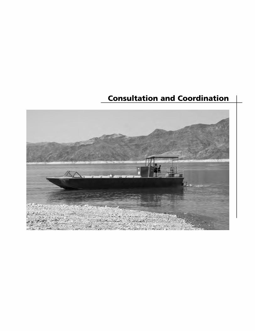
Consultation and Coordination

135
PUBLIC INVOLVEMENT
A news release was published in July 2003 announcing the initiation of the planning effort and seeking public input. A mailing list was compiled that consisted of members of government agencies, nongovernmental groups, businesses, legislators, local governments, and interested citizens. A newsletter was distributed in July 2003 to inform the gen-eral public of the beginning of the plan-ning process. The newsletter summarized the planning process and schedule, pre-sented background information and an overview on the issue of lake access in light of the falling lake levels. A response form included with the newsletter invited public comment. A total of 30 responses were received. Comments were received regarding launch ramp and marina operations as well as resource concerns related to falling water levels. A second newsletter, with preliminary alternatives was issued in March of 2004. Another mailback comment form was included for public response. A total of 24 responses were received in response to the second newsletter. Meetings were also held throughout the planning process with representatives of other agencies, local governments, and commercial operators to discuss low water planning in general, alternatives for low water access, and implications on park and commercial operations. Consultation with the U.S. Fish and Wildlife Service began in May 2004 with a request for a list of endangered and threatened species that may occur in the park. The U.S. Fish and Wildlife Service responded in June 2004 with a list of species. The National Park Service initiated formal consultation pursuant with the Endangered Species Act with the U.S. Fish and Wildlife Service regarding
actions that may adversely affect the federally threatened desert tortoise, the federally endangered razorback sucker, and associated critical habitat. A biological opinion dated May 27, 2005, was issued by the U.S. Fish and Wildlife Service. They concluded that the proposed amendment would likely adversely affect the razorback sucker and desert tortoise, and associated critical habitat, and that the proposed amendment would not likely adversely affect the bonytail chub and southwestern flycatcher. The National Park Service will comply with all conservation actions identified in the biological opinion as well as all reasonable and prudent measures and the associated terms and conditions for their implementation. These measures are summarized in appendix B and are fully described in the biological opinion (USFWS 2005). Section 106 of the National Historic Preservation Act of 1966 as amended (16USC270, et seq.) requires that federal agencies that have direct or indirect interest jurisdiction take into account the effect of an undertaking on national register properties and allow the Advisory Council on Historic Preservation an opportunity to comment. Toward that end the National Park Service works with the Nevada and Arizona State Historic Preservation Offices, and the Advisory Council on Historic Preservation to meet requirements of 36 CFR 800. Both state historic preservation offices were invited to participate in the scoping process and to comment on the preliminary alternatives. Each will have an opportunity to review and comment on the general management plan amendment and environmental assessment.
CONSULATION AND COORDINATION
136
There were 18 identified Indian tribes with an interest in Lake Mead National Recreation Area. Letters and newsletters were sent to these tribes to inform them of the planning process and to invite their input. Native American consultation concerning low water issues at Lake Mead National Recreation Area is conducted on a project-by-project basis. As requested by the
affiliated tribes, notifications are sent to them about various projects. Tribes then contact the park superintendent or the cultural resources manager if there are concerns. Low water issues are also addressed as a topic of discussion at face-to-face meetings with various tribal members during routine government-to-government consultation meetings and informal tribal visits.
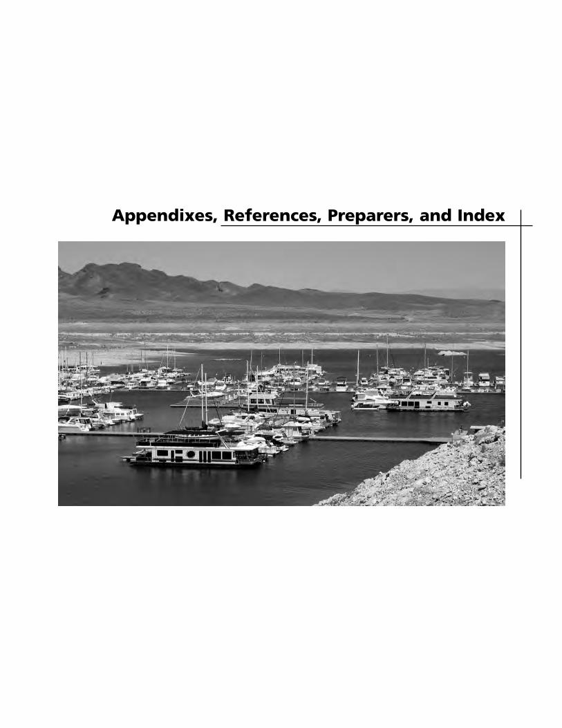
Appendixes, References, Preparers, and Index

139
140
141
142
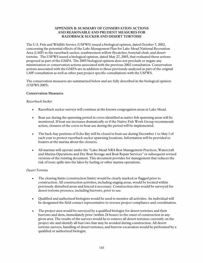
143
APPENDIX B: SUMMARY OF CONSERVATION ACTIONS AND REASONABLE AND PRUDENT MEASURES FOR
RAZORBACK SUCKER AND DESERT TORTOISE The U.S. Fish and Wildlife Service (USFWS) issued a biological opinion, dated October 7, 2002, concerning the potential effects of the Lake Management Plan for Lake Mead National Recreation Area (LMP) to the razorback sucker, southwestern willow flycatcher, bonytail chub, and desert tortoise. The USFWS issued a biological opinion, dated May 27, 2005, that evaluated those actions proposed as part of the GMPA. The 2005 biological opinion does not preclude or negate any minimization or conservation actions associated with the previous 2002 consultation. Conservation actions associated with the GMPA are in addition to those previously analyzed as part of the original LMP consultation as well as other past project specific consultations with the USFWS. The conservation measures are summarized below and are fully described in the biological opinion (USFWS 2005). Conservation Measures Razorback Sucker
• Razorback sucker surveys will continue at the known congregation areas in Lake Mead.
• Boat use during the spawning period in coves identified as native fish spawning areas will be monitored. If boat use increases dramatically or if the Native Fish Work Group recommends action, closures of the coves to boat use during the period will be implemented.
• The back-bay portions of Echo Bay will be closed to boat use during December 1 to May I of each year to protect razorback sucker spawning locations. Information will be provided to boaters at the marina about the closures.
• All marinas will operate under the “Lake Mead NRA Best Management Practices, Watercraft and Marina Operations and Dry Boat Storage and Boat Repair Services” or subsequent revised versions of the existing document. This document provides for management that reduces the risk of toxic spills into the lakes by fueling or other marina operations.
Desert Tortoise
• The clearing limits (construction limits) would be clearly marked or flagged prior to construction. All construction activities, including staging areas, would be located within previously disturbed areas and fenced ii necessary. Construction sites would be surveyed for desert tortoise presence, including burrows, prior to use.
• Qualified and authorized biologists would be used to monitor all activities. An individual will be designated the field contact representative to oversee project compliance and coordination.
• The project area would be surveyed by a qualified biologist for desert tortoises and their burrows and dens, immediately prior (within 24 hours) to the onset of construction in any given area. The results of the surveys would he to remove all desert tortoises currently on the project site and identify all bun’ows that may be avoided during construction. All desert tortoise surveys, handling of desert tortoises, and burrow excavation would be performed by a qualified or authorized biologist.
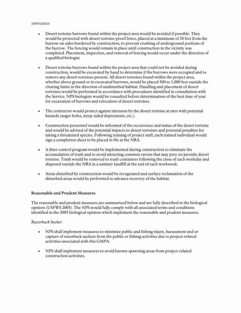
APPENDIXES
• Desert tortoise burrows found within the project area would be avoided if possible. They would be protected with desert tortoise-proof fence, placed at a minimum of 20 feet from the burrow on sides bordered by construction, to prevent crushing of underground portions of the burrow. The fencing would remain in place until construction in the vicinity was completed. Placement, inspection, and removal of fencing would occur under the direction of a qualified biologist.
• Desert tortoise burrows found within the project area that could not be avoided during construction, would be excavated by hand to determine if the burrows were occupied and to remove any desert tortoises present. All desert tortoises found within the project area, whether above ground or in excavated burrows, would be placed 300 to 1,000 feet outside the clearing limits in the direction of undisturbed habitat. Handling and placement of desert tortoises would be performed in accordance with procedures identified in consultation with the Service. NPS biologists would be consulted before determination of the best time of year for excavation of burrows and relocation of desert tortoises.
• The contractor would protect against intrusion by the desert tortoise at sites with potential hazards (auger holes, steep-sided depressions, etc.).
• Construction personnel would be informed of the occurrence and status of the desert tortoise and would be advised of the potential impacts to desert tortoises and potential penalties for taking a threatened species. Following training of project staff, each trained individual would sign a completion sheet to be placed in file at the NRA.
• A litter control program would be implemented during construction to eliminate the
accumulation of trash and to avoid attracting common ravens that may prey on juvenile desert tortoise. Trash would be removed to trash containers following the close of each workday and disposed outside the NRA in a sanitary landfill at the end of each workweek.
• Areas disturbed by construction would be revegetated and surface reclamation of the disturbed areas would be performed to advance recovery of the habitat.
Reasonable and Prudent Measures The reasonable and prudent measures are summarized below and are fully described in the biological opinion (USFWS 2005). The NPS would fully comply with all associated terms and conditions identified in the 2005 biological opinion which implement the reasonable and prudent measures.
Razorback Sucker
• NPS shall implement measures to minimize public and fishing injury, harassment and or
capture of razorback suckers from the public or fishing activities due to project-related activities associated with this GMPA.
• NPS shall implement measures to avoid known spawning areas from project-related construction activities.
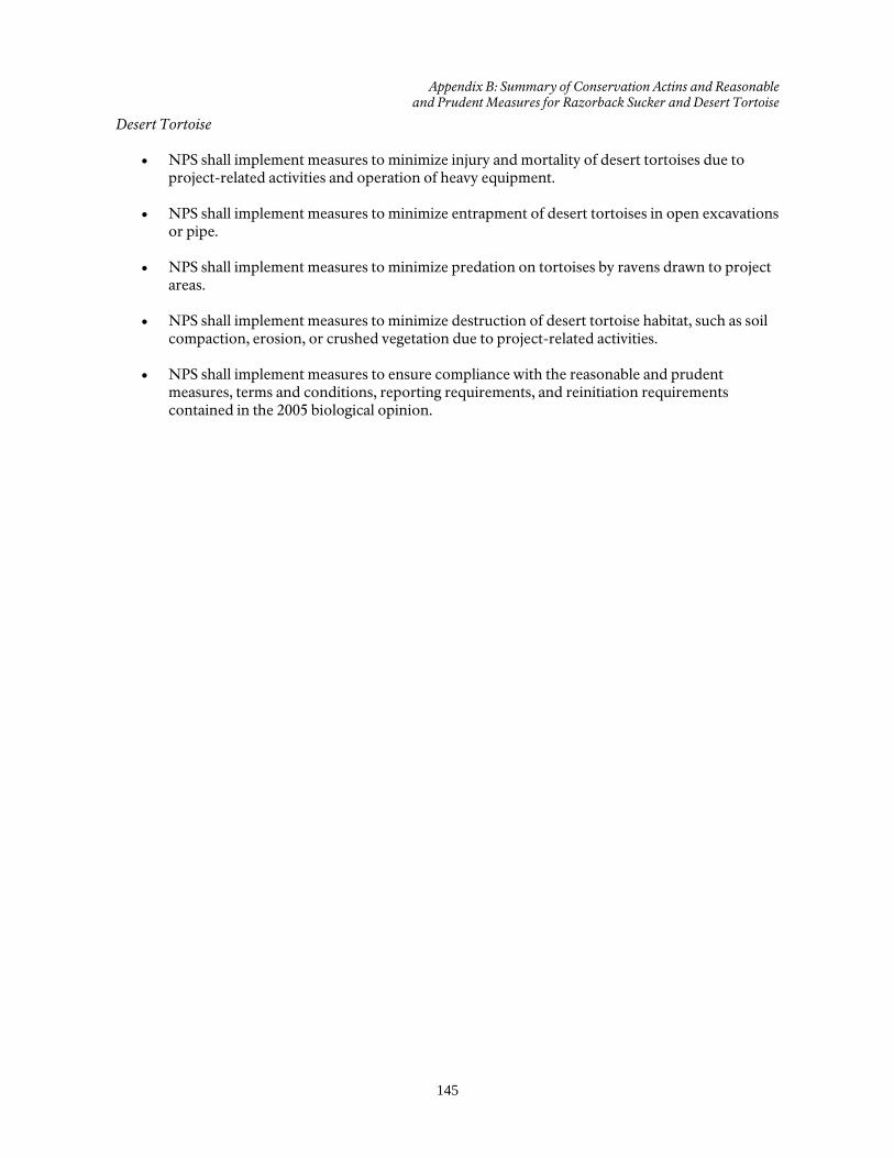
Appendix B: Summary of Conservation Actins and Reasonable and Prudent Measures for Razorback Sucker and Desert Tortoise
145
Desert Tortoise • NPS shall implement measures to minimize injury and mortality of desert tortoises due to
project-related activities and operation of heavy equipment.
• NPS shall implement measures to minimize entrapment of desert tortoises in open excavations or pipe.
• NPS shall implement measures to minimize predation on tortoises by ravens drawn to project areas.
• NPS shall implement measures to minimize destruction of desert tortoise habitat, such as soil compaction, erosion, or crushed vegetation due to project-related activities.
• NPS shall implement measures to ensure compliance with the reasonable and prudent measures, terms and conditions, reporting requirements, and reinitiation requirements contained in the 2005 biological opinion.
146
REFERENCES
BIO-WEST 2003 “Razorback Sucker Studies on
Lake Mead, Nevada and Arizona.” 2002-2003 Annual Report. Logan, Utah.
Bureau of Reclamation, U.S. Department of Interior
2002 “Analysis of Sediments from the Las Vegas Bay Delta, Lake Mead Technical Memorandum No. 8220-10-02.” Technical Service Center, Denver, Co.
2004 April 8, 2004, e-mail message and file attachments from Terry Fulp, Bureau of Reclamation on the probability of future Lake Mead reservoir levels.
HDR Engineering, Inc.
2004 “Utility Assessment and Feasibility Study.” Prepared for the National Park Service.
McClellan, Carole, David A. Phillips, Jr., and Mike Belshaw
1980 “The Archeology of Lake Mead National Recreation Area: An Assessment.” In Anthropology. Western Archeological Center, Tucson, AZ.
National Park Service, U.S. Department of the Interior
1986 Final Environmental Impact Statement, Lake Mead National Recreation Area General Management Plan. Boulder City, Nevada.
1992 Final Environmental Impact
Statement, Lakeshore Road Reconstruction, Lake Mead National Recreation Area. Boulder City, Nevada.
1996 “Best Management Practices,
Watercraft and Marina Operations, Dry Boat Storage, and
Boat Repair Services,” Lake Mead National Recreation Area, Utility Systems Branch, Division of Maintenance and Engineering, October 31.
1999 Lake Mead National Recreation
Area Resource Management Plan. Boulder City, Nevada.
2002 Lake Mead National Recreation Area Lake Management Plan and Final Environmental Impact Statement. Boulder City, Nevada.
2001 Lake Mead National Recreation
Area Strategic Plan, 2000-2005. Boulder City, Nevada.
2002a Environmental Assessment for the
Las Vegas Bay Marina Emergency Relocation. Boulder City, Nevada. September 2002.
2002b Lake Mead National Recreation
Area Lake Management Plan and Final Environmental Impact Statement. Boulder City, Nevada.
2003a Lake Mead National Recreation
Area Environmental Assessment: Relocation of Lake Mead Cruises Facility. Boulder City, Nevada. September 2003.
2003b A Monitoring Plan for the Occur-
rence of Hydrocarbon Constituents in the Reservoirs of Lakes Powell, Mead, and Mohave Arizona, Ne-vada, and Utah (Draft).In cooper-ation between the U.S. Geological Survey and the National Park Service. November 2003.
http://woodshole.er.usgs.gov/project-ages/LakeMead/mapping.htm Maintained by [email protected]. Modified Friday, 07-May-2004 13:16:02 Eastern Daylight Time.
References
147
PricewaterhouseCoopers 2004 “Draft Financial Scenario Analysis
Relating to the GMP (GMPA).” Prepared for National Park Service.
Ruppert, David E.
1976 Lake Mead National Recreation Area: An Ethnographic Overview. Western Archeological Center, Tucson, AZ.
U.S. Fish and Wildlife Service, U.S. Department of the Interior 2005 Biological Opinion for the
Amended Lake Mead National Recreation Area Lake Management Plan
148
PREPARERS AND CONSULTANTS
NATIONAL PARK SERVICE Lake Mead National Recreation Area William Dickinson, Superintendent Gary Warshefski , Park Manager Jim Holland, Park Planner Michael Boyles, Environmental Compliance
Specialist Melody Kruger, Concessions Management
Specialist Kyra Thibodeau, Supervisory Concessions Management Specialist Jim Koza, Aids to Navigation Mechanic Steve Daron, Park Archeologist Chanteil Walter, Environmental Compliance
Technician Mark Sappington, GIS Specialist Mary Hinson, Deputy Chief Park Ranger Denver Service Center Elaine Rideout, Natural Resource Specialist Michele D’Arcy, Landscape Architect Bill Shelley, Civil Engineer Manuel Sais, Cost Estimator Jim Corbett, Visual Information Specialist Sandy Schuster, Writer/Editor
Pacific West Region Ray Murray, Chief, Partnerships Program NPS Washington Office Terry Goodrich, Concession Division Gary Rosenlieb, Water Quality Division FEDERAL HIGHWAY ADMINISTRATION James Klamerus Barbara Quintana BUREAU OF RECLAMATION Terry Fulp CONSULTANTS HDR Engineering Mary Kay Provaznik Bob Rogers Price Waterhouse Coopers Margaret Bailey Larry Trabulsi
149
INDEX access, 3, 5-9, 12, 13, 21, 23-24, 27, 35, 39-40,
44, 48-50, 53, 54, 55, 56, 57, 58, 60, 64, 66, 72, 73, 94-96, 102-103, 106-110, 112, 115-118, 120-124, 126, 129-131, 135,
air quality, 7, 51, 69, 88-89, 99, 113, 127, archeological, 7-8, 15, 27 ,51, 60, 70, 89-91,
100-101, 113, 114, 127-128 bald eagle, 7, 59, 66, 97-98, 109, 112, 123, 126, boating, 5, 11-13, 24, 40, 53, 57, 59-60, 69, 71,
82, 97, 98, 102-104, 109, 112, 116-118, 123, 126, 130, 132,
Boulder Beach, 3, 7, 28-29, 33, 53, 55, 59, 64, 70-71, 98, 112, 120, 126, 131,
Callville Bay, 3, 13, 17, 34, 35, 52, 56, 64, 70- 72, 76-77, 82, 95, 102, 106, 120, 126, 131, concessioner, 12, 14, 23, 27, 52-53, 103-104, 117-118, 131-132,
costs, 14, 16, 48-51, 60, 93, 103-104, 118-119, 131-132,
cultural resources, 6, 8, 14-15, 27, 51, 81, 88- 89, 91, 100-101, 114-115, 128-129, 136,
desert tortoise, 7, 26, 52, 59, 66, 96, 98, 108, 111-112, 122, 125-126, 135
drought, 5, 69, 82, 97, 110, 124, 150 Echo Bay, 3, 7, 13, 24, 39-40, 57, 59, 60, 64- 65,
67, 71, 73, 76-77, 82, 96-98, 102, 106, 109-110, 112, 116-117, 120, 123-124, 126, 130
environment, 7, 54, 63, 69, 81, 91, 93 Government Wash, 3, 5, 34-35, 56, 59, 71-72,
76, 106-107, 109, 112, 117, 120-121, 123, 126, 130
Hemenway Harbor, 6, 28, 29, 33, 53, 55, 60, 70-72, 77, 94-96, 102-103, 106, 108-109, 116-118, 120, 122, 131
impacts, 5, 8-9, 21, 24, 26-27, 50, 54, 59-60, 63, 66, 77, 81-86, 88-89, 91- 110, 112-132
impairment, 11, 84, 95, 98, 99, 107, 112-113, 121, 126-127
issues, 3, 6-8, 48, 86, 88, 136 Lake Management Plan, 5, 12, 13, 21, 63, 73,
82, 95, 98-99, 108, 111-113, 122, 125-127 Las Vegas, 3, 5, 6-7, 13-14, 16, 17, 24, 26, 28- 29,
34-35, 48, 50, 52, 55-56, 64-65, 66-69, 71-72, 75-77, 82-83, 97-102, 104, 106, 111-115, 118, 120, 125, 127-129, 131
Las Vegas Bearpoppy, 67
launch ramps, 3, 5, 6, 10, 13, 21, 23, 29, 39, 48-49, 54, 57, 60, 71-73, 82, 94-96, 99, 101- 103, 106, 108, 112, 114-115, 117, 122, 126, 128-130
Lower Boulder Basin, 21, 28, 30, 52, natural resources, 8, 51, 81, operations, 3, 6, 7, 9, 12, 14, 21, 24, 26-29, 33,
35, 40, 43-44, 50, 53, 55-60, 74, 77, 81, 92, 94-96, 98, 103-104, 107, 109, 112, 117-119, 121, 123, 126, 130-132, 135
Overton Arm, 21, 39, 41, 50, 52, 54, 57, 66, 68, 73, 111, 116, 125, 130
Overton Beach, 3, 13, 39-40, 49-50, 57, 64, 67, 71, 73, 76-77, 112, 116-118, 126, 130-132
Pearce Ferry, 3, 5, 43-44, 48, 50, 54, 58, 60, 64, 71, 73-74, 76-77, 102, 104, 116, 118, 120, 123, 126, 130-132
preferred alternative, 21, 35, 39, 43, 51-54,106 razorback sucker, 24, 26, 52, 59, 65-66, 96-98,
109-110, 112, 123-124, 126, 135, 143-144 relict leopard frog, 7, 26, 59, 67, 68, 97-98, 109-
112, 124-126 socioeconomic, 7, 81, 92-93 South Cove, 3, 43-44, 58, 60, 64, 71, 73-74, 76-
78, 94, 102, 104, 106-107, 112, 116-118, 120-121, 126, 130-132
southwestern willow flycatcher, 7, 59, 67, 97- 98, 110, 123, 126
Stewarts Point, 13, 40, 50, 52, 57, 59-60, 66- 67, 73, 76, 82, 97-98, 106-107, 109-112, 116-117, 120-121, 123-126, 130
Temple Bar, 3, 13, 43, 58, 64, 71, 73, 76-77, 82, 94-95, 102-104, 106, 120
threatened and endangered species, 7, 51, 98, 112, 126
Upper Boulder Basin, 21, 34, 36-37, 52, visitor, 7, 12, 14, 24, 27, 39-40, 51-54, 60, 71-,
73, 81, 84, 88, 91-93, 100-03, 111, 114-117, 125, 128-131
water levels, 3, 5-7, 13, 15-16, 21-24, 28-29, 34, 39-40, 43, 48, 50, 60, 65, 77, 81-82, 94- 95, 97-104, 106, 110, 112, 114-118, 120, 124, 126, 128-129, 130-132, 135
water quality, 6-7, 13, 16, 26, 59, 82, 87-89, 98-99, 103, 110-113, 124-127
wildlife, 7, 11, 59, 68, 82, 85, 86, 88, 95, 96, 107, 108, 121, 122

As the nation’s principal conservation agency, the Department of the Interior has responsibility for most of our nationally owned public lands and natural resources. This includes fostering sound use of our land and water resources; protecting our fish, wildlife, and biological diversity; preserving the environmental and cultural values of our national parks and historical places; and providing for the enjoyment of life through outdoor recreation. The department assesses our energy and mineral resources and works to ensure that their development is in the best interests of all our people by encouraging stewardship and citizen participation in their care. The department also has a major responsibility for American Indian reservation communities and for people who live in island territories under U.S. administration. NPS D-349 / September 2005 / Printed on recycled paper
DEPARTMENTOF THE INTERIOR
NATIONALPARK
SERVICE

Related Documents