GENERAL CATALOGUE

Welcome message from author
This document is posted to help you gain knowledge. Please leave a comment to let me know what you think about it! Share it to your friends and learn new things together.
Transcript

GENERAL CATALOGUE

2
About us
GeoMax is an international and active company based in Europe that develops, manufactures and distributes quality surveying and construction equipment and integrated solutions at the best price-to-performance ratio.
Our comprehensive portfolio includes total stations, GPS/GNSS, 3D survey and 3D measuring, dataloggers, field software, optical and digital
levels, lasers, machine guidance and cable locating systems and a large offer of accessories.
Being part of the Hexagon Group, a leading global provider of information technologies that drive quality and productivity improvements across geospatial and industrial enterprise applications, grants GeoMax access to state of the art development
and production facilities in Europe, America and Asia.
Our technology is supported by a broad sales and service network covering all continents and over 100 branches. Through this continually growing distribution and service network, our products are available worldwide delivering outstanding price-performance ratio.

3
Portfolio
X·PAD MPS X·PADfor Android
X·PAD Suite & ConstructionGGO Geo Office Software
GeoMax Theodolite and LevelsZipp02
ZDL700 Series ZAL100 & 300 Series
GeoMax LasersZEL400 Series
ZLT300 & 200 SeriesZone50 Series
Zeta125 & 150 Series
GeoMax Machine Guidance and Cable Locating and Tracing
EzDig EziSystem
Ultra System
GeoMax Accessories GeoMax Quality Management
48
54
62
7075
GeoMax Total Stations Zoom80 Series
Zoom35 Pro SeriesZoom30 Pro Series
Zoom20 accXess SeriesZoom20 Pro Series
Zipp20 Open WinCE® SeriesZipp10 Pro Series
GeoMax GNSS Zenith25 Pro Series
Zenith10 & 20 Series
GeoMax Laser Scanner and Micro RobotZoom300
Zoom3D Series
GeoMax Datalogger and GIS Handheld PS336 Series
Z710 for X•PAD AndroidZenith04
GeoMax Software FieldGenius Premium
Layout Pro
4
20
26
32
40
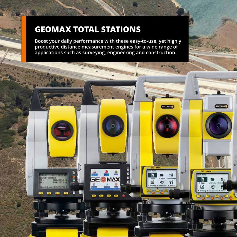
GEOMAX TOTAL STATIONSBoost your daily performance with these easy-to-use, yet highly productive distance measurement engines for a wide range of applications such as surveying, engineering and construction.


6
GeoMax Total StationsZoom80 Series
Technical data
Accuracy (ISO 17123-3) 5 ”, 2 ”, 1 ” Prism (range, accuracy) 3,500 m, 1 mm + 1.5 ppm Prism, long-range (range, accuracy) 10,000 m, 5 mm + 2 ppm Non-prism (range, accuracy) 1,000 m, 2 mm + 2 ppm* SCOUT360 range 300 m, typical search time 5 – 10 sec TRACK360 range (round / 360° prism) 800 / 600 m AIM360 range (round / 360° prism) 1’000 / 800 m
GeoMax Zoom80S (Servo) 5”, 2”, 1”AIM360, TRACK360
GeoMax Zoom80R (Robotic) 5”, 2”, 1”AIM360, TRACK360, SCOUT360
* > 500 m: 4 mm + 2 ppm
NavLightThe telescope comes equipped with NavLight, a practical alignment aid for speeding up staking-out work. The flashing red and yellow lights guide the rodman quickly and exactly into the line of sight.
AUTOMATED SURVEYINGAll Zoom80 are equipped with target recognition technology, for automated centring on prisms. The total station needs only to face the prism in order for precise targeting and position measurement to automatically be performed by the instrument. With Automated Surveying, you are much more productive, since each measurement can be completed in only a few seconds.
ROBOTIC SURVEYINGImagine an instrument that does the majority of the work for you, allowing you to survey on your own. There is no need for assistance, it is quick to set up and has many easy-to-use functionalities, simplifying the entire process even more.Zoom80R models provide everything you ever desired in your daily work. Wide angle search technology quickly locates the survey pole and once positioned, it continues to follow the prism as you move.
With this motorised total station you have a lot of comfort and all the advantages of one-man surveying. The advanced positioning technology ensures that it "works when you do”.

7
SCOUT360Scans the entire working area within seconds and quickly finds the point you need positioned. All measurement tasks can therefore be performed by one person.
TRACK360Provides continuous tracking of targets. Once locked onto a prism, the instrument will remain targeted exactly on the moving prism.
AIM360The telescope is perfectly aimed at any prism, without needing to look through the telescope. Measurements are performed automatically with constant and repeatable results.
accXess™ EDM technologyGeoMax’s accXess EDM technology provides class-leading reflectorless measurements up to 1,000 m. The extra small laser footprint and sophisticated signal processing technology, ensures you maximum accuracy, regardless of the distance or conditions.

8
GeoMax Total StationsZoom35 Pro Series
Technical data
Hz, V Standard deviation (ISO 17123-3) 1 ”, 2 ”, 3 ”, 5 ” Compensator system Quadruple-axis compensation Measuring range with prism 10,000 m Accuracy on reflector (Fine/Tracking) 2 mm + 2 ppm / 3 mm + 2 ppm Reflectorless range accXess10 >1,000 m Accuracy reflectorless 2 mm + 2 ppm (>500 m 4 mm + 2 ppm) Communication USB, Bluetooth, USB Host, RS232
EASY CONNECTIVITYThe GeoMax Zoom35 Pro manual total station includes an environmentally protected USB port, internal Bluetooth® and a cable connection port that allow for fast, simple and dependable data transfer between the instrument and your PC or handheld controller using easy to connect Plug and Play technology.
COLOUR TOUCH SCREENThe extra large 3.5” colour touch screen with Q-VGA display provides for brilliant readability even in strong sunlight. Together with an extra large high-resolution display the easy-to-use graphical interface makes regular tasks such as stake-outs easier and more productive than ever before.
SUPERIOR accXess10 EDMWith the proven accXess10 technology, the Zoom35 Pro features an intelligent distance measurement engine designed for outstanding speed and highest accuracy even on extremely long ranges. This means a wider operational coverage and significant less time lost with switching set ups.
GeoMax Zoom35 Pro accXess10Distance measurement to reflector and 1,000 m reflectorless measurement
With non-prism measurements of 1,000 m and 1” angle accuracy, the new Zoom35 Pro opens a new class of total stations for all those requiring highest performance on every levels.

9
APPLICATIONSEvery Zoom35 Pro Total Station comes with a complete range of powerful applications:
• Survey • Set-up with resection • Set out • Area 3D & volume • Remote elevation • Construction • Reference element • CoGo routines • Missing line measurement • Two Prism Offsets • Road

10
Technical data
Hz, V Standard deviation (ISO 17123-3) 2 ”, 3 ”, 5 ”, 7 ” Compensator system Quadruple-axis compensation Measuring range with circular prism 3,500 m Accuracy on reflector (Fine/Tracking) 2 mm + 2 ppm / 3 mm + 2 ppm Reflectorless range accXess 6 / accXess 4 600 / 400 m (white target) Accuracy reflectorless 2 mm + 2 ppm (>500 m 4 mm + 2 ppm) Communication USB, Bluetooth, USB host, RS232
EASY CONNECTIVITYThe GeoMax Zoom30 Pro manual total station includes an environmentally protected USB port, internal Bluetooth® and a cable connection port that allow for fast, simple and dependable data transfer between the instrument and your PC or handheld controller using easy to connect Plug and Play technology.
HIGHEST FUNCTIONALITYThe Zoom30 Pro combines faster stake-outs with NavLight™ and outstanding non-prism distance measurement over 600 m. With the NavLight™ alignment aid, the rod man can quickly align himself to the line-of-sight without needing instructions.
GeoMax Zoom30 Pro accXess6Distance measurement to reflector and 600 m reflectorless measurement
GeoMax Zoom30 Pro accXess4Distance measurement to reflector and 400 m reflectorless measurement
COLOUR TOUCH SCREENThe extra large 3.5” colour touch screen with Q-VGA display provides brilliant readability even in strong sunlight. Together with an extra large high-resolution display, the easy-to-use graphical interface makes regular tasks like stake-outs easier and more productive than ever before.
GeoMax Total StationsZoom30 Pro Series
The Zoom30 Pro has all the functionality you expect from a total station right at your fingertips. A total station for all those, demanding high performance and ease that “works when you do”.

11
POWERFUL APPSEvery Zoom30 Pro series instrument comes with a complete range of powerful applications:
• Survey • Set-up with resection • Set out • Area 3D & volume • Remote elevation • Construction • Reference Line• Reference Arc• Grid SetOut• Column Offset• CoGo routines • Missing line measurement • Two prism offsets • Road 2D• Road 3D

12
Class-leading reflectorless measurements: The extra-small EDM footprint and sophisticated signal processing technology ensures maximum accuracy and speed.
GeoMax Total StationsZoom20 accXess Series
accXess™ EDM TECHNOLOGYGeoMax’s accXess EDM technology delivers outstanding dependability and class leading accuracy with and without a prism in even the most difficult conditions.
EASY CONNECTIVITY The GeoMax Zoom20 accXessincludes an environmentally protected USB port and acable connection port that allowfor fast, simple and dependabledata transfer between theinstrument and your PC orhandheld controller using easyto connect Plug and Playtechnology.
Technical data
Accuracy 1 ”, 2 ”, 3 ”, 5 ” Compensator system Quadruple-axis compensation Prism range / accuracy 3,500 m / 2mm + 2ppm Long range / accuracy 10,000 m / 5mm + 2ppmReflectorless 2 mm + 2 ppmCommunication USB, RS232
GeoMax Zoom20 accXess4Distance measurement to reflector and 400 m reflectorless measurement
QUADRUPLE-AXIS COMPENSATIONWith advanced electronic compensators, GeoMax instruments are always level and collimation errors corrected. Quadruple-axis compensation is standard on all GeoMax total stations which means you can be sure of maximum reliability with both horizontal and vertical angles.

13
POWERFUL APPS Developed to take on a multitude of daily tasks, the Zoom20 accXess offers a wide range of highly productive applications from setting-up, measuring, setting out and checking, be certain that GeoMax “works when you do”.
COMPLETE SYSTEMGeoMax not only provides you with a highly productive instrument, but also with a complete set of accessories to meet your demanding tasks. With everything in one box.

14
Technical data
Hz, V Standard deviation (ISO 17123-3) 2 ”, 3 ”, 5 ”, 7 ” Compensator system Quadruple-axis compensation Measuring range with circular prism 3,500 m Accuracy on reflector (Fine/Tracking) 2 mm + 2 ppm / 3 mm + 2 ppm Reflectorless range accXess 4 / accXess 2 400 / 250 m (white target) Accuracy reflectorless 2 mm + 2 ppm (>500 m 4 mm + 2 ppm) Communication USB, RS232
ONBOARD SOFTWAREEasily control your data with the flexible and easy-to-use onboard software. Areas and volumes, reference elements, CoGo and more can be accessed using the large graphic display. Import and export in the format you want for total control and flexibility.
BUILT FOR ALL ENVIRONMENTSThe Zoom Pro withstands the toughest environments. With the optional polar certification, the Zoom Pro is individually tested at – 30° C. With our extensive factory tests, you can be sure that GeoMax “works when you do!”.
GeoMax Zoom20 Pro accXess4Distance measurement to reflector and 400 m reflectorless measurement
GeoMax Zoom20 Pro accXess2Distance measurement to reflector and 200 m reflectorless measurement
GeoMax Zoom20 ProDistance measurement on reflector
accXess™ EDM TECHNOLOGYGeoMax’s accXess EDM technology delivers outstanding dependability and class leading accuracy with and without a prism in even the most difficult conditions. Reflectorless accXess EDM technology is available as accXess2 (250 m) and accXess4 (400 m) on the GeoMax Zoom20 Pro series.
The Zoom20 Pro withstands the toughest environments. With the optional polar certification, the Zoom20 Pro is individually tested at -30° C. Our extensive factory tests ensure that GeoMax “works when you do”.
GeoMax Total StationsZoom20 Pro Series

15
POWERFUL APPSEvery Zoom30 Pro series instrument comes with a complete range of powerful applications:
• Survey • Set-up with resection • Set out • Area 3D & volume • Remote elevation • Construction • Reference Line• Reference Arc• Grid SetOut• Column Offset• CoGo routines • Missing line measurement • Two prism offsets

16
Technical data
Accuracy (ISO 17123-3) 2”, 5” Range with prism 3,000 m Non-prism range (Zipp10 R Pro) 250 m / 400m (white target)Accuracy with prism 2 mm + 2 ppmNon-prism accuracy 3 mm + 2 ppmMeasuring time (Tracking/Quick/Fine) 0.33 sec / 2.0 sec / 2.4 secReflectorless measuring time 3.0 – 6.0 sec
TOTALLY CONNECTED With integrated Bluetooth® and the capability to connect to any tablet or data logger, the Zipp20 provides you with highest flexibility. Data and file exchange using the USB stick makes working with the Zipp20 quite simple and easy.
TOTALLY FEATUREDAll the openness and connectivity combined in a system offering a colour & touch display, long range non-prism measurement and all your favourite Windows® CE applications make the Zipp20 the total station that “works when you do.”
TOTALLY OPEN WinCE®The Zipp20 is a fully open WinCE® total station. Featuring GeoMax FieldGenius, X·PAD, Carlson SurvCE or any localised field software, the Zipp20 allows you to work as best fits your needs. WinCE® even allows you to run your own developments and to personalise your system.
GeoMax Zipp20 R2 5”, 2”Distance measurement on reflector and 250m reflectorless
GeoMax Zipp20 R4 5”, 2”Distance measurement on reflector and 400m reflectorless
Operate it your way, store it your way, process it your way! Running fully open Windows® CE allows you to operate the field software of your choice onboard the Zipp20 – Open WinCE® Series.
GeoMax Total StationsZipp20 Open WinCE® Series

17
Zipp20 - Open WinCE® SeriesFeaturing GeoMax FieldGenius, GeoMax Layout Pro, X·PAD, Carlson SurvCE or any localised field software, the Zipp20 allows you to work the way that best suits your needs. With integrated Bluetooth® and the capability to connect to any tablet or data logger, the Zipp20 provides you with highest flexibility.
All this combined in a system offering a colour & touch display, long range non-prism measurement and all your favourite Windows® CE applications make the Zipp20 the total station that “works when you do.”

18
Technical data
Accuracy (ISO 17123-3) 2”, 5” Range with prism 3,000 m Non-prism range 250 mAccuracy with prism 2 mm + 2 ppmNon-prism accuracy 3 mm + 2 ppmMeasuring time (tracking/quick/fine) 0.33 sec / 2.0 sec / 2.4 secReflectorless measuring time 3.0 – 6.0 sec
PERFORMANCE, ROBUSTNESSProviding a 250 m reflectorless measurement range, a long prism range of 3,000 m, a coaxial visible laserbeam combined with a dust and water resistant sealed durable housing, makes the Zipp10 Pro a top performer in its class.
MULTIFUNCTIONAL KEYBOARDWith an ergonomic full numeric keypad for rapid navigation and data entry provides for direct access to apps and fast navigation. The large high-resolution bright display provides brilliant readability even in strong sunlight.
EASY CONNECTIVITYThe Zipp10 Pro features a simple transfer using a USB stick of all your data and files. Transferring data between different total stations or the office is now easier than ever and liberates you from the need to use any PC.
GeoMax Zipp10 Pro 5”, 2”Distance measurement on reflector
GeoMax Zipp10 R Pro 5”, 2”Distance measurement on reflector 250 m non-prism distance measurement
The Zipp10 Pro is your economic choice when price counts as much as performance. It provides seamless data flow via a USB stick, coaxial reflectorless measurements and a full set of applications. These benefits are proving again best price-to-performance.
GeoMax Total StationsZipp10 Pro Series

19
THE COMPLETE TOTAL STATIONWith its 250 m reflectorless measurement range, 2” and 5” angle accuracy, large bright display and easy-to-use applications, the Zipp10 Pro is your ideal tool for all surveying or construction tasks.
The Zipp10 Pro is the world’s first total station in its class featuring easy transfer via a USB stick of all your data and files. Transferring data between different total stations or the office is now easier than ever and liberates you from the need to use any PC. Keeping your total station where you need it – in the field! Zipp10 Pro – “works when you do".
APPLICATIONS• Data collect • Set out • Resection • Area & volume • Remote elevation • Missing line • Road

GEOMAX GNSSEnsure ultimate reliability with GeoMax GNSS systems under the most severe conditions. Providing true cost-effectiveness, these systems are equipped with the latest GPS technology in the field increasing your productivity and taking your performance to the new level.

22
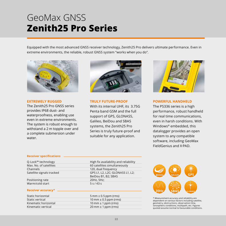
Equipped with the most advanced GNSS receiver technology, Zenith25 Pro delivers ultimate performance. Even in extreme environments, the reliable, robust GNSS system “works when you do”.
POWERFUL HANDHELDThe PS336 series is a high performance, robust handheld for real time communications, even in harsh conditions. With Windows® embedded, this datalogger provides an open system to any compatible software, including GeoMax FieldGenius and X·PAD.
TRULY FUTURE-PROOFWith its internal UHF, its 3.75G Penta band GSM and the full support of GPS, GLONASS, Galileo, BeiDou and SBAS systems, the Zenith25 Pro Series is truly future-proof and suitable for any application.
EXTREMELY RUGGEDThe Zenith25 Pro GNSS series provides IP68 dust- and waterproofness, enabling use even in extreme environments. The system is robust enough to withstand a 2 m topple over and a complete submersion under water.
Receiver specifications
Q-Lock™ technology High fix availability and reliability Max. No. of satellites 60 satellites simultaneously Channels 120, dual frequency Satellite signals tracked GPS L1, L2, L2C; GLONASS L1, L2; BeiDou B1, B2; SBAS Positioning rate 20Hz, 5Hz; Warm/cold start 5 s / 43 s
Receiver accuracy*
Static horizontal 5 mm ± 0.5 ppm (rms) Static vertical 10 mm ± 0.5 ppm (rms) Kinematic horizontal 10 mm ± 1 ppm (rms) Kinematic vertical 20 mm ± 1 ppm (rms)
* Measurement accuracy and reliability are dependent on various factors including satellite, geometry, obstructions, observation time, ionospheric conditions, multipath, etc. Figures quoted assume normal to favourable conditions.
GeoMax GNSSZenith25 Pro Series

23
Q-Lock™ TECHNOLOGYThe Q-Lock™ technology tracks all satellites with the highest available signal strength and performs regular independent checks to ensure that you can work even in challenging environments such as urban canyons or under heavy foliage.
This is all combined in a system robust enough to withstand a 2 m topple over and a complete submersion under water.

24
COMPLETE FLEXIBILITY The Zenith10 & Zenith20 are completely flexible systems, with all of the communication devices integrated into the antenna. It’s easy to switch between the UHF radio to receive correction data from a local reference station and the GSM modem to receive corrections from a regional network. At times when no corrections are available, raw data can be easily logged for post-processing in the office. The Zenith10 & Zenith20 can also operate as a local reference station, transmitting data either with the internal radio or an external high power transmitter.
QUALITY GNSS Equipped with state-of-the-art NovAtel satellite receiver technology, the Zenith10 & Zenith20 provide maximum performance. The AdVance® RTK technology, developed by NovAtel, ensures maximum positioning availability under challenging conditions. Both receivers can track satellite signals of the GPS and GLONASS type. The Zenith20 additionally supports BeiDou and Galileo.
FULLY INTEGRATED GNSSZenith10 & Zenith20 are complete and fully integrated satellite positioning systems. They consist of only two main components, a GNSS antenna and a handheld computer that can be setup on a pole or tripod. noThe integrated wireless technology, provides a completely cable-free and light-weight solution that is ready for an entire day’s work.
The Zenith Series are completely flexible systems, with all of the communication devices integrated into the antenna. A rugged handheld packed with features supports the work in demanding environments and ensures an excellent price-to-performance without compromising quality.
GeoMax GNSSZenith10 & 20 Series
Receiver specifications
NovAtel AdVance® technology Zenith10 72 channels (GPS/GLONASS), max. 36 satellites simultaneously Zenith20 120 channels (GPS/GLONASS/Galileo/BeiDou), max. 60 satellites simultaneouslySatellite signals tracked GPS L1, L2, L2C, GLONASS L1, L2, Galileo*, BeiDou Raw measurement & position outputs 5 Hz , 20Hz optional RTK signal initialization typ. less than 10 sec*** Initial capture time < 15 sec*** Internal memory 256 MB
Receiver Accuracy**
Static horizontal accuracy 5 mm ± 0.5 ppm (RMS)Static vertical accuracy 10 mm ± 0.5 ppm (RMS)Kinematic horizontal accuracy 10 mm ± 1 ppm (RMS)Kinematic vertical accuracy 20 mm ± 1 ppm (RMS)DGPS/RTCM differential positioning 0.25 m (RMS)
* The optional Galileo tracking will be made avail-able once there are sufficient of these satellites. ** The position accuracies depend on various factors including number of satellites, geometry, ionospheric conditions, multipath, etc.

25

GEOMAX LASER SCANNERA rugged and reliable Time-of-Flight laser scanner recommended for all working environments.
26

GEOMAX 3D MEASURING MICRO ROBOTEasy-to-use and fast 3D measuring instruments, the Zoom3D Series are ideal for indoor as well as outdoor applications. It can be upgraded to an innovative and user-friendly micro robot.
27

28
GeoMax Laser ScannerZoom300 Series
Zoom300 is a rugged and reliable Time-of-Flight laser scanner recommended for all working environments.
ROBUT AND EASY-TO-USESimple to use and ready to scan at the press of a button, the Zoom300 can be controlled and operated directly from all kinds of mobile devices with a WLAN connection.The GeoMax laser scanner works under extrem weather condiotions and is water and dust proof.
SURVEY GEOREFERENCING WITH GPS/GNSSNow it is possible to use a GPS/GNSS receiver to calculate the scan position and to georeference the point cloud data. Mount a GPS/GNSS antenna on the Zoom300 and the orientation will be calculated from a reference target with known coordinates using a second GPS/GNSS receiver.The equipment ensures accuracy and precision for all 3D projects using a single 3D reference system.
Technical data
Max / Min range 300m 100% reflectivity (on white target) / 2.5m Operationg conditions 250m Vertical / Horizontal field of view 90° (-25° +65°) / 360°Scan rate 40.000 points/secLaser beam divergence 0.37mradResolution 37mm x 37mm 100m Accuracy 6mm 50m / <10mm 100m
PERFORMANCE The Zoom300 supports four scan modes at different resolutions.Depending on the object and the area to scan, you can define the best resolution to optimize scan time and the size of data output.

29
FRAMEWORKThis laser scanner support is particularly useful for the scanning of closed environments such as caves, architectural structures and tunnels, where ceilings are particularly high. It allows the scanner to perform a full surface scan through a 240° rotation.
240°

Easy-to-use and fast 3D measuring instruments, the Zoom3D Series are ideal for indoor as well as outdoor applications. It can be upgraded to an innovative and user-friendly robotic total station: simply position it and turn it on, the Zoom3D will measure and layout any project site.
YOUR PERFECT PARTNER FOR INDOOR TASKSThe Zoom3D user-fiendly onboard software helps with a wide range of indoor applications such as measuring, setting out or plumbing points. Levelling can now be completed with greater ease and speed, then exported in most common file formats.
UPGRADE IT TO A MICRO ROBOT SOLUTIONFor your outdoor tasks, the Micro Robot solution is equipped with target recognition technology thatautomatically and easily centres and follows the target, allowing surveys and stakeouts in small construction sites.
PLUG AND PLAY SOLUTIONWith a very simple configuration and equipped with an auto levelling feature, a plug-and-play solution that will allow you to speed up in your daily work.
30
GeoMax 3D Measuring & Micro RobotZoom3D Series
Technical data
Goniometer (Hz/V) Range Horizontal 360°; Vertical 250° Accuracy 5 ,̋ equates to 1.2 mm @ 50 mLaser distance meter Coaxial, visible red laser; Class 2; 650 nm; < 1 mW Range 0.5 - 50 m Tie distance accuracy (3D) Angle and distance combination @10m/1mm; @30m/2mm; @50m/4mmTilt sensor self-leveling range ± 3°
GET STARTED IN 2 BUTTON PRESSES
1. Get out of the box2. Put it on the floor or on a tripod3. Turn it on, it will level automatically4. Connect it to your datalogger5. Start working!

31

GEOMAX DATALOGGERSAND GIS HANDHELDBased on an open platform, just use the software that fits best your requirements and rely on the robustness and precision of these easy-to-use devices.


34
FULLY EQUIPPEDThe PS336-E model contains high-speed communication technology for internet connection to all network types. Built-in GPS receiver, E-compass, altimeter and 5M pixel auto-focus camera are neatly integrated into an all-in-one solution.
These rugged field ready Windows Mobile® handhelds were built to meet GeoMax requirements for power, functionality and reliability, ensuring that they always “work when you do”.
EXTREMELY RUGGEDThe PS336 series is a high performance fully rugged handheld for real-time communications even in harsh conditions. It is rated IP68 dust and waterproof and meets military standards.
FULLY FLEXIBLEThe featured Windows Mobile® provides an open system for any compatible software, such as GeoMax FieldGenius, X·PAD, SurvCE, etc. for full connectivity to all GeoMax devices.
The PS336-E extended model's expansion slot enables the fitting of a long Range Bluetooth® cap which can be used as remote control in combination with the Zoom80 robotic Total Station.
PS336 Standard
PS336-E Extended
Technical data PS336 PS336-E
Wireless LAN • •
Internal Bluetooth® • •
Micro SD card slot • •
Up to 32 GB memory * • •
29 keys • •
Illuminated keys • •
5M pixel autofocus camera •
48 channels GPS receiver •
Electronic compass •
Altimeter •
Long-range Bluetooth® ** •
* Optional, ** Requires optional long-range Bluetooth® cap
GeoMax DataloggersPS336 Series

35
Physical specifications
Weight: 0.53 kg (PS336) Operating temp.: – 30°C to 60°C Protection class: IP68 dust- and waterproof / MIL-STD-810G Humidity: 95 %, non-condensing
Interface
Keyboard: 29 keys, illuminated Display: 3.5” Full-VGA Quadra-Clear™ technology colour & touchscreen I/O interface: serial, USB On-The-Go, DC jack
Computing platform
Operating system: Windows® Embedded Handheld 6.5 Processor: Texas Instruments 1 GHz Memory: Up to 32 GB *
Power supply
Internal battery: Removable Li-Ion 5.6 Ah / 3.7 V Operating time: Up to 15** hours LifeSupport™: Battery swap without shutdown
* Optional, **New battery, at 20°C

36
X•PAD for Android presents a new way of working, based on the most evolved and technologically advanced platform for mobile devices. For the first time, software designed for topographic survey and staking out in the field is available on Android with a wide range of user-friendly features. Used in conjunction with GeoMax instrumentation, X•PAD for Android will change your way of working forever.
AUGMENTED REALITY, GET THE FULL PICTUREHow can augmented reality be a useful tool in topographic surveys and stake-out? Here’s how. Simply point the camera to the area of interest and you can immediately see where the points and elements to be staked out are. X•PAD will guide you to the vicinity of the point and then to the exact location. But you can also use augmented reality to see what is not visible, such as underground pipes, cables and connections. X•PAD allows you to integrate reality with your data.
THE CONTROLLER? IT’S UP TO YOUX•PAD for Android can be supplied with a rugged tablet, featuring a 7” touch screen with the breadth and brightness to give the display instant clarity, so you can view the data quickly and with minimum effort in all conditions. Or you can also opt to use the X•PAD on your existing tablet or smartphone. It all adds up to maximum flexibility for you, the user.
YOUR DATA ON GOOGLE MAPS.With X•PAD you can see your survey and your design superimposed on a satellite map via Google Maps at any stage. See your position on the map, check the position of your reference points or measure distances and surfaces directly from CAD. This facility offers a revolutionary way of working.
GeoMax DataloggersZ710 for X·PAD Android

37
GEOMAX Z710X·PAD Android on the Z710 tablet can be used for all GeoMax Zenith GNSS antennas as well as manual and motorised Zoom Total Stations.
COMPACTBuilt to house a brilliant 7’’ display, the Z710 comes with 800 g light and is small enough to hold with just one hand, yet big enough to help you get the job done.
The Z710 is specifically engineered to be protected against 2 m drops, shocks, spills, vibration and more. Equipped with tempered glass and a temperature range of – 20°C to 50°C.
Built-in GPS, combined with E-compass and 3-axis accelerometer, the Z710 is the perfect device for anyone using GPS data in the field.

38
FULLY EQUIPEDZenith04 is equipped with all the features you could possibly want: GPS+SBAS 50 channels receiver, quad-band GSM/GPRS, Wi-Fi, Bluetooth®, 5 MP camera, full numeric keyboard and much more.
As standalone handheld GPS device for all GIS applications or as data logger for GNSS devices and total stations, Zenith04 is your equipment choice when price-to-performance counts.
Technical data
Channels 50, single frequencySatellite signals tracked GPS L1, C/A code RTK accuracy 1.5 m Standalone accuracy 1-3 m SBAS WAAS / EGNOS / MSAS / GAGANOperating system Microsoft Windows Mobile® 6.5Memory TF extensible to 32 GBUSB Mini waterproof USB connector Wireless Integrated quad-band GSM/GPRS, phone function Bluetooth® Bluetooth® V2.0 support EDRWi-Fi 802.11 b/g Wireless LANCamera AutoFocus 5 MP
GeoMax GNSSZenith04 Series
FULL SET OF COMMUNICATIONSIts full set of communications and features is complemented with the flexibility and ease of running all your applications on Windows Mobile® and using Office Mobile for your daily work.
FULL FLEXIBILITYWhether you use the ergonomic Zenith04 with its built-in high sensitivity GPS for your GIS applications or you use it as a data logger, easily combining via Bluetooth® to your GNSS antenna and total station, the Zenith04 offers you the full flexibility you need in a handheld.

39
Quad-band GSM/GPRS
Bluetooth®
and Wi-Fi
3.7” touch screen
Windows Mobile® 6.5
33 mm thick
50 GPS channels
5 MPcamera
Handstrap
Ruggeddesign
Fully numeric keyboard
Stylus

40
GEOMAX SOFTWAREAll GeoMax software is developed to make your daily work more easy and flexible. Highly innovative contents as well as simple and intuitive interactions with the system.

41

42
GeoMax FieldGenius delivers you a powerful data collection software for all your daily surveying tasks in the field. Fully equipped with four integrated modules, FieldGenius covers the entire range: from manual Total Stations to Robotic to GNSS.
INSTRUMENT CONTROL AT YOUR FINGERTIPSTotal Station and GPS functions are available on a common and easy-to-use instrument toolbar. Access measuring modes with the click of a button.
POWERFUL ROADINGFieldGenius roading allows youto manually input or import your alignment data including centerline, vertical and template data. Stake your points along your alignment with confidence.
DIGITAL TERRAIN MODELING,VOLUMES AND CONTOURINGFieldGenius has the ability to create & utilise DTM surfaces from existing survey data or create a DTM in real-time as the data is collected. The TIN and contours will automatically update with each new shot.
Total StationFull support.
GNSS/GPSSupport for RTK GPS receivers
AdvancedRoading, surfacing, slope staking functions
RoboticFunctionality for robotic total stations
All you need in one software
GeoMax Software FieldGenius Premium

GeoMax Layout Pro is a simple-to-use locating program designed specifically for construction layout and MEP contractors. GeoMax Layout Pro gives you all the tools you need to layout your points accurately and easily.
43
CONTRACTOR FRIENDLY• Code-free linework• Linework is created
automatically• No need to connect the
dots back at the office
EASY LAYOUT• Stake points/lines by
selecting the map screen.• Select the points for
staking, Layout Pro will automatically guide your layout process
• Stake DXF CAD drawings by selecting DXF entities
EASY SETUP• Begin work quickly• Reference point routine
to establish your total station location
• Reference point check to confirm and to check your position
ADVANCED DISPLAY AND PLATFORMS• Map screen to lay out data and
collect as-built details• Easy to use menu structure• Portrait and landscape devices
supported
AS-BUILT AND TOPOGRAPHIC TOOLS• As-built routines to measure
existing conditions for as-built reports or drawings
• Export to other third party applications
• Cut / fill analysis, volume calculations or DTM model creation
ROAD ALIGNMENT LAYOUT• Input alignment data from paper
drawings• Input horizontal alignment,
vertical profiles and templates
GeoMax Software Layout Pro

44
GeoMax Software X·PAD Multi Positioning Software
A new concept in software for processing topographical data, capable of integrating a range of different information such as: calculations, scan registration, management of point clouds and photography, plus topographical drawing functionality. Simplicity and interactivity all in one application!
ALL IN ONEA single software program adds up to a more efficient workflow. With X·PAD is possible to load data from total stations, GPS and laser scanners and calculate, view and manage it without having to export the data from one program to another. You can connect a TPS or GPS survey to each laser scan and view everything together.mThis is real integration!
DATA ORGANIZATIONX∙PAD easily handles a multitude of different types of data: measurements, coordinates, drawings, and point clouds. The Project Manager‘s organization of the data within the same file is orderly and logical. The management of multiple survey sessions and different groups of drawings is made easy as the relevant data can be quickly reviewed at anytime.
DATA VISIBILITYWe have developed a powerful graphics engine allowing the user to work in either 2D or 3D. You can view and manage data easily even when displayed as a spreadsheet. Functions for searching, filtering and editing make viewing and managing data straightforward.
lat.long.
lat.long.

45
GeoMax Software X·PAD for Android
X·PAD for Android is the world’s first professional surveying and construction software base on Android. It presents a new way of working based on the most evolved and technologically advanced platform for mobile devices. X·PAD for Android offers all the known feature of its Windows equivalent and even more. Used in conjunction with the GeoMax manual and robotic Total Stations as well as with the GNSS X·PAD Android will change your way of working.
AUGMENTED REALITY - GET THE FULL PICTURESimply point the camera to the area of interest to see the elements to stake.
YOUR DATA ON GOOGLE MAPSSuperimpose your data on a satellite image via Google maps at any stage of your project to check for reference points or measure directly in the drawing.
FINDING YOUR PROJECT- AS SIMPLE AS THATDon’t remember the name of file, but know when and where it was done? Simply chose your project via location on Google maps or on the calendar.

46
X·PAD SurveyX·PAD Survey combines a complete solution for all surveying tasks with a simple and easy to learn user-interface. Covering all tasks from simple stake-outs via terrain models and volumes, to road stakeout and CoGo X·PAD boosting your productivity and flexibility in the field.
X·PAD ConstructionX·PAD Construction also enables non-surveyors such as foreman to conduct all the stake-out and measuring routines they face every day independently. This boosts productivity and enables them to work more independently. Strictly following construction terminology and procedures, X·PAD Construction “speaks” the language of the construction site.
The Windows based X·PAD Survey as well as X·PAD Construction can be used in combination with all GeoMax manual and Robotic Total Stations as well as with GNSS.
COLLECT MORE THAN JUST COORDINATESX·PAD goes further than measuring the position of the point, you can integrate positions photos, notes and voice comments as well. Quick codes allow you to create your own customer panels for the most used codes.
SURVEY AND DRAW AT THE SAME TIMEThe innovative automatic drawing system operated by feature codes allows you to see the map coming to life, point by point, without requiring long and complex coding.
STAKE OUT WITH YOUR EYES CLOSEDLet the voice guidance navigate you to the target without even looking at the display or use the extra large compass for easy visual navigation. Stake out directly from any imported CAD drawing without time-consuming conversion process.
… and still more• CoGo• Terrain models and volumes• Road stake out• CAD• As-built check• Monitoring• Cadaster• Bathymetry ...
GeoMax Software X·PAD Survey & Construction

47
GeoMax Software GGO GeoMax Geo Office
GeoMax Geo Office (GGO) is the ideal office software companion for your GeoMax field equipment. With complete seamless dataflow, your field results are effortlessly transferred to the office environment ready for further processing, CAD creation or direct delivery to clients.
EASY-TO-USEFollowing Microsoft Windows standards, GGO is easy-to-use, even for novice PC users. Through use of icons and graphics working with data in GGO is as easy as “point and click”.
RINEX IMPORT/EXPORTSupport of GNSS processing using multiple sensor brands is assured thanks the GGO’s RINEX Import/Export option. By using the industry standard RINEX format you can import third party receiver data and post-process in GGO.
PREPARE, VISUALIZE AND EDITGGO has a full suite of tools that allow you to get the most out of your equipment before going
LEAST SQUARES ADJUSTMENT Available a rigorous 3D least squares adjustment package. This option allows the adjustment using least squares of GNSS, total station and combined data using a variety of different parameters and coordinate systems. The results are stored in well designed HTML reports.
on-site. Once you’ve completed your survey and seamlessly imported your field results into GGO, all observations are immediately available for visual confirmation of field activities. If errors or changes are found they can be easily edited to deliver perfect results.
DATA PROCESSING AND REPORTINGWhen post-processing of GNSS (GPS+GLONASS) data is required, GGO provides state-of-the-art technology to guarantee you always produce optimal results. Simply import data and GGO will automatically process all possible GNSS baselines. Once results are available they can be presented in customised reports.

GEOMAX ELECTRONIC THEODOLITEHighly flexible and accurate tool for checking angles, alignments, grade work and short range levelling.

GEOMAX LEVELSGeoMax levelling systems make it easy to complete your daily levelling tasks on time with the highest accuracy. Rely on their comfort and robustness when working indoor or outdoor, even under challenging weather conditions.

50
Technical data
Precision 2 ” Magnification 30 x Compensator system Automatic vertical compensator User set on/off Display Double side large character back-lit LCD Keys 6 one-touch button functions Operation period without laser plummet 36 h
Closing the gap, Zipp02: For all your general construction tasks requiring accurate angle measurement. Affordable, easy to use, flexible – quite simply, it “works when you do”.
CLOSING THE GAPWith vertical compensation and 2” accuracy the Zipp02 provides you with the precision required for your most demanding jobs at an affordable price without adding complexity. Various display modes, hold and set zero for horizontal angle, a variation of measurement units, simple distance measurement via
stadia lines all make for easy operation with only six keys. Visible laser plummet enables you to set up over a point faster and easier than ever. The Zipp02 is the tool of your choice when it comes to checking angles, alignments, grade work and short range levelling.
GeoMax Digital TheodoliteZipp02

51
GeoMax Digital LevelZDL700 Series
At GeoMax we understand that you require accurate results and demand ease of use in combination with fast operation. That’s why we’ve introduced the ZDL700 digital level for the surveying and construction world. Now you can ‘go digital’ for your entire levelling task with a product that delivers outstanding price-performance and “works when you do!”.
Technical data
Height accuracy ± 0.7 mm/km Distance accuracy D < 10 m, 10 mm D ≥ 10 m, 0.001 x D Maximum range 105 m Single measurement speed < 3 seconds Internal memory 2,000 measurements
QUICK, EASY AND ERROR-FREEThe super fast measurement speed of less than 3 seconds in combination with the simplicity of the one-push measure and store functionality provides faster, more economical workflows. Digital reading combined with internal memory make misreadings and operator interpretation errors a thing of the past.
LEAVE THE CALCULATOR IN YOUR POCKETThe onboard adjustment program, height difference calculation, inverse staff measuring mode, in combination with various
measuring configurations enable you to execute all calculations with the ZDL700. Based on digital readings and automated calculation, you will never again be slowed down by time-consuming calculator usage.
ACCURATEExtensive field tests verify the excellent accuracy of the ZDL700 of 0.7 mm for 1 km double-run level. This makes the ZDL700 an ideal level not only for high order levelling but also deformation measurements and precise surveying, as well as general construction.

52
Get all your tasks done with GeoMax’s flagship level. From daily levelling tasks to high accuracy, the ZAL300 Series is your first choice when robustness, comfort and accuracy count.
FLEXIBLE AND ERGONOMICWith four different types of magnifications, 20x, 24x, 28x and 30x, the ZAL300 series offers the accuracy of your choice. The patented magneX™ compensator system from GeoMax used in the ZAL300 series with magnetic dampening makes stuck a thing of the past.
Technical data
Magnification 30 x 28 x 24 x 20 x Minimum focusing distance 0.8 m 0.6 m Compensator damping system magneX™, automatic, magnetic-damped Standard deviation 1.2 mm 1.5 mm 2.0 mm 2.5 mm for 1km double-run levelling Horizontal fine motion screws Double-sided endless drive Dust and water resistance Conforms to IP57 (Gas filled telescope) Base / base screw Concave and flat / 5/8 ”
ZAL330 ZAL328 ZAL324 ZAL320
IP57 Waterproof
Bubble mirror
Selectable 360 °/400gon horizontal circle
Endless fine drive
Gas filledtelescope body
20 x / 24 x / 28 x / 30 x Magnification
MagneX™ Magnetic-damped compensator
Focusing knob
GeoMax Automic LevelsZAL300 Series

53
Suitable for outdoor as well as for indoor use the user friendly ZAL100 Auto Level Series from GeoMax is your guarantee to get the job done, accurately and on time.
Technical data
Magnification 32 x 28 x 24 x 20 xImage ErectMinimum focusing distance < 1.0 mCompensator damping system Automatic, air-dampedStandard deviation 2.0 mm 2.5 mm for 1km double-run levelling Graduation / intervals 360 ° / 1 °Horizontal fine motion screws Double-sided endless driveDust and water resistance Conforms to IP54 (IEC60529)Base / base screw Concave and flat / 5/8 ”
Focusing knob
32x / 28x / 24 x / 20 x magnification IP54 waterproof
Bubble mirror
Air-dampedcompensator
Endless fine drive
Adjustable 360 ° horizontal circle
BUILT TO LASTWith the ZAL100 Series, GeoMax introduces an automatic level to the construction industry that is designed for your daily levelling tasks with an outstanding price-to-performance ratio. Meeting the IP54 class specifications guarantees waterproofing of the ZAL100 Series and provides you with an instrument that “works when you do!”.
ZAL132 ZAL128 ZAL124 ZAL120
GeoMax Automatic LevelZAL100 Series

54
GEOMAX LASER ROTATORSSuitable for a wide range of applications GeoMax laser rotators are true multi-purpose tools with an oustanding cost-effectiveness.

55
GEOMAX PIPE LASERSVersatile and fully featured, the GeoMax pipe lasers will adapt the way you work.

56
Technical data
Range 300 m (diameter) Levelling range ± 10 % Levelling h & v auto h auto & h auto v semi-auto Accuracy (at 30 m) h: ± 3 mm h: ± 3 mm h: ± 3 mm v: ± 3 mm v: ± 10 mm v: N.A. Tilt alert control yes Battery 2 Alkaline D size, 160 hours, NiMh rechargeable 50 hours Detector/remote control ZDR300 Detector w. ZDT200 integrated remote control Detector
With its proven performance the ZEL400 laser rotator series covers the whole range from internal applications to general construction – a true multi-purpose tool.
SOLID AND ECONOMICTotally automatic thus easy and fast to setup, and in combination with advanced technology, GeoMax delivers a laser rotator with outstanding price-to-performance ratio. Its
ZEL400HV ZEL400H+ ZEL400H
ruggedized design, protected head and waterproof housing makes the ZEL400 series the tool for all your tasks that “works when you do!”.
Vertical plumb
Head protection
Highly visible beam
Water resistant housing
Hand detector and remote control
Tilt function
Adjustablefootscrews
Rubberbumpers
Non-slip rubber handle
GeoMax Laser RotatorsZEL400 Series

57
At GeoMax we understand that your equipment should be as flexible as you are. With the ZLT300 and ZLT200, we introduce a series of multi-purpose lasers that cover the entire range from machine control, site work, pipe laying to interior finishing.
WE LEVEL, YOU WORKNow is the time to stop chasing bubbles to get your job levelled. And the good thing is that you are only one button push away. From site work and levelling to alignment, pipe laying, interior finishing and civil engineering projects, the ZLT300 and ZLT200 are the partners that help you to get the job done in time, with the required accuracy and dependability. And all of this with the price-to-performance ratio GeoMax is known for.
DUAL GRADE SLOPESWith manually adjustable grades, you can simply match slopes in one or two axis by using the laser in manual mode. While used on one manual slope, the automatic cross axis self levelling provides you with maximum security.
Technical data
Range 800 m (diameter) Levelling range ± 8 % ± 5 °Levelling Automatic horizontal Automatic horizontal and vertical Accuracy ±10 mm at 100 m Tilt alert control User definable laser shut-off Laser battery life 50 h with internal rechargeable NiMH battery Environmental IP67 waterproofDetector/remote control ZDR300 Detector ZDT200 Detector with integrated remote control
ZLT300 ZLT200
GeoMax Laser RotatorsZLT300/200 Series

58
Featuring a fully automatic as well as an automatic model, the Zone50 Series provides the perfect match for any work site requiring highest precision, outstanding durability and extensive range.
Zone50 FAThe Zone50 FA is a fully automatic dual grade laser with an aluminium-cast housing for withstanding even the harshest conditions. As a fully automatic laser, it not only constantly checks but also permanently readjusts the defined grade to ensure highest accuracy and dependability.
Zone50 AThe Zone50 A is an Automatic laser with grade capability. Equipped with the same sturdy aluminium-cast housing and IP class 67 as the Zone50 FA, this laser is built to last on any jobsite under any conditions. With more than 100 m range for the remote and 300 m laser radius, the Zone50 A provides you with an extensive work range.
Technical data
Range Depends on receiver: >250m radius>500m radius (Laser class 3R) >300m radius (Laser class 2)
Levelling range ± 5 ° Levelling -15% up to 15% -10% up to 10% Accuracy ±5mm at 100 m Tilt alert control yes Battery NiMH; changing 4h Environmental IP67 dust and waterproof Detector/remote control (FAR) RG50FA (AR) RG50A
Zone50 FA Zone50 A
> 100 m Remote range
Alignment telescope (optional) Independent X and Y adjustment
IP67 Dust & waterproof
> 400 m Remote range
Slope range ±15%
Tilt control HiAlert
Slope range ± 10 %
> 500 m Radius workrange (3R)> 300 m Radius workrange (2)
> 300 m Radius workrange
Sector lock
Rotation speed 0/600/800 upm
Rotation speed 0/600/1,000 upm
Metal housingSector lock
GeoMax Laser RotatorsZone50 Series

59
PRECISION INPUT OF SLOPESEnter your slopes in a range of ± 15 % (± 10 % for Zone50 A) with highest precision either via the remote unit or directly at the laser.
DUAL OR SINGLE GRADEAll lasers of the Zone50 Series allow you to use two independent axes to define your grade values providing you full flexibility on complex jobs.
SECTOR LOCK –BEAM MASKINGElectronically turns off the laser beam in specific quadrants to prevent interference with other crews on the site. Can also be used to avoid shining into a roadway or to avoid reflective surfaces, which may give a false reading.
REMOTE CONTROLThe RG50FA and RG50A optional remote controls provide a range of more than 400 m and 100 m radius. All functions of the laser can be controlled via the remote. Even a reactivation of the rotation following a tilt sensor stop is possible via the remote. Users can easily run several lasers in parallel on the same site by pairing the laser with the remote control.
CONTROL FUNCTIONEquipped with tilt-control function, the Zone50 lasers will be switched off automatically if displaced inadvertently or disturbed significantly by wind. Lower sensitivity settings towards wind & vibrations can be selected to allow continuous operation and are supported by an automatic re-adjustment.
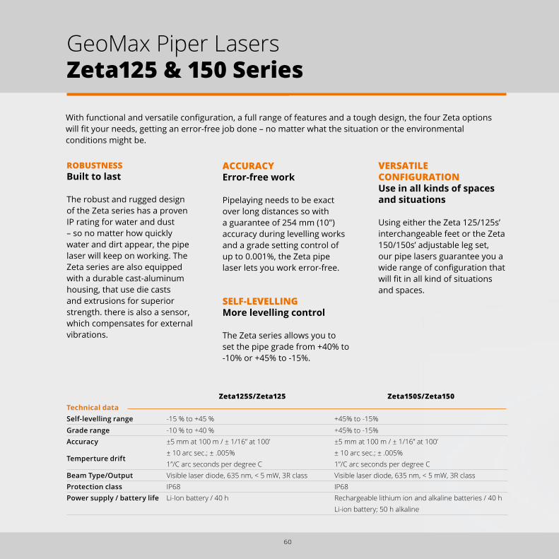
With functional and versatile configuration, a full range of features and a tough design, the four Zeta options will fit your needs, getting an error-free job done – no matter what the situation or the environmental conditions might be.
ROBUSTNESSBuilt to last
The robust and rugged design of the Zeta series has a proven IP rating for water and dust – so no matter how quickly water and dirt appear, the pipe laser will keep on working. The Zeta series are also equipped with a durable cast-aluminum housing, that use die casts and extrusions for superior strength. there is also a sensor, which compensates for external vibrations.
ACCURACYError-free work
Pipelaying needs to be exact over long distances so with a guarantee of 254 mm (10") accuracy during levelling works and a grade setting control of up to 0.001%, the Zeta pipe laser lets you work error-free.
SELF-LEVELLING More levelling control
The Zeta series allows you to set the pipe grade from +40% to -10% or +45% to -15%.
Zeta125S/Zeta125 Zeta150S/Zeta150Technical dataSelf-levelling range -15 % to +45 % +45% to -15%Grade range -10 % to +40 % +45% to -15%Accuracy
Temperture drift
±5 mm at 100 m / ± 1/16” at 100’ ± 10 arc sec.; ± .005% 1”/C arc seconds per degree C
±5 mm at 100 m / ± 1/16” at 100’ ± 10 arc sec.; ± .005%1”/C arc seconds per degree C
Beam Type/Output Visible laser diode, 635 nm, < 5 mW, 3R class Visible laser diode, 635 nm, < 5 mW, 3R classProtection class IP68 IP68Power supply / battery life Li-Ion battery / 40 h Rechargeable lithium ion and alkaline batteries / 40 h
Li-ion battery; 50 h alkaline
VERSATILE CONFIGURATIONUse in all kinds of spaces and situations
Using either the Zeta 125/125s’ interchangeable feet or the Zeta 150/150s’ adjustable leg set, our pipe lasers guarantee you a wide range of configuration that will fit in all kind of situations and spaces.
60
GeoMax Piper Lasers Zeta125 & 150 Series

ROBUST AND WATERPOOF
REMOTE CONTROL
PIVOT POINT AND 5/8” THREAD
LARGE AND EASY-TO-READ DISPLAY
INCLINATION ANGLE
UNIQUE DUAL COLOUR GRADE DISPLAY
STRINGLINE HOOK
OWNER ID AND CHECK CALIBRATION
HIGH-VISIBILITY LED LINE PIVOT
61
"S" SERIES AUTOTARGET SYSTEM AND VERTICAL LEVEL
"S" SERIES MANUAL ALIGMENT AND AUTOMATIC DUAL AXIS COMPENSATION

62
GEOMAX MACHINE GUIDANCENo more intuitive guesswork or costly and difficult-to-install-and-operate machine control systems. GeoMax has a new easy and accurate way to guide excavators.

63
GEOMAX CABLE LOCATING AND TRACINGIncrease on-site safety, minimise human error and save time and money with the GeoMax Cable Avoidance and Tracing systems.

64
The new GeoMax EzDig S and T excavator guidance system offers the easiest calibration and equipment operation available on the market – and at an affordable price. The EzDig excavator guidance systems “work when you do!”
BENEFITS
1. No more overcutting, costly fill materials and rework
2. Eliminate checking and installation machine downtime
3. No more time consuming tape measurements
4. Save fuel, time and material
Excavator work has always been based on either intuitive guesswork or by using costly and difficult-to-install-and-operate machine control systems. GeoMax EzDig is the new easy and accurate way to guide excavators.
Calibration storage 100 machines / 10,000 buckets
Intuitive graphic representation
Functions at your fingertips
Video integration for help and FAQs
7” colour and touch screen
TOUCH control unit
Technical data EzDig STANDARD EzDig TOUCHSystem power 12/28 VAngle sensorBattery chargerDimension and weightProtection
Solar70x100x20 mm; 282gIP67 Water and dust
Control unitScreen size and resolution
Digital 2.6” (10cm)128x64 pixels
Touch 7” (18cm)800x480 pixels
Optional 2D sensor N/A 2D Gyro sensorMemory Machines / Buckets number 5 / 10 per machine over 100 / over 100Accuracy +/- 7/16” - 1cmOperating temperature -20° to + 70° (-4° to 158° F)
One-function buttonsfor fast access to all functions
5 machines / 150 buckets calibration storage
Rugged and compact design
Easy-to-understand and functional icons
STANDARD control unit
GeoMax Machine Guidance EzDig Series

65
Depth Slope Distance
REAL-TIME INDICATION
SensorsSensor plates mounting via 3M extra strong adhesive tape, no welding necessary
Laser catcher for optional reference to laser rotator
Wireless communication to controller
Self-calibrating high precision angle sensor
Removal key
Solar powered and charged sensors with low cost holders to apply on multiple machines
Heads-up andtransparent deviceHigh brightness sunlight readable LED display
Screw-free installation with suction cap
Wireless antenna for sensors
Easy level indication
Magnetic holder
LED display

66
GeoMax Cable Locating and Tracing EziSystem
EziSystem i-SeriesEasily avoid buried cables and pipes before excavation work
The EZiSYSTEM cable avoidance equipment makes locating buried cables and pipes easy and efficient. With an EZiCAT i-Series locator there is no need to manually adjust the sensitivity, with the unique Automatic Pinpointing feature users can simply press the trigger and start locating.
EziSystem xf-SeriesEasily locate and trace buried utilities over greater distances
The EZiSYSTEM xf-Series utility locating and tracing equipment makes locating buried utilities easy and efficient. The xf-Series locators have additional low frequencies enabling you to locate and trace utilities over longer distances and in congested environments. With an EZiCAT locator there is no need to manually adjust the sensitivity, with the unique Automatic Pinpointing feature users can simply press the trigger and start locating.
Every year site workers are injured and equipment damaged due to accidently striking buried cables and pipes. As the complexity of large underground networks continually increases, knowing the location of buried cables and pipes prior to excavation work has never been so important.

67
LOGICAT SotwareUpload stored records to view locators use
LOGiCAT Software enables you to easily extract and upload stored data from your EZiCAT data logging and GPS cable locators, then analyse and report on the following traceable data.
The benefits of data logging in 5 steps
1. Conduct ground survey gathering data2. Send logged data to Bluetooth® enabled PC3. View EZiCAT usage statistics and charts4. Make informed decisions to efficiently manage EZiCAT
fleet and operators5. Implement changes to procedures for better results
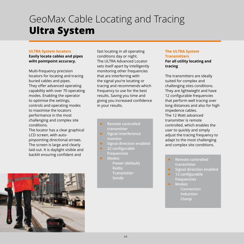
fast locating in all operating conditions day or night.The ULTRA Advanced Locator sets itself apart by intelligently monitoring other frequencies that are interferring with the signal you’re locating or tracing and recommends which frequency to use for the best results. Saving you time and giving you increased confidence in your results.
• Remote controlled transmitter
• Signal direction enabled• 12 configurable
frequencies• Modes:
ConnectionInductionClamp
ULTRA System locatorsEasily locate cables and pipes wiht pointpoint accuracy.
Multi-frequency precision locators for locating and tracing buried cables and pipes.They offer advanced operating capability with over 70 operating modes. Enabling the operator to optimise the settings, controls and operating modes to maximise the locators performance in the most challenging and complex site conditions.The locator has a clear graphical LCD screen, with auto-pinpointing directional arrows. The screen is large and clearly laid out. It is daylight visible and backlit ensuring confident and
• Remote controlled transmitter
• Signal interference monitor
• Signal direction enabled• 22 configurable
frequencies• Modes:
Power (default)RadioTransmitterSonde
The ULTRA System Transmitters For all utility locating and tracing
The transmitters are ideally suited for complex and challenging sites conditions. They are lightwieght and have 12 configurable frequencies that perform well tracing over long distances and also for high impedence cables.The 12 Watt advanced transmitter is remote controlled, which enables the user to quickly and simply adjust the tracing frequency to adapt to the most challenging and complex site conditions.
68
GeoMax Cable Locating and TracingUltra System

Technical data ULTRA Transmitters Frequency / Mode 512 Hz, 3140 Hz, 8192 Hz, 32768 Hz, 83.1 kHz, 200 kHz (12 frequencies user configurable)Protection IP65 Direct connection (Max) 12 Watt (model specific) when connected to a buried service with impedance of 100 OhmsBatteries 10 x D alkaline (IEC LR20) not suppliedBattery life Up to 100 h intermittent use (level 2 output at 20°C)
Shutdown Selectable auto shutdown after 1, 2, 3, 4, 5, 6, 7 or 8 hOperating temperature range -20° C to 50° CWeight & dimensions 3.5 kg - 255mm (H) x 190mm (D) x 305mm (W)
Technical data ULTRA locators Frequency / Mode Power 50Hz, 100Hz and 450Hz; Radio 15kHz to 60kHz; Transmitter 512Hz, 314Hz, 8192Hz, 32768Hz, 83.1kHz and 200Hkz; Sonde Preset 512Hz, 640Hz, 8192Hz, 33768Hz and 83.1kHz (22 frequencies user configurable)Antenna configuration Single peak, twin peak, null, total signal or left/right (cable only) Depth Power to 3m; Radio to 2m; Transmitter to 4.6m; Sonde to 6mDepth estimation 5% of depth in line or sonde (0.2m to 4.6m depth range) 10% of depth Sonde 4.6m to 6mProtection IP65 Bluetooth® EnabledShutdown Selectable auto shutdown after 5, 10, 20 or 30 minutesOperating temperature range -20° C to 50° C Batteries 2 x D alkaline (IEC LR20) not suppliedBattery life 60 h intermittent use (at 20°C)
Weight & dimensions 2.18 kg - 700mm (H) x 325mm (D) x 122mm (W)
69

70
GeoMax accessories have been individually tested to provide you the best performance and reliability in all your dialy tasks. Of a quality that meets the highest demands, you can be assured that the complete range of GeoMax accessories “work when you do!”. This is a selection of our currect accessories portfolio, ask more options to your GeoMax representative.
ZTW100Wooden tripod with shoulder strap and side clamp screws, 104 cm packaged length, extendible to 166 cm, weight 5.7 kg.
ZTA100Aluminium light weight tripod with shoulder strap and side clamp screws, 105 cm packaged length, extendible to 167 cm, weight 4.5 kg.
ZST101Tripod-star, for setting up of tripods on hard and slippery surfaces.
ZCA102Reflector carrier with tubular level and optical plummet, for precise positioning.
ZTR101Tribrach without optical plummet, black.ZTR103Tribrach with optical plummet, black.
ZCA101Tribrach carrier with stub for prisms.
ZCA100Tribrach carrier for GNSS antennas.
GeoMax Accessories

71
ZPC200Telescopic carbon fibre and aluminium pole for GNSS. Extends to 230 cm.
ZHR200Pole holder for Handheld PS336.
ZST100Telescopic, dual-strut pole support. Suitable for all GeoMax poles and level staffs.
ZPC210GNSS pole, 40 cm, for mounting Zenith receiver on carrier as extension.
ZPC201Telescopic carbon fibre and aluminium pole for TPS. Extends to 230 cm.
ZPC105Telescopic snap lock aluminium pole with 1/4” thread connector and screwable pin adapter. Snap lock at 1.5 and 2 m.
TOTAL STATION, CONTROLLER & DIGITAL LEVEL CABLES
Zipp10 Pro/Zipp20 USB Cable mini-USB to USB host connecting Zipp10 to a PC/Tablet. ZDC301Zoom20/30/35 Pro RS232 Cable Hirose-RS232 connecting Zoom20/30/35 (Pro) ZDC100 to a PC/Tablet using serial transfer technology. USB Cable Lemo-USB connecting Zoom20/30/35 (Pro) ZDC217 to a PC/Tablet using USB transfer technology.ZTS600, ZDL700 RS232 Cable Hirose-RS232 connecting ZTS600 & ZDL700 to a PC/Tablet. ZDC100 USB Cable Lemo-USB connecting ZTS600 & ZDL700 to a PC/Tablet ZDC102
GNSS CABLES
Zenith10/20 USB Cable Lemo-USB for Zenith10/20 connecting the device to a PC/Tablet. ZDC222 RS232 Cable Lemo-RS232 for Zenith10/20 connecting the device to a PC/Tablet. ZDC220 Satel EASyPro/battery Y-Cable Lemo to Lemo and clamps to connect Zenith10/20 ZDC221 with Satel EASyPro radio and external battery for power supply. Zenith25 RS232 Cable Lemo-RS232 for connecting Zenith25 to a PC/Tablet. ZDC227 USB Cable Lemo-USB for connecting Zenith25 to a PC/Tablet. ZDC226 Satel EASyPro/battery Y-Cable Lemo to Lemo and clamps to connect Zenith25 ZDC225 with Satel EASyPro radio and external battery for power supply.TNC TNC TNC to TNC cable. 2m extension for radio antenna. ZDC202

72
ZSA504Four-section telescopic staff. Provides dual measuring faces with bar code and millimetre graduations.
ZSF301Dual face high accuracy fibreglass levelling staff, 3 m, 1 section, barcode/E-Scale cm-graduation, with circular bubble and handle. ZSE504Level staff 5 m, 4 sections, front side with E-graduation and back side with mm-graduation.
GRZ122360° prism with 5/8” for GNSS antenna.
ZPR100 and ZTP100Circular prism with red holder, 0-offset. The ZTP100 target plate for precise aiming over long distances is separately available.
GRZ4360° prism with soft bag.
ZDE100/GFZ4 Diagonal eyepiece.
ZMP100Mini prism 0-constant with tip, fits to ZPC105 pole.
ZPM100Sliding mini-prism. True 0-constant prism, includes bubble, 4 mini poles and pole tip.
ZTM100Self-adhesive reflective target 6 x 6 cm. For measurement of surfaces with standard EDM.
GeoMax Accessories

73
ZCT102Hard shell container for 2 circular prisms, 2 carriers and 2 tribrachs.
ZCB100Backstrap for hard shell containers.
ZCH201Rapid charger or Li-Ion batteries ZBA200 and ZBA400. Includes car adapter cable.
BATTERIESHigh output Li-Ion batteries.ZBA301 for Zipp10 Pro/Zipp20/ZT20 Total Stations, 4.4 Ah ZBA101 for ZTS600 Total Stations & ZDL700 Level ZBA201 for Zoom Total Stations and Zenith25 GNSS, 2.6 Ah ZBA400 for Zoom Total Stations, 4.4 Ah ZBA202 for Zenith10/20 GNSS, 2.5 Ah CBA1 for PS336 Dataloggers, 5.6 Ah
ZCM101Industrial CF-card 256MB.ZCM04Micro SD Card 4GB.
ZMC100The 4 GB USB memory stick is suitable for GeoMax instruments, providing the highest data dependability.
ZCT105Soft bag for accessories, controllers or tablet PC.
ZCH202Dual charger for ZBA202.

74
Storm ZDDThe digital readout displays the height difference to the laser as soon as it is detected in the 127 mm reception window.
QL314SA very sturdy receiver with additional display on the back side. Powered by rechargeable NiCd batteries. Protection IP67.
LR 300Receiver with a 4 cm reception field and adjustable sound volume. Powered by 9V-alkaline.
MR240Machine control receiver, fixed with extremely strong magnets. Powered by alkaline batteries (up to 160 h) – no cables required.
MR360/ MD360 Machine control receivers with separate in-cabin display, connected via radio, powered by built-in rechargeable NiCd batteries – no cables required. Available with clamps or magnets.
SmartRodExtend the 4 m telescopic SmartRod to easily capture the laser beam within the 165 mm beam detection window and receive height measurements on the digital display. No misreading and a new dimension of range.
GeoMax Accessories
MW12Easy-to-use and light road measuring wheel with handle activated wheel brake.

Distance meter (Reflector mode): Laser class 1 in accordance with IEC 60825-1 resp. EN 60825-1 Laser plummet: Laser class 2 in accordance with IEC 60825-1 resp. EN 60825-1 Distance meter (Reflectorless mode accXess™): Laser class 3R in accordance with IEC 60825-1 resp. EN 60825-1
BUILT FOR ALL ENVIRONMENTSWith the design criteria “works when you do” GeoMax products are built to withstand all environmental conditions. GeoMax equipment is built with the intention to withstand all conditions you run into during your daily work. Rain, hail, snow or intense heat will never affect your GeoMax equipment - you can always keep working to get the job done.
OUR COMMITMENT TO SAFETY AND THE ENVIRONMENTAll GeoMax products are fully CE (Conformité Européenne) as well as RoHS (Restriction of the use of certain hazardous substances in electrical and electronic equipment) and WEEE (Waste from Electrical and Electronic Equipment) conformant.
OUR COMMITMENT TO QUALITYThe internationally active Swiss Association for Quality and Management Systems SQS, as well as the International Certification Network IQNET certified that GeoMax AG meets the requirements of ISO9001, Quality Management System and ISO14001, Environmental Management System.• Certified area: Whole
company.• Field of activity:
Development, manufacture, distribute, support and service of products, precision tools and systems for geomatic, industrial and construction applications.
Windows® CE, Windows® 7, Windows® Embedded, and Windows® Mobile are registered trademarks of Microsoft Corporation. The Bluetooth® word mark and logos are owned by Bluetooth SIG. NovAtel OnBoard® is a registered trademark of NovAtel Inc.Other trademarks and trade names are those of their respective owners.
75
GeoMax Quality Management

GeoMax Total StationZipp10 Series
ZIP
P10
Fully Equipped • Inbuilt Camera (5m Pixel)• Compass & Altimeter• 48 Channels GPS
Fully Flexible • Windows® Embedded
Handheld Platform• Full Connectivity to all
GeoMax Devices• Developed to Match
GeoMax Requirements
Outdoor Ready • IP68 Dust and Waterproof• Meets Military Standards• Optimal Sunlight Readability
Rugged HandheldPS336 Series
Multi Positioning Software
X∙PA
D M
PS
O F F I C E
Multi Positioning Software
GeoMax Automatic LevelZAL100 Series
Wor
ks w
hen
you
do
PS336 X-PAD MPS
ZAL100 SeriesZone50 Series
GeoMax FieldGeniusHigh Performance Professional Results
FIEL
DG
ENIU
S
FieldGenius Ezi & Ultra Systems
Totally open Windows® CE• Supports any field software• Open for own development• Personalise your system
Totally connected• Integrated Bluetooth®
• USB memory stick• Plug and Play technology
Totally featured • 3.5’’ colour & touch display• 400 m non-prism range• Coaxial visible laser beam
Manual Total StationZipp20 – Open WinCE® Series
ZIP
P20
Easy to install• Initial installation <1h• Cable free system• 5 min machine exchange
Easy to learn, easy to use• Always displays height
and slope• Intuitive graphical
representation• Simple one-touch menu
display
Excavator Guidance System EzDig S & T Series
Easily fits any excavator • Adapts to complexity
and size• Upgrades to complexity
and size• Wizard guided calibration
EzDig
Extensive workrange• Digital Slope ± 15 %• > 500 m Operating range• Remote control > 400 m*
Designed to last • IP67 submersion proof • 24/7 permanent operation• Shock and drop proof
Permanent precision• Fully automatic Zone50 FA• Tilt control Hi-Alert• XY-Axis independently
adjustable
GeoMax Slope LasersZone50 Series
ZON
E50
Zenith25 Pro Series
Zoom35 Pro Series
Colour- & Touchscreen • Large 3.5″ Q-VGA Display• Fast Navigation• Brilliant Readability
Highest Functionality • NavLight™ Alignment Aid• 600m Non-Prism Range• 3 mm + 2 ppm Reflectorless
Easy Connectivity • USB Memory Stick• Bluetooth® Transfer• Plug ’n Play Technology
Manual Total StationZoom30 Pro Series
ZOO
M30
PR
O
Superior accXess10 EDM • > 1,000 m Non-Prism Range• > 10,000 m Prism Range• Pin Size Laser Beam
Easy Connectivity • USB Memory Stick• Bluetooth® Transfer• Plug ’n Play Technology
Colour Touch Screen • Large 3.5″ Q-VGA Display• Fast Navigation• Brilliant Readability
Manual Total StationZoom35 Pro Series
ZOO
M35
PR
O
Cable Tracing and LocatingEZi & ULTRA Sytems
EZi &
ULT
RA
SY
STE
MS
STReAM360 • S cout – Auto Find• TR ack – Auto Tracking• A i M – Auto Targeting
Long Range Bluetooth • High-Speed Data Link• Reliable Connectivity• License Free
Powerful Handheld • Inbuilt Camera (5 M Pixel)• Compass & Altimeter• Long-range Bluetooth®
Robotic Total StationZoom80 Series
Easy connectivity • USB memory stick • Fast and easy data transfer • Plug and Play technology
Superior accXess4 EDM • Accurate under difficult
situations • Fast and reliable
measurements • Pin-size laser beam
Built for all environments• Tested and certified to -30°C• Dust and waterproof• Full day operation on one
battery
Manual Total StationZoom20 accXess Series
ZO
OM
20
acc
Xes
s
Compatta• Radio UHF Integrata• Modulo GSM/GPRS Integrato• Memoria Interna Extra Large
Fisso • IP67 resistente a polvere e acqua • Design Robusto• Professionale
Completo• 60 Satelliti Tracciati
Simultaneamente• GNSS: GPS, Glonass,
Galileo, BeiDou• NovAtel AdVance®
Ricevitore GNSS Serie Zenith10 & Zenith20
ZEN
ITH
10
& 2
0Extremely rugged • IP68 dust and waterproof• Withstands a 2 m drop• Vibration resistant
Future-proof• Quad-/penta band
GSM/GPRS/UMTS• UHF radio and Bluetooth®
• True GNSS: GPS, GLONASS, BeiDou, Galileo & SBAS
Versatile handheld • Camera, compass, altimeter• Meets military standards• Optimised for GeoMax
GNSS ReceiverZenith25 Pro Series
ZEN
ITH
25 P
RO
Easy connectivity • USB memory stick• Fast and easy data transfer• Plug and Play technology
Superior display • Largest 8 line display• Highest resolution in class• Graphical user guidance
Performance, robustness• 400 m non-prism range• Coaxial visible laserbeam• Sealed durable housing
Manual Total StationZoom20 Pro Series
ZOO
M20
PR
O
Easy Connectivity • USB Memory Stick• Fast & Easy Data Transfer• Plug ’n Play Technology
Performance, Robustness• 250 m Non-Prism Range• Coaxial Visible Laserbeam• Sealed Durable Housing
Multifunctional Keyboard • Direct Access to Apps• Fast Navigation• Brilliant Readability
Manual Total StationZipp10 Pro Series
ZIP
P10
PR
O
Zipp10 Pro Series
SP
S Z
OO
M 3
00
3D Laser Scanner
SPS ZOOM 300
Zoom300
GeoMax Digital LevelZDL700 Series
Wor
ks w
hen
you
do
ZDL700 Series
To learn more about us visit: www.geomax-positioning.com
A selection of our available marketing material:
Zoom80 Series Zoom30 Pro Series Zipp20 Open WinCE® Series
Zoom20 Pro Series Zoom20 accXess
Zenith10 & 20 Series
1015 / 768325 en Copyright GeoMax AG. Illustrations, descriptions and technical specifcations are not binding and may change. All trademarks and trade names are property of their respective owners.
GeoMax Product Marketing Material
Related Documents


