,) ) ) ) ) ) ) ) ) ) ) ) ) ) ) /) ) ) .) ) ) ) I : NTRODUCTION W^{* funu{ofzr..-' } p_0,','l"t f { ', ,', .r , ," hP'l' .^ -,' . Subr'rt \ tJ *7S jo( ,) 0.9 oAil T.P. ArT t?66 As Per the Provisions had declared its intention sec. 38 ' The Town Planning Officer appointed u/s'24 r,.ad the basis of relevant data a available int-ormation semi-Govt. institutions & various other sources' l4oreover the ptan have been technically approveC videletterNo.DP/Nanded(R)/2645Dated25/9/95& resPectivelY ' The lands reserved for various Govt' semi-Govts' & co-ordination committee meeting on dated L2'2'96 under Collector, Nanded' The cbairman has suggested the some changes vide his retter on dated 28/2/96' These changes have been incorporated in the plan As such arl regar formarities in respect of revision of Development plan have been folrowed and-accordingly the plan is prepared- The President, on behalf Nanded t{uncipal councir n"u6.i!'?ii" in lratarashrra cbvr- Gaze*e dared zg-8-96 as per the provision given under section 26 of M-R-at.P'act wit'h all relevant documents' :' st.ipulated i; the M.R. & T.P. Act 1966, Nanded Muncipal- Council had to prepare the revised Development Plan of Nanded u/s 23 read rvith prepared the revised development plan on colLected. from the census 1991' Gov't' & by D.D.T.P. A'bad and D'T'P'M'S' Pune D P-Nanded (R)/TPv-5/456, Dt' 23iL/96 other institutions were discusseC i:r the chairmanship of the Addditional ) ) )

Welcome message from author
This document is posted to help you gain knowledge. Please leave a comment to let me know what you think about it! Share it to your friends and learn new things together.
Transcript

,)
)
)
)
)
)
)
)
)
)
)
)
)
)
)/)
)
)
.)
)
)
)
I: NTRODUCTION
W^{* funu{ofzr..-' }p_0,','l"t f { ', ,', .r , ,"
hP'l' .^ -,' .
Subr'rt \ tJ *7S jo( ,) 0.9
oAil T.P. ArT t?66
As Per the Provisionshad declared its intentionsec. 38 '
The Town Planning Officer appointed u/s'24 r,.ad
the basis of relevant data a available int-ormation
semi-Govt. institutions & various other sources'
l4oreover the ptan have been technically approveC
videletterNo.DP/Nanded(R)/2645Dated25/9/95&resPectivelY '
The lands reserved for various Govt' semi-Govts' &
co-ordination committee meeting on dated L2'2'96 under
Collector, Nanded'
The cbairman has suggested the some changes vide his retter on dated 28/2/96' These changes
have been incorporated in the plan
As such arl regar formarities in respect of revision of Development plan have been
folrowed and-accordingly the plan is prepared- The President, on behalf Nanded t{uncipal
councir n"u6.i!'?ii" in lratarashrra cbvr- Gaze*e dared zg-8-96 as per the provision given
under section 26 of M-R-at.P'act wit'h all relevant documents'
:'
st.ipulated i; the M.R. & T.P. Act 1966, Nanded Muncipal- Council had
to prepare the revised Development Plan of Nanded u/s 23 read rvith
prepared the revised development plan on
colLected. from the census 1991' Gov't' &
by D.D.T.P. A'bad and D'T'P'M'S' Pune
D P-Nanded (R)/TPv-5/456, Dt' 23iL/96
other institutions were discusseC i:r
the chairmanship of the Addditional
))
)
)
)
)
)
)
)
)
i))
I
)
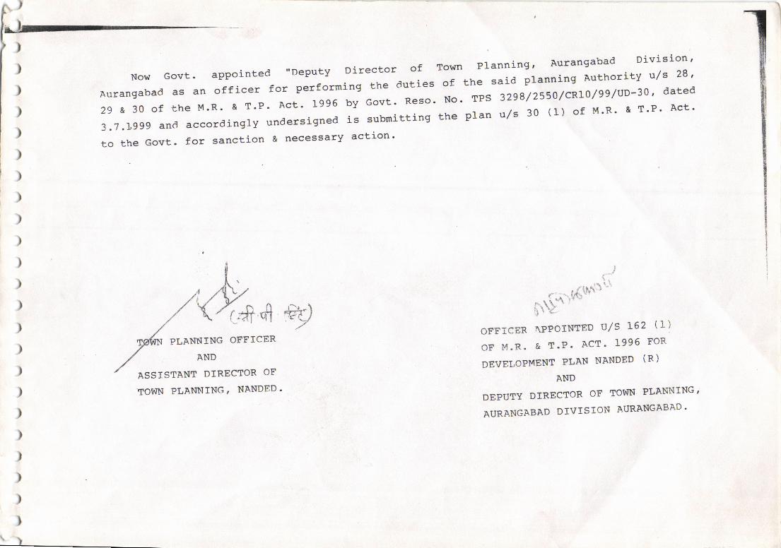
Now Govt. appointed "Deputy Director of
Aurangabad as an officer for performing the duties
29 a 30 of the M'R' & T'P' Act' 1996 by Govt' Reso'
-a.7 .1,ggg and accordingly undersigned is subnitting
to the Govt. for sanction & necessary action'
Town Planning, Aurangabad Division'
of the said planning Authority v/s 28 '
No. TPS 32g8/2550/CRIO/g9luD-30', dated
the pLan u/s 30 (f ) of M'R' & T'P' Act'
' ' '#'{hrri:fr$'"-
oFFrcER IPPOrNTED rJ/S L62 (r)
OF M.R. & T.P. ACT' 1996 FOR
DEVELOPMENT PLAN NANDED (R)
AND
DEPUTY DIRECTOR OF TOWN PLAITNING 'AURANGABAD DIVISION AURANGABAD'
ryPLANNTNG OFFTCER
AND
ASSISTANT DIREETOR OF
TOWN PLANNING' NANDED.
\)
I 1
-l
j
t
)
)
)
)
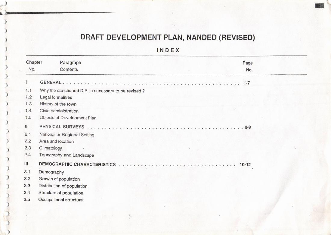
DRAFT DEVELOPMENT PLAN, NANDED (REVISED)
INDEX) Chapter Paragraph) No. Contents
Page
.No.
) | GENERAL ...; 1-7
1.1 Whythe sanctioned D.P. is necessary to be revised ?)' 1.2 Legalformalities
) 1.3 History of the town
. 1.4 Civic Administration,1.5 Objects of Development plan
) II PHYSICALSURVEYS ....8.9)' 2.1 Nationat or RegionalSetting
'l Z.Z Area and location
r 2.3 Climatology,2.4 Topography and Landscape
)III DEMOGRAPHIC CHARACTERFNCS 10.12
) 3.1 Demography\, 3.2 GroMh of population
) 3.3 Distribution of population
. 3.4 Structure of population, 3.5 Occupationalstructure)
)
)
)
-,1
I1Chapter
No.
Paragraph
ContentsPage
No.
V
5.1
5.2q?
5.4
c.5
5.6
)
)
)
)
)
)
)
)
)
)
)
)
)
))
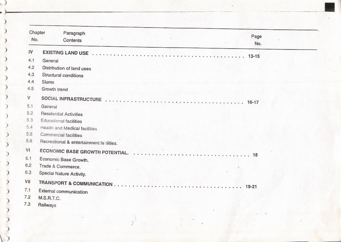
tv
4.1
4.2
4.3
4.4
4.5
13_15
Growth trend
SOCIALINFRASTFUCTURE .. ..General
Residenti al ActivitiesEducatio naf facilitiesHealth and Medical facilitiesCommercial facilitiesRecreational & entertainment farilitbs.
VI ECONOMIC SASE GROWTH POTENNAL.6.1 Economic Base Growth.6.2 Trade & Commerce. I
6.3 SpeciatNatureActivity.
VII TRANSPORT & COMMUNrcANON 19.217.1 Extemalcommunication
7 2 M.S.R.T.C.7.3 Railways
EXISNNG LAND USE
General
Distribution of land usesStruaural conditions
Slums
)
)
)
)
)
)
)
)
\o)
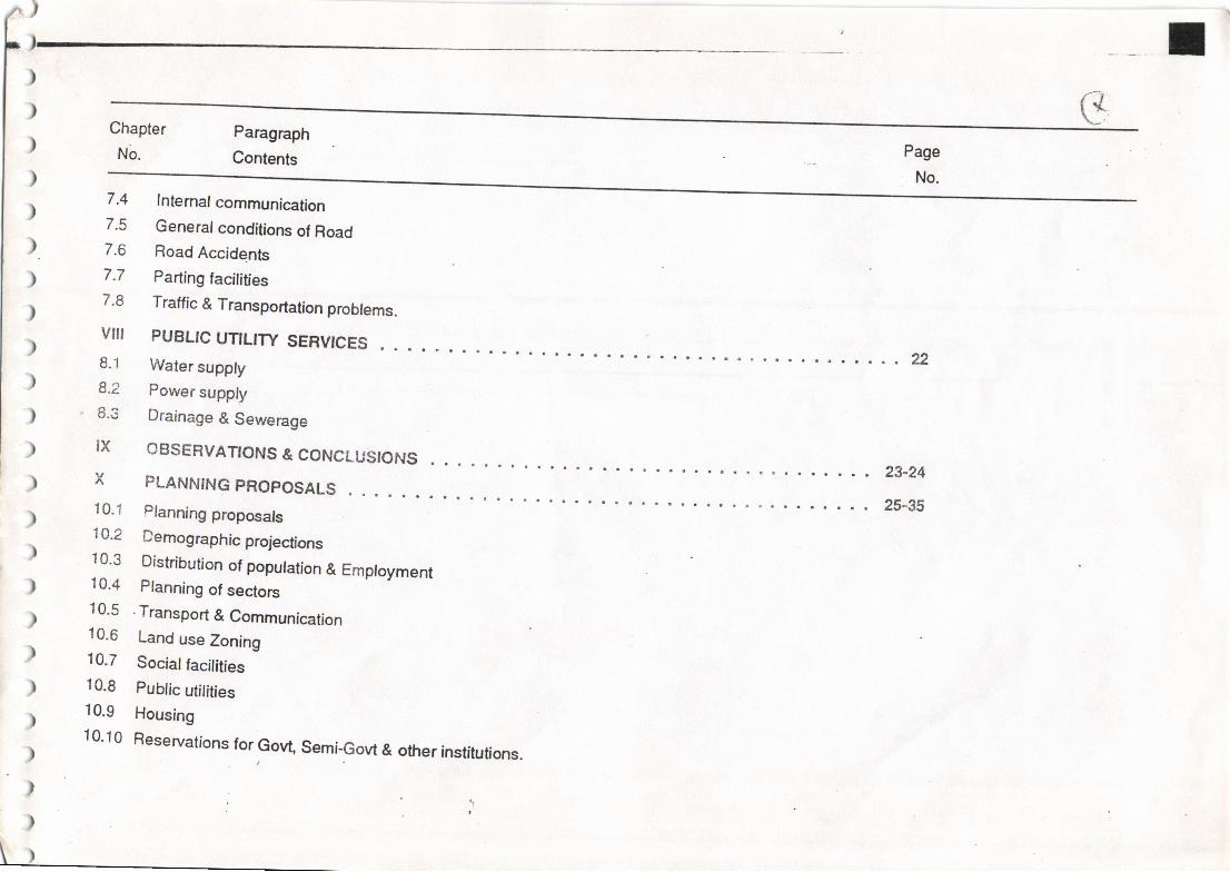
Chapter
No.
Paragraph
Contents Page
No.7.4
7.5
7.6
7.7
7.8
vilt
8.1
8.2
6.3
IX
Intemal communication
General conditions of RoadRoad Accidents
Parting facilitiesTraffic & Transportation probtems.
PUBLIC UTILITY SERVICES
Water suppty
Power suppty
Drainage & Sewerage
OBSERVATIONS & CONCLUSIONS
22
23-24PLANNING PROPOSALS
i0.1 Planningproposats1A.2 Demographic projections10.3 Distribution of population & Emptoyment10.4 Planning of sectors10.5 .Transport & Communication10.6 Land use Zoning10.7 Socialfacilities10.8 public utifities10.9 Housing10.10 Reservations for GoW Semi-Govt & other institutions.
25"35
Chapter
No.
Paragraph
ContentsPage
No.
XI
xtl
12.1
12.2
12"3
xtii1? -'!
tJt
MPROVEMENT OF ENVIRONMENT & LANDSCAPE
MPLEMENTATION OF DEVELOPMENT PLAN : PHASTNG
lmptementation of Development planManner of implementation
Phasing
DEVELOPMCruT CONTBOL
36
37-38
39-40
Transfer of Development Rights
APPENDIX .I . 41_44
APPENDIX.A ..45-49
xtv RESOURCEMOBTLTSAnON ......50-5214.1 Financial Condition of MunicipalCouncil14.2 Cost of lmplementations of D.p. proposals14.3 Mobitisation of .Resources.
CONCLUSTON 53
TABLES,CHARTS&GRAPHS
Building bye-laws & Devefopment control rulesInnplementation of Reserved sites in co-operation with the people
Demog raph ic Characteristics: G rowth of populatio nPopulation profite ( Graph)Dernographic characte ristics: occupational structu re (census : 1 9 g 1 )
{t.
2.u55
. cb-5/
//I t
Chapter
No.
Paragraph
Contents
Pagq
No.
The occupational structure fo Nanded ( census : 1961 '71'81& e1)
Employment population profile ( Bar Chart )''''Slums(Chart) ...Existing Land Use ( E.L.U. ) Analysis
Pie-diagrams of ELU AnalYsis
Statement : Sector wise Existing population ( 1991 census blocks')
Statement showing sector wise population distribution for the year 2001 '
Statement showing sector wise distribution of lorecasted poputation for the
year2001 and2011
Proposed Land Use ( P.L U. ) Analysis
Pie-diagrams of PLU AnalYsis
Municipal Finance [lncome & ExpenditureJ
Deviation statement
List of Reservations
statement: Approximate cost of acqisition of sites & cost of
development of sites in favour of Planning Authority'
Cost for implementation proposed D.P' roads'
Phasedplogtanlu.-e*!-qf -agqq!{tio-n9f sites'
CIoo
58
RO4.q
6.
7.
8.
9.
10.
11.
tz.
14.
15.
60-61
il-65
62
63
66
67
68
69
70
71-86
87-10116.
J.,h.v
102-112
113
1 14-1 15 4--
/j)
)
,
)
)
)
)
)
)
)
)
)
)
'Ii
I
I.GENERAt
l.l Why the sanc0oned developme ptan ls necessary to be rcvlsed ?
.-. . The original development plan ot Nanded was sanctioned by Govt vide Reso-No. Tps/327t579ruo-5, Dt. 3:-1.78 andJt-las came into forcew'e-f i 2'78 The overatl e*isting Gross density of the p;putarion is o zss pnr. rhis t',gi a;"",y i" orl|y o"".ffid; fimiel municipat timit andlnlited area under developmenl. To ach€ve the desirable density ot populalion, some pockets ot city wiich were prcviousty und€r no develoFnentzone will have to be zoned for residenliat purposes.
The Broad Gauge line passing exactly through the middte of the city, making the city in two parts. It is therefore necessary to co-ordinate
*::^,::1.::lo.vidinsnewrolanetno;;;"";";;";;;;;il;#;;;;;.;;;";;;il;;;;;;nowfoc,ated outside the municipal limit and hence area reseryed tor the university in the sanctioned development plan admeasuing €| 100.g5 Ha.rll, lr I tr ls gqlwill have to be properly pfanned & co-ordinated with the existing & proposed road network.
,- -, 9ln"'o"nnn tne above main points and groMh rate of poputation of Nanded city, il is lelt necessary to revise the Development plan keepingIn mind to provide good environment & infraslructure to the people residing in the city.
1.2 LFGAILEGAL FORIT4ALITIES
Sr. No. Contents Resolution No. & Date/Letter No. & Date.
)
)
)
)
Declaration of intention under section 3g read with sec.23(1) ofM.R. & T.P. Act, 1966 by the fvtunicifj Council, Nanded.a) Gazette Notification (Engtish & Marathi)
Nanded Municipal Council Resolution No. 328, Dt.16-1-1988
Maharashtra Govt. Gazette, Aurangabad Division SupplementPart-|, Page-194 & Date 31-3-1988
1
a)
b)
b) News papers'Name & Date'
Appointment of Town Planning Officer uts 24 of the MR & TP
Act, 1966 by the Municipal Council, Nanded'
Prior sanction from Govt.
Appointment letter of Municipal Council, Nanded
Preparation of existing land use map u/s 25 of the said act.
i) Normal date
ii) Extended date
iii) From the Director of T.P. bY
letter No.
iv) Existing land use map handed overto the Municipalcouncil,
Nanded.
Time limit under section 26(1) lor pubtication of Draft
Development Plan of Nanded
a) Normaldate
b) Extended date
sanctioned from Director of Town Planning, Pune by letter No.
c) Further extended datesanctioned lrom Director of Town planning, Pune by letter No'
d) Further extended dateSanctioned from Director of Town planning, Pune by letter No'
Name: 'saher' (urdu Paper) notification published in english &
marathi language Date: 1 3-3-1 988
MunicipalCouncil, Nanded Resolution No' 329, Date 16-1-88
DP (R)/Nanded/DD-A'b adl-173, 23-3-88
DP (Ry2951/88, Dt. 25-5-1988.
15-7-1988
29-6-1989
D P/Nanded (R )/TPV-V| I 6657'
Dt. 18-10€9
by letter No. DP/Nanded (F|)/ADTP/
1049-A, Dt.29-6-1989.
4)
30-3-1990
30-9-1990
D P- Nanded (R)/extr/Sec.26ff PV-V/5880; Dt' 1 - 1 0- 1 992'
31-3-1991DR-Nanded(R)/Extr/Sec.26lTPV-V/5881 ; Dt'1 -1 0-92'
30-9-91DR-Nanded(R)/Exr/Sec.2dTPV-V/5882; Dt' 1 - 1 G92'
(2)
)
)
)
)
)
)
)
)
)
)
)
)
)
)
)
)
)
)
)
)
)
)
)
)
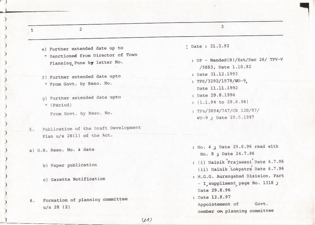
e) Further extended date uP to* Sanctioned from Director of Town
Planning,Pune bY letter No'
f) Further extended date uPto* From Govt- bY Reso. No'
g) Further extended date upto* (Period)
From Govt. bY Reso. No'
Publication of the Draft DeveloPment
Plan u,/s 26'].) of ttre Act'
I Date : 31 .3.92
DP - Nanded(Rl/Exx/sec 26/ tPv-v
/5883, Date 1.10-92Date 31.12.1993fPs/3292/L578/VD-g,Date 11.11 .L992
Date 29.8.1996( 1 .1 .94 to 29 .8 .96\
rPs/ 3a9 4/7 47 / cR L20 / 97 /UD-g j Date 29 .5.L997
No. 4 3 Date 29.6.96 read withNo. 8 ; Date 24 .7 -96
( i) Dainik 'Praiawani'Date 6 -7 -96
(ii) Dainik Lorpatrd n"t" 6.?.95
M.G.G. Aurangabad Disision, Part
- I,suppliment Page No. 1318;Date 29.8.96Date L2.8.97Appointement of Govt-
member on Planning corunittee
5.
a) G.B. Reso. No. & date
b) PaPer Publication
c) Gazette Notification
Formation of Planning cornmittee
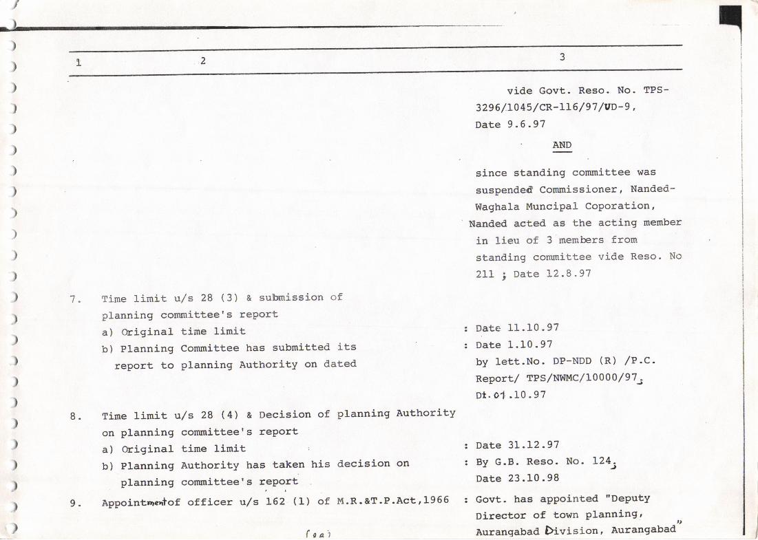
u/s 28 (2)
,l
5.
vA)
AND
)
)
)
)
)
)
)
)
)
)
7 " Tirne limit u,/s 28 ( 3 ) & submission ofplanning committee's rePorta) original time linitb) Planning Committee has submitted its
report to planning Authority on dated
vide Govt. Reso. No. TPS-
3296/.LlLslcR-115 /97 /vD-g ,
Date 9 .6.97
since standing committee was
suspended Commissioner, Nanded-
Waghala MunciPal CoPoration,Nanded acted as the acting member
in lieu of 3 members fromstanding commiLtee vide Reso- No
2IL 1 Date L2.8 .97
Date 11.10.97Date 1.10.97by lett.No. DP-NDD (R) /P.c.Report,/ TPS/NW}4C /L0000 / 97 -
Dt. 01 .10.97
Date 3L.L2.97By G.B. Reso. No. L24jDate 23.10.98
Govt. has apPointed "DePutYDirector of town Planning, ,,Aurangabad. Division, Aurangabad
)
)
)
)
)
)
)
)
)
)
)
,)
)
)
8. Time limit u,/s 28 (4) a Oecision of planning Authorityon planning comrnittee's rePorta) original tj-me limitb) Planning Authority has taken his decision on
planning conunittee's rePolt
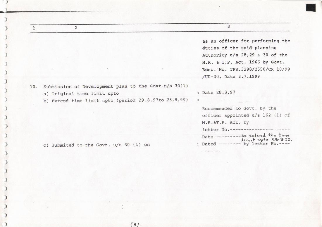
Appointrreatof officer u/s L62 (1) of M-R-&T.P.Act,L9669.
f aat
)r)
)
)
)
)
)
)
)
)
)
)
)
) c) Submited to the Govt. u/s 30 (1) on
)
)
)
)
)
)
);'
)
)G)
10. submission of Development plan to the Govt.u/s 30(I)a) original time limit uPtob ) Extend tirne linit uPto ( period 29 -8 " 97to 28 .8 . 99 ) !
as an officer for performing thedut,ies of the said planningAuthority u/s 28,29 a 30 of theM.R. & T.P. Act, 1956 by Govt.Reso.' No. TPs. 3298/2550/cR l0/99,/uD-30, Date 3.7.1999
: Date 28.8.97
Recommended to Govt" bY theofficer appointed urls L62 (1) ofM.R.&T.P. Act, by
letter No.-----Date ---lo €xl"oJ the. *;'n"
l;z'rif sp*o <g'8'35.: Dated -------- bY letter No.----
)
)
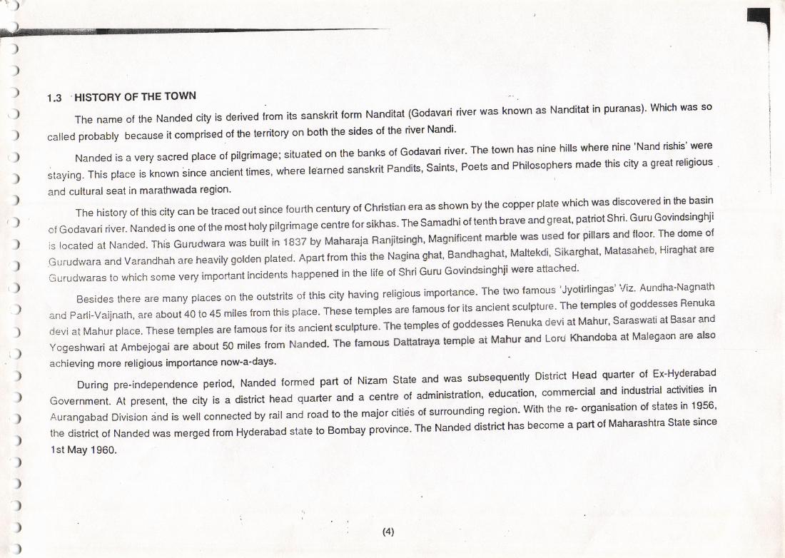
1.3 .HISTORY OF THE TOWN
ThenameoftheNandedc.tytsde'ived'romitssanskrit|ormNanditat(GodavaririverwasknownasNanditatinpu'anas).Whichwasso
called p.obably because it comprised ol t|e territory on both the sides ol th€ dver Nandi'
Nandedisaverysacredp|aceotpi|grimage:situaiedonthebanksofGodavaririver.Thetownhasninehi||swhe.enine.Nandrishis'were
staying' This p|ace is known since ancient times, where |earned sanskrit Pandiis, Saints, Poets and Phi|osophe6 made this city a great G|igious
and cultural seat in marathwada region
The hislory of this city can be traced out since fou rth century ol christian era as shown by the copper plate which uras discovered in lhe basin
cf Godavari dver. Nanded is one ot the most holy pilgrimage centre forsikhas. The samadhiof tenth brave and great' pattiot shti' Gutu Goviodsinghii
is tocated at Nanded. This curudwara was built in 1837 by Maharaja Ranjitsingh, Magnificent marble was used for pillars and floor' The dome ol
Gurudwara and varandhah are heavity golden plated. Apart from this the Nagina ghat, Bandhaghat, Maltekdi' sikarghat, Matasaheb' HiEghat are
Gurudwaras to which some very rmpofl;nt incidents happened in the lile ot shri Guru Govindsinghji were attached.
Besides there are many ptaces on the oubtrits of this city having religious importance' Th6 two famous 'Jyotidingas' viz' Aundha-Nagnath
and Parli-vainath, are aboul40 to 45 miles from this place. These temples are famous for its ancient sculplure' The temples ol goddesses Renuka
devi at Mahur place. These temples are lamous lor its ancient sculpture. The temples of goddesses Renuka devi at Mahut' saraswati at BasaI and
yogeshwari at Ambejogai are about 50 miles lrom Nanded. The famous Dattatraya temple ai Mahur and Lord Khandoba at Malegaon ate also
achieving more religious importance now'a-days.
Duringpre.independenceperiod'NandedformedpartofNizams|ateandWassubsequent|yoistrictHeadquarterofEx-HyderabadGovernment. At present, the city is a district head quarter and a centre of administration, education' commercial and industdal ac{ivilies in
Aurangabad Division and is well connected by rail and road to the maior citids of surrounding reqion' With the re' organisalion of slaies in 1956'
the district ol Nanded was merged from Hyderabad state to Bombay provrnce. The Nanded district has become a part of Mahalashtra State since
1st May 1960.
(4)
t.,I
{)
1.4 .CIVIC ADMINISTRATrcN
1-4.1 There are 10 Tahsils in ihe Nanded Districl. They are viz (1) Nanded (2) Hadgaon (3) Kinwat (41 Bhokar (5) eibti 1O; VufneA g; Oegtoor
(8) Kandhar (9) Loha (10) Ardhapur
1.4.2. There are 13 MunicipalCouncilin the Nanded Distdct. These are as under:: (1) Nanded (2) Hadgaon (3) Bitoli (4) Degloor (5)Mukhed (6)
Kandhar (7) Loha (8) Kinwat (9) Dharmabad (10) Mudkhed ('t1) Umari (12) Kundalwadi (13) Waghata
1.4.3. The city has Polic€ Station, Govt.Rest House, Post office, PrimarySchools, High Schools, Dispensaries, M.S.R.T-C. Bus Station, A.P.M.C.,
tvl.S.E.B. Sub-Station, DistdctCourt, B&C office, lrrigation olfic€, Zllla Parishad oftice etc. lhe oflice ot the Municipal Councilis at present
in its own premises. The Municipat Councit looks atler the construction and maintenance ot the roads, street lights, suppty of ddnking 'dEter,weekly market, catlle ma*et, primary educalion, public health, health & medical facilities, pa*jng tacilities, entertainment etc. in itsjurisdiction.
'2-,e- a t- -, O \ft'ott""
1 .4.4. Total income of MunicipalCd'oncil Nanded during the year €9re2 was Rs. 5:912199 Table No. 14 showing the income and expendilure
is appended to the report.
1.4.5- The main head ot taxes levied are; i) Property tax ii) Water tax iii) Ockoi iv) Educatjon cess v) Other tax
1.4.6. The main items of the expenditure a.e; i) General Administrauon ii) Watursupply iii) Street lighting iv) Maintenance & construction ol rcdsv) Hospitals and dispensades vi) Buitding vii) Education viii) public Hygien.
1.5. OBJECTS OF REVISED OEVELOPMENT PLAN\
Development plan of nanded w\ sanctioned by Govt, & has came in to lorce from 1-2-197$q uri be in lorce titlthe revised dewlopmentplan will get sanctioned by Govt. Devetdfgent plan ol Nanded was prepared for the fulure period of ten\ears i-e. taking into consideration populdiongroMh in coming ten years- The ten year p\iod was lapsed on 31-1-1g88. Taking into consideration the )psent population, itbeems to be necessaryto revise the development Dtan of Nanded.\., ,
Now it is obligatory on every plaoning authority to revise the development plan once ln 20 years under section 38 of the M.R.T,P. Act 1966.
(s)
l)
F)
)
)
)
)
)
)
)
)
)
)
)
)
)
)
)
)
)
)
)
)
)
)
)
. The tollowing terms were taken lor refe rences wh€n the su rvey was undertak€n so as to prepare a kind ol backg round for suggesting alternalive
and feasible pattem ol vaiious land uses aller its through study.
' To study the salient lealures of existing land uses the lollowing points have been taken into consideration.
i) Residential,Commercial,lndustrial,AgricultrralandRecrealional.
ii) Open use likd Forestry, Water Supply, Orainage, Sewerage, Disposal; other public ulility amenities and services, Burial grounds, No
development area, Dairies, Sanctuaies, Nature reseryes, Gadens etc.
iii) Preservation, conservation and developmenl of areas ol natural scenery and land scape for recteational amenities and picnic spots.
iv) Development of elticient hinterarea transpodalion system and linkng ofvarious lunctionalunits is necessary. Besides, itwillbe necessary
to indicate the most advantageous alignments for major roads, taversing city areas and linking it wilh its hinier-lands which is large region
of which city is a part.
v) Io indicate the planning proposals and organisationg lor optimum land uses lor vaious purposes in the proposed neighborhood units for
a plan period.
vi) The village scattered a.ound lhe main urban core of the city have to be allowed to have a share in the developmeni ot city.
vii) The important objective of planning the city is, to view the ar€a as a singl€ interlocking complex ot tand uses in which each of the components
plays a clearv detined tunctional role.
viii) Planned city devetopment will be possible ot attainment or y if the economic base ol the city to be diversified and made more balanced
. tr|em it if today
iv) The object of development plan for the city is; the lomulation of policies and programmes to meet lhe urgent and compelling need to
diversily and enrich lhe occupallonal pattem ol the city.
x) Already there arc number of Central, State & Local Authorities helping in execution of de\€lopment progr:rmmes in the city. The
strengthening and wheGver necessary, lhe co-ordination otthese agencies, has to be given serious consideration by lhe Govemmen!.
(6)
/)
)
).xi)Provisionforpetm|ssionlobegranted|orcontrottingandregu|aling|hguseanddeve|opmento||andbyintroducingtheBU|LD|NG
) BYE-LAWS AND DEVELOPMEI{I CoNTROL RULES, within iurisdic'tion ol local authotrty' tor the local authority'
) Thus lhe development plan in bdet, seeks to :
) D PFOVIoE : A yardstlck agalnst whlch the Urban Developmenl
, declslons can be evalsale
) lD SERVES : As a co'ordlnatlng lrame lor progtamme ot Prlvate' publlc
) agenclea.
) lii) lNolcATES: Courses of actlonforthe solutlon ol presslng urgent
Problema'
iv) FURNISH : A baslc for inltlatlng broad land use controls'
v) FACILITATE : Further studies to be focused on relevant matter'
Leading eventually to the tormulatlon ol the
comprehenslve Plan.
)
)
)
)
)
)
)
)
)
,
)
)
)
)
)
33/o/
(71
)
)
)
)
)
)
)
)
)
)
)
)
)
)'
)
)
)
)
)
)
)
)
)
)
II. PHYSICAL SURVEYS
2.1 NATIONAL OR FEGIONAL SETNNG
TheNandedDistriclistheeastemmosiareainMaharashtastate.Thesoulhemparto|thedisiic{|iesintheGodavaribasinwhergas
northern portion lies in the valley of Penganga river, The district lies beiween 18016' and 19055' N latitude and 760456' and 78019' E tongitude' tt
is bounded by - north by the Yeotmat d;Md, on lhe west side by Parbhani and Latur distdct' On the south side by ihe Bidar distdct of Kamalaka
State and on the east by Medak, Nizamabad and Adilabad district ot Andhra Pradesh'
2.2 AREA AND LOCATION
NandedcityissituatedontheleftbankofGodavaririver,approximatety'18030'N|atitudeand77ol0'E|ongitudeandisabout23Tkm|romAurangabad and 250 km from Hydeabad onthe Manmad-Kachiguda south-central Railway line. Nagpur- solapur state Highway and Hyderabad
Akola State Highway passes through lhis citi
Presently area within the Nanded MunicipalCouncil timit jurisdiclion is 2062'48 Hect'
2.3 CUMATOLOGY
Thec|imateofthecityisgenera||ydryexceptduringthesluth.westmonsoongeason.Nandedcityhasanaveraggannua|rainla||o|about901.1 mm ( 1981 Censusl. Temperature range is in betw;en460c lmax'1 and 190'3'
Monthly temperature records lor the district are available at Nanded station only'
The year may be divided into lourseasons viz;
i) The cold season (Nov to Feb.)
ii) The hot season (March lo June)
iii) Th€ south-West monsoon (July to Sspt)
(8)
,)
)
)
)
)
)
)
)
)
)
)
)
)
)
tl
)
)
iv) The Pasl-monsoon (Oclober)'
, There are wide seasonal variataons intemperature in the disttict. oecemberisthe coldest month ol the year' somGlimes the distlic{ is afiecled
bycotdwaveswhichareassociatedwiththeeastwardpassageo't,wstemdistudancesaclossnorth|ndiaThepgtiodlromMald|lomay|soneo|continuousriseinbothdayandr'ghttemperatures.Mayisthehottestmontho'hey€ar.Wthlheonseto'monsoonby|hgsecondweekolJune.
the temperature goes down and the weather is very pleasant throughout the south-wrst momoon ssason'
There|ativehumiditiesarehighduringthesouth-westmonsoonseason'Thesummerseasonislhedriestpado'theyearwhenthete|ative
humidity is less lhan 30 Percenl.
2.4 TOPOGRAPHY AND LANDSCAPE
Nandedcityissituatedatanaltiludgor4Sgml'omgea|eve|.TheGodava'iriverrunsalongthesouthemsideof|homunicipal|imit.Bhimghat'
Govardhanghal' Bandaghat, Naginaqhat, Mordhaghat, Dhobighat' Navghat are situated on ihe |elt bank of Godavaf river. Banda Gurudwara,
|..";", irruo*"-, tahadev temple, and some other temples are also situated on the lefl bank of river'
3no
)
)
)
))
)
)
)
r)
(e)
)
)
)
)
)
)
)
)
.)
)
)
)
)
)
)
)
)
)
))
)
I)
m DEMOGRAPHIC CHARACTERISTICS
POPULATION
14,1U
17,625
21,470
26,992
36,699
65,024
81,097
1,26,538
1,91,269
2,74,656
3.1 DEMOGRAPHY
The population of nanded city for the last ten decade i.e. from 1901 to 1991 obtained from the census book is tabulated as under-
CENSUS YEAR
1901
1911
1921
1931
1 941
1 951
1961
. 1971
1981
1991
3.2 GROWTH OF POPULATION
It seems trom the table No- | that the populalion of Nanded towlt has be€n increassd steadily up to trle year 1 951 . Dudng lhe I 951 - 61 decad€
there is increase in populalion al a slower rate as compared to the prsvious decade. During ths decade 1961-71 and 1971{1 decinial vaddion is
56,05% and 51.16% i,e. nearabout sam€ and growlh rate is very high as comparcd to previous decade. During the decade 1981-91 there is increase
('t0)
/)
in populalion at an decinial va.iation ol 43.58%. In this decade growth rate som€ what less as compared to the Previous decade' The rsdlcffon in
growth rate may b€ due to lollqwing reasons' seeh lrom graph No' 2
i. The municipal limit is constant i.e' it is not changed since from the formation mulicipal council'
ii. The area within the municipallimit nearly leveloped and herc is little scope for luturs devslopment'
iii. New devetopments are going on outrside the municipat limit i.e. in the vittages like Taroda(kh)' Tardda(Bk) ' wadi, sangvi (Bk) and in
southemsideNandedcity.onthedghtbanksideotGodavaririverwagha|aMunicipalcounci|isfomed.clocoareabinc|udedinheWaghalaMunicipa|counci|.The|eistoomuchscopefo'ihedevelopmentinthisarea.MahaEshtra|ndustria|Deve|opmenicoQorationandVishnupuri|iftirrigationproiect&swamiBamanandTirthMarathwadaUniveEilyareexislingonthissidei.e.onLaturroad.considedng
the limitations in the municipal boundaries, growth rate otpopulation, availabte inttastructure in the city' it was lelt necessary & revised he
development Plan ql Nanded.
3.3 DTSTRTBUTION OF POPULATION
It is seen from tableNo. 10 & 11 that ward No, 2,3,&7 show the population density between 150 io 350 souts per Ha ward No 5'6 & I are
Verythickpopulatedareasandtheseshowthedensityinbetweenlo00to1400sou|sperHa.ThewardNo.g,showsthedensity@75sou|sperHa. lt is less due to situalion ol large aaea under cotton Researcfi cenlre in this ward' Area of warcl No' l is near about 50% of the tolal area of
Nanded MunicipalCouncil. The densaty in this wald ls 78.77 souts per Ha.Inlhis ward lhe alea in belween Hingoli rdad and S'T'stand to Workshop
road is already developed. The area toward Wadi and area lowards easbide of Hingoti road is less developed and remaining yet to be developed'
This area is less developed because it was under no development zone in lhe sanctioned da'/elopment plan ol Nanded'
(1 1)
3.4 STRUCruRE OF POPULATTON
Sex ratio for the decade from 1971 to 1991 are given as under :
YEAR MALE FEMALE TOTAL NO. OF FEMALES PER
lOOO MALES
')
)
)
)
)
)
)
)
)
)
,
)
)
)
,
)
)
1971
1 981
1 991
67,475
1,00,337
1,43,522
59,063
90932
1 ,31,134
1,26,539
1,91,269
2,74,656
875
906
913
It is observed that the number of temales per lOOO males are incrcasing at every decada. The present gross density o{ Nanded cily workedoul to 278.52 souts per Hecter as per 199.1 population ,
3J OCCUPATIONALSTRUCTURE
To the total working poputation is go€s on increasing trom cersus 1971 to 1991. In 1991 the wo*ing poputation is 24.1404 of lotal population
and the population working in tertiary sector is about 73.54% ot totat working population i.e. The population working in te,tiary soctor is maioi portion
ol working poputaton. (tabte No.4)
ooo
)
,
)
)
,
'l
)
)
)
)
)
)
)
)
)
)
)
)
)
)
)
)
)
)
)
)
)
)
)
IV EXISTING IAIYD USE
4.1 GENERAL
For preparing a plan lor any city tof its future groMh, il is necessary lo know ihe existing land use pattem and condilion ot existing civic
amenities, social lacililies, infraslructural tacilities and also inter retationship between lhe above components in the physical planning' This kind ol
suNey is able to bring on the foreground ol lhe existing condilion and also to decida future line ot action'
The survey party was deputed tof carrying out various surveys such a sttuctural conditions, existing land use pailem under the vatious land
uses such as residential, commercial, industrial, agicultural etc. and also inlormalion regarding trend ot groMh ol the city and also the cglleclion
of socio-economic dala.
For preparing base map ol Nanded city, ciiy survey sheeb were collected, and base map was prepared by this ofiice to a scale of 1:4000'
with the help ol this base map survey was c€lrried out and details were additionally recorded on survey sheets and the same being lranslerted on
the base map. The exasgng land use map so prepared was handed over to the pianning authority i.e. Nanded Municipal Council on dated 29-6-1989'
42 OISTRIBUTION OF LAND USES
The totalarea within iurisdiction ol the Nanded Municipallimilis 2062.,18 Hect. Out ofwhich 47.817" is devoloped area. The br€akup ot existing
land use analysis is tabulaled in trble No.7
Features ol existing land use : Residenial are is only 20.14% of the totalarea. Industdalarea is only 2.85% ol the totalarea' Developed area
is 47.8170 of the lolalarea. Bi - digram No.8 Shows existhg land use pattem.
4.3 STRUCTUR;L CONDMONS :
At present there are near about 34,000 houses are existing their Nanded city. These are categodz€d aclording to the tuture life of lhe stuciures
inlo four categories i.e- A,B,C & D.
5% of the total strucrtures.A: Future life of structures above 60 years =
(13)
)
)
)
)
)
)
)
)
)
)
)
)
)
)
)
)
)
)
)
)
)
)
)
\)
B: Future life of structures between 40 to.60 years =3oo/o of the total structures
C: Future life of structure between 15 to 40 years = 30% of the total structures'
D: Future life below 15 Years =35% of the totalstructures'
The mosl of the structures in gaolhan & congested part of the cily are old'
4.4 SLUMS
The slums are in the lorm of hutmenis, where there is no proper light, ventilation and other sanitary conditions etc' lt is generally observed
thal the land owner conve rts the plots irregularshape and ofsubstanaara area ana sen them outto the needy persons without having proper planning
tor their land. This has resulted in unplanned d€velopment having no public amenities' no proper roads' no propersanitation for healthy development
ofthetown'Time|ytocontro|tocheckupandimprovementsolsuchdeve|opmentisverynecessary.Thereare22noti|ieds|umsandllotherslums which are noi notilied by Govt' Details of notilied slums are given in table No' 6
which shows 23.67% of the population ol Naoded city is living in the notilied slums'
4.5 GROWTH TREND
TheNandedcityissituatedonlhe|e|tbankofGodavaririver.Manmad-KachigudaRailwaylinepassesthroughthecity&thisBailwaytragkdivides the Nanded city into nearry two parts, one northem part & secona
"outtte'n iarr' on southem side
-ol
lhe track somewhat old part of city is
|ocated. Due to the in||uence ol raitway stalion, Govt.Hospila|, osmanshahi mi||, Bus station, o|d Mondha, Gurudwaras, Govt' & Pub|ic ot|ices' tr|e
residential and commerciat areas were developed in the large scat" ln ,n" ,outtr-"- p.n ot ttre railway track' The commercial growth encouraged
the development ol lana oet*een tne nlirw.y'"r.tion *a s"r"t" .rea. The furttrer Gvelopment ol this south side area is blocked by the flatural
barrier ol the river Goauu.ri ano *non R""earch Centre tocated on ihe edst side'
The area on lhe north side of the track was developed lateron i.e. after the developm€ntol southem parl The inlluence centres like; lndustrial
estate, New Mondha, Air strip, colleges, s'T'workshop etc are located in his northern pai'
Thedeve|opmenthasgrownupoeyondthemunicipa||imilonthenoihemside&northwestsid6i.e.beyondtheWorkshopintheTaroda(kh)& Taroda (Bk) and wad, ,,,,"n"
"r"". iillr""o "id"""'io.*, - ""
*""t "ii" a t'i"
"ity is less' on the sasbide ol ihis a."a lrend of growth is
(14)
)
)
)
)
)
)
)
)
)
)
)
)
)
)
)
)
)
)
)
)
)
)
)
\)
coming up. Previously developmenl in easlem area was stopped duE lo laqe area was kept rsselved lor Marathwada unfueBity
subcenire in sanclioneo o"u"top."n f,"i. -"- "".rrr"irr rniu"oity "umJi
r "u." ""p.r"t"a
t,ot t'larathwaaa unive.ity & convert€d to
New university, named as swami Rarjil;;;;;;-"0" ,"""**. 'nlr
l"il*"'* ii" r"na otn"t tt"n tte reseNed site and that is
;"*l :""".]j|.,*:.1,T: :::,":::': ;:'rT,:'"::lr" 1r, -1 -1;;51r'om asricurturar to residentiar use' rhe scope ror ruturc deveropment
within the rimit is onry avairaute on tre nl'ti'a."i* "*. t *" "itv. rn"'" i"ril'"
"-"ope to' t''ttt"' a"u"top.n"nt ol cw within u'" limit be*use
rimit is restricted. so, city *"" o"u",op,ni'u"i-n-a,t " tirit in
" tr"pazard manner without any danning'
ontherighisideo|th",iu",,w"gh"l"Municipatwasestab|ished.Andlh€c|DcoareawasincludedinthisWagha|aMunicipa|counci|.Themost of the agdculture r-a" in ,n,. .r"iJJr" i" l"""i"o t "
*n-"g'i"urtu;;j;; I indlcates thal lfpr€ is increase in growth trend in ihis a|ea
( adjacent to Nanded city ) bui al slower rate'
oo3
I
(1s)
t,
!1,f
a')
)
)
)
)
)
)
)
)
)
)
)
)
)
)
)
)
)
)
)
)
)
)
,
V SOCI.AL INFRASTRUCTURE
5.1 GENERAL
Social facilities such as education, health, commercial, recleational etc' ar6 ihe essential ingredients of ti healthy city These facililies promote
social inleractlon behveen dilferent groups of lhe people from the city, thus acnieve the harmonious community' Ta asses the existing pattem ol
the above essential facilities and known qualiiative and quantitative nature of lhe lacilities, a socio-economic survey ol the city was ca'ied out'
5' RESIDENTIALACTIVITIES
The residential development is existing in all sectors of the city
circulation pattem. The area under residential developrnent in the city
to divided into 7 sector for plarrning proposal.
5.3 EDUCATIONAL FACILITIES
NanCed is a teading educationat centre in the Nanded distdct. 130 pdmary schools & 52 High schools, colleges, 2 Ergineering colleges'
Govt.Po|yiechnic,l.T.|.,Ayurvedicco||ege'lMedicalcol|ege,D.Ed.&B.E4coltegeareexistinginthecity.
The existing primary schools and High schools are sufficient to meet the demands ol the educationat lacilities by quantity but not qualily' lt is
observed that most of the primary schoolg are located in rental premises' The schools have no sufficient play groundes'
5.4 HEALTH AND MEDICAL FACLMES
There is a Guru Govindsingh MemorialHospitaiattached toa Govt. Medicalcollege and Ayurvedic Hospitalattabhed to Govt'Au ediccollege'
They are located in the heart of the city. tn additionto this lhere are 56 private / municipal councit's hospitals / matemity homes and l45dispensaries
are working u,ithin the city
except sector'c'. The gaothan has no suflicient amenities and good road
is 415.51 Hect. i.e. 20.14"/o of the total Municipal area. The municipai area
(16)
)
)
)
)
)
)
)
)
)
)
)
)
)
))
)
)
)
)
)
)
)
)I
\)
55 ' @MUEBCIAL FACI-ITIES
Old mondha & Nerry mondha are the trc main Places wtl3|o commelcial
activities at€ going on .othartlran ['lsse dppping actviti€s at€ running oi tt€ load sides within ths clty' wsotJy mad€t at ltuara' Talodokaj ma*et
& Phul€ market ar€ working tor v€gslaHs ma etlng pulpos€8'
5.6 . BECREA1IONAL & ENTERTAINI'€NT FACIMES
There 30 theatr€/ ents ainm€r centEs arc exlsting wlthin ltu city
(14
VI ECONOMIC BASE GROWTH POTENTI.AL
5.1 Economlc Base Growth :,., m"r"
"re at present 15large scale units;905small scale units and 105 house hold industries ars exbting in city' In hese units 6189'4563
' & 290 Workers are engaged respectively,)' 6.2 Trade & Commerc€)
it i" uk"ady stated lhai this city is coming up as a Major cily next to Aurangabad city in the Maralhwada region. lt is important developing
) centre ol trade & Commerco for sunounding villages.
) There are 44g8-shops, | 61&commercial Societies, 613-Hotels & 3G Entertainment tacilities availablo in city at present'
) In additjon lo that Market Committee & Banks also plays an important role in trade and Comm€rc€ ot city'
) 6.3 Any Other Actlvlty Ot Spoclal Nature
) Gurudwara is only a special Natu|e ot ac{ivity in city which attracts the Fitgrims from alt over Ind'ra and also lrom abroad' Due to lhis
) 'Gurudwara", the city is known as most Holy city tor shikha's and Hindu's community'
) ffi)
)
)
)
)
);, urt
)
)
)
)
)
)
)
)
)
)
)
)
)
)
)
)
)
)
)
)
)
)
)
)
)
VtI TRANSPORT & COMMUNICATION
7.1 Extemal Communlcstlon - --^-i-r .anrres such as 1) Latur by Nanded - Latur state highway 2) Parohani by
rhe city is connected with-trade;ffiljTj"T'"r.1il1""ff'ffffi;i,hloit *-*o ' t'oerabad staie hishwav'
*."oiolnJ* ","r" *sh wav 3) Yeotmarbv Nant::::il":"il"]o'o
"" "** on*" "
n"si""dllf1"::,"#::H::":.'r"1,::llrhe most or the com'".,", 1"tj'::::l-:",
tl,"il H1",ffi::*:#'.'". "t'*' ""**er
chowk and
mixed vehicular trallic is generally-observeo I r"c'
"ing"*,on o*"tu"O on Degloor road'
that there is always heaw mixed venrcl
7' Ms'F'T'c' : N'nded - Gangakhed' Nanded'Pafihani' Nanded'Akola' Nanded - Yeotmal
M.S.R.T'C buses a€ runningonthe routes like; Nanded- Latut' Nanded -
& Nanded - Nizambad'
7.3 Railwav: ...-rL!-,{ - M,hbaivia Nanded is recentlv converted to tt11-t:1i:::T'lT.j:,:T.flfi,1rhe exisrins meter-sause rine rromr'rudkhed
; Hilil41.,ffi1"fi::":'i;;" t'*podation of comme
recentlv to connect Nanded - Amrutsarlolyd'"" -*;;;;; - ilded ' Mudkhsd with more t€quencv'
also essentialto start local shuttle s€l
7.4 Intetnal Communlcatlon - :-^ --i^. trTherearelollowingroad|inksexistinginlhecity.whichcard€maiorlra|fic:
(1) Habib talkies to Workshop road'
(2) Keli bazar to D€gloor road'
(3) Old Mondha to Balna Pettol PumP'
(1s)
)
)
)
)
)
)
)
)
)
)
)
)
)
)
)
)
)
)
)
)
)
)
)
)
1)
2)
3)
4)
(4) Shanti Nagar to Degloor road'
(5) Chikhal Wadi comsr to Hingoli gate' Flanapratap chowk to AerodromE
(6) M.S.E.B. ofiice to l.T.l' (V|P'ROAD)'
(7) NaEariuna Hotelto Workshop comet (i'€' Otd Puma Boad)'
(8) Shivaii Nagarto Ambedkar Nagar (i'€' Pilli gkni 'road )'
(9) Yeshawant coltege to Anand Nagar'
(10) Chikhal Wadi comer to Keli market ,-. .^- ..xE-^rr^- ^r ntl
Forimprovingsa|eintema|traf|icinthecity'road.signatsystemisnewlyinsialledinth€city,Forufizalionotlu||roadwidthaspha|lingisessentiar to fu, width or ttre ro.o. t urae,'" in" ",j"*- ot-"", t"r"p',on" pop"lirl"l-tna "n"'*"ttt*t
on road should be remo'ed invariably
by council.
?.5 Genersl Condltlon Ot Roads:
As Per the Counclls recotd the length wise generat Condltlons ol roads
aE under
28.87 km.
116.30 km.
107.88 km.
0.47 km.
Cerhent Roads
Asphalt Roads
W. B. M. Roads
Other Roads
253.52 km.
(20)
I
7.6 Road AccldcnG
Accidents are generalty occuned on Habib talkies lo workshop road at several iunctions: b€cause heavy vetlicles a|€ pssing thror4h he
city.The'eforeitisnecessaryiodiverttheBus&trucktrafficviaproposedringroaGinre\,iseddevelopmentplan.soasloavoidtrucktra||iccongestion in the city, truck tarminus are shitted on junction ol DEgloor road & dng rcad'
7.7 ParklngFacllltles:
Atpresentthereisnopaingfaci|ityavai|ab|einthecity.Henceparkingspacesafepro\,idedatdit|erentp|acesinthecitysuchas,behindBalna Petrol pump, Near Nagina Ghat near Habib talkies
7.8 Traltlc & Transportatlon Problcm
wilh relerence to above created trafiic problems in city, it is very essenlal to conslrucl a ring roads & New over'head btidges and N€w level
crossing ai Khalasa High-school is needed on the railway line'
cot
(211
)
)
)
)
)
)
)
)
)
)
t
)
)
)
)
)
)
)
)
)
)
)
)
)
VIII - PUBLIC UTILITY & SERVICES
8.1 Water SUPPIY :
Atpresentcityissupp|iedwithtapwaterfromthe'Godaiaririver,lhroughJackwe|t6.|tispumpedoutthroughsavenreservoirshavingaggregatestoragecapacityolll0mittionLiiersperday.Thiswatersupptyschemeis|unctioningsincelg3S.ltisalsosuppo.tedbyadditiona|extended supplementary scheme in 1969 The scheme is designed for population of 2'75 Lakh in 1991 & Water is supplied at the rate ol 95
lite r/day/caPila at Present.
8.2 POWER SUPPLY
The pow€r supply to the city is made from Paras-Parli Grid'
The city is electrified by 850 mercury lights' 150 sodium vapour lamps' 7000 tube liqhts'
Thereare38,B62e|ectncconsumersola||typestakinge|ectric|oado'28790KwH.
8.3 DRAINAGE & SEWERAGE
City has sewerage facility as follol!'s'
(A) Underground drains: 151300 m lenglh
(B) Closed drains : 1399 m length
(C) OPen drains: 1,62,750 m length
Thereare3T5Latrinesand2SUrinalsfaci|iti€savai|ab|epresentincity.Thereare@22971private|atrines.Undergroundseweragescheme
had been completed in 1969 and handed t6 council in 1974. There are two tr€atmenl planls at Gayat Mandir and at Bandhar: but these planls
are not in operation & """.q" t t",1" di'"aly mixed in the Godavari dver' which pollules water and creats epidemic diseases'
ffi'
(u)
)
)
)
)
)
)
)
)
)
)
)
)
)
)
)
Ix - oBsERvATIoNs AND coNclustoNs9.1 Extenslon Of Munlcfpaf Lfmtt
", 'l ,rT::t::::":nsion otMunicipal Limits trom its formation inyear.t952. Exisring sanclioned Devetopment ptan was prepared torthe poputation
;;;;##:::ijTliiif*'". t* is 2,75,000 sours. Larse unaurhorized devetopment has atready raken prac€ on outskirrs or tite dg rheana eredrtcity the-plo; :'#,'"T: :].t "e
limits of M.c. arc inadequate. The M.c. is at prcs€nt providing basic amenities like water, drainage
t" *"r"","0 "^"E
I Esrurng ln the ouiskirts ot city, Theretor it is necessary to exlend municipal limit.
^.,_--
*"r" is at.eadty trafric ConroYpass roa6 orooo""o "; ";;; "r:::oon
in city and to avoid traffic problems on main road, it is n€c€ssary to divett heavy tratlic along the
^,,#::ffj:.::".:';;:"'#'"':#l;"lil"il",ij T#|i":""-":"*;;:*i:;:onrverand .verbddse.n' -- ^ s,E,c rs a need ol level crossing of 24.00 m width nsar Khalasa high school9.3 carden and play G?ounds
Th€r€ is on,y on€.wsllder€bo€r9.4 otherpuut; A_r;;,;.
*'"*t gaden ( i.e. visawa) is exisrins in the city.
Ih€re is one tf€nching ground ig9.s cutural snd Mr,;;;;;;J, *ttng in th€ city. cremation grounds and Buriat grounds ars insutficient and unplanned.
in the city but they are not sufficient to fulfill the need of the peopte. The existing cultural halls and otherare inadequate.
Though cultural halls exists?ccomodations available in rn"
"rr,
\
1-OoctoaEg6EP-oE$EE?ll15
E?6F;bOogscL 'a
sgiF.EEg.9gEg.t, o9FF. T',casg6!E Bg
HEd!sc,-eaeTto:eB.ohsiE 9 .i
ZEE! Bs$ *3$:F'EA.sEgE5Ei;EE.2
; .-r 27F EHgH s ge
'E.>{cl h"a6i c! tt
:
tifili1
l \
tt\l
AA A N 't.\ N A A AA N A' A A
/)
)
X PIANMNG PROPOSALS
1o'1 x PLANNING PRoPosALs : --.. .--..',,^" ilities that can be possibly
The aim oi planning of city is to provide sufficient space lor various public & socialpurposes' so as to ensure city lac
provided in the city for h€althy atmosphere of the citizens'
'| 0.1.1 As per the Sec.22 of MR. & T.P. Act' 1966 development plan shall
generally indicate ihe manner-
(1) In which use of land in the area of planning Authotity shall be reguhr€d'
(2) Also lndicate the manner In which development plan of land therein shall be canied oul
(3) The preservation and conservation ol Histotical manumonts'
10.1.2 The proposals of devetopme plan shall, thercfore include the land use zoning proposals' the designation of land lor public purposes
educational instiiutions such as school, colleges, Medical & Public health instilutions" Matkels' cultural institt'ltions' Thealres & places lcr
Pub|icentertainments,retigiousbuiidingsandGovemment&othelpubtic)ui|dings.suchasGurudwararedeve|opmentschem€setc.
10.1 .3. The development plan also contain the proposals of designaiion ot areas for open spaces' play grounds, transport & communicafons etc'
|tmayalsoconlainsthepropqsa|sfordrainage;sewagedisposa|sandotherpub|icutilities&a|soinborporatethEgroposako|c€ntra!Government, state Govemmeni or any other Authority established by law fot designatiorF of tand as subiect to acquisition tor public
purpose'|ta|socontainsprov.sionslorcontro||ing&rcgutatingtheuseoldeve|opmento'|ardwithintheiurisdictionolLocalAuhorily..
10.1 .4 As stated earlier, tand use zoning proposals are very impoflanl so as to control the haphazard developmenl' insanitary & obnoxious uses
within the municipallimit.lt s quite necessary to separate the land uses which ate contradic'iory to eacfl otherlo locats proper & appropnale
|andusesatproperp|aces,loavoidinconvenienceloeadrtherBandtobringha'monyintheptanningiscal|ed'LANDUSEzoN|NG'of
the city. The care is also laken to utilise available land with proper and propoltionate zoning pmposals lo adlieve and cates the ne€ds of
the Dublic.
(2s)
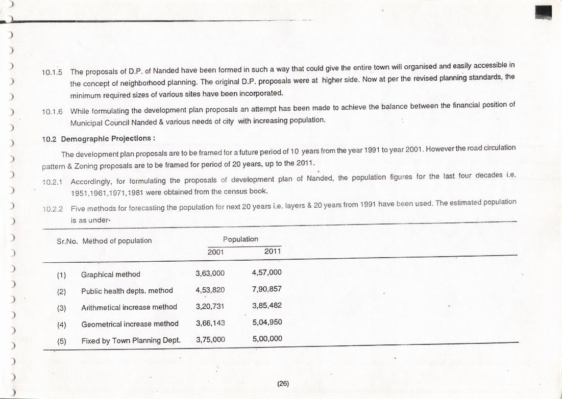
10.1 .5 The proposals ol D,P. of Nanded have been lormed in such a way that coLrld give the entile.lown will organised and easiv accessibl€ in
the concept of neighborhood planning. The original D.P. ploposais wel€ at highel sid€. Now at p€r ths revissd plaminb standards' he
minimum required sizes of various sites havs been incoQorated'
10.1-6 while formulating the development plan proposals an attempt has been made to achieve the balance beiween the financial position ol
Municioa|coUnci|Nanded&variousneed5ofcilywithincreasingpopu|ation.
102 Demographlc Projectlons :
The development ptan proposats are lo be framed lor a fulure Period of 1o years from the year 199'l lo year 200'1 ' Howeverthe toad circulalion
pattern & Zoning proposals are to be framed tor period ot 20 years, up to the 2011-
'10.2.1 Accordingly, tor lormulating the proposals of development ptan of Na;ded' the population ligures lor the last four decades ie'
1951 ,1961 ,1971,1981 were obtained ftom the census book'
10.2.2 Five methods for forecasting the population for next 20 years i.e. layers & 20 yeaE lrom 1991 have been used The estimated population
is as under-
Sr.No. Method of PoPulation Population
2001 2011
(1)
(2)
(3)
(4)
(s)
Graphicalmethod
Public health depts. method
Arithmetical increase method
Geometrical increase method
Fixed by Town Planning DePt.
3,63,000
4,53,820
3,20,731
3,66,143
3,75,000
4,57,000
7,90,857
3,85,482
5,04,950
5,oo,0oo
(26)
)
)
)
)
)
)
)
)
)
)
)
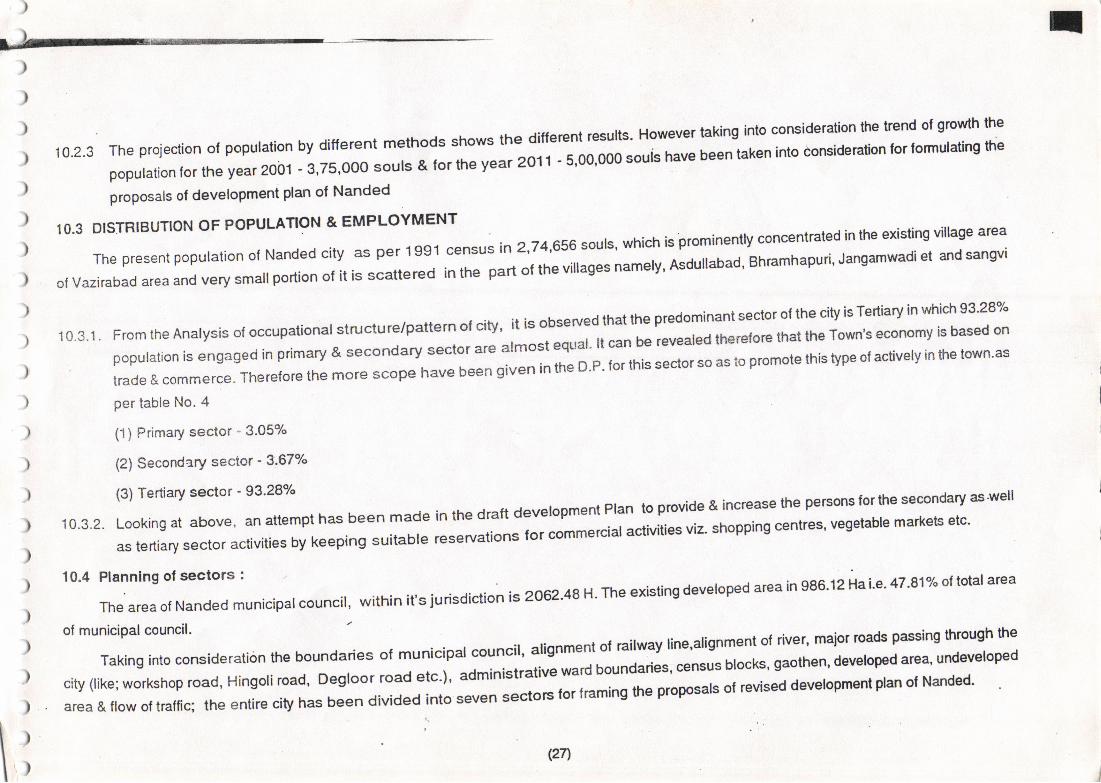
10.2.3Theprojeclionolpopulationbyditferentmethodsshowsthediflerentre6u|ts.Howevertakingintoconsiderationthelrendo|growththepopu|ationfortheyear2oi]1.3,75,ooosou|s&lorlheyear2orr.s,oo,ooo*"i"t'"*beentakenintodo$ideration|or'ormu|atinglheproposals ol development plan ol Nanded
10.3 DISTBIBUTION OF POPULATION & EMPLOYMENT
ThePresentpopulationolNandedcityasper,lgg.lcensusin2,T4,656sou|s,whichis-prominent|yconcentratedintheexistingvi||agea'ea
ofVazirabadareaandverysma||portlono|ilisscatteredinthepartofthevi||agesnamely'Asdu|labad,Bhramhapuri,Jangamwadietandsangv|
10'3.l.FromtheAnalysisoloccupationa|structure/patternotcity,itisobse'vedthatthepredominantsectorofthecityisTediaryinwhich93.2gT"population is engaged in pnmary & secondary sector are alm"", "*"i]i"""
* ,"vealed therelofe that the Town's economy is based on
trade&commerce.ThereforethemorescopehavebEengivenintheD.P.lorthissectorsoastopromotethistypeofactive|yinlhetown.as
in the draft development Plan to provide & increase the persons forthe secondary as'well
reservationsforcommercialactivitiesviz.shoppingcentres,vegetablemarketsetc.
Per table No' 4
(1) Primary sector - 3.05%
(2) Secondary sector '3'67%
(3) Tertiary sector - 93'28o/"
10.3.2. Looking at above, an attempt has been made
as tertiary sector activities by keeping suitable
t* ::::::"",-::]lt uni",p",
"oun",,, within it s jurisdiction is 2062.48 H.rhe exisrins deveroped arca in e86.12 Hai'e'47'81% of rotar area
" *r"H,
"i" -;siderarion the bound"lte. or muni"ip.r .o"i.,t ils11"* t .irwav rine,alignmeni of river, maiol roads passing through the
city(|ike;Workshoproad,Hingo|iroad,D€gloorroadetc.),administrativewardboundariEs,censusb|ocks,gaothen,deve|op€daGa,urdsvg|opedarea & ftow ot trafiiq rt
" "ntir" atv rr." Jlr"ni;"i;;; ;";
""aos tor traming the proposals oI revised dewlopmeot plan ol Nanded'
\i (271
J
)
)
)
)
)
)
)
)
)
)
)
)
)
)
)
)
)
)
)
)
)
)
)
\)
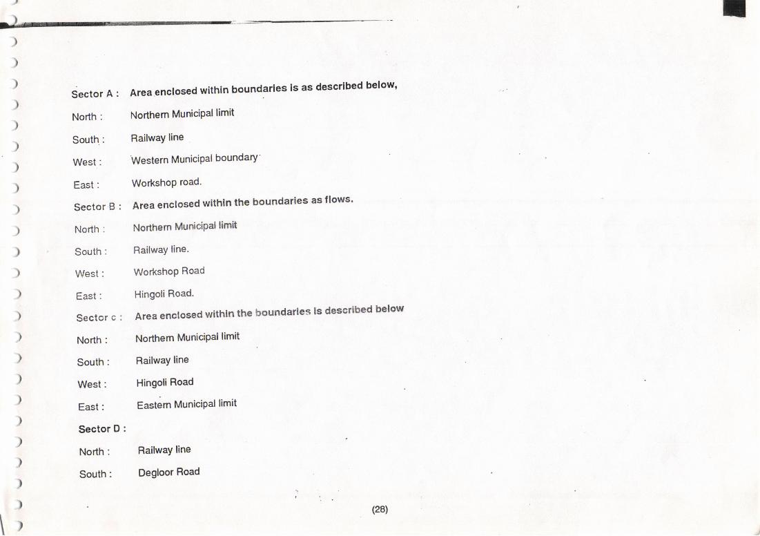
Sector A :
North:
Areagnclosed wlthln boundarles ls as descrlbed elow'
Northem MuniciPal limit
RailwaY line
Western MuniciPal boundary
WorkshoP road.
Area enclosed wlthln the boundarles asflows'
Nofthern ilhrr$ciPal lim&
RailwaY line-
WorkshoP Road
Hingoli Road.
Areaencloeedwtthtnthebotrndarles|gdeserlbcdbctow
Northem MuniciPal limit
RailwaY line
Hingoli Road
Eastem MuniciPallimit
Railway line
Degloor Road
(28)
t)TLr _t
)
Hingol,i Gate
Eastern MuniciPal limit
Sector E :
North:
South : '
West:
East:
Sector F :
North:
South:
West:
East:
Sector G :
North:
South:
East:
West:
West:
East:
)
)
)
)
)
)
)
)')
)
)
)
)
)
)
)
)
)
)
)
)
\)
I)
Deglooi Road
Godavari River
North-South road starting from degloor Road @ S'N' 94 &
runningaloqgwestemboundaryofwardno.T.vlaBekrichowk
towards south along the road up to eastem side of Fort'
Godavari River
Railway line
Godavari River
Bus-stand to Gurudwara chovrrk road & Nagina Ghat road
Westem boundary of sector E
Railway line
Godavari River
Westem boundary of sector F
Westem MuniciPal boundary ,r
(2e)
)
)
)
)
)
)
)
)
)
)
I
)
)
)
)
)
)
)
)
)
)
)
)
\r\
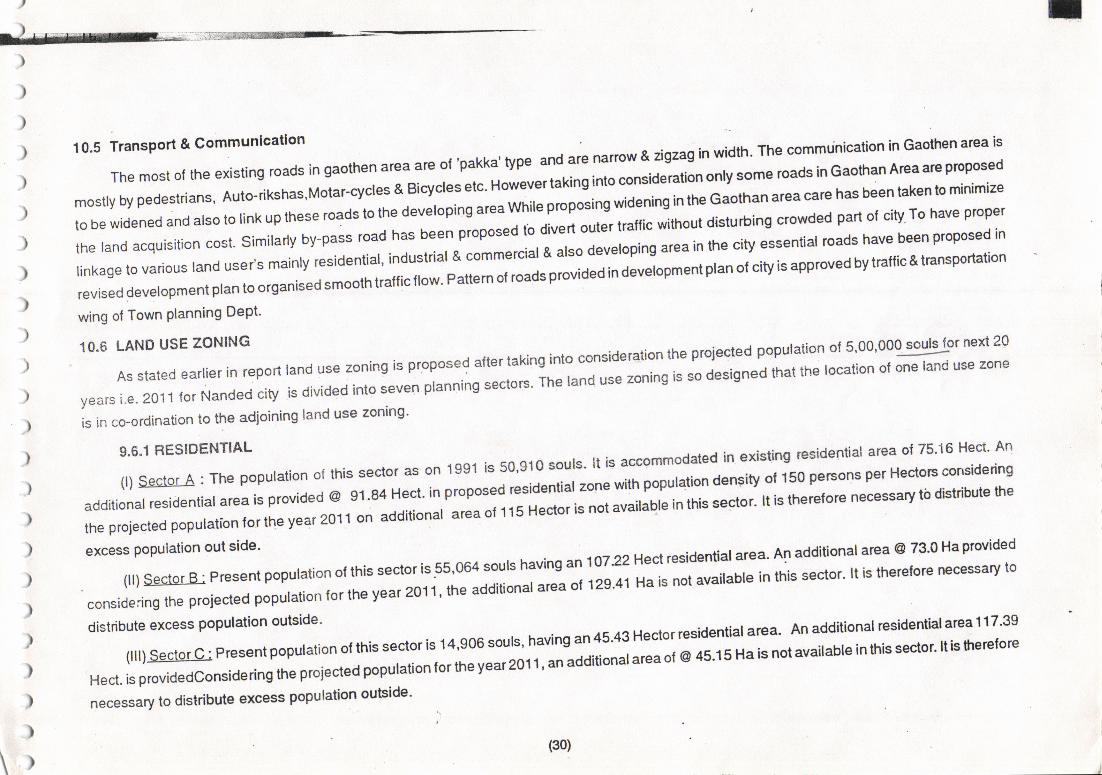
10.5 Transport & communlcailon ication in Gaothen area is
The most of the existing roads In gaothen arca are ol 'pakka' type and are nanow & igzag in width' The commun
mostly by pedestrians, Ou,o-n*n"",rorlir"*l* O"""" *". rot".r"rlafing;;conslOeration only some roads in Gaohan Area are ptoposeo
to be widened and also to tinr up tn""" rolo"-to the developing areawnire p'opo"ini *io"ning inthe Gaothan area care has been tiaken io minimize
the tand acquisition "o"t.
si,nir"ny oy-p"ll ,o"o tru" o""n propor"a ro oiu"'t oui"'-' r'"nic wirhout disturbing crowded part ot city To have proper
linkage to various rand u""ru ,",n,y ,""-id"ntial, industrial & comm"*,", u ",".
d""""-o"n area in the clty essential roads have been proposed in
revised devetopment pt.n to org"nir"o ";;;;atrrc rrow. pattern or ro.a" p.ua"o ln a"u"ropment plan ol city is approved by traflic & transportation
wing ol Town Planning DePt'
to.6 LANDUsEzoNING -,-^^r -{r-,r,r.ind inio consideration the proiected populaiion o15,00,000 souls lor next 20
,".,"i:"":XTl;1'X'iJJ::J:1ffi:"::Jl:i$'Jffff:::l:::?':'l..:i;";;;'sso jesiqnedthatttle'ocationo'one'andusezone
is in co-ordination to the adioining land use zonlog'
9'6'1 RE.IDENTIAL I is accommodated in existing tesidential atea 0175'16 Hect' An
"o.nJl"Jrffi,,.lli#:u;il:':$1;:'1ff:::;:::::::'i""::':1";"1'iil'pop'uriona"ns'tvoll:0p::':nseerHec{oBconsidednsthe projected poputation to, tt. y"", zJt r-on additionat area of 115
'"O- * ,',"i""niiot"
'n'tnt' """o'' tt t" tn"'"tore necessary tb distribute he
excess population out side' .^,,r. h.win.' an i 0732 Hect residenlial area' An addiuonal area @ 73'0 Ha pro'ided
"""",j'jl"*n*"o-l"l"i"ifi:,".,i::t1,'lffiiL''T:^':.il::i::Ti'nll t'n""'*'uabreinthissector'rtisthererorenec€ssaryto
t"ttT;ffL"J::t:: ;il"*" "
,no *.or is 1 4,e06 sours, havins an 4s.43 Hecror residenriar area' An additional residential a'ea I 1 7'3e
Hect. is providedconsia"ring un" prol.ald;ffin to, tne y.., zo.| t,.".oo**d""" or @ l5't5 H" i" not tuailabte in this seclor' ltis fprelore
necessary to disttibule excess population outside'
(30)
)
)
)
)
)
)
)
)
)
)
I
)
)
(31)
)
)
)
)
)
)
)
I
)
)I\rl'
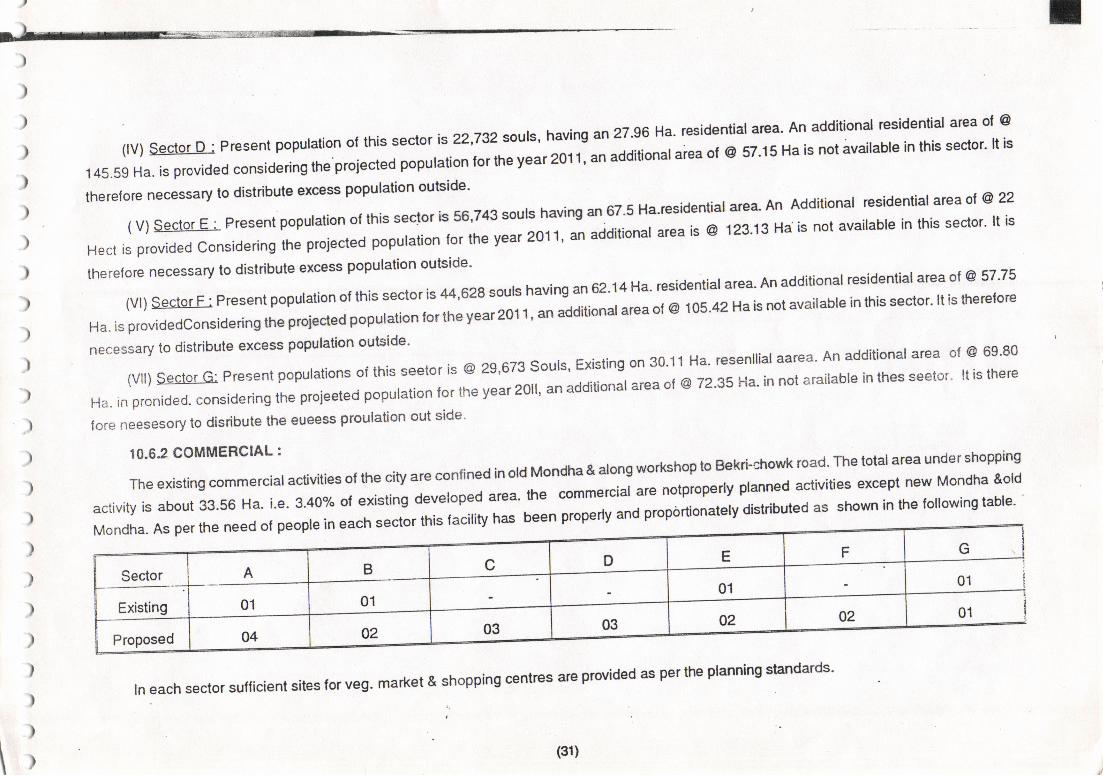
ltvlsectoro:Pre"entpopu|ationo|thissectoris22,732sou|s,havingan2T.96Ha.residentia|a!Ba.Anadditionalresidentialarcao|@145.59 Ha. is provided
"on"ia"dng the p.i""red population foI the year 2011' an additionalaiea ol @ 57'15 Ha is noi;vailabl€ in this sector' lt is
therelore necessary to disttibute excess Populaiion outside'
(v)$gc!qr-E;Presentpopu|ationofthissec'tolis56,743soulshavingan67.5Ha'Iesidentia|areaAnAdditiona|residentia|ateaot@22
Heclisprovidedconsideringtheprojectedpopu|ationfortheyear2oll,-.aaitio*[email protected]|ab|einthissector.|tistheretore necessary to dist'ibute excess population outside'
(V|)sectorF:Presentpopulationo|lhissectoris44,623soutshavingan62.14Ha.residentia|area.Anadditiona|[email protected]
Ha. is pfovidedconsid"ring th" p,oi"o"d p;pu;n tortne yearzot t, an additionalarea ol @ 105'42 Ha is not available in this sector' lt is lherctore
necessary to distribute excess population oulside'
(Vl|)gertgiIciPresentpopu|ationsofthisseetofis@29,673sou|s,Existingon30.,1lHa.resen||[email protected]
Ha. in pronided. consiaering tl,e projee;Jp.O",.O"n ",
,n" ,".r zotl, an aacmonit area ol @ 72'35 Ha' in not arailable in thes seetor' lt is there
fore neesesory to disribute the eueess proulation out side'
10.62 COMMERCIAL :
The existing commercialactivities o{ the city are confined in old Mondha & along workshop to Ebkri-.iowk road--The total area under shopphg
activity is about 33.56 Ha. i.e. 3.40% ol existing developed "r".. t" -rr"r"i"i are notproperly planned acliviiies except flew Mondha &old
M.tndha. As oer the neea ot peopte in eac-ti"""i""*o o"u,r, n"" ueen propeayana proportionatety dist'ibuted as shown in th€ following iable'
1--Mondha. As Per the ne
E F Gc D
Sector A
01
B
0101
01
01Existing02 02
03 03Proposed 04 02
rn each sector suf{icient sites for veg. market & shopping centres are provided as per the planning standards'
)
)
)
)
)
)_
)
)
)
)
)
)
)
)
)
)
)
)
)
)
)
)
)
)
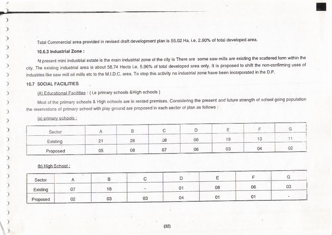
Total Commerciala.ea provided in revised d.aftdev€topm€nt plan is 55'02 Ha' i'e' 2'90% ol total dewloped arsa'
10.6,3 Industrlal Zono :
4t present mini industrial esiate is the main industriat zone ot the city is There ars some saw mills are existing the scatteted form within lhe
city. -the existing industrial area is about 58.74 Hects i.e. 5.96y. of total developed area only, lt is proposed to shift the non'confirming uses ol
industries like saw mill oil mills etc to the M.|.D.C. ar€a. To stop this activity no industrial zone have been incorpoEted in lhe D'P'
10,7 SOCTAL FACTLmES
(Al Educational Facililies : ( i,e pdmary schools &High schools )
Most of the primary schoots & High schools afe in rcnted premises. considering the p€sent and lulure strenglh ot school going population
the reservations of primary school with play ground are ptoposed in each sector of plan as follows :
(a) primary schools :
Sector A B c D E F l:
Existing 21 26 08 06 19 13 ali!
Proposed 05 08 07 06 03 04 02
(b) High School :
Sector A B C D E F G
Existing 07 18 01 08 06 03
Proposed 02 03 03 o4 01 01
(321
;l
)
)
)
)
)
)
)
)
)
)
)
)
)
)
)
)
)
)
)
)
)
)
)
)
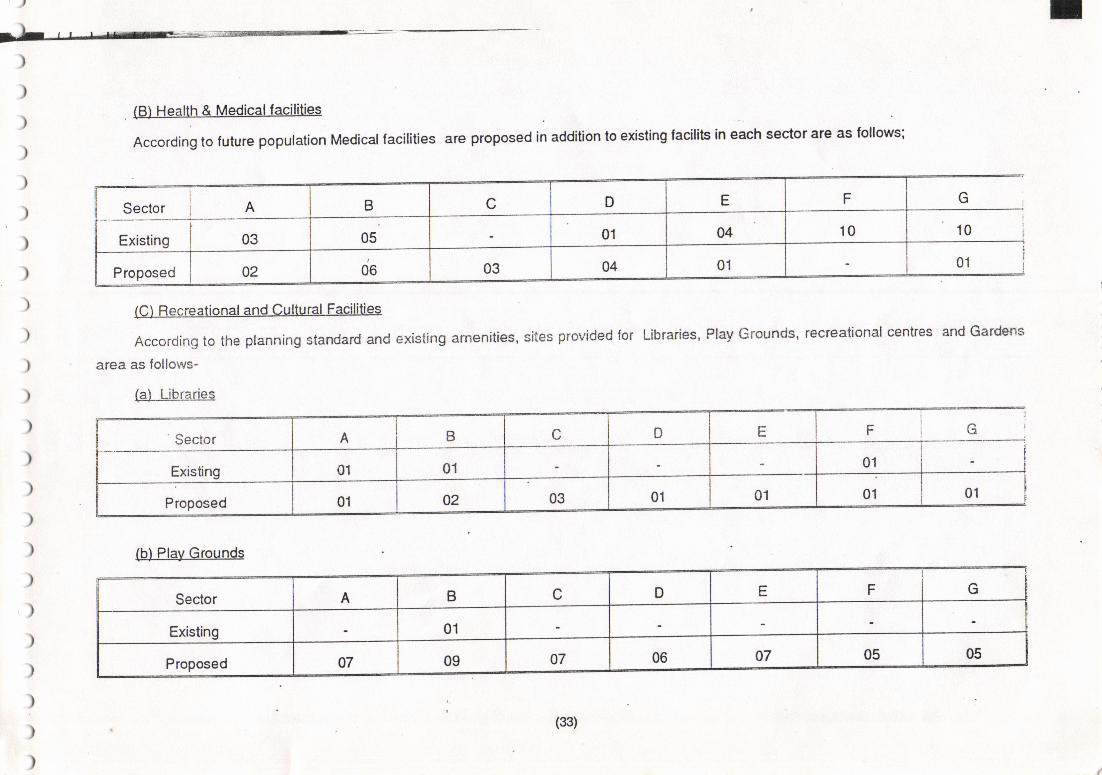
(B) Health & Medicalfacilities
According to future population Medical facilities are proposed in addition to existing facilits in each sector are as follows;
I
Sector i A B c D E F G
Exislino 03 05 01 04 10 10
Proposed 02 06 03 04 01 01
(C) Recreational and Cultural Facilities
According to the planning standard and existing amenities, sites provided for
area as follows-
(a) Libraries
Libraries, Play Grounds, recrealional centres and Gardens
Sector A B c o E F L:
Existing o1 01 01
Proposed 01 02 03 01 01 01 01
(b) Play Grounds
Sector A B c D E F G
Existing 01
Proposed 07 09 07 06 07 05 05
(33)

)
)
(c) Garden
Fi10i
q10
A
03
02
ii Sector IY-----iil Existing it:--,-__-----tl
II ProPosed i
B c D E
0405 01
'04 01 006 03
|nsomeseclorsaleaisnolavai|ab|etoproviderecrealionalandculturalaclivitiesasperp|anningstandaldandhencecarehasbl3entaken
)
)
)
)
)
)
)
)
)
)
)
)
)
)
to provide these lacilities considering the need ol overajl civ'
IO.8 PUBLIC UTILMES
.10.g..1 rt is observed that the existing Buriar Ground and cremation Grounds are in the city at various places al Northern bank of the Godavan
rive. only.
Todeve|opsomeexistingsitestheyareproposedintherevisedDrattDevelopmeniP|an.|nadditiontothesesilessomesiieso|Bufia|groundsandcremationGroundareproposedintheNorthside,We"t"lae.nae.st"ioeotthecityaccordingtotheneEdsofthepeoples
in that sedor.
l0.s.2Theexistingtrenchinggroundislocatedinthedeve|opab|eareaolthecity.Briskdevelopmentofresidenua|actirilyistakingp|acearcunothis trenching ground *o t"*"'" t"" 'earden' site is proposed in this area ol Trenching ground'
.lo.S.3Revisedwatersupp|yschemesarebeingpreparedandexecutedbyEnvironmenia|EngineeringDepLNandedandhandgdo\,erto|he.
Municipal council for working and Maintenance pdryose. In consuna;n with the above Depi' and Municipal council's engineer; various
siles tor elet'atad storage Besewoir ars Fserved aE per tequitements'
\,
(34)
,) E
)
)
)
)
)
)
)
)
)
)
)
)
)
)
)
)
)
)
)
)
)
)
)
il
10'9 HoGlng nrooerti€ may be aftected' Therelore it is obligatory lo mak€ pFpel
white imptementing the oraft Development Plan proposals ""T-:,:^H;,"p;"r-o* o""r",*'t "its
No. 4{ is res€wed as'Hor'rsing
."'";;;;;;;;;;o']'t'to''o* ot tn" tamities alrected bv the proposars or I
for dishoused'lor purpose. , -.--^ 6^--i N'nded. cw is dectared as a Holy city and Holy city plan is prepared' Fof
Atthe same time some s es are reserved for Gurudwara Board Nand-*il;;;;;""d thisGurudwaraare requir€dto be demol'rshed'
*. ;;;";;;;;ttris otan centd^c#",fJffi*':ijl}'i,l'iJ,'"L" 0"".The alfected lamilies can be accommo
';il."-'o,.o".,;;:.:il"',,il"ff:;:::::::tHilln"ntution""uit"uesi,eshavebeenreservedintf*RevisedDran
Development plan ol Nanded' ,,-- r-Ll^ N^ 16 and accordingly appropriaie aulhodties (i'e- Name of the Oept') lor its
These reservations are included in List ol reservalion Table No'16 an'
a.v"topment is shown in that table against the reserva$on'
f,o0
(35)

/)
_Ert::-
XI PROPOSALS FOR IMPROVING EI{T/IRONMENTS OF THE CITY
INCLUDING OF PRESENTATION QUALITIES OF IAND SCAPE
ll.lPortionsolna||asf|owingsoulhward&iurthermeetingtoGodavaririve|shou|dbeconnectedwith|ormingsing|e|argel.lal|aparal|e|toGodavari.
This water must be lirst treated in the plant and subsequently allowed to llow into rtuer warsr'
'|1'2Whereversulficientspacesareavai|ab|e,suitab|etandscapingwithdecoEtive|ighting,concretebenches'pathwaysshouubedeve|oped.
11.3|mporiantsquareso|junctionsshouldbeproper|ydeve|opedbyprovidingtrafficis|ands&lountainswithdecorative|ighihg.
11'4TreeplantationonbothsidessofimportantroadsshouldbetakenontopprioritybasisbyMunicipa|counci|withthehe|po|sociallorestrydeveloPment'
(a) A 'Smurti Vruksha Yoiana' shall be execuled with the help ol Public padicipation'
(b)The social institutions shall be encouraged in imptementalion ol road sid' plantation ol trees'
11.5 Every plot holder or Building owner shall be clmpelled lor planting at least five t|ees in his own premises and grown up'
i1.6 Aschemeshourdbeworkedoutbv thecouncirrorencou,.3'T,t:ffj"r::#.":|iilffji:'#"""]i:ffi:"r:##l'Jtlit'l;
';;,1;;:xru;*"Tffiil;1",::'ffil'iiilxl"'lTJjl?;.J"'*';u*'o^"'streetrum ure'citvBusstops''vove."etc
ooo
(36)
)
)
Xu IMPLEMENTATI.N oF DEI/ELOPMENT PIAN: PHASING:
t" ;:'",:::::::":r::-"il"];::"d provides a broad our rine ror deveropmenr & expansion' rr is.nec€-ssarv ror Prannins Authoritv to
charkoutthephasedp,os,."""""o'di['io*ii"iu"'io'""i*'"t"tl::::*lJ":H*lXf#i:;::"""''"tTi-TXl#li'lY;;;;;;;;;;; J pro-sramme paoiry has to be rixed' considerins the nee(
improve existing condition ^L ^ -^-^^,^.r ^i .rF<i.nated sites shal hav6 to be acquired v{ithin the period ol 10 years lrom
12.1.1 As per the provislons of M R'& T'P' Act 1966' the reserved or designate
date oi enfotcement ol the development plan'
12.1.2 In view ol provisions in Acl lt is absolutely necessary to have a phased programme to acquire lhe reserved sites'
12.2 MANNEF OF IMPLEMENTATION :
sites reserved & arso othef proposars from in deveropment pran can be implement€d by following ways'
(1) By way of Prlvats Negotlatlon : . ,- -^^^-,6'{ ih rhe .tevetooment
P|anningauthorilyhastonegotiatewiththe|andowne6whose|andshavebeenrese'v€dinthedeve|opmentp|antorpub|icpulposeby
urging them importan"" * n"""""''y 'oi'J"'"""n
t"i'L*"' 'n"
o'"""'"91t't1n" "n"u" "n"' **"*0" "'ue
lo the land ownet' on the Basis
ol land value decided ov town prannrng
*a-Jalua'il oept'which will be helplul in negotiating Land owners'
fl'J:::*:[:H:::T'fi:lJll*'''*' *" '11;1'1'l,Authodtv
mav ,"ke recouse to prcvisio"" or s€c"126 o' M'R'& r'P'
Acl.1e66 readwirhsecliono or ranancquisition Acr.1Be4. underih" "no*",i,""i i""*1"*""'."11-"Y11:T'ff"ffjJil"iT'fi:
can be compulsory acq,i'"a' er"nnlngi;ry however should stad theacqjisiiion proceedings wsll in advanc€ so
lor development ai prop"' tit"' rn" JJl"i*ii n]* "
t*" n""""sary budget pro/isions tor acqrisition per year'
(34
')
)
)
i)
)
)
)
)
)
)
)
(a) By Preparlng Town Plannlng Schemes
prop.osals of dratt development plan can also be implemented by making Town planning schemes under sec'60 ol M'B' & T'P' Act'1966'
Advantageolpreparinglownptann|ngschemeisthatthePlanningAuthorityisnotrequiredtobearentirecosto'imp|ementation,astheparlofcost or implementation is also shared by the owners in lown planning schemes are by way of incremental contribution' Planning Authotity may taKe
up town planning schemes in consulialion with town planning & valualion department'
(4) For Govt. Lands :
fi Land reserved in deveropment pran lor any pubtic purpose is owned by the GovL the ptanning Authority should approach the collector ot
District lor Grant ol such Land as per Govt inV'D D's ckcular No' IND/108329230€R 2071/G-5 dated28'10'83
(5) BY WaY Ot Flnanclal Asslstance :
UHBANDEVELoPMENTScHEME:Financia|assistancetoMunicipa|councilslolimp|ementationofDeve|oPmentPlanproposa|scanbe made available from UD-6(a).
SinceNandedMunicipa|Councilbeing'A.c|assmuncipalconcil
in aid & 66.667ol" load assistance under UD-6(a) schemes'
withpopu|ationof@2,75,000Sou|s.Thereforeitise|igib|e1or33.33%grant
12.3 PHASING:
Aphasedprogrammepreparedfoiacquisitiono|varioussilesisshownintabteNd.'lgThisprogrammeischa|kedoutwithconsidedngtrendofdeve|opmenl&needso'|oca|ity'TheplanningAuthoritymayhoweverchangethisp]ogrammeconsideringlrgeney&financialcondition|naddition to above, public sites the pranning Authodty May take up the work ot coistructon of new roads & widening ol existing toads as proposed
in develoDmenl Dlan.
noo
(38)
_.--.:i..-..:;:E;,
XITI DEVELOPMENT CONTROL
13.1 Buildlng Bye-laws & OeveloPment Conlrol Rules :
13.1.1 Introduction: ltis necessary tor elfective implementation ol development pian lorthe cilies to have aset ol rules and regulations wilh the
P|anningAuthoritytocontrotoevetopmentandtopromotedeve|opmentonorder|y|ines'Thestandardizeddeve|opmentcontrolru|esare
approved by the Govt' for A,B & C Class Municipalities'
,.tr.;;;;;;"r"""""-""tr'"towersconrerredbvsub-section(r)oJS€cton2::::11:1T:i:*"JI.1Hli:l,llljti,*"'"i'"iil:l':$:"':,ffi:fffiJilffi'"-;;.-**""*:::y:::::T:::1:i':::,:5trffiiTl'l1"Jll11lllXl,?'lll1lllili,ffiff:fil:ffi:""'"''*;'';;;;''"''^"Yl'l'il.llll,'1"3'"ijl',i1.1i1-;llilfillii:illiil',.f,Ti:oul;il.J.ljllTill^;i,;fl:fi.ilil'";;;;"0 'u,,o.n
Bve-raws and oeveropmentconrro! Rures ror'A'crass
MuniciPalities.
13'1.3App|icationolRulesiTheByejawsandru|esmadebytheGovt.lor,A,classMunicipa|itiesandadditiodomissiorva|terationintheseby€.|awsandru|esmadebytheGoVt.&circ!|a'issuedfromDkeaoro|TownP|anning|romtimetotimesha|lcomeintolorcef'omtheenfofcement this development plan, and the-se shall replace all existing building bye-laws and development control rules ii lorce framed
under MRTP Act,l966 and M'M' Ac!1965'
Thebye.|awsandrulessha||app|ytothebui|dingactivityanddeve|opmentwo*on|andswithintheJurMic{ionofNandedMunicipa|Council-
13.'1 .4 Rules lor Area within the Flood Zone'
(a) No development permission is allowed within a arca between lowest llood level (354'00 m) and River'
(b)Areawithinthe|owestf|ood|eve|(354.00m}ardhighestltood|eve|(356.70m)isa||owedfordeve|opmentina|imit€dsense.Deve|opmenlpermisslonwi||begivenwithintherGidentia|area-0.n"".'o,,."o*tructedshou|dhavoap|[email protected] plinth level @ 356.' ,'t
"i i.' *" ,"an sea level ) whichever is maximum and with necessaty safely measures'
(3s)

ll r)
)
)
)
)
)
)
)
)
)
)
)
)
)
)
)
)
)
)
)
)
)
13.2
13.3
rmprementation of Re'enied sites in the sanc{ionsd deverop.nent pran rn co-op€ration sih ths p€opl.:
UnderSeclionlS4o|theMRTPAci,1966Govtoti,aharashtrahasgiv€nthedirsctiongbyGo\'tReso.NofPs.logdcRn4/g4vD4dt.7-4_1994. Ttre proc€duE and rures givsn in t," abovs direcdws sha|| bs appllcable to the imPlementation ol reseNed slles in fi6
development plan ot Nanded trcm ths enlolc€ment of lhE Dewlopment plan'
Rdtes lor this proc€dur€ ars given in Appendix'A' ,hao tlorn tre tana
Transler of Development Righls : In cedain circumshnc$' the dw€lopment poiential of a pttt d land may be sepaE
itsetf and may be mads availabte to th;;;"","i *" L"O ," a" tm ol transl€rable Dewlqpm€nt Rig s F D'R')' Thes€ dghts may be
r"a""u"if"Ot" "na
U. subiec't to the Regulauons in Apperdix I heleto
o0il
-
APPENDIX-I
RegulationsforthegrantofTrans|erab|eDevetopmentRights(ToR)toowners/deve|opersandconditionsforgrantofsuchRights:
Theowner(or|essee}olaplotof|andwhichisreservedforapub|icpurioseinthedevetopmentplanandforadditiona|amenitiesdeemed
to be reservalions provided in accordance with these Regulations, excepting in the case ol an exisling or retention user or any required
compulsory o, recreationatopen space, shallbe eligible forthe award ol Tranierable Development Rights (TDR)in the form ot Floor space
lndex(Fsl)totheextentafldontheconditionsse|oulbe|ow.suchawardwi||entit|etheownerofthe|andtoFslintheformo|aoeve|opmentRights Certificate (DRC)which he may use himself ortransfe' to arry othet peFon'
subiect to the Regulation r aDove, where a ploi ol tand is reserved for any purpose specified in section 22oi Maharashtra Regional and
iownPlanningAct.'1966,ttleownerwi||bee|igio|elorDeve|opmentRightstotheextentstipu|aiedinRegulations5and6inthisAppendxhadthelandbeennotsoreseNed,afterthesaid|andissurrenderedlreeolcostasstipu|atedinRegu|ation5inthisAPPEND|x'andattercompletion of the development or construclion as in Regulation in this Appendix if he undertakes the same'
Deve|opmentRightsareavai|ab|eon|yincaseswhe'edev..|opmentola'eservationhasnotbeenimp|ementedi-e.TDRSwi||beavai|ab|e
only lor ptospective development of reservatiotls'
Deve|opmentRightscertificates(DRcs)wi|tbeissuedbythechielot|icdr/commigsionerhimse|f.Theywil|state,infiguresandinwords,the FSI credit in squa. ,o"*
" *" o"in p area to *hich the owner or lessee ol the said reserved plot is enlitled' the place and user
zone in which the ORs are eamed and the areas in which such cGdit may be utilized'
The built-up area for the purpose ot FSI credit in th; form of a oRc shall be equatto the gross area ot the reseryed plot to be sunendered
andwi|tproportionate|yincreaseordecreaseaccordingtoth€permissib|eFslolthezonewhe|e|romtheTDRhasorigina|ed.
when an owner or lessee also develops or conslructs the amenity on the surrendered plot at his cost subiec{ to such slipubtions as may
bepresc.ibedbythecommissioner/chielot|icerorlheappropriarsauthority,asthecasemayb€andtotheirsaiis|actionandhandsove|the said developed/construcied ameniv to the chiet officer/commissionejappropriate authority' lree of cost, he may be granted by t''e
I
L.
4.
q
6.
(41)
t'--:
1
?
commissioner /chief ollicer a lurther oR in the lorm of FSt equivalent to the area ol the constructiorvdevelopment done by him' utilization
li*i'"n .i" lau, * "ubiect
io the Bbgulations contained in this APP€No|X'
A DFIC will be issued only on the satislactory compliance with the conditions prescribed in this Appendix'
IlaholdercfaDRcintendstotransterittoanyotherpeIson,hewil|submittheDRctothecommissione'/chie'of|icerwithanappropriateapplicationfolanendorsementolthenewholder,sname'i.e.translefeeonthesaidcertilicate,WithoutsuchanendoFementbythe
commis:ionerhimge|l,thetranslershallnotbeva|idandthecerti|icatewi|lbeavai|able|oruseon|ybytheear|ielorigina|holder.
Aholdero|aoRcwhodesirestouselneFSIcreditcerti|iedlhereinonapadicu|arp|oto||andsha||attachtohisapp|icationlordeve|opmentpermiscion valid 0RCs to the exlent requlreo'
||rcsDecliveofthe|ocationolthe|andinwhichtheyoriginate.oRcsshal|notbeusedinlhesectorsE,FandG.Theymaybeusedin Sectors. A,B.C and O'
A ORC .hall nol be valid tor use on receivable plols in the aleas listed below:
a) Area \./tthin 1OO m. lrom the Air strip boundary'
b) Area vrilhin 50 m. lrom Centre ol Bailway Overbridge at Shivaii Nagat'
IU
ll
(421
)
)
)
)
)
)
)
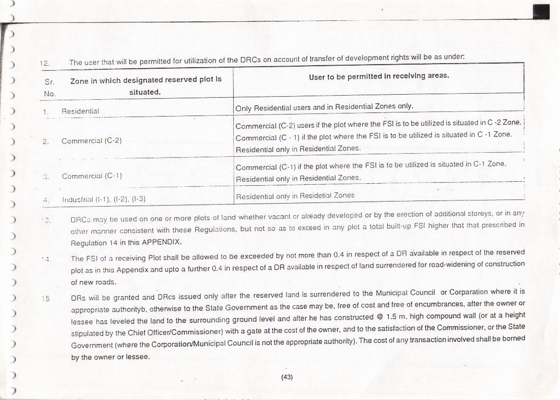
la. The user that will be permitted for utilization of the DRCs on account of transfer of development rights will be as unden
Sr.
No.
Tone in which designated reserved plot ls
situated.
Only Residential users and in ResidentialZones only'
User to be permltted In recelvlng areas.
I
)
)
)
)
)
)
)
)
)
)
)
)
)
)
)
)
)
)
)
Residential
2. Commercial (C-2)
Commercial (C-1) if fhe plot where the FSI is to be utilized is situated in C'1 Zone.
Commerctal (C-1) Residential only in Residential Zones.
lrrdusf rial (l-1 ), (l-2), (l-3)
I
lResidential only in Residetial ZonesI
DRcsmaybeUsedononeolmoreptotsollandwhethelvacantcrakeadydeve|opedorbytheerectionoladditiona|storeys,o.|nanlolhermannerconsistentwiththes€Regu|ations'butnotsoastoexceedinanyplotatotalbui|t.upFS!higherthatthatprescribed.nRegulation 14 in this APPENDIX-
theFS|olareceivingP|otsha||bea|lowedtobeexceededbynotmorethano.4inrespectolaDFtavai|ab|einrespecto|therese'vedp|otasinlhisAppendixandUptoa|Unhero.4inrespectotaoRavailab|einrespectof|andsurrendered|olroad-wideningo|construction
of new roads.
^-h, rfta. lha rF<Erved tand is surendered to the Municipal Council or Cotparation where il isORs will be granted and DRcs issued only alter the resewed land is surent
approprialeauthorityb,otherwisetotheStateGovernmentasthecasemaybe.lreeofcostand|reeolencumbances.af|ertheownerortessee has leveled the tand to the surrounding ground level and atter he has constructed @ l '5 m. high compound wall (or at a height
stipu|atedbylhechielo|ficer/comm'ssioner}withagateatth6costoltheowne',andtothesatis,actionolthecommissioner,ortheSlateGovernment (where the corporatiory'Municipalcouncilis not the appropnate authority). The cost ot any ransaclion involv€d shallbe bomed
by the owner ot lessee.
(43)
a
I
I Co**"r. ial (C-2) users if the plot where the FSI is to be utilized is situated in C -2Zone.
lao..n"r.ial (C-1)if theptotwheretheFSl istobeutilizedissituatedinC-1 Zone.I
I Residential only in H.tffi

t'')
)
)
)
)
)
)I
)
)
)
)
)
)
1 il
r3
Withanapp|ication|ordeve|opmentpermission,wherganownerseeksuti|izationoloBs,heshal|submittheDRctothechiefollicer/commissionerwho shal endorse thereon in writing in ligures and words, lhe quantum ol the DRc proposed to be utilizea' belote granting
deve|opmentpermission,andwhentheoeve|opmentiscomp|ete,thechiefot'icerrcommissionersha||endoFeontheDRcinwri|ing,in|igures
andwordg.thequantumo|oRsaclual|yuti|izedandthebajanceremainingthereafter,ifarrybelo.eissueofoccupationcedificate.
ADFlcsha|lbeissuedbythechie,oflicer/corimissionerhimse||asacer|ilicateprintedonbondpaperinappropdaielomprescribedbychieiollice/commissioner.Suchacertilicatewil|bealrans|erab|e.Negotiab|e|nstrument.alterdueaulhenticationbythechiefolf icer/commissioner- The commassloner/chief ollicer shallmainlain a registerin a lolm considered appropriale by him ol all transactions'
etc. felating to grant ol utilization ol DRs.
The currendered .eserved land lor which a DRC is lo be issued 3hall vest in the Municipal Counciucorporation or the State Govetnment'
lflhc;rpDropnateaUthorityisotherthanlheMunicipa|councivcolpolalion'andsUch|andsha||betranslerredinthecitysutveyFlecordsilllhcl)o.n(}oithecolporiliorvMun|clpslcounciIorthestateGovernment,asthecasemaybe.andsha||vestabso|UtelyintheMunicipa|
councrl/corporation or the slate Govemment. The surrendered land. so trsnsterred lc the state Govemmeni in respect of which Mun'cipal
councl|/corporationisnottheappropriateauthority,may'onapplication,lherealtefbea|lottedbythestateGovemmeniislavouroflheconcerned authority, which may be a state or central Governmenl Departmeot, Authority or organization, or an other public authority or
organisation on appropriate tetms as may be decided by the state Government'
Thechiefollicer/commissioner/appropriateaulhoritysha||drawupinadvanceandmakepub|iclromtimetotimeaphasedannua|
;;;;;" ,:,;;,;, a 107o variation ro deat with emergency deveropmenr ) for urirization of rDFls in the torm ot DFrs, priorirising rcvised
(draltorsanctioned)deve|opmentp|anreservationstobea||owedtobesUrrenderedandindicatingtheareasforlheirUti|izationonreceMng
ptots. Notwithstanding this, in urgent cases the chiel oflicerrcommissioner/appropriate authority, may lor reasons lo be recordedin writinE'
grant DRs and as and when considered appropriate and necessary'
Development Right witt be granted In respect of FSI only and atl other building byeJaws are as per the present bye'laws'
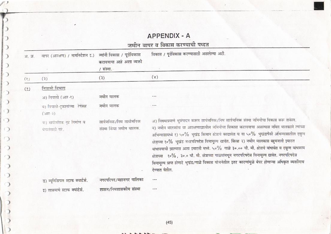
)
)')
)
)
APPENDIX - AEilfiFT EITw a fT{r€ Ewqr* quia
q. n. qrr{ (3TITe{ot1 7 qrtfrmm E.) 6qifr fqmr€ I $ftffiq6{riFrFn eili sfin qfri/ dF{r. -
k+,rs / TikflT c-r"<tst?fi' sr€+flI 3r&.
(v)(r)(?)(\)
)
)
)
)
a,
)r)r')
r)()
..)
')
)r)
r),)
)t)
r)I
{)
Frdrst Frrnr
,r1 itra'rm (3Tr-?.)
al kTnlt-fr,r+i-t{r
(rrR-i)
z1 rir;iai:izn yr ianiV aj-+--: -;'l'{1l.lltl '.1r.
s; qirisra €t.r r€Irld'.
3) Yn€rri raq'€ia{'.
qdq rTrdrdn'
;rdq qrfir5,
rrr;i:iFrc'd:rqrrriqifi F
6p41ftiar;rqr+ qr.;rn.
arRqflqqfFfrflR qrks,r
spr+fiqrtrs6|c iwr
:r) fr<nrrlrat Si'nqc q;-sq' T{rjqfuFlilq s6iqf75 dPrt qffiqr fEr+.ta E6'l^ vr6a.
a1 qfr4 rflFroiqr ?Tr 3iRs{rrnsrffa qftnieT fsCI.rg trfl?rqrin 3nrFrg qftT" xtaqn RiqI
$rfirrqrffrqd t) q"o/o $s FFqr+ qH'?Frdrfir q qt \o7o 5ticl.l-d' glfiFrT€rdTf, qRTT
eiqrqr q"96 5ef€ Tffftri+s ftHr1a4 Erqil. ffiEr r) e*+ qrcmrs crgrqd gr1a
rhnqqr* "rtzns
swr ?crcfr c.,4. q"7o q$ lo.oo "n. *. eH Ettn+d q (flT qiq*,tq
st11qT loof6 , Qo.o d. df. et=rrqT qtaaiqt1t ctR'ffic Ffir{dq ar+d. qrr{'qfur<q
fuqrTq rrq FfsrR Tis/'n* fams qFrtdrfi 56 errurfui *qt dqrqr $firf.fi ffiiuqra naia
i
tdSl\ '-,
\ al l\^.
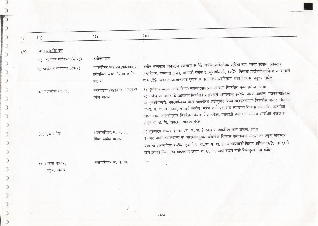
)')
(x)('. ) G)(?)
G) qrisnq faqrr
a) T4rFrr qTfrrq (ri'-ql
a) niiir€ aTFrrFi (:i-i)
q7 fa;r';1,t2 arrTp,
131 qor,H ?r,?
(r ) Eat el=rni
qlq ErsR
Efrfirfi-*,
arrqilqqTq".r+T{'crid-cnrc
n iqFFF rtF4r tFEr qqn
qrffF.
qrrrqirr</qf r:rTrqtftqr;u;
rqtq q'rirfr.
(awq;6q-q7q. T. rtt.
ftF€Ir Grqiq qiitlz6.
qr11rrftr1<l c. ?. qT.
il'rq qkrfiI+ fuen€la'Atar€ tq% ;rqiq {Tdqrffi qrqql 3qI' srq{ TaYH, fdF^fr6 .
TFrg{Ft, qvqrfi zr+i, {Fraft qefr-+, 1. sfurrigr&, a"o/o fu criTrc qtfi[q Erm€ra
q qqTo cm ?raErq(qrdn Eq.n a trt sliiqr/Tft€Irg 3g fu+rt 3rtic rcfd'
q) lit$crfi 5'6':1 qrKqf,rr<lqrr+tnqrkot 3IRqlTI ffid ms vrca' fuqr
il qqrq qr€FFti{T t 3lnelsr ffifia sllqr{ 3Tstqr€ ?"7o qrtl'd'3Tr{ffi'
qi Tr.4ftrfit, =rrgqfir+l qi-* r{rir,rirTr 3T81gR fiiqr qTrffir ffia qrrTp qTK{ a'
qr/q. a. q1. n fer+rg*r iltti i{r'r,T. 6rpi wrnnmra Ffi?r' lT ftrdl-€ qbr+-drd rwtidcr
h.TrrrkTta aRqfi111q ftr6fffi orrn is r1+l1. r.{Tgd qricr rna-+i-ra 3TRierd sftF{iryr q. qi. h. Errnrn sil''ral +ra.
q1 {fi.{r<c 51A. w. /c. i. qr. t 3{Re]vT ftrfir€a qs'vr*a. fu-qr
?) c{ qqt{ q1FFF1FII qT s1pe1ulr{gq qftr$q1 Frdrrfi 6TrrqlEn 3ffm ?R qful qiqrtqa
nrrr1:qr t61ai,H 1q% 5+n :T. rtt./q. a. w. ilT sfr+Tcrfr frra 3firfi tq% qr r{ri
ara aFrd FFsT Rr Eisrrqr 55't r. ei' h' qr<I is,q'n* k{rT€ tdr tdla'
)
)
))
)
))
)
)
r)
l)(46)
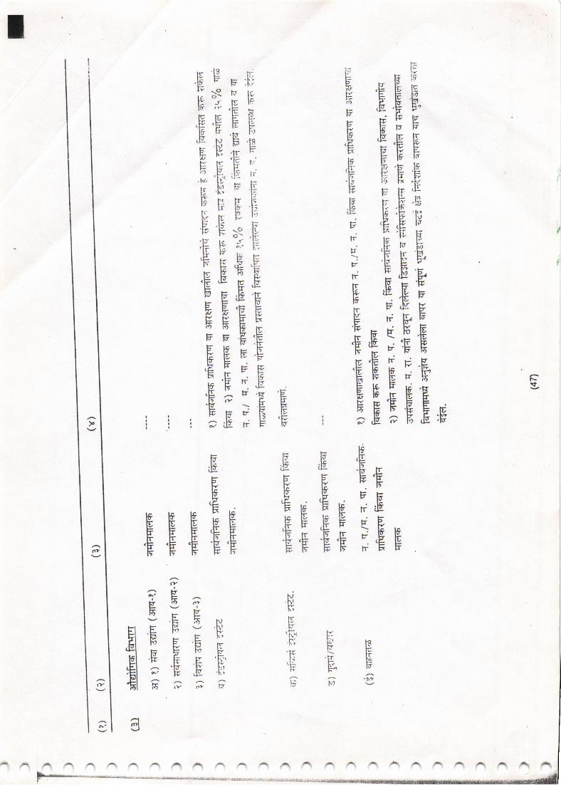
\t
E trF
E FE FE E'JF'E t'r E
:fr EE'FY F E''E ,E ,E'F
5 EEE,; E.E PE .EE E
E rEs:F +:E€.E'E E: FE EE EE, 5E5EE,g
gFe'[?[* [ t!Fr '7 'F.E.E E,
Eg IF F
IFEIEEI-p
EE€€EtE'HE EE EFF.E.E
EE
EE iE E
i i r5.E"rF'F
EE€E E Ef
EIEIIEE
E
E
EEEEI
VPBEEtrrr6.o
.Nr,lsF"
'F*'ht'ttl!:-
rf
'vgE?g,E H
EI E E F
,El zE.E#l 6'?;
Hl'
F(v
d
/1 ],.\ A n A A /a /a A A A 11 N A N A A A A A n A A A
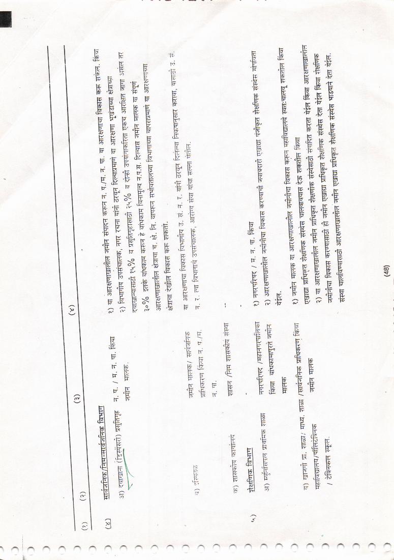
@t(t
E E E'E'p
EEIEE€E_EEEE.EEEBE €EEPE
TEEEEEE
I E'E - EE?EE
,EEF
EeE*E E
EBEEEE
EEEtE +I
IEgEEtEEEEE:*E,*E
EEIEEEEE:* F'T H E ;;
t5rrF,lE 'F ,[F\ts F (rrtFE BEF E{F F EgF FF
EEE IF
r.t ptr
'EFlr -Ertv k\l€ :t5
Btr- l^.gFFB.F #
EJI#rFtrF).gtr15
PtrftFii tlIH.EF.:FIFF.Efita\rJrt
F*
rr Ig
E rEI FI E
EEI :P
F,EI G
Itt-
f-'
ri
trv
-1)ol
;\tt
(FtsFY
tr,rFrcF;
(v
alaA:I
F-'E
E\1\)
F.E .FVF
FF
FEEF,€'E''rtr
FFF,V
Ef;wvECFTl;
.H 'E
l'tr q
IEE
^rln.:-.ry
g)s
E.F
Fpe
EEEE:f :E YE
EEFE
EEEE
,vH,F
-I VF
*l ,E ,E 'H 'Ffl Ep'E'E
El ?GG t
tr.ty
;;Pl+\F_
F|rV(=FF
H,vVFrr
;frFE,ir lI(F: trF\
"tEEp.E tFFfpF"gF'H;p G; [a \E F- F
ePFEEpEF E
F,ETpF[5[:
(v
IY
49l
vf
jr&i S
)
)
5I
;')
ir
XIV RESOURCE MOBILISATION
; 1a.1 Financlal Condltlon Ot Munlclpal Councll
) white going through the Municip?rl Budget 94-95. lt is lound that, the total income of the Municipal council is ol Rupees 131 1'07 Lacks basec
on the sources given below') Rs. in Lacks
/1\ Octroi' property tax & Dev'Charges etc 800'87\ \'/' (r) lncome trom Municipal Property 67 '67
) ,"t Grants & Grant in Aids 360'11tJ,83.42i
t ) (4) Othersi-!g. ) T^'^,g)
Total 131 1 .07
)
)
)
It,s also seen f rom expenditure side that the total expenoilure is of rupees 1265.77 Lacks on following ilems
Rs. in Lacks
(1) Administration & Establishment 235'07
) (z) Health Facilities 737.17
) (3) Education 35'80
) (4) Public Safety (Fire brigade,street lighting) 67 '04
. (5) DeveloPment Works,
190.70
Total 1265.77
(s0)
)I
I
[,
)
)
)
)
)
)
)
)
)
)
-t
I
I
I
!
Hence,itisobse.vedthatMunicipalcounci|spendsvery|essamountondeve|opmentwor*si.e.aboutl4T.ofiotalincome.outofwhich
onty 3-4"/6budget is utilized fo, imptemeniation ol developmenl plan proposab. Thercfore Municipal council has implemented just 20% ol
development plan proposalin Last 20 year'
14.2 COST OF IMPLEMENTATION OF DEVELOPMENT PLAN PBOPOSALS :
rt is estimated that the totalcost ror implementing the proposals of revised developmenl plan is about 96'51 cores' {Table no' 17 &18 )
1. Cost of land 53.51
43.00
40.65
2. Devloprnent cost
Cost of Road ( Acquisition & construction )
137.16 Rs. in CoresTotal
)
)
)
)
)
)
)
)
)
)
)
ffiaretobeimp|ementedwithin10years|.omthedateo'sanc(ono|dev€|opmentp|an.ThusNIunicipa|council required provision o, @
.t4 ""r.;;o;;;;";;.rs
inlheir Financiat Budget. gut Municipal council is notiinancially so strong to make such
orovisions. Hence it's necessary to think for mobilisation of Financial sources'
14.3 MOBILISATION OF RESOURCES
Municipal Council gets Financial assistance
proposals.
(1) Urba.n development (6) (A) Scheme :
(a)from foilowing schemes & that can be utirized for the imprementation of deveropment plan
(2) Integrated'Urlcan Development Plan Scheme
(3) Dalit Vasti Sudhar Yojana
(4) Member of Parliament Fund
(5) Member of Legislative Assembly Fund
(6) Nehru Rojgar Yoiana
(sl)
TIt
tI
II
r
iIIII
r
(b)
,
l)
)
)
)
)
)
)
)
)
)
)
)
)
))
),
)
)
)
)
)
)
)
)
(7) Statutory DevElopment Board's Fund
(8) Road Grants
(9) CentralGovt, assistance is avaitable fordevelopingthe proposals invisigae in the holy city including ol Gurudwara Edevelopmentscheme.
The financial assistance getting from various sources is also not sullicient to implement the complete development plan proposals so, it is
necessary to increase the source of income & it can be increased by manner ol following ways-
{1} To increase the income lrom Oclroi.
(2) To increase the development charges The amount collected from developmeni charges should be cenl percent utjlized for the
development plan proposals only. lt is observed that at present Municipal council is not keeping the separate account lor this & not
utilizing the amount lor the implementation ot developmenl ptan. Hence lorth seF ate account will have to be maintained and the
occured income lrcm_ this sourc€ will have to be stdctly used for lhe implementalion of o.P.proposals.
{3) The Municipal Council should observe the revison ol property tax al every louryeat as ptovided in the Municipal Act.1965.
(4) The Municipal Councilshoutd develop the shopping cenke, vegetable markets & slaughter house and rents coming lrom these siles
Which can be utilized for implementation of D.P.proposals.
Another tools lof the implemenlation ot lhe sites trom the deve'opment plan.
{1) Ihe sites can be developed as per th€ principl€ of Transl€t of development Rights Cf'D'R'}'
(2) The sjtes can bs imptemented by applying the dirctios recenty given by Govt. u/s Sec.154 of MRTP Act.1966 i's. with the h€lp ot
concept ol accommodation ol resewation
(3) The sites can be implemenied through the integrated Urban develoPmenl scheme'
(41 T.p. Scheme is also a besl toot tor implementation ot D.P. Proposals in a very cheap maoner. In Maralhwada Region, fier€ is no
T.p.Scheme. Nanded M.C. should therelore undertake this scheme as perthe provision given in the M.R. & T.P. Act.1966.
CIcCI
(52)
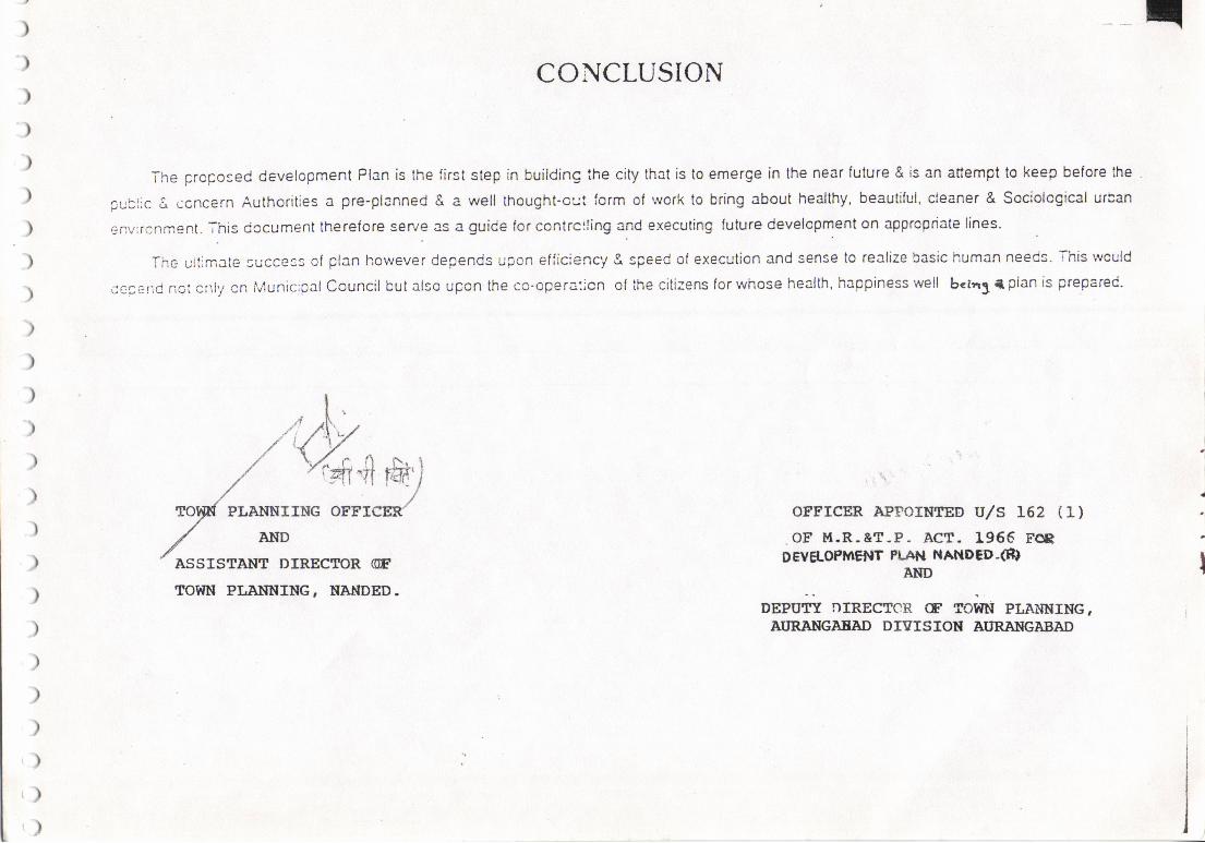
)-)
)")
)
)
)
)
)
)
)
)
)
)
))
)
)
)
)
)
)\)
()
()
CONCLUSION
The prcpored devetopment Plan is the li6t step in building the city that is to emerge in th€ near future & is an attempt lo keep belore lhe
public A ccncern Authoritie3 a pre-planned & a well thought.o!.:t iorm of wotk to bring about healthy. beautiful, cleaner & Soc,ological udan
envrrcnment. ihig docum€nt therelore s€rye as a guide lor contrclling and executing tutute developmenl on appropriale lines.
Thc ultjmate lucce.s ol plan however depeods upon efticiency g spe€d ol execution and sense to realize basic human ne€ds. This wculd
crpe d nor cnly on tvlunicipal Council but also upon lhe co-opera:icn ol lhe citizens lor whosE health, happiness well b.trr3 | plan is pretared.
: .,, \,
orrrcER APForltTED U/S t62 (1)
.oF r{.R-&T-P- ACT. 1966 reDE"T'g.OPMEilT PLAN ilANDED-@
AAD
DEPuTi nIREcITR cF ToiTN PLA}INING,N'RANGJAAAD DTSISIOT{ AI'RING]ABAD
.i
IASSISTAT.IT DIREEICIR (ETOTIN PI,A}TNING. I{AIIDED.
,/'%*e,PLAr{NrrNG orru#
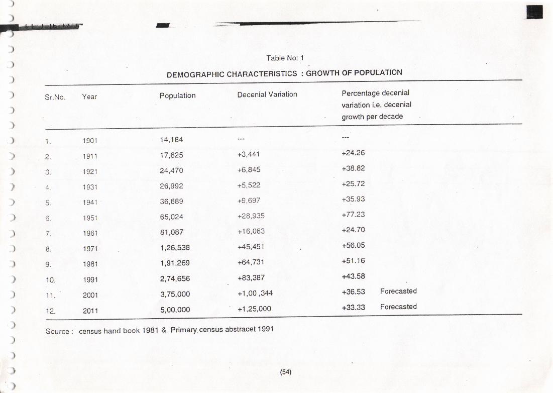
-
)
)
)
Table No:1 .
DEMOGRAPHIC CHARACTERTSTICS : GROWTH OF POPUTATION
) sr.No. Year Population DecenialVariation Percentage decenial
variation i.e. decenial
' growth Per decade)
)
) 1. t9o1
) z. 1e11
) 3. 1s21
) 4 1931
) s. 1941
) G. 19sl
) 7. 1e61
.) 8, 1971
) 9. 1981
) 10. 1s9t
) 11.' zool
) 12. 2011
1,26,538 +45,451
1,91,269 +64,731
2,74.656 +83,387
3,75,000 +1,00 ,344
5,00,000 +1,25,000
+24.26
+38.8?
+25.72
+35.93
+77.23
+24.7O
+56.05
+51.16
+43.58
+36.53 Forecasted
+3i1.33 Forecasted
14,184
17,625
24,470
26,992
36,689
65,024
91,087
+3,441
+6,845
+5,522
+9,697
+28,935
+16,063
\t Source : census hand book 1981 & Primary.census abstracet 1991
)
)
) (s4)
')
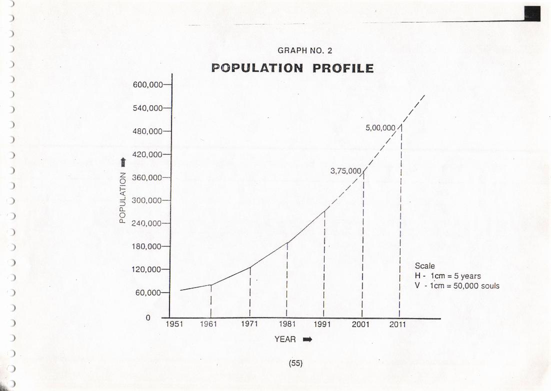
)
)
)
)
)
)
)
)
)
)
)
)
)
)
)
)
)
)
)')
)
)
)
)"()
q)
GRAPH
POPULATIONNO. 2
PROFILE600,
540,
480,
420,
360,
300,
240,
180,
120,
60,
5,00,00014
tzoEJ(Lo&
ScaleH- lcm=5yearsV - 1cm = 50,000 souls
1981 1991
YEAR t
(ss)
1951
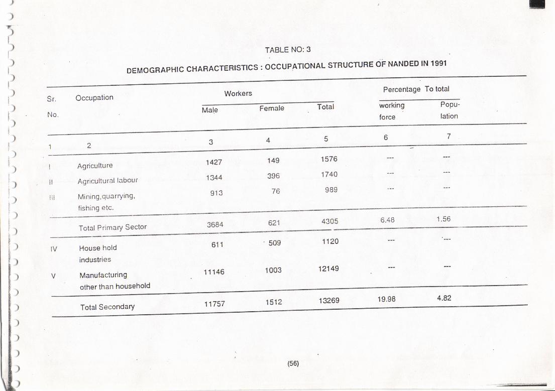
)
)-tI
TABLE NO:3
DEM.GRA'HT. cHARAcrERrsrtcs : occupATtoNAL srRUcruRE oF NANDED lN 1991
Workers Percentage To totalSr.
No.
OccuPation
Male Female Total working
force
Popu-
lation
149
396
76
I
lI
i
i
i
,
iI
ii
i
Ii
!
iIIfr
I
tltl
ilt
Agriculture
Agricultural labour
Mining,quarrying,
fishing etc.
1427
1344
913
1576
1744
989
6.48 1.56621
)
)
)
)
)
)
)
)
)
)
)
)
)
)
)
)
)
)
)
)I
;)I
[)[)
Total Primary Sector
IV
V
House hold
industries
Manufacturing
other than household
611
11146
509
1003
1120
12149
11757 1512 13269 19.98 4.82Total Secondary
(s6)
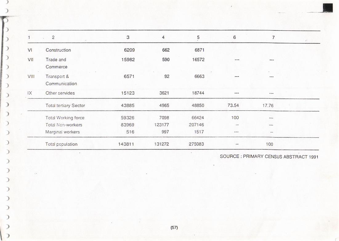
I
69
vl
vll
vill
IX
Construction
Trade and
Commerce
Transport &
Communication
Other servides
6209
15982
6571
1 5123
92
3621
6871
16572
6663
18744
662
590
Total tertiary Sector 43885 4955 48850 73.54 17.76
100
)
)
)
)
)
)
)
)
)
)
)
)
)
)
)
)
)
)
)
)
)
)
)
TotalWorking force
Total Ncn-workers
Marginalworkers
59326
83969
516
7098
123177
997
664.24
207146
1517
Total population 14381 1 131272 275083 100
i
SOURCE : PRIMARY CENSUS ABSTRACT 1991
(5n
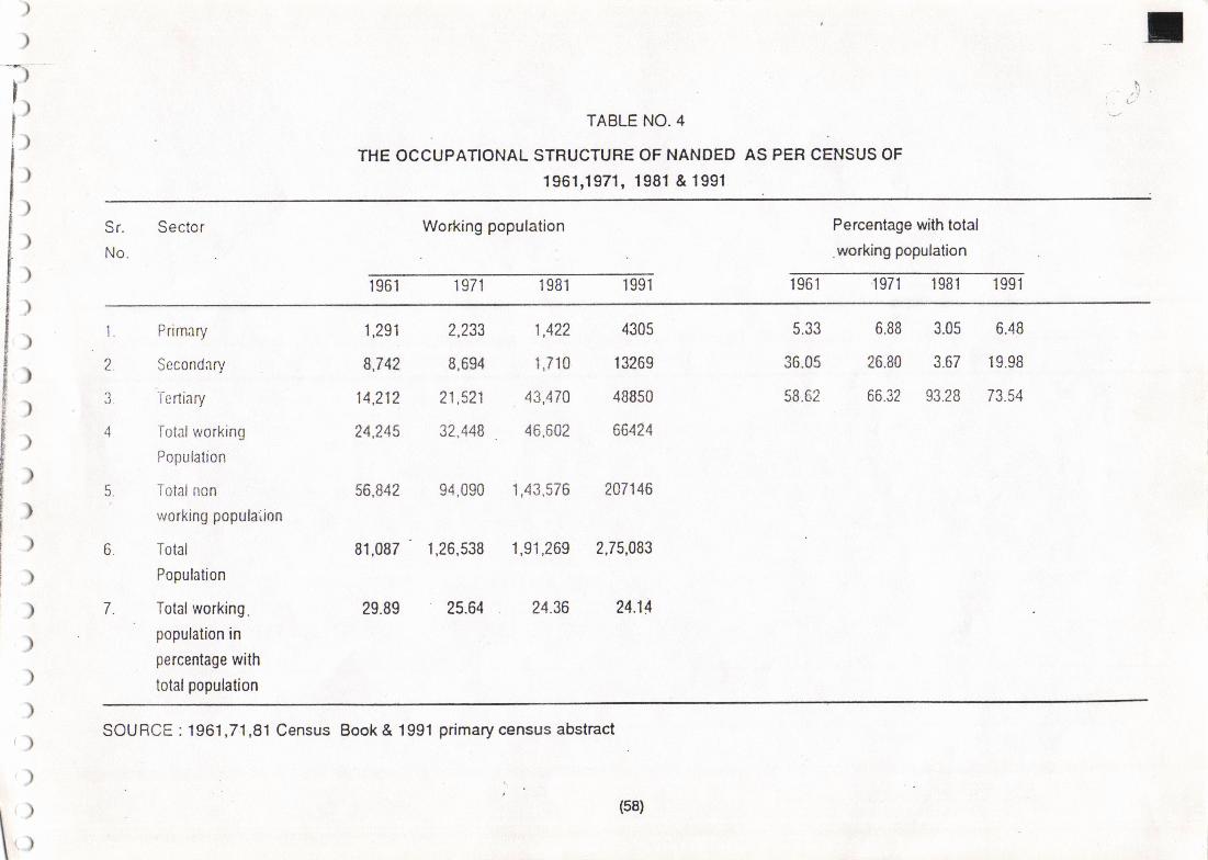
)
)
? f,'j'
l;TABLE NO.4
THE OCCUPANONAL STRUCTURE OF NANDED AS PER CENSUS OF
1961,1971, 1981 & 1991
Sr. Sector
No.
Working population Percentage with total
.wo*ing population
1961 1971 1981 1991 1961 '1971 1981 1991
) Prirnary 1,291 2,233 1,422 43{15 5.33 5.88 3-05 6-48
> 2. Secondflry \7A 8,694 1,710 13209 36,06 26.80 3.67 19.98
\ 3 Tcrtiary 14.212 21,521 .43,470 48850 58.62 66.32 93.28 73.54
) o Totalx,-orking 24,245 32.448 46,602 66124
Pooula on
) ,. rot.tnon 56,842 94,090 1,43,576 207146
) working poputa'iion
) o. Total
) Population
i ) 7. Total working. 29.89 25.64 24.36 24.14
) PoPulation in
percentage with) totalpopulation
81,087 1,26,538 1,91,269 2,75,083
, \ SOURCE : 1961,7:1,81 Census Book & 1991 primary census abstract')
)
r') (s8)
tI r)I
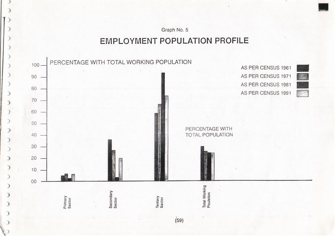
70
r))
1ll,
jlI
ltIlrI
I
,
)
)
,
)
)
)
)
)
)
)
)
Graoh No. 5
PERCENTAGE WITH TOTAL WORKING POPULATION
EMPLOYMENT POPULATION PROFILE
100 I@Iffi
AS PER CENSUS 1961
AS PER CENSUS 1971
AS PER CENSUS 1981
AS PER CENSUS 1991
PERCENTAGE WITHTO'IAL POPULATION40
JU
ZU
10
ot.g:;.9--g(U:tiioF(L
--.q9F.;
-GI9-b9('oo(l,aa
(!0Eo'=oo- u)
\,
t'sgl
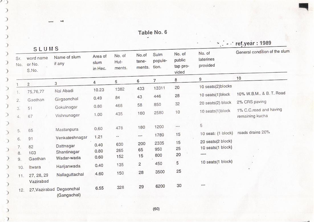
Table No. 6
' re!.year : 1989SLUMS
Area ol
slum
in Hec.
No. of
Hut-
ments.
No.of
tene-ments.
Sulmpopule-
tion.
No. of
public
tap Pro-vided
No. of
laterines
provided
General condition of lhe slum
Sr.
No.
word name
or No.
S.No.
Name ol slum
if any
10
1. 75,76,77
2. Gaothan
1 q1
4.
- ^ahhtJ.
6, 91
7. 82
8. 103
9. Gaothan
10. ltwara
11.27,28,29Vazirabad
12.27,Yazirabad
Nai Abadi
Girgaonchal
Gokulnagar
Vishnunager
MastanPura
Venkateshnagar
Dattnagar
ShantinagarWadar-wada
Hariianwada
Nallaguttachal
Degaonchal(Gangachal)
10 seats{2)blocks
10 seats(l)block
20 seats(2) bloct<
10 seats(1)biock
10 seats (1 block)
20 seats(2 block)
1O-seats(1 block)
10 seats(l block)
10% W.B.M.. & B. T. Road
2% CRS Paving
17" C.C.road and having
remaining kucha
roads drains 20%
10.23
0.49
0.80
1.00
0.60
1.21
0.40
0.80
0.60
0.40
4.60
6.55
1 382
84
468
435
478
630
265
152
135
150
328
433
43,
58
180
180
2006515
2
28
29
13311
446
850
2580
1200
1780
2335
950
800
450
3500
6200
20
2A
32
10
15
15
25
20
tr
25
30
(60)
))
10
)
)
)
)
)
)
)
)
t)')
)
)
)
)
)
)
)
)
)
)
)
)
r)
12
13. 42,43
14. 67,68
15.
16.
17.
18.
19.
20.
21.
22.
tJ.
24.
25.
26.
' 27.
28.
3.03 175
2.27 {05
Bhimghat 0.70 zOs
KhadakPura
Hamalpura
Sainagar
Ram-Rahimnagar O.71 296
Khusronagar
millarea
Jaibhimnagar
Khudwai nagar
KaiyumPlot
Rahmetnagar
Madina nagar
Govind nagar
Gandhi nagar
Shaktinagar
6.06 952 325 3500
1700 20
40 2500 5
18 1160 25
26 4100 21
2500 15
16500
-20 seats (Q block).a
,1.".,, (1 btock)
10 seats (1 block)
28
3.34 425 100 2605
1.92 465 114 2353 28
3.15 298 55 5065
Khobragade & Eswamagar 3'52 216 30
25.6 1235 193
2.10 98
1.06 158
z.sia 162
1.56 96
2.32 160
3.92 270
1600
2035
1134
22AO
980
3018
10
15
16rr - 29qO "ro. Sidha naoar r.w '--' Total 9236 84302
(61)
)
)
4
Table No- 7
EXISTING LAND USE ANALYSIS
SECTOR-WISE AREA IN HECTOR'
Total
L--'--
9'" to the
total Area:% to theDevPd.
)
)
)
)
)
)
)
)
)
)
)
)
)
G.E.D.c.
1.
2.
A
Land Use
Residential
lndustrial
Commercial
Public & Semi
Public
75.16 107.22
6.09 19.35
1]8 12-02
51.78 56.99
't 1 .31 19.05
1.02 3.49
37.03 125.95
45.43
0.46
1.41
o.22
4.43
21.34
27.96
1.74
0.79
2.82
0.48-1 '\)
10.55
67.49
4.08
14.57
2.13
a.B7
12.43
415.51
58.74
33.56
176.22
39.27
9.23r(? (Q
42.14
5.96
3.40
17.87
3.98
0.93
25.72
20.14
2.85
1.63
8.54
i.900.45
12.30
62.14 30.11
1 1 .84 19.26
10.42 3.06
27.11 22.73
0.80 1.07
0.36 o.17
27.65 18.64
q
6.
7.
Open SPace
Public Utility
TransPoi-t &)
)
)
)
)
)
)
)
)
)
)
Communicatton 47.81
184.17 344.O7 73.29 47.66 101 .57 140.32 95.04 986.12
8.
o
10.
Water Bodies
Agricultural' Vacant &
Barren Land
0.70
38.08
94.38
1.34
15.13
168.58
0.50
166.88
52.05
38.69
47.81
6.58
48.90
90.58
9.12
470.07
597.17140.58 21.81
105.41 38.42
0.44
22.79
28.96
52.19
Tot"i Und""el"Ped 133'10 185'05 219.43 245.99 60.23 86.50 146.06
Area.161.80 226.82
TOTAL: 317.27 529.12 293J3 293.72
(62)
241.10 2062.48100.00
! -.'
Diagram No. 8
)
)i)t)iriti
t:
)ii
)j
)
)I
)i
))i
)
)I
)I
.)tI;)
)
)
)
2.85
-t-2O:e
,r"r-/ -
\//zz.ts---*- --11
-{t ,rru
i{i to Total Arca
Pie-DiagramsofExistingLandUseAnalysis
ReCrleathl
krlr**l
Gomrnaltlrl
tublk& S.rdh.tlh
Qpcn ?ac:
trnDiln
tut'lkudry
Trarnpon & Cortmnk'adon
Watcr Bodar
Agrlcdural
Varcanr& B.tcnLtd
trntrntr
. 8.54-1.e_\.0.i45-\
t2.3-- :-0.44
96 to Dcvloped Arcr
(631
F 264lo 275
276to298
240
301 to 325
12
23
1
25
8440
16805
461
189n,
61
))
)*-
)
)
)
)
)
)
)
)
)
)
)
)
)
)
)
)
)
)
)
)
)
)
)
J
2
G'l 3e6
327 to 368
1
42
669
29004
29673
368 274656TOTAL ELOCKS :
(6s)
Table No.9
STATEMENT SHOWING THE SECTORWISE EXISTING POPULATION AS PER -1991 CENSUS BLOCKS.
Sr.
No.
Sector
No.
Ward
No.
Block included
in the sector
Total No.
of Blocks
Population of the
sector as per 1 991
1_ 01to67 67 5091 0
2. 68 to 137 55064
J. 138 to 156 19 1 4906
21228
1 504
27
2
)
,j)
)
)
)
)
)
)
)
)
)
)
)
)
)
)
)
)
)
)
)
)
)
)
1 57 to 1B3
299 to 300
n
22732
I8
7
E5. 184 to 209
21O to 225
226lo 239 &.
241 to 242
243 to257
258 to 263
26
16
1 9586
1 1041
1 1580
10724
3812
16
15
6
(tr)
56743
Table No. 10
ulation distribution for the year 2001
,
)
lt)
)
)
)
)
)
)
)
)
)')
)
)
)
)
)
)
)
)
)
)
)
\)
Sector
No.
Total
Area of
the se-
ctor in
Hect.
Area
Like
Flood
af{ec'
ted
Airport
c.R.c.elc.
which
can not
brought
Nett
alea
avai-
lable
for
Deve-
lopem
ent
in
Hect.
Existing
popn.as
per cen-
sus 1991
Statement showi sectorwlse
Total vacant
DeveloP- Area in
ed area Hector
of the
Sectorin
Hector
Existing Addit'
Gross ional
DensitY PoPula-
of the tion
Sector canbe
accomod-
ated at
150 PH
Total Poulation to be accomo-
popula deatd in the Year 2001
tion canbel 00344 XCol.No'9)
accomo- 128071
dated in
the sec-
tor
/ -.) -!QIunder use (4-5')
1055 B
an
-
317.27
329.12
292.72
293.65
161.80
226.82
241.10
184.17 133.10
344.A7 185.05
73.29 219.43
47.66 . ?45.99
101 .57 60.23
140.32 86.50
00.70
41.55
00.50
72.46
28.30
9.45
69.61
132.40
145.50
218.93
173.93
31.93
77.05
76.45
5091 0
550@
14906
22732
56743
44628
29673
276.43
160.04
203.38
476.96
556.bO
318.04
312.22
1 9860
21525
32840
25050
4790
1 1558
1 1468
7077Q
76589
47746
48762
61 533
561 88
41141
15560+ 50910-6ff70 - 66000
1 6885+55064-71929 - 72OAO
25730+14906=40636 - 41000
2O395+227 32=431 27 - 43 000
3753+56743=60496 - 60000
9056{44628=53684 - 54000
8e I 5 +2e 673=38619_- !999995.04 146.06 375000
2062.48 e86.12 1076!! 274656 402727
1 991 poPulation = 2,74,656""
853.79
(66)
255.13 128071
( Source : 1991 Census Record)
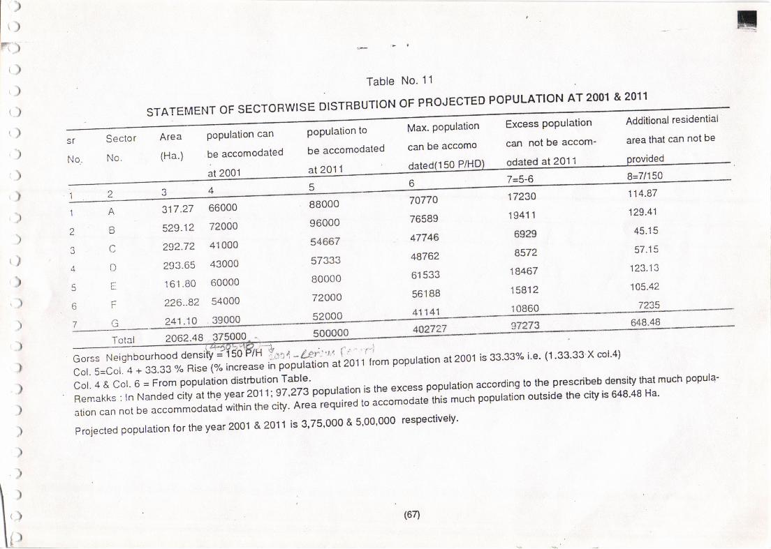
lrI
llF-y
')
>!
Table No. 11
qr
No..
Sector
No.
STATEMENT OF SECTORWISE DISTRBUTION OF PROJECTED POPULATION AT 2OO1 & 2011
'^ ha e^'nrno can not be accom- area that can not be
(Ha.) be accomodated be accomodated can be accomo
at2001at2o11dated(150P/HD)9gg|9dat2011Plo-V.l-o-ejided
)
r)
,)
)
)
)
I
)
t)
')
)
1
z
,1
5
7
tf
n
(
r
t456 zso 114'87
529.12 72000 96000 76589 19411 129'41
2s2.72 41000 54667 47746 6929 45'15
293-65 43000 57333 48762 8572 57'15
161 -80 60000 BOO00 61533 18467 123'13
226-82 54000 72000 56188 15812 105'42
2062.48 375000
E:i:=i:l'l'::$:*L':1r: Li:gX ;i:;ffi;1,'io, r'r,o' popuration at2001 is 33'33% i e' (1'33'33 X cora)
::'ri-1.":l,l;*:1fi'il',1;1"':11,""""1;l.ji *1111"1.1"1g^":::::jlj:':fl11J,1fjl3i:ffi$:"":il-':l"J} thatmuch popura.
m"5:^Xf:::#y"::',::fiii3?JJ:11:?':::3;,,ilJ;::""=;:;;J'*'muchpopurationoutsidethecitvis64s4sHaprojected population for the year 2001 & 2011 is 3,75'000 & 5'00'000 respectively'
I(64
{
)
) ,1ru
r{
Table No. 12
PROPOSED LAND USE ANALYSIS
SECTOR.WISE AREA IN HECTARE:
Sr. Land Us.e:
No.E.B.A. c. D. F. G. Total Area % to the % to the
Total Area
69.91
12.96
3.82
29.99
27.31
3.49
29.60
963.41
41.41
54"22
272.27
182.86
20.51
360.1 0
Area
50.85
2.19
2.86
14.37
9.65
1.08
19.00
46.71
2.02
2.63
13.20
8.87
0.99
| /..+o
a
1. Resrdential 162.75
2. Industrial 5.69
3. Commercial 3.21
4. Public & Semi 58.12I-UDIIC
5. Open Space 39.13
6. Public Utility 2.39
7. Transport & 45.28
Communicalion
165.82 173.55
1.74
11.62 5.83
11.82 12.67
26.69 21.22
2.35 2.96
66.32 3t.17
89.33 120.20
2.68
4.47 12.31
10.66 27 .91
10.04 17 .71
2j3 0.61
14.39 32.66
181.85
18.34
12.96
121.10
40.56
6.58
tJo./J
Total DevpdArea
31 6.57 51 8.1 2 284.62 253.14 133.70 211.60 177.06 1894.81 100.00 91.87
B.
9.
Water Eodies
Aoricuitural
o.70
11.00 8.10 40.5.1 28.10 15.22
6.58
57.46
7.28
160.39
'0.35
7.77
TOTAL AREA: 317.27 529.12 292.72 293.65 161.80 226.82 241.10 2062.48 100.00
(68)
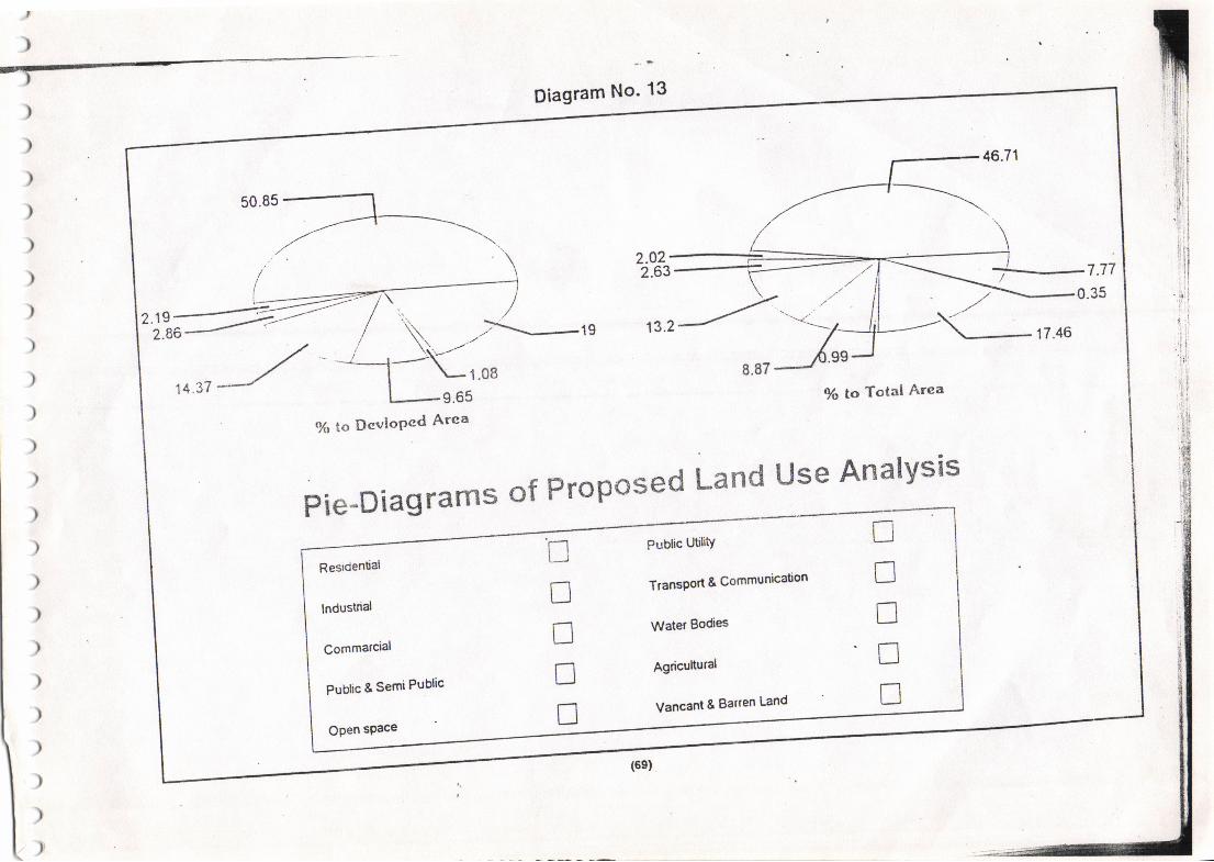
,
)
tDiagram No' 13
2.63--. 7.77
0.35
9o to Total Arca
{% to Dcviopcd Arca
Pie-Diagrams of Proposed Land Use AnalYsis
Resrdentiat
lndustrial
Commarcial
Pubtic & Semi Public
nDnnf
Public UtiliiY
TransPort & Communication
Water Bodies
Agricuttural
Vancant & Barren Land
nnnnT
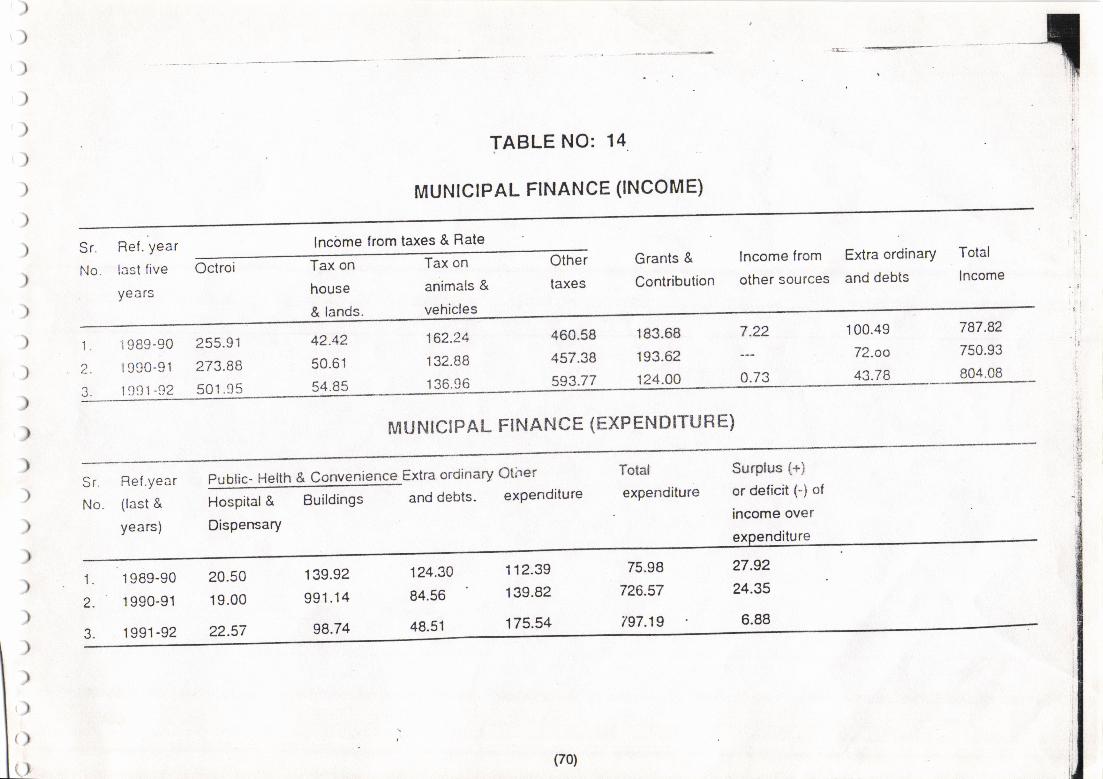
TABLE NO: 14
MUNICIPAL FINANCE (INCOME)
Sr. Ref . Year
No. last five
years
lncbme from taxes & Rate
Octroi Tax on
house
& lands.
Tax on
animals &
vehicles
Other
taxes
Grants &
Contribution
lncome from Extra ordinary Total
other sources and debts Income
'1.
2
3.
1989-90
1990-91
1931 -!12
255.91
273.88
501.95
42.42
50.61
54.85
't62.24
132.88
136.96
460.58
457.38
593.77
183.68
193.62
124.00
7.22
0.73
100.49
72-oo
43.78
787.82
750.93
804.08
'. I
MUNICIPAL FINANCE (EXP ENDITU H E)
Total
expenditure
Surplus (+)
or deiicit (-) of
income over
t':
IrI
g
)
)
)
)
)
)
Sr.
No.
Ref .year
(last &
years)
Publiq- Helth & Convenience Extra ordinary Other
Hospital & Buildings and debts' expenditure
Dispensary
{
2.
J.
1989-90
1990-91
199'1-92
20.50
19.00
22.57
139.92
991 .14
98.74
124.30
84.56
48.51
112.39
139.82
175.54
27.92
?4.35
6.88
)
)
,)
(>
() il/(70)
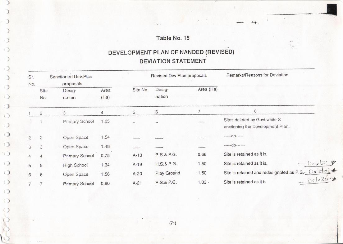
T-
Table No. 15
DEVELOPMENT PLAN OF NANDED (REVlSeOl
DEVIATION STATEMENT
:{
r. ql .
Sr.
No.
Sanctioned Dev.Plan
proposals
Revised Dev.Plan proposals Remarks/Reasons lor Deviation
Site
No:
Desig-
nation
Area
(Ha)
Site No Desig-
nation
Area (Ha)
)
).)
)
')
'))
').)
,)
r)
r)t)
,)
t)
r)'t)
t)
t)()
t)
t)()
().\
{_)
1
4.
J
4
5
6
7
1
2
3
4
5
6
7
Primary School 1.05 Sites deleted by Govt while S
anctioning the Development Plan.
----do---
--do----Site is retained as it is..
Site is retained as it is.
Open Space
Open Space
l.tt.otY School
High School
Open Space
Pdmary School
1.54
1.48
0.75
1.34
1.56
0.80
A-13
A-19
A-20
A-21
P.S.& P.G.
H.S.& P.G.
Play Grouhd
P.S.& P.G.
0.66
1.50
1.50
1.03.
Site is retained and redesignaied as r.G.1!2g!gig!#Site is retained as it is -=fXj:t'f 'I|
u(71)
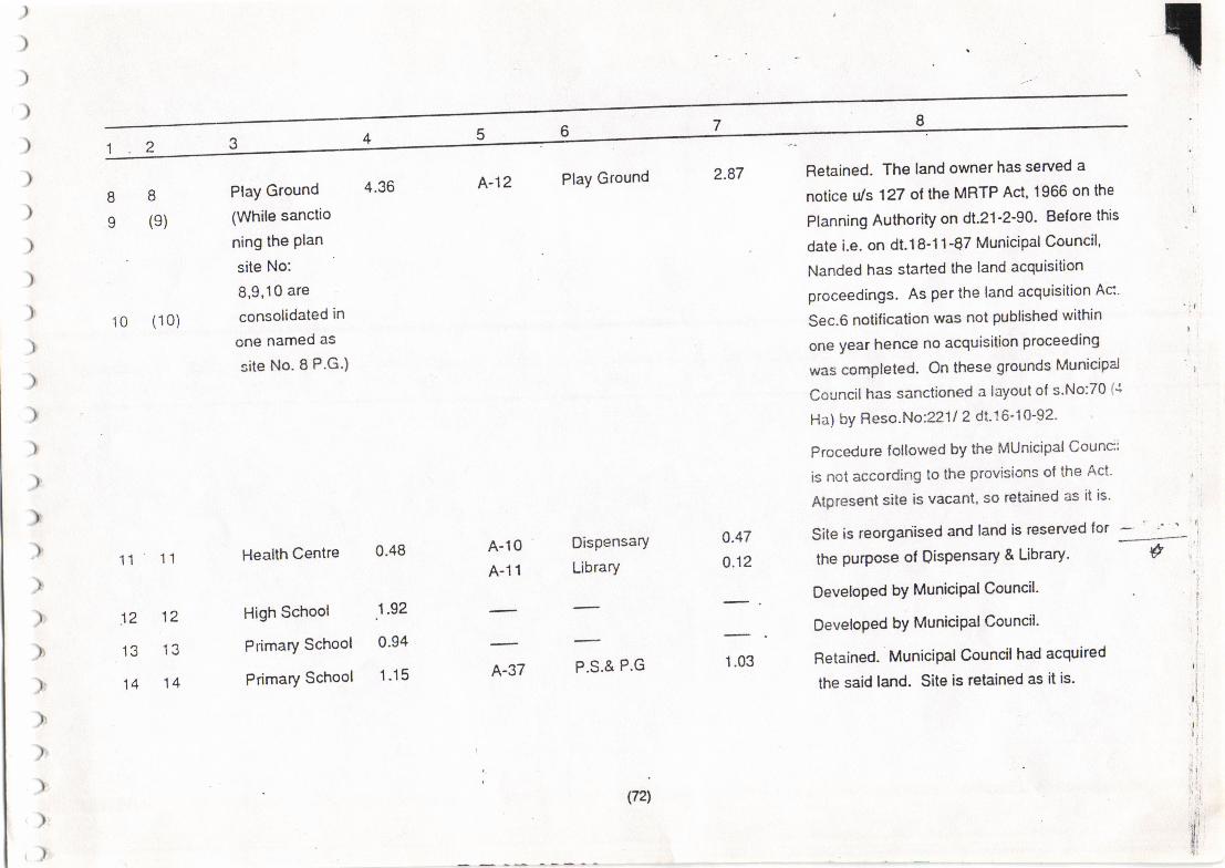
(721
8
9
)
)
)
)
)
)
)
)
)
)
)
)
)
)
)'
)
),
)
)
)
)r
)r
))
)
)
A-12 Play Ground 2.87 Retained. The land owner has served a
notice uls 127 of the MRTP Act, 1966 on the
Planning Authority on dt.21-2-90' Be{ore this
date i.e. on dt.18-11-87 Municipat Council,
Nanded has started the land acquisition
proceedings. As per the land acquisition Ac'
Sec.6 notification was not published within ' I
one year hence no acquisition proceeding
was completed. On these grounds Municipa'l i
Council has sanctioned a layoul of s'No:70 {'l
Ha) by Reso.No:22112 d1.16-10-92'
Procedure followed by the MUnicipalCounc:
is not according to the provisions ol the Act' l
Atpresent site is vacant, so retained as it is'
Site is reorgariised and land is reserved for -- ' ' . '
the purpose of Qispensary & Library ' g
DeveloPed bY MuniciPalCouncil' :
Developed bY MuniciPalCouncil' f
B
(e)
10 (10)
11
12
13
14
Play Ground
(While sanctio
ning the Plan
site No:
8,9,10 are
consolidated in
one named as
site No. I P.G.)
4.36
11
12
13
14
Health Centre 0'48
High School .1'92
Primary School 0'94
Primary School 1'15
A-10
A-11
A-37
Dispensary
Library
furn
o.47
0.12
1.03 Retained. Municipal Council had acquired
the said land. Site is retained as it is'
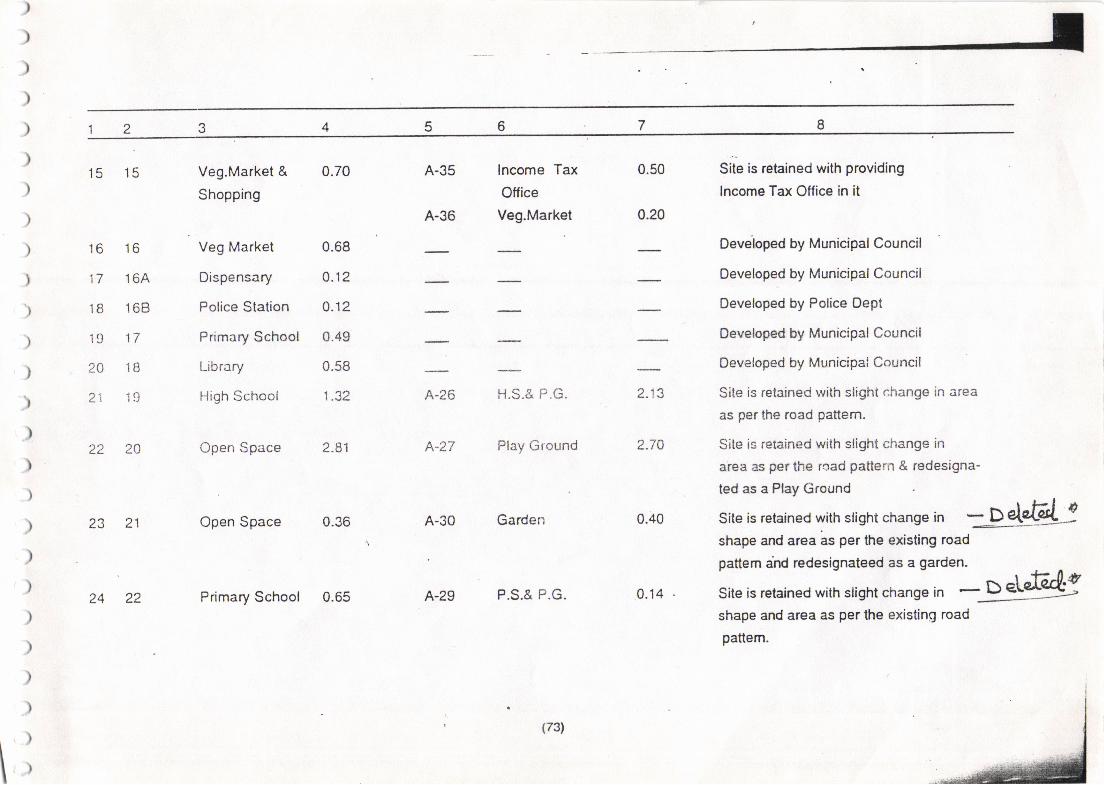
15 15
16 16
17 164
18 168
19 17
20 18
21 ]9
22 20
Veg.Market &
Shopping
Veg Market
Dispensary
Police Station
Primary School
Library
High School
Open Space
23 21 Open Space 0.36
24 22 Primary School 0.65
Site is retained with providing
lncome Tax Office in it
Deveioped by Municipal Council
Developed by Municipal Council
Developed by Police Dept
Developed by Municipal Council
Developed by Municipal Council
Site is retained lvith slighi change in area
as per the road pattern.
Site is retained with slight change in
area as per the rcad pattern & redesigna'
ted as a Play Ground
shape and area as per the existing road
pattern.
Site is retained with slight change in :-D &:shape and area as per the existing road
pattem ahd redesignateed as a garden.
Site is retained with slisht chanse in *9449
0.70
0.68
o.12
0.12
0.49
0.58
1.32
2.81
A-35
A-36
lncome Tax
Office
Veg.Market
0.50
0.20
A-26
A-27
H.S.& P.G.
Play Ground
2.13
2.70
0.40
0.14
A-30 Garden
A-29 P.S.& P.G.
\
(73)
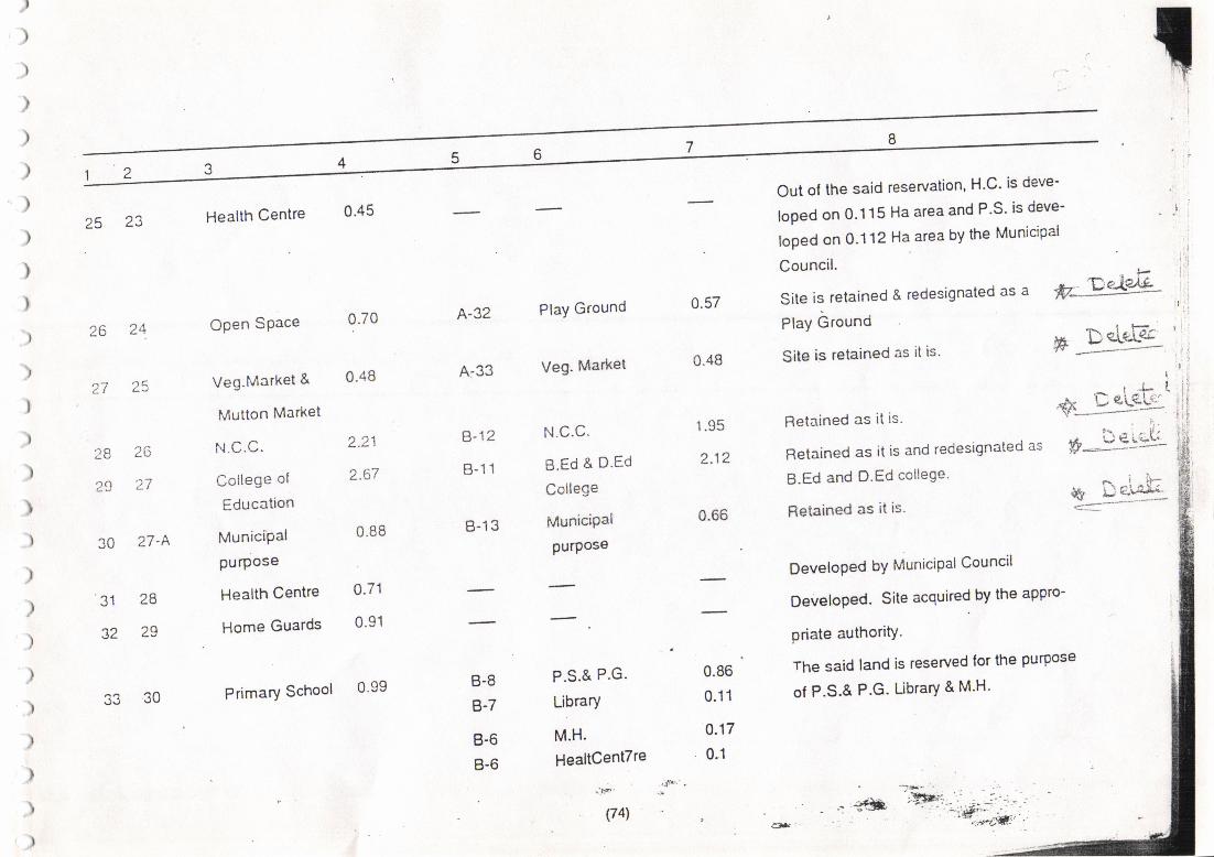
!25 23 Health Centre 0'45
Out of the said reseruation' H'C' is deve-
loped on 0.1 15 Ha area and P'S' is deve-
loped on 0.1 12 Haarea by the Municipal
26 24.
q-i )qLI
28 26
29 ',27
30 27'A
31 28
32 29
Open SPace
Veg-Market &
Mutton Market
College of
Education
MuniciPal
purpose
Health Centre
Home Guards
Primary School
0.70
0.48
2.21
1.OI
0.88
o.71
0.91
A-32
A-33
Play Ground
Veg. Market
N.c.c.
B.Ed & D.Ed
College
MuniciPal
purpos€
0.48
0.57
1.95
2.12
0.66
Council.
Site is relained & redesignated as a
Play Ground
Site is retained as it is'
Fletained as it is.
Retained as it is and redesignated as
B.Ed and D.Ed college'
Retained as it is'
DeveloPed bY MuniciPal Council
Developed. Site acquired by the appro-
priate authori$.
The said land is reserved lor the purpose
of P.S.& P.G. Library & M'H'
"l-p, _T.eiPJL
F:S'r& '
Ir J-f.
+i-c*:i*gi,'
?. - - l'.S--" 5:::t-
Li'j*{
B-12
B-11
B-13
B-8
B-7
B-6
B-6
0.99P.S.& P.G.
Library
M.H.
HealtCentTre
.-t*'
(741
0.86
0.11
0.17
0.1
s3 30
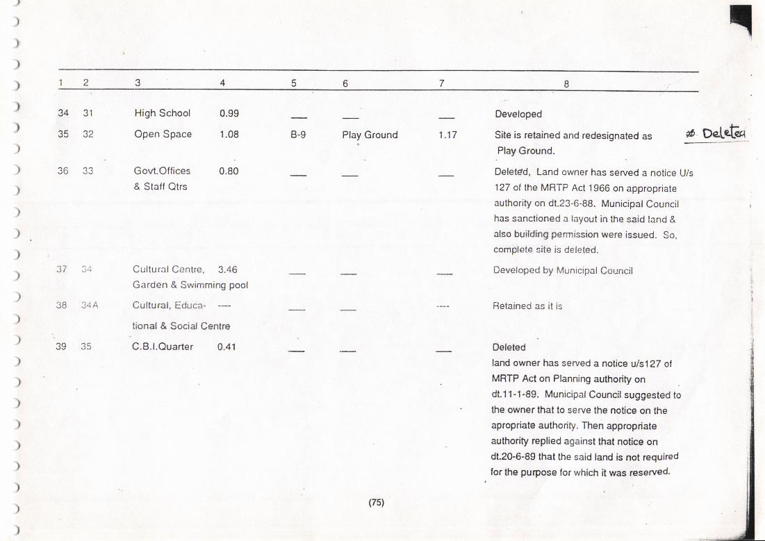
,
)
)
)
)
)
)
)
)
)
)
)
)
34 31
35 32
JO J4f\
39 35
High School
Open Space
Govt.Offices
& Staff Qtrs
0.99
1.08
0.80
B-9 Play Ground 1.17
Developed
Site is retained and redesignated as # DeLeGq
)
)
)
)
)
)
)
)
)
)
)
)
)
Cultural Cenire. 3.46
Garden & Swimming pool
Cultural, Educa-
tional & Social Centre
C.B.l.Ouarter 0.41
Play Ground.
Deletdd, Land owner has served a notice U/s
127 ot the MRTP Act 1966 on appropriate
authority on dt.23-6-88. Municipal Councilhas sanctioned a layout in the said land &
also building per."nission were issued. So,
complete site is deleted.
Developed by Municipal Council
Retained as it is
Deleted
land owner has served a notice uls127 ot
MRTP Act on Planning authority on
dt.11-1-89. Municipal Council suggested to
the owner that to serve the notice on the
apropriate authority. Then appropriate
authority replied against that notice on
dt.20-6-89 that the said land is not required
for the purpose for which it was reserved.
(7s)
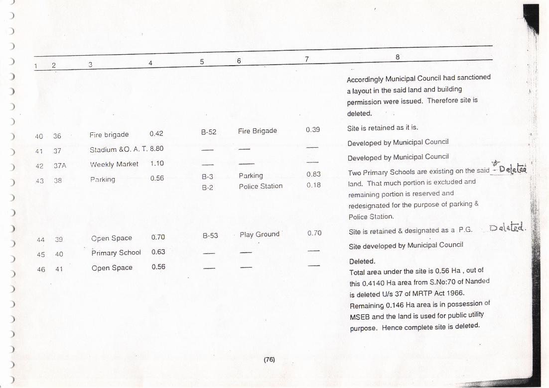
74
.+u
A1
4Z
AU
Fire brigade 0.42
Stadium &O. A- T. 8.80
V/eekly Market 1.10
Parking 0.56
B-52 Fire Brigade
Parking
Police Station
B-53 PlaY Ground
0.39
0.83
0.18
Accordingly Municipal Council had sanctioned
a layout in the said land and building
permission were issued. Therefore site is
deleted.
Site is retained as it is.
DeveloPed bY MuniciPal Council
DeveloPed bY MuniciPalCouncil * .
Two Primary Schools are existing on the saiO - Dele
land. That much portion is excluded and
remaining Portion is reserved and
redesignated ior the purpose ol parking &
Police Station.
F-i 'L€4
trt-J
6-Z
po\EEd.A A '1O
45 4A
46 41
Cpen Space
ijrimary School
Open Space
0.70
0.63
0.56
0.70 Site is retained & designated as a P'G'
Site developed by Municipal Council
Deleted.
Total area under the site is 0'56 Ha , out of
this 0.4140 Ha area from S'No:70 of Nanded
is deleted U/s 37 of MRTP Act 1966'
Remaining 0.146 Ha area is in possession of
MSEB and the land is used for pubtic utility
purpose. Hence complete site is deleted'
(76)
Site is retained as it is. 11bel'E47 42
.+ .J '+\)
49 44
50 45
az .+I
53 48
f'rlaharashtra
Warehousing
Godowns
Primary School
Open Space
Maternity Home
l&PDeptStait Qtr
Open Space
Open Space
Primary School
Fire Station
B-54 M.W.H.G.1.44
1.00
1.30
0.50
6.19
1.90
1.70
0.60
0.49
B-42
c-24
c-20
B-16
B-15
Play Ground
Extn to Air StriP
1.62
1.71
37.4
Developed. Nehru Engliih School is existing
on the site. , ,
Site is retained and redesignated as a Play tg eleFc{ '
Ground.
The said land is reserved for the purpose of
extension to Air StriP.
Developed by appropriate authonty
The said is kept reserved lor the purpose o{
extensisn to AirstriP.
Site is retained and redesignated as a Play[F-"t"GGround.
Site is retained as it is.
Deleted
, DuLM"
The complete site is deleted by Govt U/s 37
of MRTP Act,1966 bY letter NO.
TPS-3289/633/CR-47/89ryD-9 dt-2-1 -94 and
included in the residentialzone-
46:)l
Extn to Air StriP
Play Ground
P,S.& P.G.
37.4
0.90
0.6554 .49
55 50
(77)
T
57
58
51
JZ
oz ct
bJ JO
64 59
65 60
oo ol
Police Station
Post Office
Primary School
Primary School
(Open Space)
(High School)
College
0.40
0.70
0.30
0.94
(1.21)
(1.16)
2.44
B-17
B.1B
c-20
B-28 Play Ground & Garden
Retained as it is.
Retained as it is.
The site is deleted and land is included for the
purpose of extn to air strip.
Developed by Municipal Council
Developed U/s 37 of MRTP Act, these two
sites 6 m wide road in between them are
combined together and designated as a
'College' having an area 2.44 Ha. At present
M.G.M.Engineering College is existing on the
site.
3.60 Site is retained & designated as
P.G.&G.
Site is retained with slight change in shape 9Dele'teF-F-'
and area.
Site is retained with slight changb in shape
and area.
Site is retained arid designated as a Play
Ground with slight change in area.
Site is retained & ciesignated as a p.S.& P.G.
Police Station
Post office
Extn to Air StriP
0.68
0.51
37.4
59 54
60 55
61 56
Tourist Centre 4.4O
Public Health
Reservoir
0.72
Rec?eation Centre 1.26
Primary School 0.54
B-33
B-36
B-38
Public Health
Reservoir
Recreation
Centre
Play Ground
P.S.& P.G.
1.37
1.23
0.94
0.80
;
ii
i
, t!(
t!li
:
i;
lt.
,
Open Space 0.66
(78)
/)
)
)
6)
)
)
)
)
\,
2
ozo/
bU OJ
69 634
70 6,1
71 65
lz oo
Health Centre
Open Space
veg. Markret
High School
Primary School
Open Space
Open Space
Primary School
0.50
2.70
0.50
1.50
0.85
0.75
B-39
B-44
B-45
B-46
B-47
B.4B
0.37
1.90
0.10
0.30
0.38
0.66
MaternitY Home
Play Ground
Library
Dispensary
P.S.& P.G.
Garden
Site is retained as it is- 11P-3:n+' "
Land owner ol S.No:36/Bl2 andS.No: +olele+QgJik,of Asadullabad had given a purchase notice 1L*:{:,in the year 1982 u/s49 of the MRTP Act. The
1.Pe\ei. ,
notice was confirmed by the Govt. Land - l)e-i.ct' '
acquisition was started by Municipal Council Iq "fJtt'but upto the year 1988 the said land was not 'c'"-'
)
)
)
73 67
74 68
)
)
)
)
)
1.60
0.81
c-18 Play Ground
acquired by the Municipal Council' Land
owner appealed to the Govt u/s 47 of the
MRTP Act 1966. Alter that Govt' has passed
the order as follows- ' These reservations has
been lapsed irrevocably r.r/s 49 of the MRTP
Act, 1966 and become available to the owner
for the residential use'' Remaining land is
reserved and redesignated for the various
purposes like P.G.Ljbrary, Dispensary, P'S'&
P.G.& Garden.
1.20 30 m bypass road proposed by PWD is
passing through a site No:67 and touching
to a site No: 68 of Primary School' So'
these sites are combined together and
redesignated as a PlaY Ground'
(7e)
/))
)
)
)
)
)
)
)
)
t
75 69
76 70
c-13
c-9
77 71
78 72
Primary School 0.80
Open Space 1.00
High School 1.77
Open Space 2.40
Primary School A.72
Health Centre 0.36
Library 0.32
Veg. Market 0.90
c-16
c-15
\J- lZ
c-11
c-10
c-6
P.S.& P.G.
Play Ground
H.S.a p.e.
Play Ground
P.S.& P.G.
Dispensary
Library
V.M.& S.C.
0.85
1.35
1.00
2.23
0.51
0.37
0.34
0.29
1.78
Site is retained as it is.
Site is retained and redesignated as a Play
.*
l;
79 73
B0 74
81 75
61 /A
Retained as it is
Retained as it is
Ground..t
Retained as it is. D€.[e[ed"
Retained. Site slightly modified according to
the existing road pattern and redesignated as
a Play Ground. - petet-€-.{."-+ I
Retained as it is -DeleteJ..*'*b eleled". .P
De LE-tea- *Site is reorganized according to the road
patlern and retained as per the plar-;ting
standards and remaining land is included in
the adjacent sites.
Site is reorganized according to the existing
road pattein & new site proposed and
designated as a Garden.
Site is reorganized and designated as a
H.S.& P.G.
83 77 Open Space 1.00
84 78 Primary School 0.81
",U Garden
c-7 H.S.& P.G. 1.71
(80)
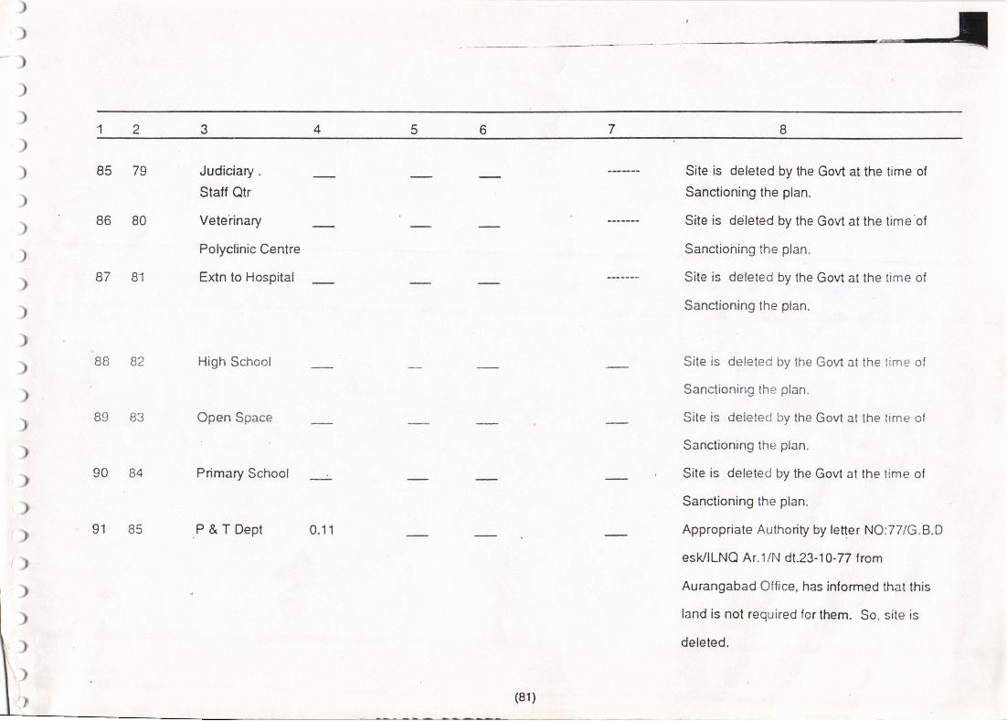
7
)
)*)
)
)
)
)
)
)
)
)
)
)
)
)
)
)r),)
r)(.>
)
)
)
)
i)
85 79
86 80
87 81
88 82
89 83
Judiciary.
Statf Qtr
Veteiinary
Polyclinic Centre
Extn.to Hospital
High School
Open Space
Site is deleted by the Govt at the time of
Sanctioning the ptan.
Site is ddleted by the Govt at the time'of
Sanctiohing the plan.
Site is deleted by the Govt at the time of
$anctioning the plan.
Site is deleted by the Govt at the time ol
Sanctioning the plan.
Site is deleted by the Govt at the time of
Sanclioning the plan.
Site is deleted by ttre Govt at the time of
Sanctioning the plan.
Appropriate Authority by letter NO:77IG.B.D
esk/ILNQ Ar.1/N dt.23-10-77 from
Aurangabad Office, has inlormed that this
land is nol required lor them. So, site is
deleled.
90 84 Prirnary Schoof
P&TDept91 0.11
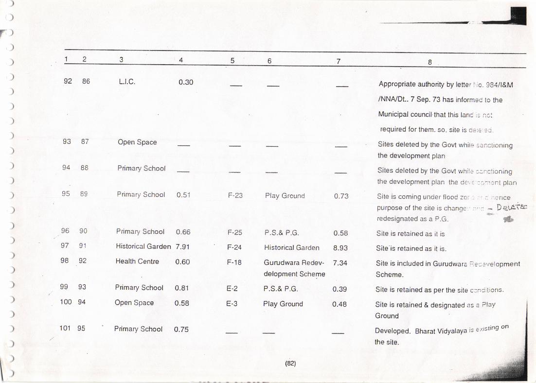
5
0.58
8.93
7.34
E-2
E-3
)
)
r))
)
)
)
)
)
)
)
)
)
)
)
)
)
)
)
)
)
)
)
)
r)l)I
92 86
oa a-7
94 88
q( Ro
96 90
97 91
98 92
oo o?vv vg
100 94
101 95
L.t.c.
Open Space
Primary School
Primary School
Primary School
Historical Garden
Health Centre
Primary School
Open Space
Primary School
0.30 Appropriate authority by letter i.,o. 984/l&M
/NNA/DI.. 7 Sep.73 has informec to the
Municipal councilthat this lanc ;s r:ot
required for lhem. so, site is cere ..:c.
Sites deleted by the Govt whire sanciioning
the development plan
Sites deleted by the Govt while :;r:ciioningthe development plan the der: ::r;.r:nt plan
0.73 Site is coming uncjer flooC zcr : , r_ ;,cr'lce
purpose of the site is changc i'. :. - DeuATsc,&.
redesignated as a P.G. &Site is retained as it is
Site'is retained as it is.
Site is included in Gurudwara F,sl*'reloomenl
Scheme.
Site is retained as per the site c:ncjjirons.
0.51
0.66
7.91
0.60
0.81
0.58
0.75
F-25
F-24
F-18
F-23 Play Ground
P.S.& P.G.
Historical Garden
Gurudwara Redev-
delopment Scheme
P.S.& P.G.
Play Ground
0.39
0.48 Site is retained & designated as a Play
Ground
Developed. Bharat Vidyalaya is e)ltsing on
the site.
(82)
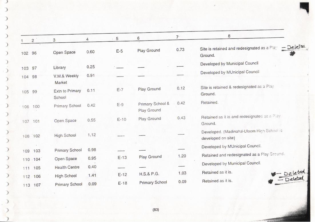
)
)
)
)
)
)
)
)
)
)
)
)
I)
)
)
)
)
)
)
)
)
)
)
)
)
)
102 96
103 97
104 98
.r n( qq
'r 06 100
107 101
1 0B 142
109 103
1 10 104
1 11 105
112 106
1 13 107
Open Space
Library
V.M.& WeeklY
Market
Extn to Primary
School
Primary School
Open Space
High School
Primary School
Open Space
Health Centre
High School
Primary School
Play Ground
Primary School &
Play Ground
Play Ground
H.S.& P.G.
Primary School
Retained as it is.
Retained as it is.
0.60
0.25
0.91
0.11
0.42
1.12
0.98
0.95
0.40
1.41
0.09
E-7
E-9
E-10
E-5 Play Ground Site is retained and redesignated as a P:a''
Ground.
Developed bY MuniciPal Council
Developed bY MUniciPal Council
Site is retained & redesignated as a Pia';
Ground.
Retained.
Retained as it is and redesignalet: :'s ; 't'::'Ground.
Devetoped. (Madinalr-rl-Uloom Hic:i Sch':'r:':
developed on site)
Developed bY MUniciPal Council'
Retained and redesignaled as a Play Gi'curi
Developed bY MuniciPal Council'
0.73
0.12
0.42
0.43
- te[e'fe*laE-#'
,
;ffiE-13 Play Ground 1.24
E-12
E-18
1.03
0.09
(83)
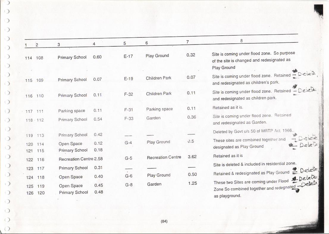
54
114 108 Primary School 0.60 E-17 Play Ground 0.32
o.o7
0.11
0.11
0.36
rl.5
3.62
0.50
1.25
Site is coming under flood zone. So purpose
of the site is changed and redesignated as
:::::::s under nood zone Retained ftr**'i ,
and redesignated as children's park'
Site is coming under flood zone- Retained { t u'"lo-"
and redesignated as children park'
Retained as it is.
Site is coming under flood zorre' Reiained
and redesignated as Garden'
Deleted by Govt u/s 50 of MRTP Act 1966'tP
These sites are combined logether and -;designated as PlaY Ground kRetained as it is
Site is deleted & included in residential zone'
1 15 109
116 110
117 11'1
1'18 112
119 113
120 114
121 115
122 116
123 117
124 118
125 119
126 120
Primary School
Primary School
Parking space
Primary School
Open Space
Open Space
Primary School O.42
Open Space Q.12
Primary School 0.18
Recreation Centre 2.58
Primary School 0.31
Children Park
Children Park
Parking sPace
Garden
Play Ground
Recreation Centre
Play Ground
Garden
0.o7
0.11
0.'!1
0.54
E-19
F-32
r-J l
F-33
', i-
)'38'3'\ifDet<'*'G-4
G-5
0.40
0.45
G-6
G-8
Retained & redesignated as Play Ground g D"*
These two Sites are coming under Ftood *035NZone So combined together and redegn"'#-'as playground.
Primary School 0.48
(84)
)
)
)
)
)
)
)
)
)
)
)
)
)
)
)
)
>
)
)
)
)
)
)
)
)
)
127 121
123 122
129 123
130 124
13'f 125
132 12b
{ rtafJ.j tzt
134 128
135 129
Library
High School
Primary School
Vegetabld MKt
BurialGround
BurialGround
Extencion to
cotton Research
Centre
Cremation
Ground
Library
0.70
1.31
0.12
0.30
1.20
1.42
0.45
3.33
0.10
G-l1
G-12
G-2
G-1
G-13
D-36
D-2
B-19
B-20
B-22
B-21
Garden
Play Ground
Primary School
Vegetable Mkt
Burial Ground
BurialGround
Bus dePol &
Stall Quarter
Crernation
Ground
Garden
E.S.R.
P.S.&P.G.
1.25
'1.42
0.12
0.14
0.79
1.30
7.00
Site is coming under flood zone' hence area
under the site is included in Garden
Site is coming under flood zone, so retained
&. designated as PlaY ground.
Retained
Retained
Retained
Retained
Area of this site is included in the
Bus Depot & Stalf Qtrs.
New site of
1.31
1.46
0.35
0.80
Cremation Ground'Garden,E-S-R- and
Prirnary School are proprsed in this site'
DeveloPed.
\
(85)
{f)i,)()
r)t)t)t)r)t)r)t)r)t)t)t)r)t)
r)r),)r)t)
r)
r)i)
136 130 District Centre 10.0
100.85
B-49
B-50
B-51
c-20
c-27
c-28
c-29
c-30
c-31
c-33c-32c-34
c-35
Dist.Centre
Garden
Veg.Mkt & SC
4.96
2.75
0.65
37.4
3.50
0.47
0.23
0.11
1.44
2.37
1.36
1.98
2.00
Dist.Centre, Garden & Vegetabfe Market u" a}f$iproposed in this site but layout is sanctioned
u/s 154 of M.R.& T.P. Act.1966 of 1'64 Ha'
area which is deleted and included in
residential zone.
Appropriaie authority by letter dt.5-12-91
had informed to M.C. that theY do no
reqrire complete land' They have acquired
the land outside the Municipallimit. so the
site is deleted. According to the prooosed
residential area, basic amenities are provided
and some land requirement proposals are
reserved in this site.
137 130A Marathwada
UniversitY
Sub-Cenlre
Extn to AirstriP
Play Ground
Primary School
MatemitY Home
Library
State Excise
Oftice & Staff Otrs
Nursery
High School& P.G-
Garden
Cremation
Ground
\()
(86)
,AA/^A4.,-\r^Ar-\AA, A| ^4, A A\ ,A. A\ ,S\ A, A /^ ,A.
Table No. - 15
LIST OF RESERVATIONS '
Area in Ha. Appropriate AuthoritYDesignationSr. No. Site No'
5.4.
.' I
(87) i
A-9
A-10
A-11
A-12
1.
(/r)
lll)l)II
1)i)i)ir;,i
;')
,)
'i )i
i)i l')li il.rlilll)li,,lj )ll')
Il
t.
.,'tc.
5.
6.
7.
8.
9..
10.
'11.
12.
A-1
A-2
A-3
A-4
A-5
A-6
A-7
. o'u
Play Ground
Burial Ground
Cremation Ground
Garden
Vegetable Mafiet & ShoPPing Centre
. Scavenger's Ouartes
Garden
Housing for Dishoused
Hostel
Dispensary
Ubrary
Piay Ground
SECTOR -A
5.00
0.45
0.45
4.24
0.34
1.66
2.00
2.38
0.36
0.47.
0j2 \
2.87
M.C.Nanded
M.C.Nanded
M.C.Nanded
M.C.Nanded
M.C.Nanded
M.C.Nandeci
M.C.Nanded
M.C.Nande(S' ff-;s":'ffi#&Az-e'i,l\c^r
Social Welfare DePartment.
M.C.Nanded
M.C.Nanded
M.C.Nanded E?'t dde'let\g \'*tacalo fic'dr s'an4-'
T
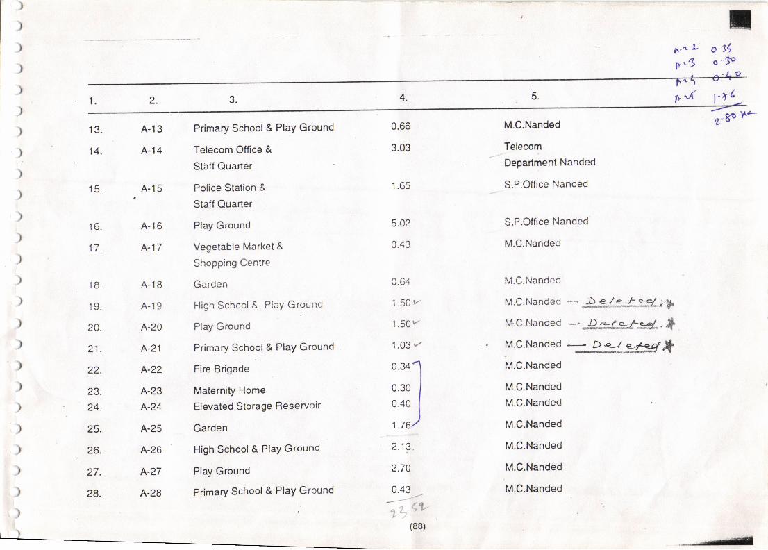
c',' JL o'jqV-3 o'3e
p -( fr{
)
)
)
)
)
)
)
)
)
)
)
)
)
)
)
)
)
)
)
)
),)
),)
r)rl
18.
1q
24.
21.
22.
23.
24.
25.
26.
27.
28.
A-13
A-14
A-15
A-16
A-17
A-18
A-19
A-20
A-21
A-?'2
A-23
A-24
A-25
A-26
A-27
A-28
s-8P l*
13.
14.
Primary School & PlaY Ground
Telecorn Office &
Staff Quarter
Police Station &
Staff Quarter
Play Ground
Vegetable Market &
Shopping Centre
Garden
High School& Play Ground
Play Ground
Primary School& PlaY Ground
Fire Brigade
Maternity Home
Elevated Storage Reservoir
Garden
High School& PlaY Ground
Play Ground
Primary School& PlaY Ground
0.66
3.03
1.65
0.&
1.50 r/
1.50r/'
1.03 ./
0.34
0.30
0.40
1.76
M.C.Nanded
Telecom
.Department Nanded
_ S.P.Olfice Nanded
S.P.Olfice Nanded
M.C.Nanded
M.C.Nanded
M.C.Nandeo - -&Sl*f,Sd-; -;M.C.Nanded - DL?otu44 ..*.
15.
16.
17.
5.02
0.43
i.tg.
2.7A
0.43
- f t
(88)
M.C.Nanded * D:J__?*d*M.C.Nanded
M.C.Nanded
M.C.Nanded
M.C.Nanded
M.C.Nanded
M.C.Nanded
M.C.Nanded
. ,. " t'_*"-*
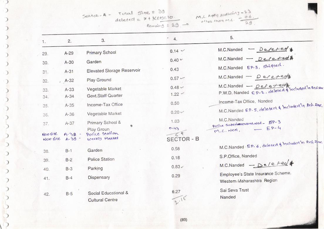
:,eA()z" ^ - T c/lcJ
dele'lcet3\a<. = 39a 7+t(f?f9
Rc'-4.i. rr : 2"$ -''
,,
6n.c n+Fo'*.1:';"n'SUe^1,44 Ahd!.? ^4,C 7 A ,
rl
5.4.3.
)
)
)
)
)
)
)
)
)
)
)
)
)
)
)
)
)
)
)
)
))
)
)
)
\' )
A-29
A-30
A-31
,A-32
A-33
A-34
A-35
A-36
A-37
A"bBA-bg -
B-1
B-2
B-3
B-4
2.1.
0.14 r
0.40 a'
0.43
0.57 q
0.48'z1.22 r
0.50
0.20,/
1.03
o"A3
---"1 xSECTOR - B
0.58
0.18
0.83 z
0.29
0.27
--i(
M.C.Nanded - *co
.)A
Nco olrartlco g\{e,
?tt
40.
41.
42. B-5
Primary School
Garden
Elevated Siorage Reservoir
Play Ground
Vegetable Market
Govt.Stalf Quarter
lncome-Tax Otfice
Vegetable Market
Primary School&
Plav GrcunPotica Saer\\on-uJe4A\f t4arL\rc,l
Garden
Police Station
Parking
Dispensary
Social Educational &
Cultural Centre
(8s)
M.C.Nanded - 2g&e*EP-3, #4 e^ '
'M.C.Nanded
M.C.Nanded
M.c.Nanded -
g*-ffit:;oc\qdec_\\n reb\ rarP.W.D' Nanded eP-L ' de'lcrtc
lncome-Tax Office, Nanded(--'
M.C.Nanded E?-5, a'\e\€/'\aA {
','*t;.Hlr51'*-'nrcar - g"-: i
-"**:.""u, -
EP-q
M.C.Nanded EP- I ' Adeae-d'$ \oclucleA\o eedr
S.P.Otfice, Nanded |
^
M.c.Nanded --AgLg- t%/ +Employee's State lnsurance Scheme'
Westem fvlaharashtra Region
Sai Seva Trust
Nanded
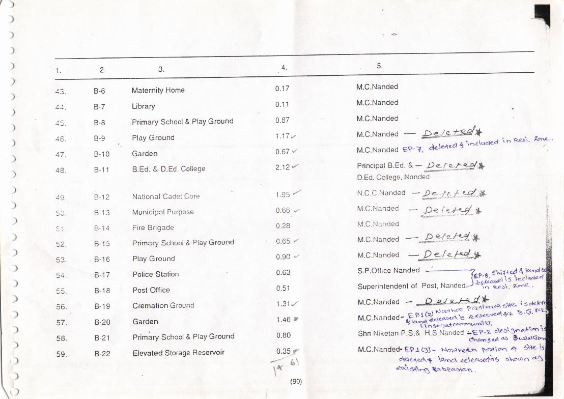
A3.l.
)
)
)
)
)
)
)
)
)
)
)
)
)
)
)
)
)
)
)
)
)
)
)
)
)
')
B-6
B-7
tt-o
B-9
B-10
D. II
El-la
t1-lq
B-16
rJ-i I
B-18
B-19
B-20
B-21
B-22
Maternity Home
Library
Primary School & PlaY Ground
Play Ground
Garden
B.Ed. & D.Ed. ColleEe
National e3flgl er;re
Municipal Purpose
Fire Brigade
Primary School& PiaY Ground
Play Ground
Police Station
Post Office
Cremation Ground
Garden
Primary School & PlaY Ground
Elevated Storage Reservoir
M.C.Nanded
M.C.Nanded
M.C.Nanded
M.c.Nanded - W-*M*M.C.Nanded e?- ?, dde*lad'{
\oa\t'rcleal
Principal B.Ed. *- k["uk*3/'*D.Ed. College, Nanded
N.C.C.tranded * *.,/.t t i.d-.*M.c.Nanded - R: I Zfl *I'l-C.hlanded
M.C.fJande d -;e*?t.?ry* *
M.c.Nanded - k-_[.y *d*,tt
0.17
0.11
0.87
t.tt,/
0.67 {
2.12r'
1.g5 /'
0.66. .z
0.28
. 0.65 "/
0.90 --
0.63
0.51
1 .31.,/
1.46 t
0.80
0.35 /
r('l
(s0)
i o Re$. Zaal- '
M.C.Nanded - -D&. ^e-"t*-Ct-,+=,uu- io,M.c.Nander-f,ff?ffi*":Shri Niketan P.S.& H.S.Nanded -€P-2 de-l\3c'a+\r'r
6narrgc-cl aa 9t'ltr<rM.C.Nanded-EPrc3)- NcrziuelLn pcrA\<n 4 elre-
dale,rcAt \arncr. ne\ec.roe4\s s\p.on d5ari ea\-O tcr bracq{azrr .
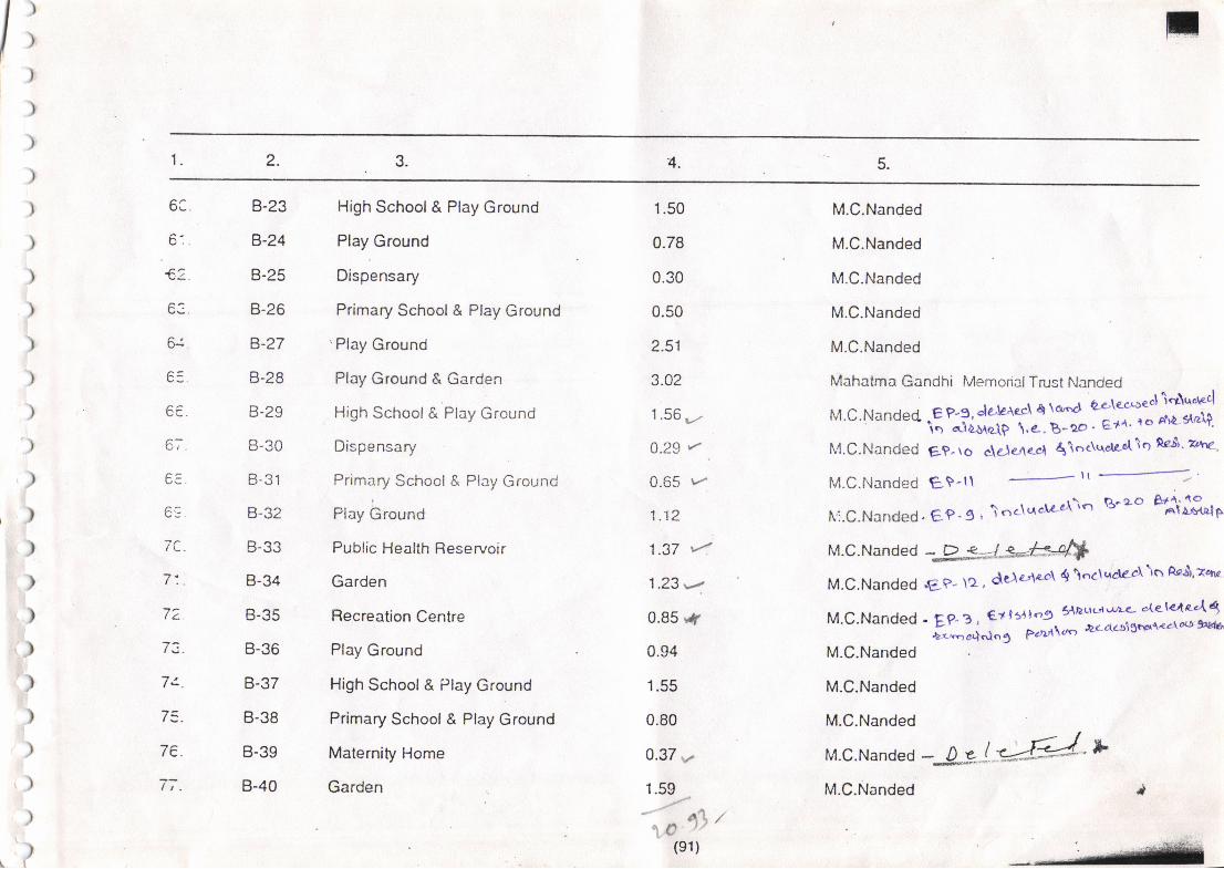
5.4.3.2.1.
6C.
6:.
,)
,)I
>I
)
)
)
)
)
)
))
)
)')
)
l)
l,)
')
")i),{
1)i
)
),)
)
..tl
r
cc.
6;.
e3
'ra
7:.
72
li-
7t.
l=.
7e.
It.
B-23
8'-24
B-25
B-26
B-27
B-28
B-29
B-30
B-31
B-32
B-33
B-34
B-35
B-36
B-37
B-38
B-39
B-40
1.50
0.78
0.30
0.50
2.51
3.02
1.56 e."
0.29 r' .
0-65 rr
1.12
1.37 41.23,,2
0.85 f0.94
1.55
0.80
0.37,.
1.59
High School & Play Ground
Play Ground
Dispensary
Primary School & Play Ground
'Play Ground
Play Ground & Garden
High School& Play Ground
Dispensary
Primary School & Play Ground
Play bround
Public Health Reservoir
Garden
Recreation Centre
Play Ground
High School& Play Ground
Primary School & Play Ground
Maternity Horne
Garden
M.C.Nanded
M.C.Nanded
M.C.Nanded
M.C.Nanded
M.C.Nanded
Mahatma Gandhi Memorial Trust Nanded
M.C.Nanded .E P?,deleAccl q ]d Q*\etaed\"r\'^"p4' icr -'d;& \... g-- ' E?t^' ro Au*strzl+'
N4.C.Nanded gt. r o c\c.1e.,rer,l {\oc\uar.A 1 q n€$' ?h4
M.C.Nanded EIP-ll tt
--='fi.C.Nanded. ec'9 i \.c\taci'c-r-\\n T3'zo gjiffi"fp
M.C.Nanded. Dj*JJr*'J/i*'M.C.Nanded .EP' ta , delaierl dl \''clqdc'cl\o Rc$'eqrc
M'C'Nande d'Er-g ' €t lstlr'g SAauc'r'r'r<- 'le-l4e.At*ljt-..', e'-f"'' e'dt'-D13io{'/loo 9tcq
M.C.Nanded
M.C.Nanded
M.C.Nanded
M.c.Nande d --{-J*"l-#"*
{*,(s1)
M.C.Nanded
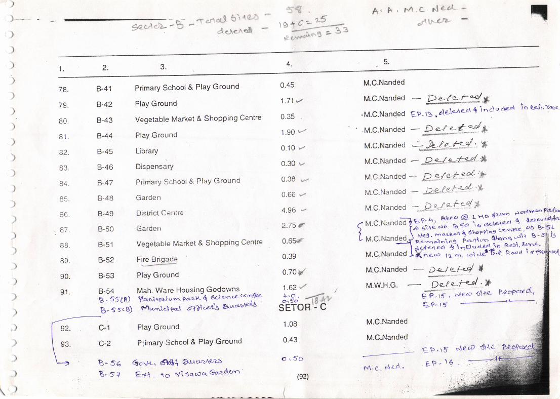
9c t't(--)nnb -{ *fl cr-9 :r
" '! ;
C cre-'r e&
A. F. M.C ile 61
*.nt !,.r C't-
rl
5.4.
)
) --
)
)
)
)
)
)
)
)
)
)
)
)
)
78.
'70
ou.
R1
a'l
84.
E6
o/.
oo.
qo
90.
91.
3.2.1.
B-41
B-42
B-43
B-44
B-45
B-46
B-47
B-48
B-49
B-50
B-51
B-s?
B-53
B-54s. sf(n)$- s sce)
Primary School & PlaY Ground
Play Ground
Vegetable Market & Shopping Centre
Play Ground
Library
Dispensary
Primary School & PlaY Ground
Garden
District Centre
Garden
Vegetable Market & Shopping Centre
Fire Brioade
---L-'Play Ground
Mah. Ware Housing GodownsSq<rilori urn pcrzR { 3cj a'<r c'e (<rrY{rZ4
fvlw';<l eqf 2r77\<cttz 6.r.e'urneaA
Play Ground
P6imary School & PlaY Ground
GcV.u, 6ie{ At-rcr'rAeraa
E+f . to vi 3o'uJcr' Ga'zd'trn'
0.45
1.71t
0.35
1.90 t-''
0.10 r
0.30 r''
0.38 {"/.
0.66 -"
4.96 -"
2.75 C
0.65.f
0.39
o.7ov
1.62 /j;5"' 4t,,
SETOR.; C
1.08
0.43
O,50
(s2)
M.C.Nanded
M.C.Nanded
-M.C.Nanded
' M.C.Nanded
M.C.Nanded
- D.-(-* t9 *EP-B .ale-\e''re-cr
$ inc\qde"r
- D ej e-*'J ***J-+t*4'*
io Rejr,?*r<
M.c.Nanded *-.-D.s-! e'*"4 ,* ,,or\rt*-o.np.a,rlc.
M.c.Nande??:';? si g \i;" -a:
r*g M.c.Nan."1:';? _::;; i:t**i fi,#.-f- * r *onegJ$*"T:ffi^ ?trii"{'.il;* 1-'} i'
r,,,. c ruanarelJ mxt, i::* r"T'l?j j't?"F
M.C.Nande d - ^Q*<=J s--"*34' '*
M.C.Nanded - R".qe- f3'/ "Y
M-c'Nande d - -Q€'tet-+4'&
M.C.Nanded - De]e-l-rs/ *
)
)
)
)
)
,)
)
)
)
)
\)
M'W.H'G- T'i -t*'t 'X**;.",.. p|opcl/d1g P-rS ' Nezc 5ne-E?- 15 t'-
92.
93.
c-1
c-2
B- s6B-sl
M.C.Nanded
M.C.Nanded
O4.C. s\ec\ '
Etr-t5EP - 16
,.\e eO d{e-
--=+e
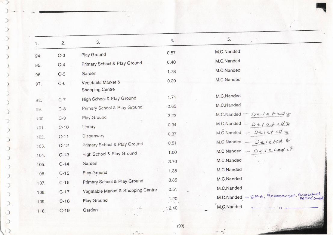
rl
5.4.
)
)
)
)
)
)
)
I
)
)
)
)
)
)
)
94.
96.
97.
i 00.
i 01.
'1A2.
1 04.
1 05.
'! 06.
1 07.
1 08.
1 09.
1 10.
c-3
c-4
c-5
c-6
c-7
C-B
c-9
c-10
c-11
c^12
c-13
c-|4
c-15
c-16
c-17
c-18
c-19
1. 3.2.
Play Ground
Primary School & PlaY Ground
Garden
Vegetable Market &
ShopPing Centre
High School & PlaY Ground
Primary School & PlaY Ground
Play Ground
Library
Dispensary
Primary Schoot& PtaY Grouncj
High School & PlaY Ground
Garden
Play Ground
Primary School & PtaY Ground
Vegetable Market & Shopping Centre
Play Ground
Garden
0.57
0.40
1.78
0.29
1.71
0.65
2.23
0.34
0.37
0.51
1.00
3.70
1.35
0.85
0.51
1.29
.2.40
M.C.Nanded
M.C.Nanded
M.C.Nanded
M.C.Nanded
M.C.Nanded
M.C.Nanded
M.C.Nanded
M.C.Nanded
lvt.C.Nanded
M.C.Nanded
M.C.Nanded
M.C.Nanded
M.C.Nanded
M.C.Nanded
M.C_.Nanded
M.C.Nanded
'M.C.Narided
"- -*:;!*"f::# $'':
*..25/ *f e4.*
-*.P*- i<-f 4 'p
-- .3*t Lrc4 &D Z.i e-.Ln4 ,--i'
(s3)
* 9p6, Rea-raa^oe.d, H&*S
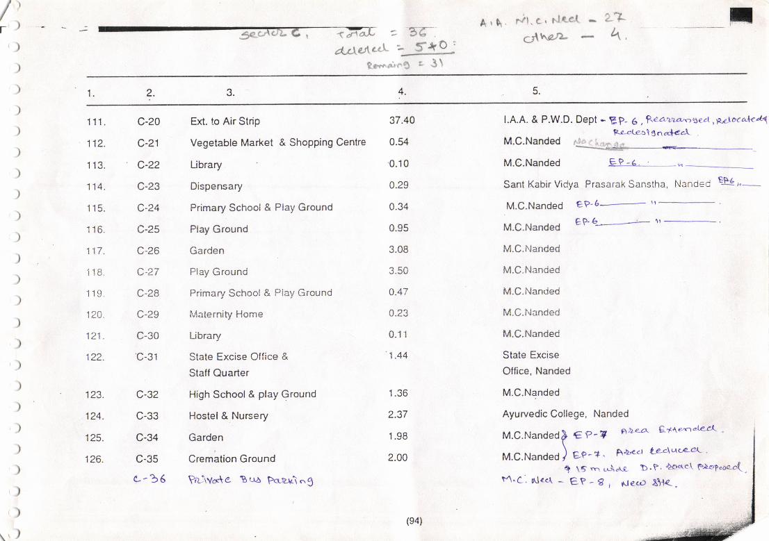
Ar\ r/1. e, rlae{^
c;\trarz-- 2.7
- 4,f,
< Fa* =5{rec\d,r)e;.ecL - 5lro '
P.c"r.. "r, r'S a 3 1
4.2.1.
lt/r)
)
)
)
)
)
)
)
)
)
)
)
)
)
)
)
)
)
)
)
)
)
)
)
q,)
111.
112.
1 13.
tt+.
1 15.
1 16.
't 1-7I tt.
i 18.
'1 19.
120.
121.
122.
123.
124.
125.
126.
c-20
c-21
c-22
w-2,)
c-24
c-25
c-26
c-27
C-28
c-29
c-30
c-31
c-32
u-.t.t
c-34
c-35
c--36
37.40
0.54
0.10
0.29
0.34
0.95
3.08
3.50
a.47
4.23
0.11
1.44
1.36
2.37
1.98
2.00
Ext. to Air Strip
Vegetable Market & Shopping Centre
Ubrary
Dispensary
Primary School & Play Ground
Play Ground
Garden
Play Ground
Primary School & Piay Ground
Maternity Home
Library
State Excise Office &
Staff Quarter
High School& play Ground
Hostel & Nursery
Garden
Cremation Ground
Prrivo*e tsua Pcrzx\n3
l.A.A. & P.W.D. Dept - EP- 6 ,Rea>za,csecl,p"ltocakaT
M.c.Nanded ,r.#"*tt"fM.C.Nanded E? -6. .
-.A
Sant Kabir Vidva Prasarak Sanstha. Nanded EP6
-
rl-
M'c'Nande( tv6-- tr
eD-b------> rl'l _-,M.C.Nanded
M.C.itlanded
M.C.l'Janded
M.C.Nanded
M.C.Nanded
M.C.Nanded
State Excise
Office, Nanded
M.C.Nanded
Ayurvedic College, Nanded
M.C.Nanded) €P-? P,he-a' Q1te'nak-r'( '\
M.C.Nandeo ) ee-*' Aa'e<t tJe-4qc-e-et' '
I ts ".r uria\c b'P' tottc\ F.)olcac-c'(,t1.C. nlee\ - g? - g I rrteco El.l<-.
(e4)
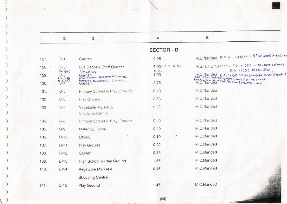
5.4.3.2.1.
)
'))
)
)
)
)
)
)
)
)
)
)
)
)
)
)
)
)
)
)
)
)
)
)
\)
127.
I zo.
129.
1 30.
1Q1
13?.
1 34.
1 35.
1 36.
137.
1 38.
1 39.
1 40.
D-1 .
u-1D- {lh)
B:3ttsD-4
D-5
D-5
t-7
u'3
D-10
LJ.I I
D-12
D-13
D-14
Garden
Bus Depot & Staff Quarter€a.2-c\e,q
"9ff9g+,"',q,,^ea'.rh cc"nllz-
\ana,nq Rr-ae,cr.acL Ce,nAPZ-.uarden
Primary School & Play Ground
Flay Ground
Vegetable Market &
Shopping Centre
Primary Schaol & Ptay Ground
Maternity Home
Library
Play Ground
Garden
High School & Play Ground
Vegetable Market &
Shopping Centre
Play Ground
SECTOR . D
0.98
Z.0O - L z- 6.0 ,
t.o"1.03
3.76
0.43
2.53
0.32
0.40
0.40
0.10
0.92
0.83
1.56
0.45
M.C.Nanded EP- 1' ddeaees { \oc\r-plcrli'' ng$'2"'"
M.S.R.T.C.Nanded * EP-\1 (5) LHa',Frz/<q aed'au4
eP- \tC:) r'leo: AhL.-lqlC.Nanded e p - \\ Ce) Rea:uzc',t,gat4 @;4i43**"4
ssi,EHstr:T.rtr,,*li,#rf ;-M.C.Nanded
tul.C.lilanded
\4.C.Nanded
1.45
M.C.Nanded
M.C.Nanded
M.C.Nanded
M.C.Nanded
M.C.Nanded
M.C.Nanded
M.C.Nanded
141. D-15
(es)
M.C.Nanded

5.4.\).2.1.
,,
i)
l
('
1A^tr/-.
| +J.
<lr
I A:.
l4+c.
1A'7tTt
I /rO.
I a.-'-
l::)u-
Irt
ta/
Jtr,ItJ1 .
'155.
1 56.
157.
1 58.
D-16
D-17
D.1B
D-19
D-20
D-21
D-22
D-23
D-24
D-25
D-26
D-27
D-28
D-29b- a3h)D-30
D-31
D-32
0.43
0.25
3.08
1.48
0.40
0.46
0.40
1.42
1.53
1.81
v.zJ
o.42
1.58
0.80
5.67
0.97
0.32
Primary School & Play Ground
Maternity Home
' Garden
Play Ground
Primary School & Play Ground
Elevated Storage Reservoir
Vegetable Market &
Shopping Centre
Play Ground
Hiqh School & Piay Ground
Garden
Dispensary
Primary School & Play Ground
Fruit Market & Godowns
Police Stationt'lwvrla-tpa-\ Cet.villr4 dam_ .
Truck Terminus
Play Ground
Dispensary
M.C.Nanded
M.C.Nanded
M.C.Nanded
M.C.Nanded gg- t b, A.L<.c.r e--taex.,cvc!.
M.C.Nanded EP- to . F.L,e-c1 r1eztuc,eeA,
M.C.Nanded g p- \ o , Re loca.lae\ ri .l s3ra da' D€'o
Y^,-a y2e tecu-:eel \nc\uazcl \ r-' S-r9,M.C.ilanded
M.C.Nanded
M.C.Nanded
M.C.Nanded
M.C.Nanded
M.C.Nanded
A.P.-fu1.C.Nanded E p lt c8) .+edk..-$ret
S.P. officie, Nanded Eptt c?)i e€-crDzelnq
il6,ffi'oaa* il*Til'^;f#,}M.C.Nanded
M.C.Nanded
(e6)
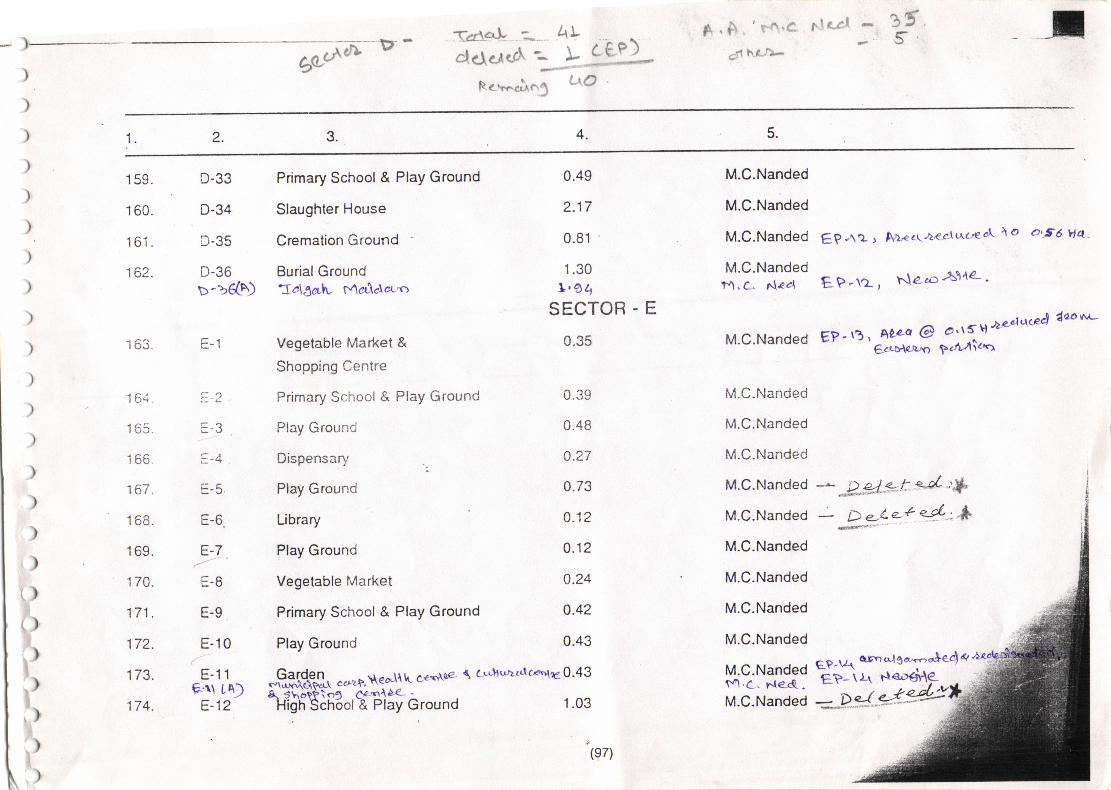
5oe,Atr D -
.i 'Ta"fl f.t(fl
,d ha..?*{.d4+ :*,
"lcl.-,rq,ct':R c ..^ci.. r,]
AY\ ceP)',.<r''*.?d
l.rO
4.2.1
)
)
)
)
)
)
)
)
)
)
)
)
)
)
)
)
r)t)
)
.)
,)
.)
)
1 59.
1 60.
161.
162.
i L)r.
I ol.
I oo"
to/.
I oo.
1 69.
1-7.r.
1-t1| / t.
172.
t/J.
174.
U.JJ
D-34
D-35
U-JO
D-)6(A)
=-l
=-J
=-4E-5
E-6.
E-7
E-B
E-9
E-10
E-11e-u rA)
E-12
Primary School & Play Ground
Slaughter House
Cremation Ground
Burial Ground-Ia\lalv Maelalet'cr
Vegetable Market &
Shopping Centre
Primary School & Play Ground
Play Ground
Dispensary
Play Ground
Library
Play Ground
Vegetable Market
Primary School & Play Ground
Play Ground
E P -\a r A1< c\,t<rl u'c'e cl \ o 0'56 vta -
E P -\2 , Ne": A\'t4- '
EP-\3 , ALzq @ o'rf,tl 4e'dacee) daovr'c
6'ttD'lp'r'o 924/lan
0.49
2.17
0.81
1.30L.64
SECTOR - E
0.35
0.39
0.48
a.27
4.73
0.12
0.12
0.24
0.42
0.43
M.C.Nanded
M.C.Nanded
M.C.Nanded
M.C.Nandedr{. c. Ne4
M.C.Nanded
M.C.Nanded
M.C.Nanded
M.C.Nanded
M.C.Nanded
M.C.Nanded
M.C.Nanded
M.C.Nanded
M.C.Nanded
M.C.Nanded
M.C.Nandedt'/'l .C , r.t€"d. -
M.C.Nanded
6p-\l{ a,trnt-lCdmc}€44gP-\\ Fl€DatAe-g$gt$. c c'zp. t\ eo'\{ k c €rdt€- I c LLh u}t td c^'le 0' 4 3
8.5hotPlo9 ee(l{A€- -
High Sch6ol-& Play Ground 1 .03
(e7)
="p.-r*4v
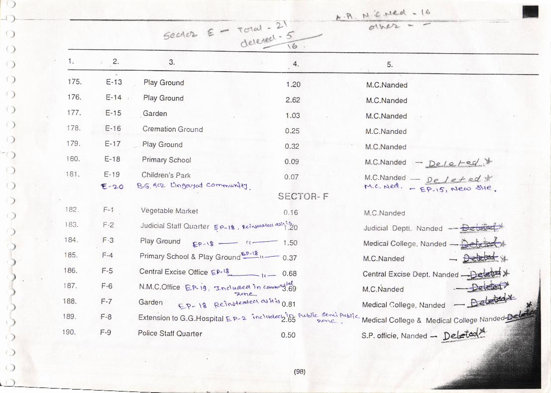
o\$c c'\ c1- € .F T#\tl'-l
$ctc'
5.4.?2.tt.
)
--. )--.--__ .-
,}
/)
)
)
)
)
)
)
')
)
)
)
)
E-13
E-14
E-15
E-16
E-17
E-18
E-19
E-zo
F-1
F-2
tr."
r-+
F-5
F-6
F-7
F-8
F-9
1.20
2.62
1.03
0.25
0.32
0.09
0.07
SHCTOR-
0.16
M.C.Nanded
M.C.Nanded
M.C.Nanded
M.C.Nanded
M.C.Nanded
M.C.Nanded
M.C.Nanded14. c, 51arl ,
M.C.Nanded
175.
176.
177.
I tJ.
r 5u.
'181.
Play Ground
Play Ground
Garden
Cremation Ground
Play Ground
Primary School
Children's Park
f3.€. {cz tiogeqa4 cocqr.\rrrrq{3 .
Vegetable Market
Judicial Staff Quarter Fp-le , tein$eor-*\\\20
Play Ground Ep-\! rt- 1.50
Primary School & Play Groundsjlg r,..--.- 0.37
Central Excise Office gD"t8_ r,_ 0.6g
N.M.C.office ep- ie , =-",,cr g()" *""c.dg
Garden q_?- \g Re-\oale..rec-r aoi'tls
O.gt
Extension to G.G.Hospitat Ep- 2 \c'c\trcletbl& P'rla'llc
0.50
- D**|**k#'".*-- p-g--/ ** eC :n"
- gP-\s, slecr: l$"le,
l oz.
| cJJ.
I o+.
1 85.
1 86.
187.
1 88.
1 89.
1 90.
Judlcial Deptt" Nandecj *#Fd #
Medical College,
M.C.Nanded
Nanded-.s#- F*kh#x
Central Excise Dept. Nand"d -[#dd*
M.C.Nanded
Medical College, Nanded
""i::^ F+bf ic- Medical college & Medical coilege Nande
Police Staff Quarter
(e8)
S.P. officie, Nanded - pg."-$#
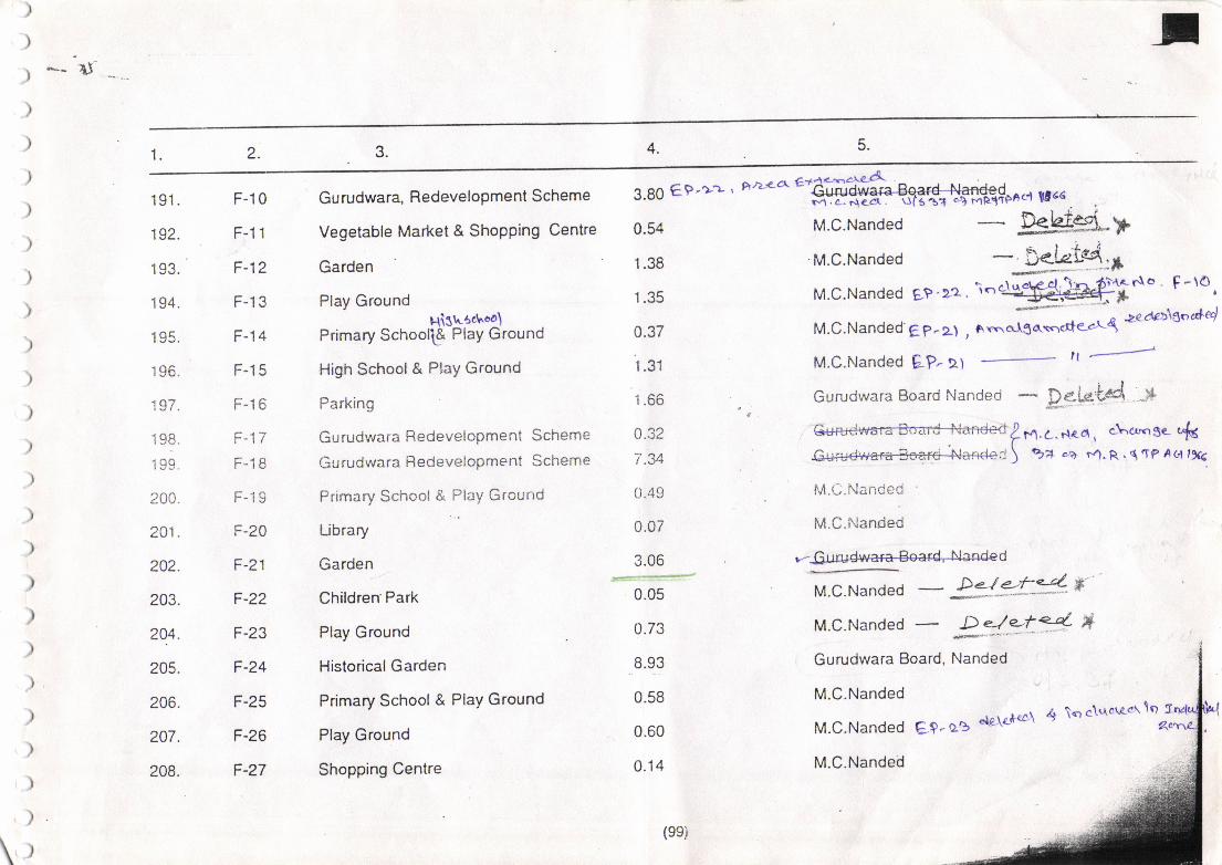
*- 1I- _-
5.4.3.2.{l.
lYt.
192.
1 93.
1 94.
1 95.
1 96.
'i97.
i98
zuv.
201.
202.
203.
20.4.
205.
206.
207.
208.
F-10
r-t I
F-12
F-13
F-14
F-15
F-16
F-17
F.1B
r- t:,
F-20
F-21
F-22
F-23
F-24
F-25
F-26
F-27
Gu rudwara, RedeveloPment Scheme
Vegetable Market & Shopping Centre
Garden
Play GroundHistrct"oa\
Primary Schooli& PlaY Ground
High School& PlaY Ground
Parking
Gurudwara RedeveloPment Scheme
Gurudwara RedeveloPment Scheme
Primary School & PlaY Grourrd
Library
Garden
Children'Park
Play Ground
Historical Garden
Primary School & PlaY Ground
Play Ground
Shopping Centre
3.g0 €.9.r-z, F/2re4'etfu$pac,t xrce
.
o.s4 M.C.Nande -PSk}#..-P1 .38 'M.C.Nanded - D€l^elad.t
M.C.Nanded EP'"2.'i''rg-rF€*-'-
-'t!-
uatf-rl. \:nr f)'\e- n\o' F -\O1 .35 M.C.Nanded EP ' tz . i."Jst$${.{ 'r
I
0.37 M.C.Nanded'ee-zt , ArnerlSA\qde-e-Lq 'zeder>\ooded
1.31 M.C.Nanded EP-lt rt F^il
1.66 . o Gurudwara Board Nanded - P.*U't4q i+
0.32 ry/.1...n"o, c-\c,-gec&
1.34 @*) %d'"4 F4.F..qTPAell9f<
t).49 M.L.Nanded
0.07 M.C.Nanded
3.06 r--Gr,r@fl
-;* M.c.Nanded - 2!-=t*'*-0.73 M.c.Nanded - R_*=t4 *8.93 Gurudwara Board, Nanded
0.58 M.C.Nanded
0'60 M'C'Nanded El'q.' ode\e'tec\ 4 \orc\''rorccr\o
0.14 M.C.Nanded
(esi
\
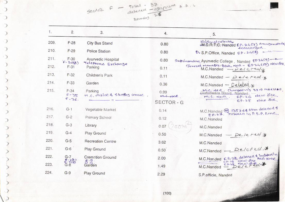
$-c;\r"tJ-TC'\a,r-l
de\e /*c't
P'2'nr'c*i"'
hF
4.?2.1.
209,
210.
211.
212.
213.
214.
215.
F-28
F-29
F-30tr- 3qA)
F-32
r-JJ
F-34F_b5€-i6-
G-1
v-z
r.f-J
G-4
G-5
G-6 '
G-7
*:tBt\:-o
0.80
0.80
0.80
0.11
0.11
0.36
0.99
City Bus Stand
Pblice Station
Ayurvedic HospitalTe-le-P6oxra Eacl-a,og<
rarKlng
Children's Park
Garden
Parkingi,A.C. ar++\ca4 6ho$P5 cr'rAa€-
d e7- 22"/;:+) otrn"rrScrmodcal(.P-Zn-z:tt!n34c^- -
Vegelable fvlarket
Primary School
Library
Play Ground
Recreation Centre
Play Ground
Cremation Ground4.€ .
^q ,q.uaroen
Play Ground
r'+-1-1:{'e4 ,
SECTOR - G
o.14
a.i2
007 ':- ,
0.50
3.62
0.50'
2.00
1.49
2.29
tl
D. S.P.Office, Nanded ep. zAc9 -Lu.---
Sr.tQdrclae5deno, Ayurvedic College . Nanded €P LA:92
Q 2,..e:>a3, tv1 dr-a€ €2: r 86il u, ^.o' -'
? p - t{ q l^\) t'{ gt'r 6'ltM.C.Nanded
-.F "-!"%f.:*l*M.C.Nanded - t) e-/ <- ; <d. , g
M.c.Nand"o -*.gg iui.q *^M.a. .tec{ CLzr'r,aCcQ !r/5 o.r" 4, h4AqTP}c,L;Un rcjrt'a ra trO:rCi, Nandeei
r-1.c-. {<-c\ . -.-ffi6
NletD bi'le--c-e GP- 2s deuo :$le-'
M'c'Nandec Q tbt3'4€ calY cle.leiarl9'-'EpJ*. -l.to\Aor-o*A le P- <.P- &'c'cr€-..-
M.C.Nanded
M.C.Nanded
M.C.Nanded De- I e- k <-4 :Y
M.C.Nanded F..r+ '
z to-
217.
218.
219.
22A.
221.
222.
223.
224.
M.c.Narr.red 6- P- eA, +93i1-{&*1I,.-"-.' -;:::--- aF zA NI.ecO d54<
ffi*dtr"%y>2*&t+ *f
M.C.Nandeo --**;p e.-/c-{ e-d "*
i
G-9
(100)
S.P.officie, Nanded
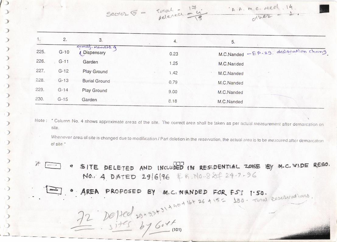
Qt# -Aclatn
n crl+ . 'A.4, ?\.c..
^re.1d " \q,
$acslcfr- S 5;,W-'--- -j'---':.'
t,)
)
)
)
)
)
)
)t,
)
)
)
)
)
),)
)
)
)
)
225.
226.
227.
228.
229.
230.
G-10
G-l1
G-12
G-13
G-14
G-15
'1. 2. 4.
0.23
1.25
1.42
0.79
9.00
8.18
fDispensary
Garden
Play Ground
Burial Ground
Play Ground
Garden
M.C.Nanded *EP'13'
M.C.Nanded
M.C.Nanded
M.C.Nanded
M.C.Nanded
M.C.Nanded
dealoyc^l\cnq c\op.'9
Note: 'column No. 4 shows approximate areas o! the site. The correct area sha be raken as per actual rneasurement after demarc;tion onsite.
whenever a€a ol site is changed due to modilicalion / Pari detelion in the rese.vation, the actuni aren is to be measured aler c,emarcllianof site '
5 tTef{o..'
"4REA
FEttTeD #ilD tfrwffi lu nFsiD$l?r}tAu zdsG
1 Bfr'teD 2-E16\96 t- fi ,ilo, 3 ie't 2+'7 'I (8y fi"c, \.lffi qf;so'
l"fo,t.;; fl*::</i'rl ral" #'*a
'
- . ___-a-..-
--J'
4r5a \go..\
w
t= PROP6.6ED ET ff1,€,,s.till.tDEg trop\ F.ff
' b glyl\\hc*\bY26Jz Mlx! *^+ 5;#{ bl,Cn(,,
/
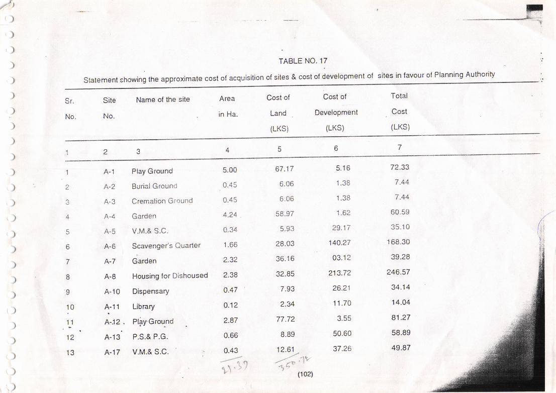
F*='--
TABLE NO. 17
statement showing the approximate cost of acquisition of sites & cost of development of sites in favour of Planning Authority
tt
)
)
)
)
)
)
)
)
)
)
)
)
)
)
No.
Site Name of the site Area
No. in Ha.
Cost oi
Land
(LKS)
Cost of
Development
(LKS)
Total
Cost
(LKS)
1
L
3
q
6
'l
B
I10
I12
't3
A-1 Play Ground
A-2 Burial Groun':
A-3 Cremaiion Ground
A-4 Garden
A-5 V.M.& S.C.
4-6 Scavenger's Quarter
A-7 Garden
A-8 Housing for Dishoused
A-10 Dispensary
t-'" Library
A-12 . Plgy'Grou-nd
A-13 P.S.& P.G.
A-17 V.M.& S.C.
5.00
0.45
0.45
4.24
1.66
2.32
2.38
0.47
o.12
2.87
0.66
0.43
!
67.17
D.UO
b-ub
(c?
28.03
36.1 6
32.85
70?
2.34
77.72
8.89
12.61-tt.',/' .'iV
zF I
zI >t)(102)
5.16
1?R
1.62
29.17
140.27
03.12
213.72
26.21
11.70
50.60
37.26
72.33
7.44
7.44
60.59
35.10
168.30
39.28
246.57
34.14
14.04
81.27
58.89
49.87
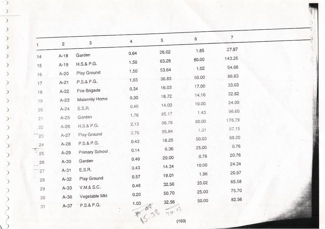
)
)
14
1(
16
1all
IQIU
/t t
/:.r:.{-i-
L.:
z,+-:*'
'zs26
'c7
10
29
"n11
A-18
A-19
A-20
A-21
A-22
A-23
A-?.4
A-25
A-26
A-ZT
A-28
A-29
A-30
A'q1
A-32
A-33
A-36
A-37
0.64
1.50
1.50
1.03
0.34
0.30
0.40
1.76
2.13
t7n
0.43
0.14
0.40
0.43
0.57
0.48
0.20
1.03
26.A2
63.26
53.tr
36.83
16.03
18.72
14.00
95.17
96.79
95,84
18.20
6.36
20.00
14.34
19.01
32.56
50.70
32.56
1.85
80.00
1.02
50.00
17.00
14.10
10.00
1.43
80.00
l.J I
50.00
25.00
0.76
10.00
1.96
33.02
25.00
50.00
Garden
H.S.& P.G.
Play Ground
P.S.& P.G.
Fire Brigade
MaternitY Home
E.S.R.
Garden
i{.s.& P.G.
Play Ground
P.S.& P.G.
Primary School
Garden
E.S.R.
Play Ground
V.M.& S.C.
Vegetable Mkt
P.S.& P.G.eq)
)
\)
Y.1 ^
\"
.l
(103)
27.87
143.26
54.66
86.83
33.03
32.82
24.04
96.60
r"7A7O
(:l lq
68.20
u./o
20.76
24.34
?0.97
65.58
75.70
82.56
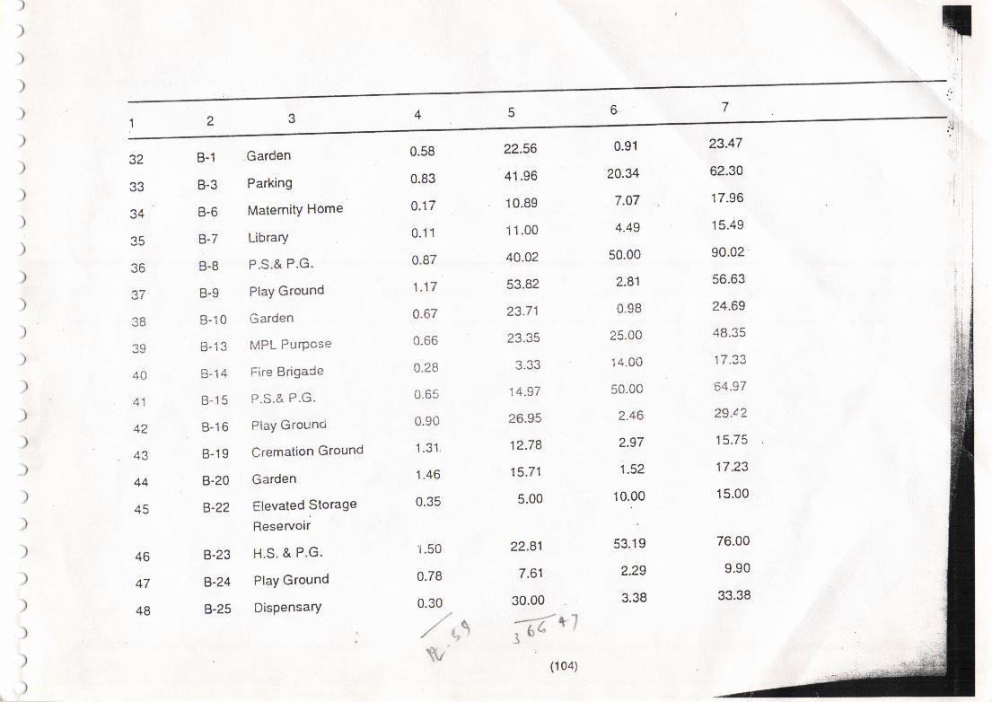
32
e?
34
?R
J{
AA
*i
42
.+J
44
45
46
+t
48
B-1 Garden
B-3 Parking
8-6 MaternitY Home
B-7 Library
8.8 P.S.& P.G.
B-9 PlaY Ground
B-10 Garden
B-13 fv4PL PurPose
B-14 Fii'e Brigace
B-15 P.S.& P.G.
B-16 PlaY Gt'ounci
B-19 Cremation Ground
B-2A Garden
B-2? Elevated Storage
Reservoir
B-23 H.S. & P.G'
B-24 PlaY Ground
B-25 DisPensary
0.58
0.83
n {7u.t,
0.11
0.87
1.17
0.67
0.66
0.28
0.65
0.90
1.31.
1.46
0.35
"i.50
0.78
0.30
//\./ r,'
\.tv
22.56
41.96
10.89
11.00
40.o2
53.82
23.71
t? ?q
14.97
26.95
12.78
15.71
5.00
22.81
7.61
30.00
-;7'q:, t)=
(1 04)
0.91
20.34
7.07
4.49
50.00
2.81
0.98
25.00
'14.00
50"0c
2.46
2.97
1.52
10.00
53.19
2.29
3.38
23.47
62.30
17.96
15.49
90.02
56.63
24.69
48.35
.t -7 1'1
or+.y /
29.c2
15.75
17.23
15.00
76.00
9.90
33.38
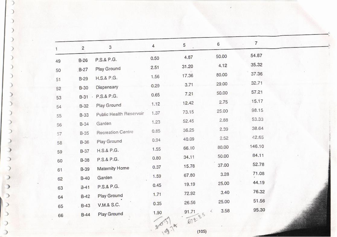
)
)
)
)
)
)
)
)
49
50
51
52
53
54
56
:r/
('l
<a
60
6'l
62
o.t
64
b5
66
8-26 P.S.& P.G.
B-27 PlaY Ground
B-29 H.S.& P.G'
B-30 DisPensary
B-31 P.S.& P.G.
B-32 PlaY Ground
B'33 Public Health Reservoir
B-34 Garden
B-35 Recreation Centre
8-36 PlaY Ground
B-37 H.S.& P.G.
B-38 P.S.& P.G.
B-39 MaternitY Home
B-40 Garden
i3-41 P.S.& P.G.
B-42 PlaY Ground
B-43 v.M.& s-c.
g-44 PlaY Ground
0.50
2.51
1.56
0.29
0.65
1.12
1 .7'f
1.23
0.85
0.94
1.55
0.80
0.37
1.59
0.45
1.71
0.35
1.90
,/'A,f
"rx,\.
'*-l
4.87
31.20
17.36
3.71
7.21
12.42
73.15
52.45
36.25
40.09
66. l0
34-11
15.78
67.80
19.19
72.92
26.56
91.71 ,, ',' a)
'-/-.tt
lAvl!,/ I
(105)
50.00
4.12
80.00
29.00
50.00
2.75
25"00
2.88
2.39
2,52
80.00
50.00
37.00
3.28
25.00
3.40
25.00
3.58
54.87
35.32
37.36
32.71
57.21
15.17
98.15
38.64
42.65
146.10
84.11
5?.78
71.08
44.19
76.3?
51.56
95.30
)
))
)
t
)
)
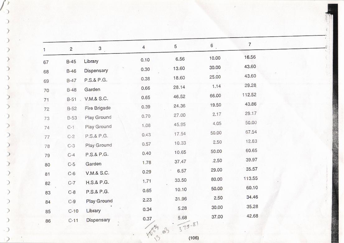
/"
)
)
,
)
)
I
)
I
)
I
,
)
67
68
69
70
71
72
-A/3
77
78
79
80
81
82
83
84
85
86
B-45 Library
8-46 DisPensary
B-47 P.S.& P.G.
B-48 Garden
B-51 V.M.& s.c.
B-52 Fire Brigade
B-53 PlaY Ground
C-r Pla.Y Ground
C.2 P.S.& P.G.
C-3 PlaY Ground
C.4 P.S.& P.G.
C-5 Garden
c-6 v.M.& s.c.
C-7 H.S.& P.G.
c-8 P.S.& P.G.
C-9 PlaY Ground
C-10 Library
C-l1 DisPensary
6.56
13.60
18.60
28.14
46.52
24.36
27.00
45.95
17 "54
10.33
10.65
37.47
6.57
33.50
10.10
31.96
5.28
5.68' -'"-r .8 )
I ',t) (106)
0.10
0.30
0.38
0.66
0.65
0.39
0.70
1.08
0.43
0.57
0.40
1.78
0.29
1.71
0.65
2.23
0.34
0.37 ,,/ rtl'dr",, \".,
10.00
30.00
25.00
1.14
66.00
19.50
2.17
4.05
50.00
2.50
50.00
.2.50
29.00
80.00
50.00
2.50
30.00
37.00
16.56
43.60
43.60
2928.
i12.52
43.86
29.17
50.00
67.54
12.83
60.65
39.97
35.57
113.55
60.10
34.46
35.28
42.68
/)o*)
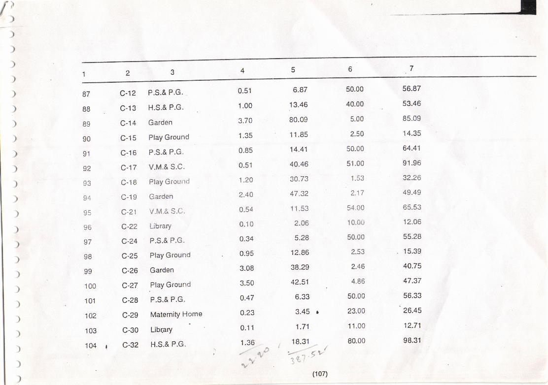
{
)
)
)
)
)
)
)
)
)
)
)
)
)
)
)
)
)
)
)
)
)
)
)
)
)
)
87
88
89
90
91
92
o?
od
oq
g6
97
98
oo
100
101
102
103
104
c-12 P.S.& P.G.
c-13 H.S.& P.G.
C-14 Garden
C-15 PlaY Ground
c-16 P.S.& P.G.
c-17 v.M.& s.c.
C-l8 PlaY Ground
C-19 Garden
c-21 v.M.& S.C.
C.22 Library
c-24 P.S.& P.G.
C-25 PlaY Ground
C-26 Garden
C-27 .PlaY Ground
c-28 P.S.& P.G.
C-29 MatemitY Home
C-30 Library
c-32 H.S.& P.G.
6.87
13.46
80.09
11.85
14.41
40.46
30.73
47.32
11.53
2.06
5.28
12.86
38.29
42.51
6.33
3.45 I
1.71
18.31i //' ,/'z'7 < v',34, |
''(107)
0.51
1.00
3.70
1.35
0.85
0.51
1.20
2.44
0.54
0.10
0.34
0.95
3.08
3.50
o.47
o.23
0.11
1.36.r- rD
v-v
50.00
40.00
5.00
2.54
50.00
51.00
1.53
2.17
54.00
10.00
50.00
2.53
2.46
4.86
50.00
23.00
1 1.00
80.00
56.87
53.46
85.09
14.35
64.41
91.96
32.26
49.49
o3.3J
12.06
55.28
. 15.39
40.75
47.37
56.33
'26.45
12.71
98.31
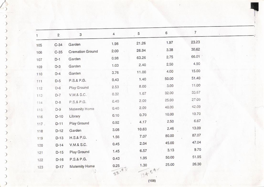
Trt'/t>,)
)
)
)
)
)
)
)
)
)
)
)
)
)
)
)
)
)
)
)
)
)
)
)
105
106
107
109
110
111
112
113
i14
;1 15
116
117.
118
119
124
121
122
123
1.98
2.OO
0.98
1.03
3.76
0.43
2.53
0.32
0.40
0.40
0.10
0.92
3.08
1.56
0.45
1.45
0.43
o.25?4.
---- -A U
++
1.97
3.38
2.75
2.50
4.00
50"00
3.00
32.00
25.00
40.00
10.m
2.50
2.46
80.00
45.00
3.13
50.00
25.00
23.23
30.62
66.01 '
4.90
15.00
51.40
11.00
33.67
27.09
42.09
r0.70
6.67
13.09
87.07
47.04
9.70
51.95
26.30
C-34 Garden
C-35 .Cremalion
Ground
D-1 Garden
D-3 Garden
D-4 Garden
D-5 P.S.& P.G.
D-6 PlaY Ground
D-7 v.M.& s.c.
D-8 P.S.& P.G.
D-9 Materni$ Horne
D-10 Library
D-l1 PlaY Ground
D-12 Garden
D-13 H.S.& P.G.
D-14 v.M.& s.c.
D-l5 PlaY Ground
D-l6 P.S.& P.G.
D-17 MatemitY Home
21.?6
26.94
63.26
2.4A
11.00
1.40
8.00
1.67
2.49
2.09
0.70
4.17
10.63
7.A7
2.O4
6.57
1.95
1.30
/.---/ Lk /\1 t(', 'i,
(108)
t)
)lFr.-:
)
)
)
)
)
)
)
)
)
)
)
)
)
)
)
)
)
)
)
)
)
)
)
,)
0.81
1.30
-.- ^SA'a-.7-
-r-r'
10.63
o.zr
2.09
2.54
e.09
4.62
6.93
8.20
1.2A
r.90
40.63
4.39
1.67
2.?2
7.50
3.67
5A9 '7 <^X(
lft'' "
(10e)
124
125
126
127
128
129
130
131
132
133
134
135
136
137
138
139
140
D-18 Garden
D-19 Play Ground
D-20 P.S.A P.G.
D-21 Elevated Storage
Reservoir
D-?2 V.M.& S.C.
D-23 Play Ground
o-24 H.S.& P.G.
O-25 Garden
D-26 Dispensary
o-27 P.S.& P"G.
D-30 . Truck Terminious
D-31 Play Ground
D-32 Dispensary
D-33 P.S.& P.G.
D-34 Slaughter House
D-35 Cremation Ground
D-36 BurialGround
3.08
1.48
0.40
0.46
0.40
1.02
1.53
1.81
0.23
a.42
5.67
0.97
2.46
3.16
25.00
10.00
40.00
2.62
bo.oo
1.t18
23.00
50.00
6.19
1.56
32.00
50.00
54.25
2.34
2.96
13.08
9.87
27.49
12.50
42.O9
7.24
86.93
10.08
24.24
52''2
46.82
5.95
33.67
5222,
61.75
6.01
8.85
Nj
o.32
0.49
2.17
IF,ii1
1,
1
I
I
)
)
)
)
)
)
)
)
)
)
l
)
I
,
)
141
142
143
144
145
146
1 r,,7
i+o
iqY
i50
i51
t3z
153
1.54
155
156
157
158
E-1
E-2
E-3
E-4
E-5
E-6
E-7
E-B
t-v
E-'10
t-ll
c_- lz
E-13
E-14
E-15
E-16
E-17
E-18
0.35
0.39
0.48
o.27
0.73
0.24
a.12
0.24
a.42
U, '+J
0.43
1.03
1.24
2.62
1.03
0.25
o.32 ,
0.09.A
--'tl.--, o k\
16.48
6.00
6.40
3.54
9.73
3.70
1.90
J./U
3. / .)
42.43
41.38
, 26.80
28.O2
1 .15
2.46
o.92
'.,rT
35.00
25.00
1.80
23.00
2.22
24.0O
0.91
24.O4
50.00
l.lL
0.92
80.00
2.86
2.25
1.42
1.30
1.47
9.00
51.48
31.00
820
26.54
11.95
27.74
2.81
27 "70
3l.ou
t ,41)
18.47
122.O3
44.24
29.05
29.44
2.45
3.93
9.92
v.M.& s.c.
P.S.& P.G.
P.G.
Dispensary
Ptay Ground
Vegetable Market
Play Ground
Vegetable MaCxet
P.S.& P.G.
PlaY Ground
Garden
H.S.& P.G.
Play Ground
Play Ground
Garden
Cremation Ground
PlaY Ground
Primary School'i't
(1 1o)
)>
)
)
)
)
)
)
)
)_
)
)
)
)
)
)
)
)
)
)
)
)
)
)
159
160
161
162
163
1tr
165
166
167
168
169
170
171
172
173
174
175
176
E-19 Children's Park
F-1 Vegetable Market
F-4 P.S.& P.G. .
F-6 N.M.C.Office
F-11 v.M.& s.c.
F-12 Garden
F-13 PlaY Ground
F-i4 P.S.& P.G.
F-15 H.S.& P.G.
F"19 P.S.& P.G.
F-20 Library
F-22 Children Park
F-23 PlaY Ground
F-25 . P.S.& P.G.
F-26 PlaY Ground
F-27 ShoPPing Centre
F-31 Parking
F-32 Children's Park
0.07
0.16
0.37
3.69
0.54
1.38
1.35
0.37
1.31
0.49
0.07
0.05
0.73
0.58
0.60
0.14
0.11
o.11-.z,lVtlt'\
a.52
6.64
11.67
120.16
53.15
30.00
29.re
9.25
16.40
1A.62
2.U
5.84
74.40
26.05
30.86
16.46
13.33
cat /'''-/ L1 /,/- t.- ///tv_h'q-
0.37
16.00
25.00
100.00
50.00
1.65
3.02
25.00
80.00
50.00
7.00
0.58
2.n.
50.00
2.A1
14.00
5.50
0.86
0.89
22.64
36.67
222.16
103.15
31.65
32.24
34.25
96.40
60.62
9.34
. 6.42
76.62
76.05
32.87
30.46
18.83
6.30
n)
)
)
)
)
)
)
))
)
)
)
)
)
)
)
)
)
)
)
)
)
)
)
)
\)
177
178
179
180
181
182
183
184
185
186
187
188
189
190
191
F-33
G-1
t2'2.
G-3
G-4
G-5
G-7
G-8
G-9
G-10
G-11
G-12
G-13
G-14
G-15
G-16
0.36
o.14
17.82
9.42
8.07
5.47
27.85
169.32
27.85
179.80
42.52
60.32
7.67
35.67
40.52
22.*
?14.0Q
?.52,.71
0.84
14.20
25.00
7.Ag /1.85
4.95
1,.95
3.67
1.70
3.93
23.00
1.56
3.10
2.31
4.20
4.00
18.66
23.62
33.07
iz.qt
29.70
174.27
29.70
183.s3
4422
64.25
30.57
37.23
43.62
24.85
21820
256.71
Garden
Vegetable Mkt
Primary School
Library
Play Ground
Recreation Centre
Play Ground
C-remation Ground
Garden
Play Ground
Oispensary
Garden
Play Ground
BurialGround
Play Ground
Garden
a.l2
0.07
0.50
3.62
0.50
2.OO
1.49
2.29,
0.23
1.25.
1.42
0.79
9.00
8.18
*#,1€-
0* |lA(o\'t (1121
4300.26 965127
Table No. 18
COST FOR IMPLEMENTATION OF D.P. HOADS
Sector No. Road width Road length land acquisition
in meter cost (laks)
Road construction
cost(235/se-m)
Side drains Total cost
cost (1240 rim in laks
12m15m18m
1 1251 325200
94.50139.12
25.24
31.72
46.70
8.46
1C trn
16.43
2.48
140.17
242.2536.14
12mlBm
1 4301 600
171 .60
288.004A3267.68
17.73
19.84
229.65375.52
r. 12m15m'18 m
24m
1 07532001 7001 000
64.50240.O4
153.00120.00
30.311 12.8071.91
56.40
39.68z l.uc12.40
luc.t+392.48245.99188.80
D 12m15m24m
1 97541 501 350
105.65
?80.12145.80
146.2976.14
2.4.49
51.4616.74
477.87
E 12m15 m
750400
45.0030.00
21.1514.10
9.304.96
75.4549.06
F 9m12m15 m
5001 850
550
54.00266.40
99.00
10.5752.17'to ?o
6.2022.14
6.82
70.77341.91i25.21
G 12m18m
4002650
38.40
381.601't.28
112.104.96
32.2654.64
525.96
€6 Total 4065.0
^ 1-{ ' - ',l
(r13)
--.t -)r l-4:-trv")q:"-.:
c.-\e--!_
-_
-: c\ri- f t;.. rrthtf, --,1 ,o'-'.. \
:-i*l {__,\':--, "l''I
,---t\.. t!*.-l
,--\\ ta
a- | |$'
t\i,; I
,;\.Lj. I
-. ji-\-'-\*.1't"t't
"l' 1
itl. cY i.,'
rli-t:=l'..\
" ,^l'.q,. Ilt)
r 'iI (1'
lr /'i=r 'l nI i
i.{
c-cJ
..iJ ' i'-r''f,-.. at),- ' ," ,:'rt .
"'j ":: l- I :.:-
i.*t-\=J;^i
r).!{il
''?. I
J 'il,.r. t
., -l,*-.1
r''r. ' I I I
+trt -ri'gri'*- f*'i,( c{ I i"rQ*i:""
! r,;L\r<.r.l
a:
e--e":\
<i
i
Ili
,. I
,,i)"
i+.
-1
,L
\u:"'
\tt
s(-r$v)
tiI. i : ': I I
rlrl\.-
I
fr
rI
Table No. 19
PHASED PROGRAMME FOR ACQUISITION OF SITES
Fifrh Sixlh Seventh Eeiohth Nineih I ^ ^+Ld>t
Sr. \/c: rq First Second Third Fourth
10
)
)
)
)
)
),1 r-i : '' ;
)
)
)
)
,
", ,). ,
)
)
)
Nane of SiteNo
1) Pr:nary SchooU
^^ P.:.&t-.tf.
A- IJ
u-6
c-2
8-15
c-4
F-4
r\-Zl
B-21
C.B
D-5
6-ZO
c-2
v-z
A-28
B-31
c-12
D.B
B-38
c-16
F-14
A-29
B-41
c-24
D-16
B-47
E-9
F-19
A.J /
C-28
D-27
D-20
i- to
F-25
r-i li.:th School/B-29 L.-J1 u-z+ na-U-J /
c- t1 A-19 B-2il /^ '7 D-13 A-26
L,.IJF1 s. & P. G. F-i5
3) f,,r.atemitY Home/ D-9 E-4
L]-IU
r]-rt *J
c-6
A <'1
D-7
Q-23
D-17
B-25 t\-zJ
Lt-lo TJ- JU
845 c-29
D-32
A"33
E-l
\r'L l
F-t I
f\-JO A-i) i
f\ 1ALJ. I+
a-22
F-27
r-84)
l-)<non<:t
ts-6
U-l I
Vag" market/
sh:ocinq centreB-45 w-11 Lf-J
r- aAq\
6)
)
)
)
tl..!.
)
)
):
l. Lr-'.:L I't''€'/ .--*-:l
c-10 A-tl D-10 E-6L,: ra
F ay Ground
r-4vB-7
A-12
B-9
c-1
D-6
B-15
c-3F-3
G-4
E-3
A-16
B-16
c-9D-11
B-2+
c-15e-lG-6
G-12
A-20
B-27
c-18D-15
B-32
D-19
r-tJ
G-9
E-5
A-32
B-36
c-27
D-23
A-27
a-42
c-25
E-14
G-14
B-44
D-31
tr-tJ
F-23
A-l
u-JJ- a-7E-tl
F-26
E-14
,
)
,)\.
(1 14)
10
7) Gardery'
Children's Pafi
B-1
c-5D-1
A-4
B-10
E-11
G-8
B-20
c-14D-3
A-7
E-l5F-21
r- tz
B-28
c-l9D-4
G-11
A-18
E-19
G-15
B-34
c-26
D-12
F-22
A-25
B-40
c-1
F-32
B-48
c-31
D-18
A-30
B-50
B-25
I-.JJ
E-16Cremation Groud
E. S.R i B. G.
10) Fire Brigade/B-3
7"1
1"1()
t)
,)
'),,)
{)
r)
r)).. )
>()
)r},
)
a)r)'
t,
'),
)')
)
>)
>
{}
F-6
NMC
office
II,|
Parki
Other'sl
Name of site
B-35
Cultural
Hall
F-31
B-13
MunciPal
purpose
D-33
Public
Health
reservoir
B-49
Dist
Centre
D-34
Slaughter
House
t-a
Bui'ial
Ground
D'30
Truck
Terminous
A-6
Scavengers
Quarters
A-8
Housing lor
dishoused
(1 15)
I {'
Related Documents