Paterson AEM Workshop, 4 May 2010 GA’s Airborne EM Project: Paterson highlights and future work Nick Williams and Alan Whitaker On behalf of: Ross Brodie, Marina Costelloe, Mike Craig, David Hutchinson, Songfa Liu, Ian Roach, Camilla Sorensen

Welcome message from author
This document is posted to help you gain knowledge. Please leave a comment to let me know what you think about it! Share it to your friends and learn new things together.
Transcript

Paterson AEM Workshop, 4 May 2010
GA’s Airborne EM Project:Paterson highlights and future work
Nick Williams and Alan Whitaker
On behalf of:Ross Brodie, Marina Costelloe, Mike Craig, David Hutchinson,
Songfa Liu, Ian Roach, Camilla Sorensen

Paterson AEM Workshop, 4 May 2010
Paterson AEM survey• Enhance uranium
exploration success in a frontier area
• 28,200 line km over 47,600 km2
• Fugro Airborne TEMPEST system
• Line spacing– 1, 2 & 6 km– 200 m

Paterson AEM Workshop, 4 May 2010
Paterson AEM survey• Enhance uranium
exploration success in a frontier area
• 28,200 line km over 47,600 km2
• Fugro Airborne TEMPEST system
• Line spacing– 1, 2 & 6 km– 200 m

Paterson AEM Workshop, 4 May 2010
Goal: Enhanced EM products
N
50 km

Paterson AEM Workshop, 4 May 2010
Goal: Enhanced EM products
300300
200200
100100
0 m ASL0 m ASL
--100100
--200200
Depth of investigation100-105 m
LEI depth slice
0.0010.01 1 S/m0.1
50 km
N

Paterson AEM Workshop, 4 May 2010
Goal: Improve exploration effectiveness• AEM Go Map
– Simple tool to map depth of investigation of AEM surveys
– Regional scale– Explorers can be sure
their investment in future high resolution AEM surveys will be effective
50 m 225 m 400 m
Depth of investigation
50 km
N

Paterson AEM Workshop, 4 May 2010
Goal: Improve exploration effectiveness• Drill hole database
– Compilation of digital data for >4,300 historical drill holes
• Collars & surveys• Geology logs
– GA Record 2009/31 online

Paterson AEM Workshop, 4 May 2010
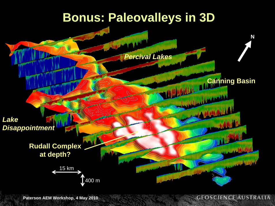
Goal: Map paleovalleys• Sub-Permian paleovalley
surface– Mapped in 3D
throughout region– Uranium explorers
might target permeable sandstone packages near reductants

Paterson AEM Workshop, 4 May 2010
Bonus: Paleovalleys in 3D
15 km
LakeDisappointment
Percival Lakes
400 m
N
Landsat

Paterson AEM Workshop, 4 May 2010
Bonus: Paleovalleys in 3D
15 km
LakeDisappointment
Percival Lakes
400 m
N
1:1Msurface geology
Paterson AEM Workshop, 4 May 2010
Bonus: Paleovalleys in 3D
15 km
LakeDisappointment
Percival Lakes
Canning Basin
Rudall Complexat depth?
400 m
N

Paterson AEM Workshop, 4 May 2010
Goal: Map prospective unconformities• Coolbro-Rudall unconformity
– Imaged clearly on multiple sections– Advantage to those explorers who can effectively
target correct position relative to unconformity
Kintyre
Cover (Cainozoic)Cover (Cainozoic)Paterson Formation (Permian)Coolbro Sandstone (Neoproterozoic)Rudall Complex (Paleoproterozoic)Drillholes
400m1000m
N
Line 41870
Line 40360

Paterson AEM Workshop, 4 May 2010
Bonus: 3D interpretations around KintyreN
1:100ksurface geology
3 km

Paterson AEM Workshop, 4 May 2010
Bonus: 3D interpretations around Kintyre
Kintyre
Lead Hills
Tracy
N
Kintyre
(25x vertical exaggeration)
Lead Hills
Tracy
Paleovalleys
1:100ksurface geology:
basement outcrop
3 km

Paterson AEM Workshop, 4 May 2010
Bonus: 3D interpretations around Kintyre
3 km
Kintyre
Lead Hills
Coolbro Sst.
Paleovalleys
Rudall Complex
Coolbro-Rudallunconformity
Unmapped fault
Tracy
N

Paterson AEM Workshop, 4 May 2010
Bonus: 3D interpretations around Kintyre
3 km
Kintyre
Lead Hills
Coolbro Sst.
Paleovalleys
Rudall Complex Unmapped fault
Tracy
Yandagooge Fm.Coolbro-Rudallunconformity
N

Paterson AEM Workshop, 4 May 2010
Paterson products• Contractor supplied data (Phase 1):
– EM Flow line data, multiplots, & grids– GA data – North Paterson (released in 2009)– GA data – South Paterson (released in 2009)– ALL data (GA + infill)
• Geoscience Australia inversion products (Phase 2)– Layered earth inversions, multiplots, grids & georeferenced images– ALL data (GA + infill)
• Geoscience Australia interpretation Records– A drill hole database with explanatory notes for the Paterson
TEMPEST AEM survey area (GA Record 2009/31)– Geological and energy implications of the Paterson Province
airborne electromagnetic (AEM) survey (GA Record 2010/12: July 2010)
• 2 articles in ASEG Preview (April 2010)
– Released online today (http://tiny.cc/aozjl)
– Released online today (http://tiny.cc/ror68)

Paterson AEM Workshop, 4 May 2010
Pine Creek AEM survey• 30,000 line km over
75,000 km2
• TEMPEST and VTEM data
• Line spacing– 200-5000 m
• Data now available online
• Inversions in July 2010
• Interpretations in March 2011
Williamson et al. (2009)

Paterson AEM Workshop, 4 May 2010
Pine Creek AEM survey• 30,000 line km over
75,000 km2
• TEMPEST and VTEM data
• Line spacing– 200-5000 m
• Data now available online
• Inversions in July 2010
• Interpretations in March 2011
Williamson et al. (2009)
EM Flow
Paterson AEM Workshop, 4 May 2010
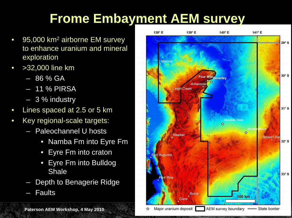
Frome Embayment AEM survey• 95,000 km2 airborne EM survey
to enhance uranium and mineral exploration
• >32,000 line km– 86 % GA– 11 % PIRSA– 3 % industry
• Lines spaced at 2.5 or 5 km• Key regional-scale targets:
– Paleochannel U hosts• Namba Fm into Eyre Fm • Eyre Fm into craton• Eyre Fm into Bulldog
Shale– Depth to Benagerie Ridge– Faults

Paterson AEM Workshop, 4 May 2010
Acknowledgements• Geological Survey of Western Australia (especially Paul Morris &
Ian Tyler)– For hosting this workshop
• Sarah James (Encounter Resources), Greg Street (FugroAirborne), Tyler Mathieson (Cameco)– For presenting their work
• Cameco, Mega Uranium, Rio Tinto, Scimitar/Cauldron Energy, Western Areas– Paterson infill partners
• Birla Nifty, Consolidated Minerals, Newcrest– Data and logistical support
• Martu people and Western Desert Lands Corporation– Land access
Related Documents